conservation management zones of australia · conservation management zones of australia, swan...
TRANSCRIPT

Conservation Management Zones of AustraliaSwan Coastal Plains Shrublands and Woodlands
Prepared by the Department of the Environment

Conservation Management Zones of Australia, Swan Coastal Plains Shrublands and Woodlands
AcknowledgementsThis project and its associated products are the result of collaboration between the Department of the Environment’s Biodiversity Conservation Division and the Environmental Resources Information Network (ERIN). Invaluable input, advice and support were provided by staff and leading researchers from across the Department of Environment (DotE), Department of Agriculture (DoA), the Commonwealth Scientific and Industrial Research Organisation (CSIRO) and the academic community. We would particularly like to thank staff within the Wildlife, Heritage and Marine Division, Parks Australia and the Environment Assessment and Compliance Division of DotE; Nyree Stenekes and Robert Kancans (DoA), Sue McIntyre (CSIRO), Richard Hobbs (University of Western Australia), Michael Hutchinson (ANU); David Lindenmayer and Emma Burns (ANU); and Gilly Llewellyn, Martin Taylor and other staff from the World Wildlife Fund for their generosity and advice.
Special thanks to CSIRO researchers Kristen Williams and Simon Ferrier whose modelling of biodiversity patterns underpinned identification of the Conservation Management Zones of Australia.
Image CreditsFront Cover: Jurien Bay, Lesueur National Park – Georgina Steytler, www.wildandendangered.com.auPage 4: Lancelin Island skink (Ctenotus lancelini) – Magnus PetersenPage 10: Splendid Fairywren (Malurus splendens) – Georgina Steytler, www.wildandendangered.com.auPage 14: Nambung National Park – Tourism Western AustraliaPage 15: Red-capped plover chick (Charadrius ruficapillus) – Benjamint444Page 16: Lesueur National Park – Georgina Steytler, www.wildandendangered.com.auPage 18: Western Ringtail Possum (Pseudocheirus occidentalis) – Greg HarewoodPage 21: Woylie (Bettongia penicillata) – Perth ZooPage 23: Western Swamp Tortoise (Pseudemydura umbrina) – Steve WilsonPage 26: Chamaescilla, Lesueur National Park – Georgina Steytler, www.wildandendangered.com.auPage 27: Little Corella (Cacatua sanguine) – OystercatcherPage 31: Red featherflower, Lesueur National Park – Georgina Steytler, www.wildandendangered.com.auPage 32: Yalgorup Canal, part of the Peel Yalgorup System Ramsar site – Nerida SloanePage 33: Banksia woodlands – M. OwenPage 34: Eucalyptus woodlands with a shrubby understorey – M. OwenPage 35: Other shrublands, Common Smokebush (Conospermum stoechadis) – John BaasPage 36: Eucalyptus open forests with a shrubby understorey – John BaasBack Cover: Jurien Bay, Lesueur National Park – Georgina Steytler, www.wildandendangered.com.au
© Commonwealth of Australia, 2015.
The Conservation Management Zones of Australia profile is licensed by the Commonwealth of Australia for use under a Creative Commons By Attribution 3.0 Australia licence with the exception of the Coat of Arms of the Commonwealth of Australia, the logo of the agency responsible for publishing the report, content supplied by third parties, and any images depicting people.
For licence conditions see here.

Conservation Management Zones of Australia, Swan Coastal Plains Shrublands and Woodlands
Contents
Acknowledgement of Traditional Owners and Country ����������������������������������������������2
Introduction ���������������������������������������������������������������������������������������������������������������������������������2
Zone at a glance �������������������������������������������������������������������������������������������������������������������������3
Population characteristics �������������������������������������������������������������������������������������������������������6
Employment, volunteering and incomes ��������������������������������������������������������������������������9
Agriculture, Natural Resource Management practices and sources of NRM advice ��������������������������������������������������������������������������������������������������11
Land tenure, land use, Native Title and Local Government Areas ������������������������� 13
Zone vegetation characteristics����������������������������������������������������������������������������������������� 15
Ramsar and Nationally Important Wetlands�������������������������������������������������������������������17
World and National Heritage ���������������������������������������������������������������������������������������������� 18
Major National Reserve System properties �������������������������������������������������������������������� 19
EPBC Act (1999) threatened ecological communities ������������������������������������������������� 20
EPBC Act (1999) threatened species ��������������������������������������������������������������������������������� 21
EPBC Act (1999) migratory species ������������������������������������������������������������������������������������ 25
Threatened endemic species ���������������������������������������������������������������������������������������������� 27
Invasive species ����������������������������������������������������������������������������������������������������������������������� 29
Vegetation profiles and management recommendations ��������������������������������������� 32

2 / Conservation Management Zones of Australia, Swan Coastal Plains Shrublands and Woodlands
The Australian Government acknowledges Australia’s Traditional Owners and pays respect to Elders past and present of our nation’s Aboriginal and Torres Strait Islander communities� We honour the deep spiritual, cultural and customary connections of Traditional Owners to the Australian landscape, including Australia’s waterways, land and sea country�
Introduction The 23 Conservation Management Zones of Australia are geographic areas, classified according to their ecological and threat characteristics. The zones are also aligned with the Interim Biogeographic Regionalisation of Australia.
The Conservation Management Zones provide a way of understanding Australia’s natural environment that will assist in long-term conservation planning and help the Australian Government to better design, deliver and report on Natural Resource Management (NRM) investments, including ensuring alignment of national NRM priorities with local action.
The Conservation Management Zones also provide a filter through which to make national environmental and socio-economic data more accessible and comprehensible, and a framework for gathering on-ground knowledge and expertise about the environment. This will improve information flow to the Australian Government about regional NRM requirements, best practice management, emerging NRM issues and knowledge gaps.
The Conservation Management Zones do not represent any change to existing administrative boundaries or governance structures, but aim to support the NRM and wider community to cooperatively manage environmental assets across boundaries, where they share common threats, ecological characteristics and stakeholders.
Each Conservation Management Zone profile contains a standard suite of nationally available ecological and socio-economic information. We hope that this information will enable Australians of all ages and backgrounds to engage with, understand and appreciate Australian landscapes, and support all Australians to manage our natural resources more effectively.
The profile information provides an indicative, high-level stock-take of the environmental and socio-economic landscape and it is not intended to be comprehensive. It should also be noted that, at present, the profiles contain only limited information on aquatic ecosystems, coastal assets and Indigenous land management practices. In future, consultation and comprehensive literature reviews will enable us to provide more complete information.
Acknowledgement of Traditional Owners and Country

3 / Conservation Management Zones of Australia, Swan Coastal Plains Shrublands and Woodlands
Zone at a glance
Area of zone: 1,525,798 hectares
% of Australia:
1.75%126.2 people per square kilometre
Population density:
Zone population characteristics
0
200,000
400,000
600,000
800,000
1,000,000
1,200,000
1,400,000
1,600,000
1,800,000 1,765,417
Tota
l
Engl
ish a
s a
seco
nd
lang
uage
Indi
geno
us
Ove
r 65
Yout
h (1
5–24
)
Num
ber o
f peo
ple
Zone employment characteristics
96.2%
3.8%
UnemployedEmployed
Source: Based on Australian Bureau of Statistics data

4 / Conservation Management Zones of Australia, Swan Coastal Plains Shrublands and Woodlands
Natural Resource Management (NRM) regionsNorthern Agricultural Catchments Council Inc WA
Peel Harvey Catchment Council WA
Perth Region NRM inc WA
Major cities and towns Population
Baldavis 13,528
Bunbury 68,248
Busselton 21,429
Ellenbrook 25,549 Perth (excluding suburbs in adjacent zones) 1,565,129
Yanchep 4,236
Climate characteristics*
Mean annual temperature 17.6 Celsius
Mean Maximum of the Hottest Month 30.8 Celsius
Mean Minimum of the Coldest Month 7.6 Celsius
Mean Annual Rainfall 737.1 mm
Dominant rainfall season Winter
* The figures are interpolated 75-year means (1921 to 1995) representing the period prior to the onset of rapid climatic warming. Cited in: Williams KJ, Belbin L, Austin MP, Stein J, Ferrier S (2012) Which environmental variables should I use in my biodiversity model? International Journal of Geographic Information Sciences 26(11), 2009–2047. (Data derived from Australian Climate surfaces version 2.1 for the ANUCLIM-BIOCLIM package).
For future climate projections please refer to: http://www.climatechangeinaustralia.gov.au/
Top five agricultural commodities Value (millions)
Vegetables for consumption $140
Nurseries and cut flowers $75
Fruit $58
Beef $49
Eggs $38Total value of agricultural commodities (including other commodities not listed here)
$422
Source: Based on Australian Bureau of Statistics data

5 / Conservation Management Zones of Australia, Swan Coastal Plains Shrublands and Woodlands
National Reserve System area
11%
89%
Other areaNRS area
Native Title area
Although there have been no Native Title Determinations finalised within this Conservation Management Zone, it continues to represent important Indigenous heritage values and places that are of deep significance to Indigenous persons and their practices, observations, customs, beliefs and history.
Native vegetation clearance level
39%
61%
Uncleared (ha)Cleared (ha)
Number of threatened species by class
102
23
11
73
Insects
SharksBirdsPlants Mammals
Fish
Reptiles
Crustaceans Other
12
2
1
Status of EPBC Act listed threatened species, communities and migratory species
0 17 34 51 68 85
54
82
64
15
10
1
Threatened ecologicalcommunities
Conservation dependent
Migratory species
Critically endangered species
Endangered species
Vulnerable species
Source: Based on data from the National Native Title Register; Collaborative Australian Protected Area Database (CAPAD); National Vegetation Information System (NVIS); Species’ Profile and Threats Database (SPRAT).

6 / Conservation Management Zones of Australia, Swan Coastal Plains Shrublands and Woodlands
Population
Population by age group
19%
14%32%
22%
65 years and over40–64 years
15–24 years0–14 years 25–39 years
13%
Indigenous population by age group
39%
22%
18%
20%
65 years and over40–64 years
15–24 years0–14 years 25–39 years
1%
Farmer and farm managers by age group
15%
3%
20%
62%
65 years and over40–64 years
25–39 years15–24 years
Gender of farmers and farm managers
1,859
833
FemaleMale
Source: Based on Australian Bureau of Statistics data
Population characteristics

7 / Conservation Management Zones of Australia, Swan Coastal Plains Shrublands and Woodlands
Languages spoken at home
English 78.06%
Other languages 16.30%
Not stated 5.44%
Non-English languages spoken at home*
Northern European (including Scandinavia, Celtic, Germanic, Dutch)Southern European
Eastern European
Central Asian, Turkic, Iranic and Semitic
Southern Asian, Dravidan and Indo-Ayran
South-East Asian
East Asian
Australian Aboriginal and Torres Strait Islander
African
Paci�c / Oceanic
Sign language
4.51% 8.28%
18.24%
0.24%1.11%
0.21%0.01%
* Please note, these �gures are based on the proportion of the population who indicated in the 2011 ABS Census that they spoke a language other than English at home.
19.65%
10.76%
18.42%
11%
7.58%
Indigenous languages spoken at home**
2%
7%
81%
Torres Strait Island Languages
Northern Desert Fringe Area Languages
Western Desert Language
Kimberley Area Languages
Other Australian Indigenous Languages
** Please note, these �gures are based on the proportion of the population who indicated in the 2011 ABS Census that they spoke an Indigenous language at home.
9%
1%
Source: Based on Australian Bureau of Statistics data
8 / Conservation Management Zones of Australia, Swan Coastal Plains Shrublands and Woodlands
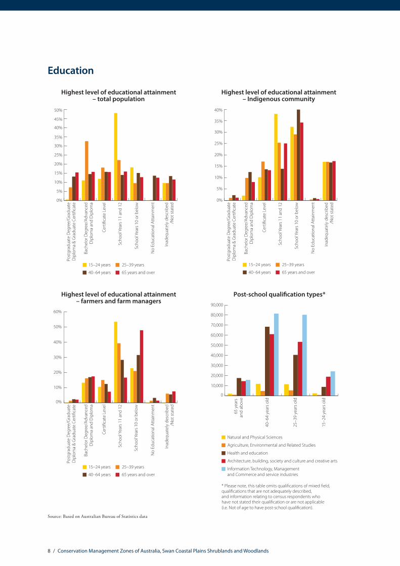
Education
0%
5%
10%
15%
20%
25%
30%
35%
40%
45%
50%
65 years and over40–64 years
25–39 years15–24 years
Highest level of educational attainment – total population
Inad
equa
tely
des
crib
ed/N
ot st
ated
No
Educ
atio
nal A
ttai
nmen
t
Scho
ol Y
ears
10
or b
elow
Scho
ol Y
ears
11
and
12
Cert
i�ca
te L
evel
Bach
elor
Deg
ree/
Adva
nced
Dip
lom
a an
d D
iplo
ma
Post
grad
uate
Deg
ree/
Gra
duat
eD
iplo
ma
& G
radu
ate
Cert
i�ca
te
Highest level of educational attainment – Indigenous community
0%
5%
10%
15%
20%
25%
30%
35%
40%
Inad
equa
tely
des
crib
ed/N
ot st
ated
No
Educ
atio
nal A
ttai
nmen
t
Scho
ol Y
ears
10
or b
elow
Scho
ol Y
ears
11
and
12
Cert
i�ca
te L
evel
Bach
elor
Deg
ree/
Adva
nced
Dip
lom
a an
d D
iplo
ma
Post
grad
uate
Deg
ree/
Gra
duat
eD
iplo
ma
& G
radu
ate
Cert
i�ca
te
65 years and over40–64 years
25–39 years15–24 years
0%
10%
20%
30%
40%
50%
60%
65 years and over40–64 years
25–39 years15–24 years
Highest level of educational attainment – farmers and farm managers
Inad
equa
tely
des
crib
ed/N
ot st
ated
No
Educ
atio
nal A
ttai
nmen
t
Scho
ol Y
ears
10
or b
elow
Scho
ol Y
ears
11
and
12
Cert
i�ca
te L
evel
Bach
elor
Deg
ree/
Adva
nced
Dip
lom
a an
d D
iplo
ma
Post
grad
uate
Deg
ree/
Gra
duat
eD
iplo
ma
& G
radu
ate
Cert
i�ca
te
0
10,000
20,000
30,000
40,000
50,000
60,000
70,000
80,000
90,000
Post-school quali�cation types*
15–2
4 ye
ars o
ld
25–3
9 ye
ars o
ld
40–6
4 ye
ars o
ld
65 y
ears
an
d ab
ove
Natural and Physical Sciences
Agriculture, Environmental and Related Studies
Health and education
Architecture, building, society and culture and creative arts
Information Technology, Management and Commerce and service industries
* Please note, this table omits quali�cations of mixed �eld, quali�cations that are not adequately described, and information relating to census respondents who have not stated their quali�cation or are not applicable (i.e. Not of age to have post-school quali�cation).
Source: Based on Australian Bureau of Statistics data

9 / Conservation Management Zones of Australia, Swan Coastal Plains Shrublands and Woodlands
Employment
0%
10%
20%
30%
40%
50%
60%
70%
80%
90%
Employment status of general population*
65 y
ears
and
abov
e
15–2
4 ye
ars o
ld
40–6
4 ye
ars o
ld
25–3
9 ye
ars o
ld
Employed
Unemployed
Not in labour force or not stated
* Please note the % �gures are relative to each of the age groupings of the population. The categories above are aggregates of the following Australian Bureau of Statistics categories: Employed = Employed full-time; Employed part-time; and Employed away from work. Unemployed = Unemployed looking for full-time work; and Unemployed looking for part-time work. Not in the Labour Force or Not Stated = Not in the Labour Force; and Not Stated. Please note the ‘not applicable’ category has been omitted from the analysis. Not applicable applies to the proportion of the population that is not of working age (e.g. 0–15 year olds and retired). ABS 2011 Census Labour Force data has been utilised for this report, as the national quarterly employment �gures are derived from a relatively small sample of the population.
Employment by industry
Agriculture, forestry and sheries
Mining
Manufacturing
Utilities, construction and transport
Health, Social Assistance, Education and training
Public administration and safety
Wholesale and retail trade
Services
Food, accommodation, arts and recreation
Unknown/not stated
5%
19%
16%
6%
14%
21%
7%9%
1%
2%
0%
10%
20%
30%
40%
50%
60%
70%
80%
90%
Employment status of general population*
65 y
ears
and
abov
e
15–2
4 ye
ars o
ld
40–6
4 ye
ars o
ld
25–3
9 ye
ars o
ld
Employed
Unemployed
Not in labour force or not stated
* Please note the % �gures are relative to each of the age groupings of the population. The categories above are aggregates of the following Australian Bureau of Statistics categories: Employed = Employed full-time; Employed part-time; and Employed away from work. Unemployed = Unemployed looking for full-time work; and Unemployed looking for part-time work. Not in the Labour Force or Not Stated = Not in the Labour Force; and Not Stated. Please note the ‘not applicable’ category has been omitted from the analysis. Not applicable applies to the proportion of the population that is not of working age (e.g. 0–15 year olds and retired). ABS 2011 Census Labour Force data has been utilised for this report, as the national quarterly employment �gures are derived from a relatively small sample of the population.
0%
10%
20%
30%
40%
50%
60%
70%
80%
90%
100%
Employment status of Indigenous population*
Indi
geno
us65
yea
rsan
d ab
ove
Indi
geno
us15
–24
year
s old
Indi
geno
us40
–64
year
s old
Indi
geno
us25
–39
year
s old
Employed
Unemployed
Not in labour force or not stated
Source: Based on Australian Bureau of Statistics data
Employment, volunteering and incomes

10 / Conservation Management Zones of Australia, Swan Coastal Plains Shrublands and Woodlands
Volunteering
0%
10%
20%
30%
40%
50%
60%
70%
80%
Volunteering rates
15–2
4 ye
ars o
ld
25–3
9 ye
ars o
ld
40–6
4 ye
ars o
ld
65 y
ears
an
d ab
ove
Not a volunteer
Volunteer
Not stated or not applicable
Income
Total household income (% of households)*
16.7%
44.4%
12%
8.1%
18.9%
Over $104,000
Under $20,800
Not Stated/Partially Stated
$20,800–64,999 $65,000–$103,999
* Please note these �gures have been derived from the ABS Equivalised Total Household Income (HIED)Census 2011 data. ABS data categories have been aggregated for the purposes of this report. For more information see: http://www.abs.gov.au/websitedbs/censushome.nsf/home/statementsdwellinghied?opendocument&navpos=430
In the 2011–12 �nancial year, persons who earned $67,500 or less were eligible for Low Income Tax O�set. Human Services applied the following de�nitions of “low income” as eligibility criteria for the Low Income Supplement in the 2012–13 �nancial year: Income below $30,000 for singles, $45,000 combined for couples, or $60,000 combined for couples or singles with a dependent child.
Source: Based on Australian Bureau of Statistics data

11 / Conservation Management Zones of Australia, Swan Coastal Plains Shrublands and Woodlands
Agricultural commodity values
Value of agricultural commodities^
$0
$20
$40
$60
$80
$100
$120
$140
Oth
er b
road
acre
cro
ps
Nut
s
Frui
t
Oils
eeds
Legu
me
for g
rain
Hay
Cere
als f
or g
rain
Eggs
Woo
l
Beef
Lam
b
Pork
Dai
ry
Vege
tabl
es fo
r see
d
Vege
tabl
es fo
r con
sum
ptio
n
Nur
serie
s and
cut
�ow
ers
Mill
ions
^ Data obtained from the Australian Bureau of Statistics Value of Agricultural Commodities Produced. The value estimates in this publication are derived by the multiplication of price and quantity estimates of agricultural commodities. Price information is estimated based on the average unit value of a given commodity realised in the market place. For more information please refer to: http://www.abs.gov.au/AUSSTATS/[email protected]/Lookup/7503.0Explanatory%20Notes12010-11?OpenDocument
Source: Based on Australian Bureau of Statistics data
Agriculture, Natural Resource Management practices and sources of NRM adviceAustralian farmers manage over 60% of the Australian continent and shoulder much of the burden of responsibility for maintaining and protecting Australia’s natural resource wealth. The information contained in this profile aims to assist the wider community, non-governmental organisations and government agencies to support Australia’s key environmental custodians.
Number of people employed in agriculture, �shing, forestry and downstream industries
5,306
15,501
204
79
83Forestry industry, including
production, logging, sawmillingand downstream wood and
paper product manufacturing
Fishing industry, includingproduction and downstream
seafood processingand wholesaling
Agriculture downstreamindustries, including services,
food and beverage
Agriculture industries (production)
3,823
742
Income
Total household income (% of households)*
16.7%
44.4%
12%
8.1%
18.9%
Over $104,000
Under $20,800
Not Stated/Partially Stated
$20,800–64,999 $65,000–$103,999
* Please note these �gures have been derived from the ABS Equivalised Total Household Income (HIED)Census 2011 data. ABS data categories have been aggregated for the purposes of this report. For more information see: http://www.abs.gov.au/websitedbs/censushome.nsf/home/statementsdwellinghied?opendocument&navpos=430
In the 2011–12 �nancial year, persons who earned $67,500 or less were eligible for Low Income Tax O�set. Human Services applied the following de�nitions of “low income” as eligibility criteria for the Low Income Supplement in the 2012–13 �nancial year: Income below $30,000 for singles, $45,000 combined for couples, or $60,000 combined for couples or singles with a dependent child.
Source: Based on Australian Bureau of Statistics data

12 / Conservation Management Zones of Australia, Swan Coastal Plains Shrublands and Woodlands
Natural Resource Management practices and sources of NRM advice
0%
10%
20%
30%
40%
50%
60%
70%
80%
90%
100%
Feral animal control*(% of agricultural holdings)
No
man
agem
ent
of fe
ral a
nim
als
Oth
er (u
nspe
ci�e
d)fe
ral a
nim
al c
ontr
ol
Fera
l goa
ts
No
data
0.0%
0.5%
1.0%
1.5%
2.0%
2.5%
Native vegetation protection and regeneration*(% of agricultural holdings)
Oth
er
Stop
ping
mec
hani
cal
or c
hem
ical
des
truc
tion
Redu
cing
gra
zing
pre
ssur
e
Man
agin
g w
eeds
Fenc
ing
o�/e
xclu
ding
stoc
k
Sought advice when adopting native vegetation management**
78.99%
21.01%
NoYes
Sources of advice**^
Yes
No
Yes
No
Yes
No
Yes
No
Yes
No
Yes
No
Yes
No
Priv
ate
cons
ulta
nt o
rag
ribus
ines
s age
nt
CMA/
NRM
regi
onem
ploy
ed fa
cilit
ator
Rese
arch
and
Dev
elop
men
t Cor
pora
tion
Gov
ernm
ent
exte
nsio
n o�
cer
Peer
s or n
eigh
bour
s
Farm
er g
roup
Land
care
or f
arm
erpr
oduc
tion
grou
p
** The sample for the Drivers of Practice Change 2012 survey consisted of a random subsample of 1228 broadacre farm managers from the Australian Agricultural and Grazing Industries Survey (AAGIS) frame. The data has been aligned to Conservation Management Zones from ABS Statistical Area 2 units. For this reason, the figures presented here are indicative only.
^ This chart indicates the sources of advice utilised for native vegetation management from respondents who identified they sought advice.
For more information please refer to http://www.daff.gov.au/SiteCollectionDocuments/forestry/domestic-forestry/prep-for-future/drivers-practice-change.pdf
* Data obtained from the Australian Bureau of Statistics (ABS) 2012 Land Management Practices Survey (LaMPS) 2012. LaMPS collected land practices information from approximately 50,000 farm businesses across Australia. The data has been aligned to Conservation Management Zones from ABS Statistical Area 2 units and Australian Agricultural Environment units. The % figures presented here are indicative only. For more information on LaMPS please refer to: http://www.abs.gov.au/ausstats/[email protected]/mf/4630.0

13 / Conservation Management Zones of Australia, Swan Coastal Plains Shrublands and Woodlands
Land tenure, land use, Native Title and Local Government Areas
Land tenure
Crown Land – Private – Leased
Crown Land – Public
Crown Land – Public – Leased
Crown Land – Unknown – Leased
Freehold – Public
Freehold – Unknown
No Data/Unknown
67.17%
0.83%
0.51%0.77%0.05%
22.06%
8.61%
Land use
Conservation and Natural Environments
Cropping and Horticulture
Grazing Modi�ed Pastures
Industry, Residential, Services and Mining
Production from Irrigated Agriculture and Plantations
Plantation Forestry
Other
23.25%
0.95%2.81%
37%
20.34%
10.72%
4.87%
Source: Land tenure data based on Environmental Resources Information Network (ERIN) categorisation of Public Sector Mapping Authority (PSMA) State Tenure 2012; Land use mapping based on Australian Collaborative Land Use and Management Program (ACLUMP) 2012. For more information on Australian land use and management information and classification please refer to: http://www.daff.gov.au/ABARES/aclump/Pages/Default.aspx
Indigenous Land Councils
South-West Aboriginal Land and Sea Council: http://www.noongar.org.au
Although there have been no Native Title Determinations finalised within this Conservation Management Zone, it continues to represent important Indigenous heritage values and places that are of deep significance to Indigenous persons and their practices, observations, customs, beliefs and history.

14 / Conservation Management Zones of Australia, Swan Coastal Plains Shrublands and Woodlands
Local Government Areas
City Of Armadale WA
City Of Bayswater WA
City Of Belmont WA
City Of Bunbury WA
City Of Busselton WA
City Of Canning WA
City Of Cockburn WA
City Of Fremantle WA
City Of Gosnells WA
City Of Joondalup WA
City Of Kwinana WA
City Of Mandurah WA
City Of Melville WA
City Of Nedlands WA
City Of Perth WA
City Of Rockingham WA
City Of South Perth WA
City Of Stirling WA
City Of Subiaco WA
City Of Swan WA
City Of Vincent WA
City Of Wanneroo WA
Local Government Areas
Shire Of Capel WA
Shire Of Chittering WA
Shire Of Coorow WA
Shire Of Dandaragan WA
Shire Of Dardanup WA
Shire Of Gingin WA
Shire Of Harvey WA
Shire Of Kalamunda WA
Shire Of Moora WA
Shire Of Mundaring WA
Shire Of Murray WA
Shire Of Peppermint Grove WA
Shire Of Serpentine-Jarrahdale WA
Shire Of Victoria Plains WA
Shire Of Waroona WA
Town Of Bassendean WA
Town Of Cambridge WA
Town Of Claremont WA
Town Of Cottesloe WA
Town Of East Fremantle WA
Town Of Mosman Park WA
Town Of Victoria Park WA

15 / Conservation Management Zones of Australia, Swan Coastal Plains Shrublands and Woodlands
Zone vegetation characteristics
Major Vegetation Subgroups (MVS) with >1% original distribution within zone
0%
5%
10%
15%
20%
25%
30%
35%
40%
45%
Othergrasslands
Banksiawoodlands
Eucalyptusopen forest
with a shrubbyunderstorey
Eucalyptuswoodlands
with a shrubbyunderstorey
Melaleucaopen forests
and woodlands
Other Acaciatall open
shrublandsand shrublands
Othershrublands
Present day percentage of CMZ areaPre 1750 percentage of CMZ area

16 / Conservation Management Zones of Australia, Swan Coastal Plains Shrublands and Woodlands
The National Vegetation Information System (NVIS) framework is a nationally consistent vegetation classification system based on vegetation data collected by states and territories. It provides information on the extent and distribution of vegetation types across the Australian landscape.
Two products are used to provide the Zone Vegetation Characteristics graph. A modelled pre-European vegetation distribution (pre-1750), and extant (current extent) vegetation, which is based on contemporary vegetation mapping. The information presented here relates to Major Vegetation Subgroups (MVSs). There are 85 MVS types across Australia, describing the structure and floristic composition of dominant and secondary vegetation stratums (e.g. canopy and mid-storey species). Major Vegetation Subgroups only reflect the dominant vegetation type occurring in an area from a mix of vegetation types. Less-dominant vegetation groups which may also be present are therefore not represented.
It is important to note that the vegetation information is indicative only, as state and territory mapping in Australia is of variable resolution and scale. However, this data is the best available nationally consistent information on vegetation, and the dataset continues to evolve and increase in accuracy.
Analysing this information at Conservation Management Zone, rather than national level provides greater discrimination for decision makers, as clearance levels of vegetation types are not uniform across Australia. For example, eucalypt woodlands with a tussock grass understory is a vegetation type found across Australia. In the Brigalow Woodlands Conservation Management Zone, eucalypt open woodlands with a tussock grass understory originally covered approximately 36% of the zone, but today it only covers only 14.5 % of the zone (58.7% of this vegetation community has been cleared in the Brigalow). In the Northern Australia Tropical Savannah zone, this vegetation type originally occupied 19.6% of the zone. Today, it occupies approximately 19.4% of the zone (only 2.3% of this vegetation type has been cleared). It should be noted that this data only provides an indication of change in extent, and not vegetation condition.
For more information on the National Vegetation Information System (NVIS) please refer to: http://www.environment.gov.au/topics/science-and-research/databases-and-maps/national-vegetation-information-system

17 / Conservation Management Zones of Australia, Swan Coastal Plains Shrublands and Woodlands
The National Vegetation Information System (NVIS) framework is a nationally consistent vegetation classification system based on vegetation data collected by states and territories. It provides information on the extent and distribution of vegetation types across the Australian landscape.
Two products are used to provide the Zone Vegetation Characteristics graph. A modelled pre-European vegetation distribution (pre-1750), and extant (current extent) vegetation, which is based on contemporary vegetation mapping. The information presented here relates to Major Vegetation Subgroups (MVSs). There are 85 MVS types across Australia, describing the structure and floristic composition of dominant and secondary vegetation stratums (e.g. canopy and mid-storey species). Major Vegetation Subgroups only reflect the dominant vegetation type occurring in an area from a mix of vegetation types. Less-dominant vegetation groups which may also be present are therefore not represented.
It is important to note that the vegetation information is indicative only, as state and territory mapping in Australia is of variable resolution and scale. However, this data is the best available nationally consistent information on vegetation, and the dataset continues to evolve and increase in accuracy.
Analysing this information at Conservation Management Zone, rather than national level provides greater discrimination for decision makers, as clearance levels of vegetation types are not uniform across Australia. For example, eucalypt woodlands with a tussock grass understory is a vegetation type found across Australia. In the Brigalow Woodlands Conservation Management Zone, eucalypt open woodlands with a tussock grass understory originally covered approximately 36% of the zone, but today it only covers only 14.5 % of the zone (58.7% of this vegetation community has been cleared in the Brigalow). In the Northern Australia Tropical Savannah zone, this vegetation type originally occupied 19.6% of the zone. Today, it occupies approximately 19.4% of the zone (only 2.3% of this vegetation type has been cleared). It should be noted that this data only provides an indication of change in extent, and not vegetation condition.
For more information on the National Vegetation Information System (NVIS) please refer to: http://www.environment.gov.au/topics/science-and-research/databases-and-maps/national-vegetation-information-system
Nationally Important Wetlands Jurisdiction Hectares CriteriaBarraghup Swamp WA 18.76 1, 2, 3, 6Becher Point Wetlands WA 0.12 1, 6Benger Swamp WA 1,086.71 3, 4, 6Booragoon Swamp WA 29.59 1, 2, 3, 6Brixton Street Swamps WA 271.63 1, 5, 6Chandala Swamp WA 435.83 1, 2, 3, 4, 6Ellen Brook Swamps System WA 19.93 1, 3, 4, 5, 6Forrestdale Lake WA 0.12 1, 2, 3, 4, 5, 6Gibbs Road Swamp System WA 5,833.15 1, 2, 3, 6Guraga Lake WA 364.93 1, 2, 3, 4, 6Herdsman Lake WA 323.54 2, 3, 4, 6Joondalup Lake WA 563.09 1, 2, 4, 6Karakin Lakes WA 621.81 2Lake McLarty System WA 263.60 1, 2, 3, 4, 6Lake Thetis WA 1.21 1, 6Lancelin Defence Training Area WA 0.11 1, 2Loch McNess System WA 195.14 1, 3, 6McCarleys Swamp (Ludlow Swamp) WA 26.10 1, 2, 3, 6Palmer Barracks, Guildford WA 0.10 1, 2Peel-Harvey Estuary WA 3,236.91 1, 2, 3, 4, 5, 6Perth Airport Woodland Swamps WA 192.23 1, 3, 5, 6RAAF Caversham WA 0.11 2, 3Rottnest Island Lakes WA 137.33 1, 2, 3, 6Spectacles Swamp WA 164.52 1, 2, 3, 6Swan-Canning Estuary WA 3,726.58 1, 2, 3, 4, 5, 6Thomsons Lake WA 236.13 1, 2, 3, 4, 6Vasse-Wonnerup Wetland System WA 1,981.53 2, 3, 4, 5, 6Wannamal Lake System WA 738.69 2, 3, 4, 5, 6Yalgorup Lakes System WA 5,087.37 1, 2, 3, 4, 5, 6
Nationally important wetlands are defined according to the following criteria:1. It is a good example of a wetland type occurring within a biogeographic region in Australia.2. It is a wetland which plays an important ecological or hydrological role in the natural functioning of a major wetland system/complex.3. It is a wetland which is important as the habitat for animal taxa at a vulnerable stage in their life cycles, or provides a refuge when
adverse conditions such as drought prevail.4. The wetland supports 1% or more of the national populations of any native plant or animal taxa.5. The wetland supports native plant or animal taxa or communities which are considered endangered or vulnerable at the national level.6. The wetland is of outstanding historical or cultural significance.Please note, the above are a subset of all the Nationally Important Wetlands found within the Zone. For more information on Nationally Important Wetlands please see: http://www.environment.gov.au/resource/directory-important-wetlands-australia-third-edition
Ramsar and Nationally Important Wetlands
For more information on Ramsar please refer to: http://www.environment.gov.au/topics/water/water-our-environment/wetlands/ramsar-convention-wetlands
Ramsar wetlands Jurisdiction Hectares
Becher Point Wetlands WA 674 Forrestdale and Thomsons Lakes WA 785 Peel-Yalgorup System WA 26,665 Vasse-Wonnerup System WA 1,114

18 / Conservation Management Zones of Australia, Swan Coastal Plains Shrublands and Woodlands
Please refer to the Australian Heritage Database for detailed information on listing criteria for these heritage values: http://www.environment.gov.au/topics/heritage/publications-and-resources/australian-heritage-database
For more information on Australia’s world and national heritage please refer to: http://www.environment.gov.au/topics/heritage/about-australias-heritage
World and National Heritage
Heritage values World or National Heritage type Jurisdiction Hectares % of zone
Australian Convict Sites (Fremantle Prison Buffer Zone)
World Cultural WA 25.73 0.002
Fremantle Prison (former) National Historic WA 7.16 0.0005

19 / Conservation Management Zones of Australia, Swan Coastal Plains Shrublands and Woodlands
Major National Reserve System properties
Major National Reserve System properties
Name Property type IUCN category Jurisdiction Hectares % of zone
Nambung National Park II WA 19,285 1.26
Moore River National Park II WA 17,241 1.13
Yalgorup National Park II WA 13,060 0.86
Watheroo National Park II WA 11,036 0.72
Wanagarren Nature Reserve IA WA 10,983 0.72
Yeal Nature Reserve IA WA 10,912 0.72
Southern Beekeepers Nature Reserve IA WA 10,866 0.71
Boonanarring Nature Reserve IA WA 9,168 0.60
Nilgen Nature Reserve IA WA 5,504 0.36
Namming Nature Reserve IA WA 5,290 0.35
Moore River Nature Reserve IA WA 4,731 0.31
Beekeepers Nature Reserve IA WA 3,763 0.25
Lesueur National Park II WA 3,687 0.24
Watheroo National Park II WA 2,903 0.19
Yanchep National Park II WA 2,877 0.19
Unnamed WA49994 Conservation Park II WA 2,773 0.18
Drovers Cave National Park II WA 2,564 0.17
Austin Bay Nature Reserve IA WA 1,658 0.11
Watheroo National Park II WA 1,634 0.11
Unnamed WA44081 Nature Reserve IA WA 1,429 0.09
The IUCN categories are as follows:
Ia Strict Nature Reserve IUCN protected area management categories classify protected areas according to their management objectives. The categories are recognised by international bodies such as the United Nations and are utilised by many national governments, including the Australian Government, as the global standard for defining and recording protected areas.
Ib Wilderness Area
II National Park
III Natural Monument or Feature
IV Habitat/Species Management Area
V Protected Landscape/ Seascape
VI Protected area with sustainable use of natural resources
Please refer to the IUCN website for further explanation: http://www.iucn.org/about/work/programmes/gpap_home/gpap_quality/gpap_pacategories/
For more information on Australia’s National Reserve System please refer to: http://www.environment.gov.au/topics/land/national-reserve-system
Source: Collaborative Australian Protected Area Database 2012.

20 / Conservation Management Zones of Australia, Swan Coastal Plains Shrublands and Woodlands
EPBC Act (1999) threatened ecological communitiesThreatened ecological communities
Name Listing status % of total distribution* % of zone**
Thrombolite (microbialite) Community of a Coastal Brackish Lake (Lake Clifton)
Critically Endangered 100 0.14
Thrombolite (microbial) community of coastal freshwater lakes of the Swan Coastal Plain (Lake Richmond) Endangered 100 0.01
Aquatic Root Mat Community in Caves of the Swan Coastal Plain Endangered 100 0.05Assemblages of plants and invertebrate animals of tumulus (organic mound) springs of the Swan Coastal Plain Endangered 100 0.04
Sedgelands in Holocene dune swales of the southern Swan Coastal Plain Endangered 100 0.47
Shrublands and Woodlands on Muchea Limestone of the Swan Coastal Plain Endangered 100 0.07
Shrublands and Woodlands on Perth to Gingin ironstone (Perth to Gingin ironstone association) of the Swan Coastal Plain Endangered 100 0.04
Corymbia calophylla – Xanthorrhoea preissii woodlands and shrublands of the Swan Coastal Plain Endangered 99.91 0.10
Corymbia calophylla – Kingia australis woodlands on heavy soils of the Swan Coastal Plain Endangered 97 0.06
Claypans of the Swan Coastal Plain Critically Endangered 94.8 0.54
Shrublands and Woodlands of the eastern Swan Coastal Plain Endangered 77.02 0.02
Shrublands on southern Swan Coastal Plain ironstones Endangered 63.24 0.01
* % of the total national distribution describes the proportion of the total national distribution of the Threatened Ecological Community that is found within the zone.
** % of the total zone area describes the proportion of the zone that the Threatened Ecological Community is likely or known to occur in.
It should be noted that the identification of any given Threatened Ecological Community above does not imply that the Threatened Ecological Community (TEC) is found uniformly across the Conservation Management Zone. Rather, the % of the TEC’s total distribution (*) within the zone is an indication of its importance to that zone in terms of conservation efforts. The % of the zone (**) indicates how rare, or difficult the ecological community may be to find within the zone.
The threatened ecological communities above are listed under The Environment Protection and Biodiversity Conservation Act 1999 (EPBC Act), which is the Australian Government’s principal environmental legislation. For more information, please refer to http://www.environment.gov.au/biodiversity/threatened/communities

21 / Conservation Management Zones of Australia, Swan Coastal Plains Shrublands and Woodlands
EPBC Act (1999) threatened species
Threatened mammals
Common name Scientific name Status % of total distribution*
% of zone**
Woylie Bettongia penicillata ogilbyi Endangered 24.29 17.23
Dibbler Parantechinus apicalis Endangered 6.77 73.25
Western Ringtail Possum Pseudocheirus occidentalis Vulnerable 0.01 0.01
Chuditch, Western Quoll Dasyurus geoffroii Vulnerable May be present
May be present
Burrowing Bettong (Shark Bay), Boodie Bettongia lesueur lesueur Vulnerable May be present
May be present
Black-flanked Rock-wallaby Petrogale lateralis lateralis Vulnerable May be present
May be present
Quokka Setonix brachyurus Vulnerable May be present
May be present
Blue Whale Balaenoptera musculus Endangered n/a n/a
Southern Right Whale Eubalaena australis Endangered n/a n/a
Australian Sea-lion Neophoca cinerea Vulnerable n/a n/a
Humpback Whale Megaptera novaeangliae Vulnerable n/a n/a

22 / Conservation Management Zones of Australia, Swan Coastal Plains Shrublands and Woodlands
Threatened birds
Common name Scientific name Status % of total distribution*
% of zone**
Carnaby’s Black-Cockatoo, Short-billed Black-Cockatoo Calyptorhynchus latirostris Endangered 8.05 30.08
Australian Painted Snipe Rostratula australis Endangered 6.8 98.33
Australasian Bittern Botaurus poiciloptilus Endangered 1.36 5.13
Northern Royal Albatross Diomedea epomophora sanfordi Endangered 0.43 29.95
Amsterdam Albatross Diomedea exulans amsterdamensis Endangered 0.23 2.99
Tristan Albatross Diomedea exulans exulans Endangered 0.2 4.87
Southern Giant-Petrel Macronectes giganteus Endangered 0.01 1.92Baudin’s Black-Cockatoo, Long-billed Black-Cockatoo Calyptorhynchus baudinii Vulnerable 0.01 1.92
Australian Fairy Tern Sternula nereis nereis Vulnerable 0.01 1.92
Malleefowl Leipoa ocellata Vulnerable 0.01 1.74
White-capped Albatross Thalassarche cauta steadi Vulnerable n/a n/a
Southern Royal Albatross Diomedea epomophora epomophora Vulnerable n/a n/a
Shy Albatross, Tasmanian Shy Albatross Thalassarche cauta cauta Vulnerable n/a n/a
Indian Yellow-nosed Albatross Thalassarche carteri Vulnerable n/a n/a
Forest Red-tailed Black-Cockatoo Calyptorhynchus banksii naso Vulnerable n/a n/a
Northern Giant-Petrel Macronectes halli Vulnerable n/a n/a
Soft-plumaged Petrel Pterodroma mollis Vulnerable n/a n/a
Slender-billed Thornbill (western) Acanthiza iredalei iredalei Vulnerable n/a n/a
Campbell Albatross Thalassarche melanophris impavida Vulnerable n/a n/a
Blue Petrel Halobaena caerulea Vulnerable n/a n/a
Wandering Albatross Diomedea exulans (sensu lato) Vulnerable n/a n/a
Australian Lesser Noddy Anous tenuirostris melanops Vulnerable n/a n/a
Black-browed Albatross Thalassarche melanophris Vulnerable n/a n/a
* % of total distribution describes the proportion of the total national distribution of the threatened species that is found within the zone.
** % of zone describes the proportion of the zone that the threatened species is likely or known to occur in.
The % of zone indicates how rare, or difficult the species may be to find within the zone.
Threatened reptiles
Common Name Scientific name Status % of total distribution*
% of zone**
Western Swamp Tortoise Pseudemydura umbrina Critically Endangered 100 0.01
Lancelin Island Skink Ctenotus lancelini Vulnerable 99.7 0.0007Jurien Bay Skink, Jurien Bay Rock-skink Liopholis pulchra longicauda Vulnerable 99.32 0.004Loggerhead Turtle Caretta caretta Endangered 0.01 2.25Leatherback Turtle, Leathery Turtle, Luth Dermochelys coriacea Endangered 0.01 2.06Flatback Turtle Natator depressus Vulnerable 0.01 2.25Green Turtle Chelonia mydas Vulnerable 0.01 2.25

23 / Conservation Management Zones of Australia, Swan Coastal Plains Shrublands and Woodlands
Other threatened fauna
Common name Scientific name Status % of total distribution*
% of zone**
a short-tongued bee Leioproctus douglasiellus Critically Endangered 100 0.02
A native bee Neopasiphae simplicior Critically Endangered 100 0.02
Dunsborough Burrowing Crayfish Engaewa reducta Critically Endangered 20.59 0.09
Shield-backed Trapdoor Spider, Black Rugose Trapdoor Spider Idiosoma nigrum Vulnerable May be
presentMay be present
Great White Shark Carcharodon carcharias Vulnerable n/a n/a
Grey Nurse Shark (west coast population) Carcharias taurus (west coast population) Vulnerable n/a n/a
Whale Shark Rhincodon typus Vulnerable n/a n/a

24 / Conservation Management Zones of Australia, Swan Coastal Plains Shrublands and Woodlands
Threatened flora
Common Name Scientific name Status % of total distribution*
% of zone**
Limestone Pea Chorizema varium Endangered 100 0.11Baby Blue Orchid, Blue Babe-in-the-cradle Orchid, Blue Babe-in-a-cradle
Epiblema grandiflorum var. cyaneum Endangered 100 0.01
One-sexed Hydatella Hydatella dioica Endangered 100 0.14Bussell’s Spider-orchid Caladenia busselliana Endangered 100 0.11
Tufted Plumed Featherflower Verticordia plumosa var. ananeotes Endangered 100 0.01
Swamp Starflower Calytrix breviseta subsp. breviseta Endangered 100 0.19Narrow-petalled Featherflower, Mundijong Featherflower
Verticordia plumosa var. pleiobotrya Endangered 100 0.28
Yanchep Mallee, Wabling Hill Mallee Eucalyptus argutifolia Vulnerable 100 0.96Beaked Lepidosperma Lepidosperma rostratum Endangered 99.97 10.21Dwellingup Synaphea Synaphea stenoloba Endangered 99.71 3.96Glossy-leafed Hammer-orchid, Praying Virgin Drakaea elastica Endangered 99.51 28.61
Curved-leaf Grevillea Grevillea curviloba subsp. curviloba Endangered 99.28 1.34
Dwarf Green Kangaroo Paw Anigozanthos viridis subsp. terraspectans Vulnerable 99.28 13.85
McCutcheon’s Grevillea Grevillea maccutcheonii Endangered 98.84 0.30
Gingin Wax Chamelaucium sp. Gingin (N.G.Marchant 6) Endangered 96.79 1.51
Royce’s Waxflower Chamelaucium sp. C Coast Plain (R.D.Royce 4872) Vulnerable 96.73 2.91
Narrow curved-leaf Grevillea Grevillea curviloba subsp. incurva Endangered 92.02 2.84
Laterite Petrophile Petrophile latericola Endangered 91.7 1.06Keighery’s Macarthuria Macarthuria keigheryi Endangered 89.15 3.16Vasse Featherflower Verticordia plumosa var. vassensis Endangered 88.89 0.01Slender Andersonia Andersonia gracilis Endangered 87.87 8.60Wavy-leaved Smokebush Conospermum undulatum Vulnerable 80.2 0.64King Spider-orchid, Grand Spider-orchid, Rusty Spider-orchid Caladenia huegelii Endangered 77.22 26.70
Purdie’s Donkey-orchid Diuris purdiei Endangered 76.19 11.14Summer Honeypot Banksia mimica Endangered 75.43 1.17Dandaragan Mallee, Mount Misery Mallee Eucalyptus dolorosa Endangered 71.13 4.71
Western Prickly Honeysuckle Lambertia echinata subsp. occidentalis Endangered 68.6 0.19
Southern Tetraria Tetraria australiensis Vulnerable 67.68 0.59Ironstone Grevillea Grevillea elongata Vulnerable 59.68 0.15Butterfly-leaved Gastrolobium Gastrolobium papilio Endangered 53.5 0.09Badgingarra Box Eucalyptus absita Endangered 53.33 5.18Dwarf Pea Ptychosema pusillum Vulnerable 52.26 0.37
* % of total distribution describes the proportion of the total national distribution of the threatened species that is found within the zone.
** % of zone describes the proportion of the zone that the threatened species is likely or known to occur in. The % of zone indicates how rare, or difficult the species may be to find within the zone.
The above species are listed under The Environment Protection and Biodiversity Conservation Act 1999 (EPBC Act), the Australian Government’s principal environmental legislation.
Please note that the list of threatened flora species is not comprehensive. The flora listed here have a significant proportion of their total national distribution within the zone. For more information please refer to: http://www.environment.gov.au/biodiversity/threatened/species or the Species Profiles and Threats Database http://www.environment.gov.au/cgi-bin/sprat/public/sprat.pl

25 / Conservation Management Zones of Australia, Swan Coastal Plains Shrublands and Woodlands
EPBC Act (1999) migratory species
Migratory birds
Common name Scientific name
Amsterdam Albatross Diomedea amsterdamensis
Bar-tailed Godwit Limosa lapponica
Black-browed Albatross Thalassarche melanophris
Black-tailed Godwit Limosa limosa
Bridled Tern Sterna anaethetus
Broad-billed Sandpiper Limicola falcinellus
Campbell Albatross Thalassarche impavida
Caspian Tern Sterna caspia
Cattle Egret Ardea ibisCommon Greenshank, Greenshank Tringa nebularia
Common Noddy Anous stolidus
Common Sandpiper Actitis hypoleucos
Curlew Sandpiper Calidris ferruginea
Double-banded Plover Charadrius bicinctus
Eastern Curlew Numenius madagascariensisFlesh-footed Shearwater, Fleshy-footed Shearwater Puffinus carneipes
Fork-tailed Swift Apus pacificusGreat Egret, White Egret Ardea alba
Great Knot Calidris tenuirostrisGreater Sand Plover, Large Sand Plover Charadrius leschenaultii
Grey Plover Pluvialis squatarola
Grey-tailed Tattler Heteroscelus brevipesIndian Yellow-nosed Albatross Thalassarche carteri
Lesser Sand Plover, Mongolian Plover Charadrius mongolus
Little Curlew, Little Whimbrel Numenius minutus
Migratory birds
Common name Scientific nameMarsh Sandpiper, Little Greenshank Tringa stagnatilis
Northern Giant-Petrel Macronectes halliNorthern Royal Albatross Diomedea sanfordi
Oriental Pratincole Glareola maldivarum
Pacific Golden Plover Pluvialis fulva
Painted Snipe Rostratula benghalensis (sensu lato)
Rainbow Bee-eater Merops ornatus
Red Knot, Knot Calidris canutus
Red-necked Stint Calidris ruficollis
Roseate Tern Sterna dougallii
Ruddy Turnstone Arenaria interpres
Rufous Fantail Rhipidura rufifrons
Sanderling Calidris alba
Sharp-tailed Sandpiper Calidris acuminataShy Albatross, Tasmanian Shy Albatross
Thalassarche cauta (sensu stricto)
Southern Giant-Petrel Macronectes giganteusSouthern Royal Albatross
Diomedea epomophora (sensu stricto)
Terek Sandpiper Xenus cinereus
Tristan Albatross Diomedea dabbenena
Wandering Albatross Diomedea exulans (sensu lato)
Wedge-tailed Shearwater Puffinus pacificus
Whimbrel Numenius phaeopusWhite-bellied Sea-Eagle Haliaeetus leucogaster
White-capped Albatross Thalassarche steadi
Wood Sandpiper Tringa glareola

26 / Conservation Management Zones of Australia, Swan Coastal Plains Shrublands and Woodlands
Other migratory species
Common name Scientific name
Blue Whale Balaenoptera musculus
Bryde’s Whale Balaenoptera edeni
Dusky Dolphin Lagenorhynchus obscurus
Flatback Turtle Natator depressus
Great White Shark Carcharodon carcharias
Green Turtle Chelonia mydas
Humpback Whale Megaptera novaeangliae
Killer Whale, Orca Orcinus orca
Leatherback Turtle, Leathery Turtle, Luth Dermochelys coriacea
Loggerhead Turtle Caretta caretta
Porbeagle, Mackerel Shark Lamna nasus
Pygmy Right Whale Caperea marginata
Southern Right Whale Eubalaena australis
Whale Shark Rhincodon typus
For more information please refer to: http://www.environment.gov.au/topics/biodiversity/migratory-species

27 / Conservation Management Zones of Australia, Swan Coastal Plains Shrublands and Woodlands
Threatened endemic species
Threatened endemic species
Taxonomic group Scientific name Reservation status EPBC Act status IUCN statusAnts, bees and wasps Leioproctus douglasiellus Recorded in reserves Critically
Endangered n/a
Plants Caladenia busselliana Unreserved Endangered n/a
Plants Macarthuria keigheryi Recorded in reserves Endangered n/a
Plants Chorizema varium Unreserved Endangered n/a
Plants Gastrolobium papilio Unreserved Endangered n/a
Plants Chamelaucium chamelaucium sp. c coastal plain Recorded in reserves Vulnerable n/a
Plants Eucalyptus dolorosa Unreserved Endangered n/a
Plants Trithuria occidentalis Recorded in reserves Endangered n/a
Plants Lepidosperma rostratum Unreserved Endangered n/a
Plants Grevillea calliantha Unreserved Endangered n/a
Plants Grevillea maccutcheonii Recorded in reserves Endangered n/a
Plants Petrophile latericola Unreserved Endangered n/a
Reptiles Pseudemydura umbrina Recorded in reserves Critically Endangered
Critically Endangered
Reptiles Ctenotus lancelini Unreserved Vulnerable Vulnerable

28 / Conservation Management Zones of Australia, Swan Coastal Plains Shrublands and Woodlands
Swan Coastal Plain shrublandsand woodlands CMZ
Concentrations of unreservedendemic species
Australian Natural HeritageAssessment Tool
Data Sources: - All biodiversity data have been derived from the Australian Natural Heritage Assessment Tool, which includes species location records from Australian museums, Australian herbaria, Birds Australia, CSIRO,state and territory governments and other sources.- Weighted endemism / richness scores are calculated for all species within a specified group with the exception of vascular plants (includes only 75 families) and vertebrates (does not include fish species).For a full list of taxa included in ANHAT see www.environment.gov.au/heritage/index.html
- Drainage and waterbodies have been derived from the GeoscienceAustralia GEODATA TOPO 10M 2002 - Locality data have been derived from the Geoscience AustraliaGEODATA TOPO 10M 2002 data layer
Caveat: While every effort has been made to ensure accuracy andcompleteness, no guarantee is given, nor responsibility taken by theCommonwealth for errors or omissions and the Commonwealth doesnot accept responsibility in respect of any information or advice givenin relation to, or as a consequence of, anything contained herein.
Produced by: The Department of the Environment. © Commonwealth of Australia 2008
0 50 10025Kilometres
Concentration of endemics1
2 - 4
5 - 8
9 - 13
14 - 15
Swan Coastal Plain shrublands and woodlands
CMZ Boundaries
Parks and Reserves
The colour grids and numbers are an indication of the location and number of endemic species that have all their known range outside of the National Reserve System. Concentrations of unreserved endemic species may be useful focal areas for private land conservation efforts.
Endemism analyses were provided by the Australian Government Department of Environment Australian Natural Heritage Assessment Tool (ANHAT). The ANHAT database has been compiled from specimens and site records held in state agency wildlife atlases, museum collections, and the work of individual researchers. For more information please refer to: http://www.environment.gov.au/topics/heritage/publications-and-resources/australian-natural-heritage-assessment-tool
Concentrations of unreserved endemic species

29 / Conservation Management Zones of Australia, Swan Coastal Plains Shrublands and Woodlands
Invasive species
Invasive mammals
Common name Scientific name % of total distribution* % of zone**
Rabbit, European Rabbit Oryctolagus cuniculus 0.28 99.87
Red Fox, Fox Vulpes vulpes 0.25 99.79
Cat, House Cat, Domestic Cat Felis catus 0.2 99.79
Black Rat, Ship Rat Rattus rattus 1.14 82.97
House Mouse Mus musculus 0.36 82.91
Domestic Dog Canis lupus familiaris 0.37 60.29
Pig Sus scrofa 0.21 48.06
Feral deer species in Australia Feral deer 1.07 26.87
Domestic Cattle Bos taurus 0.24 26.46Northern Palm Squirrel, Five-striped Palm Squirrel Funambulus pennantii 38.96 20.71
Brown Rat, Norway Rat Rattus norvegicus 1.5 18.74
Goat Capra hircus 0.09 12.20
Other invasive fauna
Common name Scientific name % of total distribution* % of zone**
Laughing Turtle-dove, Laughing Dove Streptopelia senegalensis 4.91 99.99
Rock Pigeon, Rock Dove, Domestic Pigeon Columba livia 0.6 99.99
Mallard Anas platyrhynchos 1.67 77.40
Spotted Turtle-Dove Streptopelia chinensis 1.14 62.09
Common Starling Sturnus vulgaris 0.43 60.34
Eurasian Tree Sparrow Passer montanus 2.08 37.78
House Sparrow Passer domesticus 0.2 37.78
European Goldfinch Carduelis carduelis 0.35 20.71
Asian House Gecko Hemidactylus frenatus 1.27 18.74
Common Myna, Indian Myna Acridotheres tristis 0.55 18.74Flowerpot Blind Snake, Brahminy Blind Snake, Cacing Besi Ramphotyphlops braminus 2.72 10.16
Common Blackbird, Eurasian Blackbird Turdus merula 0.14 8.58
Common Pheasant Phasianus colchicus 0.27 0.12
Indian Peafowl, Peacock Pavo cristatus 0.26 0.12
* % of the total national distribution of the invasive species found within the zone.
** % of the total zone area that the invasive species is likely or known to occur in.

30 / Conservation Management Zones of Australia, Swan Coastal Plains Shrublands and Woodlands
Invasive flora
Common name Scientific name % of total distribution* % of zone** Bridal Creeper, Bridal Veil Creeper, Smilax, Florist’s Smilax, Smilax Asparagus Asparagus asparagoides 1.85 99.79
Bitou Bush, Boneseed Chrysanthemoides monilifera 1.98 73.25
Buffel-grass, Black Buffel-grass Cenchrus ciliaris 0.32 73.25
Para Grass Brachiaria mutica 6.46 73.25Radiata Pine Monterey Pine, Insignis Pine, Wilding Pine Pinus radiata 2.45 73.25
Olive, Common Olive Olea europaea 7.73 73.25
Broom Genista sp. X Genista monspessulana 4.23 73.25
Blackberry, European Blackberry Rubus fruticosus aggregate 1.16 63.11Athel Pine, Athel Tree, Tamarisk, Athel Tamarisk, Athel Tamarix, Desert Tamarisk, Flowering Cypress, Salt Cedar
Tamarix aphylla 1.07 49.49
Lantana, Common Lantana, Kamara Lantana, Large-leaf Lantana, Pink Flowered Lantana, Red Flowered Lantana, Red-Flowered Sage, White Sage, Wild Sage
Lantana camara 1 30.95
Willows except Weeping Willow, Pussy Willow and Sterile Pussy Willow
Salix spp. except S.babylonica, S.x calodendron & S.x reichardtii
0.66 28.29
African Boxthorn, Boxthorn Lycium ferocissimum 0.75 25.95
Boneseed Chrysanthemoides monilifera subsp. monilifera 1.18 24.55
Salvinia, Giant Salvinia, Aquarium Watermoss, Kariba Weed Salvinia molesta 1.04 20.71
Flax-leaved Broom, Mediterranean Broom, Flax Broom Genista linifolia 4.56 12.21
Madeira Vine, Jalap, Lamb’s-tail, Mignonette Vine, Anredera, Gulf Madeiravine, Heartleaf Madeiravine, Potato Vine
Anredera cordifolia 1.72 10.50
Climbing Asparagus-fern Asparagus plumosus 2.73 5.81
Climbing Asparagus-fern, Ferny Asparagus Protasparagus plumosus 2.73 5.81Asparagus Fern, Ground Asparagus, Basket Fern, Sprengi’s Fern, Bushy Asparagus, Emerald Asparagus
Asparagus aethiopicus 2.8 5.67
Prickly Pears Opuntia spp. 0.18 4.43Silver Nightshade, Silver-leaved Nightshade, White Horse Nettle, Silver-leaf Nightshade, Tomato Weed, White Nightshade, Bull-nettle, Prairie-berry, Satansbos, Silver-leaf Bitter-apple, Silverleaf-nettle, Trompillo
Solanum elaeagnifolium 0.39 3.83
Water Hyacinth, Water Orchid, Nile Lily Eichhornia crassipes 0.62 3.82

31 / Conservation Management Zones of Australia, Swan Coastal Plains Shrublands and Woodlands
Invasive flora
Common name Scientific name % of total distribution* % of zone** Bridal Veil, Bridal Veil Creeper, Pale Berry Asparagus Fern, Asparagus Fern, South African Creeper
Asparagus declinatus 9.56 3.60
Delta Arrowhead, Arrowhead, Slender Arrowhead Sagittaria platyphylla 0.59 3.25
Montpellier Broom, Cape Broom, Canary Broom, Common Broom, French Broom, Soft Broom
Genista monspessulana 0.32 3.13
Ward’s Weed Carrichtera annua May be present Maybe present
* % of the total national distribution of the invasive species found within the zone.
** % of the total zone area that the invasive species is likely or known to occur in.
It should be noted that the identification of any given invasive species above does not imply that the species is found uniformly across the Conservation Management Zone. The % of the zone area (**) indicates how common or rare the species may be within the zone.
For more information on invasive species please refer to: http://www.environment.gov.au/topics/biodiversity/invasive-species

32 / Conservation Management Zones of Australia, Swan Coastal Plains Shrublands and Woodlands
Vegetation profiles and management recommendationsVegetation extent information and species lists contained in the vegetation profiles are based on analysis from the National Vegetation Information System (NVIS), including analysis of Major Vegetation Subgroups and NVIS Level V descriptions. Please see http://www.environment.gov.au/node/18930 for more information.
The management recommendations have been drawn from EPBC Act Recovery Plans, EPBC Act Ecological Communities Listing Advice and other sources. The recommendations are indicative only. Systematic reviews of management literature, consultation processes and improved Natural Resource Management program monitoring and evaluation will support development of a comprehensive set of management recommendations over time.

33 / Conservation Management Zones of Australia, Swan Coastal Plains Shrublands and Woodlands
Vegetation profiles and management recommendationsVegetation extent information and species lists contained in the vegetation profiles are based on analysis from the National Vegetation Information System (NVIS), including analysis of Major Vegetation Subgroups and NVIS Level V descriptions. Please see http://www.environment.gov.au/node/18930 for more information.
The management recommendations have been drawn from EPBC Act Recovery Plans, EPBC Act Ecological Communities Listing Advice and other sources. The recommendations are indicative only. Systematic reviews of management literature, consultation processes and improved Natural Resource Management program monitoring and evaluation will support development of a comprehensive set of management recommendations over time.
Banksia woodlands vegetation profile
Protection Sustainable Agricultural Practice
Rehabilitation Fire Management
Wildlife Management
Weed Management
Feral Animal Management
Disease Management
Ensure only authorised vehicle access for operational purposes. Otherwise, restrict access to pedestrians only and ban trail bike and BMX riding within remnants.
Avoid changes to groundwater levels and water quality by maintaining and replanting native vegetation in lands adjacent to remnants.
Exclude stock.
Minimise spray drift from adjacent agricultural lands.
Minimise ground and surface water extraction.
Undertake revegetation where there is no evidence of regeneration. Ensure seed and tubestock are locally sourced and attempt to replicate the vegetation structure and diversity of local, high quality remnants on similar soils and aspect.
Fire intervals should be a minimum of ten years apart. Use mosaic burning techniques, applied in a variety of seasons and intensities. Retain a range of vegetation age classes throughout the mosaic.
Ensure that fire regimes take account of the lifecycles of obligate seeders with long juvenile periods. Fire should not occur more frequently than twice the juvenile life stage of the slowest maturing species.
Areas that have been recently burnt should be monitored for weeds.
Manage Phytophthora outbreaks as this affects food sources for wildlife, particularly honey possums and other small marsupials.
Many species are pollinated by marsupials.
Manage Weeds including Victorian tea-tree, Watsonia, Bulbillifera, African Lovegrass and Veltgrass.
Phosphorus negatively impacts on the regeneration capacity of native vegetation and encourages proliferation of weeds.
Actively manage cats, rabbits and foxes.
Undertake fox and rabbit management simultaneously to avoid foxes switching to predation on native species, or increases in rabbit populations.
Manage native herbivores to prevent overgrazing.
Maintain strict hygiene protocols to avoid spreading Phytophthora by vehicle tyres, earthmoving machinery and boots.
Treat dieback with phosphite in early Summer, and repeat 4–5 weeks later. Sites should be treated for a wide area around an infected site.
Remove all parts of badly affected plants, including as much of the root system as possible.
Manage public access to control the spread of dieback.
52.72%Remaining
Change in extent
Pres
ent d
ay
Pre-
1750
37.5%
19.8%
Commonly found species within this communityBanksia attenuata; Banksia ilicifolia; Banksia prionotes; Banksia menziesii; Dryandra sp.; Eucalyptus todtiana; Lepidosperma drummondii; Actinostrobus arenarius; Adenanthos cygnorum; Allocasuarina humilis; Jacksonia furcellata; shrub; grass-tree; Anigozanthos humilis; Conostylis aculeata; Eremaea fimbriata; forb; shrub; grass-tree; cycad.
Management recommendations

34 / Conservation Management Zones of Australia, Swan Coastal Plains Shrublands and Woodlands
Eucalyptus woodlands with a shrubby understorey vegetation profile
16.19%Remaining
Change in extent
Pres
ent d
ay
Pre-
1750
31.4%
5.1%
Commonly found species within this communityCorymbia calophylla; Eucalyptus gomphocephala; Eucalyptus marginata; Eucalyptus loxophleba; Eucalyptus salmonophloia; Eucalyptus wandoo; Banksia attenuata; Banksia grandis; Acacia cyanophylla; Dryandra sessilis; Hakea cristata; Acacia pulchella; Dryandra nivea; Hibbertia hypericoides; Dodonaea aptera; Acacia dilatata; Allocasuarina humilis; Calothamnus quadrifidus; shrub; cycad; grass-tree.
Protection Sustainable Agricultural Practice
Rehabilitation Fire Management
Wildlife Management
Weed Management
Feral Animal Management
Disease Management
Encourage uptake of conservation agreements and covenants on private land. See: http://www.dpaw.wa.gov.au for information on covenants and private land conservation.
Ban firewood harvesting.
Protect paddock trees.
Fence, and exclude stock from remnants.
Maintain native vegetation remnants and paddock trees as this provides protection against dryland salinity.
Fence paddock trees. If no saplings appear after fencing and stock exclusion, replant paddock trees with tubestock from locally sourced seed.
Use shade cloth to construct artificial paddock shade and prevent stock camping under trees.
Minimise ground and surface water extraction.
Overstorey eucalypt species may not regenerate if sites have been previously grazed. Sites that have retained mosses and lichens are more likely to regenerate naturally.
Undertake revegetation where no natural regeneration occurs. Ensure seed and tubestock are locally sourced and attempt to replicate the structure and diversity of local, high quality remnants on similar soils and aspect.
Monitor and actively manage weed species in rehabilitation sites.
Reduce the incidence and extent of wildfire by undertaking mosaic burning and maintaining diversity of vegetation age classes in unburnt patches.
Maintain existing fire-breaks with a minimum of soil disturbance, using herbicides or mowing wherever possible.
Add coarse woody debris (such as untreated railway sleepers) into sites where fallen timber has been removed.
Maintain and protect hollow-bearing trees. If few or no mature hollow bearing trees are present within remnants, provide nesting boxes for mammals and birds. Monitor regularly for invasive species.
Ensure fencing is wildlife fencing. No electric fencing and no barbed wire.
See http://www.dpaw.wa.gov.au/get-involved/wildlife-rehabilitation-and-courses for more information.
Maintain strict hygiene protocols to avoid weed spread.
Avoid adverse impacts of chemicals or other mechanisms to manage weeds on native vegetation.
Actively manage cats, rabbits and foxes.
Undertake fox and rabbit management simultaneously to avoid foxes switching to predation on native species, or increases in rabbit populations.
Manage native herbivores to prevent overgrazing.
Maintain strict hygiene protocols to avoid spreading Phytophthora by vehicle tyres, earthmoving machinery and boots.
Treat dieback with phosphite in early Summer, and repeat 4–5 weeks later. Sites should be treated for a wide area around an infected site.
Remove all parts of affected plants, including as much of the root system as possible.
Manage public access to control the spread of dieback.
Management recommendations

35 / Conservation Management Zones of Australia, Swan Coastal Plains Shrublands and Woodlands
Other shrublands vegetation profile
42.96%Remaining
Commonly found species within this communityDryandra bipinnatifida; Agonis flexuosa; Dryandra carlinoides; Hakea auriculata; Dryandra shuttleworthiana; Calothamnus quadrifidus; Acacia heteroclita; Acacia rostellifera; Acacia saligna; Acacia decipiens; Acacia cochlearis; Acanthocarpus preissii; Lepidosperma gladiatum; Banksia sp.; Conospermum stoechadis; Lechenaultia linarioides; Hibbertia hypericoides; Burchardia umbellata; Calectasia cyanea; Scaevola crassifolia; Spinifex longifolius; shrub; forb.
Change in extent
Pres
ent d
ay
Pre-
1750
11.1%
4.8%
Protection Sustainable Agricultural Practice
Rehabilitation Fire Management
Wildlife Management
Weed Management
Feral Animal Management
Disease Management
Purchase remnants into reservation.
Encourage uptake of conservation agreements and covenants on private land. See: http://www.dpaw.wa.gov.au for information on covenants and private land conservation.
Create buffer zones and fence remnants.
Protect groundwater levels and water quality through maintaining and replanting native vegetation in adjacent lands.
Exclude stock where possible.
Use rotational grazing if sites must be grazed.
Protect soils from wind and water erosion by maintaining native ground cover.
Undertake revegetation where no natural regeneration occurs. Ensure seed and tubestock are locally sourced and attempt to replicate the structure and diversity of local, high quality remnants on similar soils and aspect.
Develop and implement appropriate fire management plans. Please seek advice from your local NRM organisation on appropriate regimes.
Too frequent and/or intense fires can damage the capacity of vegetation to regenerate and the health of fauna populations.
Manage highly flammable weeds and monitor for weeds after fire disturbance.
Maintain existing fire breaks with a minimum of soil disturbance, using herbicides or mowing wherever possible.
Monitor and manage native herbivores to prevent overgrazing.
Bridal creeper, Mediterranean Turnip, Freesia, Guildford Grass and cape weed can be major environmental weeds in this type of vegetation.
Maintain strict hygiene protocols to avoid weed spread, including when maintaining firebreaks, horse riding, cycling and bush walking.
Actively manage foxes, cats, rabbits and pigs.
Undertake fox and rabbit management simultaneously to avoid foxes switching to predation on native species, or rabbit population increases
Maintain strict hygiene protocols to avoid spreading Phytophthora by vehicle tyres, earthmoving machinery and boots.
Treat dieback with phosphite in early Summer, and repeat 4-5 weeks later. Sites should be treated for a wide area around an infected site.
Remove all parts of affected plants, including as much of the root system as possible.
Manage public access to control the spread of dieback.
Management recommendations

36 / Conservation Management Zones of Australia, Swan Coastal Plains Shrublands and Woodlands
Eucalyptus open forests with a shrubby understorey vegetation profile
22.71%Remaining
Commonly found species within this communityEucalyptus marginata; Eucalyptus rudis; Corymbia calophylla; Melaleuca rhaphiophylla; Agonis flexuosa; Dryandra sessilis; Allocasuarina fraseriana; Acacia urophylla; Bossiaea aquifolium; Hakea cyclocarpa; Hakea undulata; Macrozamia riedlei; Patersonia rudis; Styphelia tenuiflora; cycad; forb; shrub.
Change in extent
Pres
ent d
ay
Pre-
1750
7.7%
1.8%
Protection Sustainable Agricultural Practice
Rehabilitation Fire Management
Wildlife Management
Weed Management
Feral Animal Management
Disease Management
Protect remnants from clearing.
Protect from bore water extraction. Falling water tables are a key threat to the health of forest systems in Western Australia.
Protect hollow-bearing trees.
Protect standing dead trees and fallen timber.
Buffer remnants adjacent to agricultural lands with native vegetation.
Minimise spray drift from adjacent agricultural lands.
Maintain native vegetation remnants and paddock trees as this provides protection against dryland salinity.
Fence paddock trees and exclude stock. If no saplings appear after fencing and stock exclusion, then replant with tubestock from locally sourced seed.
If remnants show little evidence of regeneration, revegetate with locally sourced seed.
The ALCOA bauxite mine rehabilitation sites provide excellent examples of Jarrah Forest rehabilitation. See http://www.alcoa.com/australia/en/info_page/mining_rehab.asp
For more information on rehabilitating forest sites, please contact your local Natural Resource Management region.
Too frequent and intense fires can impact negatively on plants that have long juvenile phases or are slow to set seed.
Ensure remnants are monitored closely for weeds after planned fire or wildfire.
If fallen timber has been removed from remnants, replace with coarse woody debris (such as untreated railway sleepers). Fallen timber provides habitat for wildlife.
Maintain and protect mature trees as it can take 150-180 years for tree hollows to develop. Hollows provide shelter and breeding habitat for mammals and birds.
If few or no mature hollow bearing trees are present within remnants, provide nesting boxes. Monitor regularly for invasive birds and feral honey bees.
Ensure fencing is wildlife fencing – no electric fencing, and no barbed wire.
See http://www.dpaw.wa.gov.au/get-involved/wildlife-rehabilitation-and-courses for more information on wildlife rehabilitation.
Manage Bridal Creeper and Blackberry.
Actively manage foxes, cats, rabbits and pigs.
Undertake fox and rabbit management simultaneously to avoid foxes switching to predation on native species, or rabbit population increases.
Maintain strict hygiene protocols to avoid spreading Phytophthora by vehicle tyres, earthmoving machinery and boots.
Treat dieback with phosphite in early Summer, and repeat 4–5 weeks later. Sites should be treated for a wide area around an infected site.
Remove all parts of affected plants, including as much of the root system as possible.
Manage public access to control the spread of dieback.
Management recommendations

37 / Conservation Management Zones of Australia, Swan Coastal Plains Shrublands and Woodlands
Notes

ALC
100.
0915