conocciphillips manager, land alaska business...
TRANSCRIPT
ConocciPhillips John F. Schell, Jr. Manager, Land & Business Development Alaska
April 25, 2018
700 G Street, ATO 1476 Anchorage, Alaska 9950 I Phone(907)265-6022 Cell (832) 316-2592
Via Certified Mail and/or Hand Delivery
Andrew Mack, Commissioner
Fax (907) 263-4966 [email protected]
Rex Rock, Sr., President State of Alaska, Department of Natural Resources 550 West 7th Ave., Suite 1400
Arctic Slope Regional Corporation 1230 Agvik Street
Anchorage, AK 99501 Barrow, AK 99723-0129
Re: Application for the Eighth Expansion of the Colville River Unit ConocoPhillips No. 203488
Gentlemen:
Pursuant to the provisions of 11 AAC 83.356 and Section 12.1 of the Colville River Unit Agreement ("CRUA"), ConocoPhillips Alaska, Inc. ("ConocoPhillips"), as Unit Operator of the Colville River Unit ("CRU"), hereby applies to the State of Alaska, Commissioner of the Department of Natural Resources ("State") and the President of the Arctic Slope Regional Corporation ("ASRC") 1 to approve the eighth expansion of the CRU as described herein. The proposed expansion will add approximately 412.27 acres to the CRU.
The proposed expansion includes the State and ASRC joint oil and gas lease listed as tract 210 in Attachment 1 and shown on the map attached as Attachment 2 ("Expansion Area"). ConocoPhillips and Anadarko Petroleum Corporation ("Anadarko") are the working interest owners ofrecord in the Expansion Area, however, Anadarko assigned its 22% working interest in the Expansion Area to ConocoPhillips effective October 1, 2017, and those assignments are currently pending approval by the State.
Capitalized terms used but not defined in this Application for the Eighth Expansion of the Colville River Unit ("Application") have the meanings given in the CRUA.
Attachments The following attachments are provided in support of this Application :
Attachment 1 Attachment 2 Attachment 3
Attachment 4
Revised Exhibit A to the CRUA Revised Exhibit B to the CRUA Geological , geophysical, engineering and well information (ConocoPhillips requests confidentiality for the materials in Attachment 3 pursuant to 5 U.S.C. § 552(b)(4) and (b)(9), AS 38.05.035(a)(8), 11 AAC 82.810 and/or Section 3.9.7 of the CRUA). Exploration and Development Activities for the Expansion Area (ConocoPhillips requests confidentiality for the materials in Attachment 3 pursuant to 5 U.S.C. § 552(b)(4) and (b)(9), AS 38.05.035(a)(8), 11 AAC 82.810 and/or Section 3.9.7 of the CRUA).
1 For purposes of this application, the "Proper Authority" is the State and ASRC, as no Federal land is directly implicated. See CRUA §1.37 (definition of "Proper Authority." )

Application for 8th Expansion of the Colville River Unit April 25, 2018
State Criteria for Unit Expansion ConocoPhillips respectfully submits that this Application meets the criteria of 11 AAC 83.303(a) (made applicable by 11 AAC 83.303(c)), because it will:
• Promote the conservation of oil and gas by providing an efficient, integrated approach to development and exploration of the Expansion Area while reducing the environmental impact of that production by utilizing existing production facilities;
• Promote the prevention of economic and physical waste by setting forth development and exploration activities for the Expansion Area that allows maximization of physical and economic recovery as well as efficient use of existing production facilities; and
• Provide for the protection of the interests of all parties including the State and ASRC.
Specific 11 AAC 83.303(b) Criteria 11 AAC 83.303(b) requires that the Commissioner consider five criteria when evaluating the 11 AAC 83.303(a) criteria listed above. ConocoPhillips submits the following information regarding each of the five specific criteria.
1. Environmental Costs and Benefits of Unitized Exploration and Development [11 AAC 83.303(b)(l)] Adding the Expansion Area to the CRU minimizes the environmental costs of developing the lease for oil and gas production. As part of the CRU, production would be processed through existing CRU facilities, minimizing the effects of development upon the environment. With the addition of the Expansion Area to the CRU, the WIO's will avoid the installation of duplicative processing facilities that would increase environmental effects. Additionally, ConocoPhillips has worked diligently to safely develop resources on the western North Slope with extreme care toward meeting and exceeding environmental regulations.
2. Geological and Engineering Characteristics [11 AAC 83.303(b)(2)] See Attachment 3 - Geological, Geophysical, Engineering and Well Information (ConocoPhillips requests that these materials be treated as confidential as per 5 U.S.C. § 552(b)(4) and (b)(9), AS 38.05.035(a)(8), 11 AAC 82.810 and/or Section 3.9.7 of the CRUA).
3. Prior Exploration Activities [11 AAC 83.303(b)(3)] Seismic data covering the Expansion Area has been acquired and several exploration wells have been drilled near the Expansion Area. Results of these wells are reviewed in Attachment 3. (ConocoPhillips requests that these materials be treated as confidential as per 5 U.S.C. § 552(b)(4) and (b)(9), AS 38.05.035(a)(8), 11 AAC 82.810 and/or Section 3.9.7 of the CRUA).
4. Plans for Exploration or Development of the Expansion Area [11 AAC 83.3031(b)(4)] The Expansion Area is needed to accommodate potential future Nanushuk development on ConocoPhillips leases. Information regarding activities associated with a potential Nanushuk development are reviewed in Attachment 4. (ConocoPhillips requests that the material discussed in this Attachment 4 be treated as confidential as per 5 U.S.C. § 552(b)(4) and (b)(9), AS 38.05.035(a)(8), 11 AAC 82.810 and/or Section 3.9.7 of the CRUA).
5. Economic Costs and Benefits to the State [11 AAC 83.303(b)(5)] One of the primary goals of unitization is to protect all parties with an economic interest in one or more common hydrocarbon accumulations. The inclusion of the Expansion Area within the CRU accomplishes this goal.
Economic interests of the State and ASRC are protected by maximizing the physical recovery of hydrocarbons from the Expansion Area. Maximizing hydrocarbon recovery assures that production-based revenue to the State and ASRC (in the form of royalties and production taxes) is also maximized. Coordinated operations through unitization maximizes hydrocarbon recovery. Expanding the CRU to include the Expansion Area will expedite the development process and the corresponding receipt of revenues by the State and ASRC. Unitized operations within the
Application for 8th Expansion of the Colville River Unit April 25 , 2018
Expansion Area will also minimize impacts to the area's cultural , biological, and environmental resources .
Additional Unit Expansion Information Section 12.1 of the CRUA provides that the Unit Area can be expanded to include any additional lands determined to overlie any Reservoir, any part of which is within the Unit Area, or to include any additional lands regarded as reasonably necessary for the purposes of the CRUA.
ConocoPhillips, as CRU Operator, has obtained general CRU approval to file this Application, and has provided this application to all CRU working interest owners.
The Expansion Area will be subject to the CRU Operating Agreement currently on file with the State and ASRC.
Term ConocoPhillips requests that this expansion be granted effective as of April 1, 2018 .
Deferral of Unit Contraction ConocoPhillips also requests that future contraction of the Expansion Area be subject to the same terms and conditions set forth in the Department of Natural Resources Commissioner' s decision on Reconsideration of the Denial of the Fifth Expansion of the Unit Area with Modifications Under Which Approval Will be Granted dated August 1, 2017, as the Expansion Area is expected to be developed in conjunction with the Fifth Expansion area lands.
Copies and Exhibits The BLM, State, and ASRC are each receiving, enclosed with this original, four copies of the complete application, with the exception of Attachment 3. Due to its confidential status, only two copies of Attachment 3 are enclosed for each addressee. ConocoPhillips requests that the BLM, State, and ASRC maintain Attachment 3 as CONFIDENTIAL INFORMATION under 5 U.S.C. § 552(b)(4) and (b)(9), AS 38.05.035(a)(8), 11 AAC 82.810, Section 3.9.7 of the Colville River Unit Agreement and other applicable law. Concurrent with the submittal of this application, payment is submitted to the State in the amount of $500 for the filing fee specified in 11 AAC 05.010(1 0)(E) for expansions ofunit areas.
If you have any questions or require additional information, please contact Jason Lyons at (907) 265-6002, or the undersigned.
~ ~~9"--Land & Business Development Manager
Enclosures
cc : Chantal Walsh, Director, Alaska Division of Oil and Gas Teresa Imm, Senior Vice President - Resource Development ASRC Wayne Svejnoha, Chief, Energy & Minerals Branch, Alaska Bureau of Land Management Robert Haslam, U.S. Business Development - Anadarko Petroleum Corporation Bruce W. Hunt, Petro-Hunt, LLC Gary Taraba, Rosewood Resources, Inc. Jeff Lummus, XH, LLC
Application for 8th Expansion of the Colville River Unit April 25, 2018
Attachment 1
"Revised Exhibit A to the Colville River Unit Agreement" attached to and made a part of the Application for the Eighth Expansion of the
Colville River Unit

Exhibit A Attached to and made a part
of the Colville River Unit Agreement
Original Net Working
Tr ADLNo/ Legal Depth Royalty NPSL Royalty Mineral Net ORRI ORRI Tract Interest
No AK No. Description Acres Restrict10ns (%) (%) Owners Owns. Royalty Owners (%) Owners (%)
364472 Tl3N,R5E-U.M. None 12.5 30 State 100 12.5 CPAI 1.200000 CPAI 78.000000
931986 Sec. 9, Protracted, All 640.00 APC 22.000000
Sec. IO, Protracted, All 640.00 100.000000
Sec. 15, Protracted, All 640.00
Sec. 16, Protracted, All 640.00
Sec. 21, Protracted, All 640.00
Sec. 22, Protracted, All 640.00
Sec. 28, Protracted, All 640.00
TOTAL 4,480.00
2 364470 Tl3N,R5E-U.M. None 12.5 30 State 100 12.5 Enea Tekna Inv. 0.666600 CPAI 78.000000
931974 Sec. 17, Protracted, All 640.00 W.G. Stroecker 0.666600 APC 22.000000
Sec. 18, Protracted, All 631.00 D.K. Nerland 0.023400 100.000000
Sec. 19, Protracted, All 633.00 R.E. Wagner 0.643400
Sec. 20, Protracted, All 640.00 2.000000
Sec. 30, Protracted, All 636.00
TOTAL 3,180.00
3 364471 Tl3N,R5E-U.M. None 12.5 30 State 100 12.5 Enea Tekna Inv. 0.666600 CPAI 78.000000
931976 Sec. 26, Protracted, All 640.00 W.G. Stroecker 0.666600 APC 22.000000
Sec. 27, Protracted, All 640.00 D.K. Nerland 0.023400 100.000000
Sec. 29, Protracted, All 640.00 R. E. Wagner 0.643400
Sec. 31, Protracted, All 639.00 2.000000
Sec. 32, Protracted, All 640.00
Sec. 33, Protracted, All 640.00
Sec. 34, Protracted, All 640.00
Sec. 35, Protracted, All 640.00
Sec. 36, Protracted, All 640.00
TOTAL 5,759.00
Exhibit A to CRUA Revised Apnl 23, 2018 Page I
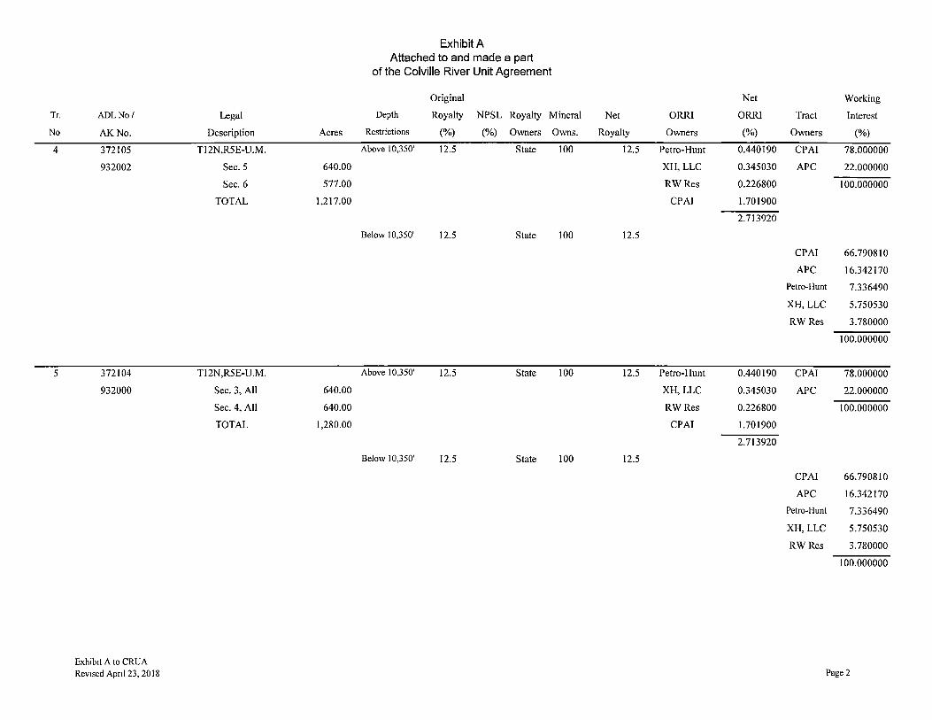
Tr.
No
4
5
ADLNo/
AK No.
372105
932002
372104
932000
Exhibit A to CRUA Revised Apnl 23, 2018
Legal
Description Acres
Tl 2N,R5E-U.M.
Sec. 5 640.00
Sec. 6 577.00
TOTAL 1,217.00
T12N,R5E-U.M.
Sec. 3, All 640.00
Sec. 4, All 640.00
TOTAL 1,280.00
Exhibit A Attached to and made a part
of the Colville River Unit Agreement
Original
Depth Royalty NPSL Royalty Mineral
Restrictions (%) (%) Owners Owns.
Above 10,350' 12.5 State 100
Below 10,350' 12.5 State 100
Above 10,350' 12.5 State 100
Below 10,350' 12.5 State 100
Net Working
Net ORRI ORRI Tract Interest
Royalty Owners (%) Owners (%)
12.5 Petro-Hunt 0.440190 CPAI 78.000000
XH,LLC 0.345030 APC 22.000000
RWRes 0.226800 100.000000
CPAI 1.701900
2.713920
12.5
CPAI 66.790810
APC 16.342170
Petro-Hunt 7.336490
XH, LLC 5.750530
RWRes 3.780000
100.000000
12.5 Petro-Hunt 0.440190 CPAI 78.000000
XH,LLC 0.345030 APC 22.000000
RWRes 0.226800 100.000000
CPAI 1.701900
2.713920
12.5
CPAI 66.790810
APC 16.342170
Petro-Hunt 7.336490
XH, LLC 5.750530
RWRes 3.780000
100.000000
Page2
Tr.
No
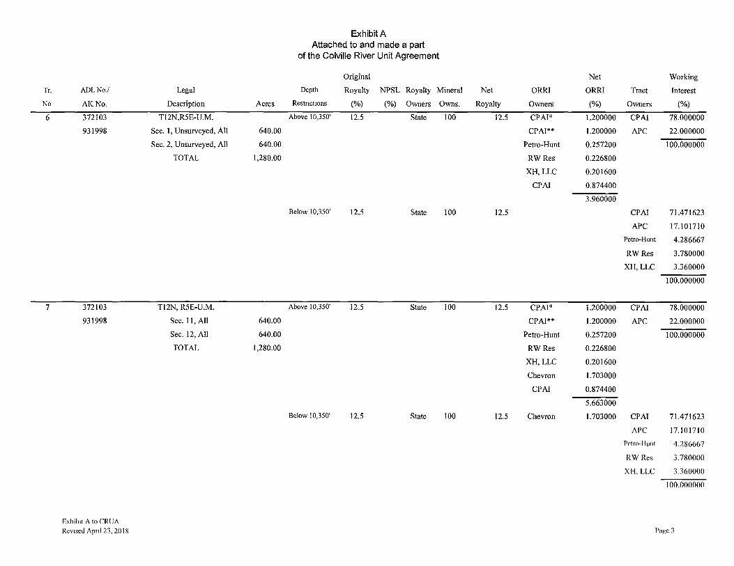
6
7
ADLNo./
AK No.
372103
931998
372103
931998
Exhibit A to CRUA Revised Apnl 23, 2018
Legal
Description Acres
Tl 2N,R5E-U.M.
Sec. 1, Unsurveyed, All 640.00
Sec. 2, Unsurveyed, All 640.00
TOTAL 1,280.00
Tl2N, R5E-U.M.
Sec. 11, All 640.00
Sec. 12, All 640.00
TOTAL 1,280.00
Exhibit A Attached to and made a part
of the Colville River Unit Agreement
Original
Depth Royalty NPSL Royalty Mineral
Restnct10ns (%) (%) Owners Owns.
Above 10,350' 12.5 State 100
Below 10,350' 12.5 State 100
Above 10,350' 12.5 State 100
Below 10,350' 12.5 State 100
Net Working
Net ORRI ORRI Tract Interest
Royalty Owners (%) Owners (%)
12.5 CPAI* 1.200000 CPAI 78.000000
CPAI** 1.200000 APC 22.000000
Petro-Hunt 0.257200 100.000000
RWRes 0.226800
XH, LLC 0.201600
CPAI 0.874400
3.960000
12.5 CPAI 71.471623
APC 17.101710
Petro-Hunt 4.286667
RWRes 3.780000
XH, LLC 3.360000
100.000000
12.5 CPA!* 1.200000 CPA! 78.000000
CPA!** 1.200000 APC 22.000000
Petro-Hunt 0.257200 100.000000
RWRes 0.226800
XH, LLC 0.201600
Chevron 1.703000
CPA! 0.874400
5.663000
12.5 Chevron 1.703000 CPAI 71.471623
APC 17.101710
Pctro-1 lunt 4.286667
RWRes 3.780000
XI-I, LLC 3.360000
100.000000
Page 3
Tr.
No.
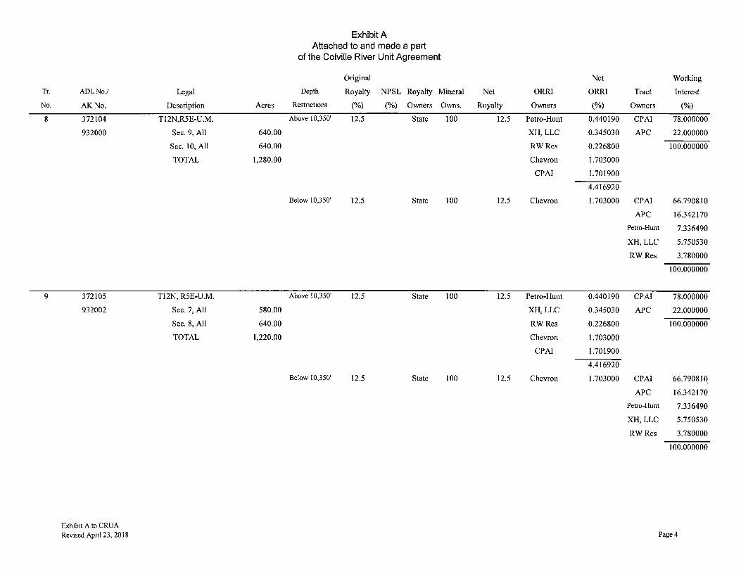
8
9
ADLNo./
AK.No.
372104
932000
372105
932002
Exh1b1t A to CRUA Revised Apnl 23, 2018
Legal
Description Acres
Tl2N,R5E-U.M.
Sec. 9, All 640.00
Sec. 10, All 640.00
TOTAL 1,280.00
T12N, R5E-U.M.
Sec. 7, All 580.00
Sec. 8, All 640.00
TOTAL 1,220.00
Exhibit A Attached to and made a part
of the Colville River Unit Agreement
Original
Depth Royalty NPSL Royalty Mineral
Restnct10ns (%) (%) Owners Owns.
Above 10,350' 12.5 State 100
Below 10,350' 12.5 State 100
Above 10,350' 12.5 State 100
Below 10,350' 12.5 State 100
Net Working
Net ORRI ORRI Tract Interest
Royalty Owners (%) Owners (%)
12.5 Petro-Hunt 0.440190 CPAI 78.000000
XH,LLC 0.345030 APC 22.000000
RWRes 0.226800 100.000000
Chevron 1.703000
CPAI 1.701900
4.416920
12.5 Chevron 1.703000 CPAI 66.790810
APC 16.342170
Petro-Hunt 7.336490
XH,LLC 5.750530
RWRes 3.780000
100.000000
12.5 Petro-Hunt 0.440190 CPAI 78.000000
XH,LLC 0.345030 APC 22.000000
RWRes 0.226800 100.000000
Chevron 1.703000
CPAI 1.701900
4.416920
12.5 Chevron 1.703000 CPAI 66.79081Q
APC 16.342170
Petro-Hunt 7.336490
XH, LLC 5.750530
RWRes 3.780000
100.000000
Page4
Tr.
No.
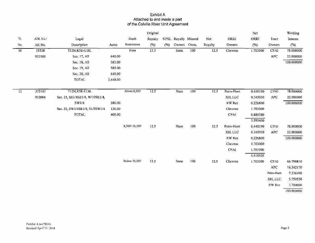
10
1 I
ADLNo./
AK No.
25538
932100
372107
932006
Exhibit A to CRUA
Revised Apnl 23, 2018
Legal
Description Acres
TI 2N,R5E-U.M.
Sec. 17, All 640.00
Sec. 18, All 583.00
Sec. 19, All 585.00
Sec. 20, All 640.00
TOTAL 2,448.00
T12N,R5E-U.M.
Sec. 21, SEl/4SEl/4, Wl/2SEI/4,
SWl/4 280.00
Sec. 22, SWl/4SE1/4, Sl/2SWl/4 120.00
TOTAL 400.00
Exhibit A Attached to and made a part
of the Colville River Unit Agreement
Original
Depth Royalty NPSL Royalty Mineral
Restrictions (%) (%) Owners Owns.
None 12.5 State 100
Above 8,500' 12.5 State 100
8,500'-l 0,350' 12.5 State 100
Below 10,350' 12.5 State 100
Net Working
Net ORRI ORRI Tract Interest
Royalty Owners (%) Owners (%)
12.5 Chevron 1.703000 CPA! 78.000000
APC 22.000000
100.000000
12.5 Petro-Hunt 0.440190 CPAI 78.000000
XH, LLC 0.345030 APC 22.000000
RWRes 0.226800 100.000000
Chevron 1.703000
CPAI 0.880380
3.595400
12.5 Petro-Hunt 0.440190 CPA! 78.000000
XH, LLC 0.345030 APC 22.000000
RWRes 0.226800 100.000000
Chevron 1.703000
CPA! 1.701900
4.416920
12.5 Chevron 1.703000 CPAI 66.790810
APC 16.342170
Petro-Hunt 7.336490
XH, LLC 5.750530
RWRes 3.780000
100.000000
Page 5
Tr.
No
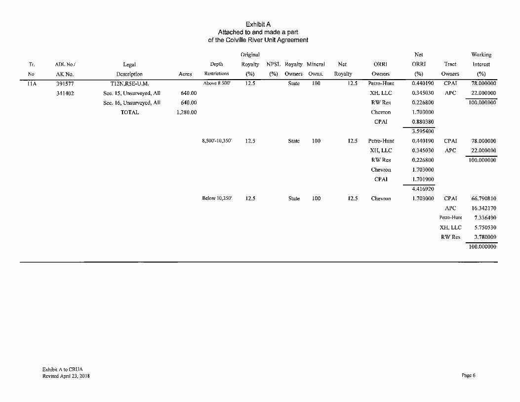
l lA
ADLNo./
AK No.
391577
341402
Exhibit A to CRUA Revised Apnl 23, 2018
Legal
Description Acres
Tl 2N,R5E-U .M.
Sec. 15, Unsurveyed, All 640.00
Sec. 16, Unsurveyed, All 640.00
TOTAL 1,280.00
Exhibit A Attached to and made a part
of the Colville River Unit Agreement
Original
Depth Royalty NPSL Royalty Mineral
Restrictions (%) (%) Owners Owns.
Above 8 500' 12.5 State 100
8,500'-10,350' 12.5 State 100
Below 10,350' 12.5 State 100
Net Working
Net ORRI ORRI Tract Interest
Royalty Owners (%) Owners (%)
12.5 Petro-Hunt 0.440190 CPAI 78.000000
XH,LLC 0.345030 APC 22.000000
RWRes 0.226800 100.000000
Chevron 1.703000
CPA! 0.880380
3.595400
12.5 Petro-Hunt 0.440190 CPA! 78.000000
XH,LLC 0.345030 APC 22.000000
RWRes 0.226800 100.000000
Chevron 1.703000
CPA! 1.701900
4.416920
12.5 Chevron 1.703000 CPA! 66.790810
APC 16.342170
Petro-Hunt 7.336490
XH, LLC 5.750530
RWRes 3.780000
100.000000
Page 6

Exhibit A Attached to and made a part
of the Colville River Unit Agreement
Original Net Working
Tr. ADLNo/ Legal Depth Royalty NPSL Royalty Mineral Net ORRI ORRI Tract Interest
No AK No. Description Acres Restrictions (%) (%) Owners Owns. Royalty Owners (%) Owners (%)
12 372106 T12N.R5E-U.M. Above 8,500' 12.5 State 100 12.5 CPAI* 1.515000 CPAI 78.000000
932004 Sec. 13, All 640.00 Petro-Hunt 0.324590 APC 22.000000
Sec. 14, All 640.00 XH,LLC 0.254430 100.000000
Sec. 23, All 640.00 RWRes 0.226800
TOTAL 1,920.00 Chevron 1.703000
CPAI 0.649180
6.188000
8,500'-10,350' 12.5 State 100 12.5 CPAI* 1.515000 CPAI 78.000000
Petro-Hunt 0.324590 APC 22.000000
XH,LLC 0.254430 100.000000
RWRes 0.226800
Chevron 1.703000
CPAI 1.255180
5.279000
Below 10,350' 12.5 State 100 12.5 Chevron 1.703000
CPAI 68.928524
APC 17.641213
Petro-Hunt 5.409868
XH,LLC 4.240395
RWRes 3.780000
100.000000
There is no Tract 13 14 25530 Tl 2N,R4E-U.M. None 12.5 State 51.97 6.49625 Chevron 1.703000 CPA! 78.000000
932098 Sec. 24, All 640.00 ASRC* 48.03 5.00375 Kuukpik Corp.* l.000000 APC 22.000000
TOTAL 640.00 11.5 2.703000 100.000000
15 25529 Tl 2N,R4E-U.M. None 12.5 State 50.05 6.25625 Chevron 1.703000 CPA! 78.000000
932096 Sec. 23, All 640.00 ASRC* 49.95 5.24375 Kuukpik Corp.* 1.000000 APC 22.000000
TOTAL 640.00 11.5 2.703000 100.000000 Exhtbtt A to CRUA Revised April 23, 20 I 8 Page 7
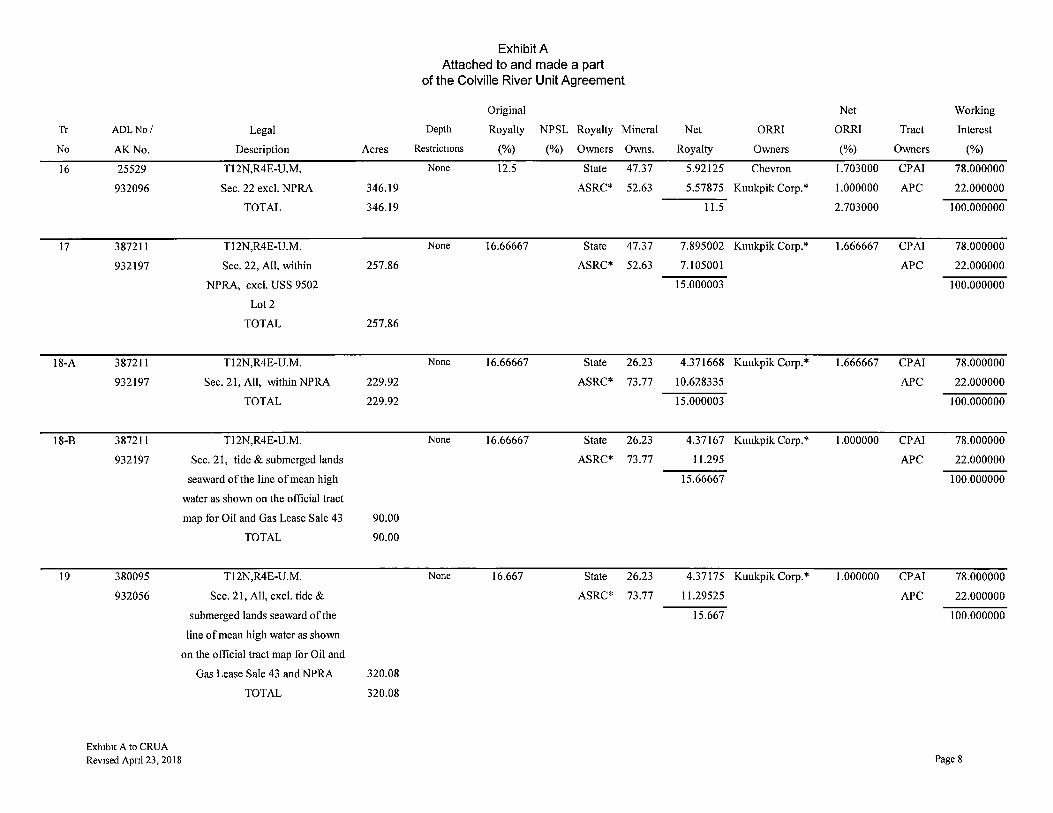
Tr
No
16
17
18-A
18-B
19
ADLNo/ Legal
AK No. Description
25529 Tl 2N,R4E-U.M.
932096 Sec. 22 excl. NPRA
TOTAL
387211 Tl 2N,R4E-U.M.
932197 Sec. 22, All, within
NPRA, excl. USS 9502
Lot2
TOTAL
387211 T12N,R4E-U.M.
932197 Sec. 21, All, within NPRA
TOTAL
387211 T12N,R4E-U.M.
932197 Sec. 21, tide & submerged lands
seaward of the line of mean high
water as shown on the official tract
map for Oil and Gas Lease Sale 43
TOTAL
380095 T12N,R4E-U.M.
932056 Sec. 21, All, excl. tide &
submerged lands seaward of the
line of mean high water as shown
on the official tract map for Oil and
Exh1b1t A to CRUA Revised Apnl 23, 2018
Gas Lease Sale 43 and NPRA
TOTAL
Acres
346.19
346.19
257.86
257.86
229.92
229.92
90.00
90.00
320.08
320.08
Exhibit A Attached to and made a part
of the Colville River Unit Agreement
Original Net Working
Depth Royalty NPSL Royalty Mineral Net ORRI ORRI Tract Interest
Restrictions (%) (%) Owners Owns. Royalty Owners (%) Owners (%)
None 12.5 State 47.37 5.92125 Chevron 1.703000 CPAI 78.000000
ASRC* 52.63 5.57875 Kuukpik Corp.* 1.000000 APC 22.000000
11.5 2.703000 100.000000
None 16.66667 State 47.37 7.895002 Kuukpik Corp.* 1.666667 CPAI 78.000000
ASRC* 52.63 7.105001 APC 22.000000
15.000003 100.000000
None 16.66667 State 26.23 4.371668 Kuukpik Corp.* 1.666667 CPAI 78.000000
ASRC* 73.77 10.628335 APC 22.000000
15.000003 100.000000
None 16.66667 State 26.23 4.37167 Kuukpik Corp.* 1.000000 CPAI 78.000000
ASRC* 73.77 11.295 APC 22.000000
15.66667 100.000000
None 16.667 State 26.23 4.37175 Kuukpik Corp.* 1.000000 CPAI 78.000000
ASRC* 73.77 11.29525 APC 22.000000
15.667 100.000000
Page 8
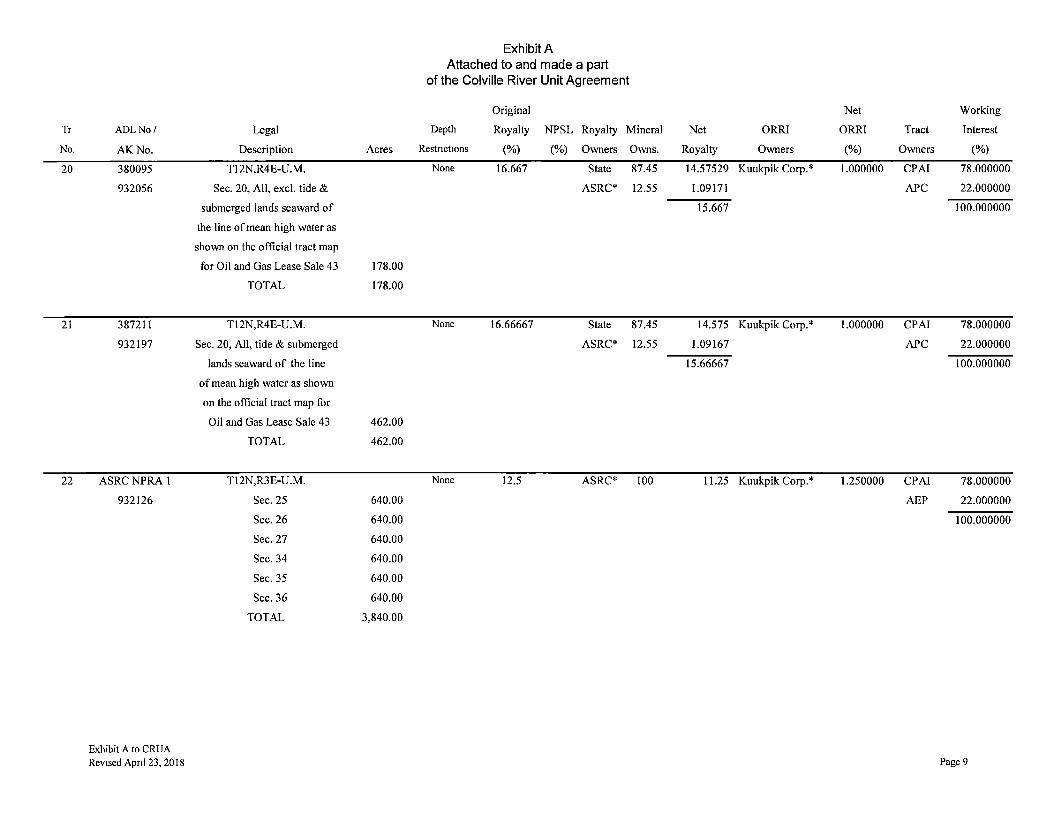
Tr
No.
20
21
22
ADLNo/
AK No.
380095
932056
387211
932197
ASRCNPRA l
932126
Exhibit A to CRUA Revised Apnl 23, 2018
Legal
Description
Tl2N,R4E-U.M.
Sec. 20, All, excl. tide &
submerged lands seaward of
the line of mean high water as
shown on the official tract map
for Oil and Gas Lease Sale 43
TOTAL
Tl2N,R4E-U.M.
Sec. 20, All, tide & submerged
lands seaward of the line
of mean high water as shown
on the official tract map for
Oil and Gas Lease Sale 43
TOTAL
Tl2N,R3E-U.M.
Sec. 25
Sec.26
Sec.27
Sec.34
Sec.35
Sec.36
TOTAL
Exhibit A Attached to and made a part
of the Colville River Unit Agreement
Original
Depth Royalty NPSL Royalty Mineral
Acres Restnct10ns (%) (%) Owners Owns.
None 16.667 State 87.45
ASRC* 12.55
178.00
178.00
None 16.66667 State 87.45
ASRC* 12.55
462.00
462.00
None 12.5 ASRC* 100
640.00
640.00
640.00
640.00
640.00
640.00
3,840.00
Net Working
Net ORRI ORRI Tract Interest
Royalty Owners (%) Owners (%)
14.57529 Kuukpik Corp.* 1.000000 CPAI 78.000000
1.09171 APC 22.000000
15.667 100.000000
14.575 Kuukpik Corp.* 1.000000 CPAI 78.000000
1.09167 APC 22.000000
15.66667 100.000000
11.25 Kuukpik Corp.* 1.250000 CPAI 78.000000
AEP 22.000000
100.000000
Page 9

Tr.
No
23
24
25
26
ADLNo./
AK No.
ASRCNPRA2
932128
387212
932199
25530
932098
387212
932199
Exhtbtt A to CRUA
Revised Apnl 23, 2018
Legal
Description Acres
Tl2N,R4E-U.M.
Sec.28 565.98
Sec. 29 402.79
Sec.30 321.28
Sec. 31 541.00
Sec.32 534.95
Sec. 33 640.00
Tl IN,R4E-U.M.
Sec. 4 640.00
Sec.5 640.00
Sec. 7 593.24
Sec. 8 640.00
Sec.9 640.00
Sec.21 640.00
TOTAL 6,799.24
Tl2N,R4E-U.M.
Sec. 27, All, within NPRA 550.29
TOTAL 550.29
Tl2N,R4E-U.M.
Sec. 27, All, excl. NPRA 89.71
TOTAL 89.71
Tl2N,R4E-U.M.
Sec. 26, All, within NPRA 17.36
TOTAL 17.36
Exhibit A Attached to and made a part
of the Colville River Unit Agreement
Original Net Working
Depth Royalty NPSL Royalty Mineral Net ORRI ORR! Tract Interest
Restric!Ions (%) (%) Owners Owns. Royalty Owners (%) Owners (%)
None 16.667 ASRC* 100 15 Kuukpik Corp.* 1.666700 CPAI 78.000000
AEP 22.000000
100.000000
None Sliding State 8 1.333334 Kuukpik Corp.* **1.666667 CPAI 78.000000
Scale ASRC* 92 **13.666669 APC 22.000000
**16.66667 15.000003 100.000000
None 12.5 State 8 1.000000 Chevron 1.703000 CPAI 78.000000
ASRC* 92 10.500000 Kuukpik Corp.* 1.000000 APC 22.000000
11.500000 2.703000 100.000000
None Sliding State 60.18 10.030002 Kuukpik Corp.* **1.666667 CPAI 78.000000
Scale ASRC* 39.82 **4.970001 APC 22.000000
**16.66667 15.000003 100.000000
Page 10

Exhibit A Attached to and made a part
of the Colville River Unit Agreement
Original Net Working
Tr. ADLNo./ Legal Depth Royalty NPSL Royalty Mineral Net ORR! ORRI Tract Interest
No. AK.No. Description Acres Restrictions (%) (%) Owners Owns. Royalty Owners (%) Owners (%)
27 25530 Tl2N,R4E-U.M. None 12.5 State 60.18 7.522500 Chevron 1.703000 CPAI 78.000000
932098 Sec. 26, All, excl. NPRA 622.64 ASRC* 39.82 3.977500 Kuukpik Corp.* 1.000000 APC 22.000000
TOTAL 622.64 11.500000 2.703000 100.000000
28 25530 Tl2N,R4E-U.M. None 12.5 State 55.79 6.973750 Chevron 1.703000 CPAI 78.000000
932098 Sec. 25, All 640.00 ASRC* 44.21 4.526250 Kuukpik Corp.* 1.000000 APC 22.000000
TOTAL 640.00 11.500000 2.703000 100.000000
29 25558 Tl2N-R5E,U.M. None 12.5 State 100 12.5 Chevron 1.703000 CPAI 78.000000
932102 Sec. 29, All 640.00 APC 22.000000
Sec. 30, All 588.00 100.000000
Sec. 31, All 591.00
Sec. 32, All 640.00
TOTAL 2,459.00
30 25557 Tl2N-R5E,U.M. None 12.5 State 100 12.5 Chevron 1.703000 CPAI 78.000000
932106 Sec. 27, All 640.00 APC 22.000000
Sec. 28, All 640.00 100.000000
Sec. 33, All 640.00
Sec. 34, All 640.00
TOTAL 2,560.00
31 372108 T12N,R5E-U.M. Above 8,500' 12.5 State 100 12.5 CPAI* 1.515000 CPAl 78.000000
932008 Sec. 26, NW1/4NW1/4, Petro-Hunt 0.324590 APC 22.000000
Sl/2 NWI/4, SWl/4, Wl/2SE1/4, 360.00 XH, LLC 0.254430 100.000000
TOTAL 360.00 RWR.cs 0.226800
Chevron 1.703000
CPAI 0.649180
4.673000 Exh1b1l A lo CRUA Revised Apnl 23, 2018 Page 11
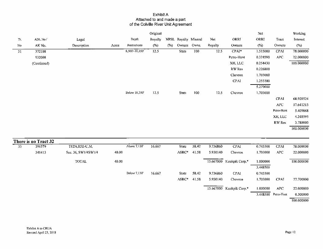
Tr. ADLNo/
No. AK.No.
31 372I08
932008
(Continued)
There is no Tract 32 33 391579
341413
Exhibit A to CRUA Revised April 23, 20 I 8
Legal
Description Acres
Tl 2N,R5E-U .M.
Sec. 36, SW1/4SW1/4 40.00
TOTAL 40.00
Exhibit A Attached to and made a part
of the Colville River Unit Agreement
Original
Depth Royalty NPSL Royalty Mineral
Restnct1ons (%) (%) Owners Owns.
8,500'-l 0,350' 12.5 State JOO
Below 10,350' 12.5 State 100
Above 7,130' 16.667 State 58.42
ASRC* 41.58
Below 7, 130' 16.667 State 58.42
ASRC* 41.58
Net Working
Net ORRI ORRI Tract Interest
Royalty Owners (%) Owners (%)
12.5 CPAI* 1.515000 CPAI 78.000000
Petro-Hunt 0.324590 APC 22.000000
XH, LLC 0.254430 l00.000000
RWRes 0.226800
Chevron 1.703000
CPAI 1.255180
5.279000
12.5 Chevron 1.703000
CPAI 68.928524
APC 17.641213
Petro-Hunt 5.409868
XH, LLC 4.240395
RWRes 3.780000
l00.000000
9.736860 CPAI 0.745500 CPAI 78.000000
5.930140 Chevron 1.703000 APC 22.000000
15.667000 Kuukpik Corp.* 1.000000 l00.000000
3.448500
9.736860 CPAI 0.745500
5.930140 Chevron 1.703000 CPAI 77.700000
15.667000 Kuukpik Corp.* 1.000000 APC 22.000000
3.448500 Petro-Hunt 0.300000
100.000000
Page 12
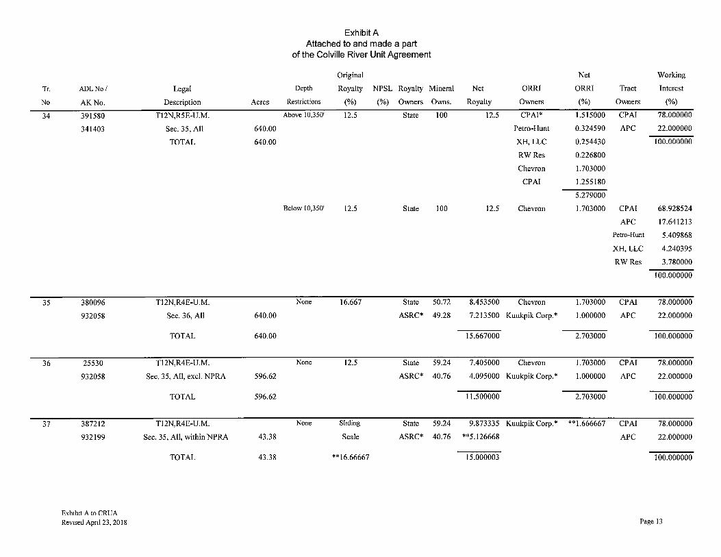
Tr.
No.
34
35
36
37
ADLNo/
AK No.
391580
341403
380096
932058
25530
932058
387212
932199
Exh1b1t A to CRUA Revised Apnl 23, 20 I 8
Legal
Description Acres
Tl 2N,R5E-U.M.
Sec. 35, All 640.00
TOTAL 640.00
Tl2N,R4E-U.M.
Sec. 36, All 640.00
TOTAL 640.00
Tl 2N,R4E-U.M.
Sec. 35, All, excl. NPRA 596.62
TOTAL 596.62
Tl2N,R4E-U.M.
Sec. 35, All, within NPRA 43.38
TOTAL 43.38
Exhibit A Attached to and made a part
of the Colville River Unit Agreement
Original
Depth Royalty NPSL Royalty Mineral
Restrictions (%) (%) Owners Owns.
Above 10,350' 12.5 State 100
Below 10,350' 12.5 State 100
None 16.667 State 50.72
ASRC* 49.28
None 12.5 State 59.24
ASRC* 40.76
None Sltding State 59.24
Scale ASRC* 40.76
**16.66667
Net Working
Net ORRI ORRI Tract Interest
Royalty Owners (%) Owners (%)
12.5 CPAI* 1.515000 CPAI 78.000000
Petro-Hunt 0.324590 APC 22.000000
XH,LLC 0.254430 100.000000
RWRes 0.226800
Chevron 1.703000
CPAI 1.255180
5.279000
12.5 Chevron 1.703000 CPAI 68.928524
APC 17.641213
Petro-Hunt 5.409868
XH, LLC 4.240395
RWRes 3.780000
100.000000
8.453500 Chevron 1.703000 CPA! 78.000000
7.213500 Kuukpik Corp.* 1.000000 APC 22.000000
15.667000 2.703000 100.000000
7.405000 Chevron 1.703000 CPA! 78.000000
4.095000 Kuukpik Corp.* 1.000000 APC 22.000000
11.500000 2.703000 100.000000
9.873335 Kuukpik Corp.* **1.666667 CPAI 78.000000
**5.126668 APC 22.000000
15.000003 100.000000
Page 13
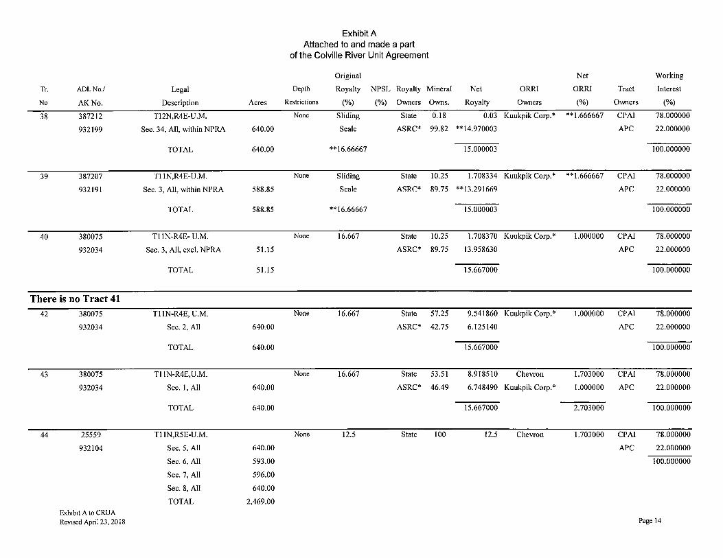
Exhibit A Attached to and made a part
of the Colville River Unit Agreement
Original Net Working
Tr. ADLNo./ Legal Depth Royalty NPSL Royalty Mineral Net ORRI ORRI Tract Interest
No AK No. Description Acres Restrictions (%) (%) Owners Owns. Royalty Owners (%) Owners (%)
38 387212 T12N,R4E-U.M. None Sliding State 0.18 0.03 Kuukpik Corp.* **1.666667 CPAI 78.000000
932199 Sec. 34, All, within NPRA 640.00 Scale ASRC* 99.82 **14.970003 APC 22.000000
TOTAL 640.00 **16.66667 15.000003 100.000000
39 387207 Tl 1N,R4E-U.M. None Sliding State 10.25 1.708334 Kuukpik Corp.* **1.666667 CPAI 78.000000
932191 Sec. 3, All, within NPRA 588.85 Scale ASRC* 89.75 **13.291669 APC 22.000000
TOTAL 588.85 **16.66667 15.000003 100.000000
40 380075 Tl 1N-R4E- U.M. None 16.667 State 10.25 1.708370 Kuukpik Corp.* 1.000000 CPAI 78.000000
932034 Sec. 3, All, excl. NPRA 51.15 ASRC* 89.75 13.958630 APC 22.000000
TOTAL 51.15 15.667000 100.000000
There is no Tract 41 42 380075 Tl lN-R4E, U.M. None 16.667 State 57.25 9.541860 Kuukpik Corp.* 1.000000 CPAI 78.000000
932034 Sec. 2, All 640.00 ASRC* 42.75 6.125140 APC 22.000000
TOTAL 640.00 15.667000 100.000000
43 380075 Tl 1N-R4E,U.M. None 16.667 State 53.51 8.918510 Chevron 1.703000 CPAI 78.000000
932034 Sec. 1, All 640.00 ASRC* 46.49 6.748490 Kuukpik Corp.* 1.000000 APC 22.000000
TOTAL 640.00 15.667000 2.703000 100.000000
44 25559 Tl lN,RSE-U.M. None 12.5 State 100 12.5 Chevron 1.703000 CPAI 78.000000
932104 Sec. 5, All 640.00 APC 22.000000
Sec. 6, All 593.00 100.000000
Sec. 7, All 596.00
Sec. 8, All 640.00
TOTAL 2,469.00
Exh1b1t A to CRUA Revised April 23, 2018 Page 14

Exhibit A Attached to and made a part
of the Colville River Unit Agreement
Original Net Working
Tr ADLNo./ Legal Depth Royalty NPSL Royalty Mineral Net ORRI ORRI Tract Interest
No. AKNo. Description Acres Restrict10ns (%) (%) Owners Owns. Royalty Owners (%) Owners (%)
45 372095 Tl 1N,R5E-U.M. Above I 0,350' 12.5 State 100 12.5 CPAI* 1.515000 CPAI 78.000000
931992 Sec. 3, All 640.00 Petro-Hunt 0.324590 APC 22.000000
Sec. 4, All 640.00 XH, LLC 0.254430 100.000000
Sec. 9, All 640.00 RWRes 0.226800
Sec. 10, All 640.00 Chevron 1.703000
TOTAL 2,560.00 CPAI 1.255180
5.279000
Below 10,350' 12.5 State 100 12.5 Chevron 1.703000 CPAI 68.928524
APC 17.641213
Petro-Hunt 5.409868
XH, LLC 4.240395
RWRes 3.780000
100.000000
46 25560 Tl 1N,R5E-U.M. None 12.5 State 100 12.5 Chevron 1.703000 CPAI 78.000000
932108 Sec. 2, All 640.00 APC 22.000000
TOTAL 640.00 100.000000
47 391581 Tl 1N,R5E-U.M. None 12.5 State 63.69 7.961250 Chevron 1.703000 CPA! 78.000000
341400 Sec. 1, Wl/2Wl/2 160.00 ASRC* 36.31 3.538750 Kuukpik Corp.* 1.000000 APC 22.000000
TOTAL 160.00 11.500000 2.703000 100.000000
There is no Tract 48 49 25560 Tl 1N,R5E-U.M. None 12.5 State 57.68 7.210000 Chevron 1.703000 CPAI 78.000000
932108 Sec. 11, All 640.00 ASRC* 42.32 4.290000 Kuukpik Corp.* 1.000000 APC 22.000000
TOTAL 640.00 11.500000 2.703000 100.000000
50 380075 Tl 1N-R4E, U.M. None 16.667 State 76.87 12.811920 Chevron 1.703000 CPAI 78.000000
932034 Sec. 12, All 640.00 ASRC* 23.13 2.855080 Kuukpik Corp.* 1.000000 APC 22.000000
TOTAL 640.00 15.667000 2.703000 100.000000 Exhibit A to CRUA Revised Apnl 23, 2018 Page 15
Tr.
No
51
52
53
54
55
56
57
AOL No/
AK.No.
380075
932034
387207
932191
380075
932034
387207
932191
387208
932193
380075
932034
387208
932193
Exhibit A to CRUA Revised Apnl 23, 2018
Legal
Description Acres
Tl 1N-R4E, U.M.
Sec. 11, All, excl. NPRA 594.02
TOTAL 594.02
Tl 1N,R4E-U.M.
Sec. 11, All, within NPRA 45.98
TOTAL 45.98
Tl 1N-R4E, U.M.
Sec. 10, All, excl. NPRA 5.83
TOTAL 5.83
Tl IN-R4E-U.M.
Sec. 10, All, within NPRA 634.17
TOTAL 634.17
Tl 1N-R4E-U.M.
Sec. 16, All, within NPRA 630.47
TOTAL 630.47
Tl IN-R4E, U.M.
Sec. 16, All, excl. NPRA 9.53
TOTAL 9.53
Tl IN-R4E-U.M.
Sec. 15, All, within NPRA 103.94
TOTAL 103.94
Exhibit A Attached to and made a part
of the Colville River Unit Agreement
Original Net Working
Depth Royalty NPSL Royalty Mineral Net ORRI ORRI Tract Interest
Restrict10ns (%) (%) Owners Owns. Royalty Owners (%) Owners (%)
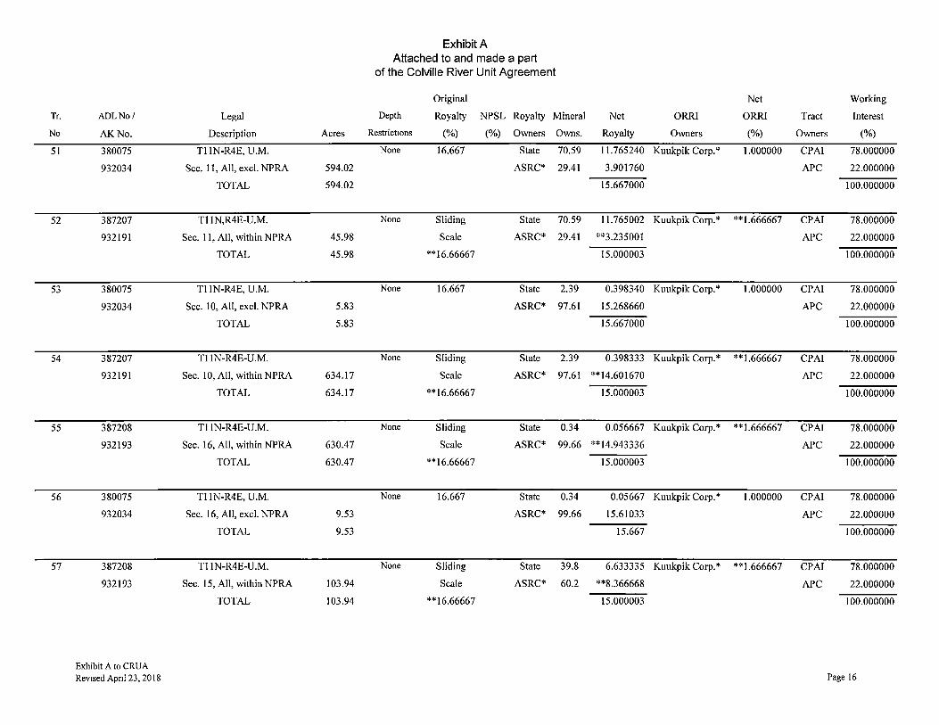
None 16.667 State 70.59 11.765240 Kuukpik Corp.* 1.000000 CPAI 78.000000
ASRC* 29.41 3.901760 APC 22.000000
15.667000 100.000000
None Sliding State 70.59 11.765002 Kuukpik Corp.* **1.666667 CPAI 78.000000
Scale ASRC* 29.41 **3.235001 APC 22.000000
**16.66667 15.000003 100.000000
None 16.667 State 2.39 0.398340 Kuukpik Corp.* 1.000000 CPAI 78.000000
ASRC* 97.61 15.268660 APC 22.000000
15.667000 100.000000
None Sliding State 2.39 0.398333 Kuukpik Corp.* **1.666667 CPAI 78.000000
Scale ASRC* 97.61 **14.601670 APC 22.000000
**16.66667 15.000003 100.000000
None Sliding State 0.34 0.056667 Kuukpik Corp.* **1.666667 CPAI 78.000000
Scale ASRC* 99.66 **14.943336 APC 22.000000
**16.66667 15.000003 100.000000
None 16.667 State 0.34 0.05667 Kuukpik Corp.* 1.000000 CPAI 78.000000
ASRC* 99.66 15.61033 APC 22.000000
15.667 100.000000
None Sliding State 39.8 6.633335 Kuukpik Corp.* **1.666667 CPAI 78.000000
Scale ASRC* 60.2 **8.366668 APC 22.000000
**16.66667 15.000003 100.000000
Page 16
Tr
No.
58
59
60
61
ADLNo/
AK No.
380075
932034
380075
932034
380075
932034
372097
931996
Exhibit A to CRUA
Revised Apnl 23, 2018
Legal
Description Acres
Tl IN-R4E, U.M.
Sec. 15, All, excl. NPRA 536.06
TOTAL 536.06
Tl IN-R4E, U.M.
Sec. 14, All 640.00
TOTAL 640.00
Tl IN-R4E, U.M.
Sec. 13, All 640.00
TOTAL 640.00
Tl 1N,R5E-U.M.
Sec. I 7, All 640.00
Sec. 18, All 599.00
TOTAL 1,239.00
Exhibit A Attached to and made a part
of the Colville River Unit Agreement
Original
Depth Royalty NPSL Royalty Mineral
Restrictions (%) (%) Owners Owns.
None 16.667 State 39.8
ASRC* 60.2
None 16.667 State 53.63
ASRC* 46.37
None 16.667 State 67.55
ASRC* 32.45
Above 10,350' 12.5 State 100.00
Below 10,350' 12.5 State 100.00
Net Working
Net ORRI ORRI Tract Interest
Royalty Owners (%) Owners (%)
6.633470 Kuukpik Corp.* 1.000000 CPAI 78.000000
9.033530 APC 22.000000
15.667000 100.000000
8.938510 Kuukpik Corp.* 1.000000 CPAI 78.000000
6.728490 APC 22.000000
15.667000 100.000000
I 1.258560 Kuukpik Corp.* 1.000000 CPAI 78.000000
4.408440 APC 22.000000
15.667000 100.000000
12.50000 CPAI* 1.515000 CPAI 78.000000
Petro-Hunt 0.324590 APC 22.000000
XH, LLC 0.254430 100.000000
RWRes 0.226800
Chevron 1.703000
CPAI 1.255180
5.279000
12.500000 Chevron 1.703000
CPAI 68.928524
APC 17.641213
Petro-Hunt 5.409868
XH, LLC 4.240395
RWRcs 3.780000
100.000000
Page 17
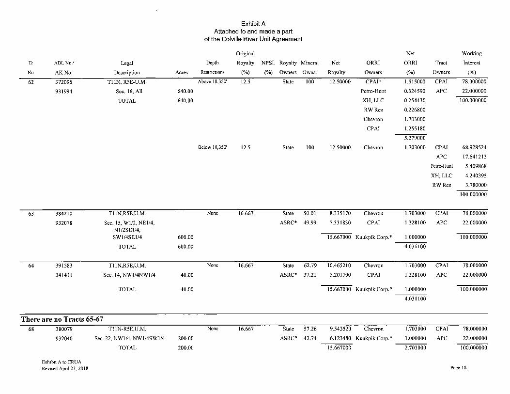
Exhibit A Attached to and made a part
of the Colville River Unit Agreement
Original Net Working
Tr ADLNo/ Legal Depth Royalty NPSL Royalty Mineral Net ORRI ORRI Tract Interest
No AK No. Description Acres Restnct10ns (%) (%) Owners Owns. Royalty Owners (%) Owners (%)
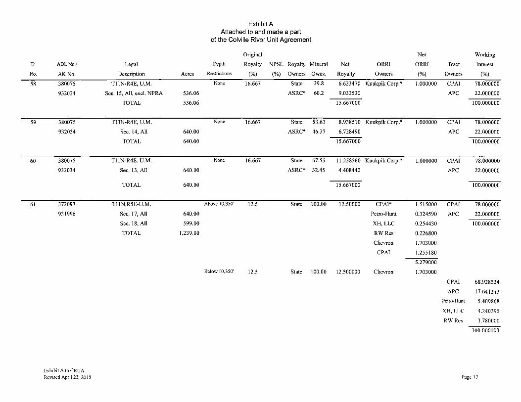
62 372096 Tl IN, R5E-U.M. Above 10,350' 12.5 State 100 12.50000 CPA!* 1.515000 CPAI 78.000000
931994 Sec. 16, All 640.00 Petro-Hunt 0.324590 APC 22.000000
TOTAL 640.00 XH, LLC 0.254430 100.000000
RWRes 0.226800
Chevron 1.703000
CPAI 1.255180
5.279000
Below 10,350' 12.5 State 100 12.50000 Chevron 1.703000 CPAI 68.928524
APC 17.641213
Petro-Hunt 5.409868
XH,LLC 4.240395
RWRes 3.780000
100.000000
63 384210 Tl IN,R5E,U.M. None 16.667 State 50.01 8.335170 Chevron 1.703000 CPA! 78.000000
932078 Sec. 15, Wl/2, NEl/4, ASRC* 49.99 7.331830 CPAI 1.328100 APC 22.000000 Nl/2SEl/4, SWl/4SEl/4 600.00 15.667000 Kuukpik Corp.* 1.000000 100.000000
TOTAL 600.00 4.031100
64 391583 Tl IN,R5E,U.M. None 16.667 State 62.79 I 0.4652 I 0 Chevron 1.703000 CPA! 78.000000
341411 Sec. 14, NWl/4NWl/4 40.00 ASRC* 37.21 5.201790 CPA! 1.328100 APC 22.000000
TOTAL 40.00 15.667000 Kuukpik Corp.* 1.000000 100.000000
4.031100
There are no Tracts 65-67 68 380079 Tl IN-R5E,U.M. None 16.667 State 57.26 9.543520 Chevron 1.703000 CPA! 78.000000
932040 Sec. 22, NWl/4, NWl/4SWl/4 200.00 ASRC* 42.74 6.123480 Kuukpik Corp.* 1.000000 APC 22.000000
TOTAL 200.00 15.667000 2.703000 100.000000
Exh1b1t A to CRUA Revised Apnl 23, 2018 Page 18
Tr.
No
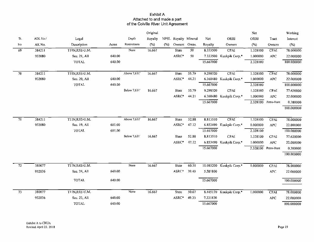
69
70
71
72
73
ADLNo/
AK No.
384211
932080
384211
932080
384211
932080
380077
932036
380077
932036
Exh1b1t A to CRUA Revised April 23, 2018
Legal
Description Acres
Tl 1N,R5E-U.M.
Sec.21,All 640.00
TOTAL 640.00
Tl 1N,R5E-U.M.
Sec. 20, All 640.00
TOTAL 640.00
Tl IN,R5E-U.M.
Sec. 19, All 601.00
TOTAL 601.00
Tl 1N,R4E-U.M.
Sec. 24, All 640.00
TOTAL 640.00
Tl IN,R4E-U.M.
Sec. 23, All 640.00
TOTAL 640.00
Exhibit A Attached to and made a part
of the Colville River Unit Agreement
Original
Depth Royalty NPSL Royalty Mineral
Restnct10ns (%) (%) Owners Owns.
None 16.667 State 50
ASRC* 50
Above 7,631' 16.667 State 55.79
ASRC* 44.21
Below 7,631' 16.667 State 55.79
ASRC* 44.21
Above 7,631' 16.667 State 52.88
ASRC* 47.12
Below 7,631' 16.667 State 52.88
ASRC* 47.12
None 16.667 State 60.51
ASRC* 39.49
None 16.667 State 50.67
ASRC* 49.33
Net Working
Net ORRI ORRI Tract Interest
Royalty Owners (%) Owners (%)
8.333500 CPAI 1.328100 CPAI 78.000000
7.333500 Kuukpik Corp.* 1.000000 APC 22.000000
15.667000 2.328100 100.000000
9.298520 CPAI 1.328100 CPAI 78.000000
6.368480 Kuukpik Corp.* 1.000000 APC 22.000000
15.667000 2.328100 100.000000
9.298520 CPAI 1.328100 CPAI 77.620000
6.368480 Kuukpik Corp.* 1.000000 APC 22.000000
15.667000 2.328100 Petro-Hunt 0.380000
100.000000
8.813510 CPAI 1.328100 CPAI 78.000000
6.853490 Kuukpik Corp.* 1.000000 APC 22.000000
15.667000 2.328100 100.000000
8.813510 CPAI 1.328100 CPAI 77.620000
6.853490 Kuukpik Corp.* 1.000000 APC 22.000000
15.667000 2.328100 Petro-Hunt 0.380000
100.000000
10.085200 Kuukpik Corp.* 1.000000 CPA! 78.000000
5.581800 APC 22.000000
15.667000 100.000000
8.445170 Kuukpik Corp.* 1.000000 CPAI 78.000000
7.221830 APC 22.000000
15.667000 100.000000
Page 19

Tr.
No
74
75
76
77
78
79
80
ADLNo/
AK No.
380077
932036
387208
932193
387209
932195
380077
932036
387209
932195
380077
932036
384209
932076
Exhibit A to CRUA Revised Apnl 23, 2018
Legal
Description Acres
Tl 1N,R4E-U.M.
Sec. 22, All, excl. NPRA 228.74
TOTAL 228.74
Tl IN,R4E-U.M.
Sec. 22, All, within NPRA 411.26
TOTAL 411.26
Tl 1N,R4E-U.M.
Sec. 27, All, within NPRA 614.70
TOTAL 614.70
Tl 1N,R4E-U.M.
Sec. 27, All, excl. NPRA 25.30
TOTAL 25.30
Tl 1N,R4E-U.M.
Sec. 26, All, within NPRA 25.23
TOTAL 25.23
Tl IN,R4E-U.M.
Sec. 26, All, excl. NPRA 614.77
TOTAL 614.77
Tl 1N-R4E,U.M.
Sec. 25, All 640.00
TOTAL 640.00
Exhibit A Attached to and made a part
of the Colville River Unit Agreement
Original
Depth Royalty NPSL Royalty Mineral
Restnc!Ions (%) (%) Owners Owns.
None 16.667 State 21.35
ASRC* 78.65
None Sliding State 21.35
Scale ASRC* 78.65
**16.66667
None Sliding State 2.6
Scale ASRC* 97.4
**16.66667
None 16.667 State 2.6
ASRC* 97.4
None Sliding State 48.75
Scale ASRC** 51.25
**16.66667
None 16.667 State 48.75
ASRC* 51.25
None 16.667 State 63.41
ASRC* 36.59
Net Working
Net ORR! ORR! Tract Interest
Royalty Owners (%) Owners (%)
3.558400 Kuukpik Corp.* 1.000000 CPAI 78.000000
12.108600 APC 22.000000
15.667000 100.000000
3.558334 Kuukpik Corp.* **1.666667 CPAI 78.000000
**l 1.441669 APC 22.000000
15.000003 100.000000
0.433333 Kuukpik Corp.* **1.666667 CPAI 78.000000
**14.56667 APC 22.000000
15.000003 100.000000
0.433340 Kuukpik Corp.* 1.000000 CPAI 78.000000
15.233660 APC 22.000000
15.667000 100.000000
8.125002 Kuukpik Corp.** **1.666667 CPAI 78.000000
**6.875001 APC 22.000000
15.000003 100.000000
8.125160 Kuukpik Corp.* 1.000000 CPAI 78.000000
7.541840 APC 22.000000
15.667000 100.000000
10.568545 CPAI 1.328100 CPAI 78.000000
4.098455 Kuukpik Corp.* 1.000000 APC 22.000000
14.667000 2.328100 100.000000
Page 20
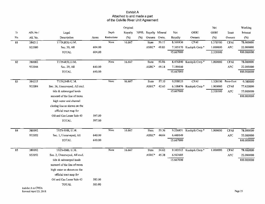
Exhibit A Attached to and made a part
of the Colville River Unit Agreement
Original Net Working
Tr ADLNo/ Legal Depth Royalty NPSL Royalty Mineral Net ORRI ORRI Tract Interest
No. AK No. Description Acres Restnctions (%) (%) Owners Owns. Royalty Owners (%} Owners (%)
81 384211 Tl 1N,R5E-U.M. None 16.667 State 50.17 8.361830 CPAI 1.328100 CPA! 78.000000
932080 Sec. 30, All 604.00 ASRC* 49.83 7.305170 Kuukpik Corp.* 1.000000 APC 22.000000
TOTAL 604.00 15.667000 2.328100 100.000000
82 380082 Tl 1N-R5E,U.M. None 16.667 State 50.86 8.476840 Kuukpik Corp.* 1.000000 CPAI 78.000000
932046 Sec. 29, All 640.00 ASRC* 49.14 7.190160 APC 22.000000
TOTAL 640.00 15.667000 100.000000
83 384215 Tl3N,R4E-U.M. None 16.667 State 57.35 9.558525 CPAI 1.328100 Petro-Hunt 0.380000
932084 Sec. 36, Unsurveyed, All excl. ASRC* 42.65 6.108476 Kuukpik Corp.* 1.000000 CPAI 77.620000
tide & submerged lands 15.667000 2.328100 APC 22.000000
seaward of the line of mean 100.000000
high water and channel
closing line as shown on the
official tract map for
Oil and Gas Lease Sale 43 597.00
TOTAL 597.00
84 380092 Tl2N-R4E, U.M. None 16.667 State 55.36 9.226851 Kuukpik Corp.* 1.000000 CPAI 78.000000
932052 Sec. 1, Unsurveyed, All 640.00 ASRC* 44.64 6.440149 APC 22.000000
TOTAL 640.00 15.667000 100.000000
85 380092 Tl2N-R4E, U.M. None 16.667 State 54.62 9.103515 Kuukpik Corp.* 1.000000 CPAI 78.000000
932052 Sec. 2, Unsurveyed, All excl. ASRC* 45.38 6.563485 APC 22.000000
tide & submerged lands 15.667000 100.000000
seaward of the line of mean
high water as shown on the
official tract map for
Oil and Gas Lease Sale 43 583.00
TOTAL 583.00 Exh1b1t A to CRUA Revised Apnl 23, 2018 Page 21
Tr.
No
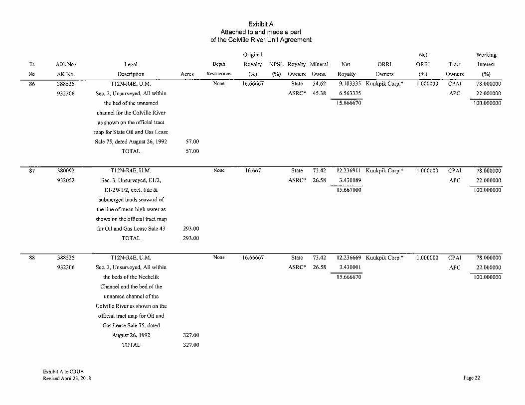
86
87
88
ADLNo/
AK No.
388525
932306
380092
932052
388525
932306
Exhibit A to CRUA Revised Apnl 23, 2018
Legal
Description Acres
T12N-R4E, U.M.
Sec. 2, Unsurveyed, All within
the bed of the unnamed
channel for the Colville River
as shown on the official tract
map for State Oil and Gas Lease
Sale 75, dated August 26, 1992 57.00
TOTAL 57.00
T12N-R4E, U.M.
Sec. 3, Unsurveyed, El/2,
El/2Wl/2, excl. tide &
submerged lands seaward of
the line of mean high water as
shown on the official tract map
for Oil and Gas Lease Sale 43 293.00
TOTAL 293.00
T12N-R4E, U.M.
Sec. 3, Unsurveyed, All within
the beds of the Nechelik
Channel and the bed of the
unnamed channel of the
Colville River as shown on the
official tract map for Oil and
Gas Lease Sale 75, dated
August 26, 1992 327.00
TOTAL 327.00
Exhibit A Attached to and made a part
of the Colville River Unit Agreement
Original Net Working
Depth Royalty NPSL Royalty Mineral Net ORRI ORRI Tract Interest
Restrictions (%) (%) Owners Owns. Royalty Owners (%) Owners (%)
None 16.66667 State 54.62 9.103335 Kuukpik Corp.* 1.000000 CPAI 78.000000
ASRC* 45.38 6.563335 APC 22.000000
15.666670 100.000000
None 16.667 State 73.42 12.236911 Kuukpik Corp.* 1.000000 CPAI 78.000000
ASRC* 26.58 3.430089 APC 22.000000
15.667000 100.000000
None 16.66667 State 73.42 12.236669 Kuukpik Corp.* 1.000000 CPAI 78.000000
ASRC* 26.58 3.430001 APC 22.000000
15.666670 100.000000
Page 22
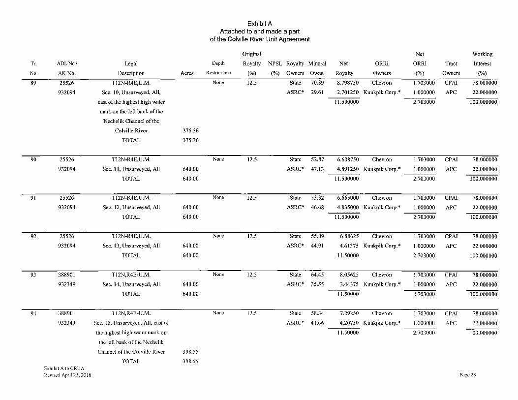
Exhibit A Attached to and made a part
of the Colville River Unit Agreement
Original Net Working
Tr. ADLNo./ Legal Depth Royalty NPSL Royalty Mineral Net ORRI ORRI Tract Interest
No AK No. Description Acres Restrictions (%) (%) Owners Owns. Royalty Owners (%) Owners (%)
89 25526 T12N-R4E,U.M. None 12.5 State 70.39 8.798750 Chevron 1.703000 CPAI 78.000000
932094 Sec. 10, Unsurveyed, All, ASRC* 29.61 2.701250 Kuukpik Corp.* 1.000000 APC 22.000000
east of the highest high water 11.500000 2.703000 100.000000
mark on the left bank of the
Nechelik Channel of the
Colville River 375.36
TOTAL 375.36
90 25526 T12N-R4E,U.M. None 12.5 State 52.87 6.608750 Chevron 1.703000 CPAI 78.000000
932094 Sec. 11, Unsurveyed, All 640.00 ASRC* 47.13 4.891250 Kuukpik Corp.* 1.000000 APC 22.000000
TOTAL 640.00 11.500000 2.703000 100.000000
91 25526 T12N-R4E,U.M. None 12.5 State 53.32 6.665000 Chevron 1.703000 CPAI 78.000000
932094 Sec. 12, Unsurveyed, All 640.00 ASRC* 46.68 4.835000 Kuukpik Corp.* 1.000000 APC 22.000000
TOTAL 640.00 11.500000 2.703000 100.000000
92 25526 T12N-R4E,U.M. None 12.5 State 55.09 6.88625 Chevron 1.703000 CPAI 78.000000
932094 Sec. 13, Unsurveyed, All 640.00 ASRC* 44.91 4.61375 Kuukpik Corp.* 1.000000 APC 22.000000
TOTAL 640.00 11.50000 2.703000 100.000000
93 388901 T12N,R4E-U.M. None 12.5 State 64.45 8.05625 Chevron 1.703000 CPAI 78.000000
932349 Sec. 14, Unsurveyed, All 640.00 ASRC* 35.55 3.44375 Kuukpik Corp.* 1.000000 APC 22.000000
TOTAL 640.00 11.50000 2.703000 100.000000
94 388901 Tl2N,R4E-U.M. None 12.5 State 58.34 7.29250 Chevron 1.703000 CPA! 78.000000
932349 Sec. 15, Unsurveyed, All, east of ASRC* 41.66 4.20750 Kuukpik Corp.* 1.000000 APC 22.000000
the highest high water mark on 11.50000 2.703000 100.000000
the left bank of the Nechelik
Channel of the Colville River 398.55
TOTAL 398.55 Exh1b1t A to CRUA
Revised April 23, 2018 Page 23

Exhibit A Attached to and made a part
of the Colville River Unit Agreement
Original Net Working
Tr ADLNo./ Legal Depth Royalty NPSL Royalty Mineral Net ORRI ORRI Tract Interest
No. AK No. Description Acres Restrict10ns (%) (%) Owners Owns. Royalty Owners (%) Owners (%)
95 388904 Tl2N,R4E-U.M. None 16.667 State 58.34 9.72353 Kuukpik Corp.* 1.000000 CPAI 78.000000
932355 Sec. 15, Unsurveyed, ASRC* 41.66 5.94347 APC 22.000000
All, West of highest high water 15.66700 100.000000
mark on the left bank of the
Nechelik Channel of
the Colville River, excluding U.S
Survey 9502 Lots 1
and 2 and the NPR-A 73.46
TOTAL 73.46
96 388906 Tl2N,R4E-U.M. None 16.66667 State 58.34 9.72334 Kuukpik Corp.* 1.666667 CPAI 78.000000
932359 Sec. 15, ASRC* 41.66 5.27667 APC 22.000000
Unsurveyed, All, 15.00000 100.000000
within the NPR-A,
excluding U.S.
Survey 9502 Lots 1
and2 7.66
TOTAL 7.66
97 388906 Tl2N,R4E-U.M. None 16.66667 State 46.21 7.70167 Kuukpik Corp.* 1.666667 CPAI 78.000000
932359 Sec. 16, Unsurveyed all ASRC* 53.79 7.29834 APC 22.000000
within the NPR-A, 15.00000 100.000000
excl. U.S. Survey 9502 Lot 1 17.08
TOTAL 17.08
98 388904 Tl2N,R4E-U.M. None 16.667 State 46.21 7.70182 Kuukpik Corp.* 1.000000 CPAI 78.000000
932355 Sec. 16, Unsurveyed, All ASRC* 53.79 7.96518 APC 22.000000
excluding U.S. Survey 9502 15.66700 100.000000
Lot 1 and the NPR-A 579.27
TOTAL 579.27 Exh1b1t A to CRUA Revised April 23, 2018 Page 24
Tr. ADLNo./ Legal
No AK No. Description
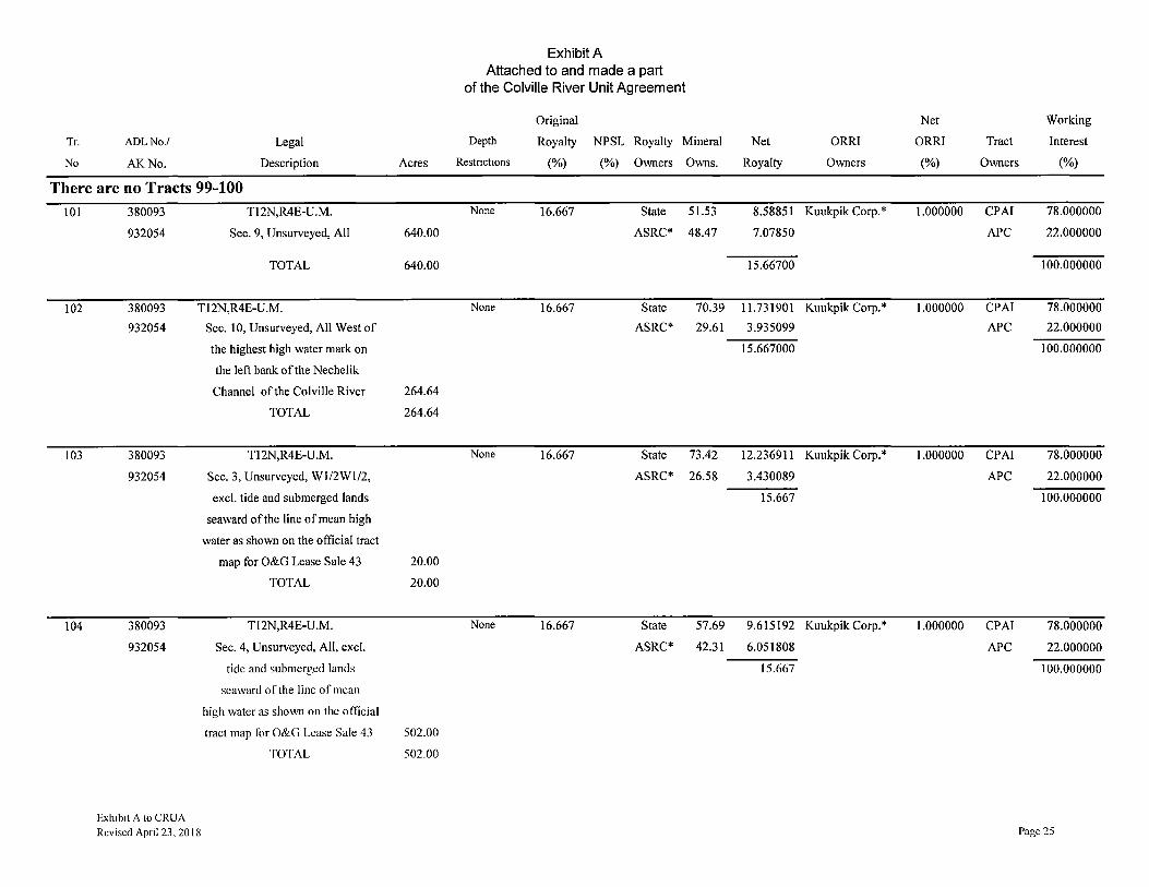
There are no Tracts 99-100
101
102
103
104
380093 Tl2N,R4E-U.M.
932054 Sec. 9, Unsurveyed, All
TOTAL
380093 Tl2N,R4E-U.M.
932054
380093
932054
380093
932054
Exhibit A to CRUA Revised April 23, 2018
Sec. 10, Unsurveyed, All West of
the highest high water mark on
the left bank of the Nechelik
Channel of the Colville River
TOTAL
Tl2N,R4E-U.M.
Sec. 3, Unsurveyed, Wl/2Wl/2,
excl. tide and submerged lands
seaward of the line of mean high
water as shown on the official tract
map for O&G Lease Sale 43
TOTAL
Tl2N,R4E-U.M.
Sec. 4, Unsurveyed, All, excl.
tide and submerged lands
seaward of the line of mean
high water as shown on the official
tract map for O&G Lease Sale 43
TOTAL
Acres
640.00
640.00
264.64
264.64
20.00
20.00
502.00
502.00
Exhibit A Attached to and made a part
of the Colville River Unit Agreement
Original Net Working
Depth Royalty NPSL Royalty Mineral Net ORR! ORRI Tract Interest
Restnctions (%) (%) Owners Owns. Royalty Owners (%) Owners (%)
None 16.667 State 51.53 8.58851 Kuukpik Corp.* 1.000000 CPAI 78.000000
ASRC* 48.47 7.07850 APC 22.000000
15.66700 100.000000
None 16.667 State 70.39 11.731901 Kuukpik Corp.* 1.000000 CPAI 78.000000
ASRC* 29.61 3.935099 APC 22.000000
15.667000 100.000000
None 16.667 State 73.42 12.23691 I Kuukpik Corp.* 1.000000 CPAI 78.000000
ASRC* 26.58 3.430089 APC 22.000000
15.667 100.000000
None 16.667 State 57.69 9.615192 Kuukpik Corp.* 1.000000 CPAI 78.000000
ASRC* 42.31 6.051808 APC 22.000000
15.667 100.000000
Page 25

Exhibit A Attached to and made a part
of the Colville River Unit Agreement
Original Net Working
Tr ADLNo/ Legal Depth Royalty NPSL Royalty Mineral Net ORR! ORR! Tract Interest
No AK.No. Description Acres Restrictions (%) (%) Owners Owns. Royalty Owners (%) Owners (%)
105 389726 T12N,R4E-U.M. None 16.66667 State 57.69 9.615002 Kuukpik Corp.* 1.000000 CPAI 78.000000
932684 Sec. 4, Unsurveyed, All within ASRC* 42.31 6.051668 APC 22.000000
the bed of the Nechelik Channel 15.66667 100.000000
of the Colville River as shown
on the official Tract Map for the
State O&G Lease Sale 75,
dated August 26, 1992 138.00
TOTAL 138.00
There is no Tract 106
107 389725 T13N,R4E-U.M. None 16.667 State 76.96 12.826923 CPAI 1.328100 CPAI 77.620000
932682 Sec. 33, Unsurveyed, All, ASRC* 23.04 2.840077 Kuukpik Corp.* 1.000000 APC 22.000000
excluding tide and submerged 15.667000 2.328100 Petro-Hunt 0.380000
lands seaward of the line of mean 100.000000
high water as shown on the official
tract map for O&G Lease Sale 43 278.00
TOTAL 278.00
108 388529 T13N,R4E-U.M. None 16.66667 State 76.96 12.826669 Kuukpik Corp.* 1.000000 CPAI 78.000000
932310 Sec. 33, Unsurveyed, All tide ASRC* 23.04 2.840001 APC 22.000000
and submerged lands seaward of 15.66667 100.000000
the line of mean high water and all
uplands within the bed of the
Nechelik Channel of the Colville
River, both as shown on the official
tract map for State O&G Lease
Sale75AdatedJune 17, 1993 362.00
TOTAL 362.00
Exh1b1t A to CRUA Revised April 23, 2018 Page 26

Exhibit A Attached to and made a part
of the Colville River Unit Agreement
Original Net Working
Tr ADLNo./ Legal Depth Royalty NPSL Royalty Mineral Net ORRI ORRI Tract Interest
No. AK No. Description Acres Restrictions (%) (%) Owners Owns. Royalty Owners (%) Owners (%)
109 388528 T13N,R4E-U.M. None 16.66667 State 67.65 11.275023 Kuukpik Corp.* 1.000000 CPAI 78.000000
932308 Sec. 34, Unsurveyed, All ASRC* 32.35 4.391677 APC 22.000000
tide and submerged lands 15.6667 100.000000
seaward of the line of mean high
water and the channel closing line,
and all uplands within the bed of
the unnamed channel of the Colville
River, both as shown on the official
tract map for State O&G Lease
Sale 75A dated June 17, 1993 420.00
TOTAL 420.00
110 389725 T13N,R4E-U.M. None 16.667 State 67.65 11.275226 CPA! 1.328100 CPA! 77.620000
932682 Sec. 34, Unsurveyed, All, ASRC* 32.35 4.391775 Kuukpik Corp.* 1.000000 APC 22.000000
excluding tide and submerged 15.667000 2.328100 Petro-Hunt 0.380000
lands seaward of the line of 100.000000
mean high water as
shown on the official tract
map for O&G Lease Sale 43 220.00
TOTAL 220.00
111 389725 T13N,R4E-U.M. None 16.667 State 60.52 10.086868 CPAI 1.328100 CPAI 77.620000
932682 Sec. 35, Unsurveyed, All, ASRC* 39.48 5.580132 Kuukpik Corp.* 1.000000 APC 22.000000
excluding tide and submerged 15.667 2.328100 Petro-Hunt 0.380000
lands seaward of the line of 100.000000
mean high water and channel
closing line as shown
on the official tract map for
O&G Lease Sale 43 555.00
TOTAL 555.00
Exh1b1t A to CRUA Revised Apnl 23, 2018 Page 27

Tr
No.
112
113
114
ADLNo/
AK No.
388527
932623
388527
932623
389725
932682
Exh1b1t A to CRUA Revised April 23, 2018
Legal
Description
Tl 3N,R4E-U.M.
Sec. 35, Unsurveyed, All tide
and submerged lands seaward
of the line of mean high water
and the channel closing line
as shown on the official tract
map for O&G Lease Sale 75A
dated June 17, 1993
TOTAL
T13N,R4E-U.M.
Sec. 36, Unsurveyed, All tide
and submerged lands seaward
of the line of mean high water
and the channel closing line as
shown on the official tract map
for O&G Lease Sale 75A
dated June 17, 1993
TOTAL
Tl3N,R4E-U.M.
Sec. 25, Unsurveyed, All,
excluding tide and submerged
lands seaward of the line of
mean high water as shown
on the official tract map for
O&G Lease Sale 43
TOTAL
Exhibit A Attached to and made a part
of the Colville River Unit Agreement
Original
Depth Royalty NPSL Royalty Mineral
Acres Restrict10ns (%) (%) Owners Owns.
None 16.66667 State 60.52
ASRC* 39.48
85.00
85.00
None 16.66667 State 57.35
ASRC* 42.65
43.00
43.00
None 16.667 State 83.68 ASRC* 16.32
196.00
196.00
Net Working
Net ORRI ORRI Tract Interest
Royalty Owners (%) Owners (%)
10.086669 A. James III 8.333330 CPAI 78.000000
5.580001 Revocable APC 22.000000
15.66667 Trust 100.000000
Kuukpik Corp.* 1.000000
9.333330
9.558335 A. James III 8.333330 CPAI 78.000000
6.108335 Revocable APC 22.000000
15.66667 Trust 100.000000
Kuukpik Corp.* 1.000000
9.333330
13.946946 CPAI 1.328100 CPAI 77.620000 1.720054 Kuukpik Corp.* 1.000000 APC 22.000000
15.667 2.328100 Petro-Hunt 0.380000
100.000000
Page 28
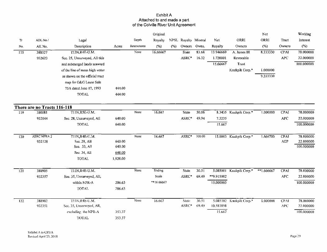
Exhibit A Attached to and made a part
of the Colville River Unit Agreement
Original Net Working
Tr ADLNo/ Legal Depth Royalty NPSL Royalty Mineral Net ORR! ORRI Tract Interest
No. AK.No. Description Acres Restnct10ns (%) (%) Owners Owns. Royalty Owners (%) Owners (%)
115 388527 T13N,R4E-U.M. None 16.66667 State 83.68 13.946669 A. James III 8.333330 CPAI 78.000000
932623 Sec. 25, Unsurveyed, All tide ASRC* 16.32 1.720001 Revocable APC 22.000000
and submerged lands seaward 15.66667 Trust 100.000000
of the line of mean high water Kuukpik Corp.* 1.000000
as shown on the official tract 9.333330
map for O&G Lease Sale
75A dated June 17, 1993 444.00
TOTAL 444.00
There are no Tracts 116-118 119 380081 Tl 1N,R5E-U.M. None 16.667 State 50.06 8.3435 Kuukpik Corp.* 1.000000 CPAI 78.000000
932044 Sec. 28, Unsurveyed, All 640.00 ASRC* 49.94 7.3235 APC 22.000000
TOTAL 640.00 15.667 100.000000
120 ASRCNPRA2 Tl 1N,R4E-U.M. None 16.667 ASRC* 100.00 15.0003 Kuukpik Corp.* 1.666700 CPAI 78.000000
932128 Sec. 28, All 640.00 AEP 22.000000
Sec. 33, All 640.00 100.000000
Sec. 34, All 640.00
TOTAL 1,920.00
121 388905 Tl 1N,R4E-U.M. None Sliding State 30.51 5.085001 Kuukpik Corp.* **1.666667 CPAI 78.000000
932357 Sec. 35, Unsurveyed, All, Scale ASRC* 69.49 **9.915002 APC 22.000000
within NPR-A 286.63 ** 16 66667 15.000003 100.000000
TOTAL 286.63
122 388902 Tl lN,R4E-U.M. None 16.667 State 30.51 5.085102 Kuukpik Corp.* 1.000000 CPAI 78.000000
932351 Sec. 35, Unsurveyed, All, ASRC* 69.49 10.581898 APC 22.000000
excluding the NPR-A 353.37 15.667 100.000000
TOTAL 353.37
Exhibit A to CRUA Revised Apnl 23, 2018 Page 29
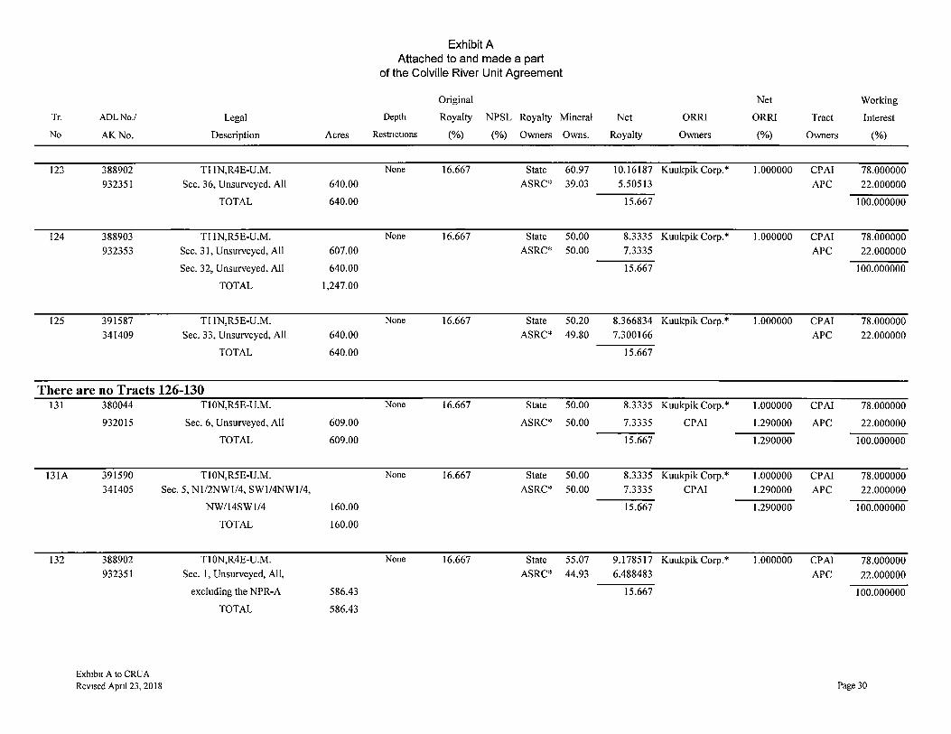
Tr. AOL No./ Legal
No AK No. Description
123 388902 Tl lN,R4E-U.M.
932351 Sec. 36, Unsurveyed, All
TOTAL
124 388903 Tl 1N,R5E-U.M.
932353 Sec. 31, Unsurveyed, All
Sec. 32, Unsurveyed, All
TOTAL
125 391587 Tl 1N,R5E-U.M.
341409 Sec. 33, Unsurveyed, All
TOTAL
There are no Tracts 126-130 131
131A
132
380044 Tl 0N,R5E-U.M.
932015 Sec. 6, Unsurveyed, All
TOTAL
391590 Tl 0N,R5E-U.M.
341405 Sec. 5, Nl/2NWI/4, SW1/4NW1/4,
388902
932351
Exh1b1t A to CRUA Revised Apnl 23, 2018
NW/14SW1/4
TOTAL
TI0N,R4E-U.M.
Sec. 1, Unsurveyed, All,
excluding the NPR-A
TOTAL
Acres
640.00
640.00
607.00
640.00
1,247.00
640.00
640.00
609.00
609.00
160.00
160.00
586.43
586.43
Exhibit A Attached to and made a part
of the Colville River Unit Agreement
Original Net Working
Depth Royalty NPSL Royalty Mineral Net ORRI ORRI Tract Interest
Restnct10ns (%) (%) Owners Owns. Royalty Owners (%) Owners (%)
None 16.667 State 60.97 10.16187 Kuukpik Corp.* 1.000000 CPAI 78.000000 ASRC* 39.03 5.50513 APC 22.000000
15.667 100.000000
None 16.667 State 50.00 8.3335 Kuukpik Corp.* 1.000000 CPAI 78.000000 ASRC* 50.00 7.3335 APC 22.000000
15.667 100.000000
None 16.667 State 50.20 8.366834 Kuukpik Corp.* 1.000000 CPAI 78.000000 ASRC* 49.80 7.300166 APC 22.000000
15.667
None 16.667 State 50.00 8.3335 Kuukpik Corp.* 1.000000 CPA! 78.000000
ASRC* 50.00 7.3335 CPAI 1.290000 APC 22.000000
15.667 1.290000 100.000000
None 16.667 State 50.00 8.3335 Kuukpik Corp.* 1.000000 CPAI 78.000000 ASRC* 50.00 7.3335 CPAI 1.290000 APC 22.000000
15.667 1.290000 100.000000
None 16.667 State 55.07 9.178517 Kuukpik Corp.* 1.000000 CPA! 78.000000 ASRC* 44.93 6.488483 APC 22.000000
15.667 100.000000
Page 30
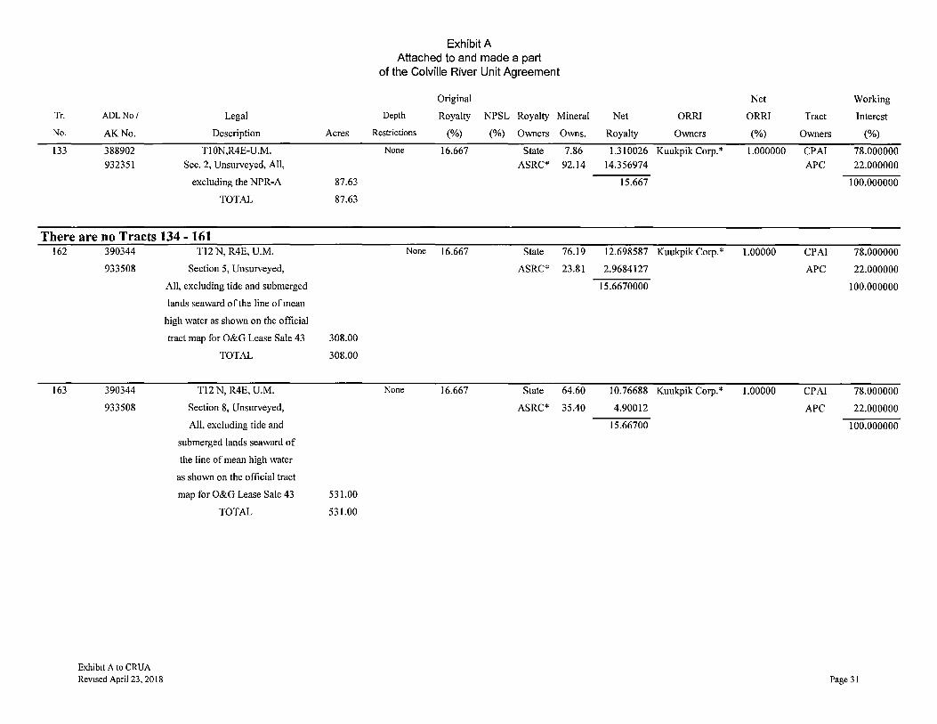
Tr. ADLNo/ Legal
No. AK No. Description
133 388902 Tl 0N,R4E-U.M.
932351 Sec. 2, Unsurveyed, All,
excluding the NPR-A
TOTAL
There are no Tracts 134 - 161 162
163
390344
933508
390344
933508
Exhibit A to CRUA
Revised April 23, 2018
T12 N, R4E, U.M.
Section 5, Unsurveyed,
All, excluding tide and submerged
lands seaward of the line of mean
high water as shown on the official
tract map for O&G Lease Sale 43
TOTAL
T12 N, R4E, U.M.
Section 8, Unsurveyed,
All, excluding tide and
submerged lands seaward of
the line of mean high water
as shown on the official tract
map for O&G Lease Sale 43
TOTAL
Acres
87.63
87.63
308.00
308.00
531.00
531.00
Exhibit A Attached to and made a part
of the Colville River Unit Agreement
Original Net Working
Depth Royalty NPSL Royalty Mineral Net ORRI ORRI Tract Interest
Restrictions (%) (%) Owners Owns. Royalty Owners (%) Owners (%)
None 16.667 State 7.86 1.310026 Kuukpik Corp.* 1.000000 CPAI 78.000000 ASRC* 92.14 14.356974 APC 22.000000
15.667 100.000000
None 16.667 State 76.19 12.698587 Kuukpik Corp.* 1.00000 CPAI 78.000000
ASRC* 23.81 2.9684127 APC 22.000000
15.6670000 100.000000
None 16.667 State 64.60 10.76688 Kuukpik Corp.* 1.00000 CPAI 78.000000
ASRC* 35.40 4.90012 APC 22.000000
15.66700 100.000000
Page 31
Tr.
No
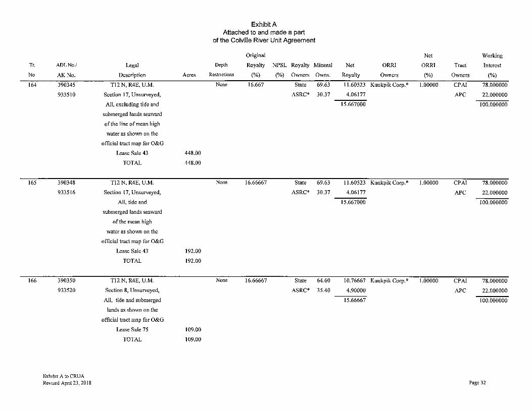
164
165
166
ADLNo./
AK.No.
390345
933510
390348
933516
390350
933520
Exh1b1t A to CRUA Revised April 23, 2018
Legal
Description Acres
T12 N, R4E, U.M.
Section 17, Unsurveyed,
All, excluding tide and
submerged lands seaward
of the line of mean high
water as shown on the
official tract map for O&G
Lease Sale 43 448.00
TOTAL 448.00
T12 N, R4E, U.M.
Section 17, Unsurveyed,
All, tide and
submerged lands seaward
of the mean high
water as shown on the
official tract map for O&G
Lease Sale 43 192.00
TOTAL 192.00
T12 N, R4E, U.M.
Section 8, Unsurveyed,
All, tide and submerged
lands as shown on the
official tract map for O&G
Lease Sale 75 109.00
TOTAL 109.00
Exhibit A Attached to and made a part
of the Colville River Unit Agreement
Original Net Working
Depth Royalty NPSL Royalty Mineral Net ORRI ORRI Tract Interest
Restnctions (%) (%) Owners Owns. Royalty Owners (%) Owners (%)
None 16.667 State 69.63 11.60523 Kuukpik Corp.* 1.00000 CPAI 78.000000
ASRC* 30.37 4.06177 APC 22.000000
15.667000 100.000000
None 16.66667 State 69.63 11.60523 Kuukpik Corp.* 1.00000 CPAI 78.000000
ASRC* 30.37 4.06177 APC 22.000000
15.667000 100.000000
None 16.66667 State 64.60 10.76667 Kuukpik Corp.* 1.00000 CPAI 78.000000
ASRC* 35.40 4.90000 APC 22.000000
15.66667 100.000000
Page 32

Tr.
No.
167
168
ADLNo./
AK No.
390350
933520
388465
300632
Exhtbtt A to CRUA Revised April 23, 2018
Legal
Description Acres
T12 N, R4E, U.M.
Section 5, Unsurveyed,
All, tide and submerged
lands and all uplands
within the bed of the
unnamed channel of the
Colville River as shown on
official tract map for
O&G Lease Sale 75 332.00
TOTAL 332.00
T12 N, R4E, U.M.
Section 6, Protracted, All 577.00
tide and submerged lands
Section 7, Protracted, All 580.00
tide and submerged lands
TOTAL 1,157.00
Exhibit A Attached to and made a part
of the Colville River Unit Agreement
Original Net Working
Depth Royalty NPSL Royalty Mineral Net ORRI ORRI Tract Interest
Restnctions (%) (%) Owners Owns. Royalty Owners (%) Owners (%)
None 16.66667 State 76.19 12.69834 Kuukpik Corp.* 1.00000 CPAI 78.000000
ASRC* 23.81 2.96833 APC 22.000000
15.66667 100.000000
None 16.66667 State 100.00 NIA None None CPAI 78.000000
APC 22.000000
100.000000
Page 33

Tr.
No
169
ADLNo/
AK.No.
388466
300634
Legal
Description
Tl2 N, R4E, U.M.
Section 18, Protracted, All
tide and submerged lands
Section 19, Unsurveyed, All tide and submerged lands seaward of the
line of mean high water and the channel closing lines as shown on
the official tract map Section 28, Unsurveyed, All tide
and submerged lands seaward of the line of mean high water and the
channel closing lines as shown on the official tract map
Section 29, Unsurveyed, All tide and submerged lands seaward of the
line of mean high water Section 30, Unsurveyed, All tide
and submerged lands seaward of the line of mean high water and the
Section 31, Unsurveyed, All tide and submerged lands seaward of the
line of mean high water Section 32, Unsurveyed, All tide
and submerged lands seaward of the line of mean high water
TOTAL
Exh1b1t A to CRUA Revised Apnl 23, 2018
Acres
583.00
424.25
71.65
237.21
264.72
50.63
101.59
1,733.05
Exhibit A Attached to and made a part
of the Colville River Unit Agreement
Depth
Restnct1ons
None
Original
Royalty NPSL Royalty Mineral
(%) (%) Owners Owns.
16.66667 State 100.00
Net
Royalty
NIA
ORRI
Owners
None
Net
ORR!
(%)
None
Working
Tract Interest
Owners (%)
CPAI 78.000000
APC 22.000000
100.000000
Page 34

Tr
No.
169
170
ADLNo./ Legal
AK No. Description
388466 THE CHANNEL CLOSING 300634 LINES WITHIN SECTIONS 19, 28
(Continued) AND 30 WERE DRAWN BASED ON COASTAL BOUNDARY BAY
CLOSING LINE PROCEDURE. THE PURPOSE IS TO
SEGREGATE TIDE AND SUBMERGED ACREAGE FROM
UPLAND ACREAGE.
388463 Tl2 N, R3E, U.M.
300628 Sl/2 of Section 1, Protracted, All tide and submerged lands
Sl/2 of Section 2, Protracted, All tide and submerged lands
Section 11, Unsurveyed, all tide and submerged lands seaward of the line of mean high water and the channel
closing lines as shown on the official tract map
Section 12, Protracted, All tide and submerged lands
Section 13, Unsurveyed, All tide and submerged lands seaward of the
line of mean high water and the channel closing lines as shown on
the official tract map Section 14, Unsurveyed, All tide
and submerged lands seaward of the line of mean high water and the
channel closing lines as shown on the official tract map
Section 24, Unsurveyed, All tide and submerged lands seaward of the
line of mean high water TOTAL
Exh1b1t A to CRUA Revised April 23, 2018
Acres
320.00
320.00
476.33
640.00
454.20
43.11
22.86
2,276.50
Exhibit A Attached to and made a part
of the Colville River Unit Agreement
Depth
Restrictions
None
Original
Royalty NPSL Royalty Mineral
(%) (%) Owners Owns.
16.66667 State 100.00
Net
Royalty
NIA
ORRI
Owners
None
Net
ORRl
(%)
None
Tract
Owners
CPA!
APC
Working
Interest
(%)
78.000000
22.000000
100.000000
Page 35

Tr.
No.
170
ADLNo/
AK No.
388463 300628 (cont.)
Legal
Description
THE CHANNEL CLOSING LINES WITHIN SECTIONS 11, 13 AND 14 WERE DRAWN BASED ON COASTAL BOUNDARY BAY
CLOSING LINE PROCEDURE. THE PURPOSE IS TO
SEGREGATE TIDE AND SUBMERGED ACREAGE FROM
UPLAND ACREAGE.
There are no Tracts 171-176 177 ASRCNPRA 1 Tl2N, R3E, U.M.
932126 Section 11: all excluding tide and submerged lands seaward of the line
of mean high water Section 13: all excluding tide and
submerged lands seaward of the line of mean high water
Section 14: all excluding tide and submerged lands seaward of the line
of mean high water Section 23
Section 24: All, excluding tide and submerged lands seaward of the line
of mean high water TOTAL
178 ASRC Tl2N, R4E, U.M.
NPRA2 Section 19 (fractional): All,
932128 excluding tide and submerged lands
seaward of the line of mean high
water
TOTAL
Exhibit A to CRUA Revised Apnl 23, 2018
Acres
178.72
184.11
624.00
640.00
625.00
2,251.83
118.97
118.97
Exhibit A Attached to and made a part
of the Colville River Unit Agreement
Depth
Restrictions
None
None
Original
Royalty NPSL Royalty Mineral
(%) (%) Owners Owns.
12.50 ASRC* 100.00
16.667 ASRC* 100.00
Net
Royalty
10.500000
15.0000
ORRI
Owners
Kuukpik Corp.*
Kuukpik Corp.*
Net
ORRI
(%)
2.000000
1.667000
Tract
Owners
CPAI
AEP
CPAI
AEP
Working
Interest
(%)
78.000000
22.000000
100.000000
78.000000
22.000000
100.000000
Page 36

Tr.
No.
179
180
181
181A
ADLNo/
AK No.
ASRC
NPRA3
932671
ASRC
NPRA4
932669
AA087888
307461
AA092347
340758
Exh1b1t A to CRUA
Revised April 23, 2018
Legal
Description Acres
Tl IN, R3E, U. M.
Section l, All 640.00
Section 2, All 640.00
Section 3, All 640.00
Section 12, All 640.00
Total 2,560.00
Tl IN, R4E. U.M.
Section 6, All 593.45
Section 17, All 640.00
Section 18, All 598.58
Section 29, All 640.00
Section 32, All 640.00
TlON, R4E, U.M.
Section 3, All 640.00
Section 4, All 640.00
Section 5, All 640.00
Total 5,032.03
Tl IN, R3E, U. M.
Section I 0, All 640.00
Section 14, All 640.00
Total 1,280.00
Tl IN, R3E, U. M.
Section 11, All 640.00
Section 13, All 640.00
Total 1,280.00
Exhibit A Attached to and made a part
of the Colville River Unit Agreement
Original Net Working
Depth Royalty NPSL Royalty Mineral Net ORRI ORRI Tract Interest
Restnct10ns (%) (%) Owners Owns. Royalty Owners (%) Owners (%)
None 12.5 ASRC* 100.00 11.2500 Kuukpik Corp.* 1.25000 CPA! 78.000000
AEP 22.000000
100.000000
None 16.667 ASRC* 100.00 15.00030 Kuukpik Corp.* 1.66670 CPAl 78.000000
AEP 22.000000
100.000000
None 16.6667 BLM 100.00 16.66667 None None CPA! 100.000000
None 16.6667 ASRC* 100.00 14.16667 Kuukpik Corp.* 2.500000 CPAI 78.000000
AEP 22.000000
100.000000
Page 37
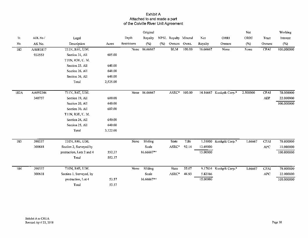
Tr.
No.
182
182A
183
184
AOL No/
AK.No.
AA081817
932552
AA092344
340757
390337
300618
390337
300618
Exhibit A to CRUA Revised Apnl 23, 2018
Legal
Description Acres
Tl IN, R4E, U.M.
Section 31, All 605.00
Tl IN, R3E, U. M.
Section 23, All 640.00
Section 26, All 640.00
Section 36, All 640.00
Total 2,525.00
Tl IN, R4E, U.M.
Section 19, All 600.00
Section 20, All 640.00
Section 30, All 602.00
Tl IN, R3E, U. M.
Section 24, All 640.00
Section 25, All 640.00
Total 3,122.00
TI0N, R4E, U.M.
Section 2, Surveyed by
protraction, Lots 2 and 4 552.37
Total 552.37
TlON, R4E, U.M.
Section 1, Surveyed, by
protraction, Lot 4 53.57
Total 53.57
Exhibit A Attached to and made a part
of the Colville River Unit Agreement
Original
Depth Royalty NPSL Royalty Mineral
Restrict10ns (%) (%) Owners Owns.
None 16.66667 BLM 100.00
None 16.66667 ASRC* 100.00
None Sliding State 7.86
Scale ASRC* 92.14
16.66667**
None Sliding State 55.07
Scale ASRC* 44.93
16.66667**
Net Working
Net ORRI ORRI Tract Interest
Royalty Owners (%) Owners (%)
16.66667 None None CPAI 100.000000
14.16667 Kuukpik Corp.* 2.500000 CPAI 78.000000
AEP 22.000000
100.000000
1.31000 Kuukpik Corp.* 1.66667 CPA! 78.000000
13.69000 APC 22.000000
15.00000 100.000000
9.17834 Kuukpik Corp.* 1.66667 CPA! 78.000000
5.82166 APC 22.000000
15.00000 100.000000
Page 38

Tr.
No
185
186
187
188
ADLNo/ Legal
AK.No. Description
390672 TI0N, R4E, U.M.
366717 Section 12, Surveyed, by
protraction, Lots 1 and 2
and the bed and of the Nechelik
Channel, 227.73 acres
TOTAL
390675 TI0N, R5E, UM
366720 Section 7, Surveyed, by
protraction, Fractional, Lots 1 and 2
and the beds of the Nechelik
Channel and the unnamed
waterbody, 606.46 acres
TOTAL
391915 TI0N, R5E, UM
366725 Section 8, Surveyed, by
protraction, All including the
beds of the Nechelik Channel and
the unnamed waterbody, 640.00 acre,
TOTAL
390674 TI0N, R5E UM
366719 Setion 9, Surveyed, by protraction,
All including the beds of the unnamed
waterbodics, 640.00 acres
TOTAL
Exhibit A to CRUA Revised April 23, 2018
Exhibit A Attached to and made a part
of the Colville River Unit Agreement
Original
Depth Royalty NPSL Royalty Mineral
Acres Restrictions (%) (%) Owners Owns.
None 16.66667 State 20.95
ASRC* 79.05
227.73
227.73
None 16.66667 State 51.10
ASRC* 48.90
606.46
606.46
None 16.66667 State 50.52
ASRC* 49.48
640.00
640.00
None 16.66667 State 50.00
ASRC* 50.00
640.00
640.00
Net Working
Net ORRI ORRI Tract Interest
Royalty Owners (%) Owners (%)
3.491667 Kuukpik Corp.* 1.000000 CPAI 78.000000
12.175003 Kuukpik Corp.*** 0.500000 APC 22.000000
15.666670 ALASKAORRI 2.783330 100.000000
BRPC 0.050000
4.333330
8.516668 Kuukpik Corp.* 1.000000 CPAI 78.000000
7 .150002 Kuukpik Corp.*** 0.500000 APC 22.000000
15.666670 ALASKAORRI 2.783330 100.000000
BRPC 0.050000
4.333330
8.420002 Kuukpik Corp.* 1.000000 CPA! 78.000000
7.246668 Kuukpik Corp.*** 0.500000 APC 22.000000
15.666670 ALASKAORRI 2.783330 100.000000
BRPC 0.050000
4.333330
8.333335 Kuukpik Corp.* 1.000000 CPA! 78.000000
7.333335 Kuukpik Corp.*** 0.500000 APC 22.000000
15.666670 ALASKA ORRI 2.783330 100.000000
BRPC 0.050000
4.333330
Page 39
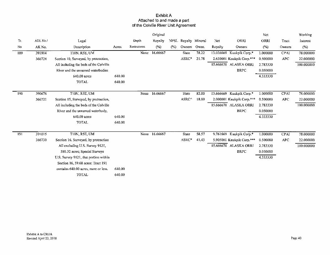
Tr.
No.
189
190
191
ADLNo/ Legal
AK No. Description
391914 Tl ON, R5E, UM
366724 Section 10, Surveyed, by protraction,
All including the beds of the Colville
River and the unnamed waterbodies
640.00 acres
TOTAL
390676 Tl ON, R5E, UM
366721 Section 15, Surveyed, by protraction,
All including the beds of the Colville
River and the unnamed waterbody,
640.00 acres
TOTAL
391015 TI0N, R5E, UM
366730 Section 16, Surveyed, by protraction
All excluding U.S. Survey 9121,
580.32 acres; Special Surveys
U.S. Survey 9121, that portion within
Section 16, 59.68 acres: Tract 191
contains 640.00 acres, more or less.
TOTAL
Exhibit A to CRUA Revised Apnl 23, 2018
Exhibit A Attached to and made a part
of the Colville River Unit Agreement
Original
Depth Royalty NPSL Royalty Mineral
Acres Restnct10ns (%) (%) Owners Owns.
None 16.66667 State 78.22
ASRC* 21.78
640.00
640.00
None 16.66667 State 82.00
ASRC* 18.00
640.00
640.00
None 16.66667 State 58.57
ASRC* 41.43
640.00
640.00
Net Working
Net ORR! ORRI Tract Interest
Royalty Owners (%) Owners (%)
13.036669 Kuukpik Corp.* 1.000000 CPAI 78.000000
2.630001 Kuukpik Corp.*** 0.500000 APC 22.000000
15.666670 ALASKAORRI 2.783330 100.000000
BRPC 0.050000
4.333330
13.666669 Kuukpik Corp.* 1.000000 CPAI 78.000000
2.000001 Kuukpik Corp.*** 0.500000 APC 22.000000
15.666670 ALASKA ORR! 2.783330 100.000000
BRPC 0.050000
4.333330
9.761669 Kuukpik Corp.* 1.000000 CPAI 78.000000
5.905001 Kuukpik Corp.*** 0.500000 APC 22.000000
15.666670 ALASKA ORR! 2.783330 100.000000
BRPC 0.050000
4.333330
Page 40
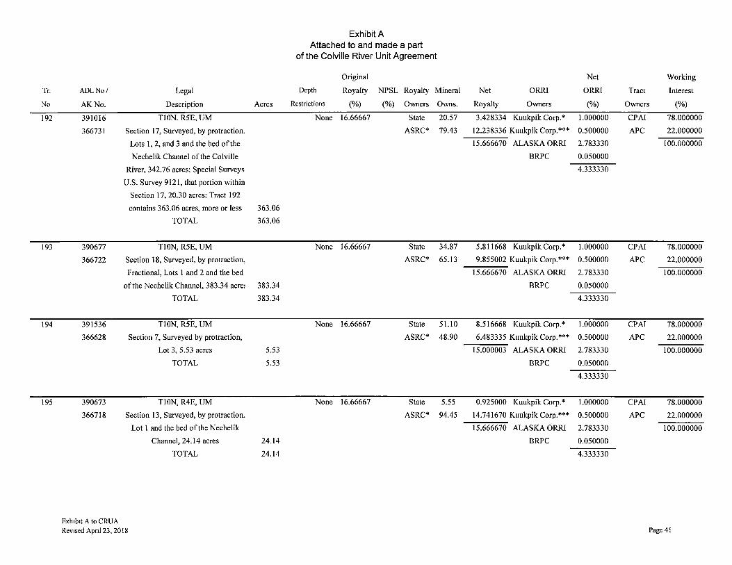
Tr.
No
192
193
194
195
ADLNo/ Legal
AK.No. Description
391016 TI0N, R5E, UM
366731 Section 17, Surveyed, by protraction.
Lots 1, 2, and 3 and the bed of the
Nechelik Channel of the Colville
River, 342.76 acres; Special Surveys
U.S. Survey 9121, that portion within
Section 17, 20.30 acres; Tract 192
contains 363.06 acres, more or less
TOTAL
390677 TI0N, R5E, UM
366722 Section 18, Surveyed, by protraction,
Fractional, Lots 1 and 2 and the bed
of the Nechelik Channel, 383.34 acre:
TOTAL
391536 TION, R5E, UM
366628 Section 7, Surveyed by protraction,
Lot 3, 5.53 acres
TOTAL
390673 TI0N, R4E, UM
366718 Section 13, Surveyed, by protraction,
Lot 1 and the bed of the Nechelik
Channel, 24.14 acres
TOTAL
Exh1b1t A to CRUA Revised Apnl 23, 20 I 8
Acres
363.06
363.06
383.34
383.34
5.53
5.53
24.14
24.14
Exhibit A Attached to and made a part
of the Colville River Unit Agreement
Original Net Working
Depth Royalty NPSL Royalty Mineral Net ORRI ORRI Tract Interest
Restrictions (%) (%) Owners Owns. Royalty Owners (%) Owners (%)
None 16.66667 State 20.57 3.428334 Kuukpik Corp.* 1.000000 CPAI 78.000000
ASRC* 79.43 12.238336 Kuukpik Corp.*** 0.500000 APC 22.000000
15.666670 ALASKA ORRI 2.783330 100.000000
BRPC 0.050000
4.333330
None 16.66667 State 34.87 5.811668 Kuukpik Corp.* 1.000000 CPAI 78.000000
ASRC* 65.13 9.855002 Kuukpik Corp.*** 0.500000 APC 22.000000
15.666670 ALASKAORRI 2.783330 100.000000
BRPC 0.050000
4.333330
None 16.66667 State 51.10 8.516668 Kuukpik Corp.* 1.000000 CPAI 78.000000
ASRC* 48.90 6.483335 Kuukpik Corp.*** 0.500000 APC 22.000000
15.000003 ALASKAORRI 2.783330 100.000000
BRPC 0.050000
4.333330
None 16.66667 State 5.55 0.925000 Kuukpik Corp.* 1.000000 CPAI 78.000000
ASRC* 94.45 14.741670 Kuukpik Corp.*** 0.500000 APC 22.000000
15.666670 ALASKAORRI 2.783330 100.000000
BRPC 0.050000
4.333330
Page 41

Tr.
No.
196
197
198
199
ADLNo/ Legal
AK No. Description
391535 Tl ON, R4E, Tract A, UM
366627 Section 13, Surveyed, by protraction,
Lot 2, 615.86 acres
TOTAL
391922 TI0N, R5E, UM
366631 Section 18, Surveyed by protraction,
Lot 3, 231.32 acres
TOTAL
391537 TI0N, R5E, UM
366629 Section 17, Surveyed, by protraction,
Lot 4, 276.94 acres
TOTAL
391923 TI0N, R5E, UM
366632 Section 20, Surveyed by protraction,
Lots 2, 4 and 5 and the beds of all
meanderable waterbodies within the
National Petroleum Reserve-Alaska,
409.55 acres
TOTAL
Exhibit A to CRUA
Revised Apnl 23, 2018
Acres
615.86
615.86
231.32
231.32
276.94
276.94
409.55
409.55
Exhibit A Attached to and made a part
of the Colville River Unit Agreement
Original
Depth Royalty NPSL Royalty Mineral
Restnct10ns (%) (%) Owners Owns.
None 16.66667 State 5.55
ASRC* 94.45
None 16.66667 State 34.87
ASRC* 65.13
None 16.66667 State 20.57
ASRC* 79.43
None 16.66667 State 16.46
ASRC* 83.54
Net Working
Net ORRI ORRI Tract Interest
Royalty Owners (%) Owners (%)
0.925000 Kuukpik Corp.* 1.000000 CPAI 78.000000
14.075003 Kuukpik Corp.*** 0.500000 APC 22.000000
15.000003 ALASKAORRI 2.783330 100.000000
BRPC 0.050000
4.333330
5.811668 Kuukpik Corp.* 1.000000 CPAI 78.000000
9.188335 Kuukpik Corp.*** 0.500000 APC 22.000000
15.000003 ALASKAORRI 2.783330 100.000000
BRPC 0.050000
4.333330
3.428334 Kuukpik Corp.* 1.000000 CPAI 78.000000
11.571669 Kuukpik Corp.*** 0.500000 APC 22.000000
15.000003 ALASKAORRI 2.783330 100.000000
BRPC 0.050000
4.333330
2.743334 Kuukpik Corp.* 1.000000 CPAI 78.000000
12.256669 Kuukpik Corp.*** 0.500000 APC 22.000000
15.000003 ALASKAORRI 2.783330 100.000000
BRPC 0.050000
4.333330
Page 42
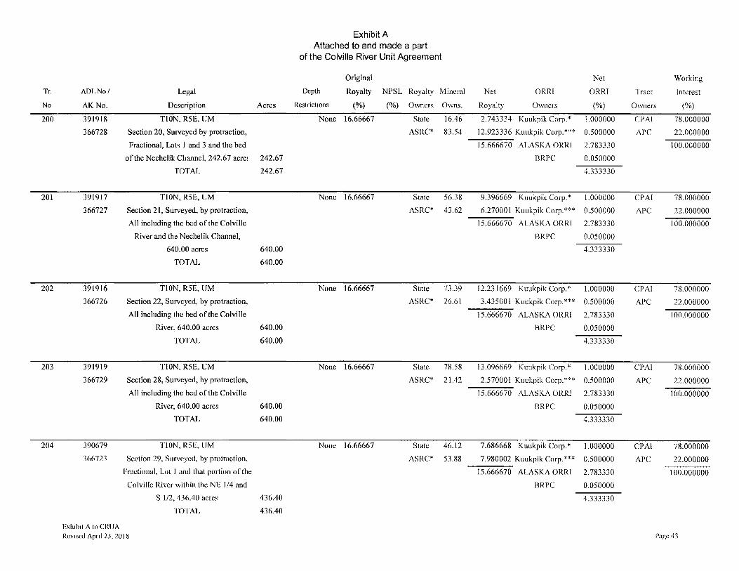
Exhibit A Attached to and made a part
of the Colville River Unit Agreement
Original Net Working
Tr. AOL No/ Legal Depth Royalty NPSL Royalty Mineral Net ORRI ORRI Tract Interest
No AK No. Description Acres Restrict10ns (%) (%) Owners Owns. Royalty Owners (%) Owners (%)
200 391918 TI0N, R5E, UM None 16.66667 State 16.46 2.743334 Kuukpik Corp.* 1.000000 CPAI 78.000000
366728 Section 20, Surveyed by protraction, ASRC* 83.54 12.923336 Kuukpik Corp.*** 0.500000 APC 22.000000
Fractional, Lots I and 3 and the bed 15.666670 ALASKA ORRI 2.783330 100.000000
of the Nechelik Channel, 242.67 acre1 242.67 BRPC 0.050000
TOTAL 242.67 4.333330
201 391917 TI0N, R5E, UM None 16.66667 State 56.38 9.396669 Kuukpik Corp.* 1.000000 CPAI 78.000000
366727 Section 21, Surveyed, by protraction, ASRC* 43.62 6.270001 Kuukpik Corp.*** 0.500000 APC 22.000000
All including the bed of the Colville 15.666670 ALASKA ORRI 2.783330 100.000000
River and the Nechelik Channel, BRPC 0.050000
640.00 acres 640.00 4.333330
TOTAL 640.00
202 391916 TI0N, R5E, UM None 16.66667 State 73.39 12.231669 Kuukpik Corp.* 1.000000 CPAI 78.000000
366726 Section 22, Surveyed, by protraction, ASRC* 26.61 3.435001 Kuukpik Corp.*** 0.500000 APC 22.000000
All including the bed of the Colville 15.666670 ALASKA ORRI 2.783330 100.000000
River, 640.00 acres 640.00 BRPC 0.050000
TOTAL 640.00 4.333330
203 391919 TION, R5E, UM None 16.66667 State 78.58 13.096669 Kuukpik Corp.* 1.000000 CPAI 78.000000
366729 Section 28, Surveyed, by protraction, ASRC* 21.42 2.570001 Kuukpik Corp.*** 0.500000 APC 22.000000
All including the bed of the Colville 15.666670 ALASKA ORR! 2.783330 100.000000 River, 640.00 acres 640.00 BRPC 0.050000
TOTAL 640.00 4.333330
204 390679 Tl0N, R5E, UM None 16.66667 State 46.12 7.686668 Kuukpik Corp.* 1.000000 CPAI 78.000000 366723 Section 29, Surveyed, by protraction, ASRC* 53.88 7.980002 Kuukpik Corp.*** 0.500000 APC 22.000000
Fractional, Lot I and that portion of the 15.666670 ALASKA ORRI 2.783330 100.000000 Colville River within the NE 1/4 and BRPC 0.050000
S 1/2, 436.40 acres 436.40 4.333330
TOTAL 436.40
Exhibit A to CRUA Revised Apnl 23, 2018 Page43
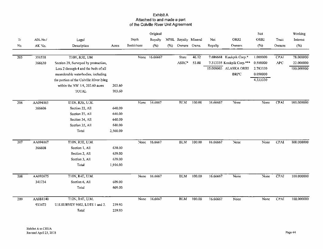
Tr
No.
205
206
207
208
209
ADLNo./ Legal
AK.No. Description
391538 TI0N, R5E, UM
366630 Section 29, Surveyed by protraction,
Lots 2 through 4 and the beds of all
meanderable waterbodies, including
the portion of the Colville River lying
within the NW 1/4, 203.60 acres
TOTAL
AA094165 Tl lN, R3E, U.M.
366606 Section 22, All
Section 27, All
Section 34, All
Section 35, All
Total
AA094167 TI0N, R3E, U.M.
366608 Section 1, All
Section 2, All
Section 3, All
Total
AA092675 TI0N,R4E, U.M.
341734 Section 6, All
Total
AA084140 T12N, R4E, U.M.
933472 U.S.SURVEY 9502, LOTS I and 2.
Total
Exhibit A to CRUA Revised April 23, 20 I 8
Exhibit A Attached to and made a part
of the Colville River Unit Agreement
Original
Depth Royalty NPSL Royalty Mineral
Acres Restrict10ns (%) (%) Owners Owns.
None 16.66667 State 46.12
ASRC* 53.88
203.60
203.60
None 16.6667 BLM 100.00
640.00
640.00
640.00
640.00
2,560.00
None 16.6667 BLM 100.00
638.00
639.00
639.00
1,916.00
None 16.6667 BLM 100.00
609.00
609.00
None 16.6667 BLM 100.00
239.93
239.93
Net Working
Net ORRI ORRI Tract Interest
Royalty Owners (%) Owners (%)
7.686668 Kuukpik Corp.* 1.000000 CPAI 78.000000
7.313335 Kuukpik Corp.*** 0.500000 APC 22.000000
15.000003 ALASKAORRI 2.783330 100.000000
BRPC 0.050000
4.333330
16.66667 None None CPAI 100.000000
16.66667 None None CPAI 100.000000
16.66667 None None CPAI 100.000000
16.66667 None None CPA! 100.000000
Page 44

Tr.
No
210
ADLNo/ Legal
AKNo. Description
391773 TlON, R4E, U.M.
342612 Section 12: Surveyed By
Protraction, Lot 3
Total
TOT AL UNIT ACREAGE
Exhibit A Attached to and made a part
of the Colville River Unit Agreement
Acres
412.27
412.27
Depth
Restrict10ns
None
131,871.49
Original
Royalty
(%)
16.6667
NPSL Royalty Mineral
(%) Owners Owns.
State 20.95
ASRC* 79.05
Net ORRI
Royalty Owners
3.49167 Kuukpik Corp.*
13.17503
16.66670
* Kuukpik Corp. Overriding Royalty deducted from ASRC Royalty as agreed between Kuukpik Corp. and ASRC for surface access.
Net Working
ORRI Tract Interest
(%) Owners (%)
1.66667 CPA! 78.000000
APC 22.000000
100.000000
** This lease has a sliding scale royalty therefore the original royalty percentage will vary between 16.66667% and 33.33333%. Kuukpik shall receive an overriding royalty equal to 10% of the Original Royalty Percentage, payable out of ASRC Original Royalty Percentage share of production. For example, using a fictitious tract with equal ownership of mineral interest between the State and ASRC, if the royalty rate escalates to 20%, then Kuukpik shall be entitled to receive 2% overriding royalty (0.10 x 0.20 = 0.02) on 8/8ths of production, the State would receive 10% royalty on 8/8ths of production (0.50 x 0.20 = 0.10), and ASRC would receive 8% royalty on 8/8ths of production [(0.50 x 0.20) - (0.10 x 0.20) = 0.08].
*** The 0.5% overriding royalty interest was created via several Assignment and Conveyance documents dated December 1, 2017 from Alaska ORRI and BRPC to Kuukpik Corp. The 0.5% overriding royalty interest is owned separate from and in addition to the overriding royalty deducted from ASRC Royalty as agreed between Kuukpik Corp. and ASRC for surface access.
KEY: ALASKA ORRI: ALASKA ORRI, LLC
APC: Anadarko Petroleum Corporation
AEP: Anadarko E&P Onshore LLC
ASRC: Arctic Slope Regional Corporation
BLM: Bureau of Land Management
BRPC: Brooks Range Petroleum Corporation
Chevron: Chevron U.S.A. Inc.
CPAI: ConocoPhillips Alaska, Inc.
CPAI*: CPA!, et al, as successor to Texaco
CPAI**: CPAI, et al, as successor to Midgard Energy Company
D.K. Nerland: Delores K. Nerland
Enea Tena Inv.: Enea Tekna Investments
Kuukpik Corp.: Kuukpik Corporation
Petro-Hunt: Petro-Hunt, L.L.C.
R.E. Wagner: Richard E. Wagner
R \\I Res: Rosewood Resources, Inc.
State: State or Alaska
W.G. Stroecker: William G. Stroecker
Exhibit A to CRUA
Revised Apnl 23, 2018 Page 45

Application for 8th Expansion of the Colville River Unit April 25, 2018
Attachment 2
"Revised Exhibit B to the Colville River Unit Agreement" attached to and made a part of the Application for the Eighth Expansion of the
Colville River Unit
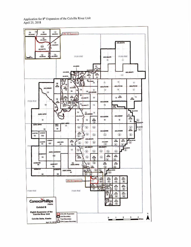
Application for 8th Expansion of the Colville River Unit April 25, 2018
(J~) •out-
f1!') A.OLM0044 -J CRU 8th Exoansion
t :1!) £ AOUHITI -- \..l!t.-•
i f~ /.· ) AC1UtOl7'
• "' ADL$t177'
' ( 111')
(i ( .. )
' .,. ,.c,ua·11n • . ........ ,, _ ... , T13N R4E
T12N R3E
I q;;;
T10N R3E
conoajphnnps Alaska
Exhibit B
1"'09297 ASRC-N'PR4 (~
T10NR4E
Eighth Expansion of the Colville River Unit O CRU &h Expansion
C Unft Bounder/ Colville Delta, AIHk• lliiJ Tract Bounder/
L.....-------'Nl='":...11:.;0"-'' 2:;.:0'-'18'-'c:J CPAI Lease Bound•l'f
' AtiC~l l'O
ADl.38«72
T-13N-R5E: J
'.LJ
ADUU.71
( i)
(!t ·-i100121oe-- "'-ADUT2104
)1)
ADL02SS31
<1i:•
I 'ADL0~55!11
(ii}
ADLGasaat
G)
( j )
AOL 1._;t~J M1'11
I
~ i
ADL02~
(,ij)
' i
Al)I.JT~l5
G)
ADL .,.,. G)
AOL .,.,. Ce)
AOL ......
L
. @ ADU111'9
N
0•-==-1 ---=2==::i3--•4Miles A,

Application for 8th Expansion of the Colville River Unit April 25, 2018
CONFIDENTIAL
Attachment 3
"Geologic, Geophysical, Engineering and Well Information" attached to and made a part of the Application for the Eighth Expansion of the
Colville River Unit
ConocoPhillips requests that these materials be treated as confidential as per 5 U.S.C. § 552(b)(4) and (b)(9), AS 38.05.035(a)(8), 11 AAC 82.810 and/or Section 3.9.7 of the CRUA
Application for 8th Expansion of the Colville River Unit April 25, 2018
CONFIDENTIAL
Attachment 4
"Exploration and Development Activities for the Expansion Area" attached to and made a part of the Application for the Eighth
Expansion of the Colville River Unit
ConocoPhillips requests that these materials be treated as confidential as per 5 U.S.C. § 552(b)(4) and (b)(9), AS 38.05.035(a)(8), 11 AAC 82.810 and/or Section 3.9.7 of the CRUA
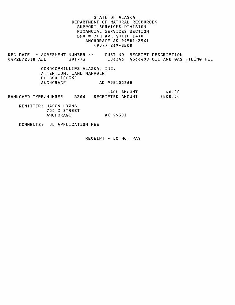
STATE OF ALASKA DEPARTMENT OF NATURAL RESOURCES
SUPPORT SERVICES DIVISION FINANCIAL SERVICES SECTION 550 W 7TH AVE SUITE 1410
ANCHORAGE AK 99501-3561 (907) 269-8500
REC DATE - AGREEMENT NUMBER -- CUST NO RECEIPT DESCRIPTION 04/25/2018 ADL 391773 106346 4366699 OIL AND GAS FILING FEE
CONOCOPHILLIPS ALASKA, INC. ATTENTION: LAND MANAGER PO BOX 100360 ANCHORAGE AK 995100360
BANKCARD TYPE/NUMBER 3206
REMITTER: JASON LYONS 700 G STREET ANCHORAGE
CASH AMOUNT RECEIPTED AMOUNT
AK 99501
COMMENTS: JL APPLICATION FEE
RECEIPT - DO NOT PAY
$0.00 $500.00