connecticut’s geospatial newsletter onnecticut geo … · don’s speech touched on various...
TRANSCRIPT

Geo Highlights Green Capitol pg 1
Post GIS Day pg 1, 4
Map Tips and Tricks pg 2
Geo-Trivia pg 3
News from UCONN pg 4
CT Soil Survey USDA pg 5
CT User to User pg 5
Mapping the Arctic Floor pg 6
Space Weather pg 6
GIS Aides MDC and Sewer Main Rehabilitation pg 7, 8
“GIS in Humanitarian Assistance “ by Feroz Verjee D. Sc. pg 9, 10
Connecticut’s Geospatial Newsletter
Winter Edition 2010
Volume 3, Issue 4
CONNECTICUT Geo-Focus
Newsletter Contacts Submit letters, projects, feedback
and articles to: [email protected] or
These articles are published for the educa-tion and enjoyment of the GIS community,
and may be edited to fit space available.
The CT Geospatial Council does not en-dorse or recommend any software
programs.
From the CT GeoDESK
“Connecticut GIS Day 2010 Celebrated at CCSU” The 2010 GIS Day event was held on the campus of Central Connecti-cut State University in New Britain on November 17. The event was coordi-nated by the Education and Outreach Working Group and hosted by the Univer-sity Geography Department as part of Geography Awareness Week. The event started at 10 am with opening remarks from GIS Council Chairperson Diane Wallace and Dr. Peter Kyem, Department Chair for the University Department of Geography. Continued on page 4.
The Green Capitols Project is part of the U.S. Environmental Pro-tection Agency’s (USEPA) national initiative designed to use public buildings in municipalities, capitol cities, and campuses across the country as demonstration areas for green infrastructures so they can be viewed by public officials and homeowners. The goal is to limit the amount of storm water runoff en-tering storm water sys-tems, in order to dem-onstrate how “going green” can be cost ef-fective, and be an envi-ronmentally preferable alternative to how con-ventional storm water currently travels to treatment plants. The “green” design encour-ages infiltration of storm water into the ground and provides detention so that peak rates of runoff to drainage systems are reduced. In Hartford, improvements to the state capitol will include a rainwater har-vesting system, permeable pavers and pervious concrete walkway demon-stration areas, porous asphalt parking areas, urban and residential rain gar-den infiltration areas and a “green” roof.
Hartford Capitol Goes Green by Jim Wysor, MDC

Connecticut’s Geospatial Newsletter
Winter Edition 2010
Volume 3, Issue 4
CONNECTICUT Geo-Focus Learn Map Tips and Tricks to Save Time
PROBLEM : I label a feature class and it works fine until I place a graphic on the map. For some reason, the labeling does not show where the graphic is.
SOLUTION : Open the properties window for that layer. Go to the Label tab. Click on the Placement Properties button. On the Conflict Detection tab, check “Place overlapping labels.” OK your way back out and you are done!
This one has dogged me since ArcMap 8 ! By Patrick Ladd, Meriden
WE WANT YOUR MAP TIPS AND TRICKS Please send your map tips and tricks to Beth Stewart-Kelly at [email protected] or Thad Dymkowski at [email protected] so we can share what we’ve painstakingly learned by doing something over one hundred times until we figure it out. Map tips and tricks will make a worthy contribution to the Geo-Focus Newsletter so, send them in!
The feature class is now labeled over the graphic.

Connecticut’s Geospatial Newsletter
Winter Edition 2010
Volume 3, Issue 4
CONNECTICUT Geo-Focus
MOSS & GRASS, Some History of Geo-Technology by Beth Kelly
Geotagging Photos by WWW.ARMY.MIL Geotagging is the process of adding geographical identification to photographs, video, websites and SMS messages. It is equivalent of adding a 10-digit grid coordinate to everything you post on the inter-net. Geotags are automatically embedded in pictures taken with smart-phones. Many people are unaware of the fact that the photos that they take with their smartphones and load to the internet have been geo-tagged. Photos have used geotagging for quite some time. Certain for-mats like the JPEG format allow for geographical information to be embedded with the image and then read by picture viewers. This shows the exact location where a picture was taken. On photo sharing sites, people can tag a location on their photos, even if the camera does not have a GPS function. A simple search for “Afghanistan” on Flickr reveals thousands of location tagged photos
that have been up-loaded. Tagging photos with an exact location on the Internet allows random people to TRACK an individ-ual’s location and cor-relate it with other in-formation. Camera owners should study their camera’s manual and understand how to turn off GPS functions. Pass this geo-
awareness information to your teenagers and other family members!
Late in the 1970s, the US Fish and Wildlife Service contracted for the development of MOSS (Map Overlay and Statistical System), an open source vector GIS that was used in many U.S. Depart-ment of Interior agencies and in a number of state and local gov-ernments. In the early 1980s, a raster GIS, GRASS (Geographic Resources Analysis Support System), was developed at the U. S. Army Corps of Engineers' Construction Engineering Research Laboratory (CERL). The Corps of Engineers, U.S. Department of Agriculture Soil Conservation Service, and National Park Service standardized on GRASS and it was used in universities around the world.
Information Technology and business are becoming inextri-cably interwoven. I don’t think anybody can talk mean-ingfully about one without talking about the other. Bill Gates
We think of enterprise architec-ture as the process we use for fully describing and mapping business functionality and busi-ness requirements and relating them to the information systems requirements. Tony Scott, Film Director
“Quotes of the 4th Quarter”

Post GIS Day, continued from page 1. Informational presentations were given by several members of the GIS community throughout the state from vari-ous organizations. They ranged on topics from environmental and research applications to health and web applica-tions. The highlight of the event was the keynote speech by Don Cooke, the GIS Hall of Famer and current ESRI Community Maps Program Director. Don’s speech touched on various topics including volunteer GIS and partici-pation in ESRI’s Community Maps Program. The day ended with the last meeting of the year for the State GIS Council. The presentation of the Certificate of Special Recognition was made by Bill DeGrazia from the Connecti-cut Geographic Alliance to the 2010 Connecticut Geography Bee winner and the Governor’s GIS Day Proclama-tion was read. Throughout the day, attendees networked and viewed the numerous map posters that were submitted which hung in the hallway of Davidson Hall, while casting votes for the People’s Choice Map Poster Award, which can be seen at www.ct.gov/gis . Also, several display tables were sponsored, offering information on a myriad of groups and GIS topics. In addition, CCSU’s Geography Department presented maps from its current class of bud-ding GIS professionals. Overall, the event was a great success and made for a great day for GIS in the State of Connecticut. Plans will be made soon for GIS Day 2011, scheduled for November 16, 2011. Mark your calendars now and plan to be there!
Attention Readers - If you would like to share your ideas on what you would like to see or hear at Connecticut GIS Day Events, please forward them and the Geospatial Education and Outreach working group will gladly include them in our next planning meeting for 2011. You are also welcome to attend the planning meetings at the Hartford Armory. Our meeting schedule will be posted on the www.ct.gov/gis website after the first of the year.
The Geospatial Training Program at UConn’s Center for Land Use Education and Research (CLEAR) is ringing in 2011 with new courses. The staple GIS training offered by the Program, Geospa-tial Technologies at Work: An Introduction to GIS will be completely overhauled for new trends in desktop GIS and for the new release of ESRI’s ArcGIS10. In addition to the new GIS training, CLEAR is also offering a train-ing that focuses on creating basic web map “mashups” with Google Maps and Google Earth. The course is titled, Mashup Madness: Using Google Tools to Create Maps on the Web and has been offered by CLEAR in several locations across the U.S. including Maui, Hawaii, San Francisco, CA and Portland, ME. This new course compli-ments the existing training, Pictures, Points and Places: An Introduction to GPS which teaches participants how to collect GPS data in the field and display it in a GIS as well as in Google Earth. The course also teaches students how to geolocate digital photographs and display them in various mapping programs. Visit http://clear.uconn.edu/geospatial to learn more about these exciting course offerings and find training dates and registration information. Questions can be directed to Cary Chadwick, [email protected] or 860-345-5216.
News from UCONN
A VERY HAPPY NEW YEAR FROM THE CT GEOSPATIAL INFORMATION COUNCIL AND ALL THE WORKING GROUPS!
Connecticut’s Geospatial Newsletter
Winter Edition 2010
Volume 3, Issue 4
CONNECTICUT Geo-Focus
Connecticut’s Geospatial Newsletter
Winter Edition 2010
Volume 3, Issue 4
CONNECTICUT Geo-Focus
CONNECTICUT SOIL SURVEY INFORMATION ON LINE Municipal land use commissions, contractors, town planners, engineers, farmers, and homeowners can now easily download soil information. The new US Department of Agriculture (USDA) Web Soil Survey site provides secure public access to the national soils information system. Click here to view site.
Soil surveys are needed for most land conservation activities, as well as private and commercial land devel-opment. With the new online SOIL SURVEY INFORMATION almost anyone in Connecticut can look up soils in-formation for their specific location. USDA designed the website with three easy-to-use features – Define, View, and Explore. When viewers access the web soil survey, they are asked to define a geographic area. Once a location is defined and projected on the screen, the viewer is offered the choice to print the map and related information, save it to their hard drive, or download the data for use in a geographic information system. The viewer can also explore the designated location and receive information on soil suitability in relationship to usage. This provides the viewer flexibility in developing a report to address a specific need – whether it is to design a road, plant a field, or create a wetland for wildlife habitat.
CT User to User Network Update GIS Education and Training Opportunities Whether you are new to GIS or a seasoned professional, we all find ourselves looking for GIS training and educational opportunities. In an effort to provide a snapshot of the GIS educational offerings available within the region, the Connecticut GIS User to User Network hosted their quarterly meeting on October 29 at the University of Connecticut Storrs Campus to explore GIS education opportunities. Representatives from multiple education and training programs provided a brief overview of GIS and remote sensing programs available for undergraduates and graduate students as well as online GIS training opportunities and public workshop offerings. For more details on GIS and remote sensing education and training offerings check out the following sites:
Center for Land Use Education and Research (CLEAR) – http://clear.uconn.edu Central Connecticut State University – http://geography.ccsu.edu Clark University – http://www.clarku.edu/departments/geography/ Eastern Connecticut State University – http://www.easternct.edu/environmentalearthscience/ ESRI – http://training.esri.com Fairfield University – http://fairfield.edu Trinity College – http://www.trincoll.edu University of Connecticut Department of Geography – http://geography.uconn.edu University of Connecticut Department of Natural Resources and the Environment – http://www.nre.uconn.edu University of Massachusetts Amherst – http://www.geo.umass.edu
Want to know more about the Connecticut GIS User to User Network and upcoming meetings?
Visit: http://ctgis.uconn.edu/ and join the listserv to connect with GIS users.

Connecticut’s Geospatial Newsletter
Winter Edition 2010
Volume 3, Issue 4
CONNECTICUT Geo-Focus
Space Weather—NOAA Now you can track Space Weather maps by visiting the Space Weather Prediction Center by NOAA or navigate to htpp://www.swpc.noaa.gov/index.html. Right out of Boulder Colorado, they map the latest Solar images and provide a downlink, Tracking and mapping the current and past 24 hours of Geomagnetic Storms, Solar Radiation Storms and Radio Blackouts. Their site provides a variety of information, including operational status reports, a scientific users guide, and a mission overview to the Geo-stationary Operational Environmental Satellite (GOES) Space Weather Station.
Scientists Set Sail to Map the Arctic Seafloor, U.S.G.S. By Jessica Robertson, Deborah Hutchinson, Jonathan Childs and Brian Edwards
The U.S. Geological Survey is the lead science agency for the United States in the 2010 U.S.-Canada Extended Continental Shelf survey. "In this expedition, Canada and the U.S. are working together to delineate the extended continental shelf in the Arctic to better determine where the Convention's criteria can be met," said USGS scientist Brian Edwards, chief scientist on the U.S. Coast Guard Cutter Healy. The ships had to alternately break through the Arctic sea ice for each other. The Healy mapped the shape of the seafloor us-ing a multibeam echo sounder, and the Louis S. St-Laurent collected multichannel seismic reflection and refraction data to determine sediment thickness. Re-search is coordinated by the U.S. Extended Continental Shelf Task Force, a government-wide group headed by the U.S. Department of State. Participants in this Task Force include the U.S. Department of the Interior; U.S. Geological Survey; National Oceanic and Atmospheric Administration; U.S. Coast Guard; National Science Foundation; Joint Chiefs of Staff; U.S. Navy; U.S. De-partment of Energy; U.S. Environmental Protection Agency; Executive Office of the President; Bureau of Ocean Energy Management, Regulation, and Enforce-ment; and the Arctic Research Commission.
For three years, American and Canadian scientists have been mapping the arctic seafloor and gathering data to help define the outer limits of the continental shelf. In 2011, they will collect data from the north of the Ca-nadian Basin. Each coastal nation may exercise sovereign rights over the natural resources of that shelf, which includes the seabed and the subsoil. These rights include control over minerals, hydrocarbons, and sedimentary organisms such as clams and coral.

GIS Aids Metropolitan District Commission in Sewer Main Rehabilitation by Jim Wysor, MDC Project Background Chartered in 1929, the Metropolitan District (MDC) is the water and sewer utility for the towns of Bloom-field, East Hartford, Newington, Rocky Hill, West Hartford, Wethersfield, and Windsor and for the City of Hartford.
The combined sewer system in Hartford is, on average, 89 years old and the sanitary sewer system in the surrounding towns is, on average, 44 years old. Each system also has numerous pipes that are in excess of 150 years old. These aging systems can surcharge with rainwater during heavy storm events, and sometimes discharge untreated wastewater, through overflows, into the Connecticut River, streets and even basements. These overflows impact the water quality of the Connecticut River and present problems for public health and safety. To plan for the rehabilitation of the sanitary sewer system, the MDC conducted studies of the combined sewer overflows (CSO) and sanitary sewer overflows (SSO) under the direction of the Connecticut Department of Envi-ronmental Protection (CTDEP) and created a long term control plan, also known as the Clean Water Project (CWP), for abating these issues. The CWP combines several abatement approaches including: new sewer mains, removal of storm water flows from the sewers, construction of sewage storage systems to prevent overflows during storm events, pipe lining and additional treatment capacity. Both CSOs and SSOs occur when a sewer system’s capacity is exceeded. The main difference is that a CSO occurs in a combined sewer system, which was
designed to handle both sanitary wastewater and storm water, and a SSO occurs in a sanitary sewer system, which was designed only to convey sanitary wastewater.
Pipe Lining for Overflow Elimination One of the leading contributors to sanitary sewer overflows (SSO) is infiltration. Infiltration is the leaking of groundwater into sanitary sewer pipes through cracks and holes in the pipes. These cracks and holes are caused by old age, tree roots, or structural defects in the pipes. The addi-tional water, when added to the existing flow in the pipe, exceeds the pipes capacity and leads to overflows and the release of untreated sewage. The CWP specifically deals with this problem by employing a variety of pipe and manhole rehabilitation methods, including manhole and pipe lining, pipe replacement, point repairs, and manhole cover replacement. The
most popular method for rehabilitation is pipe lining, also known as cured-in-place pipe lining (CIPP). CIPP is a trenchless process to rehabilitate existing sewer pipes, due to age, cracks or leaks without having to exca-vate or replace the pipe. The process starts by placing a flexible liner into an existing sewer main and curing the liner material with heat which creates a new pipe within the existing one that is free of cracks and holes. CIPP has many benefits including: cost effective, increases sewer flow capacity, avoids tearing up a street, takes less time to com-plete than replacement/excavation, reduces traffic delays, avoids underground utility conflicts and extends the life of the pipe to 50 years. Continued on page 8.
Connecticut’s Geospatial Newsletter
Winter Edition 2010
Volume 3, Issue 4
CONNECTICUT Geo-Focus

Connecticut’s Geospatial Newsletter
Winter Edition 2010
Volume 3, Issue 4
CONNECTICUT Geo-Focus Identifying Problem Pipes Continued from page 7. To reduce and eventually eliminate the SSOs, the MDC needed to identify those pipes that were suffering from infiltration problems. A Sanitary Sewer Evaluation Study (SSES) was conducted and resulted in a database with information that would allow the MDC to create a list of pipes and manholes that were in need of re-pair or rehabilitation. Specifically, the study provided infiltration values of pipes and identified those pipes, via closed circuit television (CCTV), that had holes, cracks, or roots penetrating the pipe. While this database allowed MDC engineers to determine the number of pipes they thought needed to be lined, the engineers did not know where individual problem pipes were lo-cated, the length of the pipes, or the material of the pipe. However, the MDC GIS did. The MDC identifies every pipe in its GIS with a unique id. This unique id was also used in the SSES database. Because this unique ID existed in both the GIS and the SSES databases, the MDC could join the SSES database attributes to the sanitary sewer main feature class stored in its GIS. Next, the MDC engineers determined three criteria that could be used to identify pipes to be lined. First, a pipe needed to have an infiltration rate greater than 4,000 gal-lons per day per inch, mile of pipe, in order for the MDC to be reimbursed for lining work by the CTDEP. Second, the pipe material had to be non-plastic (clay, reinforced concrete, or ductile iron, for example). Non-plastic pipes are more prone to joint issues and cracking, which would lead to infiltration. Also CIPP cannot be effectively in-stalled on a plastic pipe. Last, the pipe must not already be lined. Using the defined criteria, it was a simple query of the GIS to produce a list of pipes, by location, that could be incorporated into a pipe lining scope of work. GIS as a Multi-Benefit Project Tool Managing the pipe lining scope of work with GIS allowed the MDC to investigate different scenarios by altering the query parameters. For example, how would the scope of work change if the infiltration rate was higher or lower? How would the scope change if only one material type was used versus all non-plastic pipes? Based on the total length of pipe to be lined, should the MDC create more than one contract? Should they split the work up by town or total length of pipe to be lined? The GIS also allowed engineers to identify pipes that did not meet the above criteria, but were in between several segments of pipe that did meet the above criteria. This allowed the MDC to provide a more accurate list of pipes to the pipe lining contractor. Consequently, the MDC now has the lining status stored as an attribute of a pipe feature. MDC staff can now view a pipe’s lining status when coordinating and managing emergency and routine repair work. The MDC GIS enables the monitoring and reporting of pipe lining work pro-gress too. Each quarter, a count of the number of pipe segments lined and total footage lined must be reported. GIS generates maps and reports to easily convey the status and progress of lining work to the MDC Board of Commissioners and MDC management. Furthermore, the MDC can coordinate this work with other projects being implemented by member towns and other utility organizations to reduce the chances of repeated road closures or conflicts with other utility projects . Conclusion The MDC has been extremely active in reducing sanitary sewer overflows. Pipe lining, among other rehabilita-tion methods, has been a primary tool in this task. The MDC has lined almost 590,000 linear feet of sanitary sewer pipe and has plans to line an additional 340,000 linear feet of pipe. The MDC’s GIS has proven to be an effective tool in cre-ating, managing, maintaining, and reporting this work.

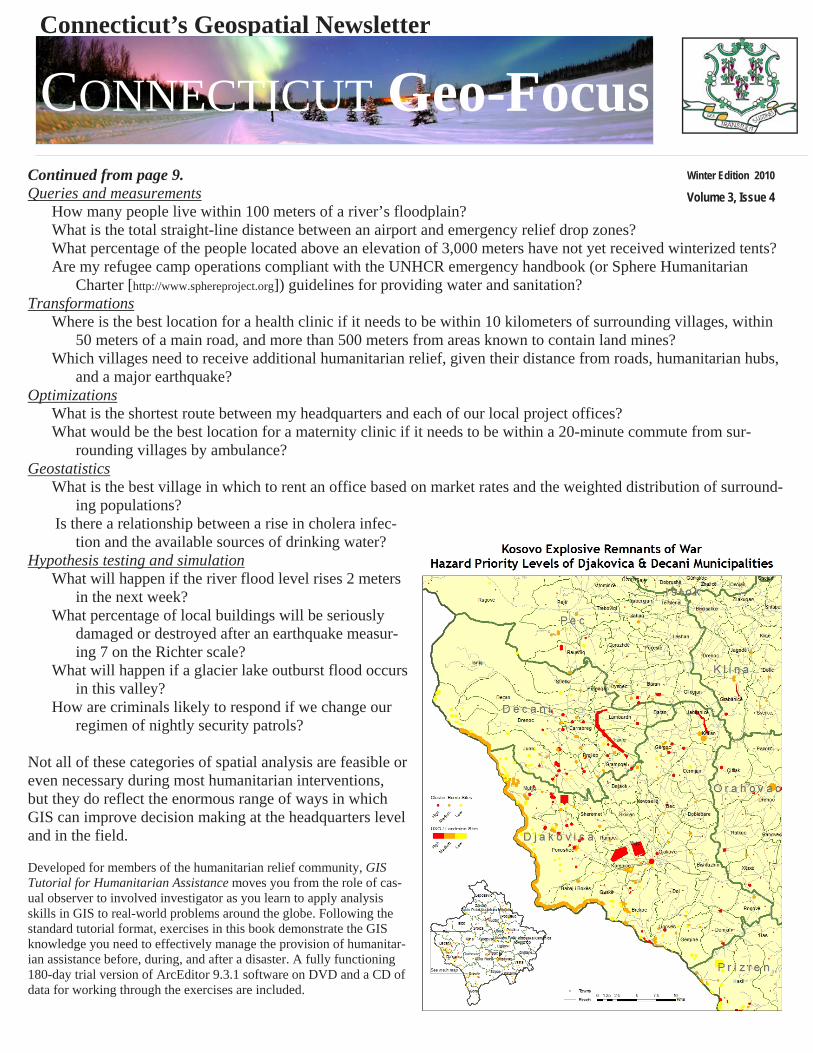
“GIS in Humanitarian Assistance” By Firoz Verjee, D.Sc., [email protected] Excerpt from the GIS Tutorial for Humanitarian Assistance (ESRI Press 2010), published with permission of the author. What are the potential applications of Geographic Information Systems (GIS) during humanitarian emergencies? From a functional point of view, GIS en-ables humanitarian organizations to:
• Visually understand and communicate what is happening • Store and share various types of information efficiently • Analyze information to reveal hidden spatial relationships that can have
a decisive impact on the outcome of humanitarian operations Visualization and communication Today, the role of GIS is primarily to help decision makers visually understand the field of operations, in the form of orientation and thematic maps. Map making (cartography) is an essential application of GIS in almost any humani-tarian intervention. Maps may be used to communicate administrative bounda-ries, terrain, navigational routes, hazards, relief operations, and countless other types of information critical to humanitarian organizations. These maps are often distributed through the UN’s Hu-manitarian Information Centers (HICs) and information-sharing portals on the Internet. Maps do not need to be static poster displays. The recent advent of interactive Web-based geovisualization tools, such as ArcGIS Explorer and Google Earth, now enables decision makers to understand the field of humanitarian operations dynamically. Storage and data exchange GIS also plays an important role as a storage and data-sharing mechanism. Because any type of humanitarian informa-tion can be associated with a location, a GIS can be most efficient in capturing, managing, and sharing that informa-tion. By consistently referencing all data with a geolocation (latitude, longitude, and sometimes elevation), a GIS can store and share very different types of data efficiently, as well as analyze relationships between datasets that might otherwise be incompatible. For example, an atlas could describe a region’s earthquake vulnerability and include a list of disaster risk-reduction projects there quite easily, but can it calculate how well those projects are addressing the re-gion’s seismic risk? Within a GIS, such dynamic data comparisons can be made. Spatial analysis Spatial analysis is the process of identifying meaningful patterns in spatial data and drawing conclusions from them. The techniques may be fairly simple, such as measuring the distance between a refugee camp and a reliable source of drinking water. Or they may be highly sophisticated, such as modeling the impact of disaster scenarios faced by vul-nerable mountain communities in order to plan preventive and mitigative strategies. Some basic categories of spatial analysis are listed below along with examples of the types of questions that can be answered. Continued on page 10.
Connecticut’s Geospatial Newsletter
Winter Edition 2010
Volume 3, Issue 4
CONNECTICUT Geo-Focus
Connecticut’s Geospatial Newsletter
Winter Edition 2010
Volume 3, Issue 4
CONNECTICUT Geo-Focus Continued from page 9. Queries and measurements
How many people live within 100 meters of a river’s floodplain? What is the total straight-line distance between an airport and emergency relief drop zones? What percentage of the people located above an elevation of 3,000 meters have not yet received winterized tents? Are my refugee camp operations compliant with the UNHCR emergency handbook (or Sphere Humanitarian
Charter [http://www.sphereproject.org]) guidelines for providing water and sanitation? Transformations
Where is the best location for a health clinic if it needs to be within 10 kilometers of surrounding villages, within 50 meters of a main road, and more than 500 meters from areas known to contain land mines?
Which villages need to receive additional humanitarian relief, given their distance from roads, humanitarian hubs, and a major earthquake?
Optimizations What is the shortest route between my headquarters and each of our local project offices? What would be the best location for a maternity clinic if it needs to be within a 20-minute commute from sur-
rounding villages by ambulance? Geostatistics
What is the best village in which to rent an office based on market rates and the weighted distribution of surround-ing populations?
Is there a relationship between a rise in cholera infec-tion and the available sources of drinking water?
Hypothesis testing and simulation What will happen if the river flood level rises 2 meters
in the next week? What percentage of local buildings will be seriously
damaged or destroyed after an earthquake measur-ing 7 on the Richter scale?
What will happen if a glacier lake outburst flood occurs in this valley?
How are criminals likely to respond if we change our regimen of nightly security patrols?
Not all of these categories of spatial analysis are feasible or even necessary during most humanitarian interventions, but they do reflect the enormous range of ways in which GIS can improve decision making at the headquarters level and in the field. Developed for members of the humanitarian relief community, GIS Tutorial for Humanitarian Assistance moves you from the role of cas-ual observer to involved investigator as you learn to apply analysis skills in GIS to real-world problems around the globe. Following the standard tutorial format, exercises in this book demonstrate the GIS knowledge you need to effectively manage the provision of humanitar-ian assistance before, during, and after a disaster. A fully functioning 180-day trial version of ArcEditor 9.3.1 software on DVD and a CD of data for working through the exercises are included.