comprehensive station plan bay fair - bart.gov · 2.4 bay fair’s comprehensive station plan...
TRANSCRIPT

Comprehensive Station Plan
Bay Fair
June 2004
Bay Fair Comprehensive Station Plan
1
June 2004
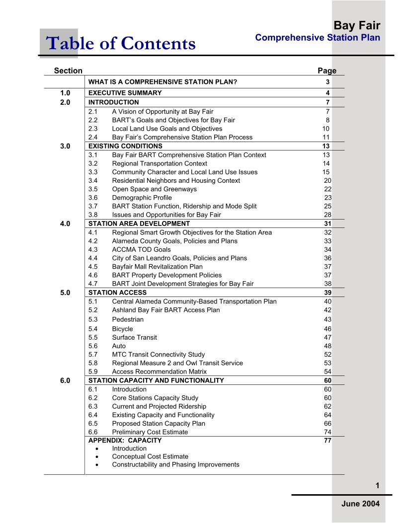
Section Page
WHAT IS A COMPREHENSIVE STATION PLAN? 3
1.0 EXECUTIVE SUMMARY 4
2.0 INTRODUCTION 7
2.1 A Vision of Opportunity at Bay Fair 7
2.2 BART’s Goals and Objectives for Bay Fair 8
2.3 Local Land Use Goals and Objectives 10
2.4 Bay Fair’s Comprehensive Station Plan Process 11
3.0 EXISTING CONDITIONS 13
3.1 Bay Fair BART Comprehensive Station Plan Context 13
3.2 Regional Transportation Context 14
3.3 Community Character and Local Land Use Issues 15
3.4 Residential Neighbors and Housing Context 20
3.5 Open Space and Greenways 22
3.6 Demographic Profile 23
3.7 BART Station Function, Ridership and Mode Split 25
3.8 Issues and Opportunities for Bay Fair 28
4.0 STATION AREA DEVELOPMENT 31
4.1 Regional Smart Growth Objectives for the Station Area 32
4.2 Alameda County Goals, Policies and Plans 33
4.3 ACCMA TOD Goals 34
4.4 City of San Leandro Goals, Policies and Plans 36
4.5 Bayfair Mall Revitalization Plan 37
4.6 BART Property Development Policies 37
4.7 BART Joint Development Strategies for Bay Fair 38
5.0 STATION ACCESS 39
5.1 Central Alameda Community-Based Transportation Plan 40
5.2 Ashland Bay Fair BART Access Plan 42
5.3 Pedestrian 43
5.4 Bicycle 46
5.5 Surface Transit 47
5.6 Auto 48
5.7 MTC Transit Connectivity Study 52
5.8 Regional Measure 2 and Owl Transit Service 53
5.9 Access Recommendation Matrix 54
6.0 STATION CAPACITY AND FUNCTIONALITY 60
6.1 Introduction 60
6.2 Core Stations Capacity Study 60
6.3 Current and Projected Ridership 62
6.4 Existing Capacity and Functionality 64
6.5 Proposed Station Capacity Plan 66
6.6 Preliminary Cost Estimate 74
APPENDIX: CAPACITY 77
Introduction Conceptual Cost Estimate Constructability and Phasing Improvements
Table of Contents

Bay Fair Comprehensive Station Plan
2
June 2004
rincipal Author
Nashua Kalil, AICP ASLA BART Planning Department
ART Team
Planning Department: Marianne Payne Val Menotti Ellen Smith Kevin Connolly Diane Stark Anthony Foster Customer Access: Carter Mau Jim Evans Laura Timothy Govt. & Community Relations: David Tucker Real Estate: Jeffrey Ordway John Rennels System Capacity: Bill Theile Samuel Lau Grants: Joanne Parker Operations Liaison: Duane Condit Police Department: Greg Savage System Safety: Mark Chan Carlina Leong Maintenance & Engineering: Roger Avery Manny Abad Ersten Iamoka Jeff Garcia Transportation: Betty Soohoo Transit System Development: Richard Wenzel James Gravesande
ity of San Leandro
Hanson Hom, Community Development Director Debbie Potter, Planning Manager Matt Tomas, Planning Department Sally Barros, Planning Department Seth Hudson, Economic Development
lameda County Redevelopment Agency
Eileen Dalton, Redevelopment Agency Assistant Director Jennie Bloebaum, Redevelopment Specialist Jamie Ratto, Redevelopment Specialist
Acknowledgments

Bay Fair Comprehensive Station Plan
3
June 2004
ART stations are both transit hubs and valued community resources.
Recognizing this, the BART Board of Directors in 2001 directed the Planning Department to undertake a thorough and integrated analysis of planning issues at every station. Called Comprehensive Station Plans, these documents are guided by BART’s Strategic Plan, with recommendations reflecting the Strategic Plan’s focus areas. Each Comprehensive Station Plan brings together the work of many BART staff, agency partners and members of the public.
Each Comprehensive Station Plan examines how effectively a station meets the present and future needs of its passengers and the surrounding community. The Comprehensive Station Plan does this by examining three key station elements:
Station Area Development--how the station relates to the surrounding community and supports smart growth
Station Access--how passengers get to and move around the station
Station Capacity and Functionality--how the physical components of the station function and necessary expansions accommodated
BART staff use Comprehensive Station Plans to evaluate the scope and timing of a proposed station project or initiative, to seek grant funds, and to communicate with the public and other agencies. Partners and potential partners use the plans to evaluate the most effective way to work toward common goals.
A Comprehensive Station Plan is to be updated or expanded as needed. As planning documents, they are living and flexible works, meant to be revised by section or overall as new information or direction becomes available. A Comprehensive Station Plan allows for revisions while it retains a station’s collectively defined vision and provides a background for future efforts.
We invite your perusal, use, and comments.
What Is a Comprehensive Station Plan?
Bay Fair Comprehensive Station Plan
4
June 2004
he Bay Fair BART Station is a regional transit and community resource.
It is a crossroads between two lines of BART service, a regional link to Central Alameda County, and a stimulus for Smart Growth transit-oriented development that also serves local redevelopment goals.
The Bay Fair BART Station offers an outstanding opportunity to accomplish reinforcing goals:
Use the station as a Smart Growth tool, focusing on dense transit-
oriented development that includes new mixed-use and infill
development around the station and along adjacent transit corridors
Reinforce BART as an amenity to retail centers and entertainment
venues through station design, access and safety improvements
Build new transit linkages including welcoming public spaces linked
to a new circulation system and mode transfer areas
Increase east-west connectivity to link surrounding neighborhoods
and commercial areas with BART and with each other, especially for
pedestrians
Increase station functionality as a sub-regional crossroads by
improving the station, especially for cross-platform patron transfers
A combination of development and neighborhood attributes provides a unique opportunity for the Bay Fair BART Station to be more than a exemplary train station with highly functioning intermodal facilities. An emerging vision for the station is a center of connectivity, a crossroads bringing the City of San Leandro, the Ashland Community and surrounding areas together with a mixed-use transit corridor and commercial center with regional rail station at it’s heart. This vision is evolving under the context of separate plans; what they have in common are their goal of urban revitalization and transit-orientation, capitalizing upon the existing BART station and associated transit facilities.
Station Area Development
ART’s 18.5 acres offer a signal opportunity to facilitate Smart Growth
with revitalization plans for Bayfair Mall, San Leandro’s East 14th Street South Area Development Strategy, and the City’s and County’s redevelopment plans. Key is relating the east side of the station to the retail commercial and entertainment uses at Bayfair Mall, along with concepts for new infill in a mixed-use commercial framework. Future development on the west side of the station should relate to and enhance the Ashland community surrounding the BART Property.
1.0 Executive Summary

Bay Fair Comprehensive Station Plan
5
June 2004
Necessary elements of planning for development and revitalization include:
Identify development synergies for BART property, with the commercial Mall to the east side of the station and with residential neighborhoods on the west.
Support transit–oriented, mixed-use development and intensification of Bayfair Mall.
Analyze the opportunities for structured parking to free up acreage for development and seek funding support for parking garage construction.
Address intermodal access and integrate facilities with valuable uses of station land
Ensure that future development proposals on BART Property adhere to BART’s Access and Transit-Oriented Development Guidelines; work closely with surrounding developers to capitalize on transit connectedness.
Support City and County land use policies and assist in public involvement processes designed to build community consensus.
Station Access
lanning for access improvements builds upon years of multi-agency
interaction to advance a community-based process. Numerous physical barriers lie between the community and BART, BART and the Mall, and for the residential neighborhoods to East 14th Street – a major transit corridor. Concepts for reorganizing public spaces and specific recommendations for access improvements have been made to bridge elements of the community and provide transit accessibility. Another key process is coordination with AC Transit to address the proposed interface with the evolving Bus Rapid Transit Project, planned to terminate at Bay Fair BART.
General access recommendations include:
Improve circulation for buses, automobiles and pedestrians into and within the Bay Fair station and property.
Implement pedestrian and bicycle access projects on BART property and work with Bayfair Mall, City and County to increase links across the County flood control channel.
Design accessible pedestrian connections to the station entry from the west lot.
Work with partner agencies to pursue funds for projects that improve pedestrian and bicycle access to the station.
Work with AC Transit to improve the connections between bus and BART, locate bus facilities appropriately (including on Mall property) and plan for Bus Rapid Transit.
Identify funding opportunities for improving wayfinding signage and real time information for bus connections.

Bay Fair Comprehensive Station Plan
6
June 2004
Station Capacity and Functionality
he Bay Fair Station was analyzed as part of a systemwide assessment
completed in early 2003. This assessment looked at BART station capacity needs in 2025 and ridership estimates affecting facility design today. The Station Capacity section of this Plan is designed to identify and accommodate station construction priorities as ridership grows.
The Station and its facilities currently act in two major capacities: first, as a station serving the community with links to a regional mall and residential neighborhoods; and second, as a transit transfer point for patrons on the current BART system that will increase dramatically with the opening of the Silicon Valley Rapid Transit (SVRT) expansion of BART to San Jose. While the SVRT project is some years in the future, planning for the station’s capacity and functionality must be understood in order to clarify development opportunities and potential access enhancements.
The analysis of 2025 capacity needs resulted in the following recommendations for Bay Fair Station:
Expand the station paid area and concourse apron.
Create a new pedestrian underpass connecting the east and west sides of the station.
Increase vertical circulation and add elevators within the paid area.
Add and upgrade fare gate equipment.
Expand platforms and covers to accommodate projected growth in ridership as well as additional vertical circulation elements.
Relocate intermodal facilities with a redesign of site circulation.
Preserve right-of-way for a potential third trackway on the station’s east side to accommodate future operations needs.
Other functionality and design elements include:
Relate the station to the Mall on the east through public art, way-finding signage and architectural elements.
Use pedestrian-scale lighting along main pedestrian pathways and access points.
Emphasize access points and station entry through streetscape designs (e.g. special pavers) and landscaping.
Trim mature trees to emphasize views to entry points, mall entries and other significant community features.
The preliminary cost estimates to implement the conceptual capacity improvements, including right-of-way preservation for a third-rail option, is approximately $56 million. The cost estimate includes major relocations of existing intermodal facility elements described above plus new staff facilities, bicycle pavilion and other site enhancements.

Bay Fair Comprehensive Station Plan
7
June 2004
2.1 A Vision of Opportunity at Bay Fair
he Bay Fair BART Station stands to become
an important transfer point for BART patrons as a result of the proposed Silicon Valley Rapid Transit (SVRT) expansion of BART to San Jose. While the SVRT project is in the future, planning for the station’s capacity and functionality must be understood in order to clarify development opportunities and potential access enhancements.
A combination of development and neighborhood attributes provides a unique opportunity for the Bay Fair BART Station to be more than a exemplary train station with highly functioning intermodal facilities. An emerging vision for the station is to be a center of connectivity -- a crossroads bringing the City of San Leandro, the Ashland Community and Central Alameda County together with a mixed-use commercial center and regional rail station at its heart. This vision is evolving under the context of separate plans; what they have in common is their goal of urban revitalization and transit-orientation, emphasizing the existing BART station.
A vision for a unified Bay Fair Station Area focuses upon a new transit-oriented center connected to the region by BART and vibrant with mixed-uses. The east side of the station should reflect the commercial hub of Bayfair Mall with connections to the East 14th Street Corridor while bridging residential neighborhoods. The west side of the station should respond to the Ashland community plans for residential strengthening. As a whole, the Bay Fair BART Station should be fully connected with the City’s and County’s regional resources, and be pedestrian and bicycle friendly.
As defined in the Goals and Objectives section of this report, the emerging vision is based upon policy and design guidelines established by the County, City, neighborhoods, private developers and regional agencies including BART. Goals and opportunities are reviewed and area demographics and travel patterns discussed in the context of access improvements and special needs. The BART station’s function and capacity is addressed through projections and analyses that lay out a footprint for future expansion.
2.0 Introduction
BART’s Dublin/Pleasanton and Fremont lines converge at Bay Fair Station, making transfers possible. In the future, Silicon Valley trains will also stop at Bay Fair.

Bay Fair Comprehensive Station Plan
8
June 2004
Finally, the information gathered is considered in relationship to the physical layout of properties and facilities, both existing and planned, to consider opportunities for Smart Growth initiatives.
2.2 BART’s Goals and Objectives for Bay Fair
ART’s goals for the Bay Fair Station and the communities it
serves are an extension of the goals for the system as a whole. The goals serve to reinforce the policy direction set by the BART Board in the adoption of the BART Strategic Plan. The following reviews focus areas from BART’s Strategic Plan goals and objectives in the context of comprehensive planning for the Bay Fair Station.
Strategic Plan Focus Area: The BART Customer ExperienceGoal: Deliver quality transportation to BART riders.
Objectives:Ensure the Bay Fair BART Station meets the current and future needs of BART commuters through quality station design.
Maximize regional transit access for all through effective coordination among transit providers.
Work together with partner transit agencies and others to improve transit transfers and connections with feeder routes.
Make transit information accessible to all people including those with limited English skills through the enhancement of wayfinding signage.
Strategic Plan Focus Area: Building Partnerships for Support Goal: Work proactively with the County, City and other stakeholders to create interagency partnerships dedicated to the Station District.
Objectives:Coordinate station design and infrastructure planning.
Support and participate in community-based transit access and ridership development planning.
Encourage public input as integral to sound, balanced policy development and decision-making, and make deliberate, disciplined decisions in the best interests of the people it serves.
Seek opportunities to improve the station and station area through partnerships with the community and local businesses.
Bay Fair Comprehensive Station Plan
9
June 2004
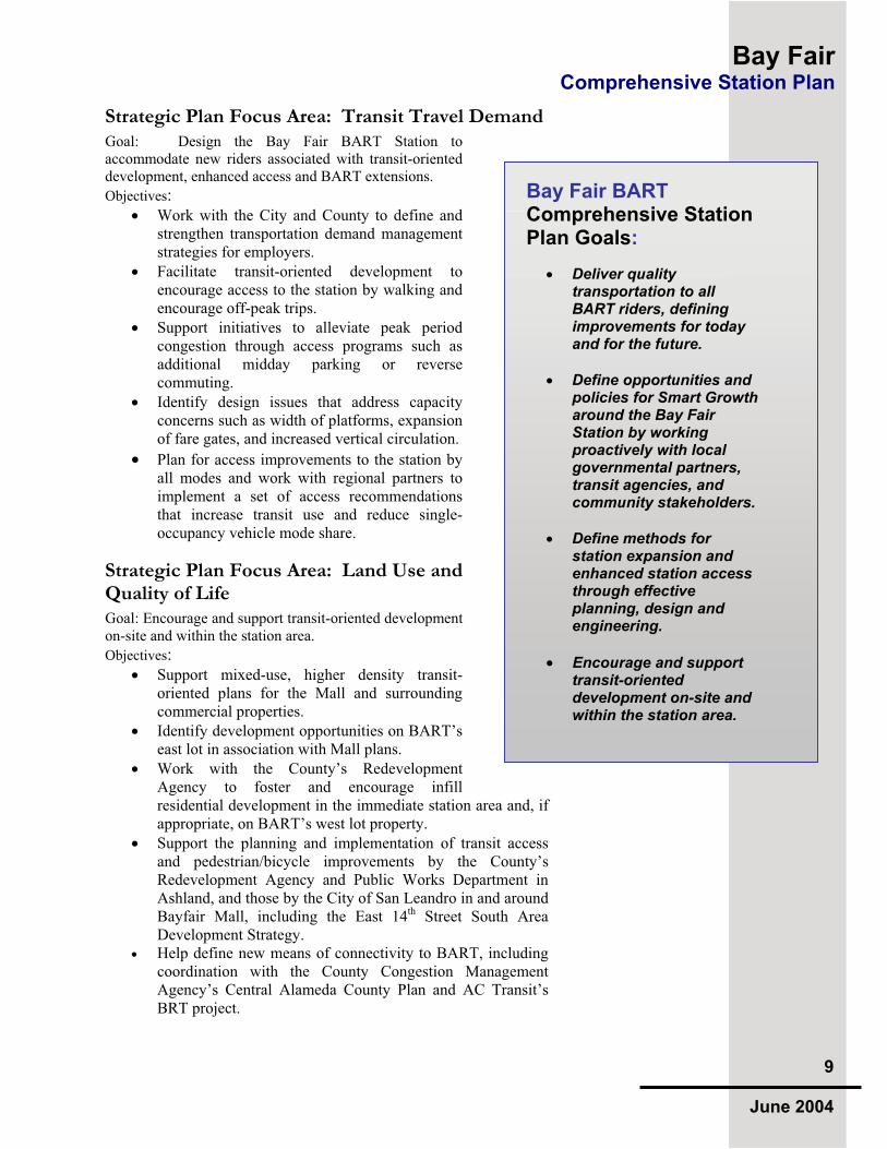
Strategic Plan Focus Area: Transit Travel Demand Goal: Design the Bay Fair BART Station to accommodate new riders associated with transit-oriented development, enhanced access and BART extensions.
Objectives:Work with the City and County to define and strengthen transportation demand management strategies for employers.
Facilitate transit-oriented development to encourage access to the station by walking and encourage off-peak trips.
Support initiatives to alleviate peak period congestion through access programs such as additional midday parking or reverse commuting.
Identify design issues that address capacity concerns such as width of platforms, expansion of fare gates, and increased vertical circulation.
Plan for access improvements to the station by all modes and work with regional partners to implement a set of access recommendations that increase transit use and reduce single-occupancy vehicle mode share.
Strategic Plan Focus Area: Land Use and Quality of Life Goal: Encourage and support transit-oriented development on-site and within the station area.
Objectives:Support mixed-use, higher density transit-oriented plans for the Mall and surrounding commercial properties.
Identify development opportunities on BART’s east lot in association with Mall plans.
Work with the County’s Redevelopment Agency to foster and encourage infill residential development in the immediate station area and, if appropriate, on BART’s west lot property.
Support the planning and implementation of transit access and pedestrian/bicycle improvements by the County’s Redevelopment Agency and Public Works Department in Ashland, and those by the City of San Leandro in and around Bayfair Mall, including the East 14th Street South Area Development Strategy. Help define new means of connectivity to BART, including coordination with the County Congestion Management Agency’s Central Alameda County Plan and AC Transit’s BRT project.
Bay Fair BART Comprehensive Station Plan Goals:
Deliver quality transportation to all BART riders, defining improvements for today and for the future.
Define opportunities and policies for Smart Growtharound the Bay Fair Station by working proactively with local governmental partners, transit agencies, and community stakeholders.
Define methods for station expansion and enhanced station access through effective planning, design and engineering.
Encourage and support transit-oriented development on-site and within the station area.

Bay Fair Comprehensive Station Plan
10
June 2004
View east to Bay Fair Mall and adjacent residential neighborhood from the train platform area, with bus bays in the foreground. A large number of mature trees characterize the BART property and adjacent flood control canal.
Strategic Plan Focus Area: Physical Infrastructure Goal: Coordinate BART commuter facility needs with new infrastructure investments for maximum efficiency and utility.
Objectives:Develop a plan for upgrading the station to meet capacity needs up to the Year 2025.
Create an architectural identity for the station that co-markets and is oriented to the commercial identity of the Mall.
Utilize CPTED (Crime Prevention Through EnvironmentalDesign) principles in all design endeavors; coordinate with BART Police and other public safety agencies.
Upgrade the access infrastructure including sidewalks, crosswalks, patron waiting zones, transfer areas and parking lots.
Identify construction priorities and develop a conceptual understanding of the costs and time required to accomplish improvements.
2.3 Local Land Use Goals and Objectiveswo local land use jurisdictions exist in the station area who set
development policy – the City of San Leandro and Alameda County for the unincorporated Ashland Community. The land use goals and objectives for the portions of the two are similar and overlap in significant ways; however, each jurisdiction sets policy, oversees legal zoning and bestows development entitlements.
There are two different land use indentities for land directly adjacent to the Bay Fair BART Station. One the east side of the station within the City of San Leandro is Bayfair Mall, with commercial and mixed-use areas along East 14th Street. Uses to the east within Ashland along East 14th Street are more mixed, with higher-density multifamily housing consisting of apartments and condominium development, with commercial development sites that are generally surrounded by single-family residential neighborhoods. This constrasts sharply with the development to the west of the BART station and trackway which is comprised of single-family residential neighborhoods.
City of San Leandro Goals and objectives for the area east of BART and within a one-half mile radius of the Bay Fair Station are defined by the City of San Leandro within the City’s General Plan and

Bay Fair Comprehensive Station Plan
11
June 2004
related plans such as the City’s Housing Element. This zone includes the Bayfair Mall, East 14th Street Corridor and surrounding residential neighborhoods. Also governing land use in the area is the City’s Redevelopment Plan, focused upon the East 14th Street corridor.
A series of City of San Leandro-sponsored workshops and public meetings associated with public planning efforts in the area provided the venue for defining a strong vision for revitalization and transit-oriented Smart Growth. Four major themes evolved from the City’s public planning efforts, including:
A Network of Transit-Oriented Neighborhoods
A Revitalized and Vibrant “Mall
Transit Corridor Infill and Mixed-Use Development Better Accessibility and Increased Public Safety for Pedestrians and Bicyclists
Ashland and Alameda County On the west side of the station, Alameda County’s Planning Department, Housing and Community Development Department and Community Development Agency have worked closely with the Ashland Neighborhood, surrounding the Bay Fair BART Station to the west and south, in the definition of neighborhood goals and objectives. Also governing land use in the area is the County’s Redevelopment Plan, focused upon Ashland. Four major goals endorsed by these efforts include:
Revitalize Ashland’s commercial areas
Preserve and strengthen residential neighborhoods
Support affordable housing infill development Create better access to transit and transit services that meet community needs
2.4 Bay Fair’s Comprehensive Plan ProcessART initiated the Comprehensive Station Plan process in 2000
to better coordinate planning, design and engineering efforts within and outside of BART. Such coordination entails bringing together the goals of internal and external stakeholders to develop a mutual understanding of opportunities with their effect upon a station’s ridership and functionality. Three areas of concentration organize the resulting recommendations: station area development, station access and station capacity and functionality. Bay Fair emerged as a comprehensive planning opportunity due to a combination of factors:
Capacity Analysis associated with the Silicon Valley BART Extension Project (SVRT)
City of San Leandro General Plan
Capacity & Station Area
Development
StationAccess
Station
Functionality
The Comprehensive Station Plan process incorporates three interrelated areas of concentration.

Bay Fair Comprehensive Station Plan
12
June 2004
County/City/BART Access Improvement Plans
Bayfair Mall’s redevelopment concepts
Central Alameda County Transportation Plan
AC Transit’s proposed Bus Rapid Transit Project terminating at the station
The basis for identifying the transit-oriented development opportunities within San Leandro, outlined in Chapter 4, includes the City’s General Plan and Housing Element, the East 14th Street
South Area Development Strategy, and by the environmental impact report and conceptual plans for Bayfair Mall that address revitalization of the thirty-year old commercial center. Those opportunities identified for the Ashland Community portion of the station area reflect the County’s Countywide Plan, Redevelopment
Plan and the County Congestion Management Agency’s policies and goals for Smart Growth around transit.
The Bay Fair BART CSP was written at the same time as changes in Mall ownership were bringing about subsequent creation of new plans for development and circulation. As a result, the Bay Fair CSP will require updating once the City approves these plans and BART can then respond with recommendations for its own property’s disposition.
Access improvement recommendations outlined in Chapter 5 include findings of the 1999 County/City/BART Access Plan and a series of workshops defining new circulation options, bus transfer facilities, Americans with Disability Act (ADA) recommendations and general methods for uniting the properties on either side of the station. While final design for new connection points will result from the Mall’s reconfiguration, the basic premises of the recommendations remain valid.
Finally, BART staff was able to define methods of analysis and create venues for design engineering in advance of expected growth due to projected BART ridership gains and operations plans resulting from the SVRT study. These form the basis for the Capacity and Functionality analyses outlined in Chapter 6. Also relevant are a number of architectural recommendations that emerge from a need to update the station and link it to its context in order to increase ridership and spur new development.

Bay Fair Comprehensive Station Plan
13
June 2004
3.1 Bay Fair BART Comprehensive Station Plan Context
he Bay Fair CSP focuses upon a
half-mile radius surrounding the Bay Fair BART Station, but also studies a larger “catchment area” from which BART riders come to Bay Fair Station.
A zone of demographic study includes a one-mile radius from the station. At Bay Fair, this includes a wide range of existing neighborhoods, commercial centers and historic transportation facilities including 18 acres of BART property dedicated to the station, trackway, and station facilities.
The half-mile station study area is generally bounded to the north by the Bancroft Avenue/Hesperian Road intersection and East 14th Street (State Route 185), with residential neighborhoods to the east towards Foothill Boulevard, the intersection of I-880 and I-580 to the south, and the residential areas intersected by the Union Pacific Railroad to the west.
To the east of the station, Bayfair Mall has undergone partial renovation and new development options are under exploration. The Mall, bounded on the west by BART and by East 14th Street to the east, is also affected by revitalization plans under development by the City of San Leandro. The most recent of these is the East 14th Street Development Strategy, which is an urban infill and streetscape improvement plan. Infill development opportunities are defined for the “Gateway” area north of the Mall that have implications for parcels connecting to the Mall itself. While the Mall is re-visioned with new ownership, several key findings point the way to a transit-oriented commercial center that potentially incorporates new housing opportunities.
The Alameda County Medical Center is a significant regional center located to the east, as is access to Chabot Regional Park and its many public resources. To the west is the unincorporated Alameda County community of Ashland, under the aegis of County’s Planning Department and Redevelopment Agency.
3.0 Existing Conditions
This Comprehensive Plan defines major opportunities for development, access
enhancements and station functionality improvements for the Bay Fair BART Station
and surrounding area. The Bay Fair Mall, the East14th Street Corridor South Area
Revitalization Strategy, AC Transit’s Bus Rapid Transit Project and the Ashland
Community Plan all come together at the BART Station.
East 14th Street
A S H L A N D
S A N L E A N D R O

Bay Fair Comprehensive Station Plan
14
June 2004
On the BART property itself, the 30-year old station will also require revitalization as development around it and ridership growth occurs. An analysis of the BART system’s accommodation of 500,000 daily riders, generally identified as the year 2025 and/or when the SVRT project to the south is implemented, led to the definition of station expansion needs and new intermodal facilities to meet future demand and fulfill the goals of BART’s Strategic Plan.
The City, County and BART have participated in cooperative interagency planning over the years. Given the need for continued work together, and the station capacity and functionality focus of this CSP, the Bay Fair BART Comprehensive Station Plan (CSP) seeks to identify priorities that facilitate common smart growth goals on and around the station.
A 1999 Access Improvement Plan created by the County, City and BART provides a blueprint for new access infrastructure projects such as new sidewalks along existing streets that are being implemented today in Ashland by the County’s Public Works Agency in conjunction with its Redevelopment Agency.
Further planning by the Alameda County Congestion Management Association for Central Alameda in 2003 and 2004 identifies a series of recommendations leading to improvements for public safety, mobility and community well being. BART is a significant resource identified in both of these revitalization efforts.
3.2 Regional Transportation Context
ay Fair Station’s location in Central Alameda
County is part of a larger identity as a transfer point in the BART system, connecting the Tri-Valley with Central and Southern Alameda County, and eventually, Silicon Valley.
The station, built in 1972, is located along a former industrial rail alignment running parallel to East 14th
Street, a historic road dating back to the late 1700’s during the Spanish Rancho era.
BART anchors transit service in San Leandro in conjunction with local bus service by AC Transit, converging at the station and radiating outward with trunk lines along major streets and loop service into surrounding neighborhoods. Two of BART’s lines intersect at Bay Fair: the “A-line” running from

Bay Fair Comprehensive Station Plan
15
June 2004
Fremont north to Oakland that opened in 1972 as part of the original BART system, and the “L-line” running west from Dublin/Pleasanton that was opened in 1999.
Major freeway access to the station is from Hesperian Boulevard connecting with State Route 238 to the south and I-880 to the west, and with Fairmont Drive (also connecting with Hesperian Boulevard) to I-580 and the eastern hills.
Another regional element is AC Transit’s Bus Rapid Transit
(BRT) project, planned to run south from the Downtown Berkeley BART Station through Oakland and San Leandro along East 14th
Street and terminating at the Bayfair BART Station. The BRT Project is currently under environmental review and has not been fully designed as discussed in more detail in Chapter 5, Station
Access Improvements.
3.3 Community Character and Local Land Uses
3.3.1 Alameda County Context
lameda County is one of the most densely populated counties
in California. Bay Fair Station is located in the Central County area, surrounded by an area with a long agricultural tradition, now growing into dense communities with a diverse population.
The Central County Area includes the cities of San Leandro and Hayward along with a host of unincorporated communities such as San Lorenzo and Ashland. New growth in the Bay Area is targeted in the County around transit stations and along transit corridors.
Alameda County Demographics Alameda C California
Population, 2002 1,444,656 34,292,871
Population, percent change, 1990 to 2002 12.9% 15.2%
High school graduates, persons 25 years and over, 2002 83.5% 79.0%
College graduates, persons 25 years and over, 2002 39.6% 28.5%
Housing units, 2002 546,795 12,507,767
Homeownership rate, 2002 55.8% 57.0%
Households, 2002 518,114 11,705,477
Persons per household, 2002 2.79 2.93
Median household money income, 2002 $61,0017 $49,738
Land area, 2000 (square miles) 738 155,959
Persons per square mile, 2002 1,959 220
The fifth largest city in the county, San Leandro encompasses 15.6 square miles with a population of 79,452. The City is
84

Bay Fair Comprehensive Station Plan
16
June 2004
surrounded by the City of Oakland to the north, the City of Hayward to the south, and the unincorporated Alameda County communities of San Lorenzo and Ashland to the west and south.
Ashland encompasses 1.8 square miles with a population of 20,793. The western half of the city and county lies on a relatively flat coastal plain and is developed, while to the east are developed hillside areas and major open space resources. For detailed information on the City of San Leandro, please visit http://www.ci.san-leandro.ca.us/ and for information on Alameda County, visit http://www.acgov.org/index.htm.
3.3.2 City/County Joint Redevelopment Project AreaSurrounding the Bay Fair BART Station is a Joint Redevelopment Project Area, created in July 1993 by the Alameda County Board of Supervisors and San Leandro's Redevelopment Agency. This area includes East 14th Street (other than the section in downtown San Leandro and north of Downtown); Marina Boulevard plus the area to the south of Marina Boulevard that includes Teagarden Street and Aladdin Avenue; Washington Avenue, from San Leandro Boulevard to Halcyon; and the Lewelling/Hesperian area.
The Joint Redevelopment Project Area was undertaken to cooperatively address problems of blight existing in contiguous City and County areas. The Joint Area originally included Bayfair Mall, but was subsequently excluded due to fiscal impacts to the revenue generation potential necessary for positive change in the larger plan area. The City and the County respectively retain separate control over the planning and implementation of projects within the incorporated and unincorporated portions, but the agencies maintain an administrative relationship for certain reporting and notification requirements. A Joint Advisory Committee meets monthly to discuss projects and programs The East 14th Street and other streetscape improvement projects are major initiatives in this area funded by the City and County redevelopment agencies.
3.3.3 BART and Public Land UsesThe one-sided Bay Fair Station is a suburban aerial station with an east-facing entrance. BART owns approximately 18 acres, currently utilized for intermodal facilities including 1,630 surface parking spaces, a 14-bay bus transfer facility and plaza accommodating shuttles, drop-off/pick-up and taxis.
Looking down on the Bay Fair BART Station, the parking lotsare focused on the station with few connections to theneighborhood surrounding it. The large bus facility is seen inthe middle-right as the lanes curve through the east lot.

Bay Fair Comprehensive Station Plan
17
June 2004
Access to the eastern portion of the BART property is provided by Coelho Drive, entering at the far southern edge of BART property. This is the primary point for local bus access. New connection points are restricted due to a flood control channel lining the interface between BART property and the Bayfair Mall. A lack of links to surrounding residential neighborhoods is also created by a street and an older subdivision parcel layout that turns its back to the station.
The public street system connecting with BART property differs significantly on each side of the station. Access to the western parking lot is regional in nature due to the connection with Hesperian Boulevard and onward to I-880. Major bicycle access to the station is from Hesperian Boulevard to the west. Access to the eastern lot tends to be focused upon the Mall and local access.
Publicly owned land also includes an Alameda County flood control channel runs east-west through the station area draining towards the Bay, providing a potential future pedestrian path. Discussions have occurred regarding the possibility of the City or County acquiring or using the Union Pacific Railroad-owned right-of-way for a rails-to-trails project in the future.
Other public land uses in the station area vicinity include civic, educational and recreational facilities:
San Leandro Hospital and its facilities, approximately one mile from the station to the northeast. A proposed senior
community center would also be located within the San Leandro Hospital facility.
Several local schools are located along East 14th Street or Bancroft Avenue within a mile of the station: San Leandro High School, Jefferson Elementary and McKinley Elementary.
A San Leandro Branch Library and U.S. Post Office along East 14th Street.
Other significant public uses associated with the periphery of the station area include the Alameda County Medical Center
to the east and beyond, Chabot Regional Park.
3.3.4 Bayfair Mall and Retail Commercial Land Use The Bayfair Mall commercial center, built in the early 1970’s at the same time as BART, remains the sole regional shopping center in the City of San Leandro, with approximately 870,000 square feet of gross leasable commercial area (GLA). A 1992 approval with environmental certification allows the Mall to expand up to 1.4 million GLA in the future.
The City’s General Plan designates the Mall as General Commercial with existing zoning as C-RM (Commercial – Regional Mall). The Mall was targeted for revitalization in the
The Mall and BART were built at the same time, though never fully integrated with one another.

Bay Fair Comprehensive Station Plan
18
June 2004
early 1990’s and a Development Agreement and Environmental Impact Report (EIR) was prepared and certified by the City.
The Mall’s main entry points are along East 14th Street (State Route 185) and from Fairmont Drive, connecting to Hesperian Boulevard. The southern edge adjacent to BART is lined with a ring road, mature trees and new landscaping along a fenced flood control channel. The east-facing BART Station entrance looks towards the Mall. Coelho Drive, located on the eastern portion of the interface and southern edge of BART’s property, connects with the Mall’s ring road, functioning as the main vehicular entry point to the eastern BART parking lot.
An existing pedestrian bridge over the channel connects the Mall and BART, landing adjacent to Target’s garden center, but without connecting to a store entrance or other major point of entry to the Mall. A new bridge connecting BART to a major entry point has been under study for several years – first as an environmental impact mitigation for mall expansion in 1992.
The 1992 EIR identifies BART adjacency as a significant aspect of proposed revitalization and includes impact mitigation measures designed to increase transit access such as the new pedestrian bridge, sidewalks and other aspects of site orientation to BART. Other mitigations were a transit pass program for employees, signage enhancements and other means for enhanced transit accessibility.
The Mall was included in the joint City/County redevelopment area until 2001 when the property was reassessed with a significantly lower value. That same year, Chicago-based M&J Wilcow purchased the Mall and studied new mixed-use development and leasing opportunities with the 1992 entitlements allowing up to 1.4 million GLA. BART staff participated in design workshops and the multi-agency review of the developer’s revitalization plans.
View looking over the BART Station, with Bayfair Mall, the Gateway area and East 14
th Street Corridor. Parking lots
dominate the immediate area surrounding the Station, providing opportunities for infill development.
B A R T
Target
Macy’
Cineple
East 14th Street
Pedestrian Bridge
Coelho Drive
Fairmont Drive
The Mall as it exists in 2004, with a new Heartland Target store replacing the former Ward’s store adjacent to BART Property. A flood control channel separates the Mall from BART with the exception of a single pedestrian bridge.

Bay Fair Comprehensive Station Plan
19
June 2004
Montgomery Ward was demolished and a new Target store built in 2003, identified as Phase I of a larger revitalization effort presented to the City of San Leandro. New opportunities defined during this process included mixed-use and multi-story options in portions of the Mall property.
A significant reorganization of the site’s circulation system was defined and partially implemented. This plan built upon the work by the City/County/BART to address access enhancement. The Mall’s plan provided enhanced pedestrian linkages throughout the Mall’s parking areas, connecting with existing sidewalks, creating new sidewalks linked to neighborhoods from Coelho Drive, and the addition of a second pedestrian bridge across the flood control channel towards the southern edge of BART property.
The recent improvements completed by the Mall have made the area more accessible, safe and attractive:
Rehabilitation of the existing pedestrian bridge
Creation of new bridge landing area on Mall property with new walkways, lighting and crosswalks
New wrought-iron style fencing and landscaping along the Mall side of canal, eliminating visual barriers
New Mall Ring Road with pedestrian improvements
New lighting and streetscape elements/standards
Conceptual plans for new pedestrian bridge and other pedestrian access elements connecting with Mall entries and through parking fields
The 30-year old Mall is again poised for redevelopment into a more intensive, mixed-use and pedestrian-oriented center with a new owner. Madison Marquette is known locally for the new commercial project Emery Bay in Emeryville. While a new concept plan for the Mall evolves, the City anticipates seeing much of the intensification and circulation enhancements seen in 2003.
3.3.5 East 14th Street/South Area Transit Corridor Development Strategy Planning Effort
The East 14th Street corridor is the primary north-south transit corridor providing access to the Mall and characterized by a variety of commercial businesses. A City-sponsored effort with a successful community-oriented process, the Development Strategy identifies economic and infill development opportunities along this transit corridor served by AC Transit and with access to BART. Housing was addressed, especially affordable units, along with the creation of commercial nodes that build upon locally serving businesses. The Development Strategy can be reviewed at http://www.ci.san-leandro.ca.us/slcommunitydev.
The flood control channel is a barrier between BART and the Mall, crossed by a single pedestrian bridge. The Mall has completed improvements along their side of the channels with new fencing, landscaping and sidewalks to turn a harsh piece of infrastructure into an amenity.

Bay Fair Comprehensive Station Plan
20
June 2004
Goals from the San Leandro General Plan targeting the South Area include:
Create a Mixed-Use Transit-Supportive Corridor Plan
Emphasize Transit Accessibility
Create a Pedestrian-Oriented Streetscape
Provide Uses and Infill Development that Support Adjacent
Neighborhoods
The market analyses and developer input, provided in the Strategy, were utilized for the creation of opportunity sites and possible development alternatives. Demographic and housing analyses led to goals with strategies identified to meet community-specific needs as well as provide for the needs of future residents.
One strategic zone adjacent to the Bayfair Mall via the northeast entry is the “Gateway District,” given its interface with the Mall, BART and Hesperian Boulevard access to I-580. Mixed-use commercial and infill residential development are appropriate for this location according to the City’s General Plan
and the Development Strategy.
3.4 Residential Neighborhoods and Housing Context OOOnce a rancho with significant agricultural
activities, the neighborhoods in the area still have their roots in the agrarian past. The advent of BART in the early 1970’s was coupled with the creation of auto-oriented commercial strip development and regional shopping malls. The combination of the two in this location has never been resolved nor integration into a pedestrian-oriented development pattern.While BART stations are increasingly attractive for mixed-use and housing development, higher density proposals are difficult given the longstanding low-density model, and neighborhood residents often see multi-family development as likely to decrease their quality of life.
Single-family residential neighborhoods characterize the outer perimeters and westerly portions of the station area. Much of this housing stock dates from the 1950’s through 1970’s. Multi-family residential development, is also present, largely along East 14th Street to the east of the station, including apartment complexes, condominiums and recent affordable housing development. Many streets in Ashland are
View of West Lot from BART Station platform, looking to the north towards lower density residential neighborhoods. In this case, mature trees help buffer the transit function from the residences.
The single-family residential neighborhood adjacent to Bay Fair has few pedestrian connections to the station and yet there are few buffers.

Bay Fair Comprehensive Station Plan
21
June 2004
lacking sidewalks and other public amenities that the County is addressing through the construction of improvements in parts of the neighborhood, similar to those pursued by the City for East 14th Street.
Residential street patterns within the station area include major arterials with older residential street grids. The grid streets provide flexibility for pedestrian connections and traffic dispersal; however, the flood control channel and other divisions of the urban fabric require strategies for overcoming barriers to direct pedestrian connections with links to other communities and the facilities that serve them.
San Leandro, Ashland and other Alameda County communities surrounding the BART station have a long tradition of affordable, mixed-density residential development in the area. Despite this tradition, housing prices have increased so significantly over the last decade that many people cannot afford to buy a home. Housing demand has remained constant despite a slow economic rebound to support commercial office development.
San Leandro housing is more affordable than in other East Bay communities, although the last decade has seen a steep increase in home prices and rents. Roughly 60 percent of the City’s housing units are owner-occupied and 40 percent by renters. The balance in the one-mile radius station area is 44 percent of owner-occupied homes.
The 1998 median home price of $184,500 rose to $340,000 in 2001 and has grown exponentially to approximately $420,000 today. San Leandro’s citywide median household income of $61,081 is 15 percent less than the overall County median. The station area’s income is much lower than the City’s and thus many Bay Fair residents are locked out of the housing market. The data suggests a market for other housing opportunities in the Bay Fair BART station area.
San Leandro built over 1,500 units of housing from 1989 to 2003. The 2003 State Housing Needs Assessment for San Leandro indicates 870 housing units should be built to meet current and projected needs over the next four years. In response, the City’s Housing Element identifies the major opportunities for new housing along transit corridors such as East 14th Street and around the City’s Downtown BART station.
2003 – 2007 State Regional Housing Needs Determination for San Leandro
Total Housing UnitsUnits for Very L
HousehoUnits for Low
HousehUnits for Modera
HousehoUnits for Above Mod
Household Avg. Need p
870 195 107 251 317 116
Source: Association of Bay Area Governments 2003

Bay Fair Comprehensive Station Plan
22
June 2004
An important tool for anticipating growth is the regional plan created by the Association of Bay Area Governments (ABAG). The projections are created in concert with land use plans of local cities and communities to prepare for new jobs and residents. ABAG has projected a population increase of over one million residents in the Bay Area over the next 15 years, much of this growth occurring in outlying areas and older suburbs.
ABAG recently worked with counties, cities and other regional agencies in a public visioning process to create a Smart Growth plan called the “Network of Neighborhoods.” The major characteristic of the Smart Growth plan is how it organizes new growth around transit stations and corridors.
In the 2025 model, an additional 1,500 new households are projected to live in San Leandro. The type of infill that could be achieved in the Ashland Community has not been defined or explored in depth. San Leandro has embarked on a study of infill along transit corridors, such as East 14th Street, and also promoted the idea of dense mixed-use redevelopment of the Mall, including housing in upper stories of commercial uses where possible.
For more information on ABAG and the Regional Smart Growth Strategy, visit http://www.abag.ca.gov/planning/smartgrowth/.
3.5 Open Space and Greenways TTThere is a notable lack of small neighborhood
parks in the area. However, the area has excellent access to Chabot Regional Park to the east with its many facilities including Lake Chabot and recreational areas. The flood control channels offer some opportunities for the creation of pedestrian and bicycle greenways in the future, perhaps linking Chabot Park westward to the Bay Trail.
A recent greenway trail plan that serves as a model is the Coliseum BART Damon Slough Trail. This project created a connection from the BART station to the Bay Trail built by Alameda County Public Works. Design issues included coordination among public agencies and adjacent land owners, and the creation of links at the I-880 freeway intersection.
The Alameda County Flood Control District has recently embarked on a progressive project to naturalize and rehabilitate San Lorenzo Creek to the west of the station area. For more information on Public Works and County Flood Control visit www.acgov.org/pwa/engineering_and_construction.shtml#flood.This project may offer insight into new thinking for the design of natural and cultural amenities in flood control infrastructure.
The Avenida section of Steven’s Creek urban creek trail in San Jose is one flood control project maximizing opportunities for public spaces combined with access.

Bay Fair Comprehensive Station Plan
23
June 2004
Finally, the City of San Leandro has expressed interest in the development of the Union Pacific Railroad right-of-way as a bicycle-pedestrian facility.
3.6 Demographic Profile 3.6.1 San Leandro, Ashland and Bay Fair Station
Area Demographics
TTThere are two types of demographic communities in the context
of BART stations. The first are households and businesses within a mile radius of the station -- an approximate 20-minute walk barring the existence of major barriers or steep grades in streets. This provides a larger context for transit use than the half-mile radius generally accepted as defining a station’s community development area.
The second community is that of the BART patron who come from both within and outside this half-mile area. Also relevant for Bay Fair Station is the existence of two communities within the station area, San Leandro and Ashland.
San Leandro is home to a diverse population of 79,452 within an area of 15.6 square miles, according to the 2000 U.S. Census. The population density of the area is 6,053 persons per square mile – a fairly low number compared with adjacent Ashland at 11,285 persons per square mile. For more detailed information on San Leandro’s demographic characteristics, visit http://www.ci.san-leandro.ca.us/sldemographics.html.
The population of San Leandro grew over 16 percent during the 1990’s. Two factors are noted in City statistics: first, about 1,100 new dwelling units were built during this time bringing the citywide total to 31,300 units. Second was the growth in household and family size.
A notably older population is being joined by new family households with young children. Average household size is 2.57 with an average family size of slightly more than 3 persons. What these numbers do not convey is the spectrum of housing need for diverse residents, present and future.
San Leandro became much more ethnically diverse over the past two decades. The number of “non-white” residents rose from 21 percent of the population in 1980 to over 54 percent in 2000. Over 25 percent of the City’s residents speak a language other than English at home today. Many Latino and Asian families are large and multi-generational offering insight to housing needs. Station area residents tend to be more diverse and less affluent than other residents within San Leandro.
The Latino Community has a historic and contemporary community presence.

Bay Fair Comprehensive Station Plan
24
June 2004
Ashland is an unincorporated Alameda County community that is 1.8 square miles in size with a population of 20,793 as of 2000. The community is notably younger and households even larger, with an average household size of 2.83 and family size of 3.37.
A more culturally diverse population is also seen, as well as a significantly increased percentage of persons living in poverty.
Residents of neighborhoods surrounding the Bayfair area and within a one-mile radius of the station are a combination of these two communities and the demographic characteristics shown in the chart below support this view.
Comparative Demographic Characteristics – 2000 U.S. Census
Avg.HH Size White Black Asian Latino HH Median Inc. Poverty Rate Use Transit to Work
San Leandro 2.57 51.3% 10% 23% 20.6% $51,081 6.4% 16%
Ashland 2.83 39.0% 20.1% 15% 32.5% $40,811 14.3% 26%
Bayfair (1 mile radius) 2.6 43% 15% 21% 26% $46,491 9.8% 10%
Source: 2000 U.S. Census; BART Planning 2003
3.6.2 Bay Fair BART Rider Demographics Demographic analysis for this Report utilized the 1998 system-wide ridership survey conducted by BART. An additional study of residents within a one-mile radius of the station was prepared with 2000 U.S. Census data. The station’s “ridership shed” – the home-based area where BART riders come from – is primarily clustered within a 3-mile radius of the station. Several patrons in the 1998 BART Bay Fair survey came from Castro Valley and Hayward, with a few coming from as far south as Union City.
Demographic differences between community residents living within a mile of the station and San Leandro BART riders in 1998 were related to income, age and cultural diversity. Riders tended to have more income, be older professionals and less diverse than residents. In general, Bay Fair BART riders tend to hold college degrees with fairly high incomes and ride BART to work daily. Notable is the larger percentage of young and Latino residents, while more African-Americans were represented in BART ridership.
1998 BART Rider and 2000 Station Neighborhood (AM Peak: 5:30AM to 10:00AM)
HouseholdIncome
Bay Fair Station Riders Bay Fair Residents System-wide
$30,000 or Less 26% 31% 21%
$30,001 to $60,000 36% 35% 34%
$60,001 to $100,000 28% 23% 27%
Over $100,000 10% 21% 20%

Bay Fair Comprehensive Station Plan
25
June 2004
1998 Bay Fair BART Riders (AM Peak: 5:30AM to 10:00AM)
2000 Station Neighborhood (1 mile radius from the Station)
CulturalDiversity
Bay Fair Station Riders BART System-wide Bay Fair Residents BART District-wide
White 49% 58% 43% 45%
Black 23% 15% 15% 13%
Asian 24% 23% 21% 25%
Native American 2% 1% 1% 1%
Other Race 5% 5% 19% 17%
Hispanic Origin* 15% 12% 26% 22%
Notes: Percentages may not add to 100% due to rounding up. * The Hispanic Origin percentage includes persons that are accounted for in the race categories noted above. Data Source: 1998 BART Station Profile Study, 2000 U.S. Census; BART Planning 2003
3.7 BART Station Function, Ridership and Mode Split
3.7.1 Station Function and Character
TTThe Bay Fair station is a single-sided east-facing station on the
BART Fremont A-line. Opened in 1972, it is a traditional suburban center platform station with its concourse level at-grade and trackway situated on a 15-foot high, retained earthen embankment.
A non-ADA accessible (Americans with Disability Act) pedestrian tunnel is located to the north of the station’s entry, connecting the two parking areas on either side of the station. Disabled patrons are provided with 29 spaces on the eastern lot with direct ADA-access to the station entrance. A grade-separated vehicular drive connects the east and west lots to the far north of the BART Property.
The concourse area is open concrete bridge structure. The central station agent booth is located against the east wall of the station to the right of the entryway, with an adjacent faregate array and handicapped swing door. Vertical circulation to the platforms above consists of one escalator and one stairway on the southern side of the station leading from the paid area to the platforms and two sets of stairways on the northern side. One elevator is located outside the central paid area, at the edge of the parking lot in the northern portion of the station.
The station entrance opens eastward to a surface parking area with a ring road that serves vehicular access including cars, buses and paratransit. A 14-bay bus facility is located on this east lot, in the southernmost portion of the site accessed by Coelho Drive and the Mall. A BART Police training building is also located on the east lot, directly across from the station entrance.

Bay Fair Comprehensive Station Plan
26
June 2004
Station renovations performed in 2001 and 2003 include painting and renovation of public restrooms, staff breakrooms and station agent booths. In a systemwide effort to reduce energy consumption, old fluorescent lighting in the concourse area was replaced with metal halide fixtures. Other improvements include new faregates and a series of sidewalk repairs to make them ADA-accessible.
A number of mature trees are located throughout the property, generally along the perimeters and along interior drives and walkways. While an asset, these trees block visual connections to the Mall and key pedestrian connections.
3.7.2 Bay Fair Ridership Trends and Access Modes Based upon the 1998 BART survey analyzing home-based morning trips to the BART station, the catchment area for home-based riders is clustered in a three-to-four mile radius around the station, with most patrons coming from San Leandro, Ashland, San Lorenzo and other nearby communities while some travel from as far south as Union City. Riders are generally commuters comi traveling to work or other regional destinations, and visitors coming to the Mall with Macy’s, Target, Western Career College and the Cineplex.
Average daily ridership in 2001 was 4,650 exits or 9,300 weekday trips. Average ridership in 2003 dipped to a total of 8,902. This drop in ridership was associated with overall economic decline during the last three years; however, ridership is now growing slowly again with steady growth of three percent or better projected over the next five years.
The table below shows average daily BART ridership with the number of residents and businesses surrounding the BART Station. Bay Fair is shown in comparison with San Leandro’s Downtown; Downtown has more jobs located within the one-half mile radius and roughly similar population, but ridership is higher at Bay Fair. Freeway access is essentially similar and while there appears to be more parking spaces at Bay Fair that might provide an explanation, additional free BART commuter spaces on land surrounding the San Leandro BART equalizes its effect. Thus, land use surrounding Bay Fair station accounts for the higher ridership.
BART Station BART Ridership (BART 2000)
½ Mi. Population (2000 Census)
Catchment Population ½ Mi. Employment (ABAG 2002)
BART Parking Spaces
Bay Fair 8,902 7,815 68,579 3,010 1,630
San Leandro 8,405 7,761 86,865 5,434 1,234*
Source: BART Planning & Customer Access * Does not include 250 - 300 unrestricted parking spaces along public streets and right-of-way adjacent to the station
Bay Fair Comprehensive Station Plan
27
June 2004
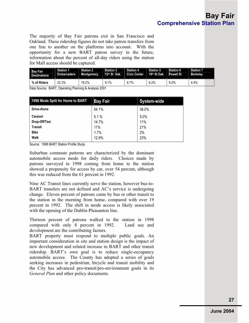
The majority of Bay Fair patrons exit in San Francisco and Oakland. These ridership figures do not take patron transfers from one line to another on the platforms into account. With the opportunity for a new BART patron survey in the future, information about the percent of all-day riders using the station for Mall access should be captured.
Bay Fair Destinations
Station 1 Embarcadero
Station 2 Montgomery.
Station 3 12th St Oak.
Station 4 Civic Center
Station 5 19th St Oak.
Station 6 Powell St
Station 7 Berkeley
% of Riders 22.3% 18.2% 9.1% 6.7% 6.2% 6.0% 4.4%
Data Source: BART, Operating Planning & Analysis 2001
1998 Mode Split for Home to BART Bay Fair System-wide
Drive-Alone 54.1% 38.0%
Carpool 5.1 % 5.0%
Drop-Off/Taxi 14.7% 11%
Transit 11% 21%
Bike 1.7% 2%
Walk 12.9% 23%
Source: 1998 BART Station Profile Study
Suburban commute patterns are characterized by the dominant automobile access mode for daily riders. Choices made by patrons surveyed in 1998 coming from home to the station showed a propensity for access by car, over 54 percent, although this was reduced from the 61 percent in 1992.
Nine AC Transit lines currently serve the station, however bus-to-BART transfers are not defined and AC’s service is undergoing change. Eleven percent of patrons came by bus or other transit to the station in the morning from home, compared with over 19 percent in 1992. The shift in mode access is likely associated with the opening of the Dublin-Pleasanton line.
Thirteen percent of patrons walked to the station in 1998 compared with only 8 percent in 1992. Land use and development are the contributing factors. BART property must respond to multiple public goals. An important consideration in site and station design is the impact of new development and related increase in BART and other transit ridership. BART’s own goal is to reduce single-occupancy automobile access. The County has adopted a series of goals seeking increases in pedestrian, bicycle and transit mobility and the City has advanced pro-transit/pro-environment goals in its General Plan and other policy documents.

Bay Fair Comprehensive Station Plan
28
June 2004
BART’s Strategic Plan calls for reducing single-passenger automobile use by increasing alternative modes of access to the system. This can be best achieved by transit-oriented development, new accessibility in the catchment area through feeder transit services such as neighborhood and business shuttles, and by creating safe and convenient routes for walking and bicycling.
BART’s goals are similarly aligned with the City’s for mixed-use development that promotes pedestrian and transit access. The County has endorsed the preservation of the existing residential areas and is aggressively working to improve pedestrian and bicycle accessibility.
The comparison in the table below shows how mixed-use transit-oriented development can reduce single-occupancy vehicle use. (Note that pick-up/drop-off is not included.) As an example, Hayward facilitated a larger pedestrian mode to BART through a relocation of City Hall and development of new housing with commercial uses in the immediate station area. Note that subsequent phases of housing and commercial development completed since 1998 are not included in this analysis.
Comparative Mode Splits for Neighboring Stations
1998 Mode to BART Bay Fair Hayward
Walk 12.9% 15%
Bus/Transit 11% 21%
Car 59.2% 56%
Bicycle 1.7% 3%Notes: Percentages may not add to 100% due to rounding up. Source: BART 2002
3.8 Issues and Opportunities for Bay Fair TTThe major outcome of an existing conditions overview is to
identify unique considerations for building upon existing strengths, including that of place identity and social culture, to advance larger societal goals. A realistic assessment of challenges can also be construed as opportunities when viewed as a strategic process as much as an outcome goal. The following outlines these opportunities and issues, leading to the conclusions set forth in subsequent chapters.
Several AC Transit Routes converge at the Bay Fair BART Station, including the 40, 40L, 50, 55, 82, 82L, 84, 93 and 97 lines.

Bay Fair Comprehensive Station Plan
29
June 2004
The tremendous opportunities present at the Bay Fair BART Station that emerged during the course of this study and analysis are abundant:
Major smart growth opportunity with Bayfair Mall adjacent to an existing BART station with options for dense mixed-use development and new accessibility infrastructure
Attraction of BART Property as a development
site is increasing, with new opportunities for development feasibility analysis
Large ridership growth, especially cross-platform patron transfers, associated with expansion of BART to San Jose
Transit-corridor infill opportunities underway along the East 14th Street Corridor
Multi-agency access improvement planning and implementation utilizing redevelopment and CMA investments
Improved bus/shuttle feeder service and increase in bus transit mode share
Issues and concerns to be dealt with as planning, engineering and other implementation activities move forward include:
Expansion of the existing BART Station due to capacity impacts of new ridership in 2025 balanced with development potential and intermodal facilities design
Providing ADA accessibility in and around the station
Coordination of development and access planning in a multi-agency relationship, as well as internal governmental agencies/departments
Overcoming obstacles for increased pedestrian,
ADA and bicycle accessibility, especially flood control canals and subsurface passageways, requiring the creation of new comprehensive circulation plan integrating the station area
Finalization of plans for a new pedestrian bridge
connecting BART to Bayfair Mall; ownership/liability clarification of the flood control channel and new bridge.

Bay Fair Comprehensive Station Plan
30
June 2004
Maintaining a mixed-use Smart Growth vision
for the Mall with new ownership
Protecting existing residential neighborhoods
while introducing new densities of housing, particularly on BART’s western property
Mitigation of automobile traffic as development occurs, in keeping with traffic management and parking reduction policies set forth by City Council and codified in the District Plan
Location, design and integration of possible future parking structures into TOD and intermodal facilities on BART, Mall or other property; potential for shared parking structures needs study
Connectivity in general is a primary theme overall: commercial to residential, development areas to the station, transit transfers, pedestrian and bicycle connections and the regional connectivity provided by BART itself. Station functionality and capacity outcomes maximize the flow of patrons in and around the Bay Fair BART Station over time with an understanding of how to meet the future needs of transit patrons.
The following chapters show how these opportunities and issues provide the basis for innovative planning based upon the City’s General Plan, BART’s policies for transit-oriented development, access, station functionality and the regional vision for Smart Growth.

Bay Fair Comprehensive Station Plan
31
June 2004
TTThe Bay Fair BART Station site provides a valuable
opportunity to support City and County goals for smart growth and revitalization around transit. As one of the few regional rail stations located adjacent to a regional mall that itself is undergoing renovation, the east side of the station can support a transit-oriented relationship to the mall and East 14th Street Corridor. The west side of the station also offers a host of opportunities to support revitalization efforts in the Ashland community.
The following chapter describes land use policies and plans for the Bay Fair Station Area that together form the basis for transit-oriented development opportunities. Absent a unified planning process, the outcomes of separate transit-oriented planning efforts by the City, County, Bayfair Mall, BART and other landowners or stakeholders provide a foundation for realization of a thriving district served by BART.
Regional and local agency’s transit-oriented design goals, principles and guidelines of merit are noted including BART’s Transit-Oriented Development Design Guidelines,Access Guidelines and Crime Prevention Through
Environmental Design policies.
The intended outcome is a context and basis for the eventual implementation of a multi-jurisdictional plan that builds upon these efforts to maximize the excellent smart growth potential of Bay Fair’s station area.
Four major areas provide the greatest opportunities for transit-oriented development:
BART’s 18-acre site, including 11.5 acres to the east of the station in the City of San Leandro that is currently utilized for intermodal facilities and commuter parking spaces, and 7.0 acres to the west of the station in an unincorporated area of Alameda County, currently programmed with commuter parking spaces.
Bayfair Mall to the east of the BART station and trackway, located in the City of San Leandro.
The East 14th Street Corridor and Gateway District, identified for infill north and east of Bayfair Mall framed by Halcyon/Fairmont Drive, located in the City of San Leandro.
Infill development opportunity areas in Ashland, to the east and south of the BART station on both sides of the BART trackway, located in the Alameda County.
4.0 Station Area Development
The half-mile area surrounding the Bay Fair BART Station has a strong street hierarchy with development opportunities along transit corridors and in the parking areas of the Mall and Station.

Bay Fair Comprehensive Station Plan
32
June 2004
The major recommendations of this CSP for transit-oriented land use planning and development include:
Use the station as a Smart Growth tool, focusing mixed-use transit-oriented development in and around the station and along adjacent transit corridors.
Identify land use compatibility with commercial development synergies with the Mall for the east side of the station and with residential neighborhoods on the west; prepare strategic economic analyses for potential development.
Support mixed-use development and intensification of Bayfair Mall.
Analyze structured parking opportunities to free up acreage for development and seek funding support for garage construction.
Address proposed BART Property and Mall bus facilities, and AC Transit’s Bus Rapid Transit Project to balance the need for transit access against other valuable uses of Bay Fair BART station land.
Ensure that future development proposals on BART property adhere to BART’s Access, Crime Prevention and Transit-Oriented Development Guidelines.
Support public involvement processes to build community consensus.
4.1 Regional Smart Growth Objectives “ SSSmart growth” has no single definition; its meaning depends on
context, perspective and timeframe. The common thread among different views is of development that revitalizes central cities and older suburbs, supports and enhances public transit, promotes walking and bicycling, and preserves open spaces. Smart growth seeks to revitalize the already-built environment and to foster efficient development at the edges of the region, in the process creating more livable communities. This is at the heart of station area planning efforts at Bay Fair.
Smart growth meets the goals of sustainable development through community design and programs that meet local needs. Focusing new housing and commercial development within already developed areas requires less public investment in new roads, utilities and amenities. Investment in the urban core can reduce crime, promote affordable housing and create vibrant central cities and small towns.
By coordinating job growth with housing growth, and seeking a match between income levels and housing prices, smart growth aims to reverse the trend toward longer commutes and local trip generation. People who live within easy walking distance of shops, schools, parks and public transit have the option to reduce their driving and therefore pollute less than those living in car-dependent neighborhoods. Regional agencies, including BART, have instituted policies, planning processes and implementation priorities for Smart Growth and revitalization of BART station areas, in partnership with the local goals and objectives that guide this comprehensive plan.

Bay Fair Comprehensive Station Plan
33
June 2004
4.2 Alameda County Goals, Policies and Plans AAAlameda County is the jurisdiction for the Ashland Community
while defining countywide land use and transportation plans. The major goals of the County’s Department of Community and Housing Development include:
Preserve the county’s housing stock through rehabilitation and repair assistance programs.
Expand the supply of affordable housing for lower income renters and owners, including first-time homebuyers
Serve the needs of the homeless community as the lead agency in the countywide homeless collaborative, and partnering with homeless service providers.
Revitalize low-income neighborhoods by installing sidewalks and public accessibility improvements, and by constructing neighborhood-serving facilities.
This map shows the various plans and studies preceding and informing the Bay Fair BART Comprehensive Station Plan (CSP). This CSP seeks to relate the plans to one another and provide a foundation for unified multi-jurisdictional strategies that will guide Smart Growth efforts in the station area with development on and around BART property.
AC Transit BRT EIR Analysis
2002 - Present
San Leandro E 14th Street /South
Area Revitalization Strategy 2003-2004
Ashland Community Transit Access
Plan 1998 - 1999/ 2004 Partial Implementation
Bay Fair Mall Redevelopment Plan2001-2003 Note: 2004 New Owner
Central Alameda County
Access PlanCMA 2003 - 2004
BART Access & Circulation
Study 2001/2002
BART Station Capacity Plan
2003
TARGET

Bay Fair Comprehensive Station Plan
34
June 2004
The County’s development plans include the expansion of public facilities at the County Hospital and the Juvenile Hall facility, located to the east of the station area. The County’s Transportation Authority and Congestion Management Agency define improvements for the local tie-ins to freeways, local streets, bicycle paths, and transit improvement plans.
The County’s Redevelopment Agency (RDA) governs land use through adopted redevelopment plans and their environmental clearance, “design for development” documents that define development form, and public facility improvements. A percentage of taxes generated by businesses and land uses in redevelopment areas provide a powerful mechanism for implementing change as well as affordable housing mandates. The Redevelopment Plan for the Bayfair Area is considered a joint City/County planning effort with separate roles for implementation of projects as of 2003.
The County’s Public Works Agency plans, designs and implements public infrastructure improvements such as local streets and County-maintained roads, bridges, creek maintenance and flood control projects. Relevant in the station area is the Agency’s assistance in the planning of new subdivisions, commercial developments, and infrastructure in Ashland and the maintenance of the flood control channels.
4.3 Alameda County Congestion Management Agency (ACCMA) Transit Oriented Development Goals
TTThe following reviews the countywide smart growth goals
approved by the ACCMA Board in May 2004. These goals are particularly important for Bay Fair given the station area lies both in the City and unincorporated County. The ACCMA will use these goals to help prioritize funding for transit-oriented development projects.
Goal 1: Mobility, Livability and Transit Support Enhance community livability by promoting infill, transit oriented and walkable communities and compact development, asappropriate. Support the development of multi-family housing, mixed-use development, and alternative transportation adjacent to transit centers to increase mobility, reduce traffic congestion, and improve opportunities for all members of the community.
Goal 2: Local and Regional Transportation Efficiencies Promote opportunities for transit use and alternative modes of transportation including improved rail, bus, high occupancy vehicle systems, and ferry services as well as enhanced walking

Bay Fair Comprehensive Station Plan
35
June 2004
and biking. Increase connectivity between and strengthen alternative modes of transportation, including improved rail, bus, rideshare and ferry services as well as walking and biking. Promote investments that adequately maintain the existing transportation system and improve the efficiency of transportation infrastructure.
Goal 3: Infrastructure Investments Improve and maintain existing infrastructure and support future investments that promote smart growth, including access improvements to transit.
ACCMA’s Definitions of Characteristics Needed for Effective Transit-Oriented Development (TOD) ACCMA’s Effective Characteristics of Transit Oriented
Development are guidelines for Agency support of projects that meet these goals.
TOD Locations
Proximity to BART or commuter rail station or trunkline bus routes, and proximity to home-end of the commute defined as within one-third mile of a transit station. Frequency of transit service should be taken into consideration in analysis of TOD.
Development Concept & Design Attributes
A mixed-use development of moderately high density with continuous sidewalks and convenient access to transit. Uses are transit-oriented, not auto-oriented, creating convenient walk and bicycle access, affordability and the buying power needed to support neighborhood-scale commercial services.
Street and Streetscape Design
Streets and streetscapes are designed to slow motor-vehicle traffic while creating shade and visual interest for pedestrians and safety for bicyclists, designed with particular attention to the safety of children and seniors.
TOD Residents Housing Mix & Affordability
Townhouses, condominiums, apartments and high density residential - for lease and sale - for middle, moderate and lower-income households. Some oriented to singles, others to seniors. Minimum average net housing density is 25 units per acre, with a preference for 40 units per acre and more.
Commercial Uses
Uses do not encourage auto-oriented access, including, but not limited to local-serving, neighborhood–scale businesses such as a child-care or senior center, a café, bakery, coffee shop, delicatessen, grocery, pharmacy or dry cleaners.
Commercial and Residential Parking
Commercial parking located behind Main-Street businesses and/or beneath apartments and condominiums. Its location is convenient, but does not compromise TOD’s priority emphasis on walkability.

Bay Fair Comprehensive Station Plan
36
June 2004
Commercial parking requirements would be a significant reduction of the jurisdiction’s previous zoning requirements for a similar commercial use. Furthermore, shared parking should be encouraged.
For residential development, a parking ratio goal of 1.5 parking spaces to 1 residential unit is encouraged. Parking for additional cars may be purchased as an add-on or upgrade, but not bundled into the base price of housing units. This increases TOD affordability for households that are likely transit users of car sharing patrons.
Local Transit and Car Sharing Services
Local bus and car sharing services connecting TOD with local employment centers, transit transfer centers, social amenities and public services, such as health clinics, senior centers, schools and universities, family youth and child care centers, parks and libraries.
4.4 City of San Leandro Goals, Policies and Plans TTThe award-winning San Leandro General Plan was updated in
2002. The Plan provides a comprehensive framework looking ahead to 2015 for the City’s physical, economic, social, and environmental development. The Plan can be reviewed on the web at http://www.ci.san-leandro.ca.us/sldevsvcsGP.html.
The Land Use Element contains maps and strategies to shape future physical form and identifies key areas where growth is encouraged. The Bayfair Mall and areas surrounding the BART Station are addressed as the City’s East 14th Street/South Area
Development Strategy, in which policies are advanced through additional strategic efforts that result in design and implementation plans. The Strategy contains new design guidelines, and improvement concepts with supportive regulations. Bayfair Mall has an independent planning effort being led by private developers.
East 14th Street South Area Development Strategy East 14th Street is one of the most heavily traveled corridors in AC Transit’s system, with over 23,000 daily riders. The East 14th
Street South Area Development Strategy refines land use policies and introduces new design guidelines and land use regulations in an effort to revitalize the busy East 14th Street Corridor.
The Strategy defines five districts along the corridor, establishes goals and objectives with studies to inform recommendations. An “Assets, Needs and Opportunities Analysis” and “Opportunity Sites and Development Feasibility Analysis” create a clear strategy for revitalizing this transit-rich area. The Gateway Area, adjacent to Bayfair Mall and one of these five districts, is included in the Bay Fair BART Station Area. The San Leandro City Council adopted the Development Strategy in April 2004. The Strategy and a PowerPoint presentation can be found at http://www.ci.san-leandro.ca.us/sldevsvcse14southstrategy.html.
The vision for the East 14th
Street Corridor is one of urban livability with great pedestrian access and compact, mixed-use development.

Bay Fair Comprehensive Station Plan
37
June 2004
4.5 Future Bayfair Mall Revitalization TTThe study of new development options and leasing
opportunities on Mall property will continue over the next few years. Expansion planning will likely take advantage of the 1992 entitlements allowing over 1.4 million GLA.
Opportunities for future buildings in parking fields can be analyzed as structured parking became feasible, potentially shared with BART. Multi-story mixed-use development is also worthy of feasibility analysis. A 2002 analysis conducted by the previous mall owners suggested the viability of mixed-use development in certain portions of the Mall property as leases expire and expansion is pursued. BART supports these opportunities and is open to shared-use parking garages as well as coordinated development with the Mall.
Next steps include developer analysis followed by conceptual plan review with the City and meetings with BART. The ultimate goal is to identify strategies and seek public-private partnerships that are profitable for the developer, meet the goals and policies of the public agencies endorsing enhanced transit access, and become a successful center of smart growth development.
4.6 BART Property Development Policy BBBART stations are increasingly attractive for mixed-use and
housing development as a result of financial investments that set the stage for development. A key factor for successful transit-oriented development (TOD) is the creation of progressive policies and plans that are adopted into General Plans with critical zoning ordinances, design guidelines, environmental review, and redevelopment implementation strategies.
Often necessary are federal, state, regional, and local government agency investments in structured commuter parking on BART property to allow for redevelopment projects. In some cases, public-private partnerships have made this investment possible. In all cases, a multi-agency and community partnership approach is necessary. BART has evolved new strategies to foster TOD through local and community partnerships, agency policies and guidelines, innovative real estate strategies and new opportunities for leveraging transportation funding investments.
BART's Transit-Oriented Development Guidelines are designed to help guide planning and development around BART stations. They address the BART customer experience, station area land use, and station circulation and access as they relate to transit-
View east to Bay Fair Mall and new Target Store. A flood control canal separates the properties, with one pedestrian bridge providing limited access. New development and access improvements should be studied comprehensively as the Mall evolves.

Bay Fair Comprehensive Station Plan
38
June 2004
Policies guiding development on BART Property and within the station area are exemplified in the Fruitvale BART Transit Village in Oakland.
oriented development. The Guidelines also consider the unique geography, transportation network and varied community priorities of the Bay Area. The ultimate goal is to promote vibrant and livable station areas that benefit the region’s environmental health, BART's patrons and the surrounding community, and that promote the use of BART as a primary means of transportation.
The Guidelines do not dictate dimensions or precise land uses; they are meant to convey best practices, clarify desired outcomes and provide an overview of how development, accessibility and transit work together to make vibrant, successful places that reflect a community’s identity and connections to the region through BART. To review the document, please visit http://www.bart.gov/docs/BARTTOD.pdf.
4.7 Bay Fair BART Joint Development TTThe existing BART Station should take its place as the central
focus of a unified station district that responds to the community’s needs.
In order to enhance the livability of the BART station area and to increase transit ridership, BART along with the City, County and the surrounding neighborhood, should, in the future, evaluate development opportunities on the BART property in coordination with other revitalization efforts. Such a community planning process would typically take into consideration surrounding land uses and community character. As identified in BART’s Transit-Oriented
Development Guidelines:
To capitalize on the extraordinary regional access that BART provides, station areas should be developed with a compact, walkable mix of residential, commercial and neighborhood-supporting land uses. The “right” mix for a station depends on the surrounding community’s needs and conditions …. (p. 36)
Such a planning process would also allow for a more detailed discussion about implementation of some of the access and community connectivity improvements identified in this report. In the interim, there are several steps that can be taken to make BART attractive as a development opportunity and in support of surrounding land use. A strong recommendation from the tri-agency work is to coordinate the trimming of large trees on BART’s eastern parking lot to open view corridors to major access points into the Mall and increase visibility to the Target store from the BART platform. BART is repaving the 30-year old asphalt parking areas in summer 2004, resulting in a cleaner environment.

Bay Fair Comprehensive Station Plan
39
June 2004
5.0 Station Access Overview TTThe existing BART Station should take its place as
the central focus of a unified station district that responds to the community’s needs. The BART property on the east, facing the Mall, should become visually and physically integrated at multiple points that relate to major entry plazas and provide safe, clear routes to activity nodes such as the theater. Also necessary are walkways and bicycle lanes to and from the surrounding residential communities.
Locations for structured commuter and development parking can be identified in terms of both circulation accessibility, but also as building blocks of transit-oriented development. On the western portion of BART property, opportunity to construct a new pedestrian underpass should be integrated with an ADA-accessible public plaza, again providing a structural foundation for development.
The increasing need for shuttle and bus feeder service, along with the proposed AC Transit BRT project provides another set of access considerations. A new bus facility must be integrated and balanced with overall program and facility needs.
BART’s Access Guidelines undergird the recommendations in this report, providing a framework for enhanced multi-modal transit access for the station area and patrons who use the station. An integrated access infrastructure approach considers ease of mode transfers, clarity and convenience, and sensitivity to ADA concerns. The following recommendations enhance each mode of access to BART throughout the Bay Fair Station Area:
Improve circulation for buses, automobiles and pedestrians into and within the Bay Fair station.
Implement pedestrian and bicycle access improvement projects on BART property and work with Bayfair Mall, City and County to remove barriers and increase links throughout the station area.
Design accessible pedestrian connections to the station entrance from the west lot.
Work with partner agencies to pursue funds for projects that improve pedestrian and bicycle access to the station.
Work with AC Transit to improve the connections between bus and BART and plan for Bus Rapid Transit.
Identify funding opportunities for improving wayfindingsignage and real time information for bus connections.
5.0 Station Access
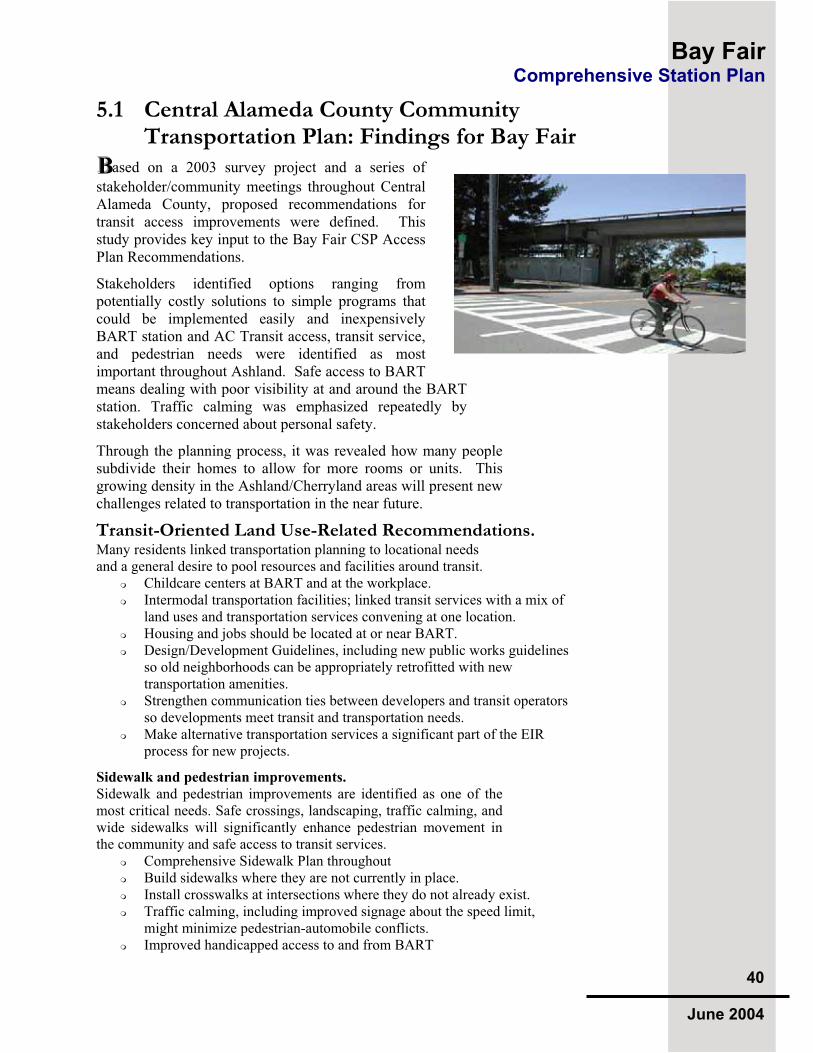
Bay Fair Comprehensive Station Plan
40
June 2004
5.1 Central Alameda County Community Transportation Plan: Findings for Bay Fair
BBBased on a 2003 survey project and a series of
stakeholder/community meetings throughout Central Alameda County, proposed recommendations for transit access improvements were defined. This study provides key input to the Bay Fair CSP Access Plan Recommendations.
Stakeholders identified options ranging from potentially costly solutions to simple programs that could be implemented easily and inexpensively BART station and AC Transit access, transit service, and pedestrian needs were identified as most important throughout Ashland. Safe access to BART means dealing with poor visibility at and around the BART station. Traffic calming was emphasized repeatedly by stakeholders concerned about personal safety.
Through the planning process, it was revealed how many people subdivide their homes to allow for more rooms or units. This growing density in the Ashland/Cherryland areas will present new challenges related to transportation in the near future.
Transit-Oriented Land Use-Related Recommendations. Many residents linked transportation planning to locational needs and a general desire to pool resources and facilities around transit.
Childcare centers at BART and at the workplace. Intermodal transportation facilities; linked transit services with a mix of land uses and transportation services convening at one location. Housing and jobs should be located at or near BART. Design/Development Guidelines, including new public works guidelines so old neighborhoods can be appropriately retrofitted with new transportation amenities. Strengthen communication ties between developers and transit operators so developments meet transit and transportation needs.Make alternative transportation services a significant part of the EIR process for new projects.
Sidewalk and pedestrian improvements.
Sidewalk and pedestrian improvements are identified as one of the most critical needs. Safe crossings, landscaping, traffic calming, and wide sidewalks will significantly enhance pedestrian movement in the community and safe access to transit services.
Comprehensive Sidewalk Plan throughout Build sidewalks where they are not currently in place. Install crosswalks at intersections where they do not already exist. Traffic calming, including improved signage about the speed limit, might minimize pedestrian-automobile conflicts.Improved handicapped access to and from BART
Bay Fair Comprehensive Station Plan
41
June 2004
Bicycle Solutions.
Better bicycle facilities, bicycle parking and safe bike lanes should be found in the area as bicycles are an inexpensive and effective way to encourage people to travel in the community.
Better and safer bicycle parking. More bicycle lanes.
Shuttles.
The community expressed a strong desire for shuttles because they are perceived as clean, friendly and safe. A shuttle is visualized as a smaller vehicle that can “go more places” than a large AC Transit bus, providing:
Late-night shuttle service to BART. Special shuttles; organized shuttle that operates with pooled resources from all of the agencies and providers in the area. Coordinated employer shuttle – Mervyn’s example for other local employers. Children’s shuttles to and from school. Shuttle services from school through the district and from residential areas to work areas in the evenings and back. Church buses available during the week for neighborhood shuttle. Care facilities should provide community shuttles.
Improved AC Transit Service.
Stakeholders seek better AC Transit frequencies, a longer service span, clean and safe bus stops, courteous drivers, lower fares and better transit information.
The buses should run from 6:00 a.m. to 11:00 p.m. 24-hour BART/bus services. AC Transit should use smaller buses, which are more environmentally friendly and better accepted by residents. Need bus shelters/ Focus on maintaining bus shelters properly. Make AC Transit service clean, on time and safe. Transit service needs to go door-to-door. It has to take less time to travel and has to be a positive experience to use. Sensitivity training for transit drivers: both AC Transit/East Bay Paratransit operators need to be efficient, cheerful and reliable.
Improved Transit Information.
Options include providing transit information at bus stops, a local transportation information center, transit education programs in the schools, and brochures in multiple languages.
Transit education at school. An easy to use information center somewhere in the community A transportation page on a local cable station with a continuous loop about services available, including maps, travel specifics and information in various languages. Bilingual information. Better information provided at bus stops with clear graphics. Central information 1-800 number to encourage/promote transit.Signage near schools, care facilities and community centers. A better information and complaint line to share information on problems and concerns about AC Transit service.

Bay Fair Comprehensive Station Plan
42
June 2004
Improved Public Safety. All residents express concern about public safety for their families. Recommendations include physical and service needs.
Better lighting along streets, especially between BART and school.Streets more attractively landscaped, more pedestrian friendly. Special crosswalk markings for Senior and community centers.Create better bus stops and safe places for people to access transportation.Security cameras at high crime locations. More law enforcement in school and senior zones. More crosswalks and crossing guards. Rails-to-trails bicycle path through the rail corridor in Cherryland.
Transit Cost Savings.
Subsidizing transit passes for single parents, students, senior citizens and persons with very limited incomes is highly desired. Seamless transfers between AC Transit and BART improve mobility options.
Single parent bus passes and senior citizen bus passes. Free or discounted youth passes for AC Transit. Subsidize BART and AC Transit passes. (i.e., explore Social Services funding or distribute passes through a CBO). Discount for parents with large families/multiple children.
Transportation Demand Management-Supportive Programs.
Introducing or promoting a “Guaranteed Ride Home Program,” a subsidized taxi program, or community-organized vanpools would increase transportation options in Central Alameda County.
5.2 Ashland Bay Fair BART Access Plan IIIn 1999, a tri-agency access plan was advanced for funding considerations. The Ashland Bay Fair BART Access
Improvement Plan, created by the County, City and BART, was a blueprint for new access infrastructure projects including new sidewalks along existing streets being implemented today in Ashland by the County’s Redevelopment Agency.
Hallmarks of the 1999 plan include a new pedestrian “spine” that would provide direct access from the station entrance to the proposed new bridge across the flood control channel to Bayfair Mall. Also included were new sidewalks and streetscape amenities for Coelho Drive to East 14th Street, and improvements for existing bus stops.
The 1999 Access Plan for the Ashland Community included a new pedestrian connection from BART to Bayfair Mall and new connections within the residential neighborhood.

Bay Fair Comprehensive Station Plan
43
June 2004
Also on BART property was the relocation and painting of the BART Police building, directional signage and other access-related wayfinding elements.
The plan was revisited once the new Target store footprint was determined in 2001. The proposed pedestrian bridge had to be relocated to the south because its original location landed pedestrians into Target’s truck bay area. The Mall’s owner committed to financial support for additional costs related to the bridge relocation, including sidewalk along the BART side of the flood control channel, stop signs and crosswalks as was advanced in a 2001 conceptual plan update.
Due to issues of public ownership and liability responsibility, and the use of public money for construction and maintenance, the bridge has not been resolved. One option is to improve the Coelho Drive/Mall Ring Road entrance with the same pedestrian elements suggested for a new bridge.
5.3 Recommendations for Improved Pedestrian Access
TTThe barriers between neighborhoods, the Mall and BART have
long been the subject of multi-agency planning endeavors. The tri-agency study by Alameda County, San Leandro and BART identified numerous barriers and listed a variety of means for redress including:
A comprehensive pedestrian plan for the station area
Direct visual and pedestrian connection improvements on BART property, including connecting BART and Bayfair Mall, new and improved crosswalks in front of the station, sidewalks in parking areas, lighting and signage
New pedestrian connections to BART and the neighborhoods on Mall Property, including new sidewalks along the Ring Road, flood control canal and parking areas, lighting and signage
The addition of sidewalks, landscaped medians, bulb-outs and other pedestrian features along neighborhood streets in the Ashland Community, particularly around Coelho Drive and 136th Avenue
With the building of Target, a 2001 concept plan shows a proposed new walkway along the flood control channel to the pedestrian bridge, now relocated to the south. New crosswalks and signage for traffic control were also added.

Bay Fair Comprehensive Station Plan
44
June 2004
Upon completion of the 1999 plan, an implementation grant was obtained from the Alameda County Congestion Management Association to be augmented by matching funds from the City and County through its Redevelopment Agency. As the Mall plans changed, the plan required readjustment. Eventually, a revised conceptual plan was devised to improve portions of the Ashland community.
The County’s Redevelopment Agency is moving forward with the construction of these improvements in the Ashland community leading up to BART property. For more information visit http://www.acgov.org/cda/redevelop/projects/index.htm.
Anticipated next steps include convening the three agencies to address unmet access needs, and meetings with the new Mall owner to revisit the EIR mitigation plan to identify methods of implementation to complete the promise of better connectivity and increased transit access.
San Leandro’s multiple planning efforts, combined with the tri-agency 1999 Access Plan and the 2003 Central Alameda County Transportation Plan, lay much of the foundation for coherent improvement of access facilities. These plans also reflect proposals in Bayfair Mall’s 1992 EIR
While improvements are being implemented adjacent to BART, the station is physically separated from the surrounding neighborhood and from the Mall. The current pedestrian bridge across the flood canal does not connect to a major Mall or store entrance, the BART station pedestrian underpass connecting east and west lots is not ADA accessible, and there is a lack of clear connections to the station entrance and wayfinding signage in the area.
The 1992 EIR and 1999 Plan identify a series of critical elements as seen in the graphics below. Highlights include:
New access ways through the eastern BART parking lot connecting with Mall
New bridge across the flood canal connecting the Mall and BART
Sidewalk and streetscape improvements along Coelho Drive and connecting County residential streets
Enhanced bus stops, including landscape, signage, lighting and street furniture
Wayfinding elements, including new signage on BART and Mall property
The Alameda County Redevelopment Agency is implementing a series of recommended pedestrian access improvements in the Ashland community that stem from the 1999 tri-agency effort. Next steps include redesign and funding for elements on and around BART property.

Bay Fair Comprehensive Station Plan
45
June 2004
Plans developed by BART for long-term expansion include a new pedestrian grade separation under the BART trackway to provide better access from the residential neighborhoods to the west of the BART Station. A second pedestrian grade separation on the southern end of the BART trackway should be studied as an extension of a comprehensive public space and pedestrian pathway system. Before this is accomplished, many improvements can be made to existing facilities in a phased plan.
The existing BART underpass is not ideal because it is not ADA accessible, it is out of sight from the station agent or other nodes of activity, and is without CCTV cameras to provide a means for public safety. It has unfortunately been the site of robberies against patrons. Interim improvements include new lighting and additional BART Police blue phones with sightlines to the underpass.
The County’s Public Works Department will be coordinating a new pedestrian plan for unincorporated communities including Ashland. A potential greenway pedestrian path system for the station area should include utilization of land adjacent to flood control and/or swales, rail trackways and major streets. Mid-block pedestrian connections should be integrated with development design guidelines. Whatever the means of arrival or departure from the BART Station, one must walk. In order to accomplish the goals of preceding plans and future development with increased BART ridership, a primary focus must be upon easy, safe and comfortable pedestrian movement.
Streetscape design shown in proposed Mall improvement plans provide design guidelines reflected in typical street sections; these sections can form the basis for future station area implementation. New streets and pedestrian path systems should be laid out in a radiating grid system to provide maximum flexibility for pedestrians, bicycles and vehicles. Larger blocks are intended to be interspersed with pedestrian pathways and streets should have clearly marked and well designed bicycle lanes.
In the case of East 14th Street, recommendations adopted by the City and redevelopment plans by the County provide a guide for the station area. These include:
Replace two-way turn lanes with tree-lined, raised and landscaped medians
Introduce pedestrian refuges in center medians
Widen sidewalks to 13.5 feet or more, dependent upon local conditions
Introduce curb extensions at side streets and at “T” intersections to facilitate shortening of pedestrian crosswalk distances
Create enhanced crosswalks utilizing special paving, zebra striping and other means of pedestrian-priority design

Bay Fair Comprehensive Station Plan
46
June 2004
5.4 Bicycle Access Improvements TTThe City’s system of bicycle routes on major arterial streets
includes Hesperian Boulevard and East 14th Street/International Boulevard. A major goal of the 1999 Plan is to provide a structure connecting neighborhood collector streets to these arterials, particularly emphasizing Coelho Drive.
The Countywide Bicycle Plan similarly emphasizes arterials and connections to major public facilities including the Bay Fair BART Station. The CSP provides a conceptual plan for BART property in order to define phased infrastructure improvements, with space identified for new facilities as the station expands.
Bicycle lanes should be designed with attention to reducing conflicts between automobile or bus traffic and bicyclists. A station area greenway system can provide multi-use paths that decrease conflict points while incorporating the same design philosophy for beauty, comfort and safety as that for street improvements.
As part of the 2001 BART systemwide bicycle facility upgrade program, new wave racks and lockers were installed in front of the Station. Currently there are a total of 36 bicycle racks and eight bicycle lockers, providing space for two bicycles per locker. The racks and lockers are fully utilized with some degree of spillover, causing an average of eight patrons to lock their bicycles to poles on a typical weekday.
One important station expansion component identified in Chapter 6, Station Capacity and
Functionality, is a new pedestrian underpass with a proposed second east-side entrance. The design engineering for the proposed new underpass should seek a grade solution eliminating stairs if possible. In lieu of such a solution, it should include bicycle channels.
The provision of channels along existing stairways for bicycles walked along by pedestrians is another facility improvement. Another bicycle-oriented station functionality recommendation is to provide a bicycle pavilion area in concert with the expanded concourse area of the Station, potentially with bicycle rental and repair available as a means for generating operating funds.
Finally, the City is dedicated to ensuring the Mall developers provide facilities and incentives to employees who bicycle directly to work or who use transit with their bicycles.
This view of a pedestrian-friendly mixed-use commercial street with ample bicycle facilities informs the vision for the Bay Fair station area

Bay Fair Comprehensive Station Plan
47
June 2004
5.5 BART & Bus Transit Improvements TTThe 2003 Central Alameda County Plan
addresses many bus improvement issues for Ashland. The City of San Leandro has also set forth transit connectivity goals via the General
Plan. Currently, nine bus routes use the 14 bays at the station as a landing with a significant degree of bus-to-bus transfers that do not include BART patrons. As property development, area plans and site design evolve within the station area, bus facilities will be designed in such a way to provide clarity for ease of use and safe pedestrian movement. reserve
Some routes may be cut due to AC Transit’s fiscal constraints. However, the station’s location currently provides a “crossroads” transfer point for bus riders and a layover area for AC Transit Operations. At the same time, an on-going environmental study process for proposed Bus Rapid Transit (BRT) along East 14th Street proposes Bay Fair Station as its southern terminus. Conceptual circulation plans and design elements for the BRT project are being debated with the City and Bayfair Mall at this time. Potential bus circulation options will be considered, with facility design advanced as a part of a full development analysis.
The eastern lot remains the logical location for a bus facility given that most of the existing nine lines and the proposed BRT comes into the station from Coelho Drive as proposed. As seen in the following chapter, the BART station platform and optional third-rail sets a development “footprint” that will eventually relocate the bus transit center.
One potential surface transit facility concept that has emerged involves a new circulation system that bisects the east lot in a manner conducive to property development (see illustration on page 56). AC Transit Planning staff has found this layout acceptable, concurring that this option could be operationally feasible given safe bus turning movements and patron safety during transfers.
A related possibility is integrating a new bus facility into a. centralized pedestrian zone. An automobile and shuttle drop-off area could be located in front of the station with a shared egress to Coelho or with the opportunity to circulate around the property and exit to the western side of the station, connecting with Hesperian Boulevard.
View of front entry of station on the east side, with bus-only lane separating pick-up/drop-off zone and parking areas.
Bus lanes and fourteen bays are located on the east side of station. When site circulation is redesigned for TOD, a new bus facility will be included.
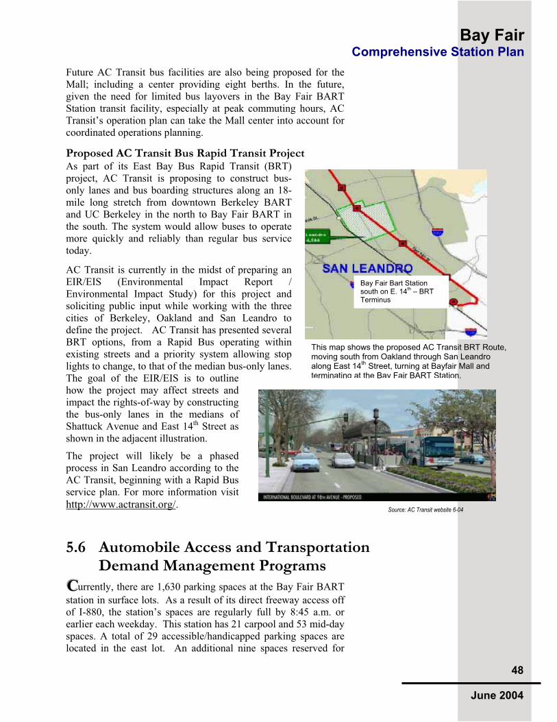
Bay Fair Comprehensive Station Plan
48
June 2004
Future AC Transit bus facilities are also being proposed for the Mall; including a center providing eight berths. In the future, given the need for limited bus layovers in the Bay Fair BART Station transit facility, especially at peak commuting hours, AC Transit’s operation plan can take the Mall center into account for coordinated operations planning.
Proposed AC Transit Bus Rapid Transit ProjectAs part of its East Bay Bus Rapid Transit (BRT) project, AC Transit is proposing to construct bus-only lanes and bus boarding structures along an 18-mile long stretch from downtown Berkeley BART and UC Berkeley in the north to Bay Fair BART in the south. The system would allow buses to operate more quickly and reliably than regular bus service today.
AC Transit is currently in the midst of preparing an EIR/EIS (Environmental Impact Report / Environmental Impact Study) for this project and soliciting public input while working with the three cities of Berkeley, Oakland and San Leandro to define the project. AC Transit has presented several BRT options, from a Rapid Bus operating within existing streets and a priority system allowing stop lights to change, to that of the median bus-only lanes. The goal of the EIR/EIS is to outline how the project may affect streets and impact the rights-of-way by constructing the bus-only lanes in the medians of Shattuck Avenue and East 14th Street as shown in the adjacent illustration.
The project will likely be a phased process in San Leandro according to the AC Transit, beginning with a Rapid Bus service plan. For more information visit
http://www.actransit.org/.
5.6 Automobile Access and Transportation Demand Management ProgramsCCCurrently, there are 1,630 parking spaces at the Bay Fair BART
station in surface lots. As a result of its direct freeway access off of I-880, the station’s spaces are regularly full by 8:45 a.m. or earlier each weekday. This station has 21 carpool and 53 mid-day spaces. A total of 29 accessible/handicapped parking spaces are located in the east lot. An additional nine spaces reserved for
Bay Fair Bart Station south on E. 14
th – BRT
Terminus
This map shows the proposed AC Transit BRT Route, moving south from Oakland through San Leandro along East 14
th Street, turning at Bayfair Mall and
terminating at the Bay Fair BART Station.
Source: AC Transit website 6-04

Bay Fair Comprehensive Station Plan
49
June 2004
BART Police use, and one space for the station agent, are adjacent to the training facility building on the east lot. Finally, there are 24 motorcycle parking spaces at this station.
The main drop-off and pick-up zone is located across from the east front entry. Between this point and the station entry is a one-way, bus-only lane leading to the bus facility. While automobile and bus traffic have separate lanes at this location, the pedestrian realm crossing them is not enhanced. On the western side is the non-ADA pedestrian underpass. Much less pick-up/drop-off activity has been seen in here during site visits.
In 2002, the BART Board voted to allocate up to 25 percent of BART parking spaces as fee-based monthly parking. This plan allows BART customers the option of reserving a space until 10:00 AM. There are currently 18 parking passes issued at this station, out of 56 reserved spaces.
The majority of on-street parking is unmetered along the adjacent streets. BART patron parking spill-over in the Ashland community has been a problem in the past for those residents living closest to the station. BART commuters parking in the Mall’s parking lot, especially prior to Target’s construction in 2003, has also been a problem.
While a primary goal of BART’s Access Policy is to increase access to the stations for modes other than the automobile, the challenge is to accomplish this while at the same time gaining maximum efficiency from its location for advantageous automobile access. The ultimate solution will be structured parking.
Many of these key issues will be resolved once a plan and design for station area development is put forward. However this Comprehensive Station Plan offers the opportunity to recommend that certain issues be explored as new station area development is designed.
Key strategies for accommodating automobiles are: Provide one or more drop-off locations within new developments that provide convenient station access. Explore programs to increase carpooling and mid-day parkingResolve circulation problems entering the station and within the station area.
“No BART Parking” signs are seen throughout the Mall’s parking lots. A BART-Mall partnership to create joint-use structured parking is an option for Bay Fair.

Bay Fair Comprehensive Station Plan
50
June 2004
While a primary goal of BART’s Access Policy is to increase access to the stations for modes other than the automobile, the challenge will be to accomplish this while at the same time gaining maximum efficiency from its location for advantageous automobile access. Therefore, recommended improvements focus on the circulation routes into and within the station, carpool participation and drop off facilities. Many of these key issues will be resolved once a plan and design for station area development is put
5.6.2 BART Property Circulation Vehicular access to the BART property will remain at the two points utilized today. The BART Station, transit-oriented development and commuter parking facilities could be accessed by a new Ring Road encircling the site with a combination of traffic flows as shown on the conceptual diagram to the right.
Preliminary ideas for this layout were advanced as a result of design workshops facilitated by BART with AC Transit, City and County staff in 2001 and 2002. A final circulation plan for the station area will rely on the completion of new Mall plans by the developer-owner, Madison Marquette. The station concepts can then be tested and design engineered.
Similarly, transit-oriented development on BART’s property will inform a circulation plan and final locations for station access facilities, including the bus/shuttle transit facility, pedestrian routes and bicycle pathways. The foundational understanding seen in the concept plan can guide ultimate infrastructure engineering.
The area directly in front of the station should be clear of curbside parking except for BART service vehicles to provide a clearly pedestrian realm. Raised-table crosswalks of colored concrete or other highly visible hardscape materials surrounded by bollards would physically define this realm.
BART commuter automobile parking displaced by facility or infrastructure construction during short term improvement projects can be located offsite with shuttle access should no suitable onsite alternative such as attended parking be adequate. In later phases, as surrounding properties move towards development with
This conceptual circulation plan creates a central spine connecting with the proposed new bridge in a location associated with a major new Mall entry. The design emerged in workshops with BART, AC Transit, City and County staff during evaluation of new Bayfair Mall plans in 2001.

Bay Fair Comprehensive Station Plan
51
June 2004
shared access, patron parking will become structured and parking for development accommodated into building design. In all cases, BART’s maintenance requirements must be met and facilities designed for operations needs.
5.6.3 Parking Reduction and Transportation Demand Management (TDM) Policies
In an effort to support transit use as a traffic mitigation, the 1992 Bayfair Mall Environmental Impact Report includes measures that address the impacts of Mall expansion and redevelopment. Approved mitigations include transit passes, physical access improvements such as the bridge and signage programs connecting the Mall with transit. The City has also discussed institution of a TDM program requiring employers to offer incentives to employees with a goal of increasing transit use, especially focused upon development along transit corridors and around the City’s two BART stations.
The City’s parking policies support reduced development requirements for parking with the need for overflow addressed through designation of on-street parking inventories and shared parking opportunities. Also to be considered are parking guidelines for transit-oriented development, especially with an understanding of needs for affordable housing and senior housing that could be implemented in the station area.
Parking for office uses or residential buildings should be integrated into podium structures, with surface lots serving initial and interim development phasing; this is the “land bank” idea that has been most successful in long term creation of a transit village As new employers within the station area incorporate structured parking into development phasing, reductions in parking requirements will be combined with transit-use incentives. Large employers and public facilities like the County Medical Center outside the station area will be encouraged to provide shuttle services to and from the station as well.
One opportunity is the establishment of an independent parking district to regulate parking supply and pricing within the area. Another is to look for shared parking opportunities, as a joint Mall/BART commuter parking garage as has been discussed over a decade ago. The parking district could provide parking enforcement and oversee a project area transportation demand management program, working with employers to increase transit use and rideshare programs. Metered on-street short-term parking should always be oriented to retail uses and a residential permit system implemented when appropriate.
A phased strategy for parking reduction requires developers to create master development plans that outline how parking

Bay Fair Comprehensive Station Plan
52
June 2004
requirement reductions are implemented. For instance, a reduced off-street parking ratio for commercial office could be 2.3 parking spaces per 1,000 square feet of development, much lower than the 3.3 spaces currently required. For the Mall, a comprehensive parking plan can provide all that is stipulated by Macy’s, the Mall oldest tenant and who has design authority for parking plans mall-wide.
5.7 MTC’s Transit Connectivity Study MMMTC is currently conducting a Transit Connectivity Study, the
purpose of which is to identify the region’s major transportation hubs and explore opportunities to promote better connections among transportation providers. Because Bay Fair is a transportation hub, the recommendations of this study are likely to be affected by it.
Although the MTC study is currently underway, several preliminary recommendations have emerged including the significant improvement and standardization of wayfinding signage at hubs, both to connecting transit as well as to local destinations, and the improvement of transit informational displays. The study also recommends adding real-time bus information at all hubs. Long-term recommendations are to create a regionally planned system of transportation hubs, develop a marketing campaign around connectivity and develop a process for locating new hubs based on emerging markets.
5.8 Regional Measure 2 and Owl Transit Service
IIIn March 2004, the Bay Area voters passed Regional Measure
2, the additional dollar toll on Bay Area bridges, provides funding for “owl” bus service along BART corridors during the late night and early morning hours when BART is not operating. This service will provide transit for individuals working night or late swing shifts. One consequence of this service is the increased activity at BART stations at night. Over the next several months, BART and its partners will have to address the issues associated with increased activity and hourly bus service into station areas – such as cleanliness, safety and security.

Bay Fair Comprehensive Station Plan
53
June 2004
5.9 Access Recommendation Matrix AAAs a way of addressing the access issues identified above, the
recommendations in this access plan matrix focus on the following:
Create a station area pedestrian access plan, coordinating with the County’s and City’s master planning efforts
Redesign the BART station property to improve circulation for pedestrians, bicycles, buses, and automobiles into and within the Bay Fair station.
Ensure that future development proposals on BART property adhere to BART’s Access and Transit-Oriented Development Guidelines and advocate for improved access with adjacent developers
Design new ADA-accessible connections to the station entry from the west lot.
Implement pedestrian and bicycle access projects on BART property and work with Bayfair Mall, City and County to increase links across the County flood control channel.
Work with partner agencies to aggressively pursue funds for projects that improve pedestrian and bicycle access to the station.
Work with AC Transit to improve the connections between bus and BART and plan for Bus Rapid Transit.
Identify funding opportunities for improving wayfinding signage and real time information for bus connections.

Ba
y F
air
C
om
pre
he
ns
ive
Sta
tio
n P
lan
54
Ju
ne 2
004
5.6
Bay
Fai
r B
AR
T S
tati
on A
cces
s Im
pro
vem
ent
Rec
omm
end
atio
ns
Mo
de
D
escr
ipti
on
L
ead
Su
pp
ort
S
/M/L
P
ote
nti
al
Sou
rces
**
WA
LK
an
d B
ICY
CL
E
W1
: B
AR
T P
ark
ing
Lo
t Im
pro
vem
ents
Upgra
de
AD
A a
cces
s on e
ast
side.
Imp
rov
e p
laza
an
d c
ross
wal
k z
on
e in
fro
nt
of
stat
ion
on
eas
t si
de
and a
lon
g w
alkw
ays
on w
est
side
Imp
rov
e ex
isti
ng
ped
estr
ian
un
der
pas
s
Pro
vid
e n
ew s
idew
alk
s th
rou
gh
par
kin
g f
ield
s
BA
RT
SB
AR
T
(in
clu
des
use
of
FT
A f
un
ds
for
AD
A)
W2
: B
ay
fair
Ma
ll:
Cre
ate
and
mai
nta
in n
ew p
edes
tria
n/b
icy
cle
bri
dg
e,
con
nec
tin
g M
all
and
BA
RT
pro
per
ties
as
des
crib
ed i
n t
he
19
92
EIR
; w
ork
wit
h t
he
Cit
y a
nd
Co
un
ty t
o i
mp
lem
ent
asp
ects
of
the
19
99
Acc
ess
Pla
n o
n B
AR
T p
rop
erty
an
d
con
cep
tual
des
ign
s fo
r th
e 2
00
3 M
all
sub
mit
tal
to t
he
Cit
y
Pro
vid
e en
han
ced
wal
kw
ays/
bic
ycl
e fa
cili
ties
in
Mal
l ci
rcu
lati
on
pla
n,
incl
ud
ing
wal
kw
ays
in p
ark
ing
fie
lds
Cre
ate
new
cu
rb c
uts
in
ex
isti
ng
par
kin
g l
ots
ad
jace
nt
to
Coel
ho D
rive
inte
rsec
tion w
ith M
all
Rin
g R
oad
Cre
ate
new
ped
estr
ian
-ori
ente
d 1
4th S
tree
t fr
onta
ge
Cre
ate
bic
ycl
e la
nes
wit
hin
Mal
l an
d B
AR
T p
rop
erti
es,
and
w
ith
in n
ew s
urf
ace
par
kin
g c
on
nec
tin
g t
o B
AR
T s
tati
on
si
gnag
e pla
n.
Bay
fair
Mal
l A
lam
eda
Co
un
ty
San
Lea
nd
ro
BA
RT
S
Mal
l &
Cit
y
W3
: C
ity
of
Sa
n L
ean
dro
:
Pro
vid
e en
han
ced
ped
estr
ian
sig
nal
act
ivat
ion
as
new
tr
affi
c li
gh
ts a
re i
nst
alle
d a
lon
g k
ey r
ou
tes.
Req
uir
e sp
ecia
l ac
cess
rev
iew
in
all
dev
elo
pm
ent
pro
posa
ls
San
Lea
nd
ro
BA
RT
, C
MA
&
Red
ev.,
M
TC
Cal
tran
s
W4
:A
lam
eda
Co
un
ty:
Pro
vid
e en
han
ced
ped
estr
ian
sig
nal
act
ivat
ion
as
new
tr
affi
c li
gh
ts a
re i
nst
alle
d a
lon
g k
ey r
ou
tes.
Co
ord
inat
e im
ple
men
tati
on
of
Co
un
tyw
ide
Bic
ycl
e P
lan
Co
ord
inat
e im
ple
men
tati
on
of
the
up
dat
ed 1
99
9
Ash
land C
om
munit
y A
cces
s Im
pro
vem
ent
Pla
n
Ala
med
a C
ou
nty
S
an L
ean
dro
, A
lam
eda
Co
un
ty C
MA
, M
TC
BA
RT
C
altr
ans
F
UR
TH
ER
IN
PU
T F
RO
M
CO
UN
TY
& C
MA

Ba
y F
air
C
om
pre
he
ns
ive
Sta
tio
n P
lan
55
Ju
ne 2
004
Mo
de
D
escr
ipti
on
L
ead
Su
pp
ort
S
/M/L
P
ote
nti
al
Sou
rces
**
WA
LK
& B
ICY
CL
EW
5:
BA
RT
Pro
per
ty:
Cre
ate
new
Rin
g R
oad
cir
cula
tio
n p
lan
wit
h a
TO
D
anal
ysi
s, d
efin
ing p
edes
tria
n/b
icy
cle
amen
itie
s.
Cre
ate
new
ped
estr
ian
pla
za i
n f
ron
t o
f ex
isti
ng
wes
t si
de
BA
RT
sta
tio
n e
ntr
ance
, in
co
nju
nct
ion
wit
h c
reat
ion
of
new
ri
ng
ro
ad f
acil
itie
s fo
r p
asse
ng
er B
AR
T s
erv
ice
veh
icle
s,
pas
sen
ger
pic
k-u
p/d
rop
-off
, A
DA
dro
p-o
ff a
nd
tax
i ar
ea.
BA
RT
S
an L
ean
dro
,
Ala
med
a C
ou
nty
,
MT
C,
AC
Tra
nsi
t
S
BA
RT
, C
ity
an
d C
ou
nty
R
edev
elo
pm
ent
Ag
ency
W6
:E
ast
14
th S
tree
t Im
pro
vem
ents
Cre
ate
ped
estr
ian
pri
ori
ty c
ross
ings
to l
ink c
om
mer
cial
ar
eas,
th
e A
shla
nd C
om
munit
y a
nd t
he
BA
RT
Sta
tion
Pro
vid
e en
han
ced
ped
estr
ian
sig
nal
act
ivat
ion
as
new
tr
affi
c li
ghts
are
inst
alle
d a
long k
ey r
oute
s.
Over
see
imple
men
tati
on o
f C
ounty
wid
e B
icycl
e P
lan
wit
h l
ink
s to
maj
or
stre
ets
San
Lea
nd
ro
Cal
tran
s M
C
ity
, A
lam
eda
Co
un
ty,
MT
C.
Cal
tran
s
W7
:C
reat
e en
han
ced m
id-b
lock
connec
tions
along a
rter
ial
and c
oll
ecto
r st
reet
s w
her
e fe
asib
le w
ithin
the
stat
ion a
rea
San
Lea
nd
ro
Ala
med
a C
ou
nty
S
S
an L
ean
dro
Ala
med
a C
ou
nty
W8
:C
reat
e bic
ycl
e/ped
estr
ian g
reen
way
pla
n,
incl
udin
g
pote
nti
al u
se o
f U
PR
R R
OW
.
San
Lea
nd
ro
Ala
med
a C
ou
nty
, B
AR
T
L
TB
D
W9
:D
evel
op
an
d i
nst
all
way
find
ing
sig
ns
alo
ng
all
key
rou
tes.
San
Lea
nd
roB
AR
TA
lam
eda
Co
un
ty,
Bay
fair
Mal
l
S &
L
TB
D
W1
0:
Lig
hti
ng
:U
pgra
de
the
ligh
tin
g w
ith
in a
ll p
ub
lic
and
civ
ic f
acil
itie
s, s
tati
on
are
as a
nd p
ark
ing
lo
ts t
o p
rov
ide
a m
inim
um
mai
nta
ined
lev
el o
f .7
5 f
oot-
candle
s, 5
to 6
fee
t ab
ove
the
lot
surf
ace.
San
Lea
nd
ro,
BA
RT
Ala
med
a C
ou
nty
TB
D
S
TB
D
Ped
estr
ian
Sa
fety
W1
1:
Ped
estr
ian
Cir
cula
tio
n:
Illu
stra
ted
des
ign
gu
idel
ines
sh
ou
ld b
e in
clu
ded
in
a f
utu
re
ado
pte
d B
ayfa
ir S
tati
on
Dis
tric
t P
lan.
BA
RT
’s C
rim
e P
rev
enti
on
Cri
teri
a sh
ou
ld b
e in
teg
rate
d
into
all
pla
nn
ing
pro
cess
es o
n a
nd
aro
un
d B
AR
T p
rop
erty
an
d f
acil
itie
s d
esig
n p
roje
cts
San
Lea
nd
ro,
Ala
med
a C
ou
nty
,
BA
RT
S
& L
A
ll T
iers

Ba
y F
air
C
om
pre
he
ns
ive
Sta
tio
n P
lan
56
Ju
ne 2
004
Mo
de
D
escr
ipti
on
L
ead
Su
pp
ort
S
/M/L
P
ote
nti
al
Sou
rces
**
WA
LK
an
d B
ICY
CL
E
Tra
nsi
t V
illa
ge
Imp
lem
enta
tio
n
W1
2:
Inte
gra
tio
n w
ith
TO
D:
Imp
lem
ent
ped
estr
ian
-ori
enta
tio
n d
esig
n g
uid
elin
es a
s p
art
of
a D
istr
ict
Pla
n w
ith d
evel
op
men
t o
f hig
h d
ensi
ty
mix
ed-u
se c
om
mer
cial
/off
ice,
ret
ail
and r
esid
enti
al
pro
ject
s on B
AR
T p
roper
ty a
nd
on p
arce
ls s
urr
oundin
g
the
BA
RT
sta
tion.
San
L
ean
dro
B
AR
T,
Ala
med
a C
ou
nty
TB
D
S &
L
All
Tie
r s:
Dev
elo
per
, S
an L
ean
dro
, B
AR
T
Bic
ycle
Pro
mo
tio
n
B1:
BA
RT
& B
ikes
-D
evel
op
a s
yst
em-w
ide
bro
chu
re
that
ill
ust
rate
s re
gio
nal
bic
ycl
e ro
ute
connec
tions
to B
AR
T
stat
ions.
BA
RT
M
TC
S
M
TC
, B
AR
T
B2
:B
AR
T S
tati
on
Fa
cili
ties
:
Inst
all
new
met
al l
ock
ers
in c
onju
nct
ion w
ith r
ider
ship
g
row
th a
nd
dem
and
.
Conduct
outr
each
wit
h l
oca
l em
plo
yer
s ab
out
Bik
e an
d
BA
RT
to w
ork
.
Cre
ate
new
Bik
e P
avil
ion w
ith s
tati
on e
xpan
sion
BA
RT
-
S
M L
BA
RT
BA
RT
B3
:B
AR
T P
rop
erty
Im
pro
vem
ents
:C
reat
e m
arked
bic
ycl
e pat
hs
wit
hin
all
BA
RT
ci
rcu
lati
on
ro
ads.
Cre
ate
new
bic
ycl
e p
ath
con
nec
tions
to B
AR
T S
tati
on
faci
liti
es (
pre
sent
and f
utu
re).
San
Lea
nd
ro,
BA
RT
- S
B
AR
T
Bik
e F
aci
liti
es/
Am
enit
ies
B4
:B
ay
fair
Ma
ll I
mp
rov
emen
ts:
Cla
rify
def
ined
bic
ycl
e la
nes
on M
all
Rin
g R
oad
and
connec
tions
to m
ajor
store
and M
all
entr
ance
s.
Cre
ate
new
bic
ycl
e la
ne
lin
kag
es.
Bay
fair
Mal
l S
an L
ean
dro
S
&L
A
ll T
ier
s: B
ayfa
ir M
all
Key
Acc
ess
Bik
e
Ro
ute
s
B5
: W
ay
fin
din
g I
mp
rov
emen
ts
Dev
elop s
ignag
e fo
r ex
isti
ng k
ey a
cces
s bik
e ro
ute
s
Pro
vid
e bik
e si
gnal
act
ivat
ion a
s new
tra
ffic
lig
hts
are
in
stal
led a
long k
ey b
ike
route
s, i
f ap
pro
pri
ate.
San
Lea
nd
ro,
Ala
med
a C
ou
nty
Ala
med
a C
ou
nty
C
MA
, M
TC
,
M
San
Lea
nd
ro, A
lam
eda
Co
un
ty,
MT
C.
Tra
nsi
t V
illa
ge
Imp
lem
enta
tio
n
B6
:B
icy
cle
Pa
rkin
g I
mp
rov
emen
ts:
Pro
vid
e b
ike
par
kin
g (
lock
ers
and
rac
ks)
in
dev
elopm
ents
and p
ubli
c st
reet
s or
pla
zas
in t
he
imm
edia
te a
rea
Bay
fair
Mal
l, S
an
Lea
nd
ro,
BA
RT
- L
D
evel
op
er,
Cit
y,
BA
RT

Ba
y F
air
C
om
pre
he
ns
ive
Sta
tio
n P
lan
57
Ju
ne 2
004
Mo
de
D
escr
ipti
on
L
ead
Su
pp
ort
S
/M/L
P
ote
nti
al
Sou
rces
**
TR
AN
SIT
T1
:B
us
Inte
rmo
da
l F
aci
liti
es
Stu
dy A
C T
ransi
t ro
ute
and
ser
vic
e p
lan
s fo
r d
efin
itio
n
of
imp
rov
emen
t p
rog
ram
Inst
all
Bra
ille
dis
pla
y c
ases
and p
rovid
e bus
sched
ule
s.
Iden
tify
pre
lim
inar
y d
esig
n f
or
Bus
Rap
id T
ransi
t co
nnec
tions
wit
hin
BA
RT
Sta
tion
Def
ine
futu
re b
us
serv
ice
loca
tions
wit
hin
Bay
fair
Mal
l an
d a
long C
ity s
tree
ts
AC
Tra
nsi
t,
San
Lea
nd
ro,
BA
RT
Ala
med
a C
ou
nty
C
MA
,
MT
C
S
AC
Tra
nsi
t,
Ala
med
a C
ou
nty
, M
TC
, B
AR
T
Lo
ad
ing
Zo
nes
T
2:
Pro
vid
e cl
ear
sig
nag
e an
d c
urb
mar
kin
gs
for
Par
atra
nsi
t,
Bus,
shutt
le l
oad
ing z
ones
in I
nte
rmodal
Tra
nsi
t P
laza
zones
an
d a
long B
AR
T c
ircu
lati
on s
tree
ts
BA
RT
A
C T
ran
sit,
oth
ers
S
CM
A,
MT
C
Fee
der
Ser
vice
T
3:
Au
gm
ente
d S
erv
ice:
Enhan
ce b
us
connec
tions
from
res
iden
tial
nei
ghborh
oods
to t
he
Sta
tion
– e
spec
iall
y d
uri
ng t
he
AM
an
d P
M p
eak
co
mm
ute
ho
urs
--
and
fro
m t
he
Sta
tio
n t
o
bo
th r
esid
enti
al n
eig
hb
orh
oo
ds
and
civ
ic u
ses/
pu
bli
c fa
cili
ties
Cre
ate
new
em
plo
ym
ent,
pu
bli
c fa
cili
ty a
nd
oth
er
shu
ttle
pro
gra
ms.
MT
C
AC
Tra
nsi
t
Em
plo
yer
s &
Pu
bli
c F
acil
itie
s
Ala
med
a C
ou
nty
C
MA
, B
AR
T
C
MA
/MT
C
Tra
nsi
t V
illa
ge
Imp
lem
enta
tio
n
T4
: N
ew B
us
Pa
ssen
ger
Fa
cili
ties
:
Des
ign n
ew f
acil
ity i
nte
gra
ted w
ith t
ransi
t-ori
ente
d
dev
elo
pm
ent;
ref
er t
o c
on
cep
tual
sit
e p
lan
s in
CS
P
Def
ine
inte
rim
loca
tions
for
bus
serv
ice
duri
ng
const
ruct
ion p
has
ing
Def
ine
new
bus
shel
ters
that
acc
om
modat
e w
hee
lchai
rs/
rela
te t
o A
DA
pat
hw
ays
from
sta
tion
BA
RT
A
C T
ran
sit,
San
Lea
nd
ro,
Bay
fair
Mal
l
L
Tie
r 2
: B
AR
T
Rea
l T
ime
Info
rma
tio
n
T5
: N
ew T
ech
no
log
ies:
Inst
all
GP
S t
echnolo
gy o
n A
C T
ransi
t B
use
s
Pro
vid
e el
ectr
onic
sig
ns
that
dis
pla
y r
eal-
tim
e tr
ansi
t ar
rival
in
form
atio
n ,
incl
udin
g t
imin
g w
ith B
AR
T t
rain
s
AC
Tra
nsi
t
TB
D
- L
L
AC
Tra
nsi
t
Un
ion
Cit
y T
ran
sit
TB
D

Ba
y F
air
C
om
pre
he
ns
ive
Sta
tio
n P
lan
58
Ju
ne 2
004
Mo
de
D
escr
ipti
on
L
ead
Su
pp
ort
S
/M/L
P
ote
nti
al
Sou
rces
**
VE
HIC
UL
AR
(A
uto
, Car
poo
l Van
, Sh
utt
le, T
axi,
etc.
) P
ha
se I
V
1:
BA
RT
Pro
per
ty:
Rep
ave
and
res
trip
e p
ark
ing
fie
lds.
Impro
ve
dra
inag
e, e
spec
iall
y a
round B
AR
T P
oli
ce
Fac
ilit
y.
BA
RT
S
Tie
r 1
: B
AR
T
V2
: B
AR
T P
rop
erty
:
Cre
ate
new
cir
cula
tion p
lan
fo
r B
AR
T p
roper
ty w
ith
def
ined
cir
cula
tio
n f
or
ped
estr
ian
s, b
icy
cles
, ca
rs, v
ans
and
sh
utt
les;
bus
acce
ss s
tudy f
or
inte
rmodal
rel
oca
tion p
lans
in c
onju
nct
ion
wit
h T
OD
an
alysi
s an
d a
ny p
ark
ing g
arag
e fe
asib
ilit
y s
tudy.
Des
ignat
e sa
fe a
nd c
onven
ient
kis
s-n-r
ide
loca
tions
for
pic
k-u
p a
nd
dro
p-o
ff,
tax
is a
nd
par
atra
nsi
t in
fro
nt
of
stat
ion
, b
oth
eas
t an
d w
est
entr
ance
s.
Pro
vid
e cl
ear
sig
nag
e fo
r v
ehic
ula
r zo
nes
.
BA
RT
S
an L
ean
dro
, A
lam
eda
Co
un
ty
CM
A,
MT
C
S
Tie
r 2
: T
BD
V3
:P
ub
lic
Str
eets
in
Sta
tio
n A
rea
:
Cre
ate
new
connec
tions
bet
wee
n B
AR
T a
nd B
ayfa
ir M
all
and B
AR
T t
o t
he
resi
den
tial
com
munit
y w
her
e fe
asib
le
Imp
rov
e st
reet
des
ign
and
im
ple
men
t tr
affi
c ca
lmin
g a
t in
ters
ecti
ons
Enhan
ce c
ross
wal
ks
and p
rovid
e n
ew c
ou
nt-
do
wn
sig
nal
s fo
r p
edes
tria
ns
San
Lea
nd
ro,
Ala
med
a C
ou
nty
Ala
med
a C
ou
nty
C
MA
, M
TC
S
A
ll T
iers
: T
BD
V
4:
Au
to W
ay
fin
din
g S
ign
s:
Inst
all
way
findin
g s
igns
dir
ecti
ng t
ravel
ers
to a
nd t
hro
ugh
the
stat
ion d
istr
ict
alo
ng
Hes
per
ian
, E
ast
14
th S
tree
t,
Co
elho
Dri
ve
and o
ther
maj
or
thoro
ug
hfa
res.
Inst
all
dir
ecti
onal
s on a
nd a
round B
ayfa
ir M
all
and B
AR
T
pro
per
ty
San
Lea
nd
ro,
Ala
med
a C
ou
nty
,
Bay
fair
Mal
l
Cal
tran
s, B
AR
T
S &
L
All
Tie
rs:
TB
D
V6
: P
ark
ing
Ca
pa
city
Pla
n a
nd
Pa
rkin
g D
istr
ict:
Ex
plo
re c
reat
ion
of
a p
ark
ing
dis
tric
t w
ith p
rote
ctio
ns
for
adja
cen
t re
sid
enti
al n
eighb
orh
ood
s.
Advan
ce m
ode
spli
t ta
rget
s w
ith p
arkin
g c
apac
ity a
nal
ysi
s
Def
ine
area
s fo
r sh
ort
-ter
m a
nd
lo
ng
ter
m p
ark
ing
fo
r m
axim
um
uti
liza
tio
n
San
Lea
nd
ro,
Bay
fair
Mal
l,
BA
RT
- M
T
BD

Ba
y F
air
C
om
pre
he
ns
ive
Sta
tio
n P
lan
59
Ju
ne 2
004
Tra
nsi
t V
illa
ge
Imp
lem
enta
tio
n
V7
:S
tru
ctu
red
Pa
rkin
g:
Conduct
a f
easi
bil
ity a
nal
ysi
s fo
r fu
ture
str
uct
ure
d p
ark
ing
, in
conju
nct
ion w
ith d
evel
opm
ent
opport
unit
ies
anal
ysi
s
See
k s
har
ed p
arkin
g o
pport
unit
ies
wit
h B
ayfa
ir M
all
and
the
Cit
y o
f S
an L
eandro
BA
RT
S
an
Lea
nd
ro,
Bay
fair
M
all
M
BA
RT
, D
evel
op
er
AL
L M
OD
ES
BA
RT
Sta
tio
n
Inte
rmo
da
l
Info
rma
tio
n
Cen
ter
A1
:In
form
ati
on
Cen
ter
Des
ignat
e a
tran
sit
info
rmat
ion c
ente
r at
th
e B
AR
T s
tati
on
inte
rmodal
fac
ilit
y.
Dis
pla
y A
C T
ransi
t, S
hutt
le a
nd b
ike
map
s.
Explo
re t
he
pro
vis
ion o
f re
al-t
ime
par
kin
g i
nfo
.
Pro
vid
e o
ther
acc
ess
bro
chu
res
and
pu
bli
cati
on
s.
BA
RT
A
C T
ran
sit,
o
ther
sL
M
TC
, B
AR
T,
oth
ers
TB
D
A2
:W
ay
fin
din
g S
yst
em
Inst
all
signs
(e.g
. B
AR
T P
ath
findin
g S
ign)
dir
ecti
ng
pas
sen
ger
s o
n a
ll m
od
es o
f tr
ansp
ort
atio
n t
o a
nd
fro
m t
he
stat
ion
an
d o
ther
maj
or
loca
l d
esti
nat
ion
s.
BA
RT
San
Lea
nd
ro
Ala
med
a C
ou
nty
C
MA
,M
TC
Cal
tran
s
M&
L
All
Tie
rs:
TB
D
Sta
tio
n I
den
tity
an
d O
rien
tati
on
A3
:V
isu
al
Imp
rov
emen
ts:
Pro
vid
e la
nd
scap
ing
an
d o
ther
vis
ual
im
pro
vem
ents
(e.
g.
publi
c ar
t) t
hat
wil
l bea
uti
fy t
he
stat
ion,
surr
oundin
g
nei
ghborh
oods
and M
all
pro
per
ties
.
San
Lea
nd
ro,
Bay
fair
M
all,
Ala
med
a C
o.
, B
AR
T
TB
D
M&
L
All
Tie
rs:
TB
D
* P
ote
nti
al F
un
din
g
& T
iers
: T
ier
1
Ex
isti
ng
Res
ou
rces
(o
r E
xcl
usi
vel
y n
on
-BA
RT
fu
nd
s)
T
ier
2
Lim
ited
Rev
enue
En
han
cem
ent
(or
Ex
clu
siv
ely
no
n-B
AR
T f
un
ds)
T
ier
3
Fu
ture
Rev
enu
es T
BD
(o
r E
xcl
usi
vel
y n
on
-BA
RT
fu
nd
s)
* (
S)
Sh
ort
Ter
m =
Up t
o 2
00
5,
(M)
Med
ium
Ter
m =
20
06
to
20
10
, (L
) L
on
g T
erm
= 2
01
0 a
nd
Aft
er

Bay Fair Comprehensive Station Plan
60
June 2004
.0
6.1 Introduction TTThe purpose of the Station Capacity Plan is to anticipate and
accommodate the capacity needs of a station as ridership grows over time by:
Informing pending and future development of the station area so as not to impede station expansions in the future; Identifying construction priorities and develop a conceptual understanding of the costs and time required to accomplish improvements; and Coordinating the timing and implementation of the capacity improvements with other projects and development activities that may occur in order to minimize disruption to the BART customer.
It is anticipated that the result of these efforts will be an improved customer experience leading to increased ridership of the BART system. A conceptual expansion and improvement plan is the result of an examination of capacity issues at the Bay Fair BART station by an interdisciplinary team of BART staff and consultants, referred to here as the Plan Team.
In addition to on-site evaluations, the Plan Team reviewed Station Capacity Plans developed for other stations, along with ongoing systemwide capacity studies. A recently completed evaluation of potential impacts on the “core” BART system resulting from the proposed BART extension to San Jose, the Silicon Valley Rapid Transit project (SVRT), as described below, is used as the basis for anticipating future capacity needs at Bay Fair.
6.2 Core Stations Capacity Study IIIn early 2003, BART completed a study of station capacity needs
for the core system of 39 stations in Alameda, Contra Costa and San Francisco counties. The “Core Stations Capacity Study,” conducted jointly with VTA as part of the SVRT Project, analyzed station capacity performance based on patronage projections for 2025 with the addition of the extension. The goal of the study was to determine station capacity performance at each of the existing 39 core stations and develop a systemwide capital improvement program to bring stations into compliance with regulations in anticipation of future ridership increases and to meet BART’s own capacity standards. Cost estimates for proposed capital improvements were also developed as part of the study effort.
6.0 Station Capacity & Functionality

Bay Fair Comprehensive Station Plan
61
June 2004
Patronage projections for the horizon year of 2025 generated specifically for the SVRT project are more robust than BART’s 2025 forecast. As a result, the Core Stations Capacity Study provides a conservative estimate of station capacity needs. The analysis of 2025 station capacity was based upon two conditions producing ridership estimates: the core system “baseline estimate” including the recently approved 5.4 mile extension to Warm Springs, and the second with the proposed SVRT extension to Santa Clara County. The SVRT extension adds approximately 80,000 passengers per average weekday to the baseline estimate of BART ridership growth, using the same 2025 horizon year.
When analyzing station capacity, two sets of patronage projections are necessary, “line load” and “station load.” Line load projections refer to the number of passengers on a train passing through a station. Line load volumes are important when measuring platform space requirements, stair and escalator capacity, as well as emergency egress capacity. It must be capable of accommodating passengers forced to off-load a train or evacuate a station in the event of a delay or emergency.
Station load projections are defined as the number of passengers entering and exiting a station. Station level projections are necessary to determine the size and count of automatic fare collection (AFC) equipment such as fare gates, addfare machines and ticket vending machines. Station load passenger volumes also contribute to calculations of platform, stair and escalator capacity based upon established performance goals.
The Capacity Study relied upon a methodology that analyzed station capacity needs on a systemwide basis and developed in-depth capital improvement programs at four prototype stations: Embarcadero, Balboa Park, Walnut Creek and Bay Fair. Capital improvements derived from the prototype station analyses were then applied to other existing stations with similar characteristics and anticipated growth to develop a conceptual/theoretical estimate of systemwide capacity impacts and costs. The main difference for Bay Fair is anticipating improvements related to projected line operations needs given Bay Fair’s function as a cross-platform transfer station.

Bay Fair Comprehensive Station Plan
62
June 2004
The analysis of station capacity was also based upon measures of capacity and congestion established by the National Fire Protection Association (NFPA 130), the California Building Code (CBC, Section 414), industry best practices and BART’s own standards. These measures govern three station design elements: platforms (side and center), vertical circulation (stairs and escalators), and AFC equipment (fare gates, addfare machines, ticket vending machines). The following table summarizes station capacity measures and sources.
To adequately understand how a station functions and operates from a capacity standpoint, an on-site study of passenger behavior and analysis of specific station characteristics is required. Because the Core Stations Capacity Study used prototype stations to extrapolate capital improvements and costs onto the entire system, the study represents a theoretical estimate of capacity solutions at all but the four prototype stations themselves. The information contained in the Core Stations Capacity Study therefore is a starting point for the detailed station-level analysis that follows.
6.3 Current and Projected Ridership
BBBay Fair Station is a major transfer station between the A
(Fremont) line and the L (Dublin/ Pleasanton) line. The historic pattern of ridership growth and change at this station has generally paralleled systemwide growth, with the exception of the 1996
Element Guideline Source
Vertical Circulation Required for: Maximum Total Platform Exit Time
Must exit trainload and occupant load from platforms within 4 minutes (platforms act as a corridor under an emergency scenario)
NFPA 130 (2000), CBC (1998)
Vertical Circulation Required for: Time from Most Remote Point to a Point of Safety
Must exit trainload and occupant load from most remote point of platform to designated point of safety within 6 minutes
NFPA 130 (2000), CBC (1998)
Platform Delay Scenario: 12 minutes delay or one missed headway (whichever is greater) plus off-load train (in peak direction track)
5 square feet per passenger (off-load of train load to platform)
IndustryStandard, BART adopted standard
AFC Gates No more than 60-second delay at fare gate with one gate per array out of service in peak direction. No queue long enough to interfere with stair and escalator operations or general concourse circulation.
BART adopted standard
Source: BART Planning Department 2003
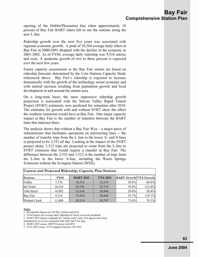
Bay Fair Comprehensive Station Plan
63
June 2004
opening of the Dublin/Pleasanton line when approximately 10 percent of Bay Fair BART riders left to use the stations along the new L line.
Ridership growth over the next five years was associated with regional economic growth. A peak of 10,364 average daily riders at Bay Fair in 2000-2001 dropped with the decline in the economy in 2001-2002. As of FY04, average daily ridership was 9,516 entries and exits. A moderate growth of two to three percent is expected over the next few years.
Future capacity assessments at the Bay Fair station are based on ridership forecasts determined by the Core Stations Capacity Study referenced above. Bay Fair’s ridership is expected to increase dramatically with the growth of the technology sector economy and with natural increase resulting from population growth and local development in and around the station area.
On a long-term basis, the most impressive ridership growth projection is associated with the Silicon Valley Rapid Transit Project (SVRT) extension, now predicted for sometime after 2010. The estimates for growth with and without SVRT show the effect the southern extension would have at Bay Fair. One major capacity impact at Bay Fair is the number of transfers between the BART lines that intersect there.
The analysis shows that without a Bay Fair Wye – a major piece of infrastructure that facilitates operations on intersecting lines -- the number of transfer trips from the L line to the lower A- and S-lines is projected to be 2,533 all day. Looking at the impact of the SVRT project alone, 1,512 trips are projected to come from the L-line to SVRT extension that would require a transfer at Bay Fair. The difference between the 2,533 and 1,512 is the number of trips from the L-line to the lower A-line, including the Warm Springs Extension without the Irvington Station (WSX).
Current and Projected Ridership, Capacity Plan Stations
Stations FY04 BART 2025 VTA 2025 BART Growth VTA Growth
Ashby 7,576 10,512 12,155 38.8% 60.4%
del Norte 14,516 24,742 32,712 70.4% 125.4%
16th Street 16,902 21,634 26,844 28.0% 58.8%
Bay Fair 9,516 12,916 20,848 35.7% 119.1%
Walnut Creek 11,008 19,114 18,747 73.6% 70.3%
Notes:
1. All ridership figures are All Day, Entries and Exits 2. FY04 figures are average daily ridership for fiscal year (exits doubled). 3. BART 2025 figures originally for "station exits" only. Exit figures have been multiplied by two to be consistent with 2003 and VTA data 4. BART 2025 source: SRTP Forecast with SFO 5. VTA 2025 source: VTA-supplied forecast, 10/15/02

Bay Fair Comprehensive Station Plan
64
June 2004
These projections and impacts have been utilized for station redesign, expansion planning and intermodal facility planning. Platform widening, queuing space, emergency exiting and a host of additional design factors are considered in the creation of a conceptual plan for expansion.
6.4 Existing Capacity and Functionality
CCCurrent capacity at the Bay Fair Station is adequate for normal
conditions. However, during some circumstances, such as special events at the Oakland Coliseum or unusual train delays, there can be crowding on the platforms. When the platform gets overcrowded, the station agent blocks the fare gates and does not allow more people to enter the station and move to the platform.
Concourse and Concourse Apron.
The concourse apron is a swath of concrete between the curb and station entrance leading to the fare gates. Bay Fair currently has two add fare machines and two bus transfer machines. Five Ticket Vending Machines (TVMs), four change machines, and a mobile concession stand are located in the concourse apron.
Paid Area
Within the paid area at Bay Fair Station are a station agent’s booth, staff room, rest rooms, one array of fare gates, and add-fare and bus transfer machines.
Automatic Fare Collection
One array of fare gates is adjacent to the station booth, including four pneumatic entry gates and four exit gates. BART replaced these gates with six new, reversible gates and one entry and one exit gate in 2003.
Vertical Circulation
To reach the aerial center platform, BART patrons can take one of two stairways, an escalator or an elevator. The stairways and escalator are inside the paid area. The elevator, located outside the paid area, is for patrons needing American Disabilities Act (ADA) access that creates a cumbersome path for wheelchair-bound patrons. The elevator does not have room for both bicyclists and people using wheelchairs. Bicyclists can carry their bicycles up the stairs. Another stairway is located outside of the paid area, connected with the pedestrian underpass linking the western parking lot underneath the Southern Pacific Railroad tracks. The underpass and stairs lead to the Ticket Vending Machines (TVMs) at the entry to the concourse of the station.
The station entrance is located on the east side of the BART property with a wide concrete apron.
Bay Fair’s paid area with station agent booth and faregates.

Bay Fair Comprehensive Station Plan
65
June 2004
For adequate vertical circulation from the train platform to the concourse, the National Fire Protection Association (NFPA) requires that the train load and occupant load must be able to exit the platforms within four minutes from the middle of the platform, and six minutes from the most remote part of the platform. Based on this standard and future ridership projections, Bay Fair Station is calculated to need an additional 296 inches of vertical circulation; assuming 66-inch wide stairs, this amounts to four new staircases leading from the platform to the station’s concourse below.
Platform capacity needs are based on BART standards that allow for a 12-minute delay scenario with an offload of a fully loaded train, including passengers already waiting to board trains on the platform, with an area of five square feet allotted for each passenger. Based on these standards, Bay Fair Station would require a 1,540 square feet wide platform, which is 11 percent above the existing 12,638 (without windscreen and other elements) or 18-foot wide in 2025.
Platform
Bay Fair Station has a 20-foot wide aerial center platform. Within the platform space are benches, windscreens, janitor’s closets and vertical circulation elements (escalator, stairs and elevator spaces). Without these elements, the platform has 12,638 available square feet in area.
With SVRT, ridership is expected to reach 20,848 entries and exits by the year 2025 at Bay Fair, (VTA supplied forecast, 2002).1
This represents a 123 percent increase above 2002 ridership. It is currently unknown now how much the proposed AC Transit BRT terminus may or may not affect ridership.
Future station design that meet capacity needs is based on applying capacity standards to ridership estimates. The estimates calculated for 2025 assume the Warm Springs and SVRT extensions. Capacity standards are based on federal and state criteria and industry and BART practice. A worst-case scenario is assumed, with two missed trains and one full train of 2,000 people arriving at the station, and requiring a four-minute evacuation time for passengers on the platform to get out of the station to a safe point.
All guidelines are applied to the peak 15 minutes of the peak hour (“peak of the peak”) in the peak direction as is consistent with BART guidelines and practices. The peak of the peak is estimated to be between 1.2 and 1.4 times the average number of passengers arriving over the peak hour, with the higher peaking rate (1.4) at less urban stations such as Bay Fair. For calculating the vertical
1 BART estimated ridership at the Bay Fair Station in 2025 is 12,916 entries
and exits.
The underpass leading from the west lot to the eastern station entrance.
The central platform at Bay Fair is adequate for today’s BART patrons, but will need expansion to meet future ridership needs.
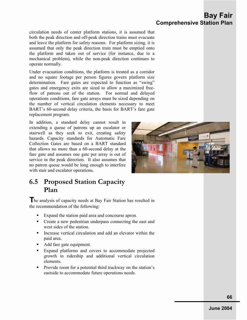
Bay Fair Comprehensive Station Plan
66
June 2004
circulation needs of center platform stations, it is assumed that both the peak direction and off-peak direction trains must evacuate and leave the platform for safety reasons. For platform sizing, it is assumed that only the peak direction train must be emptied onto the platform and taken out of service (for instance, due to a mechanical problem), while the non-peak direction continues to operate normally.
Under evacuation conditions, the platform is treated as a corridor and no square footage per person figures govern platform size determination. Fare gates are expected to function as “swing” gates and emergency exits are sized to allow a maximized free-flow of patrons out of the station. For normal and delayed operations conditions, fare gate arrays must be sized depending on the number of vertical circulation elements necessary to meet BART’s 60-second delay criteria, the basis for BART’s fare gate replacement program.
In addition, a standard delay cannot result in extending a queue of patrons up an escalator or stairwell as they seek to exit, creating safety hazards. Capacity standards for Automatic Fare Collection Gates are based on a BART standard that allows no more than a 60-second delay at the fare gate and assumes one gate per array is out of service in the peak direction. It also assumes that no patron queue would be long enough to interfere with stair and escalator operations.
6.5 Proposed Station Capacity Plan
TTThe analysis of capacity needs at Bay Fair Station has resulted in
the recommendation of the following:
Expand the station paid area and concourse apron.
Create a new pedestrian underpass connecting the east and west sides of the station.
Increase vertical circulation and add an elevator within the paid area.
Add fare gate equipment.
Expand platforms and covers to accommodate projected growth in ridership and additional vertical circulation elements.
Provide room for a potential third trackway on the station’s eastside to accommodate future operations needs.

Bay Fair Comprehensive Station Plan
67
June 2004
Other functionality and design elements include:
Relate the station to the Mall on the east through public art, way-finding signage and architectural elements.
Use white halide pedestrian-scale light fixtures along main pedestrian pathways.
Emphasize access points and station entry through streetscape designs (e.g. special pavers) and landscaping.
Trim mature trees to emphasize views to entry points, mall entries and other significant community features.
For the Bay Fair Station, an alternative emerged to address all capacity needs at the station. This conceptual capacity plan illustrates proposed accommodations for needs identified in the 2003 BART Core System Station Modifications Study. This alternative is conceptual and does not include phasing.
All improvements will meet BART’s current Station Design Criteria, and ADA accessibility requirements. All plans will require modifications as service plans, transit-oriented development and surrounding conditions change over time. Phasing of station expansion elements and other improvements will also need to respond to funding opportunities. As new information becomes available, decisions will be made in coordination with BART Real Estate, Customer Access, Engineering, Operations, Police, and others within BART. The City of San Leandro, Alameda County, AC Transit, and other local and regional agencies will also be part of the decision-making process.
6.5.1 Bay Fair Station – 3rd Track Option During the development of the capacity plan for the Bay Fair Station, the necessity of an additional platform to serve the north bound, A2, track was determined. The additional platform mitigated the requirement for exiting and queuing platform space identified in the capacity analysis. The addition of the second platform led the team to discuss other potential improvements that could be implemented as a result of the need to provide the additional platform.
One of the Bay Fair improvements is a third track on the east side of the existing station, located to the east of the new platform and used to create operational flexibility where the A and the L lines merge. The team is aware that, based on the operating plan proposed for SVRT, the additional track might not be necessary. However, because of the track’s potential benefits, the project team thought it prudent to not preclude the additional track and determine the footprint for use in the planning and design development of access facilities and future transit-oriented projects on the east parking lot connecting with Bayfair Mall.

Bay Fair Comprehensive Station Plan
68
June 2004
6.5.2 General Overview of Capacity Improvements
Vertical circulation elements (stairs, escalators and elevators) serve two important and interconnected functions at BART stations: moving passengers between the fare gates and the platforms and evacuating passengers in the event of an emergency. To accommodate growth in ridership at the Bay Fair Station, the station would need increased vertical circulation elements including additional stairs, escalator and elevator from the west parking lots.
This would require modifications to the station such as relocating the bus bays and taxi drop off area, relocating the pedestrian stairway underpass to allow more paid area within the interior station, and increasing the width of the aerial platform on its northern side. Construction of new stairs, including the emergency stairs, and the escalator would have to be staged to allow continuous use of the existing stairs and escalator. As an aerial center platform, the Bay Fair Station has space on the north side to add platform width in order to meet anticipated capacity needs. Expansion on the south side of the platform was not considered because it is physically restricted by the Union Pacific Railroad tracks. The increase in platform space would necessitate moving some of the physical elements off the platform, such as janitor’s closet, windscreens, and benches. Additionally, an emergency stairway exit would be needed for emergency egress at the northeastern end of the platform.
Below the expanded platform are the existing bus and taxi area. These areas would have to be re-located to allow room to increase the platform width, but staged to allow buses, parking and pedestrian access to safely continue during construction.
The current pedestrian underpass location limits expansion of the paid area and would need to be replaced to allow better pedestrian access from the west parking lot to the station entrance. Construction of the pedestrian underpass could be primarily cut and cover, with tunneling under the Union Pacific Railroad tracks. The existing pedestrian tunnel would be utilized until the new one is complete and then reutilized for another use such as utility location (or be filled as necessary) after construction.
Based on estimates of cost prepared by M. Lee Corporation, a consultant to BART, the costs of expanding and improving the station to accommodate the capacity and functionality needs described in this chapter that have been projected in 2025 would be approximately $56 million. The appendix provides a detailed review of budget elements.

Bay Fair Comprehensive Station Plan
69
June 2004
6.5.3 Vertical Circulation and Emergency-Only Stairs For adequate vertical circulation from the train platform to the concourse for future projected ridership, the National Fire Protection Association (NFPA) requires that the train load and occupant load must be able to exit the platforms within four minutes. Based on this standard and future ridership projections, Bay Fair Station is expected to need an additional 296 inches in width of vertical circulation. Assuming 66 inch- wide stairs, this amounts to four new staircases.
Although the new platform stairs will add exit width to the platform, an additional 200 inches of exit width is needed to meet the requirements of the California Building Code and NFPA 130. New emergency stairs are proposed to be placed at the far “outboard” ends of each platform and would be used only in the event of an emergency as they do not land in the paid area. These stairs will be enclosed to prevent unauthorized entry.
6.5.4 Platform Widening and Shelter Platform capacity needs are based on industry standards that allow for a 12-minute delay scenario and assume that the platforms would act as a corridor under emergency situations, with a five square feet area allotted for each passenger. Based on these standards, Bay Fair Station would require an additional 1,540 square feet width platform, which is an 11 percent increase above the existing 12,638 square feet without windscreen and other elements. This equates to a platform that is 18 foot wide in 2025.
Observation of passengers shows that patrons tend to concentrate in the covered central area of the train platform, especially in inclement weather. During commute hours, queues form at each car boarding point. Because the platform width is limited or blocked by elements on the platform, the queues arrange into lines that eventually obstruct access. This pattern results in uneven boarding, and also can be hazardous to those queuing closest to the platform edge. Widening the length of the platform to mitigate crowding will enhance patron comfort and safety.
Windscreens and canopies are currently limited to the central platform area. The addition of windscreen and canopy cover extending the entire length of the two platforms will also encourage passengers to move toward the ends of the platforms. The windscreen and canopy configuration will meet NFPA recommendations to prevent smoke from being trapped in the platform area.

Bay Fair Comprehensive Station Plan
70
June 2004
6.5.5 Expansion of the Paid Area Station paid areas must be sufficient to handle passenger flow from the fare gates to the platforms and in the opposite direction. In addition, paid areas must house passenger amenities such as restrooms, transit transfer machines and parking validation machines. Station agent booths and staff facilities such as break rooms and meeting rooms are also needed. Finally, paid areas must serve as landing points for stairs, escalators and elevators from the platform.
Like many stations constructed as part of the original BART system, Bay Fair has a very small concourse paid area. The small footprint of the paid area currently results in congestion during commute hours. There is little space for patron amenities because even such basic elements as benches and trash receptacles are potential obstacles. In emergency situations, the limited capacity of the paid area may be a choke point.
The existing elevator is located outside the paid area. Although they are in direct view of the agent’s booth, persons wishing or needing to use the elevators must first pass their ticket through a fare gate (usually with the help of the Station agent) before and after using the BART system. Not only is this inconvenient for patrons, this situation often results in lost fares as a result of fare evasion. With the expansion of the paid area, new opportunities for access and location of fare gates can help improve BART’s disabled patron experience.
6.5.6 Fare Collection Capacity standards for Automatic Fare Collection Gates are based on a BART standard that allows no more than a 60-second delay at the fare gate and assumes one gate per array is out of service in the peak direction. A standard delay cannot result in extending a queue of patrons up an escalator or stairwell as they seek to exit, creating safety hazards. It also assumes that no patron queue would be long enough to interfere with stair and escalator operations. As a result, Bay Fair will require five additional fare gates by 2025. No additional TVM’s or AFC machines are necessary. Expanding the paid area and creating a second entrance with it’s own gate array allows flexibility for future expansion.
6.5.7 ADA Accessibility All proposed improvements will meet the Americans with Disabilities Act (ADA) accessibility requirements. Extensive renovation of existing facilities will address a broad range of accessibility features, including:
A new station apron, entrance, crosswalks and bus facility
Fully accessible public and staff restrooms
New fully accessible elevators

Bay Fair Comprehensive Station Plan
71
June 2004
Signage
Fire alarm strobes and voice annunciators
6.5.8 Bicycle Facilities The existing bicycle facilities will need to be reconfigured to permit construction of the new vertical circulation elements and paid area expansion. The proposal is to upgrade the lockers, racks and benches within this area within a “bicycle pavilion” consistent with BART’s current guidelines. Additional bicycle storage facilities will be added as part of the proposed future development.
6.5.9 Bus Facility The existing 14-bay bus facility will require relocation and afford redesign for a more efficient use of property as well as provide for service patterns of the future. The proposed bus rapid transit (BRT) project has not been designed, nor have impacts to BART been assessed.
Next steps in the process will include analysis of projected bus service levels, access patterns and patron needs combined with a circulation plan for the east lot. This circulation plan is expected to be part of a larger transit oriented development feasibility study. With this information, BART staff can consider design options to create a modern facility meeting the needs of future BART patrons.
6.5.10 Police Currently a police training facility is housed in a portable building on the east parking lot. It is anticipated that a permanent facility would be incorporated as part of future development of the station area.
6.5.11 Safety and Security Prior to September 11, 2001, BART did not include a focus on security enhancements to the degree that have for future station capacity planning. The Warm Springs Extension Station will be the first station designed with additional security enhancements, with consideration given to available funding. The following enhancements should be considered when designing changes to existing stations:
using blast-resistant refuse cans adding cameras and monitors adding lighting providing clear lines of sight from Information Booths eliminating hidden alcoves in station area installing intrusion alarms

Bay Fair Comprehensive Station Plan
72
June 2004
Bay Fair Station has one of the highest crime incident counts according to BART Police in 2003 and 2004. Last year, more than three-fourths of BART stations had at least one robbery, with the greatest number -- 11 -- occurring at the Richmond Station and the Bay Fair Station, followed closely by the Coliseum and Hayward stations. The predominant crime events are auto break-in, auto theft and armed robbery. In any design of stations, parking lots or any parking structures, the BART Police Department endorses the concept of crime prevention through environmental design (CPTED) as a method to make an area less attractive for potential criminal activity.
CPTED promotes design standards that serve to deter the opportunity for crime and not to aid in jeopardizing the safety of patrons or employees. CPTED stresses design factors such as ensuring clear sight lines, bright lighting, and reducing potential hiding places.
The CPTED concept should be continually evaluated as facilities are designed and modified. A good design will not only act as a preventative, but also help address the public's perception of crime and feelings of safety within the facility. Many times, this perception of safety is as critical to attracting and retaining riders as the actual levels of crime.
Some of the most important areas to address include:
Providing enhanced lighting in parking lots, parking structures, walkways, bus stops and stations;
Use of graffiti-resistant surfaces in reachable areas, including glass surfaces;
Use of Closed Circuit Television (CCTV) cameras with recording capabilities in parking lots and stations, including the provision of space to house CCTV recording equipment;
Appropriate use of landscaping (e.g., does not block CCTV cameras, provide areas of concealment, etc);
Use of glass-walled elevators that allow visual deterrence for crimes within the elevator;
Clear sight-Iines for employees and patrons to observe and be observed through the majority of the station;
Proactive anti-terrorism design such as wall typologies, location of bollards, garbage can and other receptacle design/location to make it difficult to deposit explosives and incendiary devices;
Protection of pedestrians as they cross through bus zones or other access points;
Conveniently located passenger drop-off and taxi zones in areas that allow easy access to the stations and businesses;
Address questions regarding enforcement and controls up front.

Bay Fair Comprehensive Station Plan
73
June 2004
The redesign of Bay Fair Station and its environs would include a series of public safety improvements. The most easily implemented includes selective trimming, or removal and replacement, of mature trees blocking sightlines to the station entrance from pedestrian access points (notably the pedestrian bridge to the Mall). Removal of ivy and other blocking foliage along the BART side of the flood control channel and replacement of the channel’s fencing as was recently accomplished by Bayfair Mall is also recommended.
Construction of the new underpass is one of the single most important aspects for CPTED improvement for this project. The ability to create an open, well-lit and easily surveilled pedestrian connection under the trackway should be done in conjunction with future new public spaces and transit-oriented development. One example is Union City BART, where a new pedestrian/bicycle underpass is to be constructed at-grade with plazas and walkways, incorporating CCTV and other security measures.
6.5.12 Station Design, Public Art and Customer Comfort With dramatic changes planned for the station and future development on the station property, there will be significant opportunities to incorporate better aesthetic design, public art and customer amenities. While BART stations are functional, the opportunity presented by a station expansion also provides potential to incorporate design improvements that more accurately reflect the community that surrounds the station. In addition, customer amenities within and around the station should be recognized and addressed as the station expansion and development move forward.
The station frontages and entries are obvious focal points for public art. The incorporation of special pavers in patterns that define public spaces, as seen in Fruitvale, helps connect the station to its local history and colorful relationship to the adjacent mall. Station signage in keeping with the design of the Mall and future development (similar to that at Richmond) would be an asset to the station and provide a transition from the station and its future development to the Mall and surrounding station area. Several recommendations for design treatments and signage are advanced by the 1999 Ashland Bay Fair BART Access Plan, and the multiple plans for the Mall.
Other patron amenities, such as adding windscreens and canopies to shield customers and providing better lighting and a public address system, should also be considered as important station improvements.

Bay Fair Comprehensive Station Plan
74
June 2004
6.6 Preliminary Cost Estimate The conceptual cost to implement the improvements described in the proposed plan is approximately $56 million in 2003 dollars. The cost estimate includes all elements described above: two new elevators, platform widening, concourse expansion, four emergency stairs with enclosures, new staff facilities, eight additional fare gates, four new ticket vending machines and six new add fare machines, expansion of the apron, and a new bicycle pavilion.
The estimate also includes the cost of repaving, painting and finishing the concourse area, upgrading the fire sprinkler system, upgrading the station façade, and extending the weather cover and adding a new windscreen and overhead shelter. Costs associated with the removal of existing facilities, cleaning, and other miscellaneous tasks are also included as are contractor overhead, contingencies and BART project management.

Bay
Fair
Co
mp
reh
en
siv
eS
tati
on
Pla
n 75
Ju
ne
2004
This
conceptu
alpla
nvie
wshow
sth
eexpansio
nfo
rth
ee
xis
ting
pla
tfo
rms,th
ea
dd
itio
na
loptio
na
lth
ird
track
limit
line
,th
ee
xp
ansio
no
fth
eco
ncou
rse
,n
ew
ped
estr
ian
un
de
rpass
an
do
the
re
lem
en
tsn
ecessa
ryfo
rp
atr
on
sa
fety
an
dco
mfo
rt.
The
Pla
nd
oes
notshow
po
tentialtr
ansit-
oriente
ddeve
lopm
ent,
nor
the
access
facili
tydesig
nth
atw
ould
accom
pany
de
ve
lop
me
nto
fth
eB
AR
Tp
rope
rty.
Th
efo
otp
rin
td
efin
ed
by
the
desig
nation
ofth
eth
ird
track
and
oute
rlim
its
ofsta
tion
exp
ansio
nw
illin
form
asuch
de
ve
lop
men
tp
lan
nin
gin
futu
re.
ConceptualCapacityExpansionPlan

Bay F
air
C
om
pre
he
ns
ive
Sta
tio
nP
lan
76
Ju
ne
2004
Eas
t L
ot
Wes
t L
ot
Pro
po
sed
new
en
tran
ce o
n
Eas
t w
ith
new
far
egat
es,
elev
ato
r an
d r
elo
cate
dp
edes
tria
n t
un
nel
co
nn
ecti
on
Fo
otp
rin
t o
f p
ote
nti
al f
utu
re3rd
tra
ck
Exp
and
ed p
aid
are
a st
atio
nco
nco
urs
e an
d a
pro
n

Bay Fair Comprehensive Station Plan
77June 2004
Introduction
Conceptual Cost Estimate
Constructability & Phasing Improvements
Appendix: Capacity

Manna Consultants, Inc. Job No: 253 BART Capacity Expansion Date: 6/23/03 El Cerrito Del Norte, Ashby and 16th Street Stations
INTRODUCTION
1.0 Outline
1.1 The preliminary conceptual construction cost estimate (estimate) is comprised of the following integral parts: A. Introduction B. Conceptual Cost Estimate for three stations
1. El Cerrito Del Norte Station 2. Ashby Station 2A. Ashby Station – Shutdown Option 3. 16th Street/Mission Station
C. Constructibility for three stations 1. El Cerrito Del Norte Station 2. Ashby Station 2A. Ashby Station – Shutdown Option 3. 16th Street/Mission Station
2.0 Scope of Work
2.1 The estimate has been prepared based on the following information: A. Conceptual floor plans for the three stations received 05/27/03. B. As-built drawings for El Cerrito Del Norte, Ashby and 16th Street/Mission stations (reference
only). C. Observations during the site visits to El Cerrito Del Norte on 05/22/03, 16th Street/Mission on
05/23/03, and Ashby on 05/28/03. D. Engineer’s comments on station upgrade and enhancements (field notes from station visits). E. Review comments from team members. F. Various email information from architects.
2.2 For Ashby Station only, compare the cost of the multi-phased construction of the station expansion vs. a single phased or minimum-phased construction with station shutdown.
3.0 Assumptions
3.1 The estimate specifically excludes the following: A. Costs for existing equipment or system upgrade B. New radio communication, train control and SCADA system (assumed to use existing system) C. Costs for right-of-ways and land acquisition if required D. Costs for operation/maintenance E. Costs for Environmental Impact Assessment if required F. Seismic upgrade to existing facilities G. ITS H. Legal and accounting expenses I. Community outreach J. Escalation
It is assumed that the above items, if needed, are included elsewhere in the owner’s overall project budget.
3.2 The estimate is based on one general contract for each station.
3.3 All costs are based on present worth costs at mid-year 2003.
3.4 Allowances have been used for items which are required but are not able to be defined at this time.
3.5 It is assumed that the quality of new construction will match with the existing BART Design Criteria, NFPA 130, and California Building Codes.
62
Manna Consultants, Inc. Job No: 253 BART Capacity Expansion Date: 6/23/03 El Cerrito Del Norte, Ashby and 16th Street Stations
3.6 The unit prices are composite unit prices which include costs for material, labor, equipment rental and subcontractor/supplier’s mark-ups.
3.7 A mark-up of 26.5% of direct construction costs has been used for general contractor’s general conditions, overhead and profit. This rate is comprised of 15% for general conditions and compounded with a 10% for overhead and profit.
3.8 A 25% rate has been included for design development, construction and estimating contingencies due to the conceptual nature of the scope. This is deemed to be the minimum prudent allowance considering the level of scope development and information available at the time of the estimate.
3.9 BART soft cost for project development has been included at 41% of total estimated construction cost based on BART’s historical record on various sizes of projects from small local projects to large extension projects. This is for design services, construction management services and BART project administration.
3.10 Items affecting the cost estimate include, but are not limited to, the following: A. Modifications to the scope of work included in this estimate. B. Unforeseen sub-surface conditions. C. Special phasing requirements. D. Restrictive technical specifications or excessive contract conditions. E. Any specified item of equipment, material, or product that cannot be obtained from at least
three different sources. F. Any other non-competitive bid situations.
3.11 This estimate has been prepared using accepted practices and it represents our opinion of probable construction costs. We make no other warranties, either expressed or implied, and are not responsible for the interpretation by others of the contents herein the cost estimate.
3.12 Please note that the estimate has been based on very preliminary and limited information and it only serves as a general guideline for more specific and detailed studies in the future.
4.0 Basis for Pricing
4.1 In pricing the estimate, we have made references to the following sources for cost data: A. Historical cost data for BART projects (for AFC equipment, elevators, escalators, stairways) B. Historical cost data of similar projects (general use for building up unit costs) C. 2003 RS Means Building Construction Cost Data by RS Means (general use for building up
unit costs) D. 2003 Current Construction Costs by Saylor Publications (general use for building up unit costs) E. Cost Estimates for Pleasant Hill Station and Union City prepared by Manna Consultants, Inc F. Conceptual Construction Cost Estimate, VTA Impacts on BART Core System Stations Phase
One Preliminary Study, prepared by M. Lee Corporation, dated 2/28/03 (Rev 2)
5.0 Abbreviations
5.1 Abbreviations used in the estimates include the following: EA Each CY Cubic Yard LF Linear Foot LS Lump Sum N/A Not Applicable SF Square Foot AFC Automatic Fare Collection (Equipment)
63

M.
LE
E C
OR
PO
RA
TIO
N
BA
Y A
RE
A R
AP
ID T
RA
NS
IT (
BA
RT
)
VT
A C
OR
E S
TA
TIO
N IM
PA
CT
S S
TU
DY
D
ate
: 2
/28
/20
03
(R
ev 2
)
CO
NC
EP
TU
AL
CO
ST
ES
TIM
AT
E (
BY
EL
EM
EN
T)
BA
Y F
AIR
S
TA
TIO
NT
OT
AL
ES
TIM
AT
ED
CO
ST
IN
CL
UD
ING
CO
NT
RA
CT
OR
'S M
AR
KU
PS
& B
AR
T'S
SO
FT
CO
ST
S
Lin
e #
Ele
mT
ota
l C
ost
C
ap
acity
Cat.
S
ub-C
at
C
P
V
A
Co
de
(A
ll-In
clu
siv
e)
1 21
.0
Site
Wo
rk
3T
em
po
rary
Wo
rk-
-
-
-
-
4T
em
po
rary
fe
nce
9
4,1
76
C
VG
E9
4,1
76
-
9
4,1
76
-
5T
raff
ic b
arr
ier
du
rin
g c
on
str
uctio
n7
3,5
75
C
VG
E7
3,5
75
-
7
3,5
75
-
6T
raff
ic s
ign
s e
tc3
6,7
88
C
VG
E3
6,7
88
-
3
6,7
88
-
7T
raff
ic c
on
tro
ls a
nd
ma
int.
du
rin
g c
on
str
uctio
n7
3,5
75
C
VG
E7
3,5
75
-
7
3,5
75
-
8 P
ark
ing
lo
t m
od
ific
atio
n a
nd
im
pro
ve
me
nt
-
-
-
-
-
9P
ark
ing
lo
t m
od
ific
atio
n in
cl'd
kis
s r
ide
circu
latio
n4
90
,50
0
C
P4
90
,50
0
49
0,5
00
-
-
10
Pa
rkin
g lo
t m
od
ific
atio
n o
n p
ed
un
de
rpa
ss
41
6,9
25
CP
41
6,9
25
41
6,9
25
-
-
11
Ne
w c
urb
/gu
tte
r -
allo
w2
20
,72
5
C
P2
20
,72
5
22
0,7
25
-
-
12
Ne
w b
us s
he
lte
r ca
no
py
1,2
55
,68
0
CP
1,2
55
,68
0
1
,25
5,6
80
-
-
13
Pla
ntin
g a
nd
la
nd
sca
pin
g a
rou
nd
sta
tio
n/p
ark
ing
1
22
,62
5
C
P1
22
,62
5
12
2,6
25
-
-
14
Re
loca
te a
nd
ne
w lig
htin
gs o
n p
ark
ing
lo
t3
67
,87
5
C
P3
67
,87
5
36
7,8
75
-
-
15
Re
co
nfig
ure
dra
ina
ge
syste
m1
96
,20
0
C
P1
96
,20
0
19
6,2
00
-
-
16
Pe
de
str
ian
un
de
rpa
ss
-
-
-
-
-
17
Exca
va
tio
n a
nd
ba
ckfill
49
6,6
31
CV
GE
49
6,6
31
-
4
96
,63
1
-
18
Co
ncre
te b
ox t
un
ne
l fo
r p
ed
estr
ian
un
de
rpa
ss
2,3
27
,42
3
CV
GE
2,3
27
,42
3
-
2,3
27
,42
3
-
19
Wa
terp
roo
fin
g3
13
,92
0
C
VG
E3
13
,92
0
-
3
13
,92
0
-
20
Pe
rma
ne
nt
dra
in s
yste
m2
20
,72
5
C
VG
E2
20
,72
5
-
2
20
,72
5
-
21
Ele
ctr
ica
l &
lig
htin
g1
22
,62
5
C
VG
E1
22
,62
5
-
1
22
,62
5
-
22
Fill
fo
r e
xis
tin
g p
ed
un
de
rpa
ss
29
4,3
00
CV
GE
29
4,3
00
-
2
94
,30
0
-
23
Tu
nn
el u
nd
er
exis
tin
g r
ailr
oa
d9
81
,00
0
C
VG
E9
81
,00
0
-
9
81
,00
0
-
24
Re
sto
rin
g r
ail
roa
d2
45
,25
0
C
VG
E2
45
,25
0
-
2
45
,25
0
-
25
S/T
8,3
50
,51
7
-
-
-
-
26
2.0
D
em
olit
ion
-
-
-
-
-
27
Re
mo
ve
exis
tin
g p
aid
are
a s
tru
ctu
re2
45
,25
0
C
VG
E2
45
,25
0
-
2
45
,25
0
-
28
Re
mo
ve
exis
tin
g f
loo
r a
nd
pa
vin
g f
or
ne
w p
latf
orm
24
7,2
12
CP
24
7,2
12
24
7,2
12
-
-
29
Re
mo
ve
exis
tin
g w
all
19
8,6
53
CV
GE
19
8,6
53
-
1
98
,65
3
-
30
Re
mo
ve
exis
tin
g u
tilit
ies o
n u
nd
er
pa
ss s
tru
ctu
re
49
,05
0
CV
GE
49
,05
0
-
49
,05
0
-
31
Re
mo
ve
exis
tin
g p
latf
orm
sla
b f
or
sta
ir/e
sca
l/e
lev
98
,10
0
CV
GE
98
,10
0
-
98
,10
0
-
32
Re
mo
ve
exis
tin
g b
us s
he
lte
r ca
no
py
49
,05
0
CP
49
,05
0
4
9,0
50
-
-
33
Re
mo
ve
pa
rkin
g lo
t p
avin
g/w
alk
wa
y in
cl'd
cu
rb/g
utt
er
14
7,1
50
CP
14
7,1
50
14
7,1
50
-
-
34
Re
mo
ve
/re
rou
te p
ow
er
su
pp
ly &
utilit
y lin
es
24
5,2
50
CP
24
5,2
50
24
5,2
50
-
-
35
Re
mo
ve
/re
loca
te u
tilit
y e
nclo
su
res -
co
ncre
te1
9,6
20
C
VG
E1
9,6
20
-
1
9,6
20
-
36
Oth
er
mis
c.
- a
llow
12
2,6
25
CV
GE
12
2,6
25
-
1
22
,62
5
-
37
Allo
w f
or
asb
esto
s a
ba
tem
en
t4
90
,50
0
C
VG
E4
90
,50
0
-
4
90
,50
0
-
38
S/T
1,9
12
,46
0
-
-
-
-
39
3.0
S
tatio
n A
rea
-
-
-
-
-
Ite
m D
escrip
tio
n
4.4
Ba
yfa
irst
Pa
ge
54
Prin
t o
n 2
/28
/20
03

M.
LE
E C
OR
PO
RA
TIO
N
BA
Y A
RE
A R
AP
ID T
RA
NS
IT (
BA
RT
)
VT
A C
OR
E S
TA
TIO
N IM
PA
CT
S S
TU
DY
D
ate
: 2
/28
/20
03
(R
ev 2
)
CO
NC
EP
TU
AL
CO
ST
ES
TIM
AT
E (
BY
EL
EM
EN
T)
BA
Y F
AIR
S
TA
TIO
NT
OT
AL
ES
TIM
AT
ED
CO
ST
IN
CL
UD
ING
CO
NT
RA
CT
OR
'S M
AR
KU
PS
& B
AR
T'S
SO
FT
CO
ST
S
Lin
e #
Ele
mT
ota
l C
ost
C
ap
acity
Cat.
S
ub-C
at
C
P
V
A
Co
de
(A
ll-In
clu
siv
e)
Ite
m D
escrip
tio
n
40
3.1
Pla
tfo
rm L
eve
l-
-
-
-
-
41
Pla
tfo
rms c
on
cre
te s
tru
ctu
re,
ne
w6
,02
0,2
30
CP
6,0
20
,23
0
6
,02
0,2
30
-
-
42
Su
pp
ort
syste
m:
co
lum
ns/p
ile c
ap
s/d
rille
d p
iers
80
9,3
25
CP
80
9,3
25
80
9,3
25
-
-
43
Pla
tfo
rm g
ua
rd r
ail,
co
ncre
te 6
-1/2
"th
k x
3'-1
1"h
igh
33
3,7
36
CP
33
3,7
36
33
3,7
36
-
-
44
Gu
ard
wa
ll fo
r e
sca
lato
rs a
nd
sta
irs (
on
pla
tfo
rm)
15
8,9
22
CP
15
8,9
22
15
8,9
22
-
-
45
Pla
tfo
rm f
loo
r, w
ate
rpro
ofin
g w
/no
nslip
re
sis
t fin
.2
04
,87
7
C
P2
04
,87
7
20
4,8
77
-
-
46
De
tecta
ble
we
arin
g t
ile o
n e
dg
e o
f p
latf
orm
95
,35
3
CP
95
,35
3
9
5,3
53
-
-
47
Re
pa
irin
g e
xis
tin
g c
en
ter
pla
tfo
rm4
9,0
50
C
P4
9,0
50
49
,05
0
-
-
48
S/T
7,6
71
,49
4
-
-
-
-
49
3.2
C
on
co
urs
e L
eve
l-
-
-
-
-
50
Flo
or
for
exp
an
de
d p
aid
are
a
84
2,0
66
CV
GE
84
2,0
66
-
8
42
,06
6
-
51
Ce
ilin
g f
inis
h o
n c
on
co
urs
e5
61
,37
7
C
VG
E5
61
,37
7
-
5
61
,37
7
-
52
-
-
-
-
-
53
Ne
w e
xte
rio
r w
all
on
exp
an
de
d p
aid
are
a2
,34
3,3
64
CV
GE
2,3
43
,36
4
-
2,3
43
,36
4
-
54
An
cill
ary
ro
om
fin
ish
on
exp
an
de
d p
aid
are
a1
,50
0,9
30
CV
GE
1,5
00
,93
0
-
1,5
00
,93
0
-
55
Allo
w p
ub
lic a
rea
mis
c.
fin
ish
es
33
6,8
26
CV
GE
33
6,8
26
-
3
36
,82
6
-
56
Ne
w r
oll-
up
grille
- e
lec.
op
era
te7
3,5
75
C
VG
E7
3,5
75
-
7
3,5
75
-
57
Ro
ll-u
p g
rille
en
clo
su
re a
bo
ve
fa
re g
ate
arr
ay
14
7,1
50
CV
GE
14
7,1
50
-
1
47
,15
0
-
58
Ba
rrie
r ra
il a
nd
se
rvic
e g
ate
s a
t n
ew
fa
re g
ate
arr
ays
49
,05
0
CV
GE
49
,05
0
-
49
,05
0
-
59
Ne
w c
on
ce
ssio
n a
rea
w/
utilit
y r
ou
gh
-in
55
1,8
13
CV
GE
55
1,8
13
-
5
51
,81
3
-
60
Are
a im
pro
ve
me
nt
bo
th e
nd
s o
f co
nco
urs
e3
43
,35
0
C
VG
E3
43
,35
0
-
3
43
,35
0
-
61
Sig
na
ge
, g
rap
hic
-
allo
w4
90
,50
0
C
VG
E4
90
,50
0
-
4
90
,50
0
-
62
-
-
-
-
-
63
Ad
ditio
na
l p
ow
er
dis
trib
utio
n9
81
,00
0C
VG
E9
81
,00
0
-
98
1,0
00
-
64
Lig
htin
g o
n n
ew
are
a3
92
,96
4
C
VG
E3
92
,96
4
-
3
92
,96
4
-
65
Are
a lig
htin
gs -
bic
ycle
pa
vili
on
, w
alk
wa
y,
sta
irs e
tc1
22
,62
5
C
VG
E1
22
,62
5
-
1
22
,62
5
-
66
P.A
. syste
m in
cl'd
CC
TV
, in
terc
om
an
d t
ele
ph
on
e2
24
,55
1
C
VG
E2
24
,55
1
-
2
24
,55
1
-
67
-
-
-
-
-
68
Sa
nita
ry s
ew
er
an
d s
torm
dra
in3
67
,87
5
C
VG
E3
67
,87
5
-
3
67
,87
5
-
69
Wa
ter
se
rvic
e c
on
ne
ctio
n1
47
,15
0
C
VG
E1
47
,15
0
-
1
47
,15
0
-
70
Fire
sp
rin
kle
r syste
m1
96
,48
2
C
VG
E1
96
,48
2
-
1
96
,48
2
-
71
HV
AC
5
61
,37
7
C
VG
E5
61
,37
7
-
5
61
,37
7
-
72
S/T
10
,23
4,0
25
-
-
-
-
73
4.0
V
ert
ica
l C
ircu
latio
n-
-
-
-
-
74
4.1
C
on
co
urs
e p
aid
are
a t
o p
latf
orm
s
-
-
-
-
-
75
Ne
w E
leva
tors
- t
wo
sto
ps
2,6
48
,70
0
CV
EL
2,6
48
,70
0
-
2,6
48
,70
0
-
76
Ne
w E
sca
lato
rs1
,83
9,3
75
CV
ES
1,8
39
,37
5
-
1,8
39
,37
5
-
77
Ne
w e
leva
tor
sh
aft
s -
co
ncre
te
49
0,5
00
CV
EL
49
0,5
00
-
4
90
,50
0
-
78
Ne
w e
leva
tor
sh
aft
s -
te
mp
. g
lass/s
tain
less s
tee
l8
33
,85
0
C
VE
L8
33
,85
0
-
8
33
,85
0
-
4.4
Ba
yfa
irst
Pa
ge
55
Prin
t o
n 2
/28
/20
03

M.
LE
E C
OR
PO
RA
TIO
N
BA
Y A
RE
A R
AP
ID T
RA
NS
IT (
BA
RT
)
VT
A C
OR
E S
TA
TIO
N IM
PA
CT
S S
TU
DY
D
ate
: 2
/28
/20
03
(R
ev 2
)
CO
NC
EP
TU
AL
CO
ST
ES
TIM
AT
E (
BY
EL
EM
EN
T)
BA
Y F
AIR
S
TA
TIO
NT
OT
AL
ES
TIM
AT
ED
CO
ST
IN
CL
UD
ING
CO
NT
RA
CT
OR
'S M
AR
KU
PS
& B
AR
T'S
SO
FT
CO
ST
S
Lin
e #
Ele
mT
ota
l C
ost
C
ap
acity
Cat.
S
ub-C
at
C
P
V
A
Co
de
(A
ll-In
clu
siv
e)
Ite
m D
escrip
tio
n
79
Ne
w s
tairs,
pa
ralle
l w
ith
esca
lato
rs
88
2,9
00
CV
S1
88
2,9
00
-
8
82
,90
0
-
80
Esca
lato
r a
nd
sta
ir w
all
an
d s
off
it5
88
,60
0
C
VE
S5
88
,60
0
-
5
88
,60
0
-
81
Ne
w e
me
rge
ncy s
tair a
t b
oth
en
d o
f n
ew
pla
tfo
rm1
,32
4,3
50
CV
EM
1,3
24
,35
0
-
1,3
24
,35
0
-
82
Ne
w e
me
rge
ncy s
tair a
t so
uth
en
d o
f is
lan
d p
latf
orm
85
8,3
75
CV
EM
85
8,3
75
-
8
58
,37
5
-
83
Ne
w p
latf
orm
sta
ir5
39
,55
0
C
VS
15
39
,55
0
-
5
39
,55
0
-
84
Sta
ir a
t e
nd
of
un
de
rpa
ss w
ith
bik
e c
ha
nn
el
1,1
03
,62
5
CV
S1
1,1
03
,62
5
-
1,1
03
,62
5
-
85
Ma
ch
ine
ro
om
be
low
sta
ir2
45
,25
0
C
VS
12
45
,25
0
-
2
45
,25
0
-
86
Mo
dify e
xis
tin
g s
tair o
n p
aid
are
a4
9,0
50
C
VS
14
9,0
50
-
4
9,0
50
-
87
Bik
e c
ha
nn
els
- a
llow
12
2,6
25
CV
GE
12
2,6
25
-
1
22
,62
5
-
88
-
-
-
-
-
89
Lo
ca
l fire
sp
rin
kle
r sys.
un
de
r e
sca
lato
rs a
nd
sta
irs
73
,57
5
CV
ES
73
,57
5
-
73
,57
5
-
90
S/T
11
,60
0,3
25
-
-
-
-
91
5.0
F
are
Co
llectio
n-
-
-
-
-
92
Ne
w a
ge
nt
bo
oth
- c
om
ple
te6
62
,17
5
C
VG
E6
62
,17
5
-
6
62
,17
5
-
93
F &
I f
or
AF
C E
qu
ipm
en
t-
-
-
-
-
94
TV
M-
CA
-
-
-
-
95
AF
M3
06
,56
3
C
A3
06
,56
3
-
-
3
06
,56
3
96
FG
Ma
ch
ine
- E
xit
49
,05
0
CA
49
,05
0
-
-
49
,05
0
97
FG
Ma
ch
ine
- E
ntr
y5
2,1
16
C
A5
2,1
16
-
-
5
2,1
16
98
FG
Ma
ch
ine
- R
eve
rse
22
6,2
43
CA
22
6,2
43
-
-
2
26
,24
3
99
FG
Ma
ch
ine
- H
an
dic
ap
13
1,2
09
CA
13
1,2
09
-
-
1
31
,20
9
10
0C
ab
ine
t in
clu
din
g p
atc
h p
an
els
-
C
A-
-
-
-
10
1D
esig
n a
nd
En
gin
ee
rin
g in
cl'd
sp
are
pa
rts
32
5,9
67
CA
32
5,9
67
-
-
3
25
,96
7
10
2-
-
-
-
-
10
3P
ow
er
an
d c
om
pre
sse
d a
ir r
ace
wa
y t
o e
qu
ipm
en
t5
8,8
60
C
A5
8,8
60
-
-
5
8,8
60
10
4
S/T
1,8
12
,18
2
-
-
-
-
10
56
.0
Pla
tfo
rm s
he
lte
r-
-
-
-
-
10
6N
ew
pla
tfo
rm c
an
op
y1
,96
8,2
78
CP
1,9
68
,27
8
1
,96
8,2
78
-
-
10
7W
ind
scre
en
on
ne
w p
latf
orm
1,0
59
,48
0
CP
1,0
59
,48
0
1
,05
9,4
80
-
-
10
8C
an
op
y lo
uve
r6
88
,66
2
C
P6
88
,66
2
68
8,6
62
-
-
10
9-
-
-
-
-
11
0E
xte
nd
ed
sh
elte
r o
n c
en
ter
pla
tfo
rm1
,73
0,4
84
N-
-
-
-
11
1C
an
op
y lo
uve
r a
t e
xte
nd
ed
ce
nte
r p
latf
orm
40
1,7
20
N-
-
-
-
11
2W
ind
scre
en
on
ou
tbo
ard
of
tra
ck
1,0
59
,48
0
N-
-
-
-
11
3M
od
ify e
xis
tin
g c
an
op
y s
up
po
rt9
8,1
00
N
-
-
-
-
11
4-
-
-
-
-
11
5M
od
ify e
xis
tin
g S
LP
A o
n c
en
ter
pla
tfo
rm1
96
,20
0
C
P1
96
,20
0
19
6,2
00
-
-
11
6L
igh
tin
g o
n n
ew
pla
tfo
rm s
he
lte
r2
50
,50
8
C
P2
50
,50
8
25
0,5
08
-
-
11
7P
.A.
syste
m in
cl'd
CC
TV
an
d t
ele
ph
on
e2
86
,29
5
C
P2
86
,29
5
28
6,2
95
-
-
4.4
Ba
yfa
irst
Pa
ge
56
Prin
t o
n 2
/28
/20
03
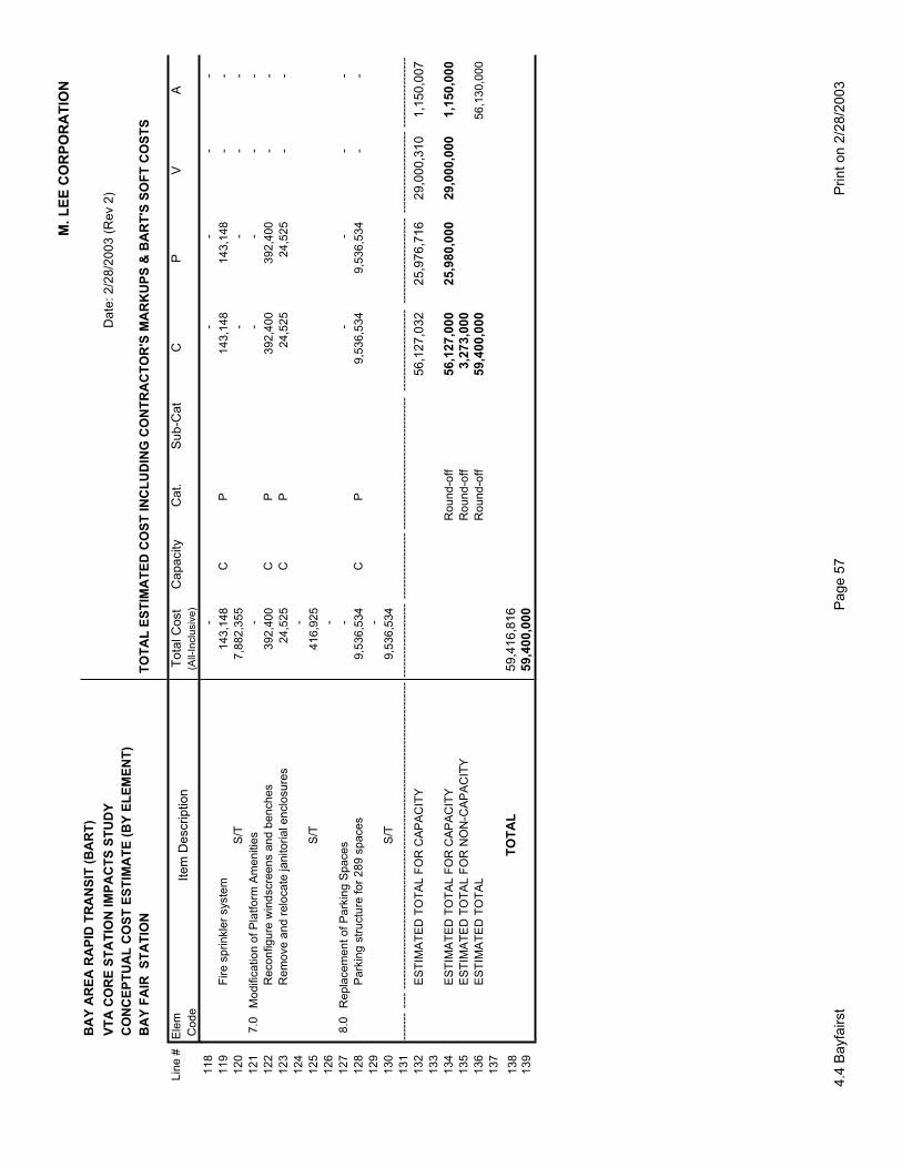
M.
LE
E C
OR
PO
RA
TIO
N
BA
Y A
RE
A R
AP
ID T
RA
NS
IT (
BA
RT
)
VT
A C
OR
E S
TA
TIO
N IM
PA
CT
S S
TU
DY
D
ate
: 2
/28
/20
03
(R
ev 2
)
CO
NC
EP
TU
AL
CO
ST
ES
TIM
AT
E (
BY
EL
EM
EN
T)
BA
Y F
AIR
S
TA
TIO
NT
OT
AL
ES
TIM
AT
ED
CO
ST
IN
CL
UD
ING
CO
NT
RA
CT
OR
'S M
AR
KU
PS
& B
AR
T'S
SO
FT
CO
ST
S
Lin
e #
Ele
mT
ota
l C
ost
C
ap
acity
Cat.
S
ub-C
at
C
P
V
A
Co
de
(A
ll-In
clu
siv
e)
Ite
m D
escrip
tio
n
11
8-
-
-
-
-
11
9F
ire
sp
rin
kle
r syste
m1
43
,14
8
C
P1
43
,14
8
14
3,1
48
-
-
12
0S
/T7
,88
2,3
55
-
-
-
-
12
17
.0M
od
ific
atio
n o
f P
latf
orm
Am
en
itie
s-
-
-
-
-
12
2R
eco
nfig
ure
win
dscre
en
s a
nd
be
nch
es
39
2,4
00
CP
39
2,4
00
39
2,4
00
-
-
12
3R
em
ove
an
d r
elo
ca
te ja
nito
ria
l e
nclo
su
res
24
,52
5
CP
24
,52
5
2
4,5
25
-
-
12
4-
12
5S
/T4
16
,92
5
12
6-
12
78
.0R
ep
lace
me
nt
of
Pa
rkin
g S
pa
ce
s-
-
-
-
-
12
8P
ark
ing
str
uctu
re f
or
28
9 s
pa
ce
s9
,53
6,5
34
CP
9,5
36
,53
4
9
,53
6,5
34
-
-
12
9-
13
0S
/T9
,53
6,5
34
13
1--
----
---
----
----
----
----
----
----
----
----
----
----
----
----
----
----
----
----
----
----
----
----
---
----
----
----
----
---
----
----
----
---
----
----
----
----
----
----
----
----
----
----
----
----
----
---
----
----
----
----
----
----
----
----
----
----
---
----
----
----
----
--
13
2E
ST
IMA
TE
D T
OT
AL
FO
R C
AP
AC
ITY
56
,12
7,0
32
2
5,9
76
,71
6
2
9,0
00
,31
0
1,1
50
,00
71
33
13
4E
ST
IMA
TE
D T
OT
AL
FO
R C
AP
AC
ITY
Ro
un
d-o
ff5
6,1
27
,00
0
25
,98
0,0
00
29
,00
0,0
00
1
,15
0,0
00
13
5E
ST
IMA
TE
D T
OT
AL
FO
R N
ON
-CA
PA
CIT
YR
ou
nd
-off
3,2
73
,00
01
36
ES
TIM
AT
ED
TO
TA
LR
ou
nd
-off
59
,40
0,0
00
56
,13
0,0
00
13
7
13
8T
OT
AL
59,4
16,8
16
13
959,4
00,0
00
4.4
Ba
yfa
irst
Pa
ge
57
Prin
t o
n 2
/28
/20
03

