compiled by christiaan burchell - escaladequebec.com
TRANSCRIPT

Ice Climbing Around Ottawa
Compiled By Christiaan Burchell
Version 0.5 – September 2007
1

Table of ContentsLegal Disclaimer...................................................3Introduction.......................................................... 5
Access.............................................................. 5Code of Conduct......................................... 6
How to use this guide.......................................7Grading........................................................7Route Symbols.......................................... 10
Ottawa Area Information............................... 11Clubs & Access......................................... 11Gyms......................................................... 11Gear Shops................................................ 11Guiding Services....................................... 11
Area Locations............................................... 12Ice Climbs...........................................................13
Eardley Escarpment....................................... 13Western Eardley........................................ 14Luskville Falls........................................... 15Hotel-de-Ville .......................................... 15
Chemin Cregheur...................................... 17Mont King................................................. 18
Calabogie....................................................... 20Edelweisses valley......................................... 23
Main Area..................................................23Middle Crag.............................................. 25South Crag.................................................25Chispa Area............................................... 26
Mont Cascades............................................... 26Mont Latuque.................................................27Mont Sainte-Marie......................................... 28Lac du Poisson Blanc.....................................28
Paroi de la Fourche....................................28La Grande Dalle........................................ 29Other Areas............................................... 30
Mount de La Coq........................................... 31References.......................................................... 32
2

Legal Disclaimer
Legal DisclaimerWarning!Climbing is an inherently dangerous sport in which severe injuries or death may occur. Relying on the information in this guide may increase the danger.When climbing you can only rely on your skill, training, experience and conditioning. If you have any doubts as to your ability to safely climb any route in this guide, do not try it.This guide is neither a professional climbing instructor nor a substitute for one. It is not an instructional guide. Do not use it as one. It contains information that is nothing more than a compilation of opinions about climbing the routes described. Those opinions are neither facts nor promises. Treat the information as one man's opinions and nothing more. Do not substitute these opinions for your own common sense and experience.
Assumption of RiskThere may be errors in this guide resulting from the inadvertent mistakes of the author and/or the people with whom he consulted. The information was gathered from a variety of sources, which may not have been independently verified. Those who provided the information may have made mistakes in their descriptions. The author may have made mistakes in his conveyance of the information in this book. He cannot, therefore, guarantee the correctness of any of the information contained in the guide. This guide was published by the author. No independent publisher checked the contents. The topographical maps, the photo-diagrams, the difficulty ratings, the protection ratings, the approach and/or descending information, the suggestions about equipment and other matters may be incorrect or misleading. Fixed protection may not be where indicated, may be absent, or may be unreliable. You must keep in mind that the information in this guide may be erroneous and use your own judgement when choosing, approaching, climbing or descending from a route described in this guide.
DO NOT USE THIS GUIDE UNLESS YOU ASSUME THE RISK OF ITS ERRORS OF REPORTAGE OR OF JUDGMENT AND OF ITS OTHER DEFECTS.
Disclaimer of WarrantiesTHE AUTHOR AND PUBLISHER WARNS THAT THIS GUIDE CONTAINS ONLY THE AUTHOR'S OPINION ON THE SUBJECTS DISCUSSED. HE MAKES NO OTHER WARRANTIES, EXPRESS OR IMPLIED, OF MERCHANTABILITY, FITNESS FOR PURPOSE, OR OTHERWISE, AND IN ANY EVENT, HIS LIABILITY FOR BREACH OF ANY WARRANTY OR CONTRACT WITH RESPECT TO THE CONTENT OF THIS GUIDE IS LIMITED TO THE
3

Legal Disclaimer
PURCHASE PRICE OF THE GUIDE. HE FURTHER LIMITS TO SUCH PURCHASE PRICE HIS LIABILITY ON ACCOUNT OF ANY KIND OF NEGLIGENT BEHAVIOR WHATSOEVER ON HIS PART WITH RESPECT TO THE CONTENTS OF THIS GUIDE.
4

Introduction
Introduction
I do not plan on publishing this guide but I will try and have it available on-line. This guide book should never be finished as I hope to change it and update it from your input. I am only one person and It is impossible for me to try and climb all the routes mention in this guide book but I have climbed a lot of them so I do not mind you sending me updated route information, corrections and additions.
Access
The Climbers’ Access Coalition is now finalizing its agreement with the NCC governing climbing on the Eardley Escarpment within Gatineau Park for the next three years. The Park has already hired additional Conservation Officers to patrol the area and advise climbers of the new rules. As well, signs are being installed in the areas covered by this agreement indicating where climbing is allowed and not allowed. Note that ice climbing, bouldering and other areas outside of the park are not affected by this agreement, but strict “Leave No Trace” practices should still be followed when involved in these activities.
General guidelines:• Do not sling trees for top anchors in
any areas, at any time. Bolted anchors are installed, or shortly will be installed, on all routes. Please use these, or set top anchors that do not involve tree-slinging.
• Do not climb outside of open areas on the Escarpment, or on cliff top areas where these are closed.
• Please encourage other climbers to respect the rules. If you see climbers in closed areas, or involved in any activity that harms plant life or violates the “Leave No Trace” ethic, please explain the new rules to them (politely). NOTE: climbers are not being asked to be “policemen”, but we need to make an effort to inform others of the rules governing climbing.
• If climbers, or other groups such as rappellers, persist in climbing in closed areas, or cut tress,
5
Access
rip out plants, or do other sorts of damage, please inform the Gatineau Park Climbers' Colition of the incident (key information: time, place, nature of the problem, identity of the culprits if known). This information will be forwarded, through the Coalition, to the Park. It is believed that much of the damage that has been done in climbing areas over the years was not done by area climbers, and we need to ensure that we are not blamed for these incidents.
Code of ConductThe Eardley Escarpment is a uniqie ecology containing several endangered or threatened species. We are encouraging climbers to adopt the following code of conduct to minimize our impact in the area. Continued access to the cliffs depends on it.
• Minimize your impact. Stay on established paths. Leave no Trace.• Make yourself familiar with threatened species in the Park. Take special care with the Eastern
Red Cedars that grow at the cliffs.• Make yourself familiar with NCC regulations for Park users and respect them.• Be safe. Practice continuous learning and use of the appropriate techniques for your sport.• Develop and practice effective contingency plans. Don’t assume that this is the same as simply
carrying a ‘cell ‘phone.• Respect others, share time on busy routes, show concern for their safety. Leave no Trace
includes removing excessive chalk and ‘tick’ marks. If loose rocks are a hazard - fix the problem.
• Use established anchors for top-roping. Lower-off routes rather than topping-out climbs to avoid cliff top erosion. Do not top-out on boulder problems with moss beds on the top surface.
• Avoid slinging trees, especially Eastern Red Cedars. If you must use slings, use padding and take care to avoid any damage to the bark.
• Respect best practices for new routes. Don’t ever chip holds. Contact the Gatineau Climbing Access Working Group before you drill. See http://gatineauclimbingaccess.ca for contact information.
6
How to use this guide
How To Use This Guide
Grading
Rock
Ottawa (and most of North America) use the YDS system is used for grading rock climbs. Many of the climbs around Ottawa were put up when 5.9 was the hardest rating. It is advisable to add a difficulty of 2 (e.g. 5.6 becomes 5.8) and decide accordingly. But most newer climbs and climbs above 5.9 are graded fine.
Ice
Ice climbing has a number of grading systems. The WI numeric scale measures the difficulty of routes on water ice; the M scale measures the difficulty of mixed climbs combining ice and rock. The WI scale currently spans grades from 1-7, and M climbs have recently surfaced graded M14.
WI 1 Easy, low-angled ice. Walking up ice where crampons are necessary. The easiest ice for which a belay rope would be used. A basic level of technical expertise for safety is required. General angle: 50 degrees.
WI 2 Moderate, low-angled water ice with short bulges. Good protection and anchors. Front-points of the crampons may or may not be required. General angle: 60 degrees.
WI 3 Steeper water ice, with longer bulges. Some continuous front pointing but with good resting places between. Generally good protection, screws can be placed from comfortable stances. The ice is usually of good quality. Requires adeptness at placing protection and making belays. General angle: 70 degrees.
WI 4 Sustained climbing with some vertical sections, separated by good belays. The ice may have some technical features like chandeliers but generally the quality of ice is good and offers secure protection and belays. Usually demands that screws be placed while on vertical or near vertical ice. General angle: 80 degrees.
WI 5 A long, steep, strenuous, columnar pitch of ice. Sustained difficulties with little opportunity to
7
Grading
rest. Expertise in dealing with the different ice formations is required (e.g., chandeliers, cauliflowers, candled sections). Adequate protection requires effort to place. The climb may sometimes be run-out above protection. Belays may be difficult to create and/or hanging. General angle: 90 degrees.
WI 6 A serious lead on severe and/or thin ice. Long vertical and/or overhanging sections, extremely sustained difficulties. Few, if any, resting sites. Ice may not be of the best quality, often thin, chandeliered and hard to protect. Expert technique and a powerful, positive mind frame are prerequisites. Hanging belays of dubious quality may be required. General angle: 90+ degrees.
WI 7 Ice that is very thin, long, overhanging or very technical. Free-hanging columns of dubious adhesion. This grade requires creative techniques to climb and to find protection. Protection may be non-existent. A very physical and emotional pitch. Total commitment is required. Belays require a very high level of expertise, and may be marginal at best. This grade applies to only a handful of routes led by an even fewer number of world class climbers. WI 7 is the outer space of ice climbing. General angle: 90++ degrees.
8

Grading
Climbing Rating Systems Comparison
YDS(USA)
British(UK)
Tech/AdjFrench
UIAA(CentralEurope)
AustralianHueco
(Bouldering)Mixed (Ice)
5.6 4a S M2
5.7 4b HS 15 M3
5.8 4c VS 5a 6- 16 M4
5.9 5a HVS 5b 6 17 V0- M5
5.10a E1 5c 6+ 18 V0 M6
5.10b 5b 6a 19 V0+
5.10c E2 7- 20
5.10d 5c 6b 7 21 V1
5.11a E3 7+ 22 V2 M7
5.11b 6c 23 V3
5.11c 6a E4 8- 24 V4
5.11d 7a 8 25 V5
5.12a E5 8+ 26 V6 M8
5.12b 6b 7b V7
5.12c E6 9- 27 V8
5.12d 6c 7c 9 28 V9
5.13a E7 9+ 29 V10 M9
5.13b 8a V11
5.13c 7a 10- 30 V12
5.13d E8 8b 10 31 V13
5.14a 10+ 32 V14 M10
5.14b 7b 8c V15
9

Route Symbols
Route SymbolsThis guide uses a series of Icons to depicted the type of climbing
The Bomb- this is not recommended Dangerous- Almost No Pro, R to X
Very Good - Check it out Loose Rock
Excellent - Don't miss it. Good Top Rope
An area classic Fat and reliable Ice
The Tick Box Mixed Ice and rock
This climb is bolt protected Rare Ice
This climb is protected traditionally, using nuts and cams
Steep Ice
The protection on this climb consists of combination of bolts, nuts and/or cams
Thin Ice
Somewhat dangerous- Tricky or limited pro, PG-13 to R
10

Ottawa Area Information
Ottawa Area Information
Clubs & AccessAlpine Club of Canada Ottawa Section http://www.alpineclubottawa.caAlpine Club of Canada Outaouais Section http://go.cac-outaouais.orgGatineau Park Climbers' Colition http://gatineauclimbingaccess.caGatineau Climbing Yahoo Group http://groups.yahoo.com/group/GatineauClimbing/NCC Restrictions on Rock Climbing in Gatineau Park http://www.canadascapital.gc.ca/data/2/rec_docs/2474_rock_climbing_e.pdf
GymsCoyote Rock Gym, 737B St. Laurent Blvd. Ottawa ON, (613)739-4074 http://www.coyoterockgym.ca/
Vertical Reality, 161 Middle Street Victoria Island, Ottawa, ON, K2H 8N5, (613) 569-3903 http://www.verticalreal.com/
Gear ShopsBushtukah, 203 Richmond Road, Ottawa, ON, K1Z 6W4, (613) 792-1170http://www.bushtukah.com/
MEC 366 Richmond Road, Ottawa, ON, K2A 0E8, (613) 729-2700http://www.mec.ca
Guiding ServicesUnfortunately there is currently no local guiding company in the Ottawa area. If you are looking into getting into climbing I recommend going to one of the local gyms or joining the ACC as they offer lessons for beginners. For more advanced courses Contact ether. Peter Slivka at Vertical Reality will sometimes take out clients.
11
Area Locations
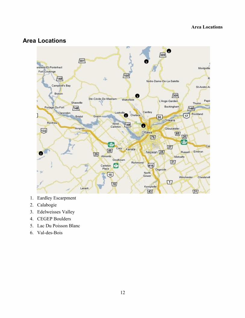
Area Locations
1. Eardley Escarpment2. Calabogie3. Edelweisses Valley4. CEGEP Boulders5. Lac Du Poisson Blanc6. Val-des-Bois
12
2
1
3
4
5
6

Ice Climbs
Ice Climbs
Eardley EscarpmentIce climbing on the escarpment is not as good or abundant as one could think. Moreover, conditions vary enormously from year to year, because of the escarpment's micro-climate. Fortunately, most of the ice climbs can be seen from the road. Bring along some binoculars to assess the conditions first-hand.
1. Ron and John2. The Heffalump3. Western Cwm4. Luskville Falls5. Twin Ribs (Down Under)6. Castle Wall7. The Cirque
8. The Throne9. Home Cliff10. The Gallery11. Farm Rock12. Bald Face13. Big Overhang
13

Eardley Escarpment
14. Buzz Rock15. Erlkoening16. Western Challet Cliffs17. The Shrine
18. Mont King19. Penguin Boulder20. CEGEP Boulders
Western Eardley1. Erlkoening WI3+ 20m
Park at the picnic area along Eardley-Marsham Road. Bushwhack or walk on the road north to the snowmobile trail. Walk east along the snowmobile past a gate into a farmers field and Bushwhack to the base of the cliffs.Climb the iced up gully to the right of the South face of Erlkoening.
(FA: Unknown)2. The Heffalump WI2-3 70m
The Heffalump is a large mass of low-angle ice that can be seen very clearly, high up the escarpment at the top of a drainage gully above the Ron and John Cliffs. Every year, a thick layer of ice forms consistently over a wide 45-degree rock slab that stays wet throughout the
14

Western Eardley
summer. The ice mass extends horizontally for over 30 meters and is 75 meters high. It can be climbed by different options, allowing to vary the difficulty. Belay on ice screws. Walk down to the right. Approach by gaining an open rounded ridge above the Black Bear Slab. Follow this ridge all the way up to the ice.
(FA: Unknown)
Luskville FallsFollow Highway 148 from Aylmer to Luskville. The village of Luskville is very spread out. Highway 148 becomes a divided highway just past Heyworth and stays divided until west of Luskville. Part way along this stretch of road is a side road running off to the right, signposted to Gatineau Park and Luskville Falls picnic ground park along the road and walk into the parking lot.
3. North Wall Gully WI2 30m
Take the equestrian trail to a bridge. (Please stay on the trail). Follow the trail along the escarpment for 600m. You will emerge into a open field A large Bolder is found 100m. Past the bolder is a faint trail to the right. Take the trial up to a metal sing where the trail splits. Take the Left branch to the North Side. Follow the trail up onto a rock ridge marked with white paint to the base of the cliffs.Climb the Gully Between North wall and Reaper Buttress in Western Cwm
(FA: Unknown)4. Spindrift Wall WI3-4 25m
A popular destination in-virtue of the well-traveled access trail, Spindrift Wall usually forms two parallel lines of thin, near-vertical ice. In good circumstances, the ice will form a continuous curtain over the wall.
(FA: R Halka, C Waring - 83)5. Luskville Falls WI2 100m
From the parking lot walk up the Luskville hiking trail till you get to the waterfall.Pitch 1 WI2 Climb the main waterfallPitch 2 WI1 Climb the nice gully above the waterfall
(FA: Unknown)
Hotel-de-Ville Follow Highway 148 from Aylmer to Luskville. The village of Luskville is very spread out. Highway
15

Hotel-de-Ville
148 becomes a divided highway just past Heyworth and stays divided until west of Luskville. Part way along this stretch of road is a side road running off to the right, signposted to Gatineau Park and Luskville Falls picnic ground. Follow this road, past the entrance to the picnic ground, to a dead end and park there.
6. The Fancy Molasses Slab WI2
Halfway between the Luskville Falls and the Twin Ribs is a moss-covered slab, particularly unattractive for rock climbing. In the wintertime, however, the left part of the slab forms a low-angle ice climb. Park at the end of Hotel-de-Vi11e and walk directly to the escarpment through the evergreens.
(FA: Unknown)7. Castle Wall Pillar WI4+ 12m
A steep ice pillar (often overhanging!) usually forms over a short overhanging rock buttress at the far left end of Castle Wall. To the left of this is also a short, near-vertical curtain of ice. Both are good top-rope options.Park at the end of Hotel-de-Ville road (the pillar can usually be seen straight ahead, at the base of the hillside). Approach as for Castle Wall.
(FA: Unknown)8. The Cirque WI3-4 60m
Located high up on the escarpment and on a vast expanse of rock, The Cirque's ice climbs have a great atmosphere and a lot of character. A two-pitch, "Scottish gully" type climb usually forms in the central part of the cliff (WI 3). The top part of the gully offers various second-pitch options, leading to one of the highest summits of the escarpment. In good years, a challenging curtain of ice pours down from the upper right part of the cliff onto a right slanting: ramp, which also forms a near-vertical pitch at its lower end.Approach as for The Cirque's rock climbs. One hour approach when snow is deep.
(FA: Unknown)9. Avalanche Gully
(FA: Unknown)10. Super Seven
(FA: M Burke, K Bowman - 04)11. La Passe a tabac WI4+ 70m
To the right and downstream from the The Cirque a iced up ramp out diagonally towards the
16

Hotel-de-Ville
line. This slope can constitute route in oneself (WI3), but in good conditions a vertical curtain of 15 m flows on the top of the slope, which makes a more difficult exit. One can also reach the summit curtain directly by a delicate slab of thin ice.
(FA: Unknown)12. Thin is in WI2 30m
(FA: A Diamond, W Douglas, J Parkison, G Stowe, D Yachuk - 02)
Chemin Cregheur13. Cabin Stream WI3 25m
To the left of Home Cliff runs a stream that forms a short wall of ice below the main Cliff, at the height of Cotter Crack Buttress.Approach the stream as for Cotter Crack Buttress.
(FA: Unknown)
14. Hidden Face WI2-4 20m
Hidden Face is a small rock outcrop located along Farm Creek, about 1km upstream of Farm Rock. A first ice climb can be found on the west side of the drainage gully: A few hundred meters further is an ice curtain on the right side of the gully.Take the trail as for Big Overhang.: Before reaching Farm Creek, a flagged trail goes straight up the escarpment. Follow this trail into the drainage gully which is then followed for another few hundred meters:
(FA: Unknown)15. Labyrnthe M4 40m
Located at Big Overhang. Climb the pillar in the corner and traverse
17
Hidden Face
The Chin and Bald Face

Chemin Cregheur
right to another bit of ice. Then mix climb your way up the rock to the top.(FA: Not Climbed )
16. The Chin WI2-3 25m
Climb the ice on the right side of The Chin.(FA: Unknown)
17. Bald Face WI2 40m
Long low-angle ice climbs on the right side of the face.(FA: Unknown)
Mont King18. Hollow Glen WI2 30m
Red rocks is located approximately 1km west of Mont King. In good years, a thin line of ice covers the right side with cliff and forms a mixed line.
(FA: Unknown)19. Mount King GulliesWI2-3
Several short ice routes form regularly in the forest, beside the main face of Mont King. A thick flow also forms in the forest, about 200m in the west of cliff.
(FA: Unknown)20. Stan's Route M? 45M
In good years a thin sheet of ice covers the right side with cliff. They form a mixed line.(FA: Not Climbed )
21. Half Baked WI4 M6
(FA: K Bowman, M Burke - 04)22. Par 3 WI3 12m
18
Mike Burke on Half Baked

Mont King
A little before the Mont King, mountain road skirts the Kingsmére golf course. Park at the clubhouse or the intersection 1 km in the south-east of clubhouse. North to the golf course there are two flows on small slabs located very close to the road.
(FA: P Delaney - 90's)
19
Calabogie
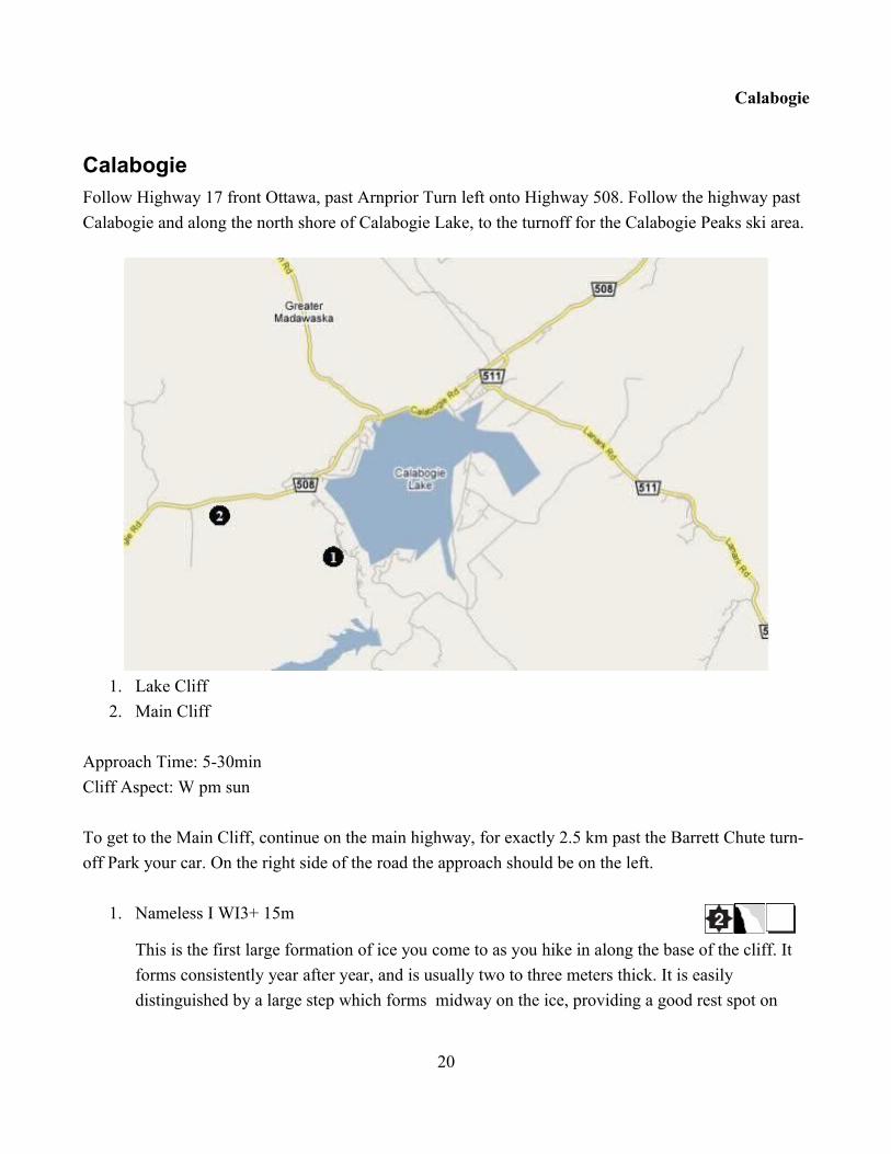
CalabogieFollow Highway 17 front Ottawa, past Arnprior Turn left onto Highway 508. Follow the highway past Calabogie and along the north shore of Calabogie Lake, to the turnoff for the Calabogie Peaks ski area.
1. Lake Cliff2. Main Cliff
Approach Time: 5-30minCliff Aspect: W pm sun
To get to the Main Cliff, continue on the main highway, for exactly 2.5 km past the Barrett Chute turn-off Park your car. On the right side of the road the approach should be on the left.
1. Nameless I WI3+ 15m
This is the first large formation of ice you come to as you hike in along the base of the cliff. It forms consistently year after year, and is usually two to three meters thick. It is easily distinguished by a large step which forms midway on the ice, providing a good rest spot on
20

Calabogie
what would otherwise be a completely vertical curtain of ice.(FA: R Halka, J. Prokopiak - 80's)
2. The Green Fang WI3+ 20m
Usually separated from Nameless I by a rock buttress, in good years the ice can form a continuous sheet. If one starts directly behind the large boulder at its base, the route provides the steepest and most sustained ice at Calabogie. Slightly easier routes can be found to the left, or to the right, where it an ice cave usually forms.
(FA: C Waring R Halka - 80's)3. Two Tool Gully WI2 20m
Located Immediately to the right of The Next Generation, where the rock face intersects the big roof. A runnel of ice may form in good years and provides an easier climb in an interesting setting
(FA: C Waring, R Halka - 80's)4. Dipstick WI3 20m
The same line as Real Men Don't place Pro. Ice climb up to the roof and aid out around it.(FA: R Halka, J Cotter - 80's)
5. Nameless Too WI2- 15m
The easiest mass of ice to climb at Calabogie, with a moderate angle, lots of bumps and grooves on which to get rests and lots of trees to belay from at the top and bottom. Recommended for beginners.
(FA: Unknown - 80's)6. Shock and Awe WI4+
In 2004 a ice dam formed on top of the cliff forming this cool route. Unfortunately it has never come back in since.
(FA: K Bowman, S Grenier - 04)7. Buckhorn Special M5
Just left of Seconds Out. It starts up a thin ice apron to a tree. From there you step right along a ledge, then climb the wall straight up through an obvious small pod/crack that takes gear. Continue to the top of the cliff on thin moves with the occasional awesome pick slot. Pass a bolt and exit to the trees.
(FA: K Bowman, S Grenier - 04)8. Seconds Out WI3 M4 20m
21

Calabogie
In rare conditions, enough ice dribbles out of the exit crack on Seconds out to form an ice climb. A nice change from the predictably thick ice of the other climbs.
(FA: R Halka S Adcock - 80's)9. Nautilus WI2-3 15m
This icefall forms over the rock climb Grunt. It has more character about it than the other routes and can vary in difficulty a fair bit. The main difficulty usually comes at the bottom where insufficient ice will leave you dangling by your tools, with a Herculean pull up (or boost from your planer) required to get your front points in the ice.
(FA: R Halka, C Waring - 80's)
22

Edelweisses valley
Edelweisses ValleyTake Highway 5 north past Wakefield Take the 366 east crossing the Gatineau river. After about 4km take a right on Chemin de la Montagne and travel 3km and park at a sand pit on your right. You should be able to see the ice from the road. Most of the rock around Edelweisses is loose and chossy making not very good for rock climbing. Recently there has been a lot of dry tooling and mixed climbing development at the crag.
Main AreaFrom the sand pit walk up the side of the pit and through a scree field walking toward the ice. The big ice fall you see is the Edelweisses Icefall.
1. Project M?
At a fixed head climb the overhanging crack to a small ledge. Travers right onto ice (in good years) and up over a juniper bush. Finish the same as Mixed Line 2.
23
Sand Pit
P
4
8 10
7
12

Main Area
(FA: Unknown)2. Mixed Line 2 M5
Climb the crack passing a bolt and pull the roof and climb to the trees. Unknown if Ice ever forms on this route as it could be a pure rock mixed line.
(FA: Unknown)3. Mixed Line 3 M8
To the left of the main icefall there is a line of bolts. Climb the short but steep face to a ledge, climb the left tending crack to the curtain of ice. Bolted in 2004 this route has not had any ice on it to call it a mixed climb.
(FA: Unknown)4. Edelweisses Icefall WI4
Walk up on the right to access the main ice flow. Climb steep ice to an easier top-out. Short but burly
(FA: Unknown)5. Edelweisses Chimney WI3+ M3
Climb the iced-up chimney down and left of the main flow. This pitch will take you up to the ledge where you would begin Edelweiss Icefall. Interesting easy/moderate mixed climbing.
(FA: Unknown)6. Edelweisses Front Chimney M4
Just below the Edelweisses Icefall a curtain forms in really good years but just to the left is a runnel of ice that forms in a corner. Climb the corner and ice to the base of the Edelweisses Icefall.
(FA: Unknown)7. Main Gully WI4 M???
To the right of the main ice flow there is prominent a gully that ices up from time to time it is
24
Edelweisses Icefall from the road
Main Area
unknown if anyone has climbed it. Climb the ice until it runs out then climb the steep headwall.(FA: Unknown)
Middle CragFrom the gravel pit walk back along the road for about 200m and bushwhack you way up to the base of the cliff.
8. ??? M4
In between the Main Area and the South Icefall there is a series of broken cliffs with lots of possibility for mixed climbs. Find the Smooth face with a bolt to the right forms a runnel of ice that tends left. Start at the base of a large off-width climb the small right facing corner to the bolts on the top.
(FA: M Burke, K Bowman - 05)9. Corner ??? M4
just To the left of the previous route is an obvious off-width corner. Climb the corner to the top.(FA: M Burke, K Bowman – 05)
South CragFrom the Middle crag keep walking south along the base of the cliff to you reach the large ice flow.
10. Left Pillar WI4+
Climb the pillar left of the main icefall. This line puts up a fight, but probably can't be given the big WI5 grade due to its short length. Definitely technical and delicate
(FA: Unknown)11. South Icefall WI4
Similar in character to Edelweiss Icefall, but a little more sustained.(FA: Unknown)
12. Fool's Errand M4
About 15 meters south of South Icefall. Climb a low ice apron, step right into an obvious seam with a low pin, and climb the seam exiting at the ledge above. Sustained dry tooling on trad gear. Mixed grade to be confirmed
(FA: S Grenier - 04)13. Ronin M7
25

South Crag
Just left of Right Gully lies an obvious pillar terminating half way up the wall. Climb this pillar to its top, step lest to good ledge, climb left-facing dihedral to roof, and pull the bolt-protected roof (big moves). Beautiful route!!
(FA: S Grenier- 05)14. Right Gully WI3
Faint easy gully 5m right of Fool's Errand. Break left at trees and head for the main ledge (FA: Unknown)
Chispa AreaChispa is on the Edelweiss escarpment, just past Edelweiss on Hwy 366. The ice is visible from the highway but doesn't come in every year. From highway 366 going east pass Chemin de la Montagne and turn right on Chemin Pine. Turn Right on to Chemin Poplar and park as close to the ice as possible. Bushwhack you way to the cliff.
15. Chispa WI4 25m
Chispa means Spark in Spanish. The ice is dead vertical but there are a couple of micro-ledges on the way up.
(FA: D Yachuck, G Stowe, S Farquarson - 05)
Mont CascadesFrom Gatineau, take the 307 and turn left in Cantley towards ski hill. A bit before the ski hill turn left on Chemin Panoramique for 1.8km. The ice should be on your right.
1. Road Side 6m WI2-3??
The road passes the foot of a short abrupt curtain of ice. Several ways are possible of which some are mixed.
(FA: Unknown)
26
Chispa From Chemin de la Montagne

Mont Cascades
2. ?? 20m WI2-3
A more impressive climb is sometimes visible a few hundred meters higher on the Right. (FA: Unknown)
Mont LatuqueMont Latuque is located north-east of Mont Sainte-Marie ski area. From Gatineau, take highway 5 north and to follow the singes for Mont Sainte-Marie ski area. 1.5km passed the entrance of the ski area turn right. 600m after the turning you reach the base of Mont Latuque. This road is narrow and depending on the snow maybe impossible to park there. In addition, the Mont Latuque is a private property. It is probably best to park at the ski hill and approach using snow shoes. Where the powerlines cross the road, go up a long scree field to reach the bottom of the wall.
1. South West Face WI2 150m
The climb follows the base of the diagonal wall. Snow or ice, depending on the season. Climb up steps and a small gully while remaining well close to the wall. Reach a clearing and cross through the trees towards the base of CMAS. To go down a little on the right, to pass two trees and to up a frozen pillar and climb to the top on icy slabs.
(FA: Unknown)2. A Crack in the Skull WI3 20m
From the South West Face, locate the first small roof (piton) in the diagonal wall, just above a of 2m buttress. This route is 30m in top and on the left. Climb the thin and narrow route pulling the overhang on the left. Often thin and mixed. Can continue up to the summit on slabs.
(FA: J Scoles - 81)3. CMAS WI4 25m
CMAS is approximately 150m on the right of A Crack in the Skull, where the wall forms a broad open left facing corner. When in good condition the dihedral forms a long pillar. Exit right over a small roof.
(FA: J Scoles, C McKnight - 88)4. Screaming Barfies WI2 50m
Take the first pitch of the South West Face and pass the pillar. The climb is located 10m towards the base of a large ice up slab located directly above CMAS. Also accessible from the top of A Crack in the Skull. Climb up the broad slab with the many small useful steps.
(FA: Unknown)
27

Mont Sainte-Marie
Mont Sainte-MarieFrom the base of Mont Latuque, to continue on 3 km down the road and on the right 1km. Where the road makes a S and crosses a brook the ice can be seen on Mont Sainte-Marie Park. at the barrier take the trail up to two small routes (1 hour)
1. Cheval Noir WI3 20m
A frozen slab at the base of an abrupt pillar. (FA: Unknown – 80's)
2. La Dent WI4 10m
The pillar behind Cheval Noir. Some fixed pins at the top of the pillar. (FA: Unknown – 80's)
Lac Du Poisson BlancFrom Ottawa Take 307 north toward St-Pierre-de-Wakefield. From the First intersection with the 366 (the 366 goes west toward Edelweisses) travel for 20km and turn Left on Chemin des Voyageurs at the singe for “Base de plein air”. Follow Chemin des Voyageurs for 5.8km till it ends and turn left at the T intersection on Chemin du Poisson Blanc and drive for 12.2km. About 500m before the road ends Park at the barrier for the Base de plein air.
Paroi de la FourcheOn Chemin du Poisson just before you park you can see two lines up high to you left on the road. Park
28
1
P
2
3
6
10
P
8
Paroi de la Fourche
on the side of the road and Bushwhack to the base.
1. La Cedraie WI3-4 20m
At the left end of the wall, under a group of cedars is a snow-covered couloir that leads to a large dihedral 20m high with ice on its two faces.
(FA: S Beylerian, Y Troutet - 02)2. La Frurche WI3 30m
At the right end of the wall there is a rectangular cascade of ice 5m wide. (FA: Not Climbed)
La Grande DalleWalk along the road toward Camp Air-Eau-Bois for about 800m till you see ice on your left and take to the trail to the base of Le Capeule.
3. Le Couloir de la Grande Dalle WI3 75m
Start in the small gully to the left of the slab.Pitch 1 climb the gully to a treed ledge.Pitch 2 50m climb the easy slab for 40m to a short vertical section at the very top.Decent walk off to the right and down the gully or rappel the route with two ropes.
(FA: Unknown)4. La Souche WI3 80m
To the right of Le Couloir and just to the left of the decent trail there is a nice easy ice fall.Pitch 1 WI2+ climb the staircased ice to the the trees.Pitch 2 50m climb pitch 2 of Le CouloirDecent walk off to the right and down the gully or rappel the route with two ropes.
(FA: Unknown)5. La Petite Dalle WI2 30m
From the first pitch of La Souche or Le Couloir de la Grande Dalle walk right up into the trees.Climb the wall of thick 60° ice 15 m wide.
(FA: Unknown)6. La Capsule WI3 15m
The first ice you come to at at the left end of the lower Wall. (FA: Unknown)
29
La Grande Dalle
7. A Fleur d'ame WI3 20m
15m to the right of La Capsule, climb a curtain that covers the left face of a small dihedral.(FA: Unknown)
8. La Bifide WI3 20m
10m to the right of A Fleur d'ame climb the ice to a group of cedars at the top. The lower part is sometimes divided into two climbs but later in the season forms one large slab of ice.
(FA: Unknown)9. D'la Galerie WI3 30m
At the right end of the lower Wall climb the thin but reliable ice. You could, after a bushwhack, to continue on La Petite Dalle
(FA: Unknown)10. Les Preposes a l'accueil WI2 10m
40m behind the first building of Camp Air-Eau-Bois. There are two large flows of thick ice one beside the other.
(FA: Unknown)
Other Areas11. Le McLau WI3 20m
From the Barrier head towards the municipal boat launch. After a few hundred meters, there is a path on the right, which leads to Lake MacLaurin (approximately 2km). On the opposite side of the lake there is a wall of broad and thick ice.
(FA: Unknown)12. Le Pilou WI2 25m
On the side opposed to bay from the municipal boat launch there are two parallel climbs 20m apart on a small cliff dominating the bay.
(FA: S Beylerian, Y Troutet - 02)13. Le Groulotte de la montange a Vincent
From municipal boat launch on the lake head toward to the right side of the the large obvious island (île Perdue). Before reaching the island find a small bay on right (3.5 km). The ice is in a large dihedral high in the wall which overhangs bay.
(FA: Not Climbed)
30

Mount de La Coq
Mount De La CoqFrom Buckingham, take highway 309 until Notre-Dame-du-Laus. At the center of the village, take chemin du Ruisseau-Serpent on the right, in direction of the Papineau-Labelle reserve. After approximately 10 km, one passes on a bridge. The wall is then unavoidable, on the left, 4 km further. The possibilities are numerous there, especially at the end of the season.
1. Les Trois vices WI3+ M5 25m
Les Trois vices is a small area offering three distinct lines at the beginning of season, in good years it form one large piece of ice. To locate a major niche approximately 50 m in the west of the Le Coil à l'âne. The bottom and the right side of the niche are covered with ice. Loption of the left, easiest, consists of a short followed vertical pillar of a series of less abrupt steps (3+). The central part of the wall forms a continuous and quasi-vertical curtain (4). At the beginning of season, one finds also a net of ice running in a weakness of the rock on the right side of the wall (M5?).
(FA: C Kinnard, Y Troutet - 02)2. Le Coil à l'âne WI3 M3 80m
Left side of the principal wall. To follow a deep corridor (the cock) driving at the left end of a long overhang. To carry out one to cross 30 m towards the line under the overhang (mixed) to join a curtain of ice (the ass) driving at the top. For lack of clearness, the virgin last 15 m of the way be-remained.
(FA: C Kinnard, Y Troutet - 02)3. Case O Beer WI3+ 80m
A broad gully covering the center of the wall, top in bottom, and offering several distinct lines.(FA : J Delanux, D Kane – 94)
4. Discrète WI3 80m
A gully located in the trees on the right of the wall. (FA : J Delanux, D Kane – 03)
31

References
ReferencesYann Troutet, Climbing on the Eardley Escarpment, 2001David Smart, Ontario's Finest Rock Climbs, 1998Peter Slivka, Selected Climbs, Sandbags and Others Around the Eardley Escarpment, 1995Marcus Buck, Steve Adcock, Climbing around Calabogie, 1991Stephen Adcock, Luskville Rock Climbs, 1988Eugene Levesque, Jean Sylvain, Parois D'Escalade au Quebec, 1978Stephane Lapierre, Bernard Gagnon, Guide des cascades de glace et voies mixtes du Quebec, 2004Norbert Kartner, Marc Braken, Southern Ontario Ice A Climbers Guide, 1995Dr Toivo Koivukoski, Bouldering at The Shrine, http://www.drtopo.com/quebec/shrine.pdfPhilippe-Albert Lefebvre, Bouldering at The Outaouais College, http://www.drtopo.com/quebec/outaouais.pdf
32

References
IndexA Crack in the Skull......................................... 27A Fleur d'ame................................................... 30Access...........................................................5, 11Area Locations................................................. 12Avalanche Gully...............................................16Bald Face..........................................................18Buckhorn Special............................................. 21Cabin Stream.................................................... 17Calabogie..........................................................20Case O Beer......................................................31Castle Wall Pillar............................................. 16Cheval Noir...................................................... 28Chispa...............................................................26Clubs.................................................................11CMAS...............................................................27Code of Conduct.................................................6Coil à l'âne........................................................31D'la Galerie.......................................................30Dipstick............................................................ 21Discrète.............................................................31Eardley Escarpment..........................................13Edelweisses...................................................... 23Edelweisses Chimney.......................................24Edelweisses Front Chimney............................. 24Edelweisses Icefall........................................... 24Erlkoening........................................................ 14Fancy Molasses Slab........................................ 16Fool's Errand.................................................... 25Gear Shops....................................................... 11Grading...............................................................7Green Fang....................................................... 21Groulotte de la montange a Vincent.................30Guiding Services.............................................. 11
Gyms................................................................ 11Half Baked........................................................18Heffalump.........................................................14Hidden Face......................................................17Hollow Glen..................................................... 18Hotel-de-Ville...................................................15La Bifide...........................................................30La Capsule........................................................29La Cedraie........................................................ 29La Dent.............................................................28La Frurche........................................................ 29La Passe a tabac................................................16La Petite Dalle..................................................29La Souche.........................................................29Labyrnthe......................................................... 17Lac du Poisson Blanc....................................... 28Le Couloir de la Grande Dalle......................... 29Le McLau......................................................... 30Le Pilou............................................................ 30Left Pillar..........................................................25Les Preposes a l'accueil.................................... 30Les Trois vice................................................... 31Luskville Falls.................................................. 15Main Gully....................................................... 24McLau.............................................................. 30Mixed Line....................................................... 24Mont Cascades................................................. 26Mont Latuque................................................... 27Mont Sainte-Marie........................................... 28Mount de La Coq..............................................31Mount King Gullies..........................................18Nameless.......................................................... 20Nameless Too...................................................21
33

References
Nautilus............................................................ 22North Wall Gully..............................................15Par 3..................................................................18Paroi de la Fourche...........................................28Pilou................................................................. 30Project...............................................................23Right Gully.......................................................26Road Side......................................................... 26Ronin................................................................ 25Route Symbols................................................. 10Screaming Barfies............................................ 27Seconds Out......................................................21
Shock and Awe.................................................21South Icefall..................................................... 25South West Face...............................................27Spindrift Wall...................................................15Stan's Route...................................................... 18Super Seven......................................................16The Chin...........................................................18The Cirque........................................................16Thin is in...........................................................17Trois vices........................................................ 31Two Tool Gully................................................21Western Eardley............................................... 14
34