comparing openstreetmap user contributions between the united states and europe jeremy stratman...
TRANSCRIPT

Comparing OpenStreetMap User Contributions between the United States and
Europe
Jeremy StratmanAdvisor: Dr. Jan Wallgrün
GEOG 596A: Individual Studies - Peer Review05/07/14

Outline
• Background• Literature Review• Project Objectives• Methodology• Anticipated Results• Proposed Timeline• Conferences & Journals• Questions• References

Background
• “Wiki” concept developed in 1995, went mainstream via Wikipedia in 2001
• Crowd-sourced Mapping is nothing new, but success of Wikipedia paved way for “geo-wiki” concepts
• OpenStreetMap (OSM) founded in 2004, within the UK where Ordnance Survey datasets were proprietary– Called “Wikipedia of Maps” by Steve Coast, Founder– Unsettled terminology:
• VGI• PGIS/PPGIS• Collaborative Mapping
Image: http://wiki.openstreetmap.org/wiki/Stats

Literature Review – OSM Communities
• European Community– Founded in Europe due to lack of freely
available GIS data [10]– OSM community mostly focused on
new data creation [20]
• US Community– Free GIS data readily available in most
locations [18]– Start of OSM community centered on
modifying and expanding upon mass data imports [12]
Images: http://resultmaps.neis-one.org/osmgps.html
Number of OpenStreetMap GPS Points as of April 2012 in Europe and the United States (© Pascal Neis, neis-one.org)

Literature Review – OSM Communities
• European Community– Very active communities in urban areas
[20]– Generally high quality data [8]
• US Community– Activity generally low to moderate [20] – Quality of data varies greatly [14]
Images: https://www.mapbox.com/osm-data-report/
Currency of OpenStreetMap data as of 2013; Cooler shades are older than Warmer shades(© Mapbox)

Literature Review – OSM Communities• So what direct comparisons between US and Europe exist?
– Previous studies are quite limited, focusing only on:• Specific data types between US and European cities (cycling features) [4] • One US city compared internationally across data types (Los Angeles) [14]• Impact of mass imports on US communities (no direct comparisons) [12]
– None include temporal comparisons of community development and contribution behaviors • One temporal study did review impact of Mapping Parties on participation
over time, but only in London [5]
Average Senior Mapper Activity Timeframe and Contributions per Urban Area [14]Total Bike Areas [4]

OpenStreetMap Data Structure
• Elements:– Data is made up of Nodes, Ways, Relations
• Node = Point• Way = Ordered list of nodes
– Open Way (Line)– Closed Way (Line)– Area (Polygon)
• Relation = List of nodes, ways, and/or other relations
– Tags provide attribute data through key/value pairs
• Output File Types– XML is the primary format
• Changesets• “Full History Dump”
Images: http://wiki.openstreetmap.org/wiki/Elements

Project Motivation & Objective
• Motivation: – Enhance the success of outreach efforts to help increase
OpenStreetMap participation in the United States
• Objective: – Determine differences in contribution behavior of US and
European users in comparable cities, measuring:• Maturity of data inputs over time• Spatial Characteristics of User Contributions• Non-Spatial Characteristics of User Contributions

Methodology
• Preparation– Choose cities– Download/Import/Prepare Data
• Execution– Query the data against established metrics
• Compare and Analyze Data
• Develop Results

Preparation
• Choose 18 cities, 9 each in US and Europe– Rural areas too variable and less comparable– Vary size: 3 large, 3 medium, 3 small– OSM Community must exist in each
• Download and Import Data– “Full History Dump” ~52gb and Changesets ~800mb– Extract regions and import to PostGIS
• Preparatory Queries– Identify mass imports and user locations
Image: http://postgis.net/

Measure Maturity Over Time
• Maturity of Data– Spatial and attribute metrics indicative of:
• Basic maturity• Intermediate maturity• Advanced maturity
– Sample yearly 2005-2014
Images: http://wiki.openstreetmap.org/wiki/Completeness_example
(Very) Basic
Advanced
Basic Intermediate

Examples of Attribute Maturity Metrics
• POIs:
• Roads:
Images: http://openstreetmap.org
BasicAdvanced
Intermediate
• Public Transport:

Spatial Characteristics of User Contributions
• Locality of contributors to the city• Spatial extent of contributions of users from the city• Changeset size
Images: http://wiki.openstreetmap.org/, http://resultmaps.neis-one.org/oooc
Map of estimated OSM User Locations (© Pascal Neis, neis-one.org)
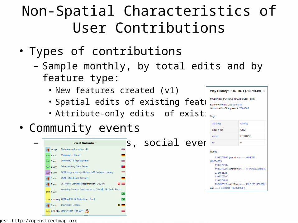
Non-Spatial Characteristics of User Contributions
• Types of contributions– Sample monthly, by total edits and by feature type:
• New features created (v1)• Spatial edits of existing features• Attribute-only edits of existing features
• Community events– Mapping Parties, social events, etc.
Images: http://openstreetmap.org

Anticipated Results
• Queries produce spatial and non-spatial data to facilitate analysis of metrics spatially and temporally
• End Products:– Conclusions about what is actually different as well as similar in the
nature of user contributions between communities– Initial proposals for how to more effectively expand OSM in the US
based upon the results
• Limitations: – Communities operate differently due to the open nature of OSM;
there are few rules and no established progression– User locations is only estimated

Proposed Timeline
• June - July 2014– Set up Linux partition with PostGIS, OSM-History-Splitter,
all other tools– Download data for a small region and test methodology– Choose cities
• August 2014– Run all queries
• September - October 2014– Compare/Analyze Data– Develop Results

Conferences & Journals
• 10/8/14 - NACIS Annual Meeting; Pittsburgh, PA– Abstracts due 5/31/14
• 4/21/15 - Association of American Geographers (AAG) Annual Meeting; Chicago, IL– No date for abstracts published, December 2014 likely
• Journals:– Transactions in GIS – Cartographica– Future Internet– Many Others…

References1. Corcoran, P. and Mooney, P. (2013). "Characterising the metric and topological evolution of OpenStreetMap network representations." The European
Physical Journal Special Topics 215(1), 109-122.2. Girres, JF. and Touya, G. (2010). "Quality Assessment of the French OpenStreetMap Dataset." Transactions in GIS, 14(4), 435-459.3. Goodchild, M. (2007). "Citizens As Sensors: The World Of Volunteered Geography." GeoJournal, 69(4), 211-221.4. Hochmair, H. H., Zielstra, D., & Neis, P. (2013, January). "Assessing the completeness of bicycle trails and designated lane features in OpenStreetMap
for the United States and Europe." In Proceedings of the Ninety-second Annual Meeting of the Transportation Research Board.5. Hristova D., Quattrone G., Mashhadi A., and Capra L. (2013). "The life of the party: Impact of social mapping on openstreetmap." In Proceedings of
the AAAI International Conference on Weblogs and Social Media(ICWSM2013). Association for the Advancement of Artificial Intelligence (AAAI).6. Mashhadi, A., Quattrone, G., Capra, L., & Mooney, P. (2012). "On the accuracy of urban crowd-sourcing for maintaining large-scale geospatial
databases." In Proceedings of the Eighth Annual International Symposium on Wikis and Open Collaboration. ACM.7. "MaZderMind/osm-history-splitter." (n.d.). GitHub. Retrieved April 13, 2014, from https://github.com/MaZderMind/osm-history-splitter8. Mondzech, J., and Sester, M. (2011). "Quality analysis of OpenStreetMap data based on application needs." Cartographica: The International Journal
for Geographic Information and Geovisualization, 46(2), 115-125.9. Mooney, P., and Corcoran, P. (2012). "Characteristics of heavily edited objects in OpenStreetMap." Future Internet, 4(1), 285-305.10. Neis, P., Zielstra, D., and Zipf, A. (2011). "The street network evolution of crowdsourced maps: OpenStreetMap in Germany 2007–2011." Future
Internet, 4(1), 1-21.11. Neis, P., and Zipf, A. (2012). "Analyzing the contributor activity of a volunteered geographic information project—The case of OpenStreetMap." ISPRS
International Journal of Geo-Information, 1(2), 146-165.12. Zielstra, D., Hochmair, H. H., and Neis, P. (2013). "Assessing the Effect of Data Imports on the Completeness of OpenStreetMap–A United States Case
Study." Transactions in GIS, 17(3), 315-334.13. Fan, H., Zipf, A., Fu, Q., and Neis, P. (2014). "Quality assessment for building footprints data on OpenStreetMap." International Journal of
Geographical Information Science, (ahead-of-print), 1-20.14. Neis, P., Zielstra, D., and Zipf, A. (2013). "Comparison of volunteered geographic information data contributions and community development for
selected world regions." Future Internet, 5(2), 282-300.15. Neis, P., & Zielstra, D. (2014). "Recent Developments and Future Trends in Volunteered Geographic Information Research: The Case of
OpenStreetMap." Future Internet, 6(1), 76-106.16. Stephens, M. (2013). "Gender and the geoweb: Divisions in the production of user-generated cartographic information." GeoJournal, 78(6), 981-996.17. "Wiki History." (n.d.). Wiki History. Retrieved April 10, 2014, from http://c2.com/cgi/wiki?WikiHistory18. Willis, N. (2007, October 11). "OpenStreetMap project imports US government maps." Linux.com. Retrieved March 27, 2014, from
http://archive09.linux.com/feature/11949319. Yasseri, T., Quattrone, G., and Mashhadi, A. (2013). "Temporal analysis of activity patterns of editors in collaborative mapping project of
OpenStreetMap." In Proceedings of the 9th International Symposium on Open Collaboration (p. 13). ACM.20. Zielstra, D., and Zipf, A. (2010). "A comparative study of proprietary geodata and volunteered geographic information for Germany." In 13th AGILE
international conference on geographic information science (Vol. 2010).

Questions?