comparing manual and computer assisted benthic cover estimations from underwater imagery for...
TRANSCRIPT

1
Comparing manual and computer assisted benthic cover estimations from underwater imagery for offshore wind-farms assessment
Aleksej Šaškov1*, Thomas Dahlgren2, Marie-Lise Schläppy 2,3, Yuri Rzhanov4
1 Coastal Research and Planning Institute, Klaipėda University; Lithuania;2 UNI Research, Norway;
3 Environmental Research Institute, University of Highlands and Islands, Thurso, Scotland, UK, 4 Center for Coastal and Ocean Mapping/Joint Hydrographic Center, University of New Hampshire, USA
Studying the impacts of offshore wind farms requires the ability to monitor benthic cover in order to assess potential changes.
Study location: Havsul near Ålesund, Norway
In this study, we analysed percentage benthic cover manually from benthic videos collected by ROV and by constructing mosaics of the video transects. The results were compared.
200 m video transectson a depth contour
200 m video transectson a depth contour

2
From the mosaics we extracted:
Data analysis
The video transects were analysed manually using a point- based method to estimate benthic cover.
Comparing manual and computer assisted benthic cover estimations from underwater imagery for offshore wind-farms assessment
Additionally, the videos were divided into 30 seconds segments, from which video mosaics were created. Video mosaic
Using a g set of colours palettes with non-overlapping colours
(a) red algae
(b) crustose coralline algae
(c) sand
3
Results and conclusions
Comparing manual and computer assisted benthic cover estimations from underwater imagery for offshore wind-farms assessment
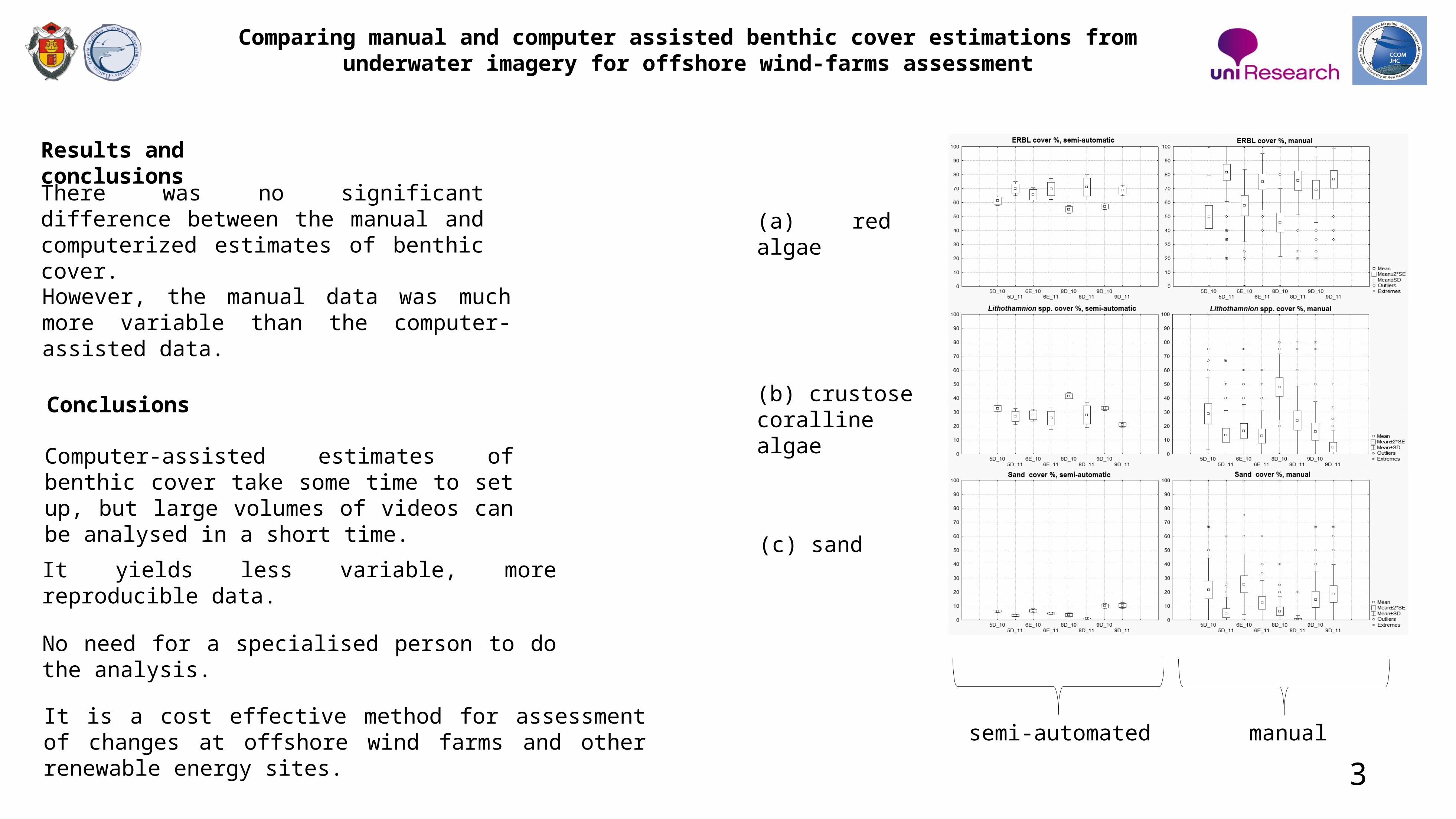
However, the manual data was much more variable than the computer- assisted data.
There was no significant difference between the manual and computerized estimates of benthic cover.
manualsemi-automated
(a) red algae
(b) crustose coralline algae
(c) sand
Conclusions
Computer-assisted estimates of benthic cover take some time to set up, but large volumes of videos can be analysed in a short time.
It yields less variable, more reproducible data.
No need for a specialised person to do the analysis.
It is a cost effective method for assessment of changes at offshore wind farms and other renewable energy sites.