community visioning report - lincoln - document · pdf file · 2016-10-31community...
TRANSCRIPT

P R U D H O M M E S S E C O N D A R Y PLAN UPDATE
C O M M U N I T Y V I S I O N I N G REPORT
MMM Group - a WSP companyThe Planning Partnership
Greenberg Consultants

Community Visioning Report - Prudhommes Secondary Plan Update | 1
Thinking Big About PrudhommesThe Prudhommes Secondary Plan Update was initiated by the Town of Lincoln, with the support of Niagara Region, to review and update the existing 2006 Secondary Plan within the context of current policy and trends. Ultimately, the Town wishes to support the creation of a complete and sustainable waterfront community. The Town of Lincoln and the Niagara Region have identified this site as having potential for becoming a landmark destination within the region, knitting together many of the attributes unique to Niagara. The Secondary Plan Update will provide the policy framework to support the development of a mixed use community with a built form and transportation network that will create a pedestrian-friendly public realm, take
advantage of its waterfront location, showcase sustainability innovations and address the barrier created by the QEW.
The Design Charrette was held on September 7th and 8th, 2016 at Fleming Centre in Beamsville. The purpose was to kick-off the Secondary Plan Update with a visioning process and the development of preliminary concepts for the study area in collaboration with the community. The Design Charrette began with a presentation by Ken Greenberg, who encouraged participants to think big about the potential and role of Prudhommes within the Niagara Region context.
The study area includes the existing Prudhommes Secondary Plan area, bounded by Lake Ontario to the north, Jordan Road to the east, North Service Road and the QEW to the south and Victoria Avenue and Vineland Research and Innovation Centre to the west.
2 | Prudhommes Secondary Plan Update - Community Visioning Report
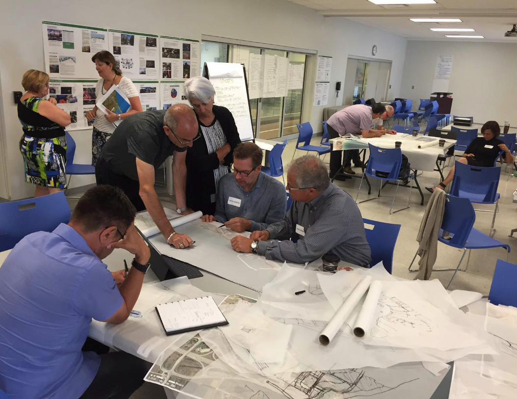
Day 1 - September 7, 2016Day 1 began with the Kick-off Presentation by Ken Greenberg and a Question and Answer period moderated by Town of Lincoln CAO Mike Kirkopoulos. Participants included representatives from across the region, including senior municipal staff and members from various tourism, local business and industry groups. Including project team members, there were 54 attendees for this event. Over the course of the afternoon, a series of small discussion groups were organized, as well as a consultant team working session.
The kick-off presentation was repeated in the evening for residents, followed by a moderated Question and Answer period by Mike Kirkopoulos. Attendees were then invited to complete three table group discussions to provide the team with input to help shape the concept plans to be generated on Day 2 and to help generate the draft vision statement. Approximately 88 members of the public participated in the evening session of Day 1. The following is a summary of responses to the three table group activities.
Participants at the Morning Kick-off PresentationSandra EastonMichael Kirkopoulos Assad HooseinGreg Hudson Kathleen DaleWalter NeubauerDianne RintjemaJohn PacherevaLynn TimmersPaul Macpherson Wayne MacMillanJohn AriensLisa Pare
Michael CommerfordAlexandria TikkyBritney WilliamsonDoug GilesJulia QiKailen GoerzManoj DilwariaMarilyn RadmanMichelle BayaRino MostacciRon Tripp Rory McNeilSamantha LegerSean SissonsSusan Dunmore Suzanne McInnes Carmen D’Angelo
John HenricksAllan Schmidt
Arlene WhiteDebbie ZimmermanDoug FernickEd Haddon
Francesco BertolaHanne Olesen-NahmanJeannette FernickJoanna PogorzeiskiJohn FracchioniJohn Leyenhorst
Joseph Nahman
Leigh Whyte Luke EdwardsMary WileyMike Williscraft
Mayor, Town of LincolnCAO, Town of LincolnTown of LincolnTown of LincolnTown of LincolnTown of LincolnCouncillorCouncillorCouncillorCouncillorCouncillorIBI GroupLincoln Chamber of CommerceLosani HomesNiagara RegionNiagara RegionNiagara RegionNiagara RegionNiagara RegionNiagara RegionNiagara RegionNiagara RegionNiagara RegionNiagara RegionNiagara RegionNiagara RegionNiagara RegionNiagara RegionNPCANPCA
Phelps HomesVineland Estates WineryWP WarehousingGrape Growers of Ontario
Foreign Affair WineryFBH Group
Lakehouse Restaurant
FBH Group
FBH GroupLincoln ConstructionLakehouse RestaurantQuartek GroupNiagara This WeekNiagara ConnectsNewsNow

Table Group Discussion #1
Think of your favourite waterfront districts. Brainstorm as a table group and write a list of the waterfront districts that are great places to visit and/or live.
Hal
ifax
Har
bour
Chicago, IllinoisPort Credit, Mississauga, OntarioStratford, OntarioFinger Lakes, New YorkPicton, OntarioBayfield, OntarioNiagara-on-the-Lake, OntarioSt. Augustine, FloridaSan Francisco, CaliforniaOrillia, Lake Simcoe/Brewery Bay, OntarioCanal Side, Buffalo, New YorkDistillery District, Toronto, OntarioLagoon City, Brechin, OntarioHalifax Historic District, Nova ScotiaHoney Harbour, OntarioBeaconsfield, Montreal, QuebecBronte Harbour, Oakville, OntarioPort Dalhousie, St. Catharines, OntarioHeritage Village Community Design Features
Cana
l Sid
e, B
uffal
o
Gra
nvill
e Is
land
Gro
s M
orne
N
atio
nal
Park
Spen
cer
Smith
Pa
rk,
Burli
ngto
n
Stra
tfor
d
Muskoka, OntarioGros Morne National Park, NewfoundlandBeddeck, MaritimesMimico Long Beach, OntarioAustin Waterfront, TexasOttawa River Walk, OntarioMyrtle Beach, Market Commons, South CarolinaDuck, North CarolinaMuskoka Warf, Gravenhurst, OntarioHuntsville, OntarioGranville Island, Vancouver, British ColombiaVictoria, British ColombiaToronto Island, OntarioBurlington Waterfront, Spencer Smith Park, OntarioBeaches in Toronto, OntarioSeaside Beach, FloridaJames Street North, Hamilton, OntarioDowntown Burlington, OntarioOakville, Ontario
Don’t like – Disneyland, Etobicoke, Waterfront from Grimsby to Stoney Creek (wall of high rises), Bomberry Park, Beamsville
4 | Prudhommes Secondary Plan Update - Community Visioning Report
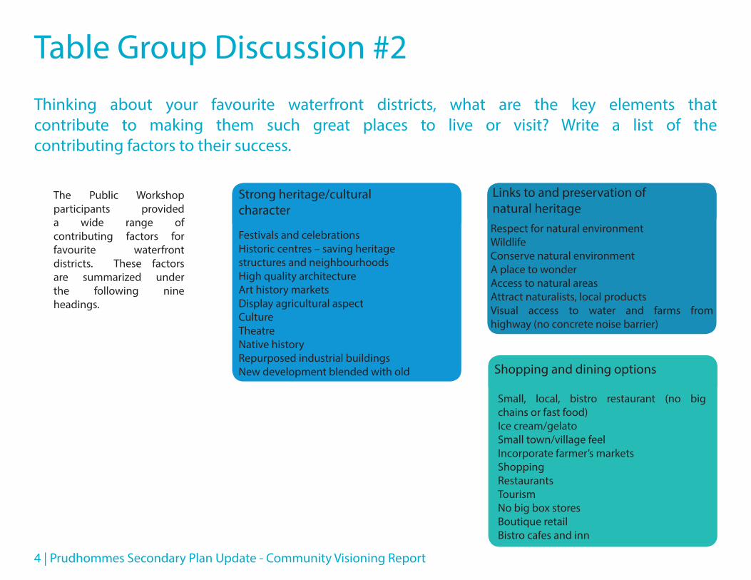
Table Group Discussion #2
Thinking about your favourite waterfront districts, what are the key elements that contribute to making them such great places to live or visit? Write a list of the contributing factors to their success.
Links to and preservation of natural heritage
Strong heritage/cultural character
Shopping and dining options
Respect for natural environmentWildlifeConserve natural environmentA place to wonderAccess to natural areasAttract naturalists, local productsVisual access to water and farms from highway (no concrete noise barrier)
Festivals and celebrationsHistoric centres – saving heritage structures and neighbourhoodsHigh quality architectureArt history marketsDisplay agricultural aspectCultureTheatreNative historyRepurposed industrial buildingsNew development blended with old
Small, local, bistro restaurant (no big chains or fast food)Ice cream/gelatoSmall town/village feelIncorporate farmer’s marketsShoppingRestaurantsTourismNo big box storesBoutique retailBistro cafes and inn
The Public Workshop participants provided a wide range of contributing factors for favourite waterfront districts. These factors are summarized under the following nine headings.

Community Visioning Report - Prudhommes Secondary Plan Update | 5
High quality greenspaces
Active transportation infrastructure
Low-scale built form Tranquil place to unwindConnected
Fully public and accessible waterfront
TreesPark spaceBenchesGardensArea for sportsRiver parklandsYear-roundPark by water
Boardwalk/ waterfront trailsMulti-use recreational trailsPedestrian streets/areasLimit automobile traffic/accessBike pathsNo parking lot out frontWalking trailsTunnel for cyclist and pedestrian traffic
Boat toursContinuous pedestrian access to waterPublic accessMarinaSailingBeachesWharf
Adequate parkingWater taxi connectionsConnections by foot, bike, non-motorized watercraftWide streets, parkingLand and waterGood signage and accessPublic transportation
Low-densityHeight restrictionsTransition with local communityGood infrastructureLow-rise buildingsCondos
QuietComfort areas – rest/washroomsQuaintSpace

6 | Prudhommes Secondary Plan Update - Community Visioning Report
Table Group Discussion #3
We need to write a vision statement to direct the exploration of concepts for development at Prudhommes. What are the key words or phrases that should be captured in a vision statement? Think about public space, buildings and circulation.
LOW RISE – GREEN SPACE – ECO FRIENDLY – COMPLEMENT VICTORIA SHORES – WATERFRONT
ACCESS – CLEAN BEACHES – WILDLIFE – TRAFFIC CALMING – BARRIER FREE – NATURAL FLOW – TREES
– NOISE ABATEMENT – LOW DENSITY – MINIMUM SIZE OF COMMERCIAL BUILDINGS – CHARACTER
– PEOPLE FRIENDLY – WELCOMING – LIVE WORK LEARN PLAY – ANCHOR – REFLECTION OF LOCAL
CULTURE AND HISTORY – UNIQUE – QUIET – OPEN SPACE – LOW IMPACT – BEACHES – TRAIL LIKE
– VISION OF WATER – PEDESTRIAN FRIENDLY – MAINTAIN HERITAGE – REFLECT LOCAL CULTURE
– PUBLIC SPACE – HIGH DENSITY ALONG HIGHWAY – SMALL VINTAGE CHARACTER BUILDINGS
– HEIGHT RESTRICTIONS – GRADUAL INCREASE FROM BEACH – PEDESTRIAN WATERFRONT –
PARKING UNDER HIGH DENSITY – ACCESSIBLE BY FOOT BIKE WATER BARRIER FREE – PEACEFUL –
VIBRANT – MEMORABLE – NATURAL PRESERVE – CONNECT ASSETS – GRASSROOTS – CENTRAL – OLD
AND NEW INTEGRATION – SMALL TOWN COMMUNITY – EXPERIENTIAL – UNCROWDED VILLAGE –
CONTINUOUS OPEN SHORELINE – COMPATIBLE ARCHITECTURE – TRANSITIONAL DENSITY – LARGE
OPEN PUBLIC SPACES JOIN TO EXISTING TRAILS – TOWN SQUARE – SHORELINE NOT INDUSTRIAL –
LOCAL DESTINATION – PUBLIC PARK – INFRASTRUCTURE – BIKE LANES – ADEQUATE ROAD ACCESS
– BOARDWALK – BEACH COMMUNITY – RECREATIONAL – CONTINUED CONSULTATION

Community Visioning Report - Prudhommes Secondary Plan Update | 7

8 | Prudhommes Secondary Plan Update - Community Visioning Report
Derived from the preceding key words and phrases provided by the Workshop participants, the team developed the following draft vision statement to guide the future work on this project. Participants were asked to review the draft vision and provided the comments below.
Draft Vision Statement
Prudhommes will be a diverse, walkable mixed use waterfront neighbourhood – adding a unique destination to Niagara Region. It will leverage and connect all that Twenty Valley has to offer. It will demonstrate the best practices in community building – socially, economically and environmentally.
Why would Prudhommes be a destination?
What about public transportation? Train? Buses?
Low density
Quiet, quaint, peaceful
Truck traffic – cycling Victoria
Seniors population VictoriaLeave off “adding a unique…region” and change “it” to “that”
“
”

Community Visioning Report - Prudhommes Secondary Plan Update | 9
Day 2 - September 8, 2016The design team developed three concepts for the site on Day 2. Stakeholders were invited to participate during the design session. All of the concepts are based on several fundamental principles:
- continuous public access to the waterfront - a connected system of public space - protected natural features - a transition of density to the adjacent Victoria Shores
neighbourhood - a mix of land uses - a variety of housing types - a grid system of roads to provide multiple ways through
the new district - a destination/landmark development
The three concepts were developed to explore options in two key variables: the location and distribution of open space and the location of higher density development.
The following are the concept sketches produced on Day 2 of the Charrette. During the evening, the project team hosted a Public Open House and drop-in session where members of the public were invited to provide feedback on the three options. Approximately 43 members of the public participated.

10 | Prudhommes Secondary Plan Update - Community Visioning Report
Concept #1 - Central Park
ParkNatural FeatureTownhouse 2-3 storeys6-10 storeysCommercialBeachRetail/Commercial
Concept 1: Central Park
Concept 1 illustrates a large central open space on the waterfront. A waterfront drive provides public access to Lake Ontario and an address for development that fronts, faces and features the waterfront. A radiating pattern of streets provide access to the waterfront and to the two access points on the North Service Road. Pedestrian access is provided between the new district and the Victoria Shores neighbourhood. Taller buildings are located on the eastern portion of the site and along a road that parallels the North Service Road. Mixed-use development is located along the North Service Road and along the main street and the waterfront drive adjacent to the park.

Community Visioning Report - Prudhommes Secondary Plan Update | 11
ParkNatural FeatureTownhouse 2-3 storeys6-10 storeysCommercialBeachRetail/Commercial
Concept 1: Central Park
ParkNatural FeatureTownhouse 2-3 storeys6-10 storeysCommercialBeachRetail/Commercial
Concept 1: Central Park
Central Park (natural feature)Parks and greenspace in right spot. Don’t overdo height of buildings. Strive for unique designs suited to environment. Be careful with minimizing density when possible. Maintain PUBLIC access to lakefront.Good flow for traffic to service roadCreates interestLots of greenspaceLow rise to shoreline higher rises to highwayDensity approach, green spaceGreen by the lakeGreat use of lake, views, walking trails/boardwalkOnly 2 storey backing onto Victoria ShoresBoat tour dock service to connect Niagara-on-the-Lake and Jordan HarbourNote: new development needs architectural uniqueness/colours reflecting “seaside look
Connection to Victoria Shores – should be kept separate6-10 storeysToo much commercial/retailNo public transportationParking?It’s all so banal. Look to the past, Prudhommes was vibrant and attracted tourists. Who is the focus client for this vision?Road access to Victoria Shores
I like…
I don’t like…
Concept #1 - Public Comments
12 | Prudhommes Secondary Plan Update - Community Visioning Report
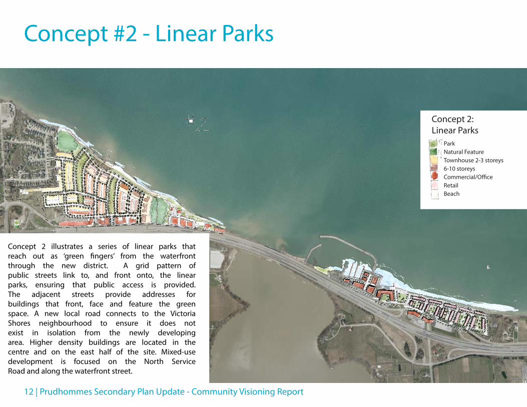
Concept #2 - Linear Parks
ParkNatural FeatureTownhouse 2-3 storeys6-10 storeysCommercial/OfficeRetailBeach
Concept 2: Linear Parks
Concept 2 illustrates a series of linear parks that reach out as ‘green fingers’ from the waterfront through the new district. A grid pattern of public streets link to, and front onto, the linear parks, ensuring that public access is provided. The adjacent streets provide addresses for buildings that front, face and feature the green space. A new local road connects to the Victoria Shores neighbourhood to ensure it does not exist in isolation from the newly developing area. Higher density buildings are located in the centre and on the east half of the site. Mixed-use development is focused on the North Service Road and along the waterfront street.

Community Visioning Report - Prudhommes Secondary Plan Update | 13
ParkNatural FeatureTownhouse 2-3 storeys6-10 storeysCommercial/OfficeRetailBeach
Concept 2: Linear Parks
ParkNatural FeatureTownhouse 2-3 storeys6-10 storeysCommercial/OfficeRetailBeach
Concept 2: Linear Parks
No roads into Victoria ShoresNo roadways in a subdivision to accommodate commercial enterpriseGreen areasHigher density to the east near existing marinaConnect both sides of Jordan Harbour entrance with walking and biking bridge and other opportune areas
No roads into Victoria ShoresI would not like to see any residential directly along waterfrontTown committed to townhouse heights, not more than 1.5 to 2 stories east of DustanThere needs to be constant pedestrian access from end to end (building boardwalks or bridges where necessaryOnly 2 storey towns backing onto Victoria ShoresNo road to Victoria ShoresWalking roadways to Victoria ShoresNo boardwalk?Replace townhouses on corner lots with 1 storey quads (like in Victoria Shores)6-10 storey buildingsConcern re: servicing
I like…
I don’t like…
Concept #2 - Public Comments

14 | Prudhommes Secondary Plan Update - Community Visioning Report
Concept 3: String of Parks on the Lake
West SideParkNatural FeatureTownhouse 2-3 storeys6-10 storeysCommercial/OfficeRetail/CommercialBeach
East SideParkResidential 3-6 storeysRetail Commercial Mixed Use
Concept #3 - String of Parks on the LakeConcept 3: String of Parks on the Lake
West SideParkNatural FeatureTownhouse 2-3 storeys6-10 storeysCommercial/OfficeRetail/CommercialBeach
East SideParkResidential 3-6 storeysRetail Commercial Mixed UseConcept 3 illustrates a string of parks
stretched along the water’s edge. A public street provides access along the parks and the waterfront. A grid pattern of streets enhances access to the waterfront parks. Pedestrian access provides a connection between the new district and the Victoria Shores neighbourhood to ensure that it does not exist in isolation. Higher density development is focused in the interior of the site. Mixed-use development is located along the North Service Road and along the waterfront street.
Community Visioning Report - Prudhommes Secondary Plan Update | 15
Concept 3: String of Parks on the Lake
West SideParkNatural FeatureTownhouse 2-3 storeys6-10 storeysCommercial/OfficeRetail/CommercialBeach
East SideParkResidential 3-6 storeysRetail Commercial Mixed Use
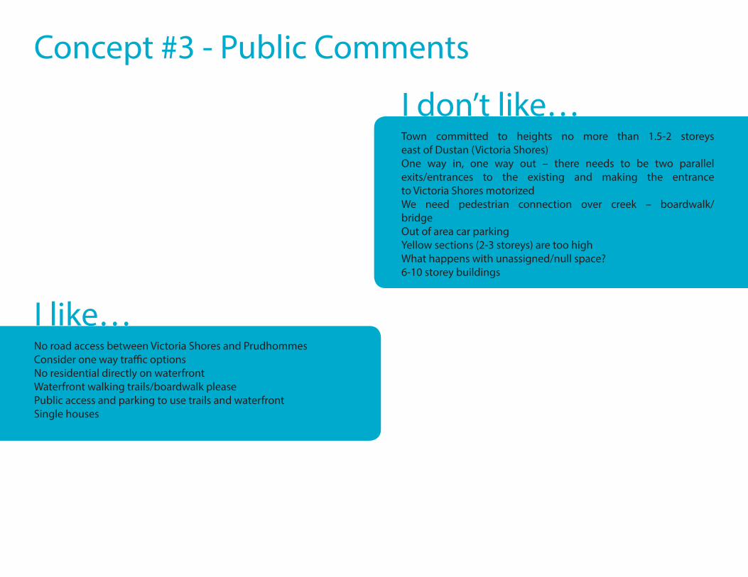
Concept #3 - Public Comments
No road access between Victoria Shores and PrudhommesConsider one way traffic optionsNo residential directly on waterfrontWaterfront walking trails/boardwalk pleasePublic access and parking to use trails and waterfrontSingle houses
Town committed to heights no more than 1.5-2 storeys east of Dustan (Victoria Shores)One way in, one way out – there needs to be two parallel exits/entrances to the existing and making the entrance to Victoria Shores motorizedWe need pedestrian connection over creek – boardwalk/bridgeOut of area car parkingYellow sections (2-3 storeys) are too highWhat happens with unassigned/null space?6-10 storey buildings
I like…
I don’t like…

16 | Prudhommes Secondary Plan Update - Community Visioning Report
Within the Context of Twenty Valley
Over the course of the Design Charrette, one of the underlying focuses was locating Prudhommes within the context of the Twenty Valley tourism area and exploring how this would impact its future role in the region.
This diagram illustrates the various centres within Twenty Valley and the potential for an interconnected system of trails and driving routes to showcase what the area has to offer. Participants were encouraged to consider how these linkages could be strengthened to enrich the visitor experience.

Community Visioning Report - Prudhommes Secondary Plan Update | 17
Recurring ThemesContinuous public access to the waterfront is critical, facilitated by a waterfront boardwalk or trail
Prioritize the use of active transportation by limiting vehicular traffic, linking to existing active transportation networks and creating designated space for active transportation users
Future development should meet a high architectural standard and ensure that adequate transition zones are in place from existing communities
The design of the site should reflect important ties to the area’s heritage and support innovations in sustainable design
The provision and design of public space and parkland will contribute to creating a tranquil and enjoyable environment
Commercial and retail development should be of an appropriate scale and enhance the character of the Twenty Valley and Jordan Harbour area
The development of this site should take advantage of and improve its connections to the wider region and beyond, including by land and water

18 | Prudhommes Secondary Plan Update - Community Visioning Report
Re-imagining PrudhommesSecondary Plan Update - Design charrette
September 7th and 8th, 2016
Ken Greenberg
MMM Group – a WSP companyThe Planning Partnership
Greenberg Consultants
The study process
1. background research and analysis
2. setting the urban vision
3. concept plan design
4. preferred plan development
PART A PART B
1. implementation strategy and official plan amendmentJul – Aug, 2016
Sep – Oct, 2016
Oct – Nov, 2016
Nov – Dec, 2016
Jan – Feb, 2017
We are here
Public Presentation
The Prudhommes TeamMMM Group and WSP Canada
The Planning PartnershipurbanMetrics
John Tassiopoulos – urban designerGord Shields – municipal infrastructureJean-Luc Daviau – water supplySteven van Haren – stormwater managementBrett Sears – transportation planning
John Grieve – transportation planningJay Cranstone – active transportation planningCindi Rowan – park concept designJennifer Sisson – landscape designerValerie Stevenson - ecologist
Ron Palmer –policy planningDonna Hinde – facilitation and consultationDavid Leinster- Landscape ArchitectMichael Sraga – Urban DesignerDaniel Leeming - Designer
Rowan Faludi – market analysisPeter Thoma – market analysis
Joe Nethery– project coordinator
Public consultation: many opportunities to get involved
> 2-day design charrette, September 7th and 8th
> Public Open House, October 26
> Public Open House, early December
> Public Open House, early January
Updates posted on the project website
http://lincoln.ca/content/prudhommes-secondary-plan-update

Community Visioning Report - Prudhommes Secondary Plan Update | 19
Monthly Updates to Council
1. Presentation to Economic Development and Planning Committee, November 14, 2016
2.Presentation to Economic Development and Planning Committee, December 13, 2016
3.Presentation to Joint Council/Committee, January 9, 2017
4.Presentation to Council, February 13, 2017
Prudhommes: potentials and challenges
1. Integrate the Niagara Region experiences
2. Focus for the Twenty Valley/Jordan Harbour Area
3. Overcome the barrier of the QEW
4. Opportunity for a broad scope of site development
Prudhommes study area
Twenty Valley area
QEW interchanges
A HIGHLY STRATEGIC SITE :50 hectares3 km of shorelineMouth of Twenty Mile Creek Existing uses:
Victoria Shores neighbourhoodVineland Manufacturing Ltd.Ramada Jordan/Beacon HarboursideResortBeacon Harbourside Yacht ClubLake House Restaurant
Prudhommes
Lake Ontario
Jordan Harbour
1. Prudhommes:A unique role to play in an unique regionFinding a niche within the regional tourism network
Prudhommes

20 | Prudhommes Secondary Plan Update - Community Visioning Report
WineriesWine toursNiagara Wine Route4-season wine festivals
Agri-tourismFarmer’s marketsRoad side standsFine dining
WaterfrontLake Ontario beachesSouth coast beachesPorts, harbours and marinasScenic views
Natural heritageNiagara EscarpmentNiagara FallsBall’s Falls
Niagara Region: a class of its ownCyclingGreater Niagara Circle RouteFriendship TrailWaterfront Trail
Cultural/industrial heritageBrock’s MonumentHistoric fortsWelland Canal
Education and researchNiagara CollegeBrock UniversityVineland Research and Innovation Centre
Arts and cultureShaw FestivalNiagara Jazz FestivalBall’s Falls Craft ShowGreat towns and villages
Prudhommes
Prudhommes
Integrate these Niagara Region experiences
Niagara Region: individual assets operating on their own
Grape Growers of Ontario
Niagara Peninsula Conservation Authority –Conservation Areas
Niagara Parks Commission
Region of Niagara – Bicycle Routes
Local Municipalities–Arts and Culture
The Niagara Escarpment
• A combination of unique geological and ecological features resulted in a landscape that is unequalled in Canada
• Most significant landform in the southern Great Lakes
• The Niagara Escarpment Plan Area stretches 725 km from Niagara Region to the tip of the Bruce Peninsula
• The Escarpment creates a rich natural heritage of diverse habitats and unique plant and animal species
The Niagara Escarpment Plan AreaPrudhommes
Stitching it together

Community Visioning Report - Prudhommes Secondary Plan Update | 21
West Lincoln
Wainfleet
Grimsby
Lincoln
Pelham
Welland
Thorold
St. Catharines
Niagara-on-the-Lake
Niagara Falls
Fort Erie
Port Colborne
Niagara Escarpment & UNESCO World Biosphere Reserve
Prudhommes & Twenty Valley Area
Lake Ontario
Nia
gara
Riv
er
Lake Erie
Niagara Escarpment & UNESCO World Biosphere Reserve
Unique Agricultural Area
Town of Lincoln FutureFocus Corporate WorkPlan 2014-2018“Partner with otherlevels of government toimplement an economicdevelopment strategyto establish Lincoln as a ‘Centre of Excellence for Agriculture’ – a catalyst for industry and business growth”
Lake Ontario
Nia
gara
Riv
er
Lake Erie
Prudhommes & Twenty Valley Area
West Lincoln
Wainfleet
Grimsby
Lincoln
Pelham
Welland
Thorold
St. Catharines
Niagara-on-the-Lake
Niagara Falls
Fort Erie
Port Colborne
West Lincoln
Wainfleet
Grimsby
Lincoln
Pelham
Welland
Thorold
St. Catharines
Niagara-on-the-Lake
Niagara Falls
Fort Erie
Port Colborne
Niagara Escarpment & UNESCO World Biosphere Reserve
Unique Agricultural Area
Beaches
Niagara’s waterfront54 km Lake Ontario53 km Niagara River56 km Lake Erie42 km Welland CanalTotal 205 km
Lake Ontario
Nia
gara
Riv
er
Lake Erie
Prudhommes & Twenty Valley Area
22 | Prudhommes Secondary Plan Update - Community Visioning Report
West Lincoln
Wainfleet
Grimsby
Lincoln
Pelham
Welland
Thorold
St. Catharines
Niagara-on-the-Lake
Niagara Falls
Fort EriePort Colborne
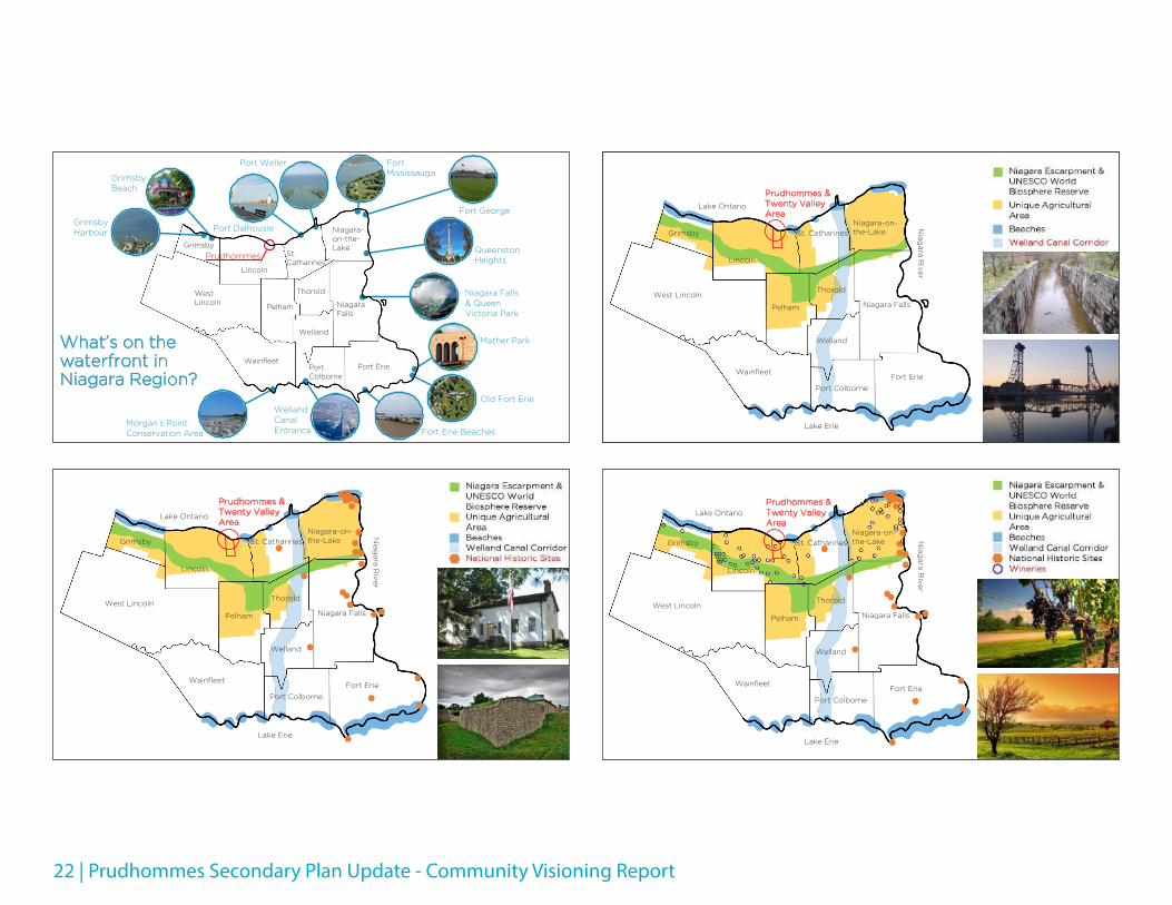
What’s on the waterfront in Niagara Region?
Grimsby Beach
Port Dalhousie
Port Weller Fort Mississauga
Fort George
Grimsby Harbour
PrudhommesQueenstonHeights
Niagara Falls & Queen Victoria Park
Mather Park
Old Fort Erie
Fort Erie Beaches
WellandCanal Entrance
Morgan’s Point Conservation Area
West Lincoln
Wainfleet
Grimsby
Lincoln
Pelham
Welland
Thorold
St. Catharines
Niagara-on-the-Lake
Niagara Falls
Fort Erie
Port Colborne
Niagara Escarpment & UNESCO World Biosphere ReserveUnique Agricultural AreaBeachesWelland Canal CorridorNational Historic Sites
Lake Ontario
Nia
gara
Riv
er
Lake Erie
Prudhommes & Twenty Valley Area
West Lincoln
Wainfleet
Grimsby
Lincoln
Pelham
Welland
Thorold
St. Catharines
Niagara-on-the-Lake
Niagara Falls
Fort Erie
Port Colborne
Niagara Escarpment & UNESCO World Biosphere Reserve
Unique Agricultural Area
Beaches
Welland Canal Corridor
Lake Ontario
Nia
gara
Riv
er
Lake Erie
Prudhommes & Twenty Valley Area
West Lincoln
Wainfleet
Grimsby
Lincoln
Pelham
Welland
Thorold
St. Catharines
Niagara-on-the-Lake
Niagara Falls
Fort Erie
Port Colborne
Niagara Escarpment & UNESCO World Biosphere ReserveUnique Agricultural AreaBeachesWelland Canal CorridorNational Historic SitesWineries
Lake Ontario
Nia
gara
Riv
er
Lake Erie
Prudhommes & Twenty Valley Area

Community Visioning Report - Prudhommes Secondary Plan Update | 23
Niagara’s Wineries
• The Niagara Peninsula is the largest viticultural area in Canada and represents one of Ontario’s 3 official Appellations of Origin
• The Ontario wine industry contributed $2.3 billion to the economy in business revenues in 2011, with a total economic impact of $3.34 billion including collected taxes and wages
• The Niagara Peninsula wine industry is responsible for over 80% of this economic impact
The Niagara Escarpment Plan AreaPrudhommes
West Lincoln
Wainfleet
Grimsby
Lincoln
Pelham
Welland
Thorold
St. Catharines
Niagara-on-the-Lake
Niagara Falls
Fort Erie
Port Colborne
Niagara Escarpment & UNESCO World Biosphere ReserveUnique Agricultural AreaBeachesWelland Canal CorridorNational Historic SitesWineriesEducational InstitutionsNiagara Circle Route
Lake Ontario
Nia
gara
Riv
er
Lake Erie
Prudhommes & Twenty Valley Area
West Lincoln
Wainfleet
Grimsby
Lincoln
Pelham
Welland
Thorold
St. Catharines
Niagara-on-the-Lake
Niagara Falls
Fort Erie
Port Colborne
Niagara Escarpment & UNESCO World Biosphere ReserveUnique Agricultural AreaBeachesWelland Canal CorridorNational Historic SitesWineriesEducational Institutions
Lake Ontario
Nia
gara
Riv
er
Lake Erie
Prudhommes & Twenty Valley Area
West Lincoln
Wainfleet
Grimsby
Lincoln
Pelham
Welland
Thorold
St. Catharines
Niagara-on-the-Lake
Niagara Falls
Fort Erie
Port Colborne
Niagara Escarpment & UNESCO World Biosphere ReserveUnique Agricultural AreaBeachesWelland Canal CorridorNational Historic SitesWineriesEducational InstitutionsNiagara Circle RouteWaterfront Trail
Lake Ontario
Nia
gara
Riv
er
Lake Erie
Prudhommes & Twenty Valley Area

24 | Prudhommes Secondary Plan Update - Community Visioning Report
Prudhommes
West Lincoln
Wainfleet
Grimsby
Lincoln
Pelham
Welland
Thorold
St. Catharines
Niagara-on-the-Lake
Niagara Falls
Fort Erie
Port Colborne
West Lincoln
Wainfleet
Grimsby
Lincoln
Pelham
Welland
Thorold
St. Catharines
Niagara-on-the-Lake
Niagara Falls
Fort Erie
Port Colborne
Niagara Escarpment & UNESCO World Biosphere ReserveUnique Agricultural AreaBeachesWelland Canal CorridorNational Historic SitesWineriesEducational InstitutionsNiagara Circle RouteWaterfront TrailNiagara ParkwayWine Route
An integrated approach for a knowable place
Lake Ontario
Nia
gara
Riv
er
Lake Erie
Prudhommes & Twenty Valley Area
West Lincoln
Wainfleet
Grimsby
Lincoln
Pelham
Welland
Thorold
St. Catharines
Niagara-on-the-Lake
Niagara Falls
Fort Erie
Port Colborne
Niagara Escarpment & UNESCO World Biosphere ReserveUnique Agricultural AreaBeachesWelland Canal CorridorNational Historic SitesWineriesEducational InstitutionsNiagara Circle RouteWaterfront TrailNiagara Parkway
Lake Ontario
Nia
gara
Riv
er
Lake Erie
Prudhommes & Twenty Valley Area
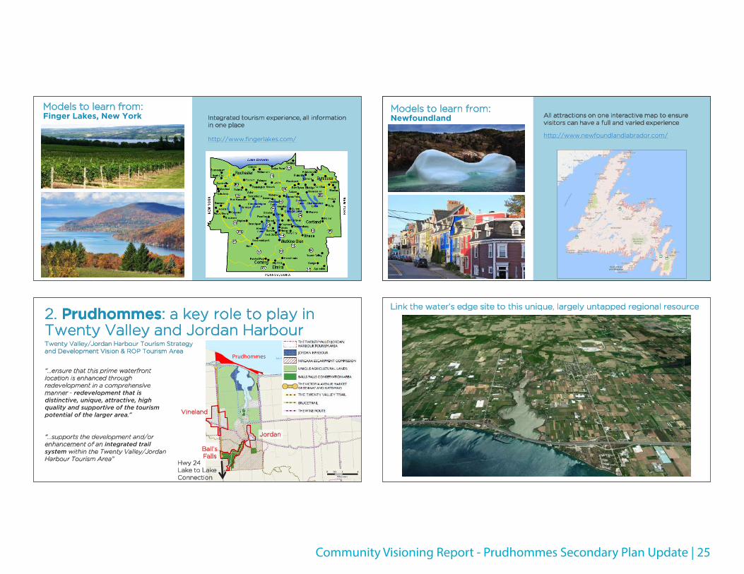
Models to learn from: Prince Edward County
Tourism promotions showcase its towns and villages
Well-connected themed routes linking towns and other attractions
http://prince-edward-county.com/
Community Visioning Report - Prudhommes Secondary Plan Update | 25
Models to learn from:Finger Lakes, New York Integrated tourism experience, all information
in one place
http://www.fingerlakes.com/
2. Prudhommes: a key role to play in Twenty Valley and Jordan Harbour
“…ensure that this prime waterfront location is enhanced through redevelopment in a comprehensive manner - redevelopment that is distinctive, unique, attractive, high quality and supportive of the tourism potential of the larger area.”
“…supports the development and/or enhancement of an integrated trail system within the Twenty Valley/Jordan Harbour Tourism Area”
Twenty Valley/Jordan Harbour Tourism Strategy and Development Vision & ROP Tourism Area
Prudhommes
Hwy 24Lake to Lake Connection
Jordan
Vineland
Ball’s Falls
Models to learn from: Newfoundland All attractions on one interactive map to ensure
visitors can have a full and varied experience
http://www.newfoundlandlabrador.com/
Link the water’s edge site to this unique, largely untapped regional resource
26 | Prudhommes Secondary Plan Update - Community Visioning Report
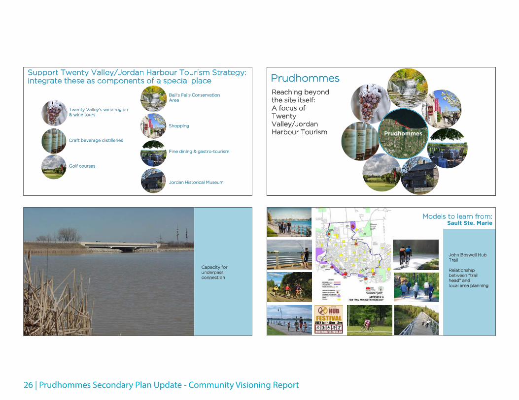
Support Twenty Valley/Jordan Harbour Tourism Strategy:integrate these as components of a special place
Twenty Valley’s wine region & wine tours
Craft beverage distilleries
Golf courses
Ball's Falls Conservation Area
Shopping
Fine dining & gastro-tourism
Jordan Historical Museum
Capacity for underpass connection
Prudhommes
Prudhommes
Reaching beyond the site itself:A focus of Twenty Valley/Jordan Harbour Tourism
John Boswell Hub Trail
Relationship between “trail head” and local area planning
Models to learn from: Sault Ste. Marie

Community Visioning Report - Prudhommes Secondary Plan Update | 27
Waterfront Canal District anchors the 25km trail
Models to learn from: Niagara-on-the-Lake/Niagara Parkway
Launching point for a memorable tourist experience
Models to learn from: Cinque Terre, Italy
Five villages where tourism promotion emphasizes the scenic and well-coordinated connections via trails, train and boat
3. Overcoming the barrier effect of the QEW
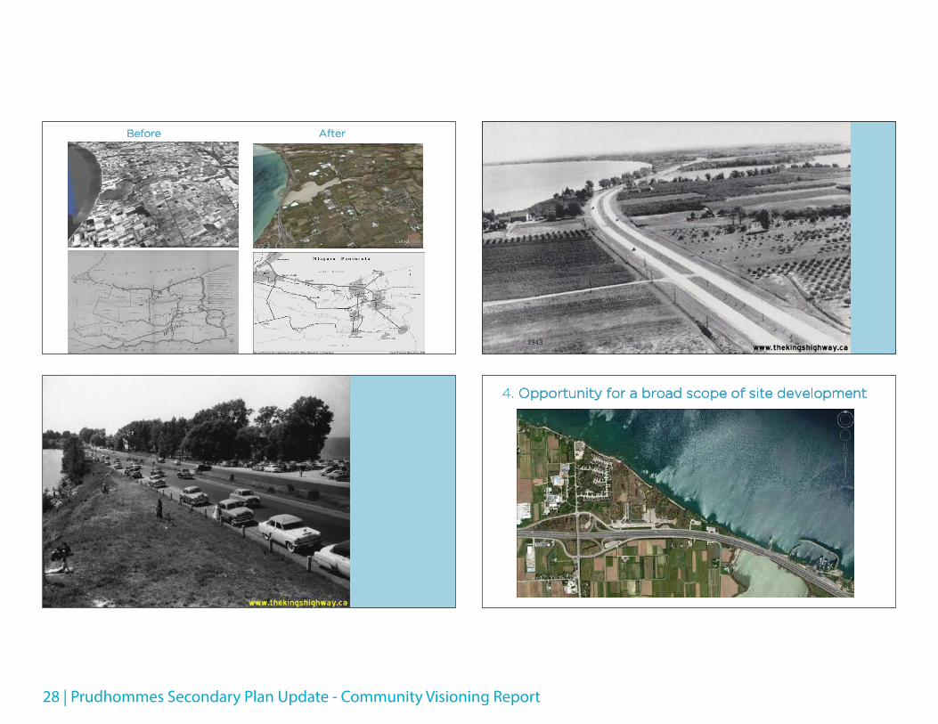
28 | Prudhommes Secondary Plan Update - Community Visioning Report
Before After
1943
4. Opportunity for a broad scope of site development

Community Visioning Report - Prudhommes Secondary Plan Update | 29
Unlocking the potential of the Prudhommes site: A vision for a rich mix of uses
HOUSING
SHOPPING
EDUCATION
TRAILS
BOATING
RESTAURANTS
EVENTSNATURAL FEATURES
Sustainable neighbourhood with a broad range of housing types: Bo01, Malmo, Sweden
30 ha development supplied by 100% renewable energy
Diverse green spaces with high level of biodiversity
Most public spaces closed to cars
Bo01, Malmo, Sweden
Prudhommes
Mixed Use District: Skaneateles
Skaneateles Commercial Core
Prudhommes
Located at the head of a Finger Lake
Waterfront includes beach, water transportation and watercraft rentals
Dynamic mixed use centre
Sustainable neighbourhood with a broad range of housing types: Bo01, Malmo, Sweden
30 ha development supplied by 100% renewable energy
Diverse green spaces with high level of biodiversity
Most public spaces closed to cars
Bo01, Malmo, Sweden
Prudhommes

30 | Prudhommes Secondary Plan Update - Community Visioning Report
Tourist Attraction: Muskoka Wharf, Gravenhurst
Completed in 2005
36 ha site dining, shopping, heritage attractions, condominiums and boat slips
Numerous events and programingPrudhommes
Muskoka Wharf
Vineland
Jordan
Ball’s Falls Prudhommes study area
QEW
Some initial thoughts on how to leverageand connect the assets of the Region andTown to enhance the site and create ahigh quality landmark development forresidents and visitors
Vineland
Jordan
Ball’s Falls
Uninterrupted public access to the water’s edge
Prudhommes study area
Water’s edge
QEW

Community Visioning Report - Prudhommes Secondary Plan Update | 31
Vineland
Jordan
Ball’s Falls Prudhommes study area
Water’s edge
Scenic route
Linked to scenic route
QEW
Vineland
Jordan
Ball’s Falls Prudhommes study area
Water’s edge
Multi-use trail
Roads
QEW interchanges
Strengthening connections among Twenty Valley centres
QEW
Vineland
Jordan
Ball’s Falls
Vineland
Jordan
Ball’s Falls Prudhommes study area
Water’s edge
Multi-use trail
Roads
QEW interchanges
Linkages
Ensuring linkages within the site and to the water
QEW
32 | Prudhommes Secondary Plan Update - Community Visioning Report
Vineland
Jordan
Ball’s Falls Prudhommes study area
Water’s edge
Multi-use trail
Roads
QEW interchanges
Linkages
Conceptual road network
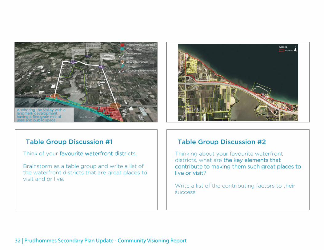
Anchoring the Valley with a landmark development having a fine grain mix of uses and public space
QEW
Lake Ontario
Jordan Harbour
Table Group Discussion #1
Think of your favourite waterfront districts.
Brainstorm as a table group and write a list of the waterfront districts that are great places to visit and or live.
Table Group Discussion #2
Thinking about your favourite waterfront districts, what are the key elements that contribute to making them such great places to live or visit?
Write a list of the contributing factors to their success.

Community Visioning Report - Prudhommes Secondary Plan Update | 33
Table Group Discussion #3
We need to write a vision statement to direct the exploration of concepts for development at Prudhommes.
What are the key words or phrases that should be captured in a vision statement? Think about public space, buildings and circulation.

Prudhommes Secondary Plan Update - Community Visioning Report