community planning staff report - clark county … · community planning staff report page ......
TRANSCRIPT

Community Planning Staff Report Page 1 of 8
Subject parcel outlined in blue. It is an approximate outline. Request to change comp plan/zoning from urban low residential/R1-7.5 to Commercial/Neighborhood Commercial.
COMMUNITY PLANNING
STAFF REPORT
TO: Clark County Planning Commission
FROM: Jacqui Kamp, Planner III
DATE: July 31, 2017
SUBJECT: CPZ2017-00021 Felida Village South
PROPOSED ACTION To amend the comprehensive plan and zoning map for a property in Felida from Urban Low Residential with an R1-7.5 zone to a Commercial comprehensive plan designation with Neighborhood Commercial (NC) zoning on a site approximately ¾ of an acre. This change would accommodate additional neighborhood scale commercial as well as the potential of a combined residential and commercial use.
BACKGROUND The area was brought into the Vancouver Urban Growth Area in 1994 with an Urban Low Residential designation and R1-7.5 zoning. There has been significant residential development in the Felida area in the last 20 plus years. The site is located at the southwest corner of the intersection of NW 119th Street and NW Lakeshore Avenue and is directly south of Felida Village, a mixed use development that has a variety of amenities, such as a restaurant, coffee shop, an exercise studio, offices and residential units.
The site has been moving through a Boundary Line Adjustment (BLA) process to reconfigure the parcel that is proposed for neighborhood commercial. The BLA is anticipated to be complete soon. It is recommended that the BLA be complete as a condition of approval.
GENERAL INFORMATION:
Parcels: 188724000 and a portion of 986041215 A boundary line adjustment is pending to incorporate the portion of 986041215 into 188724000.
Location: Southwest corner of intersection of NW 119th Street and NW Lakeshore Avenue Area: 37,744 square feet Owner(s): Western Properties II, LLC

Community Planning Staff Report Page 2 of 8
Existing land use: Site: The site has one single family residence. North: Mixed Use zoned MX South: Urban Low Density Residential zoned R1-7.5 East: Urban Medium Density Residential zoned R-12 West: Urban Low Density Residential zoned R1-7.5 SUMMARY OF COMMENTS RECEIVED No comments received. APPLICABLE CRITERIA, EVALUATION AND FINDINGS CRITERIA FOR ALL MAP CHANGES
A. The proponent shall demonstrate that the proposed amendment is consistent with the Growth Management Act (GMA) and requirements, the countywide planning policies, the Community Framework Plan, Clark County 20-Year Comprehensive Plan, and other related plans.
Growth Management Act (GMA) Goals The GMA goals set the general direction for the county in adopting its framework plan and comprehensive plan policies. The GMA goals that apply to the proposed action are Goal 1, Goal 2, Goal 4 and Goal 5.
Urban growth. Encourage development in urban areas where adequate public facilities and services exist or can be provided in an efficient manner. Reduce Sprawl. Reduce the inappropriate conversion of undeveloped land into sprawling, low-density development. Housing. Encourage the availability of affordable housing to all economic segments of the population of this state, promote a variety of residential densities and housing types and encourage preservation of existing housing stock.
Economic Development. Encourage economic development throughout the state that is consistent with adopted comprehensive plans, promote economic opportunity for all citizens of this state, especially for unemployed and disadvantaged persons and encourage growth in areas experiencing insufficient economic growth, all within the capacities of the state’s natural resources, public services and public facilities.
Current comp plan and zoning designations. Subject parcel outlined in blue.
PN: 188724000
PN: 986041215

Community Planning Staff Report Page 3 of 8
Finding: Amending the comprehensive plan designation and zoning for this site from single family residential to neighborhood commercial supports the above mentioned GMA goals. The Felida area was brought into the Vancouver Urban Growth Area in 1994 and since that time has seen escalating residential growth. This change could provide opportunity for additional neighborhood scale appropriate commercial services to this predominantly residential area. In addition, the Neighborhood Commercial zone allows integrated multifamily/commercial or mixed use structures; therefore the comprehensive plan/zone change has the potential to provide a different type of housing stock than what is typically found in this residential area. Community Framework Plan and Countywide Planning Policies. The Community Framework Plan encourages growth in centers, urban and rural, with each center separate and distinct from the others. The centers are oriented and developed around neighborhoods to allow residents to easily move through and to feel comfortable within areas that create a distinct sense of place and community. APPLICABLE FRAMEWORK POLICIES Housing 2.1.0 Communities, urban and rural, should contain a diversity of housing types to enable citizens from a wide range of economic levels and age groups to live within its boundaries and to ensure an adequate supply of affordable and attainable housing. Housing options available in the county include single-family neighborhoods and mixed use neighborhoods (e.g. housing above commercial storefronts, traditional grid single family neighborhoods, townhouses, multi-family developments, accessory units, boarding homes, cooperative housing and congregate housing.)
2.1.2 Provide housing opportunities close to employment opportunities.
2.1.6 Encourage infill development that enhances the existing community character and provide a mix of housing types in all urban and rural centers.
2.1.8 Housing strategies are to be coordinated with availability of public facilities and services, including human services.
Transportation 5.1.4 Encourage use of alternative types of transportation, particularly those that reduce mobile emissions (bicycle, walking, carpools and public transit).
Economic Development 9.1.4 Encourage appropriate commercial development in neighborhoods and rural centers that support the surrounding community. Finding: The proposal is to change the site from urban low single family residential to the neighborhood commercial zone which is intended to provide for convenient shopping needs of the immediate neighborhood. The proposal supports the framework policies to provide additional neighborhood commercial services that are appropriate in scale to the surrounding residential neighborhood as well as provide for an opportunity for different types of housing. Located within the Vancouver urban growth area, the site has adequate public facilities and services. Having neighborhood retail/commercial amenities at this location could provide the opportunity for nearby residents to walk and/or bike to shop and visit.

Community Planning Staff Report Page 4 of 8
APPLICABLE COUNTYWIDE PLANNING POLICIES Land Use 1.1.3 Urban growth shall be located primarily in areas already characterized by urban growth that have existing public facility and service capacities to adequately serve such development, and second in areas already characterized by urban growth that will be served by a combination of both existing public facilities and services that are provided by either public or private sources. Urban governmental services shall be provided in urban areas. These services may also be provided in rural areas, but only at levels appropriate to serve rural development.
Housing 2.1.6 Encourage infill housing within cities and towns and urban growth areas.
2.1.7 Encourage flexible and cost efficient land use regulations that allow for the creation of alternative housing types which will meet the needs of an economically diverse population.
Economic Development 9.1.8 The county and cities will provide for orderly long-term commercial and industrial growth and an adequate supply of land suitable for compatible commercial and industrial development.
Finding: As stated above, the subject site is within the Vancouver UGA, is located in an area of existing urban development surrounded by mostly single family zoned land and adjacent to a small mixed use development. The proposal has adequate public facilities, provides opportunity for alternative housing types and supports the compatible commercial growth goals.
Clark County 20 Year Comprehensive Plan The Clark County Comprehensive Plan contains many policies that guide urban form and efficient land use patterns. The most relevant goals and policies applicable to this application are as follows: Land Use Goal: Encourage more compact and efficiently served urban forms and reduce the inappropriate conversion of land to sprawling, low-density development. 1.3.1 Urban densities and uses may occur throughout the urban growth area if it is provided with adequate services. Development and redevelopment in the UGA should be strongly encouraged to occur in greater intensity in major centers, transit routes and other areas characterized by both existing higher density urban development and existing urban services. Development and redevelopment should be encouraged to occur with less intensity in areas where urban development is of lower density or has not yet occurred, or in areas where urban services do not yet exist. Goal: Integrate land uses to reduce sprawl, promote physical activity through active transportation and foster neighborhood and community identity. 1.4.1 Interrelated uses should generally be encouraged to locate in close proximity of each other:

Community Planning Staff Report Page 5 of 8
• Frequently used commercial activities and the residential areas they serve should be allowed and encouraged to locate near to one another.
1.4.2 Encourage mixed-use developments, which provide opportunities to combine residential, commercial or other uses within individual structures, or within adjacent structures or developments. 1.4.4 Encourage compact commercial development with an appropriate mix of uses. Housing Goal: Provide for diversity in the type, density, location and affordability of housing throughout the county and its cities. Encourage and support equal access to housing for rental and homeowners and protect public health and safety. 2.2.2 Encourage a variety of housing types and densities, including mixed-use centers, services and amenities. 2.2.6 Encourage a variety of housing types and densities in residential neighborhoods. Transportation Goal: Develop a multi-modal transportation system. 5.2.11 Promote bicycle and pedestrian safety and increased bicycling and walking through safety and encouragement activities. Economic Development Goal: Provide contextually-appropriate commercial sites adequate to meet a diversity of needs for retail, service and institutional development in Clark County. 9.4.2 Locate convenience-oriented retail and service developments adjacent to residential neighborhoods; encourage small-scale neighborhood commercial uses directly within residential areas. Community Design Goal: Development in urban areas and rural centers should incorporate diverse uses designed in a manner that provides for a sense of community, supports the human scale and allows for multi-modal transportation options. 11.2.1 Encourage the development of multi-story, mixed uses and other commercial uses that utilize regional architectural styles and are at a human scale. Finding: The re-designation of this land from urban low density residential to neighborhood commercial supports multiple goals and policies in the comprehensive plan. The change would provide additional commercial amenities to this mostly residential area. The neighborhood commercial zone further allows the potential for an integrated multifamily/commercial or mixed use structure. This housing type is lacking in the area. A neighborhood scale commercial use also provides the option for neighbors to walk and/or bike to the location. Conclusion: Criteria A has been met.

Community Planning Staff Report Page 6 of 8
B. The proponent shall demonstrate that the designation is in
conformance with the appropriate locational criteria identified in the Clark County Comprehensive Plan and the purpose statement of the zoning district. (See 40.560.010G(2)and 40.560.020H(2).)
Commercial – Neighborhood Commercial
These Commercial center areas provide services within walking distance for the frequent needs of the surrounding residents and are implemented by the Neighborhood Commercial base zone. These areas are located in the urban growth boundary and will generally be small areas which are generally designed to serve neighborhoods. Developments in these areas will be designed to be compatible with the surrounding residentially zoned neighborhoods. New neighborhood commercial areas should generally be less than five acres in size spaced less than five miles from similar uses or zones, serve a population of up to 10,000, locate at neighborhood collector or larger crossroads and serve a primary trade area within a 1.5 mile radius. A. Purpose.
1. Neighborhood Commercial (NC) District. These commercial areas of limited size are intended to provide for the convenience shopping needs of the immediate neighborhood.
2. Community Commercial (CC) District. These commercial areas are intended to provide for the regular shopping and service needs for several adjacent neighborhoods. This district is only permitted in areas designated as community commercial or mixed use on the comprehensive plan.
3. General Commercial (GC) District. These commercial areas provide a full range of goods and services necessary to serve large areas of the county and the traveling public. This district is limited to the general commercial comprehensive plan designation.
Finding: The site is located on NW Lakeshore, a minor arterial, within the Vancouver UGA and is predominantly surrounded by residential zones both low and medium density. The size of the property at approximately 37,744 square feet qualifies for the appropriate size for neighborhood commercial. It is located across the street from the Felida Village Mixed Use development that includes a brew pub, coffee shop, Barre 3 studio among other services. It meets the purpose intended by the Neighborhood Commercial District. Conclusion: Criteria B has been met.
C. The map amendment or site is suitable for the proposed designation and there is a lack of appropriately designated alternative sites within the vicinity. (See 40.560.010G(3)).
Finding: The site is suitable for the proposed designation. A market analysis was submitted indicating the need for additional commercial land. As mentioned above, the Neighborhood Commercial zone allows for an integrated residential/commercial use. That type of housing choice is lacking in the area. Conclusion: The site is suitable for the requested Commercial (C) comprehensive plan designation and Neighborhood Commercial (NC) zoning. Criteria C has been met.

Community Planning Staff Report Page 7 of 8
D. The plan map amendment either; (a) responds to a substantial
change in conditions applicable to the area within which the subject property lies; (b) better implements applicable comprehensive plan policies than the current map designation; or (c) corrects an obvious mapping error. (See 40.560.010G(4) and 40.560.020H(3).)
Finding: A neighborhood commercial use at this site would complement the mixed use development across the street. Since the original comprehensive plan designation and zoning were established for the subject area, a lot of single family residential growth has occurred. The residents in this area could benefit from additional commercial opportunities that are close by to homes. The Felida Village development project to the north of this parcel has resulted in improvements to the neighborhood by providing opportunities for neighborhood restaurants, shops and amenities in close proximity to nearby homes. It has also provided transportation infrastructure improvements along the project frontage on both NW 36th Avenue and NW 119th Street that has enhanced the streetscape for pedestrians, bicyclists and motorists. The market analysis shows a lack of commercial property in the area. The need for commercial use justifies a change in land use designation. The Felida Village development attests to how this change could continue to provide needed and beneficial retail/service amenities that are in close proximity to the surrounding residents. Conclusion: Criteria D has been met.
E. Where applicable, the proponent shall demonstrate that the full
range of urban public facilities and services can be adequately provided in an efficient and timely manner to serve the proposed designation. Such services may include water, sewage, storm drainage, transportation, fire protection and schools. Adequacy of services applies only to the specific change site. (See 40.560.010G(5)and 40.560.020H(4).)
Finding: The site is fully served by public facilities. Water, sewer, transportation, schools, and fire protection services are available. Transportation infrastructure will be enhanced by frontage improvements provided by future development. Stormwater improvements will be provided at the time of development.
Please refer to the attached Transportation Impact Analysis for further information regarding transportation for this proposal.
Conclusion: Criteria E has been met. RECOMMENDATION AND CONCLUSIONS Based upon the information and the findings presented in this report and in the supporting documents, staff recommends that the Planning Commission forward a recommendation of APPROVAL to the Board of County Councilors with the condition that the Boundary Line

Community Planning Staff Report Page 8 of 8
Adjustment for combining a portion of parcel 986041215 with parcel 188724000 be recorded with the county by November 30, 2017 before final adoption of the ordinance. RECOMMENDATION SUMMARY The following table lists the applicable criteria and summarizes the findings of the staff report for CPZ2017-00013. The Planning Commission findings will be added to the table after public deliberation at the Planning Commission hearing scheduled for this application. COMPLIANCE WITH APPLICABLE CRITERIA Criteria Met? Staff Report Planning
Commission Findings
Criteria for All Map Changes A. Consistency with GMA & Countywide Policies
Yes
B. Conformance with Location Criteria
Yes
C. Site Suitability and Lack of Appropriately Designated Alternative Sites
Yes
D. Amendment Responds to Substantial Change in Conditions, Better Implements Policy, or Corrects Mapping Error
Yes
E. Adequacy/Timeliness of Public Facilities and Services
Yes
Recommendation: Yes

CPZ2017-00021 Page 1 Felida Village South
Transportation Impact Analysis Annual Review Case: CPZ 2017-00021 Felida Village South Introduction This report provides a transportation analysis of the proposed comprehensive plan amendment and zone change. The report identifies the likely localized and general transportation impacts and shows how applicable adopted transportation policies have or have not been met by the applicant’s proposal. Subsequent development will need to comply with applicable county development regulations, including standards governing the design of access and those that ensure transportation system concurrency. Requested Amendment The applicant is requesting to amend the Comprehensive Plan designation and zoning for portions of parcel numbers: 188667000, 188665010, and all of parcel number 188724000. Two out of the 3 sites currently have single-family homes on them, and one is vacant. The change would be from a comprehensive plan designation of Urban Low-Density Residential (UL) with R 1-7.5 zoning, to a comprehensive plan designation of Commercial and zoning to Neighborhood Commercial (NC). The subject site is 37,744 sq. ft. or 0.87 acres and is located at the southwest corner of the intersection of NW 119th Street and NW Lakeshore Avenue. Both NW 119th Street and NW Lakeshore are classified as a 2-lane Minor Arterial with center turn-lane and bike lanes or M-2cb. Summary of Transportation Impact Findings The transportation analysis demonstrates that the proposed land use change generally would not significantly impact the transportation system. Staff recommends approval of the proposed comprehensive plan amendment and rezone of the subject parcel. At full build-out, the current R 1-7.5 zoning could generate 30 net new daily trips. Approval of the rezone to NC zoning would generate 437 more daily trips than the current R 1-7.5 zoning. The applicant submitted a traffic impact analysis which concluded the site could generate 396 net new daily trips when rezoned to NC zoning. Most of the study area intersections are projected to operate at acceptable levels of service in the 2035 “Existing Zoning Build-Out” and 2035 “Proposed Zoning Build-Out.” Some of the roadway segments along NW Lakeshore between NW 99th Street and NW 119th Street will exceed the volume to capacity ratio standard of 0.9 in year 2036. The Felida Village South development will install neighborhood oriented elements, such as wide sidewalks, benches, and bike racks to encourage the use of alternative modes of transportation, improve pedestrian connectivity, and facilitate access to local C-Tran bus stops. These pedestrian and bicycle elements will have a positive impact on the operation and roadway capacity of the roadways and assist in achieving acceptable volumes to capacity ratios along the impacted roadways. In addition, there is a project on the Capital Facilities Plan for improving NW Lakeshore Avenue near the subject site. Public Comment Staff has not received any comments regarding potential transportation concerns with this docket application.

CPZ2017-00021 Page 2 Felida Village South
Chapter 5: Transportation Countywide Planning Policies 5.0.8 The state, county, MPO/RTPO and local municipalities shall work together to establish a regional
transportation system which is planned, balanced and compatible with planned land use densities; these agencies and local municipalities will work together to ensure coordinated transportation and land use planning to achieve adequate mobility and movement of goods and people.
Findings: The proposed amendment is consistent with the applicable Countywide Planning Policies. The proposed land use will significantly increase trips onto both NW 119th Street and NW Lakeshore Avenue; however, the study area intersections will add only 28 additional PM peak hour trips. The County concurrency code considers only PM peak hour trips. The roads in this area will not operate at acceptable levels over the 20-year period, with or without the new trips that this docket item proposes. During the development review process, the applicant will have to address transportation impacts of the proposed development per the Title 40 development review requirements. In addition, there is a project on the Capital Facilities Plan for improving NW Lakeshore Avenue near the subject site. County 20-Year Plan Policies Goal: Develop a regionally-coordinated transportation system that supports and is consistent
with the adopted land use plan. 5.1 System Development Policies 5.1.3 Performance standards for the regional arterial system and transit routes shall direct growth to urban
centers. Findings: As previously mentioned, the proposed amendment is consistent with the applicable Countywide
Planning Policies. The location of the proposed plan amendment is in the urban area. Goal: Develop a multi-modal transportation system. 5.2 Multi-modal System Policies 5.2.2 Transit related options, including high-capacity transit, shall be encouraged in order to reduce
congestion and to improve and maintain air quality. Findings: Per the applicant’s traffic study, “The Felida Village South development will install neighborhood
oriented elements, such as wide sidewalks, benches, and bike racks to encourage use of alternative transportation, improve pedestrian connectivity, and facilitate access to local C-Tran bus stops...”
Goal: Optimize and preserve the investment in the transportation system. 5.3.5 The local street system shall be interconnected to eliminate the need to use collector or arterial street
for internal local traffic.

CPZ2017-00021 Page 3 Felida Village South
Findings: As previously mentioned, the proposed amendment is consistent with the applicable Countywide Planning Policies. During the development review stage, the applicant will need to address applicable development code regarding street circulation.
Analysis of Trip Generation The site is currently zoned R1-7.5. The potential average daily traffic to and from the site under the existing zoning is 30 trips per day. Under the proposed NC zoning, the potential average daily traffic would be 437 trips. The net impact of the proposed zoning is a potential 396 additional trips per day. Site Specific Impacts The proposed land use will significantly increase trips onto both NW 119th Street and NW Lakeshore Avenue, however, the study area intersections will add only 28 new PM peak hour trips. The roads in this area will not operate at acceptable levels over the 20-year period, with or without the new trips that this docket item proposes. During the development review process, the applicant will have to address transportation impacts of the proposed development per the Title 40 development review requirements. In addition, there is a project on the Capital Facilities Plan for improving NW Lakeshore Avenue near the subject site. System Impacts Sections of NW Lakeshore Avenue between NW 99th Street and NW 119th Street will be over the accepted v/c capacity in 20 years. Most of these areas will be over capacity in the AM and concurrency does not apply to the AM trips. Only the northbound trips on NW Lakeshore will be over capacity in the PM peak hour in 20 years. However, there is a project on the Capital Facilities Plan for improving NW Lakeshore Avenue near the subject site. The applicant’s assertion is that these impacts can be mitigated during the development review process. In addition, the applicant said site amenities can be added to encourage alternate modes of transportation. Report Prepared By: Laurie Lebowsky, Clark County Date: July 31, 2017 Disclaimer: The trip generation and system analysis in this report provides a gross estimate of the likely impacts that will result from the action of approving this Annual Review request. The assessment of transportation impacts from subsequent development of the site occurs with a specific development proposal and the testing of that proposal under the County’s Transportation Concurrency Management ordinance.
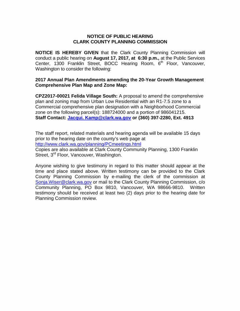
NOTICE OF PUBLIC HEARING
CLARK COUNTY PLANNING COMMISSION
NOTICE IS HEREBY GIVEN that the Clark County Planning Commission will conduct a public hearing on August 17, 2017, at 6:30 p.m., at the Public Services Center, 1300 Franklin Street, BOCC Hearing Room, 6th Floor, Vancouver, Washington to consider the following: 2017 Annual Plan Amendments amending the 20-Year Growth Management Comprehensive Plan Map and Zone Map:
CPZ2017-00021 Felida Village South: A proposal to amend the comprehensive plan and zoning map from Urban Low Residential with an R1-7.5 zone to a Commercial comprehensive plan designation with a Neighborhood Commercial zone on the following parcel(s): 188724000 and a portion of 986041215. Staff Contact: Jacqui. [email protected] or (360) 397-2280, Ext. 4913 The staff report, related materials and hearing agenda will be available 15 days prior to the hearing date on the county’s web page at http://www.clark.wa.gov/planning/PCmeetings.html Copies are also available at Clark County Community Planning, 1300 Franklin Street, 3rd Floor, Vancouver, Washington. Anyone wishing to give testimony in regard to this matter should appear at the time and place stated above. Written testimony can be provided to the Clark County Planning Commission by e-mailing the clerk of the commission at [email protected] or mail to the Clark County Planning Commission, c/o Community Planning, PO Box 9810, Vancouver, WA 98666-9810. Written testimony should be received at least two (2) days prior to the hearing date for Planning Commission review.

8705 NW 23RD CT
VANCOUVER WA, 98665
AMES P CLARENCE
3501 NW 120TH ST
VANCOUVER WA, 98685
ARENIVAS MAURISIO
4101 NW 118TH CIR
VANCOUVER WA, 98685
BARNETT STEWART N
12004 NW 36TH AVE
VANCOUVER WA, 98685
BAXTER LYLE & BAXTER NORMA
13209 NW 30TH CT
VANCOUVER WA, 98685
BAYLEAF PROPERTIES LLC
11805 NW 38TH AVE
VANCOUVER WA, 98685
BENNETT DAVID A & BENNETT
11608 NW 37TH CT
VANCOUVER WA, 98685
BERGMAN RYAN JOHN & BERGMAN
11617 NW 37TH CT
VANCOUVER WA, 98685
BLIGHTON STUART R & BLIGHTON
T L BURNETT LIVING TRUST
VANCOUVER WA, 98685
BURNETT TERRI LEEANN & WATSON
11616 NW 37TH CT
VANCOUVER WA, 98685
COFFEY RYAN C & COFFEEY KRISTIN
11702 NW 35TH AVE
VANCOUVER WA, 98685
EVANS RANDALL DEAN II & EVANS
11701 NW 38TH AVE
VANCOUVER WA, 98685
FILBIN MOLLY A
11715 NW 38TH AVE
VANCOUVER WA, 98685
FUNK DANIEL & FUNK JONI TRUSTEE
11612 NW 35TH AVE
VANCOUVER WA, 98685
GAINES CLARENCIA M
11800 NW LAKE SHORE AVE
VANCOUVER WA, 98685
GANO DAMON B
11616 NW 35TH AVE
VANCOUVER WA, 98685
HARPER JUDITH W
3512 NW 119TH ST
VANCOUVER WA, 98685
HOFFAS RONALD G & HOFFAS JOYCE
11716 NW LAKESHORE AVE
VANCOUVER WA, 98685
HOPPER CHRISTOPHER & HOPPER
11718 NW 35TH AVE
VANCOUVER WA, 98685
INGLIS LEANNA M & INGLIS THOMAS
3512 NW 118TH ST
VANCOUVER WA, 98685
KIOROGLO BORIS
12001 NW 36TH AVENUE
VANCOUVER WA, 98685
KNUDSEN KENT W & KNUDSEN
7509 N EDGEWATER AVE
PORTLAND OR, 97203
LORRAINE M CALCAGNO FAMILY LLC
11714 NW 35TH AVE
VANCOUVER WA, 98685
MAZUREK KRZYSZTOF
4910 NW 127TH ST
VANCOUVER WA, 98685
OSPREY HOMES LLC
3508 NW 118TH ST
VANCOUVER WA, 98685
RAPHAEL PAMELA K
3614 NW 119TH ST
VANCOUVER WA, 98685
REMMERDE RICHARD A & REMMERDE
3506 NW 119TH ST
VANCOUVER WA, 98685
SCOTT SHEILA A
SHAFFER LIVING TRUST
VANCOUVER WA, 98685
SHAFFER KIM K & SHAFFER LORI J
12 NELSON CT
LAGUNA NIGUEL CA, 92677
TITEIU IOAN & TITEIU MARIA
11612 NW 37TH CT
VANCOUVER WA, 98685
TURNER BRIAN BURKE & TURNER

3500 NW 119TH ST
VANCOUVER WA, 98685
TURNER LARRY
4111 NW 199TH ST
RIDGEFIELD WA, 98642
VAHNDIJK TIMOTHY M & VAHNDIJK
2300 E 3RD LOOP #120
VANCOUVER WA, 98661
WESTERN PROPERTIES II LLC
2300 E 3RD LP #120
VANCOUVER WA, 98661
WESTERN PROPERTIES II LLC
3412 NE 62ND AVE APT G4
VANCOUVER WA, 98661
WIKERT STEPHEN & WILLIAMS CASSIE


Zoning Designation
NW
35t
h AV
E
NW 119th ST (P)
NW
32n
dAV
E (P
)
NW 121st ST (P)
NW 120th ST
NW
33r
d AV
E
NW
34th
AV
E
NW 121st ST
NW 122nd ST
NW
4S
T AV
E
NW
42N
D A
VE
NW 120TH ST
NW11 5th S T (P)
NW
43rdAV
E(P
)NW 112th WAY (P)
NW
40 thAV
E(P
)
NW
38t
h AV
E
NW 116th WAY NW
33rd
AVE
NW
34t
h AV
E (P
)
NW
36t
h AV
E
NW 114th ST
NW 112th ST NW
37t
h C
T
NW
35T
H A
VE
NW 118TH ST
NW
118T H WAY
NWLAK
ESH
OR
EAV
E
NW
36t
h AV
E
NW 119th ST
NW LAKESHORE AVE
NW 34th CT
NW34th
AVE
NW 113th CIR
NW 113th ST
NW
35t
h C
T
NW 112th ST
NW 114th ST
NW 116TH ST
NW
37T
H C
T
NW
38TH
AVE
NW 121ST ST NW 121ST CR
NW 124th ST
NW
40TH
AV
E
NW11
5th ST
NW
115th
ST
NW 114th CIR
NW121 S T CR
NW 112th CIR
NW
34T
H A
VE
NW
33R
D A
VE
NW 122nd ST
NW
39T
H C
T
R1-7.5
R1-10
PF
R-12
PF
R1-10
R-18
C-3
MX
C-3
0 200 400 600Feet
1:4,800
Information shown on this map wascollected from several sources. ClarkCounty accepts no responsibility for
any inaccuracies that may be present.
Account No:Owner:Address:C/S/Z:
188667000, 188665010, 188724000GANO DAMON B
11800 NW LAKE SHORE AVE VANCOUVER, WA 98685
Printed on: October 03, 2016
Developer's GIS Packet Page 6 of 14
31132 31133
3112831129
2110421105
31131
21106
31130
Subject Parcel
Public Road
Transportation or Major Utility Easement
Zoning Boundary
Urban Holding - 10 (UH-10)
Urban Holding - 20 (UH-20)
Urban Holding - 40 (UH-40)
Surface Mining Overlay District

2014 Aerial Photography
0 200 400 600Feet
1:4,800
Information shown on this map wascollected from several sources. ClarkCounty accepts no responsibility for
any inaccuracies that may be present.
Account No:Owner:Address:C/S/Z:
188667000, 188665010, 188724000GANO DAMON B
11800 NW LAKE SHORE AVE VANCOUVER, WA 98685
Printed on: October 03, 2016
Developer's GIS Packet: Page 4 of 14
Proposed Development Area
31132 31133
3112831129
2110421105
31131
21106
31130

General Location Map
10th
CR
18
135
11
LAKESHORE
119th
COACH
26th
124
112
110
14
RD
51C
T
50AV
E52
144
WILDWOOD
RID
G EC
RES T
RID
GE
SUM MIT A
V E
CT
CreekSalmon
Greenway
CR107
LAK
ES
HO
RE
131
35 CT
24
25
24
38
136
128
MADRONA
125
13
26th
CT
114CR
37
DR
21
17
15 CT
14CT
SPR
ING
DR
137
CR
CT10
11
NW
1516
150
14
150
CR
15 13
AVE
148CR
10th
CT
143 28 PL
28 CT
23 A
VE
23rd
22nd
NW
23
RD
CT
126
17 125
123
19
20
148
2930
130th130
128 3031
Hazel Dell
22 CT
LeagueLittle
25th
2 4th
19 CT
8th 120th
119
29
CT
30
23
CR111
112
112
WY
102
103
136ST
I ND
IA N
28th
140
141
141
142
143
8 CT
PL
117
CR118
ST
113 CT
112CR11 2
24
28C
T27
CT
29
1 01
86
19
13
132
AVE
PL
112
CT
104
149th
29
129
111
109
8
LP
PL14
13816
137
136PL
17
134
9
98th
8th
96
14
13 CT
STARKREST
LA
KECREST
114th
108
LAKESHORE
CR97
91
127
35 C
T
7
(#2)
19
NW BLISS
31CT
146
25CT
138 20C
T
115
114
14
133
13PL
131
AVE
15
114
12
113CR
12
9th
116
139
140
21st
AVE29th
142143
27
141
140
FELIDA
14
12215th
123
8th
PL
9th11 120
CR
130
127
24
86
10CT12
CR87DR 23 CT
21
CR93
98
ST
FelidaPark
Pinecrest Golf Course
13
120
CR
31
WE
STG
A
T E
122
CT
44t h
CREEKSIDE
111
ChinookEL
AlkiMiddle Skyview
H S
Eisenhower El
ColumbiaRiver H S
Felida El
HATHAWAYRD
CT
19th
VIE
W
103
RD
149
14
9 PL
146
10CT
10 PL
CR144
10th
10CT
8
14 CT
146
149th
SALMONCREEK
121
1
21
43r d
107
28 CT
29t h
22
23
C R
CR
112CR
NW
33 CT
118
124
WY
CR
Salmon Creek Greenway
140
12th
CT43
106
105
111
ST
Sorenson(u)Park
CR
CR
139 LP
CR
147148
151
WY142
CR
CT
25
24
CR
WY
CR
48CT
CR
43C
T
CT
WY
8
NW
NW
122nd
14 12
CT
ST
138 WY
CR
LP
CR
145
117CR
WY
110
22 CT
CR
27
129CR 129
CT
NW
22
29th
46 C
T
CR135
48th
53 A
VE
52
BLI
SS
114
CR
WEST
- G
ATE
13th
CT14
96CR
GO
LDENAV
11CT
1 1
10
95
110
111
WY
WY
110C R
AVE
111LAKE
RIDGE
108th
109
108
109CR
CR95
17
CT
28
CTC
T30
31132 C
R
CR
133
CT
42 CT 40
39
CT37
CT
33
CR118
117
CR
126
CR
128
CT
137th
10
12
11
103rd
18
133rd
NW148 ST
100
29
24CT
98
95PL
NW
138
46 AV
CT
PL
33rd
34 CT
31st
29
2729 CT
28 CT
124
CT32
20
16th
19th
127127
25 CT
CR
CR
128
42
RD
113 CR
CR114
118
CT
25
24 23 CT
NW
86CR
95th96
CT
112
43C
T
102102
105CR
106
CR
104
10PL
CTLAKECREST
126
50 DR
49
NW
46t
h
25 24
25
116
Salmon
86th
88th
89th
90th
91
92
WEST
13 CT
RIDG E
14
18
1 5th
NW
2928
CT
ST
113
26th
33
36
CT
CT19120
22PL
121
123
124
20
HOUSE
17th
NW
3 6t h
CR
39 CT
WY
3838
Rasp-berry Fields
Jason LeeMid Sch Park
CR120
42
SgtBrad
Crawford
121st
CT
122nd
28
34
125
35
NW ST
138th
43
48
32
CR126
110CR
42 C
T
149CR
WY14 7
Cou
gar C
rG
reen
way
(u)
117 28
118
115
116 WY 33
CR125
124
29 CT
24
AlkiPark
Jack Z Fazio
Pk
Cougar Creek Woods (u)
FoleyPark (u)
147
115CR
Cougar CrGreenway (u)
CT11
Cougar C reek Trail
40
42nd
NW
40th
122121
126
48th
CT
124
121CR
99th
BUCK
MIRE
SLOUG
H
33
118
JeffersonMid
27
29
NW ASHLEYHEIGHTS
DR
14
132 ST
134 10
11th
AVE
13th
138
135
117
23 C
T
33
Episcopal ChurchSports Field (pvt)
Whipple CrGreenway
GreenwayWhipple
Cr
110 ST
Lake ShoreEl
118 CR
Creek
Cougar
50th
47th
NW McCANN
42nd 40
NW 131st
LAKE
RIVER
41st
150CR
DR
CT
44
133
45 C
T
40th
33
134
44
11th
AVE
14th
8th
9
AVE
47
124
129th
45
131
CR
151WY
150WY
148th ST
NW
25t
h
26AV
E
143
146th146
20 19
ST
44th
43rd
CT
CR
30
102
26th
10099
35
29th 2 8
t h
98
27
CT93
29
91 25
91
2324
20
90
19 18 17
86
20
92
1213
20
95
1920
15th
CT
114
34 CT
112th
NW 113th ST
115th
116
27
26
253435 31
CR128
129CR
107CR
37
105th
104th
106
103
98
17th
88
89
93
97
14th
97
96 96
107
109
115th
40
NW
38t
h
46
136CT
116
1918
106
103
105
24
20
21st
22nd2 3
rd
104th
16th
102
20th
10123
2 7
28
22
19
TERRACE
101
19
100
28
27
98
NW 94th ST
91
NW
44
117
NW 109th
118
11th
AVE
47 A
V
135
AVE
49
140WY
140 ST
141 ST
104 C R
49th
139
140
143
RD
McC
ANN
145
CT
NW 90th ST
NWER
WIN
ORI
EGER
MEM
ORI
ALHW
Y
107108
38th 37
3536
35CT
34
142141CR
53 CT
35
38
112
34
120
11 5th
9th
143
NW
21st
105th105CR
33rd
3 2
WY106
31st
103rd
41st
RD
131 CR
23
126CR
146
52 CT
141 ST
CR
30 CT
29 CT
27th
106
9th
151
CT
RD
103CR
102CR
103CR
103
103CR
102
112
7 CT
8C
T
32 121
OXB
OW
147
147 WY
149
56th
106th
33
116CR
19
117
18
108CR
32 PL
107 WY
119th120
55 CT
144 CR
52
52
51
51CT
NW
56th
AVE
24 PL
101
VIEW
9
150
59
57th
118
20
118 WY
117WY
McC
AN
N
137 137CR
136CR
137 WY
138
50
37
32
106CR
8 4t hNW LP
9
8
50 CT
!
0 0.1 0.2 0.3 0.4 0.5Miles
1:24,000
Information shown on this map wascollected from several sources. ClarkCounty accepts no responsibility for
any inaccuracies that may be present.
Account No:Owner:Address:C/S/Z:
188667000, 188665010, 188724000GANO DAMON B
11800 NW LAKE SHORE AVE VANCOUVER, WA 98685
Printed on: October 03, 2016
Developer's GIS Packet: Page 1 of 14
!
! Subject Property Location


FELIDA VILLAGE SOUTH
ANNUAL REVIEW APPLICATION
JANUARY 31, 2017

Felida Village South January 31, 2017 Page 2
APPLICATION MATERIALS
I. SUMMARY INFORMATION ............................................................................................................. 3 II. PROPOSAL DESCRIPTION/REQUESTED REVIEW ............................................................................ 4 III. CONFORMANCE WITH COMPREHENSIVE PLAN MAP CHANGE CRITERIA ..................................... 4 IV. CONFORMANCE WITH ADDITIONAL CRITERIA FOR COMMERCIAL MAP CHANGES ..................... 6 V. CONFORMANCE WITH ZONE CHANGE CRITERIA ........................................................................... 7 VI. CONCLUSION ................................................................................................................................... 8 VII. APPENDIX
1. Application Form 2. Developer’s GIS Packet 3. Legal Description 4. Property Line Exhibit 5. Market Analysis -‐ Retail MarketPlace Profile 6. Vacant Buildable Lands Model – NW Vancouver 7. Traffic Analysis 8. SEPA Checklist 9. Pre-‐Application Conference Report

Felida Village South January 31, 2017 Page 3
I. DEVELOPMENT SUMMARY INFORMATION Applicant: Western Properties II LLC 2300 East 3rd Loop, Ste 110 Vancouver, WA 98661 Applicant’s Representative: Standridge Design, Inc.
113 West 7th Street, Suite 200 Vancouver, Washington 98660 (360) 597-‐9240
Property Owners: Western Properties II LLC 2300 East 3rd Loop, Ste 110 Vancouver, WA 98661 Request: Annual Review Approval Location: NW Lakeshore Avenue and NW 119th Street Parcel ID’s: portion 188667000, portion 188665010 and 188724000
Zoning Designation: R1-‐7.5 Single Dwelling Zone

Felida Village South January 31, 2017 Page 4
II. PROPOSAL DESCRIPTION/REQUESTED REVIEW The applicant requests to amend the comprehensive plan and rezone approximately 37,744 square feet from Urban Low designation with an R1-‐7.5 zone to Neighborhood Commercial. The subject site is located at the southwest corner of the intersection of NW 119th Street and NW Lakeshore Avenue, which is a classified as a Principal Arterial. The site is presently vacant. It is comprised of portions of three parcels. Boundary line adjustments will be used to consolidate the area into one parcel. Surrounding parcels to the west, south and east are occupied by single family residences at low to medium densities. The Felida Village mixed-‐use development is located immediately to the north. The Felida Village parcels were part of a Comprehensive Plan Change and Rezone request approved in 2008. As shown in this application, there is substantial demand for commercial development in this area. Since the comprehensive plan designation and zoning were established for the subject area, significant change has occurred. The area and public would be better served by a designation allowing commercial development
III. CONFORMANCE WITH COMPREHENSIVE PLAN DESIGNATION MAP CHANGE CRITERIA
1. The proponent shall demonstrate that the proposed amendment is consistent with the Growth Management Act and requirements, the Countywide Planning Policies, the Community Framework Plan, and Comprehensive Growth Management Plan, applicable city comprehensive plans, and including applicable capital facilities plans and official population growth forecasts; RESPONSE: This request for a change in classification to a neighborhood commercial classification is consistent with Goals and Policies of the Comprehensive Plan. Specifically:
“Land Use Element Goal – Integrate land uses to reduce sprawl, promote physical activity through active transportation and foster neighborhood and community identity.” The Neighborhood Commercial designation with provide for integrated land uses that serve the Felida neighborhood. Along with Felida Village to the north, this cluster of development will serve as an identifiable pillar of the community. “Housing Element – Policy 2.2.6 – Encourage a variety of housing types and densities in residential neighborhoods.” The shift to Neighborhood Commercial will allow for integrated commercial and multi-family residential development. This housing type is lacking in the Felida neighborhood. “Community Design Goal –Development in urban areas and rural centers should incorporate diverse uses designed in a manner that provides a sense of community, supports the human scale and allows for multi-modal transportation options.” The Felida Village project has demonstrated it’s ability to blend with and accentuate the character of the Felida neighborhood through innovative architectural style and techniques. The development standards established by Clark County support strong

Felida Village South January 31, 2017 Page 5
community design considerations through the planning process. The proposed neighborhood commercial classification will ensure new development blends with the Felida neighborhood.
“Rural Lands / Agricultural Lands Goal – To maintain and enhance productive agriculture lands and minimize incompatibilities with adjacent uses. Providing for further development opportunity within an existing urban area will support greater urban density, minimizing pressure on the County’s rural lands.
“Transportation – Policy 5.2.11 Promote bicycle and pedestrian safety and increased bicycling and walking through safety and encouragement activities” A primary reason for requesting the subject parcels be classified in the Comprehensive Plan as Neighborhood Commercial is the need for safety and intersection improvements to the southwest portion of the intersection of NW 119th Street and NW Lakeshore Avenue. The Neighborhood Commercial classification and enhanced development potential will provide a catalyst for private investment in near-term intersection improvements. By meeting the County’s Street and Road Standards (including those found in CCC 40.350.030.4 and 40.350.030(B)(3)), these infrastructure improvements will benefit the entire neighborhood.
2. The proponent shall demonstrate that the designation is in conformance with the appropriate
location criteria identified in the plan; and RESPONSE: The applicant requests change to Neighborhood Commercial. Neighborhood Commercial is defined in the Comprehensive Plan as: “These Commercial center areas provide services within walking distance for the frequent needs of the surrounding residents and are implemented by the Neighborhood Commercial base zone. These areas are located in the urban growth boundary and will generally be small areas which are generally designed to serve neighborhoods. Developments in these areas will be designed to be compatible with the surrounding residentially zoned neighborhoods. New neighborhood commercial areas should generally be less than five acres in size spaced less than five miles from similar uses or zones, serve a population of up to 10,000, locate at neighborhood collector or larger crossroads and serve a primary trade area within a 1.5 mile radius.” The subject area is approximately 37,744 square feet, qualifying as an appropriate size for neighborhood commercial. It is located at the intersection of NW 119th Street and NW Lakeshore Avenue, which is classified as a Principal Arterial by the County. The development will primarily serve the local neighborhood of Felida. Felida Village to the north has shown that many people walk and bicycle from the neighborhood to take advantage of the development’s amenities

Felida Village South January 31, 2017 Page 6
3. The map amendment or site is suitable for the proposed designation and there is a lack of appropriately designated alternative sites within the vicinity; and
RESPONSE: As documented above, the site meets the locational criteria for neighborhood commercial. As shown below in response to the commercial approval criteria, there are no available parcels for commercial development in the vicinity.
4. The plan map amendment either: (a) responds to a substantial change in conditions applicable
to the area within which the subject property lies; (b) better implements applicable Comprehensive Plan policies than the current map designation; or (c) corrects an obvious mapping error; and
RESPONSE: The subject parcels are located at NW 36th Avenue and NW 119th Street, immediately to the south of the Felida Village mixed use development located at the northwest corner of this intersection. The Felida Village parcels were part of a Comprehensive Plan Change and Rezone request approved in 2008, which resulted in urban low-‐density parcels being repositioned for mixed-‐use development.
The Felida Village development project has resulted in many quality improvements to the Felida neighborhood, including opportunities for neighborhood retail, service amenities and open space. It has also provided greatly needed transportation infrastructure improvements along the project frontage on both NW 36th Avenue (an Urban Principal Arterial) and NW 119th Street (a Local Residential Access road). Pedestrians, bicyclists and motorists now enjoy the enhanced streetscape that the Felida Village development has brought to this intersection. The land use and market analysis show a clear lack of commercial property in the neighborhood. The demand for commercial use justifies a change in land use designation. The success of Felida Village attests to what this change will mean for the neighborhood.
5. Where applicable, the proponent shall demonstrate that the full range or urban public facilities
and services can be adequately provided in an efficient and timely manner to serve the proposed designation. Such services may include water, sewage, storm drainage, transportation, fire protection and schools. Adequacy of services applies only to the specific change site. RESPONSE: The site is fully served by public facilities. Water, sewer, transportation, schools, and fire protection services are available. Transportation infrastructure will be enhanced by frontage improvements provided by future development. Stormwater improvements will be provided at the time of development.
IV. CONFORMANCE WITH ADDITIONAL CRITERIA FOR COMMERCIAL MAP CHANGES

Felida Village South January 31, 2017 Page 7
1. A market analysis using the weighted block group centroid retrieval method shall be submitted which verifies the need for the new commercial area or center; and RESPONSE: A Market Analysis, in the form of a Retail MarketPlace Profile created using the weighted block group centroid retrieval method, is included in the appendix to this application. The analysis shows that existing retail within a 1.5-‐mile radius of the site only serves 8.4% of retail potential. The analysis also shows that existing food and drink establishments within a 1.5-‐mile radius of the site only serve 10.2% of the demand. Clearly there is a need for a new commercial center.
2. A land use analysis of available commercially designated and zoned land in the market area of
the proposed site shall be submitted which demonstrates that the existing commercial land is inadequate. The most recent vacant lands model must be used for the land use analysis. RESPONSE: According to the most recent vacant lands model, there are only two vanant parcels in the Felida neighborhood zoned for commercial development. One is parcel number 187909000, located on the west side of NW 36th Avenue just west of NW 124th Street. This parcel is served by a narrow flag pole driveway, and effectively has no street frontage. It is not suitable for commercial development at this time. The other parcel identified on the vacant lands model is number 188693000. This parcel is part of the Erickson’s Lake Shore Development. It is actively under development with commercial use, and therefore not available. Based on this analysis, there are no developable parcels available for commercial development in the subject area.
V. CONFORMANCE WITH ZONE CHANGE CRITERIA
1. Requested zone change is consistent with the comprehensive plan map designation. RESPONSE: The neighborhood commercial zone implements the neighborhood commercial comprehensive plan classification.
2. The requested zone change is consistent with the plan policies and location criteria and the purpose statement of the zoning district. RESPONSE: As documented above, the requested change is consistent with the plan policies and location criteria. The Neighborhood Commercial district purpose is: “These commercial areas of limited size are intended to provide for the convenience shopping needs of the immediate neighborhood. This district is permitted under the neighborhood commercial and mixed use comprehensive plan designations.”

Felida Village South January 31, 2017 Page 8
Future development of the Felida Village South property will provide for convenience shopping needs of the immediate neighborhood.
3. The zone change either: a. Responds to a substantial change in conditions to the area within which the subject
property lies; b. Better implements applicable comprehensive plan policies than the current map
designation; or c. Corrects an obvious mapping error. RESPONSE: The subject parcels are located at NW 36th Avenue and NW 119th Street, immediately to the south of the Felida Village mixed use development located at the northwest corner of this intersection. The Felida Village parcels were part of a Comprehensive Plan Change and Rezone request approved in 2008, which resulted in urban low-‐density parcels being repositioned for mixed-‐use development.
The Felida Village development project has resulted in many quality improvements to the Felida neighborhood, including opportunities for neighborhood retail, service amenities and open space. It has also provided greatly needed transportation infrastructure improvements along the project frontage on both NW 36th Avenue (an Urban Principal Arterial) and NW 119th Street (a Local Residential Access road). Pedestrians, bicyclists and motorists now enjoy the enhanced streetscape that the Felida Village development has brought to this intersection. The land use and market analysis show a clear lack of commercial property in the neighborhood. The demand for commercial use justifies a change in land use designation. The success of Felida Village attests to what this change will mean for the neighborhood.
4. There are adequate public facilities and services to serve the requested zone change.
RESPONSE: The site is fully served by public facilities. Water, sewer, transportation, schools, and fire protection services are available. Transportation infrastructure will be enhanced by frontage improvements provided by future development. Stormwater improvements will be provided at the time of development.
VI. CONCLUSION The applicant has met the burden of proof for approval of the an Annual Review application. The proposal meets all relevant criteria.


Retail MarketPlace ProfileFelida South Prepared by Esri3617 NW 119th St, Vancouver, Washington, 98685 Latitude: 45.70721Ring: 1.5 mile radius Longitude: -122.70849
Summary Demographics2016 Population 14,7772016 Households 5,1772016 Median Disposable Income $73,9152016 Per Capita Income $41,474
NAICS Demand Supply Retail Gap Leakage/Surplus Number ofIndustry Summary (Retail Potential) (Retail Sales) Factor Businesses
Total Retail Trade and Food & Drink 44-45,722 $307,271,803 $13,754,416 $293,517,387 91.4 39Total Retail Trade 44-45 $278,710,735 $12,223,507 $266,487,228 91.6 31Total Food & Drink 722 $28,561,068 $1,530,908 $27,030,160 89.8 7
NAICS Demand Supply Retail Gap Leakage/Surplus Number ofIndustry Group (Retail Potential) (Retail Sales) Factor Businesses
Motor Vehicle & Parts Dealers 441 $63,585,950 $1,824,068 $61,761,882 94.4 2 Automobile Dealers 4411 $50,311,629 $0 $50,311,629 100.0 0 Other Motor Vehicle Dealers 4412 $9,342,950 $1,673,170 $7,669,780 69.6 2 Auto Parts, Accessories & Tire Stores 4413 $3,931,371 $0 $3,931,371 100.0 0Furniture & Home Furnishings Stores 442 $8,598,437 $398,742 $8,199,695 91.1 3 Furniture Stores 4421 $4,656,585 $177,896 $4,478,689 92.6 1 Home Furnishings Stores 4422 $3,941,853 $220,846 $3,721,007 89.4 2Electronics & Appliance Stores 443 $15,615,609 $2,064,922 $13,550,687 76.6 4Bldg Materials, Garden Equip. & Supply Stores 444 $16,959,161 $821,038 $16,138,123 90.8 6 Bldg Material & Supplies Dealers 4441 $15,106,775 $779,652 $14,327,123 90.2 5 Lawn & Garden Equip & Supply Stores 4442 $1,852,386 $0 $1,852,386 100.0 0Food & Beverage Stores 445 $47,461,289 $4,533,515 $42,927,774 82.6 3 Grocery Stores 4451 $40,166,284 $4,533,515 $35,632,769 79.7 3 Specialty Food Stores 4452 $5,791,193 $0 $5,791,193 100.0 0 Beer, Wine & Liquor Stores 4453 $1,503,812 $0 $1,503,812 100.0 0Health & Personal Care Stores 446,4461 $17,463,328 $170,441 $17,292,887 98.1 1Gasoline Stations 447,4471 $13,306,701 $0 $13,306,701 100.0 0Clothing & Clothing Accessories Stores 448 $13,867,257 $201,300 $13,665,957 97.1 1 Clothing Stores 4481 $9,323,852 $201,300 $9,122,552 95.8 1 Shoe Stores 4482 $1,411,791 $0 $1,411,791 100.0 0 Jewelry, Luggage & Leather Goods Stores 4483 $3,131,614 $0 $3,131,614 100.0 0Sporting Goods, Hobby, Book & Music Stores 451 $8,999,984 $596,674 $8,403,310 87.6 3 Sporting Goods/Hobby/Musical Instr Stores 4511 $7,862,467 $427,632 $7,434,835 89.7 2 Book, Periodical & Music Stores 4512 $1,137,517 $169,042 $968,475 74.1 1General Merchandise Stores 452 $54,563,214 $342,247 $54,220,967 98.8 1 Department Stores Excluding Leased Depts. 4521 $37,105,026 $0 $37,105,026 100.0 0 Other General Merchandise Stores 4529 $17,458,188 $342,247 $17,115,941 96.2 1Miscellaneous Store Retailers 453 $13,357,857 $1,153,361 $12,204,496 84.1 6 Florists 4531 $660,766 $0 $660,766 100.0 0 Office Supplies, Stationery & Gift Stores 4532 $2,150,654 $336,529 $1,814,125 72.9 3 Used Merchandise Stores 4533 $1,428,909 $102,384 $1,326,525 86.6 1 Other Miscellaneous Store Retailers 4539 $9,117,527 $651,793 $8,465,734 86.7 2Nonstore Retailers 454 $4,931,946 $104,980 $4,826,966 95.8 1 Electronic Shopping & Mail-Order Houses 4541 $3,391,112 $0 $3,391,112 100.0 0 Vending Machine Operators 4542 $155,728 $0 $155,728 100.0 0 Direct Selling Establishments 4543 $1,385,107 $104,980 $1,280,127 85.9 1Food Services & Drinking Places 722 $28,561,068 $1,530,908 $27,030,160 89.8 7 Special Food Services 7223 $523,214 $132,935 $390,279 59.5 2 Drinking Places - Alcoholic Beverages 7224 $793,323 $0 $793,323 100.0 0 Restaurants/Other Eating Places 7225 $27,244,531 1,397,974 25,846,557 90 6
Data Note: Supply (retail sales) estimates sales to consumers by establishments. Sales to businesses are excluded. Demand (retail potential) estimates the expected amount spent by consumers at retail establishments. Supply and demand estimates are in current dollars. The Leakage/Surplus Factor presents a snapshot of retail opportunity. This is a measure of the relationship between supply and demand that ranges from +100 (total leakage) to -100 (total surplus). A positive value represents 'leakage' of retail opportunity outside the trade area. A negative value represents a surplus of retail sales, a market where customers are drawn in from outside the trade area. The Retail Gap represents the difference between Retail Potential and Retail Sales. Esri uses the North American Industry Classification System (NAICS) to classify businesses by their primary type of economic activity. Retail establishments are classified into 27 industry groups in the Retail Trade sector, as well as four industry groups within the Food Services & Drinking Establishments subsector. For more information on the Retail MarketPlace data, please click the link below to view the Methodology Statement.http://www.esri.com/library/whitepapers/pdfs/esri-data-retail-marketplace.pdf
Source: Esri and Infogroup. Retail MarketPlace 2016 Release 2. Copyright 2016 Infogroup, Inc. All rights reserved.
January 29, 2017
©2016 Esri Page 1 of 2

Retail MarketPlace ProfileFelida South Prepared by Esri3617 NW 119th St, Vancouver, Washington, 98685 Latitude: 45.70721Ring: 1.5 mile radius Longitude: -122.70849
Leakage/Surplus Factor by Industry SubsectorLeakage/Surplus Factor by Industry Subsector
Food Services & Drinking Places Nonstore Retailers
Miscellaneous Store Retailers General Merchandise Stores
Sporting Goods, Hobby, Book, and Music Stores Clothing and Clothing Accessories Stores
Gasoline Stations Health & Personal Care Stores
Food & Beverage Stores Bldg Materials, Garden Equip. & Supply Stores
Electronics & Appliance Stores Furniture & Home Furnishings Stores
Motor Vehicle & Parts Dealers
Leakage/Surplus Factor95908580757065605550454035302520151050
Leakage/Surplus Factor by Industry GroupLeakage/Surplus Factor by Industry Group
Restaurants/Other Eating Places
Drinking Places (Alcoholic Beverages)
Special Food Services
Direct Selling Establishments
Vending Machine Operators
Electronic Shopping and Mail-Order Houses
Other Miscellaneous Store Retailers Used Merchandise Stores
Office Supplies, Stationery, and Gift Stores
Florists
Other General Merchandise Stores
Department Stores (Excluding Leased Depts.)
Book, Periodical, and Music Stores
Jewelry, Luggage, and Leather Goods Stores
Shoe Stores
Clothing Stores
Gasoline Stations
Health & Personal Care Stores
Beer, Wine, and Liquor Stores
Specialty Food Stores
Grocery Stores
Lawn and Garden Equipment and Supplies Stores Building Material and Supplies Dealers
Electronics & Appliance Stores
Home Furnishings Stores
Furniture Stores
Auto Parts, Accessories, and Tire Stores
Other Motor Vehicle Dealers
Automobile Dealers
Leakage/Surplus Factor1009080706050403020100
Source: Esri and Infogroup. Retail MarketPlace 2016 Release 2. Copyright 2016 Infogroup, Inc. All rights reserved.
January 29, 2017
©2016 Esri Page 2 of 2

NE 209TH ST
NE 194TH ST
NE 129TH ST
NW 189TH ST
NE 109TH ST
NW
61S
T AV
E
NW MCCANN RD
NE
22N
D A
VE
NW 169TH ST
NE
UN
ION
RD
NW 88TH ST
NE
67T
H A
VE
NW
4TH
AV
E
NW
11T
H A
VE
NE 104TH ST
NW
LOW
ER
RIV
ER
RD
NE 113TH ST
NE 154TH ST
NW
26T
H A
VE
NE
10T
H A
VE
NW 122ND ST
NW
7TH
AV
E
NW
15T
H A
VE
NE
62N
D A
VE
NE 82ND ST
NW 131ST ST
NE 163RD ST
NW 164TH ST
NW 194TH ST
NW
9TH
AV
E
NE 126TH ST
NE
33R
D A
VE
NW 184TH ST
NE 160TH ST
NE 131ST ST
NE 124TH ST
NE 174TH ST
NE 159TH ST
NW
51S
T AV
E
NW 109TH ST
NW
2N
D A
VE
NW 82ND ST
NE 105TH ST
NW 87TH ST
NE
STU
TZ R
D
NW 219TH ST
NE
43R
D A
VE
NE
11T
H A
VE
NE 164TH ST
NE 189TH ST
NE
40T
H A
VE
NW
17T
H A
VE
NW
38T
H A
VE
NE
7TH
AV
E
NE 95TH ST
NE
64T
H A
VE
NW 166TH ST
NE 116TH ST
NE 135TH ST
NE 107TH ST
NE 102ND ST
NE 139TH ST
NE 132ND STN
E 5
TH A
VE
NE
26T
H A
VE N
E 28TH
PL
NW 104TH ST
NE 137TH ST
NE
DE
LFEL R
D
NE 146TH ST
NE
70T
H A
VE
NE 106TH ST
NE
21S
T AV
E
NW 116TH ST
NE 184TH ST
NE 98TH ST
NE 142ND ST
NW
21S
T AV
E
NW 80TH ST
NW 124TH ST
NE 157TH ST
NW 85TH ST
NE 96TH ST
NE
18T
H A
VE
NE 114TH ST
NE CORBIN RD
NE
47T
H A
VE
NW
3R
D A
VE
NE
23R
D A
VE
NE LEAPER
RD
NW
12T
H A
VE
NE 90TH ST
NE
27T
H A
VE
NE 83RD ST
NW
28T
H A
VE
NE
12T
H A
VE
NE 65TH AVE
NE 108TH ST
NW 141ST ST
NW 86TH ST
NE 94TH ST
NW 90TH ST
NE
SY
LVA
N T
ER
NE 118TH ST
NE WILDING RD
NE
2N
D A
VE
NE 111TH ST
NE 156TH ST
NE
28T
H A
VE
NE
37T
H A
VE
NE 121ST ST
NW 112TH ST
NE 155TH ST
NE 123RD ST
NW
48T
H C
T
NW
29TH AVE
NW 111TH ST
NE 85TH ST
NE 152ND ST
NE
15T
H A
VE
NE
16T
H A
VE
NE
6TH
AV
E
NW 188TH ST
NE
42N
D A
VE
NW 106TH ST
NE 136TH STN
E 4
TH A
VE
NW
20T
H A
VE
NE 110TH ST
NE
45T
H A
VE
NE 150TH ST
NW
23R
D A
VE
NE 112TH ST
NW
31S
T AV
E
NE 99TH ST
NW 202ND CIR
NW 118TH CIR
NW
33R
D A
VE
NW BASSEL RD
NW 136TH ST
NE 84TH ST
NE 93RD ST
NW
10T
H C
T
NW 151ST ST
NE
32N
D A
VE
NE
25T
H A
VE
NE 97TH ST
NE
52N
D A
VEN
W 2
5TH
AV
E
NW
RO
TH R
D
NE
20TH AV
E
NW
14TH
AVE
NW
35T
H A
VE
NE
3R
D A
VE
NW
30T
H C
T
NW 129TH ST
NW
24T
H A
VE
NW
6TH
AV
E
NE 88TH ST
NE 21ST PL
NW
8TH
AV
E
NE
48T
H A
VE
NW
46T
H A
VE
NE 100TH ST
NE 80TH ST
NE
35T
H A
VE
NE
58T
H A
VE
NE 143RD ST
NW
34TH
AVE
NE 144TH ST
NE 172ND ST
NE 6TH CT
NW
56TH
AVE
NE
39T
H A
VE
NW
52N
D A
VE
NE
36TH AV
E
NE 88TH CIR
NW 1
9TH
AVE
NW
3R
D C
T
NE
DE
LFEL C
T
NE
51S
T AV
E
NE
24T
H A
VE
NE 161ST ST
NW 105TH ST
NE 170TH ST
NE
17T
H A
VE
NW 127TH ST
NW 148TH ST
NE
7TH P
L
NW 138TH ST
NE
38T
H A
VE
NW
VIE
W R
D
NE 115TH CIR
NW
9TH
PL
NE 81ST ST
NE
8TH
CT
NW 156TH ST
NW 144TH ST
NW 145TH ST
NE 165TH ST
NE 41ST AVE
NW
13TH
CT
NW
20T
H C
T
NW
18T
H A
VE
NW 140TH ST
NW
61S
T AV
E
NW
26T
H A
VE
NW
31S
T AV
E
NW
3R
D A
VE
NE 129TH ST
NE
24T
H A
VE
NE 97TH ST
NE 94TH ST
NW
12T
H A
VE
NW
38TH
AVE
NE 112TH ST
NW
21S
T AV
E
NW
4TH
AV
E
NE
15T
H A
VE
NW
23R
D A
VE
NE
26T
H A
VE
NE
45T
H A
VE
NW 122ND ST
NE
27T
H A
VE
NE 194TH ST
NE
45T
H A
VE
NE 137TH ST
NE 136TH ST
NE
43R
D A
VE
NW 138TH ST
NE
2N
D A
VE
NW
33R
D A
VE
NE
3R
D A
VE
NE 174TH ST
NW 112TH ST
NW
23R
D A
VE
NW
20T
H A
VE
NE
37T
H A
VE
NE 209TH ST
NW
12T
H A
VE
NE
17TH AV
E
NE 189TH ST
NW
23R
D A
VE NE 144TH ST
NE 116TH ST
NW
51S
T AV
E
NE
23R
D A
VE
ExplanationVBLM Group ClassificationBuilt
Built w/Constraints
Commercial Vacant
Commercial Vacant w/Constraints
Industrial Vacant
Industrial Vacant w/Constraints
Residential Vacant
Residential Vacant w/Constraints
Excluded
Residential VBLMBuilt
Mansions and Condos
Vacant
Vacant Critical
Vacant Exempt
Underutilized
Underutilized Critical
Roads and Easements
Private Openspace
Parks and OpenSpace
Commercial VBLMBuilt
Vacant
Vacant Critical
Vacant Lot less than 5000 sq feet
Vacant Exempt
Underutilized
Underutilized Critical
Industrial VBLMBuilt
Vacant
Vacant Critical
Underutilized
Underutilized Critical
Exempt Underutilized Not Port
Exempt Vacant Port Property
Exempt Vacant Port Property Critical
Exempt Vacant Not Port
Exempt Underutilized Port
Exempt Underutilized Port Critical
Public FacilitiesParks and Open Space
Public Facilties
Urban Growth Area (UGA)City Limits
Information shown on this map was collectedfrom several sources. Clark County acceptsno responsibility for any inaccuracies thatmay be present.
0 1.75Miles
tGeographic Information System (GIS)Geographic Information System (GIS)
Date: 3/24/2016Path: Q:\Projects\conSrvs\CommDev\20120\Vlm\MXDs\Templates\vblm17x11.mxd
Vacant Buildable Lands (VBLM)Vancouver NW
2016(a)


Felida Village South Traffic Impact Analysis April 3, 2017 Page 4 of 19
Table 1: Existing Conditions Within Study Area.
Roadway Classification1
Posted Speed
Limit Sidewalks Bike Lanes Lane Geometry
Street
Parking
Transit
Routes
NW 36th Ave Minor Arterial 30 mphComplete
sidewalksNo
One lane in each
direction and a two-
way left turn lane --
NB and SB left turn
lanes at multiple
cross-streets
NoC-Tran
Route #9
Lakeshore Ave Minor Arterial 40 mphGenerally on
both sidesYes
One lane in each
direction and a two-
way left turn lane --
NB and SB left turn
lanes at multiple
cross-streets
No No
NW 119th St, west
of Lakeshore AvLocal Street 25 mph
Intermittent
on north sideNo
One lane in each
direction No No
NW 119th St, east
of Lakeshore AvMinor Arterial 35 mph
Intermittent
on north sideNo
One lane in each
direction No
C-Tran
Route #9
NW 99th St, west of
Lakeshore AvLocal Street 25 mph None No
One lane in each
direction No No
NW 99th St, east of
Lakeshore AvMinor Arterial 35 mph
Complete
sidewalksNo
One lane in each
direction plus
shoulders -- EB
and WB left turn
lanes at multiple
cross-streets
No No
NW 21st Ave, north
of 119th StLocal Street 25 mph
Intermittent
on both sidesNo
One lane in each
direction No No
NW 21st Ave, south
of 119th StCollector 35 mph
Intermittent, on
east sideNo
One lane in each
direction No
C-Tran
Route #9
1 Based on Clark County GIS MapsOnline.
Site Trip Generation
The existing site is occupied by one home. Trip rates presented in the Institute of Transportation Engineers (ITE) Trip Generation Manual, Ninth Edition, were utilized to estimate the existing site’s trip generation. The existing site’s trip generation is based on the trip rate for Single Family Residential (ITE 210) land use. Table 2 presents the existing trip generation for the site. Currently the site generates 1 AM peak hour trip and 1 PM peak hour trip.
Table 2. Existing trip generation
Total Enter Exit Total Enter Exit
Single Family Detached Housing (#210)
Generation Rate 1 1 house 9.52 0.75 25% 75% 1 63% 37%
Site Trips 10 1 0 1 1 1 0
Total Site Trips 10 1 0 1 1 1 01 Source: Trip Generation , 9th Edition, ITE, 2012, average rates.
Existing Trip Generation
Units
(#)ITE Land Use
Weekday
ADTAM Peak Hour PM Peak Hour

Felida Village South Traffic Impact Analysis April 3, 2017 Page 5 of 19
Crash Analysis
Historical crash data for the study intersections was obtained from Clark County staff for the five-year period between January 2011 and December 2015. A copy of the crash data can be found in Appendix A. The crash rates presented in Table 3 are based on the number of crashes per million entering vehicles (MEV). Typically, an intersection is not considered unsafe unless its crash rate exceeds the threshold of 1.0 crashes per MEV. None of the study intersection accident rates exceed the 1.0 crashes per MEV threshold, and thus safety-based mitigation is not necessary.
Table 3. Crash rate results.
Annual
Traffic
Entering
(veh/yr)
NW 119th Street and NW 36th Avenue/Lakeshore Avenue 5 8 1.6 4203912 0.381
NW 21st Avenue and NW 119th Street 5 3 0.6 2834262 0.212
NW 99th Street and Lakeshore Avenue 5 4 0.8 4280613 0.187
* M.E.V. - million entering vehicles.
Crash rate
per M.E.V.*Intersection
Crash
History
(Years)
Number of
Crashes
Crashes
per year
PROJECT ACCESS AND CIRCULATION The Felida Village South site is located at the southwest corner of Lakeshore Avenue and NW 119th Street. Access to the site will be provided on NW 119th Street, approximately 150 feet west of Lakeshore Avenue. The impacts of the site were evaluated considering development of six (6) apartments and a 10,000 square foot commercial space.
Sight Distance
Sight distance from the proposed site access was reviewed in the field. From the site access, more than 280 feet of unobstructed sight distance is available to the west. A sight distance of more than 280 feet will be available to the east with the removal of landscaping on the northeast corner of the site. The available sight distance in both directions from the site access will exceed the 250-foot Clark County sight distance requirement (Section 40.350.030.8.b).
Circulation Plan
A circulation plan (See Figure 3) has been prepared in accordance with Clark County’s standards (Section 40.350.030.B.2.c.). The circulation plan includes information regarding the existing and proposed streets, transit routes, and facilities for pedestrian and bicycles within 600 feet of the project boundary. Clark County Street and Road Standards identify that cross-circulation shall be provided in a manner, where possible, that will allow subsequent developments to meet the County’s block length standards. The County standards specify:
“that block lengths shall be between one hundred (100) to eight hundred (800) feet;
provided, that where a block is partially defined by an arterial or industrial road the
block lengths along the arterial shall be no less than the minimum full access
intersections spacing specified in Table 40.350.030-2 through Table 40.350.030-6.”
Both NW 119th Street and Lakeshore Avenue are classified as minor arterials. Based on the roadways’ classifications the minimum full access intersection spacing is identified as 500 feet (Table 40.350.030-2).


Felida Village South Traffic Impact Analysis April 3, 2017 Page 7 of 19
The site’s NW 119th Street frontage is located between NW 38th Avenue and Lakeshore Avenue, which are separate by approximately 536 feet. Based on this spacing Clark County’s block length standard for NW 119th Street is currently met. The site’s Lakeshore Avenue frontage measures less than 200 feet, and thus the County’s minimum full access intersection spacing standard cannot be met.
TRAFFIC DATA ANALYSIS
2016 Existing Traffic Volumes
Manual turning movements counts were conducted at the study intersections during a typical weekday in mid-December 20161. Traffic data was collected during the AM peak hour period (7:00 AM – 9:00 AM) and the PM peak hour period (4:00 PM – 6:00 PM). Figure 4 illustrates the existing volume data for the weekday peak hours. The traffic count data can be found in Appendix B.
2019 Background Traffic Volumes
The 2019 background traffic is comprised of the existing traffic volumes, background traffic growth, and in-process traffic. Clark County staff have identified the use of a 2% per year background traffic growth rate through the site’s buildout year. Further, County staff identified four in-process traffic projects that may affect the study intersections. The in-process traffic data is included in Appendix C. In-process traffic volumes for the study intersections are presented in Figure 5. The 2019 background traffic volumes are presented in Figure 6.
2019 Total Traffic Volumes
Trip rates presented in the Institute of Transportation Engineers (ITE) Trip Generation Manual, Ninth Edition, were utilized to estimate the projected site’s trip generation. The projected site’s trip generation is based on trip rates identified for Apartment (ITE 220) and Shopping Center (ITE 820) land uses. Table 4 presents the projected trip generation for the site. The site is expected to generate 13 new AM peak hour trips and 28 new PM peak hour trips.
Table 4. Projected trip generation
Total Enter Exit Total Enter Exit
Apartment (#220)
Generation Rate 1 6.65 0.51 20% 80% 0.62 65% 35%
Site Trips 40 3 1 2 4 3 1
Shopping Center (#820)
Generation Rate 1 42.70 0.96 62% 38% 3.71 48% 52%
Total Driveway Trips 427 10 6 4 37 18 19
Pass-By Rate 2 34%
Pass-By Trips 13 6 7
New Site Trips3 427 10 6 4 24 12 12
Total Site Trips 467 13 7 6 41 21 20
Restaurant Pass-By Trips 13 6 7
New Site Trips3 467 13 7 6 28 15 13
1 Source: Trip Generation , 9th Edition, ITE, 2012, average rates.
2 43% based on Trip Generation Handbook, 2nd Edition , ITE, 2004.
3 New Site Trips = Total Site Trips - Pass-by Site Trips.
10,000
sq. ft.
Units
(#)ITE Land Use
Weekday
ADTAM Peak Hour PM Peak Hour
Projected Trip Generation
6 apts.
1 Intersection turn movement counts were conducted by Quality Counts on December 13, 2016


Felida Village South Traffic Impact Analysis April 3, 2017 Page 11 of 19
Pass-by trips associated with the Shopping Center land use (see Figure 7) were assigned based on existing traffic patterns and engineering judgment. The site-generated new trips shown in Table 4 were distributed to the study area intersections based on modeling from the Regional Transportation Council (RTC) select link assignment plots. The trip distribution percentages and new trip assignments presented in Figure 8. The 2019 total traffic volumes are the summation of background traffic volumes, pass-by trips, and the site generated new trips. The total traffic peak hour volumes are presented in Figure 9.
2036 Future Traffic Volumes The site’s proposed land uses require a zone change from residential to neighborhood commercial. In accordance with Clark County Long Range Planning, a year 2036 analysis is required to demonstrate that adequate transportation facilities can be provided for a 20-year horizon. The RTC select link assignment plots were used to calculate the future growth rate near the site. A calculated growth rate of 2.76% per year will be applied to estimate the future 2036 traffic volumes at the study intersections. Figure 10 presents the 2036 future traffic peak hour volumes.
INTERSECTION PERFORMANCE
Clark County Operating Standards
Clark County Code (Section 40.350.020.G) defines the County’s Level of Service (LOS) standards for signalized and unsignalized intersections. Clark County Code specifies that signalized intersections shall operate at LOS D or better and that unsignalized intersections shall operate at LOS E or better.
Capacity Analysis
The traffic volume data was used to evaluate traffic operations at the study intersections. Synchro software (Version 9.0) was used to determine the level of service for each scenario considered. The program is based on the 2010 Highway Capacity Manual methodology. Table 5 summarizes the existing traffic and background traffic (without project) analysis results. Table 6 summarizes the total traffic (with project) and future traffic analysis results. Copies of the capacity analysis calculations are presented in Appendix D. Table 6 indicates that the study intersections will continue to operate at acceptable levels through the three-year buildout period, and thus intersection improvements in conjunction with the proposed development are not necessary.
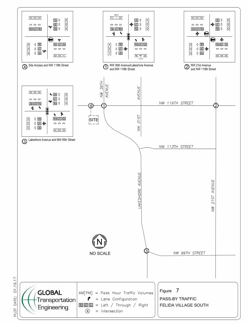


Felida Village South Traffic Impact Analysis April 3, 2017 Page 16 of 19
Table 5: Intersection Performance Summary - Without Project.
SIGNALIZED INTERSECTIONS
Delay LOS Delay LOS
AM 14.8 B 17.8 B
PM 12.7 B 15.3 B
AM 12.3 B 13.1 B
PM 14.4 B 18.7 B
UNSIGNALIZED INTERSECTION
AM 29.1 (NB) D 40.9 (NB) E
PM 19.2 (SB) C 21.5 (SB) C
Notes: 2010 Highway Capacity Manual methodology used in analysis, Synchro v9.
Table 6: Intersection Performance Summary - With Project.
SIGNALIZED INTERSECTIONS
Delay LOS Delay LOS
AM 18.2 B 44.1 D
PM 15.9 B 50.1 D
AM 13.1 B 21.1 C
PM 17.5 B 32.4 C
UNSIGNALIZED INTERSECTIONS
AM 41.2 (NB) E 565.1 (NB) F
PM 21.6 (SB) C 90.4 (NB) F
AM 8.8 (NB) A 9.0 (NB) A
PM 8.7 (NB) A 8.9 (NB) A
Notes: 2010 Highway Capacity Manual methodology used in analysis, Synchro v9.
2036 Future2019 Total
2019 Background2016 ExistingPeak
Hour
Peak
Hour
NW 119th St & NW 36th / Lakeshore Ave
NW 99th St & Lakeshore Ave
NW 21st Ave & NW 119th St
NW 119th St & NW 36th / Lakeshore Ave
NW 99th St & Lakeshore Ave
NW 21st Ave & NW 119th St
Site Access & NW 119th St
In the 2036 future year, the NW 21st Avenue and NW 119th Street intersection is expected to operate at LOS F. As indicated in Table 7, the future year operation for NW 21st Avenue and NW 119th Street intersection could be improved with the installation of a traffic signal; however, this intersection improvement is not identified in the County’s Transportation Improvement Plan. Table 7: Intersection Performance Summary - With Project - MITIGATED.
SIGNALIZED INTERSECTION
Delay LOS Delay LOS
AM - - 10.8 B
PM - - 7.2 A
Notes: 2010 Highway Capacity Manual methodology used in analysis, Synchro v9. 1 Mitigation: Install traffic signal.
2019 Total 2036 FuturePeak
Hour
NW 21st Ave & NW 119th St1

Felida Village South Traffic Impact Analysis April 3, 2017 Page 17 of 19
ROADWAY PERFORMANCE
Clark County Standards
Clark County Code (Section 40.350.020.G) defines the County’s volume to capacity ratio standards for roadway segments. The maximum volume to capacity ratio for each roadway segment shall not exceed nine tenths (0.9), when measure independently for each direction of travel. This applies for all collector and arterial roadway segments.
Capacity Analysis
The traffic volume data and capacity values from the Clark County Code, Table 40.350.020-1 were used to evaluate roadway capacities along the following roadway segments:
• NW 119th Street corridor segments between NW Lakeshore Avenue and NW 21st Avenue
• NW Lakeshore Avenue corridor segments between NW 119th Street and NW 99th Street
• NW 36th Avenue corridor segments north of NW 119th Street
Table 8 summarizes the analysis results for all the study scenarios. Table 8 indicates that the roadway segments will continue to operate at acceptable volume to capacity ratios through the three-year buildout period, except for the southbound direction along NW Lakeshore Avenue between NW 119th Street and NW 99th Street with AM
Table 8: Roadway Capacity Analysis
Roadway Segment
AM PM AM PM
2016 Existing 341 269 0.38 0.30
2019 Background 379 297 0.42 0.33
2019 Total 380 298 0.42 0.33
2036 Future 540 425 0.60 0.47
2016 Existing 298.0 302 0.33 0.34
2019 Background 322.0 338 0.36 0.38
2019 Total 323.0 339 0.36 0.38
2036 Future 540.0 425 0.60 0.47
2016 Existing 206.0 656 0.23 0.73
2019 Background 292.0 798 0.32 0.89
2019 Total 296.0 808 0.33 0.90
2036 Future 413.0 1115 0.46 1.24
2016 Existing 796.0 384 0.88 0.43
2019 Background 939.0 468 1.04 0.52
2019 Total 943 477 1.05 0.53
2036 Future 1317 657 1.46 0.73
2016 Existing 318 592 0.35 0.66
2019 Background 372 741 0.41 0.82
2019 Total 373 744 0.41 0.83
2036 Future 523 1022 0.58 1.14
2016 Existing 529 417 0.59 0.46
2018 Background 665 510 0.74 0.57
2019 Total 667 514 0.74 0.57
2036 Future 916 710 1.02 0.79
v/c Ratio
NW Lakeshore Ave: NW 119th
St to NW 99th St
SB
NB
900
Traffic Volume
NW 119th St: NW Lakeshore Ave to
NE 21st Ave
NW 36th Ave: North of NW 119th
St
900
900
CapacityStudy Scenario
EB
WB
NB
SB

Felida Village South Traffic Impact Analysis April 3, 2017 Page 18 of 19
peak hour traffic volumes. Figure 8 shows that the proposed development adds four (4) AM peak hour trips to the southbound direction along NW Lakeshore Avenue. Based on the Clark County Concurrency Code, Section 40.350.020 proposed developments shall not be required to mitigate their impacts in order to obtain the concurrency approval unless the proposed development adds at least five (5) peak period trips to a failing intersection approach, thus roadway improvements in conjunction with the proposed development are not recommended.
WARRANT REVIEW
Turn Lane Warrants
Left turn lane warrants were reviewed for the westbound approach of NW 119th Street at the site access and both NW 119th Street approaches at NW 21st Avenue. The left turn lane warrant is met with PM peak hour background traffic volumes without the inclusion of site traffic volumes for the westbound approach of the NW 119th Street at NW 21st Avenue intersection. Construction of left turn lanes is not proposed with development of the site. The left turn lane warrant monographs for the Felida Village South site are presented in Appendix E.
Traffic Signal Warrants
The peak hour signal warrant presented in the Manual on Uniform Traffic Control Devices (MUTCD) was reviewed for NW 119th Street intersection at the site access and for the NW 119th Street at 21st Avenue intersection. Based on analysis using total traffic volumes, the peak hour signal warrant is not met. Based on 2036 future year traffic volumes, the peak hour signal warrant will be met for AM peak hour volumes. Installation of traffic signals is not proposed with development of the site. The traffic signal warrants reviewed for the Felida Village South site are presented in Appendix E.
RESULTS AND RECOMMENDATIONS The proposed Felida Village South site has been evaluated considering development of six (6) apartments and 10,000 square foot commercial space. The site is expected to generate 13 new AM peak hour trips and 28 new PM peak hour trips. Access to the site is proposed on NW 119th Street, west of Lakeshore Avenue. With removal of landscaping on the northeast corner of the site, the sight lines from the proposed access will exceed Clark County’s sight distance requirement. The left turn lane warrant were reviewed. The left turn lane warrant is met with PM peak hour background traffic volumes (without project) for the westbound approach of the NW 119th Street at NW 21st Avenue intersection. Based on the acceptable levels of service through the site’s buildout, the addition of left turn lanes at study intersections are not recommended. The MUTCD peak hour signal warrant was reviewed for the intersection of NW 119th Street at NW 21st Avenue. The peak hour signal warrant is not met with 2019 total traffic (with project) volumes. Based on the acceptable levels of service through the site’s buildout, traffic signals are not recommended. The capacity analysis through the site’s 2019 buildout year verifies that the study intersections will operate at acceptable levels with the addition of the Felida Village South Development. In the 2036 future year, installation of a traffic signal at NW 21st Avenue and NW 119th Street could improve the intersection’s operation to acceptable levels; however, this intersection improvement is not identified by the County. With development of the site, intersection improvements are not necessary.

Felida Village South Traffic Impact Analysis April 3, 2017 Page 19 of 19
The roadway capacity analysis indicates that the roadway segments will continue to operate at acceptable volume to capacity ratios through the three-year buildout period, except for the southbound direction along NW Lakeshore Avenue between NW 119th Street and NW 99th Street with AM peak hour traffic volumes. However, based on less than five (5) AM peak hour trips generated by the proposed development and the Clark County Concurrency Code, the proposed development is not required to mitigate their impacts in order to obtain the concurrency approval. Based on the analysis results it is recommended that the Clark County support and approve the development application.