community mapping in informal settlements … · community mapping in informal settlements for...
TRANSCRIPT

INSPIRE-Geospatial World Forum, 25-29 May 2015, Lisbon, Portugal
1
COMMUNITY MAPPING IN INFORMAL SETTLEMENTS FOR BETTER HOUSING
AND SERVICE DELIVERY, CAPE TOWN, SOUTH AFRICA
Paper Reference Number: PN-474
Nicholas Pinfold.
Dept. of Town and Regional Planning, Cape Peninsula University of
Technology, Cape Town, South Africa,[email protected]+27(0)21 440 2255
ABSTRACT
This paper reports on the Flamingo Crescent informal settlement community mapping project in Lansdowne Industrial Park, Cape Town, South Africa. The first phase of the project was undertaken in 2013. Community leaders and Informal Settlers Network (ISN) members worked closely with students from the Cape Peninsula University of Technology (CPUT) in a problem based service learning project. The second phase of the project involved community-led layout design to facilitate re-blocking of structures. Subsequently the physical re-blocking of Flamingo Crescent informal settlement has been completed. The third phase involves iterative community mapping and building of Geographic Information over time so that community dynamics and undercurrents can be analysed. Mapping is one of several tools used to help poor communities gain an understanding of their own capacity and recourse for improved living conditions. Community mapping empowers residents to negotiate for themselves. It aims to create learning and understanding in partnership with residents, community based non-government organisations, local government and academia. Physical aspects of the community are enumerated while matters such as social organisation, culture and belief of people recorded. Community mapping is intended to create communal awareness and social constructivism through the process of participation. When people contribute and participate it creates confidence that allows communities to negotiate rather than to engage in service delivery protests. Community mapping begins with community-led survey and enumeration, looking at the relationship between the things being mapped, such as dwellings, drainage, vegetation, paths and tracks and spaces in the community. Some of these spaces are functional and have aesthetic or social value for the residents. It is important to identify these spaces and try to explain why they are successful and why others are not. Open spaces are usually dominated by local activities and occupied by a large number of residents who, to some degree, share facilities. These places hold the physical frame that provides the social fabric of the area. Quality space allows activity that adds quality to the entire area. Without these places life in the community will be very different. Community-led mapping helps community members to identify and analyse potential within their community, where and what are problems that need attention. Enumeration involves the gathering of information such as people savings, healthcare services, community welfare, and disaster mitigation.
KEYWORDS: community mapping, informal settlement, service-learning, re-blocking

INSPIRE-Geospatial World Forum, 25-29 May 2015, Lisbon, Portugal
2
1 RESEARCH PROBLEM
Informal settlements in South Africalack formal planning. The residents are permanently in a state of legal-social insecurity. The informal settlement upgrade program is to facilitate the structured in situ upgrading of the informal settlement as opposed to relocation. The program provides benefits for all the inhabitants including persons currently excluded from the benefits of theHousing Subsidy Scheme. In March 2013 the Department of Town and Regional Planning at CPUT was invited to participate in the Flamingo Crescent Informal Settlement upgrade project. Phase 1 to 3 of the upgrade project consists of basic service delivery (van Wyk,2012:506). 2 INTRODUCTION
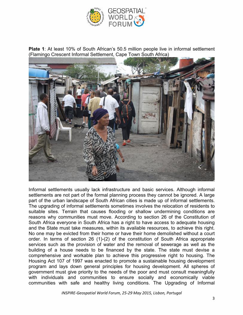
Mapping is one of several tools used to help poor communities gain an understanding of their own capacity and recourse for improved living conditions. Community mapping empowers residents to negotiate for themselves. It is believed that a community’s aspirations are entrenched within the context in which they live. The intrinsic worth of a community needs to be understood in order to build on existing capacity. Gaining wisdom by listening to stories is a meaningful approach to community engagement. The on-going mapping and enumeration of the Flamingo Crescent Informal Settlement is a service-learning project that the Department of Town and Regional Planning has embarked upon. It can be said that informal settlements in South Africa are a result of policy and legal framework of the past. Influx control in cities and racial segregation has resulted in the growth of informal settlements on the fringes of South African cities. In the 1980’s influx control and racial segregation began to be withdrawn and a large number of people moved from the rural areas to the cities (Barry and Ruther, 2005:44). As a result people in South Africa who reside in informal settlements are there because they have been marginalised and excluded from formal access to land and development. At least 10% of South African’s 50.5 million people live in informal settlements equating to a population of 4.4 and 5 million (van Wyk, 2012: 457). While some authors believe that informality is a result of rapid urbanisation (Kit et al, 2011:660) others believe slums and informal settlements are a result of local government’s inability to plan and provide affordable housing for the low-income sector of the urban population (Ooi and Phua, 2007:30). An informal settlement consists of residential buildings, usually a shack, built on planned or unplanned land without formal planning approval (Alemie et al, 2014:5). Van Wyk (2012:458) describes an informal settlement as the unauthorised and unplanned occupation of land (Plate 1).
INSPIRE-Geospatial World Forum, 25-29 May 2015, Lisbon, Portugal
3
Plate 1: At least 10% of South African’s 50.5 million people live in informal settlement (Flamingo Crescent Informal Settlement, Cape Town South Africa)
Informal settlements usually lack infrastructure and basic services. Although informal settlements are not part of the formal planning process they cannot be ignored. A large part of the urban landscape of South African cities is made up of informal settlements. The upgrading of informal settlements sometimes involves the relocation of residents to suitable sites. Terrain that causes flooding or shallow undermining conditions are reasons why communities must move. According to section 26 of the Constitution of South Africa everyone in South Africa has a right to have access to adequate housing and the State must take measures, within its available resources, to achieve this right. No one may be evicted from their home or have their home demolished without a court order. In terms of section 26 (1)-(2) of the constitution of South Africa appropriate services such as the provision of water and the removal of sewerage as well as the building of a house needs to be financed by the state. The state must devise a comprehensive and workable plan to achieve this progressive right to housing. The Housing Act 107 of 1997 was enacted to promote a sustainable housing development program and lays down general principles for housing development. All spheres of government must give priority to the needs of the poor and must consult meaningfully with individuals and communities to ensure socially and economically viable communities with safe and healthy living conditions. The Upgrading of Informal

INSPIRE-Geospatial World Forum, 25-29 May 2015, Lisbon, Portugal
4
Settlement Program (UISP) is a program of government that aims to upgrade the living conditions of poor people in supplying secure tenure and access to basic services and housing. The UISP specifically deals with policy and procedures for in situ upgrading of informal settlements in a structured way (van Wyk, 2012:476). 3 COMMUNITY MAPPING
Flamingo Crescent is a low-income informal settlement with high population densities within an industrial setting. The residents are former squatters who were provisionally moved by the local authority to a piece of land in Lansdowne industrial zoned public open space. The legal recognition of their occupation has resulted in its rapid expansion over the past decade. Census data was not available for this community and local authorities did not have enough information to plan tasks such as service delivery management and resource allocation. The Department of Town and Regional Planning at CPUTagreed to participate in the community-led mapping and enumeration of Flaming Crescent in partnership with ISN and the Community Organisation Research Centre (CORC). The first phase of the projectwas initiated in March 2013. Community leaders and ISN members worked closely with university students in mapping the Flamingo Crescent informal settlement. A problem based service-learning approach was adopted where students took part in community activities. Theprojectwas credit bearing and part of the GIS module in the curriculum of the National Diploma in Town and Regional Planning.Students were able toput theory into practice and get a better understanding of the subject contentwhile ina community setting (Bringle et al., 2004: 127). Community-led mapping requires residents to understand their environment. It teaches them to prioritise and empowers them to negotiate. A database of informationis a powerful tool when it comes to planning. The residents of the Flamingo Crescent informal settlement began by drawing a community map showing dwellings, tracks, toilets, water taps, open areas and vegetation (Plate 2). Despite the map being crude and not to scale it was surprisingly accurate in its information. The success of the mapping exercise was not in the map itself but in the process and thedialog. The map was a reflection the social fabricshowingopen spacesused for local activities. Sometimes these spaces are functional and sometimes not. In the case of large communities the array of small community maps becomes disjointed and confusing. The role of the university students in the Flamingo Crescent informal settlementproject was to expandthe map using measuring and mapping technology such as GPS, Total Station and Remote Sensing equipment. Simple innovative data collection techniques such as palmtop computers, voice recordings, digital still and video imagery were used (Barry and Ruther, 2005:43). Community members who showed potential and interest in using this technology were trained to

INSPIRE-Geospatial World Forum, 25-29 May 2015, Lisbon, Portugal
5
assist in the mapping process. It is important that the mapping exercisebe fun and does not become laborious and tiringor residents will lose interest. Plate 2:Community Map (Flaming Crescent Informal Settlement Cape Town South Africa).
Mapping was done using small groups of about three to five students with community members involved at all times. The group started with one active community member who guided the group within the community. Later other community members were included such as the youth and the very poor. The accurate measuring of the shack

INSPIRE-Geospatial World Forum, 25-29 May 2015, Lisbon, Portugal
6
footprints was essential in determiningfloor areas. The re-blocking process demands that new structures be erected with approximately the same floor area as before. Students began by capturing the rudimentary shape of shacks using desktop software and aerial photography in the classroom. Geo-referenced aerial photography was used to digitisestructures and visible services. This method of mappingwas not sufficiently accurate for the re-blocking process. In some instances field measurements revealedthat single shacks identified from aerial photography had multiple subdivisions with many occupants. Field-based observations collected by survey teams allowed detailed measurement of the shack perimeter with enumerationdata gatheredfor all occupants. Crowd sourcing was auseful way of obtainingpersonal information of occupants. The shack footprint was geo-referenced using GPS. The map was drawn and displayed in the community centre where people could comment and make corrections (Plate 3). Residentswere able to identify their shacks and lay claim to the space.By drawing on the map residents communicated concerns and suggested solutions. The map was drawn in 3D with a satellite image in the background to make the map legible and nottoo technical. It is important that communities retain ownership of knowledge derived from community mapping and that the data is presented in a way that the community can understand. The ability to collect and collate information empowers the community to negotiate on their own terms. This bottom-up approach to development gives the community an important opportunity to contribute totheir own solutions. The community mapping process teaches community members to identify and analyse various issues through prioritising and problem solving.

INSPIRE-Geospatial World Forum, 25-29 May 2015, Lisbon, Portugal
7
Plate 3:Shack footprint (Flaming Crescent Informal Settlement Cape Town South Africa)
Topographical mapswere used to provide information aboutnatural features that affect the settlement. The potential risk of natural disaster must be identified as well as the threats to sensitive natural areas such as streams, fauna and flora. Mapping at neighbourhood scale includes key development challenges surrounding the community area. This map shows various transport nodes and other information pertaining to the Integrated Development Plan (IDP), Spatial Development Framework (SDF), Local Economic Development (LED), Environmental Managements Framework and other relevant sector plans.
4 RE-BLOCKING
The second phase of the project was a community-led planning session to facilitate re-blocking of structures. Re-blocking is the moving of physical structures to facilitate a

INSPIRE-Geospatial World Forum, 25-29 May 2015, Lisbon, Portugal
8
more practical layout to improved living conditions, provide basic services, adjust movement routes and to improve spaces for community activities.
Plate 4: Community-led layout design for re-blocking (Flaming Crescent Informal Settlement Cape Town, South Africa)
These minimal adjustments can mostly be done by residents themselves once a layout plan has been approved by the relevant local authority. Students were divided into groups and allocated areas on site. Each group was accompanied by the community residents in the area. Using a field plan and cardboard cuttings of each shack the residence advised students where they would like their structure moved to while the students advised residents on the best solution as per their learning (Plate 4). This process resulted in an improved layout negotiated by the community residents themselves (Plate 5).
Plate 5:Post re-blocking (Flamingo Crescent Informal Settlement Cape Town South Africa)

INSPIRE-Geospatial World Forum, 25-29 May 2015, Lisbon, Portugal
9
5 POSTAL ADDRESS
The third phase of the service-learning projectinvolvesupdating and checking the community map.The aim of this is tobuild atemporal GIS to monitor spatial change post re-blocking. Information must be collectedcontinuously over time. This must be donediscreetly and without conflict. Crowd sourcing is useful and the use of mobile GISfast and accurate. A geo-database is kept with new and old locations. Attribute dataincludes shack numbers, name of owner and street address.

INSPIRE-Geospatial World Forum, 25-29 May 2015, Lisbon, Portugal
10
Plate 6: A significant advantage of the re-blocking exercise was that for the first time residents have street addresses (Flamingo Crescent Informal Settlement Cape Town South Africa).
A significant advantage of the re-blocking exercise is that for the first time residents have a street addresses (Plate 6). This is important because without a street address emergency vehicle such as ambulances, fire trucks and law enforcement personnel cannot be dispatched. Furthermore private messages and mail cannot be delivered and municipal services cannot be provided. In order to have an address a map with shack numbers and street addresses is needed. A home address is an essential part of a person’s personal information. Urban refers to physical space of habitation, creation and exchange. Civic refers to community life in which a citizen participates. This metaphorical space requires a system in which resources are distributed fairly and where the local level is recognised as important for handling problems directly related to the local population. In an informal settlement perhaps people know how to find one another, but this is limited to family or close associates. Without an address one cannot transform into a civic community and an individual has no civic identity. Addressing is a technical requirement for transforming a community from an informal to a civic community (Farvacque-Vitkovic et al, 2005:13). Flamingo Crescent informal settlement has now been formally renamed to Flamingo Heights.

INSPIRE-Geospatial World Forum, 25-29 May 2015, Lisbon, Portugal
11
6 CONCLUSION
South Africa’s political history has resulted in many people being marginalised and excludedfrom formal access to land and development. Informal settlement is the unauthorised and unplanned occupation of land. Informal settlements can be volatile andunpredictable. Violence, intimidation and internal conflicts complicate matters. Strained relations with the local authority often lead to confrontation. This means that upgrade projects do not always achieve the desired results. In many instances informal settlement upgrade is done incrementally to accommodate these circumstances. Spatial and social information is vital in considering appropriate strategies for improvement. Enumeration and mapping requires simple but rapid data collection that is accurate and current. It is essential that the collection of data is community-led with residents actively participating in the process. The data collected must be understandable and accessible to the community. Technology such as GPS can be used to supply position data however must be simply setup so that community members can use it. GIS provides a means to visualise spatial data and to analyse information (Barry and Ruther, 2005: 49). Furthermore GIS is a platform for the integration of both spatial and non-spatial data. When planning an informal settlement upgrade professionals must adopt a discursive, reflexive approach. There are no clear guidelines for informal settlement upgrade. Objectivity is required with a constructivist approach. It is tempting to arrive at professionally acceptable solutions and to suppress the conflict and discontent amongst the community. The significance of what is going on must not be missed. A formalistic participatory process where stakeholders just playout predetermined roles must be avoided. Professionals must work with society in order to co-produce socially robust solutions to complex social problems. 7 REFERENCE
Alemie, B. K., Bennett, R. and Zevenbergen, J. 2014. The Socio-Spatial Synergy in Land Governance: A Case of Informal Settlements in Bahir Dar, Ethiopia. 2014 World Bank Conference on Land and Poverty” The World Bank - Washington DC, March 24-27, 2014 Archer, D., Luansang, C. and Boonmahathanakorn, S. 2012. Facilitating community mapping and planning for citywide upgrading: the role of community architects Environment & Urbanization. International Institute for Environment and Development (IIED).Vol 24(1): 115–129. Barry, M. And Rüther, H. 2005. Data Collection and Management for Informal Settlement Upgrades. URISA Journal • Vol. 17, No. 1 • 2005 Bringle, R. & Steinberg, K. 2010. Educating for Informed Community Involvement. Am J Community Psychol (2010) 46:428–441

INSPIRE-Geospatial World Forum, 25-29 May 2015, Lisbon, Portugal
12
Farvacque-Vitkovic, C., Godin, L. Leroux, H., Verdet, F. and Chavez, R. 2005. Directions in Development. Street Addressingand the Managementof Cities. The International Bank for Reconstruction and Development / The World Bank Kit, O. Lüdeke, M. and Reckien, D. 2011. Texture-based identification of urban slums in Hyderabad, India using remotesensing data. Applied Geography 32 (2011) 660e667. Ooi, G. L. and Phua, K. H. 2007.Urbanization and Slum Formation.Journal of Urban Health: Bulletin of the New York Academy of Medicine, Vol. 84, No. 111524-007-9167-5 Van Wyk, J. 2012. Planning Law. Juta’s Cape Town. AUTHORS BIOGRAPHY
Nicholas Pinfold Lecturer: Cape Peninsula University of Technology Cape Town, South Africa Master’s Degree in Urban and Regional Planning - University of the Free State B Honours Spatial Planning - University of the Free State B. Tech Surveying - Cape Peninsular University of Technology Registration: Professional GISc Practitioner, Professional Engineering Survey Practitioner