community impact assessment · transportation projects can have major social and economic...
TRANSCRIPT

Community Impact Assessment A Handbook for Transportation Professionals
Central Environmental Management Office
Florida Department of Transportation
Prepared by:
Center for Urban Transportation Research University of South Florida November 2000
ACKNOWLEDGEMENTS This handbook was prepared by the Center for Urban Transportation Research (CUTR) for the Environmental Management Office of the Florida Department of Transportation (FDOT). It was developed to support the FDOT Community Impact Assessment Program.
FDOT Project Team: C. Leroy Irwin – Manager, Environmental Management Office, Florida Department of Transportation; and member - National Community Impact Assessment Design Team.
Buddy Cunill – Project Manager, Environmental Management Office, Florida Department of Transportation, and member - National Community Impact Assessment Design Team.
Lee Ann Jacobs, AICP – Co - Project Manager, Environmental Management Office, Florida Department of Transportation.
CUTR Project Team: Principal Investigators: Ed Mierzejewski, Beverly Ward, Kristine Williams
Principal Authors: Jeffrey Kramer, AICP and Kristine Williams, AICP
Contributors: Jennifer Hardin, Eric Hill, Laura Lachance.
Cover Design: Wendy Castleberry
Acknowledgements Appreciation is expressed to the following individuals for their helpful comments:
Larry D. Anderson, FHWA, Florida Division Marjorie Bixby, Florida Department of Transportation Leigh Blackman Lane, North Carolina Department of Transportation David Blodgett, Florida Department of Transportation Michael E. Burns, Maine Department of Transportation Roberto Escalera, FHWA, Florida Division Caroline Fleurissaint, Florida Department of Transportation Susan Fox, Wisconsin Department of Transportation Michele Gallant, Carter & Burgess, Inc. Michael Grant, Hagler Bailly Services, Inc. Jan H. Grenfell, Louisiana Department of Transportation Mike Guy, Sarasota-Manatee Metropolitan Planning Organization Brenda Kragh, Federal Highway Administration Robert D. Laravie, New York Department of Transportation Judith Lindsey-Foster, Maine Department of Transportation Lori G. Kennedy, Kisinger Campo & Associates Corp. Greg King, California Department of Transportation Jon B. Novick, Wisconsin Department of Transportation Tom Percival, Florida Department of Transportation Ginger Regalado, Florida Department of Transportation Colleen D. Roland, Tallahassee-Leon County Metropolitan Planning Organization John Shriner, Florida Department of Transportation Bryan Williams, Florida Department of Transportation

ABOUT THE HANDBOOK Transportation projects can have major social and economic effects—both positive and negative. Analysis of community impacts provides insight into ways projects can be improved or redefined to reduce adverse impacts and increase overall project benefits. Historically, much of the attention in environmental impact assessment has been placed on the natural environment, rather than on how transportation projects affect people and communities. This handbook provides methods and indicators that practitioners can use to identify and evaluate the community impacts of transportation projects, and strategies for reducing adverse impacts. The handbook expands upon Community Impact Assessment: A Quick Reference for Transportation, which was produced by the Federal Highway Administration in 1996, and draws upon the Guidelines and Principles for Social Impact Assessment, produced by the U.S. Department of Commerce.
This handbook is intended to serve as a reference tool for the Florida Department of Transportation during planning and project development, to supplement the FDOT Project Development and Environment Manual (PD&E Manual). It is also intended as a resource guide for metropolitan planning organizations, local governments, and other agencies seeking more effective ways to integrate transportation projects into the fabric of our communities. The project was supported by a research grant from the Florida Department of Transportation, Environmental Management Office.
The handbook begins with an introduction to community impact assessment, how it relates to organizational objectives, and an overview of laws and requirements related to community impact assessment for transportation. It proceeds with a conceptual overview of the impact assessment process, and how that process relates to the various phases of transportation planning and project development. Conducting a community impact assessment requires a thorough understanding of the affected community. Part Two, Baseline Conditions, provides guidance on how to develop a community profile. Part Three sets forth techniques for assessing social and economic impacts, including community cohesion, community facilities and services, safety, mobility, economic impacts, land use, aesthetics, relocation and civil rights. Part Four includes Appendices that provide tools and information for various assessment activities..

TABLE OF CONTENTS
CHAPTER I: INTRODUCTION .............................................................................................1-1
WHAT IS COMMUNITY IMPACT ASSESSMENT? .......................................................................1-1 WHY IS COMMUNITY IMPACT ASSESSMENT NEEDED? ...........................................................1-1 HOW DOES COMMUNITY IMPACT ASSESSMENT RELATE TO PUBLIC INVOLVEMENT? .............1-2 ORGANIZATIONAL ISSUES & OBJECTIVES..............................................................................1-3 COORDINATION ....................................................................................................................1-4 Coordination With Other Agencies .........................................................................1-4 Internal Coordination and Continuity....................................................................1-4 LEGAL REQUIREMENTS AND POLICY DIRECTIONS................................................................1-5 CHAPTER 2: THE ASSESSMENT PROCESS ....................................................................2-1
INTRODUCTION ....................................................................................................................2-1 GENERAL ASSESSMENT PROCESS .........................................................................................2-2
Use Public Involvement...........................................................................................2-2 Describe Project and Study Area ............................................................................2-3
Develop a Community Profile .................................................................................2-4 Analyze Impacts.......................................................................................................2-4 Identify Solutions.....................................................................................................2-7 Document Findings................................................................................................2-10
Sample Technical Report Format .........................................................................2-11 MONITORING ......................................................................................................................2-12
CHAPTER 3: COMMUNITY IMPACT ASSESSMENT IN PROJECT PHASES............... 3-1
PLANNING ............................................................................................................................3-2 PROJECT DEVELOPMENT & ENVIRONMENT (PD&E) ...............................................................3-4 DESIGN AND RIGHT OF WAY..................................................................................................3-5 CONSTRUCTION....................................................................................................................3-6
CHAPTER 4: DEVELOPING A COMMUNITY PROFILE.....................................................4-1
REVIEW SOCIAL AND ECONOMIC CHARACTERISTICS.............................................................4-2 Data Sources.............................................................................................................4-2 Summarizing the Data ............................................................................................4-3
IDENTIFY COMMUNITY ISSUES AND ATTITUDES ...................................................................4-4 Review Secondary Sources of Information .............................................................4-4 Talk to Knowledgeable Persons ..............................................................................4-6 Visit the Community................................................................................................4-6 Interview Stakeholders............................................................................................4-7
INVENTORY FEATURES OF THE STUDY AREA ........................................................................4-9 Inventory Community Facilities and Services.......................................................4-9 Inventory Existing Businesses..............................................................................4-10 Inventory Land Use and Transportation Characteristics ...................................4-11 Inventory Aesthetic and Cultural Resources .......................................................4-13
SUMMARIZE AND MAP KEY FINDINGS .................................................................................4-14 Prepare Socio-Economic Inventory Map...............................................................4-14
UPDATE THE PROFILE.........................................................................................................4-15

CHAPTER 5: SOCIAL IMPACTS .........................................................................................5-1
UNDERSTANDING POTENTIAL IMPACTS ................................................................................5-1 What is Community Cohesion? ...............................................................................5-2 What are Community Facilities and Services? ......................................................5-3 What is Mobility? .....................................................................................................5-4 What is Safety?.........................................................................................................5-5
DATA SOURCES .....................................................................................................................5-6 ASSESSMENT TECHNIQUES...................................................................................................5-7
What Level of Assessment is Appropriate? ............................................................5-7 Identifying Existing Conditions ..............................................................................5-8 Determining Potential Impacts.............................................................................5-11 Checklist for Assessing Social Impacts.................................................................5-12
MITIGATION AND PROBLEM SOLVING .................................................................................5-14 CONCLUSION ......................................................................................................................5-14
CHAPTER 6: ECONOMIC IMPACTS ...................................................................................6-1
UNDERSTANDING POTENTIAL IMPACTS ................................................................................6-1 Potential Impacts on Businesses ............................................................................6-2 Potential Residential Impacts .................................................................................6-5 Potential Impacts on Taxing Authorities ...............................................................6-6
DATA SOURCES .....................................................................................................................6-6 Suggested Economic Assessment Survey Questions .............................................6-9
ASSESSMENT TECHNIQUES.................................................................................................6-12 Checklist for Assessing Potential Economic Impacts ..........................................6-14
MITIGATION AND PROBLEM SOLVING .................................................................................6-19 Addressing Construction Stage Impacts ..............................................................6-19 Addressing Long-Term Impacts............................................................................6-19
CONCLUSION ......................................................................................................................6-20 CHAPTER 7: LAND USE......................................................................................................7-1
OVERVIEW ............................................................................................................................7-1 UNDERSTANDING POTENTIAL IMPACTS ................................................................................7-1
Direct (Primary) Impacts.........................................................................................7-2 Indirect (Secondary) Impacts ..................................................................................7-2
DATA SOURCES .....................................................................................................................7-3 ASSESSMENT TECHNIQUES...................................................................................................7-4
Assessing Direct Impacts.........................................................................................7-4 Determination of Growth Inducement ...................................................................7-5 Determination of Consistency .................................................................................7-6 Checklist to Evaluate Growth Inducement Potential............................................7-8
MITIGATION AND PROBLEM SOLVING .................................................................................7-11 Reuse of Contaminated Sites for Transportation Projects ..................................7-12
CONCLUSION ......................................................................................................................7-13

CHAPTER 8: AESTHETICS AND LIVABILITY....................................................................8-1
OVERVIEW ............................................................................................................................8-1 UNDERSTANDING POTENTIAL IMPACTS ................................................................................8-1 ASSESSMENT TECHNIQUES...................................................................................................8-2
Consider Typical Impacts by Project Type .............................................................8-3 Identifying Aesthetic Resources and Detractors....................................................8-3 Determining Visual Impacts ...................................................................................8-8 Aesthetic and Visual Assessment Checklist ..........................................................8-9
MITIGATION AND PROBLEM SOLVING .................................................................................8-11 CONCLUSION ......................................................................................................................8-14
CHAPTER 9: RELOCATION & DISPLACEMENT ...............................................................9-1
UNDERSTANDING POTENTIAL IMPACTS ................................................................................9-1 Impacts of Residential Relocations .........................................................................9-1 Impacts of Business or Community Facility Relocations ......................................9-3 Community/Neighborhood Impacts ........................................................................9-5 Summary ..................................................................................................................9-5
DATA SOURCES .....................................................................................................................9-6 ASSESSMENT TECHNIQUES...................................................................................................9-7
Checklist for Assessing Potential Relocation Impacts...........................................9-9 MITIGATION AND PROBLEM SOLVING .................................................................................9-11 CONCLUSION ......................................................................................................................9-13
CHAPTER 10: CIVIL RIGHTS ............................................................................................10-1
UNDERSTANDING POTENTIAL IMPACTS ..............................................................................10-2 Access to Decision-Making, Decision-Makers and Information..........................10-2 Disproportionate and Adverse Impacts ................................................................10-3 Cumulative Impacts...............................................................................................10-4
DATA SOURCES ...................................................................................................................10-5 ASSESSMENT TECHNIQUES .....................................................................................................................10-5
Access to Decision-Making and Information........................................................10-6 Disproportionate Impacts ......................................................................................10-9 Cumulative Impacts.............................................................................................10-10
MITIGATION AND PROBLEM SOLVING ...............................................................................10-11 Special Considerations.........................................................................................10-11
CONCLUSION ....................................................................................................................10-13 APPENDIX A: RESOURCE KIT
SAMPLE INTERVIEW QUESTIONS ......................................................................................... A-1 SAMPLE SURVEY QUESTIONS............................................................................................... A-3 GENERAL COMMUNITY IMPACT ASSESSMENT TECHNIQUES................................................. A-7
APPENDIX B: CASE STUDIES
WAHNETA SOCIAL IMPACT ASSESSMENT ............................................................................. B-1 THE LAKE WORTH STORY..................................................................................................... B-5 COMMUNITY MITIGATION AND ENHANCEMENT ................................................................... B-7 COMMUNITY PRESERVATION ............................................................................................... B-9

APPENDIX C: COMMUNITY IMPACT ASSESSMENT IN TRANSPORTATION PLANNING
INTRODUCTION ................................................................................................................... C-1 THE FEDERAL ROLE............................................................................................................. C-1
Rules & Regulations ............................................................................................... C-1 Oversight ................................................................................................................. C-3 Funding.................................................................................................................... C-3
THE STATE ROLE ................................................................................................................. C-4 Transportation Planning Process........................................................................... C-4 Special Studies ........................................................................................................ C-5 Land Use Planning ................................................................................................. C-5
THE ROLE OF MPOS ............................................................................................................. C-5 LRTP & Project Programming ............................................................................... C-5 3-C Transportation Planning Process.................................................................... C-7 UPWP and Special Studies .................................................................................... C-7 “Visioning” ............................................................................................................... C-7 Education, Training & Technical Assistance ........................................................ C-8 Project Review......................................................................................................... C-8
THE ROLE OF LOCAL GOVERNMENTS ................................................................................... C-9 Land Use & Transportation Planning ................................................................... C-9 Special Studies ...................................................................................................... C-10 MPO Involvement ................................................................................................. C-10
SUMMARY AND CONCLUSIONS........................................................................................... C-10 BIBLIOGRAPHY ....................................................................................................................... 1

1-1
CHAPTER 1 : INTRODUCTION
WHAT IS COMMUNITY IMPACT ASSESSMENT? Community impact assessment (CIA) is “a process to evaluate the effects of a transportation action on a community and its quality of life.”1 It is a way to incorporate community considerations into the planning and development of major transportation projects. From a policy perspective, it is a process for assessing the social and economic impacts of transportation projects as required by the National Environmental Policy Act (NEPA). The assessment may address a variety of important community issues such as land development, aesthetics, mobility, neighborhood cohesion, safety, relocation, and economic impacts.
WHY IS COMMUNITY IMPACT ASSESSMENT NEEDED? Transportation projects can affect communities in a variety of ways – both positive and negative. On the negative side, transportation projects may be developed without attention to the surrounding area, thereby disrupting or dividing stable and cohesive neighborhoods, damaging community character, promoting urban sprawl, or impeding pedestrian mobility. On the positive side, transportation projects can be shaped to help revitalize business districts, stimulate economic development, improve access to jobs, reinforce growth management goals, and enhance community character. Despite their importance, community issues have often not received the same priority in transportation project development as other environmental issues, such as recreational areas, historic structures, air quality, wetlands, or endangered species that are subject to special regulation or agency oversight. The community impact assessment program at the Florida Department of Transportation was developed to assure that transportation projects are developed with full consideration of their impact on people and communities. In particular, CIA advances the following goals:
Quality of Life: Helps to promote livable, sustainable communities by placing priority on preserving or enhancing community character, neighborhood cohesion, social interaction, safety, economic prosperity, and general quality of life.
1 FHWA, Community Impact Assessment: A Quick Reference for Transportation, September 1996.
Community impact assessment is “a process to evaluate the effects of a transportation action on a community and its quality of life.”

1-2
Responsiveness: Promotes responsive, community-sensitive decision-making in planning and developing transportation projects that embraces community concerns, seeks to minimize conflict, and works to help solve community problems. Coordination: Improves coordination among the agencies and jurisdictions involved in transportation, land use, environmental preservation, resource management, and economic development. Nondiscrimination: Ensures that environmental justice is achieved by alerting decision makers to impacts on all segments of society and avoiding disproportionate adverse impacts on specific populations. 2
HOW DOES COMMUNITY IMPACT ASSESSMENT RELATE TO PUBLIC INVOLVEMENT? Public involvement is an essential tool for community impact assessment. Public involvement activities help to identify groups affected by a transportation project and any impacts those groups perceive as significant. Involved parties can then provide insight into workable alternatives and mitigation options. Alternatively, community impact assessment helps assure that public involvement programs are meaningful. It provides a process for evaluating issues and concerns raised in the public forum and the potential impacts of various alternatives. It also helps to assure that community objectives are integrated into project decisions where possible.
2 FHWA, Community Impact Assessment: A Quick Reference for Transportation, September 1996.
General process for incorporating community values into transportation projects:
1. Define the problem to be solved.
2. Identify community and agency issues and objectives for consideration.
3. Develop possible alternative solutions to the problem.
4. Translate community and agency issues and objectives into evaluation criteria.
5. Evaluate and compare alternative solutions.
6. Select an alternative.
Source: Adapted from Route 101/Mabury Road Area Freeway Access Study Newsletter, San Jose, California, March 1993.

1-3
Community impact assessment also supplements public involvement by helping to identify the broader range of social and economic impacts of a project, and identifying effects on minorities, low-income groups, the disabled, and others historically underrepresented in the public involvement process. A thorough, objective assessment of likely impacts—both positive and negative—promotes informed public dialogue. Ultimately, this improves the quality and equity of public decision-making.
ORGANIZATIONAL ISSUES & OBJECTIVES Community impact assessment requires certain changes in the way transportation projects are planned and developed. First, transportation planners and project managers will need to be responsive to community issues and more proactive in identifying and addressing potential adverse community impacts. The process for identifying community impacts must begin early enough to address such issues without incurring substantial production delays. This suggests the need to initiate community impact assessment in the planning phase, although the most in-depth assessment of community impacts will still occur during project development.
Qualities of Effective Projects
1. The project is a safe facility for the user and the community.
2. The project satisfies the purpose and needs established by all of the parties involved. This agreement, on purpose and need, should be established at the earliest phase of a project and modified as warranted.
3. The project is in harmony with the community and preserves environmental, scenic, aesthetic, historic and natural resources of the area. Remember, not every roadway needs to be an interstate design.
4. The project exceeds the expectations of both the designers and our customers and achieves a level of excellence in the public’s mind.
5. The project is designed and built with minimal disruption to the community.
6. The project is seen as having added lasting value to the community.
Comments of Rick Chesser, District Four Secretary, Florida Department of Transportation, at the 1998 FDOT Environmental Management Office Conference.
Responsiveness
Seamless decision-making
Partnerships

1-4
A unified planning process
Second, the process must have continuity – that is, it should carry the identified issues and resulting commitments from planning through to construction. Third, the process must be comprehensive and identify, as well as involve, other agencies that have a role in addressing community impacts. Overall, this represents a shift toward a more responsive and community sensitive decision-making process.
COORDINATION
Coordination With Other Agencies
The Florida Department of Transportation and Florida’s twenty-five metropolitan planning organizations plan and develop major transportation facilities. Local governments prepare comprehensive plans and land development regulations. The Florida Department of Environmental Protection oversees compliance with state and federal environmental laws. The Florida Department of Community Affairs oversees local planning and compliance with state growth management laws. Economic development groups, like Enterprise Florida or local community redevelopment agencies, develop plans and strategies to strengthen the economy. Each of these planning activities is closely related and dependent upon the outcomes of the other. Yet, agencies often operate independently, reducing their individual effectiveness. By addressing a broader range of community issues, the assessment process helps to improve coordination between the agencies involved in transportation, land use, and economic development. The project can be shaped to help communities advance growth management policies, local comprehensive plans, land development regulations, economic development objectives and environmental laws. In addition, the assessment process helps to clarify for the public which agency has jurisdiction over problems or issues that are uncovered, and the role of each agency in resolving those issues. The result is a much higher potential for collaboration and effective solutions to state and local problems.
Internal Coordination and Continuity
Developing a transportation project can take five to ten years and sometimes longer. This time frame makes it difficult to maintain a “project memory” of issues or commitments, both within the agency and among the affected stakeholders. Yet, internal coordination and continuity in addressing community issues is critical to effective project development. Issues may arise in planning or project development that need to be communicated to designers or addressed during construction. Agency credibility can be damaged when commitments are made in project development and overlooked in design and construction, or when changes are made to a project in later phases without appropriate public involvement and consideration of potential impacts.
Local Comp Plan
MPO Plan
NEPA Process

1-5
The Florida Department of Transportation has an initiative underway, called PLEMO, aimed at improving internal coordination and continuity in transportation decision-making. PLEMO is designed to integrate planning and environmental management and incorporate NEPA considerations earlier in the planning process. It also sets forth a team approach to evaluating conceptual alternatives in order to maintain internal and interagency coordination as well as continuity of project decisions. Documenting community impacts helps FDOT maintain continuity in decision-making and enforce “commitment compliance.” As projects proceed from planning through construction, it is imperative that each office responsible for a particular phase of work provides the next office with documentation of impacts that need to be considered in that phase and any commitments made to the public in previous phases. NEPA requires reevaluation of the project in the separate phases of project development to ensure compliance with state and federal laws before advancing to the next production phase. The community impact assessment process provides a method of documenting information on community conditions, project impacts, and proposed solutions that will be received at each reevaluation phase.
LEGAL REQUIREMENTS AND POLICY DIRECTIONS
Community impact assessment is legally required and supported by a host of Federal regulations, statutes, policies, technical advisories and Executive Orders dating back to the 1960s. The pivotal legislation requiring attention to community impacts is the National Environmental Policy Act of 1969 or NEPA. NEPA was enacted due to growing concern over the
PLEMO: Planning & Environmental Management
PLEMO is a program of the Florida Department of Transportation that is aimed at improving internal and interagency coordination in transportation planning and project development. Highlights include:
• Rough feasibility analysis in long range planning to eliminate infeasible projects earlier in the planning process.
• Evaluation of conceptual alternatives using a project management team comprised of both planning and environmental management staff.
• Cross-functional project advisory teams for evaluating alternatives, including members from planning, environmental management, design, traffic operations, Metropolitan Planning Organization, local governments, and transit operators.
• Corridor level analysis during evaluation of conceptual alternatives to establish a project need statement that meets requirements of the National Environmental Protection Act and to further identify social, economic and environmental issues prior to project development.

1-6
environmental impacts of major federal actions and legislation, as well as increasing citizen activism on these issues. The purpose of the NEPA process is to identify impacts on the quality of the environment. The Act called for a systematic and interdisciplinary approach to evaluating the environmental effects of transportation projects and identifying reasonable alternatives that will avoid or reduce harmful impacts. Toward that end, NEPA required the preparation of an environmental impact statement (EIS) for federally funded actions that significantly affect the natural or human environment. Subsequent procedures established that proposed project decisions be in the overall public interest for safe and efficient transportation, and consider potential social, economic and environmental impacts and environmental protection goals. NEPA and supporting policies and regulations emphasized the importance of public involvement in these issues. The Federal Aid Highway Act of 1970 listed the social and economic impacts that must be considered for highway projects (Section 23 USC 109 (h)). These impacts are:
1. Air, noise and water pollution.
2. Destruction or disruption of man-made resources, aesthetic values, community cohesion, and availability of public facilities and services.
3. Adverse employment effects, and tax and property value losses.
4. Injurious displacement of people, businesses and farms.
5. Disruption of desirable community and regional growth.
Section 23 USC 128 (“Highways”) established a minimum requirement for investigating social, economic, and environmental effects of highway projects, and the consistency of highway plans with local comprehensive planning. The section required each state Department of Transportation to certify that it has held or provided the opportunity for public hearings on all Federal-aid highway projects that bypass or go through a community. In 1994, the Federal Highway Administration elevated its commitment to environmental management and public involvement by adopting a policy to seek new partnerships with tribal governments, businesses, interest groups, resource and regulatory agencies, affected neighborhoods, and the public. The 1994 FHWA Environmental Policy Statement emphasizes the importance of ensuring adequate outreach to minority and low-income populations and calls for: “actively involving our partners and all affected parties in an open, cooperative, and collaborative process, beginning at the earliest planning stages and continuing through project development, construction, and operation.”
“When developing transportation projects that have received federal funds, agencies must consider the economic and social effects of the project location, its impact on the environment, and consistency of the project with the goals and objectives of local comprehensive plans.”
— Section 23 USC 128
1-7
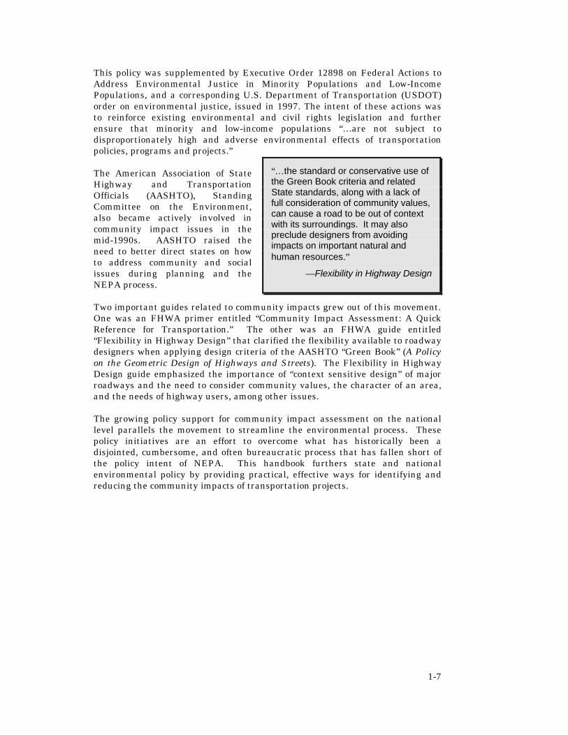
This policy was supplemented by Executive Order 12898 on Federal Actions to Address Environmental Justice in Minority Populations and Low-Income Populations, and a corresponding U.S. Department of Transportation (USDOT) order on environmental justice, issued in 1997. The intent of these actions was to reinforce existing environmental and civil rights legislation and further ensure that minority and low-income populations “…are not subject to disproportionately high and adverse environmental effects of transportation policies, programs and projects.” The American Association of State Highway and Transportation Officials (AASHTO), Standing Committee on the Environment, also became actively involved in community impact issues in the mid-1990s. AASHTO raised the need to better direct states on how to address community and social issues during planning and the NEPA process. Two important guides related to community impacts grew out of this movement. One was an FHWA primer entitled “Community Impact Assessment: A Quick Reference for Transportation.” The other was an FHWA guide entitled “Flexibility in Highway Design” that clarified the flexibility available to roadway designers when applying design criteria of the AASHTO “Green Book” (A Policy on the Geometric Design of Highways and Streets). The Flexibility in Highway Design guide emphasized the importance of “context sensitive design” of major roadways and the need to consider community values, the character of an area, and the needs of highway users, among other issues. The growing policy support for community impact assessment on the national level parallels the movement to streamline the environmental process. These policy initiatives are an effort to overcome what has historically been a disjointed, cumbersome, and often bureaucratic process that has fallen short of the policy intent of NEPA. This handbook furthers state and national environmental policy by providing practical, effective ways for identifying and reducing the community impacts of transportation projects.
“…the standard or conservative use of the Green Book criteria and related State standards, along with a lack of full consideration of community values, can cause a road to be out of context with its surroundings. It may also preclude designers from avoiding impacts on important natural and human resources.”
—Flexibility in Highway Design

2-1
Use Public Involvement
Define Project and Study Area
Develop Community Profile
Identify Solutions
Avoid
Mitigate
Minimize
Enhance
Document Findings
Analyze Impacts
CHAPTER 2 : THE ASSESSMENT PROCESS
INTRODUCTION Community impact assessment is a fluid and iterative process that occurs throughout the life of a transportation project – from planning through construction and monitoring. The basic steps of the process are listed below. Public involvement is an integral part of each of these steps. Step 1: Determine the nature of the project and define the study area. Step 2: Develop a community profile to gain a thorough understanding of the study area, including any issues surrounding the project. This information provides a baseline for analysis and is used to understand what would happen in the community with and without the project. Step 3: Analyze each project alternative and identify any potential impacts and the magnitude of those potential impacts. Step 4: Identify potential solutions to adverse impacts. Step 5: Document the findings of the assessment process, including any commitments made. Depending upon the length of the project development process, it may be necessary to reassess earlier findings to assure that the assessment is accurate or to repeat the steps to address new impacts that are identified later in the process. To streamline the process, strive to anticipate future needs and collect relevant data on all potential impacts early in the process. The level of effort involved in each step is a function of the size and complexity of the project, the level of controversy involved, and the potential for significant community impacts. If a project requires preparation of an environmental impact statement, it will also require a more detailed community impact assessment. The findings would be incorporated into the environmental impact statement, a separate technical report, or both. For smaller or less controversial projects, the results might simply be documented in the project files and summarized for use in the next phase of production. It will basically be up to the analyst to determine
Community impact assessment is an iterative process that occurs throughout the life of a transportation project – from planning through construction and monitoring.
Community Impact Assessment Process
2-2
what is reasonable in the given context. If an issue surfaces that is of considerable concern to an affected community, it should be assessed regardless of the nature of the project. This will assure that it is adequately addressed and does not stop the project later in production. Below is a brief description of each component or step of the community impact assessment process.
GENERAL ASSESSMENT PROCESS
Use Public Involvement
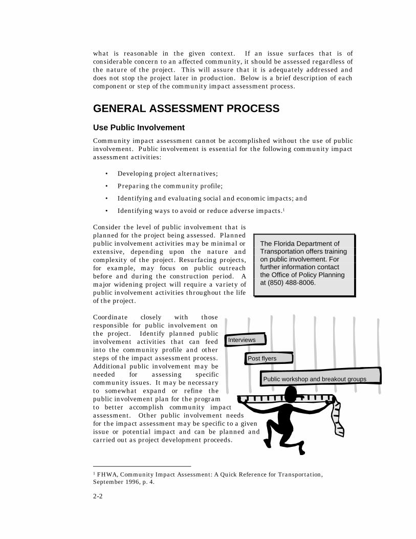
Community impact assessment cannot be accomplished without the use of public involvement. Public involvement is essential for the following community impact assessment activities:
• Developing project alternatives;
• Preparing the community profile;
• Identifying and evaluating social and economic impacts; and
• Identifying ways to avoid or reduce adverse impacts.1
Consider the level of public involvement that is planned for the project being assessed. Planned public involvement activities may be minimal or extensive, depending upon the nature and complexity of the project. Resurfacing projects, for example, may focus on public outreach before and during the construction period. A major widening project will require a variety of public involvement activities throughout the life of the project.
Coordinate closely with those responsible for public involvement on the project. Identify planned public involvement activities that can feed into the community profile and other steps of the impact assessment process. Additional public involvement may be needed for assessing specific community issues. It may be necessary to somewhat expand or refine the public involvement plan for the program to better accomplish community impact assessment. Other public involvement needs for the impact assessment may be specific to a given issue or potential impact and can be planned and carried out as project development proceeds.
1 FHWA, Community Impact Assessment: A Quick Reference for Transportation, September 1996, p. 4.
The Florida Department of Transportation offers training on public involvement. For further information contact the Office of Policy Planning at (850) 488-8006.
Public workshop and breakout groups
Post flyers
Interviews

2-3
Also evaluate the public involvement plan for the project and consider whether the activities are adequate for obtaining an understanding of community impacts. For example, are stakeholder interviews planned? Will the public be involved in developing a purpose and need statement for the project? If not, determine how to incorporate these activities into the public involvement program. What groups do you need to reach and how can you best solicit their involvement?
Recognize that public involvement programs need to be flexible and responsive to adequately address community impacts. As project development proceeds, additional meetings or other public involvement activities may be needed to obtain more specialized information.
Describe Project and Study Area
Get ready for the assessment by preparing detailed descriptions of each project alternative and mapping the physical location of each alternative on a base map of the study area. This information will provide the framework for assessing community impacts. As project development proceeds, more information will be available and can be incorporated into the consideration of potential impacts. Information to collect will include:
• Where is the project located?
• What is the conceptual design?
• How much land is required?
• What is the anticipated time frame for completion?
• What are the decision-making milestones or deadlines?
This information can be obtained from project reports and will be used to identify the primary and secondary study areas, the typical impacts relating to that project or design, the potential duration of impacts, and so on. The primary study area or affected community is typically the area immediately surrounding project alternatives. Study area or community and neighborhood boundaries can often be delineated by physical barriers (highways, waterways, open spaces, etc.), activity centers, disparate average home values, block boundaries, selected demographic characteristics (ethnic groups), and through resident perceptions. Local planning agencies can also help define spatial boundaries, as can available maps of the community. Community and neighborhood boundaries can also be identified using public reports and/or through consultation with planning agencies and community representatives.
The secondary study area may extend far beyond the project area, depending upon the nature of affected communities or the specific subject of analysis. As the assessment proceeds, it may become clear that some impacts affect a much broader “community” than is reflected in the study area. The study area or affected community may also vary depending upon the subject of analysis or the characteristics of an area.
What is a Community?
A “community” may be defined by geographic boundaries of a region, a municipality, or a neighborhood, as well as specific social characteristics that members have in common, such as religious, political, or ethnic affiliation.

2-4
Evaluation of relocation impacts, for example, will require a finer level of analysis than evaluation of potential growth inducement. Consideration of community cohesion may cover an entire small town, or it may focus on a specific neighborhood within a larger municipality. An understanding of the characteristics of that community will assist in determining the extent of the study area. This understanding can only be obtained through communication with the affected parties.
Develop A Community Profile
A community profile is a summary of the social and economic characteristics of the affected area. The purpose of the profile is to gain an understanding of the community where the project is proposed and issues that will need to be taken into account in order to gain community acceptance. It is both a “character sketch” of the community, and a geographic inventory of notable features that could be impacted. For the purposes of NEPA, the community profile is the description of the “affected environment.”
A variety of information sources can be consulted to develop the profile. These may include both secondary sources, such as newspapers, minutes of public hearings, community or facility plans, and primary sources, such as public meetings, interviews, or fieldwork. A detailed description on how to conduct a community profile is provided in Chapter 4.
Analyze Impacts
Analyzing project impacts involves uncovering potential community impacts, collecting information on the nature of those impacts, and determining the relative intensity of those impacts. This analysis needs to occur for each major project alternative, including the “No-Build” scenario. Establishing the consequences of doing nothing helps to clarify what impacts can be attributed to the project and the relative magnitude of those impacts, in relation to the potential benefits. In addition, conducting this analysis for each alternative provides a meaningful basis for comparing alternatives and selecting a final alternative.
Community impact analysis addresses three general categories of impacts:
1. Direct impacts of the project, such as destruction of structural or environmental features in the right-of-way and relocation of residents or businesses.
2. Indirect impacts of the project, which extend beyond the physical location, such as induced growth or real estate speculation. Indirect impacts can be short or long term and may also extend far beyond the project right-of-way.
3. Cumulative impacts of the project, such as those that result when a project is considered in light of other past, present, or planned future actions that taken individually have different implications than when considered together.
Potential impacts can be explored in a variety of ways, through evaluation of secondary data, basic problem solving, discussions with knowledgeable persons, and public involvement. An effective community impact assessment requires a solid understanding of the community, direct observation of the affected area, and

2-5
some research and evaluation of data. It does not, however, require or necessarily benefit from sophisticated models or many hours of technical analysis.
Determining the Appropriate Level of Assessment
Common sense and logic should guide the determination of what level of assessment is needed, how best to approach that task, and what degree of mitigation is appropriate. The level of assessment and documentation that is reasonable for a project will vary depending upon the size and complexity of the project, the level of controversy involved, and the potential for significant community impacts. Scenarios that may trigger the need for a more extensive community impact analysis could include recent major shifts in the demographics of a region or the introduction of a new community planning initiative (e.g. sustainable development, community redevelopment areas, or Main Street program). An overview of such “triggers” appears in Table 2-1.
The courts have also established guidelines for use in determining whether an impact warrants further exploration. Legal principles call for analysis of only those impacts that are “reasonably foreseeable.” This has been defined as impacts that are both (1) probable, and (2) significant. These guidelines from the environmental assessment case law, include:2
1. With what confidence can you say that the impact is likely to occur?
2. Is there sufficient knowledge about the impact to make its consideration useful?
3. Is there a need to know about the impact, due to controversy or other reasons?
2 L. Berger & Associates, NCHRP Report 403: Guidance for Estimating the Indirect Effects of Proposed Transportation Projects, National Academy Press: Washington D.C., 1998, p. 60, citing Gloucester County Concerned Citizens v. Goldschmidt, 533 F. Supp. (DNJ 1982).
Table 2-1: Scenarios That May Trigger A More Extensive Community Impact Assessment
Transportation projects that:
• Require large amounts of right-of-way or would displace a large number of people,
• Could cause a substantial increase in traffic in an area,
• Conflict with local comprehensive plans,
• Impact community facilities, such as schools, parks, or churches,
• Impact historic districts or community landmarks,
• Adversely affect aesthetic features, e.g. canopy roads or scenic landscapes, or
• Disrupt or divide an established or cohesive neighborhood.
2-6
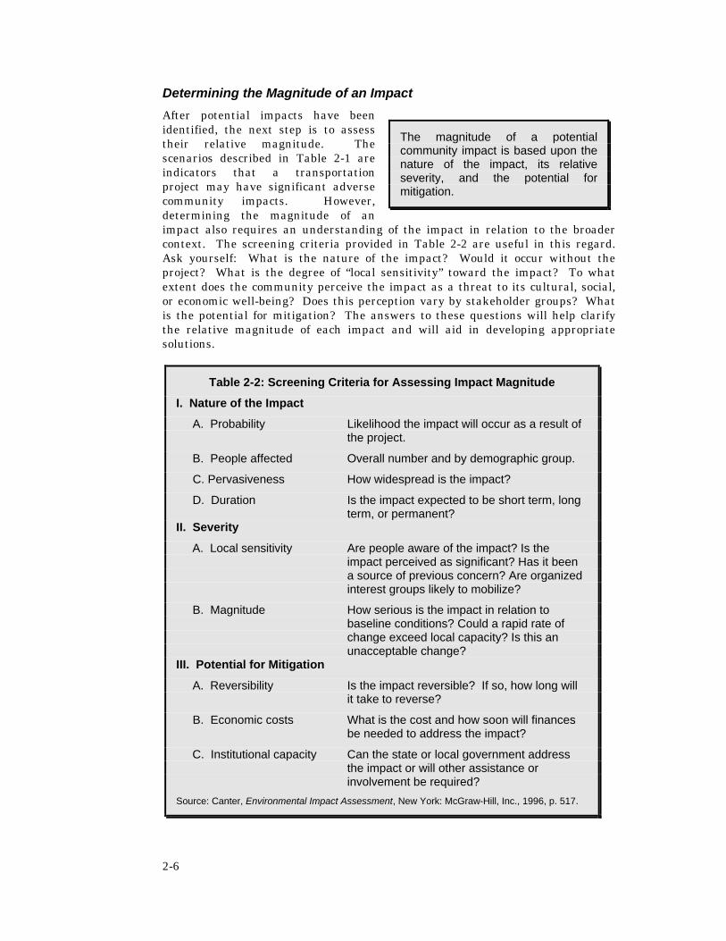
Determining the Magnitude of an Impact
After potential impacts have been identified, the next step is to assess their relative magnitude. The scenarios described in Table 2-1 are indicators that a transportation project may have significant adverse community impacts. However, determining the magnitude of an impact also requires an understanding of the impact in relation to the broader context. The screening criteria provided in Table 2-2 are useful in this regard. Ask yourself: What is the nature of the impact? Would it occur without the project? What is the degree of “local sensitivity” toward the impact? To what extent does the community perceive the impact as a threat to its cultural, social, or economic well-being? Does this perception vary by stakeholder groups? What is the potential for mitigation? The answers to these questions will help clarify the relative magnitude of each impact and will aid in developing appropriate solutions.
The magnitude of a potential community impact is based upon the nature of the impact, its relative severity, and the potential for mitigation.
Table 2-2: Screening Criteria for Assessing Impact Magnitude
I. Nature of the Impact
A. Probability Likelihood the impact will occur as a result of the project.
B. People affected Overall number and by demographic group.
C. Pervasiveness How widespread is the impact?
D. Duration Is the impact expected to be short term, long term, or permanent?
II. Severity
A. Local sensitivity Are people aware of the impact? Is the impact perceived as significant? Has it been a source of previous concern? Are organized interest groups likely to mobilize?
B. Magnitude How serious is the impact in relation to baseline conditions? Could a rapid rate of change exceed local capacity? Is this an unacceptable change?
III. Potential for Mitigation
A. Reversibility Is the impact reversible? If so, how long will it take to reverse?
B. Economic costs What is the cost and how soon will finances be needed to address the impact?
C. Institutional capacity Can the state or local government address the impact or will other assistance or involvement be required?
Source: Canter, Environmental Impact Assessment, New York: McGraw-Hill, Inc., 1996, p. 517.

2-7
Complicating the determination is the fact that “magnitude” is a relative concept. The relative magnitude of social and economic impacts can vary across communities, neighborhoods, and stakeholder groups. This variation is due to differing degrees of sensitivity toward a particular issue or impact. An impact that is perceived by one community as significantly adverse might be widely tolerated or even desirable to another. For example, one locality may desire an intensification of commercial development while the neighboring locality may be actively opposed to commercial development. Such variation can make determining the magnitude of an impact both challenging and unpredictable. Yet weighing the magnitude of impacts helps demonstrate agency responsiveness and leads to projects that are a better fit with the communities they serve.
Identify Solutions
Some adverse impacts can be avoided through attention to community issues in the development and selection of project alternatives. However, other impacts will need to be addressed after an alternative has been selected. Transportation agencies can employ a range of specific methods to reduce the adverse impacts of the selected alternative. Solutions to adverse impacts fall into the following four categories:3
Avoid – Alter the project so the impact does not occur.
Minimize – Modify the project to reduce the severity of an impact.
Mitigate – Alleviate or offset an impact or replace an appropriated resource.
Enhance – Add a desirable or attractive feature to the project to make it fit more harmoniously into the community.
Some localized impacts simply cannot be avoided or mitigated due to cost, the importance of the facility to regional mobility, or for other factors. For this reason, difficult decisions will have to be made. Table 2-3 provides a general overview of key measures for addressing project impacts. Other suggestions and techniques are provided in Part 3 of the handbook.
3 FHWA, Community Impact Assessment: A Quick Reference for Transportation, September 1996, p. 30.
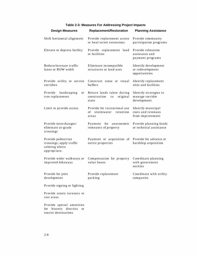
2-8
Table 2-3: Measures For Addressing Project Impacts
Design Measures Replacement/Restoration Planning Assistance
Shift horizontal alignment Provide replacement access or local street extensions
Provide community participation programs
Elevate or depress facility Provide replacement land or facilities
Provide relocation assistance and payment programs
Reduce/increase traffic lanes or ROW width
Eliminate incompatible structures or land uses
Identify development or redevelopment opportunities
Provide utility or service corridors
Construct noise or visual buffers
Identify replacement sites and facilities
Provide landscaping or tree replacement
Return lands taken during construction to original state
Identify strategies to manage corridor development
Limit or provide access Provide for recreational use of stormwater retention areas
Identify municipal costs and revenues from improvement
Provide interchanges/ eliminate at-grade crossings
Payment for uneconomic remnants of property
Provide planning funds or technical assistance
Provide pedestrian crossings; apply traffic calming where appropriate.
Payment or acquisition of entire properties
Provide for advance or hardship acquisition
Provide wider walkways or improved bikeways
Compensation for property value losses
Coordinate planning with government entities
Provide for joint development
Provide replacement parking
Coordinate with utility companies
Provide signing or lighting
Provide scenic turnouts or rest areas
Provide special amenities for historic districts or tourist destinations

2-9
Outlining Potential Solutions
The following worksheet is provided as a guide to assist in developing an action plan for addressing adverse impacts of a transportation project.
Worksheet: Outlining Potential Solutions Directions: Complete the following worksheet for each project impact. Also indicate the lead agency to undertake the specified action, if other than FDOT. Impact No 1: _____________________________________________________ A. Identify ways the project could be altered to avoid the impact. 1. _____________________________________________________________ 2. _____________________________________________________________ B. Identify ways the project could be modified to reduce the severity of the impact. 1. _____________________________________________________________ 2. _____________________________________________________________ C. Identify actions that could be taken to offset the impact or replace an appropriated resource. 1. _____________________________________________________________ 2. _____________________________________________________________ D. Identify ways the project could be enhanced to address the impact. 1. _____________________________________________________________ 2. _____________________________________________________________ E. If the adverse impact cannot readily be resolved, indicate why. 1. _____________________________________________________________ 2. _____________________________________________________________

2-10
Document Findings
Findings of the community impact assessment will need to be summarized and included in the NEPA document. General guidelines for documenting findings are provided below:
1. Keep a written record of all findings, beginning with potential impacts suggested by the community profile and proceeding to more detailed analysis as alternatives are refined and evaluated. All assessment activities and information collected should be maintained in the project file for the life of the project.
2. Summarize all public involvement activities, as well as public concerns and comments.
3. Prepare an executive summary of key findings, including public concerns, conclusions of various analyses, strategies for addressing impacts, and any commitments made to the public. Briefly summarize relevant findings for various sections of the project environmental document.
4. Use clear, non-technical language and graphics to help explain assessment results. Present the material objectively and avoid “hot button” terms or words that may indicate a bias.
The degree of documentation of community impacts is also related to the project category. Each federally assisted project must be categorized to determine what level of NEPA documentation is required (see Table 2-4). Information on the project and all potential impacts, including socio-economic impacts, will need to be collected and reviewed to determine the appropriate category for each project and the appropriate level of detail required in documenting various social and economic impacts.
Projects categorized as requiring an Environmental Assessment or Environmental Impact Statement will require more extensive assessment and documentation of findings, and may involve the preparation of a separate community impact technical report. The project scoping process can be used to determine whether a separate technical report is needed. For Type II Categorical Exclusions, social and economic impacts may be only briefly
Table 2-4 – Project Categories for NEPA Documentation
Categorical Exclusion Type I - minimal socio-economic documentation is required.
Categorical Exclusion Type II – more extensive socio-economic documentation is required in the project report; this may include technical reports.
Environmental Assessment - more extensive socio-economic documentation is required; this may include technical reports.
Environmental Impact Statement - extensive socio-economic documentation is required; this usually includes technical reports.

2-11
documented, as provided in the FDOT Project Development &Environment (PD&E) Manual. Further guidance for determining the project category and appropriate level of documentation is contained in Chapter 3 of the PD&E Manual.
Below is a sample format for a community impact assessment technical report. This is only an example, as different topics may need to be addressed for an understanding of community impacts in a particular area.
Sample Technical Report Format
Executive Summary
I. Introduction
A. Project Summary • Project Purpose and Need • Conceptual Alternatives
II. Baseline Conditions
A. Social Characteristics • Demographic Profile & Special Populations • Community Issues and Attitudes • Community Cohesion Mobility • Safety
B. Economic Characteristics
• Labor Force Characteristics • Major Employers and Industries
C. Land Use and Growth Trends
• Existing and Planned Land Use • Existing Zoning • Growth Trends and Issues (past and present)
D. Notable Features in Study Area
• Aesthetic Character • Historic Resources
III. Estimated Impacts
A. Relocation and Displacement B. Social Impacts C. Economic Impacts D. Land Use Impacts E. Aesthetic Impacts F. Civil Rights Impacts
IV. Conclusions and Recommendations
A. Recommendations for Addressing Impacts B. Project Commitments C. Agency Roles
Appendices

2-12
MONITORING
Monitoring is strongly recommended in any impact assessment program both to document actual or unforeseen impacts, and to provide useful feedback for similar projects in the future. Monitoring helps to build understanding of actual impacts for particularly controversial issues – the economic impacts of medians, for example. Monitoring is also a way to identify and address any unforeseen adverse impacts of a transportation project on safety, operations, or the community. In this sense, monitoring can be added to the list of mitigation strategies as a commitment by the transportation agency that any significant unforeseen impacts will be addressed and resolved.
Suggestions for incorporating monitoring into agency activities, include the following:
• Integrate monitoring of similar or nearby past projects into future project development and environment (PD&E) studies,
• Develop a monitoring program and data base,
• Conduct special studies to monitor the impacts of selected projects after construction, and
• Coordinate with the public information office to assure that the appropriate Department representatives are notified of public comments regarding the project after construction.
Informal monitoring is already underway to address public concerns over the economic and operational impacts of median projects. For example, FDOT has explored these concerns by conducting opinion surveys following median reconstruction projects. Surveys to date indicate that the majority of businesses have perceived no adverse impact on sales, and the various user groups (truckers, commuters, and property owners) tend to rate these projects favorably in terms of safety and operations. Such surveys are useful in addressing public concerns regarding the impacts of median projects.
Quick response to ameliorating unforeseen impacts helps to build community confidence in the agency and in the quality of transportation projects. For example, if a median project results in unexpected adverse impacts on traffic operations, then quickly reevaluate the project and consider revising the roadway design or partnering with local agencies on solutions. Options may include bulb-outs to accommodate U-turns or connecting local streets at strategic locations.

3-1
CHAPTER 3: COMMUNITY IMPACT ASSESSMENT IN PROJECT PHASES
Community impact assessment (CIA) serves an invaluable role in planning, project development, and project decision-making. Not only does CIA fulfill NEPA requirements, it also provides a basis for more integrated problem solving by identifying the role of other jurisdictions and agencies in addressing project impacts. Ultimately, CIA helps assure that important community issues are identified and assessed before a project reaches later phases of production. Early identification of community issues greatly increases the ability of an agency to effectively address those issues. CIA also facilitates commitment compliance, by assuring that any commitments made in previous phases related to the project are passed to the next phase.
The process and methods described in this Handbook have utility in each phase of a transportation project. Useful methods for planning include, but are not limited to, the community profile and overlay techniques. The purpose of CIA at the planning stage is early identification of major project issues having NEPA implications or other potentially significant adverse impacts that would eliminate the project from further consideration. Such information will provide a helpful starting point for the project development and environment (PD&E) phase.
During PD&E, the project is well enough defined for a detailed assessment of community impacts. The level of effort necessary to accomplish the various steps of the process will depend upon the nature of the project and whether or not community impact assessment was initiated in the planning phase. Each of the techniques provided in the handbook could be applied during the PD&E phase.
When the project enters the design phase, CIA becomes even more focused. Many of the controversial issues would have been addressed in previous phases, thereby reducing the potential for production delays. Design alternatives still need to be reevaluated to determine their implications in relation to community impacts. Nonetheless, designers would be informed up front as to special community needs or issues of relevance to project design, such as areas of high pedestrian activity or locally important aesthetic features. Any commitments made in previous phases would be communicated to designers, who will be responsible for carrying them out. If constraints arise that require changes in design, then the process would require follow-up with the affected community prior to proceeding.
For right-of-way staff, the information from previous phases will prove useful in preparing conceptual stage and final relocation plans. The partnering strategies also help to expand the range of potential solutions to adverse relocation impacts. When the project reaches the construction phase, many issues related to maintenance of traffic during construction will likely have already surfaced, thereby aiding in the development of maintenance of traffic plans. The community profile and related inventories will prove invaluable, as will the strategies set forth in the handbook for minimizing adverse economic impacts of

3-2
construction on area businesses. Below are specific suggestions of community impact assessment activities in the various phases of a transportation project.
PLANNING
The time to begin addressing community or resource agency issues and concerns is in the planning process, rather than after extensive time and resources have been spent on developing and designing the project. Early assessment of potential social, environmental, and economic impacts in the planning process increases the likelihood that these issues can be addressed and helps screen out projects that might be problematic.
During the development of planning studies, Metropolitan Planning Organizations, in cooperation with the FDOT, should engage in the following community impact assessment activities (See Appendix C-1):
• Broaden the scope of the Citizen Advisory Committees to enlist their assistance in identifying potential community issues and impacts.
• Conduct visioning workshops aimed at establishing long-range community objectives and mission statements in relation to the transportation plan and long-term development of the region.
• Evaluate the relationship of the long-range transportation plan to the local government comprehensive plan in cooperation with the affected local governments. Indicate any inconsistencies or potential conflicts, as well as compatibility with plan objectives. Define the need for proposed transportation improvements in relation to community goals, objectives, policies and transportation systems development.
• Conduct a screening analysis of projects to identify any with potentially significant adverse impacts on communities, protected populations, the environment, or major inconsistencies with local comprehensive plans (PLEMO exercise). Engage resource management agencies and local governments in this effort. Evaluate the secondary land use impacts of major new transportation projects or major new expansions flagged as problematic.
• Initiate a process to address conflicts or inconsistencies between the long range plan, local government comprehensive plans, and plans and programs of natural resource management agencies. Engage affected agencies and
Primary responsibility for community impact assessment in the planning phase:
• In urban areas, the Metropolitan Planning Organization (with FDOT assistance and local government involvement);
• In rural areas, the FDOT with local government involvement.

3-3
TRANSPORTATON IMPROVEMENT PROCESS
Transportation needs analysis in state, metropolitan and local plans
Coordination between FDOT offices, MPOs, local governments
Identification of subarea and corridor-level projects (need and mode)
MPO Transportation Improvement Program
FDOT Adopted 5 Year Work Program
Local Capital Improvement Program
Feasibility study
Corridor location and conceptual design
Environmental review
Project engineering and design
Plans, specifications, and estimates
Right-of-way acquisition plan and mapping
Acquisition negotiations with property owners
Settlements
Eminent Domain proceedings, if necessary
Planning
¤
Programming
¤
Project Development & Environment
¤
Design
¤
Right-of-Way
¤
Construction
Bids received
Contract awarded
Construction
Inspection
Completion
jurisdictions in identifying an acceptable compromise and determining whether the project should be retained, modified, or eliminated.
• Document any community issues that arise during this phase having NEPA implications that will need to be addressed in later phases and any project related commitments.
• Transmit these documented findings to the Project Development Team.

3-4
PROJECT DEVELOPMENT & ENVIRONMENT (PD&E)
Community impact assessment and public involvement activities are most extensive during the project development and environmental phase. The primary objective is to gain a thorough understanding of the affected community and to use this knowledge in evaluating and assessing project alternatives. Another important objective is to involve other agencies that can play a cooperative role in identifying, evaluating, and addressing community impacts.
Community impact assessment responsibilities in the project development and environmental phase are discussed in the FDOT Project Development and Environmental Manual. Key activities involve the following:
• Identify community issues and objectives that relate to the project. Speak with community stakeholders and potentially affected parties to obtain a thorough understanding of these issues. Speak with stakeholders and affected parties individually or at public workshops, public hearings, small group meetings, focus group meetings and regular meetings of local organizations.
• Establish a comprehensive purpose and need statement for the project in coordination with the affected community, stakeholders, and Metropolitan Planning Organization.
• Visit the potentially affected community and observe it first hand.
• Identify the potential social and economic impacts of project alternatives, including new impacts that may arise due to changes in the community during project development.
• Establish the significance of potential impacts to assist in determining what level of impact assessment and documentation is appropriate for the project.
• Provide social and economic criteria for evaluating and selecting a preferred alternative.
• Identify techniques for addressing potential adverse impacts, as well as potential roles for other agencies that could assist with the mitigation effort. Activities include the following:
Ø Consider adverse relocation impacts. Document any special needs or considerations for inclusion in the conceptual stage relocation plan.
Primary responsibility for community impact assessment in the PD&E phase:
• FDOT Environmental Management Office, in cooperation with Metropolitan Planning Organization and local governments.
3-5
Ø Identify issues related to maintenance of access during construction and coordinate with potentially affected parties on specific mitigation strategies.
• Provide information for project documents, such as the Categorical Exclusion (CE), Environmental Impact Assessment (EIS), Environmental Assessment (EA), Finding of No Significant Impact (FONSI), Record of Decision (ROD), Section 4F reports, and project reevaluation reports. See Chapter 3 of the FDOT Project Development &Environment (PD&E) Manual for additional guidance on documentation required for various project categories.
DESIGN & RIGHT OF WAY Typically, when a project reaches the design and right-of-way phases, many of the project commitments and community issues have already been identified. However, this is not always true. Projects classified as programmatic categorical exclusions, for example, may have potential community impacts that are not identified until the design phase. An example could be a median reconstruction project. In such cases, additional public involvement and community impact assessment may be necessary to address public concerns.
• Review environmental documents to become familiar with issues surrounding the project and commitments made to date.
• Carry out previous commitments. Any revisions that depart from past commitments or clearly pose social and economic impacts will require additional assessment and coordination with affected parties.
• Reevaluate social and economic impacts of design alternatives, including impacts on public safety, school crossings or other high pedestrian locations, and accessibility of corridor businesses and neighborhoods. Projects involving medians or access changes must be carried out in accordance with Median Opening Decision Process (625-010-020), and Working With the Public on Accessibility Concerns (625-010-021). These procedures can be obtained from the FDOT Systems Planning Office.
• Provide additional public involvement opportunities for changes that arise in design to inform affected parties and identify opportunities to avoid unnecessary adverse impacts on specific businesses, neighborhoods, or property owners.
• Incorporate information from the other phases of the community impact assessment into the conceptual stage relocation plan and develop
Primary responsibility for community impact assessment in Design phase:
• FDOT Design and Right of Way Office, in cooperation with Environmental Management Office.

3-6
strategies in coordination with affected parties and other agencies for addressing adverse relocation impacts.
CONSTRUCTION The primary consideration during construction is to manage traffic effectively in areas under construction and minimize adverse economic impacts on businesses that could result from temporary loss of access during construction.
• Review environmental documents to become familiar with issues surrounding the project and commitments made to date. Carry out specific recommendations related to maintenance of traffic and multi-modal access during construction.
• Provide outreach to affected parties for the purpose of explaining the construction schedule and notify them of the agency contact person that will assist in addressing construction impacts and problems.
• Develop maintenance of traffic plans and mitigation strategies in coordination with affected parties that minimize economic hardship on affected businesses or congestion around major employment and activity centers.
• Carry out previous commitments. Any revisions that depart from past commitments, agency standards, or that pose social or economic impacts will require additional assessment and coordination with affected parties.
Primary responsibility for community impact assessment in Construction phase:
• FDOT Construction Office, in cooperation with Environmental Management Office.

4-1
CHAPTER 4 : DEVELOPING A COMMUNITY PROFILE
The community profile is a summary of baseline conditions and trends in a community and study area. It establishes the context for assessing potential impacts and for project decision-making. Developing a community profile involves identifying community issues and attitudes, locating notable features in the study area, and assessing social and economic conditions and trends in the community and region that have a bearing on the project. Preparing a community profile is often an iterative process. Although some information can be collected early project development, other important information about the community may not be uncovered until later in project development or production.
Information can be collected both from primary sources, such as interviews or field surveys, and secondary sources, such as comprehensive plans or newspaper articles. The nature of the data collection effort and the level of documentation required will vary according to the project. For major or controversial projects, information on the community might feed into the Baseline Conditions section of the CIA technical report. For other less extensive projects, a brief summary of key issues and baseline data could be included in the project files.
This chapter provides a general process for developing a community profile (see Figure 4-1). It addresses major elements for consideration, where and how to get the information, and suggestions on documenting the information. A checklist, summarizing the various elements of a community profile, appears at the end of this chapter. It is intended as a guide for collecting relevant data, recognizing that not all of this information will be relevant for every project.
Figure 4-1: Process for Developing a Community Profile
REVIEW SOCIAL & ECONOMIC
CHARACTERISTICSDemographicsGrowth Trends
Labor ForceMajor Employers
Housing
SUMARIZEFINDINGS
Written SummarySocio-Economic Inventory Map
INVENTORY STUDYAREA FEATURES
Community Facilities & ServicesExisting Businesses
Land Use CharacteristicsTransportation Characteristics
Aesthetic and Cultural Resources
IDENTIFY COMMUNITYISSUES & ATTITUDESReview Secondary Sources
Talk to Knowledable PersonsVisit the Community
Interview Stakeholders
Update
Update

4-2
REVIEW SOCIAL AND ECONOMIC CHARACTERISTICS
Begin with a review of population, housing, and economic characteristics and trends of the broader community and the study area. Such data are useful for understanding growth trends, ethnicity, income, and mobility needs of a population. Economic data also provide insight into how the local or regional economy may be affected by a transportation project. Housing data are useful for gaining insight into economic and relocation impacts, as well as changes in housing composition that could affect the character, social organization, and the level of cohesion in a particular neighborhood.
Data Sources
Population, housing, and economic data are often readily available from other government agencies or previous planning studies. County planning departments, city planning departments and metropolitan planning organizations can provide demographic and economic information for the county and subgroups of the county. This information may already be summarized in local comprehensive plans and MPO long range plans. The U.S. Census also provides much of this information, although depending on the census year it may be somewhat out of date. Local governments or metropolitan planning organizations (MPOs) may have more current county-level census tract or block group data. Demographic information is also regularly compiled and maintained by other agencies such as School Boards, social service agencies, water management districts, and health departments. Also, a variety of locations on the Internet (including the U.S. Census Bureau website) provide demographic and other useful information at no charge.
Economic information, such as labor force characteristics and major employers and industries, may be obtained from the Census, local plans and planning studies and area economic development organizations. In addition, the Florida Department of Labor compiles a quarterly record of labor data on Florida businesses in the ES202 Database. This information is not available publicly in disaggregated format. However, the Florida Department of Transportation receives information extracted from that file and compiles data on the Traffic Analysis Zone (TAZ) level. Contained in this file is the number of employees by commercial, industrial, and service for each TAZ. This database can be obtained from the FDOT Planning Office.
Housing data are available through the FDOT Right-of-Way office, local and state planning agencies, the local property appraisers office, local real estate agencies, social service agencies, and non-profit organizations or neighborhood groups. More specific data can be obtained through field observation of housing condition and interviews with knowledgeable persons.
Types of data to look for:
a. Relevant demographic characteristics of the community include:
• Population and growth trends;
• Age distribution;

4-3
• Average household size;
• Ethnic composition;
• Average household income (compared to surrounding area); and
• Concentrations of special groups, such as minority or low-income populations, elderly persons, religious or ethnic groups, and persons with disabilities.
b. Relevant economic characteristics, include:
• Unemployment rates and trends;
• Work force characterization (by SIC code);
• Dominant business sector type; and
• Major employers and industries.
c. Relevant housing characteristics, include:
• The age, type, and condition of structures;
• Vacancy rates and trends in the community and length of residency (percentage of residents five years in home).
• The extent and availability of low-income housing in the affected community;
• The type of occupancy in the study area (renters versus owners).
Summarizing the Data
Summarize the highlights of your findings. Compare local data with similar county and state data for further insight into the magnitude of identified social and economic trends in relation to the broader region or state. The summary should address the following:
• Major population changes that have or are occurring in the community, such as major changes in population size, density, composition and/or homogeneity.
• Location and path of high growth areas in the region.
• Housing characteristics in the study area (number of units affected, types of units, soundness of units); length of residency or vacancy rates compared to the larger community, and the type of occupancy (owner vs. renter, average household size). Length of residency or vacancy rates provides some indication of the degree of stability of an area, whether it is characterized by long term residents or highly mobile individuals, and can sometimes provide clues of the degree of resident satisfaction with an area.
• Characteristics of the populations affected by the proposed transportation project in terms of age, racial and ethnic composition, employment, and relative income distribution.

4-4
• Location of special populations, such as concentrations of low-income elderly, persons with disabilities, low-income or minority neighborhoods, or ethnic communities.
• Labor force characteristics and trends, major employers in the area, dominant business sector, and employment trends that may be relevant to the project.
A Caution on Census Data
The U.S. Census provides data on racial and income characteristics at the census tract level. However, in some cases census data have been shown to be unreliable for identifying low-income or ethnic communities. The level of aggregation may not be fine enough or data may be outdated, depending upon the timing of the analysis. Also, the census is based on self-reported data, making it prone to undercounting certain populations due to their reluctance to divulge information. Aside from census data, minority and low-income populations may be identified through field observation or through nonprofit community organizations that work with specific groups or low-income populations. In some cases, surveys may be the most effective tool to determine the race/ethnicity, number of persons per household, and income level of residents near a transportation project.
IDENTIFY COMMUNITY ISSUES AND ATTITUDES
Community impact assessment requires a thorough understanding of the potentially affected community, including community values, issues or attitudes relevant to the project. Comparison with other similar projects, discussions with knowledgeable persons, and a review of community plans, media reports, and other secondary sources are all helpful in uncovering relevant issues (see Table 4-1). The following approach will provide a solid understanding of community issues and attitudes. These activities may be more or less extensive depending upon the nature of the community and the project.
Review Secondary Sources of Information
Secondary source materials can provide a wealth of helpful information. They may reveal community issues of relevance to a transportation project, provide information about community leaders or stakeholders to be interviewed, and can
“Community values can be defined as a set of ideals, which are openly practiced or hidden, that are shared among individuals that identify themselves as a group. Community values are often expressed in written, oral, ritual, or symbolic forms to communicate these ideals to the group or others. These values, which may evolve over time, may relate to family, education, government, economy, natural resources, religion, recreation, social class, communication network, health and general welfare.”
— FDOT CIA Steering Committee

4-5
be helpful in developing relevant interview questions. Good secondary sources include local government comprehensive plans and amendments, evaluation and appraisal reports, local policy studies, media reports, editorials, minutes of public hearings, published local histories, government reports, early versus current photographs of the area, or other relevant local sources.
Public comment delivered at public hearings and news clippings related to similar projects or are about your agency can provide insight into the social characteristics and values of an area, as well as public attitudes. For example, is there a history of opposition to similar projects in the affected area? If so, who
Table 4-1: Methods for Identifying Community Issues
Method
Sources of Information Telephone hot-line
Members of the community
Mail-out questionnaires
Members of the community
Published and unpublished historical materials (i.e., oral history)
Community archives Community historians
Community workshops, forums, meetings
Members of the community
Interviews with stakeholders
Environmental organizations Business and trade organizations Civic/public interest groups Grassroots/community-base organizations Elected officials and agency representatives Homeowners and resident organizations Labor unions State and local elected officials and agencies Religious groups and leaders Schools, colleges, and universities Medical community Legal aid providers Rural cooperatives Civil rights organizations Senior citizens groups Transit users MPO Citizen Advisory Committee members
Newspaper articles, media reports
Local news media
Official transcripts of public hearings
County and local records

4-6
was involved and what were their reactions? How do the comments characterize your agency? If the potential project has already been made public, how did elected officials and community leaders feel about it—who supported it, who did not, and why?
Talk to Knowledgeable Persons
Before initiating stakeholder interviews and field visits, identify and speak with a few people that are knowledgeable about the community. The local planning director, county administrator, or executive director of the metropolitan planning organization is a good place to start. Talk to these people over the phone or in person to get a perspective on active organizations in the area, issues of local or regional importance, and other people to interview. A scoping process, similar to that for projects requiring an environmental impact statement, is another method of gaining background on key issues or interest groups (see FDOT PD&E Manual, Chapter 8, Section 2-5). Scoping is a process for narrowing down the key issues to be addressed when assessing social, economic and environmental impacts — in other words a process for establishing the scope of the study. Stakeholder interviews can be conducted later to collect more specific information about the ideas and concerns of various groups, including individuals that may not be represented in the scoping process.
Visit the Community
All evaluations of community impacts should be based to some degree on direct observation of community life. Visit the community and observe the affected area as a neutral observer. How do people meet their daily needs? Where are the pedestrians and where are they crossing? Where do people congregate?
Two basic methods for gaining first hand knowledge of the area are described below.
• Participant observation is a method for obtaining first-hand knowledge of community life. Participant observation involves spending some time in the affected area, establishing rapport with community members and participating in community life so that people continue to conduct “business as usual” when you are around.
All evaluations of community impacts should be based to some degree on direct observation of community life.

4-7
• Field surveys involve visiting the affected community(s) and observing existing patterns of activity and interaction. Field surveys include visual study of the community, along with written descriptions and notations regarding activity, services available, community infrastructure, community layout, residential and commercial development, and so on. The information gathered through field surveys will be an important supplement to all of your assessment activities.
Interview Stakeholders
This stage involves visiting and speaking with area stakeholders. A stakeholder, as the name suggests, is anyone with a “stake” in the project. This will include two general groups: those directly affected by the project, such as adjacent property owners or representatives of affected neighborhoods, and those indirectly affected or that have an interest in the project, such as local officials, other community leaders, or interest groups. Personal interviews with stakeholders can provide a wealth of information related to community issues, attitudes, and potential impacts of a project. They can also pass important project information on to others with similar interests. Encourage them to convey the project information in the next group meeting or by word of mouth.
Who should be interviewed?
Stakeholder interviews should be as inclusive as possible to gain a solid understanding of potential community issues and perceived impacts. In selecting the appropriate people to interview, begin with identified community leaders. A “community leader” is anyone who is knowledgeable about the community and local issues or objectives. Subjects may include Chamber of Commerce representatives, religious leaders, local elected officials, local planning directors, leaders of social service agencies or non-profit organizations, leaders of area interest groups, school principals, school board members, community or neighborhood association representatives, or others identified as holding special knowledge or interest in the community. Preferably, the “community leader” should be an individual that has lived in the area for several years. If the study area includes low-income and minority groups, make a special effort to involve representatives from these groups in the interview process (see Chapter 10). Interview local elected officials early in the process. Use the interview as an opportunity to brief them on the project and the process underway to address potential impacts. This is important for several reasons. First, these individuals can assist in identifying interview subjects and may be helpful in making contacts or obtaining the necessary data. Second, these officials will be called on to make difficult project decisions on behalf of the community, and should be made aware of the efforts underway to minimize adverse community impacts.
How to identify interview subjects
Community leaders and affected groups may be identified through field visits to the community, informal conversations with knowledgeable persons such as

4-8
agency representatives, and minutes from community meetings. Some of the community leaders and affected groups will have already surfaced in the previous steps of this process. To broaden the pool of interviewees, try using a “snowball sampling” method. In snowball sampling, the initial set of respondents is asked to name others who should be interviewed. If the list of potential subjects is too long, narrow it down to subjects that are named by more than one other person or that represent an interest group that has not previously been interviewed.
Low-income and minority group representatives may be identified through discussions with other involved persons as well as through local churches, social welfare organizations, and neighborhood organizations. Inadequate programs for informing and involving low income and minority neighborhoods in transportation decisions are the primary cause of environmental justice concerns in transportation.
How to conduct the interview.
Prior to scheduling interviews, it is helpful to develop an interview guide containing the general topics and questions that will be addressed in each interview. Sample questions are provided below. During the interview, remember that the role of the interviewer is to listen more than to speak. Be mindful that the purpose of the interview is to learn about the respondent’s point of view, regardless of whether you agree with their perspective. Avoid agreeing or disagreeing with statements that are made.
How to Conduct Stakeholder Interviews Introduce the project and describe purpose and need. Explain that the interview is to inform them about the project and to identify potential impacts, concerns, or objectives related to the project.
Sample questions might include:
1. Do you have any questions or concerns related to this project?
2. Are you familiar with the concerns or expectations of other groups in the
community regarding the project? How would you characterize those issues?
3. What (if any) has been your experience with (our agency)? What (if any) has
been your experience with public involvement activities on our past projects?
4. What are the best ways to communicate with you and involve you or your
organization in project decisions?
5. Who else do you think we should talk to about this project?

4-9
INVENTORY FEATURES OF THE STUDY AREA
Inventories of notable features and resources in the study area provide a basis for understanding and assessing potential project impacts. Consider identifying the location and major characteristics of the following features: affected businesses, activity centers, community facilities and services, and cultural and aesthetic resources. This information, and the identification of community issues and characteristics, provides the basis for understanding and evaluating potential community impacts.
Inventory Community Facilities and Services
Compile an inventory of community facilities and services in the study area. Include information related to the number, location, service area, eligibility, membership, funding, and access of each service and facility. This information will be used to determine whether the proposed project will affect access to needed services in the study area. Chapter 5 discusses how to evaluate the impacts of a project on community facilities and services. This inventory is the first critical step. Although the inventory of community facilities and services begins during the development of the community profile, it may need to be updated and expanded as the analysis proceeds and new information is uncovered through fieldwork. The inventory of community facilities and services should identify any of the following:
1. Medical and Health Care Facilities: type of facility or service (e.g., hospital, clinic, doctor’s office, public health department, dental facility, specialty service facility, etc.), public or private designation, location, clientele, services offered.
2. Educational Facilities: type of facility (e.g., elementary, middle, or high school, community college, university, technical college, vocational school, preschool, etc.), public or private designation, location, school district boundaries, size, student enrollment, age, condition of structures.
3. Religious Facilities: type of institution (e.g., church, synagogue, temple, mosque, etc.), location, size of building, membership description (areas from which members are drawn, demographic characteristics or membership, etc.), services offered to members and/or general public, community activities.
4. Public Works and Services: description of services available to residents, including law enforcement, emergency services (such as fire protection and ambulance service), postal services, libraries, and public assistance services; location of facility; jurisdiction of services; location of emergency routes.
5. Civic Centers: location, services provided.
6. Recreational Facilities: location and description of facilities (indoor vs. outdoor, public park, community center, private facility, amenities available, etc.), availability (time of year, hours of operation, membership eligibility, etc.), programs offered, condition of structures/facilities, if applicable.
7. Historical and Cultural Facilities: location and description, assigned significance, role in community, services provided, if applicable.
8. Commercial Facilities: Location and type of facility (e.g., grocery stores, restaurants, shopping areas, businesses, etc.), services provided.
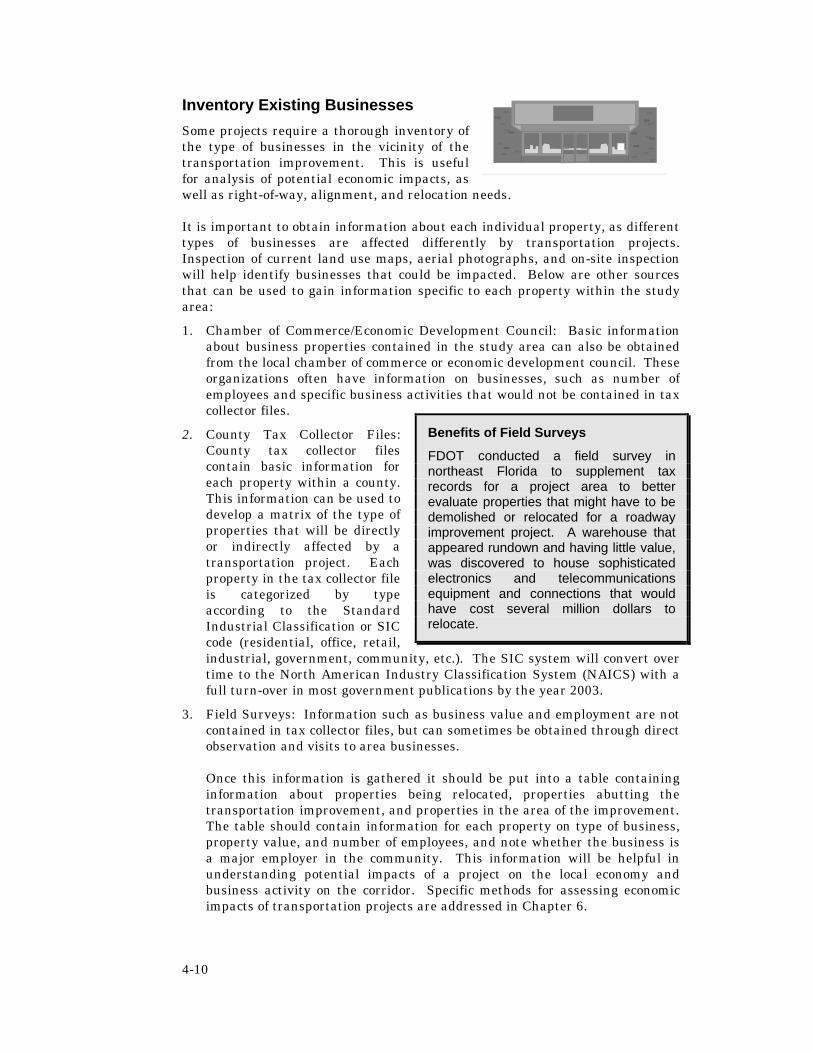
4-10
Inventory Existing Businesses
Some projects require a thorough inventory of the type of businesses in the vicinity of the transportation improvement. This is useful for analysis of potential economic impacts, as well as right-of-way, alignment, and relocation needs.
It is important to obtain information about each individual property, as different types of businesses are affected differently by transportation projects. Inspection of current land use maps, aerial photographs, and on-site inspection will help identify businesses that could be impacted. Below are other sources that can be used to gain information specific to each property within the study area:
1. Chamber of Commerce/Economic Development Council: Basic information about business properties contained in the study area can also be obtained from the local chamber of commerce or economic development council. These organizations often have information on businesses, such as number of employees and specific business activities that would not be contained in tax collector files.
2. County Tax Collector Files: County tax collector files contain basic information for each property within a county. This information can be used to develop a matrix of the type of properties that will be directly or indirectly affected by a transportation project. Each property in the tax collector file is categorized by type according to the Standard Industrial Classification or SIC code (residential, office, retail, industrial, government, community, etc.). The SIC system will convert over time to the North American Industry Classification System (NAICS) with a full turn-over in most government publications by the year 2003.
3. Field Surveys: Information such as business value and employment are not contained in tax collector files, but can sometimes be obtained through direct observation and visits to area businesses.
Once this information is gathered it should be put into a table containing information about properties being relocated, properties abutting the transportation improvement, and properties in the area of the improvement. The table should contain information for each property on type of business, property value, and number of employees, and note whether the business is a major employer in the community. This information will be helpful in understanding potential impacts of a project on the local economy and business activity on the corridor. Specific methods for assessing economic impacts of transportation projects are addressed in Chapter 6.
Benefits of Field Surveys
FDOT conducted a field survey in northeast Florida to supplement tax records for a project area to better evaluate properties that might have to be demolished or relocated for a roadway improvement project. A warehouse that appeared rundown and having little value, was discovered to house sophisticated electronics and telecommunications equipment and connections that would have cost several million dollars to relocate.

4-11
Inventory Land Use and Transportation Characteristics
Obtain comprehensive plans, land development codes, and special planning studies from the affected communities. Review this information to identify any special land use or development issues that need to be considered in relation to the project. Much of this information is readily available from the local planning or public works department, Metropolitan Planning Organization, tax assessors office, and area utility companies.
Specific data sources for the land use assessment include:
• Local Comprehensive Plans, plan amendments and Evaluation and Appraisal Report;
• Military or Federal FacilityPlans;
• Local Land Development Codes and Zoning Maps;
• Transportation Corridor Studies;
• Tax Assessor Maps/Local Plat Maps; • Transit Development Plans;
• Geographic Information System (GIS) Land Use/Land Cover Maps;
• Long Range Transportation Plans;
• Concurrency Management Program data;
• Bicycle/Pedestrian Plans;
• Neighborhood or Subarea Plans; • Congestion Management System Plans;
• Community Redevelopment Plans; • Transportation Disadvantaged Service Plans;
• Special Land Use Studies; • Transportation Demand Management Plans;
• Aerial Photographs; • Access Management Plans;
• School District Property Plans; • Florida Intrastate Highway System Plan;
• Development of Regional Impact (DRI) Studies;
• Emergency Management and Hurricane Evacuation Plans;
• Sewer and Utility Service Area Plans;
• Historic Preservation Plans;
• Economic Development Plans • Architectural/Design Guidelines/Standards
Existing land use and property ownership data are available from existing land use maps in local comprehensive plans, GIS land use/land cover maps, and tax assessors maps, as well as aerial photographs. Land use information can be acquired from Regional planning councils, local planning departments, and water management districts. Regional planning councils typically maintain a collection of all area plans, programs and studies, but these are not always up to date. County planning departments and public libraries may also maintain a similar collection. Plans for utilities, state parks, school districts, federal facilities, water management, and other relevant issues can be obtained directly

4-12
from the respective agency or organization. Large landholders (malls, theme parks, office parks, etc.) may also have useful planning documents available for review.
Some things to look for in the land use and transportation inventory are described below.
1. Obtain aerial photos of the corridor and identify existing land use characteristics. If available, compare this to aerials that were taken in past years.
2. Briefly summarize existing land use and zoning on the corridor, using a combination of land use plan maps, land cover maps, aerial photos and field surveys. Identify the type of uses abutting the corridor and what proportion of total acreage on the corridor is currently industrial, commercial, residential, agricultural, or open space/conservation. Also determine the amount of vacant land along the general corridor that is zoned for commercial, industrial or residential development. The land use and zoning designations and level of detail will vary according to the length of the corridor and whether the area is urban, suburban, or rural.
3. In suburban or rural areas, consider obtaining plat maps indicating property ownership and land division patterns abutting the facility. This information is often available for use on geographic information systems (GIS), from the local planning department or tax assessor’s office. Property ownership information is helpful for minimizing property impacts as the roadway alignment is further defined. Land division activity is an excellent indicator of the conversion of rural land for development and if time series data are available, it can dramatically illustrate losses in productive farmland and development trends along the corridor. For example, over time large agricultural land holdings are often sold off and split into smaller and smaller parcels. Lot split activity on roadway frontage leads to commercial strips and increases demand for direct roadway access, creating long-term transportation and growth management impacts for the affected community. In addition, conversion of agricultural land for residential estates is the leading cause of the disappearance of productive farmland. Such information can be useful both in raising community awareness of the problems, the relative significance of the transportation improvement in relation to other public policies that affect development outcomes, and the need for local government action in addressing adverse land use impacts.
4. Talk to the local planning or public works department to determine if there are special zoning districts or overlay regulations that apply to the study area, such as local access management plans, historic district overlay zoning, or canopy road ordinances.
5. Determine whether there are any neighborhood or subarea plans, community redevelopment areas, Main Street program areas, or other special planning designations within the study area. Identify their boundaries and any goals, objectives or policies that have a bearing on the project.
6. Identify whether transportation right of way may have been dedicated or reserved for the project.

4-13
7. Identify which utility companies will be affected and where the utilities are located.
8. Identify whether development is constrained in the study area due to lack of adequate transportation capacity to meet concurrency requirements.
9. Determine whether the community has a bicycle and pedestrian plan for the affected area and identify if any planned bicycle or pedestrian facilities lie within the study area. Locate pedestrian and school crossings and major pedestrian travel routes.
10. Locate the transit station areas and facilities in the study area and determine whether any additional facilities are planned in the area.
Inventory Aesthetic and Cultural Resources
The FDOT Project Development & Environment Manual addresses the aesthetics of highways and bridges and their impacts on the surrounding environment. However, several other aspects of aesthetics and visual quality impacts should be addressed in the community impact assessment, including:
• Trees,
• Historic districts and structures,
• Neighborhoods with adopted architectural or design guidelines,
• Local landmarks and cultural resources,
• Local measures of community character,
• Historic/scenic landscapes,
• Impacts to or of transit facilities (the aesthetics of bus and rail facilities can directly impact their patronage),
• Impacts to or of traffic control devices (ie, mast arms), and
• Impacts to or of parking facilities.
Identifying cultural and aesthetic resources is a major step toward assessing aesthetic impacts of a transportation project. The inventory of aesthetic and cultural resources along a corridor may be more or less extensive, depending upon the nature of the study area. In most cases, aesthetic or cultural resources can be identified through public involvement and field observations. If the study area includes a locally or nationally important scenic landscape, the inventory may require the assistance of a trained landscape architect. Chapter 8 provides a method for assessing the aesthetic impacts of transportation projects. A few sample options that may be used for identifying aesthetic features on a corridor include:
• Conduct a workshop in the study area. Using an aerial photograph of the corridor, ask participants to identify locally important landmarks or aesthetic features.
• Provide residents in an area with disposable cameras and ask them to take pictures of features that they prefer or would like to preserve. Ask them to provide the pictures with some indication of its location, a brief description, and any local issues.

4-14
• Review the local comprehensive plan to identify policies, programs, or land use plans related to community character and aesthetics.
• Identify someone with local knowledge of cultural resources, such as a local historian or architect, and invite them on a walking or driving tour of the corridor to identify notable cultural and aesthetic features. Indicate the specific location of the feature, a brief description, and any local issues that surround it.
• Conduct a visual preference survey with residents in the study area. Show slides of various typical project designs or streetscapes and ask them to rate their reactions.
SUMMARIZE AND MAP KEY FINDINGS Summarize the highlights of your inventory in the report of baseline conditions or in a written briefing of major findings. In summarizing the information, focus on issues of relevance to the project. As described in Chapter 2, the Baseline Conditions Assessment would include the following information:
II. Baseline Conditions A. Social Characteristics
• Demographic Profile & Special Populations • Community Issues and Attitudes (relevant to project) • Community Facilities and Services (in study area) • Community Cohesion • Mobility • Safety
B. Economic Characteristics • Labor Force Characteristics • Major Employers and Industries
C. Land Use and Growth Trends • Existing and Planned Land Use • Existing Zoning • Growth Trends and Issues (past and present)
D. Notable Features in Study Area • Aesthetic Character • Historic Resources
Prepare Socio-Economic Inventory Map
Also prepare a base map of key geographic information. This map may be simple and conceptual or more detailed, depending upon the nature of the project. Begin with a base map of the community or study area. Either on this map or through overlays, map the location of defined neighborhoods, special populations, major pedestrian crossings, community facilities, and any other notable features in the study area that you have identified through the profile. This is most easily completed through the use of GIS technology.
The socio-economic inventory map is an invaluable tool for developing and evaluating project alternatives. Alternatives can be overlaid on the socio-economic inventory map to uncover potential community impacts in a graphical way that is easy to understand. The best way to accomplish this task is through the use of geographic information systems. These maps can be used to compare

4-15
alternatives for potential impacts and to inform the community and project staff of the trade-offs among alternatives. If this is not an option, a simple conceptual graphic can also be effective in communicating the location of various features in relation to the proposed project.
UPDATE THE PROFILE Profiling a community is an iterative process. The description of baseline conditions should be updated as new information is obtained throughout the community impact assessment process. The geographic information systems are ideal for this process as inventory maps and data may be easily added or updated.

5-1
CHAPTER 5 : SOCIAL IMPACTS
Social impacts of a transportation project are impacts that disrupt the normal daily functions of a community or neighborhood. Typically, it is the broader region or jurisdiction that enjoys the social benefits of a transportation project while the social impacts are borne by the local community—particularly the neighborhoods immediately adjacent to the transportation project. Therefore, social impact assessment is often conducted at the neighborhood level.
But what is a “community” or “neighborhood?” Social scientists have defined these terms in a variety of ways. Some defining characteristics of a “community” include; geographic proximity and boundaries, a shared sense of identity, shared ethnicity or demographic characteristics, religious affiliation, common membership in a group or organization, psychological unity among the residents, social stability, or the common use of facilities or services in an area. A “neighborhood” is a small social unit based on face-to-face contacts and a sub-unit of the geographic community. A neighborhood can also be thought of as a local area with an identity that can be distinguished from the larger jurisdiction and where the daily life of residents involves contact with or dependence on other neighborhood residents, businesses and facilities.
Social impacts have historically been given little consideration during the development of transportation projects. The evidence lies in the many communities that have been adversely affected by transportation projects. In some cases, the social impacts were so severe that affected neighborhoods were unable to recover. Because of these situations, state and federal transportation and environmental laws now require that potential social impacts of transportation projects be identified and addressed. Chapter 9 of the Project Development and Environment (PD&E) Manual requires that all potential social impacts from a transportation project be addressed during the preparation of an environmental document. This chapter provides methods to achieve those objectives.
UNDERSTANDING POTENTIAL IMPACTS Social impacts can be generally categorized under the following headings:
• Community Cohesion;
• Community Facilities and Services;
• Mobility; and
• Safety.

5-2
These impacts are not mutually exclusive; nor can they be measured independently. They are interrelated and are best understood when considered together. For example, a road-widening project may increase vehicle speeds and reduce pedestrian crossing opportunities, making it more difficult for residents to move freely about the neighborhood (a mobility impact). The same project may impair access to the neighborhood corner grocery store (a community facility impact), and make it less safe for disabled, school-aged, or elderly residents who regularly cross the road (a safety impact). Therefore, any analysis of social impacts must be considered holistically.
What is Community Cohesion?
Community cohesion is the degree to which residents have a sense of belonging to their neighborhood or community, including commitment to the community or a strong attachment to neighbors, institutions in the community, or particular groups. The level of community cohesion is often evidenced by the degree of interaction among individuals, groups, and institutions within a community.
A sense of community is generally expressed through frequent social interaction, use of community facilities and services, local participation and involvement in social activities, and an undefined sense of solidarity. Members of a “cohesive community” often have a collective outward identity. Other indicators include the presence of recognized community leaders, residential stability, a family orientation, active elderly populations, defined community or neighborhood organizations, and area name identification.
• Is there evidence that the neighborhood is cohesive?
• To what degree do residents have a sense of belonging to their neighborhood?
• Will project alternatives damage or facilitate that cohesiveness?
Figure 5-1: Traditional neighborhoods often exhibit a high level of cohesion.

5-3
The assessment of social impacts should answer two questions relative to community cohesion. First, is there evidence that community cohesion exists in the neighborhoods adjacent to the project alternatives? Second, if there is evidence of cohesion, will the project alternatives damage that cohesiveness and, if so, to what extent? Transportation projects can adversely affect community cohesion through relocation or barrier effects. For example, the large scale relocation of residents or removal of popular meeting places or community facilities can unravel the delicate balance of social interaction in a neighborhood.
Transportation projects can also create a physical or perceived barrier within the neighborhood, discouraging neighborhood interaction across the facility. The barrier effect is especially damaging to cohesiveness if it involves physically isolating one section of a neighborhood from the rest. For example, the extension of a grade-separated expressway may physically separate and isolate a few blocks of a neighborhood, diminishing the cohesiveness of the neighborhood as a whole. Isolation of the area could lead to a variety of unwelcome circumstances, such as increased residential turnover, social isolation for the elderly or disabled, and increased crime.
Conversely, transportation projects can improve community cohesion. For example, a transportation improvement project may remove cut-through traffic from nearby residential streets and provide additional pedestrian crossings, making it easier for neighborhood children to cross streets and generally increasing opportunities for neighborly interaction.
What are Community Facilities and Services?
In general, a community facility or service is any public or private organization that a local population relies upon for goods or services. Community facilities and services include, but are not limited to:
• Schools;
• Religious institutions;
• Parks, recreation centers and playgrounds;
• Social service agencies;
• Housing for the elderly, retirement centers, or other special needs residential facilities;
• Hospitals and other medical facilities;
• Community centers;
• Senior centers;
• Libraries;
• Retail and other commercial establishments;
• Day care centers; and
• Emergency services, such as fire and police stations.
Will the project impede or enhance the ability of residents to make full use of community facilities and services?
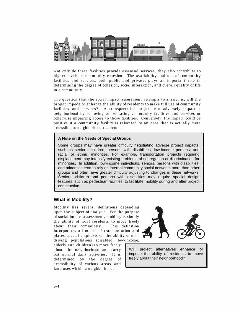
5-4
Not only do these facilities provide essential services, they also contribute to higher levels of community cohesion. The availability and use of community facilities and services, both public and private, plays an important role in determining the degree of cohesion, social interaction, and overall quality of life in a community.
The question that the social impact assessment attempts to answer is, will the project impede or enhance the ability of residents to make full use of community facilities and services? A transportation project can adversely impact a neighborhood by removing or relocating community facilities and services or otherwise impairing access to those facilities. Conversely, the impact could be positive if a community facility is relocated to an area that is actually more accessible to neighborhood residents.
What is Mobility?
Mobility has several definitions depending upon the subject of analysis. For the purpose of social impact assessment, mobility is simply the ability of local residents to move freely about their community. This definition incorporates all modes of transportation and places special emphasis on the ability of non-driving populations (disabled, low-income, elderly and children) to move freely about the neighborhood and carry out normal daily activities. It is determined by the degree of accessibility of various areas and land uses within a neighborhood.
A Note on the Needs of Special Groups
Some groups may have greater difficulty negotiating adverse project impacts, such as seniors, children, persons with disabilities, low-income persons, and racial or ethnic minorities. For example, transportation projects requiring displacement may intensify existing problems of segregation or discrimination for minorities. In addition, low-income individuals, seniors, persons with disabilities, and minorities tend to rely on internal community social networks more than other groups and often have greater difficulty adjusting to changes in these networks. Seniors, children and persons with disabilities may require special design features, such as pedestrian facilities, to facilitate mobility during and after project construction.
Will project alternatives enhance or impede the ability of residents to move freely about their neighborhood?

5-5
The question that the social impact assessment attempts to answer regarding mobility is, will project alternatives enhance or impede the ability of residents to move freely about the neighborhood? A transportation project can affect mobility by creating physical and psychological barriers within the neighborhood. A widened road may attract more vehicles, potentially making it more difficult for pedestrians to cross. For an elderly or disabled person, the sheer length of the journey may create a barrier. Both of these scenarios can be addressed through pedestrian-friendly features in the roadway design. However, not addressing neighborhood mobility issues in the project development process could have a significant adverse effect on the quality of life in the neighborhood.
Transportation projects or programs can also positively affect neighborhood mobility. A transportation improvement project could improve traffic flow on a major thoroughfare, thereby reducing cut through traffic on neighborhood streets and improving conditions for pedestrians and bicyclists. Including a new bus stop location or a bike path in the project design could also increase neighborhood mobility. An access management policy aimed at increasing vehicular and pedestrian connections between businesses helps to improve the overall accessibility of those areas.
What is Safety?
For most transportation projects, safety is typically assessed in terms of vehicular safety using crash data as the measure. Community impact assessment requires a broader definition that includes the effects of the transportation project on neighborhood safety. In this context, the assessment of safety impacts also considers whether or not residents feel safe in their neighborhood and includes issues such as crime, emergency services and bicycle/pedestrian safety. The question to answer when assessing potential safety impacts is, will project alternatives negatively or positively affect non-motorist (pedestrian and bicycle) safety conditions, crime in the neighborhood, and emergency (police, medical, and fire) response times?
For example, a transportation project may result in increased vehicular traffic, wider rights-of-way, and higher travel speeds that adversely affect pedestrian safety. Such impacts could be more severe for elderly persons and persons with disabilities, who may find it more difficult to cross the road safely. As mentioned in Chapter 2, the significance of these impacts must also be considered in context. For example, if the study area has relatively low levels of pedestrian activity and the project would resolve a traffic hazard, then pedestrian impacts are probably not as significant.
Barrier effects caused by transportation projects can also impede or enhance the delivery of emergency services in a neighborhood. Increased congestion, or local street closures caused by an above grade expressway, can delay emergency response times. Conversely, decreased congestion or improved
How will project alternatives affect pedestrian and bicycle safety, crime, and emergency response times?

5-6
neighborhood access attributable to project alternatives can improve emergency response times.
Transportation projects can also contribute or be perceived as contributing to increased neighborhood susceptibility to crime and reduced “community policing.” For example, if a roadway extension physically separates a park from the rest of the neighborhood, the physical separation can have the effect of reducing the real or perceived safety of the park. Safety impacts such as these can be addressed through attention to design features such as visibility of various areas from the roadway, roadway width, lighting, and landscaping or even through partnering strategies, such as involving a municipality in developing a crime prevention program for the area.
DATA SOURCES
Most of the data required to assess social impacts should have been collected and mapped during development of the community profile, as described in Chapter 4. This includes all relevant demographic, economic, and housing data, an inventory and map of community facilities and services and transportation characteristics, and a summary of community issues and attitudes. Additional suggestions for identifying existing conditions are provided below by topic area.
Other relevant information would have been collected for the purpose of describing the project and study area, as described in Chapter 2. This includes the statement of purpose and need for the project, which should be available from the Long Range Transportation Plan developed by the Metropolitan Planning Organization, and local comprehensive plans. The FDOT planning office may also maintain relevant background material on project planning issues.
Fieldwork is particularly important for understanding social characteristics of neighborhoods in the study area. Time should be spent observing and recording neighborhood activities in relation to the social issues that have been identified. Things to look for include general levels of pedestrian activity and whether residents walk to neighborhood facilities such as parks, schools, community centers, and businesses. Also, do residents interact with each other? Do neighbors stop and talk to each other on the street? Do neighborhood kids play together at the playground or at each other’s houses? Do seniors congregate at a particular location in the neighborhood?
Where social impacts are a potentially significant issue, additional information may be needed for an accurate impact assessment. Supplemental data collection activities would be aimed at expanding upon the community profile and obtaining information specific to a neighborhood. This information can be collected through interviews, surveys, and observation.1 A sample questionnaire and survey instrument for social impact assessment is provided in Appendix A. The questionnaire can be used either to supplement or develop the community profile. The sample survey instrument can be used and modified to collect more
1 For basic information on how to conduct statistically significant surveys, see Chapters 4-6 of the 1999 Commuter Assistance Program Evaluation Manual (Center for Urban Transportation Research, University of South Florida, Tampa).

5-7
detailed information, particularly for community cohesion. Be sure to include a description of the proposed project and a diagram of project alternatives with the survey.
ASSESSMENT TECHNIQUES The assessment of social impacts is aimed at determining whether a project could affect study area neighborhoods, positively or negatively, in terms of community cohesion, community facilities and services, mobility, and safety. Bear in mind that these social impacts are often interrelated. In addition, the assessment should be:
• Sensitive to neighborhood conditions and characteristics; • Easy to understand; and • Readily available to stakeholders.
The technique described in this chapter emphasizes simplicity and community involvement. Although simple, this assessment technique provides a reasonable basis for determining social impacts of a transportation project. Assessment techniques that are simply performed, easily understood and incorporate the sentiments of community stakeholders will be the most effective and valuable to the project development process.
In general, any assessment of social impacts should involve:
• Identifying existing conditions relative to community cohesion, community facilities and services, mobility and safety in each neighborhood adjacent to project alternatives; and
• Determining the potential social impacts to those neighborhoods, both beneficial and adverse, attributable to proposed project alternatives.
When potential impacts of project alternatives are determined, the results should be shared with stakeholders and community leaders for their review and input. This will provide local verification that the assessment accurately portrays existing neighborhood conditions and will serve to notify the neighborhood of potential impacts of the project. Keeping leaders and stakeholders informed will also reduce local anxiety over the agency’s intentions and serve to build trust between the agency and the neighborhood. The information obtained through this process can then be used in the project development process so that the final project alternative is developed with sensitivity toward potential social impacts.
What Level of Assessment is Appropriate?
The effort expended in determining social impacts should be directly related to the nature of the proposed transportation project, the perceived potential social impacts of the project, and the importance placed on those impacts by the community. If it is determined that potential social impacts will cause strong public opposition to the transportation project or that significant social impacts are likely to result from the project, a more extensive social impact assessment is warranted. Typically, the assessment of social impacts can be accomplished through the techniques provided in this handbook. Under unique

5-8
circumstances, it may be necessary to enlist the services of a social impact assessment specialist to serve as a supplemental project resource, particularly in situations where the relationship between the Department and the affected community is strained.
Identifying Existing Conditions
Begin the assessment by determining the general baseline conditions for each social issue area – community cohesion, community facilities and services, safety, and mobility. Chapter 4 describes how to establish baseline conditions through a community profile. Determining social baseline conditions in study area neighborhoods is best accomplished by reviewing the socio-economic inventory map, notes from field visits and the summary of pertinent community issues and attitudes.
Community Cohesion
For community cohesion, relevant information includes the location of special populations, the location of community facilities and services, housing data and information conveying resident attitudes about their neighborhood, and general observation of community life. Consider how the manner in which they interact with their neighbors and community facilities. Neighborhood activity information can only be collected through leader interviews, neighborhood observation and resident surveys. Compare this information to the indicators of community cohesion listed below and, using professional judgment, determine the existing cohesiveness of study area neighborhoods. Determining cohesion is a subjective task and can be estimated based on the number of indicators that apply to a neighborhood. In general, the more indicators that apply to a neighborhood, the more cohesive that neighborhood is. For example, a neighborhood in which neighbors interact frequently, rely on community facilities, have long-serving local leadership, are satisfied with the quality of life in the neighborhood, desire to stay in the neighborhood, and identify with the neighborhood would, in general, be considered cohesive. Summarize in detail the findings of this exercise.
Indicators of Community Cohesion
• Interaction among neighbors: Frequent and intense interaction between community members indicates higher levels of community cohesion. Generally, neighbors within a cohesive community interact more frequently and build strong, social relationships beyond an occasional greeting.
• Use of community facilities: Use of and reliance on local services and facilities indicates community cohesiveness. Local facilities include, but are not limited to, shopping areas, churches, businesses, medical facilities, and social services.
• Long-serving community leadership: The presence of long-serving, active community leadership indicates community cohesion. This indicator can be applied to local political leadership, civic leadership, business leadership and religious leadership.
• Participation in local organizations: Active participation in local organizations indicates community cohesion.

5-9
• Identification with the community: Members of cohesive communities typically “identify” with the neighborhood. Indicators include the existence of an established neighborhood name and an identifiable boundary.
• Desire to stay in the community: Members of cohesive communities usually have a strong desire to remain in the neighborhood and are typically resistant to the idea of change that may lead to the disruption of the neighborhood social fabric.
• Satisfaction with the community: Members of cohesive communities usually express great satisfaction with life in the neighborhood. Residents may express a desire for specific refinements or improvements, but in general are highly satisfied with the quality of life within the neighborhood.
• Homogeneity (income, ethnicity, age, etc.): In general, homogeneity of population contributes to higher levels of community cohesion. Homogeneity in terms of income and ethnicity appear to be important indicators of community cohesion.
• Family-oriented versus singles-oriented communities: In general, family neighborhoods are more cohesive than neighborhoods comprised of largely single people. This appears to be because children tend to establish friendships with other children in their community. The social networks of children often lead to the establishment of friendships and affiliations among parents in the community.
• Length of residency compared with other variables (e.g., satisfaction with community): Long-term, voluntary residence in a neighborhood often signals cohesion because residents have time to establish social networks and develop an identity with the neighborhood. Length of residency should be compared to other measures of community cohesion, such as stated satisfaction with the community and participation in local organizations. This will determine if residents are remaining in the community because they want to be there or because they are unable to leave due to economic hardship or other factors. Vacancy rates within the neighborhood can also be used to determine if more people are moving in than leaving the neighborhood.
Community Facilities and Services
Information required to assess social impacts to community facilities and services includes the exact location of all community facilities and services such as schools, recreation centers, parks, businesses, religious institutions and the manner in which neighborhood residents relate to the community facilities and services (use, access and neighborhood activities). The latter information can be collected using a combination of neighborhood observation, stakeholder interviews or through a survey of neighborhood residents.
Using the socio-economic inventory map prepared in the community profile, identify and highlight the community facilities and services used frequently in study area neighborhoods and those that serve special populations in the neighborhood (senior centers, day care centers, ethnic businesses in ethnic neighborhoods, etc.). Also, using information gained from social service providers and/or origin destination surveys (see Mobility below) determine the general location of the primary users of each community facility and service and
5-10
identify the most common routes used to gain access to these locations. Note the preferred mode of travel used to access each facility and service.
Mobility
Most data required to assess mobility within study area neighborhoods should be available from the community profile, neighborhood observation and survey results. Useful information includes data showing the general layout of the neighborhood, the location of special populations, concentrations of pedestrian and bicycle activity (based on neighborhood observation) and neighborhood travel behavior (based on responses to neighborhood surveys). Both existing and future traffic data should be available from the transportation needs analysis carried out as part of the overall PD&E effort. If mobility is raised as a community concern or special populations could be adversely impacted, additional mobility data may be needed. Additional baseline data can be collected by conducting a limited origin-destination survey at key points in the community. The survey is a simple interviewing exercise whereby pedestrians and bicyclists are asked to define their travel patterns. Collect the data at neighborhood locations with a high level of bicycle and pedestrian activity or at key community facilities. Neighborhood leaders can help identify good locations to collect this type of information.
Sample questions for a limited origin-destination assessment include:
• Where are you going?
• Where are you coming from?
• Do you typically walk/bike to reach this destination?
• How often do you make this trip?
• At what time do you typically make this trip?
• Where else do you typically walk/bike in the neighborhood?
• At what time of day do you typically make the trips?
• Do you find this neighborhood convenient to walk/bike in?
• Do you generally feel safe walking/biking in this neighborhood?
• What locations within the community do you feel less safe in while walking/biking?
After the relevant information has been collected, map the existing mobility conditions in study area neighborhoods. Identify, at a minimum, vehicular and non-motorized traffic patterns, areas where travel modes interface (transit stops, pedestrian crossings, etc.), general travel behavior in the study area, and any mobility issues unique to the area (e.g. special event locations, pedestrian crossings serving persons with disabilities, etc.).
Safety
Most data required to assess safety should already be available from the community profile. Particular attention should be paid to those community facilities and services that are sensitive from a safety standpoint such as schools, religious institutions, hospitals, other medical facilities, senior centers, etc. Also, additional information on community safety (resident opinion on

5-11
neighborhood safety issues) should be provided through survey results. Supplemental information regarding emergency services should be gathered by meeting with emergency service providers in the study area. Ask those providers to identify emergency route information and any neighborhood facilities and areas that are sensitive to changes in the provision of emergency services.
Identify and map existing study area safety conditions, including:
• Areas where safety is an identified concern;
• Emergency routing information; and
• Neighborhood structures and areas sensitive to changes in the provision of emergency services.
Summarize Existing Conditions
The final product of these efforts should be a map identifying all existing neighborhood conditions related to social impact assessment and a summary of key issues. This map would be based upon the socio-economic inventory conducted in the community profile and any additional information obtained that is specific to the various social impact areas. There should also be an estimate of community cohesion for study area neighborhoods.
Determining Potential Impacts
Using the summary of existing conditions, now evaluate potential social impacts associated with project alternatives. The assessment can be accomplished as follows:
1. Overlay a map showing the alignment of each project alternative onto the socio-economic inventory map. Compare the maps as follows:
• Using the map overlay and the information on community cohesion from the baseline assessment, complete the social impact assessment checklist provided below. Document all relevant information resulting in a ‘yes” answer to a checklist question. (Note: The checklist is provided as a general guide and should be modified to meet specific project needs.)

5-12
Checklist for Assessing Social Impacts
1. Will the project create a barrier that divides the neighborhood or limits access to all or part of the neighborhood?
Yes c No c
2. Will the project impact any special groups (such as the elderly, persons with disabilities, racial/ethnic/religious groups) within the neighborhood?
Yes c No c
3. Will the project reduce the amount of social interaction that occurs within the neighborhood?
Yes c No c
4. Will the displacement of residents resulting from the proposed project negatively affect the perceived quality of life in the neighborhood?
Yes c No c
5. Will the project affect access to, or result in the removal of, neighborhood facilities or services that are needed and valued by neighborhood residents?
Yes c No c
6. Will the facilities and services subject to removal or relocation be able to remain in or within proximity of the neighborhood?
Yes c No c
7. Will the project result in an increase in noise, vibration, odor or pollution that reduces social interaction in the neighborhood?
Yes c No c
8. Will communal areas (e.g., parks and playgrounds) used by residents be negatively affected by construction of the project?
Yes c No c
9. Will the availability and convenience of transit services be reduced as a result of the project?
Yes c No c
10. Will the project negatively affect pedestrian and non-motorized mobility within the neighborhood?
Yes c No c
11. Will vehicular mobility within the neighborhood be negatively affected by this project?
Yes c No c
12. Will vehicular traffic increase as a result of the project?
Yes c No c
13. If vehicular traffic increases, will this create unsafe conditions for non-motorized transportation within the neighborhood?
Yes c No c
14. Will “blind or isolated” areas be created that are difficult to monitor for criminal activity as a result of the project?
Yes c No c
15. Will emergency response routes be negatively impacted as a result of the project?
Yes c No c

5-13
2. For each “yes” answer, note whether the impact will be permanent or temporary. For example, access to community facilities and services may be impeded during construction, but not following construction (a temporary social impact). The most important outcome of this exercise is to look critically and objectively at the project alternatives and consider all potential impacts to study area neighborhoods from the perspective of all parties potentially impacted. Use the screening criteria provided in Table 2-2 to consider the relative significance of each impact identified on the checklist. Weigh each impact in relation to study area characteristics and relevant project benefits. Summarize the results of this analysis.
3. When the checklist is complete, prepare a written summary of potential social impacts of each project alternative on study area neighborhoods. Document all relevant supporting information, particularly information leading to a “yes” answer. There is no quantitative scoring or evaluation mechanism associated with the social impact assessment checklist. In general, the more “yes” answers, the more potential that social impacts will result from project alternatives.
4. Present the results of the assessment and the method used to reach those results to study area stakeholders for their input. They may recognize a potential impact that the analyst using the checklist may overlook. Ask them if there are any additional impacts that may have been overlooked.
5. Identify strategies for addressing each impact. A “yes” answer to any of the checklist questions indicates the need to explore the potential for revising alternatives or otherwise addressing the impacts. Some impacts may be unavoidable and may require mitigation. The solution may be more or less extensive, depending upon the significance of the particular impact and its relationship to project benefits. Sample mitigation and problem solving ideas are provided below.
Assessing Potential Social Impacts Step 1: Create a map overlay of existing neighborhood conditions and
proposed project alternatives.
Step 2: Review the map overlay and complete the social impact assessment checklist.
Step 3: Identify potential impacts, summarize results, and document supporting information.
Step 4: Provide the summary for stakeholder review and refine accordingly.
Step 5: Weigh the significance of each impact and consider potential solutions.
Step 6: Identify strategies for addressing project impacts.
5-14
MITIGATION AND PROBLEM SOLVING
A broad range of strategies for addressing adverse community impacts are presented throughout this handbook. Below is an overview of some additional sample strategies for addressing social impacts.
1. Avoid – Alter the project to avoid a potential impact. Examples include:
• Shifting a project to avoid displacing a church that serves as the focal point of neighborhood activities;
• Shifting a project to avoid creating a barrier through a cohesive neighborhood; or
• Shifting a project to avoid separating a vital community facility like a park or a senior center from a cohesive neighborhood.
2. Minimize – Modify the project to reduce the severity of an impact. Examples include:
• Reducing the project design speed in order to accommodate narrower lanes; or
• Locating a transit facility such that vacant land is utilized instead taking a valued neighborhood business.
3. Mitigate – Undertake an action to alleviate or offset an impact or to replace an appropriated resource. Examples include:
• Relocating an impacted community facility in a new, easily accessible location within the neighborhood; or
• Improving crosswalks, adding traffic calming devices and increasing pedestrian crossing times in areas with high levels of pedestrian traffic.
4. Enhance – Add a desirable or attractive feature to the project to make it fit more harmoniously into the community. Examples include:
• Incorporating landscaping and street furniture into a project design;
• Providing a small park or recreational use (ie, fishing pier) along a causeway or under a bridge.
CONCLUSION
The results of the social impact assessment can be used to guide the project development process. Upon completing the assessment of social impacts, do the following:
• Incorporate all relevant actions taken, findings reached, and commitments made as part of the assessment of social impacts into the CIA report (see outline on page 4-14);
• File all relevant documentation in the official project file;
• Incorporate the relevant findings of this assessment into the project development process to minimize the social impacts of the final project on study area neighborhoods; and
• Incorporate the documentation from the assessment into the relevant section of the environmental document for this project per the Engineering Reports Chapter in Part 1 of the PD&E Manual.

6-1
CHAPTER 6 : ECONOMIC IMPACTS
Like aesthetics, potential economic impacts of transportation projects are highly subjective and may arise from a variety of sources. Many communities pursue transportation improvements as a means of attracting economic development. Yet the impacts of a transportation project may also raise economic concerns. Typical concerns include the impacts of construction on business activity, the effect of new or wider roads on residential property values, adverse direct impacts of right-of-way acquisition, and the effect of median improvements on corridor businesses. The new emphasis on context sensitive design of transportation facilities also has economic implications. There is growing understanding of the role that design can play in stimulating the revitalization of older retail districts.
The impact assessment effort should consider potential economic effects of transportation projects broadly, and look for ways a project could be shaped to help advance the economic goals of a community or neighborhood. Identifying and addressing potential economic impacts in the context of an open public involvement process will improve project outcomes and local support. This chapter reviews strategies transportation agencies can use to identify and address the economic impacts of transportation projects. Other supporting information and techniques appear in the chapters on land use, aesthetics, and relocation.
UNDERSTANDING POTENTIAL IMPACTS Economic impacts of transportation projects can affect businesses, residences, or government agencies. They can include changes in growth rates, business activity, property values, and tax revenues. And they can be positive or negative, short-or long-term, and direct or indirect. For example, the widening of a road can adversely and directly impact corridor businesses during construction by temporarily deterring patrons, but indirectly and positively impact business activity over the long-term through increased sales activity and property values.
Economic impacts of transportation projects are generally related to one of two factors:
1. A change in the accessibility of an area (e.g. opening a new area to development, rerouting traffic, bypassing an area), or
2. A change in the local environment (e.g.. pollution, relocation, aesthetics, congestion).
Transportation projects tend to affect businesses and residences in different ways. For example, wider roads and increased traffic may adversely affect residential property values, whereas commercial property values may be
Economic Impacts Can Be:
• Positive or Negative • Temporary or Long-Term • Direct or Indirect
6-2
positively affected by these same factors. Economic impacts can also vary, depending upon whether the property directly abuts the project or is only in close proximity. Many of the potential impacts discussed in this handbook, such as noise, vibration, accessibility, growth inducement, or aesthetics, are internalized in property values and business activity. If a property is made more or less desirable from one of these effects, this will be reflected in its property value or level of business activity.
Economic changes in a community may also arise from sources unrelated to the transportation project. These include, but are not limited to:
• National, regional and local economic conditions. For example, a reduction in tourism in a tourist-dependent region could adversely impact local business activity in the project corridor, in turn reducing local tax collection revenue and property values;
• Other major infrastructure improvements. For example, a local jurisdiction could extend sewer and water services to the area, increasing property values, and stimulating business and development activity on a project corridor.
• Competition. For example, the opening of a new major discount retail business could adversely impact other businesses on a corridor that provide similar products at higher cost.
Potential Impacts on Businesses
Potential economic impacts on businesses include changes in business activity, changes in available parking and land due to right-of-way takings (see Chapter 9, Relocation and Displacement and Chapter 7, Land Use), changes in the marketability or resale value of land for development, and changes in the local availability of employees (see Chapter 9, Relocation and Displacement and Chapter 10, Civil Rights).
Business activity is a general term for all activities associated with the operation of a business (e.g. sales, revenue, marketing). One issue that affects business activity would be changes in traffic due to a transportation project. How a business could be affected by a reduction in pass-by traffic can vary according to the type of business. A destination business is often unaffected or positively affected by reduced through traffic, whereas a convenience or impulse business relies on pass-by traffic and may be adversely affected. For example, pass-by traffic generates only 17 percent of weekday peak business activity at a free-standing discount store, while a 24-hour convenience market depends on pass-by traffic for 61 percent of business activity (Trip Generation Handbook, Institute of Transportation Engineers, October 1998.)
Changing the local business environment (noise, vibration, air quality, pedestrian amenities, etc.) can affect business activity by making the shopping experience more or less pleasant. For example, increased noise, vibration and dust during construction can make the shopping experience less pleasant and discourage business patronage. Improved pedestrian amenities can help attract shoppers and improve the shopping experience by making it easier for pedestrians to cross the street or by providing benches or other pedestrian amenities.

6-3
Access Changes
Most studies of the economic effects of access changes have focused on median projects and the potential impacts of left-turn restrictions on business activity. Due to the proprietary nature of sales information and the variety of factors that affect business activity, systematic study of this issue is difficult. Studies have instead focused on business owner perceptions of impacts before and after a median project (surveys of business owners), anecdotal information, or of generalized comparisons of business activity across corridors.
In surveys conducted by the FDOT, some businesses report increases in sales, some report no change, and others report decreases. However, the majority report no change in business activity following a median project. For example, FDOT conducted a survey of merchants on Oakland Park Boulevard in Ft. Lauderdale after closure of several median openings and reconstruction of the raised median (see Figure 6-1). Seventy percent of the merchants indicated that the median changes had no adverse effect on truck deliveries, and over 60% perceived no change in business activity following the project, with others reporting increases or decreases. More than half of the merchants (57%) reported that they favored the median changes, and 80% of those traveling on the corridor favored the project.
Research findings to date suggest that the actual economic impacts of median projects are not nearly as significant as proprietors may fear, and that the more pressing issue is the anxiety that median projects tend to invoke among affected businesses. The solution is direct and meaningful involvement of affected businesses in median issues preferably beginning in planning, and early and
Access changes during the roadway improvement process may include median changes (new medians, median reconstruction, closure of median openings), driveway closure, driveway relocation, change in grade, or provision of alternative access.
Public Involvement in Median Projects
A study of public involvement in median projects conducted by the FDOT found that FDOT offices with a public involvement strategy had fewer problems with political or legal appeals and reported greater success in achieving their access management objectives than other FDOT offices interviewed. Each office attributed their success to their fair and open process for responding to public concerns. This included early public involvement in design decisions, as well as an open house meeting format, to provide a more personal atmosphere.
Source: K. Williams, “Public Involvement in Median Projects,” Proceedings of the Urban Street Symposium, Transportation Research Board, Dallas, TX, 1999. See also: Public Involvement Handbook for Median Projects, Center for Urban Transportation Research, University of South Florida, Tampa, 1994 (available at www.cutr.eng.usf.edu.)

6-4
continuing involvement at each stage of production. This requires continuity in the project decision-making process and attention to the issues raised in previous project phases and no last minute changes in design without first consulting with affected parties.
Figure 6-1
For more in-depth assessment of these issues, consider conducting a special study of potential economic impacts before and after construction of a particular median project. The sites selected would preferably reflect different types of businesses. Consider whether trips per day had changed at the affected businesses based upon counts of vehicles entering and exiting, and/or conduct customer and business owner surveys to determine perceived impacts. Also examine the characteristics of the corridor, the regional economy, and affected businesses, such as:
• Business location on the corridor (in relation to peak hour traffic and the proposed access changes);
• Traffic volumes and roadway geometrics (Are left turns already difficult?);
• Crash rates (Is the area unsafe for left turns?);
• Business type (destination or pass by?);
• The alternative method of accessing the business (Is it safer?; How does it affect delivery vehicles?); and
• Economic variables (competition from big box retailers, general sales trends, property value trends, etc.).
Efforts to assess the potential economic effects of left turn restrictions need to consider the potential economic benefits of access improvements, as well. One option is to use tax assessors data and real estate broker interviews to measure changes in property values over time on corridor segments with and without good access design. Poorly designed vehicular access not only adversely impacts the character and efficiency of a corridor, but also its economic vitality over time. Property values that have increased rapidly during commercial development, tend to decline after the area is built out, if the character and efficiency of the corridor has been damaged in the process. The end result is a pattern of
0
20
40
60
80
100
Better Safety Better Traffic Favor Project
Median Retrofit ProjectsFDOT District 4
Total
Merchants
Truckers

6-5
disinvestment as successful businesses choose other, higher quality locations. This is exemplified by the growing number of older commercial strips across the country that are now experiencing economic decline.
Potential Residential Impacts
Potential economic impacts on residential areas include changes in property values and changes in available parking and land due to right-of-way takings (see Chapter 9, Relocation and Displacement and Chapter 7, Land Use). The right-of-way acquisition impact is a direct impact and typically experienced in the short-term, even before construction commences. Changes in property values or employment opportunities are potential long-term, indirect impacts.
Residential property value is the value at which a property is assessed for taxation (assessed value) and the value at which the property can be sold on the open market (market value). A change in the market value of any given property would change the amount of equity the owner has in that property. Any change in assessed value, typically coincidental with a change in market value, translates into a change in property tax.
Property value is a reflection of the desirability of a property with regard to aesthetic qualities, accessibility, safety, and many other factors, both objective and subjective. If any one of these factors changes, the value of a property can change, either positively or negatively. For example, a transportation project can enhance the desirability of a residential area, raising property values by reducing commute times between that neighborhood and regional employment and commercial centers. However, a project may increase noise, vibration, and air pollution or adversely affect the aesthetics of a neighborhood, making it less desirable and reducing property values. The extent of changes in property values is a function of proximity to the transportation project and the changes brought about by the presence of that project in the community.
Factors Affecting Residential Development • The accessibility of raw land suitable for residential development (and the
economic demand, or competition, for such raw land), as well as the corridor’s relationship to major employment centers, retail facilities and other services (i.e., location factors).
• The image, market appeal, and prestige associated with various residential
sectors in the region (i.e., consumer preferences). • Dependence upon the availability of public water and sewer service. • Zoning regulations, densities permitted, and the attitudes of local
governments toward residential growth (i.e., growth policies). Source: Economic Impacts: A Guidance Manual For The Assessment Of Economic Impacts Due To Highway Facility Improvements, Notebook 3., U.S. Department of Transportation, 1975.

6-6
Potential Impacts on Taxing Authorities
The primary potential economic impact on local government agencies or other taxing authorities relates to changes in property or sales tax revenues. Sales taxes are collected by a government entity based on gross sales receipts of businesses in the jurisdiction. Therefore, the amount of sales tax collected will change as business activity changes. Sales tax revenues, including gasoline taxes, are also used to fund the activities and programs of special use districts and other governmental agencies (Airport Authority activities, the State Transportation Trust Fund, etc.). Generally, impacts to sales tax revenues by transportation projects are considered relatively minor and are extremely difficult to estimate.
Property taxes are collected by a governmental entity based on the assessed value of property in the jurisdiction. Local governments and other agencies (public schools, special use taxing districts, transit, etc.) use property tax revenues to fund their activities and programs. The amount of annual property taxes collected can be affected by changes in the value of commercial and residential properties, or by removal of properties from the tax rolls (e.g., displacement). Conversion of private, tax-generating property to public use has a direct impact on property tax revenues. Changes in property values are a long-term, indirect impact that may be experienced after the real estate market has an opportunity to react.
DATA SOURCES In general, data required to assess potential economic impacts include:
• Business activity;
• Property values;
• Sales and property tax;
• Project alternative design information, particularly related to the provision of access to abutting properties;
• Other potential impacts information (noise, vibration, air quality, traffic volumes, aesthetics, etc.);
• Regional economic conditions; and
• Anecdotal economic information from similar transportation projects, preferably local projects.
General business activity, property value, tax, and regional economic conditions data should already have been collected to develop the community profile (see Chapter 4). Additional data sources include:
• Census Bureau publications and statistical abstracts for economic indicators;
• Yellow pages for business locations and types;
Potential Governmental Impacts • Property Tax Revenues • Sales Tax Revenues

6-7
• Commercial providers, such as Dunn & Bradstreet, for business locations, types, employee information and other economic data;
• The Florida Statistical Abstract and the Bureau of Economic and Business Research at the University of Florida for a wide variety of economic data; and
• Regional real estate journals for information pertaining to property values.
Use this information to determine which corridor businesses are sensitive to changes in pass-by traffic, the existence of local competition (malls, superstores, national chains, etc.), employment characteristics, property values, sales,
Table 6-1: Published Economic Impact Reports From Across The Country
Bypasses
An Economic Impact Analysis of the Proposed Memorial Causeway Bridge Realignment on the Central Business District of Clearwater, Florida, Center for Urban Transportation Research, University of South Florida, 1996.
The Economic Impact of Rural Highway Bypasses: Iowa and Minnesota Case Studies, Midwest Transportation Center, Iowa State University, 1995.
Economic Impact of Highway Bypasses, Transportation Research Record 1395, S. Jonann Andersen, 1993.
The Economic Impacts of Highway Bypasses on Communities, Wisconsin Department of Transportation, 1998.
The Bypass Impact on Communities, Traffic Congestion and Traffic Safety in the 21st Century, American Society of Civil Engineers, 1997.
Effects of Highway Bypasses on Rural Communities and Small Urban Areas, Research Results Digest, Transportation Research Board, 1996.
Road Widening
Methodology for Estimating the Economic Impacts of Highway Improvements: Two Case Studies in Texas, Transportation Research Board Paper No. 920824.
Estimated Impact of Widening U.S. Highway 80 (Marshall Avenue) in Longview, Texas, Transportation Research Record 1450, Jesse L. Buffington and Marie T. Wildenthal, 1994.
Assessing the Effects of Highway-Widening improvements on Urban and Suburban Areas, Transportation Research Board, National Cooperative Highway Research Program Synthesis of Highway Practice 221, Thomas N. Harvey, 1996.
New Facility
The I-73 Economic Impact Analysis, Virginia Transportation Research Council, 1995.
Access Management
NCHRP Report 420: Impacts of Access Management Techniques, Transportation Research Board, 1998.
Raised Medians – Economic Impacts on Adjacent Businesses, Texas Transportation Institute, Proceedings of the ITE 69th Annual Meeting, Las Vegas, NV 1999.
Economic Impacts of Restricting Left Turns, NCHRP Research Results Digest, Number 231: August 1998.
Iowa Access Management Research and Awareness Project, Center for Transportation Research and Education, Iowa State University, 1997.

6-8
regional economic conditions (recession, growth trends, etc.), and tax rates and revenues. Also, useful data can be obtained by spending time in the field observing activity and traffic patterns at project corridor businesses. Project alternative design information is available as part of the broader PD&E effort. These data are useful in determining how property access may be affected during or after construction.
Information on other potential impacts of relevance to the economic assessment is generated by the assessment techniques described in this handbook and in the PD&E Manual. Other impacts of the project that may affect economic conditions in the project corridor include increased noise, vibration, and air pollution, changes to aesthetic resources, and changes in traffic volumes.
Contact local jurisdictions, Metropolitan Planning Organizations, Chambers of Commerce, Regional Planning Councils, other local business associations and other FDOT offices for case study information from similar transportation projects. Useful information includes changes in corridor business activity, employment and property values after the implementation of the transportation project. Some published reports also contain useful case study information regarding the economic impacts of transportation projects (see table 6-3 for a sample of published reports). Case study data can provide insight into the type of economic impacts that can be caused by the proposed project.
Useful economic information can be collected from business owners and managers, customers, local property appraisers and real estate agents using interview techniques. Business owners can provide information specific to business conditions and factors (pass-by traffic, customer access, freight delivery, visibility, etc.). Customers can provide important information on their travel and shopping habits and how these travel habits might change with a transportation improvement. Such information is relevant for properties abutting the improvement and retail districts potentially affected by a change in travel patterns created by a proposed bypass project. Property appraisers and real estate agents can provide useful insight on factors affecting the value of commercial and residential properties in the community. Remember that the information provided only reflects individual opinions. A survey form with suggested questions follows this section.

6-9
Suggested Economic Assessment Survey Questions
For Business Owners/Managers
1. Are there other businesses within two miles offering a similar product or service to yours? Yes c No c
Which businesses? _________________________________________________________________
___________________________________________________________________________________
___________________________________________________________________________________
2. Do you believe there are existing or proposed regional factors that affect your business?
Mall or mega-store? Yes c No c
Economic development program? Yes c No c
Major infrastructure improvements (water and sewer extension)? Yes c No c
Other? Yes c No c
Explain ___________________________________________________________________________
___________________________________________________________________________________
___________________________________________________________________________________
___________________________________________________________________________________
3. Do you believe local economic conditions are positive? Yes c No c
If yes, do you believe conditions will remain positive? Yes c No c
Explain ___________________________________________________________________________
___________________________________________________________________________________
___________________________________________________________________________________
___________________________________________________________________________________
4. Do you believe that your customer base is composed primarily of people passing through the area (pass-by traffic)? Yes c No c
5. Which two of the following factors do you believe are the most important to customers when selecting a business of your type?
q Distance to travel
q Hours of operation
q Customer service
q Product quality
q Product price
q Accessibility
q Exterior shopping environment
Other (Explain)____________________________________________________________

6-10
6. Are there any special business factors that you believe need to be taken into account when designing the proposed transportation project? Yes c No c
q Freight delivery
q Special needs clientele
q Employee access/parking
Other _____________________________________________________________________________
Explain ___________________________________________________________________________
___________________________________________________________________________________
___________________________________________________________________________________
___________________________________________________________________________________
7. Do you believe the proposed transportation project will help your business? Yes c No c
Explain ___________________________________________________________________________
___________________________________________________________________________________
___________________________________________________________________________________
___________________________________________________________________________________
8. Do you believe the proposed transportation project will hurt your business? Yes c No c
Explain ___________________________________________________________________________
___________________________________________________________________________________
___________________________________________________________________________________
___________________________________________________________________________________
For Customers
1. Do you work in this area? Yes c No c
2. If you do not work in this area, was this business your destination or were you just passing through?
___________________________________________________________________________________
3. If you were passing through, what is your destination? ___________________________________________________________________________________
___________________________________________________________________________________
4. If this area was your destination, what other businesses are you stopping at in this area? ___________________________________________________________________________________
___________________________________________________________________________________
___________________________________________________________________________________

6-11
5. What factors were most important to your decision to patronize this business today? ___________________________________________________________________________________
___________________________________________________________________________________
___________________________________________________________________________________
___________________________________________________________________________________
For Property Appraisers and Real Estate Agents:
1. What are the overall commercial/residential property value trends within the study area?______________________________________________________________________________
___________________________________________________________________________________
___________________________________________________________________________________
___________________________________________________________________________________
2. Are commercial/residential values growing faster or slower than surrounding areas and why? ______________________________________________________________________________
___________________________________________________________________________________
___________________________________________________________________________________
___________________________________________________________________________________
3. Is demand for commercial/residential property changing in the area? Yes c No c
___________________________________________________________________________________
___________________________________________________________________________________
___________________________________________________________________________________
___________________________________________________________________________________
4. Is demand for commercial/residential property becoming more intensive? Yes c No c
___________________________________________________________________________________
___________________________________________________________________________________
___________________________________________________________________________________
___________________________________________________________________________________
5. What, in your view, will be the effects of this transportation improvement on commercial/residential property values in the study area?
___________________________________________________________________________________
___________________________________________________________________________________
___________________________________________________________________________________
___________________________________________________________________________________

6-12
ASSESSMENT TECHNIQUES
There are a variety of quantitative and qualitative assessment techniques that could be used to evaluate the potential economic impacts of transportation projects. Some of these techniques include economic modeling, the application of economic multipliers and the case studies approach. For various reasons (cost, data requirements and accuracy to name a few. None of these assessment techniques is suggested for the average transportation project, though each may be appropriately applied under certain circumstances.
The suggested technique provided below involves the collection of data and the use of a checklist to stimulate critical consideration of possible outcomes. The most important aspect of this assessment technique is that it be conducted in conjunction with significant community input and outreach. Ensure that the decision-making process is open and that local concerns are accounted for in the project design and the Maintenance of Traffic Plan. Be sensitive to perceptions that construction activity will significantly impact local business. Remember that local business owners operate in a constantly changing environment and that the proposed project further complicates the environment and may be greeted with significant anxiety. Keeping corridor stakeholders informed will help reduce anxiety over the proposed project and effectively build trust between the agency and the community.
The steps of the suggested assessment technique are as follows:
1. Assemble all relevant economic data for the project corridor. As described in the Data Sources section of this chapter, most of this information is already available from other assessment activities described in this handbook and the PD&E Manual. Conduct interviews of local business owners, customers and real estate professionals using the questions provided in this chapter to supplement already collected information. This primary data will provide the best site-specific anecdotal information regarding current business activity and potential impacts. Of particular value are customer surveys, which will reveal what factors shoppers consider important in making patronage decisions. Where it is not practical to conduct an interview at every business in the project corridor, consider interviewing only those businesses that are most sensitive to changes in pass-by traffic, such as gasoline stations, restaurants, and dry cleaners. Consider conducting interviews at businesses with significant local competition. Assemble case studies of similar transportation projects (see Table 6-1). If no case studies can be found of similar projects, consider conducting a review of similar projects in the region by doing some field work and interviewing local business officials, customers and business owners.
2. Complete the checklist located at the end of this section for each proposed project alternative. The answers to the checklist questions should flow from a thorough consideration of potential economic impacts using the assembled economic data. Techniques for considering the available data include:
• Analysis of traffic data – closely consider the available data to determine trends and correlation. Consider current and existing traffic volume relative to the proportion of businesses in the project corridor that are

6-13
sensitive to pass-by traffic, particularly when the project will alter traffic volume through an established commercial district by means of a by-pass. This analysis can be simply accomplished by determining the proportion of pass-by sensitive businesses in the potentially impacted commercial district and comparing existing traffic volumes to projected traffic volumes through the commercial district. Are a high proportion of businesses in the commercial district sensitive to pass-by traffic? Do project alternatives substantially reduce the number of vehicles passing through the potentially impacted commercial district? If the answer is “yes” to both questions, then the economic impact of project alternatives may be adverse.
• Case Study Comparisons – compare case studies of similar transportation projects to draw analogies to the proposed project. Are there similarities? Are there differences? What economic changes occurred where similar transportation projects were implemented? Did the commercial character of the corridor change? Did business activity change? For the better or worse? Did business activity in the project corridor follow the same trend as the local economy? Could changes be attributed to the transportation project, or was some other factor introduced that contributed to any changes (i.e. extension of water service, new mall or other direct competition introduced, etc.)? What lessons can be learned from case studies that can be applied to the proposed project? (see also, Appendix B).
• Expert Consultation and Peer Review – Ask economic development professionals to review the data, critique the conclusions drawn from the data, or to develop their own conclusions. This activity draws on the experiences of others to identify data gaps, analysis faults and interject new ideas.
The checklist is designed to stimulate critical thought and provide a framework for considering potential economic impacts. The checklist can be modified to meet specific project needs, and should only be used as a general guide. There is no quantitative scoring or evaluation mechanism associated with the checklist. The answers to the checklist questions simply indicate the likelihood of economic impacts being caused by project alternatives. Summarize potential economic impacts based on checklist answers.
3. Make the summary of potential economic impacts available to the community and modify, as appropriate, based on additional community input. Remember that the stakeholders in the project corridor, as a group, know what drives business activity and property valuation better than anybody else. Give them an opportunity to review and comment on the findings of the economic assessment. They may raise concerns that otherwise have not been addressed or accounted for. The effort will also demonstrate that a sincere attempt is being made to address their concerns and that reasonable accommodations will be made where potential impacts are anticipated.
4. Use the results of the economic impact assessment to guide in the project development process and mitigate where feasible. Explore the potential for revising alternatives or otherwise addressing the impacts identified, where feasible. Reasonable mitigation efforts should be employed where project impacts are unavoidable.

6-14
Checklist for Assessing Potential Economic Impacts
Business Activity
Potential for Bypass Impacts
1. Will regional travel patterns change due to the proposed project?
• During construction? Yes c No c
• After construction? Yes c No c
2. If there will be a change in regional travel patterns, will traffic volume through an existing commercial district be reduced (bypassed)? Yes c No c
• If yes, what proportion of bypassed businesses are sensitive to changes in pass-by traffic? _______
• By what percent will traffic decrease in the bypassed commercial district? _______
• Will business activity in the bypassed commercial district be substantially and adversely impacted? Yes c No c
Explain ________________________________________________________________________
________________________________________________________________________
________________________________________________________________________
Business Environment
1. Will the proposed project change the business environment in the project corridor by:
• Changing noise levels during construction? Yes c No c
• Changing corridor noise levels permanently? Yes c No c
Will noise levels: Improve c Worsen c
• Changing air quality (dust, emissions, etc.) during construction? Yes c No c
Changing air quality (dust, emissions, etc.) permanently? Yes c No c
Will air quality: Improve c Worsen c
• Changing aesthetic qualities? Yes c No c
• Changing amenities (benches, pedestrian facilities, etc.)? Yes c No c
• Other change? __________________________________________________________
2. Will business activity in the project corridor be substantially and adversely impacted as a result of the change in the business environment? Yes c No c
Explain ____________________________________________________________________
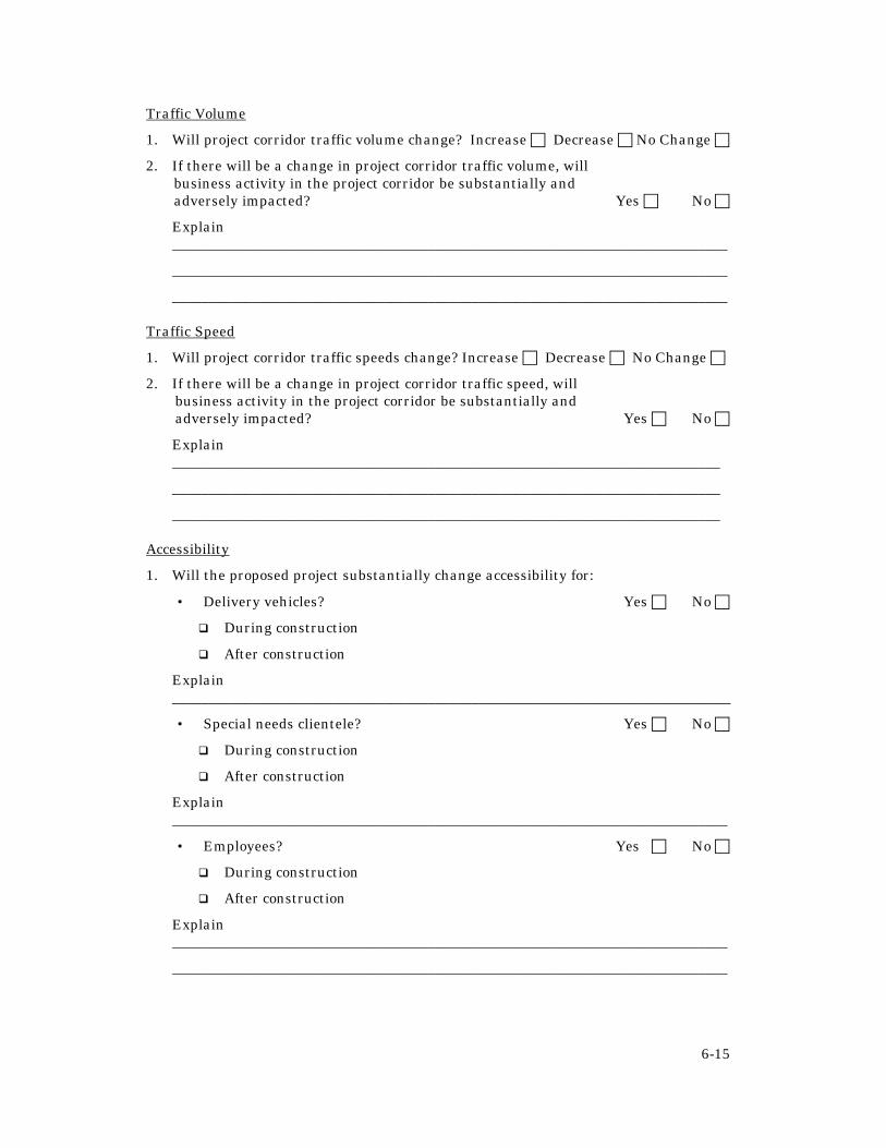
6-15
Traffic Volume
1. Will project corridor traffic volume change? Increase c Decrease c No Change c
2. If there will be a change in project corridor traffic volume, will business activity in the project corridor be substantially and adversely impacted? Yes c No c
Explain ____________________________________________________________________________
____________________________________________________________________________
____________________________________________________________________________
Traffic Speed
1. Will project corridor traffic speeds change? Increase c Decrease c No Change c
2. If there will be a change in project corridor traffic speed, will business activity in the project corridor be substantially and adversely impacted? Yes c No c
Explain ___________________________________________________________________________
___________________________________________________________________________
___________________________________________________________________________
Accessibility
1. Will the proposed project substantially change accessibility for:
• Delivery vehicles? Yes c No c
q During construction
q After construction
Explain _____________________________________________________________________________
• Special needs clientele? Yes c No c
q During construction
q After construction
Explain ____________________________________________________________________________
• Employees? Yes c No c
q During construction
q After construction
Explain ____________________________________________________________________________
____________________________________________________________________________

6-16
• Customers/Clients? Yes c No c
q During construction
q After construction
Explain ____________________________________________________________________________
• Others? Yes c No c
q During construction
q After construction
Explain ____________________________________________________________________________
2. Could business activity in the project corridor be affected by the project? Yes c No c
Explain ____________________________________________________________________________
____________________________________________________________________________
3. Will any specific project corridor business be substantially and adversely impacted? Yes c No c
If yes, which businesses and how ____________________________________________________________________________
____________________________________________________________________________
____________________________________________________________________________
Compatibility with Economic Development Plans
1. Is the proposed project located in a business district covered by an economic development program or plan? Yes c No c
2. If yes, does the proposed project support that program or plan? Yes c No c
Explain
____________________________________________________________________________
____________________________________________________________________________
____________________________________________________________________________
Residential Property Values
Residential Environment
1. Are the majority of abutting project corridor properties residential in nature? Yes c No c

6-17
2. Will the proposed project permanently change the residential environment in the project corridor by:
• Changing noise levels? Yes c No c
Will noise levels: Improve c Worsenc
• Changing air quality (dust, emissions, etc.)? Yes c No c
Will air quality: Improve c Worsen c
• Changing aesthetic qualities? Yes c No c
Will aesthetic qualities: Improve c Worsen c
• Changing amenities (pedestrian and bicycle facilities, parks, etc.)? Yes c No c
Will amenities: Improve c Worsen c
• Changing traffic volumes? Yes c No c
Will traffic volumes: Increase c Decrease c
• Changing travel speeds? Yes c No c
Will traffic speeds: Increase c Decrease c
• Other changes? _______________________________________________________________________
_______________________________________________________________________
3. Will residential property values in the project corridor be potentially, substantially, and adversely impacted as a result of the change in the residential environment? Yes c No c
Explain ____________________________________________________________________________
____________________________________________________________________________
____________________________________________________________________________
Regional Accessibility
1. Is the project study area substantially residential in nature? Yes c No c
2. Will the project substantially change accessibility between the project study area and other parts of the region?
Improve c Worsenc No Change c
3. If regional accessibility will change for study area residents, will residential property values?
Increase c Decrease c Explain ____________________________________________________________________________
____________________________________________________________________________
____________________________________________________________________________

6-18
Government Revenue
Property Conversion
1. Will taxable private property be permanently converted to public use? Yes c No c
2. Which taxing authorities currently rely on property tax revenue collected from properties that will be converted from private to public use? _____________________________________________________________________________
_____________________________________________________________________________
_____________________________________________________________________________
_____________________________________________________________________________
3. By how much ($) will revenue based on property taxation be reduced for each identified taxing authority ? _____________________________________________________________________________
_____________________________________________________________________________
_____________________________________________________________________________
4. For each taxing authority identified, what percentage of total annual budgets does the reduction in revenue represent?
_____________________________________________________________________________
_____________________________________________________________________________
_____________________________________________________________________________

6-19
MITIGATION AND PROBLEM SOLVING
Addressing Construction Stage Impacts
A variety of methods can be used to address business impacts during construction of the transportation improvement including, but not limited to, the following strategies:
1. Schedule construction for after business hours or to occur during times of low usage for seasonally-oriented businesses;
2. Stagger construction along a corridor so impacts are localized and staged;
3. Expedite construction through incentive/disincentive programs;
4. Avoid blocking business entrances with construction equipment or construction barriers;
5. Provide temporary and/or secondary business and residential access points, where feasible;
6. Clearly sign business entrances from the roadway;
7. Establish a single point of contact through which direct and regular communication with business and property owners can be achieved. This person does not need to be the project manager, but does need to be somebody who is well informed on all aspects of the proposed project. It may be useful to obtain the services of a local individual to fill this role, particularly where agency relations with the local community are strained;
8. Communicate the specifics of process and construction events with property and business owners;
9. Provide regular project progress reports to business and property owners;
10. Notify project corridor customers of impending construction activities and a contact for further information;
11. Avoid taking or blocking parking spaces whenever possible;
12. Provide alternative parking, where feasible; and
13. Provide technical assistance and support to local communities developing plans to minimize construction stage economic impacts (sales events, fairs, etc.). An example of this strategy can be found in a document by the Wisconsin Department of Transportation (In This Together: A Workbook To Help Wisconsin Businesses Thrive During Highway Construction, Wisconsin Department of Transportation, 1998).
Addressing Long-Term Impacts
The majority of long-term economic impacts are indirect and associated with other project impacts (e.g. changes in air and noise pollution, aesthetic character, traffic volume, relocation, etc.). Mitigation strategies related to other project impacts are discussed in the PD&E Manual and other chapters of this handbook. Additional

6-20
strategies, not discussed elsewhere, are listed below. Some of these strategies can only be implemented by local governments.
1. Improve signage for bypassed local business districts;
2. Joint-use of project right-of-way for such things as parking;
3. Implement economic development planning and incentive programs;
4. Improve accessibility of corridor business through joint and cross-access, shared access, and provision of alternative access roads. (see Managing Corridor Development: A Municipal Handbook, Center for Urban Transportation Research (CUTR), University of South Florida, 1996); and
5. Incorporate project design elements that enhance local business districts (e.g., pedestrian and bicycle amenities, improved landscaping, street furniture, etc.).
CONCLUSION Upon completing the economic assessment detailed in this chapter, the following actions should be completed: 1. Document all relevant actions taken, findings reached and commitments
made as part of the economic assessment;
2. File all relevant documentation related to the assessment of economic impacts in the official project file;
3. Incorporate the relevant findings of this assessment into the project development process in order to minimize the potential economic impacts of the final project; and
4. Incorporate the documentation developed as part of the economic assessment process into the relevant section of the environmental document under development for this project, per the Engineering Reports Chapter in Part 1 of the PD & E Manual.

7-1
CHAPTER 7 : LAND USE
OVERVIEW
Predicting how transportation projects will affect land use and community planning objectives is an important step in the community impact assessment process and is a required part of the Project Development and Environment process (Section 9-2.4). Although land use planning activities fall outside of the jurisdiction of transportation agencies, lack of consideration of land use impacts can counteract the effectiveness of long-range transportation planning and growth management efforts. The analysis of land use impacts improves the potential to coordinate with agencies involved in land use decisions and engage them in a collaborative planning process.
UNDERSTANDING POTENTIAL IMPACTS Transportation projects can affect the rate of growth and the development patterns of an area. Some types of development may be directly induced by the project. However, most land use impacts are not direct consequences of the project, but rather occur indirectly due to changes in travel time and increased land accessibility. The result may be shifts in the spatial distribution of development over time, including such common changes as the introduction of new activity centers along a widened suburban arterial highway or localized commercial development around a new rural highway interchange.
Regional growth patterns depend on a range of factors, including the availability of water and sewer service, access to an educated workforce, the health of the regional and local economy and the quality of transportation infrastructure. Regardless of the actual influence of transportation infrastructure on growth, it is clear that land use and transportation are interdependent. The rate and pattern of development in urban areas is a key factor in predicting the need for additional roadway capacity. At the same time, the availability and efficiency of transportation systems is a major factor in development decisions. Although it is not possible to determine precisely how a transportation project will affect regional growth patterns, the assessment effort will uncover information that could be of significant value to transportation, economic development, and growth management programs.
For more information on land use and transportation issues in Florida see the following reports:
Transportation and Growth Management: A Planning and Policy Agenda.
Planning, Zoning, & the Consistency Doctrine: The Florida Experience.
State Transportation Policy Initiative, Center for Urban Transportation Research, University of South Florida, Tampa.

7-2
Direct (Primary) Impacts
Direct land use impacts include the actual conversion of productive land to transportation use, the removal of existing uses to accommodate the facility and any immediate changes to the overall character of the affected area. Examples of direct impacts include:
• Displacement of homes and businesses;
• Demolition of homes and businesses;
• Loss of parking, water retention areas, drainage facilities, setbacks or buffer areas, and landscaping;
• Loss of or fragmentation of farmland and reduced agricultural productivity; and
• Loss of or encroachment on cultural or aesthetic resources and community facilities.
Indirect (Secondary) Impacts
Indirect or secondary impacts of transportation projects on land use tend to occur over a long period and may involve changes in the overall development and growth of an area. Indirect impacts from transportation improvements can also be cumulative. For example, the addition of a new interchange may not in and of itself influence regional development patterns, but a new intersection and new arterial roadway may cumulatively influence regional development patterns. These impacts will vary depending upon the nature of the transportation improvement and other characteristics of an area that affect growth rates. Indirect impacts that may be associated with highway projects appear in Table 7-1.
Regional growth inducement may result in impacts that are not only adverse to the community, but also can adversely impact the transportation investment. Imagine the following cyclical scenario:
1. Buildings are constructed in the planned future right-of-way of a proposed roadway, foreclosing opportunities to widen or interconnect roads where needed;
2. Thoroughfare frontage is strip zoned for commercial use or subdivided into small lots, with little attention to access control;
3. Poorly coordinated access systems force more trips onto the arterial;
4. Traffic conflicts multiply;
5. Crash rates rise;
6. Congestion increases;
7. Roadway improvements are needed sooner than expected; and
8. The cycle begins again, only structural improvements along the roadway have now increased the cost of future right-of-way and the ability to provide needed roadway capacity.

7-3
Table 7-1: General Relationship of Highway Proximity to Land Use Changes
Highway Proximity Type of Change General Relationship Comments
Residential Development Relationship varies
Complex relationship. Low-density single-family development is often independent of highways. Highways appear to promote conversion of vacant (farm) land to low-density residential use at the urban fringe (although generally some distance from the highway).
Industrial and Commercial Development
Moderate-Strong Catalyst
Highways promote conversion of vacant and residential land to commercial and industrial uses. Increased accessibility provided by highways introduces pressures for commercial development. Arterial streets and radial highways tend to promote strip development; circumferential highways promote more comprehensive development. Land use changes are most rapid and intensive at or near interchanges.
Source: Louis Berger & Associates, NCHRP Report 403: Guidance for Estimating the Indirect Effects of Proposed Transportation Projects, Transportation Research Board, Washington D.C.: National Academy of Sciences, 1998, p. 82.
This counterproductive land use and transportation cycle reduces the life of a transportation facility; and increases the potential for adverse community impacts. Conducting a community impact assessment can help raise awareness of the land use and transportation cycle, and local support for a more effective and coordinated transportation and land use planning process.
DATA SOURCES Data for the land use assessment should have largely been assembled in the development of a community profile (see Chapter 4). The most important data for the land use analysis include the following geographic and policy information:
• Existing land use and land cover
• Property ownership and plat maps

7-4
• Existing zoning
• Planned future land use
• Local growth management policies and regulations (both adopted and pending) relating to corridor development (e.g., access management, urban service areas, etc.)
• Other local plans or programs affecting corridor development (eg, community redevelopment areas, Main Street program, neighborhood planning studies, etc.).
ASSESSMENT TECHNIQUES
Assessing Direct Impacts
Direct land use impacts result from right-of-way acquisition and can be determined by comparing existing land use data obtained through the land use inventory described in Chapter 4, to proposed alternative alignments. Develop a list of potentially impacted properties for each project that outlines the extent of the potential impact. This should include a description of the existing land use (residential, commercial, industrial, etc), the amount of land potentially acquired and the specific use of the land to be acquired (parking, landscaping, drainage facility, etc.). As mentioned in Chapter 4, field surveys are recommended as they can reveal useful information that may not be apparent from reviewing secondary sources. In terms of direct impacts, potential adverse impacts to look for include:
• Loss of parking;
• Loss of storm water retention ponds and other drainage facilities; and
Figure 7-1: Sample map of zoning and property ownership information. Zoning categories vary across jurisdictions, but tend to be defined as follows: R = residential, C = commercial, MF = multiple family residential. Designations of 1-3 indicate level of intensity or density with 1 being the lowest. R-1, for example, is single family residential.
7-5
• Loss of landscaping, buffers or setback space.
Document potential direct impacts of each project alternative for each affected property. This information will prove useful in the right-of-way acquisition process and in understanding potential ways to address direct adverse impacts in project development. Sample strategies are discussed at the end of this chapter and throughout the handbook.
Determination of Growth Inducement
The determination of growth inducement establishes whether project alternatives will induce growth or alter the planned pattern of development. There are three general categories of induced growth related to transportation projects:1
1. Projects serving specific land development, such as a highway interchange for a theme park;
2. Projects that would likely stimulate complementary land development, such as the development of a hotel near a large airport; and
3. Projects that would likely influence regional land development location decisions, such as a new highway providing convenient access to developable land on the fringe of a metropolitan area.
Determining if a transportation project falls within the first two categories of growth inducement is fairly straightforward. Determining if a transportation project would influence intra-regional land development decisions is less straightforward and more subjective. However, if conditions are generally favorable for growth in a region (sewer lines, relatively low land prices, natural amenities, etc.), then transportation improvements can dramatically influence the rate and location of development. A land use modeling approach can be applied to make this determination. However, this approach is both data intensive and expensive. A less expensive and equally effective approach, recommended in this handbook, employs a checklist to determine regional growth inducement potential. The checklist approach provides guidance toward a general conclusion on growth inducement potential through the systematic consideration of common market factors applied by real estate investors when making a development or purchase decision. To determine the potential for the project to induce growth in the study area, complete the following checklist. Some of the questions can be answered by consulting publicly available information such as U.S. census data, U.S. Geological Survey topographic maps and road maps. Other information, including known future development trends, will require contact with planners, officials, and real estate professionals familiar with the region or locality in question. As with the consistency determination, the key to making a reasonable determination of growth inducement is to involve study area stakeholders in the process. In addition, the number and type of questions addressed will need to be tailored to the study area and the type of project.
1 Louis Berger & Associates, NCHRP Report 403: Guidance for Estimating the Indirect Effects of Proposed Transportation Projects, Transportation Research Board, Washington D.C.: National Academy of Sciences, 1998.
7-6
Determination of Consistency
Urban planning programs rely on reasonable consistency between transportation and land use plans and projects. Without that consistency, it is difficult to accomplish desired objectives. The purpose of the consistency determination is to assure that the final project conforms to and supports, as much as feasible, the planning objectives of the affected area. Because land use and transportation are interdependent, the consistency determination will involve both land use and transportation plans and issues in the affected area. Making a consistency determination is fairly subjective and requires a combination of common sense and some working knowledge of transportation and growth management issues. In addition, because it is essentially a policy determination, the determination of consistency must be made in the context of the local political and socio-economic environment.
Below is a general process for determining the consistency of the transportation project with local and regional growth management plans. It should be modified as necessary to accommodate local circumstances.
1. Work with local government and regional planning council staff to identify current adopted plans for each affected jurisdiction. This includes all officially adopted regional and local plans that establish transportation and growth management policies and objectives for the study area. Primary sources include local government comprehensive plans and resulting land use regulations and strategic regional policy plans. Other important sources include adopted neighborhood plans, community redevelopment area plans, corridor management plans, transit development plans, or other officially adopted sub-area or program plans. A complete list of potential data sources appears in Chapter 4 (land use and transportation inventory).
2. Consider the nature of the proposed project and review the identified plans to identify potential consistency issues. This review must be conducted for each project alternative as potential issues may vary. Examples of policies, objectives, or issues that might have a bearing on the consistency determination include:
• A local comprehensive plan policy to avoid adding capacity to major roadways outside of an adopted urban service area;
• A Main Street Plan objective to provide on street parking and street furniture to improve the image of a downtown shopping area;
• A Transit Development Plan policy to co-develop bus transfer centers along new state roadways.
• A Regional Policy Plan policy aimed at improving hurricane evacuation routes.
An effective approach is to begin by strategically scanning the material for background information and potentially relevant policies, objectives, or issues. Next, meet with local planners and other agency staff to discuss your preliminary findings and obtain further information on land use and transportation issues of relevance to the project. Then review the pertinent sections of the plans more closely to be sure that your information is complete.

7-7
It is a good idea to meet with staff of all potentially affected agencies, including regional planning councils, water management districts, or other agencies that have an obvious interest in transportation or land use issues. During these meetings, also explore the role of each agency in helping address these issues.
3. Summarize your findings. Briefly describe the type of plan reviewed and any potential consistency issues that arose through the review or discussion with agency staff. Be specific in describing the nature of the consistency issue and the potential role of each agency in addressing these issues. Also, document any relevant policies or objectives that are clearly in conflict with each other. This could be summarized briefly in text form and with a matrix that compares alternatives against various policies and each other. For example, taking the examples from #2 above, the summary may find that:
“Alternative A and B would add capacity outside the urban service area boundary and are inconsistent with Policy 1.1 of the local comprehensive plan, but consistent with Policy 2.3 of the Regional Policy Plan that calls for improved hurricane evacuation routes. Alternative C involves no new capacity but would upgrade the roadway to higher design standards. It includes paved shoulders that could be converted to additional lanes during emergency hurricane evacuation. It also provides enough right-of-way that it could be widened if desired in the future. This alternative is consistent with the local comprehensive plan and could accommodate hurricane evacuation needs.”
Proposed Alternative Urban
Service Area Hurricane Evacuation
Main Street
(A) 6 lanes m l m (B) Bypass m l l (C) Median / Wide Shoulder l w l
l Consistent w Fairly Consistent m Inconsistent
4. Review the draft consistency determination with agency staff and study area stakeholders and revise the draft accordingly. This will broaden the perspective of the findings by incorporating opinions provided by individuals with various points of view. The benefit of this exercise is that potentially controversial items, which might arise at the public hearing, will be addressed early in the process.
Where project alternatives are determined to be consistent, no more action is required beyond documenting the process and findings. Where the project alternatives are determined to be clearly inconsistent, strategies to either make the project alternatives consistent or to address their potential adverse impacts must be developed. These strategies are discussed in the section of this chapter entitled, “Mitigation and Problem Solving.”

7-8
Checklist To Evaluate Growth Inducement Potential
Directions: The purpose of this checklist is to help determine the potential for the proposed project to induce growth in the study area. Check the most appropriate response in the box or provide the appropriate answer. This information provides background for completing the rest of the checklist. The data required to complete this section of the checklist should already be available from the community profile (see Chapter 4). Additional data can be obtained through discussion with local authorities, stakeholders, and other local sources. Once completed, include the checklist in the project files or the final Community Impact Assessment report.
Background Information
Generalized Setting Within Metropolitan Statistical Area (Identify MSA) c Both Inside and Outside MSA c Outside MSA c Indicate Distance to Nearest Metropolitan Center ________ Population
Trend Projection Declining c ________ Static ( + 1%/10 years) c ________ Slow Growth c ________ Rapid Growth (> 10%/10 years) c ________
Employment
Trend Projection Declining c ________ Static ( + 1%/10 years) c ________ Slow Growth c ________ Rapid Growth (> 10%/10 years) c ________
Regional Study Area Conditions Directions: A “yes” answer indicates that conditions generally favor growth. The more “yes” answers, the higher the certainty that regional conditions generally favor growth. Is the regional population increasing rapidly (generally, > 10% per 10 years)? c Yes c No Is the region considered favorable for receiving FHA/VA loans ? c Yes c No Are there any major growth generators (e.g. universities, military installations, industries, tourist attractions) in the region? c Yes c No Is the regional office/commercial market characterized by low (generally, < 10%) vacancy rates in any class of space? c Yes c No

7-9
Is the region’s business and civic leadership committed to rapid development? c Yes c No Are there other state or federal policies or programs affecting regional study area conditions? c Yes c No
Is the region an exporter of natural resources? c Yes c No
Local Study Area Conditions
Directions: If regional conditions generally favor growth based on the answers to the preceding questions, then proceed with the next series of questions. A “yes” answer indicates that the area in the immediate project vicinity has land use conversion potential; the more “yes” answers, the higher the certainty that land use conversion will be induced by the project.
GENERAL INDICATORS
Is the regional path of development in the direction of the local study area? c Yes c No Is the project within 5 miles of a growing community (generally, >5% per 10 years)? c Yes c No Is the local study area characterized by middle and/or high-income levels? c Yes c No Is the local study area free of moratoriums on development (e.g. sewer moratoriums, growth restrictions)? c Yes c No
INDICATORS OF CONDITIONS FAVORABLE TO CONVERSION OF LOWER DENSITY DEVELOPMENT
Is the local study area within a 30-minute drive of a major employment center? c Yes c No Does the local study area have relatively high land availability/low land prices (generally <one-third of larger parcels developed)? c Yes c No Is the vacant land characterized by relatively large parcels? c Yes c No Is the local study area characterized predominantly by level land (generally, <5% slope)? c Yes c No Is the project’s Potential Impact Area characterized by soils suitable for development? c Yes c No Is the project’s Potential Impact Area predominantly free of flooding or wetlands? c Yes c No
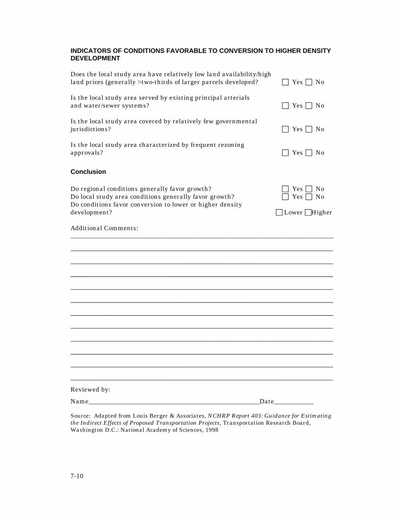
7-10
INDICATORS OF CONDITIONS FAVORABLE TO CONVERSION TO HIGHER DENSITY DEVELOPMENT
Does the local study area have relatively low land availability/high land prices (generally >two-thirds of larger parcels developed? c Yes c No Is the local study area served by existing principal arterials and water/sewer systems? c Yes c No Is the local study area covered by relatively few governmental jurisdictions? c Yes c No Is the local study area characterized by frequent rezoning approvals? c Yes c No
Conclusion Do regional conditions generally favor growth? c Yes c No Do local study area conditions generally favor growth? c Yes c No Do conditions favor conversion to lower or higher density development? c Lower cHigher Additional Comments: ________________________________________________________________________________
___________________________________________________________________
___________________________________________________________________
___________________________________________________________________
___________________________________________________________________
___________________________________________________________________
___________________________________________________________________
___________________________________________________________________
___________________________________________________________________
___________________________________________________________________
___________________________________________________________________
___________________________________________________________________
Reviewed by:
Name____________________________________________________Date____________ Source: Adapted from Louis Berger & Associates, NCHRP Report 403: Guidance for Estimating the Indirect Effects of Proposed Transportation Projects, Transportation Research Board, Washington D.C.: National Academy of Sciences, 1998

7-11
Transportation alternatives can be evaluated for their ability to stimulate desirable land use changes and avoid adverse impacts on community development and growth management objectives. When project alternatives are identified as having the potential to adversely impact land use patterns in the community, methods to address those potential impacts need to be developed and documented as part of the community impact assessment.
If it is determined that the project alternatives would not induce growth, then no further action is required beyond documenting the process and findings. If it is determined that growth will be induced by the project alternatives, then determine if the potential for induced growth is consistent with local land use planning objectives for the study area. This can be achieved by reviewing issues and findings raised in the consistency review and considering the future land use plan for the study area.
If the potential for growth inducement is largely consistent with local future land use plans, then no further action is required beyond documenting the process and findings. If the potential exists for growth inducement that is significantly inconsistent with local comprehensive plans, neighborhood or community desires, or that could adversely affect the transportation investment, then the next step is to consider alternative strategies for addressing potential growth impacts.
MITIGATION AND PROBLEM SOLVING
Many methods for addressing potential impacts cannot be implemented by transportation agencies, but are the responsibility of one of the stakeholder organizations (local jurisdictions, water management districts, federal agencies, etc.). Strategies for addressing project impacts should be identified and pursued, regardless of the lead agency involved in implementation. The community impact assessment process is an opportunity for the transportation agency to overcome jurisdictional barriers and partner with stakeholder agencies and organizations on creative solutions to transportation and development problems.
An example of this type of partnering might be a local jurisdiction implementing access management overlay zoning along a project corridor to preserve the character of the corridor and reduce adverse impacts of development on the roadway. In this example, only the local jurisdiction has the authority to implement the needed zoning changes, but the transportation agency could lend technical assistance. Another example might be partnering with local agencies on the provision of alternative parking areas within walking distance of properties that have lost parking due to the project.
Also look for ways that the project may be able to help solve community problems. Some areas have contaminated brownfield sites that have not been developed due to clean up costs. In this scenario transportation agencies could consider locating transportation projects on brownfield sites and to configure transportation systems to assure that sites slated for redevelopment are well served by transportation (see “Reuse of Contaminated Sites”).

7 -12
There are four primary methods for addressing impacts, as adapted from Community Impact Assessment: A Quick Reference for Transportation, Federal Highway Administration
1. Avoidance – Alter the project to avoid a potential impact. Examples include:
a. Shifting alignment to avoid taking parking areas, storm water retention facilities, or other direct impacts; or
b. Bridging over a roadway segment to avoid cutting off the main access point to a shopping center.
2. Minimization – Modify the project to reduce the severity of the impact. Examples include:
a. Providing on-street parking instead of additional travel lanes in a Main Street area; or
b. Shifting a project to minimize the impact on productive farmland.
3. Mitigation – Undertake an action to alleviate or offset an impact or to replace an appropriated resource. Examples include:
a. Working with local governments on development of an access management plan and regulations for the corridor;
b. Constructing a parking structure to compensate for lost private parking.
4. Enhancement – Add a desirable or attractive feature to the project to make
it fit more harmoniously into the community (not designed to replace lost resources or alleviate impacts caused by the project). Examples include:
a. Providing textured pedestrian crossings in downtown areas; b. Adding landscaping and other amenities to the facility design.
Reuse of Contaminated Sites for Transportation Projects
In May 1998, U.S. Transportation Secretary Rodney E. Slater announced a new department policy that provides states and communities the flexibility to use and redevelop contaminated "brownfields" in transportation projects. The new DOT policy changes a long-standing department policy that called for avoiding contaminated sites wherever possible. The change provides states, localities and transit agencies the choice to locate transportation projects on brownfield sites and to configure transportation systems to assure that sites slated for redevelopment are well served by transportation.
Brownfields are abandoned, idled or under-used commercial, industrial and institutional properties where redevelopment and reuse are complicated by light-to-moderate contamination from hazardous substances and wastes. The properties are most often located in urban areas previously used by industrial and commercial operations that generated waste. The Brownfields Economic Redevelopment Initiative empowers states, communities and the private sector to work together to assess, clean up and reuse contaminated properties. The program is administered by the Environmental Protection Agency.

7-13
CONCLUSION Upon completing the analysis detailed in this chapter, the following actions should be completed: 1. Document all relevant actions taken, findings reached and commitments
made as part of the land use analysis conducted per the direction of this chapter;
2. File all relevant documentation related to the land use analysis per the direction of this chapter in the official project file;
3. Incorporate the relevant findings of this analysis into the project development process in order to minimize the potential land use impacts of the final project on the community; and
4. Incorporate the documentation developed as part of the process described in this chapter into the relevant section of the environmental document under development for this project per Section 9-2.4 of the Project Development and Environment Manual.

8-1
CHAPTER 8 : AESTHETICS AND LIVABILITY
OVERVIEW
Community aesthetics and livability have historically been given low priority during the development of transportation projects. Yet potential impacts on aesthetics and community character are often the source of community resistance to transportation projects. This is because aesthetic impacts are easily understood, emotional and highly subjective. Civic pride is often associated with the aesthetic and visual qualities of a community — qualities that make a community unique among its neighbors and special to its residents.
Inattention to aesthetics and cultural resources during project development and design can adversely affect cherished community resources and greatly increases the likelihood of active opposition to a proposed transportation project. For these reasons, the Project Development and Environment (PD&E) Manual (Section 15-1) requires consideration of aesthetic and visual impacts during the PD&E process. Any project where a genuine concern is expressed for the aesthetic character of a community and where members of the community are included in the development of solutions will have a greater chance of success.
UNDERSTANDING POTENTIAL IMPACTS A community aesthetic and visual resource can be broadly defined as a natural or cultural feature of the environment that elicits positive sensory reactions and evaluations by the observer.”1 Examples might include street trees, scenic views, historic districts and structures, local landmarks, and cultural resources like libraries, town halls, civic centers and college campuses. An aesthetic and visual detractor can be defined as a structure or feature that elicits a pronounced negative sensory reaction and evaluation by the observer. Possible detractors might be a landfill, auto salvage yard, abandoned building, or a deteriorating industrial structure.
Aesthetic resources and detractors collectively define the aesthetic character of a community and contribute to its “sense of place.” Various user groups within the community often define these qualities differently. The lasting image a visitor has of a community or neighborhood, for example, is often based on the view of that community from a transportation facility (i.e., road, bus transfer center, airport, train, etc.). Residents of the community or neighborhood may define its character based upon local landmarks or features that may not be apparent to the casual visitor.
1 L. Canter, Environmental Impact Assessment, 2nd Edition, New York: McGraw Hill, 1996.
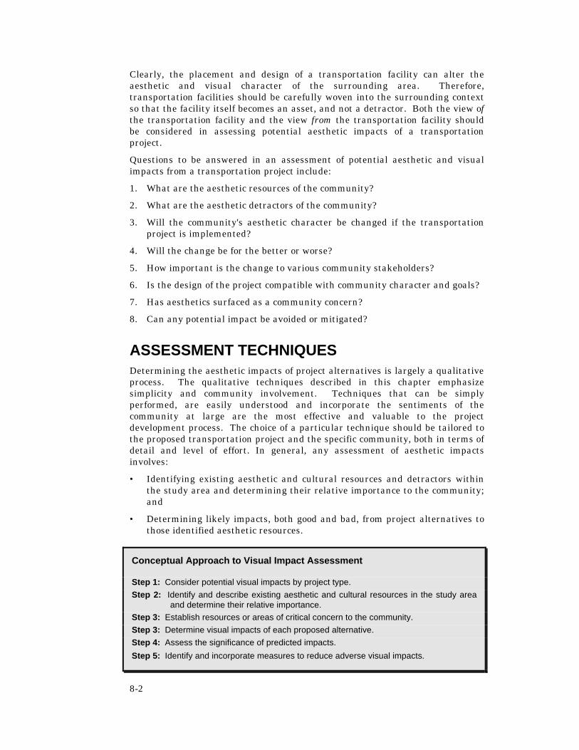
8-2
Clearly, the placement and design of a transportation facility can alter the aesthetic and visual character of the surrounding area. Therefore, transportation facilities should be carefully woven into the surrounding context so that the facility itself becomes an asset, and not a detractor. Both the view of the transportation facility and the view from the transportation facility should be considered in assessing potential aesthetic impacts of a transportation project.
Questions to be answered in an assessment of potential aesthetic and visual impacts from a transportation project include:
1. What are the aesthetic resources of the community?
2. What are the aesthetic detractors of the community?
3. Will the community's aesthetic character be changed if the transportation project is implemented?
4. Will the change be for the better or worse?
5. How important is the change to various community stakeholders?
6. Is the design of the project compatible with community character and goals?
7. Has aesthetics surfaced as a community concern?
8. Can any potential impact be avoided or mitigated?
ASSESSMENT TECHNIQUES Determining the aesthetic impacts of project alternatives is largely a qualitative process. The qualitative techniques described in this chapter emphasize simplicity and community involvement. Techniques that can be simply performed, are easily understood and incorporate the sentiments of the community at large are the most effective and valuable to the project development process. The choice of a particular technique should be tailored to the proposed transportation project and the specific community, both in terms of detail and level of effort. In general, any assessment of aesthetic impacts involves:
• Identifying existing aesthetic and cultural resources and detractors within the study area and determining their relative importance to the community; and
• Determining likely impacts, both good and bad, from project alternatives to those identified aesthetic resources.
Conceptual Approach to Visual Impact Assessment
Step 1: Consider potential visual impacts by project type. Step 2: Identify and describe existing aesthetic and cultural resources in the study area
and determine their relative importance. Step 3: Establish resources or areas of critical concern to the community. Step 3: Determine visual impacts of each proposed alternative. Step 4: Assess the significance of predicted impacts.
Step 5: Identify and incorporate measures to reduce adverse visual impacts.
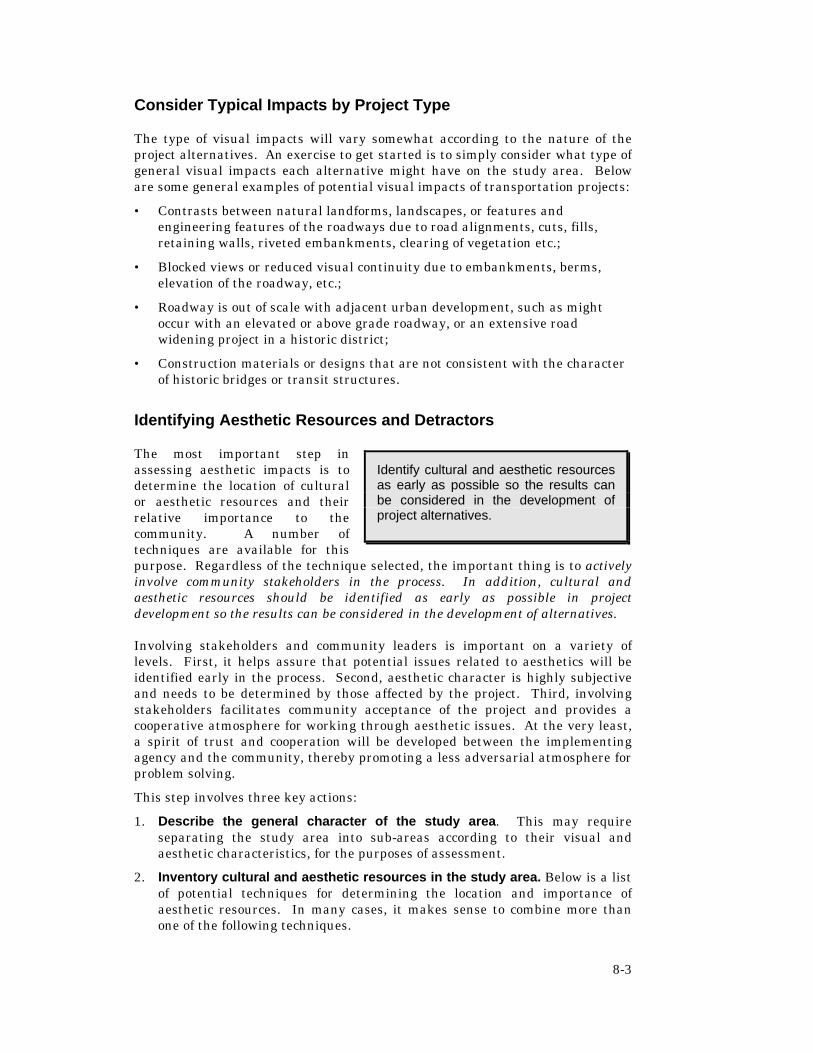
8-3
Consider Typical Impacts by Project Type
The type of visual impacts will vary somewhat according to the nature of the project alternatives. An exercise to get started is to simply consider what type of general visual impacts each alternative might have on the study area. Below are some general examples of potential visual impacts of transportation projects:
• Contrasts between natural landforms, landscapes, or features and engineering features of the roadways due to road alignments, cuts, fills, retaining walls, riveted embankments, clearing of vegetation etc.;
• Blocked views or reduced visual continuity due to embankments, berms, elevation of the roadway, etc.;
• Roadway is out of scale with adjacent urban development, such as might occur with an elevated or above grade roadway, or an extensive road widening project in a historic district;
• Construction materials or designs that are not consistent with the character of historic bridges or transit structures.
Identifying Aesthetic Resources and Detractors
The most important step in assessing aesthetic impacts is to determine the location of cultural or aesthetic resources and their relative importance to the community. A number of techniques are available for this purpose. Regardless of the technique selected, the important thing is to actively involve community stakeholders in the process. In addition, cultural and aesthetic resources should be identified as early as possible in project development so the results can be considered in the development of alternatives.
Involving stakeholders and community leaders is important on a variety of levels. First, it helps assure that potential issues related to aesthetics will be identified early in the process. Second, aesthetic character is highly subjective and needs to be determined by those affected by the project. Third, involving stakeholders facilitates community acceptance of the project and provides a cooperative atmosphere for working through aesthetic issues. At the very least, a spirit of trust and cooperation will be developed between the implementing agency and the community, thereby promoting a less adversarial atmosphere for problem solving.
This step involves three key actions:
1. Describe the general character of the study area. This may require separating the study area into sub-areas according to their visual and aesthetic characteristics, for the purposes of assessment.
2. Inventory cultural and aesthetic resources in the study area. Below is a list of potential techniques for determining the location and importance of aesthetic resources. In many cases, it makes sense to combine more than one of the following techniques.
Identify cultural and aesthetic resources as early as possible so the results can be considered in the development of project alternatives.

8-4
3. Determine the relative importance of each resource or detractor and identify resources of critical aesthetic or cultural concern. This step involves taking the master list of resources and detractors and applying a voting or ranking procedure to identify their relative importance. Identify any visual resources that are most highly valued by the community and that are highly sensitive to change. These areas would be categorized as resources of critical concern and would be considered more significant for the purposes of assessment. They would receive more careful consideration in project development to avoid or minimize potential adverse impacts. This effort may benefit from broader community participation than occurred during in the inventory. Sample ranking techniques are described below.
Review of Agency Plans and Policies
This technique is a component of the consistency determination described in the Land Use chapter, and should be conducted at the same time. It involves identifying those goals and objectives pertaining to aesthetic and visual resources. Examples might include goals and objectives related to:
1. Preserving of the rural or historic character of an area,
2. Preserving the character of a neighborhood or retail area; or
3. Preserving of a locally significant view shed, landmark, or resource.
The key to determining if these goals and objectives are important to the community is to give study area stakeholders ample opportunity to comment on them. Allowing stakeholders to define which goals and objectives are most important will sensitize the project development process to these issues. Try to reach as many interested stakeholders as possible in this process. Because this technique does not require gathering people in a room, it can be accomplished with a large number of interested parties.
One of the main benefits of this approach is broad community involvement. It also allows interested parties to self-select so that those who are really interested can review and respond and those who are not interested can simply choose to not participate. In addition, interested parties can contact others in the community and have them participate as well. In this manner, the widest possible variety of interests can be accounted for in determining what aesthetic resources are important to consider and which ones have the potential of being degraded or enhanced by the project alternatives.
Stakeholder Workshop
This technique involves gathering a group of stakeholders in a workshop format to identify important community aesthetic and visual resources and detractors. The number of stakeholders invited to participate should be manageable and appropriate given the size and diversity of the study area. The best stakeholders to invite are those with authority to represent many other stakeholders. Examples might include the president of the local chamber of commerce, the director of the local tourism association, a local elected official, the president of area home owners or neighborhood associations, president of a local environmental group, the head of a local historic preservation society, the

8-5
local planning director, and so on. Always invite any member of the community who has expressed a strong interest in participating. Below is a sample process for conducting the workshop. (A variation of this technique is the photographic log described below.)
1. Separate stakeholders into small groups and provide each group with an aerial photograph of a section of the study area.
2. Ask each group to collectively identify the important aesthetic and visual resources of the study area and any major detractors, and to circle or otherwise note the location of each important aesthetic community resource directly on the aerial photograph of the study area. (Note: Depending upon the size or complexity of the project, other potential options might include a full group brainstorming session and/or nominal group technique as described in Appendix A).
3. Next ask them to identify aesthetic detractors – structures or features that substantially detract from the aesthetic quality of the community.
4. Have each group prepare a brief written description of their identified resources and detractors. These descriptions could be attached to the aerial photograph on post-it notes or with tape. Then have the complete a more detailed description for each item. For resources, consider providing them with a log worksheet such as the following:
Sample Resource Log:
Description: ______
______
Location: ______
This resource is important because:
5. Reassemble the groups and ask them to pick a spokesperson to share their results. Ask the broader group if they missed any major resources or detractors and add these to the map.
6. Establish the relative priority or significance of the resource or detractor. This could be determined through a ranking method, similar to that provided in Table 8-1 below. The written description could also be taken into account in determining importance.
7. The final step is to transfer all the resources and detractors onto a master list to accompany the aerial photos. Consider developing a conceptual map that identifies their location. The map and master list could be disseminated to a broader group if desired and will provide the basis for assessing aesthetic impacts of various project alternatives. The product of these brainstorming sessions will be a series of geographically identified aesthetic resources and detractors, complete with descriptions, that are deemed important to the community by the stakeholders group. Project

8-6
alternatives could then be developed that avoid disrupting aesthetic and cultural resources. If need be, the stakeholder group could be reassembled later to review project alternatives against their previously selected aesthetic resources and detractors.
Stakeholder Photographic Log
This technique involves providing disposable cameras to a group of stakeholders and asking them to photograph the aesthetic and cultural resources they individually find important to the character of the study area, as well as those features that significantly detract from the aesthetic appeal of the area. Stakeholders are asked to maintain a log of their photographs that describes the location of each photograph and what is important about that resource or detractor. The cameras and logs are then gathered and sorted by stakeholder and resource. A master list is then developed, describing each resource and detractor identified by the stakeholder group.
The last step is to call a meeting of the stakeholder group to give them an opportunity to review and prioritize the completed master list of resources and detractors. This could be accomplished using the workshop ranking procedure described above. Send the master list and ranking directions to the stakeholders well in advance of the meeting to provide ample opportunity for them to review it. During the meeting, stakeholders should be asked to reach consensus on a final master list and to rank each item.
Table 8-1: Sample Ranking Method:
Directions: Ask each participant to review the list of resources and detractors and next to each one provide the number that best answers the following question using the scale provided below:
With regard to the character of the area, I would rate this feature as: _______
Sample Ranking Scale
Resources Detractors +4 Critical -1 Somewhat negative +3 Very positive -2 Negative +2 Positive -3 Very negative +1 Somewhat positive
0 Not significant Write the list on a flip chart and ask stakeholders to indicate their rating next to each resource and detractor (or review the list one by one and count hands). Call a short break and work with a volunteer to summarize the results of the ranking. Based on your general impressions of the results (or by calculating the score), categorize the list of resources by general level of importance, such as critical, important, and worthy of consideration. Review the results with participants. Ask them if they would revise the list and refine accordingly. Do the same for detractors, perhaps categorizing them as major or minor detractors.

8-7
Local Expert Walking Tour
This technique employs a local individual with substantial knowledge of the area’s history or architecture to assist in identifying important aesthetic and cultural resources and detractors. In this technique, a recognized expert on local cultural and aesthetic resources (such as a community historian) leads the analyst on a tour of the study area corridor. During that tour the expert identifies all the important cultural and aesthetic resources and any major detractors. The analyst takes notes during the tour, including the exact location, description, and all other relevant information. After the walking tour is complete, each feature identified by the expert should be located on a conceptual map of the study area along with a master list and description of the features. A community meeting or workshop may be called to present the map and list to area stakeholders, refine the list, and rank each item (see stakeholder workshop above). Forward this information to stakeholders well in advance of the meeting to provide ample opportunity for review.
Modified Visual Preference Survey
The Visual Preference Survey technique, developed by A. Nelessen Associates, can be adapted for project development purposes to gain an understanding of a community’s aesthetic preferences related to project design. In this technique, a group of local stakeholders evaluates a series of slides and scores the images according to their initial reactions as to whether the image is appealing and would be appropriate for the subject community or study area. The slide images could represent features relevant to the particular project, such as streetscapes, types of medians, bikeways, sidewalks, recreational areas, drainage structures, bridges, parking options, or transit station areas. The technique works best if the stakeholders cannot recognize the exact location of the images so as not to bias responses based on experiences not relevant to the aesthetic character of the images presented.
Stakeholders are allowed to view each image one at a time for approximately 10 seconds per image. They should rate the image on a scale between –10 and +10 based on their initial emotional response to the image. The total score for each image should be calculated and the images should be ranked from most points to least. Higher scores indicate stakeholder preference for the perceived positive aesthetic characteristics of that image.
Results are used to summarize what stakeholders have identified as the most preferred images related to planning and design in their community. The summary could then be applied to guide the development of project alternatives and conceptual designs. For example, the summary would allow project planners to gain an understanding of a community’s preferences for aesthetics and functionality of a particular roadway cross section, or bridge, as well as the types of amenities that could be provided to mitigate adverse aesthetic impacts of a project.

8-8
Determining Visual Impacts
Potential visual impacts associated with project alternatives can be determined after the important aesthetic resources and detractors have been identified. Checklists provide a straightforward approach to assessing potential aesthetic impacts related to transportation alternatives. Another supporting technique is the map overlay. These techniques are recommended as they are cost effective and can be readily incorporated into the project development process. Other techniques, such as computer simulation or bringing in special expertise, are provided for more unique circumstances where aesthetics is a significant concern or for more extensive and complex projects. Each of the techniques is described below.
Overlay Maps
Using the information on aesthetic and cultural resources and detractors from the methods above, locate each cultural and aesthetic resource and detractor in the study area on an aerial photo or conceptual map of the study area. Prepare acetate overlays of each project alternative and lay them onto this map. Summarize the aesthetic impacts of each alternative, indicating the number of features potentially affected, the nature of the feature, and potential strategies for reducing adverse impacts of each alternative. Review the results with stakeholders in the study area and refine as needed. This technique can be combined with the checklist below.
Visual Assessment Checklist
Using the information on resources and detractors, complete the following visual assessment checklist for each project alternative. The checklist is a general guide and may need to be modified to meet specific project or community needs. No scoring mechanism is provided for the checklist. Rather, it is designed to encourage critical consideration of all potential impacts of the project. Look critically at each project alternative in light of its potential aesthetic impacts from the perspective of various affected parties, such as the commuter, the neighbor, or customers and proprietors of abutting businesses. Using answers to the checklist, develop a summary outlining potential aesthetic and visual impacts of each project alternative. Next, provide the summary to stakeholders for their review and input to assure it is complete and accurate. Ask stakeholders if they concur with the identified impacts and if there are any additional impacts that should be added. The results of the checklist and the stakeholder review can be used to guide the project development process.
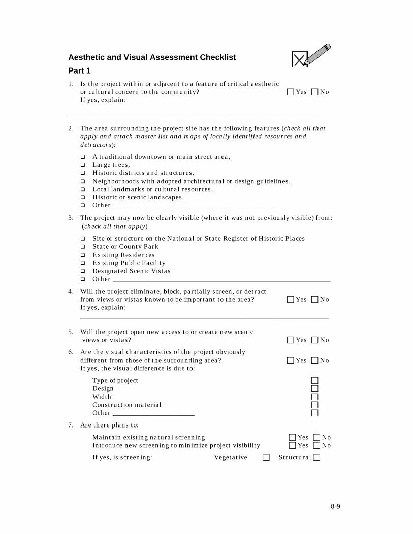
8-9
Aesthetic and Visual Assessment Checklist
Part 1
1. Is the project within or adjacent to a feature of critical aesthetic or cultural concern to the community? c Yes c No If yes, explain:
__________________________________________________________________________
2. The area surrounding the project site has the following features (check all that apply and attach master list and maps of locally identified resources and detractors):
q A traditional downtown or main street area, q Large trees, q Historic districts and structures, q Neighborhoods with adopted architectural or design guidelines, q Local landmarks or cultural resources, q Historic or scenic landscapes, q Other _______________________________________________
3. The project may now be clearly visible (where it was not previously visible) from: (check all that apply)
q Site or structure on the National or State Register of Historic Places q State or County Park q Existing Residences q Existing Public Facility q Designated Scenic Vistas q Other ________________________________________________________________
4. Will the project eliminate, block, partially screen, or detract from views or vistas known to be important to the area? c Yes c No If yes, explain: _________________________________________________________________________
5. Will the project open new access to or create new scenic views or vistas? c Yes c No
6. Are the visual characteristics of the project obviously different from those of the surrounding area? c Yes c No If yes, the visual difference is due to:
Type of project c Design c Width c Construction material c Other ________________________ c
7. Are there plans to:
Maintain existing natural screening c Yes c No Introduce new screening to minimize project visibility c Yes c No
If yes, is screening: Vegetative c Structural c

8-10
8. Is there local opposition to the project entirely, or in part, because of visual or aesthetic aspects? c Yes c No
9. Is there public support for the project because of
its visual qualities? c Yes c No
Part 2
Apply the following series of questions to help determine the importance of each visual impact. These include:
1. What is the probability of the (visual) effect occurring? c High c Moderate c Low
2. What will be the duration of the (visual) impact? c Temporary c Permanent
3. Is the (visual) impact irreversible? c Yes c No
4. Will the (visual) character of the community be permanently altered? c Yes c No
5. Can the (visual) impact be reduced? c Yes c No If yes, explain: ___________________________________________________________________________
6. Is there a regional or statewide consequence to this (visual) impact? c Yes c No If yes, explain: ___________________________________________________________________________
7. Will the potential (visual) impact be detrimental to community goals and values? c Yes c No If yes, explain: ___________________________________________________________________________
8. Are the potential (visual) impacts inconsistent with officially adopted local plans, policies or objectives related to community character? c Yes c No If yes, explain ___________________________________________________________________________
Source: Adapted from Smardon, Palmer and Fellman, Foundation for Visual Project Analysis, John Wiley and Sons, New York, 1986, pp. 154-15.

8-11
Computer Visual Simulation
This technique involves the use of special computer software to graphically simulate the visual landscape of a community with and without the completed transportation project. It can be used to compare and contrast the potential impacts of various design and alignment concepts in a manner that can be easily comprehended. In this technique, the same group of stakeholders used in previous assessment techniques is called together to view the computer simulation of proposed project alternatives. The computer simulation should include all identified community aesthetic resources and detractors. The simulation should then display the project alternatives and potential impacts created by each project alternative from the perspective of all possibly impacted user groups.
The feedback from the stakeholder group on potential impacts can be used to select the project alternative that will create the most acceptable set of impacts to the community. Additionally, possible mitigation measures can be simulated and reaction to the effect of the mitigation effort can be gauged with regard to community acceptance. This technique also gives the stakeholder group an opportunity to ask “what if” questions that can be answered visually through the simulation procedure. It also offers project designers an opportunity to clearly demonstrate any problems that might be associated with various stakeholder suggestions. This technique requires a high level of expertise and experience. A specialist will likely need to be employed to conduct the visual simulation exercise. For that reason, this technique is more appropriate where potential impacts to the aesthetic character of the community have been identified as a significant concern.
Bringing in Outside Expertise
If potential aesthetic impacts of a project become the focus of local controversy, or if the surrounding area is a designated scenic or historic landscape, then consider employing a landscape architect or planner experienced in performing aesthetic and visual impact assessments. The skill and objectivity an experienced professional can bring to this assessment can go far to reduce the adverse aesthetic impacts of a project, enhance the qualities of the area and increase sensitivity to community aesthetic values in the design process.
MITIGATION AND PROBLEM SOLVING
Attention to potential aesthetic impacts of a transportation project is an essential part of community impact assessment and can go far in increasing public support for a project. Strategies to address potential adverse impacts will need to be developed from both the perspective of the community looking onto the proposed transportation facility and from the perspective of a user of the transportation facility. Below are guiding principles that can be used as a guide

8-12
to help preserve the visual character of the study area. Additional principles can be added to reflect community values or characteristics.
Guiding Principles for the Preservation of Community Character
1. Locate new facilities where they are most compatible with the surrounding visual environment.
2. Avoid exposing visual detractors (such as salvage yards, deteriorating structures, waste disposal areas), especially near gateways to a community or adjacent to scenic vistas.
3. Preserve the visual privacy of residential sites wherever possible.
4. Provide or preserve access to public viewing points.
5. Promote coordination of utilities and transportation projects through shared corridors.
6. Strive to enhance the gateways to communities.
7. Remove or replace abandoned facilities.
8. Remove or retain vegetation along transportation corridors to highlight the natural character of the area, create or enhance scenic views, and screen visual detractors.
9. Enhance views to water bodies.
10. Avoid use of materials or colors that are incompatible with the surrounding landscape.
11. Design the facility at a scale that is compatible with the surrounding area.
Preserving the Character of Paris Pike
Public concerns ran high with regard to the potential aesthetic impacts of a road project on the Paris Pike Rural Historic District – a scenic and historic rural area in the Bluegrass region of Kentucky deemed eligible for the National Register of Historic Places. After years of litigation, a Memorandum of Agreement was signed by the Kentucky Transportation Cabinet, the Kentucky Heritage Council, Land & Nature Trust of the Bluegrass and other involved parties, outlining Cabinet responsibilities for roadway design and public involvement. A landscape architect and design consultant was retained to help assure environmentally sensitive design. Important visual characteristics of the corridor were identified, such as natural features, vegetation patterns, use of fences and trees to create boundaries, clustering of buildings, and character of small communities. The project development process combined flexible design and access management methods with a vigorous citizen involvement process. Innovative mitigation strategies were also employed, such as training local artisans in stone masonry enabling them to relocate and maintain the historic stone walls that line portions of the corridor.

8-13
Sample Strategies for Addressing Adverse Aesthetic Impacts
Many strategies for addressing potential impacts are outside the jurisdiction of the transportation agency, and would need to be carried out by another agency, such as a local government, water management district, or federal agency. This should not be viewed as an obstacle, but as an opportunity to partner with other agencies to create solutions that could not be accomplished by one agency alone. For example, a local government could contribute funds toward enhancements that match the design guidelines for a community redevelopment area (e.g. brick pavers, distinctive lamp posts), while the transportation agency incorporates the enhancements into their design plans and constructs them as part of the transportation project. Such strategies are supported by the Department’s policy on Transportation Design for Livable Communities, described below. Additional sample strategies that could be used to address adverse aesthetic impacts of transportation projects are provided below (see also Chapter 2, Table 2-3).
1. Avoidance – Alter the project to avoid a potential impact. Examples include:
a. Shifting a project to avoid the destruction of a stand of grandfather oaks,
b. Shifting the project eliminate an abandoned structure, or c. Shifting a project to avoid a view from the transportation project onto
an unattractive landscape or to open a view onto a water body.
2. Minimization – Modify the project to reduce the severity of the impact. Examples include:
a. Burying utilities associated with the transportation project so they are not visible to or from the project, or
Transportation Design for Livable Communities
It is the policy of the Florida Department of Transportation to consider the incorporation of Transportation Design for Livable Communities (TDLC) on the State Highway Systems when such features are desired, appropriate, and feasible. TDLC features shall be based upon consideration of the following principles:
• Safety of pedestrians, bicyclists, motorists, and public transit users • Balancing community values and mobility needs • Efficient use of energy resources • Protection of the natural and manmade environment • Coordinated land use and transportation planning • Local and state economic development goals • Complementing and enhancing existing standards, systems, and
processes.
Guidance in implementing this policy will be provided by the Assistant Secretary for Transportation Policy through training and annual updates to Department procedures and documents. Policy Statement Topic No. 000-625-060-a, Office: Environmental Management, Effective December 22, 1998. For further information, contact the FDOT Environmental Management Office at 850-488-2911

8-14
b. Designing the signage on the facility to match the style and color or existing signage.
3. Mitigation – Undertake an action to alleviate or offset an impact or to
replace an appropriated resource. Examples include:
a. Incorporating existing aesthetic resources, such as old street lamps, into the design of the transportation facility, or
b. Constructing earthen berms to block views onto the transportation facility from the surrounding community.
c. Providing technical assistance to the local agencies on access management strategies for the improved roadway to reduce adverse impacts of curb cuts on community character.
4. Enhancement – Add a desirable or attractive feature to the project to make it fit more harmoniously into the community (not designed to replace lost resources or alleviate impacts caused by the project). Examples include:
a. Providing landscaped medians b. Incorporating public art into the design of the transportation
facility or c. Constructing a linear park within the right-of-way of a new
transportation facility.
CONCLUSION Upon completing the analysis detailed in this chapter, the following actions should be completed:
1. Document all relevant actions taken, findings reached and commitments made as part of the aesthetic and visual impact analysis conducted per the direction of this chapter;
2. File all relevant documentation related to the aesthetic and visual impact analysis per the direction of this chapter in the official project file;
3. Incorporate the relevant findings of this analysis into the project development process in order to minimize the aesthetic and visual impacts of the final project on the community; and
4. Incorporate the documentation developed as part of the process described in this chapter into the relevant section of the environmental document under development for this project per Section 15-1 of the PD&E Manual.

9-1
CHAPTER 9 : RELOCATION & DISPLACEMENT
Transportation projects often require new right-of-way, and the acquisition of land, homes, or businesses. Relocation is the act of displacing residents, community facilities, or businesses from structures or land taken by eminent domain for transportation projects. Direct relocation impacts may range from limited incidental taking, to disruption of the function of a residence or business, to the acquisition and total demolition of structures.
The Florida Department of Transportation (FDOT) Right-of-Way Manual requires Right-of-Way Office staff to prepare a Conceptual Stage Relocation Plan (CSRP) for all transportation projects, except projects such as roadway resurfacing that are processed as a Type 1 Categorical Exclusion. (For a detailed discussion on making a class of action determination, see Chapter 3 of the Florida Department of Transportation’s Project Development Manual) and Part II, Chapter 11 of the PD&E Manual. The PD&E Manual requires Environmental Management Office staff to incorporate the CSRP into the environmental document and to assess all potential relocation impacts that could result from each project alternative, both positive and negative. This process is to include full consideration of all substantive issues raised by the CSRP. In addition, environmental management staff are to coordinate development of the environmental document with the development of the CSRP. This chapter describes potential relocation impacts and suggests assessment techniques and mitigation strategies for addressing those potential impacts.
UNDERSTANDING POTENTIAL IMPACTS Relocation impacts involve modifying relations between people and their homes, neighbors and the institutions they frequent. Typically, there are three groups affected by residential and commercial relocations:
• Relocated households
• Relocated businesses/community facilities; and
• Impacted neighborhoods, both those neighborhoods subject to relocations and those neighborhoods into which households, businesses, or community facilities are relocated.
Impacts of Residential Relocations
Potential impacts to households being relocated can be financial or social and psychological in nature. Potential negative financial impacts to relocated households include increased living expenses, increased property taxes,
Through close consultation with ROW staff, coordinate development of the Conceptual Stage Relocation Plan with the environmental document.

9-2
moving expenses, and increased travel costs to and from work. Negative financial impacts related to residential relocation are identified in the CSRP and are handled in accordance with the Uniform Relocation Assistance and Real Property Acquisition Policies Act of 1970, as amended.
Not all potential financial impacts to relocated households are negative, however. Potential positive relocation impacts include the sale of a property which may have otherwise been difficult to sell on the open market, decreased living and travel expenses, decreased property taxes, ownership of more valuable property, and relocation to decent, safe, and sanitary housing.
Potential social/psychological impacts to members of relocated households generally pertain to changes in the living environment and the emotional attachment to a particular home or neighborhood. Although the prevailing attitude is that residential relocation is a negative impact, this is not always the case. In many instances, individuals and families required to relocate due to a project improve their quality of living because of a better housing situation than the one they left behind.
However, residential relocation can have serious adverse effects, particularly for certain groups of residents. Long-term residents, persons with disabilities, and elderly persons often have particular difficulty adjusting to required relocation. Residents with mobility limitations, such as persons with disabilities and low-income individuals, may find it difficult to meet daily needs due to the loss of facilities and services they depend on. These individuals also tend to have greater reliance on community-based social networks. Elderly persons have particular difficulty adjusting to new surroundings and establishing new social ties.
Several studies support the following conclusions about the adverse impacts of relocation and displacement on low-income, minority and other special groups:1
• The impact of displacement for right-of-way acquisition is often more pronounced in low-income neighborhoods or in areas which contain large numbers of the poor, elderly, or ethnic and racial minorities, yet highway locations are more likely to be chosen through such neighborhoods due in part to lower acquisition costs;
1 U.S. Department of Transportation, The Environment Assessment Notebook Series: Social Impacts, 1975, 127.
Groups Having More Difficulty Adjusting to Relocation Include: Elderly Non-English Speaking Physically and Mentally Disabled Ethnic and Racial Minority Low-Income Long-Term Residents Households with School-Age Children
9-3
• One major factor that inhibits the ability to adjust to relocation is the shortage of affordable, decent, safe, and sanitary housing. A situation that exists in some urban areas;
• In areas where financial compensation programs are adequate, the major impact of displacement is not financial, but social and psychological, due to a sense of “localism” among inhabitants of urban neighborhoods. Additionally, persons who have resided in an area for a long period of time or who have been home owners tend to experience a greater sense of loss when compelled to relocate;
• Certain groups such as senior citizens, low-income residents and non-English-speaking people often have strong community ties and depend upon important support networks that can be severed upon relocation;
• Households with school-age children may consider relocation especially disruptive if school transfers would be involved;
• Elderly and disabled persons tend to experience a variety of problems in adjusting to relocation, such as anxiety, depression and difficulty in establishing new friendships at a new location. The physical strain of relocation also bears most heavily on elderly and disabled persons;
• Lower income and less educated persons tend to experience special difficulties during relocation, including feelings of anxiety and alienation;
• Minorities often experience difficulty in finding suitable relocation homes. These problems are aggravated where the former neighborhood contained close family relatives or when the relocatee is not fluent in English; and
• Adverse reactions to the relocation process tend to increase for all groups as a function of the distance between new and former residences, and where work trips and other major travel trips are increased in length.
Impacts of Business or Community Facility Relocations
Potential relocation impacts on businesses tend to be financial, although social/psychological impacts can occur. Potential relocation impacts for other community facilities (churches, recreation centers, clubs, schools, etc.) tend to be both financial and social/psychological.
Relocation impacts, particularly financial impacts, tend to be more of a concern for small family-owned businesses or businesses that cater to a specific clientele within the study area. This is often of concern for minority owned or ethnic businesses which cater to a local client base and for whom separation from that client base can jeopardize the existence of that business. This is in contrast to national restaurant chains, for example, that have a broad client base and tend to rely more heavily on vehicular traffic. These types of commercial establishments can survive relocation, particularly with some financial assistance, by simply identifying a new location with adequately high levels of vehicular traffic or roadside visibility.
Barber

9-4
Negative financial impacts related to business/community facility relocation are to be identified in the Conceptual Stage Relocation Plan and are handled in accordance with the Uniform Relocation Assistance and Real Property Acquisition Policies Act of 1970, as amended. Potential financial impacts to relocated businesses include:2
• Cost to find and obtain a suitable replacement site and build or redesign a facility to meet specific needs;
• Moving expenses;
• Cost of lost customers;
• Cost to promote new location in order to attract new business and inform established client base of new location; and
• Cost to replace employees not able to continue working at the new location.
The financial impacts of relocation on community facilities tend to be similar to those of small businesses. This is particularly true of those facilities that depend on membership dues or user fees to fund, in part or in total, operating expenses. For example, a local church may depend on the financial generosity and volunteer labor of members from the local neighborhood. Relocation of that church to a distant site may pose a serious financial risk for that church.
Potential social/psychological impacts can arise when a business relies on being in a specific location for its identity. An example would be a restaurant that is well known for a spectacular view. Relocation from that specific site, affording that specific view, can severely impact the ability of that business to successfully continue. Also, businesses that rely on local clientele and being part of a specific neighborhood can have great difficulties surviving a move. An example would be a Hispanic grocery store located in a Hispanic neighborhood. Relocation to a site less accessible to the residents of that neighborhood would not only separate that business from it’s target clientele (a financial impact), but could also result in a social/psychological impact due to reduced interactions with neighborhood customers.
The social/psychological impacts of relocation to a community facility can be significant. Many community facilities are supported by and supportive of specific neighborhoods. Relocation out of those neighborhoods can remove the reason for some community facilities to exist. For example, the mission of a specific Boys and Girls Club in a predominately African-American neighborhood may be to provide a safe haven for young neighborhood children to play and learn after school before parents return home from work. Relocation of that
2 Based on Illinois Department of Transportation, Environmental Technical Manual: Socio-Economic Impact Assessment, 1992, 37-38.
Businesses Most Likely To Experience Difficulty Relocating Include: Small Businesses Family Owned Cater to a Local Client Base Ethnic Businesses Site and Neighborhood Dependent Minority Owned

9-5
Boys and Girls Club to a site outside of the neighborhood would impair its ability to accomplish that mission.
Community/Neighborhood Impacts
Relocating households, businesses and community facilities can adversely affect the normal functions of both the sending and receiving neighborhood or community. The bulk of the impact is usually borne by the sending neighborhood. The intensity of the impact increases with the number of properties requiring relocation.
Potential social/psychological impacts are similar to those discussed in Chapter 6, Social Impacts. Relocating households from a neighborhood can reduce the amount of social support and neighbor-to-neighbor interaction that takes place and can generally reduce the cohesiveness of the community. Business or community facility relocations can remove local facilities on which neighborhood residents rely for essential services and can reduce the sense of community. Residential relocation and displacement can also involve issues related to the Fair Housing Act, Title VIII of the Civil Rights Act, which prohibits discriminatory conduct affecting fair housing opportunities. Title VIII involves fair housing opportunities or the provision of services associated with housing like police and fire protection and transportation.
Financial impacts typically revolve around the ability of local residents remaining in the study area to maintain employment with a business or community facility that has been relocated. Potential impacts to existing employees include:3
• Increased travel expenses to reach the new employer location. For example, an employee may now have to purchase a vehicle or transit passes to reach the employers new location, an expense that was not required when the employer was within walking distance of the employees neighborhood;
• Increased commuting time; and
• Loss of employment. This impact could be sizable if the displaced establishment employed several members of a particular neighborhood and could also affect neighborhood businesses if impacted households find it necessary to reduce expenditures due to the loss of local employment opportunities. Conversely, the displacement of a large employer could create employment opportunities for residents of the neighborhood into which the employer has been relocated.
Summary
Potential adverse relocation impacts include, but are not limited to:
• Reduction in the level of community cohesion and social interaction through the loss of population, businesses, or community facilities;
3 Based on Illinois Department of Transportation, Environmental Technical Manual: Socio-Economic Impact Assessment, 1992, 37-38.
9-6
• Loss of low-income or affordable housing;
• Loss of community social support networks;
• Reduction in potential community employment opportunities;
• Loss of access to quality schools, child care, medical care, or other services provided by displaced businesses/community facilities;
• Disproportionate financial or social/psychological impacts on certain populations (low-income, minorities, elderly, disabled);
• Reduction in local business activity;
• Loss of appropriate sites for particular businesses;
• Loss of loyal customer base for relocated businesses; and
• Loss of customer base for remaining neighborhood businesses;
Potential positive impacts of relocation activities include, but are not limited to:
• Increase in property values due to the removal of blighted areas;
• More desirable housing accommodations or residential locations for relocatees;
• More desirable business sites for relocated businesses;
• Removal of unsafe structures;
• Removal of uses that are nonconforming under local regulations; and
• Additional income for owners of undesirable properties that may not have otherwise sold.
DATA SOURCES
Almost all data required to assess relocation impacts should be available as the product of other data collection efforts including:
• Data collected and mapped during development of the community profile, as described in Chapter 4;
• Data collected and analyzed for the CSRP, available from the Right-of-Way Office; and
• Data available from supplemental data collection efforts and assessment activities related to the assessment of social impacts, as described in Chapter 6.
If additional information is required from specific households, businesses or community facilities, directly contact the individuals involved. For example, if it is unclear whether a local business primarily employs neighborhood residents, interviewing the business owner would be the most appropriate way to collect that information.

9-7
The data available from the community profile (Chapter 4) includes:
• Relevant demographic, economic, and housing information;
• An inventory and map of community facilities and services;
• A detailed accounting of all properties and structures to be relocated (including specific demographic household data and other relevant information for businesses and community facilities); and
• A summary of community issues and attitudes.
Additionally, the results of the social impact assessment (Chapter 6) provide information regarding the importance of various community facilities to local residents, the existing level of community cohesion in study area neighborhoods and other relevant information. The FDOT Planning Office or the MPO may have relevant background material on project planning issues.
The CSRP should also contain helpful data, including:
• An estimate of types of households and businesses to be displaced;
• Available area housing and displacee housing needs;
• Relocation advisory services information;
• Proposed actions to remedy insufficient relocation housing, including commitments to last resort housing; and
• An identification of publicly owned lands (see Right-of-Way Manual) that may require consideration for functional replacement of real property in public ownership.
• Summary of discussion with businesses, groups and social agencies related to impacts to remaining businesses, potential sources of funding and other incentives which will be furnished to assist businesses and relocation impacts to special populations.
ASSESSMENT TECHNIQUES
The effort expended assessing potential relocation impacts should correspond to the anticipated intensity and significance of the impacts. If potential relocation impacts become a primary community concern, extra effort should be expended to define the extent of those impacts. The following steps are recommended for assessing potential relocation impacts:
1. Summarize findings from other sources relative to potential relocation impacts. Many of the assessment techniques related to relocation are the same as for other impacts described elsewhere in this handbook, the PD&E Manual, and the Right-of-Way Manual. This includes the assessment of community/neighborhood impacts (see Chapter 6), the assessment of civil rights impacts (see Chapter 9) and the assessment of financial impacts to households and businesses/community facilities (see CSRP report).
2. Complete the relocation impact assessment checklist. The checklist is located at the end of this section. Complete the checklist for each proposed project alternative. The checklist is designed to assist in the organization

9-8
of collected data and to prompt critical consideration of potential relocation impacts. Modify the checklist to meet specific project needs and be used only as a general guide. There is no quantitative scoring or evaluation mechanism associated with the checklist. The answers to the checklist questions simply indicate the likelihood for relocation impacts. Follow-up questions are asked to qualify the answers and to provide additional useful information for determining potential impacts and developing mitigation strategies. For example, the checklist asks if elderly residents are being relocated because they tend to have more difficulty adjusting to relocation. The follow-up question asks how many elderly residents will be relocated. Although relocation of any elderly residents is undesirable, the relocation of many elderly residents is a significant adverse impact. Incorporate the checklist findings into the summary of potential relocation impacts.
3. Present the summarized findings to study area stakeholders for their input. Ask them to identify any additional potential impacts that the analyst did not detect, if any and incorporate their input into the summary
4. Use the results of the relocation impact assessment to guide project development. Explore the potential for revising alternatives or otherwise addressing the impacts identified. Mitigation efforts may be employed where project impacts are unavoidable. Incorporate the results into the Community Impact Assessment report and summarize in the environmental document.

9-9
Checklist for Assessing Potential Relocation Impacts
1. Will the project require the relocation of:
a. Long-time neighborhood residents (generally 5+ years tenure) Yes c No c If yes, how many? ____________
b. Elderly residents (generally 65+ years old) Yes c No c If yes, how many? ____________
c. Disabled residents Yes c No c If yes, how many? ____________
d. Low-income residents (generally poverty level) Yes c No c If yes, how many? ____________
e. Ethnic or racial minority residents Yes c No c If yes, how many? ____________
f. Non-English speaking residents Yes c No c If yes, how many? ____________
g. Households with school-age children Yes c No c If yes, how many? ____________
2. Are there households qualifying more than once under question 1? Yes c No c (a low-income, elderly, for example)
If yes, how many? ____________
Explain ______________________________________________________________________
______________________________________________________________________________
______________________________________________________________________________
3. Are adequate, comparable replacement housing or building sites available for relocatees in or near their current neighborhood? Yes c No c
If no, how close is comparable replacement housing or building sites?______________
4. Will the project relocate residents such that their access to current employment is impaired? Yes c No c
If yes, how many? ____________
Explain ______________________________________________________________________
______________________________________________________________________________
______________________________________________________________________________

9-10
5. Will the project relocate residents such that their access to schools, medical care, childcare or other essential goods and services is impaired? Yes c No c
If yes, how many? ____________
Explain __________________________________________________________________________
__________________________________________________________________________________
__________________________________________________________________________________
Business/Community Facility
1. Will the project require the relocation of a community facility such that the purpose for the facility is reduced or otherwise impaired? Yes c No c
If yes, which facility or facilities? ___________________________________________________
__________________________________________________________________________________
__________________________________________________________________________________
2. Will the project require the relocation of a business that depends upon it’s specific location for business? Yes c No c
If yes, which business(es)? _________________________________________________________
__________________________________________________________________________________
__________________________________________________________________________________
__________________________________________________________________________________
Public Lands
1. Will the project require the acquisition of right-of-way from public lands? Yes c No c
If yes, please explain? _____________________________________________________________
__________________________________________________________________________________
__________________________________________________________________________________
__________________________________________________________________________________

9-11
MITIGATION AND PROBLEM SOLVING
Relocation impacts from transportation projects are often unavoidable. There are a variety of strategies available to reduce adverse relocation impacts. The list below describes some of those strategies, though there are certainly others. The key to successfully addressing the relocation impacts resulting from a transportation project is to understand the nature of the potential impacts and to develop mitigation strategies in cooperation with the relocatees and the affected neighborhoods.
Financial Strategies
Mitigation for relocation impacts is usually in the form of financial remuneration or compensation for property loss and relocation expenses, as outlined in the “Uniform Relocation and Real Property Acquisition Act of 1970, as amended.” This act applies to all federal or federally assisted activities that involve displacement caused by rehabilitation and demolition activities. Details regarding the principal benefits and services to relocatees are discussed in the PD&E and Right-Of-Way Manuals.
Design Strategies
Design strategies include, but are not limited to, the following:
• Adjust the project profile and section to reduce the overall project right-of-way requirement;
• Adjust the horizontal alignment to avoid site specific takings;
• Reduce the design speeds to reduce right-of-way requirements;
• Reduce the scope of the project to reduce the required right-of-way; and
• Encourage joint development of excess or underutilized project right-of-way to increase the availability of local land for relocation purposes. For example, lost neighborhood parkland or parking could be replaced on project right-of-way, perhaps under an elevated structure. Replacement office, commercial/retail and housing accommodations can be located in project right-of-way, perhaps as part of a transit station. Co-location and joint development is particularly appropriate in urban areas where developable land is scarce.
Replacement/Restoration Strategies
Replacement and restoration strategies include, but are not limited to the, following:
• Provide replacement land and structures when the market cannot accommodate the needs of relocatees;
• Provide improved or replacement access to businesses and centers of employment. For example, a shuttle service could be established to facilitate employee retention;

9-12
• Construct replacement facilities prior to demolition of those being displaced, in order to reduce the disruption caused by relocation; and
• Restore development catalysts to generate new employment opportunities in areas losing existing employment opportunities. For example, restoring historic properties adjacent to project right-of-way could increase tourism, increasing employment opportunities.
Planning/Programmatic Assistance Strategies
Planning assistance strategies include, but are not limited to the, following:
• Identify potential replacement units in existing housing and commercial stock;
• Identify appropriate sites where additional units of housing and commercial structures can be constructed;
• Fashion a plan to manage future development induced by the transportation project that may replace lost community services and employment opportunities, in cooperation with local planning officials;
• Develop a comprehensive relocation program to:
1. Reduce losses of employment and income to the community by matching individual needs with community-wide resources; and
2. Provide information concerning the availability, cost and location of decent, safe and sanitary replacement housing and appropriate business and community facility relocation sites; and
• Draft site-reuse feasibility studies to assist local businesses and community facilities in determining the feasibility of potential relocation sites.
Regulatory Strategies
Regulatory strategies can be instituted to encourage development that will replace lost employment opportunities or community services, mitigating some of the relocation impacts on local communities and neighborhoods. Authority for developing land development regulations, area financial incentives, or property taxation policies lies with local governments. Therefore, employing these strategies would require their full involvement.
Regulatory strategies include, but are not limited to the, following:
• Zoning regulations that place conditions on the type of development that can occur;
• Taxing policies that can encourage one type of land use over another;
• Land cost write-down programs that can make targeted forms of development less expensive;
• Corridor management strategies which can combine land use and transportation regulations that encourage certain forms of development; and
• Special incentive programs that provide financial and other incentives for developers to implement desired forms of development.

9-13
CONCLUSION
Upon completing the assessment of potential relocation impacts, the following actions should be completed:
• Document all relevant actions taken, findings reached and commitments made as part of the assessment of relocation impacts;
• File all relevant documentation related to the assessment of relocation impacts in the official project file;
• Incorporate the relevant findings of this assessment into the project development process in order to minimize relocation impacts of the final project on local households, businesses, community facilities and neighborhoods; and
• Incorporate the documentation developed as part of the relocation assessment process into the relevant section of the environmental document under development for this project, per the PD&E and Right-Of-Way Manuals.

10-1
CHAPTER 10 : CIVIL RIGHTS
Historically, minority and low-income populations have been underrepresented in the transportation planning and project development process. Inadequate access to decision-making and information increases the potential that a specific population will be adversely effected by a transportation project and the likelihood that their specific needs or concerns will not be fully addressed. Since 1964, federal laws and policies have been developed to ensure that the civil rights of minority and low-income populations will be protected and that the decision-making process for those projects is free from discrimination.
Primary among these federal laws and policies are Title VI of the Civil Rights Act of 1964, as amended and Executive Order 12898 as signed by President Clinton in 1994. Title VI of the Civil Rights Act of 1964 provides that, "No person in the United States shall, on the grounds of race, color, or national origin, be excluded from participation in, be denied the benefits of, or be subjected to discrimination under any program or activity receiving Federal financial assistance.” Executive Order 12898, Federal Actions to Address Environmental Justice in Minority Populations and Low-income Populations, calls for strategies to identify and address disproportionately high and adverse human health and environmental impacts of federal actions on low-income and minority populations.
In compliance with Executive Order 12898, the U.S. Department of Transportation (USDOT) issued USDOT Order 5610.2 on Apri1 15, 1997 establishing an environmental justice strategy.
The USDOT Order also requires responsible DOT officials to, “…ensure that any of their respective programs, policies or activities that will have a disproportionately high and adverse effect on populations protected by Title VI (“protected populations”) will only be carried out if:
1. A substantial need for the program, policy or activity exists, based on the overall public interest, and
2. Alternatives that would have less adverse effects on protected populations (and still satisfy the need identified in subparagraph (1) above), either (i) would have other adverse social, economic, environmental or human health impacts that are more severe, or (ii) would involve increased costs or extraordinary magnitude.”
The USDOT strategy promotes public involvement efforts targeted for minority and low-income groups, to facilitate access to general information and input into transportation and project decisions. The Federal Highway Administration (FHWA) issued FHWA Order 6640.23 on December 2, 1998 establishing policies and procedures for the FHWA to use in complying with the strategies established by Executive Order 12898 and USDOT Order 5610.2.

10-2
The Florida Department of Transportation (FDOT) Project Development and Environment (PD&E) Manual requires that any transportation project or improvement comply with all appropriate federal and state civil rights and environmental justice guidance. In general, the intent of these federal and state efforts is simply to assure that the transportation decision-making process is open and equitable for all members of society.
UNDERSTANDING POTENTIAL IMPACTS
In general, potential civil rights concerns can be categorized under the following headings:
• Access to Decision-Making, Decision Makers, and Information;
• Disproportionate Impacts; and
• Cumulative Impacts.
Access To Decision-Making, Decision-Makers and Information
The assessment of civil rights considerations should answer two questions relative to access to decision-making:
1. Has every reasonable effort been made to equally involve all potentially impacted populations in the decision-making process, and
2. Has every reasonable effort been made to bridge ethnic or cultural barriers that may obstruct equal access to the decision-making process?
Inadequate access to project information combined with low understanding of the decision-making process for transportation projects is a major cause of perceived discrimination by minority and low-income populations. The standard public involvement and outreach program for transportation improvement projects does not intentionally exclude minority and low-income populations, but the techniques applied are often inadequate to reach these populations. Only by being involved in the decision-making process and having access to project information can a community expect that their needs or concerns will be addressed. Otherwise, the agency gives the perception that it is not open to community concerns. Further, the transportation agency can only hope to achieve community acceptance of the transportation project by addressing community concerns or objectives in project development.
Care must be taken to ensure that the public involvement program reaches all target audiences. Public involvement and outreach techniques should reach people where they live and in ways that have meaning to them. Determine how local residents receive information and use that medium to reach out to the community. This is the key to providing access to information and the decision-making process for all potentially impacted populations. For example, the local
Determine how local residents receive information and use that medium to reach out to the community. This is the key to providing access to the decision-making process.

10-3
Spanish-language newspaper may reach more households in a predominately Hispanic neighborhood. Even if a public involvement program seems adequate, be aware that some groups simply need more assistance than others in navigating the public decision-making process. Low literacy levels, unfamiliarity with the process, and language barriers are among the factors that can reduce access to decision-making among various groups.
Sometimes, even when the target audience is reached, the message may be unclear, misunderstood or mistrusted. This can be reduced through attention to the cultural bias of a specific population and sensitivity to the subtleties of cross-cultural communication. For example, if the minority community originates from a non-democratic country, then a government agency seeking input in an open decision-making process might be alien to them. A public workshop format may not be the appropriate means for involving this particular minority population. Instead, alternative methods may need to be explored to build their trust and to involve them in ways that are not perceived as threatening.
Disproportionate And Adverse Impacts
For assessment of civil rights impacts, the question must be asked, “Will the transportation project result in disproportionately high and adverse effects on minority and low-income populations?” Evidence of substantially disproportionate adverse impacts on a minority and low-income population can be characterized as a form of discrimination that is subject to civil rights action. Minority or low-income populations disproportionately suffer potential project effects, when the effects are substantially more severe or greater in magnitude than the adverse effects suffered by non-minority or non-low-income populations. The potential for disproportionate impacts of a transportation project is greatest where one or more of the following is true:
• The affected community has not been adequately involved in the decision-making process,
• The affected community is strongly opposed to the project,
• There is specific evidence that the project will adversely affect a low income or minority community more than other communities in the study area.
Community impact assessment provides a process for identifying and avoiding disproportionately high and adverse impacts on low income and minority neighborhoods. The potential for disproportionate impacts needs to be considered at all stages of the process, from location decisions to mitigation. Care must be taken to ensure that a cohesive minority and low-income community is not dispersed for new road construction simply because the cost of land tends to be the lowest in that area. Efforts to address adverse impacts should also be reasonably equitable across a study area and proportionate to the nature of the impact.
Ensure that all members of the public have equal access to decision-makers and that those decision makers express a willingness to listen and understand their opinions and concerns.

10-4
Cumulative Impacts
The best way to understand cumulative impacts is to consider the following non-transportation example. If a logger removes a single tree from a forest every day, the impact of the first tree is imperceptible. After a month, the impact is noticeable, but still insignificant. After a year, the cumulative impact of removing one tree a day from the forest is significant.
For civil rights, the assessment of cumulative impacts should address the following question: “Do potential adverse impacts resulting from the proposed transportation project – when added to the adverse impacts from previous, current, and reasonably foreseeable projects – result in a significant, cumulative, adverse impact on a minority or low-income population?”
An undesirable side effect of having several consecutive projects in one community is the creation of an impression that the community is being discriminated against or “dumped on”, even if that is not the case. This is particularly true in the case of minority and low-income populations who are already sensitive to racial bias and discrimination. The perception of discriminatory and unfair treatment can galvanize a community in opposition to the proposed improvement. Therefore, it is necessary to determine, in conjunction with the community, the potential for cumulative impacts from a proposed project. Where potential cumulative impacts can be documented, mitigation strategies must be developed. Remember to always treat the community’s concerns with respect and to maintain an open dialogue in an effort to resolve community concerns.
Do the potential adverse impacts of a proposed transportation project - when added to the adverse impacts of previous, current, and reasonably foreseeable projects - result in a significant, cumulative, adverse impact on a community and especially a minority or low-income population?
Cumulative Impacts in Miami’s Overtown Neighborhood
A case example of cumulative project impacts is that of the predominately African-American community of Overtown in Miami. Construction of I-95 and I-395 in the late 1950’s and early 1960’s split the community into quarters, significantly impacting community cohesion through both barrier and relocation impacts. Over 75% of the residents of Overtown were relocated as a result of these two projects. In the mid-1990’s, planning efforts focused on connecting western Dade County with eastern Dade County by widening and improving I-395 and introducing new light-rail transit service. Each of the proposed roadway and light rail alternatives passed through or near the Overtown community. Community concerns over the cumulative impacts of the proposed projects became apparent at a public hearing for the Draft Environmental Impact Statement in 1996. The light rail project was modified through relocation and tunneling to avoid impacting the Overtown community. Project development for the I-395 improvements was suspended, and remains so, based on the strength of neighborhood concerns over potential project impacts.

10-5
DATA SOURCES:
The data required to evaluate civil rights concerns includes:
• Demographic data: The demographic data and community values should already have been collected to develop the community profile for the study area (see Chapter 4). The most important demographic data pertain to race, ethnicity, religion and income. It is this information that will pinpoint the location of minority and low-income populations within the study area and the proportion of the broader population that these groups represent.
• Community values data: The community values information will be helpful in assessing minority and low-income participation and accessibility to the decision-making process.
• Project data: Project data refers to information related to previous, current and reasonably anticipated future projects. This includes project scope, purpose and need, implementing agency, and specific project information. This information is available from state, regional and local transportation and other agencies and is required to determine the potential for cumulative impacts that could result from any of the project alternatives under consideration. Agencies to contact include Metropolitan Planning Organizations, Regional Planning Councils, and local planning and public works departments. Also, information gathered from local residents, leaders and stakeholders for the community profile and other assessment activities will likely recall previous projects and the resulting impacts; and
• Other potential impacts data: Other potential impacts (noise, vibration, air quality, relocation, etc), will also need to be considered to determine if minority or low-income populations will potentially be disproportionately adversely impacted by project alternatives. For example, a determination of disproportionate impacts to minority or low-income populations related to noise could not be made without first knowing the nature of noise impacts, if any, from project alternatives. Information on other potential impacts will be uncovered through the assessment techniques described in this handbook or in the FDOT Project Development and Environment (PD&E) Manual.
ASSESSMENT TECHNIQUES
A primary reason for conducting a community impact assessment is to ensure that the transportation decision-making process is equitable and free of discrimination. Therefore, potential civil rights considerations must be identified, evaluated, and documented as part of the project development process. The assessment process must be sensitive to community values and characteristics, easy to understand (particularly to those individuals and populations potentially impacted), and accessible to all potentially affected and interested parties.
Although simple, the techniques described in this chapter provide a reasonable basis for determining if civil rights considerations could potentially result from project alternatives. Under special circumstances, it may be advisable to enlist the services of a civil rights specialist or individual with proficiency in a given language or culture to assist project personnel in working with a minority

10-6
community. This is particularly true where the relationship between the transportation agency and the potentially impacted population is strained or when working with special religious or ethnic communities. However, in most cases project personnel can and should carry out the assessment.
Access to Decision-Making and Information
The public involvement program for each project should promote active involvement of minority and low-income communities and improve access to information and decision-makers. The key to project success and public acceptance rests in the involvement of the community at large. If a segment of the population feels left out or discounted, then the viability of the project will be jeopardized. Given the historic experiences of discrimination among some minority and low-income communities, and the recent arrival of other nationalities, special outreach efforts may be necessary to inform and involve these citizens in the project development process.
Providing each affected group an opportunity to review findings and voice their concerns will help reduce local anxiety over the agency’s intentions and build trust between the agency and the neighborhood. The information developed from this dialogue can in turn be used in the project development process in refining the project. The aim of assessing the participation of minority and low-income populations in the decision-making process is to ensure that all potentially impacted populations have adequate input into their future. This can be done by following these steps:
1. Determine if minority or low-income populations are present in the study area. This information should have already been compiled, in map form, for the community profile (see Chapter 4). If no minority or low-income populations are present in the study area, then document that fact in the project file. If minority or low-income populations have been identified in the study area, as documented in the community profile, then note their location and consider the results of the community profile in developing ideas on how to best involve them in the decision-making process.
2. Determine if members of those communities have involved themselves thus far in the decision-making process. Consider whether the minority or low income neighborhood is adequately represented in the decision-making process. This can be accomplished by reviewing attendance records from any project related public meetings held in the study area or any comments that have been submitted. While attendance records do not typically record ethnic and racial characteristics of attendees, address information can be compared to demographic data to determine participation rates from predominately minority and low-income areas. Also, review attendance at any project related events held in minority or low-income neighborhoods and consider staff experiences thus far.
If the participation of minority and low-income populations is proportionately lower than that of the study area population as a whole, then initiate a targeted outreach effort.

10-7
• Are any participants from low-income or minority neighborhoods within the study area? How does that compare to participation by residents from the broader study area?
• How is project information being disseminated? Is information available and accessible to minority or low-income populations?
• How does the attendance at events held in low income and minority neighborhoods compare to events held in the rest of the study area? Have members of minority populations been present at project related events?
• Have people called identifying themselves as a member of a minority population and questioned the impact on their community? Have people expressed concern about potential impact on a low-income neighborhood and identified themselves as being a resident of that neighborhood? Are minority and low-income participants active in the project development process?
All of these questions are essential to evaluating minority and low-income participation in project decision-making. Consider the answers and note them in the project files. If the participation of minority and low-income populations appears to be proportionately lower than that of the study area population as a whole, then efforts need to be made to improve participation of these populations in the process.
3. Target minority and low-income populations in the public involvement program. Ensure that concerted efforts are made to reach out to minority and low-income populations during public involvement for the project. Add special outreach techniques to the project public involvement program to target minority and low-income populations and encourage their participation. Minority and low-income populations are often underrepresented in the typical public involvement process. Outreach techniques to involve minority and low-income populations in the project decision-making process include, but are not limited to:
• Information only presentations at neighborhood forums, such as local festivals, club meetings, etc.;
• Disseminate project information where the target populations are most likely to be. Go to senior centers to reach older populations, daycare centers to reach working families with young children, synagogues for Jewish populations, mosques for Muslim populations, local retail stores, human service centers for low-income populations, etc. Be creative and ask advice from neighborhood leaders and stakeholders;
• Participate in “teach-ins” and “read-ins” at are schools, churches, and other community facilities;
• Pass out educational material on the streets or at High School athletic events advising communities of their role in the transportation planning and project development process and the current project scope and objectives. Consider sending material home with school children, posting I on bulletin boards at local meeting halls and religious institutions, and hanging it in local storefronts or on telephone poles;

10-8
• Network with public human services organizations and private community organizations to disseminate outreach information;
• Look for opportunities to include transportation information in regularly scheduled outreach efforts of schools and local parks and recreation departments;
• Work through existing neighborhood organizations and networks;
• Develop a community outreach team comprised of residents from minority or low-income neighborhoods. As contacts are developed in those communities, add new members to the team;
• Many low-income and minority citizens use public transportation. Work with the local transportation providers to disseminate information;
• Information dissemination also may be mode-specific. For example, written information may be appropriate for transit. Public service announcements, presentations, and other project communication materials targeted to specific markets may be appropriate for carpools, vanpools, and single occupant vehicles; and
• Place targeted public service announcements in local newspapers and on local radio and television programming.
4. Document any additional efforts taken to improve access to the decision-
making process and the results of these outreach efforts. Did minority or low-income participation increase after the outreach effort? If not, try something new. Have complaints regarding access to the decision-making process reduced? If not, ask those complaining what could be done to improve access. Make this information part of the permanent project record. Remember that the point is to improve access to information and decision-makers. People who absolutely do not want to participate, for whatever reason, have that choice. It’s the effort made to reach out that counts. Issues and concerns identified through this process can then be summarized,
Communication Suggestions
Strive to establish a personal dialogue with minority and low-income residents, rather than relying on polls or surveys. Suggestions include:
• Identify and use neighborhood “door openers” to establish contacts (“Door openers” are considered ambassadors, not “spokespersons.” They help the project team identify opportunities to talk with the neighborhood.).
• Do not rely on a spokesman to present the neighborhood or community viewpoint. Speak with residents directly.
• Anticipate questions and prepare answers (Be prepared to explain the project and any proposed changes in everyday language).
• Consider ways to sustain communication. (This may include an advisory board that lasts throughout the project, written updates, or other methods that the neighborhood identifies. Be clear on what type of information or action is expected from affected parties.).

10-9
reviewed with area stakeholders, and refined for use in the project development process.
Disproportionate Impacts
The following technique is recommended for determining if disproportionately high and adverse effects resulting from project alternatives are being borne by minority and/or low-income populations. This assessment technique is generally applicable to all forms of transportation projects, but should be modified to match local project conditions and circumstances. The most important considerations in determining if a low-income or minority population might be disproportionately adversely impacted by project alternatives include common sense, objectivity, and sensitivity to community values and needs.
The analysis is conducted as follows:
1. Identify the potential population that might be affected by the transportation project. This information will have been assembled through the community profile. The use of a geographic information system to identify affected populations near a transportation project is highly recommended. Estimates on race, ethnicity, income, and density of populations within certain proximity from the project can be completed using Traffic Analysis Zones (TAZ), census, zip codes, or surveys of the affected population.
2. Compare the distribution of potential impacts on local populations. An evaluation should be completed for minority and low-income populations and the population as a whole. Consider the relative impact on each population as compared to the proportion of the population that each group comprises. This comparison could be made for each potential adverse impact resulting from a proposed alternative.
An area of measurement needs to be selected for conducting this assessment, such as census tract, census block group, traffic analysis zones from the regional traffic model, neighborhood, and so on. The nature and size of the area of measurement should be based on the level of detail of available data, the size of the project, and the potential area impacted. Consider applying more than one area of measurement to determine whether the potential impacts are disproportionate. Also, look at the potential impacts from the perspective of a variety of potentially impacted populations.
For example, if an increase in noise pollution adversely impacts only five percent of the non-minority study area population, but impacts eighty percent of the minority population, this would indicate a disproportionate impact on the minority population. Looked at another way, the same increase in noise pollution may potentially impact the only low-income neighborhood in the community, raising concerns that the low-income neighborhood was being singled-out and disproportionately impacted. Looked at still another way, impacts to the low-income or minority population may be roughly equivalent or lower than impacts to the non-low-
• Use Common Sense
• Be Objective
• Be Sensitive to Community Values and Needs

10-10
income and non-minority populations in the broader jurisdiction. The point is to identify potentially disproportionate impacts in minority and low-income communities.
3. Review the results with members of the potentially impacted population. This step will give the community an opportunity to review all the related and supporting facts and give the transportation agency an opportunity to receive additional input concerning project effects and community needs. This effort should be viewed as an opportunity to “partner” with members of the community to develop the best transportation solution possible.
4. Document if the potential exists for disproportionate and high adverse impacts on a minority or low-income population. That information should be coordinated with the FHWA for concurrence purposes. If a disproportionate and high adverse impact is determined, then the community should be consulted regarding the mitigation of potential impacts. Ensure that the information generated from this assessment and any mitigation efforts are made part of the permanent project file.
Cumulative Impacts
The suggested method for assessing potential cumulative impacts of project alternatives adds to the assessment technique for disproportionate impacts. Assessment of potential cumulative impacts is an effort to determine if disproportionate impacts result from the completion of more than one public and private works project, not just the proposed transportation project. The steps of the suggested technique are as follows:
1. Identify all past, present and reasonably anticipated future public works and private projects that have impacted, or have the potential to impact all populations in the study area. This can be accomplished by reviewing records from your agency and other regional and local agencies. Also, ask local government representatives or residents if they recall any past project(s) that occurred in their community or if they are aware of any present or future projects.
2. Compile a list of documented past project impacts and a list of anticipated future project impacts. In the case of any future projects, simply make a reasonable effort to estimate the potential for impacts and where they may occur given the level of information available.
3. Assess disproportionate impacts, adding the information generated from step 2 above. The base case for comparison should be community conditions prior to the completion of a series of past projects when compared to the contribution of the proposed transportation project. The result would be an identification of impacts and potential impacts resulting from a series of public works projects having occurred over time within the study area. Did any of the projects reduce pedestrian mobility in the affected neighborhood? Was access to community facilities and services impaired? Were substantial numbers of people relocated out of the neighborhood? Consider the results in relation to other populations impacted by the respective projects. Were the impacts relatively equal across population groups? Does it appear that a low-income or minority population has been disproportionately impacted by completion of several projects in the same area? Make this assessment part of the permanent project file, as described in the final two steps of the assessment of disproportionate impacts.

10-11
4. Document cumulative impacts and develop mitigation strategies as appropriate. Based on the findings and in consultation with FHWA, determine appropriate mitigation strategies and document all information and solutions accordingly. Ensure that this information is made part of the project file. Be proactive in addressing and accommodating community concerns.
MITIGATION AND PROBLEM SOLVING
Executive Order 12898, USDOT Order 5610.2 and FHWA Order 6640.23 addressing environmental justice state that departmental operations will be administered to identify and avoid discrimination and avoid disproportionately high and adverse effects on minority populations and low-income populations by:
• Identifying and evaluating environmental, public health, and interrelated social and economic effects of DOT programs, policies, and activities;
• Proposing measures to avoid, minimize and/or mitigate disproportionately high and adverse environmental and public health effects and interrelated social and economic effects, and providing offsetting benefits and opportunities to enhance communities, neighborhoods, and individuals affected by USDOT programs, policies and activities, where permitted by law and consistent with the Executive Order 12898;
• Considering alternatives to proposed programs, policies, and activities, where such alternatives would result in avoiding and/or minimizing disproportionately high and adverse human health or environmental impacts, consistent with the Executive Order; and
• Eliciting public involvement opportunities and considering the results thereof, including soliciting input from affected minority and low-income populations in considering alternatives.
Special Considerations
Using avoidance to address disproportionate impacts on low-income and minority communities from a transportation project may not be an appropriate mitigation strategy either. In some cases, residents may want the project in their community to improve traffic conditions or to stimulate community revitalization and economic development. For example, a proposed interchange in Forrest City was cited as having potential environmental justice concerns because the project would impact the predominately minority community of Forrest City, requiring the relocation of 29 minority households. The Arkansas Department of Transportation chose to relocate the interchange to the fringes of Forrest City to avoid adversely impacting the minority community. Members of the minority community were opposed to the new site, stating that an interchange in their community would help spur economic development. This illustrates that assessing social and economic impacts requires community involvement. Avoid making decisions based purely on secondary information.

10-12
Another example is the Interstate 165 project in Prichard, Alabama, which links Interstate 65 with Interstate 10 in Mobile. Prichard is one of the poorest communities in the nation. When originally planned, Mobile was opposed to the project, while Prichard strongly supported it based on the perception that it would revitalize the local economy. A partnership was formed between the City of Prichard, the Alabama Department of Transportation and the Federal Highway Administration to propose the alignment and design of the project. Representatives of Prichard opposed the original plan that would bypass the City, instead asserting the benefits of going through the community. For this project, the bypass alternative, which could have served as an avoidance strategy, was viewed as having a negative impact on a low-income community.
Providing project enhancements to an affected neighborhood can do more than reduce adverse impacts. Enhancement can also help to revitalize a depressed business district, improve community character, and increase civic pride. For example, Vine Street in Philadelphia links the Benjamin Franklin Bridge with the Schuylkill Expressway. Vine Street also passes through the Chinatown community of Philadelphia. An expansion of Vine Street to an expressway was proposed, which would have adversely impacted Chinatown. To reduce the adverse impacts and preserve community character, several community enhancing features were included in the project including an extra-wide vehicle/pedestrian bridge to maintain access to a local church and school, cultural icons and aesthetic fencing which reflected the community culture, and retaining walls angled inward to minimize traffic noise (see Community Impact Mitigation: Case Studies, by the Federal Highway Administration for more details regarding this project).
Other strategies for mitigating adverse impacts of a transportation project involve the manner in which residents and businesses can be relocated. For example, the final segment of the East-West Expressway in Durham, North Carolina links I-85 and I-40 in central North Carolina. This last segment of the expressway traverses a small African-American neighborhood in Durham known as Crest Street. Part of the mitigation strategy to reduce impacts to the community involved a comprehensive restructuring of the entire neighborhood, including relocating residents to new housing units and rehabilitation of existing housing units. An objective of this mitigation strategy was to maintain community cohesion. This was achieved by finding suitable vacant land in the Crest Street community for the residents that were relocated to new housing. This mitigation strategy resulted in the construction of 178 housing units. Also, 56 percent home ownership was achieved through relocation benefits and housing assistance.
Note:
Be careful not to overreact to civil rights and environmental justice requirements, particularly by avoiding transportation improvements in minority or low-income neighborhoods. This may only deprive minority and low-income neighborhoods of needed or desired infrastructure investments and improvements. Instead, incorporate the needs of the community into the project design to preserve and enhance the best qualities of the community and use appropriate measures to reduce adverse impacts.

10-13
CONCLUSION Upon completing the analysis detailed in this chapter, the following actions should be completed:
• Document efforts to ensure a non-discriminatory and open decision-making process, measures taken to provide free and equal access to the decision-making process and project information, findings of potential disproportionate or cumulative impacts to low-income or minority populations, mitigation strategies proposed, and commitments made as part of the assessment of civil rights and environmental justice impacts;
• File all relevant documentation in the official project file;
• Incorporate the relevant findings of this assessment into the project development process in order to minimize the civil rights and environmental justice impacts of the final project on study area neighborhoods; and
• Incorporate the documentation developed as part of the process described in this chapter into the relevant section of the environmental document under development for this project per Chapter 9, Section 2.3 of the PD&E Manual.

Appendix A - 1
SAMPLE INTERVIEW QUESTIONS
1. Are you aware of any prior government agency projects for which a study was prepared and data was collected in your neighborhood? If so, what was the project and what agency was involved?
2. Are there predominant employers that serve the neighborhood?
3. Who would you say are the neighborhood leaders? How long have they
been in leadership positions?
4. Would you characterize your neighborhood as close-knit? Do individuals
seem to know each other and interact with each other?

Appendix A - 2
5. Do you have a feel for the level of trust that groups or individuals in your
neighborhood may have in the (Insert the name of your agency)? Explain.
6. Is your neighborhood changing? How?
7. What are people’s attitudes towards the project?

Appendix A - 3
SAMPLE SURVEY QUESTIONS
First, we want to know how you feel about your neighborhood. (Please mark x in the box beside the best answer or answer the question to the best of your ability.)
1. Would you say the quality of life in you neighborhood is:
c Improving c Getting worse
c Staying the same c Don’t know/No opinion 2. How is your neighborhood changing? ( If you don’t think your neighborhood is
changing, or if you don’t know/have no opinion, then skip to the next question.)
3. How do you feel about living in your neighborhood?
4. Do you interact with your neighbors? In what way? How often?
5. What neighborhood businesses, public facilities (parks, senior center, library, etc.),
and private facilities (religious institutions, clubs, etc) do you frequent? Please list them.
6. For those places listed in question 5, how do you typically get there (car, bike,
walk, etc.), and what route do you usually take?
7. How long have you lived in the neighborhood? Years ________ 8. Do you plan to remain in the neighborhood? Yes c No c

Appendix A - 4
9. Do other members of your family live in your neighborhood, but not
in your house? Yes c No c
10. Do you feel safe in your neighborhood? If not, please explain. Yes c No c
11. Did you know about the project before you read this survey? Yes c No c
If you answered “Yes,” how did you hear about it?
c Friends/Neighbors c Local Newspaper c Project Newsletter
Other (Please indicate) ______________________________________________________
12. How do you feel the project would affect your neighborhood?
13. Studies of similar projects have shown that they created some benefits. Below are
some possible benefits of the project. How important is each of these to you?
Very Low
Low Medium High Very High
A. Faster route in and out of your neighborhood
c c c c c
B. Temporary economic boost from work force and related jobs
c c c c c
C. Increased commercial services
c c c c c
D. Other benefits (please write in and rate)
c c c c c
c c c c c
c c c c c
c c c c c

Appendix A - 5
14. Studies of similar projects have also shown that they created negative effects.
Below are some possible negative effects of the project. How important is each of these to you?
Very
Low Low Medium High Very
High
A. Relocation of you, your friends, neighborhood businesses
c c c c c
B. Loss of your sense of living in a neighborhood
c c c c c
C. Dangerous for children getting to and from school
c c c c c
D. Some neighborhood residents will move away
c c c c c
E. Harder to walk through neighborhood
c c c c c
F. Air pollution and noise increased
c c c c c
G. More traffic in your neighborhood, harder to get to local streets
c c c c c
H. Other issues (please write in and rate)
c c c c c c c c c c c c c c c
15. How do you believe the proposed project will affect your neighborhood? (Check as many as you want)
c I will have to move
c My family will have to move
c My business will have to move
c The project will take part of my land
c I will end up living too close to the project
c The project will not affect me or my family directly
c Don’t know/No opinion
c Other ways the project would affect me
16. Do you favor the proposed project?
c Yes c No c Don’t know/No opinion

Appendix A - 6
Now we would like to know about you. This information helps us to understand what you have told us and what it means to you.
17. What is your gender? c Male c Female 18. How old are you?
c 16-30 years old c 41-50 years old c 61-70 years old
c 31-40 years old c 51-60 years old c 71 years old and over 19. Please indicate your level of education.
c Did not complete High School c 4 year college degree
c High School graduate c More than 4 year college degree
c Some college c other (specify)______________________
c 2 year college degree
20. How many people live in your house, including you?
c 1 person c 4 people
c 2 people c 5 people
c 3 people c more than 5 people
21. Do you have any children who are of school age?
c Yes c No 22. What is your race or ethnic background?
c White, except Hispanic c American Indian or Alaska Native
c Hispanic c Asian or Pacific Islander
c Black c Other (fill in)
Thank you very much for your time and help. You can contact our office if you have any questions about the study by writing or calling the contact person listed below:
________________________________________________________________________
________________________________________________________________________
________________________________________________________________________
Now that you have finished the survey, please put it in the enclosed, postage-paid envelope and place it in the mail by the following date:_____________________

Appendix A - 7
GENERAL COMMUNITY IMPACT ASSESSMENT TECHNIQUES
Technique Description
Trend Projection and Correlation
These are statistical analysis techniques that make use of historical data to forecast potential future impacts of project alternatives. Trend projection analysis estimates a future condition by extrapolating historical time series data into the future and assuming that the underlying factors that created the observed historical trend will remain substantially the same. Trend correlation analysis determines the most likely future state by examining the observed relationship between one or more factors (independent variables) that create the historical trend (dependant variable) and developing a mathematical model (regression equation) to explain that relationship.
Case Study Comparison
Case study comparison uses the experience of similar transportation actions in other locations to determine potential project impacts. Projects and areas should be as similar as possible in size, project type, location, design, geography, available data sources and any other relevant characteristic. The technique begins with identifying existing case studies that describe before and after conditions or creating new case studies by collecting the required information through survey, interview and other secondary data source collection techniques. Next, likely impacts are determined based on the experience of all available case studies and by estimating likely impacts of the proposed project alternatives. Analogies are made and similarities and differences are examined over time or across areas.
Visual Imaging and Computer
Simulation
This technique involves the use of computer software to generate a visual simulation of the project corridor with and without proposed project alternatives. It can be used to compare and contrast the potential impacts of various project alignment and design concepts in a manner that is simple to comprehend. It gives the user the capacity to ask “what if” questions that can be answered visually using the simulation procedure.

Appendix A - 8
Geographic Information
Systems/Mapping Overlays
This technique involves superimposing various corridor features (physical characteristics, demographics, and project alternatives) to analyze and understand spatial relationships. GIS has the capacity to store and process enormous amounts of data and can perform numerous analytical tasks including determining physical proximity. For example, noise contour data can be compared to minority population data to determine potential civil rights impacts. A wide variety of information is available from many public and private sources, dramatically reducing data collection time.
Panel or Peer Review
This technique solicits the expert opinion of knowledgeable professionals in a face-to-face envi ronment to estimate likely project alternative impacts. The analyst provides the expert panelists with background information and facilitates a discussion on likely outcomes. Because the experts are gathered together in a meeting, each has an opportunity to argue his or her point of view and be persuaded by other points of view. This can lead to a deeper understanding of each expert’s opinion, but can also allow dominant personalities to overwhelm equally valid positions. The desired outcome is consensus on potential project impacts.
Charrette
A charrette is a meeting of stakeholders and interested parties to resolve a problem or focus on a single issue with a range of potential solutions. Within a specific length of time, participants work together intensively to reach a resolution and consensus. In a charrette, issues requiring resolution are defined. Then participants are broken into small groups, each assigned a specific issue or part of an issue to resolve. Staff members facilitate the process and provide technical support. Each group develops solutions to an issue and shares their ideas with the broader group. The whole group then discusses the solutions and consensus is reached.
Brainstorming
Brainstorming is the generation of ideas through quick response reactions in a freethinking forum. In a brainstorming session, a group of stakeholders are asked to respond to a series of questions and situations. All ideas are listed without comment or evaluation. Each idea is then evaluated with participants having the opportunity to ask questions and hear responses from the person who generated the idea. Ideas are then grouped and consensus is reached.

Appendix A - 9
Delphi Technique
The Delphi technique is a systematic, structured way to use expert opinion to determine likely project impacts. Experts provide their judgments about the potential impacts of project alternatives anonymously by responding to several rounds of questionnaires. Each expert is originally provided with the same background material from which to develop their opinions and a questionnaire to complete. The first questionnaire, in most cases, consists of open-ended questions. The analyst summarizes and statistically analyzes the results of the first round and submits the results to the experts for their reconsideration and response along with a new, often more structured, questionnaire. This continues for several rounds until consensus or a clearly defined difference of opinion is reached. The process differs from other expert opinion techniques in that it allows experts to reconsider their opinion in light of other reasoned opinions without allowing lobbying or other personal interaction.
Scenario Writing
Scenario writing attempts to anticipate a possible future condition based on a series of probable events given a set of assumptions. Scenarios are written out in narrative form starting with the present condition and moving logically through time to a predetermined horizon year. Between those two fixed points in time, the narrative assumes a logical progression of as many hypothetical developments and changing conditions as is possible. In that manner, all possible conditions can be accounted for and logically incorporated into the progression of the scenario until the horizon year is reached. The basic steps include developing a vision of the future, developing a problem statement and a list of critical issues, selecting a horizon year for the potential future scenario, collecting relevant data and information, and writing out the possible scenarios including any and all logical and potential information.
Alternative Futures
The alternative futures technique focuses on specific problems or issues through the development of multiple broad visions of future conditions. Comparing several possible future visions based around the same issue provides a better sense of possible causes and effects related to project design and potential project alternative impacts. The technique focuses on what conditions can coexist together, not on how they developed. This technique allows the visions of more than one stakeholder group to be considered simultaneously and focuses on specific endpoints such as community aesthetics or cohesion.

Appendix A - 10
Indicators Analysis
Indicators use relatively small, measurable pieces of information to represent broader community issues and conditions. For example, neighbor-to-neighbor interaction can be used as an indicator of community cohesion. Indicators analysis involves the collection of specific, measurable pieces of data and the comparison of that data against a pre-established standard or goal. Assessing a number of indicators as a whole provides insight into the general socio-economic condition of a neighborhood or community. Tracking a set of indicators over time provides a means for assessing relative changes in that socio-economic condition. Indicator analysis can be used to 1) assess socio-economic conditions within a community or neighborhood, 2) develop policy and evaluate the efficacy of existing government activities and programs, and 3) compare conditions between two or more neighborhoods or communities.
Matrices
A project evaluation matrix is a grid on which two distinct lists are arranged (e.g., project alternatives along the side and potential social impacts across the top) for the purpose of comparison. The relative effects of various actions can be determined by comparing the values, descriptive or numerical, in a given cell of the grid. A scoring or ranking system and a weighting system can be applied to the various interactions to assist the decision-making process.
Focus Groups
A focus group is a carefully planned discussion that is designed to obtain perceptions on a defined area of interest. It is facilitated by a person knowledgeable of group dynamics and the topic of discussion. The emphasis is on revealing perspectives, insights, and opinions of participants through conversation and interaction. Successful focus groups require a well-defined purpose. Once the purpose has been defined, the analyst must determine who can provide the needed information. Focus group participants are typically from homogeneous target populations to ensure that they feel comfortable speaking in the group atmosphere. All participants should share some important characteristics that have been determined based on the purpose of the focus group research. Typically, at least two focus groups are held with each targeted population group so that data can be compared and contrasted. The result is information related to the opinions of local people that can provide insight into public reactions to specific issues at one point in time.

Appendix A - 11
Checklists
Checklists provide a list of common or likely impacts along with questions related to the factors that contribute to those impacts. Checklists structure the analysis process and reduce the likelihood that effects will be overlooked. They also provide a means of concisely presenting potential impacts.
Visual Preference
Surveys
Visual preference surveys are used to identify community and design characteristics that stakeholders prefer. In this technique, images are displayed for about 5 seconds and stakeholders are asked to rank their initial reaction to the image on a scale from -10 to +10. The results are then tallied by adding the total points and dividing by the number of participants. The results can be sorted in a variety of ways to gain insight into stakeholder preferences.
Nominal Group Method
In the nominal group process, participants come together in a non-threatening group situation where balanced input from all parties is ensured and each participant’s unique knowledge and experience is utilized. The meeting facilitator presents the topic or issue that is the focus of the meeting, often in a question format. Participants are asked to write as many responses or ideas as possible. A round robin discussion of all the ideas and responses follows and all are listed, clarified, and discussed. Participants are then asked to rank or prioritize the list of ideas or responses in order of importance. This approach is very useful in a group setting as it allows for and encourages the individual generation of ideas without the possibility of dominance by an individual group member.

APPENDIX B: CASE STUDIES


Appendix B - 1
WAHNETA SOCIAL IMPACT ASSESSMENT
A community impact assessment was conducted to address the potential social impacts associated with the planning, construction, and operation of a portion of the proposed East-West Expressway designed to go through the unincorporated community of Wahneta in Polk County, Florida. The proposed East-West Expressway would be a four-lane limited-access highway located in Central Polk County.
The corridor analysis conducted as part of the PD&E study resulted in six viable alternative corridors for the Expressway. One of these alternatives, referred to as the Wahneta link, would pass directly through the community of Wahneta. This alternative had been dropped from consideration early in the PD&E study process after initial analysis showed that the severity of its negative impacts would be greater than the impacts associated with other alternative locations. However, the “Wahneta link” was reintroduced when it became clear that its location would allow for other future viable corridor locations in the study area.
The community profile identified the following characteristics. Wahneta is a primarily residential community in an area traditionally oriented towards agricultural production. In recent years, there has been a shift in the economic activities to include more light-industrial manufacturing and service-oriented economic enterprises. The community also houses several small businesses that serve the local population including a supermarket, convenience stores, and a few restaurants. There are also several churches in the community, as well as an elementary school and a day care center.
The average income of Wahneta residents is significantly lower than those for the project study area as a whole, with nearly 25 percent of residents in Wahneta below the poverty line, compared to less than 13 percent for the county overall. The socioeconomic and demographic characteristics of the population suggested that residents of Wahneta would experience particularly adverse impacts for some of the alternatives being considered. Therefore, due to the potential for disproportionate impacts to a low-income population, a separate community impact assessment was conducted specifically for the Wahneta link. The primary analysis techniques to determine the social impacts of the Wahneta link included secondary data review and a literature search; face-to-face interviews; participant-observation; a mailed survey; and one public meeting.
Secondary Data Review & Literature Search
Census data were gathered for the Wahneta area, for Polk County as a whole, and for the State of Florida. An attempt was made to locate other relevant data sources, such as planning agency reports. However, no additional pertinent data were located. A literature search was also conducted to find information about the nature of the social impacts of highway projects.
Face-to-Face Interviews
Personal interviews were conducted with community leaders in Wahneta. Community leaders for this project included pastors and members of the local

Appendix B - 2
churches, the director of the community day care center, the community’s elementary school assistant principal, community activists, a migrant workers outreach representative, and county planning officials. The purpose of the interviews was to obtain data related to community lifestyles, social interaction, relative quality of life, direction of perceived social change, and community goals. A standardized interview guide containing open-ended questions was used to interview community leaders.
Participant Observation
Participant observation techniques for the Wahneta SIA included attendance at a meeting of the community’s neighborhood association as an observer, rather than as a project representative. Observation of community life also took place during several visits to the community on different days of the week and different times of day.
Mailed Survey
A mail-out survey was developed and administered to residents to gather baseline data, to determine assessment variables, and to help predict impacts. All residents, businesses and individuals owning property in Wahneta were included in the survey sample. The survey instrument was relatively short (15 questions) and contained objective, simple questions. The instrument was sent out in both English and Spanish and consisted of four parts:
Introductory information, including an explanation of how to complete the survey and a map of the project, as it would be located in Wahneta;
1. Questions designed to determine how respondents felt about living in Wahneta;
2. Questions about how respondents felt about the proposed project and how it would impact them personally and the community in general; and,
3. Classification questions to gather basic socioeconomic and demographic information about the respondents.
Public Meeting
One public information meeting for the Wahneta link was held at a community church. Notification of the meeting was made through direct delivery of fliers announcing the meeting to all mailboxes in the community. Notices were also distributed to local businesses and neighborhood associations and a display advertisement was placed in the local paper. All notices were prepared both in English and Spanish.
Approximately 10 percent of the total community population attended the meeting (300 people). The meeting included an informal open house period during which time attendees could review maps and other displays of the proposed project and ask questions of FDOT representatives. The formal portion of the meeting included comments and questions from the attendees.

Appendix B - 3
Findings
Negative Impacts:
• The high percentage of low-income households and elderly residents in the community, as well as the scarcity of locally available replacement housing and the magnitude of residential relocations, would constitute a significant negative social impact.
• Several small businesses and two community churches would be displaced by the Wahneta link. One of the affected churches also serves as a community center and is a focal point for the community’s neighborhood association. The displacement of the businesses and churches was concluded to be a negative social impact due to the need for economic opportunity in the community and the relative lack of available social resources.
• The Wahneta link would result in the development of several psychological barriers that would likely produce major changes in the social interaction patterns of the community.
• A high level of pedestrian activity characterizes Wahneta, including many school children riding their bikes to and from school. The placement of the Wahneta link would cause a barrier effect between a large proportion of residents and the elementary school and several businesses. The impact on the safety of school children and mobility of those who rely on walking or biking to access local businesses and services was determined to be a significant negative impact.
Positive Impacts:
• An increase in economic activity could be an expected result from the project.
• Residential properties that would otherwise be difficult to sell would likely be purchased.
• The visibility of Wahneta to the external political arena would be increased.
Based upon analysis of the negative and positive social impacts of the Wahneta link, the analyst determined that the positive impacts would not outweigh the varied and potentially severe negative impacts to the social fabric of the community. This decision required that if the Wahneta link was chosen as the best viable alternative for the East-West Expressway corridor, mitigation strategies for the Wahneta project would need to be identified in collaboration with the community. Based, in part, on the results of the social impact assessment, the Wahneta Link was not implemented.

Appendix B - 4

Appendix B - 5
THE LAKE WORTH STORY
Source: FDOT Office of Policy Planning, “The Lake Worth Story.” By Gene Nowak and Ray Smith. Transportation Policy Forum 5.2 (Tallahassee: Florida Department of Transportation, Spring/Summer 1999): 4-5

Appendix B - 6

Appendix B - 7
COMMUNITY MITIGATION AND ENHANCEMENT
DURHAM, NORTH CAROLINA
Reproduced by permission of the Federal Highway Administration
Office of Environment and Planning
Source: U.S. Department of Transportation. Federal Highway Administration, Office of Environment and Planning. “Community Impact Mitigation: Case Studies.” Publication No. FHWA-PD-98-024 HEP-30/5-98 (30M)P. Washington: GPO, May 1998

Appendix B - 8

Appendix B - 9
COMMUNITY PRESERVATION
PHILADELPHIA, PENNSYLVANIA
Source: U.S. Department of Transportation. Federal Highway Administration, Office of Environment and Planning. “Community Impact Mitigation: Case Studies.” Publication No. FHWA-PD-98-024 HEP-30/5-98 (30M)P. Washington: GPO, May 1998

Appendix C - 1
COMMUNITY IMPACT ASSESSMENT IN TRANSPORTATION PLANNING
INTRODUCTION The Intermodal Surface Transportation Efficiency Act (ISTEA) and it’s successor, the Transportation Equity Act for the 21st Century (TEA-21), broadened the role of planning in transportation project development. There has also been an increased federal emphasis on considering potential community impacts during the NEPA process (the environmental documentation process established by the National Environmental Policy Act). At the same time, there has been a national effort to integrate and streamline the transportation planning and NEPA processes to eliminate duplication and increase the efficiency of federal, state and local agencies in responding to increasing demands on the nations transportation infrastructure. The confluence of these three initiatives has resulted in increased emphasis on assessing potential community impacts resulting from transportation planning decisions.
The primary agencies involved in the transportation planning process in the State of Florida are the Federal Highway Administration (FHWA) and the Federal Transit Administration (FTA), the Florida Department of Transportation (FDOT), the local Metropolitan Planning Organization (MPO) in the urbanized regions of the state, and local governments. The manner in which community impact assessment activities could be integrated into the transportation planning responsibilities of each agency is discussed below.
THE FEDERAL ROLE The federal government can promote community impact assessment activities where it is has a role in the local transportation planning process. That includes:
• The promulgation of rules and regulations to guide state and local planning activities and to implement federal transportation law;
• The oversight of state and local transportation activities, typically through the review and approval of transportation planning products; and
• Participation in the funding of transportation activities including planning, environmental documentation, design, right-of-way acquisition, construction, mitigation activities and the development of transit plans and services.
Rules & Regulations
In recent years, federal agencies have issued a variety of rules and regulations to guide the transportation planning process. Among those are seven broad planning areas that MPOs must consider during the development of long-range

Appendix C - 2
transportation plans. These seven planning areas relate to a number of community impact areas, including:
• Economics,
• Safety,
• Mobility,
• Accessibility,
• Environment, and
• Quality of life.
Considering and documenting these broad planning areas will provide a valuable foundation for later assessment of potential community impacts.
In May 2000, the federal agencies issued a Notice of Proposed Rulemaking that was intended to coordinate and streamline the planning and NEPA processes. The proposed rule states that in order to coordinate and streamline the planning process and the NEPA process, the planning process shall provide the following to the NEPA process:
• An identification of an initial statement of purpose and need for transportation investments;
• Findings and conclusions regarding purpose and need, identification and evaluation of alternatives studied in planning activities (including but not limited to the relevant design concepts and scope of the proposed action), and identification of the alternative included in the plan;
• An identification of the planning documents that provide the basis for the purpose and need statement, the findings and conclusions regarding purpose and need, the identification and evaluation of alternatives studied in planning activities, and identification of the alternative included in the plan; and
• Formal expressions of policy support or comment by the planning process participants for the purpose and need statement, the findings and conclusions regarding purpose and need, the identification and evaluation of alternatives studied in planning activities, and identification of the alternative included in the plan.
The proposed rule also states that the following sources of information shall be utilized to satisfy the proposed planning requirements (at a locally agreed upon level of detail):
• Inventories of economic, social and environmental resources and conditions;
• Analysis of economic, social and environmental consequences; and
• Evaluation of transportation benefits, other benefits, costs and consequences.
Additionally, the proposed rule requires the early review during the NEPA process of the above listed products of the planning process to determine their appropriate use.
Appendix C - 3
Further, all agencies with subsequent project level responsibilities are encouraged to:
• Participate in planning analyses and studies to the extent possible;
• Provide early identification of key concerns for later consideration and analysis as needed; and
• Utilize the sources of information developed and identified as part of the planning process.
These activities will improve the transfer of data from the planning process to the NEPA process, improve interagency communication and coordination on community impact issues, and ultimately improve the quality of and broad-based support for the existing and planned regional transportation system.
Oversight
The federal agencies review and also approve a variety of the products resulting from the regional transportation planning process. The federal agencies approve MPO UPWPs and the state’s TIP (which is comprised of those projects identified in MPO TIPs in urban areas and those projects appearing in the FDOT Adopted Work Program in rural areas). They could, in their approval role, encourage increased attention and funding for community impact assessment activities both within the UPWP and the TIP.
In addition, the federal agencies review and comment on the long-range transportation plans developed by MPOs. Based on the direction given by the existing and proposed metropolitan planning rules, the LRTP can be reviewed with a critical eye toward the provision of data and analysis to the NEPA process.
Another opportunity to encourage the integration of community impact assessment considerations into the transportation planning process is during the regular federal certification of the regional transportation planning process. Every few years, the federal agencies certify that MPOs are conducting a 3-C planning process and otherwise meeting the planning requirements of federal legislation. In this role, the federal agencies can stress the importance of integrating community impact assessment activities into all of the normal processes of the local MPO. Where MPOs are required to be incorporating community impact assessment activities, it is within the authority of the federal agencies to withhold certification until corrective actions are taken to address community impacts in the transportation planning process.
Funding
Much of the funding for transportation activities comes from the federal government. This presents yet another opportunity for the federal agencies to encourage the integration of community impact assessment into the transportation process. Designated funds could be made available to MPOs, States or local governments to implement community impact assessment during or in addition to their standard planning activities.

Appendix C - 4
THE STATE ROLE FDOT is involved in the transportation planning process in a number of ways, including:
• Participating in the transportation planning activities of the MPOs in urbanized areas;
• Retaining primary responsibility for transportation planning activities in rural areas, in cooperation with local jurisdictions;
• Conducting special transportation planning studies, and
• Reviewing local government comprehensive plans and Developments of Regional Impact (DRI) for their potential impacts on the state transportation system.
Transportation Planning Process
Like the federal agencies, the oversight role is probably the best opportunity for the FDOT to encourage the integration of community impact assessment into the transportation planning process. FDOT representatives actively participate in the MPO process and review and comment on the products of the transportation planning process. In this capacity, FDOT can encourage increased focus on the potential community impacts that may result from transportation planning decisions. In rural areas, where FDOT has the primary transportation planning responsibility, community impact assessment activities can be directly integrated into FDOT planning activities and transferred to the FDOT staff responsible for conducting the NEPA process.
FDOT District 5: State Road 25 Report
The Ocala/Marion County Comprehensive Plan and LRTP called for the widening of SR 25 through the City of Belleview from two lanes to three or more. While the MPO wanted the road widened to improve regional mobility, residents and business owners in the City of Belleview expressed strong concerns that the proposed project would significantly impact the community by displacing small businesses, residences and a church and removing parking along SR 25. FDOT initiated a special study prior to preliminary design to work through the community’s concerns and identify a potential solution that met the transportation need. A study group was formed that consisted of FDOT Planning and Environmental Management Office staff, the MPO, and the City of Belleview. This group met with corridor residents, business owners and other corridor stakeholders to assess their specific concerns and to solicit their thoughts on a final project that would address the identified needs and concerns. The final result was a recommendation to widen SR 25 to a three-lane section with sidewalks, undesignated bike lanes, and curb and gutter treatments. Also, FDOT assisted in the development of alternative parking outside the right-of-way of SR 25. The selection of this design minimized the need for right-of-way acquisition, provided alternative parking and enhanced pedestrian and bicycle facilities while improving the carrying capacity of the road.

Appendix C - 5
Special Studies
The FDOT also conducts special transportation studies to determine transportation needs along specific corridors or in specific sub-areas of a region. These studies are often prompted by particular community concerns related to a proposed transportation improvement. Through these special studies, FDOT can identify those community concerns and address them early in the project development process. In the long run, this can result in an action that addresses transportation needs in a manner that is acceptable to community stakeholders at a reduced cost to FDOT in terms of both time and money.
Land Use Planning
In reviewing DRI documents and local comprehensive plans, FDOT can identify the potential impacts to the transportation system from planned development, growth and changes in land use. In turn, these potential impacts to the transportation system can be evaluated for potential impacts to the local community, both in terms of the direct impacts associated with changed conditions on the existing transportation system and the potential impacts related to needed improvements that would be required to accommodate the increased demands placed on the existing transportation system.
THE ROLE OF MPOs MPOs can integrate community impact assessment activities into their planning programs in a variety of ways. Some MPOs have become involved in community impact assessment through the requirements placed upon them by federal transportation law (particularly those introduced by ISTEA and continued by TEA 21). MPOs are required to:
• Prepare a metropolitan long-range transportation plan (LRTP);
• Prepare a list of prioritized projects and a transportation improvement program (TIP);
• Maintain a 3-C transportation planning process; and
• Develop a Unified Planning Work Program (UPWP).
In all of these federally required activities, MPOs have the opportunity to integrate community impact assessment activities. Additionally, MPOs also undertake activities of their own that could focus on community impact assessment. These activities include:
• “Visioning”;
• Reviewing state and local transportation projects; and
• Providing training, education and technical assistance to local agencies and interested stakeholder groups.
LRTP & Project Programming
During the long-range transportation planning process, MPOs forecast the future transportation needs of the region and identify projects to address those

Appendix C - 6
needs. The list of needed projects is then constrained by reasonably anticipated future funding over the planning horizon of the LRTP using a variety of selection criteria. MPOs could include potential community impacts (community cohesion, aesthetics, environmental justice, economics, etc.) among those selection criteria. For example, one of the potential criteria that could be used might be the proximity of each alternative to a regionally significant cultural landmark or some other equally important regional asset.
Available funds are then allocated to those projects included in the LRTP through the annual development of a list of prioritized projects and the five-year TIP. In developing the list of prioritized projects, an MPO is required to indicate the methodology used for setting those priorities and indicate how the project priorities were selected from the LRTP. Potential community impacts could be integrated into the prioritization methodology. While this activity could involve detailed data collection and analysis using secondary data sources, a more cost efficient and effective method would be to collect information on community concerns during small neighborhood meetings and conduct a qualitative assessment of potential impacts.
MPOs could also serve an important role in developing a community profile database during the LRTP development process. Information that could be collected might include, but not be limited to:
• Concentrations of traditionally underrepresented populations (African-Americans, Hispanics, etc.) in the transportation decision making process;
• The location of regionally significant cultural resources;
• The location of regionally significant employment centers; or
• The name and address of community leaders and other community contacts.
Charlotte County MPO: LRTP Data Collection
The Charlotte County MPO collects extensive data on local communities as part of its long-range transportation planning process. The MPO focuses particularly on data related to environmental justice issues including such things as minority representation at MPO activities and defining the physical boundaries of minority and low-income neighborhoods within the MPO boundaries. This data is contained in a database and a geographic information system to facilitate profiling and assessment activities. The MPO has also documented public concerns related to transportation issues and proposed corrective actions to address those concerns. Among the methods used by the MPO to collect this data was a “project selection” survey. In this activity 2,403 randomly selected members of the public were asked to fund needed projects given limited available dollars. This forced the respondents to prioritize regional improvements. The survey had a 38 percent response rate.

Appendix C - 7
3-C Transportation Planning Process
MPOs are required to maintain an ongoing 3-C (continuing, cooperative and comprehensive) transportation planning process in their respective metropolitan area. This process involves the various committees of the MPO as well as an ongoing public involvement program. This process could be used to educate the various constituencies involved in transportation planning on issues related to community impact assessment. Also, community impact considerations could be integrated into the deliberations of the various MPO subcommittees during the MPO normal decision-making process.
UPWP and Special Studies
MPOs fund special studies as part of their normal planning activities funded from the UPWP. These are often sub-area or corridor studies to identify causes of facility degradation and alternative solutions. Community impact assessment considerations could be integrated into these studies in terms of the potential impacts of not correcting the existing condition on the surrounding community and the potential impacts of the identified alternative solutions.
Also, special studies could be conducted that focus exclusively on community impact assessment. These studies could range from the development of broad community profiles, to an inventory of physical assets (historic structures, community facilities, aesthetic resources, etc.) in a specific community, to the identification of community characteristics or values based on surveys of neighborhood residents or interviews of neighborhood leaders.
“Visioning”
Although the long-range transportation planning process allows MPOs to comprehensively allocate anticipated transportation funds based on projected regional growth, it limits the ability of an MPO to consider what the “desired” level of growth should be and what transportation facilities would be required to accommodate that level of “desired” growth. This is because the traditional long-range planning process takes projected land use and growth as a given based on local, regional and state land use and development plans. Alternative land development and distribution scenarios are rarely analyzed during this process.
Tallahassee/ Leon County MPO: LAPD Process
In November 1993, the Local Advanced Project Delineation (LAPD) process was initiated by the Tallahassee/Leon County MPO to identify local concerns and issues prior to including any road projects on the MPO’s work plan. For each LAPD study, several public meetings are held and technical information is reviewed to identify environmental, land use, recreation, storm water, and other neighborhood issues that would affect any future roadway plans. LAPD studies have been completed for several corridors and the information has helped guide project decision-making.
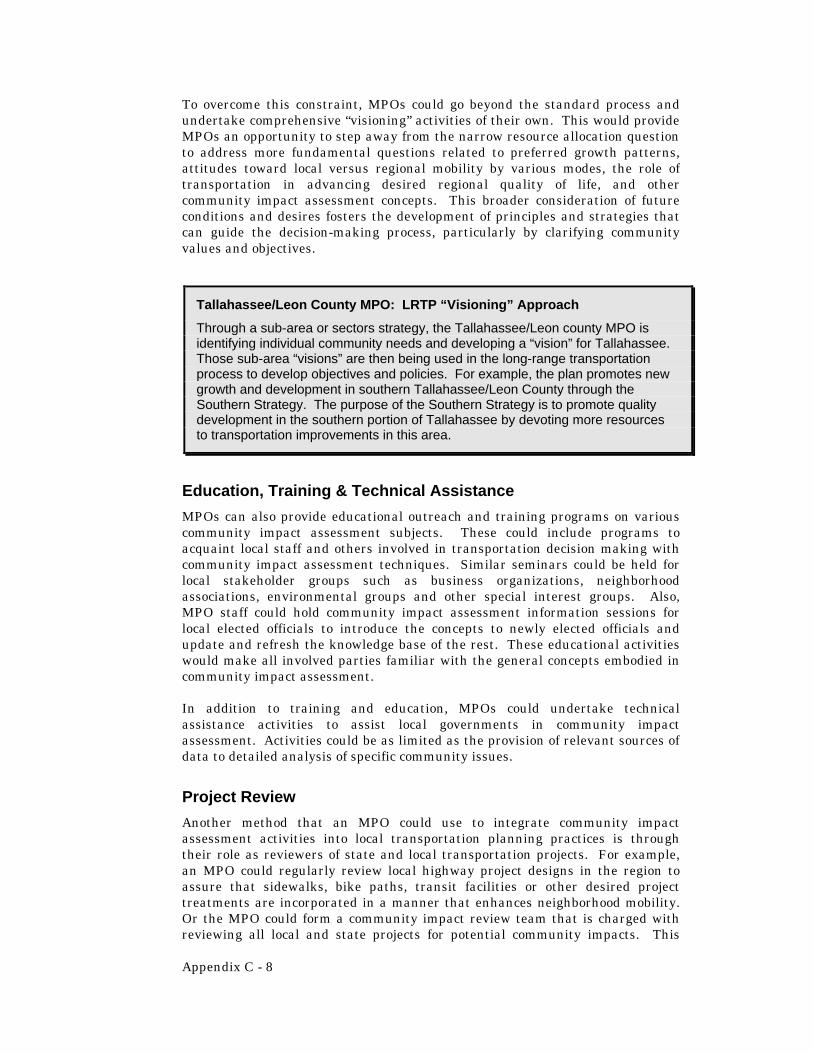
Appendix C - 8
To overcome this constraint, MPOs could go beyond the standard process and undertake comprehensive “visioning” activities of their own. This would provide MPOs an opportunity to step away from the narrow resource allocation question to address more fundamental questions related to preferred growth patterns, attitudes toward local versus regional mobility by various modes, the role of transportation in advancing desired regional quality of life, and other community impact assessment concepts. This broader consideration of future conditions and desires fosters the development of principles and strategies that can guide the decision-making process, particularly by clarifying community values and objectives.
Education, Training & Technical Assistance
MPOs can also provide educational outreach and training programs on various community impact assessment subjects. These could include programs to acquaint local staff and others involved in transportation decision making with community impact assessment techniques. Similar seminars could be held for local stakeholder groups such as business organizations, neighborhood associations, environmental groups and other special interest groups. Also, MPO staff could hold community impact assessment information sessions for local elected officials to introduce the concepts to newly elected officials and update and refresh the knowledge base of the rest. These educational activities would make all involved parties familiar with the general concepts embodied in community impact assessment.
In addition to training and education, MPOs could undertake technical assistance activities to assist local governments in community impact assessment. Activities could be as limited as the provision of relevant sources of data to detailed analysis of specific community issues.
Project Review
Another method that an MPO could use to integrate community impact assessment activities into local transportation planning practices is through their role as reviewers of state and local transportation projects. For example, an MPO could regularly review local highway project designs in the region to assure that sidewalks, bike paths, transit facilities or other desired project treatments are incorporated in a manner that enhances neighborhood mobility. Or the MPO could form a community impact review team that is charged with reviewing all local and state projects for potential community impacts. This
Tallahassee/Leon County MPO: LRTP “Visioning” Approach
Through a sub-area or sectors strategy, the Tallahassee/Leon county MPO is identifying individual community needs and developing a “vision” for Tallahassee. Those sub-area “visions” are then being used in the long-range transportation process to develop objectives and policies. For example, the plan promotes new growth and development in southern Tallahassee/Leon County through the Southern Strategy. The purpose of the Southern Strategy is to promote quality development in the southern portion of Tallahassee by devoting more resources to transportation improvements in this area.

Appendix C - 9
team could work with the project designers and report their findings back to the MPO committees for further appropriate action.
THE ROLE OF LOCAL GOVERNMENTS Local governments also have an important role in the transportation planning process and have opportunities to address community impacts in their planning and development review activities.
Land Use & Transportation Planning
Local governments are responsible for comprehensive planning activities within their jurisdictional boundaries. The local comprehensive plan covers all subject matter related to growth and land development and contains a wealth of data relevant to community impact assessment. The first source an agency conducting a community impact assessment should look for local data on a community or neighborhood is the local comprehensive plan. Local governments could improve the value of that data for community impact assessment purposes by focusing on data that might be difficult to find from another source or time consuming to collect as part of a transportation project. This data might include such things as the relative proportion of senior citizens in a community, local property values or the relative level of community cohesion in various areas.
Local governments could also incorporate community impact assessment techniques in developing the transportation and land use elements of the local comprehensive plan and when implementing the plan through local regulations. This might include such activities as assessing the potential impact of traffic derived by a new land use on neighborhood mobility, evaluating land use alternatives or determining the potential impact of a proposed local road on community facilities and services.
Another opportunity for local governments to contribute to community impact assessment activities is if they implement a community indicators program. Indicator programs attempt to assess the well being of communities through the establishment of specific measurable indicators and tracking them through time. For example, a measurable indicator of neighborhood mobility might be the
Hillsborough County: Social Information Network
The Hillsborough County City-County Planning Commission has organized an initiative called the Social Information Network. The program objective is to develop an extensive database of available community and neighborhood data sources, often referred to as “metadata.” This database directs interested users to the primary data sources for a variety of information categories. Organizations involved include neighborhood associations, health care related agencies, special interest organizations, local government agencies and more. While it is not a one-stop source of information, it is a roadmap for where the information is located and will greatly simplify the task of data collection for conducting a community impact assessment in Hillsborough County.

Appendix C - 10
number of local streets with sidewalks or the number of transit connections to regional employment centers.
Special Studies
Like MPOs and FDOT, local governments often fund special transportation studies. These studies generally focus on the identification of transportation problems on a specific corridor or in a specific sub-area of their jurisdiction. Alternative solutions are also typically identified in these studies, as are potential funding sources. Community impacts could be assessed as part of these studies.
MPO Involvement
In addition to the activities that local governments can undertake on their own, local governments can also involve themselves in community impact assessment activities through the MPO process. Primarily representatives from local governments comprise the MPO committees. As such, they can assist in the assessment of community impacts during the MPO process. Also, some MPOs receive funding directly from their member governments to supplement federal and state funds. Local governments could insist upon increased focus community impact assessment in the regional transportation planning process as a condition of continued funding.
SUMMARY AND CONCLUSIONS Integrating community impact assessment activities into transportation planning would increase the effectiveness of transportation decision-making and result in quality transportation projects that address a broad range of community needs. The challenge will be finding ways to integrate community impact assessment into already established transportation practices. It will take flexibility, creativity and commitment. In the long run, everybody will be better served.
Orange County: RCA and Sub-Area Planning Processes
Orange County conducts special studies to determine transportation needs and identify community issues and potential impacts. Orange County has established a Roadway Conceptual Analysis (RCA) Process for county road projects that mimics the project development and environment (PD&E) process conducted by FDOT. The purpose of the RCA study is to determine the improvements necessary to Orange County roads due to increasing traffic from existing and expected development. RCA studies document the analysis required for Orange County to reach a decision on the type, design and location of improvements to county roadway. The analysis considers all social, economic and environmental impacts of the proposed improvements. RCA studies place special emphasis on public involvement in order to best capture the sentiment of the potentially impacted communities. Orange County also conducts sub-area studies that look at more than one corridor at a time to determine transportation needs. These studies, like the RCA studies, also have a large public involvement component aimed at identifying community concerns early in project development.