community group briefing & workshop
TRANSCRIPT

A L D I N G A P R E L I M I N A R Y S T R U C T U R E P L A N
Community Group Briefing & Workshop
Aldinga Library
5 March 2019

A G E N D A
Welcome, Introductions & Housekeeping
BackgroundAbout Renewal SA
The Land
Planning context
Why a Structure Plan?
What is driving a Structure Plan?
Engagement Program
Preliminary Structure Plan Options
Questions & Answers
Interactive Workshop
Social Pinpoint Demonstration
2

B A C K G R O U N D
RICHARD STRANGER
DIRECTOR PLANNING AND DESIGN
RENEWAL SA
3

A B O U T R E N E W A L S A
4
Renewal SA is a State Government agency established under the Urban Renewal Act 1995
Subject to the control and direction of the Minister
The Board is responsible to the Minister
Renewal SA is primarily involved in facilitating development and achieving urban renewal
Hon Stephan Knoll MP
Minister for Transport,
Infrastructure and Local
Government
Board of
Management
Urban Renewal
Authority
(trading as
Renewal SA)
For more about Renewal SA visit:
renewalsa.sa.gov.au/about-renewal-sa

T H E L A N D A T A L D I N G A
5
94 hectares
Owned by Urban Renewal Authority (Renewal SA)
Acquired in 1989 as part of metropolitan Adelaide’s future land bank
Leased for cropping
Located within the ‘Deferred Urban Zone’
P L A N N I N G C O N T E X T
6
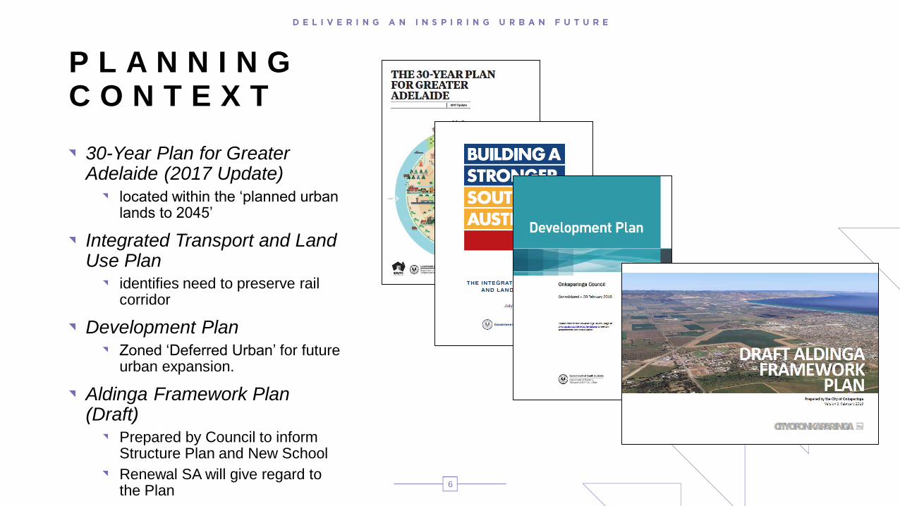
30-Year Plan for Greater Adelaide (2017 Update)
located within the ‘planned urban lands to 2045’
Integrated Transport and Land Use Plan
identifies need to preserve rail corridor
Development Plan Zoned ‘Deferred Urban’ for future urban expansion.
Aldinga Framework Plan (Draft)
Prepared by Council to inform Structure Plan and New School
Renewal SA will give regard to the Plan

W H A T I S A S T R U C T U R E P L A N ?
Next level of planning detail beneath the overarching 30-Year Plan for Greater Adelaide
Provides direction on desired land uses and infrastructure to support future development
7
Informs a Development Plan Amendment – or DPA – that allow for land to be re-zoned
Aldinga
Structure Plan

K E Y D R I V E R S
8
Rail corridor and alignment
Potential school site (subject to Minister for Education)
Main South Road duplication
Land supply

E N G A G E M E N T P R O G R A M
PRELIMINARY STRUCTURE PLAN
Council staff workshop
Council elected member briefing
Community group workshop (TODAY)
Community engagement via Social Pinpoint (Launches SOON)
DRAFT STRUCTURE PLAN
Council staff workshop (April)
Council elected member briefing (April)
Community drop-in sessions (May)
Community engagement via Social Pinpoint (from May)
DEVELOPMENT PLAN AMENDMENT
Draft Development Plan Amendment Report (July)
Briefing/Workshop with Council staff and Elected Members (July)
DPA consultation process (from August 2019)
DPA gazetted (December 2019)
9

P R E L I M I N A R Y
S T R U C T U R E P L A N
O P T I O N S MICHAEL OSBORN
NATIONAL PLANNING MANAGER
FYFE PTY LTD
10
N O N N E G O T I A B L E S
11
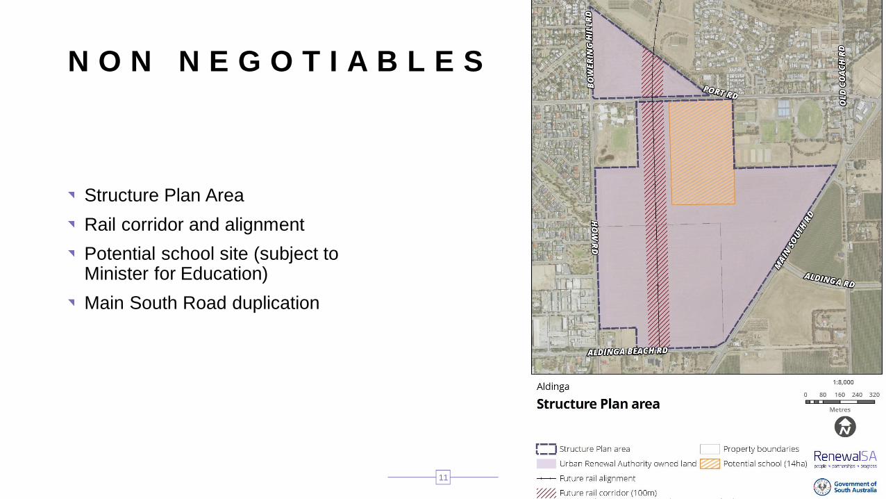
Structure Plan Area
Rail corridor and alignment
Potential school site (subject to Minister for Education)
Main South Road duplication

I N V E S T I G A T I O N S
12
Social Impact Assessment (Holmes Dyer)
Housing Analysis (Holmes Dyer)
Noise Assessment (Sonus)
Preliminary Site Investigation (Agon Environmental)
Tree Assessment (Arborman)
Visual Character Assessment (Wax Design) TBC
Employment Lands (Fyfe) TBC
Utilities Assessment (Fyfe) TBC
Traffic (MFY) TBC
Stormwater (Fyfe) TBC
Completed investigations can be downloaded from: renewalsa.sa.gov.au/projects/aldinga-structure-plan
O P P O R T U N I T I E S & C O N S T R A I N T S
13
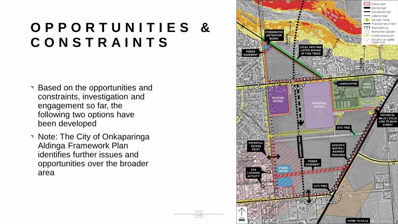
Based on the opportunities and constraints, investigation and engagement so far, the following two options have been developed
Note: The City of Onkaparinga Aldinga Framework Plan identifies further issues and opportunities over the broader area

O P T I O N 1
14
Things in common with Option 2:Rail corridor
North–south collector road
Potential school site
Proposed shared use path
Acoustic buffer/barrier to Main South Road
Neighbourhood Park
Unique to Option 1:Central rail station optimises access to the school and the future resident population
Corridor south of the rail station to be retained
East west road shown, with crossing over rail corridor. The western portion of this road may be a local road

O P T I O N 2
15
Things in common with Option 1:Rail corridor
North–south collector road
Potential school site
Proposed shared use path
Acoustic buffer/barrier to Main South Road
Neighbourhood Park
Unique to Option 2:Rail station is located adjacent to Aldinga Beach Road, optimising access to the existing areas west of How Road and south of Aldinga Beach Road
Indicative stormwater management solution shown takes into account the need to cross the rail corridor
The indicative stormwater basins/Park & Ride account for the rail line and station extending to Aldinga Beach Road frontage

E A R L Y
F E E D B A C K
A N D I D E A S
16
Feedback which falls outside the scope of this structure plan will be noted and provided to the relevant parties.
This includes thoughts on the proposed intersection upgrades – such as this and the next slide
Source: Community

17

Q U E S T I O N S&
A N S W E R S
MICHAEL OSBORN & RICHARD STRANGER
18

I N T E R A C T I V E W O R K S H O P
19
BARBARA DICKENS
MANAGER, ENGAGEMENT
RENEWAL SA

W O R L D C A F É
20
Divide into groups
Each brainstorm feedback on 1 theme (across both options):
Land Use
Open Space
Buffers
Movement
Stormwater
Rotate to the next theme – review and add
Keep rotating – until each group has covered each theme
Final group for each theme reports back
21
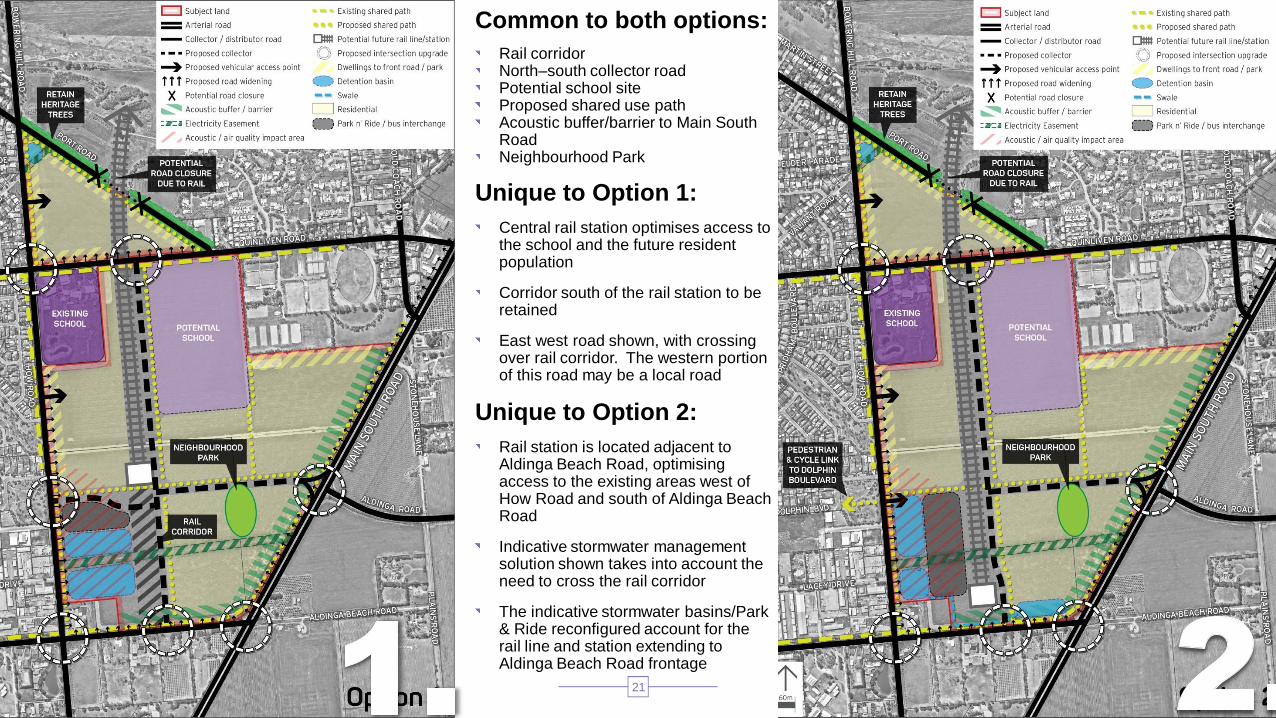
Common to both options:
Rail corridorNorth–south collector roadPotential school siteProposed shared use path Acoustic buffer/barrier to Main South RoadNeighbourhood Park
Unique to Option 1:
Central rail station optimises access to the school and the future resident population
Corridor south of the rail station to be retained
East west road shown, with crossing over rail corridor. The western portion of this road may be a local road
Unique to Option 2:
Rail station is located adjacent to Aldinga Beach Road, optimising access to the existing areas west of How Road and south of Aldinga Beach Road
Indicative stormwater management solution shown takes into account the need to cross the rail corridor
The indicative stormwater basins/Park & Ride reconfigured account for the rail line and station extending to Aldinga Beach Road frontage

T H E 5 T H E M E S – F O R F E E D B A C K
Land UseLand use maps where housing, retail, commercial, industrial and community uses of land could be located.
Open SpaceOpen space covers the indicative locations for neighbourhood parks and other public spaces, and their intended uses for nearby residents.
BuffersBuffers apply to where an interface is needed between different land uses – such as main road and housing. Buffers can include landscaped areas and acoustic walls to minimise effects of noise, dust and odour and improve visual outlook.
MovementMovement relates to how vehicles, cyclists and pedestrians move through and within the area. It considers connections and shared path links, including the rail corridor.
StormwaterStormwater considers the amount and location of land needed to manage flooding and stormwater related to the site.
22

T H A N K Y O U F O R Y O U R
P A R T I C I P A T I O N T O D A Y
23

F U R T H E R F E E D B A C K
To provide further feedback please visit:
Web URL: renewalsa.sa.gov.au/projects/aldinga-structure-plan/
Social Pinpoint URL: https://renewalsa.mysocialpinpoint.com/aldinga-psp/map/Or contact Renewal SA for alternative ways to provide feedback: P 8207 1300 E [email protected]
24