community characteristics report - ncdot
TRANSCRIPT
COMMUNITY CHARACTERISTICS REPORT Proposed Carolina Bays Parkway Extension, from SC-9 in Horry County, SC to US 17 Shallotte Bypass in Brunswick County, NC
NCDOT Project No. 44604; SCDOT Project No. P029554 Brunswick County, NC & Horry County, SC
January, 2018
Prepared for: Prepared by:
CALYX E ng ineers and Consu ltants
6750 Try on Road | Cary , NC 27518

COMMUNITY CHARACTERISTICS REPORT NCDOT Project No. 44604; SCDOT Project No. P029554
Proposed Carolina Bays Parkway Extension, From SC-9 in Horry County, SC to US 17 Shallotte Bypass in Brunswick County, NC
Submitted by: CALYX Engineers and Consultants | Date: January, 2018
Table of Contents
Executive Summary ................................................................................................................................ i
Notable Characteristics .......................................................................................................................... i
Potential Project Impacts ..................................................................................................................... iii
Findings & Recommendations .............................................................................................................. iv
1. Project Overview ............................................................................................................................ 1
1.2 Existing Roadway & Network Conditions .................................................................................. 3
1.3 Proposed Modifications ............................................................................................................ 5
1.4 Regional Community Context ................................................................................................... 5
1.5 Community Study Areas ............................................................................................................ 8
2. Community Characteristics, Impacts & Recommendations .................................................. 10
2.1 Recreational Resources & Activity .......................................................................................... 10
2.2 Section 6(f) Land and Water Conservation Fund Resources ................................................... 13
2.3 Other Regulatory Land Applications ....................................................................................... 13
2.4 Voluntary & Enhanced Voluntary Agricultural Districts .......................................................... 14
2.5 Agricultural Resources & Activity ............................................................................................ 14
2.6 Bicycle, Pedestrian, Greenway & Active Transportation ........................................................ 16
2.7 Transit & Other Multi-Modal Resources/Activity ................................................................... 19
2.8 Local Area Plans & Goals ......................................................................................................... 20
2.9 Local Area Development Activity ............................................................................................ 35
2.10 Existing Access: Driveways & Cross Streets ............................................................................ 38
2.11 Business & Economic Resources ............................................................................................. 39
2.12 Emergency Management Resources....................................................................................... 44
2.13 Schools Transportation ........................................................................................................... 46
2.14 Community Resources ............................................................................................................ 47
2.15 Community Cohesion .............................................................................................................. 54
2.16 Community Health & Safety.................................................................................................... 55
2.17 Area/Community Concerns ..................................................................................................... 55
2.18 Recurring Effects ..................................................................................................................... 57
2.19 Other Impacts ......................................................................................................................... 57
2.20 Environmental Justice (EJ) and Title VI Populations ............................................................... 58
2.21 Limited English Proficiency (LEP) or Language Assistance (LA) Populations........................... 60
2.22 Special Populations ................................................................................................................. 61
3. Additional Community Characteristics ..................................................................................... 61
3.1 Demographic Characteristics & Population Trends ................................................................ 61
3.2 Nearby STIP Projects ............................................................................................................... 64
Sources................................................................................................................................................... 66
Appendices ............................................................................................................................................ 70
Appendix A: Figures
Appendix B: Demographic Data Tables
Appendix C: Photographs
Appendix D: Local Government Interviews
Appendix E: Mapping from Local Land Use Plans
Appendix F: Known Plans for Development
Appendix G: Project Controversy & Public Involvement Documentation

C a r o l i n a B a y s P a r k w a y E x t e n s i o n | C o m m u n i t y C h a r a c t e r i s t i c s R e p o r t ( C C R )
J a n u a r y , 2 0 1 8 E x e c u t i v e S u m m a r y | i
EXECUTIVE SUMMARY
PLANNER, FIRM: Martha Hodge, AICP, CALYX Engineers and Consultants
CS PROJECT REVIEWER: Herman Huang, Ph.D, AICP
NCDOT PROJECT MANAGER: Kim Gillespie, PE SCDOT PROJECT MANAGER: Leah Quattlebaum, PE
NCDOT DIVISION: 3 SCDOT DISTRICT: 5
NCDOT WBS: 44604 SCDOT PROJECT NO.: P029554
DOCUMENT TYPE: Federal Environmental Impact Statement (EIS)
EXISTING CONTROL OF ACCESS: Combination - No Control in Horry County, Partial Control in Brunswick County
PROPOSED CONTROL OF ACCESS: Full Control
EXISTING MEDIAN: Yes except for 1 mile through Little River (Nelson Road to Pinehurst Circle)
PROPOSED MEDIAN: Yes
EXISTING NO. OF LANES: 4-5
PROPOSED NO. OF LANES: Multi-lane
PROJECT DESCRIPTION: Proposed multi-lane access-controlled expressway, part on new location, from the existing Carolina Bays Parkway (SC-31) terminus at SC-9 in Horry County, SC to US 17 (Shallotte Bypass) in Brunswick County, NC.
Notable Characteristics ⪧ Potential Section 4(f) public recreational resources in the DCIA include: (1) Waccamaw River
Heritage Preserve in Horry County; (2) North Strand Recreation Center, located on Highway 57 just south of SC-9; (3) Vereen Memorial Gardens, a community park and cemetery located on the south side of US 17 in Little River; (4) Calabash Town Park on Persimmon Road SW next to the Town of Calabash Municipal offices; (5) Ocean Isle Beach Park, located on the north side of Old Georgetown Road in Ocean Isle Beach; (6) Shallotte District Park, located on the north side of Main Street (US 17 Business) in Shallotte.
⪧ Section 6(f) resources in the DCIA include: (1) a small area adjacent to McMilly Swamp at the end of Buttercup Lane near Shallotte that does not follow property lines may be protected under Section 6(f), and (2) Ocean Isle Beach Park.
⪧ Multiple properties are currently held under private conservation easements in the DCIA: (1) River Hills Golf Course; (2) a large Ducks Unlimited easement adjacent to the Waccamaw River in Brunswick County; and (3) a North American Land Trust (NALT) easement on the south side of US 17 in Brunswick County, just east of Calabash.
⪧ There is a notable presence of agricultural resources throughout the DCIA, including the majority of land on the north side of US 17 in Brunswick County as well as a considerable amount of land located north of Highway 111 in Horry County. Known agricultural resources in the DCIA include a wide range of large and small scale crop farms, at least one permitted animal operation (swine) on
C a r o l i n a B a y s P a r k w a y E x t e n s i o n | C o m m u n i t y C h a r a c t e r i s t i c s R e p o r t ( C C R )
J a n u a r y , 2 0 1 8 E x e c u t i v e S u m m a r y | i i
Old Shallotte Road in Brunswick County, numerous tracts that are actively managed for timber production, several commercial plant nurseries and growing operations, a Century Farm (Indigo Farms), a Bicentennial Farm (Holden Brothers Farm Market), and several agritourism operations.
⪧ Existing sidewalks in the DCIA are limited to a small number of locations that support pedestrian use, including a section of US 17 through Little River, a portion of Mineola Avenue SW and the Little River Waterfront area, and a portion of NC 179 (Beach Drive) through Calabash. Some of the residential subdivisions in the DCIA also have internal sidewalk networks. There are no known local plans or recommendations for future sidewalk sections in the DCIA.
⪧ There is no dedicated bicycle access along existing facilities in the DCIA; however, there are state designated bicycle routes and a number of facilities documented as being used by local cyclists throughout the DCIA. State designated routes include: SC-9, Highway 57, Highway 111, SC-179, and NC 179 (Beach Drive). Routes used by local cyclists include: Calabash Road/Ash Little River Road, Country Club Road (SR 1168), Persimmon Road (SR 1167), Seaside Road SW (NC 904), Old Georgetown Road, Russtown Road (SR 1315), Old Shallotte Road (SR 1316), McMilly Road (SR 1320), and Main Street (US 17 Business).
⪧ The East Coast Greenway is a developing national trail system with a proposed path that passes through the DCIA, following NC 179 (Beach Drive) through Brunswick County and SC 179, US 17 and local network routes through Little River in Horry County. Otherwise, existing greenway/multi-use trails in the DCIA are limited to parks and other recreational properties.
⪧ The current adopted local plans and goals for land use in the DCIA are defined through a patchwork of documents prepared by multiple jurisdictional bodies and many are either notably dated, being developed for the first time, being updated, or cover a jurisdictional boundary that is in flux. As a result, there are numerous inconsistencies between the current adopted plans as well as the baseline land use and socio-economic data presented in them.
⪧ Widespread recent development activity has occurred in the DCIA throughout much of the Horry County portion and in areas south of Hickman Road and US 17 (Ocean Highway) in Brunswick County. There are known plans for development at several locations in Little River, the majority of which include large mixed use residential developments and subdivisions. Three of the projects include redevelopment of existing golf courses in Horry County, including the Cypress Bay, Heather Glen and Bay Tree golf courses.
⪧ Local planners from across the project area have noted the importance of tourism and the large retiree population in shaping the social and economic context of the project area. There are a variety of business and economic resources throughout the DCIA with majority representation from the recreation, tourism and service industries as well as a growing presence of medical service providers.
⪧ The DCIA contains hurricane evacuation routes and facilities. ⪧ The DCIA contains a number of community resources including at least 38 known churches and
other places of worship; more than 100 residential neighborhoods and subdivisions; child care facilities; at least 48 known cemeteries; and both state and municipal services facilities.
⪧ There are known concerns and controversy associated with the proposed project, both historically and more recently. The current adopted 2010 Brunswick County Comprehensive Transportation Plan (CTP) (2010) includes documentation of community controversy regarding historical new location alignments considered in the Brunswick County portion of the DCIA during long range plan development as well as environmental agency concerns expressed by NC state and federal agencies

C a r o l i n a B a y s P a r k w a y E x t e n s i o n | C o m m u n i t y C h a r a c t e r i s t i c s R e p o r t ( C C R )
J a n u a r y , 2 0 1 8 E x e c u t i v e S u m m a r y | i i i
regarding historical new location alignments considered in the Brunswick County portion of the DCIA during long range plan development.
⪧ Census data indicates a notable presence of both minority and low-income populations meeting the criteria for Environmental Justice (EJ) within the Demographic Study Area (DSA). A range of low-income community indicators were observed during field review and local planners have identified several low-income and/or minority communities in various locations throughout the DCIA.
⪧ The DSA contains a notable retirement population, as documented by local planners across the project area and supported by Census data. The median age for the DSA overall is 52.9 years, in comparison to a median age of 50 for Brunswick County and 43 for Horry County. The highest concentrations of elderly persons are located in the Brunswick County portion of the DSA, which contains three Block Groups where more than half of the total population is age 65 or older.
⪧ Census data does not indicate presence of Limited English Proficiency (LEP) populations meeting the US Department of Justice LEP Safe Harbor threshold but does indicate presence of Spanish, Other Indo-European and Asian/Pacific language group populations within the DSA that may require language assistance.
⪧ Several other transportation projects included in the NC and SC Statewide Transportation Improvement Programs (STIPs) are proposed nearby the CBP Extension project and may affect the same or similar transportation network.
⪧ Population growth in the DSA has been considerably higher than countywide and statewide rates in recent years. Total growth in the DSA between 2000 and 2010 was 55.1 percent (4.5 percent annually). Countywide growth rates for the same period were 46.9 percent (3.9 percent annually) in Brunswick and 37.0 percent (3.2 percent annually) in Horry. Population growth in the DSA has not been uniformly high across all Block Groups, however; and according to local planners in both Horry and Brunswick County, the proposed CBP Extension project area does not represent the highest growth areas for either county.
Potential Project Impacts ⪧ At this time, the likelihood and magnitude of project impacts to agricultural resources is higher in
association with potential new location alignments located east of Highway 111 (Little River Road/S-111) in Horry County and west of US 17 in Brunswick County.
⪧ Due to various inconsistencies between existing adopted local plans, consistency of the proposed project with local adopted plans, regulations and policies cannot be assessed at this time. The topic will be evaluated further and in greater detail in the Community Impact Assessment (CIA).
⪧ Based on the geographic distribution of EJ populations in the DSA, the likelihood of potential impacts to these populations as a result of the project would be highest in association with potential new location alignments located north of the existing Highway 111 corridor and west of the existing Highway 57 corridor in Horry County, and north and west of the existing Hickman Road and US 17 corridors in Brunswick County.
⪧ New location roadways can have notable direct, indirect and cumulative impacts on community resources. Potential direct impacts of the proposed project may include right-of-way acquisition or relocation as well as impacts to mobility, access and accessibility depending on the location of new intersections, interchanges and/or access management applications. Potential direct impacts of the proposed CBP Extension project to community resources will be evaluated in full detail in the

C a r o l i n a B a y s P a r k w a y E x t e n s i o n | C o m m u n i t y C h a r a c t e r i s t i c s R e p o r t ( C C R )
J a n u a r y , 2 0 1 8 E x e c u t i v e S u m m a r y | i v
Community Impact Assessment (CIA) after Detailed Study Alternatives have been developed for the proposed project. Potential indirect and cumulative effects on land use as a result of the proposed CBP Extension project will be assessed in detail in the Indirect and Cumulative Effects (ICE) report.
Findings & Recommendations ⪧ It is recommended the NCDOT Project Planning Engineer coordinate with NCDOT Division of Bicycle
and Pedestrian Transportation in documenting the presence of bicycle/pedestrian facilities in the project area and the appropriate level of potential facilities consideration in project design.
⪧ Public involvement and outreach activities for the proposed CBP Extension project must ensure full and fair participation of all potentially affected communities in the transportation decision-making process. In developing the Public Involvement Plan for the proposed CBP Extension project, the Project Planning Engineers should coordinate directly with NCDOT Public Involvement, SCDOT and SC local governments as appropriate to ensure all public involvement activities and outreach material developed for the project under study appropriately target Title VI populations and meet all other state and federal regulatory guidelines. Because notable Spanish, other Indo-European and Asian/Pacific populations requiring language assistance are located within the DSA, Project Planning Engineers should also consult with the Public Involvement Group to determine appropriate measures assuring meaningful public involvement to satisfy the requirements of Executive Order 12898.
⪧ It is also recommended the Public Involvement Plan for the proposed project include targeted outreach to the local agricultural community. In identifying strategies for outreach, Project Planning Engineers should consider coordinating directly with local and/or regional agricultural resource experts in Brunswick and Horry Counties.

C a r o l i n a B a y s P a r k w a y E x t e n s i o n | C o m m u n i t y C h a r a c t e r i s t i c s R e p o r t ( C C R )
J a n u a r y , 2 0 1 8 P a g e | 1
1 . PROJECT OVERVIEW
The North Carolina Department of Transportation (NCDOT) and South Carolina Department of Transportation (SCDOT) jointly propose to extend Carolina Bays Parkway (SC-31), a multi-lane fully access controlled freeway, part on new location, from its existing terminus at SC-9 in Horry County, SC to US 17 (Shallotte Bypass) in Brunswick County, NC.
Pursuant to the National Environmental Policy Act (NEPA), an Environmental Impact Statement (EIS) will be prepared for this project. This level of study can generally be classified as a “high” level environmental analysis for the documentation required under NEPA. This Community Characteristics Report (CCR) documents the existing socio-economic conditions and trends in the area surrounding the proposed project. It inventories community resources, issues and concerns that the project may effect or impact. The report includes data gathered from the US Census in combination with data from adopted local plans, policies, maps, and regulations. It includes field observations as well as information collected via interviews with local planners and other local government professionals and representatives in an effort to document community resources, visions and goals. Wherever possible, this report will map community characteristics and attributes geographically to assist in project decision-making.
Project History & Purpose
The project, as currently proposed with northern terminus at US 17 (Shallotte Bypass) in Brunswick County, NC and southern terminus at the existing Carolina Bays Parkway (SC-31) terminus at SC-9 in Horry County, SC, is not included in any existing long range or comprehensive transportation plans for jurisdictions in Horry or Brunswick County.
In South Carolina, various local government stakeholder groups and organizations began considering a major road improvement plan for the Grand Strand Region beginning in the 1980s. The North-South Corridor, Horry County, South Carolina – Conceptual Route Plan (1989) was prepared by the Waccamaw Regional Council of Governments in 1989 with funding from the Grand Strand Regional Tourism Program. The plan evaluated a north-south corridor west of the Intracoastal Waterway between SC-90 and SC-544. With a lack of funding and a number of other higher priority transportation projects in the region, the Carolina Bays Task Force was formed out of local citizen and stakeholder support for the project. The Carolina Bays Task Force Conceptual Criteria Report (1991) was prepared, identifying the general extent and location of the future parkway: Phase I of the project would extend from SC-9/SC-90 to SC-544 with future phases extending southward to US 701 and/or US 17 near the City of Georgetown, and northward to the NC state line. The Carolina Bays Parkway Feasibility Study (1993) was prepared at the recommendation of the Task Force report. The feasibility study resulted in expansion of the project limits to include the entire Grand Strand Area Transportation Study (GSATS) Municipal Planning Organization (MPO) boundary, which generally extended from Georgetown to the NC state line at the time, and concluded the future parkway would improve emergency evacuation and mobility in the region and would be a logical investment from a travel efficiency/economic standpoint. The Final Environmental Impact Statement (FEIS) was prepared in 1998, recommending the present day alignment that extends for approximately 30.2 miles along the mainline from US 17 just north of Glenn’s Bay Road to SC-9 and includes approximately 7.8 miles of connecting access roads in various locations

C a r o l i n a B a y s P a r k w a y E x t e n s i o n | C o m m u n i t y C h a r a c t e r i s t i c s R e p o r t ( C C R )
J a n u a r y , 2 0 1 8 P a g e | 2
adjacent to the mainline. In 2001, SCDOT began considering a direct link into NC and initiated a feasibility study of alternatives for the approximately 5-mile section between SC-9 and the NC state line.
In North Carolina, the current proposed project has evolved primarily out of the historically proposed I-74 corridor project, NC STIP R-3436, a route extending approximately 65 miles from US 74/76 in Columbus County to the SC state line in Brunswick County that was studied by NCDOT beginning in the 1990s (CBPE Feasibility Study Report, SCDOT & NCDOT, 2006). The Brunswick County portion of the current proposed project is a logical representation of the southernmost sections of the R-3436 project. The original feasibility study for the R-3436 project was completed by NCDOT in 1997 and found four feasible routes for the future I-74 corridor that utilized varying combinations of existing and new location roadway segments in Columbus and Brunswick Counties. In 2004, the future I-74 corridor was adopted as a Strategic Highway Corridor (SHC) by the NC Board of Transportation. Following the SHC designation, NCDOT entered into a joint agreement with SCDOT to expand the limits of the Carolina Bays Parkway Extension Feasibility Study that was already underway with SCDOT into Brunswick County. Also following the SHC designation, NCDOT completed a re-evaluation of the original R-3436 Feasibility Study in 2005, which identified a recommended alternative for the future I-74 corridor and stated that new alternative corridors were under consideration within the “Carolina Bays Parkway Extension Study” area, including the two southernmost sections 5 and 6 of the I-74 corridor study area. The re-evaluation was updated a final time in 2007 for consistency with findings of the joint NCDOT-SCDOT Carolina Bays Parkway Extension Feasibility Study Report (2006) following its completion.
The joint CBPE Feasibility Study Report (2006) identifies Alternative B, a new location alignment extending along the north side of US 17 and Hickman Road in Brunswick County from a point just west of NC 904, and adjacent to the south side of Wampee Road in Horry County to the terminus at SC-9.
1.1.1 . Project Purpose As the current proposed project has not been studied in detail, there is a range of relevant project purpose and need information.
The Carolina Bays Parkway FEIS (1998) states: The purpose of the proposed action is to provide for an improved level of service on the existing transportation network by providing a north/south, high-speed, fully controlled-access main line, multilane alternative route for local and inter-community trips along the Grand Strand. As a result, existing transportation routes along the Grand Strand would be given relief and would be able to convey shorter local trips more efficiently and provide an improved level of service on the traffic network.
The current adopted Brunswick County 2010 Comprehensive Transportation Plan (2010), which recommends the R-3436 future I-74 corridor project, provides a preliminary problem statement, which is discussed in greater detail in Section 2.8, citing the I-74/I-73 North-South (Federal) Congressional High Priority Corridor proposed through North and South Carolina as the key element of the project’s purpose.
The joint NCDOT-SCDOT Carolina Bays Parkway Extension Feasibility Study Report (2006) contains a Purpose and Need section that provides the following statement:

C a r o l i n a B a y s P a r k w a y E x t e n s i o n | C o m m u n i t y C h a r a c t e r i s t i c s R e p o r t ( C C R )
J a n u a r y , 2 0 1 8 P a g e | 3
The purpose of this project is to improve mobility and safety by providing more direct and efficient movement of traffic seeking to bypass the congestion of US 17 in the Little River and Grand Strand areas. This project would also provide a more direct route for tourist and coastal truck traffic to move through the area and along Grand Strand and coastal areas. In addition, this project would be an integral part of the proposed Interstate 74 project and North Carolina’s Strategic Highway Corridors initiative. North Carolina’s Strategic Highway Corridors initiative is the result of the collaborative efforts by the Departments of Transportation, Commerce, and Environment and Natural Resources to preserve and improve a selected group of highway corridors by working together towards common goals.
1.2 Existing Roadway & Network Conditions Carolina Bays Parkway (SC-31) is a north-south fully access controlled highway that spans eastern inland Horry County west of and parallel to US 17 for approximately 25 miles, serving the Grand Strand region of the state. The Parkway currently begins just west of the southernmost limits of Myrtle Beach at SC-544 (Corporal Dennis Lyden Memorial Highway) near Socastee, an unincorporated Census Designated Place (CDP). It extends northward to a point located just west of North Myrtle Beach on SC-9 near Little River, an unincorporated CDP just south of the state line. The existing 25-mile segment of Carolina Bays Parkway (SC-31) opened to traffic in December 2002. The highway is designated a Tier 3 Strategic Corridor and National Highway System (NHS) Principal Arterial. The remaining southernmost segments of the Parkway, as studied and recommended in the 1998 FEIS, are programmed for construction. The segment extending from SC-544 to SC-707 for approximately 3.8 miles, which includes a bridge over the Intracoastal Waterway, is currently under construction with expected completion in winter of 2017 or early 2018. The final southernmost segment connecting SC-707 to US 17 just north of Glenn’s Bay Road is approximately xx miles. Construction of this segment is funded through the Horry County RIDE 3 local sales tax program but the schedule for completion is unknown.
Within the proposed Carolina Bays Parkway (CBP) Extension project area, the existing primary road network includes US 17 and various NC and SC state highway and secondary routes. There are no interstate facilities in the project area and access along existing routes is largely uncontrolled with the exception of US 17 through the Brunswick County portion of the project area, which is currently being converted to a Superstreet design with limited access control. In addition to the primary network, there are numerous residential subdivisions in the project area served by subdivision roads that provide shared points of access to the primary network. This is particularly prevalent in the Brunswick County portion of the project area. Many of the subdivisions are expansive and contain several miles of internal street networks that provide a fair amount of connectivity to the primary network via shared points of access to multiple routes. Connectivity between subdivisions is limited, however. The current maintenance status of existing subdivision roads in the project area is unknown. Key routes in the primary network are summarized below and depicted on Figure 1 in Appendix A.
Horry County The Horry County portion of the project area is a regional trip destination for employment and tourism. SC-9, US 17 and Highway 57 (Wampee Road/S-57) are the highest volume routes in the primary network.
⟡ SC-9

C a r o l i n a B a y s P a r k w a y E x t e n s i o n | C o m m u n i t y C h a r a c t e r i s t i c s R e p o r t ( C C R )
J a n u a r y , 2 0 1 8 P a g e | 4
The mainline east-west connector through the Horry County portion of the project area, SC-9 serves inland areas of Horry and western neighboring counties, providing a link between I-95 and the Grand Strand region.
⟡ US 17 The US 17 corridor is the historical north-south highway connector through Horry County, which the recently constructed Carolina Bays Parkway (SC-31) south of the project area bypasses through much of Horry County. Through the project area, the existing US 17 corridor remains the primary north-south highway connector providing a link to Brunswick County and the southeastern region of NC and carries the majority of regional and through traffic. US 17 through the Horry County portion of the project area also functions as the main street corridor through Little River. This section carries the highest traffic volumes in the project area and experiences regular congestion.
⟡ Highway 57 (Wampee Road/S-57) The primary route alternative to US 17 in the Horry County portion of the project area, providing an approximately eight-mile connection between SC-9 and US 17 (Ocean Highway) in Brunswick County and intersecting several other key secondary routes in the network. It currently carries traffic volumes that range from moderate to moderately high, consisting primarily of local users.
Other secondary routes serving the Horry County portion of the project area, which carry moderate volumes of primarily local traffic, include: Highway 50, Highway 111 (Little River Road/Brooksville Road/S-111) and Wortham’s Cutoff Road.
Brunswick County In the Brunswick County portion of the project area, peak traffic volumes are associated with seasonal tourism. Outside of the peak season, traffic volumes are relatively modest. US 17 (Ocean Highway), NC 179 (Beach Drive), Seaside Road SW (NC 904), and Hickman Road are the highest volume routes.
⟡ US 17 (Ocean Highway) Through Brunswick County, US 17 follows a more inland path than in Horry County and is the only north-south highway through much of the county. It provides a regional connection to other key NC and US highway routes that serve inland regions of the state, including US 74-76 and I-40. Locally, US 17 through the project area in Brunswick County is the primary arterial and carries the large majority of all local, regional and through traffic. Summer seasonal tourist traffic on US 17 creates notable congestion along the corridor and at key intersections serving the beach communities. Peak seasonal traffic congestion tends to occur at regular intervals during the summer tourist season and is directly associated with the weekend check-in and check-out times for rental properties in the beach communities.
⟡ NC 179 (Beach Drive/Old Georgetown Road) Extending from US 17 in Horry County (via SC-179) for approximately 17 miles, NC 179 connects Little River to Shallotte in Brunswick County. The corridor generally parallels US 17 to the south and provides access to coastal communities in southwestern Brunswick County, including Calabash, Sunset Beach and Ocean Isle Beach.

C a r o l i n a B a y s P a r k w a y E x t e n s i o n | C o m m u n i t y C h a r a c t e r i s t i c s R e p o r t ( C C R )
J a n u a r y , 2 0 1 8 P a g e | 5
⟡ Seaside Road SW (NC 904) NC 904 extends south and perpendicular to US 17 (Ocean Highway), providing the primary connection to Sunset Beach as well as connection to key north-south routes south of the project area, NC 179 (Old Georgetown Road) and Sunset Boulevard (SR 1172)/Beach Drive, which primarily serve the beach communities. NC 904 extends north across US 17, serving the western portion of the project area in Brunswick County before crossing the Waccamaw River and veering southward into SC. On the western side of the US 17 corridor, NC 904 (Longwood Road NW) carries light traffic volumes.
⟡ Hickman Road (SR 1303) The primary route alternative to US 17 through the southwestern-most portion of the project area in Brunswick County, Hickman Road begins at US 17 about three miles east of the state line (via US 17), and extends approximately 3.5 miles due west to the state line. Hickman Road becomes Highway 57 in Horry County, SC. It currently carries traffic volumes that range from moderate to moderately high, consisting of local users and some tourism related trips.
Other secondary routes serving the Brunswick County portion of the Direct Community Impact Area (DCIA; see definition in Section 1.4.1), which carry moderate volumes of local and seasonal tourist traffic, include: Calabash Road/Ash Little River Road, Old Georgetown Road (SR 1183) and Ocean Isle Beach Road (SR 1184).
1.3 Proposed Modifications The proposed CBP Extension project involves construction of a multi-lane fully access controlled freeway, part on new location, to create a connection extending approximately 19 miles from the existing Carolina Bays Parkway (SC-31) terminus at SC-9 in Horry County to US 17 (Shallotte Bypass) in Brunswick County. The project, NCDOT Project Number 44604 and SCDOT Project Number P029554, is not currently included in the NCDOT 2018-2027 Statewide Transportation Improvement Program (STIP) or the SCDOT 2017-2022 STIP.
1.4 Regional Community Context The proposed project is located in the coastal regions of Horry County, SC and Brunswick County, NC. The project area is a major destination for recreation, tourism and retirement in both states, all of which are key elements influencing the regional community context.
Horry County, SC is one of five coastal counties in the state and the proposed project is located near the northern edge of the Grand Strand/Myrtle Beach region. Much of the SC coastline through adjacent Georgetown County to the south is held under conservation, which has served as a natural buffer between the Grand Strand region in northern coastal SC and other coastal cities further south, including Charleston and Beaufort. The Grand Strand has historically been a primary destination for coastal tourism and recreation in the state due to its geographic proximity and accessibility from inland regions. Over time, it has evolved and diversified to become a major economic hub for the state. Its regional economy remains rooted in the recreation and tourism industries but has expanded to serve a year-round market, fueling growth of secondary markets and industry diversification. Regional accessibility has also evolved over time to include two high-speed freeways, SC-31 and SC-22, connecting the Grand Strand region to points south and west within SC.

C a r o l i n a B a y s P a r k w a y E x t e n s i o n | C o m m u n i t y C h a r a c t e r i s t i c s R e p o r t ( C C R )
J a n u a r y , 2 0 1 8 P a g e | 6
Brunswick County, NC is one of eight coastal counties in the state, nearly all of which have developed coastal waterfronts and beach communities with similar tourism-based economies. Geography and accessibility of Brunswick County beaches has thus been the primary influence on historic patterns of growth and development in Brunswick County. Proximity to the City of Wilmington (New Hanover County) to the north, a historic port city with local economy rooted in commerce and tourism, has increasingly influenced growth in the northern parts of Brunswick County. This part of the county has evolved into a bedroom community of Wilmington and remains the fastest growing area in the county. The beaches and inland communities of southern Brunswick County are more remote, located in the southeastern-most corner of the state and served by a regional highway network that was not designed to provide high-speed connections. The remote geography of the area has contributed to a slow and gradual pace of development in southern Brunswick County, resulting in a low density pattern of development focused around agriculture and small coastal towns with abundant open space and widespread access to natural resources. The natural amenities and slow pace contribute to a quality of life that has proven increasingly attractive for retirees. As a result, areas in southern Brunswick County have seen substantial growth of the residential market over the past 15 years as retirees have migrated to the area en masse.
The Project Area The proposed CBP Extension project area is largely comprised of unincorporated areas in Horry and Brunswick Counties but contains portions of some small coastal towns and communities located on the inland side of the Intracoastal Waterway. The different towns, areas and communities which comprise the DCIA are summarized below. Development in the project area tends to consist of non-residential uses focused along state and US highway routes with residential uses focused along state secondary routes. While there is similarity in the overall mix of development types in the project area, the scale, density, age, and aesthetics of existing development in the project area is notably different in Horry and Brunswick Counties.
Horry County Little River is the densest population center within the Horry County portion of the project area. This section of the US 17 corridor is the most densely developed part of the project area and carries some of the highest traffic volumes. Although it is an unincorporated community, it is recognized as a US Census Designated Place (CDP) with an estimated 2015 population of 9,617. The CDP boundary lies entirely within the DCIA (as shown on Figure 2 in Appendix A), extending east of Highway 57 and south of Highway 111 (Little River Road/S-111) to the Intracoastal Waterway, and northward along the Intracoastal and US 17 corridor to just south of the state line. The Little River community was historically settled as a fishing village prior to any other settlements on the Grand Strand based on its proximity to both the Waccamaw River and Little River Inlet to the Atlantic Ocean. The Little River waterfront remains the primary commercial tourism resource and destination in the area. It is located along the Intracoastal Waterway in the northeastern portion of the CDP boundary and contains various tourist destinations that notably include the only two casino boats in the state of SC. They operate year-round, traveling daily from port in Little River to federal waters (12 nautical miles from the state shoreline).
The remaining portions of the DCIA in Horry County can be grouped into relatively distinct areas based on similarity of existing development patterns and observed activities. They generally include the SC-9

C a r o l i n a B a y s P a r k w a y E x t e n s i o n | C o m m u n i t y C h a r a c t e r i s t i c s R e p o r t ( C C R )
J a n u a r y , 2 0 1 8 P a g e | 7
corridor and areas south, the area south of Highway 111 and north of SC-9, and the area between Highway 111 and the state line.
SC-9 is the mainline east-west connection serving the Horry County portion of the DCIA. The development pattern is moderately dense and contains a wide mix of uses that have been developed incrementally over a long period of time. Existing uses include residential subdivisions of varying densities and similar in age, commercial, industrial, service-oriented, institutional, and recreational uses. The only recent development activity on the corridor is Seacoast Medical Center located just west of the US 17 interchange.
The area north of SC-9 and south of Highway 111 contains predominantly residential uses that include a mix of more recently developed subdivisions and older single family homes as well as intermittent commercial, institutional (primarily churches) and light industrial uses clustered near intersections. Subdivision development in this area is clustered along Highway 57 and Highway 111 and tend to be moderate to moderately large in size. The majority of all recent development activity in this area tends to include residential subdivisions constructed in the past 10-15 years. Other existing development in the area is older on average.
Between Highway 111 and the state line, agriculture is the predominant use with intermittent single family residential. The overall development pattern is noticeably lower in density and more modest in nature, including some observed indicators of poverty along Highway 111 and Wortham’s Cutoff Road. The Highway 50 corridor contains a residential-agriculture pattern that is moderately low density and more in kind with the residential pattern across the state line in the Farmstead and Meadowlands area of Brunswick County.
Brunswick County The large majority of the Brunswick County portion of the DCIA lies within the county’s unincorporated jurisdiction. The dominant development pattern includes low density commercial and industrial uses along highway corridors (US 17, NC 904 and NC 179) and a mix of rural residential and agriculture uses along other secondary routes. Much of the land located west of the US 17 corridor is in agricultural use. There are a number of family estates and large and small farming operations. A notable portion of the total land area west of US 17 is actively managed for timber, some of which is under ownership by corporate timber farms.
W Town of Carolina Shores Located just north of the state line, Carolina Shores has an estimated 2015 population of 3,549. The town lies entirely within the DCIA, extending south of the US 17 corridor to the NC 179 corridor. The town’s extraterritorial municipal jurisdiction (ETJ) extends north from US 17 toward Hickman Road. The town became incorporated in 1998, before which it was within the Town of Calabash. Carolina Shores is largely comprised of residential subdivisions, of which there are currently six that vary in size (identified in Section 2.14). Approximately half of the subdivisions have been constructed since the town’s incorporation in 1998, as reported in the town’s draft comprehensive plan (“Plan Carolina Shores”), which is currently under development. This will be the first local planning document adopted by the town.
C a r o l i n a B a y s P a r k w a y E x t e n s i o n | C o m m u n i t y C h a r a c t e r i s t i c s R e p o r t ( C C R )
J a n u a r y , 2 0 1 8 P a g e | 8
W Town of Calabash A small portion of the DCIA lies within the Town of Calabash, located along the Calabash River. The town’s jurisdictional limits begin at the SC state line and extend along the south side of NC 179 (Beach Road) to the Town of Sunset Beach jurisdictional boundary. Calabash was incorporated in 1973 as a small fishing village and primarily remains as such with boats docking daily to sell fresh seafood and offer chartered boat tours. In addition to fishing and boating, other tourist destinations include restaurants, shopping and golfing. The estimated 2015 population for Calabash is 1,775.
W Town of Sunset Beach A small portion of the DCIA boundary lies in the Town of Sunset Beach, the southernmost coastal barrier island beach community in NC. The town has experienced notable population growth in recent decades considered to be in kind with the growth seen in similar coastal communities across NC. The town attributes much of its growth to the nearby growing metropolitan areas of Wilmington and Myrtle Beach, the attractiveness of coastal areas for baby boomer retirement as well as numerous annexations of residential subdivision areas. The majority of the town’s population lives on the island, which is primarily built out with single family structures. Since 2005, the town has annexed several residential areas on the mainland to extend their jurisdictional boundary inland of the Intracoastal Waterway. Sunset Beach is a major destination for seasonal tourism in the region. The estimated 2015 population for Sunset Beach is 3,695.
W Town of Ocean Isle Beach The DCIA boundary also includes part of the Town of Ocean Isle Beach, the second beach community in the greater project area that is also a major generator for seasonal tourism. Ocean Isle Beach is located adjacent to Sunset Beach on the north. Population growth in Ocean Isle Beach historically has not been as high as the rates experienced in Sunset Beach; however, more recent estimates suggest it may be growing at a faster rate. The majority of the town’s population lives on the island, which has a small amount of unbuilt land and is seeing notable development and redevelopment activity in the form of single family structures. The estimated 2015 population for Ocean Isle Beach is 678.
W Town of Shallotte The northern project limits and DCIA boundary are in the Town of Shallotte. Shallotte is centrally located in Brunswick County and serves as the primary commercial, service and employment destination for residents of southern and western Brunswick County, including the Brunswick County portion of the DCIA. The Town of Shallotte contains approximately 28 square miles, with an estimated population of 3,816 in 2015.
1.5 Community Study Areas
1.5.1 . Direct Community Impact Area (DCIA) The Direct Community Impact Area (DCIA) is the area surrounding a transportation project that is likely to be directly affected in any way during, throughout, and after project completion. This study area encompasses all of the areas examined for potential community impacts as a result of the Carolina Bays Parkway Extension project. The area outlined in black and white on Figure 2 in Appendix A has been identified as the DCIA and contains properties which may experience access-related effects as a result of the proposed project. The DCIA was delineated primarily on the basis of parcel boundaries, including
C a r o l i n a B a y s P a r k w a y E x t e n s i o n | C o m m u n i t y C h a r a c t e r i s t i c s R e p o r t ( C C R )
J a n u a r y , 2 0 1 8 P a g e | 9
extension in some areas to include entire neighborhoods, while certain natural and man-made boundaries such as water bodies (i.e. Waccamaw River and Intracoastal Waterway) and roads were considered to an extent as well. Through Brunswick County, the northern DCIA boundary is also based in large part on the study area boundary identified in the Town of Carolina Shores Resolution adopted in February, 2017 (see Section 2.17.1 and Appendix G for additional information).
1.5.2 . Demographic Study Area (DSA) The Demographic Study Area (DSA) is defined to provide demographic characteristics for the community surrounding the project and contains the smallest statistical area of US Census Block Group boundaries that contain the DCIA. The DSA boundary is displayed on Figure 3 in Appendix A and includes the following US Census Block Groups:
Horry County, SC
◈ Census Tract 401.01, Block Groups 1 & 2 ◈ Census Tract 401.02, Block Groups 1 & 2 ◈ Census Tract 401.03, Block Groups 1, 2 & 3 ◈ Census Tract 401.04, Block Groups 1 & 2 ◈ Census Tract 401.05, Block Groups 1 & 2
Brunswick County, NC
◈ Census Tract 205.04, Block Group 1 ◈ Census Tract 205.05, Block Groups 2 & 3 ◈ Census Tract 205.06, Block Groups 1 & 2 ◈ Census Tract 205.07, Block Groups 1 – 5 ◈ Census Tract 205.08, Block Groups 1 & 2
Although the DSA encompasses a larger land area than the DCIA, the block groups are considered representative of the population and business community that may be affected by the proposed project. Demographic characteristics of the DSA are discussed in more detail in Sections 2.20, 2.21 and 3.1, and comprehensive summary level demographic data tables are included in Appendix B.

C a r o l i n a B a y s P a r k w a y E x t e n s i o n | C o m m u n i t y C h a r a c t e r i s t i c s R e p o r t ( C C R )
J a n u a r y , 2 0 1 8 P a g e | 1 0
2 . COMMUNITY CHARACTERISTICS, IMPACTS & RECOMMENDATIONS
2.1 Recreational Resources & Activity
Are there any recreational resources, areas, or observed activities in the Direct Community Impact Area (DCIA)? Are these potential 4(f) resources?
2.1.1 . Presence As the local and regional economy in the DCIA and greater project area is largely centered on recreational tourism, there are a variety of recreational resources located in the DCIA. In an effort to more appropriately inventory these resources within the context of existing socio-economic conditions in the project area, only potential 4(f) and other public recreational resources that may be subject to regulatory protection are documented in this section of the CCR. All other recreational resources and activity are documented in Section 2.11.1 under Business and Economic Resources. All recreational resources are shown on Community Context Mapping in Appendix A.
Potential 4(f) Resources
j Waccamaw River Heritage Preserve Owned and managed by the South Carolina Division of Natural Resources (SCDNR), the Waccamaw River Heritage Preserve is a State Conservation Area located along the Waccamaw River in Horry County that is open to the public year-round during daylight hours. The preserve is over 5,000 acres in size and extends from the state line to SC-31 near Red Bluff in Horry County. It was established to protect a range of natural resource functions, including a diverse riverine ecosystem that supports several rare plant species, a travel corridor for black bear and a buffer for the Waccamaw River, which has value as a black water river and the only river originating from a Carolina Bay (Lake Waccamaw in Columbus County, NC). According the SCDNR website, floating on the river is the best way to view the preserve and can be accessed via seven different boat landings along the river. There is one boat landing in the DCIA, Wortham's Ferry, which is located along the edge of the DCIA where Grainger Road (Hwy 111) dead-ends at the Waccamaw Riverbank. Camping overnight is permitted on the riverbank within preserve boundaries; however, the preserve is not contiguous, and there are intermittent private properties along the riverfront. (SCDNR, Waccamaw River Heritage Preserve website)
j North Strand Recreation Center
One of four community recreation centers owned and operated by Horry County, the North Strand Recreation Center is located on Highway 57, just south of the intersection with SC-9. The Horry County Parks and Open Space Inventory (2016), states community recreation centers are intended to serve residents within a 3- to 5-mile radius by providing active recreation and programming opportunities. The North Strand Center includes playgrounds, programming and ball fields. The Parks and Open Space Inventory (2016) notes each of the county recreation center resources are unable to meet existing demand and in need of expansion. Desired improvements include additional fields and outdoor courts,
C a r o l i n a B a y s P a r k w a y E x t e n s i o n | C o m m u n i t y C h a r a c t e r i s t i c s R e p o r t ( C C R )
J a n u a r y , 2 0 1 8 P a g e | 1 1
outdoor lighting, covered seating and picnic areas, trails, and additional play areas. There is also demand to collocate swim facilities at some of these sites. The Parks and Open Space Inventory (2016) notes the benefit of community recreation centers as a potential source of community cohesion in rural areas. (Horry County Parks and Open Space Board, 2016)
j Vereen Memorial Gardens A regional park owned and operated by Horry County, Vereen Memorial Gardens is located in Little River on the Intracoastal Waterway, accessible from Highway 179 near its junction with US 17. The park property extends south from Highway 179 to the Intracoastal Waterway and includes more than 115 acres of forest and marshland. The park is open to the public Monday-Saturday, 9AM – 5PM. Facilities include the CB Berry Community Center, which provides space for recreational programming and community events, and approximately 3 miles of nature trails and boardwalks that traverse the property and botanical gardens. The park property has a governing board engaged in facility enhancements and activities. (Horry County Parks and Open Space Board, 2016)
j Calabash Town Park Part of the Brunswick County park system, Calabash Town Park is a small community park located at the corner of Persimmon Road SW and Traders Lane in Calabash. Park facilities include a playground and large picnic shelter area. Construction of the park was funded in part by a NC Parks and Recreation Trust Fund (PARTF) grant from the NC Division of Parks and Recreation. The park is adjacent to a small cluster of other government services buildings, including the Calabash Town Hall and Fire Station 12-1.
j Ocean Isle Beach Park Owned and operated by Brunswick County, Ocean Isle Beach Park is located within the Town of Ocean Isle Beach on Old Georgetown Road. Construction of the park was originally identified in the current adopted Brunswick County Comprehensive Parks and Recreation Master Plan (2009), which proposes two phases for park construction. The first phase is complete and was funded in part by a PARTF grant from the NC Division of Parks and Recreation. Existing park facilities include two playgrounds, eight tennis courts, an amphitheater and pavilion, public restrooms, picnic shelter and a multi-purpose field. Construction on the second phase is expected to be initiated before the end of 2017 and a second PARTF grant was received to aid in funding the second park phase, which will include the following additional facilities: two baseball/softball fields, a field house, dog park, and nature trail. Upon build-out, the plan states Ocean Isle Beach Park will serve as a “regional park,” the largest of all park types in the system, ranging from 50-250 acres in size and serving residents located within a one-hour drive of the park. It is also intended to provide large natural areas with multi-modal accessibility for residents. Nearby bicycle and pedestrian (trail) facilities are proposed in connection with the park, as summarized in Section 2.6.1.
j Shallotte District Park Owned and operated by Brunswick County, Shallotte District Park is a community park located on the eastern edge of the DCIA on Main Street (US 17 Business) in Shallotte. The Parks Master Plan (2009) identifies it as a “community park,” intended to provide a full range of recreational activities to a service area that includes surrounding neighborhoods. It is 68 acres and includes the following:

C a r o l i n a B a y s P a r k w a y E x t e n s i o n | C o m m u n i t y C h a r a c t e r i s t i c s R e p o r t ( C C R )
J a n u a r y , 2 0 1 8 P a g e | 1 2
baseball/softball facilities, a basketball court, soccer fields, public restroom and concession building, tennis courts, a playground, and picnic shelters.
Other Public Recreational Resources
z Waccamaw River Blue Trail
The Waccamaw River Blue Trail extends along the river through both the Brunswick and Horry County portions of the DCIA. The trail is part of the National Water Trails System (NWTS) designated by the National Park Service that includes a national network of recreational routes on waterways with public access points that provide both conservation and recreational opportunities (National Water Trails System, NPS). The Blue Trails Program is administered by American Rivers, a non-government organization that partners with local communities who want to enhance recreation and protect rivers and clean water for people and wildlife. A Blue Trail is voluntary, locally-driven, and does not include additional regulations or restrictions associated with river access and use (American Rivers).
The Waccamaw River Blue Trail was established through cooperative efforts by American Rivers, Waccamaw Riverkeeper and various local partners. It begins at Lake Waccamaw in Columbus County, NC and follows the river through Brunswick and Horry Counties before merging with the Intracoastal Waterway and ending at Winyah Bay near Georgetown, SC. The trail contains 16 official public access points across North and South Carolina, which are identified in trail mapping, as well as several smaller public access points. The Wortham’s Ferry boat access is the only one located in the DCIA. The trail map identifies this access as a historical access point with limited parking and few improvements.
z Southeast Coast Saltwater Paddling Trail
The Southeast Coast Saltwater Paddling Trail (SECT) is a blueway that follows the Intracoastal Waterway through both Horry and Brunswick Counties. The SECT is a regional blueway trail that extends for over 800 miles from the Chesapeake Bay to the Georgia-Florida border. The trail also provides a connection between two other well-known trails, with the northern trail terminus connecting with the Captain John Smith Chesapeake National Historic Trail, and the southern terminus connecting with the Florida Circumnavigational Saltwater Paddling Trail. (SECT website)
2.1.2 . Impacts Project impacts to potential 4(f) and other public recreational resources in the DCIA are unknown at this time. Direct impacts to potential 4(f) and other recreational resources, including access to them, will be evaluated further and in greater detail in the Community Impact Assessment (CIA) report after Detailed Study Alternatives have been developed for the proposed project.

C a r o l i n a B a y s P a r k w a y E x t e n s i o n | C o m m u n i t y C h a r a c t e r i s t i c s R e p o r t ( C C R )
J a n u a r y , 2 0 1 8 P a g e | 1 3
2.2 Section 6(f) Land and Water Conservation Fund Resources
Are there any areas protected under Section 6(f) in the Direct Community Impact Area (DCIA)?
2.2.1 . Presence According to Land and Water Conservation Fund data from November 2016, there is a small area adjacent to McMilly Swamp at the end of Buttercup Lane near Shallotte that is protected under Section 6(f). The area does not follow property lines, however, and lies partially within two properties under different ownership (Brunswick County Parcel Numbers 1960002 and 19600019).
A Parks and Recreation Trust Fund (PARTF) grant was used in funding construction of both Phase One and Phase Two of Ocean Isle Beach Park on Old Georgetown Road.
2.2.2 . Impacts Project impacts to potential 6(f) resources in the DCIA are unlikely at this time. Direct impacts to community resources will be evaluated further and in greater detail in the Community Impact Assessment (CIA) report after Detailed Study Alternatives have been developed for the proposed project.
2.3 Other Regulatory Land Applications
Are there properties protected under any other type(s) of regulatory or protection agreement(s) located in the Direct Community Impact Area (DCIA)?
2.3.1 . Presence Multiple properties in the DCIA are currently held under private conservation easements that provide regulatory protection from development, including:
2 River Hills Golf Course is held under a private conservation easement through North American Land Trust (NALT), according to information provided by the Horry County Planning Department Representative (see Appendix D for local input forms).
2 Ducks Unlimited, a non-governmental organization (NGO), manages much of the land adjacent to the Waccamaw River in the Brunswick County portion of the DCIA. The property is held under a private conservation easement and is not open to public access.
2 North American Land Trust (NALT) manages a second, privately owned conservation easement of approximately 233 acres on the south side of US 17 in the unincorporated area of Brunswick County just east of Calabash, as shown on Community Context Mapping in Appendix A.
2.3.2 . Impacts Project impacts to conservation easements located in the DCIA are unknown at this time. Direct impacts to community resources will be evaluated further and in greater detail in the Community Impact Assessment (CIA) report after Detailed Study Alternatives have been developed for the proposed project.

C a r o l i n a B a y s P a r k w a y E x t e n s i o n | C o m m u n i t y C h a r a c t e r i s t i c s R e p o r t ( C C R )
J a n u a r y , 2 0 1 8 P a g e | 1 4
2.4 Voluntary & Enhanced Voluntary Agricultural Districts
Is there a Voluntary Agricultural District (VAD) or Enhanced Voluntary Agricultural District (EVAD) in the potential project footprint?
2.4.1 . Presence The Brunswick County VAD program is established in Article 4.9 of the Brunswick County Unified Development Ordinance (2015), which is summarized in greater detail in Section 2.8.1. There currently are no known Voluntary Agricultural Districts (VAD) or Enhanced Voluntary Agricultural Districts (EVAD) in the DCIA.
The State of SC does not have any adopted legislation similar to the NC Farmland Preservation Enabling Act, which allows local VAD and EVAD programs, and there are no known agricultural properties in the Horry County portion of the DCIA that are currently participating in other state or local farmland protection programs.
The presence of VAD, EVAD and/or agricultural properties that are otherwise protected under state or local farmland protection programs will be re-evaluated at a later date in the Community Impact Assessment (CIA).
2.5 Agricultural Resources & Activity
Are there any active agricultural operations in the Direct Community Impact Area (DCIA)? Is there any documented activity related to goods movement in the DCIA (e.g. farm or logging
trucks, tractors, or other agricultural equipment)?
2.5.1 . Presence The presence of agriculture is notable throughout the DCIA. It is the dominant land use in areas north of Highway 111 in Horry County as well as the unincorporated areas in Brunswick County with particularly notable concentrations in the areas west of US 17. In these areas where agricultural activity is high, the overall development pattern is noticeably lower in density and more modest in nature, including widespread indications of poverty (see Section 2.20.1 for additional detail). There are a number of family estates and large and small farming operations. A notable portion of the total land area west of US 17 is actively managed for timber, some of which is under ownership by corporate timber farms.
Properties in the DCIA that are zoned for agricultural use and/or appear to be actively used for agriculture based on field observations and aerial photography are depicted in Community Context Mapping Figures 4A-4F in Appendix A and a list of known (named, observed or otherwise documented) agricultural operations and farms in the DCIA is provided below. Note this list is not intended to be a comprehensive inventory of all farms and agricultural operations in the DCIA.
õ Indigo Farms An active Century Farm, market and agri-tourism operation with farm fields located in both NC and SC along Highway 57 and Hickman Road. The Indigo Farms Produce Market and Garden Center is located
C a r o l i n a B a y s P a r k w a y E x t e n s i o n | C o m m u n i t y C h a r a c t e r i s t i c s R e p o r t ( C C R )
J a n u a r y , 2 0 1 8 P a g e | 1 5
on Hickman Road just inside the NC state line and sells a wide variety of local and non-local produce as well as meats, cheeses, honey and other specialty items. In addition to the produce market, Indigo Farms offers a range of agri-tourism experiences to farm visitors, including parties by reservation: a barnyard with chickens, geese, goats, sheep, and pigs; “farm life” and educational tours; seasonal “pick your own” berries and pumpkins; hay rides; pig races; and various other seasonal farm events.
õ Holden Brothers Farm Market An active Bicentennial Farm located along both sides of the US 17 corridor near Ocean Isle Beach Road (SR 1184), Holden Brothers specializes in locally grown produce and some seasonal agri-tourism such as “pick your own” harvesting. The majority of Holden Brothers produce is cultivated on approximately 250 acres of surrounding family-owned farm property as shown on Community Context Mapping Figures 4A-4F in Appendix A. The original Holden Brothers produce market was an open-air stand located in the southwestern quadrant of US 17 and Ocean Isle Beach Road; however, an enclosed market was later constructed in 1991 and remains the primary market location on the north side of US 17 near Ocean Isle Beach Road. In addition to their own locally-grown and harvested produce, the Holden Brothers Farm Market also stocks out-of-season fruits and vegetables from other local farms in North and South Carolina as well as a variety of specialty items.
õ Carolina Greenery
A plant nursery and greenhouse located on Highway 57 just west of the state line.
õ Rosewood Nursery A plant nursery located on Seaside Road SW (NC 904) just north of the Sunset Beach municipal boundary.
õ Hughes & Hughes Nursery A family-owned plant nursery located on Ash-Little River Road (SR 1300) just south of Etheridge Road NW and approximately 12 acres of surrounding farm fields. The nursery is advertised as a family owned and operated farm that serves homeowners, landscapers and commercial developers in NC and SC.
õ Active Animal Operation Permit (Swine) According to NC Department of Environmental Quality (DEQ) data on permitted animal operations in the state, an active swine operation is located on the southern end of Old Shallotte Road. The operation appears to be relatively small based on aerial photography but it is difficult to determine as adjacent properties are all in agricultural use as well.
2.5.2 . Impacts Project impacts to agricultural resources in the DCIA are likely considering the proportion of total land area that is currently in agricultural use and the widespread location of resources in the DCIA. At this time, the likelihood and magnitude of project impacts to agricultural resources is higher in association with potential new location alignments located east of Highway 111 in Horry County and west of US 17 in Brunswick County.
C a r o l i n a B a y s P a r k w a y E x t e n s i o n | C o m m u n i t y C h a r a c t e r i s t i c s R e p o r t ( C C R )
J a n u a r y , 2 0 1 8 P a g e | 1 6
2.5.3 . Recommendations The Project Planning Team should incorporate targeted outreach efforts to the local agricultural community in the Public Involvement Plan for the proposed project. The team should also consider coordinating directly with local and/or regional agricultural resource specialists for Brunswick and Horry Counties (e.g. local Cooperative Extension Service, local/regional offices of the USDA Natural Resources Conservation Service (NRCS), etc.) to develop a more accurate and comprehensive inventory of the agricultural operations and associated resources in the DCIA.
2.6 Bicycle, Pedestrian, Greenway & Active Transportation
Are there existing bicycle, pedestrian, greenway (bike/ped) or other active transport facilities in the Direct Community Impact Area (DCIA)? Are there future plans for facilities to be located in
the DCIA? Is there any observed use or otherwise documented bike/ped activity in the DCIA?
2.6.1 . Presence The large majority of routes in the DCIA do not currently include dedicated bike/ped facilities and observed activity was limited during field review. Existing sidewalks in the DCIA are limited to a few non-residential areas where the existing development pattern supports pedestrian use, including a portion of US 17 through Little River, the Little River Waterfront area and NC 179 (Beach Drive/Old Georgetown Road) through Calabash, and in residential subdivisions where infrastructure is generally owned and maintained by Property Owners Associations (POAs). Existing greenway/multi-use paths in the DCIA are limited to parks and other recreational properties.
There is no dedicated bicycle access along facilities in the DCIA; however, a few routes are designated state routes and several have been designated for use by local cyclists.
Under the SC State Trails Program, the SC Department of Parks, Recreation, and Tourism (SCPRT) has identified a number of “State Touring Bicycle Routes,” intended as a guide for cyclists to enjoy the state's aesthetic qualities while experiencing the pleasure of bicycle touring. Two SC State Touring Bike Routes pass through the DCIA, including the Northern Crescent and Coastal Route. The Northern Crescent follows SC-9 through the DCIA. The Coastal Route follows SC-179 from the NC state line to US 17, to Highway 50, to Highway 111, to Highway 57, and follows Highway 57 across SC-9. The State Trails Program website notes the following regarding Touring Bike Routes, however: “It is important to stress that South Carolina's roads were not designed for bicycle touring and they are not currently maintained for this activity. The inclusion of any route in this guide does NOT certify it as a ‘safe bicycling route.’” (https://www.sctrails.net/resources/cycling)
NC Bicycle Route 3 (Ports of Call) is a state-designated route that passes through the Brunswick County portion of the DCIA, following Beach Drive SW (NC 179/NC 179 Business/NC 904) and Hale Swamp Road (SR 1154) from the SC state line to Shallotte. During field review, a single cyclist was observed on Old Georgetown Road (SR 1163) in the vicinity of Ocean Isle Beach Park. Field review observations were made in February, however, and thus may not be representative of typical use patterns. A number of additional routes in the DCIA have been identified for use by local cyclists and bicycle advocacy groups in the Cape Fear Regional Bicycle Plan (2017). The plan, which is summarized in greater detail in Section 2.8, states that in spite of several existing obstacles to cycling in the DCIA (e.g. roadway project
C a r o l i n a B a y s P a r k w a y E x t e n s i o n | C o m m u n i t y C h a r a c t e r i s t i c s R e p o r t ( C C R )
J a n u a r y , 2 0 1 8 P a g e | 1 7
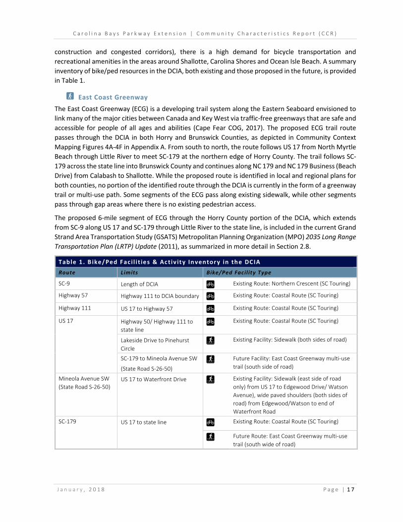
construction and congested corridors), there is a high demand for bicycle transportation and recreational amenities in the areas around Shallotte, Carolina Shores and Ocean Isle Beach. A summary inventory of bike/ped resources in the DCIA, both existing and those proposed in the future, is provided in Table 1.
F East Coast Greenway
The East Coast Greenway (ECG) is a developing trail system along the Eastern Seaboard envisioned to link many of the major cities between Canada and Key West via traffic-free greenways that are safe and accessible for people of all ages and abilities (Cape Fear COG, 2017). The proposed ECG trail route passes through the DCIA in both Horry and Brunswick Counties, as depicted in Community Context Mapping Figures 4A-4F in Appendix A. From south to north, the route follows US 17 from North Myrtle Beach through Little River to meet SC-179 at the northern edge of Horry County. The trail follows SC-179 across the state line into Brunswick County and continues along NC 179 and NC 179 Business (Beach Drive) from Calabash to Shallotte. While the proposed route is identified in local and regional plans for both counties, no portion of the identified route through the DCIA is currently in the form of a greenway trail or multi-use path. Some segments of the ECG pass along existing sidewalk, while other segments pass through gap areas where there is no existing pedestrian access.
The proposed 6-mile segment of ECG through the Horry County portion of the DCIA, which extends from SC-9 along US 17 and SC-179 through Little River to the state line, is included in the current Grand Strand Area Transportation Study (GSATS) Metropolitan Planning Organization (MPO) 2035 Long Range Transportation Plan (LRTP) Update (2011), as summarized in more detail in Section 2.8.
Tab le 1 . B ike/Ped Fac i l i t ies & Act iv ity In ventor y in th e DCIA Route Limits Bike/Ped Facil ity Type
SC-9 Length of DCIA G Existing Route: Northern Crescent (SC Touring)
Highway 57 Highway 111 to DCIA boundary G Existing Route: Coastal Route (SC Touring)
Highway 111 US 17 to Highway 57 G Existing Route: Coastal Route (SC Touring)
US 17 Highway 50/ Highway 111 to state line
G Existing Route: Coastal Route (SC Touring)
Lakeside Drive to Pinehurst Circle
Ô Existing Facility: Sidewalk (both sides of road)
SC-179 to Mineola Avenue SW
(State Road S-26-50) Ô Future Facility: East Coast Greenway multi-use
trail (south side of road)
Mineola Avenue SW (State Road S-26-50)
US 17 to Waterfront Drive Ô Existing Facility: Sidewalk (east side of road only) from US 17 to Edgewood Drive/ Watson Avenue), wide paved shoulders (both sides of road) from Edgewood/Watson to end of Waterfront Road
SC-179
US 17 to state line G Existing Route: Coastal Route (SC Touring)
Ô Future Route: East Coast Greenway multi-use trail (south wide of road)
C a r o l i n a B a y s P a r k w a y E x t e n s i o n | C o m m u n i t y C h a r a c t e r i s t i c s R e p o r t ( C C R )
J a n u a r y , 2 0 1 8 P a g e | 1 8
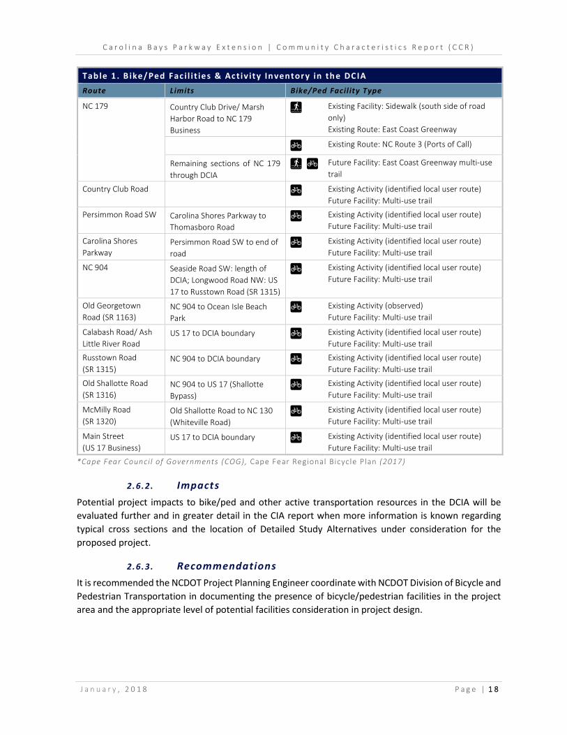
Tab le 1 . B ike/Ped Fac i l i t ies & Act iv ity In ventor y in th e DCIA Route Limits Bike/Ped Facil ity Type
NC 179 Country Club Drive/ Marsh Harbor Road to NC 179 Business
Ô
Existing Facility: Sidewalk (south side of road only) Existing Route: East Coast Greenway
G Existing Route: NC Route 3 (Ports of Call)
Remaining sections of NC 179 through DCIA
Ô G Future Facility: East Coast Greenway multi-use trail
Country Club Road G Existing Activity (identified local user route) Future Facility: Multi-use trail
Persimmon Road SW Carolina Shores Parkway to Thomasboro Road
G Existing Activity (identified local user route) Future Facility: Multi-use trail
Carolina Shores Parkway
Persimmon Road SW to end of road
G Existing Activity (identified local user route) Future Facility: Multi-use trail
NC 904 Seaside Road SW: length of DCIA; Longwood Road NW: US 17 to Russtown Road (SR 1315)
G Existing Activity (identified local user route) Future Facility: Multi-use trail
Old Georgetown Road (SR 1163)
NC 904 to Ocean Isle Beach Park
G Existing Activity (observed) Future Facility: Multi-use trail
Calabash Road/ Ash Little River Road
US 17 to DCIA boundary G Existing Activity (identified local user route) Future Facility: Multi-use trail
Russtown Road (SR 1315)
NC 904 to DCIA boundary G Existing Activity (identified local user route) Future Facility: Multi-use trail
Old Shallotte Road (SR 1316)
NC 904 to US 17 (Shallotte Bypass)
G Existing Activity (identified local user route) Future Facility: Multi-use trail
McMilly Road (SR 1320)
Old Shallotte Road to NC 130 (Whiteville Road)
G Existing Activity (identified local user route) Future Facility: Multi-use trail
Main Street (US 17 Business)
US 17 to DCIA boundary G Existing Activity (identified local user route) Future Facility: Multi-use trail
*Cape Fear Counci l of Governments (COG), Cape Fear Regional Bicycle Plan (2017)
2.6.2 . Impacts Potential project impacts to bike/ped and other active transportation resources in the DCIA will be evaluated further and in greater detail in the CIA report when more information is known regarding typical cross sections and the location of Detailed Study Alternatives under consideration for the proposed project.
2.6.3 . Recommendations It is recommended the NCDOT Project Planning Engineer coordinate with NCDOT Division of Bicycle and Pedestrian Transportation in documenting the presence of bicycle/pedestrian facilities in the project area and the appropriate level of potential facilities consideration in project design.
C a r o l i n a B a y s P a r k w a y E x t e n s i o n | C o m m u n i t y C h a r a c t e r i s t i c s R e p o r t ( C C R )
J a n u a r y , 2 0 1 8 P a g e | 1 9
2.7 Transit & Other Multi-Modal Resources/Activity
Are there any transit, freight or other multi-modal resources present in the Direct Community Impact Area (DCIA)? Were any signs or other indicators of resources observed during field
review? Has any activity been observed or documented by local officials? Are there any known special users of these resources?
2.7.1 . Presence
Transit
Waccamaw Regional Transportation Authority (Coast RTA) Coast RTA provides regional public transportation services in Horry and Georgetown Counties, SC, including 11 fixed route transit lines, paratransit services and emergency management assistance. The fixed route system operates seven days a week with stops near area employers, medical centers, hospitals, and entertainment attractions. Coast RTA also provides paratransit service to qualifying individuals with certified disabilities (physical or mental). Available services include point-to-point transportation by advanced reservation to and from any location within a ¾ mile radius of a Coast RTA fixed route. Currently, none of the Coast RTA fixed routes operate within the DCIA and none are within a ¾ mile radius, thus paratransit services should not be using the existing transportation network within the DCIA. Coast RTA also provides emergency management assistance when an executive order for evacuation is issued by the state governor, becoming part of the Horry County Emergency Preparedness initiative to transport residents to local shelters. Emergency management assistance services provided by Coast RTA operate within the DCIA, as discussed in more detail in Section 2.12.
Brunswick Transit System The Brunswick Transit System (BTS) provides non-emergency transportation services to the general public of Brunswick County and, through contract, to human service agency clients in Brunswick County. BTS does not offer fixed route service and requires passengers to schedule a trip at least 48 hours in advance. Services are open to any member of the public, with one-way fares ranging from $1.50 to $5.00, depending on the distance traveled. BTS operates Monday-Friday, from 7:00 a.m. to 4:00 p.m. and offers service to New Hanover County (Wilmington) on Tuesdays and Thursdays.
Airports
There are no airports or air fields located within the DCIA. The closest regional and international airports serving DCIA residents include:
e Odell Williamson Municipal Airport (60J) in Ocean Isle Beach, located just east of the DCIA boundary on Beach Drive SW. Owned by the Town of Ocean Isle Beach, it is a single runway facility that is publicly owned and open to public use.
e Grand Strand Airport (CRE) in North Myrtle Beach, located approximately 6.5 miles south of Little River. Owned by Horry County, it is a single runway facility that is open to public use.

C a r o l i n a B a y s P a r k w a y E x t e n s i o n | C o m m u n i t y C h a r a c t e r i s t i c s R e p o r t ( C C R )
J a n u a r y , 2 0 1 8 P a g e | 2 0
e Myrtle Beach International Airport (MYR), located south of the DCIA in Myrtle Beach, is approximately 25 miles from Little River and 45 miles from Shallotte. MYR is a primary commercial service airport with a single runway, owned and operated by Horry County.
e Wilmington International Airport (ILM), located north of the DCIA in Wilmington (New Hanover County) is approximately 40 miles north of Shallotte and 56 miles north of Little River. Owned by New Hanover County, the airport serves primarily commercial uses and has two runways.
2.7.2 . Impacts Project impacts to existing transit and other multi-modal resources in the DCIA are unlikely. The presence of resources and any potential project impacts will be evaluated again in the Community Impact Assessment (CIA) after further development of the typical cross section(s) and Detailed Study Alternatives that will be considered for the proposed project.
2.8 Local Area Plans & Goals
What are the adopted local area plans, goals and zoning initiatives specifically affecting the Direct Community Impact Area (DCIA) (e.g. comprehensive plan; corridor or thoroughfare plan;
small area plan; long-range growth plan; health impact assessment; etc.)?
2.8.1 . Presence The proposed CBP Extension project DCIA boundary contains numerous local, regional and state planning jurisdictions for both transportation and land use planning. The current local area plans and goals affecting the DCIA are defined through a patchwork of existing plans, many of which are dated, in various stages of being updated and/or target a plan area for which the boundary is still evolving. A summary of the various jurisdictional areas and associated plans and goals is provided below.
2.8.1 (a ) Transportation Plans
The adopted local transportation plans and goals affecting the DCIA are contained within several different planning documents developed by multiple entities. The existing adopted transportation plans and planning areas they cover generally vary by mode.
The majority of the DCIA boundary currently lies within the Grand Strand Area Transportation Study (GSATS) Metropolitan Planning Organization (MPO) jurisdiction. The GSATS MPO boundary spans the northern coastal portion of SC to include all areas east of the Waccamaw River and north of Winyah Bay (Georgetown County) to the state line in Horry County as well as a portion of Brunswick County, NC that includes the US 17 corridor to Varnamtown on the north side of Shallotte and all areas south (between US 17 and the Atlantic Ocean). The GSATS MPO boundary was expanded into Brunswick County, NC in 2013 following the 2010 US Decennial Census, which included this portion of Brunswick County within the Myrtle Beach – Socastee Urbanized Area for the first time (Brunswick County 2010 CTP, 2013). Prior to 2013, all of Brunswick County, NC lay within the Cape Fear Regional Planning Organization (RPO) jurisdictional boundary. Remaining portions of the DCIA in Brunswick County that do not lie within the GSATS MPO are within the current Cape Fear RPO boundary.

C a r o l i n a B a y s P a r k w a y E x t e n s i o n | C o m m u n i t y C h a r a c t e r i s t i c s R e p o r t ( C C R )
J a n u a r y , 2 0 1 8 P a g e | 2 1
Transportation planning services for GSATS MPO are provided through the Waccamaw Regional Council of Governments (COG), which provides a range of other planning services for the Waccamaw Region of SC that includes Horry, Georgetown and Williamsburg Counties. GSATS MPO is governed by two committees: the Policy Committee and the Technical Committee. The Policy Committee is the official decision-making body responsible for the adoption of plans, programs and study recommendations for the MPO. The GSATS Policy Committee is comprised of representatives from the following 18 entities: Horry County Council; Horry County Legislative Delegation; Georgetown County Council; Georgetown County Legislative Delegation; Brunswick County Commissioners; Waccamaw Regional Transportation Authority (Coast RTA); City of Myrtle Beach, SC; City of North Myrtle Beach, SC; City of Conway, SC; City of Georgetown, SC; Town of Surfside Beach, SC; Town of Shallotte, NC; Town of Ocean Isle Beach, NC; Town of Atlantic Beach, SC; Town of Briarcliffe Acres, SC; Town of Pawley’s Island, SC; SCDOT; and NC Board of Transportation. The GSATS MPO Technical Committee is established by the Policy Committee with the primary responsibility of monitoring all technical activities under the MPO’s jurisdiction, including biennial development of the draft Metropolitan Transportation Improvement Program (MTIP), and advising the Policy Committee in recommendations of major studies and planning activities. The Technical Committee is comprised of professional staff representatives from the GSATS member governments and public agencies with expertise and/or responsibilities in transportation planning and implementation.
The Cape Fear RPO was established by NCDOT in 2001 to provide transportation planning services for the area in southeastern NC that includes Brunswick, Columbus and Pender Counties. Cape Fear RPO serves as the intergovernmental organization for local elected officials, NCDOT and residents of the region to address transportation issues. Goals and duties of the RPO are similar to those of the MPO and include development of long range transportation plans for the region as well as conducting transportation related studies for local governments and other stakeholders in the region, providing a forum for public participation in the planning process, and developing and prioritizing transportation projects to be considered for inclusion in the NCDOT STIP.
GSATS MPO 2035 Long Range Transportation Plan Update (2011) The 2035 Long Range Transportation Plan (LRTP) Update (2011) is the current adopted 25-year transportation vision for the GSATS MPO. During the plan’s development and adoption, the GSATS MPO boundary did not include any part of Brunswick County, NC. A 2040 LRTP Update is currently underway with a draft version available dated July, 2017. Adoption of the final plan is expected in fall of 2017. The adopted 2035 LRTP Update (2011) envisions a transportation system that will increase accessibility and mobility throughout the region, which will integrate various transportation modes to provide efficient movement of people and goods. It states that growth in the Grand Strand area continues to outpace infrastructure development, noting the busy tourist season and traffic volumes that have increased steadily in response to population and economic growth. US 17, US 501, SC-22 and SC-31 were identified as congested corridors during the tourist season. The extension of SC-31 (Carolina Bays Parkway) from its existing terminus at SC-9 to the NC state line in Horry County is identified as a Tier 2, Priority A project in the 2035 LRTP Update (2011), which includes improvements at Highway 57 and SC-9. Other nearby projects identified in the 2035 LRTP Update (2011) include:
➊ SC-9 improvements between S-26-57 and the US 17 interchange; ➋ Sea Mountain Highway improvements between SC-90 and SC-9;

C a r o l i n a B a y s P a r k w a y E x t e n s i o n | C o m m u n i t y C h a r a c t e r i s t i c s R e p o r t ( C C R )
J a n u a r y , 2 0 1 8 P a g e | 2 2
➌ SC-90 widening from SC-22 to SC-9; ➍ Improvements to US 17 bridges in North Myrtle Beach (SC-9, SC-90 and Sea Mountain
Highway); ➊ Highway 57 widening between SC-90 to SC-9.
The transit element of the GSATS 2035 LRTP Update (2011) states the major transit provider for the planning area, Waccamaw Regional Transportation Authority (Coast RTA), has experienced a steady increase in ridership over the past three years. The plan identifies a major transit goal to provide improved services to an aging population and proposes transit projects that are aimed at improving service to growing suburban communities and offer multimodal facilities to support future transit growth.
GSATS MPO 2015-2019 Transportation Improvement Program (TIP) The 2015-2019 Transportation Improvement Program (TIP) is a five-year program of transportation capital projects together with a three-year estimate of transit capital and maintenance requirements for the GSATS MPO area. The TIP may also include regional highway projects that are being implemented by the State, City and County for which federal funding is requested. The TIP is usually approved biennially but may be amended throughout the year. The current 2015-2019 TIP for GSATS MPO includes the proposed Carolina Bays Parkway Extension from SC-9 to the NC state line. The project program type is listed as “System and Intermodal Connectivity” with “Surface Transportation Program (STP)/ National Highway System (NHS)” funding.
Brunswick County 2010 Comprehensive Transportation Plan (CTP) (2010) Adopted by NCDOT, Brunswick County and participating municipalities in 2007-2008, and endorsed by Cape Fear RPO in 2010, this long range plan covers the multi-modal transportation needs of Brunswick County through 2035, including highway, public transportation and rail, bicycle, and pedestrian. The 2010 CTP highway recommendations (provided in Appendix E of this CCR) include the proposed STIP project R-3436, I-74 corridor extending approximately 65 miles from US 74/76 in Columbus County, NC to the SC state line in Brunswick County. As discussed previously, the southernmost sections of the proposed R-3436 project are representative of the Brunswick County portion of the current proposed CBP Extension project. The 2010 Brunswick County CTP provides the following problem statement information for the proposed I-74/I-73 corridor project, NC STIP R-3436:
I-74, along with I-73, is designated as “Congressional High Priority Corridor 5” on the National Highway System3 (NHS). Roadways identified on the NHS are recognized as being important to the nation’s economy, defense, and mobility. This corridor, also known as I-73/74 North-South Corridor, is defined by federal law as traveling from Charleston, South Carolina to Sault Ste. Marie, Michigan… P.L. 102-240, Section 1105 High Priority Corridors on the National Highway System (ISTEA) describes the I-74 route within (southeastern) North Carolina as follows: US 74 to US 76 near Whiteville; US 74/76 to the South Carolina State line in Brunswick County.
Additionally, I-74 is designated as a freeway on NCDOT’s Strategic Highway Corridor Vision (SHC) Plan. This facility is intended to provide mobility in Brunswick County and, ultimately, connectivity between Wytheville, VA and Myrtle Beach, SC.
The proposed project (R-3436) is to construct a four lane freeway on new location from US 74/76 in Columbus County to South Carolina. Interchanges are recommended at: NC 211 (northern part of
C a r o l i n a B a y s P a r k w a y E x t e n s i o n | C o m m u n i t y C h a r a c t e r i s t i c s R e p o r t ( C C R )
J a n u a r y , 2 0 1 8 P a g e | 2 3
county), proposed I-74/I-140 Connector, Royal Oak Road (SR 1345), NC 130 (Whiteville Road), NC 904, and Hickman Road (SR 1303). Grade separations are recommended at: Old CC Road, Little Macedonia Road (SR 1343), Makatoka Road (SR 1342), proposed New Briton Road Extension, Pea Landing Road (SR 1304), Gwynn Road and Ash-Little River Road (SR 1300).
During the development of the CTP, residents of the Brunswick Plantation development submitted a petition (286 signatures) for the re-alignment of the proposed I-74 corridor (Carolina Bays4 section) from NC 904 to South Carolina in order to minimize impacts to the development. As a result, the alignment for this section of the corridor was adjusted northward as shown in the CTP.
The proposed project was included in the 2001 Brunswick County Thoroughfare Plan.
Other highway projects proposed in the 2010 CTP that are located within the DCIA include:
➊ Upgrade US 17 (Ocean Highway) within the GSATS MPO boundary to an expressway. ➋ Widen US 17 Business (Main Street) to a multi-lane facility from US 17 West to US 17 East. ➌ Widen NC 130 (Whiteville Road) from US 17 to McMilly Road and from US 17 Business to the
end of state maintenance. ➍ Widen NC 904 (Seaside Road SW/Longwood Road NW) to a multi-lane facility from Ash-Little
River Road to NC 179 (Beach Drive). ➎ Widen NC 179 to a multi-lane facility from SC state line to NC 904 (Seaside Road) and from
Ocean Isle Beach Road (SR 1184) to US 17. ➏ Widen NC 179 Business to a multi-lane facility from NC 179 to NC 904 (Seaside Road) ➐ Widen Ocean Isle Beach Road to a multi-lane facility from NC 179 to US 17. ➑ Upgrade Old Georgetown Road (SR 1163) to two 12-foot lanes (24-foot pavement width) from
NC 904 (Seaside Road) to Ocean Isle Beach Road. ➒ Upgrade Ash-Little River Road to two 12-foot lanes (24-foot pavement width) from NC 130 to
Hickman Road. ➓ Upgrade Calabash Road to two 12-foot lanes (24-foot pavement width) from Hickman Road to
US 17.
Other elements of the 2010 CTP include the Existing and Future Land Use Maps. The Existing Land Use map identifies areas to the north west of the US 17 corridor as primarily vacant or residential-agricultural. Some commercial, single family residential, office and institutional uses are concentrated along the US 17 corridor as well as to the south and east within the municipalities of Carolina Shores, Ocean Isle Beach, Sunset Beach and Shallotte. The Future Land Use Map identifies a similar future pattern of uses with areas to the north and west of the US 17 corridor primarily low density residential and conservation. South and east of the corridor, higher concentrations of development are expected within the municipal jurisdictions and in nodes along the corridor.
Cape Fear Regional Bicycle Plan (2017), Cape Fear Regional COG The Cape Fear Regional Bicycle Plan (2017) is a comprehensive regional planning document developed through funding provided by NCDOT, recently adopted in July, 2017 by local governments in the region, including Brunswick County. It is a 30-year plan for improving bicycle infrastructure in southeastern NC through improvements at the network level as well as the policy and program levels. The regional plan area includes all of Brunswick, Columbus, New Hanover, and Pender Counties as well as portions of Bladen, Sampson and Onslow Counties. The plan recognizes the region as a tourist destination with a

C a r o l i n a B a y s P a r k w a y E x t e n s i o n | C o m m u n i t y C h a r a c t e r i s t i c s R e p o r t ( C C R )
J a n u a r y , 2 0 1 8 P a g e | 2 4
seasonal flux in visitors that are often looking for recreational opportunities, which a regional bicycle network could satisfy while also providing local economic development opportunities to smaller inland communities. The vision is for bicycling to be a safe and accessible form of transportation and recreation for residents and visitors in the region, with key destinations served by well-connected bikeways that increase tourism and promote economic development. Existing bike routes are inventoried to include those identified in locally adopted bike/ped plans throughout the region as well as routes used by local cyclists and advocacy groups. The plan makes a number of recommendations to improve the network, which are prioritized into short term and long term facility improvements (as summarized in Section 2.6), and various program level recommendations that include regional wayfinding signage and public information campaigns about bike safety and regional route mapping. The plan also makes a range of policy level recommendations, including local adoption of Complete Streets Policies throughout the region, integration of bicycle-oriented design guidelines at the local level that support route connectivity and require certain bicycle facility accommodations in site and subdivision planning as well as a few policy recommendations specifically targeting NCDOT design guidelines and project development procedures. As the regional plan was only recently adopted, none of the recommendations have been implemented to date.
Waccamaw Regional Transit & Coordination Plan (2014), Waccamaw Regional COG The Waccamaw Regional COG provides a range of planning services, including transportation planning, for the Waccamaw Region in SC, which includes Horry, Georgetown and Williamsburg Counties. The Waccamaw Regional Transit & Coordination Plan (2014) identifies existing public transportation services, needs, and strategies for the next 20 years. The plan focuses primarily on the areas of Georgetown, Horry and Williamsburg Counties that lie outside the GSATS jurisdiction. As the Horry County portion of the DCIA is entirely within the GSATS planning boundary, the plan contains few goals and objectives which apply directly to the DCIA.
Public transportation is currently provided in the plan area through Waccamaw Regional Transportation Authority (Coast RTA), which serves the CBP project area DCIA, and the Williamsburg Transit System, which serves areas west of the CBP project area DCIA. Coast RTA provides service up to North Myrtle Beach with the majority of routes serving Myrtle Beach and Conway. A key transportation strategy presented in the plan is to coordinate the development of multimodal options for residents and visitors within the Myrtle Beach metropolitan area, including public transportation. The plan presents a demographic overview of the community, outlines existing transit options, presents coordination strategies, and identifies regional transportation needs and funding options. The Plan outlines the broad goal of enhancing and expanding existing transit services. Also, the goal to increase inter-agency coordination is outlined. This goal will likely produce greater coordination between GSATS and the Waccamaw Regional COG to coordinate future transit planning, which may impact transit services within the DCIA.
Brunswick County Trail Plan (2017) The Brunswick County Trail Plan (2017) consists of two maps, existing and proposed trails. The Existing trails inventory represents all of the bicycle, pedestrian, multi-use, and paddling trail routes throughout the county, which are currently identified in existing local plans. The Proposed trail inventory represents all of the existing routes in addition to newly proposed routes to improve the trail network linking

C a r o l i n a B a y s P a r k w a y E x t e n s i o n | C o m m u n i t y C h a r a c t e r i s t i c s R e p o r t ( C C R )
J a n u a r y , 2 0 1 8 P a g e | 2 5
communities with surrounding recreational amenities and natural resources throughout the county. The plan does not prioritize any routes in particular or outline a funding strategy for any of the proposed routes. The trail plan was approved by the Brunswick County Board of Commissioners in March, 2017 and by many of the municipalities located in Brunswick County.
All of the proposed trails within the DCIA are summarized in Table 1 in Section 2.6, and shown on Community Context Mapping Figures 4A-4F in Appendix A.
Horry County Bicycle and Pedestrian Plan (2013) The Horry County Bicycle and Pedestrian Plan (2013) assesses the different areas and communities in Horry County where better connectivity for bicyclists and pedestrians can be most effectively provided, citing the increased demand for better non-motorized connectivity and healthier transportation choices. The plan inventories existing infrastructure, identifying common barriers to shared facility use by bicycle, pedestrian and motorist users, including: fragmented sidewalks, increasing traffic volumes, auto-oriented development, lack of signalized crossings, and underdeveloped facilities. Many of these barriers occur along facilities in the DCIA. Policy recommendations made in the plan include incorporating pedestrian and bicycle facilities into design standards, providing more signalized crossings and regional coordination of proposed projects. The plan does not make any facility recommendations affecting the DCIA.
Northeast Area Transportation Plan (2009), City of North Myrtle Beach The Northeast Area Transportation Plan (2009) is intended to address congestion and safety issues in the North Myrtle Beach and northern Horry County area, an area which overlaps the DCIA slightly but is largely adjacent to it along the southern DCIA boundary. The plan area is specifically defined as being bound by SC-22 to the west, SC-90 and Highway 57 to the north, SC-9 to the east, and the Intracoastal Waterway to the south. Existing growth and development trends are considered in combination with planned future transportation projects, including the Carolina Bays Parkway Extension and future construction of I-73 and I-74 through SC.
The plan recognizes the unique character of the North Myrtle Beach area and surrounding neighborhoods and takes a multi-modal approach in recognizing the needs of different users and the importance of a system balance between mobility and access. A number of transportation planning and design tools are identified which may be effective in preserving the plan area’s appeal and character while helping it continue to grow. Identified tools include a range of access management strategies, Complete Streets concepts, options for modifying interchange designs, signal modifications, and intersection modifications. Recommendations of the plan include a range of new connections and improvements to existing facilities. Recommendations affecting the DCIA:
➊ Access management improvements to SC-9 between US 17 and Highway 57, including conversion to a 4-lane median-divided facility.
➋ Intersection improvements at SC-9 and Highway 57. ➌ Intersection improvements at SC-90 and Sea Mountain Highway.

C a r o l i n a B a y s P a r k w a y E x t e n s i o n | C o m m u n i t y C h a r a c t e r i s t i c s R e p o r t ( C C R )
J a n u a r y , 2 0 1 8 P a g e | 2 6
2.8.1 (b ) Land Use & Vision Plans
Horry County Envision 2025 Comprehensive Plan (2008) The Envision 2025 Comprehensive Plan (2008) is a tool to guide developers, political decision-makers and the general public in determining the future land use composition of the county. A rewrite of the comprehensive plan is currently underway according the Horry County Planning Department representative but the schedule for adoption is unknown. The Envision 2025 Plan notes an expanding countywide population and economy centered on tourism and entertainment, which has attracted an increasing number of retirees to the area. Due to the county’s popularity as a tourist destination, the growing enrollment numbers at colleges and universities in the area, and the increasing number of housing units, a primary goal of the Envision 2025 Plan is to balance the need for infrastructure and development with the preservation of natural and cultural resources. This Plan estimates that Horry County will see its population increase by 110,000 people through 2025, which will place additional strain on the existing transportation network and housing units.
In the Current Land Use Map, development patterns along the US 17 corridor are primarily classified as Urban Residential, Recreation and Entertainment, Mixed Use and Sales & Services. The area to the north and west of the US 17 corridor is less developed, and primarily classified as Suburban and Rural Conservation with development clustered around the intersection of Highway 57 and SC-9.
The Future Land Use Map identifies a variety of future land use classifications for the Horry County portion of the DCIA. Areas within immediate proximity of US 17 and SC-9 are designated as Urban Corridors. The portion of Little River lying between US 17 and Highway 57, generally including the area surrounding Highway 111 and Highway 50, is classified as a Transitional Growth Area. The area of Little River south of US 17 to the Intracoastal Waterway is primarily designated as Urban Communities, with exception of the Preserved Open Space and Scenic and Conservation Areas.
The Envision 2025 Plan mentions the CBP Extension project as a major proposed roadway project. The project is also intended to be an evacuation route. In describing future roadway plans, the Transportation Element of the plan outlines the proposed I-74 route connecting into NC along the Highway 57 corridor. The CBP/Robert Edge Parkway (North Myrtle Beach) project is given the highest priority in the GSATS 2030 LRTP. The project is identified as a proposed new limited-access highway connecting SC-90 and existing SC-31 (Carolina Bays Parkway) via interchange and continuing over the Intracoastal Waterway to terminate at the intersection with US 17 and Main Street in North Myrtle Beach. The CBP Extension project that would be built from SC-9 to the NC state line is given the second highest priority. The US 17 widening project in North Myrtle Beach is also identified.
The plan states that the rapid pace of population growth and development occurring in Horry County has the potential to negatively affect natural resources and the environment. The Waccamaw River, which serves as the western DCIA boundary through Horry County, is recognized as a natural feature that should be targeted for preservation. The plan suggests inclusion of low impact development techniques in the county’s Land Development Regulations, Zoning Ordinance and Storm Water Design Manual as tools of natural resource protection. The Priority Conservation Areas Map (2009), Appendix 4 of the Envision 2025 Plan Natural Resources Element, identifies much of the DCIA in Horry County located between the US 17 corridor and the Waccamaw River as either a “Forest Corridor Linkage,” or “Priority Open Space Acquisition Sites.” While the exact boundaries are difficult to discern due to the scale of the map, the portion of the DCIA extending northwest from the US 17/SC-9 interchange to

C a r o l i n a B a y s P a r k w a y E x t e n s i o n | C o m m u n i t y C h a r a c t e r i s t i c s R e p o r t ( C C R )
J a n u a r y , 2 0 1 8 P a g e | 2 7
Highway 57 is identified as “Priority Open Space Acquisition Sites.” Much of the DCIA located north and east of this area is identified as a “forest corridor linkage.” Linkages are defined as linear features that connect Hubs and/or Sites to tie the system together, while Hubs are defined as large areas of protected land that anchor an open space network. The proposed “forest corridor linkage” that includes much of the DCIA connects two existing Hubs that include: (1) the Upper Waccamaw River, and (2) Walters Island on the south side of the Intracoastal Waterway. The Priority Conservation Areas Green Infrastructure Concept Map is included in Appendix E of this CCR.
Brunswick County CAMA Core Land Use Plan (2007) The Brunswick County CAMA Core Land Use Plan (2007) provides an analysis of the existing and emerging issues related to population, housing, economy, natural systems, land use, community facilities, and related resources. The plan area includes the majority of the Brunswick County portion of the DCIA with the exception of the Calabash, Sunset Beach and Ocean Isle Beach municipal jurisdictions, as these areas had prepared individual CAMA Core Land Use Plans at the time. The Brunswick County plan introduction states the following:
The plan was prepared at a time when the county was undergoing tremendous fiscal and social change. Based on a series of public outreach efforts that including surveys distributed among residents of the plan area, the following are identified as the key issues confronting Brunswick County:
⍟ Scattered and sprawling large lot subdivision activity;
⍟ Unplanned commercial strip development;
⍟ Sewage problems/sewage solutions;
⍟ Concern with storm water runoff and drainage.
The Existing Land Use Map for the plan area shows predominantly vacant, low density residential and agricultural land uses within the Brunswick County portion of the DCIA. Other intermittent land uses within the DCIA include commercial, office and institutional, recreational, single family residential and industrial. These land uses generally occur along the US 17 and Hickman Road corridor areas. In discussing existing land use trends, the plan highlights the substantial stock of vacant, agricultural or otherwise undeveloped land county-wide as well as the abundance of environmentally sensitive areas. The plan identifies the most rapidly developing portion of the county as the area south of US 17 between the municipalities of Carolina Shores and Bolivia, an area which includes a large portion of the DCIA. The plan states there are several large golf course communities and planned residential developments located in the area, noting this type of development is occurring at an especially rapid rate between the SC state line and Shallotte where development pressure is stemming from the Myrtle Beach/Grand Strand Area. The plan further states that large development companies have already targeted this region south of US 17 for the development of additional large scale mixed use subdivisions once the county’s infrastructure develops to support.
According to the plan, undesirable land use conditions include strip commercial development along major corridors and sprawling development. As a result of inexpensive land and a continually increasing population, the majority of future development is expected to be concentrated along the US 17 corridor. Through GIS analysis that takes into account environmental constraints and current land use patterns, the Plan identifies areas along US 17 and other major roads as the most suitable places for future development.

C a r o l i n a B a y s P a r k w a y E x t e n s i o n | C o m m u n i t y C h a r a c t e r i s t i c s R e p o r t ( C C R )
J a n u a r y , 2 0 1 8 P a g e | 2 8
The Brunswick County portion of the DCIA is primarily zoned as R-7500 Residential (single family residential) and Rural Low Density Residential. Numerous parcels along major roadways are zoned as Commercial Low Density and Commercial Intensive. Additionally, a few Natural Heritage Program Natural Areas are identified within and adjacent to the DCIA, including: (1) Gause Savanna site on the north side of the US 17 corridor just southeast of Jessi Mae Monroe Elementary School; (2) the Scippio Swamp Ridge and Waccamaw River Oxbow site, both of which are located within the Ducks Unlimited conservation easement along the river; (3) the Sandy Branch Sand Ridge and Bay Complex, which extends along the north side of the recently completed Old Georgetown Road extension (NC STIP R-3432) from Ocean Isle Beach Road to the Shallotte town limits.
The Future Land Use Map designates the Brunswick County portion of the DCIA as predominately low density residential with limited commercial and industrial uses along US 17 and other major road corridors. Conservation is the predominant future use along the Waccamaw River in the northwestern part of the DCIA. The plan recommends future land use policies that consolidate development and encourage smart growth principles.
Town of Carolina Shores Draft Comprehensive Plan (Ongoing, 2017) Carolina Shores Draft Comprehensive Plan is still in the development process. Available sections include the Introduction, Community Profile and Environmental Conditions. The draft Plan was undertaken to produce a workable, creative, and dynamic plan to guide future long-term growth and development over the next twenty years. The plan is being developed by the Carolina Shores Town Planning Board, and the entire municipal boundary of Carolina Shores is within the CBP DCIA.
Carolina Shores is a growing community with a population that increased by 136 percent from 2000 to 2010. As a result, more housing units and development are accompanying the population growth. Wetlands are identified as natural resources that are prevalent within the Carolina Shores jurisdiction. There are two Natural Heritage Program Natural Areas within the city boundaries. These two sites include the Cawcaw Swamp directly west of US 17, and Little Cawcaw Swamp directly east of US 17. Additionally, much of the jurisdiction is make up of land classified as prime farmland.
Town of Calabash Land Use Maps The Town of Calabash provides Existing and Future Land Use Maps that were published in 2005 and 2007, respectively. Maps that are applicable to the DCIA include the Existing Land Use Map and Future Land Use Map. A small portion of the town’s jurisdiction is within the DCIA. NC 179 (Beach Drive) divides the Town of Calabash into its northern and southern halves.
The Existing Land Use Map classifies the portion of the NC 179 (Beach Drive) corridor extending through the DCIA as primarily commercial with some undeveloped parcels. Existing commercial development is clustered most densely around the intersection of NC 179 and Thomasboro Road. Residential land uses are concentrated north of NC 179 along Persimmon Road and south of NC 179 along NC 179 Business (Beach Drive). There are large tracts of undeveloped land throughout the Calabash municipal boundaries.
The Future Land Use Map, produced in 2007, identifies the NC 179 corridor through the DCIA as the Business District and Town Center. Residential land uses are set to be developed away from the main NC 179 corridor. The Future Land Use Map also identifies the Calabash River as a conservation area.

C a r o l i n a B a y s P a r k w a y E x t e n s i o n | C o m m u n i t y C h a r a c t e r i s t i c s R e p o r t ( C C R )
J a n u a r y , 2 0 1 8 P a g e | 2 9
Town of Sunset Beach 2010 CAMA Land Use Plan The Town of Sunset Beach CAMA Land Use Plan was adopted in June 2010 with the intent to evaluate growth and development trends in Sunset Beach, while providing a workable framework and decision making tool to guide future development. Sunset Beach has experienced increased growth and development that is consistent with other similar beach-front municipalities in southeastern NC. The plan states a desire of the town to maintain its historical character by promoting lower density and single family residential development as its primary growth pattern.
While the Town of Sunset Beach is primarily a barrier island beach community, it includes some small satellite areas that are inland and within the DCIA. Many of the inland areas were residential annexations that occurred between 1990 and 2007, as outlined in the plan. Currently, much of the town’s area lying south of NC 179 contains the Sea Trail community and golf course, which contains a number of vacant lots, as well as other low density single family residential development.
NC 179 and NC 904 through the plan area are identified as carrying Annual Average Daily Traffic Volumes (AADTV) that exceed the roadway carrying capacity. The Town Zoning Ordinance requires properties along major collectors to be zoned either Mainland Business 1 (MB-1), Mainland Business 2 (MB-2) or Mixed Use District (MUD), and to adhere to a Major Collector Plan to ensure properties situated along thoroughfares within the town’s jurisdiction are developed in a manner that promotes the public’s health, safety and welfare. Major Collector Plans would be applicable to the development along NC 179 through the DCIA.
Much of the land use policy outlined in the plan focuses on the goal of preserving existing low density development patterns in Sunset Beach. New development must be compatible with the surrounding areas and strict building heights are identified. The Town of Sunset Beach plan is unique in comparison to other adopted local plans in the CBP project area in that the town does not intend to increase density as populations continue to grow in the future.
Town of Ocean Isle Beach 2009 CAMA Land Use Plan The Town of Ocean Isle Beach CAMA Land Use Plan was adopted in March 2009. Similar to Sunset Beach, the Town of Ocean Isle Beach is primarily a barrier island beach-front community but has small satellite jurisdictional areas located inland, some of which are within the DCIA. The 2009 CAMA Land Use Plan provides guidance to local decision-makers to achieve the long-term vision for the community as articulated through public input and previous planning initiatives. The Plan calls for maintaining the small town, family friendly atmosphere at Ocean Isle Beach by encouraging architecture that maintains the historical town character and building traditional family homes and neighborhoods. Community concerns include the increasing pace of redevelopment, population growth, heavy traffic congestion in summer months, lack of bicycle and pedestrian amenities, and the need for additional recreational facilities. The Plan aims to promote land uses which are compatible with appropriate management of the estuarine system and to encourage development that will minimize the loss of public resources such as wetlands, beaches and species.
Town of Ocean Isle Beach 2016 CAMA Land Use Plan (Draft) The Town of Ocean Isle Beach 2016 CAMA Land Use Plan (Draft) was published in August 2016 but has not been formally adopted.
C a r o l i n a B a y s P a r k w a y E x t e n s i o n | C o m m u n i t y C h a r a c t e r i s t i c s R e p o r t ( C C R )
J a n u a r y , 2 0 1 8 P a g e | 3 0
The draft Land Use Plan presents policies that provide guidance for future decision-making on public and capital investment, as well as zoning and other development regulations. Land use planning can play an integral part in avoiding or mitigating some of the negative effects of rapid development by establishing goals to support growth. Much like surrounding beach front communities, Ocean Isle Beach has experienced increased population growth and development in recent decades that is due in part to the area’s popularity as a tourist destination and the influx of retirees. There are relatively few year-round residents, but the shared perception is that seasonal tourists cause congestion on local roadways in the summer. Environmental concerns expressed in the plan include the preservation of the beach against erosion as well as the protection of estuaries, salt marshes and wetlands. Swamp marshes and various classifications of non-coastal wetlands are identified in the portion of the Town’s jurisdiction that lies within the DCIA.
The Existing Land Use Map identifies the portion of the DCIA lying within the town’s jurisdiction as Public/Semi-Public and Recreational land uses. A large portion of this area north of Old Georgetown Road is identified as Vacant. Potential land use conflicts identified for this area include bottomland hardwood forests, pocosin ecosystem and pine forests. A Future Land Use Map is not included in the draft plan.
Town of Shallotte 2007 CAMA Core Land Use Plan The 2007 CAMA Core Land Use Plan was adopted by the Town of Shallotte in 2007. The plan includes information regarding population, housing, economy, natural systems, existing land use and community facilities, a land suitability analysis, and a review of current plans, policies, and regulations. In preparation of the plan, key issues identified by local residents include revitalizing the downtown area, emphasizing trails and greenway, protection of the natural environment and providing housing to seniors.
Much like surrounding communities in southeastern NC, Shallotte has experienced increased population growth and development over the past three decades. Shallotte is a major gateway to the popular beach front communities in the area and traffic congestion during the summer tourist months strains the local transportation system. The plan states many of the area roadways are at or over traffic carrying capacity and recommends several transportation improvements for area roadways, ranging from the construction of new roads, to roadway improvements aimed at improving traffic congestion and providing alternative routes around the downtown district.
The portion of Shallotte which falls within the DCIA is primarily zoned as Highway Business, Business or Residential Agricultural along US 17 and NC 130. Higher density development occurs in closer proximity to the downtown district.
Following adoption of the 2007 CAMA Core Land Use Plan, the Town of Shallotte adopted the Shallotte Vision Plan to incorporate smart growth and pedestrian-friendly principles into the existing zoning ordinances. Certain zoning designations were modified and the Future Land Use Map was updated to reclassify land uses in the area surrounding the intersection of US 17 Business (Main Street) and NC 130 (Whiteville Road) for General Commercial and Light Commercial. The downtown district extends along US 17 Business (Main Street) with future uses that include high density residential, mixed used with conservation land along nearby streams.

C a r o l i n a B a y s P a r k w a y E x t e n s i o n | C o m m u n i t y C h a r a c t e r i s t i c s R e p o r t ( C C R )
J a n u a r y , 2 0 1 8 P a g e | 3 1
2.8.1 (c) Zoning & Development Ordinances
Horry County Code of Ordinances The Horry County Code of Ordinances defines the adopted Envision 2025 Comprehensive Plan as the primary document guiding future development within Horry County. Chapter 18 (Land Development Regulations) of the Horry County Code establishes regulations applying to all land development activities in the unincorporated portions of Horry County, including minimum design standards for new development as well as zoning classifications for land use. Existing zoning classifications within the Horry County portion of the DCIA are shown in the Existing Land Use Map in Appendix E of this report. In addition to the standard zoning classifications defined in Appendix B of Chapter 18 of the Horry Code of Ordinances, several overlay zones are identified that include the Little River Overlay Zone and the Little River Height Overlay Zone.
The Little River Overlay Zone boundary includes the area extending 250 feet to the east and west of the US 17 right-of-way lines between the state line and the overpass of Highway 90 at the intersection of SC-9 and US 17. The codified boundary map of the Little River Overlay Zone is included in Appendix E. The Horry County Code states, the Little River Overlay Zone is established to provide standards relative to accessibility, appearance and safety in the development of commercial, industrial, multi-family residential and office projects. Furthermore, the overlay is established to provide unified development that promotes a sense of place and provides opportunities to develop projects to be compatible with the carrying capacity of an urban corridor. The overlay standards apply to all new development and any “substantial modification” to existing development within the codified overlay boundary. “Substantial modification” is defined as any construction activity that increases the total building footprint by 25 percent or more, has a cost equal to 25 percent or more of the total appraised value (prior to modification), results in a 100 percent or more increase in the number of required parking spaces, or results in a “significant” change in the primary use of the property. The overlay includes vegetated buffer requirements within the streetscape for properties abutting the corridor, pedestrian connectivity requirements within very large parcels and between those with adjoining outparcels and auxiliary uses, and access management requirements to limit the number and location of driveways with direct access to the arterial corridor.
The Little River Height Overlay Zone boundary extends along the US 17 corridor from the state line to Golf Avenue and Kingsport Road, including the area 500 feet to the north, northwest of the US 17 right-of-way line and the area south of the US 17 right-of-way line to the Intracoastal Waterway. The codified boundary map of the Little River Height Overlay Zone Is included in Appendix E. Within the Little River Height Overlay Zone, the height of all new construction is limited to 60 feet unless the property is rezoned to a Planned Development District (PDD), in which case a height of up to 120 feet may be approved.
Brunswick County Unified Development Ordinance (2015) The Brunswick County Unified Development Ordinance (UDO) was most recently revised and re-adopted in March of 2015. It establishes design guidelines, administrative procedures as well as the process for enforcement of construction and development activity guidelines within the Brunswick County jurisdictional boundary. The Brunswick County Zoning Map is included in Appendix E, showing the DCIA includes classifications for Commercial-Low Density (C-LD), Medium Density Residential (R-

C a r o l i n a B a y s P a r k w a y E x t e n s i o n | C o m m u n i t y C h a r a c t e r i s t i c s R e p o r t ( C C R )
J a n u a r y , 2 0 1 8 P a g e | 3 2
7500), High Density Site Built Residential (SBR-6000), High Density Residential (R-6000), and Rural Low Density Residential (RR). C-LD is the primary classification along the US 17 corridor through the DCIA, while R-7500 covers the majority of unincorporated areas south of the corridor and RR covers the majority of unincorporated areas north and west of the corridor. There is a single large SBR-6000 zoning district that covers the existing Brunswick Plantation subdivision and some large areas extending along the north side of Number 5 School Road. The area surrounding the Longwood Community at the intersection of NC 904 (Longwood Road) and Etheridge Road is zoned for R-6000 and C-LD along the NC 904 corridor.
The Brunswick County Voluntary Agricultural District (VAD) Program is established in Article 4.9 of the UDO. The stated purpose of the program is to promote rural agricultural values, increase identity and pride in the farming community, preserve the agrarian heritage of the county, and offer protection from undesirable, non-farm development. Participation in the program is voluntary. As part of the program, no public agency or governmental unit may formally initiate action to condemn land within a VAD until a request has been made to the Advisory Board to hold a public hearing. As noted in Section 2.4, there are no known VADs in the Brunswick County portion of the DCIA.
Town of Calabash Unified Development Ordinance (2010) The Town of Calabash Unified Development Ordinance (UDO) was adopted in 2010. The UDO chapters directly applicable to the DCIA include Article 9: Zoning Districts and Map, and Article 15: Planned Unit Developments (PUDs). The adopted 2010 Zoning Map for the Town of Calabash is included in Appendix E. The Zoning Map shows the NC 179 (Beach Drive) corridor through the DCIA as the Central Business (CB) District. Extending northward along Persimmon Road, zoning classifications include Residential (R-6 and R-8), Agricultural (AD) and Planned Unit Development (PUD). There is a single PUD in the DCIA, which covers the Saltaire Village residential subdivision. Design guidelines and development standards of PUDs are established in Article 15 of the UDO, which states a maximum density of ten dwelling units per acre of net buildable area. The majority of areas zoned for PUD uses within the town limits contain subdivisions.
Town of Sunset Beach Zoning Map The Town of Sunset Beach Zoning Map includes a small portion of the DCIA. The majority of the town’s jurisdictional area along NC 179 is zoned as Mainland Residential with a small node around the intersection of NC 179 and NC 904 zoned for Mainland Business. The Zoning Map is included in Appendix E.
Town of Shallotte Unified Development Ordinance The Town of Shallotte UDO was originally adopted in July 2004 and includes amendments made through 2015. The current adopted Zoning Map is dated 2015 and included in Appendix E. The Town of Shallotte jurisdictional areas lying within the DCIA are zoned primarily for commercial and residential uses. Commercial classes are concentrated along US 17, NC 130 and Main Street (US 17 Business) through the DCIA. Residential Agriculture and low-density single family residential classifications generally cover the areas in between. A narrow strip of land buffering the Shallotte River through the town’s jurisdiction is zoned for Conservation.
C a r o l i n a B a y s P a r k w a y E x t e n s i o n | C o m m u n i t y C h a r a c t e r i s t i c s R e p o r t ( C C R )
J a n u a r y , 2 0 1 8 P a g e | 3 3
2.8.1 (d ) Other Small Area, Master or Comprehensive Plans
Highway 57 and Highway 9 Area Plan (2003), Horry County Adopted in December 2003, this area plan establishes guidelines that will help manage growth and guide development in the area surrounding the Highway 57 and SC-9 intersection. The intent of the plan is to identify areas most suitable for commercial, industrial and residential land uses within the plan area, which extends for a total radius of one and one-half miles from the intersection. The plan states its development was in response to completion of the northern section of SC-31 (Carolina Bays Parkway), which increased the potential for development in the area by increasing accessibility to the Highway 57/SC-9 area.
The plan area is subdivided into three sections: the Core Area, Transition Area and Secondary Area. The Core Area encompasses land within the first one-half mile radius extending outward from the intersection. The Transition Area includes land between the Core Area to the one-mile radius. The Secondary Area includes land between the Transition Area up to the one and one-half mile radius. A map depicting the recommended Future Land Use in the plan area is included in Appendix E. Retail Business is the primary recommended land use along major roadway corridors in the plan area (i.e. Highway 57, SC-9 and SC-31. Some institutional is recommended, which generally includes the area currently occupied by the North Strand Recreation Center. Some pockets of Light Industry are also recommended, primarily within the Core Area surrounding the Highway 57 and SC-9 intersection. Low and medium density residential are recommended in remaining areas.
The plan states the following regarding the Carolina Bays Parkway:
The first segment of the Carolina Bays Parkway was opened to traffic in December 2002; it currently terminates at Highway 9. In September 2002 SCDOT began preliminary studies for the possible extension of the Parkway from Highway 9 to the North Carolina State line. The study also involved the possibility of providing an interim connector that would tie the Parkway to Highway 57. The Parkway Extension project is locally funded through the Road Improvement and Development Effort (RIDE).
SCDOT recently informed the Infrastructure and Regulation Committee of the Horry County Council that on the issue of connection to Highway 57, they had looked at a number of possible alternatives, including the interim connector; a recommendation was given based on cost, safety, and time.
The recommendation from SCDOT would provide for a substantial upgrade to the Highway 9 and Highway 57 intersection that would improve safety and traffic flow; the interim connector to Highway 57 would not be constructed at this time. The Infrastructure and Regulation Committee endorsed this recommendation as the most efficient use of RIDE funds for the citizens of Horry County. A resolution to this effect is now pending with the Horry County Council.
The study of possible routes for the extension of the Carolina Bays Parkway is continuing as a joint effort between the SCDOT and the North Carolina Department of Transportation. Should the extension of the Carolina Bays Parkway to the North Carolina State line move forward, the Future Land Use Map would need to be reevaluated.

C a r o l i n a B a y s P a r k w a y E x t e n s i o n | C o m m u n i t y C h a r a c t e r i s t i c s R e p o r t ( C C R )
J a n u a r y , 2 0 1 8 P a g e | 3 4
Little River Neighborhood Area Plan, Horry County The Little River Neighborhood Area Plan (adoption date unknown) consists of three maps developed by Horry County Planning Department, the boundaries of which are located within the Census-Designated Place (CDP) of Little River. The Little River Neighborhood Area Plan covers an area roughly extending north from the Intracoastal Waterway, across the US 17 corridor to Mulberry Street on the north, Indian Hill Road to the west and Lakeside Drive to the east. The Neighborhood Plan includes a Future Land Use Map, which is included in Appendix E and identifies properties within the plan area for dense commercial and urban residential land uses.
Horry County Parks and Open Space Plan (2009) Adopted in 2009, the Parks and Open Space Plan was published to balance the growth and development of Horry County with conservation strategies and preservation of natural resources. Dramatic population growth over the past three decades has transformed the county from a largely rural population to a predominately suburban and urban population, a trend which is particularly apparent in the Horry County portion of the DCIA. Unique natural resources within the county include the cypress swamps, Carolina bays, salt and freshwater marshes, black water rivers, ocean swashes, and hardwood river forests. The plan includes the Green Infrastructure Concept Map, also included in the county’s Envision 2025 Comprehensive Plan, which is intended to guide future open space and natural habitat planning in Horry County by identifying priority conservation areas.
The East Coast Greenway through Horry and Georgetown Counties is planned to run adjacent to US 17 south of the North Carolina state line (see Appendix E for mapping of proposed East Coast Greenway route through SC). The Plan includes an open space inventory to identify current natural protection areas within Horry County. Natural resource properties are concentrated along the Waccamaw River west of Highway 57, including several properties along the northern DCIA boundary through Horry County.
Brunswick County Comprehensive Parks and Recreation Master Plan (2009) Adopted in 2009, the Comprehensive Parks and Recreation Master Plan is a long-term plan intended to accommodate the rapid population growth and development occurring in the county while maintaining high quality recreation opportunities and services. The Plan aims to promote a better quality of life by offering safe parks and facilities and creative recreational programs that serve all residents while preserving the county’s natural resources. During plan development, residents indicated a desire for improvements to existing facilities, development of new facilities and new programming opportunities. The plan includes recommendations for improvements to existing county park facilities, which have been documented in Section 2.1 for those parks located within the DCIA. The plan also advocates for the development of a countywide greenway master plan to accommodate the proposed East Coast Greenway and to add connections to existing county parks and recreation facilities. In expanding the number of parklands within Brunswick County, the plan recommends a land acquisition strategy that focuses on parcels adjacent to existing parks, schools, and other public facilities. Development priorities include increasing the amount of parks and recreational facilities, the development of a countywide greenway plan and directing effort to connect existing parks with a network of multi-use trails.
All existing and proposed parks and recreation facilities in the plan are included in Community Context Mapping Figures 4A-4F in Appendix A. A map from the adopted Comprehensive Parks and Recreation

C a r o l i n a B a y s P a r k w a y E x t e n s i o n | C o m m u n i t y C h a r a c t e r i s t i c s R e p o r t ( C C R )
J a n u a r y , 2 0 1 8 P a g e | 3 5
Master Plan (2009) depicting existing and proposed greenways and blueways throughout the county is also included in Appendix E.
2.8.2 . Impacts There are a number of overlapping jurisdictional planning areas in the DCIA with adopted planning documents containing goals and objectives for development that are not consistent across the DCIA. A number of the current adopted plans are also notably dated, containing baseline socio-economic and land use data that is questionably still relevant. There are also two key planning documents that will affect a notable portion of the DCIA, which are currently being developed for the first time. These include the GSATS 2040 Long Range Transportation Plan (LRTP) Update and the Town of Carolina Shores Comprehensive Plan. The GSATS 2040 LRTP Update will be the first edition of the LRTP that has been developed since expansion of the MPO jurisdictional boundary into Brunswick County, NC. The Comprehensive Plan for the Town of Carolina Shores will be the first comprehensive planning document adopted by the town since its incorporation. Due to all of these variables, consistency of the proposed project with local adopted plans, regulations and policies cannot be assessed at this time. The topic will be evaluated further and in greater detail in the Community Impact Assessment (CIA).
2.9 Local Area Development Activity
Has any recent development activity occurred in the Direct Community Impact Area (DCIA)? Are there any known plans for public or private development in the DCIA?
2.9.1 . Presence
Horry County According to information provided by the Horry County Planning representative, the market for residential growth in the DCIA remains high, along with commercial uses. The Little River area is the third-fastest growing area in the county and has seen substantial new construction, redevelopment and infill activity in recent years. The US 17 corridor continues to build out with master-planned residential, mixed-use and retail developments. The SC-9 corridor in the DCIA is also growing into a focal point for commercial and professional services, anchored by McLeod Seacoast Medical Center. Assisted living facilities are reported as a fast-growing sector in this area.
The following is a summary of known recent, ongoing and future proposed development activity in the DCIA. Future proposed development activity is based on information provided by the Horry County Planning Department in June, 2017. All of the proposed developments are in various stages of approval but are reflected in Community Context Mapping in Appendix A. Proposed site plans for each of the developments, as provided by Horry County Planning, are included in Appendix F.
McLeod Seacoast Medical Center (Recent/Ongoing) Located on SC-9, Seacoast Medical Center is one of seven hospitals in the McLeod Health network, a locally owned, not-for-profit healthcare system serving northeastern SC. The hospital, which initially opened in 2011, currently has 50 acute care beds and a recently completed Emergency Department. An additional expansion of the hospital is currently under construction that will provide 50 more beds, a new inpatient tower, new operating rooms, a same-day services suite, and a modern labor and

C a r o l i n a B a y s P a r k w a y E x t e n s i o n | C o m m u n i t y C h a r a c t e r i s t i c s R e p o r t ( C C R )
J a n u a r y , 2 0 1 8 P a g e | 3 6
delivery area. The hospital has encouraged associated development along the adjacent Sawtell Road corridor, which contains a variety of professional and medical service providers.
Single Family Residential Subdivisions (Recent/Ongoing) A few residential subdivision neighborhoods have been constructed in the past 10 years along Highway 57 and Highway 111, many of which contain phases that are still under construction. A cluster of small and mid-size subdivisions located near the western end of Highway 57 are a relatively recent development pattern on the corridor. The westernmost subdivision, Ashton Acres, appears to be complete with homes built in approximately 2007-2010. Adjacent to Ashton Acres, there is a cluster of three different named subdivisions that are all interconnected. These include Stones Edge, built approximately 2005-2015; North Village, initiated approximately 2005 with construction ongoing; and Carolina Crossing, initiated approximately 2010 with construction ongoing. On Highway 111 , Lafayette Village is a large multi-phase subdivision with approximately 450 total lots that is currently under construction. As of field review in February, 2017, the subdivision appeared to be at least 60 percent built.
Heather Glen Residential Subdivision (Future) Located in Little River on US 17 just west of the SC-179 split, the proposed Heather Glen subdivision will require approval of a re-zoning request to convert the existing Heather Glen golf course into a residential subdivision community containing 1,083 dwelling units, including 799 single family units and 284 duplex units. According the sketch plan provided (see Appendix F), the total land area contained in the development is 422.5 acres.
Bridgewater PDD: Multi-Phase Planned Development District (PDD) (Future) Located in Little River along US 17 and SC-9, the proposed Bridgewater PDD will convert the existing Bay Tree golf course into a multi-phase mixed-use development containing commercial, single family and multi-family residential. The Bridgewater PDD Master Plan indicates the project will be divided into six phases. Phases 1-3 are located primarily within the portion of property closest to US 17, with Phases 4-6 located primarily within the portion closest to SC-9. Phases 1-3 contain all of the commercial and multi-family components of the development and approximately 45 percent of the single family units. All three of the initial phases are scheduled to be open by 2019. Subsequent Phases 4-6 are scheduled to be open by 2022.
Normandy Tract: Multi-Phase Mixed-Use (Future) Located in Little River on SC-9 at the existing SC-31 (Carolina Bays Parkway) terminus interchange, the proposed Normandy Tract development will require approval of a re-zoning request for build-out of approximately 92.39 acres to contain commercial/retail and multi-family residential uses. The Normandy Tract is located adjacent to the proposed Bridgewater PDD (Phases 4-6) to the south, and the proposed Retreat PDD (discussed below) to the east.
Cypress Village PDD: Golf Course Redevelopment (Future) Located in Little River on US 17 and Highway 111, Cypress Village has historically been a residential and golf course community. In 2016, site plans were submitted proposing redevelopment of the golf course into a mixed-use PDD. The Conceptual Master Plan for Cypress Village (included in Appendix F) proposes 720 total dwelling units, including 142 single family units and 578 multi-family units, and 35,000 square feet of commercial space. The master plan also shows extension of McLamb Avenue to Highway 111.
C a r o l i n a B a y s P a r k w a y E x t e n s i o n | C o m m u n i t y C h a r a c t e r i s t i c s R e p o r t ( C C R )
J a n u a r y , 2 0 1 8 P a g e | 3 7
The Retreat PDD (Future) Located in Little River between Highway 57 and SC-9, a re-zoning request was originally made and approved in 2001 to allow for the 109.2-acre mixed-use development, proposed to include 575 multi-family/apartment units, 600 hotel and motel rooms and a maximum of 62 commercial lots. Potential effects of the proposed development on existing infrastructure resources at the time are summarized in a general manner under “Staff Comments” on the rezoning request included in Appendix F. According to information provided Horry County Planning Department, the Retreat PDD is partially constructed. An existing single family neighborhood located on Highway 57 is currently signed as “The Retreat”; however, the existing development does not seem to include any of the proposed commercial, hotel or multi-family residential components.
Brunswick County In the Brunswick County portion of the DCIA, local and regional planners have all reported ongoing and planned construction in a number of master-planned subdivision communities. The Brunswick County Planning representative provided a link to an online a map containing the locations of residential building permits issued since 2011, which is included in Appendix D.
While local planners have not provided any information regarding future proposed development in the Brunswick County portion of the DCIA, recent and ongoing development activity observed during field review included the following:
Brunswick Health & Rehab Center Located at the intersection of Number 5 School Road and Ash-Little River Road (SR 1300), ongoing construction of the rehab center was observed. According to local news outlets, the center will be a 110-bed assisted living facility overseen by Saber Healthcare Group. Construction of the facility is expected to be complete in October of 2017.
Medical Service Providers & Commercial Node A recently constructed development node on US 17 just south of Persimmon Road (SR 1162) includes the South Brunswick Office Building, which is a cluster of medical service providers, and a Goodwill Foundation Donation Center and Store. The development is accessible from both US 17 and Persimmon Road.
Springmill Plantation: Residential Subdivision (Recent/Ongoing) Springmill Plantation, located just east of the state line in the area between Calabash Road and McLamb Road, is a single family residential subdivision currently under construction. The subdivision is accessible from both Calabash Road and McLamb Road. During field review in February, 2017, the subdivision appeared to be at least 50 percent built.
Other Residential Subdivisions (Recent/Ongoing) The majority of existing residential subdivisions in the DCIA are not currently built out, with many containing vacant lots and/or subdivided sections dedicated for future phases. Subdivisions in the DCIA that were recently constructed and still contain some vacant lots and/or sections include the Farm at Brunswick and Calabash Lakes. Although both of these subdivision communities are identified as existing communities on the Town of Carolina Shores website, both contain a number of vacant lots. During field review in February, 2017, Calabash Lakes was largely unbuilt while the Farm at Brunswick
C a r o l i n a B a y s P a r k w a y E x t e n s i o n | C o m m u n i t y C h a r a c t e r i s t i c s R e p o r t ( C C R )
J a n u a r y , 2 0 1 8 P a g e | 3 8
appeared to have one or two vacant areas set aside for future phases. Subdivisions in the DCIA which contain vacant lots that appear to have been vacant for some time based on presence of vegetation or some other indicator of time passage, include Farmstead, Crows Creek and Brunswick Plantation. Although Brunswick Plantation is a gated community, prohibiting field observation, aerial imagery shows the majority of the subdivision section located on the north side of Number 5 School Road is vacant or unbuilt. The real estate section of the community’s website currently advertises over 120 vacant sites for sale. The website also advertises a “delayed construction program,” a retirement planning tool that allows new home builders to purchase their lot up to eight years prior to beginning construction.
2.9.2 . Impacts New location roadways can have notable impacts on community resources, including direct, indirect and cumulative impacts on local area development patterns. Direct impacts of the proposed CBP Extension project to local area development will be evaluated in detail in the Community Impact Assessment (CIA) after Detailed Study Alternatives have been developed for the proposed project. Potential indirect and cumulative impacts of the proposed CBP Extension project will be assessed in the Indirect and Cumulative Effects (ICE) Report.
2.10 Existing Access: Driveways & Cross Streets
What are the existing access conditions along the project corridor and cross streets in the Direct Community Impact Area (DCIA)? Are there high concentrations of driveways and/or intersections
anywhere in the DCIA? Is the project likely to result in access or accessibility impacts to driveways and cross streets?
2.10.1 . Presence Outside of the single existing interchange located in the DCIA at SC-31 and SC-9, access is uncontrolled on all facilities with the exception of US 17 (Ocean Highway) through Brunswick County, which is fully median-divided and currently being converted to a limited access Superstreet. US 17 through the Horry County portion of the DCIA is median-divided with the exception of a one-mile section between Nelson Road and Pinehurst Circle, which is five lanes undivided. There are no other median-divided facilities in the DCIA.
The US 17 corridor through Little River in Horry County contains the highest concentration of driveway and cross street connections. The following corridors contain a notably higher concentration of connections than most other facilities in the DCIA, along which driveway density is relatively moderate or low on average: NC 179 (Beach Drive) through Calabash, Sea Mountain Highway and SC-90.
2.10.2 . Impacts New location roadways can have notable impacts on access and accessibility depending on the location of new intersections, interchanges and/or access management applications. Potential impacts of the proposed CBP Extension project to access and accessibility will be evaluated in detail in the Community Impact Assessment (CIA) after Detailed Study Alternatives have been developed for the proposed project.

C a r o l i n a B a y s P a r k w a y E x t e n s i o n | C o m m u n i t y C h a r a c t e r i s t i c s R e p o r t ( C C R )
J a n u a r y , 2 0 1 8 P a g e | 3 9
2.11 Business & Economic Resources
Are any specific business and/or economic resources present in the Direct Community Impact Area (DCIA) (e.g. business parks or districts, distribution centers, manufacturing facilities, etc.)?
Is there any documented activity related to goods movement in the DCIA (e.g. tractor- trailers, or industrial traffic)?
2.11.1 . Presence As summarized in previous sections, local government planners in the project area have noted the importance of tourism and the large retiree population in shaping the social and economic context of the project area. The variety of business and economic resources located in the DCIA are largely on trend with a clear focus on tourism and service industries.
Recreational Tourism Resources
Rooted in its proximity to coastal beaches and waterways, the area has historically been a popular tourist destination where recreational tourism plays a key role in the local and regional economy. As the seasonal and year-round population base has grown notably in recent decades, largely as a result of retirees migrating to the area, the local economy has also grown and evolved to include a broad range of recreational tourism resources.
Golf Courses The Grand Strand region is a national golfing destination and there are a number of courses located in the DCIA. Many of the courses in the DCIA are located within residential communities that contain a mix of single-family and multi-family options to accommodate both full-time residents and visiting golfers. Many of the courses offer membership options for full-time residents as well as participation in multi-course golf packages. Courses in the DCIA vary in age; those in Horry County are generally older than those in Brunswick County. Many of the golf communities in Brunswick County offer multiple courses at a single location, while those in Horry County are single courses. All of the courses in the DCIA are open to public use. An inventory of golf courses located in the DCIA is summarized in Table 2 below.
Tab le 2 . Go l f Course In ventory North Side of US 17
HO
RRY 1) Colonial Charters One 18-hole course
2) Eagle Nest One 18-hole course
3) River Hills One 18-hole course, held under conservation easement
BRU
NSW
ICK 4) Farmstead One 18-hole course, a portion of which lies in Horry County.
5) Meadowlands One 18-hole course advertised as “sister course” to Farmstead; membership package includes playing privileges at both courses.
6) Brunswick Plantation Three 18-hole courses within the DCIA (identified collectively as “Brunswick Plantation Golf” on Community Context Map).
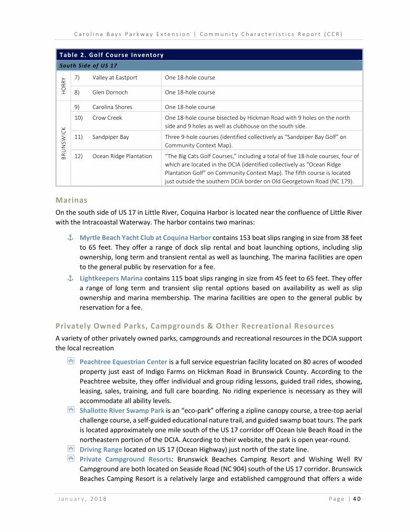
C a r o l i n a B a y s P a r k w a y E x t e n s i o n | C o m m u n i t y C h a r a c t e r i s t i c s R e p o r t ( C C R )
J a n u a r y , 2 0 1 8 P a g e | 4 0
Tab le 2 . Go l f Course In ventory South Side of US 17
HO
RRY 7) Valley at Eastport One 18-hole course
8) Glen Dornoch One 18-hole course
BRU
NSW
ICK
9) Carolina Shores One 18-hole course
10) Crow Creek One 18-hole course bisected by Hickman Road with 9 holes on the north side and 9 holes as well as clubhouse on the south side.
11) Sandpiper Bay Three 9-hole courses (identified collectively as “Sandpiper Bay Golf” on Community Context Map).
12) Ocean Ridge Plantation “The Big Cats Golf Courses,” including a total of five 18-hole courses, four of which are located in the DCIA (identified collectively as “Ocean Ridge Plantation Golf” on Community Context Map). The fifth course is located just outside the southern DCIA border on Old Georgetown Road (NC 179).
Marinas On the south side of US 17 in Little River, Coquina Harbor is located near the confluence of Little River with the Intracoastal Waterway. The harbor contains two marinas:
⚓ Myrtle Beach Yacht Club at Coquina Harbor contains 153 boat slips ranging in size from 38 feet to 65 feet. They offer a range of dock slip rental and boat launching options, including slip ownership, long term and transient rental as well as launching. The marina facilities are open to the general public by reservation for a fee.
⚓ Lightkeepers Marina contains 115 boat slips ranging in size from 45 feet to 65 feet. They offer a range of long term and transient slip rental options based on availability as well as slip ownership and marina membership. The marina facilities are open to the general public by reservation for a fee.
Privately Owned Parks, Campgrounds & Other Recreational Resources A variety of other privately owned parks, campgrounds and recreational resources in the DCIA support the local recreation
4 Peachtree Equestrian Center is a full service equestrian facility located on 80 acres of wooded property just east of Indigo Farms on Hickman Road in Brunswick County. According to the Peachtree website, they offer individual and group riding lessons, guided trail rides, showing, leasing, sales, training, and full care boarding. No riding experience is necessary as they will accommodate all ability levels.
4 Shallotte River Swamp Park is an “eco-park” offering a zipline canopy course, a tree-top aerial challenge course, a self-guided educational nature trail, and guided swamp boat tours. The park is located approximately one mile south of the US 17 corridor off Ocean Isle Beach Road in the northeastern portion of the DCIA. According to their website, the park is open year-round.
4 Driving Range located on US 17 (Ocean Highway) just north of the state line. 4 Private Campground Resorts: Brunswick Beaches Camping Resort and Wishing Well RV
Campground are both located on Seaside Road (NC 904) south of the US 17 corridor. Brunswick Beaches Camping Resort is a relatively large and established campground that offers a wide

C a r o l i n a B a y s P a r k w a y E x t e n s i o n | C o m m u n i t y C h a r a c t e r i s t i c s R e p o r t ( C C R )
J a n u a r y , 2 0 1 8 P a g e | 4 1
variety of amenities and lodging reservation options. Wishing Well RV Campground offers 15 RV sites as well as tent camping sites with water and electric service.
Other Business & Economic Resources
Other business and economic resources in the DCIA include traditional retail tourism districts, a limited number of industrial parks as well as an increasing number of medical service providers and facilities. The medical service provider market is a recent emerging trend in the area as the number and age of retirees living in the area has continued to grow. A summary of business and economic resources located in the DCIA is provided below, organized by corridor as the majority of non-residential development is focused along the same corridors. Some individual business and economic resources may also be identified as Agricultural Resources in Section 2.5 or as Community Resources in Section 2.14.
SC-9 The overall development pattern along the SC-9 corridor and US 17 interchange vicinity is traditional highway commercial. Resources primarily consist of gas stations, convenience stores, fast food, and auto-oriented services. The exception is a large medical services and facilities node anchored by McLeod Seacoast Hospital.
² McLeod Seacoast Hospital is one of seven hospitals in the McLeod Health network, a locally owned, not-for-profit healthcare system serving northeastern SC. The hospital, which opened in 2011, has 50 acute care beds, a recently completed Emergency Department and additional expansion currently under construction that will provide 50 more beds, a new inpatient tower, new operating rooms, a same-day services suite, and a modern labor and delivery area. A variety of doctors’ offices and specialty medical service providers are located along Sawtell Road surrounding the hospital.
Highway 57 & Hickman Road The development pattern is medium density near the SC-9 intersection but transitions to a lower density east of Highway 111. Business and economic resources on the corridor are a mix of agriculture, industrial and tourism-related uses.
² Case Industrial Park contains a small node of industrial resources located on Redi Mix Road, just east of the SC-9 and Highway 57 intersection in Horry County.
² Carolina Greenery and Indigo Farms, both discussed in additional detail as Agricultural Resources (Section 2.5), are also economic resources located near the state line.
² Hickman’s Seafood is located in the northwestern quadrant of the Hickman Crossroads intersection. During field review in February, 2017, the site appeared to be vacant, suggesting it only operates seasonally.
² The Rose Bed and Breakfast is located just east of Shingletree Road. According to information available on their website, the bed and breakfast contains four rooms available for individual reservation.

C a r o l i n a B a y s P a r k w a y E x t e n s i o n | C o m m u n i t y C h a r a c t e r i s t i c s R e p o r t ( C C R )
J a n u a r y , 2 0 1 8 P a g e | 4 2
Sea Mountain Highway & US 17 through Little River The primary commercial and retail districts in the Horry County portion of the DCIA are along Sea Mountain Highway and US 17 through Little River. These corridors contain the highest concentration of retail, restaurant and entertainment resources in the DCIA and likely serve as a destination for residents across the majority of the project area.
² Little River Waterfront is located along the Intracoastal Waterway in Little River, accessed via US 17 to Mineola Avenue (S-26-50). This area is a historical coastal tourism and entertainment district that primarily contains restaurants, waterfront entertainment and limited retail. This is also the location of casino boats, discussed in more detail in Section 1.3 as one of the largest year-round tourist attractions for the region.
NC-179 (Beach Drive) through Calabash The NC 179 corridor through Calabash is the primary commercial, retail and entertainment district in the Brunswick County portion of the DCIA. This corridor contains a relatively high concentration of business and economic resources that include a variety of restaurant, commercial and specialty retail shops. While many of the resources primarily serve the seasonal tourist market, some of these businesses are likely open year-round.
US 17 (Ocean Highway) Business and economic resources along the US 17 corridor through Brunswick County are a mix of low-density commercial, industrial and agricultural uses, the majority of which are individually developed sites served by individual driveways. Resources tend to be clustered around major intersection nodes. The largest shopping centers and traffic generators are:
² Carolina Commons shopping center at the intersection of Calabash Road/Country Club Road is anchored by a Food Lion grocery store and contains several restaurants, small retail and service-oriented tenants. A CVS Pharmacy is also located at this intersection on the opposite side of US 17.
² Holden Brothers Farm Market, discussed in additional detail as an Agricultural Resource in Section 2.5.1, is an economic resource located on the north side of US 17 (Ocean Highway) near Ocean Isle Beach Road (SR 1184).
² Beach House Harley-Davidson is a regional location for the national retailer near Shallotte on US 17. As advertised on their website, the retail outlet is convenient to Myrtle Beach, Little River, Loris, Tabor City, Whiteville, Oak Island, Wilmington and Murraysville. The center includes a service center and sells motorcycles, parts, clothing, and other merchandise. They also host rides and various events throughout the year. According to their online calendar, single day rides occur at least once a month on average and are typically on a Saturday or Sunday. The online event calendar also contains various recurring meetings, suggesting a level of involvement and possible source of cohesion within the local and regional community.

C a r o l i n a B a y s P a r k w a y E x t e n s i o n | C o m m u n i t y C h a r a c t e r i s t i c s R e p o r t ( C C R )
J a n u a r y , 2 0 1 8 P a g e | 4 3
Calabash Road The Calabash Road corridor parallels the state line to connect US 17 (Ocean Highway) and Hickman Road in Brunswick County. While the majority of the corridor serves residential subdivision and golf course developments, the Carolina Shores Industrial Park is located near the southern end of the corridor on Koolabrew Drive.
² Carolina Shores/Koolabrew Industrial Park is one of the only industrial development clusters in the Brunswick County portion of the DCIA. According to local planning representatives, the park is a notable economic resource for the community as it supports the local tax base and is a source of employment.
NC 904 The Seaside Road Southwest (NC 904) corridor extending along the south side of US 17 (Ocean Highway) contains a number of commercial, manufacturing, light industrial, and service-oriented business resources. A cluster of resources is concentrated along the corridor approximately midway between US 17 and Old Georgetown Road, extending from the south side of Harris Trail.
² Meadow Ridge Commercial Business Park is located at Meadow Summit Drive and contains various light-industrial, service-oriented businesses and self-storage facilities.
² Sunset Commons shopping center is located at the intersection of Seaside Road (NC 904) and Old Georgetown Road. The shopping center has numerous vacancies, including the intended anchor space for a grocery store.
The Longwood Road Northwest (NC 904) corridor extending along the north side of US 17 (Ocean Highway) does not contain any business or economic resources for several miles. The Longwood Community located near the intersection of Etheridge Road, which is also identified as a low-income community in Section 2.20, contains a small cluster of commercial resources that serve the community and include a Dollar General store and mini mart.
2.11.2 . Impacts New location roadways can have notable impacts on community resources, including direct impacts that could require relocation of businesses or other economic resources. Potential impacts of the proposed CBP Extension project to business and economic resources located in the DCIA will be evaluated in detail in the Community Impact Assessment (CIA) after Detailed Study Alternatives have been developed for the proposed project.

C a r o l i n a B a y s P a r k w a y E x t e n s i o n | C o m m u n i t y C h a r a c t e r i s t i c s R e p o r t ( C C R )
J a n u a r y , 2 0 1 8 P a g e | 4 4
2.12 Emergency Management Resources
Are there any resources related to emergency management located in the Direct Community Impact Area (DCIA)? Did the local emergency management representatives note any potential
effects the project may have on emergency management resources and/or operations?
2.12.1 . Presence The DCIA contains a wide range of emergency management and public safety resources, including hurricane evacuation routes and facilities, fire stations, emergency medical facilities and response stations, a major hospital, and police stations.
Hurricane Evacuation Routes & Facil ities
Horry County According to information provided by the Director of Emergency Management for Horry County, the highest chance of a hurricane evacuation is traditionally August – September, but evacuations have occurred as late as October.
_ SC-9 through Horry County is the designated hurricane evacuation route for coastal evacuees located north of Briarcliffe Acres. Evacuees are instructed to take SC-9 north to I-95. The Horry County Emergency Management Director stressed the importance of SC-9 a major hurricane evacuation route and major arterial connecting the north end beaches and communities to inland Horry County.
_ North Myrtle Beach High School operates as an emergency shelter prepared to handle approximately 13,416 people, in the event a Mandatory Evacuation Order is issued by the state governor (Horry County Emergency Management website).
_ Two emergency evacuation bus stops are located in the DCIA: (1) Food Lion in Little River and (2) North Myrtle Beach High School. When a Mandatory Evacuation Order is issued, Waccamaw Regional Transit Authority (Coast RTA), the local public transit provider in Horry County, becomes part of the Horry County Emergency Preparedness initiative to transport residents to local shelters. (Horry County Emergency Management website)
Brunswick County Designated hurricane evacuation routes in the Brunswick County portion of the DCIA include:
_ US 17 and US 17 Business (Main Street) through Shallotte; _ NC 179 Business (Beach Drive/Sunset Boulevard [SR 1172]) and NC 179 (Beach
Drive/Bricklanding Road SW) from the SC state line to Shallotte; _ Seaside Road SW/Longwood Road NW (NC 904); _ Ocean Isle Beach Road (SR 1184).
Brunswick County Emergency Services publishes shelter locations, evacuation routes and other critical updates in the event of an emergency and/or evacuation (e.g. hurricane, ice storm or other emergency event).

C a r o l i n a B a y s P a r k w a y E x t e n s i o n | C o m m u n i t y C h a r a c t e r i s t i c s R e p o r t ( C C R )
J a n u a r y , 2 0 1 8 P a g e | 4 5
Local Emergency Management Resources & Response
Horry County According to information provided by the Director of Emergency Management for Horry County, the proposed CBP Extension project would potentially have a low impact overall on local emergency services (see Local Government Interview Forms in Appendix D for detail). The Horry County Director identified Seacoast Medical Center and North Myrtle Beach High School as notable resources relative to emergency management services located in the DCIA. The Director also identified SC-9, US 17 and Highway 57 as corridors of particular importance, noting any detours or lane closures on these routes would cause delays in response times. An inventory of local emergency management resources and facilities located in the Horry County portion of the DCIA is summarized in Table 3 below and depicted on Community Context Mapping in Appendix A (Figures 4A-4F).
Brunswick County According to information provided by the Emergency Services Director for Brunswick County, the proposed CBP Extension project would potentially have a low impact overall on local emergency services (see Local Government Interview Forms in Appendix D for detail). The Brunswick County Director noted that any road closures or detours during high occupancy holiday periods (e.g. Fourth of July holiday) would cause concern. An inventory of local emergency management resources and facilities located in the Brunswick County portion of the DCIA is summarized in Table 3 below and depicted on Community Context Mapping in Appendix A (Figures 4A-4F).
Tab le 3 . Emer gency Response Faci l it ies Inventory Route Facil ity Type Jurisdict ion Address
Highway 57 Fire & Rescue Station Horry County (Station 18) 107 State Hwy 57 N
US 17 Fire & Rescue Station Horry County (Station 2) 4371 Baker St
NC 179 (Beach Drive SW) Sheriff Substation (South)
Brunswick County 10176 Beach Drive SW
Emergency Services Brunswick County 9031 Beach Drive SW
Persimmon Road SW Fire Station Calabash (Station 12-1) 892 Persimmon Rd SW
Number 5 School Road NW Fire Station Calabash (Station 12-2) 8995 Number 5 School Rd NW
Longwood Road NW Volunteer Fire Department
Grissettown/Longwood (VFD Station 31)
758 Longwood Rd NW
2.12.2 . Impacts Based on preliminary input provided by local emergency management service providers, notable impacts to emergency services in the DCIA are not anticipated as a result of the project. New location roadways can, however, have notable impacts on access and accessibility of some properties depending on the location of new intersections, interchanges and/or access management applications. Potential impacts of the proposed CBP Extension project to emergency management resources and/or facilities will be evaluated in further detail in the Community Impact Assessment (CIA) after Detailed Study Alternatives have been developed.
C a r o l i n a B a y s P a r k w a y E x t e n s i o n | C o m m u n i t y C h a r a c t e r i s t i c s R e p o r t ( C C R )
J a n u a r y , 2 0 1 8 P a g e | 4 6
2.13 Schools Transportation
Are there are any bus routes for local area schools located in the Direct Community Impact Area (DCIA)? Did local schools transportation representatives note any concerns or potential impacts
relative to the project?
2.13.1 . Presence
Horry County Schools According to information provided by the Assistant Manager Planning for Horry County Schools (see Local Government Interview Forms in Appendix D for detail), the proposed CBP Extension project would potentially have a high impact overall on local schools transportation if any of the corridors heavily used by buses and other school traffic are closed, reduced or detoured during peak school travel times (6:00 AM – 8:30 AM and 2:00 PM – 4:00 PM). Specific corridors identified include: Highway 57, US 17, SC-90, SC-179, Highway 111, and Highway 50. Approximately 31 buses make 120 trips per (school) day on routes to and from county schools using these routes.
Brunswick County Schools According to information provided by the Director of Transportation and Emergency Operation for Brunswick County Schools, the proposed CBP Extension project would potentially have a moderate impact overall on local schools transportation (see Local Government Interview Forms in Appendix D for detail). Approximately 25-30 buses traverse the DCIA on daily routes to and from county schools and US 17 is the main arterial corridor for buses. Regarding individual student traffic to and from schools, the Brunswick County Director noted that any potential detour routes would increase ride time.
2.13.2 . Impacts Based on preliminary input provided by local representatives, notable permanent impacts to local schools transportation services in the DCIA are not anticipated as a result of the proposed project. New location roadways can, however, have notable impacts on access and accessibility of some properties depending on the location of new intersections, interchanges and/or access management applications. Potential impacts of the proposed CBP Extension project to transportation services for local schools will be evaluated in further detail in the Community Impact Assessment (CIA) after Detailed Study Alternatives have been developed.
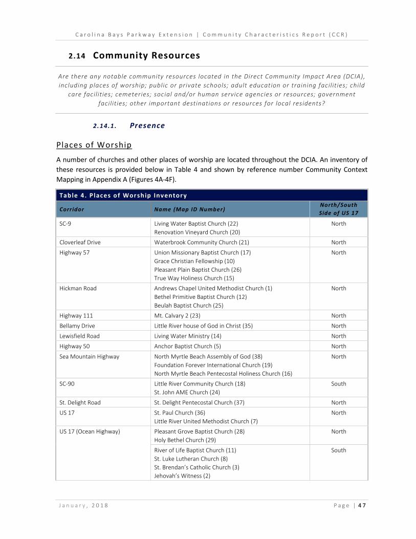
C a r o l i n a B a y s P a r k w a y E x t e n s i o n | C o m m u n i t y C h a r a c t e r i s t i c s R e p o r t ( C C R )
J a n u a r y , 2 0 1 8 P a g e | 4 7
2.14 Community Resources
Are there any notable community resources located in the Direct Community Impact Area (DCIA), including places of worship; public or private schools; adult education or training facilities; child
care facilities; cemeteries; social and/or human service agencies or resources; government facilities; other important destinations or resources for local residents?
2.14.1 . Presence
Places of Worship
A number of churches and other places of worship are located throughout the DCIA. An inventory of these resources is provided below in Table 4 and shown by reference number Community Context Mapping in Appendix A (Figures 4A-4F).
Tab le 4 . P laces o f Wor ship Inventor y
Corridor Name (Map ID Number) North/South Side of US 17
SC-9 Living Water Baptist Church (22) Renovation Vineyard Church (20)
North
Cloverleaf Drive Waterbrook Community Church (21) North
Highway 57 Union Missionary Baptist Church (17) Grace Christian Fellowship (10) Pleasant Plain Baptist Church (26) True Way Holiness Church (15)
North
Hickman Road Andrews Chapel United Methodist Church (1) Bethel Primitive Baptist Church (12) Beulah Baptist Church (25)
North
Highway 111 Mt. Calvary 2 (23) North
Bellamy Drive Little River house of God in Christ (35) North
Lewisfield Road Living Water Ministry (14) North
Highway 50 Anchor Baptist Church (5) North
Sea Mountain Highway North Myrtle Beach Assembly of God (38) Foundation Forever International Church (19) North Myrtle Beach Pentecostal Holiness Church (16)
North
SC-90 Little River Community Church (18) St. John AME Church (24)
South
St. Delight Road St. Delight Pentecostal Church (37) North
US 17 St. Paul Church (36) Little River United Methodist Church (7)
North
US 17 (Ocean Highway) Pleasant Grove Baptist Church (28) Holy Bethel Church (29)
North
River of Life Baptist Church (11) St. Luke Lutheran Church (8) St. Brendan’s Catholic Church (3) Jehovah’s Witness (2)
South

C a r o l i n a B a y s P a r k w a y E x t e n s i o n | C o m m u n i t y C h a r a c t e r i s t i c s R e p o r t ( C C R )
J a n u a r y , 2 0 1 8 P a g e | 4 8
Tab le 4 . P laces o f Wor ship Inventor y
Corridor Name (Map ID Number) North/South Side of US 17
Ash-Little River Road (SR 1300) Kingsway Ministries (31) Friendship Baptist Church (34)
North
Pea Landing Road NW (SR 1304) Thomasboro Free Will Baptist Church (27) North
Longwood Road NW (NC 904) Greater Tabernacle Church (30) Old Shallotte Baptist Church (6)
North
Old Shallotte Road NW Shepherd Assembly, Inc. (33) North
Bliss Road NW Beach Assembly of God (4) North
Carter Drive SW Lighthouse Mission Church (9) South
Seaside Road SW (NC 904) Seaside Christian Fellowship Church (32) Pleasant View Baptist Church (13)
South
Schools
There is one Horry County school located in the DCIA:
¹ North Myrtle Beach High School is located on the southern edge of the DCIA on Sea Mountain Highway.
Two additional Horry County schools that serve DCIA residents but are just outside of the boundary are located near the southern project terminus:
¹ North Myrtle Beach Middle is located on SC-90 approximately one mile west of the Sea Mountain Highway/SC-90 intersection.
¹ Waterway Elementary is located on Sandridge Road, also approximately one mile west of the Sea Mountain Highway/SC-90 intersection.
There are two Brunswick County schools located in the DCIA in Shallotte:
¹ Jessie Mae Monroe Elementary is located on Pea Landing Road NW (SR 1304) just north of its intersection with US 17. According to information available on the Brunswick County website, the district for Jessie Mae Monroe Elementary includes all areas in the Brunswick County portion of the DCIA on the west side of NC 904 (Longwood Road (NW)/Seaside Road (SW)), including Calabash, Carolina Shores and Sunset Beach.
¹ Union Elementary School is located on Union School Road NW, also just north of its intersection with US 17. According to information available on the Brunswick County website, the district for Union Elementary includes all areas in the Brunswick County portion of the DCIA on the east side of NC 904 (Longwood Road (NW)/Seaside Road (SW)), including Ocean Isle Beach and parts of Shallotte.
Two additional Brunswick County schools that serve DCIA residents, but which are located just outside of the DCIA boundary, are also in Shallotte near the northern project terminus:
¹ West Brunswick High School is located on the outer edge of the DCIA in Shallotte, just west of the northern project terminus on NC 130 (Whiteville Road), but serves all of the Brunswick County portion of the DCIA.

C a r o l i n a B a y s P a r k w a y E x t e n s i o n | C o m m u n i t y C h a r a c t e r i s t i c s R e p o r t ( C C R )
J a n u a r y , 2 0 1 8 P a g e | 4 9
¹ Shallotte Middle School is located just outside of the DCIA in Shallotte, southeast of the northern project terminus, but serves the large majority of the Brunswick County portion of the DCIA. According to information provided on the Brunswick County website, the district for Shallotte Middle includes all of the DCIA on both sides of US 17 with exception of the areas north and west of Hickman Road and Ash-Little River Road (SR 1300).
Residential Subdivisions & Neighborhoods
The DCIA contains more than 100 named residential subdivisions and neighborhoods that range in size, age and value. An inventory of known subdivisions and neighborhoods is provided in Table 5.
Tab le 5 . Known Subd iv is ions & Neighborhood s Inventor y
Subdivision Name Location (Address)
Location(s) of Neighborhood Access
Jurisdict ion
1) A Place at the River Little River US 17 Horry County 2) Ashton Acres Loris HWY 57 Horry County 3) Barcelona Little River S-26-1144 (US 17) Horry County 4) Bay Forest Little River SC-9 Horry County 5) Bay Tree Little River SC-9 Horry County 6) Beacon Townes Calabash US 17 Carolina Shores 7) Big Landing Plantation Little River SC-179 Horry County 8) Bloom Road Estates Little River Blooms Drive (HWY 111) Horry County 9) Brunswick Plantation Calabash US 17 & No. 5 School Road Brunswick County 10) Calabash Lakes Calabash Thomasboro Road Brunswick County 11) Captain's Choice Little River SC-9 Horry County 12) Carolina Cove Calabash Thomasboro Road Brunswick County 13) Carolina Crossing Loris HWY 57 Horry County 14) Carolina Shores Golf & Country
Club Calabash Country Club Road & Persimmon
Road Carolina Shores
15) Carolina Shores North Calabash US 17 Brunswick County 16) Cedar Creek Little River SC-90/US 17 Horry County 17) Cedar Tree Calabash US 17 Brunswick County 18) Cloverleaf Loris SC-9 Horry County 19) Colonial Charters Loris SC-9 & HWY 57 Horry County 20) Coquina Harbor Little River US 17 Horry County 21) Crows Creek Calabash US 17 & Hickman Road Brunswick County 22) Crystal Point Little River S-26-1144 (US 17) Horry County 23) Cypress Bay Little River US 17 & HWY 111 Horry County 24) Eagle Nest Little River US 17 Horry County 25) Eastport Little River US 17 Horry County 26) Evergreen Heights Little River US 17 Horry County 27) The Farms at Brunswick Calabash US 17 & Thomasboro Road Carolina Shores 28) Farmstead Calabash McLamb Road Brunswick County 29) Forest Acres Little River Sea Mountain Highway Horry County 30) Golden Estates Little River US 17 Horry County 31) Golfview Plantation Little River SC-9 & Sea Mountain Highway Horry County 32) Graystone Little River US 17 Horry County 33) Green Acres Little River US 17 Horry County 34) Heather Glen (Proposed) Little River US 17 Horry County 35) Hidden Lakes Village Little River Horseshoe Drive (US 17) Horry County

C a r o l i n a B a y s P a r k w a y E x t e n s i o n | C o m m u n i t y C h a r a c t e r i s t i c s R e p o r t ( C C R )
J a n u a r y , 2 0 1 8 P a g e | 5 0
Tab le 5 . Known Subd iv is ions & Neighborhood s Inventor y
Subdivision Name Location (Address)
Location(s) of Neighborhood Access
Jurisdict ion
36) Kingsport Little River US 17 Horry County 37) Kinlaw Little River SC-90 Horry County 38) Lafayette Park Little River HWY 111 Horry County 39) Lakewood Drive Shallotte Ocean Isle Beach Road SW Brunswick County 40) Lighthouse Cove Calabash Thomasboro Road Carolina Shores 41) Lightkeepers Village Little River SC-90/US 17 Horry County 42) Little River Golf & Health Resort Little River US 17 Horry County 43) Little River Heights Little River US 17 Horry County 44) Lynndale Apartments Ocean Isle Beach Seaside Road SW (NC 904) Brunswick County 45) Mallard Pointe & Mallard Creek Little River Horseshoe Drive (US 17) Horry County 46) Mariner's Pointe Little River US 17 Horry County 47) Marshfield Little River Sea Mountain Highway Horry County 48) Meadowlands Calabash Shingletree Road & Calabash Road Brunswick County 49) Mosetown Little River HWY 111 & Mineola Avenue Horry County 50) Neptune Acres Little River SC-9 Horry County 51) Newport Village Little River McCorsley Avenue (US 17) Horry County 52) North Pointe Little River HWY 1008 Horry County 53) North Village Loris HWY 57 Horry County 54) Oak Grove Little River Ellis Drive (US 17) Horry County 55) Oak View Little River Mineola Avenue Horry County 56) Oaks, The Little River Lakeside Drive (US 17) Horry County 57) Ocean Forest Calabash Calabash Road NW Brunswick County 58) Ocean Ridge Plantation Ocean Isle Beach US 17, Seaside Road SW (NC 904)
& Old Georgetown Road SW Brunswick County
59) Ocean Side Place Calabash Calabash Road NW Brunswick County 60) Old Tram Village Little River HWY 111 Horry County 61) Olde Harbour Little River SC-9 Horry County 62) Parkway Townhouses Little River Sea Mountain Highway Horry County 63) Patriot Point Loris HWY 57 Horry County 64) Pine Ere Acres Little River Mineola Avenue Horry County 65) Pinewood Court Little River Horseshoe Drive (US 17) Horry County 66) Plantation Pines Loris SC-9 Horry County 67) The Preserve at Little River Little River SC-9 Horry County 68) Ravenwood Little River Horseshoe Drive (US 17) Horry County 69) The Retreat Little River HWY 57 Horry County 70) Richland Marsh Little River Bayshore Drive (US 17) Horry County 71) River Hills Little River US 17 Horry County 72) River View Heights Little River Waterfront Avenue (US 17) Horry County 73) Riverbrook Little River Waterfront Avenue (US 17) Horry County 74) Rivergate Little River US 17 Horry County 75) Rum Bluff Loris SC-9 Horry County 76) Salt Marsh Cove Little River Watson Avenue (US 17) Horry County 77) Saltaire Village Calabash Persimmon Road Calabash 78) Sandpiper Bay Sunset Beach Old Georgetown Road SW Sunset Beach 79) Shepherd's Cove Little River Bayshore Drive (US 17) Horry County 80) Small Woods Little River Lakeside Drive (US 17) Horry County 81) The Spa At Little River Little River US 17 Horry County

C a r o l i n a B a y s P a r k w a y E x t e n s i o n | C o m m u n i t y C h a r a c t e r i s t i c s R e p o r t ( C C R )
J a n u a r y , 2 0 1 8 P a g e | 5 1
Tab le 5 . Known Subd iv is ions & Neighborhood s Inventor y
Subdivision Name Location (Address)
Location(s) of Neighborhood Access
Jurisdict ion
82) Spinnaker Bay Little River US 17 Horry County 83) Spring Mill Plantation Calabash McLamb Road & Calabash Road Brunswick County 84) Stone's Edge Loris HWY 57 Horry County 85) Sun Colony Loris SC-9 Horry County 86) Tall Pines Plantation Ocean Isle Beach US 17 Brunswick County 87) Triston Place Little River McCorsley Avenue (US 17) Horry County 88) Tullamore Lakes Loris SC-9 Horry County 89) Twisted Oaks Little River Nelson Road (US 17) Horry County 90) Tybre Downs Little River Horseshoe Drive (US 17) Horry County 91) Village at Calabash Calabash Thomasboro Road Carolina Shores 92) Village At Little River Little River Baldwin Avenue (US 17) Horry County 93) Waterway Cove Little River US 17 Horry County 94) Whispering Woods Little River Rivergate Lane (US 17) Horry County 95) Wildwood Village Shallotte Wildwood Street NW (US 17) Shallotte 96) Willard Little River Sea Mountain Highway & SC-90 Horry County 97) Windjammer Village Little River SC-179 Horry County 98) Windsong At Little River Little River Mineola Avenue Horry County 99) Woodhollow Little River Bessent Avenue (US 17) Horry County 100) Woodridge Little River Mineola Avenue Horry County 101) Wrens Crossing Little River Horseshoe Drive (US 17) Horry County
Child Care Facil ities
The number of child care facilities in the DCIA is relatively in proportion to the geographic size, likely a result of the lower demand for childcare services due to the retirement age population living in the area. Child care facilities located in the DCIA are depicted on Community Context Mapping in Appendix A (Figures 4A-4F) and include the following, from south to north:
➊ McDowell Lane, Little River: Little River Child Development ➋ Sea Mountain Highway, Little River: Sea Mountain Academy ➌ Thomasboro Road SW, Calabash: Tiny Treasures Academy ➍ Union School Road NW, Shallotte: Tiny Tots Child Care ➎ US 17 (Ocean Highway), Ocean Isle Beach: St. Luke Lutheran Preschool ➏ Old Shallotte Road, South Brunswick: Kids Connection
Cemeteries
There are 48 known cemeteries located in the DCIA, which are summarized below in Table 6 and displayed on Community Context Mapping in Appendix A (Figures 4A-4F). Information on cemeteries located in the DCIA has been provided by local planning departments for Horry and Brunswick Counties.

C a r o l i n a B a y s P a r k w a y E x t e n s i o n | C o m m u n i t y C h a r a c t e r i s t i c s R e p o r t ( C C R )
J a n u a r y , 2 0 1 8 P a g e | 5 2
Tab le 6 . Known Cem eter ies In ventor y Map ID Number & Cemetery Name Addit ional Information
1 Mt. Zion AME Church Cemetery 2 Mt. Pleasant Baptist Church Cemetery 3 Pleasant Plains Cemetery 4 Stephens Cemetery 5 Platt Cemetery 6 Mt. Calvary No. 2 Cemetery 7 Permenter-Bell Cemetery 8 Live Oak Cemetery 9 Gore Cemetery 10 Lewis Cemetery 11 Gore Cemetery 12 Cedar Creek Cemetery 13 St. Paul AME Church Cemetery 14 Little River United Methodist Church Cemetery 15 Vereen Memorial Gardens 16 North Myrtle Beach Memorial Gardens
(Veterans Cemetery) According to website, the area’s designated location for Memorial Day and Veterans Day ceremonies.
17 Purported Cemetery *Status unknown; 0 known graves; race unknown. 18 Benton/ Bethel Primative Baptist Church Cemetery *Status unknown; 0 known graves; race: white. 19 Mintz Cemetery *Currently used; 340 known graves; race: white. 20 Hewett Cemetery *Currently used; 22 known graves; race: white. 21 Angela Faye Cemetery *Currently used; 73 known graves; race: black. 22 Bland/ Gore Cemetery *Currently used; 37 known graves; race: white. 23 Brunswick Memorial Gardens Cemetery *Currently used; 63 known graves; race: N/A. 24 Patterson Cemetery *Abandoned; 40 known graves; race: N/A. 25 Piggott Cemetery *Currently used; 43 known graves; race: black. 26 Brooks Cemetery *Currently used; 162 known graves; race: white. 27 Smith *Abandoned; 9 known graves; race: white. 28 Hughes *Currently used; 5 known graves; race: white. 29 Thomas Family Cemetery *Currently used; 16 known graves; race: white. 30 Bingham Field Cemetery *Status unknown; 38 known graves; race: N/A. 31 Rum-Nelson Cemetery *Currently used; 3 known graves; race: white. 32 Tharp Cemetery *Maintained; 20 known graves; race: white. 33 Blanton Cemetery *Currently used; 36 known graves; race: white. 34 Edwards Estate Cemetery *Maintained; 0 known graves; race: white. 35 Bennett/ Manley-Bennett Cemetery *Currently used; 100 known graves; race: white. 36 Whispering Pines Cemetery *Currently used; 50 known graves; race: white. 37 Beck/ Bennett Cemetery *Maintained; 19 known graves; race: white. 38 Reaves Cemetery/ St. Anna’s Cemetery *Currently used; 22 known graves; race: black. 39 Old Shallotte Baptist Church Cemetery *Currently used; 38 known graves; race: white. 40 Beck *Maintained; 5 known graves; race: white. 41 Holy Bethel *Currently used; 42 known graves; race: black. 42 Carl Wilson Family Cemetery *Currently used; 0 known graves; race unknown. 43 Gore *Abandoned; 2 known graves; race: white 44 Thomas *Maintained; 2 known graves; race: white. 45 Stanley/ Prince/ Gore *Abandoned; 4 known graves; race: white. 46 McLamb Anderson Cemetery *Status unknown; 0 known graves; race: white.

C a r o l i n a B a y s P a r k w a y E x t e n s i o n | C o m m u n i t y C h a r a c t e r i s t i c s R e p o r t ( C C R )
J a n u a r y , 2 0 1 8 P a g e | 5 3
Tab le 6 . Known Cem eter ies In ventor y Map ID Number & Cemetery Name Addit ional Information 47 Lewis/ Bethel Primative Baptist Church Cemetery *Status unknown; 8 known graves; race: white. 48 Bennettown Cemetery *Currently used; 158 known graves; race: white.
*Source: Brunswick County GIS Department, Cemetery Data (downloaded January, 2017)
Other Community Resources
Several other notable community resources have been identified throughout the DCIA based on a public or other service of unique value to the local community. These resources are depicted on Community Context Mapping in Appendix A (Figures 4A-4F) and include the following:
W SC State & Horry County Local Government Services Center (Highway 57) A government services center containing various state and local government branches is located just east of the SC-9 and Highway 57 intersection in Horry County. State government services at this location include Stephens Health Department (SCDHEC) and a Motor Vehicles Department (SCDOT) branch. Local government services at this location include the Horry County Treasurer (tax department), Little River Public Library and Horry County Fire Rescue Station 18.
W Carolina Shores Town Hall (Persimmon Road) The Town of Carolina Shores government services center is located just south of the US 17 (Ocean Highway) corridor on Persimmon Road SW.
W Town of Calabash Municipal Services (Persimmon Road) A cluster of public service resources for the Town of Calabash are located on the southern end of Persimmon Road, just north of the intersection with Thomasboro Road and NC 179 (Beach Drive). The cluster includes the Calabash Town Hall, which contains all of the administrative, building inspections and town services offices; Calabash Fire Station 12-1; and Calabash Community Park.
² North Myrtle Beach Flea Market Located within the US 17 median at the intersection with SC-9.
² The South Brunswick Islands Center Located on US 17 (Ocean Highway) at Shingletree Road in Brunswick County, the South Brunswick Islands Center is part of the Brunswick Community College system that is used as an event center. According to the Carolina Shores planning representative, the college offers continuing education programming to the elderly population in the area. The Brunswick Community College website states that the college provides work based assessments, pre-employment training, supervision and management training, trades programs, entrepreneurial counseling and seminars, personal enrichment classes and more. The space may also be used for receptions, banquets, small conferences, lectures, dances, and small concerts.
ª Hickmans Crossroads Identified as a notable community resource by the Brunswick County planning representative, Hickmans Crossroads is located at the intersection of Hickman Road and Calabash Road/Ash Little River Road. The majority of property surrounding the intersection is under ownership by various members of the Hickman family and Hickman’s Seafood, which appeared to operate only seasonally based on observed vacancy during field review in February, 2017, is located in the northeastern quadrant of the intersection. A small Carrier HVAC service center is located in the southeastern quadrant of the

C a r o l i n a B a y s P a r k w a y E x t e n s i o n | C o m m u n i t y C h a r a c t e r i s t i c s R e p o r t ( C C R )
J a n u a r y , 2 0 1 8 P a g e | 5 4
intersection. It is unknown whether or not the center is affiliated with the Hickman family. Hickmans Crossroads Library is a Brunswick County Public Library located just southeast of the intersection on Calabash Road. Development surrounding the intersection is otherwise comprised of single family residential and agricultural uses.
2.14.2 . Impacts New location roadways can have notable impacts on community resources, including direct impacts that could require relocation of notable resources. Potential impacts of the proposed CBP Extension project to notable community resources located in the DCIA will be evaluated in detail in the Community Impact Assessment (CIA) after Detailed Study Alternatives have been developed for the proposed project.
2.15 Community Cohesion
Have any specific signs or indicators of community cohesion been observed or otherwise documented in the Direct Community Impact Area (DCIA)? Is the project likely to alter the overall
functioning of an identifiable district (e.g. interactions between or isolation of persons/groups, change in physical makeup)? Is the project likely to disrupt connections between neighborhoods
and commercial, recreational, institutional and employment facilities and/or areas?
2.15.1 . Presence Signs and indicators of community cohesion have been observed or are known to occur in various locations throughout the DCIA.
Residential Neighborhoods & Communities As the majority of existing residential communities access the primary road network via shared street connections, many of which are limited to only one or two points of access, there is reasonable potential for existing community cohesion within individual neighborhood communities. Additionally, many of the residential subdivisions and named neighborhoods in the DCIA were designed as master planned communities with shared facilities, resources and other amenities which may also contribute to community cohesion within individual neighborhoods. Due to the number of existing residential subdivisions in the DCIA, community cohesion within each has not been assessed individually for purposes of this CCR.
Commercial Shopping Resources in Brunswick County The number of non-residential development nodes serving the year-round population in the Brunswick County portion of the DCIA is limited, thus existing commercial resources are apparent sources of cohesion within the local community. Commercial shopping nodes providing basic grocery and pharmacy resources as well as those containing restaurant and retail are all located on the south side of US 17 (Ocean Highway) within the Brunswick County portion of the DCIA with the exception of the Longwood Community in the northernmost portion of the DCIA, which is served by a small cluster of limited commercial resources that does not include a full service grocery store. The only full service grocery store within the Brunswick County portion of the DCIA is located in the Carolina Commons shopping center at the intersection of US 17 (Ocean Highway) and Calabash Road/Country Club Road in Carolina Shores. A second shopping center is located at the intersection of NC 904 and Old

C a r o l i n a B a y s P a r k w a y E x t e n s i o n | C o m m u n i t y C h a r a c t e r i s t i c s R e p o r t ( C C R )
J a n u a r y , 2 0 1 8 P a g e | 5 5
Georgetown Road in Sunset Beach but is currently primarily vacant, including the grocery store anchor space. The commercial development district along NC 179 (Beach Drive) through Calabash contains the only restaurant and retail resources in the Brunswick County portion of the DCIA.
Family Estates The Horry County Planning representative noted the presence of cohesion associated with family estate properties in the DCIA, particularly those in the vicinity of Highway 57. All known estate properties in the Horry County portion of the DCIA are identified on Community Context Mapping in Appendix A (Figures 4A - 4F) based on information provided by the Horry County Planning Department. Although no data has been provided to confirm the locations of family estate properties in the Brunswick County portion of the DCIA, property tax records suggest a number of large estates may exist there as well.
2.15.2 . Impacts New location roadways can have notable impacts on community resources, including the direct disruption of physical connections between people and resources within the community or otherwise directly altering existing patterns of interaction between people and resources within the community. Potential impacts of the proposed CBP Extension project to existing connections and patterns of community cohesion in the DCIA will be evaluated in greater detail in the Community Impact Assessment (CIA) after Detailed Study Alternatives have been developed for the proposed project.
2.16 Community Health & Safety
Are there any existing or perceived crime or safety issues in the Direct Community Impact Area (DCIA), including unsafe bicycle or pedestrian facilities, inadequate lighting and/or isolated or
poorly connected areas? Is the project likely to change any existing or perceived crime or safety issues?
2.16.1 . Presence No existing or perceived crime or public safety issues have been observed or otherwise documented in the DCIA at this time.
2.17 Area/Community Concerns
Are there any known community concerns or controversy relative to the project? If concerns were voiced during Public Involvement activities, please attach the relevant comment sheets or
meeting comment summary in the Appendix. Is the project likely to be incompatible with or not address community concerns?
2.17.1 . Presence There is a range of known concerns and controversy in relation to the proposed project, both historically and more recently.
C a r o l i n a B a y s P a r k w a y E x t e n s i o n | C o m m u n i t y C h a r a c t e r i s t i c s R e p o r t ( C C R )
J a n u a r y , 2 0 1 8 P a g e | 5 6
Historical Controversy The current adopted 2010 Brunswick County Comprehensive Transportation Plan (CTP) (2010) includes documentation of controversy and concerns expressed by various stakeholder groups in relation to the proposed project during development of the 2010 CTP, throughout which a series of public outreach events were held to collect input on recommendations made in the CTP. These events in addition to agency scoping produced some notable comments and concerns relative to the proposed project. As provided in the 2010 CTP, documented comments and concerns include the following, which are provided in Appendix G of this CCR:
⍟ Concern over potential designation of US 17 (Ocean Highway) as a freeway. ⍟ Concern over the absence of new transportation facilities to serve the proposed NC
International Terminal, a project which was on hold at the time of CTP adoption. ⍟ Opposition to the originally proposed I-74 corridor alignment (Carolina Bays section) by
residents of the Brunswick Plantation subdivision. Residents submitted a petition containing 286 signatures requesting realignment of the proposed corridor between NC 904 to SC in order to minimize impacts to the subdivision. As a result, the alignment for this section of the corridor was adjusted northward as shown in the adopted 2010 CTP.
⍟ Concern consistently expressed in comments from state and federal environmental agencies regarding the rate of development in Brunswick County outpacing transportation and land use planning efforts, thus creating an increased risk for direct, secondary and cumulative effects of proposed transportation projects on the human and natural environment.
Recent Controversy A Local Officials’ Informational Meeting (LOIM) was held for the project in February, 2017 for the purpose of introducing the project study to local officials, sharing information on the project’s history and background and a proposed schedule for moving forward with project planning. A summary of this meeting is included in Appendix G.
Following the LOIM, the Town of Carolina Shores Board of Commissioners adopted and submitted a Resolution Opposing the Carolina Bays Extension Study Area and Routes as Initially Proposed. The Resolution, which is included in Appendix G along with associated documents, expresses opposition to the initial study area boundary that was shown on Vicinity Mapping distributed at the LOIM and opposition to the “2012 alternative routes,” which refers to the alignments shown on the 2005 Feasibility Study “Corridor Maps.” The Carolina Shores Resolution states the proposed study area and alternate routes will have harmful human environmental impacts and proposes a new project study area boundary and elimination of all alternate corridors for consideration. Note the Feasibility Study Corridor Maps were never distributed in association with the project and all of the proposed study corridors were determined unfeasible for various design and environmental reasons during Internal Scoping in December, 2016. The proposed revision to the project study area expands the northern boundary through Brunswick County toward the Waccamaw River. The boundary proposed in the Town of Carolina Shores Resolution is the study area boundary currently being shown on project mapping.
Local government planning representatives have also identified varying degrees of local concern and/or controversy regarding the proposed project and potential impacts on area communities on local input forms, which are compiled in Appendix D. The Brunswick County Planning representative stated that

C a r o l i n a B a y s P a r k w a y E x t e n s i o n | C o m m u n i t y C h a r a c t e r i s t i c s R e p o r t ( C C R )
J a n u a r y , 2 0 1 8 P a g e | 5 7
many local residents have expressed concern about how the project may impact their neighborhood, including residents from various subdivisions in and around the Carolina Shores and Calabash areas, and any potential project alignments located south or east of US 17 (Ocean Highway) and Hickman Road in Brunswick County would have severe impacts on existing communities and development. The Cape Fear RPO representative noted general local concern over potential impacts of the project to residences and the environment, while the Sunset Beach representative identified specific concerns relative to potential noise impacts. The Horry County Planning representative cited the possibility of environmental groups being concerned about potential wetland impacts associated with the project.
2.17.2 . Impacts Public input will be solicited during the project development process through public involvement and outreach efforts and community concerns and controversy relative to the proposed project and/or Detailed Study Alternatives will be documented in detail. Compatibility of the project in addressing local concerns and controversy will then be evaluated in the Community Impact Assessment (CIA).
2.17.3 . Recommendations It is recommended that the NCDOT Project Planning Engineer coordinate with NCDOT Public Involvement to develop a public involvement outreach plan that incorporates the necessary local stakeholders and is in accordance with all necessary state and federal guidelines.
2.18 Recurring Effects
Is the project likely to result in recurring effects on any populations and communities within the Direct Community Impact Area (DCIA)?
As proposed at this time, the project is not expected to result in recurring effects on any populations and/or communities within the DCIA.
2.19 Other Impacts
Are there any other potential impacts associated with the project?
No other potential impacts are expected in association with the project as proposed at this time.

C a r o l i n a B a y s P a r k w a y E x t e n s i o n | C o m m u n i t y C h a r a c t e r i s t i c s R e p o r t ( C C R )
J a n u a r y , 2 0 1 8 P a g e | 5 8
2.20 Environmental Justice (EJ) and Title VI Populations
Are there any populations living in the Demographic Study Area that meet the criteria for Environmental Justice (EJ) and/or Title VI? If so, note which groups are present. Is the project likely to have a disproportionately high and adverse impact, including denial of benefits, on
identified EJ and/or Title VI populations in the Demographic Study Area? Provide the associated standard language, and include a narrative description as appropriate.
2.20.1 . Presence
Environmental Justice
Census data indicates a notable presence of both minority and low-income populations meeting the criteria for Environmental Justice (EJ) within the Demographic Study Area (DSA). A range of low-income community indicators were observed during field review and local planners have identified several low-income and minority communities in the DCIA. The location of Block Groups containing EJ populations in the DSA is depicted on Figure 3B in Appendix A, including where the EJ thresholds have been met for each minority and low-income populations as well as the locations of known EJ communities that have been identified by local planners.
As shown on Figure 3B, the highest concentration of EJ populations in the DSA is on the north side of Highway 57 in Horry County and the north side of US 17 (Ocean Highway) in Brunswick County with the exception of the Block Group containing Brunswick Plantation. Widespread indicators of poverty were observed in the areas along Little River Road (S-111) and Wortham’s Cut Off Road in Horry County as well as on the north side of US 17 (Ocean Highway) in Brunswick County. There is a high prevalence of agricultural use in this area and many of the parcels are very large in size, which can isolate populations living in these areas. Numerous manufactured homes and very small single family homes were observed in these areas that were severely dilapidated and questionably habitable. Old barns and farm equipment in various states of disrepair, which may or may not be in use, were observed in different locations throughout the DCIA on the north side of US 17 (Ocean Highway) in Brunswick County.
In the remaining Horry County portion of the DSA, EJ populations are primarily located on the west side of SC-9 with the exception of the Block Group extending eastward from the SC-9 corridor through the study area, which contains both minority and low-income populations meeting the criteria for EJ. During field review, several small low-income neighborhoods were observed along the east side of the corridor. The majority of neighborhoods were comprised of single family homes in a moderate density pattern. Homes and yards appeared to be in varying states of repair, but on average was relatively modest in nature.
Low-income and minority communities in the DCIA that have been identified by local planners are summarized below and displayed on Community Context Mapping in Appendix A (Figures 4A-4F):
⟡ Mosetown Community, located in Little River just north of the Highway 50/ Highway 111 intersection.
⟡ Marlowtown Road Community, located midway between US 17 (Ocean Highway) and Hickman Road in Brunswick County, just south of Meadowlands.

C a r o l i n a B a y s P a r k w a y E x t e n s i o n | C o m m u n i t y C h a r a c t e r i s t i c s R e p o r t ( C C R )
J a n u a r y , 2 0 1 8 P a g e | 5 9
⟡ Cedar Bay Community, located in Brunswick County just north of the US 17 corridor near the intersection of Pea Landing Road and Number 5 School Road.
⟡ Longwood Community, located in the northeast corner of the DCIA at the intersection of NC 904 (Longwood Road) and Etheridge Road NW.
Title VI
The DSA contains a notable retirement population, as documented by local planners across the project area and supported by ACS age data. Golf course communities within the DCIA generally tend to contain a higher concentration of retirees than other residential communities. The Farm at Brunswick is the only known age-restricted community in the DCIA. The median age for the DSA overall is 52.9 years, in comparison to a median age of 50 for Brunswick County and 43 for Horry County. Age trends within the DSA vary considerably by Block Group, however. The highest concentrations of elderly persons are located in the Brunswick County portion of the DSA, which contains three Block Groups where more than half of the total population is age 65 or older. Median ages for these Block Groups are 67.8 (CT 205.04, BG 1), 67.1 (CT 205.07, BG 4), and 67.1 (CT 205.08, BG 1). In Horry County, the oldest Block Group is located on the southeastern side of US 17 adjacent to the Intracoastal Waterway near North Myrtle Beach. The median age of this Block Group is 63.9 (CT 401.05, BG 1). Comprehensive age data for the DSA is provided in Table B-2 of Appendix B, and Figure 3C in Appendix A shows age trends geographically across the DSA, including median age of each Block Group as well as the percentage of each Block Group population that is age 65 years and older. Other age-related trends in the DSA are discussed in greater detail in Section 3.1.2.
2.20.2 . Impacts New location roadways can have notable impacts on community resources, including direct impacts to property, mobility, access, and community cohesion. Based on the geographic distribution of EJ populations in the DSA, the likelihood of potential impacts to these populations as a result of the project would be highest in association with potential new location alignments located north and west of the existing Highway 57 corridor in Horry County and north and west of the existing Hickman Road and US 17 (Ocean Highway) corridors in Brunswick County.
Potential impacts of the proposed project will be evaluated in detail after Detailed Study Alternatives have been developed, including identification of the potential benefits and burdens resulting from the project and whether or not they appear to be equitably distributed throughout the community. The Community Impact Assessment (CIA) report will analyze the Detailed Study Alternatives to determine if impacts to EJ populations appear to be disproportionately high and adverse.
2.20.3 . Recommendations Public involvement and outreach activities for the proposed CBP Extension project must ensure full and fair participation of all potentially affected communities in the transportation decision-making process. It is recommended that the NCDOT Project Planning Engineer coordinate with NCDOT Public Involvement to ensure all public involvement activities and outreach material developed for the project under study appropriately target Title VI populations and meet all other regulatory guidelines.

C a r o l i n a B a y s P a r k w a y E x t e n s i o n | C o m m u n i t y C h a r a c t e r i s t i c s R e p o r t ( C C R )
J a n u a r y , 2 0 1 8 P a g e | 6 0
2.21 Limited English Proficiency (LEP) or Language Assistance (LA) Populations
Are there any populations living in the Demographic Study Area (DSA) that meet the criteria for Limited English Proficiency (LEP)? Are there any populations within the DSA that do not meet the
LEP threshold but do meet the criteria for Language Assistance?
2.21.1 . Presence The federal Safe Harbor threshold for Limited English Proficiency (LEP) is met when a language group which speaks English less than very well either has 1,000 adults, or makes up 5 percent of the aggregate DSA population (with at least 50 adults). Meeting or exceeding the LEP threshold requires written translation of vital documents for public outreach.
The NCDOT threshold for Language Assistance (LA) is met when a language group which speaks English less than very well has at least 50 adults in any individual Block Group. Meeting or exceeding this threshold indicates the possible need for oral interpreters at meetings, ethnic media advertising and other actions to be taken by Public Involvement. It does not require the written translation of vital documents for public outreach.
Census data does not indicate presence of Limited English Proficiency (LEP) populations meeting the US Department of Justice LEP Safe Harbor threshold but does indicate presence of Spanish, Other Indo-European and Asian/Pacific language group populations within the Demographic Study Area (DSA) that may require language assistance.
Spanish language groups meeting the LA threshold are located in both Horry and Brunswick County. Two of the Block Groups are contained entirely within the DCIA boundary, including: (1) the Block Group adjacent to the north side of SC-9 (CT 401.03, BG 1) in Horry County, which is located across from the existing SC-31 (Carolina Bays Parkway) terminus, and (2) the Block Group bound by Thomasboro Road and NC 904 (Seaside Road SW) on the south side of US 17 (Ocean Highway) in Brunswick County (CT 205.08, BG 1). The third Block Group containing a Spanish language population that meets the threshold for LA is located between Ocean Isle Beach Road and Shallotte on the south side of US 17 in Brunswick County (CT 205.06, BG 1). This Block Group is only partially contained within the DCIA boundary.
One Block Group contains an Other Indo-European language group population that meets the threshold for language assistance in Horry County along the south side of the SC-9 corridor between Highway 57 and SC-90. This Block Group is only partially contained within the DCIA boundary but includes the existing SC-31 (Carolina Bays Parkway) terminus.
One Block Group contains an Asian/Pacific language group population that meets the threshold for language assistance along the Brunswick County side of the state line in Carolina Shores. The Block Group is bound by US 17 (Ocean Highway) on the north, NC 179 on the south and Country Club Road on the west. This Block Group is contained entirely within the DCIA boundary.
2.21.2 . Recommendations Because notable Spanish, other Indo-European and Asian/Pacific populations requiring language assistance are located within the DSA, the NCDOT Project Planning Engineer should consult with NCDOT

C a r o l i n a B a y s P a r k w a y E x t e n s i o n | C o m m u n i t y C h a r a c t e r i s t i c s R e p o r t ( C C R )
J a n u a r y , 2 0 1 8 P a g e | 6 1
Public Involvement to determine appropriate measures assuring meaningful public involvement to satisfy the requirements of Executive Order 12898.
2.22 Special Populations
Are there any special populations (e.g. tribal groups connected with land, religious, ethnic or other groups with special mobility needs, unique outreach needs, etc.) located in the Direct
Community Impact Area (DCIA)?
There are no known populations or other groups with special mobility or outreach needs that have not otherwise been identified in the CCR, living in the DCIA at this time. Presence of special populations in the DCIA will be assessed again in the Community Impact Assessment (CIA) report.
3. ADDITIONAL COMMUNITY CHARACTERISTICS
3.1 Demographic Characteristics & Population Trends
What are the population characteristics of the Demographic Study Area (DSA)? Has the DSA experienced notable growth or decline in recent years, as compared to countywide and statewide
growth? Are there any other notable characteristics or trends associated with the DSA population, as compared to county and state populations?
As stated previously in Section 1.4, the DSA is defined to provide demographic characteristics for the community surrounding the project and contains the smallest statistical area of US Census Block Group boundaries that contain the DCIA, as depicted in Figure 3 in Appendix A. US Census data was used to examine various socio-economic characteristics at both the Block Group level and the DSA level in comparison to countywide, statewide and surrounding place/municipal statistics. Relevant demographic trends and characteristics revealed in the Census data are discussed below, and a comprehensive tabular summary of all demographic data examined for the CCR is provided in Appendix B. Some local officials that were interviewed for the CCR have provided comments pertaining to demographic trends affecting the project area, which are also included where applicable. A comprehensive record of all interviews with local officials for the CCR is provided in Appendix D.
Population growth trends reported in the CCR are measured by the two most recent Decennial Census counts taken in 2000 and 2010, which represent the two most recent 100 percent population counts at the Block Group level. All other demographic trends and composition traits reported for the DA population in the CCR are measured based on the most recent American Community Survey (ACS) 5-Year (2011-2015) Summary data provided by the US Census Bureau. This is a summary level dataset that provides a comprehensive range of demographic characteristics at the Block Group level.
The total population of the DSA is generally well-balanced in size between the Brunswick and Horry County portions of the boundary, with approximately 46.5 percent of the total DSA population residing in Brunswick County and 53.5 percent in Horry County based on recent estimates. As the total land area covered by the DSA boundary is not equally distributed between the two counties, this suggests

C a r o l i n a B a y s P a r k w a y E x t e n s i o n | C o m m u n i t y C h a r a c t e r i s t i c s R e p o r t ( C C R )
J a n u a r y , 2 0 1 8 P a g e | 6 2
population density is higher in the Horry County portion of the DSA and the proportion of year-round residents living in the DSA is also higher in Horry County.
3.1.1 . Population Growth Trends The project DSA has experienced notably high rates of growth in recent years, considerably higher than countywide and statewide rates. Total population growth in the DSA between 2000 and 2010 was approximately 55.1 percent (4.5 percent annually), while countywide growth rates for the same period were approximately 46.9 percent (3.9 percent annually) in Brunswick and approximately 37.0 percent (3.2 percent annually) in Horry.
Population growth in the DSA has not been uniformly high across all Block Groups, however. Figure 3A in Appendix A shows the micro level growth trends within the DSA, depicting the range of relative growth rates experienced in individual Block Groups. In the Horry County portion of the DSA, the highest growth is concentrated on the south side of SC-9 along the existing section of SC-31 (Carolina Bays Parkway), along the west side of Highway 57, and along the south side of Highway 111 between Highway 57 and US 17 in Little River. In the Brunswick County portion of the DSA, the highest growth is generally concentrated along the south side of the Hickman Road and US 17 corridors as well as the Brunswick Plantation community Block Group.
According to local planners in both Horry and Brunswick County, the proposed CBP project area does not represent the highest growth areas for either county. In Horry, the project area represents the third fastest growing area in the county. Although planners did not specify which areas in the county are growing at faster rates than the CBP project area, Census data for the 2000-2010 period indicates all of the highest growth areas in Horry County are located east of the Waccamaw River. The highest recent growth rates appear to be concentrated in particular along the existing SC-31 (Carolina Bays Parkway/John Singleton Parkway) corridor between US 501 and Robert Edge Parkway, just south of the project area, and near the southern county boundary between the Waccamaw River and US 17. In Brunswick County, local planners reported that population growth has historically been most concentrated in the northern part of the county in the Leland area, which lies within the Wilmington Urbanized Area. Southeastern Brunswick County, which includes Southport, Oak Island and the surrounding areas, is also fast-growing and has experienced notable recent growth similar to the CBP project area. Local planner comments are generally consistent with Census data across the 2000-2010 period, which indicates the highest growth areas are concentrated around Leland. The southeastern part of the county, particularly the St. James and Southport areas, have experienced high growth rates comparable to those reported in the Brunswick County portion of the DSA. It is worth noting this area in the southeastern part of the county is also known to contain a large retirement age population.
3.1.2 . Age Characteristics Age characteristics across the DSA are shown on Figure 3C in Appendix A, including median age of each block group as well as the percentage of each block group population that is age 65 years and older. The figure indicates several age-related characteristics of the DSA population worth noting. Brunswick County Block Group populations are generally older on average with higher median ages in the majority of block groups as well as three individual block groups where 50 percent or more of the population is age 65 years or older. When considering the total DSA population that is age 65 years or older, however; approximately 55 percent of them reside in the Brunswick County portion of the DSA. This suggests the Horry County block groups contain populations that are more evenly distributed in age. There is much
C a r o l i n a B a y s P a r k w a y E x t e n s i o n | C o m m u n i t y C h a r a c t e r i s t i c s R e p o r t ( C C R )
J a n u a r y , 2 0 1 8 P a g e | 6 3
greater variability between the median ages of Brunswick County Block Groups. In Brunswick County, the older populations are clearly concentrated along the south side of US 17 and closer to the state line. The oldest block groups contain the Brunswick Plantation, Carolina Shores and Sandpiper Bay communities. The younger block groups appear to be concentrated on the north side of US 17 and around Shallotte.
3.1.3 . Economic Characteristics & Commuter Trends Economic characteristics and associated data trends for the DSA overall are consistent with some countywide trends but inconsistent with others. The average unemployment rate for the DSA (9.8 percent) is inconsistent with countywide rates but generally consistent with statewide rates (9.5 percent in SC and 9.4 percent in NC. It is higher than the countywide rate in Horry (8.7 percent) and lower than the countywide rate in Brunswick (11.4 percent). The percentage of the total DSA population that is currently in the labor force is 49.1 percent, which is reasonably comparable to the countywide trend for Brunswick (52.3) but notably lower than the statewide trend for NC (62.8 percent); and notably lower than the both the countywide trend for Horry (59.1) and the statewide trend for SC (60.9 percent).
Within the DSA, economic characteristics are widely inconsistent between the two counties and between individual Block Groups. Figure 3D in Appendix A displays employment characteristics and commuter trends by Block Group, including DSA-level characteristics as well as countywide and statewide characteristics for comparison.
Brunswick County Within the Brunswick County portion of the DSA, the average unemployment rate (12.8 percent) is higher than the countywide rate (11.4 percent). At the Block Group level, average unemployment rates are widely variable, ranging from 4.2 percent to 29.2 percent. Regarding employment as an economic indicator, local planners in Brunswick County have noted that a large portion of the community does not work due to the sizeable retirement population living in the area. For the working population, the services and tourism industries are the some of the strongest local employment and economic drivers. Major employment centers serving the region are the Myrtle Beach/Grand Strand area, Shallotte and the Wilmington area (New Hanover County, NC).
Commuter data for the Brunswick County portion of the DSA indicate 33 percent of workers in Brunswick County Block Groups travel outside the county for work, which is somewhat higher than the countywide statistic (25.5 percent) and slightly higher than the statewide statistic for NC (28.3 percent). While the DSA Block Groups trend higher than countywide and statewide numbers, the difference is not great enough to suggest any definitive trends. Relative to commuter directionality, 25 percent of workers in the Brunswick County portion of the DSA commute to another state for work, presumably SC based on geography, and 8 percent commute to another county within NC for work. Local planners in Brunswick County identified US 17, NC 179 and Hickman Road as the routes most heavily used by commuters traveling from the project area to Horry County for work.
Labor force data for the Brunswick County portion of the DSA indicates only 40.4 percent of the total population age 16 and over is currently serving in the labor force, which is notably lower than both the countywide average for Brunswick (52.3 percent) and the statewide average for NC (62.8 percent). Data suggests that Brunswick County is home to an above average percentage of individuals who are not

C a r o l i n a B a y s P a r k w a y E x t e n s i o n | C o m m u n i t y C h a r a c t e r i s t i c s R e p o r t ( C C R )
J a n u a r y , 2 0 1 8 P a g e | 6 4
serving in the labor force, as compared statewide across NC, which is likely due in part to the large retirement age population known to reside in the county. The variability between the DSA-level average and the countywide average suggests two trends of note: (1) the Brunswick County portion of the DSA contains a substantial portion of all the non-working individuals in the county, and (2) there is a notable disproportionality between the percentage of working and non-working individuals within the Brunswick County portion of the DSA. Based on these trends, any economic characteristics or associated data that is aggregated across geographies higher than the Block Group level is questionably representative of the DSA population.
Horry County Within the Horry County portion of the DSA, the average unemployment rate (7.9 percent) is lower than the countywide rate (8.7 percent). At the Block Group level, average unemployment rates are moderately variable, ranging from 2.6 percent, to 14.4 percent. Horry County representatives have indicated within the Grand Strand region overall, the beach and Intracoastal Waterway areas house most of the region’s employers. Within the DCIA, the SC-9 corridor is a growing focal point for commercial activity and professional services, anchored by McLeod Hospital. The Seacoast Medical Center and associated medical service providers as well as assisted living facilities are the highest growth employment sector at this time.
In the Horry County portion of the DSA, a total of approximately 7.4 percent of workers travel outside the county for work, which is consistent with the countywide trend (7.9 percent) but widely inconsistent with the statewide trend across SC (29.1 percent). This suggests the local economy in Horry County is notably stronger on average than the local economies in other SC counties. Within the DSA, 6.1 percent of Horry County workers commute to another state for work, presumably NC based on geography, and 1.3 percent commute to another county within SC for work. Local planners in Horry County noted the existing traffic congestion issues in the area are not a result of commuter traffic, rather they are a result of tourist and seasonal traffic.
Labor force data for the Horry County portion of the DSA indicates 56.9 percent of the total population age 16 and over is currently serving in the labor force, which is reasonably comparable to both the countywide average for Horry (59.1 percent) and the statewide average for SC (60.9 percent).
3.2 Nearby STIP Projects
Are there any reasonably foreseeable STIP projects within 3 miles of this project and/or that have the potential to affect or be affected by this project?
Other transportation projects included in the current adopted STIPs for NC (2018-2027) and SC (2017-2022), which are proposed nearby the CBP Extension project and may affect the same or similar transportation network include:
➊ NC STIP No. R-5851: Convert the intersection of US 17 and NC 904 to a superstreet. Right-of-way is currently scheduled in 2023 and construction in 2025.

C a r o l i n a B a y s P a r k w a y E x t e n s i o n | C o m m u n i t y C h a r a c t e r i s t i c s R e p o r t ( C C R )
J a n u a r y , 2 0 1 8 P a g e | 6 5
➋ NC STIP No. U-5862: In Shallotte, convert the intersection of US 17 Shallotte Bypass and Smith Avenue (SR 1357) to an interchange. Right-of-way is currently scheduled in 2020 and construction in 2021.
➌ NC STIP No. R-5857: In Shallotte, convert the intersections of US 17 Shallotte Bypass and US 17 Business to superstreets. Right of way is currently scheduled in 2024 and construction in 2026.
➍ NC STIP No. U-5788: In Shallotte, realign the intersection of Wall Street/Shallotte Avenue with US 17 Business (Main Street). Right-of-way is currently scheduled in 2018 and construction 2020.
➎ NC STIP No. U-5932: In Supply, convert the intersection of NC 211 and US 17 to an interchange. Right-of-way is currently scheduled in 2022 and construction in 2024.
The current adopted SC STIP (2017-2022) contains a number of projects located within three miles of the proposed CBP Extension Project; however, all of them are safety and rehabilitation projects that are not expected to affect the existing transportation network. Projects in the SC STIP include:
➊ P030510: Resurface SC-9 between Sea Mountain Highway and SC-905.
➋ P032396: Resurface US 17 from the NC state line to Seabrook Plantation Way in North Myrtle Beach.
➌ P032441: Resurface Mulberry Street (S-1125), Palmetto Street (S-851) and Luck Avenue (S-852) in Little River
➍ P030070: Resurface SC-179 from NC state line to US 17 in Little River ➎ P028005: Install rumble strips and/or profile thermo to Little River Road from Mineola Avenue
to Waccamaw River; Wampee Road from NC state line to SC-9; SC-9 from Wampee Road to SC-905.

C a r o l i n a B a y s P a r k w a y E x t e n s i o n | C o m m u n i t y C h a r a c t e r i s t i c s R e p o r t ( C C R )
J a n u a r y , 2 0 1 8 P a g e | 6 6
SOURCES
American Rivers Blue Trails: Waccamaw River website. Accessed July 12, 2017: http://www.bluetrailsguide.org/rivers/waccamaw/
Beach House Harley-Davidson website. http://www.beachhousehd.com/information-about-us--info
The Big “M” Casino website. Accessed June 26, 2017: http://www.bigmcasino.com/
Brunswick County CAMA Core Land Use Plan. Adopted in 2007; Recertified in 2011.
Brunswick County 2010 Comprehensive Transportation Plan (CTP) (2010)
Brunswick County 2009 Comprehensive Parks and Recreation Master Plan (2009)
Brunswick County Public Utilities website. Accessed June 25, 2017: http://www.brunswickcountync.gov/public-utilities/
Brunswick County Trail Plan (2017). Brunswick County Department of Planning. Retrieved from http://www.brunswickcountync.gov/planning/trails/
Brunswick Plantation & Golf Resort website: Accessed July 13, 2017: http://www.brunswickvillas.com/
Brunswick Transit System website. Accessed June 25, 2017: http://brunswicktransit.org/
Cape Fear Regional Council of Governments website. Accessed August 4, 2017: http://capefearcog.org/
Cape Fear Regional Bicycle Plan (2017), Cape Fear Council of Governments. Accessed August 4, 2017: http://capefearcog.org/regionalbikeplan/#results
Crow Creek Golf Community website. Accessed July 13, 2017: http://crowcreekgolfcommunity.com/
Envision 2025 Horry County Comprehensive Plan (2008), Horry County Council. Accessed: https://www.horrycounty.org/Departments/PlanningAndZoning/LongRangePlanning.aspx
Envision 2025 Horry County Comprehensive Plan Update: Transportation Element (2011), Horry County Council. Accessed: https://www.horrycounty.org/Departments/PlanningAndZoning/LongRangePlanning.aspx
Envision 2025 Horry County Comprehensive Plan Update: Natural Resources Element (2015), Horry County Council. Accessed: https://www.horrycounty.org/Departments/PlanningAndZoning/LongRangePlanning.aspx
Farmstead Golf Links website. Accessed July 13, 2017: http://www.farmsteadgolflinks.com
Grand Strand Airport website. Accessed September 1, 2017: http://www.beachaviationservices.com/
Grand Strand Area Transportation Study (GSATS) Policy Committee and Study Team website. Accessed August 14, 2017: http://www.gsats.org/index.php/committees/
GSATS 2015-2019 Transportation Improvement Program (TIP). Adopted TIP. (2015). Retrieved September 6, 2017, from http://www.gsats.org/index.php/tip/

C a r o l i n a B a y s P a r k w a y E x t e n s i o n | C o m m u n i t y C h a r a c t e r i s t i c s R e p o r t ( C C R )
J a n u a r y , 2 0 1 8 P a g e | 6 7
GSATS 2035 Long Range Transportation Plan (2011)
Highway 57 and Highway 9 Area Plan (2003), Horry County Council. Accessed: https://www.horrycounty.org/Departments/PlanningAndZoning/LongRangePlanning.aspx
Holden Brothers Farm Market website. Accessed September 4, 2017: http://www.holdenbrothersfarmmarket.com/
Holland, M. (2017, May 27). Project Tracker: Assisted/nursing facilities in Brunswick County. Retrieved September 13, 2017, from www.starnewsonline.com/news/20170527/project-tracker-assistednursing-facilities-in-brunswick-county
Horry County Bicycle and Pedestrian Plan (2013). Accessed: https://www.horrycounty.org/Departments/PlanningAndZoning/LongRangePlanning.aspx
Horry County Department of Airports website. Accessed September 1, 2017: http://www.horrycounty.org/Departments/Airports.aspx
Horry County Emergency Management website. Accessed June 27, 2017: http://www.horrycounty.org/Departments/EmergencyManagement/Hurricanes/
Horry County Land Development Regulations. Adopted November, 2001; Revised February, 2008.
Horry County Parks and Open Space Inventory (2016), Horry County Parks and Open Space Board. Accessed July 30, 2017: http://www.horrycounty.org/Departments/ParksAndRecreation.aspx
Hughes & Hughes Nursery website. Accessed September 4, 2017: http://www.hughesandhughesnursery.com/
Indigo Farms website. Accessed September 4, 2017: http://www.indigofarmsmarket.com/
Lightkeepers Marina website. Accessed July 17, 2017: http://www.lightkeepersmarina.com/
Little River Future Land Use Map (Adoption date unknown), Horry County Commissioners. Accessed: https://www.horrycounty.org/Departments/PlanningAndZoning/LongRangePlanning.aspx
McLeod Health. (2017). McLeod Health. Retrieved September 6, 2017, from https://www.mcleodhealth.org/about-us/
McLeod Health. (2017). McLeod Seacoast Brings Advanced Health Services to Horry & Brunswick Counties. Retrieved September 6, 2017, from https://www.mcleodhealth.org/locations/mcleod-seacoast/
Meadowlands Golf Club website. Accessed July 13, 2017: http://www.meadowlandsgolf.com
Minnesota Population Center. National Historical Geographic Information System: Version 11.0 [Database]. Minneapolis: University of Minnesota. 2016.
Myrtle Beach International Airport website. Accessed September 1, 2017: https://www.flymyrtlebeach.com/
Myrtle Beach Yacht Club at Coquina Harbor website. Accessed July 17, 2017: http://myrtlebeachyachtclub.com/

C a r o l i n a B a y s P a r k w a y E x t e n s i o n | C o m m u n i t y C h a r a c t e r i s t i c s R e p o r t ( C C R )
J a n u a r y , 2 0 1 8 P a g e | 6 8
National Park Service National Water Trails System: Waccamaw River Blue Trail website. Accessed July 12, 2017: https://www.nps.gov/WaterTrails/Trail/Info/45
North American Land Trust (NALT) Conservation Easement Planning website. Accessed September 4, 2017: http://northamericanlandtrust.org/conservation/conservation-easement-planning/
North Carolina Department of Transportation (NCDOT), Feasibility Study Report: R-3436, I-74 Corridor from US 74 to the South Carolina Line, Columbus & Brunswick Counties (1996)
NCDOT, Feasibility Study: R-3436 Re-Evaluation, I-74 Corridor from Union Valley Road (SR 1585) in Whiteville to the South Carolina State Line, Columbus & Brunswick Counties (2005)
NCDOT, Memo to NCDOT Feasibility Study: R-3436 (I-74) (2007)
NCDOT & South Carolina Department of Transportation (SCDOT), Carolina Bays Parkway Extension Feasibility Study Report (2006).
North Carolina Parks & Recreation Trust Fund (PARTF) grants website. Accessed: https://www.ncparks.gov/more-about-us/parks-recreation-trust-fund/grants-awarded
North Carolina Strategic Transportation Corridor (STC) Policy. Adopted by the NC Board of Transportation on March 4, 2015.
North Myrtle Beach Memorial Gardens. http://localcemeteries.org/index.html
Northeast Area Transportation Plan (2009), Horry County and North Myrtle Beach Councils. Accessed: http://www.nmb.us/files/files/pdf/planning/NMBTP.pdf
Ocean Ridge Plantation website. Accessed July 13, 2017: http://www.oceanridge.com
Peachtree Equestrian Center website. Accessed 8/6/2017: http://peachtreeequestriancenter.weebly.com/
“Plan Carolina Shores,” Town of Carolina Shores draft Comprehensive Plan website. Accessed June 26, 2017: www.plancarolinashores.com
Sandpiper Bay Golf & Country Club website. Accessed July 13, 2017: http://sandpiperbaygolf.com/
Shallotte River Swamp Park website. Accessed July 11, 2017: http://www.shallotteriverswamppark.com/
SC Department of Natural Resources (SCDNR) Waccamaw River Heritage Preserve website. Accessed July 30, 2017: https://www2.dnr.sc.gov/ManagedLands/ManagedLand/ManagedLand/106
SCDOT, Carolina Bays Parkway Draft Environmental Impact Statement, Doc. No. FHWA-SC-EIS-96-01-D (1996)
SCDOT, Carolina Bays Parkway Final Environmental Impact Statement, Doc. No. FHWA-SC-EIS-96-01-F (1998)
South Carolina Multimodal Transportation Plan: Regional Transit & Coordination Plan, Waccamaw Region (2014)

C a r o l i n a B a y s P a r k w a y E x t e n s i o n | C o m m u n i t y C h a r a c t e r i s t i c s R e p o r t ( C C R )
J a n u a r y , 2 0 1 8 P a g e | 6 9
Southeast Coast Saltwater Paddling Trail website. Accessed July 30, 2017: http://www.secoastpaddlingtrail.com/
Town of Calabash website. Accessed June 26, 2017: www.townofcalabash.net
Town of Calabash Unified Development Ordinance, Article 9. Zoning Districts & Map (2010)
Town of Carolina Shores website. Accessed June 26, 2017: http://www.carolinashoresnc.com/
Town of Ocean Isle Beach CAMA Core Land Use Plan (2017). Cape Fear Council of Governments.
Town of Ocean Isle Beach Bicycle and Pedestrian Plan (2014), Ocean Isle Beach & NCDOT Division of Bicycle and Pedestrian Transportation.
Town of Shallotte website. Accessed June 26, 2017: http://www.townofshallotte.org/
Town of Shallotte CAMA Core Land Use Plan (2007), Town of Shallotte Board of Aldermen.
Town of Sunset Beach 2010 CAMA Land Use Plan Update (2007), Sunset Beach Town Council and Cape Fear Council of Governments.
Town of Sunset Beach Bicycle & Pedestrian Plan Update (2009), Sunset Beach Town Council and Cape Fear Council of Governments.
Waccamaw Regional Council of Governments website. Accessed August 4, 2017: http://wrcog.org/
Waccamaw Regional Council of Governments 2040 Long Range Transportation Plan (2016)
Waccamaw Regional Transportation Authority (Coast RTA) website. Accessed June 25, 2017: http://www.ridecoastrta.com/
Wilmington International Airport website. Accessed June 23, 2017: http://www.flyilm.com/

C a r o l i n a B a y s P a r k w a y E x t e n s i o n | C o m m u n i t y C h a r a c t e r i s t i c s R e p o r t ( C C R )
J a n u a r y , 2 0 1 8 P a g e | 7 0
APPENDICES
Appendix A: Figures
Appendix B: Demographic Data Tables
Appendix C: Photographs
Appendix D: Local Government Interviews
Appendix E: Mapping from Local Land Use P lans
Appendix F: Known Plans for Development
Appendix G: Project Controversy & Publ ic Involvement Documentation