common standards monitoring guidance for inshore sublittoral sediment habitats
TRANSCRIPT

Common Standards Monitoring Guidance
for
Inshore Sublittoral Sediment Habitats
Version August 2004 Updated from (February 2004)
ISSN 1743-8160 (online)

UK guidance for inshore sublittoral sediment Issue date: August 2004
Page 1 of 27
Common Standards Monitoring guidance for inshore sublittoral sediment habitats
Contents
1 Definition of inshore sublittoral sediment 2
2 Background, targets and monitoring techniques for individual attributes 3
2.1 Extent of inshore sublittoral sediment(s) 3
2.2 Topography 6
2.3 Sediment character: sediment type 8
2.4 Distribution of biotopes 9
2.5 Extent of sub-feature or representative/notable biotopes 12
2.6 Species composition of representative or notable biotopes 13
2.7 Species population measures 16
3 Other environmental and physical parameters 17
3.1 Water Density (salinity regime and temperature) 18
3.2 Sedimentation Rate 18
3.3 Nutrient Enrichment 18
4 Recommended visiting period and frequency of visits 19
4.1 Seasonal effects 19
4.2 Time of assessment 20
4.3 Meteorological changes 20
5 Additional information 21
5.1 Planning a sampling programme 21
5.2 Health and safety 21
6 Generic attributes table 22
7 References 26
UK guidance for inshore sublittoral sediment Issue date: August 2004
Page 2 of 27
NOTE: It is essential that the “Introduction to the marine guidance” found at the start to the marine section should be read prior to this inshore sublittoral sediment guidance when setting attributes.
1 Definition of inshore sublittoral sediment
Inshore sublittoral sediment consists of soft sediment types that are permanently covered by shallow sea water, typically at depths of less than 20 m below chart datum. The diversity of associated species and communities are determined by sediment type and a variety of other physical factors. These include geographical location reflecting biogeographical trends, the relative exposure of the coast (from wave-exposed open coasts to tide-swept coasts or sheltered inlets and estuaries) and differences in the depth, turbidity and salinity of the surrounding water. Condition assessment of inshore sublittoral sediment must include a consideration of both physical and biological components of the system. Inshore sublittoral sediment often displays considerable spatial heterogeneity in its topography, sediment structure and sediment composition. These changes in the physical environment generally result in corresponding heterogeneity in their biological composition.
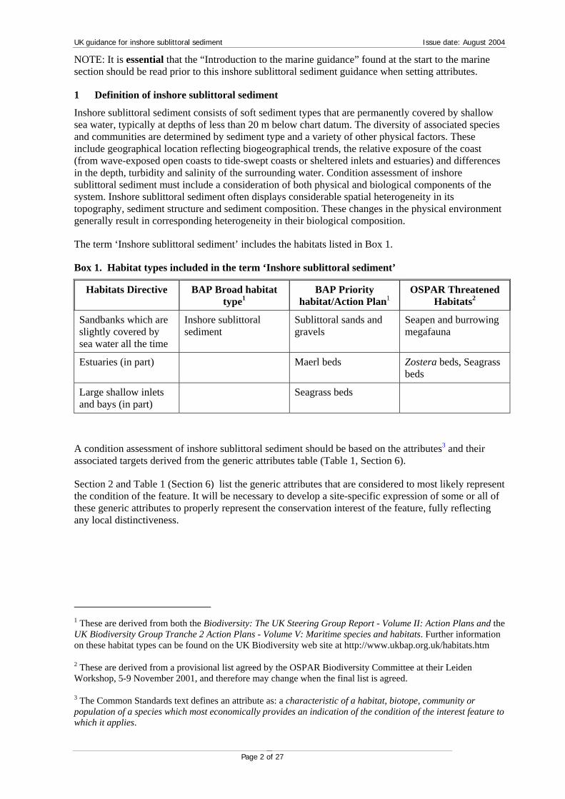
The term ‘Inshore sublittoral sediment’ includes the habitats listed in Box 1.
Box 1. Habitat types included in the term ‘Inshore sublittoral sediment’
Habitats Directive BAP Broad habitat type1
BAP Priority habitat/Action Plan1
OSPAR Threatened Habitats2
Sandbanks which are slightly covered by sea water all the time
Inshore sublittoral sediment
Sublittoral sands and gravels
Seapen and burrowing megafauna
Estuaries (in part) Maerl beds Zostera beds, Seagrass beds
Large shallow inlets and bays (in part)
Seagrass beds
A condition assessment of inshore sublittoral sediment should be based on the attributes3 and their associated targets derived from the generic attributes table (Table 1, Section 6).
Section 2 and Table 1 (Section 6) list the generic attributes that are considered to most likely represent the condition of the feature. It will be necessary to develop a site-specific expression of some or all of these generic attributes to properly represent the conservation interest of the feature, fully reflecting any local distinctiveness.
1 These are derived from both the Biodiversity: The UK Steering Group Report - Volume II: Action Plans and the UK Biodiversity Group Tranche 2 Action Plans - Volume V: Maritime species and habitats. Further information on these habitat types can be found on the UK Biodiversity web site at http://www.ukbap.org.uk/habitats.htm
2 These are derived from a provisional list agreed by the OSPAR Biodiversity Committee at their Leiden Workshop, 5-9 November 2001, and therefore may change when the final list is agreed.
3 The Common Standards text defines an attribute as: a characteristic of a habitat, biotope, community or population of a species which most economically provides an indication of the condition of the interest feature to which it applies.

UK guidance for inshore sublittoral sediment Issue date: August 2004
Page 3 of 27
2 Background, targets and monitoring techniques for individual attributes
Table 1 (Section 6) lists seven attributes, four of which (Extent, Topography, Sediment character and Distribution of biotopes) are mandatory for all sites. The rest are site-specific attributes used to highlight local distinctiveness when assessing the overall conservation value of a site and may therefore not be applicable to all sites.
2.1 Extent of inshore sublittoral sediment(s)
Extent of identified inshore sublittoral sediment(s) is an essential structural component of the feature and therefore must be assessed for all sites.
2.1.1 Background to the attribute
The factors influencing the spatial extent of sedimentary habitats were described in a report to the UK Marine SACs project (Elliot et al., 1998); the following text is taken from that report. The area of inshore sublittoral sediment is dictated by the prevailing physical conditions, especially the physiographic and underlying geology, coupled with the hydrodynamic regime (strength, direction and dynamics of currents) which dictates where and how much sediment will be deposited. The area and shape of these habitats are important in supporting and maintaining the constituent biological assemblages.
For inshore sublittoral sediments, particularly those in dynamic hydrophysical regimes, changes in extent will occur due to tidal/meteorological influences. Such fluctuations in extent may be great, but are attributable to natural coastal processes beyond management control. A full understanding of such variability will only be gained after a number of monitoring cycles. Depositional sediments are similarly dependent on the prevailing hydrophysical regime to ensure a continual supply of sediment. Any disruption to the rate of sediment supply may lead to a change in extent of the sediment and/or a change in its composition, which itself is equivalent to a loss of extent.
Where the field assessment judges extent to be unfavourable, and subsequent investigation reveals the cause is clearly attributable to cyclical natural processes, the final assessment will require expert judgement to determine the reported condition of the feature. The feature’s condition could be declared favourable where the officer is certain that the conservation interest of the feature is not compromised by the failure of this attribute to meet its target condition. Where there is a change outside the expected variation or a loss of the conservation interest of the site, (e.g. due to anthropogenic activities or unrecoverable natural losses) then condition should be considered unfavourable.
Natural changes may be attributable to a loss of sediment following winter storms or floods. Storm events are becoming increasingly frequent and can inflict extreme changes in wave action and tidal steams. These currents lead to constant changes in the size, shape and position of sediment habitats and, in some areas where currents are particularly strong, sediments may move considerably over one tidal cycle.
Changes in extent may be attributable to anthropogenic effects, where activities remove parts of the feature (i.e. dredging; spoil disposal; fishing; oil and gas exploration, development and production; aggregate extraction). Such changes in extent would be considered unfavourable.
Local topography and the shape of the coastline may have a significant influence on the direction and strength of tidal currents: for example headlands may create gyres (circular currents). Man-made structures placed on the seabed or coastal developments that change the shape of the coastline could disrupt the local hydrophysical regime and affect sediment habitats. Such changes in extent would lead to unfavourable condition.

UK guidance for inshore sublittoral sediment Issue date: August 2004
Page 4 of 27
2.1.2 Setting a target
In principle the target should be set at no loss of area of the inshore sublittoral sediment habitats during the monitoring cycle accommodating any geomorphological trajectory. It may be necessary to set a target that declines each monitoring cycle where there is an established natural loss of extent, or sufficient data available to predict (via a model) a downward trend in extent4. Departure from this predicted target then would be a trigger for investigation and the feature may be considered unfavourable.
The target should indicate the recognised area of the feature measured in hectares. It is important that targets set for this attribute are flexible enough to relate to the natural processes involved with this feature (see above text). For sediment features in dynamic situations such as inshore sublittoral sediments, it may be impractical to specify a detailed area in hectares, since the feature will move around and change shape with the prevailing environmental conditions. It would be more appropriate to focus on ensuring these hydrophysical parameters are maintained and not influenced by anthropogenic activities. Hydrographic data may be available from a number of sources. Many UK government agencies place hydrographic instruments on the seabed to gather data for research or operational monitoring for forecasting purposes (for example the Met Office). If such information is not available, it would be possible to use anecdotal evidence from local mariners such as fishermen (Elliot et al., 1998).
Extent can be measured in absolute terms, using an index approach such as point sampling over a grid, or by inference. The type of measure used should be linked to the known or likely threats posed by anthropogenic activities and take into account necessary consideration of dynamic processes.
When measuring extent, the following issues should be considered:
• Storm events can inflict extreme changes in wave action and tidal steams. These currents
lead to constant changes in the size, shape and position of sediment habitats and can transport sediment into the system. This may lead to sediment deposition and an increase in extent or alternatively loss of sediment and consequent loss of extent.
• Where currents are particularly strong sedimentary areas may be liable to severe substratum disturbance: for example inshore sublittoral sediments occurring in estuaries may be subject to winter-summer erosion-deposition cycles and spring-neap erosion-deposition cycles, reflecting the periods of highest hydrodynamic energy. Very strong currents may create channels around banks or remove all of the superficial sediment.
• Anthropogenic factors i.e. dredging, spoil disposal, fishing, oil and gas exploration, development and production, aggregate extraction can lead to extent loss/increase.
An example of how a target for this attribute might be expressed is shown in
4 It may also be possible to predict and increase in extent for littoral flats where sediment accumulation occurs.

UK guidance for inshore sublittoral sediment Issue date: August 2004
Page 5 of 27
Box 1

UK guidance for inshore sublittoral sediment Issue date: August 2004
Page 6 of 27
Box 1 A site-specific target for the attribute ‘Extent of identified inshore sublittoral sediment(s)’
Target Comments
No change in extent of inshore sublittoral sediment habitat, allowing for natural succession/known cyclical change
Area (ha.) of specified inshore sublittoral sediment(s) assessed using point sample mapping techniques guided by the work carried out mapping benthic biotopes in the Sound of Arisaig in 1996 (Davies and Hall-Spencer, 1996).
*from Sound of Arisaig cSAC
2.1.3 Suggested techniques
Acoustic mapping to determine the extent of the sediment habitats within the whole site is unlikely to be used after initial mapping exercises have been undertaken. A stratified sampling strategy guided by the initial inventory of the whole resource is likely. In shallow areas it might be appropriate to use air photo/satellite remote sensing, with suitable ground validation.
The Marine Monitoring Handbook (Davies et al., 2001) contains details of the techniques appropriate for monitoring the condition of designated features.
Possible methods provided in the handbook for measuring the extent of the feature are:
• 1-3 Seabed mapping using acoustic ground discrimination interpreted with ground truthing (AGDS)
• 1-4 The applicability of side scan sonar for seabed mapping
Other proposed methods, not as yet detailed in the handbook are:
• point sample mapping using video techniques.
2.2 Topography
Topography is considered an essential component of the feature and therefore it must be assessed for all sites.
2.2.1 Background to the attribute
Topography is defined as the depth and distribution of the sediment, which is fundamental to the structure of the feature and bears a direct influence on the associated fauna. The topography generally reflects the prevailing energy conditions and overall stability of the feature.
Depth of the feature is a major influence on the distribution of communities throughout:
• Shallow sediments are influenced by wave energy: sediments exposed to wave action are more mobile and comprise coarser sediment than more sheltered areas. These sediments may be shifted around periodically, and thus harbour an infauna of mobile species. An increase in depth would change the characteristics of the sediment and its interaction with the prevailing hydrophysical regime. If depth decreased, the sediment may become exposed on low spring tides, which would decrease the survival of subtidal fauna that cannot withstand aerial exposure (Elliot et al., 1998).
• Shallow sediments in areas of clean water can support algal communities, seagrass beds or maerl beds. Deepening of these areas may reduce the quality of light reaching the seabed and thereby lead to deterioration in the quality these communities (as can increased turbidity in these areas).
• Deeper sediments are less influenced by wave energy, and are therefore more stable, which in turn allows the development of stable communities, often dominated by bivalve molluscs.

UK guidance for inshore sublittoral sediment Issue date: August 2004
Page 7 of 27
Sublittoral topography should be allowed to respond naturally to prevailing conditions; changes in overall topography will occur seasonally, but may also be as a response to changes in the supporting hydrophysical regime.
Topographical structure is important to maerl beds. Maerl plants tend to grow in dense beds, with live maerl plants overlying dead maerl gravel. The dead plants are broken up and by the action of currents and tides and accumulate to form gravely deposits sometimes several metres thick. These plants are among the slowest growing species in the world – with the growth of individual plants being measured in tenths of a millimetre per year. Individuals may be several hundred years old. The deposits of gravel formed from the dead plants have taken literally thousands of years to accumulate. Where maerl beds are comprised of banks, a change in the depth to the surface of the bank may signify changes in the overall structure and stability of the bank. A deepening of the bank may indicate a loss of maerl gravel from the system and/or may lead to a reduction in growth due to lower incident light intensity.
The factors known to influence extent will also affect topography. See Section 2.1.1 for further information.
2.2.2 Setting a target
In principle the target should be set at no overall change to the topography during the monitoring cycle, but the target should reflect any seasonal changes that might be expected and in some areas relate to the variation in expected weather and storm activity from one year to the next. Target topographic conditions may be linked to the degree of wave action that is fundamental in defining a particular dynamic community type. Alternatively, the target topographic conditions may be critical in defining the level of irradiance for the survival of seagrass, maerl or other algal communities. The hydrophysical regime affects the rate of deposition and remobilisation of the sand and hence the nature of the substratum and the depth of the inshore sublittoral sediment. The speed of water movement and the rate of erosion and deposition of the sand are important in maintaining the integrity of these habitats. Some inshore sublittoral sediments experience very strong currents and are primarily physically controlled especially in high energy situations away from coastal silt input or where currents are sufficiently strong to prevent accumulation of fine sediment (Pethick, 1984). At certain times, particularly during storms, the top of an inshore sublittoral sediment bank can be removed and then replaced during calmer conditions. As yet there is no example of a site-specific target for topography.
2.2.3 Suggested techniques
Acoustic techniques should be used to determine the bathymetric profile of the whole sediment feature within the site as a baseline condition. Subsequent monitoring is likely to use a stratified sampling strategy to assess change along a number of depth transects in areas of interest.
The Marine Monitoring Handbook (Davies et al., 2001) contains details of the techniques appropriate for monitoring the condition of designated features.
Possible methods provided in the handbook for measuring the topography of the feature are:
• 1-3 Seabed mapping using acoustic ground discrimination interpreted with ground truthing (AGDS)
Other proposed methods, not as yet detailed in the handbook are:
• Measuring bathymetry using standard hydrographic techniques (including swath bathymetry work and representative bathymetric transects)

UK guidance for inshore sublittoral sediment Issue date: August 2004
Page 8 of 27
2.3 Sediment character: sediment type
Sediment type is an essential component of the feature and therefore must be assessed for all sites.
2.3.1 Background to the attribute
Sediment character defined by sediment type is key to the structure of the feature and reflects all of the physical processes acting on it. Sediment type is a key factor determining the biological composition of the sediment community. Very strong currents may produce channels around banks where the sediment may be extremely coarse. Large-scale sand-ripples may also develop and accumulate silt in their troughs. Recognised assemblages of species are directly related to the sediment in which they occur. A change in the particle size parameters will lead to changes in associated infaunal / epifaunal communities. Movement of watercourses in the site may change the sediment particle composition. High-energy areas with tidal streams, wave action and strong currents cause sediment transport and erosion which will affect the grain size of sediment. This natural process may be supported by a shift in the distribution/spatial patterns of determining biotopes.
Where the field assessment judges sediment type to be unfavourable, and subsequent investigation reveals the cause is clearly attributable to cyclical natural processes (e.g. winter storm, changes in supporting processes), the final assessment will require expert judgement to determine the reported condition of the feature. The feature’s condition could be declared favourable where the officer is certain that the conservation interest of the feature is not compromised by the failure of this attribute to meet its target condition. Where there is a change outside the expected variation or a loss of the conservation interest of the site, (e.g. due to anthropogenic activities or unrecoverable natural losses) then condition should be considered unfavourable.
2.3.2 Setting a target
It is important clearly to establish the link between the sediment character and the conservation interest of the feature prior to setting the target condition. It is particularly important to establish whether the conservation interest is linked to a specific sediment type or whether it is linked to a range of sediment types. For example, where an inshore sublittoral sediment bank supports biotopes characteristic of clean sand, it will be important to specify the target condition in relation to the sediment composition, either in terms of particle size parameters or the ration of sand to silt. Where an inshore sublittoral sediment bank supports a wide range of biotopes characteristic of a range of sediment types, the target reflect the need to maintain the different sediment types. It may also be important to maintain a particular spatial distribution of sediment types within an inshore sublittoral sediment feature – for example the location of live maerl beds within a broader maerl habitat comprising live and dead maerl.
It is intended that average sediment parameters for the feature should be set. In setting the target the distribution of known sediment types across the feature should be determined and the target should distinguish between the need to retain a range of sediment types throughout the feature, or the maintenance of a spatial juxtaposition of specific sediment types, possibly at a defined number of sites. This information can be derived from biotope maps, geological maps, or previous detailed survey. A target condition must be based on detailed sample data to ensure future assessments can be compared to actual baseline data.
Measuring the spatial arrangement of sediment types is more complex, since it requires a mapping approach, whereas identifying the presence of a sediment type can use a simple point sample/observation technique. To ensure a consistent approach for future assessments, expression of sediment types (‘sand’, ‘gravely sand’) can be made using mean phi values or sediment grades such as 'sand' 'muddy sand' etc as used in the Folk classification scheme (Folk, 1954).
It is important, therefore, when setting a target, to clarify the difference between a target to represent the range of sediment types over a feature and a specific requirement for a single sediment type.
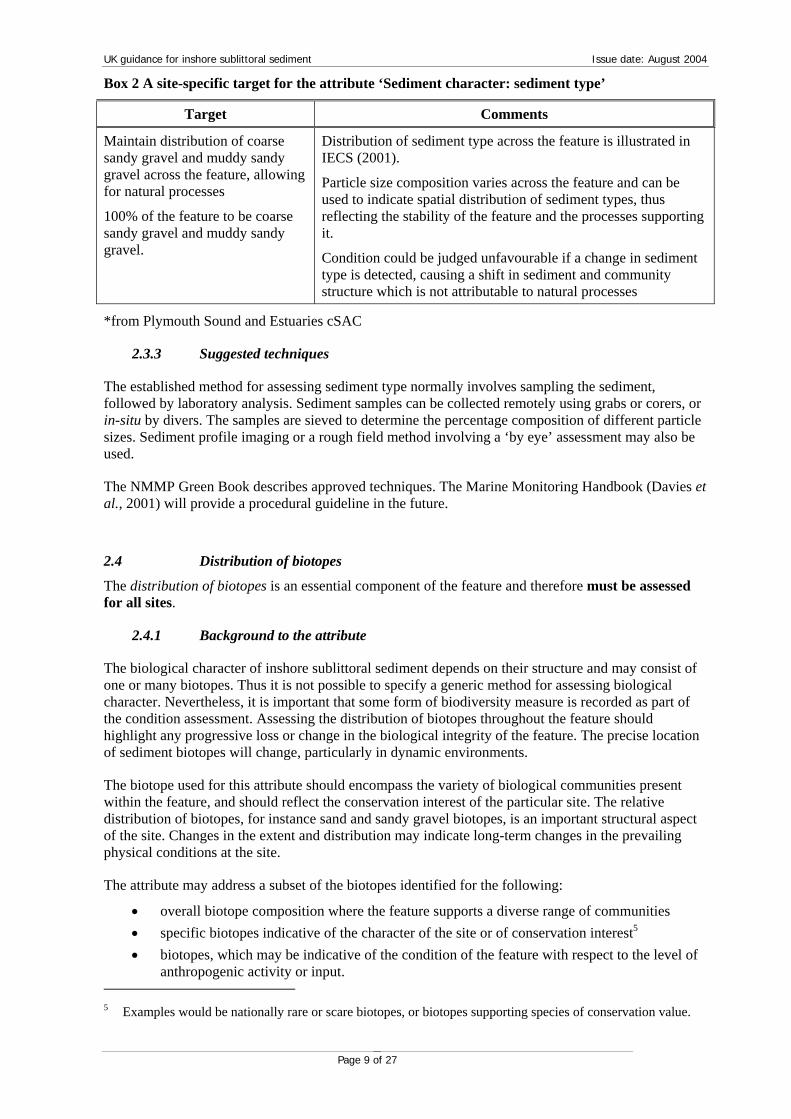
An example of how a target for this attribute might be expressed is shown in Box 2
UK guidance for inshore sublittoral sediment Issue date: August 2004
Page 9 of 27
Box 2 A site-specific target for the attribute ‘Sediment character: sediment type’
Target Comments
Maintain distribution of coarse sandy gravel and muddy sandy gravel across the feature, allowing for natural processes
100% of the feature to be coarse sandy gravel and muddy sandy gravel.
Distribution of sediment type across the feature is illustrated in IECS (2001).
Particle size composition varies across the feature and can be used to indicate spatial distribution of sediment types, thus reflecting the stability of the feature and the processes supporting it.
Condition could be judged unfavourable if a change in sediment type is detected, causing a shift in sediment and community structure which is not attributable to natural processes
*from Plymouth Sound and Estuaries cSAC
2.3.3 Suggested techniques
The established method for assessing sediment type normally involves sampling the sediment, followed by laboratory analysis. Sediment samples can be collected remotely using grabs or corers, or in-situ by divers. The samples are sieved to determine the percentage composition of different particle sizes. Sediment profile imaging or a rough field method involving a ‘by eye’ assessment may also be used.
The NMMP Green Book describes approved techniques. The Marine Monitoring Handbook (Davies et al., 2001) will provide a procedural guideline in the future.
2.4 Distribution of biotopes
The distribution of biotopes is an essential component of the feature and therefore must be assessed for all sites.
2.4.1 Background to the attribute
The biological character of inshore sublittoral sediment depends on their structure and may consist of one or many biotopes. Thus it is not possible to specify a generic method for assessing biological character. Nevertheless, it is important that some form of biodiversity measure is recorded as part of the condition assessment. Assessing the distribution of biotopes throughout the feature should highlight any progressive loss or change in the biological integrity of the feature. The precise location of sediment biotopes will change, particularly in dynamic environments.
The biotope used for this attribute should encompass the variety of biological communities present within the feature, and should reflect the conservation interest of the particular site. The relative distribution of biotopes, for instance sand and sandy gravel biotopes, is an important structural aspect of the site. Changes in the extent and distribution may indicate long-term changes in the prevailing physical conditions at the site.
The attribute may address a subset of the biotopes identified for the following:
• overall biotope composition where the feature supports a diverse range of communities • specific biotopes indicative of the character of the site or of conservation interest5 • biotopes, which may be indicative of the condition of the feature with respect to the level of
anthropogenic activity or input. 5 Examples would be nationally rare or scare biotopes, or biotopes supporting species of conservation value.

UK guidance for inshore sublittoral sediment Issue date: August 2004
Page 10 of 27
The resolution to which biotopes are expressed in the target will have to be considered with regard to their use in condition assessment. It may be appropriate to use higher level biotopes (e.g. biotope complexes) in preference to the more detailed ones that are difficult to identify in the field.
Where known changes in biotope distribution are clearly attributable to natural processes (e.g. winter storm/flood events, changes in supporting processes or mass recruitment or dieback of characterising species), this variability should be reflected in the target. If a field assessment still judges this attribute to be unfavourable and subsequent investigation indicates the cause is due to natural factors, the final assessment will require expert judgement to determine the reported condition of the feature. The feature’s condition could be declared favourable where the officer is certain that the conservation interest of the feature is not compromised by the failure of this attribute to meet its target condition. Where there is a change in biotope distribution outside the expected variation or a loss of the conservation interest of the site, (e.g. due to anthropogenic activities or unrecoverable natural losses) then condition should be considered unfavourable.
2.4.2 Setting a target
The links between the physical parameters of the sediment and the associated infaunal and epifaunal communities are strong. Therefore the dynamic nature of the system will affect the biotope distribution.
It is possible to use either an absolute measure or an index approach to measuring biotope distribution. Issues to consider when specifying site-specific targets include:
• Biotope distribution may change in response to extreme events such as increased storm occurrence.
• Some biotopes will change their distribution naturally over time, in a cycle with other biotopes (and the target should identify these if possible).
• The precise location of sediment biotopes will change, particularly in dynamic environments.
It is important that the targets and measures set are clear and unambiguous. The targets and measures should determine the resolution (i.e. whether the assessment is based on biotope complex, biotope or sub-biotope level) and the scale of the assessment (i.e. intensity of sampling). The targets should also clearly identify what must be achieved in order to pass or fail (i.e. biotope X must be present at location A, or any mud or sand biotope should be present at location A, or biotopes A, B & C must be present somewhere within area X of the feature). It is important to note the following issues when specifying biotopes as part of the target condition:
• Biotopes may change in natural cycles (and the target should identify these if possible): If an area changes from one biotope to another, this may be a natural process, possibly part of a natural cycle. It is important not to over specify targets (“biotope x must be present at site y”) unless that is an important aspect of the conservation value of the feature, to avoid the possibility of an area being deemed unfavourable where biotopes have changed as part of a natural process. For example, natural shifts in biotopes are likely to occur on inshore sublittoral sediment. Seasonal changes in hydrological regime can be significant and winter storms may reduce or remove the infauna present during summer months or alter species composition. A shift from one sub-biotope to another would not necessarily indicate a decline in the condition of the feature as it could be the result of natural processes. In this particular example, it may be suitable to set the target at the biotope complex level (“biotopes within biotope complex x must occur at site y”). Knowledge of local conditions is necessary when setting targets: some inshore sublittoral sediments experience very strong currents and at certain times, particularly during storms, the top of a sediment bank can be removed and then replaced during calmer conditions.
• Species composition of biotopes: It is not possible to apply a level in the biotope classification hierarchy at which all targets should be set: in some cases a shift from one biotope (or even sub-biotope) to a similar one may signal a decline in environmental quality. For example a change from a biotope characterised by filter-feeding bivalve molluscs to a biotope characterised by ephemeral

UK guidance for inshore sublittoral sediment Issue date: August 2004
Page 11 of 27
polychaete worms would indicate a change in the turbidity and/or sediment regime towards finer grade sediments. Fine sediments clog filter-feeding apparatus of molluscs.
• Data type and quality: For many sublittoral sediments, the biotope composition cannot reliably be identified at the biotope or sub-biotope level during Phase I-type surveys in the field, since quantitative sampling is required to identify the characterising species. It is very important to bear this in mind especially where habitat maps based on Phase I surveys are available for a particular site: subsequent quantitative surveys may lead to different habitat assignments even if there was no change to the feature. Similarly, if data from an initial quantitative survey were available to establish a target condition, subsequent rapid assessment surveys will not necessarily deliver the same level of detail. Where condition assessments will be based on data from rapid surveys, it is important not to set the target at too detailed a level in the biotope classification, as the field data will not deliver the required level of resolution. It may be necessary to set targets at the biotope complex or habitat complex level, if resources will not allow for quantitative surveys to be carried out in future.
• An agreed level of biotope discrimination must be clearly established in relation to the national biotope classification scheme. You may wish to use a higher level in the classification where biotopes are difficult to differentiate without detailed sampling.
• A subset of biotopes of importance may be identified and listed, omitting ephemeral biotopes and biotopes considered of low conservation importance. You may only wish to choose biotopes considered to be of conservation importance within the site.
• Some biotopes occur in a natural cycle and may disappear and reappear over time. These cycles are a vital part of the interest of the feature and must be considered when phrasing a target value. Too tightly defined targets could lead to a false judgement of unfavourable condition.
SSSI citations, SAC Regulation 33 packages, biotope maps or more detailed survey records should help to determine the biotopes of nature conservation importance within a site, which in turn will determine the target list of biotopes. Due consideration should also be given to activities occurring within sites.
An example of how a target might be expressed is shown in Box 3.
Box 3 A site-specific target for the attribute ‘Distribution of biotopes’
Target Comments
Maintain the distribution of the biotope subset, allowing for natural succession/known cyclical change in biotope distribution.
Phy,Phy.R, Zmar, VirOph, EcorEns, LsacX and VenNeo
The distribution should correspond with a baseline map and results.
Expect to identify the biotope subset in the field at positions derived from the baseline biotope map and cross-reference with aerial photographs.
*from the Sound of Arisaig cSAC.
2.4.3 Suggested techniques
Biotope mapping should be undertaken to provide baseline information and to guide the undertaking of more detailed targeted studies. Subsequent monitoring cycles could use a point sampling strategy (e.g. based on a grid) to compare the present situation with the baseline condition.
The Marine Monitoring Handbook (Davies et al., 2001) contains details of the techniques appropriate for monitoring the condition of designated features.
Possible methods provided in the handbook for measuring the biotope composition of the feature are:

UK guidance for inshore sublittoral sediment Issue date: August 2004
Page 12 of 27
• 1-1 Intertidal resource mapping using aerial photographs; with ground validation • 1-5 Mosaicing side scan sonar images to map seabed features • 3-14 In situ survey of sublittoral epibiota using towed sledge video and still photography
Other proposed methods, not as yet detailed in the handbook are:
• point sample mapping (from grab sampling, ROV or drop-down video data)
2.5 Extent of sub-feature or representative/notable biotopes
Extent of sub-feature or representative/ notable biotopes is considered a site-specific attribute used to highlight local distinctiveness when assessing the overall conservation value of a site. It may therefore not be applicable to all sites.
2.5.1 Background to the attribute
This attribute may highlight important structural and functional components of the feature, depending on the biotopes/sub-features chosen. The biotopes chosen should reflect the site-specific interest of the feature. Actual extent may vary on seasonal cycles and the presence or absence of a biotope can change the results quite significantly. It is important to understand cyclical succession of sediment biotopes, and to take this into account when choosing biotopes to reflect this particular attribute. The target also needs to identify biotopes that would be expected to be part of that natural cycle.
The advice concerning judgement of the feature condition provided under Extent (Section 2.1.1 Background to the attribute) equally applies to this section and should be consulted.
The extent of seagrass is a key structural component of some inshore sublittoral sediment and provides a long-term integrated measure of environmental conditions across the feature. The extent of brittlestar beds is a key structural component of some inshore sublittoral sediment. It represents a major concentration of biomass within the feature, and may play an important role in local carbon and nutrient cycles (Hughes, 1998). Fluctuations in brittlestar beds have been shown to relate both to large-scale hydrographic processes and to short-term localised events; thus they will indicate environmental change at a range of scales.
Maerl beds are created by a particular group of free-living red coralline seaweeds. Where conditions are favourable, unattached maerl nodules can occur in vast numbers forming extensive beds. Maerl plants tend to grow in dense beds. The dead plants are broken up and by the action of currents and tides and accumulate to form gravely deposits sometimes several metres thick. These plants are among the slowest growing species in the world – with the growth of individual plants being measured in tenths of a millimetre per year. Individuals may be several hundred years old. The deposits of gravel formed from the dead plants have taken literally thousands of years to accumulate. The relative distribution of different maerl biotopes, live/dead maerl and patchiness within the maerl bed, are important structural aspects of the sub-feature and therefore feature as a whole. Changes in relative extent and distribution may indicate long-term changes in the physical conditions influencing the feature.
2.5.2 Setting a target
In principle, the target should be set at no loss in extent of the sub-feature or representative/notable biotope during the monitoring cycle. It may be necessary to set a target that declines each monitoring cycle where there is an established natural loss of extent, or sufficient data available to predict (via a model) a downward trend in extent. Departure from this predicted target then would be a trigger for investigation and the feature may be considered unfavourable.
The extent of these biotope complexes is dictated by the physical conditions, especially the physiographic and underlying geology coupled with the hydrodynamic regime, which dictates where and how much sediment will be deposited. The area of an inshore sublittoral sediment bank will be influenced by the strength and dynamics of currents creating the area.
UK guidance for inshore sublittoral sediment Issue date: August 2004
Page 13 of 27
Natural variation in extent or in cyclical succession between biotopes can be expected. The target needs to identify biotopes that would be expected to be part of that natural cycle. The following issues should be considered:
• How many sub-features or representative/notable biotopes are present within the feature? • What is the extent (ha/m2) of each of the sub-features and/or biotopes? • Identify any natural “cyclical partners” for the specified biotopes: these must be listed with
the target. For example, there may be a die-back of seagrass during autumn and winter to leave predominantly sedimentary habitats (Pooley & Bamber, 2000). Seagrass beds and clean sediment are ‘cyclical partners’.
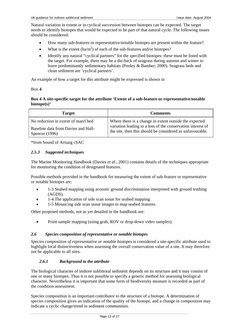
An example of how a target for this attribute might be expressed is shown in
Box 4
Box 4 A site-specific target for the attribute ‘Extent of a sub-feature or representative/notable biotope(s)’
Target Comments
No reduction in extent of maerl bed
Baseline data from Davies and Hall-Spencer (1996)
Where there is a change in extent outside the expected variation leading to a loss of the conservation interest of the site, then this should be considered as unfavourable.
*from Sound of Arisaig cSAC
2.5.3 Suggested techniques
The Marine Monitoring Handbook (Davies et al., 2001) contains details of the techniques appropriate for monitoring the condition of designated features.
Possible methods provided in the handbook for measuring the extent of sub-feature or representative or notable biotopes are:
• 1-3 Seabed mapping using acoustic ground discrimination interpreted with ground truthing (AGDS).
• 1-4 The application of side scan sonar for seabed mapping. • 1-5 Mosaicing side scan sonar images to map seabed features.
Other proposed methods, not as yet detailed in the handbook are:
• Point sample mapping (using grab, ROV or drop-down video samples).
2.6 Species composition of representative or notable biotopes
Species composition of representative or notable biotopes is considered a site-specific attribute used to highlight local distinctiveness when assessing the overall conservation value of a site. It may therefore not be applicable to all sites.
2.6.1 Background to the attribute
The biological character of inshore sublittoral sediment depends on its structure and it may consist of one or many biotopes. Thus it is not possible to specify a generic method for assessing biological character. Nevertheless it is important that some form of biodiversity measure is recorded as part of the condition assessment.
Species composition is an important contributor to the structure of a biotope. A determination of species composition gives an indication of the quality of the biotope, and a change in composition may indicate a cyclic change/trend in sediment communities.
UK guidance for inshore sublittoral sediment Issue date: August 2004
Page 14 of 27
Any change in species populations should be assessed as an overall measure of community structure of the biotope, rather than as an individual or indicator species. An assessment of species composition may be restricted to only measure the characterising species of a targeted biotope where the overall species composition of that biotope is poorly understood and subject to measurement error. These species can be identified from the MNCR biotope classification using species with a typical abundance of common or above (using SACFOR abundance scale from MNCR classification). The target should include a list of these characterising species.
Where changes in species composition are clearly attributable to natural succession and known cyclical change such as mass recruitment and dieback of characterising species, then this variability should be reflected in the target. If however, a field assessment still judges this attribute to be unfavourable and subsequent investigation indicates the cause is due to natural factors, the final assessment will require expert judgement to determine the reported condition of the feature. The feature’s condition could be declared favourable where the officer is certain that the conservation interest of the feature is not compromised by the failure of this attribute to meet its target condition. Where there is a change in species composition outside the expected variation or a loss of the conservation interest of the site, (e.g. due to anthropogenic activities or unrecoverable natural losses) then condition should be considered unfavourable
Examples of notable biotopes would be nationally rare or scarce biotopes, biotopes that are indicative of the 'health' of the feature or the level of anthropogenic activity or input.
2.6.2 Setting a target
Species composition can be measured in absolute terms (number of species, density of a species), using an index (evaluating the overall number of species even if exact species compliment changes) or in terms of presence/absence. The type of measure will depend on the context in which the attribute is used.
The following issues should be considered:
• The biotope for which a species composition measure is required must be clearly stated in the attribute table and identifiable in the field.
• Biotopes may be selected for different reasons, for example their overall diversity or because they contain species of conservation importance. Biotopes selected would be specific to the site and would either be indicative of the character of the site or represent a sub-feature such as maerl. The reason for selection will determine what species should be measured and hence the way a target is phrased.
• It may be appropriate to select a subset of the species present, avoiding species whose presence is ephemeral, difficult to sample or difficult to identify.
• It may be appropriate to develop a checklist of species for a biotope, for example those species that have important structural and functional contributions to the biotope’s continued existence.
• For biotopes that have a high turnover of species, it is more appropriate to use an index measure although careful consideration must be given to the actual measure. Note, indices have specific requirements in terms of the type of data used, and their method of collection.
• Species could be: nationally rare or scarce; species that have an important functional or structural role in the feature; species indicative of the 'health' of the feature; species indicative of the level of anthropogenic activity; non-native species (where their presence is considered unfavourable).
• Species targets could be derived from existing records for that biogeographic region. • Careful consideration must be given to the use of species that are known to have a high
turnover or fluctuation in abundance. • Species recording has significant quality assurance issues in relation to the sampling
methodology and particularly the taxonomic competence of the recorders. It may therefore
UK guidance for inshore sublittoral sediment Issue date: August 2004
Page 15 of 27
be appropriate to select species that are capable of a relatively simple assessment. If necessary a pre-assessment visit may help to identify or check the ease of recording. Target condition should be established with regard to these QA issues.
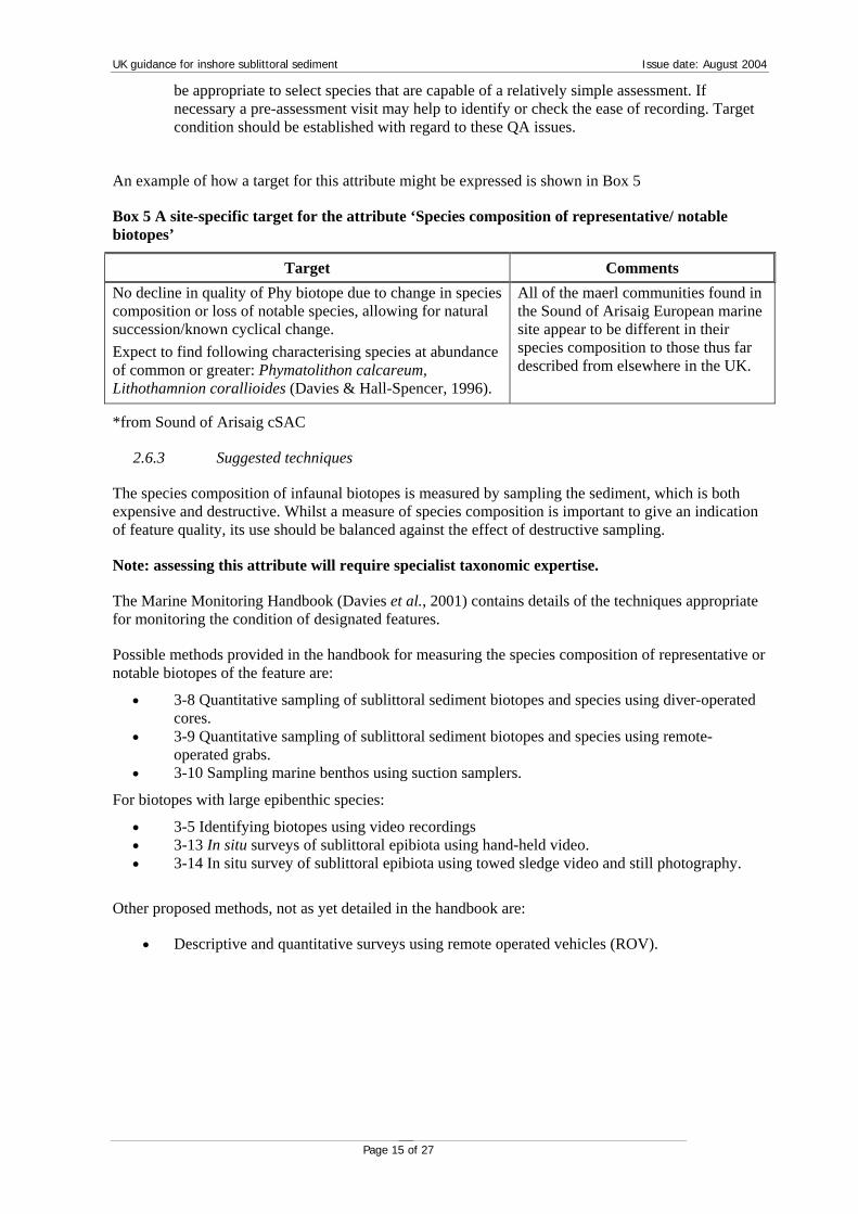
An example of how a target for this attribute might be expressed is shown in Box 5
Box 5 A site-specific target for the attribute ‘Species composition of representative/ notable biotopes’
Target Comments No decline in quality of Phy biotope due to change in species composition or loss of notable species, allowing for natural succession/known cyclical change. Expect to find following characterising species at abundance of common or greater: Phymatolithon calcareum, Lithothamnion corallioides (Davies & Hall-Spencer, 1996).
All of the maerl communities found in the Sound of Arisaig European marine site appear to be different in their species composition to those thus far described from elsewhere in the UK.
*from Sound of Arisaig cSAC
2.6.3 Suggested techniques
The species composition of infaunal biotopes is measured by sampling the sediment, which is both expensive and destructive. Whilst a measure of species composition is important to give an indication of feature quality, its use should be balanced against the effect of destructive sampling.
Note: assessing this attribute will require specialist taxonomic expertise.
The Marine Monitoring Handbook (Davies et al., 2001) contains details of the techniques appropriate for monitoring the condition of designated features.
Possible methods provided in the handbook for measuring the species composition of representative or notable biotopes of the feature are:
• 3-8 Quantitative sampling of sublittoral sediment biotopes and species using diver-operated cores.
• 3-9 Quantitative sampling of sublittoral sediment biotopes and species using remote-operated grabs.
• 3-10 Sampling marine benthos using suction samplers.
For biotopes with large epibenthic species:
• 3-5 Identifying biotopes using video recordings • 3-13 In situ surveys of sublittoral epibiota using hand-held video. • 3-14 In situ survey of sublittoral epibiota using towed sledge video and still photography.
Other proposed methods, not as yet detailed in the handbook are:
• Descriptive and quantitative surveys using remote operated vehicles (ROV).
UK guidance for inshore sublittoral sediment Issue date: August 2004
Page 16 of 27
2.7 Species population measures
The population structure of a species or the presence/abundance of specified species are considered a site-specific attribute to highlight local distinctiveness when assessing the overall conservation value of a site. They may therefore not be applicable to all sites.
2.7.1 Background to attribute
The species selected should serve an important role in the structure and function of the biological community. The method for measurement will vary, depending on the species and how it is contributing to the structure and function of the sediment feature. Changes in presence and abundance or population structure of a species (which may eventually lead to a change in abundance of longer-lived species) can critically affect the physical and functional nature of the inshore sediment feature and condition may be considered unfavourable.
Population measurements are made to assess whether there is continuing recruitment of a species into a population (i.e. to ensure the population is being maintained). This is an important measurement for the longer-lived species such as molluscs that form an important functional role in a feature. The condition of the feature may be considered unfavourable if there is a sizeable shift in the age/size class structure (for instance there may be a loss of mature adults or recruitment failure), which would cause a collapse in the population leading to loss of the species altogether from the feature.
Presence or abundance of positive indicator species may also be indicative of the condition of the inshore sediment feature. Such species may be of nature conservation importance, or particularly fragile or sensitive to disturbance. The condition of the feature would be considered unfavourable if the species is lost, or if there is a significant reduction in abundance. Increased abundance of negative indicator species may also be indicative of the condition of the sediment. For example, some polychaete worms are indicative of stressed habitats usually associated with organic pollution. The condition of the feature would be considered unfavourable if there is a significant increase in abundance that is detrimental to the feature as a whole.
2.7.2 Setting a target
Population structure of a species and the presence or abundance of specified species can be measured in absolute terms (numbers of individuals within age classes, numbers of species, density of species) using an index or in terms of presence/absence. The type of measure will depend on the context in which the attribute is used.
The following issues should be considered:
• The species for which the attribute measure is required must be clearly stated in the attribute table and identifiable in the field.
• The reason for selection will determine what should be measured and hence the way a target is phrased. A target of ‘maintain age/size structure’ should be used where one species is long-lived and is providing a structural/functional role within the habitat.
• Characterising species should be apparent from the site documentation, the SSSI citation or previous surveys. These species could be: nationally rare or scarce; species that have an important functional or structural role in the feature; species indicative of the 'health' of the feature; species indicative of the level of anthropogenic activity; non-native species (where their presence is considered unfavourable).
• Species targets could be derived from existing records for that biogeographic region. • Careful consideration must be given to the use of species that are known to have a high
turnover or fluctuation in abundance. • Species recording has significant quality assurance issues in relation to the sampling
methodology and particularly the taxonomic competence of the recorders. It may therefore be appropriate to select species that are capable of a relatively simple assessment. If necessary a pre-assessment visit may help to identify or check the ease of recording.

UK guidance for inshore sublittoral sediment Issue date: August 2004
Page 17 of 27
An example of how a target for this attribute might be expressed is shown in Box 6
Box 6 A site-specific target for the attribute ‘Species population measures’
Target Comments
Presence and abundance of the non-native species Sargassum muticum within eelgrass bed communities should not increase significantly from an established baseline, subject to natural change.
S. muticum is believed to compete with Zostera marina for space, light and other resources, modifying the structure of the eelgrass community. S. muticum is considered to be more relevant to the condition of seagrass communities for this site rather than other macroalgae, particularly opportunistic green algae.
Sargassum abundance within the seagrass bed is measured in July, twice during each reporting cycle.
*from Fal and Helford cSAC
2.7.3 Suggested techniques
The Marine Monitoring Handbook (Davies et al., 2001) contains details of the techniques appropriate for monitoring the condition of designated features.
Possible methods provided in the handbook are:
• 3-8 Quantitative sampling of sublittoral sediment biotopes and species using diver-operated cores- to enumerate presence and quantity of infaunal individuals;
• 3-9 Quantitative sampling of sublittoral sediment biotopes and species using remote-operated grabs- to enumerate presence and quantity of infaunal individuals;
Possible methods for epibenthic species:
• 3-7 In situ quantitative survey of subtidal epibiota using quadrat sampling techniques
3 Other environmental and physical parameters
Although condition assessment will look at attributes within the condition tables, in some cases the results may be difficult to interpret without some additional evidence in the form of data on environmental and physical parameters. Environmental and physical parameters are considered to be site-specific and should only be used as supporting information to highlight local distinctiveness when assessing the overall conservation value of a site, where they are considered to be fundamental to the condition of the feature. For example an attribute reflecting sediment supply may be considered where its interruption may result in a loss of the feature.
It should be emphasised that if an attribute for an environmental or physical parameter is selected as part of the definition of favourable condition for the feature, it must be considered during the assessment process. It is therefore essential that a realistic target can be established, taking account of known inherent variation, and a reliable method of measurement is available since a failure to meet the target will render the condition of the feature unfavourable.
The following parameters, from which site-specific attributes may be derived, are known to influence the status of inshore sublittoral sediment and/or their associated communities. This is not an exhaustive list and additional parameters may be appropriate, taking into consideration the comments in the preceding paragraph on the need for a strong justification for an attribute’s use in condition assessment.
It will be necessary to relate any local measurements of physical parameters to contextual information for a wider geographical area when interpreting the data Local changes may reflect a regional trend rather than any site-based anthropogenic activity and judgement needs to be made whether or not extra environmental attributes are needed. It may be necessary to seek expert advice.

UK guidance for inshore sublittoral sediment Issue date: August 2004
Page 18 of 27
3.1 Water Density (salinity regime and temperature)
Temperature and salinity are characteristic of the overall hydrography of the area. Any changes in the prevailing temperature and salinity regimes may affect the presence and distribution of species (along with recruitment processes and spawning behaviour).
Where changes in temperature or salinity through adverse impacts (e.g. thermal discharge plumes, industrial discharges) cause a severe loss or shift in community structure such that the conservation interest is adversely affected, then condition should be judged as unfavourable. Where changes in temperature or salinity are due to natural processes such as severe winter temperatures, then this may be judged as an acceptable change to the feature unless the key conservation interest is lost.
3.2 Sedimentation Rate
Where adverse anthropogenic impacts such as scallop dredging, disposal of dredge spoil or changed water flows due to artificial structures cause a change in sedimentation rate leading to severe loss of habitat, or an adverse shift in community structure, then this should be judged as unfavourable. Where changes in sedimentation rate are attributable to natural processes such as storm events, changed tidal movements or dynamics, or natural erosion, then this may be judged as an acceptable change to the feature unless the key conservation interest is lost.
3.3 Nutrient Enrichment
One of the central aims of The Convention for the Protection of the Marine Environment of the North-East Atlantic, 1992 (known as the OSPAR Convention) is the prevention and elimination of pollution, and for Contracting Parties (Countries) to take the necessary measures to protect the maritime area against adverse effects of human activities6. The Contracting Parties adopted a Strategy to Combat Eutrophication7 that sets out to tackle problems attributable to nutrient enrichment of marine systems. A Common Procedure for the Identification of the Eutrophication Status of the Maritime Area (known as the Common Procedure) will be used to characterise each part of the maritime area as a problem area or a potential problem area or a non-problem area with regard to eutrophication. OSPAR established a Eutrophication Committee to implement the eutrophication strategy. There are many papers from meetings of this committee containing relevant material to monitoring and assessing the nutrient status of marine waters. In particular, the summary document of EUC 20018 includes the ‘Draft Common Assessment Criteria their Assessment Levels and Area: Classification within the Comprehensive Procedure of the Common Procedure (Source: ETG 2001 Summary Record – ETG 01/7/1, Annex 5)’. This document sets out the process for assessing the status of marine waters (known as ‘classification’). Nutrient and/or chemical status will be monitored and assessed as part of the implementation of the Water Framework Directive; such work will be an important source of data for Common Standards Monitoring.
Nutrients are measured annually by the National Marine Monitoring Programme (NMMP). Information on the sampling and analytical procedures is available in the Green Book, which is available from the NMMP web site.9
6 See the section on the Convention on the OSPAR web site: http://www.ospar.org
7 In this context, ‘Eutrophication’ means the enrichment of water by nutrients causing an accelerated growth of algae and higher forms of plant life to produce an undesirable disturbance to the balance of organisms present in the water and to the quality of the water concerned, and therefore refers to the undesirable effects resulting from anthropogenic enrichment by nutrients as described in the Common Procedure
8 Available on the OSPAR web site: http://www.ospar.org
9 See http://www.cefas.co.uk/monitoring/page-b3.asp for information on the NMMP and for the NMMP Green book http://www.marlab.ac.uk/FRS.Web/Uploads/Documents/GBMain%20Text%201103.pdf

UK guidance for inshore sublittoral sediment Issue date: August 2004
Page 19 of 27
Ecological Quality Objectives (EcoQOs) are proposed for nutrient status of marine waters in relation to the protection of biodiversity: see ‘Revised Proposals for EcoQOs for nutrients and eutrophication effects for inclusion in the BDC (Biodiversity Committee) draft background document on the development of Ecological Quality Objectives for the North Sea as in BDC 01/12/1, Annex 5.’ This draft text includes background reference conditions for nutrients, oxygen concentrations and phytoplankton indicator species.
Within the OSPAR process over the next few years, there will be a considerable research effort focused on setting standards and developing tools to monitor against these standards for eutrophication. The OSPAR web site should be consulted to determine the most up-to-date advice on assessing eutrophication.
Historically, the presence, absence or extent of algal mats have often been considered an indication of the nutrient status of sediment systems, and hence could be used as an indicator of the favourable condition of this feature. Much of the algal growth within sediment habitats is attributed to nitrogen inputs, despite the fact that there has been no direct correlation found between nitrogen inputs to a system and green algal mat growth. This is due to many additional factors interacting with each other, which influence both initiation and rates of growth of algal mats. The growth of algal mats tends to be governed by distinct temperature and light intensity ranges (Khan J. N. (1998). Generally the nitrogen content measured within green algae can be used to reflect the availability of nutrients to the system (i.e. an indicator of raised inputs). Overall it is thought that although the initiation of the algal growth can be due to factors such as temperature and light – the maintenance and extent of these mats is determined by nutrient inputs to the system. To a point this may be true but it is possible that the inputs to maintain the mats are naturally derived and the nutrient poor systems are able to produce extensive green algal mats.
Before proceeding with using algal mats as indicators of the nutrient status of inshore sublittoral sediment, the relationship between the nutrient and the algae should be understood, especially:
• Sources of nutrients to the system • Relationships between the nitrogen in the sediment and its transference to macroalgae • Internal fluxes of nutrients within algal mats for the maintenance of biomass (Janet Khan
pers comm.)
Also, the nutrient content of the algae at the beginning of the mat formation (April/May) may be used to indicate whether the nutrients are being recycled within the system, based on a sediment-algal mat-sediment cycle system, or whether the nutrients are being derived from an external input (Jeffrey, D. W. et al. 1995)
The Environment Agency’s Environmental Monitoring Manual (EA in prep-Roger Proudfoot, pers comm.) suggests a trigger point of 25% cover before management action is required.
4 Recommended visiting period and frequency of visits
4.1 Seasonal effects
Marine communities show seasonal patterns. Many marine organisms have seasonal reproductive patterns that can significantly alter the number of individuals present at different times of the year. Some polychaete worms have semelparous or ‘boom and bust’ life history strategies where the mature adults spawn synchronously and then die. Clearly, the number of adults present in the sediment will depend on the stage in their lifecycle. Larval settlement and recruitment of juveniles to the population can result in a massive increase in the population size at certain times of the year. The presence and number of juveniles should be enumerated separately to the adults in all samples.
Algal communities show the most obvious seasonal trends and sediment habitats may support dense ephemeral algal communities during the summer months. Maerl beds support rich algal assemblages with distinct seasonal variation. For instance, a marked change in the abundance of algae in tidal

UK guidance for inshore sublittoral sediment Issue date: August 2004
Page 20 of 27
rapids was observed in Loch Maddy between autumn 1998 and summer 1999 (Howson & Davison, 2000).
Seasonal effects are also prevalent in seagrass communities. The blade density of the eelgrass itself will increase during the summer and then decrease during the autumn and winter – a process known as die-back (Short et al., 1988). Seagrass blades may support dense assemblages of epiphytic algae during the summer months, which then decline during the winter.
4.2 Time of assessment
It is important to consider seasonal patterns when planning timing of a condition assessment. Sampling should be undertaken at the same time of year if seasonal variation is likely to affect an attribute. It may be necessary to specify the duration of a sampling window, for example, to precede post-reproductive death in polychaete communities. Seasonal changes in seagrass have important consequences for the timing of remote sensing campaigns because the spectral signature10 of the seagrass will change between summer and winter (Pooley & Bamber, 2000).
Recommended timing for survey (months - weeks)
April May July AugustJune September October
Possible
Optimum
The recommended optimum timing of assessment is based on the NMMP green book (http://www.marlab.ac.uk/FRS.Web/Uploads/Documents/GBMain%20Text%201103.pdf) for sampling sediment infauna. Where the condition assessment includes the sampling of plant communities, for example on maerl beds or seagrass beds, sampling should be undertaken when the communities are fully developed, normally late summer.
4.3 Meteorological changes
Organisms living in inshore sublittoral sediment are adapted to the incident environmental conditions, particularly salinity, sediment structure, wave exposure, tidal stream strength, temperature and tidal ranges. Extreme events affecting any of these factors can have major effect on the community composition of inshore sublittoral sediment.
Meteorological changes that may result in gross visual changes to inshore sublittoral sediment habitats include:
• winter storms may cause a loss of sediment that will affect the extent of the inshore sublittoral sediment habitats
• storms may lead to the movement of sediment that will change the topography of an inshore sublittoral sediment habitat (Wyn & Kay, 2000)
The UK sits on a biogeographic boundary between warm waters to the south and west and cold, arctic influenced waters to the north and east. This is reflected in the distribution of some sediment species that reach their northern/southern limit around the UK coastline. Seawater temperatures are changing in response to climate change, which will affect the relative abundance and range of species present, allowing warm water species to advance north, and replacing the colder water species (Hawkins et al., 2001).
10 See Marine Monitoring Handbook, Section 5 (http://www.jncc.gov.uk/marine ) for an explanation.

UK guidance for inshore sublittoral sediment Issue date: August 2004
Page 21 of 27
5 Additional information
5.1 Planning a sampling programme
The whole feature must be considered when planning a sampling programme. Clearly, this poses considerable logistical problems when dealing with very extensive sites (such as the Wash and Morecambe Bay). A monitoring strategy will need to encompass techniques to consider broad-scale, whole feature attributes and some detailed sampling to assess the biological quality (Wyn & Kay, 2000). Broad-scale maps can provide both data for the whole feature (extent, biotope distribution) and the necessary information to apply a stratified sampling programme to select locations to monitor sediment structure and the composition of biotopes via direct sampling.
Boats are required to sample inshore sublittoral sediment habitats. Where necessary, sampling should be timed to coincide with slack water and calm conditions.
DGPS (Differential Global Positioning Systems) should be used for recording position on extensive inshore sublittoral sediment (see Davies et al., 2001, Procedural Guideline No. 6-1).
5.2 Health and safety
All fieldwork must follow approved codes of practice to ensure the health and safety of all staff. Risks specific to working on inshore sublittoral sediment are detailed in the Marine Monitoring Handbook (Davies et al. 2001), the NMMP’s Green Book11 and references therein.
Some sampling on inshore sublittoral sediments will involve SCUBA diving techniques. All diving operations are subject to the procedures described in the Diving at Work Regulations 199712 (see: http://www.hse.gov.uk/lau/lacs/47-11.htm) and must follow the Scientific and Archaeological Approved Code of Practice13 (see http://www.hse.gov.uk/diving/osd/part.htm#Scientific ).
11 See http://www.cefas.co.uk/monitoring/page-b3.asp for information on the NMMP and for the NMMP Green book http://www.marlab.ac.uk/FRS.Web/Uploads/Documents/GBMain%20Text%201103.pdf.
12 The Diving at Work Regulations 1997 SI 1997/2776. The Stationery Office 1997, ISBN 0 11 065170 7.
13 Scientific and Archaeological diving projects: The Diving at Work Regulations 1997. Approved Code of Practice and Guidance – L107. HSE Books 1998, ISBN 0 7176 1498 0.
UK guidance for inshore sublittoral sediment Issue date: August 2004
Page 22 of 27
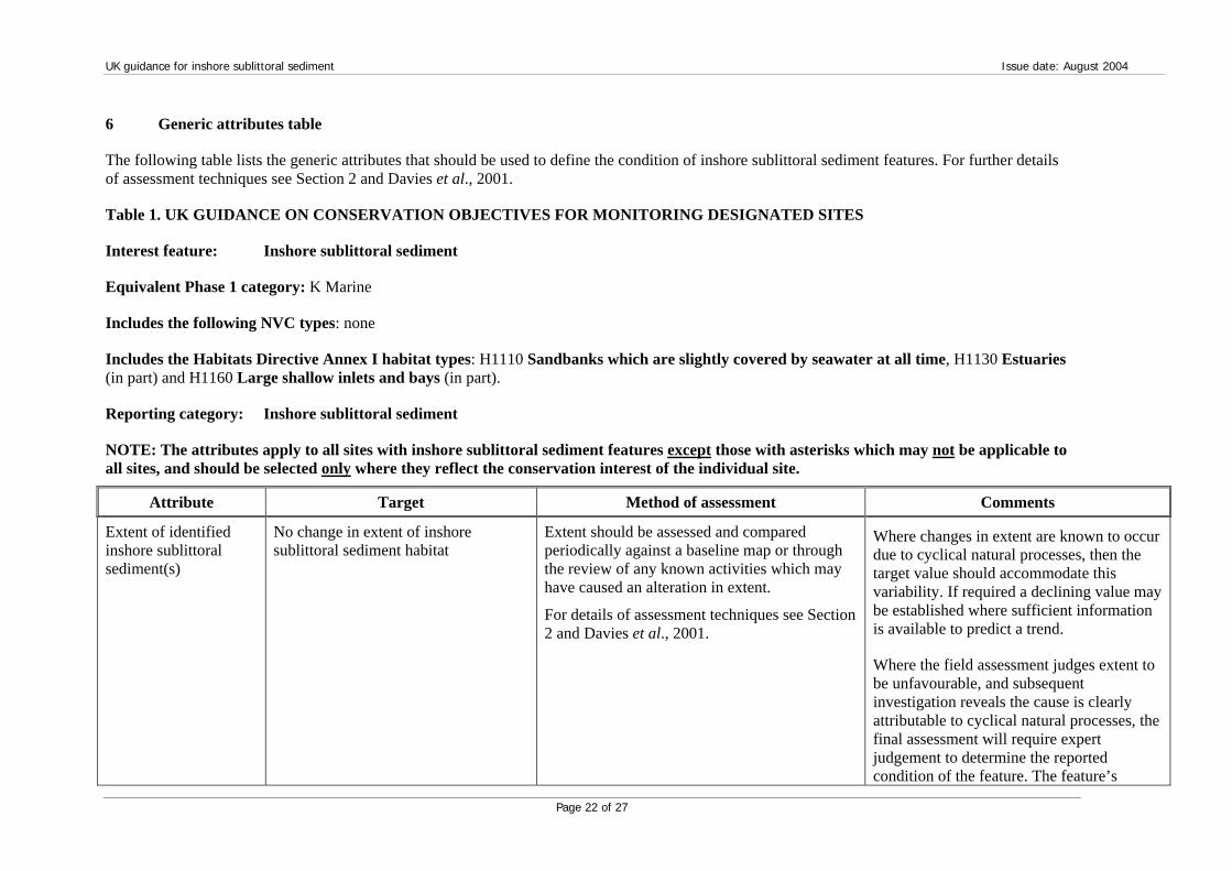
6 Generic attributes table
The following table lists the generic attributes that should be used to define the condition of inshore sublittoral sediment features. For further details of assessment techniques see Section 2 and Davies et al., 2001.
Table 1. UK GUIDANCE ON CONSERVATION OBJECTIVES FOR MONITORING DESIGNATED SITES
Interest feature: Inshore sublittoral sediment
Equivalent Phase 1 category: K Marine
Includes the following NVC types: none
Includes the Habitats Directive Annex I habitat types: H1110 Sandbanks which are slightly covered by seawater at all time, H1130 Estuaries (in part) and H1160 Large shallow inlets and bays (in part).
Reporting category: Inshore sublittoral sediment
NOTE: The attributes apply to all sites with inshore sublittoral sediment features except those with asterisks which may not be applicable to all sites, and should be selected only where they reflect the conservation interest of the individual site.
Attribute Target Method of assessment Comments
Extent of identified inshore sublittoral sediment(s)
No change in extent of inshore sublittoral sediment habitat
Extent should be assessed and compared periodically against a baseline map or through the review of any known activities which may have caused an alteration in extent.
For details of assessment techniques see Section 2 and Davies et al., 2001.
Where changes in extent are known to occur due to cyclical natural processes, then the target value should accommodate this variability. If required a declining value may be established where sufficient information is available to predict a trend.
Where the field assessment judges extent to be unfavourable, and subsequent investigation reveals the cause is clearly attributable to cyclical natural processes, the final assessment will require expert judgement to determine the reported condition of the feature. The feature’s

UK guidance for inshore sublittoral sediment Issue date: August 2004
Page 23 of 27
Attribute Target Method of assessment Comments condition could be declared favourable where the officer is certain that the conservation interest of the feature is not compromised by the failure of this attribute to meet its target condition. Where there is a change outside the expected variation or a loss of the conservation interest of the site, (e.g. due to anthropogenic activities or unrecoverable natural losses) then condition should be considered unfavourable.
Changes in extent would be considered unfavourable, if attributable to activities which remove parts of the feature i.e. dredging, aggregate extraction.
Topography No alteration in topography of the inshore sublittoral sediment, allowing for natural responses to hydrodynamic regime
Assessment of the depth distribution/profile of the inshore sublittoral sediment and periodic comparison with baseline conditions.
For details of assessment techniques see Section 2 and Davies et al., 2001.
The depth distribution of the sediment has a direct influence on the structure and function of the system.
Sediment character: sediment type
No change in composition of sediment types across the feature, allowing for natural succession/ known cyclical change.
Distribution of sediment types should be assessed across the whole feature and compared with baseline conditions.
For details of assessment techniques see Section 2 and Davies et al., 2001.
Where changes in sediment type are known to be clearly attributable to natural processes then the target value should accommodate this variability.
Where extreme events cause a change in sediment type, then this may have caused a change in the structure of the feature, which may lead to the condition of the feature being considered as unfavourable

UK guidance for inshore sublittoral sediment Issue date: August 2004
Page 24 of 27
Attribute Target Method of assessment Comments
Distribution of biotopes
Maintain the distribution of biotopes, allowing for natural succession/ known cyclical change.
Assessment of the distribution of (a) biotope(s) identified for the site.
For details of assessment techniques see Section 2 and Davies et al., 2001.
Where changes in distribution are known to be clearly attributable to cyclical succession or expected shifts in distribution then the target value should accommodate this variability. Where there is a change in biotope distribution outside the expected variation or a loss of the conservation interest of the site, then condition should be considered unfavourable.
*Extent of sub-feature or representative/ notable biotope(s)
No change in extent of the inshore sublittoral sediment biotope(s) or sub-feature identified for the site allowing for natural succession/ known cyclical change.
Assessment of the extent of (a) biotope(s) identified for the site because of its/ their nature conservation importance.
For details of assessment techniques see Section 2 and Davies et al., 2001.
Where there is clearly established natural variation in extent or in cyclical succession between biotopes, then the target value should accommodate this variability.
Where there is a change in extent outside the expected variation or a change in the structure of the sub-feature leading to a loss of the conservation interest of the site, then condition should be considered unfavourable.
*Species composition of representative or notable biotopes
No decline in biotope quality as a result of reduction in species richness or removal of notable species, allowing for natural succession/ known cyclical change.
Assessment of biotope quality through assessing species composition where the biotope is representative of the site or contains a number of species of conservation importance.
For details of assessment techniques see Section 2 and Davies et al., 2001.
Where changes in species composition are known to be clearly attributable to natural succession, known cyclical change or mass recruitment or dieback of characterising species, then the target value should accommodate this variability.
Where there is a change in biotope quality outside the expected variation or a loss of the conservation interest of the site, then condition should be considered unfavourable.

UK guidance for inshore sublittoral sediment Issue date: August 2004
Page 25 of 27
Attribute Target Method of assessment Comments
*Species population measures:
-Population structure of a species
Maintain age/size class structure of a (named) species.
Population structure should be assessed in terms of viability of the species.
For details of assessment techniques see Section 2 and Davies et al., 2001..
Where there is a sizeable shift in the age/size class structure (i.e. loss of mature adults or recruitment failure) or if disturbance causes a species of nature conservation importance to be lost, or a significant reduction in abundance then condition would be considered unfavourable.
-Presence or abundance of specified species
Maintain presence or abundance of positive indicator species (name species).
No increase in presence or abundance of negative indicator species (name species).
Assessment of the presence or abundance of positive/negative indicator species identified for the feature.
For details of assessment techniques see Section 2 and Davies et al., 2001.
The positive indicator species selected may have an important role in the structure and function of the biological community. Examples include seagrass beds where loss of the key species would lead to a major change in the inshore sublittoral sediment.
Increased abundance of negative indicator species i.e. those indicative of stressed habitats or polychaete worms indicative of organic pollution, which would be detrimental to the feature as a whole, would also cause the condition of the feature to be considered unfavourable.

UK guidance for inshore sublittoral sediment Issue date: August 2004
Page 26 of 27
7 References
Davies, J., Baxter, J., Bradley, M., Connor, D., Khan, J., Murray, E., Sanderson, W., Turnbull, C. & Vincent, M. (eds.) 2001. Marine Monitoring Handbook. Joint Nature Conservation Committee, Peterborough, UK. ISBN 1 86107 5243. The most up-to-date version of this text may be downloaded from the JNCC web site: http://www.jncc.gov.uk/marine
Davies, J. & Hall-Spencer, J. 1996. Mapping of the benthic biotopes in the proposed Sound of Arisaig cSAC. SNH RSM Report No. 83
Elliot, M., Nedwell, S., Jones, N., Read, S. J., Cutts, N. D. & Hemingway, K. L. 1998. Intertidal sand and mudflats & subtidal mobile sandbanks - An overview of dynamic and sensitivity characteristics for conservation management of marine SACs. Scottish Association for Marine Sciences, Oban (UK Marine SACs Project). A copy may be downloaded from the UK Marine SACs web site: http://www.ukmarinesac.org.uk/publications.htm/publications.htm
Folk, R. L. 1954. The distinction between grain size and mineral composition in sedimentary rock nomenclature. Journal of Geology, 62, 344-359.
Hawkins, S. J., Southward, A. J., Kendall, M. A., Burrows, M. T., Thompson, R. C. & O’Riordan, R. 2001. Marine biodiversity and climate change (MarClim): Assessing and predicting the influence of climatic change using intertidal rocky shore biota and its implications for the conservation, management and protection of the marine environment in Britain and Ireland. Project proposal of a consortium led by the Marine Biological Association in partnership with Plymouth Marine Laboratory, Scottish Association for Marine Science, University of Plymouth and University College Cork.
Howson, C. M. & Davison, A. 2000. Trials of monitoring techniques using divers and ROV in Loch Maddy cSAC, North Uist. Scottish Natural Heritage, Edinburgh.
Hughes, D. J. 1998. Subtidal brittlestar – An overview of dynamic and sensitivity characteristics for conservation management of marine SACs. Scottish Association for Marine Sciences, Oban (UK Marine SACs Project).
Institute of Estuarine and Coastal Studies (IECS). 2001. Plymouth Sound & Estuaries cSAC sediment monitoring trials. Unpublished report to English Nature, Peterborough.
Jeffrey, D. W., M. T. Brennan, E. Jennings, B. Madden, & J. G. Wilson (1995) “Nutrient sources for in-shore nuisance macroalgae; the Dublin Bay case.” Ophelia, 42, p147-161 (quoted in Khan J. N. (1998) Green Macroalgal Growth in Dublin Bay, Ph.D. Thesis, Trinity College, University of Dublin)
Khan J. N. (1998) Green Macroalgal Growth in Dublin Bay, Ph.D. Thesis, Trinity College, University of Dublin
Pethick, J. 1984. An introduction to coastal geomorphology. London, Arnold.
Pooley, M. & Bamber, R. 2000. Evaluation of aerial and diving techniques to survey vegetation in the Chesil and Fleet European marine site, unpublished report to English Nature. English Nature, Wareham.
Portmann, J. E. 2001. Review of current UK marine observations in relation to present and future needs. IACMST Information Document No 7. (See http://www.marine.gov.uk)

UK guidance for inshore sublittoral sediment Issue date: August 2004
Page 27 of 27
Short, F. T., Ibelings, B. W. & den Hartog, C. 1988. Comparison of a current eelgrass disease to the wasting disease in the 1930s. Aquatic Botany, 30, 295–307.
Wyn, G. and Kay, L. 2000. Introduction to the Estuary monitoring trial sections. In: Sanderson, W G et al. (2000) The establishment of an appropriate programme of monitoring for the condition of SAC features on Pen Llyn a’r Sarnau: 1998–1999 trials, p. 101. CCW Contract Science Report No: 380, Countryside Council for Wales, Bangor.