common approach to geoprocessing of uav data …€¦ · common approach to geoprocessing of uav...
TRANSCRIPT

COMMON APPROACH TO GEOPROCESSING OF UAV DATA ACROSS APPLICATION DOMAINS
G. S. Percivall a, * , M. Reichardt a, Trevor Taylor a
a Open Geospatial Consortium, Wayland MA, USA – (gpercivall, mreichardt, ttaylor)@opengeospatial.org
KEY WORDS: Geoprocessing, Open Standards, OGC, UAV, UAS ABSTRACT: UAVs are a disruptive technology bringing new geographic data and information to many application domains. UASs are similar to other geographic imagery systems so existing frameworks are applicable. But the diversity of UAVs as platforms along with the diversity of available sensors are presenting challenges in the processing and creation of geospatial products. Efficient processing and dissemination of the data is achieved using software and systems that implement open standards. The challenges identified point to the need for use of existing standards and extending standards. Results from the use of the OGC Sensor Web Enablement set of standards are presented. Next steps in the progress of UAVs and UASs may follow the path of open data, open source and open standards.
* Corresponding author
1. GROWTH OF UAV/UAS AS BIG DATA
The age of Unmanned Aerial Systems (UAVs) also called drones as part of Unmanned Aerial Systems (UASs) has arrived and will grow dramatically over the next few years. Kleiner Perkins Caufield & Byers’ “2015 Internet Trends Report” identifies commercial drone shipments as rising rapidly; the use of drones has very broad application; where drone use was previously held back by regulation that is now changing; so that drones will drive a new wave of big data collection (Meeker). With a recent change in FAA approval process, Commercial use of drones in the US skyrocketing (Popper). Success will require advancement in all elements of UASs. In particular the rapid evolution of software (image processing, statistical analysis, data fusion, etc.) and the high-quality of commercial cameras will define the remote sensing done with UAVs (Salamí). Expensive sensors, such as thermal cameras, LiDAR, radar or multi/hyper-spectrometers will be used only in industrial and research applications. Exponential growth in UAS applications can be anticipated with cheaper sensors. Coupled with online data processing this trend will enable widespread commodity development. Civilians, filmmakers, and many innovative users will want more camera-wielding drones (Bonnington). The first international contest for aerial photos by drones was conducted in 2014 in partnership with National Geographic France and the social network Dronestagram (Vrignaud). UAV technology is developing rapidly from research to applications with the need to identify best practices and standards that enable reuse and quality information for applications. Defining a common approach based on open standards for processing, exploiting, and disseminating are key to achieving the promise of UAVs. The approach presented here is based on open standards from the Open Geospatial Consortium (OGC Standards) and other international standard developing organizations.
2. FRAMEWORKS FOR UAS
UASs are similar to other geographic imagery systems. The UAS Production Process at USGS has defined a basic framework (Figure 2) (USGS) that is similar to imagery approaches defined by in ISO Standards (ISO 19101-2) and the US Department of Defense (DoD) for other geographic observation system. The DoD uses the acronym TCPED to define a process similar to Figure 2: Tasking aircraft, Collecting data, Processing that data, Exploiting the data into useful products, and Disseminating the data and products
Figure 1. UAS Production Process (USGS)
Figure 2. Geospatial Imagery Observation Request Process
(ISO 19101-2)
The International Archives of the Photogrammetry, Remote Sensing and Spatial Information Sciences, Volume XL-1/W4, 2015 International Conference on Unmanned Aerial Vehicles in Geomatics, 30 Aug–02 Sep 2015, Toronto, Canada
This contribution has been peer-reviewed. doi:10.5194/isprsarchives-XL-1-W4-275-2015
275
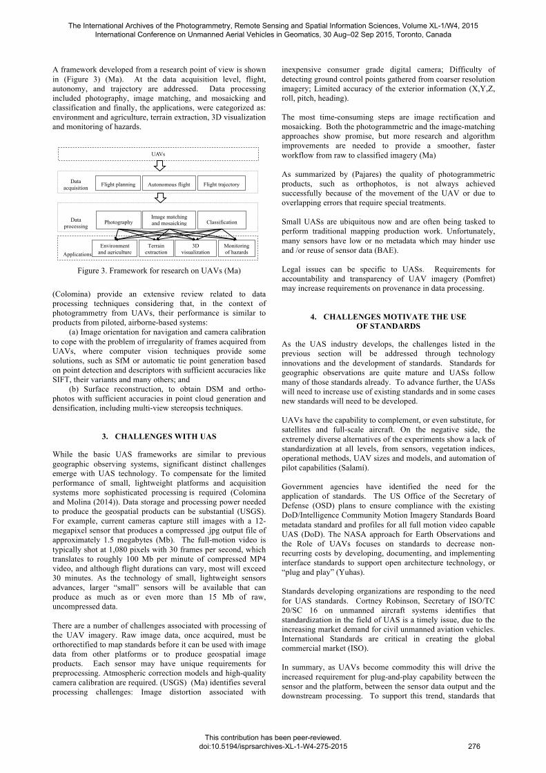
A framework developed from a research point of view is shown in (Figure 3) (Ma). At the data acquisition level, flight, autonomy, and trajectory are addressed. Data processing included photography, image matching, and mosaicking and classification and finally, the applications, were categorized as: environment and agriculture, terrain extraction, 3D visualization and monitoring of hazards.
Figure 1. The frameworks of application from UAVs
II. PROJECT WORKFLOW OF IMAGE DATA ACQUISITION AND PROCESSING
A. Data Acquisition
a Scheme of the main navigation sensors and camera
b Flight planning example
Figure 2. Data acquisition equipment and planning
In this thesis, UAVs were described as a photogrammetric data acquisition platform for further applications. The structure of UAV is showed in fig 2 a, including UAV, camera, GPS/INS. Because of the limit of playload, the quality of imageries is impacted seriously by the posture of the UAV without a self-stabilization platform. And the imageries always have a huge distortion compared to manned aircraft, due to the roll, pitch, and heading of UAV. Here, an overview of the
overall workflow for the acquisition of UAV images will be given. The main data files are defined as follows:
• Camera calibration files: measured automatically, focal length c, the coordinates of the principal point xP, yP and the radial lens distortion parameters were estimated within a bundle adjustment. Further parameters of lens distortion were not significant, therefore they were neglected [2].
• Imageries acquired with UAVs. The imageries with consumer camera always had large image scale, irregular overlap, strong geometric, and radiometric changes.
• Position Orientation System (POS) data: with the Position Orientation System, a GPS coordinate and elevation are recorded for each image, yet the roll, pitch, and heading of the platform. However, even with the autopilot system, the plane was affected by wind and thermals, which are common in the low-altitude environment [3]. The roll, pitch, and heading of the platform were useless for imageries processing, and only the coordinate was used to depict the aerial strips.
• Ground Control points: acquired by Real-time kinematic (RTK), including the coordinates, recording of the point and the image with position of point.
B. Image Processing for Photogrammetry Here we focus on the UAV image orientation and
photogrammetric products like DSM, orthoimages. Subsequent to a brief description of the “UAV Block Triangulation”, we will focus on the DSM generation and on an alternative or supplementary to the generated DSM using only image information.
For the orientation of the images software packages, like LPS (Leica Photogrammetry Suite 8.9-9.2), the embedded ORIMA (Orientation Management Software, ORIMA-LPS-M Rel. 9.10), ISDM (Z/I Imaging, Image Station Digital Mensuration Version 04.04.17.00) originally developed for the processing of aerial images, and Photomodeler 6. In addition, the INPHO model is generated in Germany, and has a particular advantage for low-altitude imageries in automatically triangulation and terrain extraction. DPGrid model developed by Wuhan University is also a professional software package
Image matching and mosaicking
Flight planning Autonomous flight Flight trajectory
Data processing
Environment and agriculture
Terrain extraction
3D visualization
Monitoring of hazards
Data acquisition
Photography Classification
Applications
UAVs
Figure 3. Framework for research on UAVs (Ma)
(Colomina) provide an extensive review related to data processing techniques considering that, in the context of photogrammetry from UAVs, their performance is similar to products from piloted, airborne-based systems: (a) Image orientation for navigation and camera calibration to cope with the problem of irregularity of frames acquired from UAVs, where computer vision techniques provide some solutions, such as SfM or automatic tie point generation based on point detection and descriptors with sufficient accuracies like SIFT, their variants and many others; and (b) Surface reconstruction, to obtain DSM and ortho-photos with sufficient accuracies in point cloud generation and densification, including multi-view stereopsis techniques.
3. CHALLENGES WITH UAS
While the basic UAS frameworks are similar to previous geographic observing systems, significant distinct challenges emerge with UAS technology. To compensate for the limited performance of small, lightweight platforms and acquisition systems more sophisticated processing is required (Colomina and Molina (2014)). Data storage and processing power needed to produce the geospatial products can be substantial (USGS). For example, current cameras capture still images with a 12-megapixel sensor that produces a compressed .jpg output file of approximately 1.5 megabytes (Mb). The full-motion video is typically shot at 1,080 pixels with 30 frames per second, which translates to roughly 100 Mb per minute of compressed MP4 video, and although flight durations can vary, most will exceed 30 minutes. As the technology of small, lightweight sensors advances, larger “small” sensors will be available that can produce as much as or even more than 15 Mb of raw, uncompressed data. There are a number of challenges associated with processing of the UAV imagery. Raw image data, once acquired, must be orthorectified to map standards before it can be used with image data from other platforms or to produce geospatial image products. Each sensor may have unique requirements for preprocessing. Atmospheric correction models and high-quality camera calibration are required. (USGS) (Ma) identifies several processing challenges: Image distortion associated with
inexpensive consumer grade digital camera; Difficulty of detecting ground control points gathered from coarser resolution imagery; Limited accuracy of the exterior information (X,Y,Z, roll, pitch, heading). The most time-consuming steps are image rectification and mosaicking. Both the photogrammetric and the image-matching approaches show promise, but more research and algorithm improvements are needed to provide a smoother, faster workflow from raw to classified imagery (Ma) As summarized by (Pajares) the quality of photogrammetric products, such as orthophotos, is not always achieved successfully because of the movement of the UAV or due to overlapping errors that require special treatments. Small UASs are ubiquitous now and are often being tasked to perform traditional mapping production work. Unfortunately, many sensors have low or no metadata which may hinder use and /or reuse of sensor data (BAE). Legal issues can be specific to UASs. Requirements for accountability and transparency of UAV imagery (Pomfret) may increase requirements on provenance in data processing.
4. CHALLENGES MOTIVATE THE USE OF STANDARDS
As the UAS industry develops, the challenges listed in the previous section will be addressed through technology innovations and the development of standards. Standards for geographic observations are quite mature and UASs follow many of those standards already. To advance further, the UASs will need to increase use of existing standards and in some cases new standards will need to be developed. UAVs have the capability to complement, or even substitute, for satellites and full-scale aircraft. On the negative side, the extremely diverse alternatives of the experiments show a lack of standardization at all levels, from sensors, vegetation indices, operational methods, UAV sizes and models, and automation of pilot capabilities (Salamí). Government agencies have identified the need for the application of standards. The US Office of the Secretary of Defense (OSD) plans to ensure compliance with the existing DoD/Intelligence Community Motion Imagery Standards Board metadata standard and profiles for all full motion video capable UAS (DoD). The NASA approach for Earth Observations and the Role of UAVs focuses on standards to decrease non-recurring costs by developing, documenting, and implementing interface standards to support open architecture technology, or “plug and play” (Yuhas). Standards developing organizations are responding to the need for UAS standards. Cortney Robinson, Secretary of ISO/TC 20/SC 16 on unmanned aircraft systems identifies that standardization in the field of UAS is a timely issue, due to the increasing market demand for civil unmanned aviation vehicles. International Standards are critical in creating the global commercial market (ISO). In summary, as UAVs become commodity this will drive the increased requirement for plug-and-play capability between the sensor and the platform, between the sensor data output and the downstream processing. To support this trend, standards that
The International Archives of the Photogrammetry, Remote Sensing and Spatial Information Sciences, Volume XL-1/W4, 2015 International Conference on Unmanned Aerial Vehicles in Geomatics, 30 Aug–02 Sep 2015, Toronto, Canada
This contribution has been peer-reviewed. doi:10.5194/isprsarchives-XL-1-W4-275-2015
276
allow for self-configuration of software are needed. Availability and proliferation of UAV sourced information will require the application of standards to effectively support the proliferation of sensors.
5. STANDARDS-BASED UAS
The previous sections identified several challenges associated with UASs as well as how those challenges motivate the need for standards. This section shows the application of OGC standards to UAS with a focus on the Sensor Web Enablement (SWE) standards. All OGC standards including SWE are freely available on the web (OGC-S). A sensor network is a computer accessible network of many spatially distributed devices using sensors to monitor conditions at different locations. A Sensor Web refers to web accessible sensor networks and archived sensor data that can be discovered and accessed using standard protocols and interfaces. The OGC Sensor Web Enablement (SWE) set of standards enable all types of sensors, instruments, and imaging devices to be accessible and, where applicable, controlled via the Web. SWE standards provide the foundation for "plug-and-play" Web-based sensor networks (Botts). The SWE Standards are (OGC Standards): • Observations & Measurements Schema (O&M) –Models
and XML Schema for encoding observations and measurements from sensors.
• Sensor Model Language (SensorML) – Models and XML Schema for describing sensors systems and processes.
• Sensor Observations Service (SOS) - Web service interface for requesting observations and sensor system information.
• Sensor Planning Service (SPS) – Web service interface for requesting user-driven acquisitions and observations.
• Sensor Alert Service (SAS) – Web service interface for publishing and subscribing to alerts from sensors.
• Web Notification Services (WNS) – Standard web service interface for asynchronous delivery of messages or alerts from SAS and SPS web services and other elements of service workflows.
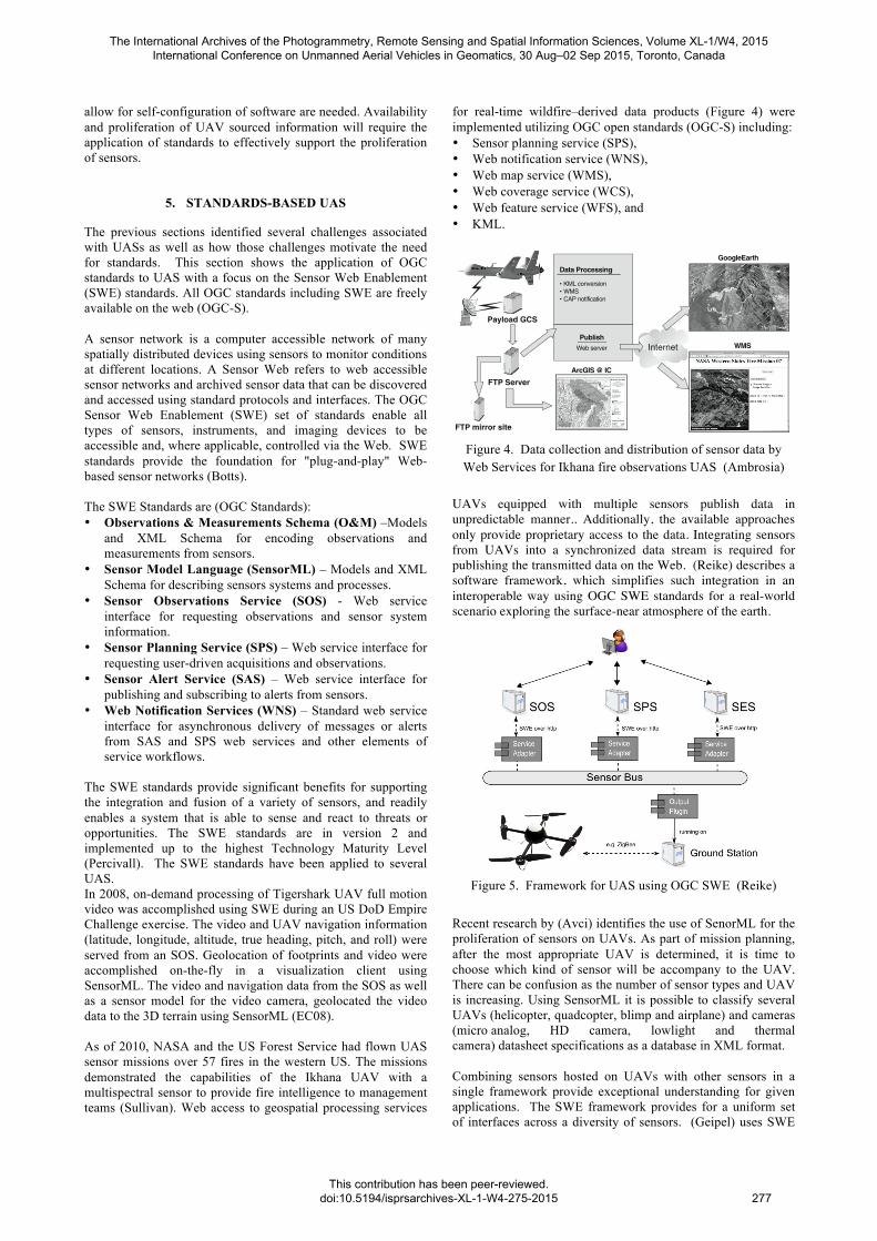
The SWE standards provide significant benefits for supporting the integration and fusion of a variety of sensors, and readily enables a system that is able to sense and react to threats or opportunities. The SWE standards are in version 2 and implemented up to the highest Technology Maturity Level (Percivall). The SWE standards have been applied to several UAS. In 2008, on-demand processing of Tigershark UAV full motion video was accomplished using SWE during an US DoD Empire Challenge exercise. The video and UAV navigation information (latitude, longitude, altitude, true heading, pitch, and roll) were served from an SOS. Geolocation of footprints and video were accomplished on-the-fly in a visualization client using SensorML. The video and navigation data from the SOS as well as a sensor model for the video camera, geolocated the video data to the 3D terrain using SensorML (EC08). As of 2010, NASA and the US Forest Service had flown UAS sensor missions over 57 fires in the western US. The missions demonstrated the capabilities of the Ikhana UAV with a multispectral sensor to provide fire intelligence to management teams (Sullivan). Web access to geospatial processing services
for real-time wildfire–derived data products (Figure 4) were implemented utilizing OGC open standards (OGC-S) including: • Sensor planning service (SPS), • Web notification service (WNS), • Web map service (WMS), • Web coverage service (WCS), • Web feature service (WFS), and • KML. 10 Ambrosia et al.
spe 482-01 page 10
Western States Fire Mission, 2008
In late June 2008, lightning ignited hundreds of fires in Northern California. When the California governor declared a State of Emergency, the WRAP team was requested to support state and federal firefighting efforts. The WRAP team requested an emergency COA amendment from the FAA to allow flight operations over a vast region of the state, which was granted on 25 June. Since the Ikhana and the AMS-Wildfire sensor had been undergoing routine maintenance and preparation for a much later seasonal mission, the first flights over the Northern California did not occur until July 8. Subsequently, four total missions were
flown in 2008 through the conclusion of the fire season (Table 4). Each of the mission data-collection efforts focused on provid-ing real-time fire information to the various ICC and well as to the State Operations Center, and the Multi-Agency Coordination Center, where data were integrated into the wildfire management decision process. The 2008 missions showcased new imaging and software enhancements, including the delivery of postfire NBR data sets to incident teams.
Following the Northern California firestorms, the remain-der of the western U.S. experienced a “light” fire season, which allowed the WRAP project team to “stand-down” capabilities for the majority of August, September, and October. In October 2008, the WRAP team discontinued demonstration and devel-opment missions, due to the official “close” of the western U.S. fire season.
Figure 7. Data collection and distribution of sensor data, illustrating the Web Services employed in the generation and distribution of the AMS sensor data sets. The AMS-derived products, generated onboard the Ikhana UAS, transmitted to the Payload Ground Control System (GCS), and then to the NASA FTP server are processed into a variety of prod-uct formats including Keyhole Markup Language (KML) Google Earth–enabled formats, Web Map Service (WMS) format, and as a Common Alerting Protocol (CAP) notification. Data investigators can also access AMS-derived product data (fire hot spot shape files) from the NASA FTP server (or a mirrored site at USFS) using Geographic Information Systems (GIS) software, such as ESRI’s ArcGIS package.
Payload GCS
FTP Server
FTP mirror site
Internet
KML conversionWMSCAP notification
Data Processing
PublishWeb server
GoogleEarth
WMS
ArcGIS @ IC
TABLE 3. 2007 WESTERN STATES FIRE MISSION SUMMARY Flight date Duration
(h) Fires flown Mileage
(km) 16 Aug. 10 4 2993 (1400 nm) 29 Aug. 16.1 7 4630 (2500 nm) 7 Sept. 20 12 5926 (3200 nm) 27 Sept. 9.9 4 3333 (1800 nm) 24 Oct. 9 11 2500 (1350 nm) 25 Oct. 8.7 11 2500 (1350 nm) 26 Oct. 7.8 11 2500 (1350 nm) 28 Oct. 7.1 11 2500 (1350 nm)
TABLE 4. 2008 WESTERN STATES FIRE MISSION SUMMARY Flight date Duration
(h) Fires flown Mileage
(km) 8 July 9.5 9 2593 (1400 nm) 19 July 5.0 4 1852 (1000 nm) 17 Sept. 3 1 1482 (800 nm) 19 Sept. 3.5 2 1482 (800 nm)
Figure 4. Data collection and distribution of sensor data by Web Services for Ikhana fire observations UAS (Ambrosia)
UAVs equipped with multiple sensors publish data in unpredictable manner.. Additionally, the available approaches only provide proprietary access to the data. Integrating sensors from UAVs into a synchronized data stream is required for publishing the transmitted data on the Web. (Reike) describes a software framework, which simplifies such integration in an interoperable way using OGC SWE standards for a real-world scenario exploring the surface-near atmosphere of the earth.
Unmanned Aerial Vehicles as MobileMulti-sensor Platforms
5
ture, the so-called Sensor Bus (Broering et al [2010]). The Sensor Bus realizes a communication infrastructure which underlies the different Sensor Web services (Figure 6). The output plugin pub-lishes the incoming sensor data on the Sensor Bus in a well defined format. These data messages are retrieved by service adapters which translate the sensor data into the service specific encoding. Con-sequently, by adapting the output plugin to the Sensor Bus and its well-defined communication proto-col, the measured data can easily be published to all Sensor Web services which are listening on the SensorBus.
Figure 6: High-level architecture.
4 IMPLEMENTATION AND EVALUATION
The control flow of the implemented prototype is maintained by the framework core according to inversion of control. It is responsible for managing the system memory and thereby ensures the stabil-ity of the software framework. In particular, it interacts with the extension points (data sources, output plugins) for retrieving or sending data. All retrieved measurements of a phenomenon are hold in a time stamped internal list as long as needed with respect to the behaviour of the output plugins.
Figure 7: User interface of the proposed Framework.
The framework also includes a graphical user interface featuring a map view (based on Open-
StreetMap6) where the current position, the magnetic heading and the raw data stream of the UAVis visualized (Figure 7). Thus, the user is able to trace the flight route and the heading of the UAV. For communicating with the Mikrokopter (Section 2), which is utilized in our use case, we implemented a particular data source component that is able to parse the incoming binary data streams (i.e. sensor
6OpenStreetMap project website: http://www.openstreetmap.org/.
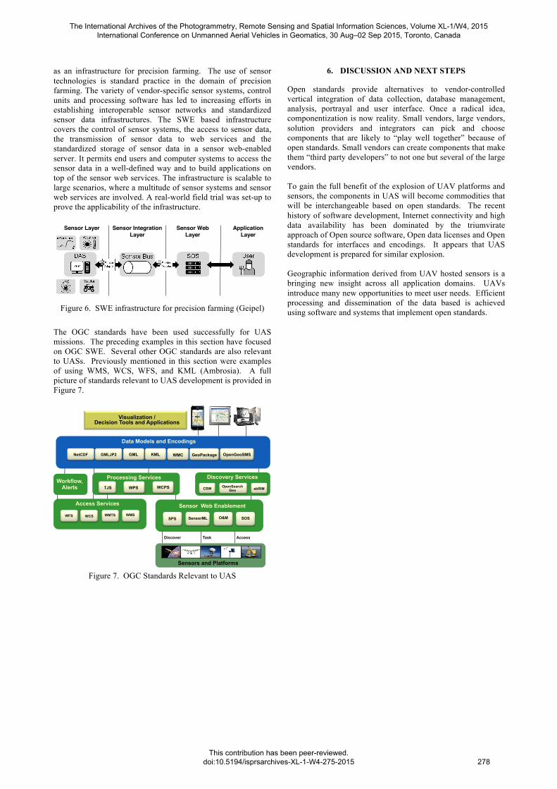
Figure 5. Framework for UAS using OGC SWE (Reike)
Recent research by (Avci) identifies the use of SenorML for the proliferation of sensors on UAVs. As part of mission planning, after the most appropriate UAV is determined, it is time to choose which kind of sensor will be accompany to the UAV. There can be confusion as the number of sensor types and UAV is increasing. Using SensorML it is possible to classify several UAVs (helicopter, quadcopter, blimp and airplane) and cameras (micro analog, HD camera, lowlight and thermal camera) datasheet specifications as a database in XML format. Combining sensors hosted on UAVs with other sensors in a single framework provide exceptional understanding for given applications. The SWE framework provides for a uniform set of interfaces across a diversity of sensors. (Geipel) uses SWE
The International Archives of the Photogrammetry, Remote Sensing and Spatial Information Sciences, Volume XL-1/W4, 2015 International Conference on Unmanned Aerial Vehicles in Geomatics, 30 Aug–02 Sep 2015, Toronto, Canada
This contribution has been peer-reviewed. doi:10.5194/isprsarchives-XL-1-W4-275-2015
277
as an infrastructure for precision farming. The use of sensor technologies is standard practice in the domain of precision farming. The variety of vendor-specific sensor systems, control units and processing software has led to increasing efforts in establishing interoperable sensor networks and standardized sensor data infrastructures. The SWE based infrastructure covers the control of sensor systems, the access to sensor data, the transmission of sensor data to web services and the standardized storage of sensor data in a sensor web-enabled server. It permits end users and computer systems to access the sensor data in a well-defined way and to build applications on top of the sensor web services. The infrastructure is scalable to large scenarios, where a multitude of sensor systems and sensor web services are involved. A real-world field trial was set-up to prove the applicability of the infrastructure.
ISPRS Int. J. Geo-Inf. 2015, 4 387
on-the-fly [25]. Having a magnitude of possibilities to combine stationary and mobile, ground-basedand aerial, as well as temporary and permanent sensor systems, current sensor networks have becomemore and more complex. As a consequence, the connection of sensor systems and entire sensor networkswith a sensor web needs to be as flexible as possible to facilitate the integration of sensor data into webservices and applications.
This study provides a simple, but effective method to embed various sensor systems into a sensor webapproach, making their data accessible for applications using well-defined and interoperable standardsof the OGC SWE initiative framework. The idea for establishing this method originates from thevarious field experiments, which were conducted at the agricultural research stations of the Universityof Hohenheim, Stuttgart, Germany. Many of these experiments involve sensor measurements, but lacka general work flow with standardized mechanisms for the control and access of sensors, as well as thestorage and processing of their data. The authors show how to utilize open source software, provided bythe 52� North Initiative for Geospatial Open Source Software GmbH (52� N), and adapt it to the needs ofPF. A field trial environment was set-up to verify the method in a real use-case scenario for the adoptionof SWE for PF-sensing.
2. Materials and Methods
This section gives background information about the principles and the implementation of an actualagricultural sensor infrastructure. The focus was set to publish sensor data to a remotely-distributedSWE infrastructure and make it accessible for researchers and user applications in a well-defined way.The sensor infrastructure of this study was based on the recommendations of Bröring et al. [18], whodescribed the implementation of an extended sensor infrastructure stack. The infrastructure stack isshown in Figure 1 and will be explained in the following.
Sensor Layer Sensor IntegrationLayer
Sensor WebLayer
Application Layer
Figure 1. The extended sensor infrastructure stack as introduced by Bröring et al. [18].It is based on three main layers for: (i) sensor control and communication (sensor layer);(ii) Sensor Web Enablement (SWE) services as part of a sensor web (sensor web layer); and(iii) end users and computers (application layer), which build applications on top of the SWEservices. A fourth layer is an intermediary integration layer, facilitating the connection ofsensors and services (sensor integration layer).
Figure 6. SWE infrastructure for precision farming (Geipel)
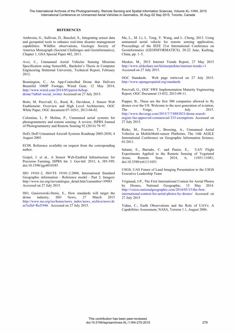
The OGC standards have been used successfully for UAS missions. The preceding examples in this section have focused on OGC SWE. Several other OGC standards are also relevant to UASs. Previously mentioned in this section were examples of using WMS, WCS, WFS, and KML (Ambrosia). A full picture of standards relevant to UAS development is provided in Figure 7.
Discover Task Access
Visualization / Decision Tools and Applications
Data Models and Encodings
WMC GML KML OpenGeoSMS GeoPackage NetCDF GMLJP2
Processing Services
WPS TJS WCPS
Discovery Services
CSW OpenSearch Geo ebRIM
WMS WMTS WFS
Access Services
WCS
Workflow, Alerts
Sensors and Platforms
SOS SPS O&M SensorML
Sensor Web Enablement
Figure 7. OGC Standards Relevant to UAS
6. DISCUSSION AND NEXT STEPS
Open standards provide alternatives to vendor-controlled vertical integration of data collection, database management, analysis, portrayal and user interface. Once a radical idea, componentization is now reality. Small vendors, large vendors, solution providers and integrators can pick and choose components that are likely to “play well together” because of open standards. Small vendors can create components that make them “third party developers” to not one but several of the large vendors. To gain the full benefit of the explosion of UAV platforms and sensors, the components in UAS will become commodities that will be interchangeable based on open standards. The recent history of software development, Internet connectivity and high data availability has been dominated by the triumvirate approach of Open source software, Open data licenses and Open standards for interfaces and encodings. It appears that UAS development is prepared for similar explosion. Geographic information derived from UAV hosted sensors is a bringing new insight across all application domains. UAVs introduce many new opportunities to meet user needs. Efficient processing and dissemination of the data based is achieved using software and systems that implement open standards.
The International Archives of the Photogrammetry, Remote Sensing and Spatial Information Sciences, Volume XL-1/W4, 2015 International Conference on Unmanned Aerial Vehicles in Geomatics, 30 Aug–02 Sep 2015, Toronto, Canada
This contribution has been peer-reviewed. doi:10.5194/isprsarchives-XL-1-W4-275-2015
278
REFERENCES
Ambrosia, G., Sullivan, D., Buechel, S., Integrating sensor data and geospatial tools to enhance real-time disaster management capabilities: Wildfire observations, Geologic Society of America Monograph (Societal Challenges and Geoinformatics), Chapter 1, GSA Special Paper 482, 2011.
Avci, C., Unmanned Aerial Vehicles Sensing Missions Specification using SensorML, Bachelor’s Thesis in Computer Engineering Halmstad University, Technical Report, February 2012.
Bonnington, C., An App-Controlled Drone that Delivers Beautiful 1080P Footage, Wired Gear, 12 May 2014, http://www.wired.com/2014/05/parrot-bebop-drone/?mbid=social_twitter Accessed on 27 July 2015.
Botts, M. Percivall, G., Reed, R., Davidson, J. Sensor Web Enablement: Overview and High Level Architecture, OGC White Paper, OGC document 07-165r1, 2013-04-02.
Colomina, I., P. Molina, P., Unmanned aerial systems for photogrammetry and remote sensing: A review, ISPRS Journal of Photogrammetry and Remote Sensing 92 (2014) 79–97.
DoD, DoD Unmanned Aircraft Systems Roadmap 2005-2030, 4 August 2005.
EC08. Reference available on request from the corresponding author.
Geipel, J. et al., A Sensor Web-Enabled Infrastructure for Precision Farming, ISPRS Int. J. Geo-Inf. 2015, 4, 385-399; doi:10.3390/ijgi4010385
ISO 19101-2, ISO/TS 19101-2:2008, International Standard Geographic information - Reference model - Part 2: Imagery http://www.iso.org/iso/catalogue_detail.htm?csnumber=39983 Accessed on 27 July 2015.
ISO, Gasiorowski-Denis, E., How standards will target the drone industry, ISO News, 27 March 2015 http://www.iso.org/iso/home/news_index/news_archive/news.htm?refid=Ref1946 Accessed on 27 July 2015.
Ma, L., M. Li, L. Tong, Y. Wang, and L. Cheng, 2013. Using unmanned aerial vehicle for remote sensing application, Proceedings of the IEEE 21st International Conference on Geoinformatics (GEOINFORMATICS), 20-22 June, Kaifeng, China, pp. 1–5.
Meeker, M., 2015 Internet Trends Report, 27 May 2015 http://www.slideshare.net/kleinerperkins/internet-trends-v1 Accessed on 27 July 2015.
OGC Standards. Web page retrieved on 27 July 2015. http://www.opengeospatial.org/standards
Percivall, G., OGC SWE Implementation Maturity Engineering Report, OGC Document 13-032, 2013-09-11.
Popper, B., These are the first 500 companies allowed to fly drones over the US: Welcome to the next generation of aviation, The Verge, 7 July 2015. http://www.theverge.com/2015/7/7/8883821/drone-search-engine-faa-approved-commercial-333-exemptions Accessed on 27 July 2015.
Rieke, M., Foerster, T., Broering, A., Unmanned Aerial Vehicles as MobileMulti-sensor Platforms, The 14th AGILE International Conference on Geographic Information Science; 01/2011.
Salamí, E., Barrado, C. and Pastor, E., UAV Flight Experiments Applied to the Remote Sensing of Vegetated Areas, Remote Sens. 2014, 6, 11051-11081; doi:10.3390/rs61111051
USGS, UAS Future of Land Imaging Presentation to the USGS Executive Leadership Team
Vrignaud, J-P., The First International Contest for Aerial Photos by Drones, National Geographic, 15 May 2014. http://voices.nationalgeographic.com/2014/05/15/the-first-international-contest-for-aerial-photos-by-drones/ Accessed on 27 July 2015
Yuhas, C., Earth Observations and the Role of UAVs: A Capabilities Assessment, NASA, Version 1.1, August 2006.
The International Archives of the Photogrammetry, Remote Sensing and Spatial Information Sciences, Volume XL-1/W4, 2015 International Conference on Unmanned Aerial Vehicles in Geomatics, 30 Aug–02 Sep 2015, Toronto, Canada
This contribution has been peer-reviewed. doi:10.5194/isprsarchives-XL-1-W4-275-2015
279