commercial estates group eia scoping report · tudor nursery, cheshunt – eia screening &...
TRANSCRIPT

JANUARY 2017
Commercial Estates Group
EIA Scoping Report
Tudor Nurseries, Cheshunt
661168

Commercial Estates Group i
Tudor Nursery, Cheshunt – EIA Screening & Scoping Report
661168
RSK GENERAL NOTES
Project No.: 661168
Title: EIA Scoping Report for Tudor Nursery, Cheshunt Client: Commercial Estates Group Date: 18th January 2017 Office: Hemel Hempstead Status: Final
Author Jade Garner Technical reviewer Richard van Gelder
Signature
Signature
Date: Date:
Project manager Richard van Gelder
Quality reviewer Alex Osborn
Signature Signature
Date: Date:
RSK Environment Limited (RSK) has prepared this report for the sole use of the client, showing reasonable skill and care, for the intended purposes as stated in the agreement under which this work was completed. The report may not be relied upon by any other party without the express agreement of the client and RSK. No other warranty, expressed or implied, is made as to the professional advice included in this report.
Where any data supplied by the client or from other sources have been used, it has been assumed that the information is correct. No responsibility can be accepted by RSK for inaccuracies in the data supplied by any other party. The conclusions and recommendations in this report are based on the assumption that all relevant information has been supplied by those bodies from whom it was requested.
No part of this report may be copied or duplicated without the express permission of RSK and the party for whom it was prepared.
Where field investigations have been carried out, these have been restricted to a level of detail required to achieve the stated objectives of the work.
This work has been undertaken in accordance with the quality management system of RSK Environment Limited.

Commercial Estates Group i
Tudor Nursery, Cheshunt – EIA Screening & Scoping Report
661168
CONTENTS
1 INTRODUCTION .............................................................................................................................. 1
2 PROJECT DESCRIPTION ............................................................................................................... 6
3 SCOPE OF THE EIA ........................................................................................................................ 9
4 AIR QUALITY ................................................................................................................................. 11
5 CULTURAL HERITAGE................................................................................................................. 15
6 ECOLOGY ...................................................................................................................................... 21
7 FLOOD RISK AND DRAINAGE .................................................................................................... 31
8 LANDSCAPE AND VISUAL .......................................................................................................... 37
9 SOCIO-ECONOMICS ..................................................................................................................... 45
10 NOISE ............................................................................................................................................. 51
11 TRANSPORT AND TRAVEL PLANNING ..................................................................................... 55
12 CUMULATIVE IMPACTS ............................................................................................................... 67
13 TOPICS TO BE SCOPED OUT ..................................................................................................... 70
14 ENVIRONMENTAL MANAGEMENT ............................................................................................. 73
15 SCOPING RESPONSE .................................................................................................................. 74
FIGURES
Figure 1.1 – Rosedale Park Location Plan ............................................................................................. 7
Figure 1.2 – Tudor Nursery Site Plan ..................................................................................................... 8
TABLES
Table 4.1 – Air Quality National Planning Policy .................................................................................. 11
Table 4.2 – Air Quality Local Planning Policy ....................................................................................... 12
Table 5.1 –Cultural Heritage National Planning Policy ......................................................................... 16
Table 5.2 –Cultural Heritage Local Planning Policy .............................................................................. 17
Table 6.1 – Key Environmental Legislation ........................................................................................... 22
Table 6.2 – Ecological National Planning Policy ................................................................................... 23
Table 6.3 – Ecological Local Planning Policy ....................................................................................... 23
Table 7.1 – Flood Risk and Drainage National Planning Policy ........................................................... 31
Table 7.2 – Flood Risk and Drainage Regional Planning Policy .......................................................... 31
Table 7.3 – Flood Risk and Drainage Local Planning Policy ................................................................ 32
Table 7.4 – Typical Chemical Concentrations ...................................................................................... 34
Table 7.5 – Magnitude of Effect ............................................................................................................ 35
Table 7.6 – Significance of Effect ......................................................................................................... 35
Table 8.1 – Landscape and Visual Impact National Planning Policy .................................................... 37
Table 8.2 – Landscape and Visual Impact Local Planning Policy ........................................................ 38
Table 9.1 – Socio Economic National Planning Policy ......................................................................... 45
Table 9.2 – Socio Economic Local Planning Policy .............................................................................. 46
Table 9.3 – Key Census Statistics ........................................................................................................ 47
Table 10.1 – Noise National Planning Policy ........................................................................................ 51
Table 11.1 – Transport National Planning Policy and Technical Guidance .......................................... 55
Table 11.2 – Transport Regional Planning Policy ................................................................................. 56
Table 11.3 – Transport Local Planning Policy ...................................................................................... 57

Commercial Estates Group 1
Tudor Nursery, Cheshunt – EIA Screening & Scoping Report
661168
1 INTRODUCTION
1.1 Overview of the Proposed Development
1.1.1 Commercial Estates Group (CEG) has commissioned RSK Environment Ltd to
undertake an Environmental Impact Assessment (EIA) of the proposed redevelopment
of the Tudor Nursery site in Cheshunt, Hertfordshire and prepare an Environmental
Statement (ES) to accompany an application for planning consent.
1.1.2 Tudor Nursery is identified in the draft Broxbourne Local Plan as a major strategic
mixed-use housing led site designed to complement the existing town. It is part of the
Rosedale Park development area, which is described in Policy CH2 of the draft
Broxbourne Local Plan as a “series of interlinked new suburban parkland communities”.
Rosedale Park is made up of three distinct areas:
i. Rosedale Park South (Tudor Nursery and environs);
ii. Rosedale Park North (Rags Valley); and
iii. Rags Brook Park
1.1.3 CEG propose to submit a planning application for the Tudor Nursery site which will
include:
i. approximately 340 new homes including affordable and retirement housing;
ii. a retail unit;
iii. associated open space; and
iv. details of the vehicular, pedestrian and cycle access.
1.1.4 A location plan and a site plan are provided at Fig 2.1 and 2.2 respectively.
1.2 Planning Context
1.2.1 A Planning Statement will accompany the application and will address relevant national
and local policy and assess the extent to which the development conforms to relevant
policy and other material considerations. The review of relevant planning policy will
include, but not be limited to, the following:
National Planning Policy
1.2.2 The guidance contained within the National Planning Policy Framework (NPPF) will be
key to the assessment of the proposal. The NPPF states that “the purpose of the
planning system is to contribute to the achievement of sustainable development”,
having regard to what it defines as the three dimensions to sustainable development –
economic, social and environmental.

Commercial Estates Group 2
Tudor Nursery, Cheshunt – EIA Screening & Scoping Report
661168
1.2.3 The NPPF contains in paragraph 14 a clear presumption in favour of sustainable
development and describes it as a “golden thread running through both plan making
and decision taking”. The EIA will recognise this key theme of government policy.
Local Planning Policy
1.2.4 Section 38(6) of the Planning & Compulsory Purchase Act 2004 requires that:
“If regard is to be had to the Development Plan for the purpose of any
determination to be made under the Planning Acts the determination must be
made in accordance with the Plan unless material considerations indicate
otherwise”
1.2.5 The site is identified in the Borough of Broxbourne’s Regulation 18 draft Local Plan
(July 2016) as suitable for the form and scale of development described in paragraph
1.1.3.
1.2.6 A comprehensive Policy Review will be submitted alongside the planning application(s).
1.3 Context of EIA Screening and Scoping Report
1.3.1 This Scoping Report accompanies a request for an EIA Scoping Opinion for the
development of Tudor Nursery referred to in this report as the site. A separate EIA
Screening Request has not been submitted, however pre-application discussions with
BBC identified potentially significant cumulative effects due to air quality, traffic and
socio-economic impacts. These cumulative effects would be as a result of the
redevelopment of the Tudor Nursery site, in combination with the adjacent Rosedale
Park North development and the sites allocated in Broxbourne Borough Council (BBC)
local plan for the Goffs Oak and West Cheshunt areas. A list of the sites to be
considered in the cumulative assessment is included in chapter 14 of this Scoping
Report. It should be noted that the inclusion of a development site on this list does not
mean it will be considered cumulatively for all topics. The inclusion of a site in a topic’s
cumulatively impact assessment is a subjective judgement based on the likelihood of
significant impacts. For instance, the presence of contamination on a site is unlikely to
have a significant cumulative impact with other development sites in the area, however
the traffic generated by a development may have a cumulative impact. In addition, the
cumulative impact of noise is likely to be significant only with sites adjacent to or in the
immediate vicinity of the proposed development, whilst the cumulative traffic impacts
could be significant over a larger area.
1.3.2 The legislative framework for EIA is set by the codified and amended European
Directive 2011/92/EU on the assessment of the effects of certain public and private
projects on the environment (this and its predecessors are known as ‘the EIA
Directive’). The EIA Directive is concerned with ensuring that the likely environmental
effects of proposed major development projects are considered thoroughly in order to
inform the decision makers in the ‘development consent’ process.
1.3.3 Since the UK has a number of different ‘development consent’ regimes for different
types of projects, the EIA Directive has been implemented into UK law through a
number of Statutory Instruments. In the case of the proposed development, consent will

Commercial Estates Group 3
Tudor Nursery, Cheshunt – EIA Screening & Scoping Report
661168
be sought through a planning application (or applications) to Broxbourne Borough
Council (BBC) as Local Planning Authority. The Statutory Instrument implementing the
EIA Directive for the purposes of planning applications is the Town and Country
Planning (Environmental Impact Assessment) Regulations 2011 (SI No. 1824). For
brevity these Regulations are referred to in this report as the ‘EIA Regulations’.
1.3.4 The process of determining whether or not an EIA is required for a given development
project is known as ‘screening’. The EIA Regulations include two lists of different types
of development projects. The first list is Schedule 1, which identifies all types of projects
for which EIA is mandatory. The second list is Schedule 2, which identifies the types
(classes) of projects for which EIA may be required.
1.3.5 A development which meets the following criteria is considered Schedule 2
Development, under the EIA Regs.
1.3.6 The criteria are:
i. The development falls within one of the classes of development stated in Schedule 2; AND
ii. EITHER exceeds the size threshold for that class of development in Schedule 2; OR it is in (or partially in) a sensitive area.
1.3.7 A project which is listed in the first column in Schedule 2 and which exceeds the
relevant thresholds or criteria set out in the second column in Schedule 2 needs to be
screened by the local planning authority to determine whether significant effects are
likely and hence whether an assessment is required. Projects listed in Schedule 2 which
are located in, or partly in, a sensitive area also need to be screened, even if they are
below the thresholds or do not meet the criteria.
1.3.8 In 2015 the UK Government amended the 2011 EIA Regulations with the introduction of
The Town and Country Planning (Environmental Impact Assessment) (Amendment)
Regulations 2015. The amended regulations have raised the thresholds for screening
of industrial estate and urban development projects to determine the need for
Environmental Impact Assessment (EIA).
1.3.9 The 2015 amendment to the regulations require urban development projects to be
screened if:
i. The development includes more than 1 hectare of development which is not dwelling house development; or
ii. The development includes more than 150 dwelling houses; or
iii. The area of the development exceeds 5 hectares.
1.3.10 The Tudor Nursery development falls under Schedule 2, Part 10b, ‘urban development
projects’ and should be screened for EIA as:
i. The site is approximately 14 ha and so exceeds the revised (5ha) threshold for this class of development;
ii. The planning application will be for a development of approximately 340 new homes and so exceeds the 150 dwelling house threshold.

Commercial Estates Group 4
Tudor Nursery, Cheshunt – EIA Screening & Scoping Report
661168
1.4 EIA Screening
1.4.1 In CEG’s view the proposed development alone would not require an EIA, however it is
accepted that there is the potential for significant cumulative effects in combination with
other developments in the local area. CEG is therefore proceeding on the basis that
EIA is required and an ES will be submitted with the planning application. A separate
request for an EIA Screening Opinion has not been made to BBC.
1.5 EIA Scoping
1.5.1 As explained in paragraph 1.3.1, it is the view of the applicant that the proposed
development of Tudor Nursery is unlikely to give rise to significant environmental effects
on its own. However, in recognition of the potential for significant, in-combination
effects, CEG are preparing an Environmental Statement to accompany the application.
1.5.2 Scoping is the process of identifying the issues to be addressed in the EIA. It aims to
focus the EIA on the likely environmental impacts that require further attention, whilst
determining the impacts that are unlikely to require additional study. The Government’s
Online Planning Policy Guidance (http://planningguidance.planningportal.gov.uk/)
acknowledges that the role of EIA is to examine “the main or significant effects to which
a development is likely to give rise”. The scoping of an EIA by which these main or
significant effects are identified is, therefore, an important preliminary procedure that
sets the context for the study.
1.5.3 Although there is no formal requirement in the EIA Regulations to produce a Scoping
Report prior to writing an ES, it is considered good practice. This Scoping Report:
i. describes the site and surroundings;
ii. describes the proposed development;
iii. identifies potential environmental issues associated with the proposed development;
iv. defines the methods to be used in the assessment of the environmental effects of the proposed development during the EIA;
v. provides a basis for consultation, where appropriate, with statutory and non-statutory consultees and the public on the relevant environmental issues; and
vi. seeks a Scoping Opinion of Broxbourne Borough Council (BBC), in order to formalise the scope of the Environmental Impact Assessment
1.5.4 The scope of the EIA proposed in this report, has therefore been limited to those topics
where significant environmental effects are considered likely to occur. This has been
established by specialists in each of the subject areas addressed by the report and
follows desk-based studies and, in some instances, site visits. The scope of work for
each environmental aspect is presented in sections 5-15.
1.5.5 This report is being submitted to BBC (as the relevant authority), for the purpose of
obtaining a formal Scoping Opinion, and to other consultees for discussion, as
recommended in European Commission and UK guidance on scoping and EIA.
Commercial Estates Group 5
Tudor Nursery, Cheshunt – EIA Screening & Scoping Report
661168
1.6 Scoping Methodology
Scoping Guidance
1.6.1 The Institute of Environmental Management and Assessment (IEMA) has published the
Guidelines for Environmental Impact Assessment, which includes guidance on
scoping1. In addition, the European Union has published guidance on various aspects
of the EIA process including the European Commission Guidance on EIA: Scoping2.
This document has been prepared with reference to both the above documents.
1 Guidelines for Environmental Impact Assessment, Institute of Environmental Management & Assessment, 2004.
2 Guidance on EIA: Scoping, European Commission, 2001, Luxembourg: Office for Official Publications of the European
Communities, 2001 - 35 pp, ISBN 92-894-1335-2.
Commercial Estates Group 6
Tudor Nursery, Cheshunt – EIA Screening & Scoping Report
661168
2 PROJECT DESCRIPTION
2.1 Overview of the Proposed Development
2.1.1 Tudor Nursery and its environs (the site) is located 2.5km west of Cheshunt within the
constituency of Broxbourne Borough Council (see figure 2.1). It has been identified in
the Draft Local Plan Consultation Document as a strategic location for growth within the
Green Belt.
2.1.2 The site is approximately 14ha in size and is occupied by a large plant nursery,
including four modern and three derelict greenhouses, associated agricultural buildings,
water tanks and car parking facilities (see figure 2.2). Two fields to the east of the study
site are reported to contain dumped waste material (plastic sheeting, vehicle tyres, etc.).
2.1.3 The site is bounded to the north by a field and suburban housing, to the west by Burton
Lane, to the south by residential housing along Goff’s Lane, and to the east by
suburban housing and fields.
2.1.4 The site is accessed via Burton Lane which is situated adjacent along the western
border of the site. The A10 is situated 2km east of the site and this provides good
access onto the M25.
2.1.5 The site is mainly level and in horticultural use with low rise vegetation and hedgerows
marking the field boundaries.
2.1.6 The proposed development will comprise the construction of approximately 340 new
homes, including affordable housing and retirement housing, a retail unit and
associated open space and vehicular, pedestrian and cycle access

Commercial Estates Group
Tudor Nursery, Cheshunt – EIA Screening & Scoping Report
661168
Figure 1.1 – Rosedale Park
EIA Screening & Scoping Report
Rosedale Park Location Plan
7

Commercial Estates Group 8
Tudor Nursery, Cheshunt – EIA Screening & Scoping Report
661168
Figure 1.2 – Tudor Nursery Site Plan

Commercial Estates Group 9
Tudor Nursery, Cheshunt – EIA Screening & Scoping Report
661168
3 SCOPE OF THE EIA
3.1 Introduction
3.1.1 The following chapters of the Scoping Report identify the scope of each of the
environmental aspects that would be affected by the proposed development. They
identify the areas in which the main significant effects are most likely and where
significant effects are not likely, the report explains why they need not be assessed in
the EIA process.
3.2 Consultation
3.2.1 As the proposed development is anticipated to proceed to a full EIA, it is intended that
this report form the basis of initial discussions with statutory and non-statutory
consultees. Throughout the development of the scheme, consultations will be
undertaken through correspondence and meetings. The aim of these consultations will
be to:
i. gather appropriate information;
ii. agree the scope of survey work required;
iii. discuss the concerns of interested parties; and
iv. identify the key environmental constraints associated with the project.
3.2.2 As part of the overall EIA process, the likely consultees will include the following:
i. Borough of Broxbourne– various departments;
ii. Hertfordshire County Council – various departments
iii. Local Lead Flood Authority (HCC)
iv. Environment Agency;
v. Natural England;
vi. Historic England;
vii. Hertfordshire Wildlife Trust; and
viii. Utilities (electricity, gas, water, telecommunications etc);
3.3 Public Consultation
3.3.1 Public consultation is a vital part of the EIA process and stakeholder consultation will be
arranged, including a public exhibition.
3.4 Scope and Methodology of the EIA
3.4.1 The EIA will satisfy the requirements of Schedule 4 of the EIA Regulations and will
comprise, where relevant, baseline surveys, assessment of impacts, development of
mitigation measures, and identification of residual effects.

Commercial Estates Group 10
Tudor Nursery, Cheshunt – EIA Screening & Scoping Report
661168
3.4.2 The objective of the assessment will be:
i. to ensure, through an extensive consultation exercise with statutory and non statutory consultees, interest groups and affected parties, that concerns about the environmental effects of the project are identified and fully considered;
ii. to work together with the engineering and design teams to develop an environmentally sensitive project design;
iii. to assess the potential environmental effects, suggest mitigation measures during the construction phase of the project; and
iv. to identify how the finished development may affect the surrounding environment and how any adverse effects can be mitigated.
3.5 Structure and Content of the Environmental Statement
3.5.1 The ES for the proposed development will include a description of the proposed works
and an overview of the likely impacts of the proposed works on the environment. Each
topic within the ES will provide an overview of baseline conditions with a brief
methodology of how the impacts of the development were assessed. The significance
of the impact will then be defined and appropriate mitigation measures recommended.
3.5.2 The following aspects will be addressed within the ES:
i. Air Quality (construction impacts and cumulative impacts only);
ii. Cultural Heritage;
iii. Ecology;
iv. Flood Risk and Drainage;
v. Landscape and Visual;
vi. Socio Economics;
vii. Noise (construction impacts and cumulative impacts only);
viii. Transport and Travel Planning;
ix. Cumulative Impacts; and
x. Environmental Management.
3.5.3 Following a comprehensive Scoping assessment, the following topics are considered
unlikely to give rise to significant environmental effects and it is suggested that they are
Scoped Out of the EIA.
i. Archaeology
ii. Ground Conditions and Contamination

Commercial Estates Group 11
Tudor Nursery, Cheshunt – EIA Screening & Scoping Report
661168
4 AIR QUALITY
4.1 Introduction
4.1.1 The air quality chapter of the ES will be prepared by Brookbanks Consulting and will
consider the impacts of the development proposals on local air quality during both the
construction and operational phases. For both phases the type, source and significance
of potential effects, including cumulative effects, will be identified and where required,
appropriate measures recommended.
4.1.2 The assessment will concentrate on impacts associated with nitrogen dioxide (NO2) and
particulate matter with an aerodynamic diameter of less than 10 µm (PM10) and 2.5 µm
(PM2.5), the pollutants most associated with traffic emissions.
4.2 Legislation and Policy Context
National
Table 4.1 – Air Quality National Planning Policy
National Policy Key Provisions
Air Quality Strategy for England, Scotland, Wales and Northern Ireland (July 2007)
Sets out a framework for reducing hazards to health from air pollution and ensuring that international commitments are met in the UK. It also sets standards and objectives for ten main air pollutants to protect health, vegetation and ecosystems
Air Quality (England) Regulations 2000
Sets out the air quality standards and objectives to be assessed as part of the Local Air Quality management regime
Air Quality (Amendment) (England) Regulations 2002
Sets out the air quality standards and objectives to be assessed as part of the Local Air Quality management regime
National Planning Policy Framework
Policy 11: Conserving and Enhancing the Natural Environment requires the planning system to ‘prevent both new and existing developments from contributing to or being put at unacceptable risk or being adversely affected by unacceptable levels of air pollution’.
Local Air Quality Management Technical Guidance TG (09)
Technical guidance on the review and assessment of air quality setting out the best practice methodology for undertaking assessments of local air quality

Commercial Estates Group 12
Tudor Nursery, Cheshunt – EIA Screening & Scoping Report
661168
Local
Table 4.2 – Air Quality Local Planning Policy
Local Policy Key Provisions
Borough of Broxbourne Local Plan
SUS6 AIR QUALITY
In considering proposals for development, the borough council will have regard to its impact on air quality, including both the operational characteristics of the development and the traffic and other activities generated by it. Development that would lead to national air quality guidelines being exceeded would not be permitted.
SUS7 AIR QUALITY MANAGEMENT AREAS
The council, in determining planning applications for development within air quality management areas, will have regard to the local air quality action plan.
4.3 Existing Baseline
4.3.1 The Borough Council carries out frequent reviews and assessments of air quality within
the area and produces Updating and Screening Assessments and Progress Reports in
accordance with the requirements of DEFRA.
4.3.2 To date the Council have declared three AQMAs in the borough of Broxbourne due to
NO2 being above air quality standards, with a further 3 under consideration (2015
Updated Screening Assessment Report)
4.3.3 The land at Goff Oak is on average 4.5km away from the AQMAs, therefore it is
considered unlikely that the proposed development will affect the integrity of the
designated areas.
4.4 Potential Air Quality Impacts
Construction
4.4.1 It is inevitable that with any development, demolition and construction activities will
cause some disturbance to those nearby. Dust arising from most construction activities
tends to be of a coarse nature, which through dispersion by the wind, can lead to soiling
of property including windows, cars, external paintwork and laundry.
4.4.2 As well as giving rise to annoyance due to soiling of surfaces, there is evidence of major
construction activities causing increases in long-term PM10 concentrations and in the
number of days exceeding the short-term PM10 objective.
4.4.3 There are a number of premises in close proximity to the development site which would
be sensitive to dust and particulate emissions from construction activities, including
residential units bounding the site to the east, south and west and a housing estate
present 100m north of the site. Emissions during construction of the proposed
development may therefore result in impacts at the adjacent sensitive receptors.
Commercial Estates Group 13
Tudor Nursery, Cheshunt – EIA Screening & Scoping Report
661168
Operation
4.4.4 The proposed development will generate additional vehicles on the adjacent road
network. In combination with additional vehicles from other proposed and completed
developments in the vicinity, an increase in vehicle emissions may result in an increase
in local pollution concentrations affecting local air quality at sensitive receptors adjacent
to the road network.
4.4.5 The proposed development site also lies directly adjacent to Goff’s Lane (B156). Traffic
related emissions from vehicles using this road link will affect air quality at the
development site. The introduction of new residential properties could therefore result in
an increase in exposure to poor air quality in the district.
4.5 Proposed Scope and Methodology of the Assessment
4.5.1 The air quality officer at Broxbourne Borough Council will be contacted at the outset of
the EIA to discuss and agree the scope of the assessment proposed in this report and
to ensure any constraints in relation to air quality are identified and considered within
the assessment.
Construction
4.5.2 An assessment of potential construction related impacts will be carried out in
accordance with the 2014 Institute of Air Quality Management (IAQM) document
‘Guidance on the Assessment of the Impacts of Construction on Air Quality and the
Determination of their Significance’. The methodology includes a qualitative assessment
of the potential sources of dust and the likely impacts that may occur at adjacent
premises, providing a risk assessment to identify those receptors that are likely to
experience significant effects. Appropriate mitigation measures will be recommended
based on the identified level of risk and significance of effects occurring.
Baseline Air Quality
4.5.3 An assessment of existing air quality in the vicinity of the development site will be
undertaken to establish baseline conditions. The assessment will include a review of the
Air Quality Review and Assessment documents and local monitoring data available
from Broxbourne Borough Council.
Operational Impacts
4.5.4 The guidance produced by Environmental Protection UK (EPUK) for assessing air
quality impacts from development proposals will be referred to when undertaking the
assessment of operational impacts.
4.5.5 Air quality monitoring for NO2 will be carried out at up to five locations on the site
boundary adjacent to the B156 and Burton Lane. Monitoring will be carried out for as
long as possible but will be influenced by the project programme. Data will be
annualised in line with DEFRA guidance.

Commercial Estates Group 14
Tudor Nursery, Cheshunt – EIA Screening & Scoping Report
661168
4.5.6 The modelling assessment will assess the impact of traffic related pollutant emissions
on local air quality at the site. The predicted results of the modelling will be assessed
against the relevant air quality objectives and guidelines, in particular the objectives set
by the Air Quality (England) 2000 Regulations and the Amended Regulations 2002 to
ascertain whether air quality at the site is suitable for residential development.
4.5.7 The modelling assessment will also be used to predict the change in local air quality as
a result of traffic generated by the development proposals on the adjacent road
network. Pollutant concentrations will be predicted at selected sensitive receptors
representing worst-case exposure to local air quality and the results of the ‘do minimum’
and ‘do something’ scenarios compared to assess the impacts on local air quality. The
significance of the predicted effects will be assessed against the criteria set out in the
EPUK guidance.
4.5.8 Where adverse effects are predicted, appropriate mitigation measures will be
recommended through discussions with the client, design team and Broxbourne
Borough Council.

Commercial Estates Group 15
Tudor Nursery, Cheshunt – EIA Screening & Scoping Report
661168
5 CULTURAL HERITAGE
5.1 Introduction
5.1.1 The Cultural Heritage chapter of the ES will be prepared by Montagu Evans LLP, a
leading heritage consultancy. It will assess the likely direct and indirect effects of the
proposed development on both designated and non-designated assets of cultural
heritage importance, both within the site boundary and within the surrounding area.
5.2 Legislation and Policy Context
5.2.1 Legislation regarding buildings of special architectural or historic interest is contained in
the Planning (Listed Buildings and Conservation Areas) Act 1990. Section 66 of the
1990 Act is relevant as it states that the decision maker, when exercising planning
functions, must give special regard to the desirability of preserving a listed building and
its setting.
5.2.2 Section 38 of the Planning and Compulsory Purchase Act 2004 states that planning
decisions should be taken in accordance with policies in the local development plan.
Commercial Estates Group 16
Tudor Nursery, Cheshunt – EIA Screening & Scoping Report
661168
National
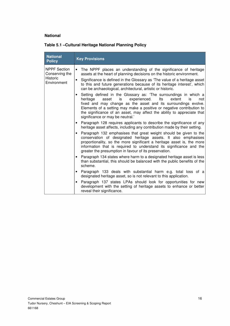
Table 5.1 –Cultural Heritage National Planning Policy
National Policy
Key Provisions
NPPF Section Conserving the Historic Environment
• The NPPF places an understanding of the significance of heritage assets at the heart of planning decisions on the historic environment.
• Significance is defined in the Glossary as ‘The value of a heritage asset to this and future generations because of its heritage interest’, which can be archaeological, architectural, artistic or historic.
• Setting defined in the Glossary as: ‘The surroundings in which a heritage asset is experienced. Its extent is not fixed and may change as the asset and its surroundings evolve. Elements of a setting may make a positive or negative contribution to the significance of an asset, may affect the ability to appreciate that significance or may be neutral.’
• Paragraph 128 requires applicants to describe the significance of any heritage asset affects, including any contribution made by their setting.
• Paragraph 132 emphasises that great weight should be given to the conservation of designated heritage assets. It also emphasises proportionality, so the more significant a heritage asset is, the more information that is required to understand its significance and the greater the presumption in favour of its preservation.
• Paragraph 134 states where harm to a designated heritage asset is less than substantial, this should be balanced with the public benefits of the scheme.
• Paragraph 133 deals with substantial harm e.g. total loss of a designated heritage asset, so is not relevant to this application.
• Paragraph 137 states LPAs should look for opportunities for new development with the setting of heritage assets to enhance or better reveal their significance.

Commercial Estates Group 17
Tudor Nursery, Cheshunt – EIA Screening & Scoping Report
661168
Local
Table 5.2 –Cultural Heritage Local Planning Policy
Local Policy Key Provisions
Broxbourne Local Plan 2001-11 ‘saved’ policies
• HD6: Other Development affecting a listed building and its curtilage – included protection of setting
• HD13: Design Principles
• HD14: Design Statement on Local Character
• HD15: Comprehensive approach to Urban Regeneration
• HD16: Prevention of Town Cramming
Broxbourne Interim Policies
• Interim Policy for Locally Listed Buildings, adopted December 2011: includes protection of setting
Broxbourne Borough Council planning guidance
• Local List, adopted December 2011
Draft Broxbourne Local Plan
• HA1: Heritage Assets
• HA2: Non-designated Heritage Assets – no specific mention of setting
• HA5: Listed Buildings – includes protection of setting
• HA7: Works within the Setting of Listed and Locally Listed Buildings
• DSC1: General Design Principles
5.2.3 In addition to legislation and policy, the assessment will take into consideration relevant
planning guidance and any material considerations, including:
i. National Planning Practice Guidance (Online)
ii. Conservation Principles: English Heritage (2008)
iii. Managing Significance in Decision-Taking in the Historic Environment, Historic Environment Good Practice Advice in Planning 2, Historic England (2015)
iv. The Setting of Heritage Assets, Historic Environment Good Practice Advice in Planning 3, Historic England (2015)
5.3 Existing Baseline
5.3.1 The application site is occupied by a large plant nursery, including four modern and
three derelict greenhouses, associated agricultural buildings, water tanks and car
parking. There are no designated heritage assets within the application site.
5.3.2 Site observations, a manual desk-based review of OS maps and relevant heritage
receptors have been used to determine the study area and this area has been further
informed by building locations and heights, topography and townscape features, and an
understanding of the scale of the Proposed Development. The study area incorporates

Commercial Estates Group 18
Tudor Nursery, Cheshunt – EIA Screening & Scoping Report
661168
all above ground heritage assets within 1km from the centre of the site, including listed
buildings, conservation areas, World Heritage Sites scheduled monuments, registered
parks and gardens and locally listed buildings. The assessment will focus on assets
where there is potential for an impact. Where there will be clearly no impact on assets,
these will be scoped out at baseline stage.
5.3.3 The following Grade II listed buildings are located within the study area:
i. Burton Lane Farm, Burton Lane
ii. 489 Goff’s Lane
iii. Colesgrove Farm, Goff’s Lane
iv. 403 Goff’s Lane
v. The Old Barn, Goff’s Lane
vi. Goff’s Oak House, Goff’s Lane
vii. Cheshunt Great House (remains), Goff’s Lane
viii. Fluted letter box, Halstead Hill
ix. Colegrove Manor, Halstead Hill
x. Halstead Hill House, Halstead Hill
xi. Rose Cottage, Halstead Hill
xii. Broadfield Farm Farmhouse
xiii. Bailiff’s House, Silver Lane
xiv. Ricklesslane Farm, St James’s Road
xv. Church of St James, St James’s Road
xvi. Church of St James’s Vicarage, St James’s Road
xvii. The Coach House, Silver Street
xviii. Outbuilding 5m to the south west of the Coach House, Silver Street
xix. Wood Green Farmhouse, Silver Street
xx. Portion of former Theobalds Deer Park Wall, 40m NE of farmhouse
5.3.4 The following locally listed buildings are located within the study area:
i. The Old Police House, 2-4 Newgatestreet Road
ii. Goff’s Oak Public House, Newgatestreet Road
iii. Burton Grange, Rags Lane
iv. Halcroft House, Dig Dag Hill
v. The Lodge, Dig Dag Hill
5.3.5 There are no conservation areas, Registered Parks and Gardens or Scheduled
Monuments in the study area.
5.4 Potential Cultural Heritage Impacts
Construction
5.4.1 Construction effects on cultural heritage assets, being short to medium-term, are
generally treated as less significant than permanent effects.

Commercial Estates Group 19
Tudor Nursery, Cheshunt – EIA Screening & Scoping Report
661168
5.4.2 It is not anticipated that there will be any direct effects on assets of a cultural heritage
during construction.
5.4.3 The construction impacts are likely to affect the setting of heritage assets in the
immediate proximity to the application site. The following grade II listed buildings may
be affected:
i. Burton Lane Farm, Burton Lane
ii. 489 Goff’s Lane
iii. Colesgrove Farm, Goff’s Lane
iv. The Old Barn, Goff’s Lane
v. Fluted letter box, Halstead Hill
vi. Colegrove Manor, Halstead Hill
Operation
5.4.4 Measures proposed to prevent, reduce or where possible offset any significant adverse
effects will be identified and developed as part of the design process and will be
identified within the report. The design mitigation is likely to include careful planning,
siting, access, layout and scale of buildings.
5.4.5 It is not anticipated that there will be any direct effects on heritage assets during the
operational phase.
5.4.6 There will be no effect on the setting of the majority of heritage assets in the study area,
because the proposed development will be screened by interposing development and
vegetation.
5.4.7 There is potential for setting effects on the following grade II listed buildings, which are
in the immediate vicinity of the application site:
i. Burton Lane Farm, Burton Lane
ii. 489 Goff’s Lane
iii. Colesgrove Farm, Goff’s Lane
iv. The Old Barn, Goff’s Lane
v. Fluted letter box, Halstead Hill
vi. Colegrove Manor, Halstead Hill
Cumulative effects
5.4.8 The assessment will consider the cumulative effect of other developments in the
vicinity, including Rosedale Park North.
5.5 Proposed Scope and Methodology of the Assessment
5.5.1 The scope of the assessment is twofold:
i. to understand the physical effect on all above ground heritage assets, including historic structures, within the footprint of the proposed development; and

Commercial Estates Group 20
Tudor Nursery, Cheshunt – EIA Screening & Scoping Report
661168
ii. to understand the effect on the setting of the designated and non-designated heritage assets within the vicinity of the site. This will include listed buildings, Conservation Areas, Registered Parks and Gardens, Scheduled Ancient Monuments and locally listed buildings.
5.5.2 The assessment will follow the advice set out in the National Planning Policy
Framework and the guidance and methodology suggested by Historic England for the
setting of heritage assets.

Commercial Estates Group 21
Tudor Nursery, Cheshunt – EIA Screening & Scoping Report
661168
6 ECOLOGY
6.1 Introduction
6.1.1 The ecology chapter of the ES will be prepared by Baker Consultants and will assess
the likely significant effects of the proposed development in terms of ecology and nature
conservation. It will describe:
i. the assessment methodology;
ii. the baseline conditions existing at the site and surroundings as derived from the surveys undertaken;
iii. the likely significant ecological effects arising from the proposed development, taking into account ‘applied mitigation’ incorporated into the masterplanning process;
iv. any additional mitigation measures required to prevent, reduce or offset any likely significant adverse effects; and
v. the likely residual effects after the mitigation measures have been employed.
6.1.2 The ecology section of this Scoping Report has set out the methodology for the
assessment of the potential ecological effects of the proposed development.
6.2 Legislation and Policy Context
6.2.1 The framework of legislation, planning policies and planning guidance relating to
biodiversity and applicable to the proposed development and its assessment is
summarised below.

Commercial Estates Group 22
Tudor Nursery, Cheshunt – EIA Screening & Scoping Report
661168
Table 6.1 – Key Environmental Legislation
Legislation Title Key Provisions
Conservation of Habitats and Species Regulations 2010 (as amended)
The Conservation Regulations enact both the EC Directive 92/43/EEC on the Conservation of Natural Habitats and of Wild Fauna and Flora (Habitats Directive) and EC Directive 2009/147/EEC on the Conservation of Wild Birds (Birds Directive). Specifically, they provide for the protection of European Sites - Special Areas of Conservation (SAC) and Special Protection Areas (SPA) - and also those European Protected Species (as listed in the Annexes to the Directives) that occur naturally in the United Kingdom.
Wildlife and Countryside Act (WCA) (1981) (as amended)
The WCA remains one of the principal pieces of legislation relating to wildlife in the United Kingdom (UK). Contained within it are lists of species of flora and fauna subject to statutory protection, with the Act detailing the level of protection attributed to each, which in some instances extends to the habitats or structures they use or in which they are found. The WCA is also the primary piece of legislation relating to the designation and protection of Sites of Special Scientific Interest (SSSIs).
Countryside and Rights of Way Act (CRoW) (2000)
The CRoW Act strengthens the provisions of the WCA in several key areas: • in respect of SSSI protection; and • in the inclusion of ‘reckless’ in addition to the intentional nature of offences listed within parts of the WCA 1981. The CRoW Act also imposed for the first time a ‘statutory duty’ on Government bodies to ‘have regard’ to the conservation of biodiversity in the exercise of their functions.
Natural Environment and Rural Communities Act (NERC) (2006)
The Natural Environment and Rural Communities Act reinforces the requirements originally set down in the CRoW Act on the Government (and extending to all public bodies), to have regard to biodiversity and to identify and take steps to conserve species and habitats of ‘principal importance’. This requirement has been addressed through the drawing up and maintenance of lists of species and habitats which are considered of ‘principal importance’ to biodiversity in the UK.
Protection of Badgers Act (1992)
This Act, as the title suggests, affords a high level of protection to both badgers and their setts, with the intention of combating persecution. The legislation was introduced primarily for reasons of animal welfare as opposed to any concern over the conservation status of what is one of the UK’s more common larger mammals.
6.2.2 Below is summary of planning policies that are relevant to the proposed development of
the site and which have informed the masterplanning process.

Commercial Estates Group 23
Tudor Nursery, Cheshunt – EIA Screening & Scoping Report
661168
National
Table 6.2 – Ecological National Planning Policy
National Policy Legislation Policy
National Planning Policy Framework (NPPF)
Central government policy on nature conservation is now contained within the NPPF, issued in March 2012. The former guidance note PPS9 has therefore been superseded, although the supporting guidance contained within the ODPM Circular 06/2005 remains applicable. The NPPF clearly identifies that planning has a role in “contributing to protecting and enhancing our natural... environment” (paragraph 8) and “helping to improve biodiversity”, through protecting existing resources such as designated or otherwise valued resources, and by “minimising impacts on biodiversity and providing net gains in biodiversity where possible, contributing to the Government’s commitment to halt the overall decline in biodiversity, including by establishing coherent ecological networks that are more resilient to current and future pressures” (paragraph 109). In particular, the NPPF has a common theme of recognising the importance of ecological networks, including ‘wildlife corridors’ and ‘stepping stones’, of seeking to ensure that development results in no net loss of biodiversity and of encouraging planning to secure the enhancement of biodiversity where opportunities arise, in particular where the creation or restoration of habitats will enhance the function of these networks, and especially where they include designated sites.
Local
Table 6.3 – Ecological Local Planning Policy
Local Policy Key Provisions
POLICY CC1 - Development Affecting an Internationally Designated Nature Conservation Site
Development likely to have a direct or indirect effect on a Ramsar site, Special Protection Area or Special Area of Conservation will not be permitted unless it is necessary for reasons of overriding public interest. Any such proposals will be subject to the most rigorous examination. Where development is permitted, the use of conditions or planning obligations will be considered, to avoid and/or minimise harm to the site, to enhance the site’s nature conservation interest and to secure any compensatory measures and appropriate management that may be required.
POLICY CC2 - Development Affecting a Nationally Designated Nature Conservation Site
Development likely to have a direct or indirect effect on a National Nature Reserve, Site of Special Scientific Interest or Environmentally Sensitive Area will not be permitted unless the need for the development clearly outweighs the importance of the site or the effects can be satisfactorily mitigated. Where development is permitted, the use of conditions or planning obligations will be considered, to avoid and/or minimise harm to the site, to enhance the site’s nature conservation interest and to secure any compensatory measures and appropriate management that may be required

Commercial Estates Group 24
Tudor Nursery, Cheshunt – EIA Screening & Scoping Report
661168
Local Policy Key Provisions
POLICY CC3 - Development Affecting Locally Designated Nature Conservation Sites
Proposals for development within or affecting areas designated as Local Nature Reserves (LNR), Wildlife Sites (WS) (formerly SINCs), or Regionally Important Geological Sites (RIGS) will not be permitted unless:
(a) The reasons for the proposal outweigh the need to safeguard the conservation or geological value of the site, and
(b) The proposal does not cause loss or damage to the nature conservation or geological interest of the site in which the development is proposed, or
(c) Any adverse or potentially adverse effects on a LNR, WS or RIGS of a proposal will be satisfactorily mitigated, for example through the creation of habitats of equal quality and value elsewhere on the site or in the District.
POLICY CC5 - Protection of Wildlife at Risk on Development Sites
1. Planning permission will not be granted for any development that would be liable to cause demonstrable harm to a species of animal or plant, or its habitat, protected under law, unless conditions are attached requiring the developer to take steps to secure their protection.
2. If development is likely to affect features of nature conservation interest, planning permission will not be granted for development there unless either:
(a) The development would not harm them; or
(b) Adequate mitigation measures are put in place; or
(c) The importance of the development outweighs the value of the features.
3. Where there is special wildlife value, or where wildlife gains can be achieved, the developer will be required to:
(a) Take steps during development to secure the protection of the nature conservation interest;
(b) Carry out any identified mitigation measures;
(c) Carry out any identified habitat enhancements.
4. Relocation of the wildlife interest from the development site will only be considered in exceptional circumstances.
POLICY CC10 - Historic Landscape Features
Development will not be permitted which would have a materially adverse impact upon landscape features of historic importance, such as ancient woodlands, registered parks and gardens, registered battlefields, protected lanes and hedgerows.
POLICY BE8 - Lighting
Applications for development requiring external lighting shall include details of lighting schemes demonstrating that:
e) The proposed lighting scheme will not be detrimental to either the visual or general amenities of the area nor to nature conservation interests following the incorporation of the mitigation measures referred to in (c) above.
Commercial Estates Group 25
Tudor Nursery, Cheshunt – EIA Screening & Scoping Report
661168
6.3 Existing Baseline
Methods
6.3.1 Baker Consultants has undertaken several detailed ecological surveys of the Tudor
Nursery Site between 2012 and 2016 and have used these to establish an ecological
baseline for the site and to inform the Scoping process. The findings of these surveys
will also be used when undertaking the EIA.
6.3.2 Detailed methods are not reproduced within this document, but in summary, the
ecological studies have included the following investigations:
i. A desk study with Hertfordshire Biological Records Centre (HBRC) in 2011
ii. Extended Phase 1 habitat survey in April 2011 and validation check in 2016
iii. Botanical survey in May 2012
iv. Bat activity/emergence and dawn-re-entry surveys in 2011, 2014 and 2016
v. Bat tree roost assessments in 2012 and 2016
vi. Stag beetle habitat assessment in September 2011
vii. Reptile surveys in 2011 and 2016
viii. Breeding bird surveys in 2012 and 2016
Designated Sites
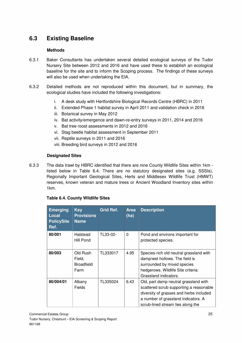
6.3.3 The data trawl by HBRC identified that there are nine County Wildlife Sites within 1km -
listed below in Table 6.4. There are no statutory designated sites (e.g. SSSIs),
Regionally Important Geological Sites, Herts and Middlesex Wildlife Trust (HMWT)
reserves, known veteran and mature trees or Ancient Woodland Inventory sites within
1km.
Table 6.4. County Wildlife Sites
Emerging
Local
PolicySite
Ref.
Key
Provisions
Name
Grid Ref. Area
(ha)
Description
80/001 Halstead
Hill Pond
TL33-02- 0 Pond and environs important for
protected species.
80/003 Old Rush
Field,
Broadfield
Farm
TL333017 4.95 Species-rich old neutral grassland with
damp/wet hollows. The field is
surrounded by mixed species
hedgerows. Wildlife Site criteria:
Grassland indicators.
80/004/01 Albany
Fields
TL335024 6.43 Old, part damp neutral grassland with
scattered scrub supporting a reasonable
diversity of grasses and herbs included
a number of grassland indicators. A
scrub-lined stream lies along the

Commercial Estates Group 26
Tudor Nursery, Cheshunt – EIA Screening & Scoping Report
661168
southern edge and old hedges are
present to the eastern and western
boundaries.
80/018 Meadow N.
of Barrow
Lane
TL338022 1.8 An area of unimproved neutral, partly
wet, grassland divided in the north-east
by a scrub-lined small ditch. Mixed-
species hedgerows of shrubs and trees
border the south, west and north sides.
80/020 Poyndon
Farm
TL325027 3.65 Neutral semi-improved rough grassland
with the greatest diversity occurring to
the southern end of the site.
80/035 Meadow S.
of Rosehill
Sports
Ground
TL337029 4.08 Neutral grassland supporting a
reasonably diverse sward which
includes a number of indicator species.
The site is largely surrounded by
hedgerows of native shrubs and trees.
80/044 Meadow W.
of Tudor
Villas
TL329030 2.37 Neutral grassland supporting a
moderately species-rich sward.
Tussocky patches, scattered scrub, a
pond with some aquatic vegetation, and
bordering hedgerows increase the
habitat diversity of the site.
80/046 Longmead
Farm
Meadows
TL328036 1.88 Two, partly damp, rank neutral
grasslands supporting a good diversity
of grasses and herbs, including several
indicator species. The fields are
surrounded by hedgerows of shrubs and
standard trees. A small stream runs
along the boundary in the north-west
corner and a small pond adds further
habitat diversity.
80/058 Bonney
Grove
Wood by
B198
TL341023 4.23 Old semi-natural broadleaved woodland
A small braided stream crosses the site
and a remnant boundary bank and
hedge is present.
Habitats
6.3.4 Habitats identified on and around the site include grassland (of various types),
woodland, scrub, hedgerow and ephemeral ponds and ditches. The woodland areas lie
immediately outside the north and east boundaries, with hedgerows dividing the two
eastern fields. Scrub was dominant in the southeast field, but this has been
substantially cut back in recent years. These habitats are of no more than local
ecological value, but the northeast grassland area is of greater interest.
6.3.5 Given the abundance of black knapweed, sweet vernal grass, ribwort plantain and
bird’s-foot trefoil in the northeast grassland sward, it is highly likely that the richer areas

Commercial Estates Group 27
Tudor Nursery, Cheshunt – EIA Screening & Scoping Report
661168
of grassland on the site accord to the MG5 community type within the National
Vegetation Classification (NVC). This is the typical unimproved species-rich neutral
grassland of lowland Britain, and is of moderate nature conservation interest.
Species
6.3.6 A total of 34 species of birds were recorded during the site surveys. Of these, only one
potential breeding species– dunnock Prunella modularis - is of conservation concern.
This species is amber-listed under the Birds of Conservation Concern initiative. The
habitats within the site, particularly the eastern half, provide good cover, nesting
locations and foraging opportunities for a range of bird species, and the site is
considered to be of local interest for its breeding bird assemblage.
6.3.7 Confirmed bat roosts have been found within two buildings on the site – a common
pipistrelle Pipistrellus pipistrellus roost within the accommodation building and a brown
long-eared bat Plecotus auritus roost within a metal barn.
6.3.8 No reptiles have been located during site surveys.
6.3.9 The presence of stag beetle in the area around the site was identified within the desk
study and suitable dead wood habitat for this species is located in the woodland belts
on the north and east boundaries of the site.
6.4 Potential Environmental Impacts
Construction
6.4.1 The principal sources of potential impacts on ecological receptors that could arise
during the construction phase of the proposed development are believed to be as
follows:
i. loss of grassland and scrub habitats;
ii. loss of two bat roosts; and
iii. loss of breeding bird habitats
Operation
6.4.2 The principal sources of potential impact on ecological receptors that could arise during
the post-completion phase of the proposed development are believed to be as follows:
i. damage to retained woodland, scrub and grassland habitats;
ii. disturbance to bat roosting, commuting and foraging habitats; and
iii. disturbance to breeding birds

Commercial Estates Group 28
Tudor Nursery, Cheshunt – EIA Screening & Scoping Report
661168
6.5 Proposed Scope and Methodology of the Assessment
6.5.1 The assessment methodology to be used is based on the guidelines produced for
Ecological Impact Assessment (EcIA) by the Chartered Institute for Ecology and
Environmental Management3 (CIEEM). The approach taken is set out below.
Identification and evaluation of Key Receptors
6.5.2 The key ecological receptors are identified from the baseline information amassed from
desk and field surveys. The decision as to which ecological receptors are ‘key’ in this
context is to some extent a value judgement, informed by factors such as national and
local conservation status and legal protection. The current CIEEM guidance recognises
that professional judgement and a certain level of subjectivity is unavoidable when
apportioning value to individual ecological receptors. However certain parameters and
points of reference can be used to help ensure consistency.
6.5.3 Sites already possessing statutory or non-statutory nature conservation designations
will have been subjected to some form of evaluation process and their importance
defined at a geographical scale (e.g. international, national, and local). The existing
citations for these sites will be reviewed as part of the assessment process, but no
further surveys of these sites will be undertaken as part of the EIA process.
6.5.4 The use of designated site criteria for evaluation can be supplemented by consideration
of whether individual species are subject to legal protection, are listed under
conservation status assessments (such as the Red and Amber lists for birds), or
whether habitats or species are present which have been identified as being of
‘principal importance’ for biodiversity conservation in the UK.
6.5.5 A geographical scale of comparison varying from the international to the local area is
used to define the ecological value attached to individual receptors. This allocates
importance at the following scales:
i. International;
ii. UK;
iii. National (i.e. England/NI/Scotland/Wales);
iv. Regional;
v. County;
vi. District;
vii. Parish; and
viii. Immediate locality (within zone of direct influence only - i.e. the application site).
Determining Impact Significance
6.5.6 Following the evaluation of the identified key ecological features, the significance of
predicted ecological impacts arising from the development proposals is assessed, prior
to mitigation being considered.
3
Chartered Institute of Ecology and Environmental Management (2006) Guidelines for Ecological Impact Assessment in the United Kingdom
(version 26 June 2006).

Commercial Estates Group 29
Tudor Nursery, Cheshunt – EIA Screening & Scoping Report
661168
6.5.7 The predicted impacts may be direct or indirect in nature and may occur in one or more
of the construction and operation phases of the scheme. The impacts identified to be
acting on each ecological feature are assessed in terms of the factors listed below:-
i. Direction (positive, negative or neutral impact) ;
ii. Magnitude (the amount or level of impact);
iii. Extent (area in hectares, linear metres);
iv. Duration (in time or related to species life-cycles);
v. Reversibility (permanent or temporary impact);
vi. Timing and frequency (e.g. related to breeding seasons); and
vii. Cumulative impacts (from a number of different sources).
6.5.8 CIEEM guidance states that impacts should be determined as being significant when
they have an adverse or positive ‘impact on structure and function of defined sites and
ecosystems’.
6.5.9 The CIEEM guidance goes on to state that “consideration of conservation status is
important for evaluating the effects of impacts on individual habitats and species and
assessing their significance:
i. Habitats – conservation status is determined by the sum of the influences acting on the habitat that may affect its extent, structure and functions as well as its distribution and its typical species within a given geographical area.
ii. Species – conservation status is determined by the sum of influences acting on the species concerned that may affect its abundance and distribution within a given geographical area.
6.5.10 Identified impacts may be significant at the level of importance defined for the ‘important
ecological feature’, or at a lesser geographical scale. For example, limited impacts on a
woodland of County value might be assessed as being significant at a Local level.
6.5.11 Using this information and professional judgement, it is determined whether the effects
will be significant or not for the integrity (of site/ecosystems) or conservation status (of
habitats/species) of each ecological feature.
6.5.12 The impact significance is determined at the appropriate geographical scale. Neutral
impacts have no level of significance applied to them. In summary, therefore, impacts
are assigned to one of three possible significance ‘options’:-
i. adverse impact, significant at [geographical, e.g. site] level;
ii. neutral impact; and
iii. positive impact, significant at [geographical, e.g. site] level.
Mitigation and Residual Impacts
6.5.13 Once the significance of impacts has been assessed, mitigation will be proposed to
avoid, reduce or compensate for negative effects. In addition, enhancement measures
will be recommended in order to provide biodiversity gain.

Commercial Estates Group 30
Tudor Nursery, Cheshunt – EIA Screening & Scoping Report
661168
6.5.14 After mitigation measures have been proposed, residual impacts will be assessed and
the potential for cumulative impacts with other relevant developments will also be
considered.

Commercial Estates Group 31
Tudor Nursery, Cheshunt – EIA Screening & Scoping Report
661168
7 FLOOD RISK AND DRAINAGE
7.1 Introduction
7.1.1 The Flood Risk and Drainage chapter of the ES will be prepared by Brookbanks
Consultants. It will assess the flood risk and drainage related environmental effects of
the proposed development. It will draw on data from a Flood Risk Assessment (FRA)
for the proposed development.
7.1.2 The FRA will also be prepared by Brookbanks and will be attached as an Appendix to
the ES. The FRA will set out the flood risk and drainage issues relating to the proposed
development and identify any necessary interventions to mitigate the anticipated effects
and to ensure no detriment to the surrounding area.
7.1.3 This Scoping Report sets out the existing baseline, the potential methodology for the
assessment of impacts and the potential flood risk and drainage impacts.
7.2 Legislation and Policy Context
7.2.1 The following documents will guide the production of the ES and FRA.
National
Table 7.1 – Flood Risk and Drainage National Planning Policy
National Policy Key Provisions
National Planning Policy Framework (NPPF)
Allocation and planning of development must be considered against a risk based search sequence, as provided by the NPPF guidance
Regional
Table 7.2 – Flood Risk and Drainage Regional Planning Policy
Regional Policy Key Provisions
East Hertfordshire and Broxbourne SWMP
(on-going): The SWMP is currently under development and will outline the main areas at risk, the preferred surface water management strategy in a given location and will set out further actions the Council will implement in the management of surface water.

Commercial Estates Group 32
Tudor Nursery, Cheshunt – EIA Screening & Scoping Report
661168
Hertfordshire Local Flood Risk Management Strategy
(2013 - 2016): The Strategy is used as a means by which the
LLFA co-ordinates Flood Risk Management on a day to day basis
and sets measures to manage local flood risk i.e. flood risk from
surface water, groundwater and Ordinary Watercourses. The
action plan shows how the LLFA intends to achieve high level
objectives relating to flood risk.
Water Cycle Study
(2010): A Water Cycle Study – Scoping Study covering the
Broxbourne was completed in April 2010. A new Water Project for
Hertfordshire is currently being commissioned by Hertfordshire
County Council with the aim of identifying the critical factors which
affect robust water supply and wastewater treatment to 2051 in
Hertfordshire. The scope of the study will only extend to flood risk,
water quality and surface water management as far as necessary
to take a holistic and integrated approach.
Local
Table 7.3 – Flood Risk and Drainage Local Planning Policy
Local Policy Key Provisions
Borough of Broxbourne
Broxbourne Borough Council Level 1 Strategic Flood Risk Assessment May 2016
7.3 Existing Baseline
7.3.1 Reference to the Flood Estimation Handbook CD dataset V3 shows the land to lie within
the catchment of the Rags Brook
7.3.2 Furthermore, the majority of the site is previously developed, being in use as a plant
nursery. As such, it is likely that this is positively drained and served by existing sewers.
7.3.3 The site is located wholly within flood zone 1.
Storm Water Hydrology
7.3.4 Storm drainage across the existing site is primarily discharged to the ordinary
watercourse tributary of the Rags Brook traversing the northern boundary of the site.
This watercourse conveys flows in an easterly direction before discharging to the Rags
Brook, circa 1km east of the site.
7.3.5 There is also an ordinary water course running along the eastern boundary of the site.
this ordinary water course is split in terms of drainage direction with the northern third
draining to the north and to another ordinary water course described in 7.3.4. The two
thirds in the south drain in a southerly direction to a culvert beneath Goffs Lane, likely to
outfall towards College Brook and or Theobolds Brook.

Commercial Estates Group 33
Tudor Nursery, Cheshunt – EIA Screening & Scoping Report
661168
Foul Drainage Hydrology
7.3.6 The proposed development lies within the catchment of the Deephams Sewage
Treatment Works (STW), which receives foul flows from areas of north London. The
STW discharges to the River Lee some 9km south east of proposed development
7.3.7 Discussions with Thames Water confirm that the Deephams STW will have sufficient
capacity to accommodate what will equate to a negligible increase in foul flows from the
proposed development.
7.3.8 It is likely that the site will connect to the existing 150mm foul sewer in Burton Lane or
alternatively make a connection to the 225mm sewer within Goff’s Lane.
7.4 Potential Flood Risk and Drainage Impacts
Construction
7.4.1 Two potential construction phase environmental effects have been identified relating to
hydrology and hydrogeology. These mechanisms are as follows:
i. direct and indirect contamination of surface water due to mobilisation of soils,
existing contamination and spillage of oils, fuels etc from construction plant.
Disturbance of the ground during construction operations has the potential to
contaminate the soil and both ground and surface waters due to discharge of
solids into water or by the short term mobilisation of any background
contaminants within the soil matrix.
ii. direct and indirect flooding and changes to baseline drainage hydrology due to
disturbance of the ground during construction works.
Flooding and changes to the baseline hydrology can occur due to various
construction related activities, such as; deposition of materials within the
floodplain, temporary diversion of watercourses, infilling of land altering
preferential drainage flow paths and flood routes, and dewatering of
excavations. Such effects can have consequences on the project, however,
good construction management procedures can mitigate the risk and the
consequence of incidents.
Operation
7.4.2 As a result of the proposed development, five potential operational environmental
effects are identified relating to water. The mechanisms are as follows:
i. direct and indirect flooding of surrounding watercourses, the wider catchment
area, adjacent land and property due to increases in surface water runoff from
positively drained hard areas.
Hydrological effects in terms of flooding arise from changes in the catchment
drainage characteristics. Urbanisation of the catchment through the
construction of the proposed development can increase peak storm water
discharge due to the accelerated run-off and reduced times of concentration

Commercial Estates Group 34
Tudor Nursery, Cheshunt – EIA Screening & Scoping Report
661168
that are associated with the hard paved areas indicated within the parameters
plan. This can result in an increased risk of flooding.
ii. direct flooding of the site due to inadequate flooding resilience and
management of residual flood risk.
An increase in surface water as a result of a development can directly lead to
flooding. The introduction of hard paved areas and building developments can
replace permeable ground thus increasing potential for surface water flooding.
The implementation of strategies to avoid any increase in residual flood risk is
vital as this could have an adverse impact on the development itself.
iii. direct contamination or deterioration of surface water quality due to leakages of
fuel oils, general spillages and other contaminants from within the development
and the associated collection of surface water drainage from hard standing
areas.
In assessing the environmental impact of the development in terms of pollution
prevention, a water impact appraisal has been completed to assess the
potential pollution receptors. The prime water receptors at risk are the
groundwater and the nearby watercourses.
Water quality in the surrounding area is reported to be good. National and
European legislation will ensure water quality is improved over time, primarily by
the implementation of more stringent controls. Accordingly, if the potential
impact of development activities is to be avoided, surface water discharged
from the development will need to be treated to improve water quality prior to
discharge from the site.
iv. direct contamination of surface and ground water may arise from accidental
spillages of chemicals sometimes employed in commercial and industrial
development. Such spillages can result in major pollution incidents. Protection
of the environment through the usage of chemicals in industry is rigorously
defended through appropriate environment legislation, requiring statutory
registration of such use and implementation of appropriate means of control.
Surface water run-off from development sites routinely contains a series of
contaminants, including petrochemical compounds, heavy metals and
suspended solids, being predominant in industrial service yards and large car
parks. In residential development the small volumes of fuel oils washed from
cars represents a far lower pollution risk to surface or ground water quality. The
direct discharge of development drainage to adjacent watercourses can
potentially lead to a degradation of water quality with associated ecological
effects.
Typical chemical concentrations are shown in Table 7.4.
Table 7.4 – Typical Chemical Concentrations
Water sources Mean Pollutant Concentration (mg/l)
Solids BOD COD NH4 Pb Oils
Rainfall 8 - 80 1 - 15 2.5 - 32 - 0.024 - 10.4
-
Typical Residential 187 8.5 80 0.6 0.14 5.1

Commercial Estates Group 35
Tudor Nursery, Cheshunt – EIA Screening & Scoping Report
661168
Areas
v. direct and indirect contamination of surface water, soil and potential
groundwater contamination due to surcharging of the foul water network or the
discharge of untreated foul flows.
When assessing potential effects of the foul drainage, it is important that the
proposed system is designed to convey foul waters safely from the site to a
suitable treatment facility, without overloading the existing sewerage systems.
Furthermore, it is also important that the treatment facility is designed to
accommodate the load from the Project and that same achieves a discharge
quality that does not impact on water quality standards in the receiving
watercourse.
7.4.3 In the baseline condition, the planning application site and master plan site do not
benefit from a connection to the foul sewerage network. However, DETR Circular 3/99
and Building Regulations state that the first presumption when considering new
development is to provide positive drainage from that development in conjunction with
the local sewerage undertaker. Accordingly, Thames Water has been involved in
investigating the impact of the development of the site in accordance with the planning
application and indicative master plan on their existing sewerage infrastructure and
treatment facilities
7.5 Proposed Scope and Methodology of the Assessment
7.5.1 Methods of assessment will be employed that are consistent with current guidance and
recommendations in the form of statutory documents and recognised publications to
ensure that the findings represent a robust approach to the assessment.
7.5.2 The tables below outline the criteria for determining the magnitude and significance of
the identified impacts.
Table 7.5 – Magnitude of Effect
Magnitude Criteria
Substantial Loss of attribute.
Moderate Losses on integrity or partial loss of attribute.
Minor Minor impact / minor loss of attribute.
Negligible Insignificant loss of attribute that does not affect use or integrity.
Table 7.6 – Significance of Effect
Magnitude Importance
Very High High Medium Low
Substantial Very Significant Highly significant
Significant Low significance
Moderate Highly significant
Significant Low significance Insignificant

Commercial Estates Group 36
Tudor Nursery, Cheshunt – EIA Screening & Scoping Report
661168
Minor Significant Low significance Insignificant Insignificant
Negligible Low significance Insignificant Insignificant Insignificant
Consultation
7.5.3 During the development of this chapter, the following statutory bodies and interested
parties have been consulted regarding the proposals:
i. The Environment Agency;
ii. Thames Water; and
iii. Hertfordshire County Council as Local Lead Flood Authority.
7.5.4 Published information has been obtained in the form of:
i. Published geology;
ii. Environmental statutory registers; and
iii. Flood mapping.
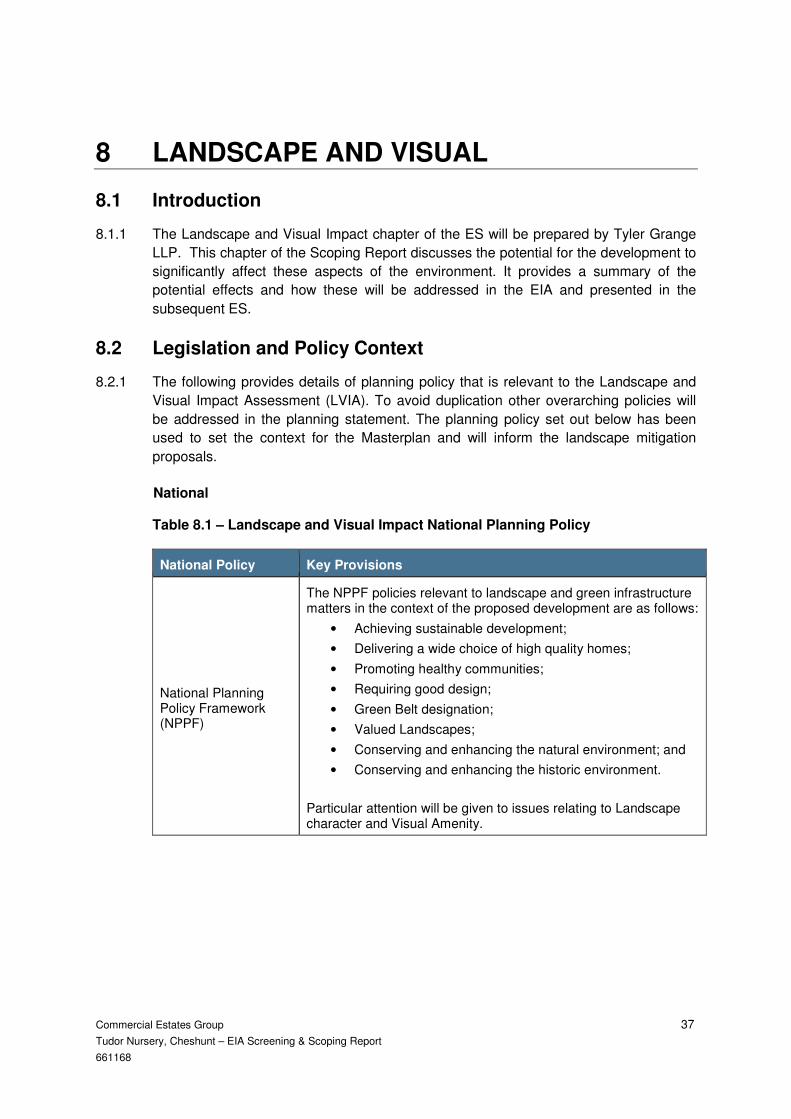
Commercial Estates Group 37
Tudor Nursery, Cheshunt – EIA Screening & Scoping Report
661168
8 LANDSCAPE AND VISUAL
8.1 Introduction
8.1.1 The Landscape and Visual Impact chapter of the ES will be prepared by Tyler Grange
LLP. This chapter of the Scoping Report discusses the potential for the development to
significantly affect these aspects of the environment. It provides a summary of the
potential effects and how these will be addressed in the EIA and presented in the
subsequent ES.
8.2 Legislation and Policy Context
8.2.1 The following provides details of planning policy that is relevant to the Landscape and
Visual Impact Assessment (LVIA). To avoid duplication other overarching policies will
be addressed in the planning statement. The planning policy set out below has been
used to set the context for the Masterplan and will inform the landscape mitigation
proposals.
National
Table 8.1 – Landscape and Visual Impact National Planning Policy
National Policy Key Provisions
National Planning Policy Framework (NPPF)
The NPPF policies relevant to landscape and green infrastructure matters in the context of the proposed development are as follows:
• Achieving sustainable development;
• Delivering a wide choice of high quality homes;
• Promoting healthy communities;
• Requiring good design;
• Green Belt designation;
• Valued Landscapes;
• Conserving and enhancing the natural environment; and
• Conserving and enhancing the historic environment.
Particular attention will be given to issues relating to Landscape character and Visual Amenity.

Commercial Estates Group 38
Tudor Nursery, Cheshunt – EIA Screening & Scoping Report
661168
Local
Table 8.2 – Landscape and Visual Impact Local Planning Policy
Local Policy Key Provisions
Broxbourne Local Plan 2005
GBC2 Development within the Metropolitan Green Belt
GBC16 Landscape character areas and enhancement
HD14 Design statement on local character
HD17 Retention/enhancement of landscape features
H8 Design quality of development
HD6 Other development affecting a listed building and its curtilage
HD13 Design Principles
HD18 Trees, hedgerows and woodlands
Broxbourne Local Plan 2016 – 2031 (emerging) REG 18 Draft Local Plan
The aspirations for the emerging local plan have been set out in a Local Plan Framework document approved by Broxbourne Borough Council cabinet in 2015.
DSC1 General design principles
GB2 Residential development on derelict glass house sites
NEB2 Green Infrastructure
NEB3 Landscape and biodiversity in new developments
NEB4 Protected trees and hedgerows
HA7 Works within the setting of listed and locally listed buildings
8.2.2 Other documents for consideration from the Evidence Base for the LDF include:
i. Borough of Broxbourne Supplementary Planning Guidance (SPG) 2004 (updated 2013). This SPG will be a material consideration in determining planning applications and provides more detailed guidance on good practice relating to development proposals.
8.3 Existing Baseline
8.3.1 A strategic landscape assessment relating to the site and wider landscape was
undertaken by Tyler Grange in 2015 and baseline studies have continued until 2016.
The “Strategic Landscape Assessment” (dated 30 November 2015) that was produced,
has involved a review of policy, guidance, the Broxbourne Landscape Character
Assessment 2008 and has included field work together with consultations with the
Senior Urban Designer at Broxbourne Borough Council. This has enabled an
understanding of landscape and visual issues relating to the site and surrounding area
and to inform the development of the masterplan and design of the proposals. The work
undertaken to date will inform the assessment process going forward.
8.3.2 Site Features. The site lies within the urban context of the Goff’s Oak area of
Broxbourne. The legacy of the horticultural industry in the form of glass houses is
evident on the site and within the surrounding landscape. The general demise of the
industry has seen large scale dereliction across the area and glass houses have

Commercial Estates Group 39
Tudor Nursery, Cheshunt – EIA Screening & Scoping Report
661168
become disused and derelict as is the case for many of the glasshouses at Tudor
Nursery. In addition the site encompasses an area of unmanaged pasture and an area
of active glass house infrastructure.
8.3.3 The site is not designated at a national, regional or local level as having any particular
landscape value. It is well contained by its boundary tree belts and adjacent to built
form.
Landscape Character
8.3.4 The published landscape character classifications cascade from the National to District
level. The Countryside Agency's Character Map of England identifies broad National
Character Areas (NCAs) for the whole of England that provide an appreciation of a
large area of landscape which at a national scale share characteristic features. The site
itself lies within the Northern Thames Basin Character Area 111 (stretching from
Hertfordshire to the Essex coast).
8.3.5 Given the extensive area covered by this classification the description is generalised
and cannot be effectively applied to specific sites. The national character mapping is
therefore considered to be of limited relevance and is not sufficiently precise to draw
any conclusions in terms of the assessment process.
8.3.6 At a district level, the Broxbourne Landscape Character Assessment (October 2008)
covers the site and its environs.
Broxbourne Landscape Character Assessment (BLCA)2008
8.3.7 The site lies within the Plateau Ridges and Slopes: Wooded Farmland (Type B)
Landscape Character Type (LCT). The key characteristics considered relevant to the
study area are as follows:
i. undulating landform encompassing a series of ridges and slopes, which result from several narrow stream valley corridors cutting across the landscape;
ii. tall hedges often line road corridors which tend to run east-west across the landscape and are predominantly rural in nature;
iii. glass houses associated with nurseries or former nurseries are recognisable features of the landscape; and
iv. settlement pattern is dominated by suburban housing at Goff’s Oak and Hammond Street and more recent housing developments at the edges of these areas.
8.3.8 The landscape condition (2008) for this LCT overall has been assessed as moderate
with expected increased pressure for housing development. It is also considered to
have some capacity to accommodate change without compromising key characteristics.
8.3.9 The LCT’s are divided further into Landscape Character Areas (LCA) and the site and
its immediate environs falls within the Goff’s Oak and Hammond Street (B2) LCA and
shares a number of its characteristics. The key characteristics are as follows:
i. suburban housing at Hammond Street to the north and Goff’s Oak to the south;
ii. separate blocks of modern housing also dominate landscape pattern;

Commercial Estates Group 40
Tudor Nursery, Cheshunt – EIA Screening & Scoping Report
661168
iii. buildings display a variety of architectural styles and materials;
iv. the landscape is an “assortment” of pasture fields, mature hedgerows, small pockets of woodland, and groups of active and derelict glasshouses;
v. fields are mainly grazed by horses, with fences, tape and other associated horticulture equipment dominant features in many areas;
vi. this “urban fringe” landscape has a number of tracks and public footpaths;
vii. within several views rows of pylons are dominant;
viii. outside the main housing areas several of the scattered large houses display “ranch style” gated entrances;
ix. the minor road corridors running through this landscape have a predominantly rural character and are often lined with mature hedgerows; and
x. glass houses contribute to local identity and sense of place.
8.3.10 It is noted that the:
“Settlement pattern is dominated by suburban housing at Goff’s Oak and Hammond
Street and more recent housing on the edges of these areas. The landscape
surrounding these housing areas often displays urban fringe characteristics, such as
horticulture (with an associated hotchpotch of fencing, tape and equipment). Rows of
dominant electricity pylons are also a feature in places.”
8.3.11 It is further noted that there is no public access within the site and that Burton Lane lies
to the immediate west and Goff’s Lane to the south, restricting physical and visual
connectivity within the locality.
Views and Visibility
8.3.12 Generally, the containment provided by linear tree belts in conjunction with adjacent
built form, means that the visual permeability is restricted. As a result, it is the
immediate context of any view which influences the composition and visual experience
moving through this area.
8.3.13 Typically, there are no long distance ‘cross’ views that extend across or along the
valley.
8.3.14 There are no significant visual landmarks or notable and prominent elements leading to
a balanced and relatively consistent visual experience within the area.
8.3.15 At a local scale the water tower close to Burton Road within Tudor Nursery is a local
landmark but not an attractor in terms of visual amenity.
8.3.16 With regard to the site and its surrounding landscape/townscape, the visual baseline
has already been considered. This is based upon the findings of the GIS first sieve
analysis and the production of the Zone of Theoretical Visibility (ZTV) to indicate the
areas from which the various development elements would be potentially visible based
on landform data only. The visual envelope for development has been determined
though field work.
Commercial Estates Group 41
Tudor Nursery, Cheshunt – EIA Screening & Scoping Report
661168
Extent of Visibility
8.3.17 The combination of topography, linear woody features and existing built form serve to
contain views.
8.3.18 Direct views into the site are very limited and occur close to the boundary where gaps in
vegetation allow. The exception to this is along Burton Lane where clear views are
afforded into the site, albeit restricted by the immediate presence of glass houses.
8.4 Potential Landscape and Visual Impacts
8.4.1 The evolving masterplan has been designed in order to respond to the landscape
context of the site, retaining all of the beneficial boundary tree belt features, maximising
the opportunity to provide quality open space and accommodating green infrastructure
in its approach.
8.4.2 New green spaces, the greater connectivity of people and landscape features to the
wider area and the provision of enhanced natural habitats form part of a landscape
framework that will provide benefits to the local environment, improvements to
landscape character and recreational opportunities.
8.4.3 Whilst changes to the fabric and character of the landscape within the site will be
directly affected, they are to be considered within the existing urban context.
8.4.4 Potential key landscape features within the site that may be directly affected by the
development are: topography; buildings; tree and hedgerow cover and boundaries.
8.4.5 Studies undertaken to date confirm that a narrow selection of visual receptors are
reasonably anticipated to be affected by a development such as this. Residents (limited
to those overlooking the site), workers (limited to those few in adjacent businesses), the
travelling public (limited to those using Goff’s Lane and Burton Lane) and those using
the Rosedale Sports Ground to the north east (who will have a focus on their activities).
There are no public rights of way crossing the site and just one to the west (Cheshunt
043) with limited glimpsed views between dense vegetation and therefore few visitors
whose main preoccupation is the enjoyment of scenery.
Construction
8.4.6 There are likely to be short term impacts of construction plant and machinery on
landscape character and visual amenity, affecting various receptors within and
surrounding the site including identified landscape and visual resources. These
temporary, impacts will be dependent on the phasing of the works and the impacts will
be defined once the construction phases have been set out.
Operation
8.4.7 There are likely to be direct changes to the site itself and such changes will be
experienced in the context of the existing townscape that surrounds the site to the
south, west and east and further to the north.

Commercial Estates Group 42
Tudor Nursery, Cheshunt – EIA Screening & Scoping Report
661168
8.4.8 Landscape Effects. The development will result in a complete change from glass house
infrastructure (some derelict and some in use) and rough grassland, to one of largely
residential development that would be consistent with and complement the townscape
in terms of use, pattern, grain and appearance.
8.4.9 The enclosing boundary linear tree belts would be retained and enhanced and a net
gain in quantum of trees achieved.
8.4.10 A qualitative landscape and GI infrastructure would provide wider community benefit
over and above the existing baseline.
8.4.11 Visual Effects. It is established that the site is well contained visually and potential
visual change experienced by those closest to the site. It is unlikely that development
would disrupt views and the change in visual composition would be in keeping with the
townscape context.
8.4.12 The details of potential impacts on landscape and visual receptors will be set out once
the LVIA assessment has been undertaken.
Cumulative
8.4.13 With regard to potential cumulative impacts on landscape and visual receptors, only
Rosedale Park North is considered to be relevant from the sites listed in Table 12.1..
8.5 Proposed Scope and Methodology of the Assessment
8.5.1 The assessment will be undertaken in accordance with the Guidelines for Landscape
and Visual Impact Assessment (Landscape Institute and Institute of Environmental
Management & Assessment, Third Edition dated 2013), which is the currently published
edition.
8.5.2 In addition, other best practice guidance will be referred to as necessary:
i. an Approach to Landscape Character Assessment – Natural England dated 2014; and
ii. photography and Photomontage in landscape and visual impact assessment – Landscape Institute Note 01/11.
8.5.3 The assessment will build upon the preliminary landscape and visual appraisal work
undertaken in November 2015.
Methodology
8.5.4 The methodology will include the following stages; Baseline Appraisal,
Classification of Resources and Assessment of Effects.
Stage 1. Baseline Appraisal
8.5.5 The baseline appraisal process includes:
i. an overview of statutory plans and other data regarding relevant designations and landscape and visual relating planning policies for the area;

Commercial Estates Group 43
Tudor Nursery, Cheshunt – EIA Screening & Scoping Report
661168
ii. an assessment of landscape character of the site and surroundings with reference to published works and checked and verified through fieldwork. This includes the classification of the landscape into units of distinct and recognisable character and land use at site specific level;
iii. fieldwork to determine the extent to which the site can be seen from the wider area, taking into account any significant vegetation or built form which restricts or limits the extent of visibility; and
iv. identification of representative viewpoints and determination of likely visual receptors.
Stage 2. Classification of Resources
8.5.6 This stage seeks to classify the landscape resources in terms of their individual or
collective sensitivity to change. This is dependent on:
i. the susceptibility of the landscape to the type of change proposed: and
ii. the value placed on the landscape (see GLVIA3 box 5.1).
8.5.7 As a general rule those landscape resources which make a notable contribution to the
character and cannot be replaced or substituted will be of high sensitivity, those
resources which are replaceable or contribute little to the overall character of the
landscape will be of low sensitivity.
8.5.8 In terms of visual amenity, the representative viewpoints are classified in terms of their
sensitivity to change. The sensitivity of the visual receptors will be dependent on:
i. the location and context of the viewpoint;
ii. the expectations and occupation or activity of the receptors; and
iii. the importance of the view.
8.5.9 Those receptors that are classified as being of high sensitivity to change may include
users of public rights of way or nearby residents and those of low sensitivity to change
may include people in their place of work or travelling through the landscape in cars or
other forms of transport.
Stage 3. Assessment of Effects.
8.5.10 The assessment of effects is undertaken in the knowledge of the scheme proposals and
the existing baseline situation. It will also include a review of other consultant’s work
such as ecology and the arboriculture survey to ensure that their findings are accounted
for in the baseline.
8.5.11 The significance of any landscape and visual effect is a function of the sensitivity of the
affected landscape resources and visual receptors against the magnitude of change
they would experience.
8.5.12 The magnitude of effect lies along a continuum from high, where there is a prominent
and notable change to landscape character or view, to low where the change is barely
perceptible.
8.5.13 The consideration of mitigation with the aim of avoiding, offsetting or reducing
significant adverse landscape and visual effects is determined during the course of the
assessment where this can be addressed through a suitably worded condition.

Commercial Estates Group 44
Tudor Nursery, Cheshunt – EIA Screening & Scoping Report
661168
8.5.14 The evaluation of landscape and visual effects following mitigation is known as residual
impacts.
8.5.15 The assessment of the nature of the landscape and visual effects depends on the
degree to which the development:
i. complements, respects and fits into the existing scale, landform and pattern of the landscape context;
ii. enables enhancement, restoration or retention of the landscape character and visual amenity and delivers policy aspirations;
iii. affects strategic and important views in addition to the visual context of receptors: and
iv. the potential cumulative landscape and visual effects of the application site alongside agreed cumulative sites.
8.5.16 The LVIA will categorise landscape and visual impacts in order to provide a sound basis
for conclusions. Significance criteria will be defined within the reporting and detailed
descriptions of the significance criteria can be provided if required.
Design Development
8.5.17 A “Strategic Landscape Assessment” relating to the Tudor Nursery site and the wider
landscape including Rag’s Brook was undertaken in November 2015. This, together
with ongoing site visits and meetings (BBC officers and the technical team) has
informed design development to date. In addition, and at the same time, Tyler Grange
LLP have produced the “West Cheshunt/Goff’s Oak Green Belt Review to consider the
contribution that land makes to the Green Belt Purposes.
8.5.18 Landscape character and visual amenity have been strongly represented in terms of
design iteration from the outset, ensuring that a landscape led approach is maintained
throughout.
General Notes
8.5.19 The range of viewpoint locations has been agreed with the Senior Urban Designer at
Broxbourne Borough Council (October 2016) and they will form the basis of the visual
assessment.
Commercial Estates Group 45
Tudor Nursery, Cheshunt – EIA Screening & Scoping Report
661168
9 SOCIO-ECONOMICS
9.1 Introduction
9.1.1 The socio-economics’ chapter of the ES will be prepared by RSK Environment Ltd.
This Scoping Report sets out the methodology to be used for the assessment of the
socio-economic effects of the proposed development during its construction and
operation.
9.1.2 Given the elements to be included in the proposed development and their location, the
scope of impacts to be considered will include, but not be limited to, demographic
change, employment, land use change, education, health, provision of and access to
amenities, access and recreation. The assessment will be based on a review of the
prevailing social and economic conditions in the area immediately surrounding the
proposed development site at Goff’s Oak and in the wider Broxbourne Borough Council
area.
9.2 Legislation and Policy Context
9.2.1 A full planning policy review will be undertaken as part of the socio-economic impact
assessment. This will include a review of national and local policies which are relevant
to the development topic.
9.2.2 An indicative overview of the key policies is presented in this section.
National
Table 9.1 – Socio Economic National Planning Policy
National Policy Key Provisions
National Planning Policy Framework (NPPF)
The NPPF aims to support strong, vibrant and healthy communities, by providing the supply of housing required to meet the needs of present and future generations; and by creating a high quality built environment, with accessible local services that reflect the community’s needs and support its health, social and cultural well-being. In addition, it requires that development takes account of and supports local strategies to improve health, social and cultural wellbeing for all, and deliver sufficient community and cultural facilities and services to meet local needs.

Commercial Estates Group 46
Tudor Nursery, Cheshunt – EIA Screening & Scoping Report
661168
Local
Table 9.2 – Socio Economic Local Planning Policy
Local Policy Key Provisions
Borough of Broxbourne Local Plan (2005)
Policy H6 Protecting the amenity of existing residential areas
In order to protect the amenity of existing residential areas:
• The scale, design and external appearance of the extension/alteration is compatible with the parent buildings and its wider setting
• The proposed extension/alteration would not materially harm the privacy, amenity or environment of nearby residents
• Provision is made for safe access and adequate vehicle parking in accordance with standards contained within borough-wide supplementary planning guidance
Policy H16 Residential Care Homes
• Provision is made for access arrangements without undue impact on the highway network
• The proposed development would not materially harm the privacy or amenity of existing nearby residents
• Provision is made for safe access and adequate vehicle parking in accordance with standards contained within borough-wide supplementary planning guidance
Policy EMP1 Employment Areas
The site or use forms part of a wider regeneration proposal providing mixed use scheme.
Policy HD13 Design Principles
All new developments should incorporate a high quality of design and make recognition of the need to pay careful attention to the relationship between the buildings and open spaces in order to ensure continuity in the street scene. The need to take into account the impact of a development on existing and proposed movement patterned. Creation of places that are acceptable to change; promoting diversity and choice through the incorporation of a balanced development mix to create viable places responsive to local needs.
Policy CLT2 Children’s play area
Planning permission for residential development of 15 dwellings or more containing family accommodation will not be permitted unless children’s play areas are provided to at least the minimum standards of the NPFA. Play space should be safely accessible and available to the general public, and of suitable size and nature for sport, active recreation or children’s play.
Local Development Plan
9.2.3 The Borough of Broxbourne Local Development Plan (LDP) is undergoing consultation
at present. This will replace the current policies in the LDP once adopted. At this time
the polices which are relevant and should be considered in preparing this assessment
would include, but are not limited to:
i. Policy H6 Protecting the amenity of existing residential areas
ii. Policy H8 Design quality of development

Commercial Estates Group 47
Tudor Nursery, Cheshunt – EIA Screening & Scoping Report
661168
iii. Policy H12 Housing mix
iv. Policy H13 Affordable housing
v. Policy H16 Residential care homes
vi. Policy EMP12 Nurseries and crèches
vii. Policy CLT1 Community, open space and recreational facilities
viii. Policy HD13 Design principles
9.2.4 The socio-economic assessment will also make reference to the findings of the 2013
study into the Glasshouse industry in the area. This report was prepared in 2013, by
the Laurence Gould Partnership Ltd having been commissioned by BBC to inform their
Local Plan. Further evidence was submitted on behalf the landowners and this will also
be referred to.
9.3 Existing Baseline
9.3.1 The site is situated on the western edge of the Cheshunt settlement, immediately to the
north of the B156 and 2km from the A10. There are a number of individual residential
dwellings located around the proposed site, with the main residential settlement located
to the north and east of the site.
9.3.2 The current land use of the proposed site is horticulture with some residential dwellings
and other buildings to the south and west of the red line boundary.
9.3.3 The site is located within Broxbourne Borough Council administrative area. Key
statistics for this ward from Census 2011 are presented in Table 9.3 and this will form
the basis for the full, detailed baseline.
Table 9.3 – Key Census Statistics
Indicator Goff’s Oak (ward)
Broxbourne (council area)
East of England (regional)
England (national)
Population 8,172 93,609 5,846,965 53,012,456
All households 2,996 37,658 2,423,035 22,063,368
Proportion of population who owned household with mortgage / loan
48.7% 40.0% 34.7% 32.8%
Proportion of population who consider themselves to have good or very good health 87.0% 83.0% 82.4% 81.4%

Commercial Estates Group 48
Tudor Nursery, Cheshunt – EIA Screening & Scoping Report
661168
Proportion of population economically active and employed
67.0% 73.0% 64.8% 62.1%
Proportion of population economically active and unemployed
0.05% 0.05% 3.8% 4.4%
People aged 16 and over with 5 or more GCSEs grade A-C, or equivalent
36.6% 28% 16.2% 15.2%
People aged 16 and over with no formal qualifications
19.5% 25% 22.5% 22.5%
Source: Census 2011
9.3.4 The key characteristics of the ward in comparison to the wider averages are:
i. the proportion of the population who own their property with mortgage or loan is higher in Goff’s Oak than for the district, region or national average;
ii. the proportion of the population who considered themselves to have at least good health is higher than the district, region or national average;
iii. proportion of population who are economically active and employed is increasingly higher than at all other spatial scales; similarly the proportion who are unemployed is lower; and
iv. the level of education attained in Goff’s Oak is higher than at other spatial scales.
9.3.5 There are a number of educational facilities in proximity to the red line boundary,
including but not limited to:
i. Fairfields Primary School approximately 1km north east of the site;
ii. Andrews Lane Primary School approximately 1km east of the site;
iii. Woodside Primary School approximately 1km west of the site; and
iv. Goff’s Secondary School approximately 1km south east of the site.
9.3.6 A review of the educational facilities in the local area, including demand for places, will
be undertaken when establishing the baseline for the EIA.
9.3.7 The nearest hospital facility is The Kings Oak Hospital Enfield approximately 4.8 km to
the south of the proposed site. There are a number of other health amenities in the local
area and a review of all these facilities’ capacities will be undertaken as part of the EIA.
9.3.8 There is a range of recreational and community amenities within the local area
including, but not limited to, Lee valley White Water centre, playing fields and open
space for recreational activity. A review of the recreational and community amenities’
capacity to respond to an increase in demand, including the impact on Public Rights of
Way (PROW), will be undertaken as part of the EIA.

Commercial Estates Group 49
Tudor Nursery, Cheshunt – EIA Screening & Scoping Report
661168
9.3.9 Further details regarding a range of topics including demographics, economic activity,
employment, health, education, housing, deprivation and recreation will be collated as
part of the baseline for the EIA.
9.4 Potential Social Economic Impacts
Construction
9.4.1 The key potential socio-economic impacts as a result of construction include, but are
not limited to the:
i. creation of temporary employment opportunities;
ii. potential temporary negative impact on existing recreational and community amenities, including PROW; and
iii. negative impact on quality of life for existing, neighbouring residents due to environmental nuisance (relating to dust, noise, and traffic).
9.4.2 It is not expected that the impacts resulting from construction will be significant due to
their temporary nature.
Operation
9.4.3 The key potential socio-economic impacts as a result of the completed development
include, but are not limited to:
i. creation of permanent employment opportunities;
ii. creation of new, good quality community and recreational amenities which will enhance the existing provision, meet demand and aid access to amenities; and
iii. create new access routes in the local area.
9.4.4 It is expected that the operational impacts will be significant as they are permanent.
9.5 Proposed Scope and Methodology of the Assessment
9.5.1 The ES will describe the potential direct, indirect and cumulative impacts of the
proposed development (construction and operation) on the local community and
economy. This will include possible positive and negative impacts. Scope of impacts
considered is expected to include:
i. demographic change;
ii. employment;
iii. land use change, including loss of agricultural earnings;
iv. education;
v. health;
vi. provision of and access to amenities;
vii. access; and
viii. recreation.
9.5.2 The ES will describe the socio-economics of the communities in proximity to the red line
boundary. The primary study area in terms of consideration of existing facilities and
amenities is proposed to be 3km from the red line boundary; this will be defined through

Commercial Estates Group 50
Tudor Nursery, Cheshunt – EIA Screening & Scoping Report
661168
scoping consultation. However, the prevailing social and economic conditions would be
collated for settlements which lie within the agreed study area, as well as for the wider
administrative council area within which the red line boundary is situated. This will
enable the full context of the baseline to be considered and accounted for in the
assessment.
9.5.3 The data used to inform this task will be collated via desk-based collation/review.
Baseline data will be collated in various ways. The most up to date, publicly available
data will be used wherever possible. Local and regional planning documents and
background studies, findings from associated consultation and use of publicly available
data will be used to generate a picture of the baseline conditions across the scoping
boundary and in the immediate surrounding area for context. Secondary data sources
include, but are not limited to:
i. census 2011;
ii. annual Population Survey;
iii. nomis;
iv. business Register and Employment Survey;
v. index of Multiple Deprivation; and
vi. local authority reporting and statistics.
9.5.4 The assessment of impacts will include the potential direct, indirect and cumulative
socio-economic impacts of the proposed development for each of the development
phases including construction, operation and decommissioning. There is currently no
established EIA methodology for the assessment of socio-economic impacts in the UK.
However, in order to provide robustness to the assessment, “Guidelines and Principles
for Social Impact Assessment” (Interorganizational Committee for the Guidelines and
Principles and Social Impact Assessment, 2003) will be used as a source of guidance.
9.5.5 Conclusions of other assessments undertaken as part of the wider EIA will be used to
inform the socio-economic assessment, including, but not limited to the LVIA, the noise
assessment, and traffic and transport assessment, however the assessment will not
include economic modelling.
9.5.6 Mitigation measures which could reduce the level of anticipated negative impacts will
also be described, where necessary. Two scenarios of impact will be described. The
first will describe the impact in the absence of mitigation measures; the second will
describe the anticipated impact following the implementation of the recommended
mitigation measures.
9.5.7 The residual impacts (those which will remain after the imposition of mitigation
measures) will be ascribed a level of significance. This will be determined by
considering the scale, duration and importance of the impact, as well as the resistance
and adaptability of the economy/ community to the change.
9.5.8 In addition to the key impacts, the potential cumulative impacts of the proposed project
and other committed developments in the vicinity of the project will be identified. Whilst
the focus of the assessment will be appropriately directed towards identification of
potentially significant cumulative impacts, consideration will also be given to potential
cumulative impacts of lower significance.

Commercial Estates Group 51
Tudor Nursery, Cheshunt – EIA Screening & Scoping Report
661168
10 NOISE
10.1 Introduction
10.1.1 The noise chapter of the ES will be prepared by Brookbanks Consultants.
Environmental noise rarely reaches the sound pressure levels associated with hearing
impairment, however, noise can cause annoyance. It is commonly blamed for sleep
disturbance and has been linked by researchers to less obvious effects, such as
cardiovascular and mental health problems and reduced performance at work or school.
10.1.2 The proposed development has the potential for noise impacts associated with
operational traffic movements; and also during the construction phase.
10.1.3 The following sections outline the proposed methodology.
10.2 Legislation and Policy Context
10.2.1 The following documents will guide the production of the Noise Assessment.
National
Table 10.1 – Noise National Planning Policy
National Policy Key Provisions
Planning Policy Guidance 24: Noise
PPG 24 provided advice on how the planning system can be used to minimise the adverse impact of noise. PPG 24 contained advice to local authorities regarding the use of their planning powers to minimise the adverse impacts of noise when considering planning applications for new residential developments.
National Planning Policy Framework
The NPPF supersedes PPG24. However, in the absence of more up-to-date appraisal criteria, the Noise Exposure Category (NEC) criteria provided by PPG24 are largely accepted as the preferred methodology.
British Standard 8233:2014 Sound Insulation and Noise Reduction for Buildings
BS8233:2014 gives recommendations for the control of noise in and around buildings and suggests appropriate criteria and internal noise limits for habitable rooms of residential dwellings.
British Standard 5228: ‘Code of Practice for Noise and Vibration Control on Construction and Open Sites’
BS5228: ‘Code of Practice for noise and vibration control on construction and open sites’ is the methodology for the prediction of construction noise, and control of noise and vibration.

Commercial Estates Group 52
Tudor Nursery, Cheshunt – EIA Screening & Scoping Report
661168
10.3 Existing Baseline
10.3.1 The site is located to the north of the B156. The site is generally bound by residential
units to the south, east and 100m north by a housing estate. Existing noise
measurements will be carried out adjacent to the roads on the boundary of the site.
10.3.2 Daytime and night time noise levels will be monitored over a 24 hour period. All acoustic
measurement equipment used during the noise surveys will conform to Type 1
specification of British Standard 61672: 2003: Electroacoustics, Part 1 Specifications
10.3.3 Existing Noise measurements will be carried out adjacent to the B156 on the boundary
of the site. The results will be used to validate 3D noise mapping produced by the
software package SoundPLAN.
10.3.4 Brookbanks will contact the relevant Environmental Health Officer at the appropriate
time to agree the scope of the assessment and the nature of the noise monitoring.
10.4 Potential Noise Impacts
10.4.1 Noise and vibration impacts have the potential to arise from the construction and
operation of the proposed development and may affect sensitive residential receptors
including neighboring properties to the north of the site. In addition, existing noise from
the B156 may affect the suitability of the site for future residential users, therefore an
assessment of noise and vibration effects will be included in the EIA and reported in the
ES.
10.5 Proposed Scope and Methodology of the Assessment
10.5.1 The assessment will consider the following potential effects:
i. a qualitative assessment for noise and vibration arising from works and activities associated with the construction phase;
ii. noise arising as a result of an increase in traffic flow on the local road network and from any fixed plant items associated with the proposed development; and
iii. noise from existing noise sources affecting future occupants of the proposed development.
10.5.2 The qualitative assessment of noise and vibration impacts of the construction phase of
the proposed development will be undertaken in accordance with the methodology and
good practice recommended in British Standard 5228:2009 “Noise and vibration control
on construction and open sites”. Noise from construction traffic will be predicted using
the methodology from the Department of Transport memorandum Calculation of Road
Traffic Noise (CRTN) and assessed in accordance with change in noise levels.
10.5.3 Fixed mechanical plant associated with the completed development phase will be
assessed in accordance with BS 4142:1999 “Method for rating industrial noise affecting
mixed residential and industrial areas” and additional traffic flows will be predicted using
the methodology from the Department of Transport memorandum CRTN and assessed
in accordance with change in noise levels.

Commercial Estates Group 53
Tudor Nursery, Cheshunt – EIA Screening & Scoping Report
661168
10.5.4 Site suitability for residential development will be assessed in accordance with the
NPPF and British Standard 8233:1999 “Sound insulation and noise reduction for
buildings – code of practice”
10.5.5 Consultation will be undertaken with the Environmental Health Officers to identify any
particular issues of concerns.
10.6 Proposed Mitigation Measures
10.6.1 To minimise the potential environmental effects of the development on the surrounding
area, the following specific measures are being incorporated into the design. An initial
review of the predicted noise environment has taken place across the site. This
identified the potential mitigation identified below.
Construction mitigation
10.6.2 To minimise the impact on receptors during the construction process, the following
generic noise and vibration mitigation measures need to be implemented as appropriate
for all works and would be incorporated into a Construction Environmental Management
Plan (CEMP):-
i. construction activities should be confined to times of the day when they are least likely to be disturbing;
ii. careful selection of plant, construction methods and programming. Only plant conforming with relevant national or international standards, directives and recommendations on noise and vibration emissions should be used;
iii. construction plant should be located, as far as is reasonably practicable, away from adjacent occupied buildings or as close as possible to noise barriers or site hoardings where these are located between the plant and the buildings;
iv. static and semi-static plant/equipment (e.g. compressors and generators) should be fitted with suitable enclosures where practicable;
v. personnel will be instructed on best practice to reduce noise and vibration as part of their induction training and as required prior to specific work activities;
vi. when plant is not being used, it should be shut down and not left to idle;
vii. methods of work and vehicular routes will be selected with regard to minimising noise and vibration impact; and
viii. given the phasing of construction, certain areas of the Proposed Development will be occupied while construction is still underway in adjacent areas. Where possible, the occupancy of completed phases of construction, including the potential school and care home, should be planned in such a way that there is a buffer between occupied areas and areas where construction is being carried out.
10.6.3 Given the nature of the construction activities expected on site, the impact could be
minor adverse without mitigation. However the construction noise and vibration impacts
can be mitigated effectively through the CEMP. Further details have been provided
within Chapter F, Transportation.

Commercial Estates Group 54
Tudor Nursery, Cheshunt – EIA Screening & Scoping Report
661168
Operational mitigation
10.6.4 Increases in traffic can increase noise levels at sensitive receptors, as detailed in the
section above. However, it is predicted that those increases can be kept within
acceptable limits as dictated by the relevant Policy / noise guidance through the
following mitigation measures:-
10.6.5 Passive ventilation systems and acoustic double glazing for only those residential
properties exceeding the internal BS8233 noise thresholds.
10.6.6 Internal layout of properties to consider the location of lounge and bedroom areas for
those properties fronting onto the main roads; and
10.6.7 Site layout to consider the orientation of residential buildings to reduce sight lines onto
the main roads.

Commercial Estates Group 55
Tudor Nursery, Cheshunt – EIA Screening & Scoping Report
661168
11 TRANSPORT AND TRAVEL PLANNING
11.1 Introduction
11.1.1 The Transport and Travel Planning chapter of the ES will be prepared by Bryan G Hall.
This Scoping Report sets out the potential methodology for the assessment of the
traffic-related environmental effects of the proposed development.
11.1.2 Data used in the assessment will be drawn from a Transport Assessment (TA) for the
proposed development, which will be attached as an Appendix to the ES. The TA will
set out the transport issues relating to the proposed development and identify any
necessary interventions to mitigate the anticipated transport effects and to improve
accessibility and safety for all modes of travel.
11.2 Legislation and Policy Context
11.2.1 The following documents will guide the production of the ES and TA.
National
Table 11.1 – Transport National Planning Policy and Technical Guidance
National Policy Key Provisions
White Paper on Transport
This requires a transport network that provides a more reliable and freer flowing service while making walking and cycling real alternatives for local trips.
National Planning Policy Framework
This was produced to support reforms of the planning system and to promote sustainable growth.
National Planning Practice Guidance (NPPG) – ‘Travel Plans, transport assessments and statements in decision-taking’
Provides practice guidance to practitioners in relation to the National Planning Policy Framework
DfT Guidance on Transport Assessments
This document has been withdrawn following publication of NPPG but can still be used to provide advice on the type and scope of a transport assessment and providing guidance on the content of any TA
DfT Circular 02/2013 – ‘The Strategic Road Network and the Delivery of Sustainable Development’
This policy sets out the way in which the Highways England will engage with communities and the development industry to deliver sustainable development and economic growth, whilst safeguarding the primary function and purpose of the strategic road network.
The strategic road network, Planning for the future, a guide to working with Highways England on planning matters, September 2015
Provides guidance to practitioners working with Highways England on planning matters

Commercial Estates Group 56
Tudor Nursery, Cheshunt – EIA Screening & Scoping Report
661168
National Policy Key Provisions
Local Transport White Paper, Creating Growth Cutting Carbon
This document, dated January 2011, sets out the Government's vision for a sustainable local transport system that supports the economy and reduces carbon emissions.
Dft Guidance on Travel Plans
The DfT guidance on travel plans has been withdrawn following publication of NPPG but can still be used to provide technical guidance on Travel Plans.. The main aims of a Travel Plan are to:
i. Encourage travel to and from the site by public transport, walking and cycling rather than by car
ii. Ensure awareness of the availability of alternatives to driving to and from the development by car
iii. Improve road safety, particularly by reducing traffic speeds, particularly for pedestrians and cyclists
iv. Improve personal security, particularly for pedestrians and cyclists
v. Encourage participation in the implementation, monitoring and evolution of the Travel Plan
Manual for Streets 1 and 2 (MfS)
Manual for Streets provides guidance for practitioners involved in the planning, design, provision and approval of new streets, and modifications to existing ones. MfS aims to increase the quality of life through good design which creates more people-oriented streets. The overall design principles can be applied to all streets within urban areas.
IEA ‘Guidelines for the Environmental Assessment of Road Traffic’
‘Guidelines for the Environmental Assessment of Road Traffic’ provides guidance for practitioners involved in the environmental assessment of Road Traffic
DMRB Volume II (Department of Transport 1994).
Provides technical guidance on highways and traffic issues that may be covered in the Environmental Assessment
Regional
Table 11.2 – Transport Regional Planning Policy
Regional Policy Key Provisions
Hertfordshire County Council’s Local Transport Plan 2011 – 2031
This was published in 2011. It sets out a 20 year strategy for development of transport in the county.
Hertfordshire County Council emerging evidence base for the Transport Vision, and the Transport Strategy
The emerging evidence base culminates in a number of strategic transport vision goals.

Commercial Estates Group 57
Tudor Nursery, Cheshunt – EIA Screening & Scoping Report
661168
Local
Table 11.3 – Transport Local Planning Policy
Local Policy Key Provisions
Hoddesdon and Broxbourne Urban Transport Plan, 2012
The Transport Plan was produced by Hertfordshire County Council to set out a framework to focus transport improvements within a specific geographical area for the next 20 years. They are daughter documents of the Local Transport Plan which sets out the transport priorities for the whole of Hertfordshire
Emerging Broxbourne Local Plan including the following evidence studies:
• Transport Plan Forecasting Report 2015 (JMP)
• Transport Modelling Study 2010 (MVA)
• Sustainable Transport Study 2008 (MVA)
• Cheshunt and Waltham Cross A10 Study 2011 (Herts CC)
• Waltham Cross and Cheshunt Urban Transport Plan.
• Hertfordshire Inter Urban Route Strategy 2012 Herts CC
The emerging draft Local Plan aims to locate residential development in locations where the need for car-based travel is minimised.
For Broxbourne’s roads, the strategy is to minimise congestion on the A10 and local roads by promoting schemes to improve the key junctions.
For rail, the strategy is to improve service frequency and capacity on the West Anglia mainline by supporting Crossrail 2, and the four tracking of the West Anglia mainline.
For bus travel, the strategy is to ensure that new strategic developments are connected into bus services and a new bus station is proposed at Brookfield.
Walking and cycling opportunities are proposed including a possible new cycle path along the New River.
11.3 Existing Baseline
11.3.1 The site is located in Cheshunt, Hertfordshire and lies adjacent to Goff’s Lane (B156) to
the south. To the east, the site boundary is formed by a sports ground and residential
units.
Highway Network
11.3.2 The site has direct frontage onto both the B156 Goffs Lane to the south and Burton
Lane to the west, the latter road being the public highway from which vehicular access
to the Tudor Nursery site is presently taken.
11.3.3 Goffs Lane is a two-way secondary distributor road connecting Potters Bar and Cuffley
to the west with Broxbourne and Cheshunt to the east. It runs broadly in an east-west
direction from its junction with A1000 in Potters Bar to its junction with A1170 in
Broxbourne. It also connects with the B198 Lieutenant Ellis Way dual carriageway at a
four armed roundabout which, in turn, runs some 2.4 kilometres to the south-east to
connect with A10 at a roundabout junction located immediately to the west of Cheshunt.
The A10 subsequently runs in a north-south direction and connects with junction 25 of

Commercial Estates Group 58
Tudor Nursery, Cheshunt – EIA Screening & Scoping Report
661168
M25 motorway some 800 metres to the south of its roundabout junction with the B198
Lieutenant Ellis Way.
11.3.4 Goffs Lane is a single carriageway two-way road with a carriageway that is typically
some 7.3 metres wide with footways on both sides separated from the carriageway by
variable width verges. The eastbound and westbound traffic lanes are separated by
central hatched carriageway markings. It is lit to main road standards and is covered by
a 30 mph speed limit and a 30 mph vehicle actuated sign is positioned to the east of the
site boundary.
11.3.5 This existing road provides direct frontage access to residential and established
commercial uses to both sides along its length together with a number of side roads
serving predominantly residential development, one of which is Burton Lane.
11.3.6 Burton Lane is a two-way unclassified road connecting to the B156 Goffs Lane to the
south and Rags Lane to the north. It runs broadly in a north-south direction from its two
priority junctions with B156 to where it changes its name to Rags Lane and continues
running to the north. At this point, Andrew Lane and St James Road connect to Burton
Lane/Rags Lane to form a staggered crossroads arrangement.
11.3.7 Burton Lane performs the function of a local access road that provides frontage access
to some 50 residential properties, a number of commercial properties including Tudor
Nurseries and also provides the sole means of access to a number of side roads that
serve a further 40 residential dwellings.
11.3.8 Burton Lane is a single carriageway two-way road with a carriageway that varies in
width between 4.1 and 5.8 metres with verges on both sides of the carriageway. It is lit
to side road standards and is covered by a 30 mph speed limit. Burton Lane
incorporates a system of traffic calming in the form of vertical cushions.
11.3.9 Burton Lane provides direct frontage access to residential development and the Tudor
Nursery site itself. Its two priority junctions with B156 Goffs Lane are some 4.7 metres
wide with adequate radii kerbs each side. The egress visibility from both priority
junctions is well in excess of any requirement for vehicles travelling within a 30 mph
speed limit measured to the nearside kerb line
11.3.10 On street signage indicates that Burton Lane is subject to a traffic regulation order that
prohibits the use of the road by heavy goods vehicles weighing greater than 5 tonnes
between the hours 7pm and 7am.
11.3.11 There are two existing gated accesses onto Burton Lane that provide vehicular and
non-vehicular access to the Tudor Nursery site. The main access is located on Burton
Lane some 100.0 metres to the north of Goffs Lane. The access is located adjacent to
and opposite existing residential properties.
11.3.12 The second site access is located some 170.0 metres to the north of the main access.
The access is some 4.0 metres wide and at this location, the carriageway width of
Burton Lane is some 5.4 metres with nominal radii on the site access. In the immediate
vicinity, Burton Lane has a nominal width grass verge to both sides of the carriageway
with no footway provision.

Commercial Estates Group 59
Tudor Nursery, Cheshunt – EIA Screening & Scoping Report
661168
11.3.13 Between the main site access and the junction with Goffs Lane, Burton Lane splits into
two carriageways that connect with B156 Goffs Lane by way of two priority controlled
junctions. The carriageway of Burton Lane on the eastern spur approach to the junction
with Goffs Lane narrows to some 2.9 metres and is of an insufficient width to allow two
vehicles to pass safely. Furthermore, where the carriageway narrows, there is a
nominal verge and no provision for pedestrians. On the western spur section of Burton
Lane, the carriageway narrows to some 4.1 metres.
11.3.14 At the junction of Burton Lane and the B156 Goffs Lane there are nominal kerb radii to
each side. The egress visibility from both priority junctions is well in excess of any
requirement for vehicles travelling within a 30mph speed limit, measured to the nearside
kerb line.
11.3.15 The geometric constraints of the junction, however, do cause issues for large heavy
goods vehicles manoeuvring through the junction to access the Tudor Nursery site.
11.3.16 The geometric layout constraints of Burton Lane keep vehicle speeds low and the
existing personal injury collision data for the period 2010 to 2015 does not indicate a
significant highway safety issue on Burton Lane.
Bus Services
11.3.17 The majority of the proposed development will be within 400 metres walking distance of
the existing bus stops on Goffs Lane. In addition there are also bus stops on Rosedale
Way to the east of the site that can be accessed via Andrew Lane or Goffs Lane. A
summary of the bus routes serving these stops is provided in Table 11.4.

Commercial Estates Group 60
Tudor Nursery, Cheshunt – EIA Screening & Scoping Report
661168
Table 11.4 – Current Bus Routes
Route Days First Bus Last Bus Daytime
Frequency Evening Frequency
242 – Potters Bar – Waltham Cross
Mon-Fri
0552 2214 60 mins 60 mins (approx. no service from 1934 to 2214)
242 –Waltham Cross – Potters Bar
0631 2315 60 mins 60 mins approx. (no service from 1945 to 2155
242 – Potters Bar – Waltham Cross
Sat
0720 2214 60 mins 60 mins approx. (no service from 1934 to 2214)
242 –Waltham Cross – Potters Bar
0822 2315 60 mins 60 mins approx. (no service from 1945 to 2155
242 – Welwyn Garden City – Waltham Cross
Sun
0833 1823 120 mins No service after 1823
242 –Waltham Cross – Welwyn Garden City
0924 1914 120 mins No service after 1914
245 – Cuffley – Cheshunt
Mon-Fri
0635 1905 30 mins (AM only)
30 mins (No service after 1905)
245 – Cheshunt – Cuffley
0632 1857 30 mins (AM only)
30 mins (No service after 1857)
246 – Waltham Cross – Cheshunt
Mon-Fri
1034 1534 60 – 120 mins
No Service
246- Cheshunt – Waltham Cross
0957 1457 60 – 120 mins
No Service
246 – Waltham Cross – Cheshunt
Sat
0934 1534 120 mins No Service
246- Cheshunt – Waltham Cross
0957 1557 120 mins No Service
11.3.18 Goffs Lane is currently served by the 242 bus service which operates Monday to
Sunday. During the daytime and early evening from Monday to Saturday there is one
bus per hour. On Sundays, there is one bus every two hours.. Bus service 242

Commercial Estates Group 61
Tudor Nursery, Cheshunt – EIA Screening & Scoping Report
661168
provides access to Potters Bar, Cuffley Rail Station, Goffs School and Waltham Cross
Bus Station.
11.3.19 Rosedale Way is also served by the 242 bus, along with the 245 and 246 buses.
During the early morning and early evening from Monday to Friday, the 245 bus runs at
a frequency of two buses per hour. During the daytime from Monday to Saturday, the
246 bus runs at a maximum frequency of one bus every two hours.
11.3.20 Table 10.4 shows that there are opportunities for future residents of the proposed
development to travel to and from the site by public. However the existing services are
not very frequent during the peak travel periods. The existing bus services provide the
opportunity to interchange with the national rail and wider local bus routes from Cuffley
and Cheshunt.
Walking
11.3.21 The proposed development will provide high quality and direct footways through the
site. The footways can connect to the existing footways along Goffs Lane providing
pedestrian access to local facilities and amenities.
Cycling
11.3.22 The site is well located in relation to existing cycle infrastructure. The South Broxbourne
Cycle Map shows that off-road cycle infrastructure is provided on Goffs Lane from
Churchgate Road to Lieutenant Ellis Way. To the south and west of the proposed
development, Barrow Lane and Newgatestreet Road respectively are designated as
advisory cycle routes.
11.3.23 The Cheshunt cycle map shows a recently completed cycle route from Dark Lane to
Theobolds Grove Rail Station. Dark Lane is directly accessible from Goffs Lane and
provides a good quality cycle commuter route for rail users and site residents travelling
towards Cheshunt and Waltham Cross.
11.3.24 Cuffley to the west and Cheshunt to the east together with large built areas to of
Broxbourne the north-east are within reasonable cycling distance of the proposed
development.
Rail Services
11.3.25 Cuffley Railway Station is approximately 2.9 kilometres to the west and Cheshunt and
Theobolds Grove Railway Stations are approximately 4.0 kilometres to the east and
southeast respectively. All three stations are within the 5 kilometre cycling catchment
area of the proposed development site.
11.3.26 Cheshunt Station is served by local and fast trains into London Tottenham Hale,
Stratford, and Liverpool Street stations. Northbound stops include Broxbourne,
Hertford, Harlow, Bishops Stortford and Cambridge.
11.3.27 From Cuffley Rail Station trains services provide access to Finsbury Park and London
Moorgate Station. Northbound stops include Hertford North and Stevenage.

Commercial Estates Group 62
Tudor Nursery, Cheshunt – EIA Screening & Scoping Report
661168
11.3.28 The proximity of the proposed development to Cuffley, Cheshunt and Theobolds Grove
Rail stations means that rail travel is a realistic travel mode for commuters to and from
the proposed development.
Existing Use of the Highway Network
11.3.29 An assessment of the current usage of the local highway network in the vicinity of the
development site will be based upon the results of traffic surveys which have been
undertaken on:
Thursday 5th November 2015:
i. St James’s Road/Rags Lane/Andrews Lane/Burton Lane junction;
ii. Andrews Lane/Rosedale Way junction;
iii. Hornbeam Way/Rosedale Way Roundabout;
iv. Rosedale Way/ Goffs Lane/Lieutenant Ellis Way Roundabout;
v. Caldecot Avenue/ Goffs Lane junction;
vi. Burton Lane/ Goffs Lane junction; and
vii. two way count on Burton Lane to the south of Whitehaven Lane.
Wednesday 21st October 2015
i. Argent Way/Hammondstreet Road Roundabout;
ii. Rags Lane/Allwood Road/Peakes Lane/Peakes Way Roundabout;
iii. St James’s Road/Rags Lane/Andrews Lane/Burton Lane junction;
iv. Burton Lane/ Goffs Lane junction;
v. Peakes Way/Rosedale Way Roundabout;
vi. Andrews Lane/Rosedale Way junction;
vii. Rosedale Way/ Goffs Lane/Lieutenant Ellis Way Roundabout;
viii. Lieutenant Ellis Way/Winston Churchill Way/A10 Great Cambridge Road Roundabout;
ix. A10 Great Cambridge Road/College Road traffic signal junction;
x. A10 Great Cambridge Road/Church Lane traffic signal junction;
xi. Two way count on Lieutenant Ellis Way to the west of the St Mays High School roundabout;
xii. two way count on Goffs Lane to the east of Burton Lane;
xiii. two way count on Burton Lane to the north of Goffs Lane;
xiv. two way count on Rosedale Way to the north of the Goffs Lane roundabout;
xv. two way count on Goffs Lane to the east of Dark Lane;
xvi. two way count on Brookfield Lane to the east of Aldermere Avenue;
xvii. two way count on Rosedale Way to the west of the Valence Drive; and
xviii. two way count on Rags Lane to the west of Foresters Close.

Commercial Estates Group 63
Tudor Nursery, Cheshunt – EIA Screening & Scoping Report
661168
11.4 Potential Transport and Travel Planning Impacts
Construction
11.4.1 Construction of the development is likely to generate construction staff car trips and
vehicles associated with materials delivered to/taken from the site. A qualitative
assessment will be undertaken to assess the impacts of HGV traffic on the highway
network during the construction period.
11.4.2 Although the road network will experience additional HGV movements during this
period, the anticipated numbers are expected to be relatively low and therefore the level
of heavy goods vehicle traffic is unlikely to be noticeable on the local highway network.
All the HGV construction traffic will use the A10, Lieutenant Ellis Way and arrive/exit via
Goffs Lane
11.4.3 Parking for all construction vehicles will be provided on site during the construction
phase. A construction management plan is likely to be conditioned should the planning
application be approved, which inter alia will minimise the transfer of materials and dust
from the site on to adjacent roads and areas.
11.4.4 Construction generated traffic movements including staff and HGVs will not increase
total traffic flows by more than 10% on any link. In terms of overall increases in traffic
movements and having regard to the sensitivity of receptors on the likely construction
traffic route, construction generated traffic is likely to result in a negligible environmental
effect (or no discernible environmental effect) on any link/junction.
Operation
11.4.5 The degree of each potentially significant effect will be considered and an assessment
has been made as to whether the proposed development will result in minor, moderate
or major adverse impacts or would be beneficial. The criteria used to determine the
significance of each of the traffic-related environmental effects will be based on the
advice given in the IEMA Guidance as summarised below.
Severance
11.4.6 Severance is the perceived division that can occur within a residential area if it becomes
separated by a major traffic artery and is used to describe the factors that separate
people from other people and places. For example, severance may be affected as a
result of an increase in traffic that could affect the difficulty of crossing a road.
11.4.7 The effects of severance can be applied to motorists, pedestrians or residents. The
IEMA Guidance suggests that changes in traffic flow of 30%, 60% and 90% are
regarded as producing ”minor”, ”moderate” and “major” changes in severance
respectively. However, there are no predictive formulae which give simple relationships
between traffic factors and levels of severance. The IEMA Guidance states that
marginal changes in traffic flow are unlikely to create or remove severance.
Driver delay
11.4.8 Delays to existing traffic can occur at several locations within the local highway network
as a result of the additional traffic that would be generated by a development. The
IEMA Guidance states that delays are only likely to be significant when the traffic on the

Commercial Estates Group 64
Tudor Nursery, Cheshunt – EIA Screening & Scoping Report
661168
network surrounding the development is already at, or close to, the capacity of the
system.
11.4.9 The theoretical capacity of a particular junction can be determined by assessing the
Ratio of Flow Capacity (RFC) for priority controlled junctions and Degree of Saturation
for signal controlled junctions. When an RFC value of 0.85 or more is experienced, or a
degree of saturation of 90%, queuing and congestion are likely to occur during busy
periods.
Pedestrian delay
11.4.10 Changes in the volume, composition or speed of traffic may affect the ability of people
to cross roads, and therefore increases in traffic levels are likely to lead to greater
increases in delay. Delays are dependent upon the general level of pedestrian activity
and general physical conditions of the crossing location.
11.4.11 Given the range of local factors and conditions which can influence pedestrian delay,
the IEMA Guidance does not recommend that thresholds be used as a means to
establish the significance of pedestrian delay, but recommends that reasoned
judgments be made instead. However the IEMA Guidance does note that, when
existing traffic flows are low, increases in traffic of around 30% can double the delay
experienced by pedestrians attempting to cross a road.
Pedestrian amenity
11.4.12 Pedestrian amenity is broadly defined as the relative pleasantness of a journey, and is
considered to be affected by traffic flow, traffic composition and pavement
width/separation from traffic.
11.4.13 The IEMA Guidance notes that changes in pedestrian amenity may be considered
significant where the traffic flow is halved or doubled, with the former leading to a
beneficial effect and the latter to an adverse effect.
Fear and intimidation
11.4.14 The scale of fear and intimidation experienced by pedestrians is dependent on the
volume of traffic, its HGV composition, its proximity to people or the lack of protection
caused by such factors as narrow pavement widths, as well as factors such as the
speed and size of vehicles.
11.4.15 There are no commonly agreed thresholds by which to determine the significance of
this effect. However, the IEMA Guidance notes previous work that has been
undertaken which puts forward thresholds that define the degree of hazard to
pedestrians by average traffic flow, 18 hour/day heavy vehicle flow and average speed
over an 18 hour day in miles per hour.
11.4.16 The IEMA Guidance also notes that special consideration should be given to areas
where there are likely to be particular problems, such as high speed sections of road,
locations of turning points and accesses. Consideration should also be given to areas
frequented by school children, the elderly and other vulnerable groups.

Commercial Estates Group 65
Tudor Nursery, Cheshunt – EIA Screening & Scoping Report
661168
Accidents and safety
11.4.17 Where a proposed development is expected to produce a change in the character of the
traffic on the local road network, as a result of increased HGV movements for example,
the IEMA Guidance states that the implications of local circumstances or factors which
may elevate or lessen risks of accidents, such as junction conflicts, would require
assessment in order to determine the potential significance of accident risk.
11.5 Proposed Scope and Methodology of the Assessment
11.5.1 The methodology will follow current best practice by assessing the impacts on the
hierarchy of transport modes: pedestrians; cyclists; public transport users; and vehicle
drivers and passengers.
11.5.2 The approach adopted for the traffic and transport assessment will be based on the
Institute of Environmental Assessment (now IEMA) Environmental Assessment of Road
Traffic (1993) (IEMA Guidance), which recommends screening criteria of:
1. roads where traffic flow would increase by more than 30% as a consequence of a
proposed development; or
2. roads where traffic flow would increase by 10% and pass close to or through
sensitive areas.
11.5.3 The significance of each effect will be considered against the criteria within the IEMA
Guidance, and where possible, used to assess the junctions and highway links listed at
paragraph 10.3.29. The threshold criteria will also be used to establish the significance
of the cumulative development impacts within the scope of this assessment. Only
cumulative developments that have a significant impact on the geographical scope of
this assessment will be included. However, it should be noted that the criteria in the
IEMA guidance state that:-
11.5.4 “…for many effects there are no simple rules or formulae which define the thresholds of
significance and there is, therefore, a need for interpretation and judgement on the part
of the assessor, backed-up by data or quantified information wherever possible. Such
judgements will include the assessment of the numbers of people experiencing a
change in environmental impact as well as the assessment of the damage to various
natural resources.”
11.5.5 The degree of each potentially significant effect will be considered and an assessment
made as to whether the proposed development would result in minor, moderate or
major adverse impacts or would be beneficial. The criteria used to determine the
significance of each of the traffic-related environmental effects is based on the advice
given in the IEMA Guidance.
11.5.6 The assessment through the IEMA guidance will be based on link flows derived from
the accompanying TA. The approach within the TA will be discussed with, Broxbourne
Borough Council, Hertfordshire County Council and Highways England with the
assessment carried out in accordance with NPPG
11.5.7 The methodology will involve a step by step approach including consideration of:

Commercial Estates Group 66
Tudor Nursery, Cheshunt – EIA Screening & Scoping Report
661168
i. National, regional and local planning/transport policies;
ii. The baseline position, including description of the current usage of the existing transport network;
iii. An assessment of existing transport infrastructure;
iv. An assessment of the transport impact of the development upon the highway network at roads and junctions agreed in consultation with BBC;
v. An assessment of the cumulative transport impact of the development, in combination with other, nearby developments, upon the highway network;
vi. Identification of positive and negative impacts;
vii. Identify, where necessary, mitigation measures required to ameliorate the impact of development traffic;
viii. An assessment of the impact of the proposed mitigation measures; and
ix. Provision of appropriate traffic data to enable related traffic impact assessment work (e.g. noise and air quality) to be undertaken.
11.5.8 The ES will assess the impacts and suggest appropriate mitigation.

Commercial Estates Group 67
Tudor Nursery, Cheshunt – EIA Screening & Scoping Report
661168
12 CUMULATIVE IMPACTS
12.1 Introduction
12.1.1 The Cumulative Impacts chapter of the ES will be prepared by RSK Environment Ltd
and will provide a summary of the cumulative assessments undertaken as part of the
topic assessments. This Scoping Report sets out the potential methodology for the
assessment of the cumulative impacts arising from the proposed development.
12.1.2 Cumulative impacts can cover all aspects of the environment. While a single activity
may itself result in a minor impact, it may, when combined with other impacts (minor or
significant) in the same geographical area, and occurring at the same time, result in a
cumulative impact that is collectively significant upon a given receptor or resource.
Cumulative effects can also arise through interactions with other developments in the
surrounding area. Of particular importance to the Tudor Nursery development is the
development of Rosedale Park North, which borders Tudor Nursery to the northeast.
12.1.3 Schedule 4 of the Town and Country Planning (Environmental Impact Assessment)
(England and Wales) Regulations 2011 states that, as with all aspects of the
environment, cumulative impacts are to be considered where there are likely to be
significant effects.
12.1.4 The Tudor Nursery site is adjacent to the Rosedale Park North scheme, which being
promoted by Crest . The two sites have been jointly allocated within the BLPCD but will
be submitted as separate planning applications and whilst the two applicants (CEG and
Crest) have been in regular dialogue regarding the inter-relationship of the
developments, the two schemes are discreet, independent proposals and so a fully
integrated EIA process is not appropriate. Therefore, it is necessary to clarify how the
two schemes will be dealt with in the ES with regards to cumulative effects.
12.1.5 The Rosedale Park North application is anticipated to be submitted in the spring of 2017
and will be closely followed by the Tudor Nursery application. In order to fully address
the potential cumulative impacts of the two developments, a section within each chapter
of the Tudor Nursery ES will outline the cumulative effects specifically with the
Rosedale Park North scheme, with further commentary on the cumulative effects from
these two schemes provided within the Cumulative Effects chapter, along with any
cumulative effects with other developments in the area (see table 12.1).
12.2 Potential Impacts
12.2.1 The most likely cumulative impacts from a development of this type relate to traffic, from
other planned development in the vicinity impacting in combination with the Tudor
Nursery site, both in terms of an increase in the number of vehicle movements on local
roads and junctions and from the additional vehicle movements impacting on air quality.

Commercial Estates Group 68
Tudor Nursery, Cheshunt – EIA Screening & Scoping Report
661168
12.2.2 Potential cumulative impacts could also occur where the proposed development
encourages other similar developments to the area. This would be further investigated
in the Cumulative Impacts chapter of the Environmental Statement.
12.3 Scope of Work
12.3.1 Each topic chapter of the Environmental Statement will include an assessment of
cumulative impact using IEMA EIA guidance and the ‘Guidelines for the Assessment of
Indirect and Cumulative Impacts as well as Impact Interactions’, prepared for the
European Commission (DG X1) and the EPA Advice Notes on Current Practice.
12.3.2 An initial appraisal will be undertaken of potential cumulative impacts, which will include
a check for other planning applications within 1km of the site. Any planned
developments will be included within the assessment of cumulative impact, where they
are relevant to the specific topic. CEG have undertaken an initial review of planned
developments and having taken advice from planning officers, the EIA will consider
those planning permissions and draft allocations listed below (table 12.1), where
relevant to each topic.
12.3.3 An assessment will also be made of consequential development, i.e. that which would
be unlikely to occur in the absence of the primary development.
Table 12.1 – Details of Cumulative Schemes Proposed
Address Application Ref Description Decision
Grangebrook Site
07/15/0856/F Demolition of existing buildings and construction of 14 five bedroom dwellings with associated landscaping and car parking
Approved
Sovereign Gate 07/12/052/O Outline planning permission for the demolition of concrete foundation posts of former clubhouse, removal of hardstanding and redevelopment of the application site to provide 96 residential units together with associated car parking, highways, landscaping and other works including new access to the site from Andrew’s Lane
Construction Complete
Former St Marys High School Site, Churchgate, Cheshunt, Hertfordshire
07/14/0076/F Demolition of all existing buildings and replacement with the erection of 79 residential dwellings comprising 12 apartments and 67 houses, provision of open spaces and landscaping, provision of an internal vehicular network and associated highway works and car parking, and creation of an attenuation pond
Approved
Rosedale Park North
Policy CH2 c375 new homes, 2-form entry primary school, country park.
Reg 18 draft local plan allocation.*
Cheshunt Football Club
Policy CH5 c120 new homes, community and commercial floor space.
Reg 18 draft local plan allocation.
Bury Green and Church Gate
Policy CH7 Housing at Theobalds Brook Field, housing Dark Lane in accordance with a development brief, housing and improved
Reg 18 draft local plan allocation.

Commercial Estates Group 69
Tudor Nursery, Cheshunt – EIA Screening & Scoping Report
661168
facilities at the V&E sports club site adjacent to Bonnygrove Field, primary school adjacent to St Marys Academy.
Maxwells Farm West, Rush Meadow safe guarded land
Policy CH8 Plan identifies land to be safeguarded for development beyond 2031.
Reg 18 draft local plan allocation.
South of Hammondstreet Road
c44 dwellings Reg 18 draft local plan allocation.
North of Goffs Lane
Policy GO2 c80 homes and commercial development for restaurant and related uses.
Reg 18 draft local plan allocation.
South of Goffs Lane
Policy GO3 c45 homes Reg 18 draft local plan allocation.
Newgatestreet Road
Policy GO4 c25 homes Reg 18 draft local plan allocation.
North of Cuffley Hill
c46 homes Reg 18 draft local plan allocation.
Oakfield Policy GO6 c8 homes Reg 18 draft local plan allocation.

Commercial Estates Group 70
Tudor Nursery, Cheshunt – EIA Screening & Scoping Report
661168
13 TOPICS TO BE SCOPED OUT
13.1 ARCHAEOLOGY
Introduction
13.1.1 The Scoping assessment of the potential archaeological impacts of the development
has considered the likelihood of direct and indirect effects on both designated and non-
designated archaeological assets within the Site boundary and within the surrounding
area.
Existing Baseline
13.1.2 There are no designated archaeological assets present on the site.
13.1.3 An archaeological desk-based assessment (DBA) has been undertaken. This
established that there are no designated or known non-designated archaeological
assets within the site. The DBA concluded that, based on current evidence, the site has
a low potential to contain any unrecorded buried archaeological remains.
Potential Archaeological Impacts
Construction
13.1.4 Due to the low potential for unknown archaeological assets in the development area, it
is considered that significant archaeological impacts are unlikely to occur and an
assessment of the impacts of construction on archaeology should therefore be Scoped
Out of the ES. CEG propose to undertake an archaeological investigation (evaluation
and excavation, as appropriate), prior to the commencement of construction
groundworks, to mitigate the risk of adverse impacts on unknown archaeological assets.
Operation
13.1.5 The archaeological investigation, carried out prior to commencement of construction
groundworks, will ensure that operation of the site will have no negative impacts on
archaeological remains and an assessment of the impacts of the operation of the site
on archaeology should be Scoped Out of the EIA.

Commercial Estates Group 71
Tudor Nursery, Cheshunt – EIA Screening & Scoping Report
661168
13.2 Ground Conditions and contamination
Introduction
13.2.1 The Scoping assessment of the potential ground conditions and contamination impacts
of the development has considered the likelihood of significant direct and indirect effects
as a result of:
i. Existing Contamination: The potential effects of the development upon the existing hydrological regime including for the potential impacts of the site on the surrounding area.
ii. Development Contamination: The potential effects of the development on drainage downstream of the site.
Existing Baseline
13.2.2 Reference to the British Geological Society data for the Tudor Nursery site indicates a
bedrock of London Clay. Sand and Gravels are shown in the east and Diamicton
superficial deposits are reported in the west of the site.
13.2.3 The site has operational and disused greenhouses across its western half, with artificial
bedding material from the greenhouse operations being located in and around the area.
13.2.4 It is thought that the remediation of the site prior to construction will involve the
clearance of materials associated with the greenhouse operations and that
contamination from these sources is likely to be at ground level.
13.2.5 There is some potential for below ground contamination from fertilizer, pesticides and
other agricultural associated activities., however, this may need to be confirmed via a
ground condition site investigation (GI). A GI would also take into consideration any
historic land uses shown on or within close proximity of the site that may provide a
potential source of contamination.
Potential Impacts due to Contamination and Ground Conditions
Construction
Contamination of Soil and Groundwater
13.2.6 Disturbance of the ground during construction operations has the potential to
contaminate the soil and both ground and surface waters due to discharge of solids into
water or by the short term mobilisation of any background contaminants within the soil
matrix.
Operation
Development Contamination
13.2.7 Direct contamination of the soil and indirect contamination of ground water may arise
from accidental spillages of liquid products and the leakage of fuel oils from vehicles.
Such spillages can result in major pollution incidents, but such events are normally
associated with industrial developments where large volumes of chemicals are stored
and where HGV vehicles are used.

Commercial Estates Group 72
Tudor Nursery, Cheshunt – EIA Screening & Scoping Report
661168
Mitigation
13.2.8 CEG propose to undertake a Geo-Environmental Appraisal, which would identify the
historic uses of the site, it would set out any contamination issues relating to the
proposed development and identify any necessary interventions to mitigate any
anticipated effects and to ensure no detriment to the surrounding area.
13.2.9 There is a low potential for significant contamination to be present at the Tudor Nursery
site. Therefore, through adherence to a Construction Environmental Management Plan
and as the development will be designed to avoid significant adverse effects during the
operational and construction phases, it is suggested that significant adverse effects are
unlikely. CEG therefore propose to Scope Out ground conditions from the EIA.
13.2.10 Should any contamination be found onsite, appropriate mitigation measures will be
recommended as part of a remediation strategy. To minimise the potential
environmental effects of the proposed development on the ground conditions and
surrounding area, the following specific measures are being incorporated into the
design.
i. An efficient system for the collection of storm and foul water from the site and conveyance to an appropriate receptor.
ii. Measures to remove background contaminants from surface water drainage prior to discharge and to contain any accidental liquid spillages at the site.
Consultation
13.2.11 During the development of this chapter of the Scoping Report, the following statutory
bodies and interested parties have been consulted regarding the proposals:
i. Environment Agency;
ii. Thames Water ; and
iii. Hertfordshire County Council Local Lead Flood Authority.
13.2.12 Published information has been obtained in the form of:
i. Published geology; and
ii. Environmental statutory registers.

Commercial Estates Group 73
Tudor Nursery, Cheshunt – EIA Screening & Scoping Report
661168
14 ENVIRONMENTAL MANAGEMENT
14.1.1 A concluding chapter will be produced which will consist of a summary table detailing
the impacts of the proposed development and proposed mitigation measures. The
chapter will detail how environmental issues will be managed during construction and
operation including production of an Environmental Mitigation Strategy and
Management Plan.

Commercial Estates Group 74
Tudor Nursery, Cheshunt – EIA Screening & Scoping Report
661168
15 SCOPING RESPONSE
15.1.1 The purpose of this report is to obtain a formal Screening and Scoping Opinion for the
proposed development at Burton Lane, Cheshunt, in order to inform the EIA process.
All responses are to be coordinated by Broxbourne Borough Council and copied to RSK
Environment Ltd at the following address:
Mr Richard van Gelder
Senior Environmental Consultant
RSK Environment Ltd.
18 Frogmore Road
Hemel Hempstead
HP3 9RT
Tel: 01442 416655
Mob: 07887 050902
Email: [email protected]