college woods management plan final draft · wildlife 32 3c1. ... 3c4. amphibians 36 3c5. reptiles...
TRANSCRIPT

1
College Woods Management Plan University of New Hampshire Office of Woodlands and Natural Areas

2
Table of Contents Page 1. Introduction 6
1a. Management Objectives 7 1b. Contextual management issues 7
2. Historical and current use 8 2a. Historical 8
2a1. Prior to European settlement 8 2a2. 1630 to 1891 8‐10 2a3. Growth of College Woods 10‐11 2a4. Logging and forest management 11 2a5. Natural Disturbances 11,12 2a6. The Natural Area 12,13
2b. University current and past use 14 2b1. Research 14 2b2. Education 15 2b3. Forest management 17‐19 2b4. Recreational use 20‐22
2b4i. Recreation: Improvements and needs 22,23
3. Physical Attributes 24 3a. Property description 24
3a1. Ecological setting 24 3a2. Topography and general description 24,25 3a3. Water 25
3a3i. Watersheds and drinking water 25 3a3ii. Open water bodies 26 3a3iii. Perennial and intermittent streams 27
3a4. Surrounding lands 27‐29 3b. Geology, Soil Descriptions and site quality 29 3bi. Geology 293bii. Soils and site quality 29‐31
3c. Wildlife 323c1. Mammals 33‐35 3c2. Birds 35 3c3. Fish and Freshwater molluscs 36 3c4. Amphibians 36 3c5. Reptiles 36 3c6. Insects and Spiders 36,37 3d1. Unique Wildlife Habitat Assets 37

3
3d2.Wildlife assets adjacent/related to ` but not on UNH property 38
3d3. Wildlife specific management suggestions for College Woods 38
3e. Invasive Plants and Pests 3e1. College Woods : Non‐Native Invasive plant
location and discussion 39 3e1i. Hemlock Woolly Adelgid(HWA)
3e1ia. Approach to probable infestation 40
3e1ib. Possible treatments 40 3e1ic.Framework for approach 41
3e2. Invasive community descriptions and control prescription 42‐44
4. Vegetation and natural communities 454a. Property wide findings 45
4a1. Property wide cover type discussion 45,46 4a2. About harvesting in College Woods 48
4b. Stand Cover types and prescription 49 4b1. Stand 1 White pine 49‐52
4b1i. Stand 1a 53 4b2. Stand 2 The Natural Area 54‐57 4b3. Stand 3 Mixed wood(Red Oak) 58 4b4. Stand 4 White Pine 61‐64
4c. Wetlands and related natural communities 64 4d. Unique Natural Features 65
5. Ecological and use value of College Woods 72‐74 6. Operations 75‐76
List of Maps Map 1 File reference map 77 Map 2 Compartment Map with discussion 78 Map 3 Invasive plant discussion 42,79 Map 4 Wetlands and natural communities discussion 64,80 Map 5 Stand Type map and discussion 14,48,81 Map 6 Unique Natural areas 65,70,82 Map 7 Recreation features map 20,83 Map 8 Recreation map ‐ discussion 22,84 Map 9 Detail Plantation Locations circa 1929 85, Map 10 Plantation Locations 1929 86 Map 11 Plantations circa 1941‐1942 87 Map 12 Treatment Map circa 1960‐1988 88

4
Map 13 Land Use Circa 1937 89 Map 14 Open land connectivity 28,90 Map 15 Wildlife discussion 34,91 Map 16 1940’s era type map 10,92 Map 17 Soil Map 30,93 Map 18 College Woods with grid overlay 94 Map 19 Overall indices by block. 95 Map 20 Research and educational use 96 Map 21 Research and education use 97 Map 22 Ecological value 98 Map 23 Ecological value 99 Map 24 Recreational value 100 Map 25 Recreational value 101 Map 26 Areas of special concern 73,102 Map 27 Open water bodies and streams of College Woods 26
List of Tables Table 1 Trees, shrubs and woody plants observed at College Woods 103,104 Table 2 Known Populations of wildlife near CW 105 Table 3 Species of mammals, birds, reptiles, and amphibians expected
in College Woods 106 Table 4 Expected Fish Species in the Oyster River 107 Table 5 Total numbers of species of spiders and insects 107 Table 6 Educational Use in College Woods for the 2010‐2011
Academic Year 108,109 Table 7 Rubric Example 111 Table 8 Summary of Educational Use 2010‐2011 15,16
List of Pictures Picture 1 The upper bridge 21 Picture 2 The lower bridge 22 Picture 3 Boardwalk in the Natural Area 23 Picture 4 Snag in the Natural Area 33 Picture 5 Vernal pool in stand 3 35 Picture 6 A variety of habitat elements on adjacent lands 38 Picture 7 What College Woods was circa 1940 46 Picture 8 1940 aerial photo of College woods; open areas shaded 47Picture 9 1962 aerial photo of College woods 47 Picture 10 2010 aerial photo of College woods 47Picture 11 An example of a group of multi‐stemmed 51 Picture 12 1940 aerial : green highlighting shows open areas 52 Picture 13 1961 aerial 52 Picture 14 By 1979 these areas were flush with young trees 52 Picture 15 Scotch pine in the Natural Area 55

5
Picture 16 Blown down by the ’38 hurricane 55Picture 17 1939; looking south into the Natural Area blowdown 56 Picture 18 pole sized hardwoods in stand 3 59 Picture 19 Stand 3 1979 59 Picture 20 Stand 3 1953 59
List of Graphs Graph 1 Stand 1 basal area/ac by species 49 Graph 2 Stand 1 trees per acre by diameter class 50 Graph 3 Stand 2 basal area/ac by species 54 Graph 4 Stand 2 Trees per acre by diameter class 56 Graph 5 Stand 3 basal area/ac by species 58 Graph 6 Stand 3 trees per acre by diameter class 60 Graph 7 Stand 4 basal area/ac by major species 61 Graph 8 Stand 4 trees per acre by diameter class 62
References 114
This plan was approved, with edits, on February 28, 2012, by the Committee on Woodlands and Natural Areas.
Author: Steve Eisenhaure, Land Use Coordinator
Editor/Contributor: Tom Lee, Forest Ecologist, Department of Natural Resources and the Environment
Contributors: Don Chandler, Professor of Zoology Kyle Lombard, State of NH Forest Health Specialist Matt Tarr, Cooperative Extension Wildlife SpecialistDick Weyrick, Faculty Emeritus

6
1. Introduction
Since the University moved its campus to Durham in 1893, students and faculty have roamed and learned in College Woods. Over the last 120 years, thousands have enjoyed this unique place for the many things it has to offer. In many ways it represents the ongoing legacy that is at the soul and origin of the University as a Land Grant institution. The following management plan endeavors to clearly define how the property has been used in the past and to project its use in the future. This discussion should further an understanding of areas that may be protected or, alternately, changed to suit the evolving objectives of the University.
Further, this document is written as both an overall resource assessment of and descriptive strategy of specific management steps to be taken in the College Woods property. UNH woodlands are working forests managed to maximize educational and research opportunities. Minimization of ecological impact from our actions, maintenance or creation of wildlife habitat, and demonstration of good land stewardship are all overarching principles that drive decision making. Management strategies and timber harvesting operations are geared towards practicality, sustainability and applicability to contemporary and long‐term research programs.
The extent to which certain properties are “managed”, which in many cases means harvested for timber, is often directly related to a common understanding of the primary uses of the property. College Woods, as an integral part of the University, is utilized in much the same way as other components of campus infrastructure: it is used for learning and teaching and to fulfill other elements of the University’s mission. Often, it also serves as a route of travel or just a place to get away from it all.
A collective understanding1 of the role College Woods plays shifts the bulk of proposed management strategies towards maintaining current forest structure “as‐is”. Certainly, implementation of limited harvesting in the western and southern portions of College Woods will increase the utility of the property for education and research. However, the majority of College Woods, especially the Natural Area, will remain free from timber management, absent an unusually compelling natural or man driven motivator.2
1 This document assumes that if an informal poll were taken among users of the property that there would be a commonality of belief about the use of College Woods. 2 Traditional timber management is driven by goals outside those action described in section3e1i.Hemlock Woolly Adelgid(HWA, which, in fact, gives compelling reasons to cut trees in the Natural Area.

7
1a. Management Objectives for College Woods
Provide, maintain, and monitor the health and diversity of vegetation, age classes, and stand types for educational and research use.
Maintain current recreational use and infrastructure. Limit unapproved recreational use outside of current trail and road systems.
Identify and monitor areas of educational and research use.
Work with UNH administration to identify key areas where edge infringement could damage the integrity of the College Woods resource as a whole. Work towards permanent protection of these areas.
Work with different internal university departments to limit degradation of College Woods resources (e.g., College Brook).
Design management operations in such a way as to increase the utility of the property by wildlife.
Support programs that maintain the water quality of the Oyster River as well as the functionality of such as a water source.
Work with abutting landowners towards objectives that satisfy the University mission using a landscape management approach.
1b. Contextual Management Issues College Woods is an extremely important asset to local and regional communities. The conservation value and preservation of the Oyster river resource is invaluable to the University of New Hampshire, the Town of Durham and its citizens, and other regional water conservation and protection groups. Within a two mile radius of campus and College Woods, nearly 1/5 of all land is under conservation protection status (source: Granit Data website). The Oyster River has been listed by the state under the New Hampshire Rivers Management and Protection Program (RMPP). Recently, private lands to the west of College Woods have been identified for potential development; not the least of which included a large student housing facility. This ~300 acres of undeveloped land (described in more detail in section 3a4. surrounding lands and 3d2. Wildlife assets adjacent/related to but not on UNH property) was recently under negotiation to be conserved through an agreement between the Town of Durham, the Trust for Public Lands, and other partners. Proposals to the University (which were not been initially accepted) have included the trade of development value in College Woods for a portion of the value of this land. (As of 3/12 the status of this project is unknown. SE)

8
2. Historical and Current Use
2a. Historical
THE COLLEGE WOODS: A PRELIMINARY HISTORY Contributed by: T. Lee and H. Asahina
2a1. Prior to European settlement In the early 1600s, prior to settlement by Europeans, the land that is now College
Woods, was almost certainly forested. While we have no objective record of what tree species dominated this forest, a study based on the witness trees selected by early land surveyors indicates that the New Hampshire seacoast region was likely covered by stands of pine and oak (Cogbill et al. 2002). Eastern white pine was likely the dominant pine and the oaks were undoubtedly a mix of red, white, and black. The forest was rounded out with eastern hemlock, American beech, maples, and birches (see Cogbill et al. 2002, especially Figure 4 and Table 3). The dominance in these “pre‐settlement” forests of eastern white pine and oak, both of which require canopy openings to establish and grow, suggests that disturbance – probably wildfire and hurricanes – were frequent enough (Boose et al. 2001, Parshall and Foster 2002) to prevent the ascendance of more shade tolerant eastern hemlock and American beech, which were (as they are today) more characteristic of old, undisturbed forests in the region (Cogbill et al. 2002, Howard and Lee 2002). The area now occupied by College Woods has landforms and soils typical of the New Hampshire seacoast, and so the pre‐settlement forest was probably similar to the pine‐oak forests that witness trees suggest typified the entire region. Consistent with the witness tree analysis is that fact that the Europeans who established the Oyster River Plantation (later Durham) in 1635 found sufficiently numerous and large eastern white pine in the vicinity of what is now College Woods, that they named a nearby thoroughfare “Mast Road” (Wilcox 1957).
2a2. 1630 to 1891 In 1642, a mere 19 years after the first permanent settlement in the seacoast
region, timber harvest was proceeding at such a rate that New Hampshire’s first four towns, Dover (including Durham), Portsmouth, Exeter, and Hampton passed laws to prevent the wasteful cutting of trees. A limit of 10 trees per person was established, with a downward revision to five just a few years later in 1647 (Wilcox 1947). A saw mill was established in Durham in 1652 (Ross and House 1996). As another indication of the rapid decline of forest in the seacoast region during the colonial era, the first town forest in New Hampshire was established in 1711 in Newington (Gregoire et al. 1980). It is likely that by the late 1600s, most of Durham, including College Woods, had been cleared of forest. Any large white pines were undoubtedly long gone by the time the British Broad Arrow Policy was enacted in 1691 (Alimi and Barrett 1976).

9
Further evidence that the College Woods tract was cleared before 1700 comes from a cohort of huge, apparently even‐aged eastern white pine (Stevens 1954), the remnants of which are scattered about the College Woods Natural Area (Lyon and Reiners 1971). A 1916 article in The New Hampshire indicated that College Woods (just the Thompson Lot at that time) was considered to be two hundred years old (Anonymous 1916b). In 1954, Clark Stevens wrote that increment cores “taken long ago” from these trees revealed ages of over 200 years or more. UNH Botanist Albion Hodgdon, writing in 1971, stated that “tree ring counts show that the older trees are close to 300 years of age (Lyon and Reiners 1971). A 1925 photograph (UNH Department of Natural Resources and the Environment) of the Paul Bunyan tree, for many years the largest tree of the old pine cohort, indicated an age of 200 years. If we assume, perhaps conservatively, that the trees were 200 years old in 1925, establishment of these trees would have occurred before 1725. [Sadly, dating the few remaining large eastern white pine in the College Woods Natural Area is now impossible due to heart‐rot, a discovery made by Dr. Gordon Jacoby of the Lamont‐Doherty Lab in the 1980s when, escorted by members of the UNH Natural Areas Committee, he attempted to take increment cores from a number of these trees (T. D. Lee and J. P. Barrett, personal communication.]
The best guess, then, is that the area now occupied by the College Woods was clear‐cut in the 1600s. The land being primarily shallow to rock, stony glacial till, or poorly drained, cultivation was out of the question and so, after clearing, it was very likely pastured (the lack of a plow layer over most of the area supports this conclusion). Based on the estimated ages of the large pines, what is now the Natural Area was probably allowed to return to forest soon after cutting. The remaining College Woods lands were probably pastured more or less continuously until after the Civil War (1861‐1865). Indeed, farming was the primary industry in Durham during the 18th and 19th Centuries (Farmer and Moore 1823). Farmland abandonment in Durham paralleled the decline in population size from 1865 to 1920 (Ross and House 1996, Howard 1999), with farmland abandonment continuing through the 1990s even as population stabilized and grew after 1920 (Howard 1999). All of the present forest within College Woods –but outside of the Natural Area – originated on these abandoned agricultural lands.
Stevens (1954) has reviewed the history of land ownership for the portion of the College Woods that came into the possession of Ben Thompson, Jr., and we will not recount that history here. In 1891, however, Thompson gave the majority of his Durham estate to the State of New Hampshire for the purpose of establishing an agricultural school (Bardwell and Bergeron 1984, Ross and House 1996). This gift included what is now, approximately, the College Woods Natural Area, which is referred to on old maps as the “Thompson Lot”. According to an article in The New Hampshire (Anonymous, Sept. 13, 1916), “This old growth forest, comprising 60 acres, is part of the farm bequeathed to the college by Benjamin Thompson. He permitted no one to cut the timber there when he was alive and in his will specified that the forest should be maintained as a park.” Examination of the actual will, however, reveals no statement

10
about maintenance of the woods as a park (S. Eisenhaure and T. Lee, personal communication); the claim published in The New Hampshire is thus apparently untrue.
While the Thompson Lot of 1891 must have had a continuous forest canopy dominated by large white pines, Richard Weyrick (2003) described its condition as anything but a pristine woodland: “The evidence is that when the ownership of the land was transferred to the university, this was a wooded pasture, large white pines and oaks dominating the land, but with an open understory of vegetation. They have now disappeared, but as late as the 1960’s there were still discernable spring boxes located near streams and in springs where livestock were watered.”
2a3. Growth of College Woods (see map 16 below for lot locations) As time passed, the College added properties to the College Woods. An 18 acre lot (Mathes Lot) northwest of the Thompson Lot (and east of the existing Public Television studio) was purchased in 1921. That same year, the College obtained two properties from Ivan Weld, one (~23 acres) northwest of the Thompson Lot and another (~32
MAP 16 1940’s era type map showing original lot locations

11
acres) immediately west of the Thompson Lot. Later, the University of New Hampshire acquired a property (as part of the Moore properties) adjacent to the second Weld Lot, and several lots (Niemi [16 acres], Ellison [9 acres], and Teeri [47 acres]) south of the Oyster River. Most of these new lands supported old field pine‐hardwoods and, perhaps, plantations, but both the Teeri lot and the 32 acre Weld Lot included a few acres of open land. In 1986, concern about a finger of private land that bordered what had become the College Woods Natural Area (the Thompson Lot) caused Jim Barrett, Natural Areas Committee chair, to successfully lobby the administration to purchase ~10 acres of land from Linda Ellison of Leawood Orchards.
2a4. Logging and forest management Despite the unusual size and age of its canopy trees, some timber harvesting was
done in the Thompson Lot. The first cutting was done in 1896 (Anonymous 1916b) in the east end of the woods (Stevens 1954), and some additional cuttings were made in 1904 (Anonymous 1916b). Both cuttings were “group” or “patch” cuts (Anonymous 1916b). An article in a 1912 edition of The New Hampshire, stated that “the reduction in the amount of hemlock is important” in order to avoid shading the understory in the future, especially for enhancing regeneration of pines for timber resources (Anonymous 1912). It also suggested removing hardwood and brush for regeneration of pines. In 1913, the College Forester initiated a program of thinning “over the entire tract” by removing mature and injured trees of white pine, hemlock, oaks, and brush (Anonymous 1916b). These amounts were predicted to be 200,000 board feet for white pine and hemlock, more than 15,000 board feet for oaks (Anonymous 1916a). In 1919, about 22,000 board feet of timber were cut, three‐fourths of which was pine and hemlock, the rest was birch, oak, hickory, and ash (Anonymous 1919). After 1919, there is no information indicating cutting in the Thompson Lot except for the salvage cuttings related to the snow storm in 1933 and the hurricanes of 1938 and 1954 (Stevens 1954).
Over the years, logging, planting, and timber stand improvement were done throughout the College Woods [see Weyrick 2003 and this management plan (sections 2b3.Forest management and 4b.Stand Cover types) for details]. Those charged with managing the forest worked with the various university departments involved in forestry teaching and research (including the Thompson School) to execute numerous projects that involved tree harvest, thinning, girdling, and planting. Some plantings utilized non‐native trees, and some of these were made in the Thompson Lot.
2a5. Natural Disturbances A number of major storms have influenced the College Woods. A severe snow
storm occurred in April 1933 (Anonymous 1933, Stevens 1954), causing some damage to larger trees in the Thompson Lot. Major hurricanes in 1938 (Great Hurricane) and 1954 (Carol) greatly influenced the College Woods, taking out much of the old cohort of white pine in the Thompson Lot (Anonymous 1938b, 1954a, 1954b; Stevens 1954). Hurricanes Gloria (1985) and Bob (1991) did only minor damage to College Woods (T. D. Lee ,

12
personal observation, see Weyrick 2003). Although an ice storm occurred in 1998, it did not affect the Durham area severely (Northeastern Area State and Private Forestry 1998).
The Great Hurricane of 1938 was the most severe of the hurricanes, blowing down 1800 trees in the Thompson Lot (Anonymous 1939). “Two century old white pine and hemlock were uprooted, twisted and broken like matchsticks”; 539,201 b.f. of white pine, 224,995 b.f. of hemlock, 8,417 b.f. of mixed pine and hemlock, and 4,656 b.f. of hardwoods were sawed from the down trees on Thompson Lot (Johnson 1940). Canopy damage in the Thompson Lot caused by this storm and by Hurricane Carol in 1954 released understory eastern hemlock and allowed mid‐tolerant hardwoods, including red and black oak, red maple, and black birch to establish (Asahina 2004). The mid‐tolerant hardwoods likely established in the large canopy gaps created by fallen canopy trees and in openings made by the extensive salvage operations (Stevens 1954). After the 1938 hurricane a sawmill was constructed in the southeast corner of the Thompson lot, just southwest of the existing natural area sign. The lumber generated by the sawmill was placed in an open field and former sheep pasture that became known as the “board yard” or “sticking yard”, currently the site of the wind tunnel. “Also located in this area was a charcoal kiln that was operated to utilize low quality wood that was harvested from university forests” (Weyrick 2003).
A windstorm in November 2003 snapped the top of the celebrated Paul Bunyan Tree, believed to be the largest diameter (49.2 inches) white pine in College Woods. The last green foliage on the remaining 60 foot bole died in 2004.
Gypsy moth defoliations probably occurred in the latter years of the 20th Century (Campbell 1979, New Hampshire Division of Forest and Lands 2001), but these would have been very minor given the small amount of hardwood timber in the forest. There is no record or evidence of major wildfire except south of the Oyster River (in the area managed as “compartment F” on map 2, see Weyrick 2003).
2a6. The Natural Area In the early 1960s, faculty in the Department of Forestry, led by Dr. Paul Bruns,
suggested that most of the Thompson Lot be designated as a natural area. Other faculty, including noted botanist Albion Hodgdon, expressed strong support for this idea. In their eyes, the great age of the large pines and hemlocks, the unique species composition and complex physiognomy of the forest, and the long history of dominance by natural processes – unique in the region – made this tract special. Bruns and his colleagues requested support from the UNH trustees, but the trustees were initially unable to come to an agreement about the proposal.
Despite the lack of trustee approval, the College Woods Natural Area was dedicated on May 12, 1962. At the dedication Bruns stated that the forest was to “mirror the true nature of the pine‐hardwood forest” and was “to be left undisturbed for the study and enjoyment of future generations” (Bruns 1963). The natural area was

13
to serve the goals of “education, research, preserving life, and for personal values” (Bruns 1963). Bruns further noted that: “It is clear that here in Durham, with much of southern New England becoming a battleground for the bulldozer and chainsaw, that the College Woods will be of greatest good to the greatest number as an outdoor demonstration of nature’s way” (Bruns 1963). The UNH trustees later approved a natural area in the College Woods, although the acreage to be preserved was not specified.

14
2b. University Current and Past Use (Analysis on all use and value can be found in section 6. Ecological and use value of College Woods)
This property has been intensively used as an outdoor classroom and research facility by hundreds of faculty members and thousands of students. Proximity to campus continues to make this the most widely used property in satisfaction of the educational and research objectives of the University as well as for a premiere recreational destination for campus and local residents.
2b1.Research
College Woods serves as a natural laboratory for research by faculty, graduate and undergraduate students. A survey of faculty, conducted as part of this assessment, indicated that five research projects are currently underway in College Woods. These include studies of water quality (W. McDowell) to fragmentation of the Great Bay watershed (R. Congalton). In fact, there is a rich history of research in College Woods. A regional study of the growth of white pine trees was initiated in the 1960s, with three plots established in the College Woods (shown as “PWP” on map 5) . UNH faculty have measured these plots for over 40 years, resulting in several scientific publications. We surveyed all masters and doctoral theses in the library of the Department of Natural Resources and the Environment, and found that 50 of these presented research conducted on UNH‐owned land, 21 conducted research in College Woods, and 6 in the College Woods Natural Area. At least some of these theses have resulted in peer‐reviewed publications.
E
Map 5
PWP
PWP
PWP
PWP

15
2b2.Education
This property has been intensively used as an outdoor classroom by hundreds of faculty members and thousands of students. Proximity to campus continues to make this the most widely used property in satisfaction of the educational objectives of the University. A recent survey was done through personal interview with all known faculty members that use College Woods and it shows that for the academic year of 2010‐2011 there were a total of 5240 visits to College Woods by University students for the purposes of education. The vast majority of these visits are attributed to natural resource classes although a surprisingly eclectic variety of programs use these areas. Table 8 below summarizes the classes and number of visits attributed to these.
Table 8 Summary of Educational Use 2010‐2011
Activity_Name Sponsor Frequency Participants Total Visits NR 740 John Litvaitis 2 20 40 BIOL 541 Jim Haney 5 80 400 RMP 770/870 Denny Byrne 3 50 150 NR 757/857 Russ Congalton 2 24 48 NR 759/859 Russ Congalton 2 12 24 NR 760/860 Russ Congalton 3 20 60 NR 729/829 Mark Ducey 9 25 225 NR 735/835 Robert Eckert 1 35 35 NR 542 Ted Howard 10 15 150 NR 745/845 Ted Howard 2 12 24 LSA 400 Ted Howard 1 30 30 PBIO 412 Leland Jahnke 1 90 90 PBIO 566 Janet Sullivan 1 36 36 NR 911 Mark Ducey 3 8 24 BIOL 541 Jim Taylor 2 92 184 NR 410 Paul Johnson 1 40 40 NR 506 Paul Johnson 3 30 90 NR 401 Paul Johnson 8 75 600 NR 527 Tom Lee 3 45 135 NR 765/965 Tom Lee 1 25 25 NR 783/883 Tom Lee 4 25 100 PBIO 566 Janet Sullivan 1 36 36 ZOOL 745/845 Don Chandler 6 8 48 ZOOL 79 Jim Haney 6 5 30 FORT 263a Matt Chagnon 1 15 15 FORT 264 Matt Chagnon 1 12 12 FORT 269 Matt Chagnon 1 17 17 FORT 266 Matt Chagnon 3 15 45

16
FORT 270 Matt Chagnon 2 16 32 FORT 270 Matt Chagnon 1 15 15 FORT 278 Mike Simmons 2 15 30 FORT 261 Don Quigley 1 15 15 GEOG 650 Joel Hartter 10 15 150 NR 749/849 Mark Ducey 12 20 240 NR 501 Serita Frey 4 72 288 NR 706/806 Serita Frey 1 35 35 NR 501 Serita Frey 6 72 432 NR 706/806 Serita Frey 4 35 140 NR 444 John Carroll 1 25 25 NR 784/884 Robert Eckert 1 45 45 NR 703/803 Bill McDowell 1 27 27 NR 502 Scott Ollinger 1 50 50 NR 730/830 Scott Ollinger 1 30 30 NR 425 Pete Pekins 4 65 260 NR 738 Pete Pekins 5 20 100 NR 433 Pete Pekins 2 135 270 KIN 543 Laurie Gullion 1 9 9 KIN 682 Laurie Gullion 1 24 24
ENG 521 Diane Freedman 2 30 60
KIN 601 Steven Wright 4 20 80
AERO 301 Maj William Michael 3 60 180
Total 5240

17
2b3. Forest management
Woodlands office records, although somewhat incomplete, show the following harvest and management activity. Descriptions of some of these operations can be found in section 4. Vegetation and natural communities. Compartment descriptions are historical divisions of the property and not necessarily followed by the prescriptions within this document.
Compartment A‐ (Designated within this management plan as a portion of stand 1)
1924‐1933 White pine and White Ash plantings (see Map 11 Plantation locations map)
1933 Jack pine plantings 1937‐1938 Red pine planting 1961 Hardwood Poisoning (see map 12 Treatment Map)
Pine Planting 1971 Harvest – Arboretum area
Volume: White pine 126 mbf(summer harvest, volume taken out through board yard)
1979 Harvest – no data1980 Harvest – no data 1982 Shown as “C” on map 2
Volume: White Pine 70.25 mbf Red Oak 1.4mbf Other saw 1.2 mbf Firewood 4 cds Softwood pulp 30 tons
(Winter harvest class, improvement thinning) 1987/88 TSI (see map 12 Treatment Map)
Compartment C (Natural Area) (Designated within this management plan as a portion of stand 1 and 2) 1913‐1917, 1929 White pine plantings 1937‐1938 Red pine planting 1938 Timber salvaged from hurricane3
White pine 539,201 board feet Hemlock 224,995 bf Pine & Hemlock 8,417 bf(mixed) Hardwoods 4,656 bf Total 777,229 bf
3 Pine and Hemlock Stand, William Johnson, The Granite State Forester, 1940

18
1942 White pine planting 2008 Shown as “E” on Map 2
Volume: White Pine 6 MBF SW Pallet 1.6 MBF Red Oak 1 MBF Pulpwood 69 TONS
This is the harvest associated with clearing one acre for the wind turbulence test facility. This is the former location of what was known as the “board yard”.
Compartment D (Designated within this management plan as a portion of stand 1)
1979 Shown as“A” on Map 2 although exact location is unclear. Volume: White Pine 15mbf
Pulp 10 tons(Winter Harvest class shelterwood Cut )
Unknown date likely between 1970‐1980 patchcut harvest in far western section of Compt. D.
Compartment E (Designated within this management plan as a part of stand 4 ) 1937,38 White pine plantings, blue spruce plantings 1962 Shown as “B” on Map 2
Harvest 193MBF White Pine (Intent noted to remove poorly formed white pine and regenerate stand) This area was seeded directly to red pine and white pine; a strip along Mill Road was planted with seedlings.
1962‐64 Direct seeding and planting of white pine 1977 TSI 1991 Shown as “D” on MAP 2
Volume: White Pine 32 MBF Red Oak 1 MBF Pulpwood 48 CD
Notes from management report: This was a fairly dense stand of white pine until the harvest in 1991. The soil is moist with a clay component making it a better E. hemlock or mixed hardwood site. However the present stand is of fairly good quality and form. The objective in this stand

19
is for a shelterwood harvest with at least two stages. This will convert the stand from pine to mixed hrdwd over the next 20 ‐ 25 years (2005). The first stage was completed in 1991 and the residual stand was left above the B‐line to help prevent windthrow.Unfortunately within a week of
harvest completion hurricane Bob hit causing some windthrow. The tract should be monitored and the next cut should occur after the turn of the century.
Compartment F (Designated within this management plan as a portion of stand 3 and 4) (see maps 11 and 12) 1925 Red pine and blue spruce in and around Arsenault memorial 1928, 31,38 Red pine, white pine plantings 1960 White pine planting 1960, 62, 64 Harvest – no data 1962 Hardwood poisoning 1979 Girdling

20
2b4.Recreational Use
Similar to other UNH woodland properties, College Woods is open to all forms of non‐invasive pedestrian based recreational activity. Unlike other properties, the entirety of College Woods is closed to hunting, and portions of the Oyster River near the dam are closed to fishing. Also, although other UNH lands are open to some forms of motorized vehicle use (snowmobiles specifically), there is a specific restriction on this within the Natural Area. Traditionally, biking has been restricted from the Natural Area as well, but there are ongoing enforcement issues.
College Woods has nearly 12 miles of footpaths and woods roads available to recreation. These trails see year round use from students, faculty and townspeople and serve a tremendous number of walkers, runners, skiers, bicyclists and others. Recent surveys estimate that there are over 14,000 visits per year (2012 College Woods Assessment Part 1). The highest concentration of use is in areas closest to campus and centered on the Natural Area. There are seven main entry points, listed below in descending level of popularity and shown on Map 7 Recreation features.
Map 7 Recreation features
A– Main – East behind Field house B – Mill Road – Southeastern entrance across from West Foss Farm. C – Main Street D ‐ Channel 11 – Through channel 11 parking lot E – Mill road pipeline entrance F – Wind Tunnel entrance G – Mill Road ‐ Southwestern entrance
A kiosk is found at entrance “A”, while at all other locations than “F”, signs are posted at the entrance that acknowledge UNH ownership and request users to refer to
A
F
E
D
C
B
G
H
I 4 3
1
5
9
8
7
6
K
2

21
information at major trailheads. Maps are also provided at locations “B” and at the trail junction shown as “H”. In addition, an exit and entrance sign, acknowledging that the trail is passing onto non‐University property, is posted at location “I”.
Although the property to the north of the river sees the most use, two bridges (marked “J” and “K” on Map 7) create a popular loop trail that links the northern and
southern sides of College Woods. These bridges also open up a wide array of long distance recreational trips by linking Mill Road to campus and other extensive trail systems on UNH’s West Foss Farm and Thompson Farm properties. Bridge “J” was constructed in the mid to late 80’s and recently repaired and resurfaced (see picture 1 at left) Bridge “K” was built upon the framework of the OysterRiver pipeline in 2007. This bridge replaces an older bridge about 100 feet downstream that was resurfaced in
2005, only to be washed away shortly thereafter; the toppled footings are still visible in the river bed.
A number of perennial and ephemeral streams can be found throughout College Woods. In the context of a trail network, these water systems necessitate an array of structures to either divert water or recreational users. Bridge or boardwalk segments, intended to allow free movement of water and limit trail disturbance, can be found at locations 1‐5 on map 7. Culverts installed for the same purpose but usually for higher volumes of water, can be found at locations 6‐8 on the recreational features map.
Although the majority of the trail system has been in place since 1913, a couple of interesting features should be noted. In the portion of land south of the river it appears that road and trail systems, as they are today, did not exist prior to 1960 (the earliest date given on map 12); this is somewhat supported by the lack of trails on map 11 (produced in the early 40’s) although map 16 (also 40’s era) does show access roads that are direct links to the reservoir from Mill Road (shown by “a” and “b”). Additionally, it appears that the trail that joins the Natural Area dedication sign and the four corner trail junction, (trail segment shown as “a” and shown by a yellow line) was constructed somewhere around 1942 (absent on map 11, but present on 1960’s era map 12 and early 1940’s era map 16). Also, several trails that can be seen on Map 12 (shown as “b” and “c”) are still faintly visible but no longer used. Map 16 shows a
Picture 2. The lower bridge
Picture 1. The upper bridge

22
number of trails that have been discontinued but faint traces may still be found of them, examples can be seen in locations “c”, “d” and “e”.
2b4i. Recreation: Recent improvements and future needs A trail resurfacing was
completed in 2006 (funded in part by the US Forest Service and the UNH Parent’s Association) as part of an effort to make a 1 mile stretch of trail accessible to users with mobility restrictions (“A” on Map 8). With help from the State Trail bureau in 2011, the upper bridge (“B” on Map 8) was rehabilitated, a boardwalk was rebuilt (“E” on map 8) and 6 culverts (“C” and “D” and “F” on Map 8) were replaced. Although trails require continual incremental upkeep, certain sections of the trail section in College Woods will need concerted attention within the next five year period; these are highlighted below.
See map 8 Recreation Map – Discussion (Future needs listed in order of priority)
Map 8 Recreation Map Discussion 1 – Boardwalk replacement This boardwalk was built in 2006 to test the durability of alternate materials. The test concluded that bulkier material is required and this now needs replacement.
2 – This section of trail connects College Woods with the abutting landowner to the west. Although several areas could use small pieces of bridge, the lack of use to this point has not
Picture 3. Boardwalk replacement
1 3
A
C
DE
2 4 BF
F

23
warranted the disturbance that would be required to bring the necessary material in. It is likely that if pedestrian structures are added, it will require extensive use of onsite materials.
3 – The trail starting at bridge location “B” and ending at bridge location “F” roughly skirts the southern margin of the reservoir. Over time this trail has become braided by various unauthorized trail re‐routes. To reduce this (and additional) impact, serious consideration should be given to choose one specific route and all other side paths should be closed. Areas near the bridge “B” also require re‐route or trail stabilization measures on the downslope (reservoir) side of the trail.
4‐ This area has been identified as a potential trail reroute. Construction of the wind turbulence facility, in the area that was once known as the “board yard” and was recently a patch of old field pine, has altered the nature of the trail. Recreational users currently use this entrance either as a method of travelling from College Woods to the lower bridge over the Oyster River, or as a way of accessing north College Woods after coming from campus and passing under the new railroad underpass.
Although the wind turbulence facility does not preclude the resumption of passage through this area, it certainly has precipitated the consideration of the utility of this entrance. Recent thought concludes that it would be advantageous to add a section of trail that bypasses this route, allowing users to travel almost entirely through the woods from the main entrance with a goal of reaching the lower Oyster River bridge.

24
3. Physical Attributes
3a. Property Description
3a1. Ecological setting College Woods is in the transition hardwoods forest region of New England, a
part of the larger eastern deciduous forest biome. This classification is based on vegetation composition which, in turn, is a direct result of different climate zones (Sperduto 2004). In terms of eco‐regions, College Woods lies on or near the boundary of the Gulf of Maine Coastal Plain and Gulf of Maine Coastal lowland subsection of the Lower New England section. These ecoregions are distinguished from others by underlying bedrock types and overlying soils (Sperduto and Kimball 2011). College Woods lies entirely within the watershed of the Oyster River and, at a larger scale, within the larger Piscataqua River‐Coastal watershed. Portions of the property are classified as the highest ranked wildlife habitat by condition and by biological region according to the NH State Wildlife Action Plan (2005).
3a2. Topography and general description College Woods is a 230 acre parcel that is nearly 100% wooded; the only
exceptions are small natural disturbances (canopy gaps) and infrequent open wetlands. The property is divided by the west‐to‐east flowing Oyster River, with 2/3 of the property on the north of this water body. College Woods is bounded by other UNH lands except most of the western boundary and all of the southern edge.
Land abutting College Woods is in a mixed developed/undeveloped state. The northern edge borders a combination of agricultural and athletic fields. The eastern edge adjoins the developed campus and has seen increased encroachment in the past 20 years. Scattered buildings and impervious surfaces run adjacent to and often directly through the forested edge; the portion of the eastern edge south of the Oyster River directly abuts an active north/south rail line.
The southern boundary of College Woods has frontage on Mill Road, a two lane paved road that links downtown Durham to Packers Falls Road (to the west). South of Mill Road is low density residential development. The private land on the western edge is entirely forested and is similar to the western part of College Woods in topography and composition of vegetation.
To the north of the river and within the College Woods boundary there is considerable topographic relief (40‐100+ feet above sea level). North of the river there are several pronounced hillocks punctuated by small rocky outcroppings. Evidence of historical quarrying can be found on these open granite faces. Nestled between these uplands and at other lower elevations are occasional pocket wetlands, most of which are associated with the two smaller streams that run through this area, College Brook (historically known as “Thompson Brook” see areas near “D” and “E” on map 27 below) and Swamp Brook (running through areas “G, H, I, J ” on map 27 below). (see description of streams below in “Water”)

25
There are few drainages that run directly from the northern part of the property into the Oyster River. In fact, as one approaches the Oyster River from the north or south, there is a quick transition from upland to riverbank with minimal flood plain. The limited flood plain areas that can be found along the river west of the reservoir do not show recent signs of significant inundation and thus do not support extensive floodplain‐related natural communities.
South of the Oyster River, the land near Mill Road is generally flat and occasionally rocky. About half the distance from Mill Road to the river, the ground drops away quickly. Southwest of the reservoir is a similar hilly topography as that to the north, characterized by rocky hillocks running north‐south and terminating at the Oyster River. The highest point of these rocky knolls rises approximately 30 to 40 feet above the low ground that separates them. Many of the low areas hold standing water for a part of the year; two of them are large enough to be considered wetlands and are fed by various seeps. Nearest the river there is a flood plain that has had considerable historic flooding of the river. However, as on the north bank there is no distinctive floodplain vegetation.
3a3. Water
3a3i. Watersheds and drinking water All of College Woods lies within the watershed of the Oyster River. Of particular
interest, however, is the sub‐watershed of the Oyster River Reservoir, which provides drinking water for UNH and the Town of Durham (see section on uses). About 57% of College Woods lies within this sub‐watershed (Map 27 below). All of College Woods south of the reservoir, except for 26 acres along the south eastern boundary, lies within this sub‐watershed. North of the reservoir, all of the land within 500‐1000 feet of the river and reservoir lie within the reservoir’s sub‐watershed. All other areas of College Woods eventually drain into the Oyster River somewhere downstream of the reservoir.
Since 1935, the UNH Arthur Rollins Water Treatment Plant on the Oyster River reservoir has supplied both the University and the Town of Durham with drinking water. In recent years the plant has removed approximately 220 million gallons annually from the reservoir (Oyster River Watershed Association, 2010, Oyster River Nomination. Submitted to the Department of Environmental Services for designation to the New Hampshire Rivers Management and Protection Program). Drinking water for UNH‐Durham is also drawn from the Lamprey River and from a well in Lee.
Using the water intake facility near the reservoir dam as a reference point, College Woods provides a ~600 foot forested buffer to Mill Road, south of the intake, a ~1500 foot buffer to the UNH athletic fields north of the intake, and protects reservoir shoreline and the river upstream of the reservoir for a distance of over 3000 feet from the intake facility. Vegetative buffers around drinking water sources are of critical importance in assuring sufficient quantities of water and in protecting water quality and thus minimizing water treatment costs.

26
3a3ii. Open water bodies The Oyster River, 17 miles long, stretches from its source in Barrington to Little
Bay, in eastern Durham. The river flows through College Woods for a distance of approximately 0.7 miles, the western half being free‐flowing (see map 27 below), while the eastern half is impounded by a 21 foot dam constructed in 1933‐34.
Other than the Oyster River and reservoir, there is only one other open water feature within the immediate area of College Woods. Although its origin is unclear, there is a small (1/10 ac.) permanent open water source east of Leawood Orchard (1 within wetland B on Map 27). This body is connected to the wetland to the south (wetland C on Map 27) and its open water is likely used by a variety of wildlife. While its ecological contribution is not substantial, the unique location and permanent water supply make it a feature that should likely be preserved.
Map 27. Open water bodies and streams of College Woods. 1 = unnamed water body, 2 and 3 = intermittent streams.
Reservoir
College Brook
1
Oyster River
College Brook
Swamp Brook
3
2
DWatershed delineation

27
3a3iii. Perennial and intermittent streams
There are two major perennial streams in College Woods. The largest, College Brook (Map 27 above), originates in a wetland on the north side of Old Concord Road west of Mast Road, gathers water near the junction of Old Concord Road and Mast Road, flows under Mast road and meets the northwestern corner of College Woods near the Channel 11 Studio. Here, it meanders and roughly defines the northwestern boundary of College Woods for approximately ¾ of a mile, then goes underground through most of the athletic fields. Near the western edge of Cowell Stadium it emerges, forming the northeastern boundary of College Woods until it crosses Colovos Road. College Brook has been channelized and rerouted a number of times, most recently underneath the new athletic fields to the northwest of Cowell Stadium. In free flowing areas, the stream width from bank to bank can range from approximately 5 to 15 feet. College Brook is fed by two intermittent streams, one (2 above) that drains the wet meadow by Channel 11, the other (3 above) that drains the wetland marked as C on Map 27 above.
The other perennial stream, “Swamp Brook” (H above) originates in a small wetland (G on map above). From here, it travels in an easterly direction, contributing to a small wetland H. At wetland J it slows briefly before exiting College Woods and creating another small wet meadow south of Gregg Hall.
There are several small intermittent streams, the most prominent flowing from wetlands and L and K on Map 27 above. These and other intermittent streams are active in spring during runoff and occasionally during periods of high rain. These offer interesting environments and diversity, differing in vegetation and structure from most other areas in College Woods.
3a4. Surrounding lands
Although College Woods is embedded within a bustling campus and small town, there are substantial undeveloped lands that can be considered as part of a larger, feasibly interconnected block that could be managed on a landscape basis. In terms of wildlife, metapopulation4 management allows the use of College Woods as a building block within a managed system of inter‐connected properties, including UNH, town, and private parcels. In terms of managing for the security of vegetative diversity (in case of crippling pest or disease infestation for instance), consideration of preservation of certain natural communities is critical. Both barriers to and corridors for connectivity must therefore be taken into consideration.
4 A Metapopulation describes one population of individuals that may survive by dispersing among fragmented chunks of land that work together as a whole.

28
Just northwest of and separated by Route 155A from College Woods is the 120 acre (42 of which is woodland) Moore Field property. This woodlot has associated cropped agricultural fields, numerous wetlands, mature white pine and hardwood stands and some immediate frontage on the Oyster River upstream from College Woods. North of and separated by the Thompson School complex, Equine facility and farm services, from College Woods is the Woodman Horticulture Farm, which has research oriented cropped fields and orchards, an extensive beaver associated wet meadow and muck and peat swamp, the old Durham reservoir and dam, and the forestry demonstration area which is located within a vigorous pine/hemlock stand. South of College Woods and encompassing nearly 600 acres are the Foss Farms, Thompson Farm, and MacDonald Lot. This block of land has a wide variety of vegetation types and age classes, forested and open wetlands, as well as a plethora of different cropped/hayed agricultural and non agricultural fields.
Separate from UNH’s own holdings, but no less important, are the 6500 acres (more than one third of the total property in a 3 mile radius), that are in conservation status. Most notable is the potential conservation land to the west of College Woods that stands between College Woods and the Spruce Hole conservation area. More detail on the makeup of some of these lands can be found in section 3. Wildlife assets adjacent/related to but not on UNH property.
Anthropogenic barriers, which vary in their degree of their restriction between these varied properties, include (in likely order of restriction) the Route 4 bypass, Campus and Main Street (F on Map 14), Mill road and suburban development G and H, and Mast Road (near E on Map 14). Although the railroad corridor (A on map 14) may act as a means for movement of certain species, it certainly can limit movement from west to east and may increase mortality to wildlife from train strike. Natural barriers to north/south
Map 14. Open land connectivity Red shaded properties are conserved. Source: Granit. Arrows show connectivity.

29
movement for certain wildlife species may include the Oyster River, where it bisects the College Woods and undeveloped lands to the west. Alternately, the river, like other natural features, can act as a successful means of movement depending upon the kind of organism.
Corridors that link UNH lands are the railroad right of way (A on Map 14, Open Land Connectivity), the passageway (C and D on Map 14) that links the larger block to the south (UNH’s Foss Farms, MacDonald Lot, NH Fish and Game’s Beaudette parcel and the Town’s Doe farm parcel) to College Woods, the connection between Moore Fields, the Spruce Hole areas to the West and College Woods (E on map 14), the Oyster River Reservoir and its riparian zone, and finally the open space connectivity between the Horticulture Farm and Kingman farm via Beech Hill, the power line right of way and Town properties (B on map 14). It is conceivable that source populations of wildlife may use any or all of these routes to move between these properties. It is less likely but still possible, mainly through related wildlife movement, that genetic diversity of vegetation could similarly be dispersed from the far corners of this map, which in turn increases the health and constitution of the forest as a whole. Thus, through their interconnections each of these properties has a substantial contribution towards the integrity of the whole.
3b. Geology, Soil Descriptions and site quality See Map 17
3bi. Geology
Nearly all of College Woods is underlain by a single igneous bedrock type, Exeter diorite, although the western fringe of the property likely covers a portion of the Eliot formation, a mix of metamorphic rocks (Lyons et al. 1997). Outcroppings of Exeter diorite occur throughout College Woods, especially on the ridges in the south central portion of the Natural Area. Over most of the area, the bedrock is covered by a mantle of glacial till, marine sediment, alluvium, or some combination of these (Vieira et al. 1973). These surficial deposits serve as parent materials for the soils described in the next section.
3bii. Soils and site quality
There are four soil types in College Woods but two, Buxton and Hollis‐Charlton, are dominant. Buxton, derived from marine sediment, makes up a large portion of the Natural Area while Hollis‐Charlton, derived from glacial till covers greater than 90% of the area outside of the Natural Area. Mixed alluvial deposits occur along the Oyster River, with Scantic soils (marine sediment) along the eastern and northern edge of College Woods (Map 17).

30
In general, soils associated with riverine or marine origins have higher moisture levels and fertility; hardwoods have greater competitive ability on these soils. In contrast, areas soils on till are drier and less fertile and softwoods (pine and hemlock) have competitive advantage. This is confounded in College Woods, as land use history has disrupted the natural course of events; thus some vegetation has been shaped by our hand rather than land capability.
Map 17 Soils in College Woods Buxton silt loam (BzB)(parent material: marine silt and clay)
Seasonal wetness and low permeability can limit access on these soils. These sites are rated good in their productivity for both white pine [65]5, upland oaks [59] and northern hardwoods [55]; and benefit wildlife in their above average ability to support grasses, legumes, wild upland herbs and hardwoods. Buxton soils do not lend themselves to road or trail construction.
Hollis‐Charlton (HcB, HcC, HdB) (parent material: glacial till) These soils are rated fair for pine [55] and upland oaks [50] and good for
northern hardwoods[55]. Limitations on operability range from moderate to severe while windthrow risk in general is moderate. Limitations with this soil are generally related to rockiness; this can be mitigated through careful skid road and harvest unit layout. Windthrow risk can be lessened through appropriate harvesting methods. Hollis Charlton soils are only rated fair in their ability to produce elements favorable to wildlife.
5Average Site Index ratings are listed following each species designation within the specific soil descriptions
(e.g. White pine[79] would be a site index of 79 for this species).
N

31
Scantic Silt Loam (Sca, ScB) (parent material: marine silt and clay) Scantic soils are not well drained and therefore limit management due to
susceptibility to windthrow and poor support for woods roads. These soils are rated fair in their productivity for both white pine [55] and northern hardwoods [50] and poor for upland oaks [44]. Scantic soils benefit wildlife in the above average ability to produce hardwoods as well as wetland‐associated food and cover plants.
Mixed Alluvial (MI) (parent material: alluvial sediment) This soil is a mixture of different types of materials found in stream bottoms,
floodplains and backwaters. Common vegetation includes red maple and wetland herbs, usually grasses and sedges. Generally wet, these soils are often a barrier for management although they produce diverse vegetation for wildlife.

32
3c. Wildlife
Portions of the College Woods are the highest ranked wildlife habitat by condition and by biological region according to the NH State Wildlife Action Plan (2005). Habitat types available on these properties and related species of concern are listed in appendix table 2.
It has been found that, by far, the majority of the species (over 59%) found in New England use a combination of non‐forested, forest, and aquatic habitat types rather than a single habitat type (only 17%) (DeGraaf et al. 1992). It has also been found that 64% of all species have a home range of 10 acres or less (Degraaf et al. 1992). In areas of rapidly diminishing woodland size and connectivity, like those in the NH seacoast, conservation efforts should be applied precisely and with awareness of the resource for greatest overall wildlife benefit.
With successional and mature woodland, river frontage and associated riparian zones, College woods itself is a substantial and unique wildlife habitat resource. When taken in consideration of surrounding properties and their associated habitat occurrences, College Woods and its expected future state of conservation represent an important foundation for larger scale conservation and management that may include disturbance related efforts on surrounding properties. Disturbance may include timber harvesting, mowing, or application of prescribed fire.
In support of habitat management goals the focus of the following sections will be on how expected uncommon species (and/or those identified in the WAP as species of concern) may utilize these properties, how the presence of locally unique habitat elements affect common wildlife species , and how we may shape our management goals to benefit these species. Less attention will be paid to the common species or habitat types that can be found on the property. A more comprehensive description of some of the common wildlife species found in College Woods and their related habitat types can be found in Degraaf et al. (2006). A listing of observed and expected wildlife in College Woods can be found in the Appendix Table 3.
Under broadly defined habitat types (WAP 2005) upland areas are generally Hemlock Hardwood Pine forest (HHP), upstream along the river is a river floodplain forest (RFP), and the river and surrounding watershed is part of the non‐tidal coastal watershed group (TCW).
Species of concern that are associated with these habitat types and/or have known populations in the local area or conditions in College Woods support them are listed in Appendix Table 2. This certainly does not mean that these species will specifically be found in College Woods, but merely allows for possibility that these species may currently or eventually use these areas. Although conditions exist for and such species have been found in the general locale, site specific features in College Woods may not be found This distinction is made within the following sections based upon rarity and lack of specific habitat features.

33
3c1. Mammals Both the increasing numbers of locally observed individuals and the large home
ranges of both bobcat and black bear make it likely that both species use portions of College Woods. Use is more likely concentrated on the margins of this property, however, due to the lower diversity of available habitat elements and higher level of human disturbance in central areas. The railroad track right of way and portions of College Woods abutting it to the east (“a” on map 15) allow access to food for both bobcat and bear as well as a connection to other useable properties. Western portions of College Woods (“b” on map 15) offer a juxtaposition of open/shrubby field and mature hardwood and conifer forest that provides hard and soft mast sources, small prey habitat, and cover elements attractive to these species as well.
The abundance of large (<18” dbh) diameter snags [both coniferous (white pine) and deciduous (American beech)] within the Natural Area create numerous roosting opportunities, either under loose bark or in cavities, for potential inhabitance by eastern pipistrelle, hoary bat, eastern small footed bat, red bat, northern myotis and silver haired bat. The reservoir and Oyster River waterway provide excellent feeding opportunities that increase the probability of seasonal populations of bats to be present.
Although early successional and shrub growth are limited within the College Woods boundaries , it is likely that at some point New England cottontails have used the sort of vegetation found along the railroad corridor (“a” on map 15) and extending downward to the river and along the small utility right‐of‐way on the extreme southeastern part of the property. Populations are known to have existed just south of here in West Foss farm and the likelihood of finding cottontails increase where you find both wet and dense shrubby conditions. Although it is unlikely that this area hosts source populations of rabbits, this cover may likely be used as an important link between West Foss farm and other properties to the north.
3c2. Birds
Goshawks are among the species of concern that are known to use areas near College Woods. Although the high amount of pedestrian traffic within the interior of College Woods limits the potential for goshawk nesting, conditions may be available in the far southwestern portion of the property (“c” on map 15). These areas are relatively
Picture 4. snag in natural area

34
undisturbed and distant from roadways. Foraging areas may be available in former pastureland to the West. Using similar nesting and foraging areas to the goshawk but more tolerant of human activity, Cooper’s hawk may be found in fringe areas of College Woods (“b” on map 15). Purple finch may use either the abundant natural coniferous cover of the College Woods, or the slightly leas abundant plantings of various spruce and fir species scattered throughout the entire area (such as “d” on map 15), esp. in the southern portion of the property where they may be supplemented by favorable suburban conditions (e.g., ornamental plantings, bird feeders). Canada warbler and veery likely can be found in the shrubby wetland areas surrounding the upper parts of the Oyster River ( “i” on map 15). Other suitable habitat can be found upriver into the property to the west, where pasture and field edges provide for dense, young growth in close proximity to the river. Areas of mature deciduous forest surrounding the river may attract Cerulean warbler and red shouldered hawk as well, although conditions for these birds improve as you move upstream and off of UNH property.
Map 15 Wildlife discussion; see text for location key

35
Great blue heron have been seen frequenting the edges of the reservoir and using the river as a travel corridor. Although nesting opportunities here are limited, these individuals may travel to the relatively food‐rich reservoir from areas along the number of beaver impoundments on western Thompson Farm, the wetlands supplied by Laroche brook on West Foss Farm or from areas off of Longmarsh Road. It is likely that American woodcock use areas behind Gregg Hall, the shrubby wet areas surrounding the Oyster River as described above, or even the margins of the athletic and hayfields to the north (“a” and “e” on map 15). These areas have excellent cover for roosting/feeding with substantial sized openings nearby.
3c3.Fish and Freshwater mollusks
We are unaware of any fish surveys conducted within the Oyster River Reservoir or upstream in the Oyster River within College Woods. General data on fish diversity in the Oyster River has been compiled by the Oyster River Watershed Association (2011). What follows is taken from that compilation. At least 16 species of fish are present and common in the Oyster River (Table 4), although for most species it is not known if habitat includes the UNH reservoir or the section of the Oyster River within in College Woods. The Oyster River is the only New Hampshire stream that supports a population of American brook lamprey eel (Lampetra sp.). NHDES has mapped brook lamprey habitat above the water supply dam, with the habitat closest to College Woods about 1 km upstream. The bridled shiner (Notropis bifrentus), now believed to be extirpated in the Oyster River, was studied there by Robert W. Harrison in the 1940's; he published a numerous papers on the life history of this fish. The cause of the extirpation is not known. Five freshwater species of concern to the State of New Hampshire occur in the river: the state endangered American brook lamprey and bridled shiner, the banded sunfish (Enneacanthus obesus), redfin pickerel (Esox americanus americanus), and swamp
Picture 5. Vernal pool in stand 3

36
darter (Etheostoma fusiforme). The distributions of most of these taxa are limited to southern New Hampshire, where aquatic habitats are often threatened by development. Brook trout (Salvelinus fontinalis) are limited to spring‐fed streams and found in feeder streams upstream of the reservoir.
3c4. Amphibians
The species of concern that have known populations in the area, and may use certain habitat components of College Woods but are unlikely to be present here are the leopard frog. It is likely that blue spotted salamander/Jefferson’s salamander can be found in portions of College Woods.
Populations of these salamanders are directly linked with the availability of wetlands that hold ponded water for a period at least 4 continuous months; the minimum length of time required for their eggs to develop into larvae that can leave the wetland before it dries. Areas that are likely to hold water, are free from large predators and are sizeable enough to support this are located at locations “f” (map 15) just west of the Natural area, “g”, an open water impoundment 1/10 ac in size, and “h”, where water backs up from the inadequate culvert draining water from College Brook and under the athletic fields. Other potential but undependable spots for others (dusky and spring salamanders) are low areas of the upstream Oyster River flood plain, seeps surrounding the origins of swamp brook, and pocket wetlands in the southwestern corner of the property.
3c5. Reptiles
Of the reptile species of special concern, wood turtles and spotted turtles may occur in College Woods although the size of the reservoir may limit the number of individuals using this area. It is also possible that turtles may use the slow sections of river north of here, where the bankside vegetation (field/shrub/floodplain forest) and composition (level sandy sites) are more amenable to a greater range of their lifecycle.
3c6. Insects and Spiders Contributed by Don Chandler, Professor of Zoology An insect and spider biodiversity survey was undertaken for a six week period in 2006 as a core activity for ZOOL 745/845 (Biology and Biodiversity of Insects). These data were obtained using several collecting techniques that took place in the northwestern portion of College Woods and the adjacent meadow east of Channel 11. The specific groups of insects that were targeted represented groups that the students could be reasonably expected to sort to the level of species and identify. Several other major insect groups were not collected or sorted. The results by major group are presented in Appendix Table 5.

37
A total of 280 species were taken. While a good spider fauna was produced, none were considered remarkable occurrences from the forest. The soggy sod samples along the forest edge produced several uncommonly taken species of beetles. Fall 2011 collections of leafhoppers (Hemiptera) along the entrance trail to College Woods by the athletic fields have produced about 20 new records of leafhopper species, but these have not yet been added to the data base. 3d1. Unique Wildlife Habitat Assets on College Woods The most unique wildlife asset in College Woods is the population of live but ancient white pine and hemlock trees. These senescent stems offer specific habitat elements unavailable anywhere else in the immediate area. Structurally, they are taller than most other trees, landforms, and human‐created objects, providing productive high nesting sites for insects, birds, and small mammals. The large diameter stems of these trees also provides feeding and denning opportunities that are used by great horned owl, long eared owl, northern saw‐whet owl, pileated woodpecker, blue headed vireo, red squirrel, fisher and porcupine. As these trees die they continue to be a productive source of shelter and food for a number of organisms. Rotting large diameter material provides important habitat that northern redbelly snake and deer mice specifically key in on. Another unique wildlife habitat is where the forest dominated by large diameter white pine hemlock meets the riparian zone of the river, creating a rare cover type that certain species prefer. These include: pileated woodpecker, red headed woodpecker, red bellied woodpecker, downy woodpecker, hairy woodpecker, wood duck, common merganser, and hooded merganser. The reservoir itself represents a suite of habitat elements unique to the general vicinity. Although the open “still” water area of the reservoir is quite small, it does support populations of insects, fish (see section 3c3. Fish and freshwater molluscs), and amphibians (red‐spotted newt, bullfrog, green frog would be expected). This in turn allows for the support of a number of species using the reservoir for this food source as well as other elements; mink, beaver, and water shrew likely use this area. The Oyster River and its riparian habitats that feed the reservoir support dozens of different bird species as well as mammals like river otter, long tailed weasel, and northern short tailed shrew. Individuals may also use or disperse to sections of College and Swamp brook that offer similar features and/or good cover for passage. Adjacent to College Woods are numerous anthropogenic features that may benefit wildlife in College Woods. Permanently maintained openings, like the athletic and hayfields to the north offer great open habitat for birds and bats as well as for species often though of as pests: woodchucks, masked, water and smoky shrew, star nosed mole, meadow jumping mouse, southern bog lemming, woodland vole, meadow vole, white footed mouse, and deer mouse. Soft field edges, especially those immediately surrounding College Brook, have great offerings for the turtles and bird species mentioned above as well as northern brown snake, common garter snake,

38
ribbon snake, northern black racer, and eastern smooth green snake. It is likely that grey and red fox and sharp shinned, broad winged and red‐tailed hawk find these areas useful for the availability of small prey species. 3d2.Wildlife assets adjacent/related to but not on UNH property Just west of College Woods is more than 300 acres of undeveloped land. Cover types include cropped and hayfields, old pasture, shrubby riparian zone, young and middle aged mixed species forest and various wetlands. Unique natural communities include the Spruce Hole Bog, a black spruce – sphagnum peatland that has been designated a National Natural Landmark (Miller 1992), as well as those communities associated with nutrient poor sites, such as pitch pine. This rich mix of different cover types in this area is a classic representation of a site reaching its highest wildlife potential. Its’ historically patchy management, proximity to College Woods and the unique resources it offers, likely support populations of wildlife unique on a community, or town scale. In addition to those listed in the sections above, it is likely that species of concern are profiting by this combination and the probability of use increases for those such as Canada warbler, red shouldered hawk, veery, and leopard frog. 3d3. Wildlife specific management suggestions for College Woods The preservation of the Natural Area is at the core of the management suggestions that follow. Since no manipulation may be made of the Natural area, any addition of earlier age classes to our available habitat types would have to be in adjacent stands to the west. High recreation use of these areas may preclude harvest implementation in certain areas. Modest treatments in far western sections may be possible if timed correctly (e.g., mid winter). These treatments should follow timber harvest prescriptions as outlined in section 4. Vegetation and natural communities.
Picture 6. A variety of habitat elements on adjacent lands

39
3e. Invasive Plants and Pests 3e1. College Woods : Non‐Native Invasive plant location and discussion See map 3 Invasive plant discussion The following section identifies and describes areas of invasive plants and describes potential treatment strategies. Often there are two main concerns regarding invasive species:
1. It is generally accepted that invasion by foreign species is a detriment to ecosystem function. 2. Any shrub monoculture that persists indefinitely in an understory limits the ability to regenerate favorable tree species; in managed stands this interrupts timber production, in unmanaged stands this influences forest succession.
Although we do not currently have an overarching policy on invasive control, operations proposed within this plan will address any known or anticipated problems as part of projections of stand development. Within this plan populations will be identified as “uncontrollable”, “controllable with effort” and “treatable at time of detection”. “C” ‐“Controllable with effort” would describe populations that could realistically be weeded by a crew of three in a week’s time. This would be an area that is < 3 acres that has less on average than 500 stems per acre. “U”‐“Uncontrollable” would describe areas greater than an acre in size with multiple age classes present and greater than 500 stems per acre. “T”‐“Treatable at time of detection” would describe areas of 5 acres or more with <20 stems per acre. Potential treatment areas are prioritized using the following: ‐Start with areas that can be controlled with effort and progress inward towards populations that cannot be controlled. Although birds can spread seed outward from here, this helps remove the self advancing front of invasive plant populations. Continuous efforts over years should concentrate on this advancing front. There are ten specific areas, these are numbered in order of priority. Priority is given to those areas that can have the most impact with the least effort. 3e1i. Hemlock Woolly Adelgid(HWA) Hemlock woolly adelgid is an exotic pest of our native Hemlock that can, when infesting a stand, can result in up to 90% hemlock mortality. HWA has been found in the immediate vicinity of and is possibly present within College Woods.

40
3e1ia. Approach to probable Hemlock Woolly Adelgid infestation in College Woods Eastern Hemlock represents a rich resource in College Woods, for its distinctive cultural aesthetic, wildlife resources, and resource protection (within the riparian zone of the reservoir). Decline of these trees from Hemlock Woolly adelgid (HWA) infestation will lead to a dramatic change in the ecological function of College Woods and a catastrophic change in its appearance. It is likely that the openings created by groups of dead hemlock will be quickly populated by invasive plants and shrubs. Allowing HWA to thrive here unchecked is a poor stewardship decision; surrounding UNH and community properties will likely suffer from a disseminating source of adelgid. An argument may be made that within Natural Areas, like a large part of College Woods is, all natural functions, even the infestation of pests, should be allowed to occur. But, not unlike how we cut trees to maintain trails, we still manage these areas for our many uses. The threshold for action is contingent upon a tipping point, that is: does our inaction result in a condition that is of severe detriment to both our current and planned use? This can be likened to a forest fire; a fire originating from lightning in the Natural Area would undoubtedly be put out. Although this fire is clearly a natural function, the possible devaluation to the resources within College Woods and in surrounding areas would exceed that which we find acceptable. This would also be true of profound Hemlock mortality. 3e1ib. Possible treatments Two major treatment options exist: (1)‐Infested tress may be cut down and limbed. The brush will either be tarped and covered for a period of two weeks or burned. (2)‐Systemic pesticides: These include basal bark application, soil injections or soil drenches. Pesticide injections may be made in the soil. The substance is absorbed by the roots and transferred to the rest of the tree where HWA takes it in when it feeds on the foliage. These treatments are limited to areas 250’ outside of the reservoir. These treatments may be used singly or in combination. The State currently approaches small infestations in State Parks (<1/4 of an acre) by cutting the infected trees in the center and then treating all trees in a perimeter around the opening with pesticide (the “donut of death”). This treatment has been found to work well (Kyle Lombard, personal communication) and would be appropriate in certain sections of College Woods.
CUT
PESTICIDE
Donut of death

41
3e1ic.Framework for approach Our treatment priorities are (in order of importance): ‐Trees within 250’ of the reservoir or feeder streams to the reservoir will be cut and limbed at a rate by the availability of resources and the current basal area law.6 (treatment option 1 above). Special circumstances not foreseen here may require application of pesticide within this buffer, which will require a special permit from the State. ‐Areas up to ¼ of an acre and outside a 250’ buffer to the reservoir and any other feeder stream (as required by law)7 will be treated (as resources allow) in methods similar to the State approach described above. Areas of extreme recreational value and where trees are in small groups may be treated using options 2 as resources allow. ‐Individual “heirloom” trees of great age that are located in key recreational areas and/or in areas of infestation greater than 2 acres in size will be treated using option 2. ‐Trees within 25’ of any water source be cut and limbed at a rate by the availability of resources and the current basal area law.8 (treatment option 1 above). Special circumstances not foreseen here may require application of pesticide within this buffer, which would require a special permit from the State. This approach intends to hold a certain size hemlock resource until appropriate bio controls are found. Like gypsy moth control, it is anticipated that these controls are likely to develop, naturally or through human effort, in as many as 50 years. (Kyle Lombard, personal communication). It is likely that with early detection and continued diligence, these treatments can effectively maintain both structural and genetic diversity of hemlock within College Woods for that time period. Funding for this project will be from the Office of Woodlands Area project (timber sale) budget and from the Boutwell Fund. HWA control efforts will likely be limited to one work week per year unless unusual circumstances present themselves.
6 RSA 227‐J:9 Basal area law. “no more than 50% of the basal area may be cut” “within 150 feet of any body of water 10 acres or greater”. 7 Pes 502.05 Applications to Public Water Supply Watersheds. (a) No person shall apply pesticides within 250 feet of the reference lines of surface waters or their tributaries used for public water supply for a radial distance of 5 miles as measured from the public water supply intake within the boundaries of the watershed surrounding that intake without being in possession of a special permit issued by the division upon consultation with the water division, department of environmental services 8 RSA 227‐J:9 Basal area law. “no more than 50% of the basal area may be cut” “within 150 feet of any body of water 10 acres or greater”.
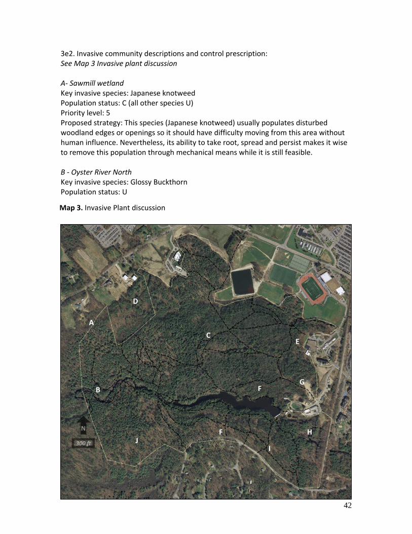
42
3e2. Invasive community descriptions and control prescription: See Map 3 Invasive plant discussion A‐ Sawmill wetland Key invasive species: Japanese knotweed Population status: C (all other species U) Priority level: 5 Proposed strategy: This species (Japanese knotweed) usually populates disturbed woodland edges or openings so it should have difficulty moving from this area without human influence. Nevertheless, its ability to take root, spread and persist makes it wise to remove this population through mechanical means while it is still feasible. B ‐ Oyster River North Key invasive species: Glossy Buckthorn Population status: U
Map 3. Invasive Plant discussion

43
Priority level: 9 Proposed strategy: Use edge control strategy to prevent natural seed distribution outward (e.g. birds or seed drop). Yearly treatment of outward‐most edge of colony with herbicide should be used on this and other “U” populations (based upon time and resources.). In more sensitive areas (e.g. Wetlands or locations with desirable natural vegetation) a similar strategy could be used with cutting, flaming or hand pulling. C‐ Natural Area and surrounding woodland (scattered populations that are centered around natural disturbances) Key invasive species: Glossy buckthorn Population status: C, T Priority level: 1 Proposed strategy: To avoid the potential need (and associated turmoil) that large scale treatment (e.g., herbicides) would result in, the natural area and buffering woodlands should be focused upon as the greatest initial priority. Using large teams (classes, volunteers), transects should be run in late fall (when all other vegetation has lost its leaves). This should make location of individual stems and small populations easier and careful hand‐pulling should result in greatest results overall. D ‐ Channel 11 Wetlands Key invasive species: Glossy buckthorn, multiflora rose. Population status: U Priority level: 8 Proposed strategy: Use edge control strategy to prevent natural seed distribution outward (e.g., birds or seed drop). Yearly treatment of outwardmost edge of colony with herbicide should be used on this and other “U” populations (based upon time and resources.). In more sensitive areas (e.g., wetlands or locations with desirable natural vegetation) a similar strategy could be used with cutting, flaming or hand‐pulling. E‐ Ocean Engineering Key invasive species: Creeping euonymus. Population status: C Priority level: 3 Proposed strategy: Use herbicides to aggressively treat and remove this population. Although this does not appear to move about quickly, our lack of knowledge about it may mean the prudent tactic would be towards immediate action and eradication. F‐ Red pine plantation and upland forest Key invasive species: Glossy buckthorn Population status: U Priority level: 7 Proposed strategy: Use edge control strategy to prevent natural seed distribution outward (e.g. birds or seed drop). Yearly treatment of outwardmost edge of colony with herbicide should be used on this and other “U” populations (based upon time and

44
resources.). In more sensitive areas (e.g. Wetlands or locations with desirable natural vegetation) a similar strategy could be used with cutting, flaming or hand pulling. G‐ Grounds and Roads Key invasive species: Garlic mustard Population status: C Priority level: 2 Proposed strategy: The aggressive nature of this plant requires continued attempts towards removal. Over the past two years this population has been treated with hand‐pulling and this should continue. H‐ Lower Oyster River Key invasive species: Glossy buckthorn Population status: U Priority level: 10 Proposed strategy: Use edge control strategy to prevent natural seed distribution outward (e.g., birds or seed drop). Yearly treatment of outwardmost edge of colony with herbicide should be used on this and other “U” populations (based upon time and resources.). In more sensitive areas (e.g., wetlands or locations with desirable natural vegetation) a similar strategy could be used with cutting, flaming or hand pulling. I ‐ Mill Road Key invasive species: Winged euonymus, Population status: U Priority level: 6 Proposed strategy: Use edge control strategy to prevent natural seed distribution outward (e.g. birds or seed drop). Yearly treatment of outward‐most edge of colony with herbicide should be used on this and other “U” populations (based upon time and resources.). In more sensitive areas (e.g. wetlands or locations with desirable natural vegetation) a similar strategy could be used with cutting, flaming or hand pulling. J‐ College Woods South Key invasive species: Glossy buckthorn Population status: C, T Priority level: 4 Proposed strategy: Use similar strategies to area “C”. Attacking when populations are small will net greatest overall results.

45
4. Vegetation and natural communities See Map 5 Stand Type Map ‐ Discussion The inventory data used here were acquired during a CFI plot installation in August of 2010. Sampling Method: Big BAF Variable plot (1 every 2.5 acres) for overstory trees. Count trees were identified using a prism with a BAF of 20; measure trees are determined using a prism with a BAF of 75. Regeneration was measured using a cluster of 5 milacre plots. 4a.Property wide (all of College Woods) findings: BA/Acre: 202 (SE 5%) Trees Per Acre: 302 (SE 10%) Average DBH: 13.6” (SE 6%) Total operable acres: 231 Average biomass volume per acre(tons): 200 4a1. Property wide cover type discussion Natural community types are groups of plants and other organisms that are often found together on specific site types. Given the climate and soil parent materials of College Woods, the expected natural community type is Hemlock‐Beech‐Oak‐Pine as characterized by Sperduto and Kimball (2011). While this is a very common natural community in New England, College Woods provides excellent examples, and exhibits classic successional stages given the types of disturbance the area has been subjected to (see unique natural features section 4d. Unique Natural Features). Within these communities, we expect to find a wide diversity of plants. Historical records (Natural Area Files circa 1970s) shows the presence of 292 vascular plants in the the Natural Area and adjacent reservoir. This number represents over 10% of the flora of the State of New Hampshire. There are 260 flowering plant species, 25 ferns and allies, and 7 gymnosperms on the list, but none are known to be rare or endangered at the state or federal levels. Twenty‐nine species are reported from the reservoir or close to it, implying that 263 species are limited to the uplands and wetlands of the Natural Area. Of course, it is likely that there are additional species in College Woods outside of the Natural Area. An up‐to‐date, property wide survey is needed. Summary data of forest types are generally more up to date and readily available (as is given in the enclosed cruise data). Generalizations about tree populations in College woods can be summarized as: ridges and upper slopes are often composed of dry site species, oaks, beech and eastern white pine pine mostly; mid‐ and lower slopes, valleys and depressions move towards red maple. Hemlock and black birch are ubiquitous.

46
Four major overstory forest community types can be found within College Woods (see Map 5). (Exceptions to this are outlined in the section “unique timber inclusions.”)
Hemlock‐beech‐oak‐pine (in and around the Natural Area; type 2 on Map 5)
Eastern white pine – hardwoods (west of the Natural Area and north of the river, type 1 and 1a on Map 5)
Mixed hardwoods – eastern white pine‐ eastern hemlock (upland areas south of the reservoir and bordering Mill Road; type 3 on Map 5 )
Eastern white pine – eastern hemlock (north facing slopes and riparian zone south of the river and reservoir; type 4 on Map 3)
In identifying cover types and discussing stand development we often are left to postulate the events that have led up to the current composition of the forest. Although that is certainly necessary within this document, we are aided by a number of excellent sources, including several 1940’s era type and plantation maps as well as a series of aerial photos, some dating back to the mid 1920’s. Close observation of these images in sequence shows some striking changes in the composition of the forest over time. As mentioned in the historical review, College Woods has been pieced together using the Thompson Lot as the base. When University foresters described College Woods at the turn of the century, they were mostly talking about the 60 acre natural area (see picture to right). What we call College Woods is a collection of parcels put together mainly during the early 1900’s. As these properties came into ownership, our predecessors put them to immediate use, likely for class lab exercises (planting) as some of these pastures were quickly converted to woodland; this is shown in map 11, plantations.
Picture 7. What College Woods was Photo circa 1940

47
While College Woods is now nearly 100% forest cover, this was not the case even as recently as 1940. Unlike our perception that College Woods is now “shrinking” from the pressure of development over the last 40 years, the woods over the previous 75 years had been expanding outward. This is most evident in the early 1940 aerial where approximately 30 acres (of the current College Woods) were either mown field or recent pasture. Maps from that time (see map “11” plantations) show that these areas were quickly planted, most often with pine but sometimes with unlikely species like scotch pine, blue spruce, Douglas‐fir or various hardwoods. By 1962 (Picture 9) all of these areas were mostly grown up into young woodlands, picture 10 shows the growth as of early 2010 as of early 2010.
Picture 8. 1940 aerial photo of College woods; open areas shaded.
Picture 9. 1962 aerial photo of College woods; northern areas are
quickly becoming forested
Picture 10. 2010 aerial photo of College woods, now nearly 100%
closed canopy forest

48
4a2. About harvesting in College Woods A debate is sure to follow any decision to harvest timber in College Woods. Although limited harvesting has been done as recently as 1991, sentiment has strayed away from implementing harvests in any area of College Woods. This document challenges that point of view. It is clear that the area within and immediately surrounding the Natural Area as well as sensitive areas, such as the buffers to the Oyster River and College and Swamp Brooks are inappropriate to harvest. Many areas could be harvested, however, with little interruption to other uses, benefitting the educational and research use of the area, increasing the health and value of the woodlot, and increasing diversity of wildlife habitat. As is clear by the plantation and treatment maps included in this document, the appearance and structure of the forest outside of the Natural Area is the way it is because of past human intervention, especially timber harvests. Intentional action by decades of University foresters has positively resulted in a dynamic and continuously evolving teaching tool. This approach parallels our mission and should continue. Although this management plan prescribes timber harvests, any specific harvest activity will be precluded by a separate operations plan that would be reviewed and would require approval by the Woodlands and Natural Areas Committee. This operations strategy would act as a supplement to and outline specifics that would be outside of the realm of this management plan.
A
DC
B
Map 5 Stand Type map and discussion

49
4b. Stand Cover types 4b1. Stand 1 – White pine – managed. (see map 5)
Natural Community type : Hemlock‐Beech‐Oak‐Pine BA/Acre: 199 sqft (SE 9 % ) Trees Per Acre: 242 (SE 18%) Mean DBH: 14.8” (SE 7 % )
Volume/Value per acre for major species and overall volume synopsis:
Species Saw (MBF)
Pulp (CDS) Biomass (Tons)
Total Vol (Tons)
Total Value
White pine
8 31 11.25 138 $1,304
Hemlock 0 2.6 2.73 25 $11
Red Oak 1.6 2.2 1.93 13 $489
All other 5.6 9.67 68 $26
Total 25.57 244 $1,830
Dominant tree species in order of prevalence [basal area ft/ac]: White pine [142] N. red oak [15] Eastern hemlock [10], American beech, black birch, black cherry, sugar maple [4‐7] American Elm, bigtooth aspen, red cedar, red maple, red pine, white ash [<5]. Regeneration and woody shrubs (>1000 stems per acre): White pine, poision ivy. Invasive shrub species present: Winged euonymus, Norway maple, glossy buckthorn, honeysuckle, common buckthorn. Stand type one describes 75 acres found mostly in the northwestern corner of College Woods. It is bounded by the UNH sawmill and hayfields to the north, the Natural Area (stand type 2) to the east, woodlands of similar type (but not of UNH ownership) to the west and the Oyster River to the south. It is likely that most of this stand was pastureland around 1900. This table is for illustrative purposes. Volumes per acre are rounded and are of major species. Stumpage values are based on current market prices and do not reflect the entire range of possible products. Total biomass is calculated using Wharton and Griffith (1997), Estimating Biomass.
Graph 1

50
The origin of the majority of this stand was from a series of white pine plantings done between the years 1926 and 1937 (see map 11 plantation locations) although notations on map 16 (“a” “old field pine”) imply that western part of the stand had partially naturally regenerated before the University acquired it (as part of the Moore lot purchases). The remaining area is composed of parcels that prior to University ownership were the Weld and Mathes lots. Harvests on the second growth that came in (or was planted) following pastureland abandonment occurred in 1961, 1979, 1980 and have led to the current condition of the dominant stand (see map 11 treatment map and section 2b3. Forest management.) This stand’s current dominant overstory tree species is white pine, aged 90‐130 years old; the oldest individuals can be found where this stand abuts Stand 2, the natural area. This stand is overstocked at 198 sq ft per acre (white pine basal area 142 and mean diameter 16.8”). The timber quality of the pine is good to very good in the eastern sections while it diminishes in the areas nearing the sawmill lot. This condition is expected given the lack of early management (planting, etc.) mentioned above.
Overall tree vigor is good although a number of larger individuals have succumbed to wind and storm damage in the past years; this is especially true in old field pine areas where there is a large percentage of multiple stemmed or “high risk” trees. This disturbance can be looked on optimistically as a boon to wildlife, although the Natural Area is immediately adjacent and will be a consistent and
dependable snag factory for many years to come Occurrence of other tree species, often in a younger age class, such as pole sized red oak, can often be directly attributed to past management. Most red oak is single stemmed and found in clumps, implying regeneration from seed and quite possibly following harvest that used small group selection methods. These patches of oak dominated hardwood often include several aspen stems. Other species present but not as abundant include hemlock, American beech and black birch. These species do not represent any substantial timber value currently but are of the age class (and quality) to be capitalized upon in future stand entries. The understory is mostly open throughout the stand and conditions are typical of the shallow soiled rocky, dry terrain found throughout this area. Unfortunately, glossy buckthorn outnumbers all other low growth and shrubby understory plants (although poison ivy has a strong presence). Although not overly abundant, you can find patchy
Stand 1
0
10
20
30
6 11 16 21 27 38
diameter class
trees per acre
trees per acreby diameterclass
Graph 2. Stand 1 trees per acre by diameter class

51
areas of woody shrubs, mostly lowbush blueberry, witch hazel and occasional clumps of Canada yew. Young regeneration of tree species is limited to occasional patches of black birch and beech. Areas near the Natural Area have expected low growth of young hemlock. White pine regeneration, although found in great numbers, is variable in the locations it occupies and mostly restricted to disturbance related microsites and not any purposeful silvicultural method. Prescription: Map 5 Stand Type Map ‐ Discussion Whenever feasible, harvests should be implemented in the winter to decrease soil disruption and limit impacts on recreational use. Access to this stand is likely from two locations. Location “A” would be used to access the peninsula that sits to the southeast of the back Channel 11 parking lot; it is secluded from the remainder of the stand by a substantial forested wetland and its feeder and outlet streams. Although a skidder bridge still remains here, it was built prior to the Channel 11 parking lot and during the TSAS logging class harvest in 1982. The brook that comes out of the wet meadow would make it difficult to use the field as a landing although an extremely careful forwarder operator may make this possible. This may require special winter conditions for a TSAS class or internal Woodlands office implemented harvest with creative approach. Location “B” would allow easy access the bulk of the stand. Entry would be through the sawmill and the landing could be constructed just beyond the dividing line between College Woods proper and the sawmill lot; there is already a bar‐way in the stonewall. Operations in this portion of the stand, esp. nearer the river, would require implementation of invasive control efforts prior to stand entry, especially those geared towards Glossy buckthorn. A minimum buffer of 300’ should be observed to the Oyster River, the Natural Area and any of the small forested wetlands in this stand. This buffer should also include portions of the stand that fall within the arboretum loop trail area. Where appropriate, thinning within the permanent white pine plots will be implemented at the same rate as the surrounding stand.
Picture 11 An example of a group of multi‐stemmed mature white pines in the western portion of stand 1.

52
The goal of the next harvest should be both to capitalize on available advanced regeneration as well as introduce regeneration of a commercially desirable species, following the guidelines below: ‐Where no desirable advanced regeneration exists and overstory trees are not financially mature9, thin as part of a two step shelterwood, leaving the most windfirm and valuable trees; remove up to half of the current basal area. ‐Where no desirable advanced regeneration exists and overstory trees are mature, use group selections in appropriate range of sizes (1/4 ac to ½ acre). These groups will often include 5 or more multi‐stemmed large diameter white pine. ‐Where desirable advanced regeneration or pole sized stock can be found it should be released by removing ½ basal area of white pine. Choice of leave tree pine should look towards the next operation (20‐25 yrs.) and should also consider thinning of pole sized hardwoods.
9 Financially mature for white pine is 18” DBH or has defect substantial enough (eg. Multiple weevil, low crook, etc.) that it will never exceed roundwood (eg. pulp) grade.
Picture 12. 1940 aerial : green highlighting shows open areas
Picture 13. 1961 aerial : detail of above area showing obvious planting
patterns
Picture 14. By 1979 these areas were flush with young trees.

53
4b1i. Stand 1a (see map 5) Stand 1 brackets the natural area on its eastern and western sides; stand 1a is the eastern portion. While the western part of this stand was heavily planted by the 1940’s and represents a fairly homogenous age and vegetation makeup, the composition of stand 1a was predestined by more than one origin. As of the mid 40’s a large portion of stand 1a was still open and actively being used to store lumber that was sawn up from the salvage of the 1938 hurricane. Its eventual reforestation resulted in a dense, young white pine stand. A portion of the northern tip of this stand (shown as “sheep pasture” on map 16) appears to have reforested naturally from lack of use, while nearby there was some purposeful planting of white pine and hardwoods in the earlier parts of the century. The southern border of the stand was planted heavily into red pine as shown by the pictures 12‐12, in the late 1950’s and early 60’s; by 1979 these areas were now nearly all forested. Campus development, the decisions surrounding the plantation area (e.g., red pine, a shallow rooted species in marine soils), the proximity to reservoir and the natural area all combine to limit our ability to actively manage this area. Operations in this area will be limited to those that relate to water quality management, timber stand health, and recreation. As no current challenges to these exist, no future operations are prescribed for this area.

54
4b2. Stand Type 2 (83 ac.) (see map 5) Eastern Hemlock ‐ White Pine / Eastern Hemlock – Mixed hardwood – Natural Area Natural Community type : Hemlock‐Beech‐Oak‐Pine BA/Acre: 226 sqft (SE 8 % ) Trees Per Acre: 350 (SE 16%) Mean DBH: 12.3 (SE 6 % )
Volume/Value per acre for major species and overall volume synopsis:
Species Saw (MBF)
Pulp (CDS) Biomass (Tons)
Total Vol (Tons)
Total Value
White pine
3.6 4.3 9.29 38.04 $562
Hemlock 2.6 21.2 28.66 94.66 $482
Red Oak 2.7 7.8 9.63 42.63 $843
All other 7 18.45 35.95 $39
Total 66.04 211.29 $1,927
Dominant tree species in order of prevalence [basal area ft/ac]: Eastern hemlock [96] , n. red oak [39] , white pine [37] black birch [22], American beech [13], red maple [9], basswood, black oak, sugar maple, white ash, white oak[<3]. Regeneration and woody shrubs (>1000 stems per acre): Many individual species were present but none at this level, greatest was eastern hemlock saplings (148 stems per acre) and American beech seedlings (152/acre) Invasive shrub species present: Glossy buckthorn, honeysuckle.
This table is for illustrative purposes. Volumes per acre are rounded and are of major species. Stumpage values are based on current market prices and do not reflect the entire range of possible products. Total biomass is calculated using Wharton and Griffith (1997), Estimating Biomass. It also should be noted that the bulk of white pine volume is mostly attributed to the oldest and largest individuals; it is unlikely, therefore, that this volume/value actually represents saleable (sawable) material given its age and size).
Graph 3

55
The natural area is approximately 70 acres in size and sits central to the northern half of the property. It is bordered to the north by the College Brook and athletic fields, the reservoir to the south, stand 2 (predominantly white pine) to the west and mostly mixed
development campus area to the east. This stand has been historically referred to as Ben Thompson’s woodlot, or the Thompson parcel. It is probable that this lot was cleared at the same time as the rest of the area (by early settlers) but unlike the other areas was left to revert to woodland. Since areas to the west (specifically the Moore parcel) have similar soil types, terrain, and eventual pasture abandonment history, the combination of the Natural Area and stand one represent a rich visual representation of the various stages a forest steps through on its way to its climax type. Although the majority of this stand is naturally regenerated, older maps (see plantation map 11) show that limited planting occurred between 1913 and 1916 and then
again in 1942 in what we now know as the natural area. Species planted here included white pine and unusual species like scotch pine, some of which persisted and can be easily located. These plantings occurred mostly before the 1938 hurricane, making it likely that some of these individuals are now lurking amongst the age class that regenerated/profited from the storm release. It also appears that the area on the northern fringe of the natural area and surrounding College brook may have remained open until the years preceding 1937 (see Map 13 land use), which may be why some of these areas were chosen for planting. Additionally, areas on the fringe and possibly including the eastern boundary of the natural area were open until the early 1940’s, where eventual building infringement appeared to make what were former pasturing areas too small to be useful and the inevitable reversion to woodland quickly followed.
Picture 15. Scotch pine in the Natural Area; records show this tree was planted in 1913.
Picture 16. Blown down by the ’38 hurricane,
this root wad settled back after the tree was salvaged

56
The current stand condition is multi‐aged although this timber survey will group together all of the younger age classes in one strata (B) and the oldest age class in another (A). The older age class consists of eastern hemlock and more notably, large diameter white pine. Both species have a number of individuals with DBH > 40” with some exceptional larger stems (see map 6). Age of this strata (strata A) ranges from 2‐300+ years old and is composed of trees that most likely came in following clearing by early settlers and in recent history, survived a series of powerful storms, the most infamous being the 1938 hurricane. Following these storms, the areas of blow‐down were quickly populated by (chiefly) hemlock regeneration, but also abundant black birch, red oak, and American beech (strata B). This age class covers a wide range and is approximately from 60‐110 years old. Other small gaps have recently formed as the larger survivors continue to topple, moving this stand eventually towards a multi, multi‐aged condition.
The vigor of the dominant white pine is slowly diminishing, lower crowns have become non existent and the tops are ever shrinking. On approach into campus from Route 4 a number of these gnarled specimens can be seen looming above the rest of College Woods. Dominant hemlock
Picture 17. 1939; looking south into the Natural Area
blowdown
Stand 2
0
20
40
60
80
5 10 14 18 23 28
diameter class
trees per acre
trees per acreby diameterclass
Graph 4. Stand 2 Trees per acre by diameter class

57
remains acceptably healthy for its age although its crowns are admittedly thinner than you would expect on stems of highest vigor. The health of trees in strata B is mixed. Crown size and depth are as good as can be expected in younger stands grown at this density (which is quite high at a basal area of 226 sq ft/ac ). As is common in our region, American beech is under attack by beech bark disease (Nectria coccinea var. faginata) and we also find (albeit rarely) black birch afflicted by bullseye canker (Nectria galligena). In stands under management, these diseases would be of high concern because of the dire impact on timber value. Our interest is more in how the stand may develop, especially with a looming infestation of hemlock woolly adelgid. Prescription: This stand will remain unmanaged. See section 3d. Invasive Plants and Pests for prescriptions on how pests will be managed.

58
4b3. Stand 3 (38 ac.) Mixed wood – Red Oak dominant – Managed stand (see map 5) Natural Community type : Hemlock‐Beech‐Oak‐Pine BA/Acre: 159 sqft (SE 19 % ) Trees Per Acre: 380 (SE 32%) Mean DBH: 13.3 (SE 22 % )
Volume/Value per acre for major species and overall volume synopsis:
Dominant tree species in order of prevalence [basal area ft/ac]: n. red oak [39] eastern hemlock [25] , white pine [25] black birch [17], red maple [13], basswood, black birch, black cherry, black oak, quaking aspen, red cedar, red pine, shagbark hickory, white ash, white oak[<3]. Regeneration and woody shrubs (>1000 stems per acre): White pine. Invasive shrub species present: Winged euonymus, glossy buckthorn, honeysuckle, Japanese barberry, Russian olive. This stand is composed mostly of the Teeri lot and a small portion of the Ellison and Niemi Lots. All of this area had at some time been pastured, and the variation in age and size classes, as well as specific species, is attributed to the slow accumulation of these lots and eventual reforestation. As of
This table is for illustrative purposes. Volumes per acre are rounded and are of major species. Stumpage values are based on current market prices and do not reflect the entire range of possible products. Total biomass is calculated using Wharton and Griffith (1997), Estimating Biomass.
Species Saw (MBF)
Pulp (CDS) Biomass (Tons)
Total Vol (Tons)
Total Value
White pine
0.24 4 1.77 12.97 $49.77
Hemlock 4 8.49 18.49 $20.49
Red Oak 3 10 21.45 61.45 $951.45
All other 8 17.36 37.36 $41.36
Total 49.06 130.26 $1,063.06
Graph 5

59
≈1937, (see map 13 land use) the level area near the road was still shown as being in pasture, and was therefore a likely target for planting classes. The presence of red pine and other unusual species (spruce) is due to plantings that occurred between 1928 and 1938 (see map 11 Plantations) and that focused on these areas. The greatest rate of
reforestation appears to be between the early 50’s and late 70’s (see pictures 18 and 19 below) where all open spots had apparently benefited from planting as well as natural regeneration. In overt acts of discrimination against hardwoods, white pine was planted in areas of the stand following the harvests in the 1960s and hardwoods were poisoned and girdled in periods between the late 60’s and early 80’s (see map 12 Treatment areas) . Some insight on management on
this area was given through personal communication with Dick Weyrick: “ in addition to the harvests in 1960 and 1962, there was subsequent harvest activity close to Mill Road around 1965. My recollection is that all the harvests were strip cuts, with site prep and planting to pine. The earlier plantings were red pine and mixes of red and white pine, and the later plantings were white pine, using both direct seeding trials and seedlings, in connection with regional white pine research efforts. I believe that there are research reports describing some of this work.”
In the 1970’s, there was student work done to manually release the white pine from the hardwood (mostly oak) competition. This was all for naught, for the gypsy moth outbreak of the early 1980’s resulted in pretty complete mortality of the young white pine. Since that time, the oaks have claimed a dominant position in the more recent harvest areas.” Currently, this stand is a mixed wood stand, with a majority of red oak. White pine and hemlock are both present in lesser numbers interior to the stand; the data (which seem slightly deceiving) probably is a result of sampling “slop‐over” from methods capturing where this stand mingled with other types. The white pine interior to the stand is mostly of a larger size class (avg. diameter 20”) than other
Picture 19. Stand 3 1979
Picture 20. Stand 3 1953
Picture 18. pole sized hardwoods in stand 3

60
species here and individuals often stand solitary and above the rest (eg. red oak mean diameter is 12”). Although this stand is considerably younger, the look of it is not entirely unlike that of a little sibling to the Natural Area; scattered large diameter softwoods often towering over a smaller and crowded understory of hemlock and mixed hardwoods; this is also represented in the graph below showing diameter class and trees per acre. The vertical disparity in stand 3 is the result of past management practices (harvests in 1960 and 1962) though and not the result of centuries without management and a big wind. Currently, the quality of white pine is greater in larger diameter stems; generally the younger stems have the poor form associated with open growth or have small crowns that are due to the thriving and more competitive hardwood stems within the stand. Conversely, young red oak seems to like the high ground of this site; it shows good growth form and rate and generally has appropriately large crowns that have good fine twig development. Other species have average quality for this site and our region. Prescription (present to 2022): See Map 5 Stand Type Map ‐ Discussion This stand is ready at any time for treatment. Ideally, non‐native invasive plants should be kept in check prior to overstory removal or large scale disturbance. Small
clumps of glossy buckthorn and others can be found in limited areas in this stand. One main goal should be to remove larger diameter white pine stems where financial maturity has been achieved. Low snag occurrence, however, here may dictate girdling some of the poorer formed large diameter individuals (1 or 2 per acre) as well as retention
of a similar number of live larger diameter stems for vertical diversity. High quality red oak pole and small sawtimber stock should be thinned as well as the occasional quality white pine stems. In absence of white pine or red oak crop tree, “best tree” crown thinning method should be used, following (in descending order) these priorities: species diversity, tree vigor, wildlife value, commercial value, size. A majority of larger oak stems and edge areas of hemlock thicket should be preserved for wildlife value. The basal area law should be conservatively followed along Mill Road and harvesting and access roads should be located away from any area of relief that drains to the reservoir.
Stand 3
0
50
100
7 10 15 18 23 45
diameter class
trees per acre
trees per acreby diameterclass
Graph 6 Stand 3 trees per acre by diameter class

61
4b4. Stand 4 (45 ac.) White Pine – Managed stand (see map 5) Natural Community type : Hemlock‐Beech‐Oak‐Pine BA/Acre: 200 sqft (SE 14 % ) Trees Per Acre: 248 (SE 19%) Mean DBH: 14.6 (SE 16 % )
Volume/Value per acre for major species and overall volume synopsis:
Species Saw (MBF)
Pulp (CDS) Biomass (Tons)
Total Vol (Tons)
Total Value
White pine
10.5 27.8 30.91 152.91 $1,689
Hemlock 1 5 6.43 23.93 $171
Red Oak 2 8.14 13.14 $14
All other 6 10.13 25.13 $28
Total 55.61 215.11 $1,903
Dominant tree species in order of prevalence [basal area ft/ac]: white pine [131] , eastern Hemlock [24] n. red Oak [13], black birch [8], red maple [7], American elm, balsam fir, bigtooth aspen, black cherry, blue beech, red cedar, shagbark hickory, sugar maple, white ash[<3]. Regeneration and woody shrubs (>1000 stems per acre): white pine. Invasive shrub species present: Winged euonymus, glossy buckthorn, honeysuckle, Japanese barberry, multiflora rose. This stand is composed of sections of the Teeri, Ellison, Niemi, and Moore lots. As with stand 3, it had all been formerly pastured, as shown both through the presence of dividing stone walls, obvious young regrowth in early aerial photos and current composition of vegetation. A number This table is for illustrative purposes. Volumes per acre are rounded and are of major species. Stumpage values are based on current market prices and do not reflect the entire range of possible products. Total biomass is calculated using Wharton and Griffith (1997), Estimating Biomass.
Graph 7

62
of areas have been planted and/or direct seeded to pine (much of the white pine in the upper/middle aged size class originated from a series of plantings between the years 1937 and 1938), but hardwoods have come in, mostly just from past harvesting practices. Currently dominated by healthy white pine, this area is differentiated from stand three mostly by a greater abundance and range of size classes of hemlock as well as a greater presence of quality mature white pine (mean DBH 22.9”). Volume per acre of white pine is an impressive 153 tons and the sawtimber portions of these stems represent the greatest current value in this stand. Scattered throughout the stand are pockets and single stems of well formed (future) high quality red oak (mean dbh 6.8”) that benefited from release during recent harvest activity, such as harvests in 1962 and 1964. Younger pine size classes (≈50 yrs old) originate from plantings and direct seeding that also followed this harvest. Other species within this age/diameter class are black birch, red maple and sugar maple, all of which appear suited to this site and healthy. Prescription (Harvest 2020‐2025) Map 5 Stand Type Map – Discussion The presence of pocket wetlands and occasional low wet areas will require the judicious location of skid roads for access into this stand especially in the western portions. Far eastern portions of this stand are mature enough for harvest although implementation may be difficult from high recreational use on the trail that runs central to this area. With the exception of the area immediately surrounding the trail that links the upper bridge and Mill road, the far western portion of this stand differs in the density and quality of pine. In general, overstory pine in this area is smaller in diameter and total height; this may be attributed to shallowly formed soils. Timber harvesting in the 60’s and 70’s provided adequate spacing for crop trees resulting in appropriate crown width and depth for vigorous trees of this age. Although past management documents called for harvest in 2005 there is no desirable advanced regeneration at this point. Any harvest, therefore, should aggressively seek to perpetuate pine here using shelterwood methods. Volume and size distributions would reasonably dictate that only two commercial sales are viable for this stand. Crop tree diameter should be slightly larger (in 10‐15 years), prior to the first cut. Removal of up to half of the volume should allow
Stand 4
0
20
40
60
5 9 15 19 25 30
diameter class
trees per acre
trees per acreby diameterclass
Graph 8 Stand 4 trees per acre by diameter class

63
for openings large enough to regenerate pine and perform a release cut in 20‐30 years. In limited areas pole sized and small sawtimber red and black oak have come in. These small pockets should be thinned appropriately at the time of next harvest. In the north‐central portion of this stand, where hemlock and pine create a substantial buffer to the reservoir, is where volume and density is highest. These trees will most likely be preserved for important functions (e.g., water quality, wildlife habitat) not directly related to timber production. Where this stand mingles with the plateau section of stand two limited harvest activity may occur at the time of harvest and under the prescription standards of that stand. Unlike other portions of the property, portions of this stand (as well as stand three) represent appropriate levels of both winter cover and food sources for deer. High levels of recent activity (winter 2009‐2010) show that protection of areas where hemlock thicket and hard mast sources meet should be prioritized.

64
4c. Wetlands and Related Natural Communities Reference Map 4 for locations discussed in this section
The following section identifies and describes wetland areas and the often unique related natural communities that are found within them. A Mixed hardwood‐eastern white pine forested wetland Overstory : Red maple, shagbark hickory, white ash, American elm, black cherry, aspen and a small amount of white pine. Understory: The shrub layer is dominated by exotics, primarily glossy and common buckthorns and multiflora rose. The herbaceous layer is dominated by intermediate wood fern and includes an anomalous patch of Japanese knotweed.
Map 4 Wetlands and natural communities

65
Unique characteristics: While this shallow depression has wet soils, the vegetation does not include any obligate wetland species. The presence of American elm and white ash suggest some soil enrichment, and this community does provide diversity in cover type, varying from the oak‐pine dominated upland to the south and the developed/open land to the north. The size and vigor of the invasive common buckthorn at this site is unusual in our area, and should be of concern. B Mixed hardwood‐eastern white pine forested wetland Overstory : Red maple and “old‐field” eastern white pine dominate, but the canopy includes American elm, shagbark hickory, white ash, and several other hardwoods. There are a number of pole sized and larger Norway maple, an exotic tree species. Understory: The shrub layer is dominated by exotics, with dense thickets of glossy buckthorn and lesser amounts of multiflora rose, especially where the forest canopy is less dense. Native shrubs include speckled alder and winterberry holly. The herbaceous layer is diverse, with sensitive fern abundant and patches of reed canary grass where the forest canopy is sparse. Unique characteristics: Areas surrounding this wetland have been aggressively harvested within the last 20 years. This primarily forested wetland is highly heterogeneous due to variation in both hydrology and history. It offers diversity in cover type that varies from the upland to the south and developed/open land to the north. There is a small stock pond here that is approximately 1/10 ac; bodies of open surface water are uncommon in College Woods. Water that gathers in this drainage eventually forms
1) The stream that makes the meadow south of the Channel 11 studio seasonally wet.
2) The beginnings of a major tributary of College Brook.
C Mixed tall graminoid scrub‐shrub meadow marsh. Dominant vegetation: Wetland shrubs include: winterberry holly, speckled alder meadowsweet, steeplebush, silky dogwood, willows. Herbaceous layer ; Canada bluejoint grass, manna grass, and other wetland grasses; numerous sedge species, broad‐leaved cattail, flat‐topped aster, rough‐stemmed goldenrod, grass‐leaved goldenrod, Canada goldenrod, marsh fern, sensitive fern. Unique characteristics: This small 1 acre swamp is where water becomes organized and a stream channel begins to take shape. Within this string of wetlands (A, B, and C map 4), this is unique in its open overstory and the large number of wetland graminoids (sedges and grasses). Though small, this is an excellent example of the tall

66
graminoid scrub‐shrub natural community (Sperduto and Kimball 2011). Because of this unique vegetation and the interaction with hardwood‐dominated woodland to the north and softwood dominated woodland to the south, we expect a high diversity of wildlife here. D Riparian zone of upper College Brook: Mixed tall graminoid – scrub shrub meadow marsh Shrub Layer: speckled alder, nannyberry, wild raisin, silky dogwood, winterberry holly, glossy buckthorn, Herbaceous layer: a near monoculture of reed canary grass (probably the exotic genotype) This area is the transition zone between the meadow to the north and east and the mixed wood upland to the west. These wetland areas are influenced by College Brook, which runs through this community and under the athletic fields before gathering water from areas “C” and “B”. The community is heavily invaded by reed canary grass and glossy buckthorn and is thus a less well developed example of this type than is wetland C. E and F Riparian Zone of lower College Brook: Alluvial alder thicket and red maple ‐ black ash swamp Tree species: black ash, white ash, American elm, basswood, red maple, sugar maple, hemlock, red oak, musclewood, shagbark hickory. Shrub Layer: speckled alder (some areas a nearly pure speckled alder without tree cover). Herbaceous layer: sensitive fern is common throughout, but some areas would be classified as “sub‐acid seep natural communities” (Sperduto and Kimball 2011); these small but significant communities include: foamflower, golden saxifrage, and swamp saxifrage. Here, College Brook gathers water from its numerous sources and becomes a well pronounced steam. Athletic fields abut its eastern edge while its western edge moistens the upland forest areas, creating sporadic pockets of alder (alluvial alder thickets; see Sperduto and Kimball 2011) and other wetland shrubs, as well as a healthy pocket of black ash. Further towards the eastern entrance, “F” on map 7, diversity of vegetation (high and low layers) is unusually high. There is an exemplary red maple – black ash – swamp saxifrage community in this area (see section on “unique natural features”).

67
G Headwaters of Swamp Brook: Hemlock‐white pine forested wetland This small perched wet area is unique mostly in its isolation. A few individuals of northern white cedar can be found surrounding this wetland. Hemmed in on all sides by a mature hemlock/pine, it is where water gathers at slight elevation to contribute to the wetlands below (starting with “H”) and eventually creating Swamp Brook. At the time of observation (December) there was a thick layer of ice here; it is likely that this area holds water for a majority of the year. H Red maple ‐ black ash swamp Here, Swamp Brook takes form and eventually crosses under a recreational trail, feeding a more extensive wetland area to the south (including “I” and “J”). The surrounding area has a number of wetland‐associated tree species including red maple, black ash, American elm, and musclewood. Species composition and growth form of upland trees species on the fringe of this wetland implies enrichment; this is also supported by species in the herbaceous layer that include pennywort and avens. Small patches of foamflower and golden saxifrage suggest sub‐acid seepage within and adjacent to this swamp. I and J Lower riparian zone of Swamp Brook: Mixed hardwood swamp This area is the final wetland area of Swamp Brook before it exits College Woods. In the northeastern corner is a burgeoning population of the non‐native invasive creeping euonymus. Shrub species here include: speckled alder (in the more open areas) tree species include: red maple, sugar maple, white ash, American elm with a diverse herbaceous understory of sensitive fern, dwarf raspberry, manna grass, avens, and many other species. As the brook exits the wood it finds a wide low area, creating a marshy wet opening that is populated by various wetland sedge species and cattails. Where it flirts with the soft edge of the woodland, it creates excellent growth conditions for clumped wetland shrub thickets composed of speckled alder, silky dogwood and meadowsweet. A good diversity of tree species includes small diameter groups of quaking aspen and red maple. Blowdown in the nearby woodland and the subsequent cleanup has created an interesting small opening adjacent to this, early successional growth will add to the diversity of age groups in the area; the adjacency to wet areas will be highly beneficial to wildlife K Red maple swamp This small red maple‐dominated wetland pocket hosts a variety of wetland shrub species, especially speckled alder, and a healthy population of invasives, especially glossy buckthorn. During high water surface drainage is directly into the reservoir and

68
the vegetation growing here likely acts as a collecting point and buffer to runoff from upland areas. L Forested wetland and intermittent stream
Overstory: Red maple, white ash, shagbark hickory, red oak, and eastern hemlock comprise the canopy of the southern half of this linear wetland, while eastern hemlock and white pine dominate the northern, downstream portion.
Understory: In the southern half of the wetland, the invasive shrub glossy buckthorn is the most common shrub but is never abundant. The herbaceous layer here includes intermediate wood fern, sensitive fern, white avens, and various grasses and sedges. The northern half of this wetland is devoid of understory vegetation, probably due to the dense hemlock canopy.
Unique characteristics: The intermittent stream originates at a seep located just north of Mill Road and about 50 m northwest of the trail head and Arsenault Memorial. Further north, downstream and downslope, the gradient steepens slightly and the stream appears to lose influence on the bankside vegetation, running through what is essentially a hemlock‐dominated upland forest until it reaches the Oyster River. M Red maple‐American elm forested wetland Overstory: Red maple with American elm and a few bigtooth aspen and white pine. Understory: Glossy buckthorn (invasive) dominates the shrub layer. Drooping wood reed and other graminoids are present in the sparse herbaceous layer.
Unique characteristics: This small wetland drains, in part, the larger wetland on private property to the south. During high water, there is likely surface drainage from this area downhill to the Oyster River. N Red maple‐American‐elm‐eastern white pine forested wetland Overstory: A mix of mainly upland tree species, with red maple, eastern white pine, American elm, red oak, shagbark hickory all present.
Understory: The shrub layer is sparse, with winterberry holly and exotic glossy buckthorn. Herbaceous plants include extensive intermediate wood fern, partridgeberry, and scattered grasses and sedges.

69
Unique characteristics: This small wetland also likely drains the larger wetland on private land to the south. O Red maple‐elm forested wetland Overstory: Red maple, American elm, sugar maple, shagbark hickory are present. Understory: A thick shrub layer dominated by exotic glossy buckthorn, and a few native speckled alder and winterberry holly. The herb layer is fern‐dominated, with both sensitive fern and intermediate wood fern. White avens and swamp dewberry are also present.
Unique characteristics: This area, which is small but structurally unusual for College Woods, is a drainage basin for the higher elevation property to the south and beyond the boundary of College Woods.

70
4d. Unique Natural Features The following section describes natural features that are recognized as unique on a regional scale. (a) Exemplary hemlock‐beech‐oak‐pine and hemlock‐pine Communities (see “A” on map “6”, individual trees marked “ * “) The College Woods Natural Area provides excellent examples of hemlock‐beech‐oak‐pine forest and hemlock‐pine forest, examples that are cited by Sperduto and Kimball (2011) in The Nature of New Hampshire: Natural Communities of the Granite State. While these forest communities are not uncommon in New Hampshire, the examples at College Woods are exceptional due to the great size and age of the eastern white pine and eastern hemlock trees. There are at least 10 eastern white pine individuals that exceed 1 meter (3.3 feet) in diameter at breast height (DBH), and some that exceed 35 meters (120 feet) in height. There are 37 white pine trees with DBH exceeding 90 cm
Map 6 Unique natural features

71
(ca, 3 feet; see A and individual trees on Map 6). Some of the pines exceed 300 years in age (based on estimates given in Stevens 1954, Lyon and Reiners 1971). Some eastern hemlock individuals approach or exceed 90 cm (3 ft) in diameter and exceed 200 years in age (Henderson, unpublished). Old hemlock‐pine forest, which we defined as areas of large pine and hemlock at least 80 cm DBH that lack evidence of disturbance by the great hurricanes of the 20th Century, occurs in six patches mainly in the western, northern, and central portions of the Natural Area (see A Map 6). Hemlock‐pine forest is a later successional stage of hemlock‐beech‐oak‐pine forest. The unusual and regionally significant properties of the forest communities in the College Woods Natural Area are well known to scientists and naturalists and are cited in Lyon’s and Reiners’ (1971) Natural Areas of New Hampshire, Jorgensen’s (1977) A Guide to New England’s Landscape, and Sperduto and Kimball (2011) as noted above. (b) Exemplary Wetland Communities While the hemlock‐beech‐oak‐pine forest of the natural area is the most widely acknowledged natural feature of College Woods, there are a number of other exemplary natural communities, several of which have been cited by the State’s Natural Heritage Bureau in Natural Communities of New Hampshire (Sperduto and Nichols 2004). Two community types considered as rare or imperiled in the state (with fewer than 20 occurrences statewide) are the red maple – black ash – swamp saxifrage community and the red maple – elm – lady fern silt forest (Sperduto and Nichols 2004; see “B” on FIG MAP 6). In College Woods, neither of these is limited to the natural area; in fact the most complete example of the former lies outside the natural area close to the eastern boundary of College Woods (see “B” on Map 6). Subacid forest seep communities also occur along the northern edge of the natural area and on the north side of the central wetland (see “C” on Map 6).

72
5. Ecological and use value of College Woods A thorough evaluation of the ecological and use value of College Woods has recently (2011‐2012) been undertaken by members of the University community. A description of the rationale and methods behind the analysis, as well as the results, can be found in a partner document to this management plan, (The College Woods Assessment). This document also shares many attributes of this plan but differs in its exclusion of contextual management topics. The findings of the assessment are important in our consideration of how this property is to be used in the future. By knowing where past focus has been, smart choices can be made to insure that important areas are kept available for use as a facility by members of the greater University community. (The following is excerpted from College Woods Assessment) INTRODUCTION The purpose of this assessment is to 1) identify those areas of College Woods that have greatest value in the undeveloped state, 2) to make recommendations about future use, and 3) to delineate a boundary for what should be designated as undeveloped land. It is important to note that this report evaluates areas within College Woods relative to each other and not in any absolute sense; in some instances a section of College Woods assigned a low value within the confines of this report may, in fact, have high value when placed in the context of the local community, town, or state. Additionally, consideration should be given to the fickle nature of the term “use”; the valuation presented in this document is a snapshot in time; as people and interests come and go, so do patterns of use. METHODS The Advisory Committee on Land and Property Use was charged with assessing College Woods, both in terms of the current uses as well as the ecological (i.e., natural resource) values. Although “use” and “value” can be interrelated, it is most useful for this process that they be analyzed separately. In addition, the committee was charged with analyzing uses and values spatially, at different locations throughout the woods. To allow spatial analysis, College Woods was broken down into 79, square, 5 acre blocks (as shown in map 18) using ARCMAP GIS. Recreational use in each block was assessed based on the presence of trails, trail junctions, bridges, and entrances (trailheads). Educational use per block was based on student visits as estimated from a survey of faculty. The ecological value of each block was based on ecosystem services (mainly drinking water protection), biodiversity, and timber value present, as well as the remoteness of the block and its role in connecting College Woods to nearby undeveloped lands. Indices of 1) recreational use, 2) educational use, and 3) ecological value were created and these were synthesized to produce an overall use and value index, in which the three components were weighted equally. RESULTS Given the assumptions made and algorithms used in the valuation methodology, our assessment established clear spatial patterns of current educational use, current recreational use, and ecological value for College Woods. Areas of greatest

73
recreational value (Maps 24,25) included major entrances (Main Street, campus, and Mill Road), major trail junctions, the trail corridor surrounding the Oyster River and reservoir, and the extensive trail network within the natural area. A recreational survey conducted in 2011 at the three major entrances conservatively estimated yearly use at over 14,000 visits; the bulk of these visitors likely use the trails in the areas mentioned above. Based on the faculty survey, areas of greatest educational and research use (Maps 20 and 21) were found in areas centered around the natural area, in blocks north of the reservoir, and within and adjacent to the entire Channel 11 peninsula. Intensity of use appears to be dependent upon distance from campus; as class time is precious it makes sense that areas closest to campus are used more intensely. That the Channel 11 peninsula, which ranks among the highest use blocks, is far from campus, suggests that these blocks have other compelling characteristics that attract teaching faculty. Surveys of educational and research use put total student visits at 5240 per year. Areas of greatest ecological value (see maps 22 and 23) were those immediately surrounding the reservoir, the natural area, and the northernmost boundary (south of Cowell Stadium). Areas of lowest relative ecological value were the Channel 11 peninsula, near the main entrance of College Woods, and along Mill Road and the southeastern‐most boundary.
Overall, considering all uses and values, the most highly ranked areas were clustered about the reservoir, the natural area, and the Channel 11 peninsula (see map 26. Lowest use areas were those immediately east of Leawood Orchard and along the immediate southwestern, southern, and southeastern boundaries of the property. Recommendations Based on the overall assessment of uses and values, we recommend the long term protection of three contiguous areas within College Woods. The first of these is the land surrounding the Oyster River and Oyster River reservoir for a distance approximately 600’ north and south of the of the river (denoted as A on Map 26). This area encompasses most of the immediate watershed of the reservoir and would be sufficient to protect the drinking water supply; it also protects areas of high recreational and educational use. The second area (B on Map 26) includes all land north of the
A
B
CD D
D E
Map 26. College Woods. Areas A, B, C recommended for long‐term protection. Areas E and D discussed in text.
E E

74
reservoir on the eastern side of a line that is 500 feet west of (and running parallel to) the natural area boundary and north of the reservoir. This area includes and effectively buffers the natural area, preserving some of the highest educational and recreational use areas and protecting the unique ecological and cultural components, including ancient trees and old forest, found here. The third area (C on Map 26) is the Channel 11 peninsula, a prime educational and recreational resource.
These three areas should be protected through a conservation easement.
Additionally, all other lands within the current boundaries of College Woods (denoted as E on Map 26) should be internally designated for “no development” in the near future, with allowance for periodic reconsideration during updates of the Campus Master plan. It is also recommended that greater awareness is given to development along the northern edge of College Woods in the vicinity of College Brook (area D on Map 26).

75
6. Operations Actions and Operations These are proposed to fulfill the objectives as defined in earlier proportions of this document. Each objective is given below with an expected course of action: Objective: 1. Provide and maintain the health and diversity of vegetation, age classes, and stand types for educational and research use.
Action items: (2012‐continuous) Effort (part of 1 week/year invasive plant control effort)
Implement immediate non‐native invasive plant and pest detection and control efforts as defined under 3d. Invasive Plants and Pests. Upon discovery of HWA within any area of the College Woods, implement control program as funds are available. These controls may use pesticide within the Natural Area to preserve some of the larger and older hemlock trees. 2. Maintain current recreational use and infrastructure. Limit unapproved recreational use outside of current trail and road systems.
Action items: (2012‐continuous) Effort (part of 1 week/year recreation management effort)
Care for trails as prioritized in section 2b4i. Recreation Future needs. Establish closer connection with campus recreation to identify desired uses and cohesive programs to use College Woods effectively. 3. Identify and monitor areas of educational and research use. Action Items: (2012‐ongoing) Promote registration of use through website CRA form. 4. Work with UNH administration to identify key areas where edge infringement could damage the integrity of the College Woods resource as a whole. Work towards permanent protection of these areas. Action items: (Immediate) Use information from this management plan to inform ecological assessment document for administrative review. 5. Work with different internal university departments to limit degradation of College Woods resources (e.g., College Brook). Action items:

76
(Future) Seek to have green buffers in place for sensitive areas like College Brook and the Natural Area based upon current science. Attempt involvement in future planning of development around College Woods (e.g., Loop road development). 6. Design management operations in such a way as to increase the utility of the property by wildlife. Action items: (unknown; future) Implement harvests that create or maintain a variety of age classes in those areas (especially on the western edge of the property) that have the least interference with recreational, research and educational use. Provide appropriate assistance to maintain the block of property to the west (not in UNH ownership) as conserved and in a state similar to its current age and vegetation makeup. Encourage UNH administration to assist in the conservation of the lands upstream of the College Woods. 7. Support programs that promote the functional integrity of the Oyster River as well its role as a drinking water source for Durham and UNH. Action items: (unknown; future) Work with water experts to help limit development along areas that supply the Oyster river (e.g., feeder streams and wetlands) as well as the river itself. Provide information regarding College Woods to local groups to assist in the permanent conservation of the lands upstream of the College Woods. Encourage UNH administration to assist in the conservation of the lands u pstream of the College Woods. Make this and other documentation readily available for public use. 8. Work with abutting landowners towards a landscape management approach. Action Items: (unknown future) Maintain contact with abutting landowners and continue communication with local land management groups (e.g. Durham Conservation Commission). Encourage UNH administration to assist in the conservation of the lands upstream of the College Woods. Make this and other documentation readily available for public use.

77
Map 1 File reference map

78
Map 2 Compartment Map with discussion
A
C
D E
B

79
Map 3 Invasive plant discussion

80
Map 4 Wetlands and natural communities discussion

81
Map 5 Stand Type map and discussion
Map 6 Unique natural areas marked by letter; individual large trees denoted (*)
A
D
C
B

82
Map 6 Unique natural areas marked by letter; individual large trees denoted (*)

83
Map 7 Recreation features map
A
F
E
D
C
B
G
H
I 4
3
1
5
9
8
7
6
K
2
J
H

84
Map 8 Recreation map ‐ discussion Map 9 Detail Plantation Locations circa 1929
H
13
A
C
DE
2 4B
F

85
Map 9 Early plantation locations

86
Map 10 Plantation Locations 1929

87
Map 11 Plantations circa 1941‐1942

88
Map 12 Treatment Map circa 1960‐1988
b
c

89
Map 13 Land Use Circa 1937

90
Map 14 Open land connectivity. Red lines indicate major anthropogenic barriers to wildlife. Arrows indicate likely corridors.

91
Map 15 Wildlife discussion
g
f
h
i
N
300 ft

92
Map 16 1940’s era type map Map 17 Soil Map
B
A
E
D
C

93
Map 17 Soils map
N
300 ft

94
Map 18 College Woods with grid overlay

95
Map 19 Overall indices by block.

96
Map 20 Research and educational use ; block number in white, score in black. Darkest areas are highest use.

97
Map 21 Research and education use; areas of highest use shown with dot densities. (1 dot = 1 visit, threshold for highest is score equal to or greater than 75)

98
Map 22 Ecological value ; block number in white, score in black. Darkest areas are highest use.

99
Map 23 Ecological value ; areas of highest use shown with dot densities. (1 dot = 1 visit, threshold for highest is score equal to or greater than 40)

100
Map 24 Recreational value; block number in white, score in black. Darkest areas are highest use.

101
Map 25 Recreational value; areas of highest use shown with dot densities. (1 dot = 1 visit, threshold for highest is score equal to or greater than 75)

102
Map 26 College Woods. Areas A, B, C recommended for long‐term protection. Areas E and D discussed in text.
A
B
C
D D
D
EE

103
Table 1 Trees, shrubs and woody plants observed at College Woods American beech Fagus grandifolia American elm Ulmus americana Bigtooth aspen Populous grandidenta Blue beech Carpinus caroliniana Basswood Tilia Americana Black ash Fraxinus nigra Black cherry Prunus serotina Black oak Quercus velutina Black birch Betula lenta Eastern hemlock Tsuga canadensis Gray birch Betula populifolia Hophornbeam Ostrya virginiana Pitch pine Pinus rigida Quaking aspen Populus tremuloides Red oak Quercus rubra Red pine Pinus resinosa Red maple Acer rubrum Red spruce Picea rubens Shagbark hickory Carya ovata Sugar maple Acer saccharum Yellow birch Betula lutea White ash Fraxinus americana White birch Betula papyrifera White oak Quercus alba White pine Pinus strobus
Indigenous woody plants and shrubs Alternate Leaved Dogwood Cornus alternifolia Arrowwood Viburnum dentatum var. recognitum Gray dogwood Cornus racemosa Highbush blueberry Vaccinium corymbosum Lowbush blueberry Vaccinium angustifolium Maleberry Lyonia ligustrina Maple Leaved Viburnum Viburnum acerifolium Nannyberry Viburnum lentago Northern wild raisin Viburnum nudum var. cassinoides Partridgeberry Mitchella repens Poison ivy Toxicodendron radicans Spirea Spirea alba Wintergreen Gaultheria procumbens Winterberry holly Ilex verticellata

104
Non‐native trees, woody plants and shrubs Common buckthorn Rhamnus cathartica European barberry Berberis vulgaris Glossy buckthorn Rhamnus frangula Japanese barberry Berberis thunbergii Morrow’s honeysuckle Lonicera morrowii Multiflora rose Rosa multiflora Oriental bittersweet Celastrus orbiculata Winged burning bush Euonymus alata Climbing Euonymus Euonymus fortunei Scots pine Pinus sylvestris Norway maple Acer platanoides Norway spruce Picea abies

105
Table 2 (from Wildlife Action Plan 2005)
Known Populations of wildlife near CW
Principal Region Habitat
Species
HHP Shrub Floodplain Forest
Marsh & Shrub
Wetlands
Vernal Pool
Freshwater molluscs
Brook floater E, RC historic population South
Fish
American brook lamprey E,RC
historic population Seacoast
Bridle shiner T Southeast
Eastern brook trout known population in feeder upstream Statewide
Redfin pickerel known population Seacoast
Swamp darter known population Seacoast
Amphibians
Blue‐spotted salamander RC
historic population in nearby town Statewide X X X
Jefferson salamander SC, RC
historic population in nearby town Statewide X X X X
Northern leopard frog SC, RC
known population in nearby town Statewide X X
Reptiles
Blanding's turtle E, RC known population Southeast X X X X
Spotted turtle T, RC known population South X X X X
Wood turtle SC, RC known population Statewide X X X
Birds
American bittern RC idenitifed as potential population Statewide X X
American woodcock known population Statewide X X X
Bald eagle (breeding) T Statewide X
Canada warbler RC Statewide X X
Cerulean warbler RC known population in nearby town South X X
Cooper's hawk T Statewide X X
Great blue heron known population (observed) Statewide X

106
Table 3 Species of mammals, birds, reptiles, and amphibians expected in College Woods. Observed taxa denoted with an asterisk. Mammals Birds beaver* American crow* kingfisher
black bear* American goldfinch* least flycatcher
bobcat American redstart Louisiana waterthrush
deer mouse American robin mallard
eastern chipmunk* Baltimore oriole mourning dove
eastern cottontail barred owl* northern cardinal*
eastern coyote* black‐and‐white‐warbler
ermine blackburnian warbler northern flicker*
Fisher black‐capped chickadee* northern waterthrush
gray fox* black‐throated blue warbler ovenbird*
gray squirrel* black‐throated green warbler* pileated woodpecker*
long‐tailed weasel blue jay* pine warbler*
masked shrew blue‐headed vireo red eyed vireo*
meadow vole broad‐winged hawk red‐breasted nuthatch
Moose brown creeper red‐tailed hawk
porcupine* Carolina wren rose‐breasted grosbeak
raccoon cedar waxwing ruby‐throated hummingbird
red fox* common yellowthroat* ruffed grouse*
red squirrel* Cooper’s hawk scarlet tanager*
river otter dark‐eyed junco sharp‐shinned hawk
snowshoe hare* downy woodpecker* song sparrow
snowshoe hare* eastern screech owl tufted titmouse*
southern flying squirrel eastern wood‐pewee warbling vireo
southern redback vole fish crow white‐breasted nuthatch*
star‐nosed mole gray catbird* white‐throated sparrow
striped skunk great blue Heron* wild turkey
Virginia opossum great crested flycatcher winter wren
white‐footed mouse great horned owl* wood duck
white‐tailed deer hairy woodpecker* wood thrush*
hermit thrush* yellowbellied sapsucker
hooded merganser yellow‐rumped warbler
house finch
Amphibians and Reptiles
blue‐spotted/Jefferson’s salamander green frog northern water snake
bull frog northern brown snake painted turtle
common garter snake* northern dusky salamander pickerel frog
common snapping turtle northern red‐backed salamander* red‐spotted newt*
eastern American toad* northern spring peeper* spotted salamander*
gray tree frog northern two‐lined salamander wood frog*

107
Table 4 Expected Fish Species in the Oyster River Black Crappie Pomoxis nigromaculatus American eel Anguilla rostrata
Blacknose Dace Rhinichthys atratulus Bluegill Lepomis macrochirus Brook Trout Salvelinus fontinalis Brown Bullhead Ameiurus nebulosus Chain Pickerel Esox niger Common Shiner Luxilus cornutus Common White Sucker Catostomus commersoni
Creek Chubsucker Erimyzon oblongus
Fallfish Semotilus corporalis Golden Shiner Notemigonus crysoleucas Horn Pout Ameiurus nebulosus Largemouth Bass Micropterus salmoides Longnose Dace Rhinichthys cataractae Pumpkinseed Lepomis gibbosus Yellow Perch Perca flavescens
Table 5 Total numbers of species of spiders and insects taken in September/October 2006 at College Woods.
GROUP # SPECIES
Araneae (spiders) 65 Coleoptera (beetles) 124 Hemiptera (long‐horned and short‐horned bugs) 50 Hymenoptera (ants, wasps, and bees) 24 Orthoptera (crickets and grasshoppers) 12 Miscellaneous other groups 5

108
Table 6 Educational Use in College Woods for the 2010‐2011 Academic Year
Sponsor Frequency Participants Total Visits
NR 740 John Litvaitis 2 20 40
BIOL 541 Jim Haney 5 80 400
RMP 770/870 Denny Byrne 3 50 150
NR 757/857 Russ Congalton 2 24 48
NR 759/859 Russ Congalton 2 12 24
NR 760/860 Russ Congalton 3 20 60
NR 729/829 Mark Ducey 9 25 225
NR 735/835 Robert Eckert 1 35 35
NR 542 Ted Howard 10 15 150
NR 745/845 Ted Howard 2 12 24
LSA 400 Ted Howard 1 30 30
PBIO 412 Leland Jahnke 1 90 90
PBIO 566 Janet Sullivan 1 36 36
NR 911 Mark Ducey 3 8 24
BIOL 541 Jim Taylor 2 92 184
NR 410 Paul Johnson 1 40 40
NR 506 Paul Johnson 3 30 90
NR 401 Paul Johnson 8 75 600
NR 527 Tom Lee 3 45 135
NR 765/965 Tom Lee 1 25 25
NR 783/883 Tom Lee 4 25 100
PBIO 566 Janet Sullivan 1 36 36
ZOOL 745/845 Don Chandler 6 8 48
ZOOL 795 Jim Haney 6 5 30
FORT 263a Matt Chagnon 1 15 15
FORT 264 Matt Chagnon 1 12 12
FORT 269 Matt Chagnon 1 17 17
FORT 266 Matt Chagnon 3 15 45
FORT 270 Matt Chagnon 2 16 32
FORT 270 Matt Chagnon 1 15 15
FORT 278 Mike Simmons 2 15 30
FORT 261 Don Quigley 1 15 15
GEOG 650 Joel Hartter 10 15 150
NR 749/849 Mark Ducey 12 20 240
NR 501 Serita Frey 4 72 288
NR 706/806 Serita Frey 1 35 35
NR 501 Serita Frey 6 72 432

109
NR 706/806 Serita Frey 4 35 140
NR 444 John Carroll 1 25 25
NR 784/884 Robert Eckert 1 45 45
NR 703/803 Bill McDowell 1 27 27
NR 502 Scott Ollinger 1 50 50
NR 730/830 Scott Ollinger 1 30 30
NR 425 Pete Pekins 4 65 260
NR 738 Pete Pekins 5 20 100
NR 433 Pete Pekins 2 135 270
KIN 543 Laurie Gullion 1 9 9
KIN 682 Laurie Gullion 1 24 24
ENG 521 Diane Freedman 2 30 60
KIN 601 Steven Wright 4 20 80
AERO 301 Maj William Michael 3 60 180
Total 5240

110

111
Table 7 Rubric used for College Woods Assessment
Ecological value assessment
Block :
1
Sub‐Cat 0 % of Total 25 % of total 50 % of total 75 % of total 100 % of total Points Potential Points
Overall Score
Notes
A: PROXIMITY TO DRINKING WATER SUPPLY
Has no impact within watershed of reservoir
Is within suggested 200' buffer to reservoir
Is immediate watershed to reservoir or to feeder stream or source wetland
Has portions of block as immediate waterfront to reservoir or contains direct feeder stream or wetland
0% 40 0
B: BIODIVERSITY
none present complements critical habitats in surrounding properties (species of concern on abutting properties)
contains vegetation or species unusual on UNH woodlands scale
contains vegetational composition or species that are unusual on a community scale and/or immediately abuts highly rated block
contains high diversity of vegetation or unique natural communities (Sperduto and Kimball 2011), or likely holds species of concern (NH FISH AND GAME), or intense habitat use by local wildlife population
25% 25 6 portion of college brook wetland

112
C: CONNECTIVITY
areas surrounded by non‐green barriers (roads; parking lots)
houses green space sizeable enough to support local populations of wildlife
man‐made barriers are present but wildlife populations are known to cross these
man‐made barriers are present but wildlife populations are known to cross these; green areas within 100' of each other
directly abuts known areas of movement for wildlife, no manmade barriers exist
25% 25 6
D: REMOTENESS
immediately adjacent to road or developed area (parking lot, lawn, building)
500' from nearest road or developed area (parking lot, lawn, building)
500' from nearest road or developed area (parking lot, lawn, building) or recreational trail
< 2 documented person visits per year
< 2 documented person visits per year within 500'
0% 5 0
E: TIMBER PRODUCTION
in socially "unmanageable area" (eg. natural area)
manageable but with difficult access or poor conditions for tree growth
Doc.harvest activity by the University; site index for red oak or pine >50, high recreational or passive ed value
documented harvest activity by the University; site index for red oak or pine >50, high research value
documented harvest activity by the University; site index for red oak or pine >50
0% 5 0
Educational and Research Use Assessment

113
0 % of Total 25 % of total 50 % of total
75 % of total
100 % of total
Points Potential Points
Overall Score
Notes
0 1‐24 person visits 24‐46 person vistis
46‐87 person visits
89+ visits per year
35.33 100 50
Recreational Use Assessment
no use abuts a section that has a trail
low use trail
high use trail or low use entrance or junction
High use entrance or bridge
0.00 100 25
Final Index
88

114
REFERENCES Asahina, H. 2004. Establishment of mid‐tolerant hardwoods in an ecological reserve. Master of Science thesis. University of New Hampshire, Durham. Bruns P. E. 1963. The College Woods Natural Area – university and community heritage. Forest Notes, Winter 1962‐63. pp. 4‐6 DeGraaf et al. 1992 New England Wildlife. DeGraf, R. M. and M. Yamasaki. 2001. New England wildlife: habitat, natural history, and distribution. University Press of New England, Hanover and London. Johnson, Willam. 1940. Pine and Hemlock Stand, The Granite State Forester. Jorgensen, N. 1977. A Guide to New England’s Landscape. Globe Pequot Press, Chester CT Lyon, C. J. and W. A. and Reiners. 1971 Natural Areas of New Hampshire. Department of Biological Sciences, Dartmouth College, hanover NH. Lyons et al. 1997 NH State Wildlife Action Plan (2005). Oyster River Watershed Association (2011). Sperduto and Kimball. 2011. The Nature of New Hampshire. University of New England Press. Sperduto, D. D. and Nichols W. F. 2004. Natural Communities of New Hampshire. New Hampshire Natural Heritage Bureau and The Nature Conservancy. Stevens, C. L. 1954. A brief history of the College Woods. UNH photocopied document. Peterson, W. R. and R. Burrows. 2004. Birds of New England. Lone Pine Press. Vieira et al. 1973