coffs harbour city council open space strategy 2010 connecting … · 2018-12-18 · coffs harbour...
TRANSCRIPT

Coffs Harbour City CouncilOpen Space Strategy 2010
VOLUME ONECONTEXT AND KEY OUTCOMES
Adopted August 2010
connecting parks and people
connecting parks and peopleconnecting parks and peopleconnecting parks and peopleconnecting parks and people
connecting parks and people
connecting parks and peopleconnecting parks and peopleconnecting parks and peopleconnecting parks and people
connecting parks and people
connecting parks and people
connecting parks and people

_____________________________________________________________________________________
Coffs Harbour Open Space Strategy 2010 Volume 1
About this Document
The Open Space Strategy will guide the planning, management and development of Coffs Harbour City Council's Open Space Network to meet the needs of our growing community. The Strategy is comprised of the following documents.
Volume 1: Context and Key Outcomes provides background information relevant to Open Space planning including information on the legislative and management framework and a discussion of issues relevant to Coffs Harbour.
Volume 2: Implementation Plan summarises strategies for achieving the key City Wide and precinct specific outcomes identified. Ion Volume 1 and the two research Reports.
Open Space Research Report 1: Precinct Analysis provides a detailed description of each of the Open space precincts and includes specific directions for each localities.
Open Space Research Report 2: Consultation Findings outlines the findings of the consultation phase undertaken in preparation of the Strategy, the influences of the local demographic profile and demand projections for likely activities conducted in Open Space.
The Coffs Harbour Sports Facility Plan serves as a companion document to this Strategy.
Acknowledgements
Coffs Harbour City Council acknowledges the support and assistance provided on this project by:
Staff of @ Leisure Consulting Pty Ltd.
Community Organisations including local sports clubs and associations, environmental groups, Landcare groups, and recreation groups whose members completed questionnaires and attended workshops.
All groups/individuals who participated in telephone interviews.
Local schools and school students who completed questionnaires.
Residents and park Visitors who completed questionnaires.
Staff from adjacent Local government Areas and NSW Government land management agencies who attended workshops and participated in phone interviews.
Staff of Coffs Harbour City Council who attended staff workshops.

_____________________________________________________________________________________
Coffs Harbour Open Space Strategy 2010 Volume 1
TABLE OF CONTENTS EXECUTIVE SUMMARY I
1. INTRODUCTION 1
1.1 What is Open Space and why do we need it 1 1.2 Open Space in Coffs Harbour 2 1.3 This Strategy 5 1.4 Planning Approach 7
2. LEGISLATIVE AND POLICY CONTEXT 8
2.1 Legislative Framework 8 2.2 Land Management Framework 12 2.3 Previous Open Space Strategy (1998) 14
3. DEMOGRAPHY AND SOCIAL CONTEXT 17
3.1 Demography 17 3.2 Social Context 20
4. OPEN SPACE PLANNING FRAMEWORK 28
4.1 Management Principles 28 4.2 Classification Scheme 29
5. APPLYING THE CLASSIFICATION SCHEME 37
5.1 Total Open Space by Precinct 37 5.2 Range of Functions 38 5.3 Range of Landscape Settings 39 5.4 Conclusions 39 5.5 Supply of Open Space Facilities 40
6. ISSUES AND KEY OUTCOMES 46
6.1 Keep Pace with the Open Space Demands of a Growing City 47 6.2 Improve Community Health and Wellbeing 54 6.3 Promote Social/Family Recreation 57 6.4 Provide Equity and Diversity in Open Space and Opportunities 60 6.5 Protect Biodiversity and Habitats 64 6.6 Provide Sustainable and Cost Effective Management 66 6.7 Promote Partnerships and Community Engagement 74 6.8 Planning for Climate Change 75 6.9 Optimisation of Sporting Opportunities 77
APPENDIX 1 LEGISLATION AND POLICY 79
APPENDIX 2 POPULATION BY PRECINCT (ABS 2006 COFFS HARBOUR LGA) 88
APPENDIX 3 CORE SERVICE LEVELS 89
APPENDIX 4 LANDS CURRENTLY ZONED 6A (LEP 2000) NO LONGER REQUIRED F0R ACQUISITION AS OPEN SPACE 106

_____________________________________________________________________________________
Coffs Harbour Open Space Strategy 2010 Volume 1
LIST OF FIGURES
Figure 1 : Public Open Space Tenures in Coffs Harbour 3 Figure 2: Public Open Space in Coffs Harbour 3 Figure 3: Methodology in Background Information 6 Figure 4: Overview of Corporate Document Relationship 11 Figure 5: Council’s Open Space Network 12 Figure 6: Relative Area of Open Space across Precincts 37
LIST OF TABLES
Table 1: Legislation and Planning Policies relating to Open Spaces in the Coffs LGA .................8 Table 2: 1998 Open Space Strategy Achievements....................................................... 15 Table 3: Projected Age Distribution – Coffs Harbour .................................................... 17 Table 4: Number of Projected Participants (over 15yrs) in Top Activities............................. 22 Table 5: Adults’ Agreement with Council Direction Options ........................................... 26 Table 6: Students’ agreement with Council direction options ..........................................27 Table 7: Open Space Network Classifications............................................................. 29 Table 8: Primary Functions of Open Spaces in Coffs Harbour .......................................... 31 Table 9: Landscape Settings ................................................................................. 35 Table 10: Summary of Open Space Functions in Coffs Harbour by Area and Number of Sites .... 38 Table 11: Open Space Land Units: Setting Area and Number of Sites ................................ 39 Table 12: Play Facilities (Toddlers and Older Children) by Precinct as of October 2009 ............ 42 Table 13: Considerations for New Open Space ........................................................... 50
LIST OF MAPS
Map 1: Public Open Space in Coffs Harbour LGA .............................................................. 4
___________________________________________________________________________________________________
Coffs Harbour Open Space Strategy 2010 i Volume 1
Open Space contributes to quality of life for individuals and communities, particularly in urban and built up situations. The presence of Open Space has many positive effects, including health and environmental benefits and enhanced social and emotional well being. Open Space defines the character and identity of settlements, differentiating, integrating and buffering the various different land uses. The Coffs Harbour City Council (CHCC) is involved in the management of over 250 Public Reserves ranging from developed sites for sporting and play, to undeveloped natural setting such as bushlands, foreshores, beaches and wetlands. Included are extensive areas of Crown Reserves managed by Council; Council owned lands and the Coffs Coast Regional Park, managed in partnership with the NSW NPWS. To guide the planning, development and management of these valuable public spaces over the next ten years Council has prepared an Open Space Strategy.
Why we need a Strategy
A number of key trends and considerations are influencing the demand for, and provision of, Open Space in Coffs Harbour including:
Increasing population.
An ageing population who are less involved in physically strenuous activities.
Decreasing private open space and changing densities.
The need to connect open space.
Lifestyle changes including changes in work patterns.
Increased community awareness of health and wellbeing.
Lack of physical activity and increasing disease burden.
Higher costs of living driving people to seek low cost alternatives for social and family time.
High visitation on foreshore areas by residents and visitors.
High community value on open space.
Increased community expectation on quality and design.
Community preferences.
Increased land values inhibiting Council's ability to acquire quality open space.
Finite financial resources to develop and maintain open space.
Changes in participation trends.
Influence of settlement type.
Sustainability principles and practices.
Forecast Climate Change.
Increased pressure on the natural environment.
The need for a Whole of Government approach to public land management.
Executive Summary

___________________________________________________________________________________________________
Coffs Harbour Open Space Strategy 2010 ii Volume 1
What we want to achieve
Key issues relevant to Coffs Harbour were identified through the analysis of Open Space and community and stakeholder consultation. From these 9 Key Outcomes for Coffs Harbour Open Space were formulated. The 9 Key Outcomes are:
Keep Pace with the Open Space Demands of a Growing City.
Improve Community Health and Wellbeing.
Promote social/family recreation.
Provide Diversity in Open Space and Opportunities.
Protect Biodiversity and Key Habitats.
Respond to Forecast Climate Change.
Provide Sustainable and Cost Effective Management.
Promote Partnerships and Community Engagement.
Optimise Sporting Opportunities.

___________________________________________________________________________________________________
Coffs Harbour Open Space Strategy 2010 iii Volume 1
How we are going to do it
The Strategy makes a number of recommendations to achieve the Key Outcomes and improve Open Space opportunities. Key Recommendations follow.
Social and Family
Aim to provide one social family space within 500m’s of the majority of households.
Instigate a shade program for play spaces.
Increase the number of social family spaces through converting play spaces and undeveloped land.
Develop a clean air policy for Open Spaces.
Develop multi purpose hard courts collocated with other recreation facilities.
Improve the level of provision of recreation facilities at village centres.
Redevelop key foreshore locations with an improved range of facilities and opportunities.
Develop a Regional level play space at the Jetty Foreshores
Continue to develop Brelsford Park as a significant social family space for the City.
Address areas underserved by recreation opportunity.
Increase funding levels for play and recreation facilities.

___________________________________________________________________________________________________
Coffs Harbour Open Space Strategy 2010 iv Volume 1
Diversity and Equity
Provide a range of functions, settings and recreation opportunities throughout neighbourhoods and Precincts.
Prioritise development of Open Spaces that service functions that are under‐provided. Seek opportunities to redress Open Space deficits.
Improve the range of opportunities at Sportsgrounds to encourage greater incidental community use outside of sporting events.
Vary playground settings in adjacent Open Spaces to create different experiences.
Establish fitness trails/circuits.
Consider using public art/sculptures, particularly as interactive features in Open Space.
Provide promotional information on Open Space opportunities.
Develop additional dog leash free Parks in each of the major coastal precincts.
Develop Community Gardens.
Develop Lunchtime worker Parks.
Rationalise the number of playgrounds through removal of play spaces where play needs are serviced by other spaces. Convert these non viable play spaces to other functions such as relaxation, visual amenity.
Cease to develop small “pocket” playgrounds and instead incorporate playgrounds into larger social family spaces with wider appeal.
Protect outdoor recreation opportunities and work with State agencies to ensure ongoing provision.
Inclusive Access
Park design and furniture should be accessible and sympathetic to the needs of people of all abilities wherever possible. Facilities should encourage universal participation rather than segregated settings.
Remove physical barriers to participation and upgrade sites for better accessibility. Regional and District sites should be a priority.
As a minimum provide a playground within a social family park in each Precinct that offers complexity and challenge in play experience for children of varying abilities and mobility.
Walkways and Trails
Increase opportunities for off road walking, cycling and physical activity. In particular develop a hierarchy of trails connecting Open Space, schools, community facilities and commercial destinations. The networks should integrate with existing footpaths and cycle ways and also include perimeter trails around larger Open Spaces and creek corridors. Key trails should be lit with energy efficient lighting.
Create nodes of activity along trail networks with opportunities for parking and recreation that will also function as rest areas on longer trails.
Consider the acquisition of land for trails as a high priority.
In partnership with the State Government develop a network of regional Trails utilising
Crown roads, Stock routes and Operational trails.
Ensure planning for rural residential areas provides for off‐road trails.

___________________________________________________________________________________________________
Coffs Harbour Open Space Strategy 2010 v Volume 1
Local Character
Promote street tree plantings to retain green leafy character of Urban areas.
Prepare appropriate policies to protect the forested ridgelines, escarpments and headlines that create the City’s landscape character.
Sustainable Asset Management
Develop asset management plans for all classes of assets.
Develop cyclic asset management systems that identify and record whole of life asset costs, including asset renewal.
Endorse Core Service Levels of Provision.
Develop park maintenance schedules aligned with park visitation, function and infrastructure.
Assist the community in developing sustainable Open Space projects.
Develop mechanisms to measure the performance of Open Space including community surveys.
Explore funding opportunities for Open Space development and management including special levies, joint ventures, external funding and commercial partnerships.
Commence a Park Improvement Program and explore funding options.
Require Vegetation Management plans, funded for 5 years, for all new flora and fauna conservation areas being dedicated to Council.
Undertake a program of rationalisation of beach access ways.
Ensure appropriate levels of Council resources for Open Space management and development.
Youth
Increase the type and variety of play opportunities and experiences across age groups, in particular for the adolescent and pre teen age group. This includes provision of hard courts in conjunction with District level social family spaces.
Develop a Regional Level Skate plaza incorporating opportunities for skating, BMX, scooters catering for a range of abilities. Space to incorporate a performance area and integrate with other opportunities.
Provide opportunities in each Precinct for young people, especially females, to be active and “hang out” in safe observable spaces.
Older People
Ensure that Open space design is considerate of the needs of older people.
Create spaces that appeal to older people and where they can feel safe and secure.

___________________________________________________________________________________________________
Coffs Harbour Open Space Strategy 2010 vi Volume 1
Landscape Design
Adopt a whole of Park approach when designing facilities.
Continue development and implementation of Masterplans for all major Park redevelopments and site design plans for minor Parks.
Develop innovative and contemporary design standards for Open Space including signage, park furniture, and infrastructure.
Administration
Ensure a coordinated approach across Council to the development and management of Open Space.
Consider disposal of Open Space deemed surplus to requirements
Achieve integrated management through rationalisation of tenures where possible.
Consider rationalising the number of Crown land Reserve Trusts that Council reports on through logical mergers.
Implement a strong Open Space planning and Policy Framework.
Rezone privately owned land currently zoned 6A that is not required for open space purposes.
Consider appropriate classification of Open Space in terms of Operational or Community
land.
Ensure up to date and relevant Plans of Management.
Planning
Plan for future urban expansion and increased housing densities through development of appropriate policies and guidelines.
Ensure the value of Open Space is recognised in key strategic documents.
Ensure that there is sufficient land set aside fro civic buildings and community facilities without targeting Open Space.
Ensure the need for indoor recreation and sporting facilities is assessed when developing structure plans and DCP’s.
Include modelling of Open Space needs in planning processes.
Prepare guidelines that promote the Open Space Policy and planning framework for new residential areas.
Provide clear and timely advice for new developments with regard to acceptable Open Space.
Retain existing Open Space around areas planned for redevelopment to higher density and improve connectivity between spaces.
Undertake regular monitoring of community satisfaction with open space management.
Advocate a whole of government approach to Open Space planning to maximise local and regional open space outcomes.
Consider the impacts of forecast Climate Change on Open Space, particularly foreshore Reserves.
Ensure consideration of the impacts of the residential interface with Open Space are planned for and mitigated at DCP and subdivision stage.
___________________________________________________________________________________________________
Coffs Harbour Open Space Strategy 2010 vii Volume 1
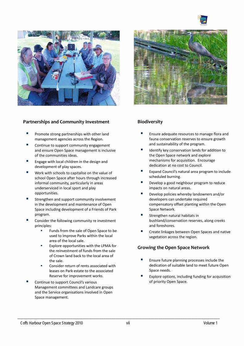
Partnerships and Community Investment
Promote strong partnerships with other land management agencies across the Region.
Continue to support community engagement and ensure Open Space management is inclusive of the communities ideas.
Engage with local children in the design and development of play spaces.
Work with schools to capitalise on the value of school Open Space after hours through increased informal community, particularly in areas underserviced in local sport and play opportunities.
Strengthen and support community involvement in the development and maintenance of Open Space including development of a Friends of Park program.
Consider the following community re investment principles: Funds from the sale of Open Space to be
used to improve Parks within the local area of the local sale.
Explore opportunities with the LPMA for the reinvestment of funds from the sale of Crown land back to the local area of the sale.
Consider return of rents associated with leases on Park estate to the associated Reserve for improvement works.
Continue to support Council’s various Management committees and Landcare groups and the Service organisations involved in Open Space management.
Biodiversity
Ensure adequate resources to manage flora and fauna conservation reserves to ensure growth and sustainability of the program.
Identify key conservation lands for addition to the Open Space network and explore mechanisms for acquisition. Encourage dedication at no cost to Council.
Expand Council’s natural area program to include scheduled burning.
Develop a good neighbour program to reduce impacts on natural areas.
Develop policies whereby landowners and/or developers can undertake required compensatory offset planting within the Open Space Network.
Strengthen natural habitats in bushland/conservation reserves, along creeks and foreshores.
Create linkages between Open Spaces and native vegetation across the region.
Growing the Open Space Network
Ensure future planning processes include the dedication of suitable land to meet future Open Space needs.
Explore options, including funding for acquisition of priority Open Space.

________________________________________________________________________________________
Coffs Harbour Open Space Strategy 2010 viii Volume 1
GLOSSARY OF TERMS Abbreviation/Term
Definition
Open Space/ Green space
Land intentionally or unintendedly not developed. Usually has minimal built form.
Open Space Network
Land that Council owns or manages on behalf of another agency for an Open Space purpose with an implicit right of public access.
Densification
Changing residential areas from low to medium and high densities.
Urbanisation
Increasing residential /mixed use development.
Rural
Areas that are predominantly for agricultural and horticultural purposes.
Rural Residential
Areas of residential development in former rural localities that have larger lot sizes, usually over one hectare.
Embellishment Improvements or upgrades to open space.
ABS
Australian Bureau of Statistics.
DCP
Development Control Plan.
D Cont P
Development Contribution Plan.
Sec 94 Contribution Plan
A plan that is prepared detailing the financial contributions that developers are required to pay, as a per lot rate, as a result of their development.
EL
Environmental Levy. A rate levy imposed on landowners to fund environmental programs/projects.
LEP
Local Environmental Plan. A land use plan detailing land use zones and permitted activities within each land use zone.
SFR
Social Family Recreation Space.
LPMA
NSW Land and Property Management Authority (formerly NSW Department of Lands).
NPWS
National Parks and Wildlife Service.
SF NSW
State Forests NSW.
DECCW
Department of Environment, Climate Change and Water.
CCSP
Coffs Coast State Park.
CCRP
Coffs Coast Regional Park.
SLEP
Standard Local Environment Plan.
CHCC Coffs Harbour City Council.

________________________________________________________________________________________
Coffs Harbour Open Space Strategy 2010 ix Volume 1
Informal recreation
Unstructured recreation that is not organised by a club or other group and participation is initiated by individuals.
Safe/easy walking distance
The perceived safety of a journey by foot between home and the nearby Open Space. Crossing main roads and railway lines can be perceived as dangerous or difficult for people to negotiate.
CPTED
Crime Prevention Through Environmental Design: A concept by which passive surveillance and location of facilities near high use areas reduces the incidence of crime.
ESD
Ecologically Sustainable Development.
Structure plans
Broad land use plans prepared for a land release area. Precedes a Development Control Plan.
WSUD
Water Sensitive Urban Design
Under‐served/gap
Refers to areas where there is no suitable Open Space within acceptable walking distance from surrounding neighbourhoods.
Encumbered land
Land that is considered constrained for recreational or sporting purposes, due to a number of factors including topography, environmental issues etc.
Unformed public road
A public road under the Roads Act 1993 that has not been physically constructed. Sometimes known as paper road.
Shared trails
Trails which can be used by pedestrians, cyclists and potentially other users such as horse riders.
LGA Local Government Area.
Council controlled land Land that is owned or managed by Coffs Harbour City Council.
Landscape Setting Defines the characteristics of the land that will influence a visitor's experience.
Catchment Defines the likely origin of visitors to the Open Space.
Function Defines the primary purpose. The Open Space may have multiple functions however only primary purpose has been identified. Secondary functions are generally encapsulated at the Master planning or Design process.
Passive surveillance A design principle describing informal visual surveillance of areas by surrounding neighbours/passers‐by.
APZ Asset Protection Zone. A space defined by legislation which is kept free of vegetation in order to protect from bushfire hazard.
KPoM Koala Plan of Management. A statutory document adopted by the CHCC.
Trail network Network of surfaced and unsurfaced pathways, tracks, cycleways.
ERP Estimated Resident Population.
RPS 2004 Recreation Preference Study 2004. Document detailing the findings of community survey regarding recreation and sporting preferences.

________________________________________________________________________________________
Coffs Harbour Open Space Strategy 2010 1 Volume 1
1. Introduction
Open Space is an important contributor to life. It delivers significant benefits across the whole community in terms of the social, physical and mental health of individuals.
1.1 What is Open Space and why do we need it
In its broadest sense open space is land that is, intentionally or unintentionally, not developed for residential, commercial, industrial or special purposes. It may be publicly or privately owned and used for purposes such as conservation, agriculture, forestry, or recreation. Open Space defines the character and identity of settlements through differentiating, integrating and buffering different land uses and provides reference points within the landscape. The open ocean can also be considered as an Open Space feature.
Open Space is highly valued by the community and provides a multitude of benefits. Key benefits are summarised below:
Child (human) Development
Independence and self‐awareness.
Risk/challenge.
Ability to explore new things.
Unpredictability.
Territoriality.
Privacy/quiet.
Creativity.
Ability to manipulate the environment.
Environment as the inspiration and source of treasures.
Sociability and ability to convey trust and confidence.
Familiarity ‐ where strangers and risks can be encountered.
Interaction with different people.
Leadership support & guidance.
Meeting with peers.
Co‐operation and sharing.
Co‐ordination and physical agility.
Civic Pride
Protection of sites of significance.
Connection and understanding of heritage and ancestral roots.
Pleasing and ornamental decoration.
Visual quality.
Community gathering areas.
Urban liveability.
Neighbourhood character.
Provide green breaks/buffering between different land uses.
Bring aesthetic value.
Develop sense of community through identification with interesting and diverse recreation and open space areas.
Education
Spatial knowledge and sense of direction.
Access to a range of life forms, and
Ability to interact sustainably with the environment.

________________________________________________________________________________________
Coffs Harbour Open Space Strategy 2010 2 Volume 1
Healthy Living City
Clean air.
Exercise.
Psychological need for contact with nature.
Personal space ‐ relief from overcrowding and urban induced stress.
Self sufficient neighbourhoods.
Access and familiarity with services and facilities.
Visual relief from development.
Green space contributes to a sense of wellbeing.
Provides neighbourhood character.
Economic
Coastal reserves and foreshores critical for the tourism and travel industries.
Contributor to quality of life which attracts and retains economic investment.
Opportunities for Biobanking and carbon trading.
Parks and open space can enhance the value of nearby properties.
Well designed open space networks attractive to retirees.
Opportunities for sport‐driven tourism.
Recreation
Social/family time.
Opportunities for isolation.
Opportunities for relaxation and spiritual development.
Skill development.
Exercise.
Nature appreciation.
Enjoyment and entertainment.
Environmental Conservation and Protection
Protection of habitats and linkages for wildlife dispersal.
Flora/fauna refuges.
Protect rare and endangered species.
Estuarine areas provide vital fish nurseries.
Controlling flooding/runoff.
Carbon sinks and absorption of greenhouse gases.
Filtering nutrients and run/off.
Protection of water supply catchments.
Opportunities for environmental education.
1.2 Open Space in Coffs Harbour
Coffs Harbour is fortunate to have an extensive and diverse array of open space enhancing the lives of all residents, providing green space buffers within urban areas and between settlements; contributing to the City’s visual amenity; providing opportunities for recreation and sport; providing areas for habitat and conservation; protecting waterways; mitigating coastal erosion and facilitating water based activities. The foreshores and marine environment, in particular, serve as a major attractant for tourists in migration to the Region and are a significant economic driver.
Open Space within the LGA is valuable to not just local residents but to the wider community of NSW. Highly urbanised and mobile communities seek destinations like Coffs Harbour for many of their open space needs. Coffs Harbour uniqueness can be attributed to the extensive natural coastline contrasting against the scenic backdrop of the escarpment and hinterland.
In the Coffs Harbour Local Government Area (LGA), there is an extensive network of Public Open Space (publically owned lands that have a public right of access). See Figure 1:

________________________________________________________________________________________
Coffs Harbour Open Space Strategy 2010 3 Volume 1
Figure 1: Public Open Space tenure in Coffs Harbour
* In the past this land and its recreation facilities have been available for the public to use, however there is an increasing trend to exclude the public from these facilities after school hours.
Almost half of the LGA, approximately 58699 hectares (excluding schools), comprises Public Open Space. See Map 1.
The majority of this public Open Space is provided and managed by the State, with strategic planning and management responsibility for this resource vested within the various NSW State land management Ministers and agencies, principally the National Parks and Wildlife Service, State Forests NSW and the Land and Property Management Authority. These lands, with the exception of certain Crown Reserves and the Coffs Coast Regional Park, are by and large outside the scope of this Strategy.
Of the total public Open Space in Coffs Harbour only a small proportion (less than 4%) is owned and /or managed by Council. See Figure 1. Sound management of this valuable resource and Council's ability to form partnerships and agreements with other land managers, through an integrated whole of government approach is critical to protecting local and regional character, biodiversity and sporting and recreational opportunity.
Figure 2: Public Open Space in Coffs Harbour
Council owned
Council managed
Crown estate
National Parks
State Forests
Public Open Space Private Open Space
National Parks
State Conservation Areas
Nature Reserves
Coffs Coast Regional Park
State Forests
Crown Estate
Council Owned
Lands
Government Education lands*
Open Space

________________________________________________________________________________________
Coffs Harbour Open Space Strategy 2010 4 Volume 1
Map 1: Public Open Space in Coffs Harbour
________________________________________________________________________________________
Coffs Harbour Open Space Strategy 2010 5 Volume 1
1.3 This Strategy
Although Council has a regulatory function in relation to private open space, this Strategy will primarily focus on public Open Space that is directly under the care, control and management of Council, and is currently, or has the potential to be managed for a range of different open space purposes and benefits, referred to in this document as the Open Space Network. These lands are detailed in Section 2.2. Council is committed to enhancing the management of these areas to ensure that current and future generations can value and enjoy the open space network. As the population of Coffs Harbour grows and changes, and our urban landscape becomes more densely settled, the need for Open Space will continue to grow.
The Strategy details Council’s intent in relation to the protection, development and management of its Open Space Network.
A number of key factors are driving the need for this Strategy including:
Increasing population and changing densities
An ageing, less active population
Decreasing private open space
Need to link open space
High visitation on foreshore areas by visitors and tourists
High community value on open space
Increased community expectation on quality and design
Competing demands on open space
Increased land values inhibiting Council's ability to acquire quality Open Space.
Development of the Strategy has been overseen by a project focus group within Council and has involved the accumulation of relevant data and background information, an assessment of the current status of Open Space and its components, a review of current and future demographic patterns and an assessment of issues relevant to all these factors (see Figure 2). This information has been used to formulate a comprehensive management document that, over the next ten years, will:
Provide guidance and direction for management and development of open space including a comprehensive open space improvement program.
Identify the existing and future open space network.
Provide guidance on the appropriate provision and enhancement of open space, particularly in developing areas.
Establish how the open space network is to function and interact with urban areas and the wider region.
Ensure adequate and ongoing provision and embellishment of open space.
Provide clarity and reasonable certainty for developers and landowners in relation to the requirements and expectation placed on planning authorities
Establish desired service levels for maintenance.

________________________________________________________________________________________
Coffs Harbour Open Space Strategy 2010 6 Volume 1
Figure 3: Methodology and Background Information Relevant to Open Space Strategy 2009
Demand Analysis Community Consultation
Household surveys Student surveys School surveys Sports Clubs and Associations surveys Phone surveys Stakeholder workshops
Supply Analysis
Mapping of open space network by function, landscape setting and catchment Assessment of Spatial distribution Assessment of current provision levels Assessment of facilities
Review of Legislation and
Policies
Review of legislation Review of standards and benchmarks from LGAs Review of relevant policies Review of assets
Issue Identification
Demographic analysis and population projections by precinct Key issues and strategies Analysis of distribution /connectivity by precinct Identification of Gaps & Opportunities by precinct
OPEN SPACE STRATEGY

________________________________________________________________________________________
Coffs Harbour Open Space Strategy 2010 7 Volume 1
1.4 Planning Approach
An earlier Open Space Plan was prepared by Council in 1998. This plan described in simplistic terms the functions of existing open space and endorsed a standards based approach to determining appropriate amounts of Open Space to service population needs. Standards however are generally developed on an historical basis which is unlikely to reflect actual or future needs given the myriad of factors affecting open space provision. They cannot assess the quality or adequacy of the open space nor the value of a particular piece of Open Space to the community. It also fails to take into account the nature, distribution and diversity of the Open Space and does not differentiate between the various settlement patterns and the impacts of this on the value, benefits and usage of Open Space.
Used alone they are not an adequate basis for planning and are intended only as a guide. Standards need to be balanced with assessments of quality, variety, distribution, access, population characteristics and
community preferences.
In the absence of any targeted state wide or regional policy in relation to strategic planning for open space, the planning approach adopted for this Strategy is a shift from a standards approach to a benefits and value related model. This approach recognises that Open Space is not homogenous and that the value of Open Space depends on the extent to which it benefits the community and the environment. The goal of this approach is to deliver an increased range of open space benefits by ensuring diversity of opportunity and an equitable distribution of open space functions.
Applying this approach it was broadly determined that it would be desirable for the Open Space Network in Coffs Harbour to provide:
One open space dedicated to social/family recreation in every local neighbourhood (500m easy walking distance of the majority of households in urban areas or one in rural/rural residential areas located within a nearby village).
Sufficient quality and diversity of accessible Open Space to serve each precinct of the urban areas, or a district catchment, equitably.
Opportunities for core activities undertaken in Open Space provided in each local neighbourhood (walking, cycling, play, informal ball games, relaxing, swimming, playing and watching sport).
Easy access to off‐road trails for local neighbourhoods.
A range of Function and Setting types present within precincts encompassing the benefits identified previously (child development, recreation, civic pride, environment, education).

________________________________________________________________________________________
Coffs Harbour Open Space Strategy 2010 8 Volume 1
2. Legislative and Policy Context
2.1 Legislative Framework
A comprehensive framework of legislation, regulations and planning policies at all levels of Government affect the use and management of the Open Space and have statutory and operational implications in certain areas. Table 1 lists legislation and planning policies relevant to Open Space management in Coffs Harbour and a summary of the way in which they relate to Open Space planning is given in Appendix 1.
At a local level, a suite of policies, planning controls, strategies and guidelines have implications for, and guide the management of, the open space network. Local mechanisms specific to the Open Space Network include:
Various land use and facility management strategies
Reserve Master Plans
Plans of Management
Reserve Action Plans
Table 1: Legislation and Planning Policies relating to Open Spaces in the Coffs LGA
ADMINISTRATION LEGISLATION / POLICIES
Environmental Protection and Biodiversity Conservation Act 1999
Native Title Act 1993
Disability Discrimination Act 1992
FEDERAL
National Strategy for Ecologically Sustainable Development
Native Vegetation Act 2003
Environment Planning and Assessment Act 1979
Protection of the Environment Operations Act 1997
Threatened Species Conservation Act 1995
Local Government Act 1993
National Parks and Wildlife Act, 1974
STATE
Rural Fires Act 1997

________________________________________________________________________________________
Coffs Harbour Open Space Strategy 2010 9 Volume 1
Rivers and Foreshores Improvement Act 1948
NSW Heritage Act 1977
North Coast Regional Environment Plan 1988
State Environmental Planning Policy (SEPP) 26‐ Littoral Rainforest
SEPP 14 – Coastal Wetlands
SEPP 44 – Koala Habitat Protection
SEPP 71 ‐ Coastal Protection
Crown Lands Act 1989
NSW State Plan
Coastal Crown Lands Policy
Draft Mid North Coast Regional Planning Strategy
Planning for Bushfire Protection 2004
Bushfire Environmental Assessment Code
State Rivers and Estuary Policy
NSW Wetland Management Policy
NSW Coastline Hazard Policy 1990
Food and Beverages on Crown reserves, 2001
NSW State Groundwater Policy
NSW State Groundwater Quality Protection Policy
NSW Biodiversity Strategy
Vision 2030 Strategic Infrastructure Plan( currently being prepared)
Vision 2020
Coffs Harbour Council Management Plan
Priority Habitats & Corridors Strategy (Draft)
Our Living City ‐ Settlement Strategy for Coffs City to 2031
Plans of Management for Community and Crown lands
Revised Koala Plan of Management
COFFS HARBOUR CITY COUNCIL
Tree Preservation Order

________________________________________________________________________________________
Coffs Harbour Open Space Strategy 2010 10 Volume 1
Social and Community Strategic Plan
Crime Prevention and Safety Plan
Coffs Harbour Local Environmental Plan (LEP) 2000
Vertebrate Pest Management Strategy
Standard Local Environmental Plan (under preparation)
Estuary Management Plans:
Hearnes Lake Management Study and Plan Draft Corindi River Estuary Management Plan Moonee Creek Estuary Management Plan Bonville and Pine Creeks Estuary Management Plan
Flood Studies and Climate Change:
Coffs Creek Floodplain Risk Management Study Bonville Creek Flood Study Moonee Creek Flood Study Greenhouse Action Strategy
Various Development Control Plans
Various Section 94 Contribution Plans
Coffs Harbour City Council Open Space Strategy 1998
Biodiversity Action Strategy
Environmental Awareness Action Strategy
Coffs Creek Flying‐Fox Strategy and Vegetation Management Plan
Vertebrate Pest Management Strategy
City Parks and Reserves associated policies: Film and TV Policy Noxious Plants Policy Noxious weeds Bitou Bush and Privet Noxious weeds Giant Parramatta Grass Noxious weeds spray exemption (organic farms) Tree vandalism Private encroachments onto community land Commercial activities on Crown lands Cemeteries

________________________________________________________________________________________________________________________________________________________________________________
Coffs Harbour Open Space Strategy 2010 11 Volume 1
The Open Space Strategy is a key policy document for the planning, provision and management of the current and future open space network within Coffs Harbour. Figure 2 below indicates the relationship between the Open Space Strategy and other key corporate documents.
Figure 4: Overview of Corporate document relationship
----------------------------------------------------------------------------------------------------------------------------------------------------------------------------------------------
Management Plan
Policies Required
By Legislation
Standard Local Environment Plan
Development Control Plans
Section 94 Contribution
Plans
Our Living City Settlement Strategy
Open Space Strategy Priority Habitats and Corridors Strategy (Draft)
Rural Residential Strategy
Industrial Lands Strategy
Plans of Management for Community and
Crown Land
Council Policies / Guidelines
Reserve Action Plans
Master Plans Regeneration Strategy (to be developed)
Playground Strategy (to be developed)
Operation Plans / Business Plans /
Auspecs
VISION 2030

________________________________________________________________________________________________________
Coffs Harbour Open Space Strategy 2010 12 Volume 1
Council has direct management involvement in a number of different land tenures that together form the Open Space Network. Figure 3 provides an overview of the current management framework.
Figure 5: Council's Open Space Network
T
2.2 Land Management Framework
Land Tenure Council owned Freehold
State owned Crown Reserves State owned Coffs Coast Regional Park
Council Management/
Role
Owner Planner Manager Regulator
Appointed Corporate Reserve Trust Manager
Open Space Network
Devolved management responsibility (Sec 48 LG Act)
Jointly managed between NPWS and Council via a Memorandum of Understanding, under the guidance of a Trust Board
Enacting Legislation
Local Government Act 1993
Crown Lands Act 1989 National Parks and Wildlife Act 1973
Management
In accordance with the Act and Plan of Management: -Leases ‐Licenses ‐Sec 355 Community Management Committees
In accordance with the Act and Plan of Management: ‐Leases ‐Licenses ‐consents
In accordance with the Act and Plan of Management: ‐Leases ‐Licenses ‐Consents
Administering Government
Agency
Coffs Harbour City Council
NSW Land Property Management Authority
NSW National Parks and Wildlife Service

________________________________________________________________________________________________________
Coffs Harbour Open Space Strategy 2010 13 Volume 1
The State lands of most relevance within this Strategy are the Crown lands administered by the LPMA (formerly Department of Lands), and the Coffs Coast Regional Park (NPWS estate), jointly managed by the NPWS and Council. Also of interest to Council are the intertidal areas in which Council has a regulatory role as well as facilitating access through provision of services and facilities.
Crown Lands
The NSW Land and Property Management Authority (LPMA) (formerly the Department of Lands) is the agency responsible for the management of the Crown Reserve system, travelling stock routes and the crown road network. The LPMA has traditionally been a major contributor to open space in NSW. The Authority not only controls important areas of open space in Coffs Harbour, but also controls some key areas of land that have strategic regional significance for future development.
Crown reserves are managed for a range of public purposes and are managed in accord with the Crown Lands Act and the Reservation Purpose. The Crown Lands Act requires that Crown lands are managed in the best interests of the people of NSW. This has planning implications when considering local open space needs as the availability of these state owned assets cannot be guaranteed in perpetuity. It is vital that Council advocates a whole of government approach in relation to the planning of Crown assets to ensure local interests are considered in any State planning/management decisions.
Notwithstanding this, the LPMA recognises the importance of the provision of open space to the community and is supportive of appropriately identified Crown lands continuing to be available for this purpose, to the extent of any statutory planning requirements embodied within the Crown Lands Act. The LPMA is also supportive of best practice in open space management throughout Council sphere of operations in so far as it complements the endeavours of the Authority and the Reserve Trusts.
Crown Reserve management is generally the responsibility of a Reserve Trust and these Trusts are central to the functioning of the Crown Reserve system. Trusts hold management responsibility on behalf of the government and the community of NSW, however the State Government is ultimately responsible for strategic planning and retains a principal stake. Reserve Trusts are accountable and required to submit annual reports to the Minister for Lands.
Coffs Harbour City Council, as a Reserve Trust Manager, holds management responsibility for extensive areas of Crown Reserve in Coffs Harbour representing, area wise, approximately 30% of Council's Open Space Network. Key Crown reserves include Park Beach Reserve, the Jetty Foreshores, Coffs Creek Reserve, Sawtell Reserve, Woolgoolga Beach Reserve and Boambee Beach.
Council has a responsibility to consult with and seek the concurrence of the relevant Reserve Trust and/or LPMA for any works on Crown Lands, particularly in those instances where it is recommending works on lands for which it is not the appointed Reserve Trust or devolved manager.
State Parks
The Crown Lands Act enables the creation of State Parks, comprising crown reserves considered of State significance. The Coffs Coast State Park (CCSP) is one of the first coastal State Parks created and is a significant asset for the Coffs Coast, encompassing over 488 of foreshore reserves from North Coffs to Sawtell. Council is the appointed Corporate Reserve Trust manager of the CCSP.
Non Council managed Crown Reserves
Notable Crown lands that council does not manage that are important to Open Space provision in Coffs Harbour include:
Coffs Harbour Showground
Coffs Harbour Racecourse
Extensive areas of Crown Reserves at Red Rock and Corindi Beach
Moonee Beach Reserve
________________________________________________________________________________________________________
Coffs Harbour Open Space Strategy 2010 14 Volume 1
Boambee Creek Reserve
These Open Space Reserves are managed by either community based Reserve Trusts who report directly to the LPMA, or by LPMA directly as the Trust Administrator, with Council having no direct management function.
Coffs Coast Regional Park
The Coffs Coast Regional Park (CCRP) is 388.2 ha’s, managed in partnership with the NPWS. The CCRP covers the majority of the lineal foreshore reserves following the coastline from Arrawarra to North Coffs Harbour. Regional Parks are managed under the provisions of the National Parks and Wildlife Act 1974, generally with a stronger focus on recreation than in National Parks. Management of the CCRP is prescribed by a Memorandum of Understanding (MOU) which divides management responsibility between the agencies, with Coffs Harbour City Council focussing on recreation/visitor management and NPWS focussing on conservation outcomes. A Trust Board has been appointed to guide management of the CCRP.
Council Owned Lands
Council manages its freehold Open Space lands to support outcomes for the community consistent with their ascribed values. The strategic planning and management of these lands is vested in Council and where leases and licenses are established Council retains a principal stake. The Local Government Act 1993 provides for the establishment of Community based advisory committees to guide management of reserves/facilities. Council has established a number of such Committees.
The Marine Environment
Although having no administrative responsibility for this resource, Council has a role in facilitating access to the marine environment through provision of facilities and services, and also through the licensing of commercial and group activities that utilise the terrestrial Open Space to access marine areas.
2.3 Previous Open Space Strategy (1998)
In 1998 Coffs Harbour City Council prepared an Open Space Strategy to guide the acquisition and development of open space lands to meet the needs of a growing community. This Open Space Strategy covered the entire LGA and focused on Council controlled open space lands and recreation facilities. A major focus of the plan was the development of a capital improvement program for reserves, to be actioned through Council’s Annual Management Plan budget allocation.
The specific goals of the Strategy were:
To protect and enhance Open Space values.
To achieve the open space vision in providing and developing Open Space and recreation facilities.
To achieve an equitable provision and distribution of recreation facilities and Open Space lands.
To develop an achievable Open Space Strategy for Coffs Harbour, and, where possible, be self funding.
Major achievements ensuing from this Strategy were:
Creation of the Coffs Coast Regional Park from a number of Crown Holdings, to be managed in partnership with the NPWS.
Creation of The Coffs Coast State Park from a number of Crown holdings, to be managed by CHCC as Trustee.

________________________________________________________________________________________________________
Coffs Harbour Open Space Strategy 2010 15 Volume 1
Management control of York Street playing fields from the Department of Education.
Adoption of a Master plan, and funding commitment, to develop Brelsford Park as a City Park.
Continued development of the Coffs Coast Sport and Leisure Park.
Partial development of the Hulberts Road Sporting Precinct including construction of a velodrome.
Development of sports fields at Nana Glen.
New playgrounds at Perry Drive, Blue Wren Close, Lakes Estate, North Sapphire.
Further achievements are listed in Table 2.
To determine the overall adequacy of supply, a standards (provision) approach was utilised whereby the Open Space was analysed in terms of hectares per number of people. The adopted standard was 3.67ha/1000 head of population; comprising two hectares for sporting provision, one hectare for informal recreation and 0.67 hectare for Regional provision.
Table 2: 1998 Open Space Strategy Achievements
District Achievements
North A cycleway link between Mullaway and Safety Beach via a bridge over Darkum Creek has been completed.
The continuation of bridge and walkway development has been completed on Woolgoolga Lake in accordance with the Woolgoolga Lake and Lake Reserves Plan of Management (1992).
Drainage works on Woolgoolga Sportsground have been completed.
A skate park facility has been developed in Woolgoolga.
Training lights have been upgraded in Centennial Reserve Woolgoolga.
Safety Beach Golf Course has been upgraded to 18 holes.
BBQ's and tables have been put in at Ocean View Beach Reserve.
Walking tracks have been resurfaced on Ocean View Headland.
Playground has been updated at the Lakeside Picnic area in Woolgoolga.
Playground has been upgraded and the sewer connected to amenities at Emerald Beach Reserve.
A site for a future neighbourhood park for West Sandy Beach has been identified in the DCP.
Central The acquisition of bushland at Roberts Hill for Council Reserve.
The preparation of a Plan of Management for Beacon Hill and some implementation of works.
Construction of playing fields at Polwarth Drive West Coffs including car park, amenities, lights, drainage, playground and tree‐planting.
Land acquisition at York Street for playing fields. Drainage on fields has been completed.
At the Bray Street Recreation Area extensions to the Indoor stadium were completed, the Police Boys Club was completed and baseball backing nets were installed.
Re design of Shepherds Park Coffs Harbour has been implemented.

________________________________________________________________________________________________________
Coffs Harbour Open Space Strategy 2010 16 Volume 1
A car park and walking track has been completed at Gallows Beach (North Boambee Beach Headland).
Playgrounds have been installed at Elouera Drive Reserve, Sapphire, Korora Beach Reserve, Saltwater Park, Perry Drive and Roselands Drive (West Coffs).
Playgrounds have been upgraded at Argyll Street Park, Hilltop Reserve (Beryl Street), Westside Reserve and Reid Drive (South Coffs).
Amenities have been upgraded at Jetty Oval.
Bush regeneration and Revegetation has been undertaken along Coffs Creek Tributary.
A playground and cycleway has been installed at Lakes Estate in North Boambee Valley.
Playgrounds, concrete paths have been installed and trees and shrubs have been planted in Taloumbi Reserve and Perry Drive/Mackays Road Reserve.
South Acquisition of land for the creation of Hulberts Road Recreation Area and the construction of the velodrome.
Reconstruction of four playing fields and associated amenities at Richardsons Park, Sawtell.
Construction of a headland walking path and upgrade of vehicle access and parking at Boambee Headland.
A Skate park has been constructed at Toormina.
Upgraded and expanded play and BBQ facilities at Wonga Park Sawtell.
Upgraded playground at Dirrigeree Crescent.
Installation of playgrounds at Platts Close and Lady Belmore Drive.
West Acquisition of land for the Archie Hunter Memorial Park at Nana Glen including development of a park concept plan and commencement of park development.
Acquisition of land for two sports fields for cricket and soccer at Nana Glen.
________________________________________________________________________________________________________
Coffs Harbour Open Space Strategy 2010 17 Volume 1
3. Demography and Social Context
3.1 Demography
Traditionally an agricultural centre, Coffs Harbour has evolved into a vibrant, coastal city with an expanding economy based on tourism, retail, manufacturing and construction, government services, education and the health industry. In recent years it has become a popular lifestyle destination for "sea changers" and “tree changers”, as well as retirees, with the population expected to reach 100,000 by 2031.
Coffs Harbour is also a popular destination for tourists and holiday makers, with the beaches and foreshore reserves a major attraction. In times of peak visitation the population swells significantly.
Due to its size and location Coffs Harbour has been identified as a major Regional Centre for the Mid North Coast within the Mid North Coast Regional Strategy 2009, with capacity to move to higher density housing.
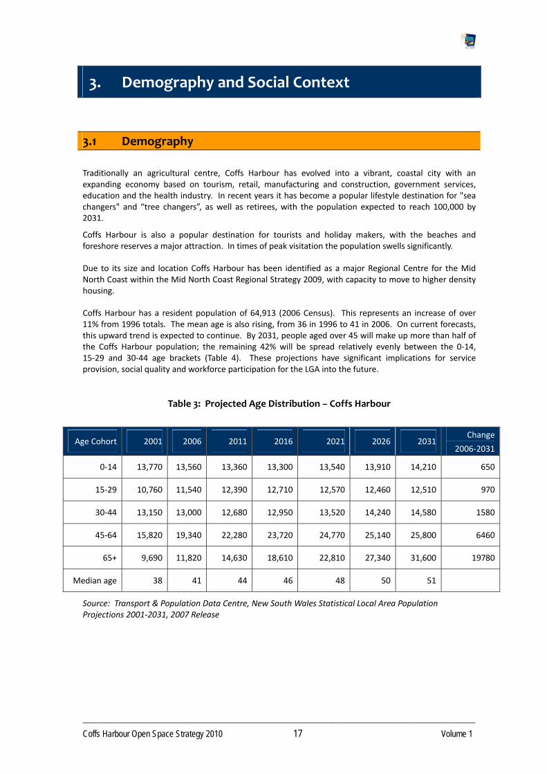
Coffs Harbour has a resident population of 64,913 (2006 Census). This represents an increase of over 11% from 1996 totals. The mean age is also rising, from 36 in 1996 to 41 in 2006. On current forecasts, this upward trend is expected to continue. By 2031, people aged over 45 will make up more than half of the Coffs Harbour population; the remaining 42% will be spread relatively evenly between the 0‐14, 15‐29 and 30‐44 age brackets (Table 4). These projections have significant implications for service provision, social quality and workforce participation for the LGA into the future.
Table 3: Projected Age Distribution – Coffs Harbour
Age Cohort 2001 2006 2011 2016 2021 2026 2031 Change
2006‐2031
0‐14 13,770 13,560 13,360 13,300 13,540 13,910 14,210 650
15‐29 10,760 11,540 12,390 12,710 12,570 12,460 12,510 970
30‐44 13,150 13,000 12,680 12,950 13,520 14,240 14,580 1580
45‐64 15,820 19,340 22,280 23,720 24,770 25,140 25,800 6460
65+ 9,690 11,820 14,630 18,610 22,810 27,340 31,600 19780
Median age 38 41 44 46 48 50 51
Source: Transport & Population Data Centre, New South Wales Statistical Local Area Population Projections 2001‐2031, 2007 Release

________________________________________________________________________________________________________
Coffs Harbour Open Space Strategy 2010 18 Volume 1
Key demographic characteristics for Coffs Harbour
Population growth ‐ Coffs Harbour is a popular destination for retirees. Migration to the area is a significant element of population growth for the LGA, accounting for 17.4% of the population to 2006.
Ageing population - Coffs Harbour has a higher than NSW State average percentage of persons aged over 65 years (16.6%). There has been a median age shift from 36 to 41 in just 10 years. The percentage of younger adults (18 to 24) in Coffs Harbour is lower than NSW State average and the percentage of adults and older adults (34 to 84) is higher. This trend is forecast to increase through the natural ageing of the population and high levels of migration into the region of older people and the continued exodus of young people leaving in search of employment and education opportunities unavailable in Coffs Harbour.
Increasing number of people born overseas ‐ The majority of the population of Coffs Harbour are Australian born, however there is a trend toward an increasing population of overseas born, with a 4.2% rate change since 1986. Throughout the LGA there are large pockets of communities from non‐English speaking countries. Woolgoolga is home to the largest Punjab community outside the NSW metropolitan area. Coffs Harbour has also witnessed an influx of refugees from western Africa and Asia.
Higher levels of unemployment ‐ Coffs Harbour has significantly higher levels of unemployment than the remainder of the State but lower than that for the Region. In 2008 unemployment in Coffs was estimated to be 8.8% compared with State average of 4.7% Coffs Harbour has a higher proportion of people engaged in part‐time work than the State or Regional averages.
Family structure ‐ 57.9% of households within Coffs Harbour are families with children. This is marginally lower than the State average of 62.3%. The average family size is 2.5. The southern and far western areas of the LGA represent the highest proportion of households with children and the Northern Beaches the lowest; however there is marked variability between townships in all precincts in this regard.
High number of separate house dwellings – The vast majority of dwellings are separate houses, representing 69.7% of housing types across the LGA. Only 19% of dwellings are apartment style housing and 9.8% are semi‐detached or townhouse and these types are largely concentrated in Park Beach and Woolgoolga.
High levels of education – Coffs Harbour has a lower proportion of residents with postgraduate degrees and bachelor degrees than the Regional and State average, but has a higher proportion of graduate and advanced diplomas and certificate qualifications.
Implications of demographic profile
The following are implied for Open Space provision from the demographic characteristics of Coffs Harbour:
Due increase in population over the past ten years, there is likely to be pressure on existing to the significant recreation facilities in the City, and unmet demand.
With the population projected to increase a further 21.4% by 2021, an equitable supply of recreation facilities will become increasingly important.
A significant proportion of the population increase will be in the older age brackets (over 45 years), affecting the demand for those activities popular with older members of the community and will have a significant impact on the way Open Space is provided for and used.
Walking, swimming and aerobic/fitness are projected to be the activities with the highest participation rates for people over the age of 15 years, up to 2021. The provision of off‐road trails, as well as gym and fitness facilities will be important.

________________________________________________________________________________________________________
Coffs Harbour Open Space Strategy 2010 19 Volume 1
Demand for participation in active but social activities such as aerobics / fitness, aqua‐aerobics, fishing, golf, carpet / lawn bowls and walking / bush walking, is likely to continue to be strong especially in Far Northern Beaches, Woolgoolga and Coffs Harbour Urban which will continue to have a high percentage of older adults.
Overall the decline in the proportion of young people may impact on sports that traditionally target young people. Sports may need to centralise and have multiple facilities together to enhance their viability. However the high percentage of children (aged 0‐14 years) in developing areas and Hinterland Villages and Hinterland Rural will continue to need provision of play opportunities, off‐road trails, sports facilities and open space.
Recreation participation in Coffs Harbour LGA may be increased by providing transport services, programming of classes and providing information about what is available and where, to target the aging population.
Participation will be constrained by the lower income levels in the LGA, hence free access opportunities close to home and subsidised sports participation will be important.
Although the population is expected to increase by approximately 30,000 people by 2031, on current forecasts, very little of the increase will be in the 0‐45 age brackets (the active age cohorts). This may result in less demand for structured sports venues.
Population Characteristics of the 12 Planning Precincts
Whilst the above summary of the key Coffs Harbour City demographic characteristics is important, it is equally important to recognise that different population characteristics may exist between different areas of the LGA. The Open Space Research Report 1 – Precinct Analysis identified 12 planning precincts as the basis for undertaking a more detailed analysis of defined areas. The key demographic characteristics of the Precincts are summarised below.
Almost three‐quarters of the population reside in the three planning precincts of Coffs Harbour Urban (40.5%), Sawtell / Toormina / Boambee East (23.1%) and Woolgoolga (10.0%). These proportions of the population are projected to remain almost identical as the total LGA population increases to over 90,000 people by 2031.
The largest net growth of people is also predicted to occur in these three planning precincts, with Coffs Harbour Urban predicted to increase by approximately 11,000 people to 2031 and will experience the largest growth of all precincts.
Of the other precincts, the Northern Beaches is predicted to increase by over 3,000 people to 9,067 people by 2031.
The rural or non‐coastal planning precincts (Far North Rural, North Rural, South Rural and Far West Hinterland) will continue to have relatively small populations through to the period 2031.
The age profile of all planning precincts in 2006 was relatively similar, although the rural planning precincts tended to be slightly ‘younger’ areas, as evidenced by the comparatively higher proportion of residents aged less than 14 years and lower proportion of residents aged over 65 years.
Of the three highly populated planning precincts, Sawtell / Toormina / Boambee East has the highest proportion of residents aged under 25 years (34.4%), followed by Coffs Harbour Urban (31.6%) and Woolgoolga (28.0%), although Coffs Harbour Urban still has the highest number of residents aged under 25 years (8,300), followed by Sawtell / Toormina / Boambee East with 5,200.

________________________________________________________________________________________________________
Coffs Harbour Open Space Strategy 2010 20 Volume 1
Note: It is understood that the Coffs Harbour City Council is currently developing standardised planning precincts that will form the basis for the majority of Council's Corporate Strategies/Plans. It is intended that the Open Space Strategy Precincts will be modified to accord with these in conjunction with future planned reviews of the document.
3.2 Social Context
There are a number of trends emerging in sport, recreation, lifestyle and open space provision across Australia that must be considered to ensure flexible open space that can meet future requirements. Ramifications of these trends for Coffs Harbour’s open space are elaborated upon in Section 6.
Participation trends in physical, social and sporting activities
The types of recreation activities that Australians undertake change with trends, promotion and awareness of different opportunities. Over recent years participation has generally shifted from organised sport to informal recreation activities, resulting in declining club memberships for some sporting codes and an increase in informal individual recreation activities. Different activities also go through periodic trends, rising and falling in popularity. Some sports are also finding that the number of different codes vying for the younger players is making securing players much more competitive than in recent decades where opportunities were more limited. As activities become popular, the community demand for supporting facilities increases, however Council must be mindful of sustainability and provides spaces that can adapt to long term changes over time.
Factors that influence the types of sport and leisure activities undertaken, and the frequency of participation include age, gender, family life stage, income and education levels.
The Exercise, Recreation, and Sport Survey (ERASS), a joint initiative of the Australian Sports Commission and State and territory agencies collects information on participation patterns by people over 15 in sport, exercise and recreation annually.
ERASS surveys show current trends for people aged over 15 years1:
Walking is the single most frequently undertaken activity across the Australian population, being the most popular form of physical activity for females (45.9%) and those aged 65 years and over (45.2%).
Aerobics/fitness activities (18.6%), swimming (15.3%) and cycling (8.8%), along with walking, make up the top four activities for the New South Wales population.
Running (7.5%), golf (also 7.5%) and tennis (5.7%) are the next most popular activities in New South Wales.
Females tend to participate more frequently in physical activity and exercise than males however males tend to participate for longer than females. Overall, women are less likely to participate in sufficient physical activity than males.
Young people tend to participate in vigorous activities more often than older adults.
Older people are more likely to participate in informal, unstructured activities, with young people being more likely to engage in organised sports.
1 Source: Participation in exercise, recreation and sport survey (ERASS), ASC, 2008
________________________________________________________________________________________________________
Coffs Harbour Open Space Strategy 2010 21 Volume 1
There is a substantial decline in organised sports participation around the age of 17 years due to changes in lifestyle and commitments as young people leave high school and commence working or undertake further studies.
Research into children’s participation in cultural and leisure activities (for those aged 5 to 14 years and outside of school hours) provides the following insights into activities of young people across Australia for the 12 months prior to the survey2:
63% of children participated in at least one organised sport outside of school hours. This is an increase of 4% from 2000 (59%).
Boys participated in organised sport more than girls (69% compared to 58% respectively). This trend was apparent from age 7 years.
Participation in sport peaked in the 9 and 10 year age bracket (above 70%), declining to 60% participation by those aged 14 years.
23% of girls participated in dancing (organised lesson or performance).
23% of children had participated in skateboarding/ rollerblading in the two weeks prior to the survey (17% for girls and 29% for boys).
Participation in bike riding was 68% on average (62% for girls, 73% for boys).
Playing electronic or computer games has declined from 69% since 2000 (with a peak of 70% in 2003) to 63%. Participation in physical activities of sport, dancing and bike riding has increased over the same period.
Table 5 indicates the likely number of participants in Coffs Harbour, aged over 15 years, for the twenty top activities with the highest participation rates for New South Wales. The majority of people walk for recreation. There are likely to be almost 25,000 people who will walk for exercise in 2021. The total people involved in walking and swimming totals more than the other activities combined. The projected increase in participation, especially in walking, is indicative of a growing and aging population wishing to continue to stay active.
These are a guide only as data has been derived from NSW‐wide information and there may be significant regional variation throughout NSW. Participation rates are likely to fluctuate over time and hence the number of participants projected should only be used as a guide. It is also noted that other local factors such as climate, physical features and facility provision also influence local demand.
2 Children's participation in cultural and leisure activities (2006) - Children Aged 5-14

________________________________________________________________________________________________________
Coffs Harbour Open Space Strategy 2010 22 Volume 1
Table 4: Number of Projected Participants (over 15yrs) in Top Activities
Activity
2006 Actual population
data
2011 Projected
2016 Projected
2021 Projected
Walking (other) 19,435 21,069 22,733 24,354
Swimming 10,093 10,942 11,806 12,648
Aerobics/fitness 9,371 10,159 10,962 11,743
Tennis 5,471 5,931 6,399 6,855
Cycling 4,944 5,360 5,783 6,196
Golf 4,847 5,254 5,669 6,073
Running 4,320 4,683 5,053 5,413
Walking (bush) 3,735 4,049 4,369 4,680
Football (outdoor) 3,306 3,584 3,867 4,143
Touch Football 2,116 2,294 2,475 2,652
Surf Sports 1,970 2,135 2,304 2,468
Yoga 1,911 2,072 2,236 2,395
Netball 1,824 1,977 2,133 2,285
Basketball 1,707 1,850 1,996 2,139
Cricket (outdoor) 1,629 1,765 1,905 2,041
Dancing 1,463 1,586 1,711 1,833
Lawn Bowls 1,424 1,543 1,665 1,784
Weight training 1,375 1,491 1,608 1,723
Martial Arts 1,258 1,364 1,471 1,576
Fishing 1,199 1,300 1,403 1,503
Population Distribution
As Coffs Harbour’s population continues to grow population density will become an important lifestyle consideration. In 2006, Coffs Harbour had a population density of 57.9 persons per square kilometre. This compares with a density of 11.6 persons/ km2 for the Mid North Coast as a region, and 8.5 persons/ km2 for the State as a whole.
Within the LGA, approximately 86.7% of the population reside in urban areas and the remaining 13.3% of people live in rural areas. Population is concentrated along the coastal strip.
Increasing Expectations
It is clear that the community’s expectations with respect to the quality of open space, the standard of maintenance, standard of park infrastructure and amenities is increasing. The community is expecting a higher standard of provision and quality of open spaces. This can be attributed to an increasing understanding of the health benefits of physical exercise and open space, and those related to environmental sustainability. In Coffs Harbour this may, in part, be due to the in migration of residents from larger capital cities where open space is often developed and maintained to a higher level. Property developers now recognise the value of high quality open space and in many instances are providing and maintaining open space assets to a higher standard than that traditionally provided by Council. This has further raised community expectations.
________________________________________________________________________________________________________
Coffs Harbour Open Space Strategy 2010 23 Volume 1
Whilst Council strives to meet community expectations it is important that the community understands that there are factors that constrain and influence decision making in respect of open space, including resource limitations; land availability; competing priorities and sustainability principles. Council needs a clear strategy for addressing these expectations and an agreed system for prioritising capital works.
Increasing pressures on the natural environment
The attractiveness of Coffs Harbour as a tourism destination and a life style choice for residency is placing increased pressures on the natural environment and the Open Space network. Development pressures include loss of habitat and fragmentation of corridors, altered stormwater runoff, introduction of pest species, erosion, inappropriate and unmanaged recreation use.
Increased development brings an increased need for infrastructure and support facilities that have the capacity to impact negatively on open space values.
Sustainability
Growing environmental awareness over recent years has resulted in local governments placing an increased focus on ecological sustainability in current and future planning. Councils are now adopting an ethos of sustainability in all areas of Council business and practices. Sustainability must be the foundation on which all decision making is based. Sustainability principles can be applied in open space in several ways including sound resource use; providing walkways/cycleways as transport options that reduce reliance on motorised transport; providing spaces for multiple use; providing opportunities for WSUD; building social capital through providing opportunities for social interaction and connection; protecting environmental values; offsetting carbon pollution through tree retention and planting.
Lifestyle changes
Although lifestyle choice is an individual matter, certain Lifestyle trends have emerged in recent years including:
Increased Health consciousness – heightened community awareness of the benefit of physical activity that has lead to people undertaking more regular, unstructured, exercise.
Changes in patterns of work practices – Changes in patterns of work practices in Australia, resulting in an increased demand on people’s time, increases in casual and shift work and increase in proportions of families with both parents working full time, more flexible work arrangements mean different people are recreating at different times, requiring access to facilities at “non traditional” times. These trends now require greater flexibility in the times that recreation facilities are available to the community.
Increase in disease burden – Although people are living longer the disease burden is expected to increase. Australia is experiencing high levels of obesity, Type 2 diabetes and declining physical activity levels. This trend is now evident amongst children, including toddlers, as well as adults.
Coffs Harbour Community Preferences
In 2004 and 2007 Council undertook extensive community consultation to determine community preferences in relation to open space provision, management and development. The following is a summary of key findings.

________________________________________________________________________________________________________
Coffs Harbour Open Space Strategy 2010 24 Volume 1
The surveys indicated that the most used recreation venues were the beaches including coastal foreshores, neighbourhood parks and walkways. Students also indicated a preference for outdoor sports fields.
Local parks were used by the majority of respondents at least weekly and in 25% of cases 2‐3 times per week. The main reasons cited for using a particular park were proximity to home and conveniently located with good facilities.
Complete analysis of findings is included in the “Open Space Research Report 2 ‐ Consultation Findings”.
Preferred Open Space types and activities
The 2006 Open Space Survey identified the three most preferred recreation activities for adults were: walking, swimming, and cycling. For students they were: soccer, swimming, and going to the beach. These findings correlate strongly with the 2004 survey in which the top three activities for adults were walking, swimming and fishing. For students they were surfing, swimming and soccer.
Respondents indicated that quality and convenience of facilities, and provision of effective information regarding activities, would increase participation in the preferred activity.
The most frequently used venue/facility for adults were the foreshores, neighbourhood parks, and walkways. For students they were outdoor sports fields, foreshores, and local parks. These findings correlate strongly with the 2004 survey in which the top three venues for adults were beach and foreshore reserves, bushland and walkways. For students they were beaches, outdoor sportsgrounds and bushland.
Preferred facilities, if funding were available, for adults were cycleways and trails, foreshore improvements, and bushland areas. For students they were outdoor skate parks, outdoor sports fields, and a swimming centre. In comparison, the 2004 funding preferences were for picnic and barbeque facilities and walkways. The top three open space types that people wanted provided were Coastal Foreshore Parks, Neighbourhood Parks and Bushland areas. Local sports fields were ranked highly in North and South districts in both surveys, perhaps indicating a lack of supply of this type of facility.
Use and perception of Local Parks
Respondents were asked a series of questions relating to their use and perception of local parks. They were asked to list their top ten parks within the Region and give reasons. The most common responses for using a park included: close to home, convenient location, and good facilities. Students also indicated that being close to the beach was a consideration.
Main activities undertaken in a park included swimming, walking, playground and park activities. Students also undertook soccer, picnic and barbeques, and play and park activities.
Almost 25% of respondents said they used a park two to three times per week, with the main benefits ensuing from using a park for adults being resting and relaxation, socialising, and nature appreciation. Students used parks for socialising, fitness, and 'having fun and playing'.
Importance and performance of Open Space services
Respondents were asked to rate a range of set criteria relating to parks, ranking the importance of each as well Council's performance on delivery of that criteria. The difference between importance and performance gives an indication of potential improvements in service delivery.

________________________________________________________________________________________________________
Coffs Harbour Open Space Strategy 2010 25 Volume 1
For adults important features of a park included shady trees, an unspoilt environment, and 'away from traffic'. They listed a lack of provision of shelter from sun and weather, lack of large shady trees, lack of toilets, and seating/rest spots, lack of high quality maintenance and walkways as areas of poor performance by Council.
Students listed toilets, social sport, and shelter from the sun/weather as important features. They listed high quality maintenance, 'away from traffic', and an unspoilt environment as lacking in provision.
Respondents were asked to identify the single thing that Council could do to improve open space. Adults cited maintenance, cleaning of and upgrading facilities, toilets, provision of cycleways and walkways, shade and seating provision. Also requested was a limit on foreshore development. Students requested a skate park, improvements in facilities and cleaning and maintenance, and park improvements to enhance relaxation and picnics. Students also requested a ban on smoking in parks.
Support for statements in relation to Open Space
Respondents were asked to indicate their level of support for a number of statements in relation to open space management. Tables 6 and 7 summarise responses:
Full details of community and stakeholder surveys are detailed in the “Open Space Research Report 2‐ Consultation Findings”.

____________________________________________________________________________________________________________________________________________________________________________
Coffs Harbour Open Space Strategy 2010 26 Volume 1
Table 5: Adults’ Agreement with Council Direction Options
Statement
Strongly
Disagree
Disagree
Agree
Strongly
Agree
I would support Council banning smoking within 10m of playgrounds. 3% 6% 19% 66%
I would support Council banning smoking on Council managed sports fields. 4% 9% 19% 60%
Ban Smoking
I would support Council banning smoking on family oriented beaches/ foreshores. 5% 10% 16% 61%
I would prefer more variety in parks across the city (e.g. natural areas, formal gardens, sport and play areas etc).
1% 13% 45% 30%
I would prefer to walk 500m to a higher quality park rather than having smaller and lower quality parks closer to home.
7% 18% 34% 32%
Park improvements
Rather than doing small improvements in lots of parks, I think Council should completely upgrade/ develop just a few parks at a time.
11% 30% 31% 20%
I think it is appropriate to have equipment hire and some recreation activities you pay for at a few major foreshore locations in Coffs Harbour City (e.g. learn to surf lessons / bike hire).
6% 8% 58% 19% Equipment hire
I think it is appropriate to have equipment hire or some recreation activities you pay for at a few major parks in Coffs Harbour City (e.g. bike hire / tai chi classes).
7% 10% 52% 21%
I think it is appropriate to provide eat‐in food premises at a few major foreshore locations in Coffs Harbour City.
19% 22% 36% 15%
I think it is appropriate to provide take‐away food outlets at a few major foreshore locations in Coffs Harbour City.
23% 20% 36% 15%
I think it is appropriate to provide eat‐in food premises at a few major parks in Coffs Harbour City. 20% 29% 32% 11%
Food and beverages in parks
I think it is appropriate to provide take‐away food outlets at a few major parks in Coffs Harbour City. 27% 25% 30% 10%

____________________________________________________________________________________________________________________________________________________________________________
Coffs Harbour Open Space Strategy 2010 27 Volume 1
Table 6: Students’ agreement with Council direction options
Statement
Strongly
Disagree
Disagree
Agree
Strongly
Agree
Ban on smoking I would support Council banning smoking around playgrounds, sporting fields and family beaches.
4.7% 4.7% 10.2% 68.4%
Park improvements I would prefer more variety in parks across the city (e.g. natural areas, formal gardens, sport and play areas etc).
1.8% 6.2% 41.9% 38.5%
Rather than doing small improvements in lots of parks, I think Council should completely upgrade/ develop just a few parks at a time.
4.6% 11.7% 35.0% 35.5%
Equipment hire I think it is appropriate to have equipment hire and some recreation activities you pay for at a few major foreshore locations in Coffs Harbour City (e.g. learn to surf lessons / bike hire).
3.5% 7.9% 38.6% 37.1%
I think it is appropriate to have equipment hire or some recreation activities you pay for at a few major parks in Coffs Harbour City (e.g. bike hire / tai chi classes).
5.0% 8.6% 38.9% 32.9%
Food and beverage in parks
I would prefer to walk 500m to a higher quality park rather than having smaller and lower quality parks closer to home.
4.3% 10.9% 39.9% 31.0%
I think it is appropriate to provide eat‐in food premises at a few major foreshore locations in Coffs Harbour City.
5.3% 14.1% 40.9% 25.6%
I think it is appropriate to provide take‐away food outlets at a few major foreshore locations in Coffs Harbour City.
8.5% 14.7% 38.2% 23.9%
I think it is appropriate to provide eat‐in food premises at a few major parks in Coffs Harbour City.
7.5% 16.5% 37.7% 23.5%
I think it is appropriate to provide take‐away food outlets at a few major parks in Coffs Harbour City.
10.2% 19.8% 32.2% 23.8%

_____________________________________________________________________________________
Coffs Harbour Open Space Strategy 2010 28 Volume 1
4. Open Space Planning Framework
4.1 Management Principles
Twelve Principles has been determined to underpin the Strategy and guide the development, management and use of Open Space in Coffs Harbour LGA. These are described below.
Diversity of Settings and Opportunities
The Open Space network will encompass a variety of types, settings and facilities to maximise the diversity of opportunity for the whole community.
Equity in Provision and Access
Equity in the distribution of and access to open space will ensure that all residents of Coffs Harbour can enjoy the benefits afforded by open space.
Childhood development
Open space will provide quality opportunity for the social, physical, emotional and cognitive development of children and youth.
Economic Responsibility
Open Spaces will be developed and managed to ensure cost effective and efficient use of resources. Financial viability will be considered in all aspects of Open Space including design, development, maintenance and servicing levels, and whole of life asset costing.
Sustainability
Open Spaces will be managed in accordance with current and future sustainability and biodiversity principles to optimise environmental, economic and social outcomes.
The Open Space network will protect, maintain and enhance areas of ecological significance and have due regard for ecological values. Habitats and biodiversity corridors will be protected and enhanced through regeneration and the management of threatening processes. Any impacts resulting from development will be offset at appropriate alternate locations.
Multiple Values and Shared Use
The Open Space network contains a multitude of land use values. All land use values will be considered in the planning and development of Open Space. Council will strongly advocate for Multi use and shared use where appropriate and practical.
Social Connectedness
Open Space will promote opportunities for social interaction and forming social connections. Open Space will be a significant contributor to the social fabric of the community and will value add social capital through opportunities for inter‐generational interaction.

_____________________________________________________________________________________
Coffs Harbour Open Space Strategy 2010 29 Volume 1
Adaptable and Responsive
Open Space will be responsive to changing community needs and aspirations. Reserve design will have the ability to adapt to accommodate different needs and preferences as they occur over time.
Safety and Security
The safety and security of the community will be integral to the design and management of Open Space, within the constraints of budget and land characteristics.
Accessible and Inclusive
Open Space will be accessible to and encourage people of all ages, gender, ability and cultural background.
Connectivity
Open Space will provide a network of linked open spaces to promote pedestrian, cyclist and wildlife movement.
Celebrate Culture
Where relevant, open space will reflect Aboriginal and non‐Aboriginal cultural heritage and be developed with the appropriate cultural character.
4.2 Classification Scheme
Open Space can be classified according to the specific benefits relating to the space. A three tiered classification scheme has been developed for Coffs Harbour based on the function type (purpose), landscape setting (character) and catchment type (sphere of influence) (Table 8). Land units can then be assigned values for these criteria and assessed over the Open Space network.
Once values are defined for specific reserves/parks, Council can direct their design, embellishment and management to maximise benefits and community outcomes.
Table 7: Open Space Network Classifications
CLASSIFICATION DEFINITION
Function Defines the primary purpose.
Catchment Defines the likely origin of visitors or sphere of influence.
Landscape Setting Defines the characteristics of the land that will influence a visitor's experience.
Functions

_____________________________________________________________________________________
Coffs Harbour Open Space Strategy 2010 30 Volume 1
The primary function defines the main purpose of the land. Whilst a primary function has been assigned to an open space it is possible for it to have a number of secondary functions. These functions are generally encapsulated at a more detailed site specific planning process.
Twenty functions have been identified. These include several functions that apply to land not directly under Council’s control/management or are Council managed lands that serve a non‐recreation related purpose. These include Showground, Racecourse, Buffer and Non‐Recreation Related. Table 8 gives examples and descriptions of all functions with the exception of “undeveloped sport/recreation”. This function has been applied to land Council has acquired but has yet to develop.

____________________________________________________________________________________________________________________________________________
Coffs Harbour Open Space Strategy 2010 31 Volume 1
Table 8: Primary Functions of Open Spaces in Coffs Harbour
Access way/Trail: Timbertops Drive, Diggers Beach
Green space links or walkways. Examples include between or along streets, reserves, waterways and easements.
Amenity Parklands: Anzac Park
Small areas providing visual relief from urban surroundings.
Cemetery/Memorial/Remembrance: Lyle Rose Memorial Park
Areas dedicated to commemorating people or events.
Buffer Bushland: Diggers Beach
Areas providing visual or noise relief for communities adjacent to industrial activity, transport routes.
Flora/Fauna Conservation: Bushland Boambee Beach
Areas managed for the protection of flora and fauna and may include facilities relating to experiencing and interpreting the natural environment.
Ornamental/Botanic Garden: Coffs Harbour Botanic Gardens
Areas designed to display specific exotic flora and/or native flora and vegetation communities.
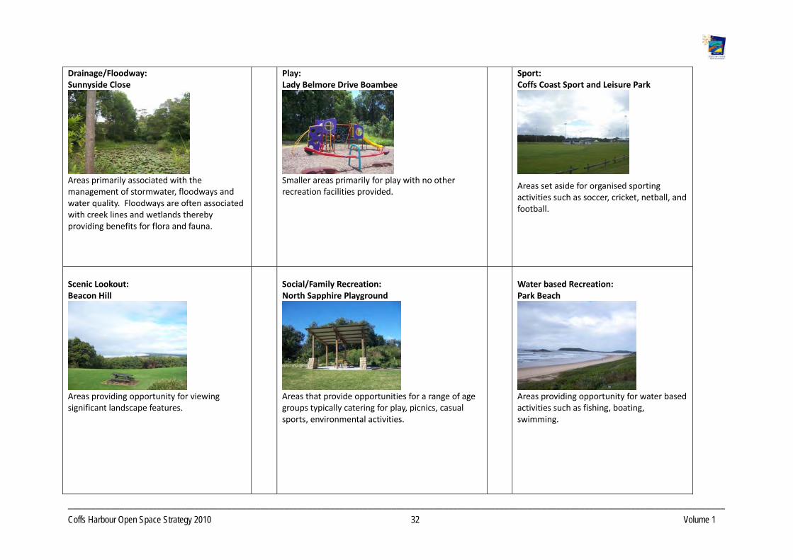
____________________________________________________________________________________________________________________________________________
Coffs Harbour Open Space Strategy 2010 32 Volume 1
Drainage/Floodway: Sunnyside Close
Areas primarily associated with the management of stormwater, floodways and water quality. Floodways are often associated with creek lines and wetlands thereby providing benefits for flora and fauna.
Play: Lady Belmore Drive Boambee
Smaller areas primarily for play with no other recreation facilities provided.
Sport: Coffs Coast Sport and Leisure Park
Areas set aside for organised sporting activities such as soccer, cricket, netball, and football.
Scenic Lookout: Beacon Hill
Areas providing opportunity for viewing significant landscape features.
Social/Family Recreation: North Sapphire Playground
Areas that provide opportunities for a range of age groups typically catering for play, picnics, casual sports, environmental activities.
Water based Recreation: Park Beach
Areas providing opportunity for water based activities such as fishing, boating, swimming.

____________________________________________________________________________________________________________________________________________
Coffs Harbour Open Space Strategy 2010 33 Volume 1
Wayside Stop: Woolgoolga Roundabout
Areas set aside for travellers short rest breaks, generally located near main transport routes.
Showground: Coffs Harbour Showground
Managed by the Showground Committee. Hosts public events.
Racecourse: Coffs Harbour Racecourse
Horse racing, training facilities.
Caravan: Park Beach Caravan Park
Temporary and permanent accommodation primarily caravans.
Relaxation/Contemplation/Escape Baden Powell Park
Open Space dedicated to relaxation, contemplation and escape, with minimal facilities other than seats, paths, viewing areas, interpretive signage etc. These facilities are often found in the Flora / Fauna Conservation areas.
Community Gardens/Horticulture Croyden Community Gardens, (not located in Coffs Harbour)
Open space set aside for the community to establish public vegetable gardens/ horticultural features/floral features.

_____________________________________________________________________________________
Coffs Harbour Open Space Strategy 2010 34 Volume 1
Catchment
Catchment defines the origin of the users or sphere of influence of the open space. It indicates the likely distance people would travel to the park, the number of visitors the space can accommodate and ascribes an appropriate size and scale of development. The catchment hierarchy has three levels; Local, District, and Regional.
Local ‐ Defines spaces that service a relatively small local area and are within easy safe walking distance (400‐500m) of the majority of households within the neighbourhood. Usage of these spaces will generally be daily or weekly. They are generally small and, dependent on function, provide opportunities for basic play, informal recreation activity and games/social sport with a low level of complexity. They typically have a low carrying capacity. It is recognised that distance thresholds for local Open Space in rural residential areas and village settings are not critical as there is not the expectation or need for walkable access to open space. Examples of Local Open Space include Lions Safety Park and Wonga Park.
District ‐ Defines spaces that service a Precinct or District. They are not necessarily within walking distance of all houses and attract visitors from throughout a Precinct or District. The expectation is that people will drive to these spaces. They are generally well known destinations and have significance due to size, diversity or function and provide opportunities for a more diverse array of activities. Dependent on function, they will cater for wide age ranges and attract families and group gatherings. Due to the diversity of elements, longer stays are expected. Examples of District Open Space include Lower Park Beach Reserve and Woolgoolga Beach Reserve.
Two levels of District provision have been determined:
District 1 Predominantly serve a group of neighbourhoods, or a Precinct. Generally larger spaces with greater range of opportunities and more complexity in design and embellishment. Longer stays expected.
District 2 Similar to District 1 however may serve several Precincts. This would be reflected in design and embellishment, experiences available and higher level of complexity.
Regional ‐ Defines spaces that attract visitors from across the City or beyond. They are generally spaces that attract visitors due to their uniqueness, degree of complexity and opportunity offered, or to the scale and complexity of events that may be staged on the site. An example of a Regional Open Space is the Botanic Gardens.
NB: Note that in Coffs Harbour at present certain open spaces are referred to as Regional including the Coffs Coast Regional Park. The reference to Regional in this instance is not an indication of a catchment classification as described above, but rather a term under the National Parks and Wildlife Act 1974.
Landscape Setting The Landscape setting defines the overall physical characteristics of the site that will influence the visitor’s experience. Settings create diversity in the visitor experiences. The same activity may result in a different experience depending on the setting in which it occurs. Diversity can be created across Parks or within a Park through creating activity spaces in a range of different settings.
Settings range from those that are relatively natural (Bushland) and undeveloped through to developed and highly modified (sport fields/paved areas).
Table 9 defines the landscape settings determined for Coffs Harbour and provides examples.
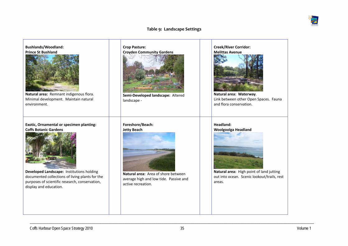
__________________________________________________________________________________________________________________________________________
Coffs Harbour Open Space Strategy 2010 35 Volume 1
Table 9: Landscape Settings
Bushlands/Woodland: Prince St Bushland
Natural area: Remnant indigenous flora. Minimal development. Maintain natural environment.
Crop Pasture: Croyden Community Gardens
Semi‐Developed landscape: Altered landscape ‐
Creek/River Corridor: Melittas Avenue
Natural area: Waterway. Link between other Open Spaces. Fauna and flora conservation.
Exotic, Ornamental or specimen planting: Coffs Botanic Gardens
Developed Landscape: Institutions holding documented collections of living plants for the purposes of scientific research, conservation, display and education.
Foreshore/Beach: Jetty Beach
Natural area: Area of shore between average high and low tide. Passive and active recreation.
Headland: Woolgoolga Headland
Natural area: High point of land jutting out into ocean. Scenic lookout/trails, rest areas.

__________________________________________________________________________________________________________________________________________
Coffs Harbour Open Space Strategy 2010 36 Volume 1
Lawn/Managed Sports Turf: Jetty Oval
Developed Landscape: Sports fields. Organised field sports such as football, rugby, cricket.
Native Grassland/Wetland: Newports Creek
Natural area: Remnant indigenous flora. Minimal development. Maintain natural environment.
Open Parkland: Thompsons Road leash free dog park
Semi Developed: Large area of land preserved in its natural state as public property. Grassland with scattered clusters of trees or shrubs.
Plaza/Square/Mall City Square
Developed Landscape: A paved square, for pedestrians. Set in shopping precincts.
Rough Natural Area: Emerald Avenue, Sapphire
Natural area: Cleared but undeveloped. May have a mix of native and exotic species.
Specialised Sports Surfaces: Coffs Coast Sport and Leisure Park
Developed Landscape: Synthetic surfaces. For organised sports such as hockey, tennis.

__________________________________________________________________________________
Coffs Harbour Open Space Strategy 2010 37 Volume 1
5. Applying the Classification Scheme
Mapping was undertaken of Council's Open Space Network and all spaces categorised according to their Function, Landscape Setting and Catchment. To more fully inform this process, mapping was also undertaken for significant Crown estate, not under Council management, considered important for open space provision in Coffs Harbour. Mapping is provided within the “Open Space Research Report 1 –Precinct Analysis”. The following is a summary of the range and distribution of Open Space by function and setting. A discussion of Open Space facilities has also been provided.
5.1 Total Open Space by Precinct
Coffs Urban has the greatest amount of Open Space, due to the extensive area of flora and fauna conservation Open Space type around the Coffs Harbour Regional Airport and Boambee Beach. Rural areas with relatively lower populations have only small amounts of Council managed Open Space; however these areas usually have extensive tracts of State Forest and/or National Parks.
Boambee Valley
Bonville
Coffs Urban
Far north Beaches
Far North Rural
Far west hinterland
Korora West
North Rural
Northern Beaches
Sawtell/toormina/boambee
South Rural
Woolgoolga
Figure 6: Relative Area of Open Space across precincts

__________________________________________________________________________________
Coffs Harbour Open Space Strategy 2010 38 Volume 1
5.2 Range of Functions
Table 10 gives a summary of the classification of the 894 Open Space land units categorised according to their function. Approximately 45% of the total area of Council's Open Space Network comprises flora and fauna conservation; much of this is comprised of the Coffs Coast Regional Park and Coffs Coast State Park. Sport represents approximately 12% and water‐based recreation 11%, due to the extensive area of beach within the municipality. Social / family recreation (SFR) represents only 2% of the overall Open Space.
Table 10: Summary of Open Space Functions in Coffs Harbour by Area and Number of Sites
Function Area (ha) % of total
area Number of spaces
Access way/ Trail 19.6 0.7 274
Amenity Parklands 27.5 1.0 61
Buffer 14.1 0.5 38
Caravan Park 47.1 1.6 9
Cemetery/ Memorial/ Remembrance 34.6 1.2 7
Community Facility 1.8 0.1 8
Drainage/ Floodway 211.7 7.4 131
Flora/ Fauna Conservation 1294.9 45.1 135
None 0.8 0.0 2
Ornamental/ Botanic Garden 21.8 0.8 1
Play 13.1 0.5 38
Relaxation/Contemplation 6.8 0.2 6
Scenic Lookout 7.7 0.3 5
Showground 9.1 0.3 1
Social/ Family Recreation 49.0 1.7 27
Sport 354.3 12.3 45
Undeveloped Sport/Recreation 47.8 1.7 11
Water based Recreation 318.9 11.1 75
Wayside Stop 0.2 0.0 2
Of the 894 spaces, 274 are small access ways usually located between residential allotments to connect across cul‐de‐sacs and to link streets to Open Space. A total of 135 sites are primarily for flora and fauna conservation and 131 for drainage purposes. Some of the drainage sites along waterways also have a strong secondary function of flora and fauna conservation. There are 27 spaces for Social Family Recreation.

__________________________________________________________________________________
Coffs Harbour Open Space Strategy 2010 39 Volume 1
5.3 Range of Landscape Settings
A total of 717 sites were classified in terms of their landscape setting (Table 13). Just over 42% of the area of open space in Coffs Harbour has a landscape setting of bushland/woodland, with over 17% classified as beach and foreshore. Open parkland comprises just over 14%. Overall, the majority of Open Space has a ‘natural’ setting. Generally Coffs Harbour has a diverse range of settings.
Table 11: Open Space Land Units: Setting Area and Number of Sites
Landscape Setting Area (ha) % of Total Area Number of
sites
Bushlands/ Woodland/ Forest 1180.6 42.6 151
Caravan Park 60.4 2.2 11
Creek/ River Corridor 202.5 7.3 127
Exotic, Ornamental or Specimen Plantings 10.6 0.4
3
Foreshore/ Beach 485.9 17.5 71
Headland 88.8 3.2 13
Lawn/ Managed Sports Turf 192.9 7.0 30
Native Grassland/ Wetland 80.8 2.9 16
Open Parkland 391.3 14.1 247
Rough Natural Area 43.3 1.6 26
Specialised Sports Surfaces 32.8 1.2 22
5.4 Conclusions
There are insufficient parks performing a social family recreation function, particularly at the local level, outside of foreshore settings. Woolgoolga, Coffs Urban West, Emerald Beach, West Sandy Beach, Toormina and Boambee East are particularly poorly serviced in terms of local social family recreation Open Spaces. There is significant opportunity to increase the number of parks filling this function through upgrading play spaces that are below capacity, developing reserves that are currently undeveloped and adding additional facilities to sports reserves. Opportunities also exist within planned future residential areas.
A number of residential areas have restricted access to local open space opportunities due to the presence of major physical barriers such as busy roads or waterways.
Boambee East is particularly poorly served in play opportunities. In these areas there is limited or poor access to existing and/or additional open space and little scope to acquire new park land. There is opportunity in some areas to create expanded social family areas in adjacent neighbourhoods and improve connectivity.

__________________________________________________________________________________
Coffs Harbour Open Space Strategy 2010 40 Volume 1
Northern Beach communities are not well served in relation to access to local sporting opportunities. There are opportunities to provide sports fields in conjunction with future development.
There is poor connectivity between reserves and a lack of off road walkways and trails. Significant opportunities exist to improve connections between open spaces by improving the quality of links along drainage corridors as well as improving the qualities of the road network and pedestrian and bicycle connections into and between open spaces. Opportunities also exist within planned future residential areas.
Coffs Harbour Urban Precinct has a large number of sites where the main function is drainage. These sites have the potential to provide a range of other functions including corridors for developing access ways and trails, and flora and fauna conservation.
In some areas, facilities are ageing and/or of lower standard. There is significant opportunity to improve these facilities.
There is a lack of shade within many reserves. There is significant opportunity to provide shade through tree planting and shade structures.
There are access and Open Space opportunity issues for people who are mobility impaired or disabled. Significant scope exists to redress these problems through improved design when facilities are developed or upgraded.
No sites have been identified for community horticulture/gardens. The demand for this Open Space type may increase in significance to the community as the population ages, housing densities increase, and new settlers arrive with a cultural interest in communal gardens. There is significant opportunity to provide Community Gardens within existing open space.
Significant opportunities within the Crown Reserve System, travelling stock routes and unformed crown roads, administered by LPMA, for additional recreational usage.
5.5 Supply of Open Space Facilities
Coffs Harbour City Council owns and manages a number of open spaces, providing a variety of recreational and sporting opportunities. Detailed descriptions of the distribution of open space and facilities are presented in “Open Space Research Report 1 –Precinct Analysis”.
Important facilities within the Open Space network managed by Council include playgrounds, BBQ and picnic facilities, skate parks, boat ramps, walkways and sporting infrastructure. Council also owns a number of sport and recreation facilities that are managed by lessees / Community Management Committees including:
Swimming Pools
Golf Courses
Tennis Courts
Sports Grounds
Equestrian Facilities
In addition to publicly owned facilities, Coffs Harbour has many privately owned sport and recreation facilities that are accessible to members. Examples include:
Bowling Clubs
Squash Courts
Gymnasiums
Golf Courses

__________________________________________________________________________________
Coffs Harbour Open Space Strategy 2010 41 Volume 1
Swimming Pools
Surf Life Saving Clubs
Fun Parks
Registered Clubs
A brief assessment of the supply for some of the key types of public open space facilities is given below.
Play Facilities
As of October 2009 there are 49 children’s play spaces catering for primary school children or toddlers, and 4 skate parks catering for older children and teenagers and a 1 BMX track that are managed by Council.
Most urban centres and villages have playgrounds with the exception of Bonville, Ulong, Nana Glen, Lowanna and Arrawarra Beach. The majority of playgrounds are designed for children to 12 years of age. Typically the playgrounds provided have limited equipment and generally cater for a lower age range. There is an opportunity to increase the challenge and variety of opportunities to engage children other than for short periods; depending on funding.
In addition to Council managed playgrounds, play facilities are also provided by LPMA (Boambee Creek Reserve, Moonee Creek Reserve), Primary Schools with varying degrees of public access, and commercial providers.
Of the 54 play facilities provided by Council:
8 of the 49 playgrounds contain only basic elements (swing and spring element/s)
92 % contain toddler settings (0‐4 years)
76% are suitable for older children (5‐9 years)
7.6% are suitable for preteens and teenagers (10‐17 year)
In 2006, Coffs Harbour had approximately 17,992 children and adolescents (under 19) in the population. This represents 27.7% of the total population. Of this 5.6% are between 0‐4 years, 6.9% are 5‐9 years and 15.26% 10‐17 years.
Comparison of provision levels and demographic data suggests that insufficient facilities are currently provided for preteens and adolescents. This is supported by feedback obtained from the student and school surveys.
Of the 49 children’s playgrounds the majority are ageing and require updating and/or redesigning. Ageing equipment increases the maintenance burden on Council. Funding is available for some replacement of items but there is a need to address a number of significant repairs. To save cost, replacement equipment is often sourced from different suppliers leading to a loss of overall design integrity and visual amenity. The majority of playgrounds target toddlers and younger children with limited provision for older children. The few sites that cater for a wider age range, for example North Sapphire, are proving very popular with families, suggesting that this style of provision is desired by the community. Table 14 compares provision rates between precincts. It can be seen that disparity exists in playground for toddlers and older children provision between precincts.
Generally shade structures are not present and a minimum standard of seating is provided. Feedback from Family Day Care, a frequent user of playgrounds also suggests lack of shade and fencing at sites near busy roads is of concern.
Currently Coffs Harbour lacks a significant play space that could be considered a Regional Level facility.

__________________________________________________________________________________
Coffs Harbour Open Space Strategy 2010 42 Volume 1
Table 12: Play Facilities (Toddlers and Older Children) by Precinct as of October 2009
Precinct No. of children's play spaces
No of children 0‐9 years
Ratio child/play spaces
Far Northern Beaches 2 145 1 / 72.5
Woolgoolga 3 677 1 / 226
Northern Beaches 6 780 1 / 130
Coffs Urban 23 3091 1 / 134
Korora West/ Moonee West 0 166 0 / 166
Sawtell /Toormina /Boambee 15 2052 1 / 137
Middle Boambee 0 222 0 / 222
Bonville 0 235 0 / 235
Far North Rural 0 60 0 / 60
North Rural 0 295 0 / 295
South Rural 1 292 1 / 292
Far West Hinterland 1 77 1 / 77
TOTAL 49 8090 1 / 165
Picnic Areas
Picnic and barbecue facilities are well‐provided in Coffs Harbour, mainly within picturesque foreshore settings. Picnic opportunities are also provided in National Parks and State Forests as well as at sites administered by LPMA and Community Reserve Trusts.
Though well provided, many of the facilities are ageing and need redesigning within the context of inclusive access and from a whole of park perspective. It is noted that in some instances shade is lacking, picnic facilities are disconnected from play spaces, making surveillance by carers/parents difficult, paths dissect picnic areas, creating safety concerns for younger children and impaired; older settings lack inclusive access in the areas of access arrangements and furniture design.
There are relatively few picnic opportunities outside of foreshore settings. Additional facilities would add value to proposed Social Family parks in non‐coastal settings.

__________________________________________________________________________________
Coffs Harbour Open Space Strategy 2010 43 Volume 1
All new picnic facilities should be designed from a whole of park perspective. The overall integrated site design plan should addresses elements such as access points; water, shade; permeability of the site for access and ease of movement through the site; layout of activity spaces including compatible of activity spaces. Picnic facilities need to be supported by water points, toilets and shelters that can support families and larger groups. Picnic facilities are normally provided within District or Regional level open space.
Youth Facilities
Currently Coffs Harbour City Council manages four skate parks, located at Toormina, Coffs Harbour, Woolgoolga and Corindi Beach. All of these skate parks, with the exception of the new facility at Corindi Beach, could be considered lower level facilities providing insufficient challenge for intermediate and advanced level skaters. Skate parks are also used by freestyle BMX riders, leading to increased wear and tear on of these facilities as they were not designed and constructed to accommodate this sport.
Existing skate facilities are aged and from a design perspective no longer meet the needs of skaters, BMX and scooter riders. The sites generally lack ancillary facilities, such as seating and shade, and lack space for observation of performances/competitions. All four sites require upgrading and replacement of components.
There is strong community support for a Regional level skate facility.
Community interest from younger people surveyed was also high for additional facilities, both BMX and skating, outside of urban areas. There is significant opportunity to provide improved facilities for young people including hard courts, skate and BMX parks integrated within social family setting.
Sport
Coffs Harbour supports a variety of sporting codes within Council owned/managed facilities. An assessment of current sporting opportunities and an analysis of current and future sporting needs will be
addressed in detail within the companion document “The Coffs Harbour Sports Facility Plan“.
Equestrian Facilities
Coffs Harbour has a major competition venue located in the north west of the LGA at Nana Glen. This venue supports Polocrosse, Horse Trials (One and Three Day Eventing), Pony Club, Local Riding Clubs as well as informal equestrian activities.
NSW State Forests cater for informal riding through their extensive network of fire trails and logging tracks. Some Crown Road reserves and travelling stock routes also provide opportunities for trail connectivity between the different land tenures.
There has been an expressed demand for public land for equestrian use in the Bonville Precinct, a rural community with high levels of horse ownership. This community is situated at some distance, by road from Nana Glen and are not well serviced by that facility. It is anticipated that Nana Glen would still be the main venue for competition with a training venue established in Bonville.
Pony Club activities are also held at the Corindi Sports Ground.

__________________________________________________________________________________
Coffs Harbour Open Space Strategy 2010 44 Volume 1
Walkways and Cycleways Walkways and cycle ways are an important recreational facility provided within our Open Space network. Facilities are located primarily in foreshore, headland, bushland and water corridor settings. Walkways are a mixture of sealed and unsealed surface types and vary in width according to the anticipated level of use and the recreational experience being created. Walkways provided are of varying length and offer opportunities for short activities as well as lengthy day walks. There are also many beach access ways, many of which comprise sections of board and chain.
Walkways serve a number of functions including providing access between key destinations, links from the road network to the Open Space, and circuit type trails for fitness / nature enjoyment.
In addition to formed walkways many informal walkways are also present, usually corresponding to preferred desire lines for access to and through a Park. Desire lines represent worn areas resulting from continual use. Many of these desire lines pose opportunities to formalise a walkway to encourage activity and access.
Key walkways include:
Coffs Creek walkway – Mixed surface walkway around Coffs Creek.
Solitary Islands Coastal walk – A significant walkway spanning the length of the LGA, north to south, predominantly located on beaches and headlands. Works are still required to complete the walkway.
Coffs Harbour City Council is currently preparing a Bike Plan that will provide recommendations on future cycleway development including priorities and will address cycle ways in more detail. At present the cycleway network is predominantly located in Road Reserve or on road. The Community consultation for the Open Space Strategy indicated a preference by the community for recreational cycle ways located off road utilising the Open Space network.
Details of potential future walkways and Cycleways are provided in the ”Implementation Plan”.
Mountain Biking Trails
Coffs Harbour City Council has made no formal provision of Mountain Bike trails and to date there has been little demand expressed for provision within Council’s Open Space network. State Forests are the main provider of land/facilities for this activity. This activity will need monitoring as to local demand as unplanned mountain biking activity can significantly impact on natural areas, through erosion, conflicts with walkers on shared trails. Council should consider partnerships with State agencies to ensure ongoing provision of land suitable for this activity. Pine Creek and Orara East State Forests are key sites for this activity.
There may be opportunity, in the longer term, to provide Council land for mountain biking at the landfill site once remediation has been completed.
Boat Ramps
Boat ramps and swimming pools provide for water based recreation activities in Coffs Harbour.
Boat access is provided at ten locations throughout Coffs Harbour. Generally boat usage within creeks is restricted to non motorised or low speed craft. The boat facility at Jetty Beach is considered problematic by many users due to ongoing siltation concerns.
__________________________________________________________________________________
Coffs Harbour Open Space Strategy 2010 45 Volume 1
Swimming Pools
Coffs Harbour manages three pools under lease, located within the main urban centres of Sawtell, Woolgoolga and Coffs Harbour. Council also manages the lease of a pool located on Department of Education grounds at Nana Glen. There is also a sea rock pool located at Sawtell.
Ageing infrastructure is of major concern at the Coffs Harbour War Memorial Pool (50m pool). Parking is also constrained, particularly when sporting events are occurring on the adjacent Fitzroy Oval. Major upgrades are currently underway for the Coffs War Harbour Memorial Pool. Sawtell and Woolgoolga Pools also have problems with ageing infrastructure.
The capacity of the Woolgoolga and Sawtell Pools to service the community well into the future is questionable given the small nature of each venue. Both are 25m in length and accommodate five lanes only. Change room facilities at both facilities are also too small to cater for future growth in use.

__________________________________________________________________________________
Coffs Harbour Open Space Strategy 2010 46 Volume 1
6. Issues and Key Outcomes
Common open space issues faced by growing communities include:
Capacity to fund and develop open space that meets the needs of a rapidly growing population.
Capacity to provide quality open space in new residential developments.
Creating walkable and connected communities.
Protection of the environment from the encroachments of urban development.
Access to open space for sport by schools and sporting groups.
Protection of natural areas and lands containing significant conservation and biodiversity values.
Increased demand for a diverse range of sporting, recreation and leisure activities.
Nine Key Outcomes have been identified for Coffs Harbour's Open Space. These have been derived from the two Open Space Research Reports.
The 9 Key Outcomes (KO) are:
Keeping up with the Open Space Demands of a Growing City.
Improving Community Health and Wellbeing.
Promoting social/family recreation.
Providing Diversity in Open Space and Opportunities.
Protecting Biodiversity and Key Habitats.
Responding to Forecast Climate Change.
Providing Sustainable and Cost Effective Open Space Management.
Promoting Partnerships and Community Engagement.
Optimising Sporting Opportunities.
Relevant issues associated with each Key Outcome are discussed in the following sections. Objectives and management strategies in relation to the issues discussed are listed in the City Wide Action Plan within the “Open Space Strategy 2010 Volume 2 Implementation Plan”.
__________________________________________________________________________________
Coffs Harbour Open Space Strategy 2010 47 Volume 1
6.1 Keep Pace with the Open Space Demands of a Growing City
Coffs Harbour is experiencing significant growth, increasing by 11% over 10 years from 1996 to 2006. Increasing urbanisation, including new developments, residential infill and increased housing densities, places additional pressures on our open space estate, particularly on natural areas, foreshores and beaches. Proposed planning for higher density within Coffs Harbour will further exacerbate demand for and pressures on the City’s open space.
Providing adequate levels of open space to meet the needs of future populations
As urbanisation continues the role of Open Space and its value to the community will become increasingly important. The provision of adequate Open Space, in terms of land area and opportunities offered, as well as the design of the spaces to accommodate multiple uses, will be of ongoing benefit to the community.
Coffs Harbour’s population is predicted to skew in future years towards a much older demographic, with significant implications for economic and social sustainability for the Region. To offset this trend, it will be important to develop facilities that attract younger families to the region.
In accommodating the future needs of Coffs Harbour, planning processes need to include modelling of Open Space needs, particularly for sport which typically requires larger land units. The challenge for Council is in determining what is/will be an appropriate/adequate level of provision to meet future community needs taking into account the myriad factors that will impact on Open Space over the longer term.
Limited suitable land availability, particularly along the costal strip, constrains Council’s ability to acquire additional open space within urban areas. Increasing land values and improvement costs further constrain Council’s ability to expand the network. This is of particular relevance in relation to sporting facilities, where Council is under pressure to provide more facilities to existing codes with increasing memberships and the desire to extend playing seasons.
When planning and providing open space it is desirable to increase the number of activities, range of users and flexibility of facilities, whilst increasing the return on investment. To ensure open spaces provide optimal experiences and opportunities, any development or redevelopment of reserves needs to be in accordance with the overall Open Space Strategy. This will ensure appropriate location of facilities and associated works.
Typically, the form and distribution of open space varies between the rural, urban and village settings. In urban areas lot sizes are generally smaller, increasing the need for an equitably distributed network of open space for recreation and connection with nature and green space. The higher population densities in urban settings makes it more cost effective, in terms of people
serviced, for Council to provide open space and facilities.
In rural and rural residential areas it is not cost effective for Council to provide local parks and recreation facilities in the same manner (within walking distance of households) as in urban settings. Further, lower population densities and larger lot sizes provide a higher level of private open space.
6.1 KO 1 Keep Pace with the Open Space Demands of a Growing City

__________________________________________________________________________________
Coffs Harbour Open Space Strategy 2010 48 Volume 1
In rural and rural residential areas planning needs to focus on:
Providing a broad range of opportunities for different age groups at village centres and adjacent towns.
Providing community meeting points at village centres to act as social hubs. Ideally sport and recreation facilities would be co‐located at these centres.
Multi‐use sports venues and sharing of school resources.
Stronger Council involvement in the maintenance of rural community facilities such as sports fields to encourage increased use.
Developer contributions (Section 94 of the EPA Act) are the key mechanism for funding Open Space provision and development required in new residential areas. There is often a significant time lag between the adoption of a Section 94 plan, development commencing and sufficient funds being generated to enable planned works to commence. This can result in planned works that are no longer desirable from the perspective of meeting community needs, are more expensive due to cost increases, or are not in synchrony with current Open Space planning policy. On occasions Council may forward fund works with revenue, placing additional burden on Council resources.
Recent changes to state planning laws in relation to capping Section 94 contributions will further restrict Council’s ability to provide quality facilities at the various catchment levels. These changes will particularly affect Council’s ability to develop Regional facilities.
Providing Open Space that is responsive to community needs over time Open Space needs to be responsive to changing community preferences over time. There should be sufficient flexibility within the network to accommodate community trends, popular activities and demographic shifts. Regular monitoring of the performance of the Open Space network should occur through community and park usage surveys. Reviewing community profiles regularly will also detect shifts in demographics that may trigger modification of facility provision and Open Space types.
Planning and providing for increased housing densities The current trend towards urbanisation is resulting in a decrease in the private open space available to people. As housing densities change from low to medium and high, the “traditional backyard “is no longer available. Since 1960, the average Australian home has more than doubled in size with a corresponding shrinking of the block size to an average of just 500m2. This reduction of functional private Open Space is particularly significant for children who need opportunities for play, social interaction and exercise.
Increased density may result in a further diminishment of private Open Space and reduced opportunity to create new larger public Open Space. Availability of suitable additional land close to these areas of increasing population density, and associated costs, will present significant challenges
in ensuring appropriate Open Space provision into the future. The protection of existing Open Space from incremental loss to buildings and car parking is of paramount importance. It will also be crucial to retain and develop functional linkages between areas of Open Space.
The NSW Department of Planning has identified Coffs Harbour as a regional centre within the Mid North Coast Regional Strategy with the expectation that higher housing densities can be accommodated.
The relationship between private and public open space is not clearly understood and it is unclear how public Open Space is substitutable for private open space. Planning of high density

__________________________________________________________________________________
Coffs Harbour Open Space Strategy 2010 49 Volume 1
developments must give appropriate consideration to the provision of adequate private and communal open spaces.
Well‐planned private open space provides amenity value as well as opportunities for play, community gardening and dog exercising. As lot sizes decrease, the placement of private open space increases in importance. Even small spaces can provide some recreational opportunities. The built form should be located to maximise private open space.
Acquiring Open Space that is fit for purpose
To meet future community needs and expectations in respect of new open space development, it is important that Council have clear understanding of the types of open space that are required and that the land acquired is useable and suits the intended purpose.
Council is often the recipient of land that is considered to be constrained for development due to a number of factors including flooding, high conservation value, topography or otherwise not viable for development. Frequently there is not a clear understanding of the intended purpose of the land and how it will address community needs and expectations. It is often the case that the land is unsuitable for social family recreation purposes even though it is may still be a useful acquisition in terms of other values and benefits such as conservation, drainage and water quality, and buffers.
Open Space requirements for new release areas and for redeveloping areas need to be determined earlier rather than later in the planning process. New Strategies, Land Release Plans, Structure Plans and Development Control Plans (DCP) should clearly indicate the purpose, setting and intended catchment of new Open Space. At subdivision stage it may be too late as the opportunity to take the land may not be present.
To achieve equitable outcomes for new communities, proposed developments needs to contain open space representing a range of purposes. Priority for new areas is the provision of suitable land for Social/Family Recreation open space. This should be provided on land that has sufficient area unencumbered to develop activity spaces. As a minimum, new development should provide at least one Social/Family Recreation open space within 500m easy walking distance of every household, in accordance with the Core Service Level framework proposed in Appendix 3. For the purpose of this document, encumbered land is considered to be:
Land located in waterway corridors and below the one in five year flood event.
Land that is unable to be cleared due to high biodiversity value.
Land developed as a detention basin or water treatment structure.
Land containing high voltage power supply easements.
Infrastructure distribution networks e.g. powerlines, services, sewer, that significantly limit recreation opportunity.
Land affected by chemical contamination, soil stability issues or hazardous substances that pose a risk to public health.
Less than 10 m wide.
Areas prone to land slip.
Overall open space within a development could include encumbered land and buffers to perform other open space functions as outlined in this report (e.g. amenity parkland, drainage, relaxation/contemplation, flora and fauna conservation). This land however would not be substitutable as the social family recreation space even though it may provide other benefits and opportunities.

__________________________________________________________________________________
Coffs Harbour Open Space Strategy 2010 50 Volume 1
Generally sites of high biodiversity value and areas adjacent to watercourses should be protected through addition to the public open space network or through a planning mechanism that ensures ongoing protection and management. The development interface needs to be designed to prevent impacts associated with development.
Development adjoining foreshores should not impinge on access and views to the beach from public roads and other areas of open space. Foreshore areas should be included in the Open Space network whenever opportunity arises.
The location and design of open space should assist permeability, diversity and continuity in neighbourhoods and encourage easy pedestrian access to and from key destinations.
The development of clear guidelines and processes would improve open space outcomes in new developments. The following should be considered within any guidelines:
Open Space should not be accepted until a detailed site assessment of the proposed open space is provided to ensure that the quality of the site will enhance current provision.
Open Space should be selected with regard to the following:
Need for specific qualities and opportunities.
The ability of the site to contribute to the overall diversity of functions, setting types and recreation opportunities within the planning area and wider community.
The potential to add to or embellish existing open space.
The following table details criteria Council should consider in making the decision whether or not to accept land as new Open Space.
Table 13: Considerations for New Open Space
CRITERIA Consideration
Context What are the characteristics of the proposed space?
Does the open space shape and landform maximise use and function?
What are the characteristics of the neighbourhood in terms of setting, demographics, and environment and how does the space contribute towards these?
What other functions and landscape settings are present within the locality.
Location / Convenience / Accessibility
The open space should be located to maximise intended use.
Are there already similar sites within close proximity?
Physical access to the site and topographic factors that will influence Council’s ability to make the site safe and offer inclusive access.
Does the site contribute to linking areas of open spaces or linking current and future development?
Does the site contribute to the amenity of the area, for example: visual relief from the built form, mitigation of noise impacts?
Is the site accessible and safe for people including those with disabilities?
Viability Is the land a good investment for Council in terms of use and cost?
What will be the costs of acquiring, developing and maintaining the land?
What are the extent of easements and service corridors that may affect
__________________________________________________________________________________
Coffs Harbour Open Space Strategy 2010 51 Volume 1
useability and restrict access?
Is the site by itself or in combination with adjoining land, of a suitable size for the intended function/purpose and likely catchment?
Adjoining land use What are the effects of adjoining land use on the values and benefits of the open space?
Quality What is the existing physical condition of the land, which may have issues such as contamination and weed infestations that will impact on Council’s financial resources?
What will be the requirements of potential users and the attributes sought?
Diversity What are the functions and settings that are required to create diversity of Open Space within the surrounding area?
What is currently available?
Protecting Landscape values
Does the open space help protect and enhance biodiversity or geological features?
Does the open space protect and enhance cultural heritage including significant trees, gardens or plantings, remnants of early occupation and settlement, indigenous heritage including:
Artefacts.
Cultural sites.
Interpretive material.
Co location and complexity
Is the open space located to complement and maximise connections with other public lands, community facilities and movement systems (bikeways, walkways) and future planned development?
What is the relationship to other spaces and their catchment hierarchy?
Opportunities What is the capacity of the site to offer a range of opportunities?
Constraints Is the open space free of elements that constrain use for the intended function?
Distribution Does the open space contribute towards equitable distribution?
In addition to the considerations above, open space proposed as additional flora fauna conservation areas should reflect one or more of the following broad principles:
The local and regional significance of the type/s of vegetation and or habitat value represented.
The opportunity to link or protect isolated or smaller remnant patches of vegetation containing endangered vegetation communities or threatened species.
The opportunity to create a larger contiguous protected area.
The size and quality of the vegetation.
Linkages and connections to existing or proposed open space areas, roadsides and waterways including forming part of an identified habitat corridor.
Area protects riparian corridor and there is opportunity for an appropriate width vegetated riparian buffer.
__________________________________________________________________________________
Coffs Harbour Open Space Strategy 2010 52 Volume 1
The ability to adequately protect and manage the vegetation.
The provision of sufficient areas to provide adequately for other open space uses compatible with nature conservation. Open Space area adjoining significant vegetation should be suitable for low impact complimentary recreation. Higher impact or formal activities to be located further away from conservation areas, where possible.
Managing the Open Space Development Interface
Open Space within a development is an important factor in the development's character and contributes to the overall amenity and liveability of a place.
The interface between the development and the open space defines the character and management of the open space and is a determinant in how the community will value, enjoy and benefit from the open space.
A poorly planned interface leads to problems with passive surveillance, issues with access circulation and permeability, and issues with managing anti‐social behaviour. In the case of conservation areas, a poor interface leads to issues including increased weed infestation, incremental loss of vegetation, and increased maintenance burdens. The result is a less than optimal outcome for the open space and the community.
The interface between development and open space provides an ideal area for implementing water sensitive urban design (WSUD) treatment options, as appropriate to the catchment needs. WSUD will not only improve water quality associated with a development, but can enhance natural values such as biodiversity, amenity and potentially recreation depending on the WSUD treatment type selected.
The following guidelines should be considered when assessing development that will adjoin new or proposed areas of open space, including conservation areas.
Servicing or infrastructure requirements do not impact negatively on trees within adjoining open space.
Passive surveillance from the development into the open space.
Road perimeters along edge of reserves rather than residential blocks.
WSUD principles incorporated into development design to avoid negative impact on water quality.
Development access to adjoining open space via approved public walkways only.
Patterns of use of the open space enhanced or retained as a result of development.
If development adjoins a sporting facility, recognition in the building design that noise and light may emanate from the open space.
Visual amenity and public enjoyment of the open space not negatively impacted by the development.
Retention of significant views from the open space.
Retention of public access to the open space.
Public open space not to become pseudo private open space.
Asset protection zones requirements and other management type functions should not impinge on the areas reserved for flora and fauna conservation.

__________________________________________________________________________________
Coffs Harbour Open Space Strategy 2010 53 Volume 1
Design is sensitive to the objectives of the Koala Plan of Management.
Development to be landscaped with species not likely to become a source of weed infestation.
Preserving Regional and Local Character and Identity Open Space contributes to sense of place and local identity for communities. Forested ridgelines, banana plantations, coastal views, and the rural backdrop are significant features that define Coffs Harbour. The interplay of built form, vegetation and topographic characteristics define neighbourhoods at a local level and on the broader scale. The natural features of the region are complemented by community development of the Arts and significant Aboriginal and European historical sites.
The Coffs Harbour region has a strong cultural association for the Aboriginal community and is rich in cultural heritage. Some of these sites and places of significance are located within or on public open space.
European heritage is also reflected in the Coffs Harbour landscape, with many buildings, streetscapes and structures dating from the 19th century, reflecting the settlement and development of the area.
Protecting and Managing Trees
Trees provide amenity and environmental benefits, and enhance the value of adjoining properties. Trees soften and enhance the landscape, breaking up building lines. They contribute to the local environment, providing fauna habitat, wind and sun protection, and provide shade and scenic amenity to pedestrians and cyclists along footpaths, walkways and trails.
Roadside vegetation outside of urban areas also contributes to scenic amenity, buffers adjoining land use and provides opportunities for wildlife corridors.
Council has a significant investment in its trees, currently maintaining in of excess of 7000 street trees and annually planting approximately 7000 trees throughout the Reserve system. Council needs to protect this investment through appropriate asset management programs.
A significant impact on coastal vegetation arises from the illegal clearing of trees on public Open Space to enhance private opportunities for coastal views. Whilst Council maintains strategically located viewscapes on public lands clearing for private views is not supported.

__________________________________________________________________________________
Coffs Harbour Open Space Strategy 2010 54 Volume 1
6.2 Improve Community Health and Wellbeing
The North Coast Area Health Service identifies cardiovascular diseases as the leading cause of death in the region and one of its health priority areas. An ageing population further exacerbates this issue.
There is strong support for activities that enhance the health and wellbeing of the community. Councils can play a key role through providing opportunities for incidental activities such as walking and cycling, and sport (both formal and informal), at no cost or low cost to participants.
Well designed Open Space provides a range of health benefits including opportunities for exercise, relaxation, social interaction, contact with nature and relief from stress.
Planning for an Ageing Population
Older adults seek diversity and choice; they want to be physically active and socially connected. Research indicates that the elderly are staying fitter for longer, with the average age for the onset of a first major illness being 73. The top activities undertaken by older adults in Coffs Harbour are walking, fishing, swimming, cycling and golf. Current trends in Coffs Harbour indicate that walking is a key recreational activity for people over 65. Gardening also rated highly as a preferred activity (CHCC community Survey 2008).
Demand for spaces where older people can engage and interact with families and younger people are likely to increase, as is demand for walking opportunities, cycling, dog walking and picnicking. Interest in communal gardening is also likely to increase as people find they can no longer manage a backyard. This will need to be reflected in the design and embellishment of open space.
Open Space design will need to be responsive to the needs of an older population, encouraging older people to get out and about and remain physically active. Park furniture, seating and paths in particular will need to complement this demographic. The increasing numbers of mobility scooters traversing footpaths means that future footpath design will need to accommodate this trend.
Rather than designing areas specifically for older adults, open space and facilities should have universal appeal and integrate and be responsive to changing demographic and trends.
Open Space providing opportunities for physical activity
Coffs Harbour features significant National Parks and beaches that provide nature‐based and water‐based activity to residents and visitors. It will be important for Council to increase options for participation to complement these activities in the future.
Council can play a key role in providing opportunities for undertaking physical activity including walking, swimming, cycling, play and sport. ERASS has repeatedly found that the most popular physical activities undertaken are walking, swimming, aerobics/fitness and tennis, usually undertaken as informal recreation.
Proactive Councils are now recognising that in order to activate open space, and encourage physical activity there is a need to provide and to support private providers of programmed activities in parks. It is no longer the case that “build something and people will come to it”. Opportunities exist for
6.2 KO 2 Improve Community Health and Well Being

__________________________________________________________________________________
Coffs Harbour Open Space Strategy 2010 55 Volume 1
school holiday programs, after school programs, walking for pleasure, environmental education, and
eco‐schools program.
Creating walkable and connected neighbourhoods
A major consultation finding was that the community sees the provision of access ways and trails as Council’s priority. This is further supported by the Coffs Harbour Settlement Strategy: ‘Our Living City’ endorsed in 2007 and the recent Vision 2030 Strategy, which encourages urban design that focuses on walkable, connected neighbourhoods and supports prioritising walkway and cycleway infrastructure development in the region.
The benefits of walking are widely documented including physical exercise, connecting socially with other people and release from stress and tension. Additional benefits of walking and cycling, particularly as an alternate form of transport, include reduced greenhouse gas emissions, and reduced need for new/upgraded road infrastructure.
The decision to walk for recreation is influenced by a number of factors: functional aspects, safety, destination and aesthetics, (Pikora et al) 3.
Factors in the decision‐making process for recreational walking
Functions
Walking surface
Width
Traffic
Permeability (street intersection design)
Safety
Personal safety
Traffic (verge widths, separation, and crossings)
Sightlines (blind corners, solid fences)
Aesthetics
Streetscapes (including maintenance and cleanliness)
Shade
Views (sights and architecture)
Destination
Parks and shops
Schools
Community facilities
Locating footpaths on both sides of streets is another significant factor influencing people’s decision to walk. From this it is clear that Council can play a key role in creating the environment that encourages walking.
Trail networks include cycleways and walkways and in rural areas, horse trails. A well‐integrated trail network system provides a safe route for residents and visitors to move through natural areas and access local commercial centres and parks as well as recreational opportunities.
In Coffs Harbour there are few off‐road circuit trails around parks and/or connecting open space and residential areas. Development of an off and on road trail network will connect open spaces and promote walkable and connected neighbourhoods. Perimeter trails can also be created around larger reserves including sportsgrounds. A number of missing links within the existing open space
3 Pikora T, etal 'Developing a framework for assessment of the environmental determinants of walking and cycling'. Journal
of Social Science & Medicine 2003; 56(8)

__________________________________________________________________________________
Coffs Harbour Open Space Strategy 2010 56 Volume 1
network have been identified (see Volume 2 Precinct Analysis Report for details). A high priority of Council should be to further develop walking trail networks.
Coffs Creek presents a major opportunity to create a Regional Walkway/Cycleway around the creek edge serving the local population as well as visitors to the Region.
Connecting Rural Residential Areas
In rural residential areas, particularly those that are yet to be released, planning needs to include creating pedestrian, cycle and horse friendly street design as the road network will, by default, be used as recreational space for trail networks. Trail planning should occur prior to development of new areas.
Considerations for roadside trails that allow safe horse/people movement in road verges include:
At least one wider verge to allow separation between traffic and people/horses.
Shade.
Safe crossing points at drains, bridges, culverts.
An understanding of the interplay between drainage swales and people/horses/cyclists.
Creating Regional Trail Corridors
A significant, underutilised component of public open space in Coffs Harbour is the Crown Road reserve system, travelling stock routes and fire management trails that traverse the LGA. Opportunities are present to develop a network of Regional Trail Corridors, utilising existing road networks, operational trails, unformed Crown roads and travelling stock routes to link townships and rural areas to key areas such as State Forests and National Parks. Regional trails need to be developed in conjunction/partnership with other local government authorities and state land management agencies and provide recreation options for hiking, horse riding, mountain biking and camping. Regional trails would service the local community as well as represent an attractant for tourists. Corridors through cleared lands can be replanted, providing shade and also improving biodiversity outcomes.
Camping areas could be developed at suitable locations in conjunction with the trail network.
Negotiation may be required with private property owners for access agreements through private land where gaps exist in the public land network.
Key trails for development include an escarpment trail from Sealy Lookout to Red Hill and through to Boambee State Forest / Englands Road; Coramba to Woolgoolga; and Wedding Bells State Forest to Nana Glen.
Key regional trail opportunities need to be identified, as a matter of urgency, prior to planned LPMA divestment of Crown roads to private buyers.
Clean Air in Parks
Community consultation indicated a strong level of support for the regulating of smoking at key sites utilised by younger people including playgrounds, sports fields and family oriented beaches. The negative effects of smoking and passive smoking are comprehensively documented.
Ideally this regulation will be managed by the community, through awareness and support, rather than financial penalties.
__________________________________________________________________________________
Coffs Harbour Open Space Strategy 2010 57 Volume 1
6.3 Promote Social/Family Recreation
People today are becoming increasingly busy and with the current financial climate there is a need for low cost alternatives to experience quality time as a family and relief from stress.
Well planned Social/Family spaces provide an opportunity for social connectedness, family time, relief from stress and daily routine and provide opportunities for physical activity and relaxation.
Within neighbourhoods there should be the option for families to access a wide range of activities and types of play, across a variety of different landscape settings, including natural as well as more developed settings.
Developing Reserves for Social Family Recreation
Open Spaces suitable as social family parks must be large enough to include recreational facilities such as walkways, picnic and barbeque facilities, as well as play opportunities. Ideally they should be developed in key sites within each locality; they should be located in high use, easily accessible areas with good surveillance. Centralising equipment and facilities will allow the creation of larger parks with increased diversity of experience.
The park’s design can then provide for diversity in play opportunities, good surveillance, and servicing a range of ages in the one space. Design of social / family recreation parks should endeavour to include:
Integration with existing walkways/cycle ways and off road trail networks.
Accessibility suited to size and use.
Inclusive access for people of all abilities.
Attractive landscaping, shade, seating, and lighting.
An environment that promotes personal safety and feelings of security.
A range of recreation opportunities across age groups.
Incorporation/enhancement of natural features for play and recreation.
At present the majority of Coffs Harbour social family space is concentrated in foreshore settings. These spaces are generally the most visited spaces in Coffs Harbour as they offer diversity in terms of setting, function and facilities and offer the greatest range of experiences.
Embellishment of these spaces to a higher standard, incorporating a better range of recreation opportunities to a wider range of ages and abilities will encourage higher visitation. There are also opportunities to create new, or improve existing, social family spaces in settings other than foreshore locations.
6.3 KO 3 Promote Family and Social Recreation

__________________________________________________________________________________
Coffs Harbour Open Space Strategy 2010 58 Volume 1
Addressing areas not well served by Open Space There are a number of areas that are not well served in open space provision; particularly social family recreation (SFR) spaces, sport and trails (see Section 4 and “Open Space Research Report 1 ‐Precinct Analysis”. Council’s priority is to address areas underserved by Open Space.
Poor open space provision can, in part, be augmented through improving the amenity value of streetscapes.
Developing Facilities for Youth
Young people seek active pursuits and have a strong desire to participate in activities that offer social interaction with friends. Open Space should provide opportunities for young people to socialise safely with friends, “hang out”, undertake physical activity, experience challenge and have fun. Open Spaces should also provide opportunities to interact with older people/parents and to be exposed to positive role models and leadership.
Young people can easily be made to feel unwanted in public spaces. An under‐engaged and disenfranchised young population leads to issues of vandalism, self harm through drug and alcohol abuse and other anti‐social behaviours. Coffs Harbour experiences significant concerns with underage drinking and vandalism.
The top activities undertaken by young people in Coffs Harbour are soccer, swimming, basketball and going to the beach.
Preferred open space types, aside from beaches, are sports fields, indoor sports courts, swimming pools, skate parks, play spaces, trails, fitness centres, and neighbourhood parks. There was a strong preference for more/improved skate parks. Younger males preferred active pursuits such as cycling, soccer and swimming while female participation is strong in walking, swimming and cycling.
The top two activities that young people indicated that they would like to do but can not included water parks and skateboarding. The main things that would encourage participation were facilities more conveniently located and better quality facilities.
Coffs Harbour is not well serviced in terms of its facilities for older children and adolescents. Coffs Harbour's existing skate parks are ageing and in need of major refurbishment (see Section 5.3.1). They are also of limited challenge to more skilled riders as they have been designed for beginner level skaters. Any upgrade/ redesign should be undertaken in conjunction with skating and community groups.
Freestyle BMX is another activity popular with adolescents in Coffs Harbour. Degradation of natural areas has occurred through the construction of illegal BMX jumps. Provision of well designed and located BMX facilities will provide recreation opportunities as well as assist in decreasing degradation of areas whose prime purpose is flora fauna conservation.
The PCYC in Coffs Harbour and the Youth Centre in Woolgoolga provide meeting places for youth where facilities promote recreational activity. The PCYC is professionally managed and offers karate, judo, fitness, gymnasium and circus skills among its physical activity options. The Woolgoolga Centre is leased to a community not for profit group and has outdoor basketball and beach volleyball courts. This facility is currently underutilised.
Coffs Harbour also lacks performance spaces for younger people to stage impromptu events such as music festivals although the current Master Plan for Brelsford Park includes an outdoor stage and civic performance space.

__________________________________________________________________________________
Coffs Harbour Open Space Strategy 2010 59 Volume 1
Creating quality play experiences
Play equipment is just one element of the play experience. To engage children and invite return visits play spaces need to provide a range of opportunity to experience challenge, risk, self confidence, and imagination. The play spaces need to include areas that are places for doing, thinking, feeling, and being and should incorporate:
A natural landscape including variety of flora, water elements, animals, and comfort (shelter/shade).
Structures that are changeable or adaptable that can be manipulated physically or in the imagination, with a variety of levels and quiet places for privacy.
Age appropriate, with separate areas for different ages (2‐5yrs, 5‐12yrs, 12 yrs+).
Provision for adults within the playground.
Safe surfaces: usable but don’t hurt.
Inclusive accessibility, including physically impaired and parents with prams.
Many of Coffs Harbour's playgrounds are located within very small parks that limit the size of the playground; therefore they provide limited play opportunities and engage children for short periods. These parks are too small to provide social/family opportunities that would encourage longer stays. Maintenance of many small playgrounds in very small parks is costly, and inhibits the opportunity to provide diverse play opportunities and experiences. (A detailed assessment of playgrounds is included in Section 5.3.1).
While the parks are an integral part of the open space network, provision of better quality playgrounds in fewer parks, in conjunction with other social/family facilities, would enable the creation of more interesting play areas and present a better return on investment. To maximise cost effectiveness, play equipment should be located in high use areas that have good surveillance, service a range of ages in the one space, be accessible, balance play value with safety, provide challenging interesting play opportunities, be located in conjunction with other recreation facilities such as walkways, picnic and barbeque facilities.
When determining key sites, consideration must be given to the carrying capacity of the site as well as parking capacity and potential social impacts on surrounding neighbourhoods. Inappropriately located play equipment will have ongoing financial and social implications.
Playgrounds, no matter how small, should aim to have sufficient choice to allow children of all abilities to access the space, be engaged, and find an enjoyable activity. This should be a primary consideration in park design. The level to which inclusive access and play opportunities are provided should link to the park catchment. Parks servicing Districts or the Region should have the greatest degree of accessibility and opportunity for children of all abilities.

__________________________________________________________________________________
Coffs Harbour Open Space Strategy 2010 60 Volume 1
6.4 Provide Equity and Diversity in Open Space and Opportunities
The consultation findings demonstrate the need to diversify participation options in Coffs Harbour, complementing the activities already provided by its beaches and bushland reserves, and to address inequities in provision and access to open space. Additional recreation opportunities identified in the survey include eco‐tourism/tourism opportunities, activities that attract and service young people and older adults, and providing opportunities for people of all abilities to participate.
Open Space across Coffs Harbour must provide a range of activities that attract diverse recreational interests. It is important that Council in its distribution and design encourage the whole community to use and access Open Space.
Developing diversity
The need to provide for individual recreation and sporting activities must be balanced with promoting equity and diversity in facility provision and access opportunities for the wide range of community users seeking opportunities within open space.
Open Space types that have been traditionally allocated for a predominate use, e.g. drainage, cricket oval, playground, have the capacity to provide other functions in addition to the main purpose of the space. Providing for other uses will make more efficient use of the land resource and provide greater opportunities for the community. For instance:
Drainage corridors ‐ Open Spaces primarily functioning as drainage corridors can be combined with shared pathways and trails, creating opportunities for recreational walking and links to key destinations such as shops and schools. Many of the drainage corridors run east west, providing good opportunities to link western areas with the CBD and other key destinations. The visual and environmental value of drainage reeves can also be enhanced through undertaking redesign of drainage channels to a natural stream form incorporating pool and riffle sequences where appropriate. Regeneration with native species will also improve biodiversity value.
Flora and Fauna Conservation – Flora and fauna conservation is the largest category by area of open space in Coffs Harbour and is well distributed across precincts. These sites offer opportunities for walking track development, environmental education and nature based recreation. These sites are often popular with children for play in undeveloped settings.
Lunch time Parks ‐ An important element currently under‐provided within CBD and
industrial areas are spaces for city workers to relax and eat lunch. Fitness trails can also be developed in worker areas. Provision of these lunch time parks will be an important consideration in any redevelopment of the CBD. Open Spaces currently classified as Relaxation/Contemplation and Amenity Parkland provide opportunities for this use.
Sports Reserve ‐ A significant component of the Open Space network are sporting fields. As well as providing for organised sporting activities, sports reserves provide a range of other opportunities including walking, play, informal games, scenic amenity, and flora and fauna conservation. These other opportunities can be enhanced through provision of additional facilities such as walkways, play facilities and tree plantings.
6.4 KO 4 Provide a diverse, equitable and accessible network of Open Space and opportunities

__________________________________________________________________________________
Coffs Harbour Open Space Strategy 2010 61 Volume 1
Golf courses present opportunities for environmental gains through tree planting to establish wildlife habitats and corridors.
Public Art/Sculpture – The use of art in public open space can increase the attractiveness of an area and bring art into the wider public sphere. Art can be used as an interpretive tool to represent the history and values of an area. Artwork can also enhance play areas and form part of the play experience.
Surplus small play parks – Non viable play parks could be redesigned utilising the character of the local area. This would provide opportunity for such recreation opportunities as community gardens, revegetation projects, amenity parks and rest areas along urban trails.
Significant opportunities exist to further diversify existing spaces through redesign, providing the same function in a different setting and varying the types of facilities provided.
The value of amenity parkland can be improved upon through landscaping/beautification works.
Creating Community Gardens Coffs Harbour currently lacks Community Gardens. The community, through the Vision 2030 process has identified a strong interest in Community Gardens. Community Gardens offer a range of positive benefits including social contact and the opportunity to grow flowers and vegetables. Community Gardens will increase in importance as areas move to higher density and people no longer have access to private Open Space for this purpose.
When considering sites to establish gardens, Council must take into account the access and use of the open space for the whole community as Community Gardens will only be accessible to part of the community. Additionally Community Gardens raise a variety of land management issues that Council must address including use of herbicides/pesticides, fertilisers, composting material, security of the sites, vandalism, visual appearance, public safety. Council also needs to consider the scale, type and management model for Community Gardens it will support, including whether or not small gardens for largely individual use will be considered as well larger gardens benefiting a larger community group.
Council will need to determine appropriate management mechanisms to address all concerns including formal agreements with community groups for management of the sites. Council will need to develop guidelines in relation to Community Gardens that include the following considerations:
A demonstrated benefit to local residents and the wider community.
Adequate open space to compensate for land being used as a community garden.
Suitable managerial mechanism for the running of the garden e.g. an incorporated community body.
Appropriate auditing mechanisms to ensure compliance with Council's requirements.
If the land is required for another purpose council must retain the right to reclaim the land for that purpose.
In the event the garden is no longer required or functional, all infrastructure and plants established as part of the community garden must be removed prior to the land being returned to Council.
When considering applicants, priority will be given to groups/individuals that do not have access to private land.

__________________________________________________________________________________
Coffs Harbour Open Space Strategy 2010 62 Volume 1
Creating Inclusive Open Space
Open Space presents a significant opportunity to cater for the wide range of interests, activities and experiences sought by people of all degrees of physical, social and mental ability.
Advances in medical technology mean that people with medical conditions and disabilities are living longer than before and have an enhanced ability to move throughout the community.
Barriers to participating in the opportunities offered by open space prevents health benefits being realised and can lead to feelings of social exclusion and frustration.
Barriers to participation often include:
Poorly designed entry points.
Lack of formed pathways.
Park furniture that does not facilitate use by the disabled.
Lack of handicapped toilets and amenities or poor access routes.
Lack of play equipment and opportunities suitable for use by disabled children.
These are all factors that need to be considered within a sympathetic design response.
Promotion and Protection of Beaches and Foreshores
The foreshores and beaches service both the local population as well as seasonal visitors. The community surveys indicated a strong preference for beaches and foreshores as a recreation activity venue and were listed as the top priority for improvements. Additionally beaches are a major tourism attractant for Coffs Harbour.
Sophisticated design response is necessary to improve the balance between carrying capacity and visitor experience, particularly with high use areas such as Jetty Beach, Park Beach, Sawtell and Woolgoolga. At higher levels of development, visitor experience may be significantly reduced due to the alteration to the setting and the high volume of users.
As a principle, any new development adjoining foreshore locations should ensure the retention/enhancement of public access.
Foreshores and the dunal systems are an important resource for conservation and the protection of biodiversity values. Indiscriminate access to these areas will have negative impacts on biodiversity values and potentially increase risk of erosion and sand blowouts. A review of current and planned beach access will be required to mitigate potential impacts.
Concerns have been expressed by the community regarding the long term future of recreational vehicle access to Council’s beaches. At present vehicles are permitted on a restricted number of beaches: Boambee Beach south of the Fishing Club to Boambee Creek; Corindi Beach through to Arrawarra Beach; Darkum Beach; Hearnes Lake Beach from Willis Creek to Sandy Beach; Woolgoolga Back Beach (southern end). Access for boat launch and retrieval is also permitted a number of other locations.
In relation to Council’s current policy, concerns have been raised about potential conflicts between other beach users and 4WDs, particularly in view of new beachside subdivisions and overall projected increases in population for the LGA inevitably resulting in increased beach usage. General concerns have also been raised in relation to environmental factors and the ecological impacts of

__________________________________________________________________________________
Coffs Harbour Open Space Strategy 2010 63 Volume 1
4WDs on shorebirds, pipis, and beach microfauna. Current research suggests numerous negative impacts from 4WD on beach ecology.
Opportunities for Leash‐free Dog Areas
It is estimated by the Petcare Information and Advisory Service Australia (PIAS) that dog ownership in Australia is currently 182 dogs for every 1000 people. Extrapolating this figure for Coffs Harbour, based on the 2006 census data, there would be almost 12,000 dogs within the LGA.
Australians value their relationship with their pets and it is anticipated that as the community ages the levels of pet ownership will increase. This increase will bring a corresponding increase in demand for areas where dogs are permitted off leash. Coffs Harbour currently has only one leash‐free park, in Coffs Urban precinct and a number of beaches where dogs are permitted off lead. Consideration needs to be given to establishing additional leash free parks in urban areas, ideally within parks serviced by good walkway connections.
The LPMA has indicated that there may be significant opportunity for leash free activity within the Crown Reserve system and within the travelling stock routes now administered by LPMA.
There has been increased interest from sporting clubs in regulating dog activity on sporting fields due to concerns with faecal material. Additionally, as coastal populations increase, conflicts may arise between beach users and dogs being exercised off lead. This will create further pressure on dog owners seeking options for walking and exercising their pets.
__________________________________________________________________________________
Coffs Harbour Open Space Strategy 2010 64 Volume 1
6.5 Protect Biodiversity and Habitats
Coffs Harbour LGA currently has substantial areas of native vegetation which support high levels of biodiversity, including a large number of plant and animal species categorised as endangered or vulnerable. A high proportion of the remaining native vegetation is considered to be of local or regional ecological significance including a number of vegetation communities that are currently listed as endangered ecological communities (EECs). Many of the significant vegetation types are poorly represented on public lands. Coffs Harbour features significant National Parks and State Forests intersecting the municipality.
Coffs Harbour's Open Space network contains a significant number of sites whose primary or secondary function is flora and fauna conservation. The majority of the drainage open space has been identified as local wildlife corridors. This natural reserve network provides important habitat and dispersal corridors, linking into sub regional and regional level corridors and larger contiguous areas of key habitats, many of which traverse Council estate. Further assessment is required to address gaps in network corridors and boundary rationalisation for management gains. These areas also provide foraging and breeding sites for a number of endangered species. In addition to biodiversity values these areas provide visual relief from surrounding development and offer a range of low impact recreational opportunities to communities.
Urban development effectively fragments these corridors and places additional pressures on the remaining land through increased urban run off, weed infestation and vertebrate pests, erosion, inappropriate recreational usage and impacts of domestic animals. This is of particular concern in preserving local bird and wildlife populations, now and into the future. Whilst some species can thrive in an urban setting, many other less adaptable species are at major disadvantage. Additionally, corridors and large contiguous units of vegetation will be critical as climate change corridors for species retreating over time from coastal inundation and the accompanying alteration in flora.
Coffs Harbour has a formal motorbike track located adjacent to the CCSLP, and State Forests provide opportunities for legal age riders to participate in non formal natural settings, however, younger unlicensed and unregistered riders residing in urban areas often resort to using Council’s natural areas for this activity. This creates problems for reserve management (weeds, erosion, noise, conflicts with walkers) as well as noise and amenity impacts to surrounding residential areas.
Retention of the motorbike track in Coffs Harbour is important in managing motocross activity in natural areas.
Many of the habitat corridors and drainage reserves present opportunities for recreational trail development. Balancing the needs of these functions against conservation values will continue to present a challenge to management.
Maintaining biodiversity will require effective management and protection of vegetation held in both public and private ownership. Council has recently undertaking a major vegetation mapping process with a view to developing partnerships and incentive schemes to protect key areas in private ownership (Draft Key Habitats and Corridors Strategy). This process will also guide the decision making in relation to future addition of Open Space for flora and fauna conservation purposes.
In many instances developers and landowners are unable to compensate for tree removal upon their own land due to site constraints. Consideration should be given to establishing mechanisms whereby these landowners can undertake their compensatory planting at priority locations identified within
6.5 KO 5 Protect Biodiversity and Habitats

__________________________________________________________________________________
Coffs Harbour Open Space Strategy 2010 65 Volume 1
the Regeneration Strategy (Draft) within the public Reserve system. Council could also use a similar process to compensate for vegetation lost as a result of Council works.
The community recognises the value and benefit of the natural environment. In repeated Council surveys (2004 and 2007) bushland was ranked highly as a type of open space on which funds should be spent, should they become available. Presently flora and fauna conservation areas and drainage corridors have the greatest area of open space type within the LGA. At present Natural areas are not funded through recurrent expenditure but are funded on annual, merit‐based, allocation from the Environmental Levy Program. This may restrict the ability to grow Natural Area Programs, particularly as additional conservation estate is accrued.
The community actively assist in the management of flora and fauna reserves through Landcare. Council should continue to support and promote Landcare.
Effective vegetation management requires an understanding of the role of fire in maintaining ecological diversity. Coffs Harbour currently has a no burn policy in place for Council estate. This will need reviewing to ensure adequate protection of life and property (legislative requirement) and ongoing maintenance of vegetation communities and plant species that have evolved in response to specific fire intervals and fire intensities. This review will need to be done in conjunction with other land management agencies, the Rural Fire Service (RFS) and the NSW Fire Brigade.
Council is an advocate of the Bushland Friendly Nursery Scheme, originally developed across a number of Local Government areas to manage and control the sale and propagation of species known to be invasive into bushland areas. Continued support for this program is vital.

__________________________________________________________________________________
Coffs Harbour Open Space Strategy 2010 66 Volume 1
6.6 Provide Sustainable and Cost Effective Management
Traditionally open space has been viewed as a community asset provided at no cost to users. However, ever‐increasing resident and user expectations regarding the standard of facilities and levels of service are becoming more difficult for Council to meet. Resources will need to be managed wisely and a targeted approach taken in order to maximise value for money spent. Resourcing Continuing growth of the Open Space network and associated infrastructure as a result of new development places further strain on Council’s operational and capital programs and impacts on Council’s ability to maintain existing, or increase, service levels. The growth in the overall area of Open Space and the amount of facilities has not been reflected in a corresponding increase in expenditure. New areas of Open Space begin to accrue maintenance costs immediately. However, sometimes expansion of the Open Space network can sometime reduce management costs for some sites. Also, as new Open Space assets are developed, maintenance costs are not always adequately identified and considered for future funding cycles.
NSW State bushfire planning requirements which commenced in 2004 are now being realised in new developments, resulting in a 230% increase in the amount of Asset Protection Zones (APZs) and a 40% increase in fire trails requiring maintenance by Council between 2005 and 2007. New development has also resulted in additional play spaces, picnic facilities and landscaped areas requiring maintenance.
Council is acquiring many additional areas of land whose main purpose is flora and fauna conservation. These areas will require ongoing management and resourcing to ensure biodiversity values are not compromised and to manage any fire risk to and from adjoining properties.
Unless more resources are made available, service levels will become unsustainable.
Council already invests significant resources towards the management of open space, park assets and vegetation. It is desirable that Council protect this substantial investment through sound management practices and an appropriate level of resourcing.
The challenge for Council is in continuing to determine and provide appropriate service levels, maximising community benefits with service delivery and managing the whole of life costs of assets. Council needs to determine what service level will be provided, the infrastructure and resources required to meet this, and what is financially sustainable for Council.
Asset Management
Maintenance levels appear to be a significant issue in many parks and open spaces.
The need to upgrade and improve maintenance levels of open space, amenities, trails, and facilities was highlighted as a key issue from the community consultations with respondents citing maintenance / cleaning of facilities and amenities as the single thing that Council could do to make their leisure time in public open space more fulfilling.
Common facility issues raised included:
Maintenance of sportsgrounds grounds and bushland/conservation areas could be increased.
6.6 KO 6 Provide Sustainable and Cost Effective Management

__________________________________________________________________________________
Coffs Harbour Open Space Strategy 2010 67 Volume 1
Ageing infrastructure.
Facilities supporting outdoor sports often require supporting amenities including toilets and seating.
Sports facilities require improved amenities, including more storage, and redevelopment to ensure accessibility for people with a disability.
Need to provide greater shelter/shade and seating in pubic open spaces.
Council has significant concerns with ageing and outdated infrastructure, particularly play spaces, picnic facilities and sports amenities, and there is an increasing demand from the community for better quality spaces including the provision of shade. A program of Reserve Improvements and asset renewal needs to be developed to redress deficits.
Climatic predictions of increased high intensity rain events will place further stress on sports fields in term of drainage requirements, many of which are located in low lying, poorly draining flood prone areas.
Some management efficiencies have been gained through flexible work programs that allow optimal use of equipment and staff. Further efficiencies may be gained through the introduction of systems that program cyclic management and ensure that all assets are renewed and refurbished in a timely manner based on service level requirements and community needs. There may also be opportunities to offset costs through partnerships, business ventures and agreements, particularly for natural assets.
To reduce maintenance costs, Council should explore options such as greater community involvement in the development and maintenance of sports fields and bushland areas and reducing mowing in areas suitable for regeneration to bushland settings.
To date, Council has not aligned maintenance levels with park function, the level of usage/visitation and infrastructure. To achieve optimal benefit from current resources it is desirable to align park maintenance schedules with levels of visitation and infrastructure development.
Core Service Levels
The term ‘Core Service Provision’ is used here to suggest an agreed base standard or level of service that is adopted for each Function, Setting Type and Catchment level of open space in order to provide consistency in provision, and to manage community expectations.
When a decision is made to provide a facility, the level of service provision and maintenance needs to be defined, taking into account community expectations, environmental conditions, usage, and risk management issues. Service levels are not planning standards; they do not determine the need for facilities, rather they suggest at what standard they can be provided and maintained in terms of what is sustainable and feasible for Council, given resource constraints. For example, it is not possible for Council to provide and service toilets in every local level park. However, when they are provided at district level or higher, Council can commit to cleaning and servicing them on a regular basis.

_____________________________________________________________________________________
Coffs Harbour Open Space Strategy 2010 68 Volume 1
Using the hierarchies established for park catchments and functions in this Plan, it is possible to develop core standards of service for each Open Space type.
These spaces should be of sufficient quality and diversity to meet a wide range of age group needs and conform to the principles set out in the Planning Framework section. It is recognised that fulfilment of stated or desired service levels may not be achievable for every land unit.
The purpose of intended open space should always be clearly indicated. If sites are developed inappropriately, or beyond capacity, issues can arise with parking, safety on site, quality of visitor experience and movement through the site. Desired Core Service Levels proposed for Coffs Harbour are shown in Appendix 3.
Funding Options
It is clear that Coffs Harbour City Council will have difficulty in allocating appropriate levels of general funding for the acquisition, development and management of open space.
Other funding sources available to Council for management of open space include:
Section 94 Contributions for provision required by new development.
General revenue from rates and Environmental Levy.
Special rates increase where benefit demonstrated.
Government Grants.
Benevolent donations.
Revenue from Crown lands under CHCC control. Note that expenditure of this income is a matter for the individual Reserve Trust generating the income and can only be spent by that Reserve Trust (other than by ministerial consent).
Income from the Public Reserve Management Fund (for Crown lands only).
Sale of surplus land.
Other Options that Council could consider include:
Special open space levy for open space infrastructure development.
Commercial partnerships for open space development.
Provide seed money or land to volunteer groups to develop facilities.
Friends of Park program.
Lease fees for infrastructure on parkland used for park improvements.
Tourism is a major economic driver for the Region. It is important that Council ensure that intrinsic economic benefits gained from tourism flow through to support strategic management outcomes for Open Space, particularly in relation to our foreshore Reserves which are a major visitor attractant.

_____________________________________________________________________________________
Coffs Harbour Open Space Strategy 2010 69 Volume 1
Promoting Sustainable Practices With climatic predictions of ongoing periods of drier weather and the need to reduce greenhouse gas emissions, the implementation of sustainable environmental practices is becoming increasingly important.
Council will continue to introduce more sustainability practices, especially for grassed areas and natural turf playing surfaces, whilst at the same time supplementing water wise strategies applied to sports fields with a satisfactory risk management program to manage the impact of longer grasses or hard playing surfaces.
Council is currently using reclaimed water in some instances and there may be opportunities to expand this. There is a need for park designs to embrace environmentally sustainable practices related in particular to water and energy use, use of recycled materials and environmentally sensitive drainage design. Park facilities can be designed to encourage minimal use of resources and wastage by users (e.g. solar powered lighting, recycling bins next to ordinary rubbish bins and self‐closing water taps).
Coordinated Planning and Management of Open Space
Open Space crosses into many spheres of Council's business and operations. This creates a need to develop a strong framework for the coordinated development, use and management of the City’s open space. To this end, policies, guidelines and processes need to be developed in relation to the future management of the City’s open space.
Master planning of key reserves is vital in ensuring optimal development of open space to meet agreed visions, address issues, and maximize opportunities and community benefit. To guard against ad hoc development, minor reserves also require designing from a whole of park perspective.
Plans of Management are key planning documents for Reserves and these detail objectives for the land, permissible and prohibited activities, identify values, issues, strategies and actions, and dictate leasing and licensing provisions.
The majority of the Council managed Open Space network is managed under a number of different Plans of Management. A full listing of relevant Plans for Management is included in Appendix 1. It is important that Council maintain up‐to‐date and relevant Plans of Management that conform to current legislative requirements and are responsive to community and environmental needs. The majority of Council’s Plans of Management are now outdated and in need of review to comply with legislative changes and changes in Council direction/policy.
The Local Government Act requires Council to classify public land as either Operational or Community land. The Act draws a significant distinction between the two types of classification in the dealings that Council may have in the land and how the land is administered. Consideration should be given to determining the appropriate classification for lands dedicated as public reserve within Coffs Harbour.
In relation to Crown land Council currently reports on a number of different Reserve Trusts for which we are the appointed manager. There may be merit in a logical merger of these individual Reserve Trusts to reduce reporting and administrative requirements and to allow more flexibility for Trust business, including expenditure of income.

_____________________________________________________________________________________
Coffs Harbour Open Space Strategy 2010 70 Volume 1
Landscape Design Standards
The design of Open Space is an important determinant in whether the open space and associated infrastructure is fully utilised by the community. Spaces that are well designed appeal to wider audiences and encourage participation. Good design also promotes a sense of place and identity and maximises the sites potential.
Design also plays an important role in the asset life expectation, its ongoing maintenance costs and resourcing required. Design should incorporate sustainability practices.
When developing or redeveloping reserves, or replacing play equipment, it is important to ensure that facilities are located in the optimum position and that associated works such as paths, shade, landscaping, seating, parking are also provided. Ad hoc development may result in dysfunctional spaces with decreased levels of visitation and usage. Whole of park planning involves looking at issues such as access, movement through the space, infrastructure and landscaping.
Design also encompasses the branding or “badging” of open space through uniformity in signage style and colour, furniture, facilities. A hierarchy of signage including park naming, regulatory and interpretive can be used to identify and promote Council open space as well creating differentiation between different reserve types and catchment levels.
Risk Management and Safety
A key concern for Council is the management of risk and safety and in limiting exposure to liability in relation to public assets. As Australia becomes more litigious, insurance premiums have increased. This has manifested an increased awareness on Council's part in identifying what constitutes risk and greater interest from insurers in Council's performance in risk management.
In managing Open Space, there is a balance between ensuring that spaces are relatively risk free whilst still providing the physical, social, environmental and managerial conditions that lead to rewarding recreation experiences. In the case of play areas and spaces for youth this is problematic as risk and challenge are integral to healthy development and are vital components of the play experience. Council needs to provide facilities with age appropriate degrees of risk and provide adequate warnings regarding safe usage and age appropriateness of equipment. Council also needs to have appropriate proactive maintenance schedules in place, based on level and type of usage, for all park assets including trees.
Design response is another important tool important tool in minimising risk. Incompatible activities should not be co‐located, especially in relation to children. For example, cycle ways should not be situated near play spaces involving young children. Known risks, such as water bodies, should be considered when designing play spaces within foreshore reserves, which are the most visited and popular Open Space type.

_____________________________________________________________________________________
Coffs Harbour Open Space Strategy 2010 71 Volume 1
Discouraging Anti Social Behaviour
Open Spaces are occasionally the target of inappropriate usage and behaviour including vandalism, excessive alcohol consumption, damage to property and harassment of other park users. This creates unnecessary expense for Council, annoyance to park neighbours, and feelings of insecurity and fear amongst visitors to the Park resulting in a disinclination to use the space.
Increasing the legitimate usage of open spaces, both at day and night time can reduce the incidence of unwanted behaviour and reduce feelings of insecurity and perception of danger by park visitors.
Council also utilises regulatory notices, enforced by Council Rangers and the Police, to regulate alcohol consumption and unwanted behaviour in open spaces.
Good design response is another tool to influence the way spaces are used. Crime Prevention through Environmental Design (CPTED) is a design approach that aims to reduce crime, fear of crime and feelings of insecurity through utilising a number of design principles. It has been shown that design practices can reduce feelings of insecurity and fear of crime in public places.
Passive surveillance is the central principle for CPTED. Buildings adjoining public spaces need to be designed with passive surveillance in mind. Design for surveillance includes encouragement of legitimate uses and pedestrian movement for as much of the day and night as possible. Sightlines need to be unimpeded, with maintenance programs ensuring they are maintained, and entrapment areas should not be created. Ensure legibility of the space by incorporating landmarks and other way finding elements. Avoid design of isolated or hidden places.
Boundaries between public and private space need to be well defined, but not discourage a feeling of community ownership of public spaces.
Well constructed facilities, designed to minimise damage with a regular maintenance regime, combined with encouraging maintenance of surrounding buildings, provide an image that the open space is cared for (Crime Prevention Through Environmental Design (CPTED) Guidelines Queensland: Queensland Police Service, 2009).
Community Festivals and Events in Open Space
Community events and festivals encourage people to use open space and generate a sense of community spirit. Coffs Harbour regularly stages a number of events in open space reserves including the Emerald Beach Fair, Food and Wine Festival and Open Air Cinema. As well as community based events, Council also permits commercial events and private functions within open space, including wedding ceremonies (but currently not receptions). Beaches are used to stage a variety of surf based events including Surf Life Saving Club activities.
All events within Open Space are done so under license with a range of conditions that must be satisfied.
Over use of open space for events can potentially conflict with the use and enjoyment of the space by regular users, compromise environmental values and disrupt the amenity of surrounding neighbours. The frequency with which events occur and the scale and degree to which they involve the local community, will also influence the community’s acceptance.
When considering reserves to stage community events the following should be considered to minimise conflicts:
Major events to be held in regional or district level open space that have the appropriate level of facilities, and support infrastructure.
_____________________________________________________________________________________
Coffs Harbour Open Space Strategy 2010 72 Volume 1
Events should; promote a sense of community spirit, not unduly disadvantage other reserve users for extended periods, not unduly impact on the surrounding neighbourhoods, particularly in relation to noise if it is an evening event, be of interest and relevance to the residents of Coffs Harbour and encourage their attendance and participation and not damage the reserve or its infrastructure and features.
Additionally for commercial events and private functions the following should be considered:
There are sufficient alternate areas of open space available for the public to use whilst the event /function is occurring.
Growing the Open Space Network
The” Open Space Research Report 1 ‐Precinct Analysis” has identified areas that are currently under‐serviced in terms of Open Space. Where opportunities arise to redress this, either through acquisition or dedication of additional Open Space, Council will give consideration to additional open space. Dedication of additional Open Space to service new developments will also need to be considered.
The Open Space Implementation Plan has also identified parcels for acquisition as Open Space and recommended an acquisition zoning within the draft Coffs Harbour Standard Local Environment Plan (SLEP). These are strategic parcels that will add value to existing Open space. Some parcels that were previously zoned for acquisition are no longer required. Recommendations to this effect are reflected in the draft SLEP. See Appendix 4 for details.
Indicative parcels have also been identified as potential additions to the Open Space network for flora and fauna conservation and for wildlife corridor linkages. Council planning processes should seek the addition of these parcels to the Open Space network through appropriate zoning and future dedication as development occurs.
Council's current Section 94 plans are the primary funding mechanism by which new Open Space is purchased. In many instances Section 94 funds are insufficient to cover the costs of new lands or are not applicable to the area in which additional land is needed. Where parcels cannot be acquired through development processes or through Section 94 funds, alternate funding mechanisms need to be investigated.
An integrated management approach between the various State land management agencies is important in maximising open space outcomes both locally and regionally. Strategically significant Crown holdings have been identified to investigate for addition to Council's Open Space Network, in particular areas adjacent to the CCSP.
Areas have also been identified as key Crown and CHCC additions to the CCRP.
Disposal of Surplus Open Space
The previous Open Space Strategy identified a number of parcels of land that were deemed suitable for disposal due to a number of factors. The funds generated from this process were put into improvements within nearby parks deemed to be of higher open space value.
The supply analysis identified a number reserves which, due to their size, topography or location, add minimal value to the Open Space network. This includes many smaller house‐sized parcels of land with limited public access or public outlook. In these instances disposal of these parcels could generate opportunities for Reserve improvements at nearby Open Space or acquisition of a more desirable parcel of open space in the area and including consideration of any existing or potential environmental benefits of the parcel for biodiversity, habitat connectivity, catchment improvement opportunities, and so on.

_____________________________________________________________________________________
Coffs Harbour Open Space Strategy 2010 73 Volume 1
Alternatively acquisition of land for the Open Space network could create the situation whereby some more constrained parcels of open space become surplus to requirements.
Land will only be considered for disposal if; it offers poor amenity as open space, alternate sites of higher value can be acquired within the area, or there is a net community gain by an alternate land use.
Land is considered to have poor amenity value if it meets the following criteria:
Is under‐utilised.
Offers poor connection to other spaces or streets.
Offers poor accessibility.
Has little potential for improvement as functional public open space.
Has limited capacity to substantially improve stormwater management outcomes.
The investigation process would involve further focussed community consultation to determine the role and value of affected land parcels. If the land was deemed surplus, Council would follow the statutory process for disposal of community lands (Local Government Act 1993).
The following community reinvestment strategies should be considered in relation to land disposal:
Funds from sale of open space to be used to improve parks within the local area where the sale originated.
Explore reinvestment opportunities, with LPMA, of funds from sale of crown lands back to the local area where the sale originated.
Involve the community when significant changes are planned.
Consider rents associated with leases on park estate for utilities (such as telecommunication infrastructure) to be returned, as additional funding, to the associated Reserve for improvement works.
Adjoining land owners be offered first right of refusal.

_____________________________________________________________________________________
Coffs Harbour Open Space Strategy 2010 74 Volume 1
6.7 Promote Partnerships and Community Engagement
Surveys undertaken for this study indicate that the community place a high value on Open Space and have a genuine interest, often at a very localised level, in the management and development of Open Space.
To increase participation and sense of ownership, communities need to be informed, engaged and involved in open space planning and delivery. An engaged community will improve local decision making and lead to better management outcomes.
The community has expressed interest, from time to time, in naming parks after significant individuals or persons of relevance to the particular park. This has also included naming infrastructure and the placement of plaques/ commemorative material. Naming parks can assist with creating local identity and a sense of place for the community. Park names could also reflect local aboriginal cultural heritage and values. This should be further explored through the development of appropriate guidelines/policy.
Partnerships and collaborative planning with other state agencies and the commercial sector provide scope for improved levels of resourcing and a wider range of recreation opportunity than Council could provide by itself. Surveys indicated that the community are generally supportive of certain types of commercial ventures in reserves including kiosks, equipment hire.
Strategically, it is important that Council advocate a whole of government approach in relation to Open Space planning and management, particularly in the absence of any targeted state level Open Space
planning.
Partnerships with other land management agencies will improve planning outcomes in relation to overall Open Space and recreation provision. State Forests in particular play a vital role in providing open space suitable for outdoor recreation which typically relies on large tracts of natural, undeveloped settings.
Council currently has in place a significant partnership with NPWS in relation to the creation of the Coffs Coast Regional Park. This partnership shares management responsibility and funding. Council also works closely with the LPMA in relation to Crown Lands under its management.
A key component of the Crown Reserve system are the various community based Reserve Trusts., holding management responsibility for a number of Crown reserves throughout Coffs Harbour and NSW. Trusts are an important vehicle for local community engagement in the planning and management of Open Space.
Partnerships with community organisations such as Landcare, service organisations such as Lions, Rotary and the Woolgoolga Men’s Club are a valuable resource in adding value to Council's management of Open Space. Council also has a number of Section 355 Community Management Committees responsible for the management of a number of sport and recreation facilities, including Sportz Central and Ayrshire Park. Council provides some financial and technical assistance to these Committees however they are in the main self reliant.
Schools are a significant provider of open space that is often underutilised outside of school hours. Schools are usually located in residential areas and have a range of facilities including ovals, courts, indoor stadiums and play facilities. Depending on the school, these facilities may be available to community groups with the necessary insurances but are not legally accessible to the general public. If schools were available to the public outside of hours this could offset local open space provision especially in areas underserved and lacking play opportunities. Issues of liability, insurance, vandalism and anti‐social behaviour would need to be addressed.
6.7 KO 7 Promote Partnerships and Community Engagement
_____________________________________________________________________________________
Coffs Harbour Open Space Strategy 2010 75 Volume 1
6.8 Planning for Climate Change
The predicted impacts of Climate Change are an increase in average global temperature by up to 1.5 degrees by 2100, sea level rise, changes to rainfall patterns, an increase in evaporation rates, and an increase in the frequency of extreme weather events.
Current global research on Climate Change indicates that climate change will occur at a faster rate than previous predictions indicated. The effects of Climate Change are already being experienced with an increase in the frequency of severe weather events and temperature increases.
Adapting Open Space for Climate Change
Preliminary Climate Change mapping of Coffs Harbour LGA indicates that a one metre sea level rise will lead to water breaking estuarine banks and spilling over onto a number of beach reserves, public parks, sports fields and golf courses; impacting on their future viability. This potential loss of key foreshore reserves, including caravan parks, has significant implications for Open Space provision and management in Coffs Harbour. Caravan parks are a key economic driver of the Crown Reserve system in Coffs Harbour. Loss of this financial resource would exacerbate problems with sustaining funding of the remaining reserve system. Saltwater inundation in times of storm surges will affect vegetation and soils. This potential loss of open space will increase pressures on the remaining open space and must be considered in current and future planning.
Increased temperatures and altered rainfall patterns may result in a shift to dryer vegetation types and an in increase in the frequency and intensity of conditions leading to severe fire weather. This potential increased risk of bushfire will require consideration in management approach and planning mechanisms applied in bushfire prone areas. Additionally, wetter periods during autumn and winter months may limit opportunities for hazard reduction burning.
Increased evaporation rates will lead to changes in stream flows and increased temperatures will impact on established open spaces.
Council currently has adopted policies on sea level rise and climate change.
Likely potential impacts on Council's open space include:
Recreation Facilities
Impacts on coastal recreational infrastructure.
Loss of existing public space in coastal areas.
Impacts to tourism/recreation activities along the coast.
Increased costs associated with operation and maintenance costs of public amenities/recreational sites due to storm damage.
Changing needs for irrigation/ sub surface drainage on playing fields and in parks.
Increased heat stress on users of sport and recreational open spaces.
6.8 KO 8 Planning for Forecast Climate Change

_____________________________________________________________________________________
Coffs Harbour Open Space Strategy 2010 76 Volume 1
Coastal Management
Increased coastal erosion and inundation.
Loss of community assets.
Loss of beach width.
Changes to wetlands due to sea level rise, shoreline erosion and saltwater intrusion.
Weed/Pest Management
Changes in distribution of invasive species due to changes in climate and associated loss of biodiversity and changes to bushfire intensity.
Biodiversity
Shifts in distributions of plant and animal species.
Increased risk of population and species extinctions.
Reduced ecosystem resilience to stress.
Increased ecosystem and species heat stress.
Increased pressure on dunal systems.
Changes to mangrove habitats due to salt water.
In relation to biodiversity DECCW has indicated:
“Priority focus areas are building and managing the reserve system; conservation planning to link public and privately‐owned land; managing wildlife; using climate change adaptation science, research and modelling; managing natural resources; environmental planning; and communication, awareness raising and capacity building.
Priority actions include identifying needs and information gaps; undertaking critical research, monitoring and modelling; and developing adaptation options to increase the resilience of vulnerable areas”.

_____________________________________________________________________________________
Coffs Harbour Open Space Strategy 2010 77 Volume 1
6.9 Optimisation of Sporting Opportunities
The “Coffs Harbour Sports Facility Plan” comprehensively addresses sporting needs, issues and recommendations. A very brief summary of major areas of concern is outlined below. Sportsgrounds and sports facilities represent a significant component of Coffs Harbour’s Open Space network. As well as providing for a wide range of formal sporting opportunities, these reserves also support other functions such as walking, play, informal games and social sport, and flora and fauna conservation. Workshops conducted with sporting clubs identified that major areas of concern were aged and outdated amenity blocks lacking particularly in storage and shade, together with substandard lighting for night fixtures. These almost universal problems at venues were further hampered by variety of concerns such as needs for subsurface drainage on playing surfaces and car parks. Coffs Harbour now faces the dual pressures of ageing facilities requiring major repairs or renovations coupled with a higher expectation of facility standard by the sporting community. There is now a need for significant capital expenditure to upgrade sport fields venues to meet the expectations of users. It will be important to continue to provide a range of quality sporting facilities to support player development as well as provide opportunity for foundation level sporting endeavour. A recent Federal study into sport (Independent Sport Study) in Australia identified the importance of the role of local government in providing foundation level sporting opportunities, supporting a “grass roots’ approach to sport development.
6.9 KO 9 Optimising Sporting Opportunity

_____________________________________________________________________________________
Coffs Harbour Open Space Strategy 2010 78 Volume 1
List of Appendices
Appendix 1: Legislation and Policy Appendix 2: Population by Precinct Appendix 3: Core Service Levels Appendix 4: Lands currently zoned 6A (LEP 2000) that are not required
for acquisition as Open Space

_____________________________________________________________________________________
Coffs Harbour Open Space Strategy 2010 79 Volume 1
Appendix 1 Legislation and Policy
Federal Legislation and Policy Environmental Protection and Biodiversity Conservation Act The EPBC Act provides a legal framework to protect and manage nationally and internationally important flora, fauna, ecological communities and heritage places — defined in the Act as matters of national environmental significance. Native Title Act 1993 This Act provides for the recognition and protection of native title. It also establishes a mechanism for determining claims to native title. Disability Discrimination Act 1992 This Act provides that wherever practicable organisations must consider the requirements of disabled members of the community when designing and constructing new facilities. It is an offence under the Act to discriminate against a person with a disability or an associate of a person with a disability. National Strategy for Ecologically Sustainable Development The Strategy defines core objectives and guiding principles regarding the use, conservation and enhancement of the communities resources so that the ecological processes on which life depends are maintained, and the total quality of life, now and in the future, can be increased.
State Legislation and Planning Policies Native Vegetation Act 2003 This Act relates to the conservation and sustainable management of native vegetation and regulates the clearing of native vegetation on all land in NSW, except for excluded land listed in Schedule 1 (including National Parks, State Forests and urban areas) of the Act. The Act outlines what landowners can and cannot do in respect of clearing native vegetation. Protection of the Environment Operations Act 1997 This Act seeks to protect the environment through the implementation of policies, licences, audits, notices and conditions. Environment Planning and Assessment Act 1979 and Regulation 2000 The EP & A Act is the principal planning legislation in NSW. This Act and Regulations provide the basis for preparing land use instruments, including State Environment Planning Policies, Regional Environmental Plans and Local Environment Plans. The Act also sets out processes for development and on public and private land.
_____________________________________________________________________________________
Coffs Harbour Open Space Strategy 2010 80 Volume 1
Part 3A, 4 and 5 of the Act outline the decision making processes for assessment of proposed development and activities. When deciding if a proposal should be approved the consent/ determining authority have regard to a range of environmental matters. Threatened Species Conservation Act 1995 This Act provides for the identification, conservation and recovery of threatened species and their populations as well as listed endangered ecological communities. It also aims to reduce the threats posed to the biodiversity of NSW by the listing and abatement of key threatening processes. The Act outlines the assessment process for proposed development that is likely to have significant impact on biodiversity. Local Government Act 1993 In relation to public land, the Act makes provision for the use and management of public land that has been categorised as community lands under the Act. It sets guidelines for the further categorisation of community lands and provides management objectives for each subcategory. The Act also prescribes leasing and licensing provisions for the various subcategories. Crown Lands Act 1989 The broad objective of the act is to ensure that Crown reserves are managed for the benefit of the people of NSW. The Crown Lands Act sets out the guiding principles for the management of crown reserves and includes:
Environmental protection principles to be observed in relation to the management and administration of the Crown Lands Act.
The natural resources of crown land be conserved wherever possible.
Public use and enjoyment of appropriate crown land be encouraged.
Where appropriate multiple use of crown land be encouraged.
Where appropriate crown land should be used and managed in such a way that both the land and its resources are sustained in perpetuity.
Crown Lands be occupied used sold leased licensed or other wise dealt with in the best interests of the state consistent with the above principles.
National Parks and Wildlife Act, 1974 Under the National Parks and Wildlife Act, the Director‐General of the NPWS is responsible for the care, control and management of all national parks, historic sites, nature reserves, reserves, Aboriginal areas and State game reserves. State Conservation areas, karst conservation reserves and regional parks are also administered under the Act. The Director‐General is also responsible under this legislation for the protection and care of native fauna and flora, and Aboriginal places and objects throughout NSW. Rural Fires Act 1997 This Act's objectives are, in part, to provide for the prevention, mitigation and suppression of bush and other fires in local government areas. Under the Act landowners are responsible for

_____________________________________________________________________________________
Coffs Harbour Open Space Strategy 2010 81 Volume 1
the management of fire risk on their property. Council maintains a comprehensive network of fire management trails and asset protection areas to meet our responsibilities under the Act. Water Management Act 2000 No 92 The objects of this Act are to provide for the sustainable and integrated management of the water sources of the State for the benefit of both present and future generations. Benefits include ecological, social, cultural and economic values. NSW Heritage Act 1977 This Act covers non aboriginal heritage. The disturbance of significant sites and the management of archaeological and maritime archaeology are covered by this Act. The development and management of the Open Space network must consider impacts on heritage. North Coast Regional Environment Plan 1988 The North Coast Regional Environmental Plan covers all of the North Coast local government areas. It identifies environment features that are important to the region and provides a basis for new urban and rural development with an emphasis on careful assessment. The Plan sets requirements for, and guides, the preparation and processing of local environmental plans and some forms of development. The plan requires LEPs to have areas for active or passive recreational use. The Plan also requires land to be provided for public access to water bodies and foreshores. Draft Mid North Coast Regional Planning Strategy The NSW Government's 25‐year Land Use Strategy aims to protect high value environments and habitat corridors, cultural and Aboriginal heritage and scenic landscapes. The Strategy also aims to protect the coast by focussing new settlement in areas identified on local strategy maps. Development in places constrained by coastal processes, flooding, wetlands, important farmland and landscapes of high scenic and conservation value will be limited. SEPP 14 – Coastal Wetlands This policy aims to protect and preserve mapped coastal wetlands from clearing, draining, filling and levee construction. This policy operates under the Environmental Planning and Assessment Act 1979. Councils Open space Network contains SEPP 14 listed areas. SEPP 26‐ Littoral Rainforest This policy places planning and development controls under the Environmental Planning and Assessment Act 1979 over stands of littoral rainforest of state significance and generally land within 100m of the stands. It seeks to preserve and protect the stands. Councils Open space Network contains SEPP 26 listed areas. SEPP 44 – Koala Habitat Protection This policy aims to encourage the proper conservation and management of areas of natural vegetation that provide habitat for koalas to ensure a permanent free‐living population over their present range and reverse the current trend of koala population decline. CHCC has an LGA wide Comprehensive Koala Plan of Management, exempting Council from the requirements of SEPP 44.

_____________________________________________________________________________________
Coffs Harbour Open Space Strategy 2010 82 Volume 1
SEPP 71 This purpose of SEPP 71 is to ensure that there is a uniform decision‐making process with respect to planning and development in the coastal zone. Planning for Bushfire Protection 2004 This document has been prepared to provide Councils, Fire Authorities, Developers, Planning Consultants, the Building Industry and the Public with an effective guideline for bushfire protection strategies and the necessary planning considerations when developing areas for residential use when sites are in close proximity to areas likely to be affected by bushfires. NSW Coastline Hazard Policy The primary purpose of this policy is to reduce the impacts of coastal hazards to reduce losses resulting from natural coastal forces through the application of effective planning and development controls by local Councils. State Rivers and Estuary Policy The objective of the policy is to “manage the rivers, estuaries and adjacent wetlands of NSW in ways which:
Slow, halt or reverse the overall rate of degradation in their systems.
Ensure the long term sustainability of their essential biophysical functions.
Maintain the beneficial use of these resources." NSW Wetlands Management Policy This policy has the goal of providing for ecologically sustainable use, management and conservation of wetlands in NSW for the benefit of present and future generations. It encourages land use management and practices that maintain or rehabilitate wetlands. NSW Groundwater Policy The goal of this policy is to manage the States groundwater’s resources so they can sustain environmental, social and economic uses. The policy considers the ecosystems from which groundwater is recharged or into which it discharges. NSW State Groundwater Quality Protection Policy The Quality Protection Policy is one of 3 component policies which, in association with the framework document make up the State Groundwater policy. The focus of this policy is to protect from pollution water below the surface in geological structures or formations known as aquifers. NSW Biodiversity Strategy The goal of the Strategy is to protect the native biological diversity of NSW and maintain ecological processes and systems. It aims to ensure the survival and evolutionary development of all species, populations and communities of plants and animals.

_____________________________________________________________________________________
Coffs Harbour Open Space Strategy 2010 83 Volume 1
Food and Beverage Outlets on Crown Reserves, 2001 This policy provides guidance for assessing food and beverage outlets which may be acceptable and those which are not on Crown reserves. Key considerations include:
The facility should enhance the public use of the reserve and not become the main focus.
The integrity of the Reserve in terms of its public use and environmental qualities should be preserved.
The public right of access to the Reserve should be preserved.
CHCC Planning Policies Vision 2020 This is a long term plan for the future of Coffs Harbour local government area. The vision notes providing walking tracks and cycleway linking parks along creeks and through bushland. The vision also speaks of a continuous coastal park system with a large coastal park to the south of the city and scenic coastal and rim trails linking the villages. Also noted is a high demand for recreation and leisure facilities. Vision 2030 Vision 2030 is a visionary document for Coffs Harbour based on community consultation. It describes the values of the community and how they would like to see Coffs Harbour LGA in the year 2030. Key visionary outcomes included: understanding and valuing the unique natural environment and its cultural connection; protection and restoration the environment to conserve biodiversity for future generations; and sustainable management of natural resources and development. Coffs Harbour Council Management Plan The Coffs Harbour Council Management Plan aims to value and promote Coffs Harbour’s unique environment and enhance Coffs Harbour as a liveable City. The Council does this by raising Environmental Levy money which is used for projects such as the control of environmental weeds in Council reserves. The Management Plan also provides money for the development of sporting facilities. Draft Priority Habitats and Corridors Strategy (Draft) (2009) The main aims of this Strategy are to improve or maintain biodiversity and to avoid and minimise impacts on environmental values and to protect environmentally sensitive areas. The best way of achieving this is through a linked network of priority habitats and corridors which take into consideration a long term planning view for the Coffs Harbour LGA. While the life of this Strategy sets the planning framework for the next 20 years, it is expected that it will influence environmental stewardship for 50‐100 years to come.

_____________________________________________________________________________________
Coffs Harbour Open Space Strategy 2010 84 Volume 1
Plans of Management Council is required under the Local Government Act to prepare plans of management for Council owned community land. Under the Act Council is required in Plans of Management to provide a description of the land, objectives and performance targets for the land, a description of buildings or improvements on the land, and specify purposes for which any further development of the land will be permitted. Council also prepares plans of management for Crown Reserves, at the Ministers discretion, for which Council is the reserve Trust Manager. Koala Plan of Management This plan was jointly developed between NSW National Parks and Wildlife Service and Coffs Harbour City Council. The plan removed the necessity of conducting rigorous assessments for koala habitat of all development proposals and activities. Koala habitat is defined and mapped in the plan and specific management and planning guidelines established. The plan also has an objective to ensure that forested areas that provide corridor links for movement of koalas be recognised and protected. Vertebrate pest Management Strategy Coffs Harbour City Council's Vertebrate Pest Management Strategy (CHVPMS) looks at ways in which Council can practically and sustainably control pest problems throughout the LGA. The CHVPMS focuses on reducing pest impacts, controlling populations and educating the community, while tailoring actions to achieve the following objectives through Council and its partner organisations. The CHVPMS aims to:
Ensure biodiversity, agricultural assets & social values consider the potentially destructive impacts of vertebrate pests.
Manage actual pest problems and target the control programs accordingly.
Highlight areas of greatest concern through a priority system.
Include careful scheduling of control techniques, integrated with life cycles and activity levels of pest species to enable targeted control.
Implement long‐term strategies and integrating a combination of pest control techniques.
Integrate State and Regional pest objectives and control targets involving all stakeholders.
Develop a practical and monitored program to focus funding & delivery of outcomes.
Encourage Community education and involvement to increase vigilance & long‐term security of the LGA.
Emphasise a process of risk assessment to prevent future problems. Social and Community Strategic Plan This plan is to ensure service delivery to the community by Council meets the interrelated principles of equity, access, participation and rights. The plan requires the needs to be addressed of the following groups: Aboriginal and Torres Strait Islander people, older people, people with a disability, young people, children, people from a culturally and linguistically diverse background and women. The plan describes the local community, summarises the key social issues within it and recommends strategies that Council can implement to address identified needs.

_____________________________________________________________________________________
Coffs Harbour Open Space Strategy 2010 85 Volume 1
Crime Prevention and Safety Plan The purpose of this plan is to assist Council, local police and the whole community in the creation of a safe community environment, to reduce the incidence of crime in the focus areas and to reduce fear of crime in the Coffs Harbour LGA. The plan implements strategies which will prevent crime or reduce its impact upon the community. Local Environment Plan (LEP) The Coffs Harbour Local Environmental Plan establishes a policy framework for land use decisions by zoning land for specific purposes. The plan aims for development within the City to be in an ecologically sustainable manner and for environmentally sensitive areas to be protected, as well as providing a quality lifestyle for residents. New LEP This is required by Councils in accordance with Standard Instrument (Local Environmental Plans) Order 2006. The new LEP requires Councils to bring into use a set number of zones for LEPs and consolidated Development Control Plans. The new LEP is still being developed by Council and will incorporate recommendations of the Mid North Coast Regional Strategy. Biodiversity Strategy This Strategy is in two parts: Part 1 provides a brief introduction to biodiversity in Coffs Harbour. Part 2 is a more detailed strategy identifying a range of actions that will be undertaken to assist on the conservation of the City's wealth of biodiversity. Water Sensitive Urban Design Policy Water Sensitive Urban Design (WSUD) is a multi‐pronged approach to managing stormwater. It integrates land‐use planning with water management. Using a holistic approach, WSUD aims to blend urban infrastructure with a site's natural features in a way that reduces negative impacts on the natural water cycle and protect the health of aquatic ecosystems. WSUD treatments collect, treat and use stormwater as close to where it falls as rain. WSUD measures aim to mimic the natural processes of small and frequent runoff (or rain) events. This is because in terms of pollution, these smaller events are of greatest environmental significance as they frequently cause enough runoff to carry pollutants into our waterways. WSUD features can form a 'treatment train' that works with or replaces conventional stormwater infrastructure such as pipes, kerb, gutters and drains. A treatment train means that you may have a combination of WSUD treatments, such as a swale drain, leading to a gross pollutant trap that then empties into a wetland area. In 2009, CHCC adopted a WSUD policy which commits Council to using the principles of WSUD in developments and other major activities. Climate Change Policy This Strategy provides a detailed action plan identifying a range of activities (for Council and the Community) that will be undertaken in the next eight years that will assist in the abatement of the greenhouse effect at a local level.

_____________________________________________________________________________________
Coffs Harbour Open Space Strategy 2010 86 Volume 1
Various Estuary Management Plans
Hearne’s Lake Management Study and Plan
This document presents short and long term management objectives for Hearne’s Lake. The top two priority objectives identified in the plan are to "Enhance and protect the vegetation and natural habitat values of Hearne’s Lake, its riparian zone and the broader catchment landscape" and to "Establish maintain and protect healthy populations of native estuary species (Including fish, birds, etc), especially locally rare and threatened species, such as Jabiru, Brolga and Wallum Froglet".
Draft Corindi River Estuary Management Plan
This plan looks at issues of pollution in the estuary, cultural heritage, silting near the boat ramp and erosion of stream banks.
Draft Moonee Creek Estuary Management Plan
This management plan looks at issues of floods, flushing of the creek, bank erosion, water quality, ecology, future development, aboriginal heritage and recreational value. Among the recommendations the report makes are to prevent the degradation of existing habitats, remove weeds from bushland areas and restore an appropriate riparian vegetation buffer. The plan also recommends the provision of vegetated wildlife corridors in future developments.
Bonville and Pine Creeks Estuary Management Plan
Management strategies recommended in this plan include reinstating native vegetation at Middle/Boambee Creek junction adjacent to the Caravan Park, and reinstating a 30m wide riparian vegetation buffer along Pine Creek to arrest bank erosion.
Flood Studies and Climate Change
Coffs Creek Floodplain Risk Management Study‐ This study recognises flood levels, risk and extent in the Coffs Creek catchment. The study also looks at flood damage. Also recommended are sites for levees and flood basins.
Bonville Creek Flood Study ‐ This study looks at flooding levels in the Bonville Creek catchment.
Moonee Creek Flood Study ‐ This study defines flood behaviour and determines flood levels in Moonee Creek for floodplain management.
Development Control Plans These plans identify areas to be protected from development such as corridors along creeks, buffers around SEPP 14 wetlands, high value vegetation and the habitat of threatened species. A minimum distance to playgrounds and providing sporting facilities is also specified.

_____________________________________________________________________________________
Coffs Harbour Open Space Strategy 2010 87 Volume 1
Section 94 Contribution Plans These plans enable Coffs Harbour City Council to levy contributions under Section 94 of the Environmental Planning and Assessment Act 1979 and under Section 64 of the Local Government Act 1993 where the anticipated development will or is likely to increase the need for public facilities. Contributions are sought for the cost of regional open space facilities attributable to new development. Coffs Harbour City Council Open Space Strategy 1998 This Strategy identifies the Coffs Coast Sport and Leisure Park as a regional recreational facility designed to cater for the entire LGA population. The Coffs Harbour International Stadium, also situated within the complex, was funded from an alternative source. The Hulberts Road Velodrome facility is also regarded as a regional facility. All contributions towards the complex received to date have been expended. In addition to the existing facilities the following facilities are proposed: 1 stadium warm up field, 3 soccer fields, 2 turf cricket wickets, 4 softball diamonds, 1 baseball diamond, International Stadium upgrades and car parking, landscaping and associated infrastructure. As the Coffs Coast Sport and Leisure Park is a regional facility, new development will be required to pay a contribution towards its construction. A network of formal district sporting facilities is required to cater for the recreational needs of both the new and existing population. The Northern District, as defined in Council’s Open Space Strategy 1998, extends from the LGA boundary in the north to Emerald Beach in the south and west to the coastal range. Active recreational facilities exist at Centennial Reserve and High Street in Woolgoolga and at the Woolgoolga Sportsground. Additional facilities will be required to cater for the needs of the new population. Land has been purchased west of the Pacific Highway at Woolgoolga to the north of Woolgoolga Dam. It is proposed to develop four district sporting ovals on this land as part of the district network. The Hearne’s Lake/Sandy Beach development Control Plan identifies land off Graham Drive at Sandy Beach for the provision of district sporting grounds and associated facilities. There are Coffs Harbour District facilities in McLean Street, Bray Street, York Street, Brelsford Park, Orlando Street, Murray Drive, Coff Street, Plantain Avenue, Korora, and Polwarth Drive, West Coffs. Land has been acquired at Combine Street and Bakers Road, West Coffs, for future active and passive open space facilities. Council intends to construct two ovals plus amenities at Combine Street and passive recreational facilities and amenities at Bakers Road. The Southern District extends from Boambee Creek in the north to the LGA boundary in the south and west. There are existing facilities at Richardson Park, Ayrshire Park, Sawtell Oval, Hulberts Road and Toormina Oval. Further works are proposed at the Hulberts Road facility to cater to the needs of the future population. These works include one soccer field, one Australian Rules/cricket oval, one baseball diamond, ten netball courts and associated amenities and parking facilities.

__________________________________________________________________________________________________________________________________________________________ Coffs Harbour Open Space Strategy 2010 88 Volume 1
Appendix 2 Population by Precinct (ABS 2006 Coffs Harbour LGA)
Precincts Gender 0-4 5-9 10-14 15-19 20-24 25-29 30-34 35-39 40-44 45-49 50-54 55-59 60-64 65-69 70-74 75-79 80-84 85-89 90 + Total Far Northern M 30 44 45 49 21 19 33 31 42 52 48 22 40 34 26 21 6 6 0 569 Beaches F 30 41 45 35 19 26 30 35 49 56 45 40 31 36 25 10 7 5 8 573 All 60 85 90 84 40 45 63 66 91 108 93 62 71 70 51 31 13 11 8 1142 Woolgoolga M 150 213 244 235 104 108 123 176 163 257 276 236 201 192 189 149 107 44 21 3188 F 138 176 238 211 112 101 153 174 235 282 276 241 195 197 213 151 128 60 31 3312 All 288 389 482 446 216 209 276 350 398 539 552 477 396 389 402 300 235 104 52 6500 Northern M 165 224 294 242 134 92 144 183 215 231 261 216 155 108 80 64 32 15 3 2858 Beaches F 162 229 278 219 108 114 185 227 254 283 261 207 120 124 70 64 48 18 5 2976 All 327 453 572 461 242 206 329 410 469 514 522 423 275 232 150 128 80 33 8 5834 Coffs Harbour M 773 829 833 909 824 647 699 767 815 922 852 886 729 598 512 481 310 168 74 12628 Urban F 728 761 815 1034 820 670 710 828 908 948 922 941 761 699 602 554 534 314 165 13714 All 1501 1590 1648 1943 1644 1317 1409 1595 1723 1870 1774 1827 1490 1297 1114 1035 844 482 239 26342 Korora West / M 36 41 74 58 25 15 27 54 56 72 70 61 42 34 22 18 7 3 3 718 Moonee West F 30 59 51 56 34 16 39 57 67 62 58 45 32 23 22 14 3 7 3 678 All 66 100 125 114 59 31 66 111 123 134 128 106 74 57 44 32 10 10 6 1396 Middle Boambee M 45 77 74 62 36 24 26 35 75 73 83 74 51 29 15 14 11 3 3 810 F 32 68 79 74 17 17 33 61 71 84 80 61 29 26 15 16 8 0 2 773 All 77 145 153 136 53 41 59 96 146 157 163 135 80 55 30 30 19 3 5 1583 Sawtell/Toormina/ M 485 600 654 557 353 327 347 431 476 479 503 450 388 294 279 255 176 87 29 7170 Boambee F 434 533 657 525 363 380 461 509 594 588 517 473 425 336 328 286 253 109 70 7841 All 919 1133 1311 1082 716 707 808 940 1070 1067 1020 923 813 630 607 541 429 196 99 15011 Bonville M 49 75 96 89 43 21 27 54 85 79 107 95 70 43 40 22 18 10 0 1023 F 45 66 98 87 24 27 47 62 97 101 103 91 66 30 26 12 16 6 1 1005 All 94 141 194 176 67 48 74 116 182 180 210 186 136 73 66 34 34 16 1 2028 Far North Rural M 11 18 23 19 8 3 11 10 17 25 20 18 14 17 9 1 7 0 0 231 F 11 20 18 12 11 4 7 16 16 23 19 12 17 10 7 4 1 3 3 214 All 22 38 41 31 19 7 18 26 33 48 39 30 31 27 16 5 8 3 3 445 North Rural M 57 83 99 98 41 37 52 68 84 68 93 86 48 37 41 24 9 0 2 1027 F 71 82 87 61 14 34 61 83 80 102 91 74 51 29 16 14 7 6 0 963 All 128 165 186 159 55 71 113 151 164 170 184 160 99 66 57 38 16 6 2 1990 South Rural M 62 89 125 95 39 33 56 66 92 108 90 86 56 46 30 10 5 0 0 1088 F 57 84 89 74 33 34 62 84 96 117 89 75 54 49 15 11 6 1 0 1030 All 119 173 214 169 72 67 118 150 188 225 179 161 110 95 45 21 11 1 0 2118 Far West M 13 27 28 22 13 7 10 18 25 34 21 27 17 11 4 4 0 0 0 281 Hinterland F 17 20 22 18 14 9 14 15 22 27 19 17 9 11 3 3 3 0 0 243 All 30 47 50 40 27 16 24 33 47 61 40 44 26 22 7 7 3 0 0 524 Total M 1876 2320 2589 2435 1641 1333 1555 1893 2145 2400 2424 2257 1811 1443 1247 1063 688 336 135 31591 Total F 1755 2139 2477 2406 1569 1432 1802 2151 2489 2673 2480 2277 1790 1570 1342 1139 1014 529 288 33322 Total All 3631 4459 5066 4841 3210 2765 3357 4044 4634 5073 4904 4534 3601 3013 2589 2202 1702 865 423 64913

__________________________________________________________________________________________________________________________________________________________ Coffs Harbour Open Space Strategy 2010 89 Volume 1
Appendix 3 Core Service Levels
1. Classification system for Open Space
PRIMARY FUNCTION LANDSCAPE SETTING CATCHMENT SETTLEMENT TYPE
OPEN SPACE FUNCTIONS OR PURPOSE OPEN SPACE FORM SPHERE OF INFLUENCE NATURE AND DENSITY OF RESIDENTIAL
AREA
Accessway / trail
Buffer
Community horticulture
Camping ground / caravan park
Cemetery / memorial / remembrance
Conservation or cultural heritage
Civic forecourt / mall
Drainage / floodway
Flora / Fauna conservation
Ornamental / Botanic Garden
Play
Relaxation / contemplation / escape
Scenic lookout / ridge way / skyline
Social / family recreation
Sport
Visual amenity
Water based recreation
Wayside stop
Bushland / woodlands / forest
Creek / river corridor
Exotic, ornamental or specimen planting
Foreshore / beach
Lawn or managed sports turf
Native grassland / wetland
Open grassy area
Open parkland
Paved area
Rough natural area
Specialised sports surfaces
Headland
Local
District*
Regional
* District includes District 1 and District 2
Rural Residential
Hinterland villages
Urban (coastal city, towns, villages and hamlets). Also includes areas of High Density / Mixed Use

__________________________________________________________________________________________________________________________________________________________ Coffs Harbour Open Space Strategy 2010 90 Volume 1
2. Core service provision, and guidelines for provision by Function and Catchment
FUNCTION SPORT
CATCHMENT LOCAL DISTRICT REGIONAL
Location and distribution
Local recreation field to provide space for informal use and social games.
Generally one outdoor grassed playing field, and free access full sized hard court for multiple activities within 1000m of each household in an urban area or at every primary school/ one in every hinterland village.
Not to be provided on encumbered land.
Sufficient land to accommodate a core range of competition sports in one major sports reserve (i.e. minimum two playing fields) in addition to support building/ pavilion and car park and ancillary space offering pleasant landscape settings for non sporting recreation, opportunities.
Served by an off‐road trail.
New sporting facilities where possible co‐located with new schools.
Prominent site but safe to access for children 10yrs and over.
Provide on public transport route.
May also fulfill the social/family recreation function for urban residents within 500m.
Not to be provided on encumbered land.
At some distance from houses to limit impact from noise, car parking and lights.
Prominent site served by public transport.
Possibly provided in association with an indoor centre.
The codes / range of sports provided should be based on ABS, ERASS, local participation data, and local demand.
Infrastructure generally provided in part by other stakeholders.
__________________________________________________________________________________________________________________________________________________________ Coffs Harbour Open Space Strategy 2010 91 Volume 1
Quality and Design
Refer to Sports Facility Plan. Refer to Sports Facility Plan.
Refer to Sports Facility Plan.
Maintenance
Refer to Sports Facility Plan.
Refer to Sports Facility Plan.
Refer to Sports Facility Plan.
Fit for Purpose
Existing vegetation/topography not to limit capacity for development for sports activities.
Size and shape complements use for social games (prefer large round rather than long thin).
Minimal residential constraints to providing floodlighting for night training/competition.
Sufficient capacity for playing surfaces above the 1:5 flood events. Support structures above the 1:100 flood event.
As for District.

__________________________________________________________________________________________________________________________________________________________ Coffs Harbour Open Space Strategy 2010 92 Volume 1
FUNCTION ACCESS WAY / TRAIL
CATCHMENT LOCAL DISTRICT REGIONAL
Location and distribution
Local circuits for fitness walking and jogging / dog walking: one circuit in every precinct.
In logical places that are now well used for example along creeks.
Connect with destinations such as community facilities, schools, in pleasant landscapes streets and parks.
Perimeter paths around large parks – with local links to district and regional trails.
Laneways in cul‐de‐sacs to link residential areas, roads, and open space.
As per local provision. As part of larger open spaces. Trails should not dominate space.
East/ west trails to connect with existing trail network.
Keep away from sensitive riparian areas / river banks.
Protection zone on either side of the treadway to insulate the trail user from activities detrimental to the trail experience, and the environment of the trail as viewed.
Instead of running a trail parallel along a significant waterway edge without a buffer, it should have a buffer and a single approach to the watercourse so there is only a single impact point.
Good distribution of different types of trail: sealed for wheeling/ skating, unsealing for park perimeters / jogging tracks for bushwalking and mountain biking.
As per District provision.
Trails between local neighbourhoods, along former easements and the Coffs Creek.
Develop a trails network that connects with the National Parks and State Forest trails.
Ensure, where possible all path and entry points road intersection etc. are accessible by wheelchair.
Networks to have directional, interpretative and information signs.
Way side stops at key intervals for rest and break out activities.

__________________________________________________________________________________________________________________________________________________________ Coffs Harbour Open Space Strategy 2010 93 Volume 1
Quality and design
Visually pleasant, linear or contiguous open space.
A hierarchy of paths in every new residential development; shared trails that connect with river / creek trails, etc.
Basic level may be foot tracks / mountain bike trails in rural or bushland areas.
Minimum trail width of 2m.
Minimum width of a trail corridor of 10m.
Shared trails should have good visibility to help avoid conflicts and increase perception of safety for users.
Dogs on lead unless additional trail is provided.
Have canopy shade trees along trail.
A trail network of defined pathways with opportunities to digress to view features. Access to seating and drinking water at nodes.
Ideally, aim for, off‐road trail within 800m of every house urban areas.
Formed paths including consolidated gravel pavement or granitic sand not screenings or toppings) or asphalt, or concrete.
Minimum trail width of 2.5m.
Minimum width of 3m for commuter trails.
Minimum width of a trail corridor of 10m.
Shared trails should have good visibility to help avoid conflicts and increase perception of safety for users.
Dogs on lead unless additional trail is provided.
Have canopy shade along route.
Regional trail routes and connections to other municipalities.
Sealed trails to be a minimum trail width of 2.5m with directional signage at nodes. Connect to SFR areas.
Minimum width of 3m for commuter trails.
Minimum width of a trail corridor of 10m.
Provide activity hubs with a toilet, car and bike parking and picnic tables at logical entry and exit nodes.
Shared trails should have good visibility to help avoid conflicts and increase perception of safety for users.
Dogs on lead unless additional trail is provided.
Have canopy shade along route.
Maintenance
Regular inspection and maintenance as per Auspec.
Regular inspection and maintenance as per Auspec. Regular inspection and maintenance as per Auspec.

__________________________________________________________________________________________________________________________________________________________ Coffs Harbour Open Space Strategy 2010 94 Volume 1
FUNCTION SOCIAL /FAMILY RECREATION
CATCHMENT LOCAL DISTRICT REGIONAL
Location and distribution
One SFR to serve each hinterland village.
In urban areas provide within 500 e of every household (without having to cross a major road / railway or other major physical barrier).
Not on encumbered land.
Absolute minimum size of one hectare and minimum dimensions of 70m in any direction.
One in each urban precinct/Sub Precinct plus areas outside 500m catchment or several with different landscape setting types to create diversity.
Not on encumbered land.
Absolute minimum size of 2 hectares and minimum dimensions of 70m in any direction.
Provide in each activity centre (i.e. Jetty Foreshores in Coffs Harbour).
Not on encumbered land.
Served by a shared path or off‐road trail.
May be in form of plaza or ornamental garden.
Quality and design
Includes areas for co‐operative play and games, some props and range of surfaces, kick about space, loose materials/contact with nature, equipment for exercise, areas with places to hide and retreats from activity, screened from boisterous play.
Incorporation of natural features for play.
Mix of 2 to 3 recreation activity areas.
Shade (either mature trees/ or structure), seating, paths. Caters to a range of age groups. At least families, children and older adults. No BBQ or toilets.
Meeting place; shade and shelter, seating and drinking water, access to nature, all accessible to people with a disability.
Some areas to have picnic/ BBQ, toilets, additional facilities might include skate facilities, free access tennis & basketball courts etc.
Some to have irrigated green lawns, formed path (not necessarily sealed) and lights and rubbish collection system.
Mix of 4 or more recreation activity areas catering for broad cross sections of the community.
Incorporation of natural features for play.
Inclusive of people with disabilities.
Carparking provided in addition to on road parking.
Significant shade and shelter, seating, lighting BBQ, public toilets. Fully accessible to people with disability, formed paths. Possibly access to refreshments and other commercial services.
Entrance and access Paths as well as internal trail networks.
Incorporation of natural features for play.
Inclusive of people with disabilities.
Provisions under “Play” apply.
Onsite carparking. Bus pull through and parking.
Integration with existing walkways / cycleways and link to off road trail networks where possible.
__________________________________________________________________________________________________________________________________________________________ Coffs Harbour Open Space Strategy 2010 95 Volume 1
Generally no lighting or water points.
Carparking on road.
Integration with existing walkways / cycleways and link to off road trail networks.
Provisions under “Play” apply.
Preferably minimum size two hectares. Provision of toilets (may be in conjunction with sporting fields).
Integration with existing walkways / cycleways and link to off road trail networks.
Maintenance To be determined. To be determined. To be determined.
Fit for purpose
There should be sufficient area above the 1 in 5 flood event to situate facilities.
There should be sufficient area free of significant vegetation constraints to develop activity nodes.
Prefer road frontage and minimum 2 access points.
As for Local. As for Local.

__________________________________________________________________________________________________________________________________________________________ Coffs Harbour Open Space Strategy 2010 96 Volume 1
FUNCTION PLAY
CATCHMENT LOCAL DISTRICT REGIONAL
Location and distribution
Classification to only be used for existing play spaces.
Future play functions will be provided in SFR (See provisions under SFR area).
One in each hinterland village within a SFR area and within 500m of all residence in urban areas.
Classification to only be used for existing play spaces.
Future play functions will be provided in SFR (See provisions under SFR area).
One in each precinct to include play equipment /opportunity to cater to children with a disability within a SFR area.
Classification to only be used for existing play spaces.
Future play functions will be provided in SFR (See provisions under SFR area).
One major accessible place space in the City in a SFR area.
Quality and design
A diversity of play settings, activities and equipment to be incorporated into each SFR area. In addition provide some specific play settings in more remote settings, especially un‐manicured natural area.
Play spaces should include a natural landscape including a variety of flora, natural materials.
Access to all three types of play; physical / gross motor activities, social / dramatic, creative / cognitive play provided by equipment and landscape features.
Playgrounds provided should complement the play opportunities available in private open space and in the neighbourhood generally.
Range of play settings varies from park to park in each precinct and overall.
Where multiple sites across the precinct: provide equitably distributed range of opportunities.
Two or more seats for every playground.
Access and parking areas for prams and persons with a disability.
Shade, constructed shelter.
Access to toilets (may be already in the reserve for picnic or sports facilities).
May be a secondary function of a larger park with special natural or other qualities or on a prominent location with safe access.
Caters for a wide range of activities / age groups.
A number of seats for adults. Shade & shelter.
Adjacent picnic area and accessible toilets.
All areas and amenities and substantial play areas accessible to persons with a disability.

__________________________________________________________________________________________________________________________________________________________ Coffs Harbour Open Space Strategy 2010 97 Volume 1
Each playground should be designed to target a specified age group, and provide shade & shelter. Locate multi age facilities together not separately.
Provision for adults including seating and shade.
New playgrounds to include a range of play activities within each playground accessible to children and adults with disabilities. Two or more seats for every playground. Access and parking areas for prams.
No BBQ or toilets or water points.
Maintenance As per Parks Maintenance Schedule. As per Parks Maintenance Schedule. As per Parks Maintenance Schedule.
Fit for purpose As for SFR. As for SFR. As for SFR.

__________________________________________________________________________________________________________________________________________________________ Coffs Harbour Open Space Strategy 2010 98 Volume 1
FUNCTION RELAXATION / CONTEMPLATION / ESCAPE
CATCHMENT LOCAL DISTRICT REGIONAL
Provision and distribution
Small pockets of existing space not suitable for play equipment or other facilities could be preserved for this purpose. Encumbered land could be used for this purpose.
Ideally located away from traffic noise.
Consider using for this function before divesting open space.
Ensure at least one space in the precinct – with limited sights and sounds of urban activity for solitary activities and stress release.
Consider providing for dog activity in selected areas.
Ensure activity nodes along major waterways are developed with areas for relaxation / contemplation / escape.
Quality and design
No facilities other than paths and seats, shade / shelter, etc.
Focus on diversity of natural features / and plant material.
No facilities other than paths and seats, bridges, boardwalks, shade / shelter, etc.
Interpretation as appropriate.
Controlled access and viewing areas where appropriate.
No facilities other than paths and seats, bridges, boardwalks, shade / shelter, etc.
Maintenance As per Parks Maintenance Schedule. As per Parks Maintenance Schedule. As per Parks Maintenance Schedule.

__________________________________________________________________________________________________________________________________________________________ Coffs Harbour Open Space Strategy 2010 99 Volume 1
FUNCTION VISUAL AMENITY
CATCHMENT LOCAL DISTRICT REGIONAL
Location and distribution
Provide in higher density development to soften built form, and reinforce the local neighbourhood character or to replace non –viable facilities on small lots.
Medians in key streets of precincts and corners of roadways and at precinct gateways.
Medians in key streets of City and corners of roadways and at City gateways, especially on Highway sites.
Quality and design
No facilities.
Use of ground covers / tree plantations in combination with lawn areas.
No facilities.
Preference for ground covers, tree plantations or areas of grass if in prominent streetscapes or town gateways for civic pride.
May include formed garden beds and horticultural displays, or large scale tree planting, ii in prominent streetscapes, adjacent to wayside stops, or town gateways for civic pride.
Maintenance As per Parks Maintenance Schedule. As per Parks Maintenance Schedule. As per Parks Maintenance Schedule.
FUNCTION CEMETARY / MEMORIA L/ REMEMBRANCE
CATCHMENT LOCAL DISTRICT REGIONAL
Provision and distribution
As required. As required. As required.
Quality and design
Manage any remnant vegetation according to significance.
If sites are of Historic interest encourage interpretation or access for casual visitor use.
Manage any remnant vegetation according to significance.
If sites are of Historic interest encourage interpretation or access for casual visitor use.
As per District provision.
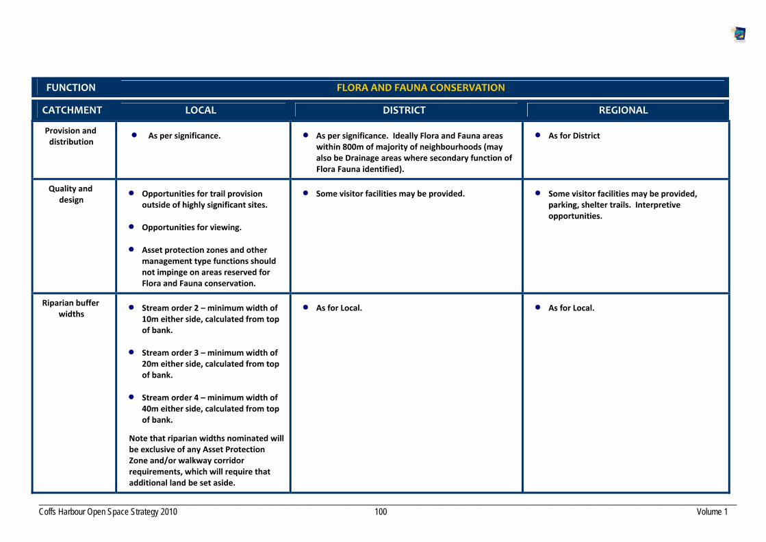
__________________________________________________________________________________________________________________________________________________________ Coffs Harbour Open Space Strategy 2010 100 Volume 1
FUNCTION FLORA AND FAUNA CONSERVATION
CATCHMENT LOCAL DISTRICT REGIONAL
Provision and distribution
As per significance. As per significance. Ideally Flora and Fauna areas within 800m of majority of neighbourhoods (may also be Drainage areas where secondary function of Flora Fauna identified).
As for District
Quality and design
Opportunities for trail provision outside of highly significant sites.
Opportunities for viewing.
Asset protection zones and other management type functions should not impinge on areas reserved for Flora and Fauna conservation.
Some visitor facilities may be provided. Some visitor facilities may be provided, parking, shelter trails. Interpretive opportunities.
Riparian buffer widths
Stream order 2 – minimum width of 10m either side, calculated from top of bank.
Stream order 3 – minimum width of 20m either side, calculated from top of bank.
Stream order 4 – minimum width of 40m either side, calculated from top of bank.
Note that riparian widths nominated will be exclusive of any Asset Protection Zone and/or walkway corridor requirements, which will require that additional land be set aside.
As for Local. As for Local.

__________________________________________________________________________________________________________________________________________________________ Coffs Harbour Open Space Strategy 2010 101 Volume 1
Fit for purpose Presents one or more of the following:
Present opportunity to create a larger contiguous protected area.
Provides linkages between forested areas particularly if creating linkages to a publicly owned reserve.
Contain habitat for endangered species or vegetation communities.
Protect isolated or smaller remnant patches of vegetation containing endangered vegetation communities or threatened species poorly represented in the public open space system.
Vegetated areas with low perimeter to area ratios preferred i.e. large round shapes better than long thin shapes.
Linear shapes should have a maximum width.
As for Local. As for Local.
Maintenance Manage in accordance with significance and degree of infrastructure.
Manage in accordance with significance and degree of infrastructure.
Manage in accordance with significance and degree of infrastructure.

__________________________________________________________________________________________________________________________________________________________ Coffs Harbour Open Space Strategy 2010 102 Volume 1
FUNCTION WATER BASED RECREATION
CATCHMENT LOCAL DISTRICT REGIONAL
Provision and distribution
Not required at Local level. Minimum one primary contact.
Minimum one primary contact.
Quality and design
Manage bank erosion and stability.
Provide for pedestrian access to the water.
Opportunities for boat launching.
Provide for access to the water including carparking and trails, seating, shade, showers, signage, rubbish bins.
Manage bank erosion and stability.
Provide for access to the water including carparking and trails, seating, shade, showers, signage.
Manage bank erosion and stability.
Maintenance As per Parks Maintenance Schedule. As per Parks Maintenance Schedule. As per Parks Maintenance Schedule.
FUNCTION DRAINAGE/FLOODWAYS
CATCHMENT LOCAL DISTRICT REGIONAL
Provision and distribution
N/A N/A N/A
Quality and design
Not to be used for main SFR or Sports fields within neighbourhoods. May be used for local level sports provided it is above recommended standard of provision.
May provide opportunities for trail provision.
May extend range of opportunities available on adjoining open space.
As for Local As for Local
Maintenance As Required As required As required

__________________________________________________________________________________________________________________________________________________________ Coffs Harbour Open Space Strategy 2010 103 Volume 1
FUNCTION COMMUNITY GARDENS
CATCHMENT LOCAL DISTRICT REGIONAL
Provision and distribution
In higher density neighbourhoods where there is potential demand.
As for Local with 1 per District in Urban towns. One major accessible space centrally located.
Quality and design
Fencing
Signage
Water points
Accessible by people with disabilities
Carparking
Fencing
Signage
Accessible by people with disabilities.
Shelter/Shade
Water points
Seating and trails
Carparking on site
Shelters
Fencing
Water points
Accessible by people with disabilities
Maintenance As per agreed. As per agreed. As per agreed.

__________________________________________________________________________________________________________________________________________________________ Coffs Harbour Open Space Strategy 2010 104 Volume 1
3. Core service provision for each Landscape Setting
LANDSCAPE SETTING GENERAL PROVISIONS
Bushland/Woodlands Controlled public access, including dogs on lead, outside of key conservation areas. In high conservation areas consider dog restrictions. Indigenous plantings only. Consider facilities as appropriate dependent on Function and Catchment. Facilities may include seating, pathways, signage, fencing, shelters, viewing platforms.
Native Grasslands/Wetlands Provide for opportunities as per function. Controlled public access only. Facilities may include pathways, boardwalks, bird hides, fencing, signage. Indigenous plantings only.
Foreshore/Beach Controlled public access. Facilities may include pathways, seating, viewing platform, bird hides.
Headland Controlled public access. Facilities may include pathways, car parks, seating, shade, viewing platforms that do not impede viewing opportunities or scenic amenity.
Creek/River Corridor Retain riparian reserves in all new areas in accordance with widths specified.
Stream order 2 – minimum width of 10m either side, calculated from top of bank.
Stream order 3 – minimum width of 20m either side, calculated from top of bank.
Stream order 4 – minimum width of 40m either side, calculated from top of bank.
Note that riparian widths nominated will be exclusive of any Asset Protection Zone and/or walkway corridor requirements, which will require that additional land be set aside.
Indigenous plantings only. Trails / cycleways may be provided they do not prevent retention of an appropriate vegetated buffer to the stream. Facilities may include paths, signage, seating.
Open Parkland Facilities as appropriate to Function and catchment including play, seating, picnic, shelters, water points, fencing.
Rough Natural Area Provide opportunities for interaction with nature. No specific facilities required.
Crop Pasture Provide opportunities for gardening and horticulture. Controlled public access. Facilities may include, dependent on catchment, fencing, pathways, shade, signage. Edge treatment to surrounding land use required.

__________________________________________________________________________________________________________________________________________________________ Coffs Harbour Open Space Strategy 2010 105 Volume 1
Lawn /managed Sports Turf Provision of managed sports turf to meet specific sports demands. Provision of lawn as required by function.
Exotic, Ornamental, specimen planting
Locate in centralised areas in conjunction with other civic functions. Type of facilities dependent on Function and catchment but may include car parks, roads, irrigation, lighting, seating, shade, shelters, picnic, kiosks, pathways.
Plaza/Square/ Mall Locate in conjunction with built form. Facilities dependent on function but may include seating, paths, shade, public art, lighting.
Specialised Sports Surface Provision of specialised sports surfaces to meet individual sports demand.

_________________________________________________________________________________________________________ Coffs Harbour Open Space Strategy 2010 106 Volume 1
Appendix 4 Lands currently zoned 6A (LEP 2000) no longer required f0r acquisition as Open Space
Lot DP Address/Property known as
Comment Current zone
341
820609 Keilawarra Close, Safety Beach
House partially in zoned area. Not required
6A
243 752853 3 Pacific Street, Woolgoolga
Boundary Adjustment to correct 6A
542 823588 Brodie Drive, Coffs Harbour
Environmental area 6A
479 PT 393 392
752817 752817 752817
Part Coffs Harbour Golf Course
Private recreation 6A
2 Section 20 759113 Ambulance Station, 1 Queen Street, Woolgoolga
Health facility 6A
43 816998 Mullaway Drive, Mullaway
Not required for sporting
22 1140702 Hoys Road, Moonee Future highway 6A
20 539984 Sawtell Golf Course Sawtell
Private recreation 6A
1 725785 Winton Land Environmental area 6A
461 and 462 1029908 Vera Drive, Coffs Harbour
Environmental area. No walkway linkage required.
6A
66 551005 Mercer land Environmental area 6A
202 874273 Vadijal land, Woolgoolga
Not required for sporting 6A
304 1143392 (part of)
Sapphire Beach Properties Pty Ltd
Northern area environmental 6A
Coffs Harbour City CouncilOpen Space Strategy 2010
VOLUME TWO Implementation Plan
Adopted August 2010
connecting parks and people


TABLE OF CONTENTS
Section 1 Overview ..................................................................................................................................................................................................1 1.1 Introduction.............................................................................................................................................................................................................................1
1.2 Proposed Capital Works Prioritisation Framework.............................................................................................................................................................. 2 Section 2 City Wide Action Plan..............................................................................................................................................................................6 Section 3 Precinct Action Plans ............................................................................................................................................................................ 33
PRECINCT 1 Far Northern Beaches............................................................................................................................................................. 35
PRECINCT 2 Woolgoolga ............................................................................................................................................................................38
PRECINCT 3 Northern Beaches ..................................................................................................................................................................46
PRECINCT 4 Coffs Urban .............................................................................................................................................................................51
PRECINCT 5 Korora West/Moonee West...................................................................................................................................................68
PRECINCT 6 Middle Boambee....................................................................................................................................................................70
PRECINCT 7 Sawtell / Toormina / Boambee............................................................................................................................................... 72
PRECINCT 8 Bonville ...................................................................................................................................................................................82
PRECINCT 9 Far North Rural.......................................................................................................................................................................85
PRECINCT 10 North Rural ...........................................................................................................................................................................87
PRECINCT 11 South Rural ............................................................................................................................................................................90
PRECINCT 12 Far West Hinterland..............................................................................................................................................................93
Section 4 Policy Review ........................................................................................................................................................................................95

_______________________________________________________________________________________________________________________________________
Open Space Strategy 2010 Page 1
Section 1 Overview
1 .1 Introduction
The “Implementation Plan“comprises a City Wide Action Plan and 12 Precinct Action Plans. The City Wide Action Plan provides a summary of the Strategies to achieve the Key Directions and Outcomes discussed in Volume 1 “Context and Key Outcome’s”, Section 6. The Precinct Action Plans have been derived from the “Open Space Research Report 1” to maximise open space outcomes across the 12 Planning Precincts.
The Implementation Plan also includes an overview of current Policy relating to open space in Coffs Harbour.
Successful implementation of the Plan will require a strong commitment from Council and the community. Key considerations include:
Integration of the Open Space Strategy with other key Council policies.
Seeking funding opportunities and mechanisms outside of Council.
Appropriate levels of Council resources for open space management and development.
Reference to the Open Space Strategy when determining development contributions.
Regular monitoring of community satisfaction with open space management.
Promotion of the plan to the wider community.
Coordinated approach to the development and management of open space.
Many of the recommendations covered in the strategy are included in Council’s current asset management programs and current funding streams, and can be absorbed within current funding levels. However recommendations relating to facility improvements, new facility development and ongoing maintenance (excluding items funded under current and future Section 94 Plans) and improved maintenance levels are currently unfunded. These recommendations will need to be considered in Council’s long term budget forecasts against overall future funding priorities.
Section 1 Overview

_______________________________________________________________________________________________________________________________________
Open Space Strategy 2010 Page 2
The Strategy has not attempted to provide cost estimates for recommendations due to their complexity, issues of timing and uncertainty regarding scope of works.
There are a number of planning documents that will need to be reviewed or developed to ensure that the strategic intent of this strategy is integrated into relevant CHCC policies, guidelines and Plans of Management. A list of anticipated policy review is included within Section 4 of this document. Note that the requirement for the development of a Plan of Management for a Crown Reserve is at the direction of the Minister for Crown Lands.
1 .2 Proposed Capital Works Prior it isat ion Framework
The Open Space Strategy recommends that Council introduce a Capital Works Prioritisation Framework for open space development projects. The framework proposed advocates a new capital works assessment and evaluation process that is designed to assist Council to prioritise the various open space projects which are nominated each year for funding. Currently, open space improvement projects may be nominated for Council funding by Council staff, Councillors, clubs/groups or other community representatives. The proposed Capital Works Prioritisation Framework will initially assess the eligibility and merit of a project to be considered for Council funding against a set of weighted recreation needs and benefits criteria, and then the project will be assessed for its “readiness to proceed”. Under the Framework, Council officers would be able to justify the value of a project from a recreation needs perspective whilst keeping the implementation process for the project separate. For example, a project may achieve a high score in relation to its need and the community benefits it will deliver, however, there may be some important planning and research tasks associated with the project that still need to be completed. These tasks could include the final design, town planning approval, confirmation of external funding sources / agreements, etc. If this is the case, then the project should not be recommended to proceed within that financial year as the likelihood of the project being completed within the financial year and the budget expended, will be very low. Once the assessment of all nominated facility development projects has been completed for any given financial year, the Council officers would have a list of proposed capital works projects that are all scored and prioritised against the same set of criteria, and which are ready for commencement should they receive Council budget approval. The prioritised list of projects could then be incorporated into the Council’s budget process, and Councillors.
Phase 1 – Needs and Benefits Assessment The first phase of the Capital Works Prioritisation Framework evaluates a project against recreation needs and benefits criteria, its alignment with Council policy directions, environmental impact, and community benefit outcomes. All criteria are weighted, with the highest rating (or weight) being applied to the most important criteria. All criteria have a set of sub‐criteria (or questions) that are individually assessed as the means of determining the score for that key criterion. The total score for a project will be the sum of the five scores for each criterion. (See table on the following page).

_______________________________________________________________________________________________________________________________________
Open Space Strategy 2010 Page 3
The total score for each project will be used to rank all projects in order of greatest priority (i.e. the project with the highest total score) to lowest priority projects. Projects receiving a low score should be re‐evaluated with the project advocate (or nominator) to ensure areas of the project that scored low might be addressed prior to a re‐assessment by Council in following years.
Sample Questions for Needs and Benefits Assessment (Phase 1 of the Capital Works Prioritisation Framework)
Key Assessment Criteria Sample questions Sample Weighting (%)
Strategic Alignment with Council Direction
Does the project help Council meet its Vision?
Is the project identified as a strategic priority in Council plans / strategies?
Has the project been identified within an endorsed master plan?
10%
Identified Needs and Benefits (Locally identified)
Is the identified need able to be clearly justified and demonstrated?
How effective will the project be in meeting the need?
As well as meeting the identified need, will the project value‐add in other areas for community benefit?
Will the project support an increase in physical activity participation rates, or help to maintain participation rates at current levels?
Will the project improve the range of recreation opportunities available to residents in the Coffs Harbour LGA?
Does the project improve the access to quality recreation opportunities for those groups traditionally disadvantaged, e.g. people with disabilities, women, young people, older adults, and people from non‐English speaking backgrounds?
Does the project improve the access to quality recreation opportunities in an area of the Coffs Harbour LGA that is underprovided?
Will the project maximise the use or multi‐use of a facility and cater for the needs a broader range of users?
35%
Identified Needs and Benefits (Industry identified)
Is the need consistent with broader recreation sector trends?
Have similar projects been undertaken by other local government authorities with a successful outcome?
Community Development Benefits
Will the project improve the capacity for community and recreation groups to deliver activities to the community?
Will the project facilitate a greater social connectedness between people and groups from within a local neighbourhood area / township?
20%
_______________________________________________________________________________________________________________________________________
Open Space Strategy 2010 Page 4
Environmental Impact Does the project include innovative, sustainable and environmentally friendly components and practices?
To what extent is the project consistent with Environmentally Sustainable Design (ESD) principles, e.g. reducing energy consumption, minimising emissions and waste, and use of recyclable materials?
Will the project result in little or no impact upon on the existing flora and fauna?
20%
Asset Management / Renewal
Does the project enhance an existing asset to extend / improve the level of service and / or increase its life?
Does the project address identified issues around user safety and risk management?
Does the project address any non‐compliance with relevant anti‐discrimination legislation, such as the Disability Discrimination Act?
15%
Note that weightings proposed are indicative only, pending adoption of the final Framework.
Phase 2 – Readiness to Proceed The second phase of the assessment process would be to determine if the project is ready to be delivered within the financial year from which funds are being sought. This assessment would be completed by asking a set of questions of the projects which require a simple “Yes” / “No” / “NA” response. Issues considered during this phase include the status of planning and building permits, level of completeness of tender specifications, and financial considerations. (See the following table). If a “No” response is provided to any of the following questions, Council would need to determine the impact of the item on the ability of the project to proceed in the budget year(s) planned. If it is determined that the project could not realistically proceed or be completed in the financial year(s) planned, the project should be removed from the priority list until such time as the outstanding matters have been resolved. Conversely, the project could be retained in the priority list for commencement in Years 2, 3, 4 or 5 of the Council’s Five Year Forward Capital Works Program, to allow officers to complete any necessary pre‐construction planning or approvals tasks.

_______________________________________________________________________________________________________________________________________
Open Space Strategy 2010 Page 5
Project Area Sample Criteria Status
Project Management Has the stakeholder consultation process been completed?
Has the scope of the project been agreed to by stakeholders?
Has the scope of the project been approved by Council?
Has a development approval been sought?
Has a tender specification for the project been prepared?
Has a building/construction certificate been sought?
Y N N/A
Y N N/A
Y N N/A
Y N N/A
Y N N/A
Y N N/A
Project Delivery Has a project plan been prepared?
Has the method of delivery of the project been determined, i.e. public tender, design and construct, quotes etc?
Y N N/A
Y N N/A
Financial Details Has the budget been prepared against a quantity surveying report, quotations, detailed design etc?
Has a phased budget been prepared that is achievable?
Have external funds been committed?
Have the recurrent maintenance costs been calculated?
Y N N/A
Y N N/A
Y N N/A
Y N N/A

_______________________________________________________________________________________________________________________________________
Open Space Strategy 2010 Page 6
Section 2 City Wide Action Plan
The City Wide Action Plan provides detailed Strategies to achieve the 9 Key Outcomes described in Volume 1 “Context and Key Outcomes”. A detailed discussion of each of the 9 Key Outcomes is provided in Volume 1, Section 6.
How to read the Plan
Key Outcome 1 : Keep Pace with the Demands of a Growing City
Section 2 City Wide Action Plan
Key Outcomes
9 Key Outcomes have been identified that encapsulate what we want our Open
Space to deliver.
Objectives
How we plan to achieve the Key Outcomes.
Strategies
What we need to do to achieve the Objectives.
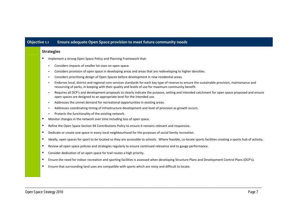
_______________________________________________________________________________________________________________________________________
Open Space Strategy 2010 Page 7
Objective 1.1 Ensure adequate Open Space provision to meet future community needs
Strategies
Implement a strong Open Space Policy and Planning Framework that:
Considers impacts of smaller lot sizes on open space.
Considers provision of open space in developing areas and areas that are redeveloping to higher densities.
Considers prioritising design of Open Spaces before development in new residential areas.
Endorses local, district and regional core services standards for each key type of reserve to ensure the sustainable provision, maintenance and resourcing of parks, in keeping with their quality and levels of use for maximum community benefit.
Requires all DCP's and development proposals to clearly indicate the purpose, setting and intended catchment for open space proposed and ensure open spaces are designed to an appropriate level for the intended use.
Addresses the unmet demand for recreational opportunities in existing areas.
Addresses coordinating timing of infrastructure development and level of provision as growth occurs.
Protects the functionality of the existing network.
Monitor changes in the network over time including loss of open space.
Refine the Open Space Section 94 Contributions Policy to ensure it remains relevant and responsive.
Dedicate or create one space in every local neighbourhood for the purposes of social family recreation.
Ideally, open spaces for sport to be located so they are accessible to schools. Where feasible, co‐locate sports facilities creating a sports hub of activity.
Review all open space policies and strategies regularly to ensure continued relevance and to gauge performance.
Consider dedication of an open space for trail routes a high priority.
Ensure the need for indoor recreation and sporting facilities is assessed when developing Structure Plans and Development Control Plans (DCP's).
Ensure that surrounding land uses are compatible with sports which are noisy and difficult to locate.

_______________________________________________________________________________________________________________________________________
Open Space Strategy 2010 Page 8
Objective 1.2 Achieve useable Open Space that meets the desired purpose
Strategies
Ensure consideration of impacts of residential interface with open space are planned for and mitigated at DCP and subdivision stage with reference to this Open Space Strategy.
Identify appropriate Open Space for transfer to Council within developments and conduct an Open Space assessment when evaluating the desirability of accepting new Open Space with reference to this Open Space Strategy, in particular Volume 1, Section 6.1.
Ensure planning schemes specify open space and developer contributions required for each new release area.
Objective 1.3 Ensure Open Space is responsive to community needs and trends over time
Strategies
Review Australian Bureau of Statistics community profiles regularly to ensure open space is responding to community needs and changing demographics.
Commission data for the Mid North Coast Region, on sport and recreation participation patterns, through the annual Exercise, Recreation and Sport Survey (ERASS) process.
Gauge levels of community satisfaction with the performance of the Open Space Network and facilities through regular surveys and feedback.
Determine the impacts of tourism on open space provision, development and management.
Keep abreast of emerging trends within the community in relation to recreation, sport and leisure activities.
Objective 1.4 Plan and provide for higher density
_______________________________________________________________________________________________________________________________________
Open Space Strategy 2010 Page 9
Strategies
Improve connections to and access to open space and the foreshore and ensure a variety of open space types within walking distance of households.
Capitalise on the value of green streetscapes to function as additional open space. Retain small green areas to provide visual relief.
Provide paved sites within developments for activities such as ball play and skating.
Preserve existing green space within the Coffs Urban Precinct, in particular the City Centre, Jetty and Park Beach areas to service future populations, and protect against incremental loss to buildings and car parks.
Ensure there is sufficient land set aside for civic buildings and community facilities without impacting on Open Space.
Ensure adequate private open space is planned for in higher density development and develop clear planning mechanisms regarding the amount and location of private and communal open space.
Consider private open space when planning the open space network.
Objective 1.5 Protect local character and identity
Strategies
Implement policies that require new development to complement the intrinsic character of the region, recognising existing character and encouraging diversity.
Promote and progress street tree planting to retain the green leafy character of urban areas.
Develop City Image program to enhance entry points within the LGA and improve the appearance of public places ensuring signage and landscape elements compliment the identity of the area.
Prepare appropriate policies to protect the forested ridgelines, escarpments, headlands that create the local landscape character, including preparing a GIS layer of scenic amenity and significant visual landscapes.
Continue to add to the Heritage register and protect all cultural elements, including preserving indigenous cultural heritage in partnership with traditional owners.
Objective 1.6 Protect and manage street trees and roadside vegetation
Strategies

_______________________________________________________________________________________________________________________________________
Open Space Strategy 2010 Page 10
Protect significant existing trees in new developments.
Implement a tree maintenance program including a tree replacement program over time.
Undertake staged removal of trees considered to be weed species.
Implement appropriate planting and maintenance schedules for trees including investigating options for the development of a regular inspection program for dangerous trees/limbs within open space, targeting locations where trees posing the greatest risks to people and assets.
Development of a road side vegetation strategy to protect and manage roadside vegetation.
Initiate public education program regarding the importance of trees and the negative effects of clearing for private coastal views.
Promote the use of trees within public areas for shade provision and landscape amenity.
Ensure impacts on street trees are considered in adjoining developments and in service locations.
Review existing Street Tree Master Plan including selecting trees for specific locations considering sustainability, safety and risk.
Key Outcome 2: Improve Community Health and Wellbeing

_______________________________________________________________________________________________________________________________________
Open Space Strategy 2010 Page 11
Objective 2.1 Plan for an ageing population
Strategies
Develop facilities that are robust and responsive to changing community needs.
Provide connections to the open space network from retirement centres and aged care facilities.
Provide a diversity of recreation activities in open space to encourage inter‐generational family participation.
Design to be considerate of older people, with rest areas located at appropriate intervals along walkways, appropriate furniture choices, walkways with gentle grades and wider footpaths to accommodate mobility scooters, safe crossing points.
Create open spaces that appeal to older people and present as places where they feel safe and secure.
Publish and provide information on open spaces, facilities and programs to encourage participation.
Objective 2.2 Promote walkable, connected neighbourhoods
Strategies
Develop a hierarchy of transport and recreation trails, serving a variety of users providing connections to key destination nodes such as schools, shopping centres, sports venues. Create circuits through integrating the off road trail network with existing and future footpaths and shared pathways/cycleway. Investigate options for providing sustainable, energy neutral lighting on key trail routes.
Create nodes of activity along trail networks with opportunities for parking and recreation that will also function as rest areas on longer trails.
Within environmentally sensitive locations, align trails with other service infrastructure to reduce impacts wherever possible.
Consider and reduce the impacts on trees when designing pathways and determining trail/path routes.
Increase access links along drainage and other corridors, including formalisation of identified desire lines to link residential areas to commercial areas, and to connect areas of open spaces.
Develop perimeter trails around reserves which are of a suitable size.

_______________________________________________________________________________________________________________________________________
Open Space Strategy 2010 Page 12
Support the development of best practice planning guidelines to ensure permeability of future subdivisions to facilitate walking and cycling. Guidelines also need to address creating pedestrian‐friendly streetscapes, with adequate shade, pathways, separation from traffic.
Develop a Shade Policy and implement a Shade Program, using appropriate native species, along major routes throughout the City.
Provide appropriate signage along trails including directional, distance and wayfarer signs.
Ensure paths and trails are maintained to an appropriate standard consistent with level and type of use.
Prioritise funding for walkway and cycleway infrastructure projects including continued development of the Coastal Cycleway, seeking funding opportunities from State Government.
Prepare a ‘Tracks, Trails and Cycleway’ brochure linked to Council’s website and distributed throughout the City.
Review the Solitary Islands Coastal Walk strategy and continue development of the coastal walk.
Objective 2.3 Create Regional Trail Corridors to service residents and visitors
Strategies
Investigate feasibility of a Regional trails network, utilising unformed Crown Roads, Travelling Stock Routes fire trails, State Forest and National Park estate and private property agreements to create a network of longer trails suitable for hiking, horse riding and mountain biking.
As a high priority, work with the Land & Property Management Authority (LPMA) to identify key Crown Roads and Travelling Stock Routes for retention by LPMA.
In partnership with LPMA, State Forests, National Parks and Wildlife Service (NPWS) and relevant private land owners, develop a Regional Trail Strategy to assess options for development, funding, marketing, management and maintenance of a Regional Trail Network.
Work with surrounding LGAs and other government agencies to map existing trails, using agreed standard nomenclature and descriptions for trail types.
Objective 2.4 Develop trail networks within rural residential areas
Strategies
Ensure planning for rural residential areas provides for off‐road trails incorporating elements within this Strategy.

_______________________________________________________________________________________________________________________________________
Open Space Strategy 2010 Page 13
Objective 2.5 Promote programs to encourage physical activity
Strategies
Investigate Council providing programmed activity in parks and seek interest from the private sector in program provision.
Develop a range of promotional material, using different media, regarding opportunities for physical activity within the Open Space Network.
Objective 2.6 Provide a network of facilities that support physical activity
Strategies
Continue to provide a diverse range of opportunities in both land based and aquatic settings to be physically active.
Support upgrades to Council managed aquatic infrastructure throughout the LGA. Progress planned upgrades to the Coffs Harbour War Memorial Pool to reinforce its position as a facility of Regional significance. Long term undertake a strategic review of aquatic needs within the LGA.
Consider developing fitness circuits along key trails. Consider creating linked fitness trails through establishing fitness equipment in small parks.
Protect outdoor recreation opportunities and work with State agencies to ensure ongoing provision. In particular advocate for an ongoing allocation of land for Mountain Biking within the State Forest system.
In conjunction with relevant providers, compile an inventory of outdoor recreation activities in Coffs Harbour and make available to the public.
Continue to provide and maintain open space and infrastructure for sport, in conjunction with Clubs, Associations and Community Management Committees.

_______________________________________________________________________________________________________________________________________
Open Space Strategy 2010 Page 14
Objective 3.1 Provide a range of opportunities for Social and Family recreation
Strategies
Redevelop key locations with an improved range of facilities and opportunities along the foreshores to cater for large gatherings and tourist influx. In particular, Jetty Foreshores, Lower Park Beach including Pet Porpoise Pool Park, Diggers Beach and Woolgoolga Beach Reserve.
Continue to develop Brelsford Park to function as a City Park incorporating elements such as a cultural precinct, walkways, Village Green and mixed age play facilities.
Upgrade existing spaces that are under capacity, with improved recreation facilities, or acquire land for local social and family recreation in under‐served areas.
Cease to develop playgrounds in “pocket parks” and instead incorporate into larger social family spaces with wider appeal.
Aim to provide a social family park within 500m of households in new developments.
Provide an adequate level of Open Space for social and family recreation that includes play opportunity.
Increase funding levels for play and recreation facilities.
Increase the number of social family spaces through converting play spaces and undeveloped land that are of sufficient size to a social family function through park redesign and provision of additional/improved facilities. Once Council has developed the key spaces, small non‐viable play spaces can be reallocated as to other functions such as relaxation contemplation or amenity parkland.
Provide diversity of experience in existing small parks by creating a different experience in each park.
Key Outcome 3 : Provide for Social and Family Recreation

_______________________________________________________________________________________________________________________________________
Open Space Strategy 2010 Page 15
Objective 3.2 Provide additional opportunities for Youth
Strategies
Provide facilities for organised sports.
Engage young people in the design development and management of youth oriented open space and facilities.
Provide opportunities in each Precinct for young people, especially females, to be active and to just “hang out” in safe observable spaces.
Investigate opportunities to provide multi‐purpose outdoor facilities, eg BMX tracks, in appropriate locations within each precinct. In villages, provide in conjunction with other facilities, creating a community hub of activity.
Investigate re‐development of existing facilities, such as the town pool and skate parks, for improved opportunity for physical activity and social interaction.
Provide opportunities for recreation through facilitating/providing events and activities, investigating opportunities to establish performance spaces.
Development of a new Regional Skate Park, serving intermediate and advanced levels.
Consider installation of lighting, to the appropriate Australian Standard for recreational use, at skate parks.
Support rural communities through provision of technical advice and assistance, to develop facilities for youth.
Work with developers and shopping centres to provide Open Space opportunities that are of interest to young people.
Objective 3.3 Provide quality play experiences for children
Strategies
Provide a variety of play equipment, experiences and settings across the Open Space Network, encompassing the design principles discussed in Volume 1.
Instigate Shade Program at play spaces and prioritise sites. All new play spaces to include shade and retrofit priority existing spaces.
Install fencing at play spaces located near collector roads or roads carrying high traffic volumes.
Develop a Regional level playground in conjunction with social family recreation space at the Jetty Foreshores containing a number of activity spaces catering for a wide range of ages.
Develop Playground Strategy for Coffs Harbour to address provision and maintenance.
Investigate removal of play spaces containing only basic play equipment, with limited opportunity for improvement, where play needs are serviced by other spaces.
Upgrade play equipment at play spaces servicing a local (500m) catchment where no opportunity to create local social/family recreation space exists.

_______________________________________________________________________________________________________________________________________
Open Space Strategy 2010 Page 16
Objective 4.1 Provide equity and diversity in Open Space provision
Strategies
Prioritise design of proposed and existing Open Spaces that service functions that are under‐provided. Seek opportunities to redress Open Space deficits, particularly for social family recreation and sport functions in under‐served areas.
Provide a range of functions, settings and recreation opportunities throughout neighbourhoods and precincts and review regularly.
Ensure an equitable distribution of foundation level sport opportunity in every precinct and facilitate access to school fields where public provision is unavailable.
Plan for specific sports facility needs, including providing multi‐use facilities.
Enhance the quality of existing sports fields to optimise usage.
Seek to develop multi‐field complexes to service future needs where possible and reclassify single playing fields to other functions or use as sites for local level foundation sport.
Improve range of opportunities at sportsgrounds through tree planting, pathways, play areas and landscaping, to encourage greater community use of the spaces outside of sporting fixtures.
Consider tourism opportunities when planning the open space network.
Explore opportunities to provide artwork including sculptures in open spaces including play areas.
Identify opportunities to establish joint ventures for major sporting/recreation infrastructure with the private sector.
Develop spaces to function as lunch time parks for workers within the town centres.
Objective 4.2 Address areas under‐served by Open Space
Key Outcome 4 : A diverse, equitable and accessible network of Open Space and opportunit ies

_______________________________________________________________________________________________________________________________________
Open Space Strategy 2010 Page 17
Strategies
Seek to create safe road crossing points for areas separated from Open Space by major roads.
Capitalise on the value of small parcels currently fulfilling a range of other functions.
Improve connectivity to existing Open Space generally.
Identify opportunities to take land in new subdivisions in under‐served areas.
Improve connectivity to existing social family recreation open Space and expand the range of opportunities available at these sites.
Enhance the visual amenity of streetscapes and roundabouts and create opportunities for off‐road trails.
Objective 4.3 Provide open space opportunities that are inclusive of people with disabilities
Strategies
All new parks district size and larger to be designed for inclusive access.
Provide inclusive play opportunities for children of all abilities through improving access to parks and to play equipment and recreation opportunities; and access to opportunities to socialise and interact with other children for children of all abilities. Aim for all new playgrounds District level and up to provide inclusive play opportunities. Ensure each urban precinct provides a playground that offers complexity and challenge for the younger disabled.
Ensure compliance with relevant Australian standards in relation to inclusive access and opportunity.
Park design and furniture should be accessible and sympathetic to the need of people of all abilities wherever possible. Facilities should be designed to encourage universal participation rather than the provision of specialised segregated settings.
Remove physical barriers to participation and retrofit sites for accessibility, targeting regional and district sites as high priority.
Objective 4.4 Provide opportunities for community gardens
Strategies

_______________________________________________________________________________________________________________________________________
Open Space Strategy 2010 Page 18
Provide opportunity for development of Community Gardens in public Open Spaces and develop guidelines for establishing community gardens which reflect the considerations outlined in this Strategy.
Determine an appropriate management model for community gardens and develop formal agreements and conditions of use.
Objective 4.5 Ensure Foreshore development maximises opportunities for visitors and the community, whilst protecting foreshore values
Strategies
Enhance trail opportunities and linkages to and from foreshore reserves.
Undertake a review of all existing beach and foreshore access points on public land to determine functionality, level of use and desirability of retention.
Develop a program for strategic foreshore reserve improvements and investigate additional foreshore opportunities. Improvements need to utilise good urban design to accommodate high visitor influx and increase carrying capacity. Include opportunities for shade provision, and provide access options for people of all abilities.
In the long term, investigate need for additional embellished foreshore reserves.
Ensure new development does not preclude foreshore access, including preserving land at road ends in foreshore developments to facilitate public access and viewing.
Conduct visitor surveys at key foreshore locations to ensure needs are being met.
Manage water‐based recreation activities to minimise conflicts.
Review functionality of existing boat ramps and access points and remove those considered to be non‐functional or no longer required. Develop programs to maintain and enhance retained boat ramps.
Objective 4.6 Manage sustainable vehicle usage of beaches
Strategies
Assess feasibility of implementing a permit system for vehicle usage on beaches.
Undertake a review of existing vehicle use beaches in conjunction with the development of the Coffs Coast Regional Park Plan of Management and the Coffs

_______________________________________________________________________________________________________________________________________
Open Space Strategy 2010 Page 19
Coast State Park Plan of Management.
Objective 4.7 Manage dog activity and provide leash‐ free opportunities
Strategies
Review current leash free provision on Hearne's Lake beach to determine potential conflicts with the newly established Little Tern Nest site.
Develop public education campaign regarding cleaning up after dogs and responsible dog ownership.
Retain Thompsons Road Reserve as leash free facility.
Consider further managing dog activity in key areas of high conservation value.
Investigate opportunities to create additional dog leash‐free parks in each of the major coastal precincts.
Consider further regulating dog activity on sports fields.
Improve off‐road connectivity to leash‐free parks through provision of trail networks linking residential areas to leash free parks.

_______________________________________________________________________________________________________________________________________
Open Space Strategy 2010 Page 20
Objective 5.1 Protect and enhance biodiversity within Open Space
Strategies
Align planning framework, policies and controls with natural vegetation mapping and Council’s environmental strategies.
Create buffers between settlement areas and Open Space for conservation purposes to manage potential impacts and, where applicable, improve water quality by implementing WSUD elements.
Identify natural values and attributes in the planning for new residential development and prioritise their protection. This includes clearly defining areas for maintaining Koala populations and biodiversity values.
Implement key actions relating to Council's Open Space from relevant Council planning documents including the Koala Plan of Management (KPOM), Biodiversity Strategy and Priority Habitats & Corridors Strategy (PHACS) (draft).
Identify priority lands for addition to the Open Space Network to optimise conservation outcomes with reference to relevant conservation planning documents, including Biodiversity Strategy, PHACS (draft) and KPOM.
Redesign open drain channels to more natural stream forms to improve biodiversity outcomes, where appropriate.
Assist in creating linkages between open spaces and native vegetation across the region.
Strengthen natural habitats in bushland/conservation reserves, along creeks and foreshores.
Consider establishing plantations of Koala food trees for harvesting by Koala carers.
Continue to co‐ordinate and promote the Bushland Friendly Nursery Scheme within the Coffs Harbour LGA and work with regional partners.
Ensure any impacts from resulting from sporting and recreation infrastructure development are offset at appropriate locations. Cost of required offsets to be included in project budgets.
Develop policies whereby landowners and/or developers can undertake required compensatory offset planting within the public reserve system, at their cost and at Councils discretion, where site constraints prevent this being undertaken on their own land, or a better long term biodiversity outcome can be assured through utilising public land.
Key Outcome 5 : Protect Biodiversity and the Natural Environment

_______________________________________________________________________________________________________________________________________
Open Space Strategy 2010 Page 21
Objective 5.2 Optimise management and maintenance
Strategies
Investigate and reduce mowing of certain vegetation types/areas.
Preparation of a Bush Regeneration Strategy identifying key reserves and priorities for maintenance/improvement works.
Review Council’s current fire management processes, including the need for burning, in relation to Council estate, in conjunction with the Rural Fire Service (RFS), NSW Fire Brigade and other land management agencies, to support proactive fire management of Council estate, and educate the community including young people on the dangers of fire and benefits of fire management. Establish working relationships with other land management agencies in relation to fire management.
Investigate options to increase levels of expenditure on Council's natural areas to improve management outcomes.
Prepare site‐specific reserve action plans for key reserves addressing issues such as fire management, trail development/rationalisation, erosion and water quality.
Implement actions from CHCC Strategic Weed Management Plan.
Continue to support the NPWS Regeneration Program within the Coffs Coast Regional Park.
Objective 5.3 Increase community interest and involvement
Strategies
Provide funding or equipment to schools, volunteers to conduct environmental management activities, e.g. weeding and planting.
Gain support from the community to enhance and manage the environment through greater promotion and information, signage, local input into planning and design of Open Spaces and an increase in collaboration with volunteers and schools.
Development and promotion, through a variety of media, of a good neighbour program to reduce impacts and increase community interest.
Encourage and support schools to 'adopt a reserve/creek', particularly those identified as key habitats or corridors.
Increase collaboration between NPWS, Northern Rivers CMA, Council and community groups and volunteers including Landcare. Continue to support Landcare through provision of technical advice, funding and equipment.

_______________________________________________________________________________________________________________________________________
Open Space Strategy 2010 Page 22
Objective 6.1 Sustainable resourcing, asset development and management
Strategies
Introduce a whole of life asset costing process/system for park assets that :
Details maintenance and capital funding requirements for all public Open Space assets.
Aligns expenditure with short and long term strategic directions of Council.
Captures the key activities and new initiatives to be undertaken.
Identifies the inputs, approved resources and targeted outcomes to be achieved.
Identifies and records whole of life costs.
Reports performance, including financial on each type of Open Space as well as individual reserves.
Review funding processes and allocations for the various Open Space programs and consider increasing funding for Council's Open Space management programs including design, planning, reserve development and maintenance.
Develop asset maintenance plans for all classes of park assets.
Work with the community to develop sustainable Open Space projects that add value to the network.
Develop mechanisms to measure the performance of Open Space including community surveys.
Create and implement a Park Improvement Program based on priorities identified within this Strategy. Investigate options for funding.
Develop programs for asset replacement and renewal including trees. Any drainage works should consider incorporating Water Sensitive Urban Design (WSUD) treatments.
Reduce mowing areas through natural and assisted regeneration where appropriate.
Continue to utilise maintenance agreements with developers for park assets associated with subdivisions.
Key Outcome 6 : Provide Sustainable and Cost EffectiveOpen Space Management

_______________________________________________________________________________________________________________________________________
Open Space Strategy 2010 Page 23
Require Vegetation Management Plans, funded for five years by developers, for all flora and fauna conservation reserves dedicated to Council.
Require that developers prepare fire plans for all significant areas of bushland coming to Council as a result of development.
Link maintenance policy and programs with other agencies.
Continue to communicate with local sport and recreation groups, providing advice and information on a broad range of topics including funding opportunities, programs, promotion, management, etc.
Ensure all new leases for sports fields require annual reporting (including membership) and include annual performance indicators.
Objective 6.2 Develop appropriate maintenance schedules
Strategies
Develop and implement park maintenance schedules aligned to park visitation, function and infrastructure, including higher levels of maintenance for reserves with high visitation and disseminate to the local community.
Objective 6.3 Capitalise on funding opportunities
Strategies
Investigate options for rents associated with leases on park estate for utilities (such as telecommunication infrastructure) to be returned to the associated reserve for improvement works.
Explore business opportunities to generate income, such as Biobanking and carbon trading, and continue to support existing internal business units such as the Tree Nursery and general Nursery.
Investigate the establishment of Council's operational teams as business units to service private clients.
Explore funding opportunities for Open Space development and management including special levies, joint ventures and commercial partnerships.
Maintain an up‐to‐date listing of all grant opportunities and seek funding through relevant streams.
Continue to refine Section 94 contributions to align with this Strategy.
Investigate options to establish “Friends of Parks” groups, including corporate “Friends”, to assist in development and maintenance of open space.
Review fees and charges for use of sports fields.

_______________________________________________________________________________________________________________________________________
Open Space Strategy 2010 Page 24
Objective 6.4 Embrace sustainable practices
Strategies
Continue to investigate opportunities to use of reclaimed water for Open Space including the Botanic Gardens.
Identify and introduce a method of monitoring energy consumption at each sports venue, including automatic timer features on new lighting installations.
Install energy efficient lamps on any new lighting project.
Adopt ESD principles in new sports field developments wherever possible.
Investigate use of energy sources that are carbon neutral.
Investigate options for grey water reuse systems for larger reserves.
Develop a policy requiring all new and upgraded areas of Open Space to adopt water conservation principles in landscaping.
Utilise WSUD principles.
Design and locate visually attractive public bins that promote recycling.
Review Council's herbicide and fertiliser use to identify opportunities to reduce or eliminate chemical use and improve application practices.
Support the use of recycled materials in construction, where appropriate.
Promote multiple uses of reserves.
Objective 6.5 Coordinate planning and management
Strategies
Develop a strong framework for the co‐ordinated development, use and management of the City’s Open Space.
Advocate a whole of government approach in relation to Open Space planning and management across the Region.
Review all existing Plans of Management to ensure compliance with current legislation, community needs and environmental values.
Develop a Plan of Management for the CCSP to set broad strategic directions, address potential land additions, and to integrate the various management units, many of which are not contiguous and have an array of divergent values.
Assist NPWS to develop a Plan of Management for the CCRP.

_______________________________________________________________________________________________________________________________________
Open Space Strategy 2010 Page 25
Implement a program of Master Plans and Site Plans that will guide the development/redevelopment of Open Space.
Adopt a whole of park approach when designing facilities.
Rezone private land, currently zoned 6A, which is no longer required for Open Space purposes.
Review current Classification of Council’s Public Reserves.
Objective 6.6 Develop design standards that are innovative, and promote safety and inclusive access
Strategies
Develop innovative and contemporary inclusive design standards for park facilities including infrastructure, furniture, pathways, signage, landscaping themed for different settings e.g. coastal and hinterland areas.
Develop signage policy for Open Space and urban areas.
Continue to include principles of Crime Prevention Through Environmental Design (CPTED) for new Open Space development.
Objective 6.7 Addressing risk management and safety
Strategies
Ensure age‐appropriate challenges are provided within Open Space and maintain the balance between providing challenge and managing unacceptable risk.
Ensure that facilities and activity nodes are designed to reduce risks, especially in relation to the co‐location of incompatible activities involving children.
Undertake hazard inspections of all park assets and maintain up to date records. Ensure timely rectification of defects.
Investigate a pro‐active program of tree inspections, particularly over heavily used spaces and facilities.
Continue to implement regular maintenance programs and align with degree of infrastructure and visitation levels.

_______________________________________________________________________________________________________________________________________
Open Space Strategy 2010 Page 26
Objective 6.8 Address anti social behaviour
Strategies
Investigate options for providing lighting at key reserves, especially along main trail routes.
Co‐locate activity nodes within open space to maximise surveillance.
Encourage community involvement and a sense of ownership of Open Space by neighbours.
Ensure open spaces are well maintained and that damage and vandalism is quickly repaired/mitigated.
Continue to utilise alcohol prohibitions within Open Space at locations where appropriate.
Objective 6.9 Manage community events and festivals
Strategies
Continue to support community events and festivals in Open Space, at a scale and frequency that does not negatively impact on other users.
Continue to support commercial events and private functions provided they do not compromise the use and enjoyment of the Open Space by other users.
Develop guidelines to assess suitability of commercial events and private functions and establish protocols for restoration of areas by event organisers post event.
Objective 6.10 Identify opportunities to add to the Open Space network
Strategies
Ensure future planning processes include the dedication of sufficient land to meet future open space needs.
Explore mechanisms for the acquisition of priority Open Space. Where parcels cannot be acquired through development processes or through Section 94 funds, alternate acquisition mechanisms, including funding, need to be investigated.
Achieve integrated management through rationalisation of reserve management where possible. Initiate discussions with LPMA for transfer of additional Crown holdings to the Coffs Coast State Park (CCSP). Progress planned Stage 2 additions of Council land to the CCRP. Continue to support consultative process between LPMA and NPWS regarding additional strategic Crown land divestments to CCRP.

_______________________________________________________________________________________________________________________________________
Open Space Strategy 2010 Page 27
Objective 6.11 Disposal of surplus Open Space
Strategies
Consider the sale of land surplus to Open Space requirements with funds generated being used for reserve improvements or for acquisition of more suitable Open Space in the neighbourhood.
Consider the following community reinvestment principles in relation to disposal:
All Funds from sale of Council owned open space to be used to improve open space opportunities within the local area of the subject land.
Explore opportunities with LPMA of funds from sale of Crown lands back to the local area of the subject land.
Involve the community when significant changes are planned.

_______________________________________________________________________________________________________________________________________
Open Space Strategy 2010 Page 28
Objective 7.1 Promote partnerships with State Government and the commercial sector to maximise use of current resources
Strategies
Continue to support partnership with NPWS for management of the Coffs Coast Regional Park.
Continue to support partnership with LPMA for management of the Coffs Coast State Park and the Crown Reserve system.
Explore opportunities with NSW State Forests for greater community use of State Forests for outdoor recreation activities.
Promote partnerships with other land management agencies to ensure Open Space not under Council control is included in planning and to ensure an ongoing supply of land suitable for outdoor recreation activities.
Seek sponsorship from commercial sector for reserve improvements.
Objective 7.2 Establish partnerships with schools for public use of school facilities
Strategies
Investigate opportunities for schools to fill gaps identified in the distribution of some open space functions such as sport, play and community horticulture.
Explore partnerships opportunities for shared provision of facilities such as Indoor sports venues and fields.
Identify opportunities to establish joint ventures for major sporting/recreation infrastructure with Schools/universities as required.
Work closely with schools to meet community and school objectives, such as enhanced physical activity and biodiversity, and encouraging children to walk and cycle to school safely.
Key Outcome 7 : Promote Partnerships and Community Engagement

_______________________________________________________________________________________________________________________________________
Open Space Strategy 2010 Page 29
Objective 7.3 Ensure community involvement in the planning and management of Open Space
Strategies
Involve the community and relevant stakeholders at an early stage in new Open Space planning and design initiatives including on site forums and questionnaires.
Continue to support a consultation process that fosters community engagement and ensure Open Space development and management are inclusive of the community’s ideas.
Continue to support and promote community groups such as Landcare, Reserve Trusts and Community Management Committees.
Explore opportunities with Service Organisations, for park based projects, developing stewardship of local Parks.
Establish “Friends of Park” program to involve the community, and commercial operators, in park development and maintenance.
Review policy for naming of Parks and Park infrastructure, including provision of plaques, and address corporate sponsorship/badging.
Objective 7.4 Develop a range of information material to promote the Open Space network to the community
Strategies
Provide information through a range of media that targets specific demographics and areas of interest on Open Space opportunities including:
Preparation of a Parks Information Brochure to promote key Parks and facilities.
Updating Council’s website to include more information on Open Space opportunities.

_______________________________________________________________________________________________________________________________________
Open Space Strategy 2010 Page 30
Objective 8.1 Consider the impacts of climate on Open Space planning, design and management
Strategies
Take account of current risk assessment strategies and identify areas of high risk where mitigation of saltwater intrusion could be feasible.
Develop strategies to address the potential loss of key foreshore reserves and associated infrastructure, including caravan parks, which are a significant economic driver of the Crown Reserve system.
Build provisions into planning documents for future Open Spaces outside of sea‐level rise affected areas.
Planning for recreational facilities above sea‐level rise predictions e.g. boardwalks.
Cost vs. likely life of asset (in relation to predicted sea level rise) analysis in relation to new major recreation and sporting infrastructure.
Changes towards more heat and drought resilient species of plants in parks and grass species on playing fields.
Assess need for increased budgets to cover likely creased maintenance costs. Provide for increased regular maintenance of park/green space in Council management plans.
Assess Open Space drainage system and improve to cope with predicted rain events.
Develop and implement a pest, weed and invasive species management policy/strategy that takes into account changed climatic conditions (many local government areas have management policies/ strategies in place). Consideration to be given to:
Promote awareness to local communities of potential weed risks resulting from climate change in the local area (incorporate into existing awareness programmes if appropriate).
Revisions to mowing and weed control schedules to take into account changed climatic conditions that affect growth and dispersal.
Key Outcome 8 : Plan for Cl imate Change

_______________________________________________________________________________________________________________________________________
Open Space Strategy 2010 Page 31
Objective 8.2 Managing for increased temperature
Strategies
Review/prepare design guidelines for street furniture, shelters and awnings, and infrastructure to provide protection, e.g. development of a shade and sun protection policy.
Conduct shade audits to determine the adequacy of existing shade, whether there is a need for more, if appropriately located and of appropriate size.
Ensure sufficient shade, either natural or built, is available or planned for when developing new recreational facilities or centres and in any development plans for picnic areas, playgrounds etc.
Objective 8.3 Manage for altered rainfall patterns
Strategies
Develop an irrigation plan to identify and reduce existing irrigation levels where possible.
Water controls and management tailored for specific Council areas.
Investigate options for stormwater harvesting and reuse water.
Identify species for use in landscaping that require less water.
Objective 8.4 Manage fire impacts
Strategies
Complete development of all Asset Protection Zones (APZs) and fire trails throughout Council’s estate and liaise regularly with the RFS to monitor adequacy over time. Ensure all new APZs are registered on the RFS Trail Register.
Work closely with bushfire management agencies and maintain up to date information through regular attendance of the Coffs Harbour Bushfire Management Committee meetings and review of the latest research from bushfire planning consortiums, universities and government agencies.
Complete vegetation hazard mapping of Council estate and align with the NSW Bushfire Environmental Assessment Code.
_______________________________________________________________________________________________________________________________________
Open Space Strategy 2010 Page 32
Refer to the “2010Coffs Harbour Sports Facility Plan”.
Key Outcome 9: Optimise Sport ing Opportunit ies

_______________________________________________________________________________________________________________________________________
Open Space Strategy 2010 Page 33
Section 3 Precinct Action Plan
The following Precinct Action Plans detail actions to be undertaken in relation to each of the twelve planning Precincts. In some instances recommendations have been made in relation to Crown lands that are not under the management of Council. These works are conceptual only, and subject to consultation with, and the concurrence of, the LPMA and the relevant Reserve Trust Manager. Note that the majority of recommendations within the Precinct Action Plans are unfunded. The identification of a project does not commit any organisation, including Council, to a responsibility for funding allocated projects, which has to balance its limited resources with other commitments and projects.
How to read the Plans
Section 3 Precinct Action Plans
Key Action Maps*: Depict the key Precinct Improvement Works.
Precinct Action Plan
Precinct Recommendations: Details a number of objectives and actions to improve Open Space outcomes.
Park Improvement Program: Details a range of Capital Improvement projects.
* Note the maps are constantly changing due to land contributions from approved development and ongoing embellishments. Some recent developments may not appear on the maps. These maps provide an overview as of 31 January 2010.

_______________________________________________________________________________________________________________________________________
Open Space Strategy 2010 Page 34
Precinct Recommendations This includes broad actions to be undertaken in relation to offsetting Gaps identified within the “Open Space Research Report 1 – Precinct Analysis". In some instances more specific recommendations to meet an opportunity are included in the Park Improvement Program. The following Objectives are addressed:
Provide additional Open Space opportunities.
Identifies opportunities to improve Open Space outcomes within the Precinct.
Provide additional land required to service future development.
Provides an indication of the likely open space required in the future as development occurs. It is a guide only as future requirements will be dependent on the
final residential footprint determined for the identified growth areas and Council's ability to service additional lands.
Integrate management of Open Space to maximise benefits.
Identifies opportunities to align management arrangements where different land tenures occur.
Park Improvement Program This comprises a list of identified capital improvement projects derived from the Open Space Research Reports. The Program has been set out by Catchment (Local, District or Regional) and Function (Open Space type). The Tables incorporate a description of the works, a priority, responsible agency for implementation and current status of the works. Note that in the majority of instances, recommendations relating to sports venue/facility improvements have not been included, as these will be addressed directly within the companion document, the “2010 Coffs Harbour Sports Facility Plan”. The proposed timeframe for implementation that reflects community need is:
High
Works substantially commenced within 1‐7 years
Medium
Works substantially commenced within 8 ‐12 years
Low
Works substantially commenced within 13+ years
Outside life of the Plan (O)
Works considered to be outside the life of Plan
As development occurs (ADO)
Works dependant on timing/staging of future development

_______________________________________________________________________________________________________________________________________
Open Space Strategy 2010 Page 35
PRECINCT 1 Far Northern Beaches
1.1 Precinct Recommendations
Objective 1.1.1 Provide additional open space opportunities
Actions Investigate the opportunities for providing improved access to open space for sport to the local school.
Provide fishing benches at boat ramps.
Install traffic calming to facilitate safe pedestrian movement across Pacific Street, Corindi Beach to the caravan park area.
Implement a Street Tree program, for major routes, to promote pedestrian friendly streets and improve visual amenity and incorporate into revised Street Tree Master Plan.
Redevelop the Corindi Beach tennis facilities to function as a multi‐purpose courts and run activities and competitions.
Work with LPMA/Reserve Trust to support improvements to Corindi Sportsground.
Long term, investigate level of support for an alternate location for the Hall including potential dedication of a site in conjunction with any redevelopment of Lot 372 DP 1026829, Pacific Street, Corindi Beach. Consult with LPMA/Trust.
Objective 1.1.2 Provide additional land to service future needs
Actions Pursue where practical the dedication of key lands as public Open Space performing habitat and/or corridor functions , that will add value to existing open space, in conjunction with any residential development of lands identified in Council's current Urban growth strategies. Encourage dedication at no cost to Council.
PRECINCT 1 Far Northern Beaches

_______________________________________________________________________________________________________________________________________
Open Space Strategy 2010 Page 36
Determine the need for additional land containing open space values, such as, recreational potential, visual amenity, pedestrian and cycle network, etc. with any residential development of lands identified in Council's current growth strategies. The number and location to be determined at detailed land planning stage. Encourage dedication at no cost to Council.
Provide a shared path through Lot 372 DP 1026829 (block between Pacific Street and sportsground) when it is developed, or negotiate acquisition of a suitable corridor for the pathway, to connect the sportsground to the village centre.
1.2 Park Improvement Program
1.2.1 Local Open Space Priority Owner/manager Status
Social Family Recreation (SFR)
Niland Park ‐ Upgrade to a local Social Family Recreation space providing mixed age play equipment, paths, seating and landscaping.
HIGH CHCC Design commenced. Funded Sec 94
Alston Wilde ‐ Improve informal open lawn area, picnic shelters, landscaping and nature based play.
MEDIUM CHCC Commenced. Funded Sec 94
Play
Corindi Skate Park ‐ Rebuild existing skate park, catering for beginner and intermediate skaters.
HIGH CHCC Completed
Access Way/trails
Completion of a footpath/cycleway loop around Corindi village. HIGH CHCC Completed
Construction of a cycleway linking Red Rock to Corindi. LOW CHCC Unfunded

_________________________________________________________________________________________________________
Open Space Strategy 2010 Page 37
Map 1 Far Northern Beaches
________________________________________________________________________________________________________________________________________
Open Space Strategy 2010 Page 38
PRECINCT 2 Woolgoolga
2.1 Precinct Recommendations
Objective 2.1.1 Provide additional open space opportunities
Actions
Create additional local social family recreation spaces to service neighbourhoods in areas under‐served including development of play facilities in conjunction with sports fields and in reserves that are currently below capacity.
Medium term, investigate new location for an upgraded Skate Park in Woolgoolga.
Woolgoolga Swimming Pool ‐ Investigate future demands and requirements of the facility.
Develop a trail network west of the Pacific Highway in Woolgoolga that connects with the existing network, local schools, sports facilities and commercial precincts.
Improve off road trail networks linking Arrawarra, Mullaway, Safety Beach and Woolgoolga including a sealed shared pathway to link Safety Beach to the High School and Woolgoolga Sportsground.
Investigate options to redress boat access points at Arrawarra where vehicles/water craft are being placed directly into the family beach area.
Plan and develop proposed open space west of Pacific Highway as a multi‐purpose sports facility serving the expected projected population.
Improve swimming and non‐motorised water craft opportunities at Woolgoolga Lake.
Investigate options for dog leash free area at Mullaway.
Provide for events including theatre, music and arts in public open space at appropriate times.
Investigate options to secure the future of the Safety Beach Golf Course.
If development occurs south of Crabbe Street Reserve, Woolgoolga, ensure that the Open Space component of the development adjoins the existing reserve.
Development of open space facilities in conjunction with planned development within the West Woolgoolga DCP area.
PRECINCT 2 Woolgoolga

________________________________________________________________________________________________________________________________________
Open Space Strategy 2010 Page 39
Objective 2.1.2 Provide additional land to service future needs
Actions Arrawarra/ Arrawarra Headland
Land to develop one local Social Family Recreation space required if residential redevelopment of Arrawarra Caravan Park occurs. Ensure any future redevelopment of the Caravan Park incorporates public access to the beach, including a new public bridge over Yarrawarra Creek.
Mullaway
Land to develop one local sport function. Investigate suitability of Lot 6 DP 417132, currently zoned 6A, for this purpose. Note the portion of Lot 43 DP 816998 zoned 6A and owned by NPWS not required for acquisition by Council.
Safety Beach
One additional local social family recreation in conjunction with development of future residential lands north of Safety Beach identified within Council's current growth strategy.
Pursue where practical the dedication of key lands as public Open Space performing habitat and/or corridor functions , that will add value to existing open space, in conjunction with any residential development of lands identified in Council's current Urban growth strategies. Encourage dedication at no cost to Council.
Woolgoolga
Create a connected open space network, filling a range of functions including, additional open space for local social family recreation as per Core Service Levels criteria for future residential areas. Note that any social family recreation space required south of Bark Hut Road will ideally adjoin existing Council Reserve. The number and location of open space reserves will be determined at the detailed land planning stage.
Pursue where practical the dedication of key lands as public Open Space performing habitat and/or corridor functions , that will add value to existing open space, in conjunction with any residential development of lands identified in Council's current Urban growth strategies. Encourage dedication at no cost to Council.
Addition of open space in accordance with the final development footprint of the West Woolgoolga DCP area.
Open Space that can provide lunch time relaxation and recreation opportunities in conjunction with planned industrial development west of the Pacific Highway. Ideally this would be located adjacent to flora and fauna conservation areas where trail circuits could then be developed.
Investigate options to acquire management of the riparian area of Lot 21 DP 259757 and Lot 1 DP 567045 to enable revegetation of Poundyard Creek.
Acquisition of Lot‘s 237 and 119 DP 752853; Lots 2, 3, 8, and 9 DP 759113; Lot 360 DP 823586.
Objective 2.1.3 Integrate management of Open Space land parcels to maximise benefits

________________________________________________________________________________________________________________________________________
Open Space Strategy 2010 Page 40
Progress Stage 2 additions to the Coffs Coast Regional Park.
Consult with LPMA/Reserve Trust regarding consideration of the addition of Woolgoolga Beach Reserve to the Coffs Coast State Park.
2.2 Park Improvement Program
2.2.1 District Open Space Priority Responsibility Status
Social Family Recreation
Woolgoolga Beach Reserve ‐ Develop Master Plan for Reserve and embellish to a District Social Family Space through redesign and provision of facilities for wider age ranges, paths, picnic facilities, car parking, and amenities.
HIGH CHCC/LPMA/Reserve Trust
Design commenced. Partially funded. Construct Stage 1 playground and pathways 2010
Arrawarra Headland – Foreshore Reserve ‐ Develop a district level Social Family Space incorporating nature based play equipment for mixed age ranges, BBQ, picnic and seating facilities, new amenities, pathways and landscaping. Rationalise parking and boat access.
HIGH CHCC and NPWS Design commenced. Partially funded NPWS and CHCC
2.2.2 Local Open Space Priority Responsibility Status
Social Family Recreation
Mullaway Beach Reserve ‐ Improve useability of the site through drainage works. Open up visual connectivity between the eastern and western areas of the Reserve. Upgrade playground to include hard court and improve pathways. Improve the connectivity through to the beach from The Boulevarde.
MEDIUM CHCC and NPWS Unfunded. Potential site for fill from highway upgrade works
Play

________________________________________________________________________________________________________________________________________
Open Space Strategy 2010 Page 41
Mullaway ‐ Develop a Dog off‐leash area on Lot 91 DP 24666, The Boulevarde. HIGH CHCC and NPWS Unfunded
Mullaway Beach Reserve ‐ Improve useability of the site through drainage works. Open up visual connectivity between the eastern and western areas of the Reserve. Upgrade playground to include hard court and improve pathways. Improve the connectivity through to the beach from The Boulevarde.
MEDIUM CHCC and NPWS Unfunded. Potential site for fill from highway upgrade works
Centennial Reserve ‐ Minor upgrade work to Skate Park in consultation with local skaters/users.
HIGH CHCC Unfunded
Social Family Recreation (SFR)
Nightingale Street ‐ Develop mixed‐age playground at the eastern end of Reserve. MEDIUM CHCC Unfunded
Crabbe Street ‐ Develop Local SFR space incorporating playground, seating, landscaping on Lot 45 DP 262100. Drainage to also be addressed in site Design Plans.
MEDIUM CHCC Unfunded
Ocean View Beach ‐ Undertake reserve improvements including upgrading beach access, parking, drainage, picnic facilities and landscaping.
MEDIUM CHCC and NPWS Unfunded
Shearer Drive ‐ Develop local SFR space on Lot 357 DP 822826 in the vicinity of Shearer Drive, West Woolgoolga.
MEDIUM CHCC Unfunded
Lakeside Reserve – Work with relevant agencies to effect road closure and reclassification to Public Reserve. Upgrade to a local SFR pace, with improved play space, picnic facilities and landscaping. Investigate options for redressing erosion problems. Rationalise and improve car parking.
HIGH CHCC/LPMA/Trust Design completed. Unfunded
Safety Beach ‐ Develop future local SFR space on future public reserve, Mariner Drive in conjunction with development.
ADO CHCC Linked to latter stages of development
Scenic Lookout
Ocean View Headland – Improve interpretative shelter and review exiting trails. MEDIUM CHCC and NPWS
Woolgoolga Headland ‐ Investigate rationalisation of walkways. Develop landscaping, seating and interpretive signage.
HIGH CHCC and NPWS Unfunded

________________________________________________________________________________________________________________________________________
Open Space Strategy 2010 Page 42
Access ways / trail
Upgrade trail from Ellem Close and Arrawarra Beach Road, Arrawarra, to northern end of reserve.
LOW CHCC Unfunded
Establish back of beach trail from Third Ave, Arrawarra, to access existing headland trails. LOW CHCC and NPWS Unfunded
Upgrade beach access trail from Ocean View Road. MEDIUM CHCC and NPWS Unfunded
Upgrade existing beach access at northern end of Mullaway, Ocean View Headland. HIGH CHCC and NPWS Unfunded
Upgrade trails to connect Sun Street to Headland Road, Arrawarra (utilising degraded 4WD tracks).
MEDIUM CHCC and NPWS Unfunded
Investigate the possibility of a walkway from southern end of Mullaway to beach. MEDIUM CHCC and NPWS Unfunded
Investigate with NPWS the provision of a walkway from Mullaway Beach Reserve to the future Local Sportsground in conjunction with sportsground development.
LOW CHCC Unfunded
Upgrade existing beach access from Darkum Headland Road parking area to Cabins Beach and Darkum Beach over the headland.
HIGH CHCC and NPWS Unfunded
Create a walkway around the Lake edge from end of Melaleuca Avenue, Woolgoolga, to bridge and around to Haines Close. Include rest area, view opportunities and seating.
HIGH CHCC Unfunded
Create walkway from end of Kim Close to Turon Parade. LOW CHCC Unfunded
Create walkway from end of Newman Street to Jarretts Creek Bridge. HIGH CHCC Unfunded
Investigate the possibility of a walkway on Lot 7044 DP 1113368 behind RSL, to Newman Street and Bultitude Street, Woolgoolga (behind the Art Gallery).
MEDIUM CHCC Unfunded
Development of Cycleway link through unformed road to link Newmans Road to Pacific Highway, Woolgoolga.
HIGH CHCC Unfunded
Formalise walkway around Woolgoolga Headland, as part of Solitary Islands Coastal Walk. HIGH CHCC and NPWS Unfunded
Create walkway from Newman Street to Lake Road, Woolgoolga. HIGH CHCC Unfunded

________________________________________________________________________________________________________________________________________
Open Space Strategy 2010 Page 43
Create walkway from Pacific Street to Wharf Street, Woolgoolga. MEDIUM CHCC Unfunded
North Woolgoolga Lake Circuit
Safety Beach Drive to Keilawarra Close.
Keilawarra Close to Centenary Drive including link to Cemetery and through to the Lake. Include rest spots and seating.
Upgrade link from SE corner of the Cemetery through to the Sportsground.
HIGH
HIGH
MEDIUM
CHCC and NPWS
CHCC and NPWS
CHCC
Unfunded
Flora and Fauna Conservation
Revegetation of Lot 1 DP 250350, Safety Beach. MEDIUM CHCC Unfunded
Weed removal and restoration of West Woolgoolga future Sportsground (Poundyard Creek). Investigate options for re‐establishing vegetation on the eastern bank (private property).
MEDIUM CHCC Unfunded
Woolgoolga Lot 29 DP 828172 ‐ Cease mowing to allow revegetation on pump station land west of the highway.
MEDIUM CHCC Unfunded
Woolgoolga Water Supply Dam ‐ Revegetation of area surrounding the dam. MEDIUM CHCC Unfunded

________________________________________________________________________________________________________________________________________
Open Space Strategy 2010 Page 44
Map 2A Woolgoolga – Arrawarra/Mullaway
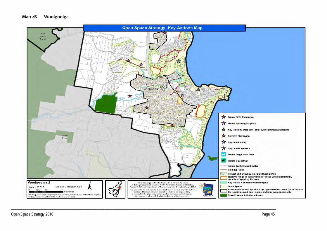
________________________________________________________________________________________________________________________________________
Open Space Strategy 2010 Page 45
Map 2B Woolgoolga

________________________________________________________________________________________________________________________________________
Open Space Strategy 2010 Page 46
PRECINCT 3 Northern Beaches
3.1 Precinct Recommendations
Objective 3.1.2 Provide additional open space opportunities
Actions Plan and develop proposed open space as a local sports facility/social family space in Sandy Beach, as per the DCP, to serve the village and surrounding areas.
Develop a trail network that connects the local school, future sports facility and coastal reserves and shops at Sandy Beach.
Development of the coastal walkway and linking trails to service both the Region as well as the local communities.
Develop footpath network at Emerald Beach primarily along the footpaths.
Consider closure of the eastern end of Fiddaman Road and removal of the boat ramp to facilitate Emerald Beach Reserve expansion.
Investigate opportunities for a suitable site for a central skate facility in Moonee Beach. Investigate suitability of Lot 21 DP 1093808.
In conjunction with future development or in co‐operation with private owners, develop walking trails along Moonee Creek from Tiki Road to Bluff Road, Emerald Beach.
Develop social family recreation space, sport and youth facilities as per the final development footprint for Moonee Beach DCP areas, to serve the Northern Beaches and Korora West Precincts and surrounding areas.
Consult with LPMA / Reserve Trust to prepare a site Master Plan for Moonee Beach Reserve with consideration of improved traffic flows, parking, play spaces and picnic facilities.
PRECINCT 3 Northern Beaches

________________________________________________________________________________________________________________________________________
Open Space Strategy 2010 Page 47
Objective 3.1.3 Provide additional land required to service future development
Actions Sandy Beach/Emerald Beach
Dedication of Open Space in accordance with the final development footprint of the Sandy Beach/Hearnes Lake DCP area.
Pursue where practical the dedication of additional open space in conjunction with any residential development of lands. Lands should contain open space values, such as recreational potential, pedestrian and cycle network, etc. Number and location to be determined at detailed land planning stage. Encourage dedication at no cost to Council.
Pursue where practical the dedication of key lands as public Open Space performing habitat and/or corridor functions , that will add value to existing open space, in conjunction with any residential development of lands identified in Council's current Urban growth strategies. Encourage dedication at no cost to Council.
Investigate options to acquire management of areas of high conservation significance within Lot 7 DP 245955, Lot 2 DP 702888, and Lot 13 DP 1140702 adjoining Moonee Creek for conservation and access way/trail purposes south of Emerald Beach.
Investigate opportunities to develop a local recreation field in conjunction with any rezoning/development of lands at Emerald Beach.
Moonee Beach/North Sapphire
Dedication of open space in accordance with the final development footprint for the Moonee Beach DCP area.
Land for local SFR and Access Way/Trails, as per core service levels criteria, in conjunction with any residential development of lands beyond intent of Moonee DCP, between North Sapphire and Moonee Beach to be determined at DA stage.
Pursue where practical the dedication of key lands as public Open Space performing habitat and/or corridor functions , that will add value to existing open space, in conjunction with any residential development of lands identified in Council's current Urban growth strategies. Encourage dedication at no cost to Council.
Determine the need for additional open space containing Open Space values, such as, recreational potential, visual amenity, pedestrian and cycle network, etc. with any residential development of lands. The number and location to be determined at detailed land planning stage. Encourage dedication at no cost to Council.
Investigate a route for South Moonee Forest walking track and seek dedication of identified land as walkway corridor.
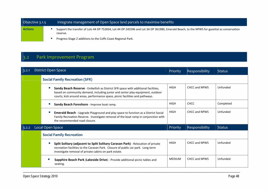
________________________________________________________________________________________________________________________________________
Open Space Strategy 2010 Page 48
Objective 3.1.5 Integrate management of Open Space land parcels to maximise benefits
Actions Support the transfer of Lots 44 DP 752834, Lot 44 DP 245596 and Lot 3A DP 361980, Emerald Beach, to the NPWS for gazettal as conservation reserve.
Progress Stage 2 additions to the Coffs Coast Regional Park.
3.2 Park Improvement Program
3.2.1 District Open Space Priority Responsibility Status
Social Family Recreation (SFR)
Sandy Beach Reserve ‐ Embellish as District SFR space with additional facilities, based on community demand, including junior and senior play equipment, outdoor courts, kick around areas, performance space, picnic facilities and pathways.
HIGH CHCC and NPWS Unfunded
Sandy Beach Foreshore ‐ Improve boat ramp. HIGH CHCC Completed
Emerald Beach ‐ Upgrade Playground and play space to function as a District Social Family Recreation Reserve. Investigate removal of the boat ramp in conjunction with the recommended road closure.
HIGH CHCC and NPWS Unfunded
3.2.2 Local Open Space Priority Responsibility Status
Social Family Recreation
Split Solitary (adjacent to Split Solitary Caravan Park) ‐ Relocation of private recreation facilities to the Caravan Park. Closure of public car park. Long term investigate removal of private cabins on park estate.
HIGH CHCC and NPWS Unfunded
Sapphire Beach Park (Lakeside Drive) ‐ Provide additional picnic tables and seating.
MEDIUM CHCC and NPWS Unfunded

________________________________________________________________________________________________________________________________________
Open Space Strategy 2010 Page 49
Access Way / trail
Construction of the Coastal Walk from Moonee Beach Reserve to Tiki Road to Moonee Beach Nature Reserve and through the Nature Reserve to the beach.
ADO CHCC and NPWS Pending development
Coastal cycleway to link Sapphire to the North Sapphire pathway network through CCRP.
MEDIUM CHCC and NPWS Unfunded
Provide for coastal walk to access White Bluff, Sapphire. MEDIUM CHCC and NPWS Unfunded

_________________________________________________________________________________________________________
Open Space Strategy 2010 Page 50
Map 3 Northern Beaches

_________________________________________________________________________________________________________________________________________
Open Space Strategy 2010 Page 51
PRECINCT 4 Coffs Urban
4.1 Precinct Recommendations
Objective 4.1.1 Provide additional open space opportunities
Actions Precinct Wide
Upgrade existing spaces that are under capacity, with improved recreation facilities, or acquire land for local social and family recreation in under‐served areas. In particular create two additional District SFR spaces at Bray Street and Bakers Road and additional local SFR at Vost Park.
Create additional dog leash free parks in Coffs Harbour.
Develop network of shared pathways/walking trails utilising the numerous drainage corridors dissecting the precinct.
Coffs Harbour War Memorial Pool. ‐ Progress planned upgrades of the facility. Beyond the life of this plan investigate an alternate location for an expanded aquatic centre when demand “triggers” the need to develop a facility able to deliver services beyond the scope of the current pool.
Investigate car parking and traffic flow requirements at major recreation and sporting reserves.
Small creek side open space presents opportunities to provide rest spots and seating along pathways.
Consider relocation of the existing beginner level skate park and the junior road safety circuit to new sites to facilitate expansion of Sportz Central. Note that any expansion of Sportz Central that requires removal of the Skatepark is contingent upon redevelopment of the Skatepark at an alternate location in conjunction with the expansion.
Explore opportunities with the Coffs Harbour Education Campus to plan and design open space and recreation facilities for use by the community.
In consultation with LPMA/Reserve Trust investigate opportunities to redevelop the existing access point to a major pedestrian entry point to the Showground at Rotary Park to enhance its connectivity to the CBD. Investigate opportunities to enhance connectivity of Botanic Gardens to the Showground, supporting the revitalisation of the Showground. NB. Dependent on Showground revitalisation.
Continue to develop the Botanic Gardens as a key Regional facility.
PRECINCT 4 Coffs Urban

_________________________________________________________________________________________________________________________________________
Open Space Strategy 2010 Page 52
Investigate the development of community gardens.
Improve recreation facilities in the caravan parks.
Investigate development of a Croquet facility adjacent to Westside Tennis, King Street.
Progress Street Tree plantings and trees/shade trees at sportsgrounds.
In consultation with LPMA/Reserve Trust investigate opportunities to redevelop the Jetty Foreshores and Southern Park Beach as a linked Regional SFR space in line with the adopted Plans of Management. Consider improving pedestrian connectivity between these sites to create an expansive foreshore recreation Reserve.
Retain Brelsford Park as a significant SFR space (City Park) to service the Region and to meet the demand of increasing housing densities around the CBD and Jetty areas, and develop in accordance with the adopted Master Plan.
Manage and regulate social events held at the beach and foreshore.
Regional Skate Park ‐ Investigate and develop a suitable site for a Regional skate plaza and freestyle BMX facility which accommodates the needs of young people. Investigate Jetty Foreshores, Brelsford Park and any other site that meets the criteria for such a facility. Determine funding opportunities.
In conjunction with preparation of the Coffs Coast State Park (CCSP) Plan of Management, investigate opportunities for strategic additions to the CCSP.
Englands Road Landfill ‐ Investigate recreational opportunities e.g. mountain bike etc. once decommissioned.
North Coffs and Korora
Investigate future coastal connections from Breakers Way to Firman Drive.
Coffs East
Investigate need for additional coastal SFR space at the southern end of Boambee Beach.
Coffs Creek Reserve (adjacent to the Pet Porpoise Pool) ‐ Ensure that, long term, the area of site currently leased, is returned to public open space upon the expiration of the lease.
Macauleys Headland – Investigate informal BMX facility at Lot 1 DP 702808 Diggers Beach Road, Coffs Harbour and determine demand.
Establish walkway connections linking Jetty area to the historic timber jetty, including seating, shade and energy efficient lighting.
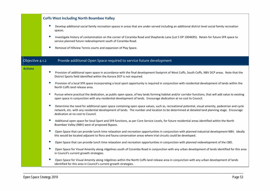
_________________________________________________________________________________________________________________________________________
Open Space Strategy 2010 Page 53
Coffs West including North Boambee Valley
Develop additional social family recreation spaces in areas that are under‐served including an additional district level social family recreation spaces.
Investigate history of contamination on the corner of Coramba Road and Shepherds Lane (Lot 5 DP 1004695). Retain for future SFR space to service planned future redevelopment south of Coramba Road.
Removal of Hillview Tennis courts and expansion of Play Space.
Objective 4.1.2 Provide additional Open Space required to service future development
Actions Provision of additional open space in accordance with the final development footprint of West Coffs, South Coffs, NBV DCP areas. Note that the
District Sports field identified within the Korora DCP is not required.
Provision of a local SFR space incorporating a local sport opportunity is required in conjunction with residential development of lands within the North Coffs land release area.
Pursue where practical the dedication, as public open space, of key lands forming habitat and/or corridor functions, that will add value to existing open space in conjunction with any residential development of lands. Encourage dedication at no cost to Council.
Determine the need for additional open space containing open space values, such as, recreational potential, visual amenity, pedestrian and cycle network, etc. with any residential development of lands. The number and location to be determined at detailed land planning stage. Encourage dedication at no cost to Council.
Additional open space for local Sport and SFR functions, as per Core Service Levels, for future residential areas identified within the North Boambee Valley (NBV) west of proposed Bypass.
Open Space that can provide lunch time relaxation and recreation opportunities in conjunction with planned industrial development NBV. Ideally this would be located adjacent to flora and fauna conservation areas where trial circuits could be developed.
Open Space that can provide lunch time relaxation and recreation opportunities in conjunction with planned redevelopment of the CBD.
Open Space for Visual Amenity along ridgelines south of Coramba Road in conjunction with any urban development of lands identified for this area in Council's current growth strategies.
Open Space for Visual Amenity along ridgelines within the North Coffs land release area in conjunction with any urban development of lands identified for this area in Council's current growth strategies.

_________________________________________________________________________________________________________________________________________
Open Space Strategy 2010 Page 54
Investigate linkage through 42 Coachmans Close, Lot 1 DP 1035561, (facilitating access for lots to the north to Campbells Beach).
Formalise future access easement through north side of Lot 2 DP 800836, Sapphire.
Investigate need to acquire Lot 1 DP 865841 to facilitate parkland development.
Investigate options to acquire management of Lot 95 DP 755536 (Airport area) to optimise management of the CCSP Boambee Creek.
Investigate options to acquire management of the areas of high conservation significance within Lots 1, 2, 3 of DP 259568, Lot 290 DP 1046425 and Lot 386 DP 820641.
Acquisition of Lot 1 449913.
Objective 4.1.3 Integrate management of Open Space to maximise benefits
Actions Progress Stage 2 additions to the Coffs Coast Regional Park.
Consolidation of the Coffs Coast State Park (CCSP). In particular:
Seek dedication of Lots 51, 6 and 7 of DP 259568 and manage in conjunction with CCSP. Consider integrated ownership with CCSP.
Coffs Creek ‐Investigate Crown Reserves bordering creek to come under Council management as part of the Coffs Coast State Park: Consider Lot 7030 DP 1051598; Lot 7029 DP 1053251, Lot 298 DP 752817, Lot 7016 DP 1101620, Lot 7028 DP 1055536, Lot 7015 DP 1101622, Pt 323 DP 752817, Lot 7027 DP 1055536, Lot 7060 DP 1050246, Lot 2 DP 549970.
Acquisition of Lot 95 DP 755536 (Airport area) and manage in conjunction with CCSP. Consider integrated ownership with CCSP.
Investigate addition of Crown Road east of Barrie Street to Harbour Drive (along Coffs Creek) to CCSP.
Investigate addition of the Coffs Harbour Golf Course to the CCSP.
Consider management of all available Council land around airport not required for aviation purposes for flora and fauna conservation and drainage.
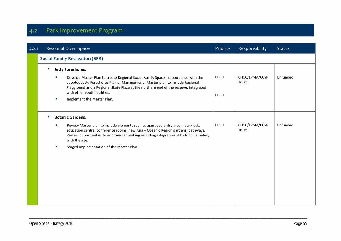
_________________________________________________________________________________________________________________________________________
Open Space Strategy 2010 Page 55
4.2 Park Improvement Program
4.2.1 Regional Open Space Priority Responsibility Status
Social Family Recreation (SFR)
Jetty Foreshores:
Develop Master Plan to create Regional Social Family Space in accordance with the adopted Jetty Foreshores Plan of Management. Master plan to include Regional Playground and a Regional Skate Plaza at the northern end of the reserve, integrated with other youth facilities.
Implement the Master Plan.
HIGH
HIGH
CHCC/LPMA/CCSP Trust
Unfunded
Botanic Gardens:
Review Master plan to include elements such as upgraded entry area, new kiosk, education centre, conference rooms, new Asia – Oceanic Region gardens, pathways, Review opportunities to improve car parking including integration of historic Cemetery with the site.
Staged Implementation of the Master Plan.
HIGH
CHCC/LPMA/CCSP Trust
Unfunded

_________________________________________________________________________________________________________________________________________
Open Space Strategy 2010 Page 56
4.2.2 District Open Space Priority Responsibility Status
North Coffs/Korora
Social Family Recreation (SFR)
Diggers Beach Reserve ‐ Complete Master Plan and upgrade as per plan to District Social Family Recreation space including new amenities, play equipment for a variety of ages, picnic facilities, paths, landscaping.
HIGH CHCC and NPWS Design commenced. Partially funded CHCC and NPWS
Norman Hill Reserve ‐ Upgrade as District level Social Family Recreation. MEDIUM CHCC and NPWS Unfunded
Coffs East
Social Family Recreation (SFR)
Lower Park Beach ‐ Develop to District 2 social family space in line with the Plan of Management for Park Beach Reserve (south).
HIGH CHCC/LPMA/CCSP Trust
Unfunded
Coffs Creek Reserve (adjacent to the Pet Porpoise Pool Park) ‐ Upgrade playground and picnic facilities. Increase parking at Edgar Street and redesign/extend Coffs Creek parking area.
HIGH CHCC/LPMA/CCSP Trust
Unfunded
Englands Park ‐ Redevelop as an extension of the Coffs Creek Reserve SFR space. Investigate closure of the northern end of Edgar Street and redesign of the boat ramp to accommodate walk in non motorised water craft only. Establish car parking off Edgar Street. Develop shared pathway including fitness stations.
MEDIUM CHCC/LPMA/CCSP Trust
Unfunded
Water Based Recreation
Northern Park Beach (Macauleys) ‐ Redesign car park and install picnic furniture. Develop new amenity block.
HIGH CHCC/LPMA/CCSP Trust
Unfunded
Coffs West

_________________________________________________________________________________________________________________________________________
Open Space Strategy 2010 Page 57
Social Family Recreation (SFR)
Bakers Road ‐ Embellish as a District SFR spaces incorporating mixed age play equipment, walkways, picnic and seating.
ADO CHCC Sec 94 funded
36 Bray Street ‐ Upgrade Park to District SFR with additional seating, shelters, car parking, toilets, and shade trees (Lot 34 DP 250921 and Lot 26 DP 258292). Relocate bicycle training circuit from Sportz Central to this location.
MEDIUM CHCC Unfunded
4.2.3 Local Open Space Priority Responsibility Status
North Coffs /Korora
Accessway/Trails
Potential walking trail from Links Avenue to Tropic Lodge Place with future development. Continue walkway from Norman Hill Drive into Opal Cove and Herman Reick Avenue.
ADO CHCC Unfunded
Future viewing area at Diggers Headland and coastal connection to Diggers Headland from Charlesworth Bay Road and Bay Drive.
MEDIUM CHCC/NPWS Unfunded
Future cycleway when development proceeds on “Beach Court” development site, Arthur Street.
ADO CHCC Unfunded
Upgrade stairs from Kotara Place to Hills Beach. CHCC/NPWS Unfunded
Flora and Fauna Conservation
Continue to support the NPWS and Landcare Coffs Coast Regional Park regeneration program. HIGH NPWS No cost to CHCC
Water Based Recreation
Sandy Beach Road, Korora – Rationalise car parking. Reinstate grass area and provide seating. Undertake minor revegetation. Upgrade beach access.
MEDIUM CHCC and NPWS Unfunded
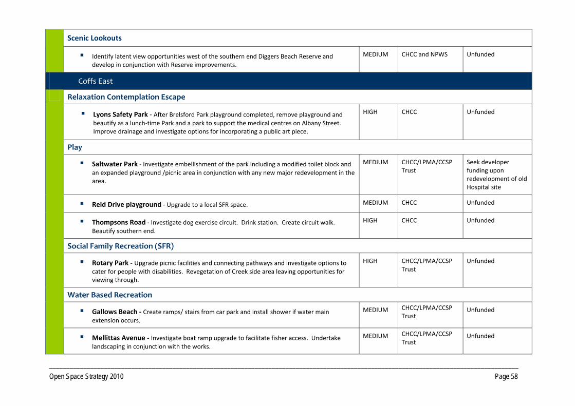
_________________________________________________________________________________________________________________________________________
Open Space Strategy 2010 Page 58
Scenic Lookouts
Identify latent view opportunities west of the southern end Diggers Beach Reserve and develop in conjunction with Reserve improvements.
MEDIUM CHCC and NPWS Unfunded
Coffs East
Relaxation Contemplation Escape
Lyons Safety Park ‐ After Brelsford Park playground completed, remove playground and beautify as a lunch‐time Park and a park to support the medical centres on Albany Street. Improve drainage and investigate options for incorporating a public art piece.
HIGH CHCC Unfunded
Play
Saltwater Park ‐ Investigate embellishment of the park including a modified toilet block and an expanded playground /picnic area in conjunction with any new major redevelopment in the area.
MEDIUM CHCC/LPMA/CCSP Trust
Seek developer funding upon redevelopment of old Hospital site
Reid Drive playground ‐ Upgrade to a local SFR space. MEDIUM CHCC Unfunded
Thompsons Road ‐ Investigate dog exercise circuit. Drink station. Create circuit walk. Beautify southern end.
HIGH CHCC Unfunded
Social Family Recreation (SFR)
Rotary Park ‐ Upgrade picnic facilities and connecting pathways and investigate options to cater for people with disabilities. Revegetation of Creek side area leaving opportunities for viewing through.
HIGH CHCC/LPMA/CCSP Trust
Unfunded
Water Based Recreation
Gallows Beach ‐ Create ramps/ stairs from car park and install shower if water main extension occurs.
MEDIUM CHCC/LPMA/CCSP Trust
Unfunded
Mellittas Avenue ‐ Investigate boat ramp upgrade to facilitate fisher access. Undertake landscaping in conjunction with the works.
MEDIUM CHCC/LPMA/CCSP Trust
Unfunded

_________________________________________________________________________________________________________________________________________
Open Space Strategy 2010 Page 59
Accessway/ Trails
Coffs Creek habitat walk:
Upgrade boardwalk and interpretive signage.
Upgrade to a cycleway with opportunities for short circuit nature trails.
Create/improve off road connectivity for the entire walkway with directional, information and interpretive signage. Consider creating activity nodes along walkway including rest stations. Improve linkages to walkway from surrounding residential areas long term. Link Creek Walk to Lawson Crescent.
Formalise walkway/cycleway from Vost Street to Brodie Drive, Coffs Harbour, with the northern Coffs Creek Walkway.
HIGH CHCC/LPMA/CCSP Trust
Funded
Continuation of walkway from Prince Street along Ocean Parade to Macauleys Beach. HIGH CHCC Unfunded
Investigate walkway and bridge through Lot 509 DP 4745 (Shea Street / Brodie Drive). Maybe structural planting at northern end of reserve.
MEDIUM CHCC Unfunded
Potential for Fitness Circuit from opposite Park Beach Caravan Park, through Park Beach Reserve, across bridge, to the Jetty Foreshores.
HIGH CHCC/LPMA/CCSP Trust
Unfunded
Formalise paths off Hogbin Drive North into residential areas. Assess pedestrian requirements in relation to crossing Hogbin Drive.
LOW CHCC Unfunded
Park Beach Reserve ‐ Develop additional walkways. Install energy efficient lighting. HIGH CHCC/LPMA/CCSP Trust
Unfunded
Flora and Fauna Conservation
Thompsons Road/Green Links Avenue site ‐ Conduct additional revegetation and closure of unformed Crown road and addition to the reserve.
MEDIUM CHCC Unfunded
Remediate the drainage line more naturally in Lot 1 DP 599577 Columbus Circuit.
MEDIUM CHCC Unfunded
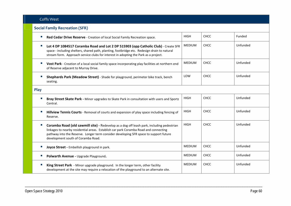
_________________________________________________________________________________________________________________________________________
Open Space Strategy 2010 Page 60
Coffs West
Social Family Recreation (SFR)
Red Cedar Drive Reserve ‐ Creation of local Social Family Recreation space. HIGH CHCC Funded
Lot 4 DP 1084517 Coramba Road and Lot 2 DP 515903 (opp Catholic Club) ‐ Create SFR space ‐ including shelters, shared path, planting, footbridge etc. Redesign drain to natural stream form. Approach service clubs for interest in adopting the Park as a project.
MEDIUM CHCC Unfunded
Vost Park ‐ Creation of a local social family space incorporating play facilities at northern end of Reserve adjacent to Murray Drive.
MEDIUM CHCC Unfunded
Shephards Park (Meadow Street) ‐ Shade for playground, perimeter bike track, bench seating.
LOW CHCC Unfunded
Play
Bray Street Skate Park ‐ Minor upgrades to Skate Park in consultation with users and Sportz Central.
HIGH CHCC Unfunded
Hillview Tennis Courts ‐ Removal of courts and expansion of play space including fencing of Reserve.
HIGH CHCC Unfunded
Coramba Road (old sawmill site) ‐ Redevelop as a dog off leash park, including pedestrian linkages to nearby residential areas. Establish car park Coramba Road and connecting pathway into the Reserve. Longer term consider developing SFR space to support future development south of Coramba Road.
HIGH CHCC Unfunded
Joyce Street ‐ Embellish playground in park. MEDIUM CHCC Unfunded
Polwarth Avenue ‐ Upgrade Playground. MEDIUM CHCC Unfunded
King Street Park ‐ Minor upgrade playground. In the longer term, other facility development at the site may require a relocation of the playground to an alternate site.
MEDIUM CHCC Unfunded

_________________________________________________________________________________________________________________________________________
Open Space Strategy 2010 Page 61
Roselands Drive Playground ‐ Install shade structure. HIGH CHCC Unfunded
Relaxation/Contemplation/Escape
Baden Powell Park ‐ Improve landscaping, pathways and seating opportunities. MEDIUM CHCC Unfunded
Reserve 134 Vera Drive ‐ Conduct minor upgrade – seating, pathway, landscaping. MEDIUM CHCC Unfunded
Heron Reserve ‐ Minor upgrade pathways and seating. MEDIUM CHCC Unfunded
Accessway/ Trails
Investigate BMX track from Taloumbi Road to Bray Street Reserve (Lot 26 258292). MEDIUM CHCC Unfunded
Upgrade existing path from Taloumbi Road to Hughes Close upgraded to shared path. MEDIUM CHCC Unfunded
Develop pathway Sandra Close to Perry Drive. LOW CHCC Unfunded
Formalise Joyce Street to Zara Place pathway. MEDIUM CHCC Unfunded
Shared pathway between Mackays Road and Joyce Street including linkages from cul‐de‐sacs. HIGH CHCC Unfunded
Formalise path from Argyll Street to Wentworth Avenue. LOW CHCC Unfunded
Formalise path from Jack Ladd Street to Joyce Street through Reserve. MEDIUM CHCC Unfunded
Create path from West High Street through to King Street. HIGH CHCC Unfunded
Shared pathway Combine Street Reserve to Coramba Road through open space network. HIGH CHCC Unfunded
Shared path Romney Close to Donn‐Patterson Drive. MEDIUM CHCC Unfunded
Cycle link from Bakers Road to Shephards Lane then onto Robin Street. HIGH CHCC Partially funded (EL)
Cycleway linking Robin Street to CBD. Investigate options for use of land on the southern side of the Narranga Primary School grounds for part of cycleway route.
HIGH CHCC Unfunded

_________________________________________________________________________________________________________________________________________
Open Space Strategy 2010 Page 62
Vost Park – Create shared path from Murray Drive to Scarba Street. Long term develop foot bridge across Coffs Creek once Council has management of the future parkland area indicated in the Coffs Harbour High Density DCP.
HIGH CHCC Unfunded
Shared path from Maple Street to Lucas Avenue. LOW CHCC Unfunded
Pathway Susan Close to Dianne Close. MEDIUM CHCC Unfunded
Shared path from Highway to Maple Street and Kurrajong Street. LOW CHCC Unfunded
Investigate shared path from Plantation Avenue to Marcia Street. MEDIUM CHCC Unfunded
Shared path Keilawarra Ridge to Donn Patterson Drive and connected to Nina Close. Create loop walk if possible.
MEDIUM CHCC Unfunded
Shared path from Hampshire to Sunnyside with connection to Cotswold Close and around Polwarth Oval.
MEDIUM CHCC Unfunded
Future natural trail linking Combine Street to Roberts Hill. HIGH CHCC Unfunded
Cycleway linking Red Cedar Drive and Robin Street via private Lot. ADO CHCC Unfunded
Roberts Hill – natural trail around Roberts Hill with viewing areas. Rationalise the local trails. HIGH CHCC Unfunded
Investigate feasibility of walking track along McCanns Fire Trail, west of Roberts Hill Reserve. Involves negotiating access agreements through private property.
LOW CHCC Unfunded
Investigate links between Kratz Drive and Santorini Place. LOW CHCC Unfunded
Continue path from King Street to James Ide Place and Combine Street and back to Gailer Drive. Connect to Caltowie Place.
MEDIUM CHCC Unfunded
Investigate walkway Petersen Road to Pacific Highway. MEDIUM CHCC Unfunded
Footpath ‐ Investigate improving Gailer Drive footpath along to West High Street.
HIGH CHCC Unfunded

_________________________________________________________________________________________________________________________________________
Open Space Strategy 2010 Page 63
Flora and Fauna Conservation
Vera Drive ‐ Continue to revegetate Reserve 134, Lot 463 DP 1029908. HIGH CHCC/Landcare
Continue current CHCC Regeneration program. HIGH CHCC EL funded on merit basis
Reduce mown area along Bray Street and allow regeneration through natural and assisted means.
HIGH CHCC Unfunded
Roberts Hill Reserve ‐ Develop revegetation plan and implement. HIGH CHCC Unfunded

________________________________________________________________________________________________________________________________________________________
Open Space Strategy 2010 Page 64
Map 4A Coffs Urban – North Coffs and Korora

________________________________________________________________________________________________________________________________________________________
Open Space Strategy 2010 Page 65
Map 4B Coffs Urban ‐ Coffs East 1

________________________________________________________________________________________________________________________________________________________
Open Space Strategy 2010 Page 66
Map 4C Coffs Urban ‐ Coffs East 2

________________________________________________________________________________________________________________________________________________________
Open Space Strategy 2010 Page 67
Map 4D Coffs Urban ‐ Coffs West

________________________________________________________________________________________________________________________________________
Open Space Strategy 2010 Page 68
PRECINCT 5 Korora West/Moonee West
5.1 Precinct Recommendations
Objective 5.1 1 Provide additional open space opportunities
Actions
Improve off road trail linkages to surrounding current and future Open Space opportunities in adjoining precincts.
Consider pedestrian linkage over the Pacific Highway to link Moonee East and West, in the vicinity of the future sports field.
Develop Social Family Recreation space in conjunction with the future sportsground development.
Objective 5.1 2 Provide additional Open Space required to service future development
Actions Dedicate land for one District level Sport function incorporating a SFR space, as per Core Service level provision, to accord with location shown in Moonee Beach DCP to service Korora West, Moonee Beach and the Northern Beaches.
Dedication of open space as per the final development footprint for the Moonee Beach DCP area.
Pursue where practical the dedication, as public Open Space, of key lands forming habitat and/or corridor functions, that will add value to existing open space in conjunction with any residential development of lands. Encourage dedication at no cost to Council.
Acquisition of Lot 9 DP 1140702.
PRECINCT 5 Korora West/Moonee West

_________________________________________________________________________________________________________
Open Space Strategy 2010 Page 69
Map 5 Korora West/Moonee West

________________________________________________________________________________________________________________________________________
Open Space Strategy 2010 Page 70
PRECINCT 6 Middle Boambee
6.1 Precinct Recommendations
Objective 6.1.1 Provide additional open space opportunities
Actions
Development of a local SFR space at Ayrshire Park co‐located with the Soccer Fields.
Objective 6.1.2 Provide additional land required to service new development
Actions Addition of Open Space in conjunction with any residential development of the area previously covered by the Boambee Creek DCP. Number and location of open space reserves to determined at detailed land planning stage.
6.2 Park Improvement Program
6.2.1 District Open Space Priority Responsibility Status
Social Family Recreation (SFR)
Ayrshire Park ‐ Development of a local SFR space (incorporating low key children’s playground) at the southern end of the Reserve. Upgrade the existing footbridge and create a circuit walk around the perimeter of the grounds.
HIGH CHCC Bridge funded. Construction to commence late 2010.
PRECINCT 6 Middle Boambee

________________________________________________________________________________________________________________________________________
Open Space Strategy 2010 Page 71
Map 6 Middle Boambee
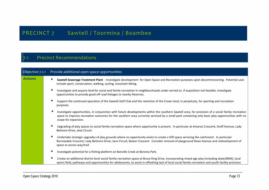
_________________________________________________________________________________________________________________________________________
Open Space Strategy 2010 Page 72
PRECINCT 7 Sawtell / Toormina / Boambee
7.1 Precinct Recommendations
Objective 7.1.1 Provide additional open space opportunities
Actions Sawtell Sewerage Treatment Plant ‐ Investigate development for Open Space and Recreation purposes upon decommissioning. Potential uses include sport, conservation, walking, cycling, mountain biking.
Investigate and acquire land for social and family recreation in neighbourhoods under‐served or, if acquisition not feasible, investigate opportunities to provide good off road linkages to nearby Reserves.
Support the continued operation of the Sawtell Golf Club and the retention of the Crown land, in perpetuity, for sporting and recreation purposes.
Investigate opportunities, in conjunction with future developments within the southern Sawtell area, for provision of a social family recreation space to improve recreation outcomes for the southern area currently serviced by a small park containing only basic play opportunities with no scope for expansion.
Upgrading of play spaces to social family recreation space where opportunity is present. In particular at Amaroo Crescent, Graff Avenue, Lady Belmore Drive, Jane Circuit.
Undertake strategic upgrades of play grounds where no opportunity exists to create a SFR space servicing the catchment. In particular Borrowdale Crescent; Lady Belmore Drive; Jane Circuit; Bower Crescent. Consider removal of playground Dews Avenue and redevelopment of space as access way/trail.
Investigate potential for a fishing platform on Bonville Creek at Boronia Park.
Create an additional district level social family recreation space at Bruce King Drive, incorporating mixed age play (including skate/BMX), local sports field, pathways and opportunities for adolescents, to assist in offsetting lack of local social family recreation and youth facility provision
PRECINCT 7 Sawtell / Toormina / Boambee
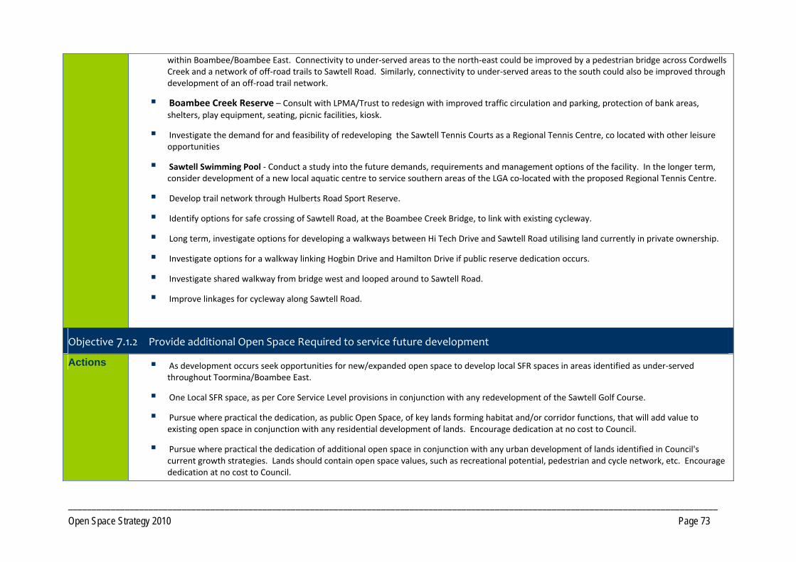
_________________________________________________________________________________________________________________________________________
Open Space Strategy 2010 Page 73
within Boambee/Boambee East. Connectivity to under‐served areas to the north‐east could be improved by a pedestrian bridge across Cordwells Creek and a network of off‐road trails to Sawtell Road. Similarly, connectivity to under‐served areas to the south could also be improved through development of an off‐road trail network.
Boambee Creek Reserve – Consult with LPMA/Trust to redesign with improved traffic circulation and parking, protection of bank areas, shelters, play equipment, seating, picnic facilities, kiosk.
Investigate the demand for and feasibility of redeveloping the Sawtell Tennis Courts as a Regional Tennis Centre, co located with other leisure opportunities
Sawtell Swimming Pool ‐ Conduct a study into the future demands, requirements and management options of the facility. In the longer term, consider development of a new local aquatic centre to service southern areas of the LGA co‐located with the proposed Regional Tennis Centre.
Develop trail network through Hulberts Road Sport Reserve.
Identify options for safe crossing of Sawtell Road, at the Boambee Creek Bridge, to link with existing cycleway.
Long term, investigate options for developing a walkways between Hi Tech Drive and Sawtell Road utilising land currently in private ownership.
Investigate options for a walkway linking Hogbin Drive and Hamilton Drive if public reserve dedication occurs.
Investigate shared walkway from bridge west and looped around to Sawtell Road.
Improve linkages for cycleway along Sawtell Road.
Objective 7.1.2 Provide additional Open Space Required to service future development
Actions As development occurs seek opportunities for new/expanded open space to develop local SFR spaces in areas identified as under‐served throughout Toormina/Boambee East.
One Local SFR space, as per Core Service Level provisions in conjunction with any redevelopment of the Sawtell Golf Course.
Pursue where practical the dedication, as public Open Space, of key lands forming habitat and/or corridor functions, that will add value to existing open space in conjunction with any residential development of lands. Encourage dedication at no cost to Council.
Pursue where practical the dedication of additional open space in conjunction with any urban development of lands identified in Council's current growth strategies. Lands should contain open space values, such as recreational potential, pedestrian and cycle network, etc. Encourage dedication at no cost to Council.

_________________________________________________________________________________________________________________________________________
Open Space Strategy 2010 Page 74
Addition of Open Space identified in the North Bonville DCP as per the final development footprint. Land should be of sufficient size to accommodate a local SFR space as per core service level criteria.
Acquire riparian corridor (zoned 6A) on Lot 3 DP 746772 (Shaws Close) to complete open space linkage.
Investigate options to acquire management of the areas of high conservation significance within Lot 61 DP 818826, adjoining Boambee Creek.
Investigate options to acquire management of Lot 2 DP 8117964 and Lot 21 DP 808755 Hogbin Drive.
Acquisition of Lot A DP 417177; Lot 5 DP 252278 to rationalise management boundaries.
Objective 7.1.3 Integrate management of Open Space to maximise benefits
Actions Initiate discussions with the NSW Department of Housing concerning Lot 238 DP 841861 (Lewis Street) becoming CHCC Public Reserve. Pathways could be built to link sewerage treatment plant site to ends of cul‐de‐sacs and connect in with bridge in cleared park to the north.
Investigate to acquire management of the areas of high conservation significance within Lot 28 705506 and Lot 131 DP 60040 (William Bayldon Public School) currently owned by NSW Education Department.
Investigate with LPMA/Trust, through the preparation of CCSP Plan of Management, the addition of Boambee Creek Reserve to the Coffs Coast State Park under Council control.
Lot 132 DP 828013 (Lyons Road) donate parcel to National Parks to add to Bongil Bongil National Park.
Seek management, as Trustee, of part of Lot 7033 DP 1114308 (Crown Reserve, Pacific Highway) adjoining future public reserve within the South Coffs DCP area when development occurs.

_________________________________________________________________________________________________________________________________________
Open Space Strategy 2010 Page 75
7.2 Park Improvement Program
7.2.1 District Open Space Priority Responsibility Status
Toormina/ Boambee East
Social Family Recreation (SFR)
Bruce King Drive ‐ Develop a District level SFR space including elements such as mixed age range playground, Hard court, BMX, walkways, landscaping.
HIGH CHCC Unfunded
7.2.2 Local Open Space Priority Responsibility Status
Sawtell
Play
Wonga Park ‐ Improve picnic facilities, linking walkways, landscaping. HIGH CHCC Unfunded
Richardson Park ‐ Develop local play space including provision of shade, drainage and landscaping.
HIGH CHCC Unfunded
Boronia Park ‐ Formalise car park on beach side of Boronia Park at Sawtell Deep Sea Fishing Club shed. Replace bollards on walkway. Reinforce Play space.
MEDIUM CHCC Unfunded
Bonville Creek at Boronia Park ‐ Access stairs need stabilizing. HIGH CHCC Unfunded
Lower Bonville Headland (adjacent to Boronia Park) ‐ Investigate opportunities to establish senior play/informal ball sports area, fitness circuits, landscaping, shade.
HIGH CHCC Unfunded
Visual Amenity
Dirrigeree Crescent ‐ Installation of seating and improved landscaping. MEDIUM CHCC Unfunded

_________________________________________________________________________________________________________________________________________
Open Space Strategy 2010 Page 76
Cemetery/Memorial Unfunded
Lyle Rose Memorial Park ‐ Renew shelters with a more contemporary design ‐ possibly reduce numbers of tables. Additional seating and interpretation within memorial area.
HIGH CHCC Unfunded
Water Based Recreation Unfunded
Sawtell Sea Pool ‐ Investigate options to establish shade/shelters/picnic facilities. MEDIUM CHCC Unfunded
Twenty‐Second Avenue ‐ Formalise car parking at end of 22nd Avenue, Murrays Beach platform and stairway.
LOW CHCC Unfunded
Micks Retreat –
Signage at Lyons Road entrance about reserve.
Investigate the need for refurbishment of the toilet with a more natural style of amenity.
Manage car parking areas including spill‐over parking up the hill.
Investigate options to redress erosion problems Bonville Creek.
MEDIUM
CHCC Unfunded
Accessway/ Trails
Boambee Headland ‐ Rationalise the fire trails. Urgently requires safety fencing. Complete walkways.
HIGH CHCC Unfunded
Create shared path between Richardson Park and Boambee Creek Reserve. HIGH CHCC Unfunded
Formalise/create walking track along northern side of Boambee Creek (Hi Tech Drive) with fishing platforms and signage.
LOW CHCC Unfunded
Upgrade walkway 22nd Avenue laneway to shared path and shared path 22nd Avenue to First Avenue.
MEDIUM CHCC Unfunded
Continue footpath from Lyle Rose Memorial Park to Surf Club and possibly continue to corner of East Street.
HIGH CHCC Unfunded
Bonville Headland ‐ Formalise desire lines into paved path including stopping zones. Include interpretive signage on whales, Headland Themeda, Little Terns etc.
HIGH CHCC Unfunded
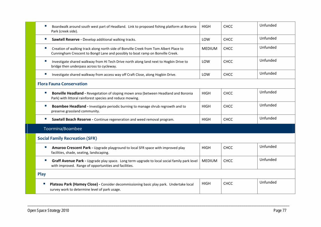
_________________________________________________________________________________________________________________________________________
Open Space Strategy 2010 Page 77
Boardwalk around south west part of Headland. Link to proposed fishing platform at Boronia Park (creek side).
HIGH CHCC Unfunded
Sawtell Reserve ‐ Develop additional walking tracks. LOW CHCC Unfunded
Creation of walking track along north side of Bonville Creek from Tom Albert Place to Cunningham Crescent to Bongil Lane and possibly to boat ramp on Bonville Creek.
MEDIUM CHCC Unfunded
Investigate shared walkway from Hi Tech Drive north along land next to Hogbin Drive to bridge then underpass across to cycleway.
LOW CHCC Unfunded
Investigate shared walkway from access way off Craft Close, along Hogbin Drive. LOW CHCC Unfunded
Flora Fauna Conservation
Bonville Headland ‐ Revegetation of sloping mown area (between Headland and Boronia Park) with littoral rainforest species and reduce mowing.
HIGH CHCC Unfunded
Boambee Headland ‐ Investigate periodic burning to manage shrub regrowth and to preserve grassland community.
HIGH CHCC Unfunded
Sawtell Beach Reserve ‐ Continue regeneration and weed removal program. HIGH CHCC Unfunded
Toormina/Boambee
Social Family Recreation (SFR)
Amaroo Crescent Park ‐ Upgrade playground to local SFR space with improved play facilities, shade, seating, landscaping.
HIGH CHCC Unfunded
Graff Avenue Park ‐ Upgrade play space. Long term upgrade to local social family park level with improved. Range of opportunities and facilities.
MEDIUM CHCC Unfunded
Play
Plateau Park (Hamey Close) ‐ Consider decommissioning basic play park. Undertake local
survey work to determine level of park usage.
HIGH CHCC Unfunded

_________________________________________________________________________________________________________________________________________
Open Space Strategy 2010 Page 78
Borrowdale Crescent ‐ Playground needs embellishments to shade, and landscaping. HIGH CHCC Unfunded
Jane Circuit and Cavanba Road ‐ Possible embellishment to park to include shade structure over playground.
MEDIUM CHCC Unfunded
Skate Park Toormina ‐ Upgrade in conjunction with users. Improve surveillance opportunities.
HIGH CHCC Unfunded
Accessway/ Trails
Hulberts Road ‐ Shared path in Hulberts Park from Minorie Drive to Hulberts Road around north‐eastern edge.
HIGH CHCC Unfunded
Lot 17 DP 263551 develop shared pathway from Wybalena Crescent into Minorie Drive. MEDIUM CHCC Unfunded
Platts Close ‐ Linking pathways to other parks through sewerage treatment plant when decommissioned.
MEDIUM CHCC Unfunded
Drainage line reserve along Playford Avenue ‐ A path to be built between Playford Avenue and Linden Avenue and along a link from Toormina Road.
HIGH CHCC Unfunded
Formalise track between Playford Avenue and Soren Larsen Crescent. HIGH CHCC Unfunded
Create a path network through from Soren Larsen Crescent to Borrowdale Crescent and Friendship Close.
LOW CHCC Unfunded
Create a path network between Kingfisher Close and Harvie Drive via Bellbowrie water reservoir.
HIGH CHCC Unfunded
Rationalise informal track network through bushland at Jane Circuit reserve and Bellbowrie water reservoir.
HIGH CHCC Unfunded
Develop path between Lady Belmore Drive and the Bellbowrie water reservoir on Jane Circuit reserve. Complete connection from Kinchela Place to Scenic Place.
MEDIUM CHCC Unfunded
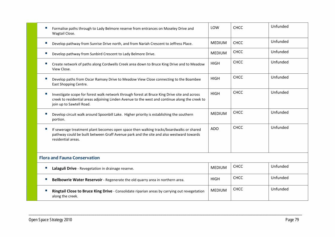
_________________________________________________________________________________________________________________________________________
Open Space Strategy 2010 Page 79
Formalise paths through to Lady Belmore reserve from entrances on Moseley Drive and Wagtail Close.
LOW CHCC Unfunded
Develop pathway from Sunrise Drive north, and from Nariah Crescent to Jeffress Place. MEDIUM CHCC Unfunded
Develop pathway from Sunbird Crescent to Lady Belmore Drive. MEDIUM CHCC Unfunded
Create network of paths along Cordwells Creek area down to Bruce King Drive and to Meadow View Close.
HIGH CHCC Unfunded
Develop paths from Oscar Ramsey Drive to Meadow View Close connecting to the Boambee East Shopping Centre.
HIGH CHCC Unfunded
Investigate scope for forest walk network through forest at Bruce King Drive site and across creek to residential areas adjoining Linden Avenue to the west and continue along the creek to join up to Sawtell Road.
HIGH CHCC Unfunded
Develop circuit walk around Spoonbill Lake. Higher priority is establishing the southern portion.
MEDIUM CHCC Unfunded
If sewerage treatment plant becomes open space then walking tracks/boardwalks or shared pathway could be built between Graff Avenue park and the site and also westward towards residential areas.
ADO CHCC Unfunded
Flora and Fauna Conservation
Lalaguli Drive ‐ Revegetation in drainage reserve. MEDIUM CHCC Unfunded
Bellbowrie Water Reservoir ‐ Regenerate the old quarry area in northern area. HIGH CHCC Unfunded
Ringtail Close to Bruce King Drive ‐ Consolidate riparian areas by carrying out revegetation along the creek.
MEDIUM CHCC Unfunded
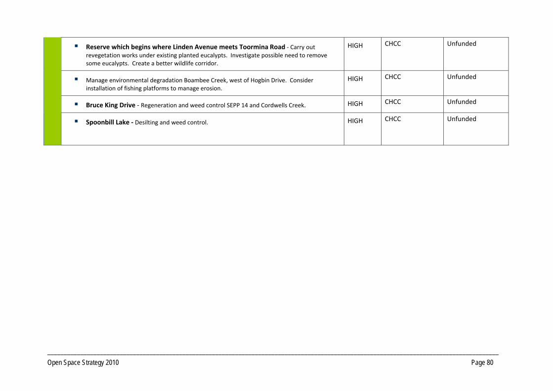
_________________________________________________________________________________________________________________________________________
Open Space Strategy 2010 Page 80
Reserve which begins where Linden Avenue meets Toormina Road ‐ Carry out revegetation works under existing planted eucalypts. Investigate possible need to remove some eucalypts. Create a better wildlife corridor.
HIGH CHCC Unfunded
Manage environmental degradation Boambee Creek, west of Hogbin Drive. Consider installation of fishing platforms to manage erosion.
HIGH CHCC Unfunded
Bruce King Drive ‐ Regeneration and weed control SEPP 14 and Cordwells Creek. HIGH CHCC Unfunded
Spoonbill Lake ‐ Desilting and weed control.
HIGH CHCC Unfunded

_________________________________________________________________________________________________________________________________________
Open Space Strategy 2010 Page 81
Map 7 Sawtell / Toormina / Boambee

_________________________________________________________________________________________________________________________________________
Open Space Strategy 2010 Page 82
PRECINCT 8 Bonville
8.1 Precinct Recommendations
Objective 8.1.1 Provide additional open space opportunities
Actions Open Space for social and family recreation that includes play for children and young people must be considered in the development plans for the future neighbourhoods.
Develop an equestrian area on the southern end of the Bakker Drive Reserve. Longer term consider the need for amenities and car parking. Develop future access via North Bonville Road and Braford Drive in conjunction with any redevelopment. Reserve to retain multi‐use capability. Consider leasing of equestrian area to the Bonville Valley Riding Club, ensuring any lease arrangement reflects multiuse principles.
Formalise public access arrangements in conjunction with any redevelopment of land to the west of Bakker Road Reserve to create bridle and access paths to nearby State Forest trail network. Also investigate opportunities to develop linkages via North Bonville Road and the Crown Road network, to the Tuckers Nob, Boambee and Orara West State Forests. Investigate need to upgrade footbridge.
Objective 8.1.2 Provide additional Open Space required to service new development
Actions Investigate the acquisition of land for a district level sports facility that provides for major participation sports in Bonville in line with the
expected population growth that is planned for the neighbourhood.
Additional open space for Local Social Family Recreation, Access way/trails and Local Sport as per Core Service Levels criteria within areas identified for Short Term future residential expansion, as identified in Council's current growth strategies. Location and number of spaces to be determined in conjunction with detailed land planning.
Additional Open Space for a range of functions including Local Social Family Recreation, Amenity Parkland, Access way/ trails and Local/District Sport as per Core Service Levels criteria within areas identified, long term, for residential expansion (future Bonville Township), identified in Council's current growth strategies. Location and number of spaces to be determined in conjunction with detailed land planning processes.
PRECINCT 8 Bonville

_________________________________________________________________________________________________________________________________________
Open Space Strategy 2010 Page 83
Pursue where practical the dedication, as public Open Space, of key lands forming habitat and/or corridor functions that will add value to existing open space in conjunction with any residential development of lands. Encourage dedication at no cost to Council.
8.2 Park Improvement Program
8.2.1 District Open Space Priority Responsibility Status
Bakker Drive ‐ Develop the southern end of the Bakker Drive Reserve for equestrian use. HIGH CHCC Unfunded
8.2.2 Local Open Space
Accessway/Trails
Formalise public access arrangements through private land to the west of Bakker Road Reserve to create bridle paths to the nearby State Forest trail network. Alignment of route to be
reviewed in context of adjoining development when it proceeds.
HIGH CHCC Unfunded
Bakker Drive Reserve ‐ Develop circuit walking trails. LOW CHCC Unfunded
Flora Fauna Conservation
Bakker Drive Reserve ‐ Regeneration of riparian area in conjunction with local Landcare group.
HIGH CHCC Unfunded

_________________________________________________________________________________________________________________________________________
Open Space Strategy 2010 Page 84
Map 8 Bonville

_________________________________________________________________________________________________________________________________________
Open Space Strategy 2010 Page 85
PRECINCT 9 Far North Rural
9.1 Precinct Recommendations
Objective 9.1.1 Provide additional open space opportunities
Actions Investigate community demand for a local sports/recreation reserve, within this precinct, that has a perimeter trail and provides for social and family
recreation.
No additional open space is immediately required within this precinct. However, this is subject to further community consultation to determine needs.
PRECINCT 9 Far North Rural
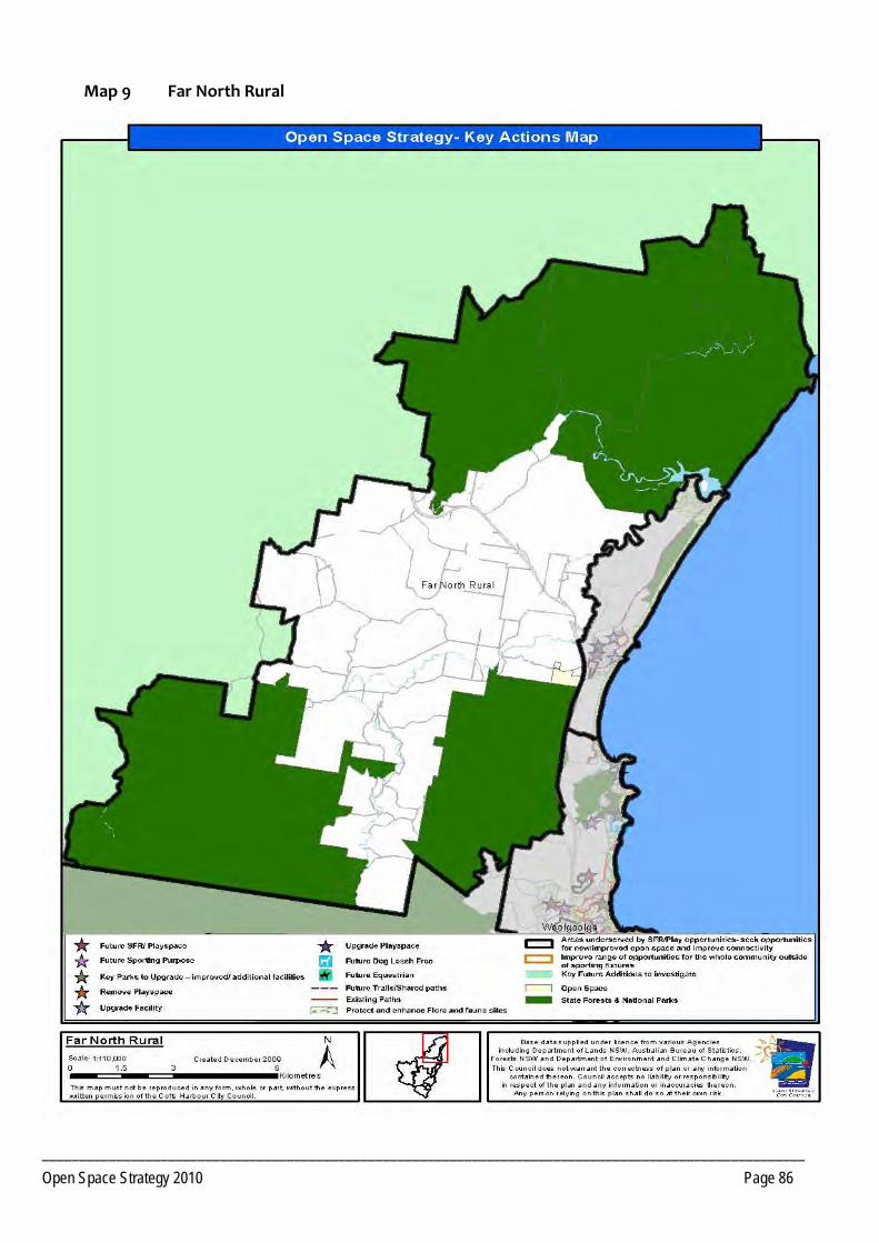
_______________________________________________________________________________________________________
Open Space Strategy 2010 Page 86
Map 9 Far North Rural

________________________________________________________________________________________________________________________________________
Open Space Strategy 2010 Page 87
PRECINCT 10 North Rural
10.1 Precinct Recommendations
Objective 10.1.1 Provide additional open space opportunities
Actions Retain focus of the Nana Glen Sport and Recreation Grounds as a venue for equestrian pursuits.
Investigate community interest in refurbishment of the Tennis Courts as a multi purpose facility.
Investigate opportunities for public use of the Nana Glen School’s recreation facilities.
Explore opportunities to develop a nature trail utilising the Sportsground to connect Nana Glen and Nana Glen Rail.
No additional open space is required within this Precinct as there is sufficient scope for redevelopment of existing open pace to service current and planned future populations as per Council's current growth strategy.
10.2 Park Improvement Program
10.2.1 District Open Space Priority Responsibility Status
Sport
Prepare Master Plan for the Nana Glen Sport and Recreation Ground.
Development of additional facilities supporting equestrian pursuits at Nana Glen Sport and Recreation Ground.
MEDIUM CHCC Unfunded
PRECINCT 10 North Rural

________________________________________________________________________________________________________________________________________
Open Space Strategy 2010 Page 88
10.2.2 Local Open Space
Social Family Recreation (SFR)
Archie Hunter Reserve ‐ Develop a nature based junior playground. MEDIUM CHCC Unfunded
Play
Bucca Sports Reserve ‐ Development of a playground. LOW LPMA/Reserve
Trust Consult with Reserve managers regarding the need for works. Unfunded
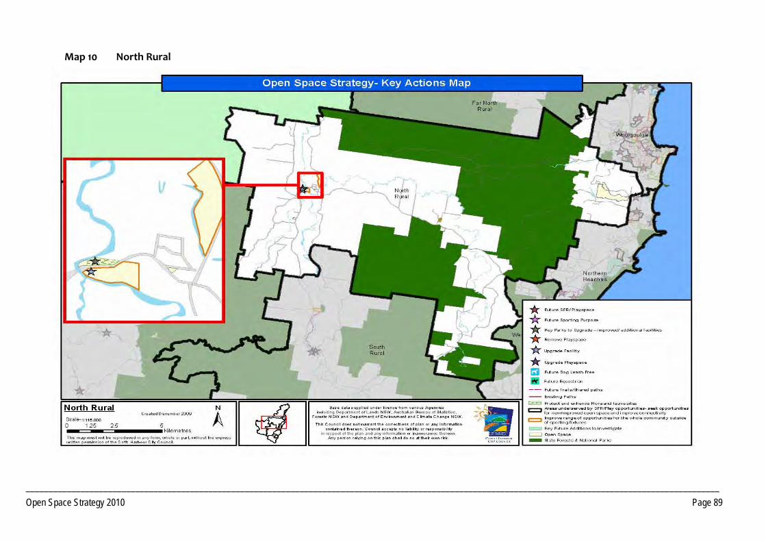
________________________________________________________________________________________________________________________________________________________
Open Space Strategy 2010 Page 89
Map 10 North Rural

_________________________________________________________________________________________________________________________________________
Open Space Strategy 2010 Page 90
PRECINCT 11 South Rural
11.1 Precinct Recommendations
Objective 11.1.1 Provide additional open space opportunities
Actions Investigate need for a tennis facility at Coramba and identify suitable sites.
Ensure zoning of land surrounding the Pistol Club, Mount Browne Road, is compatible with that sport to ensure continuation of Pistol Club.
Opportunities to access open space for social and family recreation and play for children and young people must be considered in the development plans for the areas.
Investigate opportunities for public use of Coramba School’s recreation facilities.
Investigate opportunities for an off road path connection between Coramba and the Sportsground, ideally along the Orara River.
PRECINCT 11 South Rural

_________________________________________________________________________________________________________________________________________
Open Space Strategy 2010 Page 91
11.2 Park Improvement Program
11.2.1 Local Open Space Priority Responsibility Status
Play
CWA Park, Coramba ‐ Enhance play space and refurbish amenities for day use, so to encourage way‐side stop use. Investigate feasibility of a BBQ at this location.
MEDIUM CHCC Unfunded
Thrower Avenue, Coramba ‐ Undertake drainage and fill works and develop BMX, adventure playground, hard court and games area on land parcel at Thrower Avenue. Determine other appropriate play experiences that could be provided on flood prone site.
HIGH CHCC Unfunded
Water Based Recreation
Martin Street park ‐ Investigate options to pull back car parking from river edge and develop
as a picnic area pending flooding constraints.
MEDIUM CHCC Unfunded
Accessway/Trails
Future shared path connection from Coramba village to the Showground (creek line route or main road).
LOW CHCC Unfunded
Coramba ‐ Develop connection from Coramba Hotel to Thrower Avenue Reserve. HIGH CHCC Unfunded

_________________________________________________________________________________________________________
Open Space Strategy 2010 Page 92
Map 11 South Rural

_________________________________________________________________________________________________________________________________________
Open Space Strategy 2010 Page 93
PRECINCT 12 Far West Hinterland
12.1 Precinct Recommendations
Objective 12.1.1 Providing for current and future Open Space needs
Actions Ulong ‐ To provide a play space within a social and family recreation space is a priority. The demographic indicates demand for more play opportunities for children and young people with a high number of families residing in the precinct.
Investigate level of community interest in upgrading tennis court’s to a multi purpose hardcourt facility.
No additional open space is required within this Precinct as there is sufficient scope for redevelopment of existing open pace to service current and planned future populations as per Council's current growth strategy.
Lowanna and Ulong ‐ Off road trails should be considered that connect recreation opportunities, the school and shop.
12.2 Park Improvement Program
12.2.1 Local Open Space Priority Responsibility Status
Play
Ulong Showground ‐ Develop play (including BMX) facilities catering for wide age ranges. HIGH CHCC Unfunded
Lowanna Reserve ‐ Development of a playground and facilities for adolescents. MEDIUM CHCC Unfunded
Social Family Recreation
Timms Park ‐ Additional seating, develop onsite interpretation. LOW CHCC Unfunded
PRECINCT 12 Far West Hinterland
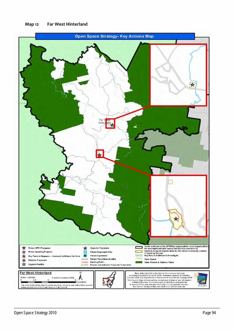
_________________________________________________________________________________________________________
Open Space Strategy 2010 Page 94
Map 12 Far West Hinterland

_________________________________________________________________________________________________________________________________________
Open Space Strategy 2010 Page 95
Section 4 Policy Review
Council Policy framework guides and informs the management of Open Space. These Policies and Plans determine the planning, development and management of Open Space. Table 1 details the relevant policies. It also gives an indication of the status of current and future policy direction.
TABLE 1: Summary of existing policies relevant to Councils Open Space Network.
Name Status Action required
Core Service Levels Draft Adoption
Street Tree Masterplan Adopted To be reviewed
Landscape Guidelines Adopted To be reviewed
Development Control Plans (various) Adopted To be reviewed
Regeneration Strategy Being prepared Adoption
Playground Strategy Not yet commenced To be developed
Signage Policy Not yet commenced To be developed
Shade Policy Not yet commenced To be developed
Park Naming Policy Not yet commenced To be developed
Events in Parks Policy Not yet commenced To be developed
Community Gardens Policy Not yet commenced To be developed
Vehicles on Beaches Adopted To be reviewed
Companion Animals Management Plan, 2000 Adopted To be reviewed
Section 4 Policy Review

_________________________________________________________________________________________________________________________________________
Open Space Strategy 2010 Page 96
Koala Plan of Management Adopted Under review
Tree Preservation Order Adopted Under review
Bushfire Management Plan
Priority Habitats & Corridors Strategy Draft Under review
Coffs Harbour Coastal Reserves Plan of Management
(covers all Coastal Reserves. Plan is rescinded to the extent of any inconsistency with the adopted individual reserve PoM)
Adopted 2000 To be reviewed (Reserves to be split between State Park and Regional Park) NPWS to undertake PoM for Regional Park. CHCC to prepare State Park PoM.
Estuary Management Plans (various) Awaiting adoption Adoption
Vision 2030 Being prepared Adoption
Standard Local Environmental Plan Being prepared Adoption
Coastal Process – Hazard Definition Study Being prepared Adoption
Masterplans:
Brelsford Park
CCSLP
Hulberts Road
West Woolgoolga
Arrawarra
Diggers Beach
Adoption
Preliminary work commenced
Preliminary work commenced
Preliminary work commenced
Preliminary work commenced
Preliminary work commenced
No work required
Adoption
Adoption
Adoption
Adoption
Adoption

_________________________________________________________________________________________________________________________________________
Open Space Strategy 2010 Page 97
Plans of Management Community and Crown Lands Adoption Date Action Required
Beacon Hill Reserve August 2000 To be reviewed
Harbourside Plan of Management 2008 No work required
Botanical Gardens To be reviewed
Bray Street Recreation Area December 1995 To be reviewed
Brelsford Park February 1999 No work required
Cemeteries Management Strategy September 1996 To be reviewed
Charlesworth Bay Reserve July 1987 To be reviewed
Coffs Coast Sport and Leisure Park December 2001 To be reviewed
Coffs Harbour Coastal Reserves February 2000 To be reviewed
Coffs Creek Waterway Improvement Programme Overall Management Plan March 1992 To be reviewed
Diggers Headland May 1993 To be reviewed
Duttons Estate Under Review To be adopted
Coffs Creek Flying Fox Camp Strategy 7 June 2007 To be reviewed
Hills Beach Reserve September 1992 To be reviewed
Natural Areas October 1996 To be reviewed
North Coast Regional Botanic Garden 1997 To be reviewed
Nana Glen Sport Recreation and Equestrian Centre To be reviewed
Park Beach Reserve 2009 No work required
Parkland July 1996 To be reviewed

_________________________________________________________________________________________________________________________________________
Open Space Strategy 2010 Page 98
Picnic Areas October 1996 To be reviewed
Playgrounds October 1996 To be reviewed
Sawtell Reserve 2009 No work required
Solitary Islands Coastal Walk Strategy February 2000 To be reviewed
Sportsground October 1996 To be reviewed
Woolgoolga Community Centre December 1999 To be reviewed
Woolgoolga Lake and Lake Reserves 1992 To be reviewed
Woolgoolga Swimming Pool and Recreation Reserve July 2000 To be reviewed

Coffs Harbour City CouncilOpen Space Research Report 2010
REPORT TWO Consultation Findings
connecting parks and people


OPEN SPACE STRATEGY – DEMAND FINDINGS (DRAFT) 1 of 97
Acknowledgements
@leisure wishes to acknowledge the support and assistance provided on this project by Sue Stewart of Coffs Harbour City Council.
PHOTOGRAPHS KINDLY SUPPLIED BY: Coffs Coast Marketing, Rob Cleary, Tom Woods, ST Images, Rachael Squires and Damon Leach.
About this document
This Consultation Findings document is prepared by @leisure for the Coffs Harbour City Council.
This document outlines the findings of the consultation phase undertaken in the preparation of an open space plan for the Coffs Harbour Local Government area, the influences of the local demographic profile, and demand projections for activities likely to be conducted in Open Space.
The Consultation Findings presents the data found through the consultation stage for the Coffs Harbour Open Space Plan and will be referenced in later volumes.
© All rights reserved. No part of this publication may be
reproduced, stored in a retrieval system or transmitted in any form, by any means,
without the prior written permission of the Coffs Harbour City Council and JEAVONS & JEAVONS Pty Ltd
Rear 534 Mt Alexander Road ASCOT VALE VIC 3032
Ph. 03 9326 1662 Fax. 03 9326 0991 Email: [email protected]

OPEN SPACE STRATEGY – DEMAND FINDINGS (DRAFT) 2 of 99
Table of Contents
1 Demographic influences and demand projections..............................3 1.1 Population Profile .................................................................................... 3 1.2 Demand for Activities .............................................................................. 8 1.3 Influence of population characteristics on demand for activities ............ 9 1.4 Implications summary ........................................................................... 14
2. Summary of Consultation Findings ...................................................15 2.1 Resident Preferences............................................................................ 15 2.2 Sports Clubs, local and state Sporting Associations and Peak Bodies . 16 2.3 Friends and Environmental Groups ...................................................... 18 2.4 Tourism Sector...................................................................................... 19 2.5 Rotary and Service Groups................................................................... 19 2.6 Developers............................................................................................ 19 2.7 Government Departments..................................................................... 20
Appendix 1 Household survey findings..............................................21
Appendix 2 School student survey .....................................................57
Appendix 3 Notes from school principal interviews..........................78
Appendix 4 Notes from internal stakeholder workshop 7/03/07 .......81
Appendix 5 Notes from workshops held 16 to 17 June 2008............89

OPEN SPACE STRATEGY – DEMAND FINDINGS (DRAFT) 3 of 99
1 DEMOGRAPHIC INFLUENCES AND DEMAND
PROJECTIONS
The demand for activities that require recreation and open space facilities has been analysed based on the resident population of Coffs Harbour LGA. Population change and demographic characteristics are key influences on the demand for recreation activities.
1.1 Population Profile
Population size, age and gender
Coffs Harbour’s resident population is estimated to be 68,048. Since 1996, the population in Coffs Harbour has grown significantly, increasing by 11% over 10 years (as shown in Figure 1).
Compared to the NSW State Average, the population of Coffs Harbour has a smaller percentage of young adults (18 to 34 year olds) and a larger percentage of adults and older adults (34 to 84 years olds).
Figure 1: Population of Coffs Harbour from 1996 to 20111
Figure 2: Age Comparison – Coffs Harbour Residents & NSW State1
1 ABS Census of population and housing, Time series Data, 2006

OPEN SPACE STRATEGY – DEMAND FINDINGS (DRAFT) 4 of 99
Demographic profiles by precinct
For the purpose of this analysis, Coffs Harbour LGA has been broken into twelve planning precincts, consisting of the following localities:
Far Northern Beaches: Red Rock, Corindi Beach
Woolgoolga including: Safety Beach, Arrawarra, Arrawarra Headland, Mullaway
Northern Beaches including: Sandy Beach, Emerald Beach, Moonee Beach, Sapphire Beach, Heritage Park
Coffs Harbour Urban including: North Boambee Valley, Korora
Korora West
Boambee Valley
Sawtell, Toormina, Boambee East
Bonville, including Bundagen
Far North Rural including: Upper Corindi Plateau, Dirty Creek
North Rural including: Nana Glen, Bucca
South Rural including: Coramba, Karangi
Far West Hinterland including: Ulong, Brooklana, Lowanna
The population of each precinct is shown in Table 1 and Figure 3.
The precincts with the largest population are Coffs Harbour Urban (41% of Coffs Harbour’s population), Sawtell (23%) and Woolgoolga (10%).
The greatest population decline has been in the Far West Hinterland Precinct (-5% decrease since 2001) representing a decrease of 29 people.
Far Northern Beaches had the greatest population increase of 23% (increase since 2001), however this only represents an increase of approximately 210 people.
Precincts with a greater proportion of children (aged 0 to 14 yrs) include Far West Hinterland (24%) and North Rural (24%) compared to Coffs Harbour LGA (20%).
Woolgoolga has a smaller proportion of young adults (10%) and a significantly larger population of older adults aged 65 years and over (23%) compared to Coffs Harbours LGA (12% and 16% respectively).
Woolgoolga (23%) and Coffs Harbour Urban (20%) have a higher percentage of older adults, while Far West Hinterland (68%) and South Rural (668%) have a higher concentration of people aged 15 to 54 years.

OPEN SPACE STRATEGY – DEMAND FINDINGS (DRAFT) 5 of 99
Table 1: Population size and percentage by precinct District Precinct
Total Population
Percentage of Population
1 Far Northern Beaches 1,142 2% 2 Woolgoolga 6,500 10% 3 Northern Beaches 5,834 9% 4 Coffs Harbour Urban 26,342 41% 5 Korora West 1,396 2% 6 Boambee Valley 1,583 2% 7 Sawtell, Toormina,
Boambee 15,011 23% 8 Bonville 2,028 3% 9 Far North Rural 445 1% 10 North Rural 1,990 3% 11 South Rural 2,118 3% 12 Far West Hinterland 524 1% Coffs Harbour (LGA) 64,913 100.0%
Figure 3: Population size and percentage by precinct
Population size and percentage by precinct
Far North Beaches Woolgoolga Northern Beaches
Coffs Harbour Urban Korora West Boambee
Sawtell, Toormina, Boambee Bonville Far North Rural
North Rural South Rural Far West Hinterland

OPEN SPACE STRATEGY – DEMAND FINDINGS (DRAFT) 6 of 99
Young people
Participation in recreation activities is highest in young people. Whilst older adults may have more time, generally speaking more young people will use open space, and sport and recreation facilities than older adults.
The 2006 census indicated there to be approximately 13,000 persons aged less than 15 years of age and 8000 persons aged 15 to 25 years in Coffs Harbour, representing 20% and 12% of the population respectively.
These are similar to the percentage of persons aged below 15 compared to Mid North Coast (MNC) and NSW state as a whole, however the proportion of people aged between 15yrs and 25yrs is higher in Coffs Harbour than that of the MNC (10.8%), but lower than the State average (13.3%).
A decrease in the proportion of people under 15 persons occurred in the population from 2001 to 2006. The proportion of persons aged below 15 years increased only slightly from 2001 to 2006.
The Boambee and North Rural precincts have the highest percentage of all residents under 25 years. However, the largest number of people under 25 years are in the Coffs Harbour Urban precinct, where there are over 4500 persons aged below 15 years, and over 3500 people aged between 15 and 25 years.
Table 2: Proportion of young people by precinct
Older Adults
Population Size
16.6% of the Coffs Harbour population are aged 65 years and over (compared to 13.6% for NSW).
The greatest concentration of people aged 65+ years are in the precincts of Woolgoolga (22.8%), Far Northern Beaches (19.6%) and Coffs Harbour Urban (19.3%).
By 2021 it is estimated the over 25% of the population will be over 65 years of age.
Precinct Persons Under 15yrs Persons 14-24 yrs
Number % Number % Far Northern Beaches 235 20.5 124 10.8%
Woolgoolga 1159 17 662 10.1%
Northern Beaches 1352 23 703 12.0%
Coffs Harbour Urban 4739 18 3587 13.6%
Korora West 291 20 173 12.3%
Boambee Valley 375 23 189 11.9%
Sawtell, Toormina, Boambee East 3363 22 1798 11.8%
Bonville 429 21 243 11.9%
Far North Rural 101 22 50 8.5%
North Rural 479 24 214 10.7%
South Rural 506 23 241 11.3%
Far West Hinterland 127 24 67 12..7%
Coffs Harbour LGA 13,156 20.3% 8,049 12.4%

OPEN SPACE STRATEGY – DEMAND FINDINGS (DRAFT) 7 of 99
Population Projections
The Coffs Harbour population is expected to increase significantly over the coming 15 years. The ABS projects the population to increase by 24.2% from 2001 to 2021, estimating the population of Coffs Harbour in 2021 to be 78,814. However these projections were estimated in 2001.
A further study by the Committee of Economic Development Australia (CEDA) in 2004 has projected the population to increase by 23.9% from 2004 to 2021, estimating a shire population in 2021 of 81,8002.
Both projections estimate the population to age significantly over the coming 15 years as highlighted in Table 2. The ABS also projects the median age of the Coffs Harbour population to increase from 41 years in 2006 to 46.9 years in 2021.
Table 3: Population projections by age group - ABS
2 Jackson, N.O. and Flemingham, B. (2004) CEDA LGAT Population Aging project
District Precinct 2006 2011 2016 2021 2026 2031 N Precinct 1
Far Northern Beaches 1142 1291 1431 1544 1659 1768
N Precinct2 Woolgoolga
6500 7538 8363 9054 9706 10353
N Precinct 3 Northern Beaches
5834 6600 7324 7929 8500 9067
C Precinct 4 Coffs Harbour Urban
26342 28515 30722 32933 35130 37290
N Precinct 5 Korora West
1396 1581 1754 1899 2035 2142
S Precinct 6 Boambee Valley
1583 1714 1846 1773 1891 2008
S Precinct 7 Sawtell / Toormina / Boambee
15011 16251 17507 18768 20277 21522
S Precinct8 Bonville
2028 2195 2364 2535 2704 2870
W Precinct9 Far North Rural
445 465 484 505 525 545
W Precinct 10 North Rural (inc Nana Glen)
1990 2070 2054 2138 2225 2305
W Precinct 11 South Rural (inc Coramba and Karangi)
2118 2203 2292 2385 2482 2570
W Precinct 12 Far West Hinterland (inc Ulong)
524 544 564 589 610 630
Total LGA 64913 70967 76705 82052 87744 93070
Census ABS projections CEDA
Age group 2006 2006 2021 2021 ABS %
Change '06-'210-4 4,020 3,623 3,149 4,030 -13.1% 5-9 4,450 4,461 4,212 4,410 -5.6% 10-14 4,910 5,066 5,201 4,690 2.7% 15-24 7,770 8,055 10,278 7,760 27.6% 25-34 6,220 6,122 5,934 6,670 -3.2% 35-44 9,050 8,674 7,651 8,840 -11.8% 45-54 10,170 9,967 13,213 10,790 32.6% 55-64 8,830 8,131 13,855 12,900 70.4% 65+ 11,520 10,802 15,321 21,260 41.8% TOTAL 66,940 64,901 78,814 81,800 21.4%
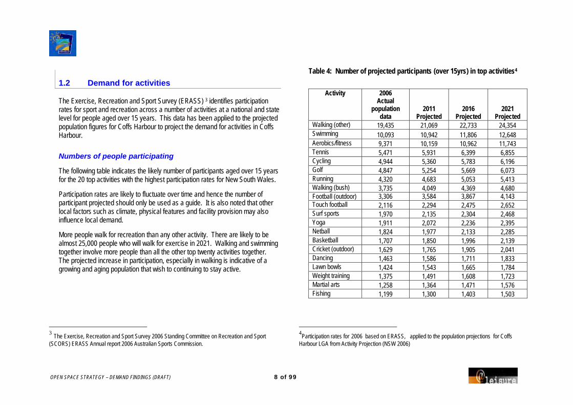
OPEN SPACE STRATEGY – DEMAND FINDINGS (DRAFT) 8 of 99
1.2 Demand for activities
The Exercise, Recreation and Sport Survey (ERASS) 3 identifies participation rates for sport and recreation across a number of activities at a national and state level for people aged over 15 years. This data has been applied to the projected population figures for Coffs Harbour to project the demand for activities in Coffs Harbour.
Numbers of people participating
The following table indicates the likely number of participants aged over 15 years for the 20 top activities with the highest participation rates for New South Wales.
Participation rates are likely to fluctuate over time and hence the number of participant projected should only be used as a guide. It is also noted that other local factors such as climate, physical features and facility provision may also influence local demand.
More people walk for recreation than any other activity. There are likely to be almost 25,000 people who will walk for exercise in 2021. Walking and swimming together involve more people than all the other top twenty activities together. The projected increase in participation, especially in walking is indicative of a growing and aging population that wish to continuing to stay active.
3 The Exercise, Recreation and Sport Survey 2006 Standing Committee on Recreation and Sport (SCORS) ERASS Annual report 2006 Australian Sports Commission.
Table 4: Number of projected participants (over 15yrs) in top activities4
Activity 2006 Actual
population data
2011 Projected
2016 Projected
2021 Projected
Walking (other) 19,435 21,069 22,733 24,354 Swimming 10,093 10,942 11,806 12,648 Aerobics/fitness 9,371 10,159 10,962 11,743 Tennis 5,471 5,931 6,399 6,855 Cycling 4,944 5,360 5,783 6,196 Golf 4,847 5,254 5,669 6,073 Running 4,320 4,683 5,053 5,413 Walking (bush) 3,735 4,049 4,369 4,680 Football (outdoor) 3,306 3,584 3,867 4,143 Touch football 2,116 2,294 2,475 2,652 Surf sports 1,970 2,135 2,304 2,468 Yoga 1,911 2,072 2,236 2,395 Netball 1,824 1,977 2,133 2,285 Basketball 1,707 1,850 1,996 2,139 Cricket (outdoor) 1,629 1,765 1,905 2,041 Dancing 1,463 1,586 1,711 1,833 Lawn bowls 1,424 1,543 1,665 1,784 Weight training 1,375 1,491 1,608 1,723 Martial arts 1,258 1,364 1,471 1,576 Fishing 1,199 1,300 1,403 1,503
4Participation rates for 2006 based on ERASS, applied to the population projections for Coffs
Harbour LGA from Activity Projection (NSW 2006)

OPEN SPACE STRATEGY – DEMAND FINDINGS (DRAFT) 9 of 99
age income education
ethnicity gender
1.3 Influence of population characteristics on demand for activities
Five principal demographic factors influence sport and leisure participation:
These affect sport and recreation activities in different ways. For example, the core age of tennis players is broader than the core age of participants for basketball (which is, generally speaking, a 'young' sport). Some activities are favoured by cultural groups. For example, people born in non-English speaking European countries are more likely to play soccer, than netball.
Visitor population In addition to permanent residents, some areas of the City experience considerable visitor population increases during peak holiday periods (primarily December to March). This includes people staying in holiday homes, guest houses, motels and hotels, caravan parks and campsites. In peak season the population in some precincts may more than double.
A high proportion of visitors travel for holiday and leisure purposes.
Many visitors will stay in their own holiday homes.
The predominant age group of visitors (38%) are aged between 25-38 years. A further 35% are aged 45-64 years.
Activities undertaken by visitors are mostly:
Social activities (78%)
Outdoor and nature activities (45%), and
Sport and active outdoor activities (24%). These are likely to include social sports such as:
tennis
bowls and golf
surf sports, and cycle sports.
Sport is a major economic driver in Coffs Harbour which injects around $30 million a year into the local economy.
The Council has held major sporting events at BCU International Stadium in Coffs Harbour, including NRL Preseason Trial matches, the Australian Women's Football (Soccer) team Olympic Qualifiers, the 2007 City v Country match, the National Girls and Boys Football (Soccer) Championships, and the Australian & New Zealand Police & Emergency Services Games.
Impact of demographic changes
Older adults
The proportion of Coffs Harbour’s population that are aged 65 years and over is 16.6% (compared to 13.6% for NSW).
The greatest concentration of people aged 65+ years are in the precincts of Woolgoolga (22.8%) and Coffs Harbour Urban (19.3%).
By 2021 it is estimated the over 25% of the population will be over 65 years of age.

OPEN SPACE STRATEGY – DEMAND FINDINGS (DRAFT) 10 of 99
There is an increasing trend for older adults to remain active later into life. Activities that currently have high participation rates for older adults in Coffs Harbour include:
Aerobics/ fitness Golf
Aqua-aerobics Carpet/Lawn bowls
Fishing Walking / bush walking
Because more older adults are staying active, demand in Coffs Harbour for physical activity is likely to decline more slowly than previously expected.
Increasing numbers of residents aged over 60 years will result in demand for different recreation needs and opportunities, including for:
Walking and cycling paths.
Non-competitive recreation activities (eg tennis, swimming).
Public toilets, paths, seating and shade, and areas to socialise with family, such as picnic areas.
Higher seats with backs and arms in public places.
Indoor recreation opportunities (eg carpet bowls, badminton, table tennis, table games, gentle exercises).
Facilities that are accessible for people using wheel chairs and mobility aids.
Specific opportunities for people with hearing and vision impairments.
Warm water at pools for hydro therapy and aqua aerobics.
Encouraging participation by older adults A variety of options are available to encourage participation by an older, more active population, including programs and classes (eg tai-chi, yoga walking and gardening and cycling and art and craft groups), provision of better information targeting older adults, and provision for activities such swimming, walking, ballroom dancing, golf, gym, cycling, bush walking.
Also, providing transport, assistance to do the activity (eg help to get there, identifying someone to do the activity with) will all be important if older adults are to be encouraged to stay active.
If more facilities were made accessible to people using wheelchairs, and more toilets, seats, ramps and wider flat pavements were provided, more older adults may be encouraged to stay connected and get out and about. And if a range of sports facilities with surfaces suitable for older adults (ie synthetics grass for tennis) are retained more people may play later in life.
Changing numbers of young people
Whilst the number of young people will decline as a proportion of the population, there will continue to be areas such as Hinterland Villages and Hinterland Rural (have a high proportion of 0-14year olds) and the Coffs Harbour Urban precinct (has the greatest proportion of young people aged 14-24 years) that are young. Demand for bike riding, swimming, surfing, soccer, jogging, and then netball, and football, cricket, basketball and tennis are likely to be strong in these areas.
Overall the decline in the proportion of young people from 0-14 yrs will impact on sports that traditionally target young people. Sports may need to centralise facilities to enhance the viability of those sports.

OPEN SPACE STRATEGY – DEMAND FINDINGS (DRAFT) 11 of 99
Despite their fewer numbers, it will be important to retain a range of activities for young people to do, to avoid the risk of more young people leaving the City.
It will be increasingly important to provide activities that target young women (eg swimming, going to the beach, netball, soccer and cycling, and possibly equestrian activities) including the provision of social opportunities for exercise.
Activities with high demand by persons under 15 years nationally include bike riding, skate boarding and rollerblading, swimming, soccer, netball and Australian Rules football. These activities (with the exception of skating) cricket, basketball and tennis have high participation rates among young people in Coffs Harbour.
The following table shows based on national figures, the projected number of young people participating in each activity, now and into 2021.
Note: this data should be used as a guide only as participation rates for people under 15 years of age are only available at a national level and do not consider local influences. Local participation shows interest in surfing, kayaking, dog walking, going to the beach, fishing etc. that is not ranked highly in national participation by young people.
Table 5: Demand for activities by residents 5-14 years)
Estimated participants
based on 2006 census
Estimated participants based on projected population
Activity 2006 2011 2016 2021 Bike riding 3819 6400 6753 7196 Skateboarding / roller blading 1329 2228 2351 2505 Swimming 980 1642 1733 1847 Soccer (outdoor) 744 1246 1315 1401 Netball 479 802 847 902 Australian Rules football 422 708 747 796 Tennis 411 689 727 775 Basketball 372 623 657 701 Cricket (outdoor) 304 510 538 573 Other organised sports 293 491 518 552 Martial Arts 253 425 448 478 Rugby League 237 396 418 446 Gymnastics 197 330 349 371 Athletics/ track and field 163 274 289 308 Soccer (indoor) 124 208 219 234
Note: This data should only be used as a guide as children activity participation rates are only available on a national scale where the child population projection is significantly higher then the Coffs Harbour child growth rate.

OPEN SPACE STRATEGY – DEMAND FINDINGS (DRAFT) 12 of 99
Housing types
There is evidence to suggest that an increasing proportion of people in the City will be living on smaller lots and thus will be seeking opportunities to participate in sport and physical activities away from home. Hence there will be increasing numbers of people who need to be accommodated in public recreation facilities and open space.
As the population ages, more people will need supported accommodation and hence there is a likelihood that more villages for older persons will need to be provided (eg hostels, retirement villages, nursing homes).
However, the increased number of older people may offer an opportunity to increase the diversity of housing types and the nature and quality of open space and recreation facilities provided to serve this market.
Income
Coffs Harbour LGA median household weekly income of $706, whilst similar to the Mid North Coast average, is well below the state average Income of $1,036. This is not unexpected given the high percentage of retirees in Coffs Harbour.
Woolgoolga was the Precinct with the lowest median weekly household income ($590), it also has the highest percentage of people aged 65 and over.
Income is a significant determinant of leisure behaviour, and is likely to affect the use of recreation facilities in several ways.
Lower income families may have lower expectations of recreation facilities, because income is often an indicator of education levels. Also, income has an impact on sports participation: the capacity to afford to join a club, as well as the ability and willingness to spend time and money on transport to games.
The increasing cost of providing indoor facilities typically leads to an increase in the cost of use. Thus, the affordability of new facilities needs to be considered, especially in the Woolgoolga planning precinct.
Free access to social/family recreation space close by to residents will continue to be important in areas where income is relatively low.
Activities likely to showing increased demand
In future years there is likely to be further demand for the following:
Programmed activities such as group fitness related activities that may be conducted in indoor facilities at sports reserves.
Incidental, non-routine social and physical activities as leisure such as going to the park with other young mothers (mums group), older men riding together, or having a game of golf.
Physically challenging but one-off competitive activities but without routine obligations, such as fun runs, annual organised bike rides, open water swims, corporate triathlons.
Diverse fitness-related activities especially trail based activities (eg. ‘walking, dog walking and cycling’) and a relative decrease in the dominance of traditional sports in terms of the proportion of physical activity.
Activities that are convenient that can be undertaken close to home or work.
Pet ownership and leisure related activities such as dog walking and pet exercising.

OPEN SPACE STRATEGY – DEMAND FINDINGS (DRAFT) 13 of 99
Inclusive opportunities and services that include all the community, not only those with high levels of physical and intellectual ability.
The neighbourhood as a leisure environment and hence the desire for pleasant streetscape and footpaths or trails on which to walk.
Sports that can be played indoors including in modified formats and on synthetic surfaces.
Other activity trends include:
a decrease in sport and physical activity in schools.
changing lifestyles and smaller private spaces that act to constrain physical activity and incidental play, particularly for children.
Higher expectations of residents
There is a changing culture of volunteerism towards shorter-term, task- orientated roles, and projects with higher recognition and reward for outcomes. The expectation that today’s young person twill be involved in a committee of management for twenty years is unlikely to be met.
As the City becomes more of a destination for retirement living, an escape for 'sea changers' and a place providing respite from the pressures of city living, it will face the challenge of meeting the expectations of new residents who have formed their views in an more urban location. These expectations might include having facilities closer to home, or of a higher quality, than is viable in a small rural community.
Conflicts over land use have the potential to escalate. For instance, some new residents may complain about noise and activity from existing farms. In terms of sports and leisure facilities, valuable broad-acre sport and recreation facilities (eg
orienteering, shooting, motocross/ motor racing) are typically located in rural areas so as to minimise their impact. However, new residential development may abut this existing use. Planning needs to address these issues.
People born overseas in non English speaking countries
Typically people born overseas in non-English speaking countries have lower participation rates in sport and physical activity than Australian born residents. Cultural background may also influence the choice of particular activities.
Just over 11% of Coffs Harbour population were born overseas, with 8.7% of households speaking a non-English language. German (5.3%) Italian (4.6%) and Chinese (2.8%) were the most common foreign languages spoken at home. Whilst these indicate there will be relatively little impact on numbers participating due to cultural background, there may well be influences in the nature of activities chosen.

OPEN SPACE STRATEGY – DEMAND FINDINGS (DRAFT) 14 of 99
1.4 Implications summary
The following implications are implied from the demographic characteristics of the Coffs Harbour LGA.
Due to the significant increase in population over the past ten years, there is likely to be pressure on existing recreation facilities in the City, and unmet demand.
With the population projected to increase a further 21.4% by 2021, an equitable supply of recreation facilities will become increasingly important.
Walking, swimming and aerobic/fitness are projected to be the highest participated in activities for people over the age of 15 years, up to 2021. The provision of off-road trails, as well as gym and fitness facilities will be important.
Demand for participation in active but social activities such as aerobics / fitness, aqua-aerobics, fishing, golf, carpet / lawn bowls and walking / bush walking, is likely to continue to be strong especially in Far Northern Beaches, Woolgoolga and Coffs Harbour Urban will continue to have a high percentage of older adults.
Overall the decline in the proportion of young people may impact on sports that traditionally target young people. Sports may need to centralise and have multiple facilities together to enhance the viability. Howeverthe high percentage of children (aged 0-14 years) in developing areas and Hinterland Villages and Hinterland Rural will continue to need provision of off road trails, sports facilities and open space.
Recreation participation in Coffs Harbour LGA may be increased by providing transport services, programming of classes and providing
information about what is available and where, to target the aging population.
Participation will be constrained by the lower income levels in the LGA, hence free access opportunities close to home and subsidised sports participation will be important.

OPEN SPACE STRATEGY – DEMAND FINDINGS (DRAFT) 15 of 99
2. SUMMARY OF CONSULTATION FINDINGS
As part of the consultation process, schools and households were sent a questionnaire. Telephone interviews were also undertaken with key stakeholder groups including sport clubs, local and state sporting associations and peak bodies, friends and environmental groups, the tourism sector, rotary and service clubs, government departments and school principals, to identify open space and recreation issues.
The following is a summary of the identified issues from all those interviewed by telephone and those surveyed.
2.1 Resident Preferences
Compared to other residents of NSW, Coffs Harbour residents have significantly higher rates of participation in walking, swimming, cycling, fishing, golf and surfing. Fitness and gymnasium activities are significantly lower.
Walking, swimming and going to the beach and art and craft activities had higher participation rates by females.
Fishing and golf had significantly higher participation by males.
Younger males preferred more active pursuits such as cycling, soccer, surfing and swimming. Female participation varies less than men with strong participation in walking, swimming and cycling across all age groups.
Cycling was the activity most respondents said they liked but were unable to undertake.
When asked what would encourage people to do an activity liked but not undertaken respondents indicated: more information, lower cost, better quality facilities and availability of programs would encourage them to participate.
Lakes and foreshores, neighbourhood parks, walking trails and picnic areas, bushland reserves and bicycle paths were the most commonly used public facilities, with social/service club/gaming facilities also popular.
21% of respondents indicated that they had to go outside Coffs Harbour to do recreation activities. This included visits to National Parks, caravan parks, rivers, boat ramps and beaches.
Bicycle trails, lake and foreshore developments and bushland/conservation areas were the top ranked facility developments nominated for upgrades if funds became available.
Younger men had preferences for sports fields, swimming pools and skate parks, younger women for playgrounds and neighbourhood parks with older residents giving priority to bushland reserves, picnic areas, lakes and foreshores and ornate gardens.
Community centres/halls/houses, theatre, music and dance halls and libraries were the indoor facilities identified as highest priority if funds became available. Younger male preferences were for indoor sports courts whereas younger women preferred fitness centre and gymnasiums.
School students identified park toilets, places to play sport socially and shelter from weather and sun as the most important park features. Higher quality maintenance, access for prams and wheelchairs and shelter were areas that could be improved. Students strongly supported banning of smoking in public areas.

OPEN SPACE STRATEGY – DEMAND FINDINGS (DRAFT) 16 of 99
Local parks were used by 25% students 2-3 times per week with a further 20% using parks weekly. Soccer, picnics, games, football, and cycling were the favoured activities with socializing with friends and family being the main expressed benefit.
To make their leisure time more fulfilling at parks students nominated clean public toilets, skate park and clean and maintained areas as their priorities.
60% of students indicated that they undertook vigorous physical activity three times a week or more with 15% exercising twice a week. Only 5% did no physical activity at all. Older students (17-19 year olds) did less vigorous activity and 16% did no vigorous exercise at all.
The most significant reason for students using their park of choice was because it was close to home.
2.2 Sports Clubs, local and state sporting Associations and Peak Bodies
Facilitiy issues
A number of sports using sporting fields complained about the lack of maintenance to grounds particularly following transition from winter to summer.
Facilities supporting outdoor sports often lack support amenities such as canteens and storage. Many fields need lights as most existing lights do not meet Australian Standards.
A lack of storage as well as disability access was the main short fall with indoor sports facilities.
Some sports expressed a desire to host high level events and may have the administration capacity to do so but lack the appropriate infrastructure to enable them to host events.
Not all sports support the notion of shared facilities. While most believe it was possible to share amenities a number of sports such as softball, baseball and hockey require specific markings and surfaces.
Sports using school facilities are often stopped from utilizing them due to conflicting school related usage.
Most sports supported the development of the BUC stadium to enable the hosting of major events.
A number of smaller sports such as badminton, table-tennis, as well as netball do not have adequate access to indoor facilities.
The Basketball Association suggested the development of half court development in parks to promote the game. With parks being used extensively for social sport currently, any development should consider multi-use eg. netball and tennis.
Schools complained about the lack of availability for space at the existing facilities in Woolgoolga and Coffs Harbour and the lack of year round swimming opportunities.
Participation
Generally sports reported that numbers were steady with small increases however a number of sports have been in decline over time. Rugby Union and athletics has declined significantly over recent years.
Soccer (in particular) and to an extent cricket are growing rapidly and will require additional playing space and time.

OPEN SPACE STRATEGY – DEMAND FINDINGS (DRAFT) 17 of 99
Some sports report a drop in participation in Coffs itself with greater demand/participation in towns /communities surrounding the major city.
A number of sports report significant increases in female participation supported by encouraging programs. Many facilities do not cater for women adequately with toilets and change amenities.
Most, if not all sports, indicate that while junior membership and participation is steady or growing, retaining players through the adolescent years is difficult.
Wheel chair sports struggle for numbers particularly females, and are concerned about access issues. However few sports appear to be taking a proactive role into including people with a disability into their activities.
Cost of participation
The cost of participation is an issue for a number of clubs and associations. The main targets for complaint are cost of facility rental and in some cases affiliation with the state / national sporting association.
Sports that need to travel for major competition (due to a lack of local opportunity) such as rugby and athletics are forced to pay a premium due the high cost of travel to other regional centres.
Sports that have specific requirements (like synthetic surfaces for hockey) are forced to charge more to recoup the cost of the surface and its eventual replacement.
Sports Administration and Officials
All sports report problems in attracting as well keeping volunteer administrators and officials.
A number of sports utilize the services of state associations to operate courses however this assistance is not always available for assistance with promotion, administrative support and officials and coaching education. Most state associations purport to assist local clubs and associations and indeed have development officers at the regional level however they limited by their resources.
Very few organizations had a forward looking or wide ranging strategic plan for the future in regard to these and other matters.
Responsibility of Council
Although the major concern with Council related to the maintenance of facilities, a number of comments were made in regard to Council assisting with providing information and assisting in the promotion of sport.
There were some concerns about a lack of communication with Council but also expression of sporting organizations being able to potentially tap into with the broad range of expertise within Council.
OPEN SPACE STRATEGY – DEMAND FINDINGS (DRAFT) 18 of 99
2.3 Friends and Environmental Groups
The Key issues raised by environment groups are as follows:
Demand and issues
Getting capital improvements done.
The need for communications and networking.
Managing weed control.
Coordinating volunteer involvement for optimum outputs (i.e. community weed programs etc).
Getting commitment from landowners (LandCare groups).
Uncertainty of development plans.
Increased use of open space by more people (and dogs, and hoons).
Motor bike use in environmental areas.
Multiple uses and demands in environmental areas, difficult to accommodate them all.
Suggested strategies
Set up a committee with representatives from different community groups, through Council.
Accept Taree City Councils model for community weeding: Council provide spray packs, equipment, funding.
Increase collaboration between National Parks, Council, other Councils and community/volunteers.
Work more closely with local kids / schools.
Initiate larger community based projects.
Develop character themes for areas.
Develop tracks from the mountains to the bay.
Develop and manage habitat links / corridors.
Clearly define areas where want to maintain koala population and general biodiversity.
Reduce mowing in certain vegetation types / areas.
Consider the Jetty area a heritage area.
Increase financing of pathway repairs and weeding controls.
Enhance community appreciation of open space, do this by interpretation, cycleways, walkways and value volunteer input.
Areas that should be acquired as open space
South Moonee Forest: areas contributing to walking track concept (mentioned several times).
Retention of existing crown land between City Centre and the Jetty.
Open space requirements for higher buildings, and for Jetty area, between Jetty and City.
Areas along Pine Brush Creek in Korora Basin.
OPEN SPACE STRATEGY – DEMAND FINDINGS (DRAFT) 19 of 99
Areas where Pine Brush Creek goes through Opal Cove.
Land in front of Opal Cove.
Boambee Beach, Boambee Nature Reserve.
Reserve at Hearns Lake (south of Woolgoolga).
Arrawarra Creek could be developed as a walking trail with a footbridge.
North Emerald Beach, north of Emerald Beach Caravan Park.
Riparian systems - make decent usable corridors.
2.4 Tourism Sector
Demand and issues
Increased backpacking, sports tourism and eco-tourism.
Suggested strategies
Need open space to support eco-tourism opportunities (camping areas and facilities).
Clean up the Jetty area.
2.5 Rotary and Service Groups
Demand and issues
Increasing demands on public open space, and pressure to develop it as something else (i.e. car parks).
Increasing population putting more pressure on existing amount of open space.
Difficulty in coordinating volunteer involvement.
Expected / anticipated upgrades and redevelopment to the Jetty area.
Suggested strategies
Consider provision of public open space in all developments, and when still in planning phase.
Provide separate areas for sport and for ‘passive’ or unstructured recreation.
Council could address / meet with groups each 6 months for an update.
2.6 Developers
Demand and issues
Developer Contribution requirements are expensive.
Suggested strategies
Retain Brelsford Park as open space.

OPEN SPACE STRATEGY – DEMAND FINDINGS (DRAFT) 20 of 99
2.7 Government Departments
Demand and issues
Increasing population and use / demand on existing facilities.
More people, smaller allotments, more open space needed.
Ageing population, therefore, type of open space needed may vary.
Lack of activities / facilities to cater for kids in the Boambee East area.
Gradual deterioration in park assets and maintaining amenity in public space.
Cost of park maintenance in line with community expectation.
Importance of designing open space that is sustainable in the long term (i.e. use of site and degree of maintenance/amenity).
Intensified development on land adjoining Crown Land.
Demand for tourist facilities on coastal land.
Public access: amount and location of private land with resorts and houses bordering marine parks.
Making public open space sustainable in terms of costs.
Greater coordination between Council and Dept of Lands regarding caravan parks and coastal areas.
Fire hazards in natural bush land areas, and management of fire buffer zones.
Suggested strategies
Provide outdoor fitness equipment.
Burn off for reasons of biodiversity and reduce dumping of green waste.
Enhance coordination and consultation with rural fire service, i.e. representative from fire service on Council and community committees.
Promote the fire resistant garden on display in Botanic Gardens.
Enhance provision of open space in new housing areas.
Improve and increase the marketing of State Parks.
Increase communication and collaboration between Council and Government Departments.

OPEN SPACE STRATEGY – DEMAND FINDINGS (DRAFT) 21 of 99
APPENDIX 1 HOUSEHOLD SURVEY FINDINGS
A residential survey was sent to households in the City of Coffs Harbour. Of these surveys 876 responses were analysed, 474 female and 402 male responses.
An overview of the findings are following.
Recreation activities you like to do
Walking was the main recreation activity that the largest number of respondents indicated they regularly participated in. The participation rate of 43.9% is significantly higher than the NSW ERASS participation rate of 33.7%. Swimming (25.6%), Cycling (16.1%), Fishing (13.9%) and Golf (11.8%) were other recreation activities that had high levels of participation. These activities had much higher participation rates than the NSW ERASS rates for 2006.
122 respondents (13.9%) indicated that they went fishing for recreation, indicating a significantly higher participation rate compared to ERASS (2.1%).
Surfing attracted 89 participants (10.2%) indicating a much higher participation rate than ERASS.
Gymnasium / fitness activities attracted only 39 participants (4.5%) indicating a significantly lower participation rate than ERASS (18.6%).
Respondents were asked to list the main recreational activities they regularly participate in away from home. Each respondent could list up to three activities. The recreational activities that recorded the most responses are shown in the following table.
Table 1: Main recreation activities undertaken by residents
Activity Number of responses Percentage ERASS -
2006 (NSW) Walking 385 43.9% 33.70%
Swimming 224 25.6% 15.30%
Cycling / cycle racing 141 16.1% 8.80%
Fishing 122 13.9% 2.10%
Golf 103 11.8% 7.50%
Surfing 89 10.2% 3.30%
Picnic / BBQs 86 9.8% -
Going to the beach 83 9.5% -
Bushwalking / hiking 61 7.0% 5.00%
Camping / caravanning 61 7.0% -
Tennis 59 6.7% 7.40%
Lawn Bowls 45 5.1% 2.30%
Gymnasium / fitness activities 39 4.5% 18.60%
Jogging / running 30 3.4% 7.50%
Arts and craft activities 27 3.1% -
Dog walking 26 3.0% -
Kayak / canoeing 25 2.9% 1.00%
Soccer 25 2.9% 5.90%
Going to the movies 21 2.4% -

OPEN SPACE STRATEGY – DEMAND FINDINGS (DRAFT) 22 of 99
Activities by gender
The results highlighted some differences between gender.
Aerobics/ callisthenics, gymnastics, hockey and netball were only participated in by females.
Australian Rules football, shooting and horse racing were only participated in by male respondents.
Walking, swimming, going to the beach and art and craft activities had higher participation by female respondents than male respondents.
Fishing and golf had significantly higher participation by male respondents than female respondents.
The following two tables highlight the top 20 activities by male and female respondents.
Table 2a: Percentage of respondent activity participation - Male
Activity Number of responses %
Walking 149 37.1% Fishing 93 23.1% Swimming 84 20.9% Golf 75 18.7% Cycling/ cycle racing 70 17.4% Surfing 66 16.4% Picnic/ BBQs 34 8.5% Camping/ caravanning 30 7.5% Going to the beach 27 6.7% Bushwalking/ hiking 26 6.5% Tennis 26 6.5% Lawn Bowls 25 6.2% Jogging/ running 19 4.7% Soccer 16 4.0% Kayak/ canoeing 15 3.7% Dog walking 13 3.2% Gymnasium/ fitness activities 10 2.5% Touch Football 9 2.2% Motor bike sports 9 2.2% Driving for pleasure/ sight seeing 8 2.0% Going to the movies 8 2.0% Motor car sports 8 2.0% Powered boating activities 8 2.0% Traveling 8 2.0%
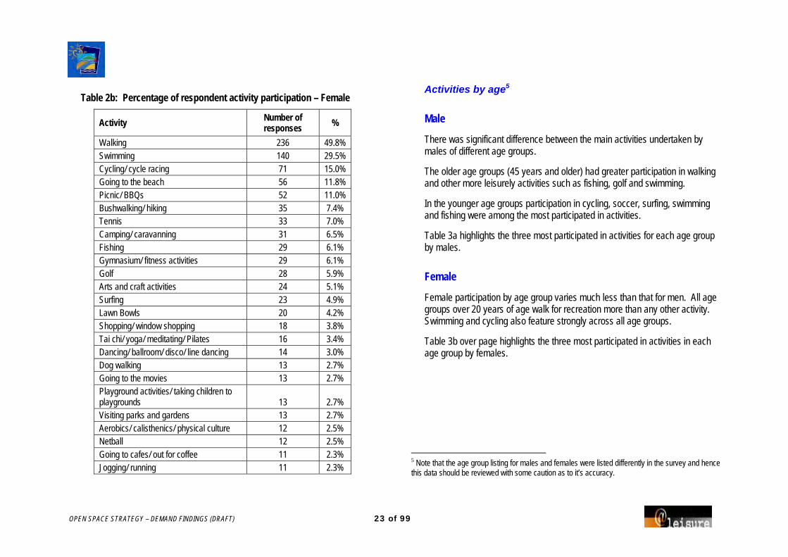
OPEN SPACE STRATEGY – DEMAND FINDINGS (DRAFT) 23 of 99
Table 2b: Percentage of respondent activity participation – Female
Activity Number of responses %
Walking 236 49.8% Swimming 140 29.5% Cycling/ cycle racing 71 15.0% Going to the beach 56 11.8% Picnic/ BBQs 52 11.0% Bushwalking/ hiking 35 7.4% Tennis 33 7.0% Camping/ caravanning 31 6.5% Fishing 29 6.1% Gymnasium/ fitness activities 29 6.1% Golf 28 5.9% Arts and craft activities 24 5.1% Surfing 23 4.9% Lawn Bowls 20 4.2% Shopping/ window shopping 18 3.8% Tai chi/ yoga/ meditating/ Pilates 16 3.4% Dancing/ ballroom/ disco/ line dancing 14 3.0% Dog walking 13 2.7% Going to the movies 13 2.7% Playground activities/ taking children to playgrounds 13 2.7% Visiting parks and gardens 13 2.7% Aerobics/ calisthenics/ physical culture 12 2.5% Netball 12 2.5% Going to cafes/ out for coffee 11 2.3% Jogging/ running 11 2.3%
Activities by age5
Male
There was significant difference between the main activities undertaken by males of different age groups.
The older age groups (45 years and older) had greater participation in walking and other more leisurely activities such as fishing, golf and swimming.
In the younger age groups participation in cycling, soccer, surfing, swimming and fishing were among the most participated in activities.
Table 3a highlights the three most participated in activities for each age group by males.
Female
Female participation by age group varies much less than that for men. All age groups over 20 years of age walk for recreation more than any other activity. Swimming and cycling also feature strongly across all age groups.
Table 3b over page highlights the three most participated in activities in each age group by females.
5 Note that the age group listing for males and females were listed differently in the survey and hence this data should be reviewed with some caution as to it’s accuracy.

OPEN SPACE STRATEGY – DEMAND FINDINGS (DRAFT) 24 of 99
Table 3a: Male activity participation by age group
Age Cohort Activity 1 % Activity 2 % Activity 3 % 10 – 14yrs Cycling 38% Swimming 38% Baseball, golf,
skateboarding 25%
15 - 19 Soccer 40% Camping, cycling 20% Jogging, swimming, surfing
20%
20 - 24 Surfing 71% Fishing 43% Dog walking, golf, kayaking/ canoeing
29%
25 - 29 Cycling 19% Fishing 19% Swimming, surfing 19% 30 - 34 Fishing 29% Walking 29% Cycling, Swimming 24% 35 - 39 Swimming 26% Surfing 26% Fishing 22% 40 - 44 Surfing 29% Cycling 26% Swimming, walking 24% 45 - 49 Walking 38% Cycling 27% Fishing 27% 50 - 60 Walking 51% Fishing 29% Golf, Swimming 23% 61 - 70 Walking 50% Swimming 27% Fishing 25% 71+ Walking 50% Golf 32% Lawn bowls 20% No age given Walking 39% Fishing 19% Cycling 16%
Table 3b: Female activity participation by age group
Age Cohort Activity 1 % Activity 2 % Activity 3 % 10 – 14yrs Cycling 75% Swimming 75% Playground activities 50%
15 - 19 Swimming 64% Soccer 36% Walking 27%
20 - 30 Walking 44% Swimming 29% Going to beach 18%
31 - 40 Walking 34% Swimming 33% Going to beach 30%
41 - 50 Walking 51% Swimming 39% Cycling 17%
51 - 60 Walking 62% Swimming 27% Cycling 17%
61 - 70 Walking 53% Swimming 23% Cycling 10%
71 + Walking 49% Lawn bowls 24% Golf, picnic/ BBQ 12%
No age given Walking 50% Arts & craft activities 20% Cycling 20%
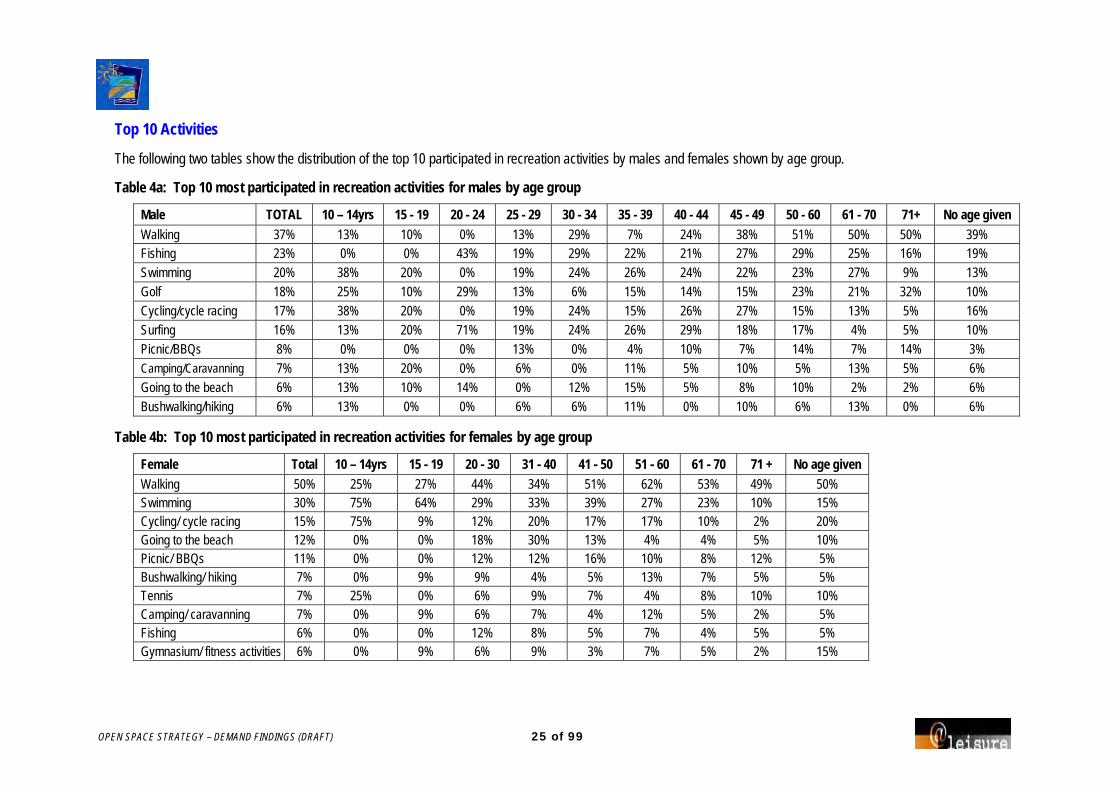
OPEN SPACE STRATEGY – DEMAND FINDINGS (DRAFT) 25 of 99
Top 10 Activities
The following two tables show the distribution of the top 10 participated in recreation activities by males and females shown by age group.
Table 4a: Top 10 most participated in recreation activities for males by age group
Male TOTAL 10 – 14yrs 15 - 19 20 - 24 25 - 29 30 - 34 35 - 39 40 - 44 45 - 49 50 - 60 61 - 70 71+ No age given Walking 37% 13% 10% 0% 13% 29% 7% 24% 38% 51% 50% 50% 39% Fishing 23% 0% 0% 43% 19% 29% 22% 21% 27% 29% 25% 16% 19%
Swimming 20% 38% 20% 0% 19% 24% 26% 24% 22% 23% 27% 9% 13%
Golf 18% 25% 10% 29% 13% 6% 15% 14% 15% 23% 21% 32% 10%
Cycling/cycle racing 17% 38% 20% 0% 19% 24% 15% 26% 27% 15% 13% 5% 16%
Surfing 16% 13% 20% 71% 19% 24% 26% 29% 18% 17% 4% 5% 10%
Picnic/BBQs 8% 0% 0% 0% 13% 0% 4% 10% 7% 14% 7% 14% 3% Camping/Caravanning 7% 13% 20% 0% 6% 0% 11% 5% 10% 5% 13% 5% 6%
Going to the beach 6% 13% 10% 14% 0% 12% 15% 5% 8% 10% 2% 2% 6%
Bushwalking/hiking 6% 13% 0% 0% 6% 6% 11% 0% 10% 6% 13% 0% 6%
Table 4b: Top 10 most participated in recreation activities for females by age group
Female Total 10 – 14yrs 15 - 19 20 - 30 31 - 40 41 - 50 51 - 60 61 - 70 71 + No age given Walking 50% 25% 27% 44% 34% 51% 62% 53% 49% 50% Swimming 30% 75% 64% 29% 33% 39% 27% 23% 10% 15% Cycling/ cycle racing 15% 75% 9% 12% 20% 17% 17% 10% 2% 20% Going to the beach 12% 0% 0% 18% 30% 13% 4% 4% 5% 10% Picnic/ BBQs 11% 0% 0% 12% 12% 16% 10% 8% 12% 5% Bushwalking/ hiking 7% 0% 9% 9% 4% 5% 13% 7% 5% 5% Tennis 7% 25% 0% 6% 9% 7% 4% 8% 10% 10% Camping/ caravanning 7% 0% 9% 6% 7% 4% 12% 5% 2% 5% Fishing 6% 0% 0% 12% 8% 5% 7% 4% 5% 5% Gymnasium/ fitness activities 6% 0% 9% 6% 9% 3% 7% 5% 2% 15%

OPEN SPACE STRATEGY – DEMAND FINDINGS (DRAFT) 26 of 99
Activities by general areas
Across all localities walking was the activity that more people participated in followed by swimming and in most places cycling. Fishing however was the third most participated in activity in the Arrawarra/ Mullaway/ Safety Beach/ Woolgoolga area and in Moonee Beach/ Sapphire Beach.
The following table highlights the main activities that people do in each locality.
Table 5: Main activities participated in by locality
Area/ locality Activities Red Rock/ Corindi Beach
Walking
Swimming
Cycling/cycle racing Fishing
Bingo
Camping/ caravanning
Going to the beach
Golf
Lawn Bowls
Visiting friends and family
Arrawarra/ Mullaway/ Safety Beach/ Woolgoolga
Walking
Swimming
Fishing
Surfing
Tennis
Cycling/cycle racing
Golf
Bushwalking/hiking
Camping/Caravanning
Sandy Beach/ Emerald Beach
Walking
Swimming
Cycling/cycle racing
Picnic/BBQs
Surfing
Golf
Fishing
Jogging/running
Bushwalking/hiking
Area/ locality Activities Moonee Beach/ Sapphire Beach
Walking
Swimming
Fishing
Golf
Surfing
Cycling/cycle racing
Picnic/BBQs
Going to the beach
Korora/ Coffs Harbour/ North Boambee Valley
Walking
Swimming
Cycling/cycle racing
Fishing
Golf
Going to the beach
Picnic/BBQs
Surfing
Lawn Bowls
Camping/Caravanning
Boambee East/ Toormina/ Sawtell/ Boambee/ Bonville
Walking
Swimming
Cycling/cycle racing
Going to the beach
Fishing
Picnic/BBQs
Golf
Bushwalking/hiking
Camping/ caravanning
Surfing
Coramba/ Nana Glen/ Ulong/ Lowanna/ Karangi
Walking
Swimming
Cycling/cycle racing
Fishing
No suburb/ outside Coffs Harbour
Walking
Cycling/cycle racing
Swimming
Tennis
Fishing
Football
Surfing

OPEN SPACE STRATEGY – DEMAND FINDINGS (DRAFT) 27 of 99
Latent demand: activities liked but not undertaken
Respondents were asked to indicate what activities they would most like to do away from home, but currently do not do.
There were 565 (280 male and 285 female) respondents who indicated that there were no activities that they would like to do away from home that they currently do not do (64% of respondents).
Cycling (15%), swimming (10%), attending live theatre/dance or performance (6%), caravanning and camping (4%), and attending theme parks/ water parks (4%) were the main activities that respondents would like to do that they currently do not do.
Gender
There is not significant difference between the main activities that males and females would like to do that they currently do not do. However, a greater percentage of males would like to cycle compared to females.
The following table highlight the top activities that male and female respondents would like to do that they currently do not do.
Age
Table 7a and 7b (over the page) highlight the different activities that males and females of different age groups would like to do that they currently do not do.
Table 6: Activities liked but not undertaken – Male and Female
Male activity Number % Female activity Number % Cycling/ cycle racing 16 17.2% Cycling/ cycle racing 20 12.9%
Swimming 10 10.8% Swimming 14 9.0%
Camping/ caravanning 5 5.4% Attending live theatre/ dance/ performance 10 6.5%
Attending live theatre/ dance/ performance 4 4.3%
Theme park/ water park 6 3.9%
Theme park/ water park 4 4.3% Arts and craft activities 5 3.2%
Fishing 3 3.2% Camping/ caravanning 5 3.2%
Sailing/sail boarding 3 3.2% Fishing 5 3.2%
Tai chi/yoga/ meditating/ Pilates 5 3.2%
Walking 5 3.2%

OPEN SPACE STRATEGY – DEMAND FINDINGS (DRAFT) 28 of 99
Table 7a: Activities males would like to do but do not – by age group
10 – 19yrs 20 - 29 30 - 39 40 - 49 50 - 60 61 - 70 71+ No age given Fitness programs / light exercise
Cycling/cycle racing Camping/ caravanning (3)
Cycling (8) Dancing/ ballroom/ disco/ line /hip hop/ break dancing (2)
Swimming (2) Archery Cycling/ cycle racing
Football - Rugby League
Football Arts and craft activities Swimming (4) Swimming (2) Camping/ caravanning Golf Swimming
Baseball Motor car sports Relaxing and sitting Attending live theatre/ dance/ performance (3)
Attending live theatre/ dance/ performance
Cycling/cycle racing Picnic/BBQs Theme/ water park
Cycling Non - powered boating activities
Orienteering Dog walking (2) Camping/ caravanning Fishing Powered Water activities/boating
Football Snow Sports Cycling (3) Entertaining/ socialising Cycling Fitness programs / light exercise
Social and service clubs
Skateboarding Theme/ water park Mountain bike riding / Trials / XC / 4X
Fishing Fishing Sailing/Sail Boarding Swimming
Sports general Going to the zoo Hockey Golf Shopping/window shopping Traveling
Paintball Motor car sports Mountain bike riding / Trials/ XC/ 4X
Painting/ printing Tai chi/ yoga/ meditating/ Pilates
Water sports general
Squash Playing a musical instrument Going to the zoo
Theme/water park Sailing/ sail boarding
Powered water activities/ boating
Snow Sports
Rock climbing Sports spectating
Sailing/ sail boarding Tai chi/yoga /meditating/ Pilates
Water sports general Water/ theme park
Snorkeling/ scuba diving

OPEN SPACE STRATEGY – DEMAND FINDINGS (DRAFT) 29 of 99
Table 7b: Activities females would like to do but do not do – by age group
10 – 19yrs 20 - 30 31 - 40 41 - 50 51 - 60 61 - 70 71 + Reading activities Going to the zoo (2) Cycling (5) Cycling (5) Swimming (7) Attending live theatre/ dance/
performance (3) Cycling
Surfing Athletics Camping/ caravanning (2) Swimming (4) Cycling/ cycle racing (4) Fishing (3) Lawn bowls Swimming Attending live theatre/ dance/
performance Dog walking (2) Arts and craft activities (2) Attending live theatre/ dance/
performance (3) Cycling (2) Participating in live
theatre or dance Aqua jet Cycling Dog obedience (2) Attending live theatre/ dance/
performance (2) Camping/ caravanning (3) Shopping/ window shopping (2) Swimming
Theme/ water park Dog Obedience Playground activities/taking children to the playgrounds (2)
Basketball (2) Visiting historic properties (2) Walking (2) Tai chi/ yoga/ meditating/ Pilates
Rock climbing Going to markets/ fairs Theme/ water park (2) Lawn bowls (2) Arts and craft activities Croquet Traveling Motor car sports Arts and craft activities Sailing/Sail Boarding (3) Croquet Dancing/Ballroom/Disco/Line
Dancing/hip hop/ break dancing
Squash Attending live theatre/ dance/ performance
Tai chi/ yoga/ meditating/ Pilates (2)
Dancing/ ballroom/Disco/ line/ hip hop/ break dancing
Entertaining/ socialising
Visiting museums/ galleries Baseball Dancing/ ballroom/ disco/ line/ hip hop/ break dancing (2)
Fishing Fitness programs / light exercise
Soccer Bushwalking/hiking Dog walking Gymnasium/ fitness activities Going to the movies Police & community youth club Going to cafes/ out for coffee Going to the movies Horse riding/pony club equestrian Participating in live theatre/ dance Cultural activities Gymnasium/fitness activities Gymnasium/Fitness activities Participating in live theatre or
dance Swimming
Basket ball Ice skating/ ice hockey Horse riding/pony club equestrian activities
Playground activities/taking children to the playgrounds
Tai chi/ yoga/ meditating/ Pilates
Sailing/sail boarding Netball Pokies/Casino/Tabaret Walking Non powered air borne
activities/parachuting/hang gliding Rowing
Play Powered Water activities/boating Visiting parks and gardens Rock climbing Walking Visiting exhibitions Tai chi/ Yoga/ Meditating/ Pilates Walking Theme/ water park Winter sports Cultural activities Theme/ water park Orienteering Snorkling/ scuba diving Tennis Fishing Bushwalking/hiking
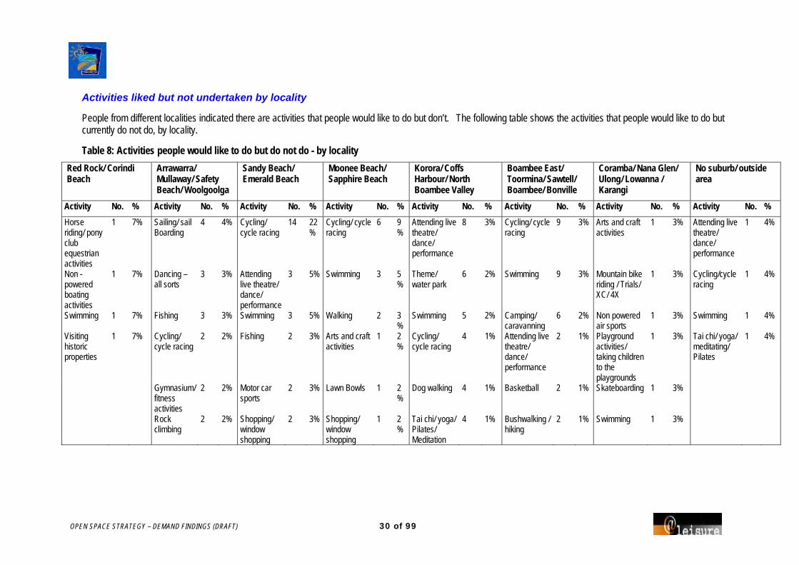
OPEN SPACE STRATEGY – DEMAND FINDINGS (DRAFT) 30 of 99
Activities liked but not undertaken by locality
People from different localities indicated there are activities that people would like to do but don’t. The following table shows the activities that people would like to do but currently do not do, by locality.
Table 8: Activities people would like to do but do not do - by locality Red Rock/ Corindi Beach
Arrawarra/ Mullaway/ Safety Beach/ Woolgoolga
Sandy Beach/ Emerald Beach
Moonee Beach/ Sapphire Beach
Korora/ Coffs Harbour/ North Boambee Valley
Boambee East/ Toormina/ Sawtell/ Boambee/ Bonville
Coramba/ Nana Glen/ Ulong/ Lowanna / Karangi
No suburb/ outside area
Activity No. % Activity No. % Activity No. % Activity No. % Activity No. % Activity No. % Activity No. % Activity No. % Horse riding/ pony club equestrian activities
1 7% Sailing/ sail Boarding
4 4% Cycling/ cycle racing
14 22%
Cycling/ cycle racing
6 9%
Attending live theatre/ dance/ performance
8 3% Cycling/ cycle racing
9 3% Arts and craft activities
1 3% Attending live theatre/ dance/ performance
1 4%
Non - powered boating activities
1 7% Dancing – all sorts
3 3% Attending live theatre/ dance/ performance
3 5% Swimming 3 5%
Theme/ water park
6 2% Swimming 9 3% Mountain bike riding / Trials/ XC/ 4X
1 3% Cycling/cycle racing
1 4%
Swimming 1 7% Fishing 3 3% Swimming 3 5% Walking 2 3%
Swimming 5 2% Camping/ caravanning
6 2% Non powered air sports
1 3% Swimming 1 4%
Visiting historic properties
1 7% Cycling/ cycle racing
2 2% Fishing 2 3% Arts and craft activities
1 2%
Cycling/ cycle racing
4 1% Attending live theatre/ dance/ performance
2 1% Playground activities/ taking children to the playgrounds
1 3% Tai chi/ yoga/ meditating/ Pilates
1 4%
Gymnasium/ fitness activities
2 2% Motor car sports
2 3% Lawn Bowls 1 2%
Dog walking 4 1% Basketball 2 1% Skateboarding 1 3%
Rock climbing
2 2% Shopping/ window shopping
2 3% Shopping/ window shopping
1 2%
Tai chi/ yoga/ Pilates/ Meditation
4 1% Bushwalking / hiking
2 1% Swimming 1 3%
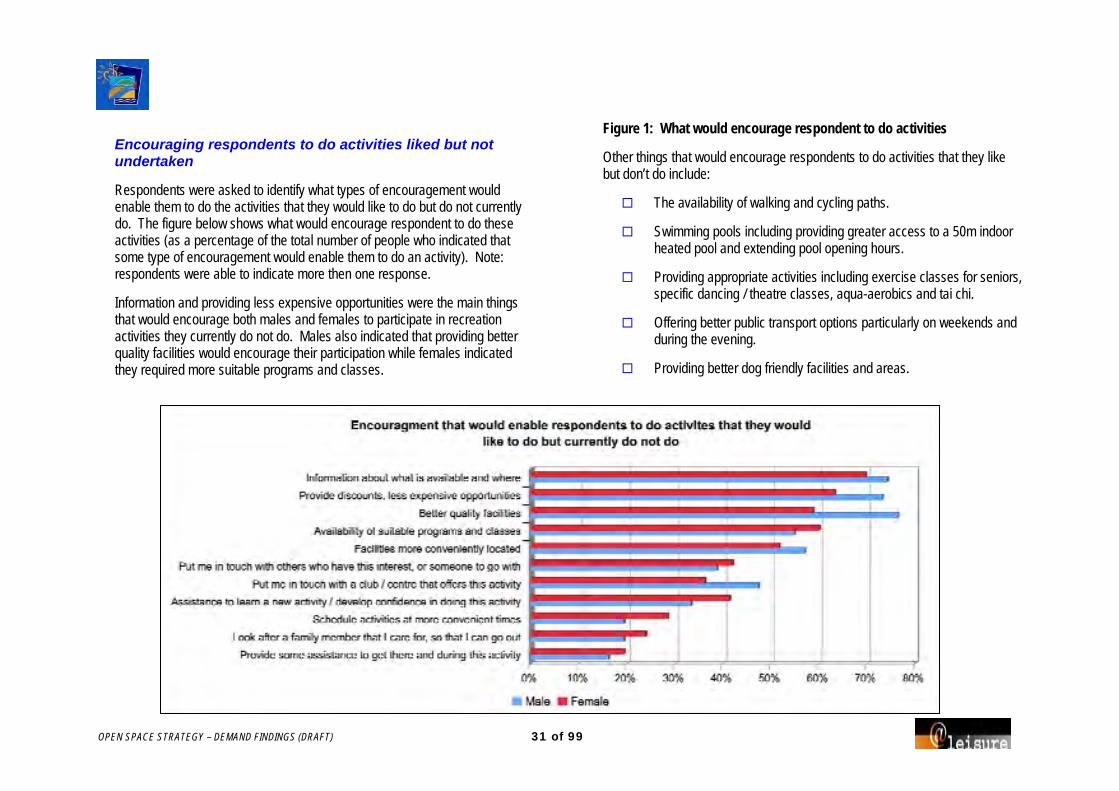
OPEN SPACE STRATEGY – DEMAND FINDINGS (DRAFT) 31 of 99
Encouraging respondents to do activities liked but not undertaken
Respondents were asked to identify what types of encouragement would enable them to do the activities that they would like to do but do not currently do. The figure below shows what would encourage respondent to do these activities (as a percentage of the total number of people who indicated that some type of encouragement would enable them to do an activity). Note: respondents were able to indicate more then one response.
Information and providing less expensive opportunities were the main things that would encourage both males and females to participate in recreation activities they currently do not do. Males also indicated that providing better quality facilities would encourage their participation while females indicated they required more suitable programs and classes.
Figure 1: What would encourage respondent to do activities
Other things that would encourage respondents to do activities that they like but don’t do include:
The availability of walking and cycling paths.
Swimming pools including providing greater access to a 50m indoor heated pool and extending pool opening hours.
Providing appropriate activities including exercise classes for seniors, specific dancing / theatre classes, aqua-aerobics and tai chi.
Offering better public transport options particularly on weekends and during the evening.
Providing better dog friendly facilities and areas.
OPEN SPACE STRATEGY – DEMAND FINDINGS (DRAFT) 32 of 99
Activity specific encouragement
For males and females that would like to cycle for recreation, the things that would encourage them to participate include: providing better quality facilities and having facilities more conveniently located. Other types of encouragement included having cycling paths that link up and providing safe cycleways.
Providing better quality facilities would also encourage people to participate in swimming and to attend live theatre/ dance/ performance. Other encouragements for people who would like to swim include having a 50m lap pool available all year round and providing an indoor heated pool.
Providing information about what is available and where was the thing that would encourage people who wanted to go camping or caravanning to participate.
The following table shows activities liked but not undertaken, by nature of encouragement, for the main activities that people would like to do.

OPEN SPACE STRATEGY – DEMAND FINDINGS (DRAFT) 33 of 99
Table 9: Number of respondents by activity with the encouragement needed to do activities liked by not undertaken
Activity
Num
ber o
f Re
spon
dent
s
Avail
abilit
y of s
uita
ble
prog
ram
s and
clas
ses
Info
rmat
ion
abou
t wha
t is
avail
able
and
wher
e
Assis
tanc
e to
learn
a ne
w ac
tivity
/ dev
elop
conf
iden
ce in
doi
ng th
is ac
tivity
Put m
e in
touc
h wi
th
othe
rs w
ho h
ave t
his
inte
rest
, or s
omeo
ne to
go
with
Put m
e in
touc
h wi
th a
club
/ cen
tre th
at o
ffers
th
is ac
tivity
Prov
ide s
ome a
ssist
ance
to
get
ther
e and
dur
ing
this
activ
ity
Look
afte
r a fa
mily
m
embe
r tha
t I ca
re fo
r, so
I may
go
out
Facil
ities
mor
e co
nven
iently
loca
ted
Bette
r qua
lity f
acilit
ies
Prov
ide d
iscou
nts,
less
expe
nsive
opp
ortu
nitie
s
Sche
dule
activ
ities
at
mor
e con
veni
ent t
imes
Cycling 36 7 14 4 9 8 3 6 19 20 9 5 Swimming 24 5 4 2 4 3 0 0 6 14 7 2 Attend theatre/dance/performance 14 4 4 2 0 2 0 0 4 9 4 2 Camping/ caravanning 10 0 8 0 1 2 0 1 1 7 3 1 Theme park/ water park 10 3 1 0 0 0 1 0 6 5 4 0 Fishing 8 3 4 1 3 2 0 1 1 1 1 1 Sailing/ sail boarding 7 4 3 4 5 5 1 1 2 1 1 1 Tai chi/ yoga/ meditating/ Pilates 7 6 4 2 2 4 0 0 2 1 2 3 Arts and craft activities 6 6 4 2 4 2 2 2 3 2 1 3 Dancing/ ballroom/ disco/ line dancing/ hip hop/ break dancing 6 3 3 2 0 1 0 0 0 2 1 1 Dog walking 6 4 2 0 3 1 0 0 6 4 2 0 Walking 5 0 3 0 0 0 0 0 3 3 0 0
Note: Respondents were able to nominate more than one type of encouragement.
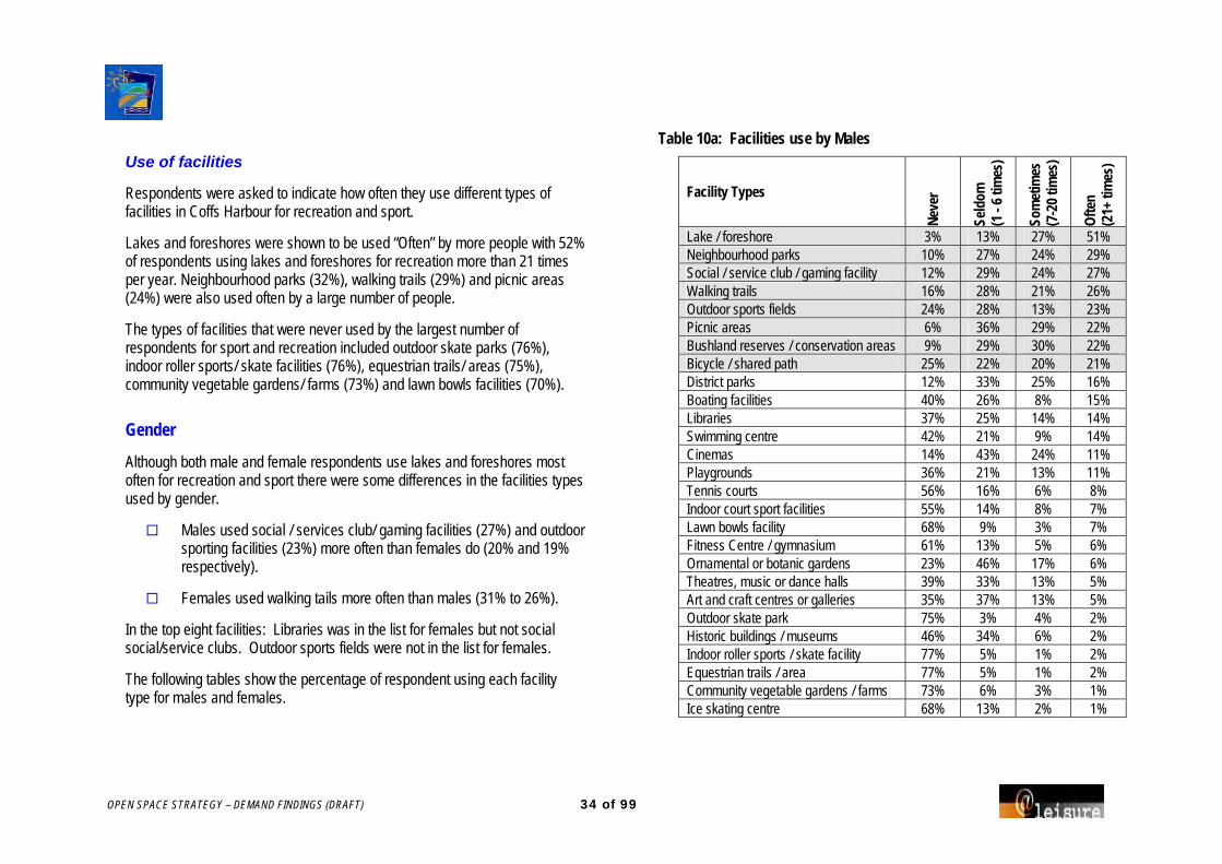
OPEN SPACE STRATEGY – DEMAND FINDINGS (DRAFT) 34 of 99
Use of facilities
Respondents were asked to indicate how often they use different types of facilities in Coffs Harbour for recreation and sport.
Lakes and foreshores were shown to be used “Often” by more people with 52% of respondents using lakes and foreshores for recreation more than 21 times per year. Neighbourhood parks (32%), walking trails (29%) and picnic areas (24%) were also used often by a large number of people.
The types of facilities that were never used by the largest number of respondents for sport and recreation included outdoor skate parks (76%), indoor roller sports/ skate facilities (76%), equestrian trails/ areas (75%), community vegetable gardens/ farms (73%) and lawn bowls facilities (70%).
Gender
Although both male and female respondents use lakes and foreshores most often for recreation and sport there were some differences in the facilities types used by gender.
Males used social / services club/ gaming facilities (27%) and outdoor sporting facilities (23%) more often than females do (20% and 19% respectively).
Females used walking tails more often than males (31% to 26%).
In the top eight facilities: Libraries was in the list for females but not social social/service clubs. Outdoor sports fields were not in the list for females.
The following tables show the percentage of respondent using each facility type for males and females.
Table 10a: Facilities use by Males
Facility Types
Neve
r
Seld
om
(1 -
6 tim
es)
Som
etim
es
(7-2
0 tim
es)
Ofte
n
(21+
tim
es)
Lake / foreshore 3% 13% 27% 51% Neighbourhood parks 10% 27% 24% 29% Social / service club / gaming facility 12% 29% 24% 27% Walking trails 16% 28% 21% 26% Outdoor sports fields 24% 28% 13% 23% Picnic areas 6% 36% 29% 22% Bushland reserves / conservation areas 9% 29% 30% 22% Bicycle / shared path 25% 22% 20% 21% District parks 12% 33% 25% 16% Boating facilities 40% 26% 8% 15% Libraries 37% 25% 14% 14% Swimming centre 42% 21% 9% 14% Cinemas 14% 43% 24% 11% Playgrounds 36% 21% 13% 11% Tennis courts 56% 16% 6% 8% Indoor court sport facilities 55% 14% 8% 7% Lawn bowls facility 68% 9% 3% 7% Fitness Centre / gymnasium 61% 13% 5% 6% Ornamental or botanic gardens 23% 46% 17% 6% Theatres, music or dance halls 39% 33% 13% 5% Art and craft centres or galleries 35% 37% 13% 5% Outdoor skate park 75% 3% 4% 2% Historic buildings / museums 46% 34% 6% 2% Indoor roller sports / skate facility 77% 5% 1% 2% Equestrian trails / area 77% 5% 1% 2% Community vegetable gardens / farms 73% 6% 3% 1% Ice skating centre 68% 13% 2% 1%

OPEN SPACE STRATEGY – DEMAND FINDINGS (DRAFT) 35 of 99
Table 10b: Facility use by Females
Facility Type
Neve
r
Seld
om
(1 -
6 tim
es)
Som
etim
es
(7-2
0 tim
es)
Ofte
n
(21+
tim
es)
Lake / foreshore 2% 12% 27% 53% Neighbourhood parks 7% 24% 25% 35% Walking trails 11% 29% 21% 31% Picnic areas 4% 31% 32% 26% Bushland reserves / conservation areas 8% 31% 27% 26% Libraries 19% 28% 20% 25% Bicycle / shared path 24% 23% 19% 22% Social / service club / gaming facility 15% 32% 24% 20% Outdoor sports fields 32% 25% 11% 19% District Parks 9% 34% 25% 19% Swimming centre 35% 22% 14% 19% Cinemas 9% 42% 26% 16% Playgrounds 30% 22% 16% 16% Fitness Centre / gymnasium 51% 15% 9% 12% Art and craft centres or galleries 21% 39% 20% 11% Boating facilities 49% 23% 6% 8% Ornamental or botanic gardens 16% 50% 20% 8% Indoor court sport facilities 59% 11% 7% 8% Theatres, music or dance halls 26% 39% 18% 7% Tennis courts 55% 18% 7% 7% Lawn bowls facility 73% 9% 1% 4% Equestrian trails / area 74% 6% 2% 3% Historic buildings / museums 40% 37% 8% 2% Outdoor skate park 77% 4% 2% 1% Community vegetable gardens / farms 73% 9% 2% 1% Indoor roller sports / skate facility 76% 8% 1% 1% Ice skating centre 66% 17% 2% 1%
Activities outside Coffs Harbour
21% of respondents indicated that they had to go outside of Coffs Harbour to do recreation activities.
The facilities that more people travel outside of Coffs Harbour to use included National Parks, caravan parks, rivers, boat ramps and beaches.
The main locations that people travel to in order to use these facilities are outlined below.
Facility Type Locations
National parks Dorrigo (7), Minnie Waters (6), Bellingen (3), Hat Head (3), Station Creek (3)
Caravan parks/ campervan
Australia wide (10), Bellingen showgrounds (2), Dorrigo Copmanhurst (2), Maroochydore (2), Yamba (2)
Rivers Mylestom (4), Urunga (4), Bellingen (2), Clarence River (2), Nambucca River (2), Yamba (2)
Boat ramps Grafton (2), Mylestom (2), South West Rocks (2)
Beaches Corindi (2)

OPEN SPACE STRATEGY – DEMAND FINDINGS (DRAFT) 36 of 99
Other facilities that respondents use outside of the Coffs Harbour LGA include:
Bike tracks Camp grounds
Bowling Club Fishing
Theatre Cricket grounds
Football fields Music venues
Additional recreation facilities needed
Outdoor Facilities
Bicycle/ shared trails and lakes/ foreshores were the outdoor facility types that respondents indicated should get highest priority if funds become available.
The following table ranks the outdoor facilities by highest priority to lowest priority for both males and females.
Other outdoor recreation facilities that were seen to be of high priority include:
Dog leash free area (fenced)
Bike paths
Beach access
Rest rooms
Zoo
Table 11: Outdoor facilities of highest priority for funding
Total Male Female Type of outdoor facility No. % No. % No. %
Bicycle / shared trails 140 16% 66 16% 74 16% Lake / foreshore 112 13% 53 13% 59 12% Bushland reserves / conservation areas 98 11% 43 11% 55 12%
Boating facilities 63 7% 46 11% 17 4% Walking trails 59 7% 22 5% 37 8% Picnic areas 56 6% 23 6% 33 7% Neighbourhood parks 54 6% 25 6% 29 6% Playgrounds 54 6% 17 4% 37 8% Swimming centre 43 5% 17 4% 26 5% Outdoor sports fields 37 4% 21 5% 16 3% District parks 24 3% 13 3% 11 2% Ornamental or botanic gardens 20 2% 5 1% 15 3%
Community vegetable gardens / farms 18 2% 3 1% 15 3%
Lawn bowls facility 10 1% 5 1% 5 1% Tennis courts 9 1% 6 1% 3 1% Outdoor skate parks 7 1% 4 1% 3 1% Equestrian trails / areas 6 1% 1 0% 5 1% Other 27 3% 11 3% 16 3%

OPEN SPACE STRATEGY – DEMAND FINDINGS (DRAFT) 37 of 99
Age groups
Different age groups indicated different facilities should be priority.
Younger men - outdoor sports fields, swimming pools and skate parks
Younger women – playgrounds and neighbourhood parks
Adults (30 – 49yrs) – playgrounds and swimming pools
Older adults (60yrs +) – bushland reserves, picnic areas, lakes and foreshores, and ornamental gardens
The following two tables highlight the facilities that should get highest priority by males and females of different age groups.
Table 12a: Outdoor facility priorities: Males, by age group
Facility Types
TOTA
L %
10 –
19yr
s
20 –
29yr
s
30 –
39yr
s
40 –
49yr
s
50 –
60yr
s
61 –
70yr
s
71yr
s +
No ag
e gi
ven
Bicycle / shared trails 16% 17% 13% 14% 22% 17% 20% 5% 16%
Lake / foreshore 13% 6% 22% 9% 12% 19% 7% 18% 10%
Boating facilities 11% 0% 13% 11% 18% 12% 9% 11% 0%
Bush land reserves / conservation areas
11% 6% 0% 11% 5% 15% 18% 7% 19%
Neighbourhood parks 6% 11% 4% 7% 7% 7% 5% 5% 3%
Picnic areas 6% 0% 4% 7% 5% 4% 11% 11% 0%
Walking trails 5% 6% 4% 9% 1% 5% 11% 5% 10%
Outdoor sports fields 5% 17% 9% 5% 8% 2% 7% 0% 0%
Playgrounds 4% 6% 4% 11% 5% 4% 2% 2% 0%
Swimming centre 4% 11% 4% 0% 10% 4% 0% 0% 3%
District parks 3% 0% 9% 2% 2% 2% 5% 7% 0%
Tennis courts 1% 0% 4% 2% 2% 1% 0% 2% 0%
Ornamental or botanic gardens
1% 0% 0% 2% 1% 1% 2% 2% 0%
Lawn bowls facility 1% 0% 0% 0% 1% 2% 0% 5% 0%
Outdoor skate parks 1% 6% 4% 2% 1% 0% 0% 0% 0%
Community vegetable gardens / farms
1% 0% 0% 0% 1% 0% 0% 0% 6%
Equestrian trails / areas
0% 0% 0% 2% 0% 0% 0% 0% 0%
Other 3% 6% 4% 5% 1% 4% 0% 5% 3%

OPEN SPACE STRATEGY – DEMAND FINDINGS (DRAFT) 38 of 99
Table 12b: Outdoor facility priorities: Females, by age group
Outdoor Facility Type
TOTA
L %
10 –
19yr
s
20 –
30yr
s
31 –
40yr
s
41 –
50yr
s
51 –
60yr
s
61 –
70yr
s
71yr
s+
No ag
e gi
ven
Bicycle / shared trails 16% 20% 6% 12% 17% 19% 18% 12% 20%
Lake / foreshore 12% 20% 15% 9% 16% 13% 12% 5% 10%
Bushland reserves / conservation areas 12% 7% 18% 9% 5% 18% 11% 10% 20%
Playgrounds 8% 7% 9% 25% 4% 5% 3% 2% 5%
Walking trails 8% 13% 3% 4% 9% 6% 14% 7% 10%
Picnic areas 7% 0% 3% 1% 4% 11% 11% 10% 15%
Neighbourhood parks 6% 20% 15% 8% 5% 4% 5% 2% 0%
Swimming centre 5% 7% 3% 7% 10% 5% 3% 2% 0%
Boating facilities 4% 0% 0% 3% 9% 3% 3% 2% 0%
Outdoor sports fields 3% 0% 6% 5% 6% 1% 1% 2% 5%
Ornamental or botanic gardens 3% 0% 0% 3% 3% 4% 5% 5% 0%
Community vegetable gardens / farms 3% 0% 6% 1% 4% 2% 7% 2% 0%
District parks 2% 0% 3% 0% 5% 2% 1% 5% 0%
Equestrian trails / areas 1% 0% 6% 4% 0% 0% 0% 0% 0%
Lawn bowls facility 1% 0% 0% 1% 0% 0% 1% 7% 0%
Outdoor skate parks 1% 0% 3% 1% 0% 0% 0% 2% 0%
Tennis courts 1% 0% 0% 0% 2% 1% 0% 0% 0%
Other 3% 7% 6% 5% 2% 4% 0% 5% 0%
Indoor Facilities
Community centres/ halls/ houses, theatre, music or dance halls and libraries were the indoor facility types that respondents indicated should get highest priority if funds become available.
The following table ranks the indoor facilities by highest priority to lowest priority for both males and females.
Table 13: Indoor facilities of highest priority for funding
Total Male Female Indoor Facility Type No. % No. % No. %
Community centre / halls / houses 136 16% 57 14% 79 17% Theatres, music or dance halls 125 14% 49 12% 76 16% Libraries 114 13% 48 12% 66 14% Indoor court sport facilities 82 9% 44 11% 38 8% Art and craft centres or galleries 62 7% 17 4% 45 9% Other 53 6% 25 6% 28 6% Cinemas 48 5% 29 7% 19 4% Fitness centre / gymnasium 40 5% 17 4% 23 5% Social / service club / gaming facility 39 4% 27 7% 12 3% Historic buildings / museums 38 4% 20 5% 18 4% Indoor roller sports / skate facility 29 3% 15 4% 14 3% Ice skating centre 10 1% 5 1% 5 1%

OPEN SPACE STRATEGY – DEMAND FINDINGS (DRAFT) 39 of 99
Age group
The facility types identified as a priority differed by age group:
Younger males – Suggested indoor court sport facilities, indoor roller and skate facilities, cinemas were a priority.
Younger women – indoor roller sport and skate facilities (including ice skating), fitness centres and gymnasiums.
Adult men – fitness centres and gymnasiums, historic buildings and museums, cinemas.
Older adults – libraries, community centres and halls.
Table 14a: Priorities for indoor facility: Males, by age group
Facility Type
TOTA
L %
10 –
19yr
s
20 –
29yr
s
30 –
39yr
s
40 –
49yr
s
50 –
60yr
s
61 –
70yr
s
71yr
s +
No ag
e gi
ven
Community centre / halls / houses 14% 0% 9% 16% 15% 19% 16% 18% 0% Theatres, music or dance halls 12% 6% 4% 11% 10% 18% 18% 7% 13% Libraries 12% 6% 4% 5% 8% 14% 14% 23% 19% Indoor court sport facilities 11% 22% 22% 14% 18% 4% 7% 5% 6% Cinemas 7% 11% 9% 11% 8% 5% 4% 9% 6% Social / service club / gaming facility 7% 6% 17% 9% 5% 7% 4% 9% 3% Historic buildings / museums 5% 6% 0% 5% 7% 10% 2% 0% 3% Fitness centre / gymnasium 4% 0% 4% 5% 10% 4% 2% 0% 0% Art and craft centres or galleries 4% 0% 0% 2% 5% 5% 7% 2% 6% Indoor roller sports / skate facility 4% 22% 9% 7% 3% 2% 0% 2% 0% Ice skating centre 1% 6% 4% 2% 2% 0% 0% 0% 0% Other 6% 6% 13% 5% 6% 7% 9% 5% 0%
Table 14b: Priorities for indoor facility: Females, by age group
Facility Type
TOTA
L %
10 –
19yr
s
20 –
30yr
s
31 –
40yr
s
41 –
50yr
s
51 –
60yr
s
61 –
70yr
s
71yr
s+
No ag
e gi
ven
Community centre / halls / houses
17% 13% 15% 16% 12% 21% 21% 12% 20%
Theatres, music or dance halls
16% 13% 18% 3% 21% 19% 21% 15% 15%
Libraries 14% 7% 9% 13% 14% 11% 22% 24% 0% Art and craft centres or galleries
9% 0% 6% 7% 15% 11% 7% 7% 15%
Indoor court sport facilities
8% 0% 12% 18% 11% 3% 4% 7% 0%
Fitness centre / gymnasium
5% 13% 6% 11% 4% 4% 1% 0% 10%
Cinemas 4% 7% 3% 7% 2% 5% 4% 2% 0% Historic buildings / museums
4% 7% 6% 4% 5% 2% 5% 2% 0%
Indoor roller sports / skate facility
3% 13% 12% 3% 4% 2% 0% 0% 0%
Social / service club / gaming facility
3% 0% 6% 3% 2% 3% 0% 7% 0%
Ice skating centre 1% 7% 0% 5% 0% 0% 0% 0% 0% Other 6% 7% 6% 4% 6% 11% 3% 2% 5%

OPEN SPACE STRATEGY – DEMAND FINDINGS (DRAFT) 40 of 99
Use and perception of local area parks
The parks in the Coffs Harbour area that are used by the most local residents are shown in the following chart.
Figure 2: Coffs Harbour Parks used most by local residents
The main reason that respondents use their local parks and reserves over others include:
Close to home 24.9%
Central/ convenient location 15.9%
Good facilities 13.4%
Close to/ access to beach 10.0%
Good quality, well maintained & pleasant surroundings 8.8%
Main activities
Picnics and BBQ’s (42%) and walking (42%) were the main activities that respondents do at the parks in their local area. Other activities include:
Swimming
Playground activities/ taking children to the playground
Relaxing or sitting
Playing outdoors with children
Male and female respondents use their local parks for similar activities with more females walking (46%) at their local park and more males picnicking or having BBQ’s at their local park (39%).
The top 10 activities that males and female do at the park they use most in their local area are listed in the table below.

OPEN SPACE STRATEGY – DEMAND FINDINGS (DRAFT) 41 of 99
Table 17: Top 10 Activities in local parks
Male % Female % 1 Picnic/BBQs 39% Walking 46%
2 Walking 37% Picnic/BBQs 45%
3 Swimming 27% Swimming 30%
4 Fishing 11% Playground activities/ taking children to playgrounds
14%
5 Playground activities/ taking children to playgrounds
9% Relaxing / sitting 11%
6 Entertaining/ socialising 9% Playing outdoors with children
11%
7 Cycling/ cycle racing 8% Entertaining/ socialising 8%
8 Relaxing / sitting 8% Dog walking 8%
9 Playing outdoors with children
7% Cycling/ cycle racing 7%
10 Surfing 7% Sports General 4%
How often?
Almost 25% of respondents indicated that they use the park (that they use most often) about 2 – 3 times per week. A similar number of respondents however used their parks only monthly.
The following chart highlights how often respondents are using their most frequently visited parks in their local area.
Figure 3: Frequency of visits to the most used local parks
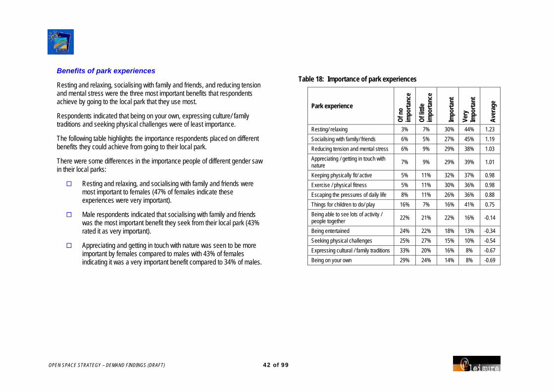
OPEN SPACE STRATEGY – DEMAND FINDINGS (DRAFT) 42 of 99
Benefits of park experiences
Resting and relaxing, socialising with family and friends, and reducing tension and mental stress were the three most important benefits that respondents achieve by going to the local park that they use most.
Respondents indicated that being on your own, expressing culture/ family traditions and seeking physical challenges were of least importance.
The following table highlights the importance respondents placed on different benefits they could achieve from going to their local park.
There were some differences in the importance people of different gender saw in their local parks:
Resting and relaxing, and socialising with family and friends were most important to females (47% of females indicate these experiences were very important).
Male respondents indicated that socialising with family and friends was the most important benefit they seek from their local park (43% rated it as very important).
Appreciating and getting in touch with nature was seen to be more important by females compared to males with 43% of females indicating it was a very important benefit compared to 34% of males.
Table 18: Importance of park experiences
Park experience
Of n
o im
porta
nce
Of lit
tle
impo
rtanc
e
Impo
rtant
Very
Im
porta
nt
Aver
age
Resting/ relaxing 3% 7% 30% 44% 1.23
Socialising with family/ friends 6% 5% 27% 45% 1.19
Reducing tension and mental stress 6% 9% 29% 38% 1.03
Appreciating / getting in touch with nature
7% 9% 29% 39% 1.01
Keeping physically fit/ active 5% 11% 32% 37% 0.98
Exercise / physical fitness 5% 11% 30% 36% 0.98
Escaping the pressures of daily life 8% 11% 26% 36% 0.88
Things for children to do/ play 16% 7% 16% 41% 0.75
Being able to see lots of activity / people together
22% 21% 22% 16% -0.14
Being entertained 24% 22% 18% 13% -0.34
Seeking physical challenges 25% 27% 15% 10% -0.54
Expressing cultural / family traditions 33% 20% 16% 8% -0.67
Being on your own 29% 24% 14% 8% -0.69

OPEN SPACE STRATEGY – DEMAND FINDINGS (DRAFT) 43 of 99
Figure 4: Importance of park experiences: comparison between male and female respondents
Perceptions of all parks
Importance
Large shady trees, being away from traffic and being an unspoilt environment were considered to be very important by the largest number of people.
Boat launching, being close to public transport and having an area to walk the dog were the features that most respondents indicated were of no importance.
Males and females shared similar views on the importance of the listed park features.
Other features that were listed as important included:
BBQ facilities.
Safety gates and rangers.
Sheltered grandstand space for major sports.
Cleanliness of toilets, parks, bins and facilities.
Important / very important park experiences

OPEN SPACE STRATEGY – DEMAND FINDINGS (DRAFT) 44 of 99
Performance
For the same list of park features, respondents were asked to rate Council’s performance in the delivery of these.
The following are the three park features that had the highest service delivery.
Beach access.
Scenery or views.
Close to home.
The following are the features perceived to have the poorest performance by Council.
Boat launching.
Trails for walking/ horse riding.
Paths for cycling/ skating.
Close to public transport.
Provision gap
By analysing the difference between the importance of park features and their service delivery by the Council the following five park features should be addressed as having high importance yet low service delivery.
Shelter from the weather / sun.
Large shady trees.
Unspoiled environment.
Toilets.
Seating / rest spots.
The following tables highlights respondents views on the importance and performance of various park features, with Table 21 highlighting the gap between importance and performance of Council in providing these features.

OPEN SPACE STRATEGY – DEMAND FINDINGS (DRAFT) 45 of 99
Table 19: Importance of park features
Park features
Of n
o im
porta
nce
Of lit
tle
impo
rtanc
e
Impo
rtant
Very
im
porta
nt
Large shady trees 1% 2% 24% 64% Away from traffic 1% 4% 29% 57% Unspoiled environment 1% 5% 26% 58% Seating / rest spots 2% 7% 27% 56% Toilets 2% 9% 24% 56% Shelter from the weather / sun 4% 7% 32% 47% Natural bush land 2% 10% 34% 44% High quality maintenance 3% 9% 33% 43% Scenery or views 3% 11% 39% 37% Access for prams/ wheelchairs/ people with disabilities
7% 8% 31% 43%
Beach access 4% 14% 31% 42% Nature walks 3% 15% 33% 38% Animals or birds to observe 3% 15% 34% 36% Close to home 4% 14% 37% 35% Access to water / water features 5% 14% 36% 33% Areas for ball games 11% 16% 35% 26% Paths for cycling / skating 13% 18% 28% 29% Playground 14% 17% 25% 32% Lighting 12% 18% 28% 29% Areas for large social gatherings 10% 20% 34% 25% Trails for walking / horse riding 15% 18% 30% 25% Places to play sport socially 15% 17% 32% 23% Flowering plants 9% 30% 32% 16% Areas to walk the dog 30% 12% 21% 26% Irrigated green lawns 19% 30% 24% 14% Sporting / cultural events to watch 18% 32% 26% 11% Close to public transport 26% 28% 20% 14% Boat launching 36% 24% 14% 12%
Table 20: Council’s performance by park features
Park features
Not g
ood
at al
l
Not v
ery
good
Quite
goo
d
Very
goo
d
Beach access 2% 6% 45% 35% Scenery or views 2% 11% 46% 26% Close to home 4% 10% 47% 25% Natural bushland 1% 13% 53% 20% Areas for ball games 1% 12% 48% 18% Areas for large social gatherings 3% 11% 47% 19% Away from traffic 2% 13% 56% 15% Places to play sport socially 3% 11% 46% 14% Playground 2% 14% 47% 16% Large shady trees 5% 15% 53% 17% Animals or birds to observe 3% 17% 46% 17% Nature walks 2% 20% 44% 16% Unspoiled environment 4% 16% 56% 12% Seating / rest spots 3% 19% 52% 14% Toilets 6% 20% 44% 20% High quality maintenance 4% 20% 50% 11% Access to water / water features 5% 21% 40% 15% Sporting / cultural events to watch 4% 17% 38% 10% Flowering plants 5% 21% 38% 12% Access for prams / wheelchairs / people with disabilities 5% 16% 39% 7% Shelter from the weather / sun 7% 29% 41% 10% Irrigated green lawns 8% 17% 38% 4% Areas to walk the dog 9% 18% 29% 9% Lighting 8% 24% 36% 5% Paths for cycling / skating 11% 24% 31% 9% Close to public transport 9% 21% 29% 6% Trails for walking / horse riding 9% 20% 26% 7% Boat launching 11% 15% 25% 4%

OPEN SPACE STRATEGY – DEMAND FINDINGS (DRAFT) 46 of 99
Table 21: Gap between importance & provision of Council park features Mean Park features Importance Provision Gap
Shelter from the weather / sun 1.22 0.21 1.01 Large shady trees 1.64 0.70 0.94 Unspoiled environment 1.47 0.64 0.83 Toilets 1.36 0.57 0.79 Seating / rest spots 1.39 0.63 0.77 Away from traffic 1.51 0.80 0.71 High quality maintenance 1.18 0.50 0.68 Access for prams / wheelchairs / people with disabilities 1.05 0.40 0.65
Paths for cycling / skating 0.49 0.04 0.45 Lighting 0.49 0.07 0.41 Access to water / water features 0.87 0.47 0.39 Trails for walking / horse riding 0.37 0.02 0.35 Nature walks 0.99 0.65 0.34 Natural bushland 1.19 0.90 0.29 Animals or birds to observe 0.96 0.69 0.27 Scenery or views 1.08 0.96 0.12 Close to home 0.94 0.91 0.04 Areas to walk the dog 0.01 0.18 -0.17 Beach access 1.00 1.18 -0.19 Flowering plants 0.19 0.41 -0.23 Playground 0.49 0.76 -0.27 Areas for ball games 0.57 0.87 -0.30 Areas for large social gatherings 0.49 0.85 -0.36 Close to public transport -0.36 0.03 -0.39 Irrigated green lawns -0.20 0.21 -0.40 Places to play sport socially 0.34 0.77 -0.43 Boat launching -0.67 -0.09 -0.58 Sporting / cultural events to watch -0.23 0.45 -0.67
Future park development
Respondents were asked to consider how strongly they agree to a number of statements regarding the future development, management and future service delivery of parks in the Coffs Harbour LGA.
Over 60% of respondents strongly agreed to Council banning smoking:
within 10m of playgrounds (66%).
on family orientated beaches and foreshores (61%).
on Council managed sports grounds (60%).
A high number of respondents agreed to the following statements:
I would prefer more variety in parks across the city (e.g. natural areas, formal gardens, sport and play areas etc).
I think it is appropriate to have equipment hire and some recreation activities you pay for at a few major foreshore locations in Coffs Harbour City (e.g. learn to surf lessons / bike hire).
I think it is appropriate to have equipment hire or some recreation activities you pay for at a few major parks in Coffs Harbour City (e.g. bike hire / tai chi classes).
Fewer respondents agreed to providing premises to eat or get take away food at parks and along foreshores in Coffs Harbour.
The following table highlights how strongly respondents agreed to all statements.

OPEN SPACE STRATEGY – DEMAND FINDINGS (DRAFT) 47 of 99
Table 22: Agreement to statements
Statement
Stro
ngly
Disa
gree
Disa
gree
Agre
e
Stro
ngly
Agre
e
I would support Council banning smoking within 10m of playgrounds 3% 6% 19% 66%
I would support Council banning smoking on Council managed sports fields 4% 9% 19% 60%
Ban Smoking
I would support Council banning smoking on family oriented beaches/ foreshores 5% 10% 16% 61%
I would prefer more variety in parks across the city (e.g. natural areas, formal gardens, sport and play areas etc) 1% 13% 45% 30%
I would prefer to walk 500 metres to a higher quality park rather than having smaller and lower quality parks closer to home
7% 18% 34% 32%
Park improvements
Rather than doing small improvements in lots of parks, I think Council should completely upgrade/ develop just a few parks at a time
11% 30% 31% 20%
I think it is appropriate to have equipment hire and some recreation activities you pay for at a few major foreshore locations in Coffs Harbour City (e.g. learn to surf lessons / bike hire) 6% 8% 58% 19%
Equipment hire
I think it is appropriate to have equipment hire or some recreation activities you pay for at a few major parks in Coffs Harbour City (e.g. bike hire / tai chi classes)
7% 10% 52% 21%
I think it is appropriate to provide eat-in food premises at a few major foreshore locations in Coffs Harbour City 19% 22% 36% 15%
I think it is appropriate to provide take-away food outlets at a few major foreshore locations in Coffs Harbour City 23% 20% 36% 15%
I think it is appropriate to provide eat-in food premises at a few major parks in Coffs Harbour City 20% 29% 32% 11%
Food and beverages in parks
I think it is appropriate to provide take-away food outlets at a few major parks in Coffs Harbour City 27% 25% 30% 10%

OPEN SPACE STRATEGY – DEMAND FINDINGS (DRAFT) 48 of 99
BCU International Stadium
The BCU International Stadium services district competition together with large spectator events such as the NRL pre-season matches. It hosts National sporting events such as the National Touch League, which significantly boost the local economy.
82% of respondents support upgrades of the BCU International Stadium so that it remains competitive in attracting major events.
A greater proportion of male respondents agree to upgrading the stadium compared to female respondents (85% to 79%).
Upgrade options
The following table shows the importance of various upgrades to the BCU International Stadium.
Table 23: Agreement to facility upgrades
Statement
Stro
ngly
Disa
gree
Disa
gree
Agre
e
Stro
ngly
Agre
e Expand car park facilities and improve traffic flow
3% 10% 38% 27%
Improve the floodlights so that it meets the needs of professional football codes
3% 10% 34% 27%
Increase amount of tiered seating 3% 9% 36% 25%
Improve catering facilities 5% 11% 38% 19%
Other suggestions for the upgrade of the BCU Stadium included:
Covered tiered seating (12 responses)
Event catering (9)
Event management (7)
Sport (7)
Low cost opportunities (5)
Lift food restrictions (3)
Other parks need funding/ support (3)
Public transport (3)
Rubbish / recycling (3)
Toilet facilities (3)

OPEN SPACE STRATEGY – DEMAND FINDINGS (DRAFT) 49 of 99
Single improvement Council could make to Open Space
Respondents were asked to list the single thing that council could do to make their leisure time in public open space more fulfilling.
Suggestions included:
Maintenance / cleaning of facilities & amenities (96 responses)
Regular cleaning of toilets and facilities.
Regular upkeep and maintenance of parks and grounds.
Emptying garbage more often.
Improve maintenance of existing facilities.
Bicycle tracks/ cycle-ways (55) Increase number of cycle paths and bike tracks.
Link the cycle tracks.
Better surfaces on bike tracks.
Separate bike tracks and walking racks.
Shade cover & seating (49) Seating and tables under shade.
Shaded seating at playgrounds.
Shade over kids playgrounds.
More seating.
Walking trails/ paths (40) Walkways around rocky headland.
Trim trees around walking paths.
Games for children to play along the walking tracks.
Better signage for walking tracks.
Limit development/ commercialisation (32) Limit commercial interests in parks.
Do not over develop foreshores.
Keep areas as natural as possible.
Prevent over development and commercialisation.
Facilities (31) Upgrade sports grounds and existing facilities.
Add more and better facilities.
Include more facilities for young children.
Provide exercise equipment in parks.

OPEN SPACE STRATEGY – DEMAND FINDINGS (DRAFT) 50 of 99
Additional comments
Issues that were raised from the additional comments made in the household survey have been summarised below by location, divided into the land settlement areas.
Area 3 – Red Rock / Corindi Beach Fishing benches and larger rubbish bins at boat ramps
Public toilets
Bike tracks – markings and promotion
Security staff in public open spaces
Removal of 4WD vehicles on beach
Area 4 – Arrawarra / Mullaway Access to Yarrawarra Creek from Arrawarra village
More activities for young people interesting playgrounds and skate parks
Commercial development for water/ recreation activities only not retail
More undercover areas in parks
Update and maintain ramps onto beach areas
Special areas should be developed for noisy activities such as motor biking, skateboarding etc.
Area 4 – Woolgoolga Allocate funding more diversely, not just to Coffs Harbour
Clean up/dredge Woolgoolga Lake, for swimming/boating
Update facilities in caravan parks and allow dogs
More events (theatre and arts) at more appropriate times
Area 5 – Sandy Beach / Emerald Beach Better public transport addressing the area
Update the playground at Emerald Beach
Improvements needed to boat ramps
Address underage drinking and anti social behaviour of youths
Better bike paths and cycling facilities

OPEN SPACE STRATEGY – DEMAND FINDINGS (DRAFT) 51 of 99
Area 6 – Moonee Beach/ Sapphire Beach Additional resources for the library.
Animal management and control – rabbits and dogs.
More garbage bins required.
Limit development.
More sheltered areas at BCU.
Picnic tables and seating in parks needed.
Ban alcohol at all recreation venues.
Traffic bypass is needed.
Area 7 – Coffs Harbour
Infrastructure requires an upgrade for an expanding population:
Car parking. Playgrounds. Areas for families and children. Theatre and entertainment / conference centre.
Limit development, keep development to the Western side of the railway line only. Leave Jetty area and foreshore as is.
More dog parks required.
Public transport improvements required.
Clean toilets.
Weed maintenance and cleaning up of vegetation.
Cycle/ bike paths required.
Better management of anti social behaviour and alcohol abuse.
More use by sports clubs and associations of BCU.
Area 7 – Korora Keep the area natural and undeveloped.
Local neighbourhood park required for the community.
Increase cycleways.
Monitor parties held on beach reserves and alcohol consumption by minors.
Area 7 – North Boambee Valley Footpaths required.
Boat launching ramps.
Greater security to prevent vandalism.
Better rubbish removal strategy.
Maintain green, open spaces.

OPEN SPACE STRATEGY – DEMAND FINDINGS (DRAFT) 52 of 99
Area 8 – Toormina Keep Jetty area undeveloped.
Restrict trail bikes from reserves.
General clean up of playground areas, BBQ’s and shelters.
More shade over different areas of parks and playgrounds.
Area 8 – Sawtell Clean up of public toilets.
Animal management including dog poo bags.
Bicycle racks at major parks.
Development of a proper performance space in the area.
Area 8 – Boambee More tables, picnic areas and lighting at picnic grounds.
Limit development to the foreshore.
Better public toilet cleaning and maintenance.
Greater shade at parks and in playgrounds.
Less money on sporting facilities and put more money into cultural events and the arts.
More activities and areas for teenagers.
Area 8 – Bonville Larger rubbish bins or more collection.
Acquire more open space, connective footpaths and community gardening space in new subdivisions.
Better view of the water from foreshore park.
Area 9 – Coramba Need more than one boat ramp in the area.
Better skate park required.
Discourage anti social behaviour in the parks.
Need to upgrade smaller parks and spend money on lighting in toilet facilities.
Spend more of rate payers money here (ie places other than Coffs Harbour).

OPEN SPACE STRATEGY – DEMAND FINDINGS (DRAFT) 53 of 99
Physical activity
59% of respondents took part in vigorous activity 3 times or more in the past 7 days (see table 24a)
More males than females did vigorous activity three times or more in the past 7 days
More people did over 5 hours of exercise (41%) in the last week, than 2 to 5 hours (30%) or less than 2 hours (22%)
Males were more likely to do over 5 hours of exercise compared to females who had a similar number doing 2 to 5 hours as 5 or more hour (see table 24b)
Table 24a: Vigorous activity in the past seven days
Number of times taken part in vigorous activity in past seven days.
Total % Male % Female %
None 78 9% 33 8% 45 9%
One time 98 11% 47 12% 51 11%
Two times 149 17% 56 14% 93 20%
Three times or more 513 59% 251 62% 262 55%
Living in Coffs Harbour
The majority of respondents to the household survey had been living in Coffs Harbour for more than 15 years.
Table 25 highlights the length of time that respondents have lived in Coffs.
The table 26 over the page indicate the suburb or town in which responses came from.
Table 24b: Hours spent in vigorous activity in the past seven days
Number of hours spent doing vigorous activity in past seven days
Total % Male % Female %
Less than 2 hours 194 22% 75 19% 119 25%
Between 2 hours but not as much as 5 hours 266 30% 106 26% 160 34%
5 hours or more 357 41% 202 50% 155 33%
Table 25: Length of time living in Coffs Harbour
Length of time living in Coffs Harbour Total % Male % Female %
Less than one year 27 3% 13 3% 14 3%
1 - 4 years 127 14% 57 14% 70 15%
5 - 10 years 166 19% 82 20% 84 18%
11 - 15 years 110 13% 53 13% 57 12%
More than 15 years 406 46% 181 45% 225 47%
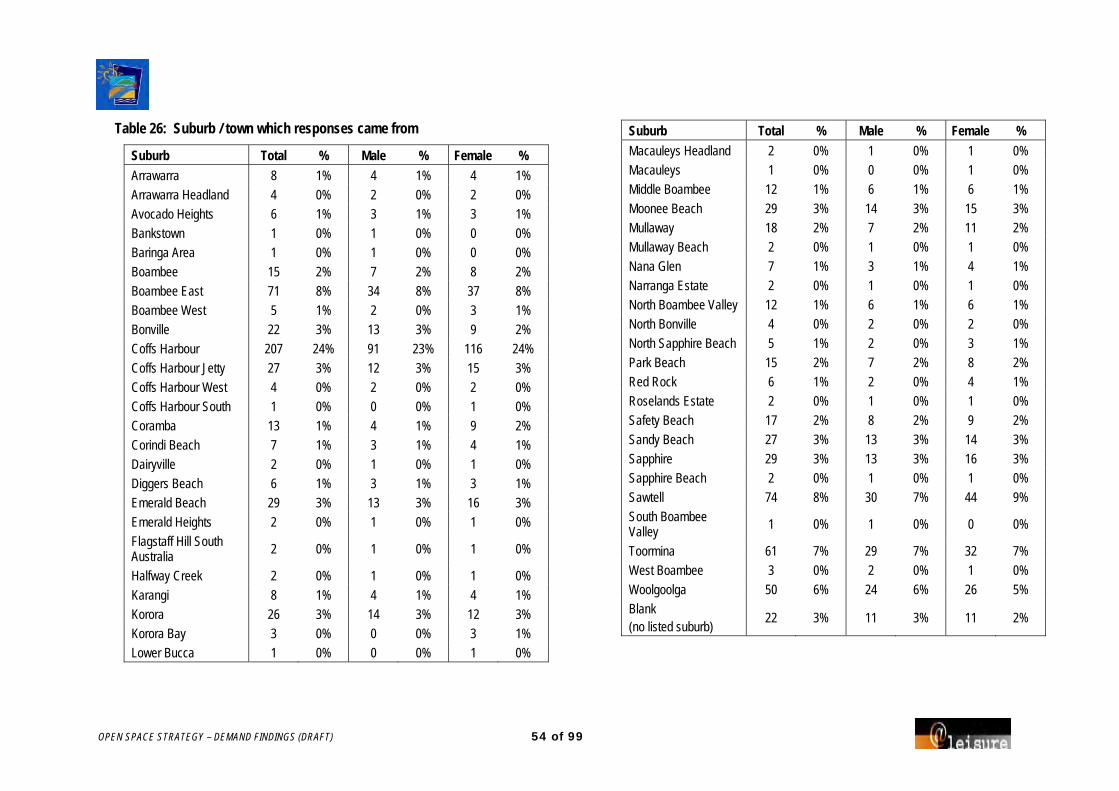
OPEN SPACE STRATEGY – DEMAND FINDINGS (DRAFT) 54 of 99
Table 26: Suburb / town which responses came from
Suburb Total % Male % Female % Arrawarra 8 1% 4 1% 4 1%
Arrawarra Headland 4 0% 2 0% 2 0%
Avocado Heights 6 1% 3 1% 3 1%
Bankstown 1 0% 1 0% 0 0%
Baringa Area 1 0% 1 0% 0 0%
Boambee 15 2% 7 2% 8 2%
Boambee East 71 8% 34 8% 37 8%
Boambee West 5 1% 2 0% 3 1%
Bonville 22 3% 13 3% 9 2%
Coffs Harbour 207 24% 91 23% 116 24%
Coffs Harbour Jetty 27 3% 12 3% 15 3%
Coffs Harbour West 4 0% 2 0% 2 0%
Coffs Harbour South 1 0% 0 0% 1 0%
Coramba 13 1% 4 1% 9 2%
Corindi Beach 7 1% 3 1% 4 1%
Dairyville 2 0% 1 0% 1 0%
Diggers Beach 6 1% 3 1% 3 1%
Emerald Beach 29 3% 13 3% 16 3%
Emerald Heights 2 0% 1 0% 1 0%
Flagstaff Hill South Australia 2 0% 1 0% 1 0%
Halfway Creek 2 0% 1 0% 1 0%
Karangi 8 1% 4 1% 4 1%
Korora 26 3% 14 3% 12 3%
Korora Bay 3 0% 0 0% 3 1%
Lower Bucca 1 0% 0 0% 1 0%
Suburb Total % Male % Female % Macauleys Headland 2 0% 1 0% 1 0%
Macauleys 1 0% 0 0% 1 0%
Middle Boambee 12 1% 6 1% 6 1%
Moonee Beach 29 3% 14 3% 15 3%
Mullaway 18 2% 7 2% 11 2%
Mullaway Beach 2 0% 1 0% 1 0%
Nana Glen 7 1% 3 1% 4 1%
Narranga Estate 2 0% 1 0% 1 0%
North Boambee Valley 12 1% 6 1% 6 1%
North Bonville 4 0% 2 0% 2 0%
North Sapphire Beach 5 1% 2 0% 3 1%
Park Beach 15 2% 7 2% 8 2%
Red Rock 6 1% 2 0% 4 1%
Roselands Estate 2 0% 1 0% 1 0%
Safety Beach 17 2% 8 2% 9 2%
Sandy Beach 27 3% 13 3% 14 3%
Sapphire 29 3% 13 3% 16 3%
Sapphire Beach 2 0% 1 0% 1 0%
Sawtell 74 8% 30 7% 44 9%
South Boambee Valley 1 0% 1 0% 0 0%
Toormina 61 7% 29 7% 32 7%
West Boambee 3 0% 2 0% 1 0%
Woolgoolga 50 6% 24 6% 26 5%
Blank (no listed suburb)
22 3% 11 3% 11 2%
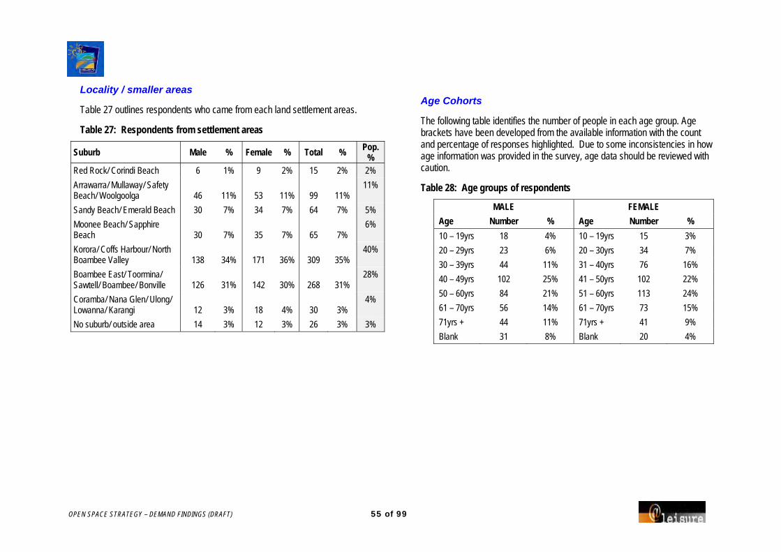
OPEN SPACE STRATEGY – DEMAND FINDINGS (DRAFT) 55 of 99
Locality / smaller areas
Table 27 outlines respondents who came from each land settlement areas.
Table 27: Respondents from settlement areas
Suburb Male % Female % Total % Pop. %
Red Rock/ Corindi Beach 6 1% 9 2% 15 2% 2%
Arrawarra/ Mullaway/ Safety Beach/ Woolgoolga 46 11% 53 11% 99 11%
11%
Sandy Beach/ Emerald Beach 30 7% 34 7% 64 7% 5%
Moonee Beach/ Sapphire Beach 30 7% 35 7% 65 7%
6%
Korora/ Coffs Harbour/ North Boambee Valley 138 34% 171 36% 309 35%
40%
Boambee East/ Toormina/ Sawtell/ Boambee/ Bonville 126 31% 142 30% 268 31%
28%
Coramba/ Nana Glen/ Ulong/ Lowanna/ Karangi 12 3% 18 4% 30 3%
4%
No suburb/ outside area 14 3% 12 3% 26 3% 3%
Age Cohorts
The following table identifies the number of people in each age group. Age brackets have been developed from the available information with the count and percentage of responses highlighted. Due to some inconsistencies in how age information was provided in the survey, age data should be reviewed with caution.
Table 28: Age groups of respondents
MALE FEMALE Age Number % Age Number % 10 – 19yrs 18 4% 10 – 19yrs 15 3%
20 – 29yrs 23 6% 20 – 30yrs 34 7%
30 – 39yrs 44 11% 31 – 40yrs 76 16%
40 – 49yrs 102 25% 41 – 50yrs 102 22%
50 – 60yrs 84 21% 51 – 60yrs 113 24%
61 – 70yrs 56 14% 61 – 70yrs 73 15%
71yrs + 44 11% 71yrs + 41 9%
Blank 31 8% Blank 20 4%

OPEN SPACE STRATEGY – DEMAND FINDINGS (DRAFT) 56 of 99
Occupation
Table 28: Occupation of respondents
Occupation Total % Male % Female % Employed full time 309 35% 168 42% 141 30% Employed part time 139 16% 38 9% 101 21% Student 36 4% 18 4% 18 4% Retired 274 31% 138 34% 136 29% Family responsibilities 72 8% 18 4% 54 11% Looking for work 8 1% 3 1% 5 1% Blank 38 4% 19 5% 19 4%
Income
Table 29: Income of respondents
Total annual income Total % Male % Female % $0 - 30,000 182 21% 80 20% 102 22% $30 - 60,000 251 29% 111 28% 140 30% $60 - 90,000 178 20% 88 22% 90 19% $90,000 plus 102 12% 51 13% 51 11% Blank 163 19% 72 18% 91 19%

OPEN SPACE STRATEGY – DEMAND FINDINGS (DRAFT) 57 of 99
APPENDIX 2 SCHOOL STUDENT SURVEY
A questionnaire was sent to schools across Coffs Harbour to understand the sport and recreational activities undertaken by students within the City.
Summary - school related issues
All schools make considerable use of Council facilities.
Access to swimming pools in Woolgoolga and Coffs Harbour is difficult for school groups.
Facilities are often distant from schools and this incurs time and transport costs.
More shelter and shade is required at a number of venues.
A synthetic athletics track should be considered.
Cost is often a disincentive for using facilities.
An overview of the issues identified from the student survey is following.
Recreation activities you like to do
Students were asked to identify the recreation activities they participate in away from home.
72% of students listed three activities they regularly participate in.
Only 3% of students did not list any activities.
Soccer was the activity that more students in Coffs Harbour regularly participated in with 22% of students playing soccer, followed by swimming (20%), going to the beach (19%) and basketball (16%). All these activities had higher participation rates than the corresponding participation rates for ABS (Under 15yrs) and ERASS (NSW Over 15yrs).
Table 30 on the following page indicates the activities undertaken by the most students (top 20 activities) with a comparison to ABS and ERASS participation rates.
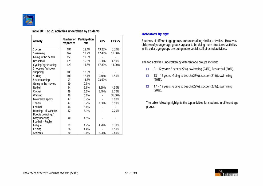
OPEN SPACE STRATEGY – DEMAND FINDINGS (DRAFT) 58 of 99
Table 30: Top 20 activities undertaken by students
Activity Number of responses
Participation rate ABS ERASS
Soccer 184 22.4% 13.20% 3.20% Swimming 162 19.7% 17.40% 13.80% Going to the beach 156 19.0% - - Basketball 128 15.6% 6.60% 4.90% Cycling/ cycle racing 122 14.8% 67.80% 11.20% Shopping / window shopping 106 12.9% - - Surfing 102 12.4% 0.40% 1.50% Skateboarding 93 11.3% 23.60% - Going to the movies 60 7.3% - - Netball 54 6.6% 8.50% 4.30% Cricket 49 6.0% 5.40% 3.70% Walking 49 6.0% - 35.60% Motor bike sports 47 5.7% - 0.90% Tennis 47 5.7% 7.30% 8.90% Football 44 5.4% - - Dancing - all varieties 42 5.1% - 2.20% Boogie boarding / body boarding 40 4.9% - - Football - Rugby League 39 4.7% 4.20% 0.30% Fishing 36 4.4% - 1.50% Athletics 30 3.6% 2.90% 0.80%
Activities by age
Students of different age groups are undertaking similar activities. However, children of younger age groups appear to be doing more structured activities while older age groups are doing more social, self directed activities.
The top activities undertaken by different age groups include:
9 – 12 years: Soccer (27%), swimming (24%), Basketball (20%).
13 – 16 years: Going to beach (23%), soccer (21%), swimming (20%).
17 – 19 years: Going to beach (29%), soccer (27%), swimming (20%).
The table following highlights the top activities for students in different age groups.

OPEN SPACE STRATEGY – DEMAND FINDINGS (DRAFT) 59 of 99
Table 31: Top Activities by age group:
9 – 12years 13 – 16years 17 – 19years No age listed Activity Count Percent Activity Count Percent Activity Count Percent Activity Count Percent
Soccer 64 27% Going to beach 101 23% Going to beach 13 29% Surfing 18 17%
Swimming 56 24% Soccer 92 21% Soccer 12 27% Soccer 16 16%
Basketball 46 20% Swimming 89 20% Swimming 9 20% Going to movies 15 15%
Cycling/ cycle racing 45 19% Shopping/ window shopping
77 18% Surfing 8 18% Going to beach 14 14%
Going to beach 28 12% Basketball 68 15% Walking 7 16% Shopping/ window shopping
12 12%
Cricket 25 11% Cycling/cycle racing 65 15% Shopping/ window shopping
6 13% Motor bike sports 11 11%
Netball 22 9% Skateboarding 63 14% Basketball 5 11% Cycling/cycle racing 10 10%
Skateboarding 19 8% Surfing 62 14% Football - rugby league 5 11% Basketball 9 9%
Tennis 18 8% Going to movies 36 8% Fishing 4 9% Entertaining/ socialising 9 9%
Dancing - all sorts 15 6% Boogie / body boarding 30 7% Football 4 9% Netball 9 9%
Motor bike sports 14 6% Tennis 27 6% Football - Aust. rules 4 9% Skateboarding 9 9%
Surfing 14 6% Football 24 5% Going to hotels/night clubs
3 7% Swimming 8 8%
Walking 14 6% Football -rugby league 23 5% Golf 3 7% Walking 8 8% Aerobics/ calisthenics/ Physical culture
11 5% Netball 22 5% Motor bike sports 3 7% Fishing 7 7%
Athletics 11 5% Dancing (all types) 21 5% Athletics 2 4% BMX 6 6%
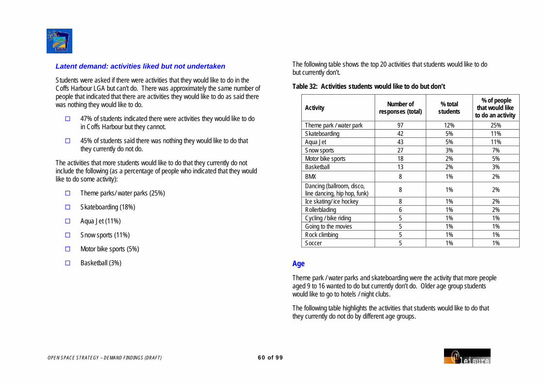
OPEN SPACE STRATEGY – DEMAND FINDINGS (DRAFT) 60 of 99
Latent demand: activities liked but not undertaken
Students were asked if there were activities that they would like to do in the Coffs Harbour LGA but can't do. There was approximately the same number of people that indicated that there are activities they would like to do as said there was nothing they would like to do.
47% of students indicated there were activities they would like to do in Coffs Harbour but they cannot.
45% of students said there was nothing they would like to do that they currently do not do.
The activities that more students would like to do that they currently do not include the following (as a percentage of people who indicated that they would like to do some activity):
Theme parks/ water parks (25%)
Skateboarding (18%)
Aqua Jet (11%)
Snow sports (11%)
Motor bike sports (5%)
Basketball (3%)
The following table shows the top 20 activities that students would like to do but currently don’t.
Table 32: Activities students would like to do but don’t
Activity Number of responses (total)
% total students
% of people that would like
to do an activity Theme park / water park 97 12% 25% Skateboarding 42 5% 11% Aqua Jet 43 5% 11% Snow sports 27 3% 7% Motor bike sports 18 2% 5% Basketball 13 2% 3%
BMX 8 1% 2%
Dancing (ballroom, disco, line dancing, hip hop, funk) 8 1% 2%
Ice skating/ ice hockey 8 1% 2% Rollerblading 6 1% 2% Cycling / bike riding 5 1% 1% Going to the movies 5 1% 1% Rock climbing 5 1% 1% Soccer 5 1% 1%
Age
Theme park / water parks and skateboarding were the activity that more people aged 9 to 16 wanted to do but currently don’t do. Older age group students would like to go to hotels / night clubs.
The following table highlights the activities that students would like to do that they currently do not do by different age groups.

OPEN SPACE STRATEGY – DEMAND FINDINGS (DRAFT) 61 of 99
Table 33: Activities students would like to do but current do not, by age group:
9 – 12years 13 – 16years 17 – 19years No age listed
Activity No. % Activity No. % Activity No. % Activity No. %
Theme park/Water park 34 14% Theme park/Water park 86 20% Going to hotels/Night clubs 3 7% Theme park 6 6%
Skateboarding 10 4% Skateboarding 29 7% Athletics 1 2% Snow Sports 4 4%
Motor bike sports 8 3% Snow Sports 14 3% Basketball 1 2% Basketball 3 3%
Snow Sports 6 3% Motor bike sports 7 2% BMX 1 2% Motor bike sports 3 3%
Ice skating/ ice hockey 5 2% Roller blading/ In line skating
6 1% Going to the movies 1 2% Fishing 2 2%
Basketball 4 2% BMX 5 1% Motor car sports 1 2% Going to the movies 2 2%
Dancing – all types 3 1% Dancing – all types 5 1% Playground activities/ taking children to playgrounds
1 2% Skateboarding 2 2%
Gymnastics 3 1% Basketball 4 1% Roller skating 1 2% Soccer 2 2%
Rock climbing 3 1% Cycling/cycle racing 4 1% Skateboarding 1 2% Party 2 2%
Aquajet 3 1% Paint ball 4 1% Soccer 1 2%
Snowboarding 3 1% Archery 3 1% Sports general 1 2%
Ice skating/ ice hockey 3 1% Water Polo 1 2%

OPEN SPACE STRATEGY – DEMAND FINDINGS (DRAFT) 62 of 99
Encouragement to participate
Main things that would encourage people to do the activities they like but currently do not include:
Facilities more conveniently located (72%)
Better quality facilities (59%)
Provide discounts, less expensive opportunities (56%)
Information about what is available and where (51%)
Availability of suitable programs and classes (48%)
Encouragement by activity
For each activity listed the key encouragement that would allow them to do these activities are listed.
Table 34: Key things that would encourage students to do activities. Theme/ water park Better quality facilities
Facilities more conveniently located eg. Lack of facilities in Coffs Harbour
Provision of transport
Snow sports Facilities more conveniently located
Availability of suitable programs and classes
Skateboarding Facilities more conveniently located
Bigger and better skate park
Street skating
More competitions
Basketball Closer localities
Provide at youth centres
Aqua jet Facilities more conveniently located
Discounted and less expensive activities
Motor bike sports Knowledge of clubs/centre’s that offer activity
Motor bike track for public use

OPEN SPACE STRATEGY – DEMAND FINDINGS (DRAFT) 63 of 99
Table 35 highlights the activities that more students would like to do but do not do and the things that would encourage them to do these activities.
Table 35: Activities that students would like to do but do no do and the things that would encourage them
Activity
Avail
abilit
y of s
uita
ble
prog
ram
s and
clas
ses
Info
rmat
ion
abou
t wha
t is
avail
able
and
wher
e
Assis
tanc
e to
learn
a ne
w ac
tivity
/ dev
elop
conf
iden
ce
in d
oing
this
activ
ity
Put m
e in
touc
h wi
th o
ther
s wh
o ha
ve th
is in
tere
st, o
r so
meo
ne to
go
with
Put m
e in
touc
h wi
th a
club
/ ce
ntre
that
offe
rs th
is ac
tivity
Prov
ide s
ome a
ssist
ance
to
get t
here
and
durin
g th
is ac
tivity
Facil
ities
mor
e con
veni
ently
lo
cate
d
Bette
r qua
lity f
acilit
ies
Prov
ide d
iscou
nts,
less
expe
nsive
opp
ortu
nitie
s
Sche
dule
activ
ities
at m
ore
conv
enien
t tim
es
Othe
r
Theme park / water park 19 36 15 24 18 24 69 56 46 22 12 Skateboarding 8 12 12 11 17 6 26 26 11 8 9 Aqua Jet 7 13 5 13 7 6 21 19 22 9 6 Snow sports 18 9 12 11 14 9 21 13 12 9 3 Motor bike sports 5 9 6 6 10 5 7 6 6 4 4 Basketball 6 5 7 6 7 5 7 2 8 6 4
BMX 1 2 3 1 3 2 6 3 3 2 0 Dancing (ballroom, disco, line dancing, hip hop, funk) 5 5 5 6 5 4 6 5 6 4 0 Ice skating/ ice hockey 7 5 5 3 2 3 4 3 7 7 0 Rollerblading 5 4 3 2 3 2 3 2 5 1 1 Cycling / bike riding 1 0 0 0 0 0 4 2 1 0 0 Going to the movies 1 0 0 0 1 0 3 2 2 0 0 Rock climbing 2 2 1 2 1 2 3 3 3 2 0 Soccer 2 1 2 3 2 1 2 3 2 2 0

OPEN SPACE STRATEGY – DEMAND FINDINGS (DRAFT) 64 of 99
Use of facilities
Students were asked to indicate how often they use different types of facilities in Coffs Harbour for recreation and sport.
Outdoor sports fields are used most often by students, 49% of students indicating they use these facilities “Often“ (21+ times per year). Other recreation facilities that students used often or sometimes (7 – 20 times) include:
Outdoor sports fields
Cinemas
Lake / foreshore
Local parks
The sporting facilities that are not used by students include lawn bowls facilities and community vegetable gardens/ farms where 74% of students said they “Never” used these facilities.
Students also never or seldom used historic buildings/ museums, equestrian trails/ areas and indoor roller sports/ skate facilities.
The following table shows the facility types in Coffs Harbour and how frequently they are used by students.
Other facilities that were listed by students as being used often include:
Beaches (35 responses; 29 used often)
Plaza and shopping centre (22 responses; 20 used often)
Ten pin bowling (9 responses; 2 often)
Motor bike tracks (6 responses; 4 often)
Table 36: Frequency of recreational facilities used
Type of recreation facility
Neve
r
Seld
om
(1-6
tim
es)
Som
etim
es
(7-2
0 tim
es)
Ofte
n (2
1+
times
)
Outdoor sports fields 9% 19% 20% 49% Cinemas 4% 21% 37% 35% Lake / foreshore 7% 23% 34% 33% Local parks 8% 35% 28% 27% Bicycle / shared path 21% 29% 23% 23% Indoor court sport facilities 29% 29% 15% 25% Swimming centre 21% 38% 21% 17% Bushland reserves / conservation areas 22% 36% 22% 17% Walking trails 23% 37% 21% 17% Larger parks 18% 42% 22% 14% Picnic areas 17% 44% 26% 10% Playgrounds 22% 38% 21% 14% Social / services club / gaming facility 27% 36% 20% 13% Fitness centre / gymnasium 39% 31% 14% 14% Theatres, music or dance halls 39% 31% 13% 14% Ice skating centre 28% 47% 14% 8% Boating facilities 39% 31% 16% 9% Libraries 37% 38% 16% 7% Outdoor skate park 48% 24% 12% 13% Tennis courts 42% 32% 12% 11% Ornamental or botanic gardens 47% 42% 6% 2% Art and craft centres or galleries 57% 30% 6% 4% Indoor roller sports / skate facility 65% 21% 6% 7% Equestrian trails / areas 66% 19% 6% 5% Historic buildings / museums 64% 27% 4% 2% Community vegetable gardens / farms 74% 16% 3% 4% Lawn bowls facility 74% 16% 3% 3% Others 1% 2% 2% 13%

OPEN SPACE STRATEGY – DEMAND FINDINGS (DRAFT) 65 of 99
Activities outside Coffs Harbour
Students were asked to indicate if they travel more than 10km to do any activities in Coffs Harbour.
55% of students travel more than 10km to do recreation/sport.
43% of students do not travel more than 10km.
Soccer grounds, the beach, basketball stadiums and Park Beach Plaza were the facilities that more students travelled more than 10 km to use for recreation. These along with others are shown in the following table.
Table 37: Facilities travelled more then 10km to use
Facility Number %
Soccer ground 89 10.8% Beach 75 9.1% Basketball stadium 38 4.6% Park Beach Plaza 37 4.5% Sports Central (indoor courts) 35 4.3% Cinema 30 3.6% Skate park 29 3.5% Tennis courts 20 2.4% Netball courts 19 2.3% Football ground 18 2.2% Swimming pool 18 2.2% Jetty 17 2.1% PCYC 12 1.5% Cricket ground 12 1.5% Ice skating rink 12 1.5%
Location
The soccer fields that people are travelling for more than 10km to use include:
High Street in Woolgoolga
Macksville
Polwarth Drive in Coffs Harbour
Maclean St in Coffs Harbour
Orara Valley
The beaches that students are travelling more than 10km to use include:
Sawtell – 22 responses
Coffs Harbour – 8 responses
Diggers Beach – 7 responses
Coffs Harbour Jetty – 6 responses
The basketball stadiums students are travelling more than 10km to use include:
Bray St – 32 responses
Grafton – 2 responses
Orara – 2 responses
The skate parks that students travel more than 10km to use include:
Bray St. Coffs Harbour – 12 responses
Woolgoolga – 10 responses
Toormina – 5 responses

OPEN SPACE STRATEGY – DEMAND FINDINGS (DRAFT) 66 of 99
The tennis courts that students travel more than 10km to use include:
West Side tennis courts – 5 responses
Curacoa Street, Coffs – 4 responses
The netball courts that students travel more than 10km to use include:
Murray Drive – 10 responses
Additional recreation facilities needed
Additional skate parks and sporting fields are the additional outdoor recreation facilities that most students think should get highest priority if funding became available. Approximately 15% of students highlighted these facilities as the single highest priority. Swimming pools (9%), lake/ foreshores (8%) and bushland reserves/ conservation areas (5%) were also high priority.
The following table shows the outdoor recreation facilities that students believe should get highest priority if funding became available.
Table 37a: Outdoor recreation facilities that students believe should get highest priority if funding becomes available
Facility type Number % Outdoor skate park 134 16.3% Outdoor sports fields 120 14.6% Other 90 10.9% Swimming centre 72 8.7% Lake / foreshore 66 8.0% Water or theme park (Aqua Jet) 50 6% Bushland reserves / conservation areas 42 5.1% Larger parks 36 4.4% Bicycle / shared path 30 3.6% Equestrian trails / areas 30 3.6% Tennis courts 30 3.6% Boating facilities 27 3.3% Local parks 23 2.8% Playgrounds 21 2.6% Picnic areas 21 2.6% Walking trails 14 1.7% Ornamental or botanic gardens 10 1.2% Motor Bike Track 9 1.1% Bike path and trails 8 1% Community vegetable gardens / farms 6 0.7% Lawn bowls facility 1 0.1%

OPEN SPACE STRATEGY – DEMAND FINDINGS (DRAFT) 67 of 99
Cinemas were the single indoor recreation facility type that students indicated should be highest priority, highlighted by 25% of students. Indoor court sport facilities and indoor roller sport/ skate facilities were also high priority (14% and 12% respectively).
The following table shows the indoor recreation facility types that students indicated should be highest priority for funding.
Table 38: Indoor recreation facility types that students indicated should be highest priority for funding
Facility Type Number % Cinemas 204 24.8% Indoor court sport facilities 114 13.9% Indoor roller sports / skate facility 97 11.8% Ice skating centre 72 8.7% Fitness centre / gymnasium 71 8.6% Theatres, music or dance halls 63 7.7% Other 51 6.2% Libraries 25 3.0% Art and craft centres or galleries 24 2.9% Social / services club / gaming facility 22 2.7% Historic buildings / museums 17 2.1% Community Centres / halls / houses 15 1.8%
Other indoor facilities included shopping centres (1%) and theme parks (0.5%).
Local Area Parks
The students were asked to discuss the park they use most often in their local area.
Jetty Foreshores Park and Englands Park were listed as being used most by students.
The ten parks that were listed most as being parks used by students in their local area are in the following table.
Table 39: Main local parks use by students Park Number Percent Jetty Foreshores & Park 78 9% Englands Park 44 5% Sandy Beach Park 24 3% Woolgoolga Beach Reserve 23 3% Richardson Park 22 3% Emerald Beach Park 20 2% Boronia Park 19 2% Ayrshire Park 18 2% Coramba Park 16 2% Skate parks 16 2% Bray Street 15 2%

OPEN SPACE STRATEGY – DEMAND FINDINGS (DRAFT) 68 of 99
Reasons for using park
The location of the park was the main reason that students used their local parks over other. Specifically because the parks was:
Close to home – 31%
Close to the beach – 10%
Other reasons for using the local parks included the park having good facilities / equipment (6%), school sport or sports club playing there (6%), fun and enjoyment (6%).
The following chart shows the main reasons for students choosing their local parks.
Figure 5: Reasons students choose to use a local park over others
Main activities
The main activities that students usually do at the local park they use most often are:
Soccer – 19%
Picnic/ BBQ’s – 17%
Play (children's games/ park activities) – 15%
Swing – 13%
Swimming – 13%
The 15 main activities that more people do at their local parks are listed in the following table.
Table 40: Activities students do at their local parks Activity Number % Soccer 154 19% Picnic/BBQs 139 17% Play (children's games/ park activities) 120 15% Swing 108 13% Swimming 105 13% Football 91 11% Playground activities/taking children to the playgrounds 86 10% Cycling/cycle racing 82 10% Entertaining / socialising 80 10% Skateboarding 62 8% Jogging/running 54 7% Walking 52 6% Cricket 50 6% Dog walking 47 6% Athletics 45 5%

OPEN SPACE STRATEGY – DEMAND FINDINGS (DRAFT) 69 of 99
How often?
Local parks that students use most often are used 2 – 3 times per week by 25% of students. A further 20% of students would use these parks weekly.
The following chart highlights how frequently students use their local park.
Figure 6: Frequency of use of local park
Benefits of park experiences
The main benefit students seek from the park they visit most.
Socialising with family and friends (70% of students).
Keeping physically fit / exercising/ physical fitness – (64% and 62% respectively).
Students also added “having fun” to the list of experiences sought in parks.
The following table shows the level of importance of park experiences for students.
Table 41: Importance of park experiences
Park experiences
Of n
o im
porta
nce
Of lit
tle
impo
rtanc
e
Impo
rtant
Socialising with family / friends 5% 13% 70% Keeping physically fit / active 5% 19% 64% Exercise / physical fitness 6% 19% 62% Things for children to do / play 12% 20% 54% Being entertained 11% 25% 49% Resting / relaxing 19% 27% 41% Escaping the pressures of daily life 21% 26% 37% Being able to see lots of activity / people together 18% 29% 36% Seeking physical challenges 24% 26% 34% Reducing tension and mental stress 24% 26% 32% Appreciating / getting in touch with nature 32% 29% 23% Expressing cultural / family traditions 48% 22% 13% Being on your own 47% 27% 8%

OPEN SPACE STRATEGY – DEMAND FINDINGS (DRAFT) 70 of 99
All Parks
Features: Importance & Performance
Respondents were asked to consider all the parks in the Coffs Harbour Local Government area, and the importance of various park features.
Importance
Park toilets, places to play sport socially and shelter from the weather/ sun were the park features that more students listed as very important or important.
Boat launching, trails for walking and horse riding and flowering plants were the park features that students saw to be of little or no importance.
Other park features that respondents indicated were important included skate parks and having the park close to shops.
Performance
Of the same list of park features respondents were asked to rate Council’s performance in providing these features6.
Seating/ rest, sports, toilets and places to play sport socially were the park features that students implied were best performed by Council.
6 Due to survey design these figures should be reviewed with caution as the heading indicated levels of “Importance” rather than “Performance”
Provision Gap
The gap between the importance of park features and the provision by Council indicates area where Council could improve facilities.
The park features that have the largest gap between the importance and provision by Council are:
High quality maintenance.
Away from traffic.
Unspoiled environment.
Access for prams / wheelchairs / people with disabilities.
Shelter from the weather / sun.
The following table highlights student’s responses to the importance and provision of park features.

OPEN SPACE STRATEGY – DEMAND FINDINGS (DRAFT) 71 of 99
Table 42: Importance of park features
Park Features
Of n
o im
porta
nce
Of lit
tle
impo
rtanc
e
Impo
rtant
Very
im
porta
nt
Toilets 4% 8% 25% 56% Places to play sport socially 6% 8% 26% 52% Shelter from the weather / sun 4% 10% 30% 48% Unspoiled environment 5% 10% 32% 42% Access to water / water features 5% 11% 34% 43% Seating / rest spots 5% 12% 34% 43% Away from traffic 5% 13% 30% 44% Areas for ball games 6% 12% 37% 39% High quality maintenance 6% 13% 28% 42% Large shady trees 5% 12% 41% 36% Access for prams / wheelchairs / people with disabilities 10% 10% 23% 47%
Close to home 6% 19% 34% 35% Paths for cycling / skating 8% 17% 33% 35% Beach access 9% 17% 28% 38% Areas for large social gatherings 8% 17% 33% 34% Lighting 9% 18% 33% 32% Irrigated green lawns 10% 17% 30% 32% Playground 9% 21% 32% 31% Areas to walk the dog 13% 19% 28% 32% Natural bushland 10% 25% 32% 25% Scenery or views 10% 23% 36% 23% Sporting / cultural events to watch 14% 26% 27% 24% Animals or birds to observe 15% 26% 28% 23% Close to public transport 15% 25% 31% 19% Nature walks 18% 29% 27% 17% Flowering plants 18% 31% 28% 16% Trails for walking / horse riding 21% 27% 25% 17% Boat launching 29% 27% 20% 14%
Table 43: Performance by Council of park features
Park Features
Not g
ood
at al
l
Not v
ery
good
Quite
go
od
Very
goo
d
Beach access 2% 6% 45% 35% Scenery or views 2% 11% 46% 26% Close to home 4% 10% 47% 25% Natural bushland 1% 13% 53% 20% Areas for ball games 1% 12% 48% 18% Areas for large social gatherings 3% 11% 47% 19% Away from traffic 2% 13% 56% 15% Places to play sport socially 3% 11% 46% 14% Playground 2% 14% 47% 16% Large shady trees 5% 15% 53% 17% Animals or birds to observe 3% 17% 46% 17% Nature walks 2% 20% 44% 16% Unspoiled environment 4% 16% 56% 12% Seating / rest spots 3% 19% 52% 14% Toilets 6% 20% 44% 20% High quality maintenance 4% 20% 50% 11% Access to water / water features 5% 21% 40% 15% Sporting / cultural events to watch 4% 17% 38% 10% Flowering plants 5% 21% 38% 12% Access for prams / wheelchairs / people with disabilities 5% 16% 39% 7% Shelter from the weather / sun 7% 29% 41% 10% Irrigated green lawns 8% 17% 38% 4% Areas to walk the dog 9% 18% 29% 9% Lighting 8% 24% 36% 5% Paths for cycling / skating 11% 24% 31% 9% Close to public transport 9% 21% 29% 6% Trails for walking / horse riding 9% 20% 26% 7% Boat launching 11% 15% 25% 4%
Table 44: Gap between importance and performance of park features

OPEN SPACE STRATEGY – DEMAND FINDINGS (DRAFT) 72 of 99
Park Features
Impo
rtanc
e
Perfo
rman
ce
Gap
High quality maintenance 0.97 -0.19 1.16 Away from traffic 1.02 -0.06 1.08 Unspoiled environment 1.06 -0.02 1.07 Access for prams/ wheelchairs etc 0.95 -0.01 0.95 Shelter from the weather / sun 1.16 0.22 0.94 Access to water / water features 1.06 0.13 0.92 Large shady trees 0.97 0.08 0.89 Irrigated green lawns 0.65 -0.20 0.85 Toilets 1.32 0.48 0.85 Lighting 0.68 -0.16 0.83 Places to play sport socially 1.20 0.42 0.78 Close to home 0.79 0.05 0.74 Paths for cycling / skating 0.77 0.06 0.71 Areas for ball games 0.97 0.36 0.61 Areas to walk the dog 0.52 0.01 0.51 Areas for large social gatherings 0.75 0.24 0.51 Seating / rest spots 1.04 0.53 0.51 Trails for walking / horse riding -0.10 -0.60 0.50 Scenery or views 0.40 -0.02 0.42 Beach access 0.75 0.35 0.40 Sporting / cultural events to watch 0.23 -0.15 0.38 Close to public transport 0.14 -0.17 0.31 Natural bushland 0.42 0.13 0.28 Animals or birds to observe 0.21 -0.07 0.28 Playground 0.58 0.39 0.19 Flowering plants -0.09 -0.26 0.17 Boat launching -0.41 -0.56 0.15 Nature walks -0.04 -0.06 0.01
Future park development
Respondents were asked to consider how strongly they agree to a number of statements regarding the future development, management and future service delivery of parks in the Coffs Harbour LGA.
The statement that was most strongly agreed to was supporting Council banning smoking around playgrounds, sporting fields and family beaches. Almost 70% of all respondents agreed with this statement.
Other statements that were agreed to by a large number of students included:
I would prefer more variety in parks across the City (eg. natural areas, formal gardens, sport and play areas etc).
39% strongly agree, 42% agree
I think it is appropriate to have equipment hire and some recreation activities you pay for at a few major foreshore locations in Coffs Harbour City (eg. learn to surf lessons / bike hire).
37% strongly agree, 39% agree
I think it is appropriate to have equipment hire or some recreation activities you pay for at a few major parks in Coffs Harbour City (eg. bike hire / tai chi classes).
33% strongly agree, 39% agree

OPEN SPACE STRATEGY – DEMAND FINDINGS (DRAFT) 73 of 99
Table 45: Students agreement with Council direction options
Statement
Stro
ngly
Disa
gree
Disa
gree
Agre
e
Stro
ngly
Agre
e
Ban on smoking I would support Council banning smoking around playgrounds, sporting fields and family beaches 4.7% 4.7% 10.2% 68.4%
Park improvements I would prefer more variety in parks across the city (eg. natural areas, formal gardens, sport and play areas etc)
1.8% 6.2% 41.9% 38.5%
Rather than doing small improvements in lots of parks, I think Council should completely upgrade/ develop just a few parks at a time
4.6% 11.7% 35.0% 35.5%
Equipment hire I think it is appropriate to have equipment hire and some recreation activities you pay for at a few major foreshore locations in Coffs Harbour City (eg. learn to surf lessons / bike hire) 3.5% 7.9% 38.6% 37.1%
I think it is appropriate to have equipment hire or some recreation activities you pay for at a few major parks in Coffs Harbour City (eg. bike hire / tai chi classes) 5.0% 8.6% 38.9% 32.9%
Food and beverage in parks
I would prefer to walk 500 metres to a higher quality park rather than having smaller and lower quality parks closer to home
4.3% 10.9% 39.9% 31.0%
I think it is appropriate to provide eat-in food premises at a few major foreshore locations in Coffs Harbour City
5.3% 14.1% 40.9% 25.6%
I think it is appropriate to provide take-away food outlets at a few major foreshore locations in Coffs Harbour City
8.5% 14.7% 38.2% 23.9%
I think it is appropriate to provide eat-in food premises at a few major parks in Coffs Harbour City 7.5% 16.5% 37.7% 23.5%
I think it is appropriate to provide take-away food outlets at a few major parks in Coffs Harbour City 10.2% 19.8% 32.2% 23.8%

OPEN SPACE STRATEGY – DEMAND FINDINGS (DRAFT) 74 of 99
Single improvement to Open Space
Students were asked what single thing Council could do to make their leisure time more fulfilling.
The following is a summary of the top responses:
Clean public toilets – 11%
Skate park – 9%
Clean and maintain areas – 8%
Ban smoking – 7%
Parks and open space areas for picnics/ relaxation etc – 6%
Better facilities including BBQs and playgrounds – 6%
A full listing of the main things that would make students leisure time more fulfilling is displayed in the following table.
Table 46: Single improvements to make students leisure time more fulfilling
Improvements to Open Space Number % Clean public toilets 87 11% Skate park 76 9% Clean and maintain area 68 8% Ban smoking 59 7% Parks and open space areas for picnics/ relaxation etc 49 6% Better facilities incl BBQ, playgrounds 48 6% Theme park/ water park 45 5% More trees/ greener grass/ shade 42 5% Outdoor playing fields 36 4% Clean drinking water 23 3% More interesting activities/ parks 22 3% Take away food shop 20 2% Outdoor sports courts 17 2% Dogs 16 2% Bike / BMX track/ jumps 16 2% Sporting facilities 14 2% Bike hire/ other activities (horse riding, surf lessons) 14 2% Rubbish bins 11 1% Plaza 9 1% Swimming pools 9 1%

OPEN SPACE STRATEGY – DEMAND FINDINGS (DRAFT) 75 of 99
Additional comments
Sporting Infrastructure Bigger basketball courts
Bigger skate park
More football fields
Swimming pool with a slide
BMX track required
Better maintenance of sporting facilities
Synthetic athletics track
Parks and Gardens Make the parks bigger
Clean toilets
Remove graffiti
More bins required including recycling
More shade over sand pits and slides
More variety of play equipment for variety of ages
More areas where dogs are allowed
Plant more trees
Other Infrastructure Water/ theme park needed
Improve Sawtell cinema
More BBQ facilities
Fix road surfaces to stop bike accidents
Better bike paths required
Services Provide equipment for hire
Ban smoking and alcohol
Better services for people with a disability
Provide music festivals, concerts and shows
More entertaining activities for young adults
Offer classes such as tai chi and yoga
Public transport
Better patrolling of beaches
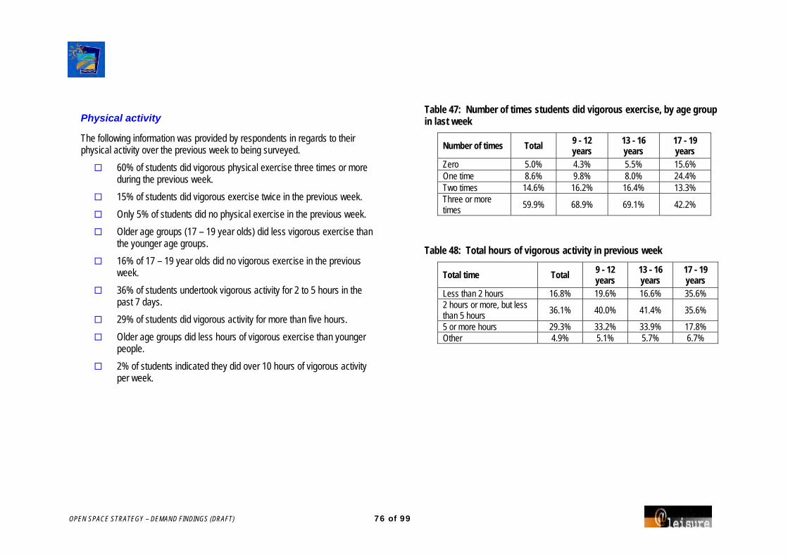
OPEN SPACE STRATEGY – DEMAND FINDINGS (DRAFT) 76 of 99
Physical activity
The following information was provided by respondents in regards to their physical activity over the previous week to being surveyed.
60% of students did vigorous physical exercise three times or more during the previous week.
15% of students did vigorous exercise twice in the previous week.
Only 5% of students did no physical exercise in the previous week.
Older age groups (17 – 19 year olds) did less vigorous exercise than the younger age groups.
16% of 17 – 19 year olds did no vigorous exercise in the previous week.
36% of students undertook vigorous activity for 2 to 5 hours in the past 7 days.
29% of students did vigorous activity for more than five hours.
Older age groups did less hours of vigorous exercise than younger people.
2% of students indicated they did over 10 hours of vigorous activity per week.
Table 47: Number of times students did vigorous exercise, by age group in last week
Number of times Total 9 - 12 years
13 - 16 years
17 - 19 years
Zero 5.0% 4.3% 5.5% 15.6% One time 8.6% 9.8% 8.0% 24.4% Two times 14.6% 16.2% 16.4% 13.3% Three or more times
59.9% 68.9% 69.1% 42.2%
Table 48: Total hours of vigorous activity in previous week
Total time Total 9 - 12 years
13 - 16 years
17 - 19 years
Less than 2 hours 16.8% 19.6% 16.6% 35.6% 2 hours or more, but less than 5 hours 36.1% 40.0% 41.4% 35.6%
5 or more hours 29.3% 33.2% 33.9% 17.8% Other 4.9% 5.1% 5.7% 6.7%

OPEN SPACE STRATEGY – DEMAND FINDINGS (DRAFT) 77 of 99
Demographic information
The following information was collected about the respondents.
The largest number of respondents (37%) have lived in Coffs Harbour for 11 to 15 years.
33% of student respondents live in the Coffs Harbour/ Korora/ North Boambee Valley.
22% of students lived in the Boambee/ Boambee East/ Toormina/ Sawtell region.
Over 50% of respondents were aged 13 – 19 years.
Only 5% of students were in the 17 to 19 year age group.
Table 49: Locality of residence: student respondents
Area name Number % Red Rock/ Corindi Beach 19 2% Arrawarra/ Mullaway/ Safety Beach/ Woolgoolga 59 7% Sandy Beach/ Emerald Beach 53 6% Moonee Beach/ Sapphire Beach 29 4% Korora/ Coffs Harbour/ North Boambee Valley 271 33% Boambee East/ Toormina/ Sawtell/ Boambee/ Bonville 184 22%
Coramba/ Nana Glen/ Ulong/ Lowanna/ Karangi 81 10% No suburb/ outside area 21 3%
Table 50: Number of student respondents by age group
Age group Number % 9 - 12 years 235 29% 13 - 16 years 440 53% 17 - 19 years 45 5% Not identified 103 13%

OPEN SPACE STRATEGY – DEMAND FINDINGS (DRAFT) 78 of 99
APPENDIX 3 NOTES FROM SCHOOL PRINCIPAL
INTERVIEWS
School principals in Coffs Harbour were interviewed by telephone to determine open space and recreation issues along with facility use in Coffs Harbour.
The following information is a summary of the key findings.
School numbers are stationary or projected to increase over the next few years.
School open space facilities
All schools interviewed have ovals (one or more) of varying size and quality.
All schools have some type of garden area including rain forest areas, native gardens, vegie gardens and grassed areas.
A number of schools have small farms on or off site.
Most schools have at least one basketball or tennis court.
Some courts under cover.
Some reported to be in poor condition.
Many of the school facilities are used by the community and are likely to continue to be used in the future.
The facilities not used by the community are unsuitable and would need improvement before increasing use.
A joint funded venture is suggested to provide an outdoor auditorium/performance space in the northern beaches. That is a community hall with covered stage area for concerts, opera in the park, carols, etc.
Most schools have no current development projects.
Off site facility use
All schools use open space and recreation facilities off site including:
Ovals/ football fields
Sports courts – netball and basketball
Showgrounds
Tennis clubs
Sports centres
Swimming pools
Beaches
Botanic Gardens
Most schools report the facilities off site to be excellent, however there are some facilities that were commented on:
Corindi Hall – needs refurbishing.
Woolgoolga Swimming Pool – only 25m and too small for community.
Coffs Harbour Swimming Pool – booking difficult and expensive to use regularly.
Coramba Sports Ground – toilet facilities appalling.
Most schools have an informal arrangement with Council to use facilities however there are a couple of schools with either a licence or lease agreement with the Council.
Relationship with outside organisations
Most school have no formal relationship with outside organizations however there are some partnerships including:
Halls hired by sports clubs.

OPEN SPACE STRATEGY – DEMAND FINDINGS (DRAFT) 79 of 99
Active after school program.
School working with Rivercare.
Schools working with PCYC and Sportz Central.
Sports coaches used to run clinics and programs.
Students with disabilities
Almost all schools have children with disabilities.
Most schools have full inclusion of students with a disability however not for all activities.
Depends on time available for assistance by teachers aides.
Some students in wheelchairs cannot access a range of activities and have alternate activities arranged for them.
Access can be difficult through a number of school areas with toilet facilities often not accessible.
Key open space issues
Open space issues identified at schools include:
Transportation to and from venues.
Cover over sports courts for wet weather and sun protection.
Shelter and shade at sports venues.
Updating of ovals.
Better facilities closer to schools.
Open space issues for all Coffs Harbour Schools include:
Costs associated with sports including hire, entrance fees and transportation.
Shelter at venues.
Synthetic athletics track and field facility.
Lack of space in general.
Key issues for school aged children include:
Transportation and access to facilities and associated costs.
Shelter at sports grounds.
Safer access to bicycle ways and footpaths.
Better skate facility or roller rink.
Suggested development/ solutions
The following suggestions were given as to how to address the key issues.
Fast track Hogbin Drive development into an athletics synthetic track with grand stand.
Lower costs for school groups.
Subsidised sports fees/ uniforms.
Waive all entrance fees for children using open space / sporting facilities.
Build shade structures and plant more trees.

OPEN SPACE STRATEGY – DEMAND FINDINGS (DRAFT) 80 of 99
Community transport.
Allow use of school passes on weekends.
Move the skate park from Bray Street to a more appropriate venue.
Additional comments
Council is developing a supportive, cooperative, helpful role in these areas.
We very rarely see or hear from council. We are flat out getting them to mow.
A major concern: Woolgoolga Pool is far from adequate for the size of schools and community; and cost to access facilities in Coffs is too expensive.
We hope that this survey helps in the provision of adequate Open Space for all schools and the community of Coffs Harbour area.

OPEN SPACE STRATEGY – DEMAND FINDINGS (DRAFT) 81 of 99
APPENDIX 4 NOTES FROM INTERNAL STAKEHOLDER
WORKSHOP 7/03/07
Part 1. Presentation by @leisure
This Part discusses open space planning, in particular the context and observations by @leisure.
Context: Urban development public policy context
Mixed land uses to create more liveable communities with less reliance upon the car.
Compact building design to limit sprawl and reduce cost of services & reduced width of road reservations.
Create housing choices; not every one wants to maintain a backyard, but land values mean most people in future won’t have one.
Walkable neighbourhoods; linked networks of footpaths, and trails. A response to the cost of inactivity, environmental responsibility, and increasing desire to feel connected with their community.
Conserving neighbourhood character and open space to foster distinctive, attractive communities with a strong sense of place.
Preserve open space, farmland and natural beauty in critical environmental areas
About open space Consider open space as a legitimate land use. It isn’t free land. Don’t think of it as undeveloped or vacant land. In fact its value is often higher when undeveloped. It is indispensable. It has economic, social and environmental benefits. It is not homogenous, it can’t therefore be assessed just in terms of
quantity. Don’t think of open space in terms of being active or passive. Think of quality in terms of “fit for purpose”. It’s a complex issue. The greatest success is had when there is a commitment by all
parties to a plan. Context: With increasing density and population there may be:
A reduction in private open space. An increase in demand for sport and leisure activities in public space. Potential for increased stress - through noise, lack of privacy,
loneliness. Less flexibility in neighbourhood design to respond to change. Limited space for incidental play and physical exercise.

OPEN SPACE STRATEGY – DEMAND FINDINGS (DRAFT) 82 of 99
What makes a good Open Space Plan?
Detailed knowledge about existing supply Strong demand analysis A comparison of demand and supply to establish gaps & issues An analysis of Council’s ability to carry out its mandate Strategy: what are the key goals & strategies to address them An implementation plan with actions: time frames, priorities,
responsibilities (+other providers’ roles) and likely costs A mechanism for ongoing evaluation of demand and supply and plan
actions.
A good plan should deliver… A network of accessible, high quality open space, sport and
recreation facilities that are: ▪ able to meet the needs of residents and visitors ▪ fit for purpose ▪ economical ▪ environmentally sustainable
A process to make decisions about future provision An appropriate balance between provision and enhancement Clarity and reasonable certainty for developers and landowners in
relation to the requirements and expectation placed on planning authorities.
Classifying open space
It is suggested that each space is classified on the basis of:
Primary Purpose
Landscape Setting, and Catchment (how far people come)
Also it is important to determine the model of open space provision that is suitable to the nature of the Settlement Type. Settlement types need to be defined for Coffs.
(would they be based on zone? Ie Mixed use, Residential, Landscape residential, Rural), or
Related to lot size/ density?, or Rural Hamlet, Coastal village, urban area.
For example; what you would provide with further development in a rural hamlet will generally be expansion or embellishment of a central space: probably the hall, reserve and pony club, all clustered in the same location. In this instance you would be taking small parcels of land for play facilities, as may be the case in an urban area where you may want a neighbourhood park within the walking distance of every residence.
OPEN SPACE STRATEGY – DEMAND FINDINGS (DRAFT) 83 of 99
Typical Classifications for adaptation to Coffs Harbour
Functions or purposes Landscape setting Play Bushland/ Woodland/ Forest
Social /family recreation Exotic, ornamental or specimen plantings
Community horticulture Open grassy area
Cemetery/ memorial/ remembrance Specialised Sports Surfaces (eg synthetic, enclosed)
Ornamental /botanic garden Native grassland/ wetland
Access way/ trail Lawn or Managed Sports Turf
Sport Open parkland
Flora/ Fauna Conservation Creek/ river corridor/
Wayside stop Foreshore/beach
Conservation of cultural heritage Rough natural area
Drainage /Floodway Paved area
Visual Amenity Vegetable garden/ agriculture
Relaxation/Contemplation/ Escape Tree Plantation
Civic forecourt /mall
Lookout/ Ridgeway/ skyline reserve
Water based Recreation
Buffer
Using “primary function” it is easy to get a quick snap shot of distribution and range of functions etc, across the council area. For management and master plans you would consider that most reserves have multiple functions or at least a primary and secondary.
Also note that a reserve that is classified as district or regional will always serve a local function too and therefore where possible this should be designed in, as Council won’t ever be in the position to provide an extra local reserve as well as a district facility in the same neighbourhood. There will however be constraints on how you can encourage local use when it is a regional sports facility that is fenced, or has high-level surfaces.
Catchment Regional District Neighbourhood
How do we evaluate open space? Evaluation criteria must first be derived from the specific benefits of
open space. These benefits determine the range & type of functions of open
space in the network, therefore we must identify: ▪ The primary purpose or function of each open space.
Experiences are influenced largely by the landscape setting, therefore we must identify: ▪ The landscape setting of each space. ▪ Features relevant to users in the catchment (ie visitors).
After considering benefits and experiences then we factor in: ▪ Public policy. ▪ Local demand/ demographics and culture. ▪ The characteristics of the physical resource.
Examples of benefits Child (human) Development
▪ Independence and self-awareness. ▪ Risk/challenge. ▪ Ability to explore new things. ▪ Un-predictability.

OPEN SPACE STRATEGY – DEMAND FINDINGS (DRAFT) 84 of 99
▪ Territoriality. ▪ Privacy/quiet. ▪ Creativity. ▪ Ability to manipulate the environment. ▪ Environment as the inspiration and source of treasures. ▪ Sociability and ability to convey trust and confidence. ▪ Familiarity - where strangers and risks can be encountered. ▪ Interaction with different people. ▪ Leadership support & guidance. ▪ Meeting with peers. ▪ Co-operation and sharing. ▪ Co-ordination and physical agility.
Healthy Living City ▪ Clean air. ▪ Exercise. ▪ Psychological need for contact with nature. ▪ Personal space - relief from overcrowding and urban induced
stress. ▪ Self sufficient neighbourhoods. ▪ Access and familiarity with services and facilities.
Education ▪ Spatial knowledge and sense of direction. ▪ Access to a range of life forms, and ▪ Ability to interact with those environmental sustainability.
Civic Pride
▪ Protection of sites of significance. ▪ Connection and understanding of heritage and ancestral roots. ▪ Pleasing and ornamental decoration. ▪ Visual quality. ▪ Community gathering point.
Classifying open space
Evaluation criteria need to be specific to the purpose of the space. Evaluation criteria / minimum service standards include:
1. Location convenience/accessibility. 2. Cluster size and complexity. 3. Viability /sustainability. 4. Quality (fit for primary purpose). 5. Diversity.
Location Convenience /Accessibility
▪ How far will people be prepared to travel to type of park (distance threshold)?
▪ What is the priority for types of park to serve residential areas ▪ Access for different types of users.
Cluster Size and Complexity ▪ What elements and facilities should relate to what to maximise their
value.
Diversity ▪ What range of functions and setting types can be provided within
in the context of the local physical and social environment. ▪ The range of opportunities / age groups catered for at the one
site & over the entire network.
Quality (fit for purpose) ▪ Requirements specific to the needs of users (age/ target group)
and the activity. ▪ Attributes commonly expected or sought after by the population. ▪ Design. ▪ Safety. ▪ Management.
Viability /sustainability

OPEN SPACE STRATEGY – DEMAND FINDINGS (DRAFT) 85 of 99
▪ What are the core services and scale of work can we afford. ▪ No of people / likely demand / size of catchment.
Demand and supply
We can estimate demand by: Determining the benefits people seek and provide specific types of
spaces that reflect these. Projecting the activities likely to be undertaken by the future
population. Anticipating the population’s response to supply.
We can analyse supply by: Classifying spaces according to purpose, landscape setting
/catchment. Reviewing:
▪ Range of opportunities by classification & settlement type. ▪ Distribution/connectivity/ convenience and gaps. ▪ Quality and quantity.
Supply For each specific open space purpose there is:
▪ Quantitative & qualitative criteria to determine ‘fit for purpose’. ▪ A desirable distance threshold to potential users. ▪ Design, accessibility and core service guidelines that can be
established.
A plan should: Assess opportunities already available before identifying new.
Assess not only environmental conditions, but also leisure potential. Evaluate the quantity, quality, distribution and value of existing open
space before design. Planning can only be cost effective with:
▪ Up-to-date inventories of POS by purpose. ▪ Open space layers in GIS system.
Supply Questions Does density change anything?
▪ Base provision on ultimate housing density. ▪ Different distance thresholds, design criteria. ▪ (Front the street) and treatment of streetscapes. ▪ The need for communal open space in high density
developments resorts or retirement villages. ▪ Actual demand for public open space by residents.
What about private open space? ▪ How to monitor the changing size and uses of private open
space. ▪ Whether to treat public open space differently where dwellings
lack private yards. ▪ What about the beach?
Observations for the site inspections
Good level of modeling for housing demand: ▪ Could add open space demand
Key strengths: ▪ High environmental and aesthetic quality ▪ Provision of bushland, beaches
Local level provision in residential areas needs more emphasis: ▪ Social /family recreation ▪ Off road trails

OPEN SPACE STRATEGY – DEMAND FINDINGS (DRAFT) 86 of 99
▪ Foundation level sport
Delivering sport cost effectively
A hierarchy of facilities N,D,R or F,P,P,E Multiple fields & 2 codes per site-1 set of change/ club rooms. Foundation level sport, ensure life long patterns are established
early: school / neighbourhood park. Make sports convenient to residents; serve sports fields with ORT &
overlook playing fields. Indoor facilities not dependant on open space. Level of development. Collocation: sport with sport, sport with school, sport with community
centre, sport with shopping; public with private. How many and where?
PART 2. Workshop Internal Staff Workshop
What this project is about
Aims in the brief Guide future provision and management for next 5-10 years (25). Provide a diverse range of experiences / opportunities -equitable
distribution, and access to open space. Facilitate community enrichment - ensuring ongoing improvements to
sport / rec / enviro / opportunities. Develop appropriate functional hierarchy/classification/ settings. Develop an Action Plan of reserve and infrastructure improvement. Understand the open space needs of the community (provision /use). Identify broad issues/ strategies /actions for resolution. Activate open space, especially for youth older adults. Identify opportunities for development / acquisition /disposal. To promote individual character of areas / villages and community
cohesiveness. To gain support of community and stakeholders (internal and
external). Identify leaders/partners in the community to promote recreation. Consider program opportunities. Develop planning principles related to acquisition of open space. Develop minimum standards of service for existing and new
developments.

OPEN SPACE STRATEGY – DEMAND FINDINGS (DRAFT) 87 of 99
Your expectations
What do you hope to get out of this plan Whole of life costs for development need to be considered Take into account:
▪ The regional strategy. ▪ New standard Enviro Plan template.
Location of where to provide facilities in new areas most important aspect.
Pressure from sports constant: ▪ Easier when principles & vision clear- ▪ This plan may not be able to get down to the detail to resolve
sport specific issues. ▪ Sport- need principles in the plan- leases need to be looked at ▪ Acknowledge extra resources required with new facilities ▪ Sharing important ie sport.
Plan must be achievable. Look at other models to do things or opportunities. Benchmarks? Rural residential areas what is needed where to serve these? Open space a competitive advantage; social etc and environ - needs
to be built into other plans. Use settlement plan as overarching strategy.
Don’t compromise ideals. Acknowledge what we have done. Long length of planning and development phase an issue for
community & Council. Private facilities i.e. golf and caravan parks.
▪ Review future use or need for golf etc, if sold.
Scope of our tasks
Defining goals and objectives. Methods for analysis of supply and demand. Design of surveys. Public consultation process. Design of open space inventory. Hierarchies, classification and functional settings. Development of precincts / localities boundaries. Design of a sport /recreation needs assessment.
OPEN SPACE STRATEGY – DEMAND FINDINGS (DRAFT) 88 of 99
Key Issues to resolve
Visual amenity. Promotion - we need a communication strategy - to go to decision
makers, stakeholders and community. Need to assess land of low value for disposal i.e. single block not
useful and not disposed of last time. Avenue to integrate plan outcomes into policy - once adopted
becomes policy. Value of public open spaces important to highlight in the plan. Infill vs. green fields - needs advice about how to serve each type of
area. Climate change / coastal hazards- info wont be ready for the plan this
year but put in action to be included in the first review.
Definitions /Terminology Use word Open space not “parks or reserves. Needs to be broader
to include paved spaces etc. Check in the template for a definition. @leisure to suggest a definition.
Defining Precincts. Agreed use: what’s in the settlement plan, and if necessary create sub neighbourhood under threat – then there is a consistency.
Catchment Regional. District (what are the districts?) need better definition. Neighbourhood (what are the neighbourhoods?)
What information do you have to contribute?
Regional -Bush Fire Risk Management Plan – ground-truthing needed- first review RFS
Disaster plan; places of assembly etc. Koalas CMAs PAMP Section 94 Management Plan (3 year) Harbour-side concept Social Plan Heritage and cultural NPW regional plan- in progress Estuary management Road transport - Hwy upgrade Flood studies Buffer in SIMP marine park DCP's catchment based Planning at more detailed level WSUD

OPEN SPACE STRATEGY – DEMAND FINDINGS (DRAFT) 89 of 99
APPENDIX 5 NOTES FROM WORKSHOPS HELD
16 - 17 JUNE 2008
The project brief Guide future provision and management for the next 5-10yrs years. Provide a diverse range of experiences and an equitable distribution
of open spaces. Improve sporting, recreation and environmental opportunities for
residents and visitors. Develop an open space classification system. Develop an Action Plan for reserve/ infrastructure improvement. Understand the open space needs of the community. Identify broad issues and strategies/actions for resolution. Activate open spaces, particularly for youth. Identify opportunities for development / embellishment, and
acquisition /disposal of open space. To promote individual character of areas / villages and community
cohesiveness. To gain support of community and stakeholders. Identify leaders in the community to promote recreation. Develop principles related to acquisition. Develop standards of service for new development areas.
@leisure’s role:
Methodology for demand and supply assessment.
Consultations. Implications of findings.
The project so far Open Space inventory prepared. Planning Framework. All open space mapped, and classified
according to function, landscape setting, and catchment. Identified eight planning precincts. Demographics and projections of participation reviewed. Extensive consultation conducted:
▪ Student and householder survey. ▪ Submissions. ▪ Telephone interviews of user and interest groups eg
environment, sports groups, school principals, government agencies.
▪ Previous meeting with staff & agencies.
Issues previously identified Age and income will constrain local demand. High demand for bike paths. Interest in dance theatre/culture. Limited opportunities for people with a disability. Demand for higher maintenance standards in parks - quality in local
parks - Young people don’t use local parks much. Schools not well connected, concern about access to and cost of
swimming and sports facilities, most have gardens, and not very accessible facilities, need shade + shelter, need .
Streetscapes – shared trails and street trees. Foreshore is major recreation setting, then neighbourhood park. High demand for young activities eg skate. Communication- between every one: schools and sport, sport and
Council, agencies and Council etc.

OPEN SPACE STRATEGY – DEMAND FINDINGS (DRAFT) 90 of 99
Sport Demand for additional and higher quality sports facilities. Sports tourism important. Key sports infrastructure needs to be updated & more viable: eg
lights, to Aust. Standards, canteens, change rooms storage etc. Appears sport is mostly played by young people. Shelter and shade needed. Tension between sport and environment. Why don’t many affiliate with NSW peak bodies?
Issues identified Off-road trails. Foreshore development/access. Sport. Young people. Access and inclusion. Streetscapes. Infrastructure and park maintenance. Standards & design guidelines for new development. Addressing changing demand. Schools.
Planning Concern about level of development and want more open space to
compensate. Planning: Neighbourhood and districts do not need to be defined –
just applied category to each open space. Should classify settlement types and define standards for each.
Workshop objectives What do you think the main recreation /open space issues are for
Coffs Harbour - from government perspective? What are the main gaps in policy/ provision of recreational
opportunities in Coffs Harbour? Are there any specific solutions or strategies you would recommend
to address these? What particular planning issues need direction from this plan? What mechanisms could help agencies work better together?
Staff workshop held 16 June 2008
What do you think the main recreation /open space issues are for Coffs Harbour- from a government perspective
Healthy by design. Spreading ourselves too thin. Coastal access – superparks not spread over large areas. Diversity of park use. Strategically place parks – social family recreation. Section 94 funding criteria. Developer parks do not attract families. Should be within residential areas or social hubs. Some parks situated near pub/drs. Sapphire playground big success – close to café. Connectiveness. Need to be involved with the developer especially with what is
classified as parks (drainage reserves) - desilt water reserves eg Corindi.
Development control plans to identify open plan areas.

OPEN SPACE STRATEGY – DEMAND FINDINGS (DRAFT) 91 of 99
What are the main gaps in policy/ provision of recreational opportunities in Coffs Harbour?
Clearer signage and perception. Restricted areas being accessed. Recreational succession – control access. Classify walkways/drainage. Urban runoff drains restricted. BMX trails not mentioned highly in survey. Implications of climate change – risk assessment being undertaken. Linking tourism with off-road trails – old visitor population – over 40. Safer by design. Manufacturers of play equipment have met physical challenge. Asset maintenance of sporting grounds not budgeted for. Minimum size and buffer zones need to be agreed. Regional skate park location.
What are the main gaps in policy/ provision of recreational opportunities in Coffs Harbour?
Swimming pools- poor condition /need new aquatic centre – maintenance and availability for winter months.
Aquajet – desired - new one at Big Banana. Regional skate facility needed. Individual pursuits to be catered for too. Balance infrastructure with maintenance costs – more research
required. Purpose built gallery and library is needed. Natural area policies – pathways interpretation etc. Transportation costs too high. Debate with community on their requirements.
What are the main gaps in policy/ provision of recreational opportunities in Coffs Harbour?
Surplus land is being sold- to fund works. Aging population – review furniture and path design. Parking an issue in many reserves. Lighting – especially at night along walks, toilets, eating areas. Foreshores – lightings and facilities needed. Reclaim railway land? Two planning documents for foreshore area and risk assessment. Revegetation – corridors, buffer land, streetscapes, open land. Need antismoking policy around playgrounds. Priority/dedication for acquisition of cycle ways and natural areas. Check affordability of plan -before putting to public. Assess needs and prioritise. Not enough funds to maintain current public land - don’t want more!! Self-sustain eg sporting groups take over maintenance. Market first what facilities are not fully utilised. Partnership with private companies, user pays. Quantify demand. Education projects, eg managing section of creeks. Community ownership.
Key issues are how do we fund and what do we do first! Need clear vision/ objectives to prioritise - Does it address the following:
Sustainable ▪ Whole of life costs – not necessarily by Council. ▪ Self-sustainable. ▪ Service for future population. ▪ Design to be cost effectively managed. ▪ Can we maintain it?
Diversity existing opportunities.
OPEN SPACE STRATEGY – DEMAND FINDINGS (DRAFT) 92 of 99
Respond to changing demographics ie older people. Market and make sustainable what we have first - that is not being
well. Protect and enhance conservation values. Opportunity to find outside. Attract state funding, rates, user pays, generate funds. Increase participation especially physical activity. Meets current demand – be able to quantify demand. Access and inclusion. Has an educational component. Does it add value to existing. Ability to pay? Meets with vision for Coffs Harbour.
▪ Providing for a diversity of population mix/generations. ▪ Employment opportunities. ▪ Best image.
Healthy commutes. Respecting the natural environment. Range of opportunities. A growth area – not a major city. Greenscape being maintained – conservation of biological heritage. An active city. Connectivity of open space. A socially engaged community.
Other issues, gaps, solutions, implementation mechanisms Safety
▪ Antisocial behaviour. ▪ Bringing people in to private areas - causes problems ie bridge. ▪ Alcohol – in sporting areas and local parks *need to block policy. ▪ Need to feel safe in using spaces and don’t create problems for
adjacent residents.
Funding ▪ Elected members – pro-development. ▪ Raise profile of open space and its benefits. ▪ Other sources of funds, eg cafes. ▪ Allocate new spaces but retain only at a minimum state. ▪ Reduce standard: Developers, Basic level of service. ▪ Triggers – at what point does standard increase? ▪ Shift between different areas, ie more on streetscapes and trails,
less on incidental spaces, play equipment. ▪ Sponsors. ▪ Levies. ▪ Linked to sporting groups. ▪ Source of funds, ie meters on car spaces. ▪ Levy to user as seed funding for state grants. ▪ Reduce mowing.
Implementation ▪ Time frames link with Management Plan. ▪ Implementation of Management Plan – in one branch. ▪ In more than one place – more likely to be funded. ▪ Flexible in different funding scenarios. ▪ Example PAMPS. ▪ Every 4 years – present/educate new council; targeted info for
Council. ▪ Annual briefings. ▪ Annual operation plans. ▪ Minimum amount of equipment. ▪ $ from rates in the area. ▪ Maintenance regimes. ▪ Fencing. ▪ Shade. ▪ Need to change where to except changing maintenance and
regimes.

OPEN SPACE STRATEGY – DEMAND FINDINGS (DRAFT) 93 of 99
Agency stakeholder workshop 16 June 2008
What do you think the main recreation /open space issues are for Coffs Harbour - from a government perspective?
Advance planning/climate change regarding foreshore. Relocation of life saving clubs/infrastructure. Risk management assessment. Large use of unlicensed bikes on government land. Coffs Harbour centre of off road driving. Environmental impact due to off road vehicles. Mark out routes through the Hinterland. Promoting cycle ways. Improve signage to national parks. Improvements limited by cost of maintenance. Multi-use of fire trails to encourage better maintenance. Safety an issue in public parks. Community gardens in demand. Space ratio an issue home/public/streetscape. New developments unable to be accessed by public transport ie cul-
de -sacs. Multi benefits of volunteers in doing weed control, eg Greencorp,
work-for-dole. But include variety of tasks could do tracks and trails picnic facilities etc.
Role of fire trails for other uses- motorised and bicycles. Stewardship – lot of interest but lack of support. Recognition of what the volunteers do is needed. Environ. Levy to be used to purchase land for multi-purpose use. Commercial opportunities need to be pursued to fund maintenance. Rather than clearing buildings on land purchased, they could be
improved and then rented out. eg Byron. Increased camping fees have resulted in families renting for short
periods allowing other families being able to use them as well.
Facilities not easy to find – council updating their directory. Connectivity of paths etc. to get to facilities. Partnership between government bodies – essential. Need for Indoor sports too- Uni want to develop a facility _ don’t know
what they should build. Meeting recently held with planners, transport, economic,
development and community services about healthy by design. Need group to champion open space issues. Benefits to be considered: social, political, economic, environmental
and governance. Cycleways need to also be commuter-friendly. Bushland – currently no burn policy, but Fire is a realistic possibility in
Coffs Harbour, and some parks need fuel reduction – Council need CFA to do the burn.
Youth education of fire management very important. Strategies to encourage people to use parks.

OPEN SPACE STRATEGY – DEMAND FINDINGS (DRAFT) 94 of 99
Sport stakeholder workshop 16 June 2008
Vision for sport in Coffs Harbour Centre of excellence for sport (in a broad sense). More cricket – turf - Council want to take one out of Brelsford Park. Hub of social activity for all age groups. Modern and sufficient facilities, especially hard courts. High profile facilities and those catering for domestic sport. Combination of versatile complex for a variety of uses. Shade and shelters. Stadium for badminton, table tennis and indoor netball. Not losing anymore open space to facilities. Initiate facilities in village areas. Need for a facility for Softball - teams from other areas cannot be
accommodated on the current fields. Vision for winter sports users to facilitate continuous use. Drainage issues- were progressively doing drainage – but stopped
because of funds. Retain existing fields and upgrade facilities. Ensure sports are sustainable from an economic point of view. Sport is embraced as being beneficial (lots of anti sport people). Ground hire costs too high (Port Macquarie don’t charge). Council charges a flat rate. Indoor stadium: outgrown facilities and high costs of court hire. Council approached to hold pro-circuit tennis tournament. Not enough permanent and good facilities to attract major sport
events. Security of tenure issues for many on crown land eg motor sports. Access for PWD- no facilities accessible. All facilities to meet council requirements/DDA. Adequate spectator facilities are needed.
External competitor events may be sponsored by Council. Clubs with volunteers suffering ie paperwork when working with
children. Compliance, eg baseball facilities portable canteen. Storage facilities – container. Facilities not adequately maintained, currently done by volunteers.
Key issues for sport Community could afford to build a synthetic Athletics track – just a
hole for money to go into. Form links with schools to encourage children to play sport. Council not looked at as referral point, normally it would be Sports &
Recreation or sporting body concerned. Neighbourhood centres and Visitor Information Centres as point of
call for sporting information - need to have one co-ordinated information set.
Parents not involved enough- just childcare. Profiling the sporting bodies. Need for and high cost of Coaches and volunteer recognition. Toilet and shade facilities needed to encourage more parent
spectators/ involvement. Facilities need to be aesthetically pleasing and permanent. Parking problems at most venues. No athletics facility. Canteens- most don’t have them. Designated smoking areas or non-smoking at events. Noise pollution- from gun club/ motor bikes. Reserve land for low intensity but noisy sports on the fringe of urban
areas. Lighting needed to meet Australian standards- few do. Maintenance needs to be better = sports unit cant afford to pay more. Funding always an issue- to find and fill in grant docs.

OPEN SPACE STRATEGY – DEMAND FINDINGS (DRAFT) 95 of 99
Sporting bodies to seek advise from council for extra funding prior to council approving final budget.
Seek funds/grants from State Government. Collectively sporting bodies may be able to lobby Council for more
funds. Council could have a grants officer to help sports fill in applications
and find appropriate grants – sports don’t Gaps and issues by precinct.
Woolgoolga ▪ An area inside Golf Club currently zoned for open space but
submission has been made to re-zone it residential- is in Council settlement plan – would make club unviable – can't afford to lose a club.
▪ More playing fields have been earmarked by Council - need to investigate whether they are suitable.
Far Northern Beaches No sports facilities in the precinct. Mullaway school fields fenced -due to concerns of vandalism.
Coffs Harbour Motor cycle – lease not secure.
South Urban Basic infrastructure is not suitable One facility with decent amenities would be suitable
Northern Beaches
Hinterland Rural Major amenities problem. Number of grounds are trust land.

OPEN SPACE STRATEGY – DEMAND FINDINGS (DRAFT) 96 of 99
Community stakeholder workshop 17 June 2008
What do you think the main recreation /open space issues are for Coffs Harbour- from a government perspective
Bray Street Sports Centre used as entertainment centre. Need more multi-purpose courts. Lack of government funding for development of facilities. Safety – reason to develop equestrian sports open grounds at
Bonville at Baker Drive. Corindi community group – are children’s playground to be checked
for needles. Need for : dog enclosed runs – dogs not accepted everywhere; need
for walkways, outdoor showers, shade over playgrounds, maintenance on skateboard parks sporting grounds and fishing areas, more community halls, bike trails, green space maintained with seating, BBQS and toilets, viewing platforms, boardwalk to beach to be made accessible by wheelchairs; informal basketball areas, foreshores for public use.
High sport fees need to be addressed. Shared pathways should be looped. Council is charging residents for
paths they pass. Cul-de-sacs should have a park at the end with a path through it. Development near ocean should take into consideration rising sea
levels. Also low lying play areas. Schools concerned about transport costs and need for bike paths;
maintenance an issue with paths. Bonville resident concerned about access on a government road (that
is not open) being fenced off by a resident. CH Bike User Group concerned with the need to link cycle paths, and
a bike area designated for smaller children. Bray Street has this facility. Booklet to be put together to advise public on where to find pathways.
Skateboarding facility not well maintained and not safe. No youth centre available.
Jetty Action Group – there is a need for: a regional skate park, a need to respect indigenous land, she-oak trees should be preserved near Pet Porpoise Pool, planting of signature trees, eg red cedar in planned zones, maximise trees for shade.
Safe Parties Group – there is a class differentiation -many people with low incomes and some with high incomes– keep access cost free like parking at the beach. Consider business sponsorship for recreational areas, Bayldon residents find it difficult to access Bray Street facilities. Considerable illegal trail bike use in this area (Hobbs Crescent).
No public transport on weekends. Neighbourhood Centre Boambee East – work with Council on what is
happening with open space. Would like a space not over developed now- still appropriate for future generations. Must be accessible/sustainable and work for whole community.
Reserve system lack linkages with walkways etc. Too much mowing and should be more vegetation and shade trees.
Waterways and wildlife corridors should be enhanced. Horse riding at rear of Bucca Drive – equestrian group should have
access to public land. Recreational fishing should be promoted – the dangerous boat ramp
fixed and better maintained. Skateboard Magazine to promote local amateurs – Need decent
skate park all neighbouring cities have them. Coffs has been waiting 15 years.
Child carers – when taking children on excursions, parks are not safe – insufficient parking, no shade, not multi-purpose, for all age groups of children, seating facilities, fencing from water. Need more than just equipment must be nice places for carers and natural elements for children to play.
Support for Bucca Road equestrian development. Residents happy to do some work and maintain.
OPEN SPACE STRATEGY – DEMAND FINDINGS (DRAFT) 97 of 99
Wires – wildlife corridors sustained in new developments. Disability organisations find it difficult for access, (poor footpaths step
etc.) require shade, public seating, close vicinity to facilities, nice place to go.
Walkers group – access denied to Roberts Hill west of town, Council have five access points, (where are they??) links between reserves, Shepherds Lane to Bruxner Park not readily accessible.
Trail bikes a nuisance and a safety concern. Vandalism an issue in public areas. Connection of parks, footpath and cycle ways – footbridge at Voss
Park has been damaged and due to anti-social behaviour residents do not want Council to replace bridge. There is another area 200m away -not near residents where there could be crossing.
Koala population has been significantly reduced. Need to protect their habitat.
Preserve the ecology. Clean-up Coffs Creek. Establish a permanent bike track network. Significant increase in older population they need to be catered for. Keep development decisions local, eg Jetty - sustainable
development – reasonable scale.
Implementation mechanisms: resources Business involvement /sponsorship matched by government funding. Diversion of Council spending. Roundabouts have a high cost of maintenance- friends of
roundabouts? Divert funds to something more important. Seek more State funding. Employ Grants officer in council to help fid and write grants – other
councils do. Volunteers in short supply- could engage them for more specific and
interesting things. Donations/wills and dedication plaques. Community work-for-the-dole or similar programs be involved. More advisory committees or specific groups to push and work on
specific things ie skate park and groups to progress the equestrian park proposal.
There was a group called CAOS a group of skaters who tried for many years to get a Park they eventually gave up. Could be re-established to get things going again.
User pays could help for some services.
Priorities: Trees: plant trees now for future generations.

OPEN SPACE STRATEGY – DEMAND FINDINGS (DRAFT) 98 of 99
OPEN SPACE STRATEGY 2008
Stake Holder Meeting – Tuesday, 17 June 2008
RECREATION, ENVIRONMENTAL AND COMMUNITY GROUPS
Name Group Phone 1. Sharon Rovere Woolgoolga Primary 6654 1305
2. Cr Rod McKelvey CHCC
3. Ray Munro Access Committee 0408 649 126
4. Tasmyn Lessells Equestrian Club
5. Caroline Mitchell Equestrian Club
6. Stephen Cross WIRES 0414 967 483
7. Janet Coleman CH Family Day Care 0400 865 238
8. Len Tyzack Bishop Druitt College 0414 515 654
9. George Cecato Thrifty Rental 6652 8622
10. Lorenz Beckett CH Chamber of Commerce
11. Louise Bottero Play Group NSW 6658 5344
12. Bevin Newton Rollin’ Skate Magazine 0434 372 611
13. Jaben Gollege Skateboarder 0439 576 476
14. Sue Di Donna Wednesday Walkers 6651 7817
15. Sue Butler Boambee East Comm Centre 6658 4655
16. Beck Harnel Toormina Skaters
17. Kristine Woods Bonville Valley Riding Club
18. Member Ayrshire Park M'gment Cttee
19. Member Bayldon Comm Cen Man Cttee
20. Donna Maher Dog Obedience 6653 1448
21. Cheryl Dooley Bicycle Group 6654 3793
22. Liz Campbell Faviell Drive
23. Barbara Robson Corindi Community Group 0427 140 844
24. Susan Ashley Corindi Community Group

OPEN SPACE STRATEGY – DEMAND FINDINGS (DRAFT) 99 of 99
OPEN SPACE STRATEGY 2008
Stake Holder Meeting – Monday, 16 June 2008
SPORTS CLUBS
Name Club Phone 1. Kevin Davey Boambee Soccer
2. Attending from CH High School
3. Melissa Fordes CH Motor Cycle club 0401 017 808
4. Donny ? CH Motor Cycle club
5. Martin Bruce CH Pistol Club 6651 9293
6. Bob Cameron CH Pistol Club 6651 9293
7. Phil Crofts COFFSAC
8. Arthur Smart 6658 1861
9. Geoff Slattery (or someone) Clay Target Club
10. Jim Woodlock (3 members) AFL
11. Jim Woodlock AFL
12. Jim Woodlock AFL
13. Liz Campbell Faviell Drive
14. Jill Nash Sawtell Tennis Club
15. Terry Herbert Cricket 0408 609 718
16. Phil Crofts
17. Steve Campbell West Coffs Cricket 6650 7019
18. Sharon Van Den Burg Coffs Harbour Softball
19. Steel Beveridge
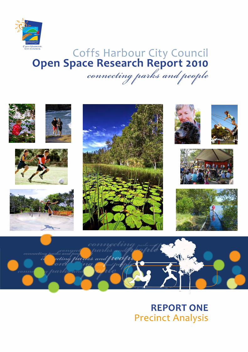
Coffs Harbour City CouncilOpen Space Research Report 2010
REPORT ONEPrecinct Analysis
connecting parks and people
connecting parks and peopleconnecting parks and peopleconnecting parks and peopleconnecting parks and people
connecting parks and people
connecting parks and peopleconnecting parks and peopleconnecting parks and peopleconnecting parks and people
connecting parks and people
connecting parks and people
connecting parks and people


___________________________________________________________________________________________ Open Space Strategy 2010 Page 2
TABLE OF CONTENTS
INTRODUCTION . . . . . . . . . . . . . . . . . . . . . . . . . . . . . . . . . . . . . . . . . . . . . . . . . . . . . . . . . . . . . . . . . . . . . . . . . . . . . . . . . . . 8 PRECINCT 1 : FAR NORTHERN BEACHES .. . . . . . . . . . . . . . . . . . . . . . . . . . . . . . . . . . . . . . . . . . . . . . . . . . . 12
1.1 Demographics........................................................................................................................12 1.2 Character ................................................................................................................................13 1.3 Future Development ............................................................................................................13 1.4 Demand For Activities ..........................................................................................................13 1.5 Current Open Space Provision ...........................................................................................14 1.6 Gaps in Open Space Provision ............................................................................................15 1.7 Opportunities.........................................................................................................................15
PRECINCT 2: WOOLGOOLGA .. . . . . . . . . . . . . . . . . . . . . . . . . . . . . . . . . . . . . . . . . . . . . . . . . . . . . . . . . . . . . . . . . . . 21 2.1 Demographics........................................................................................................................21 2.2 Character ................................................................................................................................22 2.3 Future Development ............................................................................................................22 2.4 Demand For Activities ..........................................................................................................22 2.5 Current Open Space Provision ...........................................................................................22 2.6 Gaps in Open Space Provision ............................................................................................24 2.7 Opportunities.........................................................................................................................25
PRECINCT 3: NORTHERN BEACHES .. . . . . . . . . . . . . . . . . . . . . . . . . . . . . . . . . . . . . . . . . . . . . . . . . . . . . . . . . . 32 3.1 Demographics........................................................................................................................32 3.2 Character ................................................................................................................................33 3.3 Future Development ............................................................................................................33 3.4 Demand For Activities ..........................................................................................................33 3.5 Current Open Space Provision ...........................................................................................33 3.6 Gaps in Open Space Provision ............................................................................................35 3.7 Opportunities.........................................................................................................................35
PRECINCT 4: COFFS URBAN .. . . . . . . . . . . . . . . . . . . . . . . . . . . . . . . . . . . . . . . . . . . . . . . . . . . . . . . . . . . . . . . . . . . . 42 4.1 Demographics........................................................................................................................42 4.2 Character ................................................................................................................................43 4.3 Future Development ............................................................................................................43 4.4 Demand For Activities ..........................................................................................................43 4.5 Current Open Space Provision ...........................................................................................44 4.6 Sub Precincts .........................................................................................................................44 4.6.1 North Coffs and Korora .......................................................................................................44 4.6.2 Coffs Harbour East................................................................................................................45 4.6.3 Coffs Harbour West ..............................................................................................................47 4.7 Gaps in Open Space Provision Generally..........................................................................49 4.7.1 North Coffs and Korora sub precinct................................................................................49 4.7.2 Coffs Harbour East sub precinct ........................................................................................49 4.7.3 Coffs Harbour West sub precinct ......................................................................................49 4.8 Opportunities Generally ......................................................................................................50

___________________________________________________________________________________________ Open Space Strategy 2010 Page 3
4.8.1 Coffs Harbour East sub‐precinct Opportunities ............................................................ 50 4.8.2 North Coffs and Korora sub precinct Opportunities .................................................... 51 4.8.3 West Coffs sub precinct Opportunities ........................................................................... 51
PRECINCT 5: KORORA WEST / MOONEE WEST .. . . . . . . . . . . . . . . . . . . . . . . . . . . . . . . . . . . . . . . . . . 69 5.1 Demographics....................................................................................................................... 69 5.2 Character ............................................................................................................................... 70 5.3 Future Development ........................................................................................................... 70 5.4 Current Open Space Provision .......................................................................................... 70 5.5 Gaps in Open Space Provision ........................................................................................... 70 5.6 Opportunities........................................................................................................................ 70
PRECINCT 6: MIDDLE BOAMBEE .. . . . . . . . . . . . . . . . . . . . . . . . . . . . . . . . . . . . . . . . . . . . . . . . . . . . . . . . . . . . . 77 6.1 Demographics....................................................................................................................... 77 6.2 Character ............................................................................................................................... 78 6.3 Future Development ........................................................................................................... 78 6.4 Current Open Space Provision .......................................................................................... 78 6.5 Gaps in Open Space Provision ........................................................................................... 78 6.6 Opportunities........................................................................................................................ 78
PRECINCT 7: SAWTELL / TOORMINA / BOAMBEE EAST .. . . . . . . . . . . . . . . . . . . . . . . . . . . . . . 84 7.1 Demographics....................................................................................................................... 84 7.2 Character ............................................................................................................................... 85 7.3 Future Development ........................................................................................................... 85 7.4 Demand For Activities ......................................................................................................... 85 7.5 Current Open Space Provision .......................................................................................... 85 7.6 Sub Precincts ........................................................................................................................ 86 7.6.1 Sawtell ................................................................................................................................... 86 7.6.2 Toormina................................................................................................................................ 87 7.6.3 Boambee East ....................................................................................................................... 88 7.7 Gaps in Open Space Provision Generally......................................................................... 89 7.7.1 Sawtell ................................................................................................................................... 89 7.7.2 Toormina/ Boambee East ................................................................................................... 89 7.8 Opportunities........................................................................................................................ 90
PRECINCT 8: BONVILLE .. . . . . . . . . . . . . . . . . . . . . . . . . . . . . . . . . . . . . . . . . . . . . . . . . . . . . . . . . . . . . . . . . . . . . . . . . . 97 8.1 Demographics....................................................................................................................... 97 8.2 Character ............................................................................................................................... 97 8.3 Future Development ........................................................................................................... 97 8.4 Demand For Activities ......................................................................................................... 98 8.5 Current Open Space Provision .......................................................................................... 98 8.6 Gaps in Open Space Provision ........................................................................................... 98 8.7 Opportunities........................................................................................................................ 99
PRECINCT 9: FAR NORTH RURAL .. . . . . . . . . . . . . . . . . . . . . . . . . . . . . . . . . . . . . . . . . . . . . . . . . . . . . . . . . . 105 9.1 Demographics..................................................................................................................... 105 9.2 Character ............................................................................................................................. 106

___________________________________________________________________________________________ Open Space Strategy 2010 Page 4
9.3 Future Development ..........................................................................................................106 9.4 Demand For Activities ........................................................................................................106 9.5 Current Open Space Provision .........................................................................................106 9.6 Gaps in Open Space Provision ..........................................................................................107 9.7 Opportunities.......................................................................................................................107
PRECINCT 10: NORTH RURAL .. . . . . . . . . . . . . . . . . . . . . . . . . . . . . . . . . . . . . . . . . . . . . . . . . . . . . . . . . . . . . . . . . 113 10.1 Demographics......................................................................................................................113 10.2 Character ..............................................................................................................................114 10.3 Future Development ..........................................................................................................114 10.4 Demand For Activities ........................................................................................................114 10.5 Current Open Space Provision .........................................................................................114 10.6 Gaps in Open Space Provision ..........................................................................................115 10.7 Opportunities.......................................................................................................................115
PRECINCT 11 : SOUTH RURAL .. . . . . . . . . . . . . . . . . . . . . . . . . . . . . . . . . . . . . . . . . . . . . . . . . . . . . . . . . . . . . . . . . 122 11.1 Demographics......................................................................................................................122 11.2 Character ..............................................................................................................................123 11.3 Future Development ..........................................................................................................123 11.4 Demand For Activities ........................................................................................................123 11.5 Current Open Space Provision .........................................................................................123 11.6 Gaps in Open Space Provision ..........................................................................................125 11.7 Opportunities.......................................................................................................................125
PRECINCT 12: FAR WEST HINTERLAND .. . . . . . . . . . . . . . . . . . . . . . . . . . . . . . . . . . . . . . . . . . . . . . . . . . . . 131 12.1 Demographics......................................................................................................................131 12.2 Character ..............................................................................................................................132 12.3 Future Development ..........................................................................................................132 12.4 Demand For Activities ........................................................................................................132 12.5 Current Open Space Provision .........................................................................................132 12.6 Gaps in Open Space Provision ..........................................................................................133 12.7 Opportunities.......................................................................................................................133

___________________________________________________________________________________________ Open Space Strategy 2010 Page 5
List of Maps Map 1: The Precincts and Sub‐precincts used in the Open Space Strategy....................................... 11
Map 2: Far Northern Beaches – Existing Facilities ..............................................................................16
Map 3: Far Northern Beaches – Urban Investigation Areas............................................................... 17
Map 4: Open Space Function ‐ Far Northern Beaches........................................................................18
Map 5: Landscape Setting ‐ Far Northern Beaches ............................................................................19
Map 6: Catchment ‐ Far Northern Beaches........................................................................................ 20
Map 7: Woolgoolga ‐ Existing Facilities ...............................................................................................27
Map 8: Woolgoolga ‐ Urban Investigation Areas............................................................................... 28
Map 9: Open Space Function – Woolgoolga...................................................................................... 29
Map 10: Landscape Setting ‐ Woolgoolga.......................................................................................... 30
Map 11: Catchment ‐ Woolgoolga ........................................................................................................31
Map 12 : Northern Beaches ‐ Current Facilities ................................................................................... 37
Map 13: Northern Beaches – Urban Investigation Areas .................................................................. 38
Map 14: Open Space Function ‐ Northern Beaches ........................................................................... 39
Map 15: Landscape Setting ‐ Northern Beaches ................................................................................40
Map 16: Catchment ‐ Northern Beaches .............................................................................................41
Map 17: Coffs Harbour West ‐ Existing Facilities ................................................................................ 54
Map 18: Coffs Harbour West – Urban Investigation Areas ............................................................... 55
Map 19: Open Space Function ‐ Coffs West ....................................................................................... 56
Map 20: Landscape Setting ‐ Coffs West............................................................................................ 57
Map 21: Catchment ‐ Coffs West......................................................................................................... 58
Map 22: Coffs Harbour East ‐ Existing Facilities ................................................................................. 59
Map 23: Coffs Harbour East ‐ Future Urban Development ...............................................................60
Map 24: Open Space Function ‐ Coffs East .........................................................................................61
Map 25: Landscape Setting ‐ Coffs East ............................................................................................. 62
Map 26: Catchment ‐ Coffs East.......................................................................................................... 63
Map 27: North Coffs and Korora ‐ Existing Facilities..........................................................................64
Map 28: North Coffs and Korora – Urban Investigation Areas ......................................................... 65
Map 29: Open Space Function ‐ North Coffs and Korora ..................................................................66
Map 30: Landscape Setting ‐ North Coffs and Korora....................................................................... 67
Map 31: Catchment ‐ North Coffs and Korora ....................................................................................68
Map 32: Korora West ‐ Existing Facilities.............................................................................................72
Map 33: Korora West / Moonee West – Urban Investigation Areas................................................. 73
Map 34: Open Space Function ‐ Korora West / Moonee West.......................................................... 74
Map 35: Landscape Setting ‐ Korora West / Moonee West............................................................... 75
Map 36: Catchment ‐ Korora West / Moonee west ........................................................................... 76
Map 37: Middle Boambee ‐ Existing Facilities .................................................................................... 79
Map 38: Middle Boambee– Urban Investigation Areas ....................................................................80

___________________________________________________________________________________________ Open Space Strategy 2010 Page 6
Map 39: Open Space Function ‐ Middle Boambee .............................................................................81
Map 40: Landscape Setting ‐ Middle Boambee................................................................................. 82
Map 41: Catchment ‐ Middle Boambee .............................................................................................. 83
Map 42: Sawtell / Toormina / Boambee East ‐ Existing facilities.......................................................92
Map 43: Sawtell, Toormina and Boambee – Urban Investigation Areas ......................................... 93
Map 44: Open Space Function ‐ Sawtell, Toormina and Boambee .................................................. 94
Map 45: Landscape Setting ‐ Sawtell, Toormina and Boambee ....................................................... 95
Map 46: Catchment ‐ Sawtell, Toormina and Boambee ................................................................... 96
Map 47: Bonville ‐ Existing Facilities..................................................................................................100
Map 48: Bonville – Urban Investigation Areas ..................................................................................101
Map 49: Open Space Function ‐ Bonville .......................................................................................... 102
Map 50: Landscape Setting ‐ Bonville ............................................................................................... 103
Map 51: Catchment ‐ Bonville ............................................................................................................104
Map 52: Far North Rural ‐ Existing Facilities......................................................................................108
Map 53: Far North Rural – Urban Investigation Areas .....................................................................109
Map 54: Open Space Function ‐ Far North Rural ...............................................................................110
Map 55: Landscape Setting ‐ Far North Rural .................................................................................... 111
Map 56: Catchment ‐ Far North Rural ................................................................................................ 112
Map 57: North Rural ‐ Existing Facilities.............................................................................................117
Map 58: North Rural – Urban Investigation Areas ............................................................................118
Map 59: Open Space Function ‐ North Rural .....................................................................................119
Map 60: Landscape Setting ‐ North Rural......................................................................................... 120
Map 61: Catchment ‐ North Rural ....................................................................................................... 121
Map 62: South Rural ‐ Existing Facilities ........................................................................................... 126
Map 63: South Rural – Urban Investigation Areas ........................................................................... 127
Map 64: Open Space Function ‐ South Rural .................................................................................... 128
Map 65: Landscape Setting ‐ South Rural ......................................................................................... 129
Map 66: Catchment ‐ South Rural ..................................................................................................... 130
Map 67: Far West Hinterland ‐ Existing Facilities.............................................................................. 135
Map 68: Far West Hinterland – Urban Investigation Areas ............................................................. 136
Map 69: Open Space Function ‐ Far West Hinterland ...................................................................... 137
Map 70: Landscape Setting ‐ Far West Hinterland ........................................................................... 138
Map 71: Catchment ‐ Far West Hinterland ........................................................................................ 139

___________________________________________________________________________________________ Open Space Strategy 2010 Page 7
List of Tables
Table 1: Evaluation Criteria used in the Open Space Strategy............................................................. 9
Table 2: Percentiles used to describe categories for distribution patterns of age groups ..............10
Table 3: Summary of Open Space by Type ‐ Far Northern Beaches...................................................14
Table 4: Summary of Open Space by Type – Woolgoolga ................................................................ 24
Table 5: Summary of Open Space by Type ‐ Northern Beaches........................................................ 34
Table 6: Summary of Open Space by Type – North Coffs and Korora Sub‐precinct........................ 45
Table 7: Summary of Open Space by Type ‐ Coffs Harbour East....................................................... 47
Table 8: Summary of Open Space by Type ‐ Coffs Harbour West.....................................................48
Table 9: Summary of Open Space by Type ‐ Korora West................................................................. 70
Table 10: Summary of Open Space by Type – Sawtell ....................................................................... 87
Table 11: Summary of Open Space by Type – Toormina ....................................................................88
Table 12: Summary of Open Space by Type ‐ Boambee East.............................................................88
Table 13: Summary of Open Space by Type – Bonville ......................................................................98
Acknowledgments
Coffs Harbour City Council acknowledges the support and assistance provided on this project by:
Staff of @Leisure Consulting Pty Ltd.
Community organisations including local sports clubs and associations, environment groups,
Landcare groups and recreation groups whose members completed questionnaires and
attended workshops.
All groups/individuals who participated in telephone interviews.
Local schools and school students who completed questionnaires.
Residents and park visitors who completed and returned surveys.
Staff from adjacent Local Government Areas and NSW Government land management
agencies who attended workshops and participated in phone interviews.
Staff of Coffs Harbour City Council who attended staff workshops.
PHOTOGRAPHS KINDLY SUPPLIED BY: Coffs Coast Marketing, Rob Cleary, Tom Woods, ST Images, Rachael
Squires and Damon Leach.

___________________________________________________________________________________________ Open Space Strategy 2010 Page 8
INTRODUCTION
This component of the Open Space Strategy gives an account of the current status of the open space network across the 12 Open Space planning Precincts identified for the Coffs Harbour Local Government Area (LGA) and identifies future directions for open space management. The following topics are used to provide the context for the Precinct Analysis report.
Precincts For the purpose of spatial analysis, the Open Space Strategy divides the Coffs Harbour LGA into twelve planning units, or precincts. The divisions are based upon Australian Bureau of Statistics (ABS) boundaries, topographic features, and likely catchment areas for use of Open Space. The more populated precincts of Coffs Urban and Sawtell/ Toormina/ Boambee East have been further divided into sub‐precincts. The precincts and sub‐precincts are shown in Map 1.
Evaluation of Open Space The value of open space varies according to the extent to which it meets local needs and on the range of benefits generated by the space. This report provides an analysis of current open space provision across the Coffs Harbour LGA by evaluating the existing Open Space Network against a number of criteria that reflect the values and major benefits of open space to the community. The evaluation criteria used in the present study are shown in Table 1. Other factors were also used in the evaluation process; namely demographic data, likely future urban growth and results of community surveys.
Demographics A brief summary of the 2006 ABS Census data for the Coffs Harbour LGA is provided to provide background information on likely present and future needs of a community. Estimates of future populations are given, however it is important to note that future population estimates are indicative only and subject to a range of factors including in migration, exodus, land take‐up rates and economic factors.
Character Character of each precinct refers to the physical characteristics of the area, including location, landform and settlement patterns.
Future Development Areas that are planned for future development are described, based on Council's Growth Strategy, “The Our Living City Settlement Strategy.”
Demand for Activities Extensive community survey was undertaken for the Open Space Strategy, including survey about activities which people desire but do not presently participate in.
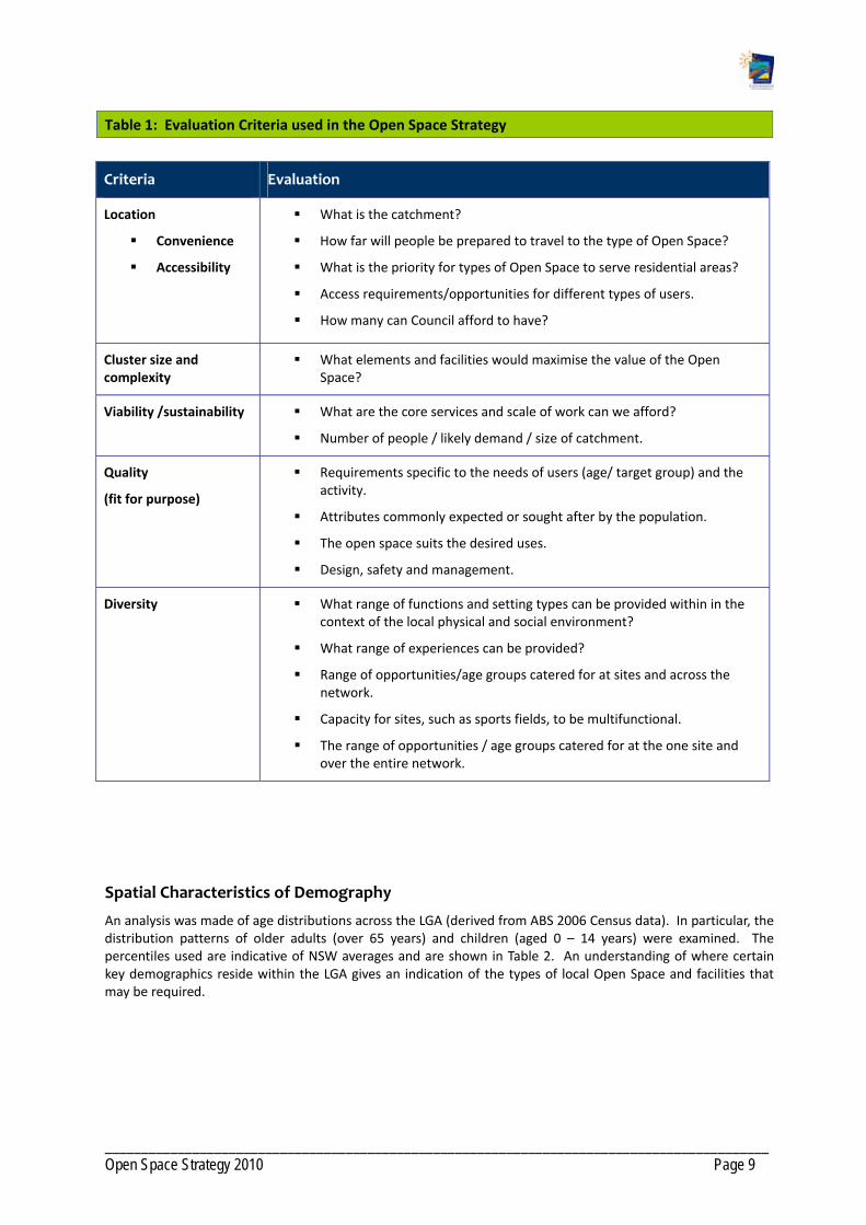
___________________________________________________________________________________________ Open Space Strategy 2010 Page 9
Table 1: Evaluation Criteria used in the Open Space Strategy
Criteria Evaluation
Location
Convenience
Accessibility
What is the catchment?
How far will people be prepared to travel to the type of Open Space?
What is the priority for types of Open Space to serve residential areas?
Access requirements/opportunities for different types of users.
How many can Council afford to have?
Cluster size and complexity
What elements and facilities would maximise the value of the Open Space?
Viability /sustainability What are the core services and scale of work can we afford?
Number of people / likely demand / size of catchment.
Quality
(fit for purpose)
Requirements specific to the needs of users (age/ target group) and the activity.
Attributes commonly expected or sought after by the population.
The open space suits the desired uses.
Design, safety and management.
Diversity What range of functions and setting types can be provided within in the context of the local physical and social environment?
What range of experiences can be provided?
Range of opportunities/age groups catered for at sites and across the network.
Capacity for sites, such as sports fields, to be multifunctional.
The range of opportunities / age groups catered for at the one site and over the entire network.
Spatial Characteristics of Demography
An analysis was made of age distributions across the LGA (derived from ABS 2006 Census data). In particular, the distribution patterns of older adults (over 65 years) and children (aged 0 – 14 years) were examined. The percentiles used are indicative of NSW averages and are shown in Table 2. An understanding of where certain key demographics reside within the LGA gives an indication of the types of local Open Space and facilities that may be required.

___________________________________________________________________________________________ Open Space Strategy 2010 Page 10
Table 2: Percentiles used to describe categories for distribution patterns of age groups
Category People over 65 years Children aged 0 – 14 years
Low 0 – 9 % 0 – 13%
Below Average 10 – 13% 14 – 17%
Average 14 ‐ 18% 18 – 22%
Above Average 19 – 22% 23 ‐ 25%
High 23 – 48% 26 – 41 %
Current open Space provision
This report details the current public open space assets under Council's or the Land and Property Management Authority (LPMA) (formerly the Department of Lands) management, including a summary table listing the amount and number of open space types.
Gaps and Precinct Recommendations
This section in each chapter provides an analysis of open space provision using all aspects of the work undertaken for this report (site analysis, inventory data base, household survey, community forums, stakeholder consultation, literature review, professional best practice) with reference to the evaluation criteria shown in Table 1.
Precinct Action Plans have been developed for each Precinct that address opportunities and future open space requirements within the Precinct, including reserve improvements, to maximise Open Space outcomes. These are detailed in Section 3 of the “Implementation Plan”.
Mapping
For each precinct, mapping includes location of all open space and existing facilities including playgrounds, picnic facilities, tracks and trails. Mapping also shows areas under‐served by open space provision and major barriers to participation including roads, railway lines and creeks. The maps detail Council's current growth strategy for future residential, rural residential and industrial land expansion. However, it is important to note that a number of matters contained in Council's Our Living city Settlement Strategy Interim Document 2006, Industrial Lands Strategy 2009 and Draft Rural Residential Strategy 2009 are yet to be endorsed by the Department of Planning and Council as part of Council's Local Growth Management Strategy.
Mapping also includes, by Precinct, the function, landscape setting and catchment of each area of Open Space.
The distribution of Open Space is not static and changes due to land contributions from approved development and ongoing embellishments and improvements. These maps provide an overview as of January 31 2010.
Note that the location of proposed playgrounds is indicative only and subject to more detailed assessment at development stage.

___________________________________________________________________________________________ Open Space Strategy 2010 Page 11
Map 1: The Precincts and Sub‐Precincts used in the Open Space Strategy

___________________________________________________________________________________________ Open Space Strategy 2010 Page 12
PRECINCT 1: FAR NORTHERN BEACHES
Current and future population projection
2001 Population
2006 Population
Projected Population 2031
Increase to 2031
% Increase to 2031
932 1142 1768 626 35.4
% Age Cohorts in population based on 2006 Census
% 0‐14 yrs % 15‐24 yrs % 25‐ 44 yrs % 45‐64 yrs % over 65 yrs
20.5 10.8 23.2 29.2 16.1
Disclaimer: Note that population are estimates only based on current ABS data and predicted growth rates.
People over 65 years Children 0 – 14 years
1 . 1 Demographics
Red Rock and Corindi Beach have average numbers of children between 0 to 14 years.
There is a high percentage of people over 65 yearsin Red Rock, a quiet coastal village popular with retirees.

___________________________________________________________________________________________ Open Space Strategy 2010 Page 13
In 2006, the population in the Far Northern Beaches precinct was 1142. The precinct has experienced the greatest increase (18%) in population across the municipality since 2001. The demographic profile shows 16% of the population aged over 65 and 20% in the of 0‐14 years age group.
1 .2 Character
The Far Northern Beaches precinct includes the coastal villages of Red Rock and Corindi Beach. Red Rock is situated at the southern end of Yuraygir National Park at the mouth of the Redbank River. Corindi Beach is located 5.5km south of Red Rock. The main areas of open space in the Red Rock and Corindi Beach precinct are the long rolling beaches and dunal complexes, and pockets of coastal wetland and heath.
1 .3 Future Development
In the long term, rural residential development is planned to the west of Corindi Beach along the Pacific Highway. The Settlement Strategy states Council’s plans for Red Rock and Corindi Beach; these areas will be developed as coastal villages, containing urban expansion and recognising the holiday, tourism and recreation appeal. Significant environmental constraints to the north limit urban expansion.
1 .4 Demand For Act iv i t ies
Activities ‐ present participation Activities people would like to do but do not
Walking
Swimming
Cycling / cycle racing
Tennis
Fishing
Bingo
Camping / caravanning
Going to the beach
Golf
Lawn bowls
Visiting friends and family
Horse riding / pony club / equestrian activities
Non‐powered boating activities
Swimming
Visiting historic properties
Council recently undertook a specific consultation process with the residents of Corindi and Red Rock concerning facility upgrades.
The top recreation related facility upgrades identified by the Corindi residents were:
Completion of a footpath / cycleway around the village
Upgrade of the Skate Park
Upgrade of the tennis court and shed.
New play facilities at the Pacific Street Reserve
Improvements to the Sports Ground
Improvements to the Community Hall
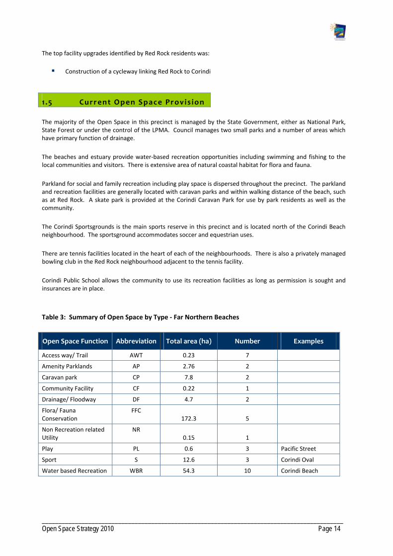
___________________________________________________________________________________________ Open Space Strategy 2010 Page 14
The top facility upgrades identified by Red Rock residents was:
Construction of a cycleway linking Red Rock to Corindi
1 .5 Current Open Space Provis ion
The majority of the Open Space in this precinct is managed by the State Government, either as National Park, State Forest or under the control of the LPMA. Council manages two small parks and a number of areas which have primary function of drainage.
The beaches and estuary provide water‐based recreation opportunities including swimming and fishing to the local communities and visitors. There is extensive area of natural coastal habitat for flora and fauna.
Parkland for social and family recreation including play space is dispersed throughout the precinct. The parkland and recreation facilities are generally located with caravan parks and within walking distance of the beach, such as at Red Rock. A skate park is provided at the Corindi Caravan Park for use by park residents as well as the community.
The Corindi Sportsgrounds is the main sports reserve in this precinct and is located north of the Corindi Beach neighbourhood. The sportsground accommodates soccer and equestrian uses.
There are tennis facilities located in the heart of each of the neighbourhoods. There is also a privately managed bowling club in the Red Rock neighbourhood adjacent to the tennis facility.
Corindi Public School allows the community to use its recreation facilities as long as permission is sought and insurances are in place.
Table 3: Summary of Open Space by Type ‐ Far Northern Beaches
Open Space Function Abbreviation Total area (ha) Number Examples
Access way/ Trail AWT 0.23 7
Amenity Parklands AP 2.76 2
Caravan park CP 7.8 2
Community Facility CF 0.22 1
Drainage/ Floodway DF 4.7 2
Flora/ Fauna Conservation
FFC 172.3 5
Non Recreation related Utility
NR 0.15 1
Play PL 0.6 3 Pacific Street
Sport S 12.6 3 Corindi Oval
Water based Recreation WBR 54.3 10 Corindi Beach

___________________________________________________________________________________________ Open Space Strategy 2010 Page 15
1 .6 Gaps in Open Space Provis ion
For its population and geographic size, the Far Northern Beaches precinct is well provided with open spaces that serve a range of functions. In addition a formal trail network could be provided, replacing numerous informal tracks. It would be beneficial to connect the local school, sports facilities and commercial precincts.
1 .7 Opportunit ies
Develop a trail network that connects the local school, sports facilities and commercial precincts. This would be primarily along footpaths. In the future, links from the village centre to the sportsground may be possible off road in conjunction with future development.
Investigate cycleway linkage from Red Rock to Corindi Beach.
Redevelop the Corindi Beach tennis facilities to function as a multi‐purpose courts and run activities and competitions.
Investigate the opportunities of providing access to open space for sport to the local schools.
Create local social family recreation space through re‐development of existing play space such as Alston Wilde Reserve and Pacific Street Reserve.
Work with the LPMA and the Reserve Trust to improve the Corindi Sportsground to promote sporting and recreational opportunities including a perimeter trail.
Improve facilities for adolescents including upgrading the Corindi Beach skate park and developing hard courts in conjunction with SFR spaces.
Additional open space for access ways and trails to link areas of existing and future open space in conjunction with any urban development of lands identified in Council's current growth strategy. The number and location of these will be determined at the detailed land planning stage.
Dedication of key lands forming habitat and/or corridors functions for flora and fauna conservation, particularly in conjunction with any urban development of lands identified in Council's current growth strategies or lands currently zoned for residential. Encourage dedication at no cost to Council.
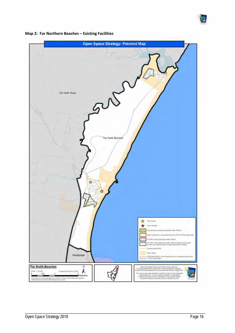
___________________________________________________________________________________________ Open Space Strategy 2010 Page 16
Map 2: Far Northern Beaches – Existing Facilities

___________________________________________________________________________________________ Open Space Strategy 2010 Page 17
Map 3: Far Northern Beaches – Urban Investigation Areas

___________________________________________________________________________________________ Open Space Strategy 2010 Page 18
Map 4: Open Space Function ‐ Far Northern Beaches

___________________________________________________________________________________________ Open Space Strategy 2010 Page 19
Map 5: Landscape Setting ‐ Far Northern Beaches

___________________________________________________________________________________________ Open Space Strategy 2010 Page 20
Map 6: Catchment ‐ Far Northern Beaches

___________________________________________________________________________________________ Open Space Strategy 2010 Page 21
PRECINCT 2: WOOLGOOLGA
2. 1 Demographics
Current and future Population Projection
2001 Population
2006 Population
Projected population 2031
Increase to 2031
% Increase to 2031
6215 6500 10353 3853 37.2
Age Cohorts based on 2006 Census
% 0‐14 % 15‐24 % 25‐ 44 % 45‐64 % 65+
17.8
10.2
18.9 30.2 22.8
People over 65 years Children aged 0‐14 years
Overall, Woolgoolga precinct has above average numbers of people over 65. A few locations have particularly high concentrations of this age group. Arrawarra has 48% over 65 yrs. North of Beach Street and south of High Street Woolgoolga are also above the average. These are older established areas of Woolgoolga, with the High Street area containing a retirement village. The areas to the west of the highway represent the newer areas of Woolgoolga and these have average and below average tallies.
Woolgoolga east of the highway generally has lower numbers of children and areas to the west average and above average tallies. Arrawarra Beach has a very low percentage of children (8%).

___________________________________________________________________________________________ Open Space Strategy 2010 Page 22
In 2006, the population in the Woolgoolga precinct was 6,500. The projected population in 2031 is 10,353. The precinct is popular with retirees and contains the highest proportion of adults aged over 65 years (23%) within the LGA. The population is also culturally diverse with a high proportion being of Indian origin.
2.2 Character
The Woolgoolga precinct includes the townships of Arrawarra, Mullaway, Woolgoolga and Safety Beach and supports a mixture of experiences and lifestyles from beach side living to rural residential and farming. The townships are all located on the coast and are surrounded by National Parks and State Forests. The majority of the coastal reserves fall within the Coffs Coast Regional Park. There is a large amount of natural coastal habitat for flora and fauna. Woolgoolga also features major sports reserves for rugby league, Australian Rules football, cricket, and netball.
2.3 Future Development
Urban growth is planned west of the Pacific Highway building off Woolgoolga. The Settlement Strategy states Council’s interest in the Woolgoolga precinct. Arrawarra, Mullaway and Safety Beach are to be retained as coastal villages recognising the holiday, tourism and recreation appeal while residential development is planned west of Pacific Highway in Woolgoolga. The Strategy also recognises the need to reinforce the commercial, retail and service role of Woolgoolga.
2.4 Demand For Act iv i t ies
Activities ‐ present participation Activities people would like to do but do not
Walking
Swimming
Fishing
Surfing
Tennis
Cycling / cycle racing
Golf
Bushwalking / hiking
Camping / caravanning
Sailing / sail boarding
Dancing
Fishing
Cycling / cycle racing
Gymnasium / Fitness activities
Rock climbing
2.5 Current Open Space Provis ion
The Woolgoolga precinct contains considerable open space functioning as flora and fauna conservation areas, as well as significant foreshores and beaches. Key natural areas include the Coffs Coast Regional Park, Garby Nature Reserve and the Wedding Bells State Forest to the west of the Pacific Highway.

___________________________________________________________________________________________ Open Space Strategy 2010 Page 23
Arrawarra / Mullaway Villages
The beaches provide water based recreation opportunities including swimming and fishing to the local communities and visitors. The beaches are buffered by Open Space for flora and fauna. Arrawarra Beach contains limited open space aside from the beach and dunal systems adjoining it. A linear reserve adjoins Yarrawarra Creek and provides opportunities for walking. This track is not at presently a circuit path and ends at private property to the north.
The Arrawarra Headland and Mullaway villages are serviced by a shared‐use trail that runs north south through Coffs Coast Regional Park and linking residential areas.
Arrawarra Headland has two boat ramps within a large beachfront reserve. There is currently no playground facility in Arrawarra Headland however the village is well serviced with two social family reserves providing picnic opportunities at either end of the township.
Mullaway has a small park with a playground that provides a social and family recreation space for the Mullaway community.
Woolgoolga / Safety Beach Neighbourhood
There are five major sporting complexes in the neighbourhood which are all located east of the Pacific Highway. These complexes serve a district catchment and include:
Woolgoolga Sports Ground, serving rugby league, athletics and tennis.
High Street Sports Complex, serving soccer and cricket.
Centennial Reserve, serving Australian Rules football and cricket.
Woolgoolga Netball Complex, serving netball.
Other sports facilities include a privately owned golf course that is available for use by the public. There are also swimming pools located east and west of the Pacific Highway including the Woolgoolga Swimming Pool.
Schools are located near sports reserves in the neighbourhood adding to the viability of these open spaces. Woolgoolga High School allows some community use of its recreation facilities. Currently courts at the school are used for basketball practice.
The shared use trail runs south from Arrawarra through Coffs Coast Regional Park into Woolgoolga to Woolgoolga Lake. The Woolgoolga neighbourhood trail network connects with the coastal parks trail while linking the major open spaces east of the Pacific Highway.
Woolgoolga Lake is a source of water‐based activity and provides a social and family recreation space for the neighbourhood.
Safety Beach has no social family reserve and no playgrounds. The community is well serviced in terms of water based recreation and conservation reserves.
A skate park, catering for beginner skaters, is situated adjacent to the Centennial Sports Reserve.
Open Spaces for play and social and family recreation are located in the centre of Woolgoolga however are under‐provided south of the township and west of Pacific Highway.

___________________________________________________________________________________________ Open Space Strategy 2010 Page 24
Table 4: Summary of Open Space by Type – Woolgoolga
Open Space Function
Abbreviation Total area (ha) Number Examples
Access way/ Trail AWT 0.85 33
Amenity Parklands AP 2.4 5
Buffer B 3.5 5
Caravan Park CP 3.0 2
Cemetery/ Memorial/ Remembrance
MEM 1.8 1
Woolgoolga Cemetery
Drainage/ Floodway DF 32.2 15
Flora/ Fauna Conservation
FFC 207.7 21
Coastal Dunes
Non Recreation related Utility
NR 0.5 1
Play PL 0.3 1 Mullaway Reserve
Scenic Lookout SL 2.4 2 Woolgoolga Headland
Social/ Family Recreation
SFR 6.1 7
Woolgoolga Beach Reserve
Sport S 21.6 5 High Street Fields
Undeveloped Sport/Recreation
USR
23.6 1
Undeveloped sportsfields west Woolgoolga
Water‐based Recreation
WBR 100.4 19
Woolgoolga Beach
Wayside Stop WS 0.2 2
2.6 Gaps in Open Space Provis ion
A priority for Council is to develop the proposed multi‐purpose sports reserve, north of the Reservoir, for major participation sports for the projected population west of the Pacific Highway.
There is currently no playground servicing the Arrawarra or Safety Beach areas.
Boat access points at Arrawarra are placing vehicles directly into the family beach area.
There is a need to further develop the trail network west of the Pacific Highway.
There is a need to provide greater open space provision for play and social and family recreation in areas currently under‐served.
Need to upgrade the existing skate facility to cater for a wider range of skating abilities and to stage competitions. Limited opportunity to do so at current site.
Currently, there is no functional centrally located accessible outdoor multi use court for adolescents.
There is currently no local sportsground at Mullaway for use by the school and community.

___________________________________________________________________________________________ Open Space Strategy 2010 Page 25
2.7 Opportunit ies
Plan and develop proposed open space west of Pacific Highway as a multi‐purpose sports facility serving the expected projected population.
Improve capacity of existing sporting facilities, in particular Woolgoolga Sportsground and High Street.
Create additional local social family recreation spaces to service neighbourhoods in areas under‐served in Woolgoolga, including development of play facilities in conjunction with sports fields and in reserves that are under currently below capacity. Potential sites include Nightingale Street, Centennial Oval, Crabbe Street and Shearer Drive.
Upgrade Lakeside Reserve, Woolgoolga Lake to a local social family recreation space and effect road closure and addition to Crown reserve system.
Improve Woolgoolga Beach Reserve as a district social family space through redesign and provision of facilities for a wider age range, paths, picnic facilities, car parking, and amenities in accordance with the Plan of Management.
Improve Arrawarra Beach Reserve as a district social family space through redesign and provision of facilities for a wider age range, paths, picnic facilities, car parking, and amenities. Consideration also needs to be given the location of boat launch facilities.
Minor upgrades to the Skate facility. In the long term, investigate new location for an upgraded Skate Park.
Identify sites for a local sportsground at Mullaway and assess feasibility of Lot 6 DP 417132, currently zoned 6A, for this purpose.
Develop a trail network west of the Pacific Highway Woolgoolga that connects with the existing network, local schools, sports facilities and commercial precincts.
Improve trail networks linking Arrawarra, Mullaway, Safety Beach and Woolgoolga including upgrading circuit trail around the Woolgoolga Lake including providing a sealed shared pathway to link Safety Beach to the High School and Woolgoolga Sportsground.
Ensure any future re‐development of the privately owned Arrawarra Caravan Park incorporates public access to the beach, including a public bridge over Yarrawarra Creek.
Increase range of opportunities at Mullaway Reserve including addition of hard court and additional pathways.
Create dog leash free area at Mullaway.
Provide for events including theatre, music and arts in public open space at appropriate times.
Investigate the future demands and facility requirements of the Woolgoolga Swimming Pool.
Investigate options to secure the long term future of the golf course at Safety Beach.
If development south of Crabbe Street Reserve, Woolgoolga, make sure that Open Space component of development adjoins existing Reserve.
Creation of a local social family recreation park in conjunction with development within the West Woolgoolga DCP area.
Develop SFR space at Safety Beach on future public reserve, Mariner Drive in conjunction with development.
Continue bush regeneration program within Coffs Coast Regional Park.
Commence regeneration program for Woolgoolga Lake and Poundyard Creek.

___________________________________________________________________________________________ Open Space Strategy 2010 Page 26
Land to develop one local social/family recreation space required if residential redevelopment of Arrawarra Caravan Park occurs.
Additional open space for local social family recreation as per core service levels criteria for future residential areas identified in Council's current growth strategies. The number required and locations are to be determined at detailed land planning stage. Note that any social family recreation open space required south of Bark Hut road should ideally adjoin existing Council Reserve.
Dedication of key lands forming habitat and/or corridors functions for flora and fauna conservation, particularly in conjunction with any urban development of lands identified in Council's current growth strategies or lands currently zoned for residential. Encourage dedication at no cost to Council.
Additional open space for access ways and trails to link areas of existing and future open space in conjunction with any urban development of lands identified in Council's current growth strategy. The number required and locations will be determined at detailed land planning stage.
Dedication of open space identified within current West Woolgoolga DCP.
Investigate options to acquire management of the riparian area of Lot 21 DP 259757 to enable revegetation of the eastern bank of Poundyard Creek.
Open Space that can provide lunch time relaxation and recreation opportunities in conjunction with planned industrial development west of the Pacific Highway. Ideally this would be located adjacent to flora and fauna conservation areas where trial circuits could be developed.
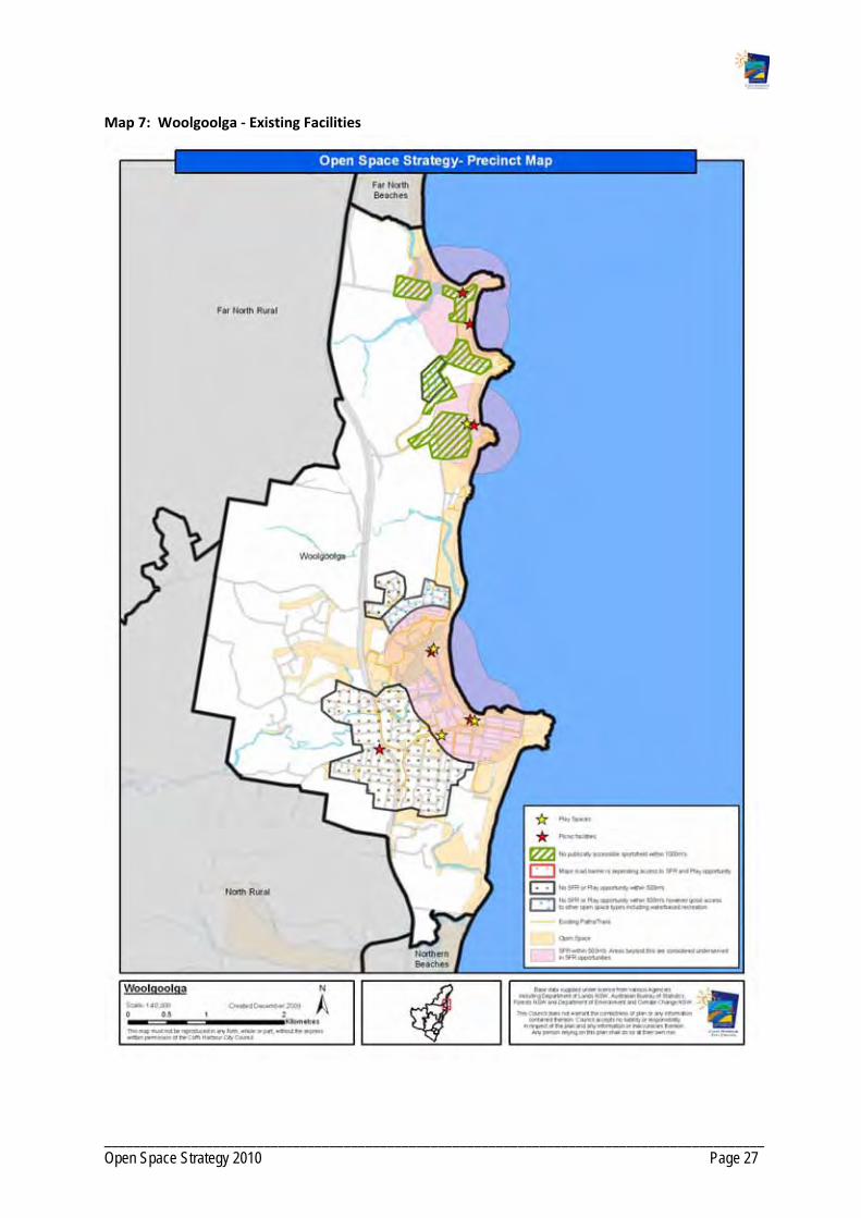
___________________________________________________________________________________________ Open Space Strategy 2010 Page 27
Map 7: Woolgoolga ‐ Existing Facilities

___________________________________________________________________________________________ Open Space Strategy 2010 Page 28
Map 8: Woolgoolga ‐ Urban Investigation Areas

___________________________________________________________________________________________ Open Space Strategy 2010 Page 29
Map 9: Open Space Function – Woolgoolga
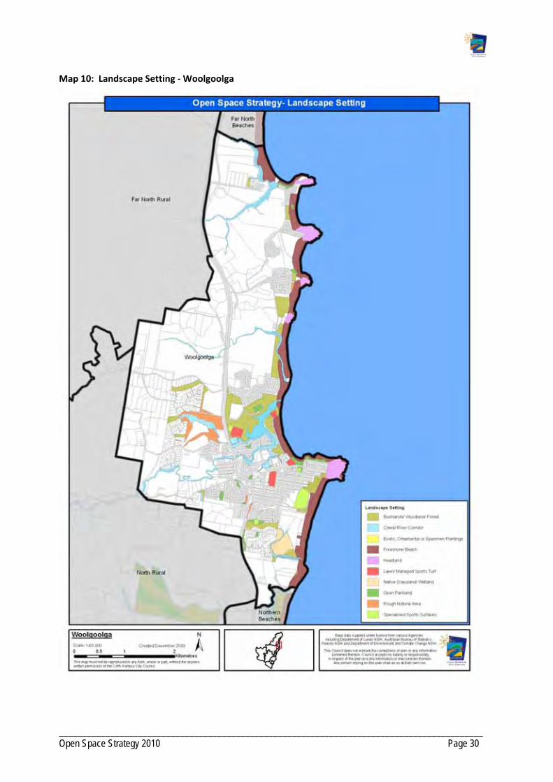
___________________________________________________________________________________________ Open Space Strategy 2010 Page 30
Map 10: Landscape Setting ‐ Woolgoolga

___________________________________________________________________________________________ Open Space Strategy 2010 Page 31
Map 11: Catchment ‐ Woolgoolga
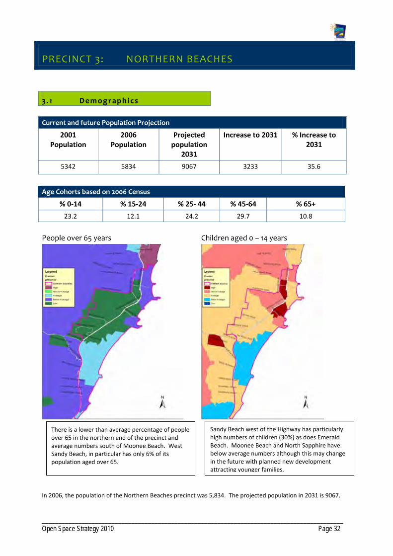
___________________________________________________________________________________________ Open Space Strategy 2010 Page 32
PRECINCT 3: NORTHERN BEACHES
3 . 1 Demographics
Current and future Population Projection
2001 Population
2006 Population
Projected population
2031
Increase to 2031 % Increase to 2031
5342 5834 9067 3233 35.6
Age Cohorts based on 2006 Census
% 0‐14 % 15‐24 % 25‐ 44 % 45‐64 % 65+
23.2 12.1 24.2 29.7 10.8
People over 65 years Children aged 0 – 14 years
In 2006, the population of the Northern Beaches precinct was 5,834. The projected population in 2031 is 9067.
There is a lower than average percentage of people over 65 in the northern end of the precinct and average numbers south of Moonee Beach. West Sandy Beach, in particular has only 6% of its population aged over 65.
Sandy Beach west of the Highway has particularly high numbers of children (30%) as does Emerald Beach. Moonee Beach and North Sapphire have below average numbers although this may change in the future with planned new development attracting younger families.

___________________________________________________________________________________________ Open Space Strategy 2010 Page 33
The Sandy Beach and Emerald Beach neighbourhoods include a high proportion of families with young children while the Moonee Beach and Sapphire Beach neighbourhoods include a higher rate of families with teenage children. Sapphire Beach is a relatively affluent community, demonstrated by unemployment levels being 3% lower and income levels 10% higher than the municipal average.
3 .2 Character
The Northern Beaches precinct includes the coastal villages of Sandy Beach, Emerald Beach, Moonee Beach and Sapphire Beach and supports a mixture of experiences and lifestyles from beach side living to rural farming. The localities use Woolgoolga and Coffs Harbour for services including health, educational and economic facilities.
3 .3 Future Development
Urban growth is planned in the precinct in accordance with the Hearnes Lake/Sandy Beach DCP and the Moonee Beach DCP. The latter document plans details a major expansion of Moonee Beach with an end population in the vicinity of 5300 people (from the current estimate of 650).
The Settlement Strategy supports developing the neighbourhoods as coastal villages however recognises the need for urban development north of Sandy Beach, west of Emerald Beach and north and west of Moonee Beach. The Strategy supports the continued development west of the Pacific Highway. The Strategy recognises the role of Moonee Beach as a retail and service centre for the Northern Beaches.
3 .4 Demand For Act iv i t ies
Activities – present participation Activities people would like to do but do not
Walking
Swimming
Cycling / cycle racing
Fishing
Surfing
Golf
Picnic / BBQs
Jogging / running
Bushwalking / hiking
Going to the beach
Cycling / cycle racing
Swimming
Attending live theatre / dance / performance
Walking
Fishing
Arts and craft activities
Motor car sports
Lawn bowls
3 .5 Current Open Space Provis ion
The main areas of open space for the Northern Beaches precinct are the Coffs Coast Regional Park and Moonee Beach Nature Reserve which stretch out along the foreshore. Residents rely on the beach and foreshore for their recreation. The beaches provide water‐based recreation opportunities to the local communities and visitors. The beaches are buffered by open space for flora and fauna.
There are drainage reserves that also provide another source of open parkland for the precinct.
___________________________________________________________________________________________ Open Space Strategy 2010 Page 34
Sandy Beach / Emerald Beach Neighbourhood In addition to the Coffs Coast Regional Park the Sandy Beach neighbourhood has significant Council flora and fauna reserves protecting native bushland in and around the township.
Beachside parks providing play and social and family recreation functions are located in the Coffs Coast Regional Park east of the Pacific Highway in Sandy Beach and in Emerald Beach.
The main sports facility is a rifle / pistol range on the outskirts of Emerald Beach.
There is no additional open space located nearby the school (Sandy Beach Primary). The school relies on its own space for recreation.
Moonee Beach / Sapphire Beach Neighbourhood The caravan park and reserve area is the focal point of open space provision for social / family recreation in Moonee Beach. The caravan park is located on Moonee Creek and provides water‐based activity, tennis, and play opportunities.
There is parkland providing social and family recreation adjoining a large bushland reserve located in the new development area of North Sapphire Beach and includes play equipment catering for a range of different ages. This park is a popular destination due to the wide age range of equipment provided, pleasant coastal setting, kiosk and picnic facilities provided. The current development consent for North Sapphire indicates additional open space and facilities may be provided in the future including a district level park and skate park.
A number of coastal reserves serving a social family function are scattered along the coast.
Small local parks are dispersed around Sapphire Beach providing an alternative landscape setting outside the beach / foreshore.
Table 5: Summary of Open Space by Type ‐ Northern Beaches
Open Space Function Abbreviation Total area (ha) Number Examples
Access way/ Trail AWT 1.4 19
Amenity Parklands AP 1.6 8
Caravan Park CP 6.4 1
Community Facility CF 0.07 1
Drainage/ Floodway DF 5.9 6
Flora/ Fauna Conservation FFC 120.9 17 Moonee Beach dunes
None N 0.8 2
Play PL 0.5 1 Beachside Park
Relaxation/ Contemplation/ Escape RCE 1.3 2
Social/ Family Recreation SFR 11.8 5 Moonee Beach Reserve
Sport S 0.07 1 Moonee Tennis Courts
Water based Recreation WBR 65.1 13 Moonee Beach Reserve

___________________________________________________________________________________________ Open Space Strategy 2010 Page 35
3 .6 Gaps in Open Space Provis ion
There is no dedicated open space for sport. Residents must travel to Woolgoolga or Coffs Harbour to access these recreation opportunities. The precinct is heavily populated with families seeking active recreation experiences and play. The development of a multi‐purpose sports facility in the precinct is therefore a priority.
Play opportunities for young people are not well‐provided and facilities like a skate park should be explored within Moonee Beach.
There is a limited trail network apart from small access ways between residential areas.
The social family recreation park at Sandy Beach is under capacity and the park at Emerald Beach also has scope for improvement. This is particularly relevant at Emerald Beach as it is the only play opportunity available for the village and there is little scope for achieving additional social family recreation or play spaces in the area. Map 3 indicates the areas that are currently under‐served at Emerald Beach.
There is inadequate car parking for the popularity of social family recreation space at Beachside Park, North Sapphire.
3 .7 Opportunit ies
Plan and develop proposed open space as a district sports facility/social family space in Sandy Beach, as per the DCP, to serve the precinct the village and surrounding areas.
Undertake improvements at Sandy Beach Reserve, embellishing as per core service levels for district social/family recreation space.
Work with LPMA and the Reserve Trust to prepare a site master plan for Moonee Beach Reserve with re‐design to achieve improved traffic flows and parking, play spaces and picnic facilities. Improve separation between traffic and pedestrians.
Embellish Emerald Beach Reserve to a district standard to offset lack of social/family recreation space in under‐served areas of the village.
Provide additional picnic facilities at Sapphire Beach Park.
Develop a trail network that connects the local school, future sports facility and coastal reserves and shops at Sandy Beach.
Develop an off‐road trail network linking Moonee Beach to Emerald Beach in conjunction with any development.
Develop footpath network at Emerald Beach. Lack of footpaths in this village limits walking opportunities.
Investigate and develop suitable site for a skate facility within Moonee Beach.
Development of the coastal walkway and linking trails to service the region as well as the local communities.
Dedication of open space in accordance with the Sandy Beach/Hearnes Lake DCP.
Dedication of lands identified as key habitats or corridors within the Priority Habitats & Corridors Strategy (draft) for flora and fauna conservation in conjunction with any urban development of lands identified in Council's current growth strategies or development of land currently undeveloped and zoned for Residential purposes. Other vegetated parcels may be considered if they add value to existing

___________________________________________________________________________________________ Open Space Strategy 2010 Page 36
open space networks or present opportunities for walkway development. Encourage dedication at no cost to Council.
Additional open space for access ways and trails to link areas of existing and future open space in conjunction with any urban development of lands identified in Council's current growth strategy.
Support the transfer of management to NPWS of Lots 44 DP 752834, Lot 44 DP 245596 and Lot 3A DP 361980, which are public lands of high conservation value.
Dedication of land for conservation and access way/trail purposes south of Emerald Beach, including riparian area of Moonee Creek.
Dedication of open space in accordance with the Moonee Beach DCP.

___________________________________________________________________________________________ Open Space Strategy 2010 Page 37
Map 12 : Northern Beaches ‐ Current Facilities

___________________________________________________________________________________________ Open Space Strategy 2010 Page 38
Map 13: Northern Beaches – Urban Investigation Areas
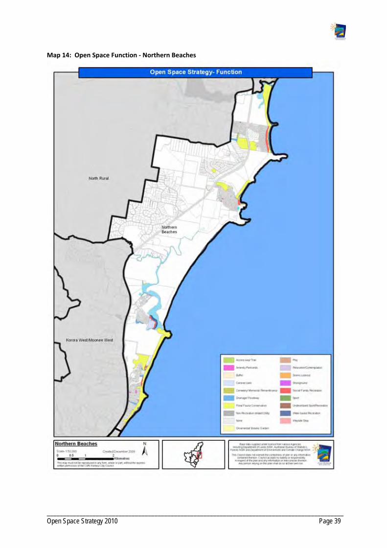
___________________________________________________________________________________________ Open Space Strategy 2010 Page 39
Map 14: Open Space Function ‐ Northern Beaches

___________________________________________________________________________________________ Open Space Strategy 2010 Page 40
Map 15: Landscape Setting ‐ Northern Beaches

___________________________________________________________________________________________ Open Space Strategy 2010 Page 41
Map 16: Catchment ‐ Northern Beaches

___________________________________________________________________________________________ Open Space Strategy 2010 Page 42
PRECINCT 4: COFFS URBAN
4.1 Demographics
Current and future Population Projection
2001 Population
2006 Population
Projected population
2031
Increase to 2031
% Increase to 2031
24718 26342 37290 10948 29.3
Age Cohorts based on 2006 Census
% 0‐14 % 15‐24 % 25‐ 44 % 45‐64 % 65+
17.9 13.6 22.9 26.4 19.0
People aged over 65 years Children aged 0 to 14 years
The precinct contains approximately 41% of the total population of the LGA.
Coffs Urban precinct has pockets of high proportions of older adults, representing locations of retirement villages, development targeting seniors and the older established areas. The area south of Park Avenue to the Golf Course is particularly high at 40%
The newer areas of West Coffs around Shepherds Lane have high proportions of children. Park Beach and the Jetty area have below average and low numbers of children.

___________________________________________________________________________________________ Open Space Strategy 2010 Page 43
4.2 Character
This precinct includes the city of Coffs Harbour which is the major regional city of the municipality. It also includes the coastal suburb of Korora and the developing North Boambee Valley. Coffs Harbour is the main business district of the LGA and provides key services including primary, secondary and tertiary education, hospitals, airport, nursing homes and retail.
Coffs Harbour is a key tourist destination catering for a broad cross section of visitors. Accommodation types range from private apartments and resorts as well as caravan parks and motels. The majority of tourist activity is focussed at Korora, Park Beach and the Jetty.
The precinct is the focus of regional open space and recreation including the Coffs Coast Sport and Leisure Park (Marshall’s Sporting Complex) that consists of an International Stadium, motor sports facility, sports fields and synthetic hockey facility. The beaches, Jetty Foreshore and the Coffs Harbour Regional Botanic Gardens are features of the precincts Open Space providing social and family recreation opportunities for residents and visitors.
4.3 Future Development
Urban development is largely completed in the Coffs Harbour Urban precinct. There is some further planned residential expansion around the town boundary of Coffs Harbour up to the future route of the Pacific Highway bypass. The Settlement Strategy supports the continued development of Coffs Harbour as the major regional centre providing the business centre and key services to the region.
Increased density of Coffs Harbour is also planned through redevelopment of existing low density residential areas to medium and higher density. These areas are primarily located around Park Beach, the Jetty and the CBD.
4.4 Demand For Act iv i t ies
Activities ‐ present participation Activities people would like to do but do not
Walking
Swimming
Cycling / cycle racing
Fishing
Golf
Going to the beach
Picnic / BBQs
Bushwalking / hiking
Camping / caravanning
Surfing
Attending live theatre / dance / performance
Theme / water park
Swimming
Cycling / cycle racing
Dog walking
Thai chi / yoga / Pilates / meditation

___________________________________________________________________________________________ Open Space Strategy 2010 Page 44
4.5 Current Open Space Provis ion
The beaches and foreshore are key features of the Coffs Harbour Urban precinct. They provide the residents and visitors with water‐based recreation activities and serve a social and family recreation function.
The precinct is also the focus of local, regional and international sports competition. The Coffs Coast Sport and Leisure Park is located south of the precinct and offers sports fields for rugby league, Australian Rules football and cricket, hockey facilities including synthetic fields, a motor cross track and the BCU International Stadium.
Smaller play spaces and sports fields and facilities are scattered throughout the precinct catering for local sports competition and neighbourhood recreation.
There is a significant network of drainage and flora and fauna reserves dissecting the precinct east to west. They are predominantly located along the riparian corridor of Coffs Creek and provide habitat for flora and fauna. Other significant flora and fauna reserves include Beacon Hill, City Hill and the heathland/swampland surrounding the airport. A number of threatened species and endangered ecological communities occur within the Coffs Harbour Urban precinct. A significant reserve for flora and fauna conservation adjoins Boambee and Newports Creek South of the airport. This reserve is the largest contiguous area of protected vegetation within the Coffs Urban Precinct and together with lands around the University and airport constitutes the largest tract of natural coastal vegetation in the urban precinct.
The Pacific Highway is a major constraint to pedestrian movement for access to sports and recreation activities. The Highway disconnects the community, particularly to the west, from all major sports reserves, the foreshore and Botanic Gardens.
4.6 Sub Prec incts
Due to the size of the population of the Precinct, Coffs Urban has been broken into 3 smaller planning units for analysis:
North Coffs and Korora.
Coffs Harbour East.
Coffs Harbour West including North Boambee Valley.
4.6 . 1 North Coffs and Korora
Population
The current population estimated at 3970 (2006 ABS data).
Residential development is planned to the future highway bypass to the north. Higher density developments are also planned to the North of Park Beach.
Open Space Distribution
The main areas of open space in the North Coffs and Korora neighbourhood are along the foreshore where Sapphire Beach, Korora Beach and Diggers Beach provide for water‐based activities and social and family recreation and provide a conservation function for the flora and fauna and landscape values on the coast. The coastal headlands also provide opportunities for walking and scenic lookouts.

___________________________________________________________________________________________ Open Space Strategy 2010 Page 45
There are additional pockets of open space conserving flora and fauna values in Korora.
The neighbourhood accesses sports facilities available in Coffs Harbour due to its close proximity to the regional centre. However there is open space for sport in the neighbourhood, including the Korora sports fields and the publicly accessible Opal Cove Resort Golf Course.
Privately provided recreation facilities in this sub‐precinct include a fun park complex which includes an ice hockey rink, water slide and toboggan run.
Table 6: Summary of Open Space by Type – North Coffs and Korora Sub‐precinct
Open Space Function Abbreviation Total area (ha) Number Examples
Access way/ Trail AWT 0.5 15
Amenity Parklands AP 2.7 6
Buffer B 0.7 2
Drainage/ Floodway DF 6.0 5
Flora/ Fauna Conservation FFC 67.8 16
Play PL 0.3 1
Relaxation/Contemplation RCE 0.7 1
Social/ Family Recreation SFR 3.6 3
Sport S 9.0 2
Water based Recreation WBR 17.5 8
4.6 .2 Coffs Harbour East
Population and Future Growth
The current population is estimated at 8060 (2006 ABS data).
Higher density residential development is planned in the Jetty and Park Beach areas as per the Park Beach and Jetty DCPs. Over time it is anticipated that the current lower socio‐economic demographic of Park Beach will shift to more affluence as redevelopment occurs. A small pocket of residential is also planned south of the Coffs Coast Sport and Leisure Park, as per the South Coffs DCP.
Open Space Distribution
The foreshore in the Coffs Harbour East sub‐precinct provides for water‐based activities and social and family recreation. The beach and foreshore areas have numerous picnic spots and a larger playground located at the Jetty Foreshore. Park Beach is another significant coastal reserve offering play, picnic and access to the water. Boambee Beach offers an undeveloped setting for water based recreation. Boambee Beach is a popular site for four wheel driving, horse riding, dog exercising and jogging. The coastal headlands also provide opportunities for walking, nature appreciation and scenic outlooks.
A major feature of the Coffs Harbour East precinct is the Coffs Harbour Regional Botanic Gardens. The gardens contain exotic and ornamental gardens and bushland and provide a place for social and family recreation and relaxation. The gardens attract visitors from around the mid north coast region as well as nationally.

___________________________________________________________________________________________ Open Space Strategy 2010 Page 46
Open Space for sport in Coffs Harbour East is dispersed across the neighbourhoods and includes:
Coffs Coast Sport and Leisure Park.
York Street Oval used for soccer, softball.
England’s Oval providing for cricket and tennis.
Jetty Oval serving cricket and AFL training.
Brelsford Park used for cricket and tennis.
Fitzroy Oval that serves cricket and AFL.
Coffs Harbour Showground providing for soccer.
Further, there are a number of sports facilities available in the neighbourhood including:
Indoor sports facility providing for table tennis at the Showground.
Indoor sports facility used by the RSL for badminton and table tennis.
Indoor sports facility and tennis facility located at the University.
Two tennis facilities in addition to the courts located at the University.
Two gymnasiums.
Three publicly accessible swimming pools located north and central to the neighbourhood.
A rifle / pistol range on the outskirts of the neighbourhood.
Bowling Clubs.
Coffs Harbour Racecourse located on the southern boundary of the neighbourhood.
The University also provides a number of other sports facilities and open space.
Coffs Harbour High School allows the community to use cricket nets at the school for practice sessions. Casuarina Steiner School are open to letting the community use their facilities in the future.
Coffs Creek habitat walk is a 9.5km circuit walk which follows and crosses Coffs Creek, incorporating views of the creek and a number of forest types. From the walk there are opportunities to enter and view the Botanic Gardens and the Showgrounds.
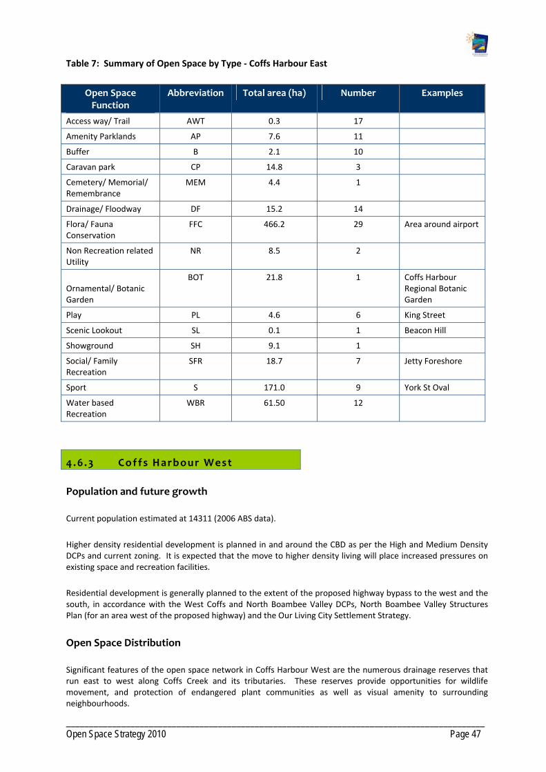
___________________________________________________________________________________________ Open Space Strategy 2010 Page 47
Table 7: Summary of Open Space by Type ‐ Coffs Harbour East
Open Space Function
Abbreviation Total area (ha) Number Examples
Access way/ Trail AWT 0.3 17
Amenity Parklands AP 7.6 11
Buffer B 2.1 10
Caravan park CP 14.8 3
Cemetery/ Memorial/ Remembrance
MEM 4.4 1
Drainage/ Floodway DF 15.2 14
Flora/ Fauna Conservation
FFC 466.2 29 Area around airport
Non Recreation related Utility
NR 8.5 2
Ornamental/ Botanic Garden
BOT 21.8 1 Coffs Harbour Regional Botanic Garden
Play PL 4.6 6 King Street
Scenic Lookout SL 0.1 1 Beacon Hill
Showground SH 9.1 1
Social/ Family Recreation
SFR 18.7 7 Jetty Foreshore
Sport S 171.0 9 York St Oval
Water based Recreation
WBR 61.50 12
4.6 .3 Coffs Harbour West
Population and future growth
Current population estimated at 14311 (2006 ABS data).
Higher density residential development is planned in and around the CBD as per the High and Medium Density DCPs and current zoning. It is expected that the move to higher density living will place increased pressures on existing space and recreation facilities.
Residential development is generally planned to the extent of the proposed highway bypass to the west and the south, in accordance with the West Coffs and North Boambee Valley DCPs, North Boambee Valley Structures Plan (for an area west of the proposed highway) and the Our Living City Settlement Strategy.
Open Space Distribution
Significant features of the open space network in Coffs Harbour West are the numerous drainage reserves that run east to west along Coffs Creek and its tributaries. These reserves provide opportunities for wildlife movement, and protection of endangered plant communities as well as visual amenity to surrounding neighbourhoods.

___________________________________________________________________________________________ Open Space Strategy 2010 Page 48
Roberts Hill Reserve represents a significant visual backdrop to west Coffs Harbour and is an important refuge for koalas and other threatened fauna.
Open Space for sport in the Coffs Harbour West neighbourhood is dispersed across the neighbourhood and includes:
Polwarth Drive Recreation Reserve used for soccer, cricket.
Bray Street Reserve providing for cricket, baseball.
McLean Street Oval serving soccer, cricket.
Murray Drive Netball Courts, servicing Coffs Harbour and the southern precincts for competitions.
Further, there are a number of sports facilities available in the neighbourhood including:
Three tennis facilities including a privately operated facility.
Bowls facility.
Gymnasium.
Indoor sports complex that includes a skate park, children’s road training circuit and indoor sports facility attached to a Youth Centre.
There are numerous small (pocket) parks distributed across the neighbourhood. Playgrounds, though small, are well represented and are dispersed across the neighbourhood in the local parks.
Tyalla Primary School and Orara High School allow the community to use facilities on school property as long as permission is sought and insurances are in place.
Social family parks are not well represented, with the majority of play parks being small with no other facilities provided.
Table 8: Summary of Open Space by Type ‐ Coffs Harbour West
Open Space Function Abbreviation Total area (ha) Number examples
Access way/ Trail AWT 3.0 65
Amenity Parklands AP 4.5 10
Buffer B 0.7 6
Community Facility CF 0.6 2
Drainage/ Floodway DF 101.1 65 Coffs Creek
Flora/ Fauna Conservation FFC 74.5 12
Non Recreation related Utility
NR 42.3 2
Play PL 3.8 10
Relaxation/Contemplation RCE 0.5 1
Sport S 16.4 6 Polwarth Drive
Soccer Fields
Undeveloped Sport/Recreation
USR 11.3 5

___________________________________________________________________________________________ Open Space Strategy 2010 Page 49
4.7 Gaps in Open Space Provis ion General ly
There is a lack of play opportunities for pre‐teens and adolescents. Young people are attracted to unstructured sports that provide a social setting. The provision of additional skate and BMX facility should be considered.
There is competition for use at the Coffs Coast Sport and Leisure Park with local sporting clubs often needing to play elsewhere when regional and national competitions are scheduled at the facilities.
Trail provision in the Coffs Harbour Urban precinct is poor. There is a need for an integrated trail network that connects open spaces, schools, business and retail districts and community services.
Lack of a defined City Park.
Lack of Community Gardens.
Lack of social family spaces aside from Foreshore areas.
Many sport fields amenities are aged and need replacement and many fields need lighting and drainage to increase capacity.
Lack of shade at playgrounds and on sport fields.
Small play spaces that lack opportunity for increasing play value.
Lack of a regional play facility.
Lack of a regional skate/BMX facility. Survey and demographic data suggest that such a facility would be well utilised by skaters in Coffs Urban as well across the region.
4.7 .1 North Coffs and Korora sub prec inct
The Korora neighbourhood is under‐served in open space for social and family recreation and play.
4.7 .2 Coffs Harbour East sub prec inct
Open Space for play outside foreshore settings in the Coffs Harbour East neighbourhood is limited.
4.7 .3 Coffs Harbour West sub prec inct
No district level social family park in Coffs Harbour West, although land has been secured that could accommodate this function.
Lack of local social family spaces.
Lack of suitable sport fields to service growth area of North Boambee Valley.
Ageing skate park that is outdated in terms of the needs of skate/BMX/scooter sports.

___________________________________________________________________________________________ Open Space Strategy 2010 Page 50
4.8 Opportunit ies General ly
The planned expansion of facilities at the Coffs Coast Sport and Leisure Park (BCU International Stadium) as well as planning for additional facilities to accommodate major participation sports needs to be progressed.
Investigate and develop a suitable site for a regional skate and BMX facility to accommodate the needs of young people. The skating community’s preferred site is the State Rail Authority land north of the Jetty Foreshores Reserve.
Develop regional level playground at the Jetty Foreshores, in conjunction with social family recreation space.
Investigate need for additional coastal social/family recreation space at the northern end of Boambee Beach.
Continue to develop the Botanic Gardens as a Regional facility.
Redevelop the Jetty Foreshores and southern Park Beach as a linked regional social/family recreation space in line with the adopted Plan of Management.
Upgrade Coffs Creek Walk (long term to surfaced cycleway) with improved connectivity to surrounding areas, rest and activity nodes, and high quality interpretive signage.
Upgrade existing spaces that are under capacity, with improved recreation facilities, or acquire land for local social and family recreation in under‐served areas. Upgrade play equipment at play spaces servicing a local (500m) catchment where no opportunity to create local social/family recreation space exists.
Investigate removal of playgrounds containing only basic play equipment with limited opportunity for improvement in areas that can be served by social family parks.
Continue developing trail network that connects with the existing network of open spaces, local schools, business and retail districts, community services and the Jetty Foreshore.
Progress the development of a community garden.
Improve recreation facilities in the caravan parks.
Investigate opportunities for additional dog leash free parks in Coffs Harbour.
Investigate car parking and traffic flow requirements at major recreation reserves.
Investigate the demand for and feasibility of developing a regional tennis centre.
Explore opportunities to work with the University to plan and design open space and recreation/sporting facilities within the Coffs Harbour Education Campus.
4.8 . 1 Coffs Harbour East sub ‐prec inct Opportuni t ies
Improve the quality of Open Space at the Jetty through revitalisation of recreation area in line with the Plan of Management recommendations.
Retain Brelsford Park as a significant social/family recreation space (City Park) to service Coffs Urban and to meet the demand of increasing housing densities around the CBD and Jetty areas. This will be developed in accordance with the adopted Master plan. Ensure no future net loss of green space, other than that indicated in the Master Plan, to buildings and major car parking.

___________________________________________________________________________________________ Open Space Strategy 2010 Page 51
Upgrade Coffs Creek Reserve adjacent to the Pet Porpoise Pool as district social/family recreation space with improved playground and picnic facilities. Ensure that in the long term the area of site currently leased is returned to public Open Space upon the expiration of the lease.
Develop England’s Park as an adjunct to the Coffs Creek Reserve. This can form a social/family recreation space incorporating a local sport space for junior training and/or school use. Investigate improved car parking of Edgar Street, fitness trails and tree planting. Potential site to investigate for a Community Garden.
Develop fitness circuit in Park Beach/Jetty Foreshore area.
Develop fitness circuit incorporating Brelsford Park, Fitzroy Oval and Coffs Creek.
Manage and regulate social events held at the beach and foreshore.
Improve beach access and showers at Gallows Beach.
Create picnic area at North Park Beach (Macauley's) and improve car park.
Develop additional local social/family recreation spaces.
Enhance major pedestrian entry point to the Showground at Rotary Park to enhance its connectivity to the CBD. Enhance connectivity of Botanic Gardens to the Showground, dependent on the revitalisation of the Showground as an event/community space.
Develop Lions Safety Park as a lunch time park for workers and visitors to the Albany Street medical precinct. Remove playground once Brelsford Park developed.
Improve dog off‐leash park at Thompsons Road including improved trails and dog exercise/agility circuit.
Upgrade Rotary Park with improved picnic facilities catering for disabled assuming disabled parking can be provided. Revegetate creek area leaving viewing opportunities.
Investigate relocation of amenity block at Fitzroy Oval to a more appropriate location in terms of retaining an open street frontage.
4.8 .2 North Coffs and Korora sub prec inct Opportuni t ies
Upgrade district social/family recreation space at Diggers Beach.
Upgrade amenities and lighting at Korora Oval.
Upgrade social/family recreation space at Korora Beach Reserve.
Create day use picnic area at Sandy Beach Road reserve, Korora. Rationalise car park and relocate access road to pump station.
4.8 .3 West Coffs sub prec inct Opportunit ies
Creation of local social/family recreation space at Red Cedar Drive and removal of Wills Street playground.
Create local social/family recreation space reserve opposite Catholic Club. Redesign drain to a natural stream form.
Create local social/family recreation space at the northern end of Vost Park and provide overflow car parking for netball adjacent to sealed car park western end.
Create two additional district social/family recreation spaces at Bray Street and Bakers Road.

___________________________________________________________________________________________ Open Space Strategy 2010 Page 52
Upgrade play area at Shepherds Park (Meadow St) as a local social/family recreation space.
Upgrade playgrounds with provision of shade at Joyce Street, Polwarth Avenue, Roselands Drive, King Street.
Minor upgrade Bray Street skate park, pending relocation of the existing beginner level skate park to a new site to facilitate expansion of SportzCentral, Council's key indoor sports venue.
Develop network of shared pathways/walking trails utilising the numerous drainage corridors dissecting the precinct.
Develop walkways and lookout at Roberts Hill.
Investigate development of a croquet facility adjacent to Westside Tennis, King Street.
Investigate feasibility of multi‐purpose hard‐court facility at Bakers Road in conjunction with planned Community Centre.
Investigate history of contamination on the corner of Coramba Road and Shepherds Lane Lot 5 DP 1004695. Consider potential uses and possible full or part disposal in the future.
Sportz Central ‐ Develop one to two new basketball courts and expand car parking. Relocation of bike safety track to bottom side of playground on Bray Street.
Improve relaxation opportunities, including additional landscaping/tree planting at Baden Powell Park; Vera Drive; Heron Reserve (Marcia Street).
Develop seating and rest spots in conjunction with walkways along creek side open space.
Dedication of open space in accordance with the West Coffs, South Coffs, North Boambee Valley DCPs. Note that the district sports field identified within the Korora DCP is not required.
Dedication of a local social/family recreation space incorporating a local sport opportunity is required in conjunction with residential development of lands within the North Coffs release area.
Dedication of key lands forming habitat and/or corridors functions for flora and fauna conservation, particularly in conjunction with any urban development of lands identified in Council's current growth strategies or lands currently zoned for residential. Encourage dedication at no cost to Council.
Additional open space for district level sport and social/family recreation as per core service levels provision for future residential areas identified within the North Boambee Valley west of proposed bypass.
Additional open space for local social family recreation as per core service levels provision for future residential areas identified in Council's current growth strategies. The number and location will be determined at detailed land planning stage.
Dedication of open space for access way and trails to link areas of existing and future open space in conjunction with any urban development of lands identified in Council's current growth strategy or land currently undeveloped and zoned for residential purposes. The number and location of these is to be determined at detailed land planning stage.
Open space for visual amenity along ridgelines south of Coramba Road in conjunction with any urban development of lands identified for this area in Council's current growth strategies.
Open space that can provide lunch time relaxation and recreation opportunities in conjunction with planned industrial development in North Boambee Valley. Ideally this would be located adjacent to flora and fauna conservation areas where trial circuits could be developed.
Open space that can provide lunch time relaxation and recreation opportunities in conjunction with planned redevelopment of the CBD.
Consolidate Coffs Coast State Park (CCSP).

___________________________________________________________________________________________ Open Space Strategy 2010 Page 53
Seek dedication of Lots 5, 6 and 7 DP 259568 and manage in conjunction with Coffs Coast State Park. Consider integrated ownership with Coffs Coast State Park.
Council to gain control of Lot 1 DP 549758 and Lot 386 DP 820641 and manage in conjunction with Coffs Coast State Park. Consider integrated ownership with Coffs Coast State Park.
Coffs Creek ‐ Crown Land bordering creek to be integrated into the CCSP with Council as the Trust Manager: Lots 7030 DP 1051598; Lot 7029 DP 1053251, Lot 298 DP 752817, Lot 7016 DP 1101620, Lot 7028 DP 1055536, Lot 7015 DP 1101622, Pt 323 DP 752817, Lot 7027 DP 1055536.
Acquisition of Lot 95 DP 755536 and mange in conjunction with State Park. Consider integrated ownership with Coffs Coast State Park.
Incorporate unformed Crown Roads east of Barrie Street to Harbour Drive (along Coffs Creek).
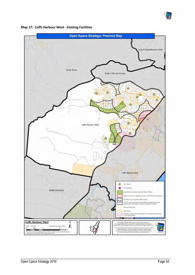
___________________________________________________________________________________________ Open Space Strategy 2010 Page 54
Map 17: Coffs Harbour West ‐ Existing Facilities
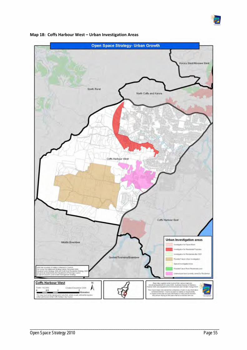
___________________________________________________________________________________________ Open Space Strategy 2010 Page 55
Map 18: Coffs Harbour West – Urban Investigation Areas

___________________________________________________________________________________________ Open Space Strategy 2010 Page 56
Map 19: Open Space Function ‐ Coffs West

___________________________________________________________________________________________ Open Space Strategy 2010 Page 57
Map 20: Landscape Setting ‐ Coffs West

___________________________________________________________________________________________ Open Space Strategy 2010 Page 58
Map 21: Catchment ‐ Coffs West

___________________________________________________________________________________________ Open Space Strategy 2010 Page 59
Map 22: Coffs Harbour East ‐ Existing Facilities
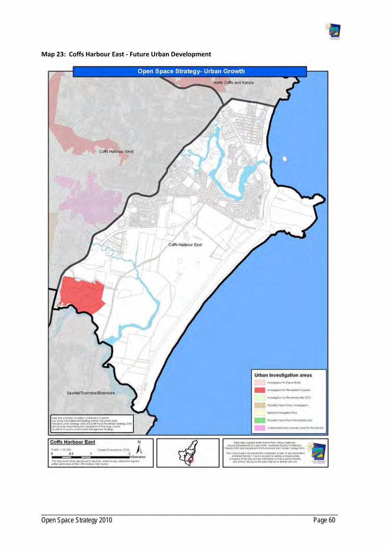
___________________________________________________________________________________________ Open Space Strategy 2010 Page 60
Map 23: Coffs Harbour East ‐ Future Urban Development

___________________________________________________________________________________________ Open Space Strategy 2010 Page 61
Map 24: Open Space Function ‐ Coffs East

___________________________________________________________________________________________ Open Space Strategy 2010 Page 62
Map 25: Landscape Setting ‐ Coffs East

___________________________________________________________________________________________ Open Space Strategy 2010 Page 63
Map 26: Catchment ‐ Coffs East

___________________________________________________________________________________________ Open Space Strategy 2010 Page 64
Map 27: North Coffs and Korora ‐ Existing Facilities

___________________________________________________________________________________________ Open Space Strategy 2010 Page 65
Map 28: North Coffs and Korora – Urban Investigation Areas

___________________________________________________________________________________________ Open Space Strategy 2010 Page 66
Map 29: Open Space Function ‐ North Coffs and Korora

___________________________________________________________________________________________ Open Space Strategy 2010 Page 67
Map 30: Landscape Setting ‐ North Coffs and Korora

___________________________________________________________________________________________ Open Space Strategy 2010 Page 68
Map 31: Catchment ‐ North Coffs and Korora
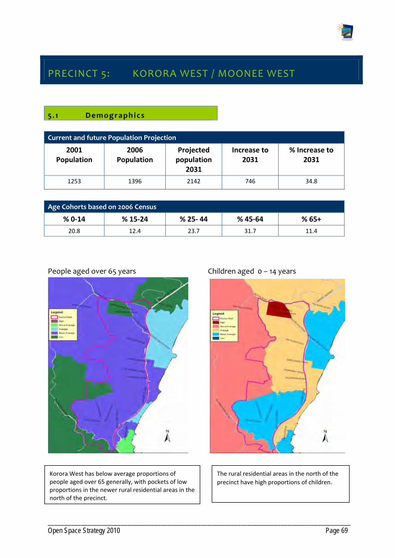
___________________________________________________________________________________________ Open Space Strategy 2010 Page 69
PRECINCT 5: KORORA WEST / MOONEE WEST
5 . 1 Demographics
Current and future Population Projection
2001 Population
2006 Population
Projected population
2031
Increase to 2031
% Increase to 2031
1253 1396 2142 746 34.8
Age Cohorts based on 2006 Census
% 0‐14 % 15‐24 % 25‐ 44 % 45‐64 % 65+
20.8 12.4 23.7 31.7 11.4
People aged over 65 years Children aged 0 – 14 years
Korora West has below average proportions of people aged over 65 generally, with pockets of low proportions in the newer rural residential areas in the north of the precinct.
The rural residential areas in the north of the
precinct have high proportions of children.

___________________________________________________________________________________________ Open Space Strategy 2010 Page 70
5 .2 Character
The Korora West precinct is located west of the Pacific Highway and is identified as a minor growth area of rural residential development stemming from Coffs Harbour and Korora.
5 .3 Future Development
Urban growth is planned in the precinct in accordance with the Korora DCP and the Rural Residential Strategy. Land within the Korora West precinct is earmarked for release in Stage Two (10‐15 years) of the Rural Residential Strategy.
The Settlement Strategy supports the rural residential development of the precinct. The Strategy recognises that future development should have regard to topography, servicing and other environmental constraints. Development should also address the impacts of the Pacific Highway.
5 .4 Current Open Space Provis ion
The Korora Nature Reserve is located on the southern boundary of the precinct.
There is a privately owned squash and swimming complex located in the southern end of the Korora West precinct and immediately west of the Pacific Highway.
Currently residents in the Korora West precinct access open space for sport, social and family recreation and play at Coffs Harbour or the Northern Beaches.
Table 9: Summary of Open Space by Type ‐ Korora West
Open Space Function Abbreviation Total area (ha) Number Examples
Access way/ Trail AWT 0.2 2
Non Recreation related Utility NR 2.3 2
5 .5 Gaps in Open Space Provis ion
The Korora West precinct does not contain any public open Spaces for play, social family recreation or amenity.
5 .6 Opportunit ies
Future sports field location has been identified within the Moonee Beach DCP, which partially falls within Moonee West. A social family space could be co‐located with this facility. This field could service the Korora West/Moonee West area as well as the Northern Beaches.

___________________________________________________________________________________________ Open Space Strategy 2010 Page 71
Dedication of key lands forming habitat and/or corridors functions for flora and fauna conservation, particularly in conjunction with any urban development of lands identified in Council's current growth strategies or lands currently zoned for residential. Encourage dedication at no cost to Council.
Additional open space as per core service levels provision for future residential areas identified in Council's current growth strategies. The number and location will be determined at detailed land planning stage.
Dedication of Open Space for access way and trails to link areas of existing and future open space in conjunction with any urban development of lands identified in Council's current growth strategy or land currently undeveloped and zoned for residential purposes. The number and location of these is to be determined at detailed land planning stage.

___________________________________________________________________________________________ Open Space Strategy 2010 Page 72
Map 32: Korora West ‐ Existing Facilities

___________________________________________________________________________________________ Open Space Strategy 2010 Page 73
Map 33: Korora West / Moonee West – Urban Investigation Areas

___________________________________________________________________________________________ Open Space Strategy 2010 Page 74
Map 34: Open Space Function ‐ Korora West / Moonee West

___________________________________________________________________________________________ Open Space Strategy 2010 Page 75
Map 35: Landscape Setting ‐ Korora West / Moonee West
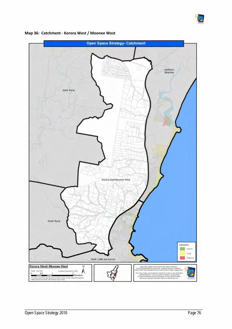
___________________________________________________________________________________________ Open Space Strategy 2010 Page 76
Map 36: Catchment ‐ Korora West / Moonee West

___________________________________________________________________________________________ Open Space Strategy 2010 Page 77
PRECINCT 6: MIDDLE BOAMBEE
6. 1 Demographics
Current and future Population Projection
2001 Population
2006 Population
Projected population
2031
Increase to 2031
% Increase to 2031
1555 1583 2008 425 21.1
Age Cohorts based on 2006 Census
% 0‐14 % 15‐24 % 25‐ 44 % 45‐64 % 65+
23.7 11.9 21.6 33.8 8.9
People aged over 65years Children aged 0‐14 years
Bonville and Boambee West have lower proportions of older adults generally.
Proportions of children in Boambee West vary between average and below average, reflective of a population below retirement age but with older children or children no longer at home. Bonville has generally average and above average numbers of children.

___________________________________________________________________________________________ Open Space Strategy 2010 Page 78
6.2 Character
The Middle Boambee precinct is located west of the Pacific Highway and is identified as a minor growth area stemming from Boambee East/ Sawtell/ Toormina. The area has been developed as rural residential with larger lifestyle lots being the dominant type.
6.3 Future Development
The Settlement Strategy supports the existing and continuing rural residential development of the precinct. The Strategy recognises that future development should have regard to topography, servicing and other environmental constraints. Development should also address the impacts of the Pacific Highway.
The South Coffs DCP identifies an area for future development at the north‐east corner of the precinct. Development proposed is industrial interspersed with pockets of rural residential.
6.4 Current Open Space Provis ion
The Boambee State Forest and Tuckers Nob State Forest borders the western boundary of the precinct.
Open Space for sport in the precinct includes Ayrshire Park which provides for soccer, and a privately owned indoor swimming pool located west of the precinct that only provides for swimming lessons.
Currently residents in the Middle Boambee precinct access open space for social and family recreation and play in Coffs Harbour or Boambee/ Sawtell/ Toormina.
Table 10: Summary of Open Space by Type – Middle Boambee
Open Space Function Abbreviation Total area (ha) Number Examples
Buffer B 1.5 1
Sport S 2.9 1 Ayrshire Park
6.5 Gaps in Open Space Provis ion
The existing Ayrshire Park Sports fields are not large enough to accommodate the expansion in soccer, the principal sport played on the grounds.
There is currently no open space for social and family recreation and play.
6.6 Opportunit ies
Development of a local social/family recreation space at Ayrshire Park co‐located with the soccer fields. Upgrade bridge and pathways at Ayrshire Park.

___________________________________________________________________________________________ Open Space Strategy 2010 Page 79
Map 37: Middle Boambee ‐ Existing Facilities

___________________________________________________________________________________________ Open Space Strategy 2010 Page 80
Map 38: Middle Boambee– Urban Investigation Areas
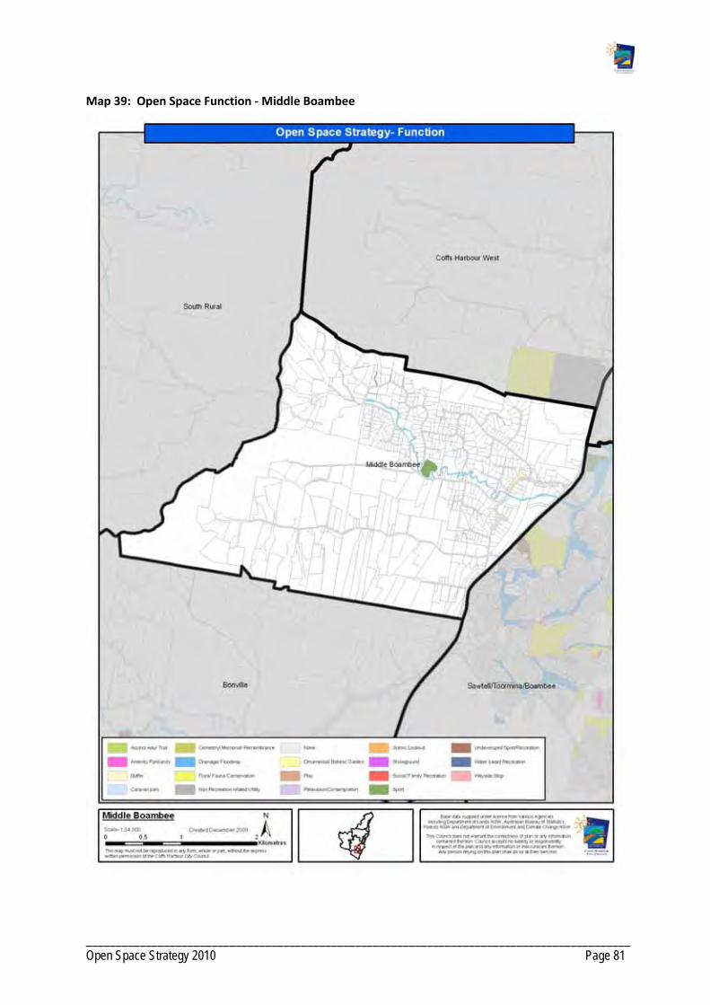
___________________________________________________________________________________________ Open Space Strategy 2010 Page 81
Map 39: Open Space Function ‐ Middle Boambee

___________________________________________________________________________________________ Open Space Strategy 2010 Page 82
Map 40: Landscape Setting ‐ Middle Boambee

___________________________________________________________________________________________ Open Space Strategy 2010 Page 83
Map 41: Catchment ‐ Middle Boambee

___________________________________________________________________________________________ Open Space Strategy 2010 Page 84
PRECINCT 7: SAWTELL / TOORMINA / BOAMBEE EAST
7 . 1 Demographics
Current and future Population Projection
2001 Population
2006 Population
Projected population
2031
Increase to 2031
% Increase to 2031
13571 15011 21522 6511 30.2
Age Cohorts based on 2006 Census
% 0‐14 % 15‐24 % 25‐ 44 % 45‐64 % 65+
22.4 12.0 23.5 25.5 16.7
People aged over 65 years Children aged 0‐14: years
Sawtell has high proportions of people over 65 in the southern area south of Lyons Road and above average generally throughout Sawtell. A retirement complex in Toormina has created a high proportion west of Hogbin Drive (41%) in Toormina/Boambee.
There are high proportions of children, reflective of a younger family demographic throughout Toormina and Boambee. Sunrise Drive area in particular has 30% of the population under 14 and only 7% over 65. The area to the east of Sawtell Road, Sawtell has low proportions of children at 8%.

___________________________________________________________________________________________ Open Space Strategy 2010 Page 85
7 .2 Character
The Sawtell/Toormina/Boambee East precinct is a major urban centre to the south of Coffs Harbour. The precinct includes the original suburbs of Sawtell, Toormina and Boambee East that have experienced rapid population growth in the last 10 years. Sawtell is the main tourist and holiday destination for the southern area of the LGA.
Sawtell has retained much of its original settlement pattern, with the main street reflecting the charm of a seaside village with the appeal of boutiques, restaurants and a cinema. The railway line splits the suburbs to the east of Sawtell. Toormina and Boambee East are primarily residential suburbs, with pockets of high quality vegetation spread throughout the localities.
7 .3 Future Development
The Sawtell precinct has been the focus of urban development in Coffs Harbour for the last 10 years and much of the land east of the Pacific Highway has been subdivided.
The Settlement Strategy states Council’s interest in the Sawtell precinct. There is support to continue developing Sawtell as a coastal village recognising the holiday, tourism and recreation appeal. Toormina and Boambee will continue to develop as coastal towns. The Strategy also recognises the need to reinforce the commercial, retail and service role of Toormina and Boambee East. This is in part reflected through the recent major expansion of the Toormina Shopping Precinct.
7 .4 Demand For Act iv i t ies
Activities ‐ present participation Activities people would like to do but do not
Walking
Swimming
Cycling / cycle racing
Going to the beach
Fishing
Picnic / barbecues
Golf
Bushwalking / hiking
Camping / caravanning
Surfing
Cycling / cycle racing
Swimming
Camping / caravanning
Attending live theatre / dance / performance
Basketball
Bushwalking / hiking
7 .5 Current Open Space Provis ion
The Bongil Bongil National Park borders the southern boundary of the Sawtell precinct. The Pacific Highway is the limit of urban development to the west and the airport lands for the boundary to the north.
The main areas of open space are the Sawtell and Boambee Beaches, Boambee Creek, and Sawtell Reserve. The Hulberts Road facility is the major sports facility for rugby league, cricket, tennis and cycling.
A number of flora and fauna reserves protect important plant communities along creeks and dunes and provide opportunities for wildlife refuge and dispersal.

___________________________________________________________________________________________ Open Space Strategy 2010 Page 86
7 .6 Sub Prec incts
Due to the size and population of the Precinct it has been broken into three smaller planning units for analysis.
Sawtell.
Toormina.
Boambee East.
7 .6 . 1 Sawtel l
The Sawtell and Boambee Beach Boambee Creek Reserve and Sawtell Reserve located on Bonville Creek provide water‐based recreation and social and family recreation opportunities to the local communities and visitors while conserving associated flora and fauna and landscape values.
Open spaces for sports in the Sawtell neighbourhood include:
The 18 hole Sawtell Golf Course.
Richardson Reserve providing for cricket and Australia Rules football.
Sawtell Reserve catering for bowls and croquet. The reserve also contains a public swimming pool.
Lyons Road tennis courts and cricket fields.
Open spaces for play and social and family recreation are distributed across the neighbourhood, although concentrated on the foreshore. The main locations for social and family recreation include Sawtell Reserve which has a caravan park, playground, picnic area and scenic lookout. Sawtell Headland and Boambee Creek reserve provide playgrounds, boat launching and picnic facilities.
There are a number of small (pocket) parks in the neighbourhood that include basic playground equipment.

___________________________________________________________________________________________ Open Space Strategy 2010 Page 87
Table 11: Summary of Open Space by Type – Sawtell
Open Space Function
Abbreviation Total area (ha) Number Examples
Access way/ Trail AWT 0.3 13
Amenity Parklands AP 1.0 5
Buffer B 0.01 1
Caravan Park CP 15.1 1
Cemetery/ Memorial/ Remembrance
MEM 0.3 1
Community Facility CF 0.4 2
Drainage/ Floodway DF 0.1 2
Flora/ Fauna Conservation
FFC 68.2 8
Play PL 0.6 3
Scenic Lookout SL 5.1 2
Social/ Family Recreation
SFR 0.6 2
Sport S 51.6 4
Water based Recreation
WBR 20.2 11
7 .6 .2 Toormina
There is significant open space conserving flora and fauna in the Toormina neighbourhood. This includes bushland / woodlands / forests to the north and native grasslands / wetlands to the south of the neighbourhood.
Open Space for sport in the Toormina neighbourhood includes:
Hulberts Road Facility including Toormina Oval that is centrally located and contains a velodrome, skate park, BMX facility, sports fields, netball courts and Guide Hall.
Toormina Rugby League Fields that provide for rugby league, rugby union and softball.
Privately owned gymnasium.
There are local parks dispersed around the neighbourhood providing for play. Toormina High School and William Bayldon Primary School allow community groups to use school facilities for recreation needs such as training.

___________________________________________________________________________________________ Open Space Strategy 2010 Page 88
Table 12: Summary of Open Space by Type – Toormina
Open Space Function Abbreviation Total area (ha) Number Examples
Access way/ Trail AWT 3.7 52
Amenity Parklands AP 4.8 12
Buffer B 3.8 7
Drainage/ Floodway DF 18.5 7
Flora/ Fauna Conservation FFC 74.6 18
Non Recreation related Utility
NR 18.6
3
Play PL 3.6 8
Relaxation/Contemplation RCE 2.2 1
Social/ Family Recreation SFR 4.7 1
Sport S 31.8 2
Undeveloped Sport/Recreation
USR 2.0
1
Water based Recreation WBR 2.4 1
7 .6 .3 Boambee East
There is a significant network of drainage and flora and fauna reserves in the Boambee / Boambee East neighbourhood. The flora and fauna conservation reserves protect bushland and forests.
The main area of open space for sport is the Boambee Sports Fields, adjacent to the Pacific Highway, providing for cricket and rugby league.
There are small local parks dispersed around the neighbourhood providing for play and visual amenity. Small playgrounds are located in the majority of the residential areas.
Boambee Primary School allows organised community groups to use recreation facilities on school property.
Table 13: Summary of Open Space by Type ‐ Boambee East
Open Space Function Abbreviation Total Area (ha) Number Examples
Access way/ Trail AWT 9.3 49
Buffer B 0.4 4
Community Facility CF 0.3 1
Drainage/ Floodway DF 26.3 12
Flora/ Fauna Conservation FFC 28.5 4
Play PL 0.5 3
Relaxation/Contemplation RCE 2.2 1
Sport S 3.3 1
Undeveloped Sport/Recreation
USR 3.3 1
___________________________________________________________________________________________ Open Space Strategy 2010 Page 89
7 .7 Gaps in Open Space Provis ion General ly
No social family opportunities exist outside of foreshore locations.
Many play spaces are small and lack sufficient challenge to engage children other than for short periods. In addition no other facilities are co‐located that would encourage longer stays.
Many areas are under‐served for social/family recreation space and play opportunities as depicted on Map 18, with limited scope to redress. This is of concern considering the younger family demographic that is prevalent throughout Toormina/ Boambee.
The precinct relies on the Toormina Sports Reserve, Hulberts Road and Toormina Rugby League Fields as the main open spaces for sport.
Sports fields require lighting and drainage works/ field improvement works to increase capacity.
The existing skate park is small and unsuitable for the full range of skate/ BBMX/blades/scooter sports.
7 .7 . 1 Sawtel l
Lack of Local social/family recreation space outside foreshore settings.
There is a lack in provision of trails in the Sawtell Precinct, with only a small number focused along the foreshore.
7 .7 .2 Toormina/ Boambee East
Lack of social family spaces with only limited capacity to upgrade play spaces to social/family recreation space due to size, topography or environmental constraints. In addition there are areas with no play or social/family recreation opportunities with limited scope to redress due to low availability of suitably located land or the existing road barriers. In particular the Lamberts Road area of Boambee East; and Seabreeze Place, Oscar Ramsay Drive and Sunrise Drive areas of Boambee lack both social/family recreation space and play opportunities.
Newer housing estates south of Lyons Road lack open space and are separated by a major road from accessing open space opportunities to the north.
Numerous small pocket playgrounds that offer very limited opportunities. Generally playgrounds lack shade and offer little scope to improve range of opportunity due to significant site constraints. Examples include Borrowdale Crescent.
Permeability: subdivision design is relatively impermeable for pedestrians and does not facilitate movement to or between public open space and schools.
Lack in provision of off‐road trails connecting key destinations.
Areas under‐served in access to local social sport opportunities in the western area of Toormina and Boambee East.
Limited recreational opportunities for adolescents outside of skate park.

___________________________________________________________________________________________ Open Space Strategy 2010 Page 90
7 .8 Opportunit ies
In particular, investigate development of Sawtell Sewerage Treatment Plant for open space sporting and recreation purposes upon decommissioning.
Investigate and acquire land for social and family recreation in neighbourhoods under‐served or, if acquisition not feasible, investigate opportunities to provide good off road linkages to nearby Reserves.
Create an additional district level social family recreation space at Bruce King Drive, incorporating mixed age play (including skate/BMX), local sports field, pathways and opportunities for adolescents, to assist in offsetting lack of local social family recreation and youth facility provision within Boambee/Boambee East. Connectivity to under‐served areas to the north‐east could be improved by a pedestrian bridge across Cordwells Creek and a network of off‐road trails to Sawtell Road. Similarly, connectivity to under‐served areas to the south could also be improved through development of an off‐road trail network.
Upgrading of play spaces to social family recreation space where opportunity is present. In particular at Amaroo Crescent, Graff Avenue, Lady Belmore Drive, Jane Circuit.
Undertake strategic upgrades of play grounds where no opportunity exists to create a SFR space servicing the catchment. In particular Borrowdale Crescent; Lady Belmore Drive; Jane Circuit; Bower Crescent. Consider removal of playground Dews Avenue and redevelopment of space as access way/trail.
Develop play space at Richardson Oval to broaden range of opportunities other than sporting.
Creation of local social family recreation space in conjunction with planned development south of Lyons Road to service the new estates areas south of Lyons Road that currently lack Open Space.
Upgrade the skate park, Minorie Drive.
Investigate opportunities, in conjunction with future developments within the southern Sawtell area, for provision of a social family recreation space to improve recreation outcomes for the southern area currently serviced by a small park containing only basic play opportunities with no scope for expansion.
Support the continued operation of the Sawtell Golf Club and the retention of the Crown land in perpetuity for sporting and recreation purposes.
Upgrade picnic area at Lyle Rose Memorial Park.
Work with LPMA and the Reserve Trust to redesign and develop Boambee Creek Reserve as a district level social family recreation space with improved pedestrian and traffic circulation, upgraded play spaces and picnic facilities, foreshore protection, improved kiosk.
Improve pedestrian circulation throughout Sawtell Headland Reserve through provision/redesign of pathways.
Increase capacity of existing sports fields through improvements.
Develop an off‐road trail network utilising drainage corridors and flora and fauna conservation spaces that connects open space, local schools, sports facilities, commercial precincts and community services.
Investigate potential for a fishing platform on Bonville Creek at Boronia Park.
Undertake improvements at the Sawtell Rock Pool including safety rail and picnic/shade/shelters.
Investigate the need for refurbishment of the toilet at Micks Retreat and create additional car parking up the hill to the west.
Develop trail network through Hulberts Road Sport Reserve.
___________________________________________________________________________________________ Open Space Strategy 2010 Page 91
Complete Master Plan for Hulberts Road and Toormina Ovals generally creating a cycling precinct throughout the eastern end and field sports/netball to the west.
Lot 132 DP 828013, Lyons Road ‐ donate parcel to National Parks for addition to Bongil Bongil National Park.
Seek opportunities for new/expanded open space to develop local social/family recreation spaces in areas identified as under‐served in open space opportunity throughout Boambee East.
Dedication of a local social/family recreation space, as per core service level provisions in conjunction with any redevelopment of the Sawtell Golf Course.
Dedication of key lands forming habitat and/or corridors functions for flora and fauna conservation, particularly in conjunction with any urban development of lands identified in Council's current growth strategies or lands currently zoned for residential. Encourage dedication at no cost to Council.
Dedication of open space for access way and trails to link areas of existing and future open space in conjunction with any urban development of lands identified in Council's current growth strategy or land currently undeveloped and zoned for residential purposes. The number and location of these is to be determined at detailed land planning stage.
Addition of open space identified in the North Bonville DCP.
Dedication of the SEPP 14 Wetland component of Lot 61 DP 818826 in conjunction with any industrial development. Encourage dedication at no cost to Council.
Lot 238 DP 841861 is Department of Housing land which could be transferred to Council. Pathways could be built to link sewerage treatment plant site to ends of cul‐de‐sacs and connect in with bridge in cleared park to the north.
In consultation with LPMA and Reserve Trust investigate addition of Boambee Creek Reserve to CCSP under Council control.
Investigate acquiring riparian corridor on Lot 3 DP 746772, Shaws Close, Boambee East.
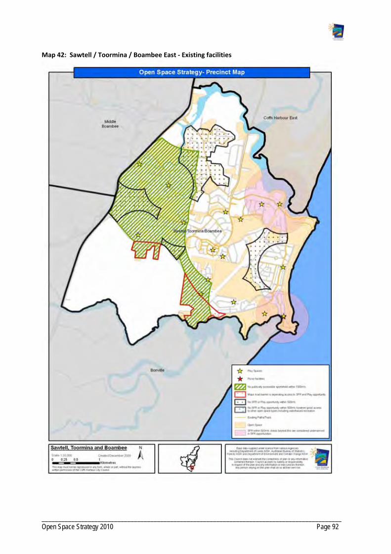
___________________________________________________________________________________________ Open Space Strategy 2010 Page 92
Map 42: Sawtell / Toormina / Boambee East ‐ Existing facilities

___________________________________________________________________________________________ Open Space Strategy 2010 Page 93
Map 43: Sawtell, Toormina and Boambee – Urban Investigation Areas

___________________________________________________________________________________________ Open Space Strategy 2010 Page 94
Map 44: Open Space Function ‐ Sawtell, Toormina and Boambee
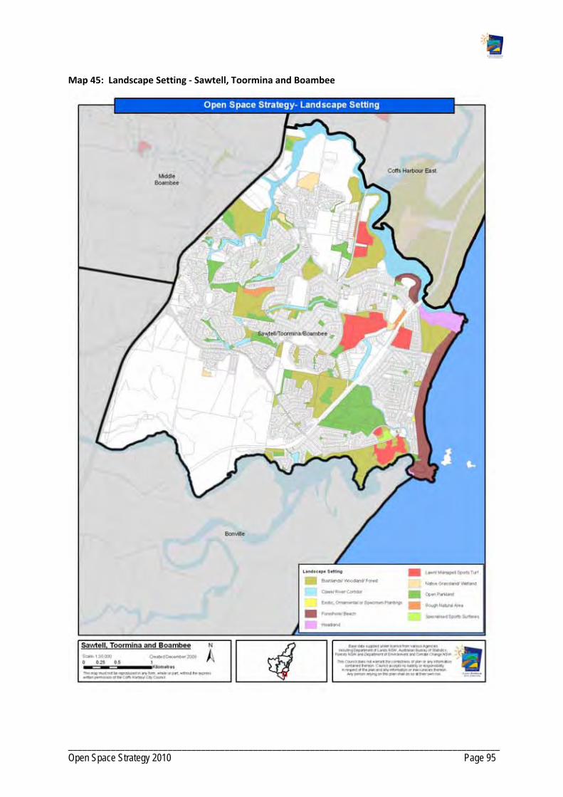
___________________________________________________________________________________________ Open Space Strategy 2010 Page 95
Map 45: Landscape Setting ‐ Sawtell, Toormina and Boambee

___________________________________________________________________________________________ Open Space Strategy 2010 Page 96
Map 46: Catchment ‐ Sawtell, Toormina and Boambee

___________________________________________________________________________________________ Open Space Strategy 2010 Page 97
PRECINCT 8: BONVILLE
8.1 Demographics
Current and future Population Projection
2001 Population
2006 Population
Projected population
2031
Increase to 2031
% Increase to 2031
1995 2028 2870 842 29.3
Age Cohorts based on 2006 Census
% 0‐14 % 15‐24 % 25‐ 44 % 45‐64 % 65+
21.1 12.0 20.7 35.1 11.1
For spatial characteristics see Precinct 6 Boambee West
8.2 Character
The Bonville precinct is located along the southern boundary of the Coffs Harbour LGA and includes the hinterland village of Bonville. It is predominantly rural and there is further rural residential expansion planned in the future. National Parks and State Forests surround Bonville and provide the main sources of open space in the precinct. The Bonville International Golf Course is also within the precinct and attracts visitors from far and wide to its facilities.
Whilst exact numbers are not available, anecdotal evidence suggests that Bonville supports a high level of horse ownership, estimated to be around 500 horses. It could be assumed that half of these would be in active work.
8.3 Future Development
Significant urban growth is planned in the precinct in accordance with the Bonville DCP and the Rural Residential Strategy. The Rural Residential Strategy shows 421 hectares earmarked for release in Stage One (within the next 10 years). The Bonville locality is the only locality with a Stage One release timeframe.
The Settlement Strategy supports the development of coastal hinterland area and retaining and enhancing rural residential character. The Strategy recognises that future residential development should have regard to the topography, access and environmental constraints of the precinct. In the long term, post 2035, the Strategy supports the development of a town centre catering for approximately 2100 dwellings.

___________________________________________________________________________________________ Open Space Strategy 2010 Page 98
8.4 Demand For Act iv i t ies
Activities – present participation Activities people would like to do but do not
Walking
Swimming
Cycling / cycle racing
Going to the beach
Fishing
Picnic / Barbecues
Golf
Bushwalking / hiking
Camping / caravanning
Surfing
Cycling / cycle racing
Swimming
Camping / caravanning
Attending live theatre / dance / performance
Basketball
Bushwalking / hiking
8.5 Current Open Space Provis ion
The Bonville precinct is surrounded by functional flora and fauna conservation open space including the Bongil Bongil National Park and State Forests of Tuckers Nob and Pine Creek. Council currently manages one reserve in the precinct.
The Bonville neighbourhood relies on the Sawtell precinct located north east to provide Open Space for sport and playground access. The only open space for sport in the precinct is the privately owned Bonville International Golf Course, which can be used by the public.
There is undeveloped parkland located on Burgess Creek off Bakker Road. This park provides an opportunity to provide an equestrian facility and/or open space for social and family recreation.
There is a community hall located centrally in Bonville.
Table 14: Summary of Open Space by Type – Bonville
Open Space Function Abbreviation Total area (ha) Number Examples
Community Facility CF 0.3 1
Drainage/ Floodway DF 1.6 1
Undeveloped Sport/Recreation USR 6.8 1
8.6 Gaps in Open Space Provis ion
There is no open space for sport in Bonville. Bonville is a focus of rural residential development in Coffs Harbour and a district sports facility should be considered in line with urban development planned for the neighbourhood.

___________________________________________________________________________________________ Open Space Strategy 2010 Page 99
Bonville has no social and family recreation and play opportunities for its community. The population would support more play opportunities for children and young people with a high number of families residing in the precinct.
There is no off‐road trail in Bonville that connects recreation opportunities, the school and commercial precinct.
Despite the high level of horse ownership there are no equestrian facilities within easy travel distance within the precinct, with riders having to travel to Nana Glen (45mins) to attend training days and competitions. Consideration should be given to the establishment of an equestrian ground for informal riding and training.
8.7 Opportunit ies
Investigate the acquisition of land for a district level sports facility that provides for major participation sports in Bonville in line with the expected population growth that is planned for the neighbourhood.
Open space for social and family recreation that includes play for children and young people must be considered in the development plans for the future neighbourhoods.
Develop an equestrian area on the southern end of the Bakker Drive Reserve and incorporate a social family park, amenities, car parking on the northern end. Future access via North Bonville Road and Braford Drive in conjunction with any redevelopment.
Formalise public access arrangements in conjunction with any redevelopment to the west of the Bakker Drive Reserve to create bridle paths and access trails to nearby State Forest trail network via Crossmaglen Road. Also investigate opportunities to develop linkages via North Bonville Road and the Crown Road network, to the Tuckers Nob, Boambee and Orara West State Forests.
Land for one district level sport venue, as per core service level criteria, to service the southern district.
Additional open space for local social family recreation and local sport as per core service levels criteria within areas identified for short term future residential expansion, as identified in Council's current growth strategies. Location and number of spaces will be determined in conjunction with detailed land planning processes.
Dedication of open space for access way and trails to link areas of existing and future open space in conjunction with any urban development of lands identified in Council's current growth strategy or land currently undeveloped and zoned for residential purposes. The number and location of these is to be determined at detailed land planning stage.
Additional open space for local social family recreation, amenity parkland and district sport as per core service levels criteria within areas identified as future town centre in the long term (post 2031) in Council's current growth strategies. Location and number of spaces to be determined in conjunction with detailed land planning processes.
Dedication of key lands forming habitat and/or corridors functions for flora and fauna conservation, particularly in conjunction with any urban development of lands identified in Council's current growth strategies or lands currently zoned for residential. Encourage dedication at no cost to Council.

___________________________________________________________________________________________ Open Space Strategy 2010 Page 100
Map 47: Bonville ‐ Existing Facilities

___________________________________________________________________________________________ Open Space Strategy 2010 Page 101
Map 48: Bonville – Urban Investigation Areas

___________________________________________________________________________________________ Open Space Strategy 2010 Page 102
Map 49: Open Space Function ‐ Bonville
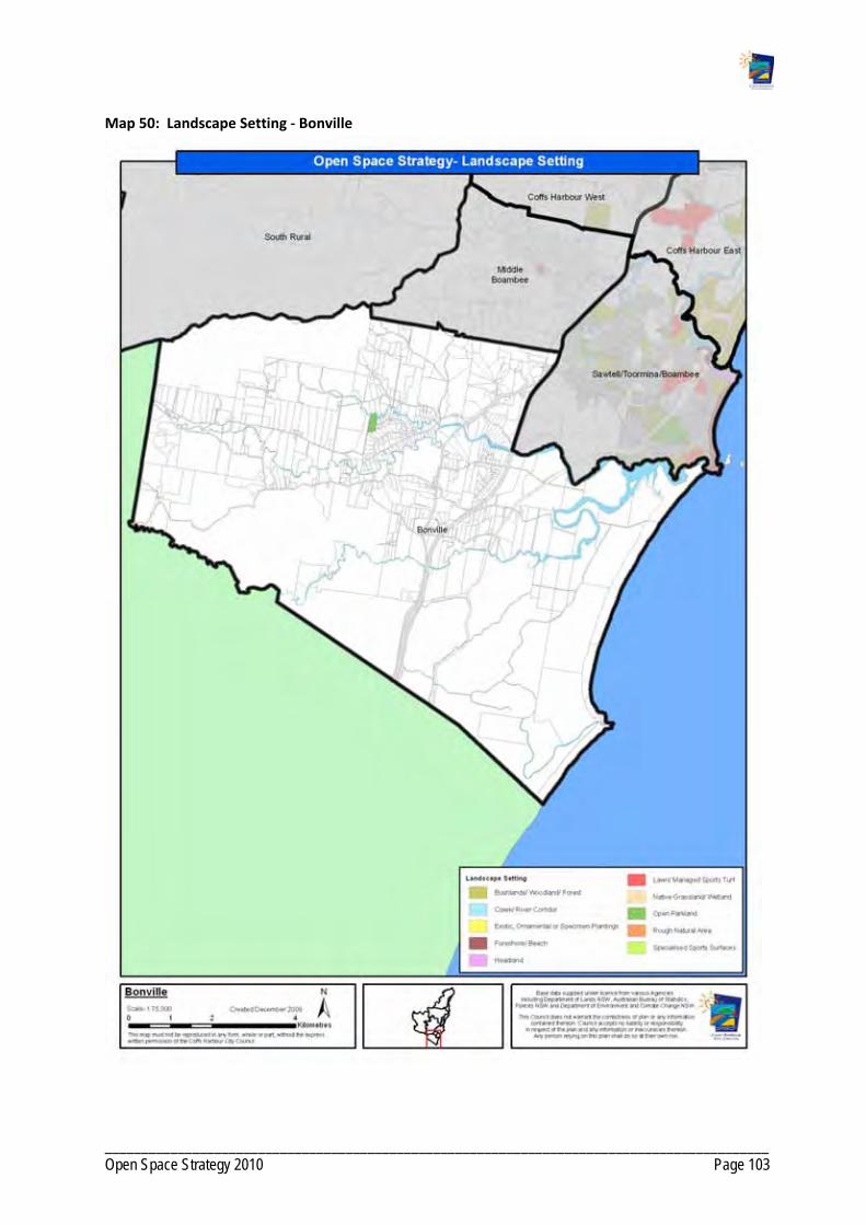
___________________________________________________________________________________________ Open Space Strategy 2010 Page 103
Map 50: Landscape Setting ‐ Bonville

___________________________________________________________________________________________ Open Space Strategy 2010 Page 104
Map 51: Catchment ‐ Bonville

___________________________________________________________________________________________ Open Space Strategy 2010 Page 105
PRECINCT 9: FAR NORTH RURAL
9. 1 Demographics
Current and future Population Projection
2001 Population
2006 Population
Projected population
2031
Increase to 2031
% Increase to 2031
370 445 545 100 18.3
Age Cohorts based on 2006 Census
% 0‐14 % 15‐24 % 25‐ 44 % 45‐64 % 65+
22.7 11.2 18.8 33.2 13.9
People aged over 65 years Children aged 0 – 14 years
Far North Rural has an average number of people over 65 in the population. This reflects an agricultural area with older people retiring to reside elsewhere.
Far North Rural has an average number of children between 0 to14 in the population.

___________________________________________________________________________________________ Open Space Strategy 2010 Page 106
9.2 Character
The Far North Rural precinct includes rural landholdings across the broad localities of Dirty Creek, Upper Corindi and Barcoongere. The Yuraygir National Park, Barcoongere State Forest and Newfoundland State Forest all border the north of the precinct. Large tracts of Conglomerate and Wedding Bells State Forests border the southern end of the precinct. These forests provide the precinct with its main areas of public open space.
9.3 Future Development
In the long term, a small pocket of rural residential development is planned to the east of the precinct along the Pacific Highway, building off the townships of Red Rock and Corindi. The Settlement Strategy indicates Council’s plans for the Red Rock and Corindi areas. Council plans to retain these townships as coastal villages, containing urban expansion. The significant environmental constraints to the north limit urban expansion.
9.4 Demand For Act iv i t ies
Activities ‐ present participation Activities people would like to do but do not
Walking
Cycling / cycle racing
Swimming
Tennis
Fishing
Football
Surfing
Attending live theatre / dance / performance
Cycling / cycle racing
Swimming
Tai chi / yoga / meditating / Pilates
9.5 Current Open Space Provis ion
No Council owned or managed recreational open space is present within this Precinct. Open space opportunities are available in the adjoining precincts of Woolgoolga, and Far Northern Beaches including Corindi and Red Rock. Community Halls are also accessible within the adjacent LGA of Clarence Valley at Halfway Creek and Lanitza.
Table 15: Summary of Open Space by Type – Far North Rural
Open Space Function
Abbreviation Total area (ha) Number Examples
Non‐Recreation Utility
NR 38.3 1

___________________________________________________________________________________________ Open Space Strategy 2010 Page 107
9.6 Gaps in Open Space Provis ion
There is no dedicated open space for sport or social and family recreation space that offers opportunities for the rural community. Residents must travel to the coastal areas of Red Rock, Corindi and Woolgoolga or to the adjoining LGA of Clarence Valley to access public open spaces. Council owns no land in this precinct, and there is no expressed demand by the community for Council‐managed public open space at this time.
Providing a local recreation reserve in conjunction with potential rural residential development in the precinct is desirable. A recreation reserve would serve the local needs for social sport and social and family recreation. The rural areas consist of some young families who seek active recreation experiences and play space.
Future public open space should be planned near the highway or major access routes within the precinct to enable access by all rural townships.
9.7 Opportunit ies
Investigate community demand for a local sports/recreation reserve which can provide for social and family recreation. Could contain a perimeter trail if appropriate.
Development of a regional trail network, to service horse riders, mountain bikers and hikers linking Corindi, Red Rock and the State Forests and National Parks utilising Crown roads and through negotiating property agreements with private property owners if required.
No additional open space is immediately required within this precinct. However, this is subject to further community consultation to determine needs.

___________________________________________________________________________________________ Open Space Strategy 2010 Page 108
Map 52: Far North Rural ‐ Existing Facilities

___________________________________________________________________________________________ Open Space Strategy 2010 Page 109
Map 53: Far North Rural – Urban Investigation Areas

___________________________________________________________________________________________ Open Space Strategy 2010 Page 110
Map 54: Open Space Function ‐ Far North Rural

___________________________________________________________________________________________ Open Space Strategy 2010 Page 111
Map 55: Landscape Setting ‐ Far North Rural
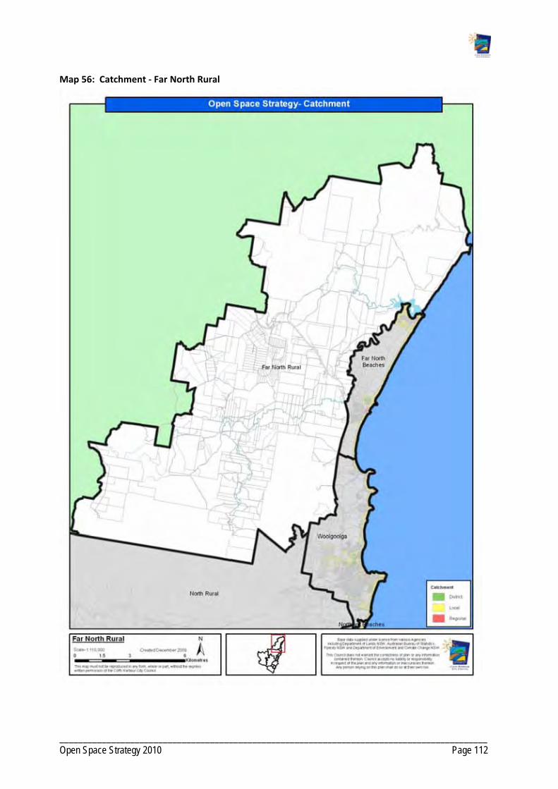
___________________________________________________________________________________________ Open Space Strategy 2010 Page 112
Map 56: Catchment ‐ Far North Rural

___________________________________________________________________________________________ Open Space Strategy 2010 Page 113
PRECINCT 10: NORTH RURAL
10 . 1 Demographics
Current and future Population Projection
2001 Population
2006 Population
Projected population
2031
Increase to 2031
% Increase to 2031
1953 1990 2305 315 13.6
Age Cohorts based on 2006 Census
% 0‐14 % 15‐24 % 25‐44 % 45‐64 % 65+
24.1 10.7 25.1 30.8 9.3
People aged over 65 Children aged 0 to 14
North Rural below averages proportions of older adults reflective of a farming and rural residential community where older people have retired elsewhere. Nana Glen in particular has only 7% of its population aged over 65.
North Rural has average and above average proportions of children once again reflecting a rural
residential community of younger families.
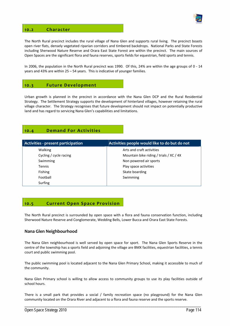
___________________________________________________________________________________________ Open Space Strategy 2010 Page 114
10 .2 Character
The North Rural precinct includes the rural village of Nana Glen and supports rural living. The precinct boasts open river flats, densely vegetated riparian corridors and timbered backdrops. National Parks and State Forests including Sherwood Nature Reserve and Orara East State Forest are within the precinct. The main sources of Open Spaces are the significant flora and fauna reserves, sports fields for equestrian, field sports and tennis.
In 2006, the population in the North Rural precinct was 1990. Of this, 24% are within the age groups of 0 ‐ 14 years and 43% are within 25 – 54 years. This is indicative of younger families.
10 .3 Future Development
Urban growth is planned in the precinct in accordance with the Nana Glen DCP and the Rural Residential Strategy. The Settlement Strategy supports the development of hinterland villages, however retaining the rural village character. The Strategy recognises that future development should not impact on potentially productive land and has regard to servicing Nana Glen’s capabilities and limitations.
10 .4 Demand For Act iv i t ies
Activities ‐ present participation Activities people would like to do but do not
Walking
Cycling / cycle racing
Swimming
Tennis
Fishing
Football
Surfing
Arts and craft activities
Mountain bike riding / trials / XC / 4X
Non powered air sports
Play space activities
Skate boarding
Swimming
10 .5 Current Open Space Provis ion
The North Rural precinct is surrounded by open space with a flora and fauna conservation function, including Sherwood Nature Reserve and Conglomerate, Wedding Bells, Lower Bucca and Orara East State Forests.
Nana Glen Neighbourhood
The Nana Glen neighbourhood is well served by open space for sport. The Nana Glen Sports Reserve in the centre of the township has a sports field and adjoining the village are BMX facilities, equestrian facilities, a tennis court and public swimming pool.
The public swimming pool is located adjacent to the Nana Glen Primary School, making it accessible to much of the community.
Nana Glen Primary school is willing to allow access to community groups to use its play facilities outside of school hours.
There is a small park that provides a social / family recreation space (no playground) for the Nana Glen community located on the Orara River and adjacent to a flora and fauna reserve and the sports reserve.

___________________________________________________________________________________________ Open Space Strategy 2010 Page 115
Bucca Neighbourhood
The Bucca neighbourhood is well served by open space for sport. This includes the Bucca Sports Reserve that has a sports field and tennis court. There are limited play opportunities at the reserve. There is a preschool that provides play opportunities for members and also provides space to a local playgroup.
Table 16: Summary of Open Space by Type – North Rural
Open Space Function
Abbreviation Total area (ha) Number Examples
Cemetery/ Memorial/ Remembrance
MEM 6.8 2
Flora/ Fauna Conservation
FFC 3.4 3
Non Recreation related Utility
NR 79.7 1
Social/ Family Recreation
SFR 0.3 1
Sport S 21.9 5 Bucca Sports Reserve
10 .6 Gaps in Open Space Provis ion
Bucca has no public play opportunities for its community, outside of the preschool. A high number of families residing in this part of the precinct and there is likely to be demand for more play opportunities for children and young people.
Nana Glen has no public playground. At present the school allows public use of their playground outside of school hours.
The BMX facility provides opportunity for adolescents however other opportunities are limited.
10 .7 Opportunit ies
Work with LPMA and the Reserve Trust to determine the level of community support for development of a playground at the Bucca Sports Reserve.
Development of a nature‐based playground at Archie Hunter Reserve.
Explore opportunities to develop a nature trail utilising the Sportsground to connect Nana Glen and Nana Glen Rail.
Development of amenities at Nana Glen Sportsground.
Development of additional facilities supporting equestrian pursuits at Nana Glen Sport and Recreation Grounds. Retain focus of equestrian centre and improvements to equestrian facilities such as stables, sand arenas, etc.
Develop trails around the perimeter of the sports reserves.

___________________________________________________________________________________________ Open Space Strategy 2010 Page 116
Investigate community interest in refurbishment of the Tennis Courts to a multi purpose facility.
Investigate opportunities for public use of Nana Glen school’s recreation facilities.
No additional Open Space is immediately required within this Precinct as there is sufficient scope for redevelopment of existing open space to service current and planned future populations as per Council's current growth strategy.

___________________________________________________________________________________________ Open Space Strategy 2010 Page 117
Map 57: North Rural ‐ Existing Facilities

___________________________________________________________________________________________ Open Space Strategy 2010 Page 118
Map 58: North Rural – Urban Investigation Areas

___________________________________________________________________________________________ Open Space Strategy 2010 Page 119
Map 59: Open Space Function ‐ North Rural

___________________________________________________________________________________________ Open Space Strategy 2010 Page 120
Map 60: Landscape Setting ‐ North Rural

___________________________________________________________________________________________ Open Space Strategy 2010 Page 121
Map 61: Catchment ‐ North Rural

___________________________________________________________________________________________ Open Space Strategy 2010 Page 122
PRECINCT 11: SOUTH RURAL
1 1 . 1 Demographics
Current and future Population Projection
2001 Population
2006 Population
Projected population 2031
Increase to 2031
% Increase to 2031
2178 2118 2570 452 17.5
Age Cohorts based on 2006 Census
% 0‐14 % 15‐24 % 25‐ 44 % 45‐64 % 65+
23.89 11.38 24.69 31.87 8.17
People aged over 65 Children aged 0‐14 years
South Rural has low proportions of older adults generally, reflective of a Rural Community where older people have retired from farming and moved elsewhere.
South Rural generally has above average proportion of children, reflective of population of younger families. There is a pocket around Karangi and Upper Orara that has average numbers of children.

___________________________________________________________________________________________ Open Space Strategy 2010 Page 123
In 2006, the population in the Rural South precinct was 2,118. The precinct consists of many young families with a high proportion of people in the age groups of 0 ‐ 14 (24%) and 43% in the 25 – 54 age group. The demographic data show a higher than average household size of around 2.8 and a higher than average median household income.
1 1 .2 Character
The Rural South precinct includes the small hinterland villages of Coramba, Karangi and Upper Orara and supports mostly rural living. Broad acre farming and nature‐based tourism are present in this precinct. National Parks and State Forests surround the settled areas. The main areas of open space are the significant flora and fauna reserves and facilities for tennis and other sports, including soccer and rugby league, in Coramba and Upper Orara.
1 1 .3 Future Development
Urban growth is planned in the precinct in accordance with the Coramba and Karangi DCP and the Rural Residential Strategy. The Rural Residential Strategy recommends the release of 837 hectares for rural residential development in stage three of the program. Stage three localities are earmarked for release in the long term (>15 years (2023+)) after areas closer to the coast and city are developed for the purpose.
The Settlement Strategy supports the development of hinterland villages, while retaining the rural village character. The Strategy recognises that future development should not impact on potentially productive land and has regard to the localities of Coramba and Karangi in terms of their capabilities and limitations.
1 1 .4 Demand For Act iv i t ies
Activities ‐ presently participation Activities people would like to do but do not
Walking
Cycling / cycle racing
Swimming
Tennis
Fishing
Football
Surfing
Arts and craft activities
Mountain bike riding / trials / XC / 4X
Non powered air sports
Play space activities
Skate boarding
Swimming
1 1 .5 Current Open Space Provis ion
The Rural South precinct is surrounded by flora and fauna conservation open space including the Bindarri and Ulidarra National Parks and the Orara West, Orara East, Lower Bucca and Boambee State Forests. State Forests provide a place for nature based recreation opportunities that are not permitted within National Parks such as horse riding and trail biking as well as recreational hunting in some locations.

___________________________________________________________________________________________ Open Space Strategy 2010 Page 124
Coramba Neighbourhood
The Coramba neighbourhood is well served by open space for sport. The Coramba Sports Reserve is located on the outskirts of the town, (however not within walking distance) and provides for field sports, specifically rugby league.
There are two small parks in Coramba (Thrower Avenue Park and CWA Park) with the CWA Park providing junior play opportunities. The CWA Park also functions as an important way stop location. It is situated on the tourist drive between Grafton and Coffs Harbour, is close to shops, and provides picnic areas and toilet facilities to travellers.
The Thrower Avenue open space has limited options for facility development due to significant flooding issues. Similar issues are associated with the open space adjacent to the Orara River off Martin Street.
The Orara River is a popular site for swimming and other water based activities.
Coramba Public School allows organised community groups to use its facilities for recreation.
Karangi Neighbourhood
The Karangi neighbourhood is under‐serviced for public open space apart from the presence of the rifle/pistol range. Residents must travel to Coffs Harbour, Coramba or Upper Orara to access open space for sport, social and family recreation and play.
Upper Orara Neighbourhood
The Upper Orara neighbourhood is well served by open space for sport. The Orara Sports Reserve is located centrally and provides for tennis and field sports, specifically soccer. The Reserve also has a playground and runs a regular playgroup from the facility.
Table 17: Summary of Open Space by Type – South Rural
Open Space Function Abbreviation Total area (ha) Number Examples
Cemetery/ Memorial/ Remembrance
21.2 1
Karangi Cemetery
Drainage/ Floodway .04 1
Non Recreation related Utility
157.1 1
Karangi Dam
Play 0.2 1
Sport 8.3 5 Orara Sports Reserve
Undeveloped Sport/Recreation
0.4 1

___________________________________________________________________________________________ Open Space Strategy 2010 Page 125
1 1 .6 Gaps in Open Space Provis ion
There is no open space for sport in Karangi. Karangi and Coramba are candidate areas for rural residential development in Coffs Harbour post 2023. In the long term, a district sports facility should be considered to service the Karangi neighbourhood in conjunction with the staging of the land release for rural residential. Playgrounds and walkways need also to be considered.
There will be a need for additional open spaces for social and family recreation in line with the growth of the precinct. The population would support more play opportunities for children and young people residing in the precinct.
The existing sportsground at Upper Orara has limited scope for expansion within the Crown Reserve, creating capacity problems due to the continuing growth in the numbers of junior players.
Amenities and car parking at Upper Orara need improvement.
There are no off‐road trails in Coramba that connect recreation opportunities, schools, commercial precincts and community services.
Lack of opportunities for adolescents.
1 1 .7 Opportunit ies
Opportunities to access open space for social and family recreation and play for children and young people must be considered in the development plans for the areas.
Develop a trail network that connects with the local schools, sports facilities, commercial precincts and community services including footpath improvements. In particular Investigate opportunities to develop an off road trail connecting Coramba to the Showground and circuit trails throughout Coramba village.
Provision of recreational facilities targeting adolescents and pre‐teens within Coramba.
Improve Martin Street Reserve for water‐based recreation/picnic opportunities within flooding constraints.
Investigate development of a local two court tennis facility at Coramba.
Explore opportunity to acquire land west of the existing Thrower Avenue Reserve as a potential tennis facility.
Investigate opportunities to develop an off road trail connecting Coramba to the Showground.

___________________________________________________________________________________________ Open Space Strategy 2010 Page 126
Map 62: South Rural ‐ Existing Facilities
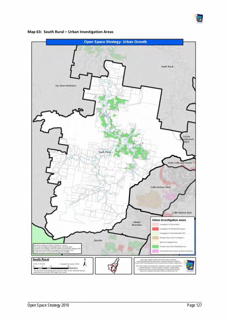
___________________________________________________________________________________________ Open Space Strategy 2010 Page 127
Map 63: South Rural – Urban Investigation Areas
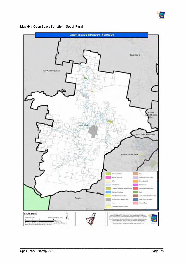
___________________________________________________________________________________________ Open Space Strategy 2010 Page 128
Map 64: Open Space Function ‐ South Rural
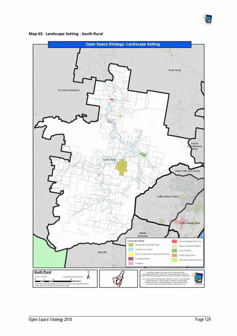
___________________________________________________________________________________________ Open Space Strategy 2010 Page 129
Map 65: Landscape Setting ‐ South Rural

___________________________________________________________________________________________ Open Space Strategy 2010 Page 130
Map 66: Catchment ‐ South Rural

___________________________________________________________________________________________ Open Space Strategy 2010 Page 131
PRECINCT 12: FAR WEST HINTERLAND
12 . 1 Demographics
Current and future Population Projection
2001 Population
2006 Population
Projected population
2031
Increase to 2031
% Increase to 2031
553 524 630 106 16.8
Age Cohorts based on 2006 Census
% 0‐14 % 15‐24 % 25‐ 44 % 45‐64 % 65+
24.2 12.8 22.9 32.6 7.4
People aged over 65 Children aged 0‐14 years
In 2006, the population in the Far West Hinterland precinct was 524.
Far West Hinterland has low proportions of older adults generally.
There are high proportions of children in Ulong and above average for the remainder of the Precinct.

___________________________________________________________________________________________ Open Space Strategy 2010 Page 132
12 .2 Character
The Far West Hinterland precinct includes the hinterland villages of Lowanna and Ulong and primarily supports rural living. Broad acre farming and nature‐based tourism are carried out in this precinct. National Parks, State Conservation Areas and State Forests are a feature of the Far West Hinterland precinct and include the Bindarri and Dorrigo National Parks. The main areas of open spaces are the significant flora and fauna reserves that not only protect the important environmental values of the area, but also provide nature‐based activities like bushwalking.
There is a higher percentage of indigenous people in the precinct. The demographic supports young families with more households supporting children; 24% of the population is between 0‐14 (Coffs Harbour average 20%). Ulong Village in particular has 34% of its population aged between 0‐14. The precinct is generally indicative of a lower socio‐economic base, illustrated by its lower than average median household income.
12 .3 Future Development
The Settlement Strategy supports the development of hinterland villages while retaining the rural village character. The Strategy recognises that future development should not impact on potentially productive land and has regard to the capabilities and limitations of Lowanna and Ulong. In the draft Rural Residential Strategy is no proposal for the Villages of Ulong and Lowanna to be candidate areas for rural residential development to the year 2031.
12 .4 Demand For Act iv i t ies
Activities ‐ present participation Activities people would like to do but do not
Walking
Cycling / cycle racing
Swimming
Tennis
Fishing
Football
Surfing
Arts and craft activities
Mountain bike riding / trials / Moto Cross / 4WD
Non powered air sports
Play space activities
Skate boarding
Swimming
12 .5 Current Open Space Provis ion
The Far West Hinterland precinct is surrounded by open space with a flora and fauna conservation function, including the Bindarri and Dorrigo National Parks and six State Forests including Wild Cattle Creek, Kangaroo River, Gundar, Nana Creek, Bagawa and Orara West. The State Forests provide opportunities for nature‐based recreation activities such as bushwalking, mountain biking, horse riding as well as motorised recreation.
The Lowanna and Brooklana neighbourhoods rely on the National Parks and State Forests for recreation, and the Ulong showground for social and sports events.
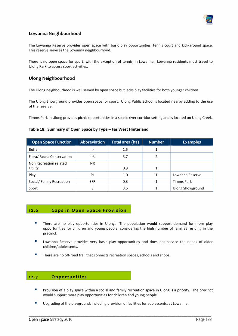
___________________________________________________________________________________________ Open Space Strategy 2010 Page 133
Lowanna Neighbourhood
The Lowanna Reserve provides open space with basic play opportunities, tennis court and kick‐around space. This reserve services the Lowanna neighbourhood.
There is no open space for sport, with the exception of tennis, in Lowanna. Lowanna residents must travel to Ulong Park to access sport activities.
Ulong Neighbourhood
The Ulong neighbourhood is well served by open space but lacks play facilities for both younger children.
The Ulong Showground provides open space for sport. Ulong Public School is located nearby adding to the use of the reserve.
Timms Park in Ulong provides picnic opportunities in a scenic river corridor setting and is located on Ulong Creek.
Table 18: Summary of Open Space by Type – Far West Hinterland
Open Space Function Abbreviation Total area (ha) Number Examples
Buffer B 1.5 1
Flora/ Fauna Conservation FFC 5.7 2
Non Recreation related Utility
NR 0.3 1
Play PL 1.0 1 Lowanna Reserve
Social/ Family Recreation SFR 0.3 1 Timms Park
Sport S 3.5 1 Ulong Showground
12 .6 Gaps in Open Space Provis ion
There are no play opportunities in Ulong. The population would support demand for more play opportunities for children and young people, considering the high number of families residing in the precinct.
Lowanna Reserve provides very basic play opportunities and does not service the needs of older children/adolescents.
There are no off‐road trail that connects recreation spaces, schools and shops.
12 .7 Opportunit ies
Provision of a play space within a social and family recreation space in Ulong is a priority. The precinct would support more play opportunities for children and young people.
Upgrading of the playground, including provision of facilities for adolescents, at Lowanna.

___________________________________________________________________________________________ Open Space Strategy 2010 Page 134
Investigate level of community interest in upgrading the tennis courts to a multi purpose facility.
Off‐road trails should be considered in Lowanna and Ulong that connect recreation opportunities, the school and shop.
Investigate need, and possible location, for a BMX/Skate facility in either Ulong or Lowanna.
No additional open space is required within this Precinct as there is sufficient scope for redevelopment of existing open pace to service current and planned future populations as per Council's current growth strategy.

___________________________________________________________________________________________ Open Space Strategy 2010 Page 135
Map 67: Far West Hinterland ‐ Existing Facilities

___________________________________________________________________________________________ Open Space Strategy 2010 Page 136
Map 68: Far West Hinterland – Urban Investigation Areas

___________________________________________________________________________________________ Open Space Strategy 2010 Page 137
Map 69: Open Space Function ‐ Far West Hinterland

___________________________________________________________________________________________ Open Space Strategy 2010 Page 138
Map 70: Landscape Setting ‐ Far West Hinterland
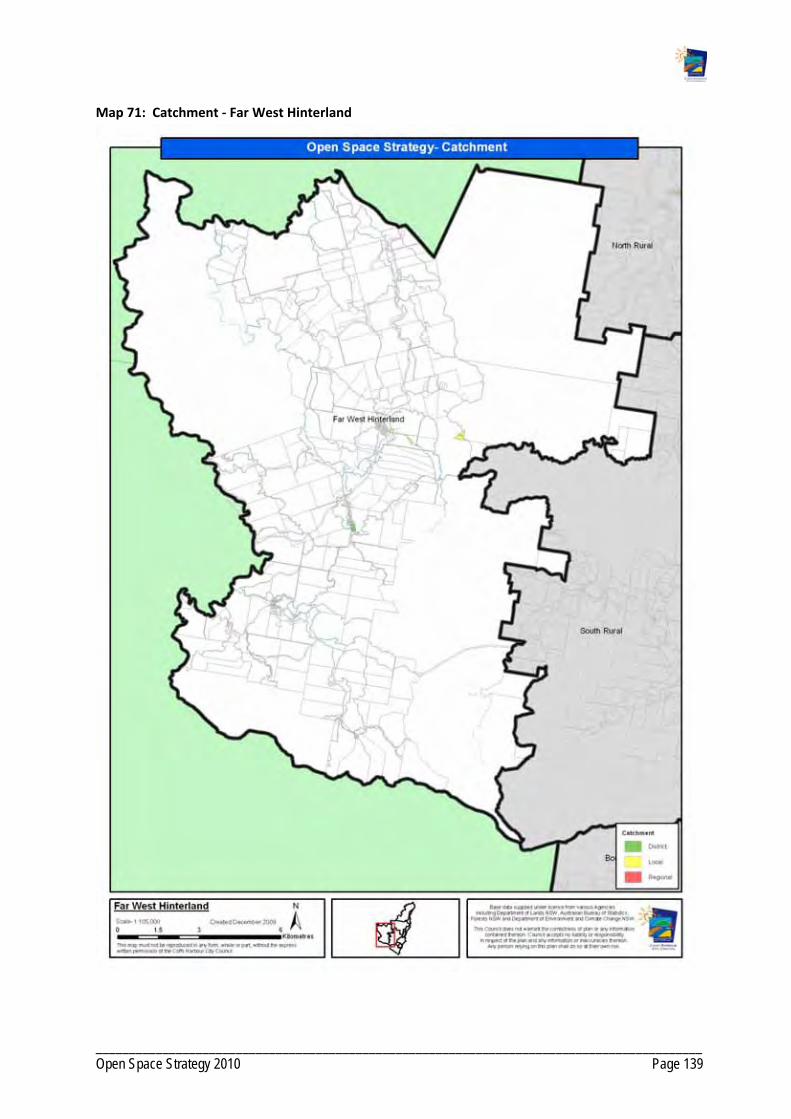
___________________________________________________________________________________________ Open Space Strategy 2010 Page 139
Map 71: Catchment ‐ Far West Hinterland