coastal structures risk communication of the great lakes ......engineers cdf 10b 24. u.s. army corps...
TRANSCRIPT

US Army Corps of Engineers BUILDING STRONG®
Coastal Structures Risk Communication of the Great Lakes Districts of the US Army Corps of Engineers
BUILDING STRONG®
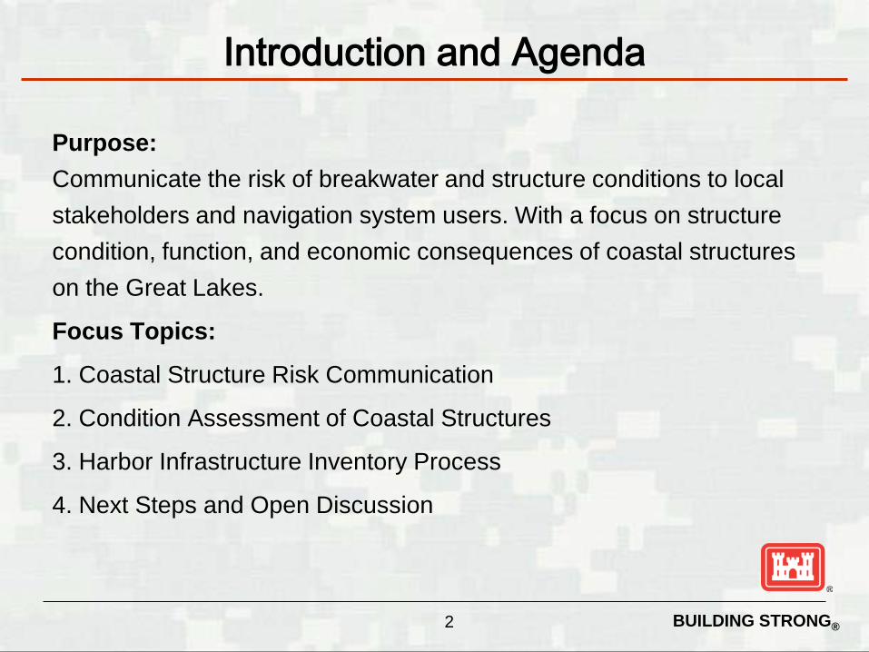
Purpose: Communicate the risk of breakwater and structure conditions to local stakeholders and navigation system users. With a focus on structure condition, function, and economic consequences of coastal structures on the Great Lakes.
Focus Topics:
1. Coastal Structure Risk Communication
2. Condition Assessment of Coastal Structures
3. Harbor Infrastructure Inventory Process
4. Next Steps and Open Discussion
2
Introduction and Agenda

BUILDING STRONG®
Lake Superior
MI
MI
NY
PA
IL
WI
IN
CANADA
OH
Oswego
Detroit River
Harbor Beach
Alpena
Cheboygan
Charlevoix
Frankfort
Manistee
Ludington
Muskegon
Holland
Grand Haven
South Haven
St. Joseph
Michigan City
Indiana Harbor Chicago River
Chicago Harbor
Waukegan
Kenosha
Milwaukee
Port Washington
Sheboygan
Manitowoc
Kewaunee
Algoma
Sturgeon Bay
Menominee
Manistique Detour
Grand Marais
Presque Isle Marquette
Keweenaw Waterway
Two Harbors Knife River
Duluth-Superior
Regional Risk Communication Meetings
Bolles Harbor
Au Sable
Hammond Bay
Harrisville
Lexington
Mackinac Island Mackinaw City
Point Lookout Port Austin
Port Sanilac
Tawas Bay Arcadia
Greilickville
Inland Route
Leland
New Buffalo
Pentwater
Petoskey
Portage Lake
Saugatuck
White Lake
Clinton River
Big Bay
Eagle Harbor
Grand Traverse Lac La Belle
Little Lake Whitefish Point
Grand Marais
Port Ontario
Cape Vincent
Oconto
Two Rivers
Bayfield
Regional Meetings
#1 16 Aug #2 West Erie #3 IN/IL #4 West MI #5 NE MI #6 SE MI #7 East Erie #8 East Ont #9 MN
#10 UP MI
Cedar River
BUILDING STRONG®
Lake Superior
MI
MI NY
PA IL
WI
IN
CANADA
OH
Commercial Recreational
Ogdensburg
Morristown
Cape Vincent
Sackets Harbor
Port Ontario
Oswego
Monroe
Rouge River
Clinton River Belle River
Pine River
Lake St. Clair
St. Clair River Black River (Port Huron)
Lexington
Port Austin
Harbor Beach
Port Sanilac Saginaw River
Point Lookout
Tawas Bay Au Sable Harbor
Harrisville
Alpena
Hammond Bay
Cheboygan Inland Route
Mackinaw City Mackinac Island
St. James
Petoskey
Charlevoix
Channels in Straits of Mackinac
Grays Reef
Leland
Greilickville Frankfort
Arcadia
Portage Lake
Manistee
Ludington
Pentwater
White Lake
Muskegon
Saugatuck
Grand River
Holland
Grand Haven
South Haven
St. Joseph New Buffalo
Michigan City
Burns Small Boat Harbor Burns Waterway Harbor Calumet Harbor
Indiana Harbor
Chicago River Chicago Harbor
Waukegan
Kenosha
Milwaukee
Port Washington
Sheboygan
Manitowoc
Washington Island (2 harbors)
Green Bay
Big Suamico Kewaunee
Algoma
Sturgeon Bay
Two Rivers
Pensaukee Oconto
Menominee Cedar River
Little Bay de Noc (Gladstone)
Manistique Detour Les Cheneaux Island
Soo Locks (part of St. Mary’s River project)
St. Marys River
Whitefish Point Harbor
Little Lake Grand Marais
Presque Isle
Marquette
Big Bay
Grand Traverse Bay
Lac La Belle Eagle Harbor
Keweenaw Waterway
Ontonagon Black River
Saxon Ashland
Chippewa Harbor
Grand Marais
Two Harbors
Knife River
Duluth-Superior Bayfield
La Pointe Cornucopia
Port Wing
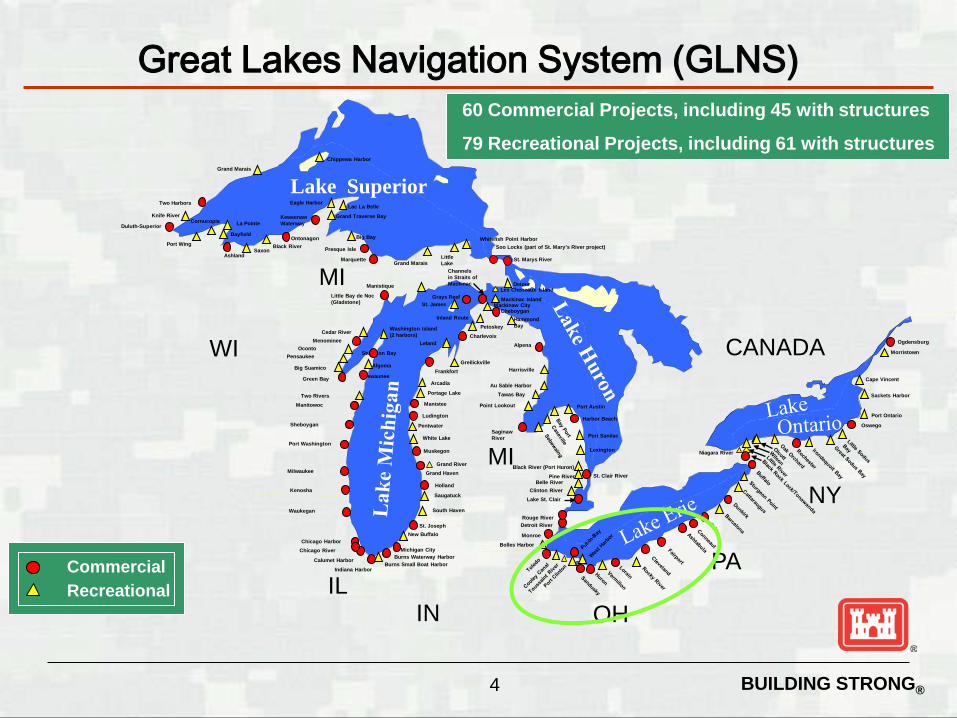
60 Commercial Projects, including 45 with structures
79 Recreational Projects, including 61 with structures
Great Lakes Navigation System (GLNS)
Niagara River
Detroit River
Bolles Harbor
4

BUILDING STRONG® 5
• 104+ miles of navigation structures on the Great Lakes • Structures include piers, jetties, revetments, and breakwaters • Most were built between 1860 and 1940 • Jetties and piers were constructed perpendicular to shore to keep the
channel open for navigation • Off shore breakwaters were constructed to allow safe navigation entry to
harbors and channels
Great Lakes Navigation System (GLNS)

BUILDING STRONG®
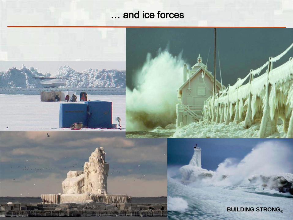
Navigation structures are regularly subjected to extreme winds and waves
6
BUILDING STRONG®
… and ice forces
7

BUILDING STRONG®
Typical Coastal Structures
8
Steel Sheet Pile Structures
Rubble Mound/Laid-Up Stone Structures
Typical Wood Crib/ Concrete Cap Structures Cross-section
Other Components: safety (railings, walking surface, etc.)
BUILDING STRONG®
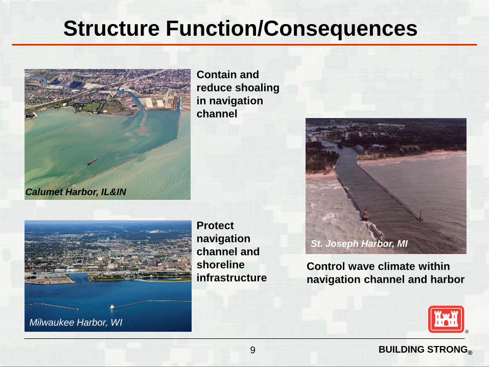
Structure Function/Consequences
Calumet Harbor, IL&IN
9
Contain and reduce shoaling in navigation channel
St. Joseph Harbor, MI
Control wave climate within navigation channel and harbor
Milwaukee Harbor, WI
Protect navigation channel and shoreline infrastructure
BUILDING STRONG®
Coastal Structure Risk Communication
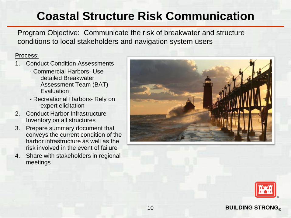
Process: 1. Conduct Condition Assessments
- Commercial Harbors- Use detailed Breakwater Assessment Team (BAT) Evaluation
- Recreational Harbors- Rely on expert elicitation
2. Conduct Harbor Infrastructure Inventory on all structures
3. Prepare summary document that conveys the current condition of the harbor infrastructure as well as the risk involved in the event of failure
4. Share with stakeholders in regional meetings
Program Objective: Communicate the risk of breakwater and structure conditions to local stakeholders and navigation system users
10

BUILDING STRONG® 11
• 50% of GL coastal structures were built before WWI
• Over 80% of all coastal structures exceed 50 years of age
• 45% have never undergone any significant repair effort due to funding constraints
• Over 30% of structures have timber crib core sections; recent low water levels have accelerated deterioration of the wood
Great Lakes Structure Condition

BUILDING STRONG® 12
A Great Lakes regional team was established in 2008 to conduct Asset Management-based condition assessments of all Great Lakes commercial navigation structures; the Team works with USACE Engineering Research and Development Center and collaborates with the National Coastal Asset Management Board. • Assessments completed to date • Conditions assessment by segments: 45% of structures are rated C or worse
• 22 miles (21%) rated C – Probably inadequate • 22 miles (21%) rated D - Inadequate • 3 miles (3%) rated F – Failed
• Cost to conduct major repair of structures: $15 – 20M per mile
Regional Condition Assessments

BUILDING STRONG®
• Structural Index is developed from assessment of major structure components / parameters with most direct link to structure reliability and function
• The structural index value is converted to an A thru F condition level which is used to communicate risk for planning and budgeting purposes
• Collecting complete continuous overlapping still photography and video of each structure at each project. Photos are labeled and geotagged for easy reference in Google Earth.
13
Regional Condition Assessments

BUILDING STRONG®
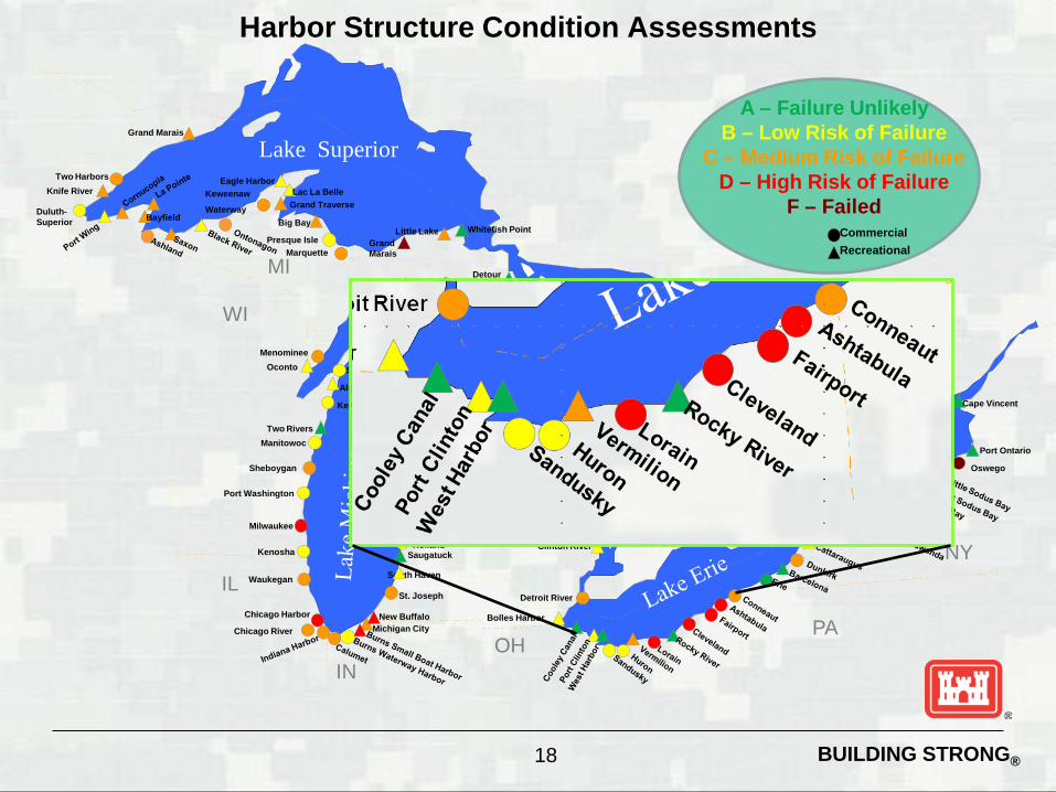
Harbor Structure Condition Assessments
Lake Superior
MI
MI
NY
PA
IL
WI
IN
CANADA
OH
Oswego
Detroit River
Harbor Beach
Alpena
Cheboygan
Charlevoix
Frankfort
Manistee
Ludington
Muskegon
Holland
Grand Haven
South Haven
St. Joseph
Michigan City Chicago River
Chicago Harbor
Waukegan
Kenosha
Milwaukee
Port Washington
Sheboygan
Manitowoc
Kewaunee
Algoma
Sturgeon Bay
Menominee
Manistique Detour
Grand Marais
Presque Isle Marquette
Keweenaw
Waterway
Two Harbors Knife River
Duluth-Superior
Bolles Harbor
Au Sable
Hammond Bay
Harrisville
Lexington
Mackinac Island Mackinaw City
Point Lookout Port Austin
Port Sanilac
Tawas Bay Arcadia
Greilickville
Inland Route
Leland
New Buffalo
Pentwater
Petoskey
Portage Lake
Saugatuck
White Lake
Clinton River
Big Bay
Eagle Harbor
Grand Traverse Lac La Belle
Little Lake Whitefish Point
Grand Marais
Port Ontario
Cape Vincent
Oconto
Two Rivers
Bayfield
Commercial Recreational
A – Failure Unlikely
B – Low Risk of Failure C – Medium Risk of Failure
D – High Risk of Failure F – Failed
14

BUILDING STRONG®
Harbor Infrastructure Inventory Process Gather information on critical infrastructure protected by federally
maintained navigation structures ► Review Documents:
• Project Drawings • Harbor Fact Sheet • Aerial/Satellite Photography; Photo document critical
infrastructure ► Identify Critical Infrastructure to Visit ► Research Identified Critical Infrastructure
Site Visit Tasks ► Met with Local Officials, Port Authority, Harbor Master, when
available ► Visit Identified Areas/Critical Infrastructure & Gather Information
Post Site Visit Tasks ► Create Report Following the Standard Report Template
15

BUILDING STRONG®
Harbor Infrastructure Inventory Report Content HARBOR LOCATION PROJECT DESCRIPTION
Authorization, harbor type (commercial or recreational), length of breakwater structures and channel
DATE OF SITE VISIT SUMMARY OF STRUCTURES
Lists all structures and facilities that are believed to be protected by the federal navigation structures; also identify any other potential stakeholders
SUMMARY OF IMPACT Summarizes any potential damage that could be experienced if the federal breakwater fails.
DESCRIPTION OF STRUCTURES Aerial photo with all potential affected structures shown along with pictures and a brief description of each potentially affected structure
16
BUILDING STRONG®
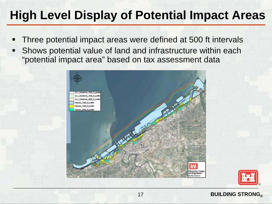
High Level Display of Potential Impact Areas
Three potential impact areas were defined at 500 ft intervals Shows potential value of land and infrastructure within each
“potential impact area” based on tax assessment data
17
BUILDING STRONG®
Harbor Structure Condition Assessments
Lake Superior
MI
MI
NY
PA
IL
WI
IN
CANADA
OH
Oswego
Detroit River
Harbor Beach
Alpena
Cheboygan
Charlevoix
Frankfort
Manistee
Ludington
Muskegon
Holland
Grand Haven
South Haven
St. Joseph
Michigan City Chicago River
Chicago Harbor
Waukegan
Kenosha
Milwaukee
Port Washington
Sheboygan
Manitowoc
Kewaunee
Algoma
Sturgeon Bay
Menominee
Manistique Detour
Grand Marais
Presque Isle Marquette
Keweenaw
Waterway
Two Harbors Knife River
Duluth-Superior
Bolles Harbor
Au Sable
Hammond Bay
Harrisville
Lexington
Mackinac Island Mackinaw City
Point Lookout Port Austin
Port Sanilac
Tawas Bay Arcadia
Greilickville
Inland Route
Leland
New Buffalo
Pentwater
Petoskey
Portage Lake
Saugatuck
White Lake
Clinton River
Big Bay
Eagle Harbor
Grand Traverse Lac La Belle
Little Lake Whitefish Point
Grand Marais
Port Ontario
Cape Vincent
Oconto
Two Rivers
Bayfield
Commercial Recreational
A – Failure Unlikely
B – Low Risk of Failure C – Medium Risk of Failure
D – High Risk of Failure F – Failed
18

BUILDING STRONG®
Conneaut Harbor
F
D
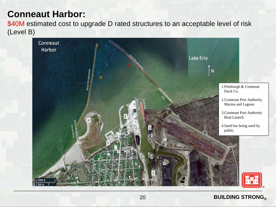
BUILDING STRONG® 20
Conneaut Harbor: $40M estimated cost to upgrade D rated structures to an acceptable level of risk (Level B)
F
1.Pittsburgh & Conneaut Dock Co.
2.Conneaut Port Authority Marina and Lagoon
3.Conneaut Port Authority Boat Launch
4.Sand bar being used by public
D

BUILDING STRONG® 21
Conneaut Harbor: Potential Impact Areas
Fedefal SInJCI1Jre
____ Shoreline_ 1 00(UU~tfer
---- Shoreline_ ' 50(U U lU'fer
~~~~ Shoreline_200CU U ldfer ~ Parcel!U£XKU U lUffer2
P~_l 500_ft_buffe<2
f'~_2000_ft_buffe<2
BUILDING STRONG®
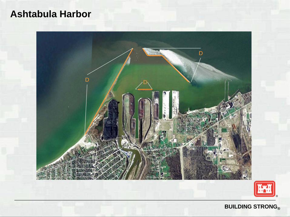
Ashtabula Harbor
D
D D

BUILDING STRONG® 23
Ashtabula Harbor: $65M estimated cost to upgrade D rated structures to an acceptable level of risk (Level B) D 1.Walnut Beach Park
2.Norfolk Southern – Ashtabula Coal Dock
3.U.S. Coast Guard Station Ashtabula
4.Ashtabula Transient Boat Dock
5.R.W. Sidley, Inc.
6.Pinney Dock and Transport Company
7.Lakeshore Park
D
D
BUILDING STRONG® 24
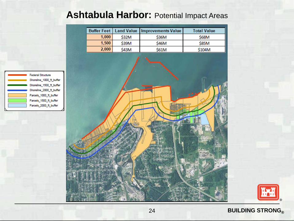
Ashtabula Harbor: Potential Impact Areas
Fedefal StruCl1Jre
Shorefine_ ' [XMU U :ufer
----- Shorefine_15(MU t_brler
~~~~~ Shoreline_2CKMUU ldfer P~_' OOO_ft_~
Paro.IU 5OO_ft_bvIfw
P~_2000_ft_bvIfw

BUILDING STRONG®
Fairport Harbor
D
D
F

BUILDING STRONG® 26
Fairport Harbor: $33M estimated cost to upgrade D rated structures to an acceptable level of risk (Level B) D 1.Headlands Beach State
Park
2.U.S. Coast Guard Search and Rescue Station Fairport Harbor
3.R.W. Sidley, Inc.
4.Morton International, Inc.
5.Carmeuse Lime
6.Osborn Concrete and Stone
7.Grand River Marine Co. – Grand River
8.Grand River Marine Co. – Fairport
9.Osborn Concrete and Stone – Fairport Dock
10.Fairport Port Authority Boat Launch Ramp
11.Fairport Harbor Lakefront Park
D F

BUILDING STRONG® 27
Fairport Harbor: Potential Impact Areas
___ Fedefal SlnJcru",
___ Shorefine_1[XMU U :u fer
---- Shoreline_15(MU t_brler
~~~~ Shoreline_2CKMUU ldfer
~==:::; P,""",_ ' OOO_ft_buIfeo-p..-_, 5OO_ft_buIfeo-
P,""",_2000_ft_buIfeo-
Buffer Feet Land Va lue 1m
1 $17M
1,500 $21M
2,000 $31M
mentsValue Total Value
$28M $45M
$42M $63M
$53M $84M
BUILDING STRONG®
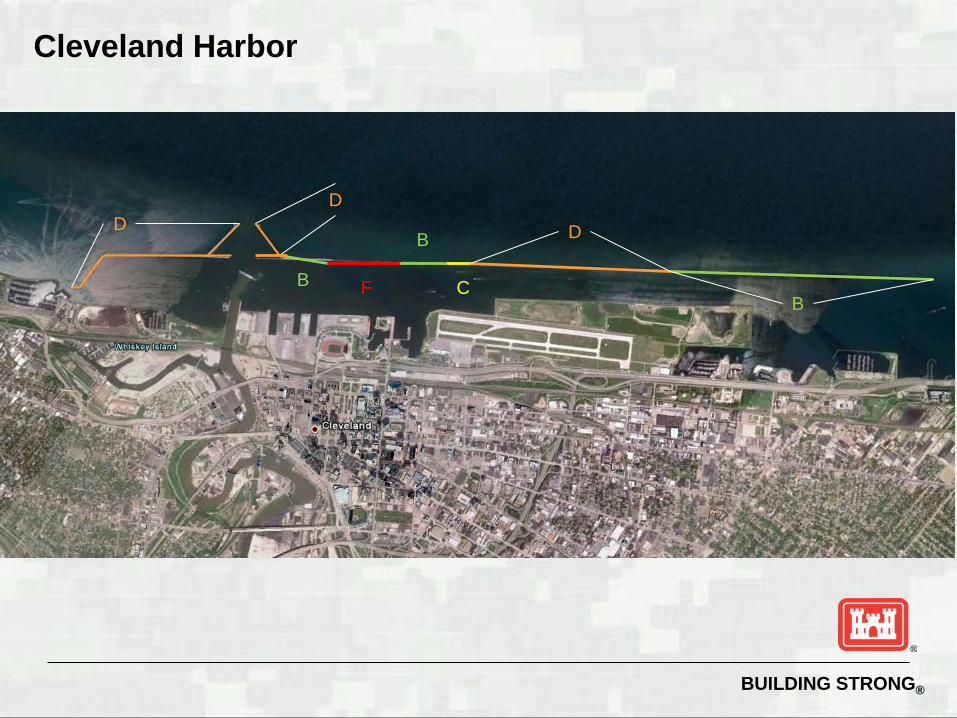
Cleveland Harbor
D
B
D D B
B C F

BUILDING STRONG® 29
13. Cleveland Port Authority – Dock 26
14. Cleveland Port Authority – Dock 28
15. Cleveland Port Authority – Dock 30
16. Cleveland Port Authority – Dock 32
17. Cleveland Browns Stadium 18. Great Lakes Science Center 19. Rock and Roll Hall of
Fame 20. U.S. Army Corps of
Engineers Ohio Area Office 21. U.S. Coast Guard Station
Cleveland 22. Burke Lakefront Airport
1. Edgewater Yacht Club 2. Edgewater Marine 3. Westerly Wastewater
Treatment Plant 4. Cleveland Bulk Terminal 5. Cargill 6. Whiskey Island Marina 7. Wendy Park 8. Former Coast Guard
Station at Wendy Park 9. Ontario Stone 10. Lafarge NA – Cleveland
Cement Terminal 11. Cleveland Port Authority
– Dock 20/22 & Essroc Cement Corp.
12. Cleveland Port Authority – Dock 24
23. U.S. Army Corps of Engineers CDF 10b
24. U.S. Army Corps of Engineers CDF 9
25. U.S. Army Corps of Engineers CDF 12
26. Lakeside Yacht Club 27. Cleveland Public Power – E
53rd St Generating Station 28. Forest City Yacht Club 29. Sailing Inc. 30. Quay 55 31. E 55th Street Marina 32. Intercity Yacht Club 33. U.S. Army Corps of
Engineers CDF 14
Cleveland Harbor: $85M estimated cost to upgrade D rated structures to an acceptable level of risk (Level B)
D
D
D
B
C B
F
B

BUILDING STRONG® 30
Cleveland Harbor: Potential Impact Areas
Federal Structure
___ Shorel1ne_ l 000_ft_butfer
___ Shorellne_ 1500_fi_butfer
;:::::: Shoreline_ 2(]OO_fi_butfer
Parcels_ l 000_h_buffer
Parcels_ 1500_ft_buffer
Parce1s_ 2000_ft_buffer
Buffer Feet
1,000
1,500
2,000
Land Va lue 1m
$309M
$350M
$430M
Value Total Va lue
$640M $949M
$668M $1_028
$770M $1_208 ~~

BUILDING STRONG®
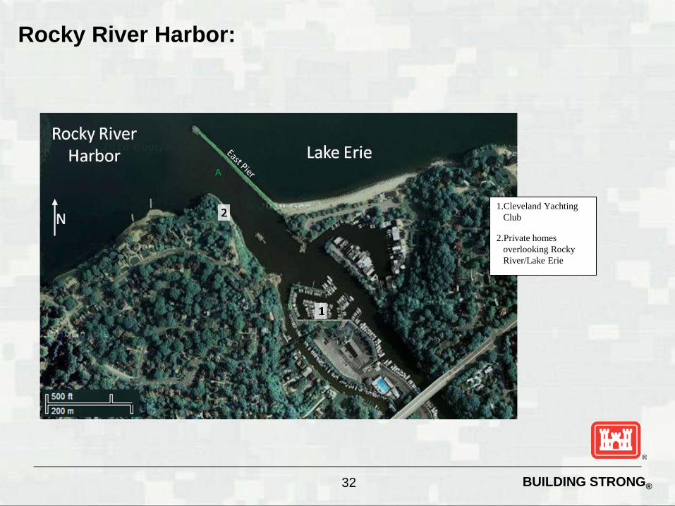
Rocky River Harbor
A
BUILDING STRONG® 32
Rocky River Harbor:
A
1.Cleveland Yachting Club
2.Private homes overlooking Rocky River/Lake Erie

BUILDING STRONG® 33
Rocky River Harbor: Potential Impact Areas
Fedefal StruCl1Jre
Shorefine_ ' [XMUU:u fer
---- Shorefine_15(MUt_brler
~~~~ Shoreline_2CKMUUldfer P~_' OOO_ft_~
Paro.IU 5OO_ft_bvIfw
P~_2000_ft_bvIfw
1,000
1 500
2,000
$16M $41M
$21M $55M $76M
$27M $66M $93M
BUILDING STRONG®
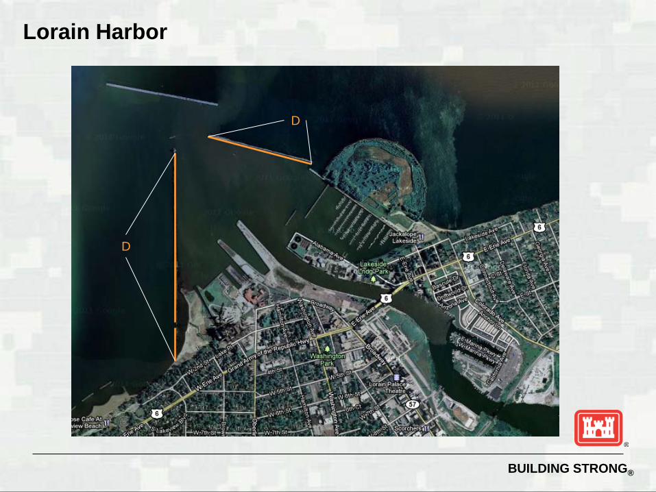
Lorain Harbor
D
D
BUILDING STRONG® 35
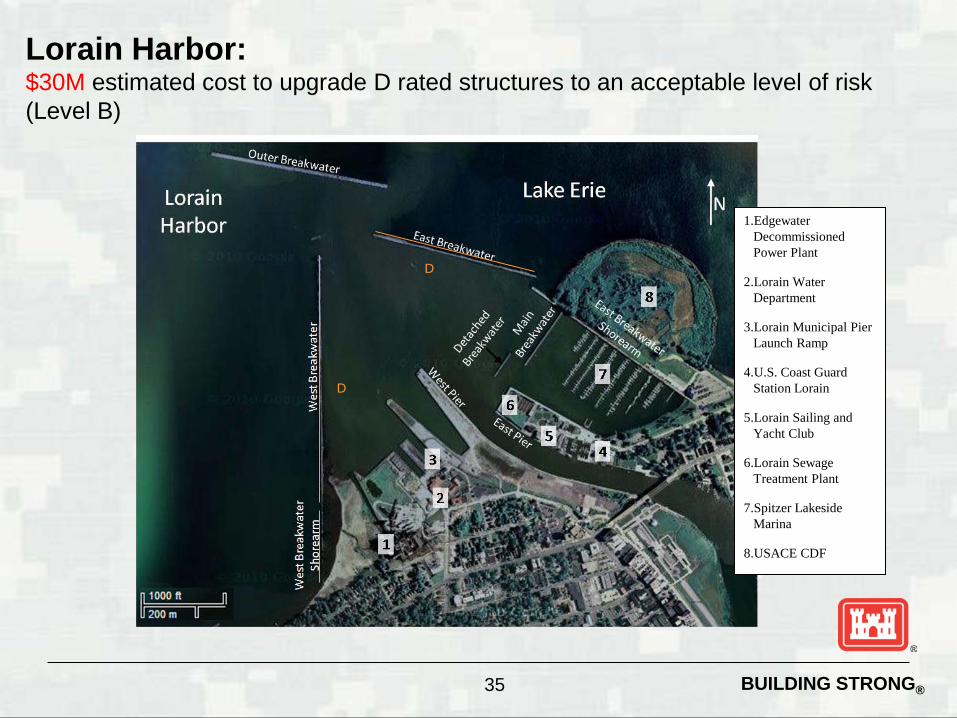
Lorain Harbor: $30M estimated cost to upgrade D rated structures to an acceptable level of risk (Level B)
D
1.Edgewater Decommissioned Power Plant
2.Lorain Water Department
3.Lorain Municipal Pier Launch Ramp
4.U.S. Coast Guard Station Lorain
5.Lorain Sailing and Yacht Club
6.Lorain Sewage Treatment Plant
7.Spitzer Lakeside Marina
8.USACE CDF
D
BUILDING STRONG® 36
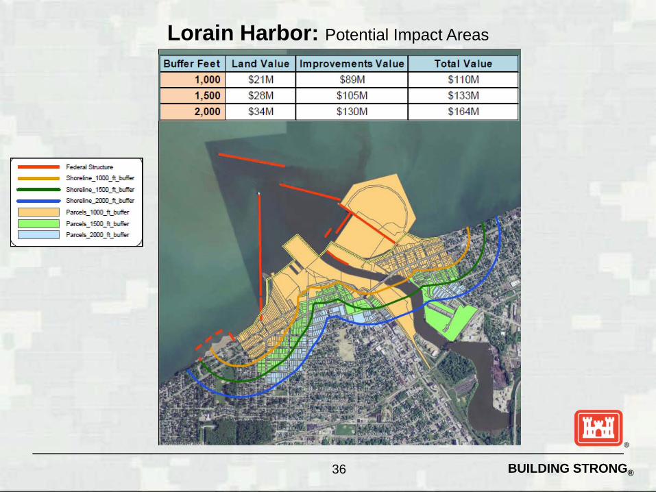
Lorain Harbor: Potential Impact Areas
___ Fedefal SlnJcru",
___ Shorefine_1[XMUU:u fer
---- Shoreline_15(MUt_brler
~~~~ Shoreline_2CKMUUldfer
~==:::; P,""",_ ' OOO_ft_buIfeo-p..-_, 5OO_ft_buIfeo-
P,""",_2000_ft_buIfeo-
Buffer Feet
1,000
1
Land Va lue
$2'IM
$28M
Improvements Va lue Tota l Va lue
$89M $1 10M
$105M $133M
BUILDING STRONG®
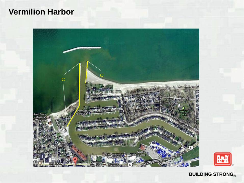
Vermilion Harbor
C C
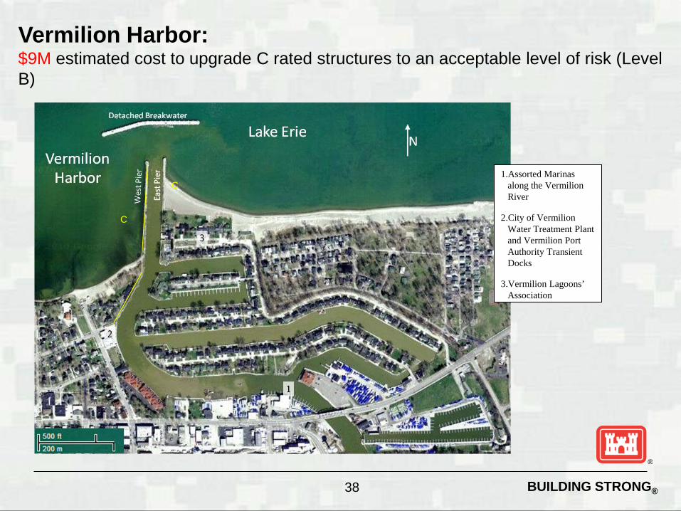
BUILDING STRONG® 38
Vermilion Harbor: $9M estimated cost to upgrade C rated structures to an acceptable level of risk (Level B)
C
1.Assorted Marinas along the Vermilion River
2.City of Vermilion Water Treatment Plant and Vermilion Port Authority Transient Docks
3.Vermilion Lagoons’ Association
C

BUILDING STRONG® 39
Vermilion Harbor: Potential Impact Areas
Fedefal StruCl1Jre
Shorefine_ ' [XMUU:ufer
---- Shorefine_15(MUt_brler
~~~~ Shoreline_2CKMUUldfer P~_' OOO_ft_~
Paro.IU 5OO_ft_bvIfw
P~_2000_ft_bvIfw
Land Value
$52M
$63M
Improvements Value Total Value
$27M $79M
$34M $97M

BUILDING STRONG®
Huron Harbor
B
B

BUILDING STRONG® 41
Huron Harbor:
B
1.Nickel Plate Beach
2.Huron Lime, Inc.
3.Huron Ore Docks
4.City of Huron – former ConAgra Plant
5.State of Ohio Boat Launch
6.Harbor North
7.Huron Yacht Club
8.Huron Municipal Boat Basin
9.U.S. Army Corps of Engineers Combined Disposal Facility

BUILDING STRONG® 42
Huron Harbor: Potential Impact Areas
Fedefal StruCl1Jre
Shorefine_ ' [XMUU:u fer
---- Shorefine_15(MUt_brler
~~~~ Shoreline_2CKMUUldfer P~_' OOO_ft_~
Paro.IU 5OO_ft_bvIfw
P~_2000_ft_bvIfw
Buffer Feet
1,000
1,500
2,000
Land Va lue
$45M
$62M
$72M
Improvements Value Total Va lue
$52M $97M
$75M $137M
$96M $168M

BUILDING STRONG®
Sandusky Harbor
B
B
C

BUILDING STRONG® 44
Sandusky Harbor: $7M estimated cost to upgrade C rated structures to an acceptable level of risk (Level B)
B
1.Norfolk Southern – Sandusky Dock Corp
2.City of Sandusky Shelby Street Docks
3.George Gradel Company
4.Deep Water Marina
5.Dock of the Bay Marina
6.Sandusky Yacht Club
7.Battery Park Marina
8.Sandusky Sailing Club
9.Lyman Harbor
10.Venetian Marina
11.Cedar Point Marina
12.Cedar Park Amusement Park
B C
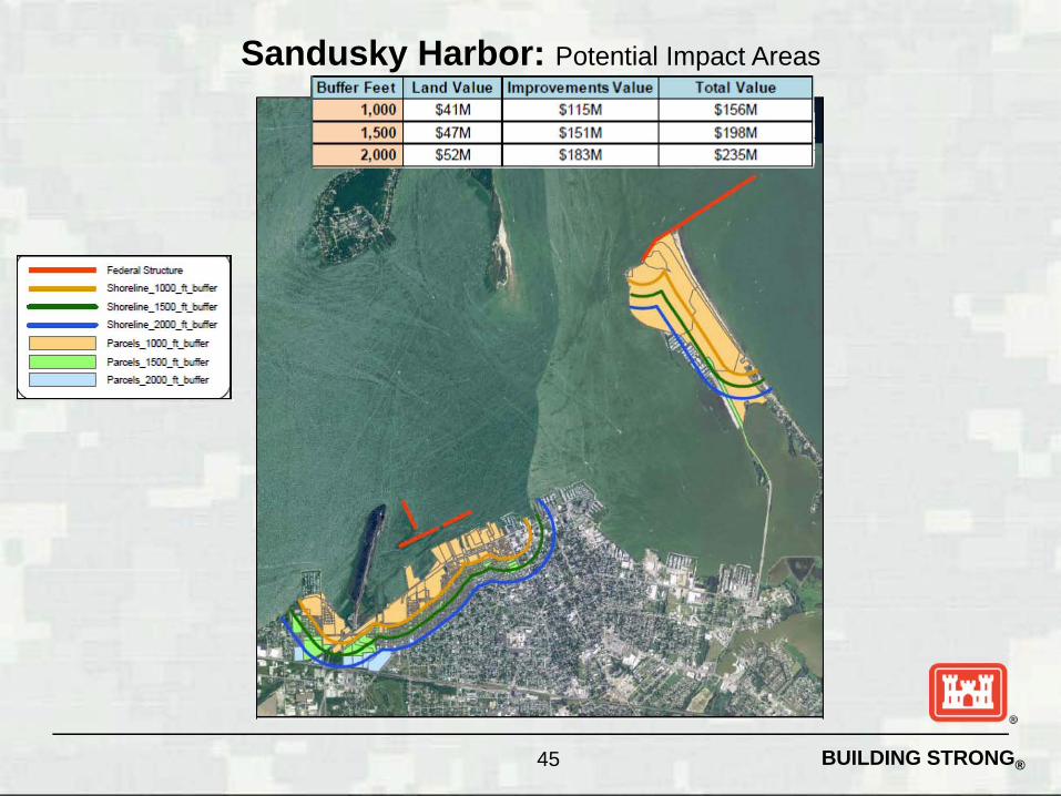
BUILDING STRONG® 45
Sandusky Harbor: Potential Impact Areas
Fedefal StruCl1Jre
Shorefine_ ' [XMU U :ufer
----- Shorefine_15(MU t_brler
~~~~~ Shoreline_2CKMUU ldfer P~_' OOO_ft_~
Paro.IU 5OO_ft_bvIfw
P~_2000_ft_bvIfw

BUILDING STRONG®
West Harbor
A
A

BUILDING STRONG® 47
West Harbor:
A 1.Harbor Island
Association
2.Gem Beach Marina
3.Fox Haven Marina
4.Moore Marina
5.Catawba Moorings
6.Herl’s Harbor
7.Additional Marinas in West Harbor
8.Anchors Away Marina
9.East Harbor State Park Marina – Run By Hoyt Marine

BUILDING STRONG® 48
West Harbor: Potential Impact Areas
___ Fedefal SlnJcru",
___ Shorefine_1[XMU U:u fer
---- Shoreline_15(MU t_brler
~~~~ Shoreline_2CKMUUldfer
~==:::; P,""",_ ' OOO_ft_buIfeo-p..-_, 5OO_ft_buIfeo-
P,""",_2000_ft_buIfeo-
Buffer Feet
1,000
1,500
2,000
Land Va lue Improvements Va lue Total Va lue $64M $1 1M $75M
$67M $14M $81 M
$93M $14M $107M

BUILDING STRONG®
Port Clinton Harbor
B
B

BUILDING STRONG® 50
Port Clinton Harbor:
B
1.Port Clinton Yacht Club
2.Drawbridge Marina
3.Additional Marinas and Charter Fishing Interests
4.Jet Express Ferry
5.City of Port Clinton Transient Boat Dock
6.Public Park

BUILDING STRONG® 51
Port Clinton Harbor: Potential Impact Areas
___ Fedefal SlnJcru",
___ Shorefine_1[XMU U :u fer
---- Shoreline_15(MU t_brler
~~~~ Shoreline_2CKMUU ldfer
~==:::; P,""",_ ' OOO_ft_buIfeo-p..-_, 5OO_ft_buIfeo-
P,""",_2000_ft_buIfeo-
Buffer Feet
1
1
Land Va lue
$7M
$12M
Improvements Va lue Tota l Va lue
$4M $1 1M
$13M $25M

BUILDING STRONG®
Cooley Canal Harbor
A
A

BUILDING STRONG® 53
Cooley Canal Harbor:
A
1.Cedar Point National Wildlife Refuge
2.Bitter End Restaurant and Bar at the Anchor Pointe Marina
3.Anchor Pointe Marina
4.Lucas County Cooley Canal Boat Ramps
5.Meinke Marina
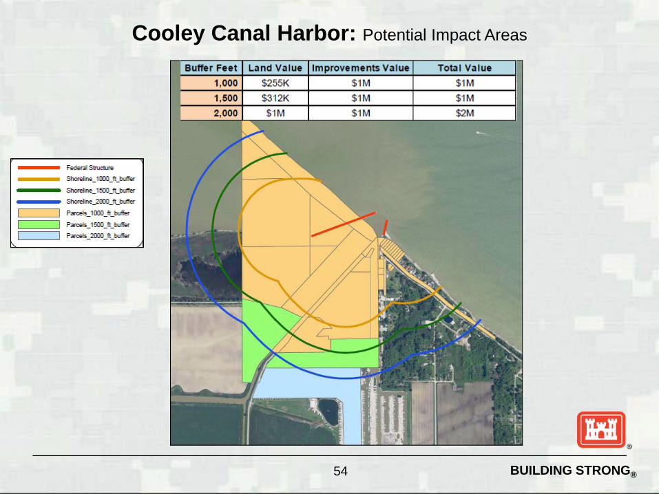
BUILDING STRONG® 54
Cooley Canal Harbor: Potential Impact Areas
Fedefal StruCl1Jre
Shorefine_ ' [XMU U :ufer
---- Shorefine_15(MU t_brler
~~~~ Shoreline_2CKMUU ldfer P~_' OOO_ft_~
Paro.IU 5OO_ft_bvIfw
P~_2000_ft_bvIfw

BUILDING STRONG®
What Can Be Done?
Federal Funding ►Funding request through the Federal Budget
process each fiscal year • Contract structural repair • Government floating plant repair
Local Funding ►Mechanisms in place to accept local funding
Transfer to State/Local Entity ►Section 216 Process
55

BUILDING STRONG® 56
• Three repair fleets – one in LRB and two in LRE conduct all of the most urgent repair needs
on navigation structures in the five Great Lakes.
• Place stone in weakened sections of structures and CDFs, conduct welding repairs on steel sheeting to retain encapsulation of fill stone; repair safety ladders, signs, and railings; remove obstructions from harbor navigation channels; and are available for a wide variety of “emergency” work including debris removal, lock repair, and other unanticipated repair needs.
Lake Superior: Duluth Repair Fleet
Lakes Michigan and Huron: Kewaunee Repair Fleet
Lakes Erie and Ontario: Cleveland Repair Fleet
Great Lakes Repair Fleet
BUILDING STRONG®
Questions?
57