coastal resilience sediment plan - microsoft · geographic coverage of existing coastal regional...
TRANSCRIPT

November 2019

ii Greater Farallones | Coastal Resilience Sediment Plan 2019
National Oceanic and Atmospheric Administration U.S. Secretary of Commerce Wilbur Ross Under Secretary of Commerce for Oceans and Atmosphere and NOAA Administrator Neil A. Jacobs, Ph.D. (Acting) Assistant Administrator for Ocean Services and Coastal Zone Management, National Ocean Service Nicole LeBoeuf (Acting) Office of National Marine Sanctuaries John Armor, Director Greater Farallones National Marine Sanctuary Maria Brown, Superintendent
Greater Farallones National Marine Sanctuary 991 Marine Drive, The Presidio San Francisco, CA 94129 https://farallones.noaa.gov/ Plan Citation: Kordesch, W.K., M. Delaney, S. Hutto, M. Rome, and S. Tezak. 2019. Coastal Resilience Sediment Plan. Report of Greater Farallones National Marine Sanctuary. NOAA. San Francisco, CA. 104 pp. Cover Photos: Bolinas Lagoon (top), Drakes Beach (middle), and Bodega Head (bottom) from ESRI World Imagery. This work was made possible with additional support from:

3 Greater Farallones | Coastal Resilience Sediment Plan 2019
Table of Contents
EXECUTIVE SUMMARY 6 CHAPTER 1: INTRODUCTION 10
Coastal Sediment Issues 10 Purpose of this Plan 10 Process of Developing this Plan 11 Scope of this Plan 13
CHAPTER 2: BACKGROUND 15 Geographic Coverage of GFNMS Management Area 15 Geographic Coverage of Existing Coastal Regional Sediment Management Plans/Report 17 Geographic Coverage of the Plan’s Study Area 18 Land Use and Shoreline Trends throughout the Study Area 18
Sonoma-Marin 18 San Francisco Central Bay 19 San Francisco Littoral Cell 19 Santa Cruz Littoral Cell 19
Sediment Sources and Sinks 20 Data Needs 22
CHAPTER 3: STRATEGIES AND SELECTION PROCESS 24 Overview 24 Sediment Management Strategies 26 Overview of Sanctuary Regulations Relevant to Sediment Management Strategies 26 Overview of Sanctuary Climate Adaptation Plan Strategies Relevant to Sediment Management 29 Recommendations at the North-central Coast Regional Level 32 Recommendations at the Site Level 34
Description of Process 34 Resulting Strategies for Sediment Management Across 41 Site Locations 39 Details of 15 Locations for Sanctuary-Focused Strategies 43
CHAPTER 4: COASTAL RESILIENCE CASE STUDIES 61 Introduction 61 Case Study 1: Bodega Harbor Dredged Material Reuse Project 61 Case Study 2: Bolinas Lagoon South End Living Shoreline Project 65 Case Study 3: Surfer's Beach Pilot Beach Restoration Project 68
CHAPTER 5: AGENCY COORDINATION 72 Development of Agency Coordination Structure 72
North-central California Coastal Sediment Coordination Committee 72 Framework for Agency Cooperation to Implement Coastal Sediment Management Actions 73 A. Goal and Structure 73 B. Sediment Coordination Committee Objectives 73 C. Sediment Coordination Committee Agencies’ Roles and Responsibilities 73 D. Steering Committee’s Role and Responsibilities 74
CHAPTER 6: IMPLEMENTATION 75 Implementation Approach 75
Streamlined Permitting Program 75 Process for RSM Stakeholder Coordination 75
Table of Contents
4 Greater Farallones | Coastal Resilience Sediment Plan 2019
Outreach and Education 76 CHAPTER 7: PLAN SUCCESS 78
Defining Success for this Plan 78 Adaptive Management 78 Metrics for Success of this Plan 78
Plan Objectives: 79 CONCLUSION 81 REFERENCES 82 APPENDICES 84
Appendix A: Strategy definitions compiled from four regional sediment management plans 84 Appendix B: Regional Recommendations compiled from three regional sediment management plans 86 Appendix C: Strategy details for 26 site locations forwarded to relevant management agencies 90 Appendix D: Implementation recommendations compiled from four regional sediment management plans 100 Appendix E: Sediment Management Strategy Agency Involvement Matrix 104

Table of Contents
5 Greater Farallones | Coastal Resilience Sediment Plan 2019
List of Figures Figure 2.1. Boundaries of the Greater Farallones National Marine Sanctuary Management Area. Figure 2.2. Boundaries of the study areas of the four individual Coastal Resilience Regional Sediment Management
Plans/Report that overlap the study area of this Coastal Resilience Sediment Plan. Figure 3.1. Study area of the Coastal Resilience Sediment Plan and the 40 locations of sites with specific
recommendations listed in each of the four Coastal Regional Sediment Management Plan/Reports. Figure 3.2. Strategy Assessment Tool. Figure 3.3 Locations of the 15 site-specific sanctuary strategies for sediment management activities. Figure 4.1. Regional map showing site locations of the three case studies included in this Plan. Figure 4.2. Map of Bodega Harbor in Sonoma County illustrating the location of the federal navigation channel that
crosses the harbor and historical placement sites. Figure 4.3. Aerial photo of Bodega Harbor showing the federal navigation channel. Figure 4.4. Bodega Harbor dredging in 2017. Figure 4.5. Project area of the Bolinas Lagoon South End Living Shoreline Project. Figure 4.6. Flooding of Calle Del Arroyo during a King Tide combined with a storm on February 2, 2019. Figure 4.7. Eroded section of shoreline and steep ~10 foot scarp along Dipsea Road. Figure 4.8. Aerial image of Half Moon Bay showing the Pillar Point Harbor and adjacent Surfer’s Beach Pilot
Restoration Project site. Figure 4.9. Two views of the most critically eroding portion of the North section. Figure 4.10. Panoramic view taken from the east breakwater looking east at the sand shoal accumulated inside the
harbor.
List of Tables Table ES.1. Site locations from the four Coastal Regional Sediment Management Plans/Report with specific
strategy recommendations and resulting categorization in this plan. Table 2.1. Geographic coverage and general description of the four Coastal Regional Sediment Management
Plans/Reports that overlap with the study area of this Plan. Table 2.2. Sand sources for potential use in addressing erosion zones described in the four Coastal Resilience
Regional Sediment Management Plan/Reports included in the study area. Table 2.3. Data needs identified in the Coastal Resilience Regional Sediment Management Plans/Report within this
Plan’s study area. Table 3.1. GFNMS regulations that could pertain to potential RSM strategies and thus trigger the need for GFNMS
review and determination if a permit is required in order to proceed with a project. Table 3.2. Regional sediment management or coastal protection strategies that could require sanctuary review and a
determination if a permit can be issued. Table 3.3. An excerpt of prioritized strategies and actions in the GFNMS Climate Action Plan relevant to sediment
management in the study area. Table 3.4. Strategies compiled from four CSRMP/Rs for sites within the study area categorized by recommended
type of Regional Sediment Management strategy. Table 3.5. Strategy recommendations from the four CSRMP/Rs for sites within the study area categorized by type
of Regional Sediment Management strategy with implementation feasibility results. Table 3.6. Strategy recommendations relevant to GFNMS for sites that fall within the sanctuary’s Management
Area. Four-character Implementation Codes indicate implementation feasibility of strategy. Table A.1. Summary of likely agency engagement listed by sediment management strategy. Table A.2. Summary of likely agency engagement listed by sediment management strategy. Agency Involvement
Matrix developed by the Sonoma-Marin CRSMP.
6 Greater Farallones | Coastal Resilience Sediment Plan 2019
EXECUTIVE SUMMARY California’s communities, its economy, and its abundant natural resources rely on a healthy and functioning coastline, and balanced sediment processes are a critical component. However, historic alteration along California’s North-central coast has interrupted the natural flow of sediment, and rising sea levels and increased storm intensity increasingly impact its shoreline. Greater Farallones National Marine Sanctuary (GFNMS or “sanctuary”) seeks to proactively address these challenges through a holistic approach to restoration and protection of natural resources and ecosystem function with a focus on nature-based solutions. GFNMS recognizes sediment as an important natural resource and sediment management as an effective tool to prepare for and respond to climate-driven shoreline impacts. From this perspective, the GFNMS Coastal Resilience Sediment Plan (hereafter referred to as the “Plan”) presents a roadmap of recommendations for coastal resilience within the sanctuary’s Management Area meant to initiate conversations at the local level to prepare the coast for the next 50 years of sediment management-related activity. GFNMS undertook the development of this Plan, with support from the California Natural Resources Agency (CNRA) and the Greater Farallones Association, its non-profit cooperating association, to leverage and build upon the work of the California Coastal Sediment Management Workgroup (CSMW) that produced four Coastal Regional Sediment Management Plan/Reports (CRSMP/Rs) spanning the majority of the coast managed by GFNMS, from Sonoma to San Mateo counties (Figure 2.2). Each CRSMP/R, developed collaboratively and vetted with input from federal, state and local agencies, and other stakeholders, outlines coastal sediment issues for a given region and a suite of recommended strategies to address them. This Plan provides an assessment of those recommendations, identifies overlap with sanctuary goals and policies, and synthesizes potential sediment management actions GFNMS can take to achieve a holistic approach to sediment management and coastal resilience. This plan serves as the foundational effort to carry out a key management priority outlined in GFNMS’s Climate Adaptation Plan—to expand sediment management in the sanctuary to enhance the region’s natural resource resilience to climate change impacts and vulnerabilities. This Plan also supports the mission of the CSMW, a collaborative effort of federal, state, and non-governmental organizations committed to evaluating California’s coastal sediment management needs and promoting regional and system-wide solutions on a statewide scale.

Executive Summary
7 Greater Farallones | Coastal Resilience Sediment Plan 2019
The collective recommendations selected and outlined in this Plan are based on the following guiding principles: Vision Statement: The North-central California coast is a thriving, resilient, sediment-balanced coastline that supports healthy ecosystems and communities. Mission Statement: Guide coordinated sediment management within the sanctuary to restore and protect natural resources, incorporate nature-based climate solutions, and recognize sediment as a natural resource in order to ensure a healthy coastline. Plan Goal: Guide actions to ameliorate adverse impacts to the sanctuary’s coastline by promoting the natural, dynamic, and geologically evolutionary processes of this internationally-recognized coastal system. Objectives:
1. Identify sediment imbalances in the sanctuary’s boundaries. 2. Coordinate collaborative sediment management actions within the sanctuary. 3. Restore natural sediment transport and ecological functions of the North-central
California coastline. 4. Increase public understanding of, and support for, regional sediment management.
A goal of this Plan is to integrate and identify appropriate sediment management strategies for actions GFNMS can take or support to increase coastal resilience along its shorelines and to provide a roadmap for the potential implementation of these actions. This document begins with an introduction to this plan and its purpose (Chapter 1) followed by a description of the four CRSMP/Rs, which form the foundation for the sediment management recommendations discussed in this Plan (Chapter 2). The recommendations are then divided into two categories: overarching regional recommendations and strategies recommended at specific site locations (Chapter 3). In total, 39 regional recommendations span the study area and promote a broad and comprehensive approach to sediment management, often involving extensive collaboration by federal, state, and local agencies and other stakeholders in the region (Appendix A). After review and assessment for key themes, this Plan condenses the 39 regional recommendations into six overarching Regional Sediment Management objectives for the North-central California coast. These recommendations align with the sanctuary’s climate adaptation goals (Table 3.3) and are integrated into the Plan’s Metrics for Success (Chapter 6). The following six regional recommendations represent overarching priorities for GFNMS in cooperation with partner agencies to manage sediment for coastal resilience throughout the study area. North-central Coast Regional Recommendations
1. Leverage partnerships and agency coordination and promote information sharing. 2. Engage communities and stakeholders through education and outreach. 3. Maintain and expand sediment research and monitoring activities. 4. Restore natural habitats and/or sediment dynamics and pursue nature-based
solutions to avoid hardening the shoreline. 5. Encourage and increase the beneficial reuse of sediment. 6. Utilize a holistic, watershed approach to sediment management.

Executive Summary
8 Greater Farallones | Coastal Resilience Sediment Plan 2019
A total of 115 strategies recommended at specific sites spanning 41 site locations are compiled from the four CRSMP/Rs in the study area (Table ES.1; mapped in Figure 3.1) and organized into 13 strategy types (Defined in Box 3.1, results listed in Table 3.4). To identify which strategies are consistent with sanctuary goals and policies and within the boundary of the sanctuary’s Management Area, strategies are further assessed to determine the potential feasibility of implementation for GFNMS. All 115 strategies are categorized as either:
1. A strategy consistent with sanctuary regulations and policies that GFNMS will support or take action on implementation (“Implement”).
2. A strategy consistent with sanctuary policies but beyond either the geographical boundaries of the sanctuary’s Management Area or the scope of the sanctuary’s authority/mandate to implement. The strategy is forwarded to a partner agency for their consideration in project planning (“Forward”).
3. A strategy not consistent with sanctuary regulations and/or policies that will not receive further consideration (“Not a Fit”).
Of the total 115 recommendations, a suite of 29 strategies at 15 site locations (Figure 3.3) are consistent with sanctuary regulations and policies and present a roadmap for potential sediment management and coastal resilience strategies to implement within the sanctuary’s Management Area. Each of these recommendations are further categorized by implementation feasibility according to the level of benefit to the marine environment, the amount of resources required (staffing and funding), the level of existing stakeholder support, and urgency (see diagram in Figure 3.2 and results in Table 3.7). Chapter 4 provides case studies for three high
Table ES.1. Locations with site-specific recommendations compiled from the four Coastal Regional Sediment Management Plans/Report. Recommendations are categorized according to implementation feasibility (“Implement,” “Forward,” or “Not a Fit”).

Executive Summary
9 Greater Farallones | Coastal Resilience Sediment Plan 2019
implementation feasibility strategies as examples of GFNMS’s approach to addressing coastal resilience and to serve as a model for project design at future sites. The case studies span the project area and include: beneficial reuse of clean dredged material from Bodega Harbor in Sonoma County; creation of living shorelines in Bolinas Lagoon in Marin County; and beach restoration at Surfer’s Beach in San Mateo County. Additionally, GFNMS will forward to relevant management agencies the 73 strategies at 37 site locations (Table 3.5) that are consistent with sanctuary goals and objectives but outside the Management Area and beyond the scope of the sanctuary’s authority (see Appendix C) to highlight the importance of further pursuing the strategy. A total of 11 strategies deemed not a good fit for the sanctuary will receive no further consideration. In general, these strategies recommend the construction of hardscape (e.g., coastal armoring) within sanctuary boundaries, which is not consistent with sanctuary policies, goals, and objectives due to detrimental impacts to coastal ecosystems. This Plan also addresses a common concern expressed in all four CRSMP/Rs—a key element for managing sediment resources and planning for coastal resilience is establishing a process and structure to achieve effective collaboration and coordination between the relevant agencies to successfully implement the site-specific and regional recommendations contained in each CRSMP/R. In tandem with the development of this Plan, GFNMS convened federal, state, and local agencies to develop a process and structure for agency cooperation to help implement the sediment management recommendations contained in this Plan. This process, and resulting North-central California Coastal Sediment Coordination Committee, is discussed in more detail in Chapter 5. Chapter 6 discusses strategies for implementation, including streamlined permitting, stakeholder coordination, and outreach. This Plan not only informs the statewide Sediment Management Plan, but also recommends building and strengthening partnerships with other agencies, academic institutions, and non-profit organizations to achieve a coordinated regional approach to sediment management. Chapter 7 outlines the criteria for success. The success of this Plan will be measured by the proportion or percentage of area along the sanctuary’s coastline that is functioning naturally without continual human intervention and is supporting healthy native species and ecosystem services. This Plan is meant to be a dynamic document with recommended strategies to guide current actions, as well as actions planned to occur over the next 50 years, and will require periodic review and updating based on new data and situations. For updates on this Plan visit https://farallones.noaa.gov/manage/climate/adaptation.html. All recommendations contained in the Plan are conceptual and any actions will require the necessary local, state, and/or federal environmental compliance and review before implementation. GFNMS encourages partner agencies and organizations to collaborate in implementing the recommendations in the Plan to ensure a healthy North-central California coast for generations.
10 Greater Farallones | Coastal Resilience Sediment Plan 2019
CHAPTER 1: INTRODUCTION
Coastal Sediment Issues California’s coastal sediment is a valuable resource for the state’s abundant wildlife and its economy; providing critical habitat for a number of species, recreational opportunities for residents and tourists, and extensive infrastructure protection for coastal development. In 2014, nearly 75 percent of California’s population lived in coastal counties and along the state’s iconic 1,270 miles of mainland coastline and the San Francisco Bay’s additional 500-mile shoreline. In 2013, the ocean and coast contributed $44.2 billion to the state’s gross domestic product and provided $19.3 billion in wages and salaries and 502,073 jobs (California Resources Agency 2017). California’s communities, its economy, and its abundant natural resources rely on a healthy and functioning coastline, and balanced sediment processes is a critical component. Shoreline development and other human activities have altered the natural movement of sediment to and along the coast, which has significantly affected coastal beaches, wetlands, and watersheds. Many watersheds no longer provide a sufficient supply of sediment to beaches and this shortfall exacerbates shoreline erosion. One of the biggest threats along the North-central California coast is increased erosion from shoreline development and climate change impacts (sea level rise, increased wave heights, and intensifying coastal storms). A recent study found that California shorelines retreated beyond previously measured landward extremes during the 2015–2016 El Niño, one of the strongest of the last 145 years (Barnard et al. 2017). Within the sanctuary, erosion is occurring at a variety of locations as a result of historic alteration of sediment supply, coastal armoring, and the combined climate impacts of sea level rise, increased wave height, and intensifying storms. While the threat of some of these events may be inevitable, understanding how to adapt to these impacts is important to ensure the resilience of the sanctuary’s coastal communities and shorelines. Though coastal sediment concerns arise locally, the dominant processes that drive them are spatially large and interlinked; therefore, sediment and erosion problems require a broader focus.
Purpose of this Plan The overall goal of this document is to produce a Coastal Resilience Sediment Plan that identifies potential sediment management actions GFNMS can take to achieve a holistic approach to sediment management and coastal resilience. As part of the development of this Plan, GFNMS reviewed and assessed the recommendations in four CRSMP/Rs with the intent to

Chapter 1: introduction
11 Greater Farallones | Coastal Resilience Sediment Plan 2019
identify and integrate appropriate strategies to address critical areas of sediment imbalances in a manner that is both sustainable and ecologically beneficial. This Plan also examines data gaps and identifies potential solutions to obstacles for protecting habitats, ensuring public access, preparing for sea-level rise, and maintaining critical infrastructure. Using a regional approach, existing and emerging efforts are combined to create a framework that addresses sediment imbalance issues to cumulatively benefit the Management Area.
Process of Developing this Plan The California Coastal Sediment Management Workgroup (CSMW) is developing a California Coastal Sediment Management Master Plan (Sediment Master Plan) to evaluate statewide coastal sediment management needs and to promote regional and system-wide solutions. CSMW is a state-federal collaborative, co-chaired by the California Natural Resources Agency (CNRA) and the U.S. Army Corps of Engineers (USACE), dedicated to protecting, enhancing, and restoring California's coastal beaches and watersheds through federal, state, and local cooperative efforts. The statewide Sediment Master Plan is a dynamic document developed through a series of regional-scale plans. A Coastal Regional Sediment Management Plan (CRSMP) has been completed for almost all segments of the California coast. Each CRSMP outlines a range of sediment management strategies developed collaboratively for its region with extensive input from applicable federal, state, and local agencies, and other stakeholders. Each CRSMP contains a compilation of physical, ecological, and economic data and regulatory, policy, and governance concerns and is designed to be a guidance and policy document that discusses how Regional Sediment Management (RSM) can be applied in a rapid, cost-effective, and resource-protective manner. Further description of CRSMPs and RSM can be found in Box 1.1. The significant investment by California in establishing a statewide network of marine protected areas (MPAs) and by the federal government in designating two national marine sanctuaries in the North-central coast provided a platform to take sediment-related management actions in these MPAs. To that end, the CSMW has increasingly collaborated with GFNMS and other partner agencies in the North-central portion of California to explore sediment management issues over the last decade. These efforts culminated in the development of three CRSMPs and one Coastal Regional Sediment Management Report (CRSMR) that span from Sonoma to Monterey Counties and into the central portion of San Francisco Bay. Together, these four plans (the Sonoma-Marin CRSMR, San Francisco Central Bay CRSMP, San Francisco Littoral Cell CRSMP, and the Santa Cruz Littoral Cell CRSMP) cover extensive sections of GFNMS and Monterey Bay National Marine Sanctuary (MBNMS). The San Francisco Central Bay CRSMP assumes a connection in sediment dynamics and transport between the bay and the sanctuaries through the Golden Gate. GFNMS’s involvement in these efforts thus far have consisted of leading the development of the fourth and final report in the region: the Sonoma-Marin CRSMR. The report was developed in partnership with the GFNMS non-profit cooperating association, the Greater Farallones Association, and financially supported by the CRNA. The process for developing the Sonoma-Marin CRSMR included the GFNMS Advisory Council establishing a Sediment Management Working Group comprised of scientists, landowners, local stakeholders, and a Technical Advisory Committee composed of local, state, and federal agency representatives who collaboratively identified the two counties’ management needs and strategies to address them.

Chapter 1: introduction
12 Greater Farallones | Coastal Resilience Sediment Plan 2019
GFNMS completed the Sonoma-Marin CRSMR in 2018 and provided it to the CSMW to inform the statewide Sediment Master Plan. With the completion of the Sonoma-Marin CRSMR, GFNMS, again in partnership with Greater Farallones Association and financially supported by the CRNA, undertook the development of this GFNMS Coastal Resilience Sediment Plan (hereafter referred to as the “Plan”) to build upon the work of the CSMW and focus on the sediment management recommendations within the boundaries of GFNMS’s Management Area. This work is recommended in the GFNMS Climate Adaptation Plan (Hutto et al., 2016), the result of a 2-year “Climate Smart Adaptation Project for the North-central California coast and ocean” (Hutto et al., 2016b). The Climate Adaptation Plan characterizes the climate impacts and vulnerabilities the sanctuary will face, and details the sanctuary’s management priorities to enhance the region’s natural resource resilience to these impacts. Among the resulting adaptation recommendations contained in the GFNMS Climate Adaptation Plan is the need to expand sediment-related management action across the sanctuary’s Management Area. Box 1.1. Regional Sediment Management Definitions
What is Regional Sediment Management?
Regional Sediment Management (RSM) is the process of developing solutions to optimize the use and management of sediments through a systems-based approach. Historically, sediment-related projects were managed on a case by case basis without consideration of impacts on a larger, more regional scale. However, projects implemented within local boundaries can have unintended results regionally (e.g., erosion adjacent to a project site). Integrating research and management across regional scales optimizes the use of sediments and considers the cumulative impacts of multiple local actions over time. RSM calls for a collaborative approach with adaptive management strategies across multiple projects to sustainably solve sediment management issues. In practice, RSM actions can take the form of regional reports (e.g., Statewide Sediment Master Plan and CRSMPs), web based mapping tools (e.g., Our Coast Our Future and SediMatch), and collaborative governance among agencies (e.g., Coastal Sediment Working Group).
What is a Coastal Regional Sediment Management Plan or Report?
A Coastal Regional Sediment Management Plan or Report (CRSMP/R) is a consensus-driven guidance and policy document for a given stretch of the California coast that provides a scientific background for decision makers to develop policies, execute sediment management projects, and support local coastal planning that enhances the resiliency of the state’s coastlines. CRSMP/Rs are individually commissioned by the CSMW for local and regional partners to develop recommendations for portions of the California coast, as part of the broader effort to develop a statewide Sediment Master Plan and foster a regional approach for the state. Each CRSMP/R contains a range of sediment management strategies developed collaboratively for those regions with extensive input from applicable federal, state and local agencies, and other stakeholders. Each CRSMP/R includes a compilation of physical, ecological, and economic data, as well as regulatory, policy, and governance concerns, and is designed to discuss how Regional Sediment Management can be applied in a rapid, cost-effective, and resource-protective manner. CRSMP/Rs seek to present ways to restore and maintain coastal beaches and other critical areas of sediment deficit, reduce the proliferation of protective shoreline structures, sustain recreation and tourism, enhance public safety and access, and restore coastal sandy habitats. CRSMP/Rs compile the best available data on sources of sediment inputs, sediment sinks, shoreline erosion rates,

Chapter 1: introduction
13 Greater Farallones | Coastal Resilience Sediment Plan 2019
threatened infrastructure and erosion hotspots, etc. They recommend future regional- and site-specific strategies for best managing and responding to these issues to protect coastal resources and infrastructure. Full and draft versions of most of these CSRMP/Rs are available on the CSMW website (http://dbw.parks.ca.gov/?page_id=29337). The Sonoma-Marin CRSMR can be found at: https://farallones.org/wp-content/uploads/2018/03/CRSMR_GFNMS_finalreport.pdf.
Scope of this Plan This Plan presents ideas generated through a diverse and collaborative effort to identify potential future actions that could be taken by or in the sanctuary to address coastal sediment issues. Though the geographic scope of this Plan, which is covered in greater detail in Chapter 2, extends from the Sonoma-Mendocino County line in the north to the Santa Cruz-San Mateo County line in the south, the Plan focuses on sites and strategies located within the GFNMS Management Area that provide a benefit to sanctuary resources. The strategies outlined in this document do not represent the entirety of what can be implemented to reduce vulnerability of coast and sediment resources within the region, nor are they fully inclusive of other actions that may be relevant to other agencies’ mandates. Implementation of these strategies will require additional funding, legal, environmental, and methodological considerations by the sanctuary on a case-by-case basis. Sanctuary regulations and considerations that may be applicable to specific sediment management strategies will need to be considered during the design and implementation of any future sediment management actions recommended in this plan. Some strategies identify new or novel ideas that have not been tested in the context recommended; therefore, these ideas may require a demonstration project and/or research on their viability and the mechanism for implementation. Further, some strategies have not been permitted before in the region, and some are more general in nature or are presented in a simplified context. Generally, all strategies will require further site-specific development, permitting, and consultations by a variety of agencies and land owners, and will require additional funding to investigate viability. Implementation of these strategies are also subject to regulations and considerations from a variety of local, state, and federal agencies. Environmental Compliance with the National Environmental Policy Act (NEPA) The National Environmental Policy Act (NEPA) requires federal agencies to follow a systematic approach to evaluate the potential environmental impacts of any major federal action. The Council on Environmental Quality’s regulations implementing NEPA define major federal actions to be “actions with effects that may be major and which are potentially subject to federal control and responsibility” (40 CFR 1508.18). NOAA issued guidelines in “Policy and Procedures for Compliance with the National Environmental Policy Act (NEPA) and Related Authorities” (NOAA Administrative Order (NOA) 216-6A and Companion Manual for NAO 216-6A) to further clarify that an environmental review under NEPA is required when “the proposed action and effects are subject to NOAA control and responsibility.” This Plan does not constitute a major federal action under NEPA because it does not propose an action that may have an effect on the environment, rather the Plan summarizes previously published sediment management strategies. NOAA also does not have control nor the

Chapter 1: introduction
14 Greater Farallones | Coastal Resilience Sediment Plan 2019
responsibility to decide which strategies in the Plan would be implemented. All the recommendations contained in this Plan are conceptual and no project or action under NOAA’s control is being implemented as a result of this Plan. Any project discussed in this Plan that is currently in progress (e.g., development or project implementation is occurring) is being implemented or coordinated by an agency other than NOAA, and, therefore, would be subject to environmental statutes and regulations applicable to that agency, such as NEPA and the California Environmental Quality Act (CEQA). Agencies with the control and responsibility to implement a future project or recommendation included in this Plan would be responsible for determining the necessary environmental compliance, such as any applicable reviews or consultations under NEPA, CEQA, the Endangered Species Act, the Coastal Zone Management Act, and the National Historic Preservation Act.

15 Greater Farallones | Coastal Resilience Sediment Plan 2019
CHAPTER 2: BACKGROUND
Geographic Coverage of GFNMS Management Area The scope of this Plan focuses on sediment management within the GFNMS Management Area which includes both the area within the GFNMS boundaries and the northern portion of MBNMS (Figure 2.1). The northern portion of MBNMS, from the southern GFNMS boundary to the San Mateo-Santa Cruz county line, is administratively managed on a day-to-day basis by staff from GFNMS, including activities such as permit decisions, emergency response, and enforcement. The resulting geographic boundary of GFNMS’ Management Area begins at Latitude 39 North at Manchester Beach (three miles north of the Point Arena Lighthouse in Mendocino County) and extends south to Point Año Nuevo at the San Mateo-Santa Cruz county line. The GFNMS Management Area includes Tomales Bay, Bolinas Lagoon, Estero Americano, and Estero de San Antonio and does not include the coastline along the San Francisco-Pacifica Exclusion Zone between Point Bonita and Point San Pedro or Bodega and Pillar Point Harbors.
Figure 2.1. Boundaries of the Greater Farallones National Marine Sanctuary Management Area extending along the coast from Manchester Beach in Mendocino County to Point Año Nuevo at the San Mateo-Santa Cruz County line.
Chapter 2: Background
16 Greater Farallones | Coastal Resilience Sediment Plan 2019
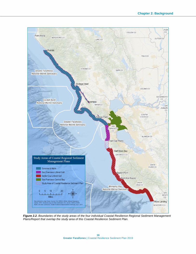
Figure 2.2. Boundaries of the study areas of the four individual Coastal Resilience Regional Sediment Management Plans/Report that overlap the study area of this Coastal Resilience Sediment Plan.

Chapter 2: Background
17 Greater Farallones | Coastal Resilience Sediment Plan 2019
Geographic Coverage of Existing Coastal Regional Sediment Management Plans/Report Four existing Coastal Regional Sediment Management Plans/Report (CRSMP/Rs) outline sediment management issues and recommendations along the North-central California coast and have geographic overlap with the GFNMS Management Area. From north to south these include: the Sonoma-Marin CRSMR, the San Francisco Central Bay CSRMP, the San Francisco Littoral Cell CRSMP, and the Santa Cruz Littoral Cell CRSMP (Figure 2.2). These plans do not fully cover the entire GFNMS Management Area; the Sonoma-Marin CRSMR ends at the Gualala River on the Sonoma-Mendocino County line and does not extend into the northern portion of GFNMS along the coast of Mendocino County. A second gap exists between the San Francisco Littoral Cell and Santa Cruz Littoral Cell CRSMPs; neither plan assesses the stretch of coastline from Point San Pedro in Pacifica to Pillar Point in Half Moon Bay due to the design of those plans along littoral cell boundaries defined by Habel and Armstrong (1978). The Sonoma-Marin and San Francisco Central Bay plans were designed to encompass a geographic region and did not follow littoral cell boundaries. Table 2.1 details the geographic coverage of each plan and a general description of land use of each area. Full and draft versions of the four CRSMP/Rs are available on the CSMW website (http://dbw.parks.ca.gov/?page_id=29337) and the GFNMS website (at https://farallones.noaa.gov/media/docs/crsmr_gfnms_finalreport.pdf). Table 2.1. Geographic coverage and general description of the four Coastal Regional Sediment Management Plans/Reports that overlap with the study area of this Plan.
Regional Sediment Management Plan/Report
Geographic Coverage General Description of Area
Sonoma-Marin CRSMR
Gualala River, Sonoma-Mendocino border to Golden Gate, Marin-San Francisco border.
Mostly rural and agricultural land use with publicly held land by the National Park Service, state parks, and county parks. High visitation rates to certain beaches and Bodega Harbor.
San Francisco Central Bay CRSMP
Central region of San Francisco Bay, including southern Marin and northern San Francisco coastlines. Specific boundaries: • Outer coast from Point Bonita to Point Lobos • North to Point San Pablo across to San Pedro Point • South to San Leandro Channel (adjacent to Bay Farm Island) and across to Hunters Point
Includes heavily urbanized port cities, publicly held lands, and suburban development along coastlines. Shipping and maritime activities dominate water use. Sand mining is allowed in central portion of the bay. Beaches and wetlands have high visitation and recreational use.
San Francisco Littoral Cell CRSMP
Golden Gate, Marin-San Francisco border to Pt. San Pedro, Pacifica. Coverage follows boundaries of the San Francisco Littoral Cell.
Seventeen miles along the Pacific Ocean coastline of San Francisco, Daly City, and Pacifica with high density urban and suburban development close to the ocean. High visitation to beaches.
Santa Cruz Littoral Cell CRSMP
Pillar Point, Half Moon Bay to Moss Landing. Coverage follows boundaries of the Santa Cruz Littoral Cell.
Mix of open space, agricultural, and urban land uses. Dense development along the coast in Santa Cruz-Capitola region but less so in northern portion of plan. High visitation to beaches and Pillar Point Harbor.

Chapter 2: Background
18 Greater Farallones | Coastal Resilience Sediment Plan 2019
Geographic Coverage of the Plan’s Study Area This Plan focuses on sanctuary relevant recommendations derived from existing CRSMP/Rs within the GFNMS Management Area (see above). The resulting study area encompasses the North-central California coastline from the Gualala River on the Sonoma-Mendocino County line in the north to the San Mateo-Santa Cruz County line in the south (Figure 2.2). Though not within the GFNMS Management Area, the San Francisco Littoral Cell CRSMP and a portion of the San Francisco Central Bay CRSMP are included in the study area of this Plan to allow for a more comprehensive analysis of sediment issues on the North-central coast. Importantly, there is significant connectivity between the bay and the outer coast via transport of sediments from watersheds of the San Joaquin and Sacramento through the bay to the Pacific. The study area includes the coast along the following counties: San Mateo, San Francisco (from the outer coast to the Golden Gate Bridge), Marin (from the Golden Gate Bridge to the Marin-Sonoma County line), and Sonoma, as well as Tomales Bay, Bolinas Lagoon, Estero Americano, and Estero de San Antonio and Bodega and Pillar Point Harbor.
Land Use and Shoreline Trends throughout the Study Area The study area encompasses a region with extensive variation in geomorphic and anthropogenic features. The diverse mix of beaches, cliffs, bays, and estuaries interspersed with areas of high development and population density, agricultural land, and open space brings with it an equally diverse array of shoreline challenges due to both sediment erosion and accretion. The following sections contain a brief description of the land use and shoreline trends as characterized by each of the four respective CRSMP/Rs included in the study area.
Sonoma-Marin The 340-mile-long coast along Sonoma and Marin Counties consists of sandy beaches, rocky cliffs, open bays (Bodega Bay, Drakes Bay, and Bolinas Bay) and enclosed bays or estuaries (Bolinas Lagoon, Tomales Bay, Estero Americano, and Estero de San Antonio). High-energy waves distribute sediment washed into the ocean by rivers and from shoreline erosion and move sand down-coast from beach to beach. The two Esteros are typically closed during summer and fall by seasonally formed sand bars, isolating the estuaries from the ocean. Tomales Bay and Bolinas Lagoon remain open to the ocean year-round. The open bays are sheltered from prevailing southerly currents by rocky headlands and points projecting westward and are important retention areas for suspended material. The largest individual sources of sediment are the Russian River, Gualala River, and San Francisco Bay. Along the coastline, sediment challenges include erosion of beaches, landslides, collapses of coastal bluffs, accumulation within bays and estuaries, and blockages of river mouths. The coastline is dominated by agricultural uses resulting in lower density of development than other portions of coastal California. Recreational uses vary considerably along the coastline with pockets of high recreational use (e.g., Stinson Beach) among miles of inaccessible and rocky shorelines. Bodega Harbor is the only Pacific Ocean port for the two counties, with some small landings along the coast for personal watercraft.

Chapter 2: Background
19 Greater Farallones | Coastal Resilience Sediment Plan 2019
San Francisco Central Bay San Francisco Bay lies between the Pacific Ocean at the Golden Gate and the confluence of the San Joaquin and Sacramento Rivers west of the Delta. It is the largest Pacific estuary in the Americas and is both highly urbanized and rural in nature. With over 7.4 million people living within its nine bordering counties, land cover primarily consists of high and medium intensity development, particularly along waterfronts dominated by marine related industries and containing deep water ports. The coastline also consists of a fair amount of natural or restored shorelines, with beaches and marshes prevalent in San Francisco and Marin counties. Much of the Central Bay topography consists of relatively flat land that gently slopes into the bay. Exceptions to this include islands (Angel, Alcatraz, etc.), and the steep slopes of the Marin Headlands, Tiburon Peninsula, and the area from Point Lobos to Baker Beach. The central portion of the bay is the most urban, and much of the shoreline in this area has been significantly altered over the past 150 years. The coastline has a long history of human impacts to sediment delivery, including upstream effects from hydraulic mining in the Sierras, infilling of San Francisco Bay for development, eliminating connection to the ocean for most coastal watersheds, dredging of the San Francisco Main Ship Channel, and commercial mining of the bay’s sandy shoals. Sediment delivery to the bay comes from Central Valley rivers and bay tributaries, tidal marshes and wetlands, shoreline bluff and cliff erosion, resuspension of sediment from the bay floor, and transport of sediment from coastal sources through the Golden Gate. The Delta, Suisun, San Pablo, the South Bay, local tributaries, and the outer coast provide an important supply, exchange, and deposit of sediment.
San Francisco Littoral Cell The 17-mile-long stretch of Pacific coastline along San Francisco and northern San Mateo Counties is especially dynamic because of interactions of the tidal pulses of San Francisco Bay and waves approaching from the open ocean. Proximal to San Francisco, tidal currents are the dominant impact on sedimentation. South of San Francisco, wave-driven processes increasingly dominate, although research by Barnard et al. (2013) and others indicates at least a connection between sediment leaving the bay and reaching the beach sands at the south end of the littoral cell. The two most significant impacts to shoreline trends on the outer coast of San Francisco and northern San Mateo County are sea level rise and reduced sediment supply from San Francisco’s Central Bay. The shoreline periodically experiences severe coastal erosion along much of its backshore from both terrestrial and marine processes, placing shoreline ecosystems and coastal development at risk, including landslides and coastal bluff collapse in Daly City and Pacifica. Armoring has been constructed along many stretches of the coast, preventing or slowing erosion of the back beach, and resulting in a narrowing of the beach as well as passive erosion adjacent to the hardened surface. Since 2005 dredged sand has also been placed at the Ocean Beach Demonstration Site, which is offshore of an erosional hotspot.
Santa Cruz Littoral Cell The Santa Cruz Littoral Cell CRSMP encompasses an approximately 75-mile-long stretch of coastline extending through San Mateo, Santa Cruz, and Monterey Counties. The northern

Chapter 2: Background
20 Greater Farallones | Coastal Resilience Sediment Plan 2019
portion is characterized by a relatively rugged rocky coastline that runs south from Pillar Point before gradually bending to the southeast at Point Año Nuevo. The southern section encompasses the northern shoreline of Monterey Bay, which extends east from Santa Cruz before curving to the south-southeast toward Moss Landing. The region consists of resistant headlands interspersed with pocket beaches from Half Moon Bay to Monterey Bay, marine terraces fronted by sandy beaches in northern Monterey Bay, and coastal dune systems in central Monterey Bay. Land use along the coastline transitions from the mostly rural northern Santa Cruz County consisting of agriculture and protected open spaces to the densely populated cities of Half Moon Bay and Santa Cruz with significant development and heavily visited beaches and harbors. The main concern along the coastline is erosion along beaches and bluffs that poses a threat to significant public infrastructure, including several locations along Highway 1. Coastal infrastructure and modifications to contributing watersheds has also affected sediment supply and transport.
Sediment Sources and Sinks Sediment sources and sinks must be identified to accurately calculate the sediment budget for a coastal area. A sediment budget refers to the total amount of sediment added to and removed from a coastal system and indicates if accretion or erosion are expected in a particular location. Gaps in knowledge on either side of the budget will prevent reliable estimates about how much sediment is accreting or eroding from a coastline each year. Conceptually, rivers, coastal watersheds, cliffs, dunes, and bays are the sources for beach-sized sand, cobble, and marsh-forming mud to coastal shorelines. Bays, lagoons, harbors, submarine canyons, and the offshore shelf are traditionally considered sinks for material in transport. Additionally, human actions impact sediment budgets when sand transport is affected by activities and structures that interrupt natural sediment pathways in the nearshore environment. Artificial sources of sand to the coast can include beach sand placement for restoration. Artificial sinks include direct removal through dredging activities and the placement of roads, highways, and culverts that prevent the free flow of sediment to the coast. The impoundment of rivers and prevention of cliff erosion by coastal armoring reduce sediment sources and can also be considered an artificial sink. Sediment sources are increasingly being recognized as a valuable resource vital to the function of ecosystems and sought after for potential reuse in restoration and addressing coastal erosion. When a sediment management strategy involves placement of sediment for beach restoration, the opportunistic use of material as a sediment resource is referred to as beneficial reuse. Several identified locations are already in the process of implementing beneficial reuse, for example USACE dredging of the San Francisco Shipping Channel annually produces 229,000 m3 (300,000 yd3) on average and is currently placed near Ocean Beach, San Francisco. It is also important to identify local sources of sediment due to a higher likelihood of compatibility for reuse. Local supplies are preferred for several reasons such as cost, geological and mineralogical similarity, habitat and species connectivity, and visual aesthetics (see more in Delaney and George 2018).

Chapter 2: Background
21 Greater Farallones | Coastal Resilience Sediment Plan 2019
Although sediment sources are not well understood in the study area because of widespread data gaps, the four CRSMP/Rs identified sand sources with the potential to address erosion zones within their respective areas. Table 2.2 details a summary of sand sources described in the CRSMP/Rs, with differing levels of detail. It is important to note that the potential sediment sources identified would all require further investigation for compatibility and availability. Table 2.2. Sand sources for potential use in addressing erosion zones described in the four Coastal Resilience Regional Sediment Management Plan/Reports included in the study area.
Sources Sonoma-Marin San Francisco Central Bay
San Francisco Littoral Cell
Santa Cruz Littoral Cell
Harbors and Navigation Channels
• Bodega Harbor, the only harbor or port within the study area, is dredged on a 10-12 year cycle.
• The USACE dredges the San Francisco Shipping Channel annually, producing 229,000 m3 (300,000 yd3) on average. Currently, this sediment is placed near Ocean Beach, San Francisco.
• Other regional harbors include those in Humboldt Bay
• Maintenance and navigational dredging sediment
• Regional harbors (e.g., Oakland, Richmond).
Annual maintenance dredging of the Main Ship Channel
• Pillar Point Harbor • Santa Cruz Harbor • Moss Landing
Harbor
Offshore Sand
Two known locations of sediment deposits are the San Andreas Graben and offshore of the Russian River.
Offshore locations
Waddell Creek Delta, located approximately 8,000 feet southwest of the mouth of Waddell Creek
Oversaturated Locations (Including Beaches and Estuaries)
• Northern Ocean Beach in San Francisco has been accreting extensively over the last decade causing the National Park Service and the City of San Francisco to truck sand from the north to the south of the beach. This sand is within the San Francisco Bay outflow zone and could be used on the Marin side of the Golden Gate.
• Bolinas Lagoon could provide opportunities for multiple benefits to the ecosystem, including local recreational needs and infrastructure protection through the use of accumulated sediment.
Dams and reservoirs
• Pescadero Marsh • Scott Creek
Lagoon • Seabright Beach
Flood Risk Management Projects and Dams
Dredging and cleaning culverts for road asset integrity may provide sediment in localized situations.
• Flood protection channel sediment
• Dams and reservoirs
• Butano Creek Channel
• San Lorenzo River • Pajaro River Bench
Excavation

Chapter 2: Background
22 Greater Farallones | Coastal Resilience Sediment Plan 2019
Sources Sonoma-Marin San Francisco Central Bay
San Francisco Littoral Cell
Santa Cruz Littoral Cell
Major Construction Projects
Highway 1 stabilization may require large earthworks that could provide considerable volumes of sediment that may end up as landslides if left alone.
Construction projects
Sediment from Caltrans road maintenance in the coastal areas of San Francisco and San Mateo Counties
None
Erosion Processes
Sea cliff erosion Sediment from backshore erosion
Mined Sand Commercially mined sand
Sediment from inside San Francisco Bay
Other Estuarine deposits
Sediment from Golden Gate National Recreation Area
Data Needs Substantial portions of the study area are missing essential information. Consolidating the data needs identified in each CRSMP/R shows there are similar themes regarding data needs (Table 2.3). A common theme is the need to consider a more systems-based approach when designing future research in order to work towards a broader understanding of natural sediment transport processes on a regional and watershed scale. Another common theme is the lack of accurate sediment source/sink estimates that prevent reliable estimates of sand budgets and resulting understanding of accretion/erosion at a given coastline. The Santa Cruz Littoral Cell CRSMP did not outline data gaps; however, a regional approach to data gathered to address the needs in other plans could be broad enough to encompass the Santa Cruz region. Several geographic data gaps also exist. The Sonoma-Marin CRSMR does not cover the northern portion of GFNMS in Mendocino County, and represents a gap in regional sediment management knowledge in that area. A second geographic gap between the San Francisco Littoral Cell and Santa Cruz Littoral Cell CRSMPs from Pacifica to Half Moon Bay is due to the design of the plans along littoral cell boundaries.

Chapter 2: Background
23 Greater Farallones | Coastal Resilience Sediment Plan 2019
Table 2.3. Data needs identified in the Coastal Resilience Regional Sediment Management Plans/Report within the Plan’s study area. The Santa Cruz Littoral Cell CRSMP did not outline data gaps.
Sonoma-Marin
Physical • Coastal watershed input of sediment • Erosion rates of cliffs • Alongshore transport pathways • Vertical land motion • Sedimentation rates along coast • Characterization of sediment sources: grain size, volume, beach or wetland compatibility (e.g.,
Bolinas Graben) Infrastructure and Economic • Highway 1 critical locations and planned actions by Caltrans • Visitor counts on beaches • Potential stockpile locations for sediment Community Features • Geospatial data on tribal and historical resources • Geospatial data on underrepresented/vulnerable communities
San Francisco Central Bay
• Baywide bathymetry below mean lower low water (MLLW) • Bathymetry of the bay bed • Region-wide, continuous monitoring of suspended sediment concentrations and bed load of
major channels, steep tributaries, and embayments varying across time, space, tidal cycle, season, and climate
San Francisco Littoral Cell
Physical and Biological • Sand availability for beach nourishment at Daly City and Pacifica • Sediment supply from watersheds and on the Daly City–Pacifica portion of the shelf • Sediment thickness and the horizon of underlying hardpan, especially in the reaches between
Sharp Park and Middle Ocean Beach • Wave conditions and alongshore transport processes south of Ocean Beach • Comprehensive ecological survey of existing habitats and special species • Vertical land motion Economic and Policy • Infrastructure replacement costs • Beach attendance and type-of-use records • The value of beaches from ecology, aesthetics, and community benefits Short and Long-Term Next Steps • Investigate offshore sand deposits for beach nourishment supply • Analyze sediment transport and complete a sediment budget analysis in the Daly City–Pacifica
area to provide more accurate information for sediment management activities • Investigate the effects of coastal armoring on beaches and bluff erosion • Investigate the sand content and size of the region’s coastal bluffs • Evaluate the other contributors to beach valuation, such as ecology and the full range of
ecosystem services • Engage the Daly City and Pacifica communities in a visioning process for their shores
investigating coastal hazard mitigation and adaptation strategies

24 Greater Farallones | Coastal Resilience Sediment Plan 2019
CHAPTER 3: STRATEGIES AND SELECTION PROCESS
Overview A goal of this document is to integrate and identify appropriate sediment management strategies for actions GFNMS can take or support to increase coastal resilience along its shorelines and to provide a roadmap for the potential implementation of these actions. This chapter begins with an overview of relevant sanctuary regulations followed by climate-related goals. Successful implementation of future projects that develop from recommendations in this Plan will need to adhere to these regulations and align with these climate-related goals. Projects will also require regulatory review and approval by other federal, state, and local agencies and will need to be consistent with their regulations and policies. The foundation for the strategies selected in this Plan are the recommendations previously outlined in the four Coastal Regional Sediment Management Plans/Report (CRSMP/Rs), which were developed through extensive collaboration by a variety of stakeholders. For example, to develop the Sonoma-Marin CRSMR, the GFNMS Advisory Council established a Sediment Management Working Group comprised of scientists, landowners, local stakeholders, and a Technical Advisory Committee composed of local, state, and federal agency representatives. The other CRSMPs utilized similar processes to solicit input from their respective communities. While vetted by a broad cross section of state, federal, and local regulatory partners, not all recommendations in the four CRSMP/Rs are necessarily consistent with sanctuary regulations and policies, nor are they all within the boundary of the sanctuary’s Management Area. Thus, compiling a list of sanctuary-focused strategies required further assessment and review in relation to sanctuary regulations, policies, and goals. The sediment management recommendations compiled from the four CRSMP/Rs can be divided into two categories: overarching regional recommendations and recommended strategies at specific site locations. In total, 39 regional recommendations span the study area and promote a broad and comprehensive approach to sediment management, often involving extensive collaboration by federal, state, and local agencies and other stakeholders in the region. After review and assessment of the 39 recommendations for similarities between CRSMP/Rs and key themes, this chapter presents six overarching Regional Sediment Management objectives for the North-central California coast. These six regional recommendations represent overarching priorities for GFNMS in cooperation with partner agencies to manage sediment for coastal resilience throughout the study area.
Chapter 3: Strategies and Selection Process
25 Greater Farallones | Coastal Resilience Sediment Plan 2019
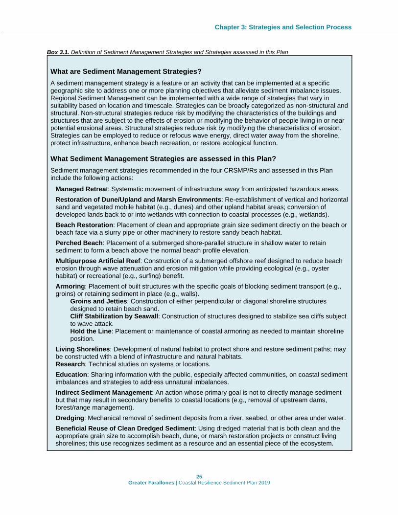
Box 3.1. Definition of Sediment Management Strategies and Strategies assessed in this Plan
What are Sediment Management Strategies? A sediment management strategy is a feature or an activity that can be implemented at a specific geographic site to address one or more planning objectives that alleviate sediment imbalance issues. Regional Sediment Management can be implemented with a wide range of strategies that vary in suitability based on location and timescale. Strategies can be broadly categorized as non-structural and structural. Non-structural strategies reduce risk by modifying the characteristics of the buildings and structures that are subject to the effects of erosion or modifying the behavior of people living in or near potential erosional areas. Structural strategies reduce risk by modifying the characteristics of erosion. Strategies can be employed to reduce or refocus wave energy, direct water away from the shoreline, protect infrastructure, enhance beach recreation, or restore ecological function.
What Sediment Management Strategies are assessed in this Plan? Sediment management strategies recommended in the four CRSMP/Rs and assessed in this Plan include the following actions:
Managed Retreat: Systematic movement of infrastructure away from anticipated hazardous areas.
Restoration of Dune/Upland and Marsh Environments: Re-establishment of vertical and horizontal sand and vegetated mobile habitat (e.g., dunes) and other upland habitat areas; conversion of developed lands back to or into wetlands with connection to coastal processes (e.g., wetlands).
Beach Restoration: Placement of clean and appropriate grain size sediment directly on the beach or beach face via a slurry pipe or other machinery to restore sandy beach habitat.
Perched Beach: Placement of a submerged shore-parallel structure in shallow water to retain sediment to form a beach above the normal beach profile elevation.
Multipurpose Artificial Reef: Construction of a submerged offshore reef designed to reduce beach erosion through wave attenuation and erosion mitigation while providing ecological (e.g., oyster habitat) or recreational (e.g., surfing) benefit.
Armoring: Placement of built structures with the specific goals of blocking sediment transport (e.g., groins) or retaining sediment in place (e.g., walls).
Groins and Jetties: Construction of either perpendicular or diagonal shoreline structures designed to retain beach sand. Cliff Stabilization by Seawall: Construction of structures designed to stabilize sea cliffs subject to wave attack. Hold the Line: Placement or maintenance of coastal armoring as needed to maintain shoreline position.
Living Shorelines: Development of natural habitat to protect shore and restore sediment paths; may be constructed with a blend of infrastructure and natural habitats. Research: Technical studies on systems or locations.
Education: Sharing information with the public, especially affected communities, on coastal sediment imbalances and strategies to address unnatural imbalances.
Indirect Sediment Management: An action whose primary goal is not to directly manage sediment but that may result in secondary benefits to coastal locations (e.g., removal of upstream dams, forest/range management).
Dredging: Mechanical removal of sediment deposits from a river, seabed, or other area under water.
Beneficial Reuse of Clean Dredged Sediment: Using dredged material that is both clean and the appropriate grain size to accomplish beach, dune, or marsh restoration projects or construct living shorelines; this use recognizes sediment as a resource and an essential piece of the ecosystem.

Chapter 3: Strategies and Selection Process
26 Greater Farallones | Coastal Resilience Sediment Plan 2019
A total of 115 specific recommendations spanning 41 site locations were compiled in the study area with a range of sediment management strategies. These strategies were categorized and processed through a Strategy Assessment Tool (see Box 3.1 and Figure 3.2) to assess first, whether each recommendation is consistent with sanctuary regulations and policies, and second, the potential feasibility of implementation for GFNMS. The final 29 sanctuary-focused strategies across 15 sites (see Table 3.6 and Figure 3.3) present a roadmap for potential sediment management and coastal resilience strategies within the sanctuary’s Management Area. Additionally, 73 strategies at 37 site locations consistent with sanctuary goals and objectives but outside the Management Area and beyond the scope of the sanctuary’s authority/mandate to implement are forwarded to relevant management agencies for their consideration and potential use for their own project planning. This chapter contains details on the process of determining the site-specific recommendations and each of the 29 sanctuary-focused strategies.
Sediment Management Strategies Worldwide, coastal engineers use a wide range of strategies to address sediment imbalances such as preventing coastal erosion or managing severely eroded areas. Each strategy is an activity that can be implemented at a specific geographic site to address one or more planning objectives. The type of strategy employed depends upon the geophysical setting, desired level of risk reduction, objectives, cost, and reliability. The four CRSMP/Rs present a range of strategies with slight variations and a clear and consistent definition is necessary to merging the four plans/report’s recommendations. The definitions used in this Plan for each of the strategies assessed can be found in Box 3.1 and Appendix A presents a comprehensive list as described in each CRSMP/R.
Overview of Sanctuary Regulations Relevant to Sediment Management Strategies A critical component of this Plan is to identify and provide consensus-driven strategies for regional sediment management throughout the study area. Most of the sediment management strategies and recommendations discussed in this Plan will require regulatory approval and/or support from a variety of federal, state, and local agencies whose jurisdictions fall within this Plan’s study area, including GFNMS and MBNMS. Successful planning and implementation of any projects that develop as a result of this Plan will need to be consistent with sanctuary regulations and policies. The following discussion provides a starting point with an overview of the sanctuary’s mandate and regulatory program. A national marine sanctuary is a federally-designated area within United States waters that protects areas of the marine environment with special conservation, recreational, ecological, historical, cultural, archeological, scientific, educational, or aesthetic qualities. GFNMS and MBNMS were designated in accordance with the National Marine Sanctuaries Act (NMSA) in 1981 and 1992 respectively, and are managed under the authority of the Act. Under the NMSA, GFNMS and MBNMS have the ability to grant permits for prohibited activities and enforce regulations, provided that the activities meet certain criteria set forth in regulations, such as conducting the activity in a manner compatible with the primary objective of protection of sanctuary resources and qualities, considering the extent to which the conduct of the activity may diminish or enhance sanctuary resources and qualities, any potential indirect, secondary or

Chapter 3: Strategies and Selection Process
27 Greater Farallones | Coastal Resilience Sediment Plan 2019
cumulative effects of the activity, and the duration of such effects (15 CFR Part 922, Subpart H, Subpart M). One of the stated purposes of sanctuaries as defined in the NMSA is to maintain the natural biological communities in the national marine sanctuaries, and to protect, and, where appropriate, restore and enhance natural habitats, populations, and ecological processes. GFNMS seeks to understand and protect the ecosystem and cultural resources of North-central California through resource protection, research, and education. As such, GFNMS addresses a wide range of resource protection issues within its boundaries to reduce or prevent detrimental human impacts on sanctuary resources through collaborative partnership efforts, implementing regulations and issuing permits, conducting emergency response, working with NOAA enforcement personnel, and implementing education programs. The shoreline boundary of the GFNMS Management Area is generally the mean high water (MHW) line, with the exception of several areas along the shoreline of Point Reyes National Seashore (PRNS) (i.e., GFNMS boundaries do not overlap with PRNS boundaries that extend a quarter mile from shore off the Point Reyes Peninsula, a portion of Drakes Bay, and the north-west shoreline of Tomales Bay from Duck Cove to Tomales Point), Arena Cove, Bodega Harbor, and Pillar Point Harbor. Also excluded are the estuaries located at the Russian River, Salmon Creek, Gualala River, and Garcia River. GFNMS implements and enforces seventeen federal regulatory prohibitions within GFNMS and 14 prohibitions within the northern portion of MBNMS designed to preserve and protect the natural and cultural resources and qualities of the ocean and estuarine areas within the boundaries of the sanctuaries. Depending upon the nature of the project, five of these prohibitions (which are the same for both GFNMS and MBNMS) could pertain to potential RSM strategies in the study area, and thus trigger the need for GFNMS review to determine if issuing a permit is necessary for the project to proceed. (Table 3.1). Table 3.1. GFNMS regulations that could pertain to potential RSM strategies and thus trigger the need for GFNMS review and determination if a permit is required in order to proceed with a project.
Prohibitions:
1 Discharging or depositing, from within or into the sanctuary, any material or other matter (with the exception of certain activities, such as fish parts from lawful fishing activities, treated vessel sewage, clean deck wash down, etc.)*
2 Drilling into, dredging, or otherwise altering the submerged lands of the sanctuary; or constructing, placing, or abandoning any structure, material, or other matter on or in the submerged lands of the sanctuary (with the exception of several activities, such as boat anchoring, lawful fishing, certain types of aquaculture activities, and harbor maintenance projects).
3 Taking or possessing (disturbing or injuring) any marine mammal, sea turtle, or bird within or above the sanctuary, except as authorized by the Marine Mammal Protection Act, Endangered Species Act, or Migratory Bird Treaty Act (regardless of intent).
4 Possessing, moving, removing or injuring a sanctuary historical resource, or attempting such actions.
5 Introducing or otherwise releasing from within or into the sanctuary an introduced species (with the exception of striped bass and some shellfish species approved for aquaculture).
*In MBNMS, an additional discharge exception includes the disposal of dredged material at EPA-designated disposal sites that were created prior to January 1, 1993; this exception does not exist in GFNMS regulations.

Chapter 3: Strategies and Selection Process
28 Greater Farallones | Coastal Resilience Sediment Plan 2019
In MBNMS, proposed RSM activities that do not meet the permit procedures and criteria described under Title 15 CFR 922.133 may qualify for separate regulatory approval known as an “authorization.” An authorization can be issued to allow an activity to occur within MBNMS that is otherwise prohibited by sanctuary regulations provided that the activity has an existing valid federal, state, or local lease, permit, license, approval, or other authorization issued, and is consistent with all applicable review requirements specified in the MBNMS regulations (15 CFR 922.49). There are several conditions that need to be met, including but not limited to: (1) The applicant notifying the Director (designated Superintendent) in writing within fifteen days of the date of filing of the application; (2) the Director notifying the applicant and authorizing agency that he or she does not object to issuance of the authorization (or amendment, renewal, or extension); and (3) the applicant complies with any terms and conditions the Director deems reasonably necessary to protect sanctuary resources and qualities. For example, in cases where proposed projects require a California Coastal Commission Coastal Development Permit (or another relevant permit issued by a state or federal agency), but would otherwise be prohibited by MBNMS regulations and does not qualify as “permitted” activity, an application can be sent concurrently to NOAA requesting an authorization. If the Coastal Development Permit is issued, and the procedures required by NOAA under the authorization authority at 15 CFR 922.49 are followed, then the Director can “authorize” a prohibited activity, but may set additional terms and conditions for compliance by the applicant. It should be noted that the “authorization” authority is not applicable within GFNMS, meaning that any proposed RSM activity must comply with GFNMS permit procedures and issuance criteria under Title 15 CFR 922.83. Table 3.2. Regional sediment management or coastal protection strategies that could require sanctuary review and a determination if a permit can be issued.
Coastal protection strategies that would require sanctuary review:
Beach restoration, living shorelines, or other habitat restoration projects where sediment, vegetation, substrate, organisms, or other materials are placed within sanctuary boundaries (i.e., below the MHW line)
Shoreline construction or beach restoration activities that may result in a discharge of matter into the sanctuary
Projects that involve dredging or dredged material placement or sediment extraction within the sanctuary
Projects that involve placement of temporary structures, materials or equipment on or into the submerged lands of the sanctuary (e.g., containment berms)
GFNMS may issue a permit for a sediment management strategy (which involves prohibited activities within the sanctuary) if the proposed action meets the appropriate review criteria under sanctuary regulations. Project approval would depend on a variety of factors including but not limited to project scale, site location, proximity to sensitive habitat and other potential habitat impacts, and materials to be used. In the case of beach restoration projects, sanctuary staff may issue a permit for projects that involve the placement of dredged material within GFNMS boundaries provided it meets the appropriate testing criteria required by all applicable regulatory agencies. Under current MBNMS regulations, sanctuary staff may not issue a permit or an Authorization to allow the direct placement of dredged material within the sanctuary (other than at EPA-designated disposal

Chapter 3: Strategies and Selection Process
29 Greater Farallones | Coastal Resilience Sediment Plan 2019
sites established prior to January 1, 1993). However, beach restoration projects utilizing clean material from other sources may be considered within MBNMS boundaries.
Overview of Sanctuary Climate Adaptation Plan Strategies Relevant to Sediment Management Successful planning and implementation of any projects that develop as a result of this Plan will need to align with the GFNMS Climate Adaptation Plan (Hutto et al., 2016). To address the effects of climate change within its boundaries, GFNMS assessed future impacts and vulnerabilities and detailed management priorities to enhance the region’s natural resource resilience. The resulting guidance for incorporating climate considerations and related adaptation actions into sanctuary management includes a number of regional sediment management strategies and highlights the need for expanding sediment-related strategies across the sanctuary. Specifically, the Climate Adaptation Plan promotes three sediment-related approaches to increase climate resilience, including: implementation of living shorelines; protection and restoration of habitat; and investment in science needs (Table 3.3). These approaches have been identified by GFNMS as priority strategies for implementation. The living shoreline approach calls for the use of nature-based and “green” infrastructure solutions (e.g., natural materials) as an alternative over “gray” (or built) infrastructure and armoring to reduce erosion and combat the effects of sea level rise and increased storms. Living shorelines benefit communities while also benefiting the environment and providing transitional habitats for flora and fauna to migrate inland or upland in response to sea level rise. This approach is acutely relevant to the sanctuary’s tidal wetlands, including Bolinas Lagoon which will experience dramatic habitat transition by 2080 under mid-sea level rise projections and by 2050 under high-SLR projections, with the complete loss of high and mid-marsh habitat (Thorne et al., 2016). Habitat protection/restoration strategies seek to directly protect and restore habitat or key ecosystem processes in order to enhance the adaptive capacity of these systems to the impacts of climate change. This approach also identifies sediment management strategies that utilize habitat protection as a method of alleviating climate impacts by directly reducing climate stressors on coastal habitats, species, and local communities. For example, reducing habitat loss by erosion through the removal or modification of structures that disrupt the delivery of sediment may also reduce climate impacts from increased storminess. “Science needs” refers to the information or products that are required in order to make an informed management decision. The strategies in this approach detail physical and biological monitoring and research that is needed to inform management responses to climate impacts by outlining the priority science needs for sanctuary management. For example, establishment of baseline monitoring can aid in identifying sand sources/sinks and locations most vulnerable to coastal inundation and erosion. GFNMS’s approach to science needs adopts one of the key tenets of climate-smart conservation—adaptive management; the flexible and rapid response of management practices to new and changing information.

Chapter 3: Strategies and Selection Process
30 Greater Farallones | Coastal Resilience Sediment Plan 2019
Table 3.3. An excerpt of prioritized strategies and actions in the GFNMS Climate Action Plan relevant to sediment management in the study area. The complete GFNMS Climate Adaptation Plan can be found at: https://farallones.noaa.gov/manage/climate/adaptation.html
GFNMS Climate Action Plan
Approach: Implement Living Shorelines (LS)
Strategy Actions
LS-1: In areas dominated by grey infrastructure, identify potential demonstration sites for nature based infrastructure projects and/or other "active management" projects; implement and evaluate effectiveness to inform future efforts across the region.
LS-1.1: Identify locations within estuaries that are currently impacted by flooding and erosion where nature-based shoreline protection projects could have co-benefits for natural systems and human communities and will not impact current protections for unique habitats or further threaten Endangered or Threatened Species. Analyze net environmental benefits to inform site selection. LS-1.2: Based on characteristics of the site, identify the appropriate nature-based infrastructure project to implement.
LS-2: To the extent practicable, reduce or modify armoring that exacerbates erosion.
LS-2.1: Identify locations with armoring that exacerbates erosion. Analyze net environmental benefits to inform site selection for modifying structures LS-2.2: Replace armoring with nature-based solutions such as natural material to create sloped, transitional habitat (e.g., native oyster reef or dune). LS-2.3: If armoring can't be removed and replaced, implement living shoreline techniques in conjunction with new construction or repairs.
LS-3: To the extent practicable, remove/redesign roads in locations that act as barriers to natural expansion of coastal habitats. Always remove roads where possible; if not possible, redesign the road.
LS-3.1: Identify areas that: A) are critical for coastal habitat expansion and that have roads that impede migration, and B) have roads vulnerable to sea level rise, flooding, other climate impacts. LS-3.2: Develop a “Climate-Ready Response” plan for identified locations to allow for road removal/redesign in case of a disaster (e.g., road is damaged from a flood event). LS-3.3: Post-disaster (flooding/road failure): implement the “Climate-Ready Response” plan to move/redesign road to enhance future resilience. LS-3.4: If road is not impacted by climate change/extreme events, remove/redesign the road as available during standard maintenance schedule timeframes (i.e., when the opportunity arises to replace/redesign the road). LS-3.5: For roads that can't be raised/moved, or in conjunction with raising/moving roads, look for opportunities to create functional habitat (e.g., replace hard/grey infrastructure such as rip-rap with living shorelines and migration space).
Approach: Protect and Restore Habitat (H)
Strategy Actions
H-1: Remove or modify structures that disrupt the delivery of sediment via long-shore sediment transport (jetties, breakwaters, storm and wastewater discharge pipes), and coastal and near-shore structures that contribute to erosion.
H-1.1: Identify and prioritize areas that are currently being impacted by sediment-disruptors, and remove where possible. H-1.2: If the structure cannot be removed, then work with partners to enable managed retreat (for bluffs to feed the beach as sea level rises) and support beach nourishment to control coastal erosion.

Chapter 3: Strategies and Selection Process
31 Greater Farallones | Coastal Resilience Sediment Plan 2019
GFNMS Climate Action Plan
H-2: For locations identified as having appropriate substrate available under eroding coastlines for potential colonization and creation of new intertidal habitat, allow those areas to erode to create new habitat. Discourage the creation of structures that would inhibit erosion.
H-2.1: Identify locations where cliff erosion may allow for the creation of new intertidal sandy beach or rocky habitat and do not armor or protect those cliffs. Maintain intertidal habitat continuity north to south - avoid where possible large stretches of total inundation and loss of intertidal habitat. H-2.2: Create unfettered sea-to-land linkages for new habitat development by allowing cliffs in these locations to erode naturally.
H-3: Protect and restore eelgrass in areas that have been adversely affected by human activities, and where restoration will have co-benefits (reducing wave energy and erosion).
H-3.1: Identify most critical locations in need of eelgrass restoration and/or protection, potentially including Tomales Bay, Esteros de San Antonio and Americano, and Bolinas Lagoon, and analyze net environmental benefits to determine if restoration is a viable option. H-3.2: As the Eelgrass Research Plan develops (see SN-3.2), adapt management and restoration plans to account for new information. Do not pursue eelgrass restoration until the most critical research questions have been answered.
H-4: Restore lower intertidal mussel beds and algae, including sea palms (a species identified as vulnerable), to reduce impact of wave energy on intertidal zones by enhancing physical/structural resistance.
H-4.1: Identify areas in need of restoration and prioritize intertidal reefs that are most vulnerable to wave energy and erosion. H-4.2: Design feasibility studies and demonstration projects to test viability.
H-5: Restore surfgrass (Phyllospadix) and algal species to act as aqueous canopies to provide shading and reduce temperatures and evaporation in tide pools.
H-5.1: Identify areas in need of restoration and prioritize intertidal reefs that are most vulnerable to prolonged exposure and heat stress. H-5.2: Design feasibility studies and demonstration projects to test viability.
H-6: Restore subtidal kelp forests to attenuate waves and buffer from enhanced storm activity.
H-6.1: Identify locations that historically had bull kelp but are in need of restoration; ensure necessary conditions for kelp settlement and growth are met (e.g., good light and water quality, little turbidity, rocky substrate) H-6.2: Design feasibility studies and demonstration projects to test viability.
H-7: In the aftermath of an oil spill or other contaminants, ensure that restoration of affected areas takes into account climate considerations.
H-7.1: Restoration plans should explicitly account for climate impacts on the successful restoration of affected sites, including the type of restoration, the location, net environmental benefits analysis, and what should actually be restored based on climate envelope modeling to predict what species will likely become dominant.
H-8: Let go of pocket beaches that can’t retreat, and do not intervene with management actions.
H-8.1: Identify beaches that can't be logistically nourished and have no options for retreat, and plan for the loss of these beaches.
Approach: Invest in Science Needs (SN)
Strategy Actions
SN-1: Conduct monitoring before and following natural extreme events to build on knowledge of climate change impacts to estuarine processes and to inform adaptive management
SN-1.1: Identify locations in the sanctuary that are most vulnerable to extreme events that result in coastal inundation and erosion. Establish baseline monitoring of these locations.

Chapter 3: Strategies and Selection Process
32 Greater Farallones | Coastal Resilience Sediment Plan 2019
GFNMS Climate Action Plan
SN-2: Determine the source of sediment for vulnerable beaches in order to improve sediment supply processes.
SN-2.1: Identify beaches in the sanctuary that are most vulnerable to erosion and sand loss and/or have unknown sediment sources. SN-2.2: Working with the Coastal Sediment Management Workgroup and USGS, identify the source of sediment and develop management recommendations and permit requirements for sediment supply management.
Recommendations at the North-central Coast Regional Level A total of 39 overarching North-central coast regional recommendations were made in the four CRMSP/Rs promoting a broad and comprehensive approach to sediment management for coastal resilience. Some of these recommendations apply to sub-regions within study areas of each CRSMP/R and some are more generally applicable across the entire region. Many of these regional recommendations require extensive coordination and collaboration by federal, state, and local agencies and other stakeholders in the region. The full list of compiled recommendations can be found in Appendix B. Regional recommendations were reviewed and assessed for similarities and common themes. The following is an abridged summary of six key, common Regional Sediment Management themes by category from the four CRSMP/Rs: 1) Leverage Partnerships and Agency Coordination and Promote Information Sharing Regional recommendations commonly discuss the importance of: coordinating agency review and permitting (e.g., following the model of the Dredged Material Management Office); seeking partnerships with local agencies to solicit local expertise, support, and potential funding opportunities (such as Resource Conservation Districts, Land Trusts, non-governmental organizations, property owner associations, and agricultural producers); convening multi-stakeholder or multi-agency task forces, or creating Memorandum of Agreements, and/or committees to facilitate a holistic approach to sediment management in the region; and ensuring that the strategies proposed by each CRSMP/R are closely coordinated with other sediment management projects or programs already occurring in each region. 2) Engage Communities and Stakeholders through Education and Outreach The regional recommendations also highlight the need to: engage local agencies and communities around the value of sediment as both a resource and natural component of the coastal environment; assist local agencies and land managers with communicating the need for sediment management to their constituents, and provide platforms to convey results and opportunities for the public to join in sediment management efforts and monitoring (e.g., encouraging community-based citizen science opportunities). 3) Maintain and Expand Sediment Research and Monitoring Activities Regional recommendations stress the need for maintaining existing regional monitoring programs and expanding new monitoring efforts, especially to better understand sediment pathways and budgets, both locally and across watersheds; and conducting sediment characterization assessments in different habitat areas (e.g., sand content and grain size in the region’s coastal bluffs) to understand how sediment supports local ecology and ecosystem services.

Chapter 3: Strategies and Selection Process
33 Greater Farallones | Coastal Resilience Sediment Plan 2019
4) Restore Natural Habitats and/or Sediment Dynamics and Pursue Nature-Based Solutions to Avoid Hardening the Shoreline Some of the most frequently highlighted regional themes pertain to restoration and nature-based design, including: limiting armoring and other interruptions to natural sediment flow (such as dams) wherever feasible and only allowing coastal armoring as a last resort option for coastal defense; encouraging the investigation and design of more “living shoreline” approaches to increase shoreline stabilization that also provides a habitat benefit to avoid additional hard-scaping of shorelines; working to preserve remaining natural habitat areas along estuarine and coastal shorelines; restoring natural sediment flow to reduce the need for sediment maintenance; encouraging new shoreline development designs that enhance or restore natural shoreline areas and shoreline processes (e.g., allowing natural sedimentation and expansion of marsh areas to keep pace with sea level rise); and beginning to plan for managed retreat in vulnerable coastal areas and allow for the successful restoration of natural coastal processes. 5) Encourage and Increase the Beneficial Reuse of Sediment Another common theme was the importance of: beneficially reusing sediment that may otherwise be discarded (such as dredged material, sediment trapped in culverts and behind dams, and landslide material) for restoration purposes; developing lists of potential “receiver” and storage sites (upland and aquatic) to be pre-qualified to increase the volume of beneficially reused sediment across the region; developing a matrix to characterize sediment compatibility across regions so that sediment can be reused more quickly and easily; and improving agency partnerships and coordination (e.g., with Caltrans and flood control districts) to help with cost-sharing opportunities for beneficial reuse. 6) Utilize a Holistic, Watershed Approach to Sediment Management Regional recommendations frequently state the importance of taking a holistic, watershed approach to understand sediment budgets and dynamics (especially in relation to estuarine systems like San Francisco Bay) by: collaborating with watershed agencies to restore and enhance fluvial sediment delivery to estuaries and coasts; encouraging the protection of creeks; identifying areas of restoration to improve downstream water quality and natural sediment transport; developing and calibrating models that can predict the rate of sediment delivery over time from the tributaries to estuaries; and encouraging the redesign of tributaries and channels to improve sediment conveyance. The six themes distilled from the regional recommendations represent overarching priorities for GFNMS in cooperation with partner agencies to manage sediment for coastal resilience throughout the study area. Many of these align with GFNMS’s climate adaptation goals (see Table 3.3) and these themes have been included in the Plan’s Metrics for Success (Chapter 6) to ensure they remain a priority going forward. Because the scope of most of these regional recommendations are generally relevant on a broader scale than the purview of the sanctuary and require involvement and leadership from many other agencies, the entire list of 39 recommendations and six summarized themes will be forwarded to other applicable federal, state, and local partner agencies who have a role in regional sediment management. The regional recommendations will also be presented to the

Chapter 3: Strategies and Selection Process
34 Greater Farallones | Coastal Resilience Sediment Plan 2019
newly formed North-central California Coastal Sediment Coordination Committee, which is further discussed in Chapter 5.
Recommendations at the Site Level All four Coastal Regional Sediment Management Plans/Report (CRSMP/Rs) in the study area point to specific locations facing sediment challenges (typically worsening erosion, but in some cases rapid or unnatural accretion), and recommend sediment management and coastal resilience strategies for addressing them. The potential strategies range in geographic extent, scope, complexity, and urgency with near-, mid-, and long-term elements. To identify appropriate strategies from those plans for future GFNMS actions, selection criteria are developed to determine whether each recommendation is consistent with sanctuary regulations and policies and if consistent, the potential feasibility of implementing the specified recommendation. The next section details on the process of compiling the site-specific recommendations and their evaluation by GFNMS using the basic assessment principles.
Description of Process A number of steps are necessary to analyze the recommended strategies in the four CRSMP/Rs (summarized in Box 3.2). First, a comprehensive list of recommendations with site-specific actions from all four CSRMP/Rs spanning across this Plan’s study area (as defined in Chapter 2) is compiled by location. The resulting list includes 41 site locations listed in Table ES.1 and mapped in Figure 3.1 and resulted in 111 recommended strategies for sediment management. These 111 strategies are sorted into 13 overarching sediment management categories (defined in Box 3.1) and listed by location in Table 3.4.
Box 3.2. Process of determining the final list of sanctuary sites analyzed in this Plan.
Process of determining sanctuary sites:
1. Compiled all site-specific recommendations contained in the four CRSMP/Rs that fall within the study area of this Plan.
2. Categorized site-specific recommendations into 13 strategies. 3. Compiled and included any relevant site-specific strategies and
recommendations not included in the four CRSMP/Rs. 4. Assessed potential sediment management strategies at each site for both
potential feasibility and for consistency with sanctuary regulations and policies using the Strategy Assessment Tool flowchart.
5. Compiled the resulting recommendations for implementation within the study area and eliminated recommendations that were not consistent with sanctuary regulations and policies.
6. Forwarded recommended strategies that GFNMS does not have the appropriate authority or mandate to implement to the appropriate agencies for their review and consideration; this includes all sites that are outside sanctuary jurisdiction and all strategies at sites within sanctuary boundaries that GFNMS lacks authority to implement.

Chapter 3: Strategies and Selection Process
35 Greater Farallones | Coastal Resilience Sediment Plan 2019
Figure 3.1. Study area of the Coastal Resilience Sediment Plan and the 40 locations of sites with specific recommendations made by the four Coastal Regional Sediment Management Plan/Reports. The “State Parks” location refers broad coastal areas in Sonoma and Marin counties (“Site Zero” in the Sonoma-Marin CRSMR) and are not represented on the map.

Chapter 3: Strategies and Selection Process
36 Greater Farallones | Coastal Resilience Sediment Plan 2019
Table 3.4. Strategies compiled from four CSRMP/Rs for sites within the study area categorized by recommended type of Regional Sediment Management strategy.

Chapter 3: Strategies and Selection Process
37 Greater Farallones | Coastal Resilience Sediment Plan 2019
Next, the list of 111 site-specific recommendations is assessed to ensure this Plan’s final list of sites is comprehensive. The Sonoma-Marin CRSMR’s recommendations included a summarized list at Bolinas Lagoon so as to not duplicate the efforts of the Bolinas Lagoon Ecosystem Restoration Project: Recommendations for Restoration and Management (GFNMS Advisory Council Working Group, 2008). The document, produced through a partnership of agencies, community representatives, and scientists, focuses on implementation of nature-based climate adaptive management strategies and restoration efforts in Bolinas Lagoon. For completeness two strategies are included in this Plan, bringing the total number of recommended strategies to 113. Lastly, to better understand which recommendations from the existing CRSMP/Rs GFNMS would potentially support, a flowchart Strategy Assessment Tool (SAT; Figure 3.2) was created to assess each recommendation’s consistency with sanctuary regulations and policies as well as the potential feasibility of implementation. The flowchart tool guides each of the 113 recommendations through a series of questions to determine applicability to the sanctuary and its management goals, and whether GFNMS has the authority to take action. At the end of the process, all strategies were categorized as either: 1) a sanctuary-focused strategy that supports sanctuary goals and objectives for implementation (“Implement”); 2) a strategy that does support sanctuary goals and objectives and will be forwarded to a partner agency due to falling outside either the geographical boundaries of the sanctuary’s Management Area or the scope of the sanctuary’s authority/mandate to implement (“Forward”); or 3) a strategy that does not support sanctuary goals and objectives (“Not a Fit”). The “Implement” strategies received coded responses to four additional questions that collectively represent implementation feasibility: the level of benefit to the sanctuary (substantial or minor), the amount of resources required (e.g. staffing and funding; small or large), the level of existing stakeholder support (large or small), and urgency (high or low). The codes are a useful indicator of which sediment management strategies the sanctuary deems “low-hanging fruit” and which strategies would require either substantially more effort, funding, time, and coordination before being developed into a feasible project, or are not as beneficial to the sanctuary for the amount of effort and agency resources required. It is important to note that the resulting list of recommendations is not a list of pre-approved projects. Each recommended strategy is not representative of a single project, but the recommended strategy to use when approaching a specific sediment related problem, which could lead to multiple individual projects at a given site location. Further, in many cases site locations have multiple strategies, either over time (e.g., Bodega Harbor has near-, mid-, and long-term recommended strategies for research) or across multiple geographically-linked sub-sites that were categorized as one site location during this process (e.g., Bodega Harbor has recommended strategies in the harbor, along adjacent roadways, and on adjacent beaches). Additionally, the assessment process resulted in two strategies categorized as both “Forward” and “Implement” (Restoration of Dune/Upland and Marsh Environment at Stinson Beach, Research at Bodega Harbor) bringing the final total number of strategies to 115. Therefore, though there are 115 strategy recommendations, there may be multiple actions resulting from each recommendation and more than 115 resulting projects. It is also important to view the implementation feasibility as dynamic rather than static; as potential projects and opportunities or constraints developed for each of the site locations evaluated by this Plan evolve, implementation feasibility may change accordingly.

Chapter 3: Strategies and Selection Process
38 Greater Farallones | Coastal Resilience Sediment Plan 2019
Figure 3.2. Strategy Assessment Tool used to assess both the potential feasibility of implementing site-specific recommendations and whether each recommendation would be consistent with sanctuary regulations and policies. Evaluation scheme for assigning codes and implementation feasibility shown in tables.

Chapter 3: Strategies and Selection Process
39 Greater Farallones | Coastal Resilience Sediment Plan 2019
Resulting Strategies for Sediment Management Across 41 Site Locations In total, 115 strategies for sediment management across 41 site locations within the study area were assessed (Table 3.5). Of these 41 sites in the study area, 19 sites (and 52 strategies) lie outside the sanctuary’s Management Area and thus are not areas where GFNMS can take direct action to implement the strategy(ies) recommended at those sites. However, 73 strategies for sediment management at 37 site locations will be forwarded to relevant management agencies as an attachment to this Plan to highlight the importance of further pursuing the strategy (see details for forwarded strategies in Appendix C). These are sediment management strategies that may support sanctuary goals and objectives but cannot be implemented by GFNMS, as they fall outside either the geographical boundaries of the sanctuary’s Management Area or the scope of the sanctuary’s authority/mandate to implement. For example, GFNMS supports the strategy of Indirect Sediment Management to restore natural sediment pathways (e.g., at the Russian River and Gualala River locations) but the specific recommendations suggest actions outside the coastal zone and beyond sanctuary boundaries (e.g., manage upstream inputs of sediment). Further details on “forward” strategies are detailed in Appendix C and individual CRSMP/Rs. Eleven strategies at 9 site locations were found to be in conflict with either sanctuary climate goals, regulations, or policies and will not be pursued or recommended to others to pursue. For example, the San Francisco Littoral Cell CRSMP recommends the “Hold the Line” strategy at all its site locations, and the Santa Cruz Littoral Cell CRSMP recommends “Groins and Jetties and Cliff Stabilization by Seawall” at Pillar Point Harbor. GFNMS does not support constructing any structure on or in the submerged lands of the sanctuary (including coastal armoring) and these strategies were deemed “Not a Fit.” Twenty-nine strategies spanning 15 site locations (three locations in Sonoma County, 11 in Marin County, and one in San Mateo County) were found to be located inside the GFNMS’s Management Area and represent a strategy GFNMS supports for implementation, thus they are further detailed in this Plan. It is worth noting one of these 15 sites is Bodega Harbor, which is located outside the boundaries of GFNMS. However, the strategy for this site would involve using dredged material from the harbor for potential restoration work in the sanctuary, hence, the inclusion of this site in the final list. A consolidation of the proposed sanctuary-focused recommended activities that fall within the study area is presented in Table 3.6 and mapped in Figure 3.3. The 29 strategies that span the final 15 sanctuary-specific sites vary in implementation feasibility and can be summarized as follows:
● Seven strategies that may be the most easily implemented, with all four codes “More Feasible” (SSLH; strategy has substantial benefit, requires small resources, has large support, and has high urgency)
● Seven strategies with three of four codes “More Feasible” (SLLH, SSLL; strategy has substantial benefit and large amounts of support but either requires large resources or has low urgency)
● Six strategies with two of four codes “More Feasible” (SSSL, SLSH, SLLL, MSLL) ● Nine strategies with only one of four codes “More Feasible” (SLSL, MSSL, MLLL)

Chapter 3: Strategies and Selection Process
40 Greater Farallones | Coastal Resilience Sediment Plan 2019
Table 3.5. Strategy recommendations from the four CSRMP/Rs for sites within the study area categorized by type of Regional Sediment Management strategy with implementation feasibility results. A four-character Implementation Code indicates the strategy is conceptually consistent with sanctuary regulations and policies; “Fwd” indicates a strategy GFNMS supports and has forwarded to one or more partner agencies that has the applicable authority or mandate to consider that strategy; “Not a Fit” indicates a strategy that is not consistent with sanctuary regulations or policies.

Chapter 3: Strategies and Selection Process
41 Greater Farallones | Coastal Resilience Sediment Plan 2019
These 15 sites and 29 strategies contained in this Plan represent a roadmap for GFNMS to take future actions to achieve more effective regional sediment management and coastal resilience, and are presented here to help facilitate both agency coordination across the region and project planning at the local site level to prepare the coast for the next 50 years of sediment management-related activity. Table 3.6. Strategy recommendations relevant to GFNMS for sites that fall within the sanctuary’s Management Area. Four-character Implementation Codes indicate implementation feasibility of strategy.

Chapter 3: Strategies and Selection Process
42 Greater Farallones | Coastal Resilience Sediment Plan 2019
Figure 3.3. Locations of the 15 site-specific sanctuary strategies for sediment management activities within the study area.

Chapter 3: Strategies and Selection Process
43 Greater Farallones | Coastal Resilience Sediment Plan 2019
Details of 15 Locations for Sanctuary-Focused Strategies The following tables present a detailed look at the 29 sanctuary-focused strategies at 15 site locations recommended for future sediment management by GFNMS listed in Table 3.6. Organized by site location, each page contains a characterization of the shoreline and description of the sanctuary strategies for sediment management identified using the Strategy Assessment Tool. Strategies supported by GFNMS and forwarded to other agencies (due to falling outside either the sanctuary’s geographical boundaries or the scope of the sanctuary’s authority/mandate to implement) are also included for these 15 locations to help present a more comprehensive perspective of sediment management at each site. All other forwarded strategies are detailed in Appendix C. The following classifications are used:
● Concerns: Brief description of sediment related problem ● Goal: Overall goal of proposed sediment management actions at the location ● Timeframe: Near-, mid-, and long-term categories (1-10 years; 10-25 years; 25-50
years) serve as a guideline based on urgency ● Management Strategy: Strategy categories, defined in Box 3.1 and listed in Table 3.6 ● Strategy Detail: Specific recommendations being made ● Implementation Feasibility: Ease of sediment management actions that could be taken
by GFNMS. Implementation Codes are the result of the Strategy Assessment Tool (Figure 3.2) and listed in Table 3.6
● Potential Agency Partners: Agencies that would likely need to be involved in some level of review, approval, and/or permitting for the proposed recommendation or be directly involved in implementation; also see Appendix E: Agency Involvement Matrix
● Notes: Additional comments highlighting site specific concerns, additional parties to work with on the proposed strategies (e.g., advocacy groups, funders, etc.) and other helpful information to aid strategy implementation
Information found in the “Shoreline Characterization” and “Strategies Forwarded to Other Agencies” tables was primarily compiled from the Sonoma-Marin CRSMR, with excerpts from the Santa Cruz Littoral Cell CRSMP and Bolinas Lagoon Ecosystem Restoration Project: Recommendations for Restoration and Management. Details of forwarded strategies not located at these 15 sites can be found in the four individual CRSMP/Rs.
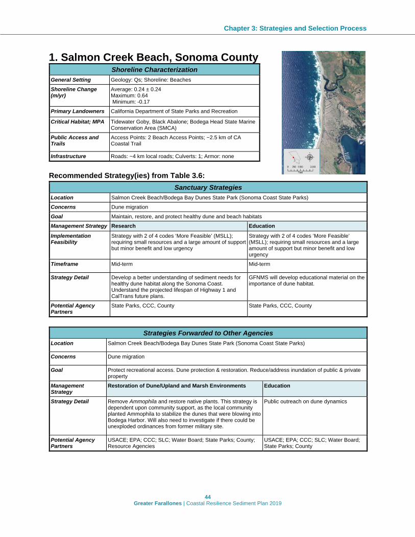
Chapter 3: Strategies and Selection Process
44 Greater Farallones | Coastal Resilience Sediment Plan 2019
1. Salmon Creek Beach, Sonoma County Shoreline Characterization
General Setting Geology: Qs; Shoreline: Beaches Shoreline Change (m/yr)
Average: 0.24 ± 0.24 Maximum: 0.64 Minimum: -0.17
Primary Landowners California Department of State Parks and Recreation Critical Habitat; MPA Tidewater Goby, Black Abalone; Bodega Head State Marine
Conservation Area (SMCA) Public Access and Trails
Access Points: 2 Beach Access Points; ~2.5 km of CA Coastal Trail
Infrastructure Roads: ~4 km local roads; Culverts: 1; Armor: none Recommended Strategy(ies) from Table 3.6:
Sanctuary Strategies Location Salmon Creek Beach/Bodega Bay Dunes State Park (Sonoma Coast State Parks) Concerns Dune migration Goal Maintain, restore, and protect healthy dune and beach habitats Management Strategy Research Education Implementation Feasibility
Strategy with 2 of 4 codes ‘More Feasible’ (MSLL); requiring small resources and a large amount of support but minor benefit and low urgency
Strategy with 2 of 4 codes ‘More Feasible’ (MSLL); requiring small resources and a large amount of support but minor benefit and low urgency
Timeframe Mid-term Mid-term
Strategy Detail Develop a better understanding of sediment needs for healthy dune habitat along the Sonoma Coast. Understand the projected lifespan of Highway 1 and CalTrans future plans.
GFNMS will develop educational material on the importance of dune habitat.
Potential Agency Partners
State Parks, CCC, County State Parks, CCC, County
Strategies Forwarded to Other Agencies
Location Salmon Creek Beach/Bodega Bay Dunes State Park (Sonoma Coast State Parks)
Concerns Dune migration
Goal Protect recreational access. Dune protection & restoration. Reduce/address inundation of public & private property
Management Strategy
Restoration of Dune/Upland and Marsh Environments Education
Strategy Detail Remove Ammophila and restore native plants. This strategy is dependent upon community support, as the local community planted Ammophila to stabilize the dunes that were blowing into Bodega Harbor. Will also need to investigate if there could be unexploded ordinances from former military site.
Public outreach on dune dynamics
Potential Agency Partners
USACE; EPA; CCC; SLC; Water Board; State Parks; County; Resource Agencies
USACE; EPA; CCC; SLC; Water Board; State Parks; County

Chapter 3: Strategies and Selection Process
45 Greater Farallones | Coastal Resilience Sediment Plan 2019
2. Bodega Harbor, Sonoma County
Shoreline Characterization General Setting Geology: Qs; Shoreline: Beaches Shoreline Change (m/yr) Average: 0.24 ± 0.24; Maximum: 0.64; Minimum: -0.17 Primary Landowners California Department of State Parks and Recreation Critical Habitat; MPA Tidewater Goby; Bodega Head SMCA Public Access and Trails Access Points: 2 Beach Access Points; ~2.5 km of CA
Coastal Trail Infrastructure Roads: ~4 km local roads; Culverts: 1; Armor: none Recommended Strategy(ies) from Table 3.6:
Sanctuary Strategies Location Bodega Harbor Concerns Dredged material from harbor has historically been disposed off offshore; GFNMS would prefer the sediment
stays in the littoral system Goal Sand stays within the system and is reused for restoration Management Strategy Research Implementation Feasibility
Strategy with 3 of 4 codes ‘More Feasible (SSLL); Substantial benefit and large amounts of support but has low urgency)
Timeframe Near-, mid- and long-term Strategy Detail Research opportunities to beneficially reuse clean dredged material from Bodega Harbor for habitat
restoration and creation of living shorelines at sites within the littoral system. Potential Agency Partners
USACE; EPA; CCC; SLC; Water Board; State Parks; County
Notes In the past, dredged materials from Bodega Harbor have been relocated to Doran Park. Important to follow guidelines regarding beneficial reuse of sediments and avoid potential source of invasive species. Though Bodega Harbor is outside the boundaries of the sanctuary, GFNMS intends to help promote the beneficial reuse of material dredged from the harbor and coordinate with other agencies to identify potential restoration sites in the vicinity and within the boundaries of the sanctuary.
Strategies Forwarded to Other Agencies
Location Bodega Harbor Concerns Lack of plan to use decadal dredge material. Bodega Bay Harbor has seen many changes in the bottom of the bay. Goal Maintain and protect an active waterfront and develop a plan for dredge material management. Maintain and protect
recreational access, including roadway flooding.
Management Strategy
Managed Retreat Living Shorelines Research
Strategy Detail Elevate roadway; build causeway; limit vehicle access. Elevate/retreat active harbor easements. Move roadway where needed. Monitor, maintain, adapt previous actions
Manage flooding of roadway. Potentially create a natural shoreline.
Develop a plan to elevate infrastructure at Spud Point and Porto Bodega Marinas to support an active waterfront/harbor.
Potential Agency Partners
Caltrans, State Parks, Water Board, County; Resource Agencies
GFNMS; USACE; EPA; CCC; SLC; Water Board; State Parks; County; Resource Agencies
County; USACE; CCC

Chapter 3: Strategies and Selection Process
46 Greater Farallones | Coastal Resilience Sediment Plan 2019
3. Doran Park, Sonoma County Shoreline Characterization
General Setting Geology: Qs; Shoreline: Beaches Shoreline Change Average: 0.39 ± 0.31; Maximum:
1.42; Minimum: 0.1 Primary Landowners Sonoma County Regional Parks
Department, Private Critical Habitat; MPA Black Abalone; none Public Access and Trails
1 Access Points: 1 Beach; ~3 km of California Coastal Trail
Infrastructure Roads: ~4 km local roads; Culverts: none; Armor: Revetment (100 m)
Recommended Strategy(ies) from Table 3.6:
Sanctuary Strategies Location Doran Park Concerns Loss of beach and dune habitat Goal Maintain beach and dune habitat Management Strategy Beach Restoration* Living Shorelines Implementation Feasibility
Strategy with 2 of 4 codes ‘More Feasible’ (SLLL); Substantial benefit and large support, but requiring large resources and low urgency
Strategy with only 1 of 4 codes ‘More Feasible’(SLSL); Substantial benefit but requiring large resources, small support and low urgency
Timeframe Near-term Near-term, mid-term, and long-term
Strategy Detail Beach restoration at outer coast sites in the littoral system using Bodega Harbor or Russian River dredged materials.
Investigate the potential for creating future living shoreline designs.
Potential Agency Partners
USACE; EPA; CCC; SLC; Water Board; State Parks; County; Resource Agencies
USACE; EPA; CCC; SLC; Water Board; State Parks; County; Resource Agencies
Notes Lots of public interest in this site Lots of public interest in this site *GFNMS could consider allowing beach sand placement only for restoration purposes.
Strategies Forwarded to Other Agencies Location Doran Park Concerns Access (parking and other park facilities) is threatened by flooding Goal Ensure continued access for recreation by reducing inundation Management Strategy
Managed Retreat Restoration of Dunes/Upland and Marsh Environments
Strategy Detail Investigate the need and potential feasibility to relocate United States Coast Guard station and to raise roadway or other improvements to maintain access.
Remove Ammophila and restore natural dune processes.
Potential Agency Partners
USCG;CCC; Caltrans; State Parks; Water Board; County; Resource Agencies
CCC; State Parks; Water Board; County; Resource Agencies
Notes Will need to engage with many agencies to address this issue.

Chapter 3: Strategies and Selection Process
47 Greater Farallones | Coastal Resilience Sediment Plan 2019
4. Estero Americano, Marin County Shoreline Characterization
General Setting Geology: Qs, Qpa, Qt, KJfs Shoreline: Beaches, Coastal Marsh, Rocky Shores
Shoreline Change
Average: 0.11 ± 0.01; Maximum: 0.12; Minimum: 0.10
Primary Landowners
Wildlands Conservancy, Private
Critical Habitat; MPA
Black Abalone, Tidewater Goby, Red-legged frog, Yellow Larkspur; Estero Americano State Marine Recreational Management Area (SMRMA)
Public Access and Trails
No Access Points <1 km of California Coastal Trail
Infrastructure Roads: <1 km local roads; Culverts: none; Armor: none Recommended Strategy(ies) from Table 3.6:
Sanctuary Strategies Location Estero Americano Concerns Sediment accumulation has changed habitats; 1 million cubic yards of sediment have entered Estero
Americano; Historically channel was open with eelgrass beds; Entire ecosystem has been altered. Presence of protected species
Goal Reduce Sediment. Improve Habitat. Increase monitoring of water quality.
Restore natural processes and investigate beneficial reuse. Educate community.
Management Strategy
Dredging* Research Education Restoration
Implementation Feasibility
Strategy with only 1 of 4 codes ‘More Feasible’(SLSL); Substantial benefit but requiring large resources, small support and low urgency
Strategy with only 1 of 4 codes ‘More Feasible’(SLSL); Substantial benefit but requiring large resources, small support and low urgency
Strategy with only 1 of 4 codes ‘More Feasible’ (MSSL); Requiring small resources, but minor benefit, small support and low urgency
Strategy with 2 of 4 codes ‘More Feasible’ (SLLL); Substantial benefit and large support, but requiring large resources and low urgency
Timeframe Mid-term Near-term; mid-term Near-term Mid-term
Strategy Detail Assess whether the removal of excess sediment by dredging would provide an ecological benefit to the system and assess sediment quality and type for potential beneficial reuse for restoration.
Near-term: Develop a framework to understand ecosystem and best path for restoration. Study sediment dynamics, including system change, species impacts, inland flooding and salinity changes; Survey for eelgrass habitat and compare with historic eelgrass extent. Mid-term: Evaluate multiple benefits, including wetland creation, flood protection, and sediment movement for the benefit of species and living shorelines.
Engage with local landowners; work with community and land managers to prevent further sedimentation.
Restore eelgrass beds. Restore habitat to decrease sediment inputs into estero. Ecosystem restoration designs in esteros should be based on results from studies recommended (see "Research" field).
Potential Agency Partners
EPA; USACE; CCC; SLC; Water Board; County; Resource Agencies
EPA; USACE; Water Board; County
Water Board; County EPA; USACE; CCC; SLC; Water Board; County; Resource Agencies

Chapter 3: Strategies and Selection Process
48 Greater Farallones | Coastal Resilience Sediment Plan 2019
Notes Collaborate with the local RCDs and the Wildlands Conservancy.
Collaborate with the local RCDs and the Wildlands Conservancy.
*GFNMS could consider allowing dredging only for restoration purposes.
Strategies Forwarded to Other Agencies Location Estero Americano Concerns Sediment accumulation has changed habitats; 1 million cubic yards of sediment have entered Estero
Americano. Historically channel was open with eelgrass beds. Entire ecosystem has been altered. Presence of protected species.
Goal Reduce excess sedimentation going into the Estero and improve habitat.
Management Strategy Indirect Sediment Management Strategy Detail Upgrade roads to improve drainage. Potential Agency Partners
Caltrans; County; Resource Agencies

Chapter 3: Strategies and Selection Process
49 Greater Farallones | Coastal Resilience Sediment Plan 2019
5. Estero de San Antonio, Marin County Shoreline Characterization
General Setting Geology: Qha, KJfs Shoreline: Beaches, Rocky Shores, Tidal Flat
Shoreline Change Average: 0.42 ± 0.15 Maximum: 0.59 Minimum: 0.22
Primary Landowners Private Critical Habitat; MPA Black Abalone, Tidewater Goby, Red-Legged
Frog, Yellow Larkspur; Estero de San Antonio SMRMA
Public Access and Trails No Access Points; No trail Infrastructure Infrastructure
Roads: <1 km local roads Culverts: none Armor: none
Recommended Strategy(ies) from Table 3.6:
Sanctuary Strategies Location Estero de San Antonio
Concerns Need to evaluate sediment issues. Assess the potential for loss of wetlands with rising sea level (open land may be available to acquire from a willing seller to allow for wetland migration). Presence of protected species (e.g., tidewater goby).
Goal Develop relationships with private landowners surrounding the estero. Develop a research program to better understand sediment dynamics.
Management Strategy
Research Education
Implementation Feasibility
Strategy with only 1 of 4 codes ‘More Feasible’(SLSL); substantial benefit but requiring large resources, small support and low urgency
Strategy with only 1 of 4 codes ‘More Feasible’ (MSSL); requiring small resources, but minor benefit, small support and low urgency
Timeframe Mid-term Near-term
Strategy Detail Develop a framework to further understand ecosystem and best path for restoration projects. Study sediment dynamics, including system change, species impacts, inland flooding and salinity changes; Characterize quality and type of sediment and identify locations for placement. Survey for eelgrass habitat and compare with historic eelgrass extent.
Develop partnerships with private landowners bordering the estero. Engage with local landowners.
Potential Agency Partners
Water Board; County Water Board; County
Notes Collaborate with the local RCDs Collaborate with the local RCDs
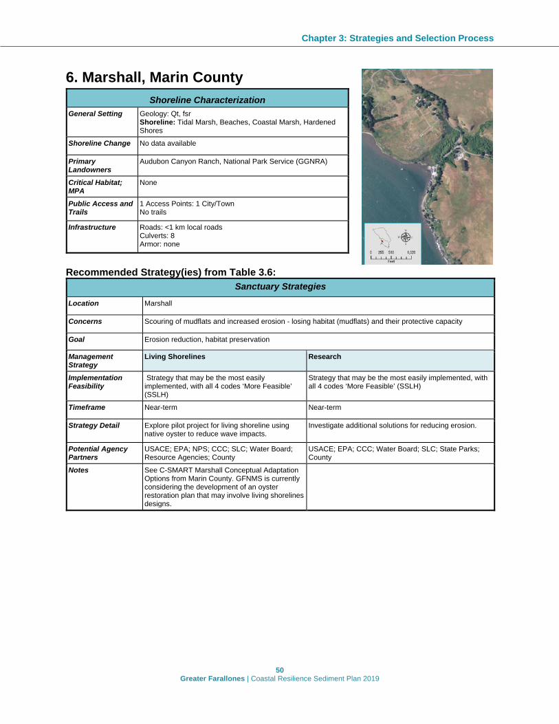
Chapter 3: Strategies and Selection Process
50 Greater Farallones | Coastal Resilience Sediment Plan 2019
6. Marshall, Marin County
Recommended Strategy(ies) from Table 3.6:
Sanctuary Strategies
Location Marshall
Concerns Scouring of mudflats and increased erosion - losing habitat (mudflats) and their protective capacity
Goal Erosion reduction, habitat preservation
Management Strategy
Living Shorelines Research
Implementation Feasibility
Strategy that may be the most easily implemented, with all 4 codes ‘More Feasible’ (SSLH)
Strategy that may be the most easily implemented, with all 4 codes ‘More Feasible’ (SSLH)
Timeframe Near-term Near-term
Strategy Detail Explore pilot project for living shoreline using native oyster to reduce wave impacts.
Investigate additional solutions for reducing erosion.
Potential Agency Partners
USACE; EPA; NPS; CCC; SLC; Water Board; Resource Agencies; County
USACE; EPA; CCC; Water Board; SLC; State Parks; County
Notes See C-SMART Marshall Conceptual Adaptation Options from Marin County. GFNMS is currently considering the development of an oyster restoration plan that may involve living shorelines designs.
Shoreline Characterization General Setting Geology: Qt, fsr
Shoreline: Tidal Marsh, Beaches, Coastal Marsh, Hardened Shores
Shoreline Change No data available
Primary Landowners
Audubon Canyon Ranch, National Park Service (GGNRA)
Critical Habitat; MPA
None
Public Access and Trails
1 Access Points: 1 City/Town No trails
Infrastructure Roads: <1 km local roads Culverts: 8 Armor: none

Chapter 3: Strategies and Selection Process
51 Greater Farallones | Coastal Resilience Sediment Plan 2019
7. Chicken Ranch Beach, Marin County Shoreline Characterization
General Setting Geology: Qt, fsr Shoreline: Beaches, Coastal Marsh, Rocky Shores
Shoreline Change No data available
Primary Landowners
California Department of Parks and Recreation, Marin County Parks Department, Private
Critical Habitat; MPA
None
Public Access and Trails
3 Access Points: 2 Beach Access, 1 Boat Access No trails
Infrastructure Roads: >1 km local roads Culverts: none Armor: none
Recommended Strategy(ies) from Table 3.6:
Sanctuary Strategies
Location Chicken Ranch Beach, Tomales Bay
Concerns Sediment is migrating to the south (losing beach on north end); water quality issues; excess sediment is being delivered to Tomales Bay
Goal Protection of the sandy beach and reduction of excess sedimentation in Tomales Bay, primarily from Third Valley Creek watershed.
Management Strategy
Research Restoration of Dune/Upland and Marsh Environments
Implementation Feasibility
Strategy with 2 of 4 codes ‘More Feasible’ (SLLL); substantial benefit and large support, but requiring large resources and low urgency
Strategy with 2 of 4 codes ‘More Feasible’ (SLLL); substantial benefit and large support, but requiring large resources and low urgency
Timeframe Near-term Near-term
Strategy Detail Explore pilot project for living shoreline using native oyster shells to reduce wave impacts.
Investigate additional solutions for reducing erosion.
Potential Agency Partners
USACE; EPA; CCC; Water Board; County
USACE; EPA; CCC; SLC; Water Board; Resource Agencies; County
Notes Environmental Action Committee, Tomales Bay Watershed Council, and Inverness Association are considering a potential restoration project. The proposed project is focused mainly on improving the water quality of Channel B at Chicken Ranch Beach, but depending on funding, it could also be expanded to include sediment management improvements as originally proposed. Chicken Ranch Beach is 303d listed as impaired for indicator bacteria.

Chapter 3: Strategies and Selection Process
52 Greater Farallones | Coastal Resilience Sediment Plan 2019
8. Inverness, Marin County Shoreline Characterization
General Setting Geology: Qt, fsr Shoreline: Coastal Marsh, Beaches
Shoreline Change No data available
Primary Landowners Audubon Canyon Ranch, National Park Service (GGNRA), Private
Critical Habitat; MPA None
Public Access and Trails
2 Access Points: 1 Beach, 1 City/Town No trails
Infrastructure Roads: <1 km local roads Culverts: none Armor: none
Recommended Strategy(ies) from Table 3.6:
Sanctuary Strategies
Location Inverness, Tomales Bay
Concerns Sediment deficit, wetlands may be submerged due to sea level rise. Road is currently impacted, with slumping and flooding.
Goal Protection of wetland resources
Management Strategy Living Shorelines
Implementation Feasibility
Strategy with only 1 of 4 codes ‘More Feasible’(SLSL); substantial benefit but requiring large resources, small support and low urgency
Timeframe Near-term
Strategy Detail Explore pilot project for horizontal levee off bulkhead protecting the road to maintain wetland habitat.
Potential Agency Partners
USACE; EPA; CCC; SLC; Water Board; State Parks; County; Resource Agencies
Strategies Forwarded to Other Agencies
Location Inverness, Tomales Bay
Concerns Sediment deficit, wetlands may be submerged due to sea level rise. Road is currently impacted, with slumping and flooding
Goal Protect infrastructure and allow wetlands and habitat to migrate and/or be restored.
Management Strategy Managed Retreat Indirect Sediment Management
Strategy Detail Investigate possibility of relocating impacted homes and businesses.
Investigate possibility of elevating homes and businesses.
Potential Agency Partners
County; Resource Agencies County; Resource Agencies

Chapter 3: Strategies and Selection Process
53 Greater Farallones | Coastal Resilience Sediment Plan 2019
9. Pt Reyes Station - Bivalve, Marin County Shoreline Characterization
General Setting Geology: Qt, fsr; Shoreline: Tidal Marsh, Coastal Marsh Shoreline Change
No data available
Primary Landowners
Audubon Canyon Ranch, National Park Service (GGNRA), California Department of Fish and Wildlife
Critical Habitat; MPA
Tidewater Goby, Red-Legged Frog; none
Public Access/ Trails
1 Access Points: 1 Visual Access; No trails
Infrastructure Roads: no roads; Culverts: none; Armor: none Recommended Strategy(ies) from Table 3.6:
Sanctuary Strategies Location Pt Reyes Station (including Bivalve, east shore of Tomales Bay, and areas behind railroad levees) Concerns The engineered railroad levees have been in place along much of the east shore of Tomales Bay since
the 1870s and have altered marsh performance. Goal Enhance wetland habitat Management Strategy Research Implementation Feasibility
Strategy with 3 of 4 codes ‘More Feasible’ (SSLL); strategy has substantial benefit and large amounts of support but has low urgency
Timeframe Near-term Strategy Detail Understand impacts of historic railroad levees and options for restoration or inland wetland migration for
continued wetland existence (removal of development). Potential Agency Partners
NPS; County; USACE; CCC; State Parks; Water Board; SLC
Notes The potential pros and cons of any action at these sites should be evaluated in the context of the value that different habitat types serve across the entire Tomales Bay system (e.g., many of the levees have created habitat that protected species now use, like the Tri-colored Blackbird). The SCC may be interested in collaborating on potential projects at these sites.
Strategies Forwarded to Other Agencies
Location Pt Reyes Station (including Bivalve, east shore of Tomales Bay, and areas behind railroad levees) Concerns The engineered railroad levees have been in place along much of the east shore of Tomales Bay since
the 1870s and have altered marsh performance. Goal Enhance wetland habitat Management Strategy Restoration of Dune/Upland and Marsh Environments Strategy Detail Implement based on what was learned in feasibility study. Potential Agency Partners
USACE; Water Board; County of Marin; CCC; Resource Agencies

Chapter 3: Strategies and Selection Process
54 Greater Farallones | Coastal Resilience Sediment Plan 2019
10. Duxbury Reef and Off-shore Area, Marin County
Shoreline Characterization General Setting Geology: Qms, Qmss
Shoreline: N/A Shoreline Change N/A Primary Landowners
Monterey Bay National Marine Sanctuary, Greater Farallones National Marine Sanctuary; State Lands Commission
Critical Habitat; MPA
Black Abalone; none
Public Access and Trails
N/A
Infrastructure N/A Recommended Strategy(ies) from Table 3.6:
Sanctuary Strategies Location Duxbury Reef and Off-shore Area Concerns Graben of deep sediment for beach nourishment for restoration purposes is an opportunity; however,
accessibility may be problematic. Goal Identify graben material and pathways for use.
Management Strategy Research Implementation Feasibility
Strategy with 2 of 4 codes ‘More Feasible’ (SLSH); substantial benefit and high urgency, but requiring large resources and small amount of support
Timeframe Near-term
Strategy Detail Characterize benthic habitat and assess "sand resources" and if and where this sand can be extracted (depth/extent) and used as source material for other restoration sites. Identify potential matching sediment restoration sites. Investigate regulatory restrictions and opportunities to access graben material.
Potential Agency Partners
USACE; EPA; CCC; Water Board; SLC; USGS; Resource Agencies; County
Notes Need to be certain protection of kelp beds even if kelp is not there, need to be certain will not impact the rocky substrate. May need to coordinate with BOEM on substrate data and policies.

Chapter 3: Strategies and Selection Process
55 Greater Farallones | Coastal Resilience Sediment Plan 2019
11. Bolinas Cliffs, Marin County Shoreline Characterization
General Setting Geology: Tms, Qt, Qsl, QTs Shoreline: Rocky Shores, Beaches
Shoreline Change Results not accurate for cliff and bluff environments Primary Landowners
Private
Critical Habitat; MPA
Black Abalone; none
Public Access and Trails
2 Access Points: 1 Beach Access, 1 Visual Access No trails
Infrastructure Roads: ~3 km local roads Culverts: none Armor: Revetment (107 m), Seawall (351 m)
Recommended Strategy(ies) from Table 3.6:
Sanctuary Strategies Location Bolinas Cliffs/ Beach (between Duxbury & Lagoon) Concerns Armoring along the base and cliff-side; homes are highly vulnerable if armoring removed but armoring
impacts sediment supply. 30% of sediment input to the lagoon is from these cliffs. Goal Ensure access and protect habitats. Management Strategy Restoration of Dune/Upland and Marsh Environments Implementation Feasibility
Strategy with 2 of 4 codes ‘More Feasible’ (SSSL); substantial benefit requiring fewer resources but with less support and urgency
Timeframe Near-term Strategy Detail Allow natural beach replenishment. Encourage bluff-top erosion control. Potential Agency Partners
USACE; EPA; CCC; Water Board; SLC; Resource Agencies; County
Notes Bluff erosion provides sediment for the beach. Potential removal of armoring if erosion becomes too severe - armoring is considered temporary and to be removed eventually. All parties would have to be on board.
Strategies Forwarded to Other Agencies
Location Bolinas Cliffs/ Beach (between Duxbury & Lagoon) Concerns Armoring along the base and cliff-side; homes are highly vulnerable if armoring removed but armoring
impacts sediment supply. 30% of sediment input to the lagoon is from these cliffs Goal Ensure access and protect habitats. Management Strategy Managed Retreat Strategy Detail Relocate homes and remove armor where possible when homes are red-tagged; Planned retreat for cliff-
side houses within hazard zone. Potential Agency Partners
County of Marin; CCC; Resource Agencies

Chapter 3: Strategies and Selection Process
56 Greater Farallones | Coastal Resilience Sediment Plan 2019
12. Bolinas Lagoon, Marin County
Shoreline Characterization General Setting Geology: Qs, Tms, QTs, af, Qha, Qoa, fsr, Kfs
Shoreline: Coastal Marsh, Tidal Flats Shoreline Change No data available Primary Landowners
National Park Service (GGNRA), Audubon Canyon Ranch, Marin County Open Space District, Private
Critical Habitat; MPA
Tidewater Goby; none
Public Access and Trails
3 Access Points: 1 Beach Access, 1 City/Town, 1 Historical/Cultural Site ~10 km of trail
Infrastructure Roads: Hwy 1 and ~10 km local roads Culverts: ~60 Armor: none
Recommended Strategy(ies) from Table 3.6:
Sanctuary Strategies Location Bolinas Lagoon Concerns The loss and/or degradation of lagoon habitats Goal Ensure access and protect and restore habitats. Management Strategy
Education Research Living Shorelines Restoration of Dune/Upland and Marsh Environments
Implementation Feasibility
Strategy that may be the most easily implemented, with all 4 codes ‘More Feasible’ (SSLH)
Strategy that may be the most easily implemented, with all 4 codes ‘More Feasible’ (SSLH)
Strategy that may be the most easily implemented, with all 4 codes ‘More Feasible’ (SSLH)
Strategy that may be the most easily implemented, with all 4 codes ‘More Feasible’ (SSLH)
Timeframe Near-term Mid-term Near to Mid-term Mid-term Strategy Detail Gather long-term
trends and work on communications with the community to help facilitate sediment management decisions.
Consider alternatives to protect the roadway including create a living shoreline or horizontal levee or elevating Highway 1 (bypass). Understand changes in depths of water level and road and habitat impacts.
Identify locations that are currently impacted by flooding and erosion, where nature-based shoreline protection projects could have co-benefits for natural systems and human communities.
Remove or modify structures that disrupt the delivery of sediment. Identify potential demonstration sites for nature based infrastructure projects.
Potential Agency Partners
NPS; CCC; SLC; County
NPS; CCC; SLC; County NPS; CCC; SLC; County; Resource Agencies
NPS; CCC; SLC; County; Resource Agencies
Notes See Bolinas North End project and Kent Island Restoration Project
Refer to general recommendation regarding CalTrans task force
See Bolinas South End Living Shorelines Project
See Bolinas Lagoon Ecosystem Restoration Project: Recommendations for Restoration and Management (2008)

Chapter 3: Strategies and Selection Process
57 Greater Farallones | Coastal Resilience Sediment Plan 2019
13. Stinson Beach, Marin County
Shoreline Characterization General Setting Geology: Qs, af, Qha, fsr; Shoreline:
Beaches Shoreline Change
Average: -0.08 ± 0.14; Maximum: 0.16; Minimum: -0.32
Primary Landowners
Marin County Parks Department, Department of Parks and Recreation, National Park Service (GGNRA), Private
Critical Habitat; MPA
Black Abalone; none
Public Access and Trails
4 Access Points: 3 Beach Access, 1 City/Town ~4 km beach trail
Infrastructure Roads: ~5 km local roads; Culverts: none Armor: Revetment (2800 m), Seawall (105 m)
Recommended Strategy(ies) from Table 3.6:
Sanctuary Strategies Location Stinson Beach Concerns Wave attack and sea level rise are threatening recreational beach, community and beach/dune habitats. Goal Preserve beach/dune and protect habitat. Management Strategy
Restoration of Dune/Upland and Marsh Environments
Beach Restoration
Research Education
Implementation Feasibility
Strategy with 3 of 4 codes ‘More Feasible’ (SLLH); strategy has substantial benefit and large amounts of support but requires large resources)
Strategy that may be the most easily implemented, with all 4 codes ‘More Feasible’ (SSLH)
Strategy that may be the most easily implemented, with all 4 codes ‘More Feasible’ (SSLH)
Timeframe Near-term Near-term Near-term
Strategy Detail Investigate and restore beach/dune habitat. Monitor rate of change of beach and offshore sediment transport pathways.
Help the community accomplish dune restoration efforts. Emphasize small restoration projects with native species.
Potential Agency Partners
NPS; USACE; EPA; CCC; Water Board; SLC; Resource Agencies; County
NPS; USACE; USGS; CCC; SLC; County
NPS; CCC; Water Board; County
Notes NPS is starting to monitor beach profiles. May be difficult to implement due to access restrictions on private property and funding. Potential for natural recovery. May want to nourish after erosive events.
*GFNMS could consider allowing beach sand placement only for restoration purposes.
Strategies Forwarded to Other Agencies Location Stinson Beach Concerns Wave attack and sea level rise are threatening recreational beach, community and beach/dune habitats Goal Preserve beach recreation and community and protect habitat
Management Strategy
Managed Retreat Restoration of Dune/Upland and Marsh Environments

Chapter 3: Strategies and Selection Process
58 Greater Farallones | Coastal Resilience Sediment Plan 2019
Strategy Detail
Consider options for managed retreat including strategies such as no shoreline protective devices for vacant lots, property acquisition, infrastructure relocation, etc. Long-term: Relocate first line of houses.
Evaluate areas with inland migration and managed retreat. Evaluate extending the dune system. Protect/enhance the existing dunes. Encourage more planting of native vegetation. Increase overflow capacity of Easkoot Creek for flood control and to create habitat. Protect/acquire open areas where dunes can migrate.
Potential Agency Partners
CCC; County of Marin National Park Service; CCC; County of Marin; Caltrans; Resource Agencies

Chapter 3: Strategies and Selection Process
59 Greater Farallones | Coastal Resilience Sediment Plan 2019
14. Muir Beach, Marin County Shoreline Characterization
General Setting Geology: fsr, Qha, Qsl Shoreline: Beaches, Rocky Shores
Shoreline Change
Average: 0.05 ± 0.08 Maximum: 0.19 Minimum: -0.05
Primary Landowners
National Park Service (GGNRA), Private, The Nature Conservancy
Critical Habitat; MPA
Black Abalone; none
Public Access and Trails
1 Access Points: 1 Beach Access ~1 km of California Coastal Trail
Infrastructure Roads: <1 km local roads; Culverts: 3; Armor: Revetment (46 m), Retaining Wall (15 m)
Recommended Strategy(ies) from Table 3.6:
Sanctuary Strategies Location Muir Beach Concerns Potential erosion of hillside and intermittent erosion up the hillside puts homes at risk and potential loss of
north county beach. Federally listed species are present and impacted. Goal Ensure coastal access and protect habitats. Management Strategy Research Implementation Feasibility
Strategy with only 1 of 4 codes ‘More Feasible’ (MLLL); large amount of resources but minor benefit, small support, and low urgency.
Timeframe Mid-term Mid-term Strategy Detail Evaluate offshore fortification/reefs to reduce
erosion, maintain beach and enhance habitat. Research the dune and beach processes.
Potential Agency Partners
NPS; USACE; EPA; CCC; Water Board; SLC; County
NPS; CCC; County
Notes NPS is conducting monitoring
Strategies Forwarded to Other Agencies Location Muir Beach Concerns Potential erosion of hillside and intermittent erosion up the hillside puts homes at risk and potential loss
of north county beach. Federally listed species are present and impacted. Goal Ensure coastal access and protect habitats. Management Strategy Managed Retreat Strategy Detail To minimize armoring, develop and implement a managed retreat plan. Potential Agency Partners
County of Marin; CCC; Resource Agencies

Chapter 3: Strategies and Selection Process
60 Greater Farallones | Coastal Resilience Sediment Plan 2019
15. El Granada (Surfer’s) Beach, San Mateo County
Shoreline Characterization General Setting Shoreline: Beach Shoreline Change Not available Primary Landowners San Mateo County Critical Habitat; MPA Black Abalone; none Public Access and Trails
Highway 1 and a segment of the California Coastal Trail
Infrastructure Roads: 1 (Highway 1) Culverts: 2 Armor: 800 feet riprap along the highway, outfall in the riprap/bluff adjoining the beach
Recommended Strategy(ies) from Table 3.6:
Sanctuary Strategies Location El Granada or Surfer’s Beach, including Vallejo Beach and Miramar Beach Concerns Area has experienced significant erosion of the beach and bluff since the construction of the
breakwater; threat of erosion to Highway 1 is imminent. Goal Reduce erosion and preserve beach habitat. Management Strategy Beach Restoration* Implementation Feasibility
Strategy that may be the most easily implemented, with all 4 codes ‘More Feasible’ (SSLH).
Timeframe Near-term; mid-term Strategy Detail Beach restoration using dredged materials from the harbor side of the East Breakwater at Pillar Point
Harbor. Dredging sand from Pillar Point Harbor and placing it at El Granada County Beach (Surfer’s Beach) could restore sandy beach habitat and provide considerable erosion mitigation effects for a period of several years while also protecting adjacent beach and dune habitat.
Potential Agency Partners
USACE; CCC; Caltrans; San Mateo County; Resource Agencies
Notes Primary land owners include San Mateo County Harbor District and Caltrans. San Mateo County Harbor District is currently leading the development of a pilot restoration project.
*GFNMS could consider allowing beach sand placement only for restoration purposes.
Strategies Forwarded to Other Agencies Location El Granada or Surfer’s Beach, including Vallejo Beach and Miramar Beach Concerns Area has experienced significant erosion of the beach and bluff since the construction of the breakwater;
threat of erosion to Highway 1 is imminent. Goal Reduce erosion and preserve beach habitat. Management Strategy Managed Retreat Strategy Detail Discuss potential Highway 1 realignment options. Potential Agency Partners
Caltrans; CCC; City of Half Moon Bay; San Mateo County; Resource Agencies

61 Greater Farallones | Coastal Resilience Sediment Plan 2019
CHAPTER 4: COASTAL RESILIENCE CASE STUDIES
Introduction Three projects selected from the list of 29 sanctuary-focused strategies (see Site-Specific Recommendations in Chapter 3) are presented here as case studies (Figure 4.1) to demonstrate how the use of sediment management best practices can support conservation and restoration projects that increase resiliency for built infrastructure while also providing benefit to the environment. Beneficial reuse of clean dredged sediment in Bodega Harbor will prevent sediment, a valuable natural resource, from being disposed of and aid in restoration projects in the region. A living shoreline project along the south end of Bolinas Lagoon will enhance and connect transitional habitat while safeguarding public access and infrastructure. Beach restoration at Surfer’s Beach will demonstrate the value of restoring sandy beach habitat for wildlife, dune habitat, and infrastructure. These three projects exemplify GFNMS-supported approaches to addressing coastal resilience within its boundaries and should serve as a model for the design of future projects. The following case studies contain short summaries of each project, specific considerations at each site, and the status of the project as of publication of this document (November 2019).
Case Study 1: Bodega Harbor Dredged Material Reuse Project This case study demonstrates the value in beneficially reusing clean dredged sediment from Bodega Harbor to support regional restoration projects and address coastal resiliency in the sanctuary. Project Goals: Prevent clean dredged sediment from being disposed of outside the region and keep this material in the littoral system. Techniques Proposed: Research and identify opportunities to store and/or beneficially reuse clean and appropriate grain sized dredged material from Bodega Harbor as a resource for beach restoration, living shorelines, and/or other habitat restoration projects on adjacent beaches and in nearby wetlands and shoreline habitats in the sanctuary.

Chapter 4: Coastal Resilience Case Studies
62 Greater Farallones | Coastal Resilience Sediment Plan 2019
Figure 4.1. Regional map showing site locations of the three case studies included in this Plan.
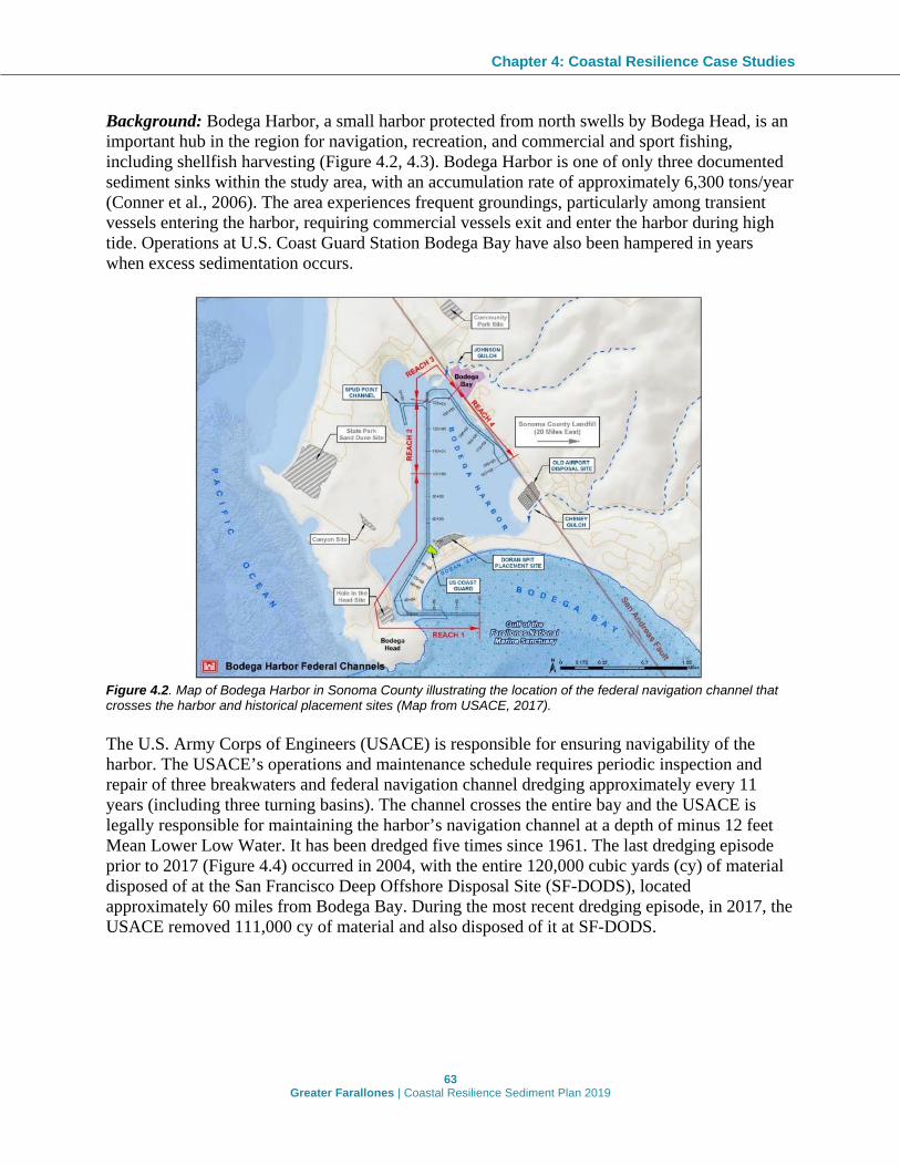
Chapter 4: Coastal Resilience Case Studies
63 Greater Farallones | Coastal Resilience Sediment Plan 2019
Background: Bodega Harbor, a small harbor protected from north swells by Bodega Head, is an important hub in the region for navigation, recreation, and commercial and sport fishing, including shellfish harvesting (Figure 4.2, 4.3). Bodega Harbor is one of only three documented sediment sinks within the study area, with an accumulation rate of approximately 6,300 tons/year (Conner et al., 2006). The area experiences frequent groundings, particularly among transient vessels entering the harbor, requiring commercial vessels exit and enter the harbor during high tide. Operations at U.S. Coast Guard Station Bodega Bay have also been hampered in years when excess sedimentation occurs.
Figure 4.2. Map of Bodega Harbor in Sonoma County illustrating the location of the federal navigation channel that crosses the harbor and historical placement sites (Map from USACE, 2017). The U.S. Army Corps of Engineers (USACE) is responsible for ensuring navigability of the harbor. The USACE’s operations and maintenance schedule requires periodic inspection and repair of three breakwaters and federal navigation channel dredging approximately every 11 years (including three turning basins). The channel crosses the entire bay and the USACE is legally responsible for maintaining the harbor’s navigation channel at a depth of minus 12 feet Mean Lower Low Water. It has been dredged five times since 1961. The last dredging episode prior to 2017 (Figure 4.4) occurred in 2004, with the entire 120,000 cubic yards (cy) of material disposed of at the San Francisco Deep Offshore Disposal Site (SF-DODS), located approximately 60 miles from Bodega Bay. During the most recent dredging episode, in 2017, the USACE removed 111,000 cy of material and also disposed of it at SF-DODS.

Chapter 4: Coastal Resilience Case Studies
64 Greater Farallones | Coastal Resilience Sediment Plan 2019
Figure 4.3. Aerial photo of Bodega Harbor showing the federal navigation channel. Photo: USACE, 2017. Justification: GFNMS recognizes that there are multiple sites near Bodega Harbor where habitats are being threatened or lost due to climate impacts such as sea level rise and increased storminess or other forces, which may exacerbate erosion and shoreline change. Dredged material from Bodega Harbor channel can provide a valuable and cost-effective resource for restoration of some of these sites, provided the material sourced is clean, suitable, and appropriate grain size.
Figure 4.4. Bodega Harbor dredging in 2017. Photo: Cea Higgins.
Project Design: Work with USACE and other sediment management agencies to identify potential receiver sites for the sediment regularly dredged from Bodega Harbor. Coordinate with agency partners and local stakeholders to facilitate more research on restoration opportunities nearby that could store or beneficially reuse clean and suitable material. A necessary step would be conducting sediment characterizations of each of the nearby potential sites in advance of the next scheduled maintenance dredging episode to expedite project planning and review.
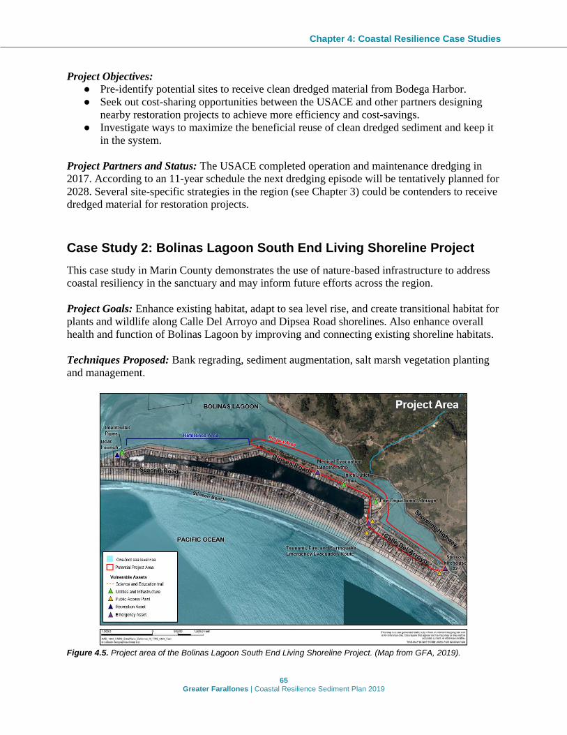
Chapter 4: Coastal Resilience Case Studies
65 Greater Farallones | Coastal Resilience Sediment Plan 2019
Project Objectives: ● Pre-identify potential sites to receive clean dredged material from Bodega Harbor. ● Seek out cost-sharing opportunities between the USACE and other partners designing
nearby restoration projects to achieve more efficiency and cost-savings. ● Investigate ways to maximize the beneficial reuse of clean dredged sediment and keep it
in the system.
Project Partners and Status: The USACE completed operation and maintenance dredging in 2017. According to an 11-year schedule the next dredging episode will be tentatively planned for 2028. Several site-specific strategies in the region (see Chapter 3) could be contenders to receive dredged material for restoration projects.
Case Study 2: Bolinas Lagoon South End Living Shoreline Project This case study in Marin County demonstrates the use of nature-based infrastructure to address coastal resiliency in the sanctuary and may inform future efforts across the region. Project Goals: Enhance existing habitat, adapt to sea level rise, and create transitional habitat for plants and wildlife along Calle Del Arroyo and Dipsea Road shorelines. Also enhance overall health and function of Bolinas Lagoon by improving and connecting existing shoreline habitats. Techniques Proposed: Bank regrading, sediment augmentation, salt marsh vegetation planting and management.
Figure 4.5. Project area of the Bolinas Lagoon South End Living Shoreline Project. (Map from GFA, 2019).

Chapter 4: Coastal Resilience Case Studies
66 Greater Farallones | Coastal Resilience Sediment Plan 2019
Background: Bolinas Lagoon in Marin County contains a mix of channel, mudflat, marsh, and riparian habitat that provides ecosystem services to 29 rare, threatened, and endangered animal and plant species and over 50,000 migratory birds. Stinson Spit is a naturally occurring barrier feature at the mouth of Bolinas Lagoon (Figure 4.5). The east end of the spit is joined to the mainland at the intersection of Highway 1 and Calle Del Arroyo, and extends west to form a peninsula with the Pacific Ocean on the south side and Bolinas Lagoon on the north side. In the 1950 to 1960s, the spit was developed and expanded into Bolinas Lagoon to create the Seadrift neighborhood. Fill was placed along the inner shoreline and bulkheads were constructed. The inner Seadrift Lagoon was also created at this time. Historical logging, farming, grazing, land use changes, lagoon dredging and fill, channelization of creeks, road construction, and hardening of the lagoon edge have led to degradation of natural hydrologic and geomorphic processes. These changes also affected patterns of sedimentation in the lagoon and disconnected estuarine and marsh habitats from riverine corridors and adjacent upland areas. Hardening of the shoreline has impacted tidal-terrestrial transition zones, which limits the ability of the lagoon and its tidal habitats to expand landward and migrate upslope in response to sea level rise. A key area of concern is the lagoon’s southeastern shoreline along the backside of the Seadrift spit. Historical impacts to the lagoon shoreline in this area have degraded wetland and marsh habitat, resulting in an unnaturally steep eroding shoreline with poor alongshore connectivity. Low lying areas of the shoreline along Calle Del Arroyo experience current and future flooding and erosion that threaten critical infrastructure and accelerate loss of habitat refugia (Figure 4.6). In addition, the shoreline along Dipsea Road is composed of loose sandy material dredged from the lagoon to construct the Seadrift Spit (Figure 4.7). As a result, the fill material is easily eroded. It is suspected that constriction of riverine and tidal flows through the eastern part of Bolinas Lagoon and the Easkoot Creek channel contribute to shoreline erosion.
Figure 4.6. Flooding of Calle Del Arroyo during a king tide combined with a storm on February 2, 2019. Water submerged the wetland, overtopped the shoreline, and extended across the road. (Photo: Kate Bimrose)
Chapter 4: Coastal Resilience Case Studies
67 Greater Farallones | Coastal Resilience Sediment Plan 2019
Justification: The need to address coastal resilience and conservation in the southeastern end of the lagoon is prioritized in multiple plans at the local (Marin County Community Development Agency, 2010; ICF International, 2015), and federal level (Hutto, 2016; GFNMS Advisory Council, 2008). Project Design: The use of living shoreline techniques within San Francisco Bay is fairly well tested and demonstrated, but its application to outer coast estuaries, have received much less attention and need more test cases (Hutto, 2016). The project aims to direct coastal protection efforts in the area away from traditional “gray” infrastructure by implementing a nature-based living shoreline adjacent to Calle del Arroyo and the eastern span of Dipsea Road. The goal is to enhance and reconnect transitional habitat, which will also safeguard public access and infrastructure, as well as establish a more climate resilient shoreline. A technical memo (AECOM, 2019) identified a number of potential nature-based strategies for shoreline enhancement, habitat connectivity, and sea level rise adaptation along Calle Del Arroyo and Dipsea Road shorelines. Strategies included a combination of fill and regrading of the shoreline to create intertidal wetland and ecotone slope, sediment augmentation, and vegetation management. Project Objectives:
● Enhance existing habitat and provide sea level rise adaptation and transitional habitat for plants and wildlife along Calle Del Arroyo and Dipsea Road shorelines.
● Preserve and enhance trail and public access along the Dipsea Road shoreline. ● Reduce further erosion of the Dipsea Road shoreline. ● Improve overall health and function of Bolinas Lagoon by improving and connecting
existing shoreline habitats.
Project Partners and Status: The project is led by GFNMS and its non-profit cooperating association, Greater Farallones Association, and conducted in partnership with Marin County, Audubon Canyon Ranch, and the Seadrift Homeowners Association. At the time of publication of this document, the project is in the planning phase. A high-level assessment identified potential shoreline strategies and confirmed the initial suitability of implementing a living shoreline project to address project objectives (AECOM, 2019). A number of data gaps still exist before the potential conceptual designs can be evaluated, including topographic and vegetation surveys, water level and groundwater analysis, habitat assessment and wetland delineation, and hydrodynamic modeling. The next phase will be a feasibility study to further evaluate existing site conditions, determine opportunities and constraints, design alternatives, and determine costs.

Chapter 4: Coastal Resilience Case Studies
68 Greater Farallones | Coastal Resilience Sediment Plan 2019
Figure 4.7. Eroded section of shoreline and steep ~10-foot scarp along Dipsea Road. An unmaintained recreational trail that runs for most of the length of Dipsea Road is located within the vegetated area along the shoreline. Erosion threatens the stability and accessibility of the trail. (Photo: Wendy Kordesch)
Case Study 3: Surfer's Beach Pilot Beach Restoration Project The San Mateo County case study demonstrates how beach restoration can restore sandy beach habitat, protect existing dune habitat, protect infrastructure, and address coastal resiliency. This pilot restoration project will demonstrate the importance of using clean dredged material as a resource by beneficially reusing clean sand to restore Surfer’s Beach in a manner that protects water quality and other sanctuary resources and provides multiple benefits to coastal shorelines. The project, if successful, could provide a model for future beneficial reuse projects. Project Goals: Restore Surfer’s Beach in order to increase sandy beach habitat, reduce further loss of shoreline habitat, and protect infrastructure (Highway 1) using a softscape approach instead of further armoring. Techniques Proposed: Dredge clean sand accumulated inside Pillar Point Harbor and beneficially reuse it to protect and restore habitat at Surfer’s Beach. Background: Surfer’s Beach (also known as El Granada County Beach) is located immediately south of Pillar Point Harbor, in San Mateo County. Two breakwaters (west and east) were constructed by the USACE in 1961 to create the 245-acre (1 square kilometer) Pillar Point Harbor (Figure 4.8; USACE, 2015). Pillar Point Harbor has three interior breakwaters enclosing a marina development at the east end of Pillar Point Harbor. The harbor is primarily used by commercial and recreational fishing interests, along with other recreational vessel traffic, and is the only harbor of refuge along the 75 miles (121 kilometers) of coastline between San Francisco and Santa Cruz.

Chapter 4: Coastal Resilience Case Studies
69 Greater Farallones | Coastal Resilience Sediment Plan 2019
Figure 4.8. Aerial image of Half Moon Bay showing the Pillar Point Harbor and adjacent Surfer’s Beach Pilot Restoration Project site. (Map from USACE, 2015) When the east breakwater was constructed, it significantly impacted sediment transport along the shoreline, resulting in increased erosion to the south of the breakwater (USACE, 2015). Surfer’s beach has eroded significantly in recent decades resulting in significant loss of sandy beach habitat (Figure 4.9).
Figure 4.9. Two views of the eroding portions of Surfer’s Beach. Left: View in Summer 2015 from the toe of the east breakwater looking south at the erosion threatening Highway 1. (Photo: Max Delaney) Right: Construction of temporary armoring during winter 2015. (Photo: California Department of Transportation) Analysis conducted by the USACE investigating impacts from the breakwater on adjacent shorelines determined the bluffs along Surfer’s Beach eroded at an average rate of 1.64 feet per year from 1993 to 2012. The study also found accelerated accumulation of sand within Pillar Point Harbor (Figure 4.10) estimated at approximately 250,000 cubic yards along the east breakwater (USACE, 2015).

Chapter 4: Coastal Resilience Case Studies
70 Greater Farallones | Coastal Resilience Sediment Plan 2019
Figure 4.10. Panoramic view taken from the east breakwater looking east at the sand shoal accumulated inside the harbor (left side of groin). (Photo: Max Delaney) Justification: Periodic armoring of the shoreline is currently used to address erosion. In November 2015, severe erosion at Surfer’s Beach threatened the structural integrity of Highway 1. In response, Caltrans took emergency action and installed 175 feet of rock slope protection (i.e., rip rap) to protect the roadway. The USACE completed a coastal engineering study in 2015 to better understand how the east breakwater affects shoaling in the harbor and 0.9 miles of shoreline directly to the south (USACE, 2015). The study found the shoreline closest to the east breakwater extending 2,215 feet (675 meters from Highway 1 revetments to Mirada Road revetments) experiences significant bluff retreat, retreating at an average 1.64 feet (0.5 meters) per year from 1993 to 2012 since construction of the east breakwater. In addition, the study found that construction is associated with the accumulation of significant sediment (primarily sand) within Pillar Point Harbor, which impacts navigation. Numerical modeling also shows a node where longshore currents likely converged to deposit sand at Surfer’s Beach disappeared after construction, instead trapping sand inside the harbor. The USACE concluded that nourishing Surfer’s Beach using sand from inside the east breakwater is the most cost-effective and most feasible strategy to mitigate erosion along the shoreline and reduce excess sediment accumulation in the harbor (USACE, 2015). GFNMS recognizes that longer-term, softscape alternatives are urgently needed to protect both Surfer’s Beach and the adjacent beach and dune system to the south. Since no other viable alternatives to armoring have been identified, GFNMS supports the beneficial reuse of sand from inside Pillar Point Harbor as the best option to restore sandy beach habitat and reduce erosion at Surfer’s Beach. This need has also been long recognized by many state, federal, and local regulatory agencies as well as local community members, including an active and vocal group representing the surfing community. Surfer’s Beach was also identified as a Beach Erosion Concern Area within the CSMW’s California Beach Erosion Assessment Survey, which identifies high priority coastal erosion locations to jurisdictional agencies. Additionally, the project was recommended in Santa Cruz Littoral Cell CRSMP, developed for the CSMW by MBNMS and the USACE in partnership with local stakeholders.

Chapter 4: Coastal Resilience Case Studies
71 Greater Farallones | Coastal Resilience Sediment Plan 2019
In 2016, the Harbor District was awarded funding from the California Ocean Protection Council (OPC) for a $75,000 Prop 84 grant to help pay for the project planning phase. In 2017, the Harbor District was subsequently awarded a grant from the California Division of Boating and Waterways (CDBW) for $800,000 to fund the project implementation (construction and monitoring). Project Objectives:
● Improve biological habitat. ● Reduce the need for coastal armoring. ● Prevent or mitigate beach erosion and sea cliff retreat. ● Improve protection of Highway 1 and other structures. ● Increase quality and quantity of public access and recreation. ● Address accelerated coastal erosion rates and shoaling inside the harbor.
Project Design: The Surfer’s Beach project is a pilot effort and a major objective is to closely study and monitor the project to determine if the one-time placement of approximately 75,000 cubic yards of sediment is effective at achieving the desired project goals and if there are any unacceptable environmental impacts. The San Mateo County Harbor District (Harbor District) is still determining the exact project design and proposed volumes and locations for sediment placement. As of July 2019, the Harbor District is considering sourcing material from both directly inside the outer breakwater and further north at the boat ramp. Sediment testing is underway to determine the suitability (i.e., cleanness and grain size) of sediment. While this project has the potential to achieve some level of erosion mitigation, it is unlikely to achieve long-lasting benefits to Surfer’s Beach. However, this option represents the most cost-efficient and effective means of addressing erosion in the area. Furthermore, because material from Pillar Point Harbor is beach quality sand from within the littoral system, it increases the likelihood it will remain in the system longer and more quickly recolonize biologically with higher quality habitat for foraging wildlife and benthic communities. The beneficial reuse of dredged material below the Mean High Water (MHW) line is currently not permissible under existing MBNMS regulations. However, at the time of publication (September 2019), MBNMS is considering allowing for future beneficial reuse of dredged material below the MHW line, which would allow for a larger scale episode of sediment placement than stated above. Project Partners and Status: The San Mateo County Harbor District is the lead on this project, with involvement from San Mateo County, Caltrans, GFNMS, and MBNMS. Permitting and review for the project is possibly needed from USACE, EPA, NOAA NMFS, USFWS, SLC, RWQCB, CDFW, CCC.

72 Greater Farallones | Coastal Resilience Sediment Plan 2019
CHAPTER 5: AGENCY COORDINATION
Development of Agency Coordination Structure A key element for managing sediment resources and planning for coastal resilience is establishing a structure or framework for agency cooperation that can guide the development, review, and implementation of specific projects and actions. The structure proposed will strive for consensus-driven approaches to address regional sediment management to improve coastal resilience throughout the region (i.e., encourage beneficial reuse of available, clean sediment resources; restore and maintain coastal beaches and other critical areas; reduce shoreline erosion and coastal storm damage; reduce the proliferation of shoreline hardening; sustain recreation and tourism; and enhance public safety and access to the coast). To be effective, this framework requires agencies have defined roles and responsibilities and that they work to establish collective objectives and priorities for sediment across the region. To explore various options for regional sediment management coordination throughout the study area, GFNMS convened federal, state, and local agencies as part of a Technical Advisory Committee (called the Sediment in the Sanctuaries Technical Advisory Committee; SiSTAC) that ultimately concluded that the most effective and efficient way to move forward is to form a coordination committee. The resulting collaborative body is called the North-central California Coastal Sediment Coordination Committee (hereafter referred to as “Sediment Coordination Committee”).
North-central California Coastal Sediment Coordination Committee The Sediment Coordination Committee, initiated in Fall 2019, will be comprised of federal, state, and local management and regulatory agencies and led by a steering committee, comprised of a smaller subset of the agencies participating in the coordination committee. All of the agencies who participated in the SiSTAC are likely to continue to play an active role in regional sediment management through participation in the Sediment Coordination Committee. Most of these agencies have also previously contributed to the development of the various Coastal Regional Sedimeng Management Plans/Report (CRSMP/Rs) that comprise the California Coastal Sediment Management Master Plan (“Sediment Master Plan” or “SMP”). The SiSTAC agreed that the term governance has a connotation which can focus solely on regulatory authority and that the scope of this coordination committee would involve other planning and science advisory responsibilities beyond a mere regulatory role. Thus, the SiSTAC decided that rather than establish a governance structure, it would be more appropriate to develop a framework for agency cooperation to be adopted by all participating agencies. The

Chapter 5: Agency Coordination
73 Greater Farallones | Coastal Resilience Sediment Plan 2019
SiSTAC agreed that all willing agencies should send their own individual agency letter of cooperation to the Steering Committee for the Sediment Coordination Committee c/o GFNMS that adopts the framework and pledges their written intent to participate in the process. The framework for agency cooperation prepared by the North-central California Coastal Sediment Coordination Committee at their Inaugural Meeting on September 25, 2019 is included below.
Framework for Agency Cooperation to Implement Coastal Sediment Management Actions
A. Goal and Structure The intent of this framework for agency cooperation is to build on the Coastal Sediment Management Workgroup’s (CSMW) collaborative efforts to develop the SMP, which is an ongoing effort to evaluate California's coastal sediment management needs and promote regional, system-wide solutions. The Sediment Coordination Committee supports coastal resiliency through consensus-driven recommendations along the coast of Sonoma, Marin, San Francisco, and San Mateo counties and is facilitated by a Steering Committee of two or more agencies (i.e., a minimum of a state and federal agency). Other partner agencies not participating in the steering committee, will serve as participating agencies in the Coordination Committee.
B. Sediment Coordination Committee Objectives 1) Strive for consensus-driven recommendations on sediment management actions for
the region based on recommendations contained in relevant guiding documents (e.g., sediment action plan(s)) to be developed and/or adopted by the Sediment Coordination Committee and document all agency and stakeholder input when consensus is not able to be achieved;
2) Coordinate programmatic and project-based consultations with other agencies where feasible (e.g., resource agencies, historic preservation offices, etc.);
3) Facilitate technical assistance to member agencies (e.g., provide data and expertise as a resource for local governments);
4) Pursue funding partnerships and/or opportunities; 5) Support collaborative education and outreach efforts (e.g., provide links to/from
agency web pages and develop unified messaging); 6) Facilitate coordinated permit review (where feasible); and 7) Assess environmental justice considerations where feasible.
C. Sediment Coordination Committee Agencies’ Roles and Responsibilities 1) Participate in Sediment Coordination Committee meetings; 2) Participate in the development of all guiding documents for the committee; 3) Review all guiding documents and provide comments to the Steering Committee; 4) Determine Sediment Coordination Committee priorities; 5) Determine agency membership and level of participation; 6) Participate in public/stakeholder outreach activities; 7) Determine Sediment Coordination Committee meetings schedule;

Chapter 5: Agency Coordination
74 Greater Farallones | Coastal Resilience Sediment Plan 2019
8) Pursue and acquire funding to plan for and implement sediment management actions;
9) Coordinate NEPA/CEQA environmental review and consultations with other agencies;
10) Conduct coordination within their respective agency entities (e.g., garnering city-wide or county-wide agency support for sediment management actions);
11) Assist the Steering Committee in keeping the guiding documents up-to-date; and 12) Collaborate with the Coastal Sediment Management Workgroup (CSMW) when
feasible to help implement sediment management actions and update the CSMW on actions taken by the Sediment Coordination Committee.
In addition to the roles and responsibilities specified above, agencies participating in the Steering Committee would also perform the following duties.
D. Steering Committee’s Role and Responsibilities 1) Schedule and coordinate Sediment Coordination Committee meetings; 2) Develop Sediment Coordination Committee meeting agendas; 3) Recruit agencies and maintain an agency membership list for the Sediment
Coordination Committee; 4) Identify, coordinate, and guide the pursuit of funding opportunities; 5) Lead the development of the Sediment Coordination Committee’s guiding
documents; 6) Revise guiding documents based on feedback from participating agencies and
public comment; 7) Maintain website/web pages for the Sediment Coordination Committee (i.e.,
CSMW if feasible); and 8) Coordinate agency volunteers to write, distribute, and maintain meeting notes for
the Sediment Coordination Committee.

75 Greater Farallones | Coastal Resilience Sediment Plan 2019
CHAPTER 6: IMPLEMENTATION
Implementation Approach Although regional sediment management (RSM) implementation is unique and tailored to a specific region and set of circumstances, several elements commonly discussed in the four Coastal Regional Sediment Management Plans/Report (CRSMP/Rs) overlap with the study area as crucial for RSM implementation. These elements are:
● A streamlined permitting program; ● A process for RSM stakeholder coordination and a structure for RSM implementation
(i.e., agency coordination); and ● An outreach and education program.
This chapter discusses how these elements may be approached by GFNMS, the Sediment Coordination Committee, and other sediment management stakeholders with an interest in implementing the recommendations in this Plan. The four CRSMP/Rs that were assessed each provide specific recommendations for how to best implement those plans/report. The full list of recommendations can be found in Appendix D. Many of the recommendations from this list have been incorporated into the discussion in this chapter as they provide insightful direction and guidance that may improve the success of implementing this Plan.
Streamlined Permitting Program The “Framework for Agency Cooperation to Implement Coastal Sediment Management Actions,” developed to guide the work of the Sediment Coordination Committee, (see Chapter 5) establishes objectives for the committee related to permitting, including coordinating programmatic consultations with other agencies where feasible (e.g., resource agencies, historic preservation offices, etc.), and facilitating coordinated and streamlined permit review where feasible. A summary of likely agency engagement for each sediment management strategy is detailed in the Agency Involvement Matrix developed by the Sonoma-Marin CRSMP (Appendix E). Also, as noted in Chapter 5, the regulatory bodies that would likely play a role in permitting and review of the site-specific strategies (listed in Chapter 3) have been identified and listed in the site tables to assist with project development and design.
Process for RSM Stakeholder Coordination Successful implementation of RSM actions across the region not only requires agency support and collaboration but also coordination and support from other stakeholders, such as landowners, local elected officials, resource conservation districts, special districts, and non-profit organizations. The specific implementation recommendations from the four CRSMP/Rs listed in

Chapter 6: Implementation
76 Greater Farallones | Coastal Resilience Sediment Plan 2019
Appendix D identify a number of important tasks that should be undertaken to improve RSM implementation including:
● Developing a comprehensive list of potential partners and stakeholders and identify their possible roles in Plan implementation;
● Establishing a list of prioritized initial stakeholder engagement actions and identifying existing outreach products and tools that could be used to support initial implementation of this Plan;
● Coordinating with the CSMW on initial Plan implementation and stakeholder outreach strategies;
● Connecting with the relevant stakeholders, including agencies and local municipalities, to provide information about the Plan, discuss potential opportunities for collaboration, and assess their interest in participation; and
● Assisting local agencies in communicating the needs for sediment management to their constituents.
Outreach and Education Outreach to impacted communities, partners, and relevant stakeholders is critical to the success of this Plan. The specific implementation recommendations from the four CRSMP/Rs listed in Appendix D highlight the importance of developing an initial outreach and education strategy to get the Plan into the hands of stakeholders that will use it and to ensure their input on RSM issues and implementation. These CRSMP/Rs also recommend hosting public workshops once the Plan has been finalized to present the final Plan and obtain input on initial implementation considerations. It is a GFNMS priority to take every opportunity to engage “agencies and communities about the value of sediment as a resource and natural component of the coastal environment in many areas,” as recommended by the Sonoma-Marin CRSMR. Therefore, throughout the nine months spent preparing this document, this work was shared with multiple, diverse audiences. Public presentations have included:
● The 9th Annual Summit on Coastal and Estuarine Restoration and Management (December 2018) where staff participated in a session titled “North-Central California Climate Adaptation & Restoration: Regional Planning to Local Implementation” to present the Sonoma-Marin Coastal Regional Sediment Management Report and the project goals and anticipated outcomes for this Plan.
● The Fifth Ocean Climate Summit (April 2019) where proposed sanctuary sediment management strategies were presented via the Ocean Climate Storymap, as part of the session “Focusing on Habitats to Support Climate Resilience.” (Website can be found at: https://farallones.org/ocean-climate-summit-2019/)
● The Living Shorelines and Resilience Workshop (April 2019) where two projects highlighted in this Plan were used as case studies exemplifying GFNMS’s approach to sediment management (Surfer’s Beach in Half Moon Bay, and Bolinas Lagoon South End Living Shorelines Project). The projects were discussed in break-out groups to increase awareness and showcase climate-informed sediment management.
● Joint GFNMS/MBNMS Advisory Council Meeting (August 2019) where staff presented the impetus for this Plan, the process of developing it, and its major outcomes. (Presentation available at https://farallones.noaa.gov/manage/sac_meetings.html)

Chapter 6: Implementation
77 Greater Farallones | Coastal Resilience Sediment Plan 2019
● California Coastal Sediment Management Workgroup (CSMW) (September 2019) where staff presented the impetus for this Plan, the process of developing it, and its major outcomes.
● GFNMS Advisory Council Meeting (November 2019) where staff presented the major outcomes and specific recommendations made in this Plan. (Presentation available at https://farallones.noaa.gov/manage/sac_meetings.html)
In addition, two online resources have been developed to provide updated and thorough content to those interested in the development of this Plan as well as future implementation of its recommendations. The GFNMS website that hosts the Sonoma-Marin CRSMR will also host this Plan, as well as highlights from the Sediment Coordination Committee. Greater Farallones Association, GFNMS’s non-profit cooperating association, hosts a website that includes a page dedicated solely to sediment-related work in the sanctuary. In addition the GFNMS Ocean Climate Storymap is an interactive tool developed as an outreach and education piece for partners and the general public. This tool introduces the vision, mission, and accomplishments of the Climate Program, highlights significant projects, products, and data from the program's inception in 2008 through 2019, presents the program's national and international work as a NOAA Office of National Marine Sanctuaries (ONMS) Center for Collaboration on Ocean Climate Change, and provides guidance to MPA managers interested in addressing climate change at their sites. GFNMS’s sediment work, including this Plan, is highlighted throughout the storymap, primarily in the “Action Areas” tab which includes all of the sanctuary-focused site-specific recommendations included in this Plan, and in the “Milestones” tab which highlights Sediment in the Sanctuaries as a current priority. The tool has been distributed throughout ONMS, as well as to regional partners, and is accessible from the sanctuary webpage. Moving forward, this Plan will be shared with all relevant stakeholders and partners, community members, and the GFNMS Advisory Council. Greater Farallones Association will share the Plan with the broader coastal community through their newsletter, targeted outreach, and public presentations. This Plan will form the foundation for the North-central coast region sediment management discussions by the newly formed North-central California Coastal Sediment Coordination Committee and will be presented to the statewide Coastal Sediment Management Workgroup. Further, focused outreach efforts will be initiated by providing presentations to local governmental organizations, holding individual meetings with stakeholders, and providing public workshops.

78 Greater Farallones | Coastal Resilience Sediment Plan 2019
CHAPTER 7: PLAN SUCCESS
Defining Success for this Plan Success for this Plan can be measured by documented progress towards achieving the guiding principles, mission, goals, and objectives (as stated in the Executive Summary). The purpose of this Plan is to communicate to partners and stakeholders GFNMS’s approach to sediment management for coastal resiliency, guide sanctuary actions related to sediment for restoration and protection of natural resources, using nature-based climate solutions, and recognize sediment as a natural resource with the goal of ensuring a healthy coastline. Success will be measured by the amount of area along the sanctuary’s coastline that is functioning naturally without continual human intervention and that is supporting healthy native species and ecosystem services. The objectives of this Plan were developed with this goal in mind and were used to design Metrics for Success of this Plan.
Adaptive Management This Plan is a “living document” that will require periodic updates to add or modify the recommended strategies as more information becomes available and climate conditions evolve. The Plan will be reviewed every 10 years by GFNMS, with input as needed from relevant resource and regulatory agencies. To ensure continued applicability and relevance to GFNMS goals, the review will consist of 1) An assessment of the success of the Plan itself using the metrics outlined below, and 2) An assessment of the strategies recommended in the Plan. Using the latest climate science, site characterization information will be updated for each of the 15 sites to assess how conditions may have changed and if the recommended strategies are still practicable and effective. Projects will be re-assessed using the Strategy Assessment Tool to update Implementation Codes. Modifications to current projects may be made using the updated site characterization and implementation codes to guide adaptive management. Modifications may also be made based on lessons learned, and additional strategies may be included, as appropriate. At the time of the review, a decision will be made by GFNMS as to whether sufficient modifications are recommended to warrant a formal update of the Plan.
Metrics for Success of this Plan The 10-year review of this Plan should use the following objectives and accompanying metrics as a guideline to assess the successful implementation of the Plan. These may be modified in the future as needed.

Chapter 7: Plan Success
79 Greater Farallones | Coastal Resilience Sediment Plan 2019
Plan Objectives: Objective 1: Identify sediment imbalances in the sanctuary’s boundaries. Anticipated Outcomes:
A. Progress towards achieving Regional Recommendation 3: Maintain and Expand Sediment Research and Monitoring Activities.
i. Maintained existing regional monitoring programs and expanded new monitoring efforts integrated into project design to understand coastal resilience benefits and limitations to inform future project designs.
ii. Increased understanding of data gaps in sediment budgets within the study area, with progress towards reducing data needs (listed in Table 2.3).
B. Progress towards completing sanctuary-focused site-specific strategies (11 of 29) recommending “Research” at 11 locations (outlined in the Site Tables at the end of Chapter 3).
i. Completion of the seven near-term “Research” strategies. ii. Progress towards completing the seven mid-term “Research” strategies and one
long-term ‘Research’ strategy. Objective 2: Coordinate collaborative sediment management actions within the sanctuary. Anticipated Outcomes:
A. Progress towards achieving Regional Recommendation 1: Leverage Partnerships and Agency Coordination and Promote Information Sharing.
i. Increased GFNMS participation in the promotion of coastal resilience through sediment management.
ii. Increased sediment management coordination and collaboration via the North-central California Coastal Sediment Coordination Committee to facilitate a holistic approach to sediment management in the region.
iii. Progress on completing the 29 sanctuary-focused strategies spanning 15 site locations in this Plan (e.g., projects being implemented or in the planning phase with feasibility studies, engineering and design plans, permitting, environmental review, etc.).
Objective 3: Restore natural sediment transport and ecological functions of the North-central California coastline. Anticipated Outcomes:
A. Progress towards achieving Regional Recommendation 4: Restore Natural Habitats and/or Sediment Dynamics and Pursue Nature-Based Solutions to Avoid Hardening the Shoreline.
i. Increased use of sediment management strategies that restore natural habitats and/or sediment dynamics and that prioritize incorporating nature-based solutions (such as living shorelines) over armoring in the study area, with broad acceptance of nature-based adaptation as the preferred mechanism for coastal protection.
ii. Adoption of climate-informed adaptive management, with an increasing number of projects using adaptive management techniques and considering sea level rise in the planning phase.
iii. Reduced use and existence of armoring and other interruptions to sediment flow throughout the study region wherever feasible.

Chapter 7: Plan Success
80 Greater Farallones | Coastal Resilience Sediment Plan 2019
B. Progress towards achieving Regional Recommendation 5: Encourage and Increase the Beneficial Reuse of Sediment.
i. Increased beneficial reuse of clean sediment to the maximum extent possible within the study area, with a documented decrease in sediment disposal.
ii. Increased agency partnership to help with storage, coordination, and cost-sharing opportunities to reduce barriers to beneficially reusing sediment.
C. Progress towards achieving Regional Recommendation 6: Utilize a Holistic, Watershed Approach to Sediment Management.
i. Increased focus on research and projects that take a holistic, broad understanding of regional and watershed-wide sediment systems, with progress towards closing known data gaps and information sharing between projects or programs.
ii. Increased communication and collaboration with watershed agencies to restore and enhance fluvial sediment delivery to estuaries and coasts, encourage the protection of creeks, and identify areas of restoration to improve downstream water quality and natural sediment transport.
D. Progress towards completing sanctuary-focused site-specific strategies (13 of 29) recommending “Restoration of Dune/Upland and Marsh Environments,” “Beach Restoration,” “Living Shorelines,” and “Dredging” at 10 locations.
i. Completion of the 10 near-term strategies. ii. Progress towards completing the six mid-term strategies and one long-term
strategy. Objective 4: Increase public understanding of, and support for, regional sediment management. Anticipated Outcomes:
A. Progress towards achieving Regional Recommendation 2: Engage Communities and Stakeholders through Education and Outreach.
i. Increased public understanding of and support for regional sediment management and the value of sediment as both a resource and natural component of the coastal environment.
ii. Increased engagement and support for nature-based solutions from coastal communities impacted by sediment issues.
iii. Increased discussion and consideration of managed retreat by communities as a safe, smart, and adaptive response to sediment issues.
B. Progress towards completing sanctuary-focused site-specific strategies (5 of 29) recommending “Education” at five locations
i. Completion of the four near-term “Education” strategies. ii. Progress towards the one mid-term “Education” strategies.

81 Greater Farallones | Coastal Resilience Sediment Plan 2019
CONCLUSION
The development of this Plan consolidated existing knowledge and revealed several opportunities to enhance coastal resilience and regional sediment management in the Greater Farallones National Marine Sanctuary Management Area. This Plan provides regional themes for sediment management and an inventory of site-specific strategies for sediment management actions that could be taken by GFNMS or GFNMS partners. It also provides local jurisdictions and agencies with a framework to develop tangible next steps for planning and implementation on a cooperative basis through the North-central California Coastal Sediment Coordination Committee. This Plan can benefit agencies, local jurisdictions, and other stakeholders as a technical reference that can be referred to as a reliable source of information for prioritizing regional sediment management for climate resilience while making planning and permitting decisions at the local, state, and federal levels. By implementing the recommendations identified in this Plan and practicing adaptive management with input as needed from relevant resource and regulatory agencies, the North-central California coast will thrive as a resilient, sediment balanced coastline that supports healthy ecosystems and communities. An action for GFNMS, as recommended in the Sonoma-Marin Coastal Regional Sediment Management Report, is to continue to “engage communities and relevant agencies throughout the region, by developing and implementing education and outreach programs about the importance of sediment to coastal regions, providing platforms to convey results and opportunities to join in sediment management efforts and monitoring, and encouraging community-based science opportunities.” GFNMS welcomes collaborative momentum and energy from partner agencies and organizations to pursue these efforts. Our goal is that this Plan, the process, and the resulting Sediment Coordination Committee serve as a forward-thinking model for other regions to advance collaborative sediment management, that our region benefits from this work, that our communities better understand the value and importance of sediment as a valuable natural resource, and, as a result, our coast is more resilient to climate change.

82 Greater Farallones | Coastal Resilience Sediment Plan 2019
REFERENCES
AECOM. (2019). Bolinas Lagoon South End Living Shorelines Project Pre-Feasibility Study. Report for the Greater Farallones Association and the Greater Farallones National Marine Sanctuary. San Francisco, CA. 33 pp.
Battalio, B., D.A. George, E. Vandebroek, D. Revel, L. White, P. Quiroga, To. Dang, E. Davidian, B. Pittman, C. Toms, P. Baye, P. King, and A. McGregor. (drafted in 2016). San Francisco Littoral Cell Coastal Regional Sediment Management Plan. Report of the U.S Army Corps of Engineers and the Coastal Sediment Management Working Group. City, CA. 306 pp.
Barnard, P.L., D. Hoover, D.M. Hubbard, A. Snyder, B.C. Ludka, G.M. Kaminsky, P. Ruggiero, T. Gallien, L. Gabel, D. McCandless, H.M. Weiner, N. Cohn, D.L. Anderson, and K.A. Serafin. (2017). Extreme oceanographic forcing and coastal response due to the 2015-2016 El Niño. Nature Communications. 8:14365.
Barnard, P.L., D.H. Schoellhamer, B.E. Jaffe, and L.J. McKee. (2013). Sediment transport in the San Francisco Bay coastal system: an overview. Marine Geology, 345, 3-17.
Bay Conservation and Development Commission, California Division of Boating and Waterways, U.S. Fish and Wildlife Service. (draft released in 2017). San Francisco Central Bay Coastal Regional Sediment Management Plan. Report of the Bay Conservation and Development Commission. San Francisco, CA. 55 pp. Available at: https://bcdc.ca.gov/sediment/CentralSFBayRSMPlan.pdf
California Resources Agency. (2017). Safeguarding California: 2017 Update. Draft Report. California’s Climate Adaptation Strategy. Sacramento, CA. Available at: http://resources.ca.gov/wp-content/uploads/2017/05/DRAFT-Safeguarding-California-Plan-2017-Update.pdf
Conner, C.S., T.R. Kendall, K.G. Berresford, P.A. Mull, S.M. Ming, and J.C. Cole. (2006). California Harbors: Where Does The Sand Go? ICCE 2006, Abstract number: 1918 (paper number 248).
Delaney, M. and D.A. George. (2018). White Paper on the Potential for Beneficial Reuse of Dredged Sediment for Restoration at Surfer’s Beach, in San Mateo County, in the Monterey Bay National Marine Sanctuary. Report of the Greater Farallones National Marine Sanctuary. NOAA. San Francisco, CA. 43 pp.
George, D.A., S. Hutto, and M. Delaney. (2018). Sonoma-Marin Coastal Regional Sediment Management Report. Report of the Greater Farallones National Marine Sanctuary. NOAA. San Francisco, CA. 201 pp. Available at: https://farallones.org/coastal-regional-sediment-management-report/
Habel, J. S., and G.A. Armstrong. (1978). Assessment and atlas of shoreline erosion along the California coast: State of California. Dept. of Navigation and Ocean Development. 277p.
Hutto, S.V. (2016). Climate Adaptation Plan. Report of the Greater Farallones National Marine Sanctuary. NOAA. San Francisco, CA. 19 pp. Available at: https://farallones.org/wp-content/uploads/2019/01/Climate-Action-Plan_public.pdf
Hutto, S.V., editor. (2016b). Climate-Smart Adaptation for North-central California Coastal Habitats. Report of the Climate-Smart Adaptation Working Group of the Greater Farallones National Marine Sanctuary Advisory Council. San Francisco, CA. 47 pp. Available at: http://climate.calcommons.org/sites/default/files/Climate-Smart%20Adaptation%20Report_March%202016.pdf
ICF International. (2015). County of Marin Climate Action Plan (2015 Update). (ICF 00464.13.) San Francisco. Prepared for Marin County, California. Available at: https://www.marincounty.org/depts/cd/divisions/sustainability/climate-and-adaptation

References
83 Greater Farallones | Coastal Resilience Sediment Plan 2019
Marin County Community Development Agency. (2010). Marin County Local Coastal Program Unit I, Amended. Report of the Marin County Community Development Agency. Marin County. San Rafael, CA. Available at: https://www.marincounty.org/depts/cd/divisions/planning/local-coastal-program/plans-and-docs
Monterey Bay National Marine Sanctuary, U.S. Army Corps of Engineers, Noble Consultants. (2015). Santa Cruz Littoral Cell Coastal Regional Sediment Management Plan. Report of the Monterey Bay National Marine Sanctuary and the Coastal Sediment Management Working Group. Monterey, CA. 344 pp. Available at: https://montereybay.noaa.gov/resourcepro/resmanissues/crsmp-sc.html
Philip Williams & Associates. (2008). E. Thorton, J. Dugan, Halcrow Group. Coastal Regional Sediment Management Plan for Southern Monterey Bay. Prepared for the Association of Monterey Bay Area Governments (AMBAG). Available at: http://www.dbw.ca.gov/csmw/pdf/SMontereyBay_CRSMP_3Nov2008.pdf
Thorne, K.M., G.M. MacDonald, R.F. Ambrose, K.J. Buffington, C.M. Freeman, C.N. Janousek, L.N. Brown, J.R. Holmquist, G.R. Gutenspergen, K.W. Powelson, P.L.Barnard, and J.Y. Takekawa. (2016). Effects of climate change on tidal marshes along a latitudinal gradient in California: U.S. Geological Survey Open-File Report 2016-1125. 75 pp. Available at: http://dx.doi.org/10.3133/ofr20161125.
Working Group of the Gulf of the Farallones National Marine Sanctuary Advisory Council. (2008). Bolinas Lagoon Ecosystem Restoration Project Recommendations for Restoration and Management. Report of the Greater Farallones National Marine Sanctuary (developed with assistance from Marin County Open Space District and United States Army Corps of Engineers). NOAA. San Francisco, CA. 100 pp. Available at: https://nmsfarallones.blob.core.windows.net/farallones-prod/media/archive/eco/bolinas/pdf/finalplanoptnov.pdf
United States Army Corps of Engineers. (2015). North Half Moon Bay Shoreline Improvement Project, Pillar Point Harbor, CA. Coastal Engineering Appendix: Final Report, January 2015.
United States Army Corps of Engineers. (2017). Bodega Harbor Federal Channels Maintenance Dredging for Fiscal Year 2017 Environmental Assessment. San Francisco, CA. 37 pp. Available at: https://www.spn.usace.army.mil/Portals/68/docs/Environmental/Bodega%20Bay%20Harbor%20Final%20EA%20(July%202017).pdf?ver=2017-07-19-114444-03

84 Greater Farallones | Coastal Resilience Sediment Plan 2019
APPENDICES
Appendix A: Strategy definitions compiled from four regional sediment management plans A comprehensive list of sediment management strategy definitions used in each regional sediment management report is detailed in Table A.1. The final description of strategies used is found in Box 3.1 of this Plan. Table A.1. Definitions of sediment management strategies provided by the four CRSMP/Rs. Underlined text indicates the definitions this Plan uses.
Measure Sonoma-Marin San Francisco Central Bay
San Francisco Littoral Cell Santa Cruz Littoral Cell
No Action Not used Not used Allow natural processes to occur without intervention. The shoreline, backshore, and bluffs (or dunes) are allowed to erode unimpeded except where armoring already exists.
This approach assumes that the “status quo” will continue over the next 50 years, often with local interests maintaining existing erosion control measures.
Managed Retreat
Systematic movement away from anticipated hazardous area
Structures and the communities that use them move away from the shore to allow the Bay waters to rise.
Move development away from sensitive and vulnerable coastal lands. Activities may entail rerouting roads and utilities, removing buildings, and relocating landfills to establish a buffer zone between the ocean and terrestrial development. This is thought out and involves significant community input.
Relocating development and infrastructure away from coastal erosion hazard zones.
Restoration of Dune/ Upland and Marsh Environment
Re-establishment of vertical and horizontal sand and vegetated mobile habitat (e.g., dunes) and other upland habitat areas. Conversion of developed lands back to or into wetlands with connection to coastal processes (wetlands).
The restoration or creation of wetlands and beaches to attenuate wave energy and flooding.
Not used Actions intended to restore natural processes to a given coastal environment, and are applicable to both Beach Erosion Concern Areas and Sediment Impaired Coastal Habitats.
Beach Nourishment/Restoration
Placement of approved sand by mechanical means or by sediment-water slurry directly on the beach or beach face.
Not defined Sand Placement: Move the shoreline seaward by placing imported sand onto the foreshore. The amount of placed sand depends on beach length and the desired sand placement width. Sand placements are triggered whenever a beach reaches a specified “minimum beach width.”
Direct placement of sand on the subaerial beach or in shallow waters (less than 10‘ deep) of the surf zone. Nearshore Berm: Sediment is placed in nearshore

Appendices
85 Greater Farallones | Coastal Resilience Sediment Plan 2019
Measure Sonoma-Marin San Francisco Central Bay
San Francisco Littoral Cell Santa Cruz Littoral Cell
waters, outside the surf zone.
Perched Beach:
Not used Not used Not used Construction of a submerged shore-parallel structure in shallow water to retain sediment to form a beach above the normal beach profile elevation.
Multipurpose Artificial Reef:
Not used Not used Offshore Reef: Detached submerged breakwaters to widen the beach through the formation of a landform that extends beyond its surroundings along the beach behind the structure.
The construction of a submerged offshore reef that is designed to reduce beach erosion through wave attenuation and erosion mitigation while providing recreational benefits (e.g., surfing).
Armor
Built structures with the specific goals of retaining sediment in place (walls) or blocking sediment transport (groins).
Create hardened structures that resist rising waters; increase heights of existing levees; build sea walls.
Sand Retention Structures: Hard structures to retain sand on beaches and to dissipate wave energy. Such structures are placed across the beach – groins – or in the nearshore – detached breakwaters – to modify waves and currents, which are the primary processes that control sand transport, beach shape, and beach erosion or accretion. Sand placement often accompanies these structures.
Groins and Jetties: One or more shore perpendicular structures designed to retain beach sand. Cliff Stabilization by Seawall: Stabilize sea cliffs subject to wave attack. Typical measures include seawalls and stabilization with soil nail walls.
Hold the Line Not used Not used Use coastal armoring, including maintaining existing armoring where it currently exists.
Not used
Living Shorelines
Blend of infrastructure and natural habitats; rely on development of natural habitat to protect shore and restore sediment paths.
Soft Shoreline Approach: Uses wetlands, beach nourishment and living shorelines to dampen effects of sea level rise and storm surge.
Not used Not used
Research Technical studies on systems or locations.
Not Defined Not Defined Not Defined
Education Public engagement on coastal sediment imbalances.
Not used Not used Not used
Indirect Sediment Management
An action whose primary goal is not to manage sediment but causes secondary benefits to sediment delivery, transport, or removal from a coastal location.
Not used Not used Not used

Appendices
86 Greater Farallones | Coastal Resilience Sediment Plan 2019
Measure Sonoma-Marin San Francisco Central Bay
San Francisco Littoral Cell Santa Cruz Littoral Cell
Dredging Mechanical movement of sediment deposits from a river, seabed, or other area of water.
Not Defined
Not Defined Not Defined
Beneficial Reuse (of Dredged Material)
The use of any dredged material as a sediment resource, which recognizes sediment as an essential piece of the ecosystem.
Sediment that can be beneficially reused in wetland and beach nourishment projects where appropriate.
Opportunistic Sand: Surplus sand from various source materials, including upland construction, development projects, and flood control (e.g., dams, channels, and debris basins).
Not Defined
Appendix B: Regional Recommendations compiled from three regional sediment management plans The following is a comprehensive list of 39 regional recommendations compiled from three coastal regional sediment management plans/report, the Sonoma-Marin CRSMR (17 recommendations), the San Francisco Central Bay CRSMP (16 recommendations), and the San Francisco Littoral Cell CRSMP (three recommendations). The Santa Cruz Littoral Cell CRSMP did not provide regional recommendations. Recommendations listed below were excerpted verbatim from each plan.
Sonoma-Marin Coastal Regional Sediment Management Report 1. Develop a regional monitoring program using best available science, coordinated agency
action, and community-based science including wave energy, water levels, shoreline change, bluff erosion, habitat evolution, water quality, sediment budget, and littoral transport. Coordinate efforts and data sharing amongst current regional monitoring programs (e.g., Russian River Regional Monitoring Program, San Francisco Bay Regional Monitoring Program) and develop sediment monitoring programs that connect the coast, coastal watersheds, and San Francisco Bay.
2. Take a holistic, watershed approach to understand sediment budgets and dynamics, and identifying areas of restoration to improve downstream water quality and encourage natural sediment transport.
3. Prioritize incentives and technical assistance to accomplish landscape level restoration of soil health and managed sedimentation through voluntary stewardship, consulting and seeking partnerships with local Resource Conservation Districts, Land Trusts, NGOs, property owner associations, and agricultural producers.
4. Develop a list of potential “receiver” and storage sites (upland and aquatic) to be pre-qualified for placement of reclaimed sediment. Develop a matrix similar to the SCOUP (Sand Compatibility Opportunistic Use Program) report to characterize sediment compatibility across the region and develop a process to implement sediment movement.
5. Referencing the SCOUP matrix (see recommendation #2), identify areas throughout the region where sediment delivery is interrupted by dams, culverts, etc. and consider

Appendices
87 Greater Farallones | Coastal Resilience Sediment Plan 2019
beneficial use of the trapped sediment and options to prevent future impoundment of sediment.
6. Coastal bluffs and beach zones throughout the region are eroding, threatening key infrastructure and transportation assets. Long-term solutions at these locations may involve moving vulnerable infrastructure inland (managed retreat). Identify areas where managed retreat will allow for restoration of natural coastal processes, including the use of phased approaches. Look at applying sediment management actions to support and inform adaptation pathways with a clear definition of “adaptation pathways”.
7. There are impacts from coastal armoring which include interrupting sediment dynamics and coastal armoring should be limited to where necessary, appropriate, and allowable. Armoring should be considered a last resort option for coastal defense and should consider maintaining sediment processes.
8. Consider using sediment from landslides as a resource to support the coastal sediment management strategies outlined in this report.
9. Promote efficiency for sediment management activities (while preserving comprehensive environmental review) through means such as: creating memoranda of understanding, eliminating redundancies, consolidating permits, encouraging interagency collaboration (SF Bay Outer Coast and SF Bay Sediment Management Plans), creating a communication structure, and taking a programmatic approach where feasible. Some examples from which to draw lessons learned include the Dredge Material Management Office (DMMO), the Joint Aquatic Resource Permit Application (JARPA), the Marin Resource Conservation District (RCD) Permit Coordination Program, and the Department of Fish and Wildlife online interface for aquaculture applications.
10. With the Coastal Sediment Management Workgroup as a lead, convene a multi-stakeholder North-Central California Coast Sediment Taskforce to facilitate a holistic approach to sediment management in the region.
11. From the range of management strategies proposed here, identify those that have been successful in similar systems/habitats to transfer lessons learned.
12. Highway 1 is integral throughout the region and actions taken by Caltrans to address erosion, retreat, and sea level rise will impact sediment management decisions by others. Within 12 months of final submission of this report, request Caltrans 1) convene a task force of planners, managers, and relevant transportation entities to consider infrastructure impacts from sediment management; 2) review this CRSMR and identify overlap with their work; and 3) incorporate the Report’s recommendations into their work.
13. Solicit input on sediment management recommendations outlined in this report from the following agencies: US Fish and Wildlife Service, California Department of Fish and Wildlife, CalFire, and Sonoma County Planning Division.
14. Coordinate this CRSMR with other ongoing sediment management work in the region (e.g., Tomales Bay, Russian River, Bolinas North-End Restoration Project). Coastal agencies and San Francisco Bay agencies working on sediment activities (e.g., sand mining or dredging) should coordinate to maintain connectivity of programs and research through the Golden Gate region.
15. Educate agencies and communities about the value of sediment as a resource and natural component of the coastal environment in many areas.
16. Engage communities and relevant agencies throughout the region, by developing and implementing education and outreach programs about the importance of sediment to

Appendices
88 Greater Farallones | Coastal Resilience Sediment Plan 2019
coastal regions, providing platforms to convey results and opportunities to join in sediment management efforts and monitoring; and, encouraging community-based science opportunities.
17. Complete a sediment management plan for Mendocino County coastline. San Francisco Central Bay Coastal Regional Sediment Management Plan The SFCB CRSMP separated regional recommendations by topic, and as a response to a problem statement: Coastal Processes and Sand Resources
1. Local coastal processes (wave climate, sediment transport, etc.) are not well known or studied in many locations along the shoreline.
• Continue surveys and monitoring where existing, and develop new monitoring to establish a sustainable low-cost, low maintenance sediment management regime.
2. Sand moves along the shoreline, accumulates in certain areas or along structures, and requires on-going maintenance to remove the material.
• Beneficially reuse clean, dredged, sandy material from areas of accumulation to nourish nearby beaches.
3. Storm waves can impact some shoreline areas more than others, causing shoreline erosion and other damage.
• Investigate whether “living shorelines” would be an effective measure for shoreline stabilization to provide wave attenuation and sediment stabilization.
4. Erosion of beaches in certain locations • Continue investigating shoreline processes along the shoreline and whether beach
nourishment provides a viable solution to shoreline erosion issues or if other methods of shoreline stabilization are more appropriate. Improving beaches improves beach habitat for sensitive species. Explore the use of small groins spaced along the beach to help prevent or reduce the amount of annual maintenance required.
Wetland Areas 1. Not enough sediment supplied to wetlands to allow them to keep pace with future rising
Bay waters. • Continue allowing natural sedimentation of marsh areas where appropriate and
investigate methods of sediment augmentation in marshes that require it. 2. Marshes around parts of Central Bay are currently eroding.
• Restoration of tidal wetlands, creation of transitions zones, protection of fringe marshes and subtidal habitats. Investigate incorporating habitat features in front of the marsh that may protect the marsh from erosion.
Watershed Systems 1. Sediment delivery via the rivers and tributaries within the system is limited and has been
reduced due to the altered watershed system. • Collaborate with watershed agencies to enhance fluvial sediment delivery to the
Bay. Encourage the protection of creeks, and moving them through, not around, baylands to deposit sediment in the baylands. Encourage redesign of channels to improve sediment conveyance to the baylands.

Appendices
89 Greater Farallones | Coastal Resilience Sediment Plan 2019
2. Sediment within the watershed gets trapped upstream behind water control structures within the tributaries.
• Partner flood control channel dredging with nearby wetland or beach restoration areas to move sediment to these locations. Investigate cost-sharing opportunities to pay for the removal and placement of the sediment.
3. Sediment delivery from rivers and tributaries fluctuates and is dependent upon variability in the climate, making it difficult to predict.
• Develop sediment budgets for all tributaries to the Bay. Develop a calibrated model, which can predict the rate of sediment delivery over time on the tributaries to the Bay.
Development 1. Development and shoreline infrastructure around the Bay may be adversely impacted by
sediment supply and local shoreline processes • Consider redesigning some shoreline areas in a way that eliminates or minimizes
the need for maintenance and removal of sediment. 2. Large portions of San Francisco’s Central Bay shoreline are armored or heavily
developed. • Encourage new development to enhance or restore natural shoreline areas and
shoreline processes as part of their project where appropriate and sustainable. 3. Some areas of natural shoreline remain around the San Francisco Bay
• Conserve and enhance natural shoreline areas around San Francisco Bay. Investigate methods to help these areas keep pace with sea level rise.
Governance 1. Obtaining regulatory permits for sediment management can be time consuming,
expensive, difficult, etc. • Seek partnerships to assist acquiring funding for dredging and flood control
projects, and identify nearby, cost-effective beneficial reuse sites. Develop a regional approach for end of channel sediment management, with a standardized or programmatic permit and mitigation that covers repetitive actions such as maintenance dredging at multiple locations.
2. A regional sediment management strategy will require multiple agencies working together to achieve the plan, not just a single agency.
• Utilize the already existing interagency Dredge Material Management Office (DMMO) collaboration and bring in other regional entities (SFEI, Coastal Conservancy, etc.) to further develop and refine the RSM plan and to assist local agencies in implementation.
3. Obtaining community financial support for sediment management projects can be difficult
• Assist local agencies in communicating the needs for sediment management to their constituents (provide flyers, presentations, etc.).
4. Shoreline stabilization projects can be costly and require the cooperation of multiple partners
• Seek funding for shoreline stabilization projects and beneficially reuse dredged sediment.

Appendices
90 Greater Farallones | Coastal Resilience Sediment Plan 2019
San Francisco Littoral Cell Coastal Regional Sediment Management Plan 1. Investigate offshore sand deposits for beach nourishment supply. 2. Analyze sediment transport and complete a sediment budget analysis in the Daly City–
Pacifica area to provide more accurate information for sediment management activities. 3. Investigate the effects of coastal armoring on beaches and bluff erosion. 4. Investigate the sand content and size of the region’s coastal bluffs. 5. Evaluate the other contributors to beach valuation, such as ecology and the full range of
ecosystem services. 6. Engage the Daly City and Pacifica communities in a visioning process for their shores
investigating coastal hazard mitigation and adaptation strategies.
Appendix C: Strategy details for 26 site locations forwarded to relevant management agencies The following tables present a detailed look at the management strategies at 26 site locations that were forwarded to relevant management agencies as an attachment to this Plan to highlight the importance of further pursuing the strategy (discussed in Chapter 3 and categorized in Table 3.5). These strategies either fall outside of the sanctuary’s geographical boundaries or the scope of the sanctuary’s authority/mandate to implement. Organized by site location, each table contains a description of the forwarded strategy. For any forwarded strategy located at one of the 15 sanctuary-focused site locations, details can instead be found in Chapter 3 of the Plan to provide a more comprehensive perspective for those 15 sites. Tables below are composed of direct, excerpted text compiled from the Sonoma-Marin CRSMR, San Francisco Central Bay CRSMP, San Francisco Littoral Cell CRSMP, and Santa Cruz Littoral Cell CRSMP. Further details are found in the individual CRSMP/Rs. The following classifications are used:
• Concerns: Brief description of sediment related problem • Goal: Overall goal of proposed sediment management actions at the location • Management Strategy: Strategy categories, defined in Box 3.1 and listed in Table 3.6 • Strategy Detail: Specific recommendations being made • Potential Agency Partners: Agencies that would likely need to be involved in some
level of review, approval, and/or permitting for the proposed recommendation or be directly involved in implementation
• Notes: Additional comments highlighting site specific concerns, additional parties to work with on the proposed strategies (e.g., advocacy groups, funders, etc.) and other helpful information to aid strategy implementation
1. State Parks, Sonoma and Marin Counties
Strategies Forwarded to Other Agencies: Location All state parks in Sonoma and Marin Counties Concerns Erosion threatening managed coastal access points and significant park resources Goal Respond and prepare for coastal erosion to protect designated access and resources (natural, cultural,
and infrastructure) Management Strategy Managed Retreat Education

Appendices
91 Greater Farallones | Coastal Resilience Sediment Plan 2019
Strategy Detail Planning for access and trail alignment. System trail repair and/or reroutes
Engage park stakeholders to explore alternatives to managed retreat
Potential Agency Partners
State Parks; County; CCC; GFNMS; Water Board; Resource Agencies
State Parks; County; CCC; GFNMS; EPA; Water Board
Notes Vertical access (e.g., stairways or trails) is important to facilities, pocket beaches, and bluff-top trails
(For detailed information, see the Sonoma-Marin CRSMR) 2. Gualala River, Sonoma County
Strategies Forwarded to Other Agencies: Location Gualala River Concerns Density of roads,
specifically legacy logging roads, is causing hillside erosion
Logging the floodplain could remove stabilizing vegetation
Gravel mining is removing essential salmon habitat from the system
Sediment loads may increase from intensified agricultural development
Goal Restore natural sediment pathways and delivery timeframe
Restore natural sediment pathways and delivery timeframe
Restore natural sediment pathways and delivery timeframe
Reduce sedimentation from agricultural lands
Management Strategy
Indirect Sediment Management
Strategy Detail
Implement best management practices on forest roads
Acquire from willing sellers the riparian forest to remove logging from floodplain
Monitor gravel mining and use adaptive management process to ensure habitat goals are being achieved and adverse effects are being avoided and minimized
Implement Best Management Practices for agricultural producers
Potential Agency Partners
CCC; Water Board; County; Resource Agencies; CalFire; Regional Parks
CCC; Water Board; Regional Parks; County; Resource Agencies
CCC; Water Board; County; USACE; Resource Agencies
CCC; Water Board; County; USDA; RCD; Resource Agencies
Notes Water Council is engaged through fundraising for road decommissioning and projects
Current gravel mining could benefit from engagement with downstream coastal community. Permit renewal could be an opportunity to help them adapt, use education and outreach to promote adaptation direction.
Sonoma RCD would be a key partner
(For detailed information, see the Sonoma-Marin CRSMR) 3. Sea Ranch, Sonoma County
Strategies Forwarded to Other Agencies: Location The Sea Ranch and Del Mar Point Concerns Erosion threatening homes and coastal access points Goal Respond and prepare for coastal erosion to protect access and property Management Strategy
Managed Retreat Education
Strategy Detail Plan for access and trail alignment. Implement as needed Consult with Sea Ranch community to explore alternatives to managed retreat
Potential Agency Partners
County; CCC; Water Board; GFNMS; USACE; EPA; Resource Agencies
County; CCC; GFNMS; EPA; Water Board
Notes Vertical access (e.g., stairways or trails) is important to facilities, pocket beaches, and bluff-top trails. Requires additional consultation with property owners. SCC would be a potential partner. Create a buffer zone for public access, incentivize
SCC would be a potential partner
(For detailed information, see the Sonoma-Marin CRSMR)
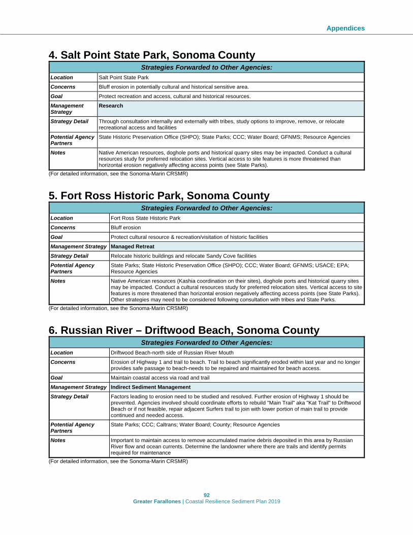
Appendices
92 Greater Farallones | Coastal Resilience Sediment Plan 2019
4. Salt Point State Park, Sonoma County Strategies Forwarded to Other Agencies:
Location Salt Point State Park Concerns Bluff erosion in potentially cultural and historical sensitive area. Goal Protect recreation and access, cultural and historical resources. Management Strategy
Research
Strategy Detail Through consultation internally and externally with tribes, study options to improve, remove, or relocate recreational access and facilities
Potential Agency Partners
State Historic Preservation Office (SHPO); State Parks; CCC; Water Board; GFNMS; Resource Agencies
Notes Native American resources, doghole ports and historical quarry sites may be impacted. Conduct a cultural resources study for preferred relocation sites. Vertical access to site features is more threatened than horizontal erosion negatively affecting access points (see State Parks).
(For detailed information, see the Sonoma-Marin CRSMR) 5. Fort Ross Historic Park, Sonoma County
Strategies Forwarded to Other Agencies: Location Fort Ross State Historic Park Concerns Bluff erosion Goal Protect cultural resource & recreation/visitation of historic facilities Management Strategy Managed Retreat Strategy Detail Relocate historic buildings and relocate Sandy Cove facilities Potential Agency Partners
State Parks; State Historic Preservation Office (SHPO); CCC; Water Board; GFNMS; USACE; EPA; Resource Agencies
Notes Native American resources (Kashia coordination on their sites), doghole ports and historical quarry sites may be impacted. Conduct a cultural resources study for preferred relocation sites. Vertical access to site features is more threatened than horizontal erosion negatively affecting access points (see State Parks). Other strategies may need to be considered following consultation with tribes and State Parks.
(For detailed information, see the Sonoma-Marin CRSMR) 6. Russian River – Driftwood Beach, Sonoma County
Strategies Forwarded to Other Agencies: Location Driftwood Beach-north side of Russian River Mouth Concerns Erosion of Highway 1 and trail to beach. Trail to beach significantly eroded within last year and no longer
provides safe passage to beach-needs to be repaired and maintained for beach access. Goal Maintain coastal access via road and trail Management Strategy Indirect Sediment Management Strategy Detail Factors leading to erosion need to be studied and resolved. Further erosion of Highway 1 should be
prevented. Agencies involved should coordinate efforts to rebuild "Main Trail" aka "Kat Trail" to Driftwood Beach or if not feasible, repair adjacent Surfers trail to join with lower portion of main trail to provide continued and needed access.
Potential Agency Partners
State Parks; CCC; Caltrans; Water Board; County; Resource Agencies
Notes Important to maintain access to remove accumulated marine debris deposited in this area by Russian River flow and ocean currents. Determine the landowner where there are trails and identify permits required for maintenance
(For detailed information, see the Sonoma-Marin CRSMR)

Appendices
93 Greater Farallones | Coastal Resilience Sediment Plan 2019
7. Russian River – Jenner to Estuary, Sonoma County Strategies Forwarded to Other Agencies:
Location Russian River (mouth, jetty and estuary); Jenner Concerns Need more complete understanding of sediment dynamics at river mouth and jetty. Need to reduce impacts of
flooding to natural habitats, private property, and public assets. Goal Holistic watershed management Management Strategy
Managed Retreat Research Education Indirect Sediment Management Dredging
Strategy Detail
Investigate relocation of housing, roadways and US Post Office. Floodplain restoration. Managed retreat at Jenner. Re-alignment and elevation of Hwy 1
Commence studies of dam removals
Conduct stakeholder meetings in order to devise a shared management plan
Support existing efforts to manage upstream inputs of sediment (see notes). Monitor upstream inputs of sediment. Continue ongoing upstream sediment management. Long-term management of upstream sediment input.
Sediment dredging from dams on Russian River for placement within littoral cell
Potential Agency Partners
SCWA; County; CCC; Caltrans; Water Board; USACE; EPA; Resource Agencies
SCWA; County; CCC; EPA; Water Board; Resource Agencies
SCWA; County; CCC; EPA; Water Board; Resource Agencies
County; CCC; Caltrans; Water Board; SWCA; USACE; EPA; Resource Agencies
USACE; EPA; Water Board; CCC; Sonoma County Water Agency (SCWA); County; Resource Agencies
Notes Drainage maintenance and best management practices (10 year), potentially armoring (20 years). Managed retreat as a continuous strategy. Ongoing monitoring and management of previous actions.
Sonoma County Water Agency is lead agency for mouth management
Sonoma County Water Agency is lead agency for mouth management
Vineyards, agriculture, logging, watershed specific planning efforts upstream to reduce anthropogenic sediment load/discharges; maximize natural sediment erosion processes. Identify partner agencies and successful programs. Reach out to landowners. Capture potential TMDL overlap. Consider restoration for estuary. Refer to the Habitat Blueprint ongoing work. Remove the dams as appropriate.
(For detailed information, see the Sonoma-Marin CRSMR) 8. Russian River – Goat Rock, Sonoma County
Strategies Forwarded to Other Agencies: Location Goat Rock (Sonoma Coast State Park) Concerns Sediment imbalance caused by infrastructure Goal Restore natural processes and maintain coastal access Management Strategy
Managed Retreat Indirect Sediment Management
Strategy Detail Develop managed retreat plan. Managed retreat of parking lot. Remove armoring to allow movement of sediment from the north.
Upgrade drainage, culverts, maintain road system
Potential Agency Partners
State Parks; CCC; Water Board; GFNMS; USACE; EPA; Resource Agencies
State Parks; CCC; Water Board; GFNMS; USACE; EPA; Resource Agencies
Notes Strategies are linked to proposal for management plan of Russian River estuary and north Goat Rock parking area
Strategies are linked to proposal for management plan of Russian River estuary and north Goat Rock parking area
(For detailed information, see the Sonoma-Marin CRSMR)

Appendices
94 Greater Farallones | Coastal Resilience Sediment Plan 2019
9. Wrights Beach, Sonoma County Strategies Forwarded to Other Agencies:
Location Wright's Beach (Sonoma Coast State Park) Concerns Flooding and erosion of the trail Goal Address inundation; Protect public access Management Strategy
Managed Retreat Restoration of Dune/Upland and Marsh Environments
Indirect Sediment Management
Strategy Detail Prepare and implement a managed retreat plan including rerouting of vulnerable trail segments and maintenance of trails where feasible
Prepare and implement a stream restoration plan
Potential Agency Partners
State Parks; CCC; Water Board; County; Resource Agencies
State Parks; CCC; Water Board; County; Resource Agencies
Notes Campground with inundation issues, storm surge, evacuate the sites. Vertical and lateral access issues (see State Parks)
(For detailed information, see the Sonoma-Marin CRSMR) 10. Gleason Beach, Sonoma County
Strategies Forwarded to Other Agencies: Location Gleason Beach Concerns Severe erosion threatening homes and Hwy 1; interest from CalTrans to move Hwy 1; restoration of Scotty Creek
to allow sediment connectivity to coast; grazing practices in Scotty Creek watershed and gullying are causing erosion
Goal Restore beach and coastal bluff habitats. Retain coastal access. Relocate Highway 1 to a suitable area. Management Strategy
Managed Retreat Restoration of Dune/Upland and Marsh Environments
Indirect Sediment Management
Strategy Detail
Move Highway 1 inland; remove houses or access roads built to remaining houses; realign Highway 1/bridge. Remove abandoned infrastructure. Monitor, maintain, and manage previous actions.
Remove culvert from Scotty Creek to restore flow to ocean. Monitor and manage flow and water quality. Remove old seawalls and derelict homes. Remove shoreline protection and debris in order to restore beach and bluffs. Restore vegetation and widen banks of Scotty Creek. Remove existing bluff armoring. Develop drainage plans. Manage and monitor previous actions.
Create coastal trail from abandoned roadway. Pedestrian bridge across Scotty Creek. Maintain trail; rolling easement.
Potential Agency Partners
Caltrans; CCC; Water Board; County; GFNMS; Resource Agencies
USACE; Caltrans; CCC; SLC; Water Board; County; GFNMS; EPA; Resource Agencies
Caltrans; CCC; Water Board; County; Resource Agencies
Notes Part of the Highway 1 realignment project. There may be opportunities to collaborate with the SCC. (For detailed information, see the Sonoma-Marin CRSMR) 11. Bodega Head, Sonoma County
Strategies Forwarded to Other Agencies: Location Bodega Head Concerns Erosion is threatening coastal access Goal Reduce runoff from parking lots. Reduce cliff erosion. Protect access to roads, parking lot. Management Strategy
Managed Retreat Research Indirect Sediment Management
Strategy Detail Relocate roadway where feasible and improve, relocate, or remove vehicle dependent facilities. Adaptively manage to relocate trail access/road and facilities.
Conduct a road protection feasibility study. To protect Bay Flat Rd and Westside Rd, investigate options to relocate road, and create living shoreline.
Implement storm water best management practices

Appendices
95 Greater Farallones | Coastal Resilience Sediment Plan 2019
Potential Agency Partners
State Parks; Water Board; Resource Agencies
Caltrans; State Parks; County; Water Board; Resource Agencies
CCC; State Parks; Water Board; County; Resource Agencies
(For detailed information, see the Sonoma-Marin CRSMR)
12. Dillon Beach (N), Marin County Strategies Forwarded to Other Agencies:
Location Dillon Beach (parking area and bluff-top homes) Concerns Sediment movement interfering with public access (especially the excess sand accumulation in parking lot) Goal Preserve public access and refer to CSMART Conceptual Adaptation Options Management Strategy
Managed Retreat Research Indirect Sediment Management
Strategy Detail Managed retreat where it would help replenish beach
Identify homes at risk from erosion along bluff-top and discuss trigger points and solutions, including erosion control measures and managed retreat. Evaluate current sand management practices on the beach and impact to public access. Consider alternatives to preserve parking availability for public access.
Reduce top of bluff erosion through "softer" erosion control measures, including reducing water flow and runoff and replacing iceplant with native vegetation
Potential Agency Partners
Potentially feasible CCC; Water Board; County Resource Agencies
CCC; County; Water Board; Resource Agencies CCC; Water Board; County Resource Agencies
Notes Look at approach to link both areas (parking lot and residential zone)
(For detailed information, see the Sonoma-Marin CRSMR) 13. Dillon Beach (S), Marin County
Strategies Forwarded to Other Agencies: Location Dillon Beach (south of Bay street, including Lawson's Landing) Concerns Dune erosion is threatening coastal access, habitat, and existing infrastructure Goal Preserve public access and refer to CSMART Conceptual Adaptation Options Management Strategy Restoration of Dune/Upland and Marsh Environments Strategy Detail Promote ongoing study/implementation of dune restoration at Lawson's Landing (Center for Ocean
Solutions adaptation strategies/study) Potential Agency Partners
USACE; EPA; CCC; County; Water Board; Resource Agencies; SLC
Notes Local group actively interested in pursuing dune restoration; COS found that dunes play a significant role in reducing vulnerability exposure here more than other areas; great case study to inform the state on effective strategies if monitoring is incorporated
(For detailed information, see the Sonoma-Marin CRSMR) 14. PRNS – Drakes Beach, Marin County
Strategies Forwarded to Other Agencies: Location Point Reyes National Seashore - Drakes Beach/Visitor Center Concerns Wetlands are not connected to system and federally listed species are impacted Goal Restoration and retain public access Management Strategy Research Strategy Detail In light of the current proposal to restore wetland connectivity and reduce the parking lot area, evaluate
opportunities to enhance habitat as part of restoration improvements

Appendices
96 Greater Farallones | Coastal Resilience Sediment Plan 2019
Potential Agency Partners
USACE; NPS; CCC; Water Board; Resource Agencies
(For detailed information, see the Sonoma-Marin CRSMR) 15. PRNS – Schooner Bay, Marin County
Strategies Forwarded to Other Agencies: Location Point Reyes National Seashore - Schooner Bay Concerns Riparian, stream, and estuarine habitat along East Schooner Creek and Schooner Bay are not connected to
overall system and federally listed species are impacted Goal Restoration and retain public access Management Strategy
Restoration of Dune/Upland and Marsh Environments
Strategy Detail Evaluate opportunities to enhance habitat as part of road and trail improvements. Develop trail plan for sea level rise. Reroute trails when triggers are met.
Potential Agency Partners
USACE; NPS; CCC; Water Board; Resource Agencies
Notes The Sir Francis Drake Road Federal Land Access Program (FLAP) through the County of Marin and Federal Highways Administration will result in substantial improvements to 12 miles of SFDB. This work will realign the road to protect riparian and marsh habitat. Installation of a bridge will enhance estuary habitat at Schooner Bay.
(For detailed information, see the Sonoma-Marin CRSMR) 16. San Francisco Gate North Reach, San Francisco County
Strategies Forwarded to Other Agencies: Location Point Cavallo west to Point Bonita at the outlet of the Golden Gate Strait Concerns Shoreline areas should be managed to keep these areas as natural as possible and maintain natural
shoreline processes, such as cliff erosion Goal Maintain natural sediment processes (to the extent feasible) along the shoreline Management Strategy Research Strategy Detail This shoreline remains natural and fairly untouched by development. Identify and further understand
shoreline processes, including the contribution of cliff erosion to Bay sediment supply through work with researchers and managers.
Potential Agency Partners
NPS; BCDC; San Francisco City and County
Notes Shoreline area is part of Marin Headlands and Golden Gate National Recreation Area (For detailed information, see the San Francisco Central Bay CRSMP) 17. Baker Beach, San Francisco County
Strategies Forwarded to Other Agencies: Location Baker Beach Concerns Erosion of the sandy beach and loss of sandy dune habitat Goal Protect the existing sandy beach and dune habitat Management Strategy Restoration of Dune/Upland and Marsh Environments Strategy Detail Consider the recreational benefits of a beach nourishment project at Baker Beach. When possible,
beneficially reuse clean dredged sandy material to restore the beach. Potential Agency Partners
NPS; BCDC; San Francisco City and County
Notes Baker Beach was identified as a beach where nourishment could increase its recreational value slightly, and provide a positive benefit-to-cost ratio, as long as the cost of nourishment is low (e.g., in circumstances where the transportation distance for material is short and cost of delivery could be low)

Appendices
97 Greater Farallones | Coastal Resilience Sediment Plan 2019
(For detailed information, see the San Francisco Central Bay CRSMP) 18. Middle Ocean Beach, San Francisco County
Strategies Forwarded to Other Agencies: Location 10,500 ft stretch of Ocean Beach from Lincoln Way to Sloat Boulevard with 3,676 ft of seawall Concerns Ecology is degraded and beach erosion is expected to damage assets. Beach is adjacent to Highway 1, seawall,
and public infrastructure. Goal Targeted erosion mitigation treatment. Management Strategy
Managed Retreat Beach Nourisment/Restoration* Multipurpose Artificial Reef
Strategy Detail
Investigate moving development away from sensitive and vulnerable coastal lands
Investigate placing sand on foreshore whenever a beach reaches a specified 'minimum beach width.' Beach enhancement should provide ecological benefits.
Investigate detached submerged breakwater to retain sand on beaches and dissipate wave energy
Potential Agency Partners
NPS; CCC; San Francisco City and County
NPS; USACE; Water Board; CCC; San Francisco City and County
NPS; NOAA Fisheries; CCC; San Francisco City and County
Notes The beach is part of the GGNRA. See Ocean Beach Master Plan. SPUR has been involved in the development of this plan and strategies for Ocean Beach.
(For detailed information, see the San Francisco Littoral Cell CRSMP) *GFNMS could consider allowing beach sand placement only for restoration purposes. 19. South Ocean Beach, San Francisco County
Strategies Forwarded to Other Agencies: Location 7,500 ft stretch of Ocean Beach from Sloat Boulevard to Fort Funston with 2,730 ft of revetment Concerns Ecology is degraded and coastal erosion is expected to damage assets. Backshore erosion threatens coastal
access points, roadway, and substantial sewer treatment facilities. Goal Targeted erosion mitigation treatment. Protect sewer infrastructure and provide for recreation and ecology. Management Strategy
Managed Retreat Beach Nourisment/Restoration* Multipurpose Artificial Reef
Strategy Detail
Investigate moving development away from sensitive and vulnerable coastal lands
Investigate placing sand on foreshore whenever a beach reaches a specified 'minimum beach width.' Beach enhancement should provide ecological benefits.
Investigate detached submerged breakwater to retain sand on beaches and dissipate wave energy
Potential Agency Partners
NPS; CCC; San Francisco City and County
NPS; USACE; Water Board; CCC; San Francisco City and County
NPS; NOAA Fisheries; CCC; San Francisco City and County
Notes The beach is part of the GGNRA; see Ocean Beach Master Plan (For detailed information, see the San Francisco Littoral Cell CRSMP) *GFNMS could consider allowing beach sand placement only for restoration purposes. 20. Manor Beach, San Mateo County
Strategies Forwarded to Other Agencies: Location 6,900 ft stretch of narrow beaches and bluffs near the Daly City – City of Pacifica border with 2,790 ft of
revetment Concerns Ecology is degraded and coastal erosion is expected to damage assets. Substantial bluff erosion near
residential property. Access to the beach is limited to a few locations where ramps have been cut into the bluffs. Goal Targeted erosion mitigation treatment Management Strategy
Managed Retreat Beach Nourisment/Restoration* Multipurpose Artificial Reef
Strategy Detail Investigate moving development away from sensitive and vulnerable coastal lands
Investigate placing sand on foreshore whenever a beach reaches a specified 'minimum beach width.' Beach enhancement should provide ecological benefits.
Investigate detached submerged breakwater to retain sand on beaches and dissipate wave energy

Appendices
98 Greater Farallones | Coastal Resilience Sediment Plan 2019
Potential Agency Partners
CCC; San Mateo County USACE; Water Board; CCC; San Mateo County
NOAA Fisheries; CCC; San Mateo County
(For detailed information, see the San Francisco Littoral Cell CRSMP) *GFNMS could consider allowing beach sand placement only for restoration purposes. 21. Beach Blvd, San Mateo County
Strategies Forwarded to Other Agencies: Location 5,200 ft stretch from Paloma Drive to Clarendon Road surrounding the Pacifica Municipal Pier mostly with shore-
parallel armoring along most of its length Concerns Ecology is degraded and coastal erosion is expected to damage assets. Frequent wave overtopping of seawall
and paved promenade, with occasional road closures. Goal Targeted erosion mitigation treatment. Management Strategy
Managed Retreat Beach Nourisment/Restoration* Multipurpose Artificial Reef
Strategy Detail Investigate moving development away from sensitive and vulnerable coastal lands
Investigate placing sand on foreshore whenever a beach reaches a specified 'minimum beach width.' Beach enhancement should provide ecological benefits.
Investigate detached submerged breakwater to retain sand on beaches and dissipate wave energy
Potential Agency Partners
State Parks; CCC; San Mateo County; City of Pacfica
USACE; State Parks; Water Board; CCC; San Mateo County; City of Pacfica
NOAA Fisheries; State Parks; CCC; San Mateo County; City of Pacfica
(For detailed information, see the San Francisco Littoral Cell CRSMP) *GFNMS could consider allowing beach sand placement only for restoration purposes. 22. Sharp Park, San Mateo County
Strategies Forwarded to Other Agencies: Location 7,500 ft stretch encompassing a large sandy cove and dunes from Rockaway headlands to Point San Pedro Concerns Ecology is degraded and coastal erosion is expected to damage assets. Beach is adjacent to Highway 1 and large
parking lot facilities. Goal Targeted erosion mitigation treatment Management Strategy
Managed Retreat Beach Nourisment/Restoration* Multipurpose Artificial Reef
Strategy Detail
Investigate moving development away from sensitive and vulnerable coastal lands
Investigate placing sand on foreshore whenever a beach reaches a specified 'minimum beach width.' Beach enhancement should provide ecological benefits.
Investigate detached submerged breakwater to retain sand on beaches and dissipate wave energy
Potential Agency Partners
State Parks; CCC; San Mateo County
USACE; State Parks; Water Board; CCC; San Mateo County
NOAA Fisheries; State Parks; CCC; San Mateo County
Notes The Sharp Park Public Golf Course and Laguna Salada wetlands, owned and operated by the CCSF, are just landward of the seawall. To the south, Mori Point Headland and restored wetlands are part of the GGNRA. A managed-retreat project was implemented here in 2005.
(For detailed information, see the San Francisco Littoral Cell CRSMP) *GFNMS could consider allowing beach sand placement only for restoration purposes. 23. Rockaway Beach (Cove), San Mateo County
Strategies Forwarded to Other Agencies: Location 2,700 ft stretch narrow sandy shore with moderate wave exposure and backed by armoring between headlands Concerns Ecology is degraded and coastal erosion is expected to damage assets. Waves frequently overtop armoring and
water flows across pavement. Goal Targeted erosion mitigation treatment.

Appendices
99 Greater Farallones | Coastal Resilience Sediment Plan 2019
Management Strategy
Managed Retreat Beach Nourisment/Restoration* Multipurpose Artificial Reef
Strategy Detail Investigate moving development away from sensitive and vulnerable coastal lands
Investigate placing sand on foreshore whenever a beach reaches a specified 'minimum beach width.' Beach enhancement should provide ecological benefits.
Investigate detached submerged breakwater to retain sand on beaches and dissipate wave energy
Potential Agency Partners
CCC; San Mateo County; City of Pacifica
USACE; CCC; Water Board; San Mateo County; City of Pacifica
NOAA Fisheries; USACE; SLC; CCC; San Mateo County; City of Pacifica
(For detailed information, see the San Francisco Littoral Cell CRSMP) *GFNMS could consider allowing beach sand placement only for restoration purposes. 24. Linda Mar, San Mateo County
Strategies Forwarded to Other Agencies: Location 7,500 ft stretch encompassing a large sandy cove with moderate wave exposure and dunes from Rockaway
headland to Point San Pedro. Concerns Ecology is degraded and coastal erosion is expected to damage assets. Beach is adjacent to Highway 1 and
large parking lot facilities. Goal Targeted erosion mitigation treatment. Management Strategy
Managed Retreat Beach Nourisment/Restoration* Multipurpose Artificial Reef
Strategy Detail Investigate moving development away from sensitive and vulnerable coastal lands
Investigate placing sand on foreshore whenever a beach reaches a specified 'minimum beach width.' Beach enhancement should provide ecological benefits.
Investigate detached submerged breakwater to retain sand on beaches and dissipate wave energy
Potential Agency Partners
CCC; San Mateo County; City of Pacifica
USACE; CCC; Water Board; San Mateo County; City of Pacifica
NOAA Fisheries; USACE; SLC; CCC; San Mateo County; City of Pacifica
Notes The Pacifica State Beach Master Plan was developed in 1990 to restore the beach as part of a flood-control renovation of San Pedro Creek. A managed-retreat project was implemented here in 2005.
(For detailed information, see the San Francisco Littoral Cell CRSMP) *GFNMS could consider allowing beach sand placement only for restoration purposes. 25. Princeton – Pillar Point Harbor, San Mateo County
Strategies Forwarded to Other Agencies: Location Mile-long strech of beach entirely inside the outer breakwaters of Pillar Point Harbor.
Concerns Considerable erosion along the shoreline, West Shoreline Trail has been affected by erosion and properties are fronted with rip rap or debris.
Goal Targeted erosion mitigation treatment.
Management Strategy Beach Nourisment/Restoration* Perched Beach Strategy Detail Investigate placement of sand directly on and
below the toe of the eroding bluff to reduce the impacts of wave attack on the bluff toe.
Investigate placement of shore-parallel material offshore to retain sand.
Potential Agency Partners USACE; CCC; Water Board; San Mateo County; City of Half Moon Bay; SMC Harbor District
USACE; CCC; Water Board; San Mateo County; City of Half Moon Bay; SMC Harbor District
Notes The Princeton shoreline is unique from a regulatory standpoint, because it lies outside the boundary of MBNMS.
Investigate in combination with nourishment/ restoration.
(For detailed information, see the Santa Cruz Littoral Cell CRSMP) *GFNMS could consider allowing beach sand placement only for restoration purposes.

Appendices
100 Greater Farallones | Coastal Resilience Sediment Plan 2019
26. Pescadero Lagoon - Butano Creek, San Mateo County
Strategies Forwarded to Other Agencies: Location Pescadero Lagoon and Butano Creek Concerns Infrastructure associated with Highway 1 has fixed the position of the spit separating the lagoon from the open
ocean and traps sediment in Pescadero Lagoon. Sediment accumulation in the Butano Creek has reduced channel and floodplain capacity, increasing flood hazard in Pescadero.
Goal Reduce flood risk and generate sand and finer sediments for beach nourishment or raising elevations of flood prone areas
Management Strategy
Restoration of Dune/Upland and Marsh Environments Dredging
Strategy Detail Realignment of Infrastructure and Restoration Realignment of Highway 1 is unlikely within the next several decades, because the Pescadero Creek Bridge was replaced in the 1980s, and a Caltrans analysis indicated that realignment would be infeasible because of environmental and cost factors. Thus, this measure is unlikely to be implemented in the next 50 years in the absence of any major failure of Highway 1 infrastructure.
Remove up to 48,000 cy of sediment from the channel starting approximately 6,500 feet upstream at the Pescadero Road Bridge
Potential Agency Partners
State Parks; CalTrans; CCC; San Mateo County; San Mateo County Resource Conservation District
State Parks; Water Board; CCC; San Mateo County
Notes The California Department of Parks and Recreation has formed the Pescadero Lagoon Science Panel, to evaluate physical and biological characteristics of the lagoon and marsh ecosystem. The San Francisco Bay Regional Water Quality Control Board is developing a total maximum daily load of sediment for the Pescadero-Butano watershed. San Mateo County Resource Conservation District (SMCRCD) leads the effort to understand and develop a plan to reduce flood risk.
(For detailed information, see the Santa Cruz Littoral Cell CRSMP)
Appendix D: Implementation recommendations compiled from four regional sediment management plans The following is a comprehensive list of implementation recommendations compiled from the four regional sediment management plans/report, the Sonoma-Marin CRSMR, the two San Francisco CRSMPs (Central Bay and Outer Coast), and the Santa Cruz CRSMP.
Sonoma-Marin CRSMR Implementation Recommendations: • Use this report as the basis for implementing a Coastal Regional Sediment Management
Plan (CRSMP). • Begin an evaluation of options for governance structure, including considerations for
potential lead agencies and partners, and processes for decision-making and information sharing.
• Develop a comprehensive list of potential RSM partners and stakeholders and identify their possible roles in CRSMR implementation.
• Connect with the relevant stakeholders, including agencies and local municipalities, to provide information about the CRSMR, discuss potential opportunities for collaboration, and assess their interest in participation.
• Reconvene the Technical Advisory Committee (TAC) that was formed for the development of this CRSMR to: present the final CRSMR, initiate discussions on RSM options, solicit recommendations on the initial implementation of a CRSMP, and discuss

Appendices
101 Greater Farallones | Coastal Resilience Sediment Plan 2019
the possibility of the TAC playing a permanent role in ongoing implementation of the CRSMP.
• Seek near-term funding to establish a new staff position within an existing agency, municipality, or other organization to coordinate initial plan implementation.
• Work with the TAC, local jurisdictions, and other stakeholders to identify and assess funding options for RSM activities; once options have been evaluated and prioritized, collaboratively pursue those sources that are most promising and establish a dedicated fund and administrative process.
• Develop a strategic implementation plan (SIP) for this CRSMR. • Initiate focused outreach efforts by providing presentations to local governmental
organizations, and holding individual meetings with stakeholders and public workshops. Provide an explanation of what this CRSMR consists of, why it was developed, and how it could be carried out.
• Establish a list of prioritized initial stakeholder engagement actions and identify existing CSMW outreach products and tools that could be used to support initial implementation of the CRSMP.
• Begin to develop a detailed permitting roadmap and explore options for a streamlined regional RSM permitting program.
San Francisco Outer Coast CRSMP Implementation Recommendations: Similarly, the San Francisco Littoral Cell (SFLC) CRSMP listed the following recommendations to address governance:
• If there are concerns about resource commitments, creating a Coordinating Network may be a good first step in advancing governance and coordination for sediment management in the SFLC (this would be formalized through a cooperative agreement [MOU or MOA] between relevant local jurisdictions and agencies). The Coordinating Network could be used as a test case to better understand the governance requirements around sediment management in the SFLC and to assess periodically whether a more formal governance structure is needed.
• To the greatest extent possible, governance for the SFLC CRSMP should be closely linked or coordinated with governance of other relevant structures – especially those established to support: 1) the San Mateo County Sea Level Rise Vulnerability Assessment, 2) implementation of the Ocean Beach Master Plan in San Francisco, and 3) the Bayside CRSMP being led by the San Francisco Bay Conservation and Development Commission.
• Because the cities of Pacifica and Daly City have limited staff and funding resources to support sediment management activities, consider having the Counties of San Mateo and San Francisco (along with relevant federal and state agencies such as GGNRA, as appropriate) serve as eventual lead agencies in a governance structure. The roles and responsibilities of the involved jurisdictions and agencies could be established in the MOU/MOA to account for these resource constraints and make it easier for Pacifica and Daly City to participate.
• A hybrid structure involving a Coordinating Network and a lead agency or agencies may be a good way to address a situation where some local jurisdictions and agencies have more resources and capacity than others, but where all may want to be involved.

Appendices
102 Greater Farallones | Coastal Resilience Sediment Plan 2019
San Francisco Central Bay CRSMP Implementation Recommendations: Obtaining regulatory permits for sediment management can be time consuming, expensive, difficult, etc.
• Seek partnerships to assist acquiring funding for dredging and flood control projects, and identify nearby, cost-effective beneficial reuse sites. Develop a regional approach for end of channel sediment management, with a standardized or programmatic permit and mitigation that covers repetitive actions such as maintenance dredging at multiple locations.
A regional sediment management strategy will require multiple agencies working together to achieve the plan, not just a single agency.
• Utilize the already existing interagency Dredge Material Management Office (DMMO) collaboration and bring in other regional entities (SFEI, Coastal Conservancy, etc.) to further develop and refine the RSM plan and to assist local agencies in implementation.
Obtaining community financial support for sediment management projects can be difficult. • Assist local agencies in communicating the needs for sediment management to their
constituents (provide flyers, presentations, etc.). Shoreline stabilization projects can be costly and require the cooperation of multiple partners.
• Seek funding for shoreline stabilization projects and beneficially reuse dredged sediment.
Santa Cruz CRSMP Implementation Recommendations: Governance structure development:
• Begin an evaluation of options for governance structure, including considerations for potential lead agencies and partners, and processes for decision-making and information sharing.
RSM stakeholder coordination process: • Develop a comprehensive list of potential partners and stakeholders and identify their
possible roles in plan implementation. • Connect with the relevant stakeholders, including agencies and local municipalities, to
provide information about the Plan, discuss potential opportunities for collaboration, and assess their interest in participation.
• Reconvene the stakeholder advisory group (SAG) that was formed for the development of this Plan for meetings to: present the final Plan; initiate discussions on RSM options; solicit recommendations on initial plan implementation; discuss the possibility of and options for the workgroup playing a permanent role in ongoing implementation of the Plan.
Outreach and education program: • Coordinate with the CSMW on initial plan implementation and stakeholder outreach
strategies. • Establish a list of prioritized initial outreach actions and identify existing CSMW
outreach products and tools that could be used to support initial implementation of the Plan.

Appendices
103 Greater Farallones | Coastal Resilience Sediment Plan 2019
• Initiate focused outreach efforts by providing presentations to local governmental organizations, and holding individual meetings with stakeholders. Provide an explanation of what the Plan consists of, why it was developed, and how it could be carried out.
• Partner with the CSMW to host at least two public workshops once the Plan has been finalized – one in Santa Cruz and another in Half Moon Bay – to present the final Plan and obtain input on initial implementation.
• Develop and implement an initial outreach and education strategy to get the Plan into the hands of stakeholders that will use it and to ensure their input on RSM issues and plan implementation.
CRSMP Funding: • Seek near-term funding to establish a new staff position within an existing agency,
municipality, or other organization to coordinate initial plan implementation. Permitting program
• Begin to develop a detailed permitting roadmap and explore options for a streamlined regional RSM permitting program.

Appendices
104 Greater Farallones | Coastal Resilience Sediment Plan 2019
Appendix E: Sediment Management Strategy Agency Involvement Matrix A summary of likely agency engagement in a given sediment management strategy is detailed in the Agency Involvement Matrix. The matrix is tailored to Sonoma and Marin counties; however, it was developed in partnership with agencies and provides general guidance applicable elsewhere. Table A.2. Summary of likely agency engagement listed by sediment management strategy. Matrix developed collaboratively with agencies for the Sonoma-Marin CRSMR and reproduced here.

105 Greater Farallones | Coastal Resilience Sediment Plan 2019