coastal erosion rates erosion rates tend to be greatest around hardened structures, which forces us...
TRANSCRIPT

Coastal Erosion RatesErosion rates tend to be greatest around hardened structures, which forces us to rethink what it means to develop
along the coast as these structures will become threatened by encroaching shorelines.

Sea Level CurveSea levels are rising which threatens sensitive coastal areas.

SubsidenceIn addition to erosion, the sinking of the land is also a factor that should be incorporated into development decisions.
This attribute affects elevation, which is a key factor in providing protection in coastal areas.
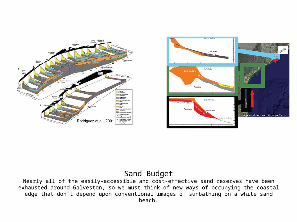
Sand BudgetNearly all of the easily-accessible and cost-effective sand reserves have been exhausted around Galveston, so we must think of new ways of occupying the coastal edge that don’t depend upon conventional images of sunbathing on a white
sand beach.

Hurricane Frequency and ImpactHurricanes are becoming more severe and more frequent.
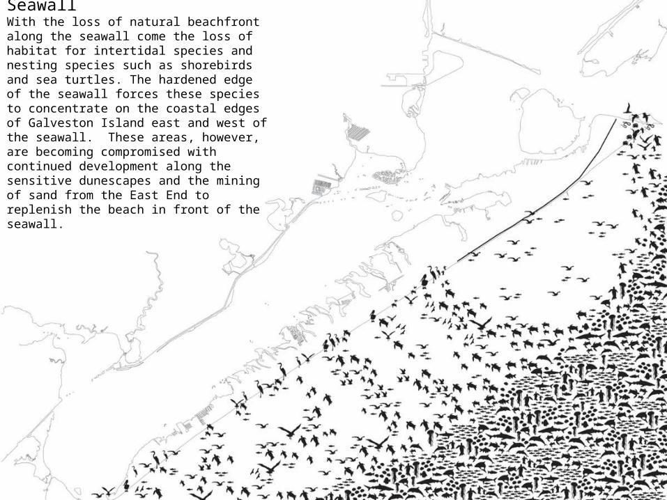
Wildlife Conditions at SeawallWith the loss of natural beachfront along the seawall come the loss of habitat for intertidal species and nesting species such as shorebirds and sea turtles. The hardened edge of the seawall forces these species to concentrate on the coastal edges of Galveston Island east and west of the seawall. These areas, however, are becoming compromised with continued development along the sensitive dunescapes and the mining of sand from the East End to replenish the beach in front of the seawall.

Bay Area EcologyGalveston Bay contains many types of ecologically unique but highly interconnected landscapes. Building a massive
concrete dike could serve to sever these ecologies from one another, and have profound impacts on the ecological and economic sustainability of Galveston.

Marsh EcosystemsThe wetlands surrounding Galveston, in addition to providing storm protection, provide habitats to a number
of ecologically and economically important species.

Marsh Food ChainThe highly inter-connected web of marsh species.

Student Project: Fluctuating TerritoriesStudent Team: North Keeragool, Kathryn Pakenham
A bay-side proposal that integrates wetland preservation and growth with ecotourism, leisure activities, and light commercial activities to produce a light touch in the sensitive wetlands that doesn’t attempt to drastically
modify the landscape into traditional development patterns.

Development on GalvestonThe 15-foot depth ordinance required for foundations does not always reach the stable Pleistocene layer, which can
result in damage to buildings during storm events. The island needs a more nuanced approach to development to deal with local variations in the island’s geology and ecology.

Shoreline Varieties on GalvestonGalveston contains a large number of shoreline types, each containing unique varieties of flora and fauna; it is
not simply either “wet” or “dry”.

Galveston’s Port could be a new Economic StimulusGalveston’s position farther out in the Gulf makes it more suitable to the future developments in containerized
shipping: larger ships with deeper depth requirements that would be very expensive to get all the way up the Ship Channel.

Shipping in the RegionThe majority of shipping now goes straight to Houston, bypassing Galveston’s undersized port. A new port located on
Galveston could prepare it for new innovations in the shipping industry and recover some of its lost industry.

No Two Hurricanes are AlikeThis map of storm routes shows that no two storms strike in quite the same way or location. Why would we
build a dike to protect us from the last storm when it is obvious that the next one will be completely different?

Hurricane Ike on the West EndIf the storm had struck just a few miles west, the west end would have been completely destroyed.

Oil Platforms in the GulfIt costs three times as much to completely remove a disused oil rig than it does to convert it to an artificial reef. Think of
the possibilities for the local economy if we could capitalize on the fishing opportunities this would provide.

A Focus on the East EndHighly intensive development on the East End is more sustainable and more protected from storms. By relieving
development pressure from the West End, this would allow the West End to serve highly sensitive ecological functions such as wetland growth and habitat for migratory birds. These in turn can feed the ecotourism industry that generates
a lot of revenue for the island.

East End vs. West EndHigh protection from storm damage coupled with low biodiversity and lots of existing transportation
infrastructure make the East End perfect for intense development.

Storm Surge and ElevationThe line of damage on the East End clearly illustrates that elevation is a key attribute of storm protection for Galveston.
The implementation of a strategic topographic line and dike in this area, coupled with sensitive and high-density development, could help to ensure Galveston’s future.

East End DensityRelieving development pressure on the West End by creating density on the East End seems the most
promising long-term development strategy.

Erosion and Wetland LossRates of erosion are greatest along, and adjacent to, the seawall. It has become evident that hardened
structures actually accelerate erosion processes in dynamic environments such as the coast.

Sustainable PlanningIntensive development on the East End would foster connections to the larger area for Galveston: it is closer to
Houston, it would allow for ecotourism and wetland growth on the west end, and it could connect to the rig infrastructure right off the coast.

Wetland ValuesWetlands offer much more than storm protection to Galveston, providing habitats to a multitude of fauna and
providing ecotourism dollars to the city.

Ike Wetland DamageBolivar peninsula suffered much more damage than Galveston from Hurricane Ike. However, if the storm had struck
farther west, Galveston’s damage would have been much more severe. This underscores the importance of wetlands as a storm protection feature.

Function and Value of WetlandsIn addition to providing storm protection for large storms that happen every 10-20 years, wetlands also contribute value during the times between these storms. How might we apply this thinking to our hardened infrastructures of seawalls and dikes, so that they also serve a purpose for the majority of time that they are not defending against a
major storm?
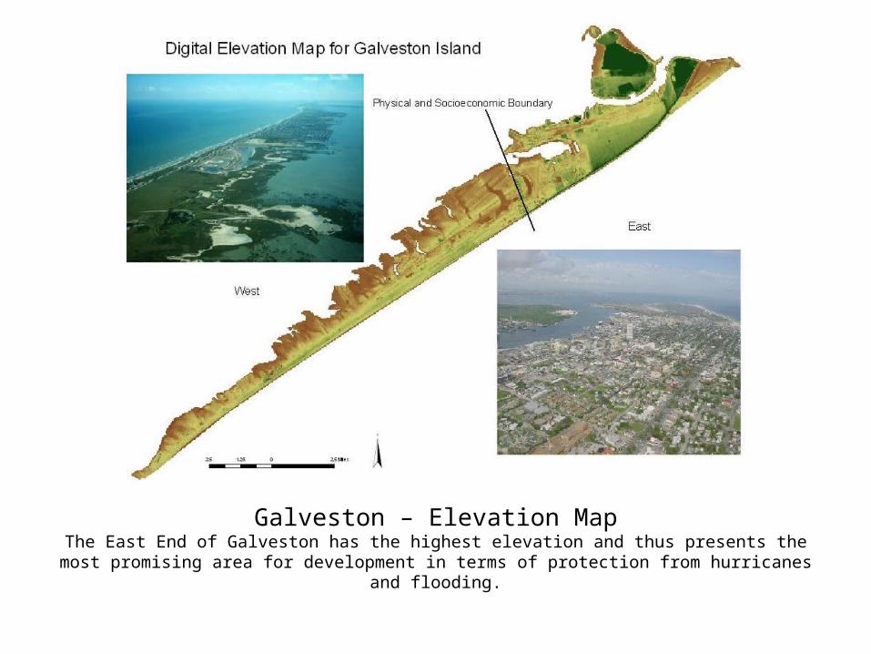
Galveston – Elevation MapThe East End of Galveston has the highest elevation and thus presents the most promising area for
development in terms of protection from hurricanes and flooding.

East End LocationThe East End’s location relative to Houston makes it much more desirable for development than the West End,
which is almost twice the distance from Houston.

East End Walking DistancesThe relative compact distribution of amenities on the East End make it highly desirable for more development
to link into it.

East End ConnectivityBecause the East End is perceived as being poorly connected to the downtown area, a strategic plan for
transportation and infrastructure could link it in a highly integrated manner into the city.
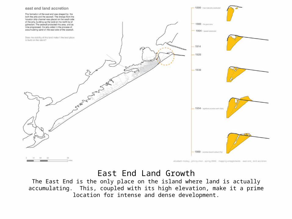
East End Land GrowthThe East End is the only place on the island where land is actually accumulating. This, coupled with its high
elevation, make it a prime location for intense and dense development.

East End AttributesThe East End contains several and different types of landscapes and amenities that, if developed and connected
intelligently, could catalyze the city of Galveston.

East End WetlandsThe East End contains a large dredge deposit site with wetlands. This area could be developed in an architecturally
interesting manner to provide both density and work with the unique characteristics of the wetlands that would create a unique destination specific to Galveston.

East End Landscape DiversityThe East End contains a diversity of landscape types and also connects to three major water bodies: the port,
the ship channel, and the gulf.

East End Density Study 1: Replacing the Population Affected by the SetbackThis study examines placing a population equivalent to the one that would be displaced from the West End
from the setback line multiplied by the rate of shoreline retreat.

East End Density Study 2: Replacing the Population Affected by the Hazard Map This study examines placing a population equivalent to the one that would be displaced from the West End from
the Hazard map that dictates areas that should not be built in.

East End Density Study 3: Replacing the Population West of Jamaica Beach This study examines placing a population equivalent to the one that would be displaced from the West End west of
Jamaica Beach, an area that is highly susceptible to storm damage because of its low elevation.

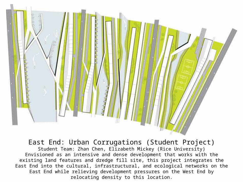
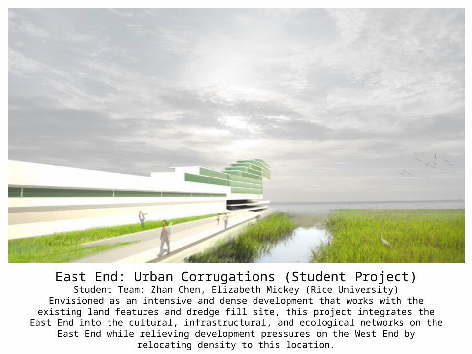
East End: Urban Corrugations (Student Project)Student Team: Zhan Chen, Elizabeth Mickey (Rice University)
Envisioned as an intensive and dense development that works with the existing land features and dredge fill site, this project integrates the East End into the cultural, infrastructural, and ecological networks on the East
End while relieving development pressures on the West End by relocating density to this location.