clustering effect of industrial site: turning morphology into guide
TRANSCRIPT

Politecnico di Torino
Porto Institutional Repository
[Article] Clustering effect of industrial site: turning morphology into guidelines for future developments of Turin Metropolitan Area
Original Citation:Giuseppe Roccasalva, Amanda Pluviano (2012). Clustering effect of industrial site: turningmorphology into guide lines for future developments of Turin Metropolitan Area. In: TEMA. - ISSN1970-9889
Availability:This version is available at : http://porto.polito.it/2503206/ since: October 2012
Publisher:Universita degli studi Federico II Napoli
Terms of use:This article is made available under terms and conditions applicable to Open Access Policy Arti-cle ("Creative Commons: Attribution 3.0") , as described at http://porto.polito.it/terms_and_conditions.html
Porto, the institutional repository of the Politecnico di Torino, is provided by the University Libraryand the IT-Services. The aim is to enable open access to all the world. Please share with us howthis access benefits you. Your story matters.
(Article begins on next page)

Urban sprawl processes characterize the landscape of the areas surrounding cities. These landscapes show different features according to the geographical area that cities belong to, though some common factors can be identified: land consumption, indifference to the peculiarities of the context, homogeneity of activities and building typologies, mobility needs exasperatedly delegated to private cars.
Tema is the journal of the Land use, Mobility and Environment Laboratory of the Department of Urban and Regional Planning of the University Federico II of Naples. The journal offers papers with a unified approach to planning and mobility. TeMA Journal has also received theSparc Europe Seal of Open Access Journals released by Scholarly Publishing and Academic Resources Coalition SPARC Europe) and the Directory of Open Access Journals DOAJ)
Vol.5 n.3 December 2012 print ISSN 1970-9889, e- ISSN 1970-9870
Dipartimento di Pianificazione e Scienza del Territorio Università degli Studi di Napoli Federico II
MOBILITY AND COMPETITIVENESS
TeMA Journal ofLand Use, Mobility and Environment

TeMA Journal of Land Use, Mobility and Environment
1 - TeMA Journal of Land Use Mobility and Environment 3 (2012)
MOBILITY AND COMPETITIVENESS 3 (2012)
Published by Laboratorio Territorio Mobilità e Ambiente - TeMALab Dipartimento di Pianificazione e Scienza del Territorio Università degli Studi di Napoli Federico II Publised on line with OJS Open Journal System by Centro di Ateneo per le Biblioteche of University of Naples Federico II on the servers of Centro di Ateneo per i Sistemi Informativi of University of Naples Federico II Direttore responsabile: Rocco Papa print ISSN 1970-9889 on line ISSN 1970-9870 Registrazione: Cancelleria del Tribunale di Napoli, n° 6, 29/01/2008 Editorials correspondence, including books for review, should be sent to Laboratorio Territorio Mobilità e Ambiente - TeMALab Università degli Studi di Napoli “Federico II” Dipartimento di Pianificazione e Scienza del Territorio Piazzale Tecchio, 80 - 80125 Napoli - Italy Sito web: www.tema.unina.it info: [email protected]

TeMA Journal of Land Use, Mobility and Environment
2 - TeMA Journal of Land Use Mobility and Environment 3 (2012)
TeMA - Journal of Land Use, Mobility and Environment offers researches, applications and contributions with a unified approach to planning and mobility and publishes original inter-disciplinary papers on the interaction of transport, land use and Environment. Domains include: engineering, planning, modeling, behavior, economics, geography, regional science, sociology, architecture and design, network science, and complex systems.
The Italian National Agency for the Evaluation of Universities and Research Institutes (ANVUR) classified TeMA s one of the most highly regarded scholarly journals (Category A) in the Areas ICAR 05, ICAR 20 and ICAR21. TeMA Journal has also received theSparc Europe Seal for Open Access Journals released by Scholarly Publishing and Academic Resources Coalition (SPARC Europe) and the Directory of Open Access Journals DOAJ). TeMa publishes online in open access under a Creative Commons Attribution 3.0 License and is double-blind peer reviewed at least by two referees selected among high-profile scientists, in great majority belonging to foreign institutions. Publishing frequency is quadrimestral. TeMA has been published since 2007 and is indexed in the main bibliographical databases and present in the catalogues of hundreds of academic and research libraries worldwide.
EDITORIAL MANAGER
Rocco Papa, Università degli Studi di Napoli Federico II, Italy
EDITORIAL ADVISORY BOARD
Luca Bertolini, Universiteit van Amsterdam, Netherlands Virgilio Bettini, Università Iuav di Venezia, Italy Dino Borri, Politecnico di Bari, Italy Enrique Calderon, Universidad Politécnica de Madrid, Spain Roberto Camagni, Politecnico di Milano, Italy Robert Leonardi, London School of Economics and Political Science, United Kingdom Raffaella Nanetti, College of Urban Planning and Public Affairs, United States Agostino Nuzzolo, Università degli Studi di Roma Tor Vergata, Italy Rocco Papa, Università degli Studi di Napoli Federico II, Italy
EDITORS
Agostino Nuzzolo, Università degli Studi di Roma Tor Vergata, Italy Enrique Calderon, Universidad Politécnica de Madrid, Spain Luca Bertolini, Universiteit van Amsterdam, Netherlands Romano Fistola, Dept. of Engineering - University of Sannio - Italy, Italy Adriana Galderisi, Università degli Studi di Napoli Federico II, Italy Carmela Gargiulo, Università degli Studi di Napoli Federico II, Italy Giuseppe Mazzeo, CNR - Istituito per gli Studi sulle Società del Mediterraneo, Italy
EDITORIAL SECRETARY
Rosaria Battarra, CNR - Istituito per gli Studi sulle Società del Mediterraneo, Italy Daniela Cerrone, TeMALab, Università degli Studi di Napoli Federico II, Italy Andrea Ceudech, TeMALab, Università degli Studi di Napoli Federico II, Italy Rosa Anna La Rocca, TeMALab, Università degli Studi di Napoli Federico II, Italy Enrica Papa, Università degli Studi di Napoli Federico II, Italy ADMISTRATIVE SECRETARY Stefania Gatta, Università degli Studi di Napoli Federico II, Italy

TeMA Journal of Land Use, Mobility and Environment
3 - TeMA Journal of Land Use Mobility and Environment 3 (2012)
MOBILITY AND COMPETITIVENESS 3 (2012) Contents
EDITORIALE
Mobility and CompetitivenessRocco Papa
3
EDITORIAL PREFACE Mobility and Competitiveness Rocco Papa
FOCUS FOCUS
The Clustering Effect of Industrial Sites: Turning Morphology into
Guidelines for future Developments within the Turin Metropolitan Area
Giuseppe Roccasalva, Amanda Pluviano
7 The Clustering Effect of Industrial Sites: Turning Morphology into Guidelines for future Developments within the Turin Metropolitan Area Giuseppe Roccasalva, Amanda Pluviano
The New Cispadana Motorway. Impact
on Industrial Buildings Property Values Simona Tondelli, Filippo Scarsi
21 The New Cispadana Motorway. Impact on Industrial Buildings Property Values Simona Tondelli, Filippo Scarsi
Trasporti, ICT e la città. Perché alla
città interessano le ICT? Ilaria Delponte
33
Trasporti, ICT e la città. Perché alla città interessano le ICT? Ilaria Delponte

TeMA Journal of Land Use, Mobility and Environment
4 - TeMA Journal of Land Use Mobility and Environment 3 (2012)
TERRITORIO, MOBILITA’ E AMBIENTE
The Relationship Between Urban Structure and Travel Behaviour:
Challenges and Practices Mehdi Moeinaddini, Zohreh Asadi-Shekari,
Muhammad Zaly Shah
47
LAND USE, MOBILITY AND ENVIRONMENT The Relationship Between Urban Structure and Travel Behaviour: Challenges and Practices Mehdi Moeinaddini, Zohreh Asadi-Shekari, Muhammad Zaly Shah
Housing Policy. A Critical Analysis on the Brazilian Experience
Paulo Nascimento Neto, Tomás Moreira, Zulma Schussel
65 Housing Policy. A Critical Analysis on the Brazilian Experience Paulo Nascimento Neto, Tomás Moreira, Zulma Schussel
The Italian Way to Carsharing Antonio Laurino, Raffaele Grimaldi 77 The Italian Way to Carsharing
Antonio Laurino, Raffaele Grimaldi
L’utente debole quale misura dell’attrattività urbana
Michela Tiboni, Silvia Rossetti 91
L’utente debole quale misura dell’attrattività urbana Michela Tiboni, Silvia Rossetti
Resilience? Insights into the Role of Critical Infrastructures
Disaster Mitigation Strategies Sara Bouchon, Carmelo Di Mauro
103 Resilience? Insights into the Role of Critical Infrastructures Disaster Mitigation Strategies Sara Bouchon, Carmelo Di Mauro
Urban Spaces and Safety Rosa Grazia De Paoli 119 Urban Spaces and Safety
Rosa Grazia De Paoli
Fruizioni immateriali per la promozione territoriale
Mauro Francini, Maria Colucci, Annunziata Palermo, Maria Francesca Viapiana
133 Intangible Fruitions - Virtualization of Cultural Heritage for the Territorial Promotion Mauro Francini, Maria Colucci, Annunziata Palermo, Maria Francesca Viapiana
OSSERVATORI
Laura Russo, Giuseppe Mazzeo, Valentina Pinto, Floriana Zucaro,
Gennaro Angiello, Rosa Alba Giannoccaro
145
REVIEW PAGES Laura Russo, Giuseppe Mazzeo, Valentina Pinto, Floriana Zucaro, Gennaro Angiello, Rosa Alba Giannoccaro

TeMA Journal of Land Use, Mobility and Environment
TeMA 3 (2012) 7-20 print ISSN 1970-9889, e- ISSN 1970-9870 DOI: 10.6092/1970‐9870/1221 review paper. received 21 September 2012, accepted 19 October 2012 Licensed under the Creative Commons Attribution – Non Commercial License 3.0 www.tema.unina.it
THE CLUSTERING EFFECT OF INDUSTRIAL SITES:
TURNING MORPHOLOGY INTO GUIDELINES FOR FUTURE DEVELOPMENTS WITHIN THE TURIN METROPOLITAN AREA
ABSTRACT As urban societies seek to redefine themselves following the decline of manufacturing, they are left with physical and social transformations supported by successive stages of industrial growth and shrinking. At the same time, new paradigms are developed in urban planning to address the challenge of cities that are declining and cities whose population is rapidly rising. As such, these attempts raise the need to understand the impact of the street network on how cities thrive or shrink, additionally to social, cultural and economic changes. This paper uses space syntax methodology and a comprehensive mapping of industrial distribution to analyse the evolution of Turin (capital of car manufacturing in Italy) and its relationship to industry from 1920 to the present. The paper focuses on the morphological clustering of industrial sites and how alternative concepts for planning development may be generated. The analysis showed that industry began within the urban core along the primary routes of global-scale movement. However, as a new era of economic production took place at the end of the 20th century, the street network and industry followed a different spatial logic. Industrial activities spread along the periphery in island clusters in close proximity to global arteries of movement. Turin’s centre, on the other hand retained a backbone of integrated streets that enabled its reinforcement when industry relocated. The analysis of their historic development shows that new concepts should be informed by quantitative analysis of the evolution of the urban street network and its effects on economic activity, such that the configurational logical described may provide the basis for future guideline policies. KEYWORDS: urban morphology, configuration analyses, industrial development, econometric analyses
GIUSEPPE ROCCASALVAa, AMANDA PLUVIANOb
a Politecnico di Torino, SiTI /Laq-TIP (High Quality Lab-Territorial Integration Project), Faculty of Architecture
e-mail: [email protected] URL: www.polito.it
b The Bartlett School of Graduate Studies, UCL e-mail: [email protected]
URL: www.ucl.ac.uk

G. Roccasa lva, A . P luv iano – The c lus te r ing e f fec t o f indus t r ia l s i tes : tu rn ing morpho logy in to gu ide l ines fo r fu tu re deve lopments w i th in the Tur in Met ropo l i tan Area
8 - TeMA Journal of Land Use Mobility and Environment 3 (2012)
FOREWORD The article is based on studies of Laq-TIP (High Quality Lab – Territorial integrated project) in collaboration
with formative experiences of the MSc in Advanced Architectural Studies, UCL. Basic concepts of Space
Syntax theory are applied in order to develop new morphological rules for future industrial developments in
the Metropolitan Area of Turin (AMT). Although Space Syntax analysis is not extensively and technically
explained, the paper draws on the results displayed through graphic and visual analyses. The main
configurational properties are highlighted and the location of industrial sites are initially questioned in this
light. A series of correlations between the development morphology of industrial sites and the syntactic
measure of choice1 were proposed and some general properties about clusters presented. The last part of
the article asserts that though traditional strategies of regeneration took place in Turin’s city centre, key
questions are left open regarding the distribution of present and past island clusters in the city’s periphery
areas.
1 INTRODUCTION Cities and regions grow, shrink or collapse and accordingly sustain significant changes to the economic,
social and environmental conditions. Over the last 30 years most mechanisms and internal systems have
been investigated and published, but the forecasting or monitoring methods still lack effective policies. In
the next 20 years, the City of Turin is facing strategic choices for a regional context broader than their
administrative boundaries. Turin has published books and made attempt to forecast, describe and share
future scenarios. The complex role of city space needs to be fostered with a new methodology with the aim
of raising the awareness of local authorities whose actions are connected not only with their administrative
boundaries but overreaching also in time.
The transformation of society in the last few decades has in a substantial way changed regional economic,
social and physical structures. In particular, investments in transport infrastructures aim at urban
regeneration and regional integration. In the last year, LAQ-tip has studied how various places are
reproduced and transformed in the metropolitan area of Turin (AMT). The studies focused on the effects on
local physical environments and social activities, and the interdependency between these two aspects, in
relation to the development of the AMT. The data gathered includes interviews, document studies, statistical
analyses and geographical information. The basic aim is to develop tools The Research Centre uses as
predictive and monitoring methods for informing public authorities about the influence of spatial choices on
the logic of urban structure.
Since 2000, much analysis of urban and territorial forms has paid great attention to the relations of
configuration and land uses in the urban grid. There have been many different experiments with
configuration analyses as an interpretative tool for the existing urban socio-economic and environmental city
structure. A number of socio-economic, environmental and transportation data regarding the AMT has been
collected and geo-referenced, and a consistent number of indicators becoming quality factors for guiding
urban transformations.
Such data was assessed to provide insight on:
− the unforeseen effects of the masterplan and transformation of the city structure;
− the location of activities according to their likely public success and use;
1 It is a syntactic measure applied to global and local conditions, measuring the movement “flow” through a space. A space has a strong choice value when many of the shortest paths, connecting all spaces to all spaces of a system, passes through it.

G. Roccasa lva, A . P luv iano – The c lus te r ing e f fec t o f indus t r ia l s i tes : tu rn ing morpho logy in to gu ide l ines fo r fu tu re deve lopments w i th in the Tur in Met ropo l i tan Area
9 - TeMA Journal of Land Use Mobility and Environment 3 (2012)
− movement patterns and flows in cities as shaped by the street network;
− the evolution of the local centres and sub-centres that makes cities liveable;
− how patterns of security and insecurity are affected by spatial design;
− how spatial segregation and social disadvantage are related in cities;
− how buildings can create more interactive organisational cultures;
− how existing cities, urban areas and buildings are linked in the configuration of the urban grid, and
simulate the likely effect of new interventions.
These studies of Turin’s city fabric are mainly driven by Space Syntax theory, a scientific-based methodology
and analytic tool used to transform urban qualities such as movement, urban growth, activities and
transportation growth from an undervalued resource into a tangible manageable asset for making local
public authorities aware of socio-economic and environmental impacts. The following section will summarise
three basic concepts of this theory: the theory of ‘natural movement’, ‘centrality’ and the ‘movement
economy’.
1.1 BACKGROUND CONCEPTS
Space Syntax was developed to understand space as an aspect of social life (Hillier 2007). A scientific
methodology was developed in order to uncover the underlying structure pertaining to (city) space by way of
its configuration. The rules of language are based on syntax as the sequence and connection between words
that give meaning to our sentences. Spatial configuration (Space syntax) is the meaningful sequences and
links in an urban grid, it is examined by way of the axial map. The axial map represents the linear nature of
urban open space. The urban environment is reduced to an axial map that is a matrix of the ‘fewest and
longest lines’ representing potential patterns of movement (Hillier 1996). According to Hillier, it is this
patterning of movement that over time gives shape to an emerging urban environment called a city. The
relationship between the urban grid and movement is referred to as the theory of ‘Natural Movement’ (Hillier
1996) and suggests that all things being equal, movement flows are systematically influenced by the spatial
configuration of the street network. Thus, the urban grid plays a crucial role in movement, rather than other
factors such as attractors or magnets (i.e. land use functions which influences the proportion of pedestrian
movement within a system). This is because the urban grid has a pattern of integration which has the
potential to draw different types of movement, generating more movement in some places compared to
others. Integration is a configurational property measuring a line’s ‘depth’ or ‘shallowness’ within the system,
such that deeper lines or spaces result in more segregated integration values, which have the by-product of
reducing the potential for movement and thus co-presence.
Moreover, if the grid has an impact on movement, this in turn will have an effect on the distribution of
functional land use. The theory of the ‘Movement Economy’ (Hillier 1996) suggests that areas naturally
attracting high levels of movement will attract movement-dependent land uses, such as retail. According to
Hillier, such areas will have higher densities of development than other areas, and because of this will then
attract more land use activities which will benefit from close proximity to those already there. Referred to as
the ‘multiplier effect’ (Hillier 1996), this process generates many aspects associated with city life often taken
as a given such as:
− diversity generated by a mixture of land use;
− co-presence of people intermingling as they participate in different activities;
− the vibrancy of well utilized spaces attracting more uses and more people.

G. Roccasa lva, A . P luv iano – The c lus te r ing e f fec t o f indus t r ia l s i tes : tu rn ing morpho logy in to gu ide l ines fo r fu tu re deve lopments w i th in the Tur in Met ropo l i tan Area
10 - TeMA Journal of Land Use Mobility and Environment 3 (2012)
Further to this, the movement economy contributes to the formation and location of core areas. ‘Live
centrality’ or the element of centrality that is led by markets, retail, entertainment, along with other activities
that benefit from movement, emerges as a spatially led process that changes over time (Hillier 1999). In
‘Centrality as a Process’ (Hillier 1999), Hillier explains how the process is dependent on both configuration
and function, driven by the social and economic life of urban societies: as settlements grow, land uses are
located according to the movement economy. Based on the study of several English town centres, core
areas will emerge as linear segments of a most integrated line, which then, gradually become more convex
and compact due to a process of grid intensification, in particular, where local grid conditions follow a ‘two-
step’ grid pattern. As settlements grow, the pattern of integration changes, shifting the centrality outwards.
With linear growth moving away from the centre, local sub-centres emerge along radial routes, with even
smaller scale sub-centres developing away from the main radials. Significantly, the process works at a global
and local level; globally, the process seeks those locations with respect to the settlement as a whole; locally,
it is the local grid conditions that give rise to the centre.
2 SCENARIOS FOR THE URBANIZED LANDSCAPE The complexity of mixed use cities requires a more accurate way of describing the configurational patterns
that impact functional land use distribution. One of the basic questions is how to build new development
scenarios for industrial spaces? How do these areas counteract or influence their configurational properties?
Hillier describes the process of the ‘deformed wheel’ (Hillier et al 1993) that whilst governed by varying socio
economic factors pertaining to different cultures, remains evident in all cities, such that the fundamental city
form is a network of linked centres and sub-centres, at all scales of growth. It is also a dual process (Hillier
1996) between a foreground network of public space, shaped by micro-economic factors, and a large
background network of residential space, shaped by cultural factors. Thus it is in the public realm – those
movement-rich and integrated areas where people come together that the private realm divides.
The town planner and scholar Sieverts makes a claim towards redefining the European city in its
contemporary state. He defines this as ‘urbanised landscape’ or ‘landscaped city’ – ‘the built up area
between the historic city centre and open countryside, between the place as a living space and the non-
places of movement’ (Sieverts 2003). In this space, he proposes that rather than reinforcing the traditional
assumptions about the two – romanticised historic centre and destructive suburban sprawl, this
‘interpenetration of open space and built form, with open space as the binding element’ offers new creative
potential (Sieverts 2003). Only by redefining this relationship is it possible to address the realities of the
contemporary city in their totality, opening the possibility of a new model of order, which according to
Sieverts, is more akin to the ‘pluralistic and democratic society’ of contemporary times, rather than the old
model of a centralized city.
How is it possible to build scenarios for the (intermediate) non-place of movement? While syntactic analysis
has provided the core theoretical framework for studying the configurational qualities of industrial sites,
Sievert’s view is considered when confronted with the results of the city ‘as it is’ and the proposition of the
city ‘as it could be’. An urbanized landscape can be reinvented through ‘meaningful’ open space.
3 OVERALL SYNTACTIC ANALYSIS The spatial configuration of the city of Turin was examined over three periods, representing key phases of
industrial development and decline – 1920’s, 1970’s and 2010. To start with, the city’s grid structure, by way

G. Roccasa lva, A . P luv iano – The c lus te r ing e f fec t o f indus t r ia l s i tes : tu rn ing morpho logy in to gu ide l ines fo r fu tu re deve lopments w i th in the Tur in Met ropo l i tan Area
11 - TeMA Journal of Land Use Mobility and Environment 3 (2012)
of the foreground network was examined, followed by the functional – spatial relationship, specifically that
of industry.
A series of syntactic measures – choice, integration, … – (Hillier 1996) were selected in order to understand
and describe the logic of the city structure and explain some key relationships. The foreground network was
studied through the measure of choice, which at a global level (Rn) sets the parameters for movement
within the system. Then, a smaller radii (R1000) was used to get a better picture of the local street network
in order to identify where and how localised centres are formed as well as to understand the differing
patterns of movement between the two scales.
Looking at the street network, central Turin (1926, Rn) is characterized by a highly regular grid structure
stemming from the historic core, which extends outwards to the north, west and south. This pattern
becomes less regular as it grows outwards, forming an interface between two overlapping structures: the
regular grid from the core moving out, and a secondary more organic network from the countryside moving
inwards. The outer network is connected to the inner grid by way of long axial lines, carrying primary
movement.
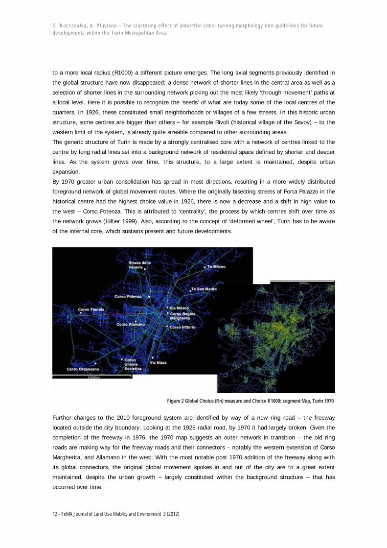
Figure 1 Global choice (Rn) measure and Choice R1000: Segment Map Turin 1926
Starting with the global choice measure, in 1926, a series of intersecting lines can be observed that pick up
the central grid structure.
Within the central area, the historic core has the highest values: bisecting streets Corso Regina Margherita
and Via Milano, forming the Porta Palazzo square (intersection of the two roads), Turin’s historic market
place.
Further south along the grid, Corso Vittorio, traversing the city from east to west is also picked up in red,
along with numerous parallel routes either side. This is attributed to the highly regular grid, which tends to
distribute movement more evenly than irregular grids. A series of radial lines carry movement from centre to
edge: Corso Francia (westward), Corso Orbassano (southwest), Corso Unione Sovietica and Via Nizza
(south), Strada della Veneria (northwest), and the road to Milan in the northeast. We also see a lateral road
outside the city, which, until 1912 was surrounded by the customs barrier (cinta daziaria from the 1906
masterplan). This ring road would have connected the surrounding villages without entering the city. Shifting
G. Roccasa lva, A . P luv iano – The c lus te r ing e f fec t o f indus t r ia l s i tes : tu rn ing morpho logy in to gu ide l ines fo r fu tu re deve lopments w i th in the Tur in Met ropo l i tan Area
12 - TeMA Journal of Land Use Mobility and Environment 3 (2012)
to a more local radius (R1000) a different picture emerges. The long axial segments previously identified in
the global structure have now disappeared: a dense network of shorter lines in the central area as well as a
selection of shorter lines in the surrounding network picking out the most likely ‘through movement’ paths at
a local level. Here it is possible to recognize the ‘seeds’ of what are today some of the local centres of the
quarters. In 1926, these constituted small neighborhoods or villages of a few streets. In this historic urban
structure, some centres are bigger than others – for example Rivoli (historical village of the Savoy) – to the
western limit of the system, is already quite sizeable compared to other surrounding areas.
The generic structure of Turin is made by a strongly centralised core with a network of centres linked to the
centre by long radial lines set into a background network of residential space defined by shorter and deeper
lines. As the system grows over time, this structure, to a large extent is maintained, despite urban
expansion.
By 1970 greater urban consolidation has spread in most directions, resulting in a more widely distributed
foreground network of global movement routes. Where the originally bisecting streets of Porta Palazzo in the
historical centre had the highest choice value in 1926, there is now a decrease and a shift in high value to
the west – Corso Potenza. This is attributed to ‘centrality’, the process by which centres shift over time as
the network grows (Hillier 1999). Also, according to the concept of ‘deformed wheel’, Turin has to be aware
of the internal core, which sustains present and future developments.
Figure 2 Global Choice (Rn) measure and Choice R1000: segment Map, Turin 1970
Further changes to the 2010 foreground system are identified by way of a new ring road – the freeway
located outside the city boundary. Looking at the 1926 radial road, by 1970 it had largely broken. Given the
completion of the freeway in 1976, the 1970 map suggests an outer network in transition – the old ring
roads are making way for the freeway roads and their connectors – notably the western extension of Corso
Margherita, and Allamano in the west. With the most notable post 1970 addition of the freeway along with
its global connectors, the original global movement spokes in and out of the city are to a great extent
maintained, despite the urban growth – largely constituted within the background structure – that has
occurred over time.

G. Roccasa lva, A . P luv iano – The c lus te r ing e f fec t o f indus t r ia l s i tes : tu rn ing morpho logy in to gu ide l ines fo r fu tu re deve lopments w i th in the Tur in Met ropo l i tan Area
13 - TeMA Journal of Land Use Mobility and Environment 3 (2012)
At local choice, however, it is apparent that the ‘seeds’ emerging in 1926 have now developed into a number
of sizeable centres.
Figure 3 Global Choice (Rn) measure and Choice R1000: segment Map, Turin 2010
According to Hillier, town centres are articulated where grid intensification coincides with the globally strong
alignments (Hillier 2009). Local properties are interrelated to global properties so that each centre is defined
in relation to the system as a whole. This is picked up through local choice measure R1000, with the
concentration of convex centres located along the global routes. In fact, a number of these formations
become visible by 1970, which continue to grow more ‘convex-like’ by 2010, with newer ones emerging as
grid intensification continues. While this gives a clear indication of the emergence of centres, a
comprehensive study of each local centre is not covered in this article. However it is important to say that
town centres and their emergence help explain the city's configuration in relation to functional distribution,
in this case industry.
As stated above, movement – by way of local and global networks, becomes key, not just because it gives
shape to the overall spatial system, but because it influences functional distributions within space by way of
the Movement economy (Hillier 1996).
4 CASE STUDY: INDUSTRIAL SYNTACTIC ANALYSES The syntactic analysis focused on the functional – spatial relationship related to industrial distribution. The
aim was to find the clustering logic of industrial distribution (linear logic, disperse logic, detached logic and
so on…). As the main literature has shown, movement is influenced by the spatial configuration of the urban
network. According to Hillier, the ‘movement economy’ impacts the functional distribution of land use: a
spatial system emerges, and as it does so it generates movement patterns, influencing land use
distributions. These in turn create ‘multiplier effects’ – i.e. influencing further distribution of certain land uses
to certain areas with further feedback on the local grid as it adapts to further development (Hillier 1996).
This explains why land uses such as shops and markets seek movement rich locations within the grid, and
other uses such as administrative or business zones are located in quieter zones in close spatial proximity to

G. Roccasa lva, A . P luv iano – The c lus te r ing e f fec t o f indus t r ia l s i tes : tu rn ing morpho logy in to gu ide l ines fo r fu tu re deve lopments w i th in the Tur in Met ropo l i tan Area
14 - TeMA Journal of Land Use Mobility and Environment 3 (2012)
the live centre. Examining the distribution of industry, it was initially assumed that industrial distribution is
heavily dependent on the foreground network, such that it may facilitate the transportation of materials as
well as workers to and from industrial areas and into the wider network.
Figure 4 Diagram of industrial units and cluster concentrations highlighted in yellow with a selection of most relevant choice measures

G. Roccasa lva, A . P luv iano – The c lus te r ing e f fec t o f indus t r ia l s i tes : tu rn ing morpho logy in to gu ide l ines fo r fu tu re deve lopments w i th in the Tur in Met ropo l i tan Area
15 - TeMA Journal of Land Use Mobility and Environment 3 (2012)
Starting with 1926, and without considering areas beyond the city limits, three distinct cluster of industrial
growth are identified.
The first cluster sits immediately north of city historic core, spreading west to east along the river from the
intersection between the Dora River and the northern railway line. From historical accounts, traditional
manufacturing such as textiles and armaments were located in this area. A second cluster is located further
south along the same railway line (the 19th century western city edge). The third area is in the southeast of
the city: bound by the southern railway line and the River Po to the east.
Upon first observation, the main organising logic at this point appears to be proximity to the railway lines
and water. Overlaying the industrial layout with segment map however, in the majority of cases industry is
nestled either between the railway lines and/or the river, and along or within close proximity to global choice
routes. There is a linear pattern of industrial distribution alongside the railway lines, it is possible to see that
high choice routes run parallel to the tracks. This suggests that the railway infrastructure is embedded within
the city’s movement network, meaning that those industries seeking proximity to the railway lines also
benefit from proximity to global movement. Furthermore, in the early twentieth century, Turin had a
comprehensive tram network system. The tramlines were traced over the system and overlaid onto the
segment map. It is possible to highlight that the main tram routes follow the global choice routes and the
shorter tramlines coincide with the more local choice routes (picked up at R1000), further enhancing
movement efficiency between industry and transport infrastructure.
Regarding the remaining industry within the city that appears more fragmented and randomly located,
almost all are located either on or in close proximity to the global choice routes of highest value. In
particular, there are a number of units located within the western fabric of the city – an area under rapid
expansion characterized by a less regular grid structure. Again, industry is located either on or close to
global routes identified in the segment map. Combining all industrial units in the system, and creating a 500
metric ‘buffer’ around the top 10% global routes, the analysis found that 82.18% of units are located within
these parameters.
From these results it is maintained that for industries that did not depend on the proximity of the railways or
water, configuration played an important part, spreading in a linear fashion along global choice routes,
setting the stage for future industrial settlement.
By 1970 – Fordist organisation at its peak – two overriding patterns emerge: firstly, industrial activity is
heavily intensified within the confines of the city: the areas previously identified in 1926 – the traditionally
industrial Borgo Dora north of the city has extended further north towards the Stura River, and significant
linear consolidation along the railway lines has developed. Secondly, a distinct pattern emerges from the
outer edges of the city centre spreading outwards into the surrounding periphery.
This pattern is consistent in all areas – from the north, west and southern edges of the city; as the central
agglomerations spread outwards they take on a very linear form. Overlaying industry with Choice, the
dispersal follows along or within close proximity to the main global choice routes. Measuring the relationship
between global choice routes and industrial distribution, a very high 59.26% of industrial units are located
within 500m of the highest 10% global choice routes highlighted on the segment analysis.
Returning to the city area, as more industry is rapidly introduced into the system the previously linear
patterns in 1926 have consolidated into thicker agglomerations of almost entirely industrial areas, which, as
they grow, start to occupy areas, which configurationally would benefit from other land use functions.
Syntactically, this is shown by the high amount of industry in the north and western parts of the city
occupying high local choice segments. This explains the overwhelming appearance of industry that

G. Roccasa lva, A . P luv iano – The c lus te r ing e f fec t o f indus t r ia l s i tes : tu rn ing morpho logy in to gu ide l ines fo r fu tu re deve lopments w i th in the Tur in Met ropo l i tan Area
16 - TeMA Journal of Land Use Mobility and Environment 3 (2012)
characterized Turin’s city in the second half of the twentieth century. This is also supported by the value of
18.09% of industrial units found to be located within 500m of the highest 10% local choice segments.
Is it possible to hypothesize that as industry settled along global routes in close proximity but not in the ‘live
centre’, as highlighted locally, they continued to expand (due to the manufacturing boom) into dense
agglomerations, in places occupying parts of the network that, all things being equal, would have carried
other land-uses?
Following the beginning of decline after the 1980s, the transformations are equally substantial. One part of
the system has experienced massive deindustrialisation, yet another has experienced new industrial growth.
Figure 5 The biggest industrial site of Turin Metropolitan area. Comparison of local choices in a cluster expansion period
By 2010 a reversed pattern of industrial distribution is presented. With the exception of the largest plants in
the system – FIAT Mirafiori to the south and IVECO to the northeast, with their adjoining agglomerations –
the city centre is almost entirely devoid of industry. The remaining industry is located on the boundary edge
of the city, and when viewed as a complete picture forms agglomerations that cross the administrative
boundaries. They are positioned at the edge of two systems: the edge of the city, and the edge of the
G. Roccasa lva, A . P luv iano – The c lus te r ing e f fec t o f indus t r ia l s i tes : tu rn ing morpho logy in to gu ide l ines fo r fu tu re deve lopments w i th in the Tur in Met ropo l i tan Area
17 - TeMA Journal of Land Use Mobility and Environment 3 (2012)
surrounding town centres. Syntactically, comparing the ‘Fordist’ period and the 2010 maps, linear pattern
has formed discrete clusters. Global movement routes again play an important role, as the clusters are
located off a portion of one of these segments, often nestled between two choice segments. Overlaying the
freeway (also picked up by global choice) we see a visible a correlation between the freeway and the
clusters. Unfortunately it was not possible to obtain a statistical correlation isolating the freeway routes,
however regarding the overall relationship between industry and global choice, it was found that 2010
displayed a lower, yet still high value of 38.6% of industry settling within 500 m from global choice routes.
Examining local choice measures, the transformation from linear to clustered form in relation to the
surrounding centres is even more visible. By comparing the 1970 segment map to today, in the transition
from linear to cluster, the relationship to local movement is less varied than in 1970, with industry
consistently nestling in low local movement areas.
Comparing the 1926-1970 periods to the 1970-2010, much of the grid intensification took place between the
first phases of study. Thus, in broad terms we can assume that land use and grid intensification was
occurring as a ‘live’ process.
As these centres grew over time, industry, as it happened within the city, sought the most peripheral areas
in relation to the town centres. These have emerged as almost entirely mono functional clusters with weak
local properties bound by high global properties (Pescarito area), from a spatial dimension, grid
intensification and the movement economy explain how this process takes place: linear agglomeration takes
its cue from global properties of the network, and island clustering, once settled according to global network,
depend on local grid conditions.
By extension, it would seem that linear dispersal represents a ‘first phase’ of (industrial) organization, and
‘island clustering’ a subsequent phase. These conclusions are based on observing local and global patterns
illustrated on the segment analysis, but would need to be further substantiated by more detailed empirical
evidence. However, it is possible to draw some evidence from the significantly lower value of 7.62% of
industrial units located within 500m of the highest 10% local (R1000) choice routes .
4.1 LOGIC OF CLUSTERING FROM 1970 ONWARD
In examining Turin’s industrial evolution, there has been a dual process occurring since the ‘crisis point’ from
the late 1970s onwards: significant deindustrialization by way of vacant and decommissioned sites within the
city boundary, and at the same time, a process of industrial clustering along the edges between the city and
wider metropolitan area. Up to the 1970’s, industry was widely dispersed within the city centre – particularly
the northern and western parts of the city. This is further supported by the high 38% of street segments
containing industrial land use.
However by 1989, nearly 1 million m2 of industrial land stood vacant and abandoned (Dansero 1996). By
2005, almost all of it had been reused.
Studying the breakdown of transformation, what role, if any, did configuration play as to the capacity for
transformation of industries? In order to examine the role of configuration and industrial transformation
more closely, industrial units were converted into points correlating land use values with syntactic values
(these points represented the phases before and after transformation - ie. industrial peak, those sites lost
through deindustrialization and those remaining after post-industrial transformation). A comparison was then
made between the R-values for each set of points. However, no significant correlations emerged, making it
difficult to ascertain the role of configuration in industrial transformation.

G. Roccasa lva, A . P luv iano – The c lus te r ing e f fec t o f indus t r ia l s i tes : tu rn ing morpho logy in to gu ide l ines fo r fu tu re deve lopments w i th in the Tur in Met ropo l i tan Area
18 - TeMA Journal of Land Use Mobility and Environment 3 (2012)
Moreover, comparing industrial streets segments that have been transformed into new uses, (Ex Industrial
streets) to current industrial streets, all show higher mean values. Segment Length and Metric step depth2
show that industry tends to be located in street segments of higher length compared to non-industrial
streets, as well as the system as a whole. Industry is also located in areas of greater step depth than those
without industry. Step depth, in segment analysis, follows the shortest angular path from selected segments
to all other segments within the system, thus it confirms again the shift of industry from close proximity to
global choice routes to areas nestled deeper in the system when measured from the global movement
routes.
Comparing ex-industrial streets to non-industrial streets, all syntactic measures tested were consistently
higher in ex industrial streets segments compared to non-industrial streets. Metric depth (Rn) measured
much lower in industrial streets at 407.193 compared to 711.179 confirming the trend for more recent
industry to seek deeper locations compared to in the past.
A summary of spatial-physical properties can be drawn from the logic of industrial cluster development:
− During the period of economic growth (1926-70), global choice measures coincide with railway
accessibility in the positioning of industrial sites. There is a correspondence between global movement,
industry and the railway system.
− During the period of economic growth (1926-70), industrial clustering emerges through linear
expansion. Clusters become denser and expand but they occupy land within the city core that is
syntactically suitable for other uses.
− During the period when industry relocates from the city to edge (1980-2010; knowledge society), linear
clusters become islands of discrete clusters.
− Linear clustering depends on global choices measure while island clustering is influenced by local
choices measures. The latter is visible in 1926 and 2010 period of analysis; it shows a locally
introverted morphology that reinforces the cluster.
− Shifting from industrial to other uses, the configuration displays higher mean values in the
deindustrialized sites and a preference for new industrial sites to be situated in areas with long
segmented length and step depth.
These are general and flexible rules, however they can orientate how clusters cooperate and adapt within a
resilient planning policy.
5 CONCLUDING REMARKS As explored through Scott, Harvey and others, space is central to industrial production, and the relationship
changes over time according to transitions within the cycle of production. The study found that spatial
configuration contributed to understanding the logic of industrial distribution. Furthermore, spatial
configuration elucidated the relationship between industrial land use with regards to the pattern of the cities
as a whole.
In the urban evolution of Turin it was found that industry moved and re-agglomerated over the three time
frames studied. It began as a linear process within the city and evolved into clusters towards the city edge
and surrounding towns. It was found that choice – a measure of movement throughout the system – played
an important role. In particular during the early years of industrial growth and as Fordist accumulation took
hold, reaching its peak around the 1970s, a significant proportion of industry was located along the primary
(global) movement routes. This figure became smaller over time as Fordism reached its maturity and a new
2 Syntactic measures which are directly connected with the length of the linear nature of urban spaces.

G. Roccasa lva, A . P luv iano – The c lus te r ing e f fec t o f indus t r ia l s i tes : tu rn ing morpho logy in to gu ide l ines fo r fu tu re deve lopments w i th in the Tur in Met ropo l i tan Area
19 - TeMA Journal of Land Use Mobility and Environment 3 (2012)
era of organisation took hold: industry spread, initially in a linear fashion away from the city, to form new
agglomerations, favourable to the demands of flexible specialisation and smaller interrelated industries. Such
arrangements are supported by configuration, with syntactic evidence of global and local choice routes
indicating a pattern of industrial settlement: industrial clusters located in ‘islands’ of weak local choice values
routes situated in close proximity or leading off high value global choice routes.
Despite deindustrialisation that characterised Turin’s city centre throughout the 1980s, industrial sites have
transformed to accommodate the emergent ‘knowledge society’ (Torino Internazionale 2006). Industry left
the core, and despite a period of decay and social unrest, the city has regained its image as a safe, vibrant,
and culturally rich centre for its citizens. How does this investment on the centre reconcile with its
surrounding periphery? Returning to Sieverts, he suggests that it is to a great extent because of this one
sided love that issues pertaining to an ‘unloved suburbia’ remain unchallenged (Sieverts 2003, 17). For this
reason, the division between city and countryside is maintained, despite the changing urban and social
reality. Turin’s masterplan argued for a ‘polycentric city open, able to unite people rather than isolate them.’
(Torino Internazionale 2006). Syntactic analyses displayed an overriding monocentric structure that persists.
If the ‘non-places’ of semi agricultural landscapes scattered with freeways, supermarkets and
monofunctional industrial parks dominate the outer suburban belt, how have the recent changes addressed
this world? While further detailed investigation of these areas would be required to ascertain a more
complete view of the relationship, the results from this study concur with Sievert’s view, that while
readapting to the needs of the ‘knowledge society’ which occupy the city core, the focus has again returned
to the city, leaving unanswered questions relating to the surrounding environement.
It is possible to conclude, however, that configurational analysis has demonstrated the powerful contribution
of space in facilitating post-industrial change. Currently, a new public organization is studying the new
Strategic Plan for Turin3. It is suggested that spatial configuration, by way of the interdependence between
local and global networks, can further assist and should be taken into consideration when future questions
pertaining to the surrounding urban territory are raised and new planning strategies are proposed.
REFERENCES
Are M., Venere M. (2006) Il Riuso di 128 Area Industriali a Torino: Conclusione del Monitoraggio 1989-2005, Tesi di Laurea, Facolta di Architettura, Politecnico di Torino.
Bazzanella L., Caneparo L., Corsico F., Roccasalva G. (2012) The Future of Cities and Regions: simulation, scenario, Governance and Scale, Springer.
Castells M. (1989) The Information City, Blackwell, Oxford.
Corsico F., Roccasalva G. (2005) “Visu-an-alyse indicators of urban quality. The crucial role of forecasting Scenarios in sustainable decision making processes”, International Conference for Integrating Knowledge and Practice, Life in The urban Landscape, Gothenburg.
Dansero E., Giaimo C., Spaziante A. (2008) Se i Vuoti Si Riempiono; Aree Industriali Dismesse: Temi e Ricerche, Alinea, Firenze.
De Rossi A., Durbiano G. (2006) Turin 1980-2011; Its Transformations and its Images, Allemandi, Turin.
Gartman D. (2009) From Autos to Architecture; Fordism and Architectural Aesthetics of the Twentieth Century, Princeton Architectural Press, Princeton.
Hall P. (1998) Cities in Civilisation, Phoenix Giant, London.
Harvey D. (1978) “The urban process under capitalism: A Framework for Analysis”, International Journal of Urban and Regional Research, 2(1-4), 101-131. 3 ‘Torino Strategica’ took the legacy of ‘Torino Internazionale’ and is studying new strategies for the Metropolitan Area of Turin.

G. Roccasa lva, A . P luv iano – The c lus te r ing e f fec t o f indus t r ia l s i tes : tu rn ing morpho logy in to gu ide l ines fo r fu tu re deve lopments w i th in the Tur in Met ropo l i tan Area
20 - TeMA Journal of Land Use Mobility and Environment 3 (2012)
Harvey D (1990) The Condition of Postmodernity, Blackwell, Oxford.
Hiller B., Hanson J. (1984) The Social Logic of Space, Cambridge University Press, Cambridge.
Hillier B. (1996) Cities as Movement Economies, Cambridge University Press, Cambridge.
Hillier B. (1999) “Centrality as a process: accounting for attraction inequalities in deformed grids”, Urban Design International, 4, 107-127.
Hillier B., Netto V. (2001a) “Society as seen through the prism of space-outline of a theory of society and space”, Proceedings of the 3rd International Space Syntax Symposium, Atlanta, 13.1-13.27.
Hillier B. (2007) Space is the machine: a configurational theory of architecture. Space Syntax, London.
Hillier B., Turner A., Yang T., Park H.-T. (2007) “Metric and topogeometric properties of urban street networks: some convergences, divergences, and new results”, 6th International Space Syntax Symposium, Istanbul, Turkey.
Hillier B., Vaughan L. (2007) “The City as One Thing”, Progress in Planning, 67(3), 205-230.
Hillier B. (2009) “Spatial Sustainability in Cities; Organic Patterns and Sustainable Forms”, D. Koch, L. Marcus, J. Steen (eds.), Proceedings of the 7th International Space Syntax Symposium, KTH, Stockholm.
Hillier B. (2009) “The Genetic Code For Cities – Is it simpler than we think?”, Conference on Complexity Theories Of Cities Have Come Of Age , Keynote Paper, TU Delft.
Hillier B., Turner A., Yang T. Park H. (2010) “Metric And Topo-Geometric Properties Of Urban Street Networks; Some convergences, divergences and new results”, The Journal of Space Syntax, 1(2).
IRES (2008) Carta del territorio: La Proposta del Piemonte per un nuovo governo del territorio regionale, IRES, Torino.
Jacobs J (1969) The Economy of Cities, Pelican Books, Gretna.
Maggi M., Piperno S. (1999) Turin, The Vain Search for Gargantua, Working Paper, 124, IRES, Torino.
Nelson G. (1939) The Industrial Architecture of Albert Khan, Architectural Book Publishing Company, New York.
Sieverts T (2003) Cities without Cities: An Interpretation of the Zwischenstadt, Spon Press, London, New York.
Torino Internazionale (2006) Second Strategic Plan for Torino’s Metropolitan Area, downloaded http://www.torino-internazionale.org/EN/.
Turner A. (2004) Depthmap 4: a researcher's handbook, Bartlett School of Graduate Studies, University College London, London.
Yang T. Hillier B. (2007) The fuzzy boundary: the spatial definition of urban areas. Istanbul Technical University, Istanbul.
ACKNOWLEDGEMENTS The essay is due to a collaboration between Giuseppe Roccasalva and Amanda Pluviano and images are elaborated for this article and adapted from her Master’s thesis at The Bartlett, UCL. AUTHORS’ PROFILE Giuseppe Roccasalva Giuseppe Roccasalva is Architect and Research Assistant in the School of Architecture at the Polytechnic of Turin from 2003, professor in sustainable design and planning. He has got international learning and professional experiences in urban design and spatial planning (C.T.H and K.T.H of Sweden). He has received award from European educational bodies and has published articles on design decision support systems and scenario making process. He is an expert in urban morphological analyses ranging from GIS-based analysis to sustainable community based design. He is consultant for architectural offices, private companies and public authorities. He is president of local landscape and environmental committees in the area of Turin. Amanda Pluviano Amanda Pluviano (b.1978) trained in architecture at the University of Sydney, and The Bartlett, University College London. With a wide range of architectural experience in Australia and Europe she adopts an evidence-based approach to design and research. Research includes a survey of architectural competitions in China, Italy and Australia and has recently completed her Master’s thesis on the spatial dynamics of industrial and post-industrial cities. Working on large-scale projects, she is interested in the public dimension of architecture. She currently resides between Annecy, France and London.