climatology of the northern-central adriatic...
TRANSCRIPT
7
Climatology of the Northern-Central Adriatic Sea
Aniello Russo1,2, Sandro Carniel2,*, Mauro Sclavo2 and Maja Krzelj3 1Marche Polytechnic University-DISVA, Ancona
2The National Research Council, Institute of Marine Sciences, Venice 3University of Split, Center of Marine Studies, Split
1,2Italy 3Croatia
1. Introduction
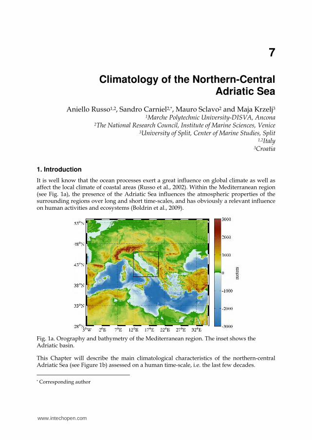
It is well know that the ocean processes exert a great influence on global climate as well as affect the local climate of coastal areas (Russo et al., 2002). Within the Mediterranean region (see Fig. 1a), the presence of the Adriatic Sea influences the atmospheric properties of the surrounding regions over long and short time-scales, and has obviously a relevant influence on human activities and ecosystems (Boldrin et al., 2009).
Fig. 1a. Orography and bathymetry of the Mediterranean region. The inset shows the Adriatic basin.
This Chapter will describe the main climatological characteristics of the northern-central Adriatic Sea (see Figure 1b) assessed on a human time-scale, i.e. the last few decades.
* Corresponding author
www.intechopen.com
Modern Climatology
178
Generally speaking, the Adriatic sea and the above atmosphere are tightly linked and together form a dynamic component of the local climate system, where the relationships are intrinsically two-way (Pullen et al., 2006). For example, short-term fluctuations in wind or temperature (i.e. weather), as well as the atmospheric action of blocking rays, can influence the currents through wind-driven processes (see for instance Carniel et al., 2009) and prevent the warming of the underlying ocean (Boldrin et al., 2009; Dorman et al., 2006).
At the same time, the atmospheric temperature and precipitation rates are relevantly affected by the variation of the sea surface temperature (SST) through processes like evaporation and cyclone development.
Besides, the atmosphere can strongly affect the density differences that are triggering baroclinic Adriatic currents (Vilibic and Supic, 2005), by intense cooling driven by turbulent heat fluxes exchange through the air-sea interface, or by changing surface salinity according to evaporation/precipitation balance. Namely, currents generated during processes typical of the "deep-water formation" are particularly important for climate. For instance, in the relatively shallow northern Adriatic Sea, during winter time, surface cooling due to strong sensible and evaporative heat losses can cause water to become more dense (Bergamasco et al., 1999; Vilibic and Supic, 2005), leading to mixing and convective overturning processes. The resulting dense waters tend to spread out over the whole basin, moving to the southern region (Carniel et al., 2012) and triggering a return circulation from the Ionian and Aegean region that is called into the basin by continuity. Such waters are transported by the Adriatic Sea eastern currents and influence the local climate by transporting relevant amount of heat (Boldrin et al., 2009).
A thorough description of the northern-central Adriatic Sea main climatological characteristics would then help to understand the influence that this sea may have, also through its direct link with the atmosphere (e.g. temperature and precipitation) and marine ecosystems, on relevant aspects and activities of the society, such as tourism, fisheries, navigation, etc.
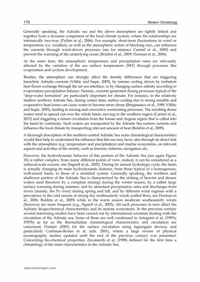
However, the hydrodynamic behavior of this portion of the Adriatic Sea (see again Figure 1b) is rather complex; from many different points of view, indeed, it can be considered as a reduced-scale oceanic one (Signell et al., 2005). During its annual hydrologic cycle, the basin is actually changing its main hydrodynamic features, from those typical of a homogenous, well-mixed basin, to those of a stratified system. Generally speaking, the northern and shallower portion of the Adriatic Sea is characterized by the sinking of heavier and denser waters (and therefore by a complete mixing) during the winter season, by a rather large surface warming during summer, and by abundant precipitation rates and discharges from rivers (mainly, the Po river) during spring and fall, and by different wind regimes with a prevalence in the cold season of strong dry northeasterly winds (called Bora, see Dorman et al., 2006; Boldrin et al., 2009) while in the warm season moderate southeasterly winds (Scirocco) are more frequent (e.g., Signell et al., 2005). All such processes in turn affect the Adriatic biogeochemical characteristics and its marine ecosystems. In the previous century several interesting studies have been carried out by international scientists dealing with the circulation of the Adriatic sea. Some of them are well condensed in Artegiani et al. (1997a; 1997b) as far as the thermohaline climatological characteristics and circulation are concerned, Poulain (2001) for the surface circulation using lagrangian devices, and particularly Cushman-Roisin et al. (eds. 2001), where a large review of physical oceanography studies updated until the end of the previous century was presented. Concerning bio-chemical properties, Zavatarelli et al. (1998) defined for the first time a climatology of the main characteristics in the Adriatic Sea.
www.intechopen.com
Climatology of the Northern-Central Adriatic Sea
179
In the following text seasonal climatology of physical and chemical properties of the water masses in the northern and central Adriatic sea are described.
Fig. 1b. Adriatic Sea orography and bathymetry. The dots represent the stations extracted from MEDATLS 2002 archive and used to compute the seasonal climatology of the northern-central portion of the Sea.
2. Materials and methods
First climatological studies of the Adriatic Sea date back to the end of the previous century,
namely Russo and Artegiani (1996), Artegiani et al. (1997a and 1997b), Zavatarelli et al.
(1998) gathered and analyzed more than 4000 stations distributed in the whole Adriatic Sea.
In the same period some relevant European projects started, with the aim of establishing larger data base focused in the Mediterranean region. The final result was reached in the data base MEDAR/MEDATLAS 2002 (MEDAR Group, 2002). This dataset encompasses more than 8800 quality checked stations in the northern and central basin.
Using the stations located in the northern central Adriatic region, a seasonal climatology has been derived (a monthly one is not achievable, standing the low data frequency during some specific months) for temperature, salinity, dissolved oxygen and nutrients (nitrates, nitrites, ortho-silicates, ortho-phosphate) that will be discussed in the next sections. Seasons are
www.intechopen.com

Modern Climatology
180
defined as follows: winter season is represented by January-February-March months (JFM), spring by April-May-June (AMJ), summer brackets July-August-September (JAS), while fall includes October-November-December (OND). Data have been selected accordingly to seasons and spatially interpolated by means of an Objective Analysis (OA) technique adopted for ocean data (see Bretherton et al., 1976 and Carter and Robinson, 1987), as applied in Artegiani et al. (1997b) and Russo et al. (2002). The interpolation has been performed according to the optimal linear estimation theory, based on the Gauss-Markov theorem.
The adopted correlation function is isotropic and has the following expression:
C(r) = (1 - r2/a2) exp (-r2/2b2) , r2 = x2 + y2 (1)
where a is the zero-crossing distance, b the spatial decay scale. These parameters should meet the condition a > 21/2 b to generate a positive-definite correlation matrix. Since the Chapter is focused on the analysis of climatological fields, large values (a= 100 km and b= 60 km) compared to mesoscale features have been chosen. The observational noise is approximated by an error variance of 10%. All the observations closer to each other than 10 km have been preliminarily averaged in order to avoid very high correlations. The number of influential points is chosen to be 10 and the mapping resolution is 0.05° both in latitude
and longitude. The total domain consists of 8181 points, and areas with error variance greater than 30% have been blanked.
3. Seasonal climatology of water masses
Main thermohaline and chemical properties (namely temperature, salinity, dissolved oxygen, nitrates, nitrites, ortho-phosphate and ortho-silicates) are described seasonally at the surface, at the depth of 10 m, 20 m, 50 m and at the bottom layer.
3.1 Temperature
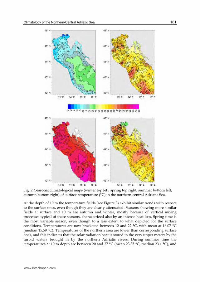
Sea surface temperature (see Figure 2) shows a strong seasonal cycle, with winter values well below 10 °C along the Italian coastal region till the Gargano and minima in the northern region. Maxima values, above 25 °C, are reached in the south-western area. During winter the mean temperature in the basin is of 11.56 °C (12.23 °C is the median). A thermal gradient is present both along the longitudinal and transversal axis, with mean temperature below 7 °C in the north and above 13 °C in the south-eastern area. This is also due to the cyclonic circulation of the basin, that brings in warmer waters from the southern basin, while the northernmost waters, subjected to large heat losses due to Bora winds (strong katabatic winds coming from NE), are transported to the south-east along the Italian coast (Dorman et al., 2006). Colder waters are also found in the sea region in the proximity of the Dalmatian islands and eastern coast, an area that is directly exposed to the cold Bora wind action. During spring time the situation is more variable. Mean temperatures in the region are comprised between 14-23 °C (mean value 17.3 °C, median 17.07 °C), with maxima found in the western region and minima in the Dalmatian islands area. In the summer time the thermal variability is much lower, with mean values bracketed between 21 and 27 °C (mean 24.47 °C, median 24.44 °C), and maxima in the south-west region, minima in the eastern one (also because of upwelling phenomena). During the fall season the surface waters get cooled down, and this happens faster in the north-east and south-west part of the basin, with values between 13 and 22 °C (averaged values in the area being 18.14 °C, median 18.37 °C).
www.intechopen.com
Climatology of the Northern-Central Adriatic Sea
181
Fig. 2. Seasonal climatological maps (winter top left, spring top right, summer bottom left, autumn bottom right) of surface temperature (°C) in the northern-central Adriatic Sea.
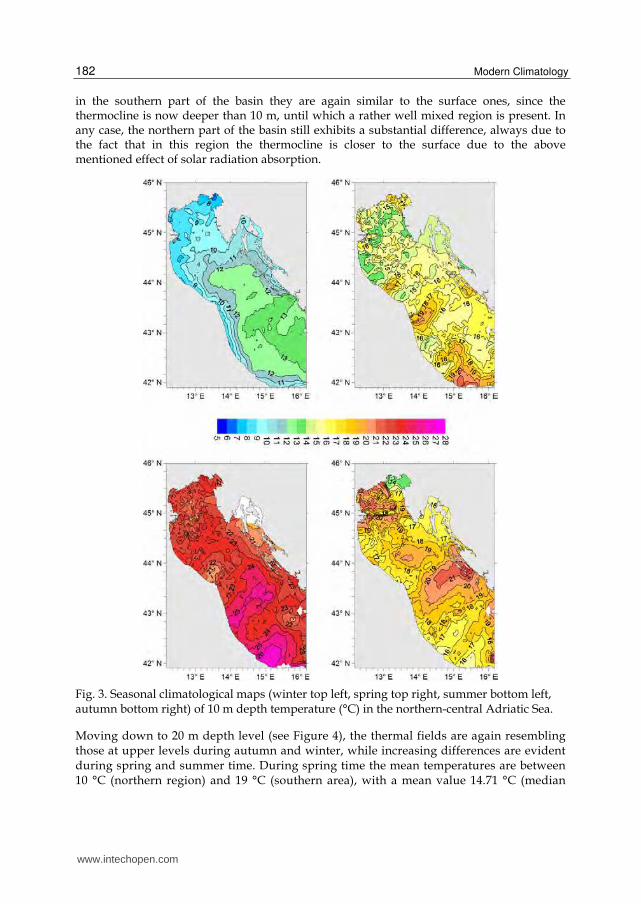
At the depth of 10 m the temperature fields (see Figure 3) exhibit similar trends with respect to the surface ones, even though they are clearly attenuated. Seasons showing more similar fields at surface and 10 m are autumn and winter, mostly because of vertical mixing processes typical of these seasons, characterized also by an intense heat loss. Spring time is the most variable season, even though to a less extent to what depicted for the surface conditions. Temperatures are now bracketed between 12 and 22 °C, with mean at 16.07 °C (median 15.59 °C). Temperatures of the northern area are lower than corresponding surface ones, and this indicates that the solar radiation heat is stored in the very upper meters by the turbid waters brought in by the northern Adriatic rivers. During summer time the temperatures at 10 m depth are between 20 and 27 °C (mean 23.35 °C, median 23.1 °C), and
www.intechopen.com
Modern Climatology
182
in the southern part of the basin they are again similar to the surface ones, since the thermocline is now deeper than 10 m, until which a rather well mixed region is present. In any case, the northern part of the basin still exhibits a substantial difference, always due to the fact that in this region the thermocline is closer to the surface due to the above mentioned effect of solar radiation absorption.
Fig. 3. Seasonal climatological maps (winter top left, spring top right, summer bottom left, autumn bottom right) of 10 m depth temperature (°C) in the northern-central Adriatic Sea.
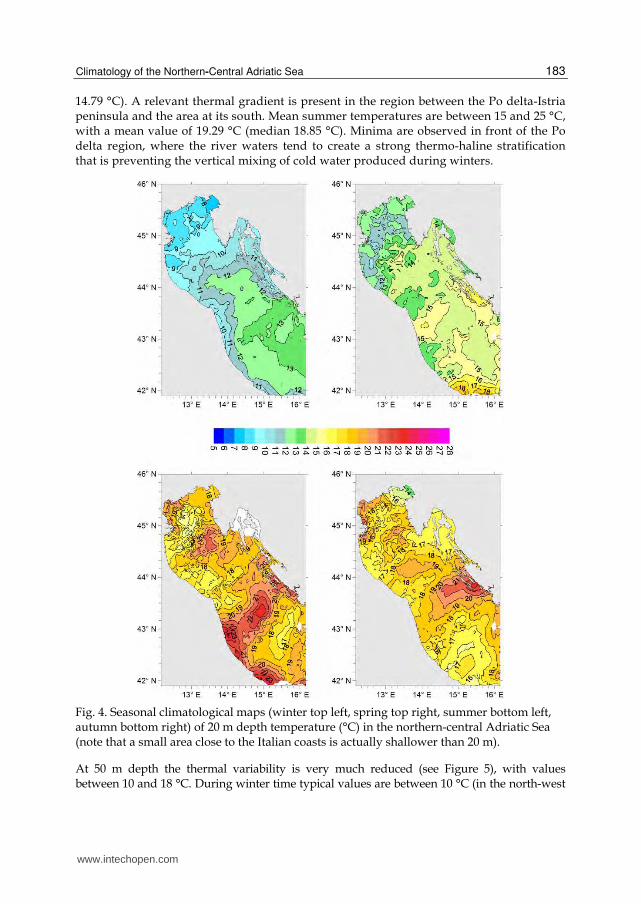
Moving down to 20 m depth level (see Figure 4), the thermal fields are again resembling those at upper levels during autumn and winter, while increasing differences are evident during spring and summer time. During spring time the mean temperatures are between 10 °C (northern region) and 19 °C (southern area), with a mean value 14.71 °C (median
www.intechopen.com
Climatology of the Northern-Central Adriatic Sea
183
14.79 °C). A relevant thermal gradient is present in the region between the Po delta-Istria peninsula and the area at its south. Mean summer temperatures are between 15 and 25 °C, with a mean value of 19.29 °C (median 18.85 °C). Minima are observed in front of the Po delta region, where the river waters tend to create a strong thermo-haline stratification that is preventing the vertical mixing of cold water produced during winters.
Fig. 4. Seasonal climatological maps (winter top left, spring top right, summer bottom left, autumn bottom right) of 20 m depth temperature (°C) in the northern-central Adriatic Sea (note that a small area close to the Italian coasts is actually shallower than 20 m).
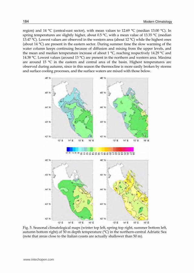
At 50 m depth the thermal variability is very much reduced (see Figure 5), with values between 10 and 18 °C. During winter time typical values are between 10 °C (in the north-west
www.intechopen.com
Modern Climatology
184
region) and 14 °C (central-east sector), with mean values to 12.69 °C (median 13.00 °C). In spring temperatures are slightly higher, about 0.5 °C, with a mean value of 13.35 °C (median 13.47 °C). Lowest values are observed in the western area (about 12 °C) while the highest ones (about 14 °C) are present in the eastern sector. During summer time the slow warming of the water column keeps continuing because of diffusion and mixing from the upper levels, and the mean and median temperature increase of about 1 °C, reaching respectively 14.29 °C and 14.38 °C. Lowest values (around 13 °C) are present in the northern and western area. Maxima are around 15 °C in the eastern and central area of the basin. Highest temperatures are observed during autumn, since in this season the thermocline is more easily broken by storms and surface cooling processes, and the surface waters are mixed with those below.
Fig. 5. Seasonal climatological maps (winter top left, spring top right, summer bottom left, autumn bottom right) of 50 m depth temperature (°C) in the northern-central Adriatic Sea (note that areas close to the Italian coasts are actually shallower than 50 m).
www.intechopen.com

Climatology of the Northern-Central Adriatic Sea
185
Mean temperature and median one are 15.57 and 15.24 °C respectively, with highest values that are aligned almost parallel to the eastern (until 18 °C) and western coasts, while the lowest values (up to 14 °C) are found in the middle of the basin.
In the layer closer to the sea bottom (see Figure 6), the thermal variability during the seasons is once again rather large (from 7 to 25 °C), mostly because of the bathymetric variations.
Fig. 6. Seasonal climatological maps (winter top left, spring top right, summer bottom left, autumn bottom right) of bottom temperature (°C) in the northern-central Adriatic Sea.
During winter the mean temperature is about 12.25 °C (median 12.92 °C); closer to the western coast, where the bottom is shallower, cold waters are encountered, with temperatures lower than 9 °C, while maxima (more than 14 °C) are found in the south-eastern region, reflecting the flow of warmer and southern waters. Relative minima are
www.intechopen.com
Modern Climatology
186
depicted in the central-southern region, in proximity of the meso-Adriatic depressions (see Figure 1b), where the dense and cold northern Adriatic waters can get accumulated without being vertically mixed during the year because of relatively high depths.
During spring time the temperature variations are limited, being the mean and median respectively of 12.73 and 12.78 °C. However, the shallow water regions along the western coasts exhibit now larger temperatures, similar to those of the eastern ones, while the central and southern areas of the basin are colder, because of the bottom currents that flush along south-east the colder and denser northern Adriatic waters formed during winter time.
During summer time the thermal picture is a lot different, with very high temperatures all along the Italian coast and minima (below 12 °C) in correspondence of the meso-Adriatic pits. Even the central region between Po delta and Istria, in the depths around 40 m, is showing now relatively low values (around 13 °C). Mean temperature of the entire domain is 15.52 °C (median 14.26 °C). The area between Dalmatian islands and Croatian coasts is very much variable, though, having warmer regions being interrupted by colder ones, reflecting a very troubled topography and probably also a data paucity.
During fall time higher values are all long the coastal regions, while lower temperatures are found in correspondence of meso-Adriatic depressions. The central regions, including the quite shallow Po-Istria area, reach in this season the highest temperature of the whole year.
3.2 Salinity
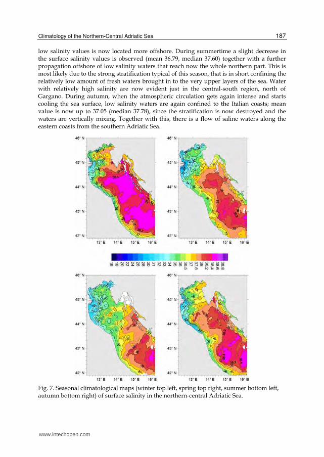
Surface salinity (see Figure 7) shows a strong variability (from less than 30.00 to 38.50; salinity is expressed with a non-dimensional number substantially corresponding to grams of salt dissolved in a kg of water), especially if compared to the Mediterranean Sea, since there are relevant river discharges (the Po river has a mean discharge of 1500 m3/s) and the basin is characterized by a shallow coastal region. However, maxima salinities are reached during winter and minima ones in summer, that is not perfectly matching Po river discharge, whose maxima are reached in spring-autumn and minima in summer. During winter, the mean salinity is 37.40 (median 38.18); along the coastal region there exists a band of low salinity waters, which largest extension is found in front of the Po delta area.
The whole northern area between the Po river delta and Istria peninsula has salinity values lower than 38.00, while higher values (up to 38.40) are observed in the central-eastern region of the basin. Moreover, along the Croatian coasts there are regions with low salinity water masses as well, because of local fresh river discharges and karstic springs.
The resulting salinity field in the Adriatic basin not only reflects the fresh water discharges distribution, but the marine dynamics as well. More saline water masses are brought in from south, transported by the so-called Eastern-Adriatic Current (EAC), while fresher waters are flowing to south-east with the Western Adriatic Current (WAC). Besides, dominant Bora winds from north-east are pushing the fresher waters closer to the western coast. During spring time a generalized decrease of the mean salinity values is depicted, with average of 36.93 (median 37.71); a significant offshore propagation of the area at low salinity is evident, as a consequence of the high discharge rate of the Po river and of the onset of the thermal stratification, that is confining the riverine waters in the upper layers of the water column. Minima are now well below 30.00 in the Po delta region, while values larger than 34.00 are found in small areas of the southern part. Along the Croatian coasts as well the region with
www.intechopen.com
Climatology of the Northern-Central Adriatic Sea
187
low salinity values is now located more offshore. During summertime a slight decrease in the surface salinity values is observed (mean 36.79, median 37.60) together with a further propagation offshore of low salinity waters that reach now the whole northern part. This is most likely due to the strong stratification typical of this season, that is in short confining the relatively low amount of fresh waters brought in to the very upper layers of the sea. Water with relatively high salinity are now evident just in the central-south region, north of Gargano. During autumn, when the atmospheric circulation gets again intense and starts cooling the sea surface, low salinity waters are again confined to the Italian coasts; mean value is now up to 37.05 (median 37.78), since the stratification is now destroyed and the waters are vertically mixing. Together with this, there is a flow of saline waters along the eastern coasts from the southern Adriatic Sea.
Fig. 7. Seasonal climatological maps (winter top left, spring top right, summer bottom left, autumn bottom right) of surface salinity in the northern-central Adriatic Sea.
www.intechopen.com
Modern Climatology
188
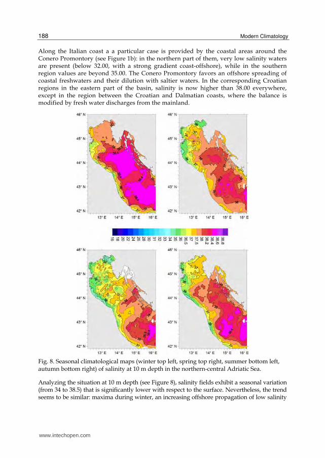
Along the Italian coast a a particular case is provided by the coastal areas around the Conero Promontory (see Figure 1b): in the northern part of them, very low salinity waters are present (below 32.00, with a strong gradient coast-offshore), while in the southern region values are beyond 35.00. The Conero Promontory favors an offshore spreading of coastal freshwaters and their dilution with saltier waters. In the corresponding Croatian regions in the eastern part of the basin, salinity is now higher than 38.00 everywhere, except in the region between the Croatian and Dalmatian coasts, where the balance is modified by fresh water discharges from the mainland.
Fig. 8. Seasonal climatological maps (winter top left, spring top right, summer bottom left, autumn bottom right) of salinity at 10 m depth in the northern-central Adriatic Sea.
Analyzing the situation at 10 m depth (see Figure 8), salinity fields exhibit a seasonal variation (from 34 to 38.5) that is significantly lower with respect to the surface. Nevertheless, the trend seems to be similar: maxima during winter, an increasing offshore propagation of low salinity
www.intechopen.com

Climatology of the Northern-Central Adriatic Sea
189
areas from the Italian coast while transitioning from winter to summer. During winter the trend is substantially similar to the surface one, since in this season the water column is very well mixed. The domain mean salinity value is 37.94, median being 38.25.
The northern region is the only one where values that are lower with respect to the previous situation can be seen (most likely due to the Po river flooding events that reach offshore areas before getting mixed). During spring period the mean salinity value reaches 37.71 (median 37.94), and a salinity lowering compared to the previous season is evident in almost the whole basin. The same is evident in summer for most of the basin, with a relevant freshening above all in the northern area, while during autumn salinities begin to increase.
Fig. 9. Seasonal climatological maps (winter top left, spring top right, summer bottom left, autumn bottom right) of salinity at 20 m depth in the northern-central Adriatic Sea.
Salinity fields at 20 m depth (see Figure 9) are resembling those at 10 m depth as far as the central-eastern sectors are concerned, while they change significantly in the north-western
www.intechopen.com
Modern Climatology
190
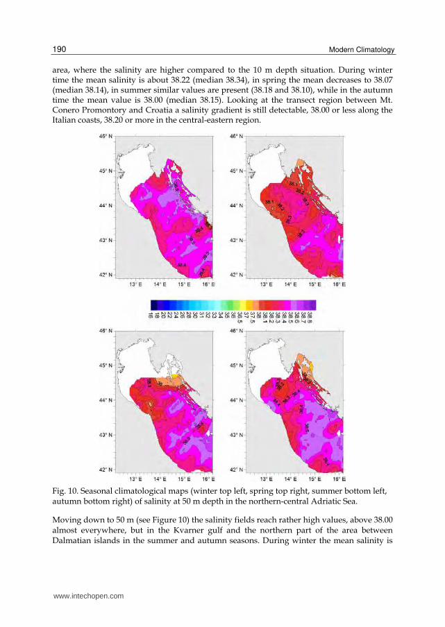
area, where the salinity are higher compared to the 10 m depth situation. During winter time the mean salinity is about 38.22 (median 38.34), in spring the mean decreases to 38.07 (median 38.14), in summer similar values are present (38.18 and 38.10), while in the autumn time the mean value is 38.00 (median 38.15). Looking at the transect region between Mt. Conero Promontory and Croatia a salinity gradient is still detectable, 38.00 or less along the Italian coasts, 38.20 or more in the central-eastern region.
Fig. 10. Seasonal climatological maps (winter top left, spring top right, summer bottom left, autumn bottom right) of salinity at 50 m depth in the northern-central Adriatic Sea.
Moving down to 50 m (see Figure 10) the salinity fields reach rather high values, above 38.00 almost everywhere, but in the Kvarner gulf and the northern part of the area between Dalmatian islands in the summer and autumn seasons. During winter the mean salinity is
www.intechopen.com
Climatology of the Northern-Central Adriatic Sea
191
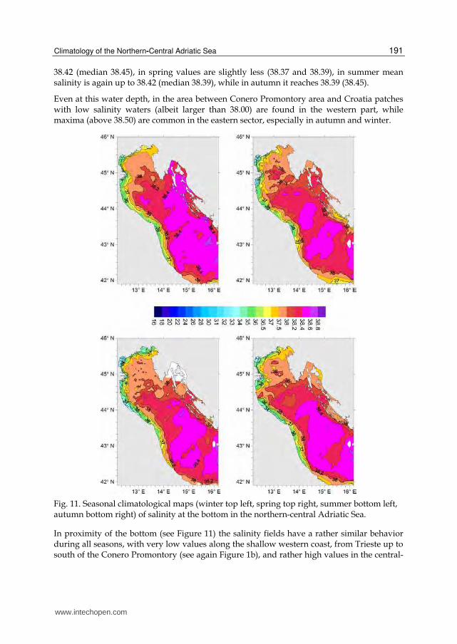
38.42 (median 38.45), in spring values are slightly less (38.37 and 38.39), in summer mean salinity is again up to 38.42 (median 38.39), while in autumn it reaches 38.39 (38.45).
Even at this water depth, in the area between Conero Promontory area and Croatia patches with low salinity waters (albeit larger than 38.00) are found in the western part, while maxima (above 38.50) are common in the eastern sector, especially in autumn and winter.
Fig. 11. Seasonal climatological maps (winter top left, spring top right, summer bottom left, autumn bottom right) of salinity at the bottom in the northern-central Adriatic Sea.
In proximity of the bottom (see Figure 11) the salinity fields have a rather similar behavior during all seasons, with very low values along the shallow western coast, from Trieste up to south of the Conero Promontory (see again Figure 1b), and rather high values in the central-
www.intechopen.com
Modern Climatology
192
eastern regions. The reduced variability throughout the season is also evident in the mean (and median) values: during winter values are up to 37.98 and 38.89 respectively, in spring these values are preserved to 37.90 (38.29); during summer values are 37.87 (38.32) and in autumn 37.84 (38.29).
3.3 Dissolved oxygen
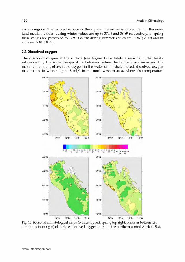
The dissolved oxygen at the surface (see Figure 12) exhibits a seasonal cycle clearly influenced by the water temperature behavior; when the temperature increases, the maximum amount of available oxygen in the water diminishes. Indeed, dissolved oxygen maxima are in winter (up to 8 ml/l in the north-western area, where also temperature
Fig. 12. Seasonal climatological maps (winter top left, spring top right, summer bottom left, autumn bottom right) of surface dissolved oxygen (ml/l) in the northern-central Adriatic Sea.
www.intechopen.com

Climatology of the Northern-Central Adriatic Sea
193
minima are found), while minima (4.5 ml/l) are measured in summer, in the southern- eastern part of the basin. During all seasons, the amount of oxygen dissolved in the western areas is generally larger than in the corresponding eastern areas.
Dissolved oxygen fields at 10 m depth (not showed) are very similar to the surface ones during all seasons, showing a reduced spatial variability.
At 20 m depth, the dissolved oxygen fields (see Figure 13) are different, mostly during summer time. At this depth, the western regions are characterized by lower values, and minima are present in the Gulf of Trieste and southern of the Po delta region, indicating hypoxic conditions in such shallow regions.
Fig. 13. Seasonal climatological maps (winter top left, spring top right, summer bottom left, autumn bottom right) of dissolved oxygen (ml/l) at 20 m depth in the northern-central Adriatic Sea.
www.intechopen.com
Modern Climatology
194
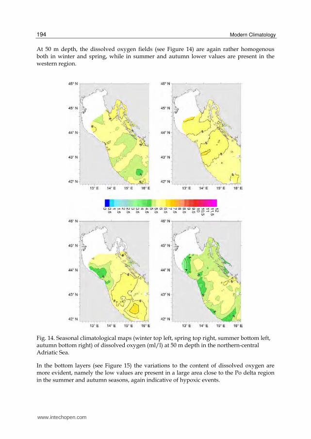
At 50 m depth, the dissolved oxygen fields (see Figure 14) are again rather homogenous both in winter and spring, while in summer and autumn lower values are present in the western region.
Fig. 14. Seasonal climatological maps (winter top left, spring top right, summer bottom left, autumn bottom right) of dissolved oxygen (ml/l) at 50 m depth in the northern-central Adriatic Sea.
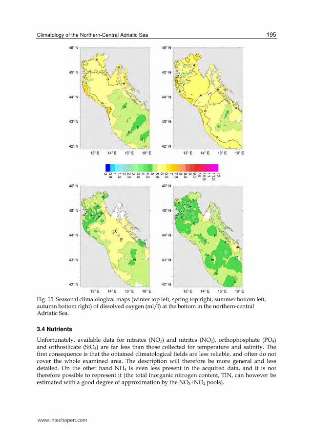
In the bottom layers (see Figure 15) the variations to the content of dissolved oxygen are more evident, namely the low values are present in a large area close to the Po delta region in the summer and autumn seasons, again indicative of hypoxic events.
www.intechopen.com
Climatology of the Northern-Central Adriatic Sea
195
Fig. 15. Seasonal climatological maps (winter top left, spring top right, summer bottom left, autumn bottom right) of dissolved oxygen (ml/l) at the bottom in the northern-central Adriatic Sea.
3.4 Nutrients
Unfortunately, available data for nitrates (NO3) and nitrites (NO2), orthophosphate (PO4) and orthosilicate (SiO4) are far less than those collected for temperature and salinity. The first consequence is that the obtained climatological fields are less reliable, and often do not cover the whole examined area. The description will therefore be more general and less detailed. On the other hand NH4 is even less present in the acquired data, and it is not therefore possible to represent it (the total inorganic nitrogen content, TIN, can however be estimated with a good degree of approximation by the NO3+NO2 pools).
www.intechopen.com
Modern Climatology
196
3.4.1 Nitrates and nitrites
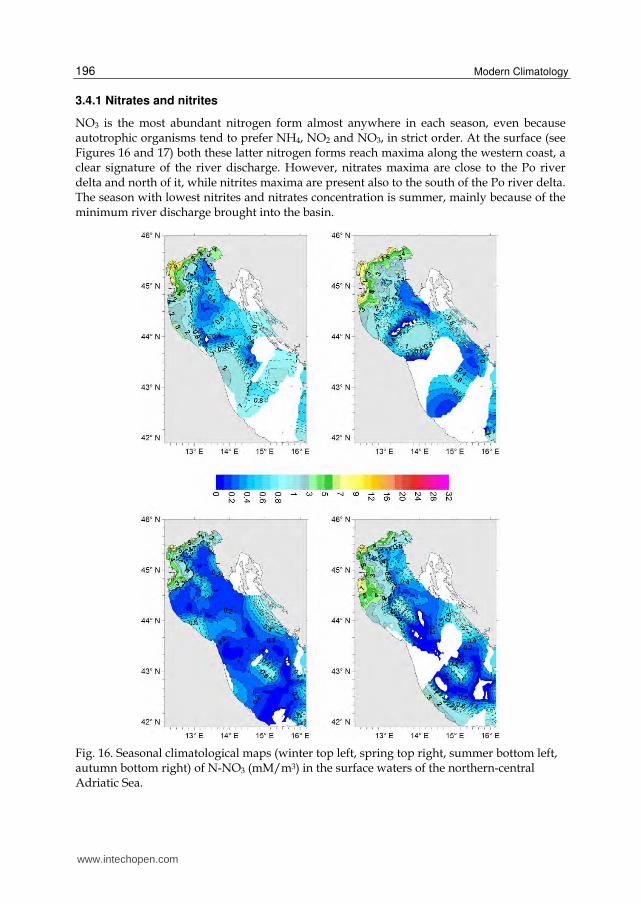
NO3 is the most abundant nitrogen form almost anywhere in each season, even because autotrophic organisms tend to prefer NH4, NO2 and NO3, in strict order. At the surface (see Figures 16 and 17) both these latter nitrogen forms reach maxima along the western coast, a clear signature of the river discharge. However, nitrates maxima are close to the Po river delta and north of it, while nitrites maxima are present also to the south of the Po river delta. The season with lowest nitrites and nitrates concentration is summer, mainly because of the minimum river discharge brought into the basin.
Fig. 16. Seasonal climatological maps (winter top left, spring top right, summer bottom left, autumn bottom right) of N-NO3 (mM/m3) in the surface waters of the northern-central Adriatic Sea.
www.intechopen.com

Climatology of the Northern-Central Adriatic Sea
197
Fig. 17. Seasonal climatological maps (winter top left, spring top right, summer bottom left,
autumn bottom right) of N-NO2 (mM/m3) in the surface waters of the northern-central
Adriatic Sea.
At 10 m depth and 20 m depth (not showed) the general trend is close to that shown at the
surface, but the absolute values are considerably smaller.
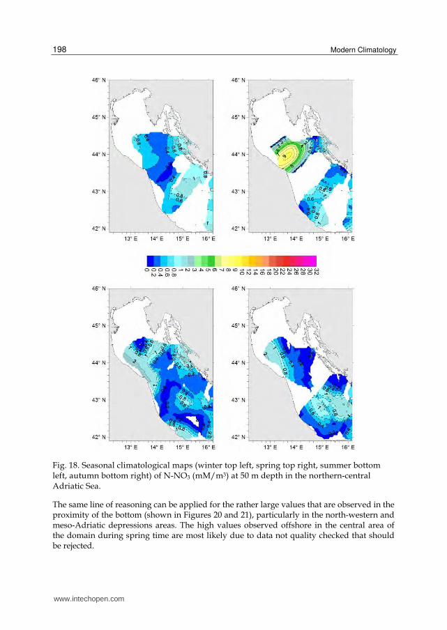
At 50 m depth (see Figures 18 and 19) the concentration increases in the north-western
region, probably because in this area the analyzed depth level is close to the bottom and is
affected by demineralization processes of the organic matter due to bacteria.
www.intechopen.com
Modern Climatology
198
Fig. 18. Seasonal climatological maps (winter top left, spring top right, summer bottom left, autumn bottom right) of N-NO3 (mM/m3) at 50 m depth in the northern-central Adriatic Sea.
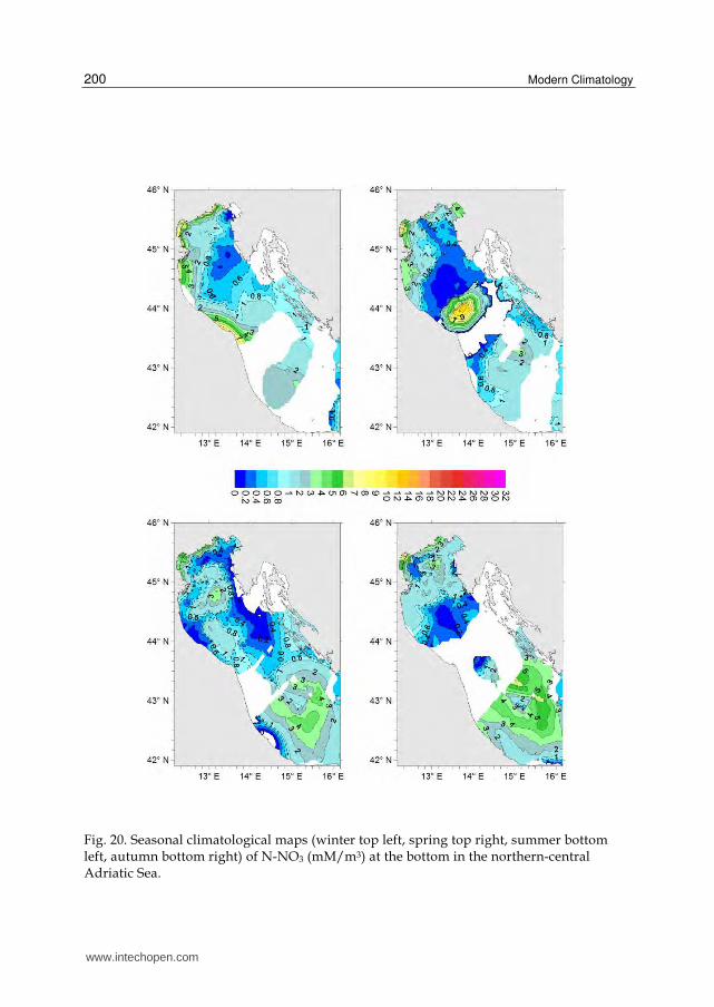
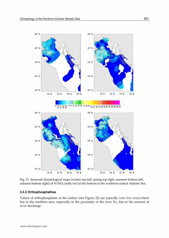
The same line of reasoning can be applied for the rather large values that are observed in the proximity of the bottom (shown in Figures 20 and 21), particularly in the north-western and meso-Adriatic depressions areas. The high values observed offshore in the central area of the domain during spring time are most likely due to data not quality checked that should be rejected.
www.intechopen.com

Climatology of the Northern-Central Adriatic Sea
199
Fig. 19. Seasonal climatological maps (winter top left, spring top right, summer bottom left, autumn bottom right) of N-NO2 (mM/m3) at 50 m depth in the northern-central Adriatic Sea.
www.intechopen.com
Modern Climatology
200
Fig. 20. Seasonal climatological maps (winter top left, spring top right, summer bottom left, autumn bottom right) of N-NO3 (mM/m3) at the bottom in the northern-central Adriatic Sea.
www.intechopen.com
Climatology of the Northern-Central Adriatic Sea
201
Fig. 21. Seasonal climatological maps (winter top left, spring top right, summer bottom left, autumn bottom right) of N-NO2 (mM/m3) at the bottom in the northern-central Adriatic Sea.
3.4.2 Orthophosphathes
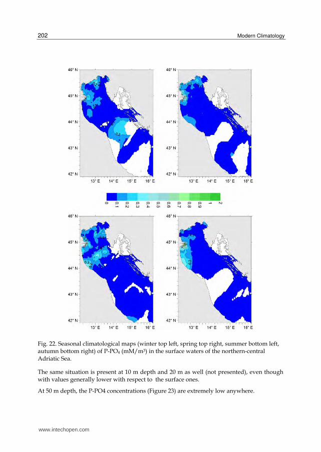
Values of orthophosphates at the surface (see Figure 22) are typically very low everywhere but in the northern area, especially in the proximity of the river Po, due to the amount of river discharge.
www.intechopen.com
Modern Climatology
202
Fig. 22. Seasonal climatological maps (winter top left, spring top right, summer bottom left, autumn bottom right) of P-PO4 (mM/m3) in the surface waters of the northern-central Adriatic Sea.
The same situation is present at 10 m depth and 20 m as well (not presented), even though with values generally lower with respect to the surface ones.
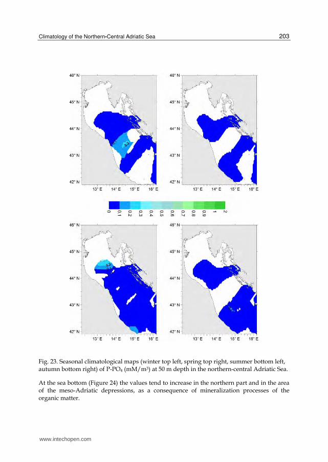
At 50 m depth, the P-PO4 concentrations (Figure 23) are extremely low anywhere.
www.intechopen.com
Climatology of the Northern-Central Adriatic Sea
203
Fig. 23. Seasonal climatological maps (winter top left, spring top right, summer bottom left, autumn bottom right) of P-PO4 (mM/m3) at 50 m depth in the northern-central Adriatic Sea.
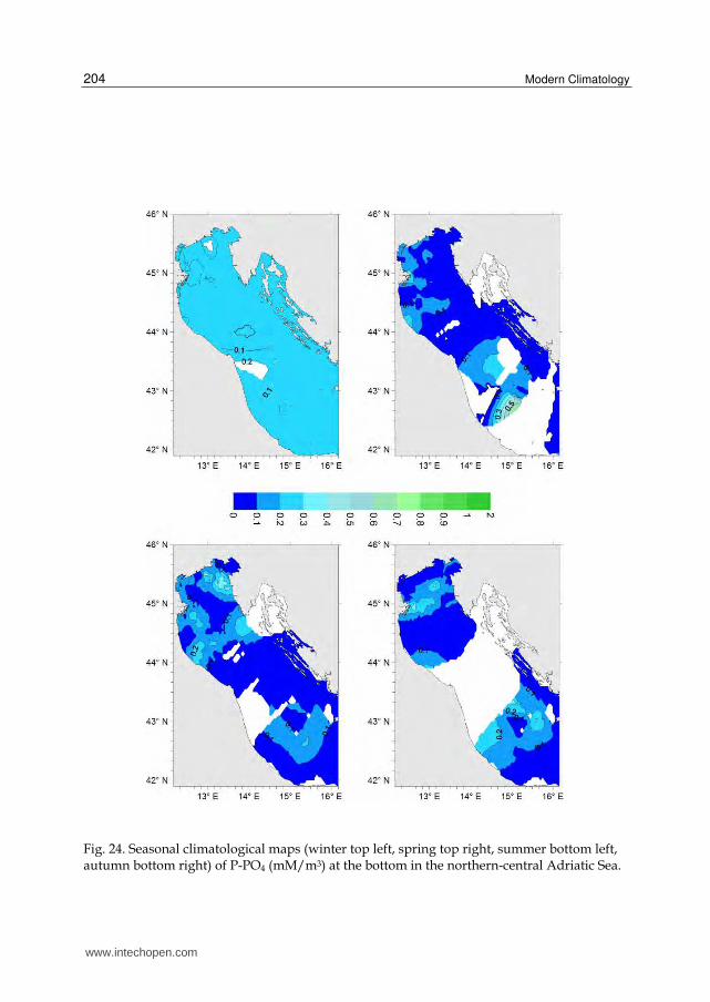
At the sea bottom (Figure 24) the values tend to increase in the northern part and in the area of the meso-Adriatic depressions, as a consequence of mineralization processes of the organic matter.
www.intechopen.com
Modern Climatology
204
Fig. 24. Seasonal climatological maps (winter top left, spring top right, summer bottom left, autumn bottom right) of P-PO4 (mM/m3) at the bottom in the northern-central Adriatic Sea.
www.intechopen.com
Climatology of the Northern-Central Adriatic Sea
205
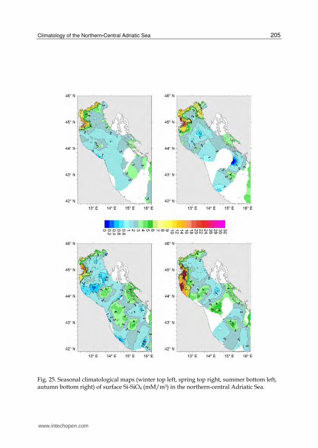
Fig. 25. Seasonal climatological maps (winter top left, spring top right, summer bottom left, autumn bottom right) of surface Si-SiO4 (mM/m3) in the northern-central Adriatic Sea.
www.intechopen.com
Modern Climatology
206
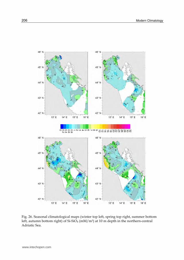
Fig. 26. Seasonal climatological maps (winter top left, spring top right, summer bottom left, autumn bottom right) of Si-SiO4 (mM/m3) at 10 m depth in the northern-central Adriatic Sea.
www.intechopen.com
Climatology of the Northern-Central Adriatic Sea
207
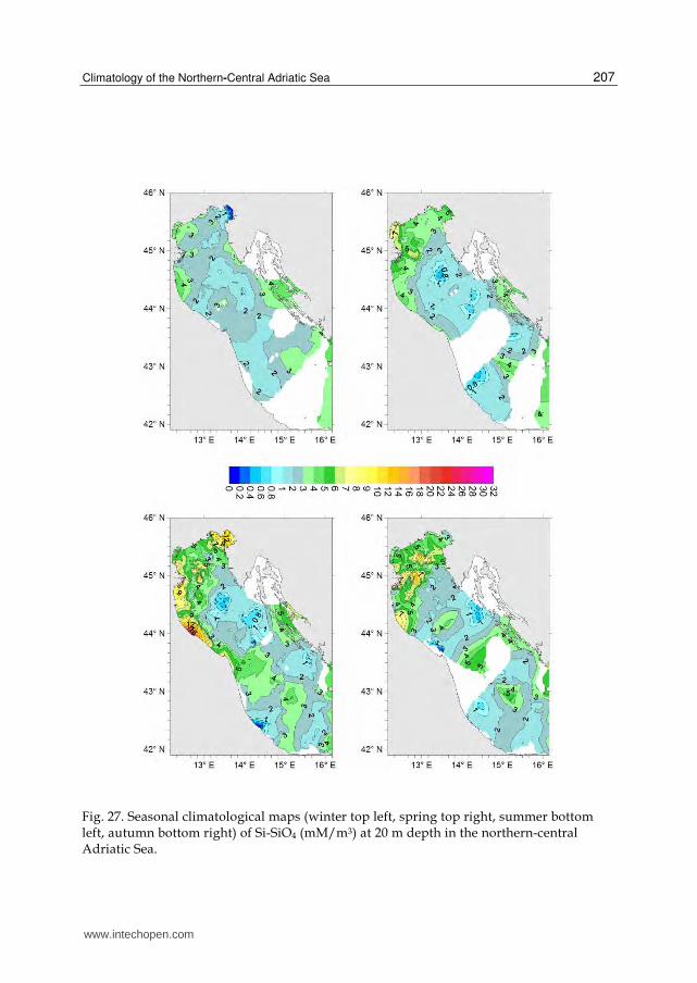
Fig. 27. Seasonal climatological maps (winter top left, spring top right, summer bottom left, autumn bottom right) of Si-SiO4 (mM/m3) at 20 m depth in the northern-central Adriatic Sea.
www.intechopen.com
Modern Climatology
208
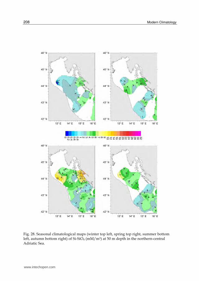
Fig. 28. Seasonal climatological maps (winter top left, spring top right, summer bottom left, autumn bottom right) of Si-SiO4 (mM/m3) at 50 m depth in the northern-central Adriatic Sea.
www.intechopen.com
Climatology of the Northern-Central Adriatic Sea
209
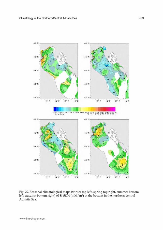
Fig. 29. Seasonal climatological maps (winter top left, spring top right, summer bottom left, autumn bottom right) of Si-SiO4 (mM/m3) at the bottom in the northern-central Adriatic Sea.
www.intechopen.com
Modern Climatology
210
3.4.3 Orthosilicates
Orthosilicates concentrations are far more larger than other nutrient salts, reaching rather
high values at the surface (see Figure 25) in the western northern Adriatic region, which is
more affected by river discharge. It can be seen that maxima concentrations are reached at
the Po delta in autumn and spring, i.e. the seasons with the highest Po river runoff.
At 10 m depth the concentrations significantly decrease, as shown in Figure 26, and quite
high values are mainly observed in autumn south of the Po delta.
At 20 m depth (see Figure 27) winter and also spring maps resemble the 10 m ones, while
during summer and autumn orthosilicates reach higher values in the north-western area
of the basin.
At 50 m very low concentrations are again depicted, but during summer time in the north-
western region and close by the Dalmatian island and Croatian coast.
At the bottom Si-SiO4 values are again considerably high (see Figure 29) in the northern
area, and also in the meso-Adriatic depressions, again because of mineralization processes
of the organic matter.
4. Conclusions
A climatology of main thermohaline and chemical properties of the northern and central
Adriatic Sea based on the MEDAR/MEDATLAS dataset has been drawn and described.
A large variability of temperature and salinity is evident at horizontal, vertical and seasonal
scales. The same can be said for nitrates and orthosilicates, while smaller variations can be
observed for dissolved oxygen, nitrites and orthophosphates.
Interesting phenomena can be individuated by analyzing the climatological maps. For
example, the dissolved oxygen minima found in summer and autumn at bottom in the
central area offshore the Po delta, combined with nutrient salts maxima (particularly
nitrates, orthosilicates and nitrites) and low temperatures, indicate that dense waters formed
during winter may persist in the area and remineralization processes contribute to the
bottom water nutrient enrichment and dissolved oxygen depletion. Similar processes can be
evidenced also in the deeper meso-Adriatic depressions.
The climatology presented in this Chapter will serve as “benchmark” for carrying out
further analysis of the changes in the oceanographic properties that may have occurred
during the last years in the northern and central Adriatic Sea.
5. Acknowledgements
This contribution was supported by the project “MARINA”, funded by Regione Veneto
within the initiatives of the regional law n.15/2007 and by the project SECURSEA funded by
Regione Marche within the EU project SECURSEA (PIC INTERREG IIIA). Partial support
was received also from the Italian Ministry of University and Research FIRB Project, code
RBFR08D825 (project “DECALOGO”) and from the PRIN 2008YNPNT9_005 grant.
www.intechopen.com
Climatology of the Northern-Central Adriatic Sea
211
6. References
Artegiani, A., Bregant D., Paschini E., Pinardi N., Raicich F. and Russo A., 1997a. The
Adriatic Sea General Circulation. Part I: air - sea interactions and water mass
structure. Journal of Physical Oceanography, 27(8), 1492-1514.
Artegiani, A., Bregant D., Paschini E., Pinardi N., Raicich F. and Russo A., 1997b. The
Adriatic Sea General Circulation. Part II: Baroclinic circulation structure. Journal of
Physical Oceanography, 27(8), 1515-1532.
Bergamasco, A., Oguz T., and Malanotte-Rizzoli P., 1999. Modeling dense water mass
formation and winter circulation in the northern and central Adriatic Sea. Journal of
Marine Systems, 20, 279-300.
Boldrin, A., Carniel S., Giani M., Marini M., Bernardi Aubry F., Campanelli A., Grilli F. and
Russo A., 2009. The effect of Bora wind on physical and bio-chemical properties of
stratified waters in the Northern Adriatic. Journal of Geophysical Research – Ocean,
114, C08S92. DOI:10.1029/2008JC004837
Bretherton, F.P., Davis R.E. and Fandry C.B., 1976. A technique for objective analysis and
design of oceanographic experiments applied to MODE - 73. Deep - Sea Research, 30,
985-1002.
Carniel, S., Warner J.C., Chiggiato J. and Sclavo M., 2009. Investigating the impact of surface
wave breaking on modelling the trajectories of drifters in the Northern Adriatic Sea
during a wind-storm event. Ocean Modeling, 30, 225-239. DOI:10.1016/
j.ocemod.2009.07.001
Carniel, S., Bergamasco A., Book J.W., Hobbs R.W., Sclavo M. and Wood W.T., 2012.
Tracking bottom waters in the Southern Adriatic applying Seismic Oceanography
techniques. [in press, Continental Shelf Research] DOI:10.1016/j.csr.2011.09.0034
Carter, E.F., and Robinson A.R., 1987. Analysis models for the estimation of Oceanic Fields.
J. Atmos. Oceanic Technol., 4, 49-74.
Cushman-Roisin, B., Gacic M., Poulain P.-M. and Artegiani (eds.) A., 2001. Physical
Oceanography of the Adriatic Sea: Past, Present and Future. Kluwer Academic
Publishers, Dordrecht/Boston/London.
Dorman, C.E., Carniel S., Cavaleri, L., Sclavo, M., Chiggiato J. and others, 2006. February
2003 marine atmospheric conditions and the Bora over the Northern Adriatic.
Journal of Geophysical Research–Ocean, 111, C03S03. DOI: 10.1029/2005JC003134
MEDAR Group, 2002. MEDATLAS/2002 database. In: Mediterranean and Black Sea database of
temperature salinity and bio-chemical parameters, 30 January 2010, Available from:
http://www.ifremer.fr/medar/
Poulain, P.-M., 2001. Adriatic Sea surface circulation as derived from drifter data between
1990 and 1999. Journal of Marine Systems, 29, 3-32.
Russo, A., and Artegiani A., 1996. Adriatic Sea hydrography. Scientia Marina, 60 (Supl.2) :
33-43.
Russo, A., Rabitti S. and Bastianini M., 2002. Decadal climatic anomalies in the Northern
Adriatic Sea inferred from a new oceanographic data set. P.S.Z.N.: Marine Ecology,
23, Supplement 1, 340-351.
Signell, R.P., Carniel S., Cavaleri L., Chiggiato J., Doyle J., Pullen J. and M. Sclavo, 2005.
Assessment of wind quality for oceanographic modeling in semi-enclosed basins.
Journal of Marine System, 53(1-4), 217-233. DOI: 10.1016/j.marsys.2004.03.006
www.intechopen.com

Modern Climatology
212
Pullen J., Doyle J. and Signell R.P., 2006. Two-way air-sea coupling: A study of the Adriatic.
Monthly Weather Review, 134(5), 1465–1483.
Vilibic, I. and Supic N., 2005. Dense water generation on a shelf: the case of the Adriatic Sea.
Ocean Dynamics, 55 (5-6), 403-415.
Zavatarelli, M., Raicich F., Bregant D., Russo A. and Artegiani A., 1998. Climatological
biogeochemical characteristics of the Adriatic Sea. Journal of Marine Systems, 18,
227-263.
www.intechopen.com
Modern ClimatologyEdited by Dr Shih-Yu Wang
ISBN 978-953-51-0095-9Hard cover, 398 pagesPublisher InTechPublished online 09, March, 2012Published in print edition March, 2012
InTech EuropeUniversity Campus STeP Ri Slavka Krautzeka 83/A 51000 Rijeka, Croatia Phone: +385 (51) 770 447 Fax: +385 (51) 686 166www.intechopen.com
InTech ChinaUnit 405, Office Block, Hotel Equatorial Shanghai No.65, Yan An Road (West), Shanghai, 200040, China
Phone: +86-21-62489820 Fax: +86-21-62489821
Climatology, the study of climate, is no longer regarded as a single discipline that treats climate as somethingthat fluctuates only within the unchanging boundaries described by historical statistics. The field hasrecognized that climate is something that changes continually under the influence of physical and biologicalforces and so, cannot be understood in isolation but rather, is one that includes diverse scientific disciplinesthat play their role in understanding a highly complex coupled "whole system" that is the earth's climate. Themodern era of climatology is echoed in this book. On the one hand it offers a broad synoptic perspective butalso considers the regional standpoint, as it is this that affects what people need from climatology. Aspects onthe topic of climate change - what is often considered a contradiction in terms - is also addressed. It is all tooevident these days that what recent work in climatology has revealed carries profound implications foreconomic and social policy; it is with these in mind that the final chapters consider acumens as to theapplication of what has been learned to date.
How to referenceIn order to correctly reference this scholarly work, feel free to copy and paste the following:
Aniello Russo, Sandro Carniel, Mauro Sclavo and Maja Krzelj (2012). Climatology of the Northern-CentralAdriatic Sea, Modern Climatology, Dr Shih-Yu Wang (Ed.), ISBN: 978-953-51-0095-9, InTech, Available from:http://www.intechopen.com/books/modern-climatology/climatology-of-the-northern-central-adriatic-sea

© 2012 The Author(s). Licensee IntechOpen. This is an open access articledistributed under the terms of the Creative Commons Attribution 3.0License, which permits unrestricted use, distribution, and reproduction inany medium, provided the original work is properly cited.