climate change in the alps: impacts and natural hazards · introduction evidence of human induced...
TRANSCRIPT

Observatoire National sur les Effets du
Réchauffement Climatique
Climate change in the Alps:
Impacts and natural hazards
Rapport Technique N°1 de l’ONERCMars 2008


Redaction: Guillaume Prudent-Richard (Observatoire National sur les Effets du RéchauffementClimatique), Marc Gillet (Observatoire National sur les Effets du Réchauffement Climatique), Jean-Marc Vengeon (Pôle Grenoblois Risques Naturels) and Sandrine Descotes-Genon (Région Rhône-Alpes).
Operational contribution: Benjamin Einhorn (Pôle Grenoblois Risques Naturels), Laurence Bourjot(Bourjot Environnement), Thomas Deniset (Pôle Grenoblois Risques Naturels) and Vincent Bourcier(Observatoire National sur les Effets du Réchauffement Climatique) ;
Editorial contribution: Didier Richard (Cemagref/ETNA), Christian Vincent (LGGE), Pierre Etchevers(Météo France/CEN), Stefan Gruber, Wilfried Haeberli, Isabelle Roer et Michael Zempf (Université deZürich), Nicola Loglisci et Renata Pelosini (ARPA Piemonte), Michel Lang (Cemagref/HH), CharlesObled (LTHE), Jean-Pierre Requillart (ONF/RTM), Daniel Duband (CSM), Denis Jongmans (LGIT),Bruno Schaedler (OFEN), Nicolas Eckert (Cemagref ETNA), Philippe Forcheron (SDIS 38) and alsofrom other members of the ClimChAlp WP5 network;
Review: Martin Beniston (Geneva University), Martin Price (Centre for Mountain Studies, UHIMillenium Insitute) and François Gillet (MEDAD Expert).
OBSERVATOIRE NATIONAL SUR LES EFFETS DU RÉCHAUFFEMENT CLIMATIQUE. Climatechange and resulting impacts in the Alps. Paris: ONERC, 2008. 95 p.
DisclaimerThe content of this report and the arguments employedhereafter do not necessarily reflect the opinions and theposition of the ONERC or contributing institutions. The wordsand figures used do not imply any opinion from the ONERC orcontributory institutions regarding the legal status of countries,territories or areas or authorities or the delimitation of bordersor the limits of any zone.

Precipitations
Temperatures
Glaciers
Snow cover
Permafrost
Vegetation

Debris flows andtorrential events
Avalanches
Mass movements
Glacial hazards
Forest fires
Storms
Floods

List of Acronyms
ALP-IMP : Multi-centennial climatevariability in the Alps based onInstrumental data, Model simulations andProxy data
ARPA-Piemonte: Agenzia regionale perla protezione dell’ambiete della piemonte(Regional agency for the environmentprotection of Piedmont, Italy)
AR4: Fourth assessment report of theIPCC (2007)
BRGM: Bureau des risques géologiqueset miniers (Office for geologic and miningrisks, France)
Cemagref: Institut de recherche pourl'ingénierie de l'agriculture et del'environnement (Research institute foragriculture and environement engineering,France)
CEN: Centre d’étude de la neige de MétéoFrance (Centre for snow studies, France)
CESR: Conseil économique et social de laRégion (Regional social and economiccouncil, France)
CETE: Centre d’étude technique del’Équipement (Technical centre for studiesof the Équipement)CSM: Conseil supérieur de lamétéorologie (Superior council ofmeteorology, France)CUDAM: Centro universitario per ladifensa idrogeologica dell’ambientemontano (University centre for thehydrogeologic protection of the mountainenvironment, Italy)
DJF: December-January-February
DTM: Développement des territoires demontagne (Mountain territoriesdevelopment, Cemagref division, France)EA: East Atlantic pattern
EAWR: East Atlantic West Russia pattern
ENSO: El Niño Southern Oscillation
EPA: Enquête permanente sur lesavalanches (Permanent avalanchemonitoring action, France)
ETNA: Érosion torrentielle, neige etavalanche (Torrential erosion, snow andavalanche, Cemagref division, France)E & F: Eaux et forêts (Service for forestand water, France)
FOEN: Federal office for the environment
FMS: Fondazione montagna sicura(Secured mountain foundation, Italy)
GCM: General circulation model
GLACIORISK: Survey of extremeglaciological hazards in Europeanmountainous regions
GLOF: Glacial lake outburst flooding
HH: Hydrologie-hydraulique (Hydrology-hydraulic, Cemagref division, France)
IGC: Italian glaciological committee
IGN: Institut géographique national(National geographic institute, France)
INRA: Institut national de rechercheagronomique (National insitute foragronomical research, France)IPCC: International panel on climatechange
IPSL: Institut Pierre Simon Laplace(Institute Pierre Simon Laplace, France)IRMa: Institut des risques majeurs deGrenoble (Institute on major hazards fromGrenoble, France)JJA: June-July-August
KLIWA: Klimaveränderung undKonsequenzen für die Wasserwirtschaft(Climate change and consequences forwater management, Germany)
LCPC: Laboratoire centre des ponts etchaussées (Public work researchlaboratory, France)
LGGE: Laboratoire de glaciologie et degéophysique de l’environnement(Laboratory of glaciology andenvironmental geophysic, France)
LGIT: Laboratoire de géophysique interneet de tectonophysique (Laboratory ofinternal geophysic and tectonophysic,France)
LIA: Little ice age
4

LST: Laboratoire des sciences de la Terre(Laboratory for Earth science, France)
LTHE: Laboratoire d’étude des transfertsen hydraulique et en environnement(Laboratory for study of hydraulic andenvironmental transfer, France)MEDAD: Ministère de l’écologie, dudéveloppement et de l’aménagementdurables (Ministry for ecology, sustainabledevelopment and landplaning, France)MWP: Medieval warm period
NAO: North Atlantic oscillation
NRP 31: National research program 31 ofSwitzerland
OAGCM: Ocean atmosphere coupledgeneral circulation modelOECD: Organisation for economic co-operation and development
ONERC: Observatoire national sur leseffets du réchauffement climatique(National observatory on the impacts ofclimate change, France)
ONF: Office national des forêts (Nationaloffice for forest, France)
PACE: Permafrost and climate in Europe
PERMOS: Permafrost monitoringSwitzerlandPGRN: Pôle grenoblois d’étude et derecherche pour la prévention et laprotection des risques natuels (Grenobleresearch pole for natural hazardsprevention and protection, France).
RCM: Regional climate model
RTM: Restauration des terrains demontagne (Mountain soils rehabilitationservice, ONF, France)
SAI: Standardized anomaly index
SCAN: Scandinavian pattern
SDIS: Service départemental d’incendie etde secours (Departmental services for fireand emergency, France)
SDM: Statistical downscaling method
SLF: Institut für chnee und LawinenForschung (Federal institute for snow andavalanche studies)
SRES: Special reports emissionsscenarios of the IPCC
STARDEX: Statistical and regionaldynamical downscaling of extremes forEuropean regions
TAR: Third assessment report of the IPCC(2001)
TORAVAL: Engineering group forhydrologic hazards in mountains (France)
UCBL: Université Claude Bernard de Lyon(Claude Bernard University of Lyon,France)
VAW: Versuchsanstalt für Wasserbau,Hydrologie und Glaziologie (Researchinstitute for hydrology and glaciology,Switzerland)w.e.: Water equivalent
WGMS: World glacier monitoring service
WP: Work package (in the ClimChAlpproject)
5

IntroductionEvidence of human induced climate change has
become increasingly evident as reports by the
International Panel on Climate Change (IPCC,
see the list of acronyms, p. 70) are giving more
accurate assessments of global climate change
throughout recent years (1990, 1995, 2001 and
2007).
It is now largely accepted that current warming is
due to the combination of natural fluctuations and
anthropogenic forcing of the climate. These
changes affecting the global climate already
have and will continue to have consequences on
both oceanic and terrestrial ecosystems and
consequently impacts on human activities and
settlements.
Not all regions will be affected by climate change
in the same way. Within Europe, mountain
ranges and coastal areas are among the most
vulnerable territories facing climate change.
Natural systems and processes in the Alps
(ecosystems, rivers patterns, erosion processes,
etc.) are closely related to temperature and its
evolution. Isotherms are crucial for the
distribution of species, glacier localisation (trough
equilibrium lines), snow cover extent and
duration, etc.
Slight changes in the mean annual temperature
may mask dramatic changes on an hourly, daily
or even monthly basis which are the relevant
timeframes for natural hazard triggering,
permafrost degradation and many other
consequences.
Increasing numbers of glacier retreats,
permafrost degradation and snow cover
decrease have been observed in numerous
mountain ranges and particularly in the European
Alps. Such evidence of climate change is quickly
multiplying.
Mountainous societies are already facing
difficulties because of both internal and external
mutations and will have to cope with the
challenge of climatic vulnerability1 in the future.
Last but not least, the consequences of climate
change are also likely to impact socio-economic
systems downstream, dependent on water
resources provided by the water tower of Europe,
the Alps.
Understanding of the impacts of climate change
is closely linked to the concept of uncertainties.
The origins of uncertainty are varied: it can be
linked to observation, to model development and
results or to the understanding of the climate
sensitivity of the considered natural systems.
In general, the understanding of impacts is
decreasing with the increase of parameters
involved in impact assessment (as developed by
Jones [2000] for the uncertainties linked to
climate projections, cf. fig 1, next page).
Uncertainties are sometimes very significant and
it is important to identify them correctly.
1 Climatic vulnerability is defined by the IPCC as “thedegree, to which a system is susceptible to, and unable tocope with, adverse effects of climate change, includingclimate variability and extremes. Vulnerability is a functionof the character, magnitude, and rate of climate changeand variation to which a system is exposed, its sensitivity,and its adaptive capacity”.
6

Societies must react without delay to cope with
climate change, as the next years will be critical
for the implementation of climate change
adaptation strategies. The most threatened
societies, like mountain communities must
identify the changes that have already taken
place, the potential changes to come and their
capacity to react to new restraints. The
identification of the time frame in which the
expected impacts might occur, (also influencing
the time frame and the priority order) represents
the first step of the adaptation strategy.
The present technical report is the fruit of two
years of work by different political, technical and
scientific institutions collaborating in the
European project ClimChAlp of the Interreg III B
“Alpine Space” program. The project results are
presented in this document to provide a common
base of knowledge of the potential and observed
impacts of climate change in the Alps.
Fig.1 – Uncertainties scheme for climate change impacts assessment
Sources : OEC
D / Jones 2003
7

The ClimChAlp projectThe ClimChAlp project "Climate change, impacts
and adaptation strategies in the Alpine Space" is
a project of the Interreg III B program. This
project is considered as “strategic” because the
partnership gathers 22 institutions (mainly
regional and national public authorities) of the
seven alpine countries and aims to provide a
strong basis for the future projects of the Alpine
Space program.
The ClimChAlp project was conducted between
April 2006 and March 2008. Its content is based
on publications concerning observed and
expected climate change in the Alps and its
potential and expected impacts. The lead partner
of the project is the Bavarian Ministry for Health
and Ecology (Bayerisches Staatsministerium für
Umwelt, Gesundheit und Verbraucherschutz
Referat Klimaschutz).
The project was divided into 9 Working Packages
(WP). Among these 9 groups, the WP 1 to 4 are
dedicated to administrative, communication and
budget issues, the WP 9 is in charge of the final
report and the WP 5 to 8 were dedicated to
different topics as follow:
Climate change and corresponding naturalhazards:
o "Climate Change" Module:
synthesis of the existing knowledge,
evaluation of the historical climatic
changes, evaluation of the Regional
Climate Change and their
uncertainties, future needs and
research agenda;
o "Natural Hazards" Module:
historical assessment of natural
hazards, evaluation of the natural
events modification that can be
attributed to climate change,
analysis of future scenarios and the
potential evolution of natural events.
WP 6. Monitoring, prevention and
management of specific impacts of climate
change on Nature: monitoring, tele-detection,
alert systems…
WP 7. Impacts of climate change on
territorial development and on territorial
economy.
WP 8. Flexible response network: reflection
on the possible adaptation of administrative
and political structures.
The ONERC and PGRN (mandated by the
Rhône-Alpes Regional Council) have been
particularly in charge of the WP 5. The Rhône-
Alpes Regional Council was also involved in the
WP 8. The ONERC was in charge of the
“Climate Change Module” while the PGRN was
in charge of the “Natural Hazards Module”. Both
partners wrote reports and built up a knowledge
platform on the observed and potential impacts
of climate change in the Alps (described further
in the report). This Technical Report is largely
based on the results obtained in the ClimChAlp
project.
Other French partners were also involved in
different WP. The Centre d’étude technique de
l’Équipement (CETE) and the Laboratoire des
sciences de la Terre (LST) participated to the
WP 6 and the Cemagref Grenoble contributed to
the WP 7. The activities of the French partners
are presented at the end of the report.
8

Within the ClimChAlp project, the ONERC, the
PGRN and the Rhône-Alpes Region developed a
knowledge platform on the impacts of climate
change in the Alps, with the support from a large
network of scientists which contributed with
information and reviewing of the syntheses and
reports. This tool is available online on the PGRN
web site: www.risknat.org
This tool aims to provide critical, valid and
traceable information on climate change and
resulting impacts classified as follows (see
below).
For each of these themes, the content is also
classified according to the type of information:
reconstructions (palaeo reconstitutions, historical
approaches, etc.), instrumental observations,
model results (such as regional climatic model or
the propagation models for natural hazards) and
the hypothesis.
A great part of this technical report has been
realised with the information provided by the
knowledge platform. For an easier reading of the
report, the scientific references corresponding to
the values and arguments presented in the text
hereafter have not been inserted in the text. At
the end of the report, the references used for
each part are listed in a coloured box (see the
following example).
Further detailed information concerning the
themes or the references associated with a value
or an argument, can be obtained by visiting the
knowledge platform (www.risknat.org).
Modification of the atmospheric parameter
Temperature Precipitation Air pressure / Winds
Effects on the natural systems and processes
Surfacewater runoff
Snow coverUnderground
runoffPermafrost Glaciers Hydrology
Forest -vegetation
Erosion
Impacts on natural events
FloodsTorrential
eventsAvalanches Mass movements
Glacialhazards
StormsForestfires
9

The French Organisationsinvolved in the ClimChAlpWP5
The ONERCCreated by the law of 19 January 2001, the
French National Observatory on the Effects of
Global Warming (Observatoire National sur les
Effets du Réchauffement Climatique, ONERC)
carries out the will of the Parliament and the
Government to take into account issues linked to
the impacts of climate change. The observatory
collects information, research and studies about
climate change hazards with the aim of informing
the public and the local communities. The
ONERC also proposes recommendations and
adaptation strategies to face climate change.
Finally, it raises awareness of climate change
issues in the dialogue with the developing
countries.
The PGRNCreated in 1988 within the “Isère Département
Pilote” framework, the Grenoble Pole for Natural
Hazards Studies and Research (Pôle Grenoblois
d’étude et de recherche sur les Risques
Naturels, PGRN) today incorporates 12 Rhône-
Alpes institutions (such as Cemagref or Météo
France) that undertake research regarding
natural hazards. About 170 persons (80
scientists, 50 engineers and technicians and 40
PhD students) are involved in the study of natural
hazards. The PGRN implements projects aiming
to develop scientific and technical tools to help
policy makers and risk managers. The PGRN
focuses its activities on mountainous natural
hazards, like avalanches, mass movements,
torrential erosion and floods, etc.
The Rhône-Alpes RegionThe second highest-ranked region in France,
Rhône-Alpes accounts for 10% of the national
population distributed among 2,879 communes
and eight administrative “départements”: Ain,
Ardèche, Drôme, Isère, Loire, Rhône, Savoie
and Haute-Savoie. This dimension places it
amongst Europe’s ten largest regions. The
regional institution is made up of two assemblies:
the Regional Council is an assembly elected by
universal suffrage for a six-year term and the
CESR (Regional Social and Economic Council)
is a consultative assembly bringing together
people/individuals from the socio-professional
world. These two assemblies are backed by
technical services. The Rhône-Alpes region aims
to raise public awareness about the possible
impacts of climate change on the territory
through various actions, from European Interreg
projects to small business initiatives.
10

Climate change and resultingimpacts on natural systems and
processes in the Alps
© O
NE
RC
/ G
. Pru
dent
© O
NE
RC
/ G
. Pru
dent

Temperature
Observations in the AlpsAccording to the last IPCC report (AR4)
“warming of the [global] climate system is
unequivocal, as it is now evident from
observations of increases in global average air
and ocean temperatures, widespread melting of
snow and ice, and rising global average sea
level. Furthermore, 11 of the last 12 years (1995-
2006) rank amongst the 12 warmest years in
instrumental records of global surface
temperature since 1850. The updated linear
trend (1906-2005) of 0.74°C is larger than the
Third Assessment Report (TAR) linear trend
(1901-2000) of 0.6°C. The linear trend for the last
50 years (0.13°C per decade) is nearly twice that
for the last 100 years. The total temperature
increase from 1850-1899 to 2001-2005 is
0.76°C”. Despite the global warming trend, there
are local disparities in the temperature increases
and a few cases of temperature decreases. At
the alpine level, most of the temperature
observations converge towards a general
temperature increase. The values proposed for
different meteorological stations in the Alps differ
in terms of magnitude but the direction is the
same: warming. Moreover, this warming trend
seems to have accelerated during the last
decade. The positive temperature trend is also
confirmed by some features common to all the
alpine regions: an increased number of hot
summer days and decreased number of freezing
days.
Despite the important work provided by scientists
and technical services, uncertainties persist even
concerning observation. The temperature series
are not always continuous and homogeneous.
Some meteorological stations have been
displaced; some have been closed after decades
of data collection and others are located in very
specific places (i.e. at a summit or exposed to the
winds) that blur the data quality.
Scientists have developed methods to assess
the evolution of temperature prior to instrumental
data collection (e.g. dendrochronology, pollinic
studies, etc.). Such methods are then validated
and calibrated by comparing the results with
historical approaches (such as those from E. Le
Roy-Ladurie in France or C. Pfister in
Switzerland). For example, the ALP-IMP project
proposed a temperature trend over the Alpine
Space using dendrochonologic methods and
data homogenisation. Using such reconstruction
methods, warm periods have been identified in
the Alpine space from about 1780 to 1810, 1890
to 1945, and the 1970s onward. In the Alpine
area, 1994, 2000, 2002 and 2003 were the
warmest years within the last 500 years (the
analysis was conducted up to 2003). Over the
20th century, the mean alpine temperature is
thought to have increased by up to + 2°C for
some high altitude sites.
The Alpine climate is a combination of
meteorological conditions at the local scale and
the influence of large synoptic situations of the
Northern Hemisphere. Many analyses have been
undertaken to understand these large scale
influences on the Alpine climate. All the results
show a year-round positive correlation of
temperature with the East Atlantic pattern (EA),
while the North Atlantic Oscillation (NAO) shows
a positive correlation in winter only. However the
correlation with the NAO is considered to be
intermittent and periods without correlation have
been identified.
12

In other seasons the Scandinavian Pattern
(SCAN) can affect Alpine temperatures. Thus
these links are complex and highly variable and
are difficult to use at the moment.
Model results for the AlpsThe average global air surface warming following
a doubling of carbon dioxide concentrations is
likely to be in the range 2°C to 4.5°C with a best
estimate of about 3°C, and is unlikely to be less
than 1.5°C. Values substantially higher than
4.5°C cannot be excluded but there is a lack of
consistency between models for these values.
For the next two decades, a warming of about
0.2°C per decade is projected for a range of
SRES emission scenarios2. The likely range of
the SRES scenarios is between 1.1°C and 6.4°C
(for 2090-2099 relative to 1980-1999) and the
best estimates are between 1.8°C and 4.0°C.
Using downscaling methods, the maximum
increase of the temperature (above 4.5°C) is
simulated over the Western parts of the Alps for
the 2071-2100 period. The warming gradually
diminishes towards the North. The downscaled
temperature change (period 2071-2100 vs.
period 1971-2000) ranges between + 2.8°C
(Bolzano) and + 4.9°C (Nice). Based on Regional
Climate Model (RCM) results, the maximum
temperature increase can be expected to range
between 3°C to 5°C in summer and 4°C to 6°C in
winter3.
Observations for the French AlpsThe annual mean temperature in France
increased by 0.9°C over the 1901-2000 period
and the warming trend clearly accelerated during
the last decade. In the French Alps the mean
annual temperature also increased by 0.9°C over
the 1901-2000 period, a value similar to the
2 For details about the SRES, seehttp://www.ipcc.ch/pdf/special-reports/spm/sres-en.pdf3 M. Beniston, personnal communication, 2007
increase in the annual mean of the daily
minimum temperature. On the other hand, the
increase of the annual mean of the daily
maximum temperature was stronger and ranged
between 0.9°C and 1.1°C in the French Alps.
In the Écrins and Dévoluy massifs, a significant
annual and seasonal temperature increase has
been observed (comparison of the 1960-1980
and 1980-2000 periods). The seasonal mean
temperature has increased by 0.9°C in summer,
0.6°C in autumn and 0.7°C in winter since 1960.
Since the 1980s, the five meteorological stations
located in the Écrins massif have recorded an
annual temperature increase, independent of the
altitude considered; furthermore the number of
freezing days decreased by between 12% and
14% since the 1980s, depending on the station
considered. Between 1965 and 2006, a warming
trend has also been observed in the Oisans and
Briançonnais massifs in the French Alps with a
warm year series between 1997 and 2003. The
warming trend has ranged between + 0.2°C and
+ 0.4°C per decade.
Model results for the French AlpsThe increase of the annual mean of the minimum
daily temperature expected for the French Alps
for 2100 (ARPEGE model) is between 2.3°C and
2.7°C for the B2 scenario and between 3°C and
3.5°C for the A2 scenario. This increase is higher
than the national average. The annual mean of
maximum daily temperature shows similar
trends. In the simulated climate (scenario 2*CO2)
for the Écrins massif, winter temperatures are
expected to increase more for the minimum than
for the maximum temperature values (up to +
10°C for very low temperatures compared to +
3°C for very high temperatures).
13
The warming is independent of the minimum and
maximum values in the other seasons: + 3°C for
spring, + 4°C for summer. The simulations for 3
stations (based on A2 scenario) in the French
Hautes-Alpes and Isère départements show an
increase of the mean temperature by + 3.79°C to
+ 3.85°C and an increase of the solar energy by
between + 22 W/m2 and + 26 W/m2 between the
current climate period (1969-1999) and the future
climate period (2069-2099). The direct
consequence of this warming is a significant
decrease in the annual number of freezing days.
The model developed by Météo France to
evaluate the evolution of the climate and the
snow cover (SAFRAN/CROCUS) are also used
to calculate past values of temperature,
precipitation and snow cover in the mountain
ranges. Even if this king of data can not be
technically considered as observation data, they
represent a precious complement to the existing
data. This is even more interesting in the
mountainous area because there are usually
more difficult to monitor than other kind of area.
This work is still under development but some
results can also be presented.
14

Deviation with the mean value calculated using a thermalindicator, mean value of the annual mean temperature for 22
metropolitan stations
Annual temperature in France: deviation with the1971-2000 mean over the 1956-2006 period
Sources: Météo France 2007
Sources: Météo France 2007
Annual, winter and summer temperatures in the Belledone massif (1800m a.s.l) obtained with models for the 1960-2007 period
Annual Summer Winter
Sources: Navarre 2007/PG
RN
All winter mean (dark blue), and each winter mean (pink)
Winter temperatures in the Chartreuse massif (1800 m a.s.l) obtainedwith models for the 1958-2006 period
Winter temperatures in the Oisans massif (2400 m a.s.l) obtained withmodels for the 1958-2006 period
All winter mean (dark blue), and each winter mean (pink)
Sources: Navarre 2007 / PG
RN
Mean summer temperatures in France from 1860 to 2100(combination of observations and model results)
Très chaud
Moyen
Très froid
Model Model 20 years mean 20th Centuryobservations
Sources: IPSL

Observations in other Alpinecountries
German AlpsIn South Germany (Baden-Württemberg and
Bavaria Länder), the annual mean temperature
increased between 0.5°C and 1.2°C during the
20th century. This warming trend was much
more significant during winter than summer:
the monthly mean temperature for August
increased by 0.7°C to 1.7°C, while the monthly
mean temperature for December increased by
1.8°C to 2.7°C. Temperature increases were
also detected for January, February, March
and October, although they were less
significant.
Italian AlpsIn Northern Italy, a warming trend is evident
throughout all seasons, with both the maximum
and minimum temperatures showing positive
trends. The number of freezing days has also
decreased in winter and spring, although not
significantly and no trend was obtained for this
index in autumn. The “heat wave duration”
index has also increased, with the most
significant increase observed in summer.
In the Piedmont and the Aosta Valley the mean
temperature increased by 1°C during the
second half of the 20th century. During the
2003-2006 period, mean temperature
anomalies at Lago Valsoera weather station
(2,440 m a.s.l, Gran Paradiso massif) reached
+ 1.8°C over 1959-2002 mean values. During
the winter of 2006-2007 (DJF), Northern Italy
experienced the mildest temperatures ever
recorded in nearly two centuries. For example,
the winter temperature anomalies in Moncalieri
(Piedmont) reached + 2.6 °C compared with
the 1961-90 mean at the Dormais station.
Swiss AlpsIn Switzerland, the years with average
temperatures above the mean (1961-1990)
increased throughout the 20th century, with a
related rise of the mean deviation. The total
temperature increase has been estimated at
1.47 °C in the period between the 1900 and
2006, with a more pronounced temperature
increase in the last 40 years (0.4 °C per
decade). 18 study sites in Switzerland (from
317 to 2,500 m a.s.l) show warming rates that
are all significant and range from 1.8°C/century
in Neuchâtel (487 m a.s.l) to 3.5°C/century in
Säntis (2,500 m a.s.l). The general rise of
winter minimum temperatures began in the
early to mid-1960s at all the 18 Swiss
monitoring sites and underwent a cooling in the
early to mid- 1980s before warming rapidly
thereafter.
Summer heat waves (such as the 2003 hot
summer) are characterised by temperatures
that significantly exceed the mean maximum
temperature values. However these summer
temperature anomalies remain smaller than
the maximum temperature anomalies in winter
(also named warm winter spells) that have
been observed in high elevation sites in the
Alps during the last quarter of the 20th century.
Daily maximum temperature anomalies (Tmax)
during winter have been observed to exceed
15°C at sites such as Saentis (2,500m a.s.l),
Grand-Saint-Bernard (2,479 m a.s.l) or
Jungfraujoch (3,572 m a.s.l), , with increases
of 10°C commonly occurring in the last 2-3
decades. Thus the warming trend in the Swiss
Alps is particularly pronounced during winter
(with a corresponding increased potentiality for
more frequent, intense and long-lasting warm
winter spells).
16

The anomalies observed were greater in winter
than in the other seasons and this is even
more significant for the + 10°C above the
mean threshold. For example, the frequency
of the winter Tmax > 10°C increased from 0 or
1 day/decade before 1970 to over 20
days/decade in the 1990s.
Model results in other Alpinecountries
German AlpsThe air temperature will continue to increase
clearly in the future in Baden-Württemberg and
Bavaria. The annual mean temperature
increase is 1.7°C for the 2021-2050 period
compared with the mean in the 1971-2000
period (using the IPCC B2 scenario). This
temperature increase is higher in winter
(approximately 2°C) than in summer (1.4°C).
The number of summer days (days with Tmax
25°C) and hot days (days with Tmax 30°C)
will rise significantly in South Germany. The
average number of summer days will increase
by approximately 17 days in the future (2021-
2050) compared to the current situation (1971-
2000). The duration of periods with summer
days should increase for most of the
considered stations. A comparison of the
current period (1971-2000) and the future
period (scenario 2021-2050) show that the
number of hot days should almost double.
Over the same time period, the occurrence of
extremely high temperature will also increase.
As a result of the temperature warming, the
number of freezing days (days with Tmin <
0°C) and also the number of icy days (days
with Tmax < 0°C) will decrease significantly. In
the future scenario period, the number of
freezing days will decrease by approximately
30 days for all the stations. The maximum
duration of the freezing period should also
decrease significantly. The number of icy days
in the future scenario is generally less than half
the number observed for the current period.
Swiss AlpsIn the future climate simulation (2071–2100, A2
IPCC scenario), the mean summer temperature
in the Swiss Alps is expected to increase by
nearly 4.6°C (cf. fig. 3). The RCM simulations
for the 2071-2100 period show similar summer
climatic conditions to those observed during
the 2003 summer in terms of temperature.
Considering this assumption, one can expect
that by the end of the 21st century (according
to the given RCM results), about every second
summer could be as warm or warmer (and also
as dry or drier) than the 2003 scorching
summer. By the end of the 21st century, the
Swiss Alps might experience a temperature
increase of between 4°C and 5°C (cf. fig. 3). A
2005 study also proposed a warming scenario
for the Swiss Alps of + 1°C (expected for 2020-
2049) and two scenarios considering two
different SRES for the 2070-2099 period: +
2.4°C to + 2.8 °C and + 3.0°C to + 3.6°C, with
warming rates in summer higher than the
annual averages. The climatic projection also
identifies winter as the season with the
strongest anomalies, with a 30% increase of
the temperature exceedance for both the 5°C
and 10°C thresholds, confirming trends
observed in the Swiss Alps throughout the 20th
century. Furthermore, winter Tmax anomalies
should exceed 18.5°C (compared to the 1998
maximum of 16.2°C) in a climate that is
simulated to warm by 4°C in winter on average
(HIRHAM 4).
17

Sources: OFEN
2007
Temperature anomalies in Switzerland during the period 1900-2006
Sources: Cicarelli et al. 2007
Temperature anomaliesin Piedmont and Aosta Valleyduring the period 1951-2002
Sources: Casty et al. 2005
Mean annual temperature anomalies in the alpine arc (1500-2004), withthe 1901-2000 years for reference
Sources: Schär et al. 2004
Temperature change in Europecalculated for the
2071–2100 period (A2 scenario)
Sources: KLIW
A 2006
Increase in the monthly mean temperature inDecember in the period 1931 – 2000 in South Germany

Precipitation
Observations in the AlpsThe trend and variability assessment for
precipitation patterns over the Alps are clearly
weaker than the Alpine temperature
assessments. This is due to several reasons:
The well known problems linked to the
precipitation measure networks in
mountains ranges: time and space
discontinuous field with intensity
distribution highly influenced by
orography; changes in the measurement
instruments and measurements location
during the last century; feeble algorithms
to correct the long time series, etc.
Different large-scale flow regimes cause
the precipitation over the Northern and
Southern Alps. Thus, any weather
regime modification induced by climate
change can affect Northern and
Southern Alps differently.
The adjustment of precipitation series at
the hourly, monthly, seasonal and even
annual timescale is much more
demanding than for temperature, as the
spatial correlation of precipitation fields
is much weaker.
Several studies on precipitation trends have
been carried out at the Alpine scale, leading to a
somewhat controversial picture. Recent results
suggest that, as far as precipitation trends are
concerned, the significance of trend results is
very sensitive to the choice of the time window
considered.
Despite the lack of significant trends at the alpine
scale and no general direction of precipitation
evolutions, local fluctuations of the precipitation
patterns have been observed. Weak or non-
significant trends for precipitation in the past
century have been found at the Mediterranean
scale, at the Alpine space scale and from the
analysis of individual time series. The correlation
analysis reveals weak and highly intermittent
correlations with the NAO Index to the North and
more robust correlations to the South of the main
Alpine range. A decrease in winter and autumn
precipitation to the South of the main ridge has
also been observed.
Inter-annual and inter-seasonal precipitation
variability is very strong. Indeed, the
reconstruction of Alpine precipitation time series
does not indicate significant trends. The
expected precipitation increase, as a
consequence of atmosphere warming, was not
found at the alpine level for the 1500-2003
period. A seasonal approach enabled the
scientists to identify specific winter and summer
features: dry winters occurred in the second half
of the 19th century, and some very dry winters
occurred between 1990 and 1994. Wet winter
conditions were seen in the 1670s, 1720s, 1910s
and from 1950 to 1990. Interannual summer
precipitation shows three prominent dry periods:
around the 1540s, after 1770, and after 1860. A
decrease in summer precipitation is also found
after 1970. Very wet summers occurred from
1550 to 1700. 1540 was the absolute driest
summer in the Alps since 1500 (anomaly of - 164
millimetres with regard to the 20th century mean
summer precipitation sums of 352 millimetres),
and the 2003 summer was of comparable
magnitude, while 1663 was the absolute wettest
summer (+ 148 millimetres).
19

Model results for the AlpsOn the global scale, the climate models generally
calculate future projections with a summer
precipitation decrease and a winter precipitation
increase for the mid-latitude regions and smaller
changes for high-latitude regions. Despite the
intensification of the global hydrological cycle
predicted by OAGCM (Ocean Atmosphere
coupled General Circulation Model), changes in
extreme precipitation remain unconvincing. The
low spatial resolution of OAGCMs precludes a
realistic simulation of regional circulation and
therefore of extreme precipitation. Furthermore,
there is no indication of a seasonal shift of
precipitation in summer and autumn.
Projections of changes in the precipitation
patterns in mountain areas are tenuous in most
General Circulation Models (GCM) because
mountain topography is poorly resolved and, as a
result, the controls of topography on precipitation
are not adequately represented. It has also been
recognized that there are superimposed effects
of natural modes of climate variability such as El
Nino/ENSO, NAO... ...which can perturb mean
precipitation patterns on time scales ranging from
seasons to decades. Such mechanisms are not
well predicted by climate models. As mentioned
above, large-scale climatic models are not
adequate for climatic projections at a regional
scale, such as the Alps. This is why some of the
ClimChAlp WP5 partners evaluated the validity of
RCM (with horizontal spatial resolution between
10 and 20 kilometres) and OAGCM (with
horizontal spatial resolution of nearly 200
kilometres) for the Alpine area. The aim of this
work was to prepare regional scenarios of
climate change with a good resolution that might
be used for impact studies at the Alpine level.
In general, the results of the RCM used in the
WP5 show a mean precipitation increase in
winter and a mean precipitation decrease during
summer (cf. fig. 5). Most of the model results
converge toward a increase in heavy
precipitation in winter. As for the summer period,
the model results are associated with significant
uncertainties and thus cannot propose a clear
picture.
Fig. 5 – Simulated changes (in %) of the winter meanprecipitation (left) and the mean summer precipitation(right) between the 1960-1991 period and the 2071-2100 period with the RegCM model and the A2scenario
This analysis further highlights the fact there is no
single best RCM for the Alpine Space. The
analysed RCMs (especially the HIRHAM
(Danish), RegCM (Italian), CLM (German) and
REMO (German)) satisfactorily reproduce the
monthly mean temperature and the daily mean
precipitation. However, the models tend to
overestimate the seasonal amounts of
precipitation.
Sources: WP5 ClimChAlp CCM report, chapter 2
20
There is a growing need for model results of
climatic extremes, particularly precipitation
extremes. Indeed, changes affecting the extreme
values will certainly have more significant
impacts than the changes of the mean values,
particularly in terms of natural hazards evolution.
The WP5 analysis notably highlighted the fact
that the assessment of the changes in terms of
frequency and intensity is still an unsolved
problem. Finally, it has been shown that it is still
difficult to use the output data from climatic
models as input data for the hydrological model.
Despite the use of correction techniques, the
biases remain significant.
A recent paper compared the results from 3
RCMs and 6 Statistical Downscaling Method
(SDM) for Europe. The RCM simulations for
future changes in European precipitation show a
seasonally distinct pattern: in winter, regions
North of about 45°N experience an increase in
mean precipitation while in the Mediterranean
region there is a tendency toward decreased
mean precipitation. The results of the three
RCMs are highly consistent. Most of the SDMs
produce an increase in mean precipitation similar
to that of the RCMs.
In summer, the RCMs simulate a strong
decrease in mean precipitation in the entire
Alpine region. This decrease is mainly due to a
substantial reduction of wet-day frequency. The
smaller number of wet days results in a large
increase (50% to 100%) of the maximum length
of dry spells. In comparison to winter, the
differences model results for summer between
the RCMs and the SDMs, but also between the
RCMs, are much larger.
Overall the differences between the RCMs and
SDMs, and the substantial biases of the RCMs in
summer highlight the large uncertainties of the
scenario results for the summer season.
In autumn, the region experiences a decrease in
mean precipitation resulting from a strong
decrease in wet-day frequency and a moderate
increase in precipitation intensity. Again the
results of the three RCMs are very similar. This
analysis suggests that the contribution to
uncertainty from downscaling is relatively small in
winter and autumn, but significant in summer.
Observations in the French AlpsNo significant trend of evolution of the mean
values of precipitation has been detected at the
French metropolitan scale. This is explained
either by the absence of changes or by
evolutions too weak regarding the uncertainties
associated with the considered data series. The
overall picture for the French Alps is not much
clearer.
In the French Southern PreAlps/Alps,
precipitation variability between 1950 and 2000
has been characterised by significant
heterogeneity. Even if light trends have been
noticed for particular characteristics and
meteorological stations, no general trends could
be found. On the other hand, some local and
regional evolutions for extreme or heavy
precipitation events have been observed (the
threshold varies from one study to another). The
stations located in the Northern Alps generally
get more intense precipitation in all seasons
except summer. Thus the increase in the
extreme precipitation indices (for example in
Savoie over the 1958-2001 period) was found to
be highly significant, especially in winter.
21

In Chamonix, the annual solid precipitation mean
and the extreme solid precipitation values show
no trend between 1959 and 2004. Very strong
interannual variations and some year cycles can
be identified. It is also interesting to note that the
most important daily snow falls were observed in
the 1990s, even though this was one of the
decades with the least snowfall overall.
In the Écrins massif, there was a significant
increase in summer precipitations with intensity
30 millimetres / day over the 1986-2000 period.
At the same time, there was no significant
variation in the annual mean precipitation at all
the weather stations studied in the Écrins and
Dévoluy massifs since 1980.
In the Alpes Maritimes, many of the indices show
a significant decrease in spring and summer,
while they show poorly significant changes in
winter over the 1958-2001 period. In autumn,
only a few monitoring sites show significant
positive trends.
Over the same period, in Queyras, signals of a
significant increase in some heavy precipitation
indices were observed in spring and winter. The
total accumulated precipitation showed a slight
increase in spring and autumn. The maximum
number of dry days also increased in spring and
decreased in autumn.
Model results for the French AlpsThe relative evolution of the annual amount of
precipitation predicted for 2100 with the
ARPEGE model for the French Alps varies
between - 0.15% and + 0.05% for the B2
scenario and - 0.6% to - 0.2% for the A2
scenario.
At the Rhône basin scale (results of ARPEGE for
the 2054-2064 period with 2*CO2 scenario), the
ratio of solid precipitation over total precipitation
is expected to decrease significantly (- 21%),
particularly for low and medium altitude
watersheds.
The climate simulated for the Écrins massif by
the ARPEGE model (scenario 2*CO2) shows an
intensity increase in autumn and winter
precipitation, especially for the heavy
precipitation indexes (the future number of
events corresponding to 45 millimetres / day may
become the actual number of 30 millimetres / day
events), while it will not change significantly for
spring. In summer, the evolution is much more
complicated. The number of days with daily
values under or equal to the 50 millimetres / day
threshold will decrease while the number of days
with daily values above this threshold will
increase. Nevertheless this situation remains
largely hypothetic.
The simulations from the ARPEGE/IFS model for
3 stations in the French Hautes-Alpes and Isère
départements (comparison between 1970-1999
and 2070-2099 using the scenario A2) indicate a
decrease of the relative humidity (- 4.38% to -
2.35%), a contrasted evolution of the liquid
precipitations (- 0.05 millimetres / day to + 0.47
mm/day) and a decrease of solid precipitations (-
0.64 millimetres / day to - 0.19 millimetres / day).
22

Observations in the other Alpinecountries
German AlpsIn South Germany, there has been a significant
decrease in mean summer precipitation since the
1930s especially in North Württemberg and
Lower Franconia; in Eastern Bavaria the
decrease shows only a low level of significance;
in Southern Bavaria a slight increase has been
identified. The winter precipitation increase is
significant for most of the studied stations except
for those located in the foothills of the Alps where
the slight increase is not statistically significant.
The extreme (percentile 90) and the heavy (often
designating precipitation > 30 millimetres / day)
precipitation indices show a controversial picture.
On one hand, the extreme precipitation index
show an increase in winter ranging between 30%
and 35% that is significant both for Germany
over the 1958-2001 period and South Germany
over the 1931-2000 period, mainly in the Black
Forest, in the North-East of Baden-Württemberg
and in the North Bavarian Region. On the other
hand, annual heavy precipitation indices shows a
significant decrease for Germany whilst no trend
is highlighted for South Germany.
Italian AlpsIn Italy, there is a clear distinction between the
“heavy” to “torrential” categories (from 32
millimetres / day to more than 128 millimetres /
day) that show an increasing trend and the other
categories (from 0 millimetres / day to 32
millimetres / day) that show a highly significant
decreasing trend over the 1951-1995 period.
This national picture is nuanced by a more
regional assessment provided within the
STARDEX project; in Northern Italy, the indices
related to heavy precipitation show negative
trends in winter and spring, while they show
positive trends in summer over the 1958-2001
period. The maximum number of consecutive dry
days increased only in winter, with no change
observed in other seasons.
As regards the Western Alps, a detailed analysis
performed on the 1952-2002 precipitation time
series, displays no significant trend for
precipitation intensity or for dry period duration. A
similar study conducted on the Eastern part of
the Italian Alps highlights the same lack of
significant precipitation trends.
These contradictions highlight the difficulty in
detecting significant trends in precipitation series
and the influence of methodological choices in
assessing precipitation data (data series,
threshold, time frame, geographical area…).
Swiss AlpsIn the Swiss Alps, the increase of mean winter
precipitation for the 1901-94 period amounts to
15% - 20% and is statistically significant, but no
significant trend is found for other seasons. The
monthly precipitation mean comparison between
the 1961-1990 period and the 1931-1960 period
shows a 20% increase for the December, March
and April months. But the July and September
months show a 10% decrease. The winter
precipitation increase seems to be maximal over
Western Switzerland (20%). This Western
Switzerland specific feature is also consistent for
the annual mean precipitation for which a general
increase has been observed between 1977 and
1998.
Regional precipitation assessments in the alpine
parts of Switzerland do not often propose
significant trends. For example, eight Swiss
meteorological stations located in four sub-
regions (Jura, Swiss Plateau, Alps, Southern
Alps) have been studied.
23

Significant variations have only been observed at
the Säntis high elevation (2,500 m a.s.l) site with
a 3.3 millimetres / day increase (1961-1990 as
reference period). Other regionally focused
studies in Ticino and the Swiss PreAlps also
reported no significant precipitation trends.
The indices related to heavy precipitation
generally show significant increases in winter and
autumn, while they show weak positive trends in
summer and spring over the 1958-2001 period.
Over the 1975-1997 period, the heavy
precipitation frequency in Switzerland
(considering threshold > 70 millimetres / day on a
minimal surface of 500 km²) increased to two
times the 1901-1974 value, to reach 3
events/year currently.
When considering the > 50 millimetres / day
threshold for heavy precipitation, an increase is
also identified since 1973. These results are
nuanced by another publication stipulating that
for extreme events, the number of stations with a
significant trend was low in all four seasons and
then the results must be considered poorly
conclusive. It is possible to draw trends of large
amplitude but they are poorly significant from a
statistical point of view.
Precipitation model results for theother Alpine countries
German AlpsThe mean annual amounts of precipitation in
South Germany are expected to increase by
approximately 8% with a bandwidth of 4% to
17% for the 2021-2050 period (using the ECHAM
4 GCM and the B2 IPCC emissions scenarios).
Large-scale precipitation will decrease by a
maximum of 4% in summer.
On the other hand, it is expected that winter
precipitation will increase significantly.
Depending on the region, the increase might
reach 35%. However the available regional
climate models currently cannot provide
quantitative data for the future development of
convective short-period precipitation
(thunderstorms), which are of relevance to
natural hazards.
Swiss AlpsDespite the uncertainties related to regional
climate simulations of precipitation in complex
terrain, recent work based on 4 regional model
projections for a "greenhouse climate" by 2100
suggests that mean and extreme precipitation
may undergo a seasonal shift. There will be more
heavy precipitation events in spring and autumn
(defined here as the 99% quantile values of daily
precipitation) than at present, and fewer in
summer. The 99% quantile corresponds to just
over 60 millimetres / day, and the increase in the
number of extreme precipitation events (over
30% between the two periods) supports earlier
findings by different authors.
24

Seasonal charts showing trend results in the frequency of intensedaily precipitation (i.e., events occurring once per 30 days onaverage over the climatic period). Symbols represent the sign of thetrend estimate (circle: increasing, triangle: decreasing) and itsstatistical significance (filled symbols: p , 5%). Trends wereestimated and tested from seasonal event counts over the period1901–94 using logistic linear regression.
Trend of intense precipitation events in Switzerland (1901-1994)
Sources : Frei & Schär 2001
Mean annual precipitation anomalies in the alpine arc (1500-2004),with the 1901-2000 years for reference
Sources: C
asty et al. 2005
Ensemble-averaged standardizedprecipitation statistics in Italy
a) Average precipitation;b) Precipitation intensity;c) Percentage of dry days in a year.Gray bands indicate 95% confidence
Sources: C
icarrelli et al. 2007
Inf. à - 25%- 15 à - 25%- 5 à - 15% - 5 à + 5%+ 5 à + 15%+ 15 à + 25%Sup. à + 25%
Annual precipitation evolution over the 20th centuryin France (% per century)
The straight arrows represent asignificant trend; the obliquearrows represent non significanttrends. The up arrows indicateincrease; the down arrows indicatedecrease
Sour
ces:
Mét
éo F
ranc
e
Sources: KLIWA 2006
Increase in daily heavy precipitation in the winter half year in theBavaria and Baden – Württemberg (1931-2000 period)

Alpine glaciers
Observations in the AlpsMountain glaciers are sensitive not only to
temperature fluctuations but also to changes in
precipitation, solar radiation, ratio of solid/liquid
precipitation, etc. During the last decades, the
length and magnitude of glacier ablation and
accumulation periods varied greatly. The glacier
mass balance and the length of the glacier
tongue are common indicators used to assess
the evolution of glaciers. Despite the complex
connection between climate and glacier reaction,
glaciers are considered to be key indicators of
climate change: their area, surface, elevation,
thickness, volume and length are all determined
by the balance between climate-driven
accumulation and ablation.
During summer, alpine glacier ice is close to
melting point, thus a change of temperature even
over a short period can lead to a dramatic
evolution. For example, the extreme 2003
summer heat wave caused record breaking
glacier melting in the European Alps with a
corresponding mean specific mass loss of -2.5m
water equivalent (w.e.). This value is eight times
the annual mean of the 1960-2000 period.
Trends in long time series of cumulative glacier
length and volume changes represent convincing
evidence of fast climatic change on the global
scale. Mountain glaciers […] have declined on
average in both hemispheres and the secular
mass loss has been considered a worldwide
phenomenon (cf. fig. 7) since 1850.
Fig. 7 – Length fluctuation of 20 glaciers worldwide
The glaciers in the European Alps have lost
about 30% to 40% in glacierized surface area
and about half their total volume (roughly - 0.5%
per year) between 1850 and around 1975.
Another 25% (or - 1% per year) of the remaining
volume probably disappeared between 1975 and
2000, and additional 10 % to 15 % (or - 2% to -
3% per year) in the first five years of this century.
Even if most of the glaciers have been in general
retreat since the end of the Little Ice Age (LIA,
considered to end in the middle of the 19th
century), there are deviations of this trend in both
time and space.
Sources : Oelermans 2000 / World Glacier Monitoring Service
26

Despite the apparent homogeneity of the signal
on the secular time scale, contrasts appear over
shorter time periods (years to decades) as a
consequence of the great local/regional
variability. For example, an advancing period
was observed in the European Alps during the
decade 1970-1980; this period of glacier
advance has also been observed in other
regions of the World such as the Pamir-Alai,
Tien-Shan, etc.
Glacier size and its area versus elevation
distribution are also critical factors when looking
at its sensitivity to climate change. Smaller
glaciers are most sensitive to climate change. At
altitudes above about 4,000 m a.s.l. iced areas
are generally cold and atmospheric temperature
rises leads to ice warming rather than mass loss.
The above-mentioned retreating trend can be
observed through the analysis of the mass
balance of some Alpine glaciers in the period
1965-2005. In the 1960s and 1970s, the annual
variations of glacier mass were balanced, but
since the mid-eighties, a period of continued and
accelerated loss of glacier volume has existed
(cf. fig. 8). This loss is estimated to be 0.5 to 1
metre w.e. per year (with an exceptional 2.5
metres w.e. during the 2003 summer).
Fig. 8 – Annual (left y-axis) and cumulated (right y-axis) mass balance of nine alpine glaciers
Argentières glacier in 1896
© L
GG
E /
Vin
cent
Alpine glaciers: Saint Sorlin (F), Sarennes(F), Silvretta (CH), Gries (CH), Sonnblickkees(A), Vernagtferner (A), Kesselwand-Ferner(A), Hintereisferner (A) and Careser (I)
Sources : OFEN 2007
© L
GG
E /
Vin
cent
Argentières glacier in 2003
27

Sources: Reynaud & Vincent 2002
Observations in the French AlpsThe dramatic advance of alpine glaciers during
the LIA might have been the consequence of
more favourable than average climatic conditions
during this cold and wet historical period. The
general shrinking of alpine glaciers during the
20th century was therefore partially due to climatic
conditions, which returned closer to the Holocene
mean value. However, it is likely that recent
global warming is accelerating this existing
glacier retreat. For example, in 2001, the front of
the Mer de Glace ended approximatively 2.2
kilometres upslope from its position of maximum
extension during the LIA (cf. fig. 9), and in 2006,
it retreated a further 100 metres to a point 2.3
kilometres upslope of the maximum extension
during the LIA.
The 20th century French mass balance analyses
highlighted four different periods: (i) between the
beginning of the 20th century and 1941, the
French alpine glaciers lost some mass (ii)
between 1942 and 1953, the glaciers showed
important deficits due to low winter precipitation
and strong summer ablations (iii) between 1954
and 1981, the mass balance was generally
positive and led to an important re-advance of
some glacier fronts (several hundreds of meters
for the la Mer de Glace, Argentière and Bossons
glaciers in the Mont Blanc massif) and (iiii) since
1982, the mass balances are in deficit due to a
high level of summer ablation (from 1.9 m to 2.8
m w.e. at 2,800 m a.s.l). This is due to a strong
increase of the energy balance.
Fig. 9 – Mer de Glace fluctuations collected by Mougin (1598-1870) and completed by recent measurements
© A
nthe
re 2
003
28

Considering cold high-altitude mountain peaks, a
recent study conducted at the summit ice cap of
Mont Blanc (4,808 m a.s.l) and Dôme du Goûter
(4,300 m a.s.l) show that, in contradiction to the
observed changes of the glacier tongues in the
Mont Blanc massif, no major thickness changes
have been detected over the 1905-2005 period
for most of the area (cf. fig. 10).
Fig. 10 – Thickness changes on the Mont Blanc andDôme du Goûter ice cap between 1905 and 2005
On the other hand, ice temperature at the Col du
Dôme du Goûter (4,250 m a.s.l) clearly increased
between 1994 and 2005 (cf. fig. 10’). If this trend
continues, this might lead to changes of thermal
mode of some glacier from “cold” to “temperate”,
with associated consequences on the long-term
stability of hanging glaciers (see “glacial hazards”
chapter).
Fig. 10’ – Températures de la glace mesurées dans desforages au Col du Dôme du Goûter en 1994 et 2005
Modelled englacial temperatures (a) withouttaking into account the latent heat flux resulting
from surface melt water refreezing (1994 inblue, 2005 in orange) and (b) taking into
account the latent heat flux resulting fromrefreezing (1994 in blue, 2005 in orange)
Sour
ces
: Vin
cent
et a
l. 20
07b
Sour
ces
: Vin
cent
et a
l. 20
07a
29

Sources: ONERC / LGGE
Mass balance sum (w.e) Mean heightvariations for Gebroulaz glacier
Sources: ONERC / LGGE
Mass balance sum (w.e)Mean height variations for
St Sorlin glacier
Sources: ONERC / LGGE
Mass balance sum (w.e)Mean height variations for
Argentières glacier
Saint Sorlin glacier
© L
GG
EFig. 11 – Mass balance sum in the French Alps
Argentières glacier
© J
M L
asls
a gl
c

Model results for the Saint Sorlinglacier (France)As glaciers will probably continue their regression
throughout the 21st century, a research team at
the Laboratoire de Glaciologie et de
Géophysique de l’Environnement of Grenoble
(LGGE) developed a model to estimate glacier
evolution in the context of climate change. This
tool has been used to evaluate the future
evolution of the Saint Sorlin glacier in the
Grandes Rousses massif. Different IPCC
scenarios (B1, A1B and A2) and different climatic
models (CSIRO-MK3-0, GFDL-CM2-0, etc.)
have been used to simulate the evolution of the
glacier with a wide range of potential climatic
values.
The results are varied due to the range of
climatic values but the disappearance of the
glacier is calculated by the end of the 21st
century with the B1 scenario and the GFDLCM2-
0 model (cf. fig. 12). Other scenarios expect
more or less extreme glacier reaction but it is
very likely that the Saint Sorlin glacier will
disappear by the end of the 21st century.
Sources: CNRS / Gerbaux
Fig. 12 – Saint Sorlin glacier evolution with the B1 scenario and the GFDLCM2-0 model
31

Observations in other Alpinecountries
Italian AlpsThere are 1,396 Italian glaciers spreading over
607 km² (21% of the glacial alpine surface).
Analysis of the data from the IGC (Italian
Glaciological Committee) shows that the melting
phase of the Italian glaciers started in the mid-
19th century with an exception in the period 1960-
1980, confirming the general trend mentioned
above. There has been a 40 % loss of the glacier
surface in Italy since 1850. When analysing the
percentage of glacier progress during the 1980-
1999 period, the percentage of progressing
glaciers dropped from 66% in 1980 to 4% in
1999, while the percentage of retreating glaciers
increased from 12% in 1980 to 89% in 1999 (to
be considered in the light of the 1960-1980
advance).
This trend is confirmed in all Italian Alpine
regions. However, this kind of approach based
on yearly changes has to be considered with
caution as it does not show important cumulative
effects. In the same period the cumulated
variation of a sample of 104 Italian glaciers
shows an average decrease of 4.8 metres / year.
The overall decrease has been estimated to be
around 95.4 metres for the 1980-1999 period.
The Lombard Alps experienced the strongest
retreat.
Fig – 13 Cumulative variation of a sample of 104 Italian
glaciers in the period 1980-1999
Pré de Bar glacier (Aosta Valley) in 1929 (left) and in 2007 (right)
© F
onda
zion
e M
onta
na S
ciur
a
© F
onda
zion
e M
onta
na S
ciur
a
Sources : ICG
32

Swiss AlpsThe Swiss Alps contain about half of the glacier
area in the European Alps as well as the largest
glaciers (Aletsch, Gorner, Fiescher, Unteraar).
Since the end of the Little Ice Age around 1850,
the length reduction has been about 3 kilometres
for the Aletsch long valley glacier tongue, roughly
1 kilometre for the steep Trient mountain glacier
and some 300 metres for the small Pizol cirque
glacier (cf. fig 14).
Fig – 14 Cumulated length variation (m) of the Pizolglacier Trient and Grosser Aletsch
Between 1850 and 1973, the elevation of the
equilibrium line increased by an average of 70
metres to 80 metres, causing an average
negative annual mass balance of a few dozen
meters. The latest glacier inventory data derived
from satellite imagery and corresponding
comparisons with older inventories compiled and
upgraded from old maps, aerial images and field
mapping show that the average decadal loss in
area between 1985 and 1998/99 is about seven
times higher than the average from 1850 to
1973. In many cases, glaciers disintegrated into
smaller units, separated from former tributaries,
showed signs of collapse and started to form
proglacial lakes which accelerate tongue retreat
locally. This loss is particularly impressive when
looking at pictures from the 19th and 21st century.
The Great Alestch glacier (Wallis) in 1856 (left) and in 2001 (right)
© M
arte
ns 1
856
©H
olzh
ause
r20
01
Area and lenght of each glaciers in 1973: Pizolglacier (0,21 km², 0,6 km), Trient (6,4 km², 4,9 km)and Grosser Aletsch (86,63 km², 24 km)
Sources : ICG
2007
33

Snow coverSnow cover plays a significant role in mountain
systems. Besides being a primary resource for
winter tourism, snow cover has a strong water
storage function, insulates the ground from air
temperature and hence its evolution is critical for
permafrost pattern fluctuations, and it also
represent an important habitat for some species.
Snow cover is closely linked to both temperature
and precipitation. For example, the ratio between
solid and liquid precipitation directly correlates
with temperature and precipitation, but many
other factors also exert an influence on snow
cover. The effects of shade, vegetation cover,
slope and wind are some, but not all, factors
infuencing snow cover evolution.
Fig. 15 – Mean snow cover duration at the Col de Porte
(1,360 m a.s.l) during the second week of February (a)and mean snow cover height at the same location (b)
Furthemore, large scale forcing, rather than just
local or regional factors, plays a dominant role in
controling the timing and amount of snow in the
Alps.
Observations in the French AlpsVery significant irregularity of the Col de Porte
(Météo France experimental site, Chartreuse
Massif, 1,320m a.s.l) snow cover for February
has been observed between 1960 and 2000.
Despite this strong interannual variability, the
general trend is a decrease in snow height,
especially due to low snow cover during the last
decade (cf. fig. 13); snow height exceeded 1.5
metres only once during the 1990s, whereas it
was 3 or 4 times this value for the precedent
decades. Snow cover duration also decreased
steadily/progressively since the 1960s (cf. fig.
15).
Number of days with snow covers > 1mNumber of days with snow cover
Sour
ces:
ON
ERC
/ M
étéo
Fra
nce
2007
Sour
ces:
CEN
/ M
étéo
Fra
nce
2007
© O
NE
RC
/ G
. Pru
dent
© O
NE
RC
/ G
. Pru
dent
34
Sources: CEN Météo France 2007
Sources : Hennegriff & al. 2006
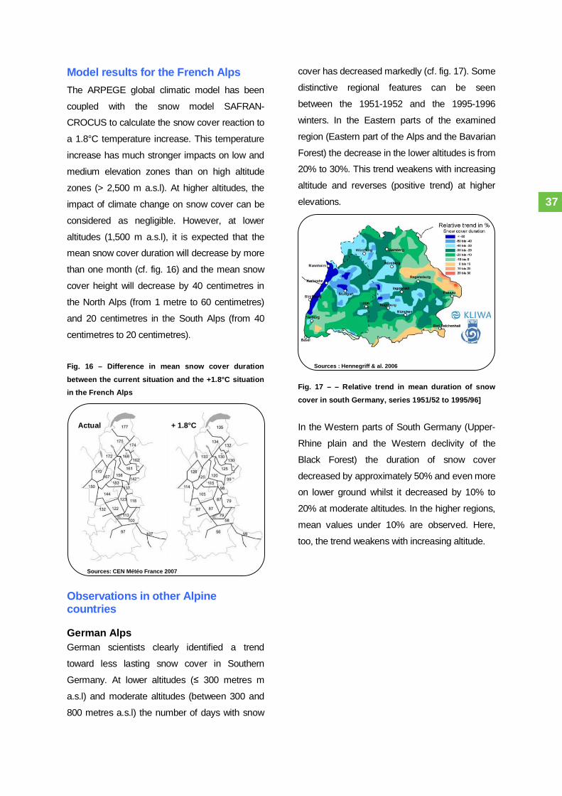
Model results for the French AlpsThe ARPEGE global climatic model has been
coupled with the snow model SAFRAN-
CROCUS to calculate the snow cover reaction to
a 1.8°C temperature increase. This temperature
increase has much stronger impacts on low and
medium elevation zones than on high altitude
zones (> 2,500 m a.s.l). At higher altitudes, the
impact of climate change on snow cover can be
considered as negligible. However, at lower
altitudes (1,500 m a.s.l), it is expected that the
mean snow cover duration will decrease by more
than one month (cf. fig. 16) and the mean snow
cover height will decrease by 40 centimetres in
the North Alps (from 1 metre to 60 centimetres)
and 20 centimetres in the South Alps (from 40
centimetres to 20 centimetres).
Fig. 16 – Difference in mean snow cover duration
between the current situation and the +1.8°C situationin the French Alps
Observations in other Alpinecountries
German AlpsGerman scientists clearly identified a trend
toward less lasting snow cover in Southern
Germany. At lower altitudes ( 300 metres m
a.s.l) and moderate altitudes (between 300 and
800 metres a.s.l) the number of days with snow
cover has decreased markedly (cf. fig. 17). Some
distinctive regional features can be seen
between the 1951-1952 and the 1995-1996
winters. In the Eastern parts of the examined
region (Eastern part of the Alps and the Bavarian
Forest) the decrease in the lower altitudes is from
20% to 30%. This trend weakens with increasing
altitude and reverses (positive trend) at higher
elevations.
Fig. 17 – – Relative trend in mean duration of snow
cover in south Germany, series 1951/52 to 1995/96]
In the Western parts of South Germany (Upper-
Rhine plain and the Western declivity of the
Black Forest) the duration of snow cover
decreased by approximately 50% and even more
on lower ground whilst it decreased by 10% to
20% at moderate altitudes. In the higher regions,
mean values under 10% are observed. Here,
too, the trend weakens with increasing altitude.
+ 1.8°CActual
37

Sources : Valt et al. 2005
Italian AlpsAn historical analysis of snow cover over the
Southern part of the Italian Alps was performed
using historical data from 40 monitoring stations.
The method for highlighting a snow-cover trend
was based on the dimensionless index SAI
(Standardized Anomaly Index). This index shows
the anomalies of quantity, by means of the
annual or seasonal contribution of each station.
The inter-annual variability of snow cover is very
significant over the 1920-2005 period but there
has been a general decrease of snow cover over
the Italian Alps (cf. fig. 18). During the 2003-2006
period, winter snow accumulation was even 40%
below normal conditions (1959-2002 mean
values) at the Lago Valsoera weather station
(2,440 m, Gran Paradiso range).
Fig. 18 – Cumulated snow cover in Italy between 1920
and 2006
Swiss AlpsThe snow depth shows great short-term
variability and marked long-term fluctuation.
Snow coverage (number of days with more than
20 centimetres of snow) shows a similar pattern
to snow depth. The variability is rather limited at
the beginning of the century and increases
thereafter. The greatest snowfall over 3 days and
the total amount of new daily snow during the
whole winter remain stable overall, but show
extreme variability from year to year. Overall,
both snow cover duration and height tended to
decrease over the Swiss mountains (cf. fig. 19).
Fig. 19 – Snow cover evolution (duration and height) inSwitzerland over the 1960-1990 period
Sources : Beniston et al. 2003a, Beniston 2005
30 km
Bern (570 m)Snow cover duration
decreased by 49%
Château d’Oex (980 m)Snow cover heightdecreased by 45%
Lugano (273 m) Snowcover duration
decreased by 80%
Säntis (2500 m) Snowcover height increased
by 35%
Davos (1590 m)Snow cover heightdecreased by 31%
36

Alpine permafrostPermafrost is perennially frozen ground and
defined as soil or other lithosphere material
(including bedrock but excluding glaciers), at a
variable depth beneath the surface of the earth,
in which below freezing temperatures have
existed continually for a long time, from two to
thousands of years. Permafrost influences the
hydrology and stability of steep scree slopes
since ice-rich permafrost acts as a barrier to
groundwater percolation and can imply local
saturation within non-frozen debris. Additionally,
permafrost thawing in non-consolidated material
can lead to a loss of cohesion and to thaw-
consolidation. The penetration of the freezing
front into previously thawed material has the
potential of intensifying rock destruction through
ice formation in cracks and fissures. Such ice
formation, in turn, reduces the near-surface
permeability of the rock walls involved and
affects hydraulic pressures inside the still open
(non-frozen) fissured rocks.
The climate is influencing permafrost, particularly
the active layer, which is melting throughout
summer and the transition periods. Snow cover
plays an important role in permafrost pattern by
insulating it from low winter temperatures, and,
as a consequence, the extent and duration of the
snow cover is a critical factor for permafrost
evolution. If snow falls in late autumn, then the
low surface and air temperatures will effectively
cool the permafrost – if snow falls in early
autumn, the snow cover insulates the ground,
preserving more of the summer heat deep within.
Similarly, early melting of snow cover exposes
the permafrost to long summer warming while
the late disappearance of snow cover will reduce
ground warming.
For example, during the 2002-2003 winter in the
Swiss Alps, there were snow falls late in autumn
but early melting of the snow cover in spring.
Thus, the permafrost had already experienced a
“bad winter”, with ground temperature anomalies,
when the 2003 summer heat wave occurred .
Similar events were observed in France at the
rock glacier of Laurichard during the 2003-2004
winter. The effect of snow is much less important
for permafrost at steep summits and in bedrock.
The warming and degradation of permafrost in
ridges, peaks and spurs is quicker and stronger
because the heat front comes from several sides.
Based on observations, theoretical considerations
and model simulations, permafrost degradation is
likely to be of critical importance for natural hazards
such as rock falls, mudslides and debris flows, as
well as interactions with other phenomena such as
hanging glaciers. These issues are developed
further in the natural hazards chapters.
Observations in the AlpsPermafrost in the Alps occupies an area that is
comparable in extent to the glacierized area but
its secular evolution is less understood due to a
lack of measurements. Gradual melting of Alpine
permafrost has already taken place since the end
of the Little Ice Age. Alpine permafrost in debris
slopes is typically several decametres to more
than 100 metres thick and has a characteristic
mean annual surface temperature between
melting point and about - 3°C. Permafrost at
steep bedrock summits can reach temperatures
well below - 10°C. Rock glaciers are also
reacting to the rise in air temperature. The
melting of ice within rock glaciers is leading to
increased speeds of deformation.
37

The movement of rock glaciers is a common
feature in the Alps, indicated by an increase in
recent years from 20% to 100% of movements in
the French, Swiss and Austrian Alps.
Measurements in the upper 60 metres of ground
show a more or less stable surface temperature
between 1950 and 1980. As a consequence of
the exceptional warming in the 1980s, the annual
rate of thaw settlement due to melting ground ice
in Alpine permafrost may have doubled since the
1970s and reached the decimetre range per
year. Borehole observations also indicate that
permafrost temperatures are now rising at a high
rate although they can be drastically influenced
by snow cover conditions in early winter that may
lead to cooling phases.
A rapid warming of 0.5°C to 0.8°C during the last
century in the upper decametres of Alpine
permafrost has been confirmed by borehole
measurements. Researchers in the PACE
project (Permafrost and Climate in Europe) have
found temperature increases between + 0.5°C
and + 2.0°C over the past 60-80 years in
permafrost soils in European mountain regions,
from the Sierra Nevada in Spain to the arctic
archipelago of Svalbard. The 2003 summer was
of critical importance in demonstrating the
reaction of permafrost to high summer
temperatures.
For example, the active layer at the monitored
Swiss site of Schilthorn dropped from 3.7 metres
to 4.2 metres in depth during the 2003 heat
wave. By 2004, the active layer had still not
recovered its initial position at 4 metres.
Laurichard Rock glacier (France)In detail, the flow speed of the Laurichard rock
glacier (Hautes-Alpes) shows successive
acceleration and deceleration during recent
decades. Between 1979 and 1997, the speed
was roughly 25 centimetres / year with a slight
inflection since 1986. Thereafter the flow
accelerated together with other rock glaciers in
the Alps, to reach a maximum speed in 2001.
The speed values then became similar to those
of the 1980-1990 period. The snowy winter of
2003-2004 clearly prevented the ground from
cooling by keeping the heat trapped within the
rock glacier throughout the 2003 summer (cf. fig.
18). This might explain the high speed and the
surface subsidence of the glacier (through
permafrost top melting) that were observed in
2004.
Fig. 20 – Ground temperature at Laurichard (2,450 and
2,600 m a.s.l) and air temperature at Monetier betweenOctober 2003 and September 2006
Sources : Bodin 2007
© C
emag
ref
38

Sources : PERMOS 2007
Permafrost and rock glaciers in theSwiss AlpsThe longest continuous series of temperature
measurements within European mountain
permafrost is from the 58 metres deep borehole
at Murtèl–Corvatsch (Engadin, Switzerland)
which was drilled in 1987 through slowly
creeping ice-rich debris. Long-term monitoring of
ground temperatures at Murtèl–Corvatsch in
Switzerland has clearly demonstrated the
sensitivity of mountain permafrost to changes in
both air temperature and the amount and timing
of winter snow cover.
Rapid warming of the uppermost 25 metres of
permafrost was observed between 1987 and
1994. The mean annual ground surface
temperature is estimated to have increased from
- 3.3 °C (1988) to - 2.3 °C (1994). At a depth of
11.6 metres (inside the active layer), the
permafrost warmed by nearly 0.6°C. At 20 m
(under the active layer), the warming was only by
0.2°C.
Fig. 21 – Ground temperature (10 m deep) at different
monitored Swiss sites (PERMOS)
However, low snowfall in December and January
during the 1994-1995 winter followed by
moderate snow fall in 1995-1996 caused intense
cooling of the ground and permafrost
temperatures returned to values similar to those
in 1987. Early winter snow was thin in 1998-1999
and winter ground temperatures remained low in
1999, 2000 and 2001.
The analysis of this long data set, combined with
more recent measurements at other Swiss
monitoring sites confirms that the permafrost has
been warming since the beginning of the
measurements. This warming took place in three
steps interrupted by a cooling during the 1995-
1996 winter and a cooling since 2002 (cf. fig. 19).
These decelerations of the warming trend are
mainly due to winters with limited snow cover.
Climate change seems also to have strong
impacts on Swiss rock glaciers. At the vallon des
Yettes Condjà (Wallis), the speed of surface
movement of one rock glacier increased by
200% between 2000 and 2004 and by 76% for
the other rock glacier (cf. fig. 22).
Fig. 22 – Rock glaciers of the vallon des Yettes Condjà(Wallis, Switzerland): Surface horizontal speed 2003-
2004 (left) and surface horizontal speed variations2001-2004 (right)
Sources : Lambiel & Delaloye 2005
Sources: PERMOS
39

Alpine vegetation
Vegetation observations in Franceand other alpine countriesClimate change has already impacted on
vegetation, through direct and indirect impacts.
For example, climatic parameters have direct
impacts on species physiology whereas the
changes in repartition of parasites and insects,
which are disease vectors (closely linked to
climate evolution), are an indirect impact.
Furthermore, evaluations of the influence of
climatic parameters on vegetation evolution
remain difficult. Indeed, Alpine vegetation has
been suffering for over a millennium from various
modifications due to human activities (wood
exploitation, agricultural changes, species
introduction, use of water resources, etc.).
A direct impact of climate change that can be
readily observed is the extended vegetative
period (not only in the Alps), with earlier bud
blooming and later leaf shedding (cf. fig. 23).
Fig. 23 – Bud blooming, blossoming and fruit
maturation dates in Colmar (Alsace)
Since the end of the 19th century, an increase in
forest growth has been observed in Europe. This
phenomenon is quite general with some marked
regional differences. For example, beech tree
height increased by 25% in North-Western
France, and 50% in North-Eastern France during
the 1900-2000 period. Climate change is one of
the hypotheses to explain this increase in forest
growth but it is still difficult to determine the
respective roles of the CO2 concentration
increase and climate evolution.
Gentiane jaune
© P
arc
Nat
iona
l des
Écr
ins
Sources:ON
ERC
/ INR
A
Fruit maturationBud blooming Blossoming
40

The evolution of the repartition area of species
has also been observed both for altitude and
latitude. For example, a general extension of
Lauryphilles (species with large, persistent and
tough leaves) has been observed, as well as the
altitude rise of some species (+ 200 metres for
the mistletoe in the Valais between 1910 and
1995).
“Negative” impacts have also been observed.
Parasites and their hosts are developing due to
warmer temperatures (cf. fig. 24, this figure
illustrates the propagation of a parasite in the
Parisian Basin but the mechanism is the same
for Alpine regions, with an additional propagation
in altitude). The temperature increase also has
negative impacts on water availability. For
example, the 2003 drought was the most severe
drought for the broad-leaved tree population in
France over the last 50 years and caused a
significant death rate peak.
Fig. 24 – Pine processionary caterpillar progression in
the Parisian Basin between 1972 and 2004
Vegetation evolution projections inFranceProjections follow the observed impacts of
climate change on vegetation, but the “positive”
impacts of climate change should continue to
occur until a threshold is reached. Beyond a limit,
the increase in vegetation production should be
counterbalanced by a lack of water for the
vegetation. Again, the balance between positive
and negative impacts of climate change on
vegetation is difficult to assess. By using models,
scientists can give directions about future
evolution of vegetation.
Sources: ON
ERC
/ INR
A©
ON
ER
C /
G. P
rude
nt
© J
ean-
Cla
ude
Mar
tyin 41
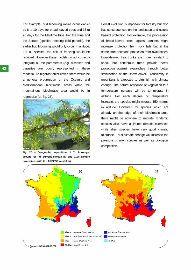
For example, bud blooming would occur earlier
by 6 to 10 days for broad-leaved trees and 15 to
20 days for the Maritime Pine. For the Pine and
the Spruce (species needing cold periods), the
earlier bud blooming would only occur in altitude.
For all species, the risk of freezing would be
reduced. However these models do not correctly
integrate all the parameters (e.g. diseases and
parasites are poorly represented in these
models). As regards forest cover, there would be
a general progression of the Oceanic and
Mediterranean bioclimatic areas while the
mountainous bioclimatic area would be in
regression (cf. fig. 25).
Fig. 25 – Geographic repartition of 7 chorologicgroups for the current climate (a) and 2100 climate
projections with the ARPEGE model (b)
Forest evolution is important for forestry but also
has consequences on the landscape and natural
hazard protection. For example, the progression
of broad-leaved trees against conifers might
increase protection from rock falls but at the
same time decrease protection from avalanches;
broad-leaved tree trunks are more resistant to
shock but coniferous trees provide better
protection against avalanches through better
stabilisation of the snow cover. Biodiversity in
mountains is expected to diminish with climate
change. The natural response of vegetation to a
temperature increase will be to migrate in
altitude. For each degree of temperature
increase, the species might migrate 150 metres
in altitude. However, for species which are
already on the edge of their bioclimatic area,
there might be nowhere to migrate. Endemic
species also have a limited climatic tolerance,
while alien species have very good climatic
tolerance. Thus climate change will increase the
pressure of alien species as well as biological
competition.
(a) (b)
© C
REA
Sources : INRA / CARBOFOR
42

The influence of the climate andclimate change impacts on natural
phenomena in the Alps
© O
. Ali
© O
NE
RC
/ G
. Pru
dent

Floods – historical processesand projections regardingclimate issuesDefinitionFloods are a rapid and long-lasting increase of
the water level that can lead to inundations
(through infiltration, dike bursting, etc.). Floods
are part of a river’s natural cycle. The
implementation of human stakes within major
riverbeds puts these stakes into potential flood
situations.
Data concerning floods in the AlpsFloods are relatively well observed in both time
and space. Monitoring and observation networks
are implemented along most of the alpine and
peri-alpine rivers. The Alps represent an
important part of the big European rivers
catchment area. Indeed, 20% of the Rhône
waters and 67% of the Rhine waters originate in
the alpine area. Rivers like the Rhône and the
Rhine have long flow chronicles. Furthermore,
historic reconstructions (like that carried out by C.
Pfister in Switzerland) can give an idea of river
activity for the period preceding instrumental
records.
Flood sensitivity and links with theclimateThe link between climatic parameters and river
floods is obscured by many human factors (this
is even more perceptible than for torrential
events). Land-use changes greatly modify the
surface flows and the stream. Today there are no
catchment areas in the Alps with “natural” flow
processes. Water used for agriculture also
represents an important part in the flow balance.
Hydraulic works can have a strong influence on
river characteristics. Dams radically change the
flow patterns, whilst protective buildings and
micro power plants represent “noises” in
frequency and intensity analyses. Moreover,
many “hazard-reducing” measures (dikes,
protection forests, etc.) were implemented in the
first half of the 20th century, while “hazard-
aggravating” measures (ground waterproofing,
concrete banks, etc.) have generally increased in
the second half of the 20th century.
The following hypothesis is generally proposed:
in a warmer climate, the situations that could lead
to floods would increase (with the postulate that
with more energy in the climatic system, the
water cycle would be enhanced). However, there
is a lack of “transfer” between climatic model
results and the possible effects on hydrological
balance and river runoff. Up till now, the
proposed impacts were mainly qualitative.
Hydrological models aimed at obtaining
quantitative results are currently under
development in Germany and Switzerland.
Climate models calculate a precipitation
increases for some seasons and precipitation
decreases for other seasons. Thus it is expected
that the evolution of floods will follow that of
precipitation. However the non-linear nature of
precipitation/runoff relations and various buffer
effects might attenuate the impact of precipitation
on large-scale catchment areas. As regard to the
torrents, the buffer effect on the catchment area
is more reduced and so it is more sensitive to
fluctuation in precipitation.
© IR
Ma
/ S. G
omin
et
44

Observed impacts of cliamet changeon floodsFlood intensity: On the world scale, around
70% of rivers flows do not show any significant
trends related to climate change. When these
trends are significant, they are divided equally
between an increase and decrease in flood
volume. In France, different studies converge on
the fact that there are no significant trends
concerning flood volumes since the middle of the
20th century. These findings are also valid for
Central Europe (Elbe and Oder rivers).
However, in Southern Germany, the examined
runoff time series demonstrate a regional
increase in flood runoff for some stations in the
last 30-40 years; but no significant changes were
detected when examining the annual series for
70 to 150 years time series duration.
Flood frequency: An increase in the frequency
of « extreme » floods in the Alps has been
observed over the past 20 years, compared to
the 20th century mean. In Southern Germany, the
KLIWA project stated that the frequency of winter
floods increased since the 1970s with the
exception of Southern Bavaria (i.e. North edge of
Alps). Significant floods occurred in Switzerland
in August 1987, September 1993 and October
2000, particularly in Ticino in 1978, 1987, 1993
and 1994. However this frequency increase
seems to be within the natural range of
variability. The same kinds of conclusion have
been proposed for floods in Central Europe
(Oder and Elbe). In France, statistical studies do
not show any significant flood frequency
increase.
Floods intensity/frequency and seasonnality:
An increase in summer flows for rivers fed by
glaciers, due to increased glacier melting, has
been observed in the Alps, with favourable
impacts (on a short-term scale) on low waters,
but no direct impact on floods. In Southern
Bavaria, the KLIWA project stated that monthly
runoffs during winter are higher since the 1970s
(compared to preceding values, available since
1931). In France, the only detected changes
concerning floods and low water patterns are
found in mountainous areas (Alps and
Pyrénées). In these mountain ranges, a
temperature rise lead to earlier melting of snow
cover and strong low water events (depending
on whether there was snow cover or not).©
Mai
rie d
e C
hona
s
45

Potential impacts of climate changeon floodsFloods intensity/frequency and seasonnality:
The simulated winter precipitation increase and
the expected limited buffer effect of snow cover
(due to a higher rain/snow limit) should lead to
favourable situations for floods in winter (both for
intensity and frequency).
Depending on the topography of the basin, these
impacts might be of major importance if it
incorporates a large zone at medium altitude (
1,000-2,500 metres a.s.l) with a consequent
snow cover (cf. fig. 24). On the other hand, the
intensity of spring flood peaks would be reduced
as a consequence of the gradual melting of snow
cover.
The river flood peak due to snow cover melting
could occur a month earlier in the year. On a
global scale, diminished low waters and even
droughts should be more frequent during
summer because of reduced summer
precipitation and stronger evapotranspiration.
Nevertheless, the rivers fed by glaciers (which
represent important water stocks) may
experience a flow increase in the short-term with
stronger glacier melting in summer. In the long-
term, once the glaciers would have lost most of
their volume (and/or surface), and thus their
potential water stock, the flow of these rivers
would decrease. The increase in summer flow
has already been observed while the long-term
decrease remains a strong assumption.Fig. 26 – Schematic evolution of the winter solid/liquid
ratio for Alpine and Pre-Alpine catchment areas
Alpine catchment area
Pre-Alpine or Plateau catchment area
Current conditions With temperature increase
Current conditions With temperature increase
2 500 m 2 500 m
2 500 m 2 500 m
1 000 m 1 000 m
1 000 m 1 000 m
Altitude range where thesolid/liquid precipitationratio might changemarkedly
Most of the precipitations fallas snow
Most of the precipitationsfall as rain
The precipitation fall assnow and rain
Sour
ces:
Aut
hor,
with
the
advi
ce o
f C. O
bled
46

Debris flows and torrentialevents – historical processesand projections regardingclimatic issuesDefinitionTorrents are mountain rivers characterised by
small length, a steep slope (> 6%), with sudden
and violent floods. Downstream of these torrents
are torrential rivers with a gentler slope (between
1% and 6%), with sudden floods and an
important solid transport linked to the slope.
Depending on the percentage of solid materials,
sediment transport in torrential floods can be
either suspension, bed load or debris flows.
Debris flows are generally triggered by extreme
precipitation, when a liquid flow in a torrent bed is
moving a large amount of non-consolidated
materials (e.g. scree, mud, etc.). These flows
constitute more than 50% solid materials of
different sizes, from very small materials to rocks
of several cubic metres. Even when they are
quite slow, debris flows can be very powerful.
Data concerning torrential events inthe AlpsDebris flows and other torrential events are
relatively difficult to observe. The same is true of
the predisposition, triggering and aggravating
factors related to torrential events. There are
insufficiencies in the rain cover network, i.e. a
precipitation measure network that is adapted to
the torrential phenomenon. With the exception of
some experimental basin catchments, measure
stations are rarely located in close vicinity of
hazard zones and the data have to be
extrapolated from distant stations. The
precipitation data provided by meteorological
stations also have limits when trying to assess
the link between torrential events and climatic
parameters.
Indeed, the significant precipitation gradient on
the mountainous relief makes the data from
permanent measure stations located at the
piedmont or valley floor unusable. For example,
during the August 2005 floods in the Belledonne
massif (France), 278 millimetres of rain was been
recorded in 48 hours at the La Pra refuge (2,100
metres a.s.l) whilst only 32 millimetres was
recorded at the Versoud automatic station (220
metres a.s.l).To correctly assess the
meteorological conditions associated with the
triggering of torrential events in a particular
location, it would be necessary to have measure
stations in these locations or at least to have a
network representing the massif with a good
altitudinal distribution. The implementation of
automatic flow monitoring stations is not feasible
as these installations would most likely be carried
away during each torrential flood. Even direct
observation during an event is difficult as it is
hard to correctly estimate torrent flows during a
flood. Automatic monitoring systems exist in
Switzerland but they are used to give the alert
and cannot provide instrumental data that could
be used for studying the events.
Indeed, torrents have a very limited observation
potential. This does not mean that no data exists
for torrents and associated natural phenomena,
but the data are too heterogeneous or too rarely
synthesised at the regional scale to propose a
complete analysis of the evolution of torrential
events. In France, these observations are
realised on the field by the RTM service (Special
Office for the Restoration of Mountain Soils) in
the Alps and the Pyrénées. These specific
studies of some torrential catchments usually
provide long event chronicles but with the
difficulties mentioned above, especially
concerning volume estimation.
47

However it is easier to evaluate the volume of
carried materials, especially coarse debris (e.g.
those exceeding 1 metre in diameter).
Furthermore, even if bed load and suspension
are important in terms of the operational
management of natural hazards, the impact of
climate change on these events has not actually
been assessed in the available scientific
literature, unlike debris flows. Thus the next
paragraph will concentrate on debris flows. This
should not obscure the importance of the other
torrential events.
Debris flows sensitivity to climatechangeDebris flows are principally triggered by violent
water release on areas where available materials
will potentially be carried away by the rush of
water. Precipitation and the availability of the
non-consolidate materials are the two main
components that might be affected by climate
change. The threshold values for triggering of
debris flows can differ from one massif to
another, and even between two hazard areas
within the same massif. This violent release of
water can be characterised as follows:
Spring / early summer thunderstorms (May,
June and July) with very confined and short
(one to four hours duration) events but at a
period when the mountainous catchment
areas are still moist from recent snow
melting.
Generalised autumn events (end August,
September, October) when water is falling
on drier ground, but with high intensity,
longer duration (six to 18 hours) and over a
wider area. Autumn events show greater
intensity due to their origin in the
Mediterranean Sea which is warmer during
this period of the year.
At Ritigraben (Wallis, Switzerland), an increase in
precipitation events with the potential to lead to
debris flows has been observed during the past
three decades. However, the precipitation data
available are on a daily scale while for a more
precise assessment, hourly precipitation data
would be required. Indeed, hourly precipitation
intensity is an important parameter, and for a
given daily precipitation value, the hourly
precipitation distribution can vary greatly.
48

Many hypotheses propose links between
permafrost degradation and an increase in debris
flow intensity and frequency through the
increased availability of non-consolidate
materials. The degradation of frozen grounds
concerns the periglacial area4 in its entirety.
Permafrost thawing diminishes cohesion inside
unstable or metastable structures and can
potentially increase the future material availability
for debris flows. Glacier retreat also exposes
large amounts of freshly uncovered materials
presenting very low cohesion.
All these phenomena, which could lead to debris
flows, are potentially influenced by climate
change through changes in the
freezing/defreezing cycles, changes in heavy
precipitation seasonality and frequency, changes
in glacier patterns as well as changes in the
available materials for debris flow triggering.
However, debris flows are phenomena
characterised by very significant spatial and time
variability which leads to difficulties in assessing
the impact of climate change on these natural
events.
4 Area where freezing/defreezing and snow coveralternation play a predominant role
Observed impacts of climate changeon debris flowsDebris flows intensity/frequency: Despite the
important number of hypotheses proposing an
increase in debris flow intensity with climate
change, no trends have been observed or
modelled. The available studies mention a
decrease in the occurrence of debris flows.
Correspondingly, the debris flow frequency in the
Swiss Wallis seems to be the lowest in the last
300 years and a significant decrease in the
number of debris flows has also been observed
since the mid 1970s in the Écrins and Dévoluy
massifs (France).
The evaluation of events considered “extreme”
when they occurred (this is especially true
concerning the Ritigraben torrent in Switzerland
in 1987 and 1993) has been moderated by
recent publications. Early analyses which
interpreted these events as the first signs of
climate change have been attenuated because
further investigations on the site showed that
such intense events occurred with the same
frequency in the past.
© O
NE
RC
/ G
. Pru
dent
49

Debris flows seasonality: Debris flows mainly
occur during summer, generally between June
and October. A seasonal shift has been
observed between the 1800-1950 and 1950-
2000 periods at Ritigraben (Swiss Wallis) where
the debris flows shifted season from June/July
(linked to local thunderstorms) to
August/September (linked to regional heavy
precipitation).
Debris flows localisation: An altitude increase
has been observed in the triggering areas of
debris flows for some massifs, such as the Écrins
(France), where their altitude rose by more than
100 metres between 1952 and 2000. The
triggering areas located under 1,800 metres a.s.l.
have remained inactive since 1976. However no
variations have been observed above 2,200
metres a.s.l. The temperature increase and the
decrease in freezing days are assumed to
explain these altitudinal shifts. Another study at
the Mont Rose, which also mentions a spatial
shift, proposes glacier retreat as an explanation.
Nevertheless today, no changes in debris flow
activity directly caused by changes in the volume
of available materials in these areas have been
detected. Given the limited number of studied
sites and the fact that existing studies do not
focus on the material availability; it cannot be
assumed that no changes have occurred as yet.
Potential impacts of climate changeon debris flowsDebris flows intensity: Despite the large
number of hypotheses proposing an increase in
debris flow intensity with climate change, no
trend has been modelled. Material availability is
the critical factor that could lead to a change in
future debris flow intensity. This intensity
variation could lead to increased volume and
stopping distance. Thus, even if debris flow
intensity can be assessed in a general manner, it
is important for policy makers and technical
services to also understand the evolution of
particular sites. Particularly, hazard areas linked
with periglacial areas may potentially experience
marked intensity changes (even if such changes
have not yet been observed).
Debris flows frequency: Model results
simulating a decrease of debris flow events for a
warmer climate are in accordance with
observations at low and medium altitude.
However, on the Alpine scale the frequency
could increase in particular regions and decrease
elsewhere depending on local situations and
driving parameters (altitude, occurrence of
permafrost…).
50

Debris flows seasonnality: Some hypotheses
also propose the evolution of debris flow activity if
precipitation were to increase during spring and
fall (as suggested by climatic models). However
this seasonal shift in precipitation should not
have any effect on debris flows because the
mean temperature during these periods would
remain lower (from 4°C to 7°C) than the mean
temperature during summer (summer is the main
season for debris flow occurrence).
Debris flows localisation: Deglaciated areas
(moraine, scree slopes) and permafrost
degradation (including rock glacier
dismantlement) are expected to furnish more
available materials for future debris flow activity.
Moraines and active talus slopes can furnish
debris flows; some dismantled rocky glaciers can
also be affected by this kind of phenomenon.
Debris flows could be triggered more easily if the
slope is steep in these areas. High mountain
areas in the periglacial zone could be more
favourable to debris flows events than in the
past.
51

Avalanches – historicalprocesses and projectionsregarding climate issuesDefinitionAn avalanche is the rapid movement of snow
cover on a slope. This is a gravity movement
triggered by a loss of balance of the snow cover.
Depending on the snow settlement, ground
temperature, existing vegetation cover, air
temperature and humidity, this movement can
occur at the ground level (wet snow or slab
avalanches), or as an aerosol. These types of
avalanches result in different propagation
characteristics inducing various levels of damage
and protection possibilities.
Data concerning avalanches in theAlpsPast avalanche activity reconstructions are
realised by using historical documents reporting
damages to buildings and inhabitants, some of
these chronicles date back to the 16th century.
However this kind of analysis cannot be used to
assess the evolution of natural events because
only catastrophic events, which lead to damages,
are reported and detailed. Some
dendrochronology and lichenometry techniques
have also been used to characterise past
avalanche activity in very precise locations.
These techniques are still being developed and
many limits still exist: the limited number of
available studies hinders a critical view of the
method used. Some problems concerning time
calibration can also be found.
Furthermore, even if avalanche activity in a
precise location can be reconstructed using
these techniques, the link with climatic
parameters is not easily discerned. Even if it is
possible to assess the link scientifically, the
researcher must extrapolate data from
meteorological stations often located quite far
from the observation site.
Avalanche observation is compiled in avalanche
atlases, databases which are often maintained
by the forest services or their equivalent in the
alpine arc. This observation work is carried out
from identified avalanche locations on maps.
Technicians observe the events and describe
their characteristics using a data form; all these
data forms represent a database describing the
avalanche activity of the monitored avalanche
area.
Some cooperation networks with ski resorts
provide information about avalanche activity
within the ski resorts or in their vicinity. The data
analysis is not able to propose a clear evolution
of avalanche hazards and even less to provide
links between avalanches and climatic
parameters. However, these data are used to
evaluate the avalanche risk with “closest
neighbour” methods. These methods are used
by the meteorological services and ski resorts in
Anglo-Saxon countries (Unites States, New
Zealand, Canada…).
©U
nive
rsité
de
Sav
oie
52

Data concerning avalanches inFranceThe « Enquête Permanente sur les Avalanches »
(EPA) started in Savoie before 1900 and has
been carried out systematically in the Alps and
Pyrénées since 1965, leading to a database
which now includes over 80 000 events. For a
long time, this monitoring was dependent on the
initiative and availability of the ONF (National
Office of Forestry) personnel and particularly the
RTM services. Despite these limits, exhaustive
data series are available for various territories,
especially since 1945.
Since 2002, the « Ministère de l’Écologie et du
Développement Durable » (today MEDAD)
aimed to give an official frame for this action
(following a recommendation of the back analysis
commission set up after the catastrophic
avalanche of Montroc in 1999). A protocol has
been developed to homogenise all the
information for the sites: observations are always
conducted from the same location, indications on
the map help the observer to estimate the
event’s magnitude and the periods without
avalanche activity are also detailed so as not to
be considered periods without observation. All
theses recommendations are detailed in an
instruction book. This new regulation of
avalanche observation should enable a scientific
analysis of the avalanche evolution for particular
locations.
The snow-meteorological network was
implemented in the 1980s through cooperation
with Météo-France. This network provides daily
information on avalanche activity in ski resorts
and their vicinity during the tourist period. These
data are not exhaustive in terms of area covered
or in terms of time covered.
They are of very poor quality when the
meteorological conditions do not enable the
personnel to make direct observations (e.g. due
to fog).
Like floods, avalanches are highly monitored (in
the critical area) and many prevention/protection
measures exist. The implementation of protection
buildings (protection dikes, snow fences,
avalanche mounds, etc.) or changes in forest
cover for example have strong impacts on
avalanche activity. All theses measures
represent “noise” in the signal of the natural
event itself, making its interpretation more
difficult.
Despite the importance of the data collected and
its compilation within a homogeneous database,
it does not represent a systematic and
instrumental chronicle of avalanche activity
enabling a complete statistical analysis on the
phenomena evolution. Thus it is important to
choose a representative sample for the
considered massif. The difficulty of collecting
data with a standard protocol (as the EPA
method) is a crucial problem for the study of
avalanches. Methods aiming to account for these
insufficiencies (using automatic monitoring with
seismic captors or satellite data for example) are
currently in development or undergoing testing
but they face technical limits.
© Cemagref
53

Avalanche sensitivity and links withthe climateAvalanche situations often results from a
combination of an extreme meteorological
situation (massive snow falls, intense melting)
and a significant existing snow cover. It is
therefore necessary to know the evolution of
such extreme meteorological situations to be
able to assess the evolution of avalanche activity.
Nevertheless the understanding and integration
of extreme meteorological events into the climatic
model is still in process. Approaches based on
“closest neighbour” methods which are used to
assess avalanche danger can also be used for
scientific purposes. These probabilistic
approaches enable scientists to associate a
climatic situation to probabilities for
corresponding avalanche activity. Some studies
have also studied the potential correlation
between avalanche activity and large-scale
climatic circulations such as the North Atlantic
Oscillation, but no links have been found.
It is also important to precisely characterise the
evolution of snow cover conditions for a wide
range of altitudes. Avalanche characteristics
(stopping distance, volume in movement, etc.)
are closely linked to snow cover conditions.
All types of avalanches are dependent on the
presence of snow cover; hence a potential
decrease (in duration, height or extent) of the
snow cover and a possible altitudinal shift of the
snow/rain limit will have impacts on avalanche
activity. Depending on the type of avalanche,
other factors are also involved. Whilst aerosol
propagation is relatively independent of the local
topography, the propagation of the wet snow and
snow-slabs avalanches is sensitive to the relief,
forest cover and whether the area is prone to
erosion. All these factors are obstacles to
providing a direct link between avalanche activity
and climatic parameters on one hand and
between avalanche activity and snow cover on
the other. Even with good snow cover
observations showing clear trends for its
evolution and efficient models of snow cover
evolution in a warmer climate, this information
would not be sufficient to assess the potential
evolution of avalanche activity. Some hypotheses
can be proposed but they encounter the limits
mentioned above.
No complete model currently exists for assessing
the predisposition, the triggering and the flow of
avalanches, but some partial models have been
developed. To fill these gaps, Météo France has
developed an approach based on snow cover
modelling in 2001. The scientists exploited the
Safran-Crocus-MEPRA coupled model that is
usually used for the assessment of snow cover
stability on a slope from observed and predicted
meteorological conditions. With this tool, it is
possible to test snow cover sensitivity to the
evolution of a meteorological parameter, e.g. air
temperature or precipitation increase. The
Cemagref also developed a numerical tool to
understand the propagation of avalanches.
© Cemagref
54
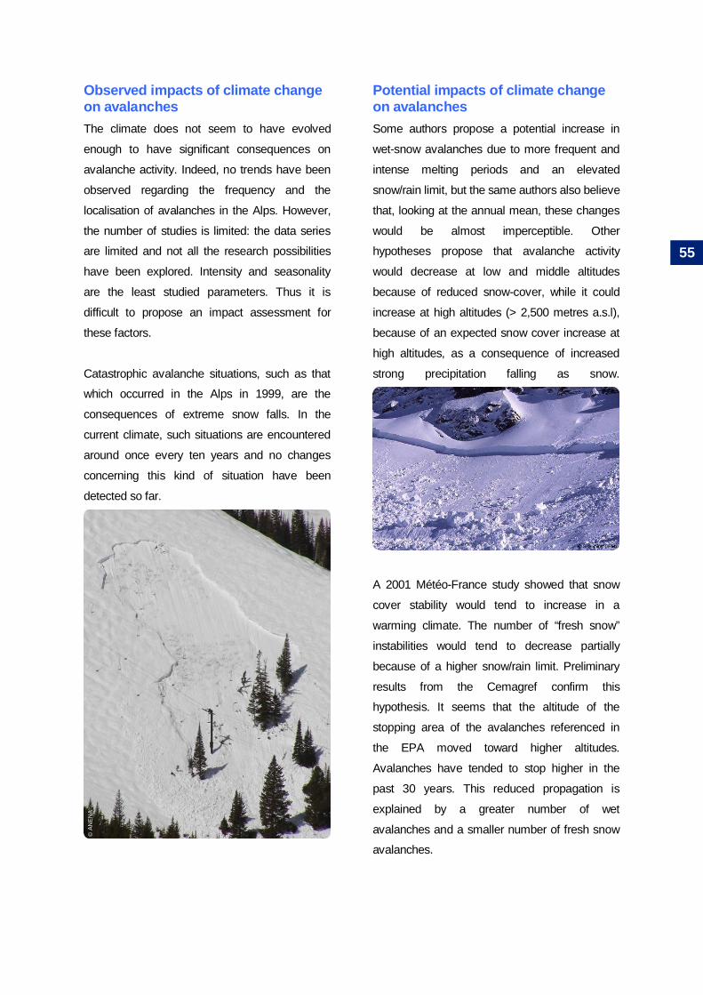
Observed impacts of climate changeon avalanchesThe climate does not seem to have evolved
enough to have significant consequences on
avalanche activity. Indeed, no trends have been
observed regarding the frequency and the
localisation of avalanches in the Alps. However,
the number of studies is limited: the data series
are limited and not all the research possibilities
have been explored. Intensity and seasonality
are the least studied parameters. Thus it is
difficult to propose an impact assessment for
these factors.
Catastrophic avalanche situations, such as that
which occurred in the Alps in 1999, are the
consequences of extreme snow falls. In the
current climate, such situations are encountered
around once every ten years and no changes
concerning this kind of situation have been
detected so far.
Potential impacts of climate changeon avalanchesSome authors propose a potential increase in
wet-snow avalanches due to more frequent and
intense melting periods and an elevated
snow/rain limit, but the same authors also believe
that, looking at the annual mean, these changes
would be almost imperceptible. Other
hypotheses propose that avalanche activity
would decrease at low and middle altitudes
because of reduced snow-cover, while it could
increase at high altitudes (> 2,500 metres a.s.l),
because of an expected snow cover increase at
high altitudes, as a consequence of increased
strong precipitation falling as snow.
A 2001 Météo-France study showed that snow
cover stability would tend to increase in a
warming climate. The number of “fresh snow”
instabilities would tend to decrease partially
because of a higher snow/rain limit. Preliminary
results from the Cemagref confirm this
hypothesis. It seems that the altitude of the
stopping area of the avalanches referenced in
the EPA moved toward higher altitudes.
Avalanches have tended to stop higher in the
past 30 years. This reduced propagation is
explained by a greater number of wet
avalanches and a smaller number of fresh snow
avalanches.
© A
NEN
A
55

Consequently, it seems quite difficult to provide a
general overview of the evolution of avalanche
activity in regards to intensity, frequency, location
and seasonality in a climate change context.
Many hypotheses have been proposed but the
evolution suggested is not quantitative and could
not actually be detected in the available data.
Nevertheless, a decrease of avalanche activity at
low and medium altitudes and an increase of the
proportion of wet snow avalanches are the most
plausible hypotheses considering current
knowledge.
Different research methods have been explored
to develop this point: improvement of the
observations, development of statistical methods
designed to assess available data sets,
development of numerical tools for better
understanding of avalanche activity and the link
with meteorological parameters, regional
application of climatic scenarios for mountainous
area.
56

Mass movement – historicalprocesses and projectionsregarding climatic issues
DefinitionA mass movement is a brutal gravity movement
of the ground dependent upon the structure of
the geologic layers, the type of soil and
underground water pressure. These movements
are due to alteration and erosion processes of
different kinds: freezing/defreezing cycles, water
erosion. Human activities can also influence
shallow landslides (for example through
ploughing) or even deeper landslides in particular
cases (concentration of drainage waters,
underground cavities, mining…). In this report,
the considered mass movements are shallow
landslides, deep landslides and rock falls.
Data concerning mass movements inthe AlpsThere are many databases in the Alps that
inventory mass movements. In France, there are
two main databases. One is the BDMvt, held by
the BRGM (Office for Geologic and Mining
Risks), with the contributions from the RTM
services and the public work research laboratory
(CETE/LCPC). For each movement data form,
the precise location (both geographic and
administrative), date, volume, width and the
possible damages are detailed. However, all the
parameters that could lead to these movements
(geologic, precipitation, chemical, etc.) are not
recorded. The second database is the BD-RTM
database which comprises observations of
forestry agents working on estate, communal or
State lands. This database references
avalanches, mass movement, torrential events
and erosion in the 11 “départements” of the Alps
and Pyrénées.
Generally only events leading to damages are
recorded in these databases, contrary to
systematic instrumental inventory (e.g. seismic
monitoring data network). These databases are
strongly influenced by the evolution of
vulnerability and thus need to be used with
caution in the evaluation of natural event
evolution.
Precise information is only available from
experimental sites (“observatories”), monitored
by laboratories or observatories. Even if these
sites have a good temporal cover, they are
limited geographically. An extrapolation based on
these data for wider territories is not possible as
each movement is strongly conditioned by local
parameters.
Radiocarbon dating methods enable scientists to
re-construct the temporal distribution of
landslides for various locations in Europe during
the Holocene. Some dendromorphology
methods are also used to reconstruct past rock
fall activity by studying the impacts of rock falls
on trees. This process is still in development and
many limits exist: rock falls may impact only a
single tree, several trees or none at all. As it is
impossible to determine, scientists make the
postulate that “each impact corresponds to a
rock fall event”.
© IR
Ma
/ S. G
omin
et
57

The impacts can make scars or “trauma” in the
resin duct, but these signs are difficult to study.
Furthermore, the correlation test with climatic
parameters is based on measures from far-away
meteorological stations (from a few to dozen of
kilometres). The limits are numerous and the
proposed results have to be considered carefully.
Mass movements / Shallowlandslides – historical processes andprojections regarding climatic issues
DefinitionLandslides are slow movements of terrain (from
some millimetres / year to metres / day) occurring
on a slope. They are characterised by the
existence of a discontinuous surface easily
identified (flat or circular), separating the stable
part from the moving part. Shallow landslides are
generally some meters deep.
Shallow landslides sensitivity and linkswith the climateIncreases in intense precipitation could lead to
increases in the frequency of shallow landslides,
which are often triggered by peaks of pore
pressure. This response depends on the water
infiltration characteristics of each site. Shallow
landslides can also be indirectly impacted by
climate change, through effects on glaciers,
permafrost or forest fires.
Glacier retreat and permafrost degradation
should lead to large areas of unstable slopes
(especially because of cohesion loss due to the
melting of ice particles in these slopes). These
voluminous materials could potentially become
debris flows at high altitudes; this is also relevant
for very steep slopes.
With a temperature increase, some hypotheses
are also proposed concerning a possible re-
colonisation of scree slopes because of longer
vegetative periods. Such re-vegetation should
enhance slope cohesion. This stabilisation as a
result of vegetation cover could also be limited by
the appearance of acidifying species (such as
Ericaceae s.l. on grassland) limiting the growth of
plants with a wider root system. The vegetation
conditions can also be very harsh at high altitude
and re-vegetation in this case will be quite slow
Forest fires cause the ground to lose a great part
of its protection previously provided by the
vegetation cover. Furthermore, small particles
(such as ash and coal) can act as lubricants,
which would favour surface erosion. All these
conditions aggravate the aggressive effects of
intense precipitation and could lead to more
superficial mudflows.
© IR
Ma
/ S. G
omin
et
© IR
Ma
/ S. G
omin
et
58

The multiplication of forest fires (plausible in a
climate change context) is a supplementary
aggrieving factor for the increase of shallow
landslides. This type of aggravating circumstance
has been observed following the forest fire in the
Chamatte massif on the 6th July 1982 (Alpes-de-
Haute-Provence, France). On 18th July of the
same year a thunderstorm reactivated slopes
(considered inactive) leading to mudflows on
Angle village.
However this degradation of ground conditions is
only temporary and after some years, re-
colonisation by vegetation will again exert a
protective effect on the slope. Similar features
can also be observed after heavy storms, when
wide parts of the forest cover are destroyed.
Observed impacts of climate changeon shallow landslidesIn the “Romandie” and Ticino cantons
(Switzerland) an increasing number of landslides
have been observed in simultaneously with
increased precipitation suggesting a link.
However the available literature does not
propose any analysis of the impacts of climate
change on shallow landslides. Indirect impacts
via forest fires and storms are often mentioned or
locally observed, though observations are limited
both in terms of time series and geographical
extent. Thus, despite the lack of significant
trends, these indirect impacts have to be
considered as potential emerging risks.
Potentila impacts of climate changeon shallow landslidesShallow landslides intensity: Some
hypotheses propose that increased heavy
rainfall, permafrost degradation and marked
glacier retreat may increase the intensity of
shallow landslides (especially mudflows through
increased available materials). These
hypotheses only concern high altitude areas and
have neither been confirmed nor disproved by
observations in the Alps.
Shallow landslides frequency: The hypotheses
developed in the intensity chapter (based on
glacier retreat and permafrost degradation) are
also valid for event frequency at high altitude. For
low and medium altitudes, there are hypotheses
concerning the destabilising effect on the first
layers of the ground of the disappearance of
vegetation cover after a forest fire or a storm.
Combining this multiplication of soil degradation
and the expected increase of precipitation,
scientists propose an increase in shallow
landslides.
The progressive re-vegetation of slopes
(moraines, scree slopes, rock chaos…) may lead
to decreased slope instability in the long-term
through better slope cohesion. However there
are currently no observations that validate this
hypothesis.
© IR
Ma
/ S. G
omin
et
© IR
Ma
/ S. G
omin
et
59

Mass movement / Deep landslides –historical processes and projectionsregarding climatic issues
DefinitionA landslide is a slow movement (from some
mm/year to m/day) of the ground occurring on a
slope. They are characterised by the existence of
a discontinuity surface easily identified (flat or
circular), separating the stable part from the
moving part. Deep landslides are generally some
dozen to hundreds of meters deep.
Deep landslide sensitivity and linkswith the climateDeep landslides often occur on “dormant”
landslides (e.g. Val Pola 1987). The assessment
of such old inactive features as well as of slow
creeping slopes is possible with
geomorphological studies, but the forecasting of
their reactivation is difficult to assess. Different
scientists propose mean annual precipitation and
even pluri-annual means as the key-parameters
for deep landslides, through the influence of
deep infiltrating waters and underground waters.
Thus, any marked change in the precipitation
pattern may have consequences on deep
landslide activity. In particular, slopes with
stability controlled by foot erosion seem to be
more sensitive to surface water runoff linked with
intense precipitation. A dendrochonologic study
has highlighted a link between climate and
landslide activity on the geological timescale in
the Fribourg Pre-Alps (e.g. Hohberg and Falli-
Hölli sites), where warm periods led to increased
deep landslide activity in the Flysch area under
1,500 metres a.s.l. This re-activation seems to be
linked with the 0°C isotherm position. However,
these links between warm periods and increased
deep landslide activity cannot be extrapolated for
the Alps.
Observed impacts of climate changeon deep landslidesNo observed impacts of actual climate change
on deep landslides are currently available in the
referenced literature.
Potential impacts of climate changeon deep landslides
Deep landslides intensity: Each deep landslide
has its own characteristics (lithology,
hydrogeology, topography, vegetation, etc.) and
regime of deformation. Some might react to
increases in precipitation with an acceleration of
their movement. This reaction might not be
systematic and may be strongly influenced by
local conditions.
Deep landslides frequency: For movements
presenting sensitivity to short-term
meteorological parameters, an increase in the
acceleration phases can be expected (as a
consequence of the expected incease in intense
precipitation).
Deep landslides localisation: As a
consequence of the new climatic conditions, and
particularly changes in precipitation patterns, a
re-activation of old deep landslides rather than an
activation of new deep landslides is expected.
©LG
IT
60

Mass movement / Rock fall –historical processes and projectionsregarding climatic issues
DefinitionRock falls are an instability phenomenon that
implies rocks or blocks breaking off a cliff or a
rock slope and subsequent movements (free fall,
rebound, rolling, sliding) along the slope until an
equilibrium is reached. Rocks usually refer to a
volume of dm3, and blocks to a volume of m3.
Rock fall sensitivty and links with theclimatePositive correlations between rock falls and days
with freezing/defreezing events have been
highlighted; however a link with precipitation has
not been established. In France, a study on 46
rock falls in the Chartreuse and Vercors massifs
has shown no correlation between rock fall
activity and precipitation; but a correlation has
been shown for days with freezing/defreezing
events. This link is valid for small to medium
scale rock falls. For very large events (millions of
cubic meters, e.g. Randa 1991), the importance
of climatic factors becomes negligible in
comparison to geological patterns.
During the 2003 summer, many rock falls were
observed in high mountain areas. This rock fall
activity increase could be the consequence of
permafrost degradation induced by very high
summer temperatures. The permafrost thaw
depth reached values 10 to 50 centimetres
deeper than the mean for the preceding 20
years. It is interesting to note that these
instabilities occurred between June and August,
i.e. not when the thawing phenomenon was at its
deepest point but when the heat flow in the
superficial layer was at its maximum.
Many studies propose the hypothesis of a link
between permafrost degradation in steep
bedrock and rock fall activity. This permafrost
degradation may have consequences on the
intensity, the frequency, the seasonality and the
localisation of the natural event.
After the immediate response of the superficial
permafrost layer to increased temperature, the
lower limit of permafrost may rise in altitude and
several instabilities may develop at high altitude
where there are usually no freezing/defreezing
cycles. The penetration of the freezing front in
previously thawed materials may lead to
important constraints through ice formation in
cracks.
© IR
Ma
/ S. G
omin
et
61

The disappearance of forest and vegetation
cover following forest fires would have potential
consequences for the rock fall triggering (thermal
constraints and stabilisation because of the roots
system) and the stopping distance (decrease of
the protective layer of the forest): the
multiplication of forest fires (likely to happen in a
climate change context) may be an aggravating
factor for the evolution of rock falls. These
negative consequences were observed following
the fire at Argentière-la-Bessée in 2003 (Hautes
Alpes, France) and at the Néron and Pont en
Royans, also in 2003 (Isère, France).
Observed impacts of climate changeon rock fall
Rock fall intensity: A study using
dendromorphology in the Swiss Pre-Alps did not
show any evolution of intensity in rock fall activity
in the studied area in the last decades.
Rock fall frequency: Rock fall frequency seems
to have increased in the Swiss pre-Alps during
the 20th century. Many rock fall events were
observed during the 2003 summer. However due
to a lack of observation, it is hard to determine if
the number of rock falls during this scorching
summer was higher than during a “normal”
summer. A statistical study proposed that the
probability of occurrence of rock fall events is 2.5
times higher for the days with freezing/defreezing
cycles than for the days without theses
influences (evaluation for the Chartreuse and
Vercors massif, France).
Rock fall localisation: During the 2003 heat
wave, numerous rock falls were observed on the
North face of the alpine mountains. This increase
in frequency may be explained by more
important permafrost surface in these slopes. A
study on the Monte Rosa (Swiss Wallis)
observed an altitudinal rise of the triggering area.
This spatial shift has been explained (as for the
debris flows) by glacier retreat.
Potential impacts of climate changeon rock fall
Rock fall intensity: Some hypotheses propose
a link between permafrost degradation and a
increase in future rock fall intensity in the zones
affected, but it remains difficult to propose trends
for future event intensity.
Rock fall frequency: The assumptions for the
evolution of rock falls propose a frequency
increase in the permafrost area influenced by
freezing/defrezzing cycles. Thus it is very likely
that the frequency would increase in these zones
but that it would also decrease in lower zones.
© IR
Ma
/ S. G
omin
et
62

Glacial hazards – historicalprocesses and projectionsregarding climatic issues
DefinitionGeneric term representing all kinds of hazards
originating from glaciers and corresponding
water pockets and lakes.
Data concerning glacial hazardsThe last catastrophe due to a glacier in the Alps
occurred in 1965, in Switzerland. The terminal
part of the Allallin glacier tongue broke off and
devastated the Mattmark dam building site
(Swiss Wallis). As few glacier catastrophes
occurred during the second half of the 20th
century, the attention given to this hazard has
decreased.
However, some potentially dangerous situations
have existed in the Alps during the last few
years, such as the pro-glacial Arsine lake
(Hautes Alpes, France), the supra-glacial lake on
the Rochemelon glacier (Savoie, France) or the
Laggo Effimero on the Belvedere glacier
(Piemonte, Italy).
The GLACIORISK program (2001-2003) aimed
to propose a homogeneous database concerning
glacial hazards in Europe. This database
provides data forms for 166 alpine glaciers
considered as “hazardous” and located in
France, Switzerland, Austria and Italy.
The glaciers characteristics (length, altitude, type,
surface, slope, orientation and localisation) are
detailed as well as known glacial events that
occurred in the past. However all the glacial
events are not reported and the data quality is
not homogeneous for all the events;
some have been provided by technical services
observers, others are quite old and based on
various historical documents. Thus although this
database is a unique for glacial hazards, it does
not allow for assessments of glacial hazard
evolution.
Up till now, glacial water pockets have been
impossible to observe and despite some
attempts using remote sensing, there are no data
for this class of glacial hazard.
Glacial lakes and ice avalanches are observed
punctually by research institutes (e.g. the French
LGGE or the Swiss VAW) at experimental sites
(which can also correspond to hazardous areas
threatening human stakes). These punctual
observations enable scientists to develop models
(especially an ice avalanche prevision model with
a precision of 1-2 weeks range) and trends for
some specific sites although general trends
cannot be proposed.
©V
AW
63

Glacial Glacial lakes OutburstFlooding – Historical processes andprojections regarding climatic issues
DefinitionAs a glacier front advances or recedes, some
natural dams (mainly moraines) can be created,
leading to glacial lake formation. As these natural
dams are made of heterogeneous materials with
limited cohesion, they can burst easily, leading to
significant inundations and debris flows in the
valleys downstream. These lakes can be located
at the glacier front (proglacial lakes), above the
glacier (supraglacial lakes), between the glacier
and the slopes (gutter lakes) or between two
glaciers (confluence lakes). The term GLOF
(Glacial Lake Outburst Flooding) is used to name
the hazard linked to glacial lakes.
« GLOF » sensitivity and links with theclimateClimatic conditions and glacier dynamics explain
these lake formations. Pro-glacial lake
occurrence is closely linked to glacier retreat with
different possible typologies. When a glacier
retreats, moraines can become dams, creating
pro-glacial lakes. These dams are often
constituted with unstable materials and very low
cohesion (some of these moraines can also be
partially frozen). Furthermore, the over-digging
ice-free basin following the glacier retreat can be
filled with liquid precipitation and water released
during glacier and snow cover melting, eventually
becoming a pro-glacial lake. Finally, pro-glacial
lakes can appear behind glacial rock bolts, e.g. at
the Rhône glacier (Swiss Wallis). If dike bursting
is a threat for the first two cases, it is far less
plausible for lakes behind a rock bolt.
Supra-glacial lakes can also be the consequence
of glacier dynamics, as supposed at the
Belvedere glacier (Piemonte, Italy) in 2002.
This lake is thought to be the consequence of the
strong advance of this glacier since 20005.
Climatic conditions can also lead to the formation
and extension of supra-glacial lakes. These
types of lakes needs further study to better
understand the conditions that lead to their
creation as well as the method of safe drainage
of the lakes (there were uncertainties during the
Rochemelon Lake draining concerning the ice
channel behaviour during the operation).
Ice avalanches in glacial lakes can also create
waves (as the 50 centimetre wave observed at
the Arsine pro-glacial lake on the 14 September
1996), which can potentially cause dikes to burst.
Research on the stability of moraines which act
as natural dikes for glacial lakes needs to be
developed.
5 Even if glacier retreat is general, some particular glacierscan be advancing.
©C
emag
ref
64

Observed impacts of climate change on« GLOF »No observed impacts of climate change on
Glacial Lakes Outburst Flooding are currently
available in the referenced literature.
Potential impacts of climate change on« GLOF »Some hypotheses propose that climate warming
(with accelerated glacier retreat and increased
heavy precipitation at high altitude) may lead to a
potential increase in glacial lake formation,
without distinction. These conjectures are based
on weak arguments because the influence of
climatic conditions on supra-glacial, peri-glacial,
gutter and confluence lakes is not clear. Only the
evolution of pro-glacial lakes is clear and there
would be a multiplication of these lakes with
strong glacier retreat.
©C
emag
ref
65

Glacial hazards / Glacial water pocket– Historical processes andprojections regarding climatic issues
DefinitionGlacial water pockets can be either intra-glacial,
i.e. within the glacier or sub-glacial, i.e. between
the glacier and the bedrock (cf. fig. 27). The
conditions leading to glacial water pocket
formation and bursting are not well known.
However, it seems that sub-glacial water pockets
often occur where there is a morphologic
projection.
Fig. 27 – Glacial water pockets
Glacial water pockets sensitivty and linkswith the climate
The formation and bursting of glacial water
pockets (both intra-glacial and sub-glacial
pockets) remain unknown processes. Liquid
water flows inside glaciers are also quite
unknown today. In the Mont Blanc massif, some
water release and its consequences have been
observed at the Trient glacier, at the Mer de
Glace and at the Tête Rousse glaciers (1995).
These observations of liquid water release
cannot yet be linked with clearly identified
causes: they could be the consequence of
accelerated melting of some part of the glacier,
the bursting of small glacial water pockets, the
flow of precipitation falling on the glacier or also
unknown intra-glacial liquid water flows.
Observed and potential impacts ofclimate change on glacial water pocketsConsidering the lack of knowledge mentioned
above, the evolution of glacial water pockets is
impossible to assess (with or without considering
climate change).
Soclerocheux
GlacierPoche d’eausubglaciaire
Glacier
Soclerocheux
Poche d’eauintraglaciaire
Sources : Auteur
66

Glacial hazards / Ice avalanches –Historical processes and projectionsregarding climatic issues
DefinitionIce avalanches are large blocks breaking off from
the glacier and falling into the downstream slope,
fracturing into smaller blocks. In some extreme
cases, the whole terminal tongue might break off.
Ice avalanche and sensitivity with theclimateIce avalanches are quite a frequent phenomenon
for glaciers and constitute a part of their natural
ablation process, particularly for hanging glaciers.
The link with climatic conditions is mainly indirect
because ice avalanches are influenced by glacier
movements and dynamics, themselves influenced
by climatic parameters. A glacier with a strong
dynamic experiences frequent ice avalanches. A
mean temperature increase would lead to an
ablation increase and an accumulation decrease
(unless the precipitation increase hypothesis for
high altitude is confirmed and is strong enough to
counterbalance the effect of the temperature
increase). This would result in a negative mass
balance and glacier flow should decrease, along
with ice avalanche flows. This evolution should
be experienced in the long-term and the
evolution of ice avalanches for the next 20-30
years is quite uncertain.
In some extreme cases, the entire terminal part
of the glacier tongue that can break off from the
glacier and fall downstream. This kind of
phenomenon occurred, for example in 1949 at
the Tour glacier (Haute Savoie) and in 1965 at
the Allalin glacier. Hanging glaciers can
effectively break off from their anchorage site if
the “freezing conditions” at their base are no
longer guaranteed.
The switch from a “cold” glacier thermal mode
(the glacier sticks to the bed rock because of the
low ice temperature of its base) to a “temperate”
glacier thermal mode (many liquid flows can
lubricate the glacier at its interface with the bed
rock) would thus be the main consequence of
climate change affecting hanging glaciers and
their stability. This is even more worrying
because warming of cold glaciers located at high
altitudes has already been highlighted in the Alps
(for example at the Col du Dôme du Goûter, refer
to the “glacier” chapter of this report). Some
“hazardous” sites have been identified: Dôme du
Goûter and Taconnaz (Haute Savoie, France)
where ice avalanches on a voluminous snow
cover lead to snow avalanches; Grandes
Jorasses (Aosta, Italy) or Randa/Weisshorn
(Swiss Wallis).
© V
AW
©V
AW
67

Observed impacts of climate on iceavalanches
Ice avalanches localisation: A study carried out
at the Monte Rosa (Swiss Wallis) has shown that
more new ice avalanche triggering zones have
developed at higher altitude than were present
before. This is the only source mentioning a
spatial shift of the ice avalanche triggering zones
and it is premature to draw general conclusions.
Potential impacts of climate change onice avalanches
Ice avalanches frequence and intensity: Ice
avalanche frequency should not increase. There
are few direct observations of this phenomenon
and the evolution of predispositions for this
natural event is mainly hypothetical. Even if a
local short-term increase in ice avalanche
frequency can be extrapolated on some sites, the
ice volume decrease and general glacier retreat
should attenuate this increase. However, as
mentioned above, the evolution of hanging
glaciers might be critical with a temperature rise.
If these glaciers switch from a cold mode to a
temperate mode, then it is likely that there would
be an increase in ice avalanche frequency and
also an increase in the volume involved in each
event, or even the breaking off of voluminous
parts of hanging glaciers.
©V
AW
©V
AW
68

Storms – Historicalprocesses and projectionsregarding climatic issuesDefinitionWhen winds are stronger than 89 km/h
(corresponding to 10 degrees on the Beaufort
scale), they are considered a “storm”. Most
storms approach Europe form the Atlantic,
between 35° and 70° latitude North. These
storms occur mainly during the European
autumn and winter (especially between
November and February).
Data concerning stormsIn France, there is no exhaustive inventory of
storms for the past centuries as wind measure
networks were only implemented at the
beginning of the 20th century. It is possible to use
air pressure data, available since the end of the
18th century for thirty stations, to extrapolate
storm activity. Exceptional events leading to
important damages (remembered by the local
population) are generally well documented.
However these extreme and punctual events
alone are not sufficient for assessment of storm
evolution.
Storm sensitivity and links with theclimateWinds are the direct consequences of pressure
differences. The influence of climate and global
warming on storm activity remains unknown.
Storm creation is closely linked to barocline
instability (which is preponderant in depression
formation). However the link between the North
Atlantic Oscillation and storms is blurred. It is
premature to propose a storm evolution
assessment based on available knowledge and
modelling.
Observed impacts of climate changeon StormsStorm intensity: There is no significant trend for
the evolution of storm intensity in France
between 1950 and 2000
Storm frequency: There has been a slight storm
frequency increase over the North Atlantic during
the 20th century, but the intensity of the events
remained unchanged. Around 15 storms are
recorded in France each year. The interannual
variability of storms is significant, for example, 25
events in 1962 against 7 in 1968. One in ten is
usually considered “strong” (i.e. at least 20% of
the departmental stations record an
instantaneous maximum wind above 100 km/h),
the frequency of such events is around 1.4
event/year over the last 50 years.
69

There has been a slight decrease of the number
of storms over the past 50 years in France, but
this trend is not significant (cf. fig 28).
Fig. 28 – Annual number of observed storms in Francefrom 1950 to 1999
Potential impacts of climate change
on stormsStorm intensity: The increase in water steam
may have two divergent impacts: it may facilitate
water steam condensation during cloud and
precipitation formation, or help the energy storm
transfer to high latitudes. So, the hypotheses for
the evolution of storm intensity are contradictory
for the moment..
Storm frequency: The warming of the
atmosphere may have contradictory
consequences with a North-South gradient
increased or decreased (depending whether the
warming impacts the high or low atmosphere to a
greater extent) and thus a storm frequency
increase or decrease.
Années
Nom
bre
d’év
énem
ents
Nombre annuelMoyenne glissante (5 ans)Linéaire (nombre annuel)
Sources : Météo France
70

Forest fires – observations etprojections dans un contextede variations climatiquesDefinitionForest fires are hazards triggered in forest or
sub-forest areas that propagate at least on 1
hectare. Forest areas are organised or
spontaneous vegetal formations that are
dominated by trees of various ages and
densities. Sub-forest areas are constituted by
bushes and small trees.
Data concerning forest firesSince 1973, there is a forest fire database for 15
South-East French “départements” called
“Prométhée”. This database references all the
fires occurring on forest or agriculture lands since
1973. The location, date and surface are always
referenced and for larger fires, more details are
included, such as the kind of vegetation and
forest cover, the vehicles and human forces
involved in the fire fighting, the means of
propagation, etc.
The Alps are not covered by this database,
except for the southernmost parts of the range.
However, since the 2003 heat waves and
resulting forest fires, the SDIS services
implemented a database for some of the Alpine
“départements” (e.g. Isère département) on the
same scheme as the “Prométhée” database.
This database aims firstly to improve the
efficiency of the emergency and fire services
through experienced feedback analysis but can
also be used to assess the evolution of forest
fires regarding climatic parameters. However, the
fact that this method has been implemented after
2003 does not allow long-term evolution
assessment and a longer period of observation
would be relevant for scientific assessment.
Forest fires sensitivity and links withthe climateForest fires are linked to the climate via various
direct and indirect parameters. Forest fire
dynamics are strongly influenced by climate,
which determine fire prone conditions: the mean
and extreme temperature, the amount and
frequency of precipitation, the intensity, duration,
type and direction of the wind and sunshine
duration have direct impacts on forest fire
proneness. One scientific paper studied the links
between forest fires and climate by identifying 6
climatic parameters: temperature maximum and
minimum, precipitation, sunshine duration, Foehn
wind events and relative humidity (measured at 7
am, 1 pm and 7 pm).
Furthermore, the climatic conditions also have
impacts on vegetation, real vegetation vaporous
transpiration, the dryness of the grounded
vegetation, etc.
© IR
Ma
/ S. G
omin
et
71

Forest fire triggering can be linked to both human
(various causes) and natural (thunder) actions.
However human triggering is the most common
and can be intentional or not:
Accidents linked to infrastructure: electric
installations, railways, vehicles (trucks and
cars) and garbage storage (official or
clandestine).
Unintentional accidents linked to professional
activities: forest works, agriculture work such
as “écobuage” and industrial activities.
Unintentional actions linked to citizen
activities: work such as garden vegetation
burning, recreation such as barbecue,
fireworks and disposal of burning objects
(mainly involving cigarette butts or ashes).
Intentional actions: conflicts linked to land
occupation and hunting problems, interests
linked to hunting, agriculture and land
occupation, pyromania. liés à la chasse, à
l’agriculture, pyromanie.
Observed impacts of climate changeon forest firesThere is no scientific assessment of forest fires in
France regarding climate change impacts.
However, during the 2003 heat waves, numerous
forest fires occurred in mountain ranges that are
usually not affected by such events (such as the
Chartreuse massif). The following maps (cf. fig.
29) show the forest fire index for the same day in
2003 and 2004. The situation during the heat
wave is one of general fire potential. The Alpine
region was almost exempt from forest fire
potential during the 2004 “normal” summer while
it was a zone of high forest fire risk during the hot
2003 summer.Fig. 29 – Forest fire risk index on the 13th of Augst
2004 (left) and 2003 (right))
Some results from scientific analyses in the
Ticino canton in South Switzerland showed that
fire potential evolved with climatic drought and
that the annual value of the climatic parameters
is of little use for assessments of forest fire
proneness. Indeed, forest fires proneness can
vary greatly at smaller timescale, i.e. season or
months. However, the interannual values of
climatic drought conditions are likely to exert an
influence on forest fire potential.
Very low risk Low risk Moderate risk
High risk Very high risk
Sour
ces
: ON
ERC
© IR
Ma
/ S. G
omin
et
72
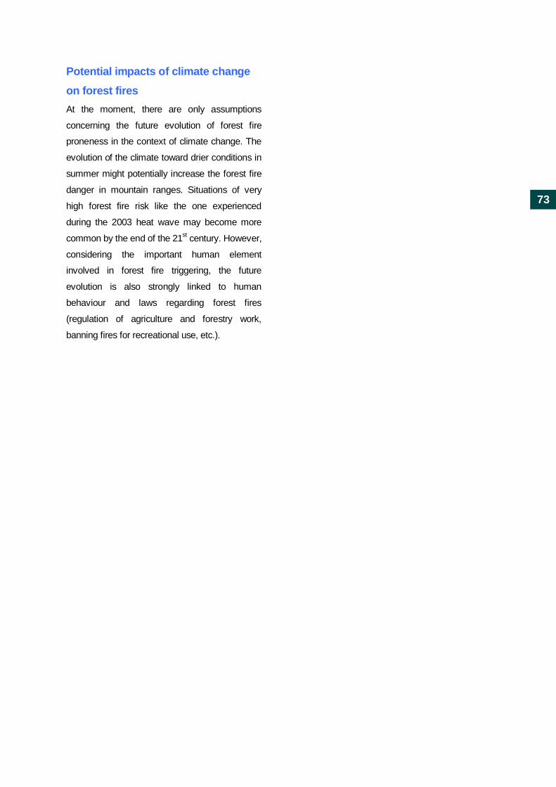
Potential impacts of climate changeon forest firesAt the moment, there are only assumptions
concerning the future evolution of forest fire
proneness in the context of climate change. The
evolution of the climate toward drier conditions in
summer might potentially increase the forest fire
danger in mountain ranges. Situations of very
high forest fire risk like the one experienced
during the 2003 heat wave may become more
common by the end of the 21st century. However,
considering the important human element
involved in forest fire triggering, the future
evolution is also strongly linked to human
behaviour and laws regarding forest fires
(regulation of agriculture and forestry work,
banning fires for recreational use, etc.).
73


Conclusions and contributionsfrom the other French partners
© O
NE
RC
/ G
. Pru
dent
© O
NE
RC
/ G
. Pru
dent

Conclusions
Climate change The observations converge toward a general
increase of the temperature in the Alpine arc.
The amplitude of the warming varies
depending on the regions considered. In the
French Alps, the mean warming reached
0.9°C during the 20th century. The model
results show that this trend should continue
throughout the 21st century. The mean
temperature in the Alps might increase by
between 3°C and 6°C by 2100.
Precipitation observations do not indicate
particular trends in the Alps, for any season
and threshold considered. Climate models
have difficulties representing precipitation in
mountain areas. However, some general
trends can be proposed with a precipitation
increase during winter and a decrease during
summer
Impacts on natural systems The duration and height of the snow cover
have both decreased in the entire Alpine arc.
The model results of snow cover evolution in
a warming climate show a decrease in the
duration and height of snow cover throughout
the 21st century.
Most Alpine glaciers have been in a retreat
phase since the end of the Little Ice Age
(middle of the 19th century). This natural
retreat accelerated strongly with the rise in air
temperature during the 20th century. Some
Alpine glaciers might disappear by the end of
the 21st century.
Observations show a degradation of Alpine
permafrost and an increase in the deformation
speed of rock glaciers in the Alps. This
degradation seems to be stronger in complex
topography such as ridges and peaks.
Observations show few trends concerning
Alpine river hydrology (mean runoff, floods
and low waters). However, the evolution of
snow cover and glaciers will certainly exert an
influence on river patterns and induce a
decrease in water resources in the long-term
after a temporary increase following
enhanced melting rates.
Some species have tended to migrate toward
higher altitudes, while parasites and disease
vectors have migrated toward higher latitudes.
The evolution of vegetation in the future in
comparison to current conditions will depend
on the balance between “positive” (less
freezing days, increase of the vegetation
period, etc.) and the “negative” effects (less
available water, development of new
diseases, droughts…).
Impacts on natural hazards An increase in the intensity and frequency of
floods has only been detected for some
Alpine regions (such as South Germany). In
the French Alps, some signs of changes have
been detected but a more detailed analysis is
needed to confirm and develop these early
findings. In the future, the flood peaks linked
to the melting of snow cover should be
weaker and occur earlier in the year. An
increase in winter floods and summer
droughts is likely to occur. Enhanced melting
of glaciers may compensate the summer
deficit of rivers fed by glaciers in the short-
term.
76

During recent years, the triggering areas of
debris flows have tended to move toward
higher altitudes in some massifs (like at the
Ritigraben or in the Écrins massif). An
increase in non-consolidated materials in the
vicinity of glaciers and the increase of heavy
precipitation might induce increased intensity
and frequency of debris flows locally.
Avalanche activity does not seem to have
evolved in a significant manner in terms of
frequency and seasonality. The assessment
of the intensity and localisation of avalanches
has been limited up till now. In the future,
avalanche activity should be closely linked to
snow cover evolution. A decrease in the
frequency of avalanches at low and medium
altitudes is likely to occur as well as an
increase in the number of wet snow
avalanches. Generalised situations of
avalanches (such as the one that occurred in
the Alps in 1999) remain probable in a
warmer climate.
An increase in rock fall frequency was
observed at high altitude during the scorching
2003 summer. With a temperature rise and a
corresponding degradation of the permafrost,
an increase in rock fall frequency should be
expected for high altitude areas. On the other
hand, a decrease in the number of
freezing/defreezing cycles at low and medium
altitudes might induce a decrease in rock fall
frequency. Furthermore, an increase in
precipitation (mainly heavy precipitation)
might lead to increased mass movements,
particularly shallow landslides.
In regards to the complexity of glacial hazards
and their limited occurrence, it is difficult to
detect trends from the observations. A
decrease in the stability of hanging glaciers
and an increase in the number and size of
proglacial lakes, due to an increase in ice
temperature and glacier retreat should be the
two main impacts of climate change on glacial
hazards.
Storm activity does not show any significant
trend in France during the past 50 years.
Storm evolution in a climate change context is
very difficult to assess because of the
uncertainties regarding warming of the high or
low atmosphere and latitudes, and the
consequences of the increased concentration
of water vapour.
During the 2003 summer, many forest fires
occurred in mountain ranges that are not
usually concerned by such hazards. A
multiplication of droughts and hot summer
might increase the forest fire proneness in
areas considered at low-risk up till now
77

Contributions of the Frenchpartners to the WP6, WP7and WP8Contribution of the WP6: Monitoring,prevention and management of
specific impacts of climate change onNature
This contribution has been written by Pierre
Potherat, Johann Kasperski and Jean-Paul
Duranthon (CETE Lyon), Pascal Allemand (LST
Lyon) and Didier Hantz (LGIT Grenoble).
In the climate change context, the observation of
the territory evolution, and more especially the
slope monitoring, is a key element to prepare
adaptation strategies. A method comparison
enables scientists and technical services to
select the most relevant method to detect
changes in the territory and then to study the link
with climate fluctuations.
The aim of the WP6 was to perform
comparisons, assessments and enhancement of
ground motion prevention by monitoring and
management techniques to, finally, propose
common response strategies against natural
hazards. These objectives were divided in two
modules and different activities. Among these
activities, a state of the art of the monitoring
methods and a comparative analysis of new
existing remote sensing techniques (laser
scanning, satellite based methods, radar
interferometers…) in situ have been performed.
The activities of the CETE de Lyon and UCBL
were focused on the evaluation of potentials and
limitations of optical remote sensing data for
deriving surface displacement maps on three
different active mountainous alpine sites: Sedrun
(Grisons, Switzerland), Séchilienne (Isère,
France) and Gorges de l’Arly (Savoie, France).
The work was also aiming to estimate the
complementarities between optical imagery and
conventional geodetic measurements. The
remote sensing data used for this analysis are
either from aerial and HD-satellite images or from
terrestrial scanner Laser and LiDAR.
Contrary to traditional techniques, the remote
sensing techniques enable the monitoring of the
global evolution of large scale landslides and
cliffs. An evaluation of some of those techniques
has been realized on the three unstable sites
mentioned above. Using optical imaging
techniques to study the kinematics of these
instable zones, it has been shown (1) that
terrestrial laser scanner allows acquiring data in
small areas undergoing higher sliding rates, often
not accessible to aerial survey; (2) and that
multitemporal image correlation is a fast way to
derive surface displacement maps:
The terrestrial Laser scanning technique
applied to the study of landslides permits to
achieve irregular 3D point clouds of land
areas in a very short time and with a high
accuracy (few centimetres on objects at
distances of some hundred of meters). Then,
scanning a landslide at different time can
shows quantitative changes in topography.
One limitation of this technique is the
difficulty to reconstruct a general picture from
focused scanning that is due to the local
topography. Despite this patchwork, the
resolution and the precision of data are
about two centimetres for a scanning
distance smaller than 80 metres. In order to
correctly use these data, one of the easiest
78

way consists in creating and comparing
multitemporal profiles in the different clouds
of points;
Images correlation is used to derive
displacement map from multitemporal
images acquired over the same area. This
technique is based on the automatic
research of same structure. Then, the shift
between the positions of the same structure
on two images can be associated to surface
displacements which occurred between the
two dates. Then correlating images of
different epochs gives a synoptic view of
displacements. Different types of images can
be used:
1) The aerial images obtained from
national geographic institutes associated
with images correlation are very useful
for scientific studies. The archive of
images covers fifty years with an
average time span of five years. Their
spatial resolution is about (or better than)
one meter and the detection threshold is
around two or three pixels;
2) High optical resolution satellite images
(IKONOS and QuickBird: images
resolution < 1 metre) associated with
correlation techniques can be used for
both scientific and hazard purposes.
Although time span of these images can
be adjusted, the lack of archives prevent
from the study of slow landslides (< 2
metres / year). These images should be
reserved to landslides with high velocity;
3) Regular acquisition of transversal
images acquired on site provides a fast,
efficient and low-cost way to follow the
evolution of a landslide.
Limits of optical correlation are mostly due to the
change of vegetation, the change in the length of
shadows due to either different time acquisition
or different angle of sight and other radiometric
differences: that can lead to problems with the
image matching, especially in the case of
studying landslides.
Here are some of the results obtained for the
CETE/UCBL case studies
The Sedrun landslide (Switzerland) has been
regularly slowing down since 2002, following
a 150% increase in speed between 1990
and 2002. The detailed description of its
kinematics combined to field geology allows
predicting the future evolution of the site.
As for the frontal zone of the Séchilienne
landslide (France), it slides horizontally
rather than it subsides vertically: using
scanner-laser data set, the scientific team
shows that the structural blocks the zone is
composed of are tilting downhill.
Lastly, at the Arly Gorges study site
(France), the Cliets tunnel undergoes
pressure releasing difficult to track using
imaging methods.
To conclude, the methods based on image
analysis are shown to be a very powerful tool.
Furthermore, they are complementary to the
traditional techniques used to follow the evolution
of the motion of specific mountainsides.
79

The activities of the Grenoble LGIT concerned
the slope evolution survey at the temporal scale
of the climatic changes which occurred in the
post-glacial period (last 10 000 years), and at the
spatial scale of homogeneous mountain ranges
like Vercors (limestone) and Écrins (crystalline).
This survey consisted firstly in assessing the rock
fall frequencies in different homogeneous ranges
or valley slopes. This assessment has been
done by using historical inventories covering
some decades up to some centuries. These
inventories make it possible to know the
frequencies associated with different rock fall
volumes (more than 100 m3, 1,000 m3, 10,000
m3, etc...), in a given area (massif or valley
slopes). Fitting a frequency-volume law makes it
possible to assess the frequencies of very large
rock falls, which did not occur during the
historical period covered by the inventory.
In order to detect the influence of the passed
climatic changes, the frequencies corresponding
to the different climatic phases of the post-glacial
period have to be determined. These frequencies
can only be determined for rock falls which are
still visible nowadays, i.e. those of more than 106
m3. As these events are relatively rare, an
inventory must be made at the scale of the
Alpine Arc. Then an Alpine database is being
achieved, including at least the location, volume
and date of each rock fall.
Determination of a rock fall volume needs to
know the initial surface, on which the fallen rocks
settled. For that, different geophysical
prospecting methods have been tested.
From the first results (Lauvitel rock fall), electrical
prospecting appears to be the more appropriate
method.
In order to estimate the date of a rock fall, the
more used method up to now consists in dating
vegetal debris found in the rock fall deposit, but
this is not always possible. That is the reason
why another method based on the rock surface
exposure to cosmic ray has been developed.
This method made it possible to date the Lauvitel
rock fall at about 3,600 years.
Presently, the number of dated rock falls in the
Alps is not yet sufficient for assessing the
influence of passed climatic change. For a better
knowledge of the occurrence probabilities of
large rock falls and a better evaluation of the
influence of the present climatic change on these
probabilities, pre-historical rock falls must be
better studied. To do so, an Alpine rock fall
database should be achieved and dating
methods should be further developed.
80

Contribution of the WP7: Impacts ofclimate change on territorial
development and on territorialeconomyThis contribution has been written by
Émmanuelle George-Marcelpoil and Vincent
Boudières (Cemagref DTM Grenoble)
Climate change from the threatquestioning to the reaction abilityToday climate change is incontestable. The last
IPCC report (AR 4) refined the uncertainties
associated with the projections of temperature.
However, the assessment of climate change
impacts is less accurate, especially for the local
level. Indeed, the uncertainty concerning the
direction and magnitude of climate changes is
already strong at the global level but it increases
exponentially when looking at the local level. And
this local level is precisely the relevant one for
the implementation of adaptation actions; this is
even truer for tourist mountainous territories.
Thus, the research on the response to face
climate change should be focus on the level of
action. In a general manner, the knowledge of
the hazard “climate change” can not solely be
undertaken as the phenomenon understanding.
In a strong uncertainty context the focus given to
the natural phenomenon tend to eclipse the
knowledge and the debate on the vulnerability.
The development of scenarios about the
potential evolution of the natural phenomena
maintains a determinist vision of climate change.
This determinist vision is an obstacle for
differentiated responses to climate change.
Climate change is generally considered as an
external threat and is less looked at from the
angle of the local adaptation ability.
Considering this point of view, the climate
change problem can be fundamentally seen as
the ability of local territories to face climate
change.
To answer this research questioning, it is very
important to identify and understand the existing
strategies and actions concerning tourism
diversification but also the kind of obstacles that
may slow down the adaptation to climate
change.
Climate change and active factors ofvulnerabilityFirstly, the following definition of the hazard has
been considered: Risk = F (unknown factor,
vulnerability), where F is a function depending on
means of analysing the problem. Considering
this approach, responses to face climate change
are possible under the condition that the territorial
vulnerability is integrated to the analysis. This
territorial vulnerability and more precisely the
vulnerability factors are closely linked to the
different actors and their state of mind. This
approach also highlights the coherence (or lack
of coherence) between the various actions
implemented in the winter resorts. In fact, winter
resorts are relevant territories for such kind of
analysis because of their high population density,
their environmental and socio-economic
importance and the complexity of their
management.
There are various vulnerability factors. Some of
them are linked to the kind of development of the
ski resort but most of them are rather linked to its
management. Thus, the following questions have
been considered: How climate change is
apprehended by the different actors? What are
the strategies developed and implemented to
face climate changes?
81

Are these strategies coherent with other politics
implemented at different intervention levels?
All these questioning highlight the importance of
the organisational and political factors in the
assessment of the vulnerability of ski resorts.
These factors have been identified trough
comparative analysis of the different strategies.
Based on an empirical approach, the analysis
concerned the structuring between the public
actors strategies (Nuts6 1, 2, 3 and 5) and the
economic actors of the mountain tourism industry
(cf. fig. 30).
This analysis that is considering climate change
not as an external threat but rather from the
angle of the internal weakness reveals the strong
stakes for the French tourism territories in the
mountains.Fig. 30 – Scheme of the strategies of the tourismactors to face climate change
6 Nuts: Nomenclature d'Unités Territoriales Statistiques. ThisEuropean nomenclature is used to facilitate the comparisonbetween countries or regions. For France, the Nuts 1 correspondsto the State, the Nuts 2 to the Region, the Nuts 3 to the Departmentand the Nuts 5 to the Commune.
It also highlights the importance of the
management where the crossing of
competences and strategies increases the
existing uncertainties about climate change
impacts. Beyond the external threat of climate
change, the future territorial management will
have to improve the thinking on coordination,
shared project and collective strategies.The wide
range of solutions implemented, the divergences
and crossings are obstacles for the
implementation of a relevant and long lasting
adaptation strategy. Indeed, to face climate
change the purpose is to look at the active
factors of vulnerability in terms of structure and
organisation. Thus it is important to not impose a
uniform view of the hazard but rather to take into
account the way each level understands and
formulates the problem. In this context, the
adaptation should not level the divergences but
rather build in the existing plurality common
strategies in a way to contribute to the durability
of the tourist destinations.
82

Contribution of the WP8: Flexibleresponse network - reflection on the
possible adaptation of administrativeand political structures
This contribution has been written by Jean-Marc
Vengeon (PGRN) and Sandrine Descotes-
Génon (Rhône-Alpes Region)
The objective of the WP8 was to provide
recommendations toward policy makers and
administration of the Alpine Space to help them to
design common actions to straighten an integrated
natural hazards management and to face climate
change.
In particular, the WP8 aimed to assess the interest
and the feasibility of an alpine institutional network
to promote and exchange quickly the ideas and the
know-how of integrated management of natural
hazards and adaptation to climate change. The
Rhône-Alpes Region participated actively to the
different activities of this group.
Firstly, each national or regional system of natural
hazards management has been described and
documented: institutional actors, rules and
procedures. A specific tool has been developed to
facilitate the access to this information: the
PLANALP-DB data base is available online on the
project web site www.climchalp.org. Some best
practices examples for each State or Region have
also been referenced and added to the data base.
Secondly, an investigation on the effective and non-
effective practices of natural hazards management
has been performed to the manager of different
regions. The analysis of these contributions
provided the base to realise a “state of the art” of
the natural hazards management in the Alps and to
formulate the expected recommendations.
Finally, an international expert hearing on the
impacts of climate change on river floods and
torrential events has been organised in Bolzano
(Italy) in May 2007. The conclusion is that a
common adaptation strategy for the Alps is highly
recommended. To help the alpine territories to be
“ready for the unexpected”, it is proposed to
increase locally the integrated management of
natural hazards while taking into account the
scenarios of climate change impacts and to
develop exchange network for an interregional
cooperation.
The recommendations for the integrated
management of natural hazards consists in the
development of the collaboration between sectors,
the best use of the existing resources and local
network, the generalisation of the hazard maps, the
straightening of the awareness and the
responsibility regarding hazards, straightening of
the maintenance program for the protection
buildings, the development of tools to deal with
extreme events (such as alert systems)…
Regarding the interregional collaboration, it has
been proposed to establish a “Flexible Response
Network” gathering the managers of the natural
hazards and territories at the alpine level. This
network should enable the permanent and fluent
exchange of information on the climate change
impacts and the best practices within the Alpine
Space. Various actions such as common training,
expert hearings and the development of a common
tool providing information are proposed.
83

Table of content
LIST OF ACRONYMS____________________ 5
INTRODUCTION ________________________ 7
THE CLIMCHALP PROJECT _____________ 9
THE FRENCH ORGANISATIONS INVOLVEDIN THE CLIMCHALP WP5 _______________ 11
THE ONERC_______________________ 11THE PGRN ________________________ 11THE RHÔNE-ALPES REGION ______________ 11
TEMPERATURE _______________________ 13
OBSERVATIONS IN THE ALPS_____________ 13MODEL RESULTS FOR THE ALPS ____________ 14OBSERVATIONS FOR THE FRENCH ALPS _______ 14MODEL RESULTS FOR THE FRENCH ALPS _____ 14OBSERVATIONS IN OTHER ALPINE COUNTRIES__ 17
German Alps _______________________ 17Italian Alps ________________________ 17Swiss Alps _________________________ 17
MODEL RESULTS IN OTHER ALPINE COUNTRIES _ 18German Alps _______________________ 18Swiss Alps _________________________ 18
PRECIPITATION _______________________ 20
OBSERVATIONS IN THE ALPS _____________ 20MODEL RESULTS FOR THE ALPS ____________ 21OBSERVATIONS IN THE FRENCH ALPS ________ 22MODEL RESULTS FOR THE FRENCH ALPS ______ 23OBSERVATIONS IN THE OTHER ALPINE COUNTRIES 24
German Alps _______________________ 24Italian Alps ________________________ 24Swiss Alps _________________________ 24
PRECIPITATION MODEL RESULTS FOR THE OTHER
ALPINE COUNTRIES ___________________ 25German Alps _______________________ 25Swiss Alps _________________________ 25
ALPINE GLACIERS ____________________ 27
OBSERVATIONS IN THE ALPS _____________ 27OBSERVATIONS IN THE FRENCH ALPS ________ 29MODEL RESULTS FOR THE SAINT SORLIN GLACIER
(FRANCE) _________________________ 32OBSERVATIONS IN OTHER ALPINE COUNTRIES ___ 33
Italian Alps ________________________ 33Swiss Alps _________________________ 34
SNOW COVER_________________________ 35
OBSERVATIONS IN THE FRENCH ALPS ________ 35MODEL RESULTS FOR THE FRENCH ALPS ______ 36OBSERVATIONS IN OTHER ALPINE COUNTRIES ___ 36
German Alps _______________________ 36Italian Alps ________________________ 37Swiss Alps _________________________ 37
ALPINE PERMAFROST_________________ 38
LAURICHARD ROCK GLACIER (FRANCE) _______ 39
PERMAFROST AND ROCK GLACIERS IN THE SWISS ALPS
_______________________________ 40
ALPINE VEGETATION __________________ 41
VEGETATION OBSERVATIONS IN FRANCE AND OTHER
ALPINE COUNTRIES ___________________ 41VEGETATION EVOLUTION PROJECTIONS IN FRANCE 42
FLOODS – HISTORICAL PROCESSES ANDPROJECTIONS REGARDING CLIMATE ISSUES______________________________________ 45
DEFINITION _______________________ 45DATA CONCERNING FLOODS IN THE ALPS _____ 45FLOOD SENSITIVITY AND LINKS WITH THE CLIMATE 45OBSERVED IMPACTS OF CLIAMET CHANGE ON FLOODS
_______________________________ 46POTENTIAL IMPACTS OF CLIMATE CHANGE ON FLOODS
_______________________________ 47
DEBRIS FLOWS AND TORRENTIAL EVENTS –HISTORICAL PROCESSES AND PROJECTIONSREGARDING CLIMATIC ISSUES ___________ 48
DEFINITION _______________________ 48DATA CONCERNING TORRENTIAL EVENTS IN THE ALPS
_______________________________ 48DEBRIS FLOWS SENSITIVITY TO CLIMATE CHANGE 49OBSERVED IMPACTS OF CLIMATE CHANGE ON DEBRIS
FLOWS __________________________ 50POTENTIAL IMPACTS OF CLIMATE CHANGE ON DEBRIS
FLOWS __________________________ 51
AVALANCHES – HISTORICAL PROCESSES ANDPROJECTIONS REGARDING CLIMATE ISSUES______________________________________ 53
DEFINITION _______________________ 53DATA CONCERNING AVALANCHES IN THE ALPS __ 53DATA CONCERNING AVALANCHES IN FRANCE ___ 54AVALANCHE SENSITIVITY AND LINKS WITH THE CLIMATE
_______________________________ 55OBSERVED IMPACTS OF CLIMATE CHANGE ON
AVALANCHES _______________________ 56POTENTIAL IMPACTS OF CLIMATE CHANGE ON
AVALANCHES _______________________ 56
MASS MOVEMENT – HISTORICAL PROCESSESAND PROJECTIONS REGARDING CLIMATICISSUES _______________________________ 58
DEFINITION ___________________________ 58
DATA CONCERNING MASS MOVEMENTS IN THE ALPS 58MASS MOVEMENTS / SHALLOW LANDSLIDES –HISTORICAL PROCESSES AND PROJECTIONS REGARDING
CLIMATIC ISSUES ____________________ 59Definition__________________________ 59Shallow landslides sensitivity and links with theclimate____________________________ 59Observed impacts of climate change onshallow landslides _________________ 60Potentila impacts of climate change onshallow landslides _________________ 60
84

MASS MOVEMENT / DEEP LANDSLIDES – HISTORICAL
PROCESSES AND PROJECTIONS REGARDING CLIMATIC
ISSUES___________________________ 61Definition _________________________ 61Observed impacts of climate change ondeep landslides_____________________ 61Potential impacts of climate change ondeep landslides_____________________ 61
MASS MOVEMENT / ROCK FALL – HISTORICAL
PROCESSES AND PROJECTIONS REGARDING CLIMATIC
ISSUES___________________________ 62Definition _________________________ 62Rock fall sensitivty and links with theclimate ___________________________ 62Observed impacts of climate change onrock fall___________________________ 63Potential impacts of climate change onrock fall___________________________ 63
GLACIAL HAZARDS – HISTORICALPROCESSES AND PROJECTIONS REGARDINGCLIMATIC ISSUES _______________________ 64
DEFINITION________________________ 64DATA CONCERNING GLACIAL HAZARDS________ 64GLACIAL GLACIAL LAKES OUTBURST FLOODING –HISTORICAL PROCESSES AND PROJECTIONS
REGARDING CLIMATIC ISSUES _____________ 65Definition __________________________ 65« GLOF » sensitivity and links with the climate__________________________________ 65Observed impacts of climate change on« GLOF » __________________________ 66Potential impacts of climate change on« GLOF » __________________________ 66
GLACIAL HAZARDS / GLACIAL WATER POCKET –HISTORICAL PROCESSES AND PROJECTIONS
REGARDING CLIMATIC ISSUES _____________ 67Definition __________________________ 67Glacial water pockets sensitivty and links withthe climate _________________________ 67Observed and potential impacts of climatechange on glacial water pockets _________ 67
GLACIAL HAZARDS / ICE AVALANCHES – HISTORICAL
PROCESSES AND PROJECTIONS REGARDING CLIMATIC
ISSUES___________________________ 68Definition __________________________ 68Ice avalanche and sensitivity with the climate68Observed impacts of climate on ice avalanches__________________________________ 69Potential impacts of climate change on iceavalanches _________________________ 69
STORMS – HISTORICAL PROCESSES ANDPROJECTIONS REGARDING CLIMATIC ISSUES______________________________________ 70
DEFINITION________________________ 70DATA CONCERNING STORMS ______________ 70STORM SENSITIVITY AND LINKS WITH THE CLIMATE 70
FOREST FIRES – OBSERVATIONS ETPROJECTIONS DANS UN CONTEXTE DEVARIATIONS CLIMATIQUES_______________ 72
DEFINITION _______________________ 72DATA CONCERNING FOREST FIRES __________ 72FOREST FIRES SENSITIVITY AND LINKS WITH THE
CLIMATE__________________________ 72
CONCLUSIONS ________________________ 77
CLIMATE CHANGE ____________________ 77IMPACTS ON NATURAL SYSTEMS____________ 77IMPACTS ON NATURAL HAZARDS ___________ 77
CONTRIBUTIONS OF THE FRENCHPARTNERS TO THE WP6, WP7 AND WP8 _ 79
TABLE OF CONTENT ___________________ 85
ILLUSTRATION LIST____________________ 87
ILLUSTRATIONS _____________________ 87PHOTOGRAPHIC CREDITS________________ 87
REFERENCES USED FOR EACH THEMATIC88
TEMPERATURE ______________________ 88PRECIPITATIONS_____________________ 88GLACIERS_________________________ 88SNOW COVER ______________________ 88PERMAFROST_______________________ 88VEGETATION _______________________ 88FLOODS__________________________ 88TORRENTIAL EVENTS __________________ 88AVALANCHES_______________________ 88MASS MOVEMENTS ___________________ 89GLACIAL HAZARDS ___________________ 89STORMS__________________________ 89FOREST FIRES ______________________ 89
BIBLIOGRAPHY _______________________ 90
85

Illustration list
IllustrationsPage 27: Argentières Glacier in 1896 (left) and in 2003(right)
Page 28: Mer de Glace in 2003
Page 30: Saint Sorlin Glacier (left) and Argentières glacier(right)
Page 32: Pré de Bar Glacier in 1929 (left) and in 2007(right)
Page 33: Great Aletsch glacier in 1856 (left) and 2001(right)
Page 34: Col de Porte measuring site (top) andChartreuse massif (bottom)
Page 38: Laurichard rock glacier (Hautes-Alpes)
Page 42: Yellow gentiam
Page 42: Black grape
Page 41: Birch in the Écrins massif (Hautes-Alpes)
Page 41: Pine processionary caterpillar
Page 42: Larch
Page 44: Rhône flood at Sablons (Isère)
Page 45: Rhône flood at Chonas (Isère)
Page 48: Torrential floods of the Doménon at St Martind’Uriage in 2005 (Isère)
Page 49: Moraine deposits in the Écrins massif (Hautes-Alpes)
Page 49: Debris flows at Claix (Isère)
Page 52 : Runoff loaded with debris (Isère)
Page 51: Debris flows at Claix (Isère
Page 52: Assy Avalanche (Savoie)
Page 53: Wet snow avalanche at the col du Lautaret(Hautes-Alpes)
Page 54: Fresh snow avalanche at the col du Lautaret(Hautes-Alpes)
Page 55: Wind slabs avalanche
Page 55: Triggering area of a wind slab avalanche in theBelledone massif (Isère)
Page 56: Avalanche flow in the Belledone massif (Isère)
Page 57: Rock fall on the RN 85 at Laffrey (Isère)
Page 57: Shallow landslide at Saint Geoires en Valdaine(Isère)
Page 58: Shallow landslide at Reyssabot (Isère)
Page 58: Shallow landslide at Voiron (Isère)
Page 62: Mud flows at Merlas (Isère)
Page 60: Deep landslide at Séchilienne (Isère)
Page 61: Rock fall at Laffrey (Isère)
Page 61: Rock fall (Isère)
Page 62: Rock fall at Oris (Isère)
Page 63: Ice avalanche at the Trift glacier (Switzerland)
Page 64: Glacial lake of Rochemelon (Savoie)
Page 65: Glacial lake of Arsine (Hautes-Alpes)
Page 65: Glacial lake of Rochemelon (Savoie)
Page 66: Ice cavity collapse after the burst of the TêteRousse water pocket (Haute-Savoie)
Page 67: The Allalin glacier and the Mattmarkconstruction site (Switzerland) before (left) and after tehcatastrophe (right)
Page 68: Ice avalanche at the Weisshorn glacier(Switzerland)
Page 69: Storm damages at La Tronche in 2007 (Isère)
Page 69: Walnut trees damaged by a storm at the hameaudu Lignet in 2006 (Isère)
Page 71: Forest fire at Pont-en-Royans (Isère) in 2003
Page 71: Néron forest fire at Grenoble (Isère) in 2003
Page 72: Néron forest fire at Grenoble (Isère) in 2003
Photographic credits© ONERC / G. Prudent-Richard (p. 2, 3, 11, 34, 41, 43, 49and 74)
© Université de Fribourg /S. Morard (p. 2)
© T. Deniset (p. 2)
© MEDD (p. 3)
© Photothèque IRMa / Sébastien Gominet (p. 3, 44, 50, 51,55, 56, 57, 58, 59, 61, 62, 65, 69, 71 and 72)
© Cemagref (p. 3, 38, 54, 53, 64 and 65)
© ANENA (p. 3 et 57)
© NOAA (p. 3)
© LGGE / C. Vincent (p. 27 et 32)
© Atheme (p. 28)
© J-M Lasalsa (p. 30)
© Martin Gerbaux / CNRS (p. 31)
© FMS (p. 32)
© Martens (p. 33)
© Holzhauser (p. 33)
© Parc National des Écrins (p. 40)
© Jean-Claude Martin (p. 41)
© CREA (p.42)
© Olivier Ali (p. 43)
© Mairie de Chonas (p. 45)
© Yannick Guigual (p. 48)
© Université de Savoie (p. 52)
© LGIT (p. 60)
© VAW (p. 63, 67 and 68)
86

References used for eachthematicThis technical report is greatly based on the
knowledge platform described page 9. To
facilitate the reading of the document, the
scientific references corresponding to the
mechanisms exposed are not inserted in the text.
If the reader wants to explore in details a
thematic and find the references associated with
a value or a mechanism, he can visit the
knowledge platform (www.risknat.org) to obtain
this detailed information.
TemperatureHaerbeli & Beniston 1998, Heimman & Sept 2000,
Beniston & Jungo 2002, Bardossy et al. 2003,
Beniston et al. 2003b, Jomelli et al. 2004, Schär et al.
2004, Beniston 2005a, Beniston 2005b, Casty et al.
2005, Horton et al. 2005, ONERC 2005, ALP-IMP
2006, Hennegriff et al. 2006, Jomelli et al. 2006a,
Jomelli et al. 2006b, Maquaire 2006, ONERC 2006,
Bodin 2007, Cat-Berro & Mercalli 2007, Ciccarelli et al.
2007, IPCC 2007, OFEN 2007, ONERC 2007
PrecipitationsLateltin et al. 1997, Frei et al. 1998, Noverraz et al.
1998, Fallot 2000, Frei & Schär 2001, Schmidli et al.
2001, Alpert et al. 2002, Anfossi et al. 2002, CUDAM
2002, Etchevers et al. 2002, Moisselin & Schneider
2002, Schmidli et al. 2002, Bardossy et al. 2003,
Beniston 2003, Beniston et al. 2003b, Christensen &
Christensen 2003, Berthelot 2004, Jomelli et al. 2004,
Barnett et al. 2005, Beniston 2005a, Casty et al. 2005,
TORAVAL 2005, Reinhard et al. 2005, Brunetti et al.
2006, Hennegriff et al. 2006, Jomelli et al. 2006a,
Maquaire 2006, Norrant & Douguedroit 2006, Perret et
al. 2006, Ciccarelli et al. 2007, Schmidli et al. 2007
GlaciersHaeberli & Alean 1985, Haeberli & Hoelze 1995,
Haeberli et al. 1997, Haeberli & Beniston 1998,
Haeberli et al. 2000, PNR 31, Maisch et al. 2000,
Reynaud & Vincent 2002, Vincent 2002, Hoelze et al.
2003, Gerbaux 2005, Paul et al. 2005, Deline 2006,
Paul 2006, Haeberli et al. 2007, OFEN 2007, GIEC
2007, Paul et al. 2007, UNEP 2007, Vincent et al.
2007a, Vincent et al. 2007b
Snow coverSchneebeli et al. 1997, Etchevers & Martin 2002,
Beniston et al. 2003a, Beniston et al. 2003b, Beniston
2005, Valt et al. 2005, Hennegriff et al. 2006, Cat-Berro
& Mercali 2007
PermafrostMüller 1947, Zimmermann & Haeberli 1992, Haeberli
et al. 1997, Haeberli & Beniston 1998, Vonder Mühll et
al. 1998, Francou et al. 1999, NRP 31, Harris et al.
2001, Harris et al. 2003, Gruber et al. 2004a, Gruber et
al. 2004b, Lambiel & Delaloye 2005, Roer et al. 2005,
Bodin 2007, Delaloye et al. 2007, Gruber & Haeberli
2007, Noetzli et al. 2007
VegetationKeller, Kienast & Beniston 2000, Theurillat & Guisan
2001, Vennetier et al. 2005, Legay & Mortier 2006
FloodsPNR 31, Stoffel & Monbaron 2000, Milly et al. 2002,
Paul 2002, Christensen & Christensen 2003, OcCC
2003, Mudelsee et al. 2003, Schirmeier 2003b,
Demirdijan 2004, ONERC 2004, GICC Rhône 2005,
Bravard 2006, Lins 2006, Renard 2006, Seiler 2006,
Hubert 2007
Torrential eventsHaeberli & al. 1997, Lateltin et al. 1997, Rebetez &
Lugon 1997, Zimmermann & al. 1997, Stoffel &
Monbaron 2000, Moirat & Nedellec 2003, Demirdijan
2004, Kääb & al. 2005, Stoffel et al. 2005, Deline 2006,
Fischer & al. 2006, Götz & Raetzo 2006, Jomelli & al.
2006a, Jomelli & al. 2006b, Maquaire & al. 2006,
Rouiller 2006, Seiler 2006, Stoffel & Beniston 2006
AvalanchesSchneebeli & al. 1997, PNR 31, Stoffel & Monbaron
2000, Martin & al. 2001, Paul 2002, Demirdijan 2004,
Jomelli & Pech 2004, Ancey 2005, Beniston 2005,
Jomelli et al. 2006c, Seiler 2006
87

Mass movementsHaeberli et al. 1997, Lateltin & al. 1997, Haeberli &
Beniston 1998, Noverraz et al. 1998, PNR 31, Stoffel &
Monbaron 2000, GIEC 2001, CIPRA 2002, Dapples
2002, Moirat & Nedelec 2003, Noetzli et al ; 2003,
OcCC 2003, Oswald 2003, Beniston & Stephenson
2004, Demirdijan 2004, Gruber et al. 2004, Kääb et al.
2005, OcCC 2005, Bravard 2006, Compagnon & Marie
2006, Fischer et al. 2006, Götz & Raetzo 2006,
Maquaire et al. 2006, Perret et al. 2006, PLANAT 2007
Glacial hazardsHaeberli & Beniston 1998, PNR 31, Stoffel &
Monbaron 2000, Kääb et al. 2005, OcCC 2005,
Fischer et al. 2006
StormsAndré et al. 2000, GIEC 2001, Bessemoulin 2002,
Paul 2002, Planton 2002, ONERC 2004, Seiler 2006,
PLANAT 2007,
Forest firesJohnson 1992, PNR 31, GIEC 2001, Rheinard et al.
2005, Legay & Mortier 2006
88

BibliographyAlpert, P., Ben-Gai, T., Baharad, A. et al. (2002),
Paradoxical increase of Mediterranean extreme daily
rainfall in spite of decrease in total values. Geophys.
Res. Lett., Vol. 29, N° 11.
André, J-C., Cariolle, D., Megie, G. et al. (2000),
Evénements extrêmes, changements climatiques et
effet de serre. Revue VO2.
Anfossi, D., Cappa, C., Von Hardenberg, J. et al.
(2002), Statistical analysis of three series of daily
rainfall in north-western Italy. Nuovo Cimento della
Societ`a Italiana di Fisica C, Geophysics and Space
Physics, Vol. 25, pp. 99 - 121.
Bárdossy, A., Anagnostopoulou, C., Cacciamani, C. et
al. (2003), Trends in extreme daily precipitation and
temperature across Europe in the 2nd half of the 20th
century. Deliverable D9 of STARDEX project:
STAtistical and Regional dynamical Downscaling of
EXtremes for European regions.
Barnett, T., Adam J. & D. Lettenmaier (2005), Potential
impacts of a warming climate on water availability in
snow-dominated regions. Nature, Vol. 438, pp. 303 -
309.
Beniston, M. & P. Jungo (2002), Shifts in the
distributions of pressure, temperature and moisture
and changes in the typical weather patterns in the
alpine region in response to the behaviour of the North
Atlantic Oscillation. Theoretical and Applied
Climatology, Vol. 71, pp. 29 - 42.
Beniston, M., Keller, F., Koffi, B. et al. (2003a),
Estimates of snow accumulation and volume in the
Swiss Alps under changing climatic conditions.
Theoretical and Applied Climatolgy, Vol. 76, pp. 125 -
140.
Beniston, M., Keller, F. & S. Goyette (2003b), Snow
pack in the Swiss Alps under changing climatic
conditions: an empirical approach for climate impact
studies. Theoretical and Applied Climatolgy, Vol. 74,
pp. 19 - 31.
Beniston, M. (2005a), Mountain climates and climatic
change: An overview of processes focusing on the
European Alps. Pure and Applied Geophysics, Vol.
162, p. 1587–1606.
Beniston, M. (2005b), Warm winter spells in the Swiss
Alps: Strong heat waves in a cold season? A study
focusing on climate observations at the Saentis high
mountain site. Geophysical Research Letter, Vol. 32,
5 p..
Berthelot. M., Genin. A., & D. Gourdon (2004),
Variabilité interannuelle des précipitations dans les
Alpes du Sud pour la période 1951-2000 : Analyse
statistique des séries. Université de Tours, Météo
France CDM Indre et Loire, TOURS, 15 p. Article non
per review.
Bessemoulin, P. (2002), Les tempêtes en France.
Annales des Mines, pp. 9 - 14.
Brunetti, M., Maugeri, M., Nanni, T. et al. (2006),
Precipitation variability and changes in the greater
Alpine region over the 1800–2003 period, Journal of
Geophysical Research, p. 111.
Casty, C., Wanner, H., Luterbacher, J. et al. (2005),
Temperature and precipitation variability in the
European Alps since 1500. International Journal of
Climatology, 26 p.
Christensen, J. & O. Christensen (2003), Severe
summertime flooding in Europe - Even as summers
become drier, the incidence of severe precipitation
could increase. Nature, vol. 421, pp. 805 - 806.
Ciccarelli, N., Von Hardenberg, J., Provenzale, A. et al.
(2007), Climate Variability in North-Western Italy during
the Second Half of the 20th Century, MedCLIVAR
Special Issue of Global and Planetary Change, in
press.
CUDAM (Centro Universitario per la Difesa
idrogeologica dell’Ambiente Montano) (2002),
Valutazione di possibili tendenze in alcune variabili
ambientali rilevanti per la sicurezza e la protezione
civile in Trentino ed elaborazione di proposte per il
miglioramento delle risorse per il monitoraggio e il
controllo ambientale, CUDAM Report.
89

Dapples F. (2002), Instabilités de terrain dans les
Préalpes fribourgeoises au cours du Tardiglaciaire et
de l'Holocène: influence des changements climatiques,
des fluctuations de la végétation et de l'activité
humaine. Thèse de doctorat : Département de
géosciences, géologie et paléontologie, Université de
Fribourg, 159 p.
Dauphiné, A. Risques et Catastrophes. Paris : Édition
Armand Colin, 2001. 288 p. ISBN 2-200-25042-8.
Delaloye, R., Peruchoud, E., Avian, M. et al. (in press):
Recent Interannual variations of rockglaciers creep in
the European Alps. Proceedings of the 9th
International Conference on Permafrost, Fairbanks,
Alaska.
Deuxième Colloque International Eau &
Environnement (2007), Hydrologie, variabilité et
changements, Hubert, P., École Nationale Supérieure
d’Hydraulique de Blida, 30-31 Janvier 2007, 5 p.
Fallot, J-M. (2000), Évolution du nombre de jours avec
des précipitations abondantes en Suisse durant le 20e
siècle, Publ. Ass. Int. Clim., Vol. 13, pp. 100 - 109.
Fifth Rosenberg International Forum Banff (2006), «
Managing Upland watersheds in times of Global
change » (2006, Alberta). Impact of climate change on
the management of upland waters : the Rhône river
case, J.-P. Bravard, Alberta, Canada, Sept. 2006, 41
p.
Fischer L. A. Kääb, C. Huggel, et al. (2006), Geology,
glacier retreat and permafrost degradation as
controlling factors of slope instabilities in a high-
mountain rock wall: the Monte Rosa east face. Natural
Hazards and Earth System Science, vol 6, pp. 761 -
772.
Frei C. & C. Schär. (2001), Detection probability of
trends in rare events: Theory and application to heavy
precipitations in the Alpine region. Journal of Climate
Research, 2001, Vol. 14, pp. 1568 - 1584.
Gerbaux, M. Reconstruction du bilan de masse des
glaciers alpins et impacts d'un changement climatique.
Thèse de doctorat : Laboratoire de Glaciologie et
Géophysique de l'Environnement, Université Joseph
Fourier, 2005. 132 p.
Géologie et Risques Naturels : La gestion des risques
au Pays du Mont Blanc (2006, Sallanches) :
Réchauffement climatique actuel et dynamique des
versants de haute montagne, P. Deline, actes du
colloque du 18 nov. 2006 à Sallanches / éd. par F.
Amelot, Centre de la Nature Montagnarde, Sallanches.
GICC RHÔNE (2005), Impacts des changements
climatiques sur l'hydrologie du bassin du Rhône (projet
GICC-Rhône, rapport final révisé - version courte).
Boone, A., Habots, F., Martin, E. et al. Météo France /
Cemagref / Ecole des Mines de Paris / CETP.
Giuffrida, A. & M. Conte. (1989), Variations climatiques
en Italie : tendances des températures et des
précipitations. Publ. Ass. Int. Climatologie, Vol. 2, pp.
209 - 216.
GREG (Groupe de Recherche En Géomorphologie)
Université De Fribourg / Université De Lausanne
(2005). Le pergélisol dans la région Mont Gelé – Mont
Fort : Rapport de recherche 2004-2005. Lambiel, C. &
R. Delaloye. Lausanne : UNIL, 12 p.
Gruber, S., Hoelze, M. & W. Haeberli. (2004a),
Permafrost thaw and destabilization of Alpine rock
walls in the hot summer of 2003. Geophysical
Research Letters, vol 31, 4 p.
Gruber, S., Hoelzle, M. & W. Haeberli. (2004b), Rock
wall temperatures in the Alps - modelling their
topographic distribution and regional differences.
Permafrost and Periglacial Processes, Vol. 15, pp.
299-307.
Gruber, S. & W. Haeberli. (2007), Permafrost in steep
bedrock slopes and its temperature-related
destabilization following climate change. Journal of
Geophysical Research, Vol. 112.
Haeberli, W. & J. Alean. (1985), Temperature and
accumulation of high altitude firn in the Alps. Annals of
Glaciology, Vol. 6, pp.161-163.
Haeberli, W. & M. Hoelzle. (1995), Application of
inventory data for estimating characteristics of and
regional climate-change effects on mountain glaciers:
a pilot study with the European Alps. Annals of
Glaciology, Vol. 21, pp. 206-212.
90

Haeberli W. Wegmann M. & D. Vonder Mühll. (1997),
Slope stability problems related to glacier shrinkage
and permafrost degradation in the Alps. Ecologae geol.
Helv., 1997, Vol. 90, 7 p.
Haeberli, W. & M. Beniston. (1998), Climate change
and its impacts on glaciers and permafrost in the Alps.
Ambio, 1998, Vol. 27, pp. 258 - 265.
Haeberli, W., Barry, R. & J. Cihlar. (2000), Glacier
monitoring within the Global Climate Observing
System. 2000, Annals of Glaciology, Vol. 31, pp. 241 -
246.
Haeberli, W., Maisch, M. & F. Paul. (2002), Mountain
glaciers in global climate-related observation networks.
WMO Bulletin, 2002, 51/1, pp. 18 - 25.
Haeberli, W. & H. Holzhauser. (2003), Alpine glacier
mass changes during the past two millennia. Pages
News, 2003, 1/11, pp. 13 - 15.
Haeberli, W., Hoelzle, M., Paul. et al. (2007),
Integrated monitoring of mountain glaciers as key
indicators of global climate change: the European Alps.
Annals of Glaciology, Vol. 46, pp. 150-160.
Harris, C., Davies, M.C. & R. Etzelmüller. (2001), The
Assessment of Potential Geotechnical Hazards
Associated with Mountain Permafrost in a Warming
Global Climate. Permafrost and Periglacial Processes,
Vol. 12, pp. 145 - 156.
Harris, C. Vonder Mühll, D. Isaken, K. et al. (2003),
Warming permafrost in European mountains. Global
and Planetary Change, Vol. 39, pp. 215 - 225.
Hennegriff, W., Kolokotronis, V., Weber, H. et al.
(2006), Climate Change and Floods – Findings and
Adaptation Strategies for Flood Protection. KA -
Abwasser, Abfall, 53, Nr. 8.
Hoelzle, M., Haeberli, W., Dischl, M. et al. (2003),
Secular glacier mass balances derived from
cumulative glacier length changes. Global and
Planetary Change, Vol. 36, pp. 295 - 306.
Impact du réchauffement climatique [on-line]. France :
Groupement TORAVAL [Réf. du 09/03/2007].
Disponible en ligne :
< http://www.toraval.fr/rechauffement.php >
Impact du réchauffement climatique en France [on-
line]. France : ONERC [Réf. du the 27/10/2007].
Disponible en ligne : < http://www.onerc.gouv.fr >
IPCC (International Panel for Climate Change) (2001):
Climate Change 2001: Impacts, Adaptation and
Vulnerability - Contribution of working group II to the
IPCC third assessment. Genêve, 2001.
IPCC 2007: Summary for Policymakers. In: Climate
Change 2007: The Physical Science Basis.
Contribution of Working Group 1 to the Fourth
Assessment Report of the International Panel on
Climate Change [Solomon, S., D. Quin, M. Manning, Z.
Chen, M. Marquis, K.B. Aveyrit, M. Tignor and H.L.
Miller (eds.)]. Cambridge University Press, United
Kingdom and New York, NY, USA.
Italian Glaciological Committee [on-line]. Italy: Italian
Glaciological Committee [Ref of the 20/10/2007].
Avalaibleonline:
<www.isat.unimib.it/comiglacio/comitatoglaciologico.ht
ml>
Johnson EA (1992), Fire and vegetation dynamics:
Studies from the North American boreal forest.
Cambridge: Cambridge University Press, 143 p.
Jomelli V. & P. Pech. (2004), Effects of the little ice age
on avalanche boulder tongues in the French Alps
(Massif des Ecrins). Earth Surface Processes and
Landforms, vol 29. Referenced as Jomelli & al. 2004a.
Jomelli, V., Pech, P., Chochillon, C. et al. (2004b),
Geomorphic variations of debris flows and recent
climatic change in the French Alps. Climatic Change,
2004, Vol. 64, pp. 77 - 102.
Jomelli V., Déqué M., Brunstein D. et al. (2006a),
Occurrence des coulées de débris dans le massif des
Ecrins (Alpes françaises) au XXIème siècle. Estimation
à partir du modèle climatique ARPEGE.
Jomelli V., Brunstein D., Grancher D. et al. (2006b), Is
the response of hill slope debris flows to recent climate
change univocal? A case study in the Massif des
Écrins (French Alps). Climatic Change, (submitted).
91

Jomelli V., Delval C., Grancher D. et al. (2006c),
Probabilistic analysis of recent snow avalanche activity
and weather in the French Alps. Cold Regions Science
and Technology, in press.
Jones, RN. (2000), Managing uncertainty in climate
change projections-issues for impact assessment.
Climatic Change, Vol. 45, p. 403 - 419.
Kääb, A., Reynolds, J. & W. Haeberli. (2005), Glacier
and permafrost hazards in high mountains. In: Huber,
U.M. Bugmann, H.K.M. Reasoner, M.A. (eds.), Global
Change and Mountain Regions (A State of Knowledge
Overview). Springer, Dordrecht p. 225 - 234.
Keller, F., Kienast, F. & M. Beniston. (2000), Evidence
of response of vegetation to climatic change on high
elevation sites in the Swiss Alps. Regional and
Environmental Change, 2000, pp. 70-77.
Klimawandel im der Alpenraum Auswirkungen und
Herausforderung (2006), Risques naturels,
changement climatique et gestion des risques. Götz,
A. & H. Raetzo. In: Deuxième manifestation
thématique "Changement du climat dans l'espace alpin
- Effets et défis" à l'occasion de la 31e réunion du
Comité permanent à Galtür, Wien, p. 20 - 29.
Klimawandel im der Alpenraum Auswirkungen und
Herausforderung (2006), Les changements
climatiques dans l'espace alpin : tendances,
retombées et défis. Seiler, W. In: Deuxième
manifestation thématique "Changement du climat dans
l'espace alpin - Effets et défis" à l'occasion de la 31e
réunion du Comité permanent à Galtür, Wien, p. 7 - 19.
Lateltin, O., Beer, C., Raetzo, H. et al. (1997),
Instabilités de pente en terrain de flysch et
changements climatiques. Rapport final PNR 31, vdf –
Hochschulverlag AG an der ETH Zürich, 168 p.
L'eau en Montagne (2002, Megève) : Impact d'un
changement climatique sur le manteau neigeux et
l'hydrologie des bassins versants de montagne.
Etchevers, P. & E. Martin, Grenoble : Centre d'Etudes
de la Neige, Météo France, 2002, 10 p.
Lins, H. (2006), Comment on "IPCC WGII Fourth
Assessment Report, Chapter 3: Freshwater Resources
and their Management", 2006.
Maisch, M., Wipf, A., Denneler, B. et al. (2000), Die
Gletscher der Schweizer Alpen. Gletscherhochstand
1850, Aktuelle Vergletscherung, Gletscherschwund-
Szenarien. vdf Hochschulverlag, Zurich.
Maquaire, O., Malet, J-P., Sailhac, P. et al. (2006),
Glissements alpins à contrôle hydrologique et
changements climatiques Projet ACI-FNS GACH2C
2005-2007. Rapport intermédiaire.
Martin, E., Giraud, G., Lejeune, et al. (2001), Impact of
climate change on avalanche hazard. Annals of
Glaciology, n°32, pp.163 - 167.
Milly, P., Wetherald, R., Dunne, K. et al. (2002),
Increasing risk of great floods in a changing climate.
Nature, Vol. 415, pp.514 - 517.
Moisselin J-M. & M. Schneider. (2002),
Homogénéisation des séries françaises de
précipitations couvrant le 20e siècle. La Houille
Blanche, N° 6/7, pp.126 - 130.
Mudelsee, M., Börngen, M., Tetzlaff, G. et al. (2003),
No upward trends in the occurrence of extreme floods
in central Europe. Nature, Vol. 425, pp. 166 - 169.
Müller, S.W. (1947), Permafrost or permanently frozen
ground and related engineering problems. JW
Edwards; Ann.Arbor, Mich.
Navarre, J-P. (2007), Climatologie des situations nivo-
météorologiques associées aux périodes
avalancheuses importantes de ces 45 dernières
années en Isère. Cemagref / Météo France, projet
financé par le PGRN, 23 p.
Noetzli, J., Gruber, S., Kohl, T. et al. (2007), Three-
dimensional distribution and evolution of permafrost
temperatures in idealized high-mountain topography.
Journal of Geophysical Research, Vol. 112.
Norrant, C. & A. Douguedroit. (2005), Monthly and
daily precipitation trends in the Mediterranean (1950-
2000). Theoretical and Applied Climatology, Vol. 83,
89 - 106.
92

Noverraz F., Bonnard C., Dupraz H. et al. (1998),
Grands glissements de terrain et climat, VERSINCLIM
– Comportement passé, présent et futur des grands
versants instables subactifs en fonction de l’évolution
climatique, et évolution en continu des mouvements en
profondeur. Rapport final PNR 31, vdf –
Hochschulverlag AG an der ETH Zürich, 1998, 314 p.
NRP 31 (National Research Program) (2000), Climate
Risks - The Challenge for Alpine Region. Zürich : vdf
Hochschuverlag AG an der ETH Zürich, 2000. 291 p.
ISBN 3-7281-2709-4
OcCC (Organe Consultatif sur les Changements
Climatiques) (2003), Evénements extrêmes et
changements climatiques. Bern : OcCC. 94 p.
OcCC (Organe Consultatif sur les Changements
Climatiques) (2005), Canicule de l'été 2003 : Rapport
de synthèse. Bern : OcCC. 28 p.
OFEV (Office Fédéral de l’Environnement) (2007),
Changements climatiques en Suisse. Indicateurs des
causes, des effets et des mesures. Ittingen : OFEV
publication, 77 p.
ONERC (Observatoire National sur les Effets du
Réchauffement Climatique) (2004), Collectivités
locales et changement climatique : Etes-vous prêts ?
Un guide pour l’adaptation à l'attention des
collectivités locales. Paris : ONERC, 11 p.
ONERC (Observatoire National sur les Effets du
Réchauffement Climatique) (2005), Un climat à la
dérive : comment s’adapter ? Rapport au Premier
ministre et au Parlement. Paris : La documentation
Française, Juin 2005. 107 p.
ONERC (Observatoire National sur les Effets du
Réchauffement Climatique) (2006), Stratégie nationale
d’adaptation aux changements climatiques. Paris :
ONERC, Novembre 2006. 56 p.
ONF-Service RTM Hautes-Alpes et Alpes Maritimes.
(2006), Instabilité gravitaire liée à la fonte du pergélisol
dans les Alpes du sud : Cas du glacier rocheux du
Bérard (Alpes de Haute - Provence). Compagnon F. &
Marie R. Rapport non publié, 5 p.
Oswald, D. (2003), Analyse de l'activité des
glissements de terrain et relation avec les conditions
climatiques : Exemple dans les PréAlpes
Fribourgeoises Thèse de doctorat : Département de
géosciences, géologie et paléontologie Université de
Fribourg. 132 p.
Paul P. (2002), Reconstitution d'anomalies de
paramètres climatiques et de fréquences de
catastrophes naturelles (crues, sécheresses,
tempêtes) au cours des 500 dernières années en
Europe Centrale. La Houille Blanche, N° 6/7, p. 111 -
114.
Paul, F. (2006), The new Swiss Glacier Inventory 2000
– Application of Remote Sensing and GIS.
Schriftenreihe Physische Geographie – Glaziologie
und Geomorphodynamik (University of Zurich), 52 p.
Paul. F., Kääb, A. & W. Haeberli. (2007), Recent
glacier changes in the Alps observed by satellite:
Consequences for future monitoring strategies. Global
and Planetary Change, 56, p 111-122.
Perret, S. Stoffel, M. & H. Kienholz. (2006), Spatial and
temporal rock fall activity in a forest stand in the Swiss
Prealps - A dendrogeomorphological case study.
Geomorphology, Vol. 74, p. 219 - 231.
PLANAT. (2007) : Changement climatique et
catastrophes naturelles en Suisse. 4 p.
Planton, S. Déqué, M. Douville, H. et al. (2005), Impact
du réchauffement climatique sur le cycle hydrologique,
Geoscience, Vol. 337, p. 193 - 202.
PNR31 (Programme National de Recherche) (1997),
Instabilités de pente en terrain de flysch et
changements climatiques. Lateltin, O., Beer, C.,
Raetzo, H. et al. Rapport final PNR 31, vdf –
Hochschulverlag AG an der ETH Zürich, 168 p.
PNR 31. (Programme National de Recherche) (1998),
Grands glissements de terrain et climat, VERSINCLIM
– Comportement passé, présent et futur des grands
versants instables subactifs en fonction de l’évolution
climatique, et évolution en continu des mouvements en
profondeur. Noverraz, F., Bonnard, C., Dupraz, H. et
al. Rapport final PNR 31, vdf – Hochschulverlag AG an
der ETH Zürich, 314 p.
93

PNR31 (Programme National de Recherche) (2000),
Climate Risks - The Challenge for Alpine Region.
Bader, S. & P. Kunz, Zürich : vdf Hochschuverlag AG
an der ETH Zürich. 291 p. ISBN 3-7281-2709-4.
PROCLIM. (1999), De pareils hivers à avalanches
sont-ils encore normaux ? Climate-Press N°5 / avril
1999, 2 p.
Rebetez, M., Lugon, R. & P. Baeriswyl. (1997),
Climatic change and debris flows in high mountain
regions : the case of study of the Ritigraben torrent
(Swiss Alps), Climatic Change, Vol. 36, p. 371 - 389.
Reinhard, E., Rebetez, M. & M. Schaepfer. (2005),
Recent climate change: Rethinking drought in the
context of Forest Fire Research in Ticino, South of
Switzerland. Theoretical and Apllied Climatology, 9 p.
Renard, B. (2006), Détection et prise en compte
d'éventuels impacts du changement climatique sur les
extrêmes hydrologiques en France. Thèse de
Doctorat, INPG, Cemagref, 364 p.
Reynaud, L. & C. Vincent. (2002), Histoire des
fluctuations des glaciers en remontant le Petit Age de
Glace. La Houille Blanche, Vol. 8, 4 p.
RISKYDROGEO (2006), Situation d’évacuation suite à
la crue du torrent Durnand (juillet 2006) : La lave
torrentielle du Durnand (25 juillet 2006) : une
conséquence directe de la fonte du permafrost,
Rouiller J.-D. Actes de la conférence finale
internationale, p. 42 - 50.
Risques Majeurs : Perception, Globalisation Et
Management (2000) : Changements climatiques et
risques naturels : un défi pour l'aménagement du
territoire en zone alpine. Stoffel, M. & Monbaron, M.
Actes du 5e Colloque transfrontalier CLUSE, Université
de Genève, 21-22 septembre 2000, 6 p.
Roer, I., Avian, M., Delaloye, R. et al. (2005),
Rockglacier “speed-up” throughout European Alps – a
climatic signal? Proceedings of the Second European
Conference on Permafrost, Potsdam, Germany, June
2005: pp. 101-102.
Schiermeier, Q. (2003), Alpine thaw breaks ice over
permafrost's role. Nature, Vol. 424, p 712.
chiermeier, Q. (2003), Analysis poors cold water on
flood theory. Nature, Vol. 425, p. 111.
Schmidli, J., Scgmutz, C., Frei, C. et al. (2002),
Mesoscale precipitation variability in the Alpine region
during the 20th century. International Journal of
Climatology, Vol. 22, p. 1049 - 1074.
Schmidli, J., Goodess, C., Frei, C. et al. (2007),
Statistical and dynamical downscaling of precipitation:
An evaluation and comparison of scenarios for the
European Alps. J. Geophys. Res., Vol. 112.
Schneebeli, M., Laternser, M. & W. Ammann. (1997),
Destructive snow avalanches and climate change in
the Swiss Alps. Eclogae geol. Helv., Vol. 90, p. 457 -
461.
SHF (Société Hydrotechnique de France) (Grenoble,
1999), Le suivi du glacier rocheux de Laurichard
(Hautes-Alpes) depuis 20 ans, par topographie des
déplacements et sondages électriques. Francou, B.
Fabre, D. Jomelli, V. et al. 3 p.
SHF (Société Hydrotechnique de France) (St-Martin
d'Hères, 2007), Le suivi du glacier rocheux de
Laurichard (Parc National des Ecrins, Hautes-Alpes) :
quelles réponses du pergélisol alpin face au
réchauffement climatique ? Bodin, X., Thibert, E.,
Reynaud, L. et al. 1 p.
SHF (Société Hydrotechnique de France) (St-Martin
d'Hères, 2007), Recent climatic and glacial evolution in
Western Italian Alps, and Ciardoney glacier mass
balance (Gran Paradiso range). Cat - Berro, D. & L.
Mercalli. 3 p.
Stoffel, M., Lièvre, I., Conus, D. et al. (2005), 400
Years of Debris-Flow Activity and Triggering Weather
Conditions: Ritigraben, Valais, Switzerland; Arctic,
Antarctic, and Alpine Research, Vol. 37, No. 3, 2005,
p. 387 - 395.
Stoffel, M. & M. Beniston. (2006), On the incidence of
debris flows from the early Little Ice Age to a future
greenhouse climate: A case study from the Swiss Alps.
Geophysical Research Letters, Vol. 33.
94

Theurillat J-P. & A. Guisan (2001), Potential impact of
climate change on vegetation in the European Alps: A
review. Climatic change, Vol. 50, pp. 77-109.
UNEP 2007: Global outlook for ice and snow. United
Nations Environment Programme, Nairobi (Kenya),
Birkeland Trykkerri, Birkeland, Norway, 235 p.
Valt, M., Cagnati A., Crepaz A. et al. (2005), Recent
trend of snow precipitation on Italian Alps. AINEVA -
Neve e Valanghe, Vol. 56, p. 24 - 31.
Vennetier, M., Vila, B., Er-Yuan, L. et al. (2005),
Impacts du changement climatique sur la productivité
forestière et le déplacement d’une limite bioclimatique
en région méditerranéenne française. Ingenierie, N°44,
p. 49-61.
Vincent, C. (2002), Influence of climate change over
the 20th century on four French glacier mass balances.
Journal of Geophysical Research, Vol. 107.
Vincent, C., Le Meur, E., Six, D. et al. (2007a), Very
high-elevation Mont Blanc glaciated areas not affected
by the 20th century climate change. Journal of
Geophysical Research, 2007, Vol. 112, 9 p.
Vincent, C., Le Meur, E., Six, D. et al. (2007b), Climate
warming revealed at Col du Dôme (4250 m, Mont
Blanc area). Geophysical Research Letters, Vol. 34, 5
p.
Vonder Mühll, D., Stucki, Th. & W. Haeberli. (1998),
Borehole temperatures in Alpine permafrost: a ten year
series. In Proceedings of the 7th International
Conference on Permafrost, Lewkowicz AG, Allard M.
(eds) Collection Nordicana 57, p. 1089 - 1095.
Zimmermann, M. & W. Haeberli. (1992), Climatic
change and debris flows activity in high mountain
areas: a case study in the Swiss Alps. Catena
Supplement, Vol. 22, p. 59 - 72.
Zimmermann, M., Mani, P. & H. Romang. (1997),
Magnitude-frequency aspects of alpine debris flows.
Eclogae geol. Helv. Vol., 90, 415-420.
95

AbstractMountain ranges are very sensitive to climatic variations. The impacts of climatechange on theses territories can be various, from the modification of the biodiversityto the permafrost melting and the evolution of natural hazards. The assessment oftemperature rise and its impacts on mountains constitutes an important issueconsidering the strong uncertainties and the specific sensitivity linked to theseareas. The territorial manager – policy makers and technicians – have to deal withthis questioning for the implementation of short term actions as well as for strategicchoices in terms of land planning and spatial development. This is why 22 publicinstitutions from seven Alpine countries were involved in the European ClimChAlpproject. The ONERC participated actively to this project in collaboration with theRhône-Alpes Région and the Pôle Grenoblois Risques Naturels. This report isbased on the synthesis realised by the French partners to propose a common baseof knowledge about climate change and its impacts in the Alps.RésuméLes milieux de montagne sont des espaces particulièrement sensibles à desvariations climatiques. Modification de la biodiversité, dégel du permafrost,évolution des risques naturels sont autant d’impacts possibles du changementclimatique. L’évaluation du réchauffement climatique et de ses impacts en zone demontagne constitue un enjeu autant par ses incertitudes que par la sensibilitécaractéristique de ces milieux. Cette question s’impose donc aux gestionnaires -décideurs et techniciens - tant pour la conduite de leurs actions à court terme quedans le choix d’orientations stratégiques d’aménagement et de gestion desterritoires. C’est pourquoi 22 institutions publiques de sept pays alpins se sontmobilisées pendant deux ans dans le cadre du projet européen ClimChAlp.L’ONERC a activement participé à ce projet aux côtés de la Région Rhône-Alpes etdu Pôle Grenoblois Risques Naturels. Ce présent rapport expose la synthèseréalisée par les partenaires français pour proposer une base de connaissancecommune sur les changements climatiques et leurs impacts dans les Alpes.
ONERC PUBLICATIONSConséquences du réchauffement climatique sur les risques liés aux événements météorologiques extrêmes. Actes du colloque du 22 au 23juin 2003, Onerc, Paris, 2003.
Êtes-vous prêt ? Guide pour l’adaptation à l’attention des collectivités locales, Onerc, Paris, 2004.
Collectivités locales et changement climatique : quelles stratégies d’adaptation? Actes du colloque du 30 septembre 2004, Onerc, Paris,2005.
Un climat à la dérive : comment s’adapter ? Rapport de l’Onerc au Premier ministre et au Parlement, La Documentation française, Paris,2005.
Changement climatique : la nature menacée en France ? En savoir plus et agir. Co-édition RAC-France, FNE, WWF, LPO, Greenpeace,Onerc, Paris, 2005.
Réchauffement climatique : quelles conséquences pour la France ? Onerc, Paris, 2006.
« Littoral en danger », comment les régions maritimes d’Europe s’adapteront-elles au climat à venir ? Actes du séminaire des 3 et 4 février2006, Onerc/CRPM, Paris, 2006.
Stratégie nationale d’adaptation au changement climatique, La Documentation française, Paris, 2007.
Changement climatique : la Caraïbe en danger ! Actes du colloque des 11, 12 et 13 décembre 2006, sous presse.
Changements climatiques et risques sanitaires en France. Rapport de l’Onerc au Premier ministre et au Parlement, La Documentationfrançaise, Paris, 2007.
Technical NotesRecensement des études concernant les effets du climat et du changement climatique sur les espaces côtiers dans les DOM-TOM, Onerc,Paris, mars 2005.
Impacts du changement climatique sur le patrimoine du Conservatoire du littoral : scénarios d’érosion et de submersion à l’horizon 2100 ,Conservatoire du littoral, Onerc, Paris, septembre 2005
Impacts du changement climatique sur les activités vitivinicoles, Onerc, Paris, janvier 2006.
Recensement des études concernant les effets du climat et du changement climatique sur les espaces de montagne en Francemétropolitaine, Onerc, Paris, mars 2008.
ONERC Web site: www.onerc.gouv.frRégion Rhône-Alpes Web site: http://www.rhonealpes.frPGRN Web site: http://www.risknat.org