climate change and the los alamos national … la-ur 14-27161 climate change and the los alamos...
TRANSCRIPT
PNNL-24097
LA-UR 14-27161
Climate Change and the Los Alamos National Laboratory:
The Adaptation Challenge
Kim M. Fowler, Pacific Northwest National Laboratory
Josh Silverman, U.S. Department of Energy
Denny L. Hjeresen, Los Alamos National Laboratory
February 2015
Prepared for the U.S. Department of Energy
under Contract DE AC05 76RL01830
Pacific Northwest National Laboratory
Richland, Washington 99352

PNNL-24097
LA-UR 14-27161

PNNL-24097
LA-UR 14-27161
1
The Los Alamos National Laboratory (LANL) has been adapting to climate change related impacts that have
been occurring on decadal time scales. The region where LANL is located has been subject to a cascade of
climate related impacts: drought, devastating wildfires, and historic flooding events. Instead of buckling under
the pressure, LANL and the surrounding communities have integrated climate change mitigation strategies
into their daily operations and long-term plans by increasing coordination and communication between the
Federal, State, and local agencies in the region, identifying and aggressively managing forested areas in need of
near-term attention, addressing flood control and retention issues, and more.
Overview
LANL is a Department of Energy (DOE) national laboratory located in the high desert of Northern New
Mexico, 35 miles northwest of Santa Fe at an elevation of 7,320 feet. The area averages 19 inches of rain and
over 55 inches of snow annually. Seven watersheds drain from LANL into the Rio Grande. LANL has 1,280
buildings covering 9 million square feet – 8 of which are high/moderate nuclear facilities – 268 miles of
roads, 139 miles of 115-KV and 13.2-KV electrical lines, 58 miles of gas lines, and its own power plant. The
site holds several metric tons of nuclear material and approximately 140,000 chemical containers.
Figure 1. Aerial view of LANL's technical area (source: http://www.lanl.gov/about/facts-figures/location.php)
LANL’s mission is “to solve national security challenges through scientific excellence.” The workforce
numbered over 11,000 in 2015. The cities of Los Alamos and White Rock are the bedroom communities of
the Laboratory with approximately 12,000 inhabitants according to the 2010 census. There is also an
extensive commuting workforce from throughout Northern New Mexico. The Laboratory and these
communities are surrounded by the Santa Fe National Forest, the San Ildefonso Indian Reservation, and
Bandelier National Monument.

PNNL-24097
LA-UR 14-27161
2
Cascading Climate Impacts
Climate-related impacts are often far-reaching,
diffuse, incremental and interrelated. Individual
impacts spread over several decades challenge
typical infrastructure planning methodologies that
are responsive to events but rarely anticipatory.
Climate variability on the Pajarito Plateau is nothing
new and has affected human populations over a
thousand years. However, the most recent cycle of
drought, fire, and flood events is illustrative of the
cumulative impacts of climate variability. The 1980’s
saw a relatively wet weather pattern with normal
monsoon rainfall and heavy winter snowpack
supporting a steady river runoff in the spring and
early summer. This period saw an increase in forest
fuel loading coupled with aggressive fire suppression
efforts when wildfires began. The early 1990’s saw
the beginning of a severe drought that has persisted
for over 20 years. Deteriorating forest health opened
a path for a widespread infestation of pine bark beetles. An outbreak-level infestation occurred in the 2002-
2004 timeframe killing millions of trees over 2.1 million acres of piñon-juniper forest and 1.3 million acres of
Ponderosa pine forest in Arizona and New Mexico. The combination of extensive understory growth in the
1980’s, the lack of natural burns, dead combustible trees, higher temperatures and dry winds set the stage for
the first of the megafires to hit the Pajarito Plateau.
Megafires
Wildfires are common in a high desert environment.
From 2000 through 2013 the State of New Mexico fire
acreage burned is variable, but the number of acres
burned has increased significantly in recent years. When
considering the major fires near the Los Alamos area
there has been a dramatic increase in acres burned per
fire:
June 1954 – Water Canyon fire: 3,000-6,000 acres
June 1977 – La Mesa fire: 15,000 acres
April–May 1996 – Dome fire: 16,000 acres
June–July 1998 – Oso fire: 5,000 acres
May 2000 – Cerro Grande fire: 43,000-48,000
acres
June – August 2011 – Las Conchas fire: 154,000
acres
Figure 2. LANL Site Footprint (source: Climate Change and Infrastructure Planning presentation [LA-UR 14-27161])
Figure 4. Major fires in Los Alamos area over the last 50 years
Figure 3. State of New Mexico fires and precipitation (2000-2013)
PNNL-24097
LA-UR 14-27161
3
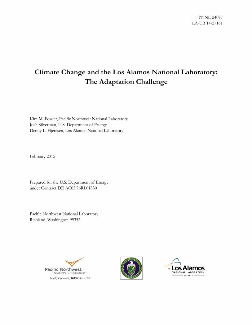
Megafires are fires that are large, have highly
unpredictable behavior and are characterized
by the impact on human environments and
extreme ecological damage, such as
destroying homes and/or destroying forest
vegetation including that needed to re-
propagate lost trees. The first of the
megafires to affect LANL was the 2000
Cerro Grande fire, which burned 43,000-
48,000 acres in the surrounding Santa Fe
National Forest from May 4th through May 19th
causing $1 billion in damages within the fire area
including the loss of 45 LANL buildings with 67 more damaged, loss of 235 homes in the surrounding
communities, displacing over 400 families, and damaging many other structures. At the time, it was the
largest forest fire in the region’s history.
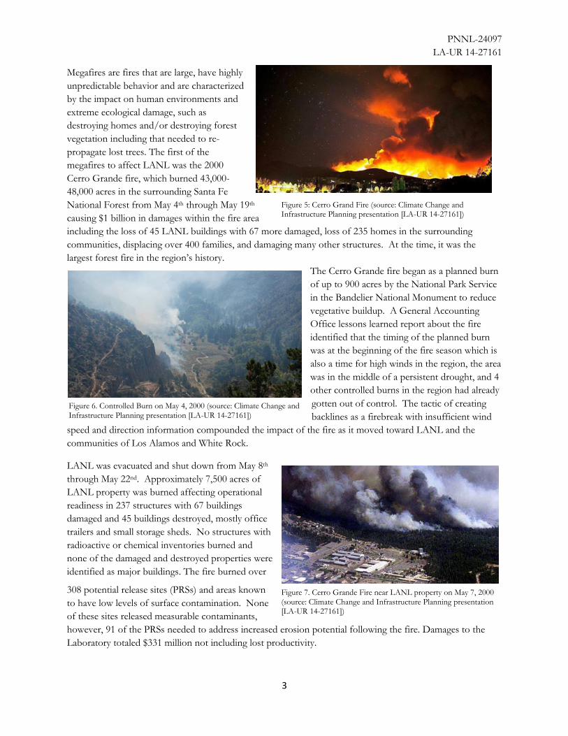
The Cerro Grande fire began as a planned burn
of up to 900 acres by the National Park Service
in the Bandelier National Monument to reduce
vegetative buildup. A General Accounting
Office lessons learned report about the fire
identified that the timing of the planned burn
was at the beginning of the fire season which is
also a time for high winds in the region, the area
was in the middle of a persistent drought, and 4
other controlled burns in the region had already
gotten out of control. The tactic of creating
backlines as a firebreak with insufficient wind
speed and direction information compounded the impact of the fire as it moved toward LANL and the
communities of Los Alamos and White Rock.
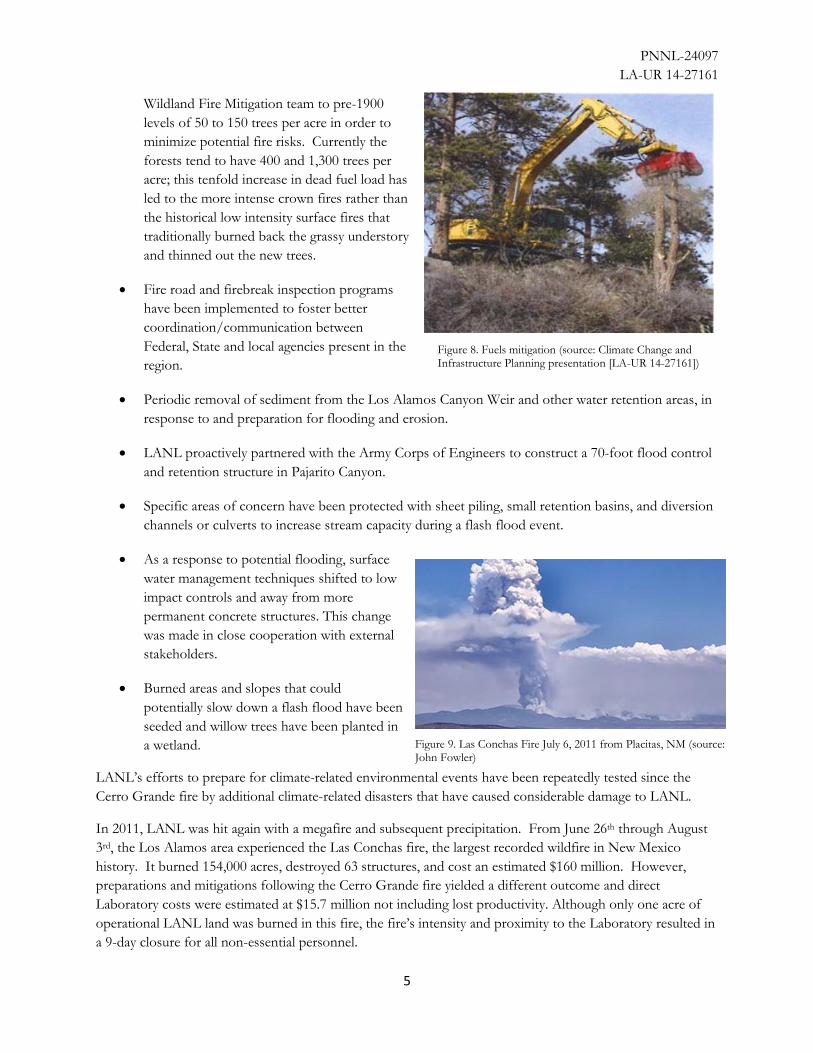
LANL was evacuated and shut down from May 8th
through May 22nd. Approximately 7,500 acres of
LANL property was burned affecting operational
readiness in 237 structures with 67 buildings
damaged and 45 buildings destroyed, mostly office
trailers and small storage sheds. No structures with
radioactive or chemical inventories burned and
none of the damaged and destroyed properties were
identified as major buildings. The fire burned over
308 potential release sites (PRSs) and areas known
to have low levels of surface contamination. None
of these sites released measurable contaminants,
however, 91 of the PRSs needed to address increased erosion potential following the fire. Damages to the
Laboratory totaled $331 million not including lost productivity.
Figure 6. Controlled Burn on May 4, 2000 (source: Climate Change and Infrastructure Planning presentation [LA-UR 14-27161])
Figure 7. Cerro Grande Fire near LANL property on May 7, 2000 (source: Climate Change and Infrastructure Planning presentation [LA-UR 14-27161])
Figure 5: Cerro Grand Fire (source: Climate Change and Infrastructure Planning presentation [LA-UR 14-27161])

PNNL-24097
LA-UR 14-27161
4
Once the fire season ends the concern shifts toward flooding
and erosion. During the monsoon season (July-August),
mitigation measures are generally taken to minimize potential
impacts from heavy rains, but the intensity of the season is
likely to determine the level of damage. Immediately following
the Cerro Grande fire, LANL built a temporary dry dam to
protect the Los Alamos Critical Experiments Facility (Technical
Area 18) from potential flash floods and within two years
completely moved all mission activities out of what was
identified to be a vulnerable site. Similar actions were taken at
Technical Area 2 in a different canyon below the Los Alamos
town site. Community organizations also worked rapidly to
address erosion concerns. Approximately 1,600 acres were
covered with hydro-mulching and hydro-seeding to speed up
the re-vegetation process, trees were planted through
community volunteer efforts, trails were repaired, and mulch
was applied to slopes to minimize erosion and facilitate
regrowth. Fortunately, the monsoon season in 2000 was mild,
so no major floods occurred.
LANL had made efforts prior to the Cerro Grande fire to
mitigate risks, by thinning forests near critical facilities and
other related measures. But the fire served as a wakeup call for
how costly and extreme the risks could be. Given the fuel
availability, temperature, precipitation, wind, humidity, lightning
strike locations, and the increase in population density, New
Mexico could expect to have a greater number of more intense
wildfires in the future unless mitigation strategies were
implemented. The Cerro Grande fire underscored these risks
and LANL undertook a concerted effort to enhance its climate-
related mitigation efforts by addressing key areas of concern:
In keeping with the recommendations of numerous
high-level climate reports, including the National
Climate Assessment and the America’s Climate
Choices Final Report, LANL developed a “Long Term
Strategy for Environmental Stewardship and
Sustainability” that includes strategies to address its
infrastructure needs for climate adaptation.
Cultural resources have been rehabilitated since the
Cerro Grande file and continue to be protected
through vegetation removal, erosion control, and
fencing.
Critical areas, called ‘fuel treatment plots,’ have been
identified and the fuel level is being managed by the
Glossary
Controlled Burn: A human initiated fire for a
specific area to achieve a defined outcome; also
called a prescribed or planned burn.
Drought: A moisture deficit or abnormally low
rainfall levels over an extended time that result in
social, environmental or economic effects. Droughts
are classified into five different categories –
abnormally dry, moderate, severe, extreme, and
exceptional.
Erosion: Natural events that cause the Earth’s
surface material to be removed and transported to a
new location.
Fire intensity: Defined by the weather and fuel
availability, the intensity is the amount of energy
released by a fire, measured by the maximum
temperature and the height of the flames.
Flash flood: A raging torrent of water caused by
rapid and/or heavy rainfall that typically lasts a
short amount of time (typically less than 6 hours).
Flood: An excess of water onto a normally dry
area. Flooding is considered a longer term event
than flash flooding (typically days to weeks).
Fuel: Potentially combustible material in forests
including grasses, dead leaves, needles, dead
branches, mosses, lichens, dead leaves, and tree
trunks. Different fuels burn at different rates and
thus help determine the fire intensity.
Monsoon: A prominent increase in rainfall in
U.S. Southwest States that have traditionally dry
summers; also called the North American
monsoon, Southwest US monsoon, Mexican
monsoon, or the Arizona monsoon. The monsoon
rains typically occur in July and August.
PNNL-24097
LA-UR 14-27161
5
Wildland Fire Mitigation team to pre-1900
levels of 50 to 150 trees per acre in order to
minimize potential fire risks. Currently the
forests tend to have 400 and 1,300 trees per
acre; this tenfold increase in dead fuel load has
led to the more intense crown fires rather than
the historical low intensity surface fires that
traditionally burned back the grassy understory
and thinned out the new trees.
Fire road and firebreak inspection programs
have been implemented to foster better
coordination/communication between
Federal, State and local agencies present in the
region.
Periodic removal of sediment from the Los Alamos Canyon Weir and other water retention areas, in
response to and preparation for flooding and erosion.
LANL proactively partnered with the Army Corps of Engineers to construct a 70-foot flood control
and retention structure in Pajarito Canyon.
Specific areas of concern have been protected with sheet piling, small retention basins, and diversion
channels or culverts to increase stream capacity during a flash flood event.
As a response to potential flooding, surface
water management techniques shifted to low
impact controls and away from more
permanent concrete structures. This change
was made in close cooperation with external
stakeholders.
Burned areas and slopes that could
potentially slow down a flash flood have been
seeded and willow trees have been planted in
a wetland.
LANL’s efforts to prepare for climate-related environmental events have been repeatedly tested since the
Cerro Grande fire by additional climate-related disasters that have caused considerable damage to LANL.
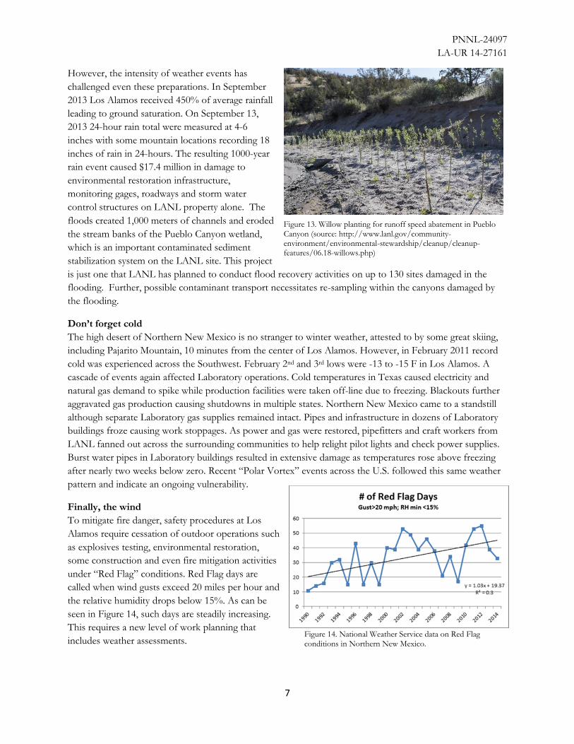
In 2011, LANL was hit again with a megafire and subsequent precipitation. From June 26th through August
3rd, the Los Alamos area experienced the Las Conchas fire, the largest recorded wildfire in New Mexico
history. It burned 154,000 acres, destroyed 63 structures, and cost an estimated $160 million. However,
preparations and mitigations following the Cerro Grande fire yielded a different outcome and direct
Laboratory costs were estimated at $15.7 million not including lost productivity. Although only one acre of
operational LANL land was burned in this fire, the fire’s intensity and proximity to the Laboratory resulted in
a 9-day closure for all non-essential personnel.
Figure 8. Fuels mitigation (source: Climate Change and Infrastructure Planning presentation [LA-UR 14-27161])
Figure 9. Las Conchas Fire July 6, 2011 from Placitas, NM (source: John Fowler)

PNNL-24097
LA-UR 14-27161
6
The Las Conchas fire also resulted in a major shift in
approach to transuranic waste storage and shipping at
Los Alamos. The perceived risk of above ground
storage of wastes at Technical Area 54 prompted the
Laboratory and the State of New Mexico
Environmental Department to reach agreement on
the accelerated removal of 3706 cubic meters of
stored aboveground transuranic waste from the site.
This resulted in shifting of priorities from other
cleanup activities; over $150 million was reprioritized
from the Lab’s environmental programs to address
the waste relocation.
And then Flooding
On August 21, 2011 the monsoon rains brought the
feared flash flooding. The flooding intensity was
significantly higher due to the Las Conchas fire
depletion of vegetation and the creation of a
hydrophobic (waxy) layer over the soil. The Park
Service at Bandelier National Monument removed
bridges so that they would not become dams in the
event of a flash flood, water repellant material was
placed on the outside walls of historic buildings, and
sand bags were used to surround and protect key
buildings. LANL immediately worked to prepare
for expected flash flooding in order to minimize
runoff from the Laboratory into the Rio Grande.
Barriers were installed to divert the water to holding
areas and sediment was removed from these holding
areas in order to better manage the flash flood
water. Wells were sealed, waste drums were moved,
and sampling stations were setup to test the runoff
water for contaminants. The mitigation measures
were successful in reducing the runoff damage from
the 2011 flash floods. LANL developed additional
plans to repair the property that was damaged in the
2011 floods and continue to deploy mitigation
measures that have been proven to work. To help
repair the stream banks and preserve the Pueblo
Canyon wetland, LANL planted approximately
10,000 willow trees.
Figure 10. Las Conchas Fire (source: Climate Change and Infrastructure Planning presentation [LA-UR 14-27161])
Figure 11. Moved transuranic waste to address perceived risk (source: Climate Change and Infrastructure Planning presentation [LA-UR 14-27161])
Figure 12. Contaminant Monitoring Station impacted by flooding (source: Climate Change and Infrastructure Planning presentation [LA-UR 14-27161])
PNNL-24097
LA-UR 14-27161
7
However, the intensity of weather events has
challenged even these preparations. In September
2013 Los Alamos received 450% of average rainfall
leading to ground saturation. On September 13,
2013 24-hour rain total were measured at 4-6
inches with some mountain locations recording 18
inches of rain in 24-hours. The resulting 1000-year
rain event caused $17.4 million in damage to
environmental restoration infrastructure,
monitoring gages, roadways and storm water
control structures on LANL property alone. The
floods created 1,000 meters of channels and eroded
the stream banks of the Pueblo Canyon wetland,
which is an important contaminated sediment
stabilization system on the LANL site. This project
is just one that LANL has planned to conduct flood recovery activities on up to 130 sites damaged in the
flooding. Further, possible contaminant transport necessitates re-sampling within the canyons damaged by
the flooding.
Don’t forget cold
The high desert of Northern New Mexico is no stranger to winter weather, attested to by some great skiing,
including Pajarito Mountain, 10 minutes from the center of Los Alamos. However, in February 2011 record
cold was experienced across the Southwest. February 2nd and 3rd lows were -13 to -15 F in Los Alamos. A
cascade of events again affected Laboratory operations. Cold temperatures in Texas caused electricity and
natural gas demand to spike while production facilities were taken off-line due to freezing. Blackouts further
aggravated gas production causing shutdowns in multiple states. Northern New Mexico came to a standstill
although separate Laboratory gas supplies remained intact. Pipes and infrastructure in dozens of Laboratory
buildings froze causing work stoppages. As power and gas were restored, pipefitters and craft workers from
LANL fanned out across the surrounding communities to help relight pilot lights and check power supplies.
Burst water pipes in Laboratory buildings resulted in extensive damage as temperatures rose above freezing
after nearly two weeks below zero. Recent “Polar Vortex” events across the U.S. followed this same weather
pattern and indicate an ongoing vulnerability.
Finally, the wind
To mitigate fire danger, safety procedures at Los
Alamos require cessation of outdoor operations such
as explosives testing, environmental restoration,
some construction and even fire mitigation activities
under “Red Flag” conditions. Red Flag days are
called when wind gusts exceed 20 miles per hour and
the relative humidity drops below 15%. As can be
seen in Figure 14, such days are steadily increasing.
This requires a new level of work planning that
includes weather assessments.
Figure 13. Willow planting for runoff speed abatement in Pueblo Canyon (source: http://www.lanl.gov/community-environment/environmental-stewardship/cleanup/cleanup-features/06.18-willows.php)
Figure 14. National Weather Service data on Red Flag conditions in Northern New Mexico.

PNNL-24097
LA-UR 14-27161
8
Responding and Preparing
Over the last 15 years, LANL has been challenged with a barrage of fires, floods, and drought. Instead of
being discouraged by these frequent climate-related disasters, the Laboratory has taken a proactive approach
to identify strategies that will mitigate or at least minimize the long- and short-term effects of these events.
LANL recognizes both the environmental and economic value to minimizing the effects of each event. The
cost implications are substantial; a shut-down of the Laboratory costs an estimated $15 million per week in
lost productivity. In addition, the proactive measures LANL took to minimize climate impacts resulted in
lower costs associated with cleaning up damaged property and resuming safe operations after the Las
Conchas fire.
LANL has successfully worked with other Federal agencies and State and local governments to improve
communication during events and restoration activities. The Laboratory has reduced the contamination risk
by relocating contaminated materials and shipping transuranic waste off-site. To increase confidence in the
surrounding communities in the Rio Grande river basin LANL has installed additional water quality monitors
and has strategies in place to minimize contaminant runoff in the case of flash floods. Retention basins and
grade-control structures have been created to reduce transport of contaminated sediment. Damaged areas
have been re-seeded with groundcover and planted with trees to give the environment a fighting chance when
the next event occurs. To keep focused attention on the subject the Laboratory appointed a Climate
Adaptation Team Leader as part of its Long Term Strategy for Environmental Stewardship and Sustainability.
Climate change is a significant challenge at the Los Alamos National Laboratory, but by integrating climate
change mitigation strategies into facility operations and long-term planning the Lab can ensure it has the best
opportunities to weather the storm.
Key Considerations for Managers and Practitioners
The efforts that LANL has taken to mitigate the impacts of climate-related effects on their site offer lessons
for all DOE sites. Sites need to be aware of changing conditions in their regions so that they can understand
how the climate-related risks may have changed, such as increase in event intensity, changes in frequency, and
how multiple events could compound the impact.
DOE sites should assess their specific operational vulnerabilities to ensure both continuity of
operations and prevention of offsite impacts from climate events. For example, are there waste
ponds or storage areas that could be compromised by an extreme storm event?
DOE sites need to recognize that their climate-related risks include “beyond design-basis” events.
Building on the lessons of the 2011 Fukushima Daiichi disaster, where multiple events compounded
impacts of an unexpectedly large earthquake, DOE sites need to be aware of the 1000-year event or
worst case scenario, not just what has been experienced in recent times. DOE sites need to
understand the probability of such events and how the probability of these events is anticipated to
change over time.
When considering the possible extreme events, consider the impacts and the external stakeholders
that will need to be involved if such an event occurs. Build community relationships before extreme
events happen. Strong networks and community partnerships improve organizational resilience.
Look to balance an understanding of the full costs of an extreme event (including the cost of
shutting down a DOE site and managing the public concerns over nuclear materials and waste) with
actions that can be taken to minimize the impact at reasonable costs. Balance the cost of possible
proactive remedies against the consequences of inaction prior to an extreme event in the planning
process.

PNNL-24097
LA-UR 14-27161
9
Remember that traditional practices (i.e., controlled burns) may need to be re-examined given
changing conditions. Climate variations may introduce new risks into what are seen as “normal”
activities. Familiar activities may not be as safe as they once were.
Learn from experience and plan for the next event. Advance planning can help to avoid or at least mitigate the most severe consequences of major events. The Las Conchas fire would have been much more damaging to LANL had the Lab not addressed lessons learned from the Cerro Grande fire.
Integrate climate considerations into existing emergency management and safety planning. Climate
risks are not fundamentally different from the risks DOE sites already plan for, and can typically be
addressed through thoughtful adjustments to existing risk management processes and systems.

PNNL-24097
LA-UR 14-27161
10
References:
Bachelet, Dominique (Oregon State University), James Lenihan, and Ronald Neilson (U.S. Forest Service).
2007. Wildfires & Global Climate Change: The Importance of Climate Change for Future Wildfire Scenarios
in the Western United States. Excerpted from the full report, Regional Impacts of Climate Change: Four Case
Studies in the United States prepared for the Pew Center on Global Climate Change. Arlington, Virginia.
County of Los Alamos, Los Alamos County Community Wildfire Protection, and Los Alamos Fire
Department. 2009. Community Wildfire Protection Plan. Los Alamos, New Mexico.
Gentile, Bill and Kevin Leifheit. 2014. LANL Emergency Planning and Preparedness Overview. Presentation
given June 4, 2104. Los Alamos National Laboratory. Los Alamos, New Mexico.
Hill, Barry. 2000. Fire Management: Lessons Learned From the Cerro Grande (Los Alamos) Fire. Statement
prepared for a hearing before the Committee on Energy and National Resources, U.S. Senate, July 20, 2000.
GAO/T-RCED-00-257. General Accounting Office. Washington, D.C.
Hjeresen, DL. 2014. Climate Change and Infrastructure Planning. Presentation given September 18, 2014,
DOE Annual Sustainability Workshop, Albuquerque, N.M. LA-UR 14-27161. Los Alamos National
Laboratory. Los Alamos, New Mexico.
LANL. 2000. A Special Edition of the SWEIS Yearbook Wildfire 2000. LA-UR-00-3471. Los Alamos
National Laboratory. Los Alamos, New Mexico.
LANL. 2012. Long Term Strategy for Environmental Stewardship and Sustainability
(http://www.lanl.gov/projects/long-term-environmental-strategy/). Accessed: January 19, 2015. LA-UR-12-
24845. Los Alamos National Laboratory. Los Alamos, New Mexico.
LANL. 2015. Location and Infrastructure. Website: http://www.lanl.gov/about/facts-figures/location.php.
Accessed: January 19, 2015. Los Alamos National Laboratory. Los Alamos, New Mexico.
Noll, Phillip. 2014. Fiscal Year 2013 Mitigation Action Plan Annual Report for the 2008 Los Alamos National
Laboratory Site-Wide Environmental Impact Statement. LA-UR-13-28416. Los Alamos National Laboratory.
Los Alamos, New Mexico.
Valdez, Carlos. 2002. Bark Beetles in a Pine Nutshell. New Mexico State University Cooperative Extension
Agent. Los Alamos, New Mexico.
Weather Warehouse. 2015. Los Alamos, New Mexico Weather Station Total Precipitation. Website:
http://weather-
warehouse.com/WeatherHistory/PastWeatherData_LosAlamos_LosAlamos_NM_August.html. Accessed:
January 19, 2015.