climate change and restoration on the stillaguamish … · annette colombini why are estuaries such...
TRANSCRIPT

Climate Change and Restoration on the
Stillaguamish Delta: Lessons learned2006
Roger FullerWestern Washington University
2014 2015
Resilience?

Sea Level Rise Salinity
Secondary Impacts
Insects Herbivory
Marsh BiomassSeasonal Temps
Mutualism 1
Mutualism 2
Disturbance Regime Predator
Shredder
Climate Change Primary Impacts
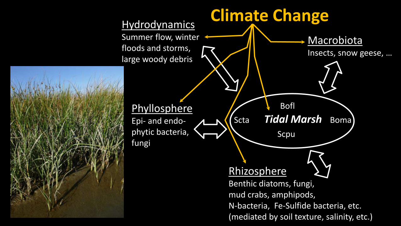
RhizosphereBenthic diatoms, fungi, mud crabs, amphipods, N-bacteria, Fe-Sulfide bacteria, etc.(mediated by soil texture, salinity, etc.)
Bofl
Scta Tidal Marsh Boma
Scpu
PhyllosphereEpi- and endo-phytic bacteria, fungi
Hydrodynamics Summer flow, winter floods and storms, large woody debris
MacrobiotaInsects, snow geese, …
Climate Change

What we’ll talk about
1. Project Objectives2. Design process3. Outcomes 4. Ecological trends5. Lessons

The Stillaguamish Estuary
Some current estuary functionsand ecosystem services
• Food web support• Sediment sink • Water quality • Storm and flood protection• Sub-irrigation• Farmland drainage• … etc.
2012 Restoration
Restoration projects should be multi-stakeholder projects
Port Susan Bay
Skagit Bay

Project Objectives
1. Restore 150 acres of tidal wetlands, and salmon access (site scale)
2. Improve connectivity between the river and the northern estuary (estuary scale)
3. Improve flood attenuation for neighbors in the lower river valley (socio-economic)

WDOE
Low
3-square bulrush
Middle
Mixed Bulrushes3-SquareSeacoastSoft-stemRiverHard-stem
High Grasses,Sedges, Rushes
Dicots
Marsh Types

Erica Sloniker
Marsh Madness
The fuel of the estuarine food web

Annette Colombini
Why are estuaries such productive ecosystems?

WSU
Crangon alaskensis Dave Cowles, Rosario Beach Marine Lab
monkeyfacenewsCrangon franciscorum
bryanlikestofish.com
3 Spine Stickleback
Grass shrimp
Amphipod
Bay Shrimp
1/8th inch
2 inches
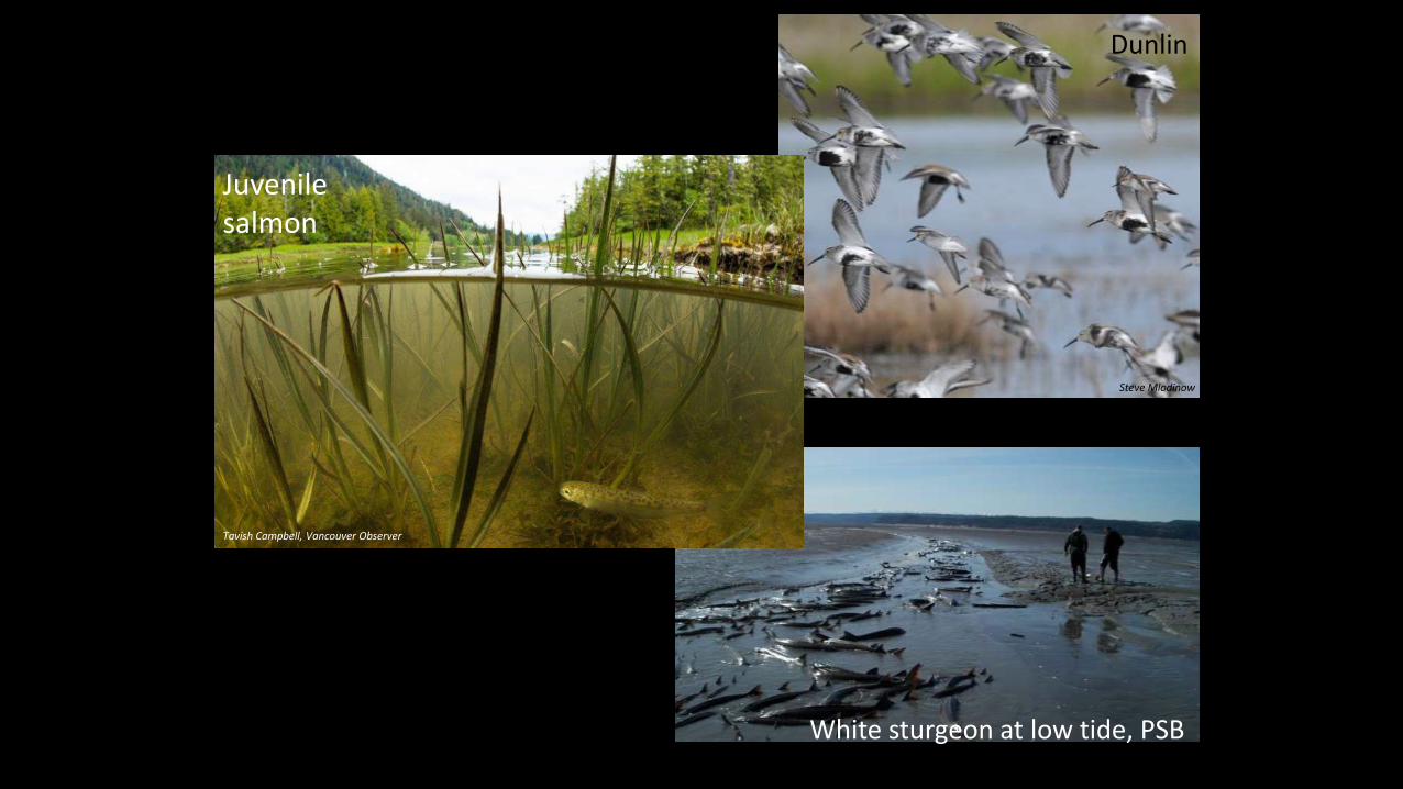
Steve Mlodinow
White sturgeon at low tide, PSB
Dunlin
Tavish Campbell, Vancouver Observer
Juvenile salmon
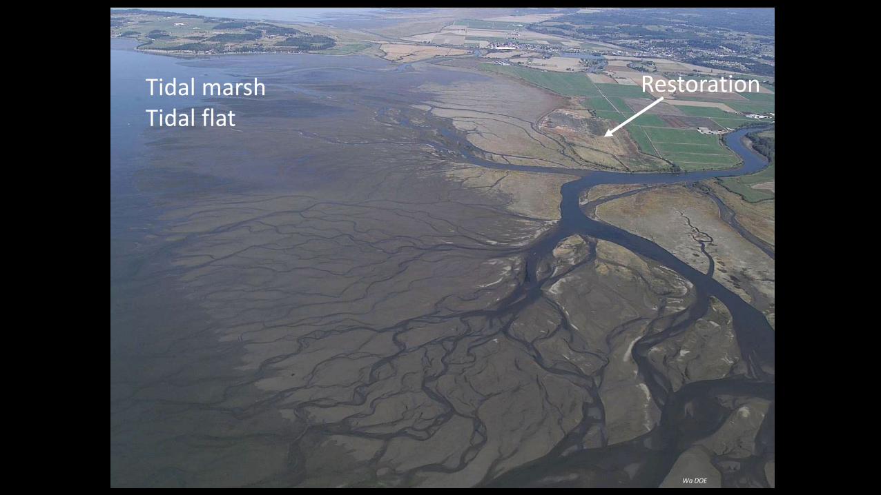
Wa DOE
Restoration Tidal marshTidal flat

Water levelsSalinitypore water
SedimentPSD, Accretion/Erosion
Estuary Ecosystemspecies composition
(plants, animals, microbiome)ecosystem services and functions
etc.
Sea level
Configuration of channels and levees
River flow regime
Climate Change
Climate Change
Storm winds
Waves
Elevation
Drivers
Feedback PathwaysControlling Factors

North and Mid-Delta Marsh Erosion
The Marsh isn’t Resilient
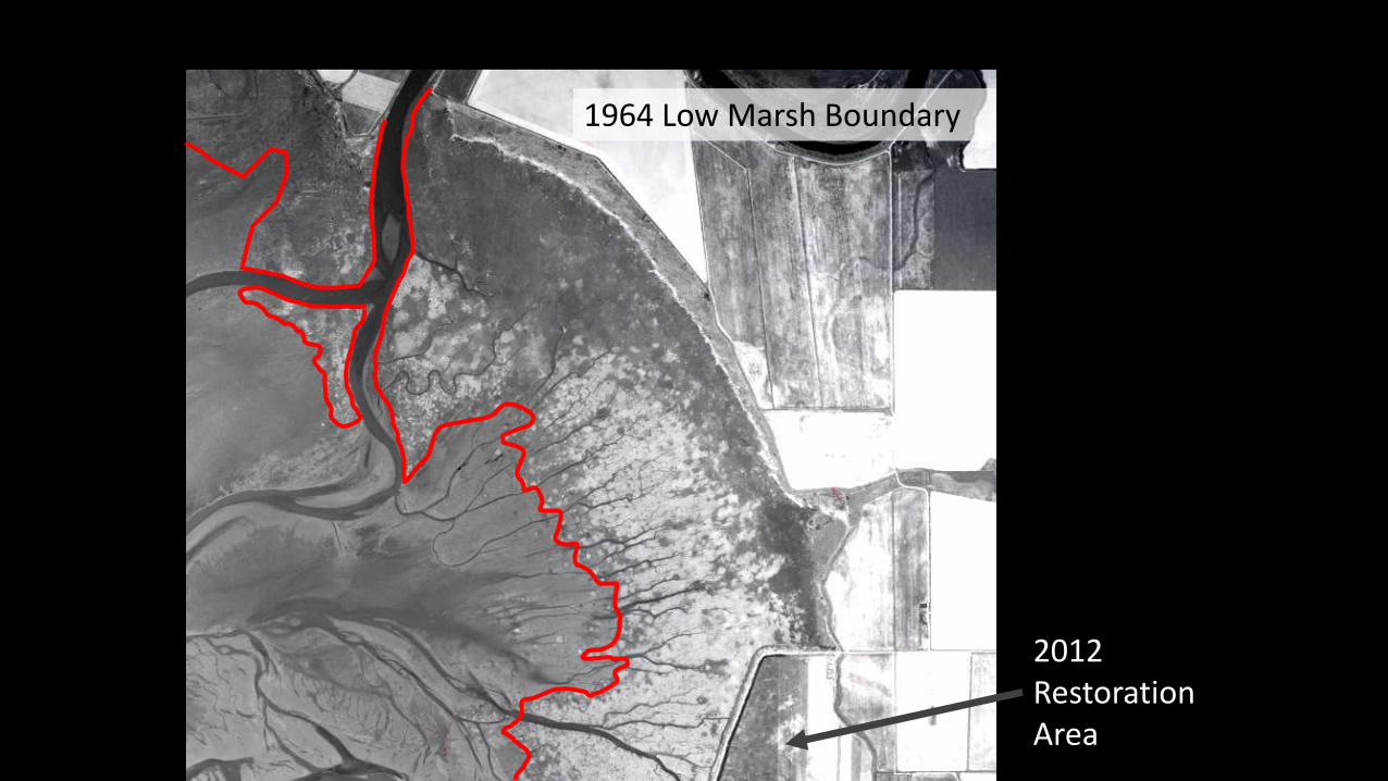
1964 Low Marsh Boundary
2012 Restoration Area

1964 Low Marsh Boundary
Low Marsh Boundary19642004
21 m/yr
5 m/yr
First Hypotheses:• Salinity• Sediment

pre-restoration
A. Existing conditionsA. Existing conditions
TNC dike
post-restoration
B. RestorationB. Restoration
With dike removal, area of low salinity for tidal marsh expands
Project Conceptual Design Modeling

SLR + Low Flow
Current Conditions
1m Sea Level Rise (SLR) SLR + snow geese
In what ways is the estuary vulnerable to climate change?

Note on Modeling:
“All models are wrong, but some are useful.” George Box
Ecological models GREATLY simplify complex natural processes.Models do NOT make decisions, or predictions. Don’t believe the maps.
“Marshes on the Move” – a manager’s guide to modelingSearch: NOAA marshes on the move

Flood-relief gate
2 breaches to channel
Dike removal
New dike
Restoration Project Elements
2012
150 acres

Predicted Habitat
(preliminary design)
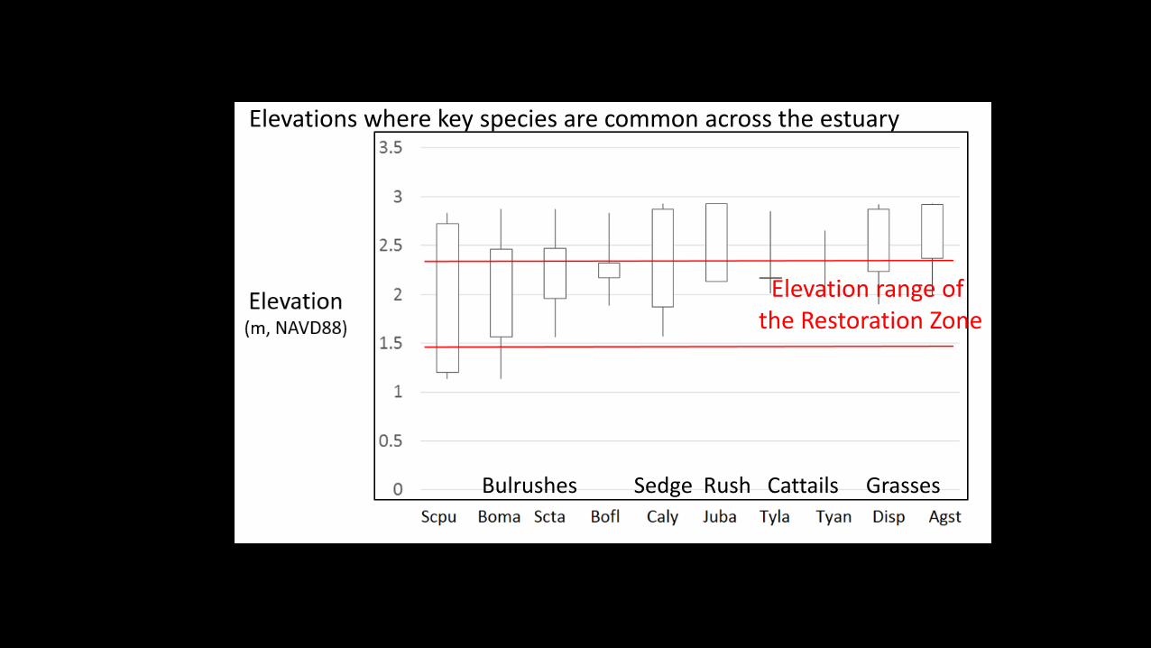
Elevation range of the Restoration Zone
Elevations where key species are common across the estuary
Bulrushes Sedge Rush Cattails Grasses

2013 2014 2015 2016
Marsh change
Restoration Outcomes

Bore holes
Preliminary ID:Bactra sp. (Tortricidae)
2015Disturbance
2014
2015
>95% plant death by July 150 acres

Highest elevation marshClosest to river mouth
Lowest elevation marsh
Stress kills

2015 Restoration Zone (salt stress, insect attack): 70% Average decrease in biomass
2016 – no recovery below ~2.1m

Bolboschoenus maritimus~100m apart
2017 – massive expansion of non-native cattail
narrow-leaved cattail produces
phenolics

Saltiness of estuary soils
normal
2015
Record Low River Flow, April through August
Estuary Plant Height
Plants were 35% shorter and didn’t produce seeds
due to salt stress
Climate change and river flows... 2015 was a great test(record low summer river flows - projected to be the average by 2050)
(35% less fuel for the food web … imagine this as the new normal!)
Median
2015

Projected Changes in Summer Low Flow Volume
Lowest 7-day average flow in 2yr period
Low Carbon Emissions Scenario (RCP 4.5)Source: UW Climate Impacts Group
2050’s
2080’s
-35%
-45%
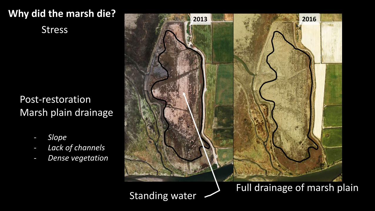
2013 2016
Standing water
Post-restoration Marsh plain drainage
- Slope- Lack of channels- Dense vegetation
Full drainage of marsh plain
Why did the marsh die?
Stress

Lesson – hydrology loggers and LiDAR aren’t enough to indicate marsh plain hydrology
Site elevations are all above the low tide line…so assumption is that marsh plain fully drains.

Elevation range of the Restoration Zone
Elevations where key species are common across the estuary
Bulrushes Sedge Rush Cattails Grasses
Big surprise in the restoration zone: 3-square bulrush has NOT colonized…why?

3-Square Bulrush Biomass and %Sand
3-square bulrush prefers sandier soil, the restoration zone is mostly silt/clay
but that still doesn’t explain its absence
Soil Drainage: low gas exchange, higher sulfides?
Lesson: monitoring plan didn’t include soil chemistry so we don’t know what is stressing the plants.

North Marsh erosion: insufficient sediment?
…plenty of sediment for the marshes at the moment, so no
Elevation Change (cm/yr)(from SETs)
Avg sea level rise rate over next 90 years
Historic rate of sea level rise
(Sediment Deposition)

Geese as ecosystem engineers
• excavate rhizomes• reduce bulrush stem density• remove the roots that hold the soil• disturb and loosens the soil• disrupt the diatom “glue”
Steve Mlodinow

MarshStructure
VariesSeasonally
WinterSummer
Seaside bulrush
River bulrush
Three-square bulrush
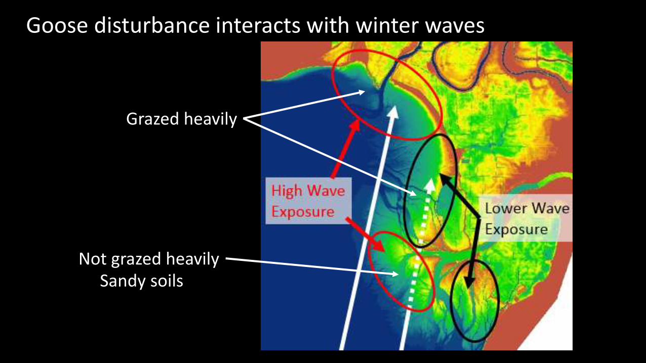
Goose disturbance interacts with winter waves
Grazed heavily
Not grazed heavilySandy soils
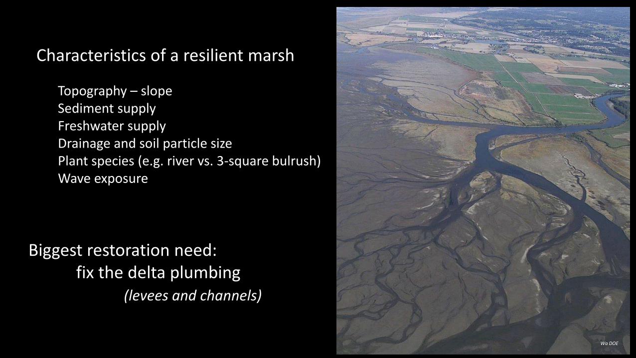
Characteristics of a resilient marsh
Topography – slopeSediment supply Freshwater supplyDrainage and soil particle sizePlant species (e.g. river vs. 3-square bulrush)Wave exposure
Wa DOE
Biggest restoration need: fix the delta plumbing
(levees and channels)

A few of the lessons learned
1. Summer flow - biggest direct climate change impact in estuaries (not sea level rise).
2. Climate change doesn't act alone, it interacts with the existing stress and disturbance regime in a system.
3. Resilience to stress differs spatially across the estuary…spatial position of a restoration site matters.
4. There are characteristics of resilient marsh that can be incorporated into adaptive management and restoration designs.

A few of the lessons learned
5. Consistency in project staffing from start to finish is important.
6. Slope and soil chemistry are important.
7. Starter channels were needed.
8. Include invasive plants in your monitoringplan, even if you don’t expect them. And
decide beforehand how you will respond.
9. System-scale perspective important. As are multiple reference sites.

A few bonus observations
1. "Think like a mountain“ (Aldo Leopold) - Challenge yourself to think at time scales, spatial scales, and scales of biotic interactions that you normally don't consider.
2. Use climate change concepts to build a broader base of support for restoration.

Jen Moslemi
Thanks! Roger Fuller Western Washington University
Acknowledgements
Colleagues: Katrina Poppe, John Rybczyk, Eric GrossmanGrad Students: Brittany Jones (UW), Chad StellernField and Data crew: Hannah LaGassey, James McArdle, Chelsea Douglas, Sarah Thomas, Abe Lloyd, Michael Heath, William Ashford, Cody Level, Adam Schnellbaecher, Christian Aguilar, Devin Debono, Andy Cortese, Alec Barber, Katy Hancock, Kaylee Guetle.
Funding: The Nature Conservancy, ESRP, NOAA