cleasby way, eaglescliffe phase 2 office development
TRANSCRIPT

Optima Highways and Transportation Consultancy Ltd Suite 1, 3rd Floor, Goodbard House, Infirmary Street, Leeds, LS1 2JP
Tel: 0113 245 1679 www.optimahighways.com
Cleasby Way, Eaglescliffe Phase 2 Office Development
Transport Statement June 2021 (Planning Issue)
Prepared on behalf of
Returnable Packaging Services Ltd

Cleasby Way, Eaglescliffe
This document has been prepared for the exclusive use of the Client and unless otherwise agreed in writing by them or by
Optima Highways and Transportation Ltd, no other party may use, make use of or rely on the contents of this document. This document cannot be assigned or transferred to any third party without the express written agreement of both Optima Highways
and Transportation Ltd and the Client.
Transport Statement Returnable Packaging Services Ltd
Cleasby Way, Eaglescliffe - Transport Statement Project No: 18137-P3
File reference O:\Cleasby Way, Eaglescliffe\TEXT\REPORTS\210629 Cleasby Way Eaglescliffe Phase 2_TS.docx
Issue/revision Initial Issue Revision 1 Revision 2 Revision 3
Remarks Draft for Comment Planning Issue
Date 20th May 2021 29th June 2021
Prepared by E A Green E A Green
Signature
Checked by T Pridmore T Pridmore
Signature
Authorised by E A Green E A Green
Signature
Quality Management
Cleasby Way, Eaglescliffe
Transport Statement Returnable Packaging Services Ltd
1. Introduction .................................................................................................................................... 1
2. Existing Site Conditions ................................................................................................................... 3
3. Proposed Development .................................................................................................................. 7
4. Site Accessibility ............................................................................................................................ 10
5. Summary and Conclusions ............................................................................................................ 13
IMAGES
Image 1.1 Site Location .......................................................................................................................... 1
Image 2.1 Cleasby Way looking to the West .......................................................................................... 3
Image 2.2 Extract from the Stockton South Cycle Map ......................................................................... 4
Image 2.3 Extract from the Crashmap Website ..................................................................................... 6
Image 4.1 Pedestrian Accessibility ....................................................................................................... 10
Image 4.2 Cycle Accessibility ................................................................................................................ 11
TABLES
Table 2.1 Bus Service Summary – Durham Lane .................................................................................... 5
Table 3.1 Average Trip Rates and Resultant Traffic Generation ............................................................ 8
Table 3.2 Assignment of Weekday Trips and Maximum Peak Hour Two-way Flow .............................. 9
Table 4.1 Accessibility by Foot ............................................................................................................. 10
FIGURES
Figure 1 Site Location Plan – Local Figure 2 Site Location Plan – Strategic Figure 3 Pedestrian Accessibility Figure 4 Cycle Accessibility
APPENDICES
Appendix A Proposed Site Plan
Appendix B TRICS Data
Content

Cleasby Way, Eaglescliffe
1 Transport Statement Returnable Packaging Services Ltd
1.1 INTRODUCTION
1.1.1 Optima Highways and Transportation Consultancy Limited (Optima) has been appointed by Returnable Packaging Services Ltd (RPS Ltd) to produce a Transport Statement (TS) to accompany a full planning application for Phase 2 of a commercial development off Cleasby Way in Eaglescliffe. Eaglescliffe lies within the administrative area of Stockton-on-Tees Borough Council which, as a unitary authority, is responsible for both planning and highways matters.
1.1.2 The Site is within the established Durham Lane Industrial Estate as shown on Figure 1, an extract of which is provided in Image 1.1. The Phase 2 site is shown edged in red with the Phase 1 site edged in blue.
Image 1.1 Site Location
1.2 BACKGROUND AND PLANNING HISTORY
1.2.1 As identified, this TS has been prepared in relation to Phase 2 of a commercial development off Cleasby Way in Eaglescliffe. Phase 1 of the development, the erection of warehouse and recycling facilities with ancillary office accommodation, associated means of access and 2.4m high means of enclosure, was granted planning permission on 15th February 2019 (Ref: 18/2431/FUL).
1.2.2 Highways England (HE) was consulted on the planning application for Phase 1 and, whilst no objection was raised, HE noted that there was to be a second phase of development which would require consideration in due course. HE stated that its primary concern is the impact in terms of safety and operation of the Strategic Road Network (SRN), and in this location that is the impact on A66 Elton Interchange.
1.2.3 An earlier outline planning application for Phase 2 (Ref: 20/1914/OUT) has been withdrawn to be replaced with this full application.
1. Introduction

Cleasby Way, Eaglescliffe
2 Transport Statement Returnable Packaging Services Ltd
1.3 SCHEME PROPOSALS AND SCOPE OF REPORT
1.3.1 The scheme proposals are for 1,866 sq. m (20,100 sq ft) gross floor area (gfa) of office space with associated car parking, open space and landscaping.
1.3.2 The report has been prepared in accordance with the Department for Communities and Local Government (DCLG) ‘National Planning Practice Guidance’ published in 2014 which supersedes the Department for Transport (DfT) and DCLG’s ‘Guidance on Transport Assessment’ (GTA) document. Cognisance has also been taken of the prevailing National Planning Policy Framework (NPPF) as well as the emerging Wakefield District Local Plan 2036. Paragraph 109 of NPPF, February 2019 states that:
“Development should only be prevented or refused on highways grounds if there would be an unacceptable impact on highway safety, or the residual cumulative impacts on the road network would be severe.”
1.3.3 This report sets out the transport impacts relating to the development proposals and considers the sustainability and accessibility of the Site, reviewing the provision and quality of facilities and connections to and from the surrounding areas. The document structure is as follows:
• Section 2 – describes the Site, its surroundings and existing transport conditions including access by all modes of transport;
• Section 3 – sets out the development proposals including means of access and provides information on the likely trip generation and distribution and, in particular, the likely impact on A66 Elton Interchange;
• Section 4 - describes the accessibility of the Site by non-car modes including accessibility to local facilities / services; and
• Section 5 – summarises and concludes the Transport Statement.

Cleasby Way, Eaglescliffe
3 Transport Statement Returnable Packaging Services Ltd
2.1 INTRODUCTION
2.1.1 This chapter describes the Site and considers the existing conditions on the surrounding highway network for a range of transport modes including public transport provision. The section also includes a review of recent personal injury collision data.
2.2 EXISTING SITE
2.2.1 The Site is situated on currently undeveloped land to the south of Cleasby Way, Eaglescliffe, to the east and north of the existing Durham Lane Industrial Estate. The Site is generally rectangular in shape and is bound to the west by the Phase 1 development, to the north partly by Cleasby Way and partly by open land and to the east and south by further open land.
2.2.2 In the wider context, the Site is situated to the west of Eaglescliffe Village Centre and lies some 5-6km to the south west of Stockton-on-Tees. The location of the Site in relation to the wider surroundings is shown in Figure 2.
2.3 EXISTING LOCAL HIGHWAY NETWORK
2.3.1 Cleasby Way is an unadopted, private road that serves multiple commercial and industrial properties within the Durham Lane Industrial Estate via a network of estate roads leading from it via Sowerby Way. Cleasby Way runs in a west to east direction from a ghost island right turn holding lane priority junction with the Durham Lane to the Site at the east.
2.3.2 Cleasby Way has been engineered to provide access for commercial and industrial units and therefore has a carriageway of circa 10m in width with 2m wide footways on both sides. Street lighting is present along Cleasby Way and it is subject to a 20mph speed limit along with the other roads within the Durham Lane Industrial Estate. There are currently no traffic regulation orders preventing parking, waiting or loading in the immediate vicinity of the Site.
2.3.3 Image 2.1 shows a section of Cleasby Way looking to the west away from the Site.
Image 2.1 Cleasby Way looking to the West
2. Existing Site Conditions

Cleasby Way, Eaglescliffe
4 Transport Statement Returnable Packaging Services Ltd
2.3.4 Durham Lane is one of the main routes in the area and, to the north, forms an important connection with the A66 at the Elton Interchange. To the south, Durham Lane meets A67 at a four arm roundabout that also provides access into a large Tesco food store.
2.3.5 A66 is part of the Strategic Road Network (SRN) and leads in a generally east to west direction from Middlesbrough to Darlington. Some 7km to the east of the Elton Interchange, A66 interchanges with A19, a key north south routh through Teesside and beyond. A67 also interchanges with A19 to the south of the Site.
2.4 EXISTING PEDESTRIAN / CYCLE FACILITIES
2.4.1 There are existing footways within the Durham Lane Industrial Estate linking the Site to the nearest bus stops and the nearest railway station, Allens West.
2.4.2 The Stockton South Cycle Map, available on-line, shows walking and cycling routes in the district and an extract is provided in Image 2.2. Advisory cycle routes are shown in yellow with traffic-free cycle paths in green and signed cycle routes in blue. Public footpaths are shown with a purple dashed line.
Image 2.2 Extract from the Stockton South Cycle Map
Source: www.stockton.gov.uk/
2.5 EXISTING PUBLIC TRANSPORT SERVICES / FACILITIES
Bus
2.5.1 The nearest bus stops to the Site are located on Durham Lane, 1.2km from the centre of the Site. The stops are provided with a shelter, seating, flag and timetable information.
2.5.2 A summary of the bus services from the stops on Durham Lane is provided in Table 2.1.

Cleasby Way, Eaglescliffe
5 Transport Statement Returnable Packaging Services Ltd
Table 2.1 Bus Service Summary – Durham Lane
Service Route Days of
Operation Approx. Frequency in
each direction Time of
operation
7A Stockton - Eaglescliffe
- Yarm
Mon-Fri Hourly 18:25 – 23:25
Sat Hourly 18:25 – 23:25
Sun Hourly 09:25 – 19:25
17/X17
Middlesbrough - Thornaby - Ingleby
Barwick - Yarm - Eaglescliffe
Mon-Fri Hourly 06:52 – 17:25
Sat Hourly 07:20 – 17:15
Sun - -
2.5.3 As can be seen from Table 2.1, the existing bus services provide journeys to and from the main areas of population within the Teesside area. These include many residential areas, where it is likely the staff for the development will live, thereby making bus travel a realistic modal choice.
Rail
2.5.4 The nearest rail stations to the site are Allens West, which is 1.3km from the centre of the Site and Eaglescliffe, which is 1.5km from the Site.
2.5.5 Allens West is on the line from Darlington to Middlesbrough. These services extend to Bishop Auckland to the west and Saltburn to the east and also offer a link to Redcar. There are two trains per hour in each direction.
2.5.6 Allens West has storage for 8 cycles which is protected by CCTV. Four of the spaces are stands and four are in lockers. The stands are free of charge and the lockers are for hire from Stockton-on-Tees Borough Council.
2.5.7 Eaglescliffe enjoys the same level of service as Allens West as they are on the same line. There is, however, an additional Grand Central service to Sunderland and York and London Kings Cross that runs five times per day in each direction. Eaglescliffe also has storage for 8 cycles in a mix of stands and lockers for hire, again covered by CCTV. There is a car park which is subject to a daily, weekly, monthly or annual charge.
2.5.8 Using the bus services in Table 2.1 allows access to further rail services. Yarm offers Transpennine Express services to York, Leeds and Manchester, including the Airport. Middlesbrough offers the same services as Yarm and Allens West with additional services to Whitby, Hartlepool, Sunderland and Newcastle.
2.6 PERSONAL INJURY COLLISION DATA
2.6.1 A review of the Crashmap website has been undertaken to provide a high level review of any collision clusters within the study area. The chosen study area includes Durham Lane between and including its junctions with A67 to the south and A66 to the north (Elton Interchange).
2.6.2 Crashmap uses validated Department for Transport data for collisions where a Personal Injury Collision (PIC) has occurred (where Police attended or were subsequently informed). Data outlined below is from the most recently available five year period covering 2015 to 2019 (some provisional 2020 data is available on Crashmap but this has yet to be verified).
2.6.3 There have been no PICs at the junction of A67 and Durham Lane and there has been one PIC, classified as slight in severity, at the junction of Durham Lane and Cleasby Way. To the north,

Cleasby Way, Eaglescliffe
6 Transport Statement Returnable Packaging Services Ltd
towards A66 there have been three PICs on Durham Lane, one of which was classified as slight in severity and the remaining two as serious.
2.6.4 At Elton Interchange, including on the slip roads, there has been a total of four PICs, two of which have been classified as slight in severity and the remaining two as severe. The PIC locations at Elton Interchange are illustrated in Image 2.3.
2.6.5 There have been no collisions resulting in fatal injury within the study area.
Image 2.3 Extract from the Crashmap Website
Source: www.crashmap.co.uk/Search
2.6.6 There have been no significant clusters of collisions within the study area and the high level assessment of the collision data has shown no common cause.
2.6.7 It is considered that there is no underlying road safety issue related to road geometry or layout that would be exacerbated by the additional traffic that will be generated by the proposed development.

Cleasby Way, Eaglescliffe
7 Transport Statement Returnable Packaging Services Ltd
3.1 DEVELOPMENT PROPOSALS
3.1.1 The scheme proposals are shown on Apto Design Ltd’s drawing no 191001.01 Rev B: Site and Location Plan, a copy of which is contained at Appendix A. The area of the Site is 5,550 sq. m (1.37 acres). The Site Plan provides the following details of the development:
• 2 no. Office Units each of 933 sq. m/10,000 sq. ft gross floor area (gfa);
• Landscaping; and
• Break Out Space with adjacent cycle parking.
3.2 ACCESS ARRANGEMENTS
3.2.1 Stockton-on-Tees Borough Council has plans to extend Cleasby Way to the east and Wass Way to the north and Cleasby Way will meet Wass Way at a simple priority junction at the north west corner of the Site.
3.2.2 Access to the Site will from the eastern side of the development via a new access on to Wass Way. Visibility splays of 4.5m x 70m can be achieved in both directions. Construction access will be from Cleasby Way, via an existing junction bell mouth. This access has 12m kerb radii and a 7.3m width carriageway, which has been vehicle tracked with the maximum vehicle length HGV to ensure operational efficiency. Visibility splays of 4.5m x 70m can be achieved on both directions from this access also.
3.2.3 Pedestrian access will be provided via the footway from Wass Way which will be extended into the Site via the existing vehicular access. Connections to the buildings will be provided via internal walkways.
3.3 INTERNAL LAYOUT AND SERVICING
3.3.1 Servicing of the development will take place within the car park and service and refuse collection vehicles will be able to enter and leave the Site in forward gear as a circulatory route within the main car parking area will be provided.
3.4 PARKING
3.4.1 Stockton-on-Tees Borough Council has produced Supplementary Planning Document 3: Parking Provision for Developments’. For B1/A2 Use Classes in all areas of the borough apart from Stockton Town Centre the SPD recommends:
• 1 non-operational parking space per 35m2 gross floor area;
• Provision for the parking of 1 cycle per 100m2 gross floor area; and
• Disabled parking provision 5 to 10% of total number of spaces.
3.4.2 The development will provide:
• 60 car parking spaces per unit including 6 spaces for disabled use (10%);
• 6 electric vehicle charging points (EVCPs);
• 6 of the car parking spaces will be reserved for car sharers; and
• 18 covered and secured cycle parking spaces.
3. Proposed Development

Cleasby Way, Eaglescliffe
8 Transport Statement Returnable Packaging Services Ltd
3.4.3 The level of car and cycle parking provision proposed is therefore in line with the recommendations of the SPD and will ensure that all parking associated with the development will be kept within the curtilage of the Site, whilst also encouraging the use of more sustainable forms of transport.
3.5 TRAFFIC GENERATION AND DISTRIBUTION
Traffic Generation
3.5.1 In order to obtain a suitable vehicular trip rate for the proposed development, the TRICS 7.8.1 on-line database has been interrogated using the following parameters:
• Land use: 02 – Employment, Category: A – Office;
• Calculation options: Vehicular trip rates selected;
• Gross floor area: 178 to 3500 sq. m;
• Date range: 01/01/13 to 09/11/20;
• Survey days: Monday – Friday; and
• Location type: Edge of Town.
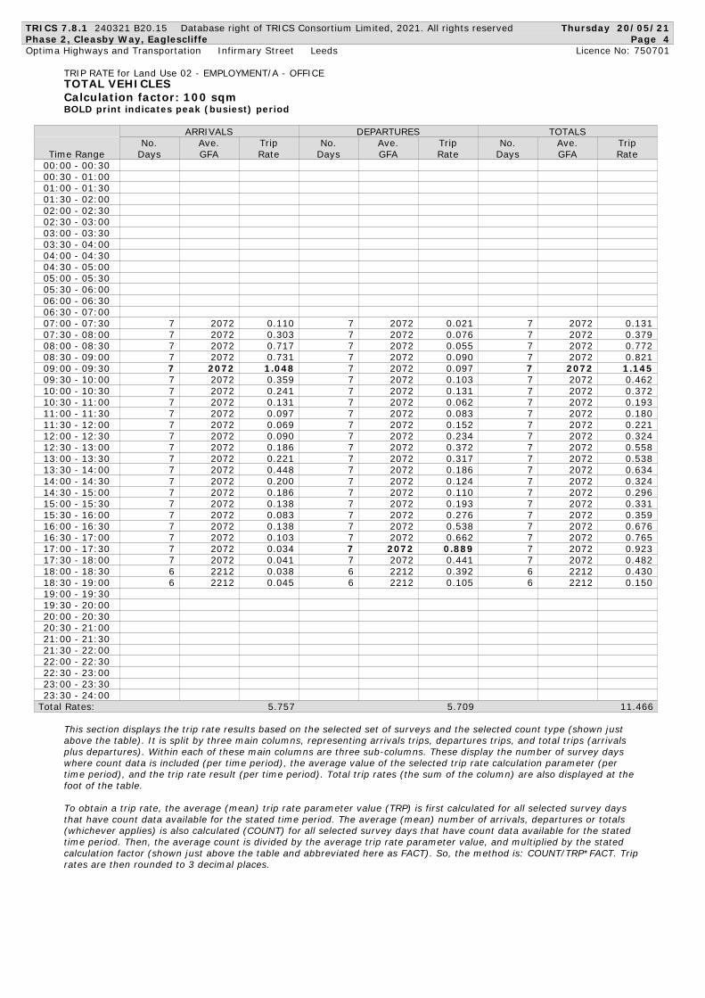
3.5.2 The full TRICS output is contained at Appendix B, with the average weekday AM and PM peak hour trip rates and resultant generated traffic for 1,866 sq. m gfa shown tabulated below in Table 3.1.
Table 3.1 Average Trip Rates and Resultant Traffic Generation
Time Period Vehicular Trip Rates (per 100 sq. m) Traffic Generation (1,866 sq. m)
Arrivals Departures Total Arrivals Departures Total
AM Peak 08:00-09:00 1.448 0.145 1.593 27 3 30
PM Peak 17:00-18:00 0.075 1.330 1.405 1 26 27
Traffic Distribution and Materiality Assessment
3.5.3 The previous national ‘Guidance on Transport Assessment’, March 2007, (now withdrawn) suggested that a development traffic generation of 30 two-way trips represented an appropriate threshold figure above which further assessment may be required but below which the impact could be considered as non-material. Whilst the Government’s current NPPG does not specifically refer to 30 trips, this remains a threshold which is generally applied within the industry including by local authorities and Highways England.
3.5.4 Having established the weekday AM and PM peak hour vehicular trip generation for the proposed development, as shown in Table 3.1, a distribution exercise has been completed to predict the assignment of these trips on to the local highway network.
3.5.5 The Nomis database WU03EW - Location of usual residence and place of work by method of travel to work (MSOA level) (which is based on the 2011 Census) has been interrogated to obtain the origins (by MSOA) within the Stockton-on-Tees, Darlington and Middlesbrough local authority areas for residents that work in the Stockton-on-Tees 021 Super Output Area - Mid Layer (MSOA), within which the Site is located.

Cleasby Way, Eaglescliffe
9 Transport Statement Returnable Packaging Services Ltd
3.5.6 From this dataset, it is then possible to assign the vehicular trips on to the local highway network and the results of the percentage assignment by route is contained within Table 3.2 along with the resultant peak hour two way flow on the route.
Table 3.2 Assignment of Weekday Trips and Maximum Peak Hour Two-way Flow
Route Percentage Assignment
Maximum Two-way Flow
AM Peak Hour PM Peak Hour
Cleasby Way 100 30 27
Durham Road(N) – south of Elton Interchange
57.2 17 15
A66(E) 36.7 11 10
A66(W) 4.6 1 1
Darlington Road - north of Elton Interchange
15.9 5 4
Durham Lane(S) 42.7 13 12
3.5.7 Therefore, it can be seen from the maximum peak hour two-way flows in Table 3.2 that there will not be a material impact on any part of the local highway network. Even at the Elton Interchange, the maximum total increase in flow through the junction is 17 two-way vehicles in the AM peak hour.

Cleasby Way, Eaglescliffe
10 Transport Statement Returnable Packaging Services Ltd
4.1 ACCESSIBILITY ON FOOT
4.1.1 It is generally considered that an acceptable maximum walking distance from home to a place of work is 2km. The Chartered Institution of Highways and Transportation (CIHT) document ‘Guidelines for Providing for Journeys on Foot’ recommends various thresholds for desired, acceptable and preferred maximum distances to various services as shown in Table 4.1.
Table 4.1 Accessibility by Foot
Town Centres (m) School/Work (m) Elsewhere (m)
Desirable 200 500 400
Acceptable 400 1,000 800
Preferred Maximum 800 2,000 1,200
Source – Table 3.2 ‘Guidelines for Providing for Journeys on Foot’ published by CIHT
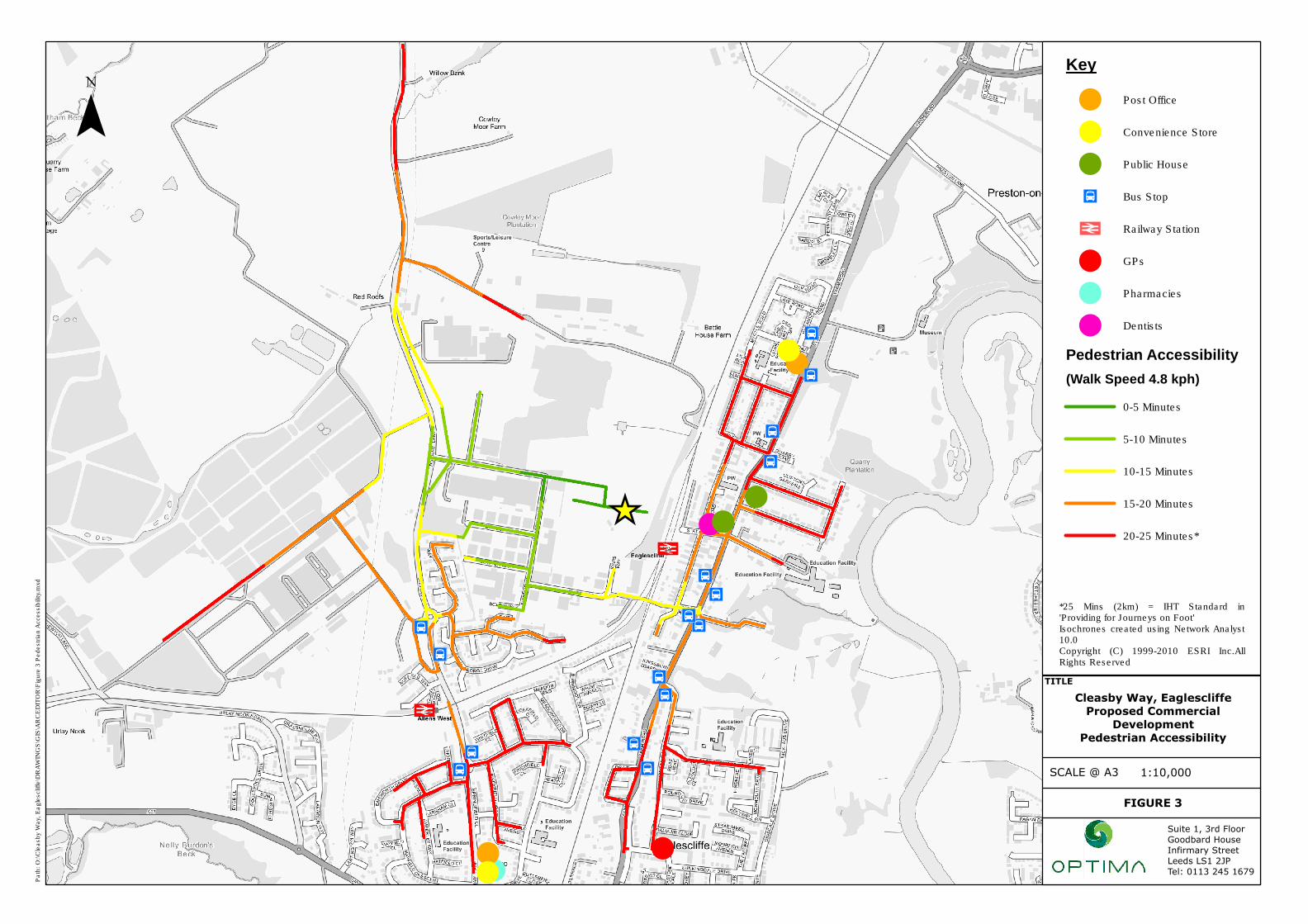
4.1.2 Using GIS Network Analyst software, typical walk times (up to 25 mins equating to 2km) have been plotted from the centre of the proposed development which are shown on Figure 3. An extract of Figure 3 is provided as Image 4.1.
Image 4.1 Pedestrian Accessibility
4.1.3 The following key facilities can be accessed on foot:
• The local bus stops at Allens West are 15 minutes’ walk from the Site;
• The stations at Allens West and Eaglescliffe can be walked to well within 20 minutes; and
• Significant residential areas are within a 25 minute walk from the Site.
4. Site Accessibility

Cleasby Way, Eaglescliffe
11 Transport Statement Returnable Packaging Services Ltd
4.1.4 When Wass Way is extended to meet Cleasby Way, a more direct pedestrian route to Eaglescliffe Station will be provided as well as to the residential areas on the eastern side of the railway line and the bus stops on A135 Yarm Road.
4.2 ACCESSIBILITY BY CYCLE
4.2.1 An acceptable and comfortable distance for general cycling trips is considered to be up to 5 kilometres as referred to in DfT’s Local Transport Note 2/08. However, the same guidance also refers to commuting cycle trips of up to 8km. Whilst, in terms of design guidance for cycle facilities, this LTN has now been superseded by LTN 1/20, there is no reason to suggest that the accepted cycle distances have changed.
4.2.2 Figure 4 illustrates an 8km (30 minute) cycle distance produced using Network Analyst software. An extract of Figure 4 is shown on Image 4.2.
Image 4.2 Cycle Accessibility
4.2.3 From the Site, an 8km catchment area encompasses an area that can be defined by Stockton to the north, Thornaby and Ingleby Barwick to the east, Yarm to the west and Durham Tees Valley Airport to the west.
4.3 PUBLIC TRANSPORT
Bus
4.3.1 The centre of the Site is located some 1200m (which equates to an approximate 15 minute walk time) of the bus stops on Durham Lane at Allens West. When Wass Way is extended to meet Cleasby Way, a more direct pedestrian route to the alternative bus stops on A135 Yarm Road will be provided with these being within a 600m walking distance.

Cleasby Way, Eaglescliffe
12 Transport Statement Returnable Packaging Services Ltd
4.3.2 Services from the existing bus stops provide journeys to multiple residential areas where employees and visitors may reside making this a realistic travel option for journeys to and from the Site.
Rail
4.3.3 Allens West and Eaglescliffe Stations are both within a reasonable walking distance of the Site and within an easy cycle ride. Rail services from these stations open up a wider catchment area for employees and an additional opportunity to use public transport for work-based and business trips.
4.3.4 When Wass Way is extended to meet Cleasby Way, a more direct pedestrian route to the Eaglescliffe Station will be provided with the station being within a 900m walking distance.

Cleasby Way, Eaglescliffe
13 Transport Statement Returnable Packaging Services Ltd
5.1 SUMMARY
5.1.1 This Transport Statement has been prepared by Optima to support a full planning application for Phase 2 of the development of land to the south of Cleasby Way, which is located on the Durham Lane Industrial Estate, Eaglescliffe. Phase 2 of the development will provide office accommodation with access being taken from a planned extension of Wass Way to meet Cleasby Way.
5.1.2 This report has provided a commentary on the Site and its present conditions. It has demonstrated that the Site is in a relatively sustainable location with public transport and pedestrian links. This provision provides future staff members and visitors with opportunities to travel via alternatives modes of transport and minimise trips by the private car.
5.1.3 A review of personal injury collision data has been undertaken for the local study area and this has shown that there are no specific road safety concerns.
5.1.4 The parking provision is in accordance with that expected by Stockton-on-Tees Borough Council and will ensure that all parking is kept within the curtilage of the Site with no impact on surrounding highways.
5.1.5 The level of traffic generated by the development is modest and will not result in a material impact on the local highway network including at the Elton Interchange on A66 which is part of the SRN. The levels of traffic predicted to be generated by the proposed office development will be indiscernible over and above the usual daily fluctuations in flow on the local highway network.
5.2 CONCLUSIONS
5.2.1 This Transport Statement has demonstrated that there will be no unacceptable impact on highway safety and no severe impact on the highway network. The proposal will therefore accord with NPPF which states that “Development should only be prevented or refused on highways grounds if there would be an unacceptable impact on highway safety, or the residual cumulative impacts on the road network would be severe.”
5.2.2 It is therefore concluded that there are no highway or transport related issues that would prevent the proposed Phase 2 office development on this Site from being granted planning permission.
5. Summary and Conclusions

Cleasby Way, Eaglescliffe
Transport Statement Returnable Packaging Services Ltd
Figures

Eaglescliffe
Pa
th:
O:\
Cle
asby W
ay,
Ea
gle
sclif
fe\D
RA
WIN
GS
\GIS
\AR
CE
DIT
OR
\Fig
ure
1 S
ite
Lo
ca
tion
-Lo
ca
l.m
xd
FIGURE 1
Cleasby Way, Eaglescliffe
Proposed Commercial
Development
Site Location - Local
TITLE
1:5,000SCALE @ A3
¯Key
Phase 1 Indicative Site Boundary
Phase 2 Inidicative Site Boundary
Suite 1, 3rd Floor
Goodbard House
Infirmary Street
Leeds LS1 2JP
Tel: 0113 245 1679

_̂
Stockton OnTees
Eaglescliffe
MIDDLESBROUGH
Yarm
Pa
th:
O:\
Cle
asby W
ay,
Ea
gle
sclif
fe\D
RA
WIN
GS
\GIS
\AR
CE
DIT
OR
\Fig
ure
2 S
ite
Lo
ca
tion
-S
trate
gic
.mxd
FIGURE 2
Cleasby Way, Eaglescliffe
Proposed Commercial
Development
Site Location - Strategic
TITLE
1:50,000SCALE @ A3
¯Key
_̂ Site Location
Suite 1, 3rd Floor
Goodbard House
Infirmary Street
Leeds LS1 2JP
Tel: 0113 245 1679
!
!
!
_̂
!
!
!
!
Ja
Ja
Ja
Ja Ja
Ja
Ja
JaJa
Ja
Ja
Ja
Ja
Ja
Ja
Ja
! !
Pa
th:
O:\
Cle
asby W
ay,
Ea
gle
sclif
fe\D
RA
WIN
GS
\GIS
\AR
CE
DIT
OR
\Fig
ure
3 P
ed
estr
ian
Accessib
ility
.mxd
FIGURE 3
Cleasby Way, Eaglescliffe
Proposed Commercial
Development
Pedestrian Accessibility
TITLE
1:10,000SCALE @ A3
¯Key
! Post Office
! Convenience Store
! Public House
Ja Bus Stop
Railway Station
! GPs
! Pharmacies
! Dentists
Pedestrian Accessibility
(Walk Speed 4.8 kph)
0-5 Minutes
5-10 Minutes
10-15 Minutes
15-20 Minutes
20-25 Minutes*
Suite 1, 3rd Floor
Goodbard House
Infirmary Street
Leeds LS1 2JP
Tel: 0113 245 1679
*25 Mins (2km) = IHT Standard in'Providing for Journeys on Foot'Isochrones created using Network Analyst10.0Copyright (C) 1999-2010 ESRI Inc.AllRights Reserved

_̂
MIDDLESBROUGH
Yarm
Eaglescliffe
Pa
th:
O:\
Cle
asby W
ay,
Ea
gle
sclif
fe\D
RA
WIN
GS
\GIS
\AR
CE
DIT
OR
\Fig
ure
4 C
ycle
Accessib
ility
.mxd
FIGURE 4
Cleasby Way, Eaglescliffe
Proposed Commercial
Development
Cycle Accessibility
TITLE
1:50,000SCALE @ A3
¯Key
_̂ Site Location
Railway Staton
Cycle Accessibility
(Cycle Speed 16 kph)
0-5 Minutes
5-10 Minutes
10-15 Minutes
15-20 Minutes*
20-25 Minutes
25-30 Minutes**
Suite 1, 3rd Floor
Goodbard House
Infirmary Street
Leeds LS1 2JP
Tel: 0113 245 1679
*19 mins (5km) = LTN 2/08
Standard for General Cycling
**30 mins (8km) = LTN 2/08
Standard for Commuting
Isochrones generated using
Network Analyst 10.0 Copyright
(C) 1999-2010 ESRI Inc. All

Cleasby Way, Eaglescliffe
Transport Statement Returnable Packaging Services Ltd
Appendices

Cleasby Way, Eaglescliffe
Transport Statement Returnable Packaging Services Ltd
Appendix A Proposed Site Plan

PROPOSED SITE LAYOUT SCALE 1:500
0-10m 50m10m 30m
Site Boundary
S124.354
S224.080
S323.983
S424.176
S524.603
S624.410
S724.593
PHASE 1
PHASE 2
C L E A S B Y W A Y
S O
W E
R B
Y
W A
Y
13,740m (3.4 Acres)
5,550m (1.37 Acres)
Returnable Packaging Services Ltd
2
2
UNIT 1
UNIT 2
5m Boundary Condition
Sculpture
NEWACCESS
TEMPORARYACCESS
PAVILION
A3
W A
S S
W
A Y
Drain
Tank
RH
2b
El Sub Sta
CLEASBY WAY
Drain
FB
Tanks
Drain
Def
ESS
Hopper
Tank
31
LB
SOW
ERBY
WAY
Eaglescliffe
RH
Def
1b 1a
Def
LB
Tank
Tanks
Tank
RH
2aGUISELEY WAY
Chimney
RH
RH
4
Tanks
12
CLEASBY WAY
SITE LOCATION PLAN SCALE 1:2500
THE SITE
A1 NOTES
191001 01 B
SCHEDULE OF OFFICE ACCOMMODATION
UNIT 1933m2 / 10,050sqft 30 Parking Spaces
UNIT 2933m2 / 10,050sqft 30 Parking Spaces
DRAFT

Cleasby Way, Eaglescliffe
Transport Statement Returnable Packaging Services Ltd
Appendix B TRICS Data

TRICS 7.8.1 240321 B20.15 Database right of TRICS Consortium Limited, 2021. All rights reserved Thursday 20/05/21
Phase 2, Cleasby Way, Eaglescliffe Page 1
Optima Highways and Transportation Infirmary Street Leeds Licence No: 750701
Calculation Reference: AUDIT-750701-210520-0542
TRIP RATE CALCULATION SELECTION PARAMETERS:
Land Use : 02 - EMPLOYMENT
Category : A - OFFICE
TOTAL VEHICLES
Selected regions and areas:
03 SOUTH WEST
WL WILTSHIRE 1 days
04 EAST ANGLIA
NF NORFOLK 1 days
SF SUFFOLK 1 days
07 YORKSHIRE & NORTH LINCOLNSHIRE
WY WEST YORKSHIRE 1 days
14 LEINSTER
LU LOUTH 1 days
16 ULSTER (REPUBLIC OF IRELAND)
MG MONAGHAN 1 days
17 ULSTER (NORTHERN IRELAND)
AN ANTRIM 1 days
This section displays the number of survey days per TRICS® sub-region in the selected set
Primary Filtering selection:
This data displays the chosen trip rate parameter and its selected range. Only sites that fall within the parameter range
are included in the trip rate calculation.
Parameter: Gross floor area
Actual Range: 500 to 3205 (units: sqm)
Range Selected by User: 178 to 3500 (units: sqm)
Parking Spaces Range: All Surveys Included
Public Transport Provision:
Selection by: Include all surveys
Date Range: 01/01/13 to 09/11/20
This data displays the range of survey dates selected. Only surveys that were conducted within this date range are
included in the trip rate calculation.
Selected survey days:
Monday 1 days
Tuesday 3 days
Wednesday 2 days
Thursday 1 days
This data displays the number of selected surveys by day of the week.
Selected survey types:
Manual count 7 days
Directional ATC Count 0 days
This data displays the number of manual classified surveys and the number of unclassified ATC surveys, the total adding
up to the overall number of surveys in the selected set. Manual surveys are undertaken using staff, whilst ATC surveys
are undertaking using machines.
Selected Locations:
Edge of Town 7
This data displays the number of surveys per main location category within the selected set. The main location categories
consist of Free Standing, Edge of Town, Suburban Area, Neighbourhood Centre, Edge of Town Centre, Town Centre and
Not Known.
Selected Location Sub Categories:
Industrial Zone 1
Commercial Zone 2
Development Zone 1
Residential Zone 1
Out of Town 1
No Sub Category 1
This data displays the number of surveys per location sub-category within the selected set. The location sub-categories
consist of Commercial Zone, Industrial Zone, Development Zone, Residential Zone, Retail Zone, Built-Up Zone, Village,
Out of Town, High Street and No Sub Category.
TRICS 7.8.1 240321 B20.15 Database right of TRICS Consortium Limited, 2021. All rights reserved Thursday 20/05/21
Phase 2, Cleasby Way, Eaglescliffe Page 2
Optima Highways and Transportation Infirmary Street Leeds Licence No: 750701
Secondary Filtering selection:
Use Class:
Not Known 7 days
This data displays the number of surveys per Use Class classification within the selected set. The Use Classes Order 2005
has been used for this purpose, which can be found within the Library module of TRICS®.
Filter by Site Operations Breakdown:
All Surveys Included
Population within 500m Range:
All Surveys Included
Population within 1 mile:
1,000 or Less 1 days
1,001 to 5,000 1 days
5,001 to 10,000 1 days
10,001 to 15,000 3 days
15,001 to 20,000 1 days
This data displays the number of selected surveys within stated 1-mile radii of population.
Population within 5 miles:
5,001 to 25,000 1 days
25,001 to 50,000 2 days
125,001 to 250,000 3 days
250,001 to 500,000 1 days
This data displays the number of selected surveys within stated 5-mile radii of population.
Car ownership within 5 miles:
0.5 or Less 1 days
0.6 to 1.0 3 days
1.1 to 1.5 3 days
This data displays the number of selected surveys within stated ranges of average cars owned per residential dwelling,
within a radius of 5-miles of selected survey sites.
Travel Plan:
No 7 days
This data displays the number of surveys within the selected set that were undertaken at sites with Travel Plans in place,
and the number of surveys that were undertaken at sites without Travel Plans.
PTAL Rating:
No PTAL Present 7 days
This data displays the number of selected surveys with PTAL Ratings.
Covid-19 Restrictions Yes At least one survey within the selected data set
was undertaken at a time of Covid-19 restrictions

TRICS 7.8.1 240321 B20.15 Database right of TRICS Consortium Limited, 2021. All rights reserved Thursday 20/05/21
Phase 2, Cleasby Way, Eaglescliffe Page 3
Optima Highways and Transportation Infirmary Street Leeds Licence No: 750701
LIST OF SITES relevant to selection parameters
1 AN-02-A-06 SPORTS ADMINISTRATION ANTRIM
UPPER MALONE ROAD
BELFAST
Edge of Town
Residential Zone
Total Gross floor area: 2 2 1 7 sqm
Survey date: TUESDAY 20/11/18 Survey Type: MANUAL
2 LU-02-A-01 BETTING HEADQUARTERS LOUTH
INNER RELIEF ROAD
DUNDALK
Edge of Town
Commercial Zone
Total Gross floor area: 2 0 5 2 sqm
Survey date: MONDAY 09/11/20 Survey Type: MANUAL
3 MG-02-A-02 OFFICES MONAGHAN
ARMAGH ROAD
MONAGHAN
Edge of Town
Out of Town
Total Gross floor area: 3 2 0 5 sqm
Survey date: WEDNESDAY 16/11/16 Survey Type: MANUAL
4 NF-02-A-04 BUILDING CONSULTANT NORFOLK
WHITING ROAD
NORWICH
Edge of Town
Commercial Zone
Total Gross floor area: 5 0 0 sqm
Survey date: WEDNESDAY 13/11/19 Survey Type: MANUAL
5 SF-02-A-03 OFFICES SUFFOLK
WHITE HOUSE ROAD
IPSWICH
Edge of Town
Industrial Zone
Total Gross floor area: 2 8 0 0 sqm
Survey date: THURSDAY 24/09/20 Survey Type: MANUAL
6 WL-02-A-01 PET INSURANCE COMPANY WILTSHIRE
THE CRESCENT
AMESBURY
SUNRISE WAY
Edge of Town
Development Zone
Total Gross floor area: 2 5 0 0 sqm
Survey date: TUESDAY 18/09/18 Survey Type: MANUAL
7 WY-02-A-05 OFFICES WEST YORKSHIRE
PIONEER WAY
CASTLEFORD
WHITWOOD
Edge of Town
No Sub Category
Total Gross floor area: 1 2 3 0 sqm
Survey date: TUESDAY 23/05/17 Survey Type: MANUAL
This section provides a list of all survey sites and days in the selected set. For each individual survey site, it displays a
unique site reference code and site address, the selected trip rate calculation parameter and its value, the day of the
week and date of each survey, and whether the survey was a manual classified count or an ATC count.
TRICS 7.8.1 240321 B20.15 Database right of TRICS Consortium Limited, 2021. All rights reserved Thursday 20/05/21
Phase 2, Cleasby Way, Eaglescliffe Page 4
Optima Highways and Transportation Infirmary Street Leeds Licence No: 750701
TRIP RATE for Land Use 02 - EMPLOYMENT/A - OFFICE
TOTAL VEHICLES
Calculation factor: 100 sqm
BOLD print indicates peak (busiest) period
ARRIVALS DEPARTURES TOTALS
No. Ave. Trip No. Ave. Trip No. Ave. Trip
Time Range Days GFA Rate Days GFA Rate Days GFA Rate
00:00 - 00:30
00:30 - 01:00
01:00 - 01:30
01:30 - 02:00
02:00 - 02:30
02:30 - 03:00
03:00 - 03:30
03:30 - 04:00
04:00 - 04:30
04:30 - 05:00
05:00 - 05:30
05:30 - 06:00
06:00 - 06:30
06:30 - 07:00
7 2072 0.110 7 2072 0.021 7 2072 0.13107:00 - 07:30
7 2072 0.303 7 2072 0.076 7 2072 0.37907:30 - 08:00
7 2072 0.717 7 2072 0.055 7 2072 0.77208:00 - 08:30
7 2072 0.731 7 2072 0.090 7 2072 0.82108:30 - 09:00
7 2072 1.048 7 2072 0.097 7 2072 1.14509:00 - 09:30
7 2072 0.359 7 2072 0.103 7 2072 0.46209:30 - 10:00
7 2072 0.241 7 2072 0.131 7 2072 0.37210:00 - 10:30
7 2072 0.131 7 2072 0.062 7 2072 0.19310:30 - 11:00
7 2072 0.097 7 2072 0.083 7 2072 0.18011:00 - 11:30
7 2072 0.069 7 2072 0.152 7 2072 0.22111:30 - 12:00
7 2072 0.090 7 2072 0.234 7 2072 0.32412:00 - 12:30
7 2072 0.186 7 2072 0.372 7 2072 0.55812:30 - 13:00
7 2072 0.221 7 2072 0.317 7 2072 0.53813:00 - 13:30
7 2072 0.448 7 2072 0.186 7 2072 0.63413:30 - 14:00
7 2072 0.200 7 2072 0.124 7 2072 0.32414:00 - 14:30
7 2072 0.186 7 2072 0.110 7 2072 0.29614:30 - 15:00
7 2072 0.138 7 2072 0.193 7 2072 0.33115:00 - 15:30
7 2072 0.083 7 2072 0.276 7 2072 0.35915:30 - 16:00
7 2072 0.138 7 2072 0.538 7 2072 0.67616:00 - 16:30
7 2072 0.103 7 2072 0.662 7 2072 0.76516:30 - 17:00
7 2072 0.034 7 2072 0.889 7 2072 0.92317:00 - 17:30
7 2072 0.041 7 2072 0.441 7 2072 0.48217:30 - 18:00
6 2212 0.038 6 2212 0.392 6 2212 0.43018:00 - 18:30
6 2212 0.045 6 2212 0.105 6 2212 0.15018:30 - 19:00
19:00 - 19:30
19:30 - 20:00
20:00 - 20:30
20:30 - 21:00
21:00 - 21:30
21:30 - 22:00
22:00 - 22:30
22:30 - 23:00
23:00 - 23:30
23:30 - 24:00
Total Rates: 5.757 5.709 1 1.466
This section displays the trip rate results based on the selected set of surveys and the selected count type (shown just
above the table). It is split by three main columns, representing arrivals trips, departures trips, and total trips (arrivals
plus departures). Within each of these main columns are three sub-columns. These display the number of survey days
where count data is included (per time period), the average value of the selected trip rate calculation parameter (per
time period), and the trip rate result (per time period). Total trip rates (the sum of the column) are also displayed at the
foot of the table.
To obtain a trip rate, the average (mean) trip rate parameter value (TRP) is first calculated for all selected survey days
that have count data available for the stated time period. The average (mean) number of arrivals, departures or totals
(whichever applies) is also calculated (COUNT) for all selected survey days that have count data available for the stated
time period. Then, the average count is divided by the average trip rate parameter value, and multiplied by the stated
calculation factor (shown just above the table and abbreviated here as FACT). So, the method is: COUNT/TRP*FACT. Trip
rates are then rounded to 3 decimal places.

TRICS 7.8.1 240321 B20.15 Database right of TRICS Consortium Limited, 2021. All rights reserved Thursday 20/05/21
Phase 2, Cleasby Way, Eaglescliffe Page 5
Optima Highways and Transportation Infirmary Street Leeds Licence No: 750701
The survey data, graphs and all associated supporting information, contained within the TRICS Database are published
by TRICS Consortium Limited ("the Company") and the Company claims copyright and database rights in this published
work. The Company authorises those who possess a current TRICS licence to access the TRICS Database and copy the
data contained within the TRICS Database for the licence holders' use only. Any resulting copy must retain all copyrights
and other proprietary notices, and any disclaimer contained thereon.
The Company accepts no responsibility for loss which may arise from reliance on data contained in the TRICS Database.
[No warranty of any kind, express or implied, is made as to the data contained in the TRICS Database.]
Parameter summary
Trip rate parameter range selected: 500 - 3205 (units: sqm)
Survey date date range: 01/01/13 - 09/11/20
Number of weekdays (Monday-Friday): 7
Number of Saturdays: 0
Number of Sundays: 0
Surveys automatically removed from selection: 0
Surveys manually removed from selection: 0
This section displays a quick summary of some of the data filtering selections made by the TRICS® user. The trip rate
calculation parameter range of all selected surveys is displayed first, followed by the range of minimum and maximum
survey dates selected by the user. Then, the total number of selected weekdays and weekend days in the selected set of
surveys are show. Finally, the number of survey days that have been manually removed from the selected set outside of
the standard filtering procedure are displayed.