cl-9: flood – australia and other international exposures
TRANSCRIPT
1
©2011 AIR WORLDWIDE CONFIDENTIAL: For the exclusive use of 2011 CAS Ratemaking and Product Management Seminar attendees 1
CL-9: Flood – Australia and Other International ExposuresDavid Lalonde, FCAS, FCIA, MAAACasualty Actuarial Society, 2011 Spring MeetingMay 15-18, 2011Palm Beach, FL
Antitrust Notice
• The Casualty Actuarial Society is committed to adhering strictly to the letter and spirit of the antitrust laws. Seminars conducted under the auspices of the CAS are designed solely to provide a forum for the expression of various points of view on topics described in the programs or agendas for such meetings.
• Under no circumstances shall CAS seminars be used as a means for competing companies or firms to reach any understanding –expressed or implied – that restricts competition or in any way impairs the ability of members to exercise independent business judgment regarding matters affecting competition.
• It is the responsibility of all seminar participants to be aware of antitrust regulations, to prevent any written or verbal discussions that appear to violate these laws, and to adhere in every respect to the CAS antitrust compliance policy.

2
©2011 AIR WORLDWIDE CONFIDENTIAL: For the exclusive use of 2011 CAS Ratemaking and Product Management Seminar attendees 3
Agenda
• Defining flood events
• Evolution of modeling floods around the world
• Innovative approach to modeling inland flood risk
©2011 AIR WORLDWIDE CONFIDENTIAL: For the exclusive use of 2011 CAS Ratemaking and Product Management Seminar attendees 4
Defining Floods Events
• A flood is an overflow of an expanse of water that submerges land
• Floods can take many different forms
– Coastal flooding is caused by wind driven seas inundating low lying areas
– Inland flooding is caused when a combination of precipitation and snow melt overtop river banks
– Tsunami flooding results from ocean waves produced by earthquakes or underwater landslides

3
©2011 AIR WORLDWIDE CONFIDENTIAL: For the exclusive use of 2011 CAS Ratemaking and Product Management Seminar attendees 5
Floods Can Claim Thousands of Lives Especially in Unprepared Regions
Location Date Event Death toll
China 1931 1931 China floods 2,500,000–3,700,000
China 1887 1887 Yellow River (Huang He) flood 900,000–2,000,000
China 1938 1938 Yellow River (Huang He) flood 500,000–700,000
China 1975
Banqiao Dam failure, result of Typhoon Nina. Approximately 86,000 people died from flooding and another 145,000 died during subsequent disease.
231,000
Indonesia 2004 Indian Ocean tsunami 230,000
China 1935 1935 Yangtze river flood 145,000
Netherlands 1530 St. Felix's Flood, storm surge 100,000+
North Vietnam 1971 Hanoi and Red River Delta flood 100,000
China 1911 1911 Yangtze river flood 100,000
Source: Wikipedia: “Flood”
©2011 AIR WORLDWIDE CONFIDENTIAL: For the exclusive use of 2011 CAS Ratemaking and Product Management Seminar attendees 6
Floods Can Also Result in Billions of Dollars of Losses:Top 10 Economic Losses Since 2000
Location Date Event Death
Toll
Losses
(M USD)
Area
(km2)
U.S. 2005 Hurricane Katrina overtops levies in New Orleans, LA 1,053 60,000 50,000
Central Europe
2002 Heavy rains flood the Danube and inundate areas in Czech Republic, Germany & Austria
55 20,000 252,000
U.K. 2007 A series of storms inundates much of the western U.K. 7 6,500 24,000
U.S. 2005 Hurricane Rita causes coastal flooding in LA and TX 0 6,000 33,000
U.K. 2000 A series of storms causes rivers to break their banks throughout the southern U.K
0 5,900 5,300
Iran 2001 Extreme rainfall caused severe flooding in southern Iran 6 5,000 500
Mexico 2007 Heavy rainfall caused extensive flooding of the states ofTabasco and Chiapas
19 5,000 36,000
China 2007 Heavy rains cause severe flooding in southern China 600 4,250 1,916,000
India 2005 Rain from monsoon floods areas around Mumbai 987 3,500 35,000
SE Asia 2006 Rain resulting from Typhoon Billis floods areas of Taiwan, China, and the Philippine
629 2,238 612,000
Source: Dartmouth Flood Observatory

4
©2011 AIR WORLDWIDE CONFIDENTIAL: For the exclusive use of 2011 CAS Ratemaking and Product Management Seminar attendees 7
On January 13th and 14th, 2011 Southern Queensland, Australia Experienced Major Flooding
• 30,000 properties in the Queensland city of Brisbane have been flooded
• Flood waters reached a peak of 4.46m (14.6ft), almost 1 m less than the record 1974 floods
Flooding in Brisbane’s Suburbs Flooding in Rockhampton
©2011 AIR WORLDWIDE CONFIDENTIAL: For the exclusive use of 2011 CAS Ratemaking and Product Management Seminar attendees 8
Heavy Rains Are a Result of a La Nina Weather Pattern in the Pacific
• The floods were a result of heavy rainfall caused by Tropical Cyclone Tasha that combined with a trough during the peak of a La Niña event
La Nina Conditions in January
Source: IRI
Tropical Cyclone Tasha’s Track
5
©2011 AIR WORLDWIDE CONFIDENTIAL: For the exclusive use of 2011 CAS Ratemaking and Product Management Seminar attendees 9
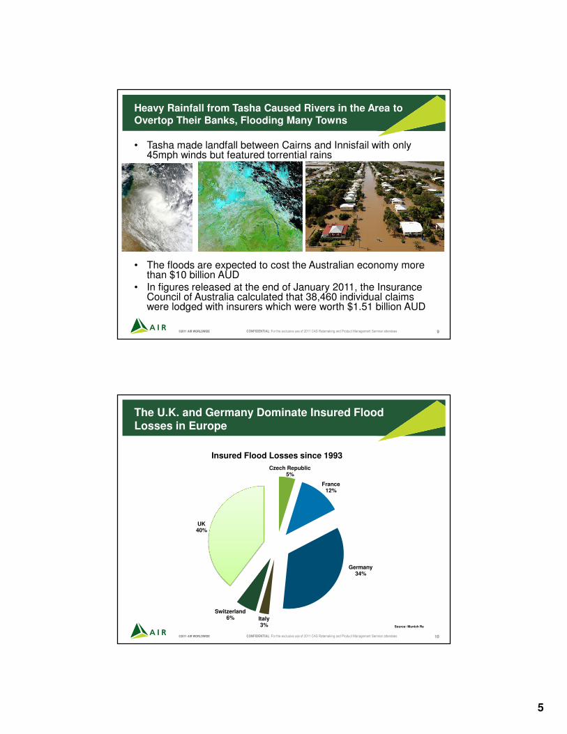
Heavy Rainfall from Tasha Caused Rivers in the Area to Overtop Their Banks, Flooding Many Towns
• Tasha made landfall between Cairns and Innisfail with only 45mph winds but featured torrential rains
• The floods are expected to cost the Australian economy more than $10 billion AUD
• In figures released at the end of January 2011, the Insurance Council of Australia calculated that 38,460 individual claims were lodged with insurers which were worth $1.51 billion AUD
©2011 AIR WORLDWIDE CONFIDENTIAL: For the exclusive use of 2011 CAS Ratemaking and Product Management Seminar attendees 10
Czech Republic5%
France 12%
Germany34%
Italy3%
Switzerland6%
UK40%
Insured Flood Losses since 1993
Source: Munich Re
The U.K. and Germany Dominate Insured Flood Losses in Europe
6
©2011 AIR WORLDWIDE CONFIDENTIAL: For the exclusive use of 2011 CAS Ratemaking and Product Management Seminar attendees 11
Inland Flood Losses in Germany 1980–2010
0
500
1000
1500
2000
Economic Loss Insured Loss
Millio
ns [
Eu
ro]
Average Economic Loss: 854M Euros*
Average Insured Loss: 203M Euros*
Average Ratio Insured / Economical Loss: 21%
Source: Presseforum der Schaden- und Unfallversicherer, 14.-15.5.2001,
Düsseldorf (www.gdv.de); Berechnungen des DIW Berlin. DIW Berlin
2002
* Original Losses, not indexed
Euro 9,200M
©2011 AIR WORLDWIDE CONFIDENTIAL: For the exclusive use of 2011 CAS Ratemaking and Product Management Seminar attendees 12
Flood Modeling at AIR Began with the Introduction of the Storm Surge Component of the U.S. Hurricane Model
• “Storm surge is simply water that is pushed toward the shore by the force of the winds swirling around the storm” – National Hurricane Center
• The AIR Storm Surge model is based upon the Sea, Lake and Overland Surges from Hurricanes (SLOSH) model
• SLOSH model– Developed by FEMA, US Army Corps of Engineers and National
Weather Service– Used for hurricane evacuation planning– Considers hurricane parameters and local shoreline characteristics to
model surge height

7
©2011 AIR WORLDWIDE CONFIDENTIAL: For the exclusive use of 2011 CAS Ratemaking and Product Management Seminar attendees 13
Storm Surge Must Be Accounted for Because It Can Have a Large Financial Impact
• Storm surge poses challenges for insureds, insurers and reinsurers since many policies may cover wind but not surge damage
• Difficult to identify which losses occur purely from surge as opposed to wind
• Hurricane Ike modeled losses were perceived as too low in some cases
• The AIR model allows users to obtain an informed view of their storm surge risk and address these challenges
©2011 AIR WORLDWIDE CONFIDENTIAL: For the exclusive use of 2011 CAS Ratemaking and Product Management Seminar attendees 14
Probabilistic Storm Surge Models for the U.S. and U.K. Incorporate Both Storm and Surge-Specific Parameters
• Storm surge is a sub-peril which does not occur in the absence of hurricanes or extra tropical cyclones
• The storm surge model relies on the primary meteorological variables, including central pressure, forward speed and storm track angle at landfall
• In addition to these meteorological variables, the model incorporates detailed databases of– Coastal elevation– Coastline orientation– Tide height– Bathymetry– Storm duration and timing
relative to tides– Sea defences– Waves
US Army Corps of Engineers

8
©2011 AIR WORLDWIDE CONFIDENTIAL: For the exclusive use of 2011 CAS Ratemaking and Product Management Seminar attendees 15
Interaction Between Storm Surge and Local Terrain
• Waves come ashore and attenuate based on the terrain type encountered
• Each attenuation function accounts for the friction factor different terrain types impart on the waves
• Flatter terrain imparts less friction and rougher terrain imparts more friction
• Wave heights may also be amplified because a larger volume of water is forced into a smaller area
• Bay amplification factors are used to capture unique features
©2011 AIR WORLDWIDE CONFIDENTIAL: For the exclusive use of 2011 CAS Ratemaking and Product Management Seminar attendees 16
Modeling Precipitation Induced Flood Introduces Additional Challenges
• Realistically simulating rainfall patterns over large areas while preserving rainfall distributions at each location
• Transforming the rainfall into runoff while accounting for antecedent conditions
• Accurately modeling local conditions including terrain’s physical properties and possible snow melt
• Propagating the excess runoff downstream along the river network
• Differentiating flood damage from damage caused by other perils
• Accounting for the unique insurance terms surrounding flood losses
• Floods can result from conditions other than rainfall including storm surge and tsunamis

9
©2011 AIR WORLDWIDE CONFIDENTIAL: For the exclusive use of 2011 CAS Ratemaking and Product Management Seminar attendees 17
In 2005 AIR Developed a Sophisticated Precipitation Induced Flood
Model as Part of the Tropical Cyclone Model for Mexico
• Precipitation, terrain, soil type and land use all influence flood risk
• Flood risk is based on redistribution of storm total rainfall by terrain and soil features
• Rainfall is dependent on storm intensity, as well as the size and speed of the storm
• Mountainous terrain can enhance the local rainfall amounts
• Precipitation is used in conjunction with a 3D terrain model and soil data to calculate run-off
STORM TOTAL
PRECIPITATION
3D TERRAIN
MODEL
SOIL &
LAND USE
©2011 AIR WORLDWIDE CONFIDENTIAL: For the exclusive use of 2011 CAS Ratemaking and Product Management Seminar attendees 18
This Methodology Was Later Used to Develop Precipitation Induced Flood Models Around the World
precipitation accumulated runoff
land use
terrain
soil
Soil and Land Use Data are Used to route Precipitation and Identify High-
Risk Areas

10
©2011 AIR WORLDWIDE CONFIDENTIAL: For the exclusive use of 2011 CAS Ratemaking and Product Management Seminar attendees 19
Wind and Precipitation Induced Flood are Accounted for in Regions where Both are Covered Perils
• Tropical cyclone models for Mexico, the Caribbean, Central America, China, Japan and South Korea all include both wind and flood components
• Flooding is highly impacted by duration of storm
• Landslides are implicitly captured in AIR’s models
Landslides from Mitch 1998
©2011 AIR WORLDWIDE CONFIDENTIAL: For the exclusive use of 2011 CAS Ratemaking and Product Management Seminar attendees 20
These Models Capture the Way Rainfall Risk Exists Throughout a Region…

11
©2011 AIR WORLDWIDE CONFIDENTIAL: For the exclusive use of 2011 CAS Ratemaking and Product Management Seminar attendees 21
…And Use Accumulated Runoff to Captures Flood Risk
Accumulated Runoff accounts for
the impact of both rainfall amount
and topography
©2011 AIR WORLDWIDE CONFIDENTIAL: For the exclusive use of 2011 CAS Ratemaking and Product Management Seminar attendees 22
Flood Damage Function
Flood Damage Is Fundamentally Different from Wind Damage
• Research results from local authorities and detailed claims data used to develop flood damage functions separately from wind damage functions
• Mean damage ratio for low-rise buildings is much higher than ratio for high-rise buildings because more of the exposure lies below the water line
Wind Damage Function
Hazard Intensity
Mean D
am
age R
atio
Residential Wood Frame Building
12
©2011 AIR WORLDWIDE CONFIDENTIAL: For the exclusive use of 2011 CAS Ratemaking and Product Management Seminar attendees 23
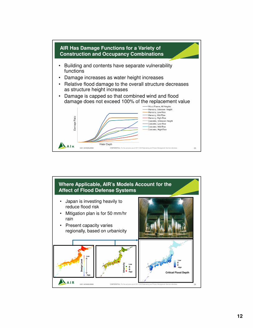
AIR Has Damage Functions for a Variety of Construction and Occupancy Combinations
• Building and contents have separate vulnerability functions
• Damage increases as water height increases
• Relative flood damage to the overall structure decreases as structure height increases
• Damage is capped so that combined wind and flood damage does not exceed 100% of the replacement value
©2011 AIR WORLDWIDE CONFIDENTIAL: For the exclusive use of 2011 CAS Ratemaking and Product Management Seminar attendees 24
Where Applicable, AIR’s Models Account for the Affect of Flood Defense Systems
• Japan is investing heavily to reduce flood risk
• Mitigation plan is for 50 mm/hr rain
• Present capacity varies regionally, based on urbanicity
High
Low
Critical Flood DepthHigh
Low
Urb
an
icit
y
Desig
n L
evel
Low
High
Desig
n L
evel

13
©2011 AIR WORLDWIDE CONFIDENTIAL: For the exclusive use of 2011 CAS Ratemaking and Product Management Seminar attendees 25
The Next Challenge Was Modeling Inland River Floods
The antecedent
soil moisture conditions are determined by
previous rainfall and
local soil type, geology and land cover
A new space-time rainfall
occursPrecipitation is
transformed into runoff
depending on the antecedent
conditions
Runoff is propagated downstream
along the river network as a flood wave
Flood waters burst river
banks and if the peak flows
exceeds the bankfull
discharge
Flow Chart of a Typical Flood Event Defines the Major Model Building Blocks
©2011 AIR WORLDWIDE CONFIDENTIAL: For the exclusive use of 2011 CAS Ratemaking and Product Management Seminar attendees 26
AIR Made a Major Leap Forward in Flood Modeling in 2008 with the Release of the Inland Flood Model for Great Britain
HAZARD
ENGINEERING
FINANCIAL
Intensity Calculation
Exposure
Information
Damage
Estimation
Policy
Conditions
Insured Loss
Calculations
Event Generation
LocalizedPhysically-
Based
HydraulicModel
Large
ScaleStochastic
Hydrological
Model
Off-Floodplain
Hazard
Estimation
Components of the AIR Inland Flood Model

14
©2011 AIR WORLDWIDE CONFIDENTIAL: For the exclusive use of 2011 CAS Ratemaking and Product Management Seminar attendees 27
Physically based flood routing
module
Input from simulated rainfall
event…
Large Scale Hydrologic Models Compute Runoff and Discharge at Each Location and Time Step
Statistical-physical runoff
generation module
… OR input from weather radar
©2011 AIR WORLDWIDE CONFIDENTIAL: For the exclusive use of 2011 CAS Ratemaking and Product Management Seminar attendees 28
Excess Water Is Then Propagated Along the River Network
Over 11,000 stream links
constitute the river network
Over 15,000 small
catchments are modeled explicitly as a part of the
runoff module

15
©2011 AIR WORLDWIDE CONFIDENTIAL: For the exclusive use of 2011 CAS Ratemaking and Product Management Seminar attendees 29
Runoff Generation is Affected by a Range of Different Factors
Topography and
local climate
Geology and soil
typeLand cover and
urbanization
©2011 AIR WORLDWIDE CONFIDENTIAL: For the exclusive use of 2011 CAS Ratemaking and Product Management Seminar attendees 30
Flood Routing is Also Affected by a Number of Factors
Various flood defense
structures and over
4,000 dams and lakes
Topography and
river corridor
geometryLand cover and
urbanization

16
©2011 AIR WORLDWIDE CONFIDENTIAL: For the exclusive use of 2011 CAS Ratemaking and Product Management Seminar attendees 31
Relative Runoff Combined with Relative Elevation and Population Used to Assess the Off Plain Risk
Relative Runoff
Relative Elevation Population density
©2011 AIR WORLDWIDE CONFIDENTIAL: For the exclusive use of 2011 CAS Ratemaking and Product Management Seminar attendees 32
However, Realistically Modeling Precipitation on a European Scale Presents Significant Challenges
• Preserving large-scale patterns of extreme precipitation in space and time is critical when estimating extreme loss events
• Preserving local distributions of precipitation accumulationis essential for capturing localized flash floods
• Precise modeling of snow-melt conditions is crucial to account for the effects of the many mountainous areas in Europe and is important on both large and small scales

17
©2011 AIR WORLDWIDE CONFIDENTIAL: For the exclusive use of 2011 CAS Ratemaking and Product Management Seminar attendees 33
AIR’s Innovative Solution to Large Scale Precipitation Simulation: Coupling GCM and NWP Models
1. Couple Global Circulation Models (GCM) at global scale with a mesoscale Numerical Weather Prediction (NWP) models at regional scale to provide coherent large-scale patterns
2. Employ sophisticated downscaling techniques to realistically simulate small scale features
3. Utilize “quantile mapping” to preserve local rainfall statistics
©2011 AIR WORLDWIDE CONFIDENTIAL: For the exclusive use of 2011 CAS Ratemaking and Product Management Seminar attendees 34
Advantages to Using Coupled GCM and NWP Models
• For the first time, AIR is creating a purely physically-based large-scale catalog of events at sufficiently high resolution
• Realistically represents precipitation patterns at continental scale
• Accounts for the effects of local terrain and land cover on precipitation
• Provides multi-component output to support reliable simulation of snowmelt
• A common event ID for each storm provides consistency
18
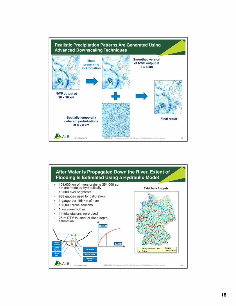
©2011 AIR WORLDWIDE CONFIDENTIAL: For the exclusive use of 2011 CAS Ratemaking and Product Management Seminar attendees 35
Realistic Precipitation Patterns Are Generated Using Advanced Downscaling Techniques
NWP output at 90 × 90 km
Mass preserving
interpolation
Smoothed version of NWP output at
8 × 8 km
Spatially-temporally coherent perturbations
at 8 × 8 km
Final result
©2011 AIR WORLDWIDE CONFIDENTIAL: For the exclusive use of 2011 CAS Ratemaking and Product Management Seminar attendees 36
After Water Is Propagated Down the River, Extent of Flooding Is Estimated Using a Hydraulic Model
• 101,000 km of rivers draining 354,000 sq. km are modeled hydraulically
• 18,000 river segments
• 938 gauges used for calibration
• 1 gauge per 108 km of river
• 163,000 cross-sections
• 1 x-s every 500 m
• 14 tidal stations were used
• 25-m DTM is used for flood depth estimation
Flow
Depth
DTM Surface
River bed
Water surface
Total Flow
Model Flow
Bankfull Flow

19
©2011 AIR WORLDWIDE CONFIDENTIAL: For the exclusive use of 2011 CAS Ratemaking and Product Management Seminar attendees 37
Insurance Terms Covering Flood Vary Across Different Regions
• In Germany, for example:– Flood risk is covered by non-obligatory
extended elementary risk policies
– Residential take-up rate in Germany is about 25% (with regional variations) � Tendency: Increasing.
– Commercial / Industry take-up rate is higher at about 40%
– Market generally uses standard policy conditions, deductibles, and limits
– Reinsurance market generally applies a 504 hours clause captured in AIR‘s CLASIC/2
AIR Residential Take-up Rate Assumptions based on publications of the GDV figures (www.gdv.de)
©2011 AIR WORLDWIDE CONFIDENTIAL: For the exclusive use of 2011 CAS Ratemaking and Product Management Seminar attendees 38
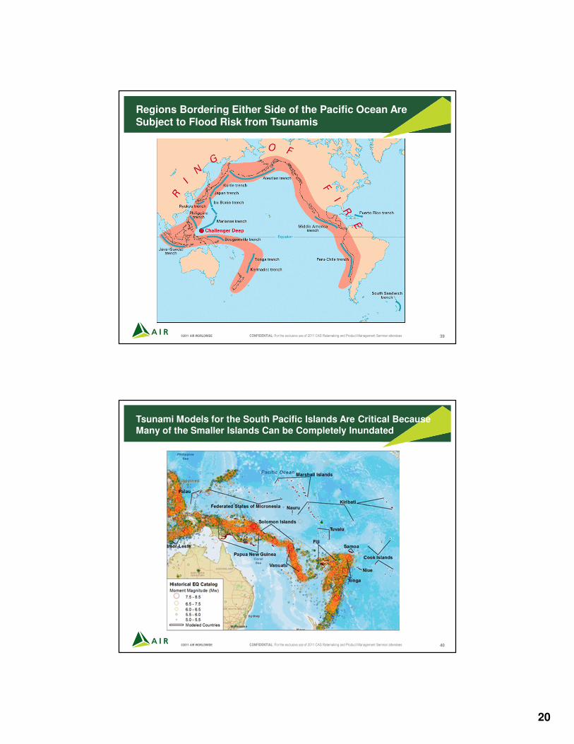
Tsunamis
• Tsunamis are caused when a large offshore earthquake that raises the sea floor
• Eighty percent of earthquakes occur on the sea floor, and most of them occur along plate boundaries, such as those in the South Pacific Region or around Japan
• For major faults in the Pacific, a fault slip map was estimated, describing the amount and direction of slip that occurs for the subduction zone
• Armed with the slip map, the orientation of the fault and the bathymetry of the seafloor in the region, the tsunami module produces wave height and velocity in the ocean and at the coastline
20
©2011 AIR WORLDWIDE CONFIDENTIAL: For the exclusive use of 2011 CAS Ratemaking and Product Management Seminar attendees 39
Regions Bordering Either Side of the Pacific Ocean Are Subject to Flood Risk from Tsunamis
©2011 AIR WORLDWIDE CONFIDENTIAL: For the exclusive use of 2011 CAS Ratemaking and Product Management Seminar attendees 40
Tsunami Models for the South Pacific Islands Are Critical Because
Many of the Smaller Islands Can be Completely Inundated
21
©2011 AIR WORLDWIDE CONFIDENTIAL: For the exclusive use of 2011 CAS Ratemaking and Product Management Seminar attendees 41
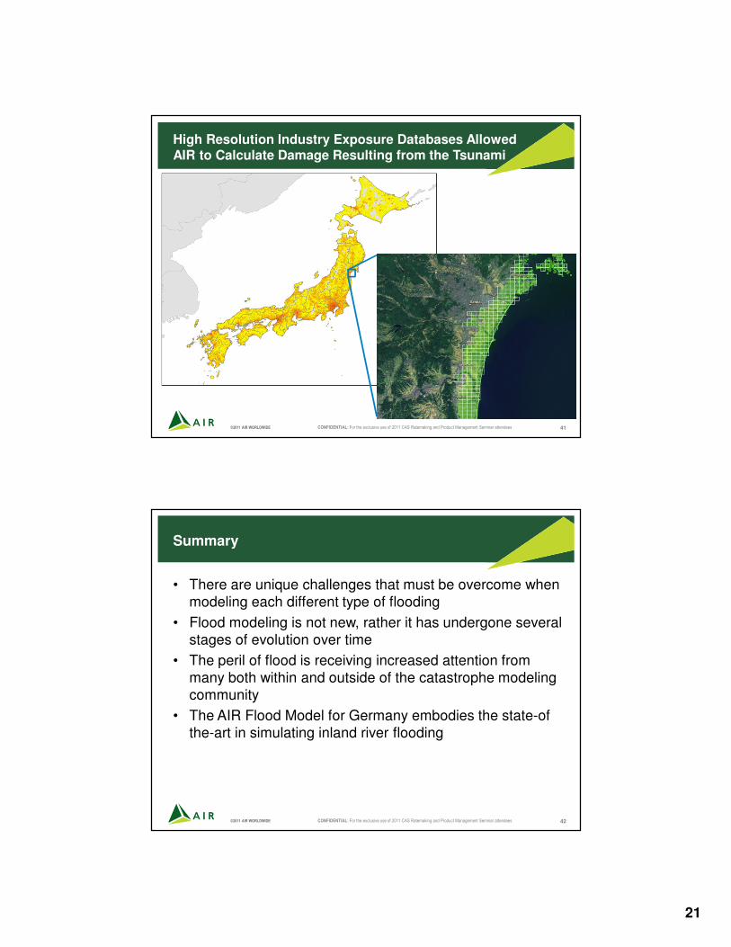
High Resolution Industry Exposure Databases Allowed AIR to Calculate Damage Resulting from the Tsunami
©2011 AIR WORLDWIDE CONFIDENTIAL: For the exclusive use of 2011 CAS Ratemaking and Product Management Seminar attendees 42
Summary
• There are unique challenges that must be overcome when modeling each different type of flooding
• Flood modeling is not new, rather it has undergone several stages of evolution over time
• The peril of flood is receiving increased attention from many both within and outside of the catastrophe modeling community
• The AIR Flood Model for Germany embodies the state-of the-art in simulating inland river flooding