civil aviation authority of nepal atm department
TRANSCRIPT

CIVIL AVIATION AUTHORITY OF NEPAL
ATM DEPARTMENT
Air Traffic Services Operations Manual
Pokhara Civil Aviation Office
(ATSOM, PKCAO)
First Edition
FEBRUARY 2017
Submitted By Shrestha Consultancy Services Email: [email protected]

CIVIL AVIATION AUTHORITY OF NEPAL
ATM DEPARTMENT
Air Traffic Services Operations Manual
Pokhara Civil Aviation Office
(ATSOM, PKCAO)
First Edition
FEBRUARY 2017

FOREWORD
Pursuant to the Chapter1 Para (i) Introduction of Manual of Standard Air Traffic Services (MATS) Nepal2014, this Air Traffic Services Operations Manual referred herein after ATSOM, PKCAO has been developed by ATM Department, CAAN in coordination with Pokhara Civil Aviation Office (PKCAO). This ATSOM incorporates the provisions of MATS Nepal2014, relevant Civil Aviation Requirements, and provision of related ICAO Annexes and Documents.
This ATSOM prescribes the detail processes and procedures for Air Traffic Services under the jurisdiction of Pokhara Tower for the safety, regularity and efficiency of air navigation applicable for Pokhara Airport. ATS personnel are required to comply with the provisions of this manual to perform their operational responsibilities.
This manual is approved by Director General of Civil Aviation Authority of Nepal and issued under his authority which comes into effect from………………
-------------------------------------------------
Director General Civil Aviation Authority of Nepal Babar Mahal, Kathmandu

Amendment Record
Amendments and Corrigenda to this "Air Traffic Services Operations Manual, PKCAO" are regularly issued by Director General of CAAN, Nepal. The space below is provided to keep a record of such amendments.
RECORD OF AMENDMENTS AND CORRIGENDA
AMENDMENT CORRIGENDA No. DATE
APPLICABLE DATE ENTERED
ENTERED BY
No. DATE APPLICABLE
DATE ENTERED
ENTERED BY

FOREWORI)
Pursuant to the Chapterl Para (i) Introduction of Manual of Standard Air TrafficServices (MATS) Nepa12014, this Air Traffic Services Operations Manual refenedherein after ATSOM, PKCAO has been developed by ATM Department, CAAN incoordination with Pokhara Civil Aviation office [pKCAo). This ATSOMincorporates the provisions of MefS Nepa12014, relevant Civil AviationRequirements, and provision of related ICAO Annexes and Documents.
This ATSOM prescribes the detail processes and procedures for Air Traffic Servicesunder the jurisdiction of Pokhara Tower for the safety, regularity and efficiency ofair navigation applicable for Pokhara Airport. ATS personnel are iequired to complywith the provisions of this manual to perform their operational responsibilities.
Aviation Authority of Nepalfrom...Lo. Ii\. .f, .a..b, 2o \!.
DirecCivii Aviation Authority of NepalBabar Mahal, Kathmandu
TABLE OF CONTENTS
1. INTRODUCTION …………………………………………………………….. 1
2. DEFINITIONS ……………………………………………………………….... 3
3. GENERAL-ORGANIZATIONAL STRUCTURE OF PKCAO ………....... 15
3.1 ORGANIZATIONAL STRUCTURE
3.2 AERODROME CONTROL TOWER
4. GENERAL-AIR TRAFFIC SERVICES........................................................... 16
4.1 AIR TRAFFIC SERVICES-GENERAL
4.2 DIVISIONS OF THE AIR TRAFFIC SERVICES
5. APPLICATION OF AIR TRAFFIC CONTROL SERVICE AT PHOKHARA…………………………………………………………………....18
5.1. APPLICATION OF AIR TRAFFIC CONTROL SERVICE
5.2. PROVISION OF AIR TRAFFIC CONTROL SERVICE
5.3. CLASSIFICATION OF AIRSPACES
5.4. FLIGHT PLANNING
5.5. FLIGHT RULES
5.6. PROVISION OF SEPARATION
5.7. CONTROL OF TRAFFIC
5.8. AIR TRAFFIC CLEARANCES
5.9. SIGHT AND FOLLOW PROCEDURE
6 . ALTIMETER SETTING PROCEDURE........................................................... 25
6.1 GENERAL
6.2 ALTIMETER SETTING PROCEDURES
6.3 TAKE-OFF AND CLIMB
6.4 APPROACH AND LANDING
6.5 PROCEDURES APPLICABLE TO OPERATORS AND PILOTS
6.6 CRUISING LEVELS

7. WAKE TURBULENCE .................................................................................... 28
7.1 WAKE TURBULENCE IN GENERAL
7.2 AIRCRAFT CATEGORY
7.3 NON-RADAR WAKE TURBULENCE LONGITUDINAL SEPARATION MINIMA
8. FUEL DUMPING IN FLIGHT ....................................................................... 31
8.1 GENERAL
9. VVIP MEVEMENT HANDLING PROCEDURE ........................................... 33
9.1 GENERAL
10. PROVISION OF AIR TRAFFIC SERVICES .............................................. 34
10.1 AERODROME CONTROL SERVICE
11. SEPARATION METHODS AND MINIMA ................................................. 67
12. GENERAL COORDINATION PROCEDURE ........................................... 68
12.1 COORDINATION IN GENERAL
12.2 CHANGES OF FREQUENCY
12.3 INTERCOMMUNICATION COORDINATION
13. PHRASEOLOGIES ....................................................................................... 69
13.1 COMMUNICATIONS PROCEDURES
13.2 GENERAL
13.3. ATC PHRASEOLOGIES
14. AIR TRAFFIC CONTROLLER LICENSE,TRAINING AND RATING ... 82
15. ATS SAFETY MANAGEMENT ................................................................... 84
15.1 GENERAL
15.2 OBJECTIVES
15.3 ATS SAFETY MANAGEMENT ACTIVITIES
15.4 MONITORING OF SAFETY LEVELS
15.5 SAFETY REVIEWS

15.6 SAFETY ASSESSMENTS
15.7 SAFETY-ENHANCING MEASURES
16. CONTINGENCY PROCEDURES ................................................................... 90
16.1 COMMUNICATION AND NAVIGATION 16.2 OTHERATC CONTINGENCIES
17. DOCUMENTS AND RECORDS ...................................................................... 96
17.1 RECORDS TO BE KEPT
17.2 MAINTAINING RECORDS
17.3 MAINTAINING OPERATIONAL LOG BOOKS
18. AERODROME DIMENSIONS AND RELATED INFORMATIONS .......... 98
19. EMERGENCY PROCEDURES ...................................................................... 105
19.1 AIRCRAFT EMERGENCIES
19.2 OVERDUE AIRCRAFT
19.3 CLASSIFICATION OF EMERGENCIES
19.4 SOME MAJOR AIRCRAFT EMERGENCIES
20. ADMINISTRATIVE INSTRUCTIONS ....................................................... 134
21. CONTROL ROOM DISCIPLINE ………………………………………….. 137
21.1. CONTROL ROOM DISCIPLINE
21.2. PROCEDURES FOR TAKING OVER AND HANDING OVER WATCH
21.3. TRANSFER OF RESPONSIBILITY TO HIGHER AUTHORITY
21.4. ATC LOG BOOKS
21.5. PROCEDURES FOR MAINTAINING ATC WATCH LOG
21.6. PROCEDURE FOR INCIDENT REPORTING AND AIRMISS REPORTING
21.7. DUTY ROSTER
21.8. LOCAL NOTICES TO STAFF
21.9. SUGGESTIONS
21.10. RELATIONS WITH PRESS AND GENERAL PUBLIC
21.11. DESCRIPTION OF DOCUMENTS AND RECORD KEEPING SYSTEM OF POKHARA TOWER

22. ATS FACILITY AND EQUIPMENT .................................................... 143
22.1 INTRODUCTION
22.2 CONTROL TOWERS
23. MISCELLANEOUS PROCEDURES .......................................... 145
23.1 RESPONSIBILITY IN REGARD TO MILITARY TRAFFIC
23.2. RESPONSIBILITY IN REGARD TO UNMANNED FREE BALLOONS
23.3. NOTIFICATION OF SUSPECTED COMMUNICABLE DISEASES,
OR OTHER PUBLIC HEALTH RISK, ON BOARD AN AIRCRAFT
23.4. PROVISIONS FOR AIRPORT OPERATION
23.5. ACCESS TO THE AERODROME MANOEUVERING AREA
24. MAPS AND CHARTS ............................................................................. 148

25. APPENDICES ......................................................................................... 153
APPENDIX A AERODROME TOWER STRIP MARKING PROCEDURES APPENDIX B OPERATIONAL LETTER OF AGREEMENTS BETWEEN
PK TWR AND KT ACC/KT APP APPENDIX C MUTUAL AGREEMENT BETWEEN ATCO PKCAO AND
REPRESENTATIVES, ULTRALIGHTCOMPANIES, POKHARA
APPENDIX D MODEL COORDINATION PHRASEOLOGY APPENDIX E SECTOR VISIBILITY PROCEDURE IN VNPK APPENDIX F ABBREVIATIONS APPENDIX G SYMBOL AND CODES APPENDIX H ATC TRAINING SYLLABUS FOR RATING /LICENSING
FOR PKCAO APPENDIX I PKCAO ORGANIZATION CHART APPENDIX J REMOVAL OF DISABLED AIRCRAFT APPENDIX K TABLE OF SUNSET TIME OF VNPK APPENDIX L AIR TRAFFIC INCIDENT REPORT FORM APPENDIX M ATS INCIDENT REPORT FORM APPENDIX N BIRD /OTHER WILDLIFE STRIKE REPORT FORM

ATS Operations Manual, PKCAO February, 2017
CIVIL AVIATION AUTHORITY OF NEPAL Page 1
CHAPTER 1
1. INTRODUCTION
1.1 General
1.1.1 Background
1.1.1.1 This "Air Traffic Services (ATS) Operation Manual for Pokhara CAO 2017", made under the provision of Manual of Standard Air Traffic Services Nepal 2014 (MATS Nepal 2nd Edition) Chapter 1, Para A (i) Introduction of Manual of Standards- Air Traffic Services, refers to the Procedures and methods to be used in Pokhara Airport in providing ATS services. This document is referred as ATSOM, PKCAO in short.
1.1.1.2 Readers should understand that in the circumstance where there is any inconsistency between the provision of MATS Nepal and the ATSOM, PKCAO, the MATS Nepal prevails.
1.1.2 Related Documents
1.1.2.1 The provisions in this document should be read in conjunction with:
a) Civil Aviation Requirements (CAR-11) –Air traffic Services 2002
b) Civil Aviation Requirements (CAR-2) –Rules of the Air. 2002
c) MATS Nepal 2014
d) ICAO Air Traffic Services Planning Manual (Doc 9426)
e) ICAO Procedures for Air Navigation Services – Air Traffic Management (PANS-ATM) (Doc 4444)
f) ICAO Regional Supplementary Procedures (Doc 7030)
g) AIP Nepal, AICs, AIP Supplement, DGCA Directives and Advisory Circulars.
h) ICAO Annex 10 – Aeronautical Telecommunications, Volume II –Communications Procedures
i) ICAO Annex 15 – Aeronautical Information Services
j) ICAO Safety Management Manual Doc 9859
1.1.3 Differences Published in AIP
1.1.3.1 Differences from ICAO Standards, Recommended Practices and Procedures are published in AIP Nepal.
1.1.4 ATSOM, PKCAO Documentation Change Management

ATS Operations Manual, PKCAO February, 2017
CIVIL AVIATION AUTHORITY OF NEPAL Page 2
1.1.4.1 Pokhara Civil Aviation Office (PKCAO) has responsibility for the technical contents of this ATSOM which can be amended and issued after the endorsement by PKCAO and approval from the Director General, CAAN.
1.1.4.2 The need to change procedures in this ATSOM can arise for any of the following reasons:
a) to respond to changes in MATS, Nepal;
b) to respond to changes in other safety standards of CAAN;
c) to respond to ICAO prescription;
d) to accommodate proposed initiatives or new technologies.

ATS Operations Manual, PKCAO February, 2017
CIVIL AVIATION AUTHORITY OF NEPAL Page 3
CHAPTER 2
2. DEFINITIONS
When the following terms are used in the present document they have the following meanings:
Accepting unit/controller. Air traffic control unit/air traffic controller next to take control of an
aircraft.
Note- See definition of “transferring unit/controller”.
Aerodrome. A defined area on land or water (including any buildings, installations and equipment)
intended to be used either wholly or in part for the arrival, departure and surface movement of aircraft.
Note.— The term “aerodrome” where used in the provisions relating to flight plans and ATS
messages is intended to cover also sites other than aerodromes which may be used by certain types of
aircraft, e.g. helicopters or balloons.
Aerodrome control service. Air traffic control service for aerodrome traffic.
Aerodrome control tower. A unit established to provide air traffic control service to aerodrome
traffic.
Aerodrome elevation. The elevation of the highest point of the landing area.
Aerodrome traffic. All traffic on the manoeuvring area of an aerodrome and all aircraft flying in the
vicinity of an aerodrome.
Note.— An aircraft is in the vicinity of an aerodrome when it is in, entering or leaving an aerodrome
traffic circuit.
Aerdrome traffic circuit. The specified path to be flown by aircraft operating in the vicinity of an
aerodrome.
Aeronautical fixed service (AFS). A telecommunication service between specified fixed points
provided primarily for the safety of air navigation and for the regular, efficient and economical
operation of air services.
Aeronautical ground light. Any light specially provided as an aid to air navigation, other than a light
displayed on an aircraft.
Aeronautical Information Publication (AIP). A publication issued by or with the authority of a
State and containing aeronautical information of a lasting character essential to air navigation.
Aircraft. Any machine that can derive support in the atmosphere from the reactions of the air other
than the reactions of the air against the earth’s surface.
Aircraft observation. The evaluation of one or more meteorological elements made from an aircraft
in flight.
Aircraft proximity. A situation in which, in the opinion of a pilot or air traffic services personnel, the
distance between aircraft as well as their relative positions and speed have been such that the safety of
the aircraft involved may have been compromised. An aircraft proximity is classified as follows:

ATS Operations Manual, PKCAO February, 2017
CIVIL AVIATION AUTHORITY OF NEPAL Page 4
Risk of collision: The risk classification of an aircraft proximity in which serious risk of
collision has existed.
Safety not assured: The risk classification of an aircraft proximity in which the safety of the
aircraft may have been compromised.
No risk of collision: The risk classification of an aircraft proximity in which no risk of
collision has existed.
Risk not determined: The risk classification of an aircraft proximity in which insufficient
information was available to determine the risk involved, or inconclusive or conflicting
evidence precluded such determination.
Air-ground communication. Two-way communication between aircraft and stations or locations on
the surface of the earth.
AIRMET information. Information issued by a meteorological watch office concerning the
occurrence or expected occurrence of specified en-route weather phenomena which may affect the
safety of low-level aircraft operations and which was not already included in the forecast issued for
low-level flights in the flight information region concerned or sub-area thereof.
AIRPROX. The code word used in an air traffic incident report to designate aircraft proximity.
Air-report. A report from an aircraft in flight prepared in conformity with requirements for position,
and operational and/or meteorological reporting.
Air-taxiing. Movement of a helicopter/VTOL above the surface of an aerodrome, normally in ground
effect and at a ground speed normally less than 37 km/h (20 kt).
Note.— The actual height may vary, and some helicopters may require air-taxiing above 8 m (25 ft)
AGL to reduce ground effect turbulence or provide clearance for cargo slingloads.
Air-to-ground communication. One-way communication from aircraft to stations or locations on the
surface of the earth.
Air traffic. All aircraft in flight or operating on the manoeuvring area of an aerodrome.
Air traffic control clearance. Authorization for an aircraft to proceed under conditions specified by
an air traffic control unit.
Note 1.— For convenience, the term “air traffic control clearance” is frequently abbreviated to
“clearance” when used in appropriate contexts.
Note 2.— The abbreviated term “clearance” may be prefixed by the words “taxi”, “take-off”,
“departure”, “en-route”, “approach” or “landing” to indicate the particular portion of flight to
which the air traffic control clearance relates.
Air traffic control instruction. Directives issued by air traffic control for the purpose of requiring a
pilot to take a specific action.
Air traffic control service. A service provided for the purpose of:
a) preventing collisions: 1) between aircraft, and 2) on the manoeuvring area between aircraft and obstructions; and
b) expediting and maintaining an orderly flow of air traffic.

ATS Operations Manual, PKCAO February, 2017
CIVIL AVIATION AUTHORITY OF NEPAL Page 5
Air traffic control unit.A generic term meaning variously, area control centre, approach control unit
or aerodrome control tower.
Air traffic flow management (ATFM).A service established with the objective of contributing to a
safe, orderly and expeditious flow of air traffic by ensuring that ATC capacity is utilized to the
maximum extent possible, and that the traffic volume is compatible with the capacities declared by
the appropriate ATS authority.
Air traffic management (ATM).The dynamic, integrated management of air traffic and airspace
including air traffic services, airspace management and air traffic flow management — safely,
economically and efficiently — through the provision of facilities and seamless services in
collaboration with all parties and involving airborne and ground-based functions.
Air traffic management system. A system that provides ATM through the collaborative integration
of humans, information, technology, facilities and services, supported by air and ground- and/or
space-based communications, navigation and surveillance.
Air traffic service (ATS). A generic term meaning variously, flight information service, alerting
service, air traffic advisory service, air traffic control service (area control service, approach control
service or aerodrome control service).
Air traffic services airspaces. Airspaces of defined dimensions alphabetically designated, within
which specific types of flights may operate and for which air traffic services and rules of operation are
specified.
Note.— ATS airspaces are classified as Class A to G as shown in Annex 11, Appendix 4.
Air traffic services reporting office. A unit established for the purpose of receiving reports
concerning air traffic services and flight plans submitted before departure.
Note.— An air traffic services reporting office may be established as a separate unit or combined with
an existing unit, such as another air traffic services unit, or a unit of the aeronautical information
service.
Air traffic services unit. A generic term meaning variously, air traffic control unit, flight information
centre or air traffic services reporting office.
Airway. A control area or portion thereof established in the form of a corridor.
ALERFA. The code word used to designate an alert phase.
Alerting service. A service provided to notify appropriate organizations regarding aircraft in need of
search and rescue aid, and assist such organizations as required.
Alert phase. A situation wherein apprehension exists as to the safety of an aircraft and its occupants.
Alternate aerodrome. An aerodrome to which an aircraft may proceed when it becomes either
impossible or inadvisable to proceed to or to land at the aerodrome of intended landing. Alternate
aerodromes include the following:
Take-off alternate: An alternate aerodrome at which an aircraft can land should this become
necessary shortly after take-off and it is not possible to use the aerodrome of departure.
En-route alternate: An aerodrome at which an aircraft would be able to land after
experiencing an abnormal or emergency condition while en route.
ATS Operations Manual, PKCAO February, 2017
CIVIL AVIATION AUTHORITY OF NEPAL Page 6
Destination alternate: An alternate aerodrome to which an aircraft may proceed should it
become either impossible or inadvisable to land at the aerodrome of intended landing.
Note.— The aerodrome from which a flight departs may also be an en-route or a destination
alternate aerodrome for that flight.
Altitude. The vertical distance of a level, a point or an object considered as a point, measured from
mean sea level (MSL).
Approach sequence. The order in which two or more aircraft are cleared to approach to land at the
aerodrome.
Appropriate ATS authority. The relevant authority designated by the State responsible for providing
air traffic services in the airspace concerned.
Appropriate authority.
a) Regarding flight over the high seas: The relevant authority of the State of Registry.
b) Regarding flight other than over the high seas: The relevant authority of the State having
sovereignty over the territory being overflown.
Apron. A defined area, on a land aerodrome, intended to accommodate aircraft for purposes of
loading or unloading passengers, mail or cargo, fuelling, parking or maintenance.
ATIS. The symbol used to designate automatic terminal information service.
ATS route. A specified route designed for channeling the flow of traffic as necessary for the
provision of air traffic services.
Note 1.— The term “ATS route” is used to mean variously, airway, advisory route, controlled or
uncontrolled route, arrival or departure route, etc.
Note 2.— An ATS route is defined by route specifications which include an ATS route designator, the
track to or from significant points (waypoints), distance between significant points, reporting
requirements and, as determined by the appropriate ATS authority, the lowest safe altitude.
Automatic terminal information service (ATIS). The automatic provision of current, routine
information to arriving and departing aircraft throughout 24 hours or a specified portion thereof:
Data link-automatic terminal information service (D-ATIS). The provision of ATIS via data link.
Voice-automatic terminal information service (Voice-ATIS). The provision of ATIS by means of
continuous and repetitive voice broadcasts.
Base turn. A turn executed by the aircraft during the initial approach between the end of the
outbound track and the beginning of the intermediate or final approach track. The tracks are not
reciprocal.
Note.— Base turns may be designated as being made either in level flight or while descending,
according to the circumstances of each individual procedure.
Blind transmission. A transmission from one station to another station in circumstances where two-
way communication cannot be established but where it is believed that the called station is able to
receive the transmission.

ATS Operations Manual, PKCAO February, 2017
CIVIL AVIATION AUTHORITY OF NEPAL Page 7
Broadcast. A transmission of information relating to air navigation that is not addressed to a specific
station or stations.
Ceiling. The height above the ground or water of the base of the lowest layer of cloud below 6000 m
(20 000 ft) covering more than half the sky.
Clearance limit. The point to which an aircraft is granted an air traffic control clearance.
Common point. A point on the surface of the earth common to the paths of two aircraft, used as a
basis for describing longitudinal separation minima (e.g. significant point, waypoint, navigation aid,
fix).
Note.— Common point is not used for operational purposes or in pilot-controller communications.
Computer. A device which performs sequences of arithmetical and logical steps upon data without
human intervention.
Note.— When the word “computer” is used in this document it may denote a computer complex,
which includes one or more computers and peripheral equipment.
Control area. A controlled airspace extending upwards from a specified limit above the earth.
Controlled aerodrome. An aerodrome at which air traffic control service is provided to aerodrome
traffic.
Note.— The term “controlled aerodrome” indicates that air traffic control service is provided to
aerodrome traffic but does not necessarily imply that a control zone exists.
Controlled airspace. An airspace of defined dimensions within which air traffic control service is
provided in accordance with the airspace classification.
Note.— Controlled airspace is a generic term which covers ATS airspace Classes A, B, C, D and E as
described in Annex 11, 2.6.
Controlled flight. Any flight which is subject to an air traffic control clearance.
Control zone. A controlled airspace extending upwards from the surface of the earth to a specified
upper limit.
Cruising level. A level maintained during a significant portion of a flight.
Current flight plan (CPL). The flight plan, including changes, if any, brought about by subsequent
clearances.
Note.— When the word “message” is used as a suffix to this term, it denotes the content and format of
the current flight plan data sent from one unit to another.
Decision altitude (DA) or decision height (DH). A specified altitude or height in the precision
approach or approach with vertical guidance at which a missed approach must be initiated if the
required visual reference to continue the approach has not been established.
Note 1.— Decision altitude (DA) is referenced to mean sea level and decision height (DH) is
referenced to the threshold elevation.
Note 2.— The required visual reference means that section of the visual aids or of the approach area
which should have been in view for sufficient time for the pilot to have made an assessment of the
aircraft position and rate of change of position, in relation to the desired flight path. In Category III
ATS Operations Manual, PKCAO February, 2017
CIVIL AVIATION AUTHORITY OF NEPAL Page 8
operations with a decision height the required visual reference is that specified for the particular
procedure and operation.
Note 3.— For convenience where both expressions are used they may be written in the form “decision
altitude/ height” and abbreviated “DA/H”.
DETRESFA. The code word used to designate a distress phase.
Distress phase. A situation wherein there is reasonable certainty that an aircraft and its occupants are
threatened by grave and imminent danger or require immediate assistance.
Elevation. The vertical distance of a point or a level, on or affixed to the surface of the earth,
measured from mean sea level.
Emergency phase. A generic term meaning, as the case may be, uncertainty phase, alert phase or
distress phase.
Estimated elapsed time. The estimated time required to proceed from one significant point to
another.
Estimated off-block time. The estimated time at which the aircraft will commence movement
associated with departure.
Estimated time of arrival. For IFR flights, the time at which it is estimated that the aircraft will
arrive over that designated point, defined by reference to navigation aids, from which it is intended
that an instrument approach procedure will be commenced, or, if no navigation aid is associated with
the aerodrome, the time at which the aircraft will arrive over the aerodrome. For VFR flights, the time
at which it is estimated that the aircraft will arrive over the aerodrome.
Expected approach time. The time at which ATC expects that an arriving aircraft, following a delay,
will leave the holding fix to complete its approach for a landing.
Note.— The actual time of leaving the holding fix will depend upon the approach clearance.
Filed flight plan (FPL). The flight plan as filed with an ATS unit by the pilot or a designated
representative, without any subsequent changes.
Note.— When the word “message” is used as a suffix to this term, it denotes the content and format of
the filed flight plan data as transmitted.
Final approach. That part of an instrument approach procedure which commences at the specified
final approach fix or point, or where such a fix or point is not specified,
a) at the end of the last procedure turn, base turn or inbound turn of a racetrack procedure, if specified;
or
b) at the point of interception of the last track specified in the approach procedure; and ends at a point
in the vicinity of an aerodrome from which:
1) a landing can be made; or
2) a missed approach procedure is initiated.
Flight crew member. A licensed crew member charged with duties essential to the operation of an
aircraft during a flight duty period.

ATS Operations Manual, PKCAO February, 2017
CIVIL AVIATION AUTHORITY OF NEPAL Page 9
Flight information region (FIR). An airspace of defined dimensions within which flight information
service and alerting service are provided.
Flight information service. A service provided for the purpose of giving advice and information
useful for the safe and efficient conduct of flights.
Flight level. A surface of constant atmospheric pressure which is related to a specific pressure datum,
1 013.2 hectopascals (hPa), and is separated from other such surfaces by specific pressure intervals.
Note 1. — A pressure type altimeter calibrated in accordance with the Standard Atmosphere:
a) when set to a QNH altimeter setting, will indicate altitude;
b) when set to QFE altimeter setting, will indicate height above the QFE reference datum;
c) when set to a pressure of 1 013.2 hPa, may be used to indicate flight levels.
Note 2. — The terms “height” and “altitude”, used in Note 1 above, indicate altimetric rather than
geometric heights and altitudes.
Flight plan. Specified information provided to air traffic services units, relative to an intended flight
or portion of a flight of an aircraft.
Note.— Specifications for flight plans are contained in Annex 2. A Model Flight Plan Form is
contained in Appendix 2 to this document.
Flight visibility. The visibility forward from the cockpit of an aircraft in flight.
Flow control. Measures designed to adjust the flow of traffic into a given airspace, along a given
route, or bound for a given aerodrome, so as to ensure the most effective utilization of the airspace.
Forecast. A statement of expected meteorological conditions for a specified time or period, and for a
specified area or portion of airspace.
Ground effect. A condition of improved performance (lift) due to the interference of the surface with
the airflow pattern of the rotor system when a helicopter or other VTOL aircraft is operating near the
ground.
Note.— Rotor efficiency is increased by ground effect to a height of about one rotor diameter for most
helicopters.
Ground visibility. The visibility at an aerodrome, as reported by an accredited observer or by
automatic systems.
Heading. The direction in which the longitudinal axis of an aircraft is pointed, usually expressed in
degrees from North (true, magnetic, compass or grid).
Height. The vertical distance of a level, a point or an object considered as a point, measured from a
specified datum.
Holding fix. A geographical location that serves as a reference for a holding procedure.
Holding procedure. A predetermined manoeuvre which keeps an aircraft within a specified airspace
while awaiting further clearance.
Hot spot. A location on an aerodrome movement area with a history or potential risk of collision or
runway incursion, and where heightened attention by pilots/drivers is necessary.

ATS Operations Manual, PKCAO February, 2017
CIVIL AVIATION AUTHORITY OF NEPAL Page 10
IFR. The symbol used to designate the instrument flight rules.
IFR flight. A flight conducted in accordance with the instrument flight rules.
IMC. The symbol used to designate instrument meteorological conditions.
INCERFA. The code word used to designate an uncertainty phase.
Incident. An occurrence, other than an accident, associated with the operation of an aircraft which
affects or could affect the safety of operation.
Note.— The type of incidents which are of main interest to the International Civil Aviation
Organization for accident prevention studies can be found at http://www.icao.int/anb/aig.
Instrument meteorological conditions (IMC). Meteorological conditions expressed in terms of
visibility, distance from cloud, and ceiling, less than the minima specified for visual meteorological
conditions.
Note 1. — The specified minima for visual meteorological conditions are contained in Chapter 3 of
Annex 2.
Note 2.— In a control zone, a VFR flight may proceed under instrument meteorological conditions if
and as authorized by air traffic control.
Landing area. That part of a movement area intended for the landing or take-off of aircraft.
Level. A generic term relating to the vertical position of an aircraft in flight and meaning variously,
height, altitude or flight level.
Location indicator. A four-letter code group formulated in accordance with rules prescribed by
ICAO and assigned to the location of an aeronautical fixed station.
Manoeuvring area. That part of an aerodrome to be used for the take-off, landing and taxiing of
aircraft, excluding aprons.
Meteorological information. Meteorological report, analysis, forecast, and any other statement
relating to existing or expected meteorological conditions.
Meteorological office. An office designated to provide meteorological service for international air
navigation.
Meteorological report. A statement of observed meteorological conditions related to a specified time
and location.
Minimum fuel. The term used to describe a situation in which an aircraft’s fuel supply has reached a
state where little or no delay can be accepted.
Note.— This is not an emergency situation but merely indicates that an emergency situation is
possible, should any undue delay occur.
Missed approach procedure. The procedure to be followed if the approach cannot be continued.
Movement area. That part of an aerodrome to be used for the take-off, landing and taxiing of aircraft,
consisting of the manoeuvring area and the apron(s).
ATS Operations Manual, PKCAO February, 2017
CIVIL AVIATION AUTHORITY OF NEPAL Page 11
NOTAM. A notice distributed by means of telecommunication containing information concerning the
establishment, condition or change in any aeronautical facility, service, procedure or hazard, the
timely knowledge of which is essential to personnel concerned with flight operations.
Obstacle clearance altitude (OCA) or obstacle clearance height (OCH).The lowest altitude or the
lowest height above the elevation of the relevant runway threshold or the aerodrome elevation as
applicable, used in establishing compliance with appropriate obstacle clearance criteria.
Note 1.— Obstacle clearance altitude is referenced to mean sea level and obstacle clearance height is
referenced to the threshold elevation or in the case of non-precision approaches to the aerodrome
elevation or the threshold elevation if that is more than 2 m (7 ft) below the aerodrome elevation. An
obstacle clearance height for a circling approach is referenced to the aerodrome elevation.
Note 2.— For convenience when both expressions are used they may be written in the form “obstacle
clearance altitude/height” and abbreviated “OCA/H”.
Operational control. The exercise of authority over the initiation, continuation, diversion or
termination of a flight in the interest of the safety of the aircraft and the regularity and efficiency of
the flight.
Operator. A person, organization or enterprise engaged in or offering to engage in an aircraft
operation.
Pilot-in-command. The pilot designated by the operator, or in the case of general aviation, the owner,
as being in command and charged with the safe conduct of a flight.
Positive radio fix. (a)An NDB or locator site (when propagation is normal); or
(b) VOR, TACAN site or marker beacon.
Pressure-altitude. An atmospheric pressure expressed in terms of altitude which corresponds to that
pressure in the Standard Atmosphere.
Procedural control. Term used to indicate that information derived from an ATS surveillance system
is not required for the provision of air traffic control service.
Procedural separation. The separation used when providing procedural control.
Procedure turn. A manoeuvre in which a turn is made away from a designated track followed by a
turn in the opposite direction to permit the aircraft to intercept and proceed along the reciprocal of the
designated track.
Note 1.— Procedure turns are designated “left” or “right” according to the direction of the initial
turn.
Note 2.— Procedure turns may be designated as being made either in level flight or while descending,
according to the circumstances of each individual procedure.
Profile. The orthogonal projection of a flight path or portion thereof on the vertical surface containing
the nominal track.
Receiving unit/controller. Air traffic services unit/air traffic controller to which a message is sent.
Note.— See definition of “sending unit/controller”.
ATS Operations Manual, PKCAO February, 2017
CIVIL AVIATION AUTHORITY OF NEPAL Page 12
Repetitive flight plan (RPL). A flight plan related to a series of frequently recurring, regularly
operated individual flights with identical basic features, submitted by an operator for retention and
repetitive use by ATS units.
Reporting point. A specified geographical location in relation to which the position of an aircraft can
be reported.
Rescue coordination centre. A unit responsible for promoting efficient organization of search and
rescue services and for coordinating the conduct of search and rescue operations within a search and
rescue region.
Rescue unit. A unit composed of trained personnel and provided with equipment suitable for the
expeditious conduct of search and rescue.
Runway.A defined rectangular area on a land aerodrome prepared for the landing and take-off of
aircraft.
Runway-holding position. A designated position intended to protect a runway, an obstacle limitation
surface, or an ILS/MLS critical/sensitive area at which taxiing aircraft and vehicles shall stop and
hold, unless otherwise authorized by the aerodrome control tower.
Note.— In radiotelephony phraseologies, the expression “holding point” is used to designate the
runway-holding position.
Runway incursion. Any occurrence at an aerodrome involving the incorrect presence of an aircraft,
vehicle or person on the protected area of a surface designated for the landing and take-off of aircraft.
Safety case. A safety case provides documented evidence and argument that a service or facility, or a
proposed change to the design of a service or facility, meets safety objectives or levels for the service
or facility.
Safety management system (SMS). A systematic approach to managing safety, including the
necessary organizational structures, accountabilities, policies and procedures.
Sending unit/controller.Air traffic services unit/air traffic controller transmitting a message.
Note.— See definition of “receiving unit/controller”.
SIGMET information. Information issued by a meteorological watch office concerning the
occurrence or expected occurrence of specified en-route weather phenomena which may affect the
safety of aircraft operations.
Significant point. A specified geographical location used in defining an ATS route or the flight path
of an aircraft and for other navigation and ATS purposes.
Slush. Water-saturated snow which with a heel-and-toe slap-down motion against the ground will be
displaced with a splatter; specific gravity: 0.5 up to 0.8.
Note.— Combinations of ice, snow and/or standing water may, especially when rain, rain and snow,
or snow is falling, produce substances with specific gravities in excess of 0.8. These substances, due
to their high water/ice content, will have a transparent rather than a cloudy appearance and, at the
higher specific gravities, will be readily distinguishable from slush.

ATS Operations Manual, PKCAO February, 2017
CIVIL AVIATION AUTHORITY OF NEPAL Page 13
Special VFR flight. A VFR flight cleared by air traffic control to operate within a control zone in
meteorological conditions below VMC.
Stopway. A defined rectangular area on the ground at the end of take-off run available prepared as a
suitable area in which an aircraft can be stopped in the case of an abandoned take-off..
Taxiing. Movement of an aircraft on the surface of an aerodrome under its own power, excluding
take-off and landing.
Taxiway. A defined path on a land aerodrome established for the taxiing of aircraft and intended to
provide a link between one part of the aerodrome and another, including:
a) Aircraft stand taxilane. A portion of an apron designated as a taxiway and intended to
provide access to aircraft stands only.
b)Apron taxiway. A portion of a taxiway system located on an apron and intended to provide a
through taxi route across the apron.
c) Rapid exit taxiway. A taxiway connected to a runway at an acute angle and designed to
allow landing aeroplane to turn off at higher speeds than are achieved on other exit taxiways
thereby minimizing runway occupancy times.
Terminal control area (TMA).A control area normally established at the confluence of ATS routes
in the vicinity of one or more major aerodromes.
Threshold. The beginning of that portion of the runway usable for landing.
Total estimated elapsed time. For IFR flights, the estimated time required from take-off to arrive
over that designated point, defined by reference to navigation aids, from which it is intended that an
instrument approach procedure will be commenced, or, if no navigation aid is associated with the
destination aerodrome, to arrive over the destination aerodrome. For VFR flights, the estimated time
required from take-off to arrive over the destination aerodrome.
Touchdown.The point where the nominal glide path intercepts the runway.
Note.— “Touchdown” as defined above is only a datum and is not necessarily the actual point at
which the aircraft will touch the runway.
Track. The projection on the earth’s surface of the path of an aircraft, the direction of which path at
any point is usually expressed in degrees from North (true, magnetic or grid).
Traffic avoidance advice. Advice provided by an air traffic services unit specifying manoeuvres to
assist a pilot to avoid a collision.
Traffic information. Information issued by an air traffic services unit to alert a pilot to other known
or observed air traffic which may be in proximity to the position or intended route of flight and to help
the pilot avoid a collision.
Transfer of control point. A defined point located along the flight path of an aircraft, at which the
responsibility for providing air traffic control service to the aircraft is transferred from one control
unit or control position to the next.
Transferring unit/controller. Air traffic control unit/air traffic controller in the process of
transferring the responsibility for providing air traffic control service to an aircraft to the next air
traffic control unit/air traffic controller along the route of flight.

ATS Operations Manual, PKCAO February, 2017
CIVIL AVIATION AUTHORITY OF NEPAL Page 14
Transition altitude. The altitude at or below which the vertical position of an aircraft is controlled by
reference to altitudes.
Transition layer. The airspace between the transition altitude and the transition level.
Transition level. The lowest flight level available for use above the transition altitude.
Uncertainty phase.A situation wherein uncertainty exists as to the safety of an aircraft and its occupants.
Unmanned free balloon. A non-power-driven, unmanned, lighter-than-air aircraft in free flight.
Note.— Unmanned free balloons are classified as heavy, medium or light in accordance with specifications contained in Annex 2, Appendix 4.
VFR. The symbol used to designate the visual flight rules.
VFR flight. A flight conducted in accordance with the visual flight rules.
Visibility. Visibility for aeronautical purposes is the greater of:
a) the greatest distance at which a black object of suitable dimensions, situated near the ground, can be seen and recognized when observed against a bright background;
b) the greatest distance at which lights in the vicinity of 1000 candelas can be seen and identified against an unlit background.
Note 1.— The two distances have different values in air of a given extinction coefficient, and the latter b) varies with the background illumination. The former a) is represented by the meteorological optical range (MOR).
Note 2.— The definition applies to the observations of visibility in local routine and special reports, to the observations of prevailing and minimum visibility reported in METAR and SPECI and to the observations of ground visibility.
Visual approach. An approach by an IFR flight when either part or all of an instrument approach procedure is not completed and the approach is executed in visual reference to terrain.
Visual meteorological conditions. Meteorological conditions expressed in terms of visibility, distance from cloud, and ceiling, equal to or better than specified minima.
Note.— The specified minima are contained in Annex 2, Chapter 4.
VMC. The symbol used to designate visual meteorological conditions.

ATS Operations Manual, PKCAO February, 2017
CIVIL AVIATION AUTHORITY OF NEPAL Page 15
CHAPTER 3
3. GENERAL
3.1 ORGANIZATIONAL STRUCTURE
3.1.1 POKHARA CIVIL AVIATION OFFICE (PKCAO)
3.1.1.1 Pokhara Civil Aviation Office (PKCAO) is an entity directly under Civil Aviation Authority of Nepal (CAAN). Its main goal is to ensure safe, efficient and orderly movement of air traffic operating in ATZ, Control zone and other airspace under its jurisdiction.
Organization structure of PKCAO is presented in Appendix- I.
3.1.2 Following air traffic control unit has been established to provide air traffic control service, flight information service and alerting service, within control zone and uncontrolled airspace under its responsibility.
3.1.2.1 Aerodrome Control Tower
Aerodrome control tower has been established at Pokhara Airport and is designated as Pokhara Tower.
The hours of operations of air traffic services or ATC units in Pokhara Airport as published in the AIP Nepal.
Months Time (UTC)
Jan, Feb, Nov, Dec 0100-1215 UTC
Mar, Apr, Sept, Oct 0030-1245 UTC
May, June, July, Aug 0015-1300 UTC
Note: Any changes or amendments are notified by NOTAM and subsequently through AIP amendment.
3.1.3 The movement of persons or vehicles including towed aircraft on the maneuvering area of an aerodrome is controlled by the Pokhara Control tower as necessary to avoid hazard to them or to aircraft landing, taxiing or taking off.
ATS Operations Manual, PKCAO FEBRUARY, 2017
CIVIL AVIATION AUTHORITY OF NEPAL Page 16
CHAPTER 4
4. AIR TRAFFIC SERVICES
4.1 OBJECTIVES OF THE AIR TRAFFIC SERVICES
4.1.1 The objectives of the air traffic services will be to:
a) Prevent collisions between aircraft;
b) Prevent collisions between aircraft on the manoeuvring area and obstructions on that area;
c) Expedite and maintain an orderly flow of air traffic;
d) Provide advice and information useful for the safe and efficient conduct of flights;
e) Notify appropriate organizations regarding aircraft in need of search and rescue aid, and assist such organizations as required.
4.2 DIVISIONS OF THE AIR TRAFFIC SERVICES
4.2.1 The air traffic services comprise of three services identified as follows:
4.2.1.1 Air traffic control service
4.2.1.1.1 The air traffic control service, to accomplish following objectives:
a) Prevent collisions between aircraft;
b) Prevent collisions between aircraft on the manoeuvring area and
obstructions on that area;
c) Expedite and maintain an orderly flow of air traffic;
4.2.1.1.2 Air traffic control services have been divided in three parts as follows:
4.2.1.1.2.1 Area control service
The function of Area control is to establish the safe, orderly and expeditious flow of
air traffic in control areas under its jurisdiction.
4.2.1.1.2.2 Approach control service
The function of approach control is to ensure the safe, orderly and expeditious flow
of air traffic in the control zone and in those portions of controlled areas, which are
under its jurisdiction.
4.2.1.1.2.3 Aerodrome control service
The function of aerodrome control is to:
a) to authorize aerodrome traffic to taxi, take-off or land, and
b) to ensure the safe, orderly and expeditious flow of aerodrome traffic.

ATS Operations Manual, PKCAO FEBRUARY, 2017
CIVIL AVIATION AUTHORITY OF NEPAL Page 17
4.2.1.1.2.4. Flight information service The flight information service to provide advice and information useful for the safe and efficient conduct of flights.
4.2.1.1.2.5. Alerting service
The alerting service to notify appropriate organizations regarding aircraft in need of search and rescue aid and assist such organizations as required.
ATS Operations Manual, PKCAO February, 2017
CIVIL AVIATION AUTHORITY OF NEPAL Page 18
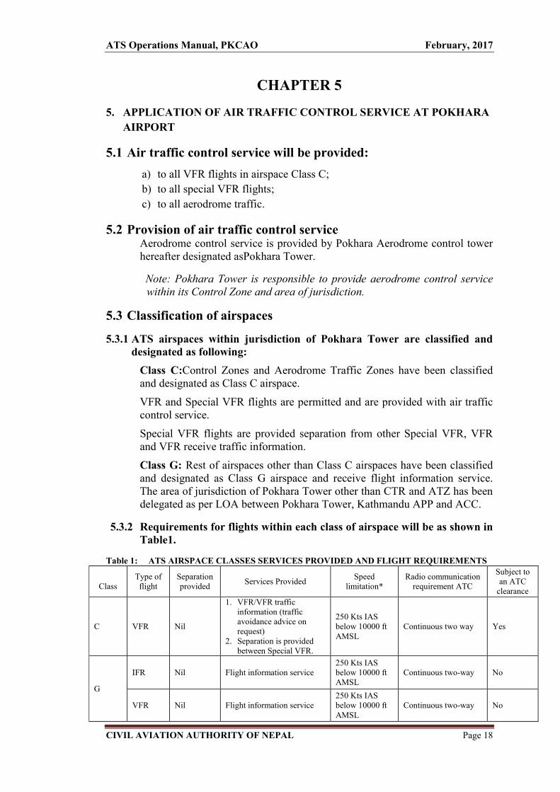
CHAPTER 5
5. APPLICATION OF AIR TRAFFIC CONTROL SERVICE AT POKHARA
AIRPORT
5.1 Air traffic control service will be provided:
a) to all VFR flights in airspace Class C;
b) to all special VFR flights;
c) to all aerodrome traffic.
5.2 Provision of air traffic control service Aerodrome control service is provided by Pokhara Aerodrome control tower hereafter designated asPokhara Tower.
Note: Pokhara Tower is responsible to provide aerodrome control service within its Control Zone and area of jurisdiction.
5.3 Classification of airspaces
5.3.1 ATS airspaces within jurisdiction of Pokhara Tower are classified and designated as following:
Class C:Control Zones and Aerodrome Traffic Zones have been classified and designated as Class C airspace.
VFR and Special VFR flights are permitted and are provided with air traffic control service.
Special VFR flights are provided separation from other Special VFR, VFR and VFR receive traffic information.
Class G: Rest of airspaces other than Class C airspaces have been classified and designated as Class G airspace and receive flight information service. The area of jurisdiction of Pokhara Tower other than CTR and ATZ has been delegated as per LOA between Pokhara Tower, Kathmandu APP and ACC.
5.3.2 Requirements for flights within each class of airspace will be as shown in Table1.
Table 1: ATS AIRSPACE CLASSES SERVICES PROVIDED AND FLIGHT REQUIREMENTS
Class
Type of flight
Separation provided
Services Provided Speed
limitation* Radio communication
requirement ATC
Subject to an ATC
clearance
C VFR Nil
1. VFR/VFR traffic information (traffic avoidance advice on request)
2. Separation is provided between Special VFR.
250 Kts IAS below 10000 ft AMSL
Continuous two way Yes
G
IFR Nil Flight information service 250 Kts IAS below 10000 ft AMSL
Continuous two-way No
VFR Nil Flight information service 250 Kts IAS below 10000 ft AMSL
Continuous two-way No

ATS Operations Manual, PKCAO February, 2017
CIVIL AVIATION AUTHORITY OF NEPAL Page 19
5.4. FLIGHT PLANNING
5.4.1. Procedure for the submission of the flight plan.
5.4.1.1 A flight plan shall be submitted to the Pokhara Tower in respect of the
following flights,
a) All VFR flights operating from Pokhara Airport.
b) Any flight or portion thereof, to be provided with air traffic control
service,
5.4.1.2. The flight plan submitted to Pokhara Tower should be signed and filed by
the pilot-in-command or authorized representative at least sixty
minutes prior to departure (the estimated off block time) using the ICAO
flight plan form.
5.4.1.3 In the event of delay of 60 minutes for domestic fights in excess of
EOBT, the flight plan should be amended or a new flight be submitted
and old flight plan canceled, whichever is applicable.
5.4.1.4 Flights in compliance with VFR flights shall insert VFR (V) and if on en-
route will operate in compliance with IFR flight shall insert VFR then IFR
(Z) in the flight plan.
5.4.1.5 The total number of persons on board (passengers plus crew) should be
stated in the flight plan.
5.4.1.6 In addition, pilots are required to pass the total number of persons
(POB) to the concerned ATC unit when requesting engine start-up
during departure.
5.4.1.7 No flight plans shall be filed for routes deviating from the published
ATS route structure unless prior permission has been obtained from the
appropriate ATS unit.
5.4.1.8 When a flight is planned to operate in aerodrome traffic circuit or local/
training flight, flight plan shall be submitted to ATS units.
5.4.1.9 Whenever a flight, for which a flight plan has been submitted, is cancelled,
Pokhara Tower shall be informed immediately.
5.4.1.10 Changes to a current flight plan for a controlled flight during flight
shall be reported or requested, subject to the provisions in CAR 2, 3.6.2
(Adherence to flight plan).
5.4.1.11. While conducting a flight of a military nature like a formation flight or
Para-drop or dummy drop, the pilot in command should always file a flight
plan to the appropriate ATS unit and obtain an ATC clearance before
conducting the operation.

ATS Operations Manual, PKCAO February, 2017
CIVIL AVIATION AUTHORITY OF NEPAL Page 20
5.5. FLIGHT RULES
5.5.1. VFR Flights
5.5.1.1. VFR flights will not be authorized to take off or land at Pokhara controlled aerodrome or enter the aerodrome traffic zone or traffic pattern.
a) When the ceiling is less than 1500ft. (450m) or, b) When the ground visibility is less than 5 Km
Note: For the purpose of permitting VFR flight, weather observations may be made over the entire horizon or only in the sector used by the flight.
5.5.1.2.WEATHER OBSERVATIONS
It should be noted that all the assessments of weather conditions made for the purpose of opening or closing aerodrome are the responsibility of the aerodrome controller and should be made as required by visual observation from the control tower.
5.6. PROVISION OF SEPARATION
5.6.1. RESPONSIBILITIES FOR SEPARATION
5.6.1.1. In Pokhara control zone:
5.6.1.1.1. ATC will provide separation between Special VFR flights as prescribed in 10.1.24.
Greater separation will be applied if considered necessary and
specifically
a) For the avoidance of wake turbulence, or
b) Exceptional circumstances.
5.6.1.1.2. Separation minima (Spacing/sequencing) between VFR may be reduced in the vicinity of aerodromes if:
a) Adequate separation can be provided by the aerodrome controller
when each aircraft is continuously visible to the controller, or
b) Each aircraft is continuously visible to pilot-in-command of the
other aircraft concerned and the pilots report that they can
maintain their own separation, or
c) In the case of one aircraft following another, the pilot-in-
command of the succeeding aircraft reports that he has the other
aircraft in sight and can maintain separation.
5.6.1.1.3. VFR traffic will be provided with traffic information of other VFR traffic and traffic avoidance advice on request.
ATS Operations Manual, PKCAO February, 2017
CIVIL AVIATION AUTHORITY OF NEPAL Page 21
5.6.1.1.4. A controller will issue traffic information when in his opinion, traffic proximity warrants it. The traffic information provided will contain sufficient of the following to assist the pilot in identifying the other aircraft.
a) Call sign of the aircraft
b) Type of the aircraft
c) Direction of flight
d) Cruising level of aircraft and estimated time over the reporting point
nearest to where the level will be crossed.
5.6.1.1.5. Traffic sequencing and separation will be provided between all aircraft in the Traffic circuit, landing and taking off.
5.6.1.1.6. The separation of military aircraft will be maintained in the same manner as for civil aircraft, except that when required by relevant military authority, different standards as specified by that authority will be applied between military aircraft.
5.6.1.1.7. In Pokhara, there is no provision of Formation flight for Civil air traffic. However, Formation flights are occasionally conducted by Military flight operation, and when conducted, will be exempted from the separation with respect to each other aircraft of the same formation.
5.6.1.1.8. While conducting a flight of a military nature like a formation flight or para-drop or dummy drop, the pilot in command should always file a flight plan to the appropriate ATS unit and obtain an ATC clearance before conducting the operation.
5.7. Priority of handling traffic
5.7.1. In assessing priorities for the use of part of the manoeuvring area or airspace for which there are conflicting requirements, provided that safety is in no way jeopardized, traffic priorities will be applied in the following order: a. An aircraft in emergency, including being subjected to unlawful
interference will be given priority in all circumstances. b. An aircraft which has suffered Radio communications failure will be
granted priority for landing. c. An aircraft which has declared a Mercy flight. d. An aircraft which is participating in Search and rescue operation. e. An aircraft classified as a VVIP flight. f. A landing aircraft will have priority over a departing aircraft if the later
cannot take off with prescribed separation standards. g. An aircraft landing or taking off will be given priority over taxiing
aircraft.
ATS Operations Manual, PKCAO February, 2017
CIVIL AVIATION AUTHORITY OF NEPAL Page 22
h. An aircraft able to use the landing area or desired airspace, at first in the normal course of its operation will be given priority except significant economic benefit would result for other aircraft by deferring this priority.
The following guidelines should be observed when allocating priorities.
i. When a clearance for a turbo-jet aircraft has been pre-arranged.
ii. Where significant economic benefit would result for a number of the
aircraft by deferring this priority.
iii. Flight desiring to operate in other than the normal pattern for
operational rather than training reasons, will be given the same priority
as other flights unless it involves a short notice change to a clearance
already issued to another aircraft. In this case, approval to operate will
be deferred.
5.7.2. VVIP aircraft are normally required to adhere strictly to pre-arranged schedules. These schedules will be prepared following prior liaison with ATC to ensure choice of the most suitable route. Where the additional mileage is not great, it is expected that normal routes will be used, but in some cases direct flights will be required and approved accordingly.
5.8. AIR TRAFFIC CLEARANCES
5.8.1. A controller achieves Air traffic control by the issue of clearances to pilots desiring operation in controlled airspace. When practicable, the requirement for such clearances will be anticipated in order to eliminate delays to aircraft.
5.8.2. Clearances issued will contain the following items:
a) Aircraft identification
b) The route authorized
c) The level authorized
d) The geographical limit of authorization in respect of (b) or (c) i.e. the clearance limit; and
e) Any time limitation on authorization (b) or (c).
5.8.3. The whole or any part of a clearance may be extended or cancelled and replaced by a new clearance, but the controller will ensure at all times that the pilot is in no doubt as to any of the elements specified in para 5.9.2.
5.8.4. When a clearance limit is cancelled, the level and route to be flown from the point will be specified.
5.8.5 The contents of a clearance or revisions to it will apply only to those portions of the flight conducted within control zone.

ATS Operations Manual, PKCAO February, 2017
CIVIL AVIATION AUTHORITY OF NEPAL Page 23
5.8.6 If a pilot requests clearance to maneuver his aircraft in a manner different from that specified, a new clearance in accordance with the request will be issued if the traffic conditions permit.
5.8.7 Where an aircraft has flight planned for flight in and out of controlled airspace, clearances should be aimed primarily at keeping it in the control airspace.
5.8.8 A pilot-in-command is required to read back all contents of the ATC clearance and any item notified in the clearance as "AMMENDED". This will be checked, and if omitted by the pilot, should be requested by the controller. When a track of flight or level is changed, and the pilot is not offered an alternative clearance, attention will be drawn to the change by prefixing the amended item with the word "AMENDED" e.g. AMENDED LEVEL- CLERANCE CRUISE (AMENDED LEVEL)….etc. ATC will not give a reason for a change of flight plan if it is believed that the reason will be evident to the pilot-in-command.
5.8.9 Where a pilot is offered a choice of available levels or tracks, transmission by the pilot of the selected level or track is sufficient for its acknowledgement.
5.8.10 If it is necessary for a controller to issue a clearance to an intermediary for relay to an aircraft, he will do so in a clear and concise manner, using the exact phrases by which he requires the clearance to be passed to the pilot. When it is considered appropriate to give emphasis to any unusual elements, these elements should be repeated after the phrase – "I SAY AGAIN"
5.8.11 The intermediary responsible for the relay of clearance will acknowledge receipt by reading back the clearance in full to the issuing controller. The clearance will subsequently be transmitted to the pilot in exactly the same form.
5.8.12 When a request for a clearance “enter control zone” is received and a clearance is not immediately available, a controller will indicate this in the terms…(callsign) "CLEARANCE NOT AVAILABALE CALL AT….(time) REMAIN OUT SIDE CONTROL ZONE”
5.8.13 Unless otherwise specified for particular cases, a clearance issued through other than ATC frequencies, will be reissued on initial contact with the aircraft.
5.8.14 A request to a pilot to report at a specified position will not be regarded by the controller as imposing a clearance limit.
5.8.15 When a clearance is given for an aircraft to proceed on a local flight inside the control zone, it will include a description of the area in which the flight is to be conducted.
5.8.16 Clearance limits – a description of a holding path to be flown at the clearance limit may be omitted when
a) sight and follow procedure will not be utilized until the following aircraft confirms that the preceding traffic has been sighted, or
preNote: For the Ultralight flights operating in Pokhara, follow their
ATS Operations Manual, PKCAO February, 2017
CIVIL AVIATION AUTHORITY OF NEPAL Page 24
b) a clearance limit has been imposed temporary, and it is expected that the requirement to hold will have lapsed before the aircraft arrives at the designated holding point.
5.9 SIGHT AND FOLLOW PROCEDURE
5.9.1 Within control zone, in VMC, during the hours of daylight, ATC may instruct an arriving aircraft to sight and follow a preceding arriving aircraft maintaining visual separation with that aircraft.
5.9.2 To assist in the identification procedure, ATC will specify the type of aircraft to be followed, provide accurate information on its position and advise the aircraft concerned of their number in the landing sequence.
5.9.3 The Sight and follow procedure will not be utilized until the following aircraft confirms that the preceding traffic has been sighted and can be followed.
5.9.4 The controller will issue an alternative clearance if there is any doubt of the pilot's ability to keep the preceding traffic in sight or if there is a possibility of a traffic confliction resulting from the sight and follow procedure.
-determined routes that may preclude the items given in 5.8
and 5. 9
. The procedure has been in practice on the basis of SOP developed as
per the meeting minute with different stakeholders at Pokhara. However, the ATM
Dept. CAAN has been undertaking its responsibility for the pending procedure
approval by CAAN.

ATS Operations Manual, PKCAO February, 2017
CIVIL AVIATION AUTHORITY OF NEPAL Page 25
CHAPTER 6
6.1 GENERAL ALTIMETER SETTING PROCEDURES
6.1.1. An altimeter setting is pressure datum which, when set on the sub-scale of a sensitive altimeter, causes the altimeter to indicate vertical distance from that pressure datum. A pressure type altimeter calibrated in accordance with the international standard atmosphere (ISA) may be used to indicate altitude, flight level or height as follows:
a) When set to QNH it will indicate altitude. An altimeter set to QNH reads, within close limits, the vertical distance above mean sea level of the aircraft is on the ground at the aerodrome, the altimeter will register the elevation of the aerodrome above mean sea level.
b) When set to standard pressure (1013.2hpa) it may be used to indicate flight levels. An aircraft maintains flight level with the altimeter set to standard pressure flying along a surface of constant atmosphere pressure. The aircraft's vertical distance from mean sea level may vary while the aircraft maintains the flight level due to change in atmospheric pressure en route in the horizontal, for example, an aircraft flying toward a low pressure area will fly progressively lower while maintaining a flight level.
c) When set to QFE, it will indicate height above the QFE reference datum. Maximum variation in QNH values within Kathmandu FIR does not exceed 15hpa either side of the standard of setting 1013.2hpa representing the change of 450ft. on the altimeter from QNH to 1013.2hpa. To simplify ATC procedures, therefore, a transition level of FL150 has been established, thus provides a transition layer of 1500ft. and ensures at all times the 1000ft. vertical separation between aircraft.
6.1.2 The system of altimetry used in Kathmandu FIR (VNSM) makes use of a transition layer to separate aircraft using QNH from those using 1013.2hpa (hecto pascal)
6.1.3 A common transition altitude of 13500ft. has been established for the entire Kathmandu Flight Information Region.
6.1.4 A transition level of FL150 has been established for the entire Kathmandu Flight Information Region.
6.2 Altimeter setting procedures applicable at Pokhara airport
6.2.1. PROCEDURE
6.2.1.1.All aircraft at or below the transition altitude will use QNH supplied by Pokhara Tower.
6.2.1.2.For the flight at or above the transition level, the standard altimeter setting of 1013.2 hpa will be used.

ATS Operations Manual, PKCAO February, 2017
CIVIL AVIATION AUTHORITY OF NEPAL Page 26
6.2.1.3.Change from QNH to 1013.2hpa will be made on climbing through the transition altitude
6.2.1.4.Change from 1013.2hpa to QNH will be made on descending through the transition level
6.2.1.5.Cruising within the transition layer is not permitted.
6.2.1.6.Change from Pokhara QNH to Destination or Kathmandu QNH as appropriate when leaving Pokhara CTR.
6.2.1.7.Change from Departure aerodrome or Kathmandu QNH as appropriate to Pokhara QNH when entering Pokhara CTR.
6.2.1.8.Level of aircraft when at or below the transition altitude is expressed in terms of altitudes where as such level at or above transition level is expressed in terms of flight level. While passing through the transition layer, level is expressed in terms of altitude when descending and in terms of flight level when ascending.
6.3. TAKE-OFF AND CLIMB
6.3.1. A QNH altimeter setting will be made available to aircraft by Pokhara Tower in the routine take off and climb instructions.
6.3.2. Level of aircraft during climb will be effected by reference to altitude until reaching the transition altitude above which level will be effected by reference to flight level.
6.3.3. A QFE altimeter setting will be provided on request if available but reports to ATC are to be made in altitude.
6.4. VERTICAL SEPARATION EN-ROUTE
6.4.1. Aircraft en-route (irrespective of whether IFR or VFR) will be flown at flight levels or altitudes where appropriate.
6.4.2. It is the pilot's responsibility to select an appropriate level, which will give adequate terrain clearance using given pressure.
6.4.3. For the purposes of en-route vertical separation between IFR and VFR flights in controlled airspace and flights in uncontrolled airspace, reference should be made to the following:
a) Quadrantal system of cruising levels at or below 13,500ft b) Semi-circular system of cruising levels at or below FL150
6.5. APPROACH AND LANDING
6.5.1. A QNH altimeter setting will be made available in the routine approach and landing instructions.
6.5.2. A QFE altimeter setting will be provided on request if available but reports to ATC are to be made in altitude.
ATS Operations Manual, PKCAO February, 2017
CIVIL AVIATION AUTHORITY OF NEPAL Page 27
6.5.3. Level of aircraft during approach is effected by reference to flight level until reaching the transition level below which level is effected by reference to altitude.
6.6. PROCEDURES APPLICABLE TO OPERATORS AND PILOTS
6.6.1. FLIGHT PLANNING
6.6.1.1. The level(s) at which a flight is to be conducted will be specified in a flight plan
a) in terms of flight level (s) if the flight is to be conducted at or above transition level, and
b) in terms of altitude (s) if the flight is to be conducted in the vicinity of an aerodrome and at or below the transition altitude.
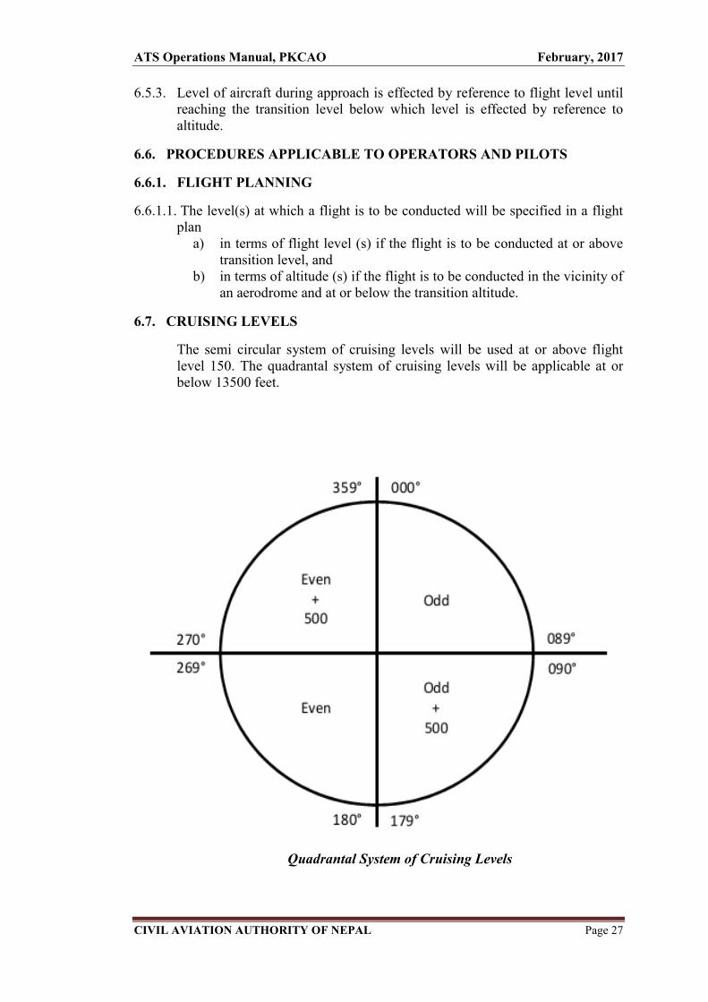
6.7. CRUISING LEVELS
The semi circular system of cruising levels will be used at or above flight level 150. The quadrantal system of cruising levels will be applicable at or below 13500 feet.
Quadrantal System of Cruising Levels
ATS Operations Manual, PKCAO February, 2017
CIVIL AVIATION AUTHORITY OF NEPAL Page 28
CHAPTER 7
7.1 WAKE TURBULENCE
7.1.1. Wake Turbulence in General
Aerodrome controllers will, when applicable, apply the wake turbulence separation minima as specified in this chapter. Whenever the responsibility for wake turbulence avoidance rests with the pilot-in-command, aerodrome controllers will, to the extent practicable, advice aircraft of the expected occurrence of hazards caused by turbulent wake.
Note. — Occurrence of turbulent wake hazards cannot be accurately predicted and aerodrome controllers cannot assume responsibility for the issuance of advice on such hazards at all times, nor for its accuracy. Information on hazards due to wake vortices is contained in the Air Traffic Services Planning Manual (Doc 9426), Part II, Section 5.
7.1.2. Aircraft Category
Wake turbulence separation minima will be based on a group of aircraft types into three categories according to maximum certificated take-off mass as follows:
a) HEAVY (H)-all aircraft types of 136000 kg or more;
b) MEDIUM (M)-aircraft types less than 136000 kg but more than 7000 kg; and
c) LIGHT(L)-aircraft types of 7000 kg or less.
7.1.3. Non-radar wake turbulence longitudinal separation minima
7.1.3.1. Applicability
7.1.3.2. The ATC unit will, when deemed necessary, issue a caution of possible wake
turbulence. The pilot-in-command of the aircraft concerned will be responsible for
ensuring that the spacing from a preceding aircraft of a heavier wake turbulence
category is acceptable. If it is determined that additional spacing is required, the
flight crew will inform the ATC unit accordingly, stating their requirements.
7.1.3.3. Arriving aircraft
7.1.3.3.1. Following non radar separation minima will be applied to light aircraft landing
behind a MEDIUM aircraft:
LIGHT aircraft behind a HEAVY or MEDIUM aircraft---3 minutes

ATS Operations Manual, PKCAO
CIVIL AVIATION AUTHORITY OF NEPAL
7.1.3.3.2. Departing aircraft
7.1.3.3.2.1. A minimum separation of 2 minutes will be applied between a LIGHT
aircraft taking off behind a MEDIUM aircraft when the aircraft are using the
same runway.
7.1.3.3.2.2. Separatio
when taking off behind a MEDIUM aircraft from an intermediate part of the
runway.
Figure 2.2 Three
ATS Operations Manual, PKCAO
CIVIL AVIATION AUTHORITY OF NEPAL
Departing aircraft
A minimum separation of 2 minutes will be applied between a LIGHT
aircraft taking off behind a MEDIUM aircraft when the aircraft are using the
same runway.
Figure 2.1 Two-minute separations for following aircraft
Separation minima of 3 minutes will be applied between a LIGHT aircraft
when taking off behind a MEDIUM aircraft from an intermediate part of the
runway.
Figure 2.2 Three-minute wake turbulence separations for following aircraft
February, 2017
Page 29
A minimum separation of 2 minutes will be applied between a LIGHT
aircraft taking off behind a MEDIUM aircraft when the aircraft are using the
minute separations for following aircraft
n minima of 3 minutes will be applied between a LIGHT aircraft
when taking off behind a MEDIUM aircraft from an intermediate part of the
rations for following aircraft

ATS Operations Manual, PKCAO
CIVIL AVIATION AUTHORITY OF NEPAL
7.1.3.3.3. Displaced landing threshold
A separate minimum of 2 minute will be applied between a LIGHT aircraft and a MEDIUM aircraft when operating on a runway with a displaced landing threshold when :
a) A departing LIGHT aircraft follows a MEDIUM aircraft arrival; or
b) An arriving LIGHT aircraft follthe projected paths are expected to cross.
7.1.3.3.4. Opposite direction
A separation minimum of 2 minutes will be applied between a LIGHT aircraft and a medium aircraft when the heaver aircraft is making a low or missed approach a
a) Utilizing an opposite
Figure 2.3 Two
b) Landing on the same runway in the opposite direction.
Figure 2.4 Two
ATS Operations Manual, PKCAO
CIVIL AVIATION AUTHORITY OF NEPAL
Displaced landing threshold
parate minimum of 2 minute will be applied between a LIGHT aircraft and a MEDIUM aircraft when operating on a runway with a displaced landing threshold when :
A departing LIGHT aircraft follows a MEDIUM aircraft arrival; or
An arriving LIGHT aircraft follows a MEDIUM aircraft departure if the projected paths are expected to cross.
Opposite direction
A separation minimum of 2 minutes will be applied between a LIGHT aircraft and a medium aircraft when the heaver aircraft is making a low or missed approach and the lighter aircraft is:
Utilizing an opposite –direction runway for take
Figure 2.3 Two-minute wake turbulence separation for opposite direction take
Landing on the same runway in the opposite direction.
Figure 2.4 Two-minute wake turbulence separations for opposite direction landing
February, 2017
Page 30
parate minimum of 2 minute will be applied between a LIGHT aircraft and a MEDIUM aircraft when operating on a runway with a
A departing LIGHT aircraft follows a MEDIUM aircraft arrival; or
ows a MEDIUM aircraft departure if
A separation minimum of 2 minutes will be applied between a LIGHT aircraft and a medium aircraft when the heaver aircraft is making a low or
direction runway for take –off; or
minute wake turbulence separation for opposite direction take-off .
Landing on the same runway in the opposite direction.

ATS Operations Manual, PKCAO February, 2017
CIVIL AVIATION AUTHORITY OF NEPAL Page 31
CHAPTER 8
8.1. GENERAL PROCEDURE OF FUEL DUMPING IN FLIGHT
8.1.1 An aircraft in emergency or other urgent situations may need to dump fuel so as to reduce its weight to maximum landing mass in order to affect a safe landing.
8.1.2 When an aircraft operating within controlled airspace needs to dump fuel, the
flight crew will advise ATC at Pokhara Tower. Then PK Tower Controller
should then coordinate with the flight crew the following:
a) the route to be flown, which, if possible, should be clear of cities and
towns, preferably over water and away from areas where thunderstorms
have been reported or are expected;
b) the level to be used, which should be not less than 1800 m (6000 ft);
and
c) the duration of the fuel dumping.
8.2 SEPARATION
Other known traffic should be separated from the aircraft dumping fuel by:
a) at least 19 km (10 NM) horizontally, but not behind the aircraft dumping
fuel;
b) vertical separation if behind the aircraft dumping fuel within 15 minutes
flying time or a distance of 93 km (50 NM) by;
i. at least 300 m (1000 ft) if above the aircraft dumping fuel; and
ii. at least 900 m (3000 ft) if below the aircraft dumping fuel.
Note.— The horizontal boundaries of the area within which other traffic
requires appropriate vertical separation extend for 19 km (6 NM) either side
of the track flown by the aircraft which is dumping fuel, from 19 km (6 NM)
ahead, to 93 km (50 NM) or 15 minutes along track behind it (including
turns).

ATS Operations Manual, PKCAO February, 2017
CIVIL AVIATION AUTHORITY OF NEPAL Page 32
8.3 COMMUNICATIONS
If the aircraft will maintain radio silence during the fuel dumping operation,
the frequency to be monitored by the flight crew and the time when radio
silence will terminate should be agreed.
8.4 INFORMATION TO OTHER ATS UNITS AND NON-CONTROLLED
TRAFFIC
8.4.1 A warning message will be broadcast on appropriate frequencies for non-
controlled traffic to remain clear of the area concerned. Adjacent ATC units
and control sectors should be informed of the fuel dumping taking place and
requested to broadcast on applicable frequencies an appropriate warning
message for other traffic to remain clear of the area concerned.
8.4.2 Upon completion of the fuel dumping, adjacent ATC units and control sectors
should be advised that normal operations can be resumed.
Note: There is no pre-assigned segregated airspace for fuel dumping by
aircraft in Pokhara. The area will be allocated depending on the
need of the aircraft with respect to route and sector of the flight.

ATS Operations Manual, PKCAO February, 2017
CIVIL AVIATION AUTHORITY OF NEPAL Page 33
CHAPTER 9
9. VVIP MOVEMENT HANDLING PROCEDURE
9.1 GENERAL 9.1.1 In order to facilitate the movement of VVIP aircraft into and out of Pokhara
Control Zone and to conform to the times shown in the Ceremonial Reception Schedule, Pokhara Tower is authorized to provide special priority for all VVIP fights over all other normal traffic within its areas of responsibility.
9.1.2 The term "VVIP FLIGHT" refers to the flight carrying on-board the under mentioned: a) The President b) The Vice President c) The Prime Minister
9.1.3 Flights of other reigning sovereigns, Head of the States and the Prime Minister of foreign countries designated by the Government of Nepal to be VVIP may also be afforded "VVIP Flight" status.
9.1.4 The Chief of Pokhara Civil Aviation Office will inform all concerned relating to VVIP flight some or all of the following details: a) Period and area of restrictions imposed on other fights. b) Call sign and type of aircraft, c) Point of departure/destination d) Embarkation/disembarkation site e) EOBT and ETA f) Ceremonial details g) Any other pertinent information
9.1.5 Message received from VVIP on-board will be kept highly confidential and reported to Chief of Pokhara Civil Aviation Office.
9.1.6 The following procedures will be enforced when a VVIP FLIGHT is notified.
9.1.6.1 A NOTAM based on the schedule of the VVIP flight movement will be issued in advance.
9.1.6.2 No aircraft except in emergency be allowed to land or depart from the aerodrome or operate in the aerodrome traffic circuit for the period specified in the NOTAM.
Note: The Chief of Pokhara Civil Aviation Office may adjust the timing to ensure that there is no disturbances during ceremonial period at the airport.
9.1.6.3 Control Zone: Inside Control zone, Vertical separation minimum will be 1000ft at all levels
9.1.6.4. Outside Control Zone: No other aircraft will be cleared to operate in the block of uncontrolled airspaces 1000ft below and above the cruising level and 10NM on either side of the intended route of the VVIP flight.

ATS Operations Manual, PKCAO February, 2017
CIVIL AVIATION AUTHORITY OF NEPAL Page 34
CHAPTER 10
10. PROVISIONS OF AIR TRAFFIC SERVICES
10.1 AERODROME CONTROL SERVICE
10.1.1FUNCTION OF POKHARA TOWER
10.1.1.1 Responsibility: Aerodrome control service is provided by Pokhara tower to all
aerodrome traffic within ATZ, control zone and additional delegated airspace under
its responsibility.
10.1.1.2 General : Pokhara tower will issue information and clearances to aircraft under its
control to achieve a safe, orderly and expeditious flow of air traffic on and in the
vicinity of an aerodrome with the objective of preventing collision(s) between:
a) aircraft flying within the designated area of its responsibility;
b) aircraft operating on the manoeuvring area;
c) aircraft landing and taking off;
d) aircraft , vehicles and personnel operating on the manoeuvring area;
e) aircraft on the manoeuvring area and obstructions on that area.
10.1.1.3 Pokhara Tower will maintain a continuous watch on all flight operations on and in
the vicinity of the aerodrome as well as vehicles and personnel on the maneuvering
area. Watch will be maintained by visual observation. Traffic will be controlled in
accordance with the procedures set forth herein and all applicable traffic rules
specified by the Civil Aviation Authority of Nepal.
10.1.1.4 Controllers will maintain a continuous watch on all appropriate radio frequencies and
conduct all air-ground communications in accordance with these instructions and
those contained in the AIP.
10.1.1.5 Company messages concerned with the safety of the aircraft will be accepted for
transmission. The transmission of other company messages will be at the discretion
of the controller. Messages unless concerned with the immediate safety of the aircraft
will not be passed to the aircraft which has been cleared for take-off and has entered
the runway. Transmission of these messages will be delayed until the aircraft is
airborne.

ATS Operations Manual, PKCAO February, 2017
CIVIL AVIATION AUTHORITY OF NEPAL Page 35
10.1.1.6 An aircraft operating locally may be required to report at specified time or position
at nominated reporting points.
10.1.1.7 Aerodrome controller will use visual signals as and when required. The meanings of
the light or ground signals for use in aerodrome control are as per the TABLE-ATC
LIGHT SIGNALS.
10.1.1.8 Aerodrome controllers will be familiar with the spread of the light signal lamp in
use and will choose a time for the direction of a signal so that it is not received by
aircraft other than the one for which it is intended.
10.1.1.9 Aerodrome controllers will use light signal from the table to control aircraft and
movement of vehicles, equipment and personnel on the maneuvering area when
radio communications cannot be employed.
TABLE-ATC LIGHT SIGNALS
COLOUR
AND
TYPEOF
SIGNALS
AIRCRAFT ON MOVEMENT OF
VEHICLES.EQUIPMENT
AND PERSONEL
GROUND FLIGHT
Steady green… Cleared for take off Cleared to land (Not applicable)
Flashing
green….
Cleared to taxi Return for Landing (to
be followed by Steady
green at the Proper time)
Cleared to cross or proceed.
Steady red…. Stop Give way to other
aircraft and continue
circling
Stop
Flashing red… Taxi clear of landing
Area
Airport unsafe, do not
land
Clear the taxiway/runway.
Flashing white Return to starting
Point on airport
Land at this Aerodrome
& Proceed to apron
Return to starting point of
airport.
TABLE- GROUND SIGNALS TO AIRCRAFT
GROUND SIGNAL
WHERE DISPLAYS MEANINGS
Two white cross Adjacent to windsock On maneuvering area
Aerodrome completely unserviceable An area marked by a cross or crosses with the limits delineated by markers, is unfit for use by aircraft
10.1.1.10 Alerting service provided by Pokhara tower
Pokhara tower is responsible for alerting the rescue and fire-fighting services
whenever:
ATS Operations Manual, PKCAO February, 2017
CIVIL AVIATION AUTHORITY OF NEPAL Page 36
a) an aircraft accident has occurred on or in the vicinity of the aerodrome; or,
b) information is received that the safety of an aircraft which is or will come
under the jurisdiction of the Pokhara tower may have or has been
impaired; or
c) requested by the flight crew; or
d) when otherwise deemed necessary or desirable.
10.1.1.11. Procedures concerning the alerting of the rescue and fire fighting services will be
contained in local instructions. Such instructions will specify the type of
information to be provided to the rescue and fire fighting services, including type
of aircraft and type of emergency and, when available, number of persons on
board, and any dangerous goods carried on the aircraft.
10.1.1.12 Aircraft which fail to report after having been transferred to Pokhara tower, or,
having once reported, cease radio contact and in either case fail to land five
minutes after the expected landing time, will be reported to the Kathmandu ACC or
to the Rescue Coordination Centre.
10.2 INFORMATION ON THE OPERATIONAL STATUS OF NAVIGATION
SERVICES
10.2.1Pokhara Tower shall be kept currently informed of the operational status of radio
navigation services and visual aids essential for takeoff, departure, approach and
landing procedures within the area of responsibility.
10.2.2 FAILURE OR IRREGULARITY OF NAVIGATION AIDS AND EQUIPMENT
Pokhara tower will immediately report of any failure or irregularity of operation in
any equipment, light or other device established at Pokhara aerodrome for the
guidance of aerodrome traffic and flight crews or required for the provision of air
traffic control service.
Same will be reported to Com/Nav-aid office PK and if required, Com and Nav-aid
Department, Kathmandu depending on the severity of the problem.
Note.—Separate local instructions or SOP for Airport Rescue and Fire Fighting Service of
PKCAO is yet to be developed. So, procedures concerning the alerting of the Rescue
and Fire fighting services are done in accordance with the SOP for Airport Rescue
and Fire Fighting Service, Domestic Airport 2011.

ATS Operations Manual, PKCAO February, 2017
CIVIL AVIATION AUTHORITY OF NEPAL Page 37
10.3 SELECTION OF RUNWAY-IN-USE
10.3.1 The term “runway-in-use” will be used to indicate the runway at a particular time is
considered by the Pokhara tower to be the most suitable for maximum use by the types
of aircraft expected to land or take- off at the aerodrome.
10.3.2 Normally, an aircraft will land and take off into the wind unless safety, the runway
configuration, meteorological conditions and air traffic conditions determine that a
different direction is preferable. In selecting the runway-in-use, however, Pokhara
Tower will take into consideration, besides surface wind speed and direction, other
relevant factors such as the aerodrome traffic circuits, the length of runways, and the
approach and landing aids available.
10.3.3 If the runway-in-use is not considered suitable for the operation involved, the flight
crew may request permission to use another runway and, if circumstances permit,
should be cleared accordingly.
10.3.4 The Aerodrome controller will nominate for use, the runway which appears to be
most suitable, taking into consideration:
a) Type of aircraft
b) Effective length of the runway
c) Wind velocity / downwind component
d) Weather phenomena including such things as wind gradients turbulence effects
and position of sun
e) Disposition of the traffic
f) if work load and traffic conditions permit, local instructions on “preferred
runways’’ in particular wind conditions to avoid noise nuisance and runway
deterioration.
10.3.5 A controller may authorize a departure from a runway intersection when requested by
the pilot or may offer an intersection departure to assist traffic flow for those type of
aircraft not exceeding STOL Type aircrafts. The pilot must be advised of the
remaining runway length if such information is not readily available to the pilot.
10.4 SELECTION OF CIRCUIT DIRECTION
10.4.1 The turn and circuit direction will be specified by the aerodrome controller for
particular traffic needs.

ATS Operations Manual, PKCAO February, 2017
CIVIL AVIATION AUTHORITY OF NEPAL Page 38
10.4.2 The pilot in command is responsible for advising the controller when a particular
turn is essential to the safety of the aircraft due terrain or aircraft performance
reasons. This does not necessarily preclude the issue of instructions in anticipation of
a pilot’s advice.
10.5 ENTRY OF TRAFFIC CIRCUIT
10.5.1 The clearance to enter the traffic circuit should be issued to an aircraft approaching
the landing area in accordance with current traffic circuit but traffic conditions do
not yet allow a landing clearance to be issued. Depending on the circumstances and
traffic conditions, an aircraft may be cleared to join at any position in the traffic
circuit.
10.6 INFORMATION TO AIRCRAFT BY POKHARA TOWER
10.6.1 FLIGHT INFORMATION SERVICE
Pokhara tower will provide Fight information service to all aircraft which are likely
to be affected by the information and which are:
a) Provided with air traffic control service; or
b) Otherwise known to the relevant air traffic services units
10.6.2 Flight information service will include the provision of pertinent:
a) METAR and SPECI and information on Weather observation;
b) information on changes in the serviceability of navigation aids;
c) information on changes in condition of aerodromes and associated facilities,
including information on the state of the aerodrome movement areas when they are
affected by snow ice or significant depth of water;
d) weather conditions reported or forecast at departure, destination and
alternate aerodromes;
e) any other information likely to affect safety.
10.7 AERODROME AND METEOROLOGICALINFORMATION
10.7.1 Prior to taxiing for take-off, aircraft will be advised of the following elements of
information, in the order listed, with the exception of such elements which it is
known the aircraft has already received:
a) the runway to be used;

ATS Operations Manual, PKCAO February, 2017
CIVIL AVIATION AUTHORITY OF NEPAL Page 39
b) the surface wind direction and speed, including significant variations;
c) the QNH altimeter setting
d) the air temperature
e) the correct time.
10.7.2 Prior to take-off aircraft will be advised of:
a) any significant changes in the surface wind direction and speed, the air
temperature, and the visibility.
b) significant meteorological conditions in the take-off and climb-out area,
except when it is known that the information has already been received by
the aircraft.
Note.— Significant meteorological conditions in this context include the occurrence or
expected occurrence of cumulonimbus or thunderstorm, moderate or severe
turbulence, wind shear, hail, moderate or severe icing, severe squall line, freezing
precipitation, sand storm, dust storm, blowing snow, tornado or waterspout in the
take-off and climb-out area.
10.7.3 Prior to entering the traffic circuit or commencing its approach to land, an aircraft will
be provided with the following elements of information, in the order listed, with the
exception of such elements which it is known the aircraft has already received:
a) the runway to be used;
b) the surface wind direction and speed, including significant variations there
from;
c) QNH altimeter setting
10.7.4 AERODROME WEATHER OBSERVATIONS
10.7.4.1 The Aerodrome Controller will be the sole authority responsible for opening or
closing an aerodrome to arrivals and departures. Pilots will be advised of
observed weather conditions necessary for the purpose of landing and take-off
and of significant weather, i.e. any weather phenomenon which might affect
flight visibility or presence of a hazard to an aircraft.

ATS Operations Manual, PKCAO February, 2017
CIVIL AVIATION AUTHORITY OF NEPAL Page 40
10.7.4.2 Aerodrome controller will use his own observations for determining whether the
prevailing conditions are above or below the minima prescribed for aircraft
operations. The aerodrome METAR will not be used for the purpose of opening
or closing an aerodrome to aircraft operations.
10.7.4.3 When observing weather conditions, the aerodrome controller may either make
his observations over the whole of the visual horizon (general observations) or
restrict the area considerations to that enclosing the probable flight path of the
aircraft (sector observations). Sector observations may be made in any direction
in order to accommodate both fixed and rotary wing operations.
10.7.4.4 In the specific cases covered by the following subparagraphs the aerodrome
controller will make either sector or general observations as specified.
10.7.4.4.1 Observations for the purpose of closing the aerodrome and for authorizing a
flight will be sector observations.
10.7.4.4.2 Observations made in response to a request by another unit will be general
observations.
10.7.4.5 Weather observation for departure and landing will include such of the following.
Items as are significant to the circumstance:
a) Wind Velocity.
b) Altimeter setting.
c) Temperature.
d) Dew point subject to its availability.
e) Low cloud.
f) Visibility in meters.
g) Intensity of rain, reported or known wind shear, turbulence, etc.
10.7.5 Sector visibility observation and procedure see Appendix E.
Note: Final decision on weather analysis, closure and open of aerodrome rests on
aerodrome controller on duty.

ATS Operations Manual, PKCAO February, 2017
CIVIL AVIATION AUTHORITY OF NEPAL Page 41
10.7.6 ESSENTIAL LOCAL TRAFFIC INFORMATION
10.7.6.1 Information on essential local traffic will be issued in a timely mannerin the
judgment of the aerodrome controller, such information is necessary in the interests
of safety, or when requested by aircraft, Ultra light, paraglide/hang-glider, vehicle or
personnel on or near the maneuvering area or traffic operating in the vicinity of the
aerodrome, which may constitute a hazard to the aircraft concerned.
10.7.6.2 Essential local traffic will be described so as to be easily identified.
10.7.7 RUNWAY INCURSION OR OBSTRUCTED RUNWAY
10.7.7.1 In the event the aerodrome controller, after a take-off clearance or a landing
clearance has been issued, becomes aware of a runway incursion or the imminent
occurrence thereof, or the existence of any obstruction on or in close proximity to
the runway likely to impair the safety of an aircraft taking off or landing,
appropriate action will be taken as follows:
a) cancel the take-off clearance for a departing aircraft;
b) instruct a landing aircraft to execute a go-around;
c) in all cases inform the aircraft of the runway incursion or obstruction and
its location in relation to the runway.
Note. — Animals and flocks of birds may constitute an obstruction with regard to runway
operations. In addition, an aborted take-off or a go-around executed after
touchdown may expose the aeroplane to the risk of overrunning the runway.
Moreover, a low altitude go-around may expose the aeroplane to the risk of a tail
strike. Pilots may, therefore, have to exercise their judgment in accordance with
CAAN CAR-2, Para 2.4 concerning the authority of the pilot-in-command of an
aircraft.
10.7.7.2 Following any occurrence involving an obstruction on the runway or a runway
incursion, pilots and controllers will complete an air traffic incident report in
accordance with the ICAO model air traffic incident report form.
10.7.8 Helicopter Operation and Wake Turbulence
10.7.8.1 Helicopters operation and Wake Turbulence
Helicopters should be kept well clear of light aircraft when hovering or while air taxiing.
Note.—Helicopters produce vortices when in flight and there is some evidence that per
kilogram of gross mass, their vortices are more intense than those of fixed-wing aircraft.

ATS Operations Manual, PKCAO February, 2017
CIVIL AVIATION AUTHORITY OF NEPAL Page 42
10.7.8.1 General Caution
In issuing clearances or instructions, air traffic controllers should take into account the
hazards caused by propeller slipstream to taxiing aircraft, to aircraft taking off or landing,
particularly when intersecting runways are being used, and to vehicles and personnel
operating on the aerodrome.
Note.—the propeller slipstream can produce localized wind velocities of sufficient strength
to cause damage to other aircraft, vehicles and personnel operating within the affected area.

ATS Operations Manual, PKCAO February, 2017
CIVIL AVIATION AUTHORITY OF NEPAL Page 43
10.7.9 ABNORMAL AIRCRAFT CONFIGURATION AND CONDITION
10.7.9.1 Whenever an abnormal configuration or condition of an aircraft, including
conditions such as landing gear not extended or only partly extended, or unusual
smoke emissions from any part of the aircraft, is observed by or reported to the
aerodrome controller, the aircraft concerned will be advised without delay.
10.7.9.1 When requested by the flight crew of a departing aircraft suspecting damage to the
aircraft, the departure runway used will be inspected without delay and the flight
crew advised in the most expeditious manner as to whether any aircraft debris or
bird or animal remains have been found or not.
10.7.10 ESSENTIAL INFORMATION ON AERODROME CONDITIONS
10.7.10.1 Essential information on aerodrome conditions is information necessary to safety
in the operation of aircraft, which pertains to the movement area or any facilities
usually associated therewith. For example, construction work on a taxi strip not
connected to the runway-in-use would not be essential information to any aircraft
except one that might be taxied in the vicinity of the construction work. As another
example, if all traffic must be confined to runways, that fact should be considered
as essential aerodrome information to any aircraft not familiar with the aerodrome.
10.7.10.2 Essential information on aerodrome conditions will include information relating to
the following:
a) construction or maintenance work on, or immediately adjacent to the
movement area;
b) rough or broken surfaces on a runway, a taxiway or an apron, whether
marked or not;
c) water on a runway, a taxiway or an apron;
d) other temporary hazards, including parked aircraft and birds on the ground
or in the air;
e) failure or irregular operation of part or all of the aerodrome lighting system;
f) any other pertinent information.
Note. — Up-to-date information on the conditions on aprons may not always be
available to the Pokhara control tower. The responsibility of the Pokhara tower in
relation to aprons is, with respect to the provisions of 10.1.12.1 and10.1.12.2,limited
to the transmission to aircraft of the information which is provided to it by the
authority responsible for the aprons.

ATS Operations Manual, PKCAO February, 2017
CIVIL AVIATION AUTHORITY OF NEPAL Page 44
10.7.10.3.Essential information on aerodrome conditions will be given to every aircraft,
except when it is known that the aircraft already has received all or part of the
information from other sources. The information will be given in sufficient time for
the aircraft to make proper use of it, and the hazards will be identified as distinctly
as possible.
Note.— “Other sources” include NOTAM and the display of suitable signals.
10.7.10.4 When a previously non-notified condition pertaining to the safe use by aircraft of
the maneuvering area is reported to or observed by the controller, the appropriate
Aerodrome Engineering authority will be informed and operations on that part of
the maneuvering area terminated until otherwise advised by the appropriate
aerodrome Engineering authority.
10.7.11 MESSAGES CONTAINING INFORMATION ON AERODROME
CONDITIONS
10.7.11.1 Whenever information is provided on aerodrome conditions, this will be done in a
clear and concise manner so as to facilitate appreciation by the pilot of the situation
described. It will be issued whenever deemed necessary by the controller on duty
in the interest of safety, or when requested by an aircraft. If the information is
provided on the initiative of the controller, it will be transmitted to each aircraft
concerned in sufficient time to enable the pilot to make proper use of the
information.
10.7.11.2 Information that water is present on a runway will be transmitted to each aircraft
concerned, on the initiative of the controller, using the following terms:
DAMP - the surface shows a change of color due to moisture.
WET - the surface is soaked but there is no standing water.
WATER PATCHES - patches of standing water are visible.
FLOODED - extensive standing water is visible.

ATS Operations Manual, PKCAO February, 2017
CIVIL AVIATION AUTHORITY OF NEPAL Page 45
10.7.12 CONTROL OF AERODROME TRAFFIC
10.7.12.1 General
As the view from the flight deck of an aircraft is normally restricted, the controller
will ensure that instructions and information which require the flight crew to
employ visual detection, recognition and observation are phrased in a clear, concise
and complete manner.
10.7.12.2 Designated positions of aircraft in the aerodrome traffic and taxi circuits
The following positions of aircraft in the traffic and taxi circuits are the positions
where the aircraft normally receive aerodrome control tower clearances. The
aircraft should be watched closely as they approach these positions so that proper
clearances may be issued without delay. Where practicable, all clearances should
be issued without waiting for the aircraft to initiate the call.
Position1 Aircraft initiates call to taxi for departing flight. Runway-in-use information and taxi clearances are given.
Position2 If there is conflicting traffic, the departing aircraft will be held at this position. Engine run-up will, when required, normally be performed here.
Position3 Take-off clearance is issued here, if not practicable at position 2.
Position4 Clearance to land is issued here as practicable.
Position5 Clearance to taxi to apron is issued here.
Position6 Parking information issued here, if necessary.

ATS Operations Manual, PKCAO February, 2017
CIVIL AVIATION AUTHORITY OF NEPAL Page 46
10.7.12.3 TRAFFIC ON THE MANOEUVRING AREA
10.1.13.3.1 CONTROL OF TAXIING AIRCRAFT
10.7.12.3.1.1 TAXI CLEARANCE
Prior to issuing a taxi clearance, the controller will determine where the aircraft
concerned is parked. Taxi clearances will contain concise instructions and
adequate information so as to assist the flight crew to follow the correct taxi
routes with appropriate designators, to avoid collision with other aircraft or
objects and to minimize the potential for the aircraft inadvertently entering an
active runway.
10.7.12.3.1.2When a taxi clearance contains a taxi limit beyond a runway, it will contain an
explicit clearance to cross or an instruction to hold short of that runway.
10.7.12.3.1.3TAXIING ON RUNWAY-IN-USE
For the purpose of expediting air traffic, aircraft may be permitted to taxi on the
runway-in-use, provided no delay or risk to other aircraft will result.
10.7.12.3.1.4 If the control tower is unable to determine that a vacating or crossing aircraft
has cleared the runway, the aircraft will be requested to report when it has
vacated the runway. The report will be made when the entire aircraft is beyond
the relevant runway-holding position.
10.7.12.3.1.5 USE OF RUNWAY-HOLDING POSITIONS
10.7.12.3.1.6 Aircraft will not be held closer to a runway-in-use than at a runway-holding
position.
10.7.12.3.1.7 Aircraft will not be permitted to line up and hold on the approach end of a
runway-in-use whenever another aircraft is affecting a landing, until the
landing aircraft has passed the point of intended holding.
Note. — See Figure 2-6.

ATS Operations Manual, PKCAO February, 2017
CIVIL AVIATION AUTHORITY OF NEPAL Page 47
Figure 2-6 Method of holding aircraft
10.7.12.3.1.8 HELICOPTER TAXIING OPERATIONS
10.7.12.3.1.8.1 When necessary for a wheeled helicopter or vertical take-off and landing
(VTOL) aircraft to taxi on the surface, the following provisions are applicable.
10.7.12.3.1.8.2 A frequency change should not be issued to single-pilot helicopters hovering
or air taxiing. Whenever possible, control instructions from the next ATS unit
should be relayed as necessary until the pilot is able to change frequency.
Note. — Ground taxiing uses less fuel than air-taxiing and minimizes air turbulence. However, under
certain conditions, such as rough, soft or uneven terrain, it may become necessary to air-taxi for
safety considerations. Helicopters with articulating rotors (usually designs with three or more main
rotor blades) are subject to “ground resonance” and may, on rare occasions, suddenly lift off the
ground to avoid severe damage or destruction.
10.7.12.13.1.8.3. When it is requested or necessary for a helicopter to proceed at a slow
speed above the surface, normally below 37 km/h (20 kts) and in ground
effect, air taxiing may be authorized except for the larger and heavier
helicopters (e.g. S332, MI8).
Note. — Air-taxiing consumes fuel at a high burn rate, and helicopter downwash turbulence
(produced in ground effect) increases significantly with larger and heavier helicopters.

ATS Operations Manual, PKCAO February, 2017
CIVIL AVIATION AUTHORITY OF NEPAL Page 48
10.7.12.13.1.8.4. Instructions which require small aircraft or helicopters to taxi in close
proximity to taxiing helicopters should be avoided and consideration
should be given to the effect of turbulence from taxiing helicopters on
arriving and departing light aircraft.
Note. — Most light helicopters are flown by one pilot and require the constant use of both hands and
feet to maintain control during low-altitude/low-level flight. Although flight control friction
devices assist the pilot, changing frequency near the ground could result in inadvertent
ground contact and consequent loss of control.
10.7.12.3.2 CONTROL OF OTHER THAN AIRCRAFT TRAFFIC
10.7.12.3.2.1 ENTRY TO THE MANOEUVRING AREA
The movement of pedestrians or vehicles on the maneuvering area will be
subject to authorization by Pokhara control tower. Persons, including drivers
of all vehicles, will be required to obtain authorization from the aerodrome
control tower before entry to the maneuvering area. Notwithstanding such an
authorization, entry to a runway or runway strip or change in the operation
authorized will be subject to a further specific authorization by Pokhara
control tower.
10.7.12.3.2.2 PRIORITY ON THE MANOEUVRING AREA
10.1.13.4.2.2.1 All vehicles and pedestrians will give way to aircraft which are landing,
taxiing or taking off, except that emergency vehicles proceeding to the
assistance of an aircraft in distress will be afforded priority over all other
surface movement traffic. In the latter case, all movement of surface traffic
should, to the extent practicable, be halted until it is determined that the
progress of the emergency vehicles will not be impeded.
10.7.12.3.2.2.1 When an aircraft is landing or taking off, vehicles will not be permitted to
hold closer to the runway-in-use than:
a) at a taxiway/runway intersection — at a runway holding position;
and
b) at a location other than a taxiway/runway intersection — at a
distance equal to the separation distance of the runway-holding
position.

ATS Operations Manual, PKCAO February, 2017
CIVIL AVIATION AUTHORITY OF NEPAL Page 49
10.7.12.3.2.3 COMMUNICATION REQUIREMENTS AND VISUAL SIGNALS
10.7.12.3.2.3.1 All vehicles employed on the maneuvering area will be capable of main-
taining two-way radio communication with the aerodrome control tower,
except when the vehicle is only occasionally used on the maneuvering area
and is:
a) accompanied by a vehicle with the required communications
capability, or
b) employed in accordance with a pre-arranged plan established with
the aerodrome control tower.
10.7.12.3.2.3.2 When communications by a system of visual signals is deemed to be
adequate, or in the case of radio communication failure, the signals given
hereunder will have the meaning indicated therein:
Light signal from Aerodrome Control
Meaning
Green flashes Permission to cross landing area or to move onto taxiway
Steady red Stop
Red flashes Move off the landing area or taxiway and watch out for
aircraft
White flashes Vacate maneuvering area in accordance with local
instructions
10.7.12.3.2.3.3 In emergency conditions or if the signals in 10.7.12.3.2.3.2 are not
observed, the signal given here under will be used for runways or taxiways
equipped with a lighting system and will have the meaning indicated
therein.
Light signal Meaning
Flashing runway or taxiway lights
Vacate the runway and observe thetower for light signal
10.7.12.3.2.3.4When employed in accordance with a plan pre-arranged with the aerodrome
control tower, constructional and maintenance personnel should not normally
be required to be capable of maintaining two-way radio communication with
the aerodrome control tower.
10.7.13 PRIORITY FOR LANDING
10.7.13.1 Priority shall be given to:

ATS Operations Manual, PKCAO February, 2017
CIVIL AVIATION AUTHORITY OF NEPAL Page 50
a) An aircraft which anticipates being compelled to land because of factors
affecting the safe operation of the aircraft ( engine failure, shortage of fuel,
etc);
b) Hospital aircraft or aircraft carrying any sick or seriously injured person
requiring urgent medical attention;
c) Aircraft engaged in search and rescue operations; and
d) Other aircraft as may be determined by ANSP.
10.7.13.2 If an aircraft enters an aerodrome traffic circuit without proper authorization, it
will be permitted to land if its actions indicate that it so desires. If circumstances
warrant, aircraft which are in contact with the controller may be instructed to
give way so as to remove the hazard introduced by such unauthorized operation
as soon as possible. In no case will permission to land be withheld indefinitely.
10.7.13.3 In cases of emergency it may be necessary, in the interests of safety, for an
aircraft to enter a traffic circuit and affect a landing without proper authorization.
Controllers should recognize the possibilities of emergency action and render all
assistance possible.
10.7.14 ORDER OF PRIORITY FOR ARRIVING AND DEPARTING AIRCRAFT
An aircraft landing or in the final stages of an approach to land will normally have
priority over an aircraft intending to depart from the same or an intersecting
runway.
10.1.15.1 CONTROL OF DEPARTING AIRCRAFT
10.1.15.1.1Departure sequence
10.1.15.1.1.1 Departures will normally be cleared in the order in which they are ready for
take-off, except that deviations may be made from this order of priority to
facilitate the maximum number of departures with the least average delay.
Factors which should be considered in relation to the departure sequence
include, inter alias:
a) types of aircraft and their relative performance;
b) routes to be followed after take-off;
c) any specified minimum departure interval between take-offs;
d) need to apply wake turbulence separation minima;
e) aircraft which should be afforded priority;
f) aircraft subject to slot requirements.

ATS Operations Manual, PKCAO February, 2017
CIVIL AVIATION AUTHORITY OF NEPAL Page 51
10.1.15.1.1.2 Departing aircraft may be expedited by suggesting a take-off direction which is not into
the wind. It is the responsibility of the pilot-in-command of an aircraft to make a take-off
or wait for take-off in a preferred direction.
10.1.15.1.2 General Procedures for Departing Aircraft
Clearances for departing aircraft will specify, when necessary for the separation of
aircraft, direction of takeoff and turn after take-off, heading or track to be made good
before taking up the cleared departure track, level to maintain before continuing climb to
assigned level, time, point and/or rate at which a level change will be made, and any
other necessary manoeuver consistent with safe operation of the aircraft.
10.1.15.1.3 Standard clearances for departing aircraft
10.1.15.1.3.1Clearance
Issuance of the standard clearances and the transfer of control of departing
aircraft between the ATC units will be according to the standardized
procedures as established in this manual and AIP.
ATS Operations Manual, PKCAO February, 2017
CIVIL AVIATION AUTHORITY OF NEPAL Page 52
10.1.15.1.4 Contents of standard clearances
Standard clearances for departing aircraft will contain the following items:
a) aircraft identification;
b) clearance limit, normally destination aerodrome;
c) track authorized
d) initial level;
e) any other necessary instructions or information, e.g. turn after
departure, instructions relating to change of frequency and the time of
expiry of the clearance.
10.1.15.1.5 Read-back of clearances and safety-related information
10.1.15.1.5.1 The flight crew will read back to the air traffic controller safety-related parts of ATC
clearances and instructions which are transmitted by voice. The following items will
always be read back:
a) ATC route clearances;
b) clearances and instructions to enter, land on, take off from, hold short
of, cross and backtrack on any runway; and
c) runway-in-use, altimeter settings,level instructions, heading and speed
instructions.
10.1.15.1.5.2 Other clearances or instructions, including conditional clearances, will be read
back or acknowledged in a manner to clearly indicate that they have been
understood and will be complied with.
10.1.15.1.5.3 The controller will listen to the read-back to ascertain that the clearance or
instruction has been correctly acknowledged by the flight crew and will take
immediate action to correct any discrepancies revealed by the read back.
10.1.15.2 Separation of departing aircraft
A departing aircraft will not normally be permitted to commence take-off until
the preceding departing aircraft has crossed the end of the runway-in-use or
has started a turn or until all preceding landing aircraft are clear of the runway-
in-use (Note . — See Figure 2-7).

ATS Operations Manual, PKCAO February, 2017
CIVIL AVIATION AUTHORITY OF NEPAL Page 53
10.1.15.3 Engine starting procedures
10.1.15.3.1In order to maintain an orderly flow of traffic, it is necessary that pilots of
departing aircraft request a startup clearance. When requesting a startup
clearance, a pilot will indicate the runway he/she requires to use if limited to a
particular runway and name of destination airport.
10.1.15.3.2If it is anticipated that traffic conditions may cause a delay before issuance of a
taxi clearances of more than 6 minutes, pilots should be issued with a
recommended startup time.
10.1.15.3.3 Clearance delivery
ADC will deliver standard ATC clearance to all departing aircraft prior to issue
taxi clearance.
10.1.15.4 Taxi clearance and provision of information
10.1.15.4.1Clearance
Taxi clearance will be issued for the purpose of
a) providing the pilot with guidance to the appropriate runway.
b) providing routes which will involve the minimum of conflict with other
traffic.
c) protecting other aircraft from the jet blast of heavy jets, helicopter
downwash.
Position limits to be reached by a landed aircraft (A) or a departing aircraft (B or C) before an arriving aircraft
may be cleared to cross the threshold of the runway-in-use or a departing aircraft may be cleared to take off,
unless otherwise prescribed by the appropriate ATS authority.
Figure 2-7 Separation between departing and arriving aircraft (See 10.1.15.5)

ATS Operations Manual, PKCAO February, 2017
CIVIL AVIATION AUTHORITY OF NEPAL Page 54
10.1.15.4.1.1 Taxi information
10.1.15.4.1.2 Prior to taxi for takeoff aircraft will be advised of the elements in the order
listed in Para 10.1.15.7.1, with the exception of such elements which it is
known that the aircraft has already received.
10.1.15.4.1.3 At the discretion of the aerodrome controller, pilots in command of aircraft
requesting permission to run up on the runway in use may be permitted.
However when a suitable alternate is available, aircraft will normally be
required to use this area, and will only be permitted to run up on the runway if
it is certain that this will not delay arriving or other departing aircraft.
10.1.15.4.1.4 An aircraft operating on the ground will be warned of jet blast or downwash of
helicopters.
10.1.15.4.2 Take off information
10.1.15.4.2.1 The aerodrome controller will provide to each aircraft under his/her control,
the following information for take-off purposes as required:
a) The mean and maximum crosswind components;
i. when the mean component equals or exceeds 8 knots for single-
engine aircraft and 12 knots for multi-engine aircraft; orwhen
requested by the pilot.
b) The cross wind component may be interpolated by use of the following
table:
10.1.15.4.2.2 Cross wind components should be calculated as shown in below:
Divergence from
Take-off/Landing Direction
Fraction of Wind
Speed
15 degrees 3/10
30 degrees 5/10
45 degrees 7/10
60 degrees 9/10
75 degrees 1

ATS Operations Manual, PKCAO February, 2017
CIVIL AVIATION AUTHORITY OF NEPAL Page 55
10.1.15.4.3 Taxiing Aircraft
10.1.15.4.3.1 Controllers will not issue conditional taxi instructions that are dependent upon the
movement of an arriving aircraft on or approaching the runway or a departing aircraft
established on a take-off roll, e.g., do not say “cleared to line up and hold behind the
landing traffic or line up and hold after departing traffic except when the aircraft or
vehicles concerned are seen by the appropriate controller and pilot. The aircraft or
vehicle causing the condition in the clearance issued will be the first aircraft/vehicle
to pass in front of the other aircraft concerned.
10.1.15.4.4 Intersection Departure
10.1.15.4.4.1 An intersection departure is a departure from a point of intersection of a runway or
taxiway with the active runway.
10.1.15.4.4.2 A pilot wishing to use less than the available full length of the runway will intimate
his/her intentions whilst taxiing. Intersection departure may be initiated by the
controller to expedite traffic for those type of aircraft not exceeding STOL type of
aircrafts keeping in mind the runway length available and wind condition etc. While
approving any intersection departure, the controller will advise the pilot of the
remaining length available before issuing take-off clearance. The responsibility for
accepting an intersection departure remains with the pilot in command.
10.1.15.4.4.3 Phraseology will be as follows:
(Aircraft identification) RUNWAY (runway designator) INTERSECTION
DEPARTURE FROM TAXIWAY INTERSECTION (taxiway designator)
AVAILABLE or APPROVED, REMAINING LENGTH (feet) AVAILABLE.
10.1.15.4.5 Take-off clearance
10.1.15.4.5.1 An aircraft will be cleared to enter the runway and take-off in
accordance with the priorities and maintaining the separation specified in
this manual.

ATS Operations Manual, PKCAO February, 2017
CIVIL AVIATION AUTHORITY OF NEPAL Page 56
10.1.15.4.5.2 The take-off clearance will be issued when the aircraft is ready for take-off and at or
approaching the departure runway and the traffic situation permits. To reduce the
potential for misunderstanding, the take-off clearance will include the designator of
the departure runway.However, the provision of omitting RWY designator will be
considered, in case the controller ascertain the designator is not necessary.
10.1.15.4.5.3 In the interest of expediting traffic, a clearance for immediate take-off may be issued
to an aircraft before it enters the runway. On acceptance of such clearance, the aircraft
will taxi out to the runway and take off in one continuous movement.
10.1.15.4.5.4 Any requirement after departure will be communicated to the pilot before takeoff.
10.1.15.4.5.5 When a taxing aircraft of heavier weight is followed by an aircraft of lesser weight
the aerodrome controller will not issue a line up for immediate departure clearance
that will require the aircraft of heavier weight to use more than normal taxing power
to enter the runway.
10.1.15.4.5.6 Before clearing an aircraft for take-off, and immediately before it commences to take-
off the aerodrome controller will make a visual check from the control tower to
determine, as far as practicable, whether obstructions exist on or near the take-off
area (runway/strip). If there is any obstruction in respect of which continued
operation has not been authorized or is not possible, the controller will withhold or
cancel the clearance until the obstruction is removed.
10.1.15.4.5.7 When departure separation is based on the position of a preceding landing aircraft
and conditions preclude the aerodrome controller from clearly observing that the
landing aircraft vacated and is taxing away from the runway, conformation of this
manoeuver will be obtained from the pilot in command prior to issuance of the take-
off clearance.
10.1.15.4.5.8 Operation will normally be confined to the runway most suitable for the majority of
the current traffic.
10.1.15.4.5.9 The word “TAKE-OFF” will be used in clearing an aircraft for take-off or canceling
a take-off clearance; they will be used as the last word of the take-off clearance
except that an instruction specifying a turn or circuit direction to be made after
departure will be placed after the words “TAKE-OFF”.

ATS Operations Manual, PKCAO February, 2017
CIVIL AVIATION AUTHORITY OF NEPAL Page 57
10.1.15.4.5.10 Before Authorizing a Take-off, the aerodrome controller will, by his/her own
visual observations, be reasonably satisfied that the weather conditions in the
sector of airspace enclosing the normal path of a civil aircraft’s take-off and initial
climb are not below the minima applicable to the particular flight. Assessment of
weather conditions for the purpose of authorizing take-off will be the
responsibility of the aerodrome controller and should be made immediately prior
to the aircraft departure.
10.1.15.4.5.11 An aircraft will not be cleared for take-off when weather conditions do not meet the
requirement or when in the opinion of the aerodrome controller, the cumulative
effects of small amounts of cloud at various levels below the minimum ceiling
constitute a hazard in regard to obstructions in the take-off and initial climb area.
10.1.15.4.5.12 An aircraft will also not be cleared for take-off when hazardous weather conditions
are expected to exist. Such conditions might be a violent wind change, a heavy rain
storm, or known sever convective turbulence moving over the runway during take-off
or affecting the flight path after airborne.

ATS Operations Manual, PKCAO February, 2017
CIVIL AVIATION AUTHORITY OF NEPAL Page 58
10.1.16 CONTROL OF ARRIVING AIRCRAFT
10.1.16.1 Determining of aircraft position
10.1.16.1.1 As necessary, aircraft will be requested to report their positions by reference to
navigation aids, by a distance and direction (e.g. 5 miles NE) from the
aerodrome, or by reference to one of the legs of a traffic circuit. Locally
known place names will not be used unless they are readily discernible on the
appropriate aeronautical chart. Where established, Visualfix points may be
used for position reporting purposes.
10.1.16.1.2 In addition to a radio watch, the aerodrome controller will maintain, as far as
practicable, a continuous watch with the unaided eye and, if necessary with
binoculars, for the purpose of determining the position and ensuring the safety
of aircraft. In particular, attention will be paid to an aircraft suffering radio
failure.
10.1.16.1.3 A controller’s visual determination of the relative distance of aircraft close to
each other can be seriously in error, even to the extent of reversing the
position of the two aircraft. This is particularly so when two aircraft of similar
sizes are being considered.
10.1.16.1.3.1 In providing visual separation, controllers will rely primarily on separation in
azimuth, and not by distance or height. Visual separation by judgment of
relative distance or height will be used only when the margins are so wide that
there is no possibility of the aircraft being close to each other. Corroborative
evidence from the pilot of one aircraft of the relative position of another
aircraft will be obtained whenever possible before the application of visual
separation.
10.1.16.1.4 Visual determination of position is not complete until aircraft identity has been
established to the extent required for the adequate provision of traffic
information or visual separation. Positive identifying action will be taken by
the controller before providing visual separation between arriving aircraft
during the hours of daylight as follows:
a) Identification by type, or distinguished markings if the same type; or
b) Change the heading of one the aircraft concerned.

ATS Operations Manual, PKCAO February, 2017
CIVIL AVIATION AUTHORITY OF NEPAL Page 59
10.1.16.1.5 The controller may instruct a following aircraft to sight-and-follow a preceding
aircraft. In exercising such control, it is essential that the pilot of the following
aircraft correctly identifies the aircraft he/she is to follow. To assist pilot in proper
identification, the controller will;
a. Specify the type if the aircraft to be followed and if an unfamiliar type, a
brief description of the aircraft;
b. Provide accurate position information on the preceding aircraft using
direction and distance or position in the circuit; geographical features
should only be used if depicted on relevant charts or the feature is
regularly used in the control of locally operating aircraft; and
c. Advise the pilot of the following aircraft of his number in the landing
sequence.
10.1.16.1.6 In the case of formation flights by Ultra light flight in Pokhara, the controller will
advise only the leader of the formation, and the individual aircraft will be
responsible for landing.
10.1.16.1.7 Before issuing any control clearance requiring that the pilot of one aircraft keep
another
a. in sight, the aerodrome controller will bear in mind the following
limitations to the pilot’s ability to do this:
b. the field view from the cockpit:
c. the contrast formed by an aircraft with its background;
d. glare from the sun;
e. restriction on visibility which may not be currently apparent to the pilot
e.g. loss of forward visibility following descent into a haze layer.
10.1.16.1.8 The aerodrome controller will issue an alternative clearance if there is any
doubt about the ability of the pilot to see the position of the other aircraft for
the duration of the originally proposed clearance.
10.1.16.2 REGULATION OF CIRCUIT TRAFFIC
10.1.16.2.1 Arriving aircraft will enter the traffic circuit as per landing sequence
established by aerodrome controller.

ATS Operations Manual, PKCAO February, 2017
CIVIL AVIATION AUTHORITY OF NEPAL Page 60
10.1.16.2.2 For each type of aircraft engaged in airline operation, there is a normal circuit
pattern which is largely dictated by the operating characteristics of the
particular type. Thus, in spacing arriving aircraft during a landing sequence,
controllers should pay due regard to these different circuit patterns.
Nevertheless, to prevent cumulative delays to following aircraft, a pilot may
be requested to make a short approach. Circuit diagram is mentioned in AIP
Nepal.
10.1.16.2.3 If an aircraft suffering radio failure enters the traffic circuits in such a manner
that the aerodrome controller is doubtful whether sufficient spacing from
another aircraft can be maintained, he/she will request the radio equipped
aircraft who is in contact to give way.
10.1.16.3 LANDING INFORMATION AND LANDING CLEARANCES
10.1.16.3.1 Landing information
10.1.16.3.1.1 Aerodrome controller will provide each aircraft under his/her control the following
information as applicable for landing purposes with the exception of such elements,
which it is known, the aircraft have already received:
a) runway;
b) wind velocity, QNH and temperature;
c) known significant weather information;
d) aerodrome surface conditions and the presence of birds;
e) the mean and maximum crosswind components:
i) when the mean component equals or exceeds 8 knots for single-
engine aircraft or 12 knots for multi-engine aircraft; or
ii) when requested by the pilot;
f) any discernible downwind component;
g) possibility of wake turbulence.
10.1.16.3.1.2 Calculation of cross-wind component. See table (10.1.15.7.2.2)

ATS Operations Manual, PKCAO February, 2017
CIVIL AVIATION AUTHORITY OF NEPAL Page 61
10.1.16.3.1.3 Aircraft flying at low speed, especially near the point of take-off and landing, create
turbulence in their wake. The severity of the turbulence created is proportional to the
weight of the aircraft, and the degree to which a following aircraft will be affected is
proportional to the difference in weights involved. This turbulence may have very
serious effects upon succeeding aircraft, particularly those of significantly lesser
weight. Whenever practicable, the aerodrome controller will advise aircraft of the
expected occurrence of hazards caused by turbulence wake, by use of the phrase
“CAUTION- WAKE TURBULANCE” however, as the occurrence and persistence
of turbulent wake hazards cannot be predicated accurately it may not be possible to
issue advice on such hazards at all times. Nevertheless, the prescribed separation
standards for wake turbulence avoidance must always be applied as per this manual.
10.1.16.3.2 Landing Clearance
10.1.16.3.2.1 Except as provided in Para 10.1.16.3.2.3, clearance to land will be issued to a
pilot when the separation required has been established but not before either of
the following conditions:
a. The aircraft has been sighted by the aerodrome controller, either
approaching the end of the downwind leg, on base leg, or on the final
leg of the circuit pattern, alternatively;
b. if a circling approach has been made, in an approximately equivalent
position to the foregoing.
10.1.17.3.2.2. Before clearing aircraft to land, and before the aircraft committed to a
landing, the Aerodrome controller will make a visual check from the control
tower to determine as far as practicable whether obstruction exist on the
landing area( runway/strip). If there is any obstruction, the controller will
withhold the clearance until it is removed.
10.1.17.2.2.3 An aircraft will also not be cleared to land when hazardous weather
conditions are expected to exist.
10.1.17.2.2.4 Aerodrome controller in his discretion, will advise aircraft of any discernible
downwind. This will be done at a time, which permits the pilot in command to
nominate and land on another runway.

ATS Operations Manual, PKCAO February, 2017
CIVIL AVIATION AUTHORITY OF NEPAL Page 62
10.1.17.2.2.5 When the landing area is occupied by another aircraft, or is obstructed, the
pilot of the approaching aircraft will be instructed as follows:
a) if it is assessed that the landing area will become available but a landing
clearance cannot be issued immediately-CONTINUE APPROACH (follow
later with the appropriate clearance) ; or
b) a landing aircraft will not be permitted to cross the beginning of the RWY
on its final approach until the preceding departing aircraft crosses the end
of the runway-in-use or has started a turn or until a preceding landing
aircraft is clear of the runway in use; or
c) an aircraft may be cleared to land when there is reasonable assurance that
the separation in (10.1.16.3.2.4.b) will exist. The landing clearance will
include the designator of landing runway.
d) if it is apparent that the landing area will not be available GO ROUND or,
if in a position to do so, -ORBIT. (Instructions to commence a second
approach or hold should follow).
10.1.17.2.2.6 When separation is based on the position of a preceding landing aircraft and
conditions preclude the Aerodrome controller from clearly observing that the
landing aircraft has vacated and is taxing away from the runway, conformation
of this manoeuver will be obtained from the pilot in command prior to
issuance of the clearance to land.
10.1.17.2.2.7 Any special clearance or information relating to vacating off the runway after
landing should, if practicable, be given with the landing clearance. The
phraseology should be followed by “if feasible vacate the RWY via Taxiway
A”.
10.1.17.3 TAXIING AFTER LANDING
10.1.17.3.2 Taxi clearance and provision of information
10.1.17.3.2.3 Taxi clearance will be issued governing entry to and movement on the taxiway
for the purpose of:
a) applying priorities as laid down in this manual;
b) providing the pilot with guidance to the apron area;

ATS Operations Manual, PKCAO February, 2017
CIVIL AVIATION AUTHORITY OF NEPAL Page 63
c) providing routes which would involve the minimum of conflict with other
traffic;
d) protecting other aircraft from the jet blast of heavy jets and downwash of
helicopters;
10.1.17.3.3 An aircraft known or believed to be the subject of unlawful interference or
which for other reasons needs isolation from normal aerodrome activities will
be cleared to designated isolated parking position.Such an isolated parking
position has been assigned, the aircraft will be cleared to the position in
Northern part of Taxiway A or areas advised by the Chief of Pokhara Civil
Aviation Office or in his absence by Designated Senior Duty Officer. The taxi
clearance will specify the taxi route to be followed to the parking position. This
route will be selected with a view to minimizing any security risks to the
public, other aircraft and installations at the aerodrome.
10.1.17.3.4 A pilot-in-command who is unfamiliar with the aerodrome may request
“GUIDANCE TO TERMINAL”. In providing this guidance, the controllers
will issue specific instructions relating to taxiing of the aircraft. The taxi route
to be followed will be progressively described, each section being specified in
sufficient time for the pilot to recognize turning points etc., and to take action.
Taxiway letters, numbers or local designator, e.g. “Southern taxiway” should
not be used.
10.1.17.3.5 Taxi clearances will not relate to movement on the apron areas, nevertheless,
available essential information referring to her aircraft entering or leaving the
same apron area will be given to an aircraft approaching the apron area.
10.1.17.3.6 An aircraft operating on the ground will be warned of jet blast and helicopter
downwash as appropriate.
10.1.17.3.7 Clearance that require the use of greater than normal taxing power by a jet,
when other aircraft may be affected by the jet aircraft blast, will be avoided.
Every endeavor will be made to avoid stopping a jet while it is taxing.
10.1.17.4 Landing and roll-out maneuvers
10.1.17.4.2 When necessary or desirable in order to expedite traffic, a landing aircraft may
be requested to:
a. land beyond the touchdown zone of the runway;
b. vacate the runway at a specified exit taxiway;
c. expedite vacating the runway.

ATS Operations Manual, PKCAO February, 2017
CIVIL AVIATION AUTHORITY OF NEPAL Page 64
10.1.17.4.3 In requesting a landing aircraft to perform a specific landing and/or roll-out
maneuver, the type of aircraft, runway length, location of exit taxiways, reported
braking action on runway and taxiway, and prevailing meteorological
conditions will be considered.
10.1.17.4.4 If the pilot-in-command considers that he/she is unable to comply with the
requested operation, the controller will be advised without delay.
10.1.17.4.5 When necessary or desirable, e.g. due to low visibility conditions, a landing or a
taxiing aircraft may be instructed to report when a runway has been vacated.
The report will be made when the aircraft is well clear of the runway.
10.1.18 RUNWAY CLOSURE
10.1.18.2 If the effect of any conditions (e.g. weather, navigation aids availability, airspace
restrictions, etc.) creates the situation where no approach system can be used, then
the Runway will be closed for landing.
10.1.18.3 Similarly, when special circumstance exist which in the opinion of the aerodrome
controller on duty, would make a landing or take-off hazardous, the controller will
close the Runway for landing, take-off or all operations as appropriate.
10.1.18.4 The decisions to make a landing or take- off in cross wind or down wind
conditions, wet runway due water or slush or when the presence of birds has been
notified, rest solely with the pilot–in–command.
10.1.18.5 When the Runway is closed to aircraft for landing, take-off or all operations, the
aerodrome controller will notify all aircraft which are affected and which are
listening on the appropriate tower frequency.
10.1.19 USE OF CLOSED RUNWAY IN EMERGENCY
10.1.19.1 When the Runway is closed, if a pilot declares an emergency or after advice from
the aerodrome controller of any known alternatives courses of action, states that
it will be safer to land than to adopt alternative action, all assistance to land at the
aerodrome will be afforded to him and the incident will be reported as an
Incident Report.
10.1.19.2 In the situation as mentioned in 10.1.19.1 ATC phraseology that can be used are:
RUNWAY (runway number) CLOSED/UNSAFE. UNABLE TO ISSUE
LANDING CLEARANCE. LANDING WILL BE AT YOUR OWN RISK.

ATS Operations Manual, PKCAO February, 2017
CIVIL AVIATION AUTHORITY OF NEPAL Page 65
10.1.20 SUSPENSION OF VISUAL FLIGHT RULES OPERATIONS
10.1.20.1 Any or all VFR operations on and in the vicinity of the aerodrome may be
suspended by Pokhara Control Tower or as instructed by Chief of Pokhara Airport
whenever safety requires such action.
10.1.20.2 All such suspensions of VFR operations will be accomplished through Pokhara
Tower.
10.1.20.3 The following procedures will be observed by Pokhara tower whenever VFR
operations are suspended:
a) hold all VFR departures;
b) recall all local flights operating under VFR or obtain/process for approval of
special VFR operations;
c) notify all concerned ATS units as appropriate of the action taken;
d) notify all operators, or their designated representatives, of the reason for
taking such action, if necessary or requested.
10.1.21 SPECIAL VFR FLIGHT
10.1.21.1SPECIAL VFR FLIGHT PROCEDURE
Special VFR fights is a VFR flights cleared by ATC to operate within Pokhara
control zone in meterological conditions below VMC provided:
a) traffic conditions permit.
b) the ground visibility is not less than:
i. 1000 meters for rotary wing aircraft
ii. 2500 meters for fixed-wing aircraft.
c) between sunrise to sunset at the request of the pilot
d) the aircraft will be flown clear of cloud and in-sight of surface.
10.1.21.2 AUTHORIZATION OF SPECIAL VFR FLIGHTS
10.1.21.2.1 The request for Special VFR flights will be approved by Pokhara Tower. Request
for such authorization will be handled individually.
10.1.21.2.2 Separation will be effected between Special VFR flights in accordance with
prescribed separation minima.
10.1.21.2.3 Special VFR flight will not be authorized if there is any doubt to the ATC that an
aircraft may not be able to fly clear of clouds and in sight of surface.
10.1.21.2.4 Weather observations made for the purpose of authorizing a flight to be
conducted under special VFR will be general observations.

ATS Operations Manual, PKCAO February, 2017
CIVIL AVIATION AUTHORITY OF NEPAL Page 66
10.1.21.2.5 Only one SVFR flight will be authorized to operate within a specified sector (east
sector and west sector)
Note: The topographical feature of the kingdom of Nepal is mainly mountainous. During the
monsoon season clouds are developed mostly in those hills & mountains. Controllers,
during the monsoon season, will consider the monsoon factor before clearing the
flight in special VFR conditions.
10.1.22 AERONAUTICAL GROUND LIGHTS
PAPI light has been decommissioned
10.1.23 Strip Marking
Strip marking will be accomplished in accordance with the procedures detailed in
Appendix A “Strip Marking Procedures”.
10.1.24 SECTOR VISIBILITY PROCEDURES
See. Appendix- E

ATS Operations Manual, PKCAO February, 2017
CIVIL AVIATION AUTHORITY OF NEPAL Page 67
CHAPTER 11
SEPARATION METHODS AND MINIMA
IN POKHARA AIRPORT, STANDARD SEPARATION CRITERIA ARE NOT
APPLICABLE EXCEPT THE CRITERIA AS MENTIONED BEFORE IN
CHAPTER 5, PARA 5.6

ATS Operations Manual, PKCAO February, 2017
CIVIL AVIATION AUTHORITY OF NEPAL Page 68
CHAPTER 12
COORDINATION PROCEDURES
12.1 COORDINATION IN GENERAL
12.1.1 Coordination will be accomplished by all air traffic control units in accordance with procedures detailed in the appropriate letter of agreement attached in D. This part of the instructions sets out the basic guidelines in establishing required co-ordination between units providing air traffic control service to aircraft.
12.1.2 Thorough and concise coordination between ATC units is as important as giving information or instructions to pilot. The best way of ensuring this complete coordination is to
UNDERSTAND the other ATC's job
BE ALERT for changes to a situation which another ATC must know about.
DEVELOP SOUND HABITS for scanning your information records to ensure that all relevant information is given.
The above is essential in all positions, but absolutely vital in situations where two aircraft operating under different controllers could come into conflict..
12.1.3 The transfer of responsibility for providing necessary services to aircraft normally occurs at the crossing of the vertical or lateral boundary between the two areas, transfer of the responsibility might take place at any point as agreed upon after prior coordination;
12.1.4 Where there is a position report on or within 10 miles of the boundary, the transfer will normally be affected at that position.
12.2 CHANGES OF FREQUENCY
12.2.1 In coordination with the adjacent unit the normal frequency change point may be varied to permit the use of a preferred frequency for a particular service. However the transferring unit will ensure that the change of frequency will take place not later than the aircraft reaching the specified transfer of control point.
12.2.2 Irrespective of whether a frequency change is involved, the transferring unit will inform the accepting unit of any difficulties with communications or equipment.
12.3 INTERCOMMUNICATION COORDINATION 12.3.1 Calls over the intercommunication systems should be answered promptly. Both from
the point of view of efficiency and human relations, the aim should be either to deal with the call at once or to give an interim reply such as STAND BY or CALL YOU BACK.
12.3.2 Coordination should normally be effected on intercom or liaison channels. When these are not available, public telephone channels should be used in preference to the AFTN.

ATS Operations Manual, PKCAO February, 2017
CIVIL AVIATION AUTHORITY OF NEPAL Page 69
CHAPTER 13
PHRASEOLOGIES
13.1 COMMUNICATIONS PROCEDURES
The communications procedures will be in accordance with Volume II of Annex 10 — Aeronautical Telecommunications, and pilots, ATS personnel and other ground personnel will be thoroughly familiar with the radiotelephony procedures contained therein.
13.2. GENERAL
13.2.1 Most phraseologies contained in Section 9.3 of this Chapter show the text of a complete message without call signs. They are not intended to be exhaustive, and when circumstances differ, pilots, ATS personnel and other ground personnel will be expected to use plain language, which should be as clear and concise as possible, to the level specified in the ICAO language proficiency requirements contained in Annex 1 — Personnel Licensing, in order to avoid possible confusion by those persons using a language other than one of their national languages.
13.2.2. The phraseologies are grouped according to types of air traffic service for convenience of reference. However, users will be familiar with, and use as necessary, phraseologies from groups other than those referring specifically to the type of air traffic service being provided. All phraseologies will be used in conjunction with call signs (aircraft, ground vehicle, ATC or other) as appropriate. In order that the phraseologies listed should be readily discernible in Section 9.3, call signs have been omitted. Provisions for the compilation of RTF messages, call signs and procedures are contained in Annex 10, Volume II, Chapter 5.
13.2.3. Section 13.3 includes phrases for use by pilots, ATS personnel and other ground personnel.
13.2.4. Phraseologies for the movement of vehicles, other than tow-tractors, on the manoeuvring area will be the same as those used for the movement of aircraft, with the exception of taxi instructions, in which case the word “PROCEED” will be substituted for the word “TAXI” when communicating with vehicles.
13.2.5. Conditional phrases, such as “behind landing aircraft” or “after departing aircraft”, will not be used for movements affecting the active runway(s), except when the aircraft or vehicles concerned are seen by the appropriate controller and pilot. In all cases a conditional clearance will be given in the following order and consist of:
a) Identification;
b) the condition;
c) The clearance; and
d) brief reiteration of the condition,
for example: “BHA501, BEHIND AT43 ON SHORT FINAL, LINE UP BEHIND”.

ATS Operations Manual, PKCAO February, 2017
CIVIL AVIATION AUTHORITY OF NEPAL Page 70
Note.— This implies the need for the aircraft receiving the conditional clearance to identify the aircraft or vehicle causing the conditional clearance.
13.2.6. The phraseology in Section 9.3 does not include phrases and regular radiotelephony procedure words contained in Annex 10, Volume II.
13.2.7. Words in parentheses indicate that specific information, such as a level, a place or a time, etc., must be inserted to complete the phrase, or alternatively that optional phrases may be used. Words in square parentheses indicate optional additional words or information that may be necessary in specific instances.
13.2.8. Examples of the application of the phraseologies may be found in the Manual of Radiotelephony (Doc 9432).
13.3. ATC PHRASEOLOGIES
13.3.1 General
Circumstances Phraseologies
13.3.1.1 DESCRIPTION OF LEVELS (SUBSEQUENTLY REFERRED TO AS “(LEVEL)”)
a) FLIGHT LEVEL (number); or
b) (number) FEET
13.3.1.2. LEVEL CHANGES, REPORTS AND RATES
….instruction that a climb (or descent ) to a level within the vertical range defined is to commence
a) CLIMB (or DESCENT)
followed as necessary by :
1) TO (level)
2) TO REACH (level) AT (or BY) (time or significant point)
3) REPORT LEAVING (or REACHING, or PASSING) (level)
4) AT (number) FEET PER MINUTE [OR GREATER (or OR LESS)]
b) MAINTAIN AT LEAST (number) FEET ABOVE (or BELOW) (aircraft call sign)
c) REQUEST LEVEL (or FLIGHT LEVEL or ALTITUDE) CHANGE FROM (name of unit) [AT (time or significant point)
d) STOP CLIMB (or DESCENT) AT (level)
e) CONTINUE CLIMB (or DESCENT) TO (level)
f) EXPEDITE CLIMB (or DESCNET) [UNTIL PASSING (level)]
g) WHEN READY CLIMB (or DESCEND) TO (level)
h) EXPECT CLIMB (or DESCENT) AT (time or significant point)
i) REQUEST DESCENT AT (time)
…..to require action at a specifi3 time or place
j) IMMEDIATELY
k) AFTER PASSING (significant point)
l) AT (time or significant point)
…..to require action when convenient m) WHEN READY (instruction)

ATS Operations Manual, PKCAO February, 2017
CIVIL AVIATION AUTHORITY OF NEPAL Page 71
..when there is doubt that an aircraft can comply with a clearance or instruction
p) IF UNABLE (alternative instructions) AND ADVISE
..when a pilot is unable to comply with a clearance or instruction
q) UNABLE
13.3.1.3 TRANSFER OF CONTROL AND/OR FREQUENCY CHANGE
Note.— An aircraft may be requested to “STAND BY” on a frequency when it is intended that the ATS unit will initiate communications soon and to “MONITOR” a frequency when information is being broadcast thereon.
a) CONTACT (unit call sign) (frequency) [NOW];
b) AT (or OVER) (time or place) [or WHEN] [PASSING/LEAVING/REACHING (level)] CONTACT (unit call sign) (frequency);
c) IF NO CONTACT (instructions);
d) STAND BY FOR (unit call sign) (frequency);
*e) REQUEST CHANGE TO (frequency);
f) FREQUENCY CHANGE APPROVED;
g) MONITOR (unit call sign) (frequency);
*h) MONITORING (frequency);
i) WHEN READY CONTACT (unit call sign) (frequency);
j) REMAIN THIS FREQUENCY.
* Denotes pilot transmission.
13.3.1.4 CHANGE OF CALL SIGN
... to instruct an aircraft to change its type of call sign
a) CHANGE YOUR CALL SIGN TO (new call sign) [UNTIL FURTHER ADVISED];
... to advise an aircraft to revert to the call sign indicated in the flight plan
b) REVERT TO FLIGHT PLAN CALL SIGN (call sign) [AT (significant point)].
13.3.1.5. TRAFFIC INFORMATION
... to pass traffic information
a) TRAFFIC (information);
b) NO REPORTED TRAFFIC;
... to acknowledge traffic information
*c) LOOKING OUT;
*d) TRAFFIC IN SIGHT;.
*e) NEGATIVE CONTACT [reasons];
f) [ADDITIONAL] TRAFFIC (direction) BOUND (type of aircraft) (level) ESTIMATED (or OVER) (significant point) AT (time);
g) TRAFFIC IS (classification) UNMANNED FREE BALLOON(S) WAS [or ESTIMATED] OVER (place) AT (time) REPORTED (level(s)) [or LEVEL UNKNOWN] MOVING (direction) (other pertinent information, if any).
* Denotes pilot transmission
ATS Operations Manual, PKCAO February, 2017
CIVIL AVIATION AUTHORITY OF NEPAL Page 72
13.3.1.6 METEOROLOGICAL CONDITIONS
a) [SURFACE] WIND (number) DEGREES (speed) (units);
b) WIND AT (level) (number) DEGREES (number) KILOMETRES PER HOUR (or KNOTS);
Note.— Wind is always expressed by giving the mean direction and speed and any significant variations thereof.
c) VISIBILITY (distance) (units) [direction];
d) PRESENT WEATHER (details);
e) CLOUD (amount, [(type)] and height of base) (units) (or SKY CLEAR);
Note.— Details of the means to describe the amount and type of cloud are in Chapter 11, 11.4.3.2.3.
f) CAVOK;
Note.— CAVOK pronounced CAV-O-KAY.
g) TEMPERATURE [MINUS] (number) (and/or DEWPOINT [MINUS] (number));
h) QNH (number) [units];
i) QFE (number) [(units)];
j) (aircraft type) REPORTED (description) ICING (or TURBULENCE) [IN CLOUD] (area) (time);
k) REPORT FLIGHT CONDITION
13.3.1.7 POSITION REPORTING
... to omit position reports until a specified position
a) NEXT REPORT AT (significant point);
b) OMIT POSITION REPORTS [UNTIL (specify)];
c) RESUME POSITION REPORTING.
13.3.1.8 ADDITIONAL REPORTS
... to request a report at a specified place or distance
a) REPORT PASSING (significant point);
b) REPORT (distance) MILES (GNSS or DME) FROM (name of DME station) (or significant point);
..to report a specified place or distance *c) (distance) MILES (GNSS or DME) FROM (name of DME station) (or significant point);
… to request a report of present position
d) REPORT PASSING (three digits) RADIAL (name of VOR) VOR;
e) REPORT (GNSS or DME) DISTANCE FROM (significant point) or (name of DME station);
*f) (distance) MILES (GNSS or DME) FROM (name of DME station) (or significant point).
* Denotes pilot transmission.

ATS Operations Manual, PKCAO February, 2017
CIVIL AVIATION AUTHORITY OF NEPAL Page 73
13.3.1.9. AERODROME INFORMATION a) [(location)] RUNWAY SURFACE CONDITION RUNWAY (number) (condition);
b) [(location)] RUNWAY SURFACE CONDITION RUNWAY (number) NOT CURRENT;
c) LANDING SURFACE (condition);
d) CAUTION CONSTRUCTION WORK (location);
e) CAUTION (specify reasons) RIGHT (or LEFT), (or BOTH SIDES) OF RUNWAY [number];
f) CAUTION WORK IN PROGRESS (or OBSTRUCTION) (position and any necessary advice);
g) RUNWAY REPORT AT (observation time) RUNWAY (number) (type of precipitant) UP TO (depth of deposit) MILLIMETRES. BRAKING ACTION GOOD (or MEDIUM TO GOOD, or MEDIUM, or MEDIUM TO POOR, or POOR or UNRELIABLE) [and/or BRAKING COEFFICIENT (equipment and number)];
h) BRAKING ACTION REPORTED BY (aircraft type) AT (time) GOOD (or MEDIUM, or POOR);
i) BRAKING ACTION [(location)] (measuring equipment used), RUNWAY (number), TEMPERATURE [MINUS] (number), WAS (reading) AT (time);
j) RUNWAY (or TAXIWAY) (number) WET [or DAMP, WATER PATCHES, FLOODED (depth), or SNOW REMOVED (length and width as applicable), or TREATED, or COVERED WITH PATCHES OF DRY SNOW (or WET SNOW, or COMPACTED SNOW, or SLUSH, or FROZEN SLUSH, or ICE, or ICE UNDERNEATH, or ICE AND SNOW, or SNOWDRIFTS, or FROZEN RUTS AND RIDGES)];
k) TOWER OBSERVES (weather information);
l) PILOT REPORTS (weather information);
13.3.1.10 OPERATIONAL STATUS OF VISUAL AND NON-VISUAL AIDS
a) (specify visual or non-visual aid) RUNWAY (number) (description of deficiency);
b) (type) LIGHTING (unserviceability);
b) TAXIWAY LIGHTING (description of deficiency);
Circumstances Phraseologies
13.3.1.11.DEPARTURE INSTRUCTIONS
a) [AFTER DEPARTURE] TURN RIGHT (or LEFT) HEADING (three digits) (or CONTINUE RUNWAY HEADING) (or TRACK EXTENDED CENTRE LINE) TO (level or significant point) [(other instructions as required)];
b) AFTER REACHING (or PASSING) (level or significant point) (instructions);

ATS Operations Manual, PKCAO February, 2017
CIVIL AVIATION AUTHORITY OF NEPAL Page 74
c) TURN RIGHT (or LEFT) HEADING (three digits) TO (level) [TO INTERCEPT (track, route, airway, etc.)];
d) (standard departure name and number) DEPARTURE;
e) TRACK (three digits) DEGREES [MAGNETIC (or TRUE)] TO (or FROM) (significant point) UNTIL (time, or REACHING (fix or significant point or level)) [BEFORE
PROCEEDING ON COURSE];
f) CLEARED VIA (designation).
Note.— Conditions associated with the use of this phrase are in Chapter 4, 4.5.7.2.
13.3.1.12. HOLDING CLEARANCES
.. visual
a) HOLD VISUAL [OVER] (position), (or BETWEEN (two prominent landmarks));
... published holding procedure over a facility or fix
b) CLEARED (or PROCEED) TO (significant point, name of facility or fix) [MAINTAIN (or CLIMB or DESCEND TO) (level)] HOLD [(direction)] AS PUBLISHED EXPECT APPROACH CLEARANCE (or FURTHER CLEARANCE) AT (time);
13.3.2. Phraseologies for use on and in the vicinity of the aerodrome
Circumstances Phraseologies
13.3.2.1. .IDENTIFICATIONOF AIRCRAFT
SHOW LANDING LIGHTS.
13.3.2.2. ACKNOWLEDGEMENT BY VISUAL MEANS
a)ACKNOWLEDGE BY MOVING AILERONS (or RUDDER);
b) ACKNOWLEDGE BY ROCKING WINGS;
c) ACKNOWLEDGE BY FLASHING LANDING LIGHTS.
13.3.2.3 STARTING PROCEDURES
... to request permissionto start engines
*a) [aircraft location] REQUEST START UP;
*b) [aircraft location] REQUEST START UP,
... ATC replies c) START UP APPROVED;
d) START UP AT (time);
e) EXPECT START UP AT (time);
f) START UP AT OWN DISCRETION;
g) EXPECT DEPARTURE (time) START UP AT OWN DISCRETION.
13.3.2.1. * Denotes pilot transmission

ATS Operations Manual, PKCAO February, 2017
CIVIL AVIATION AUTHORITY OF NEPAL Page 75
13.3.2.4 TO REQUEST TIME CHECK AND/OR AERODROME DATA FOR DEPARTURE
... whenNo ATIS broadcast is available
*a) REQUEST TIME CHECK;
b) TIME (time);
*c) REQUEST DEPARTURE INFORMATION;
d) RUNWAY (number), WIND (direction and speed) (units) QNH (or QFE) (number) [(units)] TEMPERATURE [MINUS] (number), [VISIBILITY (distance) (units)] [TIME (time)].
* Denotes pilot transmission.
13.3.2.5.. TAXI PROCEDURES
... for departure
*a) [aircraft type] [wake turbulence category if “heavy”] [aircraft location] REQUEST TAXI [intentions];
*b) [aircraft type] [wake turbulence category if “heavy”] [aircraft location] (flight rules) TO (aerodrome of destination) REQUEST TAXI [intentions];
13.3.2.2. c) TAXI TO HOLDING POINT [number] [RUNWAY (number)] [HOLD SHORT OF RUNWAY (number) (or CROSS RUNWAY (number))] [TIME (time)];
... where detailed taxi instructions are required
*d) [aircraft type] [wake turbulence category if “heavy”] REQUEST DETAILED TAXI INSTRUCTIONS;
e) TAXI TO HOLDING POINT [number] [RUNWAY (number)] VIA (specific route to be followed) [TIME (time)] [HOLD SHORT OF RUNWAY (number) (or CROSS RUNWAY (number))];
f) TAXI TO HOLDING POINT [number] (followed by aerodrome information as applicable) [TIME (time)];
13.3.2.6. where aerodrome information is not available from an alternative source such as ATIS
g) TAKE (or TURN) FIRST (or SECOND) LEFT (or RIGHT);
h) TAXI VIA (identification of taxiway);
i) TAXI VIA RUNWAY (number);
j) TAXI TO TERMINAL (or other location, e.g. GENERAL AVIATION AREA) [STAND (number)];

ATS Operations Manual, PKCAO February, 2017
CIVIL AVIATION AUTHORITY OF NEPAL Page 76
... for helicopter operations
13.3.2.3.
*k) REQUEST AIR-TAXIING FROM (or VIA) TO (location or routing as appropriate);
l) AIR-TAXI TO (or VIA) (location or routing as appropriate) [CAUTION (dust, blowing snow, loose debris, taxiing light aircraft, personnel, etc.)];
m) AIR TAXI VIA (direct, as requested, or specified route) TO (location, heliport, operating or movement area, active or inactive runway). AVOID (aircraft or vehicles or personnel);
... after landing
*n) REQUEST BACKTRACK;
o) BACKTRACK APPROVED;
p) BACKTRACK RUNWAY (number);
... general *q) [(aircraft location)] REQUEST TAXI TO (destination on aerodrome);
r) TAXI STRAIGHT AHEAD;
s) TAXI WITH CAUTION;
t) GIVE WAY TO (description and position of other aircraft);
*u) GIVING WAY TO (traffic);
*v) TRAFFIC (or type of aircraft) IN SIGHT;
w) TAXI INTO HOLDING BAY;
x) FOLLOW (description of other aircraft or vehicle);
y) VACATE RUNWAY;
*z) RUNWAY VACATED;
aa) EXPEDITE TAXI [(reason)];
*bb) EXPEDITING;
cc) [CAUTION] TAXI SLOWER [reason];
*dd) SLOWING DOWN.
* Denotes pilot transmission.

ATS Operations Manual, PKCAO February, 2017
CIVIL AVIATION AUTHORITY OF NEPAL Page 77
13.3.2.7. HOLDING
... to hold not closer to a runway than specified in Chapter 6, .6.1.15.3.1.3
13.3.2.4.
‡a) HOLD (direction) OF (position, runway number, etc.);
‡b) HOLD POSITION;
‡c) HOLD (distance) FROM (position);
‡d) HOLD SHORT OF (position);
*e) HOLDING;
*f) HOLDING SHORT.
‡ Requires specific acknowledgement from the pilot.
* Denotes pilot transmission.
13.3.2.5. The procedure words ROGER and WILCO are insufficient acknowledgement of the instructions HOLD, HOLD POSITION and HOLD SHORT OF (position). In each case the acknowledgement will be by the phraseology HOLDING or HOLDING SHORT, as appropriate.
13.3..2.8. TO REPORT RUNWAY CLEAR
Note :-- The pilot will, when requested, report "RUNWAY VACATED" when the entire aircraft s beyond the relevant runway-holding position
*e) RUNWAY VACATED
*denotes pilot transmission
13.3.2.9. PREPARATION FOR TAKE-OFF
a) UNABLE TO ISSUE (designator) DEPARTURE (reason);
b) REPORT WHEN READY [FOR DEPARTURE];
c) ARE YOU READY[FOR DEPARTURE]?;
d) ARE YOU READY FOR IMMEDIATE DEPARTURE?;
*e) READY;
…clearance to enter runway and Await take-off clearance
f) LINE UP (AND WAIT);
†g) LINE UP RUNWAY(number);
h) LINE UP. BE READY FOR IMMEDIATE DEPARTURE;
…conditional clearances ‡i)condition) LINE UP (brief reiteration of the condition);
…acknowledgement of a conditional clearance
*j) (condition) LINING UP (brief reiteration of the
condition);

ATS Operations Manual, PKCAO February, 2017
CIVIL AVIATION AUTHORITY OF NEPAL Page 78
…confirmation or otherwise of the readback of conditional clearance
k) [THAT IS] CORRECT (or NEGATIVE) [I SAY AGAIN]..(as appropriate)
*denotes pilot transmission
† When there is the possibility of confusion during multiple runway operation
‡ Provisions concerning the use of conditional clearances are contained in 9.2.7
13.3.2.10. TAKE-OFF CLEARANCE
... when take-off clearance has not been complied with
... to cancel a take-off clearance
a) RUNWAY (number) CLEARED FOR TAKE-OFF (REPORT AIRBORNE);
b) TAKE OFF IMMEDIATELY OR VACATE RUNWAY [(instructions)];
c) TAKE OFF IMMEDIATELY OR HOLD SHORT OF RUNWAY;
d) HOLD POSITION, CANCEL TAKE-OFF I SAY AGAIN CANCEL TAKE-OFF (reasons);
*e) HOLDING;
... to stop a take-off after an aircraft has commenced take-off roll
... for helicopter operations
f) STOP IMMEDIATELY [(repeat aircraft call sign) STOP IMMEDIATELY];
*g) STOPPING;
h) CLEARED FOR TAKE-OFF [FROM (location)] (present position, taxiway, final approach and take-off area, runway and number);
*i) REQUEST DEPARTURE INSTRUCTIONS;
j) AFTER DEPARTURE TURN RIGHT (or LEFT,orCLIMB) (instructions as appropriate).
* Denotes pilot transmission. HOLDING and STOPPING are the procedural responses to e) and g) respectively.
13.3.2.11 .TURN OR CLIMB INSTRUCTIONS AFTER TAKE-OFF
*a) REQUEST RIGHT (or LEFT) TURN;
b) RIGHT (or LEFT) TURN APPROVED;
c) WILL ADVISE LATER FOR RIGHT (or LEFT) TURN;
d) REPORT AIRBORNE;
…to request airborne time e) AIRBORNE (time);
f) AFTER PASSING (level) (instructions);

ATS Operations Manual, PKCAO February, 2017
CIVIL AVIATION AUTHORITY OF NEPAL Page 79
…heading to be followed
…when a specific track is to be followed
g) CONTINUE RUNWAY HEADING (instructions);
h) TRACK EXTENDED CENTRE LINE (instructions);
i) CLIMB STRAIGHT AHEAD (instructions).
* Denotes pilot transmission.
13.3.2.12 ENTERING AN AERODROME TRAFFIC CIRCUIT
*a) [aircraft type] (position) (level) FOR LANDING;
b) JOIN [(direction of circuit)] (position in circuit) (runway number) [SURFACE] WIND (direction and speed) (units) [TEMPERATURE [MINUS] (number)] QNH (or QFE) (number) [(units)] [TRAFFIC (detail)];
c) MAKE STRAIGHT-IN APPROACH, RUNWAY (number) [SURFACE] WIND (direction and speed) (units) [TEMPERATURE [MINUS] (number)] QNH (or QFE) (number) [(units)] [TRAFFIC (detail)];
13.3.2.13 IN THE CIRCUIT
*a) (position in circuit, e.g. DOWNWIND/FINAL);
b) NUMBER ... FOLLOW(aircraft type and position) [additional instructions if required].
* Denotes pilot transmission
13.3.2.14 APPROACH INSTRUCTIONS
Note.— The report “LONG FINAL” is made when aircraft turn on to final approach at a distance greater than 7 km (4 NM) from touchdown or when an aircraft on a straight-in approach is 15 km (8 NM) from touchdown. In both cases a report “FINAL” is required at 7 km (4 NM) from touchdown.
a)MAKE SHORT APPROACH;
b) MAKE LONG APPROACH (or EXTEND DOWNWIND);
c) REPORT BASE (or FINAL, or LONG FINAL);
d) CONTINUE APPROACH [PREPARE FOR POSSIBLE GO AROUND].
13.3.2.15. LANDING CLEARANCE
... special operations
a) RUNWAY (number) CLEARED TO LAND;
b) CLEARED TOUCH AND GO;
c) MAKE FULL STOP;
.. to make an approach along, or parallel to a runway, descending to an agreed minimum level
... to fly past the control tower or other observation point for the
purpose of visual inspection by
persons on the ground
*d) REQUEST LOW APPROACH (reasons);
e) CLEARED LOW APPROACH [RUNWAY (number)] [(altitude restriction if required) (go around instructions)];
*f) REQUEST LOW PASS (reasons);
g) CLEARED LOW PASS [as in f)];

ATS Operations Manual, PKCAO February, 2017
CIVIL AVIATION AUTHORITY OF NEPAL Page 80
... for helicopter operations
*h) REQUEST STRAIGHT-IN (or CIRCLING APPROACH, LEFT (or RIGHT) TURN TO (location));
i) MAKE STRAIGHT-IN (or CIRCLING APPROACH, LEFT (or RIGHT) TURN TO (location, runway, taxiway, final approach and take-off area)) [ARRIVAL (or ARRIVAL ROUTE) (number, name, or code)]. [HOLD SHORT OF (active runway, extended runway centre line, other)]. [REMAIN (direction or distance) FROM (runway, runway centre line, other helicopter or aircraft)]. [CAUTION (power lines, unlighted obstructions, wake turbulence, etc.)]. CLEARED TO LAND.
* Denotes pilot transmission.
13.3.2.16. DELAYING AIRCRAFT a) CIRCLE THE AERODROME;
b) ORBIT (RIGHT, or LEFT) [FROM PRESENT POSITION];
c) MAKE ANOTHER CIRCUIT.
13.3.2.17.GOING AROUND IF UNABLE TO LAND
a) GO AROUND;
*b) GOING AROUND.
* Denotes pilot transmission.
13.3.2.18. INFORMATION TO AIRCRAFT
... when pilot requested visual inspection of landing gear
... wake turbulence
... jet blast on apron or taxiway
... propeller-driven aircraft slipstream
a) LANDING GEAR APPEARS DOWN;
b) RIGHT (or LEFT, or NOSE) WHEEL APPEARS UP (or DOWN);
c) WHEELS APPEAR UP;
d) RIGHT (or LEFT, or NOSE) WHEEL DOES NOT APPEAR UP (or DOWN);
e) CAUTION WAKE TURBULENCE [FROM ARRIVING (or DEPARTING) (type of aircraft)] [additional information as required];
f) CAUTION JET BLAST;
g) CAUTION SLIPSTREAM.
13.3.2.19. RUNWAY VACATING AND COMMUNICATIONS AFTER LANDING
a) CONTACT GROUND (frequency);
b) WHEN VACATED CONTACT GROUND (frequency);
c) EXPEDITE VACATING;
d) YOUR STAND (or GATE) (designation);

ATS Operations Manual, PKCAO February, 2017
CIVIL AVIATION AUTHORITY OF NEPAL Page 81
13.3.2.6. ... for helicopter operations
e) TAKE (or TURN) FIRST (or SECOND, or CONVENIENT) LEFT (or RIGHT) AND CONTACT GROUND (frequency);
f) AIR-TAXI TO HELICOPTER STAND (or) HELICOPTER PARKING POSITION (area);
g) AIR-TAXI TO (or VIA) (location or routing as appropriate) [CAUTION (dust, blowing snow, loose debris, taxiing light aircraft, personnel, etc.)];
h) AIR-TAXI VIA (direct, as requested, or specified route) TO (location, heliport, operating or movement area, active or inactive runway). AVOID (aircraft or vehicles or personnel).

ATS Operations Manual, PKCAO February, 2017
CIVIL AVIATION AUTHORITY OF NEPAL Page 82
CHAPTER 14
14 AIR TRAFFIC CONTROLLER LICENSE, TRAINING AND RATING
14.1. The provisions for ATC license and rating are prescribed in Personnel Licensing
Requirements (PELR) and Manual of Standards: Licensing/Rating of ATC
Personnel.
14.2 Air Traffic Control Training Programme will be conducted by OJTI for the trainees for the positions to which they are to be rated. They shall be trained and continuously monitored during their OJT period. Following parts should be covered by OJTI during the training of Trainee controllers.
14.3 AERODROME CONTROL
i. Aerodrome layout, dimensions, directions of runways, details of obstructions, taxi routes and parking areas.
ii. Dimensions of Aerodrome Traffic Zone, Control Zone, Control Area, Route structures and area of responsibility.
iii. Local ATS procedures.
iv. Characteristics of local traffic.
v. Terrain and prominent landmarks.
vi. Procedures for alerting emergency services
vii. VHF radio and Nav-Aid facilities..
viii. Layout and operation of airport lighting.
ix. Means of assessing wind velocity, cloud base and visibility.
x. Meteorological conditions under which various operations are permitted.
xi. Closure of aerodrome due to weather or other conditions.
xii. Runway inspection procedure.
xiii. Selection of runway in use.
xiv. Transfer of control and coordination procedures between each units.
xv. Regulation of circuit traffic to provide separation and landing sequence.
xvi. Visual separation and control of traffic to assist in establishing lateral separation or departure separation standards.
xvii. Application of separation standards.
xviii. Use of flight progress strips and Tower Console.Understanding of NOTAM format and content.

ATS Operations Manual, PKCAO February, 2017
CIVIL AVIATION AUTHORITY OF NEPAL Page 83
xix. Analysis and interpretation of weather patterns and data.
xx. Knowledge of wake turbulence standards including heavy helicopter down-wash
xxi. Understanding of Airport Emergency Plan (AEP), procedures and declaration of SAR phase.
xxii. Removal of disable Aircraft (RODA), Handling of VVIP aircraft.
xxiii. Reporting procedure for accidents and incidents.
xxiv. Knowledge of dangerous goods legislation.
14.1.3. On Job Training Instructor (OJTI)
14.1.4.1 The OJTI is responsible for the quality of training undertaken at operational ATC units, for the initial rating of controllers and for ensuring that the provision of Air Traffic Control is delivered in a safe, efficient and standard manner.
14.1.4.2 The PKCAO will prepare the Unit Training Plan (UTP) in accordance with the provision of MATS Nepal 2014 and submit for the approval from licensing authority.
14.1.4.3 The detail description about OJTI are mentioned in PELR, 2nd edition, 2010 (Para10.27 & 10.28) and also in MOS Licensing/Rating of ATC Personnel, Third Edition, August-2015 (para 5.1 & appendix G),
14.1.4.4 Interested ATCs who meet the requirements as per 14.3.1 and 14.3.2 has to submit an application letter to the ANS directorate for the post of OJTI .
14.1.4.5 Presentation will be evaluated by the OJTI selection team in the presence of Chief of ATS or a representative designated by him/her. Team will be constituted by ATM Department, CAAN.

ATS Operations Manual, PKCAO February, 2017
CIVIL AVIATION AUTHORITY OF NEPAL Page 84
CHAPTER 15
ATS SAFETY MANAGEMENT
15.1 GENERAL
15.1.1. PKCAO will ensure that the level of air traffic services (ATS) and communications, navigation and surveillance, as well as the ATS procedures applicable to the airspace of Pokhara aerodrome are appropriate and adequate for maintaining an acceptable level of safety in the provision of ATS.
15.1.2. PKCAO will implement Safety Management System for the air traffic services under its jurisdiction to ensure that safety in the provision of ATS is maintained.
15.1.3. Pokhara Civil Aviation shall develop and implement ATS Safety Management
System separately in accordance with CAR 19.

ATS Operations Manual, PKCAO February, 2017
CIVIL AVIATION AUTHORITY OF NEPAL Page 85
15.2 OBJECTIVES
15.2.1 The objectives of ATS safety management are to ensure that:
a) the established level of safety applicable to the provision of ATS within an airspace or at an aerodrome is met; and
b) safety-related enhancements are implemented whenever necessary.
15.3 ATS SAFETY MANAGEMENT ACTIVITIES
15.3.1 An ATS SMS will include the following with respect to the provision of air traffic services:
a) monitoring of overall safety levels and detection of any adverse trend;
b) safety reviews of ATS units;
c) safety assessments in respect of the planned implementation of airspace reorganizations, the introduction of new equipment systems or facilities, and new or changed ATS procedures; and
d) a mechanism for identifying the need for safety enhancing measures.
15.3.2 All activities undertaken in an ATS SMS will be fully documented. All documentation will be retained for such period of time as is specified by the ANS Directorate.
15.4 MONITORING OF SAFETY LEVELS.
15.4.1 Collection and evaluation of safety-related data
15.4.1.1 Data for use in safety monitoring programmes will be collected from as wide range of sources as possible
15.4.1.2 PKCAO establish a formal incident reporting system for ATS personnel to facilitate the collection of information on actual or potential safety hazards or deficiencies related to the provision of ATS, including route structures, procedures, communications, navigation and surveillance systems and other safety significant systems and equipment as well as controller workloads.
15.4.1.3 Review of incident and other safety-related reports
15.4.1.4 Safety-related reports concerning the operation of air traffic services, the serviceability of ATS facilities and systems, including air traffic incident reports, will be systematically reviewed in order to detect any trend in the operation of such systems which may have an adverse effect on safety.
15.5 SAFETY REVIEWS 15.5.1 General requirements
Safety reviews of ATS units will be conducted on a regular and systematic basis by personnel qualified through training, experience and expertise and having a full understanding of relevant civil aviation requirements (CARs), safe operating practices and Human Factors principles.

ATS Operations Manual, PKCAO February, 2017
CIVIL AVIATION AUTHORITY OF NEPAL Page 86
15.5.2 Scope
The scope of ATS unit safety reviews will include at least the following issues:
15.5.2.1 Regulatory issues to ensure that:
a) ATS operations manuals, ATS unit instructions and air traffic control (ATC) coordination procedures are complete, concise and up-to-date;
b) the ATS route structure, where applicable, provides for:
i. adequate route spacing; and
ii. crossing points for ATS routes located so as to reduce the need for controller intervention and for inter- and intra-unit coordination;
c) the separation minima used in the airspace or at the aerodrome are appropriate and all the provisions applicable to those minima are being complied with;
d) where applicable, provision is made for adequate observation of the manoeuvring area, and procedures and measures aimed at minimizing the potential for inadvertent runway incursions are in place. This observation may be performed visually or by means of an ATS surveillance system;
e) appropriate procedures for low visibility aerodrome operations are in place;
f) traffic volumes and associated controller workloads do not exceed defined, safe levels and that procedures are in place for regulating traffic volumes whenever necessary;
g) procedures to be applied in the event of failures or degradations of ATS systems, including communications, navigation and surveillance systems, are practicable and will provide for an acceptable level of safety; and
h) procedures for the reporting of incidents and other safety-related occurrences are implemented, that the reporting of incidents is encouraged and that such reports are reviewed to identify the need for any remedial action.
15.5.2.2 Operational and Technical issues to ensure that:
a) the environmental working conditions meet established levels for temperature, humidity, ventilation, noise and ambient lighting, and do not adversely affect controller performance;
b) automation systems generate and display flight plan, control and coordination data in a timely, accurate and easily recognizable manner and in accordance with Human Factors principles;
c) equipment, including input/output devices for automation systems, are designed and positioned in the working position in accordance with ergonomic principles;

ATS Operations Manual, PKCAO February, 2017
CIVIL AVIATION AUTHORITY OF NEPAL Page 87
d) communications, navigation, surveillance and other safety significant systems and equipment:
i. are tested for normal operations on a routine basis;
ii. meet the required level of reliability and availability as defined;
iii. provide for the timely and appropriate detection and warning of system failures and degradations;
iv. include documentation on the consequences of system, subsystem and equipment failures and degradationsinclude measures to control the probability of failures and degradations; and
v. include adequate backup facilities and/or procedures in the event of a system failure or degradation; and
e) detailed records of systems and equipment serviceability are kept and periodically reviewed.
Note- In the context above, the terms reliability and availability have the following meanings:
Reliability. The probability that a device or system will function without failure over a specified time period or amount of usage; and
Availability. The ratio of percentage of the time that a system is operating correctly to the total time in that period.
15.5.2.3 Licensing and Training issues to ensure that:
a) controllers are adequately trained and properly licensed with valid ratings;
b) controller competency is maintained by adequate and appropriate refresher training, including the handling of aircraft emergencies and operations under conditions with failed and degraded facilities and systems;
c) controllers, where the ATC unit/control sector is staffed by teams, are provided relevant and adequate training in order to ensure efficient teamwork;
d) the implementation of new or amended procedures, and new or updated communications, surveillance and other safety significant systems and equipment is preceded by appropriate training and instruction;
e) controller competency in the English language is satisfactory in relation to providing ATS to international air traffic as well as domestic traffic; and
f) standard phraseology is used.
15.6 SAFETY ASSESSMENTS
15.6.1 Need for safety assessments:

ATS Operations Manual, PKCAO February, 2017
CIVIL AVIATION AUTHORITY OF NEPAL Page 88
15.6.1.1 A safety assessment will be carried out in respect of proposals for significant airspace reorganizations, for significant changes in the provision of ATS procedures applicable to an airspace or an aerodrome, and for the introduction of new equipment, systems or facilities, such as:
a) a reduced separation minimum to be applied within an airspace or at an aerodrome;
b) a new operating procedure, including departure and arrival procedures, to be applied within an airspace or at an aerodrome;
c) a reorganization of the ATS route structure;
d) areasectorization of an airspace;
e) physical changes to the layout of runways and/or taxiways at an aerodrome; andimplementation of new communications, surveillance or other safety-significant systems and equipment, including those providing new functionality and/or capabilities.
Note 1.— A reduced separation minimum may refer to the reduction of a horizontal separation minimum, including a minimum based on required navigation performance (RNP), a reduced vertical separation minimum of 300 m (1 000 ft) between FL 290 and FL 410 inclusive (RVSM), the reduction of a separation minimum based on the use of an ATS surveillance system or a wake turbulence separation minimum or reduction of minima between landing and/or departing aircraft.
Note 2.— When, due to the nature of the change, the acceptable level of safety cannot be expressed in quantitative terms, the safety assessments may rely on operational judgments.
15.6.1.2 Proposals will be implemented only when the assessment has shown that an acceptable level of safety will be met.
15.6.2 Safety-significant factors
The safety assessment will consider relevant all factors determined to be safety-significant, including:
a) types of aircraft and their performance characteristics, including aircraft
navigation capabilities and navigation performance;
b) traffic density and distribution;
c) airspace complexity, ATS route structure and classification of the airspace;
d) aerodrome layout, including runway configurations, runway lengths and
taxiway configurations;
e) type of air-ground communications and time parameters for communication
dialogues, including controller intervention capability;
f) type and capabilities of surveillance system, and the availability of systems
providing controller support and alert functions.

ATS Operations Manual, PKCAO February, 2017
CIVIL AVIATION AUTHORITY OF NEPAL Page 89
g) any significant local or regional weather phenomena.
Note 1.— Guidance material on methods of expressing and assessing a safety level and on safety monitoring programmes is contained in CAR-11, Attachment B, the Air Traffic Services Planning Manual (Doc 9426), the Manual on Implementation of a 300 m (1 000 ft) Vertical Separation Minimum Between FL 290 and FL 410 Inclusive (Doc 9574), the Performance-based Navigation Manual (Doc 9613) and the Manual on Airspace Planning Methodology for the Determination of Separation Minima (Doc 9689).
15.7 SAFETY-ENHANCING MEASURES
15.7.1 Any actual or potential hazard related to the provision of ATS within an airspace or at an aerodrome, whether identified through an ATS safety management activity or by any other means, will be assessed and classified for its risk acceptability.
15.7.2 Except when the risk can be classified as acceptable, PKCAO, as a matter of priority and as far as practicable, implement appropriate measures to eliminate the risk or reduce the risk to a level that is acceptable.
15.7.3 If it becomes apparent that the level of safety applicable to an airspace or an aerodrome is not, or may not be achieved, the PKCAO will, as a matter of priority and as far as practicable, implement appropriate remedial measures.
15.7.4 Implementation of any remedial measure will be followed by an evaluation of the effectiveness of the measure in eliminating or mitigating a risk.

ATS Operations Manual, PKCAO February, 2017
CIVIL AVIATION AUTHORITY OF NEPAL Page 90
CHAPTER 16
CONTINGENCY PROCEDURE
16.1 COMMUNICATION AND NAVIGATION
16.1.1 Application: a. During VHF problem
b. During problem in airfield lighting
c. During ATC frequency being blocked
d. During unauthorized use of ATC frequency
16.1.2 Purpose: To avoid confusion and enable duty controller to perform his/her duty
efficiently.
16.1.3 Conditions: When 123.8 MHz (ADC freq.) and 122.7 MHz are U/S, then
- 121.5 MHz (EMERGENCY freq.) will provide aerodrome control service.
- Provide priority to ARRIVALS
- Local flights will be permitted based on traffic situation.
- Increase separation minima as required.
16.1.4 When both ADC and EMERGENCY frequencies are U/S, then
- Provide priority to ARRIVALS
- Tower will maintain communication on VHF walkie-talkie
- Landing and take-off clearance will be issued by using walkie-talkie
OR
- IF HF is available at tower, landing and take-off clearance will be issued
through HF frequency.
OR
- Whenever feasible use Light gun for landing and take-off clearance and for
surface movement.
- Increase separation minima as required.

ATS Operations Manual, PKCAO February, 2017
CIVIL AVIATION AUTHORITY OF NEPAL Page 91
- Advise other stations to release departure for Pokhara subject to prior
approval of Pokhara Tower.
16.1.5 Blocked Frequency
In the event that the control frequency is inadvertently blocked by an aircraft
transmitter, the following additional steps should be taken:
a) attempt to identify the aircraft concerned;
b) if the aircraft blocking the frequency is identified, attempts should be made
to establish communication with that aircraft, e.g. on the emergency
frequency 121.5 MHz, by SELCAL, through the aircraft operator’s company
frequency if applicable, on any VHF frequency designated for air-to-air use
by flight crews or any other communication means or, if the aircraft is on the
ground, by direct contact;
c) if communication is established with the aircraft concerned, the flight crew
will be instructed to take immediate action to stop inadvertent transmissions
on the affected control frequency.
16.1.6 Unauthorized Use of ATC Frequency
16.1.6.1 Instances of false and deceptive transmissions on ATC frequencies which may
impair the safety of aircraft can occasionally occur. In the event of such
occurrences, the ATC unit concerned should:
a) correct any false or deceptive instructions or clearances which have been
transmitted;
b) advise all aircraft on the affected frequency(-ies) that false and deceptive
instructions or clearances are being transmitted;
c) instruct all aircraft on the affected frequency(-ies) to verify instructions and
clearances before taking action to comply;
d) if practical, instruct aircraft to change to another frequency; and
e) if possible, advise all aircraft affected when the false and deceptive
instructions or clearances are no longer being transmitted.
16.1.6.2 Flights crews will challenge or verify with the ATC unit concerned any instruction
or clearance issued to them which they suspect may be false or deceptive.

ATS Operations Manual, PKCAO February, 2017
CIVIL AVIATION AUTHORITY OF NEPAL Page 92
16.1.6.3 When the transmission of false or deceptive instructions and clearances is detected,
the appropriate authority will take all necessary action to have the transmitter located
and the transmission terminated.
16.2 OTHERATC CONTINGENCIES
The various circumstances surrounding each contingency situation preclude the
establishment of exact detailed procedures to be followed. The procedures outlined
below are intended as a general guide to air traffic services personnel.
16.2.1 Emergency separation
16.2.1.1 If, during an emergency situation, it is not possible to ensure that the applicable
horizontal separation can be maintained, emergency separation of half the
applicable vertical separation minimum may be used, i.e. 150 m (500 ft) between
aircraft in airspace where a vertical separation minimum of 300m (1 000 ft) is
applied.
16.2.1.2 When emergency separation is applied the flight crews concerned shall be advised
that emergency separation is being applied and informed of the actual minimum
used. Additionally, all flight crews concerned shall be provided with essential
traffic information.
16.2.2 Procedures in regard to aircraft equipped with airborne collision avoidance systems
(ACAS)
16.2.2.1 The procedures to be applied for the provision of air traffic services to aircraft
equipped with ACAS shall be identical to those applicable to non-ACAS equipped
aircraft. In particular, the prevention of collisions, the establishment of appropriate
separation and the information which might be provided in relation to conflicting
traffic and to possible avoiding action shall conform with the normal ATS
procedures and shall exclude consideration of aircraft capabilities dependent on
ACAS equipment.
16.2.2.2 When a pilot reports an ACAS resolution advisory (RA), the controller shall not
attempt to modify the aircraft flight path until the pilot reports “Clear of Conflict”.
16.2.2.3 Once an aircraft departs from its ATC clearance or instruction in compliance with
an RA, or a pilot reports an RA, the controller ceases to be responsible for providing
separation between that aircraft and any other aircraft affected as a direct
consequence of the manoeuvre induced by the RA. The controller shall resume
responsibility for providing separation for all the affected aircraft when:

ATS Operations Manual, PKCAO February, 2017
CIVIL AVIATION AUTHORITY OF NEPAL Page 93
a) the controller acknowledges a report from the flight crew that the aircraft has
resumed the current clearance; or
b) the controller acknowledges a report from the flight crew that the aircraft is
resuming the current clearance and issues an alternative clearance which is
acknowledged by the flight crew.
16.2.2.4 ACAS can have a significant effect on ATC. Therefore, the performance of ACAS
in the ATC environment should be monitored.
16.2.2.5 Following a significant ACAS event, pilots and controllers shall complete an air
traffic incident report.
16.2.3 Change of radiotelephony call sign for aircraft
16.2.3.1 An ATC unit may instruct an aircraft to change its type of RTF call sign, in the
interests of safety, when similarity between two or more aircraft RTF call signs are
such that confusion is likely to occur.
16.2.3.2 Any such change to the type of call sign shall be temporary and shall be applicable
only within the airspace(s) where the confusion is likely to occur.
16.2.3.3 To avoid confusion, the ATC unit should, if appropriate, identify the aircraft which
will be instructed to change its call sign by referring to its position and/or level.
16.2.3.4 When an ATC unit changes the type of call sign of an aircraft, that unit shall ensure
that the aircraft reverts to the call sign indicated by the flight plan when the aircraft
is transferred to another ATC unit, except when the call sign change has been
coordinated between the two ATC units concerned.
16.2.3.5 The appropriate ATC unit shall advise the aircraft concerned when it is to revert to
the call sign indicated by the flight plan.
16.2.4 Strayed or unidentified aircraft
Note1: The terms “strayed aircraft” and Unidentified aircraft” in this paragraph
have the following meanings:
Strayed aircraft: An aircraft which has deviated significantly from its intended track
or which reports that it is lost.
Unidentified aircraft:An aircraft which has been observed or reported to be
operating in a given area but whose identity has not been established.

ATS Operations Manual, PKCAO February, 2017
CIVIL AVIATION AUTHORITY OF NEPAL Page 94
Note 2: An aircraft may be considered, at the same time, as a “strayed aircraft” by
one unit and as an “unidentified aircraft” by another unit.
Note 3: A strayed or unidentified aircraft may be suspected as being the subject of
unlawful interference. See CAR 11 2.24.1.3.
16.2.4.1 As soon as an air traffic services unit becomes aware of a strayed aircraft, it shall
take all necessary steps as outlined in 16.9.4.1.1 and 16.9.4.1.2 to assist the
aircraft and to safeguard its flight.
Note: Navigational assistance by an air traffic services unit is particularly important
if the unit becomes aware of an aircraft straying, or about to stray, into an area
where there is a risk of interception or other hazard to its safety.
16.2.4.1.1 If the aircraft’s position is not known, the air traffic services unit shall:
a) attempt to establish two-way communication with the aircraft, unless such
communication already exists;
b) use all available means to determine its position;
c) inform other ATS units into whose area the aircraft may have strayed or may
stray, taking into account all the factors which may have affected the
navigation of the aircraft in the circumstances;
d) inform, in accordance with locally agreed procedures, appropriate military
units and provide them with pertinent flight plan and other data concerning the
strayed aircraft;
e) request from the units referred to in c) and d) and from other aircraft in flight
every assistance in establishing communication with the aircraft and
determining its position.
Note.—The requirements in d) and e) apply also to ATS units informed in
accordance with c).
16.2.4.1.2 When the aircraft’s position is established, the air traffic services unit shall:
a) advise the aircraft of its position and corrective action to be taken; and
b) provide, as necessary, other ATS units and appropriate military units with
relevant information concerning the strayed aircraft and any advice given to
that aircraft.
Note: The requirements in d) and e) apply also to ATS units informed in accordance
with c).

ATS Operations Manual, PKCAO February, 2017
CIVIL AVIATION AUTHORITY OF NEPAL Page 95
16.2.4.1.3 When the aircraft’s position is established, the air traffic services unit shall:
a) advise the aircraft of its position and corrective action to be taken; and
b) provide, as necessary, other ATS units and appropriate military units with
relevant information concerning the strayed aircraft and any advice given to
that aircraft.
16.2.4.2 As soon as an air traffic services unit becomes aware of an unidentified aircraft in
its area, it shall endeavour to establish the identity of the aircraft whenever this is
necessary for the provision of air traffic services or required by the appropriate
military authorities in accordance with locally agreed procedures. To this end, the
air traffic services unit shall take such of the following steps as are appropriate in
the circumstances:
a) attempt to establish two-way communication with the aircraft;
b) inquire of other air traffic services units within the FIR about the flight and
request their assistance in establishing two-way communication with the aircraft;
c) inquire of air traffic services units serving the adjacent FIRs about the flight and
request their assistance in establishing two-way communication with the aircraft;
d) attempt to obtain information from other aircraft in the area.
16.2.4.2.1 The air traffic services unit shall, as necessary, inform the appropriate military
unit as soon as the identity of the aircraft has been established.
16.2.4.3 Should the ATS unit consider that a strayed or unidentified aircraft may be the
subject of unlawful interference, the appropriate authority designated by the
State shall immediately be informed, in accordance with locally agreed
procedures.
ATS Operations Manual, PKCAO February, 2017
CIVIL AVIATION AUTHORITY OF NEPAL Page 96
CHAPTER 17
DOCUMENTS AND RECORDS
17.1 RECORDS TO BE KEPT
17.1.1 Automatic recordings.
The following items used for the provision of air traffic services must be recorded automatically and retained for the period shown:
a) direct pilot-controller two-way radiotelephony—30 days;
b) direct-speech or data link between air traffic services units—30 days;
17.1.2 Document records.
The following items must be kept for a minimum of 90 days (ICAO Air Traffic Services Planning Manual):
a) ATS messages, including flight plans;
b) flight progress strips or documents of a similar nature used for the recording of flight data and the issue of clearances, instructions and directions;
c) log books;
17.2 Maintaining Records
17.2.1 Deletions from communications records are not permitted. All entries must be written in non-erasable ink, and must be legible.
17.2.2 Non-active forms or strips on which an error is noted may be replaced. Active forms or strips, fault reports, records and Log Books must be changed, or errors corrected by:
a) drawing a line through the incorrect data and writing the correct data adjacent thereto;
or
b) cancelling the old and rewriting the record, retaining both the old and the new for later reference purposes.
17.3 Maintaining Operational Log Books
17.3.1 All significant occurrences and actions relating to operations, facilities, and equipment at an ATS unit shall be recorded on the Log book.
17.3.2 A working record or Log Book entry shall not be inserted between earlier entries. In the event of an out of sequence entry being necessary, it must be entered as soon as possible, and annotated that it is out of sequence with an explanatory note as to why it is out of sequence.
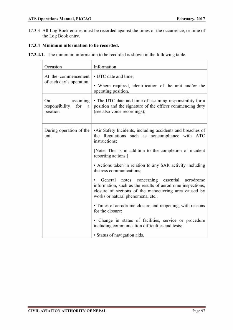
ATS Operations Manual, PKCAO February, 2017
CIVIL AVIATION AUTHORITY OF NEPAL Page 97
17.3.3 All Log Book entries must be recorded against the times of the occurrence, or time of the Log Book entry.
17.3.4 Minimum information to be recorded.
17.3.4.1. The minimum information to be recorded is shown in the following table.
Occasion Information
At the commencement of each day’s operation
• UTC date and time;
• Where required, identification of the unit and/or the operating position.
On assuming responsibility for a position
• The UTC date and time of assuming responsibility for a position and the signature of the officer commencing duty (see also voice recordings);
During operation of the unit
•Air Safety Incidents, including accidents and breaches of the Regulations such as noncompliance with ATC instructions;
[Note: This is in addition to the completion of incident reporting actions.]
• Actions taken in relation to any SAR activity including distress communications;
• General notes concerning essential aerodrome information, such as the results of aerodrome inspections, closure of sections of the manoeuvring area caused by works or natural phenomena, etc.;
• Times of aerodrome closure and reopening, with reasons for the closure;
• Change in status of facilities, service or procedure including communication difficulties and tests;
• Status of navigation aids.

ATS Operations Manual, PKCAO February, 2017
CIVIL AVIATION AUTHORITY OF NEPAL Page 98
CHAPTER 18
18.1 AERODROME DIMENSIONS AND RELATEDINFORMATION
VNPK AD 18.1.1 AERODROME LOCATION INDICATORS AND NAMEVNPK –
POKHARA /Domestic
VNPK AD 18.1.2 AERODROME GEOGRAPHICAL ANDADMINISTRATIVE DATA
1. ARP Coordinates and site at AD 28 12 00 N 083 58 54 E *
2. Direction and Distance from Adjoining to the South of the City (city)
3. Elevation/Reference Temperature 822m /2696 ft., 35°C (June)
4. MAG VAR/Annual Change 0 ° E
5. AD Administration, address Civil Aviation Authority of Nepal Telephone, Telefax, Telex AFS Pokhara Airport , Kaski
Te1- 977-061-465725, 535725
Fax - 977-061-465725
AFS – VNPKYDYX
6. Types of traffic permitted VFR (IFR/VFR)
7. Remarks -
VNPK AD 18.1.3 OPERATIONAL HOURS
1. AD Administration SUN-THU 10:00 -17:00 LT (SUMMER), 10:00-1600 LT (WINTER),
FRI 10:00-1500 LT
2. Customs and immigration NIL
3. Health and sanitation NIL
4. AIS Briefing Office AS ATS
5. ATS Reporting Office (ARO) AS ATS
6. MET Briefing Hourly METAR provided during Operation Hours
7. ATS Jan, Feb, Nov, Dec 0100-1215 UTC Mar, Apr, Sept, Oct 0030-1245 UTC May, June, July, Aug 0015-1300 UTC
** 8. Fuelling Jet A1 during Operation Hours
9. Handling (Cargo) NIL
10. Security H-24
11. Remarks Any change will be notified by NOTAM
* WGS 84 Coordinates
** For operations other than above, Prior Co-ordination is required

ATS Operations Manual, PKCAO February, 2017
CIVIL AVIATION AUTHORITY OF NEPAL Page 99
VNPK AD 18.1.4 RESCUE AND FIRE FIGHTING SERVICE
1. AD Category for firefighting (V) Category V RFF service available
2. Rescue equipment Available as per category
3. Capability for removal of NIL disabled aircraft
4. Remarks -
VNPK AD 18.1.5 SEASONAL AVAILABILITY
Aerodrome is available throughout the year.
VNPK AD 18.1.6 APRONS, TAXIWAYS AND CHECK LOCATION DATA 1. Apron surface and strength Surface - Asphalt Concrete,
Strength - …
2. Taxiwaywidth, surface and Width - 23 m, Surface – Bitumen,
Strength Strength - …
2.1 Loop Taxiway -Designation C and D
3. ACL location and elevation
Location: - At Apron
Elevation :- 2723 ft.
4. VOR/INS checkpoints --
5. Remarks Isolated parking 65× 60m Gravel, ATR 42 Type
VNPK AD 18.1.7 SURFACE MOVEMENT GUIDANCE AND CONTROLSYSTEM AND
MARKINGS
1. Use of aircraft stand ID signs, Taxiing guidance signs at intersections with TWY
TWY guide lines and visual and RWY and at holding positions. Guide lines at
docking/parking guidance system apron.
of aircraft stands
2. RWY and TWY markings and RWY: 04/22, THR, TDZ, Center line, RWY
LGT edge marked.
TWY: Center line, holding positions at all
TWY/RWY intersections marked.
3. Stop bars ……
4. Remarks -

ATS Operations Manual, PKCAO February, 2017
CIVIL AVIATION AUTHORITY OF NEPAL Page 100
VNPK AD 18.1.8 AERODROME OBSTACLES
OBST ID/ Obstacle ELEV/HGT Markings/Type
Designation type Obst. Position * (mt) color Remarks
a b c d e f
VNPKOB001 Radio Nepal 28 13 15 N 968 /30 Marked/LGTD
Antenna 083 58 50 E
VNPK OB002 Hill top 28 14 23 N 1431/20 Marked
View TWR 084 00 39 E
VNPK OB003 Trees 28 09 55 N 1223/20 --
South west 083 57 41 E
VNPK AD 18.1.9 METEOROLOGICAL INFORMATION PROVIDED
1. Associated MET Office MET office, Pokhara Airport 2. Hours of service MET office outside hours As ATS 3. Office responsible for TAF preparation NIL
periods of validity 4. Type of landing forecast interval of issuance NIL 5. Briefing/Consultation provided METAR 6. Flight documentation language(s) used Charts or Tabular forms Text English 7. Charts and other information available for NIL
briefing or consultation 8. Supplementary equipment available for Self- briefing terminal
providing information 9. ATS units provided with information Pokhara TWR 10. Additional information (limitation of service, --
etc.)
* WGS 84 Coordinates
VNPK AD 18.1.10 RUNWAY PHYSICAL CHARACTERISTICS Strength(PCN)and THR elevation and Highest
Designation TRUE & Dimensions surface of RWY THR elevation of TDZ of Precision RWY NR MAG BRG of RWY (M) and SWY Coordinates APP RWY
1 2 3 4 5 6
04 040 1444 x 30 Bitumen 28 11 47 N* 810 m AMSL
083 58 37 E
22 220 1444 x 30 Bitumen 28 12 19 N* 822 m AMSL 083 59 08 E
SWY CWY Strip
Slope of Dimensions Dimensions Dimensions RWY-SWY (M) (M) (M) OFZ Remarks
7 8 9 10 11 12
………. ………. ………. .......... ………. ……….

ATS Operations Manual, PKCAO February, 2017
CIVIL AVIATION AUTHORITY OF NEPAL Page 101
VNPK AD 18.1.11 DECLARED DISTANCES TORA TODA ASDA LDA
RWY Designator (m) (m) (m) (m)
Remarks
1 2 3 4 5 6
04 1444 1444 1444 1444
22 1444 1444 1444 1444
VNPK AD 18.1.12 APPROACH AND RUNWAY LIGHTING
RWY Center
APCH
TD Line LGT
Z Length, RWY SWY
LGT LG spacing RWY edge End LGT LGT
type THR VASIS
T color, LGT LEN, color LEN
RWY LEN LGT LE INTST spacing color (M)
Designator INTST color PAPI N INTST color Remark
WBAR
s
1 2 3 4 5 6 7 8 9 10
04 NIL NIL NIL NIL NIL NIL NIL NIL
22 NIL NIL NIL NIL NIL NIL NIL NIL
* WGS 84 Coordinates
VNPK AD 18.1.13 OTHER LIGHTING, SECONDARY POWER SUPPLY
1. ABN /IBN Location, characteristics and ABN: at Tower Building, G ALTN with W
hours of operation EV 2 SEC/IBN: NIL
H12
2. LDI Location and LGT Anemometer NIL
Location and LGT
3. TWY edge and Centre line lighting Edge: All TWY
Centre Line: NIL
4. Secondary power supply / switch over Secondary power supply to all lighting at
Time AD
Switch over -time: manually
5. Remarks NIL
VNPK AD 18.1.14 HELICOPTER LANDING AREA
Not specified
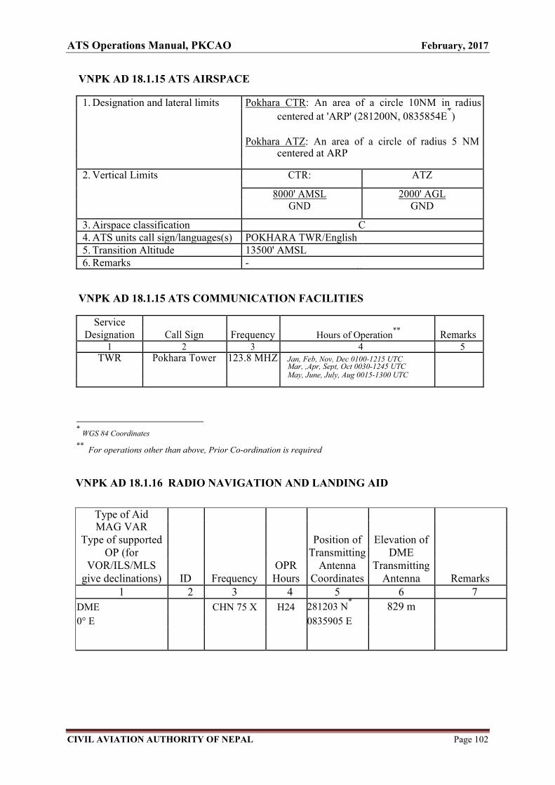
ATS Operations Manual, PKCAO February, 2017
CIVIL AVIATION AUTHORITY OF NEPAL Page 102
VNPK AD 18.1.15 ATS AIRSPACE
1. Designation and lateral limits Pokhara CTR: An area of a circle 10NM in radius
centered at 'ARP' (281200N, 0835854E*)
Pokhara ATZ: An area of a circle of radius 5 NM centered at ARP
2. Vertical Limits CTR: ATZ
8000' AMSL 2000' AGL GND GND
3. Airspace classification C 4. ATS units call sign/languages(s) POKHARA TWR/English 5. Transition Altitude 13500' AMSL
6. Remarks -
VNPK AD 18.1.15 ATS COMMUNICATION FACILITIES
Service Designation Call Sign Frequency Hours of Operation
** Remarks
1 2 3 4 5 TWR Pokhara Tower 123.8 MHZ Jan, Feb, Nov, Dec 0100-1215 UTC
Mar, ,Apr, Sept, Oct 0030-1245 UTC
May, June, July, Aug 0015-1300 UTC
* WGS 84 Coordinates
** For operations other than above, Prior Co-ordination is required
VNPK AD 18.1.16 RADIO NAVIGATION AND LANDING AID
Type of Aid MAG VAR
Type of supported Position of Elevation of OP (for Transmitting DME
VOR/ILS/MLS OPR Antenna Transmitting give declinations) ID Frequency Hours Coordinates Antenna Remarks
1 2 3 4 5 6 7
DME CHN 75 X H24 281203 N* 829 m
0° E 0835905 E

ATS Operations Manual, PKCAO February, 2017
CIVIL AVIATION AUTHORITY OF NEPAL Page 103
VNPK AD 18.1.17 LOCAL TRAFFIC REGULATIONS
BTN 0445-0945 Daily, Paragliding activities takes place at Sarangkot, Toripani, Mahendradhunga at Pokhara area. Pilots to exercise caution while flying over that area. Airspace: 7000 ft AMSL
GND
BTN 0415-1115 Daily, Paragliding activities takes place at Bandipur area, near W41 route (26 NM South East of Pokhara airport). Pilots to exercise caution while flying over that area. Airscpace: 5000 ft AMSL
GND
BTN 0015 - 1115 Daily, Ultra Light Training Flight zone has been established at 5.6 DME from Pokhara Airport at Laurek, Kaski District within 1NM circle From the mid point of Laurek Air Strip. Ultra light Training flight shall strictly remain to the west of HarpanKhola bridge to separate from the Paragliding Flights. Pilots to exercise caution while flying over that area. Airspace: 4500 ft AMSL
GND
Note.- Any changes will be notified by NOTAM `
* WGS 84 Coordinates

ATS Operations Manual, PKCAO February, 2017
CIVIL AVIATION AUTHORITY OF NEPAL Page 104
18.2 Access to the Aerodrome Movement Area
18.2.1 Purpose
The aim of these procedures is to assist the safety of aircraft operations by only
permitting access onto the movement area to authorized persons, vehicles,
equipment, plant or animals.
18.2.2 Responsibilities
The AirportDirector has overall responsibility for ensuring that procedures are
established and resources are provided for aviation security and for the control of
airside access to the airport.
Pokhara Control Tower has the responsibility for control of vehicles on the
maneuvering area. No person or vehicle may enter this area without ATC approval.

ATS Operations Manual, PKCAO February, 2017
CIVIL AVIATION AUTHORITY OF NEPAL Page 105
CHAPTER 19
19. EMERGENCY PROCEDURE
19.1 AIRCRAFT EMERGENCIES
19.1.1. INTRODUCTION
19.1.1.1. The circumstances of each aircraft emergency can vary to such an extent that
detailed instructions cannot be given for every situation. The procedures outlined
in this section are intended as a general guide and controllers must use their own
judgment when handling a particular emergency.
19.1.1.2. The procedures described in the preceding sections and the appropriate standard
phraseology may also be varied to meet an emergency situation but any reduction
in separation, necessary to cope with the emergency, should be restored as soon as
possible. Special arrangements, made locally for handling aircraft emergencies, are
detailed in DAEP of concerned airport.
19.1.2. Controller's Responsibility
19.1.2.1. Controllers must always be alert to the possibility of an aircraft emergency. Speed
may be necessary in certain circumstances but calm co-ordinated actions are
essential in all situations.
19.1.2.2. Controllers shall offer as much assistance as possible to any aircraft that is
considered to be in an emergency situation. Assistance to the aircraft can include
the provision of information on the availability of aerodromes and their associated
approach aids, weather information and details of terrain clearance. An emergency
may require alerting action to be taken immediately or it may develop to that point
later.
19.1.2.3. The supervisor, if available, should be informed as soon as practicable and where
more than one ATSU is involved complete co-ordination must be maintained
between units.
19.1.3. Recognizing an Emergency Situation
19.1.3.1. A controller may suspect that an aircraft is in an emergency situation or has
suffered unlawful interference when:
a) radio contact is not established at the time it is expected to be established;

ATS Operations Manual, PKCAO February, 2017
CIVIL AVIATION AUTHORITY OF NEPAL Page 106
b) radio contact is lost;
c) a pilot makes a report about the malfunctioning of his aircraft or the unusual
behaviour of persons on-board;
d) the erratic behaviour of an aircraft or position symbol is observed;
e) it is overdue at an aerodrome; or
f) the pilot reports that the aircraft is short of fuel.
19.1.3.2. If the controller is in radio contact with the aircraft he should ask the pilot if he
wishes to declare an emergency and, if not specified by the pilot, the class of
emergency being declared.
19.1.3.3. More positive indications that an aircraft is in an emergency are described in the
following paragraphs.
19.1.4. Distress and Urgency Messages
19.1.4.1. Pilots have been advised that, in the event of an emergency situation, an ATSU can
only provide the necessary priority and handling if the controller is made aware of
the emergency by the crew’s formal declaration on the RTF. Pilots have also been
advised that the extent to which an ATSU will be able to offer assistance will
depend on the amount of information provided and on its being transmitted at the
earliest opportunity. Furthermore, it is preferable that if pilots believe that they are
facing an emergency situation, to declare it as early as possible and cancel it later if
they decide that the situation allows.
19.1.4.2. There are two classes of emergency message:
Distress: A condition of being threatened by serious and/or imminent danger
and of requiring immediate assistance.
Urgency: A condition concerning the safety of an aircraft or other vehicle, or of
some person on board or within sight, but which does not require immediate
assistance.
19.1.4.3. The message will contain as many as possible of the following items:
MAYDAY, MAYDAY, MAYDAY (for distress messages) or
PAN PAN, PAN PAN, PAN PAN (for urgency messages) and
Name of the station addressed (time and circumstances permitting)
Identification of the aircraft

ATS Operations Manual, PKCAO February, 2017
CIVIL AVIATION AUTHORITY OF NEPAL Page 107
Nature of the emergency
Intention of the pilot in command
Present position, level and heading
Qualification of the pilot (e.g. student, full instrument rated, etc)
As much other information as time permits.
19.1.4.4. When a pilot has given certain items of information normally associated with an
emergency message but has not prefixed the transmission with 'MAYDAY' or
'PAN', the controller is to ask the pilot if he wishes to declare an emergency. If the
pilot declines to do so, the controller may, if he thinks it appropriate, carry out the
necessary actions as if the pilot had declared an emergency.
19.1.4.5. If a controller considers that another ATSU may be able to give more assistance
and, in the circumstances, it is reasonable to do so, the pilot should be asked to
change frequency.
19.1.5. ACTION ON RECEIVING URGENCY CALLS
The controller shall take the following action at an aerodrome on receiving an urgency call:
a) If the pilot elects to land at the aerodrome receiving the call. Rearrange traffic as
necessary to enable him to make an uninterrupted approach;
b) alert local safety services, and initiate local emergency action as necessary and
appropriate;
c) Inform the Kathmandu ACC giving full details;
d) If any doubt exists that the aircraft can reach an aerodrome, request Kathmandu, ACC
to alert RCC stating that the Alert phase exists;
e) Inform the aircraft's owners or representatives if possible.
19.1.6. ACTION ON RECEIVING DISTRESS CALLS
a) The controllers shall take the following action at an aerodrome on receiving a
Distress Call;
b) Plot aircraft's position on map;'
c) Assist pilot in every way possible to make a safe landing;
d) Advise pilot of nearest aerodrome if aircraft position is known;

ATS Operations Manual, PKCAO February, 2017
CIVIL AVIATION AUTHORITY OF NEPAL Page 108
e) Inform the Kathmandu ACC/Radio giving full details (ACC/Radio will alert
RCC) and give all possible assistance in warning airfields adjacent to the aircraft
track and in warning the local rescue services in the area in which the aircraft
may crash-land.
f) Alert aerodrome and local safety services;
g) Inform aircraft's owner or representative if possible.
19.1.7. Emergency Aircraft – Selection of Controlling Agency
19.1.7.1. Transfer of Control
On receipt of information that indicates that an aircraft is in an emergency, the
controller must decide whether or not to transfer the aircraft to another agency.
The choice of agency will depend upon the circumstances and no hard and fast
rules apply. The following guidance material will help controllers to make this
decision.
19.1.7.2. Retaining Control
19.1.7.2.1. If the controller can offer immediate assistance the aircraft should normally be
retained on the frequency. If necessary, impose a radio silence on other aircraft or
transfer them to another frequency.
19.1.7.2.2. Alternatively it may be more expedient to transfer the emergency aircraft to a
discrete frequency, particularly if a radio silence would endanger other traffic.
19.1.7.2.3. The aircraft should be retained on the original frequency if it is unreasonable to
ask the pilot, or if he is not prepared, to change frequency. The controller may be
able to relay instructions and information from other units to the pilot.
19.1.7.3. Transferring Control
19.1.7.3.1. If a controller considers that another unit may be able to give more assistance than
he can himself and in the circumstances it is reasonable to ask the pilot to change
frequency, he shall either:
a) consult the ACC supervisor and transfer the aircraft according to his
instructions; or
b) alert the nearest suitable unit and transfer the aircraft to a common
frequency, giving assistance to that unit as required.

ATS Operations Manual, PKCAO February, 2017
CIVIL AVIATION AUTHORITY OF NEPAL Page 109
19.1.7.3.2. Before transferring aircraft, controllers should obtain sufficient information from
the pilot to be convinced that the aircraft will receive more assistance from
another unit. If a change of frequency is desirable the pilot must be instructed to
revert immediately if there is no reply on the new frequency. Controllers should
then listen out on the original frequency until the aircraft is known to be in two-
way communication with the other unit.
19.2. Overdue Aircraft
19.2.1. Introduction
19.2.1.1. Overdue action should not be considered in isolation and the emergency actions
described in other chapters, in particular radio failure procedures should be applied
if they are appropriate. For example, if a radio equipped aircraft fails to make an
expected report, continued attempts should be made to re-establish communication
while at the same time commencing overdue action.
19.2.1.2. Overdue action is not related solely to the filing of a flight plan. If, at any stage of a
flight the pilot has made his intentions clear and subsequently does not arrive or
report when expected, controllers should seriously consider taking overdue action.
19.2.2. Radio Equipped Aircraft – Preliminary Action
If an aircraft fails to make a position report when expected, the following
preliminary action shall be commenced not later than the estimated time for the
reporting point plus 30 minutes:
• Advise the ACC supervisor that the aircraft is overdue;
• Confirm ATD from departure aerodrome by quickest possible means;
• Ensure that an RQS message is sent.
19.2.3. Radio Equipped Aircraft – Full Overdue Action
If, after the action above, no news is received or 1 hour has elapsed since a scheduled
position report should have been received, or the fuel carried by the aircraft is considered to
be exhausted, whichever is the sooner; the controller at the destination aerodrome shall
inform the ACC supervisor that the aircraft is fully overdue.
ATS Operations Manual, PKCAO February, 2017
CIVIL AVIATION AUTHORITY OF NEPAL Page 110
19.2.4. Non-Appearance of Aircraft
19.2.4.1. If an aircraft, which has been cleared to commence approach, after completing
any necessary holding fails to land within 5 minutes of the estimated time of
landing and communication cannot be established, the following action shall
be taken:
• Alert Approach Radar Control where available;
• Request other aircraft flying in the vicinity of the aircraft’s last known
position to be on the lookout;
• Exercise caution when authorizing the movement of aerodrome traffic;
• Alert the emergency services in accordance with AEP;
• Check with other aerodromes in vicinity;
• Advise the ACC supervisor.
19.2.4.2. Alerting service shall be provided:
a) for all aircraft provided with air traffic control service;
b) in so far as practicable, to all other aircraft having filed a flight plan or
otherwise known to the air traffic services; and
c) to any aircraft known or believed to be the subject of unlawful
interference.
19.2.4.3. Kathmandu Area control centres shall serve as the central point for collecting
all information relevant to a state of emergency of an aircraft operating within
the flight information region or control area concerned and for forwarding
such information to the appropriate Rescue coordination centre.
19.2.4.4. In the event of a state of emergency arising to an aircraft while it is under the
control of an aerodrome control tower or approach control unit, such unit shall
notify immediately the concerned Area control centre responsible which shall
in turn notify the Rescue coordination centre, except that notification of the
area control centre,, or rescue coordination centre shall not be required when
the nature of the emergency is such that the notification would be superfluous.

ATS Operations Manual, PKCAO February, 2017
CIVIL AVIATION AUTHORITY OF NEPAL Page 111
19.2.4.4.1. Nevertheless, whenever the urgency of the situation so requires, the aerodrome
control tower or approach control unit responsible shall first alert and take
other necessary steps to set in motion all appropriate local rescue and
emergency organizations which can give the immediate assistance required.
19.2.5. Notification of Rescue Coordination Centre
19.2.5.1. Without prejudice to any other circumstances that may render such
notification advisable, air traffic services units shall, except as prescribed in
15.2.8.1, notify rescue coordination centres immediately an aircraft is
considered to be in a state of emergency in accordance with the following:
a) Uncertainty phase when:
1. no communication has been received from an aircraft within a period of thirty minutes
after the time a communication should have been received, or from the time an
unsuccessful attempt to establish communication with such aircraft was first made,
whichever is the earlier, or when
2. an aircraft fails to arrive within thirty minutes of the estimated time of arrival last
notified to or estimated by air traffic services units, whichever is the later, except
when no doubt exists as to the safety of the aircraft and its occupants.
b) Alert phase when:
1. following the uncertainty phase, subsequent attempts to establish communication with
the aircraft or inquiries to other relevant sources have failed to reveal any news of the
aircraft, or when
2. an aircraft has been cleared to land and fails to land within five minutes of the
estimated time of landing and communication has not been re-established with the
aircraft, or when
3. information has been received which indicates that the operating efficiency of the
aircraft has been impaired, but not to the extent that a forced landing is likely, except
when evidence exists that would allay apprehension as to the safety of the aircraft and
its occupants, or when
4. an aircraft is known or believed to be the subject of unlawful interference.
c) Distress phase when:
1. following the alert phase, further unsuccessful attempts to establish communication
with the aircraft and more widespread unsuccessful inquiries point to the probability
that the aircraft is in distress, or when

ATS Operations Manual, PKCAO February, 2017
CIVIL AVIATION AUTHORITY OF NEPAL Page 112
2. the fuel on board is considered to be exhausted, or to be insufficient to enable the
aircraft to reach safety, or when
3. information is received which indicates that the operating efficiency of the aircraft has
been impaired to the extent that a forced landing is likely, or when
4. information is received or it is reasonably certain that the aircraft is about to make or
has made a forced landing, except when there is reasonable certainty that the aircraft
and its occupants are not threatened by grave and imminent danger and do not require
immediate assistance.
19.2.5.2. The notification shall contain such of the following information as is available
in the order listed:
a) INCERFA, ALERFA or DETRESFA, as appropriate to the phase of
the emergency;
b) agency and person calling;
c) nature of the emergency;
d) significant information from the flight plan;
e) unit which made last contact, time and means used;
f) last position report and how determined;
g) colour and distinctive marks of aircraft;
h) dangerous goods carried as cargo;
i) any action taken by reporting office; and
j) other pertinent remarks.
19.2.5.2.1. Such part of the information specified in 19.2.5.2, which is not available at the
time notification is made to a rescue coordination centre, should be sought by
an air traffic services unit prior to the declaration of a distress phase, if there is
reasonable certainty that this phase will eventuate.
19.2.5.2.2. Further to the notification in 19.2.5.1, the rescue coordination centre shall,
without delay, be furnished with:
a) any useful additional information, especially on the development of the
state of emergency through subsequent phases; or
b) information that the emergency situation no longer exists.
Note. — The cancellation of action initiated by the rescue coordination centre
is the responsibility of that centre.

ATS Operations Manual, PKCAO February, 2017
CIVIL AVIATION AUTHORITY OF NEPAL Page 113
19.2.6. Use of communication facilities
Air traffic services units shall, as necessary, use all available communication facilities to
endeavor to establish and maintain communication with an aircraft in a state of emergency,
and to request news of the aircraft.
19.2.7. Plotting aircraft in a state of emergency
When a state of emergency is considered to exist, the flight of the aircraft involved shall be
plotted on a chart in order to determine the probable future position of the aircraft and its
maximum range of action from its last known position. The flights of other aircraft known
to be operating in the vicinity of the aircraft involved shall also be plotted in order to
determine their probable future positions and maximum endurance.
19.2.8. Information to the operator
19.2.8.1. When an area control decides that an aircraft is in the uncertainty or the alert
phase, it shall, when practicable, advise the operator prior to notifying the rescue
coordination centre.
Note.— If an aircraft is in the distress phase, the rescue coordination centre has to be
notified immediately in accordance with 15.2.5.1.
19.2.8.2. All information notified to the rescue coordination centre by an area control
shall, whenever practicable, also be communicated, without delay, to the
operator.
19.2.9. Information to aircraft operating in the vicinity of an aircraft in a state of
emergency
19.2.9.1.1. When it has been established by an air traffic services unit that an aircraft is in
a state of emergency, other aircraft known to be in the vicinity of the aircraft
involved shall, except as provided in 15.2.9.2, be informed of the nature of
the emergency as soon as practicable.
19.2.9.1.2. When an air traffic services unit knows or believes that an aircraft is being
subjected to unlawful interference, no reference shall be made in ATS air-
ground communications to the nature of the emergency unless it has first been
referred to in communications from the aircraft involved and it is certain that
such reference will not aggravate the situation.
ATS Operations Manual, PKCAO February, 2017
CIVIL AVIATION AUTHORITY OF NEPAL Page 114
19.3. CLASSIFICATION OF EMERGENCIES
Aircraft emergencies are classified into ten categories as follows:
19.3.1. "ALERT 1" - AIRCRAFT ACCIDENT (on-airport)
When an aircraft accident has occurred on the airport or in the immediate vicinity of
the airport (within 4 kilometers of the airport boundary).
19.3.2. "ALERT 2" - AIRCRAFT ACCIDENT (off-airport)
When an aircraft accident has occurred - but not in the immediate vicinity of the
Airport (more than 4 kilometers from the airport boundary).
19.3.3. "ALERT 3 " - FULL EMERGENCY (Airborne Aircraft)
When an aircraft approaching the airport has declared an emergency if it is known to
have problem or defect which will cause or is likely to cause an aircraft accident.
19.3.4. "ALERT 4" - UNLAWFUL INTERFERENCE
When it is known or suspected that an aircraft has been subjected to a threat of
sabotage or unlawful seizure (hi-jacking) - or any act has been committed which
would affect the normal operation of that aircraft or safety of its occupants.
19.3.5. "ALERT 5" - BOMB THREAT - TO AIRCRAFT
When information is received that an explosive device has been located (or suspected)
on an aircraft either in the air or on the ground.
19.3.6. "ALERT 6" - BOB THREAT - TO BUILDING
When information is received that an explosive device has been located (or suspected)
in, or around, airport building, facilities or equipment.
19.3.7. "ALERT 7" -AIRCRAFT GROUND INCIDENT
When an incident occurs involving an aircraft on the ground which will affect the
safety of that aircraft.
19.3.8. "ALERT 8"- STRUCTURAL FIRE
When a fire occurs on the airport buildings, facilities, equipment or vehicles, and
which does not directly involve an aircraft. Fires in Navigational or other auxiliary
service station or complex or facilities located off-airport are also included in this
category.

ATS Operations Manual, PKCAO February, 2017
CIVIL AVIATION AUTHORITY OF NEPAL Page 115
19.3.9. "ALERT 9" - LOCAL STANDBY
When an aircraft approaching the airport has developed - or suspected to have
developed – some defect, but this defect should not create any difficulty in effecting a
safe landing. Crash vehicles may standby in the station, or at position on the
movement area, as the situation warrants.
19.3.10. "ALERT 10" - WEATHER STANDBY
When severe storms or other expected adverse weather conditions can affect the
safety of aircraft, or adversely affect the safety of persons, buildings, facilities, or
equipment at the Airport.
NOTE: The above classification - by ALERT number - shall be used for initial
notification of emergency situations. If the emergency condition changes, complete
additional notifications must be made for the new condition - Example: an Alert 9
(Local Standby) may escalate to an alert 3 (Full Emergency) condition.
19.4. Some major aircraft emergencies:
1) Pressurization Failure
2) Unlawful Interference – aircraft hijack
3) Brake Problem
4) Communication Failure
5) Hydraulic Failure
6) Engine Failure
7) Bird Strike
8) Fuel Dumping
9) Landing Gear Problem
10) Urgency Message
19.4.1. Pressurization Failure
(a) General
i) Pressurization problem may arise due to the result of one or more of the
following:
a. malfunction of pressurization system

ATS Operations Manual, PKCAO February, 2017
CIVIL AVIATION AUTHORITY OF NEPAL Page 116
b. damage to a door or window
c. physical leak in the system
ii) Depressurization may cause severe medical problems for crews as well as
passengers with heart or respiratory disease.
iii) The time of useful consciousness is very short and can vary depending on:
a. the altitude
b. the size of the leak
c. the size of the fuselage
iv) Rate of descent could be very high.
(b) Effects/Consequences will be as follows:
i) Loss of oxygen, loosing consciousness, ultimately hypoxia
ii) Increased gas pressure in the human body
iii) Temperature drop
iv) Wind sucks items towards the hole
v) Acft will stop climb
vi) Request for immediate descent
vii) Emergency descent without warning
viii) Turn off track
ix) Poor R/T quality (as pilot using cabin oxygen mask)
x) Chances of separation infringement
(c) ATC shall act in the following manner
i) Assist the pilots as follows:
a. Acknowledge
b. Separate
c. Silence
d. Inform

ATS Operations Manual, PKCAO February, 2017
CIVIL AVIATION AUTHORITY OF NEPAL Page 117
e. Support
f. Time
ii) Broadcast of emergency descent.
iii) Clear the airspace directly beneath the aircraft.
iv) Inform supervisor/shift-in-charge
v) Inform pilot about MEA or MSA if needed.
(d) Phraseology
(i)When pilot has sufficient time
9NAAA CONTROL, 9NAAA MAINTAINING FL250 REQ EMERGENCY
DESCENT TO 12500' DUE PRESSURIZATION FAILURE
ACC 9NAAA DESCEND TO 12500' [QNH -------] REPORT REACHING
(ii)When pilot doesn't have sufficient time
9NAAA CONTROL, 9NAAA POSITION SMR EMERGENCY DESCENT TO
11500' DUE DECOMPRESSION NOW PASSING FL150 TURNING
TO THE RIGHT [or LEFT] OF TRACK
ACC 9NAAA [QNH -------] REPORT REACHING 11500'
(iii)ATC phraseology with other aircraft
ACC ATTENTION ALL AIRCRAFT IN THE VICINITY OF [or AT] ------
--- (significant point or location) EMERGENCY DESCENT IN
PROGRESS FROM -------- (level) TO 11500' ALL AIRCRAFT
BELOW -------- (level) AND ABOVE 11500' LEAVE THE FLIGHT
PATH [or AIRSPACE] IMMEDIATELY AND ACKNOWLEDGE.
19.4.2. Unlawful Interference – aircraft hijack
(a) Air Traffic Controllers should remember the following during an
aircraft hijack:
i) Countermeasures against hijacking in the aircraft are limited.
ii) Concentrated calmness of crew and ATC is necessary to avoid
additional risk and provocation to hijackers.
iii) Planning for all eventualities by ATC is an important task.

ATS Operations Manual, PKCAO February, 2017
CIVIL AVIATION AUTHORITY OF NEPAL Page 118
iv) Acquire permission from central security committee through command
post to allow the aircraft to enter into Kathmandu FIR or land at
Nepalese aerodrome.
(b) Effects and consequences of a hijack could be as follows:
i) Crew under high stress
ii) Every possible dangerous situation apparent to aircraft and its
occupants
iii) R/T problem, crew may communicate in code
iv) May squawk 7500 in radar environment
v) Non-compliance with ATC instructions
(c) ATC responsibility will be to assist as follows:
i) Do not initiate any further RTF unless confirmed by pilot.
ii) If 7500 code observed in radar, check transponder setting with
phraseology "CONFIRM SQUAWKING 7500"-- no reply here shall
also considered as aircraft is hijacked.
iii) Immediately after it is confirmed that aircraft is hijacked, inform it to
supervisor/shift-in-charge/chief ATC and proceed as per local
procedure.
iv) Convey the message of designated authority to hijacker, and vice-
versa.
v) Comply with pilot's request as for as possible.
vi) Transmit pertinent information without expecting a reply.
vii) Monitor and plot all flight manoeuvres and coordinate transfer of
control without requiring the response from the aircraft.
viii) Collect any necessary information e.g. Destination aerodrome, WX
situation at destination, routing, etc.
ix) If aircraft lands, direct it to the specified isolated parking position or to
the location as designated by command post.

ATS Operations Manual, PKCAO February, 2017
CIVIL AVIATION AUTHORITY OF NEPAL Page 119
(d) Brakes Problem
Following factors should be kept in mind during brakes problem in aircraft.
(a) Air Traffic controllers should remember that:
i) Hydraulic failure may cause problems with brakes.
ii) Aircraft with brakes problem doesn't get priority unless it commences
approach.
(b) Some possible effects and consequences are as follows:
i) Overrunning RWY threshold. Landing distance may increase by up to
approximately 50%.
ii) Increase the probability of tyre-brust.
iii) Aircraft may swerve off RWY.
iv) Chances of RWY blockage.
v) Following traffic may not land and chances of diversion.
vi) Priority could be given to following traffic.
(c) ATC responsibility will be to assist, such as;
i) Inform supervisor/shift-incharge.
ii) Keep airport fire on alert position.
iii) Inform pilot about the RWY length/condition.
iv) Keep runway strip and associated area clear.
v) Check for towing vehicle stand-by.
vi) Check if technical personnel required.
(d) Phraseology
9NAHY, 9NAHY DIVERTING TO KATHMANDU DUE BRAKE
PROBLEM WILL HOLD INITIALLY OVER NOPEN FOR
THE INSTRUMENT CHECK
APP 9NAHY CLEARED TO NOPEN VIA 20DME ARC
DESCEND TO ------- (level) REPORT WHEN READY TO
COMMENCE APPROACH.

ATS Operations Manual, PKCAO February, 2017
CIVIL AVIATION AUTHORITY OF NEPAL Page 120
(Initially clear the other succeeding aircraft below it for the approach then ask
its intention; and decide the further priority.)
(If aircraft ready to commence approach)
APP 9NAHY DO YOU NEED ANY GROUND ASSISTANCE ?
19.4.3. Communication Failure
(a) Introduction
i) Communication failure may be due to the result of either
electrical/electronic and hardware problems.
ii) Causes of communication failure may be simple (i.e. earphone
and microphone problems) or complex (i.e. broken wire, power
failure and malfunctioning radio).
iii) Communication problems may originate with Pilots or ATCs.
iv) Communication failure in one of the following cases:
v) receiver failure
vi) transmitter failure
vii) total failure
viii) An aircraft is considered to have a radio communication failure if
a message is missing for a period of 5 minutes or more.
ix) Recognize that this is considered to be an emergency, andwith
urgency, try to find out the cause of the emergency.
(b)Effects and consequences of communication failure
Pilots' action (VMC):
o Continue fly in VMC.
o Land at the nearest suitable aerodrome, and
o Report its arrival by the most expeditious means to
appropriate ATC unit.
(c) ATC responsibility will be to assist in following manner:
i) Inform supervisor/shift-in-charge.

ATS Operations Manual, PKCAO February, 2017
CIVIL AVIATION AUTHORITY OF NEPAL Page 121
ii) Serial ATC actions:
iii) Separate RCF aircraft with other aircraft.
iv) Transmit blind the pertinent information on the available frequencies.
v) Other aircraft in the vicinity are to be informed about the RCF aircraft, and
requested to establish two way communications with the aircraft.
vi) Inform all ATS units concerned along the route of the flight and are
requested to attempt to establish communication with the aircraft.
vii) Inform all alternate aerodromes about possible diversion of the RCF
aircraft.
viii) By agreement with operator, when weather at intended aerodrome is bad,
transmit blind clearing the aircraft to suitable alternate aerodrome.
ix) If communication re-established or aircraft has landed, inform all
previously notified regarding termination of RCF situation.
x) If aircraft unable to land within 30 minutes of ETA or EAT whichever is
later, after prior consultation with airline operators or their designated
representative and PIC of other aircraft, normal control can be resumed if
they desire.
(d) Phraseology
ATC RNA203 DO YOU READ ME
RNA203 (no response)
ATC RNA203 IF YOU READ ME (any suitable instruction or
information considering that aircraft receiver operating
normal.)
19.4.4. Hydraulic Failure
(a) General
i) Hydraulic system is usually distributed throughout the aircraft body and
affects multiple systems.
ii) Hydraulic system may be affected by technical problems or outside
damage.

ATS Operations Manual, PKCAO February, 2017
CIVIL AVIATION AUTHORITY OF NEPAL Page 122
iii) Problems with hydraulics may affect various parts of the aircraft resulting
in complete or partial failure of flaps, ailerons, elevators, rudder, lift and
roll spoilers, brakes and nose wheel steering.
iv) Any or all of these may lead to control difficulties.
v) Hydraulic problems may lead to:
o Fuel Dumping
o Gear Problems
o Brake Problems
vi) Relatively High-speed Approach and Landing
vii) The crew needs time to check alternate systems and all other related
functions.
viii) The crew may also need more time for actions such as manual gear
extension.

ATS Operations Manual, PKCAO February, 2017
CIVIL AVIATION AUTHORITY OF NEPAL Page 123
(b) Effects and Consequences of hydraulic failure are as follows:
i) Problems with aircraft control and limited maneuverability (bank
angle/turns).
ii) Limited or no flap setting
iii) Limited bank angle (15 degrees)
iv) Manual gear extension (no retraction possible)
v) Holding pattern for necessary checks (may need extended hold due to lack of
maneuverability)
vi) Extended final
vii) Higher approach speed on final
viii) Limited braking capability
ix) Possible overrun
x) RWY blocked after landing
(c) ATC responsibility should be to assist as follows:
i) Inform supervisor/ shift- in-charge.
ii) Keep airport fire on alert position.
iii) Increase vertical and lateral separation.
iv) Ask if dangerous goods on board.
v) Ask for POB and FOB if feasible.
vi) Avoid ATC-caused GO AROUND.
vii) Clear RWY according to local instructions.
viii) Keep runway strip and associated area clear.
ix) Towing equipment and other emergency vehicles on stand-by as appropriate.
x) If needed, inform pilot about:
xi) Next suitable aerodrome
xii) Aerodrome details as soon as possible

ATS Operations Manual, PKCAO February, 2017
CIVIL AVIATION AUTHORITY OF NEPAL Page 124
xiii) WX information of landing aerodrome
xiv) Fire or smoke from brakes
(d) Phraseology
BHA601 PK Tower, BHA601 WE HAVE GOT HYDRAULIC
PROBLEM REQUEST PRIORITY LANDING
PK Tower BHA601 YOU ARE NUMBER ONE IN APPROACH
SEQUENCE. DO YOU NEED ANY GROUND
ASSISTANCE?
19.4.5. Engine Failure
(a) General
i) Engine failure may be caused by:
1. hydraulic or electric problems
2. bird-strike
3. engine on fire
4. fuel problems
5. low oil pressure
6. icing
7. intake of debris, or
8. pilot error
ii) Loss of engine reduces its power and ability of normal flying.
iii) May result in:
1. abandoned take-off
2. pressurization problems
3. fuel dumping
4. precautionary approach
(b) Effects and consequences of engine failure are as follows:

ATS Operations Manual, PKCAO February, 2017
CIVIL AVIATION AUTHORITY OF NEPAL Page 125
i) Heavy workload in the cockpit
ii) Deviation from SID
iii) Descent
iv) Prefer flying straight and level and in a larger turning radius (especially in
multiple engine aircraft)
v) Course deviation
vi) Take-off abort
vii) Pressurization problems
viii) Fuel dumping
ix) Diversionary or forced landing
x) Blocked RWY after landing
(c) ATC responsibility are to assist as follows:
i) Inform supervisor/shift-in-charge.
ii) Keep airport fire on alert position.
iii) Request for POB and FOB if feasible.
iv) Inform landing aerodrome.
v) Clear RWY according to local procedures.
vi) Keep safety strip clear.
vii) Offer pilot extended final.
viii) Towing equipment and other emergency vehicles on stand-by as appropriate.
ix) Monitor and mark the aircraft position in radar environment.
x) In case of forced landing, record last known position and time for SAR
purposes.
xi) If needed, inform pilot about:
o next suitable aerodrome
o alternate aerodrome details ASAP
o WX information of landing aerodrome

ATS Operations Manual, PKCAO February, 2017
CIVIL AVIATION AUTHORITY OF NEPAL Page 126
(d) Phraseology
(i) Standard Phraseology
NYT 463 PK Tower, NYT463, RIGHT ENGINE ON FIRE
DECLARING FULL EMERGENCY REQUEST PRIORITY
LANDING
PK Tower NYT463 REQ FUEL REMAINING AND PERSON ON
BOARD
NYT463 --------- HOURS OF FUEL REMAINING AND ----- (no. of
persons) PERSONS ON BOARD
PK Tower NYT463 EMERGENCY SERVICES ALERTED ------- (other
pertinent instructions)
NYT463 MAYDAY, MAYDAY, MAYDAY. PK Tower, NYT463,
BOTH ENGINES FAILURE. 7 MILES ON APPROACH
PASSING 8000’FT
PK Tower NYT 463 PK Tower ROGER MAYDAY. WIND 022
DEGREES 10 KNOTS QNH ----- YOU ARE NUMBER ONE CLEARED TO
LAND.
PK Tower EMERGENCY TO ALL CONCERNED. EMERGENCY
(OtherA/C) EXIST AT POKHARA AIRPORT. DELAY NOT
DETERMINED DUE AIRCRAFT IN DISTRESS.
(ii) Imposition of radio silence during emergency
PK Tower ALL STATIONS POKHARA TOWER. STOP
TRANSMITTING, MAYDAY.
Other A/C 9NAGQ POKHARA TOWER. STOP TRANSMITTING,
MAYDAY.
(iii) Termination of radio silence
PK Tower ALL STATIONS,POKHARA TOWER, DISTRESS TRAFFIC
ENDED
19.4.6. Bird Strike
(a) General

ATS Operations Manual, PKCAO February, 2017
CIVIL AVIATION AUTHORITY OF NEPAL Page 127
i) Bird strike may result in:
1. Broken Windshield / Canopy
2. Engine Failure (Multi-engine)
3. Engine Failure (Single-engine)
4. Hydraulic Problems
5. Precautionary Approach
6. Handling Difficulties
7. Electrical Problems
8. Gear Problems
ii) The seriousness of this emergency depends on:
o Thesize of the bird
o Thespeed of the aircraft at impact
o where it hits the aircraft
iii) Its effects may be very severe.
iv) The most dangerous strikes are to the windshield and engine.
o A strike of this nature may lead to the ultimate loss of the aircraft.
v) Strikes especially on the windshield or on the engine may impair the flying
characteristics of the aircraft, making levels and headings difficult to
maintain and safe landings difficult. They may ultimately lead to loss of
control, or even structural failure.
vi) The likelihood of bird-strike varies depending on the level, the location and
the time of year.
vii) The greatest risk of bird-strike is at lower level with decreasing risk with
increasing level.
viii) The risk is also higher in spring and autumn.
ix) Highest risk over:
1. garbage dumps

ATS Operations Manual, PKCAO February, 2017
CIVIL AVIATION AUTHORITY OF NEPAL Page 128
2. rivers
3. breeding grounds
4. wintering places
(b) Effects and consequences of bird strike
i) Shutdown of engine
ii) Aborted take-off
iii) Immediate return to aerodrome
iv) Reduced/loss of visibility if windscreen broken
v) IFR operation (instrument flight rules)
vi) The pilot may have to land at the nearest suitable aerodrome
vii) Landing next suitable aerodrome
viii) Hydraulic problems
(c) ATC responsibility is to assist as follows:
i) Inform supervisor/shift-in-charge.
ii) Keep airport fire on alert position when required.
iii) Find out if the pilot can still control the aircraft. If control problem, allow
increased separation.
iv) Arrange technical assistance as necessary by appropriate specialists.
v) If aircraft intends to land at nearest suitable aerodrome, recommend it one
or more landing options with all the aerodrome details with weather details
ASAP.
vi) Allow a LONG FINAL if requested.
vii) Avoid chances of possible miss approach.
viii) Check RWY, if bird-strike is during or after take-off.
(d) Phraseology
9NABU PK TOWER9NABU DIVERTING TO POKHARA DUE
BIRD HIT AT RIGHT WING

ATS Operations Manual, PKCAO February, 2017
CIVIL AVIATION AUTHORITY OF NEPAL Page 129
ATC 9NABU DO YOU NEED ANY GROUND ASSISTANCE
9NABU RQ FIRE ON ST BY. AND ONE AMBULENCE ON
ARRIVAL
ATC (successive instructions as per the aircraft request)
19.4.7. Fuel Dumping
(a) General
i) In emergency, aircraft may need to dump fuel to reduce landing mass so as
to effect a safe landing.
ii) Avoid the crowded or congested area and the area where TS is reported or
expected.
iii) Dumping level should not be less than 1800 m (6000 ft).
(b) Effects and consequences of fuel dumping could be as follows:
i) Dumping at lower altitudes may create the chances of developing flammable
mist near the ground which may produce toxic effects to all human being,
animals and plants.
ii) Aircraft may dump fuel in emergency without adequate warning.
iii) Need of greater separation.
(c) ATC responsibility when emergency dumping will be to assist as follows:
i) Inform supervisor/ shift-in-charge.
ii) Recommend minimum altitude from which the fuel should be dumped.
iii) Advise most suitable airspace for fuel dumping.
iv) Make every effort to keep other aircraft clear of the vapor zone.
v) Separate other aircraft from it:
1. Horizontally by keeping them:
at least 10 nm beyond either sides.
at least 15 mins flying time or 50 nm beyond at back side.
2. Vertically by keeping them:
at least 1000 ft above.
at least 3000 ft below.

ATS Operations Manual, PKCAO February, 2017
CIVIL AVIATION AUTHORITY OF NEPAL Page 130
vi) In case of emergency fuel dumping, broadcast this warning information so
that other aircraft flying in the vicinity may avoid the affected airspace.
vii) Inform adjacent ATC units about fuel dump operation.
viii) Inform all previously notified if fuel dumping is complete.
(d) Phraseology for
(i) Non-emergency fuel dumping
BHA205 PK TOWER, BHA205, REQ FUEL DUMP ALONG W41
BETWEEN PHR AND DHORPATAN AT FL ------ (level).
PK Tower BHA205 OPERATE IN BETWEEN 10DME WEST OF PK
AND DR (or any suitable area, not crowded city or town area
and preferably over water) AT ---------- (level, not below 6000'
from GND).
(iii) Instruction to other aircraft
PK Tower ALL STATION THIS IS POKHARA TOWER, BA46
DUMPING FUEL --------------- (description of fuel dumping
area) AT -------- (level) AVIOD FLIGHT BETWEEN -------
(level) and -------- (level) WITHIN 50 MILES BEHIND, 10
MILES AHEAD OF AIRCRAFT AND WITHIN 10 MILES
TO THE SIDES OF FUEL DUMPING TRACK.
(iv) Fuel dumping outside controlled airspace
ATC ALL STATIONS THIS IS KATHMANDU -------- (name of
unit), FUEL DUMPING IN PROGRESS OVER --------
(description of dumping area) RECOMMEND REMAIN
CLEAR THIS AREA UNTIL ADVISED
(v) Completion of fuel dumping
PK TOWER ALL STATIONS THIS IS POKHARA TOWER, FUEL
DUMPING COMPLETED.
19.4.8. LANDING GEAR PROBLEM
(a) General
i) Gear extension problem, either partially or fully, is to be considered as an
emergency.

ATS Operations Manual, PKCAO February, 2017
CIVIL AVIATION AUTHORITY OF NEPAL Page 131
ii) The landing gear is held up by a hook system and when the hook is released
the gear falls down. A hydraulic or an electrical system supports this
movement.
iii) Mechanical or electrical malfunction may cause gear extension problem.
iv) When gear extension problem occurs, the pilot may ask for a low pass in
order to inspect the position of the landing gear visually by ATCs and
concerned technicians.
v) Foam carpeting over the runway is required to reduce the runway friction.
(b) Expectations and Consequences of landing gear problem
i) GO AROUND
ii) Low pass for gear check by ATCs and concerned technical experts.
iii) Request for foam carpet
iv) Possible fuel dumping to reduce aircraft weight
v) Manual gear extension
vi) RWY blocked after landing
vii) Skidding off RWY
viii) Taxiway may be blocked after clearing runway
(c) ATC responsibilities will be to assist as follows:
i) Inform supervisor/ shift-in-charge.
ii) Keep airport fire on alert position.
iii) Inform pilot about landing gears position by carefully observing low pass
manoeuvre, and seek specialists’ advice in this regard.
iv) Clear the runway strip and associated area clear.
v) Keep towing vehicle on stand-by position.
(d) Phraseology
BHA406 TWR BHA406, GOING AROUND DUE GEAR EXTENSION
PROBLEM

ATS Operations Manual, PKCAO February, 2017
CIVIL AVIATION AUTHORITY OF NEPAL Page 132
TWR BHA406 CARRY OUT STANDARD MISAPPROACH
CONTACT APP ON 120.6 [or --------- (any suitable
instruction)]
BHA406 APP BHA406 CARRYING OUT STANDARD
MISAPPROACH DUE GEAR EXTENSION PROBLEM
PASSING ------- (level) FOR -------- (level) WILL CHECK
THE PROBLEM OVER DHARKE
BHA406 APP BHA406, INBOUND TO DHARKE MAINTAINING
12500' UNABLE TO RECTIFY THE PROBLEM. WE ARE
VMC CANCELING IFR REQUEST LOW PASS FOR
VISUAL INSPECTION FROM TWR
(For low pass visibility should be preferably at least VMC.)
APP BHA406 CANCELLED IFR AT------- (time). DESCEND TO -
----- (level) CLEARED LOW PASS FOR VISUAL
INSPECTION REPORT 10 MILES
(Advise TWR about the intention of aircraft and get the
required clearance. TWR vacates the traffic circuits in order to
separate aircraft with landing gear extension problem.)
BHA406 TWR BHA406, PASSING LOW FROM YOUR ----------
(side/direction) CONFIRM LANDING GEARS DOWN
TWR BHA406, LANDING GEAR APPEARS DOWN
or
BHA406, RIGHT [or LEFT or NOSE] WHEEL APPEARS
DOWN [or UP]
or
BHA406, RIGHT [or LEFT or NOSE] WHEEL DOES NOT
APPEAR DOWN [or UP]
(If landing gears not extended or partially extended)
BHA406 APP BHA406, REQUIRE FUEL DUMP REQ INSTRUCTION

ATS Operations Manual, PKCAO February, 2017
CIVIL AVIATION AUTHORITY OF NEPAL Page 133
BHA406 APP BHA406, WILL MAKE BELLY LANDING REQ RWY
FOAMING FROM RWY TH --- TO TXY INTERSECTION --
---.
APP BHA406, RWY FOAMING COMPLETE FROM RWY TH ---
TO TXY INTERSECTION ------.
19.4.9. URGENCY MESSAGE
(a) General
i) An urgency message should contain as many of the following elements as for
as possible:
o Name of the station addressed
o Identification of the aircraft
o Nature of urgency
o Intention of PIC
o Position, level and heading of the aircraft in urgency, and
o Any other useful information.
ii) Urgency call should me made on the frequency in use at the time.
iii) Urgency message should be addressed to the station in shoes area of
responsibility the urgency aircraft is operating.
(B) PHRASEOLOGY
BHA409 PAN PAN, PAN PAN, PAN PAN CONTROL BHA409,
PASSENGER WITH SUSPECTED HEART ATTACK
REQUIRING IMMEDIATE MEDICAL ASSISTANCE,
REQUEST PRIORITY LANDING.
PK TWR BHA409 ROGER YOU ARE NUMBER ONE IN
APPROACH SEQUENCE AMBULANCE ALERTED
BHA401 PAN PAN, PAN PAN, PAN PANPK TWR BHA401
INTERCEPTED URGENCY CALL FROM 9NAEW
HAVING GEAR PROBLEM REQUESTING PRIORITY
LANDING. HER POSITION 13 MILES WEST AT 6500’.
PK TOWER BHA401 ROGER.
PK TWR 9NAEW PK TWR, WIND 250 DEGREES 5 KNOTS QNH ----
-- NO TRAFFIC.REPORT --------.

ATS Operations Manual, PKCAO February, 2017
CIVIL AVIATION AUTHORITY OF NEPAL Page 134
CHAPTER 20
ADMINISTRATIVE INSTRUCTIONS
Before proceeding with the actual work of ATC it is necessary to know the administrative procedures associated with the provision of ATC. When prior instructions have not been issued, the administrative rules included in this manual are applicable.
20.1 DUTIES AND RESPONSIBILITIES
20.1.1. UNIT INCHARGE TOWER CONTROLLER
The control tower Unit In-charge, shall be responsible for the safety and standard in the provision of Air Traffic Control by all the staffs of control tower. Following are the duties and responsibilities of Unit In-charge.
i) ATC services are conducted in accordance with ATS Operations Manual.
ii) All equipment and activities of the control tower are closely watched and the proficiency of personnel in their respective duties is assessed.
iii) The work- load is distributed evenly so that no one controller is over taxed at any time, however in doing this he should assign personnel to the positions of operation commensurate with the individual capabilities.
iv) All facility documents and fault reporting registers are up to date.
v) During the watch period notification of any fault is made to the concerned units for any necessary action.
vi) Any unusual circumstances are to be briefed to the Unit In-charge responsible for the next shift. This can be done either by face to face hand over or by making an entry in the appropriate logbook .
vii) The console is kept neat and unlittered at all times;
viii) Action to be taken to initiate any necessary NOTAMS.
ix) Sufficient staff is manned in the all ATC position as per the published roster. It is the duty of the Unit Incharge to notify the Shift-in–charge of any absences and to request extra or replacement staff in the event of sickness, emergency situations, etc;
x) Initiate action for search and rescue in accordance with prescribed procedure if required;
xi) Co-ordinate and cooperate with the concerned units as and when required for the efficient and smooth operation;
xii) Responsible for resolving any conflicts of opinion relating to aircraft safety or expedition of aircraft movement.

ATS Operations Manual, PKCAO February, 2017
CIVIL AVIATION AUTHORITY OF NEPAL Page 135
20.1.2. AERODROME CONTROLLER
Aerodrome Controller shall perform traffic separation and coordination tasks in accordance with the ATSOM and letters of agreement and instructions and in particular;
i) Ensure the safe, orderly and expeditious flow of air traffic in its area of jurisdiction;
ii) Maintain separation standards in respect of all aircraft operations;
iii) Integrate arriving aircraft into an orderly landing sequence;
iv) Exercise judgment in the provision of landing and take-off clearances to aircraft.
v) Exercise control of aircraft making missed approach.
vi) Close or reopen a runway, the airport or any specific approach landing area.
vii) Determine the use of sector weather observations to permit aircraft operations as applicable.
viii) Initiate search and rescue or airport emergency action in accordance with AEP;
20.1.3. TOWER FLIGHT DATA
Following are the duties and responsibilities of the Tower Flight Data ;
i) Collect flight data and post the information directly on the appropriate flight progress strips;
ii) Calculate estimates on each strip and to pass on to TWR Coordinator.
iii) Relay flight data to appropriate ATS Units;
iv) Assist the tower controllers as directed;
v) Bring to the attention of the tower controllers any significant irregularities encountered when processing flight data.
vi) To up-date the data in ATIS recorder and to control and monitor the ATIS transmission.
20.1.4. TOWER CORDINATION POSITION
Following are the duties and responsibilities of Tower Coordination Position
i) Coordinate airways clearances for departing aircraft.
ii) Coordinate with the approach controller the extent to which visual separation can be applied by the control tower.
iii) Coordinate with the aerodrome/approach controller the minimum time interval between landings;
ATS Operations Manual, PKCAO February, 2017
CIVIL AVIATION AUTHORITY OF NEPAL Page 136
iv) Coordinate the activities of the aerodrome control unit with technical maintenance authorities, emergency services and department officers.
v) Initiate search and rescue or airport emergency action in accordance with prescribed procedures.
vi) Coordinate with appropriate ATS units for exchange of operational datas.
vii) Coordinate in between SMC and ADC/APP controllers.
20.1.5. ON JOB TRAINING INSTRUCTOR (OJTI)
The OJTI is responsible for the quality of training undertaken at operational ATC units, for the initial rating of controllers and for ensuring that the provision of Air Traffic Control is delivered in a safe, efficient and standard manner. The detail duties are listed below:
a) The OJTI will train the OJT trainees, to the position for which they are to be rated.
b) Maintain a register of Trainees Roster and period of duty performed on job training for each position.
c) Make frequent inspection of all ATC units to check the performance of the trainees on OJT.

ATS Operations Manual, PKCAO February, 2017
CIVIL AVIATION AUTHORITY OF NEPAL Page 137
CHAPTER 21
21.1. CONTROL ROOM DISCIPLINE
21.1.1. VISITORS
No unauthorized person shall be allowed access to an ATS Operational Room. Allowing such visitors to the control Room is the explicit authority of the watch Unit In-charge and before bringing in authorized visitors a check shall be made with the watch Unit In-charge or the Duty ATCO as to whether the traffic situation permits such a visit. At no time shall visitors be allowed to interfere with the smooth running of the watch.
21.1.2. CLEANLINESS
1. The watch Unit In-charge or the Duty ATCO depending on the ATS unit, shall ensure that the ATS Unit Room is kept in a clean and tidy condition at all times .
2. All equipment will be ensured in serviceable condition and stowed away when not in use.
21.1.3. SUPERVISION
The watch Unit In-charge or Shift In-Charge, depending on the ATS Unit will be responsible for the supervision of all staff and the maintaining of a generally high standard.
21.2. PROCEDURES FOR TAKING OVER AND HANDING OVER WATCH
21.2.1. TAKING OVER WATCH
21.2.1.1. Prior to taking over watch ATCOs shall:
Ensure that they are fully conversant with the latest promulgated orders, instructions, notices and signals with particular reference where appropriate to the serviceability of the aerodrome and its facilities.
21.2.1.2. Obtain full information and briefing from the MET office regarding the weather position and tendencies for the period of their watch whenever necessary as justified by the general weather condition.
21.2.1.3. Ensure that they have a full understanding of the air traffic situation prevailing with particular reference to separation standards.
21.2.1.4. Familiarize themselves with the serviceability of all equipment under their charge and likely t be used during the period of their watch.
21.2.1.5. Ensure that they are acquainted with any special movements or maneuvers likely to occur during their watch.

ATS Operations Manual, PKCAO February, 2017
CIVIL AVIATION AUTHORITY OF NEPAL Page 138
21.2.1.6. Having completed the above procedure ATCOs shall sign the ATC watch log as having taken over watch. This signature shall imply that items 1 to 5 inclusive have been complied with and that the ATCO taking over watch has assumed all the defined responsibilities of the ATCO handing over watch, including the safe custody of equipment and any secret or confidential document within the place of duty.
21.2.2. HANDING OVER WATCH
21.2.2.1. ATCOs handing over watch shall ensure that they provide their successors with the fullest possible information regarding the current situation including any items of specific interest or urgency which have influenced the development of the situation and which may have a bearing on the progress of the ensuing watch.
21.2.2.2. Should any situation have developed during the watch such as action in the event of distress, emergency or accident whereby in the interests of safety oR efficiency it is considered beneficial for the Duty ATCO to complete such actions and subsequent reports and records rather than to transfer the responsibility for completion to another officer. Notwithstanding the fact that watch roster defines the appointed time to hand over, the ATCO handing over watch shall remain on until such time as this responsibility has been discharged.
21.2.2.3. When the ATCO taking over is fully conversant with the air traffic situation and is prepared to assume full responsibility for the watch the ATCO handing over shall sign the ATC watch log as having handed over watch.
21.3. TRANSFER OF RESPONSIBILITY TO HIGHER AUTHORITY
21.3.1. Should a situation arise where by the Duty ATCO/ Unit In-charge considers it necessary to seek the advice of higher authority he should call upon the Shift-In-charge/Supervisor. If either of these ATCOs should consider it advisable to act in other than an advisory capacity whether by direction, supervision or the assumption of command, the watch shall be handed over to him and he shall make an entry in the log book as having taken over the watch there by assuming the responsibilities of the Duty ATCO as defined in the above instructions.
In general when Duty ATCOs take action on the advice or directives of higher authority this fact should be recorded in the watch log in order that the reasons for such action and respective responsibilities may be defined.
21.4 ATC WATCH LOG
An aerodrome surface inspection log shall be maintained and entries shall be made
after a surface inspection has been carried out. Arrangement shall be make to ensure
that information on unserviceability recorded, is forwarded as soon as possible to
the authorities concerned.
21.4.1. AERODROME LIGHTING INSPECTION LOG
An aerodrome lighting inspection log shall be maintained and similar arrangements to those outlined in the above paragraph for distribution of information on unserviceability recorded.

ATS Operations Manual, PKCAO February, 2017
CIVIL AVIATION AUTHORITY OF NEPAL Page 139
21.5 PROCEDURES FOR MAINTAINING ATC WATCH LOG
21.5.1 The ATC watch log shall be maintained at all times. Entries shall be made in ink and no erasures shall be made.
21.5.2 In no circumstances shall pages be removed from the log book.
21.5.3 Entries shall be made in chronological order and as far as possible concurrently with the incident being recorded.
21.5.4 When during emergencies or rush periods it is impossible to make detailed entries at the time of the occurrence, rough notes shall be kept with exact times and a detailed entry made as soon as possible. The rough notes should be attached to the log book for future reference, should it appear at all likely that they may be required.
21.5.5 Entries shall be in sufficient detail to enable anyone investigating an incident to have a complete understanding of all actions taken during the watch period.
21.5.6 Items to be logged shall include changes in the serviceability of radio aids, other essential aerodrome information, reports of incorrect procedures by aircraft, technical failures in aircraft, runway changes, visits of VIPs, clock synchronization checks and any unusual occurrence.
Note: The accident investigation branch have full authority to impound any ATC log book if they consider that its contents throw any light on a particular accident. When such action is taken the log book shall be withdrawn as soon as possible after the request is made and handed over the AIB. In these circumstance a replacement log book shall be opened.
21.6 PROCEDURE FOR INCIDENT REPORTING AND AIRMISS REPORTING
21.6.1 INCIDENT REPORTING
An incident is an occurrence which might result in an accident. Generally speaking, it may be caused by:
Ground Organization
Equipment defects, faulty organization and procedure.
Personnel error, incompetence, failure to comply with instruction etc.
Aircraft
Defects in the aircraft or its equipment, loss of control due to MET conditions, etc.
Aircrew
Negligence, incompetence, failure to comply with procedures and instructions, incorrect practices and errors of judgment etc.
21.6.2 DIVISION OF INCIDENTS
Categorized division of incidents would include:

ATS Operations Manual, PKCAO February, 2017
CIVIL AVIATION AUTHORITY OF NEPAL Page 140
a) Pilot Deviations
b) Operational Errors
c) Airmisses
d) Bomb Threat/Unlawful Interference Incidents
e) Emergencies
f) Miscellaneous any not covered by a through e.
21.6.3 DIVISION OF RESPONSIBILITY FOR ACTION
21.6.3.1 In the case of minor incidents involving installations or personnel on the aerodrome, or aircraft under Aerodrome Control, the Airport Manager will deal with the matter locally.
21.6.3.2 Those incidents which cannot be dealt with locally shall be reported to CAAN.
21.6.3.3 ATC personal shall use the form described in Appendix M for the submission of such report.
21.6.3.4 All incidents which call for a statement of weather conditions will be reported to the local MET office without delay.
21.6.4 AIRMISS REPORTING PROCEDURES
21.6.4.1 An "AIRMISS" report may be filed by a pilot when he considers that his aircraft has been endangered by the proximity of another aircraft during flight, to such an extent that an actual or potential risk of collision existed. In order that such an incident may be investigated as speedily as possible as standard system and form of report been devised. (Refer to Appendix L for format of the form)
21.6.4.2 The majority of AIRMISS REPORTS will be made by radio or by telephone shortly after the pilot has landed, which be confirmed in due time.
21.6.5 ACTION BY PILOT
21.6.5.1 The pilot will make his initial report to an ATS Unit as soon as after the incident has occurred. If the report is made by R/T the message will include the following:
AIRMISS REPORT
POSITION
TIME OF INCIDENT
LEVEL (climbing, descending or cruising)
HEADING
WEATHER CONDITIONS
BRIEF DETAILS OF INCIDENT INCLUDING DISTANCES INVOLVED.
Note: Should a pilot omit the prefix while reporting on R/T, the ATCO should ask
him if it is his intention to file an AIRMISS REPORT.

ATS Operations Manual, PKCAO February, 2017
CIVIL AVIATION AUTHORITY OF NEPAL Page 141
21.6.5.2 If the initial report is made by radio or telephone, the pilot will confirm by submitting direct to CAAN H.O. within 7 days of the incident. If this confirmatory form is received by the ATS Unit, it shall be forwarded to CAAN H.O.
Note: The purpose of following such incidents with immediate proper reporting is to facilitate investigation with the objective of preventing another of similar nature.
21.7 DUTY ROSTER
21.7.1 ATCOs shall adhere to the time and periods of watch-keeping duties details in this roster and shall arrive at their place of duty in time to carry out the procedures detailed in para 3 (procedures for taking over handing over watch)
21.7.2 No alterations are to be made to the watch rosters without reference to, and approval by the ATCO shift-in-Charge.
21.8 LOCAL NOTICES TO STAFF
Local notices to staff shall be displayed on a board placed preferable in the ATS Reporting office hung specifically for this purpose.
21.9 SUGGESTIONS
ATCOS are encouraged to put forward suggestions for improving the general operating efficiency of the services, such suggestions should be put forward through the normal channels for onward transmission to DCA as necessary.
21.10 RELATIONS WITH PRESS AND GENERAL PUBLIC
21.10.1 Discussions on matters to ATC policy and the operation of control should be avoided with persons other than officials of the ATS services.
21.10.2 Reports on accidents, breaches of regulations, reprimands to pilots, or other personnel, etc. shall be treated as confidential matters and shall not be discussed in public or passed to the media.
21.10.3 During normal working hours, request for information by representatives of the press should be referred to CAAN, H.O. Outside normal hour these requests will be referred to the CAAN Representative.
21.10.4 ATS Units will not normally conduct correspondence direct with operating companies or individuals, except when and where authority to do so has been expressly given by Director General of Civil Aviation. Complaints received regarding specific incidents shall be submitted to CAAN after acknowledgement has been made to the originator.
21.10.5 The movement of VVIPs and other special Flights and their position reports shall be treated as confidential. On request from the public such information shall not be given out except to the appropriate bodies.
ATS Operations Manual, PKCAO February, 2017
CIVIL AVIATION AUTHORITY OF NEPAL Page 142
21.11 DESCRIPTION OF DOCUMENTS AND RECORD KEEPING SYSTEM OF
POKHARA TOWER
a. Pokhara tower have compiled the sets of available documents in the
manual record keeping system and digital system.
b. It includes identifying, classifying, and storing the records for the specific
period or on long term basis.
c. Related documents available in Pokhara tower are AIP, ATS Manual,
Domestic Airport Emergency Plan (DAEP), SOP for Airport Rescue and
Fire Fighting Service, AIS Standard Operating Procedure, Manual of
Standards for Licensing/ Rating Of Air Traffic Control Personnel as hard
copy whereas ICAO ANNEXES (1 to 19) and ICAO Procedures for Air
Navigation Services – Air Traffic Management (PANS-ATM) (Doc
4444) in a digital system;
d. Similarly, the related folders available in VNPK Tower are,
i. VNPK tower related Maps and Charts.
ii. VNPK tower Incoming files.
iii. VNPK tower Outgoing files.
iv. VNPK tower related LOA and other coordination files.
v. VNPK tower Incident Report submitted File.
vi. VNPK tower Bird Strike Report submitted file.
vii. VNPK tower aircrafts technical reports file.
viii. Airlines schedule related files.
ix. VNPK tower records of rating and licensing of ATCOs.
x. Folder containing documents of Avia Club Nepal.
xi. Folder containing documents of PokharaUltralight Pvt. Ltd.
xii. Folder containing documents of Fishtail Ultraflight Pvt. Ltd.
xiii. Folder related to the permission of flights into restricted area
from ministry and CAAN head office.

ATS Operations Manual, PKCAO February, 2017
CIVIL AVIATION AUTHORITY OF NEPAL Page 143
CHAPTER 22
ATS FACILITIES AND EQUIPMENT
22.1. INTRODUCTION
22.1.1 This chapter provides the guidelines for the design, sitting, construction, equipping and maintenance of ATC facilities where applicable.
22.1.2. Each control unit must always have documents and other needful log-books.
22.2. CONTROL TOWERS
22.2.1. Visibility. The control tower will have:
a) adequate visibility to all the maneuvering area and airspace which are under the controllers’ area of responsibility;
b) a view of all runway ends and taxiways, with suitable depth perception;
c) maximum visibility of airborne traffic patterns with primary consideration given to the view from the aerodrome control position;
d) unobstructed lines of sight from the control tower eye level to: the maneuvering area of the aerodrome;
e) sufficient visual resolution of all aerodrome movement areas for which has a responsibility;
f) ability to detect movement of a departing aircraft as soon as possible after it has commenced its take-off run;
22.2.2. Communication. Control tower will have
a) an appropriate power supply to service the facilities identified in this Section;
b) facilities capable of two-way communications with aircraft, vehicles and persons within its area of responsibility;
c) facilities capable of providing two-way communications:
i) between operational positions within the control tower;
ii) with adjacent ATS units;
iii) with aerodrome rescue and fire fighting services;
d) a means of alerting emergency services;
e) a means of recording air/ground/air and ground/ground communications;
f) AMHS terminal or other means to provide information normally conveyed by AMHS;
g) binoculars;

ATS Operations Manual, PKCAO February, 2017
CIVIL AVIATION AUTHORITY OF NEPAL Page 144
h) signal lamp, with white, red and green functions.
22.2.3. Displays. The control tower must have the following displays:
a) Meteorological displays which meet the accuracy criteria specified in Annex 3 and which provide at least the following information:
i. wind velocity;
ii. barometric pressure;
iii. temperature
b) operational data displays for:
(i) relevant maps and charts;
c) a time display at each operational position.
22.2.4. Monitors and controls for aerodrome equipment.
A control tower will have appropriate monitors, and controls for aerodrome lighting equipment for which the control tower has responsibility, including:
a) Obstruction lighting;
b) Illuminated wind indicator; and
22.2.5. The control tower will have a means to readily recognize the failure of any terrestrial navigation aid being used for the control of aircraft.
ATS Operations Manual, PKCAO February, 2017
CIVIL AVIATION AUTHORITY OF NEPAL Page 145
CHAPTER 23
MISCELLANEOUS PROCEDURES
23.1. RESPONSIBILITY IN REGARD TO MILITARY TRAFFIC
23.1.1. It is recognized that some military aeronautical operations necessitate non-
compliance with certain air traffic procedures. In order to ensure the safety of flight operations the appropriate military authorities will be asked, whenever practicable, to notify the proper aerodrome control tower prior to undertaking such maneuvers.
23.1.2. A reduction of separation minima required by military necessity or other
extraordinary circumstances will only be accepted by aerodrome control tower when a specific request in some recorded form has been obtained from the authority having jurisdiction over the aircraft concerned and the lower minima then to be observed will apply only between those aircraft. Some recorded form of instruction fully covering this reduction of separation minima will be issued by the aerodrome control tower.
23.2. RESPONSIBILITY IN REGARD TO UNMANNED FREE BALLOONS
23.2.1. On receipt of notification of the intended flight of a medium or heavy unmanned
free balloon, the aerodrome control tower will arrange for the information to be
disseminated to all concerned. The information will include:
a) the balloon flight identification or project code name;
b) balloon classification and description;
c) Nav aids frequency as applicable;
d) the launch site;
e) the estimated time of the commencement of the launch or the planned
period of the launches;
f) the expected direction of ascent;
g) the cruising level(s) (pressure-altitude); and
h) the estimated elapsed time to pass 18 000 m (60 000 ft) pressure-
altitude, or to reach cruising level if at or below 18 000 m (60 000 ft),
together with the estimated location.
23.2.2. On receipt of notification that a medium or heavy unmanned free balloon has
been launched, aerodrome control tower will arrange for the information to be
disseminated to all concerned. The information will include:

ATS Operations Manual, PKCAO February, 2017
CIVIL AVIATION AUTHORITY OF NEPAL Page 146
a) the balloon flight identification or project code name; b) balloon classification and description; c) Nav aids frequency as applicable; d) the launch site; e) the time of launch(es); f) the estimated time at which 18 000 m (60 000 ft) pressure-altitude will
be passed, or the estimated time at which the cruising level will be
reached if at or below 18 000 m (60 000 ft), and the estimated location;
g) the estimated date and time of termination of the flight; and h) the planned location of ground contact, when applicable.
23.3. NOTIFICATION OF SUSPECTED COMMUNICABLE DISEASES, OR
OTHER PUBLIC HEALTH RISK, ON BOARD AN AIRCRAFT
23.3.1. The flight crew of an en-route aircraft will, upon identifying a suspected case(s)
of communicable disease, or other public health risk, on board the aircraft,
promptly notify the aerodrome control tower with which the pilot is
communicating, the information listed below:
a) aircraft identification;
b) departure aerodrome;
c) destination aerodrome;
d) estimated time of arrival;
e) number of persons on board;
f) number of suspected case(s) on board; and
g) nature of the public health risk, if known.
23.3.2. The PK TWR, upon receipt of information from a pilot regarding suspected
case(s) of communicable disease, or other public health risk, on board the
aircraft, will forward a message as soon as possible to the ATS unit serving the
destination/departure aerodrome.
23.3.3. When a report of a suspected case(s) of communicable disease, or other public
health risk, on board an aircraft is landing in Pokhara Airport, the PK TWR will
notify the Airport Director/ Air Navigation Service Directorate, CAAN and
TIACAO and the aircraft operator or its designated representative.
Note .— The information to be provided to the departure aerodrome will prevent
the potential spread of communicable disease, or other public health risk,
through other aircraft departing from the same aerodrome.

ATS Operations Manual, PKCAO February, 2017
CIVIL AVIATION AUTHORITY OF NEPAL Page 147
23.4. PROVISIONS FOR AIRPORT OPERATION
23.4.1. The Air Traffic Service to be provided under the jurisdiction of Pokhara
aerodrome control tower will be as per the standards specified in the Civil
Aviation Requirements.
23.4.2. The responsibility of ensuring the service as per the standard pursuant to will be
that of the Airport Director
23.4.3. All pilots, during flight, will follow the instruction of the Air Traffic Controller.
23.4.4. If any situation arises for not being able to comply with the instruction given by
the Air Traffic Controller pursuant to 23.4.3 in a view of the flight safety, the
pilot will inform the same to the Air Traffic Controller.
23.4.5. Any information on incident, event or occurrence relating to the air navigation
services that affects or may affect the safety of air navigation will be reported
by Aerodrome Control Tower to Airport Director which in turn would be
reported to Civil Aviation Safety Regulation Directorate without delay through
Air Navigation Directorate of Civil Aviation Authority of Nepal. Such reports
may be made available through telephone, cell phone, email in initial report
however the report will be submitted through the prescribed format (refer :
appendix L.M.N ) .
23.4.6. The Airport Director will have the responsibility to install, operate and maintain
the communication and navigation equipment to support smooth operation of
Air Traffic Services. However, in case of unavailability of resource he will have
the only option to coordinate with Air Navigation Service Directorate, CAAN
and its concerned Departments.
23.5. ACCESS TO THE AERODROME MANOEUVERING AREA
i. The Chief of the Airport/Airport Director has overall responsibility
for ensuring that procedures are established and resources are provided
for aviation security and for the control of airside access to the airport
and is responsible for developing an Airport Security Program.
ii. Airport security personnel has the responsibility to check restricted
area pass and other valid document and make search of person so that no
unauthorized person can enter the airside area of the airport.
iii. The Aerodrome Control Tower has the responsibility for control of
vehicles on the maneuvering area. No person or vehicle may enter this
area without ATC approval. Any person entering the maneuvering area
will also hold, or be escorted by a person who holds, a valid airport pass
having access.

ATS Operations Manual, PKCAO February, 2017
CIVIL AVIATION AUTHORITY OF NEPAL Page 148
CHAPTER 24
MAPS AND CHARTS
LIST OF MAPS AND CHARTS:
I. POKHARA CONTROL ZONE
II. AIRPORT VISIBILITY REFERENCE CHART
III. VFR HOLDING CHARTS
IV. ULTRA LIGHT FLIGHT ROUTE CHART

ATS Operations Manual, PKCAO February, 2017
CIVIL AVIATION AUTHORITY OF NEPAL Page 149

ATS Operations Manual, PKCAO February, 2017
CIVIL AVIATION AUTHORITY OF NEPAL Page 150

ATS Operations Manual, PKCAO February, 2017
CIVIL AVIATION AUTHORITY OF NEPAL Page 151

TO BE DEVELOPED
ULTRALIGHT FLIGHT ROUTES
ATS Operations Manual, PKCAO February, 2017
CIVIL AVIATION AUTHORITY OF NEPAL Page 152

ATS Operations Manual, PKCAO February, 2017
CIVIL AVIATION AUTHORITY OF NEPAL Page 153
APPENDICES
APPENDIX A AERODROME TOWER STRIP MARKING PROCEDURES APPENDIX B OPERATIONAL LETTER OF AGREEMENTS BETWEEN
PK TWR AND KT ACC/KT APP APPENDIX C MUTUAL AGREEMENT BETWEEN ATCO PKCAO AND
REPRESENTATIVES, ULTRALIGHTCOMPANIES, POKHARA
APPENDIX D MODEL COORDINATION PHRASEOLOGY APPENDIX E SECTOR VISIBILITY PROCEDURE IN VNPK
APPENDIX F ABBREVIATIONS APPENDIX G SYMBOL AND CODES APPENDIX H ATC TRAINING SYLLABUS FOR RATING /LICENSING
FOR PKCAO APPENDIX I PKCAO ORGANIZATION CHART APPENDIX J REMOVAL OF DISABLED AIRCRAFT APPENDIX K TABLE OF SUNSET TIME OF VNPK
APPENDIX L AIR TRAFFIC INCIDENT REPORT FORM APPENDIX M ATS INCIDENT REPORT FORM
APPENDIX N BIRD STRIKE REPORT FORM

ATS Operations Manual, PKCAO February, 2017
CIVIL AVIATION AUTHORITY OF NEPAL Page 154
APPENDIX A
STRIP MARKING PROCEDURES
INTRODUCTION
1.1 The following sections specify the procedures and standards application to the processing of flight data by Air Traffic Controllers. Data concerning the current and planned progress of flight to be provided with ATS are normally displayed on flight progress strips to facilitate the prediction and resolution/ conflicts between aircraft. The strips are coded by color to indicate general direction of flight and the flight category and rules under which the flight is operating.
1.2 DEFINITIONS
1.2.1 THE FLIGHT PROGRESS BOARD shall comprise one or more bays to
accommodate flight progress strip holder on which are displayed necessary for
control of air traffic or the provision of a flight information service.
A bay is a division on a flight progress board on which strip holders are
arranged.
Bay dividers are used to sub-divide bays as required to denote airspace
boundaries or position reporting points or transfer of control points.
Bay dividers are labeled to indicate their purpose.
Suspense bays shall be used to accommodate strips prior to their being
required for control purposed.
Active bay is a bay or bays shall be used to accommodate being actively used
for Air Traffic Control purposes.
Strip holders shall be used to hold flight progress strips.
Flight progress strips consist of paper strips; color coded for particular
purposes to record and displays all data necessary for the control of air traffic.
A box is sub-divided area on a flight progress strips used to segregate
particular information.
A Departure strip is a strip used to display essential details of a departing
flight.
An arrival strip is a strip used to display essential details of an arriving flight.

ATS Operations Manual, PKCAO February, 2017
CIVIL AVIATION AUTHORITY OF NEPAL Page 155
En-route strip is used to display essential details of flight at each displayed
reporting points over which the flight will pass.
Entry strip is an en-route strip used at the first reporting points within the area
of responsibility.
Exit strip is en-route strip used at the reporting point on the route of the flight
within the area of responsibility.
1.3 STRIP MARKING AND OPERATION OF THE FLIGHT PROGRESS
BOARD
Only such data as are required for the efficient operation of a particular operating
position need to be encoded on a flight progress strip. However, it must be borne
in mind that in addition to being aide-memories, the data should be sufficient to
enable a change of watch to be effected with the minimum of verbal briefing on
the current traffic situation.
Strips shall be maintained on all flights within the Kathmandu FIR.
A flight progress strip shall be reared whenever information is received that a flight is
scheduled to take place or is already in flight.
Strips of different colors shall be used as follows:
a) CONTROL TOWER
i) Buff for departures
ii) Blue for arrivals
iii) Pink for local flights
iv) Buff for Enroute East
v) Blue for Enroute west
Unless otherwise noted all markings in the strip shall be written in black pen do not
eraser or overwrite any item. Draw horizontal line through it and write the new item
immediately adjacent to it and within same space
Letters should be in printed capitals
Arabic numerals should be use to record figures and time should be recorded in 4
digits.
Hours and Minutes
Time changes
When the hour changes, line through all four digits and place new time beneath the
original time.
Example: 1402
1355
ATS Operations Manual, PKCAO February, 2017
CIVIL AVIATION AUTHORITY OF NEPAL Page 156
When the minute changes, line through last two digits and place new time beneath the
original time.
Example: 13 59
55
Altitude and level changes should be tabulated downwards as they occur.
Levels to be checked in climb of descent should be shown separately alongside the
climb/descent symbol.
Estimated time of arrivals (ETAs) should be tabulated downward in order of
occurrence.
Any item of an aircraft report not in accordance with a previously issued clearance,
should be recorded alongside the correct data and circled. and such incorrect data should be
immediately checked with the aircraft.
2. AERODROME CONTROL
2.1 General
a) Do not erase or overwrite any item. Draw a horizontal line through it and write
the new item immediately adjacent to it and within the same space.
b) Revised altitude
To correct and amend an altitude, draw a horizontal line through the altitude to
be corrected or amended and write the new altitude to the right of the old.
Example : 70 50
c) The absence of an airway or route number between two fixes in the route of
flight indicates " DIRECT" no sysmbol or abbreviation is required.
2.1 Departure strip marking
a) The departure strip is of standard format.
b) "Buff" color shall be used.
c) Data required for aerodrome control puropose shall be recorded position as
specified below.

ATS Operations Manual, PKCAO February, 2017
CIVIL AVIATION AUTHORITY OF NEPAL Page 157
1 3a 3b B 5 6a 7a 8
9
C
T
A
B
4 6b 7b
La 13a
2 c d
e/f
10 11 12 13b
(1) The estimated time of departure.
(1a) Calculated time of departure passed to APP
(2) Time setting course (if required).
(3a) Planned cruising level.
(3b) Level cleared by ATC
Note: In case aircraft reports level other than asigned level, note the level and circle it.
(4) Aircraft identification.
(4b) Type of aircraft
(4c) Symbol of flight rule if other than IFR.
(4d) Beacon code.
(4e) True airspeed.
(4f) Speed during climb (if available).
(5) RWY –in-use.
(6a) Time start up clearance issued.
(6b) Time taxi clearance issued.
(7a) Time of release and ATC clearance requested to APP.
(7b) Time Airways/ TMA clearance issued to aircraft.
(8) Time-take off.
(9) Miscellaneous items such as:
All control data and coordination
Airways clearance etc.
(10) Aerodrome of departure
(11) Route of flight

ATS Operations Manual, PKCAO February, 2017
CIVIL AVIATION AUTHORITY OF NEPAL Page 158
(12) Destination or aerodrome of first intended landing
(13a) Point of release to other control unit (fix, time, r altitude).
(13b) Actual time aircraft is instructed to contact the unit.
2.1.1 Departure strip handling
(a) Time shall be entered immediately after actions being taken.
(b) A departure strip shall be placed under the "TAXYING" designator
immediately as taxing commences and shall be placed under the RUNWAY
Designator when entered the runway.
(c) The departure strip shall be displayed 5 minutes after traffic has been handed
over to the Approach control.
2.3 Arrival strip marking
a) The arrived strip utilized of standard format.
b) blue color shall be used.
d) Data required for aerodrome control purpose shall be recorded in position as
specified below.
1
3
a b 5 6 7 8
9
C
T
A
B
4
10a 13a
2 c d/e 10b 11 12 13b
(1) Estimated of arrival.
(2) The actual time the fix serving the aerodrome when aircraft requires holding.
(3) Latest Cruising level or level descending to subsequently level reported by
pilot.
(4) Aircraft identification.
(4a) Point of departure.
(4b) Type of airspeed.
(4c) Type of aircraft if other than IFR.
(4d) True airspeed.

ATS Operations Manual, PKCAO February, 2017
CIVIL AVIATION AUTHORITY OF NEPAL Page 159
(4e) Speed during descend (if available)
(5) RWY-in-use
(6) Time over the LTH or base leg of the traffic circuit if landing clearance is not
issued at that time.
(7) Blank
(8) Previous fix/time
(9) Miscellaneous items such as:
ATC clearance and other instructions supplied by APP;
Control data etc.
(10a) Release point (fix, time or altitude) from APP
(10b) Time of first contact.
(10) Expected Onward clearance time. (EOC)
(13a) Time clearance to land.
(13b) Landing time.

ATS Operations Manual, PKCAO February, 2017
CIVIL AVIATION AUTHORITY OF NEPAL Page 160
APPENDIX B
ATS Operational Letter of agreement (LOA) between Kathmandu Area Control
Center/Kathmandu Approach Unit and Pokhara Tower
1. General
1.1 Purpose
The purpose of this letter of agreement is to define the agreed procedure applied
between Kathmandu Area Control Center (KT ACC )/Kathmandu Approach Unit (
KT APP ) and Pokhara Tower for the safe and efficient conduct of Air Traffic
Services within their jurisdictions.
1.2 Scopes
The procedure contained in this document shall be applied in the jurisdiction of KT
APP/ACC and Pokhara Tower.
2. Air Space
Within Kathmandu FIR the airspace is classified as follows:
i) Class C - Airways, Airspace in Terminal Areas, Control Areas, Control Zones and
Aerodrome traffic Zones.
ii) Class G - Airspace other than in class C
3. Jurisdictions and Area of the Responsibility for the provision of ATS.
3.1 Sectors of VNSM
i) Kathmandu Sector
Kathmandu sector includes all Kathmandu FIR airspace to the East of 83ºE
longitude from ground level to unlimited.
ii) Nepalgunj Sector
Nepalgunj sector includes all Kathmandu FIR airspace to the West of 83ºE Longitude
from ground level to unlimited.
3.2 Jurisdictions
i) Jurisdiction of Kathmandu ACC shall be the whole airspace within the Kathmandu
FIR excluding control Zones, jurisdictions of KT APP, NG TWR and AFIS
aerodromes.
ii) Jurisdiction of Pokhara Tower shall be the control zone area of Pokhara Tower.

ATS Operations Manual, PKCAO February, 2017
CIVIL AVIATION AUTHORITY OF NEPAL Page 161
3.3 Areas of Responsibility of ATS
i) Besides its Control zone, Pokhara Tower shall be responsible for providing Air
Traffic services in the area between 84º30'00"E longitudes and 83º30'30"E longitudes
including W41 route and North of this route inside VNSM at or below transition
altitude (13500ft) excluding the area of responsibility of AFIS aerodromes. (Area to be
discussed for revision)
ii) Besides its jurisdiction, KT APP shall also be responsible for providing air traffic
services to all air traffics in Kathmandu - Pokhara sector beyond TMA from F150 to
F200.
iii) KT ACC shall be responsible for providing air traffic services itself in the area
other than the responsibility of Pokhara Tower, KT APP as mentioned in 3.2 (I) and
3.2 (II) and in the area of responsibility of AFIS aerodromes.
4. Altimeter setting procedure
i) All aircraft operating in the area of responsibility of Pokhara Tower 3.2 (I) shall use
Pokhara QNH supplied by Pokhara Tower.
ii) Change of altimeter setting from Pokhara QNH to 1013.2 hpa during climb shall be
in the transition layer.
iii) Change of altimeter setting from 1013.2 HPA to Pokhara QNH during descend
shall be in the transition layer beyond Kathmandu TMA.
iv) Flights Operating at or below transition altitude shall change KT QNH to PK QNH
and vice versa at KT TMA boundary point in the East i.e "MANKA" and along
83º40'00" E longitude in the West of Pokhara.
5. Separation
Separation shall be applied as per the ATC Manual and procedures for Air Navigation
Services Air Traffic Management (DOC 4444)
6. Transfer of control and co-ordination procedure
6.1 Transfer of control point
i) Pokhara TWR shall transfer of control to KT APP at KT TMA boundary
(MANKA) along W41 route or passing 13500 ft during climbing phase in the East
whichever is earlier and to KT ACC at 83º30'30"E longitude or passing 13500 ft
during climbing phase in the west whichever is earlier.
ii) KT APP shall transfer of control to PK TWR at KT TMA boundary (MANKA)
along W41 route and or at transition level (F150) during descending phase whichever
is later.

ATS Operations Manual, PKCAO February, 2017
CIVIL AVIATION AUTHORITY OF NEPAL Page 162
iii) KT ACC shall transfer of control to PK TWR at 83º30'30"E longitude along W41
route or at transition level F150 East of 83º30'30"E longitude during descending
phase whichever is later.
iv) Rest side transfer of control point (TCP) shall be at Pokhara Control Zone
boundary from KT ACC to Pokhara TWR and vice versa.
6.3 Co-ordination procedure
i) Transferring unit shall supply all necessary information to accepting unit such as :
A/C Call sign Type of A/C Departure point Route Level of A/C and changes of level there to ETA as and when required Destination Any other pertinent information.
ii) Coordination shall be effected at the earliest after the departure of A/C but not
later than 5 minutes of the departure time of A/C.
iii) The accepting unit shall immediately confirm and notify any specific
requirements for flights upon receipt of co-ordination notice.
iv) In case of climb or descent requested by the A/C to the level other than
previously co-coordinated, co-ordinate it at the earliest to the accepting unit.
v) In case of emergency, allow all to perform the requested manoeuvre and
coordinate it to the accepting unit as early as possible. If possible, advise A/C to
coordinate its manoeuver to the accepting unit at the earliest.
vi) If any estimates varies by 3 minutes or, more from that previously
coordinated, coordination shall be re-made.
vii) If the accepting ATS unit cannot accept a flight offered in accordance with
the conditions specified above, it shall clearly indicate its inability and specify the
conditions under which the flight will be accepted.
viii) For any proposed deviation from route or level the transferring unit shall
initiate an approval request.
ix) The accepting ATS unit shall not notify the transferring ATS unit that it has
established ground air communications with the transferred aircraft unless specifically
requested to do so. The accepting shall notify the transferring unit in the event that
communication with the aircraft is not established as expected.

ATS Operations Manual, PKCAO February, 2017
CIVIL AVIATION AUTHORITY OF NEPAL Page 163
7. Communication system for co-ordination
i) Direct Hotline or AMSS
ii) HF/RT
iii) ISDN dedicated telephone
8. Revisions
8.1 This agreement shall be subject to revision when ever
i) An amendment to applicable Civil Aviation requirements (CAR) manuals and
operating procedures or instructions which might affect the procedures contained in
this agreement occurs,
ii) New communication facilities or Air Traffic services systems which might affect
these procedures are commissioned,
iii) For any other reason, which might make it advisable to change this agreement, the
interested ATS unit shall propose the pertinent revision through Air Traffic
management department CAAN, Head office. The revision requires the mutual
written consent at the respective units. However, the chief of the concerned ATS units
may introduce by mutual agreement and for specified time of period, temporary
modification to the procedures laid down in this agreement.
8.2 Incidental deviations
Instances may arise where incidental deviations from the procedures specified in this
LOA may become necessary. Under these circumstances, air traffic controllers are
expected to exercise their best judgment to ensure the safety and efficiency of air
traffic.
9. Cancellation/ modification
Cancellation/modification of this present LOA by mutual agreement of the respective
approving authorities with the consent of CAAN Head Office may take place at any
time, provided that the cancelling unit declares its intention to cancel the LOA with a
minimum of 30 days pre-notification before the date the cancellation is to take effect.
10. Interpretation and settlement of disputes
i) Should any doubt or diverging views arise regarding the interpretation of any
provisions of the present LOA or in case of dispute regarding its application, the units
shall endeavor to reach a solution acceptable to both of them.
ii) Should no agreement be reached, each of the units shall refer to CAAN Head office,
to which the dispute shall be submitted for settlement.

ATS Operations Manual, PKCAO February, 2017
CIVIL AVIATION AUTHORITY OF NEPAL Page 164
11. Validity
This letter of agreement becomes effective from 8 August 2010 and supersedes the
previous letter of agreement done between KT ACC/KT APP and Pokhara Tower.
Signed by Signed by
……………………. ..……………….……….
Director Deputy Director
Flight Operation Department, TIACAO Pokhara Civil Aviation Office
Date: Date:
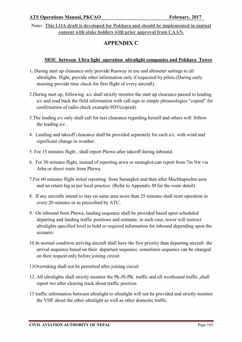
ATS Operations Manual, PKCAO February, 2017
CIVIL AVIATION AUTHORITY OF NEPAL Page 165
Note: This LOA draft is developed for Pokhara and should be implemented in mutual
consent with stake holders with prior approval from CAAN.
APPENDIX C
MOU between Ultra light operation ultralight companies and Pokhara Tower
1. During start up clearance only provide Runway in use and altimeter settings to all
ultralights flight, provide other information only if requested by pilots.(During early
morning provide time check for first flight of every aircraft).
2.During start up, following a/c shall strictly monitor the start up clearance passed to leading
a/c and read back the field information with call sign or simple phraseologies “copied” for
confirmation of radio check example:9DV(copied).
3.The leading a/c only shall call for taxi clearance regarding herself and others will follow
the leading a/c .
4. Landing and takeoff clearance shall be provided separately for each a/c. with wind and
significant change in weather .
5. For 15 minutes flight , shall report Phewa after takeoff during inbound.
6. For 30 minutes flight, instead of reporting arwa or sarangkot,can report from 7m Nw via
Arba or direct route from Phewa.
7.For 60 minutes flight initial reporting from Sarangkot and than after Machhapuchre area
and on return leg as per local practice. (Refer to Appendix M for the route detail)
8. If any aircrafts intend to stay on same area more than 25 minutes shall reort operation in
every 20 minutes or as prescribed by ATC.
9. On inbound from Phewa, landing sequence shall be provided based upon scheduled
departing and landing traffic positions and estimate. in such case, tower will instruct
ultralights specified level to hold or required information for inbound depending upon the
scenario.
10.In normal condition arriving aircraft shall have the first priority than departing aircraft. the
arrival sequence based on their departure sequence. sometimes sequence can be changed
on their request only before joining circuit.
11Overtaking shall not be permitted after joining circuit
12. All ultralights shall strictly monitor the Pk-JS-PK traffic and all westbound traffic ,shall
report twr after clearing track about traffic position.
13 traffic information between ultralight to ultralight will not be provided and strictly monitor
the VHF about the other ultralight as well as other domestic traffic.
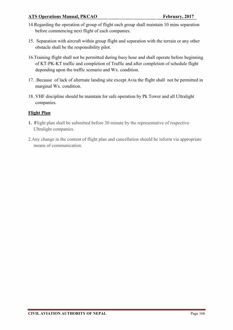
ATS Operations Manual, PKCAO February, 2017
CIVIL AVIATION AUTHORITY OF NEPAL Page 166
14 Regarding the operation of group of flight each group shall maintain 10 mins separation
before commencing next flight of each companies.
15. Separation with aircraft within group flight and separation with the terrain or any other
obstacle shall be the responsibility pilot.
16.Training flight shall not be permitted during busy hour and shall operate before beginning
of KT-PK-KT traffic and completion of Traffic and after completion of schedule flight
depending upon the traffic scenario and Wx. condition.
17. .Because of lack of alternate landing site except Avia the flight shall not be permitted in
marginal Wx. condition.
18. VHF discipline should be maintain for safe operation by Pk Tower and all Ultralight
companies.
Flight Plan
1. Flight plan shall be submitted before 30 minute by the representative of respective
Ultralight companies.
2.Any change in the content of flight plan and cancellation should be inform via appropriate
means of communication.
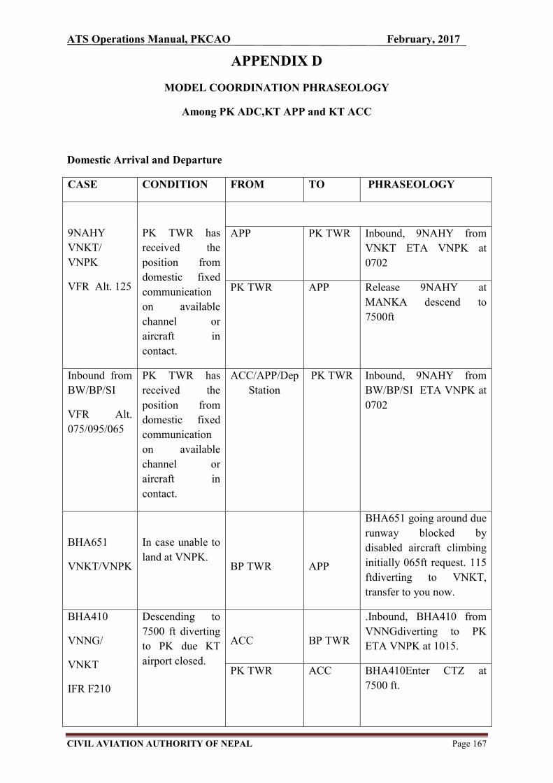
ATS Operations Manual, PKCAO February, 2017
CIVIL AVIATION AUTHORITY OF NEPAL Page 167
APPENDIX D
MODEL COORDINATION PHRASEOLOGY
Among PK ADC,KT APP and KT ACC
Domestic Arrival and Departure
CASE CONDITION FROM TO PHRASEOLOGY
9NAHY
VNKT/
VNPK
VFR Alt. 125
PK TWR has
received the
position from
domestic fixed
communication
on available
channel or
aircraft in
contact.
APP PK TWR Inbound, 9NAHY from
VNKT ETA VNPK at
0702
PK TWR APP Release 9NAHY at
MANKA descend to
7500ft
Inbound from
BW/BP/SI
VFR Alt.
075/095/065
PK TWR has
received the
position from
domestic fixed
communication
on available
channel or
aircraft in
contact.
ACC/APP/Dep
Station
PK TWR Inbound, 9NAHY from
BW/BP/SI ETA VNPK at
0702
BHA651
VNKT/VNPK
In case unable to
land at VNPK.
BP TWR
APP
BHA651 going around due
runway blocked by
disabled aircraft climbing
initially 065ft request. 115
ftdiverting to VNKT,
transfer to you now.
BHA410
VNNG/
VNKT
IFR F210
Descending to
7500 ft diverting
to PK due KT
airport closed.
ACC
BP TWR
.Inbound, BHA410 from
VNNGdiverting to PK
ETA VNPK at 1015.
PK TWR
ACC BHA410Enter CTZ at
7500 ft.

ATS Operations Manual, PKCAO February, 2017
CIVIL AVIATION AUTHORITY OF NEPAL Page 168
BHAXXX
BW/BP/NG
to PK
VFR Alt.
065/095/105
PK TWR has
received the
position from
domestic fixed
communication
on available
channel or
aircraft in
contact, the a/c
required to hold
for their landing
sequence.
BW/PK/KT
PK TWR
Inbound estimate,
BHAXXX from
BW/BP/KT to PK
estimates PK at 0220
PK TWR ACC/APP BHAXXX from BW,
Enter ctz at 7500 ft release
at 15 NM.
PK TWR ACC/APP BHAXXX from NG, Enter
ctz at 7500 ft release at 15
NM expected to hold over
XXX at 3000 ft for
landing sequence.
PK TWR APP BHAXXX from KT,
release at MANKA
descent to 6500ft expected
to hold over XXX at
5500ft for landing
sequence.
9NABU
VNKT/
VNPK
A085
Requesting
SVFR due
weather.
APP
PK
Inbound, 9NABU from
VNKT ETA VNPK at
0320,requesting SVFR
PK TWR KT APP Roger, visibility now
2500m.,SVFR approved
for 9NABU interctz at or
below 6500 ft release at
MANKA.
9NAHV
VNPK/VNKT
Alt. 115
9NAHV starting
for KT
PK TWR APP Request clearance and
release for 9NAHV to KT
Alt 115
In case of no
traffic
APP PK TWR (Clearance for 9NAHV)
9NAHV clear to KT FPL
route climb to 115 release
now.
In case of traffic
required to hold
and delay
departure
APP
PK TWR
For 9NAHV initial altitude
9500ft expect higher after
in contact with APP
release at or after……….

ATS Operations Manual, PKCAO February, 2017
CIVIL AVIATION AUTHORITY OF NEPAL Page 169
9NAHV
departed.
PK TWR KT APP
Departure, 9NAHV 0122
for KT.
9NAEV
PK to
BP/BW/SI
A085/ 075
9NAEV starting
for PK/BW/SI
PP TWR
ACC/APP
Request clearance and
release for 9NAEV
(VNPK) to BP/BW/SI
A085/075
In case of no
traffic
ACC/APP BP TWR 9NAEV is cleared to
BP/BW/SIclimb to
A085/075, release now.
In case of traffic
ACC/APP PK TWR 9NAEVrelease at or after
………(UTC), initially at
065/055 75ft due traffic
expect higher after contact
with ACC/APP.
9NAHS
VNPK/
VNKT
A095
9NAHS
requesting
start up for
VNKT on SVFR
PK TWR APP Request clearance and
release for 9NAHS
(VNPK) to VNKT expect
departure after 0645 on
SVFR departure
APP PK TWR 9NAHS clear to KT FPL
route climb to 9500ft ,
departafter 0645 only.
9NAHS departed PK TWR APP Departure 9NAHS at 0950
for VNKT
Phraseology used for in bound traffic from VNKT
Pilot PK- 9NAGI 54 miles toPkr Maintaining 125ft ETA 0900
PK TOWER 9NAGI RWY INUSE Wind (….◦KTS) QNH , TEMP Report Manka
Pilot Readback Pilot PK- 9NAGI Manka 125ft PK TOWER 9NAGI Enter Control Zone descending 6500ft
report entering Pilot Readback Pilot PK- 9NAGI Entering control zone maintaining
6500feet
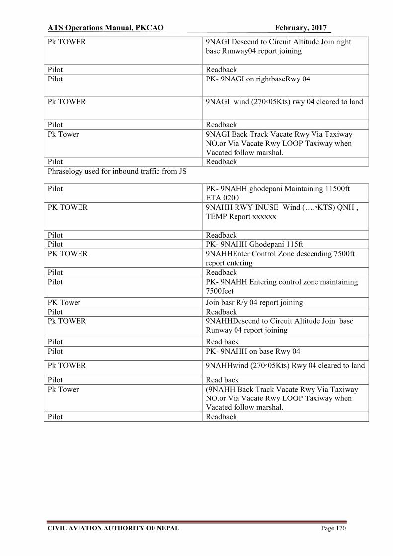
ATS Operations Manual, PKCAO February, 2017
CIVIL AVIATION AUTHORITY OF NEPAL Page 170
Pk TOWER 9NAGI Descend to Circuit Altitude Join right base Runway04 report joining
Pilot Readback Pilot PK- 9NAGI on rightbaseRwy 04
Pk TOWER 9NAGI wind (270◦05Kts) rwy 04 cleared to land
Pilot Readback Pk Tower 9NAGI Back Track Vacate Rwy Via Taxiway
NO.or Via Vacate Rwy LOOP Taxiway when Vacated follow marshal.
Pilot Readback Phraselogy used for inbound traffic from JS
Pilot PK- 9NAHH ghodepani Maintaining 11500ft ETA 0200
PK TOWER 9NAHH RWY INUSE Wind (….◦KTS) QNH , TEMP Report xxxxxx
Pilot Readback Pilot PK- 9NAHH Ghodepani 115ft PK TOWER 9NAHHEnter Control Zone descending 7500ft
report entering Pilot Readback Pilot PK- 9NAHH Entering control zone maintaining
7500feet
PK Tower Join basr R/y 04 report joining Pilot Readback Pk TOWER 9NAHHDescend to Circuit Altitude Join base
Runway 04 report joining
Pilot Read back Pilot PK- 9NAHH on base Rwy 04
Pk TOWER 9NAHHwind (270◦05Kts) Rwy 04 cleared to land
Pilot Read back Pk Tower (9NAHH Back Track Vacate Rwy Via Taxiway
NO.or Via Vacate Rwy LOOP Taxiway when Vacated follow marshal.
Pilot Readback

ATS Operations Manual, PKCAO February, 2017
CIVIL AVIATION AUTHORITY OF NEPAL Page 171
APPENDIX E
SECTOR VISIBILITY PROCEDURES IN VNPK
Likewise in TIA, the controllers and pilots face several flight delays and traffic congestion due to the fog during winter season in Pokhara. Introduction of sector visibility confirms the CAAN's Concern improving the safety and promoting flight operations. As no set of rules is comprehensive enough to dictate easily in the application of the controller's judgment the contents of this memorandum are the best possible compromise safeguarding the interest of both controllers & pilots.
1. NOTE: The procedures outlined below in the form of Instructions are intended to act as guidelines but nothing in them precludes the CONTROLER from exercising his own discretion and initiative under any particular circumstances if by so doing traffic will be expedited without undue reduction of safety.
2. INSTRUCTIONS: 1. SECTOR VISIBILITY: By this term a Controller shall understand that (slant) visibility within the limits of that airspace above the ground which encompasses the climb-out & approach path of an aircraft. The visibility that is evaluated in each sector is the sector visibility.
3. ILLUSTRATION Plane view
Fig. the sector view through runway.
In pokhara, Traffic are generally east bound and west bound. Aircraft shall be cleared for take-off if the duty controller, in his opinion, feels that the climb-out path along the relevant sector is clear although the prevailing visibility is below the prescribed minima of 5km. The final decision, as to any positive action lie closing or opening the R/Yetc, rests exclusively with the shift incharge.
a. Blue sky and hills to the south and climb out area of SW or SE visible through thin fog layer or local patches of in and out clouds.
The Controller keeping the above in mind and making his own observation can logically conclude that the visibility along the climb-out-path (falling wihtin the sector visibility_ of an aircraft departing from RWY 22 is acceptable, i.e. 5 km or
ATS Operations Manual, PKCAO February, 2017
CIVIL AVIATION AUTHORITY OF NEPAL Page 172
more, although there may be fog patches or low level local clouds present elsewhere, which are not relevant to the movement of the aircraft.
b. Blue sky and hills to the north and climb out area of NE or NW visible through thin fog layer or local patches of in and out clouds. Same as above, when the visibility along the climb out path ( falling within the sector visibility of aircraft departing from RWY 04 is acceptable, i.e. 5 km or more, although there may be fog or low level local cloud patches present elsewhere, which are not relevant to the movement of the aircraft.
c. When weather conditions warrant that sector visibility permits departures only due fog patches over the threshold or along the final approach the controller shall make the aircraft intending to depart aware of this situation. Phraseology in this context shall be DUE VISIBILITY RWY OPEN FOR DEPARTURES ONLY and asking for the TAKE-OFF ALTERNATE. If the airborne traffic insists on landing the controller shall use the phraseology LANDING SHALL BE AT YOUR RISK and initiate the appropriate emergency step immediately. Note:.Ultralights from VNPK are operated locally and they do not possess any alternate aerodromes. So, they aren’t warranted for take-offs when prevailing conditions sector visibility permits departures only. Whereas, for the arrival, controller keeping in the mind of weather pattern may assist them with the use of phraseology LANDING SHALL BE AT YOUR RISK and initiate the appropriate emergency step immediately. All abnormalities, be it weather or other factors that affect traffic movement shall be entered in the appropriate log book. Irrespective of type, all aircraft movements shall be held or cleared according to the minimum.
i. With the best judgment, controller in duty may warrant the sector visibility advisable to STOL aircrafts only.

ATS Operations Manual, PKCAO February, 2017
CIVIL AVIATION AUTHORITY OF NEPAL Page 173
APPENDIX F
ABBREVIATIONS
Unless otherwise stated, abbreviations in this ATSOM have the meanings as follows or as
given in AIP, Nepal:
A
AA All after ……
A/A Air-to-air
AAL Above Aerodrome Level
AB All before……
ABM Abeam
ABT About
AC Altocumulus
ACCID Initial Notification of Aircraft accident
ACFT Aircraft
ACK Acknowledge
ACP Acceptance (message type designator)
ACPT Accept or Accepted
ACT Active or activated or activity
AD Aerodrome
ADA Advisory area
ADDN Addition or additional
ADF Automatic direction-finding equipment
ADJ Adjacent
ADZ Advise
AFIL Flight Plan Filed in the Air
AFM Yes, Affirm

ATS Operations Manual, PKCAO February, 2017
CIVIL AVIATION AUTHORITY OF NEPAL Page 174
AFS Aeronautical Fixed Service
AFT After ……. (time or place)
AFTN Aeronautical Fixed Telecommunication Network
A/G Air-to-ground aids
AGA Aerodrome, air routes & ground aids
AGL Above ground level
AGN Again
AIC Aeronautical Information Circular
AIP Aeronautical Information Publication
AIRAC Aeronautical Information Regulation and Control
AIREP Air-report
AIS Aeronautical Information Service
ALA Alighting Area
ALERFA Alert Phase
ALM Aircraft Landing Minima
ALR Alerting (Message type designator)
ALS Approach Lighting System
ALT Altitude
ALTN Alternate (aerodrome)
AMD Amend or amended
AMS Aeronautical Mobile Service
AMSL Above Mean Sea Level
AP Airport
APCH Approach
APRX Approximate or approximately
APV Approved, approve
ARFOR Area forecast (in aeronautical meteorological code)
ARMET Forecast upper wind and temperature at specified points (in aeronautical

ATS Operations Manual, PKCAO February, 2017
CIVIL AVIATION AUTHORITY OF NEPAL Page 175
meteorological code)
ARO Air Traffic Services Reporting Office
ARP Aerodrome Reference Point
ARQ Automatic Error Correction
ARR Arrival (message type designator)
ARR Arrive or arrival
AS Altostratus
ASC Ascent to or ascending to
ASDA Accelerate-stop distance available
ASPH Asphalt
ATA Actual time of arrival
ATC Air Traffic Control (in general)
ATD Actual Time of Departure
ATFM Air Traffic Flow Management
ATP At ….. (time or place)
ATS Air Traffic Service(s)
ATTN Attention
ATZ Aerodrome Traffic Zone
AUG August
AUX Auxiliary
AVASIS Abbreviated visual approach slope indicator system
AVBL Available or availability
AVG Average
AWK Aerial work
AWY Airway
AZM Azimuth
B
BA Braking Action

ATS Operations Manual, PKCAO February, 2017
CIVIL AVIATION AUTHORITY OF NEPAL Page 176
BASE Cloud base
BCFG Fog Patches
BCN Beacon (aeronautical ground light)
BCST Broadcast
BDRY Boundary
BECMG Becoming
BKN Broken
BLDG Building
BLSN Blowing snow
BOMB Bombing
BR Mist
BRG Bearing
BRKG Braking
BS Commercial broadcasting station
BTL Between layers
BTN Between
C
C Degree Celsius (Centigrade)
CAT Clear Air Turbulence
CAVOK Visibility, cloud and present weather better than prescribed values or
conditions
CB Cumulonimbus
CC Cirrocumulus
CD Candela
CDN Co-ordination (message type designator)
CFM Confirm or I confirm
CHG Modification (message type designator)
CI Cirrus

ATS Operations Manual, PKCAO February, 2017
CIVIL AVIATION AUTHORITY OF NEPAL Page 177
CIT Near or over large towns/city
CIV Civil
CK Check
CL I am closing my station
CLA Clear type of ice formation
CLBR Calibration
CLD Cloud
CLR Clear or cleared to .. or clearance
CLSD Closed
CM
CMB
Centimeter
Climb to, or Climbing to
CMPL Completion or completed or complete
CNL Flight plan cancellation (message type designator)
CNL Cancel or cancelled
CNS Communications, Navigation and Surveillance
COM Communications
CON Console
CONC Concrete
CONST Construction or constructed
CONT Continue or continued
COP Change Over Point
COR Correct or corrected or correction
COV Cover or covered or covering
CPL Current flight plan (message type designator)
CS Call sign (used to request a call sign)
CS Cirrostratus
CTA Control area
CTAM Climb to and maintain

ATS Operations Manual, PKCAO February, 2017
CIVIL AVIATION AUTHORITY OF NEPAL Page 178
CTL Control
CTN Caution
CTR Control zone
CU Cumulus
CUF Cumuliform
CW Continuous wave
CWY Clearway
D
D Danger area (followed by identification)
DA
DATIS
Decision altitude
Data Link Automatic Terminal Information Service
DCKG Docking
DCT Direct (in relation to flight plan clearances and type of approach)
DEC December
DEG Degree
DEP Depart or departure
DEP Departure (message type designator)
DES Descend to or descending to
DEST Destination
DETRESFA Distress phase
DFTI Distance from touchdown indicator
DH Decision height
DIF Diffuse
DIST Distance
DLA Delay (message type designator)
DLA Delay or delayed
DME Distance measuring equipment
DNG Danger or dangerous

ATS Operations Manual, PKCAO February, 2017
CIVIL AVIATION AUTHORITY OF NEPAL Page 179
DOC Document
DOM Domestic
DPT Dew Point temperature
DR Dead reckoning
DSB Double side band
DTAM Descend to and maintain
DTG Date-time-group
DTRT Deteriorate or deteriorating
DTW
DU
Dual tandem wheels
Dust
DUC Dense upper cloud
DUPE This is duplicate message
DUR Duration
DW Dual wheels
DZ Drizzle
E
E East or eastern longitude
EAT Estimated approach time
EET
EFC
Estimated elapse time
Expected Further Clearance
EHF Extremely high frequency 300000 KHz to 300000 MHz
ELBA Emergency location beacon aircraft
ELEV Elevation
ELR Extra long range
ELT Emergency locator transmitter
EM Emission
EMBD Embedded in a layer (to indicate cumulonimbus embedded in layers of
other clouds)

ATS Operations Manual, PKCAO February, 2017
CIVIL AVIATION AUTHORITY OF NEPAL Page 180
EMERG Emergency
ENE East north east
ENRT En-route
EOBT Estimated off-block time
EQPT Equipment
ESE East south east
EST Estimate or estimated or estimate (as message type designator)
ETA Estimated time of arrival or estimating arrival
ETD Estimated time departure or estimating departure
ETO Estimated time over significant point
EV Every
EXC Except
EXER Exercises or exercising or to exercise
EXP Expect or expected or expecting
EXTD Extend or extending
F
F Fixed
F Degree Fahrenheit
FAC Facilities
FAF Final approach fix
FAL Facilitation
FAP
FAS
Final approach point
Final Approach Segment
FATO Final approach and take-off area
FAX Facsimile transmission
FBL Light (used to qualify icing, turbulence, interference or static reports)
FC Funnel cloud
FCST Forecast

ATS Operations Manual, PKCAO February, 2017
CIVIL AVIATION AUTHORITY OF NEPAL Page 181
FEB February
FG Fog
FIC Flight information center
FIR Flight information region
FIS Flight information service
FISA Automatic flight information service
FL Flight level
FLG Flashing
FLR Flare
FLT Flight
FLTCK Flight check
FLW Follow(s) or Following
FLY Fly or flying
FM
FMS
From
Flight Management System
FNA Final approach
FPL Filed flight plan (message type designator)
FPM Feet per minute
FREQ Frequency
FRI Friday
FRNG Firing
FRONT Front (relating to weather)
FRQ Frequent
FSL Full stop landing
FSS Flight service station
FST First
FT Feet (dimensional unit)
FU Smoke

ATS Operations Manual, PKCAO February, 2017
CIVIL AVIATION AUTHORITY OF NEPAL Page 182
FZ Freezing
FZDZ Freezing drizzle
FZFG Freezing fog
FZL Freezing level
FZRA Freezing rain
G
G/A Ground-to-air
G/A/G
GBAS
Ground-to-air and air-to-ground
Ground Based Augmentation System
GCA Ground control approach or ground controlled approach
GEN General
GEO Geographic or true
GLD Glider
GMT Greenwich mean time
GND Ground
GNDCK
GNSS
Ground check
Global Navigation Satellite System
GP
GPWS
Glide path
Ground Proximity Warning System
GR Hail
GRADU Gradual or gradually
GRAS
GRASS
Ground Based Regional Augmentation system
Grass landing area
GRID Processed meteorological data in the form of grid point values (in
aeronautical meteorological office)
GRVL Gravel
GS Ground seed
ATS Operations Manual, PKCAO February, 2017
CIVIL AVIATION AUTHORITY OF NEPAL Page 183
H
H24 Continuous day and night service
HBN Hazard beacon
HDG Heading
HEL Helicopter
HF High frequency (3000 to 30000 kHz)
HGT Height or height above
HJ Sunrise to sunset
HLS Helicopter landing site
HLDG Holding
HN Sunset to sunrise
HO Service available to meet operational requirement
HOL Holiday
HOSP Hospital aircraft
HPA Hectopascal
HR Hours
HS Service available during hours of scheduled operations
HURCN Hurricane(s)
HX No specific working hours
HZ Hertz (cycles per second)
HZS Horizontal surface
I
IAF Initial approach fix
IAL Instrument approach and landing
IAO
IAP
In and out of clouds
Instrument Approach Procedure
IAR Intersection of air routes

ATS Operations Manual, PKCAO February, 2017
CIVIL AVIATION AUTHORITY OF NEPAL Page 184
IAS Indicated air speed
IBN Identification beacon
ICAO International Civil Aviation Organization
ICE Icing
IDENT Identification
IAF Intermediate approach fix
IFF Identification friend/foe
IFR Instrument flight rules
IGA International general aviation
ILS Instrument landing system
IM Inner marker
IMC Instrument meteorological condition
IMPR Improve or improving
IMT Immediate or immediately
INA Initial approach
INBD Inbound
INC In cloud
INCERFA Uncertainty phase
INFO Information
INOP Inoperative
INP If not possible
INPR In progress
INS Inches (dimensional unit)
INS Inertial navigation system
INSTL Install or installed or installation
INSTR Instrument
INT Intersection
INTER Intermittent

ATS Operations Manual, PKCAO February, 2017
CIVIL AVIATION AUTHORITY OF NEPAL Page 185
INTL International
INTRG Interrogator
INTRP Interrupt, interrupted or interruption
INTSF Intensify or intensifying
INTST Intensity
IR
IRS
Ice on runway
Inertial Reference System
ISA International standard atmosphere
ISOL Isolated
J
JAN January
JTST Jet stream
JUL July
JUN June
K
KG kilogram(s)
KHZ Kilohertz
KM Kilometer(s)
KMH Kilometer per hour
KPA Kilopascal
KT Knots
KW Kilowatt
L
L Left (runway identification)
L Locator (see LM, LO)
LAN Inland
LAT Latitude
LB Pounds (weight)

ATS Operations Manual, PKCAO February, 2017
CIVIL AVIATION AUTHORITY OF NEPAL Page 186
LCN Load classification number
LDA Landing distance available
LDG Landing
LDI Landing direction indicator
LEN Length
LF Low frequency (30 to 300 KHz)
LGT Light or lighting
LGTD Lighted
LLZ Localizer
LM Locator, middle
LMT Local mean time
LO Locator, outer
LOC Locally, location or located
LONG Longitude
LR The last message received by me was.
LRG Long range
LS The last message sent by me was….
LSQ Line squall
LTD Limited
LTH Light-intensity high
LTL Light-intensity low
LTM Light-intensity medium
LV Light and variable (relating to wind)
LYR Layer or layered
M
M
M
Meter
Mach Number (Followed by figures)
MAG Magnetic
ATS Operations Manual, PKCAO February, 2017
CIVIL AVIATION AUTHORITY OF NEPAL Page 187
MAINT Maintenance
MAP Aeronautical maps and charts
MAPT Missed approach point
MAR March
MATS Manual of Standards Air Traffic Services
MAX Maximum
MAY May
MB Millibar
MDA Minimum descent altitude
MDH Minimum descent height
MEA Minimum en-route altitude
METAR Aviation routine weather report (in aeronautical meteorological code)
MF Medium frequency 300 to 3000 KHz
MHZ Megahertz
MIFG Shallow fog
MIL Military
MIN Minutes
MISC Miscellaneous
MKR Marker radio beacon
MNM Minimum
MLS Microwave landing system
MM Middle marker
MNPS
MNPSA
Minimum Navigation Performance Specifications
Minimum Navigation Performance Specifications
MNT Monitor or monitoring or monitored
MNTN Maintain
MOC Minimum obstacle clearance (required)
MOCA Minimum obstacle clearance altitude

ATS Operations Manual, PKCAO February, 2017
CIVIL AVIATION AUTHORITY OF NEPAL Page 188
MOD Moderate (used to qualify icing, turbulence, interference, or static reports)
MON Above mountains
MON Monday
MOV Move or moving or movement
MPH Statute miles per hour
MPS Meters per second
MRG Medium range
MRP ATS/MET reporting points
MS Minus
MSA Minimum safe altitude
MSG Message
MSL Mean sea level
MT Mountain
MTOF Maximum Take-Off Weight
MTU Metric units
MTW Mountain waves
MWO Meteorological watch office
N
N North or northern latitude
NAV Navigation
NB North bound
NC No change
NDB Non-directional radio beacon
NE North-east
NEG Negative
NGT Night
NIL None or I have nothing to send
NM Nautical miles

ATS Operations Manual, PKCAO February, 2017
CIVIL AVIATION AUTHORITY OF NEPAL Page 189
NML Normal
NNNN Connect to (………) stations (used in multiple transmission, followed by
call sign of stations)
NNE North North East
NNW North North West
NOF International NOTAM Office
NOSIG No significant change (used in trend type landing forecast)
NOTAM A notice to Airmen
NOV November
NPA Non Precision Approach
NR Number
NS Nimbostratus
NSC Nil Significant Cloud
NW North west
NXT Next
O
OAS Obstacle assessment surface
OBS Observe or observed or observation
OBSC Obscure or obscured or obscuring
OBST Obstacle
OBSTR Obstruction
OCA Obstacle Clearance Altitude
OCC Occulting (light)
OCH Obstacle Clearance Height
OCNL Occasional or occasionally
OCS Obstacle clearance surface
OCT October
OK We agree or it is correct

ATS Operations Manual, PKCAO February, 2017
CIVIL AVIATION AUTHORITY OF NEPAL Page 190
OPA Opaque, white type of ice formation
OPC The control indicated is operational control
OPMA Onboard Performance Monitoring and Alerting
OPMET Operational meteorological (information)
OPN Open or opened or opening
OPS Operations
O/R On request
ORD Indication of an order
OTP On top
OVC Overcast
P
P Prohibited area (followed by identification)
PANS Procedures for air navigation services
PAPI Precision approach Path indicator
PAR Precision approach radar
PARL Parallel
PAX
PBN
Passenger(s)
Performance Based Navigation
PCN Pavement classification number
PER Performance
PERM Permanent
PJE Parachute jumping exercise
PLA Practice low approach
PN Prior notice required
PNR Point of no return
PO Dust devils
POB Person on board
PPI Plan position indicator

ATS Operations Manual, PKCAO February, 2017
CIVIL AVIATION AUTHORITY OF NEPAL Page 191
PPR Prior permission required
PRKG Parking
PROB Probability
PROC Procedure
PROV Provisional
PS Plus
PSG Passing
PSN Position
PVT Private
PWR Power
Q
QDM Magnetic heading (zero wind)
QDR Magnetic Bearing
QFE Atmospheric pressure at aerodrome elevation (or runway threshold)
QFU Magnetic orientation of runway
QNH Altimeter sub-scale setting to obtain elevation when on the ground
QTE True bearing
QUAD Quadrant
R
R Restricted area (followed by identification)
R Right (followed by runway identification)
RA
RA
Rain
Resolution Advisory
RAC
RAD
Rules of the air and Air Traffic Services
Radius
RAG Ragged
RAI Runway alignment indicator
RAPID Rapid or rapidity
ATS Operations Manual, PKCAO February, 2017
CIVIL AVIATION AUTHORITY OF NEPAL Page 192
RASH Rain and showers
RB Read back
RB Rescue boat
RCC Rescue co-ordination center
RCF Radio communication failure (message type designator)
RCL Runway center line
RDO
RDL
Radio
Radial
RE Recent (used to qualify weather phenomena such as rain),e.g. recent rain =
RERA
REC Receive or receiver
REF Reference to ..or refer to ….
REG Registration
REILS Runway end illumination light system
REP Report or reporting or reporting point
REQ Request or requested
RG Range (lights)
RIF Re-clearance in flight
RITE Right (direction or turn)
RLCE Request level change en-route)
RMK Remark
RNAV Area navigation
RNG Radio rang
RNP Required Navigation Performance
RNP AR Required Navigation Performance Authorization Required
RNP APCH Required Navigation Performance Approach
ROBEX Regional OPMET bulletin exchange (exchange)
ROC Rate of climb

ATS Operations Manual, PKCAO February, 2017
CIVIL AVIATION AUTHORITY OF NEPAL Page 193
ROFOR Route forecast (in aeronautical meteorological code)
RON Received only
RPL Repetitive flight plan
RPLC Replace or replaced
RPS Radar Position Symbol
RPT Repeat or I repeat Indication of a request
RQMNTS Requirements
RQP Request flight plan (message type designator)
RR Report reaching
RSC Rescue Sub-Centre
RSP Responder Beacon
RSR
RTE
En-route Surveillance Radar
Route
RTF Radiotelephony
RTG Radiotelegraph
RTN Return OR Returned OR Returning
RV Rescue vessel
RVR Runway visual range
RWY Runway
S
S South or Southern Latitude
SA Dust storm, sand storm, rising dust or rising sand
SALS Simple Approach Lighting System
SAP As soon as possible
SARPS Standard and Recommended Practices (ICAO)
SAT Saturday
SC Stratocumulus
SCT Scattered

ATS Operations Manual, PKCAO February, 2017
CIVIL AVIATION AUTHORITY OF NEPAL Page 194
STDBY Stand by
SE South East
SEC Seconds
SELCAL Selective calling system
SEP September
SER Service or Servicing or Serviced
SEV Severe (use to qualify icing and turbulence reports)
SFC Surface
SG Snow Grains
SGL Signal
SH Showers
SHF Super High Frequency (3000 to 30000 MHz)
SID Standard Instrument Departure
SIF Selective Identification Feature
SIGMET Information concerning en-route weather phenomena which may affect the
safety of aircraft operations
SIGWX Significant weather
SIMUL Simultaneous or Simultaneously
SIWL Single Isolated Wheel Load
SKC Sky Clear
SLW Slow
SMC Surface Movement Control
SMR Surface Movement Radar
SN Snow
SNOWTAM A special series NOTAM notifying the presence or removal or hazardous
conditions due to snow, ice, slush or standing water associated with snow,
slush and ice on the movement area, by means of a specific format
SNSH Snow Showers
SOC Start of Climb

ATS Operations Manual, PKCAO February, 2017
CIVIL AVIATION AUTHORITY OF NEPAL Page 195
SPECI Aviation selected special weather report (in aeronautical meteorological
code
SPECIAL Special meteorological report (in abbreviated plain language)
SPL Supplementary flight plan (message type designator)
SPOT Spot wind
SQ Squall
SR Sunrise
SRA Surveillance Radar Approach
SRE Surveillance Radar Element of precision approach radar system
SRG Short range
SRR Search and rescue region
SS Sunset
SSB Single side band
SSE South South East
SSR Secondary Surveillance Radar
SST Supersonic transport
SSW South South West
ST Stratus
STA Straight in approach
STAR Standard (Instrument) Arrival
STN Station
STNR Stationary
STOL Short Take-Off and Landing
STS Status
SUBJ Subject to
SUN
SUP
Sunday
Supplement (AIP Supplement)
SUPPS Regional supplementary procedures

ATS Operations Manual, PKCAO February, 2017
CIVIL AVIATION AUTHORITY OF NEPAL Page 196
SVC Service message
SVCBL Serviceable
SVFR Special Visual Flight Rules
SW South West
SWY Stop way
T
T Temperature
TA Transmission altitude
TACAN UHF Tactical Air Navigation Aid
TAF Aerodrome forecast
TAR Terminal Area Surveillance Radar
TAS True Airspeed
TAX Taxi or taxiing
TC Tropical Cyclone
TCAS Traffic Alert and Collision Avoidance System
TCU Towering Cumulus
TDO Tornado
TDZ Touch Down Zone
TECR Technical Reason
TEMPO Temporary or Temporarily
TFC Traffic
TGL Touch-and-Go Landing
TGS Taxiing Guidance System
THR Threshold
THRU Through
THU Thursday
TIL Until
TKOF Take-off

ATS Operations Manual, PKCAO February, 2017
CIVIL AVIATION AUTHORITY OF NEPAL Page 197
TMA Terminal control area
TO To …. (place)
TOC Top of climb
TODA Take-Off Distance Available
TOP Top of Cloud
TORA Take-Off Runway Available
TP Turning Point
TR Track
TRA Temporary Reserved Airspace
TRANS Transmit or Transmitter
TS Thunderstorm
TSGR Thunderstorm with hail
TSSA Thunderstorm with dust storm or sandstorm
TT Teletypewriter
TUE Tuesday
TURB Turbulence
TVOR Terminal VOR
TWR Aerodrome control tower
TWY Taxiway
TWYL Taxiway Link
TXT Text
TYP Type of aircraft
TYPH Typhoon
U
UAB Until Advised By ……….
UAC Upper Area Control Center
UAR Upper Air Route
UDF Ultra High Frequency Direction Finding System

ATS Operations Manual, PKCAO February, 2017
CIVIL AVIATION AUTHORITY OF NEPAL Page 198
UFN Until Further Notice
UHF Ultra High Frequency
ULR Ultra Long Range
UNA Unable
UNL Unlimited
UNREL Unreliable
U/S Unserviceable
UTA Upper Control Area
UTC Co-ordinated Universal Time
V
V Cleared over a reporting point
VAL In valleys
VAR Magnetic variation
VASIS Visual Approach Slope Indicator System
VDF
VDP
Very High Frequency Direction Finding Station
Visual Descent Point
VER Vertical
VFR Visual Flight Rules
VHF Very High Frequency (30 to 300 MHz)
VIP Very Important Persons
VIS Visibility
VLF Very Low Frequency
VLR Very Long Range
VMC Visual Meteorological Conditions
VOLMET Meteorological information for aircraft in flight
VOR Very High Frequency Omni-directional Radio Range
VORTAC VOR and TACAN combination
VOT VOR airborne equipment test facility

ATS Operations Manual, PKCAO February, 2017
CIVIL AVIATION AUTHORITY OF NEPAL Page 199
VRB Variable
VSA By visual reference to the ground
VSP Vertical speed
VTOL Vertical Take-Off and Landing
W
W West or Western longitude
WAC World Aeronautical Chart ICAO 1:1000 000
WDI Wind Direction Indicator
WDSPR Widespread
WED Wednesday
WEF With Effect From or Effective From
WI Within
WID Width or Wide
WIE With Immediate Effect or Effective Immediately
WIP Work In Progress
WKN Weaken or Weakening
WNW West North West
WPT Way-point
WRNG Warning
WS Wind Shear
WSW West South West
WX Weather
X
X Cross
XBAR Crossbar (of approach landing system)
XS Atmospheric
XX Heavy (used to quality weather phenomena such as rain, e.g. heavy rain –
XXRA)

ATS Operations Manual, PKCAO February, 2017
CIVIL AVIATION AUTHORITY OF NEPAL Page 200
Y
YD Yards
YES Yes (affirmative)
YR Your
Z
Z Coordinated universal time

ATS Operations Manual, PKCAO February, 2017
CIVIL AVIATION AUTHORITY OF NEPAL Page 201
APPENDIX G
SYMBOLS AND CODES
1 It has been found in practice that message of routine nature can be taken by down at the same as that at which a clearly spoken transmission is made, by the use of approved abbreviation, contractions and symbols.
2 The abbreviations and symbols which follow are authorized for the use in making
entries on flight progress strips in copying or writing traffic
3. Unauthorized abbreviations and symbols shall not be used.
Clearance limits
A = Cleared to aerodrome (point of first intended landing)
V = Cleared to reporting point
H = Holding instructions issued
MB = Cleared to Min Beacon
= Cleared to leave control area
OM = Cleared to an Outer Marker
X = Cleared to cross the airway in the vicinity of reporting position
V = Cleared over a reporting point (over flight)
Clearance Instruction

ATS Operations Manual, PKCAO February, 2017
CIVIL AVIATION AUTHORITY OF NEPAL Page 202
C = ATC CLEARANCE …………………
= NO delay expected
RSYD = Release subject to your discretion with regard to ……….
CE = Clearance expires……………… (time)
…… = Release not before ……………….. (time)
RLCE = Request level change en-route
M = Maintain ………. (Level) …………….
= Descend
– = To : (used to indicate "Form ……….. to ……….. )
( ) = Alternative instruction
= Restriction written below this line
/ = After passing
= Aircraft has reported at an altitude other than that proposed
= Joining Flight
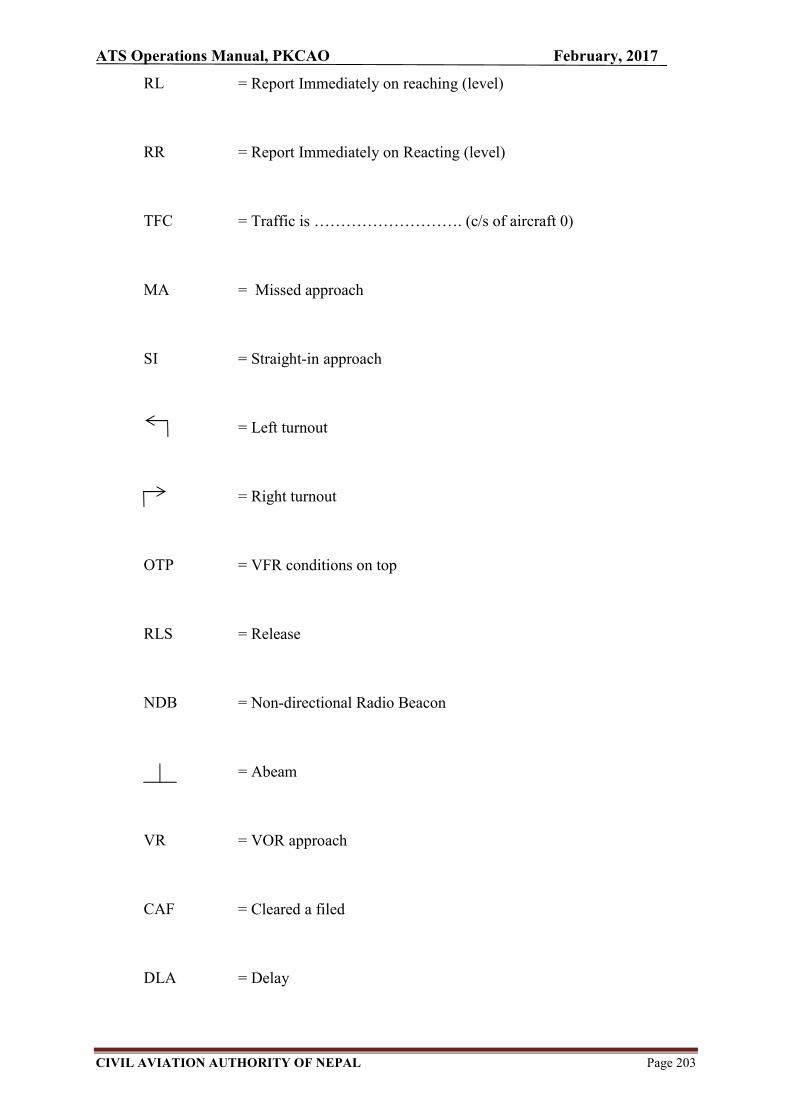
ATS Operations Manual, PKCAO February, 2017
CIVIL AVIATION AUTHORITY OF NEPAL Page 203
RL = Report Immediately on reaching (level)
RR = Report Immediately on Reacting (level)
TFC = Traffic is ………………………. (c/s of aircraft 0)
MA = Missed approach
SI = Straight-in approach
= Left turnout
= Right turnout
OTP = VFR conditions on top
RLS = Release
NDB = Non-directional Radio Beacon
= Abeam
VR = VOR approach
CAF = Cleared a filed
DLA = Delay
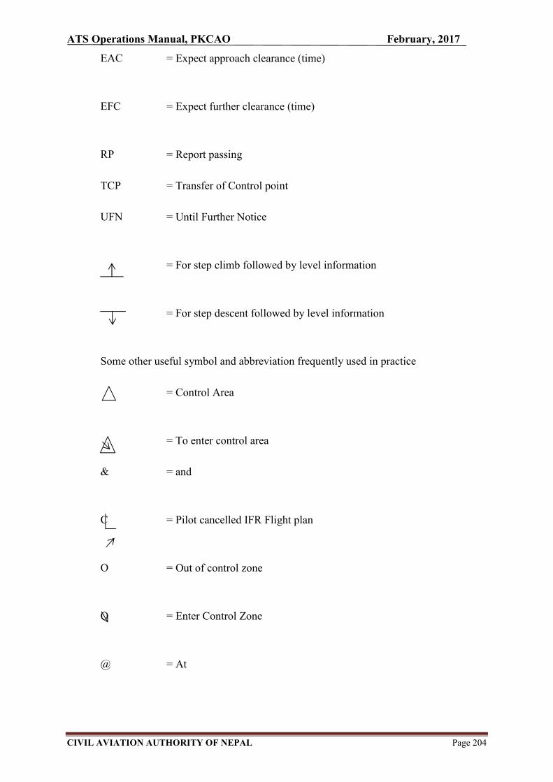
ATS Operations Manual, PKCAO February, 2017
CIVIL AVIATION AUTHORITY OF NEPAL Page 204
EAC = Expect approach clearance (time)
EFC = Expect further clearance (time)
RP = Report passing
TCP = Transfer of Control point
UFN = Until Further Notice
= For step climb followed by level information
= For step descent followed by level information
Some other useful symbol and abbreviation frequently used in practice
= Control Area
= To enter control area
& = and
C = Pilot cancelled IFR Flight plan
O = Out of control zone
O = Enter Control Zone
@ = At

ATS Operations Manual, PKCAO February, 2017
CIVIL AVIATION AUTHORITY OF NEPAL Page 205
ABV = Above …………. ft =+ ………………….
BLO = Below ………. ft =+ ………………….
> = Before
< = After
TKOF = Take off
V< (TIME) = Clearance void after ……………(time)
ADNL TFC = Additional traffic is ……………..
RC = Reserve Course
UFA = Until further advise
INDEF = Delay indefinite
= Information forwarded
C = Coordination effected
C = Climb coordinated
C = Descent coordinated

ATS Operations Manual, PKCAO February, 2017
CIVIL AVIATION AUTHORITY OF NEPAL Page 206
…....+ = At or above ……….... ft
…….– = At or below ………… ft
CC = Climb cruise
Z = Delay not determined

ATS Operations Manual, PKCAO February, 2017
CIVIL AVIATION AUTHORITY OF NEPAL Page 207
APPENDIX H
ATC Training Syllabus for Rating/Licensing Purpose for POKHARA CAO
Note-1 ATC-L - Air traffic controller license ATC-SL - Student air traffic controller license ATC-1 - Aerodrome control rating .
Note-2: For domestic controlled airports where approach control service is combined with aerodrome control service, ATC-1 and ATC-2 papers shall be combined with 50 questions.
Paper Subject Questions Time Pass
ATC-SL ATC-L
annex 1,2,3,5,610,11,14,15 and ICAO doc. 4444 , civil aviation requirements ,and the subjects as required by 4.1.1.1f)/ 4.2.1 f) of MOS Licensing/Rating of ATC Personnel, Third Edition, August, 2015
100 3 hours 70%
ATC-1 ATC-L and practical aspects of aerodrome control and relate subjects from AIP Nepal ATSOM , MATS Nepal and local instructions
50 2hours 70%
ATC-2 ATC-L and practical aspects of approach control rating and relative subjects from AIP Nepal , ATSOM ,MATS Nepal and local instructions
50 2 hours 70%

ATS Operations Manual, PKCAO February, 2017
CIVIL AVIATION AUTHORITY OF NEPAL Page 208
APPENDIX I
PKCAO ORGANIZATION CHART
Pokhara Civil Aviation Office
Director (L-11) T/CA/AT 1
Operations Section
Manager (L-9)
T/CA/AT - 1
ATS Operations Asst. Manager (L-8) T/CA/AT - 2 Sr. Officer (L-7) T/CA/AT - 4
RFF Operations Sr. Officer (L-7 ) T/CA/AF -1 Officer (L-6) T/CA/AF -2 Sr. Asst. (L-5) T/CA/AF -6 Assistant (L-4) T/CA/AF -8
Civil Aviation Authority of Nepal
Civil Maint. Section
Sr. Assistant (L-5) T/CE - 1 Officer (L-6) T/CE - 1
Finance Section Asst. Manager (L-8) A/FA/Acc - 1 Officer (L-6) FA/Acc -1 Officer (L-6) FA/Rev- -1
Administration Section
Asst.Manager(L-8) A/A/A - 1 Officer (L-6) A/A/A - 1 Asst. (L-4) A/A/A - 1
Technical Operations Sr. Officer (L7) T/ET - 1 Officer (L-6) T/EE - 1 Officer (L-6) T/ME - 1 Helper (L-2) T/Open - 1
Total : 36

ATS Operations Manual, PKCAO February, 2017
CIVIL AVIATION AUTHORITY OF NEPAL Page 209
APPENDIX J
REMOVAL OF DISABLED AIRCRAFT
1 Purpose
The aim of the Disabled Aircraft Removal Plan is to provide for an efficient,
coordinated response to quickly and safely remove an aircraft that has caused
temporary closure of a runway, taxiway or affected the OLS.
These procedures are intended to deal solely with disabled aircraft within the
aerodrome boundary only after the requirements of the DAEP relevant to the aircraft
incident or accident have been completed.
2 Responsibilities
The Airport Director has overall responsibility for the Disabled Aircraft
Removal Plan at the Pokhara Airport.
For minor incidents, Sr. ATS personnel are responsible for controlling and
coordinating the response for removal of a disabled aircraft. This may require
liaison with the airline or aircraft operator and the Aviation Safety
Department of CAAN and/or Airport Security Police (if involved) to obtain a
clearance to remove the aircraft. the event that the Airport Director is not
available the designated Sr. ATS personnel will undertake these
responsibilities.
For accidents of a more serious or protracted nature, the Airport Manager has
responsibility for coordinating the removal of the aircraft and returning the
aerodrome to full operational status.
The Airport Director is responsible for notifying ATC about disabled
aircraft (if ATC are not already aware) and inform to KT INT’L Notam
Office for issuing an appropriate NOTAM. He/she is also responsible for
ensuring that any unserviceable portions of the maneuvering area are
correctly marked, in accordance with Manual of Aerodrome Standards Nepal
(MASN), to provide for safe aircraft operation on the remaining usable areas.
Aerodrome Tower Controller (ATC) will initiate activation of the Disable
Aircraft Removal Plan if advised of an immobilized aircraft by the pilot.
RFF equipment (available fire extinguishers) may be required to remain on
standby with trained airline personnel to assist with operations as required,
especially when de-fuelling is required.
The Aircraft Owner, defined as the holder of the certificate of registration, is
responsible for the aircraft removal and disposal of fuel and other hazardous
materials that have been spilt as a result of the incident/accident. Prior

ATS Operations Manual, PKCAO February, 2017
CIVIL AVIATION AUTHORITY OF NEPAL Page 210
approval for aircraft removal may be required from either Aviation Safety
Department/CAAN and/or from the Airport Manager for accidents of a more
serious nature that require on-scene investigations.
The Flight Safety Departmentof CAAN is responsible for the initial
investigation of all aircraft accidents and incidents involving civil aircraft
operations. If the department elects to conduct an on-scene investigation, a
disabled aircraft cannot be removed from the movement area until authorized
by the CAAN Flight Safety Department.
The Airport Security (if involved through activation of the DAEP), in
conjunction with the CAAN Aviation Safety Department, authorizes the
removal of a disabled aircraft when their on-scene investigation has been
completed.
If an emergency involves a Nepal Sainik Biman Sewa aircraft, the Chief of
No.11 Brigade authorizes its removal including any dangerous cargo on the
aircraft.
3 Legislation, Standards and Technical References
Regulation 20 of the CAAN Airport Certificate Regulation 2004 requires
aerodrome operators to establish the procedures for the removal of disabled
aircraft from the movement area.
International recommendations for the removal of disabled aircraft are
described in the ICAO Airport Services Manual, Part 5.
4 Immediate Operational Considerations and Actions The following criteria are to be used for determining the availability of runways
affected by a disabled aircraft:
If the aircraft is within 75 m of the runway centerline, revised declared distances must be provided.
If the threshold requires displacement it will be marked in accordance with Manual of Aerodrome Standards Nepal (MASN) and revised declared distances calculated. Airport Director is responsible to coordinate with Aerodrome Engineering Directorate for displacement of Threshold as required.
Aerodrome Tower Controller will:
Notify local city fire service if the RFFS is not in operation. Notify the Airport Director. Notify the concern operator. Determine estimated time of arrival (ETA) of all aircraft requiring
use of the closed runway. Determine latest time for affected aircraft to divert. Notify CAAN Flight Safety Department of:
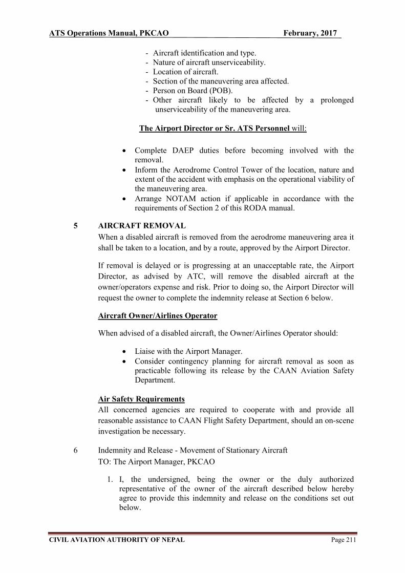
ATS Operations Manual, PKCAO February, 2017
CIVIL AVIATION AUTHORITY OF NEPAL Page 211
- Aircraft identification and type. - Nature of aircraft unserviceability. - Location of aircraft. - Section of the maneuvering area affected. - Person on Board (POB). - Other aircraft likely to be affected by a prolonged
unserviceability of the maneuvering area.
The Airport Director or Sr. ATS Personnel will:
Complete DAEP duties before becoming involved with the removal.
Inform the Aerodrome Control Tower of the location, nature and extent of the accident with emphasis on the operational viability of the maneuvering area.
Arrange NOTAM action if applicable in accordance with the requirements of Section 2 of this RODA manual.
5 AIRCRAFT REMOVAL
When a disabled aircraft is removed from the aerodrome maneuvering area it
shall be taken to a location, and by a route, approved by the Airport Director.
If removal is delayed or is progressing at an unacceptable rate, the Airport
Director, as advised by ATC, will remove the disabled aircraft at the
owner/operators expense and risk. Prior to doing so, the Airport Director will
request the owner to complete the indemnity release at Section 6 below.
Aircraft Owner/Airlines Operator
When advised of a disabled aircraft, the Owner/Airlines Operator should:
Liaise with the Airport Manager. Consider contingency planning for aircraft removal as soon as
practicable following its release by the CAAN Aviation Safety Department.
Air Safety Requirements
All concerned agencies are required to cooperate with and provide all
reasonable assistance to CAAN Flight Safety Department, should an on-scene
investigation be necessary.
6 Indemnity and Release - Movement of Stationary Aircraft
TO: The Airport Manager, PKCAO
1. I, the undersigned, being the owner or the duly authorized representative of the owner of the aircraft described below hereby agree to provide this indemnity and release on the conditions set out below.

ATS Operations Manual, PKCAO February, 2017
CIVIL AVIATION AUTHORITY OF NEPAL Page 212
2. I agree and consent to Airport Manager, PKCAO, its agents, contractors and employees to move at any time required the aircraft at my sole cost and expense.
3. In consideration of the PKCAO moving the aircraft I agree to indemnity and keep indemnified the PKCAO against all and any loss damage cost charge expense or other liability however suffered paid or incurred by or threatened against the PKCAO in relation to or arising out of or in consequence of any action, proceeding, claim or demand which is or may be brought made or prosecuted or threatened against the PKCAO in respect of any loss of or damage to property, loss of life or personal injury or other loss that may arise in any way from the moving of the aircraft by the PKCAO.
4. I further agree to release the PKCAO from all claims actions, causes of actions, proceedings and demands which I and or the owner now has or but for this indemnity and release would or might at any time in the future have against the PKCAO and from all present and future liability of the PKCAO to me and or the owner however caused in relation to or arising out of or in consequence of the moving of the aircraft.
5. I confirm that it is the intention of this indemnity and release that each servant, agent, contractor and employee of the PKCAO obtain the benefits expressed in their favor under this indemnity and release and be entitled to enforce such benefits.
6. I confirm that I and the owner have abided and will abide by all applicable laws including without limitation acts, regulations, bylaws, directions and determinations relating to or made by the Civil Aviation Authority of Nepal, the CAAN Air Safety Department, the PKCAO and any other relevant authority or body which has authority in relation to interference with or movement of an aircraft.
Description of Aircraft:
Type of Aircraft:
Registration No:
Full name:
Signed by:
Date:
In the presence of:

ATS Operations Manual, PKCAO February, 2017
CIVIL AVIATION AUTHORITY OF NEPAL Page 213
APPENDIX K
SUNSET TIME AT POKHARA
TIME ON UTC
MONTH JAN FEB MAR APR MAY JUN JUL AUG SEP OCT NOV DEC
DATE↓ HRS→ 1100 1200 1200 1200 1200 1300 1300 1300 1200 1200 1100 1100
1 39 02 24 42 59 16 24 15 46 10 39 28
2 39 03 25 43 59 16 24 14 45 09 39 28
3 40 04 25 43 1300 17 24 14 44 08 38 28
4 41 05 26 44 00 17 24 13 43 06 37 29
5 41 06 27 44 01 18 24 12 41 05 37 29
6 42 06 27 45 02 18 24 11 40 04 36 29
7 43 07 28 45 02 19 24 11 39 03 35 29
8 43 08 29 46 03 19 24 10 38 02 35 29
9 44 09 29 46 03 19 24 09 37 01 34 29
10 45 10 30 47 04 20 24 08 35 1200 34 29
11 46 10 30 47 04 20 24 07 34 1159 33 30
12 46 11 31 48 05 21 24 06 33 57 33 30
13 47 12 32 49 06 21 23 06 32 56 32 30
14 48 13 32 49 06 21 23 05 31 55 32 31
15 49 13 33 50 07 22 23 04 29 54 32 31
16 50 14 33 50 07 22 22 03 28 53 31 31
17 50 15 34 51 08 22 22 02 27 52 31 32
18 51 16 34 51 08 22 22 01 26 51 30 32
19 52 16 35 52 09 23 21 00 24 50 30 32
20 53 17 36 52 10 23 21 1259 23 49 30 33
21 54 18 36 53 10 23 21 58 22 48 30 33
22 54 19 37 54 11 23 20 57 21 48 29 34
23 55 19 37 54 11 24 20 56 20 47 29 34
24 56 20 38 55 12 24 19 55 18 46 29 35
25 57 21 38 55 12 24 19 54 17 45 29 35
26 58 21 39 56 13 24 18 53 16 44 29 36
27 58 22 39 56 13 24 18 52 15 43 29 36
28 59 23 40 57 14 24 17 51 13 42 28 37
29 1200 23 40 57 14 24 17 49 12 42 28 38
30 01 41 58 15 24 16 48 11 41 28 38
31 02 42 15 16 47 40 39
OPERATION HOUR PK
MONTH NOV DEC JAN FEB
MAR APR SEP OCT MAY
JUNE
JULY AUG
HRS (UTC) 0100-1215 0030-1245 0015-1300
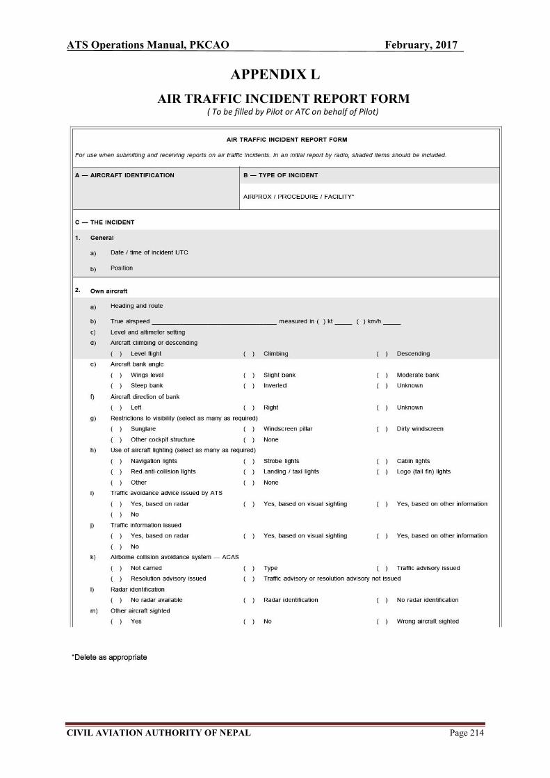
ATS Operations Manual, PKCAO February, 2017
CIVIL AVIATION AUTHORITY OF NEPAL Page 214
APPENDIX L
AIR TRAFFIC INCIDENT REPORT FORM ( To be filled by Pilot or ATC on behalf of Pilot)
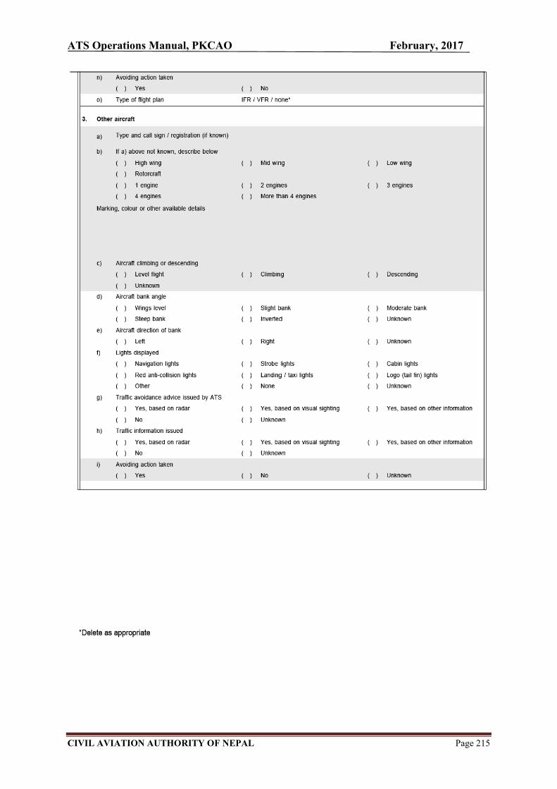
ATS Operations Manual, PKCAO February, 2017
CIVIL AVIATION AUTHORITY OF NEPAL Page 215

ATS Operations Manual, PKCAO February, 2017
CIVIL AVIATION AUTHORITY OF NEPAL Page 216

ATS Operations Manual, PKCAO February, 2017
CIVIL AVIATION AUTHORITY OF NEPAL Page 217

ATS Operations Manual, PKCAO February, 2017
CIVIL AVIATION AUTHORITY OF NEPAL Page 218
Instructions for completion of the Air Traffic Incident Report Form
Item
A Aircraft identification of the aircraft filing the report.
B An AIRPROX report should be filed immediately by radio.
C1 Date / time UTC and position in bearing and distance from a navigation aid or in LAT / LONG.
C2 Information regarding aircraft filing the report, tick as necessary.
C2 c) E.g. FL 350 / 1013 HPA or 2500 FT / QNH 1 007 HPA or 1200 FT / QFE 998 HPA.
C3 Information regarding the other aircraft involved.
C4 Passing distance - state units used.
C6 Attach additional papers as required. The diagrams may be used to show aircraft’s positions.
D1 f) State name of ATS unit and date / time in UTC.
D1 g) Date and time in UTC.
E2 Include details of ATS unit such as service provided, radiotelephony frequency, SSR Codes assigned and altimeter setting. Use diagram to show the aircraft’s position and attach additional papers as required.

ATS Operations Manual, PKCAO February, 2017
CIVIL AVIATION AUTHORITY OF NEPAL Page 219
APPENDIX M
ATS INCIDENT REPORT FORM
(To be filled by ATS personnel)
CATEGORIES OF OCCURRENCE
1 ACCID AIRPORX INCID VIOLATION INFRINGEMENT
2 Occurrence
3 FL
4 Date (dd/mm/yyyy) 5 Time - UTC (HH:MM) 6
Position
ALT/HT
Day Night
OPERATOR CALLSIGN/ TYPE FROM TO SSR MODE C IFR/VFR/SVFR
REGN CODE DISPLAYED
7 8 9 10 11 12 13 14
YES NO
15 1
6 17 18 19 20 21 22
YES NO
23 2
4 25 26 27 28 29 30
YES NO
31 RTF Frequencies 32 Radar Equipment 33 Equipment unserviceability 34 QNH 35 Runway in use
36 Class & Type of Airspace 37 ATS PROVIDED 38 SID/STAR/ROUTE

ATS Operations Manual, PKCAO February, 2017
CIVIL AVIATION AUTHORITY OF NEPAL Page 220
39 Was prescribed 40 Min. Separation 41 Alert Activation 42 Traffic info 43 Avoiding
Separation
lost? Horizontal ……… nm Collision CA given by ATC? action given by
ATC?
Vertical …………. ft
TCAS
STCA YES
YES
NO
NO
44 BRIEF TITLE Summary
45 NARRATIVE -use a diagram if necessary (Include NOTAM if necessary.) Use additional sheet if necessary
46 Name 47 On duty as 48 ATS Unit 49 Time since last 50 Start time of 51 Radar
break shift (UTC) recordings held
YES
NO
52 RTF recordings held 53 List other agencies 54 Signature 55 Date (dd/mm/yyyy)
advised
YES NO
……………………………..
…………………………….. ……………………………..
……………………………..
56 Address
…………………………………………………………………………………………………………………
……………………………………………………………………………………Telephone …………………

ATS Operations Manual, PKCAO February, 2017
CIVIL AVIATION AUTHORITY OF NEPAL Page 221
APPENDIX N
BIRD /OTHER WILDLIFE STRIKE REPORT FORM
(To be filled by Pilots, ATC, Airport operator, Airline, Safety personnel, etc.)
1. CATEGORIES OF OCCURRENCE
ACCID INCID HAZARD BIRDSTRIKE WILDLIFE STRIKE
(Will fill one of first three boxes and one of the last two boxes.)
2. Name of Operator 3. Aircraft Make/Model 4. Engine Make/Model
5. Aircraft Registration 6. Date of Incident (dd/mm/yyyy)
7. Time of Incident (UTC)……
Dawn Dusk
Day Night
8. Airport Name 9.
Runway Used 10. Location if en-route
(Nearest city, place, etc.)
11. FL/ALT/HT (ft) 12. Speed (IAS kts
13. Phase of Flight
14. Parts of Aircraft Struck or Damaged
Struck Damaged Struck Damaged
A. Parked
B. Taxi A. Radome H. Propeller
C. Take-off Run B. Windshield I. Wing/Rotor
D. Climb C. Nose J. Fuselage
E. Enroute D. Engine No. 1 K. Landing Gear
F. Descend E. Engine No. 2 L. Tail M. Lights
G.Approach F. Engine No. 3 N. Other: (Specify)
H. Landing Roll
G. Engine No. 4
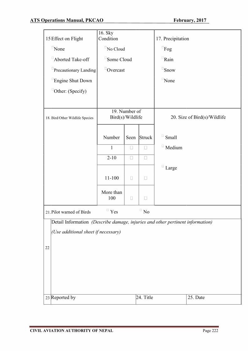
ATS Operations Manual, PKCAO February, 2017
CIVIL AVIATION AUTHORITY OF NEPAL Page 222
15 Effect on Flight 16. Sky Condition 17. Precipitation
None No Cloud Fog
Aborted Take-off Some Cloud Rain
Precautionary Landing Overcast Snow
Engine Shut Down None
Other: (Specify)
18. Bird/Other Wildlife Species
19. Number of Bird(s)/Wildlife 20. Size of Bird(s)/Wildlife
Number Seen Struck
Small
1 Medium
2-10
Large
11-100
More than
100
21. Pilot warned of Birds Yes No
22
Detail Information (Describe damage, injuries and other pertinent information)
(Use additional sheet if necessary)
23 Reported by 24. Title 25. Date