civic visions, national politics, and international
TRANSCRIPT

CIVIC VISIONS, NATIONAL POLITICS, AND INTERNATIONAL DESIGNS:
Three Proposals for a New Urban Center in Tehran (1966-1976)
By
Farshid Emami
Bachelor of Architecture
Shahid Beheshti University (2004)
Master of Urban Design
University of Tehran (2007)
Submitted to the Department of Architecture in partial fulfillment of the requirements
for the degree of Master of Science in Architecture Studies
at the
MASSACHUSETTS INSTITUTE OF TECHNOLOGY
June 2011
© 2011 Farshid Emami. All Rights Reserved.
The author hereby grants to MIT the permission to reproduce and to distribute publicly paper and elec-
tronic copies of the thesis document in whole or in part in any medium now known or hereafter created.
Author_______________________________________________________________________________
Department of Architecture
May 20, 2011
Certified by___________________________________________________________________________
Professor James Wescoat Jr.
Aga Khan Professor of Architecture
Thesis Supervisor
Accepted by___________________________________________________________________________
Professor Takehiko Nagakura
Associate Professor of Design and Computation
Chair of the Department Committee on Graduate Students


Talinn Grigor
Assistant Professor of Fine Arts, Brandeis University
Thesis Reader
Mark Jarzombek
Professor of the History and Theory of Architecture
Thesis Reader
James Wescoat Jr.
Aga Khan Professor of Architecture
Thesis Supervisor


CIVIC VISIONS, NATIONAL POLITICS, AND INTERNATIONAL DESIGNS:
Three Proposals for a New Urban Center in Tehran (1966-1976)
By
Farshid Emami
Submitted to the Department of Architecture on May 20, 2011, in partial fulfillment of the
requirements for the Degree of Master of Science in Architecture Studies
ABSTRACT
In 1975, Muhammad Reza Shah, the king of Iran, inaugurated the construction of a
ceremonial urban center in northern Tehran. The proposed plan, prepared by Llewelyn-
Davies International, consisted of a large plaza and two boulevards lined with
governmental and commercial buildings—an extravagant project made possible by the
1973 oil boom that quadrupled Iran’s revenue. But the Shah’s vision was never realized:
construction was soon halted with the eruption of the protests that led to the fall of the
Pahlavi monarchy in 1979. The Llewelyn-Davies plan was not the first proposal for the
site. It was initially planned in Tehran’s master plan—prepared jointly by Victor Gruen
and Farmanfarmaian Associates (1966-70). In late 1973, Louis Kahn was solicited to
prepare a proposal, which was never finished as Kahn died in March 1974.
This thesis examines these three proposed plans for a new urban center in Tehran. Through
a detailed examination of consultancy reports, architectural drawings and archival
documents, the thesis critically analyzes the urban vision and socio-political underpinnings
of the projects. Based on the three main roles of the new urban center—civic, national, and
international—I interpret the plans as metaphors of urban life; as political tools of nation
building in the postwar web of nation-states; and as products of international design
currents. The aim is to delineate the ways in which international design currents meshed
with the political, social and intellectual context of Iran in the 1970s, a period characterized
by authoritarian rule, monarchical nationalism and rapid modernization.
Underlying all three proposals was a yearning to create a modernized, acculturated and
apolitical urban middle class. The trajectory of these plans demonstrates how the demand
for rapid modernization obliterated alternative voices and led, ultimately, to “the tragedy
of development.”
Thesis Supervisor: James Wescoat Jr.
Title: Aga Khan Professor of Architecture


ACKNOWLEDGEMENTS
I would like to thank first of all Professor James Wescoat Jr. and Professor Nasser
Rabbat, for my intellectual and academic development in the past two years at MIT.
I could not have completed the program without their support. When I look back, I
realize the extent to which my experience at MIT has been life-changing and eye-
opening.
This thesis was a didactic experience. I owe the coherent final shape of my thesis to
my advisor, Professor Wescoat, whose guidance was critical in bringing this work to
this stage. I am grateful to my committee, Professors Mark Jarzombek and Talinn
Grigor, for their continued insights and feedbacks.
I would also like to thank Marilyn Levine at the MIT Writing Center for her editorial
inputs and productive feedbacks. Our conversations helped me find my voice. I
would like to thank Nancy Thorne at the Architectural Archive at the University of
Pennsylvania. I cannot imagine the time that I spent in Philadelphia without her kind
smile.
I would also like to thank Professor Seyyed Mohsen Habibi and Professor Zahra
Ahari; it was under their direction at the University of Tehran that I began my
research on the urban plans of Tehran.
My family supported me through my education at MIT. Thanks to Behzad, my dear
life-time friend, for his photos from Tehran. Thanks to my colleagues in AKPIA and
HTC—particularly Igor, Adam and Maryam—for their help and support.
Ultimately, this was all possible because of Jaleh. I would not have been able to
finish this thesis without her endless support. Her love is the ultimate reason that I
go on.

CONTENTS
INTRODUCTION
11
I. GRUEN AND FARMANFARMAIAN
19
Historical Geography of Modern Tehran 21
The Comprehensive Plan for Tehran: Importing an American Dream 29
The Social Structure of the Metropolis 36
The TCP Plan for Abbasabad Hills 38
Conclusion 41
II. LOUIS KAHN
45
The Global Arena of Kahn’s Architecture 48
Kahn and Iranian Architectural Tradition 49
Kahn in Tehran 54
Tehran Civic Center: “A Place of Natural Gathering” 56
Conclusion 63
III. CENTER FOR THE SHAH AND NATION: SHAHESTAN PAHLAVI
67
Realized Centrality 70
Aesthetics of Rapid Modernization 73
The Plan 74
Accommodating Iranian Tradition 79
Gendered Representation of Monarchy 81
Conclusion
85
IV. CONCLUSION
89
EPILOGUE
99
BIBLIOGRAPHY
105


11
INTRODUCTION

13
INTRODUCTION
On August 19, 1975, Muhammad Reza Shah, the king of Iran,
inaugurated the construction of a sumptuous ceremonial urban center on
the 560-hectare site of Abbasabad in northern Tehran.1 The proposed
plan, prepared by the British firm Llewelyn-Davies International,
consisted of a large rectangular plaza and two boulevards lined with
governmental, commercial, and cultural buildings—an extravagant
project made possible by the 1973 oil boom that had quadrupled Iran’s
revenue. On that midsummer morning in Abbasabad Hills everything
seemed calm and stable; in the same year the Shah had turned Iran into a
one-party state and the opposition was utterly suppressed. The new urban
center was intended “to demonstrate to the world” that Iran was rapidly
moving toward what the shah had proclaimed “Great Civilization.”2 But
the vision of Muhammad-Reza Shah, “the Sun of the Aryans,” was never
realized: construction was soon halted with the eruption of the street
protests that led to the revolution of 1978-79, which ultimately replaced
the Pahlavi monarchy with the Islamic Republic.
The significance of the site of the project stemmed, in part, from its
geographic location: with the northward expansion of Tehran in the
1950s and 1960s, Abbasabad had gained relative centrality in the
northern part of the emerging metropolis on the backdrop of the Alborz
Mountains. As an elevated land with deep valleys and steep ridges, the
site survived the rapid middle class urbanization that was gradually
covering the entire vacant lands between Tehran’s old core and the
foothill region of Shemiran. By the early 1960s, Abbasabad Hills, frozen
amid a residential fabric, was deemed to be an exceptional site for
creating a new urban center in the rapidly expanding capital of the
Imperial Government.
The Llewelyn-Davies design, however, was not the first attempt to plan
and design Abbasabad. In the late 1960s, the first master plan of the
1. Llewelyn-Davies International, Shahestan Pahlavi, A New City Center for Tehran (Tehran: November 1976), 6.
2. Ibid., 36.

14
city—prepared jointly by Abdol-Aziz Farmanfarmaian Association of
Tehran and Victor Gruen Associates of Los Angeles—defined and
planned the site as an urban center. In the Gruen-Farmanfarmaian master
plan for Tehran, Abbasabad was the center of one of the ten proposed
“urban towns,” proposed to be tied by an extensive network of highways
and rapid transit routes. Planned to house a modern neighborhood, the
hilly part of the site was intended to become “a symbol of modern
urbanism.” But the government had higher expectations, far beyond the
bureaucratic design and limited scope of the master plan; in 1973, Louis
Kahn was solicited, in association with the Japanese architect Kenzo
Tange, to prepare a proposal for the new city center. Kahn’s design,
however, remained at the level of preliminary sketches with his death in
March 1974. In the same year, a development corporation was
established by the municipality of Tehran to plan and build the urban
center. In the final scheme of Llewelyn-Davies International (1974-76),
the physical and functional scope of the complex expanded drastically,
covering the hilly part of the site with a building program of more than
five million meters of floor space.
This work aims to critically analyze the socio-political underpinnings of
the three plans prepared for a new urban center in Tehran: the Gruen-
Farmanfarmaian Master Plan (1966-70), Louis Kahn’s unfinished
scheme (1973-74) and the final plan, known as Shahestan Pahlavi,
prepared by Llewelyn-Davies International (1974-76). My attempt is to
understand the ways in which international design currents, as embodied
in these proposals and their designers’ approaches, meshed with the
political, social and intellectual context of Iran in the last fifteen years of
the Pahlavi reign, a period characterized by authoritarian rule, rapid
modernization and fervent nationalism.
The conceptual framework of this study is derived from the three main
roles of the proposed new urban center: civic, national, and
international. I will interpret these three proposals at these three
interrelated levels; as instances of thinking about a civic center and
metaphors of urban life; as political tools of nation building in the

15
postwar web of nation-states; and as products of international design
currents. The interconnected matrix of these levels allows for a fuller
understanding of the multiplicity of voices and complexity of the
modernist project.
Civic. In order to understand the civic scope of the projects, I examine
them within their immediate urban context as well as in the broader
metropolitan area. Geographically, the site of Tehran’s new urban center
was not at the center of the whole city but rather at the center of its
northern part—the urban locus of an emerging upper middle class.
Images of modernity (highways, residential towers, shopping centers,
and theaters), were all targeted toward this specific social group.
National. In the proposals for Tehran’s new urban center, one discerns a
political will to create a modernized, acculturated and apolitical middle
class. This social agenda was interwoven with a nationalism promoted
through monarchy—the king and the queen—portrayed, paradoxically,
as a deeply historical yet modern institution.
International. As works of international modernism, the trajectory of
these projects span a shifting period in the international architectural
discourse: the story begins with a modernist master plan—idealistic and
devoid of notions of history (Gruen); it then moves to the work of an
idiosyncratic intuitive architect of late modernism (Kahn); it concludes
with an “urban design” project that negates modernist ideals of free
rational planning in favor of spatial uniformity, axial configuration and
historical urban forms (Llewelyn-Davies). By analyzing this trajectory,
this work provides a case study of how with the postwar
internationalization of modernism, its social premises—as attempts to
make sense of industrialized societies—metamorphosed into
development agendas in service of oil-rich autocratic states.
While the shift from Gruen to Llewelyn-Davies is emblematic of this
larger global transformation, Kahn offers a unique alternative voice in
late modernism. In this thesis, I demonstrate how Kahn’s idiosyncratic

16
perceptions intersected with the growing interest in traditional
architecture and the idea of Eastern spirituality in Iran. The shift from
Kahn to Llewelyn-Davies shows how the intuitive approach—as signifier
of an alternative yet problematic modernity—was crushed under the
heavy demands for rapid modernization, fueled by the idea of “catching
up with the West” made possible by soaring oil revenues.
Ultimately, the story of Abbasabad is the story of a modern metropolis.
As a visionary future was being imagined for Tehran and its new urban
center, the city was expanding rapidly, not merely in the direction that
the urban plans had projected. It was this conflation of planned and
spontaneous urbanization that brought larger portions of the society into
direct contact with modernity, modernization, and their inherent tensions.
The result was a city whose spatial form—and ultimately its fate—was
shaped by the combined effects of everyday interactions of ordinary
people with modernity, on the one hand, and top-down modernization on
the other.
Except for a short essay by Bernard Hourcade, the proposed projects for
the Tehran new urban center have not been the subject of scholarly
attention.3 Similarly, there have been very few studies on the planning
ideas that have shaped modern Tehran. My investigation, however,
benefits greatly from the emerging scholarship on modernism in the
Middle East as well as the new critical studies of the architectural history
of contemporary Iran.4 By focusing on the large-scale urban planning
projects, I attempt to shed light on other less-studied aspects of the
modernist project in the final decade of the Pahlavi reign. Building a new
urban center for Tehran was the most ambitious project of the Pahlavi
era, and hence it occupies an important place in the national and social
agenda of the state and its manifestations in architecture and planning
discourses.
4. My work particularly benefits from the scholarly works of Talinn Grigor, who has worked extensively on modernism, nationalism and architecture in Iran. This research provides further evidence for many of her interpretations. My attempt is to understand the interactions of broader trends with internal discourses. See Talinn Grigor, Building Iran: modernism, architecture, and national heritage under the Pahlavi monarchs (New York: Periscope Publishing, 2009).
3. Bernard Hourcade, “Urbanisme et Crise Urbaine Sous Mohammad-Reza Pahlavi,” in Téhéran: capitale bicentenaire (Paris: Institut français de recherche en Iran, 1992).

17
Method
In order to identify the ideological stances and implicit assumptions of
the plans, my analysis begins with a close reading of texts, with
particular attention the terminology and details of descriptions. While the
consultancy reports constitute the main source for the analysis of the
Gruen and Llewelyn-Davies proposals, I have used the office documents
in Kahn’s archive for the contextual analysis of his project. The textual
analysis is complemented with a detailed examination of architectural
representations. I have interpreted models, drawings and renditions to
delineate the plans’ paradoxes and underlying assumption, not merely as
further proof for textual information.
I have also used archival documents and journals to establish the broader
architectural context. Demographic and physical changes are studied
through maps, aerial photos, photographs, and census information,
largely provided by consultancy reports. Historical studies of Mark J.
Gasiorowski, Homa Katouzian and Ervand Abrahamian are the main
sources for the political, social and economic history of modern Iran in
the 60s and 70s.5
Thesis Structure
Narrated through historical progression, the thesis is divided into three
main chapters, each focusing on one project. Chapter one begins with a
brief description of the historical geography of Tehran from 1930
through 1965, when the preparation of the city’s first master plan was
begun. By presenting this historical preview, the first part of the chapter
situates Tehran of the mid-1960s in its urban and political context. The
chapter then examines the Tehran Comprehensive Plan and its proposal
for Abbasabad. Despite its reliance on scientific analysis, the ultimate
goal of the Gruen-Farmanfarmaian plan, I argue, was to create an image
of a modern city, and to promote a lifestyle that would be on par with its
contemporaneous Western (American) cities.
5. Ervand Abrahamian, A history of modern Iran (Cambridge: Cambridge University Press, 2008) and Iran between two revolutions (New Jersey: Princeton University Press, 1982).

18
Chapter two focuses on the short yet unexplored involvement of Louis
Kahn in the Abbasabad project. In addition to the materials in Kahn’s
archive at the University of Pennsylvania, I have used architectural
journals to establish the context of Kahn’s design for Abbasabad. The
first part of the chapter focuses on Kahn’s engagement with a
symposium on “the Interaction of Tradition and Technology,” held in the
Iranian city of Isfahan in 1970. I show how Kahn’s intuitive approach
became intertwined with cultural essentialism.
Chapter three focuses on the Shahestan Pahlavi plan, prepared by
Llewelyn-Davies International, under the leadership of the American
planner Jacquelin Robertson. As a large urban scheme, this plan
exemplifies the shift that occurred in the planning discourse from
modernism to a new paradigm that puts more emphasis on image,
identity, and perception of urban spaces. As a national symbol,
Shahestan, I contend, is the manifestation par excellence of what
Muhammad Reza Shah, relying on soaring oil revenues, envisioned to
project as the image of a modernized, yet historical nation-state. In this
chapter, I will show how the increasing oil revenues impacted its design
and how certain historical narratives formed the plan’s frivolous attempts
to incorporate traditional architecture.
In conclusion, I assess the plans by situating them in the broader context
of architectural production in the 1970s. Ultimately, the trajectory of the
Abbasabad plans demonstrates how the demand for rapid modernization
obliterated alternative voices and eventually led to “the tragedy of
development.”

19
Chapter One
GRUEN AND FARMANFARMAIAN


21
I. Gruen and Farmanfarmaian
The Abbasabad site was first defined and planned in the late 1960s in the
Tehran Comprehensive Plan (TCP), the first master plan of the city
prepared jointly by Victor Gruen Associates of Los Angeles and Abdol-
Aziz Farmanfarmaian Associates of Tehran. The TCP envisioned a
metropolis with ten urban districts, containing 5.5 million people,
connected by an extensive network of highways and organized around
ten commercial cores tied by rapid transit routes. The preparation of this
idealistic master plan took place thirty-five years after the demolition of
Tehran’s nineteenth-century walls: a turning point in the history of the
city which opened the way for its postwar dramatic expansion. Before
examining the overall master plan and its proposal for Abbasabad, this
chapter gives a brief account of the historical geography of modern
Tehran from the demolition of its fortifications in the early 1930s until
the preparation of its first master plan in the mid-1960s.
Historical Geography of Modern Tehran (1930-1965)
Until the late nineteenth century, Tehran was a small town, famous for its
gardens, pomegranates and aged plane trees. The early history of the city
was overshadowed by the presence of the city of Rey, an important urban
center of the medieval Muslim world, which was devastated during the
Mongol conquests of the thirteenth century C.E. Located on the northern
fringe of the central Iranian plateau, Tehran occupied less than four
square-kilometers and had the familiar structure of the historical cities of
the region: a linear bazaar connected the southern gate to a roughly
rectangular citadel, which was surrounded by five neighborhoods
(mahalleh) containing a dense fabric of narrow winding alleyways and
courtyard houses. Tehran became the capital in 1789 by the order of Aga
Muhammad Khan, the founder of the Qajar dynasty (1772-1925), who
chose Tehran as the capital; but the original walls of the city—built by
the order of Safavid Shah Tahmasb (reg. 1525-76) in 1553 C.E.—
remained intact for a century, until the late nineteenth century, when,

22
under Naser al-din Shah (reg. 1848-96), the city was enlarged and
surrounded by octagonal walls modeled after Vauban’s design for Paris
(Fig. 1).1
The story of modern Tehran begins with the demolition of the Nasseri
walls and gates. Despite the undertakings of the late Qajar period, Tehran
had remained largely traditional in urban form and architecture,
exhibiting a touch of eclecticism—combining motifs and elements of
European classical architecture with those of traditional Islamic
architecture—particularly in its northern European-elite-inhabited
neighborhoods. It was in the 1930s, under the autocratic state of Reza
Shah Pahlavi (reign 1925-41), that a sequence of interventions
transformed the city from a walled town into a modern-looking city with
a super-imposed network of broad streets—a process generally compared
to the transformation of Paris by Haussmann in the mid-nineteenth
century. The urban transformation was swift and radical; over the course
of a few years, all the gates and walls were torn down, broad avenues
Figure 1. The 1891 map of Tehran. By building the new moat and walls in a distance of two kilometers to the north and one and a half kilometers to the other three directions, the area of the city grew from almost four to twenty square kilometers. The old city and citadel are visible in the center of the map. Instead of the old six gates, the city acquired twelve gates. (Later, with the construction of the railroad, another gate was added.) Growing to the north, many gardens and palaces of the notables were added to the city which turned into the upper class neighborhood where European and the elite lived. As the map shows, many parts of the city were not built upon covered by gardens or farm lands for later developments. This map of Tehran was prepared by Abd ol-Ghafar Khan and his students. Source: H. Bahrambeygui Tehran: an Urban Analysis (Tehran: Sahab, 1977), 24.
1. The design of the octagonal walls is attributed to General Bohler, a French instructor of Dar ol-Funun, a polytechnic institute established in 1851 by the order of Amir Kabir (1807-1852), the powerful vizier of Nasser al-din Shah. For a study of this plan and Tehran in the late nineteenth-century see Mahvash Alemi, "The 1891 Map or Tehran: Two cities, two cores, two cultures." Environmental Design: Journal of the Islamic Environmental Design Research Centre 1 (1985): 74-84.

23
were built on the moats, and cross-shaped streets (khiyabans) cut through
the dense fabric of the city center.2 Even a large portion of the old core
was razed to the ground to make way for the construction of a stoke
market (bourse).3 Within the city, “street widening” was the key word of
urban projects—justified as a necessity for motor vehicles; the
underlying motivation of the urban projects, however, was to create an
image of a modern city: a report on one the first street-widening projects,
published in the Tehran Municipality’s Magazine (Majalleye Baladiyye)
in 1927, stated how after the implementation of the project “the bad-
looking tiny shops running along the street have been replaced by superb
stores.”4 Urban projects had less to do with the functional aspects of the
city than with its appearance—its modern representation.
The urban transformation of Tehran was an integral part of the reforms
promoted by the state of Reza Shah, which aimed at creating a
homogenous, secular and modern nation-state out of the multi-ethnic
territories that it had inherited from the Qajar dynasty. It was along the
same lines that a dress code outlawed the traditional dress (chador) for
women and made a cylindrical hat (kolah Pahlavi) mandatory for all
men.5 Even the performance of the ritual of Ashuara, the most important
Shiite ceremony, became forbidden. In the same period, a secular
judiciary and a modern educational system replaced the religious courts
and schools (madrasas) traditionally administrated by the clergy.
Bureaucracy, court patronage and a modern military were the three main
pillars of “New Iran.”6
It appears that most of the interventions in Tehran were based on an
idealistic plan prepared in the early 1930s, which proposed a network of
boulevards and a relatively rigid system of zoning mostly inspired by the
principles of the Modern Movement.7 Straight streets, monumental
roundabouts at intersections, and a checkerboard pattern for residential
areas were the key concepts of the plan that were implemented in the
1930s. The streets that were built on the moats opened the way for the
expansion of the city toward west and north.
2. The term khiyaban originally referred to orthogonal pathways of gardens, but since the 16
th century
it also designated a monumental tree-lined avenue outside the city. The modern meaning of the term emerged with these projects.
3. Sangelach was one of the five neighborhoods (mahallas) of Tehran. The ambitious plan to build a stoke market was never realized. In 1950s, however, the vacant land was turned into the first large urban park of Tehran known as Park-e Shahr. Seyyed Mohsen Habbi, Az Shar ta Dhahr [de la Cite a la ville] (Tehran: Tehran University Press, 2003) 128.
4. “Khiyaban-i Cheragh Bargh,” in Majalleye Baladie, issue 4, 1927 [1306]: 21-24. Archives of the library of the University of Tehran.
5. Homa Katouzian, State and Society in Iran: The Eclipse of the Qajars and the Rise of the Pahlavis (London: I.B.Tauris &Co Ltd, 2000) 335-6
6. Ervand Abrahamian, Iran between two revolutions (Princeton: Princeton University Press, 1982), 38.
7. Unfortunately there are very few archival studies on the ideas and plans that formed Tehran in the interwar period. The map referred to here is kept in an office of the municipality of Tehran, but has not been studied.

24
Two major architectural styles became dominant in the new streets of the
capital, replacing the eclectic style of the late Qajar period: a modern
abstract style inspired, in part, by the neo-classicism of interwar
Germany, and a historicist style that used pre-Islamic architectural motifs
on the exterior. While the former was generally used in the multi-story
concrete buildings that lined the new streets, the latter was employed in
governmental structures. Through the railroad network and its stations,
the hegemonic visual identity of the state was disseminated throughout
the country. The years between 1930 and 1941 also saw the emergence
of a new form of housing, characterized by orthogonal streets,
particularly to the west and north of the city. These new neighborhoods
were chiefly intended for employees of the government, karmandan. The
expanding bureaucracy of the Pahlavi state translated into new
residential areas.
Figure 2. The 1937 plan of Tehran,
which became known as Map of
Streets (khiyabanha). On the plan,
according to a note at the bottom
of the sheet, “His Majesty, Reza
Shah had marked with a red pen.”
This reminds one of Haussmann’s
Paris where “Napoleon III with his
own hand, ‘his own august hand,’
plotted the alterations he intended
to make in the city.” See Sigfried
Giedion, Space, time and
architecture (Cambridge: Harvard
University Press, 1967), 740.
Image source: Tehran GIS
Organization.
Figure 3. Photo showing the ruins of Tehran’s walls and gates. Source: Hossein Kariman, Tehran dar Gozashte va Hal (Tehran: Melli University Publication, 1976), 227.

25
In this process of urban transformation, the city center acquired a new
meaning and signification. With the replacement of the imperial seat to
the west of the city, most of the Qajar palaces were torn down to make
way for modern buildings housing ministries and governmental
institutions: The physical center of the city was no longer a closed space
covered by interconnected gardens and courtyards used by the Shah’s
harem, but rather an open imposing space dotted with free-standing
modernist buildings, epitomizing the centralized state of Reza Shah and
its heavy reliance on bureaucracy. The symbolic center of the nation that
the state of Reza Shah was attempting to construct was not the locus of
the institution of monarchy but secular judiciary, ministries, and modern
banks.8
The northward expansion of the city began in the same period. The urban
growth was targeted toward Shemiran: a foothill region stretching to the
south of the Alborz Mountains, some five kilometers north of the old
core of the city (Fig. 4). With small villages, verdant valleys and a milder
weather, Shemiran was an appealing retreat from the hot summer days of
Tehran since the nineteenth century. Qajar monarchs had built several
summer palaces in the foothill region overlooking the city. The main
road connecting the city to Shemiran was Old Shemiran Road, which
terminated in Tajrish, the central village of the foothills. In the 1930s, the
north-south connection was augmented by the construction of a new tree-
lined street (Pahlavi Road)—running parallel to the east of the Old
Road—linking the railroad station to a new palatial complex in
Shemiran, called Saadabad. It was along these two avenues that the
postwar expansion of the city took place.
In the summer of 1941, when Soviet and British troops entered Tehran
and the Allied forced Reza Shah to abdicate, little remained of what
defined the Capital of Naser al-din Shah Qajar (Dar ol-Khalafeye
Nasseri). To Western visitors, the city looked quite modern, though
behind the modern façade of the new broad streets, narrow winding
alleyways—and their concomitant social structures—continued to exist
(Fig. 5).9
8. Initially Reza Khan, who assumed power through a coup d’état in 1920, aimed to establish a republic, inspired by the reforms led by Ataturk in Turkey. The idea was rejected, particularly by the clergy. See Abrahamian, Iran between two revolutions.
9. See for example the reflection of the director of the Point Four Program, who was shocked by the modernity of Tehran at the first glance and then realized the hidden part of the city. See William E. Warne, Mission for Peace (New York: Bobbs-Merrill, 1956).
Figure 4. Map of Tehran, showing the northward growth toward Shemiran along Old Road (right) and Pahlavi Road.
Shemiran
26
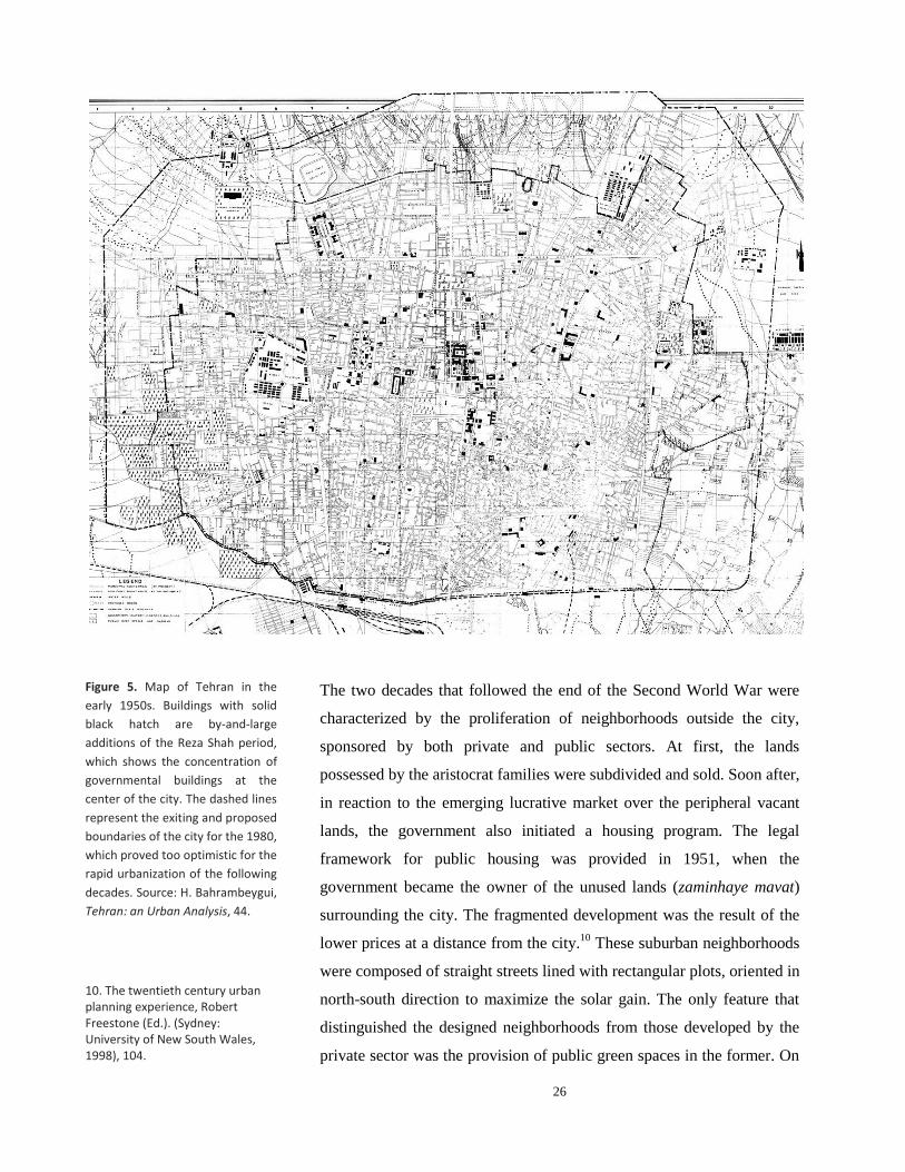
The two decades that followed the end of the Second World War were
characterized by the proliferation of neighborhoods outside the city,
sponsored by both private and public sectors. At first, the lands
possessed by the aristocrat families were subdivided and sold. Soon after,
in reaction to the emerging lucrative market over the peripheral vacant
lands, the government also initiated a housing program. The legal
framework for public housing was provided in 1951, when the
government became the owner of the unused lands (zaminhaye mavat)
surrounding the city. The fragmented development was the result of the
lower prices at a distance from the city.10
These suburban neighborhoods
were composed of straight streets lined with rectangular plots, oriented in
north-south direction to maximize the solar gain. The only feature that
distinguished the designed neighborhoods from those developed by the
private sector was the provision of public green spaces in the former. On
Figure 5. Map of Tehran in the
early 1950s. Buildings with solid
black hatch are by-and-large
additions of the Reza Shah period,
which shows the concentration of
governmental buildings at the
center of the city. The dashed lines
represent the exiting and proposed
boundaries of the city for the 1980,
which proved too optimistic for the
rapid urbanization of the following
decades. Source: H. Bahrambeygui,
Tehran: an Urban Analysis, 44.
10. The twentieth century urban planning experience, Robert Freestone (Ed.). (Sydney: University of New South Wales, 1998), 104.
27
the other hand, modernist aesthetics turned into the dominant language of
architectural design, particularly in the areas located to the north of the
old core, where mid-rise apartment buildings were gradually emerging.
Western-educated architects played a key role in the design of residential
complexes and the dissemination of modernist vocabulary of solid forms
and austere elevations.
The governmental modernization of the 50s and 60s, however, was
largely concentrated on rural areas and provincial towns. As manifested
in the Truman’s Point Four program,11
this preference was informed by
the U.S. Cold War policy that favored reforms in the areas with potential
threat of espousing communism. The propagandist apogee of these
efforts took place in 1962, when Muhammad Reza Shah ushered the
White Revolution: an extensive land reform plan accompanied by
programs for modernization of agriculture, education, sanitation, etc. The
Shah’s Revolution was a modernization package in tune with the
development theories prevalent in the 1950s and 60s, which called for
total restructuring of the “underdeveloped” societies of Asia, Africa and
South America.12
The land reforms had a serious bearing on Tehran,
though: many peasants, no longer capable of effective production in their
allocated lands, began leaving villages for the vocational opportunities
that the capital had to offer, which resulted in a rapid growth in Tehran’s
population.
By the early 1960s, as a result of these social transformations, a clear
north-south polarity had taken shape in the city: while well-to-do
families had begun residing permanently in their villas in Shemiran,
immigrants were gradually settling the old urban fabric of the city center
and the emerging shantytowns of its southern periphery. In 1967, the
Shah’s family left the Marmar Palace of the old core for the Niavaran
Palace in Shemiran. 13
In the mid-sixties, in terms of social and physical
structure, Tehran could be divided into three main regions: the old core,
the central and the north, inhabited by low-income, middle-income and
high-income groups, respectively.14
The hierarchical distribution of these
regions corresponded with the topography of the city: the northern part,
11. William E. Warne, Mission for Peace, Point 4 in Iran (New York: Bobbs-Merrill, 1956).
12. See Arturo Escobar, Encountering Development: The Making and Unmaking of The Third World (New Jersey: Princeton University press, 1995), 4.
13. Designed by the Iranian architect Mohsen Foroughi, the new Niavaran Palace, initially intended for ceremonies, was built between 1956-67 in a garden of Qajar era, where a nineteenth century summer palace was already standing. It became the permanent residence of Muhammad Reza Shah’s family in
1967.
14. Victor Gruen Associates and Abdol Aziz Farmanfarmaian Planners and Architects, The Comprehensive Plan for Tehran, First Stage: Concept Development, Volume I, I-3-5.

28
which has a relatively milder weather in the summer, had larger plots and
was inhabited by wealthy families and high-ranking officials of the
government; low-income classes lived in the southern part; and the
central areas were occupied by middle-income families in two distinct
patterns: low density residential units to the east and west, and three-to-
four-story apartment buildings in the northern part, between the old core
and Shemiran.15
The early 1960s also marked the last presence of urban protesters on the
streets of Tehran until the revolution of 1978-79. With the suppression of
the 1963 uprising (15 Khordad Revolt), which put an end to the minimal
activities of the opposition groups after the coup d’état of 1953, began a
period of political stability and oppressive rule that was to last for fifteen
years. Relying on a notorious secret police (SAVAK), increasing oil
revenues and U.S. military and economic support, in 1963 a highly
autonomous state had been realized.16
By 1966, when the consortium of
Gruen and Farmanfarmaian began to prepare a 25-year plan for Tehran,
its population had reached 3 million (which was 700,000 at the time of
demolition of the walls), with 180 square-kilometers of built area
(including Rey and Shemiran).
Figure 6. Map of Tehran in the mid 1960, showing the development of the city when Gruen-Farmanfarmaian began the plan. The fragmented development of the areas around the city was a reflection of the lower prices of the peripheral lands (in eastern and western parts) and an increased reliance on private vehicles (in northern neighborhoods). Source: TCP
15. Ibid.
16. Mark J. Gasiorowski, U.S. Foreign Policy and The Shah (Ithaca: Cornell University Press, 1991).

29
The Comprehensive Plan for Tehran: Importing an American
Dream
[T]he habit of the people of the United States of America is that women
usually take their husbands to work, then drop off their children at
schools, and go shopping on their way home. The same trend is
gradually becoming evident in Tehran, and the degree of its success at
the end of the plan depends on the efficiency of the public transportation
network. Yet, in terms of planning, the use of private vehicles should be
the basis of future developments.
—The Tehran Comprehensive Plan, 1968.
In late 1965, the Plan and Budget Organization of Iran approached the
architect Abdol-Aziz Farmanfarmaian to prepare a 25-year growth plan
for Tehran.17
In the same year, High Council for City Planning had been
created by the Organization to oversee the preparation of master plans
for major cities. The commission, however, was contingent upon
collaboration with a “foreign partner.” In an interview in 2006,
Farmanfarmaian recalled that the choice of Victor Gruen Associates as
the foreign partner was quite fortuitous: the link between the American
and Iranian firms was Fereydoon Ghaffari, an Iranian town planner
employed by Gruen Associates, who was in Tehran at that time looking
for a potential project for Gruen’s firm. The following year, Gruen
travelled to Tehran and a contract was signed first between the partners
and in February 1966 (Bahman 1344) with the government.18
In Iran, theoretical foundations for a modernist approach to large-scale
planning had been shaped in a conference, Seminar on Social Problems
of Tehran, held at the University of Tehran in 1961. It was in this
symposium that a translation of the Athens Charter, the canonical
manifesto of modernist urban planning, was presented to Iranian
audience for the first time. The participants in the conference—largely
Iranian architects and high-ranking officials but also foreign advisors of
17. Established in 1947 to promote economic development programs, the Plan and Budget Organization was administrated by apolitical technocrats who became the dominant group in the government after the suppression of opposition groups and consolidation of the state in the early 1960s. The main task of the organization was to prepare development plans, which began in 1949 with the assistance of American advisors. The preparation of the master plans was part of the Third Development Plan (1963-67).
18. “Interview with Abdol-Aziz
Farman-Farmaian,” Shahrnegar, Journal of Urban Planning and GIS, No.36, Aug. 2006, 18-25.

30
Tehran’s municipality—called for total redevelopment of the old core of
the city and the provision of a master plan for the capital.19
For the task of preparing a master plan for Tehran, Farmanfarmaian
architectural firm was the best, and perhaps the only, Iranian choice for
the government. Scion of a Qajar aristocratic family and a graduate of
the Ecole de Beaux Arts, Abdol-Aziz Farmanfarmaian (b. 1920) had
established the first “consultant architects firm” in the country and was a
prolific architect, designing several modern houses, as well as high-rise
corporate buildings since his return from Paris in 1950. The
Comprehensive Plan for Tehran was, however, the first “urban venture”
of Farmanfarmaian Associates.
The Austrian-American architect and planner, Victor Gruen (1903-
1980) spent 30 years of his life in the United States, where he became
known as the mastermind of shopping malls, described as the designer
who gave architectural shape to American consumerism.20
Born in
Vienna in a Jewish family, his career in the U.S. began in the early
1940s, subsequent to the Nazi occupation of Vienna. By the early 1960s,
the focus of his work had shifted from mall design to urban planning. In
his 1964 book, The Heart of Our Cities, Gruen proposed an ideal
diagram for a metropolitan region, a proposal that closely resembled
Ebenezer Howard’s Garden City (Fig. 7).21
His role in the master plan of
Tehran, however, appears to have been limited to the first stages, as he
retired from Gruen Associates in 1968, in part because of his ailing
health, but largely to fulfill his lifetime desire of returning to Vienna.22
Fereydoon Ghaffari was the principle designer that played the key role
for Gruen Associates in the master plan of Tehran.
19. Seminar on the Social Problems of Tehran (Tehran: University of Tehran, 1961).
20. For a detailed study of Gruen’s American career see M. Jeffrey Hardwick, Mall Maker: Victor Gruen, Architect of an American Dream (Philadelphia: University of Pennsylvania Press, 2004)
21. In the book, Gruen states that it was after completing his diagrams that he realized someone else had proposed a similar diagram. See Victor Gruen, The Heart of Our Cities (New York: Simon and Schuster, 1963)
22. Hardwick, Mall Maker: Victor Gruen, Architect of an American Dream.

31
The Tehran Comprehensive Plan (TCP) was prepared in two stages. The
final consultancy report was drafted in English and a translation with
minor modifications was submitted to the government. The first stage,
“Concept Development,” consisted of five volumes with over 1500
pages. While the first volume provides a summary of the whole report,
the second and third volumes shape the main body of the report. The
second volume, “Study and Evaluation,” is basically a detailed study of
Tehran, its history, current status and future needs, providing an
extensive physical program for the plan. Concluding with “Projection of
Growth,” it leads to the third and the core of the report, “The Planning
Concept,” where the main ideas of planning and growth are presented.
Organized in a classical urban planning report, the third volume begins
with goals and objectives, followed by a planning program. It then offers
a number of alternative patterns and subsequently presents the concept
for the comprehensive plan and its economic aspects. The relatively brief
Figure 7. Gruen’s diagram for “the
cellular metropolis” of tomorrow:
“ten cities surrounding metro core
consisting of ten core frame units
and metro center. Source: Victor
Gruen, The Heart of Our Cities
(New York: Simon and Schuster,
1963), 272.

32
fourth and fifth volumes, “Recommendations for Urgent Problems” and
“Appendix” are complementary to the main text and target the current
problems which need to be addressed in short term. A full examination
of the Tehran Comprehensive Plan is beyond the scope of this study. A
review of some of its key features, however, will help situate the
proposals for Abbasabad in their broader context, and is essential to
understanding the site’s future transformations as well as the transitions
in the architectural culture of Iran in the following decade.
The plan enumerates the major problems of the city as high density
(especially in the city center), air pollution, inadequate services,
unemployment, and constant migration.23
The document also alludes to a
shortage in housing: while there are 20,000 extra residential units for the
high-income portion, at the level of low-income classes a shortage of
80,000 residential units is discernable. In terms of economic prospect,
the most significant trend in the next 25 years would be a considerable
increase in income per capita and car ownership.24
The TCP is also preoccupied with the image of Tehran as a capital. A
survey of Iranian historical capitals (such as Shiraz and Isfahan) and
modernist cities like Brasilia and Chandigarh was carried out to
determine the elements that constitute “a recognizable and admirable
capital image.” Based on this study, the document concludes that,
“Tehran has neither the historical characteristics of Rome and London,
nor the controlled appearance of Washington or Canberra.”25
In keeping with the modernist emphasis on rationalism and scientific
analysis, the TCP attempts to base its proposal on extensive social,
economic and demographic studies. Part of these studies, conducted by
the Institute for Social Studies, showed that the population of Tehran at
the final stage of the plan in 25 years would reach between 12 to 16
million. However, the officials—and probably the Shah himself—
decided to limit the population to 5.5 million, allegedly due to the limited
water resources.26
This decision required a decrease in the rate of
23. Gruen and Farmanfarmaian, Comprehensive Plan for Tehran, Stage I, Concept Development, Volume I, 5-9.
24. Ibid., C-I-52.
25. Ibid.
26. Ibid., I- 5-2.
33
population growth from 5.2% to 1%. It appeared as if a royal decree
would determine the future.
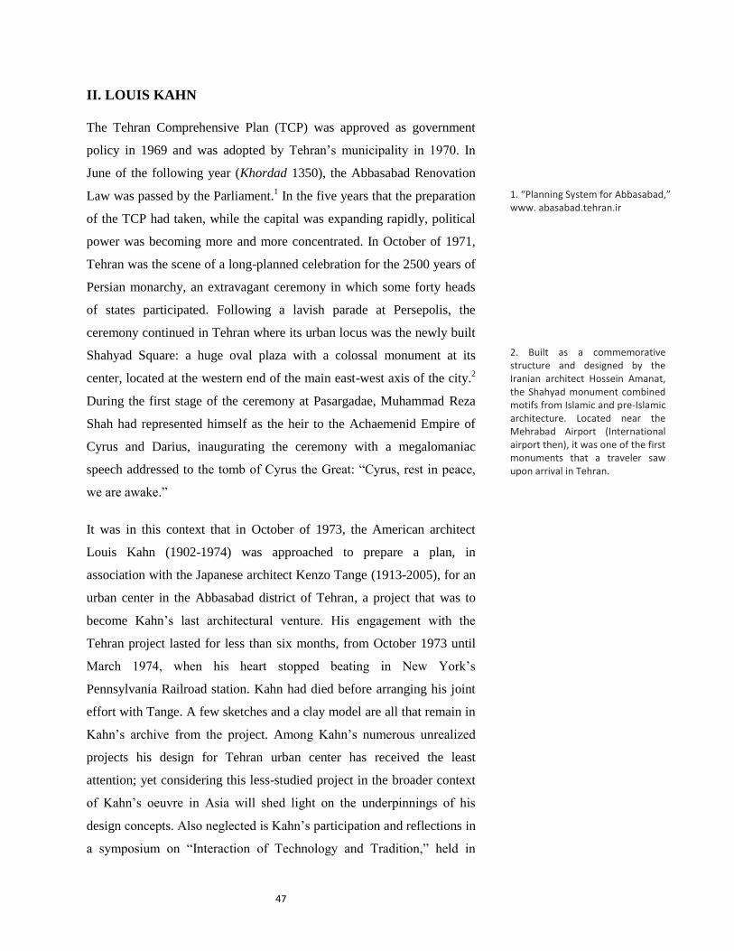
In order to determine the most appropriate “development concept” for
Tehran, the TCP uses oversimplified abstract notions of urban form,
developed in utopian proposals since the nineteenth century. The final
proposal is an east-west linear growth, a concept privileged over nuclear
and distributed “forms of growth” on the basis of a brief analysis of
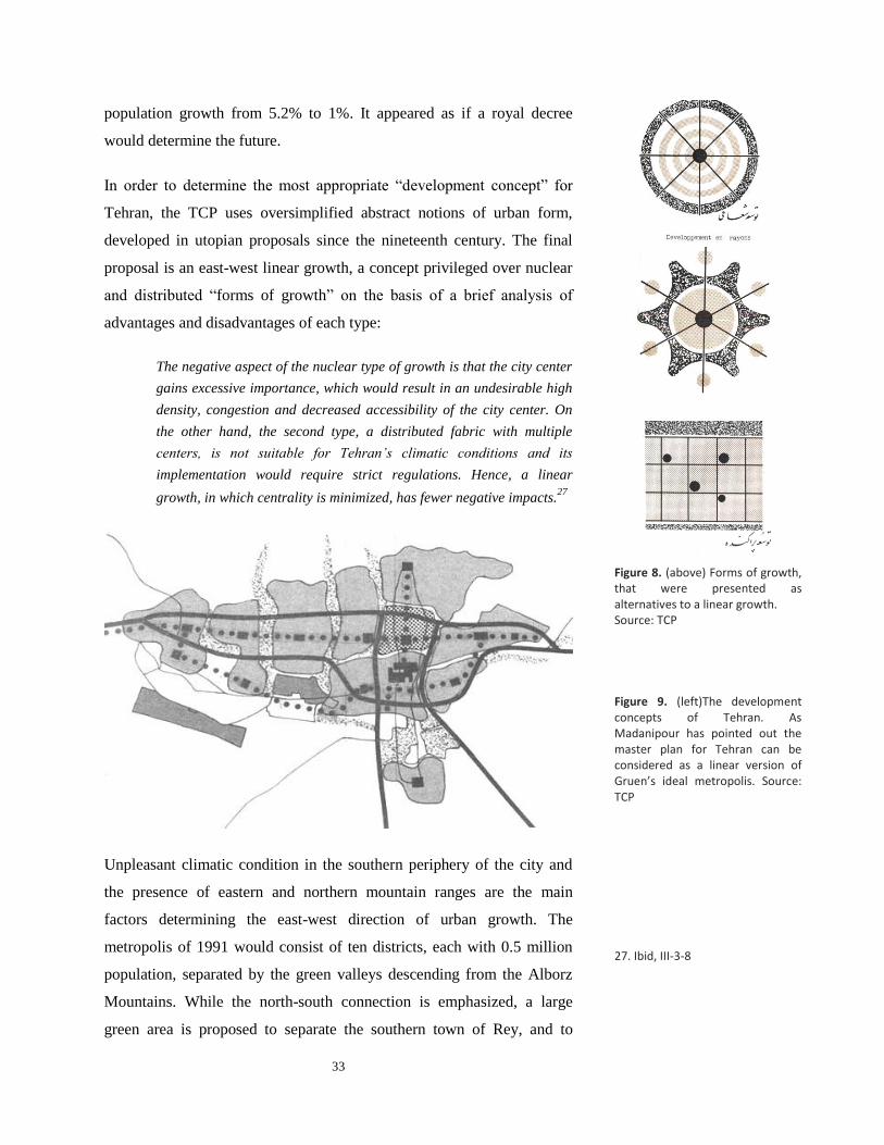
advantages and disadvantages of each type:
The negative aspect of the nuclear type of growth is that the city center
gains excessive importance, which would result in an undesirable high
density, congestion and decreased accessibility of the city center. On
the other hand, the second type, a distributed fabric with multiple
centers, is not suitable for Tehran’s climatic conditions and its
implementation would require strict regulations. Hence, a linear
growth, in which centrality is minimized, has fewer negative impacts.27
Unpleasant climatic condition in the southern periphery of the city and
the presence of eastern and northern mountain ranges are the main
factors determining the east-west direction of urban growth. The
metropolis of 1991 would consist of ten districts, each with 0.5 million
population, separated by the green valleys descending from the Alborz
Mountains. While the north-south connection is emphasized, a large
green area is proposed to separate the southern town of Rey, and to
27. Ibid, III-3-8
Figure 8. (above) Forms of growth, that were presented as alternatives to a linear growth. Source: TCP
Figure 9. (left)The development concepts of Tehran. As Madanipour has pointed out the master plan for Tehran can be considered as a linear version of Gruen’s ideal metropolis. Source: TCP

34
enhance the linear growth of the city. Each district would contain a
commercial and an industrial center.
For transportation, the TCP proposes a “complete network of highways”
with the total length of 150 kilometers. Yet the plan also attempts to put
a similar emphasis on a public transit system. Following a description of
two different methods of transportation—network of highways and
public transportation—the TCP suggests “a balanced system” as the best
solution for Tehran’s transportation system. Referring to current
transportation systems in Los Angeles as an example for network of
highways and New York, Moscow, London and Paris as cities with
extensive networks of public transportations (including subway trains
and buses), the TCP suggests a balanced system of transportation like
that of Chicago, claiming that such a system would combine the
advantages of both systems. In the TCP’s final proposal for Tehran’s
transportation, an east-west rapid transit route, with a branch heading to
the south, is completed with two main east-west highways on the two
sides of the rapid transportation route, giving access to all parts of the
city (Fig. 9).
As Madanipour has also pointed out, the master plan of Tehran can be
considered as a linear version of Gruen’s diagram for an ideal
metropolis: 28
both plans consist of ten smaller units, the urban centers
are connected by public transit lines, and large green areas separate the
districts. The design of the urban centers also resembles Gruen’s designs
for shopping malls and renovation plans for city centers in the United
States (Fig. 10 & 11). Yet, the idea of a linear city is somehow at odds
with Gruen’s idea of a distributed metropolis. In many ways, the TCP
diagrams evince more similarities with Le Corbusier’s design for
Chandigarh, whose green strips might have been the “formal” model for
the green valleys of Tehran, displaying a formalism that was criticized by
Gruen in The Heart of Our Cities. As it was with “high modernism,”
Tehran was conceived like a tableau— an esthetic composition of green
strips, parkways and highways.
28. Ali Madanipour, Tehran: the Making of a Metropolis (Chichester: John Wiley, 1998), 208.

35
Figure 10. (left) Interior view of a
shopping center proposed by the
Tehran Comprehensive Plan. In
representation, it resembles
Gruen’s design for shopping malls
in the US. Yet, interestingly, all the
boards are national products.
Source: “Tehran Comprehensive
Plan,” Honar va Memari, Issue 5,
33.
Figure 11. Section of an urban
center proposed by Tehran
Comprehensive Plan.
Source: “Tehran Comprehensive
Plan,” Honar va Memari, Issue 5,
67.

36
The Social Structure of the Metropolis
In terms of social structure, the TCP extends the newly formed north-
south social division of the existing city to the areas planned for
development to the west: just as in the existing city, well-to-do families
would “naturally” settle the northern foothill region; the southern parts,
which are closer to industrial centers, would be inhabited by low-income
people; and the central areas are reserved for middle-income group. The
middle class is referred to as the least satisfied class in the city as they
have the desire to enjoy the same life-style of the wealthier for which
they do not have the financial resources. The plan, therefore, strives to
provide the facilities of a “modern life-style” to satisfy the developing
middle-class. 29
The underlying social vision of the TCP is particularly evident in the
plans and descriptions that it offers as prototypes for different income
groups. Modeled after the concept of “Neighborhood Unit,”30
the typical
high-income neighborhood is composed of large plots arranged around
an open space with an elementary school (Fig. 13). Accessed by
highways and curved roads, the neighborhood is mostly covered with
single-family plots; though luxurious apartment buildings with
“swimming pools and tennis courts” are also provided, perhaps to
enhance the modern image of the neighborhood. Because of their high
income, the document further relates, “automobile, television,
refrigerator, garden and skiing” would be important in the lives of these
families.31
(The first three commodities clearly indicate the consumerism
that was being promoted by the master plan.) It appears that this was the
group for whom the entire city was being designed, whose life-style
would attract other income groups: with their “increased mobility,” the
middle-income families “will tend to settle in the northern parts of the
city.”32
In contrast to the curvilinear street system of high-income districts, the
typical southern neighborhood is composed of orthogonal grid with tiny
plots, probably modeled after the Doxiadis grid design (Fig. 14).
30. According to Clarence Perry’s diagrammatic planning model for neighborhoods, the city should provide services in different scales. The basic unit of a neighborhood is associated with the number of households in a walking distance to an elementary school. A combination of these units shape a larger unit serviced by a high school and etc.
31. “Tehran Comprehensive Plan,” Honar va Memari, Issue No. 5, 53.
32. The assumption of designing neighborhoods as transition was a common concept in postwar international modernism. The notion of social mobility was also present in the Doxiadis plan for Islamabad.
29. According to the TCP, the lower income groups “see Tehran as their Utopia, regardless of the deficiencies they face in the city.” like lack of clean water, high density and low standards of living.

37
Housing immigrants, the southern part is considered as a necessity, a
transitory station for immigrants, who would be absorbed into the middle
class in future. Although the idea of dividing the city in specific areas for
certain income groups was not a new phenomenon in the master plan of
Tehran, it had rarely been given such a clear spatial expression.
Figure 13 & 14. Plan of residential
neighborhoods for high-income
(left) and low-income (right)
communities.
Figure 12. View of the proposed
design for the northern part of the
city. This vision was partly realized
in the 70s. Source: “Tehran
Comprehensive Plan,” Honar va
Memari, Issue 5 (The two other
images on this page are also from
the same source)

38
The TCP Plan for Abbasabad Hills
The story of Abbasabad corresponds with the general historical
geography of Tehran. Like many other lands located on the periphery of
the city, Abbasabad initially belonged to Qajar aristocrat families. Old
maps show that a structure was standing on the site, and that it was
dotted by several strings of subterranean water channels (qanats). The
land was purchased by the Agricultural Bank of Iran in the 1930s, and
was later distributed among other governmental institutions, which then
subdivided and allocated the plots to their employees. In 1963 (1342),
the government approved repurchasing the land, which was completed in
1969.33
A map published in the TCP shows the whole area, similar to the
surrounding fabric, was to be regularly subdivided (Fig.15). Thus, the
idea of making Abbasabad an urban center existed before the preparation
of the TCP.
In the general scheme of Gruen for Tehran, Abbasabad occupied a
prominent position; it was not only the center of one of the ten proposed
urban districts (mantaghe), but also located at the intersection of the two
main axes of the city: a north-south axis, comprising four nodes —
Shemiran, Abbasabad, the old city center and Rey—and the proposed
Figure 16. Map of Tehran and its
environ in the nineteenth century,
showing Abbasabad to the north of
Tehran. Source: H. Bahrambeygui,
Tehran; an Urban Analysis, 22.
Figure 15. Plan for the subdivision
of Abbasabad prior to the
preparation of the master plan of
Gruen-Farmanfarmaian.
Source: TCP
33. “Planning System for Abbasabad,” www. abasabad.tehran.ir

39
east-west axis along which the future growth of the city was envisioned.
Moreover, the two main north-south and east-west public transit routes
(metro) intersected on the southern part of the site.
The TCP divides Abbasabad into three parts: the Abbasabad district, an
arbitrary boundary that encompassed one of the ten proposed districts of
the master plan; the hills were reserved for housing development; and the
Abbasabad urban center was located on the flatter lands to the south of
the hills. The aim of the comprehensive plan for Abbasabad, then, was
twofold: first, to prepare “an appropriate environment” for creation of “a
modern urban center” (markaz-e modern-e shahri),34
and second,
preparation of a plan for land subdivision, which would replace a pre-
existing one (Fig. 15). The principal concern expressed is that the site
might be filled with monotonous two-story residential buildings, which
would be in contrast to making Abbasabad a sample of “modern
urbanism” (shahrsazi-ye jadid), as envisioned in the master plan.
Figure 16. Urban districts proposed
by the Tehran Comprehensive
Plan. Source: Llewelyn-Davies
International, Shahestan Pahlavi
(1976), Book I, 30.
34. Gruen and Farman-Farmaian, Comprehensive Plan for Tehran, Stage I, Comprehensive plan for Abbasabad.

40
Prepared as an attachment to the TCP, a report that deals with Abbasabad
specifically is concise and follows the same visions of the overall master
plan. Like the master plan, the urban analysis of Abbasabad district
exhibits a heavy reliance on scientific methods: the need for new roads is
based on a quantitative study of traffic flow in major thoroughfares. This
scientific tenor gives the plan a seeming rationality, which is not
necessarily related to the final design.
It is in the final parts that the true modernistic nature of the plans reveals
itself—where hotels, stadiums, the green strips connecting the schools
are described and “the beauty of highways” is emphasized. Judging by
the descriptions of the neighborhood prototypes, the hilly part of the site
was designed for high-income groups, although geographically it was not
located in the northern part of the city: It was the altitude of a site that
determines the appropriate social class that would inhabit it—the higher
lands topographically were reserved for groups higher economically. In
Figure 17. The Master plan’s
proposal for Abbasabad. Dots
represent elementary schools,
which are connected by green
strips. Three district centers are
also proposed. The southern part,
in dark grey, is reserved for the
urban center. Source: TCP

41
the TCP, Abbasabad was envisioned as a luxurious modern
neighborhood, rather than an administrative center.
Conclusion
The Tehran Comprehensive Plan, and its proposal for Abbasabad, was a
an instance of modernist planning, with similar grand aspirations, yet
devoid of Early Modernism’s humanist premises and goals of social
equality. It shows how with the postwar internationalization of
modernism, it metamorphosed into a tool for development and creation
of images of modernity.
Yet, ironically, the plan is devoid of explicit political manifestations or
symbolic representations of state, a key feature of several postwar
international urban plans. Unlike the Doxiadis master plan for Islamabad
(1959), for example, no ceremonial axial space was proposed in the TCP;
nor does the plan have the iconic center of, say, Brasilia, where the so-
called Plaza of Three Powers was situated at the focal point of the
crescent-shaped plan of the city. The study of the image of the capitals
was hardly, if at all, reflected in the final master plan or its proposal for a
city center at Abbasabad. (Even the consultancy report is devoid of the
hyperbolic language of later projects praising the Shah and his glorious
services to the country.) At the core of the master plan was the lifestyle
of an economically prosperous capitalist society (read America), whose
symbols—i.e., shopping malls, highways and privatized housing—were
extrapolated to a new landscape: the plan was a replication par
excellence of “American landscapes of consumption.”35
The culture of
consumption was particularly celebrated by positioning the shopping
malls at the foci of the ten proposed urban towns.
Of the four core urban functions proposed by CIAM (Congrès
internationaux d'architecture moderne), the master plan’s emphasis was
on housing and transportation rather than industry. Even the economic
opportunities that the production of the city would create were to be
channeled through the state: the entire infrastructure and large housing
35. Jeffrey W. Cody, Exporting American Architecture, 1870-2000 (New York: Routledge, 2003), xiv.

42
developments were to be implemented through large public investment.
In the oil-based economy of Iran, in which the government acted as the
distributer of oil revenues, the modern city was to facilitate consumption
rather than any real economic production.
Due to the master plan’s emphasis on material prosperity and the absence
of direct ideological representation, scholars such as Ali Madanipour
maintain that the Comprehensive Plan for Tehran—and generally urban
planning in pre-revolutionary Iran—was largely an apolitical activity, a
phenomenon that should be analyzed within a technocratic framework.36
Yet in the context of the 60’s, in which the democratic aspirations of
modern middle class had been suppressed, this seemingly apolitical
approach in fact served a highly political end: for the autocratic regime
of the Shah, modern urban planning was a tool, a mechanism “to co-opt
the modern middle class, the industrial working class, and other key
societal groups, undermining support for opposition organizations among
these groups.”37
What the TCP was attempting to create was a
prosperous “apolitical” society whose main communal spaces, just as in
its American model, were to be pseudo-democratic spaces of shopping
centers.
Even so, from a post-colonial standpoint, the TCP should also be seen as
a constituent part of the global experience of modernity and
modernization. Despite the over-simplified statement of some studies,
which regard non-Western societies as passive recipients of Western
models, it was not the Shah “who chose Gruen for his Modernization
program.”38
The preparation of the master plan of Tehran attests to the
active role of the Iranian partner. In contrast to the common narratives,
the non-Western agents of modernization and proponents of modernism
in architecture and planning cannot be described as “brainwashed
postcolonial elites,” who betrayed their ancestral tradition.39
In Iran, the
genealogy of modernists can be traced back to the intelligentsia of the
nineteenth century (the Qajar era), who, in the semi-colonial context of
territorial losses to Russia and Britain, began advocating for extensive
reforms and “the rule of law.” Like their Western counterparts, their faith
36. Ali Madanipour, Tehran: the Making of a Metropolis (Chichester: John Wiley, 1998), 206.
37. Gasiorowski, U.S. Foreign Policy and The Shah, 187.
38. See for example the short account of Jeffrey Hardwick in Mall Maker: Victor Gruen, 220.
39. William J. R. Curtis, Modern Architecture since 1900 (Oxford: Phaidon, 1982), 356.

43
in modernism stemmed from a deep belief in dramatic societal change, in
a penchant for breaking with the past and replacing the old norms and
institutions with something utterly new. From this perspective, the TCP
presents a conscience appropriation of images of modernity.
Another noteworthy feature of the TCP is the absence of historical
references or Orientalist fantasies, which were present in several postwar
architectural and urban proposals in the Middle East. Walter Gropius’s
design for the University of Baghdad (1953-58), for example, had
engaged with several architectural and social aspects of the region.40
Similarly, Frank Lloyd Wright’s first reaction to a commission from the
Iraqi government was excitement about designing in the land of A
Thousand and One Nights.41
Even Doxiadis master plan for Baghdad
(1958), attempted to incorporate some aspects of local culture by
designating communal spaces of neighborhoods as gossip squares.42
It
appears that the reason for the absence of Orientalist assumptions was
the presence of an Iranian partner, with a firm belief in the global
application of modernism. The absence of notions of history and local
customs in the Tehran Comprehensive Plan is particularly important
when compared with the proposals prepared for Abbasabad in the 1970s.
The master plan of Tehran presents the first attempt to plan the
Abbasabad site. While the hilly part of the site was designed to house a
modern neighborhood, the southern flatter lands were reserved for the
district’s urban center. The TCP’s proposal for Abbasabad was the basis
for the projects that were prepared for the site in the 70s, including the
proposals of Louis Kahn and Llewelyn-Davis International.
As a comprehensive plan, the TCP established the spatial and regulatory
framework for the development of the city until the revolution of 1978-
79. It is the main design proposal that has had the most significant impact
on the physical form of Tehran. Beginning from the late 1980s, under the
leadership of a new class of technocrats, the infrastructure of the Gruen
plan was gradually implemented—an important part of a new
modernization program begun after a decade of revolutionary instability
41. Panayiota I. Pyla, “Baghdad’s
Urban Restructuring, 1958:
Aesthetics and Politics of Nation
Building,” Modernism and the
Middle East, 97-115.
42. Magnus T. Bernhardsson, “Visions of Iraq: Modernizing the Past in 1950s Baghdad,” in Modernism and the Middle East, 88.
40. Gwendolyn Wright, “Global
Architecture and Local
Knowledge,” Modernism and the
Middle East: architecture and
politics in the twentieth century.
Sandy Isenstadt and Kishwar Rizvi,
ed. (Seattle: University of
Washington Press, 2008), 221.

44
and war with Iraq. The proposed commercial centers of the TCP were
never realized but the interlacing highways and parkways now constitute
the major elements of the image of Tehran, particularly in its northern
and western parts. Forty years later, from an airplane, one can see partial
realization of the modernist tableau.

45
Chapter Two
LOUIS KAHN

47
II. LOUIS KAHN
The Tehran Comprehensive Plan (TCP) was approved as government
policy in 1969 and was adopted by Tehran’s municipality in 1970. In
June of the following year (Khordad 1350), the Abbasabad Renovation
Law was passed by the Parliament.1 In the five years that the preparation
of the TCP had taken, while the capital was expanding rapidly, political
power was becoming more and more concentrated. In October of 1971,
Tehran was the scene of a long-planned celebration for the 2500 years of
Persian monarchy, an extravagant ceremony in which some forty heads
of states participated. Following a lavish parade at Persepolis, the
ceremony continued in Tehran where its urban locus was the newly built
Shahyad Square: a huge oval plaza with a colossal monument at its
center, located at the western end of the main east-west axis of the city.2
During the first stage of the ceremony at Pasargadae, Muhammad Reza
Shah had represented himself as the heir to the Achaemenid Empire of
Cyrus and Darius, inaugurating the ceremony with a megalomaniac
speech addressed to the tomb of Cyrus the Great: “Cyrus, rest in peace,
we are awake.”
It was in this context that in October of 1973, the American architect
Louis Kahn (1902-1974) was approached to prepare a plan, in
association with the Japanese architect Kenzo Tange (1913-2005), for an
urban center in the Abbasabad district of Tehran, a project that was to
become Kahn’s last architectural venture. His engagement with the
Tehran project lasted for less than six months, from October 1973 until
March 1974, when his heart stopped beating in New York’s
Pennsylvania Railroad station. Kahn had died before arranging his joint
effort with Tange. A few sketches and a clay model are all that remain in
Kahn’s archive from the project. Among Kahn’s numerous unrealized
projects his design for Tehran urban center has received the least
attention; yet considering this less-studied project in the broader context
of Kahn’s oeuvre in Asia will shed light on the underpinnings of his
design concepts. Also neglected is Kahn’s participation and reflections in
a symposium on “Interaction of Technology and Tradition,” held in
1. “Planning System for Abbasabad,” www. abasabad.tehran.ir
2. Built as a commemorative structure and designed by the Iranian architect Hossein Amanat, the Shahyad monument combined motifs from Islamic and pre-Islamic architecture. Located near the Mehrabad Airport (International airport then), it was one of the first monuments that a traveler saw upon arrival in Tehran.
48
Isfahan in 1970, which can be illuminating in understanding the nature of
his relationship with the non-Western context, as well as the intellectual
and political context of his design for Tehran’s new urban center.
The aim of this chapter is to delineate how Kahn’s perceptions of
monumentality and history became intertwined with the architectural
culture and political context of Iran in the 1970s. I will demonstrate how
Kahn’s encounter with local architects was reflected in his thinking and
design, and how his ideas were co-opted to serve a political end. In doing
so, and in order to establish the context of Kahn’s project, the first part of
the chapter focuses on the Isfahan symposium in 1970, analyzing its
main political and intellectual underpinnings as they intersected with
Kahn’s thoughts. I will then examine Kahn’s design for Abbasabad
Urban Center (1973-74), its political underpinnings, and its influence on
the future planning and design of the site.
The Global Arena of Kahn’s Architecture
The prolific period of Kahn’s career, which brought him international
fame, began in the early 1960s, a rather late time in his life. Several of
these projects, now considered as canonical works of modern
architecture, were from across the globe—designed with relative
freedom and supported by large budgets. Chief among Kahn’s
international projects were the Indian Institute of Management in
Ahmadabad (1962-74), the Parliament building in Dhaka (1962-74), and
an unrealized synagogue in Jerusalem, all characterized by monumental
expression and sensitivity toward their new international context.
It has been argued that for Kahn, who was educated in a Beaux-Arts
system at the University of Pennsylvania (1924), history and
monumentality had been the main themes of design from the outset. Yet
it was in the postwar architectural discourse that his ideas were
articulated. In his first theoretical article, which appeared in 1944 along
with an article by the celebrated theorist of modern architecture Sigfried
Giedion on “the question of monumentality,” Kahn wrote that “the

49
buildings of our future” should rely on “the common characteristics of
the greatness” that are embodied in the “monumental structures of the
past.” Kahn’s definition of monumentality was imbued with mystical
terms: “monumentality in architecture can be defined as a quality, a
spiritual quality inherent in a structure which conveys the feeling of its
eternity, that it cannot be added to or changed.”3 Kahn’s argument was
that “monumental architecture should be discovered in history and then
made modern by the application of new technology.”4 Yet as several
scholars have argued, his commissions in the Indian subcontinent had a
great impact on his design and thinking, accentuating the mystical
approach and transcendentalism that he had developed in the early years
of his career. The central water channel in the iconic plaza of the Salk
Institute (1959-65) was certainly inspired by the Mughal gardens of
India.5 The square basin at the end of the channel particularly recalls
Mughal gardens.6 Yet the influence can be described in broader terms:
the Salk Institute was perhaps the first modern building whose primary
image was not massive forms but an open space.
The global context of these projects also led to Kahn’s criticism of the
internationalism of early modernism. During his visit to Chandigarh in
1962, Kahn criticized the masterpiece of Le Corbusier for being out of
context.7 If in 1944 he had mentioned Roman and gothic architecture as
historical sources for a modern monumentality, Kahn’s “history” was
now largely expanded.
Kahn and Iranian Architectural Tradition
In October 1973, when Louis Kahn was contacted regarding the design
of an urban center in Tehran, the National Assembly at Dhaka was in the
final stages of construction and the Indian Institute of Management was
just recently completed. Iran was the last country, following India,
Pakistan and Israel, in which Kahn was solicited to design a building of
national significance. Kahn’s commission for the new Urban Center in
Tehran, however, was not his first engagement with the architectural
culture of Iran. In September 1970, together with Buckminster Fuller
6. The final design of the plaza took place in 1965.
7. Brownlee and De Long, Louis I. Kahn, In the Realm of Architecture, 82.
3. Quoted in David B. Brownlee and David G. De Long, Louis I. Kahn, In the Realm of Architecture (New York: Museum of Contemporary Art, 1997), 43.
4. Ibid.
5. Ibid., 100.

50
(1895-1983), George Candilis (1913-1995) and Paul Rudolph (1918-
1997) among others, he participated in the International Congress of
Architects, a symposium organized by the Ministry of Development and
Housing and Iran’s Society of Architects.8 Held a month before the
2500-year celebration of the Persian Monarchy, the symposium had
similar political underpinnings: following a visit to Persepolis and the
historic monuments of Isfahan, “the delegates from fourteen different
nations,” convened in the Chehel Sotoon palace, a seventeenth-century
Safavid monument, for the opening ceremony of four days of discussions
on “The Interaction of Tradition and Technology.”9 It was in this
gathering that the main architectural discourse in Iran was crystallized.
Studying the symposium and its key ideas is helpful in understanding
how Kahn’s design and idiosyncratic perceptions intersected with the
political and intellectual context of Iran in the 1970s.
The symposium was inaugurated by Queen Farah Pahlavi (b. 1938),
who, in keeping with her position as the royal consort and as a former
student of architecture, was an avid patron of art and architecture.10
In
addition to organizing an annual art festival in Shiraz, she had purchased
a unique collection of modern art for the Museum of Contemporary Arts
in Tehran, which is still claimed to be the largest collection of Western
art outside the West. Her role gained a more conspicuous political
dimension in 1967, when she was declared the royal regent and was
bestowed the title of Shahbanou (literary “lady-king”), a term supposedly
used in Middle Persian for the female monarchs of the Sassanian dynasty
(224- 651 C.E.).11
The concept of Shah and Shahbanou, a ruling couple,
was intended to project a gesture of gender equality, to construct a
modern image of the Pahlavi family disguised in pseudo-historical terms.
In her inaugural speech to the Isfahan conference, where Kahn was
sitting in the audience hall of Chehel Sotoon with images of Safavid
kings in battle and feasting, Farah Pahlavi referred to “the technological
progress of our time” which provided “unlimited facilities and new
horizons to those who create our human environments.” Yet for those
countries “who share a strong traditional background” the queen
10. The role of Farah Pahlavi has been studied extensively by Talinn Grigor. My analysis of her role in the Abbasabad projects is based on her interpretations. See Grigor, Building Iran, 182-186.
11. The queen’s role as the royal regent was legally affirmed by an amendment to the constitution stipulating that in the event of the death of the Shah, if the crown prince was under the legal age, the queen would rule the country.
Figure 18. Farah Pahlavi,
inauguration ceremony of Isfahan
symposium. Source: The Interaction
of Tradition & Technology (the two
following photos are from the same
source.)
8. Walter Gropius, Mies van der Rohe and Richard Neutra were also planning to attend the symposium, but all died in late 1969/early 1970.
9. The lectures and discussions were transcribed in a volume: The Interaction of Tradition & Technology, Report of the Proceedings of the First International Congress of Architects, Isfahan (Ministry of Housing & Urban Development, Government of Iran, 1970).

51
emphasized that it is important to find “compatible interaction between
elements of permanence within this overall change. In our view,” she
concluded, “these resolutions should reflect the spiritual base that
characterizes the Eastern culture.”12
The key themes of the symposium—namely tradition, spirituality and
interaction between tradition and technology— signaled a major shift in
the approach of the Pahlavi regime toward Iran’s history and
architectural heritage: unlike the mainstream ideology of the Reza Shah
period (1925-1941), where only the monuments of pre-Islamic Iran were
considered as true manifestations of the Aryan origin of the Iranians, in
the postwar era the Islamic monuments were given an equal emphasis.13
Beginning from the 1960s, besides upholding a Persian essence, the
monuments of the Islamic period were also considered as manifestations
of Eastern spirituality, inspired by the mystical Sufi tradition of Islam.14
The concept of spirituality, emphasized in the queen’s speech, was
instrumental in the co-option of Sufism into the regime’s ideology. The
modern identity of the Iranian nation-state was no longer solely Aryan or
Persian. Islam, conceived as spirituality, was creeping into the state’s
ideology.15
Figure 19. Louis Kahn (the third
person from the right) in a photo
with Queen Farah Pahlavi at
Isfahan symposium.
13. The notion of a continuous Persian architecture was particularly promoted by the appearance of two publications: the second edition of A Survey of Persian Art (1964), a multi-volume collection of essays on arts of Iran since prehistory edited by American art historians Arthur Pope and Phyllis Ackerman, and L’Art de l’Iran (1962), authored by Andre Godard, a French archeologist and architect who served as the director of the Iran Archeological Service for nearly thirty years. In both publications, architecture and art of the Islamic period were celebrated for the way they had perpetuated the pre-Islamic Persian tradition. The Islamic period was portrayed as a stage in the long history of Persian architecture.
14. The emergence of the notion of Eastern spirituality was a global phenomenon. In his 1965 article, the Japanese architect Mayekawa, had proposed the same approach for dealing with the “inhumanness” of modern architecture: “We must go back to the beginnings of Western civilization and discover whether the power to bring about such an ethical revolution can really be found in the inventory of Western civilization itself. If not, then we must seek it, together
12. The Interaction of Tradition & Technology, 3.
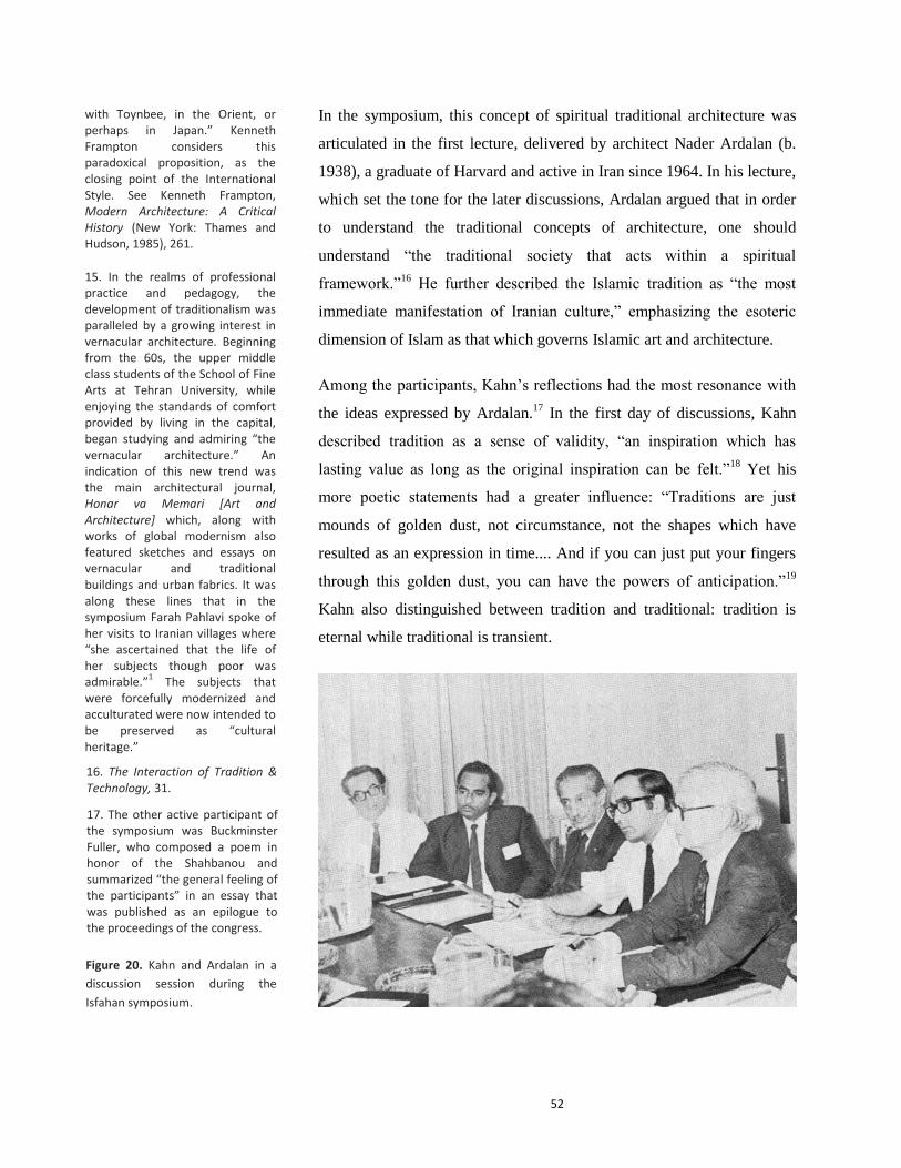
52
In the symposium, this concept of spiritual traditional architecture was
articulated in the first lecture, delivered by architect Nader Ardalan (b.
1938), a graduate of Harvard and active in Iran since 1964. In his lecture,
which set the tone for the later discussions, Ardalan argued that in order
to understand the traditional concepts of architecture, one should
understand “the traditional society that acts within a spiritual
framework.”16
He further described the Islamic tradition as “the most
immediate manifestation of Iranian culture,” emphasizing the esoteric
dimension of Islam as that which governs Islamic art and architecture.
Among the participants, Kahn’s reflections had the most resonance with
the ideas expressed by Ardalan.17
In the first day of discussions, Kahn
described tradition as a sense of validity, “an inspiration which has
lasting value as long as the original inspiration can be felt.”18
Yet his
more poetic statements had a greater influence: “Traditions are just
mounds of golden dust, not circumstance, not the shapes which have
resulted as an expression in time.... And if you can just put your fingers
through this golden dust, you can have the powers of anticipation.”19
Kahn also distinguished between tradition and traditional: tradition is
eternal while traditional is transient.
with Toynbee, in the Orient, or perhaps in Japan.” Kenneth Frampton considers this paradoxical proposition, as the closing point of the International Style. See Kenneth Frampton, Modern Architecture: A Critical History (New York: Thames and Hudson, 1985), 261.
15. In the realms of professional practice and pedagogy, the development of traditionalism was paralleled by a growing interest in vernacular architecture. Beginning from the 60s, the upper middle class students of the School of Fine Arts at Tehran University, while enjoying the standards of comfort provided by living in the capital, began studying and admiring “the vernacular architecture.” An indication of this new trend was the main architectural journal, Honar va Memari [Art and Architecture] which, along with works of global modernism also featured sketches and essays on vernacular and traditional buildings and urban fabrics. It was along these lines that in the symposium Farah Pahlavi spoke of her visits to Iranian villages where “she ascertained that the life of her subjects though poor was admirable.”
1 The subjects that
were forcefully modernized and acculturated were now intended to be preserved as “cultural heritage.”
16. The Interaction of Tradition & Technology, 31.
17. The other active participant of the symposium was Buckminster Fuller, who composed a poem in honor of the Shahbanou and summarized “the general feeling of the participants” in an essay that was published as an epilogue to the proceedings of the congress.
Figure 20. Kahn and Ardalan in a
discussion session during the
Isfahan symposium.

53
Kahn’s other comments on Iranian architectural history were also in tune
with the mainstream attitude toward the history of Iran. In an interview
with the main architectural journal, Honar Va Memari, when asked to
reflect on the sites he had visited in Iran, Kahn mentioned that he was
more impressed by Persepolis rather than the monuments of Isfahan as
he is “more inspired by the oldest works of architecture.” He further
explained that in his view, Persepolis, like other monuments built during
the early period, was without a prototype, whereas the buildings of
Isfahan were derived from earlier precedents.20
In Kahn’s view,
Persepolis “was built with no book, or manual, or mentor or school, it
was only inspiration that has created this work.” 21
Two different notions
of “beginning,” both imagined, converged on a monument: the beginning
of the nation for the Pahlavi state and the beginning of architecture for
Kahn were both to be found in the Achaemanid ruins.
The spiritual reading of tradition, which underlay the symposium, was
conceptualized in The Sense of Unity: The Sufi Tradition in Persian
Architecture, an illustrated book on “Islamic architecture in its Persian
setting,” authored by Nader Ardalan and Laleh Bakhtiar, an Iranian-
American who had developed a keen interest in Sufism upon her return
to Iran in 1964.22
The book was prefaced by Seyyed Hossein Nasr (b.
1933), a traditionalist philosopher, whose thoughts not only shaped the
book’s conceptual framework, but also provided a theoretical foundation
for the traditionalist movement in architecture.23
The second intersection
of Louis Kahn with the architectural discourse of Iran was through this
book. Indeed, he played a key role in the appearance of the Sense of
Unity by writing recommendation letters to the University of Chicago
Press in support of its publication.24
The authors’ appreciation of Louis
Kahn is expressed in the acknowledgements where they thank him “for
having kindly reviewed the manuscript and confirmed their conceptual
approach to this study.”25
In a letter to Ardalan on the book, Kahn
restated the idea that he had mentioned in the symposium: “what they are
bringing to us is the recalling of the original inspiration which motivated
building.”26
18. The Interaction of Tradition & Technology, 87.
19. Ibid.
20. Interview with Loius Kahn, Honar va Memari, Issue 8, December-February 1971, 66-68.
21. Ibid.
22. Nader Ardalan and Laleh Bakhtiar, The Sense of Unity: The Sufi Tradition in Persian Architecture ; with a foreword by Seyyed Hossein Nasr (Chicago, University of Chicago Press, 1973)
23. Seyyed Hossein Nasr received his Ph.D. in the history of science from Harvard when he was 25. Upon his return to Iran in 1958, he accepted a position at the University of Tehran as the professor of philosophy, and in 1973, he was appointed as the head of the Imperial Academy of Philosophy by the order of Queen Farah. Influenced by Frithjof Schuon, Titus Burckhardt and Marco Pallis, Nasr was an advocate of traditional metaphysics and the philosophia perennis in his academic and intellectual activities. Nasr’s prelude to The Sense of Unity not only distills the major themes of the book, but also reveals its ontological foundation, which is based on a cultural essentialist view that rejects modernity in favor of a return to tradition. In order to grasp the attitude of the book, Nasr contends, traditional teachings should be recalled, teachings that were “forgotten and neglected in the West since the Renaissance and among the modernized classes of the East since the spread of the modern mentality.” For Nasr, the traditional society not only still exists among the not-modernized parts of the East, but it is superior to the materialistic modern culture of the West.

54
In the Sense of Unity, and in the whole discourse on traditional
architecture, Kahn’s search for archetypical patterns, and “central
meanings of architecture” found an ironic parallel. This is particularly
evident in the second chapter of the book, “The Concept of Traditional
Forms,” where the authors present eight forms (garden, socle (takht),
porch, gateway, room, dome, chahar taq and minaret), explaining how
they reflect certain archetypes throughout the history of Persian
architecture: a categorization leading to “a glossary of architectural
forms that would allow for the generation of new syntheses that manifest
traditional foundations.”27
In a paradoxical metamorphosis, the
universalism with which Kahn was originally searching for the
beginnings of architecture, for the original inspiration, was transformed
into a regionalism in quest of identity. The Sense of Unity was not a
historical examination of Iranian architecture but an impressionistic
study aimed at finding “elements of permanence” for contemporary
architectural—and political—use. Kahn’s presence in Isfahan
symposium and his reflections on The Sense of Unity were regarded as an
affirmation of the new traditionalist discourse in architecture: Western
architects were invited to determine the future of the East and its
interaction with its own tradition. Three years after the symposium, in
October 1973, when Kahn was contacted regarding the design of an
administrative center in Tehran, his experience in Isfahan in 1970 and his
relationship with Ardalan appears to have contributed greatly to his
vehement acceptance of the task.
Kahn in Tehran
In late 1973, when Kahn was contacted regarding the Tehran project, he
was involved in several undertakings. He traveled to Tehran in mid-
November. The handwritten draft of a letter dated November 13, 1973,
addressed to “Farah Pahlavi, Shahbanou of Iran,” indicates that Kahn
considered the queen as his patron. In the letter, Kahn thanked the queen
for “the honor and the warmth” of her reception, expressing how dear it
was to him “to have felt her grace, aspirations and foresight” as they
talked about “the beautiful expectations of Abbasabad.”28
Finally, Kahn
22. Nader Ardalan and Laleh Bakhtiar, The Sense of Unity: The Sufi Tradition in Persian Architecture ; with a foreword by Seyyed Hossein Nasr (Chicago, University of Chicago Press, 1973)
25. Ardalan and Bakhtiar, The Sense of Unity, xvii.
26. Davar Ardalan, My Name is Iran (New York: Henry Holt and Company, 2007), 306.
27. Ardalan and Bakhtiar, The Sense of Unity, 67.
28. Letter, Kahn to Farah Pahlavi, November 13, 1973, Folder 030.II.A.106.13. Louis I. Kahn Collection, University of Pennsylvania and the Pennsylvania Historical and Museum Commission.

55
mentioned that flying over the city, he had found that “the strength and
beckoning of this ancient land offers ever so more than he imagined.”
The arid lands of Tehran, seen as an ideal site for an ideal metropolis by
Gruen just eight years before, were now reminders of an imagined
antiquity for Kahn, who was well aware of the political wills of his first
“royal” patron.29
Figure 21. Kahn’s sketch of Tehran
shows his impression of the city.
The northern region (Shemiran) is
covered with green hatch, while
the southern periphery is in gray-
white. While the two royal palaces
of Shemiran are marked by red
circles, solid red squares represent
other governmental buildings. To
the two old north-south roads is
now added a new parkway, lined
with hotels and a complex for
international exhibition. The
emphasis is on northern Tehran
and its southern periphery is
barely visible.
Source: Louis I. Kahn Collection,
University of Pennsylvania and the
Pennsylvania Historical and
Museum Commission.
29. Among the documents kept in the Louis I. Kahn Collection there are multiple copies of newspapers containing news on the life of Shah and the queen, which indicates Kahn’s curiosity about his patrons.

56
For the project, not surprisingly, Kahn chose Nader Ardalan as his
assistant and coordinator of local efforts. Kahn’s close collaboration with
a “local architect,” however, was not a new phenomenon in his career. In
the design and implementation of the Indian School of Management he
was assisted by Balkrishna Doshi, a former assistant of Le Corbusier,
who introduced Kahn to the Indian scene and had once described Kahn
as being “more Indian than a lot of Indians.”30
In Iran, just as in India,
the genius Western architect was regarded not only as capable of creating
a work of international stature but also more versed than indigenous
people in understanding their culture. In the case of the Indian School of
Management (which was based on Harvard Business School), the Irony
of this notion lay in searching for an indigenous language for an institute
totally based on a “Western” model.31
Kenzo Tange was contacted simultaneously regarding the Abbasabad
Center. Archival documents indicate that the nature of the relationship
between Kahn, Tange and the developer, John Rayward, was not
finalized at the time of Kahn’s death. A meeting, arranged by the
developer, took place in Tokyo in January and in February the architects
met in Tehran, where Tange stayed for a longer time to meet with the
king and the queen. The correspondence between Kahn and Tange
suggests that a presentation of basic concept was planned for late April
1974, a month after Kahn’s death, and that Tange had agreed to proceed
with “the development of design on the basis of Kahn’s scheme.” 32
Tehran Civic Center: “A Place of Natural Gathering”
Kahn’s initial proposal for Abbasabad was based on the general scheme
and guidelines of the master plan of Tehran. In the first scheme, the
complex was restricted to the irregularly bounded flat land situated to the
south of the hills, designated as the urban center of the Abbasabad
District (one of the ten proposed urban centers). While the hilly part of
the site was left intact, residential buildings were arranged along the
northern peripheral motorway. The building program was also based on
30. Carter Wiseman, Louis I. Kahn: Beyond Time and Style: a Life in Architecture (New York, W.W. Norton & Company, 2007), 139.
31. Also emblematic of this paradoxical claim, was the debate that occurred over the creation of a large pond in the Ahmadabad building: the pond was an important part of Kahn’s design but was rejected by the patron, as it would create an environment for mosquitoes. Obsessed with his idea, Kahn proposed disinfection, which was also rejected, because as a Jain, the patron wouldn’t allow for killing animals. These examples further reveal the superficiality of the post-colonial notion of identity.
32. Letter, Tange to Kahn, February 27, 1973, Folder 030.II.A.106.13. Louis I. Kahn Collection, University of Pennsylvania and the Pennsylvania Historical and Museum Commission.

57
the master plan, completed with some other functions proposed by the
municipality.
A rectangular urban plaza surrounded by colonnades and a triangular
area covered with square blocks arranged in a checkerboard pattern were
the main elements of the first proposal.33
While the heart of the complex
was intended to house commercial and business activities, governmental
buildings were grouped in two rows on the eastern side of plaza. Other
33. In addition to the documents
kept in Kahn’s archive I have used
two other sources with brief
description of Tehran project:
Romaldo Giurgola & Jaimini
Mehta, Louis I. Kahn (Boulder:
Westview Press, 1975), 242-43 and
David B. Brownlee & David Gilson
De Long, Louis I. Kahn: In the
Realm of Architecture (New York:
Rizzoli International Publications,
Inc., 1991).
Figure 22. View of the model
prepared for the first proposal. The
precision of the terrain and the
absence of the surrounding urban
fabric are indicative of negligence
toward the urban context. Source:
Louis Kahn Collection.

58
functions, including a stadium and mosque were situated in the western
part. The inclusion of a mosque in the building program of the civic
center also signals a new approach to Islamic tradition. Because of the
existence of a paper with chess puzzles among office documents, it has
been suggested that Kahn may have been inspired by the chessboard in
the design of this part of the site.34
Yet the presence of a sheet of chess
puzzles might have been an accident as the similar scheme is also
discernable in Kahn’s other projects.
Before Tehran project, Kahn had been involved in similar urban plans,
particularly Philadelphia civic center (1957). In both projects, especially
in their linear arrangement of cubical or pyramidal structures, one can
discern an allusion to the ancient architecture of Native Americans. In
Abbasabad project, historical references were consciously and
Figures 23 & 24. Model prepared
for the first proposal. Source: Louis
I. Kahn Collection.
34. Brownlee & De Long, Louis I. Kahn: In the Realm of Architecture, 125.

59
deliberately employed in architectural design. Among the documents
kept in the archive are plans of several historical monuments including
Isfahan and its Safavid square, Persepolis, Saint Peter plaza in Vatican
City and Piazza San Marco in Venice. Sketches also show Kahn’s
attempt to connect the plaza to the business district (Fig. 25 & 26),
settled finally on an oval-shaped space, clearly modeled on Saint Peter
plaza (Fig. 27). This spatial separation between the checkerboard part to
the north and the rest of the complex—emphasized by the pond and oval
plaza—appears to have been conceptual rather than functional. The
monumental expression on a large scale through a checkerboard
configuration appears to be the main theme of the design.
Figures 25 & 26. Sketches showing
the development of the first
scheme for Abbasabad Urban
Center. Source: Heinz Ronner,
Louis I Kahn: Complete Work,
1935-1974.

60
Kahn’s sketches for Abbasabad show several typical features of his
former designs. Just as his scheme for the National Center in Dhaka,
where a large pond unifies freestanding structures, water plays an
important role from the early sketches of Abbasabad.35
This emphasis on
water is particularly evident in a sketch in which the pond stretches along
the main north-south valley within the hills (Fig. 28).
Office documents indicate that the clay model was finished by February
10, 1974 and its photos were taken to Tehran, which were presented to
the mayor during Kahn’s short trip in mid-February.36
It was during this
visit that Kahn and Tange discussed their joint project, and Tange agreed
to proceed on the basis of Kahn’s sketch. An important decision about
the site was also taken at this time: the urban center was to expand from
the limited land of southern part into the hills, initially reserved for
housing and green spaces in the master plan. In the second stage of
design, Kahn extended the city center northward in a linear strand: the
large plaza and the stadium were relocated to the center of the hilly part
of the site, and the business district took a diamond shape (Fig. 29). By
moving the plaza to the hills, it became disconnected from the urban
fabric of the city, like an acropolis, an idea perhaps more attuned to the
Shah’s vision of an urban center. In the notes on the sketch plan of the
second scheme, Kahn described the plaza as “the place of civic and
national meeting in regard to the way of life.” In the notes, Kahn also
35. Initially Kahn wanted to create a pond in his design for the Indian School of Management.
Figures 27. Sketch showing the
final configuration of the plaza and
adjoining buildings. Source:
Ronner, Louis I Kahn: Complete
Work, 1935-1974.
Figures 28. A Sketch showing the
urban center with an extended
pond.
Source: Louis I. Kahn Collection.
36. Folder 030.II.A.106. Louis I. Kahn Collection, University of Pennsylvania and the Pennsylvania Historical and Museum Commission.

61
referred to Palazzo dei Congressi, his unrealized design for a bridge-
shaped city hall in Venice. The reference to the Venice city hall indicates
Kahn’s belief in a relatively more democratic way of life, also evident in
his previous projects. For example, as Goldhagen suggests, unlike Le
Corbusier who had placed the presidential palace at the apex of his
scheme for Chandigarh, in Kahn’s design for the Dhaka Center the
assembly is the focal point.37
On the periphery of the sketch, Kahn also
noted “East=West” which might indicate, not surprisingly, that he saw
the plaza as a meeting place between the East and the West.
It is hard to draw broad conclusions from the sketches and notes that
Kahn has left behind. Kahn’s sketch plan of the second scheme (Fig. 29)
suggests that he had grouped the functions in two clusters: the first one,
37. Sara Williams Goldhagen, Louis Kahn’s Situated Modernism (New Haven: Yale University Press, 2001), 168.
Figure 29. Kahn’s sketch plan of
the second scheme for Abbasabad.
The notes to the right read:
“Religious art” “Cultural (rel)” “The way of life” “(White Revolution)” “The place of civic and national meeting in regard to the way of life” “Opera philharmonic” “east=west” “Inter-nation symposiums” “Plazzo dei congressi” “national resources” “cultural” “art galleries of merchants” “The samovar convention” “The rug symposium” “banks” “surveys of the nations for enterprise to find the availabilities” “wall streets” “bourse” “stock exchange” “world bank” “scholastic availabilities” “classroom en site” Source: Heinz Ronner, Louis I Kahn:
Complete Work, 1935-1974.

62
organized around the plaza, included the opera philharmonic, city hall
and inter-nation symposium, among other functions. The diamond-
shaped southern part, which Kahn further developed in a separate sketch
(Fig. 30), was intended to house art galleries of merchants, the rug
symposium, wall streets, bourse, stock exchange and world bank. It
appears that in Kahn’s reformulation of the program, in both clusters the
cultural character was dominant. If the northern cluster was an
expression of “the way of life,” with White Revolution and religious art,
in the southern part national cultural products were emphasized. The
emphasis on financial functions was based upon the idea that Tehran
would become a major world financial center.38
The diamond-shaped part was the core concept of Kahn for Abbasabad
to create the sense of place. In its cross axial arrangement one can
discern an allusion to the chaharbagh (quadripartite) layout of traditional
gardens, with which Kahn had been familiar from India. This conjecture
is further supported by the closeness of the space (emphasized by the red
color of the surrounding walls and structures) and limited access from
the four corner point. In The Sense of Unity, the architectural conception
Figure 30. Kahn’s sketch of the second scheme. With the extension of the site to the hills, Kahn gave a more perfect shape to his design for the core area of the complex. The diamond-shaped cluster of square buildings is bisected by the rapid transit route (running in north-south direction), and an east-west highway, forming a cross axial form which might allude to the chaharbagh layout of Persainate gardens. Source: Heinz Ronner, Louis I Kahn:
Complete Work, 1935-1974.
39. Letter, John Rayward to Kahn and Tange, January 30, 1974. Folder 030.II.A.106. Louis I. Kahn Collection, University of Pennsylvania and the Pennsylvania Historical and Museum Commission.

63
of garden was described as a reflection of the “sense of place,” “a
defined space encompassing within itself a total reflection of the
cosmos.”39
Kahn had used a similar composition in his design for a
Women’s dormitory at Bryn Mawr, where three diamond-shaped were
arranged diagonally.40
Just as in Abbasabad plan, the entrances were
located at the corners. In both plans rotated squares evoke a sense of
order without adhering to a rigid symmetry.
Kahn’s design for Tehran urban center further indicates that the same
compositional rules could be applied in different scales, even in a large
urban complex. Irrespective of immediate urban context, an urban center
could be a compositional experiment, a “concept” inspired by
archetypes. In all the sketches, the forms are by and large independent of
the building program and detached from the surrounding urban fabric. In
his letter to the Shahbanou, Kahn had emphasized that “this new
anchoring civic place must be conceived as a whole presenting an
indelible, comprehensive and symphonic.” The center was designed as a
whole, but not as part of the city. It appears that the building program of
Abbasabad had provided Kahn with an unprecedented opportunity for
monumental expression. The Tehran project indicates that even in a large
urban project Kahn retained his idiosyncratic design.
Conclusion
The unexpected death of Kahn on March 17, 1974 was received with
ultimate grievance by Iranian Architects. In the especial issue of Honar
va Memari journal, it was described as the loss of “one of America's
greatest architect-artist-philosophers.” 41
The editors recalled Kahn’s visit
a month before, a trip which might have resulted in “the creation of a
masterpiece” and “could have been the beginning of a beautiful
relationship between Iran and his creative spirit.” In a similar vein,
Ardalan described Kahn’s death as “a particularly great loss for the
39. Ardalan and Bakhtiar, The Sense of Unity, 68.
40. Brownlee & De Long, Louis I. Kahn: In the Realm of Architecture, 164.
41. Honar va Memari, March-April 1974, No. 21, p. 20.
64
unfolding of contemporary architecture in the Orient, and especially that
of Persia.” In a note he wrote:
In the embers of the traditions of these ancient lands, Lou sensed a
validity of his own personal intuitions. In return, he provided a
confirmation to those who sought for an identity in these same ashen
fires.42
Yet, this symbiotic relationship between Kahn’s intuitions and the post-
colonial quest for identity was not solely a coincidence. What Kahn
shared with the proponents of traditional architecture—with architects in
zealous search of a "truly Iranian contemporary design idiom”43
— was
literal ignorance of history. If for the authors of the Sense of Unity of the
history of his motherland and its Sufi culture was based on few
translations, “Kahn always claimed never to have read.”44
Considering
Persepolis as a work without a prototype stems from the same historical
unawareness that underpins the conception of continuous Persian
architecture. The major difference was that history was intended to
provide a sense of identity and being rooted in an imagined past for the
intelligentsia of the post-colonial nation states.
Even so, despite these epistemological paradoxes, the regionalist
approach to modern architecture outside the West, as exemplified in the
works of Kahn and his proponents, added new aesthetic dimensions to
modernism. A wider palette of historical references provided more
opportunities for aesthetic expression—for new forms, materials and
spatial configurations. Perhaps the major difference between Kahn of the
early 1970s and that of the 1940s is the global expansion of the scope of
his thinking and design; if initially Kahn sought spiritual quality in
Gothic and Roman architecture,45
with the global dissemination of
modernism the scope of his historical references had become far larger.
The Tehran project was not Kahn’s first engagement with the complexity
of representations of nation. Yet compared with India and Israel, the
resonance of Kahn’s ideas with Iranian nationalism appears to have been
higher. The intuitive approach of Kahn provided justification for the
42. Louis I. Kahn, What Will Be Has Always Been. The Words of Louis I. Kahn. Edited by Paul Saul Wurman (New York: Access Press, 1986), 266.
44. Brownlee & De Long, Louis I. Kahn: In the Realm of Architecture, 50.
45. Ibid., 43.
43. Honar va Memari, March-April 1974, No. 21, p. 20.

65
impressionistic understanding of history that was being promoted by the
Pahlavi state to legitimize its power. If Kahn’s proposal had been built, it
would have been regarded as a tribute to the ancient civilization.
After Kahn’s demise, Ardalan had expressed his hope to manifest,
together with Kenzo Tange, some of Kahn’s thoughts based on his notes
and sketches. But a few months after, in a meaningful move from an
“artist-architect-philosopher” to technocratic corporate urban planning,
the task of designing the Abbasabad Urban Center was given to a British
firm, Llewelyn-Davies International. Archival documents, however,
indicate that “the English firm” was a rival of Kahn even before his
demise: the Mayor of Tehran, Ghulam Reza Nikpay, was advocating for
Llewelyn-Davies from long before. In a letter to Kahn, dated February
27, 1974, Ardalan had informed Kahn of his recent meeting with the
queen during which she had warned him about “Tehran’s mayor backing
of an English group for the same project.” In the letter, whose content
was to remain confidential, Ardalan gave a detailed account of his
meeting with the queen:
I had the good fortune on Saturday, February 3rd
to have an audience
with her Imperial Majesty, the Queen, regarding an architectural project
which she had personally asked us to undertake, but during the meeting
she asked about the progress of our joint efforts on Abbasabad. I
mentioned how enthusiastic both yourself and Kenzo Tange had been and
that a presentation of the basic concept had been planned for late April-
early May. She was pleased, but indicated her anxiety regarding the
situation. Her Majesty inquired if I knew about the Mayor’s backing of
an English group for the same project. I answered that I had heard of
this. She then restated that how essential and important was for her that
yourself and Kenzo Tange would always be the designers of this project
and then wondered out loud if any especial binding agreement existed
between yourselves and those who were sponsoring you. I made no
response. She then mentioned that she would speak to the mayor about
her concern and would try to straighten things out so that your central
roles would never be jeopardized. 46
Finally, Ardalan states that he had the impression that “she and His
Majesty were fully committed to Kahn and Tange.”
46. Letter, Nader Ardalan to Kahn, February 27, 1973. Source: Folder 030.II.A.106.16. Louis I. Kahn Collection, University of Pennsylvania and the Pennsylvania Historical and Museum Commission.
66
Historical evidence, however, suggests that Ardalan was wrong in his
statement about the king’s vision. For Farah Pahlavi architecture was
high art; the building of the National Center was far more important for
the Shah to be in the hands of the Shahbanou and “her entourage of
liberal royalists.”47
Kahn’s loss was not just a physical death. Later in
1974, the British firm Llewelyn-Davies presented its preliminary concept
to the Shah, and “won his enthusiastic support.”48
If Kahn’s poetic and
idiosyncratic architecture was the taste of the Shahbanou—and
traditionalist architects of her court—the Shah ultimately preferred the
austere appearance and axiality of Llewelyn-Davies proposal.
47. Grigor, Building Iran, 176. As Grigor has argued, from the Shah’s point of view, the queen’s patronage of art and architecture was not an apolitical activity. For example once he “was irritated that she was asked to participate in the review of drawings for the Pahlavi museum in 1972.” The main tension between the Shahbanou and the Shah was cultural heritage and preservation of historical urban fabrics. A manifestation of this tension was in the process of decision making for the destruction of the urban fabric surrounding the shrine of Imam Reza in Mashhad, vehemently rejected by the architect Kamran Diba, a cousin of the queen, but finally approved by the king.
48. Llewelyn-Davies International, Shahestan Pahlavi: A New City Center for Tehran, Book I, 36.

67
Chapter Three
A CENTER FOR THE SHAH AND NATION


69
III. A CENTER FOR THE SHAH AND NATION
The central place of Shahestan Pahlavi will be Shah and Nation Square,
which is intended to be the focus of Tehran’s political, social, cultural,
ceremonial and commercial activities... His Majesty the Shahhanshah
will be able to review major ceremonial events, such as national
parades, from a raised platform located beneath the great portal, or
ivan, which comprises the Pahlavi Monument. At this monument, visiting
dignitaries and VIPs will be able to pay their respects to Iran’s past.
—Shahestan Pahlavi, Llewelyn-Davies International, 1976.
In late 1973, following the OPEC Oil Embargo, Iran’s oil income
quadrupled. Historical studies indicate that the sudden swelling of the
country’s revenue had enormous political repercussions; in fact, it was at
this historical moment that Muhammad-Reza Shah, who had assumed
power through a CIA-led coup d’état in 1953, turned into a consummate
megalomaniacal autocrat. He relinquished the idea of opening up the
political scene and instead turned the country into a one-party state.1
Also symptomatic of his incipient megalomania were his comments
about “men with blue eyes,” who, he claimed, needed to wake up. In the
final years of his reign, when criticized by foreign media for human
rights abuses and political suppression, the shah insisted on a kind of
relationship between king and people in Iran, which was beyond the
understanding of Westerners. Perhaps the most conspicuous sign of the
new era was the replacement of the Hegira Calendar by the Imperial
Calendar. According to the new calendar, the Shah’s ascension to the
throne coincided, miraculously, with the exact 2500-year anniversary of
the coronation of Cyrus the Great. With the new calendar, the twentieth-
century Iran of the Shah was temporally related to the Persian Empire of
Cyrus.
With increasing oil revenues, the transformations in physical and social
structure of the capital accelerated. Soon after the oil boom, the Shah
1. The Rastakhiz (Resurgence) party was founded in early 1975, replacing the two existing parties. It was mandatory for all Iranian to register in it. Few years earlier the Shah had associated the single party system with fascism. For a detailed study see P. Amini, “A Single Party State in Iran, 1975-78: The Rastakhiz Party,” Middle Eastern Studies, Volume 38, Issue 1, 2002, 131– 168.
70
ordered the Plan and Budget Organization to increase its budget for the
Fifth Development Plan.2 “The urban middle class benefited most from
the oil revenue, as the social services were mostly located in urban
areas,” and primarily in Tehran.3 (Per Capita Gross National Product was
three times greater in Tehran than elsewhere. 4
) “New employment
opportunities provided by the state bureaucracy also contributed to the
increasing prosperity of the urban population.”5
The final plan for Abbasabad Urban Center, prepared by Llewelyn-
Davies International (LDI) under the direction of the American planner
Jaquelin Robertson, reflects all these transformations. Its
conceptualization, preparation, and aesthetic inclinations were in tune
with the burgeoning oil income and the megalomaniacal kingship that the
soaring income had inspired. Given a bombastic title, Shahestan Pahlavi
(literally “the Imperial Site of Pahlavi”), the new urban center was to be
the physical manifestation of the new calendar and the new single-party
system—an urban signifier of the ultimate realization of the Shah’s
modernization package, White Revolution. The plan’s superficial
attempts to accommodate indigenous architecture stemmed from an
insistence on combining rapid design with a sense of respect for
indigenous culture, totally unknown to the Western designers of a
corporate firm. Shahestan Pahlavi was intended to become a national
center “that would demonstrate to the world that Iran is rapidly moving
towards HIM the Shahnshah Aryamehr’s proclaimed Great
Civilization.”6 Its sumptuous plan can now be read as a relic of a fallen
monarch, epitomizing his last attempts to utilize physical planning to
consolidate his power.
Realized Centrality
By the mid-seventies, the signs of the rapid economic growth were
evident throughout the capital, particularly in its northern neighborhoods.
While “supermarkets and department stores were changing the city’s
retail fabric,”7 new high-rise apartment buildings were gradually
emerging, particularly in the Vanak area to the west of Abbasabad. The
3. Ibid., 165.
4. Llewelyn-Davies International, Shahestan Pahlavi: A New City Center for Tehran, Book I (November 1976), 20.
5. Gasiorowski, U.S. Foreign Policy and the Shah, 133.
6. Llewelyn-Davies International, Shahestan Pahlavi: A New City Center for Tehran, Book I, 36.
7. Ibid., 17.
2. Gasiorowski, U.S. Foreign Policy and the Shah, 133.

71
components of the Gruen master plan were also taking shape. Large
green spaces and parkways were the first emblems of the master plan to
appear. Plans were made for two large satellite towns and the city had
acquired two new plans for infrastructure: a plan for highways and metro
network, both prepared on the basis of the Tehran Comprehensive Plan.8
While the areas intended to house middle and higher-income
communities were gradually being realized, shanty towns, comprising
low-quality dwellings in tiny plots, were growing on the southern
periphery of the city, where the population density was the highest. By
1975, with a population or 4.6 million, Tehran was among the rapidly
growing metropolises of the Third World, second only to Cairo in the
Middle East.9
With this rapid pace of urbanization, when LDI was commissioned,
Abbasabad had gained a more central position in northern Tehran. The
periphery of the site was covered with a dense urban fabric of residential
apartment buildings (Fig. 32). The development of the area surrounding
Abbasabad was, in part, the result of strict adherence to a 5-year service
boundary, established in 1969 by the master plan. The centrality of the
site was also augmented by the new proposed (or constructed)
infrastructure. In 1974, the Shahanshahi Highway, the first intercity
Figure 31. Plan of Tehran in the mid-1970s showing the complete development of the areas surrounding the Abbasabad site. Source: Pardisan (Philadelphia:
Wallace McHarg Roberts and Todd,
1975), 10.
8. Societe Francaise d’Etudes et des Realisations de Transports Urbains, Tehran Plan de Transport, Rapport Final, 1974 (1353)
9. Llewelyn-Davies International, Shahestan Pahlavi: A New City Center for Tehran, Book I, 18. With a population growth of 5 to 6 percent in the past 20 years.
Abbasabad

72
autobahn of the city was constructed passing through the main north-
south valley of the site. Moreover, in the final plan for highways, the
east-west 76 Meter Motorway (the main artery of the Gruen master plan),
which in the early plans circumscribed the site, was designed to pass
through its main east-west valley. Within the site, the motorway
intersected with the north-south highway in a complicated interchange.
Abbasabad was now to become the locus of the modern transportation of
the city, the very symbol of modernity.
Figure 32. Aerial view of Abbasabad in 1975 shows the total development of the areas surrounding the site—a hilly barren land bounded by dense residential urban fabric. Source: Llewelyn-Davies International (hereafter LDI), Shahestan Pahlavi (1976), Book I, 44.

73
Aesthetics of Rapid Modernization
The commissioning of a corporate firm like Llewelyn-Davies
International (LDI) was in part the result of a major shift that occurred in
the management and development of Abbasabad. In 1974, a
governmental corporation called “Sherkat Sahami Nosazi Shahestan
Pahlavi” (Corporation for Development of Shahestan Pahlavi) was
established by the municipality of Tehran to oversee and manage the
development of Abbasabad, replacing initial independent developers.
The new official title of the project, Shahestan Pahlavi, signaled the
augmented significance that the project had acquired in the propagandist
agenda of the state. The establishment of the firm was also indicative of
the greater role that the municipality, within a bureaucratic framework,
was to play in the development of the site.
The man behind the corporation was the young Mayor of Tehran,
Ghulam Reza Nikpay, praised for his “vision, energy, creativity, and
decisiveness” in the LDI report.10
As mentioned in the previous chapter,
archival evidence indicates that Nikpay was advocating for Llewelyn-
Davies even before the death of Kahn.11
Also indicative of the mayor’s
role in the development of Abbasabad is a mediocre plan, which had
been prepared for the site under the mayor’s direction by the
municipality. The model shows the roots of several key ideas of the LDI
plan (Fig. 33). The Municipality plan, however, was not approved by the
Shah. In a letter, the first developer of the project, John Rayward, had
informed Kahn and Tange that “the king particularly disapproved of the
residential areas which in their plan were in four storey buildings; he
specifically indicated that he wanted high towers, which has been his
position all along.”12
In late 1974, a few months after Kahn’s demise, Llewelyn-Davies
presented its preliminary concept “to his majesty the Shahanshah”—who
clearly preferred high-rise buildings—“and won his enthusiastic
support.”13
The oil boom had persuaded the Shah that it would be
possible to catch up with the West in a short time. Not surprisingly, the
10. Ibid., 13.
11. In the Llewelyn-Davies consultancy report there is no allusion to the involvement of Kahn and Tange in the project.
12. Letter, Rayward to Kahn, LIK
13. Llewelyn-Davies International, Shahestan Pahlavi: A New City Center for Tehran, Book I, 36.

74
grading of the site and the new roads began on August 19, 1975, just six
months after the arrival of the team. While LDI was still preparing the
plan, the Shah inaugurated construction by “the burying of a gold
plaque” on the future site of “Shah and Nation Square.”14
The
inauguration day commemorated the Shah’s real source of power: the
anniversary of “Iranian National Revolution,” a euphemism used by the
Shah regime for the CIA-led coup d’état of 1953, which toppled the
nationalist prime minister, Muhammad Musaddegh. Indeed, a corporate
firm like LDI was the best choice for the task of capturing “national
aspirations sufficiently, without being so intricate that the new center’s
construction becomes unnecessarily slow and arduous.”15
A master plan
for 554 hectares of open land, with 5,130,000 meters of floor space, was
prepared with “a sense of urgency” over an 18-month period by a team
of 50.16
The Plan
The LDI report mentions three different roles for Shahestan Pahlavi: to
serve as a national center, to provide a coherent center for northern
Tehran, and to become a transportation center. The report bases the first
function on the Tehran master plan’s demand for an image capital. Yet
this role stands in contrast with the essence of Gruen master plan, which
Figure 33 & 34. View of the model prepared by the municipality of Tehran for Abbasabad, which shows the roots of the idea of creating an urban plaza. Source: Louis I Kahn Collection.
14. Ibid., 12.
15. Ibid., 39.
16. Ibid.

75
had called for a decentralized development. The document also mentions
the lack of a large park like Regent’s Park of London, considered to be
an important component of a capital city.
As an urban plan, Shahestan is described as a large-scale project, similar
to “the great achievements of Shah Abbas in Isfahan, Pope Sixtus V in
Rome, and Baron Haussmann in Paris,” implying that the Shahestan plan
would create “the Tehran of Muhammad-Reza Shah.” The report relates
that “in these instances an artistic response to the city’s needs was
combined with a genius for city building—the ability to carry out plans
on a large enough scale to influence the character of a city.” 17
This
statement stands in sharp contrast to Gruen’s master plan wherein
Haussmann’s plan for Paris was described as creation of a “dictatorial
power,” motivated by “the desire to create efficient military routes rather
than artistic boulevards.” The disparity between these two interpretations
further reveals the ideological basis of both plans: the democratic
connotations of planning for the TCP and the association of LDI’s plan
with political oppression. To ensure that the proposed plan was no less
grand than these historical precedents, maps of historic London, Paris
and Isfahan were overlaid on the site plan of Abbasabad (Fig. 35).
Claimed to be the largest planned city center in the world, Shahestan had
an extensive building program, reaching a total floor space of 5,130,000
square meters. The site was intended to be a concentration of hitherto
dispersed governmental buildings; the prime minister’s office and fifteen
ministries were to be located in the site. A similar amount of floor space
Figure 35. Plans of historic cities overlaid on the Abbasabad site to ascertain that it is “large enough to contain the grand axis of Paris (middle) or the entire center of Isfahan (left).” Source: Shahestan, Book II, 9.
17. Ibid., 9. Emphasis is mine.

76
was allocated to commercial facilities, with the hope that the
“psychological importance of Shahestan” would attract commercial
office space. As a civic center, Shahestan was designed for the needs of
the residents of Northern Tehran (estimated to be 1.5 million of the city’s
population), who were “much more affluent than the average Tehrani,
yet not well served by public facilities.”18
While the southern
neighborhoods had more urgent needs, the report highlights “a shortage
of schools, libraries and health facilities” in northern Tehran and its need
for “public green space for recreation.”19
The final report consists of two volumes, 270 pages in total. Book I is on
the master plan, or “the strategic aspects,” while the second, claimed to
have gone beyond the requirements of “a conventional master plan,”20
is
on design context, themes, and proposals. The second book provides “a
detailed urban design for the project’s entire central area.” 21
Penned by
the Project Director Jaquelin Robertson, the report begins with a sharp
criticism of the scientific basis of modernist planning, proclaiming that,
more than a science, “town planning” is an art; and that the field’s basic
concern is “to translate society’s basic values into an improved
environment.”22
Robertson further emphasizes that rational methods
should be complemented by “the mixture of experience and
imagination.” The “urban crisis” is attributed to the failure to
acknowledge “the spiritual and cultural content of cities.”23
The aim of
the plan, therefore, is to develop an aesthetic and symbolic base for
Shahestan Pahlavi, a goal that master plans, focused on land use
planning, have failed to achieve.
LDI’s response to these aspirations was in axial configuration and
massive forms. The main commercial and governmental buildings were
to be organized in a north-south linear “spine,” roughly four kilometers
long. Beyond the spine were to be “vast areas of landscaped parkland.”
The main axis would generate a linear grid pattern on either side of the
spine and for the flanking public buildings and residential neighborhoods
beyond. Similar to Kahn’s scheme, a row of residential towers were
arranged along the northern highway (Fig. 36).
19. Ibid., 27.
20. Ibid., 42.
21. Ibid., 12.
22. Ibid., 9.
23. On the first page of the report the emphasis on the aesthetic and symbolic aspect of urban planning is juxtaposed with an image of “his Imperial Majesty.”
18. Ibid., 26.

77
“A comprehensive cultural sphere” was proposed in the northern part of
the site. In the report, the creation of this specific zone for cultural
facilities (with 250,000 square meters of floor space) is attributed to “the
advice of the Shahbanou.”24
Like the Gruen master plan, spaces of
consumption occupy a central position in Shahestan. A “modern
shopping center” containing two to three department stores was proposed
along the main spine, with a “shopping galleria” running parallel to east
Figure 36. Model of Shahestan proposed by Llewelyn –Davies International. According to the plan, large portions of the site were to be graded. Source: Shahestan, Book II, 2.
24. Llewelyn-Davies International, Shahestan Pahlavi, Book I, 52.
Shahanshah Boulevard
Shahbanou Boulevard and Park
Shah and Nation Square

78
of the boulevard.25
The shopping center was meant to be for the use of
offices and hotels as well as “current retail demand of North Tehran.”
Each of the residential communities would also have its own shopping
center.26
The Pahlavi huge bureaucracy was to be embodied not only in
the governmental buildings of the central spine, but also the site’s
peripheral housing. The residential neighborhoods were to accommodate
“the broad spectrum of employees required at Shahestan Pahlavi.”27
Similarly, the community facilities were to serve the needs of those
working in the office buildings of the site.
Figure 37. View of the model of Shahestan looking north along the central spine, lined with governmental and commercial buildings. The two flanking buildings—the national bank and the Central bank—are claimed to define a gate for the ceremonial boulevard. Source: Shahestan, Book II, 83.
25. Ibid., Book II, 18.
26. Llewelyn-Davies International, Shahestan Pahlavi: A New City Center for Tehran, Book I, 54.
27. Ibid., 40.

79
At the center of the complex was a vast plaza, 200 by 400 Meters—
“larger than Moscow’s Red Square.” Proposed as a platform over the 76
Meter Motorway, the plaza was to serve as “the civic heart of the
nation.”28
Like an agora of an acropolis located on a hilltop, the square
provided “residents and visitors” a vintage point to see the surrounding
Tehran as well as “the view of the mountains.”29
(The setbacks in the
northern buildings were to preserve the view toward the Alborz
Mountains.) The plaza was to be surrounded by “the most prestigious
new buildings.” To the north were Pahlavi Library, City Hall
(Municipality Building) and Museums (including National, Handicraft,
Textile and Modern Art). To the south were theater Center and Ministry
of Foreign Affairs. The symbolic meaning of the square derived from the
careful arrangement of these functions around the plaza. The
Juxtaposition of the National Museum and Ministry of Foreign Affairs
was a symbolic statement of “the nation” vis-à-vis “foreign” countries.
Accommodating Iranian tradition
Despite its rapid preparation, the LDI plan attempts to “draw inspiration”
from Iranian architectural tradition. These attempts are primarily
represented verbally and visually in the second volume, under the rubric
of “Design context” and “Design Themes.” The report states that “the
design and massing of buildings in the new center will blend the best of
Figure 38. Shah and Nation Square was claimed to have been modeled after Maydan-i Shah, the famous seventeenth-century square of Isfahan. The position of Shah’s monument particularly evokes the Ali Qapu Palace, from which the Safavid kings watched the events taking place in the Maydan. Source: Shahestan, Book II, 91.
28. Ibid., 18.
29. Llewelyn-Davies International, Shahestan Pahlavi: A New City Center for Tehran, Book II, 8.
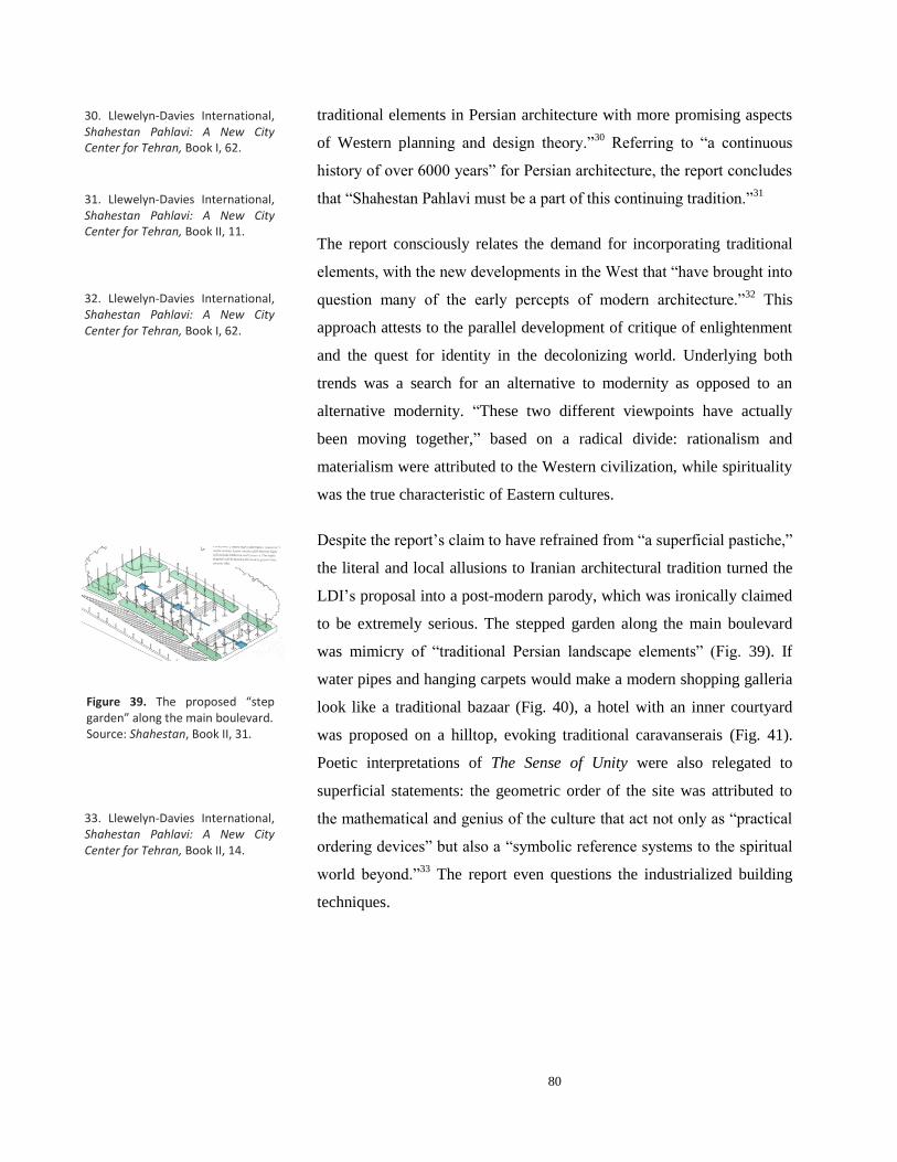
80
traditional elements in Persian architecture with more promising aspects
of Western planning and design theory.”30
Referring to “a continuous
history of over 6000 years” for Persian architecture, the report concludes
that “Shahestan Pahlavi must be a part of this continuing tradition.”31
The report consciously relates the demand for incorporating traditional
elements, with the new developments in the West that “have brought into
question many of the early percepts of modern architecture.”32
This
approach attests to the parallel development of critique of enlightenment
and the quest for identity in the decolonizing world. Underlying both
trends was a search for an alternative to modernity as opposed to an
alternative modernity. “These two different viewpoints have actually
been moving together,” based on a radical divide: rationalism and
materialism were attributed to the Western civilization, while spirituality
was the true characteristic of Eastern cultures.
Despite the report’s claim to have refrained from “a superficial pastiche,”
the literal and local allusions to Iranian architectural tradition turned the
LDI’s proposal into a post-modern parody, which was ironically claimed
to be extremely serious. The stepped garden along the main boulevard
was mimicry of “traditional Persian landscape elements” (Fig. 39). If
water pipes and hanging carpets would make a modern shopping galleria
look like a traditional bazaar (Fig. 40), a hotel with an inner courtyard
was proposed on a hilltop, evoking traditional caravanserais (Fig. 41).
Poetic interpretations of The Sense of Unity were also relegated to
superficial statements: the geometric order of the site was attributed to
the mathematical and genius of the culture that act not only as “practical
ordering devices” but also a “symbolic reference systems to the spiritual
world beyond.”33
The report even questions the industrialized building
techniques.
30. Llewelyn-Davies International, Shahestan Pahlavi: A New City Center for Tehran, Book I, 62.
31. Llewelyn-Davies International, Shahestan Pahlavi: A New City Center for Tehran, Book II, 11.
32. Llewelyn-Davies International, Shahestan Pahlavi: A New City Center for Tehran, Book I, 62.
33. Llewelyn-Davies International, Shahestan Pahlavi: A New City Center for Tehran, Book II, 14.
Figure 39. The proposed “step garden” along the main boulevard. Source: Shahestan, Book II, 31.
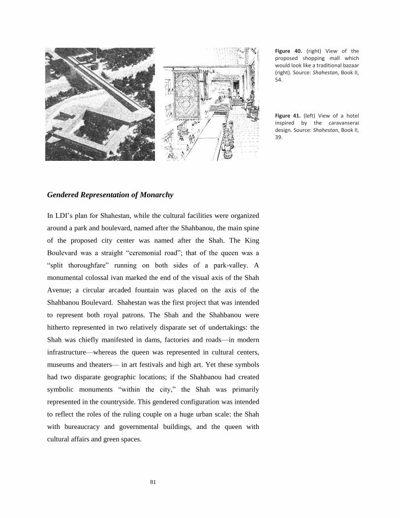
81
Gendered Representation of Monarchy
In LDI’s plan for Shahestan, while the cultural facilities were organized
around a park and boulevard, named after the Shahbanou, the main spine
of the proposed city center was named after the Shah. The King
Boulevard was a straight “ceremonial road”; that of the queen was a
“split thoroughfare” running on both sides of a park-valley. A
monumental colossal ivan marked the end of the visual axis of the Shah
Avenue; a circular arcaded fountain was placed on the axis of the
Shahbanou Boulevard. Shahestan was the first project that was intended
to represent both royal patrons. The Shah and the Shahbanou were
hitherto represented in two relatively disparate set of undertakings: the
Shah was chiefly manifested in dams, factories and roads—in modern
infrastructure—whereas the queen was represented in cultural centers,
museums and theaters— in art festivals and high art. Yet these symbols
had two disparate geographic locations; if the Shahbanou had created
symbolic monuments “within the city,” the Shah was primarily
represented in the countryside. This gendered configuration was intended
to reflect the roles of the ruling couple on a huge urban scale: the Shah
with bureaucracy and governmental buildings, and the queen with
cultural affairs and green spaces.
Figure 40. (right) View of the proposed shopping mall which would look like a traditional bazaar (right). Source: Shahestan, Book II, 54. Figure 41. (left) View of a hotel inspired by the caravanserai design. Source: Shahestan, Book II, 39.

82
In the final synthesis that the Shahestan project strove to represent, it was
the Shah’s masculinist aesthetics that became dominant. With their
austere appearance, the cultural facilities that were grouped in the
northern part of the site were far removed from the kind of aesthetics
used in the design of the Museum of Modern Arts, The City Theater, or
Niavaran Cultural Center, all built under the auspices of the queen. The
co-option of the queen’s sphere of activities was symbolically
proclaimed by positioning all the museums behind the king’s monument.
Shahestan was the Shah’s architectural venture. Instead of the
Shahbanou, the usual patron of architecture, it was he who periodically
reviewed the preliminary plans of Abbasabad.34
The queen who presided
over all cultural affairs of the state, and “The International Congress of
Architects,” was relegated to an inferior position, now that architecture
was to define the National Center. This downgrading is evident in an
image published in the consultancy report (Fig. 42) where Queen Farah,
from behind the men, is trying to get a glimpse of the plan while the shah
is looking down on the plan arrogantly.
Figure 42. Jaquelin Robertson, the managing director of Llewelyn-Davies International , is holding a corner of the sheet, while the Shah is looking at the plan during a visit to Abbasabad. The queen—with a black hat in the middle—from behind men and even her own kids is trying to get a glimpse of the plan. Source: Shahestan, Book I, 142.
34. Llewelyn-Davies International, Shahestan Pahlavi, Book I, 39.
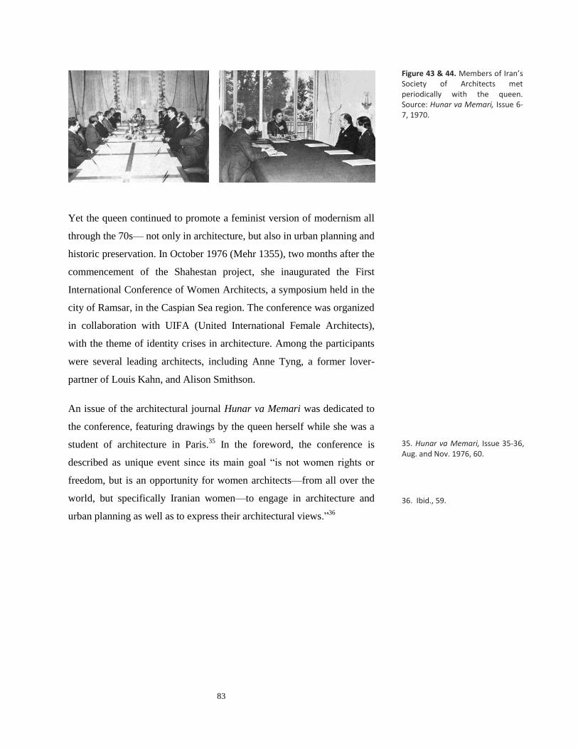
83
Yet the queen continued to promote a feminist version of modernism all
through the 70s— not only in architecture, but also in urban planning and
historic preservation. In October 1976 (Mehr 1355), two months after the
commencement of the Shahestan project, she inaugurated the First
International Conference of Women Architects, a symposium held in the
city of Ramsar, in the Caspian Sea region. The conference was organized
in collaboration with UIFA (United International Female Architects),
with the theme of identity crises in architecture. Among the participants
were several leading architects, including Anne Tyng, a former lover-
partner of Louis Kahn, and Alison Smithson.
An issue of the architectural journal Hunar va Memari was dedicated to
the conference, featuring drawings by the queen herself while she was a
student of architecture in Paris.35
In the foreword, the conference is
described as unique event since its main goal “is not women rights or
freedom, but is an opportunity for women architects—from all over the
world, but specifically Iranian women—to engage in architecture and
urban planning as well as to express their architectural views.”36
Figure 43 & 44. Members of Iran’s Society of Architects met periodically with the queen. Source: Hunar va Memari, Issue 6-7, 1970.
35. Hunar va Memari, Issue 35-36, Aug. and Nov. 1976, 60.
36. Ibid., 59.

84
A significant part of the seminar was a critique of the Tehran
Comprehensive Plan. Commissioned by Women Organization of Iran
(WOI)37
, Moria Moser Khalili—an American architect who had worked
in Iran since 1971 along with her husband architect Nader Khalili—
studied “Urban Design and Women lives.” The result of the research was
published in 1975 and was distributed among the participants of the
Women’s Congress in Mexico.38
(A Persian translation was also
published by the Women’s Organization of Iran.) In her book, Khalili
criticized the Master Plan of Tehran for neglecting the role of working
women in planning, proposing a scheme that would increase the mobility
of women in urban spaces (Fig. 46).
Figure 45. A picture published in the especial issue of Hunar va Mimari for the First International Conference of Women Architects. Source: Honar va Memari, Issue 35-36. Aug. Nov. 1976. Special Edition for International Conference of Women Architects
38. Llewelyn-Davies International, Shahestan Pahlavi: A New City Center for Tehran, Book I, 61.
37. Established in 1966 by a 5000-member assembly of Iranian women from diverse backgrounds by Ashraf Pahlavi (the Shah’s sister), WOI’s aim, according to its constitution, was “to raise the cultural, social and economic knowledge of the women of Iran and to make them aware of their family, social and economic rights, duties, and responsibilities.”

85
The fact that a cutting edge feminist critique of urban planning was
taking place in Iran not only reveals the complexity of the historical
moment but also the underlying gendered notions of Western
modernism. Indeed, it is in this extrapolation to a different landscape that
the gendered assumptions of modern planning and the American
lifestyle, becomes evident, a modernism in which women “remained a
passive, voiceless object of domination and acculturation.”39
Only a
feminist critique could relieve the rigid segregation of income groups in
the Tehran Comprehensive Plan.
Conclusion
As work of international (post) modernism, the Llewelyn-Davies design
for Tehran urban center signals the outset of a new approach, a shift from
modernist ideals of rationalist planning to an “urban design” paradigm,
which place greater emphasis on collective memory and traditional urban
forms. Robertson’s proclamation of planning as an art—and his call for
the completion of rational analysis with a “mixture of art and
imagination”— is a clear sign of the new approach. Yet compared to the
plan prepared by the municipality (Fig. 33), LDI’s proposal offers no
novel “imaginative” solution; it is simply a more proportionate,
regularized version of the earlier proposal. (A clear sign of the plan’s
inability in symbolic expression is the proposed design of the Shah
monument which indicates the wealth of the buildings could not be
utilized for the creation of a symbolic monument.) The Llewelyn-Davies
Figure 12. Diagrams
Figure 46. Diagrams of the existing (Gruen-Farmanfarmaian) and proposed Master plan by Khalili. The segregation of different income levels in the city has resulted in deprivation of women from higher and lower incomes from mobility (left). In the proposed version, more access to transportation routes is provided for everyone (right). Source: Honar va Memari, Issue 35-36. Aug. Nov. 1976. Special Edition for International Conference of Women Architects
39. Grigor, Building Iran, 186.
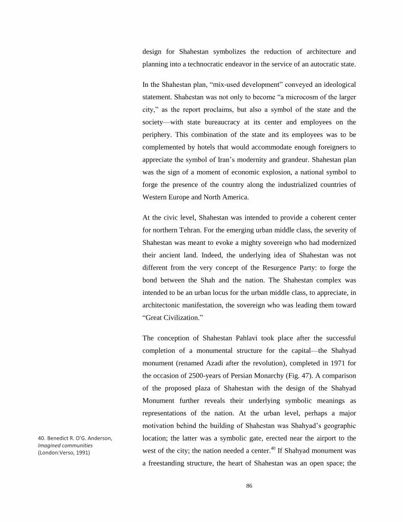
86
design for Shahestan symbolizes the reduction of architecture and
planning into a technocratic endeavor in the service of an autocratic state.
In the Shahestan plan, “mix-used development” conveyed an ideological
statement. Shahestan was not only to become “a microcosm of the larger
city,” as the report proclaims, but also a symbol of the state and the
society—with state bureaucracy at its center and employees on the
periphery. This combination of the state and its employees was to be
complemented by hotels that would accommodate enough foreigners to
appreciate the symbol of Iran’s modernity and grandeur. Shahestan plan
was the sign of a moment of economic explosion, a national symbol to
forge the presence of the country along the industrialized countries of
Western Europe and North America.
At the civic level, Shahestan was intended to provide a coherent center
for northern Tehran. For the emerging urban middle class, the severity of
Shahestan was meant to evoke a mighty sovereign who had modernized
their ancient land. Indeed, the underlying idea of Shahestan was not
different from the very concept of the Resurgence Party: to forge the
bond between the Shah and the nation. The Shahestan complex was
intended to be an urban locus for the urban middle class, to appreciate, in
architectonic manifestation, the sovereign who was leading them toward
“Great Civilization.”
The conception of Shahestan Pahlavi took place after the successful
completion of a monumental structure for the capital—the Shahyad
monument (renamed Azadi after the revolution), completed in 1971 for
the occasion of 2500-years of Persian Monarchy (Fig. 47). A comparison
of the proposed plaza of Shahestan with the design of the Shahyad
Monument further reveals their underlying symbolic meanings as
representations of the nation. At the urban level, perhaps a major
motivation behind the building of Shahestan was Shahyad’s geographic
location; the latter was a symbolic gate, erected near the airport to the
west of the city; the nation needed a center.40
If Shahyad monument was
a freestanding structure, the heart of Shahestan was an open space; the
40. Benedict R. O'G. Anderson, Imagined communities (London:Verso, 1991)

87
former imposed itself on the urban space, the latter was designed to
contain it. This spatial discrepancy is also reflected in their names:
Shahyad was intended to be a memorial to the Shah; the plaza of
Shahestan was named after “the Shah and the nation.” The distributer of
oil income needed a place to embrace the urban middle class in the
middle of the metropolis. Shahyad was an aesthetic representation of
Iran’s past and future, Shahestan was a symbol of modernization—a
condensation of the dams and factories that the Shah had erected around
the country. Perhaps Shahyad was too poetic, too cursive—too
feminine—for the Shah’s vision of a modernized nation-state.
Figure 47. The Shahyad (now called Freedom/Azadi Square) has managed to become a public monument, beyond “the memory of the Shah.” It still embodies all the paradoxical characteristics with which the modern urban middle class of Iran, a creation of the Pahlavi era, wants to be represented: modern, white and solid, yet cursive, deeply traditional and open to other cultures. Source: Roloff Beny & Shahrokh Amirarjomand, Iran: Elements of Destiny (New York: Everest House, 1978)


89
Chapter Four
CONCLUSION


91
IV. CONCLUSION: THE TRAJEDY OF DEVELOPMENT
The only way for modern man to transform himself, Faust and we will
find out, is by radically transforming the whole physical and social and
moral world he lives in.
—Marshal Berman, All that is Solid Melts into Air.
In the preceding chapters, I analyzed the three proposed projects for
Tehran’s new urban center by contextualizing them at three levels—
civic, national, and international. In conclusion, I further explore the
plans’ commonalities and disparities, analyzing the ways this three-tier
framework helps us understand the relationship between international
design currents and the national and social agenda of the Pahlavi regime.
I will also attempt to situate the plans in the broader context of
architectural production in the 70s.
In terms of global design currents, the most significant outcome of the
thesis is the insight that it provides into the varied and complex meanings
that international practices of 60s and 70s acquired through interaction
with a context marginal to centers of global capitalism. If for Gruen
modern planning was a scientific method of social, economic and
technical analysis, for his Iranian partner modernism connoted higher
standards of living—at its core, modernist urban planning was a political
tool for creating an (illusion of) economically prosperous society. A
similar shift of meanings is discernable in the case of Kahn, whose
idiosyncratic perceptions of spiritual qualities were co-opted as an
affirmation for a politically-driven regionalist (traditionalist)
architecture. With Llewelyn-Davies, however, the local and the global
converge: for both the Iranian state and the Western corporate firm
planning and architecture were tools of rapid development mingled with
“parodies of the past.”1 The trajectory of the Abbasabad plans provides a
case study of how with the internationalization of modernism, architects
metamorphosed into “cultural or technocratic mercenaries.”2
1. Marshall Berman, All that is Solid Melts into Air: the Experience of Modernity (New York: Viking Penguin, 1988), 22. 2. In a seminar on Architectural Transformations in the Islamic World, held by the Aga Khan Award for Architecture in April 1978, Jaquelin Robertson, who presented Shahstan Pahlavi, wrote: Many of us at this conference are what I would have to call cultural or technocratic mercenaries. See Robertson, Jacquelin T. “Shahestan Pahlavi: Steps toward a New Iranian Centre” Toward an Architecture in the Spirit of Islam. Renata Holod (ed.) (Philadelphia: The Aga Khan Award for Architecture, 1978).
92
The thesis also shows how through these interactions the implicit social
assumptions of the original architectural or planning models can be
unraveled. For example, it is in the Comprehensive Plan for Tehran that
the central role of spaces of consumption and the stereotypical gendered
assumptions underlying modernist urban planning surface. Similarly, it is
by analyzing Kahn’s interaction with his non-western proponents that the
pitfalls of his intuitive method and intuitive understanding of history can
be best understood. More importantly, a careful study of the LDI plan
debunks the claims of anti-modernist planning in providing more
democratic and human environments: it shows that the very same ideas
of defined urban spaces can be more suitably utilized by authoritarian
regimes.
Inscribed in each of these plans is an ideological statement about modern
urban life and public sphere. Commercial centers constituted the main
communal spaces of the Gruen-Farmanfarmaian master plan. Kahn’s
design would have provided a more aesthetically appealing
environment—probably more attuned to a democratic way of life—
though it could have hardly been part of the urban fabric. In LDI’s plan,
public domain was to be totally dominated by the state bureaucracy and
symbols of monarchy.
In order to understand the role of international architects in the 1970s in
Iran, it is important to note that these three projects represent the most
significant instances of the participation of Western architects and firms
in the design of public monuments; since the end of the Second World
War, nearly all major public buildings had been commissioned to Iranian
architects. In 1955, the Senate House (Fig. 48) was designed by Heydar
Ghiai, who was also the architect of the Hilton Hotel. Similarly, the new
Niavaran Palace, the City Theater (Fig. 49), and The Museum of
Contemporary Arts (Fig. 50) were all designed by local architects. In the
late 1960s, the Olympic Complex was designed and executed under the
direction of Farmanfarmaian Associates. Even the Shahyad monument
(Fig. 47), the most symbolic structure of modern Iran, was designed by a
26-year-old graduate of the University of Tehran, Hossein Amanat,
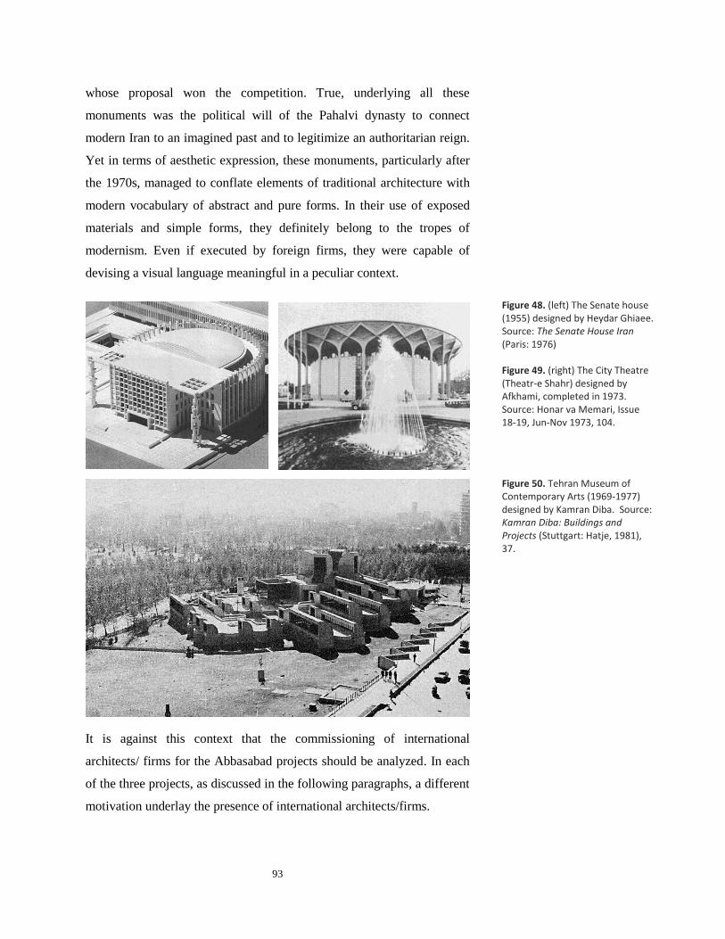
93
whose proposal won the competition. True, underlying all these
monuments was the political will of the Pahalvi dynasty to connect
modern Iran to an imagined past and to legitimize an authoritarian reign.
Yet in terms of aesthetic expression, these monuments, particularly after
the 1970s, managed to conflate elements of traditional architecture with
modern vocabulary of abstract and pure forms. In their use of exposed
materials and simple forms, they definitely belong to the tropes of
modernism. Even if executed by foreign firms, they were capable of
devising a visual language meaningful in a peculiar context.
It is against this context that the commissioning of international
architects/ firms for the Abbasabad projects should be analyzed. In each
of the three projects, as discussed in the following paragraphs, a different
motivation underlay the presence of international architects/firms.
Figure 50. Tehran Museum of Contemporary Arts (1969-1977) designed by Kamran Diba. Source: Kamran Diba: Buildings and Projects (Stuttgart: Hatje, 1981), 37.
Figure 48. (left) The Senate house (1955) designed by Heydar Ghiaee. Source: The Senate House Iran (Paris: 1976) Figure 49. (right) The City Theatre (Theatr-e Shahr) designed by Afkhami, completed in 1973. Source: Honar va Memari, Issue 18-19, Jun-Nov 1973, 104.

94
In the discourse that was centered on Queen Farah, architecture was high
art; Kahn was seen as a leading artist—like Annis Xenakis, Peter Brook,
Merce Cunningham and other Avant-garde artists who performed in the
Shiraz Art Festival. The idea behind inviting leading architects to a
symposium on “the Interaction of Tradition and Technology” was to
forge a kind of dialogue; the underlying motivation was not solely a need
to create a symbol for a modern state (as was expected of Le Corbusier in
Chandigarah); celebrated architects like Kahn were invited to confirm the
country’s position in the web of nation-states. Avant-garde artists and
architects were staged in the historic not only to appreciate the country’s
cultural heritage, but also to spark the creation of a national high art that
would be as “avant-garde” as the contemporary art and architecture of
the West, yet also rooted in an imagined local tradition. Through arts and
architecture, the queen and the liberal artists and architects of her court,
strove to carve a space for the country on the modern world stage.
Yet, as the trajectory of Abbasabad plans exemplifies, the demand for
rapid modernization that instigated with the oil boom in the 1970s put an
end to these liberal artistic endeavors in architecture. With the pouring of
the corporate firms like Llewelyn-Davies, other alternative modernities
Figure 51. Avant-garde Western artists like Merce Cunningham performed at the Shiraz Arts Festival in the 70s. The idea behind inviting leading architects like Kahn was not different from the message conveyed by juxtaposing Western performers with the ruins of Persepolis. Source: Robert Gluke, "The Shiraz Arts Festival: Western Avant-Garde Arts in 1970s Iran” LEONARDO, Vol. 40, No. 1, pp. 20–28, 2007. Cunningham Dance Foundation Archive)

95
were marginalized. (The Shah and the mayor of Tehran might have heard
of Kahn’s delays in preparing his design for Dhaka.) In the final years of
the Pahlavi reign, as LDI’s design exemplifies, the aesthetic idiom that
developed in the 60s and early 70s gave way to a heavy wave of
bureaucratic design, suitable for the rapid oil-driven development yet
unable to negotiate modernity with older established norms.3
From a feminist standpoint, the choice of Llewelyn-Davies over an
architect like Kahn signals the final triumph of the masculinity of rapid
modernization over a feminine perception of modernism. It reflects the
king’s mistrust in local architects of the queen’s court. It further reveals
that the idea of the queen’s regency was no more than a gesture, resulting
from the Shah’s distrust in the political elite rather than a belief in gender
equality or women’s rights. (In an interview with the Italian journalist
Oriana Fallaci, the Shah claimed that women by nature had inferior
minds.)4 The queen was intended to be a transition from a male ruler to
his male heir.
This shift in the political underpinnings of the architectural culture,
instigated by the oil boom, is evident in all aspects of the trajectory of the
Abbasabad plans. In the TCP, the political system of Iran is described as
a constitutional monarchy; in the LDI report the politics is centered on
the Shah’s personality. If the final version of the TCP was in Persian, and
the maps were bilingual, the LDI plan, allegedly more eager to
accommodate Iranian tradition, was produced in English. The shift from
the cosmopolitan approach of the Comprehensive plan for Tehran to the
superficial attempts of Llewelyn-Davies International is indicative of the
global transformations in architectural discourse.
The disparity between the building program of Kahn’s project and that of
Llewelyn-Davies is also indicative of the two approaches that were being
promoted by the king and the queen in the 70s. A meaningful difference
was the exclusion of the proposed mosque in Kahn’s design from the
plan of Shahestan. Moreover, while Kahn had noted “religious arts,” it
was totally removed from the Shahestan project. These two approaches
4. Oriana Fallaci, Interview with History (Boston: Houghton Mifflin, 1976), 271– 2.
3. Iran’s Society of Architects, along with other independent intellectual and reformist groups, were all marginalized. Another sign of this transformation was the shift from French to English as the second language of the Honar va Memari journal, a shift from the language of intellectuals to the new language of global language of corporate firms.

96
were theoretically fueled by two totally disparate figures: Shojaodin
Shafa (1918- 2010) and Seyyed Hossein Nasr (b.1933). Shafa was the
cultural advisor of the Shah, the mastermind of the celebration of the
2500-years of monarchy and the replacement of the calendar with the
Imperial Calendar. He was an atheist and an agitator against Abrahamic
religions. By contrast, Nasr, who was appointed in 1973 as the Head of
the Imperial Society of Philosophy, was a Muslim Sufi believer and the
cultural advisor of the Queen. Was Islam being co-opted by the regime
or simply creeping into its ideology through the queen’s entourage?
Could the second approach have prevented the revolution? Could the
inclusion of a mosque in the building program of Tehran’s urban center
accommodate the growing quest for Islamic identity? The answer is
probably no, as the second approach was also based on an imagined idea
of tradition and Islamic identity, not real societal input. In fact the Shiraz
Arts Festival that the queen organized was one of the sources of agitation
for the Islamic fanatics in the years leading to the revolution of 1979.
Perhaps the pace of (urban) modernization was not fast enough to absorb
the whole population—or too fast for the traditional class to absorb.
The conceptualization and preparation of Shahestan Pahlavi, the last
grandiose scheme of the Pahlavi era, further indicates that what
ultimately derived the Shah was a fervent zeal for rapid modernization—
for “radically transforming the whole physical and social and moral
world.”5 If for the artists and architects of the queen’s court, history was
a source of identity, for the Shah history was useful as long as it provided
legitimization for political power. With the instigation of the new era of
oil-driven modernization, the discourse on national heritage was
relegated to a superficial pastiche. That the primary obsession of urban
plans was creating images of modernity is also attested to by the serious
functional deficiencies of Tehran in the 70s—by the lack of a sewage
system and the poor quality of the city’s southern neighborhoods.
The superficiality and grandness of the Shahestan plan was also evident
in the other projects prepared in the 1970s. Another grandiose project of
similar scale was an ecological park, called Pardisan, whose design was
5. Berman, All that is Solid Melts into Air: the Experience of Modernity, 40.
97
commissioned to the American landscape architect Ian McHarg. Located
to the west of Abbasabad, the environmental park “would contain biomes
of all continents.”6 But its designers were not as lucky as those of the
Llewelyn-Davies. Wallace McHarg Roberts and Todd, who had opened
an office in Tehran in 1977, were unable to get their final payments after
the revolution. Another international project was the Pahlavi Library
Competition, announced in July 1976. Among the proposals was an entry
by the British architects Alison and Peter Smithson, which was allegedly
inspired by peacock feather, described as “a symbol of Persian
sovereignty.”7
The preparation of a symbolic urban center was, in part, motivated by the
paucity of discernable public symbols of monarchy. In keeping with the
Persianate tradition, the Shah’s palaces were all hidden in the gardens of
Shemiran. The Shahyad monument was perhaps too minor to be a
symbol of modern Iran. Shahestan is reminiscent of the bureaucratic
center that Reza Shah created at the old core of Tehran. Yet, from a
dynastic standpoint, it is ironic that Muhammad Reza Shah could not
create what his father successfully implemented in ten years.
The fall of Muhammad Reza Shah is an example of what Berman calls
“the tragedy of development.” The Shah’s notion of modernization is the
embodiment par excellence of “Pseudo-Faustian model” of
development.8 His metamorphosis into a developer was instigated with
the oil boom, and rapid development went hand in hand with “systematic
repression of the masses.”9 As it was based on oil income, the Shah’s
development program did not liberate the economic forces; though it
released its subjects from the underworld. The ultimate failure of the
Shah’s regime is the failure of an autocrat who strove to enhance the
material prosperity of people, but denied them the right to the democratic
advantages of being modern. Shahestan Pahlavi was intended to
strengthen the image of the state—and to solidify its relationship with the
urban middle class—but it proved too late for the Shah to utilize urban
design to reinforce his dominance, as it was too late for queen Farah
Pahlavi to embrace the real tradition.
8. Ibid., 74.
9. Ibid., 75.
6. Anne Whiston Spirn, “Ian McHarg, Landscape Architecture, and Environmentalism: Ideas and Methods in Context.” Landscape Architecture, Michel Conan Dumbarton (Ed.) (Washington, D.C.: Oaks Research Library and Collection) 7. William J. R. Curtis, Modern Architecture since 1900 (Oxford: Phaidon, 1982).


99
EPILOGUE

101
Epilogue
At the time of the revolution, Tehran’s population had reached 5 million,
only half a million less than what the Gruen-Farmanfarmaian master plan
had envisioned for 1993. The entire city was (to be) filled with the name
of Shah: the Shahanshahi Highway passed through Shahestan Pahlavi,
which consisted of Shahanshah Boulevard and Shahbanu Park. If built,
Shahestan might have had a serious impact on the unfolding of the events
that led to the revolution of 1979.
Of the figures involved in the story of the Abbasabad plans, the saddest
destiny is that of Nikpey, the mayor of Tehran. He was among the
hapless figures who were jailed in 1978 as part of the Shah’s futile
attempts to quell the flames of the revolution. In the revolutionary court,
Nikpey was accused of neglecting the poor neighborhoods of southern
Tehran, among other charges, and was executed.
The fate of the Abbasabad site after the revolution displays several
continuities and ruptures with the ideas developed in the Pahlavi era.
Although the interrupted Shahestan project was never resumed, the site
remained significant after the revolution, housing the largest architectural
project sponsored by the Islamic Republic. In the early 1980s high-
ranking officials chose the southern part of Abbasabad to build Musalla,
a grand mosque with dependencies to house the weekly Friday Prayers.
Held in the campus of the University of Tehran, the Friday Prayer had
become tremendously popular in the initial months after the revolution,
attracting over a million. For the design of the Musalla, an
“international” competition was held and construction began soon after
in accordance with the winning project, designed by Parviz Moayyed
Ahd, an Iranian architect educated at the Ecole des Beaux-Arts in Paris.
In the decade that followed, the highways proposed in the Gruen-
farmanfarmaian master plan were finally implemented, dividing the site
into segregated islands. A number of high-rise were also erected on the
western part of the site in the lands allocated to ministries and

102
governmental institutions. With the inauguration of the metro station in
the early 1990s, the northern part of Abbasabad became a transportation
center, as envisioned in the pre-revolutionary plans. A park on the
northwestern part of the site was the only component of the LDI plan that
was implemented.
Currently, while after 20 years Musalla is still under construction, the
municipality of Tehran has prepared a new master plan for Abbasabad in
which governmental buildings are proposed to be replaced with a series
of parks, museums, and open spaces scattered around a ceremonial
central spine that leads to a large open square—three times larger than
the plaza of the LDI plan—intended for parades and official ceremonies;
Musalla would stand at the southern end of the ceremonial axis.
The physical and symbolic similarities between the recent scheme and
the pre-revolutionary plan of Llewelyn-Davies are striking. Both strive to
embody an ideological narrative, to give a meaning to a city and
represent a nation. Underlying the plans is a similar anxiety over their
relation to the world: if the plaza of Shahestan was intended to be the
largest in Asia, Musalla’s pair of minarets are claimed to be the tallest in
the Islamic world.
Figure 52. View looking south along the Modarres highway with the minarets and dome of Musalla seen in background. Photo by: Behzad A.
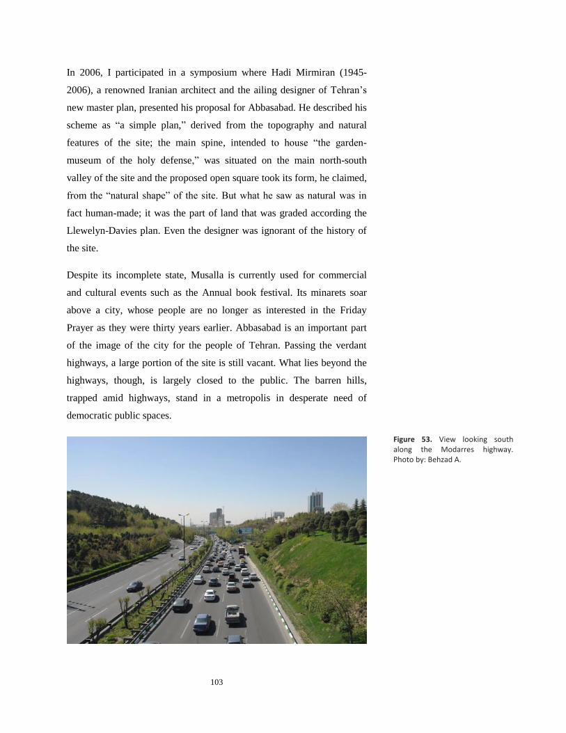
103
In 2006, I participated in a symposium where Hadi Mirmiran (1945-
2006), a renowned Iranian architect and the ailing designer of Tehran’s
new master plan, presented his proposal for Abbasabad. He described his
scheme as “a simple plan,” derived from the topography and natural
features of the site; the main spine, intended to house “the garden-
museum of the holy defense,” was situated on the main north-south
valley of the site and the proposed open square took its form, he claimed,
from the “natural shape” of the site. But what he saw as natural was in
fact human-made; it was the part of land that was graded according the
Llewelyn-Davies plan. Even the designer was ignorant of the history of
the site.
Despite its incomplete state, Musalla is currently used for commercial
and cultural events such as the Annual book festival. Its minarets soar
above a city, whose people are no longer as interested in the Friday
Prayer as they were thirty years earlier. Abbasabad is an important part
of the image of the city for the people of Tehran. Passing the verdant
highways, a large portion of the site is still vacant. What lies beyond the
highways, though, is largely closed to the public. The barren hills,
trapped amid highways, stand in a metropolis in desperate need of
democratic public spaces.
Figure 53. View looking south along the Modarres highway. Photo by: Behzad A.

104
The trajectory of the plans prepared for Abbasabad is paradigmatic of the
turbulent history of modern Iran. Its fragmented development is the
legacy of the contested ideologies that have shaped the civic space of the
metropolis. It is a symbol of all the historical opportunities that were lost.
Ultimately, these plans show the (failed) attempts of a nation-state to
define its position on the modern world stage.

105
BIBLIOGRAPHY
Abrahamian, Ervand, A History of Modern Iran. Cambridge: Cambridge
University Press, 2008.
____, Iran between Two Revolutions. Princeton: Princeton University
Press, 1982.
Alemi, Mahvash. "The 1891 Map or Tehran: Two cities, two cores, two
cultures." Environmental Design: Journal of the Islamic
Environmental Design Research Centre 1 (1985): 74-84.
Amini, P. “A Single Party State in Iran, 1975-78: The Rastakhiz Party.”
Middle Eastern Studies, Volume 38, Issue 1, 2002. 131–168.
Anderson, Benedict R. Imagined Communities: Reflections on the origin
and Spread of Nationalism. London: Verso, 1983.
Ardalan, Davar. My Name is Iran. New York: Henry Holt and Company,
2007.
Ardalan, Nader; Bakhtiar, Laleh. The Sense of Unity: the Sufi Tradition
in Persian Architecture. With a foreword by Seyyed Hossein
Nasr. Chicago: University of Chicago Press, 1973.
Bahrambeygui, H. Tehran: an Urban Analysis. Tehran: Sahab, 1977.
Banani, Amin. The Modernization of Iran, 1921-1941. Stanford:
Stanford University Press, 1961.
Berman, Marshall. All that Is Solid melts into Air: the Experience of
Modernity. New York: Viking Penguin, 1988.
Brownlee, David B. Brownlee and De Long , David G. Louis I. Kahn, In
the Realm of Architecture. New York: Museum of Contemporary
Art, 1997.
Cody, Jeffrey W. Exporting American Architecture, 1870-2000. New
York: Routledge, 2003.
Curtis, William. Modern Architecture since 1900. Oxford: Phaidon,
1982.
Diba, Kamran. Kamran Diba: Buildings and Projects.
Stuttgart: Hatje, 1981.

106
Escobar, Arturo. Encountering Development: The Making and Unmaking
of the Third World. New Jersey: Princeton University press,
1995.
Fallaci, Oriana. Interview with History. Boston: Houghton Mifflin, 1976.
Frampton, Kenneth. Modern Architecture: A Critical History. New
York: Thames and Hudson, 1985.
Gasiorowski, Mark J. U.S. Foreign Policy and the Shah: Building a
Client State in Iran. Ithaca: Cornell University Press, 1991.
Ghiai, Heydar. The Senate House Iran. Paris: Ghiai, 1976.
Giedion, Sigfried. Space, time and architecture. Cambridge, Harvard
University Press, 1967.
Giurgola, Romaldo and Mehta, Jaimini. Louis I. Kahn. Boulder:
Westview Press, 1975.
Goldhagen, Sarah Willams. Louis Kahn’s Situated Modernism. New
Haven: Yale University Press, 2001.
Grigor, Talinn. Building Iran: Modernism, Architecture, and National
Heritage under the Pahlavi Monarchs. New York: Periscope
Publishing, 2009.
____. “Construction of History: Mohammad-Reza Shah Revivalism,
Nationalism, and Monumental Architecture of Tehran, 1951-
1979.” MS Thesis, Massachusetts Institute of Technology, Dept.
of Architecture, 1998.
_____. “Cultivat(ing) modernities: the Society for National Heritage,
Political Propaganda and Public Architecture in Twentieth-
century Iran.” PhD dissertation, Massachusetts Institute of
Technology, 2005.
Gruen, Victor. The Heart of Our Cities. New York: Simon and Schuster,
1963.
Habbi, Seyyed Mohsen. Az Shar ta Dhahr [de la Cite a la ville]. Tehran:
Tehran University Press, 2003.
Hardwick M., Jeffrey. Mall Maker: Victor Gruen, Architect of an
American Dream. Philadelphia: University of Pennsylvania
Press, 2004.

107
Hourcade, Bernard. “Urbanisme et Crise Urbaine Sous Mohammad-Reza
Pahlavi,” in Téhéran: Capitale Bicentenaire. Paris: Institut
français de recherche en Iran, 1992.
Isenstadt, Sandy and Rizvi, Kishwar. Modernism and the Middle East:
Architecture and Politics in the Twentieth Century. Seattle:
University of Washington Press, 2008.
Kahn, Louis I. What Will Be Has Always Been. The Words of Louis I.
Kahn. Edited by Paul Saul Wurman. New York: Access Press,
1986.
Kariman, Hossein. Tehran dar Gozashte va Hal [Tehran in the Past and
present].Tehran: Melli University Publication, 1976.
Katouzian, Homa. State and Society in Iran: The Eclipse of the Qajars
and the Rise of the Pahlavis. London: I.B.Tauris &Co Ltd, 2000.
Katouzian, Homa. The Political Economy of Modern Iran: Despotism
and Pseudo-modernism, 1926-1979. New York: New York
University Press, 1981.
Kheirabadi, Masoud. Iranian Cities: Formation and Development.
Austin: University of Texas Press, 1991.
Llewelyn-Davies International. Shahestan Pahlavi, A New City Center
for Tehran. Tehran: November 1976.
Madanipour, Ali. Tehran: the Making of a Metropolis. Chichester,
England; New York: John Wiley, 1998.
Mitchell, Timothy, ed. Questions of Modernity. Minneapolis: University
of Minnesota Press, 2000.
Mohr, Robert Allen. “The people in the city of the nation: re-viewing
Islamabad's fifth function.” M.C.P.Thesis, Massachusetts Institute
of Technology, 2009.
Muzaffar, M. Ijlal, “The Periphery within: Modern Architecture and the
Making of the Third World.” PhD dissertation, Massachusetts
institute of Technology, 2007.
Pardisan. Philadelphia: Wallace McHarg Roberts and Todd, 1975.
Ronner, Heinz. Louis I. Kahn: Complete Work, 1935-1974. Boston:
Birkhauser, 1987.
108
Robertson, Jacquelin T. “Shahestan Pahlavi: Steps toward a New Iranian
Centre” Toward an Architecture in the Spirit of Islam. Renata
Holod (Ed.) Philadelphia: The Aga Khan Award for
Architecture, 1978
Seminar on the Social Problems of Tehran. Tehran: University of
Tehran, 1961.
Spirn, Anne Whiston. “Ian McHarg, Landscape Architecture, and
Environmentalism: Ideas and Methods in Context.” Landscape
Architecture, Michel Conan Dumbarton (Ed.)Washington, D.C.:
Oaks Research Library and Collection.
The Interaction of Tradition & Technology. Report of the Proceedings of
the First International Congress of Architects, Isfahan: Ministry
of Housing & Urban Development, Government of Iran, 1970.
Victor Gruen Associates and Abdol Aziz Farmanfarmaian Planners and
Architects, The Comprehensive Plan for Tehran, First Stage:
Concept Development.Tehran, 1968
Warne, William. Mission for Peace: Point 4 in Iran. Indianapolis:
Bobbs-Merrill, 1956.
Wheatley, Paul, "Levels of Space Awareness in the Traditional Islamic
City," Ekistics 253 (Dec 1976): 354-66.
Wiseman, Carter. Louis I. Kahn: Beyond Time and Style: a Life in
Architecture. New York, W.W. Norton & Company, 2007.
Archive:
Louis I Kahn Collection, the Architectural Archives, University of
Pennsylvania.