city of elko mp.pdf · southern riverside is, ... elko county, and the city of elko. harp fits into...
TRANSCRIPT

CITY OF ELKO
Humboldt Area River Project (HARP)
Concept Master Plan
January, 1999
Drafted by: The Humboldt Area River Project Sub-Committee
Elko City Planning Commission Elko City Planning Staff And Concerned Citizens of Elko
(Updated May, 2001)


Table of Contents Mission Statement . . . . . . . . . . . . . . . . . . . . . . . . . . . . . . . . . . 1 Summary and Vision Outline . . . . . . . . . . . . . . . . . . . . . . . . . 2-4 Goals/Objectives . . . . . . . . . . . . . . . . . . . . . . . . . . . . . . . . . . . 5 Plan Components and Features . . . . . . . . . . . . . . . . . . . . . . . 6-8 Recommended Tree and Shrub Planting Schedule . . . . . . . 9-10 Master Plan Approval: City Planning Commission and City Board of Supervisors . . . . . . . . . . . . . . . . . . . 11-12

Mission Statement A sub-committee of the City of Elko Planning Commission, the Humboldt Area River Project (HARP) sub-committee, initiated creation of a concept master plan for an open space system along the river. A Mission Statement was adopted by the committee assembled to provide guidance for HARP and to determine potential community uses and protection of this vital natural resource.
"The principal focus of the Humboldt Area River Project (HARP) is to promote the Humboldt River as a valuable, underutilized natural resource of the community. Our mission is to coordinate the development of a multiple-use open space system along the Humboldt corridor that will contribute broadly to the community and help foster river habitat preservation and enhancement, recreational experience and activity, transportation and public safety, neighborhood revitalization, and economic opportunity.
Implementation of the open space system would be accomplished by a combination of professional services, community participation, and public agency support and assistance."
HARP is meant to complement existing public agency efforts in achieving its mission.
1

Summary and Vision Outline The Humboldt River, the longest river in the state, punctuates the vast semi-arid landscape of northeastern Nevada. This vital river flows through the middle of Elko, both dividing the City and providing an opportunity to bring the community together. The river has a history of flooding, complicating development along the frontage. Historical industrial development along the river has been predominantly on the north side delineated by mainline railroad tracks and the older industrial portions of Elko. The southern riverside is, for the most part, undeveloped, and with the formation of the Humboldt Area River Project (HARP) team, a plan has been proposed to invest in restoring, maintaining and perpetuating the unique natural setting while encouraging multiple uses for the community at-large. A number of challenges must be surmounted to fully appreciate the important character of the river as a community resource. Previous dredging and channelization have harmed the natural riparian habitat, old levees stand along the south side, and bridge abutments protrude down to the river. These features will affect any design and construction concepts. Careful planning will overcome these interferences. This concept master planning document is the most recent scoping plan to explore how to enhance the river's impacts on our community. Such plans may give direction and guidance to future land use decisions regarding growth along the river. As such, the plan is meant to generally outline a vision for the highest and best community use of such a natural resource and augment the ratified City of Elko Master Plan. Conversely, this conceptual plan does not address any particular parcel, development or use on adjacent or neighboring private property. It is beyond the scope of HARP to suggest any specific use. Such decisions reside in the governing entities of the State of Nevada, Elko County, and the City of Elko. HARP fits into the current City of Elko Master Plan developed in accordance with NRS Statutes, particularly the Parks, Recreation, and Open Space component. Open space systems are recognized as superior ways of improving and enhancing a community's quality of life. A well-conceived open space system will be safe, effective in bringing community neighborhoods together, provide broad-based outdoor activity potential, and better a community's pedestrian transportation systems. 2

Plans for HARP are to clean up the old features and debris accumulated over the past as an adjunct to initially developing a one and one-half mile long open space system to tie together the community along the river corridor, enhancing pedestrian opportunities between recreational sites along the river. The keystone to the project will be a pedestrian/bicycle pathway meandering along the river from the City-owned property, west of Errecart Boulevard, to just past the 12th Street bridge. HARP also envisions near-term extensions further west and east as the City expands. Future long-term plans may incorporate expanding the HARP open space system to tie into other components of the City's parks. Sites will be identified, catalogued, and developed along the Humboldt, where appropriate, for benches, side trails down to the river or to overview spots to watch wildlife, more traditional landscaped park-like settings, and access to these facilities for community benefit. Funding and development will be by a number of sources including federal programs, state grants, community contributions of in-kind services, local and regional governmental agency assistance, and individual donations. This Concept Master Plan is presented to foster public community input, communicate concepts and goals for grant agencies and funding sources, and to lay the groundwork for detailed inventories and planning of improvements. An itemized vision of HARP as it may emerge and influence the community in the near and distant future is provided in outline format as follows: USE OF THE CONCEPT MASTER PLAN
• Educational tool to help explain the importance of the Humboldt River to the community.
• Promotional tool for the expansion and development of a multiple use park and open space system along the Humboldt River.
• Implementation tool providing guidance, sequence and prioritization for improvements and development of the Humboldt River corridor.
HABITAT PRESERVATION AND ENHANCEMENT
• Removal of junk, trash, debris from the Humboldt River corridor. • Restoration of natural vegetation within the floodway of the river, enhancing
riparian habitat for the benefit of area and migratory wildlife. • Supplementary tree and vegetation planting adjacent to more sensitive
habitat areas. • Identifying and cataloging flora and fauna endemic to the river habitat area.
3

RECREATIONAL EXPERIENCES
• Multiple use paved pathway for walking, jogging, bicycling, in-line skating and similar activities.
• Trails and paths to and through riparian area to access scenic overviews and riparian habitat viewing areas.
• Interpretive signage and markers to help educate interested individuals in the features and characteristics of the Humboldt River.
• Rest areas and passively improved areas adjacent to and peripheral to sensitive river habitat areas.
• Active recreational opportunity within the Bullion Road Park component of HARP inclusive of ballfields, game courts, indoor facilities, ice skating and staging areas for canoeing, kayaking, and tubing.
TRANSPORTATION
• Provide safe access via the main pathway to and from area schools, parks and other public and private destination oriented facilities.
COMMUNITY LINKAGES
• As a community backbone feature, unifying rather than dividing, providing linkage and connections to existing and emerging neighborhoods, the downtown and public and private facilities via 9th Street to the north and to the south and the Humboldt River corridor to the east and to the west.
GROWTH, DEVELOPMENT, ECONOMIC OPPORTUNITY
• Stimulus for new compatible development along the Humboldt River corridor. • Catalyst for revitalization and introduction of new construction within older
established residential areas. • Stimulus for sustaining existing area business. • Catalyst for the expansion of tourism and enhancement of downtown
revitalization.
4

Goals/Objectives The City of Elko and the surrounding Elko County have recognized the unique, valuable nature of the Humboldt River. The Concept Master Plan is presented to express the diverse opportunities and desires to utilize the river while at the same time protecting the resource. Some potential major objectives to fostering reasoned and measured implementation of a Concept Master Plan are:
• Creation of a public open space system along the Humboldt River that will serve the citizens of the area communities.
• Provide the backbone of future open space expansion to tie together
neighborhoods and districts within the City of Elko.
• Development of multiple uses compatible with the river environment that will serve to enhance the quality of life.
• Protection of the river habitat vital to the survival of all flora and fauna
found within any area of use.
• Creation of a single source document that details the short-term and long-term vision of HARP in sufficient depth to allow public agency review and funding of various aspects of the Concept Master Plan.
• Describe the potential plans in enough detail to seek community input and
ratification of both this plan and any future development surrounding the river.
• Implement portions of the Parks, Recreation, and Open Space Plan
component of the City of Elko Master Plan.
• Highlight the aesthetic attractiveness of the enhanced riverfront as a positive attribute thus attracting more diverse businesses to the community.
5

Plan Components and Features The Humboldt Area River Project Concept Master Plan identifies means and methods of providing appropriate multiple uses of a sensitive community resource. The goal of developing an open space system to provide essential pedestrian transportation and recreational needs can be implemented at a low cost through careful, considered actions by the community. The map provided illustrates the general boundaries conceived for the Humboldt Area River Project. The map shows the western terminus at the City-owned acreage now planned for the Boy/Girls Club and possibly a community recreation and services center and the eastern end just past the 12th Street bridge, a distance of approximately one and one-half miles. Due to constraints with the railroad mainline tracks on the north side of the river corridor, development concepts along the core areas are focused on the south side of the river. The project area has further been classified into four broad categories of land use which helps to identify preferred distribution of uses and activities adjacent to and peripheral to the river corridor. These categories are identified and defined as follows: SENSITIVE HABITAT AREA - Sensitive habitat area held in
reserve as open space to be left in natural undisturbed state; not contemplated for accessibility or
development other than habitat restoration.
LIMITED ACCESS AREA - Sensitive habitat area held in
reserve as open space but contemplated for limited access via nature trails and paths for observation of wildlife and river habitat area; suitable for vegetation restoration with native species and for limited improvements such as paths, benches, shelters, observation decks, benches, and similar complementary features.
6

TRANSITION AREA - Area within the river floodplain
but removed from sensitive habitat area; suitable for limited development such as benches, picnic tables, trash receptacles, informative signs, vehicle access and parking, playfields, staging and gathering areas and for non-native complementary landscaping enhancement including grass, shrubs and trees.
ACTIVITY AREA - Area outside of the floodplain and
sensitive habitat area. Suitable for a wide range of development, improvement and activities, such as improved parking, restrooms, buildings, structures, athletic fields and similar active recreation facilities.
The HARP Concept Master Plan includes several main components. A main bicycle/pedestrian walkway along the river, coupled with narrower trails leading to overviews and riparian viewing areas will wind through the open space. Broader expanses will allow diversity in settings with more traditional park-like features. Benches and rest stops will be sited to accentuate the environment. Signage and markers will announce and educate interested parties about specific items of interest. Several ingress/egress paths will allow more neighborhood access and emergency services for public safety. Sensitive wildlife habitat areas will be left unaffected to encourage and promote a viable natural setting for the numerous river area wildlife. Along a portion of the proposed HARP a levee was built to protect low-lying areas from flooding. This levee now acts as a functional boundary between the river habitat and development. Proper configuration of the main pedestrian path will turn the levee into a suitable location for the planned walkway. This dual use will keep the flood protection aspect intact while incorporating improvements for public access and beautification of the river corridor. The often narrow linear aspects of the proposed open space system significantly limit and define some of the features to be built along the river. Preservation of the native species and minimizing human impacts on the habitat suggest use of 7

a main eight to twelve foot wide pedestrian walkway with shoulders on each side. Such a walkway may be paved or graveled to tolerate the annual water level fluctuations. The principal path will wander through the open space, maintaining a character subordinate to the river, while keeping appropriate line-of-sight distances and emergency access. The main pathway will be designed to accommodate physically challenged individuals. In places where the main pathway distances itself from the river, less developed trails will be planned for specific areas where interests are identified. These trails may be two to five foot wide, meandering to suit the terrain, and distinct from the main path. As design concepts are finalized, some of these paths may incorporate wooden elevated walkways in selected areas, platforms for viewing, small shelters to provide human screening from aviaries, and observation points. Wider pathways to bird viewing platforms or sitting areas will also be accessible. Signage will be site-based to give information about local species, migratory species, and Humboldt River history. Open space system information and route maps will be furnished as required and as funding permits. All of the features installed along the HARP open space will be designed and constructed to maintain public safety. Compatible construction materials will be selected to withstand the weather conditions and continual use. If funding permits, non-intrusive pathway lighting may be possible. Overall concepts will be presented to the community for input and direction.
8
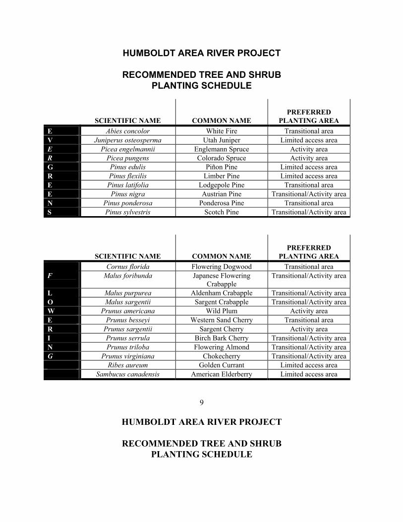
HUMBOLDT AREA RIVER PROJECT
RECOMMENDED TREE AND SHRUB PLANTING SCHEDULE
SCIENTIFIC NAME
COMMON NAME
PREFERRED
PLANTING AREA E Abies concolor White Fire Transitional area V Juniperus osteosperma Utah Juniper Limited access area E Picea engelmannii Englemann Spruce Activity area R Picea pungens Colorado Spruce Activity area G Pinus edulis Piñon Pine Limited access area R Pinus flexilis Limber Pine Limited access area E Pinus latifolia Lodgepole Pine Transitional area E Pinus nigra Austrian Pine Transitional/Activity areaN Pinus ponderosa Ponderosa Pine Transitional area S Pinus sylvestris Scotch Pine Transitional/Activity area
SCIENTIFIC NAME
COMMON NAME
PREFERRED
PLANTING AREA Cornus florida Flowering Dogwood Transitional area F Malus foribunda Japanese Flowering
Crabapple Transitional/Activity area
L Malus purpurea Aldenham Crabapple Transitional/Activity areaO Malus sargentii Sargent Crabapple Transitional/Activity areaW Prunus americana Wild Plum Activity area E Prunus besseyi Western Sand Cherry Transitional area R Prunus sargentii Sargent Cherry Activity area I Prunus serrula Birch Bark Cherry Transitional/Activity areaN Prunus triloba Flowering Almond Transitional/Activity areaG Prunus virginiana Chokecherry Transitional/Activity area Ribes aureum Golden Currant Limited access area Sambucus canadensis American Elderberry Limited access area
9
HUMBOLDT AREA RIVER PROJECT
RECOMMENDED TREE AND SHRUB PLANTING SCHEDULE

SCIENTIFIC NAME
COMMON NAME
PREFERRED
PLANTING AREA Acer glabrum Rocky Mountain Maple Limited access area Acer platanoides Norway Maple Activity area Acer rubrum Scarlet Maple Activity area Alnus rhombifolia White Alder Limited access area Alnus tenuifolia Mountain Alder Transitional area D Amelanchier alnifolia Serviceberry Limited access area E Cercocarpus ledifolius Curl Leaf Mountain
Mahogany Limited access area
C Fraxinus excelsior European Ash Transitional area I Fraxinus pennsylvanica Green Ash Transitional area D Populus tremuloides Quaking Aspen Transitional/Activity areaU Platanus occidentalis American Sycamore Transitional/Activity areaO Quercus gambelii Rocky Mountain White Oak Transitional area U Rhus glabra Smooth Sumac Transitional area S Robenia ambiguia Idaho Locust Activity area Robenia psuedoacacia Black Locust Transitional area Sorbus aucuparia European Mountain Ash Transitional/Activity area Symphoricarpus albus Common Snowberry Limited access area Symphoricarpus chenaultii Creeping Snowberry Limited access area Symphoricarpus orbiculatus Coral Berry Limited access area
10

