city of london local plandemocracy.cityoflondon.gov.uk/documents/s27586/local plan.pdf · 1...
TRANSCRIPT
1
APPENDIX
CITY OF LONDON
LOCAL PLAN
Planning & Transportation Committee 5th November 2013

2
The Local Plan comprises:
• The Core Strategy (adopted September 2011)
• New development management policies.
Material carried forward unchanged from the Core Strategy is
shown in blue text.
Alterations to the Core Strategy are shown in black underlining
and strikethrough.
The new development management policies are shown in black text.

3
CONTENTS 1. INTRODUCTION 5 2. SPATIAL STRATEGY, VISION AND STRATEGIC OBJECTIVES 12 3. DELIVERY STRATEGY 27
A World Financial and Business Centre 3.1 Offices 28 3.2 Utilities Infrastructure 38 3.3 Security and Safety 44 3.4 Planning Contributions 56 Key City Places 3.5 The North of the City 63 3.6 Cheapside and St Paul’s 71 3.7 Eastern Cluster 77 3.8 Aldgate 83 3.9 Thames and the Riverside 89 City Culture and Heritage 3.10 Design 93 3.11 Visitors, Arts and Culture 106 3.12 Historic Environment 112 3.13 Protected Views 122 3.14 Tall Buildings 125 Environmental Sustainability 3.15 Sustainable Development and Climate Change 129 3.16 Public Transport, Streets and Walkways 142 3.17 Waste 153 3.18 Flood Risk 161 City Communities 3.19 Open Spaces and Recreation 169 3.20 Retailing 180 3.21 Housing 187 3.22 Social Infrastructure and Opportunities 197
Appendices 1 Maps and Diagrams 205 2 Policies Map 207 3 Glossary 209

4
MAPS AND DIAGRAMS INTRODUCTION
Figure A: Core Strategy Preparation 8 SPATIAL STRATEGY, VISION AND STRATEGIC OBJECTIVES
Figure B: Key Diagram 15 DELIVERY STRATEGY
A World Financial and Business Centre Figure C: Employment specialisms in the City 28 Figure D: Electricity demand in London 39 Key City Places Figure E: The North of the City 62 Figure F: Cheapside and St. Paul’s 70 Figure G: Eastern Cluster 76 Figure H: Aldgate area 82 Figure I: Thames and the Riverside 88 City Culture and Heritage Figure J: Visitor attractions 108 Figure K: Conservation areas 113 Figure L: Protected views 123 Figure M: Tall buildings 126 Figure N: Areas inappropriate for tall buildings 127 Environmental Sustainability Figure O: Area served by the CCHP network 129 Figure P: Highway hierarchy 143 Figure Q: Public transport 143 Figure R: Walbrook Wharf safeguarded site 155 Figure S: City flood risk areas 161 Figure T: SuDS management train 166 City Communities Figure U: Open spaces 171 Figure V: Environmental Public realm enhancement schemes 171 Figure W: Sites of importance for nature conservation 173 Figure X: Principal shopping centres and retail links 180 Figure Y: Residential areas 188 Figure Z: Housing trajectory 196 Figure ZZ: Social and community infrastructure 198
POLICIES MAP Policies Map A } Not included: Policies Map B } to be displayed at Committee meeting
The maps in this document are based on the Ordnance Survey © Crown copyright and database rights 2012 Ordnance Survey 100023243.
5
1: INTRODUCTION WHAT IS THE CORE STRATEGY LOCAL PLAN? 1.1 The Core Strategy is a planning document that sets out a spatial framework for how the City Corporation wants to see the City of London develop to 2026 and beyond. It takes account of projected changes in economic circumstances and numbers of people in work, transport needs, housing needs, the impact of climate change, the need to protect and enhance the City’s historic legacy and the overarching need to improve the quality of life for all the City’s communities (workers, residents and visitors).The Local Plan sets out the City Corporation’s vision, strategy, objectives and policies for planning the City of London. It provides a spatial framework that brings together and co-ordinates a range of strategies prepared by the City Corporation, its partners and other agencies and authorities. It includes policies for deciding development proposals. It takes account of projected changes in the economy, employment, housing need, transport demand, and seeks to maintain the quality of the City’s environment and its historic heritage. It provides the strategy and policies for shaping the City until 2026 and beyond. THE LOCAL DEVELOPMENT FRAMEWORK 1.2 The Core Strategy is one of the documents that make up the City’s Local Development Framework (LDF). Together these documents provide policies, guidance and feedback on how the City is developing A more detailed explanation of the LDF system and the planning documents proposed in the City is set out in the City’s Local Development Scheme. In summary, the City’s LDF will comprise the following:
• Local Development Scheme – this describes the documents that make up the LDF and the timetable for preparing them;
• Statement of Community Involvement – sets out how we will consult the public on the LDF;
• Core Strategy Development Plan Document (DPD) – sets out strategic policies to guide development in the City;
• Development Management DPD - contains detailed policies for deciding planning applications;
• Supplementary Planning Documents (SPDs) – set out in more detail how some of the planning policies will be applied;
• Annual Monitoring Report (AMR) - reports progress being made on preparing and implementing the LDF.
1.3 The Core Strategy is accompanied by a Proposals Map, (in two parts) which shows where policies of the Core Strategy and Unitary Development Plan (see below) apply to specific locations.
1.4 Before the introduction of the Local Development Framework process the City was required to prepare a Unitary Development Plan (UDP) which was adopted in 2002. Most of the UDP’s policies have now lapsed, but 55 will remain in force until the adoption of the Development Management DPD. A list of these policies is set out in Appendix 3.

6
THE WIDER POLICY CONTEXT 1.5 1.2 The City cannot be planned in isolation. The Core Strategy Local Plan has been developed in the context of a range of other plans and strategies operating at the City, London and national levels. City Strategies 1.6 1.3 The overarching strategy for the City is its sustainable community strategy The City Together Strategy: The Heart of a World Class City 2008-2014. The Strategy was drawn up and will be is being implemented by the City’s Local Strategic Partnership (The City Together), which brings together businesses, residents, infrastructure and service providers. The Vision for the City Together Strategy is: “The City Together will work to support the City of London as a leading international financial and business centre in a way that meets the needs of its diverse communities and neighbours.” 1.7 1.4 The Vision is supported by five key themes for achieving a World Class City, which: • is competitive and promotes opportunity;
• supports our communities;
• protects, promotes and enhances our environment;
• is vibrant and culturally rich;
• is safer and stronger. 1.8 1.5 This Vision and the five themes have been integrated into the Spatial Strategy, Vision, Strategic Objectives and policies of the Core Strategy Local Plan. 1.9 1.6 The City Together Strategy will be implemented through the Core Strategy Local Plan and a number of other local strategies prepared by the City Corporation or its partners, covering areas such as economic development, transport (the Local Implementation Plan), health and community services, crime and disorder, biodiversity, waste management recycling, air quality and climate change. The Core Strategy Local Plan aims to bring together the spatial elements of these strategies and provide a focus for future development in the City. London and National Strategies and Policies 1.10 1.7 A wide range of regional strategies, including those for planning, transport, economic development, housing, energy and air quality are prepared by the Mayor of London, and brought together in the London Plan 2011. The Core Strategy City’s Local Plan, like those produced by the London boroughs, must be in general conformity with the London Plan. The London Plan, together with the City’s Local Development Framework Plan, form the ‘Development Plan’ for the City of London. The Core Strategy Local Plan does not repeat policy in the London Plan, or national guidance, except where more detail is required to reflect local circumstances.
7
1.11 1.8 In preparing the Core Strategy Local Plan, the City Corporation has liaised closely co-operated with a range of other bodies to ensure a co-ordinated approach in the development of its policies. These bodies include the Mayor of London, the Greater London Authority and its “family” of authorities, including Transport for London, London Boroughs with its (especially the neighbouring boroughs: Westminster, Camden, Islington, Hackney, Tower Hamlets, Southwark and Lambeth) to ensure a coordinated approach. , together with agencies responsible for transport, health and the environment. 1.12 1.9 The Core Strategy Local Plan must also reflect the national planning policy guidance. This is currently set out in a series of Planning Policy Statements (PPS) and Circulars, but will be replaced by a National Planning Policy Framework (NPPF) issued by the Secretary of State for Communities & Local Government. The NPPF establishes a presumption in favour of sustainable development, which the City Corporation will implement in making its planning decisions. Core Strategic Policy: Presumption in favour of sustainable development 1) When considering development proposals the City Corporation will take a positive approach that reflects the presumption in favour of sustainable development contained in the National Planning Policy Framework. It will always work proactively with applicants jointly to find solutions which mean that proposals can be approved wherever possible, and to secure development that improves the economic, social and environmental conditions in the area. 2) Planning applications that accord with the policies in this Local Plan (and, where relevant, with polices in neighbourhood plans) will be approved without delay, unless material considerations indicate otherwise. 3) Where there are no policies relevant to the application or relevant policies are out of date at the time of making the decision then the City Corporation will grant permission unless material considerations indicate otherwise – taking into account whether: • Any adverse impacts of granting permission would significantly and
demonstrably outweigh the benefits, when assessed against the policies in the National Planning Policy Framework taken as a whole; or
• Specific policies in that Framework indicate that development should be restricted.
PREPARATION OF THE CORE STRATEGY LOCAL PLAN 1.13 1.10 The development of the Core Strategy involved public consultation, information-gathering, research and sustainability appraisal. The principal supporting evidence and the conclusions of the sustainability appraisal are outlined under each policy. The Local Plan sets out the City Corporation’s policies for planning the City in a single document. It incorporates the City of London Core

8
Strategy, which was adopted in 2011. The Core Strategy contains the vision, strategic objectives and 22 key policies for shaping the City. The material carried forward from the Core Strategy has been reviewed and updated, but as it was recently prepared, only limited changes are required. Fourteen of the Core Strategy policies are supplemented by further development management policies. 1.11 The preparation of the Local Plan’s policies involves public consultation and the development of an evidence base of research and information. Policy development has also been carried out in the light of a sustainability appraisal and an equalities impact assessment. All this evidence is made publicly available. 1.14 1.12 Although the Core Strategy Local Plan identifies the broad scale and location of development expected in the City up to 2026, the overarching strategic objectives provide a framework for development beyond this date. The City Corporation will keep the evidence base under review and monitor the implementation of the Core Strategy Local Plan’s objectives and policies. Monitoring reports on key Local Plan issues will be published on an annual basis, and other reports published occasionally. This monitoring will be reported annually (to reflect changes in the Localism Bill) and will highlight whether circumstances have changed sufficiently to require a review of the Core Strategy Local Plan in its entirety or a review of selected policies.
Figure A: Core Strategy Local Plan Preparation
Wider Policy Framework
National Policy and Guidance
The London Plan;
Other Mayoral strategies and guidance
City Plans and Strategies;
The City Together Strategy;
Corporate Plan; Local Implementation
Plan
Core Strategy Local Plan
Vision
Strategic Objectives
Delivery Strategy
Policies
Monitoring Framework
Sustainability Appraisal
Alig
nmen
t
Consultation
Evidence Base
Equality Impact
Assessment
Infrastructure Delivery Plan

9
OTHER PLANNING DOCUMENTS 1.13 The Local Plan is accompanied by a number of other planning documents that provide policies, guidance and feedback on how the City is developing: • Policies Map, (in two parts) which shows where the Local Plan’s policies apply to
specific locations;
• Local Development Scheme – this lists and describes all planning policy documents and the timetable for preparing them;
• Statement of Community Involvement – sets out how we will consult the public in preparing planning policies;
• Supplementary Planning Documents (SPDs) – set out in more detail how some of the Local Plan’s policies will be applied;
• Community Infrastructure Levy (CIL) – A charging schedule sets out how the CIL will be applied to various categories of development.
IMPLEMENTATION AND DELIVERY 1.15 1.14 Implementation of the Core Strategy Local Plan requires partnership working and co-operation with a range of organisations, including developers, businesses, residents, community and amenity groups, transport and service providers, the Mayor of London and neighbouring boroughs. 1.16 1.15 A key mechanism for implementing the Core Strategy Local Plan is the consideration of planning applications through the development management process. The Core Strategy Local Plan should be read as a whole and applications for planning permission will be considered against all relevant policies in the Core Strategy Local Plan and those in, the London Plan and the NPPF. The City Corporation will provide more detailed planning policies in the Development Management DPD. The City Corporation will require developers to demonstrate that they have consulted with people who live in or occupy premises in the vicinity before submitting planning applications and what account has been taken of the views received. 1.17 1.16 The City Corporation also uses its management of the public realm and environmental enhancement strategies to help deliver the vision and policies in the Core Strategy Local Plan. It will, where necessary, use its land and property ownership to assist with site assembly and use its compulsory purchase powers to enable the high quality development the City needs. 1.18 1.17 Under each policy topic of the Local Plan is a table setting out how the policy policies will be delivered, identifying the main delivery partners and processes. Key factors in delivery will be the detailed evaluation and prioritisation of proposals and the availability of funding. The City’s Infrastructure Delivery Plan, which is summarised in Appendix 2, aims to identify and collate the investment plans of a range of infrastructure providers determining where there might be gaps in

10
funding, or trigger points which require a step change in levels of infrastructure. Where gaps in the funding of infrastructure necessary to implement the Core Strategy Local Plan are identified, the City Corporation will seek alternative funding streams, including the use of the Community Infrastructure Levy and other contributions from development, and will consider the need to prioritise available funds. Where necessary funds cannot be secured, the City Corporation will also consider whether there is a need to review the Core Strategy Local Plan. 1.19 1.18 Alongside the Core Strategy Local Plan, the City Corporation has prepared a detailed Infrastructure Delivery Plan, which is available on the City Corporation’s website. This Delivery Plan is a ‘living’ document which will be updated on an ongoing basis. WHAT IF THINGS CHANGE? 1.20 1.19 The City Corporation will update the evidence base and Infrastructure Delivery Plan and monitor progress towards meeting the Core Strategy Local Plan’s strategic objectives. Key areas where changing trends or uncertainty may result in a need to change policy include: • Future levels of economic and employment growth;
• Transport and infrastructure capacity;
• The appropriate balance of uses in the City;
• Climate change;
• The security context;
• The availability of funding for the delivery of necessary infrastructure; and
• Changes in legislative requirements or Government guidance. 1.21 1.20 The Core Strategy Local Plan was prepared in the context of the most up to date and relevant information available. A range of projections and potential future scenarios were considered and a risk analysis undertaken for each policy area. However, unforeseen events may prompt a need for review of some policies. The monitoring framework (Appendix 1) and the Infrastructure Delivery Plan (Appendix 2) that accompany the Local Plan provide the basis for identifying when a review will be required.

11
STRUCTURE OF THE CORE STRATEGY LOCAL PLAN 1.22 1.21 The remainder of the Core Strategy Local Plan is structured as follows: Section 2: Spatial Strategy, Vision and Strategic Objectives – outlines the spatial strategy for the City, highlights the challenges it the City faces and outlines a spatial strategy and a vision for the future under five broad themes: • A World Financial and Business Centre
• Key City Places
• City Culture and Heritage
• Environmental Sustainability
• City Communities Section 3: Delivery Strategy – sets out policies to implement the spatial strategy and vision under 22 topics. The first policy under each topic is a Core Strategy Strategic policy, which addresses the strategic context, the relationship with other plans and strategies, and key planning issues. Fourteen of these policies are followed by additional development management policies that will be used in the consideration of applications for planning permission and related consents. The Delivery Strategy contains maps and diagrams, which are for illustration only. The Policies Map that accompanies the Local Plan shows where its policies apply to geographical locations. Section 4: Appendices 1.23 1.22 The vision, delivery strategy and policies are intended to provide an integrated and co-ordinated approach to planning the City. The Core Strategy Local Plan should therefore be read as a whole.
12
2: SPATIAL STRATEGY, VISION AND STRATEGIC OBJECTIVES
THE CITY TODAY 2.1 The City of London is unique. Although little more than one square mile in size, it is densely developed and is the world’s leading international financial, business and maritime centre. It is a leading driver of the London and national economies, contributing 12 14% of London’s GDP and an estimated 8.5 3.1% of the UK’s GDP. It provides employment for over 370,000 people who mostly use public transport to commute to work from across London and the surrounding regions. Offices make up over 70% of all buildings and many of them are occupied by financial and business services. 2.2 Alongside its primary business function, the City has many other roles:
• It is home to approximately 10,000 9,000 residents; • It is a centre of learning with over 29,000 students; • It provides national, regional and local health services; • It is at the hub of an extensive regional public transport network; • It houses arts and cultural facilities of international renown; • It is a visitor destination with 8.8 million visitors a year and a distinctive, high quality environment that combines modern architecture and tall buildings with historic buildings and conservation areas within a rich historic environment. 2.3 The City’s economic dynamism means there is a high rate of change and development, putting particular pressure on the City’s transport and utility infrastructure. There are significant competing demands between the need to accommodate new office development alongside the need for new housing, social and community facilities and improved transport infrastructure. These pressures are felt City-wide and the Core Strategy Local Plan needs to respond accordingly. SUSTAINABLE GROWTH – THE CENTRAL CHALLENGE 2.4 The central challenge facing the City, therefore, is the delivery of sustainable long-term economic growth to support the London and national economies, whilst at the same time providing for population growth and protecting and improving the environment and quality of life. The City is expected to see continued economic, employment and population growth in the medium to longer term, notwithstanding short-term economic cycles. Table 2.1 shows the scale of the projected growth in employment and population expected in the City over the period to 2026.

13
Table 2.1: Growth in Population and Employment 2006 2011 - 2026 2006 2011 2016 2021 2026 Employment Projections
332,000 373,000 401,000 423,000 428,000
Population Projections 8,900 9,700 7,400 10,400 8,100 11,400 9,200 12,100 10,000
Note: Population projections exclude 1,370 second home owners in 2011. Total City population in 2011 was approximately 9,000 including them. Sources: Working Paper 39: Borough Employment to 2031 GLA Economics November 2009 2010 2012 Round Demographic Projections for the London Plan- SHLAA GLA February 2011 2012 2.5 In turn, this growth will lead to further pressure for new offices, shops, homes and leisure facilities, and the services necessary to support them. A balance is needed between providing for this new development and retaining and improving the best of the current building stock. Table 2.2 illustrates the overall scale and phasing of development anticipated in the City over the next 15 years. Table 2.2: Indicative Scale and Phasing of Growth in Main Land Uses 2011-2026 Land Use 2011-2016 2016-2021 2021-2026 Total 2011-2026 Offices 650,000m2 250,000m2 250,000m2 1,150,000m2 Retailing (A1-A5) 52,000m2* 44,000m2 40,000m2 136,000m2 Housing 667 units 430 units 550 units 1,647 units * Figures relate to the 2009-2016 period 2.6 The distribution of the development set out in Table 2.2 will reflect the City’s primary business role and the expectation that offices will be acceptable development across the City unless indicated otherwise by policies in this Core Strategy Local Plan. Table 2.3 provides an illustration of the scale of development that could take place in each of the five Key City Place areas and the rest of the City through the implementation of the policies in this Core Strategy Local Plan and the development pipeline (sites under construction at March 2011 or with the benefit of planning permission). The figures are not prescriptive and are presented as percentage ranges.

14
Table 2.3: Indicative Distribution of Development (% of floorspace and % of residential units)
Offices Retailing Hotels Housing North of the City 10-20 20-30 0-10 60-70 Cheapside 0-10 50-60 20-30 0 Eastern Cluster 50-60 10-20 0-10 0 Aldgate 0-10 0-10 0-10 0-10 Thames & Riverside 0-10 0-10 50-60 0-10 Rest of the City 20-30 0-10 0-10 10-20 City of London 100 100 100 100 SPATIAL STRATEGY 2.7 Although development pressures are felt City-wide, the Key Diagram identifies five key areas (the Key City Places) which face particular challenges over the next 20 years. The Key City Places do not have defined boundaries. The areas shown in Figure 2 B and Figures 5–9 E-I are indicative. • The North of the City – addressing the impact of, and accommodating the growth resulting from, Crossrail, whilst maintaining the area’s mix of uses, enhancing its cultural offer and delivering sustainable development. • Cheapside and St Paul’s – guiding the delivery of significant increases in retail floorspace and enhancing the area’s visitor/cultural offer to restore the area as the City’s ‘high street’. • Eastern Cluster – providing a clear policy framework to guide business development, particularly tall buildings, whilst ensuring a safe and attractive environment. • Aldgate – improving the highway and public realm, and promoting social, environmental and business regeneration, particularly centred on the Mansell Street and Middlesex Street residential estates. • Thames and the Riverside improving vibrancy, encouraging a mix of commercial uses which retaining retains existing tranquil areas, promoting environmental improvements, increasing accessibility on land and by river and managing and reducing flood risk. VISION AND STRATEGIC OBJECTIVES 2.8 The following pages set out the key challenges facing the City, identifying the City Corporation’s vision for how the City should develop over the period to 2026 and beyond, and the strategic objectives for achieving this vision. The vision and strategic objectives reflect the overarching vision and five key themes in The City Together Strategy.

15

16
A World Financial and Business Centre The Challenge…. The City is the heart of the world’s leading international financial, business and maritime centre. It provides a major source of employment for London and its surrounding regions and is a vital asset to the national economy. The City’s status as the primary global financial and business centre has strengthened in recent years, although competition is increasing from existing and emerging financial centres, including those in China, India and the Middle East. In addition, the fallout from the financial crisis and a changing regulatory regime have created global uncertainty and new challenges. The City needs to continue to offer the right business conditions, built environment and infrastructure to allow its financial and business services sector to help the economy to flourish once again and to compete internationally as a global centre of business excellence. Offices are the major land use in the City and the financial and business services sector is the main office occupier, although the technology, media and telecommunications (TMT) sector is growing. This office stock will need to increase and improve in quality to meet future business needs. A good supply of high quality, modern and sustainable office accommodation is required to meet the needs of the City’s commercial occupiers. The City cannot function without the provision of adequate utilities, particularly high quality electronic trading and telecommunications facilities, which also place increased demand on electricity supplies. Space for utilities under the City’s streets is limited and, while the supply of services is currently adequate, there is a challenge to meet increased demand as the economy grows whilst at the same time adapting to a low carbon economy. The City is a safe place to live and work, but must recognise and address increasing concerns about global security. More locally, growth in the night-time economy entertainment is leading to concerns about anti-social behaviour. The challenge is to address these global and local concerns, whilst maintaining an attractive and accessible environment.

17
A World Financial and Business Centre The Vision…. The City will remain the world’s leading international financial and business centre and a driver of the national economy, continually innovating and developing new business areas, including in the TMT sector, delivering growth and prosperity for its communities. The quantity and quality of new development, particularly offices, will keep pace with growing business needs, allowing the continued clustering of businesses that is vital to the City’s operation. The provision of utilities and infrastructure will keep pace with, and anticipate, the demands set by this growth, funded in part by new development. The City will remain a safe place to work, live and visit. Building design, servicing arrangements and management of the public realm will address wider security threats, whilst effective building design and management of the night-time economy entertainment will reduce the potential for anti-social behaviour.
STRATEGIC OBJECTIVE 1 To maintain the City’s position as the world’s leading international financial and business centre.

18
Key City Places The Challenge…. The North of the City The north of the City contains a mix of areas and uses, including the strategic cultural quarter centred on the Barbican, and residential areas at the Barbican and Golden Lane, each with its own distinctive character. The construction of Crossrail will bring significant change and increased pedestrian flows. Careful planning is essential to retain the character and amenity of individual areas, whilst managing growth. Cheapside and St Paul’s A substantial increase in retail floorspace is under construction taking place which, together with environmental improvements, will restore is restoring Cheapside’s former position as the City’s ‘high street.’ The challenge is to integrate these improvements with the established visitor attraction at St Paul’s Cathedral and visitor flows across the Millennium Bridge. Eastern Cluster The east of the City has the highest density of business activity in the City and contains a cluster of tall buildings. New tall buildings are expected to be clustered in this area. The resulting significant increase in numbers of people either working in or commuting to this small area will put more pressure on public transport, streets, open spaces and services. Aldgate This area has significant potential for development but suffers from high traffic levels, pollution and a lack of street activity. Residents living on the Mansell and Middlesex Street Estates have lower levels of employment and poorer health than others in the City. Highway changes and regeneration are needed to improve safety, the environment and amenities, improve the health and well-being of local residents and provide further development and employment opportunities. Thames and the Riverside Now that the riverside walk is nearly complete, it is important to exploit fully the riverside’s potential to provide recreation and enjoyment. The greater mix of uses requires careful planning to avoid the loss of important office floorspace and to avoid conflict with residential areas at the Temples and around Queenhithe. There is significant potential for increased transport use of the River, making greater use of existing piers for passenger services, the movement of construction materials and deconstruction materials demolition waste, and continuing to make full use of Walbrook Wharf for the movement of materials including waste.
19
Key City Places The Vision….
The North of the City Passengers will emerge from new Crossrail stations to find a lively variety of restaurants and shops with attractive streetscapes and vistas. Attractive pedestrian routes will link pockets of well designed open space. Progressive building designs and sensitive refurbishments will mean residents, workers and visitors remain in a comfortable and safe environment that has adapted to climate change. The Barbican will form part of a wider strategic cultural quarter. Evening and night time activity will be well managed.
Cheapside and St Paul’s This area will be a vibrant office, retail and cultural destination attracting visitors seven days a week. It will provide a high quality pedestrian environment, including gathering spaces, pocket parks and seating for relaxation which supports the business City. Well signposted walking routes will link Cheapside with its surrounding attractions such as the Museum of London, the Barbican Complex, the Riverside and the Tower of London.
Eastern Cluster Office and employment growth will be successfully accommodated by a cluster of attractive, sustainably designed tall buildings, providing an iconic image of London that will help to attract significant global investment. The area will be safe for workers and visitors, with a high quality street scene and environment, improving pedestrian movement and permeability, both within the area and outside to other parts of the City.
Aldgate The area will be attractive and vibrant, with a mix of high quality offices, residential, retail, leisure and cultural facilities, catering for residents, workers, students and visitors. The health of residents will be good and they will be able to access training and job opportunities relevant to their needs. The physical environment will be pleasant, with an efficient street layout which minimises congestion and traffic pollution and improves accessibility. Green spaces will be created which enable people to relax and play and trees and green walls will be planted wherever possible.
Thames and the Riverside The Thames and its riverside will provide well designed and managed public spaces, catering for a variety of uses. ranging from lively and vibrant areas, to areas of relative tranquillity for relaxation and contemplation. Employment, residential, educational and, recreational and employment activity will be enhanced by high quality sustainable streetscapes which will address the challenges of climate change. The river will continue to be used for the transport of people and materials, including through the safeguarded Walbrook Wharf. The riverside will be easily accessible from other parts of the City and from the south side of the Thames.
STRATEGIC OBJECTIVE 2 To ensure that the challenges facing the five Key City Places are met, complementing the core business function of the City, contributing to its unique character and distinguishing it from other global financial districts.

20
City Culture and Heritage The Challenge…. The City of London is a historical and cultural centre, and the City Corporation, as a major sponsor of the arts, makes a major contribution to the cultural life of London. The City provides facilities for arts and entertainment of international standing, including the Barbican complex and the Guildhall School of Music & Drama. It also contains important cultural assets such as the Museum of London, a range of lending and specialist libraries and many churches places of worship, which contribute to the spiritual life of the City. Alongside these assets are many other leisure facilities, including restaurants, bars and shopping facilities, all of which contribute to the City’s attractions. Lively night-time economy entertainment is developing and needs to be actively managed. The Square Mile is the original core from which London developed. It contains a valuable heritage of historic buildings, spaces and areas which make an important contribution to the City’s distinctive identity. The City has 26 conservation areas, nearly over 600 listed buildings, and is one of the most archaeologically important areas in the country. Further development must not detract from these historic assets and their settings, or adversely affect significant views, especially of St Paul’s Cathedral and the Tower of London. The City’s townscape combines leading modern architecture with a valuable heritage of historic buildings. Tall buildings within the City are a distinctive element of London’s skyline and further tall buildings are likely to be needed to accommodate future growth. Tall buildings should make a positive contribution to the existing character of the City and beyond, by being of high architectural quality and appropriate to their context.
21
City Culture and Heritage The Vision…. The City’s arts, cultural, heritage and retail assets will be managed so that it continues to be a cultural and leisure destination for workers, residents and visitors. The Barbican area will continue to develop as a strategic cultural quarter of national and international stature. World class architecture will continue to add to the City’s environment and a high standard of design will be required for all buildings and the public realm, integrating sustainability into the construction and operation of buildings and spaces and delivering environmental improvements across the City. Further tall buildings will be allowed where they can make a positive contribution to their surroundings and the skyline, particularly adding to the tall building cluster in the east of the City. The City’s rich architectural and archaeological heritage will continue to be conserved or enhanced. New development will enhance the City’s character and add value to the wider character and quality of London, whilst respecting the setting of St Paul’s Cathedral and the Tower of London. The City will offer equality of opportunity, accessibility and involvement so that everyone will have the chance to benefit from the many opportunities and facilities it offers. The City will be designed so that buildings, streets and spaces are functional, inclusive, interesting and legible, which will allow its diverse communities to enjoy the City to its fullest. STRATEGIC OBJECTIVE 3 To promote a high quality of architecture and street scene appropriate to the City’s position at the historic core of London, complementing and integrating the City's heritage assets and supporting the continued development of the City as a cultural destination for its own communities and visitors.

22
Environmental Sustainability The Challenge…. The City is a heavy user of natural resources, especially energy. Its contribution to climate change needs to be minimised and measures are required to adapt to the inevitable consequences of climate change, such as increased temperatures. The City suffers from poor air quality, although much of the pollution originates outside the City, and its causes must be addressed strategically. The City produces large quantities of waste, most of which is generated by City businesses and collected by private contractors. Waste collected by the City Corporation is currently sorted and partly recycled before A proportion of this waste is transported by river barges from Walbrook Wharf providing sustainable waste transfer to riverside facilities elsewhere in London. Although recycling rates have increased, the City’s high density and the lack of space for sorting and processing make recycling and waste management a difficult challenge. The City has the highest density of public transport provision in Britain. Over 90% of the City’s workers commute by public transport. Additional capacity will be needed to accommodate future employment growth. Improvements to existing services are producing some additional capacity and Crossrail will deliver a significant improvement after 2018. Within the City most movement is on foot. Although the congestion charge has reduced road traffic during the day, many City streets are still busy and pedestrians are confined to narrow footways. As the workforce and population grow, more space will be needed for pedestrians and more facilities required for safer and responsible cycling, whilst retaining road capacity for those who depend on motor vehicle access. Most of the City is built on high ground and is at relatively low risk from flooding from the Thames or along the course of the former River Fleet. There is normally sufficient capacity within the sewer system to deal with rainfall, although in periods of heavy rain sewers can overflow directly into the Thames causing pollution. There is also some risk of localised surface flooding in small parts of the City.

23
Environmental Sustainability The Vision…. Buildings will be highly sustainable, designed to minimise their impact on climate change, provide appropriate mitigation and be adaptable to its effects. Buildings will use resources more efficiently through passive design, combined cooling, heat and power networks, renewable energy, sustainable waste management and sustainable urban drainage. The risk of flooding will be minimised by the incorporation of measures to reduce run-off and increase rain water recycling. The Thames Tideway Tunnel will be constructed as a means of greatly reducing storm discharges from the combined sewer system and improving the quality of the water in the River Thames. Businesses and residents will reduce the amount of waste they produce and will increase the proportion of waste they recycle. A greater proportion of construction waste will be recycled in situ. Walbrook Wharf will continue to provide a facility for transferring materials, including waste, by river barge, thereby reducing lorry traffic in London. More sustainable travel patterns and modes of transport will be promoted and public transport capacity increased, principally through improvements to the Thameslink service, and the construction of Crossrail and the Northern Line/Bank Upgrade. The City’s streets will be managed to improve conditions for pedestrians and cyclists, while providing for essential private vehicle movements. Maximum use will be made of the River Thames to transport materials including construction and demolition deconstruction materials, waste, freight and general goods. Greater use will be made of piers on the River Thames for the transport of passengers. STRATEGIC OBJECTIVE 4 To ensure that the City of London remains at the forefront of action in response to climate change and other sustainability challenges that face high density urban environments, aiming to achieve national and international recognition for its sustainability initiatives.

24
City Communities The Challenge…. The City has a diverse range of communities: business, workers, residents, students and visitors, each with different needs. Providing for all these needs in such a small area is unrealistic, so choices will need to be made and partnership working will be needed for appropriate provision. The City has many, mainly small, open spaces and many indoor recreation facilities, most of them private. All are heavily used and the growth in the City’s workforce and residential population will put even greater demands on them. Retailing is an important amenity for workers, residents and visitors, although the quantity and quality on offer does not meet aspirations, and much is scattered across the City. Increasing the it would benefit from an increased range and concentration of facilities which will allow workers and residents to shop and relax near their place of work or home. The City’s residential population is small but growing and most housing is concentrated around the City fringes. Twenty-four hour business activity and high demand for office space mean that many areas are not suitable for residential development. Housing is expensive and beyond the means of some who need to live in the City, but the provision of affordable housing within the City is difficult due to the scarcity and cost of land. The health of residents is generally good, although health inequalities exist, with pockets of poor health in the Portsoken and Golden Lane areas. The Index of Multiple Deprivation suggests that the east of the City (Portsoken) is deprived compared to the rest of the City and should be a focus for work to reduce health inequalities within the City. The small size of the residential population means that it is not viable to provide all necessary community services within the City and so some need to be supplied in co-operation with other authorities. Although St. Bartholomew’s Hospital is located in the City, it mainly serves regional needs. A particular concern is the need to provide health and community facilities for the large and growing working population. The City’s schools and universities are attended by 29,000 students. The City has one primary school, but no state secondary schools, although the Corporation runs two independent schools in the City, the Guildhall School of Music & Drama and funds academies in neighbouring boroughs. As the residential population and student numbers grow, there will be increased competition for a limited number of places and a greater need for joint working with adjoining boroughs.

25
City Communities The Vision…. The number of open spaces will be increased by encouraging owners of private amenity space to make it available for public access, the use of highways no longer needed for traffic and by the provision of green roofs and roof gardens. Biodiversity will be increased by the incorporation of wildlife-friendly features into open spaces, buildings and the river front. The quality and quantity of retail facilities will be increased to meet the aspirations of the City’s communities and to cope with rising demand. Retail growth will be focused in the five Principal Shopping Centres. There will be a mix of dwelling types to meet identified needs, located primarily in or near existing identified residential areas, which will provide a high quality living environment for residents. Housing will continue to be discouraged in locations where it would conflict with the City’s business role or provide poor residential amenity. Affordable housing will be achieved on some City sites and more will be provided outside the City, utilising funding generated by development in the City. The City will have a network of high quality social and community facilities in accessible locations to foster cohesive and healthy communities. Links between the City residents and those of neighbouring boroughs will be strengthened and closer co-operation will provide a stronger sense of community and more efficient services. The health and well-being of the City’s population will be generally good, with improvements in the health of residents in the Portsoken and Golden Lane areas. Partnership working will effectively tackle the wider causes of poor health by promoting the recreational benefits of a healthy life style, reducing pollution and ensuring access to good quality open spaces and recreational opportunities. The City’s higher education institutions will continue to enjoy an international reputation for excellence. The City will work with partners to ensure high quality training and learning opportunities are accessible to all. City and City fringe residents will develop the skills needed to enter careers in the City and benefit from the City’s prosperity.
STRATEGIC OBJECTIVE 5 To ensure the provision of inclusive facilities and services that meet the high expectations of the City’s business, resident, student and visitor communities, aiming for continuous improvement in the City’s rating in satisfaction and quality of life surveys.

26

27
3: DELIVERY STRATEGY
28
3.1 OFFICES
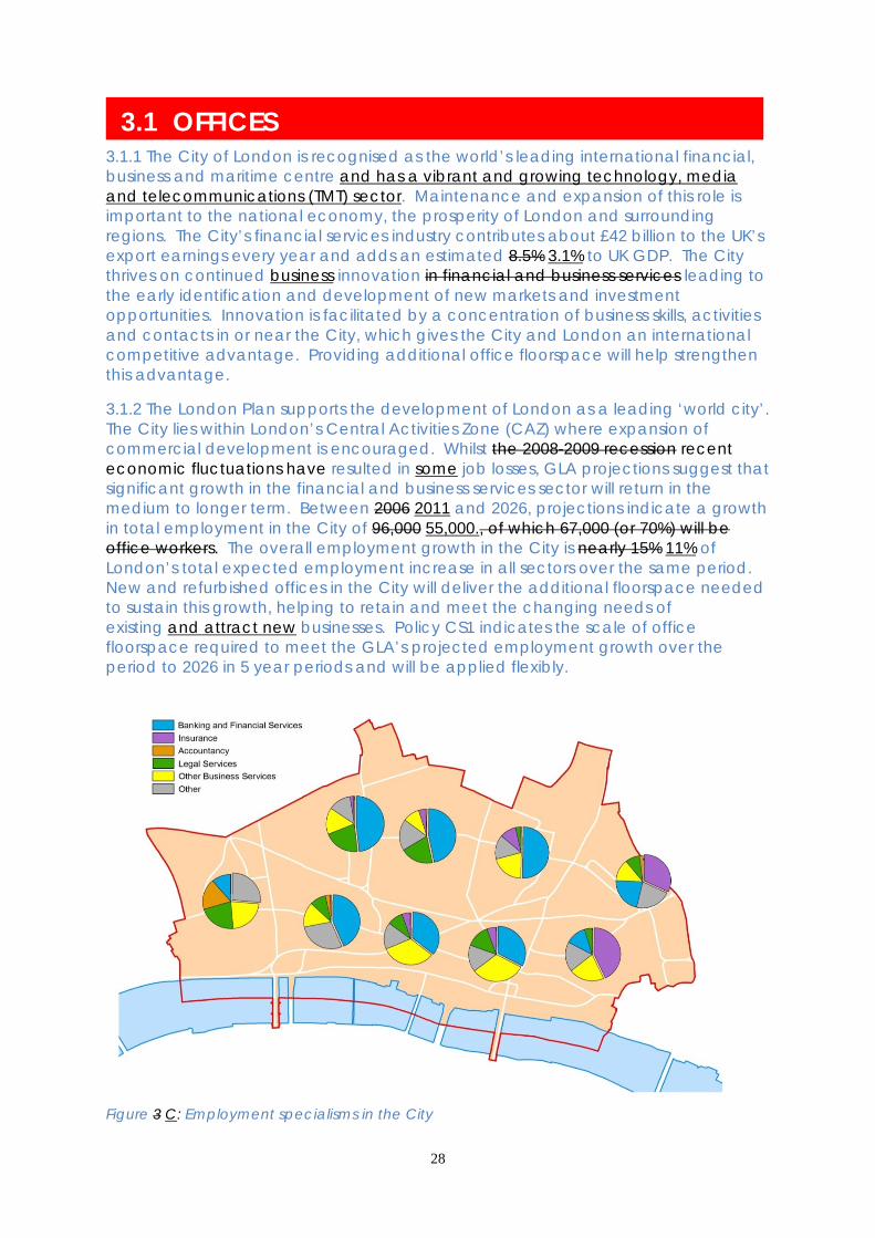
3.1.1 The City of London is recognised as the world’s leading international financial, business and maritime centre and has a vibrant and growing technology, media and telecommunications (TMT) sector. Maintenance and expansion of this role is important to the national economy, the prosperity of London and surrounding regions. The City’s financial services industry contributes about £42 billion to the UK’s export earnings every year and adds an estimated 8.5% 3.1% to UK GDP. The City thrives on continued business innovation in financial and business services leading to the early identification and development of new markets and investment opportunities. Innovation is facilitated by a concentration of business skills, activities and contacts in or near the City, which gives the City and London an international competitive advantage. Providing additional office floorspace will help strengthen this advantage. 3.1.2 The London Plan supports the development of London as a leading ‘world city’. The City lies within London’s Central Activities Zone (CAZ) where expansion of commercial development is encouraged. Whilst the 2008-2009 recession recent economic fluctuations have resulted in some job losses, GLA projections suggest that significant growth in the financial and business services sector will return in the medium to longer term. Between 2006 2011 and 2026, projections indicate a growth in total employment in the City of 96,000 55,000., of which 67,000 (or 70%) will be office workers. The overall employment growth in the City is nearly 15% 11% of London’s total expected employment increase in all sectors over the same period. New and refurbished offices in the City will deliver the additional floorspace needed to sustain this growth, helping to retain and meet the changing needs of existing and attract new businesses. Policy CS1 indicates the scale of office floorspace required to meet the GLA’s projected employment growth over the period to 2026 in 5 year periods and will be applied flexibly.
Figure 3 C: Employment specialisms in the City

29
3.1.3 The London Plan encourages the provision of mixed use office and housing development within the Central Activities Zone. The City of London, however, is identified as a strategically important globally-orientated financial and business services centre where the emphasis should be the provision of new and refurbished office floorspace. To sustain this cluster, a mix of office and other appropriate commercial uses will be encouraged. In addition, the London Plan supports the use of land use swaps and housing credits, which will deliver new housing within existing residential clusters areas inside the City and on appropriate sites outside the City. 3.1.4 Offices are the predominant land use in the City, providing approximately 70% of all floorspace and 80% of total employment, although there are areas where other uses, such as retailing and housing, are locally dominant. Table 2.3 shows the anticipated distribution of office development highlighting that the Eastern Cluster will be the main focus for offices, with 50-60% of growth planned to take place in the area. The North of the City will also see significant office growth (10-20% of the total), with the remaining growth distributed across other parts of the City. 3.1.5 The City contains a number of specialist business clusters within the broad definition of financial and business services (see Fig. C). International financial and wholesale banking services have spread out from their established concentrations in the centre and east of the City near the Bank of England to other areas such as Bishopsgate, Broadgate, Fleet Street and Newgate Street. The maritime and insurance sector is concentrated in the east of the City, centred on the Lloyds insurance market. Legal and accounting services dominate the business services sector in the City and are largely clustered in the west of the City close to the Law Courts. Future office developments across the City will provide scope to reinforce these specialist clusters, accommodate growing sectors, such as the TMT sector and to strengthen the overall ‘critical mass’ of the City as a hub of financial and business services. 3.1.6 All types of office development need to be appropriate to the existing context and should not cause undue harm to the City’s historic environment. It is important that the assembly of large sites is undertaken sensitively to avoid inappropriate loss of historic urban grain or street patterns. 3.1.7 The National Planning Policy Framework (paragraph 51) states that local planning authorities should normally approve planning applications for changes to residential use and any associated development from commercial buildings (including offices) where there is an identified need for additional housing in that area, provided that there are not strong economic reasons why such development would be inappropriate. Such strong economic reasons exist in the City, where a significant loss of office buildings and land to other uses would potentially harm the City’s primary business function and jeopardise the City’s capacity to provide sufficient office accommodation to meet the needs of projected long-term economic and employment growth. Hence the whole of the City is exempt from office to residential change of use national permitted development rights as it is recognised by the Government as being a nationally significant area of economic activity.
30
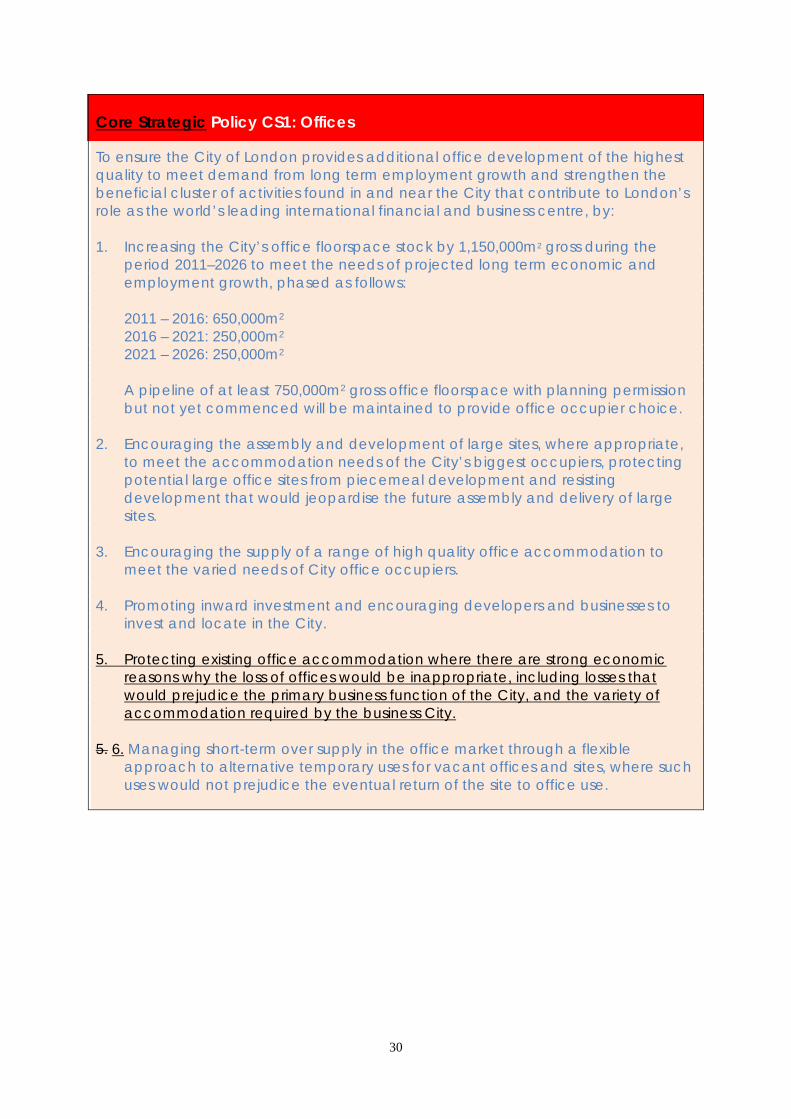
Core Strategic Policy CS1: Offices To ensure the City of London provides additional office development of the highest quality to meet demand from long term employment growth and strengthen the beneficial cluster of activities found in and near the City that contribute to London’s role as the world’s leading international financial and business centre, by: 1. Increasing the City’s office floorspace stock by 1,150,000m2 gross during the
period 2011–2026 to meet the needs of projected long term economic and employment growth, phased as follows:
2011 – 2016: 650,000m2 2016 – 2021: 250,000m2 2021 – 2026: 250,000m2 A pipeline of at least 750,000m2 gross office floorspace with planning permission
but not yet commenced will be maintained to provide office occupier choice. 2. Encouraging the assembly and development of large sites, where appropriate,
to meet the accommodation needs of the City’s biggest occupiers, protecting potential large office sites from piecemeal development and resisting development that would jeopardise the future assembly and delivery of large sites.
3. Encouraging the supply of a range of high quality office accommodation to
meet the varied needs of City office occupiers. 4. Promoting inward investment and encouraging developers and businesses to
invest and locate in the City. 5. Protecting existing office accommodation where there are strong economic
reasons why the loss of offices would be inappropriate, including losses that would prejudice the primary business function of the City, and the variety of accommodation required by the business City.
5. 6. Managing short-term over supply in the office market through a flexible
approach to alternative temporary uses for vacant offices and sites, where such uses would not prejudice the eventual return of the site to office use.
31
DEVELOPMENT MANAGEMENT POLICIES Policy DM 1.1 Protection of office accommodation To refuse the loss of existing (B1) office accommodation to other uses where the building or its site is considered to be suitable for long-term viable office use and there are strong economic reasons why the loss would be inappropriate. Losses would be inappropriate for any of the following reasons: • prejudicing the primary business function of the City; • jeopardising the future assembly and delivery of large office development sites; • removing existing stock for which there is demand in the office market or long
term viable need; • introducing uses that adversely affect the existing beneficial mix of commercial
uses. 3.1.8 To meet the targets for the significant increase in office floorspace it is necessary both to encourage new office development and to protect existing office accommodation and sites. Proposals for change from offices will normally be refused if the building or site is considered to be suitable for long-term viable office use. Applicants seeking an exception will need to show robust evidence relating to the current and long term unsuitability of the site for office use and that the proposed change would not adversely affect the existing beneficial mix of commercial uses in the area nor prejudice the primary business function of the City. Exceptionally, the loss of individual office developments to other commercial or infrastructure uses may be acceptable, where the proposed alternative use meets the wider objectives of the Local Plan. 3.1.9 It is important that the City office market remains buoyant and continues to offer a wide range of office types, sizes, cost and locations in order to meet the diverse needs of large and small prospective occupiers. It needs to have a healthy supply of new and refurbished offices, offering efficient space with high environmental standards, including: • large office buildings: offering large floorplates or space for single large
occupiers or for headquarters; • tall office buildings: offering high-profile accommodation for large firms or for
smaller firms in multi-let accommodation; • medium and small office buildings: providing space for small and medium sized
enterprises, which form an important part of the City’s business cluster. Such office space needs to be in a mix of new, refurbished and older stock to provide occupier choice over character and cost.
3.1.10 Offices are distributed throughout the City and it is important that they are protected across the City to provide occupiers with choice of location and cost. Offices in the Key City Places contribute to the diversity of the City office market. The Eastern Cluster of tall buildings forms part of the City core. In the Cheapside and St. Paul’s area offices complement its retail and visitor attractions. Parts of the North of the City will benefit from proximity to the emerging ‘Tech City’ business cluster in Clerkenwell and Shoreditch and from the increasing accessibility provided by Crossrail. The riverside is an attractive location for offices and office-led commercial

32
mixed-use development. Aldgate is an area with particular potential for office-led regeneration stimulated by highway and environmental enhancements. 3.1.11 The City Office Use Supplementary Planning Document provides further guidance on office use in the City including the criteria for marketing evidence which would be required to show that there is no recent or likely future demand for continued office use on a site or building. Policy DM 1.2 Assembly and protection of large office development sites To promote the assembly and development of sites for large office schemes in appropriate locations. The City Corporation will: • assist developers in identifying large sites where large floorplate buildings may be
appropriate; • invoke compulsory purchase powers, where appropriate and necessary, to
assemble large sites; • ensure that where large sites are developed with smaller buildings, the design
and mix of uses provides flexibility for potential future site re-amalgamation; • resist development and land uses in and around potential large sites that would
jeopardise their future assembly, development and operation, unless there is no realistic prospect of the site coming forward for redevelopment during the Plan period.
3.1.12 The City needs sites which can meet the accommodation requirements of the City’s biggest office occupiers including for large trading floors. However, the supply of such sites is limited due to the City’s relatively fragmented land ownership pattern and environmental considerations, including its distinctive pattern of streets, spaces and historic buildings. Some suitable sites may not be available if they are subject to piecemeal redevelopment or provide a campus of smaller buildings instead. 3.1.13 Where potential large sites are developed to provide a number of smaller buildings they may still meet the needs of large occupiers if they are mostly taken by a single occupier to provide campus-style accommodation. In these circumstances it will be important to ensure that the building design, mix of uses and tenure provide flexibility for site re-amalgamation on future redevelopment. For example, the introduction of housing as part of such a scheme would not be appropriate as it would be likely to prejudice the business activities of large occupiers or future site amalgamation. Careful consideration will also be given to proposed uses adjacent to potential large development sites to ensure that they would not adversely impact on the ability to deliver and operate large office buildings.

33
Policy DM 1.3 Small and medium sized business units To promote small and medium sized businesses in the City by encouraging: • new accommodation suitable for small and medium sized businesses or
occupiers; • office designs which are flexible and adaptable to allow for sub-division to
create small and medium sized business units; • continued use of existing small and medium sized units which meet occupier
needs. 3.1.14 Small and medium sized enterprises play a significant part in the City’s success, providing support for larger companies and a seedbed for continued innovation and change. They need a mix of new, refurbished and older stock suitable for a range of business users, including start-up, grow-on and co-working spaces, to provide occupier choice. 3.1.15 Small and medium businesses are broadly defined as those with not more than 50 and 250 employees respectively. Ninety-eight percent of firms in the City employ fewer than 250 people. They provide a range of professional, business and other essential services to the City and wider business community. Larger City firms make frequent use of small local firms to take advantage of the quicker speed of service, the ease of face-to-face contact and specialist knowledge. Larger firms also use small units themselves to provide flexible space for their business sub-units. 3.1.16 The City Corporation’s Local Procurement Initiative supports regeneration in the City and its fringes by encouraging competitive procurement from small and medium sized enterprises in the City and in surrounding boroughs. Policy DM 1.4 Temporary alternative use of vacant office buildings and sites 1) To permit the temporary use of vacant office buildings and sites by other uses
where such uses would not produce unacceptable amenity conflicts nor prejudice the eventual return of the site to office use.
2) To refuse the temporary replacement of vacant offices with housing where it
would adversely affect the existing beneficial mix of commercial uses. 3.1.17 Fluctuations in the economic cycle can result in short term over-supply in the office market and higher vacancy rates. There can also be short-term vacancy during the early stages of the site acquisition and redevelopment process. Measures aimed at bringing vacant or under-used buildings back into use can help manage the office market and can enhance the appearance and vitality of the City. Alternative temporary uses of vacant office buildings and sites will be allowed provided that they do not lead to unacceptable amenity conflicts nor prejudice the eventual return to office use. Housing is not considered to be a suitable temporary

34
use for vacant offices as it could adversely affect the existing beneficial mix of commercial uses. 3.1.18 Temporary uses will be expected to revert to offices and therefore are not protected by other policies of the Local Plan relating to permanent uses. Applications to extend the period of temporary use or make it permanent will be considered against the policies of the Plan as a whole. Policy DM 1.5 Mixed uses in commercial areas To encourage a mix of commercial uses within office developments which contribute to the City’s economy and character and provide support services for its businesses, workers and residents. 3.1.19 Offices are the predominant land use in the City but they need to be complemented by other commercial uses to provide supporting activities and services. Complementary uses, including retailing, leisure, education and health facilities, contribute to the City’s economy, character and appearance, and provide support services for its businesses, residents, workforce and visitors. 3.1.20 A mix of commercial uses can be particularly beneficial at street level where it enhances vitality and interest. Such vitality is an essential element of the character of many areas in the City, especially retail areas, the Smithfield area and some conservation areas, such as Bow Lane and St Paul’s. The nature of the proposed development, the existing characteristics and changing circumstances of the surrounding buildings and area will be taken into consideration when assessing the desirability of maintaining or enlivening street level activity. Some parts of the City have an established special land use or townscape character which would not benefit from the introduction of mixed uses at street level and this will be respected. Such places include tranquil open spaces and buildings within conservation areas whose character would be harmed by conversion to other uses.

35
Who will deliver How we will make it happen Who When Meeting occupiers’ needs A “plan, monitor, manage” approach to office development will be taken, assessing schemes on their merits and working jointly with developers and landowners to ensure that a range of sites is available to meet future needs. Development management, compulsory purchase powers, land ownership and joint working with developers to assist in site assembly, where appropriate. To ensure office floorspace targets are met, to protect large sites (generally over 50,000m2 gross and single floorplates up to 5,000m2) from piecemeal development and to provide a range of premises suitable for small and medium sized businesses. Further guidance will be set out in the Development Management DPD. Further guidance will be set out in the City Office Use SPD.
City Corporation - Developers - Landowners
Ongoing 2012
Office renewal Delivery of new office floorspace through speculative or commissioned development, including through new tall buildings.
Developers - Occupiers
Ongoing
Inward investment Assistance to developers in meeting the needs of new and existing City occupiers. Promotion of the City and encouraging inward investment.
City Corporation: City Property Advisory Team (CPAT) City Corporation: Economic Development Office (EDO)
Ongoing Ongoing
SUPPORTING EVIDENCE • The Importance of Wholesale Financial Services to the EU Economy 2009 London Economics for the City of London 2009 • London’s Place in the UK Economy 2009-2010 LSE for the City of London 2009 • London’s Economic Outlook GLA Economics 2009 • The Economic Outlook for London Oxford Economics 6 monthly • Workforce Info City of London 2006 • Employment Info City of London Annual • Development Info City of London 6 monthly • Development Schedules – Offices City of London 6 monthly • City Agents’ Quarterly Office Demand Survey Experian for the City of London Quarterly

36
• London Office Policy Review 2009 Ramidus Consulting & Roger Tym and Partners for the Mayor of London 2009 • Working Paper 39: Borough Employment Projections to 2031 Greater London Authority 2009 • City of London Office Evidence Paper City of London 2011 3.1.7 The Sustainability Appraisal found that this policy is expected to have beneficial impacts locally against social objectives and nationally against economic objectives, but could result in regionally negative environmental impacts. Potential direct impacts on the historic street pattern, transport systems and secondary impacts arising from those systems, as well as potential impacts on climate change drivers and the use of resources e.g. water and waste arisings from offices. Mitigation measures are included in the Core Strategy to maintain or improve water and air quality, biodiversity and the historic environment and reduce overall resource use for increased office development. RISK MANAGEMENT 3.1.8 3.1.201 The office floorspace targets reflect GLA (2009) triangulated employment projections, which underpin London Plan projections and that expect most growth during the decade 2006-2016. These They are based on current trends, site capacity and transport accessibility. The London Office Policy Review (2009) developed develops these into linear projections on office based employment, from which the City’s office floorspace targets are derived. The City Corporation is confident that these targets can be met over the Local Plan period, but short-term economic uncertainty may require some of the 2011-2016 target to be carried forward into the subsequent phasing period. it can meet most of the 2011-2016 target from developments currently under construction. Fluctuations in the economic cycle may also mean that there may be periodic short-term over supply of offices and higher vacancy rates. This is addressed through a flexible approach to temporary changes of use of office buildings and sites while protecting the long term potential of prime sites. The Development Management DPD will provide detailed policy guidance to ensure that temporary accommodation can be returned to office use. 3.1.9 3.1.212 Projected long-term office and employment growth will require improvements in the quality and capacity of public transport infrastructure. The City Corporation considers that short to medium term needs can be addressed by planned improvements to the capacity and management of the underground network and the significant enhancement to Thameslink. Longer term needs will be addressed by the development and opening of Crossrail. If Crossrail is delayed significantly beyond its scheduled opening in 2018 then a review of the Core Strategy may be needed in the longer term to take account of the potential impact on the ability of the City to absorb additional employment generating development. 3.1.10 3.1.223 Technological and social changes may provide further opportunities for working at home or elsewhere that may reduce the demand for office floorspace in some secondary locations. The City thrives on face-to-face meetings, informal networks and team working and there is no indication that this will change significantly in future, suggesting that more flexible working patterns will have a limited impact on future office requirements in prime locations such as the City. Demand for offices and working patterns will be kept under review.

37
MONITORING 3.11 Key monitoring indicators are: • Office floorspace permitted, under construction and completed annually • Number of employees • Property satisfaction survey

38
3.2 UTILITIES INFRASTRUCTURE 3.2.1 The City relies on a range of utilities to function as a global financial and business centre and to meet the needs of its varied communities. Electricity, telecommunications, water, gas and heating and cooling via the Combined Cooling Heating and Power (CCHP) network are of particular importance. There are specific challenges to providing the infrastructure needed to support existing activity in the City and provide the infrastructure necessary to deliver the office, retail and housing growth envisaged in the period to 2026: • The dense concentration of businesses means that high demand is
concentrated in a restricted geographical area; • There is a legacy of congested cable routes under the City’s streets; • Delivery of new infrastructure and improvements to existing networks could result
in temporary disruption to businesses, residents and visitors; • Energy demands are increasing, particularly to provide air conditioning to
buildings to counter increased warming due to climate change, and to deliver the upgraded ICT networks required by the financial services sector possibly including the provision of data centres.
3.2.2 Pipe subways under streets accommodate gas and water mains and electricity and telecommunications cables more efficiently than simply burying pipes and cables in the ground. There are several existing pipe subways in the City and the potential for constructing more is being investigated to provide greater capacity for pipes and cables, whilst reducing the need for disruptive street works in the future. 3.2.3 The City Corporation has strong links with the various infrastructure providers that service the City, including Thames Water, UK Power Networks, National Grid (Gas), Citigen CCHP station and BT Openreach. The continuation of this co-operative working relationship is key to ensuring delivery of this policy. Developers, landowners and building occupants also have a role to play in demand management, early engagement with utility providers and co-operative working to avoid disruption. 3.2.4 Further information on planned and necessary infrastructure improvements is set out in the City of London Infrastructure Delivery Plan.

39
Core Strategic Policy CS2: Utilities Infrastructure To co-ordinate and facilitate infrastructure planning and delivery to ensure that the functioning and growth of the City’s business, resident, student and visitor communities is not limited by provision of utilities and telecommunications infrastructure, by: 1. Minimising the demand for power, water and utility services,
requiring that sustainable building design and the incorporation of demand management measures are incorporated within all development.
2. Encouraging early engagement between developers and infrastructure
providers to identify the infrastructure needs arising from new development and ensuring that these are addressed through building design and utility networks and connections in time to serve the proposed development.
3. Protecting existing essential utilities and telecommunications infrastructure from
development unless it is no longer required or will be adequately relocated. 4. Working with infrastructure providers to minimise disruption to highways and
businesses during major infrastructure upgrades and pipe subway construction. 5. Promoting the provision and use of pipe subways, particularly in areas where
there is extreme pipe and cable congestion under the streets.
Figure 4 D: Electricity demand in London

40
DEVELOPMENT MANAGEMENT POLICIES Policy DM 2.1 Infrastructure provision and connection 1) Developers will be required to demonstrate, in conjunction with utility providers,
that there will be adequate utility infrastructure capacity, both on and off the site, to serve the development during construction and operation. Development should not lead to capacity or reliability problems in the surrounding area. Capacity projections must take account of climate change impacts which may influence future infrastructure demand.
2) Utility infrastructure and connections must be designed into and integrated with
the development. As a minimum, developers should identify and plan for: • electricity supply to serve the construction phase and the intended use for the
site, and identify, in conjunction with electricity providers, Temporary Building Supply(TBS) for the construction phase and the estimated load capacity of the building and the substations and routes for supply;
• reasonable gas and water supply considering the need to conserve natural resources;
• heating and cooling demand and the viability of its provision via decentralised energy (DE) networks. Designs must incorporate access to existing DE networks where feasible and viable;
• telecommunications network demand, including wired and wireless infrastructure, planning for dual entry provision, where possible, through communal entry chambers;
• separate surface water and foul drainage requirements within the proposed building or site, including provision of Sustainable Drainage Systems (SuDS), rainwater harvesting and grey-water recycling, minimising discharge to the combined sewer network;
3) In planning for utility infrastructure developers and utility providers must provide
entry and connection points within the development which relate to the City’s established utility infrastructure networks, utilising pipe subway routes wherever feasible. Sharing of routes with other nearby developments and the provision of new pipe subway facilities adjacent to buildings will be encouraged.
4) Infrastructure provision must be completed prior to occupation of the
development. Where potential capacity problems are identified and no improvements are programmed by the utility company, the City Corporation will require the developer to facilitate appropriate improvements, which may require the provision of space within new developments for on-site infrastructure or off-site infrastructure upgrades.
3.2.5 Utility infrastructure relates to the provision of electricity, gas, water, sewerage, sustainable drainage (SuDS), telecommunications, including wired and wireless infrastructure, decentralised energy networks and the pipe-subway networks that house such infrastructure.

41
3.2.6 Early engagement with infrastructure providers is essential to ensure that capacity is available in the wider infrastructure network to service the development in construction and operational phases, and that suitable connection layouts and future-proofing are considered at the design stage. In some circumstances it may be necessary for developers to carry out studies to ascertain whether the proposed development will lead to overloading of existing infrastructure. Adequate time should be allowed to consider supply options covering the construction and operational phases allowing utility providers to formulate an informed response. Realistic projections of electricity demand should be provided in order to avoid over specification of infrastructure which may never be utilised. The cumulative impact of proposed developments in the vicinity must be taken into account through discussions with utility providers and at pre-application meetings with the City Corporation. Co-ordination of infrastructure works is essential to minimise the level of disruption and impact on existing services associated with provision. 3.2.7 The Sustainability Statement or the Energy Statement which accompanies the application may be used to demonstrate the demand management measures that are to be incorporated and the engagement with utility infrastructure providers. This may be through the inclusion of a joint statement of intent endorsed by the relevant utility providers. S106 agreements may be used to ensure continued engagement regarding route planning and confirmation of load demands. 3.2.8 The volume of redevelopment in the City and the congestion of cables and pipes under the City’s streets create a challenge for new utility infrastructure to be installed without disruption to the City’s public realm and street network. Pipe subways provide a means of reducing the level of disruption during installation and maintenance of infrastructure. Existing subways must be used whenever possible for the installation of utility infrastructure. Expansion and integration of pipe subway and decentralised energy networks is a long term aspiration of the City Corporation in order to minimise disruption due to utility works. Extensions to existing pipe subway networks will be sought where there is adequate evidence that services to developments would be better integrated within an established pipe subway in the vicinity. 3.2.9 Best practice in the field of infrastructure provision is constantly evolving. The City Corporation has published ‘City Developer Guidelines for Incoming Utility Services’, which provides guidance on best practice and should be used in the first instance for guidance on utility connections.
Who will deliver How we will make it happen Who When
Demand Management Requiring Sustainability or Energy Statements to be submitted with planning applications to demonstrate that building design minimises demand for electricity, water and other utility services. Detailed requirements will be set out in the Development Management DPD. Implementation of utility company strategic plans: • Thames Water – Our Plans for Water – Business Plan
City Corporation- Developers Utility Companies
Ongoing 2012 2010-2015 2035
42
2010-2015, Taking care of water Strategic Direction Statement 2010-2035 and Water Resources Management Plan, 2010-2035
• UK Power Networks – Business Plan Long Term Development Statement 2012
• National Grid gas – Streetworks pipe replacement programme.
Infrastructure delivery Monitor and co-ordinate utility infrastructure needs and delivery, implementing the Strategic Infrastructure Action Plan. Pre-application discussions to highlight the need for early engagement with utility infrastructure providers. Implementation of a 33kV power network in the City to supplement the existing 11kV network. Lobbying for legislative changes to allow proactive investment in utility infrastructure.
City Corporation (CPAT)- Utility Companies City Corporation- Utility Companies UK Power Networks City Corporation
In line with the SI Action Plan Ongoing By 2016 Short term Ongoing
Minimise Disruption The City of London’s ‘City d Developer g Guidelines for i Incoming u Utilities’ will be kept up to date. Co-ordinating street works through the London Permit Scheme (LoPS) to minimise disruption.
City Corporation- Utility Companies- Developers. City Corporation- Utility Companies
Adopted 2009 Periodic review Ongoing
SUPPORTING EVIDENCE
• Central London Infrastructure Study URS for Central London Forward 2009 • An assessment of the City’s ICT Infrastructure SAMI Consulting for City of
London 2009 • Energy Trends Data Department of Energy and Climate Change (DECC)
2005-2007 3.2.5 The Sustainability Appraisal concluded that this policy would have positive impacts when assessed against the environmental and economic objectives and was unlikely to influence the social objectives significantly.

43
RISK MANAGEMENT 3.2.6 3.2.10 Fluctuations in the economic cycle may reduce funding for infrastructure upgrades but will also impact on the need to expand infrastructure. The City Corporation will consider the demand for, and funding of, infrastructure improvements through the Infrastructure Delivery Plan, prioritising funds where necessary. 3.2.7 3.2.11 Climate change could alter demand patterns. For example, greater need for air conditioning in summer months would create more demand for electricity. The policy Local Plan addresses this by requiring sustainable building designs. 3.2.8 3.2.12 Changing business practices, e.g. use of data centres, or changes in the City’s business mix, may impact on the level of utilities required and the spatial distribution of demand and supply. Continued monitoring of trends will highlight any issues in this respect, identifying any need to review Policy CS2 or the Infrastructure Delivery Plan. MONITORING 3.2.9 Key monitoring indicators are:
• DECC high level energy trends data • The City of London Survey of Businesses and Strategic Infrastructure Plan update • City of London highways disruption indicator

44
3.3 SECURITY AND SAFETY 3.3.1 The City is a safe place to live, work and visit, with low rates of crime. Ensuring the City remains safe and secure is paramount to promoting confidence in the City as a place to do business. As the world’s leading international financial and business centre, addressing potential risks from economic crime and terrorism is of critical importance. The City has its own police force which enables it to focus on the priorities relevant to the City’s specific circumstances, setting out priorities in a three year Local Policing Plan, updated annually, including: • Economic crime, including mortgage and bank fraud, identity fraud, insider fraud, credit card fraud; • Money laundering; • Anti-social behaviour associated with growth of the night-time economy. • protection from terrorism and extremism; • protection from fraud; • responding effectively to public disorder; • reducing levels of violent crime and theft; • reducing the number of injuries on the City’s roads. 3.3.32 The City of London Police produce a three-year Local policing Plan, which is updated annually to address changing priorities. The annual Safer City Partnership Plan highlights six eight priorities for maintaining and improving the City’s security: anti-social behaviour; domestic abuse; reducing re-offending; night-time entertainment issues; fraud and economic crime; counter terrorism; civil disorder; and victim-based acquisitive crime. countering terrorism; economic crime; protecting people against crime; protecting vulnerable people; the night-time economy; and anti-social behaviour. A range of initiatives are used to deliver these priorities, including: Safety Thirst, Ward Policing, Taxi Marshalling Scheme, Strategic Youth Forum, Young City Safe Scheme, Anti-Social Behaviour Working Group, Controlled Drinking Zones, Alcohol Strategy and the Domestic Abuse Delivery Group. In addition, the City’s Statement of Licensing Policy provides guidance in determining applications for drinking establishments and other licensed premises. 3.3.43 There have been concerns about aspects of night-time economy entertainment in the City, particularly related to anti-social behaviour, with a number of hotspots around the City. The City’s Statement of Licensing Policy deals with applications for new licences, applications to vary existing licences and applications to review licences, providing guidance for determining applications for drinking establishments and other licensed premises. 3.3.24 More people are killed or seriously injured through traffic accidents collisions on the City’s streets each year than are harmed in violent crime and disorder. Therefore road safety is also a priority. The City of London’s Road Danger Reduction Plan 2013 focuses on road safety as a priority. 3.3.5 The City is also home to the Central Criminal Court at the Old Bailey.
45
Core Strategic Policy CS3: Security and Safety To ensure that the City is secure from crime, disorder and terrorism, has safe systems of transport and is designed and managed to satisfactorily accommodate large numbers of people, thereby increasing public and corporate confidence in the City’s role as the world’s leading international financial and business centre, by: 1. Ensuring that the dense network of buildings and spaces, including the activities
they contain, is designed to be safe, minimising the potential for crime and anti-social behaviour and providing for a mix of uses and natural surveillance of streets and spaces.
2. Proactively managing the night-time economy entertainment to minimise
disturbance to residents and workers. 3. Implementing measures to enhance the collective security of the City against
terrorist threats, applying security measures to broad areas such as the Traffic and Environmental Zone, major development schemes, or to the City as a whole.
4. Ensuring that security and safety measures are of an appropriate high quality
design. 5. Developing area-based approaches to implementing security measures where
a number of large developments are planned or are taking place at the same time, and in locations where occupiers have requested collective security measures. The character and distinctiveness of these areas needs to be taken into account in assessing their suitability for security measures.
6. Building a resilient society to ensure the residential and business communities are
better prepared for, and able to recover from, emergencies (including the promotion of business continuity measures). Promoting business continuity measures to ensure that businesses have the opportunity to recover quickly from terrorist attacks.
7. Ensuring that transport systems help are designed to resolve conflicts between
the high and growing volume of pedestrians and other road users, by considering safety within the design of routes, stops, stations and interchanges and creating more traffic-free and traffic-calmed areas for pedestrians and cyclists. Measures should contribute to an attractive public realm and will need to be self-enforcing and not rely unduly on police resources.
46
DEVELOPMENT MANAGEMENT POLICIES Policy DM 3.1 Self-containment in mixed use developments Where feasible, proposals for mixed use developments must provide independent primary and secondary access points, ensuring that the proposed uses are separate and self-contained. 3.3.6 Providing the right mix of uses can generate greater activity and surveillance, but a mix of uses within individual buildings or developments may give rise to problems of security, management and amenity. This can cause difficulty in letting accommodation and lead to pressure for the loss of uses for which provision has been made. Where feasible, the City Corporation will require the provision of independent primary and secondary access points in new and refurbished buildings. Policy DM 3.2 Security measures in new developments and around existing buildings To ensure that security measures are included in new developments, applied to existing buildings and their curtilage, by requiring: • building-related security measures, including those related to the servicing of the
building, to be located within the development’s boundaries; • measures to be integrated with those of adjacent buildings and the public
realm; • that security is considered at the concept design or early developed design
phases of all development proposals to avoid the need to retro-fit measures that impact on the public realm;
• developers to seek recommendations from the City of London Police Architectural Liaison Officer at the design stage. New development should meet Secured by Design principles;
• the provision of service management plans for all large development, demonstrating that vehicles seeking access to the building can do so without waiting on the public highway;
• an assessment of the environmental impact of security measures, particularly addressing visual impact and impact on pedestrian flows.
3.3.7 Security and safety are important to the quality of life of those who work, live and travel in the City and to protect its economic role. Late consideration of security in developments can be inefficient, lead to increased costs, and have a negative impact on the architectural quality and design of a building. These difficulties can be avoided by considering security at the design stage. Early engagement with the City of London Police Architectural Liaison Officer (ALO) and the City Corporation is therefore essential. Where the development has an impact on heritage assets, early contact with English Heritage is also recommended.
47
3.3.8 All applications should be accompanied by a Design & Access Statement which meets the recommendations of the ALO and sets out how security matters have been considered at the design stage. New development should incorporate “Secured by Design” (SBD) principles. The design should fully incorporate protective security requirements within the site boundary, as far as practicable. Building designs should provide for a high level of natural surveillance of all surrounding public areas and highway. 3.3.9 Incorporating security measures early in the design of new development or the refurbishment of existing buildings will avoid the need for later retro-fitting of security measures, which can impact on the architectural quality and design of the development. 3.3.10 All new developments need to maximise the level of security provision to reduce the risk and the likely impact. It is not always possible to provide security measures wholly within the building or development site, particularly when there is a need to provide stand-off distances to protect against potential vehicle-borne attacks, or where the building line is immediately bounded by public highway. Security features on the public highway should be considered as a last resort when all other alternative proposals have been exhausted. Policy DM 3.3 Crowded places On all major developments, applicants will be required to satisfy principles and standards that address the issues of crowded places and counter-terrorism, by: • conducting a full risk assessment; • keeping access points to the development to a minimum; • ensuring that public realm and pedestrian permeability associated with a
building or site is not adversely impacted, and that design considers the application of Hostile Vehicle Mitigation measures at an early stage;
• ensuring early consultation with the City of London Police on risk mitigation measures;
• providing necessary measures that relate to the appropriate level of crowding in a site, place or wider area.
3.3.11 Incorporating security measures at an early stage of the development process will require consideration of the characteristics of occupiers, where known, who may have their own servicing strategies. Developments that impact on or involve provision of open spaces and landscaping should incorporate collective security measures and not be retro-fitted. Early consultation with the City of London Police ALO is essential. Developers should engage the Police as advisers on counter-terrorism measures for public projects, including open spaces. Where the development has an impact on heritage assets, early contact with English Heritage is also recommended. 3.3.12 A risk assessment should be submitted for approval by the City Corporation as part of a planning application or transport proposal and should include: • assessment of the risk of structural damage from an attack;
48
• identification of measures to minimise any risk; • how the perimeter is treated, including glazing.
3.3.13 Designing the public realm taking into account Hostile Vehicle Mitigation measures, will ensure that the correct level of protection is provided without compromising the ability to create aesthetic and functional public spaces. Proposals should not impose undue restrictions on other occupiers in the area. Policy DM 3.4 Traffic management To require developers to reach agreement with the City Corporation and TfL on the design and implementation of traffic management and highways security measures, including addressing the management of service vehicles, by: • consulting the City Corporation on all matters relating to servicing; • restricting motor vehicle access, where required; • implementing public realm enhancement and pedestrianisation schemes,
where appropriate; • using traffic calming, where feasible, to limit the opportunity for hostile vehicle
approach. 3.3.14 The management of traffic and control of servicing and delivery vehicles are key elements of effective security measures and may include restricted vehicular and access gates, timed management of service vehicles and local traffic management schemes. The City Corporation and developers will co-operate to agree servicing arrangements that may include on-street measures. Development should give priority to pedestrian and cycle movements and create safe and secure layouts which reduce conflict, including traffic management schemes to improve safety of vulnerable road users. 3.3.15 The City Corporation will use conditions on planning applications, Section 106 and Section 278 agreements and financial contributions secured through the Community Infrastructure Levy to ensure implementation of appropriate measures. Further information on City Corporation standards is set out in the guidance note, “Standard Highway and Servicing Requirements for Developments in the City of London”.
49
Policy DM 3.5 Night-time entertainment 1) Proposals for new night-time entertainment and related uses and the extension
of existing premises will only be permitted where it can be demonstrated that, either individually or cumulatively, there is no unacceptable impact on:
• the amenity of residents and other noise-sensitive uses; • environmental amenity, taking account of the potential for noise, disturbance
and odours arising from the operation of the premises, customers arriving at and leaving the premises and the servicing of the premises;
2) Applicants will be required to submit Management Statements detailing how
these issues will be addressed during the operation of the premises. 3.3.16 Night-time entertainment uses in the City include restaurants and cafes (A3), drinking establishments (A4), hot food takeaways (A5) and other related uses including, for example, a nightclub or a mix of such uses. 3.3.17 The control of night-time entertainment and licensed premises is undertaken through the operation of both planning and licensing regimes. In general, the planning regime controls the location, design and planning use of premises to protect the amenity of an area or local residents, whilst the licensing regime is used, having regard to licensing objectives, to control specific activities at premises to prevent, for example, noise and other public nuisance. 3.3.18 Planning and licensing regimes operate under separate legislative and regulatory frameworks. The City Corporation will ensure that, as far as is possible, a complementary approach is taken between planning and licensing within the legislative framework. The City Corporation publishes a Statement of Licensing Policy, which outlines the approach that it will take when considering applications for the sale and supply of alcohol, the provision of regulated entertainment and the provision of late night refreshment. This is supported by the City Corporation’s Code of Good Practice for Licensed Premises. The City Corporation has also published a Noise Strategy which sets the strategic direction for noise policy within the City of London and outlines steps that the City will take, and is already taking, in dealing with noise issues, including those arising from night-time entertainment. 3.3.19 The character of many licensed premises has changed significantly in recent years. Existing and new premises often have longer operating hours, may have larger capacity and may provide live or recorded amplified music. Some of these premises are close to residential accommodation and this can result in complaints about disturbance and nuisance from excessive noise, particularly from people drinking and smoking outside, and arriving or leaving. 3.3.20 All planning applications for A3, A4, A5, and related, uses should include information stating the proposed hours of operation. Where this information is not provided, or hours of operation have not yet been confirmed, the City Corporation will impose conditions requiring the closure of the premises between the hours of 11pm and 7am unless further permission to vary these times is sought and granted.

50
3.3. 21 Potential applicants seeking planning permission for a night-time entertainment use, between the hours of 11pm and 7am, are encouraged to engage at the earliest possible stage with the City Corporation as Licensing Authority, the City of London Police, local residents and other neighbouring occupiers that will be affected by the proposal. This will ensure that the local context and local sensitivities are fully understood and can be taken into account when designing premises for night-time entertainment uses and planning the operation of the proposed use to minimise adverse impact on amenity. 3.3.22 Planning applications for new and extended night-time entertainment uses or for variations of planning conditions must be accompanied by a Management Statement that addresses planning amenity issues, sets out how potential impacts on amenity will be addressed through the design of the premises and how they will operate without causing disturbance including: • hours of closure to protect amenity; • noise mitigation plans related to both internal and external noise, including
measures to reduce sound transfer, such as sound-proofing, noise controls and double entry lobbies;
• arrangements for the storage, handling and disposal of waste. • a timed programme for deliveries and collections and other servicing
arrangements; • measures to deal with the emission of odours; and • location of ventilation ducts and plant.
3.3.23 Assessment of the Management Statement will have regard to the City Noise Strategy, the provisions of the City of London Statement of Licensing Policy and to any submitted licence application operating schedule. 3.3.24 To safeguard quiet times and amenity, particularly for residents and other noise-sensitive uses, the City Corporation will attach planning conditions or seek s106 planning obligations to ensure compliance with agreed Management Statements. The City Corporation will normally apply conditions to limit the hours of operation where there is potential for unacceptable disturbance to local residents and others. Each case will be considered in relation to its locality and the need to strike a balance between the benefits to the City of night-time entertainment and the risk of disturbance to local residents, workers and others.

51
Who will deliver How we will make it happen Who When Crime, Terrorism & Safety Joint working with prospective developers and the City of London Crime Prevention Design Advisor Architectural Liaison Officer to incorporate crime prevention and counter terrorism security into City developments. City of London Police Counter Terrorism Security Advisers (CTSAs) and Emergency Planning officers providing advice and guidance to business and residents on protective security and business continuity, through Project Griffin, Project Argus and other media. Encouraging co-operation in developing crime prevention measures between the City of London Corporation, the City of London Police and the business community. Providing sufficient emergency service resources to cope with large scale emergencies, the projected increase in workers, residents and visitors. Maintaining the Central Criminal Court within the City at the Old Bailey.
City Corporation- Developers- Crime Prevention Association- City of London Police- HM Court Service City Corporation- City of London Police Heads of security in major international businesses. City of London Police Emergency services City Corporation- HM Court Service
Ongoing Ongoing Ongoing Ongoing Ongoing

52
Requiring design and access statements, delivering improved street lighting strategies, traffic and street management and CCTV networks. Implementing the licensing objectives of the Statement of Licensing Policy (SLP), the Gambling Act Statement of Licensing Principles and the City Corporation’s Code of Good Practice for Licensed Premises. Supporting licensees in reducing anti-social behaviour. Considering the need for a Noise Supplementary Planning Document to provide further guidance on noise and noise-related impacts. Consulting on a “Late Night Levy” on the licensees of premises selling alcohol after a prescribed time. Revenue generated from the Levy would be split between the City Corporation and the City Police to support implementation of licensing objectives. Managing parking associated with the night-time economy entertainment, to prevent disturbance to residents and to address a potential security risk. Implementing the recommendations of the Safer City Partnership thematic groups, covering: • Night time economy entertainment • Anti-social behaviour • Counter terrorism • Vulnerable people • Rough sleepers • Domestic abuse • Community cohesion • Vehicle crime • Persistent offenders • Economic crime
City Corporation- Developers City Corporation- City of London Police City Corporation- City of London Police City Corporation City Corporation Safer City Partnership
Ongoing SLP and Gambling Act SLP Adopted 2011 Reviewed every 3 years Both currently out to public consultation; publication 2013 To be confirmed From 2014 2009–2012 2012–2015 To be reviewed in 2012 annually

53
Terrorism Requiring design and access statements incorporating managed access schemes. Implementation of collective security measures, especially in the Traffic and Environmental Zone. Mobile phone and SMS alert systems related to terrorism. Business continuity support and assistance to businesses, e.g. through Project Argus and Project Griffin. Co-ordinating support in areas of emergency planning and resilience. Environmental enhancement initiatives, including restricted vehicular access gates (to control motor vehicle access whilst maintaining pedestrian and cycle permeability), timed management of service vehicles and local traffic management schemes. Providing security advice to medium to large businesses.
City Corporation- Developers- Building occupiers- City of London Police City Corporation City Corporation- City of London Police- Heads of security in major international businesses. Central London Resilience Forum. City Corporation City of London Police ALO Security Advice Unit (SAU): comprises representatives of the City Police and the City Corporation.
Ongoing Ongoing Ongoing Ongoing Review of environmental enhancement strategies every 5 years Ongoing

54
Transport Safety Ensuring public highways and other spaces are designed and managed to help reduce road casualties amongst pedestrians and vulnerable road users, reduce crime and disorder, and improve transport security. Implementing the objectives of the City of London Road Danger Reduction Plan 2013. Partnership working with transport providers and others to maximise public transport safety, encouraging greater staff presence at platforms, stations and on public transport. Implementing traffic management measures, including traffic-free and traffic-calmed areas, and taking account of the increase in cycle use., including that resulting from the Mayor’s cycle hire scheme.
City Corporation- City of London Police- Safer City Partnership City Corporation City Corporation- TfL- Network Rail- Train operating companies- Port of London Authority- British Transport Police- Neighbouring boroughs City Corporation- TfL
Ongoing Ongoing Ongoing Ongoing
SUPPORTING EVIDENCE • Crowded Places: The Planning System & Counter Terrorism Home Office/CLG 2010 • Safer City Partnership Plan 2009–2012: Working Together For a Safer City City of London Safer City Partnership 2009 • City of London Police Local Policing Plan 2010–2013 City of London Police 2010 • City of London Corporation Licensing Act 2003: Statement of Licensing Policy City of London 2011 3.3.6 The Sustainability Appraisal notes that this policy is expected to have beneficial impacts locally and nationally against the relevant social, environmental and economic objectives. RISK MANAGEMENT 3.3.21 The City continues to be at risk from terrorism. The terrorist threat is unpredictable and an attack could have significant consequences for the City. The City Corporation will seek to ensure, through partnership working, that the most effective counter-terrorism measures are maintained within the City and plans are put in place to ensure business continuity. These measures will be kept under continual review to ensure the safety of businesses, residents and visitors. MONITORING 3.3.8 Key monitoring indicators are: Crime and safety / terrorism • To produce an annual Safer City Partnership plan

55
• Protection against Terrorist Attacks Transport safety • Pedestrian crossings fully accessible to the public • Road Traffic Casualty Indicator (LIP) • Cycle parking for commuters
56
3.4 PLANNING CONTRIBUTIONS 3.4.1 The City Corporation imposes conditions on planning permissions and seeks planning obligations (also known as S106 agreements) from developers, to secure the best use of land and a properly planned environment in the City. S106 agreements are legal agreements linked to planning permissions that regulate the way a development is undertaken and are used where it is not possible to regulate the permission by means of a condition. They may be in the form of in kind benefits, or a financial contribution, and may be used to prescribe the nature of a development, compensate for loss or damage created by a development, or mitigate the impacts associated with the development. The Government’s current approach to planning obligations is set out in Circular 05/2005, as amended by the Community Infrastructure Levy Regulations, 2010 and 2011. Under this guidance, a planning obligation may only constitute a reason for granting permission if the planning obligation is: i) necessary to make the development acceptable in planning terms; ii) directly related to the development; and iii) fairly and reasonably related in scale and kind to the development. 3.4.2 The compact nature of the City and the intensification of development and employment place demands on the City’s services, infrastructure and environment. The City Corporation attaches planning conditions and negotiates planning obligations with developers to mitigate the impact of these demands. The nature and level of any contribution sought takes account of the demands created by the development concerned, existing levels of provision within the City, the City Corporation’s priorities and the impact of the obligation upon the viability of the development proposed. 3.4.3 The scale and type of benefits sought must be related to the demands created by the development. Large developments have effects that spread beyond the immediate site, creating demand for labour, transport, housing and amenities, and they have an impact on the wider environment. Some of these effects may be mitigated by the direct provision of infrastructure or services by a developer, others may require a financial contribution. Where a financial contribution is sought, it may be necessary to pool some contributions in order to address some of the wider development impacts. The pooling of contributions from several planning permissions to form an investment pot is particularly relevant to the provision of affordable housing, training and local community facilities. Increasingly, infrastructure and environmental improvements are being delivered through area-based improvement strategies and it is intended that, where feasible, planning contributions in the City will contribute towards the delivery of these area based improvement strategies. 3.4.4 While planning obligations in the City are principally sought from office led commercial development, other forms of development will also be expected to make a contribution. Contributions towards affordable housing will be sought from both commercial and residential development.
57
3.4.5 In determining priorities, the City Corporation has had regard to the regional priorities set out by the Mayor in the London Plan, including the provision of additional funding to assist delivery of Crossrail. 3.4.6 The 2008 Planning Act sets out the legislative basis for the Community Infrastructure Levy, and the enabling regulations came into effect in April 2010. These provide for the setting and collection of a statutory charge levied on development intended to address the infrastructure needs arising out of the implementation of the Local Development Framework. S106 agreements have been retained but will be scaled back to focus on site specific mitigation in line with the three tests outlined in paragraph 3.4.1. The regulations allow for a transition period until 2014, within which s106 agreements can be retained to deliver wider planning benefit, pending the adoption of a Community Infrastructure Levy. 3.4.7 Planning contributions under this policy include both S106 agreements and the Community Infrastructure Levy that will replace it in part. 3.4.1 The compact nature of the City and the intensification of development and employment place demands on the City’s services, infrastructure and environment. The City Corporation utilises the Community Infrastructure Levy (CIL), attaches planning conditions and negotiates planning obligations (also known as S106 agreements) with developers, to secure the best and most sustainable use of land and to mitigate the impact of these demands. Community Infrastructure Levy 3.4.2 The 2008 Planning Act and Community Infrastructure Levy Regulations 2010 (as amended) set out the legislative and regulatory basis for the CIL. They provide for the setting and collection of a statutory charge levied on development, intended to address the infrastructure needs arising out of the implementation of the Local Plan. CIL is the primary mechanism for seeking contributions from developers towards the provision of new infrastructure. Infrastructure is defined broadly in the Act to include transport, flood defences, schools and other educational facilities, medical facilities, sporting and recreational facilities and open spaces. The City Corporation will publish on its website a list of the types of infrastructure or infrastructure projects that may be funded in part or in whole by CIL (Regulation 123 list). This list will reflect the infrastructure needs set out in this Plan. 3.4.3 The City CIL and Local Plan are supported by: • An Infrastructure Delivery Plan (IDP), which sets out the range of additional
infrastructure required to implement the policies in this Plan. The IDP is kept under regular review; and
• A City-wide viability study, which demonstrates that the implementation of the Local Plan and the City CIL rates will not impact adversely on the viability of development.
3.4.4 Details of the CIL rates applied in the City of London and any exemptions from CIL will be set out on the City of London’s website and in its Community Infrastructure Levy Charging Schedule.

58
Planning Obligations 3.4.5 CIL Regulations indicate that planning obligations may only constitute a reason for granting permission if the planning obligation is: i) necessary to make the development acceptable in planning terms; ii) directly related to the development; and iii) fairly and reasonably related in scale and kind to the development. 3.4.6 Planning obligations are legal agreements linked to planning permissions that regulate the way a development is undertaken and are used where it is not possible to regulate the permission by means of a condition. They may be in the form of in kind benefits or a financial contribution, and may be used to prescribe the nature of a development, compensate for loss or damage created by a development, or mitigate the impacts associated with the development. The level of any obligation is subject to consideration of its impact on the viability of the development proposed. 3.4.7 In line with legislative and regulatory requirements, and the provisions of the City Corporation’s CIL, planning obligations in the City will be sought for site specific mitigation, for affordable housing, the provision of training and skills programmes and to ensure delivery of non-financial benefits, such as the City Corporation’s Local Procurement Initiative. Planning obligations in the City are sought principally from commercial development, but other forms of development will also be expected to make a contribution. Contributions towards affordable housing will be sought from both commercial and residential development. 3.4.8 The planning obligation thresholds and required levels of contribution will be set out in a Planning Obligations Supplementary Planning Document. Crossrail 3.4.9 The London Plan requires development to make a financial contribution towards the construction cost of Crossrail, through both s106 planning obligations and the Mayoral CIL. Planning obligations contributions will be required from office, hotel and retail development and CIL contributions from all qualifying development in the City. Details of the s106 and CIL rates charged by the Mayor are set out in Supplementary Planning Guidance to the London Plan and the Mayor’s Community Infrastructure Levy Charging Schedule.

59
Core Strategic Policy CS4: Planning Contributions To manage the impact of development, seeking appropriate developer contributions having regard to the impact of the contributions on the viability of development, by: 1. Requiring contributions on or off site, in kind, or through financial contributions, which address the City of London’s priorities, including: through the Community Infrastructure Levy to assist in the delivery of the infrastructure necessary to support implementation of the Local Plan. 2. Requiring s106 planning obligations, having regard to the impact of the obligation on the viability of development, for: (i) local community facilities site specific mitigation meeting statutory tests; (ii) environmental improvements, including street scene improvements; (iii) measures to adapt to climate change or mitigate its impacts; (iv ii) affordable housing delivery; (v) transport infrastructure and service improvements; (vi iii) local training, skills provision and local procurement in the City and City Fringe and job brokerage; (iv) local procurement in the City and City Fringe. 2 3. Requiring qualifying development to make an additional contribution to meeting the costs of Crossrail construction in accordance with the provisions of the London Plan.
60
Who will deliver How we will make it happen Who When Further policy guidance in Community Infrastructure Levy Charging Schedule Development Management DPD and Planning Contributions Obligations SPD
City Corporation
Development Management DPD, 2012 CIL Charging Schedule and Planning Contributions Obligations SPD 2014 (date to be confirmed)
Implementation of London Plan and Mayoral CIL requirements for Crossrail Contributions Negotiation on individual development proposals
City Corporation- Mayor of London City Corporation- Mayor of London- Development Industry
Ongoing Ongoing
SUPPORTING EVIDENCE • Planning Obligations Supplementary Planning Guidance City of London June 2004 • Supplementary Planning Guidance: Use of Planning Obligations in the Funding of Crossrail Mayor of London July 2010 3.4.8 The Sustainability Appraisal notes that this policy will result in positive social and environmental impacts. There are possible uncertainties in respect of economic factors due to the costs associated with planning obligations. This is recognised in the policy by ensuring that the scale and nature of the benefits is relevant to the development proposed and to the impact on economic viability. RISK MANAGEMENT 3.4.810 The level of development in the City varies with economic cycles. The provision of in-kind benefits, facilities or financial contributions depends on the number and scale of developments and whether outstanding planning permissions are implemented. Future changes in City-wide economic viability may require a review of policy CS4, the City CIL Charging Schedule or the Planning Obligations SPD. 3.4.911 Where insufficient funding is provided through CIL or S106 agreements to deliver necessary infrastructure, additional sources of funding may be required. The availability of this additional funding will depend upon the priorities attached to proposed schemes by other funding organisations and the availability of funds. In the short to medium term, public sector funding restraint may mean there are
61
insufficient funds for all identified schemes to progress. In these circumstances, the City Corporation will prioritise the allocation of funds so that some schemes can progress. 3.4.10 12 The introduction of the Community Infrastructure Levy will alter the legal and procedural basis for seeking planning contributions. The publication of further legislation and guidance on CIL and planning obligations and a replacement to Circular 05/2005 may require a future review of the planning contributions this policy in the Core Strategy to ensure that policy it continues to provide a basis for the provision of contributions. and/or a revision of other policies to reflect the changing funding context. 3.4.11 The introduction of planning obligations and Community Infrastructure Levy requirements for Crossrail may impact on the ability to meet City Corporation priorities expressed through this policy. This may require a review of the planning contributions policy or its application in the City through the proposed Development Management DPD or Planning Contributions SPD. MONITORING 3.4.13 Key monitoring indicators are: • Amount and distribution (by priority area) of S106 agreements and Community Infrastructure Levy Contributions secured • Amount of S106 agreements and Community Infrastructure Levy Contributions secured to fund Crossrail

62
63
3.5 THE NORTH OF THE CITY 3.5.1 The construction and operation of Crossrail will bring major benefits to the City, but the implications for the northern part of the City will need to be carefully managed so that its full advantages are realised. Two Crossrail stations will be are being constructed in the City, with entrances at Farringdon, Lindsey Street, Moorgate and Liverpool Street, with works sites around these points and at Finsbury Circus during the construction phase (2010 – 2018). The completion of Crossrail, together with increased capacity of Thameslink services at Farringdon, will increase the area’s attractiveness to new development and will result in many more pedestrians walking to and from the Crossrail stations through surrounding areas. 3.5.2 Whilst acknowledging the need for sustainable design throughout the City, this area has the potential to lead the way as an ‘eco design’ district within the City, capitalising on its mixed use character, improved public transport, low car ownership levels, opportunities for improved cycle infrastructure and the combined cooling heat and power network in the area. Specific challenges include the need to reduce rainwater run-off in critical drainage areas, and climate change mitigation and adaptation, particularly in this area’s numerous listed buildings, many of which are residential. 3.5.3 The north of the City contains over 50% of the Square Mile’s residential population, with the highest concentration at the Barbican Estate and Golden Lane estates, both of which are listed for their architectural significance. Approximately 60 - 70% of new residential development in the City is expected to take place in the north of the City, principally through two major developments within the Barbican residential area (see Table 2.3). The north of the City also contains the Museum of London, the Guildhall School of Music and Drama and the Barbican complex, which is Europe’s largest multi-arts and conference venue. The cultural quarter focused on the Barbican is recognised in the London Plan as one of the capital’s strategic cultural areas, whose offer and environment should be further enhanced. 3.5.4 The Smithfield area has a distinctive mixed use character with a residential component, dominated by the wholesale meat market but supporting a range of other activities, including housing. The market is expected to remain in Smithfield although the General Market building in Farringdon Street is no longer occupied by meat traders and is currently subject to proposals for redevelopment to provide a mix of office and retail uses. A short distance from the market, redevelopment at St. Bartholomew’s Hospital will result in provision of a new cardiac and cancer specialist centre and hospital consolidated onto a single site. The release of surplus buildings presents opportunities for change and particularly for the encouragement of small and medium sized businesses, such as professional consultants. A Thriving and expanding night time economy entertainment adds to the challenges for the Smithfield area. 3.5.5 The London Plan identifies Farringdon/Smithfield as an Area for Intensification, where opportunities should be taken to accommodate growth in employment of 2,500 jobs and 850 new homes. The City Corporation considers that the majority of this growth should be accommodated in the neighbouring parts of Camden and Islington Boroughs, with some growth within the wider northern and western areas of the City. The area around Bishopsgate is included within adjacent and

64
complementary to the London Plan’s Mayor’s draft City Fringe Opportunity Area and Tech City area, where growth of 70,000 new jobs and 7,000 new homes is proposed in the wider City fringe areas of Islington, Hackney and Tower Hamlets. The City Corporation will work with the Mayor and these neighbouring boroughs to agree appropriate targets for the City as a contribution to meeting these wider targets assist delivery of development to meet these targets and ensure continued investment and growth in the Tech City area.

65
Core Strategic Policy CS5: The North of the City To ensure that the City benefits from the substantial public transport improvements planned in the north of the City, realising the potential for rejuvenation and “eco design” to complement the sustainable transport infrastructure, by: 1. Ensuring that disruption to the City is minimised during construction of Crossrail and requiring the restoration of worksites to deliver enhancement of biodiversity, heritage assets and the public realm, open space provision and integration with other transport modes. 2. Implementing proposals for the rejuvenation of Farringdon, Moorgate and Holborn jointly with neighbouring boroughs in the Farringdon / Smithfield Area for Intensification, and through the City Fringe Opportunity Area Planning Framework taking account of urban design studies, conservation area management strategies and area enhancement strategies. 3. Requiring improvements to pedestrian and cycle routes to maintain safe, effective and efficient pedestrian and cycle flows, including for disabled people, within and through the north of the City. 4. Ensuring the retention and improvement of pedestrian permeability and connectivity, at ground and high walk level through large sites such as Smithfield Market, Barbican, Golden Lane and Broadgate, whilst preserving privacy, security and noise abatement for residents and businesses. 5. Identifying and meeting residents’ needs in the north of the City, including protection of residential amenity, community facilities and open space. 6. Safeguarding the Citigen combined cooling heating and power (CCHP) network and ensuring that, where feasible, all new development is designed to enable connection to the CCHP network. 7. Requiring the incorporation of sustainable urban drainage solutions (SuDS), such as green roofs, into development. 8. Requiring developers to make use of innovative design solutions to mitigate and adapt to the impacts of climate change, particularly addressing the challenges posed by heritage assets whilst respecting their architectural and historic significance. 9. Further enhancing the distinctive character of the Smithfield area by retaining a range of buildings suitable for accommodating a mix of uses, whilst recognising the particular challenges arising from the 24 hour character of the area. 10. Recognising and supporting the continued presence of both Smithfield Market and St Bartholomew’s Hospital. 11. Promoting the further improvement of the Barbican area as a cultural quarter of London-wide, national and international significance.

66
Who will deliver How we will make it happen Who When Crossrail Joint working with Crossrail Ltd, providing funding and sitting on the Crossrail Planning Forum to ensure the resolution of planning issues associated with Crossrail. Joint working to implement the recommendations of the Mayor’s Smithfield/Farringdon Area for Intensification (AFI) and achieve the Mayor’s targets and objectives for Tech City and the City Fringe Opportunity Area Planning Framework (OAPF). Details of delivery in the City will be considered through the Development Management DPD
City Corporation- Crossrail Ltd- Mayor of London Mayor of London- City Corporation- LB Camden- LB Islington- LB Tower Hamlets- LB Hackney
By 2018 Completion of OAPF (to be confirmed) Development Management DPD 2012 Ongoing
Pedestrian movement Implementation of Environmental Public Realm Enhancement Strategies for Liverpool Street and West Smithfield, informed by Design Studies for Farringdon and Liverpool Street, and partly funded through developer contributions and TfL.
Crossrail Ltd- TfL- City Corporation- Developers Crossrail Ltd- TfL-
By 2018
Residents Regular liaison with residents’ associations and consultation with residents in the North of the City regarding local development and community issues.
Residents’ associations- City Corporation
Ongoing
Eco design Expansion of the CCHP network in the North of the City to enable more buildings to connect. Liaison with the London Borough of Islington to ensure that the Charterhouse Street Citigen power station is continues to be safeguarded.
Citigen (EON)- London Development Agency Mayor of London- City Corporation LB Islington – City Corporation - Citigen
In line with Citigen Strategic Plans Review 2010 Ongoing By 2011 Ongoing

67
Requiring developers to demonstrate innovative design through sustainability statements and Design and Access statements. Detailed requirements will be set out in the Development Management DPD.
City Corporation- Developers- English Heritage- Environment Agency
2012
Rejuvenation and mixed use Use of the Development Management process and environmental enhancement area strategies to rejuvenate key areas and promote mixed uses and cultural excellence. Further guidance will be contained in supplementary planning documents. Implementation of the Health Authority strategic plans for St Bartholomew’s Hospital. Maintaining the presence of Smithfield Market Implementation of the Safer City Partnership plan “Working together for a Safer City” to provide the framework for balancing the mixed needs of different groups in this area.
City Corporation- Developers- Crossrail Ltd Barts Health and the London NHS Trust- City Corporation City Corporation Safer City Partnership
By 2018 By 2016 Ongoing 2009-2012 To be reviewed in 2012 2012-15
SUPPORTING EVIDENCE • Crossrail Context Report for the City of London Crossrail 2009 • Smithfield Conservation Area Character Summary City of London 1996 • Barbican and Golden Lane Listed Building Management Guidelines City of
London 2005 & 2007 • City of London Strategic Flood Risk Assessment Mouchel for City of London 2007 • Barbican Street Scene Area Strategy City of London 2009 • Draft City Fringe Opportunity Area Planning Framework Mayor of London 2009
68
3.5.6 The Sustainability Appraisal supports the identification of this area and demonstrates the sustainability benefits of considering the impact of Crossrail across the north of the City. Any negative impacts as a result of increased development will be mitigated through Policies CS15 ‘Sustainable Development and Climate Change’ and CS12 ‘Historic Environment’. RISK MANAGEMENT 3.5.7 3.5.6 Crossrail will produce significant improvements in transport capacity necessary to deliver long term economic growth. The City Corporation considers that short to medium term needs can be addressed by planned improvements to the capacity and management of the underground network and the significant enhancement to Thameslink. If Crossrail is delayed significantly beyond its scheduled opening in 2018 then a review of the Core Strategy may be needed to take account of the potential impact on employment growth. MONITORING 3.5.8 Key monitoring indicators are: Crossrail Construction progress considered against published project plans published by
Crossrail Ltd Pedestrian Movement • Pedestrian flows around Crossrail stations and across the north of the City • Number of Street Scene enhancement projects implemented Eco design • Number of connections to decentralised energy networks • Number of green roofs and walls in the north of the City • BREEAM assessments in the north of the City • Number of street scene enhancement strategies in progress or completed Mixed use • Analysis of planning permissions, buildings under construction and completions

69

70

71
3.6 CHEAPSIDE AND ST PAUL’S 3.6.1 Cheapside is one of the five Principal Shopping Centres (PSCs) in the City. Although the area has been the City’s principal market place and high street since Saxon times, during the twentieth century its position declined as shops were displaced by offices. In recent years there has been a revival with, in 2010, a major increase in the amount of shopping floorspace either under construction constructed or proposed since 2010. Much of this growth will be is within the One New Change development which, although completed in October 2010, is included within the retail floorspace growth targets set out in Policy CS6. The majority of the remaining floorspace is likely to be completed by 2017. Once completed, Cheapside will provide a critical mass of retailing, while continuing to provide office accommodation on upper floors, making it a major destination for workers, residents and visitors, seven days a week and re-establishing it as the City’s High Street. 3.6.2 Alongside new development there is a continuing need for the area to be well managed and promoted in the long term to deliver an attractive retail environment, ensuring future success and providing the potential for further development. The Cheapside Initiative has been established by the City Corporation, as a voluntary partnership including key landowners and developers, to co-ordinate the development and improvement projects and to promote the area and its many attractions. 3.6.3 Some of the City’s most prominent visitor and cultural attractions and heritage assets lie within and around the Cheapside area. St Paul’s Cathedral stands at the western end of the area and the Royal Exchange at the east, while other attractions, such as the Museum of London and the Barbican complex, are only a short walk away. There is potential to enhance the area’s cultural offer and vibrancy, through better promotion, including making better use of existing facilities such as local churches and events such as the Lord Mayor’s Show, as well as delivering improved pedestrian links particularly from the Millennium Bridge. The City of London Hotel Study notes that Cheapside and St Paul’s would be a suitable location for further hotel provision and that such uses would further increase the vibrancy of the area. 3.6.4 The area has a high level of accessibility by public transport and has the potential to achieve sustainable growth through the efficient use of this infrastructure, together with safer and responsible cycling and improvements to the pedestrian environment. There are high levels of traffic and significant congestion at peak times at Bank Junction, which are identified in the 2010 Retail Study as constraints to growth. In the longer term, improvements will be required to pedestrian, underground and surface transport to ensure a safe, less congested environment. The City Corporation is working with TfL to deliver substantial improvements in transportation movements and public realm at Bank Junction and significant increases in the capacity of Bank Underground Station.

72
Core Strategic Policy CS6: Cheapside and St Paul’s To develop the Cheapside and St Paul’s area as the City’s ‘high street’ and key visitor destination, increasing the amount of high quality retailing, promoting the City’s unique cultural and leisure activities and heritage and improving the pedestrian environment, by: 1. Increasing the overall amount of retail floorspace across the Cheapside and St
Paul’s area by over 41% between 2010 and 2017. 2. Prioritising A1 floorspace fronting Cheapside, Poultry and Bow Lane, resulting in
an increase in total floorspace in the Cheapside Principal Shopping Centre from 21,000m2 in 2010 to 43,000m2 by 2017.
3. Encouraging a mix of retail unit sizes, including large units fronting onto
Cheapside and facilitating the development of smaller retail units in surrounding streets, particularly in the Guildhall and Bow Lane Conservation Areas.
4. Enhancing pedestrian links: (i) from the Millennium Bridge to St Paul’s and Cheapside and onwards to the
Museum of London and the Barbican complex; (ii) to and from residential and employment clusters and leisure and recreation
areas. 5. Promoting visitor attractions in and around Cheapside, including museums and
art galleries such as the Guildhall Art Gallery, churches and other heritage assets, cultural events, including the Lord Mayor’s Show and exploring the potential for street markets.
6. Improving visitor information, including use of the Visitor Information Centre,
signage and the “square miler” volunteers. 7. Permitting hotel development that supports the primary business function of the
City and enhances the attractiveness of the area as a visitor destination. 87. Enhancing the environment for pedestrians, shoppers, cyclists, public transport
users and, where appropriate, motor vehicle users. Improving safety, accessibility and inclusivity through the development of area-based improvement strategies.
98. Maintaining and improving on the current low levels of crime and anti-social
behaviour.

73
Who will deliver How we will make it happen Who When High quality retailing Joint working to deliver additional retail floorspace and enhance the retail offer in Cheapside. Relevant SPDs on shopping will give further detail on the Cheapside Principal Shopping Centre (PSC). The Development Management DPD will review PSC boundaries.
City Corporation- Cheapside Initiative- Developers- Retailers City Corporation City Corporation
Increase to 114,000 m2 by 2016 by 41% by 2017 2012 2012
Culture and Leisure Using environmental enhancement schemes and signage to improve pedestrian access and promote defined, accessible, routes. Improve visitor information, promotion of attractions and events and identifying priorities for investment and marketing through the Cheapside Initiative Action Plan and Destination Visitor Strategy. Establish Cheapside Long Term Delivery Management Group through Cheapside Action Plan.
City Corporation- TfL- Developers- Museum of London- Barbican Complex City Corporation- Cheapside Initiative- Visitor Strategy Group- Key visitor attractions-VisitLondon Cheapside Initiative
Ongoing 2015 in accordance with the Action Plan 2013

74
Pedestrian Environment Deliver pedestrian and cycle improvements through environmental public realm enhancements and area-based strategies, particularly the Cheapside Area Strategy. Promote off-street servicing through securing delivery and servicing plans as part of planning obligations where necessary. Deliver improvements to the Bank junction interchange and capacity improvements to Bank Underground Station
City Corporation- TfL- Developers City Corporation-Developers TfL- City Corporation
Major improvements complete by 2012, further improvements Ongoing Ongoing 2010 -2021
Safety Implementation of the City of London Partnership Plan, the Local Policing Plan and Licensing Policy.
City of London Police
Ongoing
SUPPORTING EVIDENCE: • City of London Retail Study CBRE 2006 • City of London Retail Study (Capacity) Nathaniel Lichfield & Partners for the City of London 2010 • Cheapside Background Evidence City of London 2009 • Cheapside Area Strategy City of London 2009 • Cheapside Initiative Action Plan City of London 2007 • City of London Hotel Study Cushman & Wakefield for City of London 2009 3.6.5 The Sustainability Appraisal notes positive social and economic benefits to developing Cheapside as a retail and cultural destination. Environmental mitigation is required due to increased resource use and waste. This is provided in the relevant thematic policies. RISK MANAGEMENT 3.6.6 3.6.5 Fluctuations in the economic cycle may reduce the funding available from developers to fund and implement environmental, public transport and pedestrian enhancements. Priority will be given to those schemes integral to the delivery of the policy such as the Cheapside Area Strategy. External funding sources will also be investigated. 3.6.7 3.6.7 Fluctuations in the economic cycle could also affect the amount of vacant retail floorspace in the Cheapside area. This will be monitored and if vacancy levels are significantly above the 11% target set in the Local Plan’s Monitoring Framework this would could trigger a review of the Retailing and

75
Cheapside policies or policies in the Development Management DPD as well as an update of the Cheapside Initiative Action Plan. MONITORING 3.6.8 Key monitoring indicators are: Retailing
• Amount of retail floorspace permitted, under construction and completed • Amount of A1 floorspace fronting Cheapside and Bow Lane • Accessibility of retail units, including door and step access • Retail occupancy data Vibrancy and culture • Footfall, particularly at weekends • Number of visitors to tourist attractions in the area • Number of hotels completed Environment and transport • Number of environmental enhancement schemes completed or underway in the area • Number of cycle racks Safety
• Number of thefts from shops and persons • Number of pedal cycle thefts • Numbers killed and seriously injured in road accidents
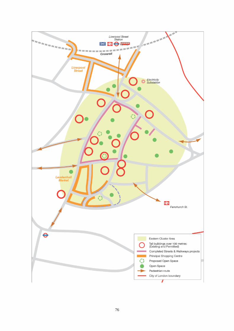
76

77
3.7 EASTERN CLUSTER 3.7.1 In the east of the City a cluster of tall buildings forms a distinctive element in the skyline. This cluster contains the greatest density of businesses and jobs in the Square Mile, principally offices in banking and insurance use, but there are also other land uses, including open spaces and retailing at Leadenhall Market. The Eastern Cluster has potential to accommodate more development and jobs and has fewer constraints on the development of tall buildings. In the future the Eastern Cluster will contain more tall and large buildings and an even larger workforce. Table 2.3 shows that the majority of new office space will be built in the Eastern Cluster, accounting for 50-60% of all projected City office space. 3.7.2 There are a number of key issues for the Eastern Cluster. These include increased demand for large offices and tall buildings, leading to greater demand for vehicle servicing on the street and utilities under the street; greater numbers of commuters walking to work from stations and bus stops, including new Crossrail stations; greater pedestrian movement from the cluster to facilities, particularly retail, elsewhere in the City; and greater security risks, principally terrorism, due to the number of high profile buildings and occupiers and increased numbers of workers. 3.7.3 New tall and large buildings should contribute positively to their surroundings and must not harm the City’s environment, including its historic environment, or the wider London skyline. The greatly increased numbers of pedestrians must be provided with safe and attractive walking routes, both within the area and linking to other parts of the City. The growth in the workforce will need to be complemented by improvements to retail and leisure facilities and the improvement of existing, and provision of new, open spaces. The challenge facing the Eastern Cluster is to accommodate the many demands generated by growth while creating a safe, efficient, uncongested and attractive public realm of streets and open spaces.
78
Core Strategic Policy CS7: Eastern Cluster To ensure that the Eastern Cluster can accommodate a significant growth in office floorspace and employment, while balancing the accommodation of tall buildings, transport, public realm and security and spread the benefits to the surrounding areas of the City, by: 1. Increasing the provision of sustainable, energy-efficient, attractive, high quality
office floorspace in a range of accommodation types, that meet the varied needs of office occupiers and achieve modernisation of office stock.
2. Promoting the Eastern Cluster as a location for inward investment, providing
assistance to potential developers, investors and occupiers. 3. Delivering tall buildings on appropriate sites that enhance the overall
appearance of the cluster on the skyline, and the relationship with the space around them at ground level, while adhering to the principles of sustainable design, conservation of heritage assets and their settings and taking account of their effect on the wider London skyline and protected views.
4. Ensuring the safety of businesses, workers, residents and visitors, promoting
natural surveillance of buildings, open spaces and streets and protecting against crime and terrorism.
5. Enhancing streets, spaces, and the public realm for pedestrians, providing new
open and public spaces where feasible, increasing connectivity with surrounding areas and improving access to facilities and services, particularly in the Cheapside and Aldgate areas and towards the City Fringe.
6. Ensuring the provision of high quality utilities (including CCHP where feasible)
and communications infrastructure, encouraging early engagement and joint working between developers and utility providers and maximising the space under the streets, particularly through the use of pipe subways.
7. Delivering improvements to public transport to cope with the demands of the
growing numbers of workers and visitors, implementing street and traffic management measures and ensuring that improvements do not compromise the quality of the environment.

79
Who will deliver How we will make it happen Who When Offices Providing guidance and assistance to developers and occupiers seeking to locate and expand in the Eastern Cluster; promoting inward investment, prime sites and opportunities in the that complement the Mayor’s City Fringe Opportunity Area. Requiring a sustainability statement to ensure that proposals will be sustainable, energy efficient, viable and accessible for all and do not have a negative impact on the historic environment. Further detail will be included in the Development Management DPD.
City Corporation: City Property Advisory Team CPAT and Economic Development Office EDO – Developers.
Ongoing 2012 Ongoing
Tall buildings Guiding tall buildings to appropriate locations and ensuring the highest possible design standard, while ensuring a commitment to accessibility and inclusive design. This will include pre-application discussions, Section 106 agreements Heritage Impact Assessment Statements, Design & Access Statements and sustainability statements and have regard to the Mayor’s LVMF as well as St. Paul’s Heights, and other local views; and the Outstanding Universal Value and setting of the Tower of London World Heritage Site. The appropriateness of tall buildings should, in particular, be considered against Policies CS12, CS13 and CS14.
City Corporation- Mayor of London- Design Council- English Heritage- Historic Royal Palaces- Relevant boroughs- Amenity societies- Developers
Ongoing
Security Implement a security-led, area-managed access scheme, including the use of Environmental Traffic Regulation Orders, to guide service vehicles and related traffic, including consideration of hours of operation and impact on pedestrians and residents.
City Corporation- Developers
By 2021

80
Public realm Environmental Public realm enhancement strategies. Planned schemes include the St. Helens Public Realm Strategy and projects associated with developments at 22–24 Bishopsgate (Pinnacle Tower), 201 Bishopsgate / Broadgate Tower, Lime Street and Tower Gateway. Introducing vehicle-free routes within the Cluster, providing limited access to specific vehicles to enhance pedestrian movement and safety. Creating a network of high quality open spaces through the Open Spaces Strategy.
City Corporation
Review of environmental public realm enhance-ment strategies every 5 years
Utilities Identify and bring forward sites required to meet the demand for the projected growth in the Eastern Cluster, and provide necessary infrastructure to meet demand. Early engagement with developers will include joint identification of suitable major substation sites.
City Corporation: CPAT- Utility and Telecommunications providers- Developers
Ongoing Depends on infrastruc- ture require ments of different businesses
Public transport Implementation of Crossrail and the interchange masterplan including design options for Liverpool Street / Bishopsgate. Delivery of local transportation enhancements through development management.
Crossrail Ltd- TfL- City Corporation- Developers City Corporation Developers
Crossrail by 2018; Masterplan published October 2009 Ongoing
SUPPORTING EVIDENCE • City of London Tall Buildings Evidence Paper City of London 2010 • City of London Office Evidence Paper City of London 2011 • London View Management Framework Supplementary Planning Guidance Mayor of London 2010 • Enhancing the Public Realm in the Eastern City Cluster Lovejoy for the City of London 2005 • St Helen’s Square and Vicinity – Enhancing the Public Realm Lovejoy for the City of London 2007 3.7.4 The Sustainability Appraisal supports the identification of this area and notes that this policy is expected to have beneficial impacts locally against social objectives and nationally against economic objectives. There is uncertainty at a

81
regional scale against environmental objectives, with an increase in resource use and waste production and potential for overcrowding on the transport network, with clustering of buildings potentially adding to the heat-island effect. However this policy does include promotion of sustainable new buildings. Mitigation measures are included in the Core Strategy to improve local water quality, air quality, biodiversity and the historic environment. RISK MANAGEMENT 3.7.5 3.7.4 Economic cycles lead to periods of over and under-supply of office accommodation. This can result in short term delays to development. Policy CS1 seeks to protect large floorplate office sites, while allowing flexibility for alternative temporary uses. 3.7.6 3.7.5 An increased concentration of tall building development in the Eastern Cluster could exacerbate the problem associated with wind turbulence. This will be mitigated by carrying out requiring wind assessments on to be submitted as part of planning applications and requiring appropriate amendments to be made to schemes or measures to be implemented to eradicate problems. 3.7.7 3.7.6 While security measures are being carefully considered in major schemes in the Eastern Cluster, terrorism is unpredictable. The City will ensure that the most effective counter-terrorism measures are maintained and enhanced throughout the Eastern Cluster. MONITORING 3.7.8 Key monitoring indicators are: • Number of office schemes permitted, under construction and completed • Number of tall buildings permitted, under construction and completed • Compliance with LVMF protected views • Utilities and communications improvements • Number of public transport enhancement schemes planned and implemented • Number of commuters exiting from underground stations within and around the Cluster • Thefts from a person or a building • Number of environmental enhancement projects planned and implemented

82
83
3.8 ALDGATE 3.8.1 The Aldgate area is positioned between the City’s eastern cluster of tall buildings and London’s East End. Tower Hamlets, one of the most deprived boroughs in England, adjoins the area. Although there is significant potential for development, environmental concerns, including traffic levels, pollution and a lack of street-level activity, mean that the area is not as attractive for new business investment as other areas of the City. The City Corporation aims to regenerate Aldgate by developing it into a vibrant, safe and distinctive office location, whilst remaining a sustainable place in which to live, work and learn. Residential development will be encouraged in or near to existing residential areas clusters in the Aldgate area. 3.8.2 Aldgate is home to parts of the London Metropolitan University, two housing estates – Middlesex Street Estate and Mansell Street Estate – and the City’s only primary school, Sir John Cass. The area is within walking distance of several major visitor attractions including the Tower of London, Brick Lane, Petticoat Lane Market and Spitalfields Market. The Aldgate area suffers from a lack of publicly accessible open space and has a relatively deprived residential population with poor access to retail facilities, high levels of unemployment, poorer than average standards of health and relatively high numbers of residents who need help to improve language skills. The Aldgate area is within includes Portsoken Ward, which is amongst the 25% most deprived areas of the country. 3.8.3 The predominant land use in the Aldgate area is good quality, recently built or refurbished office stock, dating from the 1960s to the 1990s. Although it has experienced limited recent development activity, the Aldgate area is capable of accommodating large-scale office development that can provide space for company headquarters or business support functions, while other sites will be more appropriate for mixed use or residential development. Tall buildings may be appropriate on certain sites. 3.8.4 The City Corporation participates in a number of cross-border partnership programmes which aim to bring lasting social, economic and physical regeneration to the boroughs bordering the City. Future development in Aldgate will depend upon these cross-border initiatives and will need to take account of emerging guidance from the Mayor through the Tech City and City Fringe Opportunity Area Planning Framework (CFOAPF), and proposals from Tower Hamlets. The draft CFOAPF helps co-ordinate the regeneration strategies of the four local authorities within whose areas the City fringe lies, and is particularly focused on overarching issues such as access, open space, and the scale of buildings, which are central to the area’s identity. The London Plan proposes growth of 70,000 new jobs and 7,000 new homes within the City fringe areas of Islington, Hackney and Tower Hamlets. The City will work with the Mayor and these neighbouring boroughs to agree appropriate targets for the City as a contribution towards meeting the wider City fringe targets facilitate the delivery of development and investment to meet these targets. 3.8.5 The Aldgate area has benefitted from public realm improvement works that have taken place outside of the City through the Tower Hamlets Aldgate Masterplan, including the replacement of the Aldgate Gyratory with a more
84
pedestrian-friendly street layout, and the new open space at Braham Street. The City Corporation adopted the Aldgate and Tower Area Enhancement Strategy in 2012, whose key proposal is to remove the Aldgate Gyratory and create a new public space. The Strategy also details plans for enhancing the street environment, adding greenery, reducing traffic congestion and making it easier and safer to walk and cycle through the area. Core Strategic Policy CS8: Aldgate To regenerate the amenities and environment of the Aldgate area for businesses, residents, workers, visitors and students, promoting development and investment, by: 1. Promoting the Aldgate area as an attractive office and residential location to
assist in its regeneration. 2. Identifying and meeting residents’ needs, particularly on the Middlesex and
Mansell Street Estates, utilising a range of funding sources to: (i) maximise training, education and employment opportunities for residents; (ii) maximise opportunities for delivering health, community and educational
services and facilities for residents; (iii) create additional publicly accessible open space and additional accessible
play space for children; (iv) encourage local retail facilities. 3. Improving transport connections and pedestrian links, especially between the
housing estates and Aldgate Station and Sir John Cass School and between Aldgate and Aldgate East stations:
(i) replacing the Aldgate Gyratory (St. Botolph’s section) with a two way street
system providing additional public open space; (ii) improving Aldgate Bus Station to deliver improved access for pedestrians to
and from community facilities, housing estates, open spaces and retail facilities; (iii) improving signage for visitors from Liverpool Street Station to Tower Hill and
from Aldgate to Cheapside. 4. Enhancing the public realm of the Aldgate area, its streets and spaces and
implementing improvement schemes at Middlesex Street and St. Botolph’s House. Identifying opportunities for urban greening schemes, congestion and pollution reduction measures, particularly in the vicinity of Sir John Cass School and Middlesex Street and Mansell Street Estates.
85
Who will deliver How we will make it happen Who When Promoting Aldgate as office location Through a multi-discipline developer partnership, identify opportunities in Aldgate and the Tower Hamlets fringe area. Assistance to individual occupiers and developers looking to locate and invest in the area.
City Corporation- LB Tower Hamlets- Developers
Ongoing
Identifying and meeting residents’ needs Encouraging small and medium sized business growth and developing employment opportunities through assistance to business and Implementation of the Community and Children’s Services Business Plan. Providing community and health facilities through developer contributions Community Infrastructure Levy or s106 planning obligations. Partnership arrangements to deliver health improvements. Implementing the City of London’s Open Space Strategy Five Year Action Plan and Open Spaces Audit report. Redevelopment of part of Middlesex Street Estate to deliver 23 additional affordable homes, community and leisure facilities. Implementing sustainability improvement schemes on residential estates.
City Corporation City Corporation- Developers City Corporation- LB Tower Hamlets- City and Hackney Clinical Commissioning Group City Corporation City Corporation City Corporation
Ongoing advice: Business plan 2010-2013 Ongoing Ongoing Ongoing By 2013 When funding available When funding available

86
Improving connections and linkages Using developer contributions Community Infrastructure Levy or s106 planning obligations to fund pedestrian improvements. Implementing the City Fringe Opportunity Area Strategic Connection 4. Delivering transport improvements through joint working and the provisions of the Local Implementation Plan. Implementing the Sir John Cass School Travel Plan.
City Corporation- Developers City Corporation – Mayor of London City Corporation- TfL- LB Tower Hamlets- Developers City Corporation St John Cass School
Ongoing City Fringe Opportunity Area Framework – Draft in preparation 2009 Ongoing Ongoing
Opportunities to enhance the public realm Working with partners to implement the Aldgate and Tower Area Enhancement Strategy, Environmental enhancement strategies City Fringe Opportunity Area guidance and LIP.
City Corporation- Mayor of London- Developers
Ongoing
SUPPORTING EVIDENCE • Working in Partnership with our Neighbours City of London 2008 • Supporting Economic Regeneration in the City Fringe City of London 2007 • Draft City Fringe Opportunity Area Planning Framework Mayor of London 2009 • Commercial Land and Property Study, Aldgate BBP Regeneration for Tower
Hamlets 2007
3.8.6 The Sustainability Appraisal of this policy notes that there would be positive social, economic and environmental benefits.
RISK MANAGEMENT
3.8.7 3.8.6 Delivery of many of the improvements sought will rely upon sufficient s106 monies being made available through the development management process Community Infrastructure Levy or s106 planning obligations contributions being made available. The level of developer activity and potential developer funding will vary according to the economic cycle. If insufficient funding is available in future, the City Corporation will investigate the potential to use other, public funding sources and prioritise improvements to deliver maximum benefit to residents, workers and visitors.
3.8.8 3.8.7 Fluctuations in the economic cycle may reduce the demand for new
office accommodation. The Local Plan Core Strategy policy framework is flexible enough for suitable temporary uses to be allowed without harming the long term prospects of the business City.
87
MONITORING
3.8.9 Key monitoring indicators are: Office location ● Number of offices permitted, under construction and completed Identifying and meeting residents’ needs ● Community facilities provided • Amount of s106 funding • Leisure facilities provided • Additional open space provision • Health of residents Improving connections and linkages ● Monitoring indicators established in the City of London Local Implementation
Plan Identifying opportunities to enhance the public realm • Pedestrian and cyclist counts and classifications • Pedestrian and cyclist route and attitude surveys • Before-and-after street and walkway condition assessments, including the PERS2
(pedestrian environment review system) and Living Streets Community Street Audit method

88

89
3.9 THAMES AND THE RIVERSIDE 3.9.1 The River Thames forms the southern boundary of the City and has historically played a major role in its prosperity and everyday life. The riverside provides a breathing space from the busy environment which characterises the rest of the City, as well as a traffic-free walkway on the north bank of the Thames. In developing the riverside’s potential it is important to balance the river’s functional uses for the movement of people and materials with its role in providing for the recreational needs of residents, workers and visitors. The presence of offices on the riverside makes a valuable contribution to the City’s varied office stock, which in turn contributes to the wider economic prosperity of London. Minimisation of flood risk and respect for the riverside’s rich archaeological heritage, which includes the Queenhithe Dock scheduled ancient monument, are also important considerations. 3.9.2 The City’s topography with the land rising from the riverside means that most of the City is at low risk from flooding. Nevertheless this risk needs to be managed, particularly in the face of climate change. 3.9.3 A series of strategies help to shape the riverside. These include the London Plan, which requires the designation of a Thames Policy Area, whose identification includes consideration of areas and buildings that have historic, archaeological and cultural association with the Thames; and the Mayor’s Riverside Strategy, which emphasises links between central London and the Thames riverside to the east; and the Mayor’s Vision for cycling in London. The Environment Agency’s Thames Estuary 2100 Plan and Thames River Basin Management Plan address flood risk and water quality issues for the Thames. Thames Water’s proposal to build the Thames Tideway Tunnel is intended to capture and divert storm overflows, including the Fleet Combined Sewer Outflow (CSO) at Blackfriars, to Beckton Sewage Treatment Works, to avoid discharging them into the River. The City’s Riverside Walk Enhancement Strategy sets out the City’s plans for street scene enhancement along the riverside, and the riverside walk forms part of Natural England’s Thames Path National Trail. The River Thames is designated as a Site of Metropolitan Importance for Nature Conservation. Core Strategic Policy CS9: Thames and the Riverside To ensure that the City capitalises on its unique riverside location, sustaining the river’s functional uses in transport, navigation and recreation, whilst minimising risks to the City’s communities from flooding, by: 1. Designating the Thames Policy Area and preparing and keeping under review
an area appraisal which identifies the attributes of the area and gives guidance on development within this area.
2. Ensuring that buildings and spaces on or near the riverside contribute
to sustainable economic growth and further the aims of the Riverside Walk Enhancement Strategy, particularly through:

90
(i) protecting public access and river views along the riverside walk and securing completion of the riverside walk at Queenhithe;
(ii) improving access to the river and riverside walk from the rest of the City and the Thames bridges;
(iii) improving the vibrancy of the riverside by encouraging a mix of appropriate commercial uses and promoting office-led commercial development, particularly at Three Quays, the Millennium Bridge, and Blackfriars, whilst preserving privacy, security and noise abatement amenity for residents, businesses and other stakeholders;
(iv) improving opportunities for biodiversity, in line with the City of London Habitat Action Plan for the Thames foreshore.
3. Supporting and safeguarding sites for the construction of the Thames Tideway
Tunnel, including connection of the Fleet combined sewer outflow, resulting in reduced storm water discharges into the River Thames and improved water quality.
4. Promoting the functional uses of the River Thames and its environs for transport,
navigation and recreation particularly through: (i) retaining Walbrook Wharf for waterborne freight traffic; (ii) encouraging the use of the River Thames for the transport of construction and
deconstruction materials and waste; (iii) retaining Blackfriars Pier, Swan Lane Pier and access to Tower Pier, and
encouraging the reinstatement of Swan Lane Pier and the use of these facilities for river transport. Applications to remove these facilities will be refused unless suitable replacement facilities of an equivalent or higher standard are provided;
(iv) maintaining London Bridge, Tower Bridge, Blackfriars Bridge, Southwark Bridge and the Millennium Bridge;
(v) resisting refusing development on or over the River, including permanently moored vessels, except for structures which specifically require a waterside location for river-related uses;
(vi) resisting the permanent mooring of vessels; if moored vessels are exceptionally permitted they must be of national importance, have a special connection with the City and the River Thames and be used for a river related purpose;
(vii) maintaining access points to the River Thames foreshore, from both land and water, for public or private use as appropriate, subject to health and safety and environmental safeguards.
(vii) encouraging the use of the River Thames for the transport of construction and demolition materials and waste.
5. Permitting residential and hotel development within the Thames Policy Area as long as flood risk issues can be adequately addressed, with particular emphasis on:
(i) allowing clustering of housing along the riverside, particularly close to the existing residential development at Queenhithe
(ii) maintaining residential uses in the Inner and Middle Temples; (iii) encouraging clustering of hotels close to visitor attractions and in areas of vibrancy.

91
Who will deliver How we will make it happen Who When Thames Policy Area Reviewing and replacing the 2002 - Riverside Appraisal of the Thames Policy Area in the City of London, through a SPD, taking account of strategic riverside issues in neighbouring boroughs. Enhancing riverside heritage assets.
City Corporation City of Westminster- LB Southwark- LB Tower Hamlets City Corporation-English Heritage
2012 2014 Ongoing
Riverside walk enhancement Implementation Review of the Riverside Walk Enhancement Strategy alongside the Riverside Appraisal SPD subject to funding from development, TfL and other sources. Implementation of the Walk London strategic walking routes, including along the riverside. Implementation of the City of London Biodiversity Action Plan and other biodiversity enhancements.
City Corporation- TfL- Developers- Natural England
City Corporation- TfL City Corporation- Environment Agency
By 2013 2014 Subject to commercial property development
Ongoing
Water quality Joint working to enable completion of the Thames Tideway Tunnel through the Thames Tunnel Forum. Upholding the Ministerial Direction safeguarding the Thames Tideway Tunnel sites at Blackfriars as shown on the Policies Map
City Corporation- Thames Water City Corporation
By 2019 Ongoing
Functional uses of the River Thames Maintenance of bridges, wharfs and piers Upholding of Ministerial Direction safeguarding Walbrook Wharf, maintaining it for use as a wharf.
Bridge House Estates- City Corporation- Port of London Authority City Corporation
Ongoing Ongoing
Housing and hotels Applying sequential and exceptions tests requirements to all development on the riverside.
Environment Agency – City Corporation
Ongoing
92
Maintaining the balance of housing and other uses in the Temples through the Development Management DPD
City Corporation City Corporation
2012
2012 SUPPORTING EVIDENCE • Riverside Appraisal of the Thames Policy Area City of London 2002 • Thames Estuary 2100 Flood Risk Management Plan Environment Agency 2009 • By the River Mayor of London 2009 • River Thames Pier Plan London Development Agency 2009 • Riverside Walk Enhancement Strategy City of London 2005 3.9.4 The Sustainability Appraisal concluded that this policy would have beneficial social, environmental and economic impacts. RISK MANAGEMENT 3.9.5 3.9.4 Fluctuations in the economic cycle could result in reduced developer contributions available to fund riverside improvements. The City will seek other potential sources of funding, e.g. TfL or European funding, and prioritise schemes. 3.9.6 3.9.5 Climate change may alter flood risks. See Policy CS18 ‘Flood Risk’ for detailed risk management. MONITORING 3.9.7 Key monitoring indicators are:
Thames Policy Area • Adoption of revised guidance for the Thames Policy Area Riverside Walk Enhancement • Progress in implementation of the riverside walk and improvements as set out in
the Riverside Walk Enhancement Strategy • Mix of uses permitted in Thames Policy Area Water Quality and functional uses • NI 189 actions associated with Thames Tideway Tunnel Housing & Hotels • Number and location of residential developments permitted, under construction
and completed • Number and location of hotel bedspaces permitted, under construction and
completed.
93
3.10 DESIGN 3.10.1 The City has a unique and distinctive built environment characterised by a great variety and high quality of buildings which, individually and together, comprise a townscape that is renowned nationally and internationally, as well as containing lesser known buildings and spaces of high quality. This townscape is characterised by a diversity of building type, age, materials and architectural design, both historic and modern. The rich and diverse patterns of buildings and spaces in the City have, to varying degrees, the following common characteristics: • human scale reflected in the relationship between buildings and their
surroundings; • interlinking pedestrian routes and intimate open spaces; • mixtures and concentrations of building scales, materials and periods. There are many open spaces and a complex pattern of streets of medieval and Roman origin. The rich variety of buildings means that the character of areas can contrast greatly within local areas. The townscape of the Square Mile reflects both its long economic and trading history and its modern role as a world-leading financial and business centre. Good design is key to maintaining and enhancing the quality and interest of the City’s townscape and functions. 3.10.2 The City is predominantly commercial in nature and this is reflected in its buildings, their design, the activities they contain and the density of development. The rate of change and rebuilding in the City presents challenges and opportunities to ensure that new development contributes positively to the townscape. The City’s position at the heart of London and its world status demand the highest standards of design and sustainability for buildings, spaces and the street scene. The diversity of the townscape means that different design considerations apply to each site and these need to be carefully assessed to take account of each building’s context. This should not constrain design approaches, and a range of solutions may be appropriate. To ensure that sound design principles are followed, the City Corporation will issue further advice in the Development Management DPD, SPDs and other documents. 3.10.3 Outdoor advertising has a significant strong impact on the appearance of buildings, the street scene and, in particular, the historic environment. The City Corporation’s approach to the control of is to restrain advertisements in terms of size, location, materials and illumination in order is restrained to safeguard the high quality of the City’s environment. 3.10.4 The City has a large workforce whose numbers are expected to grow substantially. Most journeys within the Square Mile are on foot and this movement is particularly high during morning and evening peak times. Despite redevelopment throughout its history, the City has retained much of its dense street pattern, which provides convenient walking routes and allows for a high degree of pedestrian permeability. At the same time, the pattern of narrow streets and alleyways may poses challenges in terms of accessibility, way-finding, safety and increased pressure on the pedestrian environment. The City has numerous small open spaces, which provide valuable amenities, and many are of historic importance. The location and design of these small spaces requires innovative and
94
sensitive solutions which respect their settings and create high quality, accessible areas for all the City’s communities. The City’s streets also provide space for public enjoyment, and the City Corporation has an extensive programme of street scene public realm enhancement projects to improve the quality, sustainability, inclusivity and amenity of the public realm. 3.10.5 The City provides a great range of employment and leisure opportunities that should be widely accessible to all, including to disabled people. Accessibility to new and existing buildings and spaces must be maximised to create an inclusive environment. Adaptation of historic buildings presents particular challenges and requires careful design solutions. The City Corporation has an active programme of implementing access adaptations and will prepare a SPD to give guidance to for developers. Core Strategic Policy CS10: Design To promote a high standard of design and sustainable design of buildings, streets and spaces, having regard to their surroundings and the historic and local character of the City and creating an inclusive and attractive environment, by: 1. Ensuring that the bulk, height, scale, massing, quality of materials and detailed
design height of buildings are appropriate to the character of the City and the setting and amenities of surrounding buildings and spaces.
2. Encouraging design solutions that make effective use of limited land resources. 3. Ensuring that development has an appropriate street level presence and
roofscape and a positive relationship to neighbouring buildings and spaces. 4. Requiring the design and management of buildings, streets and spaces to
provide for the access needs of all the City’s communities, including the particular needs of disabled people.
5. Ensuring that new development respects and maintains the City’s characteristic
dense network of streets and alleyways. 6. Delivering improvement in the environment, amenities and enjoyment of open
spaces, play areas, streets, lanes and alleys through schemes in accordance with public realm enhancement strategies.
7. Ensuring that signs and advertisements respect the restrained character of the
City.

95
DEVELOPMENT MANAGEMENT POLICIES Policy DM 10.1 New Development To require all developments, including alterations and extensions to existing buildings, to be of a high standard of design and to avoid harm to the townscape and public realm, by ensuring that: • the bulk and massing of schemes are appropriate in relation to their surroundings
and have due regard to the general scale, height, building lines, character, historic interest and significance, urban grain and materials of the locality and relate satisfactorily to the character of streets, squares, lanes, alleys and passageways;
• all development is of a high standard of design and architectural detail with elevations that have an appropriate depth and quality of modelling
• appropriate, high quality and durable materials are used; • the design and materials avoid unacceptable wind impacts at street level or
intrusive solar glare impacts on the surrounding townscape and public realm; • development has attractive and visually interesting street level elevations,
providing active frontages wherever possible to maintain or enhance the vitality of the City’s streets;
• the design of the roof is visually integrated into the overall design of the building when seen from both street level views and higher level viewpoints;
• plant and building services equipment are fully screened from view and integrated in to the design of the building. Installations that would adversely affect the character, appearance or amenities of the buildings or area will be resisted;
• servicing entrances are designed to minimise their effects on the appearance of the building and street scene and are fully integrated into the building’s design;
• there is provision of appropriate hard and soft landscaping, including appropriate boundary treatments;
• the external illumination of buildings in carefully designed to ensure visual sensitivity, minimal energy use and light pollution, and the discreet integration of light fittings into the building design;
• there is provision of amenity space, where appropriate; • there is the highest standard of accessible and inclusive design. 3.10.6 The network of routes and spaces, the scale, form, architectural expression and detailed design of buildings, together with the use of particular building materials, and the contribution of these elements to the composition of street blocks are characteristic of and combine to produce the close-knit and intricate townscape of the City. It is important that new buildings and alterations respect and reinforce this general character. The City has dynamic, striking and internationally acclaimed architecture as well as more contextual buildings appropriate to their townscape setting. 3.10.7 In assessing development schemes detailed consideration will be given to the bulk and massing and special characteristics of their locality. All development proposals are expected to have a high standard of design and detailing.

96
3.10.8 Wind conditions and solar glare can have an adverse effect on the surrounding townscape and the quality and use of the public realm. Assessments will need to be carried out on the impact of proposed development on wind conditions and solar glare. Any adverse impacts will need to be mitigated and mitigation measures should be integrated into the design of the development. 3.10.9 In most buildings, the ground floor elevation has the most effect on public amenity, so its design should be given particular attention to ensure that it is legible, visually attractive and provides active frontages, where appropriate. Features such as blank frontages, and ventilation louvres should be avoided, while servicing entrances should be carefully designed to minimise adverse effects on the townscape. 3.10.10 The City’s significant number of public and private viewing galleries and its tall buildings mean that many workers, residents and visitors see the townscape from above. Special consideration needs to be given to the roofscape as a “fifth” elevation that is integrated into the architectural design of the building. Attention should be given to the form, profile and general appearance of the roofscape to ensure that it complements the building as viewed from surrounding buildings as well as from the ground. 3.10.11 Additional roof top plant for an existing building should be satisfactorily integrated into the form and design of the existing roof. It should be enclosed and covered where it would otherwise harm the appearance of the building, the general scene, or views from other buildings. Where feasible, plant should be located below ground. Consideration should be given to the use of external heating and cooling supplies from combined heat and power systems, where available, as these may avoid or reduce the need for roof top installations such as boiler flues, cooling towers and plant rooms, as well as providing wider environmental benefits. 3.10.12 The design and execution of extensions and alterations to buildings, such as entrances and windows, are of considerable importance since they have a cumulative effect on the overall character and appearance of the City. Extensions or alterations should be considered in relation to the architectural character of the building, designed to minimise their impact and integrated with the design of the building. Alterations and extensions should achieve a successful design relationship with their surroundings, taking full account of the local context and the setting of the building. 3.10.13 Servicing entrances can have a detrimental impact on the appearance of the building and its immediate setting and can harm otherwise attractive pedestrian routes. The City Corporation expects innovative design solutions for servicing entrances and adjacent areas to minimise their visual impact and to enable them to be integrated into the design of the building. Design solutions must respect the sensitive nature of listed buildings and conservation areas. Gates and doors should be well designed and should be kept closed when the entrance to the service bay is not in use. 3.10.14 The illumination of buildings should only occur where it would contribute to the unique character and grandeur of the City townscape by night. Lighting intensity, tone and colour need to respect the architectural form and detail of the

97
building, be sensitive to the setting and avoid light pollution of the sky and adverse effects upon adjacent areas and uses. Light fittings, including street lighting, should be discreetly integrated into the design of the buildings, where possible. 3.10.15 Ventilation or extraction systems should be routed internally and extensive or unsightly external ducting will be resisted. In new development, provision must be made within the building for services and ducting to and from all uses, including retailing. Ventilation louvres should not be sited adjoining footways. 3.10.16 Developers will be encouraged to provide suitable rooftop ventilation for the City’s sewer network, which should be integrated into the design of buildings. Policy DM 10.2 Design of Green Roofs and Walls 1) To encourage the installation of green roofs on all appropriate developments.
On each building the maximum practicable coverage of green roof should be achieved. Extensive green roofs are preferred and their design should aim to maximise the roof’s environmental benefits, including biodiversity, run-off attenuation and building insulation.
2) To encourage the installation of green walls in appropriate locations, and to
ensure that they are satisfactorily maintained.
3.10.17 Green roofs and green walls have the potential to contribute to climate change adaptation by reducing surface water run-off and by improving building insulation, urban greening and biodiversity. Additionally, green roofs and walls can be used in context with amenity spaces and can enhance their quality and the appearance of the City’s roofscape. The City Corporation especially encourages the installation of biodiverse green roofs. Their substrates should be between 80mm and 150mm thick to provide water attenuation. They are easy to install and require little maintenance. Varying the substrate levels within this range will be encouraged to enhance biodiversity, and a high proportion of native plants are expected to be used. Green roofs can be installed on sloping roofs, between cleaning cradle tracks and underneath solar panel installations, provided that the type of planting is selected for its location. 3.10.18 Where developers prefer to install intensive green roofs with deeper substrates, these are expected to be of high quality design and to provide amenity space. The green roof should not impact on protected views and planting should be appropriate to the location and height of the roof. 3.10.19 Green walls can bring many of the benefits of green roofs, and can improve the appearance of locations where there is limited opportunity for planting. To be successful they require careful design and installation and regular maintenance.
98
Policy DM 10.3 Roof Gardens and Terraces 1) To encourage high quality roof gardens and terraces where they do not: • immediately overlook residential premises; • adversely affect rooflines or roof profiles; • result in the loss of historic or locally distinctive roof forms, features or coverings; • impact on identified views. 2) Public access will be sought where feasible in new development.
3.10.20 Roof gardens and terraces are becoming increasingly common in the City. Public and private roof gardens and terraces present an opportunity for amenity space and the creation of new viewpoints of the City and the surrounding areas and reinforce London’s cultural and historic attractions. 3.10.21 Roof terraces and gardens should be publicly accessible where possible and entrances should not result in safety or security concerns or adversely impact on the environmental quality at street level. Opening hours may be managed by condition or agreement. Policy DM 10.4 Environmental Enhancement The City Corporation will work in partnership with developers, Transport for London and other organisations to design and implement schemes for the enhancement of highways, the public realm and other spaces. Enhancement schemes should be of a high standard of design, sustainability, surface treatment and landscaping, having regard to: • the predominant use of the space, surrounding buildings and adjacent spaces; • connections between spaces and the provision of pleasant walking routes; • the use of natural materials, avoiding an excessive range and harmonising with
the surroundings of the scheme and materials used throughout the City; • the inclusion of trees and soft landscaping and the promotion of biodiversity,
where feasible linking up existing green spaces and routes to provide green corridors;
• the City’s heritage, retaining and identifying features that contribute positively to the character and appearance of the City;
• sustainable drainage, where feasible, co-ordinating the design with adjacent buildings in order to implement rainwater recycling;
• the need to provide accessible and inclusive design, ensuring that streets and walkways remain uncluttered;
• the need for pedestrian priority and enhanced permeability, minimising the conflict between pedestrians and cyclists;
• the need to resist the loss of routes and spaces that enhance the City’s function, character and historic interest;
• the use of high quality street furniture to enhance and delineate the public realm;
• lighting which should be sensitively co-ordinated with the design of the scheme.

99
3.10.22 The City Corporation will actively promote schemes for the enhancement of the street scene and public realm, in appropriate locations. All works should conform to the City Streets Manual Supplementary Planning Document and have regard to the Mayor of London’s Streetscape guidance. 3.10.23 High quality natural materials are characteristic of the City of London and add greatly to the character and identity of streets, courts and spaces. Wherever possible, the City Corporation will retain these surface materials and will carry out repairs to match and extend their use. Elsewhere, the City Corporation will encourage a limited palette of materials, providing continuity in the street scape. 3.10.24 The City Corporation will undertake street enhancement works through specifically targeted projects or in association with general street maintenance and vehicle, cycle and pedestrian traffic management schemes. The City Corporation will use the Community Infrastructure Levy or s106 planning obligations to deliver enhancement works. 3.10.25 All projects should be inclusive in design so that they provide access for all. 3.10.26 The incorporation of artworks or integral decorative features, such as sculptures, fountains and schemes included in the City Arts Initiative to create animated spaces, will be encouraged where appropriate and their design, management and maintenance regime should be considered at an early stage of the design. Policy DM 10.5 Shopfronts To ensure that shopfronts are of a high standard of design and appearance and to resist inappropriate designs and alterations. Proposals for shopfronts should: • respect the quality and architectural contribution of any existing shopfront; • respect the relationship between the shopfront, the building and its context; • use high quality and sympathetic materials; • include signage only in appropriate locations and in proportion to the
shopfront; • consider the impact of the installation of louvres, plant and access to refuse
storage; • incorporate awnings and canopies only in locations where they would not harm
the appearance of the shopfront or obstruct architectural features; • not include openable shopfronts or large serving openings where they would
have a harmful impact on the appearance of the building and/or amenity; • resist external shutters and consider other measures required for security; • consider the internal treatment of shop windows (displays and opaque windows)
and the contribution to passive surveillance; • be designed to allow access by users, for example, incorporating level
entrances and adequate door widths. 3.10.27 Shopfronts are important elements in the townscape and can contribute significantly to the attractive quality of any street scene. The design of a shopfront

100
should recognise this and be appropriate to, or enhance, the building and its location. It should respect the design of the building and not obscure, or result in damage to, existing architectural features. 3.10.28 Existing shopfronts that contribute to the appearance or special interest of a building or the street scene, particularly in listed buildings or conservation areas, or that are of design or historic significance in their own right or as part of a group, should be retained. Any modifications necessary should be sympathetic to the original design. 3.10.29 New shopfront proposals should consider the relationship with the upper floors of the building and surrounding buildings and include high quality materials and finishes. The City Corporation will seek a reduction in the size of fascias of excessive dimensions (height, width and depth), which are out of proportion or scale with the shopfront or considered to have a detrimental effect on the appearance of the building or the street scene. The design of new shopfronts should include a signage zone that is consistent across a parade of shops of matching or similar design. 3.10.30 Modification required to shopfronts and shopfront designs incorporating louvres, plant or refuse accommodation should be undertaken in a manner sympathetic to the design and character of the shopfront and the building if they cannot be accommodated in less sensitive elevations. Awnings and canopies should be integrated into the design of the shopfront in relation to size, location and materials. 3.10.31 Openable shopfronts and large serving openings are not normally acceptable as they create a void at ground floor level that could harm the appearance of buildings and create potential amenity issues. 3.10.32 Security measures should be internal to limit their visual impact on shopfronts. External shutters are not normally acceptable while internal shutters should be perforated to enable visibility into the shop and passive surveillance. To enliven frontages and enable passive surveillance, all retail frontages should provide good visibility and glazing should not be blanked out. The installation of security glass and steel reinforced frontages will be considered in the context of the impact on the appearance and historic significance of shopfronts. 3.10.33 Retail entrances should be designed with level entrances to enable inclusive access by all; access measures and movable ramps should only be used where this is not feasible. Policy DM 10.6 Advertisements 1) To encourage a high standard of design and a restrained amount of advertising
in keeping with the character of the City. 2) To resist excessive or obtrusive advertising, inappropriate illuminated signs and
the display of advertisements above ground floor level.
101
3.10.34 In order to protect and enhance the dignified character of the City’s streets, the City Corporation considers that advertising material should be restrained in quantity and form. It has for many years sought to exercise careful control over the display of advertisements and seeks improvements where appropriate. The City Corporation will exercise advertisement control having regard to visual amenity and public safety. 3.10.35 Advertising hoardings and advertisements on street furniture will not normally be permitted as these detract from the restrained character of the City. The display of poster advertisements on construction site hoardings will be resisted unless directly related to the development site. Further guidance is contained in the City Corporation’s ‘Hoardings Advice Note.’ The design of advertising material should respect its locality and use appropriate materials of high quality. Advertisements should be appropriate to the frontage served and should avoid static or moving projection of images beyond the frontage, such as laser projections and projections on building façades in order to protect visual amenity and public safety. Digital advertising is not appropriate in the City’s historical context. Any illumination of advertisements should be discreet and incorporate LEDs, where possible to reduce the overall bulk and energy use of signage. Advertising flags and banners will not normally be permitted except, where appropriate, for cultural institutions. Rotating advertisements will be resisted as these detract from the City’s character. 3.10.36 Particular care will be necessary with retailing advertisements on or in the settings of listed buildings and within conservation areas. Internal illumination of adverts in such areas will not normally be permitted. 3.10.37 Advertisements above ground level are detrimental to the appearance and visual amenity of the street scene and can detract from the character and qualities of individual buildings by obscuring architectural features. While there are exceptions, such as traditional or historic signs, signs in an elevated position will not usually be permitted. 3.10.38 Appropriate action will be taken to have unauthorised advertisements removed. Policy DM 10.7 Daylight and Sunlight 1) To resist development which would reduce noticeably the daylight and sunlight
available to nearby dwellings and open spaces to unacceptable levels, taking account of the Building Research Establishment’s guidelines.
2) The design of new developments should allow for the lighting needs of intended
occupiers and provide acceptable levels of daylight and sunlight. 3.10.39 The amount of daylight and sunlight received has an important effect on the general amenity of dwellings, the appearance and enjoyment of open spaces and streets, and the energy efficiency of all buildings

102
3.10.40 The Building Research Establishment (BRE) has issued guidelines that set out several methods of assessing changes in daylight and sunlight arising from new developments. The City Corporation will apply these methods, consistent with BRE advice that ideal daylight and sunlight conditions may not be practicable in densely developed city-centre locations. When considering proposed changes to existing lighting levels, the City Corporation will take into account the cumulative effect of development proposals. Where appropriate, the City Corporation will take into account unusual existing circumstances, such as development on an open or low rise site and the presence of balconies or other external features, which limit the daylight and sunlight that a building can receive. 3.10.41 Planning considerations concerning daylight and sunlight operate independently of any common law rights and any light and air agreements which may exist. If a development is considered acceptable in planning terms and has planning permission, but is not proceeding due to rights to light issues, the City Corporation may consider acquiring interests in land or appropriating land for planning purposes to enable development to proceed. Policy DM 10.8 Access and Inclusive design To achieve an environment that meets the highest standards of accessibility and inclusive design in all developments (both new and refurbished), open spaces and streets, ensuring that the City of London is: • inclusive and safe for of all who wish to use it, regardless of disability, age,
gender, ethnicity, faith or economic circumstance; • convenient and welcoming with no disabling barriers, ensuring that everyone
can experience independence without undue effort, separation or special treatment;
• responsive to the needs of all users who visit, work or live in the City, whilst recognising that one solution might not work for all.
3.10.42 It is imperative that the built environment is safe, accessible and convenient as this is fundamental to improving the quality of life for all City users and particularly for disabled and older people. Despite progress in building a more accessible City, some people still experience considerable barriers to living independent and dignified lives as a result of the way the built environment is designed, built and managed. The outcome of embracing inclusive design should be a City where people want to live, work and visit. 3.10.43 Developers will be required to submit Design and Access Statements which demonstrate a commitment to inclusive design and engagement with relevant user groups. Design and Access Statements should include details both on how best practice standards have been complied with and how inclusion will be maintained and managed throughout the lifetime of the building. 3.10.44 The City Corporation manages the Considerate Contractors Scheme and encourages all those undertaking building and civil engineering work within the City to sign up to this scheme. This encourages them to carry out their operations safely
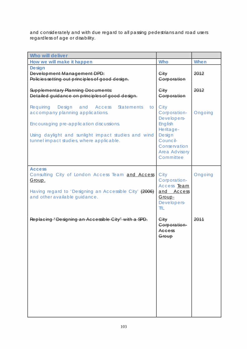
103
and considerately and with due regard to all passing pedestrians and road users regardless of age or disability. Who will deliver How we will make it happen Who When Design Development Management DPD: Policies setting out principles of good design.
City Corporation
2012
Supplementary Planning Documents: Detailed guidance on principles of good design.
City Corporation
2012
Requiring Design and Access Statements to accompany planning applications. Encouraging pre-application discussions. Using daylight and sunlight impact studies and wind tunnel impact studies, where applicable.
City Corporation- Developers- English Heritage- Design Council- Conservation Area Advisory Committee
Ongoing
Access Consulting City of London Access Team and Access Group. Having regard to ‘Designing an Accessible City’ (2006) and other available guidance.
City Corporation- Access Team and Access Group- Developers- TfL
Ongoing
Replacing “Designing an Accessible City” with a SPD.
City Corporation- Access Group
2011

104
Improved environment Using developer contributions and other funding to improve the public realm where required and provide new open space through environmental enhancement strategies. Ensuring the highest quality street furniture and street environment through the use of the Street Scene Manual City Streets Manual SPD.
City Corporation- TfL- Developers- Landowners- Residents- Public-Private partnerships
Ongoing
Incorporate trees to enhance sustainability and provide an attractive environment, in line with Tree SPD.
City Corporation- Developers
SPD 2011 Ongoing
Take forward the Quiet City Spaces Project. City Corporation
Ongoing
Incorporate play space and sports facilities in developments or public realm improvements in innovative, attractive ways, where feasible.
City Corporation- Developers- Sports Strategy steering group- Open Space Strategy steering group
Ongoing
SUPPORTING EVIDENCE • City Street Scene Manual City of London 2005 • Designing an Accessible City City of London 2006 • Conservation Areas in the City of London, a general introduction to their character City of London 1994 3.10.6 The Sustainability Appraisal noted that this policy would deliver positive social, environmental, and economic effects. RISK MANAGEMENT 3.10.7 3.10.45 Fluctuations in the economic cycle could result in pressure for a reduction in design quality due to cost cutting measures. The City Corporation will continue to require a high quality of design in planning applications in accordance with the aims of the policy. 3.10.8 3.10.46 Fluctuations in the economic cycle may also impact on the level of planning contributions available to deliver environmental, play space, sports facilities and signage improvements. In the event of a reduction in contributions, the City Corporation will prioritise schemes and seek alternative sources of funding where possible.

105
MONITORING 3.10.9 Key Monitoring Indicators are: • The number of architectural, heritage and environmental awards, commendations or notifications received by development carried out in the City • The number of awards, commendations or notifications for public realm improvements in the City • Access to shops and services • Number of wheelchair-accessible hotel bedrooms
106
3.11 VISITORS, ARTS AND CULTURE 3.11.1 Cultural facilities and events in the City attract millions of visitors each year, complementing the City’s business role and contributing to its vibrancy. The City’s historic environment also attracts many visitors who come to enjoy the historic urban form and heritage assets. The City Corporation operates a visitor information centre near St. Paul’s Cathedral as well as a number of visitor attractions including the Barbican complex, the Monument, Guildhall Art Gallery and Tower Bridge, and contributes to the provision of others, including the Museum of London. The Barbican complex is Europe’s largest multi-arts and conference venue with a diverse range of art, music, theatre, dance, film and education events. It is also home to the London Symphony Orchestra and the Guildhall School of Music & Drama. The Barbican complex is recognised by the Mayor of London as one of a number of internationally important cultural institutions and is designated as one of central London’s three most important Strategic Cultural Areas. 3.11.2 The City has a range of lending and specialist libraries serving the local community and housing collections of national and international significance. The City also has many churches places of worship which contribute to the cultural and spiritual life of its communities and, along with the livery halls, are used for concerts and exhibitions. Encouraging arts and culture in the City benefits workers, residents and attracts visitors, contributing to London’s role as an international tourist and business destination. This assists job creation within the City and in neighbouring boroughs. The City Corporation is the third biggest sponsor of arts in the UK and provides an extensive programme of arts and cultural events. 3.11.3 The City Corporation has developed an approach to promote art and culture in the City through the City Arts Initiative, a multi-departmental group which acts as a single point of contact for external organisations wishing to locate public art within the City. The City Arts Initiative seeks to enhance the City’s international commercial and financial identity through the development of visual and public art projects. 3.11.4 The City Corporation has prepared a Visitor Strategy ‘Visit the City’ which promotes the City as a high quality visitor destination, particularly for business visitors, in a way that complements the needs of the business City. It also seeks to target visitor activity to deliver increased visitor numbers and make full use of the City’s cultural facilities. 3.11.5 The London Plan promotes London’s hotels, cultural and arts facilities and fosters their contribution to both local regeneration and London’s global economic offer. The Plan also seeks to protect and enhance the Barbican Strategic Cultural Area. The number of hotels in the City has increased significantly in recent years. The Mayor of London’s 2006 Hotel Study encouraged an increase in London’s hotel provision and set targets for each borough which the City has met exceeded. The City of London Hotel Study concluded that there is capacity for further hotel development in the City particularly in the area around the Tower of London, the Millennium Bridge and around Cheapside to meet the needs of City businesses and visitors.
107
Core Strategic Policy CS11: Visitors, Arts and Culture To maintain and enhance the City’s contribution to London’s world-class cultural status and to enable the City’s communities to access a range of arts, heritage and cultural experiences, in accordance with the City Corporation’s Destination Visitor Strategy, by: 1. Providing, supporting and further developing a wide range of cultural facilities,
including the cultural quarter focussed on the Barbican complex, the Guildhall School of Music & Drama, the Guildhall Art Gallery and City libraries and encouraging and promoting other facilities including the Museum of London. Encouraging the use of churches places of worship, livery halls and other venues, including the Bridewell Theatre, for cultural events alongside their primary uses.
2. Maintaining the City’s existing collection of public art and culturally significant
objects, pursuing opportunities to commission new, high-quality pieces in appropriate locations.
3. Protecting existing cultural facilities where they are needed, ensuring there is no
net loss of cultural facilities in the City. 4. Providing visitor information, increasing awareness of the City’s cultural and
heritage assets and encouraging the City’s communities and visitors to make full use of its cultural and heritage facilities.
5. Allowing hotel development where it supports the primary business or cultural
role of the City and refusing new hotels where they would compromise the City’s business function or the potential for future business growth. Hotels should not be located where they would create amenity problems for existing residential areas clusters.

108
Figure 10 J: Visitor attractions DEVELOPMENT MANAGEMENT POLICIES Policy DM 11.1 Protection of Visitor, Arts and Cultural Facilities 1) To resist the loss of existing visitor, arts and cultural facilities unless: • replacement facilities are provided on-site or within the vicinity which meet the
needs of the City’s communities; or • they can be delivered from other facilities without leading to or increasing any
shortfall in provision, and it has been demonstrated that there is no demand for another similar use on the site; or
• it has been demonstrated that there is no realistic prospect of the premises being used for a similar purpose in the foreseeable future.
2) Proposals resulting in the loss of visitor, arts and cultural facilities must be
accompanied by evidence of the lack of need for those facilities. Loss of facilities will only be permitted where it has been demonstrated that the existing floorspace has been actively marketed as a visitor, arts or cultural facility at reasonable terms.
3.11.6 The City’s cultural infrastructure is important to the distinctive character of the Square Mile. The international reputation and high quality of this cultural activity is acknowledged as having a critical part to play in the vibrancy of the working
109
environment of the City. Cultural facilities include a wide range of uses such as arts venues, theatres, cinemas, public galleries and community centres with an established cultural quarter focussed on the Barbican area. However, this policy protection does not apply to hotels. Policy DM 11.2 Public Art To enhance the City’s public realm and distinctive identity by: • protecting existing works of art and other objects of cultural significance and
encouraging the provision of additional works in appropriate locations; • ensuring that financial provision is made for the future maintenance of new
public art; • requiring the appropriate reinstatement or re-siting of art works and other
objects of cultural significance when buildings are redeveloped. 3.11.7 Art can contribute significantly to the quality of the environment, particularly where it enhances a sense of place. Public art can mitigate the impacts of development by the creation of works giving visual pleasure and helping to re-establish local identity and sense of place. In this way public art is a form of community infrastructure. 3.11.8 Objects of cultural significance can include blue plaques, statues, monuments, fountains, memorials, parish boundary markers and other similar heritage assets. 3.11.9 Opportunities for public art in open spaces should be considered at an early stage to ensure that they are satisfactorily integrated into the design. Where works of public art are sited in the public realm, they should be endowed to secure their appropriate maintenance in perpetuity and their retention will be secured by conditions in planning permissions, or legal agreements. Where works of art form part of a development or are on private land it is expected that those pieces will be maintained to a high standard by the land owner. Policy DM 11.3 Hotels Proposals for new hotel and apart-hotel accommodation will only be permitted where they: • are not contrary to policy DM1.1; • contribute to the balance and mix of uses in the immediate locality; • do not result in adverse impacts on the amenity of neighbouring occupiers,
including cumulative impacts; • provide satisfactory arrangements for pick-up/drop-off, service delivery vehicles
and coaches, appropriate to the size and nature of the hotel or apart-hotel; • are inclusive, providing at least 10% of hotel rooms to wheelchair-accessible
standards; • ensure continuing beneficial use for historic buildings, where appropriate.
110
3.11.10 The City’s central location makes it attractive for hotel development. While hotels may create jobs and support the visitor and business economy, it is important to ensure that other planning objectives are also met, and that hotels do not prejudice the achievement of other priorities, in particular ensuring that development does not result in the loss of suitable and viable office accommodation or sites. New hotel development will also be required to secure a balance of use, protect residential amenity and address local traffic and servicing impacts. Large hotels with substantial facilities may be inappropriate in some locations due to the adverse impact on amenity and traffic. 3.11.11 Hotel development will be assessed taking into account the impact of existing and proposed development, to ensure that the amenities of surrounding residents and businesses are not adversely affected, for example by noise nuisance and traffic congestion. Night clubs and other facilities in hotels can cause nuisance to neighbours and restrictions may be imposed on their operation. 3.11.12 This policy applies to hotels and apart-hotels. Proposals for serviced apartments may be considered under this policy depending on their characteristics. Each proposal will be considered on its merits. Who will deliver How we will make it happen Who When Promote a range of cultural activity Implementation of the City Corporation Visitor Strategy and Cultural Strategy Using the City Arts Initiative to co-ordinate public art within the City Allow alternative uses in places of worship, livery halls and other venues, resist the net loss of cultural facilities and locate new cultural facilities in appropriate locations.
City Corporation- Barbican Arts Centre- Museum of London City Corporation- Developers City Corporation. Developers
Ongoing Ongoing Short term Ongoing
Encourage the use of cultural facilities Implementation of Corporation strategies; Visitor Strategy, Olympic Strategy, Cheapside Strategy, Open Spaces Strategy and the public realm enhancement programme. The Development Management DPD will set out guidance on issues affecting cultural facilities.
City Corporation
Ongoing 2012
111
Hotel Development Detailed guidance on the location of hotels, taking account of the City of London Hotels Study 2009, will be included in the Development Management DPD. Requiring new hotel development to include wheelchair-accessible accommodation. Facilitating inclusive hotel group meetings.
City Corporation City Corporation City Corporation
2012 Ongoing As feasible
SUPPORTING EVIDENCE • One Square Mile: A Destination Strategy for the City of London City of London
2009 • City of London Hotel Study Cushman & Wakefield for City of London 2009 • City of London Cultural Strategy City of London 2010 • City of London Olympic Strategy City of London 2009
3.11.6 The Sustainability Appraisal of this policy notes that it is likely to result in beneficial social effects. Potential negative environmental and economic effects due to increased visitor numbers will be mitigated by the City of London Destination Strategy encouraging people to visit lesser known attractions outside of ‘peak’ hours, and by encouraging sustainable tourism. Policy CS3 seeks to minimise anti-social behaviour. RISK MANAGEMENT
3.11.7 3.11.13 Visitor numbers may fluctuate due to economic and other factors. The Development Management DPD Local Plan will allow some flexibility for visitor and cultural attractions to change use if no longer required. The City Corporation will monitor visitor trends and numbers and address significant change through the Visitor Strategy and consider the need for a review of the Core Strategy Local Plan. MONITORING 3.11.8 Key monitoring indicators are: Promoting cultural activities ● Cultural activity will be monitored through the City of London Cultural and Visitor
Strategies Encouraging communities to use cultural facilities ● Visitor Attraction Trends published by VisitBritain • Number of new facilities permitted, under construction and completed Encouraging an increase in hotels ● Number and location of hotels and bedspaces permitted, under construction
and completed
112
3.12 HISTORIC ENVIRONMENT 3.12.1 The City’s unique townscape of historic buildings, streets and open spaces juxtaposed with contemporary modern buildings creates a varied, attractive and lively environment which attracts companies and visitors who support the services which contribute to its cultural vibrancy. The City contains a large number of heritage assets which include almost over 600 listed buildings, 26 conservation areas, 48 scheduled ancient monuments and 4 historic parks and gardens. There are many protected trees in conservation areas and with Tree Preservation Orders. Historic buildings characteristic of the City include notable buildings such as Mansion House, Guildhall and St Paul’s Cathedral, livery company halls and a large number of churches places of worship. In addition, the Tower of London, which lies just outside the City boundary, is inscribed by UNESCO as a World Heritage Site of universal significance and its protection includes a buffer area defined local setting which is partly within the City. 3.12.2 The City is the historic core from which the rest of London developed. Its townscape is derived from its historical development and role as a centre of commerce and trade. The street pattern comprises medieval lanes and alleyways, overlain by later, wider streets. The dense nature of development is ameliorated by the many green spaces, including a high number of small open spaces such as former churchyards, as well as larger gardens. 3.12.3 The City is characterised by many historically important buildings and collections of buildings. Its varied townscape includes areas of formal layout, those with a more domestic and small scale character, as well as larger building complexes such as Smithfield and Leadenhall Markets. There is a close proximity of very different historic areas with a common purpose and business function, which contributes to the special character of the townscape. The City can claim to have one of the greatest concentrations of church buildings of outstanding architectural quality in the country, with 42 places of worship, all but one of which are listed. The City also possesses a modern architectural heritage including, for example, the listed Barbican and Golden Lane Estates and the Lloyds Building. 3.12.4 The City is one of the most important areas in the country in terms of archaeology. Its unique archaeological heritage dates back to the Roman settlement and has evolved through Saxon, medieval and later periods. Many Roman, Saxon and medieval remains still survive in the City today, including buried as well as visible remains, such as the Roman amphitheatre below Guildhall, the Roman and medieval London wall and the reconstructed Temple of Mithras in Queen Victoria Street. Archaeological investigation is an important aspect of development proposals.
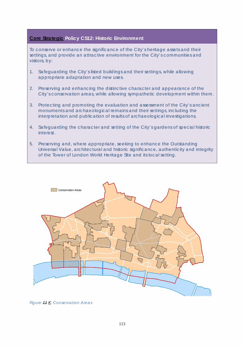
113
Core Strategic Policy CS12: Historic Environment To conserve or enhance the significance of the City’s heritage assets and their settings, and provide an attractive environment for the City’s communities and visitors, by: 1. Safeguarding the City’s listed buildings and their settings, while allowing
appropriate adaptation and new uses. 2. Preserving and enhancing the distinctive character and appearance of the
City’s conservation areas, while allowing sympathetic development within them. 3. Protecting and promoting the evaluation and assessment of the City’s ancient
monuments and archaeological remains and their settings, including the interpretation and publication of results of archaeological investigations.
4. Safeguarding the character and setting of the City’s gardens of special historic
interest. 5. Preserving and, where appropriate, seeking to enhance the Outstanding
Universal Value, architectural and historic significance, authenticity and integrity of the Tower of London World Heritage Site and its local setting.
Figure 11 K: Conservation Areas

114
DEVELOPMENT MANAGEMENT POLICIES Policy DM 12.1 Managing change affecting all heritage assets and spaces 1) To sustain and enhance heritage assets, their settings and significance. 2) Development proposals, including proposals for telecommunications
infrastructure, that have an effect upon heritage assets, including their settings, should be accompanied by supporting information to assess and evaluate the significance of heritage assets and the degree of impact caused by the development.
3) The loss of routes and spaces that contribute to the character and historic
interest of the City will be resisted. 4) Development will be required to respect the significance, character, scale and
amenities of surrounding heritage assets and spaces and their settings. 5) Proposals for sustainable development, including the incorporation of climate
change adaptation measures, must be sensitive to heritage assets. 3.12.5 Development proposals will be required to include supporting information describing the significance of any heritage assets whose fabric or setting would be affected and the contribution made by their setting to their significance. 3.12.6 The pattern of streets, lanes, alleyways and other open spaces such as squares and courts is a distinctive element of the City’s townscape and is of historic significance. The City Corporation will seek to maintain the widths and alignments of streets, lanes, and other spaces where these have historic value or underpin the character of a location or their surroundings. 3.12.7 Developers should provide supporting information on: • how existing trees will be affected by a proposed development; • how gardens, surface treatment and landscaping will be affected by a
proposed development; • relevant landscaping, surface and street materials that relate positively to the
City’s urban environment and the character of a heritage asset and its setting; • consideration of tranquillity and positive soundscapes; • the types and suitability of historic materials in the public realm to complement
the built fabric. The information provided should be proportionate to the level of change or impact a proposal will have on the heritage asset or assets. 3.12.8 Developers should take account of the Mayor’s Supplementary Planning Guidance “World Heritage Sites – Guidance on Settings”, the City Corporation’s Conservation Area Character Summary & Management Strategy SPDs, Barbican and Golden Lane Listed Building Management Guidelines SPDs, Tree Strategy SPD and other design guidance, where relevant.

115
Policy DM 12.2 Development in conservation areas 1) Development in conservation areas will only be permitted if it preserves and
enhances the character or appearance of the conservation area. 2) The loss of heritage assets that make a positive contribution to the character or
appearance of a conservation area will be resisted. 3) Where permission is granted for the demolition of a building in a conservation
area, conditions will be imposed preventing demolition commencing prior to the approval of detailed plans of any replacement building, and ensuring that the developer has secured the implementation of the construction of the replacement building.
3.12.9 The designation of a conservation area carries with it the statutory duty to consider how an area or areas can be preserved and enhanced. The City Corporation will take the opportunity presented by development proposals within a conservation area to strengthen the special character of that conservation area and its setting. 3.12.10 In the design of new buildings or alteration of existing buildings, developers should have regard to the size and shape of historic building plots, existing street patterns and the alignment and the width of frontages, materials, vertical and horizontal emphasis, layout and detailed design, bulk and scale, including the effects of site amalgamation on scale, hard and soft landscaping, all of which are often critical to the character of conservation areas and their settings. Regard should be paid to the richness, variety and complexity of the architectural form and detailing of buildings within conservation areas and to the broader character of area. The City Corporation is preparing character summaries and management strategies as SPDs for each of the 26 conservation areas which give further guidance on the appropriate form of development. 3.12.11 Planning permission is required to demolish unlisted buildings in a conservation area. A significant number of buildings in conservation areas, whilst not being listed, contribute positively to the character of these areas. Any application to demolish a building in a conservation area will be considered in terms of the contribution the building makes to the character or appearance of the area concerned. 3.12.12 The boundaries of the City Corporation’s conservation areas will be kept under review.

116
Policy DM 12.3 Listed buildings 1) To resist the demolition of listed buildings. 2) To grant consent for the alteration or change of use of a listed building only
where this would not detract from its special architectural or historic interest, character and significance or its setting.
3.12.13 Particular care and attention are required in planning works to listed buildings; even quite minor changes can have a significant effect on their overall character, appearance and group value, where this contributes to the significance of the heritage asset. The list description is unlikely to refer to all features of significance, and the interiors and plan forms of listed buildings are of importance. An inspection will therefore be necessary to identify the special interest and significance of the building and its curtilage. 3.12.14 Where extensions are proposed, in order to be acceptable, they should be located where they minimise the effect on the listed building concerned, such as the rear of the building or light-wells, and should always be appropriate in scale and character. The bulk, height, location and materials of roof extensions will be particularly critical and should be appropriate to the period and style of the building and its setting. 3.12.15 Where listed buildings are no longer used for their original or previous function, it is important to find alternative uses that safeguard their future. Alternative uses must be compatible with the character of the building and should not entail alterations or the introduction of servicing arrangements which are detrimental to the building’s special interest. Where a building has been neglected or is on the ‘Heritage at Risk Register’ appropriate repair and re-use would be sought. 3.12.16 Where alterations are acceptable, the City Corporation may require a standing building record to be made of internal or external structures and features that may be affected or revealed during the course of work. These circumstances would include occasions where a building is likely to be changed as a consequence of major repairs, alteration or extension. 3.12.17 In the Barbican and Golden Lane estates, developers should take account of the Listed Building Management Guidelines SPDs.
117
Policy DM 12.4 Ancient monuments and archaeology 1) To require planning applications which involve excavation or ground works on
sites of archaeological potential to be accompanied by an archaeological assessment and evaluation of the site, including the impact of the proposed development.
2) To preserve, protect, safeguard and enhance archaeological monuments,
remains and their settings in development, and to seek a public display and interpretation, where appropriate.
3) To require proper investigation and recording of archaeological remains as an
integral part of a development programme, and publication and archiving of results to advance understanding.
3.12.18 All of the City is considered to have archaeological potential, except where there is evidence that archaeological remains have been lost due to deep basement construction or other groundworks. The City Corporation will indicate the potential of a site, its relative importance and the likely impact on archaeology at an early stage so that the appropriate assessment and design development can be undertaken. 3.12.19 Planning applications that involve excavation or ground works must be accompanied by an archaeological assessment and evaluation of the site, including the impact of the proposed development. An evaluation should include trial work in agreed specific areas of the site to provide more information and inform consideration of the development proposals by the City Corporation. 3.12.20 In some cases, a development may reveal a monument or archaeological remains which will be displayed on the site, or reburied. On sites where important monuments or archaeological remains exist, development must be designed to enhance physical preservation and avoid disturbance or loss. This can be done by the sympathetic design of basements, raising ground levels, site coverage, and the location of foundations to avoid or minimise archaeological loss and securing their preservation for the future, accepting that they will remain inaccessible for the time being. 3.12.21 The interpretation and presentation to the public of a visible or buried monument and enhancement of its setting should form part of the development proposals. Agreement will be sought, where appropriate, to achieve reasonable public access. The City Corporation will refuse schemes which do not provide an adequate assessment of a site, make any provision for the incorporation, safeguarding or preservation in situ of nationally or locally important monuments or remains, or which would adversely affect those monuments or remains. 3.12.22 A programme of archaeological work for investigation, excavation and recording and publication of the results to a predetermined research framework and by an approved organisation, should be submitted to and approved by the
118
City Corporation, prior to development. This will be controlled through the use of conditions and will ensure the preservation of those remains by record. Policy DM 12.5 Historic parks and gardens 1) To resist development which would adversely affect gardens of special historic
interest included on the English Heritage register. 2) To protect gardens and open spaces which make a positive contribution to the
historic character of the City. 3.12.23 The City contains numerous open spaces, gardens and churchyards which are of historic importance. Four parks and gardens are included on English Heritage’s Register of Parks and Gardens of special interest: Barbican; Finsbury Circus; Inner Temple; Middle Temple. 3.12.24 Development proposals that may affect the City’s historic parks and gardens will be assessed to ensure that overshadowing does not occur, that their historic character is maintained, and that the setting, enjoyment, and views into and from these gardens are respected. Developments should not detract from the layout, design, character, appearance or setting of the park or garden or prejudice its future restoration. 3.12.25 Schemes that include gardens of special historic interest within the development site should include proposals for their interpretation and presentation. They should also take account of the sensitivity of the gardens to climate change.
119
Who will deliver How we will make it happen Who When City heritage Preparing conservation area character summaries and management strategies to guide the management of the historic environment. Preparing an Archaeology SPD. Partnership working with relevant amenity societies, including heritage bodies and the City of London Conservation Area Advisory Committee. The Diocesan Advisory Committee will be consulted in relation to City churches. Managing change affecting historic buildings, spaces and public highways through Local Development Documents and other guidance. This will include support for heritage-led regeneration, promoting greater understanding of the significance of the historic environment, sensitive adaptation and re-use of the existing fabric, and its contribution to delivering sustainable development. Further guidance will be set out in the Development Management DPD.
City Corporation City Corporation City Corporation- English Heritage- Design Council Historic Royal Palaces- Amenity societies- Diocesan Advisory Committee- Mayor of London- Neighbouring boroughs City Corporation
Ongoing By 2013 Ongoing Barbican Listed Building Management SPG adopted 2012; Golden Lane Listed Building Management Guidelines SPD due to be adopted 2014 Golden Lane Listed Building Management Guidelines SPD and Barbican Listed Building Management SPG reviewed periodically

120
World Heritage Site Collaborative working to ensure the local setting of the Tower is preserved and enhanced, through high quality, innovative and sensitive design.
Tower WHS Consultative Committee
Consult- ative Commit- tee meets every 6 months with Planning Sub- Groups between
Implementation of Tower of London World Heritage Site Management Plan (2007). Considering the recommendations of the World Heritage Committee for the management of the Tower of London World Heritage Site. Applying the recommendations of the DCMS “State of Conservation Reports” to the UNESCO World Heritage Committee.
Historic Royal Palaces- Tower WHS Consultative Committee- City Corporation- Mayor of London- Neighbouring boroughs UNESCO- DCMS
WHS Manage- ment Plan reviewed every 5 years. First review commenced 2012 UNESCO World Heritage Committee meets annually
SUPPORTING EVIDENCE • Planning Advice Note 3: Archaeology in the City of London City of London 1998 • City of London Conservation Area Character Summaries City of London • City of London Conservation Area Management Strategies City of London • Tower of London World Heritage Site Management Plan Historic Royal Palaces 2007 • Tower of London Local Setting Study Land Use Consultants for Historic Royal Palaces 2010 • Seeing the History in the View Land Use Consultants for English Heritage 2011 • Golden Lane Listed Building Management Guidelines Supplementary Planning Document City of London with English Heritage 2007 • Barbican Listed Building Management Guidelines Supplementary Planning Guidance City of London with English Heritage 2005 • City of London Street Scene Manual City of London 2005 • Conservation Areas in the City of London: A General Introduction to their Character City of London 1994 • Draft Statement of Outstanding Universal Value DCMS February 2011 3.12.5 The Sustainability Appraisal of this policy notes that it is expected to result in positive social, economic and environmental impacts, locally and regionally.

121
RISK MANAGEMENT 3.12.6 3.12.26 Increased pressure for development in the City has a potential impact on the historic environment when not properly and carefully considered. Implementation of this policy these policies will seek to manage this risk, ensuring that new development and the historic environment can complement each other to benefit the City’s image. 3.12.7 3.12.27 The UNESCO World Heritage Committee has considered placing the Tower of London on the Endangered List of World Heritage Sites, regarding the balance between conservation and development and the impact on views of the Tower from given locations. This is addressed through the Tower of London World Heritage Site Management Plan and is also acknowledged in the English Heritage document “Seeing the History in the View” and the GLA’s Supplementary Planning Guidance “World Heritage Sites – Guidance on Settings” which seeks to strengthen the Tower’s dynamic visual position visibility of the Tower in its context. 3.12.8 3.12.28 Future implementation of the Tower of London World Heritage Site Management Plan will have a significant impact on some major development proposals, particularly within the setting of the Tower of London. However the Management Plan also includes the requirement to provide a tool to help deliver an assessment of the local setting of the Tower and guidelines for managing the public realm which will inform future development proposals. This is addressed through the Tower of London Local Setting Study (2010). 3.12.9 3.12.29 Circular 07/2009 “Protection of World Heritage Sites”, has implications with regard to the call-in procedure and the designation of “buffer zones” or “immediate settings” of protected buildings. This will again impact on future development proposals. MONITORING 3.12.10 Key monitoring indicators are: City heritage • English Heritage: At Risk Register • Composite heritage assets indicator including conservation areas and historic assets at risk • Heritage assets protected from inappropriate development activity • Number of mature trees / Tree Preservation Orders World Heritage Site • Heritage assets (including World Heritage Sites) • Enhancement by / quality of developments in the local setting of the Tower of London

122
3.13 PROTECTED VIEWS
3.13.1 The City and its surrounding area contain many famous landmarks that are visible from viewpoints across London. Views of the City’s skyline from the River Thames are especially notable and certain local views of St. Paul’s Cathedral have been protected successfully by the City Corporation’s ‘St. Paul’s Heights’ code since the 1930s. Landmarks such as St. Paul’s Cathedral, the Monument and the Tower of London are internationally renowned and add to the City’s "world class" status. These views are protected by an integrated range of national, regional and local policies.
3.13.2 The London Plan sets out the overall view protection requirements which apply to Strategically Important Landmarks. The Mayor of London’s View Management Framework (LVMF) SPG (20102012) provides more detail, including detailed management plans for each protected view of landmarks such as St. Paul’s Cathedral and the Tower of London. The LVMF defines a Protected Vista for the Tower of London. Any development in the Wider Setting Consultation Area in the background of this Protected Vista should preserve or enhance the viewer’s ability to recognise the landmark and appreciate its Outstanding Universal Value. City sites have the potential to be intrusive in the view because of their relative proximity to the Tower. It is likely that proposed new development in the City which exceeds the threshold plane will not be acceptable as it will not preserve the view.
3.13.3 The Tower of London has additional view protection, implemented through the Tower of London World Heritage Site Management Plan (2007). This defines and protects a range of “settings” of the Tower World Heritage Site, which includes its relationship to historic features that are visible in the urban landscape. All new buildings in the setting of the Tower should contribute to the quality of views both of and from the Tower.
3.13.4 The Design Council/CABE and English Heritage Guidance on Tall Buildings provides advice to local authorities and developers on the process of assessing development proposals that have protected views implications.
Core Strategic Policy CS13: Protected Views
To protect and enhance significant City and London views of important buildings, townscape and skylines, making a substantial contribution to protecting the overall heritage of the City’s landmarks, by:
1. Implementing the Mayor’s London View Management Framework SPG to manage designated views of strategically important landmarks (St. Paul’s Cathedral and the Tower of London), river prospects, townscape views and linear views.
2. Protecting and enhancing: local views of St. Paul’s Cathedral, through the City’s “St. Paul’s Heights” code; the setting and backdrop to the Cathedral; significant local views of and from the Monument; and views of historic City landmarks and skyline features.
3. Securing an appropriate setting of and backdrop to the Tower of London World Heritage Site, which adjoins the City, so ensuring its Outstanding Universal Value, taking account of the Tower of London World Heritage Site Management Plan (2007).
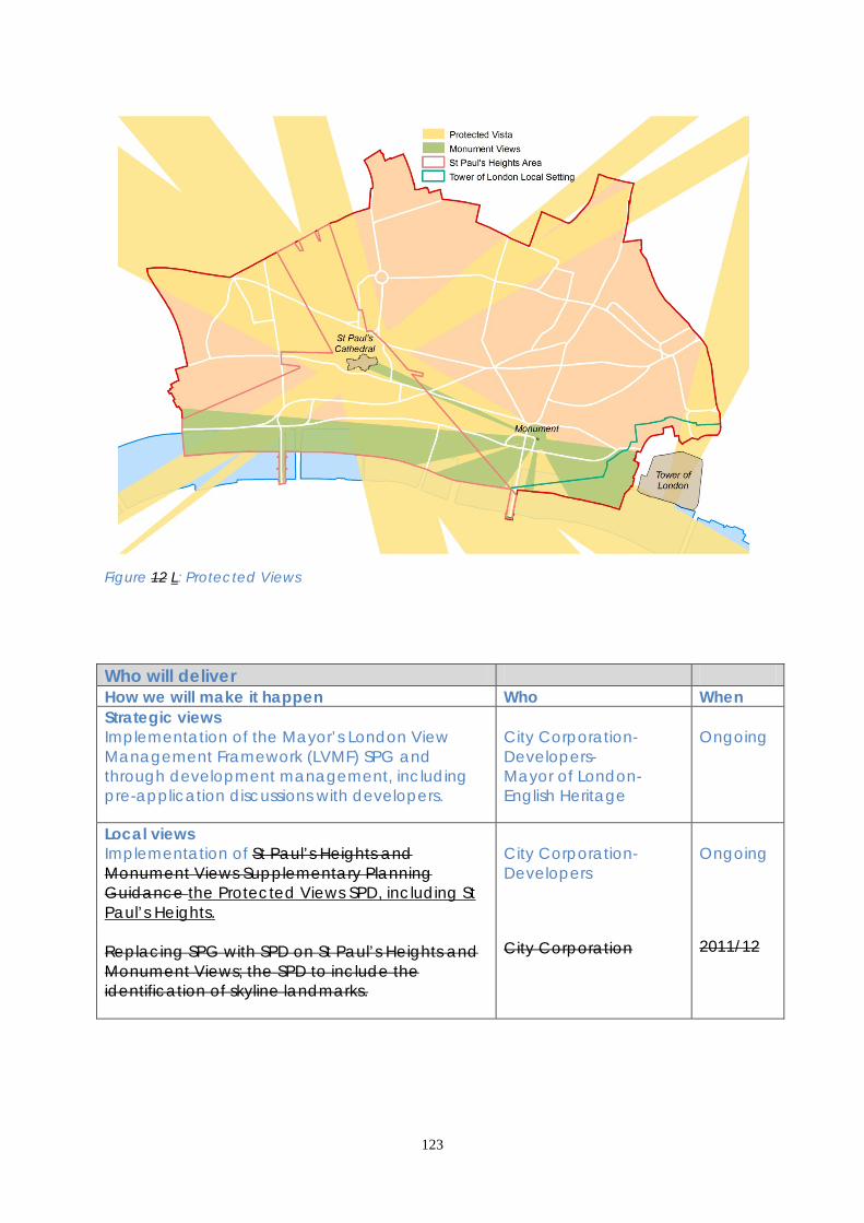
123
Figure 12 L: Protected Views Who will deliver How we will make it happen Who When Strategic views Implementation of the Mayor’s London View Management Framework (LVMF) SPG and through development management, including pre-application discussions with developers.
City Corporation- Developers- Mayor of London- English Heritage
Ongoing
Local views Implementation of St Paul’s Heights and Monument Views Supplementary Planning Guidance the Protected Views SPD, including St Paul’s Heights. Replacing SPG with SPD on St Paul’s Heights and Monument Views; the SPD to include the identification of skyline landmarks.
City Corporation- Developers City Corporation
Ongoing 2011/12

124
World Heritage Site Implementation of the Tower of London World Heritage Site Management Plan (2007), and the Local Setting Study (2010), the London View Management Framework, and the State of Conservation Reports submitted by DCMS to the UNESCO World Heritage Committee.
City Corporation- Historic Royal Palaces- Tower of London World Heritage Site Consultative Committee- English Heritage- Developers
Manage-ment Plan reviewed every 5 years
SUPPORTING EVIDENCE • London View Management Framework Supplementary Planning Guidance Mayor of London 2010 • St. Paul’s and Monument Views Supplementary Planning Guidance City of London 2002 • Tower of London World Heritage Site Management Plan Historic Royal Palaces 2007 3.13.5 The Sustainability Appraisal notes that this policy is expected to result in positive social and environmental impacts, locally and regionally. Economic impacts are uncertain as there could be a restricted supply of floorspace in tall buildings. This impact will be mitigated by Policy CS14. RISK MANAGEMENT 3.13.6 3.13.5 While Tthe protection of views is dependent on policy and associated guidance, and the enhancement of views is dependent on development proposals in relevant areas coming forward. MONITORING 3.13.7 Key monitoring indicators are: Strategically important views • Number of developments that improve or are contrary to the London View Management Framework protected vistas Local views • Number of developments that improve or infringe the ‘St Paul’s Heights’ views
125
3.14 TALL BUILDINGS 3.14.1 The City contains many tall buildings (defined as those which significantly exceed the height of their general surroundings), particularly in a cluster of the tallest buildings in the east (see Policy CS7). Tall buildings that achieve a world class standard of architectural quality and whose context and layout are carefully considered can help to enhance the City’s environment and economy, and contribute to London’s world city role.
3.14.2 Guidance issued by Design Council/CABE and English Heritage encourages local planning authorities to consider the scope for tall buildings as part of strategic planning and to identify locations where tall buildings are, and are not, appropriate. The London Plan requires Local Development Frameworks Plans to identify areas that are appropriate, sensitive or inappropriate to tall buildings and sets out criteria for assessing the suitability of proposals against which planning applications in the City will be considered. The City Corporation is required to refer applications for buildings over 150 metres in height (25 metres in the Thames Policy Area) to the Mayor of London. The Mayor’s London View Management Framework Supplementary Planning Guidance (see Policy CS13) explains the London Plan’s policies in more detail.
3.14.3 While tall buildings are a characteristic element of the skyline, the City’s unique environment and built heritage means that particular consideration should be given to their impacts throughout the City and beyond. Areas outside of the City may also be sensitive to the development of tall buildings within the City. The location and impact of future tall buildings therefore needs to be carefully considered. 3.14.4 Proposals for new tall buildings should take account of the cumulative impact of the proposed development, in relation to other existing and proposed tall buildings. The City Corporation will require proposals to maintain and enhance the provision of public open space around the building, avoid the creation of building canyons, which have a detrimental impact on amenity, and maintain pedestrian permeability.

126
Figure 13 M: Tall buildings Core Strategic Policy CS14: Tall Buildings To allow tall buildings of world class architecture and sustainable and accessible design in suitable locations and to ensure that they take full account of the character of their surroundings, enhance the skyline and provide a high quality public realm at ground level, by: 1. Permitting tall buildings on suitable sites within the City’s Eastern Cluster. 2. Refusing planning permission for tall buildings within inappropriate areas,
comprising: conservation areas; the St. Paul’s Heights area; St. Paul’s protected vista viewing corridors; and Monument views and setting, as defined on the Proposals Policies Map.
3. Elsewhere in the City, permitting proposals for tall buildings only on those sites
which are considered suitable having regard to: the potential effect on the City skyline; the character and amenity of their surroundings, including the relationship with existing tall buildings; the significance of heritage assets and their settings; and the effect on historic skyline features.
4. Ensuring that tall building proposals do not adversely affect the operation of
London’s airports.
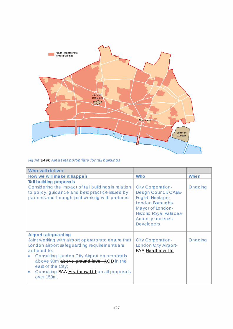
127
Figure 14 N: Areas inappropriate for tall buildings Who will deliver How we will make it happen Who When Tall building proposals Considering the impact of tall buildings in relation to policy, guidance and best practice issued by partners and through joint working with partners.
City Corporation- Design Council/CABE- English Heritage- London Boroughs- Mayor of London- Historic Royal Palaces- Amenity societies- Developers.
Ongoing
Airport safeguarding Joint working with airport operators to ensure that London airport safeguarding requirements are adhered to: • Consulting London City Airport on proposals
above 90m above ground level AOD in the east of the City;
• Consulting BAA Heathrow Ltd on all proposals over 150m.
City Corporation- London City Airport- BAA Heathrow Ltd
Ongoing
128
SUPPORTING EVIDENCE • London View Management Framework Supplementary Planning Guidance Mayor of London 2010 • St. Paul’s and Monument Views Supplementary Planning Guidance City of London 2002 • Guidance on Tall Buildings CABE / English Heritage 2007 • City of London Tall Buildings Evidence Paper City of London 2010 3.14.4 The Sustainability Appraisal notes that this policy is expected to result in positive social, economic and environmental impacts, locally. RISK MANAGEMENT 3.14.5 3.14.4 3.14.5 The recession of 2008-2009 has Economic conditions since 2008 have impacted had an impact on development, slowing down or delaying tall building proposals across the City. The City Corporation will monitor take up of planning applications and completions for tall buildings and, if a long term reduction in such development is evident, will consider whether a change to the Core Strategy Local Plan is required. MONITORING 3.14.6 Key monitoring indicators are: • Number and location of tall buildings permitted, under construction and completed

129
3.15 SUSTAINABLE DEVELOPMENT AND CLIMATE CHANGE 3.15.1 The City of London is a sustainable location, with good public transport, a high density of development and many small open spaces, making best use of the available land. All development takes place on previously developed land. Future development must contribute to improving this approach. 3.15.2 The drivers for sustainable development are increasing, affecting global and local businesses, workers, residents and visitors. The pace and prestige nature of development in the City presents opportunities to incorporate innovative eco-design in both new and existing buildings including the numerous historic buildings in the City. Particular issues for the City include: • Energy consumption: Electricity consumption in the City is high and rising to
service IT needs and associated cooling in the City’s expanding office stock; • Air quality: Nitrogen dioxide and particulate (PM10) levels in the City are high.
Areas of greater vulnerability to poor air quality include residential areas, the City’s schools and St Bartholomew’s Hospital;
• Urban heat island and climate change: The City can experience temperatures up to 10oC higher than the countryside around London. This will get worse with climate change and adaptation is imperative if the City is to remain a comfortable place to live, work and visit.
3.15.3 The London Plan contains comprehensive policies on sustainable design and climate change, setting targets for substantial carbon emission reduction. The London Plan seeks a 60% reduction in emissions by 2025. The London Plan is complemented locally by the City of London’s Energy, Noise, Air Quality and Climate Change Mitigation and Adaptation Strategies and Codes of Practice.
Figure 15 O: Area served by the CCHP network

130
Core Strategic Policy CS15: Sustainable Development and Climate Change To enable City businesses and residents to make sustainable choices in their daily activities creating a more sustainable City, adapted to the changing climate, by: 1. Requiring all redevelopment proposals to demonstrate the highest feasible and
viable sustainability standards in the design, construction, operation and “end of life” phases of development. Proposals for major development should aim to achieve a BREEAM rating of “excellent” or “outstanding”. Residential development should aim to achieve a minimum standard of Code for Sustainable Homes level 4, rising to level 6 by 2016 or in line with government targets.
2. Requiring development to minimise carbon emissions and contribute to a City
wide reduction in emissions: (i) adopting energy-efficiency measures; (ii) enabling the use of decentralised energy, including the safeguarded Citigen
CCHP network, CCHP-ready designs in areas where CCHP networks are not yet available, and localised renewable energy technologies;
(iii) adopting offsetting measures to achieve the Government’s zero carbon targets for buildings.
3. Avoiding demolition through the reuse of existing buildings or their main
structures, and minimising the disruption to businesses and residents, using sustainably sourced materials and conserving water resources.
4. Requiring development to positively address: (i) local air quality, particularly nitrogen dioxide and particulates PM10 (the City’s
Air Quality Management Area pollutants); (ii) protection of the City’s quiet areas and quiet times of day for businesses
(daytime) and residents (night time); (iii) the need to limit the City’s contribution to light spillage and ‘sky glow’; (iv) water quality and flood risk particularly in areas at risk of sewer flooding; (v) land contamination, ensuring development does not result in contaminated
land; (vi) the need to enhance biodiversity and provide for its conservation and
enhancement, particularly for the City’s flagship species and the City’s priority habitats (urban green spaces, churchyards and cemeteries, built structures and the tidal Thames).
5. Incorporating climate change adaptation measures into development and the
City’s infrastructure, including street scene, transport and utility infrastructure, social and emergency infrastructure, and heritage assets, having regard to the need to protect their historic significance.

131
DEVELOPMENT MANAGEMENT POLICIES Policy DM 15.1 Sustainability requirements 1) Sustainability Statements must be submitted with all planning applications in
order to ensure that sustainability is integrated into designs for all development. 2) For major development (including new development and refurbishment) the
Sustainability Statement should include as a minimum: • BREEAM or Code for Sustainable Homes pre-assessment; • an energy statement in line with London Plan requirements; • demonstration of climate change resilience measures. 3) BREEAM or Code for Sustainable Homes assessments should demonstrate
sustainability in aspects which are of particular significance in the City’s high density urban environment. Developers should aim to achieve the maximum possible credits to address the City’s priorities.
4) Innovative sustainability solutions will be encouraged to ensure that the City's
buildings remain at the forefront of sustainable building design. Details should be included in the Sustainability Statement.
5) Planning conditions will be used to ensure that Local Plan assessment targets are
met. 3.15.4 Sustainability Statements should be used to provide comprehensive evidence of the sustainability of each development, demonstrating that the design meets the highest feasible and viable standards. For major development, standard methods of assessment, such as the Building Research Establishment Environmental Assessment Method (BREEAM) and Code for Sustainable Homes (CfSH) should be used wherever possible. The City Corporation will identify priority credits, through a supplementary planning document which developers should aim to achieve. A summary sheet showing the achievement of BREEAM or Code for Sustainable Homes credits should be included in the Sustainability Statement. 3.15.5 Although minor development may only provide limited opportunities for the incorporation of sustainability features it is important that sustainability is considered at the design stage for all projects. For most minor development inclusion of information in the Design and Access Statement will suffice. 3.15.6 Planning conditions will be used to ensure that Local Plan design stage assessment targets are met. Post construction assessments will be used to evaluate any performance gaps between the design and the in-use performance of buildings. Developers should provide evidence of the reasons for any identified performance gaps between design and in-use building performance.
132
Policy DM 15.2 Energy and CO2 emissions assessments 1) Development design must take account of location, building orientation,
internal layouts and landscaping to reduce likely energy consumption. 2) For all major development energy assessments must be submitted with the
application demonstrating: • energy efficiency – showing the maximum improvement over current Building
Regulations to achieve the required Fabric Energy Efficiency Standards; • carbon compliance levels required to meet national targets for zero carbon
development using low and zero-carbon technologies, where feasible; • where on-site carbon emission reduction is unviable, offsetting of residual CO2
emissions through “allowable solutions” for the lifetime of the building to achieve national targets for zero-carbon homes and non-domestic buildings. Achievement of zero carbon buildings in advance of national target dates will be encouraged;
• anticipated residual power loads and routes for supply. 3.15.7 Emissions of carbon dioxide and other greenhouse gases must be minimised in order to reduce the contribution that the City’s buildings make to climate change. National targets require all new homes built from 2016 and all new non domestic buildings from 2019 to be Zero Carbon. The definition of Zero Carbon consists of three elements: • energy efficiency; • carbon compliance; • “allowable solutions” or carbon offsetting. 3.15.8 In developing energy strategies to achieve carbon compliance developers must take account of the particular opportunities and constraints that exist in the City. Building design, orientation and layouts can assist in minimising energy requirements through the positioning of rooms that require heating where they will benefit from passive solar gain, and by locating temperature-sensitive rooms, such as server rooms, where they will avoid overheating. Decentralised energy networks represent the most effective option for limiting carbon emissions in high density urban environments such as the City. 3.15.9 The City is an air quality management area for NOx and fine particulates and it is important that renewable energy technologies such as biomass and biofuel use do not exacerbate this problem. Where combustion-based renewable technologies are proposed developers will need to provide evidence that their use will not result in the deterioration of air quality. 3.15.10 Ground Source Heat Pumps (GSHP) may provide a suitable source of low carbon heat and cooling in some parts of the City. Developers must liaise with the Environment Agency to ascertain the suitability of this option for their site and obtain the necessary licences ensuring long term protection of underground resources.
133
3.15.11 Other low and zero carbon technologies should be considered. The technologies most likely to be suitable in the City include photovoltaic and solar thermal and air source heat pumps. However, in this fast-evolving field the use of innovative new technologies should be investigated. 3.15.12 In preparing energy statements developers should make use of guidance provided by the GLA. Energy statements should identify the anticipated power loads that the building is being designed to provide for, and anticipated routes for supply.
Policy DM 15.3 Low and zero carbon technologies 1) For development with a peak heat demand of 100 kilowatts or more developers
should investigate the feasibility and viability of connecting to existing decentralised energy networks. This should include investigation of the potential for extensions of existing heating and cooling networks to serve the development and development of new networks where existing networks are not available. Connection routes should be designed into the development where feasible and connection infrastructure should be incorporated wherever it is viable.
2) Where connection to offsite decentralised energy networks is not feasible,
installation of on-site CCHP and the potential to create new localised decentralised energy infrastructure through the export of excess heat must be considered.
3) Where connection is not feasible or viable, all development with a peak heat
demand of 100 kilowatts or more should be designed to enable connection to potential future decentralised energy networks.
4) Other low and zero carbon technologies must be evaluated. Non combustion-
based technologies should be prioritised in order to avoid adverse impacts on air quality.
3.15.13 The most effective means of reducing carbon emissions for high density urban environments such as the City is through combined heat and power networks, where excess heat from power generation is used to provide heat (and cooling, through tri generation). The City of London heat mapping study shows that there is sufficient heat and cooling load to support a comprehensive decentralised energy network throughout the City. 3.15.14 The existing Citigen CCHP network in the north of the City could be expanded to cover a wider area, but there is also a strong case for the development of additional CCHP networks in other parts of the City. This can be achieved through the installation of localised CCHP infrastructure serving groups of buildings with complementary heat demands; for example, office development which requires daytime heat can be paired with hotels and residential premises which require more heat at night. Developers should use the London Heat Map to investigate possible opportunities for connection to existing networks or for the development of new networks in the vicinity of their development sites. The
134
installation of decentralised energy network infrastructure at building development stage will enable cost and carbon savings and contribute to security of supply for the lifetime of the building. As more developments connect, the viability of the City’s CCHP networks will improve leading to greater incentives for existing properties to connect. 3.15.15 The London Plan requires developers to prepare an energy assessment. This should provide details of the feasibility and viability of connection to existing heating and cooling networks as required by both the London Plan and the Local Plan. Further details are contained in the Mayor’s Supplementary Planning Guidance "Sustainable Design and Construction" and detailed guidance on technical requirements is available through the Mayor's District Heating Manual for London Policy DM15.4 Offsetting of carbon emissions 1) All feasible and viable on-site or near-site options for carbon emission reduction
must be applied before consideration of offsetting. Any remaining carbon emissions calculated for the lifetime of the building that cannot be mitigated on-site will need to be offset using “allowable solutions”.
2) Where carbon targets cannot be met on site the City Corporation will require
carbon abatement elsewhere or a financial contribution, negotiated through a S106 planning obligation to be made to an approved carbon offsetting scheme.
3) Offsetting may also be applied to other resources including water resources and
rainwater run-off to meet sustainability targets off-site where on-site compliance is not feasible.
3.15.16 There are many factors which influence the level of carbon emissions from commercial and residential buildings, including heating, cooling and ventilation, use of information technology, lighting and catering. However, building design is a major contributing factor in creating environments where carbon emissions can be minimised through energy efficiency, low and zero carbon energy supply and demand management. 3.15.17 The City of London has been at the forefront of building design which enables occupants to reduce their carbon emissions. However, the City’s high density environment means that it is challenging to meet zero-carbon standards on-site. In such cases, offsetting provides a mechanism to achieve zero net emissions from the building over its lifetime through investment in carbon reduction elsewhere. It is the Government’s intention that zero carbon standards should be administered through Building Control1, starting with zero carbon homes from 2016. Until the Government’s regulatory mechanism comes into effect, any carbon offsetting required to meet London Plan or Government targets will be negotiated through S106 planning obligations.

135
Policy DM 15.5 Climate change resilience and adaptation 1) Developers will be required to demonstrate through Sustainability Statements
that all major developments are resilient to the predicted climate conditions during the building’s lifetime.
2) Building designs should minimise any contribution to the urban heat island effect
caused by heat retention and waste heat expulsion in the built environment. 3.15.18 The City of London Climate Change Adaptation Strategy concludes that the City is likely to experience effects including hotter, drier summers, milder, wetter winters and more frequent extreme high temperatures and heavy downpours of rain. 3.15.19 Buildings that are being planned now will experience these changed climate conditions during their lifetime and must be designed to be resilient to a wider range of weather conditions than existing buildings. BREEAM and Code for Sustainable Homes assessments do not currently include climate change adaptation and resilience; therefore, the City Corporation will expect this aspect to be addressed through the Sustainability Statement. As a minimum, developers will be expected to consider the potential for: • solar shading to prevent solar gain through glazing; • High thermal mass of the building fabric to moderate temperature fluctuations; • design of “cool roofs”, installation of green roofs and green walls to prevent
overheating; • urban greening to improve the micro climate and benefit biodiversity; • rainwater attenuation / SuDS to prevent surface water flooding; • flood risk assessment and mitigation to prevent flooding from other sources; • biodiversity protection and enhancement to enable wildlife to survive changed
climate conditions; • air quality impact assessment to ensure that buildings and services will not
contribute to worsening vulnerability to photochemical smog; • passive ventilation and heat recovery. Policy DM 15.6 Air quality 1) Developers will be required to consider the impact of their proposals on air
quality and, where appropriate, provide an Air Quality Impact Assessment. 2) Development that would result in deterioration of the City’s nitrogen dioxide or
PM10 pollution levels will be resisted. 3) Major developments will be required to maximise credits for the pollution section
of the BREEAM or Code for Sustainable Homes assessment relating to on-site NOx emissions.
4) Developers will be encouraged to install non-combustion low- and zero-carbon
energy technology. A detailed air quality impact assessment will be required for

136
combustion-based low- and zero-carbon technologies, such as CHP plant and biomass or biofuel boilers, and necessary mitigation must be approved by the City Corporation.
5) Construction and deconstruction and the transport of construction materials
and waste must be carried out in such a way as to minimise air quality impacts. 6) Air intake points should be located away from existing and potential pollution
sources (e.g. busy roads and combustion flues). All combustion flues should terminate above the roof height of the tallest building in the development in order to ensure maximum dispersion of pollutants.
3.15.20 Air quality can be affected by a range of factors including smoke, fumes, gases, dust, steam and odours. The City Corporation will consider the individual and cumulative impact of development on local air quality and the wider impacts, particularly of transport-related emissions, on regional air quality. Buildings are responsible for 31% of total NOx emissions and 14% of PM10 emissions in the City. The development process provides an opportunity to reduce this level of emissions by reducing direct emissions from buildings and by reducing the emissions associated with traffic which serves the building. The Environmental Impact Assessment or Sustainability Statement should be used to provide evidence of the air quality impact of development. The City of London Air Quality Strategy provides detailed information on the air quality issues facing the City of London and is a useful reference document when preparing air quality evidence to accompany planning proposals. The City of London Code of Practice for Deconstruction and Construction Sites provides guidance on procedure to be adopted to minimise air quality impacts of these activities. Policy DM 15.7 Noise and light pollution 1) Developers will be required to consider the impact of their developments on the
noise environment and where appropriate provide a noise assessment. The layout, orientation, design and use of buildings should ensure that operational noise does not adversely affect neighbours, particularly noise-sensitive land uses such as housing, hospitals, schools and quiet open spaces.
2) Any potential noise conflict between existing activities and new development
should be minimised. Where the avoidance of noise conflicts is impractical, mitigation measures such as noise attenuation and restrictions on operating hours will be implemented through appropriate planning conditions.
3) Noise and vibration from deconstruction and construction activities must be
minimised and mitigation measures put in place to limit noise disturbance in the vicinity of the development.
4) Developers will be required to demonstrate that there will be no increase in
background noise levels associated with new plant and equipment.

137
5) Internal and external lighting should be designed to reduce energy consumption, avoid spillage of light beyond where it is needed and protect the amenity of light-sensitive uses such as housing, hospitals and areas of importance for nature conservation.
3.15.21 Although the City is busy and densely built up, there nevertheless needs to be protection from excessive noise for the general business environment, quiet areas, such as open spaces, and noise-sensitive uses, such as hospitals and housing, and the City’s ambient noise levels should not increase. For example, heating and ventilation plant should be designed so that it does not adversely affect nearby open spaces which are valued for their quiet environment. The level of noise emitted from any new plant should be below the background level by at least 10dBA. 3.15.22 Policy DM 3.5 provides guidance on the location and control of night-time entertainment and related uses. 3.15.23 The City of London Noise Strategy identifies the strategic approach to noise in the City in line with the National Noise Policy Statement and the City’s Code of Practice for Deconstruction and Construction Sites provides guidance on procedures to be adopted to minimise the noise impacts of development. The use of planning conditions or obligations will be considered where this could successfully moderate adverse effects, for example, by limiting hours of operation. Policy DM 15.8 Contaminated land and water quality Where development involves ground works or the creation of open spaces, developers will be expected to carry out a detailed site investigation to establish whether the site is contaminated and to determine the potential for pollution of the water environment or harm to human health and non-human receptors. Suitable mitigation must be identified to remediate any contaminated land and prevent potential adverse impacts of the development on human and non-human receptors, land or water quality. 3.15.24 When a site is developed and ground conditions change there is potential for contaminants to be mobilised, increasing the risk of harm. Site investigation should establish whether the proposed use is compatible with the land condition. 3.15.25 Pre-application discussions should be used to identify the particular issues related to environmental protection that are relevant to each development site. The City of London’s Air Quality, Noise and Contaminated Land Strategies provide details of the issues likely to be encountered in different parts of the City and should be used for reference by developers.

138
Who will deliver How we will make it happen Who When Sustainable design Requiring Ssustainability Sstatements with all planning applications, including energy assessments for major development. Detailed requirements will be defined in the Development Management DPD.
City Corporation- Developers
Ongoing 2012
Require BREEAM assessments or Code for Sustainable Homes for all major development, including post-construction assessment, against a target of BREEAM “Excellent” or “Outstanding”, or a minimum of CSH Level 4, obtaining maximum points from the water section. Detailed requirements will be included in the Development Management DPD.
City Corporation- Developers- Building Research Establishment
Ongoing 2012
Implementation of London Plan, or City of London SPD on Sustainable Design & Construction.
City Corporation- Developers- Mayor of London
2011-2012 Ongoing
Incorporating sustainable design into street environmental public realm enhancement works.
City Corporation
Ongoing
Resource use and carbon footprint Implementation of extensions to the decentralised energy CCHP network in the City: suitable areas to be identified in the Development Management DPD.
City Corporation- Citigen/EON- London Development Agency Mayor of London
2012 Ongoing
Working with LB Islington to safeguard the CHP Power station in Charterhouse Street.
LB Islington- EON- City Corporation
In line with Islington’s Local Development Scheme

139
Working with developers to determine appropriate offsetting measures in the City’s context to account for carbon not mitigated on site. Further details will be included in the Development Management DPD. Planning obligations may will be used to enable “allowable solutions” to contribute to off-site carbon reduction.
City Corporation- Developers
Mechanism will be finalised by 2012 2016
Pre application discussions to explore opportunities to avoid demolition. Developers will be expected to follow the City of London Good Practice Guide to Construction and Deconstruction Code of Practice for Deconstruction and Construction Sites and the Considerate Contractors Scheme.
City Corporation- Developers
Ongoing
Requiring developers and environmental enhancements to have regard to the BRE Green Guide to Specification to demonstrate that materials have been sourced sustainably.
City Corporation- Developers- BRE
Ongoing
Environmental protection Implementation of the City of London Air Quality (2011) and Noise (2012) strategies through associated action plans and supplementary planning documents.
City Corporation- Infrastructure and transport providers- Developers- City businesses
In line with current air quality and noise strategies
Flood Risk Assessments will inform the development management process for sites in flood risk areas. Detailed requirements will be defined in the Development Management DPD.
City Corporation- Environment Agency- Developers
Ongoing 2012
Implementation of the City’s Biodiversity Action Plan, particularly for the City’s Flagship Species: house sparrows, peregrine falcons, black redstarts, bats and stag beetles; and habitats in urban green spaces: churchyards, built structures and the tidal Thames.
City Corporation- Developers- City residents, businesses and Voluntary organisations
2010-2015

140
Climate change and urban heat island Implementation of City of London Climate Change Adaptation Strategy 2007 and 2010 update. Specific adaptation measures associated with development will be identified in the Development Management DPD.
City Corporation Developers
In line with targets set in Climate Change Adaptation Strategy 2012
SUPPORTING EVIDENCE • Rising to the Challenge – The City of London Corporation’s Climate Change
Adaptation and Mitigation Strategy Acclimatise for City of London 2007 and Action Plan Update 2010
• City of London Carbon Footprint URS Corporation for City of London 2009 • City of London Air Quality Strategy and Action Plan 2003 and annual air reports
City of London 2003-2008 • City of London Strategic Flood Risk Assessment Mouchel for City of London 2007 • City of London Biodiversity Action Plan City of London 2010-2015 • Central London Infrastructure Study URS for Central London Forward 2009 • UK Climate Projections 09 Key Findings London UK Climate Impacts Programme
2009 • City of London Contaminated Land Strategy City of London 2003 3.15.4 The Sustainability Appraisal found that this policy is likely to have beneficial impacts when assessed against social and environmental objectives, and uncertain economic impacts. This policy provides essential mitigation against possible negative impacts of many other options. RISK MANAGEMENT 3.15.26 Climate change impacts may be greater than anticipated, requiring additional mitigation and adaptation. By keeping up to date with emerging trends the City Corporation will be well placed to adjust its policy approach to address such trends. This could be implemented via the Development Management DPD setting appropriate standards responding to changing circumstances. 3.15.27 Increased electronic trading may require greater data processing capability, with high electricity demand leading to an increase in the City’s carbon footprint. The City will continue to explore innovative solutions to offset such trends, e.g. increased use of decentralised and renewable energy, improved IT infrastructure design. If energy trends data shows continued escalation in electricity consumption then changes in legislation may be needed to enable energy providers to invest in new infrastructure ahead of demand. MONITORING 3.15.7 Key monitoring indicators are:
Sustainable Design

141
Proportion of major developments achieving BREEAM “excellent” or “outstanding”
Proportion of residential development achieving a minimum of Code for Sustainable Homes (CSH) Level 4
Resource use and carbon footprint Amount of floorspace on previously developed land Production of secondary/recycled aggregates Energy trends data published by DECC renewable energy capacity by type Environmental protection NI 194 Air quality – levels of Nitrogen Dioxide and PM10s Amount of contaminated land Net change in the number of open spaces Climate change and urban heat island NI 188 “Adapting to Climate Change”

142
3.16 PUBLIC TRANSPORT, STREETS AND WALKWAYS 3.16.1 The City is served by an extensive public transport network with 6 six mainline railway stations, 12 underground and DLR stations and 54 bus routes within the City and stations such as London Bridge just outside its boundary serving large numbers of City commuters. Public transport also links the City to the five London airports and the Channel Tunnel rail network for international travel. 3.16.2 There are high levels of pedestrian flow in the City with many business journeys made on foot, and journeys to the City using other forms of transport completed on foot. Nearly 90% of journeys to work are made by public transport, with only 6% by private car. Car ownership among City residents (38%) is the lowest of any local authority area in the United Kingdom. There has been a significant increase in cycling as a mode of travel in central London, including the City. The City Corporation is implementing appropriate changes to road layouts and public realm enhancement schemes to create safe and efficient cycling routes. 3.16.3 The strategic importance of the City’s public transport network has been recognised by national and regional government through the approval and investment in Crossrail, Thameslink and London Overground (the East London Line extension). The City Corporation strongly supports these schemes and is contributing significant funding to Crossrail. 3.16.4 Increased public transport capacity, coupled with higher employment levels, will increase pedestrian numbers on the City’s already busy streets. Climate change may result in further impacts through localised flooding and high urban temperatures. These impacts must be addressed to provide efficient, safe and attractive walking routes through the City’s streets, lanes and walkways. The City Corporation has adopted a Road Danger Reduction Plan which includes a 20 mph limit for the whole City. 3.16.5 In contrast to other parts of London, taxis and goods vehicles comprise a high proportion of the City’s motor vehicle traffic with private vehicles comprising less than 30% of this traffic. Congestion remains an issue in some locations at certain times of the day. Traffic management measures that aim to improve journey time reliability form an important element in tackling this. 3.16.6 In common with the rest of central London the City has been designated as an air quality management area for particulate matter and nitrogen dioxide, much of which comes from road traffic, and an air quality action plan has been adopted to address this issue. The role of buses in enabling efficient use of road space, thereby reducing air pollution and congestion, forms an important element of the City’s transport mix. 3.16.7 The Mayor’s Transport Strategy provides regional policy guidance on transport, which is implemented at a local level through the City’s Local Implementation Plan. Transport providers serving the City also publish plans and strategies that influence investment and management decisions affecting the City’s transport network.
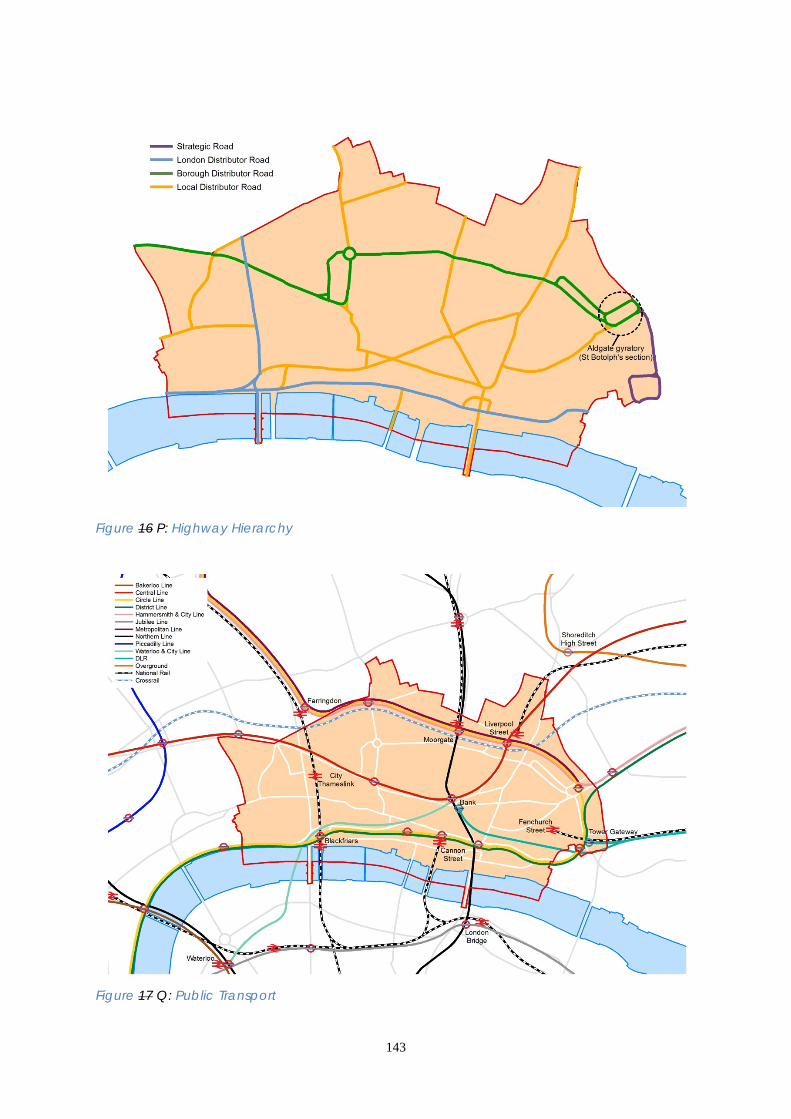
143
Figure 16 P: Highway Hierarchy
Figure 17 Q: Public Transport

144
Core Strategic Policy CS16: Public Transport Streets and Walkways To build on the City’s strategic central London position and good transport infrastructure to further improve the sustainability and efficiency of travel in, to, from and through the City, by: 1. Securing increased public transport capacity through support for Crossrail and
the Northern Line/Bank Station upgrade (including safeguarding land as shown on the Proposals Policies Map), and the completion upgrading of the Thameslink programme. and the completion of London Overground (the East London Line extensions).
2. Facilitating further improvements to public transport capacity and step-free
access at existing mainline rail and London Underground stations including Aldgate, BankCannon Street and St Paul’s, subsurface and Northern Line upgrades and planning for possible longer term improvements such as the westward extension of the Docklands Light Railway beyond Bank.
3. Improving conditions for safe and convenient walking and cycling,
incorporating adaptation to the City’s anticipated future climate: (i) improving access routes and the streetscape around stations, with particular
focus on Bank and the proposed Crossrail station entrances at Farringdon, Lindsey Street, Moorgate and Liverpool Street;
(ii) designing and implementing environmental public realm enhancement strategies that encourage pedestrian and cycle travel, taking account of the needs of disabled people;
(iii) implementing contra-flow cycling on one way streets; (ivii) supporting London-wide schemes such as the cycle hire scheme and cycle
superhighways, in parallel with initiatives to improve cycle parking in the City; (iv) working with TfL to reinstate two-way working and surface-level pedestrian
crossings in place of the Aldgate (St Botolph’s section) gyratory and remove the Museum of London gyratory.
4. Minimising congestion and reducing vehicle emissions: (i) directing through motor traffic within the City onto appropriate streets in
accordance with the Highway Hierarchy. Bus routes will continue to serve customer needs throughout the City and will not be subject to the Hhighway Hhierarchy;
(ii) continuing to facilitate intermediate modes (coaches, car clubs, taxis and private hire vehicles) and to provide for essential motor vehicle traffic, including addressing the servicing of City buildings and the needs of disabled people, whilst minimising the environmental impact of these modes;
(iii) encouraging the provision of infrastructure for alternative-fuel vehicles, such as off-street electric vehicle recharging points;
(iv) using traffic management measures and street works permits to improve journey time reliability on the City’s roads;
(v) requiring developers to demonstrate, through transport assessments, construction logistics plans, travel plans and delivery/servicing plans, how the environmental impacts and road danger of travel and servicing will be minimised, including through the use of river transport.
145
DEVELOPMENT MANAGEMENT POLICIES Policy DM 16.1 Transport impacts of development 1) Development proposals that are likely to have effects on transport must be
accompanied by an assessment of the transport implications during both construction and operation, in particular addressing impacts on:
• road dangers • pedestrian environment and movement; • cycling infrastructure provision; • public transport; • the street network. 2) Transport Assessments and Travel Plans should be used to demonstrate
adherence to the City Corporation’s transportation standards. 3.16.8 Development has the potential to create significant changes in transport demands and patterns which must be assessed at an early stage. Any adverse impacts must be minimised or mitigated through building design and management of operational activities. Transportation standards are set out in a series of advice notes that are available on the City Corporation website and from the Department of the Built Environment. Guidance on transport assessments is available in Transport for London’s Transport Assessment Best Practice Guidance. 3.16.9 Transport Assessments and Travel Plans will be required for all major development (over 1000sq m or 10 or more residential units) and any other development that will cause significant transport impacts over the local or wider area (Table 16.1). Transport Assessments and Travel Plans should take account of transport infrastructure, transport services, transport capacity constraints and how the impact of the development on the transport system can be mitigated. In particular, assessments and plans should give consideration to pedestrian movement associated with the development and impacts on the bus, underground and railway networks. The needs of cyclists and parking for the disabled should form part of the Transport Assessment. Travel Plans must maximise the use of active transport modes (principally walking and cycling) and public transport. For developments that will have a lesser transport impact a Transport Statement will be required. 3.16.10 Delivery and Servicing Plans will be required for all major development and any other development that will cause significant transport impacts on the local or wider area, through operational deliveries and servicing. 3.16.11 Construction Logistics Plans will be required for all major development and for any development that will cause significant transport impacts during its construction phase.
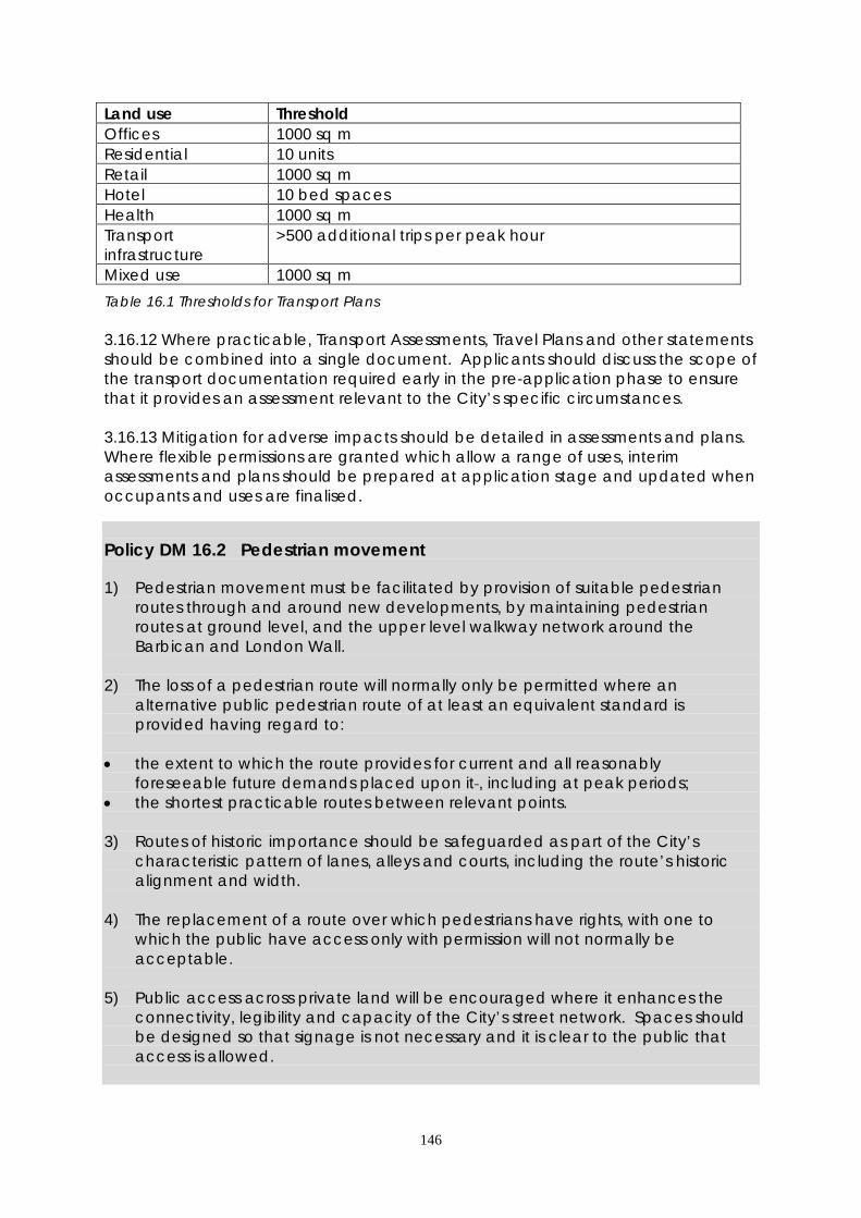
146
Land use Threshold Offices 1000 sq m Residential 10 units Retail 1000 sq m Hotel 10 bed spaces Health 1000 sq m Transport infrastructure
>500 additional trips per peak hour
Mixed use 1000 sq m
Table 16.1 Thresholds for Transport Plans 3.16.12 Where practicable, Transport Assessments, Travel Plans and other statements should be combined into a single document. Applicants should discuss the scope of the transport documentation required early in the pre-application phase to ensure that it provides an assessment relevant to the City’s specific circumstances. 3.16.13 Mitigation for adverse impacts should be detailed in assessments and plans. Where flexible permissions are granted which allow a range of uses, interim assessments and plans should be prepared at application stage and updated when occupants and uses are finalised. Policy DM 16.2 Pedestrian movement 1) Pedestrian movement must be facilitated by provision of suitable pedestrian
routes through and around new developments, by maintaining pedestrian routes at ground level, and the upper level walkway network around the Barbican and London Wall.
2) The loss of a pedestrian route will normally only be permitted where an
alternative public pedestrian route of at least an equivalent standard is provided having regard to:
• the extent to which the route provides for current and all reasonably
foreseeable future demands placed upon it , including at peak periods; • the shortest practicable routes between relevant points. 3) Routes of historic importance should be safeguarded as part of the City’s
characteristic pattern of lanes, alleys and courts, including the route’s historic alignment and width.
4) The replacement of a route over which pedestrians have rights, with one to
which the public have access only with permission will not normally be acceptable.
5) Public access across private land will be encouraged where it enhances the
connectivity, legibility and capacity of the City’s street network. Spaces should be designed so that signage is not necessary and it is clear to the public that access is allowed.

147
6) The creation of new pedestrian rights of way will be encouraged where this would improve movement and contribute to the character of an area, taking into consideration pedestrian routes and movement in neighbouring areas and boroughs, where relevant.
3.16.14 The capacity of the City’s streets and lanes to accommodate movement and to provide social space is under pressure in many parts of the City and at certain times of the day due to increasing numbers of pedestrians. Employment growth and new public transport infrastructure such as Crossrail will increase pressure on the City’s streets. New pedestrian routes should be provided wherever feasible, including through the provision of enhanced public access to private spaces and routes.
3.16.15 In considering proposals for new pedestrian routes, the City Corporation will ensure that routes are of adequate width, step-free and follow best practice in street design, for example, using tactile paving. The City Walkway network provides an important means of pedestrian access to some parts of the City. It is important that the integrity of the City Walkway network is maintained in and around the Barbican complex, where it is an integral element of pedestrian movement. It is important that lift access, for people with restricted mobility, is maintained or provided in new developments.
Policy DM 16.3 Cycle parking 1) On-site cycle parking must be provided in accordance with the local standards
set out in Table 16.2 or, for other land uses, with the standards of the London Plan. Applicants will be encouraged to exceed the standards set out in Table 16.2.
2) On-street cycle parking in suitable locations will be encouraged to meet the
needs of cyclists.
Land Use Minimum Number of Cycle Parking Spaces B1 business 1 space per 125 m2 of gross floorspace (gross
external area) Mainline railway termini 1 space per 600 morning peak hour exits Mainline railway non-termini 1 space per 1,000 morning peak hour exits Bus stations 1 space per 50 morning peak hour alighting
passengers All other uses See London Plan standards
Table 16.2: Local Minimum Cycle Parking Standards
3.16.16 Cycle parking must be provided within new developments and refurbishments. Cycle parking should be retained for the use of cycles and not used for other purposes such as storage. On-street cycle parking and the Mayor of London’s cycle hire scheme are public facilities and are not to be regarded as substitutes for private on-site cycle parking and will not be included within the cycle parking requirement for any development.
148
Policy DM 16.4 Facilities to encourage active travel
1) Ancillary facilities must be provided within new and refurbished buildings to support active transport modes such as walking, cycling and running. All commercial development should make sufficient provision for showers, changing areas and lockers/storage to cater for employees wishing to engage in active travel.
2) Where facilities are to be shared with a number of activities they should be conveniently located to serve all proposed activities.
3.16.17 Active travel can be encouraged by providing appropriate facilities which make it easier for people to wash, change and store their equipment easily. Showers, changing areas lockers/storage and drying facilities should be designed to a high standard and include facilities for people with disabilities.
Policy DM 16.5 Parking and servicing standards
1) Developments in the City should be car-free except for designated Blue Badge spaces. Where other car parking is exceptionally provided it must not exceed London Plan’s standards.
2) Designated parking must be provided for Blue Badge holders within
developments in conformity with London Plan requirements and must be marked out and reserved at all times for their use. Disabled parking spaces must be at least 2.4 m wide and at least 4.8 m long and with reserved areas at least 1.2 m wide, marked out between the parking spaces and at the rear of the parking spaces.
3) Except for dwelling houses (use class C3), whenever any car parking spaces (other than designated Blue Badge parking) are provided, motor cycle parking must be provided at a ratio of 10 motor cycle parking spaces per 1 car parking space. At least 50% of motor cycle parking spaces must be at least 2.3m long and at least 0.9m wide and all motor cycle parking spaces must be at least 2.0m long and at least 0.8 m wide.
4) On site servicing areas should be provided to allow all goods and refuse collection vehicles likely to service the development at the same time to be conveniently loaded and unloaded. Such servicing areas should provide sufficient space or facilities for all vehicles to enter and exit the site in a forward gear. Headroom of at least 5m where skips are to be lifted and 4.75 m for all other vehicle circulation areas should be provided.
5) Coach parking facilities for hotels (use class C1) will not be permitted.
6) All off-street car parking spaces and servicing areas must be equipped with the facility to conveniently recharge electric vehicles.

149
7) Taxi ranks are encouraged at key locations, such as stations and hotels. The provision of taxi ranks should be designed to occupy the minimum practicable space, using a combined entry and exit point to avoid obstruction to other transport modes.
3.16.18 The availability of public transport in the City negates the requirement for private car use in most circumstances making lower car parking levels than the London Plan standards appropriate for some use classes. In exceptional circumstances the provision of car parking may be justified by the exceptional requirements of businesses. The London Plan’s coach parking standards for hotels will not be applied in the City. 3.16.19 The low numbers of private motor vehicles mean that delivery and service vehicles have a relatively greater impact on traffic congestion and air quality. Efficient off-street servicing and delivery arrangements are vital to keep the City’s traffic moving. In order to reduce vehicle impact on air quality, electric vehicle fast-charging infrastructure needs to be available in convenient locations. Guidance is contained in the City Corporation’s “Standard Highway and Servicing Requirements for Developments in the City of London”. Policy DM 16.6 Public car parks No new public car parks will be permitted in the City, including the temporary use of vacant sites. The redevelopment of existing public car parks for alternative land uses will be encouraged where it is demonstrated that they are no longer required. 3.16.20 The City’s public car parks were mostly constructed during the 1960’s when car use was encouraged. Some are underused and provide an opportunity for conversion and redevelopment for other uses. Policy DM 16.7 Aviation landing facilities No heliports will be permitted in the City. Helipads will only be permitted where they are essential for emergency or security purposes. 3.16.21 The noise and disturbance associated with helicopters would result in disproportionate disruption to the City’s businesses and residents. The need for helipads would only be permitted for emergency or security purposes where the need for the facility is certified by the emergency services and cannot be met elsewhere. Policy DM 16.8 River transport 1) River piers, steps and stairs to the foreshore, the Walbrook Wharf safeguarded
site, and other river-based transport infrastructure will be safeguarded.

150
2) Development adjacent to or over the River Thames must be supported by a
Transport Assessment and a Construction Logistics Plan addressing the potential for the use of the river for the movement of construction materials and waste.
3.16.22 New river piers must be publicly accessible. The City Corporation will expect construction and waste materials from developments on or near the river to be transported by river barge. Who will deliver How we will make it happen Who When Public Transport Crossrail: partnership working with Crossrail Ltd to secure implementation of Crossrail through the City and provision of additional funding, including through Mayoral s106 agreements and CIL.
City Corporation- Crossrail Ltd- Mayor of London- Developers
Completion 2018
Thameslink: accommodating construction work at Blackfriars and London Bridge and Farringdon Stations.
Network Rail- First Capital Connect- City Corporation- LB Southwark- LB Islington
Completion 2018
London Overground (East London Line) extensions to Highbury & Islington and Clapham Junction.
TfL- LB Tower Hamlets
Completion 2012
Bank Station congestion relief project Northern Line/Bank Station upgrade.
TfL- City Corporation
2010- 2021 2022
Working with other stakeholders to secure funding, aid implementation and reduce disruption associated with transport improvement schemes.
City Corporation- TfL- Transport & Infrastructure Providers- Developers
Ongoing
Review of bus provision and routes serving the City.
TfL- City Corporation
By 2015 Ongoing

151
Walking and Cycling Securing funding for, designing and implementing environmental public realm enhancement strategies and programmes.
City Corporation- TfL- Developers- City of London Police
Reviewed annually
Securing funding for, designing and implementing cycle facilities.
City Corporation- TfL- Developers
Reviewed annually
Secure funding and improvements to the Aldgate (St. Botolphs section) gyratory systems.
City Corporation- TfL- Developers
Medium Term 2017
Congestion and Air Quality Require Transport Assessments, Construction Logistics Plans, Travel Plans and Servicing/ Delivery Plans to be submitted with planning applications. Detailed requirements will be defined in the Development Management DPD.
City Corporation- Developers-
Ongoing 2012
Implementation of the City of London Air Quality Action Plan.
City Corporation- Mayor of London- Neighbouring boroughs- Developers
2010-2015 Ongoing
Engaging in consultation on the Mayor of London’s transport plans.
City Corporation- Mayor of London-
Mayors Transport Strategy –2010
Using the Development Management DPD to identify suitable traffic management measures, such as parking standards.
City Corporation
2012
SUPPORTING EVIDENCE • Crossrail Context Report for the City of London Crossrail 2009 • Supplementary Planning Guidance: use of planning obligations in the funding of
Crossrail Mayor of London July 2010 • City of London Rail Strategy City of London 2009 • Street Scene Enhancement Strategies and Area Delivery Plans City of London
2005 – 2010 • City of London Cycling Plan City of London 2005

152
• Cycle Parking Strategy City of London 2010 • City of London Local Implementation Plan City of London 2007 • TfL Investment Programme 2009/10 to 2017/18 Transport for London 2010
3.16.8 The Sustainability Appraisal concluded that this policy is expected to result in beneficial social, environmental and economic impacts. There could be negative impacts including the loss of a Site of Importance for Nature Conservation associated with Crossrail construction. This is mitigated through Policy CS5 which requires restoration of worksites to deliver enhanced biodiversity. Possible impacts on historic buildings are mitigated through Policy CS12 and potential water quality impacts resulting from greater use of river transport are mitigated through Policy CS15. RISK MANAGEMENT 3.16.923 Although funding for the major passenger rail schemes has been secured, funding of the complementary enhancements to the City’s streets and walkways may be difficult to secure in the short to medium term. To address this, the City Corporation will seek funding from other stakeholders and partners and prioritise public realm schemes that deliver the greatest benefits and complement transport improvement phasing.
3.16.1024 Crossrail will produce significant improvements in transport capacity necessary to deliver long-term economic growth. The City Corporation considers that short to medium term needs can be addressed by planned improvements to the capacity and management of the underground network and the significant enhancement to Thameslink. If Crossrail is delayed significantly beyond its scheduled opening in 2017 then a review of the Core Strategy may be needed to take account of the potential impact on employment growth.
3.16.1125 Climate change impacts could affect the viability, reliability and comfort of long-distance commuting. Monitoring will highlight trends and identify possible impacts on the City’s business role. MONITORING 3.16.12 Key monitoring indicators are:
Public Transport TfL published data on numbers of underground, bus and river passenger journeys Progress on Crossrail and other major public transport schemes Number of stations with step free access
Walking & Cycling Number and quality of public realm enhancement schemes Number of cycle parking spaces Number of pedal cycle thefts Percentage of people commuting to work by cycle Number of pedestrians, cyclists and motorcyclists seriously injured or killed
Congestion and Air Quality Motor vehicle congestion – COL bi-annual journey time survey Pedestrian Flows survey data

153
3.17 WASTE 3.17.1 Waste management in the City is unusual in that a high proportion of the City’s waste comes from commercial rather than domestic premises. Much of this commercial waste is collected and managed by private contractors, who work across local authority boundaries, so the exact amount of waste produced in the City is difficult to verify. The London Plan projects that the City’s total waste arisings of municipal (MSW) and commercial and Industrial (C&I) waste for 2026 2031will be 558,000 565,000 tonnes and the City of London Waste Arisings study 2013 estimates total MSW and C&I waste arisings for 2031 at between 509,000 and 539,000 tonnes. 3.17.2 Waste collected by on behalf of the City Corporation from households and the City’s streets is known as municipal waste, 90% of which is waste from commercial premises. The City’s municipal waste is taken to Walbrook Wharf, enabling sustainable onward transport to the riverside energy-from-waste facility in the London Borough of Bexley, by river rather than road. Walbrook Wharf is also available to commercial waste operators for sustainable waste transfer. The City’s Municipal Waste Management Strategy 2008-2020 shows that recycling rates for municipal, construction and demolition waste are increasing significantly. It also identifies use of the riverside energy-from-waste facility in the London Borough of Bexley as the preferred option for the management of the City’s municipal waste, which was formerly sent to a landfill site in Essex. This minimises the carbon impact of waste transport by using sustainable transport and contributes to the London Plan objective of managing London’s waste within London. 3.17.3 Development and M major infrastructure projects such as Crossrail and the Thames Tideway Tunnel will generate large quantities of waste and recyclables during construction which will need to be transported to appropriate facilities outside of the City. The City of London Waste Arisings Study 2013 estimates that 336,000 tonnes of construction and demolition waste, 775 tonnes of hazardous waste including low level radioactive waste, and 4.2 million cubic metres of waste water will be generated in the City in 2031. DCLG guidance identifies that waste planning authorities should plan for these wastes in addition to MSW and C&I waste 3.17.4 The London Plan and the Mayor’s Municipal Waste Management Strategy and Business Waste Management Strategy set the framework for waste management in London. These strategies promote the waste hierarchy: prevention, preparing for reuse, recycling, other recovery, and disposing only as a last resort. The London Plan has set a waste apportionment figure requiring the City to identify sites with capacity to manage 100,000 tonnes of waste annually until 2031. This figure represents the City’s contribution to meeting the Mayor’s target of 100% net self-sufficiency in the management of London’s waste by 2031. The London Plan sets out criteria for the selection of waste management sites, which the City of London Waste Capacity Study 2009 has used to evaluate potential sites in the City. This study shows that, with current technologies and economic considerations, there is no viable waste management capacity within the Square Mile and that the City will not be able to satisfy the London Plan waste apportionment within its boundaries. The City Corporation is therefore working with the London Borough of Bexley, utilising spare waste management capacity in Bexley, to ensure that the City’s waste apportionment can be met. In the future, changing economics and new waste
154
management technologies may mean that small scale waste management becomes viable within the City. Such changes will be identified through regular review of the City’s Waste Capacity Study. During the period 2013 – 2031 a proportion of the City of London’s waste, will continue to be managed outside London. Co-operation with waste planning authorities outside London will be needed to ensure that facilities with sufficient capacity remain available to accept the City’s waste during this period. 3.17.5 The London Plan sets out borough apportionments for land-won aggregates which should be reflected in borough DPDs Local Plans. No apportionment is made for the City of London and there is no requirement to include a policy for minerals within this Core Strategy Local Plan. Core Strategic Policy CS17: Waste To support City businesses, residents and visitors in making sustainable choices regarding the minimisation, transport and management of their waste, capitalising on the City’s riverside location for sustainable waste transfer and eliminating reliance on landfill for municipal solid waste (MSW) by: 1. Enabling waste minimisation and adherence to the waste hierarchy: (i) requiring the provision of facilities for waste segregation, handling and
management within new developments; (ii) increasing the proportion of municipal solid waste recycled to at least 45% by
2015 in line with the City of London Municipal Waste Management Strategy; (iii) promoting improved waste management choices for businesses and
residents. 2. Enabling waste to be managed at the nearest available suitable location: (i) identifying waste management capacity in the City, or elsewhere in London,
to meet the City’s London Plan waste apportionment target, including through partnership working with the London Borough of Bexley.
(ii) safeguarding Walbrook Wharf as a waste handling site and investigating the potential for waste management, alongside its waste transfer function.
(iii)co-operating with other waste planning authorities to ensure appropriate waste management facilities are available to manage waste generated in the City
3. Enabling the sustainable transport of materials including waste and recyclables
by river: (i) safeguarding Walbrook Wharf as a wharf suitable for river transport of
materials including waste; (ii) exploring the potential for further use of waterways for the transport of waste
and construction materials subject, where appropriate, to the potential impact on Natura 2000 sites.
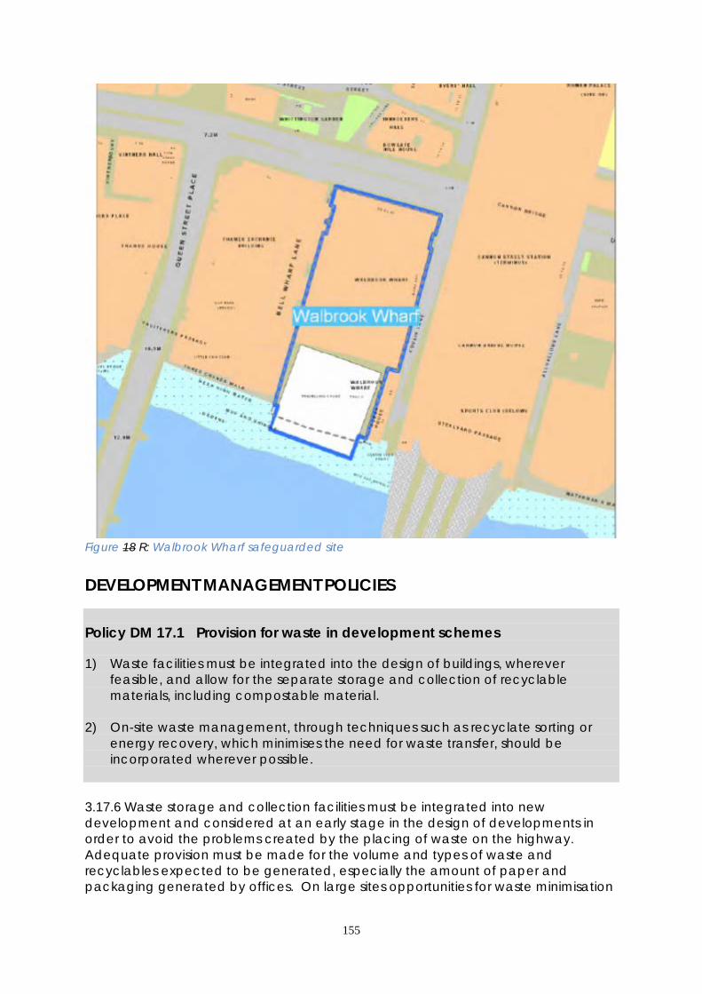
155
Figure 18 R: Walbrook Wharf safeguarded site DEVELOPMENT MANAGEMENT POLICIES Policy DM 17.1 Provision for waste in development schemes 1) Waste facilities must be integrated into the design of buildings, wherever
feasible, and allow for the separate storage and collection of recyclable materials, including compostable material.
2) On-site waste management, through techniques such as recyclate sorting or
energy recovery, which minimises the need for waste transfer, should be incorporated wherever possible.
3.17.6 Waste storage and collection facilities must be integrated into new development and considered at an early stage in the design of developments in order to avoid the problems created by the placing of waste on the highway. Adequate provision must be made for the volume and types of waste and recyclables expected to be generated, especially the amount of paper and packaging generated by offices. On large sites opportunities for waste minimisation

156
and on-site waste management, in line with the London Plan’s definition of waste management, should be explored in order to minimise the transport of waste within and beyond the City. The need to avoid health hazards associated with waste from catering establishments, the waste storage and collection needs of street traders, the separate storage of recyclable waste and the special arrangements required for the storage and transportation of clinical and hazardous waste should be considered, where necessary. 3.17.7 Waste and recyclables should be capable of collection from off-street service areas which are integrated into the design of buildings. The provision of such areas may not be practicable in small developments or refurbishments and may conflict with the protection of listed buildings and conservation areas. In such cases waste stores within the site near the highway, are preferable to the presentation of waste and recyclables on the pavement. Residential developments must be provided with ground floor waste and recyclables storage and collection facilities, with direct access to the highway for collection purposes. 3.17.8 The City Corporation will attach appropriate planning conditions relating to waste storage and collection, but may also make use of its other regulatory powers to control waste in the City. Pre-application consultation on suitable waste storage and collection facilities is encouraged. Compliance with the City of London’s operational waste requirements should enable BREEAM or Code for Sustainable Homes waste credits. Policy DM 17.2 Designing out construction waste New development should be designed to minimise the impact of deconstruction and construction waste on the environment through: • reuse of existing structures; • building design which minimises wastage and makes use of recycled materials; • recycling of deconstruction waste for reuse on site where feasible; • transport of waste and construction materials by rail or river wherever
practicable; • application of current best practice with regard to air quality, dust, hazardous
waste, waste handling and waste management. 3.17.9 Construction and deconstruction waste forms a significant proportion of the waste generated in the City due to high levels of redevelopment. The process of designing out waste must begin early in site development and must include all those involved throughout the planning and construction of the development. Particular attention should be given to the sensitivity of the area surrounding the site to air quality and transport disruption. 3.17.10 For development on large sites the feasibility of recycling deconstruction waste for reuse on site should be investigated taking account of the requirements of the City of London’s ‘Code of Practice for Deconstruction and Construction Sites’.
157
Sustainable transport of waste off site should be demonstrated through Construction Logistics Plans. Policy DM 17.3 New waste management sites When new facilities for waste management, handling and transfer are proposed developers will be required to demonstrate through design and sustainability statements that the benefits of the proposed development outweigh any adverse impacts and particularly that: • the development will handle waste which has been generated locally; • access arrangements, mode of transport and transport routes will minimise the
potential for congestion and environmental impacts, including local air quality impacts and carbon emissions. Use of the river for transport of waste and recyclables will be encouraged;
• the carbon impact of the development will be minimised. New waste facilities should comply with the Mayor’s Carbon Intensity Floor (CIF);
• the development is designed with resilience to natural and man-made safety and security challenges.
3.17.11 The profile of waste management in the City differs from other local authority areas in that the majority of the waste is generated from commercial rather than residential premises. Most of this waste is collected by private contractors, who determine where it is finally managed. In order to reduce the distance that waste travels for management, the Mayor has set a target for London to be self-sufficient in the management of its waste by 2031. This will require the provision of additional waste management facilities within London. 3.17.12 Although the City is unlikely to be able to accommodate large waste management facilities within its boundary, changes in technology and waste transport costs may make small scale facilities viable in the future. The criteria set out in this policy will be used, alongside other policy considerations, to evaluate the suitability of proposed waste facilities and appropriate conditions will be applied to ensure that any new facility is suitable for the City’s high density urban environment. Policy DM 17.4 Development affecting waste management sites 1) Development in the vicinity of waste management sites should not compromise
the waste management operations on the site or create an unacceptable land use conflict.
2) Noise-sensitive development adjacent to the existing waste site at Walbrook
Wharf and development which would compromise the use of the river for waste operations will be resisted.
158
3.17.13 Any proposed development which might prejudice the operation of the existing safeguarded waste site at Walbrook Wharf (Fig S) will be resisted. Assessment of potential conflicts such as noise, vibration, odour, visual impact, pedestrian access and road or river transport will be taken into account in consideration of proposals. Mitigation may be necessary to allow development to proceed where a potential conflict is identified. Who will deliver How we will make it happen Who When Waste Hierarchy Requiring sustainability statements to address waste management in new development.
City Corporation- Developers
Ongoing
Improving recycling services in line with the City’s Municipal Waste Management Strategy and promoting uptake of City recycling services.
City Corporation- Waste contractors- City businesses- Residents
45% by 2015
Sponsoring and promoting waste initiatives and awards schemes such as the Clean City Awards and Sustainable City Awards.
City Corporation- City businesses- Residents
Annually
Improving the collection of data on waste to inform implementation and future review of relevant strategies and the Core Strategy Local Plan.
City Corporation- Environment Agency- Defra- Mayor of London- Waste contractors
5 yearly review of City’s Waste Capacity Study
Waste Apportionment and duty to cooperate Joint working to meet the City’s London Plan waste management apportionment target on sites elsewhere in London.
City Corporation- Other London boroughs- Mayor of London
In line with London Plan waste management apportionment targets
Reviewing the City of London Waste Capacity Study every five years and, if necessary, implementing any identified changes in viability of waste management within major developments through review of the Development Management DPD. Local Plan
City Corporation
By 2016
159
Set out assessment criteria for new waste management sites in the Development Management DPD. Identifying areas where the City’s waste is managed and co-operating with waste planning authorities for these areas
City Corporation City Corporation- Other waste planning authorities
2012 Ongoing
Waste Transport Upholding of Ministerial Direction safeguarding Walbrook Wharf and maintaining it as a wharf suitable for the river-based movement of materials, including waste.
City Corporation
Ongoing
Requiring site waste management plans and transport assessments and construction logistics plans to consider transport of materials, including waste, via river or canal. Detailed requirements will be defined in the Development Management DPD.
City Corporation- Developers
Ongoing 2012
SUPPORTING EVIDENCE • Waste Arisings in the City of London AEA for the City of London 2008 • Waste Management Capacity in the City of London AEA for the City of London
2009 • Waste Apportionment – investigation of the potential for joint working with other
boroughs City of London 2008 and 2009 • London Waste Apportionment Study Jacobs Babtie for the Mayor of London
2006 • London Waste Apportionment Study Update and further sensitivity testing
Jacobs Babtie for the Mayor of London 2007 • City of London Municipal Waste Management Strategy AEA for the City of
London 2008 3.17.6 The Habitats Regulation screening highlighted the potential of using waterways for the movement of waste to affect Natura 2000 sites. Therefore specific reference to such sites has been included in the policy. The Sustainability Appraisal identified potential transport impacts of changes in waste collection. This is mitigated by Policy CS16 which promotes the use of alternative fuelled vehicles to reduce emissions and Policy CS19 which promotes enhancement of biodiversity particularly on the River Thames. RISK MANAGEMENT 3.17.7 3.17.14 The viability of different waste management activities could change due to external factors such as changes in markets for recycled products. Improved data and monitoring will identify trends and associated issues in a timely manner. Encouragement to use recycled products at individual, business and building design levels is important in creating a market for recycled products. Review of the City of London Waste Capacity Study will highlight any changes in viability and further

160
policy guidance will be provided through in the Development Management DPD or a Supplementary Planning Document or a review of the Local Plan. MONITORING 3.17.9 Key monitoring indicators are: Waste Hierarchy
• Clean City Awards & Sustainable City Awards – participation rates • Amount of municipal waste arising and percentage of this which is recycled • NI 191 Household waste collected per head Waste Apportionment
• Capacity of new waste management facilities by type
Waste Transport
• Capacity for waste management and transfer at Walbrook Wharf • Total waste transported by river

161
3.18 FLOOD RISK 3.18.1 Although the City stands beside the Thames, it is built on relatively high ground and so is at low risk of flooding. Two natural watercourses, the River Fleet and the Walbrook, flow through the City, but both these rivers have been fully canalised and now form part of London’s extensive sewer network.
3.18.2 The City is protected by local flood defences along the Thames riverside and by the Thames Barrier at Woolwich as part of the wider protection of London. The zone at risk of flooding, in the unlikely event of flood defence breach or over-topping, is confined to an area close to the Thames. Critical drainage areas Surface water flood risk hotspots, which are at risk of sewer flooding in extreme circumstances, extend along the Thames riverside and up the former Fleet Valley towards Smithfield. Some neighbouring boroughs contain extensive low-lying areas close to the City and flooding in these could adversely affect the City’s transport, communications and essential services. It is therefore important that flood risk is considered strategically.
3.18.3 Uncertainties exist in predicting the future flood risk due to the effects of climate change, such as sea level rise and an increase in extreme weather events. The Environment Agency is carrying out extensive research to inform future plans for flood protection of Thames Estuary and tidal Thames areas, including modelling for climate uncertainties. Future UK Climate Projections (UKCP) will inform reviews of all assessments and strategies related to flood risk.
Figure 19 S: City flood risk areas

162
3.18.4 Government guidance (currently set out in PPS25) sets out requirements for planning and development in relation to flood risk. In accordance with this guidance, the City of London has published its Strategic Flood Risk Assessment (SFRA), which identifies areas of the City that are at risk of flooding from a range of sources. It has also prepared a Climate Change Adaptation Strategy, which highlights the actions required to adapt to the increased flood risk due to climate change. Core Strategic Policy CS18 Flood Risk To ensure that the City remains at low risk from all types of flooding, by: 1. Minimising river flooding risk, requiring development in the City Flood Risk Area to
seek opportunities to deliver a reduction in flood risk compared with the existing situation:
(i) applying the sequential test and exception test as set out in PPS25 the NPPF and associated technical guidance on flood risk and requiring Flood Risk Assessments to be submitted, in support of all planning applications in the City Flood Risk Area (Environment Agency Flood Zones 2 and 3 and critical drainage areas surface water flood risk hotspots) and for major development proposals elsewhere;
(ii) protecting and enhancing existing flood defences along the riverside, particularly those identified as fair or poor in the current City of London SFRA. Development adjacent to the River Thames must be designed to allow for maintenance of flood defences.
2. Reducing the risks of flooding from surface water throughout the City, ensuring
that development proposals minimise water use and reduce demands on the combined surface water and sewerage network by applying the London Plan drainage hierarchy.
3. Reducing rainwater run-off, through the use of suitable Sustainable Urban
Drainage Systems (SUuDS), such as green roofs and rainwater attenuation measures particularly in critical drainage areas. throughout the City.
4. Ensuring that wider flood defences afford the highest category of protection for
the City, participating in the development and implementation of the Environment Agency’s Thames Estuary 2100 project.
5. Reviewing and updating the City of London’s Strategic Flood Risk Assessment at
least every 5 years or more frequently if circumstances require, to ensure that changes in flood risk are identified and suitable responses implemented.
163
DEVELOPMENT MANAGEMENT POLICIES Policy DM 18.1 Development in the City Flood Risk Area. 1) Where development is proposed within the City Flood Risk Area evidence must
be presented to demonstrate that: • the site is suitable for the intended use (see table 18.1), in accordance with
Environment Agency and Lead Local Flood Authority advice; • the benefits of the development outweigh the flood risk to future occupants; • the development will be safe for occupants and visitors and will not compromise
the safety of other premises or increase the risk of flooding elsewhere. 2) Development proposals, including change of use, must be accompanied by a
site-specific flood risk assessment for: • all sites within the City Flood Risk Area as shown on the Policies Map; and • all major development elsewhere in the City. 3) Site specific flood risk assessments must address the risk of flooding from all
sources and take account of the City of London Strategic Flood Risk Assessment. Necessary mitigation measures must be designed into and integrated with the development and may be required to provide protection from flooding for properties beyond the site boundaries, where feasible and viable.
4) Where development is within the City Flood Risk Area, the most vulnerable uses
must be located in those parts of the development which are at least risk. Safe access and egress routes must be identified.
5) For minor development outside the City Flood Risk Area, an appropriate flood
risk statement may be included in the Design and Access Statement. 6) Flood resistant and resilient designs which reduce the impact of flooding and
enable efficient recovery and business continuity will be encouraged. 3.18.5 The City Flood Risk Area is shown on the Policies Map and includes areas at risk both from river flooding and surface water and sewer flooding. Where development is proposed within this area, pre-application discussions with the City Corporation, the Environment Agency and other interested parties should explore the suitability of the site for the intended use. Where incompatibility between the intended use and the flood risk vulnerability classification is identified (Tables 18.1 and 18.2), the developer should investigate whether there is a reasonably available site outside the City Flood Risk Area which would be more suitable for the intended use. Where no alternative site is available, the developer must demonstrate, through the Exceptions Test, that the benefits of the development outweigh any risk from flooding and that the development will be safe without increasing flood risk elsewhere. The designation of parts of the development for particular uses may be necessary. Basement and ground floor areas that are liable to flooding should be
164
allocated for less vulnerable uses, and access and egress routes must be provided through areas which are not susceptible to flooding. 3.18.6 Site-specific flood risk assessments must address flood risk from the River Thames and the former River Fleet and River Walbrook, sewer flooding and its interaction with fluvial flooding, groundwater flooding and surface water flooding. The City of London Strategic Flood Risk Assessment identifies actions which will result in reduced flood risk or increased resilience. Further guidance on potential mitigation measures will be included in the City of London Flood Risk Strategy.
Flood Risk Vulnerability classification
Essential Infrastructure
Water Compatible
Highly Vulnerable
More Vulnerable
Less Vulnerable
EA Zone 1
EA Zone 2
Exceptions Test
required
EA Zone 3a
Exceptions
Test required
Exceptions Test required
EA Zone 3b
Exceptions
Test required
SFRA Surface water/sewer
flood risk hotspots
Exceptions
Test required
Exceptions Test required
Key: Development is acceptable Development is not acceptable Table 18.1 Suitability of development in different parts of the City Flood Risk Area
165
Essential Infrastructure
• Essential transport infrastructure (including mass evacuation routes) which has to cross the area at risk, strategic utility infrastructure, including electricity generating power stations and grid and primary substations
Highly Vulnerable
• Police, ambulance and fire stations and command centres and telecommunications installations required to be operational during flooding
• Emergency dispersal points • Basement dwellings • Installations requiring hazardous substances consent
More Vulnerable
• Hospitals • Residential institutions such as care homes and hostels • Dwelling houses, student halls of residence, drinking
establishments, nightclubs and hotels • Non-residential uses for health services, nurseries and
educational establishments • Sites used for waste management facilities for hazardous
waste Less Vulnerable
• Retailing, offices, general industry, storage and distribution, non-residential institutions not included in ‘more vulnerable’ and assembly and leisure
Table 18.2 Flood risk vulnerability classifications relevant to the City Policy DM 18.2 Sustainable drainage systems (SuDS) 1) The design of the surface water drainage system should be integrated into the
design of proposed buildings or landscaping, where feasible and practical, and should follow the SuDS management train (Fig U) and London Plan drainage hierarchy.
2) SuDS designs must take account of the City’s archaeological heritage, complex
underground utilities, transport infrastructure and other underground structures, incorporating suitable SuDS elements for the City’s high density urban situation.
3) SuDS should be designed, where possible, to maximise contributions to water
resource efficiency, biodiversity enhancement and the provision of multifunctional open spaces.
3.18.7 From 2014 all proposals which affect surface water discharges must be approved by the SuDS Approval Body (SAB). The application for SAB approval can be made as a joint Planning / SAB application. SuDS designs must comply with the SuDS National Standards. Pre-application discussion with the SAB and consultation with the Environment Agency, Thames Water and other interested parties will ensure that SuDS designs are suitable for the proposed site. Designs should follow the SuDS management train (Fig U) and drainage hierarchy.
166
Figure T: SuDS Management Train Policy DM 18.3 Flood protection and climate change resilience 1) Development must protect the integrity and effectiveness of structures intended
to minimise flood risk and, where appropriate, enhance their effectiveness. 2) Wherever practicable, development should contribute to an overall reduction in
flood risk within and beyond the site boundaries, incorporating flood alleviation measures for the public realm, where feasible.
3.18.8 The City of London is locally protected from flooding by flood defence walls along the River Thames. Development adjacent to these flood defences must maintain their integrity and effectiveness for the benefit of the whole City. The Thames Estuary 2100 project recognises the need for the raising of flood defences by up to 0.5 metres by 2065 and 1m by 2100. Development on the riverside should be designed to enable this future defence raising without adverse impacts on river views and pedestrian movement along the riverside walk. Discussions with the Environment Agency will be required to establish the most effective designs for improved flood defences. 3.18.9 In some parts of the City there is a risk of flooding due to surcharging of sewers during periods of heavy rainfall. Adherence to the SuDS National Standards for all development will assist in alleviating this flood risk. Developers, in conjunction with the Environment Agency and the City Corporation, should explore the contribution that their developments can make to improving the wider flood risk beyond their site boundaries.

167
Who will deliver How we will make it happen Who When River Flood Risk Manage development to ensure adherence to Government guidance (currently set out in PPS25) the NPPF and associated technical guidance on flood risk and consult the Environment Agency according to current Standing Advice. Detailed requirements will be defined in the Development Management DPD.
City Corporation- Developers- Environment Agency
Ongoing 2012
Liaison with Environment Agency on proposed flood defence improvements.
City Corporation- Developers- Landowners- Environment Agency
Annual review SFRA to be updated every 5 years
Surface water Preparation and implementation of Surface Water Management Plans a Flood Risk Strategy for the City and Camden through the Drain London Project.
City Corporation- LB Camden- Drain London Forum
SWMP to be completed by 2011 2015
Application of the London Plan drainage hierarchy for surface water management in the built environment. Detailed requirements will be defined in the Development Management DPD.
City Corporation- Developers- Thames Water
Ongoing. Associated with all built development 2012
Wider Flood Risk Contributing to consultations and implementation of the TE 2100 Action Plan.
City Corporation- Developers- Environment Agency
TE 2100 Action Plan 2010 2012
Review of neighbouring boroughs’ LDF Local Plans and DPDs to ensure adequate wider protection.
City Corporation- Neighbouring boroughs
As LDF documents are issued for consultation
Climate Change Review of the City’s SFRA according to EA guidance.
City Corporation- Environment Agency
By 2012 2017
168
SUPPORTING EVIDENCE • City of London Strategic Flood Risk Assessment Mouchel for the City of London
2007 • Environment Agency - Thames Estuary 2100 Flood Risk Management Plan
Environment Agency 2009 • City of London Climate Change Adaptation Strategy Acclimatise for the City of
London 2008 and Action Plan Update 2010 • UK Climate Projections 09 Key Findings for London Climate Impacts Programme
2009 3.18.5 The Sustainability Appraisal found that this policy is likely to have beneficial impacts both locally and regionally against the relevant social, environmental and economic objectives. RISK MANAGEMENT 3.18.6 3.18.10 Climate change prediction through UKCP may identify different impacts that need to be addressed, including issues beyond the City’s boundaries. Keeping the City’s SFRA up to date will ensure timely identification of these impacts. MONITORING 3.18.7 Key monitoring indicators are:
River flooding • Number of permissions granted contrary to EA advice Surface Water • NI 189 - agreed actions regarding Surface Water Management • Number of green roofs Wider flood risk • NI 189 – Agreed actions from the TE 2100 Action Plan Climate change • Changes in flood risk, identified through review of the Strategic Flood Risk
Assessment
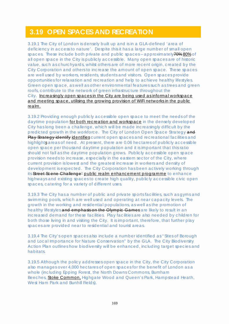
169
3.19 OPEN SPACES AND RECREATION 3.19.1 The City of London is densely built up and is in a GLA-defined ‘area of deficiency in access to nature’. Despite this it has a large number of small open spaces. These include both private and public spaces – approximately70% 80% of all open space in the City is publicly accessible. Many open spaces are of historic value, such as churchyards, whilst others are of more recent origin, created by the City Corporation and others to increase the amount of open space. These spaces are well used by workers, residents, students and visitors. Open spaces provide opportunities for relaxation and recreation and help to achieve healthy lifestyles. Green open space, as well as other environmental features such as trees and green roofs, contribute to the network of green infrastructure throughout the City. Increasingly open spaces in the City are being used as informal workspace and meeting space, utilising the growing provision of WiFi networks in the public realm. 3.19.2 Providing enough publicly accessible open space to meet the needs of the daytime population for both recreation and workspace in the densely developed City has long been a challenge, which will be made increasingly difficult by the predicted growth in the workforce. The City of London Open Space Strategy and Play Strategy identify identifies current open spaces and recreational facilities and highlights areas of need. At present, there are 0.06 hectares of publicly accessible open space per thousand daytime population and it is important that this ratio should not fall as the daytime population grows. Publicly accessible open space provision needs to increase, especially in the eastern sector of the City, where current provision is lowest and the greatest increase in workers and density of development is expected. The City Corporation has been actively working through its Street Scene Challenge’ public realm enhancement programme to enhance highways and existing spaces to create high quality, publicly accessible civic open spaces, catering for a variety of different uses. 3.19.3 The City has a number of public and private sports facilities, such as gyms and swimming pools, which are well used and operating at near capacity levels. The growth in the working and residential populations, as well as the promotion of healthy lifestyles and emphasis on the Olympic Games are likely to result in an increased demand for these facilities. Play facilities are also needed by children for both those living in and visiting the City. It is important, therefore, that further play spaces are provided near to residential and tourist areas. 3.19.4 The City’s open spaces also include a number identified as “Sites of Borough and Local Importance for Nature Conservation” by the GLA. The City Biodiversity Action Plan outlines how biodiversity will be enhanced, including target species and habitats. 3.19.5 Although the policy addresses open space in the City, the City Corporation also manages over 4,000 hectares of open spaces for the benefit of London as a whole (including Epping Forest, the North Downs Commons, Burnham Beeches, Stoke Common, Highgate Wood and Queen’s Park, Hampstead Heath, West Ham Park and Bunhill Fields).

170
Core Strategic Policy CS19: Open Spaces and Recreation To encourage healthy lifestyles for all the City’s communities through improved access to open space and facilities, increasing the amount and quality of open spaces and green infrastructure, while enhancing biodiversity, by: 1. Seeking to maintain a ratio of at least 0.06 hectares of high quality, publicly
accessible open space per 1,000 weekday daytime population: (i) protecting existing open space, particularly that of historic interest, or ensuring
that it is replaced on redevelopment by space of equal or improved quantity and quality on or near the site;
(ii) securing public access, where possible, to existing private spaces; (iii) securing additional publicly accessible open space and pedestrian routes,
where practical, particularly in the eastern part of the City; (iv) creating additional civic spaces from underused highways and other land
where this would not conflict with other strategic objectives; (v) encouraging high quality green roofs, roof gardens and terraces, particularly
those which are publicly accessible, subject to the impact on the amenity of adjacent occupiers.
2. Improving access to new and existing open spaces, including those in
neighbouring boroughs, promoting public transport access to nearby open space outside the City and ensuring that open spaces meet the needs of all of the City’s communities.
3. Increasing the biodiversity value of open spaces, paying particular attention to
sites of importance for nature conservation such as the River Thames. Protecting the amenity value of trees and retaining and planting more trees wherever practicable.
4. Improving inclusion and access to affordable sport, play and recreation,
protecting and enhancing existing facilities and encouraging the provision of further facilities within major developments.
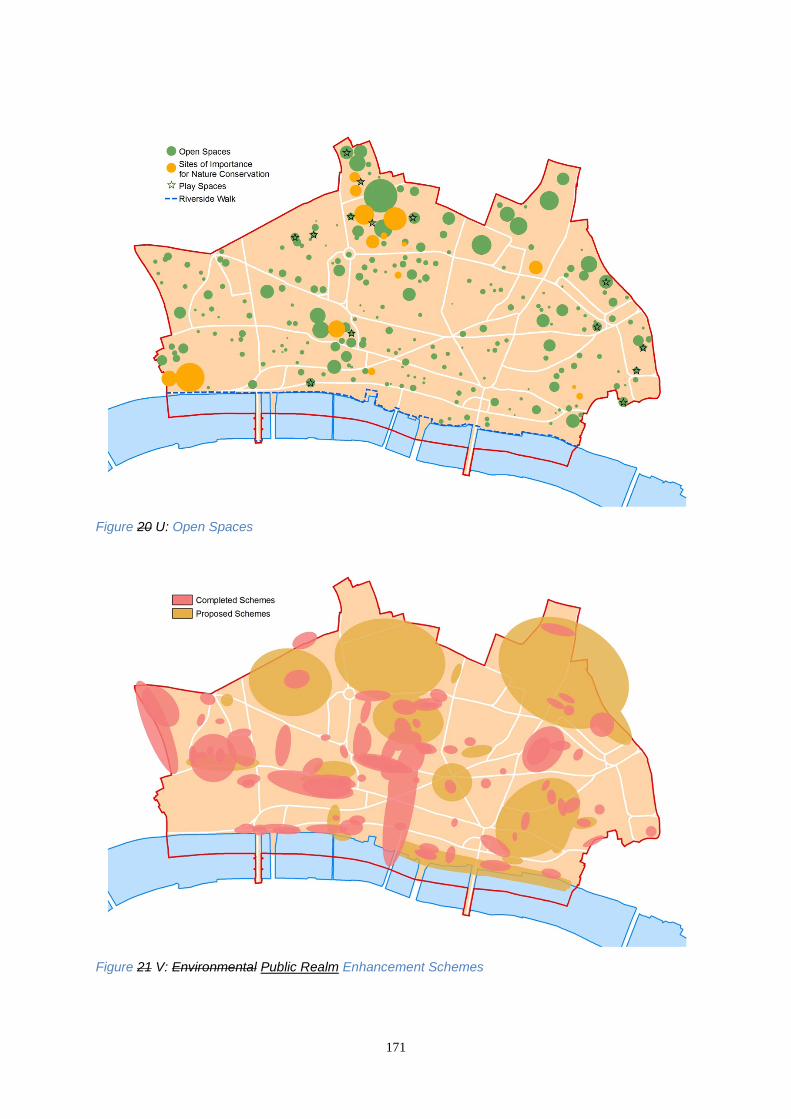
171
Figure 20 U: Open Spaces
Figure 21 V: Environmental Public Realm Enhancement Schemes

172
DEVELOPMENT MANAGEMENT POLICIES Policy DM19.1 Additional open space 1) Major commercial and residential developments should provide new and
enhanced open space where possible. Where on-site provision is not feasible, new or enhanced open space should be provided near the site, or elsewhere in the City.
2) New open space should: • be publicly accessible where feasible; this may be achieved through a legal
agreement; • provide a high quality environment; • incorporate soft landscaping and Sustainable Drainage Systems, where
practicable; • have regard to biodiversity and the creation of green corridors; • have regard to acoustic design to minimise noise and create tranquil spaces. 3) The use of vacant development sites to provide open space for a temporary
period will be encouraged where feasible and appropriate. 3.19.6 The design of open space should incorporate as much soft landscaping as practicable; provide for biodiversity; incorporate planting, which should be resilient to a range of climate conditions; incorporate sustainable drainage; be sustainable; take account of ‘’designing out crime” principles; be accessible to all; be appropriate to the space’s context and the character of its surrounding area; enhance tranquillity; and minimise noise levels by installing sound-based public art, such as fountains, which positively enhance tranquillity. Areas identified as ‘tranquil areas’ under the City Noise Strategy, and areas with identified positive sound features will, as far as practicable, be protected from noise associated with new developments. 3.19.7 Technological advances in recent years have resulted in different ways of working, including working on laptops and tablets out of the office environment utilising WiFi connections in cafes and open spaces. Open spaces in the City should embrace these changes and allow for comfortable seating arrangements which would assist in “out of office” working practices. 3.19.8 Where it is not feasible to provide new open spaces within a development site, or a site in the vicinity, developers will be required to work with the City Corporation to ensure that additional open space, or enhancement of existing open space, is delivered elsewhere in the City. 3.19.9 Developers will be required to maintain newly created public open spaces on private land, as set out in relevant legal agreements. 3.19.10 New public space will be particularly encouraged where it connects with other green spaces to form green corridors. These corridors create a wider network

173
with other green spaces, and so strengthen, enhance and build a green network of public open space. 3.19.11 Whilst the emphasis is on the provision of publicly accessible open space, private open space and amenity space is valuable in developments where occupiers of the building can access the space or view it. This type of space can be incorporated as internal courtyards, large balcony space or roof gardens. 3.19.12 During times of temporary vacancy, the use of land for temporary open space and recreational uses will be encouraged, where it would not prejudice the eventual return to office (or other) use. Where temporary green spaces are provided, it may be appropriate for trees and plants to be planted within moveable containers, so as not to prevent or deter future development on site, and so that any green infrastructure can be utilised elsewhere. Policy DM19.2 Biodiversity and urban greening Developments should promote biodiversity and contribute to urban greening by incorporating: • green roofs and walls, soft landscaping and trees; • features for wildlife, such as nesting boxes and beehives; • a planting mix which encourages biodiversity; • planting which will be resilient to a range of climate conditions; • maintenance of habitats within Sites of Importance for Nature Conservation.
Fig W: Sites of Importance for Nature Conservation (SINCs)

174
3.19.13 The City has several Sites of Importance for Nature Conservation (SINCs), but is identified as an area of deficiency in nature conservation by the GLA. It is important that opportunities are taken to improve greening and biodiversity throughout the City, and in particular in areas where this would improve green corridors or biodiversity links, such as along the riverside. 3.19.14 Climate change is recognised as an increasingly significant environmental challenge. Central London is likely to suffer from the adverse effects of the urban heat island effects and be more susceptible to surface water flooding. The introduction of additional green infrastructure, such as soft surfaces, green roofs and street tree planting, has the potential to cool and improve air quality in the City and reduce the risk of surface water flooding, in addition to enhancing the biodiversity and attractiveness of the urban environment. 3.19.15 When considering proposals for urban greening within and around conservation areas and other areas and buildings of heritage or other special character, the City Corporation will have regard to the potential visual impact on its architectural or special character. 3.19.16 When planting green walls consideration should be given to the use of plants which are suitable for local conditions, pollution and wind effects as well as climate change. The City Corporation will require management arrangements for the proposed green infrastructure to ensure its long term sustainability and lasting contribution to the urban environment. 3.19.17 Where existing green infrastructure is disturbed, removed or damaged as a result of development, it must be replaced with good quality urban greening. There should be no net loss of green infrastructure. Existing trees should be replaced with trees of an equivalent size and quality. Policy DM19.3 Sport and recreation 1) To resist the loss of public sport and recreational facilities for which there is a
continuing demand, unless: • replacement facilities are provided on-site or within the vicinity that meets the
needs of the users of that facility; or • necessary services can be delivered from other facilities without leading to, or
increasing, any shortfall in provision; or • it has been demonstrated that there is no demand for sport and recreation
facilities which could be met on the site. 2) Proposals involving the loss of sport and recreational facilities must be
accompanied by evidence of a lack of need for those facilities. Loss of facilities will only be permitted where it has been demonstrated that the existing floorspace has been actively marketed at reasonable terms for sport and recreational use.
3) The provision of new sport and recreation facilities will be encouraged:

175
• where they provide flexible space to accommodate a range of different uses/users and are accessible to all;
• in locations which are convenient to the communities they serve, including open spaces;
• near existing residential areas; • as part of major developments subject to an assessment of the scale, character,
location and impact of the proposal on existing facilities and neighbouring uses; • where they will not cause undue disturbance to neighbouring occupiers. 4) The use of vacant development sites for a temporary sport or recreational use
will be encouraged where appropriate and where this does not preclude return to the original use or other suitable use on redevelopment.
3.19.18 There are numerous private gyms and sports clubs in the City which mostly serve the needs of the day-time working population. While these facilities are important in meeting sport and recreation needs it will not always be necessary to prevent their change of use, due to the fluid nature of the private market. 3.19.19 Open spaces and publicly accessible rooftops can provide valuable space for the provision of leisure and sports facilities. Policy DM19.4 Play areas and facilities 1) The City Corporation will protect existing play provision and seek additional or
enhanced play facilities or space, particularly in areas identified as deficient, by: • protecting existing play areas and facilities and, on redevelopment, requiring
the replacement of facilities either on-site or nearby to an equivalent or better standard;
• where the creation of new play facilities is not feasible, requiring developers to work with the City Corporation to deliver enhanced provision nearby;
• requiring external play space and facilities as part of new residential developments which include 20 or more family units (those with 3 or more bedrooms) or 10 or more affordable units of 2 or more bedrooms;
• promoting opportunities for informal play and play within open spaces where it is not possible to secure formal play areas.
2) Play areas and facilities should not be located where they would cause undue
disturbance to neighbouring occupiers. 3.19.20 Play is essential for the healthy development of children and takes place in both formal and informal spaces. Formal play spaces include areas specifically designed and designated for play. Informal play spaces are those not designated solely for that purpose but which contain features that can be used for imaginative play. The residential estates and the east of the City are areas which are most deficient in play facilities.

176
3.19.21 Play spaces should be appropriate in terms of size and scale, have natural daylight and sunlight, meet the needs of various age groups, be accessible to children with disabilities and provide for safe and secure environments incorporating natural surveillance.

177
Who will deliver How we will make it happen Who When Increase amount of open space Negotiate access agreements in accordance with the City’s Open Spaces Strategy. Update the City of London Open Spaces Strategy and targets for open space provision.
City Corporation City Corporation
Ongoing 2013/14
Ensure developments incorporate open space or contribute towards open spaces elsewhere through developer financial contributions.
City Corporation- Developers
Ongoing
Improve quality of open spaces through the City’s Open Spaces Delivery Strategy and Management Plans for City gardens. Consider the need for a Noise Supplementary Planning Document.
City Corporation
2012 Ongoing
Implement environmental public realm enhancement strategies that provide increased open spaces on highways, creating links to neighbouring boroughs and taking into account sports uses. Further policies on the quality, quantity and accessibility of open spaces will be provided in the Development Management DPD.
City Corporation- TfL City Corporation
Ongoing 2012
Access to open spaces Using City Corporation land ownership and management of open spaces to ensure they are safe and accessible.
City Corporation
Ongoing
Partnership working with neighbouring boroughs to improve open spaces.
City Corporation- Neighbouring boroughs- City Fringe Agencies
Ongoing

178
SUPPORTING EVIDENCE: • Open Spaces Strategy City of London 2008 • Biodiversity Action Plan 2010 -2015 City of London 2009 • Draft Sports Strategy City of London 2010 • Street Scene Manual City of London 2005 • Play Strategy 2007 - 2010 City of London 2007
3.19.6 The Sustainability Appraisal of this policy notes that it is likely to result in beneficial environmental, social, and economic effects, although there may be slight conflict with transport, particularly in terms of creating more congestion and lower air quality. This is mitigated by Policy CS16. RISK MANAGEMENT
3.19.7 3.19.22 Many open spaces are created in partnership with developers and are dependent in their timing on enabling development proceeding. Changes in the economic cycle can lead to short term variations in the availability and amount of developer contributions that can be used for the creation of further open spaces. Where development is reduced and contributions are slow coming forward, funding will be sought from other sources.
Improve Biodiversity Implementing the Biodiversity Action Plan. Using tree preservation orders to protect trees. Further detail on trees in the City is will be given in the City of London Tree Strategy SPD. More detail on incorporating biodiversity into open spaces and new developments will be given in the Development Management DPD.
City Corporation- City Biodiversity Action Plan-Steering Group City Corporation City Corporation
2009 – 2014 Ongoing 2012 Ongoing 2012
Access to Sport and Play Delivering improved play spaces and improved sports facilities through the Play Strategy Action Plan, Open Spaces Strategy, and Sports Strategy and the Mayor’s SPG ‘Shaping neighbourhoods: play and informal recreation’.
Play Partnership and Sports Strategy Steering City Corporation
2007-2015 Ongoing
Improving and refurbishing Golden Lane Leisure Centre.
City Corporation
2012

179
3.19.8 3.19.23 Climate change could result in increased water use in summers, the inability of plants to cope with increased heat stress and increased need for open spaces to mitigate its impacts. This will be addressed through regular updates of the Open Spaces Strategy.
MONITORING
3.19.9 Key monitoring indicators are:
Open Spaces • The amount of open space in hectares • People’s opinions on open spaces in the City of London • The quality of street scene schemes in the City of London Biodiversity • The number of Sites of Local Importance for Nature Conservation in the City • Monitoring through the City’s Biodiversity Action Plan • Number of green roofs completed
Sport, recreation and play • the number of completed recreation and play facilities in the City • Usage of the Golden Lane Leisure Centre (as a proxy for leisure centre usage in
the City) • Residents’ use of facilities (sport, libraries, recreation)

180
3.20 RETAILING 3.20.1 Retailing contributes to the City’s vitality and provides an important service for all the City’s communities – workers, residents and visitors. Consultation has shown that many workers and residents would like a better range and quality of shopping. Retail demand is dominated by the local working population, with footfall concentrated over weekday lunch-times, resulting in a five day trading pattern with relatively few shops open at weekends. This has discouraged some major retailers from locating in the City. However, the above-average spending power of the City’s growing working and residential populations and the Square Mile’s high accessibility by public transport creates significant opportunities for improvement to the retail offer. 3.20.2 The City has five Principal Shopping Centres (PSCs), which provide a variety of comparison and convenience shopping: Cheapside, Moorgate, Fleet Street, Liverpool Street and Leadenhall Market. Of these, Cheapside is considered to be the City’s main high street. The PSCs are recognised in the London Plan as ‘CAZ frontages’. Each of these centres has its own distinctive amenity, diversity and character. Outside these concentrations there are large numbers of scattered retail units which either provide a link between the PSCs or between PSCs and transport nodes, or form convenient local centres and isolated units.
Fig 22 X: Principal shopping centres and retail links 3.20.3 This retail distribution currently has benefits of local convenience for workers and residents, but lacks focus, making it unattractive to some retailers and shoppers. The City’s strategy is to strengthen the status of the five PSCs, enhancing the retail offer in the City and supporting its primary business function, whilst also drawing in

181
shoppers from outside the Square Mile. Improving pedestrian links and the retail offer between the PSCs would encourage shoppers to move between the PSCs. 3.20.4 New retail development should have regard to the retail hierarchy in the City and adopt a sequential approach to site selection, whilst ensuring that it does not compromise the City’s primary business function. Major shopping developments should locate within the PSCs and other retail uses should be located within the PSC links Retail Links (shown on figure 22 Y) to create attractive routes. Active retail frontages, (defined as a cluster of retail units that interrelate and provide a valuable service) which are scattered throughout the City, will be maintained and should comprise a balanced mix of retail uses, with a significant element of A1 (shops) at street level. Elsewhere in the City local facilities should be maintained, but not significantly expanded. Core Strategic Policy CS20: Retailing To improve the quantity and quality of retailing and the retail environment, promoting the development of the five Principal Shopping Centres and the linkages between them, by: 1. Focusing new retail development on the Principal Shopping Centres, so that
they become attractive shopping destinations. Encouraging movement between the Principal Shopping Centres by enhancing the retail environment in the Retail Links between them. Achieving a gross increase in retail floorspace within the PSCs and Retail Links of at least 136,000m2 by 2026.
2. Requiring developers of major shopping proposals to demonstrate a sequential
approach to site selection, looking firstly at locations within the Principal Shopping Centres, secondly at sites immediately adjoining the PSCs and in the Retail Links between centres and, thirdly, other areas in the City.
3. Giving priority to shops (A1 uses) within the Principal Shopping Centres, with
other retail facilities uses directed to the peripheries of the centres and the Retail Links between them, resulting in an increase in the total A1 floorspace of 66,000m2 by 2026.
4. Enhancing the environment of Principal Shopping Centres and the Retail
Links between them, specifically focusing on improving conditions for pedestrians, improving accessibility for all and ensuring a safe and secure retail environment.
5. Maintaining a scattered distribution of convenient local services elsewhere in the
City by protecting existing retail facilities unless it is demonstrated that they are no longer required.

182
DEVELOPMENT MANAGEMENT POLICIES Policy DM 20.1 Principal shopping centres 1) Within Principal Shopping Centres (PSCs) the loss of retail frontage and
floorspace will be resisted and additional retail provision will be encouraged. Proposals for changes between retail uses within the PSC will be assessed against the following considerations:
• maintaining a clear predominance of A1 shopping frontage within PSCs, refusing
changes of use where it would result in more than 2 in 5 consecutive premises in non-A1 use;
• the contribution the unit makes to the function and character of the PSC ;the effect of the proposal on the area involved in terms of the size of the unit, the length of its frontage, the composition and distribution of retail uses within the frontage and the location of the unit within the frontage;
2) Proposals for the change of use from shop (A1) to financial and professional
service (A2) restaurant and cafes (A3) drinking establishments (A4) or hot food takeaways (A5), use at upper floor and basement levels will normally be permitted, where they do not detract from the functioning of the centre.
3.20.5 The five PSCs are defined on the Policies Map. Concentrating major new retail development in and adjoining PSCs provides an opportunity to focus retail facilities in the most appropriate areas of the City, enhancing these as shopping destinations for City residents, workers and visitors. 3.20.6 Retailing comprises several uses, including shops (A1), financial and professional services, such as banks (A2), restaurants and cafes (A3), drinking establishments (A4) and hot food takeaways (A5). When considering proposals for changes between retail uses, the City Corporation will aim to maintain at least 70% of retail frontage within a PSC in A1 use. It will also assess the contribution the unit makes to the shopping character of the PSC as a whole and its frontage; for example, units that are large or in prominent locations should be retained in shop use (A1). To prevent significant breaks in A1 frontage, the City Corporation will also refuse proposals which would result in more than 2 in 5 consecutive premises in non-A1 use. 3.20.7 Shop (A1) units at upper floor and basement levels may contribute to the retail provision of PSCs. However, it is recognised that by locating other retail uses at non-ground level, pressure on ground floor shop units may be reduced. Changes of use from shops to other retail uses at upper floors or basements will be assessed in relation to the contribution the unit makes to the character of the Principal Shopping Centre and with regard to the effect of the proposed entrance and use on the ground floor frontage. This policy refers to individual retail units facing PSC frontages and not to multi-level shopping centres.
183
Policy DM 20.2 Retail links To encourage the provision and resist the loss of retail frontage and floorspace within the Retail Links. A mix of shops and other retail uses will be encouraged in the Links, ensuring that the location and balance of uses does not adversely affect the function of the Link, any nearby PSC or their surrounding areas. 3.20.8 Retail Links connect the City’s PSCs and provide connections to neighbouring boroughs’ retail frontages, transport hubs, areas with high footfall and residential areas, providing City workers and residents with important services and leisure facilities. The mix of uses in the Links should include A1 shops, but a variety of other retail uses will be permitted. Proposed A3/A4/A5 uses, will be resisted where they have a detrimental effect on the amenity of neighbouring residential premises, such as noise, disturbance, odours, including cumulative effects. Policy DM 20.3 Retail uses elsewhere in the City To resist the loss of isolated and small groups of retail units outside the PSCs and Retail Links that form an active retail frontage, particularly A1 units near residential areas, unless it is demonstrated that they are no longer needed. 3.20.9 Isolated retail units outside of PSCs and Retail Links provide local facilities for the City’s workforce, enhance the City’s vibrancy, and may serve the City’s residential communities. The City Corporation will resist the change of use of existing units from retail to other uses, particularly near residential areas, but the loss of such units will be permitted where it is demonstrated that there is no longer a need for the unit in the locality, 3.20.10 In many parts of the City, retail units are grouped together to form active retail frontages which comprise a mix of retail uses and provide valuable services. The frontages should generally include A1 shops, but other retail uses will be acceptable provided that an active frontage is retained. When considering proposals to change from shops to other retail uses or for the loss of retail uses, particular consideration will be given to the contribution that individual units make to the locality, having regard to: • the size of a unit and the length of its frontage; • the composition and distribution of retail uses locally; • the location of the unit within the identified frontage; • the length of vacancy and active marketing.

184
Policy DM 20.4 Retail unit sizes 1) Proposals for new retail uses should provide a variety of unit sizes compatible
with the character of the area in which they are situated. 2) Major retail units (over 1,000m2) will be encouraged in PSCs and, where
appropriate, in the Retail Links in accordance with the sequential test. 3.20.11 The City Corporation wishes to ensure that adequate provision is made for all retail uses. Various retail sub sectors have different floorspace requirements and the provision of a range of unit sizes encourages a variety of retail uses. However, the shopping areas in the City have different characteristics. A proportion of large units is needed to attract a balanced mix of retailers. Retail premises in the City are, on average, smaller than elsewhere in London and small shops are a distinctive part of the character of some streets. The imposition of standard unit sizes within an area or development may not be a suitable response to these characteristics. Who will deliver How we will make it happen Who When Principal Shopping Centres and links Apply the sequential approach to new retail development, encouraging A1 uses within PSCs. Detailed policy on the application of the sequential test and assessment criteria for retail applications will be given in the Development Management DPD, including the size and design of retail units and protection of shops. Detailed policy on shopping frontages and the character and development of the City’s five Principal Shopping Centres will be given in the relevant Shopping Frontages SPDs.
City Corporation- Developers- Retail operators
Ongoing 2012 2012
Enhance the environment Delivery of pedestrian improvements within PSCs through implementation of street scene strategies such as the Cheapside Area Strategy.
TfL- City Corporation- Developers- Retailers
Ongoing
Promoting and co-ordinating the wider The 2010 Ongoing
185
Cheapside area. Cheapside Initiative Cheapside Long Term Delivery Management Group
2010 onwards Ongoing
Safe and secure retail environment Implementation of City of London Statement of Licensing Policy 2011, Safer City of London Partnership Plan and Safety Thirst programmes and awards
City of London Licensing Committee- City of London Police- Safer City Partnership- London Fire Brigade
Ongoing updated every three years 2009-2012 2012-15 Reviewed annually
SUPPORTING EVIDENCE: City of London Retail Study CBRE 2006 City of London Retail Study (Capacity) Nathaniel Lichfield for City of London
2010
3.20.6 The Sustainability Appraisal notes that this policy will lead to more people travelling to the City at weekends resulting in an increased need for servicing and delivery and increased waste and litter. How the City intends to address these issues is outlined in Policies CS16 and CS17. RISK MANAGEMENT
3.20.7 3.20.12 Retail demand and development activity is dependent upon variations in the economic cycle. An economic downturn will lead to a reduction in the number of new retail units, an increase in the vacancy rate and decreased vibrancy in the City. The effect of the economic cycles will be monitored within the City to ensure the risk is sufficiently mitigated. If floorspace targets are not achieved this will trigger a review of retail policy in the Core Strategy or the detailed application of policy through the Development Management DPD. 3.20.8 3.20.13 Reduced retail activity will reduce developer contributions towards service and environmental improvements. The City will address this by seeking alternative funding sources and prioritising street scene public realm enhancement strategies. 3.20.9 3.20.14 Focusing retailing, including bars, in particular areas may have implications for anti-social behaviour and the way in which the area is managed. It is important that the City Corporation continues to work with the Safer City Partnership and the licensing committee to ensure safety. If safety is found to be significantly affected this would trigger enhanced partnership working with the City of London Police to develop new safety measures.

186
MONITORING 3.20.10 The City corporation will monitor the vitality and viability of the PSCs through its three yearly retail survey. Key monitoring indicators are:
Retailing • Amount of A1 retail use permitted, under construction and completed within the
PSCs and the PSC links • Number of A1 retail units outside of PSCs and the linkages between them • Percentage of A1 units within each PSC • Ratio of convenience to comparison goods units • Retail vacancy rate • Accessibility to shops, in terms of step and door access • Retail needs study kept up to date Environmental Enhancement • Number of street scene enhancement projects within PSCs and their immediate
surrounds and links
3.21 HOUSING
187
3.21.1 A thriving residential community adds to the City of London’s vitality and makes it livelier and safer outside working hours, but can result in conflicts between residential amenity and the needs of businesses. The residential population of approximately 10,000 9,000 is small in comparison to the daily working population, but is growing. The GLA’s 2010 2012-based projections suggest that the City’s population (including those with main homes elsewhere) will increase to approximately 12,000 by 2026. The City’s housing is concentrated around the edge of the City in four estates (the Barbican, Golden Lane, Middlesex Street and Mansell Street) and also in Smithfield, the Temples, near the River parts of the riverside, Fleet Street, and Carter Lane and Botolph Lane. Most residential units developed in the City are flats with one or two bedrooms. There have also been a number of units developed for temporary sleeping accommodation. short-term lets which are considered to fulfil more of a ‘hotel’ role for the City’s business community. 3.21.2 In recent years most new residential development has been located in or near existing residential concentrations areas. This allows greater opportunities for creating peaceful areas and a high quality residential environment. It avoids potential conflict with commercial and office uses, and the concentrations areas are more easily serviced with facilities required by residents. The density of Rresidential development will be guided by the Density Matrix in the London Plan. 3.21.3 The Strategic Housing Market Assessment (SHMA) supports the need for additional housing in the City, including affordable units. Research commissioned by the City Corporation indicated that there was sufficient capacity to provide over 800 housing units during the next decade from small-scale windfall sites in the City. The City Corporation’s Housing Trajectory shows that the supply of small windfall sites, Ttogether with large sites in the development pipeline, there is will provide sufficient capacity to meet the London Plan annual average monitoring target of 110 additional homes between 2011 and 2021 (the Housing Trajectory is shown in Figure 24 ZZ). On the basis of past trends it is anticipated that there will be a sufficient supply of housing to achieve targets up to 2026. References to housing include market and affordable housing, hostels, sheltered and special needs housing and non-self-contained accommodation, in accordance with the London Plan’s definition. 3.21.4 The size and commercial character of the City mean that new housing development has come through ‘windfall’ development rather than through the allocation of sites. Most housing developments in the City are either redevelopment, conversion or change of use of existing buildings and the majority of new housing comes forward on sites of under 10 units. Evidence demonstrates that the reliance on windfalls has delivered a steady stream of new housing, meeting and exceeding target requirements (City of London Schedules of Development). There is no reason to suppose that windfalls will not, in the future, continue to deliver the required level of housing. 3.21.5 There is a presumption that new affordable housing should be provided on site. However, as land within the City is an expensive and limited resource, the City Corporation also works with housing partners to deliver new affordable housing on sites in the City fringe and in neighbouring boroughs utilising commuted sums from commercial and housing developments within the City. This approach is supported by the London Plan and provides affordable housing in locations in or near the City

188
that meet local housing need, whilst making the best use of City land for strategically important commercial activity. Since 2000, approximately 500 affordable homes have been provided in neighbouring boroughs and 43 within the City through this mechanism. An Affordable Housing Viability Study has been undertaken to support the implementation of the affordable housing targets set out in this policy. 3.21.6 The Mayor of London prepares has completed a Strategic Housing Land Availability Assessment (SHLAA) for London, providing guidance on the amount of land potentially available in the City for residential development. The East London Housing Partnership, of which the City is a member, has published a SHMA, looking at housing need in the East London region and updating the City’s Housing Need Study. The SHMA indicates a need for an affordable housing tenure split of 70:30 (social rented: intermediate housing). 3.21.7 The London Boroughs’ Gypsy and Traveller Accommodation Needs Assessment (2008) carried out for the Mayor indicates that there is no requirement to provide gypsy and traveller pitches or accommodation for travelling showmen in the City.
Figure 23 Y: Residential Areas

189
Core Strategic Policy CS21: Housing To protect existing housing and amenity and provide additional housing in the City, concentrated in or near identified existing residential areas communities, as shown in Figure 24 Z, to meet the City’s needs, securing suitable, accessible and affordable housing and supported housing, by: 1. Exceeding the London Plan’s minimum annual requirement of 110 additional
residential units in the City up to 2026: (i) guiding new housing development to and near identified residential
areas existing communities; (ii) protecting existing housing; (iii) refusing new housing where it would be prejudice the primary business
function of the City and the comprehensive redevelopment of potential large office sites; contrary to Policy DM 1.1;
(iv) exceptionally, allowing the loss of isolated residential units where there is a poor level of amenity.
2. Ensuring sufficient affordable housing is provided to meet the City’s housing
need and contributing to London’s wider housing needs by requiring residential developments with the potential for 10 or more units to:
(i) provide 30% affordable housing on-site or; (ii) exceptionally, provide 60% equivalent of affordable housing units off-
site, (aiming to achieve an overall target of 30% affordable housing across all sites). These targets should be applied flexibly, taking account of individual site and scheme viability; or equivalent cash-in-lieu, if a viability study demonstrates to the City Corporation’s satisfaction that on-site provision is not viable. These targets should be applied flexibly, taking account of individual site and scheme viability;
(iii) provide 60% of affordable units as social/affordable rented housing and 40% as intermediate housing, including key worker housing.
3. Providing affordable housing off-site, including the purchase of existing
residential properties on the open market to meet identified housing needs, such as large units for families. 4. Requiring all new and, where possible, converted residential units to meet
Lifetime Homes standards and 10% of all new units to meet Wheelchair Housing Standards (or be easily adaptable to meet these standards).

190
DEVELOPMENT MANAGEMENT POLICIES Policy DM 21.1 Location of new housing 1) New housing should be located on suitable sites in or near identified residential
areas. Within these areas a mix of appropriate residential and commercial uses will be permitted.
2) New housing will only be permitted where development would not: • be contrary to policy DM 1.1; • inhibit the development potential or business activity in neighbouring
commercial buildings and sites; and • result in poor residential amenity within existing and proposed development,
including excessive noise or disturbance 3.21.8 New housing includes permanent housing (use class C3), temporary sleeping accommodation, student accommodation and housing for the elderly. 3.21.9 In recent years most new housing development has been located in the residential areas identified in Figure Z. These areas contain a mix of housing and commercial land uses. Concentrating housing in these areas allows greater opportunity to avoid conflict with office and other commercial uses and for providing better residential amenities. 3.21.10 The City is a predominantly commercial area with a high density of development and intense activity throughout the day and night. Large areas of the City are unsuitable for housing because they would have poor residential amenity. The presence of housing can also inhibit the development of neighbouring sites and the operation of commercial activities due to the need to protect residents’ amenities. Housing is therefore not considered appropriate City-wide. Where residential development is exceptionally permitted outside identified residential areas, this development will not be considered to have formed a new residential area. 3.21.11 Applicants proposing new housing development will be expected to demonstrate that the site is not suitable for office or an alternative commercial use, in accordance with policy DM 1.1, providing robust evidence. Details are outlined in the City Office Use SPD. 3.21.12 Housing proposals for nine units or fewer will be assessed to determine if they are capable of delivering more units and consequently an affordable housing contribution. The London Plan (paragraph 3.78) advises that the housing potential of sites should be optimised and regard had to the space standards in the London Plan to judge the potential capacity for residential units on a site. 3.21.13 The cumulative effect of separate proposals for small numbers of housing units on a site will be assessed to maximise the potential for an affordable housing contribution on the site.

191
Policy DM 21.2 Loss of housing The loss of existing housing units will not be allowed except where: • they provide poor amenity to residents which cannot be improved; • they do not have a separate entrance; • large scale office development would be prejudiced by the retention of isolated
residential units. 3.21.14 Isolated units can suffer poor amenity and can be adversely affected by the operation of the business City. Housing units outside identified residential areas are more likely to suffer noise nuisance and other disturbance due to other non-residential uses being permitted in close proximity, including clubs and pubs. Policy DM 21.3 Residential environment 1) The amenity of existing residents within identified residential areas will be
protected by: • resisting other uses which would cause undue noise disturbance, fumes and
smells and vehicle or pedestrian movements likely to cause disturbance; • requiring new development near existing dwellings to demonstrate adequate
mitigation measures to address detrimental impact. 2) Noise-generating uses should be sited away from residential uses, where
possible. Where residential and other uses are located within the same development or area, adequate noise mitigation measures must be provided and, where required, planning conditions will be imposed to protect residential amenity.
3) All development proposals should be designed to avoid overlooking and seek to
protect the privacy, day lighting and sun lighting levels to adjacent residential accommodation.
4) All new residential development proposals must demonstrate how potential
adverse noise impacts on and between dwellings will be mitigated by housing layout, design and materials.
5) The cumulative impact of individual developments on the amenity of existing
residents will be considered. 3.21.15 The City is predominately a centre of business, with activity taking place 24 hours a day, 7 days a week. This sometimes results in noise and disturbance to residents. While the City Corporation will endeavour to minimise noise and other disturbance to residents it is inevitable that living in such a densely built-up area will result in some disturbance from a variety of sources. The potential for such disturbance should be considered by developers when proposing new residential
192
development. Where required planning conditions will be imposed which limit the hours of operation and servicing. Policy DM 3.5 addresses the issue of night time entertainment. 3.21.16 The avoidance of overlooking of residential accommodation is a consideration in the design and layout of both new residential buildings and other development. However due to the density of development in the City avoidance of overlooking may not always be possible. Policy DM 21.4 The Temples Within the Temples adjustments between professional and residential accommodation will be permitted where: • the overall balance of residential and professional chambers is maintained; • it is important to the functioning or character of the Temples, or to the
continuing use of their buildings. 3.21.17 The Inner and Middle Temples are two of the Inns of Court which provide accommodation for the legal profession in the south west of the City between Fleet Street and the River Thames. The Temples mainly contain barristers’ chambers (about a quarter of which are in residential use) together with other buildings for members of the Bar. The area has a strong “collegiate” atmosphere and is of great historic interest and high environmental quality. 3.21.18 In determining applications the City Corporation will have regard to the importance of the continued existence of a residential element in the Temples and of the contribution that this makes to their special character. However, the need of the Temples to rationalise and refurbish chambers in order to maintain an efficient business and professional community is recognised. Policy DM 21.5 Housing quality standards All new housing must be designed to a standard that facilitates the health and well-being of occupants, and: • takes account of the London Plan’s space standards and complies with the
London Plan’s Density Matrix standards; • provides acceptable daylight to dwellings commensurate with a city centre
location; • meets standards for Secured by Design certification; • maximises opportunities for providing open and leisure space for residents. 3.21.19 All new housing will be expected to provide well designed, high quality living environments, both internally and externally, incorporating principles of inclusive, secure and sustainable design.
193
3.21.20 Housing development should take account of the requirements in the London Plan and the Mayor’s London Housing Design Guide. The layout should incorporate sufficient storage space and facilities for waste and recycling bins. 3.21.21 Amenity space for residents could include gardens, roof top gardens, balconies and the provision of new sports facilities. These amenity spaces could be private, shared or have public access. Policy DM 21.6 Temporary sleeping accommodation 1) Temporary sleeping accommodation will not normally be permitted where it is
mixed with permanent residential accommodation within the same building. 2) Permanent residential accommodation will not normally be permitted to
change use to temporary sleeping accommodation. 3) Where temporary sleeping accommodation is permitted, conditions will be
imposed to prevent any later changes to permanent residential use in unsuitable accommodation or locations.
3.21.22 Under the Greater London Council (General Powers) Acts 1973 and 1983, planning permission is required for the use of housing for temporary sleeping accommodation occupied by the same person for less than 90 consecutive nights. Temporary sleeping accommodation can help to meet the accommodation needs of business visitors and will normally be considered suitable within identified residential areas, subject to consideration of policy DM21.1. The requirement for the provision of affordable housing in policy CS 21 applies to temporary sleeping accommodation. 3.21.23 The change of use of temporary sleeping to permanent residential accommodation will normally be permitted within identified residential areas, where housing and amenity standards are met. Policy DM 21.7 Student housing and hostels 1) Proposals for new student accommodation and hostels will be refused where it
would: • result in the loss of office buildings or sites, contrary to policy DM 1.1. • result in an excessive concentration of student housing and/or hostels; • have an adverse impact on the residential amenity of the area; • involve the loss of permanent residential accommodation. 2) Proposals for student housing must be supported by identified further or higher
educational institutions operating in the Central Activities Zone and provide accommodation for their own students.
3) Self-contained student housing will be expected to contribute to the supply of
affordable housing in accordance with Policy CS21.

194
4) The loss of existing student housing and hostels will be resisted unless: • the accommodation is being relocated within a reasonable distance and it
meets identified need in London; • the accommodation is required to meet residential needs as part of a published
strategy by a local service provider; • it is vacant and has been actively marketed as student or hostel
accommodation at reasonable terms and there is no demand from another organisation for a hostel in that location.
3.21.24 The demand for student accommodation in London continues to grow. The City is primarily a commercial area and therefore opportunities for housing development are limited. Housing for students may represent an opportunity lost for other housing needs in residential areas and therefore will only be permitted when supported by an identified further or higher educational institution for the housing of its own students. A section 106 agreement will be required which limits occupation to students studying at the stated further or higher education institution. 3.21.25 Student housing which is self-contained and is not affiliated to an institution will be treated as permanent residential accommodation. Self-contained accommodation is defined as a unit whereby an occupant would not have to share a kitchen, WC or bathroom. Who will deliver How we will make it happen Who When Targets and locations Monitoring the net gain in housing in the City, off-setting the loss of housing units against new supply. The Development Management DPD will set out more detailed policies on the protection of existing housing in appropriate locations and for new residential units not in or near existing residential concentrations.
City Corporation- Developers
Ongoing 2012
Affordable housing Deliver affordable housing targets through s106 agreements and planning contributions.
City Corporation- Developers- RSLs
Ongoing
Using planning contributions related to commercial development in the City and joint ventures to provide affordable housing in areas outside the City and purchase suitable properties on the open market.
City Corporation- Joint Venture Partners- Developers- Space Check
Consultants currently advising on possible joint ventures Ongoing

195
Type of Housing Detailed policies for determining the appropriate location (including guidance on residential clusters), mix and type of housing and consideration of residential amenity issues will be included in the Development Management DPD.
City Corporation 2012
SUPPORTING EVIDENCE • City of London Strategic Housing Market Assessment City of London 2010 • Mayor of London: The London Strategic Housing Land Availability Assessment
and Housing Capacity Study Mayor of London 2009 • City of London Affordable Housing Viability Study City of London 2010 • Study of Additional Residential Development Capacity for the City of London
2007-2017 London Development Research 2005. 3.21.8 The Sustainability Appraisal notes that this policy is expected to result in
positive social impacts. Potential negative environmental impacts due to the increased use of resources and increase in waste production would be mitigated through Policy CS15 and Policy CS17. Uncertain economic impacts on developers resulting from affordable housing requirements would be mitigated by applying the affordable housing element of the housing policy in accordance with viability assessments. RISK MANAGEMENT
3.21.9 3.21.26 All housing sites in the City are windfall sites, making the City’s housing sector vulnerable to the economics of development. It is expected that a reasonable supply of housing will continue to be delivered during the lifetime of the Core Strategy Local Plan, as demonstrated by the Housing Trajectory in Figure 24 ZZ.
3.21.10 3.21.27 Fluctuation in the economic cycle may lead to a reduction in planning contributions and a fall in residential development, impacting on the City’s ability to meet the annual requirement and affordable housing target. In the event of a substantial reduction in residential development and affordable housing provision, the City will consider the opportunities for changing the use of vacant offices to residential in or near existing residential clusters where they would not prejudice the primary business function, seek amendments to the targets set out in the London Plan, seek alternative funding sources to finance affordable housing provision, or review the Core Strategy Local Plan. MONITORING
3.21.11 Key monitoring indicators are: Housing targets and locations • Number, type and location of residential completions • Housing Trajectory • Housing Quality Affordable housing • Number and location of affordable housing completions • Affordable housing units purchased on the open market
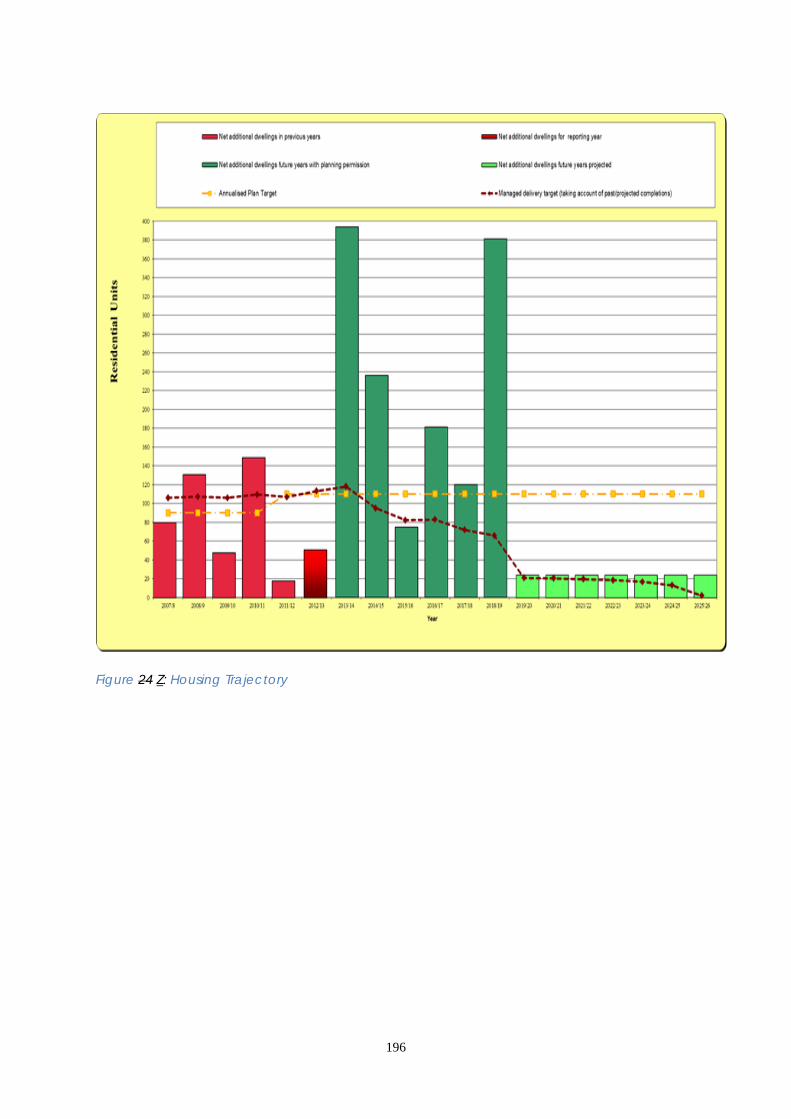
196
Figure 24 Z: Housing Trajectory

197
3.22 SOCIAL INFRASTRUCTURE AND OPPORTUNITIES 3.22.1 The City of London has a large daily working population and a comparatively small, but growing, residential population. Changes to the way healthcare is accessed means that the demand for health facilities from the City’s working population may increase significantly. In order to deliver accessible and affordable social, community and educational facilities the City Corporation must make the best use of existing facilities and work jointly with neighbouring boroughs, health providers and organisers organisations and other providers. Existing and new facilities should be multi-use and, where possible, cater for the needs of both residents and workers. 3.22.2 There are large numbers of privately run health facilities in the City which mainly cater for the needs of the working population. Although such facilities are encouraged, they are difficult to plan for as provision will reflect demand from City workers and businesses, rather than be determined by the health needs of the residential population. The City Corporation now has responsibility for the provision and commissioning of public health services through its Health and Wellbeing Board. Not all NHS commissioned health services for residents can be provided within the City but out of borough services must be accessible for City residents. The catchment areas for primary care facilities are drawn so that all residential populations in the City and neighbouring boroughs have access to adequate health services. There is currently one GP practice located within the City and NHS East London and the City the City and Hackney Clinical Commissioning Group is working to ensure GP and community health service provision is accessible to the increasing residential population of the City of London. 3.22.3 Care Closer to Home sets out the vision for the development of primary care clinical networks in City and Hackney. Within these plans, City residents will be part of the South West network, and served by a new Primary Care Resource Centre based at the current St. Leonard’s Hospital Site. The City and Hackney Clinical Commissioning Group is working with the City Corporation and the Neaman Practice to look at integrated (out of hospital) care to ensure an appropriate model is developed for the City. The Bart’s and the London NHS Trust is implementing a major redevelopment programme to transform the existing Bart’s Hospital site into a Cancer and Cardiac Centre of Excellence, incorporating services from the London Chest Hospital in Bethnal Green, alongside other local facilities. 3.22.4 There are a number of educational institutions in the City that provide learning and training opportunities to support local job creation and growth for the local community, particularly in the City fringe where there are high levels of deprivation. The London Metropolitan University and Guildhall School of Music & Drama provide higher education, while institutions such as the Bishopsgate Institute provide adult education courses. The Cass Business School and City University are located just outside the City’s boundary. These institutions run many courses aimed specifically at the needs of the City business community. 3.22.5 The City has one primary school, Sir John Cass, and several independent schools. The City Corporation provides a number of subsidised childcare places within the City and at Golden Lane Children’s Centre in Islington, and facilitates the provision of primary and secondary school places outside the City, as well as

198
funding secondary education through the sponsorship of academies in Southwark, Islington and Hackney. Demand for school places generated by City residents is currently met, but considerable growth in demand is projected over the next five years. The City Corporation has carried out a Social Infrastructure Audit which details relevant facilities both in and outside the City. 3.22.6 There is a thriving volunteering sector involved in the City of London that seeks to combat poverty, disadvantage and discrimination and improve the quality of life for communities and individuals. Services to provide information and advice for City workers and residents have been commissioned by the City of London and a forum exists to support organisations which provide information and advice within the City’s boundaries.
Figure 25 ZZ: Social and community infrastructure

199
Core Strategic Policy CS22: Social Infrastructure and Opportunities To maximise opportunities for the City’s residential and working communities to access suitable health, social and educational facilities and opportunities, while fostering cohesive communities and healthy lifestyles, by: 1. Maximising opportunities for delivering services and facilities for the City’s
communities, particularly residents: (i) continuing to work in partnership with neighbouring boroughs to deliver
accessible additional educational, health and community services and facilities; (ii) promoting opportunities for training and improving residents’ business and
other skills; (iii) supporting the development and capacity of the voluntary sector. 2. Providing adequate health care facilities and services for City residents and
workers and creating healthy urban environments: (i) protecting and enhancing existing public health facilities and providing new
facilities where necessary; (ii) encouraging the provision of private health facilities; (iii) supporting the continued presence and improvement of St. Bartholomew’s
Hospital in the City; (iv) ensuring that the use, design and management of new development and
spaces help deliver healthy outcomes, particularly for more deprived residents. 3. Protecting and enhancing existing community facilities and providing new
facilities where required, whilst allowing flexibility in the use of underused facilities, including places of worship. There should be no overall loss of community facilities (D1) in the City, where a need exists.
4. Improving the skills and education of all the City’s communities: (i) providing adequate educational facilities and services to meet the
community’s needs; (ii) protecting and enhancing existing education facilities including schools,
adult and higher education premises, and ensuring that new facilities are sited in appropriate locations;
(iii) continuing to provide and improve social and educational services through the City’s libraries;
(iv) ensuring adequate childcare facilities, including nursery provision and crèches. Encouraging nursery providers and businesses to establish additional childcare facilities, where a need exists.

200
DEVELOPMENT MANAGEMENT POLICIES Policy DM 22.1 Location and protection of social and community facilities 1) To resist the loss of social and community facilities unless: • replacement facilities are provided on-site or within the vicinity which meet the
needs of the users of the existing facility; or • necessary services can be delivered from other facilities without leading to, or
increasing, any shortfall in provision; or • it has been demonstrated that there is no demand for another similar use on site. 2) Proposals for the redevelopment or change of use of social and community
facilities must be accompanied by evidence of the lack of need for those facilities. Loss of facilities will only be permitted where it has been demonstrated that the existing floor space has been actively marketed at reasonable terms for public social and community floorspace.
3) The development of new social and community facilities should provide flexible,
multi-use space suitable for a range of different uses and will be permitted: • where they would not be prejudicial to the business City and where there is no
strong economic reason for retaining office use; • in locations which are convenient to the communities they serve; • in or near identified residential areas, providing their amenity is safeguarded; • as part of major mixed-use developments, subject to an assessment of the scale,
character, location and impact of the proposal on existing facilities and neighbouring uses.
4) Developments that result in additional need for social and community facilities
will be required to provide the necessary facilities or contribute towards enhancing existing facilities to enable them to meet identified need.
3.22.7 Social and community facilities contribute to successful communities by providing venues for a wide range of activities and services. As such they make a significant contribution to people’s mental and physical well-being, sense of community, learning and education. Library and educational facilities for children and those that support the City’s business role are particularly important and will be protected where there is a demand for these facilities. It is recognised that there may be advantages of locating organisations together so that they can share resources. 3.22.8 Social and community accommodation will be protected, unless it can be demonstrated to the City Corporation’s satisfaction that there is no demand from social and community users for this floorspace or that the loss of floorspace is part of a published asset management plan, in the case of non-commercial enterprises. 3.22.9 Where existing social and community floorspace is to be relocated, the replacement floorspace should be within the City. However, for services that serve a
201
wider catchment area, relocation outside the City, but within a reasonable distance, might be acceptable. 3.22.10 Where rationalisation of services as part of asset management plans would result in either the reduction or relocation of social and community floorspace, the replacement floorspace must be of a comparable or better standard. Policy DM 22.2 Provision of public toilets A widespread distribution of public toilets which meet public demand will be provided by: • requiring the provision of a range of public toilet facilities in major retail and
leisure developments, particularly near visitor attractions, public open spaces and major transport interchanges. This includes the provision of pop-up toilets in suitable areas with concentrations of night-time activity;
• supporting an increase in the membership of the Community Toilet Scheme; • resisting the loss of existing public toilets unless adequate provision is available
nearby and requiring the provision of replacement facilities; • taking the opportunity to renew existing toilets which are within areas subject to
major redevelopment schemes and seeking the incorporation of additional toilets in proposed developments where they are needed to meet increased demand.
3.22.11 Public toilets are important facilities for everyone who visits, works or lives in the City, particularly for the elderly, people with disabilities and chronic illnesses and carers with small children. Areas of the City with concentrations of night-time entertainment require adequate toilet provision to prevent fouling of the streets. 3.22.12 The City Corporation provides public toilets and aims to provide a distribution which effectively meets public demand, but this needs to be supplemented by provision in major retail and leisure development. Where it is not feasible for major development to provide toilets, it is expected that the Community Toilet Scheme will be implemented in the development. The City Corporation provides attended toilets equipped with baby changing units and facilities for disabled people, while automatic toilets provide a 24-hour service. The Community Toilet Scheme allows the public to use toilet facilities in participating businesses. 3.22.13 Public toilets should be clearly sign-posted to ensure they are easily found. Facilities should be maintained by the owner as part of the overall maintenance of any development.
202
Who will deliver How we will make it happen Who When Delivering services and facilities Implementation of the Community & Children’s Services Department Business Plan.
City Corporation- Health and Wellbeing Board- Neighbouring boroughs- Partnership organisations
Ongoing
Implementing the City of London Community Toilet Scheme.
City Corporation
Ongoing
Residents’ meetings and consultation. City Corporation
Ongoing
Detailed guidance on the type and location of social and community facilities will be included in the Development Management DPD.
City Corporation
2012
Healthcare facilities and services Implementation of the NHS Delivery Plans and successor plans and strategies.
NHS Trusts- City Corporation Health and Wellbeing Board -City and Hackney Clinical Commissioning Group, NHS England, Public Health England - LB Tower Hamlets-
Ongoing
Ensuring the use, design and management of new development addresses the wider determinants of health.
City Corporation- Health and Wellbeing Board- Developers.
Ongoing
203
Development Operation of Primary Care Resource centre at St. Leonard’s Hospital site in Hackney.
NHS England NHS East London and the City and successor
Ongoing 2012
Commission a new dental practice in south-east of the City.
NHS England NHS East London and the City and successor
Social facilities and Services Encouraging new facilities which are multi-use and cater for both residents and workers.
City Corporation- Health and Wellbeing- LB Tower Hamlets.
Ongoing
Skills and education and facilities Implementation of the City of London School Organisation Plan. Implementation of the Children and Young People’s Plan. Implementation of the Adult and Community Learning Strategy.
City Corporation City Corporation City Corporation
Ongoing Ongoing Ongoing
SUPPORTING INFORMATION • City and Hackney Joint Strategic Needs Assessment CHPCT 2009 • City and Hackney Health Improvement Plan (2006-2009) CHPCT 2006 • City of London Community and Children’s Services Business Plan 2007-2010, City
of London 2009 • City of London Childcare Sufficiency Statement City of London 2008
3.22.7 The Sustainability Appraisal notes that this policy is likely to result in beneficial environmental, social and economic effects. RISK MANAGEMENT
3.22.8 3.22.14 The City’s small residential population means that it is likely that an adequate provision of social and community services and facilities will continue to be delivered during the lifetime of the Local Plan Core Strategy. There is likely to be an increased demand for private health facilities and increased pressure on the redevelopment of existing facilities to meet the needs of the financial and business sectors. Monitoring will be used to identify loss of facilities and the need for review of the Local Plan Core Strategy. MONITORING
3.22.9 Key monitoring indicators are: Opportunities for delivering services and facilities

204
● Surveys of resident and worker satisfaction levels • NI 7: Environment for a thriving Third Sector Healthcare facilities and services ● Reported satisfaction of City residents with primary care services Social facilities and services ● Number of community facilities Skills and education and facilities ● Number of City of London residents studying at level 2 and level 3 ● Number of childcare facilities in the City
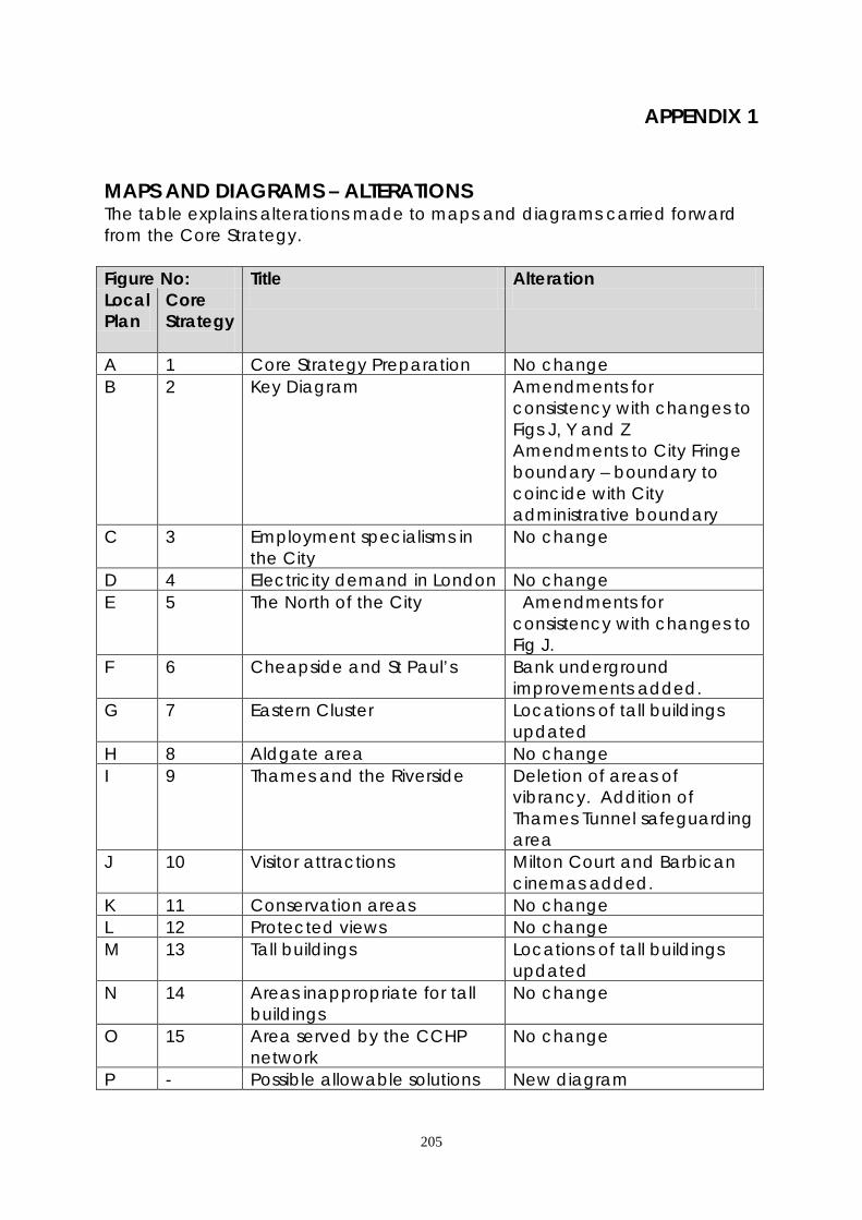
205
APPENDIX 1 MAPS AND DIAGRAMS – ALTERATIONS The table explains alterations made to maps and diagrams carried forward from the Core Strategy. Figure No: Title Alteration Local Plan
Core Strategy
A 1 Core Strategy Preparation No change B 2 Key Diagram Amendments for
consistency with changes to Figs J, Y and Z Amendments to City Fringe boundary – boundary to coincide with City administrative boundary
C 3 Employment specialisms in the City
No change
D 4 Electricity demand in London No change E 5 The North of the City Amendments for
consistency with changes to Fig J.
F 6 Cheapside and St Paul’s Bank underground improvements added.
G 7 Eastern Cluster Locations of tall buildings updated
H 8 Aldgate area No change I 9 Thames and the Riverside Deletion of areas of
vibrancy. Addition of Thames Tunnel safeguarding area
J 10 Visitor attractions Milton Court and Barbican cinemas added.
K 11 Conservation areas No change L 12 Protected views No change M 13 Tall buildings Locations of tall buildings
updated N 14 Areas inappropriate for tall
buildings No change
O 15 Area served by the CCHP network
No change
P - Possible allowable solutions New diagram
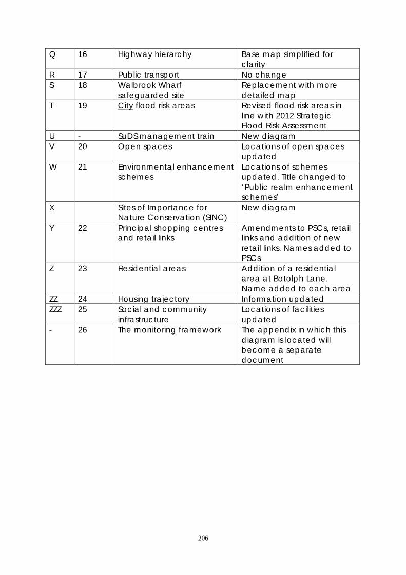
206
Q 16 Highway hierarchy Base map simplified for clarity
R 17 Public transport No change S 18 Walbrook Wharf
safeguarded site Replacement with more detailed map
T 19 City flood risk areas Revised flood risk areas in line with 2012 Strategic Flood Risk Assessment
U - SuDS management train New diagram V 20 Open spaces Locations of open spaces
updated W 21 Environmental enhancement
schemes Locations of schemes updated. Title changed to ‘Public realm enhancement schemes’
X Sites of Importance for Nature Conservation (SINC)
New diagram
Y 22 Principal shopping centres and retail links
Amendments to PSCs, retail links and addition of new retail links. Names added to PSCs
Z 23 Residential areas Addition of a residential area at Botolph Lane. Name added to each area
ZZ 24 Housing trajectory Information updated ZZZ 25 Social and community
infrastructure Locations of facilities updated
- 26 The monitoring framework The appendix in which this diagram is located will become a separate document

207
APPENDIX 2 POLICIES MAP The Policies Map (which is in two parts) accompanies the Local Plan and shows where its policies apply to specific locations. It will replace the Proposals Map which accompanies the Core Strategy. The tables below show the alterations that will be made between the current Proposals Map and the new Policies Map. POLICIES MAP A Policy No. Reason for alteration
City Culture & Heritage Conservation Areas CS 12 & 14
UDP ENV 11 & 13 DM 12.1 & 12.2
Revised policy numbers only
London View Management Framework – Protected Vista Viewing Corridors
CS 13 & 14 No change
London View Management Framework – Protected Vista Assessment Areas
CS 13 & 14 No change
St Paul’s Heights Policy Area CS 13 & 14 No change
Monument Views and Setting CS 13 & 14 No change
Airport Safeguarding Area CS 14 No change
Tower of London World Heritage Site – Local Setting Area
CS 12
No change
POLICIES MAP B Policy No. Reason for alteration Key City Places Smithfield CS 5
UDP ECON 6 The area is no longer specifically defined in a policy.
Thames Policy Area CS 9 No change Site of Metropolitan Importance for Nature Conservation
CS 9 No change

208
The Temples CS 9 UDP HOUS 3 DM 21.4
Revised policy numbers only
Safeguarded Wharf CS 9 & 17 No change Riverside Walk CS 9 No change Environmental Sustainability Crossrail Safeguarding Area CS 5 & 16 No change Bank Station Improvements Safeguarding Area
CS 16 Addition
Highway Widening Line UDP TRANS 9 & 10 Three proposals for widening in London Wall are no longer to proceed and so are deleted.
Strategic Road CS 16 UDP TRANS 9 & 11
Revised policy numbers only
London Distributor Road CS 16 UDP TRANS 9 & 11
Revised policy numbers only
Borough Distributor Road CS 16 UDP TRANS 9 & 11
Revised policy numbers only
Local Distributor Road CS 16 UDP TRANS 9 & 11
Revised policy numbers only
Strategic Cycle Route (London Cycle Network)
UDP TRANS 12 The London Cycle Network is now considered in the Local Implementation Plan (LIP) and the routes are currently under review. However, as the network is not referred to in any policy of the Local Plan it is deleted from the Policies Map.
City Flood Risk Area
CS 18 DM 18.1
The boundary of the area has been amended in line with the 2012 Strategic Flood Risk Assessment.
Thames Tideway Tunnel Safeguarding Area
CS 18 Area covered by safeguarding direction issued by the Secretary of State 5 October 2012.
City Communities Principal Shopping Centre CS 20
UDP SHOP 5, 8 & 9 DM 20.1
The centre frontages are revised.

209
CITY OF LONDON LOCAL PLAN GLOSSARY Explanation of terms used in the City of London Local Plan. * Terms explained elsewhere in the glossary are marked with an asterisk. Affordable Housing
Affordable housing is defined primarily by affordability and not by tenure. It comprises ‘social rented housing’; ‘affordable rented housing’ and ‘intermediate housing.’ Social rented housing is at rents no greater than target rents set by government for local authority, Registered Social Landlords* (RSL) and cooperative tenants. Affordable rented housing has the same characteristics as social housing but is offered at up to 80% of local market rentals. Intermediate housing is sub-market housing where costs are above target rents for social rented housing but are below open market levels and are affordable by households on moderate incomes. Intermediate housing can include shared ownership, sub-market rented and key worker provision.
AMR Authority’s Monitoring Reports Reports identifying progress in meeting the timetable of the Local Development Scheme* (LDS) and containing indicators and targets to assess success in the delivery of Local Plan policies.
Apart-hotel Apart-hotels provide accommodation for short or medium-term stays and generally provide more amenities for daily use (such as a small kitchenette) than standard hotel accommodation. They have a reception area where customers can access services without pre-booking and are available on a nightly basis without a deposit being required against damages.
Cash-in-lieu Payments of money received from developers instead of the provision of affordable residential units in the City of London or in neighbouring boroughs. The money is pooled and used by the City Corporation when opportunities to develop affordable housing arise.
CAZ Central Activities Zone The area defined in the London Plan* where planning policy promotes financial and business services, specialist retailing, tourist and cultural uses and activities. The City is wholly within the CAZ.
Central London Local Resilience Forum A forum bringing together the emergency services, the Health Service, government bodies, Transport for London,* utilities, businesses, the City Corporation and the boroughs of Kensington & Chelsea, Lambeth, Southwark, Tower Hamlets and Westminster. It provides a forum for co-operation and joint working between organisations across central London to ensure the effective preparation and delivery of emergency plans.

210
CPAT City Property Advisory Team A service provided by the City Corporation to help businesses find and retain premises in the City and City fringe and assist developers in delivering their schemes to the market.
CIL Community Infrastructure Levy A statutory charge on new development used to contribute towards the funding of infrastructure provision. The City Corporation is preparing a CIL charging schedule that will implemented in April 2014.
CAAC Conservation Area Advisory Committee A consultative group set up to advise on planning applications and other proposals in the City’s conservation areas.
Core Strategy A Development Plan Document* (DPD), adopted in September 2011, that sets out the overall vision and key policies for planning the City. It is being reviewed and incorporated into the Local Plan.*
City Flood Risk Area Area of the City which is susceptible to flooding from the River Thames, surface water or the sewer network.
Culturally Significant Object Objects which people identify and value and which reflect their evolving knowledge, culture, beliefs and traditions.
DCMS Department of Culture, Media and Sport Central government department of state whose responsibilities include recreation, the arts and historic buildings.
Decentralised Energy Energy that is generated close to the place where it is used, so that transmission of electricity, heat and other energy carriers are minimised. Deconstruction The act of breaking down a building into components or dismantling - this allows for recycling of the resulting materials. Different to demolition which involves wrecking, destroying or tearing down completely.
Development Management The process by which the City Corporation (and, where appropriate, the Mayor of London and Secretary of State) determine applications for planning permission and related consents. Applications are decided with regard to the development plan,* NPPF* and other material considerations.
Design Council Advisor to central and local government on good design. It includes CABE, the Commission for Architecture and the Built Environment.*
DCLG Department of Communities and Local Government The government department of state whose responsibilities include town planning.

211
Development Plan The statutory documents that together set out the planning policies for an area. In the City the development plan comprises the Mayor’s London Plan* together with the City’s Core Strategy* and the remaining policies of the Unitary Development Plan*. The last two will be replaced by the Local Plan* in 2014.
DPD Development Plan Document Statutory planning policy document whose preparation process includes public examination. There is one adopted DPD in the City: the Core Strategy DPD*, which will be replaced by the Local Plan DPD*.
Eco Design Design which incorporates improvements to the environmental performance of a building.
EDO Economic Development Office The City Corporation’s service to promote the financial and business City and encourage inward investment.
English Heritage The body responsible for advising the government, local authorities and others on historic buildings and archaeology.
GLA Greater London Authority The GLA comprises the Mayor of London* (who has an executive role and makes decisions on behalf of the GLA) and a separately elected Assembly (a body of 25 elected Members which has a scrutiny role and is responsible for appointing GLA staff).
Green Corridors Almost continuous areas of open space which are linked. They can act as wildlife corridors and serve amenity, landscape and access roles.
Green Infrastructure A strategically planned and managed network of green spaces and other environmental features vital to the sustainability of any urban area. This includes (although not exclusively) trees, green roofs and walls and green corridors.
Heritage Asset A building, monument, site, place, area or landscape positively identified as having a degree of significance meriting consideration in planning decisions. Heritage assets are the valued components of the historic environment. They include listed buildings, conservation areas, scheduled ancient monuments and world heritage sites, among others.

212
Highway Hierarchy Categorisation of streets by Transport for London to provide guidance on preferred types of traffic depending on the suitability within the street network: Strategic Road - Nationally significant roads used for the distribution of goods and services, and a network for the travelling public. London Distributor Road - Roads which provide links between the Transport for London Road Network and which distributes traffic to neighbouring boroughs. “Borough” Distributor Road - Roads providing suitable routes for emergency vehicles and in some cases public transport. Local Distributor Road - Roads whose function is to distribute local traffic within and to each part of the City. Local Access Road - Roads whose function is to distribute local traffic and to provide access to local centres.
Hostile Vehicle Mitigation Structural measures that prevent access to, or close proximity of, unscreened vehicles to a building or space, or measures that reduce the speed of vehicles approaching a site or its defences.
Housing Trajectory A projection of the number of new homes expected to be added to the City’s housing stock over a given time period.
Intermediate Transport Modes Modes of transport which enable multiple individuals to access a single motor vehicle at different times, thus reducing parking demand, e.g. taxis, coaches, car clubs, private hire vehicles.
Lifetime Homes Ordinary homes designed to provide accessible and convenient accommodation for a large segment of the population from young children to frail older people and those with temporary or permanent physical or sensory impairments.
Listed Building A building or structure protected because of its historic or architectural interest. The list of such buildings is drawn up by English Heritage* and the Department of Culture, Media and Sport.*
LDD Local Development Document Documents containing policies and guidance, comprising Development Plan Documents*, Supplementary Planning Documents* and the Statement of Community Involvement*.
LDF Local Development Framework A term used between 2004 and 2012 for the documents that contain the planning policies and guidance for the City. These included the Core Strategy*, Supplementary Planning Documents*.
LDS Local Development Scheme Timetable and project plan for producing the Local Plan.* It is regularly updated.
213
LIP Local Implementation Plan Statutory transport plan produced by the City Corporation bringing together transport proposals to implement the Mayor’s Transport Strategy at the local level.
Local Plan The document setting out the strategy, vision and policies and proposals for planning the City. It will incorporate the Core Strategy.* It is prepared in consultation with the public and will be adopted in 2014.
London Plan (Spatial Development Strategy) Prepared by the Mayor of London*, it provides a London-wide planning strategy and the City’s Local Plan* must generally conform to it.
LVMF London View Management Framework Guidance by the Mayor of London* on the protection of important views, including those of St Paul’s Cathedral and the Tower of London.
Major development Residential development of 10 or more dwellings or on a site of 0.5 hectares or more, and all other development of 1,000 square metres or more floorspace, or on a site of 1 hectare or more.
Mayor of London The Mayor is the executive head of the Greater London Authority* and is also responsible for a number of related organisations, including Transport for London,* Homes for London Board and the Metropolitan Police Authority. The Mayor prepares London-wide strategies, including those for planning (the London Plan*), transport, waste, energy, economic development, housing and air quality. He has powers to direct decisions on large planning applications.
Municipal Waste Waste collected by a local authority, including domestic waste and street cleansing waste. It also includes commercial waste collected by the authority, although waste producers may also have this privately collected.
NPPF National Planning Policy Framework The government’s statement of planning guidance to local planning authorities, issued by the Department of Communities and Local Government* in March 2012. The City Corporation must take account of it in preparing and implementing its planning policies.
Offsetting Measures The measures permitted for dealing with residual emissions remaining after taking account of energy efficiency and decentralised and low carbon energy sources e.g. retrofitting works undertaken by a developer to improve the energy efficiency of existing buildings in the vicinity of the development; export of low carbon heat from the development to other developments; or investment in low carbon community heat infrastructure.
214
Open Space Land which is not built on and which has some amenity value or potential for amenity value. Amenity value is derived from the visual, recreational or other enjoyment which the open space can provide, such as historic and cultural interest and value. This includes open spaces in public or private ownership.
Pipe Subway Tunnels, mainly under streets, that accommodate utilities such as gas and water pipes and electricity and telecommunications cables, providing a more efficient alternative to burying these in the ground.
Planning Obligations Legal agreements negotiated between the City Corporation and developers (or offered unilaterally by developers) setting out financial and non-financial undertakings relating to a planning permission. Also known as “section 106 Agreements.” From April 2014 some financial planning obligations in the City will be replaced by the Community Infrastructure Levy*.
Policies Map A map accompanying the Local Plan* showing where its policies apply to specific locations.
Proposals Map A map showing where policies of the Core Strategy* and Unitary Development Plan* apply to specific locations. It will be replaced in 2014 by the Policies Map* accompanying the Local Plan.*
Public Examination The Local Plan* will be subject to public examination before an independent planning inspector. The inspector assesses the “soundness” of the Local Plan.
Rejuvenation Maximising opportunities for enhancement through appropriate redevelopment.
RSL Registered Social Landlord Not for profit providers of affordable* and other social housing, including housing associations and regulated by Government.
Residential Amenity The pleasant or advantageous features of a residence which contributes to its overall character and the enjoyment of residents.
Safer City Partnership A partnership, comprising representatives from a range of City interests, whose aim is to reduce the level of crime, disorder, antisocial behaviour, terrorism and substance use in the City.
Secured By Design A crime prevention initiative, to encourage those involved in the development industry to adopt crime prevention measures to assist in reducing the opportunity for crime and the fear of crime, creating a safer and more secure environment.

215
SINCs Sites of Importance for Nature Conservation The Greater London Authority* designated SINCs to highlight areas of ecological value in the City. The sites are graded as being of Metropolitan, Borough or Local importance.
SA Sustainability Appraisal The Local Plan* is subject to SA, which ensures that it is soundly based on the principles of sustainable development. SA is carried out as the policies are developed or reviewed so that they can take account of its findings.
SEA Strategic Environmental Assessment The environmental assessment of plans, required by EU Directive 2001/42/EC. It is carried out as part of the sustainability appraisal*.
SCI Statement of Community Involvement The City’s plan for public consultation on planning policy documents and planning applications, adopted in 2012.
SPD Supplementary Planning Document A document that explains the policies of the Core Strategy* and Local Plan* in detail. It is subject to consultation, but not public examination.*
SPG Supplementary Planning Guidance Guidance that was prepared by the City Corporation to explain some of the policies of the Unitary Development Plan* in more detail. The City’s SPG is being replaced by supplementary planning documents*. The Mayor of London* also prepares SPGs to explain policies of the London Plan.*
SuDS Sustainable Drainage Solutions A range of sustainable measures for surface water management which reduce the amount, flow or rate of surface water discharge into sewers.
Temporary Sleeping Accommodation Accommodation occupied by the same person for less than 90 consecutive nights under the Greater London Council (General Powers) Act 1973 and 1983. Also referred to as short-let accommodation.
TCT The City Together The Local Strategic Partnership for the City. This is an umbrella partnership (comprising the key public, voluntary and private sector providers and representatives of the City’s business and residential communities) which is committed to improving the quality of life, governance and service provision in the City.
The City Together Strategy Subtitled “The Heart of a World Class City 2008-2014” and prepared by The City Together,* this is the City’s sustainable community strategy. It aims to improve and co-ordinate service delivery in the Square Mile.
TfL Transport for London The body, under the control of the Mayor of London,* responsible for strategic transport policy and the provision of public transport, including buses and the underground. TfL is responsible for certain major streets in the City.
216
Tower of London World Heritage Site Consultative Committee A committee of experts and policy makers providing guidance for the preparation and implementation of the Tower of London Management Plan, and comprising representatives from: Historic Royal Palaces, City Corporation, English Heritage*, GLA*, , International Council on Monuments and Sites (ICOMOS), Department of Culture, Media and Sport* (DCMS) and the London Boroughs of Southwark and Tower Hamlets.
UDP Unitary Development Plan The City of London UDP, adopted in 2002, was the previous plan for the City. Most of its policies have lapsed, but 55 will remain in force until the adoption of the Local Plan* in 2014.
UNESCO United Nations Educational, Scientific and Cultural Organisation Among UNESCO’s responsibilities are the inscription of World Heritage Sites, which include the Tower of London.
Waste Management The London Plan’s* definition of waste management includes its use for energy recovery or composting or recyclate sorting and bulking, but does not include waste transfer.
Wheelchair Housing Standards Homes built to meet the standards set out in the second edition of the Wheelchair Housing Design Guide by Stephen Thorpe, Habinteg Housing Association 2006.
Windfall Housing Housing development that does not take place on sites identified in the Development Plan* or on the Policies Map* but is brought forward by developers.
World Heritage Site A site inscribed by UNESCO* for its outstanding universal value. The Tower of London, located just outside the City’s boundaries, is so designated.