city of kingston heritage study place identification form
TRANSCRIPT

City of Kingston Heritage Place No 35
City of Kingston Heritage StudyPlace Identification Form (2001)
B r y c e R a w o r t h P t y L t d1 9 V i c t o r i a S t r e e t , S t K i l d a 3 1 8 2 , A u s t r a l i a
Address/Location of PlaceCourthouse Reserve, The Strand, Chelsea
Type of PlaceMemorial
Name of PlaceGeorge Gilding Memorial
Alternate Name(s) of Place
Listings andC o n t r o l s
Victorian HeritageRegister
Yes � No g
Register of theNational Estate
Yes � No g
Register of theNational Trust(Victoria)
Yes � No g
Construct ionDate
1945Source
Site inspection
History and Description
First constable George Gilding is remembered by way of a small memorial constructed in the grounds of the Chelsea Court House afterhis death in 1945. The modest memorial incorporates a number of stone elements arranged in an informal manner around a simplemarble plaque. The plaque is inscribed "To the memory of 1st Constable Geo R Gilding May 5th 1945. The memorial was fundedthrough public donation
1 Barnard & Sheehan, City of Kingston Heritage review, part 1.
"To the mC o n d i t i o n
Excellent g Good � Fair � Poor � Ruins �
I n t e g r i t y
Substantially Intact g Altered Sympathetically � Altered Unsympathetically � Damaged/Disturbed �
Comparable examples within the City of Kingston
The George Gilding memorial compares to a number of others within the Municipality including the memorial to an early head teacherat Clayton South Primary School; Memorial clock towers on the Nepean Highway in Mordialloc and Chelsea; the memorial plaquefixed to an early horse trough and dedicated to equestrians, Violet and Bill Murrell, in Station Reserve in Mentone and many others.

City of Kingston Heritage Place No 35
Statement of Significance
Constructed in 1945 the George Gilding memorial in the garden of the former Chelsea Courthouse is of social, and architecturalsignificance at a local level. The memorial is socially significant as an expression of gratitude by the local community for the work ofConstable George Gilding. It is architecturally significant in its own right as a simple and understated design and for the contributionthat it makes to an understanding of the former courthouse building
Recommendat ions
A heritage overlay is recommended for the structure.
City of Kingston Planning Scheme
Recommended for inclusion in a heritage overlay to the Planning Scheme Yes g No �Should external paint controls apply? Yes g No �Should internal alteration controls apply? Yes � No g
Should tree controls apply? Yes � No g
Other Listings and Controls
Recommended for inclusion on the Victorian Heritage Register? Yes � No g
Recommended for inclusion on the Register of the National Estate? Yes � No g
Recommended for inclusion on the National Trust (Victoria) Register? Yes � No g

City of Kingston Heritage Precinct No P22
City of Kingston Heritage StudyPlace Identification Form (2001)
B r y c e R a w o r t h P t y L t d1 9 V i c t o r i a S t r e e t , S t K i l d a 3 1 8 2 , A u s t r a l i a
Address/Location of Place1132-1142 Nepean Highway, Highett.
Type of PrecinctFormer Industrial Complex. Now a Business Park.
Name of PlaceHighett Gasworks Precinct.
Alternate Name(s) of PlaceHighett Gas Technology Business Centre.
Listings andC o n t r o l s
Victorian HeritageRegisterYes c No g
Register of theNational EstateYes c No g
Register of theNational Trust(Victoria)Yes c No g
Construct ionDate
From 1939Source
Refer History
History and Description
Supporters of the Central Brighton and Moorabbin Gas Company first convened in March 1886.1 They quickly resolved to establish agas company to provide competition to the existing Brighton Gas Co. By February the following year, Coates & Co had begunconstruction of a new gas manufacturing plant at the intersection of Well & Burrow Streets. It opened in August 1887. The newcompany offered gas at considerably cheaper rates than its rival, which promptly reduced its charges to match. With its stated aim ofcheaper charges achieved, the Central Brighton and Moorabbin Gas Company began to examine the possibility of a merger. BySeptember the two companies had agreed to an amalgamation. The Central Brighton plant was dismantled and local gas requirementswere served by a plant, located in New Street, Brighton, for the next half century.
In 1939 the Brighton Gas Company commissioned a substantial new plant on the Nepean Highway at Highett. This was the onlycompletely new black coal gas plant built in Victoria in the twentieth century. Aerial photographs of the site dating from the periodshortly after its construction show a group of lightweight production spaces in the western sections of the site.2 Two large gasometerswere located a little to the south and a number of administration areas had been constructed along the Nepean Highway frontage. Thegreater part of the site to the south remained undeveloped with little building evident in the southern sections of the site near Bay Road.
The Brighton Gas Company and the Metropolitan Gas Company amalgamated with the State Government in 1952 to form the Gas &Fuel Corporation of Victoria. The union heralded a period of extensive change within the local gas industry.3 From the mid 1950s gasfrom brown coal deposits at Morwell became available as did refinery gas formed as a byproduct of the oil refining process. As aconsequence, the Highett facility was used increasingly to blend gases from other sources. These technological developments broughtabout marked changes in the appearance of the site in the 1950s and 1960s.The last gas was made at the Highett plant in 1969 when theGas & Fuel Corporation converted the entire Victorian system to natural gas from undersea deposits.4 The Highett plant wasdecommissioned shortly afterwards.

City of Kingston Heritage Precinct No P22
History and Description (continued)
Aerial photographs from 1970 show two additional gasometers and marked expansion of the gas production/blending facilities at thenorth of the site.5 By this time, virtually all of the early administration areas had been demolished. A section of this land along thehighway frontage had been sold to Mason Firth & McCutcheon c.19556 who constructed a group of factory and office buildings on thesite. This group was later purchased and expanded on by printers, Leigh Mardon. The undeveloped southern section of the site was soldoff by the Gas & Fuel corporation to help finance Metropolitan Melbourne's conversion to natural gas. It now forms the Sir WilliamFry reserve.
Over the last thirty years, the site has been extensively altered. The Gas & Fuel Corporation retained the considerably reduced site andredeveloped it as a gas sales, information and administration centre, known most recently as the Highett Gas Technology BusinessCentre. A number of large new buildings were constructed through the 1970s and 1980s to the extent that the site today presents as abusiness park rather than a production facility. Virtually all of the infrastructure associated with the production of gas, most notablythe gasometers and production areas, has been demolished in the past three decades. The only built element to survive from the originalconstruction is a single remnant chimney from an early production building. A pair of simple red brick buildings adjacent to thechimney which present as interwar structures do not appear on the 1945 aerial photograph7 and are likely to date from c.1950. Aweighbridge located near the Nepean Highway entry to the site also dates from the post-war period.8
1 Unless noted otherwise, this extract is drawn from Proudley, Circle of Influence, pp.342-4.2 Aerial photograph, Melbourne and Metropolitan Project, Run 7, Photograph No 57309.3 Proudley, op cit, pp.227-9.4 Proudley, op cit, pp.269-70.5 Aerial photograph, Melbourne 1970 Project, October 1970, Run 47E, Photograph No 171.6 Conversation with, Maxine Styles, secretary to the CEO, Leigh Mardon, 24 January 2002.7 Aerial photograph, Melbourne and Metropolitan Project, December 1945, Run 7, Photograph No 57309.8 Ibid. The original principal entry was located to the south of the current location. No weighbridge is evident at that location in the 1945 aerial photograph.
I n t e g r i t y
Substantially Intact c Altered Sympathetically c Altered Unsympathetically c Damaged/Disturbed g
Comparative Examples within the City of Kingston
No comparable examples exist within the City of Kingston.
Statement of Significance
Constructed from 1939 until c.1990, the Highett Gasworks Precinct is of local social significance for its role in the development ofservices in neighbouring communities and as a large local employer. With the exception of a single remnant chimney, none of theinfrastructure relating to the significant period of the site appears to have survived.
Left: Remnant Chimney (1939) and Right: Red brick outbuilding (c.1950)

City of Kingston Heritage Precinct No P22
Recommendat ions
A heritage overlay is recommended for the remnant chimney and a small curtilage around the chimney only. It may be appropriate tomake some provision for interpretation of the early site incorporating this early structure and documentary material.
City of Kingston Planning Scheme
Recommended for inclusion in a heritage overlay to the Planning Scheme Yes g No c
Should external paint controls apply? Yes g No c
Should internal alteration controls apply? Yes c No g
Should tree controls apply? Yes c No g
Other Listings and Controls
Recommended for inclusion on the Victorian Heritage Register? Yes c No g
Recommended for inclusion on the Register of the National Estate? Yes c No g
Recommended for inclusion on the National Trust (Victoria) Register? Yes c No g

City of Kingston Heritage Precinct No P22
Aerial Photograph of Gasworks. Melbourne 1970 Project. Run 47E, Photo 171. By 1970, much of the Highway frontage had been sold anddeveloped as office space. The diamond-shaped section at the south of the site which then housed three gasometers and minor structures
near the intersection of Bay Rd and the Nepean Hwy is now a public park.

City of Kingston Heritage Precinct No P22
Aerial Photograph of Gasworks, Melbourne & Metropolitan Project, 1945, Run 7, Photo 57309.1945, the gasworks site occupied the entire strip between the Highway and the railway north of Bay Road

City of Kingston Heritage Place No 189
City of Kingston Heritage StudyPlace Identification Form (2003)
B r y c e R a w o r t h P t y L t d1 9 V i c t o r i a S t r e e t , S t K i l d a 3 1 8 2 , A u s t r a l i a
Address/Location of Place6 Bowman Street, Aspendale.
Type of PlaceHouse.
Name of PlaceCoolullah.
Alternate Name(s) of PlaceNone.
Listings andC o n t r o l s
Victorian HeritageRegisterYes c No g
Register of theNational EstateYes c No g
Register of theNational Trust(Victoria)Yes c No g
Construct ionDate
c.1932Source
Refer History
History and Description
The subject building, Coolullah, situated at 6 Bowman Street Aspendale, appears to have been built in 1932 as a holiday house. At thisstage Bowman Street was called William Street.1 The house was used by the Air Force/Navy as an observation post for Port Phillipduring WWII.2 The occupant from 1948 was Mrs HJ Crisp. Crisp occupied the house into the 1970s.3
The house is situated on a ridge and faces the Mordialloc Creek with rear views across the bay. It is built over three levels plus a roofgarden. The design adopts an arrangement of stark rectangular masses, combined to exhibit a studied asymmetry. It is a rare example ofan uncompromising modernist design within the Municipality. Cantilevering balconies and awnings, unadorned surfaces and strictrectilinear geometries enhance the stark Modernity of the dwelling.
Coolullah has recently been repainted and the front entry porch and garden have been renovated in a sympathetic manner.4
1 Sands and McDougalls Directory of Victoria 1930 – 1974. Held at the Royal Historical Society of Victoria, Melbourne.2 Information provided by Margaret Hunter. Mordialloc and District Historical Society.3 Sands and McDougalls. Op cit.4 Photograph of Place 189 taken 3/12/1999 for City of Kingston Heritage Study Stage One.
C o n d i t i o n
Excellent g Good c Fair c Poor c Ruins c
I n t e g r i t y
Substantially Intact c Altered Sympathetically g Altered Unsympathetically c Damaged/Disturbed c
City of Kingston Heritage Place No 189
Comparable examples within the City of Kingston
No comparable examples were identified within the City of Kingston by this study.
Statement of Significance
Coolullah, at 6 Bowman Street Aspendale, is of architectural significance at a local level as a rare and uncompromising Modernistdesign within the Municipality.
Recommendat ions
A heritage overlay is recommended for the building.
City of Kingston Planning Scheme
Recommended for inclusion in a heritage overlay to the Planning Scheme Yes g No c
Should external paint controls apply? Yes g No c
Should internal alteration controls apply? Yes c No g
Should tree controls apply? Yes c No g
Other Listings and Controls
Recommended for inclusion on the Victorian Heritage Register? Yes c No g
Recommended for inclusion on the Register of the National Estate? Yes c No g
Recommended for inclusion on the National Trust (Victoria) Register? Yes c No g

City of Kingston Heritage Place No 187
City of Kingston Heritage StudyPlace Identification Form (2003)
B r y c e R a w o r t h P t y L t d1 9 V i c t o r i a S t r e e t , S t K i l d a 3 1 8 2 , A u s t r a l i a
Address/Location of Place1 Nepean Highway, Mordialloc.
Type of PlaceHotel.
Name of PlaceBridge Hotel.
Alternate Name(s) of PlaceDoyles Hotel.
Listings andC o n t r o l s
Victorian HeritageRegisterYes c No g
Register of theNational EstateYes c No g
Register of theNational Trust(Victoria)Yes c No g
Construct ionDate
1871Source
Refer History
History and Description
The first Bridge Hotel was a two-roomed weatherboard building built by William Coleman of Mordialloc. Coleman had purchased theland for the hotel in May 1866. The beer license was obtained in 1868 suggesting that the hotel also opened that year. Coleman hadbeen a member of Collingwood’s first council in 1855 before relocating to Mordialloc. The present Bridge Hotel was built of bluestoneon land purchased from Sir James Palmer, a Lord Mayor of Melbourne. It was completed in 1871. As constructed, the Bridge Hotel was a2-storey building with a small single storey wing. The building had balconies to the north, east and west sides and a steeply pitchedslate roof. Numerous photographs of the original building survive.1
Coleman transferred the hotel license to E Marson in March 1874 and then to William Hambly Shepherd in February 1885. DuringShepherd's occupation of the hotel he extended the picnic grounds to accommodate up to 500 diners. It quickly became a popularmeeting place. By 1890, a single-storey wing had been added to the north side of the building. The hotel had many other notablelicensees over the years including Richard Bloxsidge a racing and hunting personality. Despite the large number of licensees, the hotelwas owned by William Coleman (and later by his estate) until 1915. From that time, the House family operated the hotel. By 1934, thebalcony had been removed along with much of the decorative detail. It is likely that the extensive works to the facade visible today datefrom the period shortly after this time. In 1954 Bob and Rosie Doyle purchased the hotel. It was sold to the Richmond Brewery Co in1960 and then taken over by Carlton & United Brewery in 1962.
Doyles Bridge Hotel situated at 1 Nepean Highway Mordialloc has been extensively modified and extended since the time of itsconstruction. The fabric at the centre of the hotel is thought to be amongst the oldest in the former City of Chelsea2. Virtually nonineteenth century fabric is visible from the highway. Later additions have largely subsumed the original building. Today, the hotelpresents to the street as an interwar structure. The central section of the building which incorporates the earlier fabric is a two-storeybuilding with a large balcony. Large 2-storey wings extend to either side. These contain large windows on the ground floor with robustbracketed awnings. These elements date from the interwar period and largely define the character of the building. Further single storeyadditions have been undertaken to the far north and south of the building.
1 Photo Heritage Australia, www.photoheritage.com.au.2 Frank McGuire. Chelsea by the sea: from swamp to city. Produced by City of Chelsea Historical Society. 2nd Edition 1971.

City of Kingston Heritage Place No 187
C o n d i t i o n
Excellent c Good g Fair c Poor c Ruins c
I n t e g r i t y
Substantially Intact c Altered Sympathetically c Altered Unsympathetically g Damaged/Disturbed c
Comparable examples within the City of Kingston
The principal comparative example within the City of Kingston is The Kingston Club Hotel, also located on the Nepean Highway atMordialloc but built around 20 years earlier. The Doyles/Bridge Hotel and the Kingston Club Hotel act as bookends to the Mordiallocshopping strip. Both are notable buildings with associations to the early history of Mordialloc and both have been extensivelyextended and modified over time.
Statement of Significance
Although, considerably altered, the Bridge Hotel on Nepean Highway, Mordialloc is of historical, social and some architecturalsignificance at a local level. The place is socially significant as a focus of the local community since the mid-nineteenth century and i tcontinues in its historical role. It is historically significant as one of a pair of extant early hotels in Mordialoc (the other being theKingson Club hotel) and fabric at the centre of the building is believed to be amongst the oldest in the area. The building is also ofsome architectural significance, primarily for its landmark presence on the highway.
Recommendat ions
A heritage overlay is recommended for the building. It should be noted that the significance of the building relates primarily to thehistoric use of the building and that interventions, which relate to the later physical fabric only are unlikely to affect that significance.Current and future owners should be encouraged to restore the early appearance of the building should the opportunity arise.
City of Kingston Planning Scheme
Recommended for inclusion in a heritage overlay to the Planning Scheme Yes g No c
Should external paint controls apply? Yes g No c
Should internal alteration controls apply? Yes c No g
Should tree controls apply? Yes c No g
Other Listings and Controls
Recommended for inclusion on the Victorian Heritage Register? Yes c No g
Recommended for inclusion on the Register of the National Estate? Yes c No g
Recommended for inclusion on the National Trust (Victoria) Register? Yes c No g

City of Kingston Heritage Place No 191
City of Kingston Heritage StudyPlace Identification Form (2001)
B r y c e R a w o r t h P t y L t d1 9 V i c t o r i a S t r e e t , S t K i l d a 3 1 8 2 , A u s t r a l i a
Address/Location of PlacePine Crescent, Aspendale.
Type of PlaceSchool.
Name of PlaceMordialloc-Chelsea High School.
Alternate Name(s) of PlaceMordialloc-Carrum HS, Mordialloc-Chelsea Secondary College.
Listings andC o n t r o l s
Victorian HeritageRegisterYes c No g
Register of theNational EstateYes c No g
Register of theNational Trust(Victoria)Yes c No g
Construct ionDate
1928Source
Refer History
History and Description
The Borough of Mentone and Mordialloc made the first recorded request to the Government for a high school in December 1922.Similar requests from the Borough of Carrum and the local RSSAILA and MPs followed. Subsequently, the Minister and the Director ofEducation selected a site for the school at Attenborough Park; a scrub covered area adjacent to the creek. The first headmaster, EdwardByrne settled his pupils in temporary accommodation in the Mechanics Institute on 18 February 1924. Soon afterwards, AJ Colocottbecame President of the newly formed Advisory Council and J Cully became permanent headmaster, a position he held until 1941.During his period in office he helped many pupils in financial need. The name of the school changed from Mordialloc District toMordialloc-Carrum High School on 24th August 1924, becoming the Mordialloc-Chelsea High School in 1929 when the Borough ofCarrum became the City of Chelsea.
On 15 March 1928, the £20,999 building was officially opened. Although planned to accommodate only 400 pupils, the schoolaccepted 407 enrolments. It consisted of eight classrooms, plus facilities for commercial, domestic science, woodwork, sheet metalwork and blacksmithing. Additions to the original two buildings included a caretaker’s cottage constructed in 1929, prefabricatedclassrooms and the small hall opened in 1956, the domestic and manual arts block erected in 1961 and the science block dating from1967. The Welfare Association opened a canteen in 1956. During 1967 the school reached its highest attendance with 911 pupils.Playing fields have been added to the original school property, some of the land was purchased by the Welfare Association in 1939.Principal HV Butler initiated extensive beautification of the school surroundings and, in conjunction with the advisory Council,initiated a co-operative society, which helped to finance the multi-purpose assembly hall opened by Director General Brooks in 1968.
1
1 This reference is drawn with minor editing from, Education Department of Victoria, Vision and Realisation: A Centenary History of State Education in Victoria,Vol III, Melbourne, 1973.

City of Kingston Heritage Place No 191
History and Description (continued)
The original school consisted of the High School building and the Manual Arts building at the rear. The main building comprised apolite tripartite design finished in red face brick. The manual training block was similar but more modest. The buildings are typical ofthe output of the Public Works under Chief Architect, E Evan Smith. The caretaker's cottage and a toilet block constructed as a part ofthe original development have since been demolished. The two principal buildings remain in good original condition although theearly character of the broader site has been compromised by the proliferation of modern buildings east of the original block.
C o n d i t i o n
Excellent c Good g Fair c Poor c Ruins c
I n t e g r i t y
Substantially Intact c Altered Sympathetically g Altered Unsympathetically c Damaged/Disturbed c
Comparable examples within the City of Kingston
There are no comparable examples within the City of Kingston. The original building, with rear verandah overlooking a partiallyenclosed court is typical of a number of schools produced by the Public Works department under E Evan Smith during the 1920s andearly 1930s. Similar, single storey examples include State schools at Ouyen (1928) and Nhill (1933). No contemporary two storeyschools employing this rear verandah treatment were identified as part of this study within the municipality.2
2 Richard Peterson, Historic Government Schools: A Comparative Study, prepared for Heritage Management Branch, Building Division, Department of Planningand Development, June 1993.
Statement of Significance
Opened in 1929, the original sections of the Mordialloc-Chelsea High School are of local architectural and social significance. Theyare architecturally significant as handsome and substantially intact interwar school buildings and are typical of the output of the PublicWorks Department under Chief Architect E Evan Smith. The school is socially significant for its long relationship with the localcommunity.
Recommendat ions
A heritage overlay is recommended for the two buildings dating from the original 1929 construction only.
City of Kingston Planning Scheme
Recommended for inclusion in a heritage overlay to the Planning Scheme Yes g No c
Should external paint controls apply? Yes g No c
Should internal alteration controls apply? Yes c No g
Should tree controls apply? Yes c No g
Other Listings and Controls
Recommended for inclusion on the Victorian Heritage Register? Yes c No g
Recommended for inclusion on the Register of the National Estate? Yes c No g
Recommended for inclusion on the National Trust (Victoria) Register? Yes c No g

City of Kingston Heritage Place No 3
City of Kingston Heritage StudyPlace Identification Form (2001)
B r y c e R a w o r t h P t y L t d1 9 V i c t o r i a S t r e e t , S t K i l d a 3 1 8 2 , A u s t r a l i a
Address/Location of Place64 Nepean Highway, Aspendale
Type of PlaceHouse
Name of PlaceBalmoral
Alternate Name(s) of Place
Listings andC o n t r o l s
Victorian HeritageRegister
Yes � No g
Register of theNational Estate
Yes � No g
Register of theNational Trust(Victoria)
Yes � No g
Construct ionDate
c.1939Source
Refer History
History and Description
Leslie Leyshon purchased the substantial site at 64 Nepean Highway from Ada Lukey around 1937. It appears that an earlier holidayhome had existed on the site but this was quickly demolished to make way for the commodious new residence known today asBalmoral1. The residence was completed in 1939 and, at the time of its construction, commanded uninterrupted views to the Dandenongranges and across Port Phillip Bay while enjoying direct access to the local beach.
It is understood that Leyshon was a key figure in the Nicholas organisation, which manufactured the pain killer Aspro. CompanyDirector, Alfred Nicholas, had commissioned a house in Sherbrooke Forest in the Dandenong Ranges in 1932. The massive residenceBurnham Beeches was completed in 1933 to designs by noted architect Harry Norris. It was among the first instances of a residentialdesign in the Streamline Moderne mode and brought enormous popularity to the style2. It has been suggested that the Leyshon familycontracted a builder to complete Balmoral along similar lines to Burnham Beeches3 although the horizontality, modernity and theexuberance of the original are less evident here. Rather, Balmoral employed a number of Moderne devices such as cylindrical buildingelements, curving balustrades and windows in a contemporary European style as a decorative applique to what is in essence asubstantial but straightforward gable-ended dwelling. Cylindrical towers to either end of the main body of the dwelling recall themassing of more traditional Northern European antecedents and those connections are reinforced by symmetry and formality of thearchitectural design and its steeply pitched roofs.
It is understood that the residence was used as a holiday home for the Leyshon family until 1949 when JLW McKay of East Prestonpurchased the property for a sum of £12,0004. Les McKay was a bookmaker who led the Australian Olympic team on the opening day ofthe London Olympic games in 1948. Through the early 1960s, Ian Naylor and later VR Venke lived in the house before FA James tookup residence around 1964. James occupied the property for over a decade.5 Businessman David Meisner lived in the property from 1982until the early 1990s.6

City of Kingston Heritage Place No 3
History and Description (continued)
The house was extended over the years and by the early 1990s, boasted 15 rooms including six bedrooms and four bathrooms6.However, the early character and generous 120 ft allotment remains intact and Balmoral survives as a one of a small group ofsubstantial homes which rose above the camps and shacks along the Aspendale foreshore.
1 City of Chelsea Ratebooks, 19372 Bryce Raworth, A Question of Style, unpublisged Masters Theseis, University of Melbourne 1993, p.123.3 Natalie Filmer, Balmoral Sale stalled, Mordialloc Chelsea News, 19 April 1991. p.9.4 City of Chelsea Property Sales Register, held at Chelsea Historical Society.5 Sands & Mc Dougall Directory of Victoria, 1946-1972.6 Filmer, loc cit.
C o n d i t i o n
Excellent g Good � Fair � Poor � Ruins �
I n t e g r i t y
Substantially Intact � Altered Sympathetically g Altered Unsympathetically � Damaged/Disturbed �
Comparable examples within the City of Kingston
Substantial, early holiday homes are reasonably rare within the municipality although a handful were built in the early part of thetwentieth century amongst the camps and shacks along the coast between Mordialloc and Carrum. Although some years older, Karalocated in nearby Kara Grove serves as the most direct comparison. No other dwellings adopting the unusual architectural expressionfound at Balmoral were noted as part of this study.
Statement of Significance
Balmoral, constructed on the Nepean Highway in Aspendale c.1939, is architecturally and historically significant at a local level. It isarchitecturally significant as a local landmark and for its unusual architectural expression. It is historically significant for itsassociations with the early development of the area as a holiday destination.
Recommendat ions
A heritage overlay is recommended for the building.
City of Kingston Planning Scheme
Recommended for inclusion in a heritage overlay to the Planning Scheme Yes g No �Should external paint controls apply? Yes g No �Should internal alteration controls apply? Yes � No g
Should tree controls apply? Yes � No g
Other Listings and Controls
Recommended for inclusion on the Victorian Heritage Register? Yes � No g
Recommended for inclusion on the Register of the National Estate? Yes � No g
Recommended for inclusion on the National Trust (Victoria) Register? Yes � No g

City of Kingston Heritage Place No 6
City of Kingston Heritage StudyPlace Identification Form (2001)
B r y c e R a w o r t h P t y L t d1 9 V i c t o r i a S t r e e t , S t K i l d a 3 1 8 2 , A u s t r a l i a
Address/Location of Place3 Kara Grove, Aspendale
Type of PlaceHouse
Name of PlaceKara
Alternate Name(s) of PlaceJC Williamson House
Listings andC o n t r o l s
Victorian HeritageRegister
Yes � No g
Register of theNational Estate
Yes � No g
Register of theNational Trust(Victoria)
Yes � No g
Construct ionDate
c.1924Source
Refer History
History and Description
Although the Aspendale area had its share of substandard homes constructed among the ti-tree between the highway and the bay, it alsohad a number of solidly built spacious dwellings built by several Melbourne businessmen as holiday houses or family homes. Theseinclude , Kara on the La Boheme estate (now Kara Drive).1
It has been suggested that the dwelling was constructed in the early 1920s although the architectural style would suggest a constructiondate c.1910s. The original owner is unclear. It has been suggested that the dwelling was constructed by noted entrepreneur John Cassius(JC) Williamson although no evidence to substantiate this claim has been found.2 Williamson died in 1913 and spent many of his finalyears overseas and a close connection with the site appears unlikely. By 1924, Leslie H Biddle is noted as the owner of the property.By 1930, Horace Frank Richardson is noted as the occupant. The property has changed hands on a number of occasions since that time.
Kara is a substantial arts and Crafts villa of note for its complex massing of building elements and roof forms. It retains to a largedegree its early ti-tree setting which contributes to the early character of the place.
1 Frank McGuire, Chelsea: A Beachside Community, p.116.2 Frank McGuire, Chelsea: A Beachside Community, p.116.3 Ian G Dicker, JCW A short biography of James Cassius Williamson, 1974, discusses Williamson's residences elsewhere but makes no reference to property in
Aspendale .4 City of Chelsea ratebooks, various years.
C o n d i t i o n
Excellent � Good g Fair � Poor � Ruins �
I n t e g r i t y
Substantially Intact � Altered Sympathetically g Altered Unsympathetically � Damaged/Disturbed �

City of Kingston Heritage Place No 6
Comparable examples within the City of Kingston
Substantial, early holiday homes are reasonably rare within the locality although a handful were built in the early part of the twentiethcentury amongst the camps and shacks along the coast between Mordialloc and Carrum. Although some years younger, Balmorallocated on the Nepean Highway serves as the most direct comparison.
Statement of Significance
Constructed c.1910s, Kara is architecturally and historically significant at a local level. It architecturally significant as a handsomeArts and Crafts villa and an example of the solidly built spacious dwellings that rose infrequently amongst the camps and shacks alongthe coast between Mordialloc and Carrum. It is historically significant for its associations with the early development of the area as aholiday destination.
Recommendat ions
A heritage overlay is recommended for the building.
City of Kingston Planning Scheme
Recommended for inclusion in a heritage overlay to the Planning Scheme Yes g No �Should external paint controls apply? Yes g No �Should internal alteration controls apply? Yes � No g
Should tree controls apply? Yes � No g
Other Listings and Controls
Recommended for inclusion on the Victorian Heritage Register? Yes � No g
Recommended for inclusion on the Register of the National Estate? Yes � No g
Recommended for inclusion on the National Trust (Victoria) Register? Yes � No g

City of Kingston Heritage Place No 233
City of Kingston Heritage StudyPlace Identification Form (2001)
B r y c e R a w o r t h P t y L t d1 9 V i c t o r i a S t r e e t , S t K i l d a 3 1 8 2 , A u s t r a l i a
Address/Location of PlaceLaura Street, Aspendale.
Type of PlaceSchool.
Name of PlaceAspendale Primary School.
Alternate Name(s) of PlaceState School No 4193.
Listings andC o n t r o l s
Victorian HeritageRegisterYes c No g
Register of theNational EstateYes c No g
Register of theNational Trust(Victoria)Yes c No g
Construct ionDate
1925Source
Refer History
History and Description
Aspendale Primary School was established on 11 January 1925 by the first Head Teacher, Frank Holloway and his two assistants. Theschool started with 112 students and was opened by the Minister of Public Instruction, Sir Alexander Peacock MLA. An ‘L’ shapedbuilding was built with five classrooms a Head Teacher’s office and a staff room. By the 1970s the façade had largely been obscured bythe construction of a large single storey addition to the front of the building. The additions comprised additional nine classrooms and alibrary. The school population remained relatively modest until the local racecourse was subdivided for housing.1
This simple red brick, single storey school is largely obscured by additions to the front of the building. Only the early entry and roofforms remain visible. The entry is distinguished by a portico with a pediment and columns drawing from Greek Revival sources (seephoto over page). The school is finished in face brick with a cementitious tiled roof and timber multi-paned windows. The lateradditions adopt the same range of materials, utilising the same colour brickwork, similar multi-paned windows and trims. The additionsare roofed in steel decking.
1 This reference is drawn with minor editing from, Education Department of Victoria, Vision and Realisation: A Centenary History of State Education in Victoria,Vol III, Melbourne, 1973.
C o n d i t i o n
Excellent c Good g Fair c Poor c Ruins c
Integrity
Substantially Intact c Altered Sympathetically c Altered Unsympathetically g Damaged/Disturbed c

City of Kingston Heritage Place No 233
Comparable examples within the City of Kingston
Comparable school buildings within the City of Kingston include the 1929 extensions to the Moorabbin Primary School and theoriginal building at Clayton South Primary School (1929). However, Moorabbin and Clayton South Primary schools are more intact totheir early states.
Statement of Significance
Although partially obscured by later additions, Aspendale Primary School is of social significance to the local community. It is also ofsome architectural significance at a local level for its Greek Revival portico.
View of main entry to school building showing portico.
Recommendat ions
Despite additions to the street frontage that to some extent obscure the original architectural character of the building a heritageoverlay is recommended for this site. The building has longstanding social links to the community and is distinguished by its porticodrawing from Greek Revival sources. Restoration, including the removal of the additions to the street frontage, should be encouraged asopportunities arise. Any heritage overlay should be limited to the principal building and its setback from Laura Street.
City of Kingston Planning Scheme
Recommended for inclusion in a heritage overlay to the Planning Scheme Yes g No c
Should external paint controls apply? Yes g No c
Should internal alteration controls apply? Yes c No g
Should tree controls apply? Yes c No g
Other Listings and Controls
Recommended for inclusion on the Victorian Heritage Register? Yes c No g
Recommended for inclusion on the Register of the National Estate? Yes c No g
Recommended for inclusion on the National Trust (Victoria) Register? Yes c No g

City of Kingston Heritage Place No 16
City of Kingston Heritage StudyPlace Identification Form (2001)
B r y c e R a w o r t h P t y L t d1 9 V i c t o r i a S t r e e t , S t K i l d a 3 1 8 2 , A u s t r a l i a
Address/Location of PlaceThe Fairway, Carrum
Type of PlaceClubhouse
Name of PlacePatterson River County Club
Alternate Name(s) of Place
Listings andC o n t r o l s
Victorian HeritageRegister
Yes � No g
Register of theNational Estate
Yes � No g
Register of theNational Trust(Victoria)
Yes � No g
Construct ionDate
From 1926Source
Refer history
History and Description
The site of the Patterson River Country Club formed part of three hundred acres selected by George Whitehead when the Carrum swampwas first thrown open for selection. By the early part of the twentieth century, the site had been purchased by noted physician, DrPeacock and was known generally as the Peacock Estate. The estate changed hands on a number of occasions before being purchased asfarmland by Alfred Turner Priestly in 1920. He renamed the property Riverview Farm.
Alfred Priestly (known locally as Dick Priestly) had brought his family to Carrum for a holiday in 1913 but moved there permanentlyfrom 1918. At Carrum, he took over Seacombe House on the highway, building extensions to accommodate seventy people during theholiday period. He purchased the adjacent property and installed playground and picnic equipment, renaming it Seacombe House PicnicGround.
Around 1926, Priestly decided, on the advice of a friend, to turn the 170 acre Riverview Farm from a dairy property into public golflinks. GB Oliver was commissioned to design the course. Priestly, his wife and two daughters constructed the course one hole at a timeto eventually produce Victoria's best 'pay as you play' course. The site eventually boasted 27 holes.
In 1937, Priestly constructed a grand residential clubhouse on the property. An early photograph held by the Chelsea HistoricalSociety shows the building shortly after construction.2 It was a picturesque two-storey building of note for its ostentatious centrepiececomprising an ornamental staircase to a first floor viewing platform. The structure incorporated a small kiosk at ground level and wassurmounted by a theatrical tower with prominent clock. Priestly obtained a liquor license in the following year
Priestly sold the concern in 1947 for £35,000. It was later sold t o the Patterson River Country Club for £48,000. The Patterson RiverCountry Club continues to operate from the premises.

City of Kingston Heritage Place No 16
History and Description (continued)
The club was extended and refurbished during the early 1980s. The floor area of the building was dramatically increased at that time.Windows openings have been modified over the life of the building and various other minor alterations have, and continue to be,undertaken. To a large degree, the early character of the building has been undermined by later works. Nonetheless, the original facadeand central staircase feature remains broadly intact and retains some of the spirit of the early composition.
1 Unless noted otherwise, this citation is drawn from, Frank McGuire, Chelsea: A Beachside Community, pp.100-1.2 Photograph No 564, Patterson River Golf Club, believed to date from c.1940s, held by Chelsea Historical Society,
C o n d i t i o n
Excellent � Good g Fair � Poor � Ruins �
I n t e g r i t y
Substantially Intact � Altered Sympathetically � Altered Unsympathetically g Damaged/Disturbed �
Comparable examples within the City of Kingston
No directly comparable clubhouses were identified within the City of Kingston during the course of this study although other golf clubsin the area share a similar construction date and general layout. Many golf clubs were constructed in the area during the 1920s and1930s as urban development pushed clubs further away from Melbourne. However, principal building at the Patterson River CountryClub appears to be unique within the local area for its unusual ostentatious central staircase feature to what is otherwise a verystraightforward clubhouse design.
Kingston Heath Golf Club opened in 1925 and has a long American ranch style clubhouse with black tiled roof, white rendered walls,multipaned windows and gabled roofs. The Commonwealth golf club opened in 1928 and adopted an understated Georgian mode. TheYarra Yarra Golf club opened at its present site in 1928. Its two-storey clubhouse is constructed from brown brick and has a tiled gabledroof. As with the Patterson River Clubhouse, the building is two-storey and features a tower-like element recalling the English QueenAnne style. However, the similarities are passing at best. Other golf clubs to open around the same time include the Victoria Golf Clubin Park Road Cheltenham which opened in 1927, the Patterson River Country Club at Bonbeach (which opened to the public in 1925(having previously been a private course)), the Southern Golf Club in 1937 on Lower Dandenong Road Braeside and the HuntingdaleGolf Club in Oakleigh South (in the City of Monash) in 1941.5
Statement of Significance
Established in 1926, with the residential clubhouse constructed in 1937, the Patterson River Country Club is of social, historical andarchitectural significance at a local level. The institution is socially and historically significant a part of the interwar profusion of golfclubs within the Municipality through the mid-twentieth century. It has been a social and recreational focus for the district for overseventy years. Although considerably extended, the clubhouse is architecturally significant for its early facade and a distinctive centralstair, tower and kiosk arrangement.
Recommendat ions
A heritage overlay is recommended for the building. However, the significant fabric is limited to the remnant sections of the originalfacade incorporating the central stair, tower and kiosk arrangement. The balance of the physical fabric contributes little to thesignificance of the place and could be sympathetically remodeled if required to ensure that the valued use of the site continues.
City of Kingston Planning Scheme
Recommended for inclusion in a heritage overlay to the Planning Scheme Yes g No �Should external paint controls apply? Yes g No �Should internal alteration controls apply? Yes � No g
Should tree controls apply? Yes � No g

City of Kingston Heritage Place No 16
Other Listings and Controls
Recommended for inclusion on the Victorian Heritage Register? Yes � No g
Recommended for inclusion on the Register of the National Estate? Yes � No g
Recommended for inclusion on the National Trust (Victoria) Register? Yes � No g

City of Kingston Heritage Place No 030
City of Kingston Heritage StudyPlace Identification Form (2001)
B r y c e R a w o r t h P t y L t d1 9 V i c t o r i a S t r e e t , S t K i l d a 3 1 8 2 , A u s t r a l i a
Address/Location of PlaceThe Beauty Spot, Carrum.
Type of PlaceMemorial.
Name of PlaceSoldier's Memorial.
Alternate Name(s) of PlaceCarrum War Memorial.
Listings andC o n t r o l s
Victorian HeritageRegisterYes c No g
Register of theNational EstateYes c No g
Register of theNational Trust(Victoria)Yes c No g
Construct ionDate
c.1920Source
Refer History
History and Description
Memorials to the fallen servicemen of WWI began to appear in Australia as early as 1915.1 The stone soldier quickly emerged as themost popular form of commemoration despite official preference for more abstract memoria such as columns, obelisks and clocktowers. From 1918, New South Wales and Victoria established War Memorial Advisory Boards, based upon the committee appointed bythe Royal Academy of Art in Great Britain. These boards gave advice to local authorities and fund-raising groups. They also attempted,if not always successfully, to approve designs. The New South Wales board even issued approved designs. The boards were set up inresponse to concerns among the architectural profession that inartistic memoria were debasing public taste. To the professionaldesigners on these boards, the stock or 'manufactured' stone soldiers were an affront. They wanted simple abstract memorials withunderlying symbolic content to fire popular imagination and considered the austere monuments designed by Sir Edwin Lutyens for theImperial War Graves Commission to be the epitome of informed good taste.
Nonetheless, the literal portrayal of servicemen, at attention, at ease or in some instances relaxed and off-duty, continued toproliferate. A number of manufacturers of memoria such as Anselm Odling of Sydney came to specialise in this type of statuary. AnselmOdling had a branch at Carrara, Italy and some of their figures were advertised as being made 'in Italian Studios'. Many of the statues ofItalian manufacture were, in fact, based upon the Italian Alpino soldier whose uniform closely resembled that of the Australian digger.The headgear of the Alpino differed from the Australian slouch hat in that the front and rear were turned up in addition to the left side.The most famous example of this substitution occurred at Howard near Bundaberg in Queensland.
The Carrum soldier's memorial dates from c.1920. An inscription on the pedestal notes that it was 'erected by the residents in gratefulremembrance of the heroes of Carrum who made the supreme sacrifice in the great war 1914-1919.' It comprises a statue in marble of aninfantryman, standing at ease with his rifle at his side. The pedestal is constructed of granite with the names of local residents killedduring the conflict inscribed on the sides. The statue is clearly of an Alpino soldier with characteristic headgear of the type provided byAnselm Odling of Sydney. The memorial was further inscribed after WWII to include the names of locals killed during that conflict.
1 This reference is drawn with minor editing from, Judith McKay, Putting the Digger on a pedestal, Historic Environment, Vol. 5 Number 3, 1986, pp.5-17.
C o n d i t i o n
Excellent g Good c Fair c Poor c Ruins c
City of Kingston Heritage Place No 030
I n t e g r i t y
Substantially Intact g Altered Sympathetically c Altered Unsympathetically c Damaged/Disturbed c
Comparable examples within the City of Kingston
An example comparable with this memorial is the WWI obelisk in Beach Road, Parkdale, erected c.1920.
Statement of Significance
The Carrum soldiers' memorial is of architectural and historical significance at a local level. The physical fabric is significant as ahandsome example of an off the shelf war memorial and of some minor interest for the inaccuracies in the detailing to the uniform. It i shistorically significant as part of a wave of memorials constructed to honour Australian servicemen after WW1.
Recommendat ions
A heritage overlay is recommended for the site.
City of Kingston Planning Scheme
Recommended for inclusion in a heritage overlay to the Planning Scheme: Yes g No c
Should external paint controls apply? Yes g No c
Should internal alteration controls apply? Yes c No g
Should tree controls apply? Yes c No g
Other Listings and Controls
Recommended for inclusion on the Victorian Heritage Register? Yes c No g
Recommended for inclusion on the Register of the National Estate? Yes c No g
Recommended for inclusion on the National Trust (Victoria) Register? Yes c No g

City of Kingston Heritage Place No 28
City of Kingston Heritage StudyPlace Identification Form (2001)
B r y c e R a w o r t h P t y L t d1 9 V i c t o r i a S t r e e t , S t K i l d a 3 1 8 2 , A u s t r a l i a
Address/Location of Place622 Nepean Highway, Carrum
Type of PlaceShop
Name of PlaceShop
Alternate Name(s) of Place
Listings andC o n t r o l s
Victorian HeritageRegister
Yes � No g
Register of theNational Estate
Yes � No g
Register of theNational Trust(Victoria)
Yes � No g
Construct ionDate
c.1920sSource
Refer history
History and Description
W Stephens was a blacksmith and carrier who operated a wood yard on the Nepean Highway at Carrum. An early photograph of RutlandLodge on the adjacent site to t he south1 inadvertently shows Stephens' site undeveloped in 1915. However, it is likely that Stephensconstructed the present building shortly afterwards. The building was purpose built for Stephens' needs. It featured a grand two-storeybalcony rising to subtle modeled parapet. At the southern end of the facade, a carriage entry allowed the passage of horse drawnvehicles to the blacksmith and wood yard areas at the rear. At ground level, retail premises with a highway frontage were created andthis was subsequently home to Stephens Real Estate and other Stephens family concerns.2 It is likely that he family occupied the firstfloor of the building. The connection with the Stephens family diminished after WWII and by 1956, J Salpaetro occupied the retailpremises (although Sands and McDougall directories note that Norman Stephens at 622a and Miss ML Stephens at 621)
The main body of the building survives on the site. The carriageway entry still allows access to the rear although the handsomeverandah visible in post war photographs of the area has been removed (presumably to allow the widening of the highway). The loss ofthis building element has greatly diminished the early character of the place. A modern verandah at ground floor level is a relativelyrecent addition.
1 Photograph No 1206, Rutland Lodge, believed to date from c.1915, held by Chelsea Historical Society.2 Sands & McDougall Directory of Victoria, various editions.
C o n d i t i o n
Excellent � Good g Fair � Poor � Ruins �
I n t e g r i t y
Substantially Intact � Altered Sympathetically � Altered Unsympathetically g Damaged/Disturbed �

City of Kingston Heritage Place No 28
Comparable examples within the City of Kingston
No other example of a purpose built blacksmith shop was noted during the course of this study
Statement of Significance
Built c.1920s to meet the various commercial and residential needs of the Stephens family, the building at 622 Nepean Highway,Carrum is of, historical and architectural significance at a local level. It is historically significant as one of the earliest shops in thearea and for its associations with early development along the Highway. It is architecturally significant for its unusual carriagewayentry and as a rare example of a purpose built blacksmith shop.
Recommendat ions
A heritage overlay is recommended for the building.
City of Kingston Planning Scheme
Recommended for inclusion in a heritage overlay to the Planning Scheme Yes g No �Should external paint controls apply? Yes g No �Should internal alteration controls apply? Yes � No g
Should tree controls apply? Yes � No g
Other Listings and Controls
Recommended for inclusion on the Victorian Heritage Register? Yes � No g
Recommended for inclusion on the Register of the National Estate? Yes � No g
Recommended for inclusion on the National Trust (Victoria) Register? Yes � No g
City of Kingston Heritage Place No 22
City of Kingston Heritage StudyPlace Identification Form (2001)
B r y c e R a w o r t h P t y L t d1 9 V i c t o r i a S t r e e t , S t K i l d a 3 1 8 2 , A u s t r a l i a
Address/Location of Place628 Nepean Highway, Carrum
Type of PlaceHouse
Name of PlaceHouse
Alternate Name(s) of Place
Listings andC o n t r o l s
Victorian HeritageRegister
Yes � No g
Register of theNational Estate
Yes � No g
Register of theNational Trust(Victoria)
Yes � No g
Construct ionDate
1937Source
Refer history
History and Description
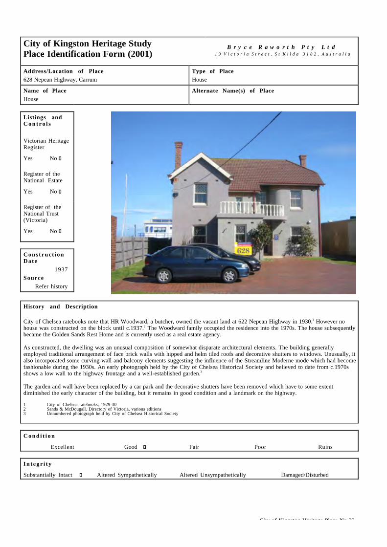
City of Chelsea ratebooks note that HR Woodward, a butcher, owned the vacant land at 622 Nepean Highway in 1930.1 However nohouse was constructed on the block until c.1937.2 The Woodward family occupied the residence into the 1970s. The house subsequentlybecame the Golden Sands Rest Home and is currently used as a real estate agency.
As constructed, the dwelling was an unusual composition of somewhat disparate architectural elements. The building generallyemployed traditional arrangement of face brick walls with hipped and helm tiled roofs and decorative shutters to windows. Unusually, italso incorporated some curving wall and balcony elements suggesting the influence of the Streamline Moderne mode which had becomefashionable during the 1930s. An early photograph held by the City of Chelsea Historical Society and believed to date from c.1970sshows a low wall to the highway frontage and a well-established garden.3
The garden and wall have been replaced by a car park and the decorative shutters have been removed which have to some extentdiminished the early character of the building, but it remains in good condition and a landmark on the highway.
1 City of Chelsea ratebooks, 1929-302 Sands & McDougall. Directory of Victoria, various editions3 Unnumbered photograph held by City of Chelsea Historical Society
C o n d i t i o n
Excellent � Good g Fair � Poor � Ruins �
I n t e g r i t y
Substantially Intact g Altered Sympathetically � Altered Unsympathetically � Damaged/Disturbed �

City of Kingston Heritage Place No 22
Comparable examples within the City of Kingston
Balmoral on the Nepean Highway in Aspendale provides the most ready comparison to this unusual building.
Statement of Significance
Built in 1937 for HR Woodward, the house at 628 Nepean Highway is of architectural significance at a local level for its unusual designand landmark presence.
Recommendat ions
A heritage overlay is recommended for the building.
City of Kingston Planning Scheme
Recommended for inclusion in a heritage overlay to the Planning Scheme Yes g No �Should external paint controls apply? Yes g No �Should internal alteration controls apply? Yes � No g
Should tree controls apply? Yes � No g
Other Listings and Controls
Recommended for inclusion on the Victorian Heritage Register? Yes � No g
Recommended for inclusion on the Register of the National Estate? Yes � No g
Recommended for inclusion on the National Trust (Victoria) Register? Yes � No g

City of Kingston Heritage Place No 27
City of Kingston Heritage StudyPlace Identification Form (2001)
B r y c e R a w o r t h P t y L t d1 9 V i c t o r i a S t r e e t , S t K i l d a 3 1 8 2 , A u s t r a l i a
Address/Location of PlaceStation Street, Carrum
Type of PlaceShop
Name of PlaceShop
Alternate Name(s) of PlaceThree step shop
Listings andC o n t r o l s
Victorian HeritageRegister
Yes � No g
Register of theNational Estate
Yes � No g
Register of theNational Trust(Victoria)
Yes � No g
Construct ionDate
c.1900sSource
site inspection
History and Description
The shop at 506 Station street Carrum appears to date from the early years of the twentieth century. It retains many early featuresincluding, to a large extent, the original shopfronts. The verandah on site today appears to be refurbished but otherwise unchangedfrom the structure visible in early photographs of the site.1 The premises have accommodated a number of retail uses over their lifeincluding confectioners, fruiterers and butchers. The building is in good condition and remarkably intact to its original state.
1 Photograph No 86 held by Chelsea historical Society2 Sands & McDougall directories, various editions
C o n d i t i o n
Excellent � Good g Fair � Poor � Ruins �
I n t e g r i t y
Substantially Intact g Altered Sympathetically � Altered Unsympathetically � Damaged/Disturbed �
Comparable examples within the City of Kingston
This building is unusual within the Municipality and the shopfront appears to be the earliest noted during the current study.
Statement of Significance
Likely to date from c.1900s, the 'three step shop' is of architectural and historical significance at a local level. It appears to be one ofthe oldest extant buildings in Carrum and is of particular note for its largely intact early shopfront.

City of Kingston Heritage Place No 27
Recommendat ions
A heritage overlay is recommended for the building.
City of Kingston should establish a register of intact early shopfronts as a means of safeguarding the small number of early shopfrontsthat survive within the Municipality.
City of Kingston Planning Scheme
Recommended for inclusion in a heritage overlay to the Planning Scheme Yes g No �Should external paint controls apply? Yes g No �Should internal alteration controls apply? Yes � No g
Should tree controls apply? Yes � No g
Other Listings and Controls
Recommended for inclusion on the Victorian Heritage Register? Yes � No g
Recommended for inclusion on the Register of the National Estate? Yes � No g
Recommended for inclusion on the National Trust (Victoria) Register? Yes � No g

City of Kingston Heritage Place No 018
City of Kingston Heritage StudyPlace Identification Form (2001)
B r y c e R a w o r t h P t y L t d1 9 V i c t o r i a S t r e e t , S t K i l d a 3 1 8 2 , A u s t r a l i a
Address/Location of Place9 Walkers Road, Carrum.
Type of PlaceHouse.
Name of PlaceNone.
Alternate Name(s) of PlaceNone.
Listings andC o n t r o l s
Victorian HeritageRegisterYes c No g
Register of theNational EstateYes c No g
Register of theNational Trust(Victoria)Yes c No g
Construct ionDate
c.1900Source
Refer History
History and Description
The physical fabric of the building at 9 Walkers Road, Carrum suggests that it was constructed c.1900 although no documentaryevidence has been found to confirm this assessment. It is first listed in the Sands & MacDougall Directory of 1933.1 The residencesalong the road were not numbered at that time, suggesting that it was simple unmade track. In 1933, two residents were noted as livingbetween Tonbridge Street and Valetta Street, namely Frederick Stevens to the west and Miss E Woods to the east. Later subdivision(after 1974)2 of one or both of these early properties has subsequently allowed the construction of two more residences betweenTonbridge and Valetta Streets. The Stevens residence on the corner of Tonbridge Street is presumed to be the residence known today as9 Walkers Road.
The house is a simple double fronted weatherboard cottage with a steep corrugated steel roof consistent with a turn of the centuryconstruction date. A simple skillion roofed verandah extends across the full frontage. The building has been subject to some alterationsover the course of its life. The verandah has been rebuilt, the Tonbridge Street facade has been re-clad in hardiplank, a modern aluminumwindow has been installed and numerous additions have been made to the rear. Nonetheless, the building survives in good conditionand retains much of its early character.
The Stevens family appears to have remained in the house for over forty years. Henry Stevens, succeeded Frederick Stevens as theprincipal occupant and remained in residence from before 1955 until at least 1974.
1 Sands and MacDougall Directory of Victoria, 1932-1974, trace the development of the area.2 Sands and MacDougall Directory of Victoria, 1974, continues to list only two properties between Tonbridge and Valetta Streets.
C o n d i t i o n
Excellent c Good g Fair c Poor c Ruins c
I n t e g r i t y
Substantially Intact c Altered Sympathetically g Altered Unsympathetically c Damaged/Disturbed c

City of Kingston Heritage Place No 018
Comparative Examples within the City of Kingston
Although houses of this style and age are rare within Carrum, they are more common within the more northern sections of theMunicipality.
Statement of Significance
Believed to date from c.1900, the house at 9 Walkers Road, Carrum, is of local historical and architectural significance. It i shistorically significant as one of the earliest extant dwellings in the area. It is architecturally significant for its simple, early characterthat survives in few instances locally.
Recommendat ions
A heritage overlay is recommended for the site.
City of Kingston Planning Scheme
Recommended for inclusion in a heritage overlay to the Planning Scheme Yes g No c
Should external paint controls apply? Yes g No c
Should internal alteration controls apply? Yes c No g
Should tree controls apply? Yes c No g
Other Listings and Controls
Recommended for inclusion on the Victorian Heritage Register? Yes c No g
Recommended for inclusion on the Register of the National Estate? Yes c No g
Recommended for inclusion on the National Trust (Victoria) Register? Yes c No g

City of Kingston Heritage Place No 024
City of Kingston Heritage StudyPlace Identification Form (2001)
B r y c e R a w o r t h P t y L t d1 9 V i c t o r i a S t r e e t , S t K i l d a 3 1 8 2 , A u s t r a l i a
Address/Location of Place2–6 Church Road (cnr Walkers Road), Carrum.
Type of PlaceSchool.
Name of PlaceCarrum Primary School.
Alternate Name(s) of PlaceState School No 3385.
Listings andC o n t r o l s
Victorian HeritageRegisterYes c No g
Register of theNational EstateYes c No g
Register of theNational Trust(Victoria)Yes c No g
Construct ionDate
From c.1910Source
Site Inspection
History and Description
On 10th July 1900, parents began their attempts to secure a school for children of the rapidly growing township of Carrum. At thattime children were required to attend Carrum North State School on Wells Road by travelling along roads that were infested by snakes insummer and almost impassible in winter. The students and teachers moved from Wells Road to a new school called Chelsea Heights,which was on a new site. Departmental Inspector Swindley recommended the establishment of a part-time school near the CarrumStation. On 25th February 1902 Head Teacher John Steane opened State School No.3385 from rented accommodation. Two monthslater, parents demanded a permanent schoolhouse, arguing that they could guarantee more than the required number of students in thefollowing year. Later in 1903, the Board of Advice recommended the purchase of a one-acre site from Howard Rigby and the erection ofa school building.
A second wooden structure was erected some years later (c.1910). It is likely that the building was designed by William Mackay, anArchitect of the Public Works Department, whose personal style dominated new works in Melbourne’s southeastern suburbs throughoutthe early years of the 20th Century. This building survives although it has subsequently been incorporated in a sympathetic manner intothe central brick building (c.1920). Despite its staged construction, the resultant composite building is stylistically consistent andappears as a handsome example of early twentieth century school design. This building was used into the 1970s as a Rural TrainingSchool but currently forms the administration block for the Primary School. The original 1903 building was retained as a shelter shed,which remained in service until at least 19732 although it appears subsequently to have been demolished. In the post-war years, atimber canteen and library and numerous portable classrooms have been erected on the site.
Today, the post-war structures dominate the site although the early building with its prominent location at the intersection of Walkers& Church Roads remains the centrepiece of the group. It adopts the form of a picturesque Arts & Crafts bungalow finished inweatherboard and face brick and a roof of galvanised steel. The building is of note for its overhanging bracketed eaves to the principalwindow on the 1910 building which form a counterpoint to the verandah treatment to the younger sections.
The administration building is in good condition and retains a high level of integrity to its c.1920 state.

City of Kingston Heritage Place No 024
History and Description (continued)
1 This reference is drawn with minor editing from, Education Department of Victoria, Vision and Realisation: A Centenary History of State Education in Victoria,Vol III, Melbourne, 1973, pp.414-5.
2 Ibid.
C o n d i t i o n
Excellent c Good g Fair c Poor c Ruins c
I n t e g r i t y
Substantially Intact g Altered Sympathetically c Altered Unsympathetically c Damaged/Disturbed c
Comparable examples within the City of Kingston
The principal building of Heatherton Primary School (1900) is a building of comparable size and type to the administration building atCarrum Primary school. It adopts a simpler but broadly similar approach to massing and detailing, consistent with its earlierconstruction date. No other comparable school buildings in the City of Kingston were identified as a part of this study.
Statement of Significance
Constructed c.1910 and extended c.1920, the administration building of the Carrum Primary School is of local architectural and socialsignificance. It is architecturally significant as a handsome example of early twentieth century school design and demonstrates thesimple infrastructure associated with rural education at that time. It is of social significance for its long association with the localcommunity.
Recommendat ions
A heritage overlay is recommended for the administration building only comprising the original (c.1910) building and its later(c.1920) additions.
City of Kingston Planning Scheme
Recommended for inclusion in a heritage overlay to the Planning Scheme Yes g No c
Should external paint controls apply? Yes g No c
Should internal alteration controls apply? Yes c No g
Should tree controls apply? Yes c No g
Other Listings and Controls
Recommended for inclusion on the Victorian Heritage Register? Yes c No g
Recommended for inclusion on the Register of the National Estate? Yes c No g
Recommended for inclusion on the National Trust (Victoria) Register? Yes c No g

City of Kingston Heritage Precinct No P05
City of Kingston Heritage StudyPlace Identification Form (2001)
B r y c e R a w o r t h P t y L t d1 9 V i c t o r i a S t r e e t , S t K i l d a 3 1 8 2 , A u s t r a l i a
Address/Location of Place538, 542-545 Station St, Carrum.
Type of PlaceHouses.
Name of PlaceRailway Worker's Houses.
Alternate Name(s) of PlaceNone.
Listings andC o n t r o l s
Victorian HeritageRegisterYes c No g
Register of theNational EstateYes c No g
Register of theNational Trust(Victoria)Yes c No g
Construct ionDate
c.1900Source
Refer History
History and Description
When the present Frankston line opened in 1881, its terminus was located at South Brighton (Mordialloc). In the following year it wasextended to Frankston. The station at Carrum was the first to be built along this latter section of the line and was opened due to pressurefrom local farmers wanting to take produce to market.1 Carrum was also important as a terminus for trains that weren’t going all the wayto Frankston.2
For the first few years the Station Master is listed in the McDougalls directory under the listing for the station but no residence i sassociated with the station. It is likely that the houses in the station precinct were built shortly after 1900 and by 1907 the StationMaster was in residence in the town of Carrum. Although not definitive, it is likely that the Station Master occupied one of theresidences in Station Street. Nos 538, 542, 544 and 545 were occupied by railway employees but the two houses between were notassociated with the railway. In 1930, 542 Station Street was occupied by the Station Master Arthur T Bowell and 544 was occupied byGeorge Clarke, Assistant Station Master. George Clarke lived in this residence into the 1940s.3 Subsequent occupation suggests that542 was the Station Masters house and the other houses were at times residences for Drivers, Shunters etc for the railway. From the1940s the residences went into private ownership.4
These four houses are somewhat degraded but retain a general early character despite additions and alterations. The house at 538 takes adifferent form to the others in the group. Nos 542-545 appear to have once all taken the same simple rectangular plan form with acentral entry. They would have all originally had gambrel roofs, central gable roofed porch and windows either side of the doorway.Each house is likely to have been clad in timber weatherboards have a corrugated iron roof and timber joinery. 542 Station Street hasbeen significantly extended to the street front with an additional half timbered gable ended bay. This house sits on a larger site than theother cottages. 544 retains little early fabric, with roof, weatherboards and joinery recently replaced. The chimney appears to be theonly original fabric to the exterior. 545 has retained its original timber weatherboards and brick chimney. Every house has skillionadditions to the rear, which have been extended over the years. 538 is a simple weatherboard cottage with a hipped corrugated iron roof.It appears to have been extended on the south side at some stage with a sympathetic weatherboard addition.

City of Kingston Heritage Precinct No P05
History and Description (continued)
1 Barnard & Sheehan, City of Kingston Heritage Study, Stage I, pp.38–422 Conversation between John Statham and Ron Jacobs of Chelsea and District Historical Society 8 May 2002.3 Sands & McDougalls Directory of Victoria. 1900 - 1974. Held at the Royal Historical Society, Melbourne. The directories do not list Carrum by street until
about 1930, listing is alphabetical by resident before this time. The occupations of the residents in Station Street are not listed between 1930 and 1974.4 Conversation between John Statham and Ron Jacobs of Chelsea and District Historical Society 8 May 2002.
I n t e g r i t y
Substantially Intact c Altered Sympathetically c Altered Unsympathetically g Damaged/Disturbed c
Comparable examples within the City of Kingston
A number of cottages of comparable size, construction, date and condition were identified within the City of Kingston. While the groupis of some interest historically, for its association with the station, that interest is not legible through the architecture.
Statement of Significance
The houses at 538, 542 – 545 Station Street, Carrum are of some social, architectural and historical significance at a local level asexamples of houses once associated with the railway.
Above: 538 Station Street showing simple cottage form, extended to the south.
Right: 542 Station Street, Showing extensive addition to the front with its half timbering and the terracotta chimney pots. Left: 544Station Street, showing new weatherboards, roofing, windows and inappropriate roller shutters.
City of Kingston Heritage Precinct No P05
Recommendat ions
A heritage overlay is not recommended for this precinct. However, the former Station Master's house at 542 Station Street is the mostintact and most historically significant dwelling of the group. It may be appropriate to consider a heritage overlay for this individualbuilding.
City of Kingston Planning Scheme
Recommended for inclusion in a heritage overlay to the Planning Scheme Yes g No c
Should external paint controls apply? Yes g No c
Should internal alteration controls apply? Yes c No g
Should tree controls apply? Yes c No g
Other Listings and Controls
Recommended for inclusion on the Victorian Heritage Register? Yes c No g
Recommended for inclusion on the Register of the National Estate? Yes c No g
Recommended for inclusion on the National Trust (Victoria) Register? Yes c No g

City of Kingston Heritage Place No 033
City of Kingston Heritage StudyPlace Identification Form (2001)
B r y c e R a w o r t h P t y L t d1 9 V i c t o r i a S t r e e t , S t K i l d a 3 1 8 2 , A u s t r a l i a
Address/Location of Place380 Nepean Highway, Chelsea.
Type of PlaceHotel.
Name of PlaceChelsea Hotel.
Alternate Name(s) of PlaceLong Beach Hotel.
Listings andC o n t r o l s
Victorian HeritageRegisterYes c No g
Register of theNational EstateYes c No g
Register of theNational Trust(Victoria)Yes c No g
Construct ionDate
1937Source
Refer History
History and Description
At the opening of the twentieth century, there were no outlets for the sale of alcohol in Chelsea. In 1905, the Chelsea General Storewas constructed on the corner of Avondale avenue and Point Nepean Road (Nepean Highway) for Mr. WD Calahan. It was the first retailestablishment of any kind to be built in Chelsea. Calahan sold the premises to a Mr. Gill whom in turn sold out to Mrs. Duncan whooperated the business with the help of her two daughters and her son James. The Duncans commenced business in 1908 and held aCommonwealth wine license for the small wine saloon on the south side of the building. In addition to the saloon, the establishmentconsisted of a post office, newsagency and general store.1
For decades, the seaside community resisted the introduction of further licensed premises. In February 1914, a referendum was held todecide whether Chelsea should have a licensed hotel or not. Despite an active campaign for more licensed venues, the poll attracted 50votes in favour and 381 votes against.
Around the same time, the Duncans sold their establishment to Mrs. Louise Moore who became the local postmistress, storekeeper andran the saloon. Over the subsequent decades, there were changes in the wine license and various others took charge of the post officebut Mrs. Moore retained possession of the property until the local resistance to more substantial licensed premises abated.
Permission to operate a licensed hotel was finally approved in 1937 and the Chelsea Hotel opened on Easter Monday of that year on thesite of the Chelsea General Store. Louise Moore died before the hotel was completed but left the establishment to her three sons,Thomas, Samuel and James. Tom Moore, the eldest of the three was entrusted with the management. Both Tom and Jim Moore wereinvolved in the theatrical world. Tom as a dancer and, for a time, producer while Jim was a stage electrician. Tom Moore was brieflymarried to Gladys Moncrieff, the famous star of musical comedy and ran the hotel for many years before moving to Surfers Paradise.

City of Kingston Heritage Place No 033
History and Description (continued)
The two-storey Chelsea Hotel was completed in the Moderne style, introduced to Melbourne through the 1930s by the work of HarryNorris and others. The building was finished in cream face brick and employed horizontal banding, in the form of stepped brickworkabove the upper storey windows and long cantilevering balconies below, to produce the popular streamlined appearance. The buildingadopted a u-shaped plan around a motor court in response to the growing need for motor vehicle accommodation. At the time of itsopening, the Chelsea Hotel represented the height of Moderne styling and contemporary planning.
The building has been rendered, painted and adorned in signage in recent years which has considerably diminished its early character.Nonetheless, the building is substantially intact and would benefit from relatively straightforward restoration measures such as theremoval of inappropriate signage.
1 This reference is drawn with minor editing from, Frank McGuire, Chelsea: A Beachside Community, Prepared for the Chelsea Historical Society, Mentone, 1985,pp.103-105.
C o n d i t i o n
Excellent c Good c Fair g Poor c Ruins c
I n t e g r i t y
Substantially Intact c Altered Sympathetically c Altered Unsympathetically g Damaged/Disturbed c
Comparative Examples within the City of Kingston
A number of early hotels refurbished to present in a more modern style continue to trade within the municipality including theKingston Club Hotel (formerly The Mordialloc Hotel) and Tudor Inn, Cheltenham. However, no other local hotels in a Modern stylewere identified as a part of this study. Other examples of the style elsewhere in Victoria include, Mitchell House, Lonsdale street,Melbourne (1936) designed by Harry Norris and Newburn Flats, South Melbourne (1939) designed by Romberg and Shaw.
Statement of Significance
Opened in 1937, the Chelsea Hotel is of local historical and architectural significance as the first licensed hotel in Chelsea and an earlyexample of the Moderne style within the area. The building has been altered but generally retains the form and much of the character ofthe original development.
Recommendat ions
A heritage overlay is recommended for the site.
City of Kingston Planning Scheme
Recommended for inclusion in a heritage overlay to the Planning Scheme Yes g No c
Should external paint controls apply? Yes g No c
Should internal alteration controls apply? Yes c No g
Should tree controls apply? Yes c No g
Other Listings and Controls
Recommended for inclusion on the Victorian Heritage Register? Yes c No g
Recommended for inclusion on the Register of the National Estate? Yes c No g
Recommended for inclusion on the National Trust (Victoria) Register? Yes c No g

City of Kingston Heritage Place No 15
City of Kingston Heritage StudyPlace Identification Form (2001)
B r y c e R a w o r t h P t y L t d1 9 V i c t o r i a S t r e e t , S t K i l d a 3 1 8 2 , A u s t r a l i a
Address/Location of PlaceNepean Highway, Chelsea
Type of PlaceClock tower
Name of PlaceChelsea clock tower
Alternate Name(s) of PlaceCentenary clock
Listings andC o n t r o l s
Victorian HeritageRegister
Yes � No g
Register of theNational Estate
Yes � No g
Register of theNational Trust(Victoria)
Yes � No g
Construct ionDate
1934Source
Refer history
History and Description
The Chelsea clock was constructed in 1934 as part of Chelsea's contribution to Victoria's centenary celebrations. The clock andmechanism were donated by the Carrum Electricity Supply Company and the bricks were supplied by the City of Chelsea. The designeris not known but the construction works were undertaken by unemployed locals.
The clock was situated in a tall masonry structure on the eastern side of Pt Nepean Road (Nepean Highway). The square clock faceadopted an understated Modern manner, reiterated in the rectilinear form of the tower and the crisp exterior of its narrow-coursed'Roman' bricks.
The clock served as a landmark on the highway until the 1990s when the property was identified for demolition to allow for roadwidening. The local community objected to the loss of this valued structure and the highway authorities agreed to demolish and rebuildthe clock two metres to the east of its original position. These works were undertaken in association with road widening c.1996.
Comparison between the clock today and an early photograph held by the Chelsea Historical Society show the character and landmarkstature of the clock to be unaltered by the upheavals of the 1990s.
1 Frank McGuire, Chelsea: a Beachside Community. p.122.2 Photograph No 446, understood to date from c.1940s, held by Chelsea Historical Society.
C o n d i t i o n
Excellent g Good � Fair � Poor � Ruins �
I n t e g r i t y
Substantially Intact g Altered Sympathetically � Altered Unsympathetically � Damaged/Disturbed �

City of Kingston Heritage Place No 15
Comparable examples within the City of Kingston
The clock towers at Mordialloc and Chelsea form a pair of significant landmarks on the highway frontage. Their designs are broadlysimilar, reflecting the understated Modern aesthetic admired during the interwar period. They respectively commemorate David White, alocal Councilor and the state's centenary, underscoring the wide range of applications for structures of this type.
Statement of SignificanceThe Chelsea clock tower, constructed in 1934 and rebuilt in c.1996 is of local architectural and significance for its handsome designand as a valued local landmark. It is of some historical significance for its associations with Victoria’s centenary celebrations.
Recommendat ions
A heritage overlay is recommended for the structure.
City of Kingston Planning Scheme
Recommended for inclusion in a heritage overlay to the Planning Scheme Yes g No �Should external paint controls apply? Yes g No �Should internal alteration controls apply? Yes � No g
Should tree controls apply? Yes � No g
Other Listings and Controls
Recommended for inclusion on the Victorian Heritage Register? Yes � No g
Recommended for inclusion on the Register of the National Estate? Yes � No g
Recommended for inclusion on the National Trust (Victoria) Register? Yes � No g

City of Kingston Heritage Place No 38
City of Kingston Heritage StudyPlace Identification Form (2001)
B r y c e R a w o r t h P t y L t d1 9 V i c t o r i a S t r e e t , S t K i l d a 3 1 8 2 , A u s t r a l i a
Address/Location of Place21 Thames Promenade, Chelsea
Type of PlaceHouse
Name of PlaceHouse
Alternate Name(s) of PlaceShillinglaw House
Listings andC o n t r o l s
Victorian HeritageRegister
Yes � No g
Register of theNational Estate
Yes � No g
Register of theNational Trust(Victoria)
Yes � No g
Construct ionDate
c.1920Source
Refer History
History and Description
Mrs J Shillinglaw was granted a subdivision of land measuring 60' by 165' in Thames Promenade in 1919.1 By 1924 the house at 21Thames Promenade had been constructed. The first occupant was John H Buttle. Buttle occupied the house until the late 1930s. Forseveral years the house was occupied by FW Shillinglaw, a sack merchant, and local councilor from 1947-53. By 1946 the house wasoccupied by Arthur W Hough. Hough lived there for only a brief period as did subsequent occupant Norman V Parris. By 1953 Mrs NoraMorris had taken up residence in the house. She remained until the late 1950s. Mrs E Giblin then took over, occupying the propertyuntil the late 1960s. In the 1970s the property again reverted back to the Shillinglaw family. It is understood that the house was ownedthroughout by members of the Shillinglaw family.2
The dwelling at 21 Thames Promenade, Chelsea appears to have been constructed a as simple gable ended cottage of two principalrooms. It is evident that the verandah to the street frontage and the skillion-roofed addition to the eastern elevation are later additions.despite the alterations, the building retains its early character.
1 Frank McGuire, Chelsea, a Beachside Community, p.121.2 Sands & mcDougall directory of Victoria, various editions.3 Personal comment, Ron Jacobs, President, Chelsea Historical society.
C o n d i t i o n
Excellent � Good g Fair � Poor � Ruins �
I n t e g r i t y
Substantially Intact � Altered Sympathetically g Altered Unsympathetically � Damaged/Disturbed �

City of Kingston Heritage Place No 38
Comparable examples within the City of Kingston
Locally, early dwellings survive at a number of locations including: 67 Edithvale Road, Edithvale; 50 Clydebank Road, Edithvale; and6 Shenfield Street, Chelsea.
Statement of Significance
Constructed c.1920, the house at 21 Thames Promenade, Chelsea is of historical and architectural significance at a local level as one ofa small number of extant early dwellings in the area. Despite some additions, the early architectural character and significance of thedwelling survives. The residence derives some additional significance as the former residence of local Councilor, Frank Shillinglaw.
Recommendat ions
A heritage overlay is recommended for the building.
City of Kingston Planning Scheme
Recommended for inclusion in a heritage overlay to the Planning Scheme Yes g No �Should external paint controls apply? Yes g No �Should internal alteration controls apply? Yes � No g
Should tree controls apply? Yes � No g
Other Listings and Controls
Recommended for inclusion on the Victorian Heritage Register? Yes � No g
Recommended for inclusion on the Register of the National Estate? Yes � No g
Recommended for inclusion on the National Trust (Victoria) Register? Yes � No g

City of Kingston Heritage Place No 046
City of Kingston Heritage StudyPlace Identification Form (2001)
B r y c e R a w o r t h P t y L t d1 9 V i c t o r i a S t r e e t , S t K i l d a 3 1 8 2 , A u s t r a l i a
Address/Location of PlaceStation Street, Chelsea.
Type of PlaceRailway Station.
Name of PlaceChelsea Station & Signal Box.
Alternate Name(s) of PlaceNone.
Listings andC o n t r o l s
Victorian HeritageRegisterYes c No g
Register of theNational EstateYes c No g
Register of theNational Trust(Victoria)Yes c No g
Construct ionDate
From 1907Source
Refer History
History and Description
The first railway lines were laid in Melbourne in the 1850s and linked inner southern suburbs and places like Geelong and Bendigo tothe city. All lines came under the umbrella of the Victorian Railways in the 1880s and it was generally accepted that the railwaysbrought prosperity and development to an area. Development of the Frankston line began in 1859 when the line was extended out toCaulfield Station. Development to Bentleigh, Moorabbin, Cheltenham and Mentone soon followed when the line was extended fromCaufield to Mordialloc in 1881. Station buildings were often not completed until later and the first temporary buildings weresometimes not replaced for decades. For example, the temporary buildings at Mentone Station were not replaced until 1900. Therailway was extended to Frankston in 1882, passing through Edithvale, Chelsea, Bonbeach and Carrum along the way. However not allof these stations opened straight away. When the railway opened there was only a station at Carrum. Carrum station was onlydeveloped due to pressure from local farmers wanting to take produce to market. Other stations opened as demand required such as atAspendale for the Racecourse in 1891. Chelsea was opened in 1907, Edithvale Station was not opened until 1919 and BonbeachStation was opened in 1926. The arrival of the railway helped to stimulate development of residential and commercial areas along theline. The railway became electric in 1922.1
The Chelsea Railway Station sits between the Edithvale and Bonbeach Railway stations on the Frankston line. Chelsea RailwayStation first opened as a flag station. This meant that passengers had to flag down the train otherwise it would not stop at the station.However, it eventually became a full station and was serving the needs of over 150 000 passengers annually by 1913/14.2 It wasopened due to pressure from local developers who encouraged local farmers to contribute to the cost of the station. The local farmersused the railway to transport produce and there is still evidence at Chelsea Station of a loading siding on the Upside of the platform.The arrival of a station at Chelsea helped to boost the population, especially with seaside visitors as well as with new residents as therailway allowed people to commute to work elsewhere easily.3
A double line was constructed and came into use on December 1st 1910. At this stage there were two platforms but no signals were inplace until 1912. A 10 lever signal box was erected on the 28 March 1912 in the middle of the Upside platform. The first electric trainscommenced on the 27 August 1922. Two years later in 1924, a new 24 lever signal box was erected on the up end of the Upsideplatform.4

City of Kingston Heritage Place No 046
History and Description (continued)
Chelsea station is part of a group of stations with the same plan form, sometimes referred to as the Parkdale Style. These stations alsoinclude Parkdale, Seaford, Edithvale, Bonbeach and Aspendale on the Frankston line, Springvale and Clayton on the Pakenham lineand Tottenham on the St Albans line. However the original buildings at Edithvale, Bonbeach, Aspendale and Tottenham stations havebeen demolished and replaced with new facilities. Parkdale is the most intact out of the group as it retains most of its decoration,however since the Ward and Donnelly study it has lost its original picket fencing and level crossing gates.5
The Upside building (c.1907) is a simple ‘T’ shape in plan and is clad in timber weatherboards. It is flanked by a wide verandah on theplatform side. The building has a gable roof. The pavilion style northern end has windows around two sides. A curved tubular steelshelter shed clad in corrugated iron exists to the south end of the building. The building is very simple in detail and features nodecorative adornment. The platform is constructed from concrete planks. The building has been somewhat modified over the years andthe roof, verandah and shelter building are much newer. The building is in a degraded condition.
The Downside building (c.1913) is also a simple weatherboard building. The building has a verandah along the platform side and thesouth end. There are two openings for access in the centre of the building, the larger of which opens into a shelter area. Entry to theplatform is from the south end, which appears to have been modified. The roof and verandah have also been modified. The building is ina degraded condition. The platform on this side is also constructed from concrete planks.
1 This reference is drawn with minor editing from, Barnard & Sheehan, City of Kingston Heritage Study, Stage I, pp.38 – 42.2 Ibid.3 Ibid.4 From information supplied by Ron Jacobs, Chelsea and District Historical Society. Jack McCarthy. Recollections Recorded for the City of Chelsea Historical
Society and the Chelsea & District Historical Society Inc.5 A. Ward & A. Donnelly (In association with the Australian Railway History Society). Victoria’s Railway Stations. An Architectural Survey (Vols. 1- 4), 1982.
C o n d i t i o n
Excellent c Good c Fair g Poor c Ruins c
I n t e g r i t y
Substantially Intact c Altered Sympathetically g Altered Unsympathetically c Damaged/Disturbed c
Comparable examples within the City of Kingston
No comparable examples were identified by this study, although Parkdale and Seaford Stations on the Frankston Line and Springvaleand Clayton on the Pakenham line may compare. Of these, only the Parkdale station is within the boundaries of the City of Kingston.The downside building at Chelsea is broadly comparable with that at Mordialloc, with its wide verandah and simple gable roofed form.
Statement of Significance
Both station buildings at Chelsea Railway Station (excluding the tubular steel additions) and the Signal Box are of social andarchitectural and historical significance at a local level. The group is socially significant for its long association with the localcommunity. It is architecturally significant as an example of early twentieth century railway architecture. It is historically significantfor its associations with the early development of Chelsea and the broader region.

City of Kingston Heritage Place No 046
Above: View of the Upside building (c1907) showing the simple timber structure, platform and level crossing.
Recommendat ions
A heritage overlay is recommended for both of the station buildings and the signal box including the present setback and railwayreserve area.
City of Kingston Planning Scheme
Recommended for inclusion in a heritage overlay to the Planning Scheme Yes g No c
Should external paint controls apply? Yes g No c
Should internal alteration controls apply? Yes c No g
Should tree controls apply? Yes c No g
Other Listings and Controls
Recommended for inclusion on the Victorian Heritage Register? Yes c No g
Recommended for inclusion on the Register of the National Estate? Yes c No n
Recommended for inclusion on the National Trust (Victoria) Register? Yes c No n

City of Kingston Heritage Place No 43
City of Kingston Heritage StudyPlace Identification Form (2001)
B r y c e R a w o r t h P t y L t d1 9 V i c t o r i a S t r e e t , S t K i l d a 3 1 8 2 , A u s t r a l i a
Address/Location of Place318 Station Street, Chelsea
Type of PlaceCinema
Name of PlaceMason’s Picture Theatre
Alternate Name(s) of PlaceChelsea Picture Theatre
Listings andC o n t r o l s
Victorian HeritageRegister
Yes � No g
Register of theNational Estate
Yes � No g
Register of theNational Trust(Victoria)
Yes � No g
Construct ionDate
1923Source
Refer history
History and Description
Cinemas arrived in Melbourne in 1896 when Carl Hertz treated an audience at the Opera House to a number of short films to greatapplause. Over the next few years, enthusiasm for the form grew and from 1906 a local cinema industry began to emerge. In that year,the groundbreaking local feature, the Kelly gang was shown at the Athenaeum and the Town Hall. In 1909, Kings Theatre was opened.West's Theatre was constructed on the south side of the Yarra in the following year. By 1911 there were more than twenty suburbanpicture shows operating.1
The first cinemas in the City of Kingston were not constructed until the 1920s. At Chelsea, The Palais opened in The Strand and theChelsea Theatre, sometimes known as Mason's opened in Station Street. The Palais has since been demolished but Mason's survives atthe intersection of Chelsea Road and Station Street.
Mason's hall and two associated shops along the Station street frontage are noted as being under construction in the Sands &McDougall Directory of 1923. In the following year, WG Mason a real estate agent and builder (and presumably the owner of thebuilding) operated from premises on the corner. By that time, the hall was in use as a picture theatre. The two tenancies to the westernside of the building were occupied by a variety of trades during the 1920s and 1930s including: The Fecto Manufacturing Co; estateagent George Tozell; fruiterer Frank Leversham; and confectioner Miss IM Walsh. From the late 1920s the establishment was known asthe Chelsea Theatre and from the mid-1930s as the Plaza Theatre.
The building survives in broadly its original state. It is a substantial rendered brick building with a grand two-storey facade to Stationstreet concealing the simple hipped roof structure of the hall to the rear. Windows at first floor level along the Station Street elevationhave been altered but much of the early fabric to the ground floor tenancies including their recessed entries remains intact. Despiteminor alterations and overpainting, the building retains its early character and is generally in good condition.
1 Miles Lewis, Melbourne, The City's history and Development, Melbourne, 199 I, p.90.2 Barnard & Sheehan, City of Kingston Heritage Study, Stage I, p138-9.3 Sands & McDougall Directory of Victoria, 1923-1974.

City of Kingston Heritage Place No 43
C o n d i t i o n
Excellent � Good g Fair � Poor � Ruins �
I n t e g r i t y
Substantially Intact g Altered Sympathetically � Altered Unsympathetically � Damaged/Disturbed �
Comparable examples within the City of Kingston
No other purpose built cinemas dating from the early years of the Municipality were identified during the course of this study. Theformer Edithvale cinema has a similar construction date to the subject building but was constructed as a meeting hall and refurbished asa cinema during the early 1940s and does not adopt the characteristic cinema form found here.
Statement of Significance
Constructed c.1923 by real estate agent and builder WG Mason, the former Mason’s Picture Theatre is historically, socially andarchitecturally significant at a local level. It is historically significant as one of the first cinemas constructed in the Municipality andas the oldest surviving example of a purpose built cinema within locality. It is socially significant as a focus of the local community asa theatre and more recently as a bingo hall. It is architecturally significant as an unusual building type and the only example of a singlescreen, purpose built cinema in the Muncipality.
Recommendat ions
A heritage overlay is recommended for the building.
City of Kingston Planning Scheme
Recommended for inclusion in a heritage overlay to the Planning Scheme Yes g No �Should external paint controls apply? Yes g No �Should internal alteration controls apply? Yes � No g
Should tree controls apply? Yes � No g
Other Listings and Controls
Recommended for inclusion on the Victorian Heritage Register? Yes � No g
Recommended for inclusion on the Register of the National Estate? Yes � No g
Recommended for inclusion on the National Trust (Victoria) Register? Yes � No g

City of Kingston Heritage Place No 47
City of Kingston Heritage StudyPlace Identification Form (2001)
B r y c e R a w o r t h P t y L t d1 9 V i c t o r i a S t r e e t , S t K i l d a 3 1 8 2 , A u s t r a l i a
Address/Location of Place50 Chelsea Road (cnr Drinan Road), Chelsea
Type of PlaceShop and Residence
Name of PlaceShop
Alternate Name(s) of PlaceNone
Listings andC o n t r o l s
Victorian HeritageRegister
Yes � No g
Register of theNational Estate
Yes � No g
Register of theNational Trust(Victoria)
Yes � No g
Construct ionDate
From 1921Source
Refer History
History and Description
Prior to 1920, the area on the south side of Chelsea Road between Fowler Street (which was renamed Drinan Road in c.1980s) andStation Street was sparsely populated with little development and numerous vacant lots. In 1920 the land at the corner of Fowler andChelsea Roads was undeveloped but two houses had been constructed on the corner site by the following year. The residences share thesame address at 50 Chelsea Road and both appear to have been contained within the large weatherboard structure, which survives on thesite.
In 1924, James Furness, a grocer moved into a store on the corner of the site which is likely to have been constructed around this time.He operated the shop until the late 1920s when William Simmons, also a grocer, took over. By 1934 the site was occupied by Mrs.Lillian Furness and by the 1940s James and Lillian Furness were both listed as occupants. In the 1940s it appears that the property wasagain subdivided and an additional residence created. James Furness, grocer, was listed as the occupant of a corner shop and Mrs. L BFurness was listed as occupying the newly created dwelling. It is likely that the clinker brick facade to the west was constructed at thistime as an entry to the new dwelling. The Furnesses occupied the house and shop until the late 1950s when R & S Taylor, also grocers,took over the two properties. The property changed hands several times through the subsequent decades and continues to serve as ageneral store to the present day. Remnant signage suggests that the entrance area to the later sections of the building have also beenused as a shop in the post-war period.1
The single storey shop and residence at 50 Chelsea Road, Chelsea is of a domestic scale and presents as two shopfronts to ChelseaRoad with a large undeveloped tract of land to the Drinan Road frontage. The three original structures namely, the large weatherboarddwelling towards the rear of the block, (1921), the brick corner store (1924) and the clinker brick residential entry (c.1945) all surviveon the site.
The weatherboard residential sections of the building comprise a simple timber structure with a low-pitched hipped roof and skillionadditions to the rear. The building is distinguished by two elegant extended chimneys but is otherwise a simple vernacular building.

City of Kingston Heritage Place No 47
History and Description (continued)
The corner store is finished in face brick and retains its recessed entry with display windows either side. There is a simple verandah tothe Chelsea road frontage. A number of minor alterations have been made to the building including the painting of the east wall, tilingbelow the display window and modern signage. Despite the later alterations it retains the character of an early corner shop.
The additions of the 1940s are generally of red brick apart from the façade, which is finished in clinker brick. A feature is the largearched window and the glass brick insert beside the door. The building draws upon no particular stylistic tradition and is likely the workof a local builder.
1 Sands & Mc Dougalls Directory of Victoria. 1920 – 1930, 1935, 1940, 1948, 1952, 1955, 1960, 1965. Held at the Royal Historical Society, Melbourne.
C o n d i t i o n
Excellent � Good � Fair g Poor � Ruins �
I n t e g r i t y
Substantially Intact g Altered Sympathetically � Altered Unsympathetically � Damaged/Disturbed �
Comparable examples within the City of Kingston
No comparable examples were identified within the City of Kingston by this study. However many comparable examples may exist inthe wider metropolitan area.
Statement of SignificanceThe corner shop, residence and shop/residence at 50 Chelsea Road Chelsea are of social significance at a local level as a focus of thelocal community. The building is also of some architectural significance as a legible example of an early retail development.
Recommendat ions
A heritage overlay is recommended for the site including the corner shop (1924), residence (1921) and the shop/residence entry(c1945). It should be noted that the building of primary significance on the site is the corner shop (1924) and the other buildings(residence and shop/residence entry) are of minor contributory significance.
City of Kingston Planning Scheme
Recommended for inclusion in a heritage overlay to the Planning Scheme Yes g No �Should external paint controls apply? Yes g No �Should internal alteration controls apply? Yes � No g
Should tree controls apply? Yes � No g
Other Listings and Controls
Recommended for inclusion on the Victorian Heritage Register? Yes � No g
Recommended for inclusion on the Register of the National Estate? Yes � No g
Recommended for inclusion on the National Trust (Victoria) Register ? Yes � No g

City of Kingston Heritage Place No 47
View of Drinan Road side of the shop and residence showing house at rear.
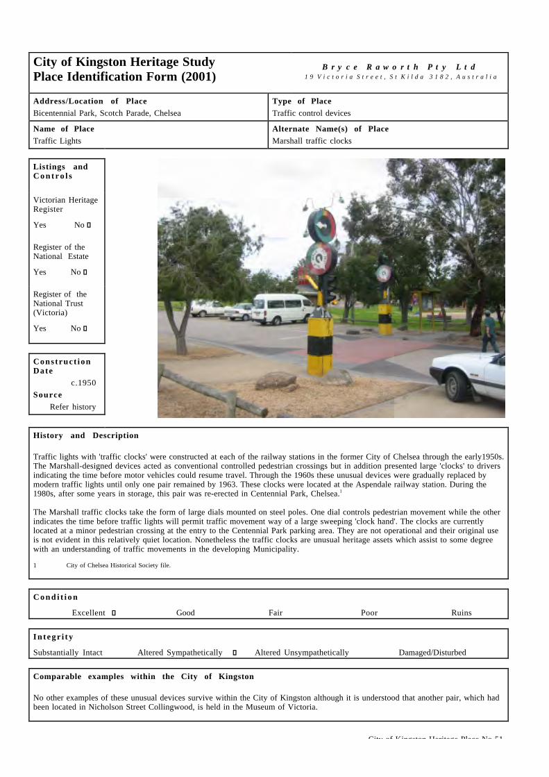
City of Kingston Heritage Place No 51
City of Kingston Heritage StudyPlace Identification Form (2001)
B r y c e R a w o r t h P t y L t d1 9 V i c t o r i a S t r e e t , S t K i l d a 3 1 8 2 , A u s t r a l i a
Address/Location of PlaceBicentennial Park, Scotch Parade, Chelsea
Type of PlaceTraffic control devices
Name of PlaceTraffic Lights
Alternate Name(s) of PlaceMarshall traffic clocks
Listings andC o n t r o l s
Victorian HeritageRegister
Yes � No g
Register of theNational Estate
Yes � No g
Register of theNational Trust(Victoria)
Yes � No g
Construct ionDate
c.1950Source
Refer history
History and Description
Traffic lights with 'traffic clocks' were constructed at each of the railway stations in the former City of Chelsea through the early1950s.The Marshall-designed devices acted as conventional controlled pedestrian crossings but in addition presented large 'clocks' to driversindicating the time before motor vehicles could resume travel. Through the 1960s these unusual devices were gradually replaced bymodern traffic lights until only one pair remained by 1963. These clocks were located at the Aspendale railway station. During the1980s, after some years in storage, this pair was re-erected in Centennial Park, Chelsea.1
The Marshall traffic clocks take the form of large dials mounted on steel poles. One dial controls pedestrian movement while the otherindicates the time before traffic lights will permit traffic movement way of a large sweeping 'clock hand'. The clocks are currentlylocated at a minor pedestrian crossing at the entry to the Centennial Park parking area. They are not operational and their original useis not evident in this relatively quiet location. Nonetheless the traffic clocks are unusual heritage assets which assist to some degreewith an understanding of traffic movements in the developing Municipality.
1 City of Chelsea Historical Society file.
C o n d i t i o n
Excellent g Good � Fair � Poor � Ruins �
I n t e g r i t y
Substantially Intact � Altered Sympathetically g Altered Unsympathetically � Damaged/Disturbed �
Comparable examples within the City of Kingston
No other examples of these unusual devices survive within the City of Kingston although it is understood that another pair, which hadbeen located in Nicholson Street Collingwood, is held in the Museum of Victoria.

City of Kingston Heritage Place No 51
Statement of Significance
Marshall traffic clocks, constructed on the Nepean Highway in the early 1950s and relocated to Centennial park during the 1980s, areof enduring historical and technical significance despite the loss of their original highway context. They are unusual heritage assetsthat offer insights into the development of traffic control technology and assist in an understanding of traffic movements in thedeveloping Municipality.
Recommendat ions
A heritage overlay is recommended for the Marshall traffic clocks. However, the devices have no historical or functional associationwith their current site and heritage controls should not limit the extent to which other developments on the site can proceed. If anopportunity arises, consideration should be given to relocation of the clocks to a site that re-establishes their connection with theNepean Highway and allows for them to be made operational.
City of Kingston Planning Scheme
Recommended for inclusion in a heritage overlay to the Planning Scheme Yes g No �Should external paint controls apply? Yes g No �Should internal alteration controls apply? Yes � No g
Should tree controls apply? Yes � No g
Other Listings and Controls
Recommended for inclusion on the Victorian Heritage Register? Yes � No g
Recommended for inclusion on the Register of the National Estate? Yes � No g
Recommended for inclusion on the National Trust (Victoria) Register? Yes � No g

City of Kingston Heritage Place No 050
City of Kingston Heritage StudyPlace Identification Form (2001)
B r y c e R a w o r t h P t y L t d1 9 V i c t o r i a S t r e e t , S t K i l d a 3 1 8 2 , A u s t r a l i a
Address/Location of Place362 Station Street, Chelsea.
Type of PlaceChurch.
Name of PlaceSt Joseph's Roman Catholic Church.
Alternate Name(s) of PlaceNone.
Listings andC o n t r o l s
Victorian HeritageRegisterYes c No g
Register of theNational EstateYes c No g
Register of theNational Trust(Victoria)Yes c No g
Construct ionDate
1941Source
Refer History
History and Description
The first Catholic services were held in the area in 1905 in the home of Joshua Mc Clelland and his family. As more Catholic familiesmoved into the area, the house became too small for services so they were held in Dorney’s Billiard Rooms in Chelsea. Later serviceswere held in Hoadleys Hall (also called the Joss House due to its ‘Chinese’ appearance) which was shared on Sunday by the Methodists,Church of England and the Spiritualists, all booking a timeslot during the day.1
A weatherboard church was built for Catholic services on the corner of Station Street and Woodbine Crescent in 1913 and was opened in1914. This 60 x 30 ft building was extended in 1924 and folding doors were fitted to provide for a Catholic School. 2 The two schoolrooms were enlarged to four in 1935.3
By 1939 plans had begun to be drawn up for a larger more permanent church next to the original church in Station St. The church wasdesigned by the architect Cyril Kelly.4 Building slowed with the outbreak of WWII (due to material shortages) but was completed by theend of 1940. St Joseph's new church was blessed and officially opened by archbishop Mannix on 5th January 1941.5 The builder wasW. J. Kelly and the supervisor of woodwork was Stan Kelly. The total cost of the church was £10 500.6 After the new church was built,the old church was used as a hall (and school) until it was damaged by fire in 1965.7
A Presbytery was built for the Priest in 1951 when St Joseph’s Parish separated from Frankston to form a separate parish.8 It remainson the adjacent site in a considerably modified form. In 1952 it came to the church’s attention that a convent was needed for the Sistersso a four-roomed weatherboard cottage was purchased and six bedrooms, a bathroom and laundry were added. The original cottage wasfitted out as a chapel and with a community room, dining room, kitchen and interview room by church volunteers.9 The convent wasupgraded in the mid 1960s when a new large brick Convent was built with accommodation for up to twelve Sisters.1 0
From 1924 a school had been held in the old weatherboard church building and despite various renovations, it was inadequate. Aroundthe time the Convent was being renovated (1950s), plans were drawn up for a new two storey block with eight classrooms facingWoodbine Grove and a teachers room, cloakrooms and a toilet block facing Station Street.11 The new St Joseph's school was blessedand officially opened by Archbishop Mannix on Sunday 8th January 1956.1 2

City of Kingston Heritage Place No 050
History and Description (continued)
The church is located on the corner of Station Street and Woodbine Crescent, Chelsea. It is a long rectilinear cream brick buildingdrawing inspiration from Mediterranean sources. The west (Station Street) front is flanked by two small cubic forms either side of therecessed arch entry. There are brick buttresses along either side of the nave. Tall arched windows run along the north and south sides ofthe church. The church features rendered trims to the arch, buttresses and parapeted gable. Other features include the iconography,stained glass windows and crosses at the top of the gable. The arched portico to the north side is a later extension. The church sharesgrounds with the adjoining St. Joseph's Catholic school.
1 St Joseph’s Church. St Joseph’s Church Chelsea 50 Years: A brief history of St Joseph’s Church, Chelsea for the golden jubilee of the blessing and openingon 5th January 1941. Chelsea, 1990/1991. p.8.
2 Op cit. p.8 &10.3 Op cit. p.11.4 Op cit. pp.12 – 13.5 Op cit. p.12.6 Op cit. p.13.7 Op cit. p.22.8 Op cit. p.16.9 Op cit. p.16.10 Op cit. p.20.11 Op cit. p.16.12 Frank McGuire, Chelsea: a Beachside Community , p.122.
C o n d i t i o n
Excellent g Good c Fair c Poor c Ruins c
I n t e g r i t y
Substantially Intact g Altered Sympathetically c Altered Unsympathetically c Damaged/Disturbed c
Comparable examples within the City of Kingston
St Joseph’s shares some characteristics with St. Patrick’s, Mentone (1950s) such as the large size of the building, the plain brickwalls, tall height of the nave, tall thin windows and arched entry window. Some similar details can also be identified with St Monica’s,Mount Alexander Road, Moonee Ponds (1934) designed by Thomas G. Payne. St Monica’s is in the Arts and Crafts Gothic style andfeatures the same vertical proportions, large arched central window, and simple long gable roofed nave space with no tower.1 3
13 Miles Lewis (Ed). Victorian Churches: Their origins, their story & their architecture. The National Trust of Australia (Victoria), 1991. p.69.
Statement of Significance
Completed in 1940, St Joseph’s Roman Catholic Church, Chelsea is of local social, architectural and spiritual significance. It i ssocially significant for its long association with the local Catholic community and for its role in the development of Catholiceducation in the City of Kingston. It is architecturally significant for its handsome design, its landmark stature and for the way inwhich it demonstrates the impact of Mediterranean and other architectural traditions on local ecclesiastical design. It is spirituallysignificant as the focus of local worship for the Catholic community.
Recommendat ions
A heritage overlay is recommended for the building.
City of Kingston Planning Scheme
Recommended for inclusion in a heritage overlay to the Planning Scheme Yes g No c
Should external paint controls apply? Yes g No c
Should internal alteration controls apply? Yes c No g
Should tree controls apply? Yes c No g

City of Kingston Heritage Place No 050
Other Listings and Controls
Recommended for inclusion on the Victorian Heritage Register? Yes c No g
Recommended for inclusion on the Register of the National Estate? Yes c No g
Recommended for inclusion on the National Trust (Victoria) Register? Yes c No g

City of Kingston Heritage Place No 045
City of Kingston Heritage StudyPlace Identification Form (2001)
B r y c e R a w o r t h P t y L t d1 9 V i c t o r i a S t r e e t , S t K i l d a 3 1 8 2 , A u s t r a l i a
Address/Location of Place34 – 44 Argyle Avenue (cnr Fowler Street), Chelsea.
Type of PlaceSchool.
Name of PlaceChelsea Primary School.
Alternate Name(s) of PlaceChelsea School No 3729.
Listings andC o n t r o l s
Victorian HeritageRegisterYes c No g
Register of theNational EstateYes c No g
Register of theNational Trust(Victoria)Yes c No g
Construct ionDate
From 1914Source
Refer History
History and Description
Chelsea Primary School opened in January 1912, using Hoadley's Hall to accommodate Head Teacher Mary West and her 65 pupils. Thefirst permanent head teacher G.H. Rogers took charge in September of that year and remained in that position until his retirement in1930. In 1913, increased attendance necessitated the use of the Congregational Hall as supplementary accommodation. A permanentbrick structure was completed on a two-acre block on the corner of Argyle and Fowler Streets in the following year. The new structurecomprised three classrooms to accommodate 150 students with an additional open-air pavilion to take another fifty. Between 1922 and1927, nine additional classrooms were constructed. In 1951, a Bristol prefabricated unit was erected followed by an annexe of twomodern rooms and an office in 1955. In 1967, an outside block comprising a library, two classrooms and an additional staffroom wereconstructed.1
Chelsea Primary School is a two storey red brick building with three bays addressing Argyle Ave. The earliest section includes the bayto the east of the entry and the entry bay. The other two bays to the west (right of the photo above) date from the 1920s. Eachindividual bay is broadly symmetrical with centrally located windows. The main entry is located in the central projecting bay and i sdelineated by a curved cornice. The windows are multi-paned and framed in timber, slightly varying in form on either side of thedoorway, indicating the different periods in which they were built. The roof is tiled with Marseilles tiles. Other features includeterracotta chimney pots and corbelled elements at the base of the chimneys, rendered trims and school signage above the door. Thealterations of the 1920s responded sympathetically to the original politely classicised entry and understated style and detailing.
1 This reference is drawn with minor editing from, Education Department of Victoria, Vision and Realisation: A Centenary History of State Education in Victoria,Vol III, Melbourne, 1973.
C o n d i t i o n
Excellent c Good g Fair c Poor c Ruins c
I n t e g r i t y
Substantially Intact c Altered Sympathetically g Altered Unsympathetically c Damaged/Disturbed c

City of Kingston Heritage Place No 045
Comparable examples within the City of Kingston
Other comparable schools within the City of Kingston as identified by this study include the Mordialloc (1884) and Mentone PrimarySchools (1889). Although these examples are earlier they share some similar Arts and Crafts features such as the tall chimneys, hippedtiled gable rooves, multi-paned timber windows and rendered lintels and window sills.
Statement of Significance
Chelsea Primary School is of social and architectural significance at a local level. It is of social significance for its long associationwith the local community. It is of local architectural significance as a fine example of PWD architectural work during the 1910s.
View from Fowler Street looking at the eastern elevation: a one storey wing with original signage.
Recommendat ions
A heritage overlay is recommended for the building works dating from the 1912 and 1927 constructions only.
City of Kingston Planning Scheme
Recommended for inclusion in a heritage overlay to the Planning Scheme Yes g No c
Should external paint controls apply? Yes g No c
Should internal alteration controls apply? Yes c No g
Should tree controls apply? Yes c No g
Other Listings and Controls
Recommended for inclusion on the Victorian Heritage Register? Yes c No g
Recommended for inclusion on the Register of the National Estate? Yes c No g
Recommended for inclusion on the National Trust (Victoria) Register? Yes c No g

City of Kingston Heritage Place No 65
City of Kingston Heritage StudyPlace Identification Form (2001)
B r y c e R a w o r t h P t y L t d1 9 V i c t o r i a S t r e e t , S t K i l d a 3 1 8 2 , A u s t r a l i a
Address/Location of Place1261 Nepean Highway Cheltenham.
Type of PlaceHall.
Name of PlaceFernwood Female Fitness Centre.
Alternate Name(s) of PlaceFormer RSL Club.
Listings andC o n t r o l s
Victorian HeritageRegisterYes c No g
Register of theNational EstateYes c No g
Register of theNational Trust(Victoria)Yes c No g
Construct ionDate
1886Source
Refer History
History and Description
The Cheltenham Protestant Hall Company Limited was established on 26 May 1886 by the Protestant Alliance Friendly Society. Thecompany was established to raise funds to build a community hall. One thousand shares in the company were sold to raise the £900needed to construct the building. The hall opened at the end of 1886 to serve the Cheltenham community as a meeting place for display,entertainment and education. The company had also planned to build other halls elsewhere in the State of Victoria but this did noteventuate.
In the late 19th and early 20th centuries members of the Moorabbin Shire Council examined the possibility of purchasing the buildingfor use as a Shire Hall. Residents in Cheltenham and Mordialloc had argued that the location of the current Town Hall in Moorabbin wastoo far north to allow easy access. Calls for a new Town Hall located in Cheltenham persisted into the 1920s.
The RSL purchased the hall1 and in 1923 it was renamed the Soldiers Hall.2 ANZAC day ceremonies were held on the small assemblyground at the entrance to the hall from the early 1920s until the 1970s when the highway was widened to absorb the assembly area.Several monuments were also located in front of the hall until this time. These were relocated to Cheltenham Park and subsequently tothe new Cheltenham RSL Club in Centre Dandenong Road, Heatherton. In addition, the hall was used by the Methodist Home forChildren as a School until the home could afford to build its own building. The Beaumaris School (now Cheltenham State School) alsoused the hall to accommodate excess students. Church groups and sporting organisations used the hall for annual balls, regular dancesand other social functions. From the 1920s until the 1950s the hall served as Cheltenham’s picture theatre with regular showings offilms and newsreels. The first public viewing of television in Cheltenham were also took place at the hall.
The hall remained in use by the RSL until the late 1970s3 when it became Columns Receptions. It has subsequently been used as a bingohall and more recently as Fernwood Female Fitness Centre.4
At the time of the construction of the Cheltenham Protestant Hall, another hall appears to have occupied the rear of the adjacent site tothe south. This hall was often referred to as ‘the orderly room’ and was the home of the Cheltenham Rangers Unit before becoming themeeting place for the Returned Sailors’, Soldiers’ and Airmen’s Imperial League. A further building closer to the highway frontage wasconstructed c.1910s and was subsequently used as a billiards room. Both of these structures have since been demolished. The site of theSoldiers Billiard Room became part of a Catholic School in the late 1950s.

City of Kingston Heritage Place No 65
History and Description (continued)
At the time of the construction of the Cheltenham Protestant Hall, another hall appears to have occupied the rear of the adjacent site tothe south. This hall was often referred to as ‘the orderly room’ and was the home of the Cheltenham Rangers Unit before becoming themeeting place for the Returned Sailors’, Soldiers’ and Airmen’s Imperial League. A further building closer to the highway frontage wasconstructed c.1910s and was subsequently used as a billiards room. Both of these structures have since been demolished. The site of theSoldiers Billiard Room became part of a Catholic School in the late 1950s.
As constructed, the hall was a massive single storey building set back from the Nepean Highway with a grassed area at the front. It hadan austere facade with minimal decoration other than some detail at the parapet and around the central formal arched entry. The buildingwas constructed from brick with the front facade in ashlar ruled render. It originally remained unpainted render. Either side of the mainentry were two blind windows. The entrance ramps date from at least before WWII and may even date from the original construction.5
The building has since been altered with the facade painted, the blind windows opened up and some of the parapet detail and thedenticulated lintel above the door removed. Four classically inspired pilasters were added to the facade presumably when the buildingbecame Columns Reception Centre in the c.1980s.
Since Fernwood’s occupation of the building two years ago, the southern wall has been cement rendered and new aluminium windowshave replaced the windows on the front facade and along the sides. The roof has also been reclad in new corrugated steel sheet. Thesidewalls are flanked with simple rectangular windows and have a low parapet.
1 Kingston Historical Website. http://localhistory.kingston.vic.gov.au ‘The Protestant Hall: Still Standing’ by T A Sheehy.2 Sands & McDougalls Directory of Victoria. 1900 - 1970. Held at the Royal Historical Society, Melbourne.3 Kingston Historical Website.4 John Cribbin. Moorabbin: A Pictorial History 1862 – 1994. City of Kingston, Moorabbin, 1995. p.189.5 Ibid.
C o n d i t i o n
Excellent c Good g Fair c Poor c Ruins c
I n t e g r i t y
Substantially Intact c Altered Sympathetically g Altered Unsympathetically c Damaged/Disturbed c
Comparable examples within the City of Kingston
Several other halls in the City of Kingston compare with the former Cheltenham Hall. These share a similar public use, scale and massand simplicity in their architectural detailing. They include the Masonic Lodge in Albert Street Mordialloc, the Cheltenham Church ofChrist Bible School Hall at the corner of Chesterville and Pine Streets Cheltenham and the Mentone Hall at the corner of Cremona andVenice Streets in Mentone.
Statement of Significance
The Fernwood Female Fitness Centre building (former Protestant Alliance Friendly Society and RSL Club Hall) is of social, historicaland architectural significance at a local level. It is historically and socially significant for the wide range of community functionsassociated with the site through the twentieth century most notably its relationship with the RSL. It is of architectural significance asan unusual building type, for its simple design and its intactness to its early state.
Recommendat ions
A heritage overlay is recommended for the building.
City of Kingston Planning Scheme
Recommended for inclusion in a heritage overlay to the Planning Scheme Yes g No c
Should external paint controls apply? Yes g No c
Should internal alteration controls apply? Yes c No g
Should tree controls apply? Yes c No g

City of Kingston Heritage Place No 65
Other Listings and Controls
Recommended for inclusion on the Victorian Heritage Register? Yes c No g
Recommended for inclusion on the Register of the National Estate? Yes c No g
Recommended for inclusion on the National Trust (Victoria) Register ? Yes c No g

City of Kingston Heritage Place No 053
City of Kingston Heritage StudyPlace Identification Form (2001)
B r y c e R a w o r t h P t y L t d1 9 V i c t o r i a S t r e e t , S t K i l d a 3 1 8 2 , A u s t r a l i a
Address/Location of PlaceCnr Chesterville & Pine Streets, Cheltenham.
Type of PlaceChurch.
Name of PlaceSouthern Community Centre.
Alternate Name(s) of PlaceCheltenham Church of Christ, Former Christian Chapel.
Listings andC o n t r o l s
Victorian HeritageRegisterYes c No g
Register of theNational EstateYes c No g
Register of theNational Trust(Victoria)Yes c No g
Construct ionDate
From 1878Source
Refer History
History and Description
The first group of adherents to the Church of Christ met in the Charman home in 1858. They built a chapel on the corner of CharmanRoad and Patty Street in 1860. They enlarged the chapel in 1866. Another group of Church of Christ members met on the corner ofWickham and Chesterville Roads. These groups combined in 1870, meeting in the chapel in Charman Road. They also met in theMechanics Hall for a short time.1
The simple timber building in Charman Road appears to have existed up until at least 1937, although it was not in use as a church atthat time. The building was replaced with a more substantial church in Chesterville Road in the 1878.2 The 1878 portion of thecomplex was built for a cost of £865 with brick from a brickyard in nearby Chapel Road. It was designed by one of the church members,J. Brough and built by Evans of Ballarat. The church was officially opened on the 8th of December 1878. Early photographs3 indicatethat the building was handsome polychrome brick with a small entry porch. 4
Work amongst children and the community was essential to the church’s outreach and by the early 20th century the growth of thechurch’s youth ministry was so substantial that another building was needed. A brick hall was built at the rear of the chapel in 1902 for£850. It was designed and supervised by C. Fleming McDonald. The foundation stone for the building was laid on the 2n d of April 1902by Mrs. R. W. Tuck.5
In 1920, kindergarten work also required a building so the E. T. Penny Memorial Hall was erected and early photos suggest that thisbuilding was located to the rear of the brick 1902 hall (east end).6 By 1936 the primary school work also needed more space so theexisting kinder hall was enlarged. 7 The kinder/primary hall has since been demolished.
In order to accommodate the preacher a six-roomed Manse was erected in Chesterville Road in 1922. This was located across the roadfrom the church.8 Alterations to the façade were made in 1956 by the architects Plaisted and Warner, the builder was J L Richards. Thesealterations were in a Spanish Mission style.9 Further additions were made to the south of the church in the 1970s and an administrationbuilding has been built across the road in Pine Street opposite the site. Neither of these contributes to the early character of the site.

City of Kingston Heritage Place No 053
History and Description (continued)
The original 1878 Chapel is rectilinear in form with a gable roof. A new facade and tower have been added to the front (1956). The 1878section features simple gable end, round headed window arches and rendered walls. It has probably been re-roofed. The alterations of1956 are in a Spanish Mission style and while they have obscured the original style of the chapel they have none the less added avaluable postwar character to the building. Original window trimmings appear to have been either covered over or removed by thisrenovation. The Spanish Mission style alterations feature interesting window tracery throughout. The 1902 building is a handsomebrown brick structure with red brick banding and understated classical detailing on the end (east) wall. A new roof has been added, butother than this it appears to be in largely original condition.
1 From information supplied by Graham Whitehead, Historian, City of Kingston.2 This reference is drawn with minor editing from, Barnard & Sheehan, City of Kingston heritage Study, Stage I, pp.113-4.3 J. Ernest Allan. 1857 - 1937, Souvenir history of the Church of Christ Cheltenham Victoria Australia. (80th Anniversary booklet) Photograph of 1878 Chapel.
p.8.4 Ibid. p.115 Ibid. p.13.6 Ibid. p.13.7 Ibid. p.15.8 Ibid. p.18.9 From information supplied by Graham Whitehead, Historian, City of Kingston.
C o n d i t i o n
Excellent c Good g Fair c Poor c Ruins c
I n t e g r i t y
Substantially Intact c Altered Sympathetically g Altered Unsympathetically c Damaged/Disturbed c
Comparable examples within the City of Kingston
No comparable examples within the City of Kingston were identified by this study.
Statement of Significance
The Cheltenham Church of Christ complex is of historical, architectural and spiritual significance at a local level. The groupincorporates one of the earliest churches in the Cheltenham area and the first (extant) Church of Christ in the district. The buildings areof architectural significance as examples of the Spanish Mission and Federation styles in an ecclesiastical design. Together they forma coherent group of architectural styles and forms with the polychrome Bible School hall to the rear, white rendered Spanish Missionwith its ornate tracery to the front and the plain linking building on the Pine Street elevation. The group is of spiritual significance tothe local Church of Christ congregation.
Left: Bible School Hall (1902). Right: Adjoining section between Bible School Hall (1902) and Chapel (1878, altered 1956).

City of Kingston Heritage Place No 053
Recommendat ions
The significance of the site relates to the mature state incorporating the Chapel (1878), Bible School Hall (1902) and reconstructedentry (1956). A heritage overlay is recommended for the site. However, the primary significance of the place relates to the earlyelements noted above. The later c1970s additions are of minor cultural significance. The setback of the principal façade fromChesterville Street also contributes to the significance.
City of Kingston Planning Scheme
Recommended for inclusion in a heritage overlay to the Planning Scheme Yes g No c
Should external paint controls apply? Yes g No c
Should internal alteration controls apply? Yes c No g
Should tree controls apply? Yes c No g
Other Listings and Controls
Recommended for inclusion on the Victorian Heritage Register? Yes c No g
Recommended for inclusion on the Register of the National Estate? Yes c No g
Recommended for inclusion on the National Trust (Victoria) Register? Yes c No g

City of Kingston Heritage Place No 67
City of Kingston Heritage StudyPlace Identification Form (2001)
B r y c e R a w o r t h P t y L t d1 9 V i c t o r i a S t r e e t , S t K i l d a 3 1 8 2 , A u s t r a l i a
Address/Location of PlaceNepean Highway Cheltenham.
Type of PlaceHotel.
Name of PlaceTudor Inn.
Alternate Name(s) of PlaceFormer Exchange Hotel.
Listings andC o n t r o l s
Victorian HeritageRegisterYes c No g
Register of theNational EstateYes c No g
Register of theNational Trust(Victoria)Yes c No g
Construct ionDate
c.1884Source
Refer History
History and Description
The first hotel on the section of the Nepean Highway between Hill Street and Goulburn Streets in Cheltenham was the Cheltenham Innconstructed by the 1850s.1 The name ‘Cheltenham Inn’, became so well known that the surrounding district became known asCheltenham rather than its original name ‘Two Acre Village'2. The Tudor Inn was built on an adjacent site c.1884 and was initiallyknown as the Exchange Hotel. At that time it was one of three hotels in the area.3
Members of the Keys family occupied the hotel for many years.4 The Keys were a prominent early family of Kingston with Robert Keysrunning the ‘Bush Inn’ at Little Brighton in the 1850s.5 Robert Keys prospered, becoming one of the area’s most successfulbusinessmen. He became a large landholder, purchasing tracts of land in the Moorabbin area.6 The Keys involvement with the area i sremembered by Keys Road and the suburb of Keysborough. Other members of the family had land holdings from the Carrum Swamp inthe south to Brighton in the north.7
At the time of its construction the Exchange Hotel operated from substantial two storey premises facing Point Nepean Road. It was ofnote for its understated Italianate detailing, two storey front verandah and projecting pedimented bay. A single storey addition wasconstructed to the north of the original building around c.1900. A photograph dating from c.1910s show this to be a simple gableended structure with modest classical detailing to a shallow portico.8
The Exchange Hotel appears to have existed in this state until at least WWII, but it has been substantially altered since that time. Thesealterations include extensions to the north and south and the construction of a new facade, although the original facade appears tosurvive behind the additions. The Exchange Hotel adopted the name Tudor Inn after the 1970s.9
The Tudor Inn comprises a mix of one and two storey sections, which cover the large prominent site. The two storey sectionincorporates the original Exchange Hotel structure but has been rendered, adopts simple detailing and generally presents as a modernbuilding. Single storey additions to the north and south of the original hotel adopt an unsympathetic modern style. It appears that thec.1900 extension was demolished for additions to the north. The bluestone cobblestones at the front of the hotel appear to haveexisted before WWI.10 The early character of the hotel is preserved through views to the rear of the hotel in which early face brick,roofing material and fenestration remain visible.

City of Kingston Heritage Place No 67
History and Description (continued)
1 Sands & McDougalls Directory of Victoria. 1870 - 1970. Held at the Royal Historical Society, Melbourne.2 John Cribbin. Moorabbin: A Pictorial History 1862 – 1994. City of Kingston, 1995. p.24-5 and Sands & McDougalls Directory of Victoria. 19003 As noted in contemporary Sands & Macdougall directories, the others being the Royal Oak Hotel and the Cheltenham Hotel.4 Sands & McDougalls Directory of Victoria.5 John Cribbin. Op cit. p.29.6 Ibid. p.40.7 Information provided by Graham Whitehead, City of Kingston’s Historian.8 John Cribbin. Op cit. p.67.9 Sands & McDougalls Directory of Victoria.1 0 John Cribbin. Op cit. p.67.
C o n d i t i o n
Excellent c Good g Fair c Poor c Ruins c
I n t e g r i t y
Substantially Intact c Altered Sympathetically c Altered Unsympathetically g Damaged/Disturbed c
Comparable examples within the City of Kingston
A number of early hotels within the City of Kingston were identified by this study although none are directly comparable with thisexample. The Royal Oak Hotel in Cheltenham is of a similar age1 1 but is not stylistically comparable. Other comparable examples mayexist within the wider Melbourne metropolitan area.
1 1 Sands & McDougalls Directory of Victoria. 1870 - 1970. Held at the Royal Historical Society, Melbourne.
Statement of Significance
The Tudor Inn, Cheltenham is of social, historical and architectural significance at a local level. It has served as a social focus for theCheltenham community for almost 120 years. It is historically significant as the earliest extant hotel in the area. Althoughextensively altered, the building retains some architectural significance as an early hotel.
Above: Early bluestone cobblestones in front of the hotel.
Recommendat ions
A heritage overlay is recommended for the building. The remnant fabric and traditional use have each been identified as being central tothe significance of this building and retention of both should be encouraged. Present and future owners should also be encouraged toremove the c.1970s additions to the highway facade and the single storey sections to the north and south. The original facade should bereinstated as future refurbishment opportunities arise.

City of Kingston Heritage Place No 67
City of Kingston Planning Scheme
Recommended for inclusion in a heritage overlay to the Planning Scheme Yes g No c
Should external paint controls apply? Yes g No c
Should internal alteration controls apply? Yes c No g
Should tree controls apply? Yes c No g
Other Listings and Controls
Recommended for inclusion on the Victorian Heritage Register? Yes c No g
Recommended for inclusion on the Register of the National Estate? Yes c No g
Recommended for inclusion on the National Trust (Victoria) Register ? Yes c No g

City of Kingston Heritage Place No 54
City of Kingston Heritage StudyPlace Identification Form (2001)
B r y c e R a w o r t h P t y L t d1 9 V i c t o r i a S t r e e t , S t K i l d a 3 1 8 2 , A u s t r a l i a
Address/Location of PlaceNepean Highway, Cheltenham.
Type of PlaceCourt House.
Name of PlaceCourt House.
Alternate Name(s) of PlaceNone.
Listings andC o n t r o l s
Victorian HeritageRegisterYes c No g
Register of theNational EstateYes c No g
Register of theNational Trust(Victoria)Yes c No g
Construct ionDate
From 1892Source
Refer History
History and Description
The subject building comprises an amalgam of early and more recent fabric including the original Cheltenham Courthouse building,constructed in 1892. The original courthouse was renamed the Police Court in c.1900 and continued to be used as a courthouse until the1970s. During the 1950s, the Court House formed part of a group of civic buildings that included a Police Station, Post Office, Churchof England Church (St Matthews), Mechanics Institute and Free Library sited prominently on the Highway1. The building has beenremodeled extensively during the post-war period with a new façade and wings added c.1960s.
The tall single storey volume of the 1892 hall remains visible despite the single-storey additions to three of its four sides. The earlybuilding is rectangular in plan and has painted rendered walls. The gabled roof is relatively shallow-pitched for a building of this periodand has been reclad in modern roof tiles. A row of simple windows with deep reveals is visible to each side of the building and a circularwindow in the gable end presents to the street. The c.1960s additions adopt a simple domestic scale, taking the form of a single storeyentry along the highway elevation and wings to the north and south elevations. The additions are finished in cream brick with shallow-pitched skillion roofs and large windows and generally avoid references to the contemporary institutional vocabulary in favour ofsimple domestic detailing.
1 Sands & McDougalls Directory of Victoria. 1891 - 1972. Held at the Royal Historical Society, Melbourne.
C o n d i t i o n
Excellent c Good g Fair c Poor c Ruins c
I n t e g r i t y
Substantially Intact c Altered Sympathetically c Altered Unsympathetically g Damaged/Disturbed c

City of Kingston Heritage Place No 54
Comparable examples within the City of Kingston
The original section of the courthouse building is broadly comparable to the former RSL, now Fernwood Female Fitness Centre on theNepean Highway at Cheltenham, the Hall at 1 Cremona St Mentone and the Masonic Lodge in Albert Street Mordialloc. Thesebuildings are comparable in their simple rectilinear forms and understated detailing. The more recent domestic scale additions on thefront of the building compare to the former Fire Station at 430 &430A South Rd, Moorabbin and the former Police Station at 1003Nepean Highway, Moorabbin.
Statement of Significance
Cheltenham Court House is of social, architectural and historical significance at a local level. It is socially significant as thelegislative focus of the local community. It is historically significant as the first court house in the area, operating in that role into the1970s. Although partially obscured by additions, it is architecturally significant as an unusual building type and for its simplehandsome expression.
Recommendat ions
A heritage overlay is recommended for the earlier 1892 building only. Owners should be encouraged to remove later accretionsincluding the entry and wings. Alternatively, it may be appropriate to render the 1960s additions to reduce their impact on the originalstructure.
City of Kingston Planning Scheme
Recommended for inclusion in a heritage overlay to the Planning Scheme Yes g No c
Should external paint controls apply? Yes g No c
Should internal alteration controls apply? Yes c No g
Should tree controls apply? Yes c No g
Other Listings and Controls
Recommended for inclusion on the Victorian Heritage Register? Yes c No g
Recommended for inclusion on the Register of the National Estate? Yes c No g
Recommended for inclusion on the National Trust (Victoria) Register? Yes c No g

City of Kingston Heritage Place No 066
City of Kingston Heritage StudyPlace Identification Form (2001)
B r y c e R a w o r t h P t y L t d1 9 V i c t o r i a S t r e e t , S t K i l d a 3 1 8 2 , A u s t r a l i a
Address/Location of Place161 Park Road (Corner Nepean Highway),Cheltenham.
Type of PlaceChurch.
Name of PlaceSt Matthews Anglican Church.
Alternate Name(s) of PlaceFormer St Matthews Church of England.
Listings andC o n t r o l s
Victorian HeritageRegisterYes c No g
Register of theNational EstateYes c No g
Register of theNational Trust(Victoria)Yes c No g
Construct ionDate
From 1867Source
Refer History
History and Description
In the 1850s there were two centres for Anglican worship in the Cheltenham district. One was at Spring Grove (now the corner ofWeatherall Road and Church Street) and the other was adjoining the Wilde property (now Silver Street). These were both schools, whichwere used for services on a Sunday. In 1867 the first church in the settlement of Cheltenham was constructed for the local Church ofEngland community.1 St Matthews Church of England was erected on the present site on the Nepean Road (now Nepean Highway).2 It i sthe oldest church in Cheltenham.3
The church was extended around 1905 and a chancel and sanctuary were added. In 1932 a vestry, designed by the architect LouisWilliams was added to the southern side. In 1955 an annex was added to the north of the church (visible to the right of the photographabove). This annex building was later incorporated into a new church and parish centre to the south of the original building that wasopened in 1966. The earlier vestry was demolished around this time. The complex also includes a residence for the priest built at aroundthis time in nearby Park Road.4 The parish centre was designed by Chancellor and Patrick, architects who also executed several otherprojects in the Kingston area.5
This simple gable ended form fronts the Nepean Highway. It is constructed from Hawthorn brick and has a slate roof. The porch at theside of the building also has a gable roof. The building is distinguished by its lancet windows and the roof vents as dormers. Thewindow, door and parapet dressings are cement rendered. The main central pointed arched windows are encompassed by an unusual ogeearched dressing. The 1955 building is in complementary tones to the 1867 church. The 1966 building complex is also brick but hastimber details.
1 From information supplied by Graham Whitehead, Historian, City of Kingston.2 This reference is drawn with minor editing from, Barnard & Sheehan, City of Kingston heritage Study, Stage I, pp.105-6.3 From information supplied by Graham Whitehead.4 Memorial stone on site.5 Kingston Historical Website. http://localhistory.kingston.vic.gov.au ‘Rex Patrick: Architect’ by Graham J Whitehead.

City of Kingston Heritage Place No 066
C o n d i t i o n
Excellent c Good g Fair c Poor c Ruins c
I n t e g r i t y
Substantially Intact c Altered Sympathetically g Altered Unsympathetically c Damaged/Disturbed c
Comparable examples within the City of Kingston
There are no comparable examples within the City of Kingston. No other examples featuring the simple massing and a side entry ofthis building were identified as part of this study. The Heatherton Uniting Church (1859) is of a similar age but this is renderedstonework and has a central entry porch, not the asymmetry of St Matthews. The Wickham Road Uniting Church (1867) is renderedbrickwork with much more elaborate gothic detailing.
Statement of Significance
St Matthews Anglican church is of historical, architectural and spiritual significance at a local level. The earliest section of thebuilding, dating from 1867, is of historical significance as the earliest extant church in Cheltenham. It retains its legibility as astructure church despite its incorporation into a large parish centre. St Matthews is of architectural significance for its unusualasymmetrical form and side entry. The building is of spiritual significance to the local Anglican community.
Recommendat ions
A heritage overlay is recommended for the site. The primary significance of the place derives from fabric dating from the original 1867construction only. The 1955 additions to the north and the large church centre to the south (1966) are of minor cultural heritagesignificance.
City of Kingston Planning Scheme
Recommended for inclusion in a heritage overlay to the Planning Scheme Yes g No c
Should external paint controls apply? Yes g No c
Should internal alteration controls apply? Yes c No g
Should tree controls apply? Yes c No g
Other Listings and Controls
Recommended for inclusion on the Victorian Heritage Register? Yes c No g
Recommended for inclusion on the Register of the National Estate? Yes c No g
Recommended for inclusion on the National Trust (Victoria) Register? Yes c No g

City of Kingston Heritage Place No 242
City of Kingston Heritage StudyPlace Identification Form (2001)
B r y c e R a w o r t h P t y L t d1 9 V i c t o r i a S t r e e t , S t K i l d a 3 1 8 2 , A u s t r a l i a
Address/Location of PlaceCorner Gardenia Crescent and Centre Dandenong Road,Cheltenham.
Type of PlaceHouse.
Name of PlaceAllnutt House.
Alternate Name(s) of PlaceNone.
Listings andC o n t r o l s
Victorian HeritageRegister
Yes c No g
Register of theNational Estate
Yes c No g
Register of theNational Trust(Victoria)
Yes c No g
Construct ionDate
c.1887Source
Refer History
History and Description
Joseph and Matilda Allnutt came to Australia in 1857, settling in East Brighton to grow vegetables and herbs. Their son GeorgeAllnutt purchased the 12 acres of land in Centre Dandenong Road in 1884 with the proceeds from his work carting gravel for the railwayline1. The Allnutt House was completed sometime after 1884 (probably about 1887) but is understood to incorporate two roomsconstructed by an earlier occupant who had walked away from the property.2 George Allnutt is generally credited with later additions tothe house although Sands & McDougall Directories list William C. Allnutt as the occupant at that time3. The house was known as'Trianon' after the ship, 'The Grand Trianon', which had brought had brought George and Josephine Allnutt's families to Australia.4 TheAllnutts bred Jersey cattle on the property for milk for many years. Over the next 25 years he added more land to his estate until heowned 120 acres from the Mentone Racecourse to the corner of Warrigal Road and Cheltenham Road. George Allnutt also grewvegetables, and was a successful horse and cattle dealer. He brought horses from all over Victoria and brought them back to Cheltenhamto train them. He was also an inventor, patenting the Invicta Butter Cutter and design a tip truck on a model-T ford chassis.5
During WWI, the rear verandah of the property was enclosed and a large laundry was constructed. By the early 1920s, Jonathan Allnutt(likely to be John Allnutt, son of George6), a carrier, had taken over the property.7 John Allnutt was born in the house in 1887. He wasinvolved in the local Methodist Church as a leader and also fought in WWI. He went on to become a councilor in the Shire ofMoorabbin and was president of the shire in 1930/31 and mayor of the City of Moorabbin in 1936/37 and 1948/49. He was a key partof the movement to establish a local public hospital in Moorabbin, a member and later president of the Cheltenham Football Club andof the Cheltenham Bowling Club.8
The Allnutt family owned the house and land until the 1930s when Josephine Allnutt died. The property was bought by WJ Gatford, amarket gardener. Gatford renovated the interior of the dwelling during WWII and continued to live on site until the 1960s when thelarge acreage was subdivided. Since this time a succession of people have occupied the property.9 It is one of the earliest dwellings tosurvive in the area.

City of Kingston Heritage Place No 242
History and Description (continued)
This house is understood to have begun its life as a simple two room cottage with a gable roof and simple timber doors and windows.The early character of the house is still discernable. The gable roof has been retained and the symmetrical arrangement of doors andwindows is still evident. The original brick chimneys remain. An early photograph shows the front two sections of the house withoutthe front verandah and it would appear that the verandah was added at a later date6. The building has been reclad in hardiplankweatherboards, the roof has also been reclad and recapped, and the original windows have been replaced with aluminium units. It i sunclear to what extent early fabric survives beneath the modern cladding. The building has also been extended to the rear and is nowconsiderably larger than original. The additions have been constructed in a way that maintains the general cottage character.
1 Kingston Historical Website. http://localhistory.kingston.vic.gov.au ‘The Allnutts of Cheltenham’ by Graham J Whitehead.2 Information provided by the current owner, Mrs Irene Punch.3 Ibid.4 Sands & McDougall Directory of Victoria. 1885 - 1974. Held at the Royal Historical Society, Melbourne.5 Kingston Historical Website. ‘The Allnutts of Cheltenham’6 Ibid.7 Sands & McDougall Directory of Victoria.8 Kingston Historical Website. ‘The Allnutts of Cheltenham’6 Sands & McDougall Directory of Victoria.
C o n d i t i o n
Excellent g Good c Fair c Poor c Ruins c
I n t e g r i t y
Substantially Intact c Altered Sympathetically g Altered Unsympathetically c Damaged/Disturbed c
Comparable examples within the City of Kingston
Several other simple cottages dating from the late nineteenth century such as 21 Thames Promenade, Chelsea have been assessed aspart of this study. The Allnutt House is of interest for the way in which it has been extended, by duplicating the original two roomedstructure and erecting another behind.
Statement of Significance
The Allnutt House on the Corner of Gardenia Crescent and Centre Dandenong Road in Cheltenham is of historical and architecturalsignificance at a local level. It is historically significant for its relationship to the prominent Allnutt family and farming in the areagenerally. Although altered, the building retains some architectural significance as one of a small number of early timber dwellings tosurvive in the Municipality.
Recommendat ions
A heritage overlay is recommended for the building.
City of Kingston Planning Scheme
Recommended for inclusion in a heritage overlay to the Planning Scheme Yes g No c
Should external paint controls apply? Yes g No c
Should internal alteration controls apply? Yes c No g
Should tree controls apply? Yes c No g
Other Listings and Controls
Recommended for inclusion on the Victorian Heritage Register? Yes c No g
Recommended for inclusion on the Register of the National Estate? Yes c No g
Recommended for inclusion on the National Trust (Victoria) Register? Yes c No g

City of Kingston Heritage Place No 117
City of Kingston Heritage StudyPlace Identification Form (2001)
B r y c e R a w o r t h P t y L t d1 9 V i c t o r i a S t r e e t , S t K i l d a 3 1 8 2 , A u s t r a l i a
Address/Location of PlaceRear of Cheltenham RSL Club, Centre DandenongRoad, Heatherton.
Type of PlaceWar Memorials.
Name of PlaceWar Memorials.
Alternate Name(s) of PlaceNone.
Listings andC o n t r o l s
Victorian HeritageRegisterYes c No g
Register of theNational EstateYes c No g
Register of theNational Trust(Victoria)Yes c No g
Construct ionDate
From 1902SourceInscriptions onMonuments
History and Description
This group of five Memorials is situated at the Cheltenham RSL Club in Centre Dandenong Road, Heatherton. The memorials arelocated at the end of a small parade ground behind the club house. The first monument (from the east to the west) is to the ReturnedServices League of Australia. This simple concrete block with a plaque mounted on the front and was erected c.2000. The secondmonument is to those who served in WWII and it consists of two granite forks on a granite base. This was originally unveiled in theCheltenham Park on May 2, 1962 by Sir George Holland.1 The third monument is to those who served in WWI. This monument and itsmatching pair both consist of a truncated column with a wreath around the top on a tall plinth all made from granite. These memorialswere erected on behalf of the residents of the Shire of Moorabbin. They were once located outside the RSL Hall on the Nepean HighwayCheltenham but were relocated due to road widening works near the hall2. The small monument between the two columns is bluestonewith a plaque acknowledging the support of the RSL and the Australian Government in relocating the monuments in April 2000. Thenext monument is to all who served in the navy in the RAN, RANR, RANVR, RANR(S), WRANS, RANNS and MN in all theatres of war.This is a simple white column with the naval emblem and was erected on this site two years ago. The seventh memorial is small andrectilinear with a classical temple style front motif as a plaque. It is dedicated to those who died during WWI and it was erected by theMoorabbin and Highett War Service League. The last memorial is dedicated to those who served in the South African War. It consists ofa red granite column on a bluestone base.
1 Kingston Historical Website. http://localhistory.kingston.vic.gov.au ‘The Leader Collection’ by Graham J Whitehead.2 John Cribbin. Moorabbin: A Pictorial History 1862-1994. City of Kingston, 1995. p.189.
C o n d i t i o n
Excellent g Good c Fair c Poor c Ruins c
I n t e g r i t y
Substantially Intact g Altered Sympathetically c Altered Unsympathetically c Damaged/Disturbed c

City of Kingston Heritage Place No 117
Comparable examples within the City of Kingston
There are a number of comparable monuments within the City of Kingston, including the WWII Memorial in the Heatherton RecreationReserve, Ross Street. This is simple granite obelisk, like some of those found here.
Statement of Significance
The Memorials at the Cheltenham RSL Club in Centre Dandenong Road, Heatherton are of social and historical significance at a locallevel. Although their individual significance has been diminished to some extent by their relocation to this site, they remain the mostcomprehensive group of memorials in the Municipality of individual architectural significance for their designs and historicalsignificance for their associations with the local community and a range of military endeavours over a long period.
View of the memorials from the west.
Recommendat ions
A heritage overlay is recommended for the group of memorials. It should be noted that the significance of the group is associated withthe physical fabric of the monuments rather than their current location. Relocation of some or all of the memorials in the future may beappropriate depending on the suitability of the proposed destination.
City of Kingston Planning Scheme
Recommended for inclusion in a heritage overlay to the Planning Scheme Yes g No c
Should external paint controls apply? Yes g No c
Should internal alteration controls apply? Yes c No g
Should tree controls apply? Yes c No g
Other Listings and Controls
Recommended for inclusion on the Victorian Heritage Register? Yes c No g
Recommended for inclusion on the Register of the National Estate? Yes c No g
Recommended for inclusion on the National Trust (Victoria) Register? Yes c No g

City of Kingston Heritage Place No 144
City of Kingston Heritage StudyPlace Identification Form (2001)
B r y c e R a w o r t h P t y L t d1 9 V i c t o r i a S t r e e t , S t K i l d a 3 1 8 2 , A u s t r a l i a
Address/Location of Place5 LaTrobe Street, Mentone.
Type of PlaceHouse.
Name of PlaceNone.
Alternate Name(s) of PlaceNone.
Listings andC o n t r o l s
Victorian HeritageRegisterYes c No g
Register of theNational EstateYes c No g
Register of theNational Trust(Victoria)Yes c No g
Construct ionDate
1928Source
Refer History
History and Description
Around 1888, James A Coleman took possession of a large tract of land on the east side of Charman Road in Cheltenham on which heestablished a market garden. LaTrobe Street was constructed in 1892 along the southern boundary of Coleman's property creatingfrontages to both thoroughfares. From the late 1920s, Coleman began to subdivide his land into residential blocks. The first, onLaTrobe Street near the corner of Charman Road was purchased by William J Greenwood who constructed a large family home on theproperty in 1928.
The house was a generous bungalow drawing inspiration from Arts & Crafts sources. Finished in red brick with a complex tiled roof, thedwelling is a handsome example of the bungalow type. It is distinguished by a skillion-roofed verandah supported on white Tuscancolumns adjacent to a gabled bay with bracketed eaves. The house is set behind an informal garden of note for its fence and large andsuperbly manicured hedge along the front boundary.
Greenwood appears to have died in 1934 and left the house to his wife Mrs GE Greenwood who remained in residence until the early1970s. Coleman continued to subdivide his market gardens through the 1930s but remained on his much-diminished property untilc.1950.1
1 Sands and MacDougall Directory of Victoria, 1888-1974, trace the development of the area.
C o n d i t i o n
Excellent c Good g Fair c Poor c Ruins c
I n t e g r i t y
Substantially Intact g Altered Sympathetically c Altered Unsympathetically c Damaged/Disturbed c

City of Kingston Heritage Place No 144
Comparative Examples within the City of Kingston
Although bungalows of this type are commonplace in the inner eastern suburbs such as Malvern and Kew, sophisticated and intactexamples such as that found at 5 LaTrobe Street are rare within the Municipality. Similarly, large manicured hedges of the type foundhere are plentiful in Toorak but are less common within the City of Kingston.
Statement of Significance
Constructed in 1928 for William J Greenwood, the house at 5 LaTrobe Street is of architectural significance at a local level as ahandsome example of an Arts & Crafts bungalow. The front fence and large, manicured hedge is unusual within a local context and alsocontributes to the early character and significance of the place.
View of Hedge at the front of 5 LaTrobe Street
Recommendat ions
A heritage overlay is recommended for the site. The heritage overlay should extend to the house and the hedge.
City of Kingston Planning Scheme
Recommended for inclusion in a heritage overlay to the Planning Scheme Yes g No c
Should external paint controls apply? Yes g No c
Should internal alteration controls apply? Yes c No g
Should tree controls apply? Yes g No c
Other Listings and Controls
Recommended for inclusion on the Victorian Heritage Register? Yes c No g
Recommended for inclusion on the Register of the National Estate? Yes c No g
Recommended for inclusion on the National Trust (Victoria) Register? Yes c No g

City of Kingston Heritage Place No 104
City of Kingston Heritage StudyPlace Identification Form (2001)
B r y c e R a w o r t h P t y L t d1 9 V i c t o r i a S t r e e t , S t K i l d a 3 1 8 2 , A u s t r a l i a
Address/Location of Place241-301 Kingston Road, Heatherton.
Type of PlaceHouse.
Name of PlaceNone.
Alternate Name(s) of PlaceNone.
Listings andC o n t r o l s
Victorian HeritageRegisterYes c No g
Register of theNational EstateYes c No g
Register of theNational Trust(Victoria)Yes c No g
Construct ionDate
c.1900Source
Refer History
History and Description
The first European to occupy land in the Heatherton area was John O’Shannessy, who had a squatting licence for 40 000 acres in theearly 1840s. His run included land in what are now Clarinda, Clayton South, Dingley and Heatherton. His licence was taken up by Johnand Richard King in 1846 who ran sheep and cattle on the land. Squatting licences were revoked in the early 1850s and the governmentof the Colony of Victoria divided the King run and auctioned it off to selectors. The land was brought by small farmers, land speculatorsand market gardeners that slowly cleared the land and cultivated the soil. In the next 100 years this area was to become part of thelargest horticultural district in Victoria, producing a large proportion of Melbourne’s vegetables. By the late 19th century developmentconcentrated along the coastal areas and much of the Clayton South, Oakleigh South and Clarinda area remained sparsely settled. Theconstruction of the railway in the 1870s and 1880s encouraged development, although new building was mainly clustered around thestations. Into the first half of the twentieth century the development in the area remained scattered. However rapid expansion during thepost WWII period inundated the surrounding areas.1
Heatherton was not subdivided until the 1880s when the area formed part of large pastoral land holdings or undeveloped land. The siteof 290 Kingston Road was first purchased by A Beveridge during the 1870s as part of Lot 4A of Section XV, Parish of Mordialloc. Heoccupied the site until c.1900 and it appears likely that the house was constructed around this time.2 By 1910 Frank Fiedler was livingon the property. He remained in residence until the 1930s when Jas Baker, a market gardener moved in. From the late 1940s until thelate 1960s the property was occupied by another market gardener, Jonathan Neale. K Kilsner occupied the property from the early1970s.3
Market gardening was an important occupation in the early years of the district as the proximity to Melbourne afforded an advantageover other gardeners from further afield4. The cost of living in the city was also high, enabling market gardeners on the fringe of thecity to make a good living5. Gardeners in the City of Kingston brought their produce into Melbourne’s Victoria Market twice a week forsale, returning often with a load of manure for fertiliser. The number of market gardens in the area decreased as better road transportbecame available, enabling more competition from further afield to trade in Melbourne.6
City of Kingston Heritage Place No 104
History and Description (continued)
This house is a single storey weatherboard bungalow set amongst market gardens and well back from the road. Some remnant earlytimber details such as brackets, columns and remnant lacework remain. The house is generally in poor condition, although a detailedinspection of the dwelling was not undertaken.
1 Kingston Historical Website. http://localhistory.kingston.vic.gov.au ‘History of Clarinda, Oakleigh South and Clayton South’.2 Mordialloc, County of Bourke Crown Portion Subdivision Map. First Edition 8th December 1884 and Mordialloc, County of Bourke Crown Portion
Subdivision Map, Second Revised Edition, c.1900.3 Sands & McDougalls Directory of Victoria. 1902 - 1974. Held at the Royal Historical Society, Melbourne.4 Kingston Historical Website. http://localhistory.kingston.vic.gov.au ‘Market Gardening in Kingston’ by Graham J Whitehead.5 Kingston Historical Website. ‘History of Clarinda, Oakleigh South and Clayton South’.6 Kingston Historical Website. ‘Market Gardening in Kingston’.
C o n d i t i o n
Excellent c Good c Fair c Poor g Ruins c
I n t e g r i t y
Substantially Intact c Altered Sympathetically g Altered Unsympathetically c Damaged/Disturbed c
Comparable examples within the City of Kingston
Other comparable examples include the house at the rear of 546 Heatherton Road, which also retains a large landholding and stillremains in a rural setting.
Statement of Significance
The House at 241-301 Kingston Road Heatherton is of historical and architectural significance. It is historically significant as anexample of an early and continuing market gardening property. It is also of some architecturally significance for retaining an originalor early farm dwelling in its original setting.
Recommendat ions
A heritage overlay is recommended for this house, including a curtilage of at least ten metres around the house. A broader charactercontrol could be placed on the area between the road and the house to retain the market garden character of the property.
City of Kingston Planning Scheme
Recommended for inclusion in a heritage overlay to the Planning Scheme Yes g No c
Should external paint controls apply? Yes g No c
Should internal alteration controls apply? Yes c No g
Should tree controls apply? Yes c No g
Other Listings and Controls
Recommended for inclusion on the Victorian Heritage Register? Yes c No g
Recommended for inclusion on the Register of the National Estate? Yes c No g
Recommended for inclusion on the National Trust (Victoria) Register? Yes c No g

City of Kingston Heritage Place No 073
City of Kingston Heritage StudyPlace Identification Form (2001)
B r y c e R a w o r t h P t y L t d1 9 V i c t o r i a S t r e e t , S t K i l d a 3 1 8 2 , A u s t r a l i a
Address/Location of Place539 Clayton Road, Clayton South.
Type of PlaceSchool.
Name of PlaceClayton South Primary School.
Alternate Name(s) of PlaceClayton South School No 4384.
Listings andC o n t r o l s
Victorian HeritageRegisterYes c No g
Register of theNational EstateYes c No g
Register of theNational Trust(Victoria)Yes c No g
Construct ionDate
1929Source
Refer History
History and Description
Until the end of the nineteenth century the land to the south of Clayton was undeveloped bushland. First settlers were farmers andmarket gardeners and their children traveled to school in surrounding districts such as Springvale, Clayton or Heatherton. A petitionwas taken to the minister of Public Instruction requesting a school, despite opposition from some residents who felt a school should belocated in the town near to shops and the railway. However the application was approved and land selected with Clayton South PrimarySchool opening in January 1929 with 59 pupils. It is likely that this building was designed by HTC Coney, Chief Architect of the PWDfor this area from 1926. Despite small beginnings, by the 1970s the school had grown to over 500 students and was set in the midst ofa large residential area.1
This simple single storey rectilinear red brick building presents an understated façade to Clayton Road. The hipped gable roof is clad inMarseilles tiles and has a tall red brick chimney. Features include rendered cement trims and multi-paned timber windows. The buildingretains its original signage.
The building is no longer the most prominent building on the site which is dominated by post WWII timber buildings. None the lessthe façade and early character contribute to the Clayton Road streetscape. New gutters and drains have been added to the building as wellas an unsympathetic security grill to the entry door. It is currently used as an art room.
1 This reference is drawn with minor editing from, Education Department of Victoria, Vision and Realisation: A Centenary History of State Education in Victoria,Vol III, Melbourne, 1973.
C o n d i t i o n
Excellent c Good g Fair c Poor c Ruins c
I n t e g r i t y
Substantially Intact g Altered Sympathetically c Altered Unsympathetically c Damaged/Disturbed c

City of Kingston Heritage Place No 073
Comparable examples within the City of Kingston
Clayton South Primary School is similar to several other 1920s schools in the City of Kingston. Other examples include theAspendale Primary School (1925) and the brick portion of the Carrum Primary School (c.1920). However the Aspendale PrimarySchool has been substantially altered and the Carrum Primary School brick portion is a small extension only. The extensions to theMoorabbin Primary School (also 1929) are more comparable as they also feature tall chimneys, hipped Marseilles tiled roofs onrectilinear forms and rendered trims. These are similar in terms of materials simple rectilinear massing.
Statement of Significance
Constructed in 1929 to designs by the PWD, the Clayton South Primary School is of social and architectural significance at a locallevel. It is architecturally significant as a handsome example of early twentieth century school design and demonstrates the simpleinfrastructure associated with rural education at that time. It is of social significance for its long association with the local community.
Recommendat ions
A heritage overlay is recommended for the building dating from 1929 and its setback from Clayton Road only.
City of Kingston Planning Scheme
Recommended for inclusion in a heritage overlay to the Planning Scheme Yes g No c
Should external paint controls apply? Yes g No c
Should internal alteration controls apply? Yes c No g
Should tree controls apply? Yes c No g
Other Listings and Controls
Recommended for inclusion on the Victorian Heritage Register? Yes c No g
Recommended for inclusion on the Register of the National Estate? Yes c No g
Recommended for inclusion on the National Trust (Victoria) Register? Yes c No g

City of Kingston Heritage Place No 092
City of Kingston Heritage StudyPlace Identification Form (2001)
B r y c e R a w o r t h P t y L t d1 9 V i c t o r i a S t r e e t , S t K i l d a 3 1 8 2 , A u s t r a l i a
Address/Location of Place6 Lochiel Avenue, Edithvale.
Type of PlaceChurch.
Name of PlaceSt Columba’s Anglican Church.
Alternate Name(s) of PlaceSt Columba’s Edithvale.
Listings andC o n t r o l s
Victorian HeritageRegisterYes c No g
Register of theNational EstateYes c No g
Register of theNational Trust(Victoria)Yes c No g
Construct ionDate
1913SourceFoundation Stone
History and Description
On the 4 August 1912, a meeting was held on the corner of Station Street and Lochiel Avenue to consider a site for the erection of achurch. A site facing Lochiel Avenue and measuring 150 x 100 ft on Clyde Bank Road was purchased that same year. The first servicewas held in the home of Mrs A A Jones on the 6 October 1912. 60 people were present for this meeting, including the church’s firstvicar, Rev L H R Croker. The church was built by the builders Smalley & Sons at a cost of £324. Arch Deacon Hindley, Vicar General,laid the foundation stone on the 3rd of May 1913. The church held its first service four weeks later. At this stage the church did not havea chancel or porch1 it was just a simple rectangular building with an altar at the south end.2 In 1918 the church’s congregation numbered27 under the leadership of Rev A M S Wilson and the Sunday School was growing steadily. In 1919 St Columba’s became part of theAspendale – Mordialloc Parish. At this stage the name Aspendale encompassed the current Aspendale and Edithvale districts. The nameEdithvale was introduced to reflect the name of the new station, which opened in 1920. The church paid for the construction of LochielAvenue (£97) in 1919 and Clyde Bank Road (£67) in 1921. Ongoing fundraising work helped to provide for these expenses.3
The church had grown to 400 communicants in 1922 through the work of the Ladies Guild and the Sunday School had also grown innumber. By 1923 the church had another 100 members and the mortgage had been paid off, including that on the construction ofLochiel Avenue. St Columba’s became a separate parish in 1925 under the Rev T Mappin. A block of land was purchased on Clyde BankRoad in the same year. Land to the west side of the church was donated to the church by Canon Hughes and his wife. In 1928 a ParishHall and Chancel were built on the west end of the church at a cost of £978. In 1931 the church was led by the Rev W G Thomas, whostayed in the Vicarage at 216 Station Street Edithvale. The parish was renamed the Edithvale - Dingley Parish in 1933. This was laterrenamed Edithvale – Mordialloc in 1935. When the Edithvale Primary School burnt down in 1940, the church hall was rented by theschool during rebuilding for classes.4

City of Kingston Heritage Place No 092
History and Description (continued)
In 1945 the Ladies Guild raised money through various events for a new fence around the church which were erected in memory of CanonHughes.5 The Guild also raised money to help pay off the mortgage and to erect a stained glass window to honour those who served inWWII. In 1950 Rev L W Bull became the vicar. At around this time the church was valued at £3000. The church’s 50th anniversary wascelebrated in 1963. Rev Norman Hill became the vicar in 1969. In the 1960s discussion began about a new church building on thecorner of Clyde Bank Road. A bequest from the Pollock Estate and the sale of a small part of the church’s land made the projectpossible. The last church service was held in the timber hall on the 7 August 1977. The new church building was dedicated on the 14August 1977 and the first service was held that evening. In the late 1970s it was necessary to re-roof the old timber church building.After the construction of the new brick church building, the timber building was used as a Sunday School and an Opportunity Shop. There-roofing was largely paid for by the proceeds of the Op Shop.6 Rev Barry Thompson took over in December 1977. He served until1983 when Rev Ronald Beattie began. Rev. Beattie stayed until 1992 when the Rev Douglas Stevens started his work at the church.7
St Columba's is ‘T’ shaped in plan and is clad in timber weatherboards with a simple tiled gable roof. There is a chancel to the west endand an entry porch attached to the Lochiel Avenue side. The Lochiel Avenue frontage is dominated by the large gable end to thechancel. The rear of the building, as visible from the Clyde Bank Road side, is a conglomeration of small extensions, some of whichmay date from the building works of 1928. To the front façade the windows are hopper windows which have curved timber mullions,filled with coloured and patterned glass. Decorative features include small notchings on the weatherboards and timber eaves bracketsvisible in the Lochiel Avenue gable.
The church building is in need of repair and some unsympathetic alterations have been made. Some weatherboards have been replacedwith new boarding and the original roof has been replaced with a new cement tiled roof. This re-roofing product is a cement pebble/sandcoated product likely to date from the 1970s. Many weatherboards and sills have rotted out and are in need of replacement. A stonememorial gate was erected on the Lochiel street side sometime after 1942 was also re-roofed as part of the 1970s works. A small timberbell tower exists at the end of the building also on this side.
A hall has been added to the east on the corner of Lochiel Avenue and Clyde Bank Road, which dates from the post war period. This isnot sympathetic to the weatherboard church building as it is constructed of brown brick and has modern details. The Diocesan Architecthas advised the parish that the old timber church will reach the end of its economic life within five years.8
1 Bill Gibson & Margaret Birkenhead. St Columba’s Anglican Church; Edithvale. p.19.2 From information provided by Colin Duggan, Church Warden. [email protected] Gibson and Birkenhead. p.20.4 Ibid. p.205 Ibid. p.20.6 Ibid. p.217 Ibid. p.228 Colin Duggan. Op cit.
C o n d i t i o n
Excellent c Good c Fair g Poor c Ruins c
I n t e g r i t y
Substantially Intact c Altered Sympathetically c Altered Unsympathetically g Damaged/Disturbed c
Comparable examples within the City of Kingston
There are no comparable examples within the City of Kingston as identified by this study. The use of timber construction in churchbuilding is unusual within the municipality.
Statement of Significance
Completed in 1913, St Columba's Church, Edithvale is of social, architectural and spiritual significance at a local level. It is sociallysignificant for its long association with the local congregation. It is architecturally significant for its timber construction as few earlytimber churches survive in Municipality. It derives some additional significance for its simple, almost residential design withreferences to more conventional church designs limited to its unusual window detailing. It is spiritually significant as the focus of localworship for the Catholic community.

City of Kingston Heritage Place No 092
Recommendat ions
A heritage overlay is recommended for the building dating from the original 1913 construction and the 1928 additions including thesetback from Lochiel Street. The later hall to the east and the accretions to the rear of the principal building are of minor culturalheritage significance.
City of Kingston Planning Scheme
Recommended for inclusion in a heritage overlay to the Planning Scheme Yes g No c
Should external paint controls apply? Yes g No c
Should internal alteration controls apply? Yes c No g
Should tree controls apply? Yes c No g
Other Listings and Controls
Recommended for inclusion on the Victorian Heritage Register? Yes c No g
Recommended for inclusion on the Register of the National Estate? Yes c No g
Recommended for inclusion on the National Trust (Victoria) Register? Yes c No g

City of Kingston Heritage Place No 236
City of Kingston Heritage StudyPlace Identification Form (2001)
B r y c e R a w o r t h P t y L t d1 9 V i c t o r i a S t r e e t , S t K i l d a 3 1 8 2 , A u s t r a l i a
Address/Location of PlaceNepean Highway, Edithvale
Type of PlaceHouse
Name of PlaceFormer Edithvale Cinema
Alternate Name(s) of PlaceFormer Plain’s Hall
Listings andC o n t r o l s
Victorian HeritageRegister
Yes � No g
Register of theNational Estate
Yes � No g
Register of theNational Trust(Victoria)
Yes � No g
Construct ionDate
c.1920sSource
Refer History
History and Description
Plain's Hall was constructed during the 1920s by AH Plain, a local real eastate agent.1 It boasted " 2800 square feet of floor spacesurrounded by oval shaped mirrors". The building, also known as the Edithvale Hall, accommodated local social events and meetingsand provided lodge rooms for the Manchester Unity Independent Order of Oddfellows (MUIOOF). A shop incorporated into the buildingprovided premises for confectioner, John Henderson. In 1931, the hall was leased by Mr R Birrell who established the EdithvaleTalkies Theatre in the building.
Plain died in1937 and it appears that the MUIOOF purchased the building at that time and renamed the building the Unity Hall. It wasreconstructed as a picture theatre and the Order's lodge rooms were refurbished. The current Moderne expression is likely to date fromthis refurbishment. The theatre was leased by Mr Jones who ran the enterprise until 1942. A confectionery store remained a feature ofthe building throughout much of the life of the hall. Miss Hazel Walker occupied the store in 1937. H Dwyer operated the store in 1942,followed by Miss J Dewar in 1946 and S Devenish by the mid 1950s. Devenish ran the shop until the early 1960s when J Marlow tookover.
The Unity Picture Theatre closed down in 1964 or 1965 and the building remained vacant until the late 1960s. when the building wasoccupied by Craig Manufacturing, who operated a tiling business on the site into the 1970s. The building remains broadly intact to itsc.1940 state. The building is now used as an opportunity shop operated by the St Vincent de Paul Society.
The building is a simple two storey rectilinear volume in an understated streamline Moderne style. It is largely undecorated other thanhorizontal streamlines, and subtle modeling to the parapet. The most overt reference to the Streamline Moderne is the circular windowabove the principal entry. Fenestration at ground floor level has been altered but early steel framed windows survive at first floor level.The building has been overpainted but survives in good condition with a high degree of intactness to its c.1940 state.
1 Unless noted otherwise this extract is drawn from information provided by Marg Jacobs, Chelsea Historical Society.2 Sands and McDougalls Directory of Victoria 1924 – 1974.
C o n d i t i o n
Excellent � Good g Fair � Poor � Ruins �

City of Kingston Heritage Place No 236
I n t e g r i t y
Substantially Intact g Altered Sympathetically � Altered Unsympathetically � Damaged/Disturbed �
Comparable examples within the City of Kingston
The former Plains Hall is unusual within the Municipality as a purpose built community hall. Although a number of Churches retainearly halls, only a small number of buildings such as the former RSL hall in Cheltenham (constructed by the Cheltenham ProtestantHall Company in 1866) provide a direct comparison. The building is also of note for its Streamline Moderne stylings shared by a verysmall number of buildings locally such as the Chelsea Hotel
Statement of Significance
The former Plains Hall is architecturally significant at a local level as a purpose built community hall and for its Streamlinwe Modernstylings. Although its traditional use as a hall and later as a cinema have been lost, the place retains some historical and socialsignificance for its relationship with the Edithvale community.
Recommendat ions
A heritage overlay is recommended for the building.
City of Kingston Planning Scheme
Recommended for inclusion in a heritage overlay to the Planning Scheme Yes g No �Should external paint controls apply? Yes g No �Should internal alteration controls apply? Yes � No g
Should tree controls apply? Yes � No g
Other Listings and Controls
Recommended for inclusion on the Victorian Heritage Register? Yes � No g
Recommended for inclusion on the Register of the National Estate? Yes � No g
Recommended for inclusion on the National Trust (Victoria) Register? Yes � No g
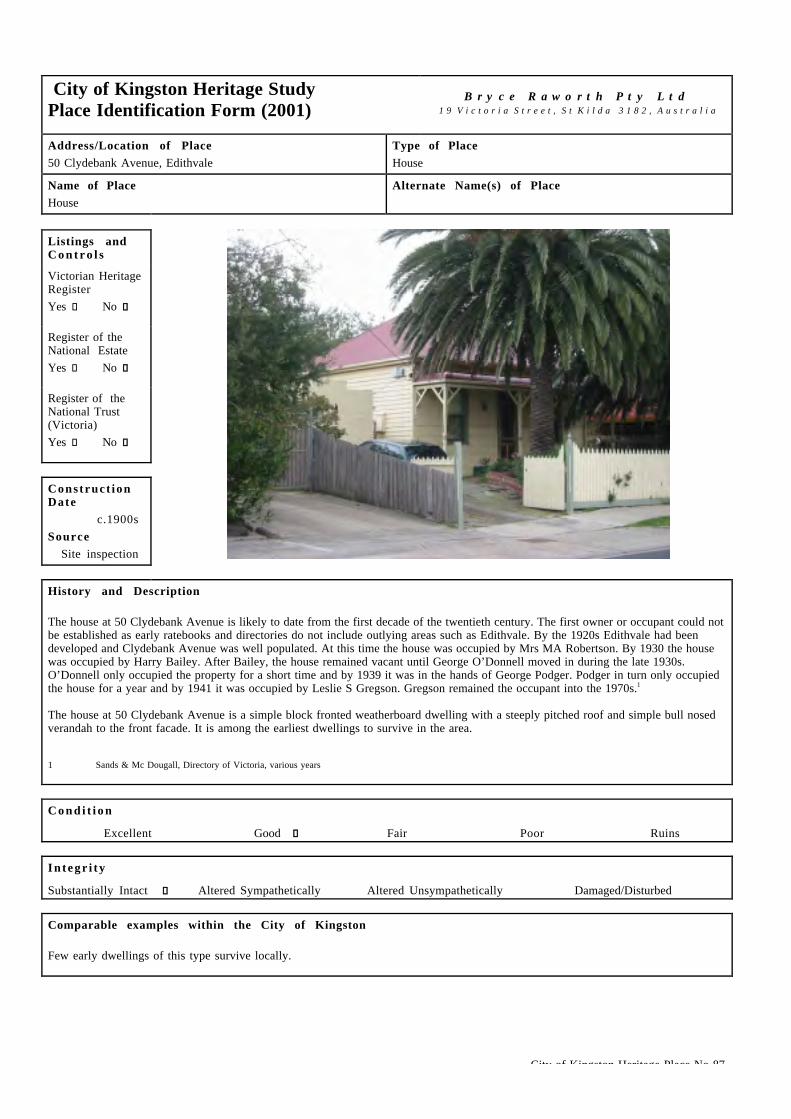
City of Kingston Heritage Place No 87
City of Kingston Heritage StudyPlace Identification Form (2001)
B r y c e R a w o r t h P t y L t d1 9 V i c t o r i a S t r e e t , S t K i l d a 3 1 8 2 , A u s t r a l i a
Address/Location of Place50 Clydebank Avenue, Edithvale
Type of PlaceHouse
Name of PlaceHouse
Alternate Name(s) of Place
Listings andC o n t r o l s
Victorian HeritageRegisterYes c No g
Register of theNational EstateYes c No g
Register of theNational Trust(Victoria)Yes c No g
Construct ionDate
c.1900sSource
Site inspection
History and Description
The house at 50 Clydebank Avenue is likely to date from the first decade of the twentieth century. The first owner or occupant could notbe established as early ratebooks and directories do not include outlying areas such as Edithvale. By the 1920s Edithvale had beendeveloped and Clydebank Avenue was well populated. At this time the house was occupied by Mrs MA Robertson. By 1930 the housewas occupied by Harry Bailey. After Bailey, the house remained vacant until George O’Donnell moved in during the late 1930s.O’Donnell only occupied the property for a short time and by 1939 it was in the hands of George Podger. Podger in turn only occupiedthe house for a year and by 1941 it was occupied by Leslie S Gregson. Gregson remained the occupant into the 1970s.1
The house at 50 Clydebank Avenue is a simple block fronted weatherboard dwelling with a steeply pitched roof and simple bull nosedverandah to the front facade. It is among the earliest dwellings to survive in the area.
1 Sands & Mc Dougall, Directory of Victoria, various years
C o n d i t i o n
Excellent � Good g Fair � Poor � Ruins �
I n t e g r i t y
Substantially Intact g Altered Sympathetically � Altered Unsympathetically � Damaged/Disturbed �
Comparable examples within the City of Kingston
Few early dwellings of this type survive locally.

City of Kingston Heritage Place No 87
Statement of Significance
Constructed c.1900s, the dwelling at 50 Clydebank avenue, Edithvale is of local historical and architectural significance as an unusualexample of an ashlar boarded dwelling and one of the earliest residences to survive in this locale.
Recommendat ions
A heritage overlay is recommended for this building.
City of Kingston Planning Scheme
Recommended for inclusion in a heritage overlay to the Planning Scheme Yes g No �Should external paint controls apply? Yes g No �Should internal alteration controls apply? Yes � No g
Should tree controls apply? Yes � No g
Other Listings and Controls
Recommended for inclusion on the Victorian Heritage Register? Yes � No g
Recommended for inclusion on the Register of the National Estate? Yes � No g
Recommended for inclusion on the National Trust (Victoria) Register? Yes � No g

City of Kingston Heritage Place No 086
City of Kingston Heritage StudyPlace Identification Form (2001)
B r y c e R a w o r t h P t y L t d1 9 V i c t o r i a S t r e e t , S t K i l d a 3 1 8 2 , A u s t r a l i a
Address/Location of Place42 - 54 Edithvale Road (cnr French Avenue),Edithvale.
Type of PlaceSchool.
Name of PlaceEdithvale Primary School.
Alternate Name(s) of PlaceFormerly Aspendale Primary School.
Listings andC o n t r o l s
Victorian HeritageRegisterYes c No g
Register of theNational EstateYes c No g
Register of theNational Trust(Victoria)Yes c No g
Construct ionDate
From 1942Source
Refer History
History and Description
In September 1908 residents of Aspendale began campaigning for a school to be erected in their area. Twenty-two potential studentsfrom this small farming community attended schools some distance away at Mordialloc and Carrum. In 1910, the Education Departmentexamined a site offered by Dr Carty Salmon but decided that the location, near an unfenced railway line, was unsuitable. In September1911, Robert Vincent sold the present three-acre site to the Department, and construction of a new wooden school building began. Inthe interim, a three-roomed building was leased from Mrs. Jones to serve as a classroom for the initial enrolment of 150 students. On7th March 1913, Head Teacher Charles McKinley transferred his students to the newly completed school known at that time asAspendale Primary School. In 1921, the school was renamed Edithvale Primary School to accord with the recently completed EdithvaleRailway Station. By 1923, enrolments had reached 277 and the Department was forced to lease the new Edithvale Hall to relieveovercrowding. Sir Alexander Peacock officially opened the school in 1924.
Over the following years, enrolments continued to increase and further accommodation was required. In 1939, a pavilion classroom wasrelocated from Camberwell to relieve overcrowding.
On 30th December 1940, a fire destroyed the main building and badly damaged the detached classroom. During 1941, classes were heldin the renovated classroom, a play pavilion and three leased church buildings. A brick structure of seven classrooms, an office andteachers' room was constructed to replace the original building. It opened in January 1942 and it is likely to have been designed by thePWD architect Percy Everett. Intensive building activity in the district brought further enrolments necessitating the construction oftwo brick classrooms in 1947. Over the next seventeen years, six Bristol prefabricated classrooms and two additional timber buildings(containing nine classrooms, teachers' room and a library) were constructed.
In 1960, the school became a training school for students from the Frankston Teachers College as well as still being used as a PrimarySchool. In 1969 a detached Art and Craft centre began operation. At that time, the student population numbered 756.1 Extensiveredevelopment of the grounds was undertaken in 1975. This involved many new landscaped areas; new play equipment and ball courts.A hall was constructed in 1984. Further work to the grounds was completed in 1987. By the mid 1980's the number of students haddropped to 490 which left space for a computer room, music room and enabled the school to be involved in a Community House.

City of Kingston Heritage Place No 086
History and Description (continued)
The original Edithvale Primary School building is predominantly single storey with a tower feature addressing Edithvale Road and thecorner. It is primarily red brick and has hawthorn brick window trims designed in the Streamlined Moderne Style and features horizontalwindow and door mullions and flat roofs with wide projecting eaves. As constructed the tower was capped with a chamfered brick edgingmore consistent with the rest of the buildings detailing.2 This tower has since been extended to create more space, and has lost some ofits original qualities. Another feature of the building typical of Everett’s work is the projecting curved corner bay adjacent to the entry.In order to get more light into the central hallway; clerestorey windows were located above the classrooms and light filters throughwindows in the hallway. The building is in good general condition although some original timber horizontal mullioned windows havebeen replaced with new aluminum windows.
1 This reference is drawn with minor editing from, Education Department of Victoria, Vision and Realisation: A Centenary History of State Education in Victoria,Vol III, Melbourne, 1973, pp.436.
2 Meriden Wall (Compiled by Sue McNiff). 3790 Edithvale Primary School History 1913 – 1988. Edithvale Primary School Council, Edithvale.1988. p.60.
C o n d i t i o n
Excellent c Good g Fair c Poor c Ruins c
I n t e g r i t y
Substantially Intact c Altered Sympathetically g Altered Unsympathetically c Damaged/Disturbed c
Comparable examples within the City of Kingston
No other buildings constructed to designs by PWD Architect Percy Everett were identified as part of this study. Few examples of theModerne style embraced by the PWD under Everett were constructed locally. The original sections of the Chelsea Hotel on the NepeanHighway Chelsea are the most prominent example of the mode.
Statement of Significance
Dating from 1942, the earliest building of the Edithvale Primary School is of local social significance for its long association with thelocal community. It is also of some architectural significance as an example of the Modernist designs of PWD Architect Percy Everett.The remainder of the fabric on the site is of little significance.
Recommendat ions
A heritage overlay is recommended for the original building (dating from 1942) and its setbacks from Edithvale Road and FrenchAvenue.
City of Kingston Planning Scheme
Recommended for inclusion in a heritage overlay to the Planning Scheme Yes g No c
Should external paint controls apply? Yes g No c
Should internal alteration controls apply? Yes c No g
Should tree controls apply? Yes c No g
Other Listings and Controls
Recommended for inclusion on the Victorian Heritage Register? Yes c No g
Recommended for inclusion on the Register of the National Estate? Yes c No g
Recommended for inclusion on the National Trust (Victoria) Register? Yes c No g

City of Kingston Heritage Place No 88
City of Kingston Heritage StudyPlace Identification Form (2001)
B r y c e R a w o r t h P t y L t d1 9 V i c t o r i a S t r e e t , S t K i l d a 3 1 8 2 , A u s t r a l i a
Address/Location of Place67 Edithvale Road, Edithvale
Type of PlaceHouse
Name of PlaceHouse
Alternate Name(s) of Place
Listings andC o n t r o l s
Victorian HeritageRegister
Yes � No g
Register of theNational Estate
Yes � No g
Register of theNational Trust(Victoria)
Yes � No g
Construct ionDate
c.1910sSource
Refer history
History and Description
The house at 67 Edithvale Road is likely to date from the second decade of the twentieth century. By the 1920s Edithvale was welldeveloped and the Edithvale Road was well populated. Through the mid-1920s (and possibly earlier) the house was occupied by AlfredW Bradford. By the late1930s, 67 Edithvale Road was occupied by Mrs MJ Kalalo. By the early 1940s it was occupied by EHollingsworth. In the mid-1940s, the Barry family began an association with the house which would endure for over thirty years.1
The house is an unusual combination of building elements and materials producing a design which combines local lightweight buildingtraditions with the layout and massing of vernacular exemplars. The asymmetrical dwelling is largely clad in weatherboards to dadolevel with roughcast render above. Roof elements are steeply pitched with gable ends and a shallow verandah on decorative columns tothe front facade. The dwelling retains a large allotment which contributes to its early character.
1 Sands and McDougall Directory of Victoria 1924 – 1974.
C o n d i t i o n
Excellent g Good � Fair � Poor � Ruins �
I n t e g r i t y
Substantially Intact g Altered Sympathetically � Altered Unsympathetically � Damaged/Disturbed �
Comparable examples within the City of Kingston
12 Wimbourne Street, Chelsea also incorporate the lightweight building traditions of the holiday home with a more traditionalarchitectural expression although the architectural expression is somewhat different.

City of Kingston Heritage Place No 88
Statement of Significance
Built c.1910s, the dwelling at 50 Clydebank Avenue, Edithvale, is of architectural significance as an early building of an unusual andhandsome design which incorporates some aspects of the lightweight building traditions associated with the development of theEdithvale as a holiday destination.
Recommendat ions
A heritage overlay is recommended for the building.
City of Kingston Planning Scheme
Recommended for inclusion in a heritage overlay to the Planning Scheme Yes g No �Should external paint controls apply? Yes g No �Should internal alteration controls apply? Yes � No g
Should tree controls apply? Yes � No g
Other Listings and Controls
Recommended for inclusion on the Victorian Heritage Register? Yes � No g
Recommended for inclusion on the Register of the National Estate? Yes � No g
Recommended for inclusion on the National Trust (Victoria) Register? Yes � No g

City of Kingston Heritage Place No 91
City of Kingston Heritage StudyPlace Identification Form (2001)
B r y c e R a w o r t h P t y L t d1 9 V i c t o r i a S t r e e t , S t K i l d a 3 1 8 2 , A u s t r a l i a
Address/Location of Place23 Fraser Ave, Edithvale
Type of PlaceHouse
Name of PlaceThe Pines
Alternate Name(s) of Place
Listings andC o n t r o l s
Victorian HeritageRegister
Yes � No g
Register of theNational Estate
Yes � No g
Register of theNational Trust(Victoria)
Yes � No g
Construct ionDate
1934Source
Refer History
History and Description
The parcel of land at 23 Fraser Avenue had been part of Robert Vincent's farm prior to its subdivision in 1928.1 The block waspurchased by building surveyor turned architect, Eliab Box and investor, Thomas Cooper in 1932 and an unusual holiday residence,constructed using a novel system of interlocking concrete blocks, was completed in 1934 (although other sources note a slightlyearlier construction date).2 A stand of trees surviving from the earlier farm site is understood to have provided the name for thedwelling, The Pines. The Cooper family used the house for a year before constructing another holiday house in Carrum.
Eliab Box was born in Cambridge, England in 1865 and began his professional career as an engineer. He emigrated to Victoria with hissecond wife and twelve children in 1903. Box was Building Surveyor for the City Caulfield from 1914 to 1919. After the war, heregistered as an architect and established his own practice in Hawthorn Road Caulfield.3 He designed a number of houses in the Caulfieldarea and St Paul's Hall.
It has been suggested that The Pines was built to designs by noted American architect, Walter Burley Griffin, who practised inCanberra, Melbourne and later Sydney from the 1910s to the 1930s. The Pines adopts an interlocking block system similar to theknitlock design conceived in Griffin's office and employs a Griffinesque passage free plan recalling his designs for houses such asPholiota and Stokesay. In addition, the residence has been known locally as the Burley Griffin house for many years. However, thedwelling is sufficiently idiosyncratic to suggest that the construction system, and the dwelling generally, were conceived by another,most likely, Box.4
After the Cooper family's brief period of residence, the property was let to John Butler, a carpenter, who occupied the dwelling until itwas sold to Miss Featherstone and Mrs Elizabeth Sutton. It was sold to Mrs Elizabeth Clark and remained in the Clark family for thirty-five years. The property was subsequently rented to a range of tenants and fell into disrepair. In 1985, the house was purchased byarchitects, Spiros and Winifred Kolaitis who undertook its restoration. Later owners, Ken Hatfield and Adrienne Howard modernised thekitchen and undertook some additions to the rear. The site is currently owned by Frank McGuire, local historian and author of Chelseaand Mordialloc's history.

City of Kingston Heritage Place No 91
History and Description (continued)
The house is constructed in concrete block and dominated by a large low hipped roof in corrugated steel. The full width verandah tothree sides of the building is distinguished by massive timber columns and accessed by French windows across the entire front facade.The dwelling recalls the simple Indian pavilions or bengala, a source of inspiration for American and Australian bungalow designsthrough the early twentieth century.
1 Unless noted otherwise, this citation is drawn from Frank McGuire, 23 Fraser Avenue, Edithvale, City of Chelsea Historical Society Building Register, December 1991, copy provided by the author.
2 Miles Lewis, 'The Pines, 23 Fraser Avenue, Edithvale', original held on Historic Buildings Council file, ,suggests a 1927 construction date.3 Sands & McDougall Directory of Victoria, 1920.4 Lewis, loc cit.
C o n d i t i o n
Excellent � Good g Fair � Poor � Ruins �
I n t e g r i t y
Substantially Intact g Altered Sympathetically � Altered Unsympathetically � Damaged/Disturbed �
Comparable examples within the City of Kingston
No buildings adopting the form or unusual construction methods found here were identified during the course of this study. The buildingwas nominated to the Historic Building Council some time ago but no action was taken at that time. Professor Miles Lewis ofMelbourne University has encouraged the inclusion of the building on the Victorian Heritage Register on a number of occasions.
Statement of Significance
The Pines, at 23 Fraser Avenue, Edithvale was constructed in c.1934, most likely to designs by Eliab Box. It is of local significance asan unusual and handsome design in a manner that recalls the Indian bengala and for its unusual construction system. The buildingemploys an arrangement of interlocking concrete blocks similar to the knitlock system developed by noted American architect WalterBurley Griffin.
Recommendat ions
A heritage overlay is recommended for the building.
City of Kingston Planning Scheme
Recommended for inclusion in a heritage overlay to the Planning Scheme Yes g No �Should external paint controls apply? Yes g No �Should internal alteration controls apply? Yes � No g
Should tree controls apply? Yes � No g
Other Listings and Controls
Recommended for inclusion on the Victorian Heritage Register? Yes g No �Recommended for inclusion on the Register of the National Estate? Yes � No g
Recommended for inclusion on the National Trust (Victoria) Register? Yes g No �

City of Kingston Heritage Place No 243
City of Kingston Heritage StudyPlace Identification Form (2001)
B r y c e R a w o r t h P t y L t d1 9 V i c t o r i a S t r e e t , S t K i l d a 3 1 8 2 , A u s t r a l i a
Address/Location of PlaceCorner of Warrigal Highway and Kingston Road,Heatherton.
Type of PlaceHealth Care Centre.
Name of PlaceKingston Centre.
Alternate Name(s) of PlaceFormer Benevolent Asylum, Former Melbourne BenevolentAsylum & Hospital for the Aged and Infirm, Former MelbourneHome & Hospital for the Aged and Former Cheltenham Home &Hospital for the Aged.
Listings andC o n t r o l s
Victorian HeritageRegisterYes c No g
Register of theNational EstateYes c No g
Register of theNational Trust(Victoria)Yes c No g
Construct ionDate
From 1909Source
Refer History
History and Description
This large site, situated on the corner of Kingston Road and the Warrigal Highway in Heatherton, has been used for various purposesover its extensive history. The site probably started out as part of a larger farming estate in the late 19th century or as a marketgardening property. In 1900 the site was still listed as in private ownership in the directories,1 although the area had been set aside as areserve as early as 1884.2 In 1909-10 the Melbourne Benevolent Asylum constructed a building on the corner site.3 The foundationstone was laid in March 1909 by Sir Thomas Gibson Carmichael, Esq., Governor of Victoria and President of the MelbourneBenevolent Asylum. The Asylum was for the care of mentally ill patients.4 It was built because the Melbourne Asylum had becomedangerously crowded, vermin infested and difficult to maintain. The location of the Melbourne Asylum was also at a disadvantage as thecrowded city harbored disease and epidemics were prevalent. In 1880 a committee had met with the Premier to request a land grant in theCheltenham area for construction of a new facility. Progress was slow and it wasn’t until 1904 when 154 acres of land on the corner ofwhat are now Kingston and Warrigal Roads were identified for its construction5. The asylum building was designed by Charles d’Ebro, anoted Melbourne architect.6 d’Ebro was well known for both industrial and public buildings including projects such as the GollinBuilding at 563 Bourke Street (1901), the now demolished Adelaide Steamship building in Collins Street (1905) and Scottish House at90-96 William Street (1907/8)7. The successful tenderers for the new asylum were Messrs Wadey and Company at £77 269. In order toconstruct the building, transport had to be carefully considered, as the site was two miles from the railway line over poor roads. So aline of rail was laid along what are now Park, Centre Dandenong and Warrigal Roads. This railway line was in place for around 2 yearsfor the transportation of materials and other goods to the building site but was removed soon after construction was completed.8
Initially the centre was called the Melbourne Benevolent Asylum, but the name was changed in 1924 to the Melbourne BenevolentAsylum & Hospital for the Aged and Infirm 9. By the mid 1930s it appears that the site was reasonably developed and contained aroundeight buildings.1 0. This appears to have been the case until the mid-1950s.1 1 Another 1930s plan shows the main asylum buildingoverlooking a lake.1 2 In 1949 the words asylum and infirm were dropped from the title, with the place renamed as the Melbourne Home& Hospital for the Aged. In 1965 the name was changed to the Cheltenham Home & Hospital for the Aged and in 1970 it was changedto the Kingston Centre.1 3 The centre was later expanded to its current state, including a Geriatric Hospital and Kingston AgedPsychiatry. The site is still called the Kingston Centre.

City of Kingston Heritage Place No 243
History and Description (continued)
The Kingston Centre consists of over 30 buildings spread over a large site. The buildings range from the early 1910 Schutt Centre, theoriginal Asylum building, to the more recent PGNH & AU Buildings in the north east corner of the site.
The Asylum was joined by an additional facility called the Heatherton Sanatorium in 1913.1 4 The Sanatorium dealt in particular withTuberculosis patients1 5 and had 100 beds for the purpose.1 6 An electric tram was used to transport food from the asylum which providednot only meals but also staff and administration, although by the 1950s it was independent. The early buildings were joined by twonew modern wards, some residences and a concert hall by the 1930s and by a five storey hostel in 19521 7. The hostel was designed bythe then Chief Architect of the PWD Percy Everett, who designed a large number of institutional buildings in modernist style between1934 and 1953 for the PWD.1 8 Tuberculosis was a disease, which had been prevalent in Melbourne since the 1880s. Various measureswere taken to reduce the number of TB casualties, particularly chest radiography during and after the Second World War. The regime wasso effective that by the 1960s the death rate from Tuberculosis had fallen to 0.002%.19 With the number to TB cases dramaticallyreduced patients from other hospitals were transferred to Heatherton. In 1974 the Alcohol and Drug Dependent Persons Services Branchand patients from the Prince Henry’s Hospital moved onto the site and the wards were refurbished. The name was changed to theHeatherton Hospital. In the 1980s when Willsmere Hospital closed the patients from there were also moved to Heatherton. The northand south blocks were refurbished for the purpose and the site became a Psychiatric hospital for the elderly. However, during the early1990s the buildings and grounds became degraded and in 1993 the hospital once again came under the umbrella of the asylum (by thistime called the Kingston Centre). The Heatherton Hospital closed in 1998 and the buildings were subsequently demolished.20 The sitewas subdivided and is now used for residential purposes.
1 Sands and McDougalls Directory of Victoria, 1895 - 1974. Held at the Royal Historical Society of Victoria, Melbourne.2 Mordialloc, County of Bourke Crown Portion Subdivision Map. First Edition 8th December 1884 and Mordialloc, County of Bourke Crown Portion
Subdivision Map, Second Revised Edition, c.1900.3 Kingston Historical Website. http://localhistory.kingston.vic.gov.au ‘Kingston, hardly a gem of a name: Where did it originate?’ by Graham J Whitehead.4 Sands and McDougalls Directory of Victoria.5 Kingston Historical Website. http://localhistory.kingston.vic.gov.au ‘Street Train to the Benevolent Asylum’ by Graham J Whitehead.6 Kingston Historical Website. ‘Street Train to the Benevolent Asylum’7 Miles Lewis for the City of Melbourne. Melbourne: The City’s History and Development. Second Edition, November 1995. p.103/4.8 Kingston Historical Website. ‘Street Train to the Benevolent Asylum’.9 Kingston Historical Website. ‘Kingston, hardly a gem of a name: Where did it originate?’.1 0 Department of Lands and Survey, Melbourne. Melbourne and Suburbs. Map of 1935. Held at the State Library of Victoria, Maps Collection.1 1 Department of Lands and Survey, Melbourne. Melbourne and Suburbs. Map of 1956. Held at the State Library of Victoria, Maps Collection.1 2 Commonwealth Section Imperial General Staff. Map of 1-8-1935. Held at the State Library of Victoria, Maps Collection.1 3 Kingston Historical Website. ‘Kingston, hardly a gem of a name: Where did it originate?’.1 4 Kingston Historical Website. http://localhistory.kingston.vic.gov.au ‘Heatherton Tuberculosis Sanatorium’ by Alan Bennett.1 5 Sands and McDougalls Directory of Victoria,1 6 Kingston Historical Website. ‘Heatherton Tuberculosis Sanatorium’.1 7 Ibid.1 8 National trust of Australia (Victoria) Website, Citation for Heatherton Sanatorium (File No B6929): http://www.nattrust.com.au1 9 Graeme Butler, CAD Conservation Study, 1985, 378 Lt Lonsdale Street.2 0 Kingston Historical Website. ‘Heatherton Tuberculosis Sanatorium’.
C o n d i t i o n
Excellent c Good g Fair c Poor c Ruins c
I n t e g r i t y
Substantially Intact c Altered Sympathetically g Altered Unsympathetically c Damaged/Disturbed c
Comparable examples within the City of Kingston
No comparable examples are known to exist within the City of Kingston, however, complexes such as Willesmere/Kew Cottages retainsome buildings similar to those found at the Kingston Centre.
Statement of Significance
Although somewhat altered, the Kingston Centre is of historical, architectural and social significance at a local and potentially statelevel. It retains historical associations with the Melbourne Benevolent Asylum, the City's first asylum and second hospital and anumber of buildings dating from the original construction (1909-11), most notably the Schutt Centre, (the original Asylum building)and a number of early dormitories. The earliest buildings on the site were constructed to designs by noted Engineer/Architect CharlesD'Ebro and are of architectural significance as an unusual example of his later work. Locally, the hospital has maintained anassociation with the local community for almost a century and it continues in its traditional role of care.

City of Kingston Heritage Place No 243
Left: Education and Socialisation Center’s. Right: MonArc Aged Mental Health Research Unit.
Left: Community Clinic Building. Right: Workshops.
Recommendat ions
A heritage overlay is recommended for The Schutt Centre (Earliest Asylum Building, 1910), Education and Socialisation Centre’s (twolong wings in the south east of the site), MonArc Aged Mental Health Research Unit (large bungalow style building facing KingstonRoad) and the Community Clinic Building (two storey building to the east of the administration building). Other buildings of intereston the site include the workshops, which should be retained if possible. Consideration should be given to nominating the SchuttCentre and other key buildings to the Victorian Heritage Register, Register of the National Estate and the National Trust (Vic) Register.
City of Kingston Planning Scheme
Recommended for inclusion in a heritage overlay to the Planning Scheme Yes g No c
Should external paint controls apply? Yes g No c
Should internal alteration controls apply? Yes c No g
Should tree controls apply? Yes c No g
Other Listings and Controls
Recommended for inclusion on the Victorian Heritage Register? Yes g No c
Recommended for inclusion on the Register of the National Estate? Yes g No c
Recommended for inclusion on the National Trust (Victoria) Register? Yes g No c

City of Kingston Heritage Place No 118
City of Kingston Heritage StudyPlace Identification Form (2001)
B r y c e R a w o r t h P t y L t d1 9 V i c t o r i a S t r e e t , S t K i l d a 3 1 8 2 , A u s t r a l i a
Address/Location of PlaceCnr Kingston & Old Dandenong Rd, Heatherton.
Type of PlaceChurch.
Name of PlaceThe Uniting Church of Australia, Heatherton Dingley Parish.
Alternate Name(s) of PlaceFormer Heatherton Wesleyan Church.
Listings andC o n t r o l s
Victorian HeritageRegisterYes c No g
Register of theNational EstateYes c No g
Register of theNational Trust(Victoria)Yes c No g
Construct ionDate
From 1859Source
Refer History
History and Description
The first meetings of the Wesleyan Methodist church in Heatherton were held it the home of Mr. Henderson and later at the home of Mr.Laver in 1859. The church grew quickly and soon a church building was needed. At Heatherton (which was then called Kingstown – thisname was changed to Heatherton in around 1861 due to confusion with another town of the same name1), the foundation stone was laidfor a rubble stone church on the corner of Kingston and Old Dandenong Roads in 1859. A member of the congregation, Mr. Laver, astonemason, 2 constructed the church free of charge with stone from the nearby Old Dandenong Road, Dingley Quarry. Volunteer labourenabled the church walls to be constructed in a record time. A building committee was established to raise funds for the completion ofthe roof, doors and windows. The first services were held in the church without a floor until money was available for its construction,but by the time of the official opening, the church was free of debt. A Sunday School was established in the same year. By thebeginning of the twentieth century the church was looking towards expansion, and the church was extended with stone from Berwick,hauled to the site by a horse and dray. 3 The Wesleyans combined with the Primitive Methodists and Bible Christians to form theMethodist Church of Australasia in 1902.4
Due to clashes in activities5a new timber church was built alongside the original building to provide more space in 1909.6 This waslocated next to the original church between the church and the Kingston and Old Dandenong Roads corner intersection. The winningtender was from builder J. B. Foster of Dandenong at £199 and an overdraft was taken out with the ES&A bank to pay for construction.The church measured 40x24x13 ft and had a 7x4x6 porch. The church was opened on the 25th of July 1909. The timber church was usedas a church for around 25 years. Mr Pasher, a local builder, who had produced the original plans for the building, painted the timberbuilding in 1912.7 The timber building was demolished in the early 1990s due to termite damage rendering the building unsafe. Plansfor a replacement building were drawn up and a building was constructed to the rear of the church.8
Once the new timber church building was built the original church building was used as the Sunday School. The original church wasextended again in the 1920s with a vestry built on the east end. In 1933 it was showing signs of deterioration (because of white antinfestation) so the walls were supported with new buttresses and rendered with cement. These works enabled the building to be onceagain used as the church building. A porch was added to the front of the church later in that year at a cost of £40. The timber buildingbecame the Sunday School Hall.9
City of Kingston Heritage Place No 118
History and Description (continued)
Fundraising in 1945 made £250 available to go towards the construction of a Kindergarten. Negotiations with authorities commencedfor a permit to build a brick veneer 20x24ft building. However permission was not granted. In the late 1940s the Heatherton PrimarySchool used the timber building while their buildings were being repaired. Further fundraising was undertaken during the 1950s with theview of constructing the kindergarten or improving the Sunday School accommodation. However, the money saved for theconstruction of the Kindergarten had to be used in 1964, to purchase a new organ for the church. In 1967, the Heatherton Churchobtained a kindergarten building that was surplus to the requirements of the Tucker Rd Church. A new roof and ceiling was installed andthe whole building repainted for $340, in addition to the $500 transportation fee.1 0
In 1977, the Heatherton Wesleyan Church became part of the Uniting Church of Australia and, in 1981, part of the new HeathertonDingley Parish. The parish was able to call its own full time minister in 1987 and purchased a manse in Dingley for the minister. In1990, the internal orientation of the church was changed to face the opposite direction in order to provide better access and more space.The space freed by this change was used as an entrance lobby and a vestry. A covered way between the church entrance and the SundaySchool Hall was constructed at around the same time.1 1
The original church building (1859 - 1861) is a simple single storey structure with small buttresses (1933) and some stained glasswindows. A small portico (1940) at the western end is rectilinear in form and also features dwarf buttresses. New glazing has been fittedto the windows on the southern side as well as extensive additions to the rear of the building which were undertaken in 1967 and duringthe 1990s. These additions include the present hall that is clad in hardiplank and has a corrugated sheet roof. These new additions areunsympathetic to the original church building and obscure the early character when viewed from the south. A new roof and guttering hasbeen added and the parapet has been flashed. The new roof material (colourbond) is not sympathetic to the church building. The timberhall (1909) has been demolished and no trace remains of it on the site.1 From material provided by Mr. L. B. Mill, Heatherton Uniting Church, Heatherton2 Barnard & Sheehan, City of Kingston heritage Study, Stage I, p.114.3 From material provided by Mr. L. B. Mill.4 Wesleyan Methodist Uniting. 2nd Edition, 1995.5 From material provided by Mr. L. B. Mill.6 Barnard & Sheehan, p.114.7 From material provided by Mr. L. B. Mill.8 Ibid.9 Ibid.1 0 Ibid.1 1 Ibid.
C o n d i t i o n
Excellent c Good g Fair c Poor c Ruins c
I n t e g r i t y
Substantially Intact c Altered Sympathetically g Altered Unsympathetically c Damaged/Disturbed c
Comparable examples within the City of Kingston
There are no comparable examples within the City of Kingston as identified by this study. This is an early church and it is of note inthe district as it is rendered stonework rather than brick, the more common material.
Statement of Significance
Heatherton Uniting Church is of historical, architectural and spiritual significance at a local level. The earliest section of the building,dating from 1867, is of historical significance as the earliest extant church in the area and retains its legibility as an early churchdespite its incorporation into a larger group. The church is of architectural significance for its simple early form and rubbleconstruction. The building is of spiritual significance as the focus of the local Uniting Church community.
Recommendat ions
A heritage overlay is recommended for the original church dating from 1859 only.
City of Kingston Heritage Place No 118
City of Kingston Planning Scheme
Recommended for inclusion in a heritage overlay to the Planning Scheme Yes g No c
Should external paint controls apply? Yes g No c
Should internal alteration controls apply? Yes c No g
Should tree controls apply? Yes c No g
Other Listings and Controls
Recommended for inclusion on the Victorian Heritage Register? Yes c No g
Recommended for inclusion on the Register of the National Estate? Yes c No g
Recommended for inclusion on the National Trust (Victoria) Register? Yes c No g

City of Kingston Heritage Place No 114
City of Kingston Heritage StudyPlace Identification Form (2001)
B r y c e R a w o r t h P t y L t d1 9 V i c t o r i a S t r e e t , S t K i l d a 3 1 8 2 , A u s t r a l i a
Address/Location of PlaceOld Dandenong Road, Heatherton.
Type of PlaceSchool.
Name of PlaceFormer Heatherton Primary School.
Alternate Name(s) of PlaceState School No 938, Former Kingston Primary School.
Listings andC o n t r o l s
Victorian HeritageRegisterYes c No g
Register of theNational EstateYes c No g
Register of theNational Trust(Victoria)Yes c No g
Construct ionDate
From c1990Source
Refer History
History and Description
Early in 1867, Thomas Attenborough, a wealthy grazier, proposed the construction of a school to be called Kingston Common School.A committee comprising Attenborough, J Stooke, J Aitken and P Robertson sought a grant of £50 from the Board of Education toestablish the school. In April 1868, the boards Inspector Stasse recommended the grant but stipulated a wooden building instead of thecommittee's architect-designed brick proposal. The Inspector - General agreed to match funds raised by the community to a maximum of£50 and building commenced on the present site. In May 1868, the board granted permission for instruction to be undertaken in aprivate cottage pending the construction of the building. In June 1870, Head Teacher, Rebecca Waugh enrolled 22 children from thesurrounding areas and tuition began. A further grant of £30 in 1871 assisted completion of the building and the efforts of Head TeacherWJ Stephens led to the completion of a school residence before 1880. Within the first few years of operation, the school adopted itsmore familiar name, Heatherton Primary school.1 The original school building was moved to the Heatherton Recreation Reserve, whereit is still located today at the north end of the hall. The school building has however undergone substantial modifications since thistime.2
By 1900, enrollment had increased to around 100, necessitating the construction of the present main building (comprising twoclassrooms, a storeroom and an office) and the employment of two assistants for headmaster, Peter Hotton. It is possible that the newbuilding was designed by William Mackey, PWD Architect to the area.
As other schools were established throughout the district, enrollments fell to around seventy. Numbers remained fairly constant overthe next forty years until post-war development began to exert pressure on the aging building stock. In 1958, an LTC classroom wasconstructed and in 1963, another two classrooms, a staffroom and ladies' washroom were added. In 1973, plans were drawn up for twonew classrooms, one to replace the part of the century old building and the other to cater for anticipated enrolments in excess of 190students.3 Despite strong enrollments into the early 1990s, by the end of the decade the number of students attending the school haddropped dramatically. The School Council was faced with the difficult decision of closing down, finances and projected enrolments wereconsidered and parents consulted but it seemed that the most likely solution. The school was officially informed of its closure on 10December 1999 and the remaining students were transferred to other schools. The school is currently boarded up following its closure.4

City of Kingston Heritage Place No 114
History and Description (continued)
The c.1900 building on the site is clad in timber weatherboards, has unusual multipaned hopper windows with timber joinery and a newcorrugated sheet roof. The building features two tall red brick chimneys with terracotta pots. Additional buildings on site include ac.1920s building to the back of the site and post WWII classrooms. However, the 1900 building still retains its original prominentposition on the site.
1 This reference is drawn with minor editing from, Education Department of Victoria, Vision and Realisation: A Centenary History of State Education in Victoria,Vol III, Melbourne, 1973.
2 From information supplied by Graham Whitehead, Historian, City of Kingston.3 Education Department of Victoria, Op cit.4 Kingston Historical Website. http://localhistory.kingston.vic.gov.au ‘Kingston Common School: Heatherton School No.938’ by Graham Whitehead and Alan
Bennett.
C o n d i t i o n
Excellent c Good g Fair c Poor c Ruins c
I n t e g r i t y
Substantially Intact g Altered Sympathetically c Altered Unsympathetically c Damaged/Disturbed c
Comparable examples within the City of Kingston
A comparable example of a timber school building is the early section of Carrum Primary School (1910). These two buildings comparebecause of picturesque massing, Arts and Crafts details such as grouped windows, bracketed awnings and gambrel roofs. It is possiblethat both of these buildings were constructed to designs by William Mackey, PWD architect to this region through the early 1900s.
Statement of Significance
Constructed c.1900 Heatherton Primary School is of social and architectural significance at a local level. Although recently closed, theschool had been a focus for the local community for over a century and the site retains some social significance. It is of somearchitectural significance as an example of a c.1900 timber school design of note as a particularly early and intact school buildingwithin the Municipality.
Recommendat ions
A heritage overlay is recommended for the c.1900 building only.
City of Kingston Planning Scheme
Recommended for inclusion in a heritage overlay to the Planning Scheme Yes g No c
Should external paint controls apply? Yes g No c
Should internal alteration controls apply? Yes c No g
Should tree controls apply? Yes c No g
Other Listings and Controls
Recommended for inclusion on the Victorian Heritage Register? Yes c No g
Recommended for inclusion on the Register of the National Estate? Yes c No g
Recommended for inclusion on the National Trust (Victoria) Register? Yes c No g

City of Kingston Heritage Place No 95
City of Kingston Heritage StudyPlace Identification Form (2001)
B r y c e R a w o r t h P t y L t d1 9 V i c t o r i a S t r e e t , S t K i l d a 3 1 8 2 , A u s t r a l i a
Address/Location of Place198 Old Dandenong Road, Heatherton.
Type of PlaceHouse.
Name of PlaceNone.
Alternate Name(s) of PlaceNone.
Listings andC o n t r o l s
Victorian HeritageRegisterYes c No g
Register of theNational EstateYes c No g
Register of theNational Trust(Victoria)Yes c No g
Construct ionDateLate 19th CenturySource
Refer History
History and Description
The first European to occupy land in this area was John O’Shannessy, who held a squatting license for 40 000 acres in the early 1840s.His run included land in parts of what are now Clarinda, Clayton South, Dingley and Heatherton. His license was taken up by John andRichard King in 1846 who ran sheep and cattle on the property. Squatting licenses were revoked in the early 1850s and the Governmentof the Colony of Victoria subdivided the King run and auctioned it off to selectors. The land was brought by small farmers, landspeculators and market gardeners who slowly cleared the land and cultivated the soil. Over the next 100 years the area became part ofone of the largest horticultural districts in Victoria, producing a large quantity of Melbourne’s vegetables. By the late 19th centurydevelopment to the south east of Melbourne had centred upon coastal areas and much of the Clayton South, Oakleigh South andClarinda area remained sparsely settled. The construction of the railway in the 1870s and 1880s encouraged development, but thismainly clustered around the stations. Up until the first half of the twentieth century development in the area remained scattered.However rapid expansion during the post WWII period inundated the surrounding areas.1
The subject site originally formed part of Lot 4F of Section XV in the Parish of Mordialloc. It was first purchased by J Porter in the1870s2 and Porter is likely to have occupied the property until Alfred Korthe moved in at around c.1900. An early house on the site maydate from the late 19th century and was likely to have been built for Porter and Korthe. Walter Follett was the occupant of the house inthe later 1900s. From the 1910s until the 1950s the property was occupied by Jas E Cochrane, a market gardener. The current house onthe site was constructed for a family named Dunlop. He continued to occupy the property until the 1960s when Jack Lacey took upresidence. Lacey occupied the house into the 1970s.3
Market gardening played a pivotal role in the early years of the district. Market gardens in the City of Kingston enjoyed a proximity toMelbourne, which afforded them an advantage over market gardens further afield. The cost of land in the city was high, enabling marketgardeners on its fringes to make a good living.4 Gardeners in the City of Kingston brought their produce into Melbourne’s VictoriaMarket twice weekly for sale, often returning with manure for fertiliser. The number of market gardens in the Heatherton area decreasedas better road transport became available, enabling increased competition from further afield.5 Nonetheless, market gardeningcontinues within the City of Kingston and the subject site continues an association with market gardening which has survived for atleast 100 years.

City of Kingston Heritage Place No 95
History and Description (continued)
The subject site has retained its early, market gardening role and the early farming character of the dwelling and its environs remainsclearly legible. This simple timber weatherboard house has survived in broadly original condition. It is constructed on an asymmetricalplan with a rectangular gable ended bay to the street frontage. The roof and long verandah are clad in corrugated steel. Entry to thehouse is by way of a central doorway with timber framed windows to either side. A single chimney survives to one end of the roof.Some elements such as the decking to the verandah and the window joinery may date from the original construction or soon after. Anumber of outbuildings associated with the market gardening enterprise are located to the rear of the principal dwelling. These appearto date from the relatively recent past.
1 Kingston Historical Website. http://localhistory.kingston.vic.gov.au ‘History of Clarinda, Oakleigh South and Clayton South’.2 Mordialloc, County of Bourke Crown Portion Subdivision Map. First Edition 8th December 1884 and Mordialloc, County of Bourke Crown Portion
Subdivision Map, Second Revised Edition, c.1900.3 Sands & McDougalls Directory of Victoria. 1895 - 1974. Held at the Royal Historical Society, Melbourne.4 Kingston Historical Website. http://localhistory.kingston.vic.gov.au ‘Market Gardening in Kingston’ by Graham J Whitehead.5 Ibid.
C o n d i t i o n
Excellent c Good g Fair c Poor c Ruins c
I n t e g r i t y
Substantially Intact g Altered Sympathetically c Altered Unsympathetically c Damaged/Disturbed c
Comparable examples within the City of Kingston
A number of broadly similar dwellings exist within the City of Kingston including 65 Tootal Road Dingley and 50 Clydebank RoadEdithvale. However, the subject site is of considerably greater significance as a consequence of its extant context, fabric and itsongoing association with the market gardening industry.
Statement of Significance
The House at 198 Old Dandenong Road Heatherton is of historical and architectural significance at a local level It is historicallysignificant as an early farming site and retains the original or early farm dwelling. The site retains its significant use and is clearlylegible as an early market gardening site.
Recommendat ions
A heritage overlay is recommended for the building, including a small curtilage around the house. It may also be appropriated to includepart or all of the broader property under a character overlay to protect the valued farming character of the property
City of Kingston Planning Scheme
Recommended for inclusion in a heritage overlay to the Planning Scheme Yes g No c
Should external paint controls apply? Yes g No c
Should internal alteration controls apply? Yes c No g
Should tree controls apply? Yes c No g
Other Listings and Controls
Recommended for inclusion on the Victorian Heritage Register? Yes c No g
Recommended for inclusion on the Register of the National Estate? Yes c No g
Recommended for inclusion on the National Trust (Victoria) Register? Yes c No g
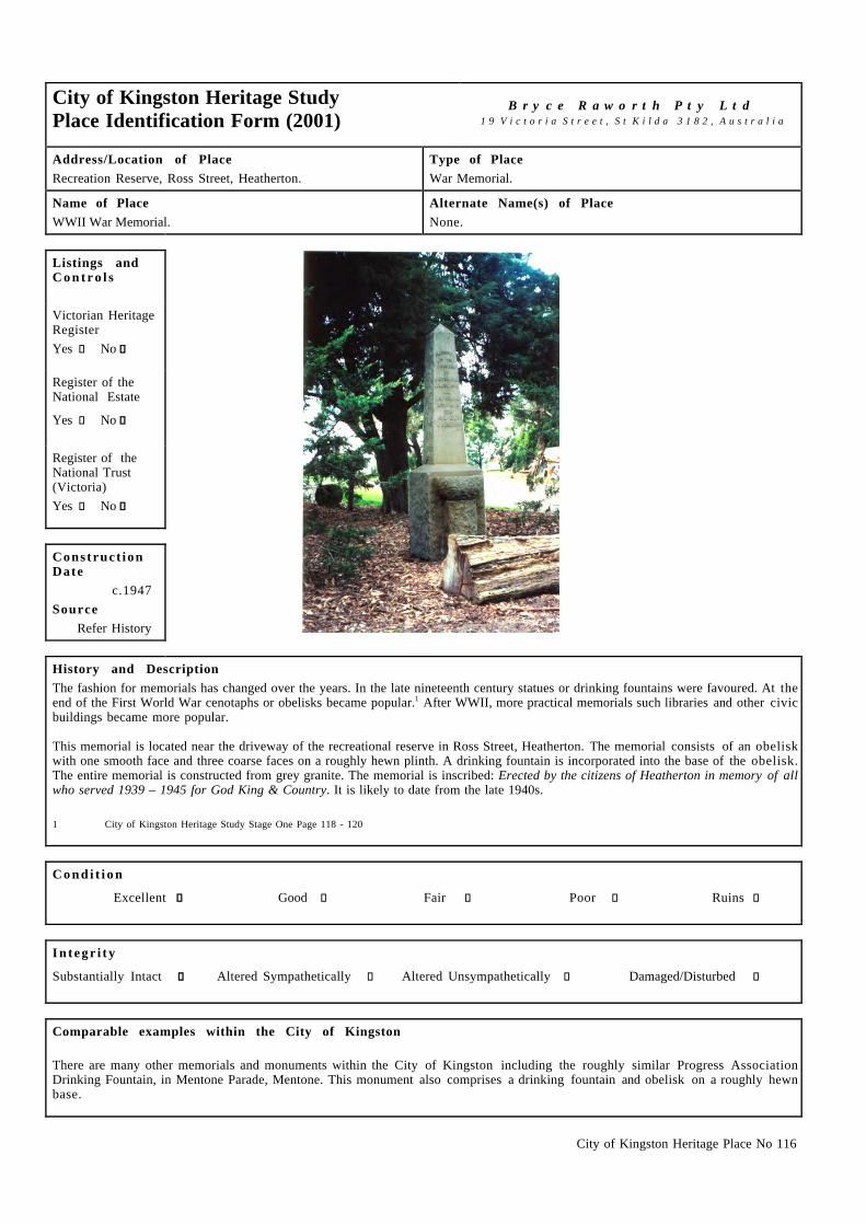
City of Kingston Heritage Place No 116
City of Kingston Heritage StudyPlace Identification Form (2001)
B r y c e R a w o r t h P t y L t d1 9 V i c t o r i a S t r e e t , S t K i l d a 3 1 8 2 , A u s t r a l i a
Address/Location of PlaceRecreation Reserve, Ross Street, Heatherton.
Type of PlaceWar Memorial.
Name of PlaceWWII War Memorial.
Alternate Name(s) of PlaceNone.
Listings andC o n t r o l s
Victorian HeritageRegisterYes c No g
Register of theNational Estate
Yes c No g
Register of theNational Trust(Victoria)Yes c No g
Construct ionDate
c.1947Source
Refer History
History and DescriptionThe fashion for memorials has changed over the years. In the late nineteenth century statues or drinking fountains were favoured. At theend of the First World War cenotaphs or obelisks became popular.1 After WWII, more practical memorials such libraries and other civicbuildings became more popular.
This memorial is located near the driveway of the recreational reserve in Ross Street, Heatherton. The memorial consists of an obeliskwith one smooth face and three coarse faces on a roughly hewn plinth. A drinking fountain is incorporated into the base of the obelisk.The entire memorial is constructed from grey granite. The memorial is inscribed: Erected by the citizens of Heatherton in memory of allwho served 1939 – 1945 for God King & Country. It is likely to date from the late 1940s.
1 City of Kingston Heritage Study Stage One Page 118 - 120
C o n d i t i o n
Excellent g Good c Fair c Poor c Ruins c
I n t e g r i t y
Substantially Intact g Altered Sympathetically c Altered Unsympathetically c Damaged/Disturbed c
Comparable examples within the City of Kingston
There are many other memorials and monuments within the City of Kingston including the roughly similar Progress AssociationDrinking Fountain, in Mentone Parade, Mentone. This monument also comprises a drinking fountain and obelisk on a roughly hewnbase.

City of Kingston Heritage Place No 116
Statement of Significance
The WWII War Memorial in the Recreational Reserve in Ross Street Heatherton is of social, historical and architectural significance ata local level. It is of social significance as an expression of gratitude from the local community for the sacrifice of servicemen duringWWII. It is historically significant as part of a wave of memorials constructed to honour Australian servicemen after the war. It is alsoof some architectural significance for its simple and practical design.
Recommendat ions
A heritage overlay is recommended for the memorial.
City of Kingston Planning Scheme
Recommended for inclusion in a heritage overlay to the Planning Scheme Yes g No c
Should external paint controls apply? Yes g No c
Should internal alteration controls apply? Yes c No g
Should tree controls apply? Yes c No g
Other Listings and Controls
Recommended for inclusion on the Victorian Heritage Register? Yes c No g
Recommended for inclusion on the Register of the National Estate? Yes c No g
Recommended for inclusion on the National Trust (Victoria) Register? Yes c No g

City of Kingston Heritage Place No 133
City of Kingston Heritage StudyPlace Identification Form (2003)
B r y c e R a w o r t h P t y L t d 1 9 V i c t o r i a S t r e e t , S t K i l d a 3 1 8 2 , A u s t r a l i a
Address/Location of Place
Granary Lane, Mentone.
Type of Place
Name of Place
Bakery Building.
Alternate Name(s) of Place
None.
Listings andC o n t r o l s
Victorian HeritageRegister
Yes � No ����
Register of theNational Estate
Yes � No ����
Register of theNational Trust(Victoria)
Yes � No ����
Construct ionDate
c.1930
Source
Refer history
History and Description
The Granary building on Granary lane is a 2-storey outbuilding constructed at the rear of the premises on Florence Street. Its preciseorigin can not be ascertained as available references offer little insight into outbuildings. Prior to c.1930, this section of FlorenceStreet was occupied by dwellings and holiday houses. From 1930, a number of commercial enterprises began to proliferate throughoutthe area. It is possible that the subject site was constructed as part of Lyon's wood yard noted in Sands and McDougall Directories of1930. However, it is far more likely that the building was associated with the Baking industry. In the early 1930s, Otto's bakeryoccupied a site in this section of Florence Street and it is likely that the large structure to the rear of the site today dates from this timeand was used as a grain store or housed baking ovens. From c.1934 until at least 1941, AE Hahn operated a bakery on the site. From1944-45, Richard Hayward operated a post office & bakery later operated by H Tozer. In 1950, the site was known briefly as theMentone Cordial but by 1955, appears to have reverted to its earlier role as the Sunbeam Bakehouse
1961 LF Clements purchased the site and is likely to have undertaken its redevelopment to produce the modern arrangement of shopsfound along Florence Street today. A cake shop that operated from this section of the street through the 1960s may indicate acontinuing association with the bakery building to the rear.
The bakery building is a two storey redbrick structure with a galvanised steel roof and tall red brick chimney. It is almost withoutornament. As a consequence of constructing a large carpark on the adjacent site during the late twentieth century, the building nowaddresses Granary lane.
1 Sands & McDougall directories, 1919-1974.
C o n d i t i o n
Excellent � Good � Fair ���� Poor � Ruins �
I n t e g r i t y
Substantially Intact � Altered Sympathetically ���� Altered Unsympathetically � Damaged/Disturbed �

City of Kingston Heritage Place No 133
Comparable examples within the City of Kingston
The former bakery (now Charles Ferguson Museum) in Old Bakery Lane, Mentone, is comparable to the Bakery Building. It is likelythat grain for the bakery would have been stored here.
Statement of Significance
The former bakery building in Granary Lane, Mentone c.1930 is of social, historical and architectural significance at local level. Thebuilding is socially significant for its long association with the local community and the building remains legible as an early foodproduction facility. The substantial building is architecturally significant for its massive form and detailing and
Recommendat ions
A heritage overlay is recommended for the building.
City of Kingston Planning Scheme
Recommended for inclusion in a heritage overlay to the Planning Scheme Yes ���� No �
Should external paint controls apply? Yes ���� No �
Should internal alteration controls apply? Yes � No ����
Should tree controls apply? Yes � No ����
Other Listings and Controls
Recommended for inclusion on the Victorian Heritage Register? Yes � No ����
Recommended for inclusion on the Register of the National Estate? Yes � No ����
Recommended for inclusion on the National Trust (Victoria) Register? Yes � No ����

City of Kingston Heritage Place No 158
City of Kingston Heritage StudyPlace Identification Form (2003)
B r y c e R a w o r t h P t y L t d1 9 V i c t o r i a S t r e e t , S t K i l d a 3 1 8 2 , A u s t r a l i a
Address/Location of Place48 Como Parade West, Mentone.
Type of PlaceShops.
Name of PlaceReal Estate Agents
Alternate Name(s) of PlaceNone.
Listings andC o n t r o l s
Victorian HeritageRegisterYes c No g
Register of theNational EstateYes c No g
Register of theNational Trust(Victoria)Yes c No g
Construct ionDate
1906Source
Refer History
History and Description
The building at 48 Como Parade West, Mentone was built in 1906 for Small and Edwards Estate Agents. Herbert C Edwards owned thebuilding along with many properties around the Mentone municipality.1 Small and Edwards occupied the building for over 50 yearsuntil Hill and Co Estate agents took over in the early 1960s. Hill and Co occupied the building well into the 1970s.2 Hocking StuartEstate Agents currently occupy the building.
The Estate Agents is situated on an island site within the Mentone shopping precinct. The building is tuck pointed red brick with averandah wrapping around the north and south sides of the building. The verandah has decorative timber posts and it's clad in corrugatediron. The building has two pediments on the south side of the building and three on the north side rising above the parapet. To the rearis a small courtyard, which is surrounded by a brick fence. The building appears to retain its original windows on the north side. Thewindows located above head height feature decorative timber triangular elements, which mimic the pediments above.
The windows on the south side of the building seem to have been replaced or altered. Some decorative elements under the windows havealso been removed. Despite these changes the building retains its early character.
1 Moorabbin Rate Books, Victorian Archives, 99 Shiel Street, North Melbourne, Years – 1887, 1888, 1911, 1912, 19182 Sands & Mc Dougalls Directory of Victoria 1906 - 1970. Held at the Royal Historical Society, Melbourne.
C o n d i t i o n
Excellent g Good c Fair c Poor c Ruins c
I n t e g r i t y
Substantially Intact c Altered Sympathetically g Altered Unsympathetically c Damaged/Disturbed c

City of Kingston Heritage Place No 158
Comparable examples within the City of Kingston
There were no comparable examples found within study the City of Kingston.
Statement of Significance
The Real Estate Agents situated at 48 Como Parade West, Mentone was constructed in 1906. It is of historical and architecturalsignificance at a local level. It is architecturally significant for its unusual island site, its irregular design and its relationship withsurrounding building, most notably the Coffee Palace. The building draws some additional historical significance from its role as anEstate Agency for over 90 years. The site continues to operate in that capacity.
Recommendat ions
A heritage overlay is recommended for the building.
City of Kingston Planning Scheme
Recommended for inclusion in a heritage overlay to the Planning Scheme Yes g No c
Should external paint controls apply? Yes g No c
Should internal alteration controls apply? Yes c No g
Should tree controls apply? Yes c No g
Other Listings and Controls
Recommended for inclusion on the Victorian Heritage Register? Yes c No g
Recommended for inclusion on the Register of the National Estate? Yes c No g
Recommended for inclusion on the National Trust (Victoria) Register? Yes c No g
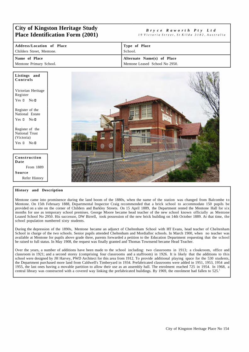
City of Kingston Heritage Place No 154
City of Kingston Heritage StudyPlace Identification Form (2001)
B r y c e R a w o r t h P t y L t d1 9 V i c t o r i a S t r e e t , S t K i l d a 3 1 8 2 , A u s t r a l i a
Address/Location of PlaceChilders Street, Mentone.
Type of PlaceSchool.
Name of PlaceMentone Primary School.
Alternate Name(s) of PlaceMentone Leased School No 2950.
Listings andC o n t r o l s
Victorian HeritageRegisterYes c No g
Register of theNational EstateYes c No g
Register of theNational Trust(Victoria)Yes c No g
Construct ionDate
From 1889Source
Refer History
History and Description
Mentone came into prominence during the land boom of the 1880s, when the name of the station was changed from Balcombe toMentone. On 15th February 1888, Departmental Inspector Craig recommended that a brick school to accommodate 150 pupils beprovided on a site on the corner of Childers and Barkley Streets. On 15 April 1889, the Department rented the Mentone Hall for sixmonths for use as temporary school premises. George Moore became head teacher of the new school known officially as MentoneLeased School No 2950. His successor, DW Birrell, took possession of the new brick building on 14th October 1889. At that time, theschool population numbered sixty students.
During the depression of the 1890s, Mentone became an adjunct of Cheltenham School with HT Evans, head teacher of CheltenhamSchool in charge of the two schools. Senior pupils attended Cheltenham and Mordialloc schools. In March 1900, when no teacher wasavailable at Mentone for pupils above grade three, parents forwarded a petition to the Education Department requesting that the schoolbe raised to full status. In May 1908, the request was finally granted and Thomas Townsend became Head Teacher.
Over the years, a number of additions have been made to the school including: two classrooms in 1913; a cloakroom, office andclassroom in 1921; and a second storey (comprising four classrooms and a staffroom) in 1926. It is likely that the additions to thisschool were designed by JH Harvey, PWD Architect for this area from 1912. To provide additional playing space for the 530 students,the Department purchased more land from Caldwell's Timberyard in 1934. Prefabricated classrooms were added in 1951, 1953, 1954 and1955, the last ones having a movable partition to allow their use as an assembly hall. The enrolment reached 725 in 1954. In 1968, acentral library was constructed with a covered way linking the prefabricated buildings. By 1969, the enrolment had fallen to 525.1

City of Kingston Heritage Place No 154
History and Description (continued)
The original single storey red brick building has been subsumed into the present structure. The school today presents as a two storeyred brick building with a tile roof and timber window frames which date from the 1920s. It is simple in decoration and has exposed roofrafters and timber lined eaves. The window sills in the new building are cement rendered. The older 1889 section of the building (groundfloor east end – to the left side of the photo above) has ashlar window sills and contrasting cream brick banding. An entry porch withsteeply pitched tiled roof and timber shingles within the gable denotes the main entry. The porch was presumably added with the 1920sadditions to give the building symmetry. Various other additions to cater for the increased capacity have since been made to the sideand rear of this main block.
1 This reference is drawn with minor editing from, Education Department of Victoria, Vision and Realisation: A Centenary History of State Education in Victoria,Vol III, Melbourne, 1973.
C o n d i t i o n
Excellent c Good g Fair c Poor c Ruins c
I n t e g r i t y
Substantially Intact c Altered Sympathetically g Altered Unsympathetically c Damaged/Disturbed c
Comparable examples within the City of Kingston
Other comparable school buildings within the City of Kingston identified by this study include the Mordialloc Primary School (1884)and the Chelsea Primary School (1912). These two storey red brick schools are all in the Arts and Crafts style and have tile rooves andrendered trims.
Statement of Significance
Constructed over a number of building programs between 1889 to 1926, Mentone Primary School is of architectural and socialsignificance at a local level. It is architecturally significant as a handsome example of early twentieth century school design. It is ofsocial significance for its long association with the local community.
Recommendat ions
A heritage overlay is recommended for those sections of the principal building on the site dating from 1889 to 1926.
City of Kingston Planning Scheme
Recommended for inclusion in a heritage overlay to the Planning Scheme Yes g No c
Should external paint controls apply? Yes g No c
Should internal alteration controls apply? Yes c No g
Should tree controls apply? Yes c No g
Other Listings and Controls
Recommended for inclusion on the Victorian Heritage Register? Yes c No g
Recommended for inclusion on the Register of the National Estate? Yes c No g
Recommended for inclusion on the National Trust (Victoria) Register? Yes c No g

City of Kingston Heritage Place No 163
City of Kingston Heritage StudyPlace Identification Form (2001)
B r y c e R a w o r t h P t y L t d1 9 V i c t o r i a S t r e e t , S t K i l d a 3 1 8 2 , A u s t r a l i a
Address/Location of Place10 Rogers Street, Mentone.
Type of PlaceChurch.
Name of PlaceSt Patrick's Catholic Church.
Alternate Name(s) of PlaceSt Patrick & Holy Angels.
Listings andC o n t r o l s
Victorian HeritageRegisterYes c No g
Register of theNational EstateYes c No g
Register of theNational Trust(Victoria)Yes c No g
Construct ionDate
Refer HistorySource
c1950s
History and Description
Father Carey built the first Catholic church for the parish of Mentone in 1885. He established the first Catholic primary school fromAugust 1904 in this building. The second church was constructed in 1905 (this later became Kilbreda Hall). These buildings were bothlocated on Como Parade West.1 Kilbreda Hall has since been demolished.2
The first timber church was used as the school building until the present school building (next to the church) was constructed in 1928.The building was later demolished, along with the presbytery from this time.3
Father Thomas English purchased two blocks on the corner of Barkly (Rogers Street) and Mitchell Streets in around 1914 that wouldlater form the site of the present presbytery and the centre of the parish block4. The need to build another church was mentioned as earlyas the 1930s but construction did not begin until the 1950s, possibly due to the outbreak of the WWII. The design for the new churchwas by the Sydney firm Fowell, Mansfield and Maclurcan and associate Architect Mr. Stan Moran. The builder was Tom Bonnice.6
The church was designed to seat 820 people in a 172ft long and 85ft wide chapel space in the traditional cruciform shape. The walls areGlen Iris bricks, the timber from the pews is Queensland Silky Oak, the ceiling Australian Hardwood and Queensland Maple over thesanctuary. The stonework and altars are Hawksbury freestone with Grecian Botitini marble at the front of the altar. The 13cwt. bell,which hangs from the top of the tower, is the highest point in Mentone and was founded in Ireland by Matthew O’Byrne in 1959. Thestained glass window above the main entrance is by Gabriele Loire and was made in Chartres in France. The eight golden mosaics alsoabove the main entrance were crafted in the Vatican Mosaic Studio.7
The altar was modified in 1968 to accommodate changes in the celebration of mass. The church was modified again in 1977 with thesanctuary being enlarged, the Altar moved further forward and the Tabernacle put on a freestone plinth.8
It is of note that the F W Nicholson Pipe Organ in the church is listed by both the National Trust and is on the Victorian HeritageRegister. The organ is significant as the only F W Nicholson organ to be imported to Australia and the largest known extant exampleof Nicholson's work in the world. It was originally installed in the Independent Congregational Church, Prahran in 1861 but when thechurch was sold in the 1980's it was donated to St. Patrick’s.9

City of Kingston Heritage Place No 163
History and Description (continued)
This massive orthogonal orange brick building has a tall tower, high internal spaces and tall clerestory windows. The tower featuresgeometric designs to the upper sections and window tracery. The windows are fitted with leadlight. St Patrick's is notable for itsstriking gold mosaic tiles with a selection of iconographic images.
1 This reference is taken with minor editing from Pat Lane & Sheila Johnston. St Patrick’s: the Mission of Mentone. Published by the Church, c1990. p.8 & p.23.Held at the Catholic Archdiocese of Melbourne.
2 Op cit. p.23.3 Op cit. p.23.4 Op cit. p.235 MDHC Index to The Advocate. September 27th 1951 p13, April 30th 1936 and May 8th 1930, p.16. Held at the Catholic Archdiocese of Melbourne.6 Pat Lane & Sheila Johnston. p.247 Op cit. p.24 – 25.8 Op cit. p.26.9 National Trust of Australia (Victoria) Website: www.nattrust.com.au/register and Victorian Heritage Register: www.doi.vic.gov.au
C o n d i t i o n
Excellent g Good c Fair c Poor c Ruins c
I n t e g r i t y
Substantially Intact g Altered Sympathetically c Altered Unsympathetically c Damaged/Disturbed c
Comparable examples within the City of Kingston
St Patrick’s is similar in some details to St Joseph’s, Chelsea (1941). Both churches are substantial district churches from the midtwentieth century with plain brick walls, tall high naves, tall thin windows and an arched window over the entry. However, St Patrick’sis of particular note for its elaborate façade ornamentation and imagery.
Statement of Significance
St Patrick's Roman Catholic Church is of architectural, spiritual and social significance at a local level. The structure is architecturallysignificant for its size, which creates a landmark presence locally; and the complex detailing, most notably, the geometric elements onthe tower and the gold mosaic, which are unique in the area. It is socially and spiritually significant as the focus of worship for the localCatholic community.
Recommendat ions
A heritage overlay is recommended for the building.
City of Kingston Planning Scheme
Recommended for inclusion in a heritage overlay to the Planning Scheme Yes g No c
Should external paint controls apply? Yes g No c
Should internal alteration controls apply? Yes c No g
Should tree controls apply? Yes c No g
Other Listings and Controls
Recommended for inclusion on the Victorian Heritage Register? Yes c No g
Recommended for inclusion on the Register of the National Estate? Yes c No g
Recommended for inclusion on the National Trust (Victoria) Register? Yes c No g

City of Kingston Heritage Place No 164
City of Kingston Heritage StudyPlace Identification Form (2001)
B r y c e R a w o r t h P t y L t d1 9 V i c t o r i a S t r e e t , S t K i l d a 3 1 8 2 , A u s t r a l i a
Address/Location of PlaceChilders Street, Mentone.
Type of PlaceSchool.
Name of PlaceSt Patrick's Catholic School.
Alternate Name(s) of PlaceNone.
Listings andC o n t r o l s
Victorian HeritageRegisterYes c No g
Register of theNational EstateYes c No g
Register of theNational Trust(Victoria)Yes c No g
Construct ionDate
from 1928Source
Refer History
History and Description
The 1872 Education Act created a 'free, secular and compulsory' system and threw the onus of an alternative educational arrangement onits proponents. State aid to denominational schools ceased after 1873 and most religious groups acceded to state control of elementaryschooling. The most notable exception was the Catholic Church which developed its own system of schools albeit slowly and at greatexpense.1
The Catholic Primary school system lagged well behind the establishment of a State educational system in the City of Kingston. Thefirst Catholic Primary School to be established was St Patrick's in Mentone, commencing with twenty-five students in 1904. This firstschool was located in the original timber church hall (built in 1885) for many years until land for a new school was purchased inChilders Street, Mentone.2 The original timber hall was not used by the church after 1928 and was moved to another site to be used as astable and garage. It was eventually demolished.3
By the 1920s the little school building was becoming crowded, possibly due to the school's reputation for high academic achievementand the lack of Catholic schools in the area. By the time the new brick school was completed the school had around 150 pupils.4 Thefoundation stone of the main front building, designed by the Architect P J O'Connor, was laid by D Mannix, Archbishop of Melbourneon the 19th of August 1928.5
The building was first extended in 1952 and may have been undertaken as part of the construction of St Patrick’s Church on the adjacentsite. The new works took the form of an ‘L’ shaped addition to the existing school.6 The building was modified again in the 1970s. Thefirst floor level was extended to provide two additional rooms and a library and multi-purpose room. The hall and amenities were alsoupgraded. This project was completed and opened in October 1972.7
The original school is a two storey rectilinear red brick building. The front is distinguished by a shallow bay rising to a pediment. Thesteep roof is tiled and topped with terracotta roof ornaments. Features of the building include a statue of St. Patrick at the top of thepediment and cement dressings. Some alterations have been made to the building including the new aluminum windows on the streetside and inappropriate additions to the west side of the main building. These post WWII additions mean that some of the originalcharacter of the building has been lost. The east side retains a more intact character, including its original window joinery.

City of Kingston Heritage Place No 164
History and Description (continued)
1 This reference is drawn with minor editing from, Barnard & Sheehan, City of Kingston heritage Study, Stage I, pp.105-62 This reference is drawn with minor editing from, Barnard & Sheehan, pp.105-6 and Pat Lane & Sheila Johnston. St Patrick’s: the Mission of Mentone.
Published by the Church, c1990. p.8 & 23 Held at the Catholic Archdiocese of Melbourne.3 Pat Lane & Sheila Johnston. p.23.4 Op cit. p.32.5 Op cit. p.26.6 From information provided by the Mordialloc and District Historical Society.7 Pat Lane & Sheila Johnston. p.26.
C o n d i t i o n
Excellent c Good g Fair c Poor c Ruins c
I n t e g r i t y
Substantially Intact c Altered Sympathetically g Altered Unsympathetically c Damaged/Disturbed c
Comparable examples within the City of Kingston
No comparable Catholic school examples were identified as part of this study. The State Primary Schools at Mentone (1889, 1913,1926) and Mordialloc (1884) are broadly similar to St Patrick’s but are fundamentally different in their detailing. Both are two storeybrick buildings with tile roofs and simple rendered trims. Catholic School Architecture from this period adopted an individual characterincorporating statuary and other decorative devices, which distinguished its design from those of the PWD.
Statement of Significance
St Patrick’s Catholic School is architecturally, historically and socially significant at a local level. It is architecturally significant as ahandsome example of early Catholic school architecture that incorporates statuary and other devices to create a different externalexpression to that of PWD designed institutions. It is historically significant as the first Catholic school to open in the City ofKingston. It is socially significant for its long relationship with the local Catholic community.
Recommendat ions
A heritage overlay is recommended for the building work dating from 1928 only.
City of Kingston Planning Scheme
Recommended for inclusion in a heritage overlay to the Planning Scheme Yes g No c
Should external paint controls apply? Yes g No c
Should internal alteration controls apply? Yes c No g
Should tree controls apply? Yes c No g
Other Listings and Controls
Recommended for inclusion on the Victorian Heritage Register? Yes c No g
Recommended for inclusion on the Register of the National Estate? Yes c No g
Recommended for inclusion on the National Trust (Victoria) Register? Yes c No g

City of Kingston Heritage Place No 126
City of Kingston Heritage StudyPlace Identification Form (2003)
B r y c e R a w o r t h P t y L t d1 9 V i c t o r i a S t r e e t , S t K i l d a 3 1 8 2 , A u s t r a l i a
Address/Location of Place44 Florence Street, Mentone.
Type of PlaceBank.
Name of PlaceHodges Estate Agents.
Alternate Name(s) of PlaceFormer State Savings Bank.
Listings andC o n t r o l s
Victorian HeritageRegisterYes c No g
Register of theNational EstateYes c No g
Register of theNational Trust(Victoria)Yes c No g
Construct ionDate
1926Source
Refer History
History and Description
The building at 44 Florence Street was constructed in 1926 for the State Savings Bank. It was occupied by the bank into the 1970s.1 In1974 the City of Mordialloc purchased the building for use as a citizens’ advice bureau. Council occupied the building until 1995 whenit was subsequently sold to Hodges Estate Agents. 2 The building is still currently occupied by Hodges Estate Agents.
The former State Savings Bank is a two-storey red brick building with rendered treatment to its front facade. The building adopts asimple Free Classical approach in which classical building elements are abstracted and combined in an informal manner. Understatedrectangular columns rise from a simple banded base to an elaborate cornice and an unusual arrangement of elements at parapet level. Thedesign makes reference to contemporary modern styles through the jazz designs of its balustrades and railings.
Alterations to the building are largely limited to the sympathetic signage ‘HODGES EST 1854’ in bas-relief at parapet level andchanges to the window joinery on the ground floor.
1 Sands & McDougalls Directory of Victoria 1920 - 1974. Held at the Royal Historical Society, Melbourne.2 Information provided by Margaret Hunter, Mordialloc and District Historical Society.
C o n d i t i o n
Excellent g Good c Fair c Poor c Ruins c
I n t e g r i t y
Substantially Intact c Altered Sympathetically g Altered Unsympathetically c Damaged/Disturbed c

City of Kingston Heritage Place No 126
Comparable examples within the City of Kingston
Although considerably more modest and subsequently altered, the bank constructed for the ES&A Bank in 1923 at 36 Como Parade,Mentone broadly compares with the subject site.
Statement of Significance
The former bank building at 44 Florence St Mentone, built in 1926, is of architectural significance for its handsome free-classicaldesign.
Recommendat ions
A heritage overlay is recommended for the building.
City of Kingston Planning Scheme
Recommended for inclusion in a heritage overlay to the Planning Scheme Yes g No c
Should external paint controls apply? Yes g No c
Should internal alteration controls apply? Yes c No g
Should tree controls apply? Yes c No g
Other Listings and Controls
Recommended for inclusion on the Victorian Heritage Register? Yes c No g
Recommended for inclusion on the Register of the National Estate? Yes c No g
Recommended for inclusion on the National Trust (Victoria) Register? Yes c No g

City of Kingston Heritage Place No 128
City of Kingston Heritage StudyPlace Identification Form (2003)
B r y c e R a w o r t h P t y L t d1 9 V i c t o r i a S t r e e t , S t K i l d a 3 1 8 2 , A u s t r a l i a
Address/Location of PlaceCorner Mentone Parade and Florence Street, Mentone.
Type of PlaceSmall Retail Group.
Name of PlaceComber’s Buildings.
Alternate Name(s) of PlaceNone.
Listings andC o n t r o l s
Victorian HeritageRegisterYes c No g
Register of theNational EstateYes c No g
Register of theNational Trust(Victoria)Yes c No g
Construct ionDate
1914Source
Refer History
History and Description
Comber's Building at 129–131 Mentone Parade (corner of Mentone Parade and Florence Street) was built during 1914. The first ownersand occupants were Mr Edmund Comber and Mrs Blanche E Comber. From 1915, they operated a stationery shop and a fruit store,which occupied both tenancies within the building. By 1923, the Combers had vacated the site but the retail outlets that they hadestablished continued. By 1929 LW Penny, a fruiterer and confectioner was trading from the building while Williams & Linington,newsagents and stationers occupied the adjacent shop. LW Penny was succeeded by D Russo, a fruiterer in 1931 and E Poore1 a butcher2
in 1935 as operators of the shop. Williams & Linington (later Tyler & Linington and Bancroft & Linington) operated the newsagencyuntil at least 1941. In 1955 the building was occupied by G Jacono a fruiterer and J W Charlton who ran a shoe shop. The late 1950ssaw the building occupied by Leslie F Salmon and later RJ Hinde a shoe retailer and G Jacono a fruitier. Jacono continued to operate thefruit shop into the 1960s. The shoe store was taken over by A & D White by the 1960s. By 1963 the building was occupied by, DZinno, fruiterer, and Mentone Health Foods.1 In 1965 the fruit shop was run by Marzano & Fillippone and G & H Scicluna occupied theadjacent shop.3 The Comber building is now occupied by a Hairdresser, Cake shop, and a Menswear shop.
Comber's Building is located on a prominent corner site within the Mentone shopping precinct. It is a two-storey red brick structurewith decorative pilasters rising from the ground floor to form decorative elements at parapet level. Each parapet bay features asemicircular decorative device in red brick and render. The corner tenancy is of note for its parapet signage and for its bay window atfirst floor level realised in timber and decorative shingles. First floor windows to Mentone Parade feature simple timber awnings. TheFlorence Street facade is considerably simpler.
Extensive alterations have been undertaken to the ground floor of the building and the early character of the shopfonts has to someextent been lost. The original pair of tenancies built in 1914 has been subdivided and the building now accommodates five differentretailers. Consequently all of the original joinery to doors and windows have been replaced in aluminum. In addition, someinappropriate materials such as Castlemaine slate and extensive signage have been introduced in some areas. Nonetheless, thecharacter of the building as a whole remains intact. The building is in good condition.
1 Sands & McDougalls Directory of Victoria 1910 - 1974. Held at the Royal Historical Society, Melbourne.2 Information provided by Margaret Hunter, Mordialloc and District Historical Society.3 Sands & McDougalls Directory of Victoria.

City of Kingston Heritage Place No 128
C o n d i t i o n
Excellent c Good g Fair c Poor c Ruins c
I n t e g r i t y
Substantially Intact c Altered Sympathetically g Altered Unsympathetically c Damaged/Disturbed c
Comparable examples within the City of Kingston
The shops at 218 to 222 Como Parade West and the nearby Abbott Buildings at 129-131 Mentone Parade, Mentone compare to thisbuilding.
Statement of Significance
Comber’s Building is of social, historical and architectural significance at a local level. It is socially significant as a focus of the localcommunity. It is historically significant as an unusual example of an Edwardian retail group within the Municipality. It is also of somearchitectural significance for its simple and well-resolved design.
Recommendat ions
A heritage overlay is recommended for the building.
City of Kingston Planning Scheme
Recommended for inclusion in a heritage overlay to the Planning Scheme Yes g No c
Should external paint controls apply? Yes g No c
Should internal alteration controls apply? Yes c No g
Should tree controls apply? Yes c No g
Other Listings and Controls
Recommended for inclusion on the Victorian Heritage Register? Yes c No g
Recommended for inclusion on the Register of the National Estate? Yes c No g
Recommended for inclusion on the National Trust (Victoria) Register? Yes c No g
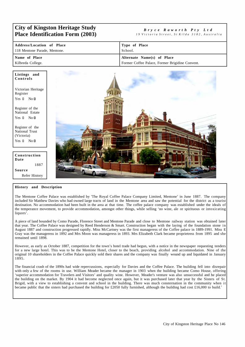
City of Kingston Heritage Place No 146
City of Kingston Heritage StudyPlace Identification Form (2003)
B r y c e R a w o r t h P t y L t d1 9 V i c t o r i a S t r e e t , S t K i l d a 3 1 8 2 , A u s t r a l i a
Address/Location of Place118 Mentone Parade, Mentone.
Type of PlaceSchool.
Name of PlaceKilbreda College.
Alternate Name(s) of PlaceFormer Coffee Palace, Former Brigidine Convent.
Listings andC o n t r o l s
Victorian HeritageRegisterYes c No g
Register of theNational EstateYes c No g
Register of theNational Trust(Victoria)Yes c No g
Construct ionDate
1887Source
Refer History
History and Description
The Mentone Coffee Palace was established by 'The Royal Coffee Palace Company Limited, Mentone’ in June 1887. The companyincluded Sir Matthew Davies who had owned large tracts of land in the Mentone area and saw the potential for the district as a touristdestination. No accommodation had been built in the area at that time. The coffee palace company was established under the ideals ofthe temperance movement, to provide accommodation, amongst other things, while selling ‘no wine, ale or spirituous or intoxicatingliquors’.
A piece of land bounded by Como Parade, Florence Street and Mentone Parade and close to Mentone railway station was obtained laterthat year. The Coffee Palace was designed by Reed Henderson & Smart. Construction began with the laying of the foundation stone inAugust 1887 and construction progressed rapidly. Miss McCartney was the first manageress of the Coffee palace in 1889-1991. Miss EGray was the manageress in 1892 and Mrs Moon was manageress in 1893. Mrs Elizabeth Clark became proprietress from 1895 and sheremained until 1898.
However, as early as October 1887, competition for the town’s hotel trade had begun, with a notice in the newspaper requesting tendersfor a new large hotel. This was to be the Mentone Hotel, closer to the beach, providing alcohol and accommodation. Nine of theoriginal 10 shareholders in the Coffee Palace quickly sold their shares and the company was finally wound up and liquidated in January1895.
The financial crash of the 1890s had wide repercussions, especially for Davies and the Coffee Palace. The building fell into disrepairwith only a few of the rooms in use. William Meader became the manager in 1903 when the building became Como House, offering‘superior accommodation for Travelers and Visitors’ and quality wine. However, Meader's venture was also unsuccessful and he placedthe building on the market. By 1904 it had become neglected once again, but it was purchased later that year by the Sisters of St.Brigid, with a view to establishing a convent and school in the building. There was much consternation in the community when i tbecame public that the sisters had purchased the building for £2050 fully furnished, although the building had cost £16,000 to build.1

City of Kingston Heritage Place No 146
History and Description (continued)
The Brigidine Sisters had already established schools at Coonamble (NSW) Echuca and Ararat (VIC) in the 1880s when they purchasedthe Coffee Palace building. Primary and secondary classes began at the Brigidine Convent in 1904. The school began with only threestudents on 8 August 1904 but grew steadily over the years. By the early 1930s it was the largest of the Brigidine Schools in Australia.The school became ‘Kilbreda College’ in 1933. Kilbreda College today boasts a student population of 1000, which is largely drawnfrom the Kingston and Bayside municipalities.
Kilbreda College is situated in a prominent location within the Mentone shopping precinct. It is a two-storey red brick building with alarge central tower. The building incorporates elements of Romanesque and Greek styles with ornate contrasting render to thestringcourses, pediments over the windows, window trims, and colonnades to the upper sections of the tower. The building hasdecorative Dutch gables and a complex slate roof.
Some alterations have been undertaken to the facade. The alternations are largely confined to the west side of the front facade. A doorvisible in early photographs of the building has been removed from this area and replaced with a window. The original ripple iron fencehas been replaced. The replacement fence now encompasses the whole front facade of the building.
The school was extended in the 1950s when the St Anne’s Wing was constructed and the Margaret Mary wing replaced Kilbreda Hall(the former St Patrick’s Church). In the 1960s a new year nine block was constructed in addition to a Chapel and Science wing. Someold timber classrooms were also demolished at this time. Further building works were undertaken during the 1970s includingconstruction of a library, the purchase of further properties on Como Parade and various renovations. The former dining rooms wererefurbished for Home Economics during the 1980s. During the 1990s Creative Arts and Technology rooms and year ten classroomswere constructed. In addition the Chapel was refurbished as a meeting room, the former sanctuary was refurbished to become a chapeland the Administration areas were relocated into the former Coffee Palace building. The upstairs rooms of the convent were convertedinto staff areas. Further refurbishment took place in 2001.2
1 Kingston Historical Website. http://localhistory.kingston.vic.gov.au ‘The Mentone Coffee Palace’ by Damian Smith and Kingston Historical Website.http://localhistory.kingston.vic.gov.au ‘Mentone College and Thomas McCristal’ by Leo Gamble.
2 Kilbreda College Website. http://www.kilbreda.vic.edu.au
C o n d i t i o n
Excellent g Good c Fair c Poor c Ruins c
I n t e g r i t y
Substantially Intact c Altered Sympathetically g Altered Unsympathetically c Damaged/Disturbed c
Comparable examples within the City of Kingston
There are no comparable examples within the City of Kingston.
Statement of Significance
The Kilbreda College is of historical and architectural significance at a local level. It survives as one of the earliest buildings in theMentone area and retains associations with the area as a former Coffee Palace and as a prominent local school. Kilbreda College is ofarchitectural significance for its handsome red brick and render design.
Recommendat ions
A heritage overlay is recommended for the principal building to the Florence Street frontage. However, the significance of thisbuilding is generally associated with fabric dating from the original Coffee Palace building and works to later sections of the building(understood to date from c.1950s) are unlikely to be problematic. Works to the later buildings on the site or the construction of newbuildings of a modest scale are unlikely to diminish the cultural heritage significance of the former Coffee Palace.

City of Kingston Heritage Place No 146
City of Kingston Planning Scheme
Recommended for inclusion in a heritage overlay to the Planning Scheme Yes g No c
Should external paint controls apply? Yes g No c
Should internal alteration controls apply? Yes c No g
Should tree controls apply? Yes c No g
Other Listings and Controls
Recommended for inclusion on the Victorian Heritage Register? Yes g No c
Recommended for inclusion on the Register of the National Estate? Yes g No c
Recommended for inclusion on the National Trust (Victoria) Register? Yes g No c

City of Kingston Heritage Place No 127
City of Kingston Heritage StudyPlace Identification Form (2003)
B r y c e R a w o r t h P t y L t d 1 9 V i c t o r i a S t r e e t , S t K i l d a 3 1 8 2 , A u s t r a l i a
Address/Location of Place
Old Bakery Lane Mentone.
Type of Place
Museum.
Name of Place
Charles Ferguson Museum.
Alternate Name(s) of Place
Former Mentone Bakery.
Listings andC o n t r o l s
Victorian HeritageRegister
Yes � No ����
Register of theNational Estate
Yes � No ����
Register of theNational Trust(Victoria)
Yes � No ����
Construct ionDate
c.1923
Source
Refer History
History and Description
The original Mentone Bakery was established by George Barnett in the early 1890s. Barnett sold the bakery to Frederick Atherton in1895 who in turn sold it to D Waddell in 1899. Waddell only owned the bakery for a year before H Chittick took ownership in 1900.George Pockney owned the bakery in 1901 and FJ Peachey bought the bakery from George Pockney in 1904. J Bowring bought thebakery the following year and then sold it to Albert Derden in 1906. Derden held the bakery for several years before selling to JohnRennie.
The current building was constructed between 1922 and 1924 by owners, John Murphy and William Oliver. In the late 1920s thepartnership was dissolved and Murphy became the sole owner of the bakery. By this time, it had become a successful business, makingbread, buns and pastries for customers as far afield as Dingley and Beaumaris. The bakery was associated with a shop facing MentoneParade selling directly to the public. The baker at this stage was Jack Long. When Edward Ellis brought the bakery during the early1940s, he retained Jack Long as the baker. Eva Long purchased the building in the late 1940s. In the early 1950s, the building waspurchased by the Hennesy Bros of Caufield who were associated with the national Austral and Home Pride brands. They closed thebusiness.1
The property was then used by the Commonwealth Bank of Australia as a storeroom until c.1974.2 The Mordialloc City Councilpurchased the building in 1974 and established the museum here in 1976. The building is also used as the Mordialloc HistoricalSocieties headquarters. Charles Ferguson was a key player in the effort to persuade the Mordialloc Council to find a building for thesociety. The building was named in recognition of his work. In November 1998 the building was renamed the Laura and CharlesFerguson Museum. The building now houses a museum and the Mordialloc and District Historical Societies archives. The previouslyunnamed lane has been known as Old Bakery Lane since the Historical Society took over the premises.3

City of Kingston Heritage Place No 127
History and Description
The former bakery situated in Old Bakery Lane is a two-storey red brick building. It adopts a simple gable-ended form with corbeledbrick treatment to a corrugated iron roof. The building has two brick chimneys, once used for the wooden ovens that baked the bread.At ground floor level the windows have a smooth rendered lintel, with a rounded brick reveal. The rounded brick treatment is reiteratedat the corners of the building.
A number of additions have been made to the original bakery building. The timber window on the west of the building, below thecathead, is a later addition which may have replaced early wooden doors when the Commonwealth Bank turned the building into astoreroom. A portico has been constructed to the south side of the building adjacent to the main door. There also appears to be a laterdoor on the north side of the building. Some additions have been made to the rear of the building. The building is in good condition.
1 Kingston Historical Website. http://localhistory.kingson.vic.gov.au ‘Old Bakery, Mentone’ by Graham J Whitehead.2 Ibid.3 Information provided by Margaret Hunter, Mordialloc and District Historical Society.
I n t e g r i t y
Substantially Intact � Altered Sympathetically ���� Altered Unsympathetically � Damaged/Disturbed �
Comparable examples within the City of Kingston
Another building of similar design and construction date is located in nearby Granary Lane. It is understood that this building alsooperated as a bakery.
Statement of Significance
The former bakery built at Old Bakery Lane Mentone in 1922 is of social, historical and architectural significance at local level. Thebuilding is socially significant for its long association with the local community and the building remains legible as an early foodproduction facility. The substantial building is architecturally significant for its massive and form and detailing and
Recommendat ions
A heritage overlay is recommended for the building.
City of Kingston Planning Scheme
Recommended for inclusion in a heritage overlay to the Planning Scheme Yes ���� No �
Should external paint controls apply? Yes ���� No �
Should internal alteration controls apply? Yes � No ����
Should tree controls apply? Yes � No ����
Other Listings and Controls
Recommended for inclusion on the Victorian Heritage Register? Yes � No ����
Recommended for inclusion on the Register of the National Estate? Yes � No ����
Recommended for inclusion on the National Trust (Victoria) Register? Yes � No ����

City of Kingston Heritage Place No 153
City of Kingston Heritage StudyPlace Identification Form (2003)
B r y c e R a w o r t h P t y L t d1 9 V i c t o r i a S t r e e t , S t K i l d a 3 1 8 2 , A u s t r a l i a
Address/Location of PlaceMentone Reserve, Remo Street, Mentone.
Type of PlacePavilion.
Name of PlaceCH Soppitt Pavilion.
Alternate Name(s) of PlaceNone.
Listings andC o n t r o l s
Victorian HeritageRegisterYes c No g
Register of theNational EstateYes c No g
Register of theNational Trust(Victoria)Yes c No g
Construct ionDate
1928Source
Refer History
History and Description
The CH Soppitt Pavilion is situated within Mentone Reserve, Remo Street, Mentone. An inscription on a granite plaque affixed to thebuilding notes, ‘Erected 1928 by Mentone Recreation Reserve Committee Cr.J.H Mc Bean J.P Chairman’. The grandstand is typical ofits era comprising a simple roof over elevated seating. The seating consists of malthoid coated timber decking mounted on an elevatedroughcasted concrete platform. The roof above is gable-ended with decorative pressed metal ends. A smaller transverse gable,orientated towards the oval incorporates a clock. The roof is supported on steel and timber framing
A number of minor alterations to the pavilion have been undertaken. The original corrugated iron roof has been replaced and the groundfloor of the pavilion has been renovated. However, the construction of single storey clubrooms to the front and to either side of thegrandstand has largely subsumed the early character of the structure. Extensions have also been made recently to the change rooms. Thepavilion is still used during sporting events held on the Mentone Reserve football field.
C o n d i t i o n
Excellent c Good g Fair c Poor c Ruins c
I n t e g r i t y
Substantially Intact c Altered Sympathetically g Altered Unsympathetically c Damaged/Disturbed c
Comparable examples within the City of Kingston
There are no comparable examples found within the heritage study of City of Kingston.

City of Kingston Heritage Place No 153
Statement of Significance
Although considerably altered, the CH Soppitt Pavilion situated within Mentone Reserve, Remo Street, Mentone is of social andarchitectural significance at a local level. It is socially significant for its relationship with the local sporting community. It i sarchitecturally significant as the first pavilion built in Mentone dating from 1928 and as an exemplar of the simple massing anddetailing of an interwar grandstand.
Recommendat ions
A heritage overlay is recommended for the building. The significance of the structure is limited to the 1928 sections only. Works to thebuilding, which do not impact upon the early fabric of the structure, are unlikely to diminish the significance of the place. The ownersshould be encouraged to restore the early sections of the stand as opportunities arise.
City of Kingston Planning Scheme
Recommended for inclusion in a heritage overlay to the Planning Scheme Yes g No c
Should external paint controls apply? Yes g No c
Should internal alteration controls apply? Yes c No g
Should tree controls apply? Yes c No g
Other Listings and Controls
Recommended for inclusion on the Victorian Heritage Register? Yes c No g
Recommended for inclusion on the Register of the National Estate? Yes c No g
Recommended for inclusion on the National Trust (Victoria) Register? Yes c No g

City of Kingston Heritage Place No 129
City of Kingston Heritage StudyPlace Identification Form (2003)
B r y c e R a w o r t h P t y L t d1 9 V i c t o r i a S t r e e t , S t K i l d a 3 1 8 2 , A u s t r a l i a
Address/Location of PlaceKeith Styles Reserve, Mentone Parade, Mentone.
Type of PlaceDrinking Fountain.
Name of PlaceProgress Association Drinking Fountain.
Alternate Name(s) of PlaceNone.
Listings andC o n t r o l s
Victorian HeritageRegisterYes c No g
Register of theNational EstateYes c No g
Register of theNational Trust(Victoria)Yes c No g
Construct ionDate
1910Source
Refer History
History and Description
The fashion of memorials has changed over the years. In the late nineteenth century statues or drinking fountains were popular. At theend of the First World War cenotaphs or obelisks became popular.1
This drinking fountain, constructed by the Progress Association in 1910, is thought to be the earliest existing monument in Mentone.It was originally located at the corner of Venice Street and Mentone Parade. The drinking fountain is now in the Keith Style Reserve inclose proximity to the Memorial Gates. A stone plaque on the base of the drinking fountain, notes, ‘ Erected by the Mentone ProgressAssociation, John Delves (President) 1910’. The structure is a granite obelisk with a sturdy bluestone base. Its pluming hardware hasbeen replaced.
1 Barnard & Sheehan. City of Kingston Heritage Study Stage One Report. 2000. pp.118 - 120
C o n d i t i o n
Excellent g Good c Fair c Poor c Ruins c
I n t e g r i t y
Substantially Intact g Altered Sympathetically c Altered Unsympathetically c Damaged/Disturbed c
Comparable examples within the City of Kingston
There are a number of comparable monuments within the City of Kingston, including the WWII Memorial in the Heatherton RecreationReserve, Ross Street and at Rear of Cheltenham RSL Club, Centre Dandenong Road, Heatherton and WW1 Memorials, Beach Road,Parkdale.

City of Kingston Heritage Place No 129
Statement of Significance
The drinking fountain in the Keith Styles Reserve, Mentone Parade, Mentone is of social, historical and architectural significance at alocal level. It is socially and historically significant for its associations with the early development of the area and the formation oflocal progress associations. It is also of some architectural significance as a fine example of an early memorial.
Recommendat ions
A heritage overlay is recommended for the drinking fountain. It may be appropriate to protect this and the adjacent memorial gatesunder a single heritage overlay.
City of Kingston Planning Scheme
Recommended for inclusion in a heritage overlay to the Planning Scheme Yes g No c
Should external paint controls apply? Yes g No c
Should internal alteration controls apply? Yes c No g
Should tree controls apply? Yes c No g
Other Listings and Controls
Recommended for inclusion on the Victorian Heritage Register? Yes c No g
Recommended for inclusion on the Register of the National Estate? Yes c No g
Recommended for inclusion on the National Trust (Victoria) Register? Yes c No g

City of Kingston Heritage Place No 168
City of Kingston Heritage StudyPlace Identification Form (2003)
B r y c e R a w o r t h P t y L t d1 9 V i c t o r i a S t r e e t , S t K i l d a 3 1 8 2 , A u s t r a l i a
Address/Location of PlaceKeith Styles Reserve, Mentone Parade, Mentone.
Type of PlaceGates.
Name of PlaceWar Memorial Gates.
Alternate Name(s) of PlaceNone.
Listings andC o n t r o l s
Victorian HeritageRegisterYes c No g
Register of theNational EstateYes c No g
Register of theNational Trust(Victoria)Yes c No g
Construct ionDate
c.1919Source
Refer History
History and Description
The form of memorials generally has evolved over the years. In the late nineteenth century statues or drinking fountains were popular.By the end of the First World War cenotaphs or obelisks had become a common form of memorial.1 In the years after WWII, morepractical memorials such as halls, swimming pools or kindergartens were constructed.
The memorial gates situated at Keith Styles Reserve, Mentone Parade, Mentone are formed from coarsely hewn granite blocks arrangedin a semi circle. The gates occupy the centre of the arrangement and take the form of a trabeated temple front with a cast iron gate. Aformal cast iron fence, incorporating decorative rosette element extends from the memorial gates along the street frontage. Thepediment bears the inscription: ‘To the glorious memory of the men of Mentone who gave their lives for our freedom 1914-1919. Thetrumpet sounded and they entered into their rest.' Above the inscription is the coat of arms of Australia with wreaths. The two columnsare etched with honor rolls listing the men from Mentone who lost their lives during the war. The gates are likely to date from c.1920.
The path from the memorial gates leads on to the Keith Style Reserve and memorial drinking fountain. The obelisk granite drinkingfountain was erected in 1910 and is thought to be the earliest existing monument in Mentone. The two granite memorials form acomplementary arrangement.
C o n d i t i o n
Excellent g Good c Fair c Poor c Ruins c
I n t e g r i t y
Substantially Intact g Altered Sympathetically c Altered Unsympathetically c Damaged/Disturbed c

City of Kingston Heritage Place No 168
Comparable examples within the City of Kingston
There are a number of comparable monuments within the City of Kingston, including the WWII Memorial in the Heatherton RecreationReserve, Ross Street and others at the rear of the Cheltenham RSL Club, Centre Dandenong Road, Heatherton and the remnant gates atSt Bede’s, Beach Road, Mentone.
Statement of Significance
The WWI War Memorial in the Keith Styles Reserve, Mentone Parade, Mentone is of social, historical and architectural significance ata local level. It is of social significance as an expression of gratitude from the local community for the sacrifice of servicemen duringWWII. It is historically significant as part of a wave of memorials constructed to honour Australian servicemen after the WWI. It is alsoof some architectural significance for its simple robust design.
Recommendat ions
A heritage overlay is recommended for the structure. It may be appropriate to protect this structure and the nearby drinking fountainunder a single heritage overlay.
City of Kingston Planning Scheme
Recommended for inclusion in a heritage overlay to the Planning Scheme Yes g No c
Should external paint controls apply? Yes g No c
Should internal alteration controls apply? Yes c No g
Should tree controls apply? Yes c No g
Other Listings and Controls
Recommended for inclusion on the Victorian Heritage Register? Yes c No g
Recommended for inclusion on the Register of the National Estate? Yes c No g
Recommended for inclusion on the National Trust (Victoria) Register? Yes c No g

City of Kingston Heritage Place No 138
City of Kingston Heritage StudyPlace Identification Form (2003)
B r y c e R a w o r t h P t y L t d1 9 V i c t o r i a S t r e e t , S t K i l d a 3 1 8 2 , A u s t r a l i a
Address/Location of Place25 Milan Street, Mentone.
Type of PlaceHouse.
Name of PlaceNone.
Alternate Name(s) of PlaceNone.
Listings andC o n t r o l s
Victorian HeritageRegisterYes c No g
Register of theNational EstateYes c No c
Register of theNational Trust(Victoria)Yes c No g
Construct ionDate
Before 1887Source
Refer History
History and Description
The house at 25 Milan Street Mentone appears to be constructed before 1887 by Edwin and Emily Harriet Plummer who named the house‘St Leonards’. Edwin Plummer was a commercial traveler and part of the Equity Trustees Executors Company, which owned land aroundBlack Rock and Mentone. It also appears that the company was involved in the construction of the house.
By 1903, the property was occupied by John and Mary Ann Delves who had moved in after the house was left vacant for a year.1.JohnDelves was the President of the Progress Association and instrumental in the construction of the drinking fountain situated in the KeithStyles Reserve, Mentone. The Delves family occupied the house until the early 1920s when Mr Jonathan J Teague and Mrs Ida Teaguemoved in. From 1939 until around 1941, the house was left vacant. It was then occupied by Leonard M Thomas, for one year before MrsJCR Reynolds acquired the property. The 1948 ratebooks note Miss Merle Reynolds as the occupant. She continued to live here until1967 when Mrs ME Davidson moved in. Mrs. Davidson continued to reside there into the 1970s.2
During the 1920s, possibly during the Teague occupancy, the house was extensively remodeled. Today the house presents to the streetas an interwar residence of two storeys. It is finished in rendered brick with a gable ended slate roof and understated decorative detail.The design of the facade draws some inspiration from emerging bungalow idioms. The rear of the building was left largely unchangedby the interwar works and the original rendered chimneys and face brickwork are still evident in this area.
Some alterations have been undertaken during the later twentieth century but the building is still largely intact to its interwar state. Thebuilding is in good condition.
1 Moorabbin Rate Books, Victorian Archives, 99 Shiel Street, North Melbourne, Years – 1887, 1888, 1911, 1912, 19182 Sands & McDougalls Directory of Victoria. 1887 - 1974. Held at the Education Resource Centre, The University of Melbourne.
C o n d i t i o n
Excellent c Good g Fair c Poor c Ruins c

City of Kingston Heritage Place No 138
I n t e g r i t y
Substantially Intact c Altered Sympathetically g Altered Unsympathetically c Damaged/Disturbed c
Comparable examples within the City of Kingston
No comparable examples were identified within the City of Kingston by this study.
Statement of Significance
The house at 25 Milan Street, Mentone is of architectural significance at a local level. It is an unusual and particularly handsomeredevelopment of an early dwelling within the Municipality.
Recommendat ions
A heritage overlay is recommended for the building.
City of Kingston Planning Scheme
Recommended for inclusion in a heritage overlay to the Planning Scheme Yes g No c
Should external paint controls apply? Yes g No c
Should internal alteration controls apply? Yes c No g
Should tree controls apply? Yes c No g
Other Listings and Controls
Recommended for inclusion on the Victorian Heritage Register? Yes c No g
Recommended for inclusion on the Register of the National Estate? Yes c No g
Recommended for inclusion on the National Trust (Victoria) Register? Yes c No g

City of Kingston Heritage Place No 147
City of Kingston Heritage StudyPlace Identification Form (2003)
B r y c e R a w o r t h P t y L t d1 9 V i c t o r i a S t r e e t , S t K i l d a 3 1 8 2 , A u s t r a l i a
Address/Location of Place6 Harkin Avenue, Mentone.
Type of PlaceHouse.
Name of PlaceKillara.
Alternate Name(s) of PlaceNone.
Listings andC o n t r o l s
Victorian HeritageRegisterYes c No g
Register of theNational EstateYes c No g
Register of theNational Trust(Victoria)Yes c No g
Construct ionDate
c.1883/4Source
Refer History
History and Description
Killara was one of around five tower houses built in Mentone during the land boom of the 1880s. However, only Killara and theMentone RSL, remain. Killara was originally part of a seven-acre allotment purchased by Percy Dobson in 1882. Dobson purchased theproperty through The Southern Investment & Agency Company of which he was manager. This enterprise appears to have beenprimarily concerned with the transformation of the Mentone area into a seaside resort. Dobson was also involved in other landspeculation ventures with his brother in law Charles Henry James and was well connected socially as the son in law of the well-knownnineteenth century architect Lloyd Tayler.
Dobson constructed Killara in either 1883 or 1884 and lived there with his wife Emily (nee Tayler) until 1885 when his fortuneschanged and the property was purchased by his father in law Lloyd Taylor and brother in law, David Watson. Watson lived in the housefrom 1886. The Dobsons returned to Killara in 1889 but Dobson died in the following year. After Dobson's death the house became theproperty of his wife Emily. She leased the property to various tenants until it was sold in 1929. She appears to have married again andlived in Chiltern with her husband.
In 1929 the house was sold to Lilian Rose Squire of Charman Road Cheltenham who subdivided the house into three flats and divided upthe estate. It was sold to Ellen Amelia Vincent of Mathoura Road Toorak in 1954. The house was tenanted out and remained subdividedinto flats up until the 1970s.1 Since that time it has been restored to a single grand dwelling.1
The house is a grand Italianate house with an imposing tower. The exterior appears to be in good and largely original condition.
1 City of Kingston Historical Website. http://localhistory.kingston.vic.gov.au Killara: A Tower House at Mentone.
C o n d i t i o n
Excellent c Good g Fair c Poor c Ruins c

City of Kingston Heritage Place No 147
I n t e g r i t y
Substantially Intact g Altered Sympathetically c Altered Unsympathetically c Damaged/Disturbed c
Comparable examples within the City of Kingston
The nearby Mentone RSL offers the most immediate comparison locally.
Statement of Significance
Despite some alterations, Killara is architecturally and historically significant at a local level. It is one of only five grand tower housesconstructed in the area during the land boom of the 1880s and one of only two that survive. Killara is architecturally significant for itsa grand Italianate design and imposing tower. The building retains its original facade and early character.
Recommendat ions
A heritage overlay is recommended for the building.
City of Kingston Planning Scheme
Recommended for inclusion in a heritage overlay to the Planning Scheme Yes g No c
Should external paint controls apply? Yes g No c
Should internal alteration controls apply? Yes c No g
Should tree controls apply? Yes c No g
Other Listings and Controls
Recommended for inclusion on the Victorian Heritage Register? Yes c No g
Recommended for inclusion on the Register of the National Estate? Yes c No g
Recommended for inclusion on the National Trust (Victoria) Register? Yes c No g

City of Kingston Heritage Place No 131
City of Kingston Heritage StudyPlace Identification Form (2003)
B r y c e R a w o r t h P t y L t d1 9 V i c t o r i a S t r e e t , S t K i l d a 3 1 8 2 , A u s t r a l i a
Address/Location of Place63 Venice Street, Mentone.
Type of PlaceFormer Residence (now part of Mentone Grammar School).
Name of PlaceFrogmore.
Alternate Name(s) of PlaceNone.
Listings andC o n t r o l s
Victorian HeritageRegisterYes c No g
Register of theNational EstateYes c No g
Register of theNational Trust(Victoria)Yes c No g
Construct ionDate
c.1910Source
Site Inspection
History and Description
The building at 63 Venice Street, now occupied by the Mentone Boys Grammar School, was probably built before 1891 as the residenceof Reverent Robert Morrison Fergus a minister in the Independent Church, the house was situated on 6 acres of land. By 1900 the housewas occupied by Rev JE Higginbotham of the Presbyterian Church. The house was also occupied by a Presbyterian minister, the Rev JHHewitt in 1910. These are all known to have been ministers at the Presbyterian Church (now the Davies Memorial Uniting Church) at74 Venice Street Mentone. In 1917 Richard Correll a commercial traveler owned the house.1 The Mentone Grammar School purchasedthe building for £1340 for use as the headmaster’s residence and school boarding house in 1923.2 The first headmaster to occupy thehouse was Harry L Tonkin.3 After Tonkin the house was occupied by RJ Royce Mayne (1932),4 and them by CC Thorold in 1933. CCThorold also purchased the school after the Mentone Grammar School Association was absolved due to financial difficulties.5 His sonJJ Thorold who looked after the schools book-keeping,7 is listed in the Sands and McDougalls as the occupant of the house from the1940s into the 1970s.6 The building continues to be used as the principal’s office and other offices today.Mentone Grammar was established as a non denominational institution although the local Church of England vicar traditionally servedas school chaplain and established an association that persists today.3
Frogmore is situated within the Mentone Grammar School grounds. It adopts a broadly medieval style demonstrating some Tudor,English Domestic Revival influences in association with some Arts and Crafts elements. Frogmore is a two-storey residence withroughcast walls and a steeply pitched roof. The roof is clad in Marseilles tiles and has projecting gables. The residence also has a broadcorner verandah with robust timber arches and balcony. Entry to the house is via a deeply recessed verandah, which creates an almostenclosed entrance area. Other features of the building include decorative timber derived from English Medieval sources and leadlightglass doors. There are also a variety of windows with stained glass to the ground floor, a large bay window to the principal living areaand a small bay window to the first floor. It appears that few alterations have been made to the house and the original character of theplace remains evident throughout.

City of Kingston Heritage Place No 131
History and Description (continued)
1 Moorabbin Rate Books, Victorian Archives, 99 Shiel Street, North Melbourne, Years – 1891, 1892, 19172 James Rundle. Against All Odds: A history of Mentone Grammar School 1920 – 1988. p.30.3 Sands & McDougalls Directory of Victoria 1900 - 1974. Held at the Royal Historical Society, Melbourne.4 James Rundle. Op cit. p.655 Ibid. pp.74-75.6 Ibid. pp.76-77.7 Sands & McDougalls. Op cit.
C o n d i t i o n
Excellent g Good c Fair c Poor c Ruins c
I n t e g r i t y
Substantially Intact g Altered Sympathetically c Altered Unsympathetically c Damaged/Disturbed c
Comparable examples within the City of Kingston
No comparable examples were identified by this study within the City of Kingston.
Statement of Significance
Frogmore, situated at 63 Venice St, Mentone and built around 1910 is of social and architectural significance at a local level. It i shistorically significant for its long associations with the prominent Mentone Grammar School and the Anglican church generally. It i salso of some architectural significance for its unusual design drawing upon Medieval antecedents.
Recommendat ions
A heritage overlay is recommended for the building.
City of Kingston Planning Scheme
Recommended for inclusion in a heritage overlay to the Planning Scheme Yes g No c
Should external paint controls apply? Yes g No c
Should internal alteration controls apply? Yes c No g
Should tree controls apply? Yes c No g
Other Listings and Controls
Recommended for inclusion on the Victorian Heritage Register? Yes c No g
Recommended for inclusion on the Register of the National Estate? Yes c No g
Recommended for inclusion on the National Trust (Victoria) Register? Yes c No g

City of Kingston Heritage Place No 244
City of Kingston Heritage StudyPlace Identification Form (2003)
B r y c e R a w o r t h P t y L t d 1 9 V i c t o r i a S t r e e t , S t K i l d a 3 1 8 2 , A u s t r a l i a
Address/Location of Place
41 Como Parade East, Mentone.
Type of Place
House.
Name of Place
None.
Alternate Name(s) of Place
None.
Listings andC o n t r o l s
Victorian HeritageRegister
Yes � No ����
Register of theNational Estate
Yes � No ����
Register of theNational Trust(Victoria)
Yes � No ����
Construct ionDate
1887
Source
Refer History
History and Description
The house at 41 Como Parade East, Mentone was the earliest house in the block bound by Barry Street and Moorabbin Road (nowknown as Warrigal Road). Believed to be constructed in 18871, the house was occupied by G. Waghorn by 1889. From 1891 to 1893,the house was occupied by E. Nicholls. In 1894 Reverend Price had moved in, who stayed until 1895. From the late nineteenth centuryto the 1920s), the property had an unusually high turn over of residents. It was occupied by A. Hugard, J Hobday, C Pridham, OCrawford, T Boyd, A Crockett, E Harry, C Cooper, V Woinarski, T Bentley and R Keil2 with none of the occupancies exceeding threeyears. Sands & McDougall Directories suggests that by the mid-1920s the block had been subdivided, and some renovations andextensions to the house are likely to have taken place around that time.3 After the subdivision, Fernie H Killingsworth occupied thehouse in 1927 followed by Mrs F Keys in 1928. By 1930 Patrick Sexton had moved in. His occupancy lasted into 1961. By 1965, thehouse had been turned into rental flats owned by W E Howard. The multiple occupancy of the property had resulted in a number ofinternal and external modifications most notably extensive additions along the Warrigal Road frontage with multiple entries.
41 Como Parade East, Mentone is a mildly classicised double storey building, characterised by an asymmetrical projecting bay and adouble storey balcony. The Como Parade elevation broadly retains its nineteenth century character although its composition i scompromised to some extent by a bay added to the west side. Some of the original render details have survived, though othernineteenth-century details, most notably original window joinery, have been lost. Much of the building fabric at the balcony appearsto date from the post-war period. The balustrades of the balcony have been, as with many other features of the building, replaced withsimplistic modern details. The Warrigal Street elevation is dominated by the modern additions to the rear of the original building. Theadditions are considerably larger than the original building. The external walls have been overpainted and the roof has been reclad inmodern tiles.
1 Hocking Stuart Auction brochur, 2004, believed to be prepared by Hunter, M, President of Mentone Historical Society.2 Sands & McDougall Directory of Victoria 1900 - 1974. Held at the Royal Historical Society, Melbourne3 Site inspection suggests that the bay to the west was constructed c.1930s.
C o n d i t i o n
Excellent ���� Good � Fair � Poor � Ruins �

City of Kingston Heritage Place No 244
I n t e g r i t y
Substantially Intact � Altered Sympathetically � Altered Unsympathetically ���� Damaged/Disturbed �
Comparable examples within the City of Kingston
No nineteenth century two-storey houses other than a small number of tower dwellings such as Killara at 6 Harkin Avenue, Mentoneand the Mentone RSL were noted in the City of Kingston. Buildings of the style and building type found in the subject site are rare inthis Municipality. Numerous examples survive in other metropolitan areas especially in inner city suburbs such as Prahran, Malvern,Kew and St. Kilda.
Statement of Significance
The house at 41 Como Parade East, Mentone is of architectural and historical significance. It is historically significant as one of theearliest extant dwellings constructed in the municipality. It is of architectural significance as the only nineteenth century two storeyVictorian house existing in the area, although the original characteristics are somewhat compromised by a number of later additionsand modifications.
Recommendat ions
A heritage overlay is recommended for the building. However the significance of the building lies largely in the 1887 sections of thebuilding, which comprise a small part of the building footprint. Much of the Warrigal Road frontage and the family room bay to thewest of the house are later additions and contribute little to the significance of the place.
City of Kingston Planning Scheme
Recommended for inclusion in a heritage overlay to the Planning Scheme Yes ���� No �
Should external paint controls apply? Yes ���� No �
Should internal alteration controls apply? Yes � No ����
Should tree controls apply? Yes � No ����
Other Listings and Controls
Recommended for inclusion on the Victorian Heritage Register? Yes � No ����
Recommended for inclusion on the Register of the National Estate? Yes � No ����
Recommended for inclusion on the National Trust (Victoria) Register? Yes � No ����
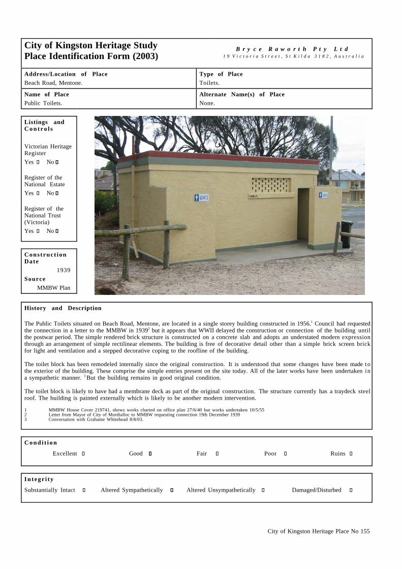
City of Kingston Heritage Place No 155
City of Kingston Heritage StudyPlace Identification Form (2003)
B r y c e R a w o r t h P t y L t d1 9 V i c t o r i a S t r e e t , S t K i l d a 3 1 8 2 , A u s t r a l i a
Address/Location of PlaceBeach Road, Mentone.
Type of PlaceToilets.
Name of PlacePublic Toilets.
Alternate Name(s) of PlaceNone.
Listings andC o n t r o l s
Victorian HeritageRegisterYes c No g
Register of theNational EstateYes c No g
Register of theNational Trust(Victoria)Yes c No g
Construct ionDate
1939Source
MMBW Plan
History and Description
The Public Toilets situated on Beach Road, Mentone, are located in a single storey building constructed in 1956.1 Council had requestedthe connection in a letter to the MMBW in 19392 but it appears that WWII delayed the construction or connection of the building untilthe postwar period. The simple rendered brick structure is constructed on a concrete slab and adopts an understated modern expressionthrough an arrangement of simple rectilinear elements. The building is free of decorative detail other than a simple brick screen brickfor light and ventilation and a stepped decorative coping to the roofline of the building.
The toilet block has been remodeled internally since the original construction. It is understood that some changes have been made tothe exterior of the building. These comprise the simple entries present on the site today. All of the later works have been undertaken ina sympathetic manner. 3 But the building remains in good original condition.
The toilet block is likely to have had a membrane deck as part of the original construction. The structure currently has a traydeck steelroof. The building is painted externally which is likely to be another modern intervention.
1 MMBW House Cover 219741, shows works charted on office plan 27/6/40 but works undertaken 10/5/552 Letter from Mayor of City of Mordialloc to MMBW requesting connection 19th December 19393 Conversation with Grahame Whitehead 8/8/03.
C o n d i t i o n
Excellent c Good g Fair c Poor c Ruins c
I n t e g r i t y
Substantially Intact c Altered Sympathetically g Altered Unsympathetically c Damaged/Disturbed c

City of Kingston Heritage Place No 155
Comparable examples within the City of Kingston
There is a comparable toilet block within the Mordialloc Creek and Foreshore Precinct Nepean Highway, Mordialloc.
Statement of Significance
The Public Toilets situated on Beach Road, Mentone are of historical, social and architectural significance at a local level. Theydemonstrate the historical and social role of the beach as a recreational space within the Municipality. The building is also of somearchitectural significance as an example of a simple, utilitarian structure, typical of the austere designs produced in the Municipality inthe period immediately after WWII.
Recommendat ions
A heritage overlay is recommended for the building.
City of Kingston Planning Scheme
Recommended for inclusion in a heritage overlay to the Planning Scheme Yes g No c
Should external paint controls apply? Yes g No c
Should internal alteration controls apply? Yes c No g
Should tree controls apply? Yes c No g
Other Listings and Controls
Recommended for inclusion on the Victorian Heritage Register? Yes c No g
Recommended for inclusion on the Register of the National Estate? Yes c No g
Recommended for inclusion on the National Trust (Victoria) Register? Yes c No g

City of Kingston Heritage Place No 132
City of Kingston Heritage StudyPlace Identification Form (2003)
B r y c e R a w o r t h P t y L t d1 9 V i c t o r i a S t r e e t , S t K i l d a 3 1 8 2 , A u s t r a l i a
Address/Location of Place74 Beach Road, Mentone.
Type of PlaceFlats.
Name of PlaceGlen Court.
Alternate Name(s) of PlaceNone.
Listings andC o n t r o l s
Victorian HeritageRegisterYes c No g
Register of theNational EstateYes c No g
Register of theNational Trust(Victoria)Yes c No g
Construct ionDate
c.1942Source
Refer History
History and Description
The Glen Court Flats were constructed at the corner of Naples Street in Beach Road Mentone during 1942.1 Glen Court is a two-storeybrick group of flats executed in a Streamline Moderne mode. The facade at ground floor level is realised in clinker brick while the firstfloor is finished in red brick. A rendered brick cream band connects the two sections. The flats have a shallow pitched tiled roof withtwo brick chimneys the north and south sides of the building. The building has slender timber windows with horizontal glazing bars assubtle decorative elements. The flats retain their original cast iron signage. The block features a prominent bay window to the west sideof the facade, which forms a base for the balcony at first floor level and a focus for the facade as a whole. The stairwell is of note for itsslender frosted glass window. The building retains its original fence although original roof tiles have been replaced.
1 Sands & McDougalls Directory of Victoria 1930 - 1974. Held at the Royal Historical Society, Melbourne.
C o n d i t i o n
Excellent g Good c Fair c Poor c Ruins c
I n t e g r i t y
Substantially Intact g Altered Sympathetically c Altered Unsympathetically c Damaged/Disturbed c
Comparable examples within the City of Kingston
No directly comparable examples were identified within the City of Kingston as part of this study.

City of Kingston Heritage Place No 132
Statement of Significance
The Glen Court Flats at 74 Beach Road, Mentone are of architectural significance at a local level as a simple block of flats in aStreamline Moderne mode. Developments of this type are unusual within the Municipality.
Recommendat ions
A heritage overlay is recommended for the building.
City of Kingston Planning Scheme
Recommended for inclusion in a heritage overlay to the Planning Scheme Yes g No c
Should external paint controls apply? Yes g No c
Should internal alteration controls apply? Yes c No g
Should tree controls apply? Yes c No g
Other Listings and Controls
Recommended for inclusion on the Victorian Heritage Register? Yes c No g
Recommended for inclusion on the Register of the National Estate? Yes c No g
Recommended for inclusion on the National Trust (Victoria) Register? Yes c No g

City of Kingston Heritage Place No 159
City of Kingston Heritage StudyPlace Identification Form (2003)
B r y c e R a w o r t h P t y L t d1 9 V i c t o r i a S t r e e t , S t K i l d a 3 1 8 2 , A u s t r a l i a
Address/Location of Place9 Palermo Street, Mentone.
Type of PlaceClub House.
Name of PlaceRiviera.
Alternate Name(s) of PlaceMentone RSL Club.
Listings andC o n t r o l s
Victorian HeritageRegisterYes c No g
Register of theNational EstateYes c No g
Register of theNational Trust(Victoria)Yes c No g
Construct ionDate
1884-1886Source
Refer History
History and Description
The Riviera building, which is now known as the Mentone RSL was built during the land boom period in 1884- 1886. It was firstoccupied by C.J Potts a Melbourne solicitor. Marcella Dawson took ownership of the house in the 1920s. Dawson owned land aroundPalermo St and fronting Naples Rd. In 1921-1922 the house was sold to John Allan Anderson, a solicitor. In 1946-1947 the house wasknown as the Riviera Guest House and was operated by a woman called O’Brien.1
The Mentone RSL, situated at 9 Palermo Street, Mentone is a large single story building executed in an understated Italianate mode. It i sof note for the large tower above the main entrance surmounted by an ornate balustrade treatment with decorative urns. Four roundheaded openings to the tower have been glazed in recent years to reduce weather damage in the tower.
The building has recently been extensively renovated. The original verandah has been replaced, as has the corrugated iron roof, whichhad experienced problems with leakage. In recent years an additional wing to the north of the building has been constructed. Theaddition is broadly sympathetic to the character of the original building, reproducing the bullnosed verandah and roof design of theoriginal design.
1 Moorabbin Rate Books, Victorian Archives, 99 Shiel Street, North Melbourne, Years – 1887, 1891, 1901, 1906, 1913.
C o n d i t i o n
Excellent c Good g Fair c Poor c Ruins c
I n t e g r i t y
Substantially Intact c Altered Sympathetically g Altered Unsympathetically c Damaged/Disturbed c

City of Kingston Heritage Place No 159
Comparable examples within the City of Kingston
Substantial Italianate villas survive at 22 Bear Street, Mordialloc (Fortunatus House) and 6 Harkin Ave, Mentone (Killara).
Statement of Significance
The RSL club at 9 Palermo Street, Mentone is historically and architecturally significant at a local level. It is one of only five grandtower houses constructed in the area during the land boom of the 1880s and one of only two that survive. It is architecturallysignificant for its a grand Italianate design and imposing tower. Despite some alterations, the building remains the most intact towerhouse in the area.
Recommendat ions
A heritage overlay is recommended for the building.
City of Kingston Planning Scheme
Recommended for inclusion in a heritage overlay to the Planning Scheme Yes g No c
Should external paint controls apply? Yes g No c
Should internal alteration controls apply? Yes c No g
Should tree controls apply? Yes c No g
Other Listings and Controls
Recommended for inclusion on the Victorian Heritage Register? Yes c No g
Recommended for inclusion on the Register of the National Estate? Yes c No g
Recommended for inclusion on the National Trust (Victoria) Register? Yes c No g

City of Kingston Heritage Place No 151
City of Kingston Heritage StudyPlace Identification Form (2003)
B r y c e R a w o r t h P t y L t d1 9 V i c t o r i a S t r e e t , S t K i l d a 3 1 8 2 , A u s t r a l i a
Address/Location of PlaceBeach Road, Mentone.
Type of PlaceHotel.
Name of PlaceMentone Hotel.
Alternate Name(s) of PlaceAlloid's Mentone Hotel, Edgewater Beach Hotel.
Listings andC o n t r o l s
Victorian HeritageRegisterYes c No g
Register of theNational EstateYes c No g
Register of theNational Trust(Victoria)Yes g No c
Construct ionDate
1888Source
Refer History
History and Description
The Mentone Hotel was erected in 1887-8 to designs by CD Figgis of Loweish Moorhouse and Figgis. It was commissioned by localland boom developers and remains one of the oldest buildings in Mentone.1 The building is included on the Register of the NationalTrust (B5852).1
The hotel is situated on a prominent wedge-shaped site on the corner of Mentone Parade and Beach Road in Mentone. It adopted anunusual site-responsive design in which elements were combined in a non-academic manner reflecting the boom period vogue forcomplex eclectic design. At that time, Beach Road was a narrow unmade track some distance from local population centres and the hotelmaintained a garden frontage to the road.
CJ Hearly was the first manager of the hotel. 1n 1891 A Glasson took over as manager until 1894 when he was replaced by Mrs EHunter. Directories suggest that Francis M Scudds became the manager in 1905 although he appears to have been involved with theestablishment from at least 19012 and continued the association until c.1920. Scudds was a Councilor of the Shire of Moorabbin and anoted local figure. Between 1923 and 1952, a number of people managed the hotel including: Mrs Maud Buchanan; Mrs S V Kelly;Thomas Schifferle; Ephriam F Alloid; Arthur Fry; J A McPhee; Mrs Malone; Mr and Mrs Leo Holcroft; Mr and Mrs Barnett Klooger;Donald A Gillespie; LI and WE Philip and William A Olsen. In 1953, when AV Angus became the manager the hotel, its name waschanged to Edgewater Beach Hotel. Angus worked there until 1962 when RC Bew replaced him. RC Bew remained for two years until CCBew replaced him. George Con became manager in 1969 operating the hotel into the early 1970s.3 The hotel has been a focus of thelocal community throughout the twentieth century hosting meetings and celebrations and servicing the recreational and social needs ofthe area.4 The building continues to operate as a hotel.
The hotel is constructed on a narrow wedge of land on the eastern side of Beach Road. The design takes advantage of its problematic siteto produce an unusual and handsome arrangement of building elements. The focus of the composition is the entrance tower at the apexof the wedge combining a variety of classical elements to unusual effect. The broadly identical Beach Road and Mentone Parade facadeare more conventional combining two storey pedimented elements and broad verandahs and under a complex arrangement of roofforms. The principal focus of the composition is the tower on the corner.

City of Kingston Heritage Place No 151
History and Description (continued)
The National Trust citation for the building suggests that the building anticipates the free-style designs of the Edwardian era.
The building remains broadly intact to its early state. Some alterations have been undertaken, most notably the enclosure of the smallverandahs to either side of the principal entry, remodeling of windows along the Beach Road frontage and overpainting of the exteriorrender. Nonetheless, the form, character and much of the original detailing of the building survives intact. The building is in excellentcondition.
1 National Trust of Australia (Victoria) Website: www.nattrust.com.au Citation for the Mentone Hotel, File No.58522 City of Kingston Historical website, A New Nation Raises the Union Jack, http://localhistory.kingston.vic.gov.au3 Sands & Mc Dougalls Directory of Victoria. 1889 - 1974. Held at the Royal Historical Society, Melbourne.4 City of Kingston Historical website, various articles, http://localhistory.kingston.vic.gov.au
C o n d i t i o n
Excellent g Good c Fair c Poor c Ruins c
I n t e g r i t y
Substantially Intact c Altered Sympathetically g Altered Unsympathetically c Damaged/Disturbed c
Comparable examples within the City of Kingston
Although a number of early hotels survive within the City of Kingston, none compare directly in terms of architectural style to theMentone Hotel. The building is of the same age as the nearby former Coffee Palace (now Kilbreda College) in Mentone Parade and thatbuilding provides the most direct comparison in terms of age, prominence and original usage to the subject site.
Statement of Significance
Built in 1889, the Mentone Hotel, situated on the corner Mentone Parade and Beach Road, is of architectural, social and historicalsignificance. It historically significant as the first hotel to serve alcohol in Mentone and remains one of the oldest extant buildings inthe district. It has been a focus of the local community for over a century and continues to demonstrate its early and valued use. Thebuilding is of architectural significance for its unconventional arrangement of classical architectural elements responding in handsomefashion to the site and reflecting the boom period vogue for complex and eclectic design.
Recommendat ions
A heritage overlay is recommended for the building.
City of Kingston Planning Scheme
Recommended for inclusion in a heritage overlay to the Planning Scheme Yes g No c
Should external paint controls apply? Yes g No c
Should internal alteration controls apply? Yes c No g
Should tree controls apply? Yes c No g
Other Listings and Controls
Recommended for inclusion on the Victorian Heritage Register? Yes c No g
Recommended for inclusion on the Register of the National Estate? Yes c No g

City of Kingston Heritage Place No 150
City of Kingston Heritage StudyPlace Identification Form (2003)
B r y c e R a w o r t h P t y L t d1 9 V i c t o r i a S t r e e t , S t K i l d a 3 1 8 2 , A u s t r a l i a
Address/Location of PlaceSt Bede’s, Beach Road, Mentone.
Type of PlaceGates.
Name of PlaceMemorial Gates.
Alternate Name(s) of PlaceNone.
Listings andC o n t r o l s
Victorian HeritageRegisterYes c No g
Register of theNational EstateYes c No g
Register of theNational Trust(Victoria)Yes c No g
Construct ionDate
1938Source
Refer History
History and Description
The De La Salle Brothers established St Bede’s in 1938. Until this time there had been no secondary college for Catholic boys inMentone and many boys were going to school in the city or leaving school altogether. The parish priest of Mentone persuaded the DeLa Salle order to purchase the former McCristal property and others adjoining to establish the school. The McCristal property was usedas a college for students of mixed denomination. Enrolments grew to 300 by the end of the 1940s, and the school also took around 100boarders per year from the 1940s until the 1970s. With the 1950s baby boom the school grew to 1000 students by the end of the 1950sand by the 1960s the enrollment had reached 1300. Classrooms were often crowded during this early period, as the school had nofinances to replace the buildings during WWII and the postwar period. However, all of the original buildings had been replaced by the1970s. The school has since produced many high achievers who have made substantial impact on the local and wider community.1
The memorial gates situated at St Bede’s, Beach Road, Mentone are executed in a 19th century gothic style but are likely to date fromthe establishment of the school in 1938. They are not visible in an aerial photograph of the site dating from c.1920s.1 The gatescomprise four principal columns, which divide the cast iron design into 3 sections. The four columns are connected by a low concreteretaining wall. The cast iron design contains a simple crucifix design, which is repeated 3 times within the columns. The tops of thecolumns consist of a gable motif. The concrete columns and retaining wall painted white against the black of the cast iron design createa striking effect on the corner of Beach Rd and Palermo St in Mentone.
1 Kingston Historical Website. http://localhistory.kingston.vic.gov.au ‘St. Bede’s College’ by Leo Gamble.2 Ibid
C o n d i t i o n
Excellent c Good g Fair c Poor c Ruins c
I n t e g r i t y
Substantially Intact c Altered Sympathetically g Altered Unsympathetically c Damaged/Disturbed c

City of Kingston Heritage Place No 150
Comparable examples within the City of Kingston
The War Memorial Gates in the Keith Styles Reserve Mentone Parade are broadly comparable to the subject site.
Statement of Significance
The memorial gates on the corner of Beach Rd and Palermo St, Mentone are of architectural, historical and social significance at a locallevel for their handsome design and as a remnant of the earliest fabric on the site.
Recommendat ions
A heritage overlay is recommended for the structure.
City of Kingston Planning Scheme
Recommended for inclusion in a heritage overlay to the Planning Scheme Yes g No c
Should external paint controls apply? Yes g No c
Should internal alteration controls apply? Yes c No g
Should tree controls apply? Yes c No g
Other Listings and Controls
Recommended for inclusion on the Victorian Heritage Register? Yes c No g
Recommended for inclusion on the Register of the National Estate? Yes c No g
Recommended for inclusion on the National Trust (Victoria) Register? Yes c No g

City of Kingston Heritage Place No 177
City of Kingston Heritage StudyPlace Identification Form (2001)
B r y c e R a w o r t h P t y L t d1 9 V i c t o r i a S t r e e t , S t K i l d a 3 1 8 2 , A u s t r a l i a
Address/Location of PlaceCnr. South Rd & Nepean Highway, Moorabbin.
Type of PlaceHall.
Name of PlaceKingston Arts Centre.
Alternate Name(s) of PlaceFormer Moorabbin Town Hall, Former Moorabbin CouncilChambers.
Listings andC o n t r o l s
Victorian HeritageRegisterYes c No g
Register of theNational EstateYes c No g
Register of theNational Trust(Victoria)Yes c No g
Construct ionDate
1928Source
Memorial Stone
History and Description
The first Moorabbin Shire Hall was constructed in 1867 near the corner of Nepean and South Roads1. The building was extended in 1884and improved again in 1905 towards the Nepean Highway frontage2. From 1928, the building became council offices when a new andlarger Council Chambers was constructed on an adjacent site closer to the corner of Nepean and South Roads3. The foundation stone forthe new building was laid on the 23rd of November 1928 by Shire President of Moorabbin, Cr. A. H. Castle JP.
This later two-storey red brick rectilinear building is known today as the Kingston Arts Centre. It adopts a Georgian Revival style andis symmetrical. The front façade is dominated by classically inspired portico entry with Tuscan order columns surmounted by a smallbalcony. The building features dual chimneys, steel multipaned windows and a cement-tiled roof. It is trimmed with cement quoins.
Over the years a ramshackle collection of buildings developed to the rear and side of the 1928 Council Chambers which are clearlyvisible on contemporary aerial photographs.4 These were demolished in 1962 along with the original 1867 building to make way forthe construction of a third building, a Town Hall on the site.5 Further additions were made to either side of the 1928 Council Chambersfacade during the 1950s.6 These were demolished during the 1990s,7 effectively restoring the building façade to its original state.
With the construction of the new Moorabbin Town Hall in the 1963, the 1928 building became redundant and remained vacant forseveral years during the 1980s. Discussions with residents of the City of Kingston in the early 1990s led to the development of acommunity arts centre. The Kingston Arts Centre opened in March 1994.8 A two storey addition to the rear of the 1928 buildingemploying similar massing, materials and detailing to the earlier building appears to have been constructed as part of the Art Centreredevelopment. These additions are connected to the 1928 building by a linkway.9 An unsympathetic disabled access ramp has beenadded to the front of the building but the building is otherwise in good, original condition. Thew building remains in local governmentownership.
City of Kingston Heritage Place No 177
History and Description (continued)
1 Moorabbin City Council. Moorabbin: A Centenary History 1862 – 1962. Moorabbin City Council, Moorabbin, 1962, p.XVI and XVII.2 From information supplied by Graham Whitehead. Historian, City of Kingston.3 Moorabbin City Council. Op cit.4 Melbourne and Metropolitan Area Project. 12/1945, Run 9, Photograph 57416 and 3/1954, Run 2, Photograph 26 Held at Land Titles Office.5 John Cribbin. Moorabbin: A Pictorial History 1862 - 1994. City of Kingston, 1995. p.64, 157, 172, 185.6 Ibid.7 Marc Fiddian. Civic Places: A Tableau of Australian Town Halls. Packerhan, 1986.p.93-94.8 Discussion with Susan Cooper, Manager of the Kingston arts Centre, February 18 2002.9 Ibid.
C o n d i t i o n
Excellent c Good g Fair c Poor c Ruins c
I n t e g r i t y
Substantially Intact c Altered Sympathetically g Altered Unsympathetically c Damaged/Disturbed c
Comparable examples within the City of Kingston
There are no comparable examples within the City of Kingston indentified by this study.
Statement of Significance
The Kingston Arts Centre, formerly the Moorabbin Council Chambers, constructed from 1928 is of social and architecturalsignificance at a local level. It is of social significance for its role in local politics and subsequently as a centre for the arts. Thebuilding is also as some architectural significance as relatively intact example of the Inter-war Georgian Revival style.
Recommendat ions
A heritage overlay is recommended for the building dating from 1928 only. The additions to the rear date from a much later period andare of little local significance.
City of Kingston Planning Scheme
Recommended for inclusion in a heritage overlay to the Planning Scheme Yes g No c
Should external paint controls apply? Yes g No c
Should internal alteration controls apply? Yes c No g
Should tree controls apply? Yes c No g
Other Listings and Controls
Recommended for inclusion on the Victorian Heritage Register? Yes c No g
Recommended for inclusion on the Register of the National Estate? Yes c No g
Recommended for inclusion on the National Trust (Victoria) Register? Yes c No g

Preliminary Assessment of theHeritage/Cultural Significance of theMoorabbin Town Hall
Prepared for the City of KingstonChris Johnston (Context Pty Ltd) & NigelLewis (Nigel Lewis Richard Aitken Pty Ltd)
July 2001

Contents
INTRODUCTION 1
The Brief 1
Previous Assessments 1
Analysis undertaken 3
THE MOORABBIN TOWN HALL 4
History 4
Architecture and design 7
DESCRIPTION 10
SIGNIFICANCE 15
Concept of Cultural Significance 15
Assessment criteria 15
Discussion of significance 16
Statement of significance 18
RECOMMENDATIONS 20
Retaining the significance of the Moorabbin Town Hall 20
Seeking heritage protection 20
REFERENCES 22
APPENDIX 1: CRITERIA FOR THE VICTORIAN HERITAGE REGISTER 23
APPENDIX 2: VICTORIAN HERITAGE REGISTER LISTING: WURLITZERTHEATRE ORGAN 24

Moorabbin Town Hall: Preliminary assessment of significance Page 1
Introduction
The Brief
Chris Johnston (Context Pty Ltd) and Nigel Lewis (Nigel Lewis Richard Aitken PtyLtd) were commissioned by the City of Kingston to undertake a preliminaryassessment of the significance of the Moorabbin Town Hall. It was agreed that thiswork would be done in two phases. The first phase would involve meeting withcouncil officers and the mayor, reviewing existing information on the town hallincluding an inspection of the building and reviewing any additional historicalinformation. Also part of phase one was considering the assessment of socialsignificance and providing a preliminary assessment of significance using HeritageVictoria’s criteria. This phase one report concludes with recommendations on phasetwo.
Phase two of the work would involve preparation of a nomination to the VictorianHeritage Register should this be sought by the City of Kingston as a result of phaseone.
Previous Assessments
The City of Kingston has recently completed stage one of a heritage study and hascommissioned Bryce Raworth to undertake stage two. The stage one studyrecommended the Town Hall for further assessment, however this had not beencompleted at the time of preparing this report.
Typological study of local government offices and halls
In 1994 Andrew Ward undertook a survey of all municipal Town Halls and officesthroughout Victoria. His aim was to identify places for the Victorian HeritageRegister through a process of comparative analysis. He looked at the MoorabbinCivic Complex and at each of the three separate buildings:

Moorabbin Town Hall: Preliminary assessment of significance Page 2
§ the 1928 Town Hall
§ the 1962 Moorabbin Town Hall
§ the 1986 Moorabbin City Offices
Ward’s study identified a total of three hundred and fifty one town hall and officestructures throughout Victoria, the majority of which were post-World War 2buildings.
Ward's study noted that the original 1867 Town Hall and Offices on the NepeanHighway, Moorabbin had been demolished and replaced with a new set of offices in1928. This 1928 building is currently used as an art centre and its heritagesignificance is recognised by the City of Kingtson. It was not recommended by Wardfor consideration for the Historic Buildings Register (now Victorian HeritageRegister).
The 1962 Town Hall is the building that is being considered in the present report.Andrew Ward did not recommend it to be considered for the Historic BuildingsRegister (now Victorian Heritage Register). His study notes it as a “a post-war officecomplex”.
The third element is the 1986-88 Moorabbin City Offices Complex. Again Ward didnot recommend any further investigation of this building for Historic BuildingsRegister (now Victorian Heritage Register). This building won a design award fromthe Royal Australian Institute of Architects.1
He recommended only one post-World War 2 town hall for the Victorian HeritageRegister - the City of Brighton Offices and Council Chamber, a complex designed byOakley and Parkes, and opened in 1961. According to Ward, the following Post-World War 2 town halls/offices are worthy of further investigation:
§ Altona (1963)
§ Doncaster and Templestowe (c1970) (identified in Doncaster & TemplestoweHeritage Study in 1991 as of State significance - designed by Gert and RenateBlock)
§ Sunshine (1967)
§ Waverley (1984)
§ Whittlesea (1993.
None of these buildings have, as yet, been added to the Victorian Heritage Register.The (former) City of Doncaster & Templestowe Offices has been added to theindicative list within the Register of the National Estate and awaits assessment.
Heritage listings
The only element currently protected within the Moorabbin Town Hall (and theadjoining civic complex) is the Wurlitzer theatre organ which is on the VictorianHeritage Register and is listed by the National Trust. The area protected under theVictorian Heritage Register is:
1 Living Histories p. 92

Moorabbin Town Hall: Preliminary assessment of significance Page 3
To the extent of all the structure known as the Moorabbin Town Hall WurlitzerTheatre Organ including the console; the relays and relay room; all the pipes;and ancillary and connecting elements such as wind pumps.
The Victorian Heritage Register listing and an image of the organ is included inAppendix 2.
The 1962 Town Hall has not been assessed for listing on any statutory or non-statutory heritage registers to date: that is, the Victorian Heritage Register; Register ofthe National Estate; National Trust Register.
Analysis undertaken
During phase one of the study the consultants received information from the councilincluding the thematic environmental history prepared as part of stage one of theheritage study (Living Histories 2000), a copy of Moorabbin: a pictorial history1862-1994, copies of other materials held by Council including a special souveniredition of the local paper that marked the opening of the 1962 Moorabbin Town Hall.
The consultants also inspected the Town Hall building using a set of building plansprepared by Millar Robertson Architects Pty Ltd in 1996. Following that inspection,the consultants have obtained a copy of the original Bates Smart McCutcheon plans.
Kingston City Council issued a media release seeking community input into theproject. This was designed to encourage those with some memory of the place tocome forward and contribute what they knew. A questionnaire was developed toenable the council officer to seek information from any people who responded. As aresult Mr Ken Hodgson, Mayor of the City of Moorabbin at the time of the building ofthe hall made contact with the Council and was able to be interviewed.

Moorabbin Town Hall: Preliminary assessment of significance Page 4
The Moorabbin Town Hall
History
When the Moorabbin Town Hall was opened in 1963 it was said to have ‘one of thelargest auditoriums in Victoria’.2 The opening celebrated the city’s centenary as alocal government authority. Compared to the earlier buildings built by themunicipality, the 1962 Town Hall was a grand structure. The first building by themunicipality had been built in 1867 and as the area had grown a larger town hall andmunicipal offices were built in 1928. The municipality was declared a city in 1934.
Cribbin’s local history illustrates the massive growth in the municipality since the endof the Second World War. From a population of around 25,000 at the end of the warthe following twenty years saw its fourfold expansion to more than 100,000.Likewise the number of dwellings grew from just under 7,000 dwellings to nearly30,000. This was a time of massive expansion throughout Melbourne with the city'spopulation almost doubling and the metropolitan area increasing more than ten timeswith the biggest expansion eastwards.3
During this period, the City of Moorabbin witnessed enormous expansion and changewithin its own boundaries. Market gardens and dairy farms were carved up forhousing and Moorabbin itself was the focus of much of this development.4 By 1964,and with a population of 100,000, the City of Moorabbin was one of the largestmunicipalities in Victoria at that time.
The new Town Hall was to be located next to the 1928 Town Hall, creating a largercivic complex, but retaining this important function at the same location from 1867when the first Shire Hall was built at the corner of the Nepean Highway and SouthRoad. The Nepean Highway is one of the earliest travel routes through themunicipality, dating from the early 1840s. The quickly became a focus of activity,with the Shire Hall built in 1867, the Plough and Harrow Hotel on the north-eastcorner by 1872 (or earlier)5, and construction of the railway to Mordialloc in 1881(with the Moorabbin station just to the south-east of the Shire Hall6). By the earlytwentieth century, there was a post office, telephone exchange, police station,Mechanics Institute and library, two churches at this corner.7
Along with housing, industry was developing in parts of the municipality (Cribbin1995:173). While there had been some industry in Moorabbin before the secondWorld War, there was dramatic growth straight after the war, most concentrated inMoorabbin East. Having its own airport, established in 1949, was also seen as anincentive for industry to establish nearby. Moorabbin was the first municipality in
2 Living Histories p. 923 Living Histories p. 534 Living Histories p. 565 Now just outside the City of Kingston6 The railway crossing of Nepean Highway at Moorabbin was put underground in the 1950s to reducetraffic delays. (Cribbin 1995:94)7 Living Histories pp. 92, 35, 38; Cribbin p.93.

Moorabbin Town Hall: Preliminary assessment of significance Page 5
Victoria to adopt its own town planning scheme in the 1950s8, and this wasconsidered by then councillor Ken Hodgson to have been an action that wasresponsible for:
… bringing order to the growth of the municipality at a time when things werein grave danger of getting out of control … Later Moorabbin was ask torelinquish its independent powers to the Melbourne and Metropolitan Board ofWorks … But Moorabbin had already established its own framework for a fineresidential city that harmoniously co-existed with what was to become, in thatperiod, the largest industrial area in the state of Victoria.9
As well as the construction of the new town hall, Cribbin's identifies two otherimportant events during the 1960s: the move of the St Kilda Football club from theJunction Oval (it's home from 1897-1964) to Moorabbin in 1965 (accompanied bymajor upgrading to the facilities at the Linton St oval) and the establishment of theSouthland Shopping Complex in 1968. These developments are examples of thethriving nature of this area at this time. The Southland development, initiallyproposed in 1964, was part of the Myer Emporium Limited plan to ring Melbournewith these new style shopping centres, of which Southland was to be the fourth in thegroup.
The opening of the town hall was a proud moment for the city. In the souvenirsupplement to the Standard Newspaper the editorial declared “Tomorrow the City ofMoorabbin will dramatically proclaim its progress to the world with the opening of atown hall worthy of its present stature”. The then mayor Councilor Ken Hodgsondeclared “we have built for the future-for the population of 150,000 which Moorabbincould boost in the next ten years and the even greater number which could follow –and the hall has been designed to allow for extensions when necessary at a minimumcost to the rate payers”. The town hall was located "in the heart of the thrivingcommunity which it will serve" and "destined to become the acknowledged centre ofcultural and community life" in the city.
The opening of the new Town Hall was marked by a number of events, including theofficial opening, a naturalisation ceremony and a Citizen's Ball. The opening wasattended by more than 2000 local people, all of whom were able to be seated in thenew hall. As well as the dignitaries present at the opening, the Council entertained thePremier, Henry Bolte, arranging a preview of the Town hall prior to its opening.
8 Living Histories refers to three municipalities being granted the power to prepare planning schemes in1955 - Moorabbin, Mentone and Chelsea - p. 56.9 Cribbin pp. 159-160, 162

Moorabbin Town Hall: Preliminary assessment of significance Page 6
Architectural illustration of the interior (Bates Smart archives)
The importance of having a new space suited for large gatherings was emphasised bythe Mayor at the time, and his words were echoed by local organisations who alsorecognised the importance of having a large space for gatherings such as speechnights, school concerts, displays, conferences, art and horticultural shows, concerts. Areporter in the Standard Supplement, Tom Sheehy comments:
The new town hall is now available for use by the people.
… this means that cultural activities having been dogged by the need for asizeable hall ever since the foundation of Moorabbin as a District 101 years agowill at last be given the opportunity to expand.
More than that, the building will be the means of providing a much deservedboost to the prestige of a city, which might have been regarded up till now as a"poor relation" of neighbouring municipalities.
No longer will there be a need to go from city to city seeking the use of a hall inwhich to hold functions which should be held in our own locality …"
Development of such a large building was an ambitious project, designed to instilledconfidence and to demonstrate that this municipality had arrived. But the function wasthe paramount thing, not its appearance. Ken Hodgson confirmed that the Council'spriority was for a practical, functional building that worked well and served all of thisgrowing community's needs. The interior was the focus, in terms of creating pleasantand functional spaces. The lack of space for community gatherings had becomecritical, as had spaces for official functions and larger Council events such as themayoral ball (the latter being held in the St Kilda Town Hall).
As may be surmised from the Standard Newspaper Souvenir Supplement the buildingof a new hall was not without its critics. However, Ken Hodgson recalls tremendouscommunity support for the project. Funding it was a challenge for the Council.

Moorabbin Town Hall: Preliminary assessment of significance Page 7
And the timing of its construction added some challenges. At the opening, Cr Clark,Chair of the Works Committee commented that while some people had beendisappointed that the hall had not been completed in the centenary year, the councilhad saved £30,000 by postponing acceptance of the tenders until after the "creditsqueeze" and had therefore been able to restore many of the features eliminated fromthe original design for financial reasons.
Since its opening, the hall has been used for many local events: ranging from theannual school concerts and speech nights through to political rallies, football clubevents, dances, Christmas parties and organ concerts. In the 1975 Federal electioncampaign, the Liberal and Labor parties focused major campaigning efforts on theseat of Hotham, both choosing the Moorabbin town hall as the venue. Labor's Hothamcampaign launch was reported as nearly a full house, while the Liberals launch wascancelled due to Malcolm Fraser's ill health. And for a mass rally at the just two daysbefore the election, the Labor Party chose the other large gathering place - the StKilda football ground.10
Different spaces attracted different uses. Once the new hall was opened, thecommunity was also able to use the committee rooms in the adjoining 1928 building.The Reception Room upstairs was reserved for official functions and a stylish kitchenfacility was added to the room.11
The Wurlitzer Theatre Organ, built in 1928 by the Wurlitzer Company of New Yorkand originally installed in the State Theatre, Flinders Street Melbourne in 1929 wasremoved in 1963, restored by members of the Theatre Organ Society of Australia andinstalled in its present location in at the Moorabbin Town Hall in 1970.
Architecture and design
The building was designed by the prominent Melbourne architectural firm of BatesSmart Mc Cutcheon, at a time when this office was involved in a number of importantand innovative commissions, most notably ICI House, in Nicholson Street (1958).This was Melbourne’s first major high rise building, and remains an outstandingexample of curtain wall construction. The firm is Melbourne’s oldest, and hasevolved through many name changes and partners, and was first established by JosephReed in the middle of the 19th Century. The firm designed many major buildingsincluding the Royal Exhibition Buildings and Rippon Lea.
The commission for the City of Moorabbin extended over 9 years, and included otherprojects other than the ‘Civic Centre and Town Hall’ that was first commissioned in1955 (Job No 3264).12
These projects were Stage 3 of the Municipal Offices 1958 (adjacent), MunicipalLibrary 1958, City Hall renovations 1958, Council Depot amenities 1959, MunicipalOffices, first floor alterations and additions 1960, Comfort Station 1964. It is alsointeresting to note they also designed the nearby Gilby’s distillery, another Nepean
10 Moorabbin News Pictorial, various dates 197511 Ken Hodgson pers. comm.12 Bates Smart archives, Job No index card

Moorabbin Town Hall: Preliminary assessment of significance Page 8
Highway landmark in this location.13 The Municipal Library was a better example ofthis distinguished firms work, with respect to the exterior.
Photo of the completed hall (Bates Smart archives)
Further work on the ‘Civic Centre’ (Job No 3721) was undertaken in 1958, ‘TownHall’ (Job No 3911) in 1959-60 which included the working drawings for Stage 1,‘Town Hall furniture’ 1962 (Job No 4443), and ‘Additional Works – Town Hall’ 1964(Job No 4831).14
Now entitled Bates Smart, the firm’s archives now only hold the 1959-60 workingdrawings, and some photographs. The working drawings shows the buildingcomplete other than the clock tower and third floor function room and balconyoverlooking Nepean Highway.
Standard News Supplement provides a good description of the hall at its opening:
"Dignified" and "flexible" and the adjectives used by the architects Bates, Smartand McCutcheon to describe the new Moorabbin Town Hall.
Designed to seat 1100, the hall has a flat floor suitable for a variety of functionssunk below the level of the loges at the sides.
Along one side of the hall a moveable screen can be opened across a gallerylinking it with the adjoining supper room which as served by a fully equippedkitchen.
13 Robert Bruce, director Bates Smart architects, pers. comm., 24 May 2001; when he searched archiveshe noted this other job14 Bates Smart archives, Job No index card
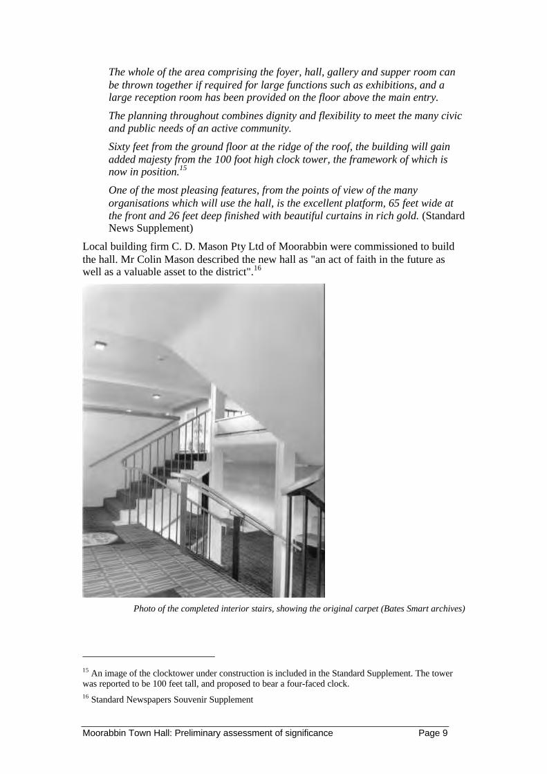
Moorabbin Town Hall: Preliminary assessment of significance Page 9
The whole of the area comprising the foyer, hall, gallery and supper room canbe thrown together if required for large functions such as exhibitions, and alarge reception room has been provided on the floor above the main entry.
The planning throughout combines dignity and flexibility to meet the many civicand public needs of an active community.
Sixty feet from the ground floor at the ridge of the roof, the building will gainadded majesty from the 100 foot high clock tower, the framework of which isnow in position.15
One of the most pleasing features, from the points of view of the manyorganisations which will use the hall, is the excellent platform, 65 feet wide atthe front and 26 feet deep finished with beautiful curtains in rich gold. (StandardNews Supplement)
Local building firm C. D. Mason Pty Ltd of Moorabbin were commissioned to buildthe hall. Mr Colin Mason described the new hall as "an act of faith in the future aswell as a valuable asset to the district".16
Photo of the completed interior stairs, showing the original carpet (Bates Smart archives)
15 An image of the clocktower under construction is included in the Standard Supplement. The towerwas reported to be 100 feet tall, and proposed to bear a four-faced clock.16 Standard Newspapers Souvenir Supplement

Moorabbin Town Hall: Preliminary assessment of significance Page 10
Description
The architect’s perspective is used to illustrate the building on the front page of theStandard News Souvenir Supplement for the Opening in May 1963.17 This shows itin its proposed completed form with the clock tower and upper level function roomand balcony, although windows are not clearly shown. The adjacent aerial viewshows it without the tower, although it was shown under construction in the samepublication. The 1960 working drawings18 do not show these items, other than asquare on the ground level plan for the tower location. It cannot be explained why theclock tower was not documented for this first stage. The drawings do not show a liftor lift well.
The upper level function room was partially constructed in 1963 with the steel framework extending full height. It is shown in the working drawings with temporaryboxing of the steel frame and a steel deck roof in lieu of a floor, with safety handrail.This is described in the Souvenir as the building being designed for expansion at‘minimum cost to the ratepayer’. It appears that this extension took place some timeafter the work was commissioned in 1964, and a lift added. For some reason, thewindows for the new function room were constructed in aluminium, instead of thetimber used for the hall foyer level and main entrance window walls below. Thealuminium windows are separated by the balcony from the mezzanine windowsbelow. Commissioned photographs by BSM show the completed façade, but theangle causes the balcony to hide these windows, so it cannot be assumed that thealuminium windows are original. The mixture of materials and designs of thesewindows confuses the simple utilitarian design expression.
17 Standard Newspaper Souvenir Supplement ‘Moorabbin Town Hall’, 23 May 196318 Bates Smart McCutcheon, Moorabbin Town Hall, Working Drawings, 25.8.60 -14. 9.60, ContractDrawings Nos 1-10, plans, elevations, sections

Moorabbin Town Hall: Preliminary assessment of significance Page 11
Other BSM photographs show the stairs and toilet mezzanine when first completed.These show the carpet, furniture and lighting, and a sophisticated standard of finishand interior design. There is also an architect’s perspective of the hall.
Overall, the emphasis on the building has been on creating a functional andsophisticated venue, somewhat disguised by the building’s exterior. This clearlyreflects pragmatic municipal objectives and budgetary requirements, especially whencompeting with other municipal building projects. The exterior is essentially a cuboidfront three storey section that only partially screens the simple portal frame design ofthe large enclosure of the main auditorium. Extruded salmon coloured brickworkcovers most of the exterior façade, and combined with the design detailing and othermaterials indicate financial austerity. The interior by comparison could almost belongto civic centre from a far more affluent suburb, or even a five star hotel of the period,such as the Southern Cross Hotel built at the same time.
The hall is set above a ground level carpark, a fairly common but expensive practicefor this period when the car had a new status in urban planning. Furthermoreexcavated underground carparking was not often viable before more recent advancesin engineering techniques. This carpark had two principal entrances to the entrancelobby, creating a duality with the street entrance, a design that would have elevatedthe status of the carpark. Stairs were seen as a means of enhancing architecturalcharacter and creating a sense of theatre for patrons as they arrived, or moved aroundthe building. This was the era of the split level house. Disabled access was not anissue at the time. This building maximises stairs and changes of level for theseobjectives.
The impressive nature of most public circulation spaces is one of the features of thebuilding. The entrance lobby only serves the cloak room counter, and leads to the twogenerous sets of stairs at each end, the southern stairs being the principal stairs. It hasa mezzanine well that looks up to the mezzanine floor. The floor is terrazzo. There

Moorabbin Town Hall: Preliminary assessment of significance Page 12
have been some changes to the entrance doors; they are set in a simple timber framedwindow wall.
The mezzanine level looks down to the entrance lobby and is set down two steps fromthe stair landing, presumably to help people see partners or friends over the crowd. Itretains the original rubber foam settees with Pirelli webbing with black vinylupholstery and an elegant polished steel frame; there are matching occasional tables.These may have been similar to the design of seating used in the main hall andapparently the chairs recently disposed off.19 The original carpet seen in earlyphotographs ahs been replaced by an out of character design, but light fittings havebeen retained.20 The mezzanine provides access to the rest rooms and toilets, alsowith terrazzo floors. Both have generous airlocks, and twin entrances, the women’shas a large separate ‘Rest Area’ with full height mirrors for dress adjustments andmake up. The men’s toilet has two extended urinals that would serve the largest hotelor sporting venue.
The two stairs continue for twomore flights to the main level. Thestairs to the south are wider andlead to a large foyer overlookingthe Nepean Highway throughtimber windows. This foyer is100’7” long by 27’6” wide andprovides access to the main hallfrom both ends as well as the stairs.The main stairs also lead direct tothe Gallery between the hall andsupper room. This gallery isdefined by wing walls and loweredopenings to hang sliding doors, it is18’9” wide, and extends the fulllength of the hall. On the right isthe vast Supper Room 75’1” by64’1”. At the opposite end is awide servery, which provides anopening into the large kitchenbehind. This still contains most ofthe lavish equipment extolled in thesouvenir supplement.
19 A set of special furniture was designed for the new town hall. This is confirmed by the architect'sillustrations, advice from Ken Hodgson and the description in the Souvenir Supplement. The latetridentifies: 1111 seats in the main hall; 732 supper room chairs; 120 folding tables; VIP chairs and easychairs (perhaps those shown in the Standard Supplement photo of the Premier); 46 foyer chairs, vinylupholstered in a white pigskin effect.20 Carpet for the hall was specially designed and woven Geelong in tonings of brown and grey/green, itis said to have set the scene for the entire furnishing scheme. The carpet and its laying in the upstairsReception Room is illustrated in the Standard News Supplement.

Moorabbin Town Hall: Preliminary assessment of significance Page 13
The main hall is the most important aspect of the building. This is from theconsideration of both function and design. It comprises a large auditorium withproscenium stage at the far end, with a staggered profile in plan and sculpted ceiling.This would appear to have been influenced by the acoustic derived designs developedby Finnish architect Alvar Aalto. The main auditorium is set down four steps fromthe intermediate areas, titled ‘Loge’ (from the use as a theatre box), which alsoextends to the west or the rear. They provide a view across the auditorium. At thesides these have a lower ceiling, the same height as the super room and gallery. Themain hall with the main roof form and at the lower level is 80’6” long by 70’0”across. The ‘Loges’ on the sides are between 12’0” and 19’0” wide. The ceiling hasretained the large spherical acrylic chandeliers, but the sky light has been blockedover. Some intrusive handrails have been installed for stage and disabled access; theyare out of character.
The entire floor of the supper room, gallery, loges and main hall is finished withhardwood parquetry, and this is reflected in the elegant original handrail detailingdefining the upper Loges. The stage area has been designed for civic functions, balls,concerts and school speech nights. It has a depth of 26’0”, and a 6’0” back stagepassage. There is inadequate provision for most theatre productions. To the side ofthe stag is the piano store room used to house the Wurtlizer Organ (see Appendix 2).
The sense of arrival created by this set-down main hall and spatial experience of thishall is dramatic and exceptional.
Integrity
An examination of the building fabric and the working drawings generally show thebuilding and its interior from the 1963 stage in their current state. The main exceptionis the removal of the two series of ‘Sliding Panels’ that separated the main Hall fromthe Gallery, and the Gallery from the Supper Room. Their removal has altered the

Moorabbin Town Hall: Preliminary assessment of significance Page 14
original design concept and character, as well as substantially compromising thefunctionality of these spaces.
It appears that few changes have taken place to the 1964 works, assuming thealuminium windows are original. The connection walkway to the new Cocks andCarmichael municipal offices has made little impact on the significance of thebuilding.
Moorabbin Town Hall: Preliminary assessment of significance Page 15
Significance
Concept of Cultural Significance
The commonly accepted definition of cultural significance is those places which havehistoric, aesthetic, social, scientific or spiritual value to the present community orfuture generations.
The Guidelines to the Australia ICOMOS Charter for the Conservation of Places ofCultural Significance (The Burra Charter) define these terms as meaning:
§ Aesthetic: aesthetic value includes aspects of sensory perception
§ Historic: historic value encompasses the history of aesthetics, science and society
§ Scientific: the scientific or research value of a place depends on the importance ofthe data involved and the extent to which a place can contribute further substantialinformation. (This criterion is often applied to archaeological sites)
§ Social: social value embraces the qualities for which a place has become a focusof spiritual, political, national or other cultural sentiment.21
Cultural significance is embodied in:
§ the fabric of a place (including its setting and relationship to other items)
§ the records associated with the place, and
§ the response that the place evokes in the community or individuals to whom it isimportant.
Assessment criteria
Assessment of cultural significance relies on:
§ an understanding and analysis of these values derived from examination of thecontext of a place or item
§ the way in which its surviving fabric demonstrates its function
§ its associations, and
§ its formal or aesthetic qualities.
An understanding of the historical context of a place and consideration of its physicalevidence are therefore key components in significance assessment.
The Australian Heritage Commission's assessment criteria are generally used for localheritage studies across Australia. For this assessment, the criteria of the HeritageCouncil of Victoria have been used (see Appendix 1). These two sets of criteria aregenerally similar.
The threshold for entry of a place into the Victorian Heritage Register is statesignificance. The threshold for protection of a place through the planning scheme (themost common form of heritage protection) is local significance or above.
21 Spiritual significance has only recently been recognised as a separate value.

Moorabbin Town Hall: Preliminary assessment of significance Page 16
These thresholds or levels of significance can be defined as follows:
National significance: those places that are considered to contribute to the heritage ofAustralia.
State significance: those places that are considered to contribute to the heritage ofVictoria.
Regional significance - places that contribute to the heritage of a region, where theregion may be defined on a thematic or geographic basis.
Local significance - places that form an important part of a locality's heritage,including those places relevant to the history of more than one local area or are highlyimportant examples within a municipality.
Local interest - places that are of lesser importance but that have meaning for a localcommunity (eg. as a landmark, because of community use, associated with localidentity) but that retain little of their fabric or places that retain their overall form andscale and are part of a precinct
Not significant - places retaining insufficient evidence of significant periods orassociations and places that have been substantially demolished.
Discussion of significance
Based on the evidence to hand, the Moorabbin Town Hall is historically and sociallysignificant to the City of Kingston, and is an important landmark in the south-easternregion of Melbourne. It is certainly of regional significance, and may potentially be ofgreater significance.
Historical significance
In terms of its historical importance the Moorabbin Town Hall is part of a complex ofbuildings that demonstrates the aspirations and achievements of the City ofMoorabbin. Compared to the two other buildings that provide evidence of localgovernment within the present municipality (fmr City of Chelsea Council Chambers,Chelsea: Kingston Council Chambers, Mentone), the Moorabbin civic complexprovides the primary and most important evidence of this theme. This places it at thehighest level of local significance.
Considering the history of the municipality within the wider regional context, the1962 Moorabbin Town Hall provides evidence of the massive urban expansion ofMelbourne in the post-war period. Within the municipality, other evidence of thisgrowth can be found in the extensive suburbs that date from this time, other majordevelopments such as Southland (1968) and St Kilda Football Ground (upgraded1965), and a number of industrial developments (eg. Nylex). The Moorabbin TownHall is an important public expression of this period of development, and is thereforelikely to be of regional historical significance. Further comparative analysis could beundertaken when Stage 2 of the Kingston Heritage Study has been completed.
Historically, the 1962 Moorabbin Town Hall is one of a number of public meetingplaces developed throughout the municipality. Of these a few examples surviveincluding the Mordialloc Masonic Hall, RSL (fmr Protestant Friendly Alliance,Cheltenham), Heatherton Recreation Reserve Hall, fmr church hall (?) in Mentone.(Living Histories 2000: 147-158). Of these, the Moorabbin Town Hall served the

Moorabbin Town Hall: Preliminary assessment of significance Page 17
municipality, not just smaller local communities and provides the best example of aplace that illustrates theme 9.2.6 Public halls.
Social significance
Recognising social significance - or the importance of a place to a group orcommunity who have direct experience and knowledge of a place - is today animportant part of understanding the heritage value of a place.
Social significance is a value held by today's community - or a group within a largercommunity. Assessing social significance is therefore not the same as doing a socialhistory of a place, nor is it the same as historic value.
Social significance includes:
§ Important to a community as a landmark, marker or signature
§ Important as a reference point in a community's identity
§ A place with strong or special community attachment developed from use and/orassociation.
To understand the social significance of a place is a complex task, and involvesidentifying and working with those communities or groups of people who have closeassociations to that place.
A media release by the City of Kingston asked people to contribute their memories ofthe Moorabbin Town Hall to help demonstrate that the town hall "is historically andsocially important to the community". There were only three responses: one was theMayor of the City of Moorabbin at the time of the construction of the Town Hall;another was a former Council officer and the other was a couple who remembered the1928 Town Hall.
Despite this, it is clear from historical sources that the Moorabbin Town Hall hashosted - and continues to host - important events in the social life of this community.It is expected that a more extensive process of consultation would reveal many localswith fond memories of this place, and probably a strong sense of attachment to it.
Historically and socially, its positioning on the corner of the Nepean Highway andSouth Road is also important as a marker of the centre of the local government. The1962 Hall and clocktower are well-known landmarks on the Nepean Highway, andmay be of social significance to people from throughout Melbourne. No comparativestudies of similar landmarks have been undertaken.
Socially, the 1962 Moorabbin Town Hall is probably the most important communitygathering place within the municipality. It also played a similar role within the widerregion.
Architectural/design significance
The architectural and design expression has been on creating a functional andsophisticated venue for social and community events. The pragmatic need for a seriesof functional spaces and the budgetary constraints has resulted in a simple exteriorform. As an example of the work of the prominent Melbourne architectural firm ofBates Smart McCutcheon, it is not outstanding.

Moorabbin Town Hall: Preliminary assessment of significance Page 18
By comparison the internal spaces are well-considered and the interior detailing isstylish and contemporary. The entry through the foyer and stairs is well conceived,and the overlooking mezzanine creates a strong sense of theatre for patrons as theyarrived. These large public circulation spaces are a feature throughout, reflecting thecommunity's need for a venue for large and small gatherings, as well as anappreciation of the potential future needs of a growing population. The main hall(with its adjoining gallery and supper room) is the most important aspect of thebuilding, considering both function and design and appears to have been influencedby the acoustic derived designs developed by Finnish architect Alvar Aalto. The senseof arrival created by this set-down main hall and spatial experience of this hall isdramatic and exceptional.
Statement of significance
Moorabbin Town Hall is significant as:
§ A civic expression of confidence in the future of the municipality in the immediatepost-war years
§ A demonstration of the massive urban expansion of Melbourne in the post-warperiod and the response to a paucity of facilities for a rapidly growing community

Moorabbin Town Hall: Preliminary assessment of significance Page 19
§ As a well-designed, functional and sophisticated venue for social and communityevents created to meet the needs of the community by the prominent Melbournearchitectural firm of Bates Smart McCutcheon.
§ As a marker of the centre of the local government and public life for themunicipality for 132 years (along with the other two civic buildings in thiscomplex)
§ As a well-known landmark on the Nepean Highway
§ As the most important of the few surviving public halls within the presentmunicipality
§ As the place, for nearly 30 years, for important social, cultural and civic occasionswithin the municipality, and attracting people from throughout the municipalityand beyond.

Moorabbin Town Hall: Preliminary assessment of significance Page 20
Recommendations
Retaining the significance of the Moorabbin Town Hall
Moorabbin Town Hall is of considerable significance to the City of Kingston and toMelbourne. As a publicly owned and managed building it deserves the highest levelof care and protection. In this way, the City can maintain an important communityasset and demonstrate its commitment to history and heritage.
The aim of conservation is to retain the significance of the place. The fundamentalrequirements are to:
§ Understand the nature and extent of significance - this preliminary assessment hasmade a step in this direction
§ Appreciate the condition and integrity of the fabric
§ Understand, more precisely, the community's values (social significance) andaspirations
§ Determine a use or uses that is compatible with retaining the cultural significanceof the hall - the most suitable use is likely to be continuation of the hall as apublicly-owned community venue.
These tasks would form part of establishing a conservation management plan for theTown Hall. Such a plan could be linked to an overall management plan that considersother aspects such as the operation of such a facility, its funding and management(etc).
Seeking heritage protection
The City of Kingston wishes to nominate the Moorabbin Town Hall to the VictorianHeritage Register. The City will use this report as the basis for that nomination.Further comparative assessment against other post-war town halls may be sought aspart of the assessment by Heritage Victoria.
The Moorabbin Town Hall should be protected through the heritage overlayprovisions in the Kingston Planning Scheme. This action could be startedimmediately.
The best protection for the Town Hall will come through its continuing use as thisimplies a commitment from the City to its future.
Once the Town Hall receives a suitable level of protection it will become eligible forfuture funding support from Heritage Victoria. One source is the Public HeritageProgram (Heritage Victoria) which funds local heritage studies, heritage advisors andcapital works.
As part of defining a program of works, conservation management plan should beundertaken. This could be done by a conservation architect. Involvement of BatesSmart architects in any new design is desirable as this firm will bring a sympatheticeye to the refurbishment of a building they created nearly 30 years ago.
Conservation issues
From our inspection, the following conservation issues are apparent. While these needto further considered and solutions found through the conservation planning process,the following is offered as a starting point.
Moorabbin Town Hall: Preliminary assessment of significance Page 21
§ New carpet and painting could see the two lower floors largely restored.
§ The missing sliding doors would re-establish the original design and functionalattributes of the original design.
§ The parquetry floor has suffered some damage in places, but could be repaired inthese areas.
§ The roof light baffle could be removed or replaced in a more sympathetic manner.
§ More sympathetic handrails and balustrades could replace later out of placeinstallations.
§ The roof plumbing should be inspected and replaced where necessary, especiallyin the back stage area where there is evidence of water entry.
§ All surviving furniture items should be inventoried. No internal fittings orfurnishings should be disposed prior to the development of a ConservationManagement Plan for the building.
§ Further investigation into the interior fittings and furnishings is warranted. Thisshould include documentation of paintings and floral and plant displays oncelocated within the building.
In terms of its functionality, the following comments are offered:
§ The building provides a valuable resource to the municipality, other than for itshistoric and architectural attributes. It could easily be restored internally to regainmuch of its original character. Any changes to the exterior should take account ofthe significant character of the interior.
§ The building appears to need assessment of electrical and mechanical services, asthere are many signs of deterioration and intrusive replacements.
§ There is no reason that the back stage space could not be extended to permit awider range of performance.
§ The lift and later ramps provides addresses some disability access issues, but moreinvestigation is required to address other matters, while better retaining thecharacter of the building.

Moorabbin Town Hall: Preliminary assessment of significance Page 22
References
Published materials
Bates Smart archives, Job No index card
Bates Smart McCutcheon, Moorabbin Town Hall, Working Drawings, 25.8.60 -14.9.60, Contract Drawings Nos 1-10, plans, elevations, sections
Burns Bridge Australia & WSC Consultants (1997) Moorabbin Town Hall: Analysisof ongoing viability. Report prepared for the City of Kingston.
Cribbin, John (1995) Moorabbin: a pictorial history 1862-1994. City of Kingston.
Heritage Victoria, Register listing for the Wurlitzer Organ, Moorabbin Town Hall,File No. H1860.
Living Histories (2000) Heritage study Stage One Report: Section II EnvironmentalHistory. Prepared by Jill Barnard & Mary Sheehan (Living Histories) for the City ofKingston.
Millar Robertson Architects Pty Ltd (1996) Moorabbin Town Hall RefurbishmentProgram Report. Prepared for the City of Kingston
Moorabbin News Pictorial: various dates - Wed 10 December, 1975, p. 1; Wed. 26Nov, p. 1; Wed 3 December, p. 1
Moorabbin Town Hall: Souvenir Supplement, Standard Newspapers (no date visibleon copy provided by City of Kingston - assumed date 22 May 1963)
National Trust of Australia (Victoria) Register listing for the Wurlitzer Organ,Moorabbin Town Hall, File no. B6099.
Ward, A. (1994) Typological study of Local Government Offices & Halls: Victoria.Report prepared for the Historic Buildings Council.
Other sources
Cr Elizabeth Larking, Mayor of the City of Kingston
Mr Ken Hodgson, former Councillor, City of Moorabbin.
Further materials held by Ken Hodgson
Architect's sketches
Photographs of the official opening
Collection of invitations and newspaper cuttings related to the building and openingof the hall

Moorabbin Town Hall: Preliminary assessment of significance Page 23
Appendix 1: Criteria for the Victorian Heritage Register
CRITERION A. The historical importance, association with or relationship toVictoria's history of the place or object.
CRITERION B. The importance of a place or object in demonstrating rarity oruniqueness.
CRITERION C. The place or object's potential to educate, illustrate or providefurther scientific investigation in relation to Victoria's cultural heritage.
CRITERION D. The importance of a place or object in exhibiting the principalcharacteristics or the representative nature of a place or object as part of a class ortype of places or objects.
CRITERION E. The importance of the place or object in exhibiting good designor aesthetic characteristics and/or in exhibiting a richness, diversity or unusualintegration of features
CRITERION F. The importance of the place or object in demonstrating or beingassociated with scientific or technical innovations or achievements.
CRITERION G. The importance of the place or object in demonstrating social orcultural associations.
CRITERION H. Any other matter which the Council considers relevant to thedetermination of cultural heritage significance

Moorabbin Town Hall: Preliminary assessment of significance Page 24
Appendix 2: Victorian Heritage Register listing: WurlitzerTheatre Organ
MOORABBIN TOWN HALL, 977 NEPEAN HIGHWAY MOORABBIN
VHR Number H1860
File Number 608234
Year Construction Started 1928
Municipality Kingston City
Extent of Registration
To the extent of all the structure known as the Moorabbin Town HallWurlitzer Theatre Organ including the console; the relays and relayroom; all the pipes; and ancillary and connecting elements such aswind pumps.
Additional Information
Comparisons: One of only four identical models constructed by theWurlitzer Company of New York, three of which were sent toAustralia. One, installed in the Regent Theatre in Melbourne, wasdestroyed by fire in 1945. Another, installed in the State Theatre inSydney, is said to currently be in a poor condition.
The Moorabbin Town Hall Wurltizer organ is a rare example of itstype.
Rarity: Only known example surviving in Victoria
General ReferencesThe Organ: A brief guide to its construction, history, usage andmusic., David Baker, 1952, Cit Printing Services, Dyfed, UnitedKingdom
Heritage Act Categories Heritage place
Item Categories
Item Group Item Category
Recreation and Entertainment Cinema
Recreation and Entertainment Entertainment Centre
Statement of SignificanceWhat is significant?The Wurlitzer Theatre Organ, built in 1928 by the Wurlitzer Company of New York wasinstalled in the State Theatre, Flinders Street Melbourne in 1929. The organ was removed in1963 and installed in its present location in 1970 after restoration by members of the TheatreOrgan Society of Australia. The organ is particularly associated with silent cinema, a majorform of popular entertainment introduced in the early twentieth century. The Wurlitzer organhas twenty-one ranks and is able to exhibit a richness and diversity of sounds beyond thecapabilities of earlier more traditional nineteenth century pipe organs.
How is it significant?The Wurlitzer Theatre Organ is of historical and technological significance.
Why is it significant?The Moorabbin Town Hall Wurlitzer organ is historically significant as the only example

Moorabbin Town Hall: Preliminary assessment of significance Page 25
surviving in Victoria. It is historically significant for its association with popularentertainment, particularly the development of the cinema in Victoria. The State Theatre,where the organ was originally located, was one of only three American-inspired'atmospheric' cinemas in Australia. The Wurlitzer contributed to the ambience of this theatreduring its silent film phase. Since relocation to the Moorabbin Town Hall, the Wurlitzer hascontinued to entertain and offer evidence of the 'atmospheric' cinema experience.
The Moorabbin Town Hall Wurlitzer organ is scientifically important for its ability toillustrate technological advances in the construction of organs, which in the nineteenthcentury were primarily used for sacred music. Following the application of electricity organsbecame more flexible resulting in the freeing of the console from the pipe chest, allowing theorgan console to be located at a distance from the pipe chest, joined only by its electric cable.

City of Kingston Heritage Place No 173
City of Kingston Heritage StudyPlace Identification Form (2001)
B r y c e R a w o r t h P t y L t d1 9 V i c t o r i a S t r e e t , S t K i l d a 3 1 8 2 , A u s t r a l i a
Address/Location of Place430 & 430A South Road, Moorabbin.
Type of PlaceFire Station & Flats.
Name of PlaceNone.
Alternate Name(s) of PlaceNone.
Listings andC o n t r o l s
Victorian HeritageRegisterYes c No g
Register of theNational EstateYes c No g
Register of theNational Trust(Victoria)Yes c No g
Construct ionDate
1958Source
Refer History
History and Description
Until the mid 1950s few properties existed on South Road between Linton and Sheppard Streets. From the beginning of the twentiethcentury until this time, the area had largely been occupied by market gardens and farms. In 1956 the block between Linton andSheppard Streets was vacant other than the Moorabbin Bowling Green and a single dwelling. Sands and Mc Dougalls directories of1958 notes a house under construction on the corner of Sheppard Street. This is the present site of the flats and the Fire Station(pictured above). By 1959 two more houses had been built in the area and the occupier of the corner property was the Metropolitan FireBoard1. The property no longer operates as a fire station and all of the fire services for the area have been relocated to a new facility onWickham Road.
The fire station is a red brick building with large timber garage doors and domestic details. Set back from the street at the first floorlevel and mostly hidden by a parapet is a large timber gable end, which appears to be part of the original construction. The ground floorfacade of the fire station building features the fire department logo in formed cement in the upper left corner above the door.
Two conjoined two storey flats are located next door to the fire station. These are also constructed from red brick and are have a tiledgable roof. The flats have timber windows, doors and verandahs. There is a timber ventilator in the gable. The style of the flats i sinspired by earlier twentieth century British anticedents. British housing of the 1950s and early 1960s often took the form of semidetached two or three storey terraces with small gardens.2 The precedents relate to the British Garden City and satellite New TownModels which were characterised by cleanliness, comfort and amenity to the detriment of style. These buildings promoted the idea ofthe ‘People’s Detailing’, and the kind of the comfortable Modernism (domestic in scale and appearance) that was celebrated at theFestival of Britain.3
1 Sands & McDougalls Directory of Victoria. 1956, 1958 – 9, 1961. Held at the Royal Historical Society, Melbourne.2 Helena Barrett and John Phillips. Suburban Style: The British Home, 1840-1960. Macdonald & Co Ltd, 1987. pp.136-1373 Charles Jencks. Modern Movements in Architecture. 2nd Edition, Penguin Books, Harmondsworth, 1985. p.242-246.
C o n d i t i o n
Excellent c Good g Fair c Poor c Ruins c

City of Kingston Heritage Place No 173
I n t e g r i t y
Substantially Intact g Altered Sympathetically c Altered Unsympathetically c Damaged/Disturbed c
Comparable examples within the City of Kingston
No comparable examples were identified in the City of Kingston by this study, however numerous other examples may exist within thewider metropolitan area.
Statement of Significance
The Fire Station and Flats at 430 & 430A South Road, Moorabbin are of social, historical and architectural significance at a local level.The building is socially significant for its association with the local community. It is historically significant as a legible reminder ofthe development of public infrastructure in the area. It is of architectural significance both as an unusual and readily identifiablebuilding type with uncommon incorporation of contemporary British building philosophies.
Recommendat ions
A heritage overlay is recommended for the Fire Station and associated Flats at 428 South Road Moorabbin.
City of Kingston Planning Scheme
Recommended for inclusion in a heritage overlay to the Planning Scheme Yes g No c
Should external paint controls apply? Yes g No c
Should internal alteration controls apply? Yes c No g
Should tree controls apply? Yes c No g
Other Listings and Controls
Recommended for inclusion on the Victorian Heritage Register? Yes c No g
Recommended for inclusion on the Register of the National Estate? Yes c No g
Recommended for inclusion on the National Trust (Victoria) Register? Yes c No g

City of Kingston Heritage Place No 181
City of Kingston Heritage StudyPlace Identification Form (2001)
B r y c e R a w o r t h P t y L t d1 9 V i c t o r i a S t r e e t , S t K i l d a 3 1 8 2 , A u s t r a l i a
Address/Location of Place61 – 67 Worthing Road (cnr Dane Road) Moorabbin.
Type of PlaceSchool.
Name of PlaceMoorabbin Primary School.
Alternate Name(s) of PlaceFormer South Brighton School, Moorabbin State SchoolNo.1111, Worthing Road School.
Listings andC o n t r o l s
Victorian HeritageRegister
Yes c No g
Register of theNational Estate
Yes c No g
Register of theNational Trust(Victoria)
Yes c No g
Construct ionDate
from 1872Source
Refer History
History and Description
In October 1872, SS1111 Box Rise opened on the corner of Worthing Road and Dane Road. In order for this school to open, School No442, a Wesleyan School, on the corner of Wickham Road and Chapel Lane, had to agree to close to meet pupil number requirements1.
Charles Sadgrove was head teacher of the new State School when it opened on October 1 1872 and he remained until 18782. The schoolwas renamed South Brighton in 1887 to accord with the nearby railway station which opened around that time. The main part of thepresent building dates from 1890. By the early 1900s the school had been extended to the north.3 These additions are visible behindand to the right of the original building in the photograph above. The school was renamed Moorabbin in 1909.4 In 1929, extensiveadditions including four extra classrooms and a teachers room were constructed at the eastern side (the left side of the photo above) ofthe building. It is likely that these works were constructed to designs by HTC Coney, Public Works Department architect for thisregion through the late 1920s. The construction date of the additions to the west of the original building is unclear although the worksappear to date from c.1920.5
The 1890 building is finished in red tuck-pointed brick with a half-hipped gable roof. It has contrasting polychrome brick trimsdecorative hood moulds and string courses with broadly Federation Arts and Crafts detailing. The later side wings form a tripartitearrangement with the 1890 building. The building is generally in good condition although some of the mortar joins have degraded inthe central building. Much of the original interior joinery including some fireplaces has been retained. The buildings were reroofed in1919 over the top of the original slate roof. However by 1979 these also had to be replaced as the roof had become damaged and wasnot watertight. The roof is now covered with glazed Marseilles tiles.

City of Kingston Heritage Place No 181
History and Description (continued)
After WWII extra accommodation was provided in two Bristol prefabricated units, two old weatherboard units transported from theWilliamstown area and a weatherboard block of three rooms. The old weatherboard rooms were replaced by a library building in 1968.During the 1940s and 1950s population in the area surged and school enrolments peaked to over 800 under head teacher CS Lansell.Enrolments decreased to 470 in 1969. By the 1990s however, enrollments began to increase again. Prefabricated classrooms wereadded to the building stock in 1950 but these were already old and were demolished in 1967. In 1962, the school became a teachertraining school associated with Toorak Teachers College and later Frankston Teachers College. A new art and craft centre (designed bythe architect John Baird of Albert Road, South Melbourne) was opened in 1971 and a hall was built in 1977. In 1980/81 the 1890 and1920 sections of the school were renovated and many internal walls were removed to create a more open plan school. These walls werereinstated in 1994 to enable access through to the administration and library without having to disrupt lessons. New buildings havebeen designed to compliment the earlier buildings.6
The school contains a plaque for HG Hawker who attended the school in the closing years of the nineteenth century. Hawker becameone of the pioneers of aviation in England and his name is perpetuated in the Hawker-Siddeley company in England and the Hawker-de-Haviland Company in Australia. Hawker was the first aviator to fly 1000 miles over land and the first to fly the same distance over sea.7
1 From information supplied by Graham Whitehead. Historian, City of Kingston.2 Moorabbin Primary School No 1111, 125th Anniversary 1872-1997, anniversary booklet produced by staff of the school.3 John Cribbin. Moorabbin: A Pictorial History: 1862 - 1994. City of Kingston, 1995. p.162.4 From information supplied by Graham Whitehead. Historian, City of Kingston.5 Moorabbin Primary School No 1111, 125th Anniversary 1872-1997, anniversary booklet produced by staff of the school.6 This reference is drawn with minor editing from, Education Department of Victoria, Vision and Realisation: A Centenary History of State Education in Victoria,
Vol III, Melbourne, 1973 and Moorabbin Primary School No.1111: 125th Anniversary 1872 - 1997.7 John Cribbin. Moorabbin: A Pictorial History: 1862 - 1994. City of Kingston, 1995. p.162.
C o n d i t i o n
Excellent c Good g Fair c Poor c Ruins c
I n t e g r i t y
Substantially Intact c Altered Sympathetically g Altered Unsympathetically c Damaged/Disturbed c
Comparable examples within the City of Kingston
Other comparable school buildings within the City of Kingston identified by this study include the original portions of the MordiallocPrimary School (1884) and the Mentone Primary School (1889). Although these schools are two storey, they share many similarfeatures such as polychrome brickwork trims (Mentone), and the Arts and Crafts styling of these buildings.
Statement of Significance
The central 1890 building at Moorabbin Primary School is architecturally and socially significant at a local level. It is historicallysignificant as an unusually early school building and architecturally significant as an example of Arts and Crafts as used in schooldesign. The building is socially significant for its long association with the local area. The later additions generally add to the earlycharacter of the place.
Recommendat ions
A heritage overlay is recommended for the 1890 - 1929 buildings only.
City of Kingston Planning Scheme
Recommended for inclusion in a heritage overlay to the Planning Scheme Yes g No c
Should external paint controls apply? Yes g No c
Should internal alteration controls apply? Yes c No g
Should tree controls apply? Yes c No g

City of Kingston Heritage Place No 181
Other Listings and Controls
Recommended for inclusion on the Victorian Heritage Register? Yes c No g
Recommended for inclusion on the Register of the National Estate? Yes c No g
Recommended for inclusion on the National Trust (Victoria) Register? Yes c No g

City of Kingston Heritage Place No 184
City of Kingston Heritage StudyPlace Identification Form (2001)
B r y c e R a w o r t h P t y L t d1 9 V i c t o r i a S t r e e t , S t K i l d a 3 1 8 2 , A u s t r a l i a
Address/Location of Place185 - 189 Wickham Road (cnr Chapel Street),Moorabbin.
Type of PlaceChurch.
Name of PlaceWickham Road Uniting Church.
Alternate Name(s) of PlaceFormer Wesleyan Church.
Listings andC o n t r o l s
Victorian HeritageRegisterYes c No g
Register of theNational EstateYes c No g
Register of theNational Trust(Victoria)Yes c No g
Construct ionDate
From 1867Source
Refer History
History and Description
At Moorabbin, Methodists first used a tent for worship. In 1854, they constructed their first permanent church on a site in WickhamRoad. This was replaced by the current Wickham Road church in 1867.1 A church hall was constructed on a site immediately adjacent tothe church in 1928. The memorial stone for the hall was laid by Rev R Barnes, President of the Conference.
The original church and hall remain on the site. The church is a rendered brick structure with a slate roof. It was designed in a Gothicstyle favoured by the church in the 1860s and 70s with prominent corner pinnacles and butresses. The principal facade of the church i sof note for its tracery and lancet arched heads to doors and windows. The hall is designed in a simpler but complementary style. Bothearly buildings have been painted white. A number of additions have been made to the group since WWII. A child care facility has beenadded to the rear of the church and a vestry has been constructed to the rear of the hall. Both appear to date from c.1960. A portecochere and entry hall constructed some years later form a link between the two early buildings but their form and detailing areappreciably different to that of the early buildings and the early group remains clearly legible.
The Methodist Church was among a number of denominations to amalgamate, forming the Uniting Church in 1977. The church hasbeen known as the Wickham Road Uniting Church since this time.
All the buildings on the site are in good, original condition.
1 Barnard & Sheehan, City of Kingston Heritage Study, Stage I, p.114.
C o n d i t i o n
Excellent g Good c Fair c Poor c Ruins c
I n t e g r i t y
Substantially Intact c Altered Sympathetically g Altered Unsympathetically c Damaged/Disturbed c

City of Kingston Heritage Place No 184
Comparable examples within the City of Kingston
St Andrews Presbyterian Church in Barkly Street, Mordialloc (1889) is a broadly similar design for a different denomination. It i sconsiderably younger than the Wickham Road Uniting Church and adopts a considerably simpler approach in its massing and Gothicdetailing (without pinnacles or ornate window treatments). A number of more readily comparable churches remain elsewhere within thestate. These include: Brownhill Methodist Church, Ballarat (1869) to designs by JA Doane, Cogholl's Creek Wesleyan Church (nearBallarat, 1870), and to a lesser extent Flemington Wesleyan Church by Crouch & Wilson (1865). 2
2 Miles Lewis (Ed), Victorian Churches: Their Origins, their story & their architecture. The National Trust of Australia (Victoria), 1991.
Statement of Significance
Constructed in 1867, Wickham Road Uniting Church is of social, spiritual and architectural significance at a local level. It i sarchitecturally significant as an early and notable example of the nineteenth century Gothic revival style with prominent cornerpinnacles and butresses as developed by the Methodist Church in Victoria. The church hall dating from 1928 is designed in asympathetic manner and adds to the significance of the site as a whole. The group is socially and spiritually significant as the focus oflocal worship for the local Methodist and later Uniting Church communities.
Recommendat ions
A heritage overlay is recommended for the site although the significance of the place is primarily associated with the original churchbuilding dating from 1867 and the adjacent church hall dating from 1928. The remainder of the building stock on the site is of minorcultural heritage significance.
City of Kingston Planning Scheme
Recommended for inclusion in a heritage overlay to the Planning Scheme Yes g No c
Should external paint controls apply? Yes g No c
Should internal alteration controls apply? Yes c No g
Should tree controls apply? Yes c No g
Other Listings and Controls
Recommended for inclusion on the Victorian Heritage Register? Yes c No g
Recommended for inclusion on the Register of the National Estate? Yes c No g
Recommended for inclusion on the National Trust (Victoria) Register? Yes c No g

City of Kingston Heritage Place No 171
City of Kingston Heritage StudyPlace Identification Form (2001)
B r y c e R a w o r t h P t y L t d1 9 V i c t o r i a S t r e e t , S t K i l d a 3 1 8 2 , A u s t r a l i a
Address/Location of Place28 Levanswell Road, Moorabbin.
Type of PlaceFactory.
Name of PlaceCoca Cola Factory.
Alternate Name(s) of PlaceNone.
Listings andC o n t r o l s
Victorian HeritageRegisterYes c No g
Register of theNational EstateYes c No g
Register of theNational Trust(Victoria)Yes c No g
Construct ionDate
From 1959Source
Refer History
History and Description
Prior to WWII, there had been few manufacturing operations within the City of Moorabbin. The prominent Gilbey's Distillery had beenbuilt on the Nepean Highway in 1937, but most other industrial enterprises were small and inconspicuous. After the war, manufacturingbusiness began to increase steadily. The Council adopted a new rating system, which had the effect of freeing up large areas of formeragricultural land for industrial use at attractive prices. The new zoning provisions designating specific areas for light industrial andgeneral industrial activity and encouraged confidence in Moorabbin as a manufacturing region. The majority of the new developmentoccurred in Moorabbin East, near Chesterville, Cochranes and Keys Road where major companies including Schweppes, Coca-ColaBottlers, Beechams, Singer, Horndraulics, Coates Brothers and Phillip Morris established factories or warehouses.1
Coca Cola was first sold in Australia in 1937, having been invented fifty years earlier in America. The first Coca Cola Factory inAustralia opened in Sydney in 1938. This was soon followed by factories in other cities as the popularity of Coca Cola grew in the1940s and 1950s.2 Coca Cola attributes its success worldwide to its association with local workers, service providers and community.3
The Coca Cola Factory is located on the corner of Friars Road and Levanswell Road in Moorabbin. The area was undeveloped in theearly 1950s although it had been the site of a Navy listening station during WWII. All traces of this station were removed soon afterthe war.4 Levanswell Road was constructed in the late 1950s. By 1959, on the corner of Levanswell and Friars Roads, the Coca ColaFactory was under construction. The factory was completed by 1960 and continues to serve Coca Cola today.5
The Coca Cola Factory is a long rectilinear two-storey brick building. Most of the building appears to date from around the 1970s, withonly the central portion dating from 1959. The 1970s section is brown brick with concrete trims and aluminum windows. The 1959section has aluminum windows but is fully rendered. This part also has cement sheet paneling on the first floor level. The rest of theCoca Cola complex consists of fairly generic factory and warehouse spaces, which do not form a coherent early group. These buildingsdo not express the brand identity in any way, other than the minimal signage on the Levanswell Road frontage.

City of Kingston Heritage Place No 171
History and Description (continued)
1 John Cribbin. Moorabbin: A Pictorial history 1862 – 1994. City of Kingston, 1995. p.160.2 Coca Cola Website. http://www.coca-cola.com.au Accessed 28th March 2002 and Coca Cola Amatil Website. http://www.ccamatil.com/ Accessed 28th
March 2002.3 Pat Watters. Coca Cola: An Illustrated History. Double Day & Company Inc, Garden City, 1978. p.189, 198.4 Kingston Historical Website. http://localhistory.kingston.vic.gov.au ‘The Secrets of Chesterville Road’ by John Cribbin.5 Sands & Mc Dougalls Directory of Victoria. 1950, 1955, 1958, 1961, 1970. Held at the Royal Historical Society, Melbourne.
C o n d i t i o n
Excellent c Good g Fair c Poor c Ruins c
I n t e g r i t y
Substantially Intact g Altered Sympathetically c Altered Unsympathetically c Damaged/Disturbed c
Comparable examples within the City of Kingston
A large number of generic, post war factory buildings exist within the City of Kingston, particularly in the Cochranes, Keys andChesterville Roads areas. The Coca Cola factory is among the more significant as a large employer associated with the post war boomin manufacturing.
Statement of Significance
The Coca Cola Factory at 28 Levanswell Road, Moorabbin is of social significance at a local level. It is socially significant as a majorlocal employer and as a built reminder of postwar settlement and employment practices in the municipality. It remains one of the moreprominent postwar factory sites in the area. It also retains some limited architectural significance associated with the simple facadetreatment and signage to the Levanswell Road façade.
Recommendat ions
A heritage overlay is recommended for the c.1959 buildings along Levanswell Road only.
City of Kingston Planning Scheme
Recommended for inclusion in a heritage overlay to the Planning Scheme Yes g No c
Should external paint controls apply? Yes g No c
Should internal alteration controls apply? Yes c No g
Should tree controls apply? Yes c No g
Other Listings and Controls
Recommended for inclusion on the Victorian Heritage Register? Yes c No g
Recommended for inclusion on the Register of the National Estate? Yes c No g
Recommended for inclusion on the National Trust (Victoria) Register? Yes c No g

City of Kingston Heritage Place No 197
City of Kingston Heritage StudyPlace Identification Form (2003)
B r y c e R a w o r t h P t y L t d1 9 V i c t o r i a S t r e e t , S t K i l d a 3 1 8 2 , A u s t r a l i a
Address/Location of Place1 Albert Street, Mordialloc.
Type of PlaceHouse.
Name of PlaceNone.
Alternate Name(s) of PlaceNone.
Listings andC o n t r o l s
Victorian HeritageRegisterYes c No g
Register of theNational EstateYes c No g
Register of theNational Trust(Victoria)Yes c No g
Construct ionDate
Before 1935Source
Refer History
History and Description
The house at 1 Albert Street, Mordialloc was built by local builder George Packer for George and Nel Gardner in 1914.1 The Gardnersnamed the property 'Edenhall' and remained in residence until 1939. They undertook some alterations to the residence during the 1920slargely comprising the enclosure of the rear verandah.1 The property at that time was over 330 feet deep and included a tennis court andorchard to the rear of the dwelling. The property was occupied by Peg Maltby from 1940 and she purchased the property in 1945.Maltby was an artist and illustrator who contributed stories to children's books. She remained in residence until 1947 when theproperty was sold to the Thomas family. Maltby moved to the Dandenongs where she continued her career as a successful artist. TheThomas family divided that property into two flats with laundry facilities provided in a separate bungalow. Over the following thirty-five years, a variety of family members lived in the dwelling and the large section of land was slowly subdivided to its presentconfiguration. The property was purchased by Bruce and Gabriella Brunsdon in May 1983 for use as a child minding centre. TheBrunsdons undertook some overdue maintenance and installed additional toilets but otherwise left the building unaltered. In 1988,Coltoz nominees purchased the property but encountered problems with its ongoing use as a childminding centre and placed theproperty back on the market. By December of 1988, Peter and Judie Coles, the current owners, had purchased the property. In recentyears, the Coles family have undertaken extensive restoration works.
The subject house is an unusually handsome Craftsman Bungalow. The stylistic term is derived from the American magazine, TheCraftsman, which actively promoted the style in the USA and locally. The residence is similar to (but somewhat grander than) manyhundreds of bungalows constructed around Melbourne during the 1910s and 1920s. The Australian bungalow had its origins inAmerican designs, which combined local carpentry traditions, elements derived from the British Domestic Revival and Japanese timberdetailing as an expression of American Arts and Craft ideals. Broad low pitched roofs with overhanging eaves became the hallmarks ofthe American bungalow while the dramatic use of interlocking timbers along with sturdy piers of rustic masonry demonstrated thecraftsmanship of the builders. The American design was quickly adapted to Australian conditions, blending Craftsman, Californian andlocal influences into a simple red brick form known locally as the Californian bungalow. The California bungalow would become astaple of the burgeoning interwar building industry.2 This type of dwelling, particularly in its simple Craftsman form, lost favourduring the 1930s and the subject site appears to represent a particularly late example of the mode.

City of Kingston Heritage Place No 197
History and Description (continued)
The subject residence is situated on an elevated corner site addressing two street frontages. It is a substantial single-storeyweatherboard house employing a rich palette of decorative materials and sophisticated Arts and Crafts detailing. The building i sinformally massed with a low-pitched corrugated iron roof with broad overhanging eaves. It presents a decorated gable end to eachstreet frontage. A timber portico to the principal (Ashmore Street) elevation is clad in hung timber shingles and supported on massivetimber columns. The secondary (Albert Street) facade is more restrained but features an ornate box bay window and coarsely renderedchimney. Timber shingles recur as a decorative treatment to the gable end. The building is an unusually sophisticated example of theearly American bungalow mode, which draws little from contemporary local building traditions.
The residence appears to be little altered from its original construction.
1 Unless noted otherwise, the history of the property is drawn from information provided by the current owners, Peter and Judie Coles.2 Bryce Raworth, A Question of Style, Bryce Raworth’s Master of Architecture Thesis 1993. p.32.
C o n d i t i o n
Excellent g Good c Fair c Poor c Ruins c
I n t e g r i t y
Substantially Intact g Altered Sympathetically c Altered Unsympathetically c Damaged/Disturbed c
Comparable examples within the City of Kingston
Although a number of bungalows drawing on American antecedents exist within the City of Kingston the subject residence is one of asmall number of dwellings to employ early Craftsman designs. Residences of this type are rare within the Municipality and uncommonthroughout the broader Metropolitan area. Comparable examples principally survive within the inner ring of suburbs such asEssendon, Kew, Toorak and Caulfield.
Statement of Significance
The house at 1 Albert Street, Mordialloc is of architectural significance at a local level as an unusual example of the Craftsmanbungalow.
Recommendat ions
A heritage overlay is recommended for the building.
City of Kingston Planning Scheme
Recommended for inclusion in a heritage overlay to the Planning Scheme Yes g No c
Should external paint controls apply? Yes g No c
Should internal alteration controls apply? Yes c No g
Should tree controls apply? Yes c No g
Other Listings and Controls
Recommended for inclusion on the Victorian Heritage Register? Yes c No g
Recommended for inclusion on the Register of the National Estate? Yes c No g
Recommended for inclusion on the National Trust (Victoria) Register? Yes c No g

City of Kingston Heritage Place No 212
City of Kingston Heritage StudyPlace Identification Form (2003)
B r y c e R a w o r t h P t y L t d1 9 V i c t o r i a S t r e e t , S t K i l d a 3 1 8 2 , A u s t r a l i a
Address/Location of Place429 Nepean Highway, Mordialloc.
Type of PlaceHall.
Name of PlaceScout Hall, 1st Mordialloc Scout Group.
Alternate Name(s) of PlaceNone.
Listings andC o n t r o l s
Victorian HeritageRegisterYes c No g
Register of theNational EstateYes c No g
Register of theNational Trust(Victoria)Yes c No g
Construct ionDate
c.1914Source
Refer History
History and Description
Scouting first came to the City of Kingston around 1908 when the Chelsea District Scout Association was formed. In the followingyear, Everest Le Page initiated a Cheltenham Scout Troop, later known as the First Cheltenham Troop1. At the time the local ShireCouncilors of Moorabbin saw the Boy Scout Movement as the answer to youth problems. Local boys had developed an adversarialrelationship with local police and scouting was seen as a means of removing boys from the streets. Scouting also provided anopportunity to educate, instill values and develop skills, which would be valuable to future members of the local community.2
On December 10, 1914 the 1st Mordialloc troop was formed and a hall was built on the Nepean Highway shortly afterwards. WilliamHenry Widlake, George Salter and Archibald Salter acting were among the early leaders of the troop. The first boys to join the troopincluded Cecil Rook, Frank Allen, Fred Hansen, Allen Reid, Archie Salter, Laurie Layford, Jack Layford, Robert Robertson, LesStewart, Laurie Brown, Jack Endnott, Frank Groves and Fred Zimmerman.3 The hall has been used as a scout hall continuously since thattime.
During the postwar period, the popularity of scouting diminished and the area experienced a surplus of scout halls. The younger cub,scout and venturer groups moved out of the hall during the 1990s. The 1st Mordialloc scout group was dispersed between the 4th and5th Mordialloc Scout troops, both of which maintain halls nearby. The hall is now only used by a small Rover group with surplusspace rented out to a dance group.4
The Scout Hall situated on 429 Nepean Road, Mordialloc is a collection of large gable ended structures. The original building has beenextended considerably during the periods before and after WWII. Additions are broadly sympathetic to the original design. Althoughthe original building is more decorative than the later additions they share similarities in terms of their cladding, roofing materials andtimber windows design. The hall is constructed of deep profile weatherboards with a corrugated iron roof. The central entry has aprojecting gable with simple federation decorative elements.
1 Jill barnard and mary Sheehan, City of Kingston Heritage Study, Stage One, pp.127-8.2 http://localhistory.kingston.vic.gov.au ‘Scouting in Kingston’ by Alan Bennett.3 http://localhistory.kingston.vic.gov.au ‘Scouting in Kingston’4 Correspondence from Greg Davies, archivist, Scouts Australia.

City of Kingston Heritage Place No 212
C o n d i t i o n
Excellent c Good g Fair c Poor c Ruins c
I n t e g r i t y
Substantially Intact c Altered Sympathetically g Altered Unsympathetically c Damaged/Disturbed c
Comparable examples within the City of Kingston
No comparable examples were noted within the City of Kingston as a part of this study.
Statement of Significance
The 1st Mordialloc Scout Hall is of social, historical and architectural significance at a local level. It is socially significant for its longassociation with the local community. It is of historical significance as the first scout hall in Mordialloc and one of first scout hallswithin the City of Kingston. It is also of some architectural significance. Although considerably altered, the character of the originalsimple design survives intact.
Recommendat ions
A heritage overlay is recommended for The 1st Mordialloc Scout Hall. The significance of the building is limited to the earliestsections of the hall, constructed c.1914. The precise extent of the original hall is unclear but appears to be limited to the entry andadjacent fabric.
City of Kingston Planning Scheme
Recommended for inclusion in a heritage overlay to the Planning Scheme Yes g No c
Should external paint controls apply? Yes g No c
Should internal alteration controls apply? Yes c No g
Should tree controls apply? Yes c No g
Other Listings and Controls
Recommended for inclusion on the Victorian Heritage Register? Yes c No g
Recommended for inclusion on the Register of the National Estate? Yes c No g
Recommended for inclusion on the National Trust (Victoria) Register? Yes c No g

Preliminary Draft City of Kingston Heritage Place No 201
City of Kingston Heritage StudyPlace Identification Form (2003)
B r y c e R a w o r t h P t y L t d 1 9 V i c t o r i a S t r e e t , S t K i l d a 3 1 8 2 , A u s t r a l i a
Address/Location of Place
520 Main Street, Mordialloc
Type of Place
House
Name of Place
Lissadell
Alternate Name(s) of Place
Listings andC o n t r o l s
Victorian HeritageRegister
Yes No
Register of theNational Estate
Yes No
Register of theNational Trust(Victoria)
Yes No
Construct ionDate
1915
Source
Refer to Hisory
History and Description
The Lissadell house was built in 1915 for Thomas and Ellen Monahan. They used the house as a family home and holiday house. TheMonahan family owned a few land allotments, which were close to the Lissadell house. In 1942 Mrs A Carey took up occupancy of thehouse. In 1948 Wilfred Cooper moved in and lived there until 1950 when Dr Arthur Haywood took ownership of the house. He livedthere for only a year before it was sold the St Brigid Catholic Church located next door, Reverend James C English became the occupantand lived in the house for over twenty years. The church still owns the house.
The Lissadell house situated at 520 Main Rd, Mordialloc, is a single storey red brick villa with box bay timber windows. It hascorrugated iron bull nosed verandah with timber columns to each street frontage. The balustrade treatment to the parapet illustrates thatthe house was designed to be appreciated from all angles of the corner block. The pediment on the front of the house has the name‘Lissadell’ in bas-relief with decorative earns either side.
There appear to have been a number of alterations and additions to the house. An addition to the north west of the building is similar indesign and materials to the earlier sections of the building suggesting that the addition were undertaken soon after the house was built.It is evident that the window on the north side of the house, has been altered during the renovations. It is likely that the originalverandah would have had a timber decking. This has been replaced with Castlemaine slate in a random pattern. The redbrick and timberfence, to the boundary of the block, appears to be a recent addition. All the additions to the house are generally sympathetic to theoriginal design and retain the character of the house.
1 Sands and McDougalls Directory of Victoria, 1915, 1918, 1924, 1930, 1932, 1934, 1935, 1936, 1937, 1939, 1941, 1942, 1943, 1946, 1948, 1949, 1950, 1951, 1955, 1965, 1974. Held at the Royal Historical Society of Victoria, Melbourne.
C o n d i t i o n
Excellent � Good IIIIIIIIIIIIIIII Fair � Poor � Ruins �
I n t e g r i t y
Substantially Intact � Altered Sympathetically IIIIIIIIIIIIIIII Altered Unsympathetically � Damaged/Disturbed �

Preliminary Draft City of Kingston Heritage Place No 201
Comparable examples within the City of Kingston
No comparable examples in the City of Kingston were identified as a part of this study.
Statement of Significance
The house situated at 520 Main Street, Mordialloc built in 1915 is of social and architectural significance at a local level. It is sociallysignificant for its associations with the adjacent church. It is architecturally significant as an unusual design response to its prominentcorner site.
Recommendat ions
A heritage overlay is recommended for the building.
City of Kingston Planning Scheme
Recommended for inclusion in a heritage overlay to the Planning Scheme Yes IIIIIIIIIIIIIIII No �Should external paint controls apply? Yes IIIIIIIIIIIIIIII No �Should internal alteration controls apply? Yes � No IIIIIIIIIIIIIIIIShould tree controls apply? Yes � No IIIIIIIIIIIIIIII
Other Listings and Controls
Recommended for inclusion on the Victorian Heritage Register? Yes � No IIIIIIIIIIIIIIIIRecommended for inclusion on the Register of the National Estate? Yes � No IIIIIIIIIIIIIIIIRecommended for inclusion on the National Trust (Victoria) Register? Yes � No IIIIIIIIIIIIIIII
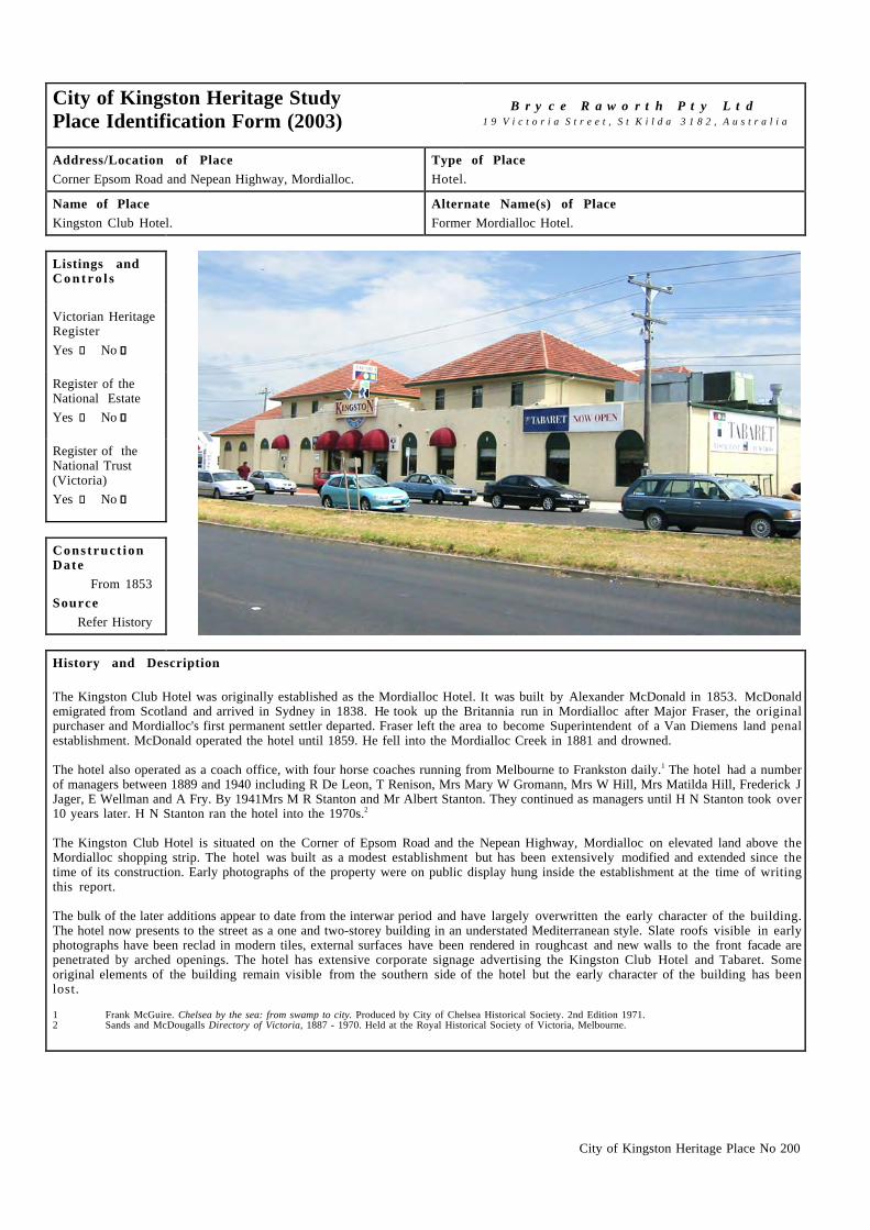
City of Kingston Heritage Place No 200
City of Kingston Heritage StudyPlace Identification Form (2003)
B r y c e R a w o r t h P t y L t d1 9 V i c t o r i a S t r e e t , S t K i l d a 3 1 8 2 , A u s t r a l i a
Address/Location of PlaceCorner Epsom Road and Nepean Highway, Mordialloc.
Type of PlaceHotel.
Name of PlaceKingston Club Hotel.
Alternate Name(s) of PlaceFormer Mordialloc Hotel.
Listings andC o n t r o l s
Victorian HeritageRegisterYes c No g
Register of theNational EstateYes c No g
Register of theNational Trust(Victoria)Yes c No g
Construct ionDate
From 1853Source
Refer History
History and Description
The Kingston Club Hotel was originally established as the Mordialloc Hotel. It was built by Alexander McDonald in 1853. McDonaldemigrated from Scotland and arrived in Sydney in 1838. He took up the Britannia run in Mordialloc after Major Fraser, the originalpurchaser and Mordialloc's first permanent settler departed. Fraser left the area to become Superintendent of a Van Diemens land penalestablishment. McDonald operated the hotel until 1859. He fell into the Mordialloc Creek in 1881 and drowned.
The hotel also operated as a coach office, with four horse coaches running from Melbourne to Frankston daily.1 The hotel had a numberof managers between 1889 and 1940 including R De Leon, T Renison, Mrs Mary W Gromann, Mrs W Hill, Mrs Matilda Hill, Frederick JJager, E Wellman and A Fry. By 1941Mrs M R Stanton and Mr Albert Stanton. They continued as managers until H N Stanton took over10 years later. H N Stanton ran the hotel into the 1970s.2
The Kingston Club Hotel is situated on the Corner of Epsom Road and the Nepean Highway, Mordialloc on elevated land above theMordialloc shopping strip. The hotel was built as a modest establishment but has been extensively modified and extended since thetime of its construction. Early photographs of the property were on public display hung inside the establishment at the time of writingthis report.
The bulk of the later additions appear to date from the interwar period and have largely overwritten the early character of the building.The hotel now presents to the street as a one and two-storey building in an understated Mediterranean style. Slate roofs visible in earlyphotographs have been reclad in modern tiles, external surfaces have been rendered in roughcast and new walls to the front facade arepenetrated by arched openings. The hotel has extensive corporate signage advertising the Kingston Club Hotel and Tabaret. Someoriginal elements of the building remain visible from the southern side of the hotel but the early character of the building has beenlost.
1 Frank McGuire. Chelsea by the sea: from swamp to city. Produced by City of Chelsea Historical Society. 2nd Edition 1971.2 Sands and McDougalls Directory of Victoria, 1887 - 1970. Held at the Royal Historical Society of Victoria, Melbourne.

City of Kingston Heritage Place No 200
C o n d i t i o n
Excellent g Good c Fair c Poor c Ruins c
I n t e g r i t y
Substantially Intact c Altered Sympathetically c Altered Unsympathetically g Damaged/Disturbed c
Comparable examples within the City of Kingston
The principal comparative example within the City of Kingston is Doyles Bridge Hotel, also located on the Nepean Highway atMordialloc but built around 20 years later. The Doyles Hotel and the Kingston Hotel act as bookends to the Mordialloc shopping strip.Both are notable buildings with associations to the early history of Mordialloc and both have been extensively extended and modifiedover time.
Statement of Significance
Although, considerably altered, the Kingston Club Hotel on Nepean Highway, Mordialloc is of historical, social and somearchitectural significance at a local level. The place is socially significant as a focus of the local community since 1859 and i tcontinues its historical and valued use as a hotel. It is historically significant as the earliest extant hotel in Mordialoc and fabric at thecentre of the building is believed to be amongst the oldest in the area. The building is also of some architectural significance, primarilyfor its landmark presence on the highway.
Recommendat ions
A heritage overlay is recommended for the building. It should be noted that the significance of the building relates primarily to thehistoric use of the building and that interventions, which relate to the later physical fabric only are unlikely to affect that significance.Current and future owners should be encouraged to restore the early appearance of the building should the opportunity arise.
City of Kingston Planning Scheme
Recommended for inclusion in a heritage overlay to the Planning Scheme Yes g No c
Should external paint controls apply? Yes g No c
Should internal alteration controls apply? Yes c No g
Should tree controls apply? Yes c No g
Other Listings and Controls
Recommended for inclusion on the Victorian Heritage Register? Yes c No g
Recommended for inclusion on the Register of the National Estate? Yes c No g
Recommended for inclusion on the National Trust (Victoria) Register? Yes c No g

City of Kingston Heritage Place No 215
City of Kingston Heritage StudyPlace Identification Form (2001)
B r y c e R a w o r t h P t y L t d1 9 V i c t o r i a S t r e e t , S t K i l d a 3 1 8 2 , A u s t r a l i a
Address/Location of PlaceCorner of McDonald & Barkly Streets, Mordialloc.
Type of PlaceChurch & Hall.
Name of PlaceSt Andrews Presbyterian Church & Mc Indoe Hall.
Alternate Name(s) of PlaceSt Andrews Mordialloc.
Listings andC o n t r o l s
Victorian HeritageRegisterYes c No g
Register of theNational EstateYes c No g
Register of theNational Trust(Victoria)Yes c No g
Construct ionDate
Church 1887-9Hall 1907-8
SourceRefer History
History and Description
Presbyterians first worshipped in the City of Kingston area at the Cheltenham Church. The first services at Mordialloc were held in1885 in the original Church of England Church. Land was set aside for a Presbyterian Church, a Church of England Church and aPrimary School between Barkly, Albert and McDonald Streets. Two acres were set aside for the Presbyterian Church. The Presbyterianssold one acre to pay for the construction of the present church. The rest of the money was raised by the congregation through donation(the church was debt free by 1912). When services in St Andrews Church began in 1887 it was part of the United Charge of Cheltenham,Mentone and Mordialloc. The church was officially opened in 1889.
By 1905 the church had grown to 50 communicant members, had a Sunday school and engaged in community outreach. The parish ofMordialloc/Carrum had their own minister by 1908. Around this time, the Sunday School Hall, later known as McIndoe Hall, was built.Extensions were made to the hall in 1910, more than doubling its size. In 1914 a porch was added. From this time until at least the1950s the hall was used by the Education Department during the week and by the church on the weekend. A Baby Health Centre andvarious clubs and societies also met in the hall. A Kindergarten hall was built adjacent to the Sunday School Hall was completed in1924. The two halls - Kindergarten and Primary - were extended again in the 1950s and 1960s to cater for the increasing numbers.
A manse was constructed in c.1925 for the minister on church land in Barkly Street. This manse was used until 1967 when it was sold tothe Education Department for extensions to the nearby primary school. A temporary Manse was established in Connell StreetMordialloc until another house in Barkly Street was purchased the mid 1970s.
Since 1925 the church has been known as St Andrews Mordialloc. By 1937 the congregation numbered 138. In 1953 the interior of thechurch was renovated and some plaster due to alleviate ongoing seepage troubles. The church had paid off all of the debt accumulatedthrough the construction of the Manses and Halls by 1971 and was considering constructing an elderly person’s village. However thisturned out to be too expensive. So the land (on the church site) was developed into 18 Housing Commission units and the land wasleased from the church to provide additional income.
During the late 1950s St Andrews was considering a possible union with the Mordialloc Methodist church but this did not eventuate. StAndrews also later voted against becoming part of the Uniting church of Australia in 1977.1

City of Kingston Heritage Place No 215
History and Description (continued)
This symmetrical church building dominates its corner site. It adopts a simple gable-ended form with a porch to the McDonald Streetfaçade. The building draws its inspiration from Gothic Revival sources with pointed lancet windows, buttresses and a steep slate roofwith transverse vents. Decorative detailing is simple and elegant, with understated mouldings and decorative iron wall grates. Theoriginal brick exterior of the church was cement rendered in 1910 to help to prevent seepage. The exterior of the church was cleaned,patched and repainted in 1984 and the seepage problem, which had reoccurred throughout the church’s history was rectified. The churchhas recently been painted in a bright white. The church roof was re-slated in 1919. McIndoe Hall and other modest weatherboardstructures to the rear of the church adopt a simple gable-ended form in sympathy with the style the church.
The National Trust (Vic) examined this building with a view to its registration in 1988. It chose not to proceed with registration at thattime. It still maintains a file on this building. 2
1 Unless noted otherwise this extract is drawn from, Saint Andrews’ Presbyterian Church Mordialloc Centenary 1884 – 1984. Produced by Church, 1984. P.9-30.
2 St Andrews Presbyterian Church Mordialloc. National Trust File No.B2225. Held at National Trust (Victoria) Offices.
C o n d i t i o n
Excellent c Good g Fair c Poor c Ruins c
I n t e g r i t y
Substantially Intact c Altered Sympathetically g Altered Unsympathetically c Damaged/Disturbed c
Comparable examples within the City of Kingston
St Andrews shares some features with the Wickham Road Uniting Church in Moorabbin (1867) such as the general rectangular gableroofed form and plain rendered surface. Both churches have buttresses and simple label moulds over the windows.
Statement of Significance
Constructed in 1887, St Andrews church, Mordialloc is of architectural, social and spiritual significance at a local level. It i sarchitecturally significant as an early and notable example of nineteenth century Gothic revival architecture. The church hall datingfrom 1928 is designed in a sympathetic manner and adds to the significance of the site as a whole. The group is socially and spirituallysignificant as the focus of worship for the local Presbyterian congregation.
McIndoe Hall (1908) with additions (1910) and porch (1914).
Recommendat ions
A heritage overlay is recommended for the site although the primary significance is associated with the church building dating from1887 and the later timber additions to the rear.

City of Kingston Heritage Place No 215
City of Kingston Planning Scheme
Recommended for inclusion in a heritage overlay to the Planning Scheme Yes g No c
Should external paint controls apply? Yes g No c
Should internal alteration controls apply? Yes c No g
Should tree controls apply? Yes c No g
Other Listings and Controls
Recommended for inclusion on the Victorian Heritage Register? Yes c No g
Recommended for inclusion on the Register of the National Estate? Yes c No g
Recommended for inclusion on the National Trust (Victoria) Register? Yes c No g

City of Kingston Heritage Place No 209
City of Kingston Heritage StudyPlace Identification Form (2001)
B r y c e R a w o r t h P t y L t d1 9 V i c t o r i a S t r e e t , S t K i l d a 3 1 8 2 , A u s t r a l i a
Address/Location of Place58 Barkly Street or 71 – 79 Albert Street, Mordialloc.
Type of PlaceSchool.
Name of PlaceMordialloc Primary School.
Alternate Name(s) of PlaceMordialloc School No.846.
Listings andC o n t r o l s
Victorian HeritageRegisterYes c No g
Register of theNational EstateYes c No g
Register of theNational Trust(Victoria)Yes c No g
Construct ionDate
from 1884Source
Refer History
History and Description
In 1865, a Committee of Parents (William Coleman, Hugh Brown, James McMahon, Albert MacDonald and the Rev John Hitchin ofthe Church of England) requested that the Board of Education establish a school in their district. £50 was granted towards theconstruction of a timber building, which became Common School No 846. It stood in an acre of Crown Land. At the official openingon 6th January 1868, the school population comprised thirty-six pupils (22 boys and 14 girls) ranging in age from four to fifteenyears. The first teacher was Mrs Rebecca Waugh and struggling locals were required to find a weekly fee of between 6d and 1s for herservices. Mrs Waugh, having difficulty in obtaining board, asked that a residence be built but resigned in 1869, prior to itscompletion. She was succeeded by Mr Hesketh, JH Potts, Robert Riggs and Thomas (Boss) Miller who served for twenty-three yearsfrom 1906.
In 1882, the coming of the railway brought about an increase in enrolments. Early in 1884 a 40'x20' brick building was completed,part of it later being incorporated into the extant main building. By 1888, the enrolment had risen to 100, the six classes beingconducted in one room by the head teacher and two staff. Steadily increasing enrolment necessitated the erection of another room andlater, the use of a room in the teachers residence and one of the corridors as temporary classrooms. During 1918-19 a second storey wasadded to the 1884 building and an acre of additional grounds were compulsorily acquired from the adjacent Church of England. In 1953,following rapid development of the area, land was acquired on the opposite side of Barkly Street. Two aluminum prefabricatedclassrooms followed by a wooden unit of two classrooms were erected on the site. Some years later, four new timber rooms wereconstructed in the main yard. While this arrangement solved the accommodation problems, it reduced the already limited outdoor spacefor a student population numbering 700. In 1963, work began on a library and canteen building. In 1967, the purchase of theneighbouring Presbyterian manse site helped relieve the crowded playground. The school celebrated its centenary in 1968.1

City of Kingston Heritage Place No 209
History and Description (continued)
This two-storey school adopts an understated Arts and Crafts character. The building presents subtly differing elevations to Barkly andAlbert Streets. The back of the school (Barkly Street side) has red brick walls with a contrasting cream brick base course and renderedtrims. The windows are multi-paned timber framed and the central window has a scroll figured label mould above it. The roof is tiled andfeatures stepped brickwork at the bases of the chimneys. To the station (Albert Street) side (the original front of the school), thebuilding also has polychrome brick banding and tuckpointing. The face bricks on this wall are hawthorn bricks, while red bricks areused for the corners and chimneys. The ground floor windows have timber-bracketed awnings above them. The cream brick has degradedsomewhat, as has the mortar on the station side of the building, but the building is generally in good condition.
Although the building developed over a period of thirty-five years, the resulting building presents as a handsome and remarkablycoherent example of early twentieth century school design.
1 This reference is drawn with minor editing from, Education Department of Victoria, Vision and Realisation: A Centenary History of State Education in Victoria,Vol III, Melbourne, 1973.
C o n d i t i o n
Excellent c Good g Fair c Poor c Ruins c
I n t e g r i t y
Substantially Intact c Altered Sympathetically g Altered Unsympathetically c Damaged/Disturbed c
Comparable examples within the City of Kingston
Other comparable school buildings identified by this study include the original sections of the Mentone Primary School (1889) andChelsea Primary Schools (1912). Both have red brick with tiled roofs and rendered trims in common with the subject building. Bothemploy simple stepped massing as a means of integrating additions and extensions into a unified architectural composition.
Statement of Significance
Constructed over a number of building programs from 1882, the principal building of the Mordialloc Primary School is ofarchitectural, historical and social significance at a local level. It is architecturally significant as a handsome and early example of aschool design prepared by the Public Works Department. It is of some historical significance for its associations with the earlydevelopment of the area. It is socially significant for its long association with the local community.
West (Albert Street) elevation.
Recommendat ions
A heritage overlay is recommended for the original building and additions up to the 1919 works.

City of Kingston Heritage Place No 209
City of Kingston Planning Scheme
Recommended for inclusion in a heritage overlay to the Planning Scheme Yes g No c
Should external paint controls apply? Yes g No c
Should internal alteration controls apply? Yes c No g
Should tree controls apply? Yes c No g
Other Listings and Controls
Recommended for inclusion on the Victorian Heritage Register? Yes c No g
Recommended for inclusion on the Register of the National Estate? Yes c No g
Recommended for inclusion on the National Trust (Victoria) Register? Yes c No g

City of Kingston Heritage Place No 210
City of Kingston Heritage StudyPlace Identification Form (2001)
B r y c e R a w o r t h P t y L t d1 9 V i c t o r i a S t r e e t , S t K i l d a 3 1 8 2 , A u s t r a l i a
Address/Location of PlaceCorner Bear & Albert Street, Mordialloc.
Type of PlaceRailway Station.
Name of Place Mordialloc Railway Station.
Alternate Name(s) of PlaceNone.
Listings andC o n t r o l s
Victorian HeritageRegisterYes c No g
Register of theNational EstateYes c No g
Register of theNational Trust(Victoria)Yes c No g
Construct ionDate
From 1882Source
Refer History
History and Description
The first railway lines were laid in Melbourne in the 1850s and linked inner southern suburbs and places like Geelong and Bendigo tothe city. All lines came under the umbrella of the Victorian Railways in the 1880s and it was generally accepted that the railwaysbrought prosperity and development to an area. Development of the Frankston line began in 1859 when the line was extended toCaulfield Station. Development to Bentleigh (then called East Brighton), Moorabbin (then called South Brighton), Cheltenham andMentone (then called Balcombe Road) soon followed when the line was extended from Caulfield to Mordialloc in 18811 and then toFrankston in 1882. Stations opened at Chelsea in 1907, Edithvale in 1919 and Bonbeach in 1926. The arrival of the railway helped tostimulate development of residential and commercial areas along the line. The railway became electric in 1922.2
The Mordialloc Railway Station is located on the Frankston railway line between Parkdale and Aspendale Stations. Mordialloc RailwayStation consists of two buildings on opposite sides of the track. On the west is the Upside building (1882, see photo last page) and onthe east is the Downside building (1887, pictured above). The first station buildings at Mordialloc were temporary portable woodenrooms. Tenders were called for the design of permanent station buildings including a station office and Station Master’s residence inAugust 1881. The plans were drawn up by R Ford of the Railways Department. However, the Commissioner for Railways, the HonThomas Bent found the design too expensive and a new architect was called in to design the station. The commissioner used S EBindley of the Education department to design the new stations along the Frankston line. The stations were designed in a ‘GardenCottage’ style as this was estimated to be £500 cheaper. Tenders for construction of the project were called in December 1881. Thesuccessful tenderer was William Chaffer who began work on the Mordialloc building in February 1882 but work was not completed untilJuly that year due to delays. The building cost £784 to build.3 The Downside building was constructed by the builder S Young in 1887.4
The opening of the railway line encouraged a great housing and commercial boom in Mordialloc. The town developed rapidly from whatwas a ‘dreary waste’ to a ‘very presentable’ place.5 By 1913/14 the railway was carrying over 320 000 passengers annually, comparedto 113 000 passengers in 1904/05.6

City of Kingston Heritage Place No 210
History and Description (continued)
The Upside building (pictured over page) is representative of the ‘cottage’ style typical of all the early 1880s station houses along thisline.7 The building is detailed in a mix of the Boom and Late Victorian styles. The cottage style buildings were designed so thattravelers entered through a central doorway and proceeded to one side to the booking office. On the other side was a ladies waiting roomand access to the toilets across the yard. The toilets were located away from the building for hygiene reasons. In addition to the ladieswaiting room, travelers gathered in the large booking hall.8 The buildings were symmetrical with the two gables either side of a centralentry covered by a wide verandah. They were decorated with timber barge boards, iron gable top finials and polychrome brickchimneys. The verandahs had iron lacework and brackets.9 Later additions to the south end have more than doubled the building in size.The alterations included a new booking lobby, enlargement to the Station Master’s office (created by absorbing the original bookinglobby) and roadside verandah areas. Two rooms at the Up end were converted into a bicycle shed.10 Other changes to the buildingincluded the replacement of the original slate tile roofing with iron in 1984, removal of entries and various signal boxes located atvarious times on the level crossing, in the original ladies waiting room and in the former entry.1 1
The Downside building is broadly Late Victorian in style and has a gable roof with decorative cross bracing in the gable, weatherboardwall cladding and a wide verandah. It was originally a shelter shed but it has since been divided into a general waiting area, ladieswaiting room, ladies toilets and men’s toilets. Some reorganisation has been undertaken to the original toilets to provide both maleand female toilets and a room has been added to the Down end of the building. Some of the original decoration has been removedincluding decorative cross bracing in the end gable but the rest is in good condition. This building differs from others on the line inthat it is not based on a standard plan.1 2
The buildings retain their early relationship with the Water tower (1910) which dates from the steam days of the railway. This tower i scovered fully in Place No 211 – Mordialloc Railway Station Water Tower in stage one of the City of Kingston Heritage Study.
1 This reference is drawn with minor editing from, Barnard & Sheehan, City of Kingston Heritage Study, Stage I, pp.38 – 42.2 This reference is drawn with minor editing from, Barnard & Sheehan, City of Kingston Heritage Study, Stage I, pp.38 – 42.3 From information provided by Des Jowett on the 27 March 2002. Taken from Victorian Parliamentary Debates (various), Victorian Parliamentary Papers 1883
(Reports relating to Railway Contracts & Conduct of Hon T. Bent), Final Returns, Victorian Railways Contracts, Public Records Office Victoria – VictorianRailways Correspondence, Electrification Committee.
4 A. Ward & A. Donnelly. (In association with the Australian Railway History Society). Victoria’s Railway Stations. An Architectural Survey (Vols. 1- 4), 1982. 5 Ibid. p.39.6 Ibid. p.41.7 Ibid. p.38.8 A. Ward & A. Donnelly. Op cit.9 A. Ward & A. Donnelly. Op cit.1 0 A. Ward & A. Donnelly. Op cit.1 1 Des Jowett. Op cit.1 2 A. Ward & A. Donnelly. Op cit.
C o n d i t i o n
Excellent c Good g Fair c Poor c Ruins c
I n t e g r i t y
Substantially Intact g Altered Sympathetically c Altered Unsympathetically c Damaged/Disturbed c
Comparable examples within the City of Kingston
The Upside building at Mordialloc Railway Station is comparable to several others along the Frankston line which were built to thesame standard plan in around 1882. Of the nine stations designed in the ‘Garden Cottage’ style only three remain: Mordialloc,Cheltenham (Downside) and Highett. This is one of the earliest examples of standardised design for suburban railway use. The standardplan of a central lobby, booking office to one side and ladies waiting room to the other side is also found in the St Arnaud style plan,although this is a more elaborate example.1 Each station has been altered differently over the years but they generally remain legible asan early group. The Downside building has evolved uniquely over the years and appears to be the only one of this type along theFrankston line, perhaps in the City of Kingston.1 3
1 3 A. Ward & A. Donnelly (In association with the Australian Railway History Society). Victoria’s Railway Stations. An Architectural Survey (Vols. 1- 4), 1982..
Statement of Significance
Constructed in 1882 and 1887, the buildings at the Mordialloc railway station are of are historical, architectural, technical, and socialsignificance at a state level. The buildings are historical significance for their role in the development of the local area and the areassoutheast of the City generally through the late nineteenth century. They are architecturally significant as part of a small group ofextant stations along the Frankston line in the ‘Garden Cottage’ style. In addition, the structures at Mordialloc railway station are moreintact than other stations along the Frankston line and retain their early relationship with the railway water tower. The structures andthe complex generally demonstrate the technical advance of rail transport. The station is of local significance for its long associationwith the local community.

City of Kingston Heritage Place No 210
View of Upside Station Building (1882) showing double gable roof, wide verandah and long rectilinear form
Recommendat ions
A heritage overlay is recommended for both the Upside building (1882) and the Downside building (1887).
City of Kingston Planning Scheme
Recommended for inclusion in a heritage overlay to the Planning Scheme Yes g No c
Should external paint controls apply? Yes g No c
Should internal alteration controls apply? Yes c No g
Should tree controls apply? Yes c No g
Other Listings and Controls
Recommended for inclusion on the Victorian Heritage Register? Yes g No c
Recommended for inclusion on the Register of the National Estate? Yes g No c
Recommended for inclusion on the National Trust (Victoria) Register? Yes g No c

City of Kingston Heritage Place No 211
City of Kingston Heritage StudyPlace Identification Form (2001)
B r y c e R a w o r t h P t y L t d1 9 V i c t o r i a S t r e e t , S t K i l d a 3 1 8 2 , A u s t r a l i a
Address/Location of PlaceCnr Bear & Albert Street, Mordialloc.
Type of PlaceWaterwork/Tower/Tank.
Name of PlaceMordialloc Railway Water Tower.
Alternate Name(s) of PlaceNone.
Listings andC o n t r o l s
Victorian HeritageRegisterYes c No g
Register of theNational EstateYes c No g
Register of theNational Trust(Victoria)Yes g No c
Construct ionDate
1911/12Source
Refer History
History and Description
Before the Frankston line became electric in 1922, passenger and goods trains were powered by steam. The water supply at Frankstonwas unreliable so a water tower was needed at Mordialloc. Prior to the construction of the water tower pictured above, there was a 6000gallon water tank at Mordialloc, however this was inadequate so the new 20 000 gallon tank was built.1
The Mordialloc railway water tower was built by James Younger in 1911/12. He was the successful tenderer with a price of £428 onNovember 9 1911. However construction ended up costing only £392 when the tower was completed in March the following year.2 It i sa reinforced concrete and brick tower situated within the railway station grounds in Albert Street Mordialloc. The structure takes theform of an inverted cone with a capacity of over 100,000 litres. It is carried on a circular brick base with corbelled cap and plain frieze,the uppermost course being bluestone. There is a timber access door with a bluestone lintel.3
The Mordialloc railway water tower was registered by the National Trust of Australia (Victoria) in February 1990 (reference No.B5123).It is in good, original condition.
1 From information provided by Des Jowett on the 27 March 2002. Taken from Victorian Parliamentary Debates (various), Victorian Parliamentary Papers 1883(Reports relating to Railway Contracts & Conduct of Hon T. Bent), Final Returns, Victorian Railways Contracts, Public Records Office Victoria – VictorianRailways Correspondence, Electrification Committee.
2 Des Jowett. Op cit.3 This reference is drawn from, National Trust of Australia (Victoria), online citation, Water Tower - Mordialloc Railway Station, www.nattrust.com.au.
C o n d i t i o n
Excellent c Good g Fair c Poor c Ruins c
I n t e g r i t y
Substantially Intact g Altered Sympathetically c Altered Unsympathetically c Damaged/Disturbed c
City of Kingston Heritage Place No 211
Comparable examples within the City of Kingston
No comparable examples exist within the City of Kingston or within the broader railway network of the State of Victoria. The tower i sthe last remaining example from a small group of Edwardian towers of this design. The last other known example of a water tower ofthis type was demolished at Dandenong in January 1964.4
4 This reference is drawn from, National Trust of Australia (Victoria), online citation, Water Tower - Mordialloc Railway Station, www.nattrust.com.au.
Statement of Significance
The Mordialloc railway water tower was built by James Younger in 1910. It is of state historical and technical significance. The toweris the last remaining example from a small group of Edwardian towers of this design and makes a unique contribution to anunderstanding of contemporary railway water towers. The structure is of local architectural significance for its landmark presence.
Recommendat ions
A heritage overlay is recommended for this structure.
City of Kingston Planning Scheme
Recommended for inclusion in a heritage overlay to the Planning Scheme Yes g No c
Should external paint controls apply? Yes g No c
Should internal alteration controls apply? Yes g No c
Should tree controls apply? Yes c No g
Other Listings and Controls
Recommended for inclusion on the Victorian Heritage Register? Yes g No c
Recommended for inclusion on the Register of the National Estate? Yes g No c

City of Kingston Heritage Place No 202
City of Kingston Heritage StudyPlace Identification Form (2003)
B r y c e R a w o r t h P t y L t d1 9 V i c t o r i a S t r e e t , S t K i l d a 3 1 8 2 , A u s t r a l i a
Address/Location of PlaceAlbert Street, Mordialloc.
Type of PlaceAssembly Hall.
Name of PlaceNone.
Alternate Name(s) of PlaceFormer Mordialloc Masonic Lodge.
Listings andC o n t r o l s
Victorian HeritageRegisterYes c No g
Register of theNational EstateYes c No g
Register of theNational Trust(Victoria)Yes c No g
Construct ionDate
1925Source
Refer History
History and Description
Freemasonry is one of the world’s oldest fraternal societies. Through the middle ages, it comprised itinerant skilled stonemasons.More recently, the society has attracted a broader range of business and professional men concerned with moral and spiritual values andthe pursuit of a way of life consistent with their religious, family and community affiliations. Freemasons typically meet at a lodge, aterm derived from the medieval English word used to describe the temporary buildings erected by Masons alongside their constructionprojects.1
The planning permit and finance for the former Masonic Lodge building in Albert Street Mordialloc were confirmed on 19 May 1924.Blackett and Forster were the architects for the project and L Butterworth was the builder. Both were the lowest tenderers. The buildingwas completed in 1925.2 The unusual form of the lodge was a response to the particular needs of the society. The large entrance foyerand hall to the ground floor were semi public areas, in which social events with members' partners and non-members could be held. Thefoyer housed the grand staircase to the upper floor which contained the 'members only' areas. The ground floor hall was temporarilyused as a courthouse and as meeting rooms for the Mordialloc Tourist and Publicity Association in 1929.3
The popularity of Freemasonry began to dwindle in the 1990s and the temples at Chelsea, Mordialloc, Dandenong and Springvale wereamalgamated in order to build a temple at Keysborough. The lodge was sold at that time and a dance group is now using the building.4
The former Masonic lodge is situated in Albert Street near the Mordialloc train station. The building is comprised of two distinctelements, namely a simple rectilinear entry block to the street with the main body of the lodge expressed as a two storey gable-endedstructure to the rear. Both elements are finished in red brick with understated rendered detail drawn from Classical sources. The buildingis accessed by way of a large single storey entry featuring columns in antis. Smooth quoining extends across the facade as renderedbanding to form a substantial base to the building. The two-storey section of the building is a straightforward gable ended structurewith decorative quoins to corners and a garlanded decorative detail to the roof ventilator. Two brick rendered chimneys survive on thenorth and south of the building. Windows are simple but are enhanced with decorative cement panels under the windows (one of whichhas been removed). The building has a large balcony located above the main entry foyer and accessed from the first floor. Doors to thebalcony take the form of a Serlian window with timber stairs to the terrace below.

City of Kingston Heritage Place No 202
History and Description (continued)
It is evident that there have been few changes to the building. The timber stairs from the members' areas to the balcony have beenrecently replaced and it is unclear whether these reproduce the form of an earlier element. As noted earlier, one decorative panel below awindow to the principal facade has been removed, front doors and window joinery above the doors has been replaced. Otherwise thebuilding retains a high degree of integrity to its original state. The building is unusual for its retention of original rendered surfaces inan unpainted condition.
1 http://www.freemasonryaust.org.au/freemason.html.2 Conversation with Peter Thurnton archivist Masonic Lodge, East Melbourne, 3rd February 2003.3 Cheltenham Gazette, 15th June 1929, p.3-5.4 Conversation with Peter Thurnton archivist Masonic Lodge, East Melbourne, 3rd February 2003.
C o n d i t i o n
Excellent c Good g Fair c Poor c Ruins c
I n t e g r i t y
Substantially Intact g Altered Sympathetically c Altered Unsympathetically c Damaged/Disturbed c
Comparable examples within the City of Kingston
No comparable examples were noted within the Municipality during the preparation of this report.
Statement of Significance
The former Freemasons hall in Albert Street, Mordialloc, is of architectural and social significance at a local level. It is as a handsomeexample of an unusual building type designed expressly to meet the needs of the Freemasons. The building is of some note for itsassociations with professional and business activity within the Mordialloc area during the twentieth century.
Recommendat ions
A heritage overlay is recommended for the building.
City of Kingston Planning Scheme
Recommended for inclusion in a heritage overlay to the Planning Scheme Yes g No c
Should external paint controls apply? Yes g No c
Should internal alteration controls apply? Yes c No g
Should tree controls apply? Yes c No g
Other Listings and Controls
Recommended for inclusion on the Victorian Heritage Register? Yes c No g
Recommended for inclusion on the Register of the National Estate? Yes c No g
Recommended for inclusion on the National Trust (Victoria) Register? Yes c No g

City of Kingston Heritage Place No 216
City of Kingston Heritage StudyPlace Identification Form (2001)
B r y c e R a w o r t h P t y L t d1 9 V i c t o r i a S t r e e t , S t K i l d a 3 1 8 2 , A u s t r a l i a
Address/Location of Place9 Bear Street, Mordialloc.
Type of PlaceChurch.
Name of PlaceSt Nicholas' Church of England.
Alternate Name(s) of PlaceSt Nicholas' Anglican Church.
Listings andC o n t r o l s
Victorian HeritageRegisterYes c No g
Register of theNational EstateYes c No g
Register of theNational Trust(Victoria)Yes c No g
Construct ionDate
1922Source
Refer History
History and Description
The first church of St Nicholas in Mordialloc was built in 1874. It served the local community until the present church was completedin 1922. After this time the earlier building was moved to a new site and used as a parish hall until the 1970s.1
Louis Williams designed St Nicholas’ in 1919 in the closing years of his partnership with Alexander North. North retired in 1921before the construction of this building began and the design is generally attributed to Williams alone.2 The unusual design of thischurch adopts an Arts and Crafts Gothic mode. It may draw its inspiration from RA Cram’s influential text Church Building althoughWilliams’ approach is more austere than Cram’s picturesque illustrations.3 St Nicholas’ embodies Cram’s approach to country chapeldesign and the belief that the use of honest, durable materials could give rise to a new mode of ecclesiastical architecture.4 Thefoundation stone of the church was laid on the 15th of September 1922 by the then Archbishop of Melbourne, Barrington C Lees. CRCull is noted as the builder. The cost for construction was £3277, however construction was never completed due to financialconstraints. Timber and glass walls were constructed in the side archways as a temporary measure and these still remain. Theincomplete church has never been consecrated. Plans are in place to complete and expand the church and to have it consecrated in thenear future.5
This striking red brick building is of note for its studied asymmetry. It features a battered tower, ogee arches and stylised gabletreatment. Subtle brick banding on the façade is achieved using courses of double sized bricks. The eastern elevation features widearches with timber infill, which contribute to the Arts and Crafts character of the place. The western elevation has more traditionalGothic features emphasised by the lancet windows, buttresses and label moulding.
1 From information provided by Colin Duggan. Church Warden. [email protected] G Marie Moore, ‘Louis Reginald Williams’ (2 vols., thesis submitted for MPD, University of Melbourne, 2001).3 As identified by G Marie Moore, op cit.: RA Cram. Church Building: A Study of the Principles of Architecture in Relation to the Church, Boston, 1914 (3rd
Edition).4 RA Cram. Op cit. p.13 and p.16.5 Colin Duggan. Op cit.
C o n d i t i o n
Excellent c Good g Fair c Poor c Ruins c

City of Kingston Heritage Place No 216
I n t e g r i t y
Substantially Intact g Altered Sympathetically c Altered Unsympathetically c Damaged/Disturbed c
Comparable examples within the City of KingstonThere are no comparable churches within the City of Kingston. This building is somewhat unique in the metropolitan area. LouisWilliams' later St Stephen's (1926-7) at Darebin in Heidelberg City is similar in style and use of form. That church also incorporatesboldly abstracted masses, battered walls, sheer brick surfaces and depressed arched windows into its design. St Stephens has beenidentified as being of State significance by The National Trust (Vic) as being an outstanding example of Williams' work.6 Williams i sbelieved to have constructed another church to a similar design at Gilgandra in New South Wales but this structure has subsequentlybeen modified.7
6 Miles Lewis (Ed). Victorian Churches: Their origins, their story & their architecture. National Trust of Australia (Victoria), 1991, p. 747 From information provided by Colin Duggan. Church Warden. [email protected]
Statement of SignificanceConstructed in 1922 to designs by Louis Williams, St Nicholas' Church, Mordialloc is of local and potentially state significance. It i sof architectural significance as an example of the Arts & Crafts Gothic work of Louis Williams and predates his highly valued andbroadly similar design for St Stephens, Darebin by four or five years. The church is of social and spiritual significance for its ongoingassociations with the local Anglican community.
Left: East facing elevation showing arches with timber infill. Right: West facing elevation showing flat buttresses, lancet archedwindows and label mould above door.
Recommendat ionsA heritage overlay is recommended for the building. Consideration should be given to its nomination to the various heritage registersnoted below. Completion of the church to William's original design would not diminish the significance of the building.
City of Kingston Planning Scheme
Recommended for inclusion in a heritage overlay to the Planning Scheme Yes g No c
Should external paint controls apply? Yes g No c
Should internal alteration controls apply? Yes c No g
Should tree controls apply? Yes c No g
Other Listings and Controls
Recommended for inclusion on the Victorian Heritage Register? Yes g No c
Recommended for inclusion on the Register of the National Estate? Yes g No c
Recommended for inclusion on the National Trust (Victoria) Register? Yes g No c

City of Kingston Heritage Place No 194
City of Kingston Heritage StudyPlace Identification Form (2003)
B r y c e R a w o r t h P t y L t d1 9 V i c t o r i a S t r e e t , S t K i l d a 3 1 8 2 , A u s t r a l i a
Address/Location of Place11 Bear Street, Mordialloc.
Type of PlaceHouse.
Name of PlaceNone.
Alternate Name(s) of PlaceNone.
Listings andC o n t r o l s
Victorian HeritageRegisterYes c No g
Register of theNational EstateYes c No g
Register of theNational Trust(Victoria)Yes c No g
Construct ionDate
Before 1920Source
Refer History
History and Description
Directories first include the subject property in 1920 although its appearance suggests a somewhat older building. At that time, it wasoccupied by Robert K Morrison. Between 1927 and 1950 there was a succession of residents including Fredric Salva, Henry H Andrew,Jason McDonald, William Binks and Mrs AM Clark. In 1950 Bert W Wooten moved in. He occupied the house for twenty years.1
The subject house is a modest symmetrical villa with a steep corrugated iron gable roof. The simple skillion-roofed verandah is of notefor its decorative pickets at either end, known colloquially as 'lollipop sticks'. Unusually large and ornate windows are situated toeither side of the central doorway. The house features a number of decorative elements such as timber brackets under the windows andunusual cast iron awnings over the western windows. The columns and fretwork on the verandah appear to be later interventions andweatherboards to the western elevation have been replaced by modern materials. Nonetheless, the dwelling is largely intact and retainsits early much of its early character.
1 Sands and McDougalls Directory of Victoria, 1920 - 1966. Held at the Royal Historical Society of Victoria, Melbourne.
C o n d i t i o n
Excellent c Good g Fair c Poor c Ruins c
I n t e g r i t y
Substantially Intact c Altered Sympathetically g Altered Unsympathetically c Damaged/Disturbed c

City of Kingston Heritage Place No 194
Comparable examples within the City of Kingston
A number of buildings exist within the City of Kingston and the wider Melbourne metropolitan area, which broadly compare with thisearly dwelling. Similar examples found locally include 65 Tootal Road Dingley, 50 Clydebank Road Edithvale, and 210 Old DandenongRoad, Heatherton. Nonetheless, buildings of this age which demonstrate the unusual detailing found here are rare within theMunicipality.
Statement of Significance
The house at 11 Bear Street, Mordialloc is of historical and architectural significance at a local level. It is historically significant asevidence of the early development of this section of the Municipality. It is architecturally significant for its early form and the extentto which it retains early architectural features such as decorative bargeboards, awnings and window elements.
Recommendat ions
A heritage overlay is recommended for the building.
City of Kingston Planning Scheme
Recommended for inclusion in a heritage overlay to the Planning Scheme Yes g No c
Should external paint controls apply? Yes g No c
Should internal alteration controls apply? Yes c No g
Should tree controls apply? Yes c No g
Other Listings and Controls
Recommended for inclusion on the Victorian Heritage Register? Yes c No g
Recommended for inclusion on the Register of the National Estate? Yes c No g
Recommended for inclusion on the National Trust (Victoria) Register? Yes c No g
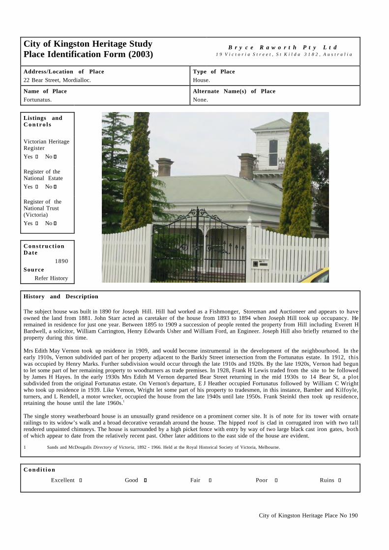
City of Kingston Heritage Place No 190
City of Kingston Heritage StudyPlace Identification Form (2003)
B r y c e R a w o r t h P t y L t d1 9 V i c t o r i a S t r e e t , S t K i l d a 3 1 8 2 , A u s t r a l i a
Address/Location of Place22 Bear Street, Mordialloc.
Type of PlaceHouse.
Name of PlaceFortunatus.
Alternate Name(s) of PlaceNone.
Listings andC o n t r o l s
Victorian HeritageRegisterYes c No g
Register of theNational EstateYes c No g
Register of theNational Trust(Victoria)Yes c No g
Construct ionDate
1890Source
Refer History
History and Description
The subject house was built in 1890 for Joseph Hill. Hill had worked as a Fishmonger, Storeman and Auctioneer and appears to haveowned the land from 1881. John Starr acted as caretaker of the house from 1893 to 1894 when Joseph Hill took up occupancy. Heremained in residence for just one year. Between 1895 to 1909 a succession of people rented the property from Hill including Everett HBardwell, a solicitor, William Carrington, Henry Edwards Usher and William Ford, an Engineer. Joseph Hill also briefly returned to theproperty during this time.
Mrs Edith May Vernon took up residence in 1909, and would become instrumental in the development of the neighbourhood. In theearly 1910s, Vernon subdivided part of her property adjacent to the Barkly Street intersection from the Fortunatus estate. In 1912, thiswas occupied by Henry Marks. Further subdivision would occur through the late 1910s and 1920s. By the late 1920s, Vernon had begunto let some part of her remaining property to woodturners as trade premises. In 1928, Frank H Lewis traded from the site to be followedby James H Hayes. In the early 1930s Mrs Edith M Vernon departed Bear Street returning in the mid 1930s to 14 Bear St, a plotsubdivided from the original Fortunatus estate. On Vernon's departure, E J Heather occupied Fortunatus followed by William C Wrightwho took up residence in 1939. Like Vernon, Wright let some part of his property to tradesmen, in this instance, Bamber and Kilfoyle,turners, and L Rendell, a motor wrecker, occupied the house from the late 1940s until late 1950s. Frank Steinkl then took up residence,retaining the house until the late 1960s.1
The single storey weatherboard house is an unusually grand residence on a prominent corner site. It is of note for its tower with ornaterailings to its widow’s walk and a broad decorative verandah around the house. The hipped roof is clad in corrugated iron with two tallrendered unpainted chimneys. The house is surrounded by a high picket fence with entry by way of two large black cast iron gates, bothof which appear to date from the relatively recent past. Other later additions to the east side of the house are evident.
1 Sands and McDougalls Directory of Victoria, 1892 - 1966. Held at the Royal Historical Society of Victoria, Melbourne.
C o n d i t i o n
Excellent c Good g Fair c Poor c Ruins c

City of Kingston Heritage Place No 190
I n t e g r i t y
Substantially Intact c Altered Sympathetically g Altered Unsympathetically c Damaged/Disturbed c
Comparable examples within the City of Kingston
A comparable dwelling exists at 6 Harkin Ave, Mentone.
Statement of Significance
The house at 22 Bear Street, Mordialloc is of historical and architectural significance at a local level. It is historically significant as anearly house which demonstrates early residential development patterns in the area, It is of architectural significance as an unusuallygrand residence on a prominent corner site and one of one of a small number of extant tower houses in the Municipality.
Recommendat ions
A heritage overlay is recommended for the building.
City of Kingston Planning Scheme
Recommended for inclusion in a heritage overlay to the Planning Scheme Yes g No c
Should external paint controls apply? Yes g No c
Should internal alteration controls apply? Yes c No g
Should tree controls apply? Yes c No g
Other Listings and Controls
Recommended for inclusion on the Victorian Heritage Register? Yes c No g
Recommended for inclusion on the Register of the National Estate? Yes c No g
Recommended for inclusion on the National Trust (Victoria) Register? Yes c No g

City of Kingston Heritage Place No 206
City of Kingston Heritage StudyPlace Identification Form (2003)
B r y c e R a w o r t h P t y L t d1 9 V i c t o r i a S t r e e t , S t K i l d a 3 1 8 2 , A u s t r a l i a
Address/Location of PlaceCorner Beach Road and Centreway, Mordialloc.
Type of PlaceHall/Cafe now Flats.
Name of PlaceFormer Pasadena Cafe.
Alternate Name(s) of PlaceFormer Pasadena Dance Hall.
Listings andC o n t r o l s
Victorian HeritageRegisterYes c No g
Register of theNational EstateYes c No g
Register of theNational Trust(Victoria)Yes c No g
Construct ionDate
c.1930Source
Refer History
History and Description
The building on the corner of Beach Road and Centreway was constructed around 1930 for use as a cafe. The first occupant was RP Fordin 1931. By 1932 JA Haberman had the cafe and in 1935 it was occupied by JE Hodgkinson. H Hewison had the cafe in 1941 and by1942 it had taken up the name ‘Pasadena Cafe’ under the proprietorship of Mrs A Cohen. Cohen occupied the cafe until the mid 1940swhen Clifford Palmer took over. By 1950 there were two cafe’s operating from the site, the Pasadena Cafe and Martini & Ganora’s Cafe,with Silvio Ganora the proprietor. However, in 1955 only the Pasadena Cafe remained. The cafe closed in the late 1950s and the sitewas converted into flats during the 1960s.1 It would appear that the cafe also offered or hosted dancing, hence its commonly knownname ‘Pasadena Dance Hall’.
The former Pasedena Dance Hall is a two storey rendered edifice on a prominent corner site. It adopts an unusual bungalow style with alow pitched roof and understated Mediterranean detailing, principally in the form of a decorative bay window and associated parapetdetail to the western facade. The building has been altered since its construction, largely through the introduction of new windowdetailing and overpainting. Nonetheless, the unusual structure retains its early form and character and survives in generally good andlargely intact condition.
1 Sands and McDougalls Directory of Victoria 1930 – 1974. Held at the Royal Historical Society of Victoria, Melbourne.
C o n d i t i o n
Excellent c Good g Fair c Poor c Ruins c
I n t e g r i t y
Substantially Intact c Altered Sympathetically g Altered Unsympathetically c Damaged/Disturbed c

City of Kingston Heritage Place No 206
Comparable examples within the City of Kingston
No comparable examples of a café and apartment building were noted during the course of this study.
Statement of Significance
The former Pasadena Dance Hall is of social, historical and architectural significance at a local level. It is architecturally significant asan unusual building combining café and residential functions. It is unusual for its bungalow stylings, normally associated with moremodest residential designs. The building is also of some social and historical significance as a built reminder of the early developmentof the area as a recreational destination.
Recommendat ions
A heritage overlay is recommended for the building.
City of Kingston Planning Scheme
Recommended for inclusion in a heritage overlay to the Planning Scheme Yes g No c
Should external paint controls apply? Yes c No g
Should internal alteration controls apply? Yes c No g
Should tree controls apply? Yes c No g
Other Listings and Controls
Recommended for inclusion on the Victorian Heritage Register? Yes c No g
Recommended for inclusion on the Register of the National Estate? Yes c No g
Recommended for inclusion on the National Trust (Victoria) Register? Yes c No g

City of Kingston Heritage Place No 193
City of Kingston Heritage StudyPlace Identification Form (2003)
B r y c e R a w o r t h P t y L t d1 9 V i c t o r i a S t r e e t , S t K i l d a 3 1 8 2 , A u s t r a l i a
Address/Location of Place11 Park Street, Mordialloc.
Type of PlaceHouse.
Name of PlaceHenwood Cottage.
Alternate Name(s) of PlaceNone.
Listings andC o n t r o l s
Victorian HeritageRegisterYes c No g
Register of theNational EstateYes c No g
Register of theNational Trust(Victoria)Yes c No g
Construct ionDate
1887Source
Refer History
History and Description
The Frankston train line was extended from Caulfield to Mordialloc in 1881 and to Frankston in 18821. The train line broughtprosperity to Mordialloc and other small coastal towns. The house at 11 Park St, Mordialloc was constructed in 1887. It is likely thatthe residence was built by or for the Henwood family who lived in the house from 1887 until 1917. It was the first house constructed inthe street and was situated on a large block of the land bounded by Chute, Park and Albert Streets. It appears that there were originallytwo houses on the block. The subject house is the second of these, which was built for Catherine Henwood but owned by MaryHenwood. There has been considerable local subdivision since the time the subject house was built2 and the area now presents as astraightforward suburban location.
In 1917 the house was sold to Mrs Catherine Bungey who owned the house until 1927 and named the house 'Parkview'. She let thehouse to Dykes S Vallance, a Railway employee3. Horace L Weeks lived in the house for a year until the Dennet family moved in 1929remaining in residence until 1935. The house was then purchased by Mrs Glady Cripps who lived there till the early 1970s.4
The residence at 11 Park Street, Mordialloc is a simple single-storey symmetrical cottage situated on a residential street overlookingthe train line. The dwelling is clad externally in weatherboards. It has a mulipaned window either side of the door and a corrugated irongabled roof. The skillion verandah has square columns. There appear to have been few alterations to the house. The fence is a relativelyrecent addition but is nonetheless sympathetic to the period and design of the house.
1 Barnard & Sheehan, City of Kingston Heritage Study, Stage I, pp.38 – 42.2 Moorabbin Rate Books, Victorian Archives, 99 Shiel Street, North Melbourne, Years – 1888, 1891, 1901, 1906, 19133 Moorabbin Rate Books, Victorian Archives, 99 Shiel Street, North Melbourne, Years – 19184 Sands and McDougalls Directory of Victoria, 1887 - 1970. Held at the Royal Historical Society of Victoria, Melbourne.
C o n d i t i o n
Excellent c Good g Fair c Poor c Ruins c

City of Kingston Heritage Place No 193
I n t e g r i t y
Substantially Intact g Altered Sympathetically c Altered Unsympathetically c Damaged/Disturbed c
Comparable examples within the City of Kingston
A number of residences exist within the City of Kingston, which compare with this early dwelling. Similar local examples include 65Tootal Road Dingley, 50 Clydebank Road Edithvale, 210 Old Dandenong Road Heatherton, 9 Walkers Rd Carrum and 11 Bear StreetMordialloc.
Statement of Significance
The house at 11 Park Street, Mordialloc is of historical and architectural significance at a local level. It is historically significant asone of a small number of extant houses constructed in response to the construction of the railway link to Mordialloc. Althoughsomewhat altered, the building retains some architectural significance as a consequence of its early form and detailing.
Recommendat ions
A heritage overlay is recommended for the building.
City of Kingston Planning Scheme
Recommended for inclusion in a heritage overlay to the Planning Scheme Yes g No c
Should external paint controls apply? Yes g No c
Should internal alteration controls apply? Yes c No g
Should tree controls apply? Yes c No g
Other Listings and Controls
Recommended for inclusion on the Victorian Heritage Register? Yes c No g
Recommended for inclusion on the Register of the National Estate? Yes c No g
Recommended for inclusion on the National Trust (Victoria) Register? Yes c No g

City of Kingston Heritage Place No 223
City of Kingston Heritage StudyPlace Identification Form (2001)
B r y c e R a w o r t h P t y L t d1 9 V i c t o r i a S t r e e t , S t K i l d a 3 1 8 2 , A u s t r a l i a
Address/Location of PlaceVernal Road, Oakleigh South.
Type of PlaceClub House.
Name of PlaceCommonwealth Golf Club.
Alternate Name(s) of PlaceNone.
Listings andC o n t r o l s
Victorian HeritageRegisterYes c No g
Register of theNational EstateYes c No g
Register of theNational Trust(Victoria)Yes c No g
Construct ionDate
1928SourceFoundation Stone
History and Description
The Commonwealth Golf Club is located on a 60ha site on the north side of Old Dandenong Road in Oakleigh South. The clubhouse i slocated on the western side of the course, accessible from Warrigal Road. Several other Golf Clubs are located nearby, including theMetropolitan Golf Club, Huntingdale Golf Club, Yarra Yarra Golf Club, Kingston Heath Golf Club and the Capital Golf Course. Manyof these are broadly the same age as the Commonwealth Club, dating from the interwar period. The Commonwealth Golf Club and theseother golf courses are located along Melbourne’s famous sand belt region, which is ideal for golf.
The Commonwealth Golf Club site was part of Section 1 of Crown Portion VIII, Parish of Mordialloc. This was first purchased byJames Duke in c.1854. Twelve acres of this allotment, near to the present site of the clubhouse was gazetted as a night soil depot in1917. It is unclear how long this operated.1 Sometime before 1914 golf enthusiasts laid out a 6 hole course on Flatmans Paddock atCarnegie which they called the Murrumbeena Golf Club. Later that year, founding members of the Commonwealth Golf Club leased landat Glen Iris to build a 12 hole course. The club prospered and after five years it became apparent that further development of the coursewould be inhibited by nearby residential development and that a new site was needed. The present site was purchased in 1919 and 12holes were laid out by club professional S Bennett. The course was extended to 18 holes in 1926 and several changes were made to thecourse in response to suggestions by members of the club.2 Since this time the club has enjoyed continued success including hostingthe Australian Open Championships in 1967.3
A clubhouse was constructed shortly after the golf course. The foundation stone for the new building was laid by W. H. Cuming Esq,President of the club, on the 20th October 1928.4 The clubhouse may have been extended since its construction however no substantialchanges appear to have been made since the late 1970s.5
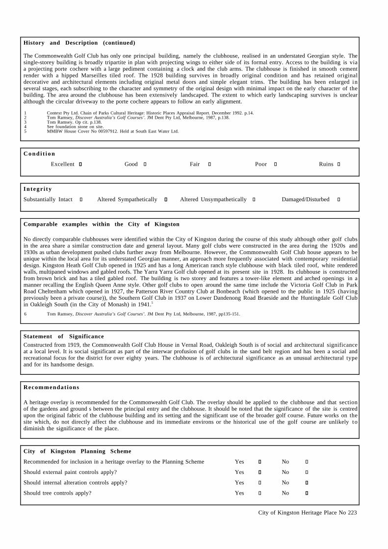
City of Kingston Heritage Place No 223
History and Description (continued)
The Commonwealth Golf Club has only one principal building, namely the clubhouse, realised in an understated Georgian style. Thesingle-storey building is broadly tripartite in plan with projecting wings to either side of its formal entry. Access to the building is viaa projecting porte cochere with a large pediment containing a clock and the club arms. The clubhouse is finished in smooth cementrender with a hipped Marseilles tiled roof. The 1928 building survives in broadly original condition and has retained originaldecorative and architectural elements including original metal doors and simple elegant trims. The building has been enlarged inseveral stages, each subscribing to the character and symmetry of the original design with minimal impact on the early character of thebuilding. The area around the clubhouse has been extensively landscaped. The extent to which early landscaping survives is unclearalthough the circular driveway to the porte cochere appears to follow an early alignment.
1 Context Pty Ltd. Chain of Parks Cultural Heritage: Historic Places Appraisal Report. December 1992. p.14.2 Tom Ramsey, Discover Australia’s Golf Courses’. JM Dent Pty Ltd, Melbourne, 1987, p.138.3 Tom Ramsey. Op cit. p.138.4 See foundation stone on site.5 MMBW House Cover No 00597912. Held at South East Water Ltd.
C o n d i t i o n
Excellent g Good c Fair c Poor c Ruins c
I n t e g r i t y
Substantially Intact c Altered Sympathetically g Altered Unsympathetically c Damaged/Disturbed c
Comparable examples within the City of Kingston
No directly comparable clubhouses were identified within the City of Kingston during the course of this study although other golf clubsin the area share a similar construction date and general layout. Many golf clubs were constructed in the area during the 1920s and1930s as urban development pushed clubs further away from Melbourne. However, the Commonwealth Golf Club house appears to beunique within the local area for its understated Georgian manner, an approach more frequently associated with contemporary residentialdesign. Kingston Heath Golf Club opened in 1925 and has a long American ranch style clubhouse with black tiled roof, white renderedwalls, multipaned windows and gabled roofs. The Yarra Yarra Golf club opened at its present site in 1928. Its clubhouse is constructedfrom brown brick and has a tiled gabled roof. The building is two storey and features a tower-like element and arched openings in amanner recalling the English Queen Anne style. Other golf clubs to open around the same time include the Victoria Golf Club in ParkRoad Cheltenham which opened in 1927, the Patterson River Country Club at Bonbeach (which opened to the public in 1925 (havingpreviously been a private course)), the Southern Golf Club in 1937 on Lower Dandenong Road Braeside and the Huntingdale Golf Clubin Oakleigh South (in the City of Monash) in 1941.5
6 Tom Ramsey, Discover Australia’s Golf Courses’. JM Dent Pty Ltd, Melbourne, 1987, pp135-151.
Statement of SignificanceConstructed from 1919, the Commonwealth Golf Club House in Vernal Road, Oakleigh South is of social and architectural significanceat a local level. It is social significant as part of the interwar profusion of golf clubs in the sand belt region and has been a social andrecreational focus for the district for over eighty years. The clubhouse is of architectural significance as an unusual architectural typeand for its handsome design.
Recommendat ions
A heritage overlay is recommended for the Commonwealth Golf Club. The overlay should be applied to the clubhouse and that sectionof the gardens and ground s between the principal entry and the clubhouse. It should be noted that the significance of the site is centredupon the original fabric of the clubhouse building and its setting and the significant use of the broader golf course. Future works on thesite which, do not directly affect the clubhouse and its immediate environs or the historical use of the golf course are unlikely todiminish the significance of the place.
City of Kingston Planning Scheme
Recommended for inclusion in a heritage overlay to the Planning Scheme Yes g No c
Should external paint controls apply? Yes g No c
Should internal alteration controls apply? Yes c No g
Should tree controls apply? Yes c No g

City of Kingston Heritage Place No 223
Other Listings and Controls
Recommended for inclusion on the Victorian Heritage Register? Yes c No g
Recommended for inclusion on the Register of the National Estate? Yes c No g
Recommended for inclusion on the National Trust (Victoria) Register ? Yes c No g

City of Kingston Heritage Place No 167
City of Kingston Heritage StudyPlace Identification Form (2003)
B r y c e R a w o r t h P t y L t d1 9 V i c t o r i a S t r e e t , S t K i l d a 3 1 8 2 , A u s t r a l i a
Address/Location of Place58 Warrigal Road, Mentone.
Type of PlaceHouse.
Name of PlaceVilla D’Este.
Alternate Name(s) of PlaceNone.
Listings andC o n t r o l s
Victorian HeritageRegisterYes c No g
Register of theNational EstateYes c No g
Register of theNational Trust(Victoria)Yes c No g
Construct ionDate
c.1880sSource
Site inspection
History and Description
By the late 1880s the site on the corner of Como Parade East and Warrigal Road (then called Moorabbin Road) was occupied by DanielKekewick (or Keckwith), an accountant. He occupied the site until the early 1890s when the Sands and McDougalls Directories list TheMentone Land Co (in liquidation) as the occupant. In 1900 the site was occupied by Oliver Crawford. Crawford remained only for a fewyears until JL Wharton took over. The name “Villa d’Este” is listed as early as 1905.1 The catholic church were the occupants fromaround 19062 until the late 1910s. Occupants included the Rev Thomas Quinn and Rev Joseph J Murphy. By 1919 John DC Angus wasthe occupant of the house, remaining until the late 1920s. The house saw a succession of occupants during the 1930s including ThomasM Hanlon (1930-33), Lionel C Saunders (1934), Frank Nunn (1935-36), Reginald W Scott (1937-38) and AEG Shearn (1939-40). Thevilla then remained vacant for a year until Nils Borlaug moved in 1942. Borlaug occupied the house until the 1950s. ET Cerini was theoccupant from the 1960s until the early 1970s. By 1974 the house was occupied by JW Saunders.3
The house at 58 Warrigal Road, Mentone is an unusually ornate timber villa dating from the late nineteenth century. It is principallyclad in weatherboards although the extensive use of decorative elements such as bay windows with stained glass, four pointed archesand extensive quoining set this residence apart from the majority of weatherboard villas within the Municipality. The corrugated steelroof is of note for its bell-shaped profile drawing its inspiration from the pagoda forms of eastern buildings. During the nineteenthcentury, this palette of decorative devices was seen to produce an oriental appearance. This is likely to be the source of the name of thehouse, Villa d'Este, meaning villa of the east or oriental villa.
There have been some modifications to the house. An early outbuilding to the rear of this dwelling (possibly the original kitchen) hasbeen connected to the principal building by a later infil structure. Nonetheless, the alterations are generally in sympathy with thedesign of the house. The fence which surrounds the house is not original but has been designed to contribute to the early character ofthe building. The house has been overpainted in white, which has to some extent diminished the legibility of the detail and the ornatecharacter of the building.
1 Sands and McDougalls Directory of Victoria 1889 – 1974. Held at the Royal Historical Society Melbourne.2 Information provided by Graham Whitehead, City of Kingston Historian.3 Sands and McDougalls. Op cit.

City of Kingston Heritage Place No 167
C o n d i t i o n
Excellent c Good g Fair c Poor c Ruins c
I n t e g r i t y
Substantially Intact c Altered Sympathetically g Altered Unsympathetically c Damaged/Disturbed c
Comparable examples within the City of Kingston
Other residences such as Killara, Eblana and Riviera are comparable in terms of being substantial residences constructed during the late1880s boom period in Mentone.1 However, very few residences adopting the broadly eastern flavour found here exist within themetropolitan area.
1 Jill Barnard and Mary Sheehan. City of Kingston Heritage Study Stage One Report. 2000. p.47.
Statement of Significance
The Villa D’Este at 58 Warrigal Road, Mentone is of architectural significance at a local level as an unusual example of a residentialdesign drawing its inspiration from eastern sources.
Recommendat ions
A heritage overlay is recommended for the building.
City of Kingston Planning Scheme
Recommended for inclusion in a heritage overlay to the Planning Scheme Yes g No c
Should external paint controls apply? Yes g No c
Should internal alteration controls apply? Yes c No g
Should tree controls apply? Yes c No g
Other Listings and Controls
Recommended for inclusion on the Victorian Heritage Register? Yes c No g
Recommended for inclusion on the Register of the National Estate? Yes c No g
Recommended for inclusion on the National Trust (Victoria) Register? Yes c No g

City of Kingston Heritage Place No 156
City of Kingston Heritage StudyPlace Identification Form (2001)
B r y c e R a w o r t h P t y L t d1 9 V i c t o r i a S t r e e t , S t K i l d a 3 1 8 2 , A u s t r a l i a
Address/Location of PlaceComo Parade West, Mentone.
Type of PlaceSubstation.
Name of PlaceRailway Electricity Substation.
Alternate Name(s) of PlaceNone.
Listings andC o n t r o l s
Victorian HeritageRegisterYes c No g
Register of theNational EstateYes c No g
Register of theNational Trust(Victoria)Yes c No g
Construct ionDate
1921Source
Refer History
History and Description
This substation was erected as part of the Melbourne Suburban Railway system’s electrification in 1921. Substations were located atvarious points along the railway system to convert the 20 000-volt AC power supplied by the Newport Power Station into 1500 voltsDC for use by trains. Up until 1914/15 substation buildings were constructed from brick, after this time they were constructed fromreinforced concrete. Construction of the substations along the Frankston line was to be from 1916, however due to the outbreak ofWWI, the electrification program was delayed. This was because the electrical equipment was to be imported from Europe.
Work began on the Mentone substation in July 1921 with the contract to supply and erect steel framework going to Dorman Long &Co. This was completed by October 1921 and installation of the electrical operating equipment began. The Mentone substation housedthree 1500kw Rotary Converters, transformers, switch gear and circuit breakers. Reinforced concrete walls helped minimise externalnoise. Electric Trains began running to Mordialloc in June 1922 and to Frankston in August of that year. The Mentone substationcontinued to be used until 1956 when the new higher - powered electric trains began running. A new cream brick substation has beenconstructed adjacent to the subject building. The earlier building has since been used for non railway use.1
The substation is a simple building with a half hipped roof. The walls of the substation are a reinforced concrete with a coarse cementrender and the roof is clad in cement shingles. A mural has been painted onto the walls. An usual feature of the building is the pagodastyle ventilator on the top of the roof. This appears to have a steel frame and is clad in steel sheet with a steel ornament at the apex.
1 From information provided by Des Jowett on the 27 March 2002. Taken from Victorian Parliamentary Debates (various), Victorian Parliamentary Papers 1883(Reports relating to Railway Contracts & Conduct of Hon T. Bent), Final Returns, Victorian Railways Contracts, Public Records Office Victoria – VictorianRailways Correspondence, Electrification Committee.
C o n d i t i o n
Excellent c Good g Fair c Poor c Ruins c

City of Kingston Heritage Place No 156
I n t e g r i t y
Substantially Intact c Altered Sympathetically c Altered Unsympathetically g Damaged/Disturbed c
Comparable examples within the City of Kingston
There are no comparable examples within the City of Kingston as identified by this study. However a similar type of structure can befound near the intersection of Balcombe Road and the Nepean Highway in Mentone. This building is a simple rectilinear renderedstructure with a gable roof. However this structure does not have a pagoda style ventilator on top or steel ornamentation. Otherexamples exist at Caulfield, Seaford and East Camberwell.2
2 From information provided by Des Jowett. 29 March 2002. Op cit.
Statement of Significance
The railway substation in Como Parade West, Mentone is of historical and architectural significance at a local level. It is historicallysignificant as an early building associated with the operation of the Melbourne to Frankston electric railway. The building i sarchitecturally significant as an eclectic mix of eastern and western styles with its pagoda to the roof and simple rectilinear form.
Recommendat ions
A heritage overlay is recommended for the building.
City of Kingston Planning Scheme
Recommended for inclusion in a heritage overlay to the Planning Scheme Yes g No c
Should external paint controls apply? Yes g No c
Should internal alteration controls apply? Yes c No g
Should tree controls apply? Yes c No g
Other Listings and Controls
Recommended for inclusion on the Victorian Heritage Register? Yes c No g
Recommended for inclusion on the Register of the National Estate? Yes c No g
Recommended for inclusion on the National Trust (Victoria) Register? Yes c No g

City of Kingston Heritage Place No 224
.City of Kingston Heritage StudyPlace Identification Form (2003)
B r y c e R a w o r t h P t y L t d1 9 V i c t o r i a S t r e e t , S t K i l d a 3 1 8 2 , A u s t r a l i a
Address/Location of PlaceCorner Como Parade West and Herbert Street, Parkdale.
Type of PlaceHealth Centre.
Name of PlaceThe Parkdale Baby Health Centre.
Alternate Name(s) of PlaceFormer City of Mordialloc Baby Health Centre.
Listings andC o n t r o l s
Victorian HeritageRegisterYes c No g
Register of theNational EstateYes c No g
Register of theNational Trust(Victoria)Yes c No g
Construct ionDate
c.1930Source
Refer History
History and Description
The Parkdale Baby Health Centre (originally the City of Mordialloc Baby Health Centre) was built in 19301 and was developed as partof an effort to try to slow the high infant mortality rate.2 Health care in outer suburban areas up to this time had been poor. It was notuntil communities were able to raise the funds to build their own hospitals that health care became more generally available.3 BabyHealth Care centres were placed in every community and the former City of Moorabbin had six Baby Health centres and four sub centresby 1960. The centres had an overall annual attendance of 45000 mothers and young children.4 The Chelsea Baby Health Centre openedin 1953 and at Aspendale and Carrum baby centers opened in 1955.5
The Parkdale Baby Health Centre is situated on the corner of Como Parade West and Herbert Street, Parkdale, near to the railway. Thecentre is a single story building in tuckpointed clinker brick and roughcast. It draws architectural elements and details fromcontemporary domestic work, to produce a broadly residential character. The centre has a tiled hipped roof with exposed rafters underthe eaves. The facade of the building has decorative pilasters rising from the base the building to form part of the decorative detail atparapet level. The building incorporates bas-relief decorative signage, which says ‘ City of Mordialloc, Baby Health Centre’. Theverandah adopts an arched expression with a smaller side arch, to Herbert Street. The parapets and arches suggest some SpanishMission influence.
Few alterations to the original building are evident. The principal entrance doors have been replaced and there have been someadditions to windows within the main arched entry. The low clinker brick and roughcast wall has been modified and cyclone fencing hasbeen introduced. The 'Baby Health Centre' on the signage is now no longer emphasised in contrasting coloured paintwork. Otherwisethe building is substantially intact and retains the character of the original design. This building forms part of a transition fromimposing, often classically-inspired municipal buildings to those adopting a scale and expression more consistent with their suburbansurroundings.
1 Sands and McDougalls Directory of Victoria. 1928 – 1932. The directories first note the Baby Health Centre as occupying this site in 1930 but generally havea time lag of 1 to 2 years suggesting a 1928 or 1929 construction date.
2 Jill Barnard & May Sheehan. City of Kingston Heritage Study Stage One Report. 2000. p.99.3 Jill Barnard & May Sheehan. Op cit. p.99.4 John Cribbin. Moorabbin: A Pictorial History 1862 – 1994. City of Kingston, 1995. p.162.5 Frank McGuire. Chelsea by the sea: from swamp to city. Produced by City of Chelsea Historical Society. 2nd Edition 1971.

City of Kingston Heritage Place No 224
C o n d i t i o n
Excellent g Good c Fair c Poor c Ruins c
I n t e g r i t y
Substantially Intact g Altered Sympathetically c Altered Unsympathetically c Damaged/Disturbed c
Comparable examples within the City of Kingston
Very few comparable examples are found in the city of Kingston. The Cheltenham Baby Health Centre (1951-2) survives as part of agroup of baby centres constructed during the post-war period but this building adopts a different architectural vocabulary. TheCheltenham centre is no longer used as a baby health centre and has lost much of its early character through the removal of its signage.
Statement of SignificanceThe Parkdale Baby Health Centre is of social, historical and architectural significance at a local level. It is has been an importantcommunity focus for over seventy years and demonstrates the efforts made by the government in addressing the infant health,particularly in the early part of the 20th Century. The Baby Centre is of architectural significance as an unusual and handsomeinstitutional building that demonstrates the transition from imposing municipal buildings to more domestically scaled structures.
Recommendat ions
A heritage overlay is recommended for the building.
City of Kingston Planning Scheme
Recommended for inclusion in a heritage overlay to the Planning Scheme Yes g No c
Should external paint controls apply? Yes g No c
Should internal alteration controls apply? Yes c No g
Should tree controls apply? Yes c No g
Other Listings and Controls
Recommended for inclusion on the Victorian Heritage Register? Yes c No g
Recommended for inclusion on the Register of the National Estate? Yes c No g
Recommended for inclusion on the National Trust (Victoria) Register? Yes c No g

City of Kingston Heritage Place No 230
.City of Kingston Heritage StudyPlace Identification Form (2001)
B r y c e R a w o r t h P t y L t d1 9 V i c t o r i a S t r e e t , S t K i l d a 3 1 8 2 , A u s t r a l i a
Address/Location of PlaceBeach Road, Parkdale.
Type of PlaceMemorial.
Name of PlaceParkdale War Memorials.
Alternate Name(s) of PlaceNone.
Listings andC o n t r o l s
Victorian HeritageRegisterYes c No g
Register of theNational EstateYes c No g
Register of theNational Trust(Victoria)Yes c No g
Construct ionDate
c.1920-1968Source
Refer History
History and Description
The war memorial on Beach Road, Parkdale appears to be the result of at least three programmes of construction. The obelisk situated inthe eastern section of the site is a WWI memorial likely to date from c,1920. The larger obelisk situated on the west of the site i sunderstood to have been erected after WWII. Plaques set into a bluestone wall to either side of the original obelisk were erected inmemory of the veterans of the Korean and Vietnam conflicts and date from 1968.
The form of memorials generally has evolved over the years. In the late nineteenth century statues or drinking fountains were popular.By the end of the First World War cenotaphs or obelisks had become a common form of memorial.1 In the years after WWII, morepractical memorials such as halls, swimming pools or kindergartens were constructed. It is of note that memorials on the Beach Roadavoided shifting fashion seeking to create an architectural unity in which each new element built upon the new preexisting elements.
The WWI memorial consists of a simple granite obelisk. The memorial was constructed in honour of the men of Parkdale who lost theirlives in First World War. An inscription reads, ‘Parkdale tribute to her fallen heroes 1914-1918’. Bluestone walls to either side of theobelisk appear to date from a later building campaign. Plaques set into these walls honour combatants in the Korean and Vietnamconflicts. The plaque to the left notes,‘This memorial was unveiled by his excellency Major- General Sir Rohan Delcombe, Governor ofVictoria, 10th November, 1968’. The plague to the right notes ‘The City of Mordialloc will always remember its fallen’. The WWIImemorial to the east takes the form of a much taller and more slender obelisk in plain concrete with a large three-pronged base. It has asimple brass wreath to one face. The group is linked by a simple concrete apron, which describes a simple contemplative spacebetween the memorials.
The group is in excellent condition.
1 Jill Barnard & Mary Sheehan. City of Kingston Heritage Study Stage One Report. 2000. p.118-120.
C o n d i t i o n
Excellent g Good c Fair c Poor c Ruins c
City of Kingston Heritage Place No 230
I n t e g r i t y
Substantially Intact g Altered Sympathetically c Altered Unsympathetically c Damaged/Disturbed c
Comparable examples within the City of Kingston
There are a number of comparable monuments within the City of Kingston, including the WWII Memorial in the Heatherton RecreationReserve, Ross Street and those at Rear of the Cheltenham RSL Club, Centre Dandenong Road Heatherton.
Statement of Significance
The War Memorial group on Beach Road, Parkdale is of social, historical and architectural significance at a local level. The group is ofsocial significance as an expression of gratitude from the local community for the sacrifice of servicemen over a range of twentiethcentury conflicts. It is historically significant as part of the wave of memorials constructed to honour Australian servicemen after eachof these conflicts. It is also of some architectural significance for the design quality of the individual memorials and for the sensitivemanner in which each memorial has built upon the character of earlier memorials.
Recommendat ions
A heritage overlay is recommended for the memorials.
City of Kingston Planning Scheme
Recommended for inclusion in a heritage overlay to the Planning Scheme Yes g No c
Should external paint controls apply? Yes g No c
Should internal alteration controls apply? Yes c No g
Should tree controls apply? Yes c No g
Other Listings and Controls
Recommended for inclusion on the Victorian Heritage Register? Yes c No g
Recommended for inclusion on the Register of the National Estate? Yes c No g
Recommended for inclusion on the National Trust (Victoria) Register? Yes c No g

City of Kingston Heritage Precinct No P04
City of Kingston Heritage StudyPlace Identification Form (2001)
B r y c e R a w o r t h P t y L t d1 9 V i c t o r i a S t r e e t , S t K i l d a 3 1 8 2 , A u s t r a l i a
Address/Location of PlaceLower Dandenong Road, Braeside.
Type of PlaceParkland and Buildings.
Name of PlaceBraeside Park.
Alternate Name(s) of PlaceNone.
Listings andC o n t r o l s
Victorian HeritageRegisterYes c No g
Register of theNational EstateYes c No g
Register of theNational Trust(Victoria)Yes c No g
Construct ionDate
From 1880sSource
Refer History
History and Description
Braeside Park covers an area of around 312 hectares and extends from Lower Dandenong Road to Governor Road. It is currently a publicrecreational space operated by Parks Victoria.
The area was once home to the Boon Wurrang (also spelt Boonwerwrung or Bunurong) people who occupied an area from Mordialloc tothe Anderson Inlet on Westernport Bay, including the Mornington Peninsula and inland to land near Warragul. Six scar trees on the siteare evidence of their occupation.1 The early explorers Hume and Hovell traversed the Carrum Carrum Swamp area in February 1827. Thefirst Europeans to settle in the area included Michael Solomon and his family who arrived in 1840. Other settlers such as FarquarMcCrae, CLJ De Villiers, Major James Fraser and James Horsfall quickly followed. Solomon became insolvent in 1842 and Charles andJames Lomax Beswicke took over part of the run, which included the current Braeside Park area. They held the license for two yearsuntil George Keys took over in 1844. When the government revoked squatting licenses in 1851 George Keys was given theopportunity to purchase some of the land that he had previously worked.2
Today, Braeside Park covers most of the original three allotments purchased by members of the Keys family, namely, Lot 1 & 2 ofSection 21 and Lot 2 of Section 22.3 The Keys were a highly influential family in the area who owned large tracts of land from theCarrum Swamp to Brighton. Robert Keys, one of the first co-owners of Braeside Park, also owned the Exchange Hotel at Cheltenhamand was active in local politics.4 Over time the Keys sold their land with Lot 2 Section 22 going to David Syme in 1902 and Lot 1Section 21 to Syme’s son, Arthur Edward Syme in 1915. David Syme is remembered as the owner of The Age newspaper. His son Arthurwas a surgeon. With David Syme’s death, Arthur became owner of the entire parcel of land. Lot 2 Section 21 was extensively subdividedand had been divided into four different allotments by c.1900. It appears that two of these were purchased by Frederick William Werrett,who used the land for market gardening purposes.5
Dr Arthur Syme developed his land as a large racehorse training complex located near the corner of Springvale Road. He constructedstables for 20 horses, quarters for his employees, a grass track and a sand track. His trainer, Adam Skirving, lived in the residence builtby the Keys. There was a bungalow for the foreman, a bunkhouse for other employees, a shower house and various outbuildings forstorage of equipment.6 Syme and Werrett sold their properties to the MMBW in 1928.7

City of Kingston Heritage Precinct No P04
History and Description (continued)
The MMBW had planned to construct a new sewage treatment plant to service the suburbs to south and east of Melbourne. Oppositionto the scheme quickly emerged with people worried that outfall from the scheme would pollute Port Phillip Bay and become a threat tohealth.8 However, due to protests and the depression9 work did not commence immediately and the MMBW offered the land to tenants.The tenants included horse trainer Harry Telford who occupied the former Syme property and market gardener Frederick Werrett wholeased back the property (part of Lot 2 Section 21) that he had sold to the MMBW. Telford paid £800 per year to use the facilitiesconstructed by Syme. He employed 25 people as gardeners, farmhands, stable boys and apprentices. Telford is famous as the trainer of1930 Melbourne Cup winner Phar Lap, who trained on the site for a small period during in 1930/31. In 1940 Ernest John Wilmott tookover the lease on the horse training section of the property. Willmott and his family lived in the Keys residence which had at this stagebeen extended from the original four rooms. Other elements on the property included the Canadian cedar stables, an underground tank,four raised water tanks, milking sheds and other buildings. During this period, an extensive garden with varieties of fruit trees andornamental plants occupied a part of the site.1 0
To ease pressure on the Werribee sewage treatment plant, the MMBW commenced construction of a facility at Braeside park in 1939.The plant was built mostly by day labour and opened by then Premier, Edwin Dunstan in October 1940. It was initially designed to copewith sixteen thousand people but later expanded to service around 60 thousand people.1 1 The sewage was biologically treated using aseries of tanks and lagoons. Raw sewage was filtered through crushed rock in concrete holding tanks near the pump house. Then theeffluent was purified before being evaporated from lagoons.12 Or the purified effluent was used to irrigate the surrounding MMBW ownedland. The land was leased for sheep grazing. This type operation was common throughout the world during the interwar years.1 3
Higher than expected population growth after WWII forced revision of the city’s sewerage scheme. Various feasibility studies beganincluding a scheme to pump untreated sewage from a pumping station at Carrum into the ocean at Cape Schanck. This scheme wasrejected in favour of constructing a new pumping station at Brooklyn and enlargement of the Braeside and Outfall Sewer operations.1 4
In the mid 1950s Braeside was expanded and small neighbourhood treatment plants were constructed. However confined growth placed astrain on the sites. In 1964 the board decided to build a major treatment plant near Carrum to treat all sewage from the eastern zone.Construction was delayed until the late 1960s due to financial constraints and the need for investigation of the environmental andhealth issues.1 5 This new plant eventually made Braeside obsolete.16 The Braeside treatment plant eventually closed in 1980.1 7
With the Braeside sewage treatment plant (and several others) decommissioned, various future uses were suggested by communitygroups. The MMBW decided to develop the area as a public park and nature reserve, preserving remnant MMBW buildings and otherMMBW sites.18 It was anticipated that the park would create an urban escape of open spaces and landscape features while protectingnatural areas. Around 770 acres were developed as a park19 which opened in April 1989.20 The former Keys residence was demolished andthe stables were destroyed by fire in 1982.2 1
This is a very large site, which is used as a public park. It is largely covered with native or replanted vegetation. The site has an avenueof large pine trees, which was planted in the late 1930s along the entrance avenue to the Pumping Station. The original pumpingstation building (c.1939) is used by the park staff as an office. This building is constructed from red brick in a Streamlined Modernestyle. It features brick quoins, a parapeted gable with brick detailing and strong horizontal emphasis. The building has new somewindows. Other sites of interest include a remnant settling pond with concrete outlet and inlets in place, a substation, some pumpingmachinery, the former MMBW Chlorine Store and Surveyors Markings. Several new buildings have been erected on the northern sideof the park for public use and interpretation of the site. A permanent installation dealing with the issue of Aboriginal reconciliationhas been erected beside the remnant settling pond.
1 Context Pty Ltd. Braeside Park Cultural Values Assessment Review, July 2002. p.1, 15.2 Context Pty Ltd. p.3.3 Mordialloc, County of Bourke Crown Portion Subdivision Map. First Edition 8th December 1884 and Mordialloc, County of Bourke Crown Portion
Subdivision Map, Second Revised Edition, c.1900.4 Graham Whitehead, Personal Communication, 1 November 2002.5 Graham Whitehead, Personal Communication, 29 October 2002.6 Kingston Historical Website. http://localhistory.kingston.vic.gov.au ‘A Racing Establishment at Braeside’ by Graham J Whitehead.7 Kingston Historical Website.8 T Dingle & C. Rasmussen. Vital Connections, 1990. p.161.9 Kingston Historical Website.1 0 Kingston Historical Website.1 1 Sign on site near pumping station.1 2 Sign on site near pumping station.1 3 T Dingle & C. Rasmussen. p.200-201.1 4 T Dingle & C. Rasmussen. p.216.1 5 T Dingle & C. Rasmussen. p.293.1 6 Sign on site near pumping station.1 7 Parks Victoria. Braeside Park Website. http://www.parkweb.vic.gov.au1 8 Sign on site near pumping station.1 9 T Dingle & C. Rasmussen. p.328.2 0 Parks Victoria. Braeside Park Page.2 1 Kingston Historical Website.
I n t e g r i t y
Substantially Intact c Altered Sympathetically g Altered Unsympathetically c Damaged/Disturbed c

City of Kingston Heritage Precinct No P04
Comparable examples within the City of Kingston
No comparable examples were identified within the City of Kingston by this study. However, similar sites throughout the widerMelbourne metropolitan area retains large elements of former MMBW plants, including the Werribee Sewer and pumping stations.
Statement of Significance
Braeside Park is of historical and technological significance at a local level. Although substantially altered to provide Park andWildlife habitat, it retains a number of early key elements of historical significance from its period as a pastoral property including theracetrack. It retains other elements from the period as an MMBW sewage treatment plant including settling basin, substation, andadministration buildings that are of historical and some technological significance.
Recommendat ions
A heritage overlay is recommended for selected sites throughout the precinct including the former settling pond and associated outletand inlet, former pumping station building, substation shed and other remnant MMBW equipment. There are ongoing discussions withHeritage Victoria and Parks Victoria to develop a more complete inventory of significant elements on the site.
A landscape assessment should be undertaken in conjunction with Parks Victoria to establish the significance of early plantingsincluding the avenue of pines leading to the former pumping station building and to determine the necessity for planning schemecontrols. Future works should refer to the recent Context Pty Ltd report undertaken on the park.
City of Kingston Planning Scheme
Recommended for inclusion in a heritage overlay to the Planning Scheme Yes g No c
Should external paint controls apply? Yes g No c
Should internal alteration controls apply? Yes c No g
Should tree controls apply? Yes c No g
Other Listings and Controls
Recommended for inclusion on the Victorian Heritage Register? Yes c No g
Recommended for inclusion on the Register of the National Estate? Yes c No g
Recommended for inclusion on the National Trust (Victoria) Register? Yes c No g
Remnant MMBW infrastructure

City of Kingston Heritage Precinct No P32
City of Kingston Heritage StudyPlace Identification Form (2001)
B r y c e R a w o r t h P t y L t d1 9 V i c t o r i a S t r e e t , S t K i l d a 3 1 8 2 , A u s t r a l i a
Address/Location of Place25-29 Nepean Highway, Mentone.
Type of PlaceIndustrial Park.
Name of PlaceNylex Factory.
Alternate Name(s) of PlaceNone.
Listings andC o n t r o l s
Victorian HeritageRegisterYes c No g
Register of theNational EstateYes c No g
Register of theNational Trust(Victoria)Yes c No g
Construct ionDate
From 1944Source
Refer History
History and Description
After the WWII the demographics of the manufacturing industry throughout Melbourne began to change. Prior to WWII most ofMelbourne’s industry was located within three miles of Melbourne's General Post Office. However, in the years following the war, largehaul trucks began to liberate industry from the railhead enabling it to take up areas of open land large enough to accommodate itsgrowing scale. Melbourne became the manufacturing capital of Australia, with over a third of the nation's factories constructed in theState in the decades after 1945 on green field sites throughout the City of Kingston.
Among the first manufacturing operations to take advantage of the opportunities available in outer suburban Melbourne was MouldedProducts (later Nylex) which established its headquarters on the Nepean Highway at Mentone.
The Moulded Products plant occupied a tract of land, which had formerly been associated with the Brigidene Convent. The BrigideneSisters had acquired the site on the east side of Point Nepean Road in 1906. The parcel comprised a little over 35 acres and was usedprimarily for farming, providing the Convent with fresh produce. Two farmers, Edward Naughton and Festus Coyne worked the land forthe sisters. On 26 July 1944, the sisters transferred about half of the land to Moulded Products Australia Ltd. The remainder, a triangularportion at the north of the block and a strip at the south was sold in 1952. Despite the sale, Naughton and Coyne remained in residenceon the site until their deaths in the early 1960s.1
The Mordialloc News of 5 July 19452 noted that Moulded Products was to open a factory in Mentone The site was developed quickly,with the factory commencing production in the following year. Development on the site proceeded rapidly from this time.
An aerial photograph dating from 19633 shows a large number of structures present on the site. The laboratory complex, gatehouse anda number of sawtooth roofed factory buildings line the Nepean Highway frontage while more sawtooth roofed production spaces arevisible towards the rear of the site. The present administration building at the front of the site is not evident in the photograph nor i sthe illuminated clock, which has, in the ensuing decades, become a landmark structure on the highway. Both of these structures arebelieved to date from c.1970.

City of Kingston Heritage Precinct No P32
History and Description (continued)
Since that time, further production spaces have been added to the plant and a new administration building has been constructed alongthe Warrigal Road frontage.1 Kilbreda College Archives.2 Mordialloc News, 5 July 1945.3 Aerial photograph, Melbourne 1963 Project, Run 24, 24/12/1963, Original held at Land Titles Office.
I n t e g r i t y
Substantially Intact c Altered Sympathetically g Altered Unsympathetically c Damaged/Disturbed c
Comparable examples within the City of Kingston
The Nylex factory was among the first of many constructed in City of Kingston in the years following WWII. It is of note for its role inthe development of local industry and as a large local employer. There are few comparable examples of a site of this size or earlyconstruction date within the Municipality. The site compares more favourably with factory developments such as the AGM Factory atSpotswood or The Nestle factory at Mulgrave. It is of note that more significant industrial sites such as the ETA Factory in Sunshinethe CSR Factory in Bacchus Marsh have been identified as being of state significance and are now listed on the Victorian HeritageRegister.
Little early signage remain within the City of Kingston. A number of early signs of considerably greater significance remainthroughout the broader metropolitan area such as the Pelaco sign in Richmond (c.1939) or the Capitol sign in Swanston Street(c.1932).
Statement of Significance
Constructed from 1944 and constantly extended and upgraded since that time, the Nylex factory is of social and some architecturalsignificance at a local level. It is socially significant as an expression of the post-war industrial boom within the City. The physicalfabric of the buildings on the site largely comprises generic production and administration spaces of minimal architectural ortechnological significance, with the exception of the neon sign at the entry, which has become a local architectural landmark and asymbol of social and technological progress within the area.
Recommendat ions
A heritage overlay is recommended for the illuminated sign at the entry to the site only. It is understood that the sign is to be relocatedto a new position a little to the south of its present position in the near future. Provided the sign retains its associations with the Nylexplant and is re-erected on an equally prominent site on the highway, this action is seen as having minimal impact on the culturalheritage significance of the structure. No heritage overlay is recommended for the broader site.
City of Kingston Planning Scheme
The following recommendations apply to the illuminated clock only.
Recommended for inclusion in a heritage overlay to the Planning Scheme Yes g No c
Should external paint controls apply? Yes g No c
Should internal alteration controls apply? Yes c No g
Should tree controls apply? Yes c No g
Other Listings and Controls
Recommended for inclusion on the Victorian Heritage Register? Yes c No g
Recommended for inclusion on the Register of the National Estate? Yes c No g
Recommended for inclusion on the National Trust (Victoria) Register? Yes c No g

City of Kingston Heritage Place No 030
City of Kingston Heritage StudyPlace Identification Form (2001)
B r y c e R a w o r t h P t y L t d1 9 V i c t o r i a S t r e e t , S t K i l d a 3 1 8 2 , A u s t r a l i a
Address/Location of PlaceThe Beauty Spot, Carrum.
Type of PlaceMemorial.
Name of PlaceSoldier's Memorial.
Alternate Name(s) of PlaceCarrum War Memorial.
Listings andC o n t r o l s
Victorian HeritageRegisterYes c No g
Register of theNational EstateYes c No g
Register of theNational Trust(Victoria)Yes c No g
Construct ionDate
c.1920Source
Refer History
History and Description
Memorials to the fallen servicemen of WWI began to appear in Australia as early as 1915.1 The stone soldier quickly emerged as themost popular form of commemoration despite official preference for more abstract memoria such as columns, obelisks and clocktowers. From 1918, New South Wales and Victoria established War Memorial Advisory Boards, based upon the committee appointed bythe Royal Academy of Art in Great Britain. These boards gave advice to local authorities and fund-raising groups. They also attempted,if not always successfully, to approve designs. The New South Wales board even issued approved designs. The boards were set up inresponse to concerns among the architectural profession that inartistic memoria were debasing public taste. To the professionaldesigners on these boards, the stock or 'manufactured' stone soldiers were an affront. They wanted simple abstract memorials withunderlying symbolic content to fire popular imagination and considered the austere monuments designed by Sir Edwin Lutyens for theImperial War Graves Commission to be the epitome of informed good taste.
Nonetheless, the literal portrayal of servicemen, at attention, at ease or in some instances relaxed and off-duty, continued toproliferate. A number of manufacturers of memoria such as Anselm Odling of Sydney came to specialise in this type of statuary. AnselmOdling had a branch at Carrara, Italy and some of their figures were advertised as being made 'in Italian Studios'. Many of the statues ofItalian manufacture were, in fact, based upon the Italian Alpino soldier whose uniform closely resembled that of the Australian digger.The headgear of the Alpino differed from the Australian slouch hat in that the front and rear were turned up in addition to the left side.The most famous example of this substitution occurred at Howard near Bundaberg in Queensland.
The Carrum soldier's memorial dates from c.1920. An inscription on the pedestal notes that it was 'erected by the residents in gratefulremembrance of the heroes of Carrum who made the supreme sacrifice in the great war 1914-1919.' It comprises a statue in marble of aninfantryman, standing at ease with his rifle at his side. The pedestal is constructed of granite with the names of local residents killedduring the conflict inscribed on the sides. The statue is clearly of an Alpino soldier with characteristic headgear of the type provided byAnselm Odling of Sydney. The memorial was further inscribed after WWII to include the names of locals killed during that conflict.
1 This reference is drawn with minor editing from, Judith McKay, Putting the Digger on a pedestal, Historic Environment, Vol. 5 Number 3, 1986, pp.5-17.
C o n d i t i o n
Excellent g Good c Fair c Poor c Ruins c

City of Kingston Heritage Place No 030
I n t e g r i t y
Substantially Intact g Altered Sympathetically c Altered Unsympathetically c Damaged/Disturbed c
Comparable examples within the City of Kingston
An example comparable with this memorial is the WWI obelisk in Beach Road, Parkdale, erected c.1920.
Statement of Significance
The Carrum soldiers' memorial is of architectural and historical significance at a local level. The physical fabric is significant as ahandsome example of an off the shelf war memorial and of some minor interest for the inaccuracies in the detailing to the uniform. It i shistorically significant as part of a wave of memorials constructed to honour Australian servicemen after WW1.
Recommendat ions
A heritage overlay is recommended for the site.
City of Kingston Planning Scheme
Recommended for inclusion in a heritage overlay to the Planning Scheme: Yes g No c
Should external paint controls apply? Yes g No c
Should internal alteration controls apply? Yes c No g
Should tree controls apply? Yes c No g
Other Listings and Controls
Recommended for inclusion on the Victorian Heritage Register? Yes c No g
Recommended for inclusion on the Register of the National Estate? Yes c No g
Recommended for inclusion on the National Trust (Victoria) Register? Yes c No g

City of Kingston Heritage Precinct No P27
City of Kingston Heritage StudyPlace Identification Form (2001)
B r y c e R a w o r t h P t y L t d 1 9 V i c t o r i a S t r e e t , S t K i l d a 3 1 8 2 , A u s t r a l i a
Address/Location of Place
9-17 Como Parade East, Mentone.
Type of Place
Houses.
Name of Place
None.
Alternate Name(s) of Place
None.
Listings andC o n t r o l s
Victorian HeritageRegister
Yes � No ����
Register of theNational Estate
Yes � No ����
Register of theNational Trust(Victoria)
Yes � No ����
Construct ionDate
From 1890
Source
Refer History
History and Description
These five dwellings are situated opposite the Frankston railway line and railway reserve. The area consists of four houses (9, 11, 13,17) and a block of flats (15).
The four houses in this precinct were built between 1890 and 1893. The first property to be built was No 11 Como Parade East, whichwas built between 1890 and 1891. However by 1893 Nos 9, 13 and 17 had also been constructed. The flats at number 15 were builtduring the 1960s, before this time it appears to have been an empty site. Several of the properties remained in continuous occupancyuntil the 1960s or 1970s when some were converted or subdivided for the construction of flats. Hector Tause, a dentist, lived at No 9from the 1920s until the 1950s. This house was called ‘Egmont’. Number 11 was occupied by the Coffey family from the 1910s untilthe 1960s. This property was called ‘Neridale’. Number 13 was occupied by Thomas Sheilds from the late 1890s until the 1910s andthen by Mrs Mary J Brookes until the 1920s. The Kemps moved in during the 1930s. The property was subdivided in the 1970s.Number 17 has had a continuous turnover of occupiers during its history. Flats were built on the site, to the rear of the house in theearly 1960s.1
Dwellings at 9, 11, 13 and 17 are Italianate in style, while number 15 is a block of modern flats. Number 15 contributes to the generalscale and setback of the other buildings. No 9 is constructed of rendered brick with a verandah and a three sided bay window. The roof i stiled in slate. A high masonry fence and planting largely obscure the house from the street. No 11 is finished in ashlar ruled render andconstructed on a bluestone base. To the street is a verandah and projecting rectangular bay. The roof is tiled in slate. The house atnumber 13 (see photograph above) differs in that it is un-rendered polychrome brickwork. The house generally remains intact despitesome alterations. The original slate roof has been replaced with modern tiles. Number 17 is rendered and has a verandah and projectingbay. The roof is corrugated steel sheet. The verandah is of note for its unusual lace work design.
Most of the fences in this precinct are inappropriate and modern.
1 Sands & McDougalls Directory of Victoria. 1889 - 1974. Held at the Royal Historical Society, Melbourne.

City of Kingston Heritage Precinct No P27
I n t e g r i t y
Substantially Intact � Altered Sympathetically ���� Altered Unsympathetically � Damaged/Disturbed �
Comparable examples within the City of Kingston
Several comparable individual buildings have been identified within the City of Kingston by this study. These include 2 Jellicoe StreetCheltenham, 1 Elbana Avenue Mentone, 6 Harkin Avenue Mentone, 416 South Road Moorabbin. However, no comparable precincts ofsubstantial dwellings in an Italianate style were identified by this study and groups of this type appear to be relatively rare within theCity of Kingston. However, many comparable examples exist within the wider Melbourne metropolitan area.
Statement of Significance
The houses at 9-17 Como Parade East are of architectural significance at a local level as an unusual group of Italianate dwellings.Groupings of dwellings in this early style are rare within the Municipality.
Left: Number 11 Como Parade East Mentone showing projecting window bay and verandah. Right: Number 17 Como Parade EastMentone, which adopts a subtly different Italianate expression.
Recommendat ions
A heritage overlay is recommended for the houses at 9 – 17 Como Parade East Mentone. Owners should be encouraged to replace frontfences with more appropriate models when future refurbishment opportunities arise.
City of Kingston Planning Scheme
Recommended for inclusion in a heritage overlay to the Planning Scheme Yes ���� No �
Should external paint controls apply? Yes ���� No �
Should internal alteration controls apply? Yes � No ����
Should tree controls apply? Yes � No ����
Other Listings and Controls
Recommended for inclusion on the Victorian Heritage Register? Yes � No ����
Recommended for inclusion on the Register of the National Estate? Yes � No ����
Recommended for inclusion on the National Trust (Victoria) Register? Yes � No ����

City of Kingston Heritage Precinct No P38
City of Kingston Heritage StudyPlace Identification Form (2001)
B r y c e R a w o r t h P t y L t d1 9 V i c t o r i a S t r e e t , S t K i l d a 3 1 8 2 , A u s t r a l i a
Address/Location of PlaceNepean Highway, Mordialloc.
Type of PlaceForeshore Precinct.
Name of PlaceMordialloc Creek and Foreshore Precinct.
Alternate Name(s) of PlaceNone.
Listings andC o n t r o l s
Victorian HeritageRegisterYes c No g
Register of theNational EstateYes c No g
Register of theNational Trust(Victoria)Yes c No g
Construct ionDate
From c.1870sSource
Refer History
History and Description
The Mordialloc Creek and Foreshore Precinct is a large and diverse area to the north of the Mordialloc Creek sandwiched between BeachRoad and Port Phillip Bay. This section of the bay was a popular nineteenth century seaside destination and still retains the earlyfishing, boat building and tourism activities that have traditionally been central to Mordialloc’s identity and income. Since the earliestdays of white settlement, the creek has been popular with both visitors and locals for fishing and boating pursuits while the beach waspopular for sea bathing1. A pier was constructed near the mouth of creek before 1870 2 and a walled breakwater was built at the shorewardend of the pier before 19003. The pier has since been replaced by a considerably larger timber structure. In the late nineteenth centurytimber sea baths were constructed on the foreshore to the north of the pier near the present-day life saving club.4 The baths weredemolished by the mid 20th century.5
Today, the precinct consists of a long narrow strip of beach, separated from sheltered amenity and recreational areas by a narrow bandof coastal vegetation and low sea wall. The more formal sheltered areas are largely grassed with barbecue, play and parking areas and anumber of buildings. Structures in the precinct include the beach seawall and boulevard, war memorial, horse trough, pier, toilet block,bandstand rotunda and public shelter. The current appearance of the area was moulded through an in intense period of works from theearly 1920s to the early 1930s.
Prior to the early 1920s, there had been little development on the Mordialloc foreshore (known at that time as the Moorabbin Reserve)other than the construction of the pier, the seabaths and some modest outbuildings visible in early photographs of the site. In October1923, The Mordialloc Progress Association decided to stage a carnival and aquatic sports event to raise funds for the construction of abandstand rotunda. This and subsequent carnivals over the following decade raised over £40,000 for improvements and beautificationof the foreshore. The Mordialloc Carnival Committee erected the bandstand in 1925.6 The bandstand remains on the site in broadlyoriginal condition. It is an octagonal structure finished in ruled render and capped with an octagonal hipped roof. Access to the elevatedbandstand is via a set of elegant stairs at the rear. The bandstand base and stairs are decorated with a raised cross motif and sections ofroughcast render. The pantile roof is supported by rectangular columns drawing inspiration from contemporary jazz motifs. The stairsconceal the entrance to a store underneath the rotunda. The rotunda was restored in 1992 by the Mordialloc Mentone Lions Club andopened by then Mayor, Cr Hazel Pierce OAM.7

City of Kingston Heritage Precinct No P38
History and Description (continued)
In the following year, the Committee turned its attention to the construction of a sea wall and boulevard. The first stage of theboulevard commencing at the Pier was opened by the Mayoress Mrs J T Denyer on 19 June 1927. The boulevard was completed to theBaths in 1928.8 The seawall was completed in the same year. The boulevard and seawall remain on site and run along the edge of thebeach from the pier to the lifesaving club. The boulevard is constructed from reinforced concrete. The seawall is constructed fromrendered masonry and sits on a bluestone base. It incorporates tall lighting bollards along its entire length. As part of the same works,a large grassed area on the sheltered side of the seawall was developed as a lawn beach. This was popular through the interwar period forsun bathing and sporting pursuits. The foreshore area was leveled and the large parking area and playground graded in 1933. Provisionwas made for the extensive planting of trees and hedges.9 Since that time, the lawn has been replanted with traditional coastalvegetation.
Through the early 1930s works to the creek became the focus of the committee's attention. In 1931, valuable area of land on thenorthern bank of the Creek was reclaimed and the creek was dredged to a uniform depth to improve its amenity. The north and southbanks of the creek were sheet piled between 1931 and 1933.1 0 It is likely that the sheet piling on site today is part of more recentrefurbishment of the creek walls.
A number of other structures on the site including, the toilet block, public shelter and pier were constructed by other authorities in theearly part of the twentieth century in tandem with the works of the Committee.
The public toilet at the northern end of the precinct dates from c.1930s. It is detailed in a Streamlined Moderne mode with a stronghorizontal emphasis. Streamlines are evident in the stepped parapet, string course, windowsills and curved entry walls. The buildingcombines areas of smooth and course renders. The design incorporates circular motifs to the door (since reiterated in modern grilles towindows) and decorative pilasters with florets and raised lettering.
A large public shelter is located adjacent to the toilet block at the northern end of the precinct. The shelter shares a number ofdecorative features with the seawall suggesting that it was modelled on the seawall. It is octagonal in plan with low rendered brickwalls. Substantial timber columns support a complex arrangement of structural beams and a roof clad in Mediterranean style pantiles.The roof adopts an unusual form with a raised central section, which is atypical for this type of structure. The shelter is believed to datefrom the 1980s or early 1990s.1 1
Other elements of interest in the precinct are concrete benches in front of the bandstand, which appear to date from the construction ofthe bandstand rotunda, a horse trough, a war memorial and a row of palm trees.
The largest and most significant structure in the precinct is the pier. Constructed on the site of the original 1870s structure, the pier i sconstructed on rectangular timber piles with massive crossheads and a timber deck. It is likely to date from the early twentieth centuryalthough no precise date has thus far been established. Tubular steel balustrading and modern lighting appear to be modern additions. Asmall timber shelter structure on the pier appears to date from around c.1905. The final 60 metres of the pier was restored and reopenedin June 19871 2. The pier suffered extensive storm damage shortly after WWII and much of the earlier fabric was replaced at this time1 3.The pathway to the Pier was constructed in 19301 4and the approach features lighting bollards similar to those found on the boulevardand palm trees which may date from the original construction of the path. The pathway and associated plantings has to some extentbeen subsumed into a relatively recent vehicular accessway to the pier.
The foreshore reserve is known today as the Peter Scullin Reserve after the Councillor (1971- 1975) and Mayor (1974)1 5. It area hasbeen continuously refurbished to provide increased amenity largely in the form of increased parking and children’s play areas. Themore formal lawned and structured interwar character engendered by the beach lawn, ordered paths and formal plantings has to someextent been lost through recent works. Nonetheless the ongoing use of the place and the large number and highly intact state of muchof the early building stock allow the precinct to remain legible as an early recreation area.
1 ‘Scene at Mordialloc’, 1870, Fred Kruger. From Andrea Inglis, Beside the Seaside: Victorian Resorts in the 19th Century. Melbourne University Press, 1999.p.45 and Frank McGuire, Mordialloc – the early days: a brief history. The Mordialloc Community Committee for Victoria’s 150th Anniversary, 1985. p.44.
2 Scene at Mordialloc, 1870. Op cit3 Frank McGuire, Op cit. p.44.4 ‘Scene at Mordialloc’, 1870. Op cit. and Photograph of ‘The Baths Mordialloc’, c1911, Published for W R Miller, LaTrobe Photographic Collection, Held at the
State Library of Victoria and Frank McGuire, Op cit. p.44.5 Photograph ‘Having Fun at the Beach Mordialloc Vic’, c1940-1960, Rose Series of Postcards, LaTrobe Photographic Collection, Held at the State Library of
Victoria6 City of Kingston. Kingston Historical Website. ‘Mordialloc Carnival: The First Ten Years’. http://localhistory.kingston.vic.gov.au7 See memorial plaque on bandstand8 See memorial plaque located at approach to pier.9 City of Kingston. Kingston Historical Website.1 0 City of Kingston. Kingston Historical Website.1 1 Graham Whitehead, City of Kingston Historian. Personal Communication 29th October 2002.1 2 See memorial plaque located at approach to pier.1 3 Graham Whitehead, City of Kingston Historian. Personal Communication 8th August 2003.1 4 City of Kingston. Kingston Historical Website.1 5 See memorial plaque on toilet block
I n t e g r i t y
Substantially Intact c Altered Sympathetically g Altered Unsympathetically c Damaged/Disturbed c

City of Kingston Heritage Precinct No P38
Comparable examples within the City of Kingston
No comparable examples were identified within the City of Kingston by this study. However, similar examples, most notably the StKilda Beach precinct exist elsewhere in the broader Melbourne metropolitan area.
Statement of Significance
The Mordialloc Creek and Foreshore Precinct is of social, historical and architectural significance at a local level. It is sociallysignificant as a focus of the local community. It is historically significant as a reasonably nineteenth intact example of a latenineteenth and early twentieth century seaside resort and the precinct remains legible as an early recreational centre. The area i sarchitectural significant for a number of unusual structures which survive from the early development of place, most notably the pierbut including less prominent structures such as the sea wall, band rotunda and toilet block.
Left: View of bandstand dating from 1924/5. Right: Shelter showing unusual roof form and ballustrading recalling the seawall.
Left: View of the rear of the toilet block showing the strong horizontal lines. Right: sea wall
Recommendat ions
A heritage overlay is recommended for the precinct and associated structures including the pier, seawall, boulevard, toilet block,bandstand, shelter rotunda, horse trough and war memorial.

City of Kingston Heritage Precinct No P38
City of Kingston Planning Scheme
Recommended for inclusion in a heritage overlay to the Planning Scheme Yes g No c
Should external paint controls apply? Yes g No c
Should internal alteration controls apply? Yes c No g
Should tree controls apply? Yes g No c
Other Listings and Controls
Recommended for inclusion on the Victorian Heritage Register? Yes c No g
Recommended for inclusion on the Register of the National Estate? Yes c No g
Recommended for inclusion on the National Trust (Victoria) Register? Yes c No g

City of Kingston Heritage Place No 240
City of Kingston Heritage StudyPlace Identification Form (2003)
B r y c e R a w o r t h P t y L t d1 9 V i c t o r i a S t r e e t , S t K i l d a 3 1 8 2 , A u s t r a l i a
Address/Location of PlaceAspendale Gardens, Aspendale, Chelsea Heights andPatterson Lakes.
Type of PlaceDrain.
Name of PlaceMordialloc Secondary Drain.
Alternate Name(s) of PlaceMain Swamp Drain.
Listings andC o n t r o l s
Victorian HeritageRegisterYes c No g
Register of theNational EstateYes c No g
Register of theNational Trust(Victoria)Yes c No g
Construct ionDate
From 1873Source
Refer History
History and Description
Much of the southeast portion of the City of Kingston was once part of the Carrum Swamp, which extended from Mordialloc toFrankston. The swamp was fed by the waters of the Eumemmering, Dandenong and other creeks, whose sources lay in the DandenongRanges. It was ineffectively drained by the Mordialloc Creek at Mordialloc and the Kananook Creek in Frankston. Hodgkinson andCouchman undertook a survey of the swamp in the late 1860s and noted that draining the swamp would immediately unlock 6,000 acresfor agricultural purposes. Although no works were undertaken, the land was opened to selection in 1869.
The government developed a strategy for draining the swamp but deemed the exercise too costly and it fell to local selectors to raisefunds to implement the scheme. From the 1870s, a number of remedial measures were undertaken. These included the construction ofdrains linking the Mordialloc Creek and the Eumemmering with the Kananook to run water to the sea and a main swamp drain betweenthe Mordialloc Creek and the Patterson River. The main swamp drain is known today as the Mordialloc Secondary Drain. These workswere commenced by the Dandenong Roads Board in 1873. The works were a limited success and further works were undertaken includingPatterson's Cut (a channel from the swamp to the sea creating an outfall known today as Patterson River) completed in 1879.
As residential development of the area proceeded through the twentieth century, more measures were undertaken to further safeguardlocal housing stock from flood.1 Nonetheless, floods in 1934 and 1952 produced extensive damage in Chelsea and Mordialloc. Inresponse, the main swamp drain was enlarged and tidal gates were installed at each end.
The Mordialloc Secondary Drain is a simple graded depression allowing the egress of stormwater from Chelsea Heights and Aspendaleto the Mordialloc Creek to the north and Patterson River to the south. Very little built fabric is associated with the drain. This i sprincipally limited to the pumping station, gates and associated plant situated at the northern end of the drain adjacent to the creekoutfalls.
1 Jill Barnard & Mary Sheehan. City of Kingston Heritage Study, Stage One Report. p.79-83.
C o n d i t i o n
Excellent c Good g Fair c Poor c Ruins c

City of Kingston Heritage Place No 240
I n t e g r i t y
Substantially Intact g Altered Sympathetically c Altered Unsympathetically c Damaged/Disturbed c
Comparable examples within the City of Kingston
No comparable examples are understood to exist within the City of Kingston
Statement of Significance
The Mordialloc Secondary Drain is of historical significance to the City of Kingston retaining associations with the draining of theCarrum Swamp for agriculture and later residential uses.
Recommendat ions
A heritage overlay is recommended for the plant and infrastructure associated with the Mordialloc secondary drain. This should applyonly to the elements built of infrastructure in the northern section of the drain adjacent to the Mordialloc Creek. Consideration shouldbe given to the implementation of a landscape control to ensure that the early character of the drain and its environs remainsunchanged.
City of Kingston Planning Scheme
Recommended for inclusion in a heritage overlay to the Planning Scheme Yes g No c
Should external paint controls apply? Yes c No g
Should internal alteration controls apply? Yes c No g
Should tree controls apply? Yes c No g
Other Listings and Controls
Recommended for inclusion on the Victorian Heritage Register? Yes c No g
Recommended for inclusion on the Register of the National Estate? Yes c No g
Recommended for inclusion on the National Trust (Victoria) Register? Yes c No g
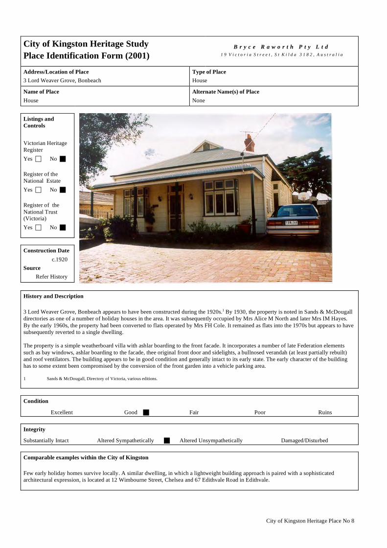
City of Kingston Heritage Place No 8
City of Kingston Heritage Study Place Identification Form (2001)
B r y c e R a w o r t h P t y L t d
1 9 V i c t o r i a S t r e e t , S t K i l d a 3 1 8 2 , A u s t r a l i a
Address/Location of Place 3 Lord Weaver Grove, Bonbeach
Type of Place House
Name of Place House
Alternate Name(s) of Place None
Listings and Controls Victorian Heritage Register Yes No Register of the National Estate Yes No Register of the National Trust (Victoria) Yes No Construction Date c.1920 Source Refer History
History and Description 3 Lord Weaver Grove, Bonbeach appears to have been constructed during the 1920s.1 By 1930, the property is noted in Sands & McDougall directories as one of a number of holiday houses in the area. It was subsequently occupied by Mrs Alice M North and later Mrs IM Hayes. By the early 1960s, the property had been converted to flats operated by Mrs FH Cole. It remained as flats into the 1970s but appears to have subsequently reverted to a single dwelling. The property is a simple weatherboard villa with ashlar boarding to the front facade. It incorporates a number of late Federation elements such as bay windows, ashlar boarding to the facade, thee original front door and sidelights, a bullnosed verandah (at least partially rebuilt) and roof ventilators. The building appears to be in good condition and generally intact to its early state. The early character of the building has to some extent been compromised by the conversion of the front garden into a vehicle parking area. 1 Sands & McDougall, Directory of Victoria, various editions. Condition
Excellent � Good Fair � Poor � Ruins � Integrity
Substantially Intact � Altered Sympathetically Altered Unsympathetically � Damaged/Disturbed � Comparable examples within the City of Kingston Few early holiday homes survive locally. A similar dwelling, in which a lightweight building approach is paired with a sophisticated architectural expression, is located at 12 Wimbourne Street, Chelsea and 67 Edithvale Road in Edithvale.

City of Kingston Heritage Place No 8
Statement of Significance The dwelling at 3 Lord Weaver Grove, Bonbeach is of architectural and historical significance at a local level as one of a small number of extant early holiday homes in the area with associations with the early development of the area a s a holiday destination. Recommendations A heritage overlay is recommended for the building. City of Kingston Planning Scheme
Recommended for inclusion in a heritage overlay to the Planning Scheme Yes No � Should external paint controls apply? Yes No � Should internal alteration controls apply? Yes � No Should tree controls apply? Yes � No Other Listings and Controls
Recommended for inclusion on the Victorian Heritage Register? Yes � No Recommended for inclusion on the Register of the National Estate? Yes � No Recommended for inclusion on the National Trust (Victoria) Register? Yes � No

City of Kingston Heritage Place No 62
City of Kingston Heritage Study Place Identification Form (2001)
B r y c e R a w o r t h P t y L t d
1 9 V i c t o r i a S t r e e t , S t K i l d a 3 1 8 2 , A u s t r a l i a
Address/Location of Place 24 Wilson Street Cheltenham.
Type of Place House.
Name of Place None.
Alternate Name(s) of Place None.
Listings and Controls Victorian Heritage Register Yes No Register of the National Estate Yes No Register of the National Trust (Victoria) Yes No Construction Date c.1900 Source Refer History
History and Description The house at 24 Wilson Street formed part of the Two Acre Village development, which was initiated by Josiah Morris Holloway in 1852. Holloway brought 625 acres between what are now the Nepean Highway, Centre Dandenong Road, Chesterville Road and Bernard Street in Cheltenham. He subdivided the land into 370 allotments roughly two acres in size each (although there were exceptions), and gave it the name Two Acre Village. Land sold quickly due to the proximity to the beach and to Brighton, availability of clay suitable for brick making, wooded land, land set aside for a school (this was never built) and government roads. Much of the land was sold to speculators although some brought land with the purpose of living and working on it. The blocks were later subdivided further into smaller house sized allotments, sometimes at good profit for speculators.1
This house was probably built between 1900 and 1905 for William Rich. He held the property until the early 1910s when it was occupied by Alfred J Howe. 1920 saw the property occupied by Frederick Richardson but by 1925 it had passed to Miss Rosina Patrick who remained in residence until the late 1930s. In 1941 Leonard S Francis occupied the property but by 1942 it was occupied by William C Jasper. Jasper occupied the property until the late 1960s. It was then occupied by D E Sers who remained in residence into the 1970s.2
Number 24 Wilson Street Cheltenham dates from the early c.1900s. It is constructed from timber with understated Italianate detailing. The house features a projecting rectangular bay and a verandah to the street frontage. The hipped roof is clad in corrugated iron and has two tall rendered chimneys. The windows are of double sash construction with side lights. Many original features are retained including the timber eaves brackets and detail to the chimneys. Some additions have been constructed to the rear and northern sides of the house. These are generally sympathetic in scale, detail and material to the original construction. The modern timber additions to the north are largely obscured from the street by a mature pine and other planting. 1 Kingston Historical Website. http://localhistory.kingston.vic.gov.au ‘Two Acre Village’ by Graham J Whitehead. 2 Sands & McDougalls Directory of Victoria. 1900 - 1970. Held at the Royal Historical Society, Melbourne. Condition
Excellent Good Fair Poor Ruins

City of Kingston Heritage Place No 62
Integrity
Substantially Intact Altered Sympathetically Altered Unsympathetically Damaged/Disturbed Comparable examples within the City of Kingston A small number of similar buildings exist within the City of Kingston, including 3-5 High Street, Mordialloc and 5 Cremona Street, Mentone. All of the examples noted here are larger weatherboard dwellings drawing inspiration from Italianate sources. Statement of Significance The house at 24 Wilson Street Cheltenham is of architectural significance at a local level as a fine example of an early and intact dwelling in an Italianate mode. It is of some additional interest for its weatherboard construction. Recommendations A heritage overlay is recommended for the building. City of Kingston Planning Scheme
Recommended for inclusion in a heritage overlay to the Planning Scheme Yes No
Should external paint controls apply? Yes No
Should internal alteration controls apply? Yes No
Should tree controls apply? Yes No Other Listings and Controls
Recommended for inclusion on the Victorian Heritage Register? Yes No
Recommended for inclusion on the Register of the National Estate? Yes No
Recommended for inclusion on the National Trust (Victoria) Register ? Yes No

City of Kingston Heritage Place No 99
City of Kingston Heritage StudyPlace Identification Form (2001)
B r y c e R a w o r t h P t y L t d1 9 V i c t o r i a S t r e e t , S t K i l d a 3 1 8 2 , A u s t r a l i a
Address/Location of Place156 Kingston Road, Heatherton.
Type of PlaceHouse.
Name of PlaceNone.
Alternate Name(s) of PlaceNone.
Listings andC o n t r o l s
Victorian HeritageRegisterYes c No g
Register of theNational EstateYes c No g
Register of theNational Trust(Victoria)Yes c No g
Construct ionDate
c.1910Source
Refer History
History and Description
The site at 156 Kingston Road was originally part of Lot 1 of Section XV in the Parish of Mordialloc. The first owner was P Riley whoretained the property up until c.1900. Riley owned a large amount of land in the local area including Lots 1 and 2 of Section XVIII andLot 1 of Section XIX. In addition he was part owner with N Polark of Lot 2 Section XIV, Lot 2 of Section XXIII, Lots 3 and 4 of SectionXVI, Lots 9 and 10 of Section I and Lots 1 and 7 of Section IV.1 It is likely that the subject site formed part of an early market gardeningor pastoral property.
Market gardening played a pivotal role in the early years of the district. Market gardens in the City of Kingston enjoyed a proximity toMelbourne, which afforded them an advantage over market gardens further afield2. The cost of land in the city was high, enablingmarket gardeners on its fringes to make a good living.3 Gardeners in the City of Kingston brought their produce into Melbourne’sVictoria Market twice weekly for sale, often returning with manure for fertiliser. The number of market gardens in the Heatherton areadecreased as better road transport became available, enabling increased competition from further afield.4
By the early twentieth century Jesse N Tatterson occupied the subject property. Tatterson occupied the house until c.1915 when IrvinTatterson, a market gardener took over. It is likely that one or other member of the Tatterson family constructed the extant houseduring the 1910s. Irvin Tatterson remained in residence until at least 1924. The house was occupied by a succession of people duringthe 1930s including E Delo, Harold Tuscon and Jonathon Harris. By the 1940s the house was occupied by William Tomlinson whoremained in residence into the early 1950s. After this time GE Lewis occupied the house for a short period until it was taken over by WRFollett in the late 1950s. Follett lived at this address into the 1970s.5 The subject site and many adjoining sites have since beensubdivided. Although Heatherton has retained its early pastoral identity to a greater degree than almost any other section of themunicipality, subsequent development has nonetheless diminished the market garden/farming character of the area.

City of Kingston Heritage Place No 99
History and Description (continued)
This modest, single-storey timber dwelling is located among remnant market garden sites in Kingston Road. The house presents asomewhat unusual combination of elements combining late nineteenth century features with later Federation-era devices. It adopts anasymmetrical plan with a projecting rectangular gable roofed bay and verandah to the street frontage typical of nineteenth centurydesigns. Weatherboards to the front façade are detailed to give the appearance of ashlar stonework reinforcing connections withnineteenth century building traditions. However, the house incorporates timber posts and curving timber valences to the verandah anda stained glass bay window to the western corner of the building which draw their inspiration from more contemporary architecturaldesigns. The roof is clad in modern corrugated steel.
As noted, the roof, which was likely to have originally been finished in slate or Marseilles tiles, has been reclad. The original windowin the gabled section has been replaced with a new aluminium unit. However, although the building appears to be in need of somemaintenance it is generally in fair and largely original condition.
1 Mordialloc, County of Bourke Crown Portion Subdivision Map. First Edition 8th December 1884 and Mordialloc, County of Bourke Crown PortionSubdivision Map, Second Revised Edition, c.1900.
2 Kingston Historical Website. http://localhistory.kingston.vic.gov.au ‘Market Gardening in Kingston’ by Graham J Whitehead.3 Kingston Historical Website. http://localhistory.kingston.vic.gov.au ‘History of Clarinda, Oakleigh South and Clayton South’.4 Kingston Historical Website. http://localhistory.kingston.vic.gov.au ‘Market Gardening in Kingston’ by Graham J Whitehead.5 Sands & McDougalls Directory of Victoria. 1895 - 1974. Held at the Royal Historical Society, Melbourne.
C o n d i t i o n
Excellent c Good c Fair g Poor c Ruins c
I n t e g r i t y
Substantially Intact g Altered Sympathetically c Altered Unsympathetically c Damaged/Disturbed c
Comparable examples within the City of Kingston
A number of comparable examples of modest asymmetrically planned cottages exist within the City of Kingston and the broaderMetropolitan area. However, the subject site is unusual for its combination of nineteenth century and Federation era elements. Broadlycomparable timber dwellings include 24 Wilson St, Cheltenham and 198 Old Dandenong Road, Heatherton.
Statement of Significance
The House at 156 Kingston Road Heatherton is of architectural significance at a local level as an unusual timber dwelling combininglate Victorian and Federation era decorative elements.
Recommendat ions
A heritage overlay is recommended for the building.
City of Kingston Planning Scheme
Recommended for inclusion in a heritage overlay to the Planning Scheme Yes g No c
Should external paint controls apply? Yes g No c
Should internal alteration controls apply? Yes c No g
Should tree controls apply? Yes c No g
Other Listings and Controls
Recommended for inclusion on the Victorian Heritage Register? Yes c No g
Recommended for inclusion on the Register of the National Estate? Yes c No g
Recommended for inclusion on the National Trust (Victoria) Register? Yes c No g

City of Kingston Heritage Place No 125
City of Kingston Heritage StudyPlace Identification Form (2003)
B r y c e R a w o r t h P t y L t d1 9 V i c t o r i a S t r e e t , S t K i l d a 3 1 8 2 , A u s t r a l i a
Address/Location of Place133 Mentone Parade, Mentone.
Type of PlaceShops.
Name of PlaceAbbott Buildings.
Alternate Name(s) of PlaceNone.
Listings andC o n t r o l s
Victorian HeritageRegisterYes c No g
Register of theNational EstateYes c No g
Register of theNational Trust(Victoria)Yes c No g
Construct ionDate
1923Source
Refer History
History and Description
The Abbott Buildings were constructed as a grocery store in 1923 for the established firm of J Abbott & Son.
The firm began its life as Abbott & Mason, a grocery concern, in the early years of the twentieth century. The firm later incorporateddrapery into their services and eventually expanded into a general merchant business under the name J Abbott & Son.1 Abbott’s grocerystore, was located on a prominent corner site in the heart of the Mentone shopping precinct and was often the scene of political debate.During election time, political parties would make speeches from soap boxes in front of the store.2
The Abbott building was occupied by J Abbott & Son until the early 1930s. By this stage the company had expanded to include CJAbbott. In 1935 the property was occupied by the Cheltenham and District Co-op Society Ltd, who operated a store on the site until the1960s. A second shop within the building at the corner was occupied by Albert A Denny up the late 1960s. From the early 1950s anumber of tenants including Mrs. M Le Page, a ladies hairdresser and Whiteway Dry Cleaners occupied the site. By the 1970s thebuilding was once again occupied by single tenant, WJ Larkins, a jeweler3, who still occupies the building.
The Abbot Building is a two-storey red brick building. It adopts an understated design in which pilasters rise through the full height ofthe facade to form decorative elements at the parapet level and to define the individual shop fronts. Original windows to the first floorremain intact with understated decorative detail to the sills.
The building has been altered at ground floor level and the early character to this section of the building has, to some extent, been lost.The original windows have been replaced with aluminium windows and ground level pilasters have been clad in navy tiles. Much of thefrontage to Florence Street appears to date from the postwar period. Nonetheless, the building remains in good condition with its earlycharacter generally intact.
1 Sands & McDougalls Directory of Victoria 1900 - 1974. Held at the Royal Historical Society, Melbourne.2 Kingston Historical Website. http://localhistory.kingston.vic.gov.au ‘The Art of Politics’ by Franky Y Turley.3 Sands & Mc Dougalls Directory of Victoria.
C o n d i t i o n
Excellent c Good g Fair c Poor c Ruins c

City of Kingston Heritage Place No 125
I n t e g r i t y
Substantially Intact c Altered Sympathetically c Altered Unsympathetically g Damaged/Disturbed c
Comparable examples within the City of Kingston
Comber's Building, on the corner of Mentone Parade and Florence Street in Mentone, compares broadly to the subject site.
Statement of Significance
Abbot's Building is of social and architectural significance at a local level. It is socially significant as a focus of the local community.It is historically significant as an intact interwar retail establishment. It is also of some architectural significance for its simple andwell-resolved design. The relatively recent section of the building to the Florence Street frontage contributes little to the significanceof the site.
Recommendat ions
A heritage overlay is recommended for the Abbotts Building. The overlay should apply to the entire building but works to the singlestorey, Florence Street sections of the building should be permitted unless they compromise the character or appearance of earlier,more significant building to the corner.
City of Kingston Planning Scheme
Recommended for inclusion in a heritage overlay to the Planning Scheme Yes g No c
Should external paint controls apply? Yes g No c
Should internal alteration controls apply? Yes c No g
Should tree controls apply? Yes c No g
Other Listings and Controls
Recommended for inclusion on the Victorian Heritage Register? Yes c No g
Recommended for inclusion on the Register of the National Estate? Yes c No g
Recommended for inclusion on the National Trust (Victoria) Register? Yes c No g
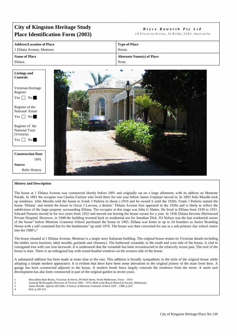
City of Kingston Heritage Place No 130
City of Kingston Heritage Study Place Identification Form (2003)
B r y c e R a w o r t h P t y L t d
1 9 V i c t o r i a S t r e e t , S t K i l d a 3 1 8 2 , A u s t r a l i a
Address/Location of Place 1 Eblana Avenue, Mentone.
Type of Place House.
Name of Place Eblana.
Alternate Name(s) of Place None.
Listings and Controls Victorian Heritage Register Yes No Register of the National Estate Yes No Register of the National Trust (Victoria) Yes No Construction Date 1891 Source Refer History
History and Description The house at 1 Eblana Avenue was constructed shortly before 1891 and originally sat on a large allotment, with its address on Mentone Parade. In 1891 the occupier was Charles Fartiere who lived there for one year before James Urquhart moved in. In 1893 John Moodie took up residence. John Moodie sold the house to Frank J Perkins in about c.1910 and he owned it until the 1920s. Frank J Perkins named the house ‘Eblana’ and rented the house to Oscar J Lawson, a dentist.1 Eblana Avenue first appeared in the 1930s and is likely to reflect the subdivision of the large property surrounding Eblana. The occupier at this stage was John G Slatter. He lived in Eblana from 1930 to 1931. Edward Parsons moved in for two years from 1932 and moved out leaving the house vacant for a year. In 1936 Eblana become Merlswood Private Hospital. However, in 1948 the building reverted back to residential use for Jonathan Dick. DJ Nelson was the last residential owner of the house2 before Mentone Grammar School purchased the house in 1965. Eblana was home to up to 24 boarders as Junior Boarding House with a self contained flat for the headmaster3 up until 1976. The house was then converted for use as a sub-primary day school centre into the 1980’s.4 The house situated at 1 Eblana Avenue, Mentone is a single story Italianate building. The original house retains its Victorian details including the timber eaves brackets, label moulds, garlands and chimneys. The bullnosed verandah, to the south and west side of the house, is clad in corrugated iron with cast iron lacework. It is understood that the verandah has been reconstructed in the relatively recent past. The roof of the house is slate. There is an orthogonal bay with round-headed windows on the western side of the house. A substantial addition has been made at some time to the east. This addition is broadly sympathetic to the style of the original house while adopting a simple modern appearance. It is evident that there have been some alterations to the original joinery of the main front door. A garage has been constructed adjacent to the house. A modern brush fence largely conceals the residence from the street. A multi unit development has also been constructed in part of the original garden in recent years. 1 Moorabbin Rate Books, Victorian Archives, 99 Shiel Street, North Melbourne, Years – 1910 2 Sands & McDougalls Directory of Victoria 1881 - 1974. Held at the Royal Historical Society, Melbourne. 3 James Rundle. Against All Odds: A history of Mentone Grammar School 1920 – 1988. p.263 4 Ibid. p.320-321.
City of Kingston Heritage Place No 130
Condition
Excellent Good Fair Poor Ruins Integrity
Substantially Intact Altered Sympathetically Altered Unsympathetically Damaged/Disturbed Comparable examples within the City of Kingston A number of comparable examples exist within the City of Kingston although houses of this type are reasonably rare within this section of the municipality. These include 2 Jellicoe Street, Cheltenham and the precinct of early residences at 9-17 Como Parade East Mentone. These are houses of a similar age and size in a similar Italianate style. Timber examples such as 24 Wilson Street, Cheltenham and 156 Kingston Road, Heatherton are also comparable. Many comparable examples also exist within the wider Melbourne metropolitan area. Statement of Significance The house at 1 Elbana Avenue, Mentone is of architectural significance at a local level as a fine example of an Italianate villa, albeit with some modern additions. Residences of this type are relatively rare within this section of the municipality. Recommendations A heritage overlay is recommended for the building. City of Kingston Planning Scheme
Recommended for inclusion in a heritage overlay to the Planning Scheme Yes No
Should external paint controls apply? Yes No
Should internal alteration controls apply? Yes No
Should tree controls apply? Yes No Other Listings and Controls
Recommended for inclusion on the Victorian Heritage Register? Yes No
Recommended for inclusion on the Register of the National Estate? Yes No
Recommended for inclusion on the National Trust (Victoria) Register? Yes No

City of Kingston Heritage Place No 137
City of Kingston Heritage StudyPlace Identification Form (2003)
B r y c e R a w o r t h P t y L t d1 9 V i c t o r i a S t r e e t , S t K i l d a 3 1 8 2 , A u s t r a l i a
Address/Location of Place5 Cremona Street, Mentone.
Type of PlaceHouse.
Name of PlaceNone.
Alternate Name(s) of PlaceNone.
Listings andC o n t r o l s
Victorian HeritageRegisterYes c No g
Register of theNational EstateYes c No g
Register of theNational Trust(Victoria)Yes c No g
Construct ionDate
1891Source
Refer History
History and Description
The house situated at 5 Cremona St, Mentone was built in 1891 for James and Julia Cowen. They lived there for over 25 years. Theynamed the house ‘Glengariff’ although the use of that name has subsequently been discontinued. Alfred Perry moved in to the house in1920 and lived there until 1932 when Miss Laura Perkins took up occupancy. Miss Perkins lived in the house until the late 1960’s. By1970 R Rubira occupied the house.
The house is an asymmetrical single storey Italianate villa with ashlar weatherboards. It features an octagonal bay with round-headedwindows to the west and a large timber window beneath a simple curved verandah. The building has a slate roof with two decorativerendered brick chimneys. The verandah at the front of the house is of note for its decorative lace work. The house has a picket fence tothe street.
The building has had a later well-concealed addition at the north (rear) of the building. The building largely retains it original character.
1 Sands & McDougalls Directory of Victoria. 1891 - 1970. Held at the Education Resource Centre, The University of Melbourne.
C o n d i t i o n
Excellent g Good c Fair c Poor c Ruins c
I n t e g r i t y
Substantially Intact c Altered Sympathetically g Altered Unsympathetically c Damaged/Disturbed c

City of Kingston Heritage Place No 137
Comparable examples within the City of Kingston
Few ashlar-boarded asymmetrical villas exist within the City of Kingston although the villa at 156 Kingston Road Heatherton broadlycompares with the dwelling found here. Large numbers of comparable examples exist within the wider Melbourne metropolitan area.
Statement of Significance
The house at 5 Cremona Street, Mentone, built in 1891 is of architectural significance as an intact example of ashlar-boardedasymmetrical villa. Dwellings of this type are reasonably rare within the Municipality.
Recommendat ions
A heritage overlay is recommended for this building.
City of Kingston Planning Scheme
Recommended for inclusion in a heritage overlay to the Planning Scheme Yes g No c
Should external paint controls apply? Yes g No c
Should internal alteration controls apply? Yes c No g
Should tree controls apply? Yes c No g
Other Listings and Controls
Recommended for inclusion on the Victorian Heritage Register? Yes c No g
Recommended for inclusion on the Register of the National Estate? Yes c No g
Recommended for inclusion on the National Trust (Victoria) Register? Yes c No g

City of Kingston Heritage Place No 162
City of Kingston Heritage StudyPlace Identification Form (2003)
B r y c e R a w o r t h P t y L t d1 9 V i c t o r i a S t r e e t , S t K i l d a 3 1 8 2 , A u s t r a l i a
Address/Location of Place36 Como Parade, Mentone.
Type of PlaceShop.
Name of PlaceFormer ES&A Bank.
Alternate Name(s) of PlaceNone.
Listings andC o n t r o l s
Victorian HeritageRegisterYes c No g
Register of theNational EstateYes c No g
Register of theNational Trust(Victoria)Yes c No g
Construct ionDate
c.1923Source
Refer to History
History and Description
The building at 36 Como Parade was built in 1923. It was occupied by the ES&A Bank Ltd for over 45 years until the ANZ Bank tookover in the early 1970s. The shop is now occupied by Rokk Ebony Hairdressers.1 It has been suggested that an early bank on or nearthis site was associated with local entrepreneur Matthew Davies, however no evidence has come to light during the preparation of thiscitation to substantiate this assertion.
The shop is a bold single storey building. It is finished in rendered brick with understated classical decorative elements. The shopfronthas wide pilasters recalling Greek Revival antecedents with expressed plinths and pronounced capitals in the manner of massivecolumns. The building has a featureless pediment above an understated dentilated cornice. The front entrance is set back from the mainfacade to create a deeply recessed entrance. A narrow awning is situated above the entry.
The original bank has been substantially altered and much of the early character of the building has been lost. All the original windowjoinery and the front doors have been removed. The building has been painted in corporate colours and has conspicuous andinappropriate signage.
1 Sands & McDougalls Directory of Victoria 1889 - 1974. Held at the Royal Historical Society, Melbourne.
C o n d i t i o n
Excellent g Good c Fair c Poor c Ruins c
I n t e g r i t y
Substantially Intact c Altered Sympathetically c Altered Unsympathetically g Damaged/Disturbed c

City of Kingston Heritage Place No 162
Comparable examples within the City of Kingston
44 Florence Street, Mentone compares broadly with this building as do a number of other simple broadly Classically-inspired shopswithin the Municipality.
Statement of Significance
The building at 36 Como Parade, Mentone is of architectural significance at a local level. It has been somewhat altered but broadlyretains its early character and some architectural significance.
Recommendat ions
A heritage overlay is recommended for the building.
City of Kingston Planning Scheme
Recommended for inclusion in a heritage overlay to the Planning Scheme Yes g No c
Should external paint controls apply? Yes g No c
Should internal alteration controls apply? Yes c No g
Should tree controls apply? Yes c No g
Other Listings and Controls
Recommended for inclusion on the Victorian Heritage Register? Yes g No c
Recommended for inclusion on the Register of the National Estate? Yes g No c
Recommended for inclusion on the National Trust (Victoria) Register? Yes g No c

City of Kingston Heritage Place No 166
City of Kingston Heritage Study Place Identification Form (2001)
B r y c e R a w o r t h P t y L t d
1 9 V i c t o r i a S t r e e t , S t K i l d a 3 1 8 2 , A u s t r a l i a
Address/Location of Place 74 Venice Street, Mentone.
Type of Place Church.
Name of Place Mentone Uniting Church.
Alternate Name(s) of Place Mary Forrest Davies Memorial Church, Davies Memorial Uniting Church.
Listings and Controls Victorian Heritage Register Yes No Register of the National Estate Yes No Register of the National Trust (Victoria) Yes No Construction Date 1883 Source Memorial Stone History and Description Davies Memorial Uniting Church was constructed in 1883 as a memorial to Mary Forrest Davies.1 Davies was a tireless worker for the establishment of a church in Mentone up until her death. After her death her husband, Joseph B Davies, donated the funds to build a church in her memory. The church was dedicated and formally opened on the 17th of August 1889. At this time there were few other buildings in the area, either residential or business. The church was originally an independent church but became part of the Presbyterian Church in the early 1890s. The first minister was the Rev M Fergus. He led the church until around 1900 when the Rev J E Higginbotham assumed the position. For the next two decades the church was led by Rev J H Hewitt from c.1910 and Rev W Agnew from c.1915.2
From the 1920s the church also operated a Sunday school on the site.3 At this stage there were two other Presbyterian Churches in the area, St Andrews in Mordialloc and another church at Cheltenham.4 From the 1940s it appears that the minister was living in an adjacent presbytery. The minister at this time was the Rev A L Cloyd. By the 1950s the minister was the Rev A C Karmouche, who served at the church until the late 1950s when the Rev A Heggie took over. By the 1970s the minister was Rev A J Haysey. At this time it appears that the church was also associated with the Mentone Creche or that the creche used the church's buildings. 5
Davies Memorial Uniting Church appears to remain unchanged in appearance since construction. An MMBW map of 1895 shows the footprint of the church as it is today. The map clearly shows the church’s tower to the north and spire to the south, vestry to the rear of the church, and protruding central entry. It is of note that a smaller building existed on the site to the south of the church at this time. At this time two large asphalt tennis courts were located to the north and south of the church and another building was located to the rear. The building to the west (rear) is a simple rectangular building with two small verandahs to the north and east.6 A photograph taken at some time between 1940 and 1960 shows the church as it is today except for a small fence and more garden at the street frontage.7
In 1977 the Mentone Presbyterian Church became part of the Uniting Church of Australia. The Uniting Church of Australia brought together churches of three denominations: Congregationalist, Methodist and Presbyterian. Each had been established in Victoria during the nineteenth century but experienced reductions in their numbers through the twentieth century.

City of Kingston Heritage Place No 166
History and Description (continued) The massive brick church has an asymmetrical façade that incorporates a spire, gable and tower on the Venice Street frontage. The walls are red face brick and the building sits on a bluestone base. It has a gable roof, which is tiled in slate and a spire with a copper roof. A large ogee arched window with decorative tracery drawing inspiration from Gothic architectural sources adorns the centre of the front façade in the parapeted gable. The side walls are lined with pointed arched windows and small buttresses. There are two simple windows at the rear of the building. The motifs draw principally from Gothic sources and include, pointed arched windows (some with stone tracery), buttresses and an arcaded corbel table to the corner tower. The only alterations appear to be the unsympathetic security grilles fitted to the side windows. Mary Forrest Davies is acknowledged with a marble stone and font-like feature on the front wall of the church. The building appears to be in good condition throughout. 1 Memorial Stone on site. 2 Sands & Mc Dougalls Directory of Victoria. 1889 - 1970. Held at the Royal Historical Society, Melbourne. 3 Ibid. 4 Saint Andrews’ Presbyterian Church Mordialloc Centenary 1884 – 1984. Produced by Church, 1984. p.9-30. 5 Sands & Mc Dougalls Directory of Victoria. Op cit. 6 MMBW Map of 1895. Map No. 4215 Scale: 40ft to1 inch. Held at the State Library of Victoria. 7 The Presbyterian Church, Mentone, Vic. c.1940 – 1960. PCV LTGN P.3893 La Trobe Library Picture Collection, State Library of Victoria. 8 Peter Bently and Philip J. Hughes. The Uniting Church in Australia. Australian Government Publishing Service, Canberra Condition
Excellent Good Fair Poor Ruins Integrity
Substantially Intact Altered Sympathetically Altered Unsympathetically Damaged/Disturbed Comparable examples within the City of Kingston No comparable examples were identified as part of this study. Statement of Significance Mentone Uniting Church is of architectural, spiritual and social significance at a local level. The structure is architecturally significant an unusually well resolved Gothic Revival church. It is socially and spiritually significant as the focus of local worship for the local Presbyterian community. The building is of some historical interest for its associations with Mary Forrest Davies and the benevolence of her husband, Joseph B Davies. Recommendations A heritage overlay is recommended for this building. However, it should be noted that buildings on the land other than the church do not contribute to the significance of the place and their demolition is unlikely to raise heritage issues. Nonetheless, a permit would be required for any new works on associated land within the heritage overlay. City of Kingston Planning Scheme
Recommended for inclusion in a heritage overlay to the Planning Scheme Yes No
Should external paint controls apply? Yes No
Should internal alteration controls apply? Yes No
Should tree controls apply? Yes No Other Listings and Controls
Recommended for inclusion on the Victorian Heritage Register? Yes No
Recommended for inclusion on the Register of the National Estate? Yes No

City of Kingston Heritage Place No 166
Recommended for inclusion on the National Trust (Victoria) Register? Yes No
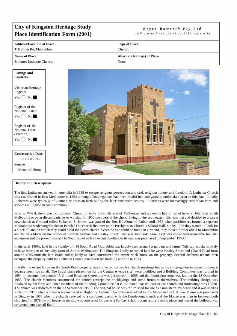
City of Kingston Heritage Place No 182
City of Kingston Heritage Study Place Identification Form (2001)
B r y c e R a w o r t h P t y L t d
1 9 V i c t o r i a S t r e e t , S t K i l d a 3 1 8 2 , A u s t r a l i a
Address/Location of Place 416 South Rd, Moorabbin.
Type of Place Church.
Name of Place St James Lutheran Church.
Alternate Name(s) of Place None.
Listings and Controls Victorian Heritage Register Yes No Register of the National Estate Yes No Register of the National Trust (Victoria) Yes No Construction Date c.1900 -1955 Source Memorial Stone
History and Description The first Lutherans arrived in Australia in 1838 to escape religious persecution and seek religious liberty and freedom. A Lutheran Church was established in East Melbourne in 1854 although Congregations had been established and worship undertaken prior to this date. Initially Lutherans were typically of German or Prussian birth but by the later nineteenth century, Lutherans were increasingly Australian born and services in English became common.1 Prior to WWII, there was no Lutheran Church to serve the south east of Melbourne and adherents had to travel in to St John’s in South Melbourne or other distant parishes to worship. In 1950 members of the church living in the southeastern districts met and decided to create a new church at Ormond called St James. St James’ was part of the Box Hill/Ormond Parish until 1958 when parishioners formed a separate Moorabbin/Dandenong/Frankston Parish.2 The church first met in the Presbyterian Church’s School Hall, but by 1953 they started to look for a block of land on which they could build their own church. When no site could be found in Ormond, they looked further afield to Moorabbin and found a block on the corner of Central Avenue and Healey Street. This was soon sold again as it was considered unsuitable for later expansion and the present site at 416 South Road with an extant dwelling to its rear was purchased in September 1953.3 In the early 1900s, land in the vicinity of 416 South Road Moorabbin was largely used as market gardens and farms. This subject site is likely to have been part of the dairy farm of Arthur W Simpson. The Simpson family occupied land between Healey Street and Chapel Road from around 1895 until the late 1940s and is likely to have constructed the extant brick house on the property. Several different tenants then occupied the property until the Lutheran Church purchased the building and site in 1953. Initially the extant house on the South Road property was converted for use for church meetings but as the congregation increased in size, it became much too small. The initial plans (drawn up for the Central Avenue site) were modified and a Building Committee was formed in 1954 to construct the church.4 A Ground Breaking Ceremony was performed in 1955 and the foundation stone was laid on the 18 December 1955. The church members constructed the church (except the bricklaying) and some furniture themselves.5 The building design was finalized by Mr Bray and other members of the building Committee.6 It is estimated that the cost of the church and furnishings was £3700. The church was dedicated on the 23 September 1956.7 The original house was refurbished for use as a minister’s residence and it was used as such until 1970 when a house was purchased in Highbury Avenue.7 An office was added to this Manse in 1972. A new Manse was purchased in Dingley in 1988 when the church reverted to a combined parish with the Dandenong church and the Manse was then in between both churches.9 In 1978 the old house on the site was converted for use as a Sunday School rooms and a meeting place and part of the building was converted into a small flat.10

City of Kingston Heritage Place No 182
History and Description (continued) In 1960 a Sunday School and General Purpose Hall was constructed to the rear of the church and the former residence at a cost of approximately £3400.11 Also, in1963, a Kindergarten was established in the hall during the week. The kindergarten ran until 1978 when government regulations made it necessary to change into a Preschool instead. This ran for a few years helping to support the church financially.12 Major renovation work was carried out in 1990 including: replacement of the original roofing, repainting of the ceiling and beams and re-carpeting the church.13 This austere cream brick building is an amalgam of modest early English and Medieval influences executed using contemporary domestic materiality and detailing. The large cross, tall windows and the castellated parapet offer simple ecclesiastical adornment to an otherwise simple Modern building. A low brick fence at the front of the site adds to the overall character and significance of the building. 1 Correspondence from Charles Almond, on behalf of the Members of St James Lutheran Church, Moorabbin, to Rosa Zouzoulas, Statutory planner, City Of Kingston, 14
October 2004. 2 F. A. Morcomb. St. James’ Lutheran Church Moorabbin Victoria, 1950 – 1990: A Brief History of Forty Years. September, 1990.p.3 and p.7. Dandenong became a
separate parish in 1962 and Frankston became a separate parish in 1971. St James’ was self-supporting by 1974. But after realignment in 1987 the Moorabbin/Dandenong Parish was recreated. (pp.13-15).
3 Ibid. p.4. 4 Ibid. p.5. 5 Ibid. p.6. 6 Almond, loc cit. 7 Ibid. p.7. 8 Ibid. p.13. 9 Ibid. p.15 10 Ibid. p.14. 11 Ibid. p.l8. 12 Ibid. p.13. 13 Ibid. p.16. Condition
Excellent Good Fair Poor Ruins Integrity
Substantially Intact Altered Sympathetically Altered Unsympathetically Damaged/Disturbed Comparable examples within the City of Kingston No comparable examples were identified as part of this study. Statement of Significance St James Lutheran Church is of architectural, spiritual and social significance at a local level. The structure is architecturally significant as an example of austere, post WWII church building design that nonetheless reflects early English antecedents. It is socially and spiritually significant as the focus of local worship for the local Lutheran community. The building is of some historical interest for its associations with postwar development of the Lutheran Church in Victoria. The early dwelling to the rear of the church, which has undergone various alterations and is no longer intact, and the associated cream brick hall are of minor social significance. Recommendations A heritage overlay is recommended for the church building and associated site. It should be noted that the arrangement of titles on this site will necessitate the inclusion of the early dwelling to the rear of the church and the cream brick hall to its rear within any future heritage overlay. These buildings do not contribute to the valued character or significance of the subject site to any substantial degree and works to the rear of the site generally are unlikely to raise heritage issues. Demolition of these buildings to the rear should be considered permissible as part of any future (and otherwise acceptable) development proposal, subject to a photographic survey being undertaken

City of Kingston Heritage Place No 182
City of Kingston Planning Scheme
Recommended for inclusion in a heritage overlay to the Planning Scheme Yes No
Should external paint controls apply? Yes No
Should internal alteration controls apply? Yes No
Should tree controls apply? Yes No Other Listings and Controls
Recommended for inclusion on the Victorian Heritage Register? Yes No
Recommended for inclusion on the Register of the National Estate? Yes No
Recommended for inclusion on the National Trust (Victoria) Register? Yes No

City of Kingston Heritage Place No 183
City of Kingston Heritage Study Place Identification Form (2001)
B r y c e R a w o r t h P t y L t d
1 9 V i c t o r i a S t r e e t , S t K i l d a 3 1 8 2 , A u s t r a l i a
Address/Location of Place 944-954 Nepean Highway, Moorabbin.
Type of Place Recreational Centre.
Name of Place Ten Pin Bowls, Moorabbin.
Alternate Name(s) of Place Moorabbin Bowl.
Listings and Controls Victorian Heritage Register Yes No Register of the National Estate Yes No Register of the National Trust (Victoria) Yes No Construction Date 1963 - 4 Source Refer History
History and Description The post war period gave rise to an increase in youth unemployment in the municipality. The community responded with youth centres, dances, social clubs, sporting activities, while commerce responded with cinemas and bowling alleys.1 Two bowling centres remain in the City of Kingston, this one at Moorabbin and another at Mentone. Prior to the construction of the Ten Pin Bowling Centre this site was occupied by the Builders Suppliers, Williams & McIntosh, and a small house. The yards and house were demolished in 1963 for the construction of the bowling centre. The centre was in operation by 1965.2
The Moorabbin Ten Pin Bowling Centre is a large building designed by noted local architect, Theodore Berman. It adopts the International Style of the mid-twentieth Century with hovering planar forms and cuboid massing. The building consists of a main bowling space and an attached entry porch, which wraps around part of the eastern street frontage and the northern section of the building. The building is accessed by a concrete entrance ramp. The principal structure is constructed from concrete blockwork and has corrugated sheet roofing. It presents itself as a rectilinear box. The porch is constructed from steel and it sits on a plinth of Castlemaine stone. The porch has large windows, which impart a hovering quality to its flat roof and cantilevering floor slab. As constructed, the building was detailed in an understated manner with textured glazed tiles to the south side of the main entry and subtle patterning to the blockwork. It has been painted in an unsympathetic manner in recent years, which has to some extent undermined the early character. Nonetheless, the building is in good original condition and does not appear to have been substantially altered. 1 Cribbin, John. Moorabbin: A Pictorial History 1862 – 1994. City of Kingston, 1995. p.162 – 164. 2 Sands & McDougalls Directory of Victoria. 1950, - 1965. Held at the Royal Historical Society, Melbourne. Condition
Excellent Good Fair Poor Ruins

City of Kingston Heritage Place No 183
Comparable examples within the City of Kingston Constructed c.1964, the Mentone Ten Pin Bowling Centre in Warrigal Road Mentone is broadly comparable to the Moorabbin bowling centre. However, the Mentone Bowling Centre does not adopt the innovative Modernist style found at the Moorabbin Ten Pin Bowling Centre. In spirit, Moorabbin bowling centre is more consistent with other striking Modern designs along the Highway such as the Leigh Mardon factory or the Nylex clock. Statement of Significance Constructed in 1963-4 to designs by noted Melbourne architect, Theodore Berman, the Moorabbin Ten Pin Bowling Centre building at 944-954 Nepean Highway Moorabbin is of social and architectural significance at a local level. It is socially significant as a major recreational focus, particularly for younger residents and as a built reminder of postwar entertainment patterns in the municipality. It is architecturally significant as a striking Modernist composition and an example of the exuberance found frequently in local architectural design during the postwar period. The building derives some additional significance for its associations with architect, Theodore Berman. Recommendations A heritage overlay is recommended for the building. It should be noted that the arrangement of titles on this site will necessitate the inclusion of the adjacent car park area within any future heritage overlay. The car park does not contribute to the character or significance of the subject site to any substantial degree and redevelopment of this area is unlikely to impact detrimentally on the character or significance of The Moorabbin Ten Pin Bowling Centre. Similarly, works to the rear of the building or works which do not substantially alter the manner in which the building presents to the Highway are also unlikely to raise heritage issues. Accepting this, it is understood that the extent of the site that needs to be protected is the front of the building facing Nepean Highway and the side elevations for a length of 10m from the facade. Development on the car park site to the north should not raise any issues and need not be subject to a permit under the heritage overlay subject to a laneway or other vehicle access type of separation between the existing and new building (preserving the integrity of the northern elevation and views to that elevation from the street. City of Kingston Planning Scheme
Recommended for inclusion in a heritage overlay to the Planning Scheme Yes No
Should external paint controls apply? Yes No
Should internal alteration controls apply? Yes No
Should tree controls apply? Yes No Other Listings and Controls
Recommended for inclusion on the Victorian Heritage Register? Yes No
Recommended for inclusion on the Register of the National Estate? Yes No
Recommended for inclusion on the National Trust (Victoria) Register ? Yes No

City of Kingston Heritage Place No 222
City of Kingston Heritage StudyPlace Identification Form (2003)
B r y c e R a w o r t h P t y L t d1 9 V i c t o r i a S t r e e t , S t K i l d a 3 1 8 2 , A u s t r a l i a
Address/Location of PlaceWhite Street, Mordialloc.
Type of PlaceClub House.
Name of PlaceWoodlands Golf Club.
Alternate Name(s) of PlaceNone.
Listings andC o n t r o l s
Victorian HeritageRegisterYes c No g
Register of theNational EstateYes c No g
Register of theNational Trust(Victoria)Yes c No g
Construct ionDate
1927-9Source
Refer History
History and Description
The Mordialloc Golf Club was established in 1913 when George Hunter Rogers, a school teacher from the Hamilton district moved toMordialloc. He was instrumental in the establishment of the Mordialloc Golf Club after WWI. This club was dissolved in 17th October19251 when its assets were transferred to the new Woodlands Golf Club.2 The club’s building committee immediately held a competitionto select a design for the new clubhouse. A proposal by RA Lippincott and EF Billson was selected, but was not implemented until a firein April 1927 completely destroyed the existing club house. After some deliberation a revised design by Billson was produced and workon the structure was commenced in 1927.
Edward Billson was the first person to enroll in the University of Melbourne Architecture course and the first Australian to servearticles under the noted American architect Walter Burley Griffin. During his time with Griffin, Billson became part of a circle ofarchitects which was instrumental in establishing the Prairie School of architecture in Melbourne3. Billson had already explored a localvariant of the Prairie style in his domestic work such as the Alfred A Billson house in Toorak (1918) and the Margaret Armstronghouse, Caulfield (1918-19). The Woodlands Golf Course was Billson's first opportunity to test the Prairie Style in an institutionalsetting.
Billson’s revised design for the clubhouse was slightly larger and adopted a more pleasing elevational treatment than the 1925 design.Billson also designed the interiors of the clubhouse which were clad in plaster panels and accented in timber. The clubhouse wascompleted by early 1929.4
The Woodlands Golf Course is a single storey building. The design of the clubhouse is drawn from the Prairie School style. It is asprawling' firmly grounded structure with broad overhanging eaves. The clubhouse is of timber and brick construction clad inweatherboard and stucco. The original windows are comprised of 3 panes with an unusual 3-part arrangement of timber mullions, whichrecall the work of Billson's mentor, Walter Burly Griffin.

City of Kingston Heritage Place No 222
History and Description (continued)
The building has been enlarged in several stages. Each addition has been generally sympathetic to the style of the original building.The roof retains a mixture of tiles, which help to illustrate the various building campaigns. The bay windows to the north of thebuilding are an addition possibly dating from the 1960s. The east side of the building, orientated towards the main White Streetentrance was largely rebuilt in the 1980s. The later date of these works is evident through its robust joinery modeled on, but notreplicating the original design. The building is in very good condition but some of the early modest character has been lost through thesubsequ ent additions.
1 Kingston Historical Website. http://localhistory.kingston.vic.gov.au ‘Beginning of the Woodlands Golf Club’2 Tom Ramsey. Discover Australia’s Golf Courses. JM Dent Pty Ltd, Melbourne, 1987. p.147.3 Nigel Lewis, City of Malvern Heritage Study, Appendix 1: Architects of Malvern, Billson4 Donald Leslie Johnson. Australian Architecture 1901-1951:Sources of Modernism. Macarthur Press (Books) Pty Ltd, Paramatta, 1920, p.122-5
C o n d i t i o n
Excellent g Good c Fair c Poor c Ruins c
I n t e g r i t y
Substantially Intact c Altered Sympathetically g Altered Unsympathetically c Damaged/Disturbed c
Comparable examples within the City of Kingston
No directly comparable clubhouses were identified within the City of Kingston during the course of this study although other golf clubsin the area share a similar construction date and general layout. Many golf clubs were constructed in the area during the 1920s and1930s as urban development pushed clubs further away from Melbourne. However, the Woodlands Golf Club house appears to be uniquewithin the local area for its Praire School stylings. Kingston Heath Golf Club opened in 1925 and has a long American ranch styleclubhouse with black tiled roof, white rendered walls, multipaned windows and gabled roofs. The Yarra Yarra Golf club opened at itspresent site in 1928. Its clubhouse is constructed from brown brick and has a tiled gabled roof. The building is two storey and features atower-like element and arched openings in a manner recalling the English Queen Anne style. Other golf clubs established around thesame time include the Victoria Golf Club in Park Road Cheltenham which opened in 1927, the Patterson River Country Club atBonbeach (which opened to the public in 1925 having previously been a private course), the Southern Golf Club (1937) on LowerDandenong Road Braeside and the Huntingdale Golf Club in Oakleigh South, in the City of Monash (1941).1
1 Tom Ramsey, Discover Australia’s Golf Courses’. JM Dent Pty Ltd, Melbourne, 1987, pp135-151.
Statement of Significance
Constructed from 1929, the Woodlands Golf Club House in White Road, Mordialloc is of historical, social and architecturalsignificance at a local level. It forms part of the interwar profusion of golf clubs in the sand belt region and has been a social andrecreational focus for the district for over seventy years. Although somewhat altered, the clubhouse remains significant architecturallyas an important example of the work of noted architect Edward Billson and a rare example of the American Prairie style within theMunicipality.
Recommendat ions
A heritage overlay is recommended for the clubhouse, carpark and entry from White Street only. Future works on the site which, do notdirectly affect the clubhouse and its immediate environs or the historical use of the golf course are unlikely to diminish the significanceof the place.
City of Kingston Planning Scheme
Recommended for inclusion in a heritage overlay to the Planning Scheme Yes g No c
Should external paint controls apply? Yes g No c
Should internal alteration controls apply? Yes c No g
Should tree controls apply? Yes c No g

City of Kingston Heritage Place No 222
Other Listings and Controls
Recommended for inclusion on the Victorian Heritage Register? Yes c No g
Recommended for inclusion on the Register of the National Estate? Yes c No g
Recommended for inclusion on the National Trust (Victoria) Register? Yes c No g

City of Kingston Heritage Place No 225
City of Kingston Heritage Study Place Identification Form (2001)
B r y c e R a w o r t h P t y L t d
1 9 V i c t o r i a S t r e e t , S t K i l d a 3 1 8 2 , A u s t r a l i a
Address/Location of Place 56 The Corso, Parkdale.
Type of Place Church.
Name of Place
Parkdale Greek Orthodox Church.
Alternate Name(s) of Place Greek Orthodox War Memorial Church.
Listings and Controls Victorian Heritage Register Yes No Register of the National Estate Yes No Register of the National Trust (Victoria) Yes No Construction Date 1969 Source Memorial Stone
History and Description Melbourne gained its first Greek Orthodox Priest in 1898. By 1911, the number of people who classified themselves as Greek Catholic (including Greek Orthodox) was 2814. In 1921 this number had doubled and by 1933 had risen to over 11 000. A number of large city churches had been established in Australia by this time.1 However, only one Greek Orthodox Church existed in Melbourne in the 1950s. With the influx of post war immigrants, the number had grown to 25 churches in the 1970s. This church is part of that postwar boom.2
This massive salmon brick building was erected to the memory of Australians and Greeks 'who gave their lives for freedom, the democratic principles and the Christian ideals.' The foundation stone was laid by the Archbishop Ezekiel on the 4th of December 1969.3 The street façade of the building is flanked by two towers and has a barrel vaulted roof whose form is reflected in the parapet. The building is of note for its striking triple arched entry, columns and white brick trims to the windows. The front steps and columns are clad in white marble tiles. The two towers beside the entry are topped with onion domes and crucifixes. Cruciform motifs are found throughout the building with crosses also formed in the brickwork and on flagpoles to the front of the building. The fence is balustraded and appears to date from the original construction, although the gates appear to be of more recent construction. The interior features ornate timberwork, decorational motifs and coloured glass windows. The design is typical of Greek Orthodox churches with its barrel vaulted roof, onion domes on top of dual side towers and triple arched entry based on the traditional west front. 1 Hugh Gilchrist. Australians & Greeks: volume II: The Middle Years. Halstead Press, Rushcutters Bay, 1997. p.265 2 Dominique François De Stoop. The Greeks of Melbourne. Transnational Publishing Company Pty. Ltd. Melbourne, 1996. p.42 3 Memorial stone on site. Condition
Excellent Good Fair Poor Ruins

City of Kingston Heritage Place No 225
Comparable examples within the City of Kingston There are no comparable examples identified by this study within the City of Kingston area. However, similar examples can be found within the wider Melbourne metropolitan area. Statement of Significance The Parkdale Greek Orthodox Church is of historical, architectural social and spiritual significance at a local level. It is historically significant as a tangible reminder of the influx of Greek migrants into the municipality in the years after WWII. It is architecturally significant as a handsome example of the bold architectural styling which typify the buildings of the Greek Orthodox Church. The church is of social and spiritual significance for its long associations with the local Greek Orthodox community.
Side view of church showing simple arched windows and doors with white brick trims. Recommendations A heritage overlay is recommended for the building. It is noted that adaptive reuse of Church sites is not permitted within the traditions of the Greek Orthodox Church. In the event of the Church leaving the site, demolition of the building could be permitted subject to the preparation of an appropriate photographic and/or other documentary record of the place. Reasonable modifications to the building to allow it to continue to function as a modern Greek Orthodox church are unlikely to raise heritage issues. City of Kingston Planning Scheme
Recommended for inclusion in a heritage overlay to the Planning Scheme Yes No
Should external paint controls apply? Yes No
Should internal alteration controls apply? Yes No
Should tree controls apply? Yes No Other Listings and Controls
Recommended for inclusion on the Victorian Heritage Register? Yes No
Recommended for inclusion on the Register of the National Estate? Yes No
Recommended for inclusion on the National Trust (Victoria) Register? Yes No

City of Kingston Heritage Precinct No P34
City of Kingston Heritage StudyPlace Identification Form (2001)
B r y c e R a w o r t h P t y L t d1 9 V i c t o r i a S t r e e t , S t K i l d a 3 1 8 2 , A u s t r a l i a
Address/Location of PlaceWrens Road, Moorabbin.
Type of PrecinctLight Industrial Area.
Name of PlaceWrens Road Factories.
Alternate Name(s) of PlaceNone.
Listings andC o n t r o l s
Victorian HeritageRegisterYes c No g
Register of theNational EstateYes c No g
Register of theNational Trust(Victoria)Yes c No g
Construct ionDate
1959-1969Source
Refer History
History and Description
Prior to WWII, there had been few manufacturing operations within the City of Moorabbin.1 The prominent Gilbey's Distillery hadbeen built on the Nepean Highway in 1937, but most other industrial enterprises were small and inconspicuous. After the war,manufacturing business began to increase steadily. The Council adopted a new rating system, which had the effect of freeing up largeareas of former agricultural land for industrial use at attractive prices. The new zoning provisions designating specific areas for lightindustrial and general industrial activity and encouraged confidence in Moorabbin as a manufacturing region.
The majority of the new development occurred in Moorabbin East, near Chesterville, Cochranes and Keys Road where major companiesincluding Schweppes, Coca-Cola Bottlers, Beechams, Singer, Phillip Morris, Coates Brothers and Horndraulics (Australia) establishedfactories or warehouses.2 More modest industrial development flourished nearby. In Wrens Road to the north of Cochranes Road,favorable zoning produced a spate of new construction from the late 1950s. Development in the area proceeded in spectacular fashion.In June 1959, Jack Allan Sherrin applied for permission to construct a factory3 and Philip Epstein applied to construct an engineeringworks.4 Sherrin undertook another development in the same street in November5 and Sydney Eldridge undertook construction of afactory in December.6 In the following year, Lawrence Royer and Lawrence William Binns applied to construct a brick factory.7
Construction continued into the 1960s including David and Isobel Brown's application to construct a cafe8 and David Turnbull's brickfactory for the purposes of motor wrecking.9 By c.1970 the development of the area was more or less complete.
The speed of the development, the tight regulatory constraints and the uniformity of the available blocks have resulted in a relativelyconsistent group of buildings. Every building in the group is of a simple, single storey construction; all of the buildings (exceptNo.14, c.1980) appear to date from the original period of construction (1959-1969) and only one occupies more than a single block(No.10-12). The buildings employ a range of construction techniques and materials to their rear, consistent with their varied uses, andvariously feature sawtooth, flat deck and conventional hipped roofs. However, the use of tall parapeted end-walls and forecourts worksto conceal the variety within the group and produce a strong and unified external physical expression. Modifications are generallysympathetic and the buildings appear generally to be in good condition.
An unusual circular office building located at Kingsway Street & Wrens Road, and discussed in detail under a separate report (City ofKingston heritage place No 172) adopts an unusual post war modern style which contributes to a limited extent to the character ofWrens Road.

City of Kingston Heritage Precinct No P34
History and Description (continued)
1 This reference is drawn from, John Cribbin, Moorabbin: A Pictorial History 1862-1994, Prepared for the City of Kingston, Moorabbin, 1995, pp.159-160.2 Ibid.3 Application for permit under Town and Country Planning Scheme for works to lot 29 Wrens Road, dated 6 June 1959.4 Application for permit under Town and Country Planning Scheme for works to lots 24&25 Wrens Road, dated 29 June 1959.5 Application for permit under Town and Country Planning Scheme for works to Lot 3 Wrens Road, dated 24 November 1959.6 Application for permit under Town and Country Planning Scheme for works to Lot 33 Wrens Road, dated 21 December 1959.7 Application for permit under Town and Country Planning Scheme for works to Lot 13 Wrens Road, dated 19 February 1960.8 Application for permit under Town and Country Planning Scheme for works to 20 Wrens Road, dated 15 January 1963.9 Application for permit under Town and Country Planning Scheme for works to 29 Wrens Road, dated 3 July 1969.
I n t e g r i t y
Substantially Intact c Altered Sympathetically g Altered Unsympathetically c Damaged/Disturbed c
Comparative Examples within the City of Kingston
A number of broadly comparable post-war developments exist in streets immediately to the south and west of Wrens Road. RobernaStreet, Joyner Street, Ebden Street, parts of Alex Avenue and others are all small-scale postwar developments catering for lightindustrial and warehousing needs. However, none demonstrates the consistency of building stock and block sizes which combine tocreate the early character found in the Wren’s Road precinct.
Statement of Significance
Generally constructed between 1959-1969, the factories in Wrens Road, Moorabbin are of local historical and architecturalsignificance. The group is of historical significance as a physical expression of the post-war industrial boom within the City and theforward-looking approach to zoning employed by the local council. It is architecturally significant for the consistent character of itsbuilding facades. The significant fabric is limited to the brick facades and front setbacks only.
Typical factories in precinct
Recommendat ions
A heritage overlay is recommended for the buildings noted on the attached plan. It comprises even Nos. 2-32 and odd Nos. 7-37 WrensRoad, Moorabbin. It is important to note that the significant fabric is limited to the brick facades and front setbacks.

City of Kingston Heritage Precinct No P34
City of Kingston Planning Scheme
Recommended for inclusion in a heritage overlay to the Planning Scheme Yes g No c
Should external paint controls apply? Yes g No c
Should internal alteration controls apply? Yes c No g
Should tree controls apply? Yes c No g
Other Listings and Controls
Recommended for inclusion on the Victorian Heritage Register? Yes c No g
Recommended for inclusion on the Register of the National Estate? Yes c No g
Recommended for inclusion on the National Trust (Victoria) Register? Yes c No g

City of Kingston Heritage Precinct No P41
City of Kingston Heritage Study Place Identification Form (2001)
B r y c e R a w o r t h P t y L t d
1 9 V i c t o r i a S t r e e t , S t K i l d a 3 1 8 2 , A u s t r a l i a
Address/Location of Place Main Street, Mordialloc.
Type of Place Shops.
Name of Place Main Street, Mordialloc.
Alternate Name(s) of Place None.
Listings and Controls Victorian Heritage Register Yes No Register of the National Estate Yes No Register of the National Trust (Victoria) Yes No Construction Date From c.1880s Source Refer History
History and Description Main Street comprises two strips of retail premises, located adjacent to Nepean Highway in Mordialloc. They contain almost one hundred properties situated between McDonald and Epsom Roads and the Mordialloc Creek. Broad median strips containing avenues of mature palms form a buffer between the highway and the traffic and parking areas of Main Street to produce an unusually broad and elegant boulevard. Prior to 1880, Main Street Mordialloc consisted predominantly of single storey shops with wide verandahs and parapets.1 Between the establishment of the railway station in December 1881 and 1890, the town was transformed from a rural settlement to a bustling township. In 1891, Main Street comprised thirty-six shops along an unmade road. Businesses included two hotels, the Mordialloc Hotel and the Temperance Hotel, a coffee palace, two grocers, a butcher, a hairdresser, a plumber, two bootmakers, two dressmakers, a baker, a restaurant and two stores. Mordialloc also boasted a post office and a branch of the English Scottish and Australian Chartered Bank.2 In 1910 Main Street remained an unmade road, although a number of substantial two-storey masonry buildings had been built. The first steps towards the present landscaped medians had begun in the form of fenced gardens in the centre of the highway.3 By this time, Mordialloc had become a popular holiday retreat and many of the businesses catered to the summer crowds. Glamille House, a boarding house opposite the station, claimed to have first class cuisine and offered holiday-makers a choice of recreational pursuits including boating and fishing all for a moderate tariff. It has since been demolished. By the 1940s the character of the street had become more formal. Some of earlier single-storey shops had been replaced by new two storey brick buildings with tall brick parapets and wide verandahs to the street5. Formal landscaping had been established and the general axial character of the precinct defined. In the period shortly after WWII, fences around the central garden beds were removed, the road was paved, raised medians were constructed and prominent palm trees to the median strips were planted4.Several memorials were also erected on the median strips including, two artillery pieces, a WWI memorial and clock tower erected to the memory of Cr David White JP. By the mid 20th century the street had broadly adopted its present appearance with palm trees lining the road, monuments to median strips and a predominantly two storey character to the busy thoroughfare6. The directory of 1950 lists over 50 commercial premises, almost double the number present in 19007. Since that time, the street has continued its evolution with a number of new shops constructed within the established precinct boundaries, most notably the large Safeway complex on the site of the early coffee palace.

City of Kingston Heritage Precinct No P41
History and Description (continued) The present character of the Main Street Mordialloc Precinct is varied with shops dating from c.1880s to late 20th century. The key buildings in the street date from the late nineteenth and early twentieth centuries and comprise late Victorian and Edwardian shops and other commercial premises. Extant Federation and Italianate buildings are generally of two stories with decorative mouldings to parapets. Facades have generally been modified at ground floor level but typically remain unaltered above. Shops at 473 and 515 Main Street retain the form of their original shopfronts although no early fabric appears to remain. Other premises dating from this period include: the group at 471-475, completed in an understated Italianate mode, the ES&A bank at 481constructed before 1891; and 497 and 501 Main Street. Number 515 Main Street, a former butcher's shop, offers an unusual alternative to conventional Italianate detailing, with decorative cattle heads at parapet level in addition to more traditional urns and balustrade. A single storey shop at 503-5 Main Street was constructed before 1887 and has retained its original verandah, roof form, parapet and general layout.8 Interwar structures contribute to the valued character of the precinct through their massing, scale and form. Shops from this period are typically of two stories, some featuring decorative brickwork and parapets (517, 584, 622–626) or strong geometrical detailing (572, 622–626). The war memorials also date from this period. The Great War Memorial, 1914-1919, was erected ‘to those in the district who gave their lives’ and is likely to date from c.1920. It is a bluestone block base topped with a large granite cross. Two artillery pieces were erected to either side between the wars. The nearby brick clock tower was erected to the memory of Cr David White, JP, who died on February 25 1937. This memorial is constructed from clinker bricks graded from dark brown at the base to a light cream at the top. The tower was completely rebuilt in the early 1990s. While the area retains much of its interwar character, many of the buildings are relatively recent replacements of the early building stock. As noted, a large portion of the western side of the street dates from c.1980, including 592 to 620 (excluding the early building at 596) and much of the building stock to the north of Owen Street. Nonetheless, the quality and substantial numbers of early buildings in conjunction with the large expanses of landscaping and associated memorials recall an early formality, more often encountered in rural Victoria than metropolitan Melbourne. 1 Frank McGuire, Mordialloc – the early days: a brief history, The Mordialloc Community Committee for Victoria’s 150th Anniversary, 1985. P.19. 2 Sands & McDougalls Directory of Victoria. 1870 - 1974. Held at the Royal Historical Society, Melbourne. 3 ‘Photograph of Main Street Mordialloc’, c1910, Shirley Jones Collection of Victorian Postcards, LaTrobe Photographic Collection, Held at the State Library of Victoria. 4 ‘Photograph of Main Street Mordialloc’, c1910, Op cit, ‘Photograph of Shopping Centre Mordialloc Victoria’, c1940-1960, Rose Series of Postcards, LaTrobe
Photographic Collection, Held at the State Library of Victoria and ‘Aerial Photograph of Mordialloc c1925 -1940 showing Albert and Main Streets and Railway Station’, Airspy Collection of Aerial Photographs, LaTrobe Photographic Collection, Held at the State Library of Victoria and ‘Pt. Nepean Road, Mordialloc – 1920s’, Thomas Arthur Sheehy, Mordialloc-Chelsea: aspects of history, Vol 1, Standard Newspapers of Cheltenham, 1970.p.xi.
5 ‘Pt. Nepean Road, Mordialloc – 1920s’. Op cit. 6 ‘Photograph of Nepean Highway Mordialloc’. Rose Series of Postcards, LaTrobe Photographic Collection, Held at the State Library of Victoria and ‘Photograph of
Nepean Highway Mordialloc’, c1940-1960, Rose Series of Postcards, LaTrobe Photographic Collection, Held at the State Library of Victoria and ‘Main Street & Monument Mordialloc’, c1940-1960, Rose Series of Postcards, LaTrobe Photographic Collection, Held at the State Library of Victoria.
7 Sands & McDougalls Directory of Victoria. 8 Photograh in the possession of the current owner, Graham W Bell. Integrity
Substantially Intact Altered Sympathetically Altered Unsympathetically Damaged/Disturbed Comparable examples within the City of Kingston No comparable examples have been identified within the City of Kingston. Comparable wide commercial boulevards are readily encountered in rural Victoria in locations such as Ballarat and Nhill. Statement of Significance The Main Street Mordialloc Precinct is of social, historical and architectural significance at a local level. The precinct is socially significant as a focus of the Mordialloc community. It is historically significant as a tangible reminder of development patterns in the area during the late nineteenth and early twentieth centuries. It retains its original relationship to the Mordialloc Railway Station and the neighbourhood remains unusually legible as an early retail/transportation hub. The precinct is architecturally significant for the quality of its early building stock and the precinct retains much of its early built fabric including early buildings, memorials, avenue layout and landscaping.

City of Kingston Heritage Precinct No P41
Left: Memorials in the central median strip including Canon, WWI Memorial, and Clock Tower memorial to Cr David White JP. Right: Late Victorian shops on the east side of Main Street, Nos 471 – 481.
Recommendations A heritage overlay is recommended for Mordialloc Main Street to the extent indicated on the accompanying map. The schedule to the heritage overlay should reflect that controls extend to memorials, median strips and associated tree plantings in addition to the building stock. It should be noted that existing buildings at 469, 507, 511-513, 515, 521, 525-527, 529-531, 530, 540-548, 1/566, 1-31/572 and 598-618 Main Street are non-contributory elements within the streetscape and their demolition is not problematic subject to the design of an appropriate replacement building. City of Kingston Planning Scheme
Recommended for inclusion in a heritage overlay to the Planning Scheme Yes No
Should external paint controls apply? Yes No
Should internal alteration controls apply? Yes No
Should tree controls apply? Yes No
Other Listings and Controls
Recommended for inclusion on the Victorian Heritage Register? Yes No
Recommended for inclusion on the Register of the National Estate? Yes No
Recommended for inclusion on the National Trust (Victoria) Register? Yes No

City of Kingston Heritage Precinct No P47
City of Kingston Heritage StudyPlace Identification Form (2001)
B r y c e R a w o r t h P t y L t d1 9 V i c t o r i a S t r e e t , S t K i l d a 3 1 8 2 , A u s t r a l i a
Address/Location of Place218-286 Como Parade West and 79 – 85 Parkers Road,Parkdale.
Type of PlaceShops.
Name of PlaceParkdale Shopping Centre.
Alternate Name(s) of PlaceNone.
Listings andC o n t r o l s
Victorian HeritageRegisterYes c No g
Register of theNational EstateYes c No g
Register of theNational Trust(Victoria)Yes c No g
Construct ionDate
From c.1920Source
Refer History
History and Description
The Parkdale Shopping Centre is located on Como Parade West in Parkdale in the vicinity of Alameda Street and Parkers Road. TheFrankston rail line and the Parkdale Railway Station are situated on the opposite side of the street.
The first shops in the precinct were built in the early 1920s. The Sands and McDougalls directory of 1920 lists no shops or occupantsbetween Alameda Street and Helsop Street, although a single tenant occupied a dwelling a little to the north1. It appears that the areahad been largely undeveloped prior to the opening of the Parkdale Railway station (then called Parkers Road Station) in 1920.Development of the railway was soon followed by residential and commercial development2 and by 1924 there were five shops betweenAlameda Street and Heslop Street. Businesses at this time included a newsagent, two estate agents, a draper and one tenant. By 1927 afurther seven shops had been built and another two were under construction, totaling 14 shops. Between 1927 and 1930 another 8shops were built. These shops are generally still present today and remain the dominant building expression within the precinct.
The 1930s saw a period of growth within the street with another 16 shops built, bringing the total number of shops to 38 by 1941.Businesses in 1941 included two confectioners, three grocers, two drapers, three fruiters, two butchers, three hairdressers, two dairyproducers, three estate agents, a newsagent, a fishmonger, a cake shop, a boot repairer, a chemist, a fuel shop and a billiard saloon.There were also various tenancies and a post office. Little change occurred over the next two decades. By the 1970s the number oftenancies had reduced to 27 shops, due largely to single tenancies occupying multiple premises.3
The early character of the original development is still evident within this precinct. The majority of shops in the area date from theinterwar development of the area and are generally intact to their early state above first floor level and in some instances retain earlyfeatures at street level. Shops in the precinct are generally two storey with high decorative parapets (218 to 226, 238 to 246, 254 to258 and 262 to 268 Como Parade West). Other remnant early features include central projecting bay windows in the upper storey (218to 222, 238 and 268 Como Parade West) and pressed metal under verandahs (222 Como Parade West and 79–85 Parkers Road). Someshops have curved parapets with a decorative brick course or rendered trim (79-85 Parkers Road and 260-258 Como Parade West). Thedevelopment at 218-222 Como Parade West is of particular note for its intact form and largely intact shopfront retaining some facetiles and pressed metal to the underside of its verandah. The upper floors these shops are tuck-pointed red brick with cement parapet

City of Kingston Heritage Precinct No P47
History and Description (continued)
cappings and decorative panels (see photographs over page). Some unusual examples of shopfront design can be found within thisprecinct. Number 276 Como Parade West has a bungaloid type façade and is domestic in scale and detail. Another shopfront of interestis the Spanish Mission styled shopfront at 236 Como Parade West. It has large arched openings, which have been infilled with timberweatherboards, pantiles at parapet level and an early shopfront. This appears to be a reasonably uncommon style within themunicipality. These examples add to the character of the precinct as they are of a similar scale and style.
Later shops such as 272-4 Como Parade West (see photographs over page) are of later construction than most in precinct butnonetheless contribute to the early character of the strip. No 272-4 Como Parade is constructed from clinker and cream brick and retainsits original shopfront form and much of its original detailing. There are few post WWII shops in the precinct so they do not detractfrom the general character of the precinct. The most visible example is No 280 Como Parade West on the corner of Helsop Street andComo Parade West. This was built in the 1970s.
A group of shops directly on Como Parade West at the northern end of the precinct, directly on Como Parade West appear to be of laterconstruction than the remainder of the strip. These shops are generally of single storey with understated generic parapet detail andmodern shopfronts. They are of minor significance and contribute little to the character of the precinct.
Development since WWII has consisted mainly of alterations to existing shopfronts, repainting and modern signage with only onenew shop, number 278, constructed since this time. Nonetheless, the precinct still reads as a coherent strip of interwar shops.
1 Sands & McDougalls Directory of Victoria. 1920 - 1974. Held at the Royal Historical Society, Melbourne.2 Jill Barnard and Mary Sheehan. City of Kingston Heritage Study Stage One Report. 2000. p.39.3 Sands & McDougalls Directory of Victoria. Op cit.
I n t e g r i t y
Substantially Intact c Altered Sympathetically g Altered Unsympathetically c Damaged/Disturbed c
Comparable examples within the City of Kingston
The Parkdale Shopping Centre is a particularly intact example of a shopping strip dating from the interwar period. It is in goodcondition and relatively uniform stylistically in comparison to other shopping strip precincts within the City of Kingston. Whilecomparable examples exist within other municipalities it is rare to find an interwar shopping strip of the integrity and consistency ofthe Parkdale Shopping Centre within the City of Kingston.
Statement of Significance
The Parkdale Shopping Centre at 218 to 286 Como Parade West and 79-85 Parker’s Road, Parkdale is of social, historical andarchitectural significance at a local level. The precinct is of social significant as a focus of the Parkdale community. It is historicallysignificant as a tangible reminder of development patterns in the early twentieth century. It retains its original relationship to theParkdale Railway Station and the neighbourhood remains unusually legible as an early retail/transportation hub. The precinct i sarchitecturally significant as the most intact collection of inter-war shops in the municipality.
City of Kingston Heritage Precinct No P47
Left: No 218 to 222 Como Parade West, particularly intact late Edwardian shops. Right No 238 to 242/6 Como Parade West, Edwardianshops with decorative parapets.
Left: No278(1970s), 276 (interwar), 272-274 (1930s), 270 (interwar) and 268-266 (1920s) Como Parade West, Interwar shops.Right: 79 to 85 Parkers Road, a set of one and two storey 1920s shops.
Recommendat ions
A heritage overlay is recommended for the shops in Como Parade West from the intersection of Alameda Street, to the Parkers Roadintersection. This includes numbers 218 to 286 Como Parade West. The heritage overlay should also include the shops around theParkers Road railway crossing and roundabout. This includes numbers 79 to 85 Parkers Road and the garages at the rear of these shopsin Helsop Street.
City of Kingston Planning Scheme
Recommended for inclusion in a heritage overlay to the Planning Scheme Yes g No c
Should external paint controls apply? Yes g No c
Should internal alteration controls apply? Yes c No g
Should tree controls apply? Yes c No g
Other Listings and Controls
Recommended for inclusion on the Victorian Heritage Register? Yes c No g
Recommended for inclusion on the Register of the National Estate? Yes c No g
Recommended for inclusion on the National Trust (Victoria) Register? Yes c No g