city of burlington shoreacres creek erosion control of burlington shoreacres creek erosion control...
TRANSCRIPT


City of Burlington Shoreacres Creek Erosion Control Municipal Class EA
WR13-0898 (September 2015) Page ii
Statement of ConditionsThis Report / Study (the “Work”) has been prepared at the request of, and for the exclusive use of, theOwner / Client, and its affiliates (the “Intended User”). No one other than the Intended User has theright to use and rely on the Work without first obtaining the written authorization of Cole EngineeringGroup Ltd. and its Owner. Cole Engineering expressly excludes liability to any party except the intendedUser for any use of, and/or reliance upon, the work.
Neither possession of the Work, nor a copy of it, carries the right of publication. All copyright in theWork is reserved to Cole Engineering. The Work shall not be disclosed, produced or reproduced, quotedfrom, or referred to, in whole or in part, or published in any manner, without the express writtenconsent of Cole Engineering and the Owner.

City of Burlington Shoreacres Creek Erosion Control Municipal Class EA
WR13-0898 (September 2015) Page i
Table of Contents
1.0 Introduction....................................................................................................................1
1.1. Study Background............................................................................................................. 2
1.2. Previous Studies ............................................................................................................... 2
1.3. Additional Information ..................................................................................................... 3
1.4. Objectives of the Project................................................................................................... 3
1.5. Limits of Project ................................................................................................................ 4
1.6. Purpose of the Project File................................................................................................ 4
2.0 Planning Context and the EA Planning Process...............................................................4
2.1. Municipal Class EA ............................................................................................................ 42.1.1. Four (4) Project Schedules .............................................................................................. 6
2.2. Schedule ‘B’ Classification................................................................................................. 72.2.1. Schedule ‘B’ Class EA Process ......................................................................................... 7
3.0 Problem / Opportunity Statement..................................................................................8
3.1. Problem ............................................................................................................................ 8
3.2. Opportunity ...................................................................................................................... 8
4.0 Alternative Solutions ......................................................................................................8
4.1. Alternative 1 – Do Nothing ............................................................................................... 9
4.2. Alternative 2 – Harden Select Locations within Creek..................................................... 10
4.3. Alternative 3 – Implement Bio Engineering Solution at Select Locations within Creek... 11
4.4. Alternative 4 – Realign / Reconstruct Sections of the Creek ........................................... 12
5.0 Inventory of Existing Conditions ...................................................................................13
5.1. Environment ................................................................................................................... 135.1.1. Erosion Sites................................................................................................................. 135.1.2. Fluvial Geomorphology................................................................................................. 145.1.3. Aquatic Ecology ............................................................................................................ 145.1.4. Aquatic Habitat Characteristics..................................................................................... 155.1.5. Terrestrial Ecology........................................................................................................ 235.1.6. Socio Economic ............................................................................................................ 295.1.7. Cultural Environment ................................................................................................... 29
5.2. Hydrology and Hydraulics ............................................................................................... 295.2.1. Review of Hydrologic Modelling ................................................................................... 305.2.2. Review of Hydraulic Modelling ..................................................................................... 31
6.0 Evaluation of Alternatives.............................................................................................39
City of Burlington Shoreacres Creek Erosion Control Municipal Class EA
WR13-0898 (September 2015) Page ii
6.1. Identification / Description of Alternative Solutions ...................................................... 39
6.2. Development of Evaluation Categories and Criteria ....................................................... 39
6.3. Undertake Net Effects Analysis....................................................................................... 40
6.4. Comparative Evaluation Based on Net Effects and Identification of RecommendedAlternative Solution ................................................................................................................. 40
6.5. Evaluation Summary....................................................................................................... 406.5.1. Alternative 4: Ranked First ........................................................................................... 416.5.2. Alternative 3: Ranked Second....................................................................................... 416.5.3. Alternative 2: Ranked Third .......................................................................................... 426.5.4. Alternative 1: Ranked Fourth........................................................................................ 43
6.6. Summary......................................................................................................................... 43
6.7. Preferred Alternative Solution........................................................................................ 47
7.0 Public and Agency Consultation....................................................................................49
7.1. Consultation Activities .................................................................................................... 497.1.1. Notice of Commencement............................................................................................ 497.1.2. Notice of Public Information Centre ............................................................................. 497.1.3. Public Information Centre ............................................................................................ 507.1.4. Notice of Completion ................................................................................................... 507.1.5. First Nations Consultation ............................................................................................ 507.1.6. Consultation with Conservation Halton ........................................................................ 517.1.7. Consultation with the Ministry of the Environment ...................................................... 517.1.8. Stakeholder Consultation ............................................................................................. 51
8.0 Description, Implementation, and Monitoring of the Project.......................................52
8.1. Description of the Project ............................................................................................... 528.1.1. Permits and Approvals.................................................................................................. 528.1.2. Site Clearing and Preparation ....................................................................................... 538.1.3. Bio Engineering Works ................................................................................................. 548.1.4. Realignment / Reconstruction Works ........................................................................... 548.1.5. Re vegetation and Site Take Down ............................................................................... 54
8.2. Summary of Potential Effects and Mitigation Measures................................................. 558.2.1. Utilities......................................................................................................................... 558.2.2. Effects on Adjacent Land Uses ...................................................................................... 558.2.3. Erosion and Siltation Control ........................................................................................ 558.2.4. Effects on Fish and Wildlife........................................................................................... 568.2.5. Mitigation Measures .................................................................................................... 578.2.6. Effects on the Receiving Watercourse........................................................................... 598.2.7. Terrestrial Ecology........................................................................................................ 598.2.8. Waste Disposal............................................................................................................. 60
8.3. Implementation.............................................................................................................. 608.3.1. Notification of Completion ........................................................................................... 608.3.2. Proposed Construction Schedule .................................................................................. 61

City of Burlington Shoreacres Creek Erosion Control Municipal Class EA
WR13-0898 (September 2015) Page iii
8.4. Proposed Mitigation Measures, Monitoring, and Maintenance ..................................... 61
8.5. Estimated Cost ................................................................................................................ 62
9.0 References ....................................................................................................................62
LIST OF FIGURES
Figure 1 1 Study Area ............................................................................................................................. 1Figure 2 1 Municipal Class EA Process..................................................................................................... 5Figure 4 1 Conceptual Cross Section of Alternative 1.............................................................................. 9Figure 4 2 Conceptual Cross Section of Alternative 2............................................................................ 10Figure 4 3 Conceptual Cross Section of Alternative 3............................................................................ 11
LIST OF TABLES
Table 5.1 – Cole Engineering Survey Findings......................................................................................... 13Table 5.2 – Site Conditions .................................................................................................................... 15Table 5.3 – Fish Collected from Shoreacres Creek, 1995 to 2008............................................................ 19Table 5.4 – Life History Characteristics for Fish Found in Shoreacres Creek ............................................ 20Table 5.5 – Natural Heritage Information Centre Results ....................................................................... 23Table 5.6 – Summary of Vegetation Classification.................................................................................. 25Table 5.7 – Shoreacres Creek Flow Rates from HEC RASModel ............................................................. 30Table 5.8 – Received Channel Velocities and Water Levels by Storm Event ............................................ 31Table 5.9 – Existing Channel Velocities and Water Levels by Storm Event .............................................. 32Table 5.10 – Proposed Channel Velocities and Water Levels by Storm Event for Alternative 3 ............... 35Table 5.11 – Proposed Channel Velocities and Water Levels by Storm Event for Alternative 4 ............... 37Table 6.1– Preliminary Evaluation Criteria ............................................................................................. 39Table 6.2 – Summary of Comparative Evaluation ................................................................................... 40Table 6.3 – Advantages and Disadvantages of the Alternative Solutions ................................................ 44Table 6.4 – Summary of Preferred Alternatives...................................................................................... 47Table 8.1 – Summary of Permits and Approvals ..................................................................................... 52Table 8.2– Cost of Preferred Alternatives .............................................................................................. 62
APPENDICES
Appendix A – FiguresAppendix B – Site PhotographsAppendix C – Existing Utilities InformationAppendix D – Fluvial Geomorphological Assessment ReportAppendix E – Ecological Mapping and Inventory
E 1 – Aquatic FiguresE 2 – Aquatic CorrespondenceE 3 – Aquatic Field NotesE 4 – Terrestrial CorrespondenceE 5 – Terrestrial FiguresE 6 – Plant List & ELC Forms
City of Burlington Shoreacres Creek Erosion Control Municipal Class EA
WR13-0898 (September 2015) Page iv
E 7 – Bird SurveyE 8 – Tree Survey
Appendix F – HEC RAS InformationF 1 – Cross Section MapsF 2 – Received HEC RAS OutputF 3 – Existing HEC RAS OutputF 4 – Proposed Cut HEC RAS OutputF 5 – Proposed Realign HEC RAS Output
Appendix G – Net Effects AnalysisAppendix H – Cost Estimates
H 1 – Site AH 2 – Site BH 3 – Site CH 4 – Site DH 5 – Site EH 6 – Site F
Appendix I – Public ConsultationI 1 – Public CommentsI 2 – Notice of CommencementI 3 – Notice of Public Information CentreI 4 – Public Information Centre MaterialI 5 – Conservation Halton Consultation
Appendix J – Statement of Limiting Conditions and Assumptions
LIST OF DRAWINGS
Dwg EC – Existing Conditions.................................................................................................. Map Pocket

City of Burlington Shoreacres Creek Erosion Control Municipal Class EA
WR13-0898 (September 2015) Page 1
1.0 Introduction
In 2014 the City of Burlington (the “City”) initiated a Schedule ‘B’ Municipal Class EnvironmentalAssessment (Class EA) to identify a solution for ongoing erosion concerns along Shoreacres Creek fromMillcroft Park Drive to the CN Rail. The Class EA will comprise of design alternatives to mitigate theerosion control problem and selection of a preferred alternative solution based on relevant evaluationcriteria.
The Shoreacres Creek watershed originates in the Niagara Escarpment and outlets to Lake Ontario witha drainage area of approximately 12.9 km2. The study area, shown in Figure 1 1 below, consists of astretch of Shoreacres Creek between Millcroft Park Drive Road and the CN Rail to the east of WalkersLine in the City of Burlington.
Figure 1 1 Study Area

City of Burlington Shoreacres Creek Erosion Control Municipal Class EA
WR13-0898 (September 2015) Page 2
1.1. Study Background
Shoreacres Creek (the “Creek”) is completely developed within the urban boundary south of DundasStreet with the exception of infill opportunities. The watershed upstream of the urban boundary willnot be developed as the lands are within the Rural Planning area, Greenbelt Plan area, Parkway BeltWest Plan Area, and Niagara Escarpment Plan Area and include lands designated by the Region ofHalton as Environmentally Sensitive Areas. Shoreacres Creek ranges from reaches still in an entirelynatural state to reaches that have undergone some form of channelization.
Cole Engineering Group Ltd. (Cole Engineering) is involved in the study of 1,500 m of the Creek thatextends from Millcroft Park Drive to the CN Rail. This section encompasses mainly residential /institutional properties. It is zoned mostly as residential and partially as major parks and open space inthe City of Burlington Official Plan (City of Burlington, 2012). Within the Creek there are various types offailing erosion protection including tipping concrete block walls, erosion control blankets, and failinggabion baskets and channel blocks. There are also several exposed slopes and a significant amount ofdebris both natural and manmade. In addition, a few of the erosion sites are in close proximity toprivate property and may pose potential risks to landowner property in the future.
1.2. Previous Studies
Several previous studies have addressed the drainage issues throughout the Shoreacres Creek system.These studies include:
Environmental Study Report (ESR) – Mainway at CNR Halton Subdivision Grade Separation,Class EA by McCormick Rankin, March 2012;Shoreacres Creek Erosion Control and Stream Restoration Class EA, New Street to LakeshoreRoad by TSH (now AECOM), April 2009;Creek Inventory and Erosion Assessment by Water’s Edge, December 2008;Interim Stormwater Management for North Service Road Industrial Development by A.MCandaras Associates Inc., April 2005;Shoreacres Creek Floodline Mapping Update by Environmental Water Resource Group Ltd.,July 1997;Alton Community Secondary Plan, Subwatershed Impact Study by G.M. Sernas Associates Ltd.& Ecoplans, July 1997;Downstream Drainage Assessment, Silvan West / Krysan Lands by A.J. Clarke & Associates Ltd.,June 1995;Drainage Study – Shoreacres Creek, Tansley Community by A.J. Clarke & Associates Ltd.,revised December 1995;Tansley District Centre Secondary Plan Study by M.M. Dillon Ltd, 1989; and,Tuck, Shoreacres, Appleby and Sheldon Creeks Watershed Study by The Proctor & RedfernGroup, June 1985.

City of Burlington Shoreacres Creek Erosion Control Municipal Class EA
WR13-0898 (September 2015) Page 3
The Creek Inventory and Erosion Assessment by the City, the ESR by McCormick Rankin, and theShoreacres Creek Erosion Control and Stream Restoration Class EA by AECOM are the latest studies inthe area. The Shoreacres Creek Erosion Control and Stream Restoration Class EA Assessment by AECOMcovered a study area stretching from New Street to Lakeshore Road. This is located downstream of thestudy area for this Class EA. The primary focus of the EA was to develop alternatives for erosion sitesalong the stretch of Shoreacres Creek that had been deemed high priority by the Creek Inventorycompleted in 2008.
1.3. Additional Information
Requests were made to Ontario One Call for information regarding existing utilities within the studyarea. Utility reports were received from Enbridge and Union Gas indicating that the proposed work areawas clear of utilities. Correspondence and drawings from the various utility companies are included inAppendix C.
The City also provided information on existing services in the vicinity of the study area. There are noexisting sanitary sewers, storm sewers, or watermains within the study area. It was noted during fieldsurveys there are existing storm outlets discharging from the private properties within the study area.At the detailed design stage it is recommended to further investigate utilities on a site specific basisprior to construction.
1.4. Objectives of the Project
In the winter of 2013, the City retained Cole Engineering to explore options for mitigating the existingerosion sites in Shoreacres Creek from Millcroft Park Drive to the CN Rail. The Study was undertaken inaccordance with the Municipal Class Environmental Assessment Act (October 2000, as amended in2007), by the Municipal Engineers Association, which is approved under the Ontario EnvironmentalAssessment Act. The ecological assessment has been conducted by SLR, and the fluvial geomorphologyassessment by Water’s Edge.
The objectives of this study are to:
Prevent further erosion along Shoreacres Creek;Provide aquatic and terrestrial habitat enhancement where feasible;Improve the quality of Shoreacres Creek;Reduce the risk of failing infrastructure; and,Provide enhanced aesthetics for surrounding landowners.

City of Burlington Shoreacres Creek Erosion Control Municipal Class EA
WR13-0898 (September 2015) Page 4
1.5. Limits of Project
This assessment provides and recommends alternatives to mitigate the major erosion sites found in thestudy area. The alternatives are a reactive solution to the erosion problem found in the study area anddo not address the increasing presence of erosion in Shoreacres Creek. Possible causes of the erosioncould be attributed to urban development upstream of the study area. Increased runoff due to theaddition of impervious surfaces in combination with the lack of storm water controls ultimatelyincreases flood levels downstream. Increased flow thereby increases the critical particle size of a reach.In most cases, substrate found in this reach of Shoreacres Creek is smaller than the critical particle size,and is being flushed downstream, indicating erosion potential (see the Fluvial GeomorphologicAssessment Report in Appendix D for more explanation). Possible remedies to this issue would includea suggestion to the City for the retrofitting of stormwater infrastructure upstream of the study area.
1.6. Purpose of the Project File
This Project File documents the planning and design process and the conclusions reached for theShoreacres Creek Erosion Control Class EA Study. In accordance with the Municipal Class EA, theproblems and opportunities associated with this study were investigated and documented. Next, anumber of alternative solutions were identified and evaluated, leading to the selection of a preferredsolution. This information was presented to stakeholders at a Public Information Centre (PIC) onSeptember 16, 2014. The Project File documents the EA process and is structured for ease of publicreview.
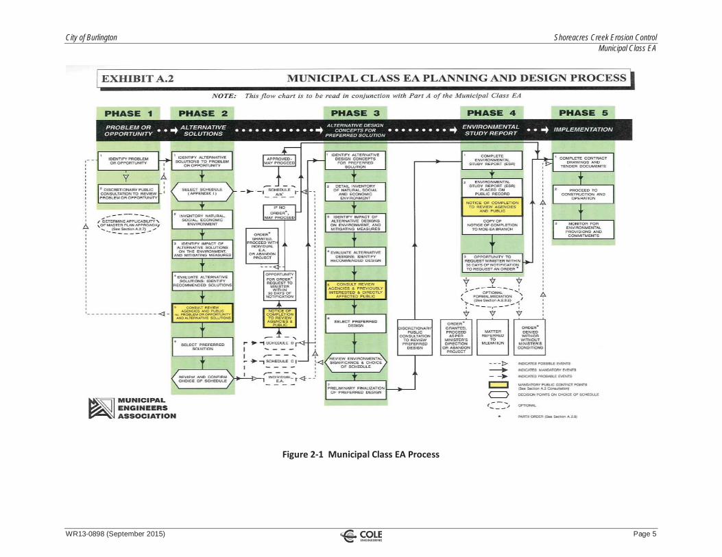
2.0 Planning Context and the EA Planning Process
2.1. Municipal Class EA
The Municipal Class EA (2011) planning and design process was followed for this project because itallows the City to meet the requirements of the Ontario Environmental Assessment Act (OEAA) formunicipal infrastructure without having to either undertake an Individual Environmental Assessment orrequest a specific exemption for the project. The Class EA is a planning process approved under theOEAA for a class or group of undertakings including municipal infrastructure.
Municipal projects included in the Class EA may be implemented without further approval under theOEAA, provided that the approved Class EA planning and design process is followed (refer to Figure 2 1).
City of Burlington Shoreacres Creek Erosion Control Municipal Class EA
WR13-0898 (September 2015) Page 5
Figure 2 1 Municipal Class EA Process

City of Burlington Shoreacres Creek Erosion Control Municipal Class EA
WR13-0898 (September 2015) Page 6
2.1.1. Four (4) Project Schedules
Since projects undertaken by municipalities vary in their environmental effects, the Class EA classifiesthese projects into four (4) schedules according to their environmental significance:
Schedule ‘A’Projects are limited in scale, have minimal adverse effects and include the majority of municipalmaintenance and operational activities. These projects are approved and may proceed directly to PhaseFive for implementation without following the other phases.
Schedule ‘A+’Projects are limited in scale and have minimal adverse effects. These projects are approved and mayproceed directly to Phase Five for implementation without following the other phases. However, thepublic is to be advised prior to project implementation though there is no ability for the public torequest a Part II Order.
Schedule ‘B’Projects have the potential for some adverse environmental effects. The municipality is required toundertake a screening process (Phases One and Two) involving mandatory contact with directly affectedpublic and relevant review agencies to ensure that they are aware of the project and that their concernsare addressed. Schedule ‘B’ projects require that a Project File report be prepared and submitted forreview by the public and review agencies. If there are no outstanding concerns, then the municipalitymay proceed to Phase Five for implementation.
Schedule ‘C’Projects have the potential for significant environmental effects and must proceed under the fullplanning and documentation procedures specified in the Class EA Document (Phases One to Four).Schedule ‘C’ projects require that an Environmental Study Report be prepared and submitted for reviewby the public and review agencies. If there are no outstanding concerns, then the municipality mayproceed to Phase Five for implementation.
City of Burlington Shoreacres Creek Erosion Control Municipal Class EA
WR13-0898 (September 2015) Page 7
2.2. Schedule ‘B’ Classification
Appendix 1 of the Municipal Class EA document identifies activities or projects subject to Schedule ‘B’for Municipal Water and Wastewater Projects of the Class EA, including the following:
“17. Works undertaken in a watercourse for the purposes of flood control or erosion control, which mayinclude:
Bank or slope regrading;Deepening the watercourse;Relocation, realignment or channelization of watercourse;Revetment including soil bio engineering techniques; and,Reconstruction of a weir or dam.”
Since this project involves bank or slope re grading, revetment including soil bio engineering techniques,and other potential works in the watercourse for the purpose of erosion control, it is classified as aSchedule ‘B’ project.
2.2.1. Schedule ‘B’ Class EA Process
The following activities were carried out for this Study:
Phase One: Identify the Problem / OpportunityThis phase involves identifying the problem / opportunity to be addressed through the study anddescribing it in sufficient detail to lead to a clear problem / opportunity statement. Upon completion ofthe problem / opportunity statement, a Notice of Commencement is published to notify the public thatthe Class EA study has been initiated. This Phase is described in Section 3.0.
Phase Two: Identify and Evaluate Alternative Solutions to the Problem / OpportunityThis phase involves six (6) steps:
1. Identify reasonable alternative solutions to the problem / opportunity (Section 4.0);2. Prepare a general inventory of the existing natural, social, and economic environments in which the
project is to occur (Section 5.0);3. Identify the net positive and negative effects of each alternative solution, including mitigating
measures (Section 0);4. Evaluate the alternative solutions (Section 6.5);5. Consult with review agencies and the public to solicit comment and input (Section 0); and,6. Select or confirm the preferred solution.
Once completed, the Project File is placed on public record for a period of at least 30 calendar days toallow review agencies and the public an opportunity to review it. During this review period, concernedindividuals have the right to raise and discuss issues prior to requesting a Part II Order before the projectmay proceed to implementation. A Part II Order requires an Individual EA to be carried out andsubmitted to the Minister of the Environment and Climate Change for review and approval. Thedecision on whether the project should be subject to a Part II Order rests with the Minister of theEnvironment. Assuming there are no outstanding Part II Order requests, the Municipality is able toproceed to the final phase of the process once the review period has expired.
City of Burlington Shoreacres Creek Erosion Control Municipal Class EA
WR13-0898 (September 2015) Page 8
3.0 Problem / Opportunity Statement
3.1. Problem
Ongoing excessive erosion in Shoreacres Creek has been identified between Millcroft Park Drive and theCN Rail. This erosion presents a risk to private property and municipal infrastructure due to failing valleyslopes. Figure DE 1 in Appendix A illustrates typical cross sections of the erosion problems within thestudy area.
3.2. Opportunity
This project presents an opportunity to provide environmental and social benefits within the study area.It can help to mitigate excessive erosion along Shoreacres Creek and improve the water quality of thecreek. Opportunities are present to provide additional terrestrial and aquatic habitat, and improve fishpassage by removing debris from the Creek. The improvement to the Creek may provide an enhancedaesthetic environment for surrounding landowners and reduce the risk to private property caused bybank erosion.
4.0 Alternative Solutions
A range of alternative solutions was developed in order to address the identified problem andopportunity. The four (4) alternatives identified for evaluation are:
1. Alternative # 1 Do Nothing;2. Alternative # 2 Harden Select Locations within Creek;3. Alternative # 3 Implement Bio Engineering Solution at Select Locations within Creek; and,4. Alternative # 4 Realign / Reconstruct Sections of the Creek.
Even though the “Do Nothing” alternative does not address the Problem / Opportunity Statement, theClass EA document mandates its consideration in all Class EA’s as a means of providing a benchmark forevaluating the other alternative solutions.
Conceptual drawings of each of the proposed alternatives are provided in Figure DE 2 in Appendix A.The following subsections briefly describe each of these alternative solutions.
City of Burlington Shoreacres Creek Erosion Control Municipal Class EA
WR13-0898 (September 2015) Page 9
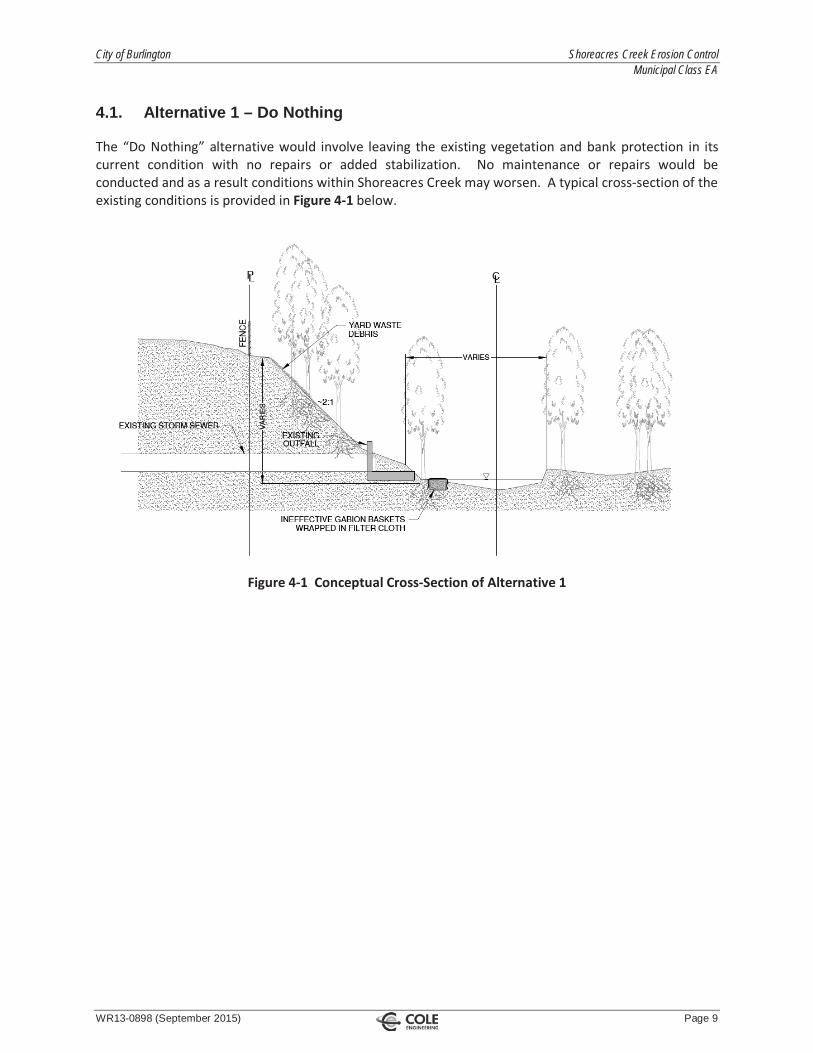
4.1. Alternative 1 – Do Nothing
The “Do Nothing” alternative would involve leaving the existing vegetation and bank protection in itscurrent condition with no repairs or added stabilization. No maintenance or repairs would beconducted and as a result conditions within Shoreacres Creek may worsen. A typical cross section of theexisting conditions is provided in Figure 4 1 below.
Figure 4 1 Conceptual Cross Section of Alternative 1

City of Burlington Shoreacres Creek Erosion Control Municipal Class EA
WR13-0898 (September 2015) Page 10
4.2. Alternative 2 – Harden Select Locations within Creek
This alternative would involve channelizing the creek at select locations within the study area by usingarmourstone or concrete. Armourstone would be embedded along the slopes of the eroded areasproviding further bank protection. Channelization with concrete would involve stabilizing near verticalto vertical banks with a concrete based retaining wall. Concrete walls can be faced with stone ortextured to appear like rock to improve aesthetics and provide some roughness. A conceptualcross section of Alternative 2 is provided in Figure 4 2 below.
Figure 4 2 Conceptual Cross Section of Alternative 2

City of Burlington Shoreacres Creek Erosion Control Municipal Class EA
WR13-0898 (September 2015) Page 11
4.3. Alternative 3 – Implement Bio-Engineering Solution at Select Locations within Creek
This alternative would involve removing failing erosion control structures within the study area. Thecreek area would then be re graded and planted according to a naturalized channel design using variousbio engineering techniques including root wads, live fascines, reinforced slope, live stakes, toeprotection, soil nails, vegetated riverstone and crib walls. A conceptual cross section of this alternativeis provided in Figure 4 3 below.
Figure 4 3 Conceptual Cross Section of Alternative 3

City of Burlington Shoreacres Creek Erosion Control Municipal Class EA
WR13-0898 (September 2015) Page 12
4.4. Alternative 4 – Realign / Reconstruct Sections of the Creek
The fourth alternative would involve modifying the flow path of certain sections of the creek to reduceerosion of private property. In addition, potted plants and live stakes would be installed on the slope toincrease slope stability. The reconstruction of the creek would be more intrusive and involve a largerdisturbance to the area and residents than the aforementioned alternatives. However, this alternativewould reduce long term maintenance of the channel and avoid future risk to private property owners. Aconceptual drawing of this alternative is provided in Figure 4 4 below.
Figure 4 4 Conceptual Cross Section of Alternative 4

City of Burlington Shoreacres Creek Erosion Control Municipal Class EA
WR13-0898 (September 2015) Page 13
5.0 Inventory of Existing Conditions
5.1. Environment
Field visits were undertaken to collect existing conditions information and desktop reviews werecompleted where applicable. Site photographs are included in Appendix B. Existing natural andsocio economic conditions were assessed, along with the conditions of existing erosion control works.
The watercourse block is within City owned property in Halton Region and is regulated by ConservationHalton. Drawing EC included in the map pocket shows the Regulatory floodplain within the study areaas well as the approximate regulation limit.
5.1.1. Erosion Sites
The site area was surveyed to document the extent of the damage to the existing erosion controlstructures. The survey was undertaken to assist in the assessment of the alternative solutions and todevelop appropriate mitigation measures for the preferred alternative solution.
Cole Engineering conducted field surveys to document the existing conditions of the study area and tolocate problem areas. The existing conditions and identified erosion and debris sites are illustrated onDrawing EC in the map pocket. Typical details of the erosion problems are provided in Figure DE 1 inAppendix A. The findings are summarized in Table 5.1 below. The site ID’s in Table 5.1 correspond tothe labelled sites in Drawing EC provided in the map pocket.
Table 5.1 – Cole Engineering Survey FindingsSite ID Description Chainage
Site A Steep slope with some erosionapproaching private property,many large downed trees and
debris.
± 0+058 m (downstream of southcrossing on Millcroft Park Drive)
Site B Failed block wall and section ofconcrete block lined channel (in
poor condition).
± 0+061 m (downstream of northcrossing on Millcroft Park Drive)
Site C Steep, exposed slope nearingprivate properties, a lot of yard
debris on slopes.
± 0+174 m (downstream of northcrossing on Millcroft Park Drive)
Site D Excessive backyard debris onvalley slopes amongst reasonsfor poor slopes and erosionapproaching private property.
± 0+341 m (downstream of northcrossing on Millcroft Park Drive)
Site E Eroding slope approachingprivate property, unknown drainpipe outlets to a slope in this
area.
± 0+530 m (downstream of northcrossing on Millcroft Park Drive)
Site F Eroding slope nearing publictrail.
± 2+050 m (downstream of northcrossing on Millcroft Park Drive)

City of Burlington Shoreacres Creek Erosion Control Municipal Class EA
WR13-0898 (September 2015) Page 14
5.1.2. Fluvial Geomorphology
A fluvial assessment was completed by Water’s Edge to determine the existing conditions within theCreek in the study area. The purpose of the study was to address fluvial geomorphological issuesrelated to the proposed works, specifically:
Determination of geomorphic stream conditions; and,General review of erosion and bankfull flows.
In order to carry out a fluvial assessment, a geomorphic survey of the stream reach was completed. Theassessment included a desktop analysis as well as several site investigations. Shoreacres Creek is a 2nd /3rd order stream that flows through the Waterdown Moraine physiographic regions prior to dischargingto Lake Ontario.
The fluvial assessment identified that issues of concern that need to be addressed as part of this ClassEA include:
Local bank erosion that is threatening public and private infrastructure in certain areas;Failing or failed gabion structures;Failure of rip rap and filter cloth bank protection;Displaced creek blocks that threaten to cause further erosion; and,Localized accumulations of large woody debris.
Appendix D includes full details of the fluvial geomorphic assessment report.
5.1.3. Aquatic Ecology
SLR biologists reviewed existing conditions as shown on aerial photography, fish collection databases,and existing reports. SLR reviewed and compiled a database of relevant information from supplementalreports listed below. These sources are referenced throughout this report.
Shoreacres Creek Fish Collection Information (Ontario Ministry of Natural Resources,Conservation Halton – 1995 to 2010);Urban Creeks and Supplemental Monitoring – Long Term Environmental Monitoring Program(Conservation Halton 2009); and,Bronte Creek and Supplemental Monitoring – Long Term Environmental Monitoring Program(Conservation Halton 2009).
Information in existing reports and databases was confirmed during a site visit by SLR fisheries biologiston August 15, 2014. General conditions at the time of the site visit are summarized in Table 5.2.

City of Burlington Shoreacres Creek Erosion Control Municipal Class EA
WR13-0898 (September 2015) Page 15
Table 5.2 – Site Conditions
LocationAir
Temperature(°C)
Conditions WaterTemperature
(°C)
Conductivity(μS)
DissolvedOxygen(mg/L)
pH TimeMeasured
Site A 21 Clear skies,no
precipitationon two (2)
dayspreceding
the site visit.
15 1002 10.02 7.90 12:30 pm
Site B 18 15 1024 12 7.91 9:00 am
Site C 18 15 1024 12 7.91 10:00 am
Site D 20 14.8 1001 6.17 7.92 11:00 am
Site E 17 14.9 984 5.75 7.85 8:00 am
Site F 18 16.6 1045 11.2 8.16 1:30 pm
The objective of field investigations was to map and describe the existing aquatic habitat within thestudy area. Habitat parameters investigated included:
1. General channel dimension and flow;2. Morphology;3. Substrate characterization;4. Instream and riparian vegetation;5. Bank stability and cover;6. Areas of critical habitat (spawning, nursery, feeding);7. Presence of fish barriers and system connectivity; and,8. Potential enhancement opportunities.
In addition, digital photographs for each creek site were taken at both the upstream and downstreamlocations; refer to Figure 5 1 in Appendix E 1.
Due to the completion of recent aquatic monitoring and reporting by agencies (correspondenceprovided in Appendix E 2), the existing fish community database was deemed sufficient and SLRfisheries biologists did not conduct additional fish collections within the study area. It should be notedthat Conservation Halton possesses more recent fish survey data than that included in Appendix E 2,which was noted upon receipt of initial CH comments; this data was excluded based on its lack of impactto the overall outcome of this assessment.
5.1.4. Aquatic Habitat Characteristics
Shoreacres Creek is a permanent warm water system within the Burlington Urban Creeks Watershed.The watercourse flows generally from northwest to southeast as a single channel, and ultimately outletsinto Lake Ontario. Similar to many creeks within the Urban Creeks Watershed, Shoreacres Creek isfragmented due to instream barriers. Downstream of the Queen Elizabeth Way (QEW), a concrete weirextends across the width of Shoreacres Creek (SLR 2014). During periods of low flow, this structure maypresent a seasonal barrier to upstream fish passage.
Within the study area, the upstream extent of Shoreacres Creek is located at Millcroft Park Drive and thearea is bounded by the CN railway at the downstream end. The length of watercourse within thislocation includes approximately 2,310 m flowing adjacent to urban land use including residential andmunicipal infrastructure surrounded by parking lots.

City of Burlington Shoreacres Creek Erosion Control Municipal Class EA
WR13-0898 (September 2015) Page 16
At the upstream extent of the study area, the East (Site B) and West (Site A) branches of ShoreacresCreek confluence, and continue to flow southeast as Shoreacres Creek (Sites C, D, E, F) through thestudy area (Figure 5 1 in Appendix E 1). Generally, the channel follows a sinuous course, with largermeanders and pool riffle sequences throughout the study area reach. As a result of meanders, erosionand deposition occur throughout the channel. The highest degree of erosion occurs on the outer side ofeach bend and as a result deeper pools have developed. Over time, the channel has migrated close toadjacent private property, and slopes are moderately unstable. Recently inundated floodplains wereobserved to extend approximately 4 m beyond the edge of water, indicating that the channel conveys amuch greater volume during peak events. Shoreacres Creek largely comprise shale bedrock bottom withminimal instream cover available.
Conservation Halton (2009a & 2009b) reported that in general the creek is in poor health with low fishspecies diversity. This is largely due to little availability of protective habitat for species, primarilyinstream cover and overhanging vegetation. In addition, benthic water quality classifications atmonitoring locations were found to be impaired.
Data collected through the desktop analysis and the field investigations were used to provide adescription of the fish and fish habitat associated with the upstream and downstream reaches ofShoreacres Creek within the study limits (Appendix E 3). The fish and fish habitat through the studyarea is discussed below in six (6) sections oriented from upstream to downstream sites: Sites A, B, C, D, Eand F as identified on Figure 5 2 and Figure 5 3 in Appendix E 1.
Site AAt the upstream extent of the study area, the west branch of Shoreacres Creek outlets from a doublecell concrete bridge structure at Millcroft Park Drive into pool habitat. The pool was approximately 3 mby 4 m in dimension, and was dominated by cobble substrate. Pool depth was approximately 0.35 m.Instream cover was provided by aquatic macrophyte growth and undercut banks. A school of cyprinidspecies were observed utilizing the pool habitat. Overall, bank stability was poor throughout this site.
Hereafter, the channel narrowed to a width of approximately 1 m and was dominated by silt and claysubstrates. Water depth was very shallow at the time of investigation. Moderate instream cover wasprovided by overhanging vegetation and woody debris. The remaining downstream portion of this sitewas typified by riffle, run and pool sequencing. Large gravel shoals were deposited along the right andleft banks. Site A has characteristics suitable for functions such as spawning activities for residentcyprinid species.
Site BThe east branch of Shoreacres Creek outlets from a closed bottom concrete box culvert under MillcroftPark Drive. Within the culvert, shallow sheet flow was observed and inter rubble / gravel flow occurredat the culvert base. The transition of flow from inside the culvert to the natural channel bed was poor.This could present passage issues for select species, especially during low flow events.
Hereafter, the watercourse is bioengineered with concrete bricks that occupy in the channel bed. Thechannel was approximately 1 m wide and water depth was 0.15 m. A stormflow channel was located tothe north of the creek. This channel was approximately 0.5 m wide and was dry at the time ofinvestigation, however soils were saturated.
At the confluence of the east and west branches, the majority of the brick work was destabilized.Downstream from the confluence a large deep pool had formed, approximately 3 m wide and 0.5 mdeep. Moderate cover provided by overhanging trees was observed, but sparse understory was noted.

City of Burlington Shoreacres Creek Erosion Control Municipal Class EA
WR13-0898 (September 2015) Page 17
Site CAt Site C, Shoreacres Creek is the combined flow of the east and west branches. At this location, thechannel widened to approximately 3 m and had a bank full height which ranged between 0.5 m and 1 mhigh. This portion of the creek was typified by riffle, run, and pool sequencing. Substrate wasdominated by flat shale fractured bedrock. Rubble and small boulders were also observed. Depositionof gravel was observed in the convex bank. Lateral erosion and undercutting also occurred on theconcave banks. This deposition likely provides shoal habitat for spawning activities. Channel bankswere moderately unstable and undercut. Instream cover was provided by submerged woody debris andoverhanging vegetation. Step pool morphology dominated the watercourse configuration toward thedownstream portion of the site.
Similar to Site B, a secondary storm flow channel had formed to the north of the creek. This channelcontained disconnected pools of water during investigations.
Site DThe habitat through this reach was typified by run habitat, with a few dispersed pools. This siterepresented the widest and deepest channel characteristics within the study area. Channel widththrough this reach widened to 4 m and water depth ranged from 0.5 m to 0.6 m through run habitat,and 0.7 m in pools. Substrate was dominated by silt and clay with some gravel and cobble. Gabionbaskets existed on channel banks. Woody debris was observed throughout this portion of the creek.Unlike the upstream portions of the channel, Site D supported a moderate amount of aquaticmacrophytes. Riparian areas were dominated by exposed clay and silt substrates with little understorygrowth.
Similar to Sites B and C, a stormflow channel existed to the north to carry overland flow during stormevents. During investigations, disconnected shallow pools were observed in this stormflow channel.
Site EThis portion of the creek was characterized as an oxbow channel. The watercourse had an extremecurvature that double backs onto itself. This site comprised run and pool habitat. The average width ofthe channel was approximately 1.8 m and water depth ranged from 0.3 m to 0.4 m in deeper pools. Topof bank was as great as 3 m, and highly unstable adjacent to residential houses. Disconnected poolsexisted throughout the oxbow, primarily on the northwest side of the oxbow. The south side of theoxbow had low flow at the time of investigation. Substrates included sorted patches of gravel, clay, andsilt. Undercut banks, overhanging vegetation and dense woody debris existed throughout this reach.
Site FLocated at the most downstream portion of the study area, this section exhibited relatively simplemorphology, with a small meander. The channel was dominated by run habitat with few pools andriffles. Channel width was approximately 1.5 m and water depth ranged from 0.25 m in runs to 0.55 min deeper pools. Substrate was dominated by cobble and gravel with dispersed boulders. The northchannel bank was stabilized with gabion baskets. Banks were undercut and moderate amount of woodydebris was observed in the channel. Aquatic macrophytes were present throughout this reach.Overhanging riparian vegetative cover was considerably denser at this site in comparison to upstreamsites. At the downstream extent of the study area, the watercourse flowed through a double cellconcrete culver under the CN railway.

City of Burlington Shoreacres Creek Erosion Control Municipal Class EA
WR13-0898 (September 2015) Page 18
5.1.4.1 Fish Community Characteristics
Fish collections occurred from 1995 to 2008 and were provided by Ontario Ministry of Natural Resources(MNR) and Conservation Halton. Fish collection data from five (5) locales within the regional study area(Figure 5 1 and Figure 5 2 in Appendix E 1) are provided allowing interpretations of fish communitycharacteristics and associated aquatic functions from regional and more focused study areaperspectives. Please refer to Table 5.3 for a complete list of fish species collected from the study areaproximity.
It should be noted that more recent fish survey data became available after the first submission of thisreport, however this information is not included here. The more recent survey data was not includedbecause a comparative review of the older data and recent data indicated that the data used in thisstudy appears to represent conditions in Shoreacres Creek. Including the more recent fish data wouldnot change the outcome of this assessment.
Shoreacres Creek, within the study area, is dominated by warmwater forage fish including Creek Chub(Semotilus atromaculatus), Fathead Minnow (Pimephales promelas), White Sucker (Catostomuscommersoni), Blacknose Dace (Rhinichthys atratulus), and Brook Stickleback (Culaea inconstans).
Fish dot files from MNR dating from 1991 through to 1994 indicate the presence of Chinook Salmon,Rainbow Smelt, Carp, Common Shiner and Golden Shiner in the downstream portion of ShoreacresCreek. Surveys completed from 1995 onward have not documented the presence of these species inthe study area or in Shoreacres Creek.

City of Burlington Shoreacres Creek Erosion Control Municipal Class EA
WR13-0898 (September 2015) Page 19
Table 5.3 – Fish Collected from Shoreacres Creek, 1995 to 2008
Site Sampling
White
Sucker
Blacknose
Dace
CreekCh
ub
Blun
tnose
Minno
w
Broo
kStickleb
ack
Upstream from QEW, downstream ofMainway X
Downstream from QEW and SouthService Road X X X
Downstream from QEW, northwest ofservice Road and Harvester RoadIntersection X X X X
Upstream from Harvester Road X X
Downstream from of Harvester Road,just east of Morris Drive X X X
The communities found within the study area comprise generally of feeding groups including cyprinid,stickleback and catostomidae species. These fish are relatively tolerant of stresses associated withurbanization.
In this system, Creek Chub is the most dispersed species and is likely the top predator (part piscivore)and feed on other insectivore and omnivore minnows. This species spawns in spring / summer, typicallyover gravel substrates. Fathead Minnow occurred in almost all sampling stations in the watercourse.Fathead Minnow is a generalist species that spawns in spring / summer; typically on the underside oflogs or large rocks. Blacknose Dace and White Sucker were less abundant species in the system.Blacknose Dace is a coolwater species that prefers run and pool habitat, and usually spawn over gravelsubstrates. White Sucker is a migratory species which moves from lake to riverine environments tospawn (Table 5.4).
In summary, the aquatic environment within the study area has low productive capacity. The habitat isof marginal quality and is highly degraded. During field investigations, no sensitive species or specializedhabitat was noted. The fish community within Shoreacres Creek is highly tolerant to disturbance. Noaquatic Species at Risk were identified by Conservation Halton, or MNR.

City of Burlington Shoreacres Creek Erosion Control Municipal Class EA
WR13-0898 (September 2015) Page 20
Table 5.4 – Life History Characteristics for Fish Found in Shoreacres Creek
CommonName Scientific Name Trophic
ClassThermalRegime
PreferredWater
Temp ( C)Preferred Habitat Spawning
PeriodSpawningZone
ReproductiveMode
PreferredSpawningSubstrate
BlacknoseDace
RhinichthysObtusus Generalist Cool 19.3
Runs and pools ofclear, cool,
swiftly flowingcreeks and small
rivers.
Spring (May– June), 15 –
22°CRivers
Non guardersbut malessometimesdefend eggsimmediatelypost spawn;eggs are
scattered overclean gravel.
Gravel substrate.
BluntnoseMinnow
PimephalesNotatus Generalist Warm 28.1
Sand and gravelbottomed
shallows of clearlakes, creeks,
rivers and ponds.
Summer(June –
August), 19– 26°C
Lakes,streams
Guard theirspawn in
natural holesand cavities or
speciallyconstructedburrows.
Underside of flatstones or otherobjects lyingdirectly on the
bottom.
BrookStickleback
CulaeaInconstans Generalist Cool 21.3
Small, boggyheadwaterstreams,
backwaters ofcreeks and small
rivers withaquatic
vegetation.
Spring –Summer
(May –July),10 – 22°C
Riverine,Lacustrine
Guarders: Nestspawners.
ChinookSalmon
OncorhynchyusTshawytscha Pelagic Cold 12 – 16
Lacustrine – midwater (15 60 m)in or belowthermocline.
September– October Riverine
Non guardersHollow out nestnear riffles.
Gravel substrate.

City of Burlington Shoreacres Creek Erosion Control Municipal Class EA
WR13-0898 (September 2015) Page 21
CommonName Scientific Name Trophic
ClassThermalRegime
PreferredWater
Temp ( C)Preferred Habitat Spawning
PeriodSpawningZone
ReproductiveMode
PreferredSpawningSubstrate
CommonCarp Cyprinus Carpio Generalist Warm 31.3
Muddy pools ofsmall to large
rivers, lakes andponds, at depths
of <30 m.
Spring –Summer(May –
August) 17 –25°C
Lacustrine;Riverine
Nonguarders:Open
substratumspawners:Phyto
lithophils.
Attach eggs toplants.
CommonShiner
LuxilusCornutus Generalist Cool 21.9
Pools near rifflesin clear, cool
creeks and smallto medium rivers,and near shore inclear water lakes.
Spring –Summer
(May – July),16 – 26°C
Rivers
Non guarders:build nests ingravel areas oruse existing
nests.
Gravel beds atthe head of
riffles.
Creek Chub SemotilusAtromaculatus Generalist Cool 20.8
Pools of clearcreeks and smallrivers; rare inlakes and large
rivers.
Spring (May– June), 12 –
17°C
Rivers,above orbelowriffle
Non guarders:build nests in
gravelsubstrate.
Gravel stream.
FatheadMinnow
PimephalesPromelas Generalist Warm 27.9
Still waters ofponds, lakes,
creeks and smallrivers.
Spring –Summer(May –
August), 14– 29°C
Lakes,streams
Guard theirspawn in
natural holesand cavities or
speciallyconstructedburrows.
Underside of log,branch, board or
large rock.
GoldenShiner
NotemigonusCrysoleucas
GeneralistFeeder Cool 17 – 24
Clear, weedy,quiet waters oflakes, ponds,reservoirs andpools of small tolarge rivers.
June –August Lacustrine
Nonguarders:Open
substratumspawners:Phytophils.

City of Burlington Shoreacres Creek Erosion Control Municipal Class EA
WR13-0898 (September 2015) Page 22
CommonName Scientific Name Trophic
ClassThermalRegime
PreferredWater
Temp ( C)Preferred Habitat Spawning
PeriodSpawningZone
ReproductiveMode
PreferredSpawningSubstrate
PumpkinSeed
LepomisGibbosus Generalist Warm 30.3
Warm, shallow,vegetated lakesand ponds, quietvegetated poolsof creeks andsmall rivers.
Spring –Summer(May –
August), 20– 28°C
Lake,rivers
Guarders, buildnests in shallow
water.
Clay, sand orgravel; malesweeps toexpose hardbottom in
vegetated areasof lakes, ponds,slow moving
rivers.
RainbowSmelt
OsmerusMordax Pelagic Cold 7 – 16
Cool and clearmedium to large
rivers.Spring Lacustrine,
riverine
Non guarders:open
substratumspawners.
WhiteSucker
CatostomusCommersonii Generalist Cool 24.1 Riverine,
lacustrine.
Spring (April– June), 7 –
10°CRivers
MigratoryNon guarders,broadcastspawners.
Gravel to rockysubstrate.
Note: Species in shaded rows were collected from the study area proximity.

City of Burlington Shoreacres Creek Erosion Control Municipal Class EA
WR13-0898 (September 2015) Page 23
5.1.5. Terrestrial Ecology
5.1.5.1 Agency Consultation
The Study Area is within the jurisdiction of the Aurora District of the MNR. Natosha Fortini, AssistantSpecies at Risk Biologist, was contacted regarding natural heritage information for the Study Area. MNRnoted that no natural heritage features are recorded for the Study Area (pertinent correspondencerecords are provided in Appendix E 4).
A site walk was conducted on April 29, 2014 with staff from Cole Engineering, SLR Consulting, Water’sEdge, the City of Burlington, and Conservation Halton. The purpose of the site walk was to reviewcurrent conditions and design alternatives with Conservation Halton and, in relation to terrestrial andaquatic investigation, to focus the scope of the studies. ELC investigations and the Tree Inventory wereto be focused on the Areas of Disturbance, amphibian surveys would occur at suitable habitat asdetermined by SLR Ecologists, and a bird survey would be undertaken throughout the Study Area.
The Natural Heritage Information CentreThe Natural Heritage Information Centre (NHIC) maintains information about species of conservationconcern in Ontario. A list of sightings of species within the Study Area was downloaded from the NHICwebsite1. The majority of sightings occurred before the 21st century (Table 5.5 below). PerfoliateBellwort (Uvularia perfoliata) was observed in 2001. Habitat for Perfoliate Bellwort includes large riverbanks in wooded areas, as is found in the Study Area.
Table 5.5 – Natural Heritage Information Centre Results
Common Name Scientific Name Status1 Date of LastObservation
Burning Bush Euonymus atropurpureus S3 1973 06 30
Brainerd's Hawthorn Crataegus brainerdii S2 1981 09 07
Virginia Lungwort Mertensia virginica SE1 1982 05 26
Shiny Wedge Grass Sphenopholis nitida S1 1988
Jefferson X Blue spottedSalamander, Jefferson genomedominates2
Ambystoma jeffersonianum
S2,Endangered(COSEWIC andCOSSARO)
1989 05 19
Perfoliate Bellwort Uvularia perfoliata S1 2001 05 111S1 – Critically Imperiled: Critically imperiled in the nation or state / province because of extreme rarity (often five (5) or fewer occurrences) or because of some factor(s) such as very steep declines making it especially vulnerable to extirpation from the state / province.S2 – Imperiled: Imperiled in the nation or state / province because of rarity due to very restricted range, very few populations (often 20 or fewer), steep declines, or other factors making it very vulnerable to extirpation from the nation or state / province. S3 – Vulnerable: Vulnerable in the nation or state/province due to a restricted range, relatively few populations (often 80 or fewer), recent and widespread declines, or other factors making it vulnerable to extirpation. COSEWIC: Committee on the Status of Endangered Wildlife in Canada. Endangered: A wildlife species that is likely to become endangered if nothing is done to reverse the factors leading to its extirpation or extinction.
1 https://www.ontario.ca/environment and energy/natural heritage information centre, April 2014.2 Status only applies to the species, not hybrids.

City of Burlington Shoreacres Creek Erosion Control Municipal Class EA
WR13-0898 (September 2015) Page 24
5.1.5.2 Methodology
An SLR terrestrial ecologist and Registered Professional Forester conducted a site visit of the subjectlands on August 15, August 20, and September 5, 2014 to document and classify vegetationcommunities, inventory vegetation within and adjacent to the Area of Disturbance, and to inventorytrees. Plant communities were classified using the Ecological Land Classification System for SouthernOntario (ELC), as per Lee et al. (1998). This is the provincially accepted standard for classifyingvegetation communities in Ontario. Based on this standard, vegetation communities were identifieddown to Vegetation Type where possible. Information recorded regarding the structure andcomposition of these vegetation units included information describing dominant species, cover,community structure, community disturbance and other notable features (please refer to Appendix E 6for ELC Forms).
Breeding bird surveys were undertaken by an avian specialist in the peak of breeding season on June 4,2014 and June 26, 2014. These surveys were conducted in the early morning period (approximatelybetween 5:30a.m. and 10:30 a.m.) in suitable weather conditions. Survey protocol followed protocoldeveloped for the Ontario Breeding Bird Atlas field program. Five (5) survey point locations were visitedand transects were conducted in representative habitats. For survey point locations, see Figure 5 3 andFigure 5 4 in Appendix E 5. Breeding birds were counted, using the “assumed pair” as the counting unit(i.e., one (1) of: a singing male, a pair seen, or single adult birds in suitable nesting habitat).
Amphibian calling surveys followed Ontario Marsh Monitoring Protocols occurred on the evenings ofMay 9, 2014, June 20, 2014, and May 12, 2015 in suitable weather. All ponds and old oxbows in each ofthe Study Areas were searched for tadpoles. Creation of an oxbow planned for Site E north of UpperMiddle Road will create more amphibian habitat than currently available at the site (Figure 5 3 inAppendix E 5).
The tree inventory followed City of Burlington guidelines. Trees over 10 cm in diameter within andadjacent to Disturbance Areas (adjacent meaning its crown or roots may intersect the Disturbance Area)were assessed. Trees within the following areas were not surveyed; Rehabilitation Disturbance Area,Realignment Disturbance Area, and the Bioengineered Disturbance Area as these areas were notdelineated at the time of the survey. Individuals were mapped using handheld GPS to provideapproximate locations. Each assessed tree was tagged with a unique ID number and the following datawere collected:
Diameter at Breast Height (DBH);Species; and,Health (Poor, Fair, and Good).
During specific surveys for flora or aquatic habitat species, incidental observations of fauna wererecorded. This included direct observations (visual or auditory) or indications of habitat use (tracks,scat, etc.).

City of Burlington Shoreacres Creek Erosion Control Municipal Class EA
WR13-0898 (September 2015) Page 25
5.1.5.3 Vegetation Communities
Eight (8) vegetation polygons were identified in the Study Area (Table 5.6 below). One (1) is designatedas a wetland, but many of the upland polygons are classified as moist fresh, as a large portion of theStudy Area is influenced by the flooding of Shoreacres Creek. The area is highly disturbed, which hascreated variable canopies and a high amount of Manitoba Maple (Acer negundo), a non native treespecies. The ecological investigations occurred after the ice storm of the winter of 2014, whichdamaged many of the large willow individuals and created some canopy gaps.
Table 5.6 – Summary of Vegetation ClassificationPolygonNumber ELC Code ELC Description Area (ha)
1 FOD 7 Fresh Moist Lowland Deciduous Forest Ecosite 0.22
2 FOD5 2 Dry Fresh Sugar Maple – Beech Deciduous Forest Type 0.42
3 FOD7 Fresh Moist Lowland Deciduous Forest Ecosite 2.64
4 SWD 4 1 Willow Mineral Deciduous Swamp Type 0.30
5 CUM1 1 Dry Moist Cultural Meadow 0.18
6 CUM1 1 Dry Moist Cultural Meadow 0.21
7 FOD7 4 Fresh Moist Black Walnut Lowland Deciduous Forest 0.45
8 FOD9 5
Fresh Moist Bitternut Hickory Deciduous Forest Type
Inclusion: Dry fresh Sugar Maple Beech Deciduous Forest Type(FOD5 2).
Inclusion: Willow Mineral Deciduous Swamp Type (SWD 4 1)
0.68
Polygon 1 FOD7 – Fresh to Moist Lowland Deciduous ForestThis area is to the east of the stream alignment that is engineered. It is separated from the stream by asmall hummock. Water clearly overflows this hummock during high water periods. The tree species inthis polygon are highly variable, as no species is particularly dominant. The overstory comprisesAmerican Elm (Ulmus americana), Ironwood (Ostrya virginiana), Manitoba Maple, and Green Ash(Fraxinus pennsylvanica) and is only described to the Ecosite level as previous disturbance has created ahighly variable canopy. There are areas of backchannels with wetland indicators such as Jewelweed(Impatiens capensis) and shallow standing water. The soil is a silty clay over clay with a moisture regimeof six (6) (very moist). There are small upland hummocks, comprised of Eastern White Pine (Pinusstrobus) and Red Oak (Quercus rubra).
Polygon 2 – FOD5 2 – Dry Fresh Sugar Maple – Beech Deciduous Forest TypeThis area is on a slope from the backyards to the east side of the stream dominated by upland toleranthardwood trees such as Sugar Maple (Acer saccharum), Beech (Fagus grandifolia), and Ironwood. Inlimited lower areas, Basswood (Tilia americana), American Elm, and Manitoba Maple are Subdominant.Ground vegetation is limited, but is comprised of Virginia Creeper (Parthenocissus quinquefolia), HerbRobert (Geranium robertianum), Multiflora Rose (Rosa multiflora), Calico Aster (Symphyotrichumlateriflorum), and Wild Cucumber (Echinocystis lobata). Yard waste is present. The moisture regime istwo (2) (moderately fresh).

City of Burlington Shoreacres Creek Erosion Control Municipal Class EA
WR13-0898 (September 2015) Page 26
Polygon 3 – FOD7 – Fresh Moist Lowland Deciduous Forest EcositeThis polygon is riparian and is highly variable in moisture regimes and species dominance. This polygonis highly variable due to previous disturbances varying in duration, frequency, and severity includingflooding, anthropogenic influence, and ice storm damage. Eastern White Pine individuals extend farabove the canopy of a variation of Manitoba Maple, Green Ash, and Basswood. The diverse and variableoverstory results in this polygon being classified only to the Ecosite level. The shrub layer is dominatedby Manitoba Maple and Common Buckthorn (Rhamnus cathartica). There is a noticeable lack ofunderstory due to high energy flooding in most areas. However, discrete areas where vegetation ispushed over from flooding show the ground layer was heavily dominated by Giant Ragweed (Ambrosiatrifida). In localized areas, there is a lack of overstory, likely caused by the ice storm disturbance, withan abundance of Virginia Creeper and Wild Cucumber. The soil is a silty clay. The dominant moistureregime is four (4) (moderately moist).
Polygon 4 – SWD4 1 – WillowMineral Deciduous Swamp TypeThis small polygon is almost entirely dominated by large Crack Willow (Salix fragilis) trees with anunderstory of Manitoba Maple. There is virtually no understory present as recent flooding hasdeposited large amounts of sand and gravel, burying ground vegetation. There are Sugar Maple treespresent on the steep slope on the south side of the stream, adjacent to the backyards of homes. Themoisture regime in this wetland is six (6) (very moist).
Polygon 5 CUM 1 1 – Dry Moist Cultural MeadowThis cultural meadow is mowed adjacent to the walking path. There are scattered young ManitobaMaple trees between the open canopy of the cultural meadow and the forested area to the southeast.The small areas is comprised of plants common in disturbed areas such as Tall Goldenrod (Solidagoaltissima), Wild Teasel (Dipsacus fullonum), Raspberry (Rubus idaeus), and Wild Carrot (Daucus carota).The moisture regime is two (2) (fresh).
Polygon 6 – CUM1 1 – Dry Moist Cultural MeadowThis area is adjacent to the paved walking path, and between Polygon 7 and the CN railroad tracks. Thearea is almost entirely dominated by Tall Goldenrod and there are lesser amounts of Wild Carrot. Thisarea is very structurally simple with very few species. There is hedgerow of Manitoba Maple on theslope to the raised CN railroad tracks. The moisture regime is two (2) (fresh).
Polygon 7 – FOD7 4 – Fresh Moist Black Walnut Lowland Deciduous Forest TypeThis polygon is considered a Provincially Rare (S2S3) Vegetation community. This polygon is relativelyopen; Black Walnut (Juglans nigra) is the dominant tree providing sparse cover. Black Walnutreproduces aggressively in floodplain environments and is expected to flourish in this environment.Manitoba Maple and Green Ash are subdominant. An open area adjacent to the stream comprises TallGoldenrod and Giant Ragweed.
In the southern area of the polygon, close to CUM polygon (Polygon 6), a mixture of wetland and uplandplants is present on the slope from the stream to the meadow. These plants include Coltsfoot (Tussilagofarfara), Common Cinquefoil (Potentilla canadensis), Riverbank Grape (Vitis riparia), Green Ash, andPurple Loosestrife (Lythrum salicaria). The moisture regime is four (4) (moderately moist).

City of Burlington Shoreacres Creek Erosion Control Municipal Class EA
WR13-0898 (September 2015) Page 27
Polygon 8 – Fresh Moist Bitternut Hickory Deciduous Forest Type (FOD9 5)This lowland area comprises varying and heterogeneous forest cover types. The dominant canopy isBitternut Hickory (Carya cordiformis) and Green Ash, which is greater than Elm and Manitoba Maple.The understory comprises Green Ash, Sugar Maple, and Elm. The ground layer is extremely sparse inmost areas of the majority of the stand likely due to seasonal flooding with high energy. Debris pilesand silt covered plants show flooding through most of the stand. However, in areas directly adjacent tothe stream, there are wetland plants such as Stinging Nettle (Urtica dioica), Jewelweed, Colts Foot, andFowl Manna Grass (Glyceria striata). The soil is a clay loam for approximately 30 cm, above a layer ofsilty clay with mottles with a moisture regime of five (5) (moist). The clay loam in this area is the leastdense and fine textured of the A horizons in the Study Area.
There is a sloped area from the valley of the stream to the residential area that is not comprised oflowland species due to its raised elevation. This area, not large enough to be mapped as its owncommunity, comprises Sugar Maple, American Beech, and Eastern White Pine. This inclusion isclassified as a Dry fresh Sugar Maple Beech Deciduous Forest Type (FOD5 2).
There is a wetland inclusion classified as Willow Mineral Deciduous Swamp Type (SWD 4 1) of some verylarge (50 cm or more in diameter) Crack Willow individuals in the “island” to the oxbow of the stream.The understory is more disturbed in this area than in the majority of the polygon, with significantamounts of down woody material, likely due to damage from the ice storm in the winter of 2014.
5.1.5.4 Flora
67 plant species were identified in the Study Area. The majority of species identified are common inSouthern Ontario and adapted to the various moisture regimes and history of disturbance found on thesite. For a complete list of plant species observed by polygon, see Appendix E 6. One (1) healthyButternut (Juglans cinerea), an Endangered species in Ontario was identified in Polygon 8. Theindividual has 90% live crown, with exposed roots, and does not appear to be infected by ButternutCanker. It is located at the following UTM coordinates: 596897, 4803929. Another Butternut wasobserved at the following UTM coordinates: 597794, 4803598. This individual was missing a crown andhad been dead for several years at the time of sampling; it is now a snag.
None of the plants identified by NHIC as being observed in the past in the Study Area were observedduring 2014 surveys.

City of Burlington Shoreacres Creek Erosion Control Municipal Class EA
WR13-0898 (September 2015) Page 28
5.1.5.5 Wildlife
A total of 21 bird species were noted (heard) during the two (2) surveys. Of these species, eight (8) wereheard on two (2) survey dates at the same plot, indicating a confirmation of breeding. Plot locations areshown on Figure 5 3 and Figure 5 4 found in Appendix E 5. Confirmed breeding observations occurredthroughout the Study Area, and no plots showed particularly high or low numbers of breeding birds. Fora complete list of birds observed by plot number see Appendix E 7.
The Eastern Wood Pewee, a species of Special Concern (ESA, 2007) in Ontario, was identified in theStudy Area (see Section 5.1.4.7 for more information). The species was heard only once, on June 26,2014, which does not constitute a confirmation of breeding; the bird is a visitor to the area. The EasternWood Pewee is a flycatcher that, although ubiquitous in southern Ontario, has been declining inpopulation. This species is adapted to a wide variety of habitats, including forest clearings, edges, andwoodlands.
Very limited numbers of amphibians were heard calling at the single plot on both survey dates (May 9and June 20, 2014). On May 9, 2014, approximately three (3) Spring Peepers (Pseudacris crucifer) andone (1) Green Frog (Lithobates clamitans) were heard. On June 20, 2014, no calls were heard.
During field surveys, several Red Squirrel nests (Tamiasciurus hudsonicaus) were observed in Polygon 3.Several burrows were observed in Polygon 2. A Grey Squirrel was observed in the 2015 spring site visit.The watercourse provides connectivity to the broader landscape for additional wildlife species.However, the flood regime in the valley reduces habitat suitability for wildlife. Extensive bare groundand relatively sparse undergrowth limits browse opportunities for species such as deer.
5.1.5.6 Tree Survey
A total of 480 trees were tagged and assessed according to the methodology described above. The treesurvey data are included as Appendix E 8. The locations of surveyed trees are provided on Figure 5 5,Figure 5 6, Figure 5 7 and Figure 5 8 in Appendix E 8.
5.1.5.7 Significance and Sensitivity
The majority of the Study Area is identified by Conservation Halton as Candidate Significant Woodland.Conservation Halton identifies Candidate Significant Woodlands based on four (4) primary and two (2)secondary criteria. The woodland surrounding Shoreacres Creek is over 4 ha in size, meeting one (1)criterion for significance.
Overall, the forested habitat in the Study Area is disturbed in portions of the upper canopy and in theentire canopy in some areas. There are portions, particularly in Polygons 2 and 3, of mid age to matureforest. Portions of these areas have been disturbed by human recreation. Yard waste is present alongthe eastern and western sides of the Study Area, increasing the chance of invasive speciesestablishment. There are high amounts of non native Manitoba Maple and Common Buckthornthroughout the Study Area. Flooding has deposited alluvial soils, particularly in the northern portion ofthe Study Area, that limit understory species establishment.
City of Burlington Shoreacres Creek Erosion Control Municipal Class EA
WR13-0898 (September 2015) Page 29
Perfoliate Bellwort, critically imperiled, was last observed within the Study Area in 2001. Habitat forPerfoliate Bellwort includes large river banks in wooded areas, as is found in the Study Area. A springbotanical survey occurred on May 12, 2015. No Perfoliate Bellwort was observed in the valley. Thevalley shows evidence of substantial flooding including numerous braided channels resulting in adisturbance regime that would not be tolerated by a plant such as the bellwort. Other associates of thebellwort, e.g. Trillium, Mayflower, were not observed.
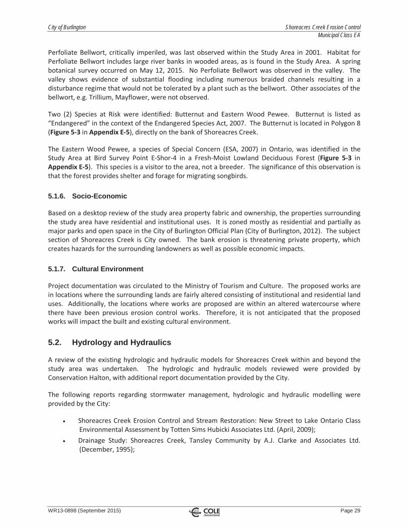
Two (2) Species at Risk were identified: Butternut and Eastern Wood Pewee. Butternut is listed as“Endangered” in the context of the Endangered Species Act, 2007. The Butternut is located in Polygon 8(Figure 5 3 in Appendix E 5), directly on the bank of Shoreacres Creek.
The Eastern Wood Pewee, a species of Special Concern (ESA, 2007) in Ontario, was identified in theStudy Area at Bird Survey Point E Shor 4 in a Fresh Moist Lowland Deciduous Forest (Figure 5 3 inAppendix E 5). This species is a visitor to the area, not a breeder. The significance of this observation isthat the forest provides shelter and forage for migrating songbirds.
5.1.6. Socio-Economic
Based on a desktop review of the study area property fabric and ownership, the properties surroundingthe study area have residential and institutional uses. It is zoned mostly as residential and partially asmajor parks and open space in the City of Burlington Official Plan (City of Burlington, 2012). The subjectsection of Shoreacres Creek is City owned. The bank erosion is threatening private property, whichcreates hazards for the surrounding landowners as well as possible economic impacts.
5.1.7. Cultural Environment
Project documentation was circulated to the Ministry of Tourism and Culture. The proposed works arein locations where the surrounding lands are fairly altered consisting of institutional and residential landuses. Additionally, the locations where works are proposed are within an altered watercourse wherethere have been previous erosion control works. Therefore, it is not anticipated that the proposedworks will impact the built and existing cultural environment.
5.2. Hydrology and Hydraulics
A review of the existing hydrologic and hydraulic models for Shoreacres Creek within and beyond thestudy area was undertaken. The hydrologic and hydraulic models reviewed were provided byConservation Halton, with additional report documentation provided by the City.
The following reports regarding stormwater management, hydrologic and hydraulic modelling wereprovided by the City:
Shoreacres Creek Erosion Control and Stream Restoration: New Street to Lake Ontario ClassEnvironmental Assessment by Totten Sims Hubicki Associates Ltd. (April, 2009);Drainage Study: Shoreacres Creek, Tansley Community by A.J. Clarke and Associates Ltd.(December, 1995);

City of Burlington Shoreacres Creek Erosion Control Municipal Class EA
WR13-0898 (September 2015) Page 30
Downstream Drainage Assessment: Silvan West/Krysan Lands by A.J. Clarke and AssociatesLtd. (June, 1995);Alton Community Secondary Plan: Subwatershed Impact Study by G.M. Sernas & AssociatesLtd. (July, 1997);Interim Stormwater Management for North Service Road Industrial Development by a.m.canderas associates inc. (April, 2005); and,Tansley District Centre Secondary Plan Study by M.M. Dillion Ltd. (September, 1989).
The most recent report relevant to the study area is the Shoreacres Creek Class EA from 2009 (‘2009Class EA’), which analysed the reach of Shoreacres Creek from New Street to Lakeshore Boulevard. Thisreach is downstream of Highway QEW. The scope of work for the 2009 Class EA is similar to the currentClass EA for Shoreacres Creek between Millcroft Park Drive and the CN Rail. Thus, the hydrologic andhydraulic information presented in the 2009 report is appropriate for review in comparison with thecurrent subject site.
5.2.1. Review of Hydrologic Modelling
The existing hydrologic model was a GAWSER model, updated in 1997 by EWRG Ltd. and received fromConservation Halton. The hydrologic model output as summarized in the 2009 Class EA was reviewedand checked for consistency with the hydraulic model. The flows were compared to those in theexisting hydraulic model; the flow inputs were consistent with the hydrologic output and are provided inTable 5.7 below.
Table 5.7 – Shoreacres Creek Flow Rates from HEC RAS ModelLocation HEC RAS Flow
Input SectionPeak Flow by Storm Event (m3/s)
2 year 5 year 10 year 25 year 50 year 100 year Regional
Upstream ofMillcroft ParkDrive (West)
219.1325 n/a n/a n/a n/a n/a n/a 35.6
Upstream ofMillcroft ParkDrive (East)
200 n/a n/a n/a n/a n/a n/a 18.6
Upstream ofMillcroft ParkDrive (East)
27.12670 n/a n/a n/a n/a n/a n/a 19.3
Downstreamof MillcroftPark Drive
7635.922 9.6 15.0 18.0 22.0 26.0 29.0 55.0
Upstream ofUpper MiddleRoad
7265.283 9.7 15.0 18.0 23.0 26.0 29.0 57.0
The proposed project will not impact the hydrologic behaviour of Shoreacres Creek since no changes inland use or flow patterns are proposed. The existing GAWSER hydrologic output as provided in the 2009Class EA and the existing hydraulic model was found to be sufficient for this study and will not beupdated.

City of Burlington Shoreacres Creek Erosion Control Municipal Class EA
WR13-0898 (September 2015) Page 31
5.2.2. Review of Hydraulic Modelling
The existing HEC RAS models were provided by Conservation Halton. The site covers three (3) reachesof the creek. Flood depths and water velocities for various events were determined. Below in Table 5.8below the water elevations and channels velocities calculated prior to updating the HEC RAS model withsite specific survey information can be found; detailed output can be found in Appendix F 2.
Table 5.8 – Received Channel Velocities and Water Levels by Storm EventCrossSection
Description 2 year 5 year 10 year 25 year 50 year 100 year Regional
155.4218
(West)
Water Level(m)
139.34
Velocity (m/s) 1.65
129.5606
(West)
Water Level(m)
139.40
Velocity (m/s) 0.37
5.996320
(West)
Water Level(m)
139.39
Velocity (m/s) 0.46
56.36505
(East)
Water Level(m)
139.39
Velocity (m/s) 0.53
27.12670
(East)
Water Level(m)
139.39
Velocity (m/s) 0.32
7635.922
(Main)
Water Level(m)
137.45 137.65 137.75 137.88 137.99 138.05 138.46
Velocity (m/s) 1.46 1.62 1.67 1.71 1.75 1.81 2.23
7578.887
(Main)
Water Level(m)
137.11 137.25 137.29 137.35 137.43 137.53 137.99
Velocity (m/s) 1.65 2.09 2.35 2.66 2.84 2.82 3.11
7500
(Main)
Water Level(m)
136.67 136.82 136.88 136.93 136.99 137.02 137.34
Velocity (m/s) 1.79 1.92 2.00 2.14 2.27 2.37 2.72
7400
(Main)
Water Level(m)
136.25 136.36 136.41 136.48 136.55 136.61 137.15
Velocity (m/s) 1.42 1.72 1.84 1.92 1.99 2.01 1.92
7321.627
(Main)
Water Level(m)
135.93 136.09 136.18 136.31 136.39 136.46 137.09
Velocity (m/s) 1.44 1.47 1.46 1.39 1.46 1.46 1.45
7265.283
(Main)
Water Level(m)
135.81 135.97 136.06 136.21 136.28 136.37 137.03
Velocity (m/s) 1.10 1.28 1.34 1.40 1.43 1.46 1.51
7186.294 Water Level(m)
135.74 135.94 136.04 136.20 136.28 136.37 137.04

City of Burlington Shoreacres Creek Erosion Control Municipal Class EA
WR13-0898 (September 2015) Page 32
CrossSection
Description 2 year 5 year 10 year 25 year 50 year 100 year Regional
(Main) Velocity (m/s) 0.86 0.81 0.80 0.80 0.81 0.82 0.90
7176.266
(Main)
Water Level(m)
135.47 135.59 135.65 135.73 135.79 135.83 136.22
Velocity (m/s) 1.93 2.25 2.39 2.63 2.73 2.85 3.61
5837.541
(Main)
Water Level(m)
128.96 129.10 129.17 129.34 129.46 129.60 131.56
Velocity (m/s) 1.55 1.90 1.97 1.77 1.59 1.41 0.69
5785.512
(Main)
Water Level(m)
128.81 128.96 129.07 129.28 129.42 129.57 131.56
Velocity (m/s) 1.27 1.44 1.44 1.31 1.21 1.12 0.57
5682.790
(Main)
Water Level(m)
128.28 128.63 128.82 129.10 129.25 129.41 131.55
Velocity (m/s) 1.66 1.52 1.47 1.43 1.40 1.36 0.75
5661.461
(Main)
Water Level(m)
128.26 128.62 128.81 129.08 129.25 129.41 131.42
Velocity (m/s) 0.95 1.09 1.15 1.24 1.29 1.33 1.35
Cross sections within the study area were updated (see Table 5.9 below for updated existing results).The topographic information used in this update was from a composite 3 dimensional surface of thearea created using AutoCAD Civil 3D software using the points from the Cole Engineering topographicsurvey and 1 m contour data provided by Conservation Halton. Appendix F 1 includes a figure showingthe locations of the cross sections. Table 5.7 summarizes the water levels and velocities within thestudy area from the updated existing HEC RAS model. Detailed output is available in Appendix F 3.
Table 5.9 – Existing Channel Velocities and Water Levels by Storm EventCrossSection
Description 2 year 5 year 10 year 25 year 50 year 100 year Regional
155.4218
(West)
Water Level(m)
139.33
( 0.01)
Velocity(m/s)
1.65
129.5606
(West)
Water Level(m)
139.40
Velocity(m/s)
0.35
( 0.02)
5.996320
(West)
Water Level(m)
139.39
Velocity(m/s)
0.32
( 0.14)
56.36505
(East)
Water Level(m)
139.39
Velocity(m/s)
0.53

City of Burlington Shoreacres Creek Erosion Control Municipal Class EA
WR13-0898 (September 2015) Page 33
CrossSection
Description 2 year 5 year 10 year 25 year 50 year 100 year Regional
27.12670
(East)
Water Level(m)
139.39
Velocity(m/s)
0.32
7635.922
(Main)
Water Level(m)
137.30
( 0.15)
137.54
( 0.11)
137.65
( 0.10)
137.79
( 0.09)
137.91
( 0.08)
137.99
( 0.06)
138.44
( 0.02)
Velocity(m/s)
0.92
( 0.54)
1.12
( 0.50)
1.17
( 0.50)
1.22
( 0.49)
1.23
( 0.52)
1.30
( 0.51)
1.66
( 0.57)
7578.887
(Main)
Water Level(m)
136.93
( 0.18)
137.14
( 0.11)
137.22
( 0.05)
137.33
( 0.02)
137.42
( 0.01)
137.52
( 0.01)
137.99
Velocity(m/s)
2.27
(+0.62)
2.46
(+0.37)
2.61
(+0.26)
2.71
(+0.05)
2.88
(+0.04)
2.85
(+0.03)
3.13
(+0.02)
7500
(Main)
Water Level(m)
136.59
( 0.08)
136.73
( 0.09)
136.80
( 0.08)
136.88
( 0.05)
136.93
( 0.06)
136.97
( 0.05)
137.35
(+0.01)
Velocity(m/s)
1.17
( 0.62)
1.42
( 0.50)
1.52
( 0.48)
1.66
( 0.48)
1.82
( 0.45)
1.93
(0.44)
2.50
( 0.22)
7400
(Main)
Water Level(m)
136.16
( 0.09)
136.30
( 0.06)
136.35
( 0.06)
136.41
( 0.07)
136.50
( 0.05)
136.57
( 0.04)
137.15
Velocity(m/s)
1.86
(+0.44)
1.98
(+0.26)
2.10
(+0.26)
2.23
(+0.31)
2.19
(+0.20)
2.15
(+0.14)
1.92
7350
(Main)
Water Level(m)
136.11 136.23 136.30 136.39 136.46 136.53 137.10
Velocity(m/s)
1.20 1.52 1.66 1.77 1.90 1.95 2.04
7321.627
(Main)
Water Level(m)
135.91
( 0.02)
136.07
( 0.02)
136.15
( 0.03)
136.29
( 0.02)
136.36
( 0.03)
136.44
( 0.02)
137.07
( 0.02)
Velocity(m/s)
1.52
(+0.08)
1.55
(+0.08)
1.54
(+0.08)
1.45
(+0.06)
1.52
(+0.06)
1.51
(+0.05)
1.46
(+0.01)
7265.283
(Main)
Water Level(m)
135.70
( 0.11)
135.90
( 0.07)
136.00
( 0.06)
136.16
( 0.05)
136.25
( 0.03)
136.33
( 0.04)
137.01
( 0.02)
Velocity(m/s)
1.34
(+0.24)
1.45
(+0.17)
1.48
(+0.12)
1.50
(+0.10)
1.50
(+0.07)
1.51
(+0.05)
1.53
(+0.02)
7186.294
(Main)
Water Level(m)
135.74 135.94 136.04 136.19
( 0.01)
136.28 136.36
( 0.01)
137.03
( 0.01)
Velocity(m/s)
0.31
(+0.55)
0.37
(+0.44)
0.40
(+0.40)
0.44
(+0.36)
0.46
(+0.35)
0.48
(+0.34)
0.61
(+0.29)
7176.266
(Main)
Water Level(m)
135.47 135.59 135.65 135.74
(+0.01)
135.79 135.83 136.22
Velocity(m/s)
1.91
( 0.02)
2.20
( 0.05)
2.39 2.61
( 0.02)
2.74
( 0.01)
2.85 3.62
(+0.01)

City of Burlington Shoreacres Creek Erosion Control Municipal Class EA
WR13-0898 (September 2015) Page 34
CrossSection
Description 2 year 5 year 10 year 25 year 50 year 100 year Regional
5837.541
(Main)
Water Level(m)
128.97
(+0.01)
129.11
(+0.01)
129.20
(+0.03)
129.36
(+0.02)
129.48
(+0.02)
129.61
(+0.01)
131.57
(+0.01)
Velocity(m/s)
0.81
( 0.74)
0.89
( 1.01)
0.88
( 1.09)
0.85
( 0.92)
0.81
( 0.78)
0.77
( 0.64)
0.44
( 0.25)
5785.512
(Main)
Water Level(m)
128.81 128.96 129.07 129.28 129.42 129.57 131.56
Velocity(m/s)
1.27 1.44 1.44 1.31 1.21 1.12 0.57
5682.790
(Main)
Water Level(m)
128.28 128.64
(+0.01)
128.82 129.10 129.26
(+0.01)
129.44 131.55
Velocity(m/s)
1.66 1.52 1.47 1.43 1.40 1.36 0.75
5661.461
(Main)
Water Level(m)
128.26 128.62 128.81 129.08 129.25 129.41 131.42
Velocity(m/s)
0.95 1.09 1.15 1.24 1.29 1.33 1.35
The HEC RAS model was updated to reflect Alternative 3 (Implement Bio Engineering Solution at SelectLocations within Creek) and Alternative 4 (Realign / Reconstruct Sections of the Creek). This consisted ofupdating cross sections of the erosion sites where works are proposed. The results of the proposedcondition model are summarized in Table 5.10 and Table 5.11 below. Detailed output is available inAppendix F 4 for Alternative 3 and Appendix F 5 for Alternative 4. For Alternative 3 it can be seen thatwater levels decreased or remained the same throughout the study area for all storm events. ForAlternative 4 it can be seen that there were several increases in the water level (up to +0.08 m for the2 year storm at the 7500 Cross Section). These storm events are all contained within the channel andvalleylands at this location, and therefore the effects will be minimal. At detailed design, the model willbe further evaluated and defined with detailed grading. There was a variable response in the change ofvelocities from the model for Alternative 3, ranging from a change of 0.4 m/s to + 0.23 m/s and forAlternative 4, ranging from a change of 0.14 m/s to + 0.60 m/s. However, the exact hydraulic impactsof any proposed measures are site specific and should be addressed at the detailed design stage with anupdate to the hydraulic model.

City of Burlington Shoreacres Creek Erosion Control Municipal Class EA
WR13-0898 (September 2015) Page 35
Table 5.10 – Proposed Channel Velocities and Water Levels by Storm Event for Alternative 3CrossSection
Description 2 year 5 year 10 year 25 year 50 year 100 year Regional
155.4218
(West)
Water Level(m)
139.33
Velocity(m/s)
1.65
129.5606
(West)
Water Level(m)
139.40
Velocity(m/s)
0.35
5.996320
(West)
Water Level(m)
139.39
Velocity(m/s)
0.32
56.36505
(East)
Water Level(m)
139.39
Velocity(m/s)
0.53
27.12670
(East)
Water Level(m)
139.39
Velocity(m/s)
0.32
7635.922
(Main)
Water Level(m)
137.30 137.54 137.65 137.79 137.91 137.99 138.44
Velocity(m/s)
0.92 1.12 1.17 1.22 1.26
(+0.03)
1.30 1.66
7578.887
(Main)
Water Level(m)
136.93 137.14 137.22 137.33 137.42 137.52 137.99
Velocity(m/s)
2.27 2.46 2.61 2.71 2.88 2.85 3.13
7500
(Main)
Water Level(m)
136.48
( 0.11)
136.67
( 0.06)
136.75
( 0.05)
136.83
( 0.05)
136.91
( 0.02)
136.95
( 0.02)
137.33
( 0.02)
Velocity(m/s)
1.40
(+0.23)
1.51
(+0.09)
1.58
(+0.06)
1.71
(+0.05)
1.82 1.92
( 0.01)
2.48
( 0.02)
7400
(Main)
Water Level(m)
136.12
( 0.04)
136.25
( 0.05)
136.31
( 0.04)
136.41 136.49
( 0.01)
136.56
( 0.01)
137.14
( 0.01)
Velocity(m/s)
1.46
( 0.40)
1.82
( 0.16)
1.95
( 0.15)
2.00
( 0.23)
2.07
( 0.12)
2.05
( 0.10)
2.88
( 0.04)
7350
(Main)
Water Level(m)
136.11 136.23 136.30 136.39 136.46 136.53 137.10
Velocity(m/s)
1.20 1.52 1.66 1.77 1.90 1.95 2.03
( 0.01)
7321.627 Water Level(m)
135.91 136.07 136.15 136.29 136.37 136.44 137.07

City of Burlington Shoreacres Creek Erosion Control Municipal Class EA
WR13-0898 (September 2015) Page 36
CrossSection
Description 2 year 5 year 10 year 25 year 50 year 100 year Regional
(Main) (+0.01)
Velocity(m/s)
1.52 1.55 1.54 1.45 1.51
( 0.01)
1.51 1.46
7265.283
(Main)
Water Level(m)
135.70 135.90 136.00 136.16 136.25 136.33 137.01
Velocity(m/s)
1.34 1.45 1.47
( 0.01)
1.49
( 0.01)
1.49
( 0.01)
1.51 1.53
7186.294
(Main)
Water Level(m)
135.74 135.94 136.04 136.19 136.28 136.36 137.03
Velocity(m/s)
0.36
(+0.05)
0.43
(+0.06)
0.47
(+0.07)
0.51
(+0.07)
0.53
(+0.07)
0.56
(+0.08)
0.70
(+0.09)
7176.266
(Main)
Water Level(m)
135.47 135.59 135.65 135.74 135.79 135.83 136.22
Velocity(m/s)
1.91 2.25 2.39 2.61 2.74 2.85 3.62
5837.541
(Main)
Water Level(m)
128.97 129.11 129.20 129.36 129.48 129.61 131.57
Velocity(m/s)
0.81 0.89 0.88 0.85 0.81 0.77 0.44
5785.512
(Main)
Water Level(m)
128.81 128.96 129.07 129.28 129.42 129.57 131.56
Velocity(m/s)
1.27 1.44 1.44 1.31 1.21 1.12 0.57
5682.790
(Main)
Water Level(m)
128.28 128.64 128.82 129.10 129.26 129.44 131.55
Velocity(m/s)
1.66 1.52 1.47 1.43 1.40 1.36 0.75
5661.461
(Main)
Water Level(m)
128.26 128.62 128.81 129.08 129.25 129.41 131.42
Velocity(m/s)
0.95 1.09 1.15 1.24 1.29 1.33 1.35

City of Burlington Shoreacres Creek Erosion Control Municipal Class EA
WR13-0898 (September 2015) Page 37
Table 5.11 – Proposed Channel Velocities and Water Levels by Storm Event for Alternative 4CrossSection
Description 2 year 5 year 10 year 25 year 50 year 100 year Regional
155.4218
(West)
Water Level(m)
139.33
Velocity(m/s)
1.65
129.5606
(West)
Water Level(m)
139.40
Velocity(m/s)
0.37
(+0.02)
5.996320
(West)
Water Level(m)
139.39
Velocity(m/s)
0.32
56.36505
(East)
Water Level(m)
139.39
Velocity(m/s)
0.53
27.12670
(East)
Water Level(m)
139.39
Velocity(m/s)
0.32
7635.922
(Main)
Water Level(m)
137.29
( 0.01)
137.54 137.65 137.79 137.91 137.99 138.44
Velocity(m/s)
0.93
(+0.01)
1.12 1.17 1.22 1.26
(+0.03)
1.30 1.66
7578.887
(Main)
Water Level(m)
136.92 137.14 137.22 137.33 137.42 137.52 137.99
Velocity(m/s)
2.27 2.46 2.61 2.71 2.88 2.85 3.13
7500
(Main)
Water Level(m)
136.67
(+0.08)
136.79
(+0.06)
136.85
(+0.05)
136.93
(+0.05)
137.97
(+0.04)
137.99
(+0.02)
137.33
( 0.02)
Velocity(m/s)
1.48
(+0.31)
1.83
(+0.41)
1.95
(+0.43)
2.1
(+0.344)
2.33
(+0.51)
2.51
(+0.58)
3.1
(+0.60)
7400
(Main)
Water Level(m)
136.16 136.30 136.35 136.41 136.50 136.57 137.15
Velocity(m/s)
1.86 1.98 2.10 2.23 2.19 2.16
(+0.01)
1.92
7350
(Main)
Water Level(m)
136.11 136.23 136.30 136.39 136.46 136.52
( 0.01)
137.10
Velocity(m/s)
1.20 1.52 1.66 1.77 1.90 1.95 2.04
7321.627 Water Level 135.91 136.07 136.15 136.29 136.36 136.44 137.07

City of Burlington Shoreacres Creek Erosion Control Municipal Class EA
WR13-0898 (September 2015) Page 38
CrossSection
Description 2 year 5 year 10 year 25 year 50 year 100 year Regional
(Main) (m)
Velocity(m/s)
1.52 1.55 1.54 1.46
(+0.01)
1.52 1.51 1.46
7265.283
(Main)
Water Level(m)
135.70 135.90 136.00 136.15
( 0.01)
136.24
( 0.01)
136.33 137.01
Velocity(m/s)
1.35
(+0.01)
1.46
(+0.01)
1.48 1.50 1.50 1.51 1.53
7186.294
(Main)
Water Level(m)
135.74 135.94 136.04 136.19 136.28 136.36 137.03
Velocity(m/s)
0.32
(+0.01)
0.38
(+0.01)
0.41
(+0.01)
0.46
(+0.02)
0.48
(+0.02)
0.50
(+0.02)
0.64
(+0.03)
7176.266
(Main)
Water Level(m)
135.47 135.59 135.65 135.74 135.79 135.83 136.22
Velocity(m/s)
1.91 2.25 2.39 2.61 2.74 2.85 3.62
5837.541
(Main)
Water Level(m)
128.98
(+0.01)
129.13
(+0.02)
129.21
(+0.01)
129.36 129.48 129.62
(+0.01)
131.57
Velocity(m/s)
0.78
( 0.03)
0.87
( 0.02)
0.88 0.85 0.81 0.76
(+0.01)
0.44
5785.512
(Main)
Water Level(m)
128.86
(+0.05)
128.99
(+0.03)
129.08
(+0.01)
129.28 129.42 129.57 131.56
Velocity(m/s)
1.13
( 0.14)
1.38
( 0.06)
1.41
( 0.03)
1.32
(+0.01)
1.21 1.11
( 0.01)
0.57
5682.790
(Main)
Water Level(m)
128.28 128.64 128.82 129.10 129.27
(+0.01)
129.45
(+0.01)
131.55
Velocity(m/s)
1.85
(+0.19)
1.51
( 0.01)
1.42
( 0.05)
1.35
( 0.08)
1.30
( 0.10)
1.25
( 0.11)
0.72
( 0.03)
5661.461
(Main)
Water Level(m)
128.26 128.62 128.81 129.08 129.25 129.41 131.42
Velocity(m/s)
0.95 1.09 1.15 1.24 1.29 1.33 1.35

City of Burlington Shoreacres Creek Erosion Control Municipal Class EA
WR13-0898 (September 2015) Page 39
6.0 Evaluation of Alternatives
6.1. Identification / Description of Alternative Solutions
As an initial step, the Project Team identified and described alternative solutions, or functionallydifferent ways of addressing the problem / opportunity statement, as described in Section 4.0. Any“reasonable” alternative was included initially. All alternatives were considered equally for discussionpurposes and evaluation.
6.2. Development of Evaluation Categories and Criteria
Evaluation criteria were developed to reflect the definition of “environment” provided in the OEAA andthe specific circumstances associated with this project. All applicable comments were considered in theimplementation of the criteria in order to correctly evaluate all instances that would affect the Creek.Criteria were divided into the following categories, as listed in Table 6.1 below.
Table 6.1– Preliminary Evaluation CriteriaFunctional
Opportunity to improve conveyance of watercourse.
Opportunity to decrease erosion of watercourse.
Opportunity to improve functionality of adjacent lands.
Social Environment
Ability to improve public safety.
Impacts to private properties.
Impacts to public property.
Economic Environment
Capital costs.
Maintenance costs.
Risk management.
Natural Environment
Impacts on the thermal regime of the watercourse.
Impacts to terrestrial ecology.
Impacts to direct and indirect fish habitat.
Impacts on general water quality of the creek.
Impacts to natural hazard features.
Cultural Environment
Impacts to built and cultural heritage landscape.
Impacts to archaeological resources.
Constructability
Ease of construction and accessibility.
Expected disturbance to private / public property.

City of Burlington Shoreacres Creek Erosion Control Municipal Class EA
WR13-0898 (September 2015) Page 40
6.3. Undertake Net Effects Analysis
Using the evaluation criteria, the Project Team applied a net effects analysis to the alternative solutionsthat involved the following steps:
Identify potential effects;Develop and apply mitigation / compensation / enhancement measures; and,Determine net effects after mitigation measures have been applied.
The details of the net effects analysis are included in Appendix G. Cost estimates to support theevaluation of the alternative solutions are included in Appendix H. It is noted that the cost estimatesare evaluated by each individual site (i.e. Site A, Site B, etc.). The cost of each applicable alternative isthen evaluated for each site.
6.4. Comparative Evaluation Based on Net Effects and Identification of Recommended Alternative Solution
A comparative evaluation was undertaken using a “reasoned argument” or trade off method. Thismethod highlights the relative advantages and disadvantages of each alternative solution based on itsidentified net effects. This allowed for a clear presentation of the key trade offs between the variousevaluation factors and the reasons why one (1) alternative solution is preferred over another.
As a result, the relative differences and key trade offs between each alternative solution for the variousfactors are clearly understood and a traceable rationale for the selection of the preferred solution isprovided.
6.5. Evaluation Summary
The alternative solutions were ranked in order of preference according to their net effects analysis asidentified in the comparative evaluation. The ranking is summarized in Table 6.2 below.
Table 6.2 – Summary of Comparative EvaluationRank Alternative Solution
1st Alternative #4 – Realign / Reconstruct Sections of the Creek
2nd Alternative #3 – Implement Bio Engineering Solution at Select Locations within Creek
3rd Alternative #2 – Harden Select Locations within Creek
4th Alternative #1 – Do Nothing
The following provides a rationale for the ranking of each of the alternative solutions.

City of Burlington Shoreacres Creek Erosion Control Municipal Class EA
WR13-0898 (September 2015) Page 41
6.5.1. Alternative 4: Ranked First
Alternative 4 (Realign / Reconstruct Sections of the Creek) ranked the highest among the four (4)alternatives due to the mitigation of the major erosion locations, associated improved long term publicsafety and maintenance, and low risk to the natural environment.
Alternative 4 provided an overall advantage due to the proximity of Shoreacres Creek to private andpublic property in the majority of the sites chosen for the investigation (Sites A, B, C, E and F). Theoption will create a larger buffer zone between the creek and the public and private property, and allowfor filling of the existing creek bed and restoration of the slope at the select locations. The erosion atprivate properties will be mitigated and the flow capacity of the creek increased, and thus, public safetywill be improved. There will be no proposed net fill, therefore loss of riparian flood storage is notanticipated.
While the cost of Alternative 3 is lower than Alternative 4, re grading to achieve a stable slope at thesesites without realigning the creek may result in cutting into private property due to the proximity of thecreek. Realigning the creek would allow for a stable slope to be achieved without encroaching onprivate property and would reduce long term maintenance to the City. In addition, while the ecologicaldisturbance is high for Alternative 4 during construction works, this option provides an opportunity toenhance the local terrestrial environment and manage invasive species once construction is complete.Most of the proposed realignment sites have straightforward site access due to their proximity to publicroads and trails. Access to Site C will be facilitated through the construction of Site B.
6.5.2. Alternative 3: Ranked Second
Alternative 3 (Implement Bio Engineering Solution at Select Locations within Creek) ranked secondamong the four (4) alternatives due to the mitigation of the major erosion locations, associatedimproved public safety, and low risk to the natural environment.
Alternative 3 provided an overall advantage for sites that have a larger distance between the creek andthe private / public property (Site D). Implementing bio engineering solutions at this major erosionlocation within the study area will provide an effective means of bank erosion control while avoiding thedisturbance caused by unnecessary realignment of the creek at Site D. The conveyance of thewatercourse will be improved due to the reduced grade of the creek banks and the risk to theneighbouring private properties will be reduced. There will be no proposed fill, therefore loss of riparianflood storage is not anticipated. The cost of Alternative 3 is less than Alternative 2 and Alternative 4,which also address the problem / opportunity statement. In addition, Alternative 3 provides anopportunity to improve the natural environment. Construction will provide an opportunity to enhancethe local terrestrial environment and manage invasive species. Since the works will occur only on one(1) bank of the creek, the watercourse will not have to be completely dammed and pumped around thesite. Only a portion of the creek bank will have to be isolated to work in the dry through the use of acoffer dam and pump dewatering system. The proposed bio engineering site will be accessed throughSite C (and/or the easement from Waterbridge Drive, if determined to be necessary). Access to Site Cwill be facilitated through construction at Site B.

City of Burlington Shoreacres Creek Erosion Control Municipal Class EA
WR13-0898 (September 2015) Page 42
The disadvantages of this alternative are minimal. Further spot repairs may be required in the futuresince only the major erosion sites are proposed to be mitigated at this time. However, minor erosionlocations currently do not pose a risk to private property and therefore are not proposed to bemitigated at this time. The condition of the creek and bio engineering solutions should be monitoredoccasionally for damages. Negative impacts to the natural environment are limited. No sensitivespecies were identified during the investigations undertaken for this Class EA. Net positives can beachieved from a natural environment perspective.
The successful completion of Alternative 3 is reliant upon the availability of dormant live material usedin the bioengineering works. Construction should occur over the late fall to early spring when theappropriate materials are available. Expected complications to this construction period from the springfreshet will be mitigated by accessing and constructing one (1) bank at a time. The proposedconstruction staging and work plan will be further defined at the detailed design stage.
6.5.3. Alternative 2: Ranked Third
Alternative 2 (Harden Select Locations within Creek) ranked third among the four (4) alternatives due toits ability to address the problem / opportunity statement but it has a high cost and more significantenvironmental impact.
Alternative 2 also provides functional benefits. It provides the required erosion protection to the majorerosion locations. The hardened locations would have a long life span and low maintenance costs forthe harden structures themselves. Downstream locations may require remediation in the future due toerosion occurring at other locations within the study area. This may incur moderate economicinvestment by the City for downstream erosion sites in the future. It should also be noted, each of themajor erosion sites has straightforward site access due to its proximity to private property and parkinglots.
Alternative 2 presents disadvantages in terms of the economic, natural environment, andconstructability criteria categories. The hard and developed channel would have an overall negativeimpact on the environment including terrestrial habitat. It will also have a significant impact on fish andfish habitat. The hardened channel would also increase velocities, which could lead to future erosionproblems downstream of the hardened areas. The hardened aesthetic will be negative to surroundinglandowners. The capital costs of this alternative are higher than Alternative 3 and Alternative 4. Theconstructability of the hardened watercourse will be intensive and it will require each section of thecreek, where works are proposed, to be dammed and pumped.

City of Burlington Shoreacres Creek Erosion Control Municipal Class EA
WR13-0898 (September 2015) Page 43
6.5.4. Alternative 1: Ranked Fourth
Alternative 1 (Do Nothing) ranked last among the four (4) alternatives primarily because it does notaddress the problem / opportunity statement.
Alternative 1 provides limited advantages in the economic and constructability categories. This optionrequired no construction work and therefore has no associated capital costs, does not disturb theexisting habitat surrounding the Creek, and does not disturb nearby properties.
Alternative 1 presents overall disadvantages under the functional, natural environment, and socialcriteria categories. This option does not improve bank stability and allows erosion to worsen over time.The risk to private properties caused by the bank erosion will also get worse with time and may impactprivate properties in the future. The current conditions of the Creek also pose a safety hazard to thepublic and are undesirable in appearance where there are failing erosion control works. The existinghabitat may degrade further over time and continue to consist of invasive plant species.
6.6. Summary
Table 6.3 provides a summary of the evaluation and identifies the advantages and disadvantages of eachalternative.

City of Burlington Shoreacres Creek Erosion Control Municipal Class EA
WR13-0898 (September 2015) Page 44
Table 6.3 – Advantages and Disadvantages of the Alternative SolutionsEvaluation Category Alternative 1: Do Nothing Alternative 2: Harden Select
Locations within CreekAlternative 3: Implement BioEngineering Solution at Select
Locations within Creek
Alternative 4: Realign /Reconstruct Sections of the
Creek
1. Functional AdvantagesNone.
DisadvantagesDebris jams will remain andmay worse in the future;Erosion in the watercoursewill continue to occur; and,The functionality of theadjacent lands will remainthreatened due to proximityto bank erosion.
AdvantagesFlow capacity will be increased atproposed work locations;Major erosion sites will bemitigated; and,Functionality of adjacent lands willbe improved.
DisadvantagesHigher velocities could impactpreviously stable areasdownstream.
AdvantagesFlow capacity will be increasedat proposed work locations;Major erosion sites will bemitigated; and,Functionality of adjacent landswill be improved.
DisadvantagesGrading to achieve a stableslope will encroach on privateproperty.
AdvantagesErosion of adjacent privateproperty will be mitigated;and,Flow capacity will increase.
DisadvantagesPool riffle sequence will berequired to reduce the creekvelocity to previous rates toavoid an increase of erosionat downstream locations.
2. Social Environment AdvantagesNone.
DisadvantagesProximity to erosion is a riskto public safety; and,Additional debris and erosionwill create further safetyhazards to the public.
AdvantagesReduction of debris, existing majorerosion locations, and removal offailing erosion control structureswill increase public safety;Hardened creek could eliminatethe possibility of further erodingpublic lands; and,Public safety will be improved.
DisadvantagesCreek will have a “hard” exteriorwith little naturalized aesthetics.
AdvantagesPublic safety will be improved;Positive aesthetic effect foradjacent landowners;Reduced risk of impacts toprivate properties;Reduction of debris, existingmajor erosion locations, andremoval of failing erosioncontrol structures will increasepublic safety; and,Bio Engineering could eliminatethe possibility of furthereroding public lands.
DisadvantagesGrading of slope will bring thetop of slope closer to privateproperty.
AdvantagesPrivate properties will bepositively impacted from areduction of erosion of theslope adjacent to theproperty; and,Public safety will beimproved.
DisadvantagesProperties will be disruptedduring construction – thisoption is the most intrusive ofall alternatives.

City of Burlington Shoreacres Creek Erosion Control Municipal Class EA
WR13-0898 (September 2015) Page 45
Evaluation Category Alternative 1: Do Nothing Alternative 2: Harden SelectLocations within Creek
Alternative 3: Implement BioEngineering Solution at Select
Locations within Creek
Alternative 4: Realign /Reconstruct Sections of the
Creek
3. EconomicEnvironment
AdvantagesNo capital costs ormaintenance costs will beassociated with works.
DisadvantagesThe cost of repair works andfuture maintenance willincrease; and,The value of the adjacentlands will remain threateneddue to proximity to bankerosion.
AdvantagesInfrequent maintenance will berequired to the hardenedstructure; and,Low risk of failure.
DisadvantagesHighest capital costs; and,Large replacement cost.
AdvantagesLowest capital cost ofalternatives that addressproblem / opportunitystatement.
DisadvantagesOngoing periodic maintenancewill be required.
AdvantagesLong termmaintenance willbe minimized from the City;and,Infrequent maintenance willbe required.
DisadvantagesHigh capital cost due todisturbance.
4. NaturalEnvironment
AdvantagesNo disturbance to the existingvegetation, fish, and fishhabitat will occur due toconstruction.
DisadvantagesInvasive species will remain;No opportunity to enhanceaquatic and terrestrialenvironment;Unnatural debris andsediment from erosion maynegatively impact the fishhabitat;Erosion in the watercoursewill continue and steep slopesof the creek banks willremain; and,Erosion may cause prematurecollapse of vegetation prior togrowth of seedlings andcollapse of undercut banksreducing cover for fish.
AdvantagesProposed construction will providean opportunity to enhance thelocal environment through invasivespecies management andproposed vegetation plantings;and,Major erosion sites will bemitigated.
DisadvantagesIncreased water temperatures anddecreased water quality;Net loss of terrestrial habitat; and,Negative impact to fish and fishhabitat.
AdvantagesProposed construction providesan opportunity to enhance thelocal environment throughinvasive species managementand proposed vegetationplantings using only nativespecies;Using native plant species in allrestoration works will increasebiodiversity and ecologicalfunction of this habitat;Improvement to fish and fishhabitat;No net loss of terrestrialhabitat;Erosion will be mitigated; and,Steep bank slopes will bereduced.
DisadvantagesDisturbance duringconstruction.
AdvantagesProposed constructionprovides an opportunity toenhance the localenvironment through invasivespecies management andproposed vegetationplantings using only nativespecies.
DisadvantagesDisturbance duringconstruction; and,Vegetation will take sometime to reestablish within thecreek, during this period,shading will be reduced, thusincreasing summer watertemperatures.

City of Burlington Shoreacres Creek Erosion Control Municipal Class EA
WR13-0898 (September 2015) Page 46
Evaluation Category Alternative 1: Do Nothing Alternative 2: Harden SelectLocations within Creek
Alternative 3: Implement BioEngineering Solution at Select
Locations within Creek
Alternative 4: Realign /Reconstruct Sections of the
Creek
5. CulturalEnvironment
AdvantagesBuilt heritage features andarcheological resources willnot be impacted.
DisadvantagesNone.
AdvantagesBuilt heritage features andarcheological resources are notexpected to be impacted.
DisadvantagesNone.
AdvantagesBuilt heritage features andarcheological resources are notexpected to be impacted.
DisadvantagesNone.
AdvantagesBuilt heritage features andarcheological resources arenot expected to be impacted.
DisadvantagesNone
6. Constructability AdvantagesNo construction required.
DisadvantagesNone.
AdvantagesConstruction locations easilyaccessible from private property.
DisadvantagesComplex construction process andmaterial quantities.
AdvantagesConstruction process should bestraightforward; and,Construction locations easilyaccessible from public orprivate property.
DisadvantagesNone.
AdvantagesConstruction locations easilyaccessible from privateproperty.
DisadvantagesConstruction process isintrusive, largest disturbanceof all options; and,Will be the most complexconstruction process of allalternatives.
Overall Ranking 4th 3rd 2nd 1st

City of Burlington Shoreacres Creek Erosion Control Municipal Class EA
WR13-0898 (September 2015) Page 47
6.7. Preferred Alternative Solution
The net advantages of Alternative 4 (Realign / Reconstruct Sections of the Creek) are superior to theother alternatives for sites A, B, C, E and F since this option allows for the creation of a buffer zonebetween Shoreacres Creek and the adjacent properties threatened by the creek’s eroding banks.Through implementing this option at the specified major problem locations within the creek blockwhere Shoreacres Creek can reasonably be re routed and the flow capacity of the creek can beincreased. This solution maintains a lower cost than Alternative 2 which also addresses the problem /opportunity statement, and also has a lower impact on the natural environment, especially terrestrialand aquatic ecology than Alternative 2. This option also provides advantages over Alternative 3 incertain locations, since the proximity of the creek to private and public property at these sites limits thearea available for regrading the banks to stabilize the slope.
Alternative 3 (Implement Bio Engineering Solution at Select Locations within Creek) yielded a morepositive net effects analysis outcome than all other alternatives for Site D, since the risks theinfrastructure are not immediate at this location. Implementing bio engineering techniques at thislocation presented a lower cost than Alternative 4 while still addressing the problem / opportunitystatement, and achieved a superior impact on terrestrial and aquatic ecology to Alternative 2.
All alternatives were presented to the public and stakeholders for comment at the public informationcentre (PIC) held in September 2014, with Alternatives 3 and 4 being presented as the recommendedalternatives. Typical bio engineering alternatives that could be implemented at the specified erosionsites are illustrated in Figure DE 3 in Appendix A. Figure DE 4 and Figure DE 5 in Appendix A showtypical details of bio engineering options that could be implemented within the study area.
It is noted that the preferred alternative solutions, Alternative 3 (Implement Bio Engineering Solution atSelect Locations within the Creek) and Alternative 4 (Realign/Reconstruct Sections of the Creek) arerecommended at this stage of the project. A summary of the recommended alternatives is found belowin Table 6.4 below, and in Appendix G. At the detailed design stage, all sites will be assessed on a sitespecific basis and the methods of bio engineering and the optimal creek realignment routes will beselected. While a solution has been recommended for Site D, after consultation with the City it hasbeen decided that construction will be deferred and the site will be monitored. Environmentalmonitoring will take place at the site to determine whether the site will be appropriately rehabilitatedthrough bio engineering techniques.
Table 6.4 – Summary of Preferred AlternativesErosion Site Preferred Alternative Implementation Notes of Preferred Alternative
Site A 4. Realign/Reconstruct Section of Creek
• Realign tributary to the north away fromtownhouse development
• Access from Millcroft Park Drive• Stabilize existing slope where required (i.e.
mitigate surface erosion down slope,geotechnical issues etc.)
• Public education regarding dumping of debrisand organics

City of Burlington Shoreacres Creek Erosion Control Municipal Class EA
WR13-0898 (September 2015) Page 48
Erosion Site Preferred Alternative Implementation Notes of Preferred Alternative
Site B 4. Realign/Reconstruct Section of Creek
• Reconstruct confluence to eliminateknickpointing.
• Access from Millcroft Park Drive• Stabilize existing slope where required (i.e.
mitigate surface erosion downslope,geotechnical issues etc.)
• Implement pool riffle sequences and plantingsto develop the natural channel
Site C 4. Realign/Reconstruct Section of Creek
• Realign tributary to the south away from rearbackyards and fenceline
• Access from Millcroft Park Drive through Site B• Stabilize existing slope where required (i.e.
mitigate surface erosion down slope,geotechnical issues etc.)
• Public education regarding dumping of debrisand organics
Site D 3. Bio Engineering at Select Location
• Rehabilitate failed concrete block lining andgabion baskets at outfall
• Access from Millcroft Park Drive through Site Band Site C
• Implement stone protection at outfall,rehabilitate headwall. Implement plantingsand bio engineering techniques.
• Monitoring only to be undertaken at thisstage.
Site E 4. Realign/Reconstruct Section of Creek
• Isolate oxbow and realign tributary to thesouth away from private property andundercut fenceline. Design vernal pool,pending monitoring results.
• Access from Upper Middle Road• Stabilize existing slope where required (i.e.
mitigate surface erosion down slope, stabilizethe drainpipe, geotechnical issues etc.)
• Public education regarding dumping of debrisand organics
Site F 4. Realign/Reconstruct Section of Creek
• Realign tributary to the north away frompaved pedestrian pathway
• Access from Mainway and pedestrian pathwayor Pincay Oaks Lane and pedestrian pathway
• Stabilize existing slope where required (i.e.mitigate surface erosion down slope,geotechnical issues etc.)
• Implement plantings and bio engineeringtechniques with no re grading of sloperequired, as a supplementary measure

City of Burlington Shoreacres Creek Erosion Control Municipal Class EA
WR13-0898 (September 2015) Page 49
7.0 Public and Agency Consultation
7.1. Consultation Activities
The general public, property owners, agencies, etc. were given a variety of opportunities throughout theproject for learning, sharing, and responding by means of the following points of public contact. TheMunicipal Class EA requires the Proponent to undertake two (2) mandatory points of public contactduring Phase Two (Alternative Solutions) for a Schedule ‘B’ project. The Project Team has exceeded themandatory number of public contacts, with the following opportunities for comment provided:
Notice of Commencement;Notice of Public Information Centre #1;Public Information Centre #1; and,Notice of Completion.
Public comments were welcome throughout the EA process. Any public comments received areincluded in Appendix I 1.
7.1.1. Notice of Commencement
A Notice of Commencement was prepared and distributed to local stakeholders and review agencies.The notice was published in the “Burlington Post” on Thursday, March 13, 2014 and Thursday, March20, 2014.
In addition, the notice was mailed directly to affected property owners and posted on the City ofBurlington website. The purpose of the notice was to notify the public that a Class EA Study has beeninitiated for the study area. It also provided background information on the study including thepurpose, objectives, and process. The contact information for the City’s Project Manager and ColeEngineering’s Project Manager were made available to the public to engage any initial feedback on theproject.
A copy of the Notice of Commencement is provided in Appendix I 2.
7.1.2. Notice of Public Information Centre
A Notice of the first Public Information Centre (PIC) was prepared and distributed to local stakeholdersand review agencies. The notice was published in the “Burlington Post” on September 11, 2014.
In addition, the notice was mailed directly to the affected property owners and posted on the City ofBurlington website. The notices provided a description of the project, provided details of the PIC, andincluded a request for comments and input. Contact information was provided for the City’s ProjectManager and Cole Engineering’s Project Manager to encourage the submission of comments. A copy ofthe notice is provided in Appendix I 3.

City of Burlington Shoreacres Creek Erosion Control Municipal Class EA
WR13-0898 (September 2015) Page 50
7.1.3. Public Information Centre
A Public Information Centre (PIC) took place on Tuesday September 16, 2014 once the preliminarypreferred solutions had been identified. The Project Team including representatives from the City andCole Engineering were in attendance to answer any questions that participants had.
The PIC presented the following elements:
Background Information on the study;Background on the Class EA process;Problem / Opportunity Statement;Description of the Preliminary Alternative Solutions;Preliminary Evaluation Criteria;Preliminary Evaluation of the Alternative Solutions; and,Preliminary Preferred Alternative Solution.
One (1) comment was received at the PIC from a resident at 2062 Waterbridge Drive (Site C) supportingthe realignment of the creek away from the property line. The display panels presented at the PIC canbe found in Appendix I 4. The PIC sign in sheet and comment form are also enclosed in Appendix I 4.
7.1.4. Notice of Completion
The Notice of Completion informs stakeholders of the completion of the Class EA and provides thelocations where stakeholders can review the completed Project File. The notice also informs the publicof the 30 day review period associated with the conclusion of the Class EA process. During this reviewperiod, concerned individuals have the right to raise and discuss issues prior to requesting a Part II Orderbefore the project may proceed to implementation. A copy of the Notice of Completion will be includedat the start of the Project File.
7.1.5. First Nations Consultation
The Notice of Commencement, Notice of Public Information Centre, and Notice of Completion were allsent to Aboriginal stakeholders and to agencies responsible for Aboriginal issues along with consultationfor the other stakeholders.

City of Burlington Shoreacres Creek Erosion Control Municipal Class EA
WR13-0898 (September 2015) Page 51
7.1.6. Consultation with Conservation Halton
An initial meeting was held with the City, the Region of Halton and staff of Conservation Halton onMarch 6, 2014. The purpose of this meeting was to review preliminary alternatives, the problem /opportunity statement, and overall concerns. Minutes of this meeting are included in Appendix I 5,with key points summarized below:
The problem / opportunity statement was found to be acceptable;Hydraulic modelling must be completed to ensure the preferred alternative does not increaseflood elevations (downstream area is susceptible to flooding); and,Tree replacement shall be based on area of significant woodland removed rather thanquantity of trees removed.
A site walk was held with Conservation Halton, the City of Burlington, SLR and Water’s Edge on April 29,2014. The purpose of the meeting was to determine the areas of concern and to develop and discusssome mutually agreed upon design alternatives with Conservation Halton and the City. Minutes of thismeeting are included in Appendix I 5, with key points summarized below:
A focus of the EA and DD should be on public education regarding the effects of dumping yardwaste into the creek valley; and,The proposed alternatives and proposed work locations were agreed upon by the City andConservation Halton. The alternatives were refined based on recommendations providedduring the site walk.
7.1.7. Consultation with the Ministry of the Environment
A covering letter and the Notice of Commencement were sent to the Ministry of the Environment (MOE)on March 14, 2014 and the Notice of Public Information Centre on September 8, 2014.
7.1.8. Stakeholder Consultation
The notices for this project were sent to many stakeholders to engage them in the Class EA processincluding those mentioned above, the Ministry of Natural Resources, Ministry of Transportation,Ministry of Tourism and Culture, Environment Canada, Transport Canada, Fisheries and Oceans Canada,and Halton Regional Municipality.

City of Burlington Shoreacres Creek Erosion Control Municipal Class EA
WR13-0898 (September 2015) Page 52
8.0 Description, Implementation, and Monitoring of the Project
8.1. Description of the Project
The following sections describe the proposed works recommended as part of this Class EA.
8.1.1. Permits and Approvals
In water works typically require approval from a variety of reviewing agencies depending on the natureof the work proposed. Table 8.1 below summarizes the approval requirements for the project.
Table 8.1 – Summary of Permits and ApprovalsAgency Approval Mechanism Alternative Solution
Conservation Halton (CH) Permit under O.Reg.162/06 Pre consultation with CH has beenundertaken as discussed inSection 7.1.6. Permit applicationwill be submitted during detaileddesign process.
Department of Fisheries and Oceans Authorization under the FisheriesAct
DFO review is required for project.A Project Notification Form shouldbe prepared and submitted. DFOwill determine if an authorization isrequired as a result of projectactivities.
Transport Canada Permit under the Navigable WatersProtection Act
The proposed works are classified as“minor works” erosion protectionand an application under the NWPAis not required.
Ministry of Natural Resources Permit under the Lakes and RiversImprovement Act
MNR typically does not reviewapplications in areas with aConservation Authority in place,with the exception of work withdams. To be confirmed at detaileddesign.
All permits and approvals must be in hand prior to commencing the works.
City of Burlington Shoreacres Creek Erosion Control Municipal Class EA
WR13-0898 (September 2015) Page 53
8.1.2. Site Clearing and Preparation
In order to create a safe and effective working site within the channel at Site B and Site D, water must bediverted from the construction area. This is completed at Site D by isolating the bank with a dam andpump dewatering system to convey water out of the working area. Site B will require the east branch ofShoreacres Creek to be completely dammed and pumped around the site. The main branch ofShoreacres Creek will only be partially dammed at the confluence, allowing the creek to maintain flow inits original channel. Fish transfer may be required with the dewatering activity at the beginning of eachworking day, prior to dewatering the working area. Realigned channel reaches at Sites A, C, E and F willbe constructed in dry conditions. The new channel will be commissioned when it is stable. Biologistswill be on site to rescue and transfer stranded fish when the new channel is commissioned.
Prior to any construction taking place the site must be cleared. There is existing vegetation at the siteswhere erosion control works are proposed that will have to be removed. This includes removal ofseveral small trees though some larger trees may require removal as well. Trees removed with a 15 cmDBH or greater will be replaced at a ratio of 3:1. Transplantation will be considered if desirable sensitivespecies are discovered, however based on ecological work completed for this Class EA, species thatrequire transplanting are not anticipated. Potential for vegetation retention will be assessed on a sitespecific basis during the detailed design process. Vegetation removal is not to occur during nestingseason, in compliance with the migratory Birds Convention Act. No in water works will occur betweenthe timing window identified by Conservation Halton.
Halton Region is a regulated area (by Ministerial Order) with respect to ash tree material and theEmerald Ash Borer (EAB). As some of the trees affected by construction are ash species, all treatmentand disposal procedures required by the Canadian Food Inspection Agency (CFIA) shall be implemented.
8.1.2.1 Invasive Species Management
During construction related activities woody vegetation will be removed to allow vehicle and materialaccess providing an opportunity for invasion of non native species identified in the Plant Species List(Appendix E 6). Prior to the replanting of native vegetation post construction, a survey of theconstruction area should be carried out to identify regenerating non native species. These should beremoved prior to planting native replacement vegetation. Restoration plans should include invasivespecies control measures that may include the use of herbicides to kill woody invasive material,composting, mulching and monitoring for invasions. Site specific herbicide application should beconsidered; Best Management Practices (BMP) documents developed by the Ontario Invasive PlantCouncil (OIPC) should be followed during application of all herbicides used for invasive speciesmanagement.

City of Burlington Shoreacres Creek Erosion Control Municipal Class EA
WR13-0898 (September 2015) Page 54
8.1.3. Bio-Engineering Works
Once the work area has been isolated, Site D will require the banks to be cut back at a safe slope.Depending on the site and proposed works, the appropriate slope will be determined by a geotechnicalengineer during the detailed design phase. Once preliminary grading is completed, bio engineeringtechniques for slope stabilization and erosion control can be implemented. These will be site specificbut may include root wads, live fascines, live stakes, toe protection, vegetated riverstone, and crib walls.All biomaterial should be native to Ontario, and species local to the region are preferred. All vegetatedmaterial should be planted as far into the soil as possible in the best growing medium available toensure the success of the plantings. The detailed design will be completed in consultation with a fluvialgeomorphologist, a biologist, and Conservation Halton. All bio engineering works should be installedafter October 30 and before April 1 for better establishment of vegetative material. It is recommendedthat a professional with adequate demonstrated experience in the design and installation ofbio engineering projects be on site at all times during the bio engineering installations.
Preliminary recommendations for implementation during the detailed design stage were investigated. Itis strongly recommended for all sites that the vegetated material be watered twice a week during thefirst growing season and then once a week during the months of June, July and August.
8.1.4. Realignment / Reconstruction Works
After isolating the work area, a new creek pathway will be cut and the existing pathway will be filled(with the exception of the oxbow at Site E, which will be isolated and redesigned into a vernal pool).The confluence at Site B is to be reconstructed and shall retain its original course. Proposed realignmentlocations are shown in Figure PLAN 1 and Figure PLAN 2 in Appendix A. The detailed design will becompleted in consultation with a fluvial geomorphologist, a biologist and Conservation Halton. Anyrequired dewatering / fish removal shall be completed during the appropriate fisheries timing window.
8.1.5. Re-vegetation and Site Take Down
Once the bio engineering / rehabilitation, and realignment works are completed to meet therequirements of the detailed design, all construction materials and equipment will be removed from thesite. Re vegetation will occur to ensure that any removed vegetation is replaced based on therequirements outlined by Conservation Halton. Tree replacements in locations designated as SignificantWoodland will be based on area of significant woodland removed as opposed to quantity of treesremoved. Native species will be planted during the re vegetation phase in order to encourage thenatural succession of these native species.
City of Burlington Shoreacres Creek Erosion Control Municipal Class EA
WR13-0898 (September 2015) Page 55
8.2. Summary of Potential Effects and Mitigation Measures
This section describes the potential adverse effects associated with the realignment and bio engineeringworks as well as re vegetation of the site, along with the various mitigation measures to minimizeand/or eliminate these adverse effects.
8.2.1. Utilities
Ontario One Call and DigLine were contacted for utility locates. Correspondence is included inAppendix C. It is not anticipated that the proposed works will impact the utility locations.
The City of Burlington also provided information on existing services in the vicinity of the study area.There are no existing sanitary sewers, storm sewers, or watermains within the study area. It was notedduring field surveys that there are existing storm outlets from private properties within the study areabut it is not anticipated that these will be impacted by the proposed works. It is not anticipated that theproposed works will impact the existing services and utilities.
8.2.2. Effects on Adjacent Land Uses
During construction there will be some nuisance effects, such as noise, odour, and dust. Through thedesign process, a management plan will be prepared to mitigate these potential effects. Theeffectiveness of the mitigation measures to control noise, odour, and dust will be monitored by theresident inspector and adjusted in the field to ensure control. Impacts to the adjacent properties will beminimized as much as possible. Access locations will be limited to those shown during the detaileddesign phase.
8.2.3. Erosion and Siltation Control
During construction, there is a risk of potential erosion and siltation impacts that could release sedimentinto the watercourse. This impact would degrade the water quality of the creek and affect the habitatof wildlife. Therefore, an erosion and siltation plan must be developed to mitigate this potential effect.Possible measures include, but are not limited to, the use of siltation fences, coffer dams, mud mats,and dewatering of the work areas within the creek during construction. These activities will beconfirmed during the detailed design phase of the project before implementation and will be reviewedand approved by Conservation Halton as part of their permit process.

City of Burlington Shoreacres Creek Erosion Control Municipal Class EA
WR13-0898 (September 2015) Page 56
8.2.4. Effects on Fish and Wildlife
Recent fish collections completed by Conservation Halton and MNR have identified several specieslocated within the local study area. The presence of fish within this portion of Shoreacres Creek wasconfirmed during an ecological field survey completed for this Class EA. The species identified arerelatively tolerant to disturbance and spawn in the spring and summer.
Potential effects to fish during the construction phase include altered surface water quality and habitatfunction in Shoreacres Creek. These impacts may occur as a result of site erosion and release ofsediment laden water, and surface runoff and the introduction of deleterious substances from fuel spills(i.e. storage and refueling of equipment). In addition to altered water quality, these activities couldcause temporary avoidance of habitat, and altered habitat function.
The preferred alternative will result in realignment / reconstruction of portions of the existing channel atfive (5) locations and bio engineering at one (1) location. During construction, downstream flow andconnection to the upstream reaches will be maintained in the existing channel while the new channel isconstructed in the dry. The preferred alternatives require a portion of the creek bank to be isolated viacoffer dam and pump dewatering system. This process enables work to be completed in the dry andreduces potential adverse effects to fish and fish habitat. The creek should be redirected and the newchannel commissioned during the window of least risk to fish and fish habitat (warmwater timingwindow July 15 to March 15).
The new channel design should achieve habitat characteristics functions comparable to the existingchannel. Designs should incorporate a mixture of riffle, run and pool habitat and have a range ofsubstrate types and sizes. Natural establishment of the channel should occur over time. An opportunityhas been identified to create amphibian habitat in meanders taken offline to help improve habitatbiodiversity.
Permanent alteration of riparian areas will occur as a result of channel realignment. Alterations willinvolve vegetation removal, excavation, and grading. Although vegetation removal will be kept to theminimum necessary, this activity will decrease the stability of soils potential for sediment releasetemporarily until the channel is stable.
The preferred alternative will also result in bio engineering at select locations within the creek. Thisalternative involves less disturbance of land, and will ultimately decrease the likelihood of sedimentloading in the creek.
The suspension of materials into Shoreacres Creek can cause respiratory stress, reduced vision andfeeding, and altered growth patterns for resident fish species and invertebrate which they use as a foodsource. Discharge of sediment from construction activities can also affect the availability of spawningand nursery habitat by smothering spawning beds and filling in pool habitat. The accumulation ofsediments may choke out instream vegetation and bury larger substrates, which can adversely affectfood production within this ecosystem.
Fortunately, most of these impacts are well understood and through the use of mitigation techniques,impacts can be avoided or significantly reduced. Standard mitigation techniques are outlined below.

City of Burlington Shoreacres Creek Erosion Control Municipal Class EA
WR13-0898 (September 2015) Page 57
8.2.5. Mitigation Measures
Fish ProtectionAll in water and near water activities in Shoreacres Creek will be conducted within the applicablein water construction timing windows, as identified by MNR, to protect the resident fishery lifefunctions as outlined below. Fish protection measures include:
The warm water timing window of July 15 to March 15 should be applied for all in water andnear water works. All in water and near water activities will occur within this constructiontiming window.
Erosion and Sediment ControlA comprehensive Erosion and Sediment Control (ESC) plan will be implemented to prevent migration ofsediment laden runoff (or other contaminants) from the construction zone to the creek. This plan willinclude inspection and maintenance of the measures until final cover is established. Specific aspectsinclude:
Perimeter silt fence will be installed between the work areas and the watercourses;The fencing will be properly installed and regularly inspected and maintained. It will be left inplace and maintained until all surfaces contributing drainage to these watercourses are fullystabilized;All exposed and newly constructed surfaces will be stabilized using appropriate means inaccordance with the characteristics of the soil material;These surfaces will be fully stabilized and re vegetated as quickly as possible followingcompletion of the proposed works; and,Contingency procedures, materials and notification procedures will be readily available for usein the event of a silt release and for general application in regular maintenance and repair.
Protection during Removal of the Existing MaterialsRemoval of the existing materials in Shoreacres Creek will require adherence to appropriatedebris containment and extraction techniques. Removal of debris will be undertaken byisolating the active work area from the flowing portion of the creek with the use of temporaryisolation techniques such as coffer dams.Both large material and fine particulate entry into the watercourse and will be monitoredregularly. Any accidental deposition of debris into the existing isolated creek bed shall becarefully removed prior to re instating flow to the isolated reach.All excavated material shall be removed and deposited in an area above the high water markof the shoreline and be contained behind properly installed and maintained sediment barriersor devices.

City of Burlington Shoreacres Creek Erosion Control Municipal Class EA
WR13-0898 (September 2015) Page 58
Construction Access, Site Controls and Operational ConstraintsThe construction access and work areas will be confined to the extent required for theconstruction activities, and these areas are then defined in the field using appropriatelyinstalled protective fencing or other suitable barriers.Removal of riparian vegetation, particularly woody vegetation, will be kept to the minimumnecessary for the project works. The woody vegetation that will likely require removal will bereplaced with appropriate native species.Any temporarily stockpiled material, construction or related materials will be properlycontained (e.g. within silt fencing) in areas separated a minimum of 30 m from anywatercourse.All construction materials and debris will be removed and appropriately disposed of followingconstruction.Every effort will be made to retain as much of the natural vegetation as reasonably possible tohelp ensure bank stability, control erosion and expedite the re colonization of vegetativecover.All vegetation clearing required for access will be conducted using proper clearing techniquesand appropriate construction timing windows as may be defined by other legislation (e.g.Migratory Birds Convention Act).All activity will be controlled to prevent entry of any petroleum products, debris or otherpotential contaminants or deleterious substances, in addition to sediment as outlined above,to any watercourse. Storage, maintenance or refueling of equipment will be conducted aminimum of 30 m from any watercourse.A Spills Prevention and Response Plan will be developed and kept on site at all times.Appropriate machinery for construction use will be selected on the basis to minimize impactto adjacent natural heritage features.
Rehabilitation Following ConstructionAll of the areas disturbed during construction will be restored, stabilized and re vegetated assoon as the works are completed to prevent migration of fine material to the watercourseduring runoff events, as well as minimizing the opportunity for colonization of the area byinvasive species.Only native plants, compatible with site conditions will be used.
Site Inspection and MonitoringEnvironmental monitoring will be conducted to inspect environmental protection measures(ESCs, containment measures, etc.) and to identify deficiencies. The inspector will ensure allenvironmental mitigation and design measures are properly installed, constructed andmaintained, and appropriate contingency and response plans are in place and implemented ifrequired.

City of Burlington Shoreacres Creek Erosion Control Municipal Class EA
WR13-0898 (September 2015) Page 59
8.2.6. Effects on the Receiving Watercourse
The proposed bio engineering and realignment / reconstruction works will not cause any adverse effectson the receiving watercourse with respect to an increased water quantity or decreased water quality.The area of land contributing flows to the watercourse will remain unchanged.
Erosion protection measures will be implemented during construction. With the bio engineeringtechniques or realignment / reconstruction measures implemented, the existing erosion will decrease.This will reduce the amount of sediment entering the watercourse and therefore have a positive effecton the receiving watercourse. Removing failing erosion protection measures from the major erosionsites within the study area will also have a positive impact on the water quality in the watercourse.Realignment / reconstruction works will involve moving the existing stream to a position that willminimize the current risk of erosion near the private properties, while maintaining a natural appearance.To mitigate the potential effects of sedimentation due to construction, works will be done in dryconditions, constructing the proposed creek channel and commissioning only once completed, therebyminimizing the amount of sediment released to the downstream watercourse.
8.2.7. Terrestrial Ecology
The most adverse effects to terrestrial ecology come from the removal of vegetation. Vegetationprovides habitat and helps maintain the ecological integrity of Shoreacres Creek. Vegetation adjacent toconstruction zones may be mechanically damaged. Works may also damage the endangered Butternutobserved in the Study Area. Removal of vegetation may also impact habitat for breeding and migratorybirds. Exposed soils during construction may promote establishment of invasive species. A smallreduction in vegetated areas is possible in areas where riverstone is applied.
8.2.7.1 Mitigation Measures
The following include mitigation measures to alleviate any potential harmful effects on terrestrialecology by completion of this project:
A 25 m buffer around the Butternut individual should be maintained. If this is not possible,the individual tree should be assessed by a Certified Butternut Health Assessor and the areashould be searched for saplings prior to construction activities. The individual tree should beregistered with MNR during subsequent design stages and appropriate replacement plantingsbe provided.The proposed location of construction and access routes should be identified to disturb areascomprising non native vegetation.Vegetation could be installed above the banks.Invasive species management could be included in the construction works.Incidental wildlife observations will be made during construction.Restoration plantings should comprise non invasive species entirely and be adapted to the soiland moisture conditions of the site.A tree protection plan and compliance with the Migratory Bird Convention Act should beincluded.

City of Burlington Shoreacres Creek Erosion Control Municipal Class EA
WR13-0898 (September 2015) Page 60
Trees with a 15 cm or greater DBH that are removed for construction will be replaced at aratio of 3:1.Regional Forestry criteria will be met through the proposed works.Post construction, any exposed soils should be re vegetated as soon as possible with nativeseed mixes to reduce erosion. If stabilization is not possible by plantings, then otherappropriate erosion controls (e.g. coir mats) should be applied in the interim.Removal of woodland vegetation should take place outside of the breeding bird window (April15 to July 31) in order to avoid disturbance of migratory breeding birds protected by theMigratory Birds Convention Act (1994).Opportunity for the meanders taken offline to be made into amphibian habitat and improvehabitat biodiversity.
8.2.8. Waste Disposal
During construction, all waste removed from the site must be directed to the appropriate facility fordisposal. If any hazardous / biological waste is discovered, the appropriate agencies should be notifiedand the waste should be directed to the required facility. To further mitigate any potential waste thatcan be re directed from landfill facilities, any existing failing erosion protection materials will be re used,if feasible. Other waste will be investigated to determine if there are feasible alternative facilities torecycle or reuse the material. The waste management plan will be confirmed during the detailed designphase of the project.
8.3. Implementation
8.3.1. Notification of Completion
The last step of the Schedule ‘B’ Class EA process following documentation of Phases One and Twoinvolves issuing a “Notice of Completion” to review agencies and the public providing the Project File forreview for a period of 30 calendar days. Following the end of the review period for the Project File, ifthere are no outstanding Part II Order Requests, the City may proceed to Phase 5 of the Class EA processto complete the contract drawings and tender documents. This undertaking requires a number ofpermits to be acquired before construction can begin, as described in Section 8.1.1.
In order to satisfy the notification requirements, a Notice of Completion will be mailed to each of thepreviously contacted individuals in the project mailing list who wished to be further involved in theproject and published in the “Burlington Post” as well as on the City’s website. The notice will informstakeholders and the general public of the project’s completion, including the preferred solution andtheir rights regarding the Part II Order provisions.

City of Burlington Shoreacres Creek Erosion Control Municipal Class EA
WR13-0898 (September 2015) Page 61
8.3.2. Proposed Construction Schedule
Assuming that there are no outstanding Part II Order requests at the end of the 30 calendar day reviewperiod, construction of the preferred alternative is tentatively scheduled as follows:
End of 30 day review period: Month 0Design and tender period: Month 0 to Month 7Construction: Month 7 to Month 10Post construction monitoring: Month 10 to Month 34Additional monitoring: Year 2, 4 and 6
Conservation Halton will provide a fish timing window that restricts the time during which the proposedworks can occur. Also, vegetation removal will not be permitted within nesting season in compliancewith the Migratory Birds Convention Act.
8.4. Proposed Mitigation Measures, Monitoring, and Maintenance
As part of implementing this project monitoring and maintenance will be conducted during constructionto ensure that:
Individual mitigation measures are providing the expected control and / or protectioncontinuously throughout the construction period;The mitigating measures are adequate to minimize or eliminate adverse effects;Additional mitigating measures are provided, if required, to address any unanticipatedadverse environmental effects that arise during construction; and,Adequate information is available for the assessment of the mitigation measures.
Ongoing periodic post construction monitoring of the creek will be required and will include engineeringinspections of the realigned creek, the rehabilitation works and the bio engineering techniques.Ecological inspections will be conducted to monitor vegetation growth and determine the presence ofnon native species. Subsequent recommendations will be made after the monitoring to determine anyrequired maintenance activities.

City of Burlington Shoreacres Creek Erosion Control Municipal Class EA
WR13-0898 (September 2015) Page 62
8.5. Estimated Cost
A summary of the estimated cost for the preferred alternative at each site is provided below in Table 8.2below.
Table 8.2– Cost of Preferred AlternativesErosion Site Preferred Alternative Estimated Cost
Site A Alternative 4 $146,608.18
Site B Alternative 3 $98,097.28
Site C Alternative 4 $252,050.74
Site D Alternative 3 $129,259.43
Site E Alternative 4 $131,650.65
Site F Alternative 4 $122,673.08
Total $880,339.36
9.0 References
Canadian Council on Ecological Areas. 2010. Ecozones of Canada. <http://www.woodroffehs.ocdsb.ca/geomatics/en/pdf/l1pdf.pdf >. December 13, 2013.
Chapman, L.J. and D.F. Putnam. 1984. The Physiography of Southern Ontario. 3rd ed. Toronto: OntarioMinistry of Natural Resources. (Ontario Geological Survey. Special volume 2) ISBN 0 7743 9422 6.
Conservation Halton and MNR. 2010. Shoreacres Creek Fish Collection Information (1995 to 2010).
Conservation Halton. 2009a. Bronte Creek and Supplemental Monitoring – Long Term EnvironmentalMonitoring Program.
Conservation Halton. 2009b. Urban Creeks and Supplemental Monitoring – Long Term EnvironmentalMonitoring Program
Fisheries and Oceans Canada (DFO). 2012. Conservation Authority Species At Risk Distribution Maps.Lower Trent Conservation Authority. http://conservation ontario.on.ca/projects/DFO.html
Lee, H.T., W.D. Bakowsky, J. Riley, J. Bowles, M. Puddister, P. Uhlig and S. McMurray, 1998:Ecological Land Classification for Southern Ontario: First Approximation and Its Application. OntarioMinistry of Natural Resources.
Ontario Ministry of Natural Resources and Forestry (MNR). 2014. Natural Heritage Information Centre(NHIC). www.nhic.mnr.gov.on.ca/

City of Burlington Shoreacres Creek Erosion Control Municipal Class EA
WR13-0898 (September 2015) Page 63
Ontario Ministry of Natural Resources and Forestry (MNR). 2007. Ecological Land Classification Primer –Central and Southern Ontario.http://www.mnr.gov.on.ca/stdprodconsume/groups/lr/@mnr/@lueps/documents/document/264777.pdf
Ontario Ministry of Natural Resources (MNR), 1983. Land Use Guidelines.
Ontario Ministry of Natural Resources (OMNR). 2007. Ecological Land Classification Primer – Central andSouthern Ontario.http://www.mnr.gov.on.ca/stdprodconsume/groups/lr/@mnr/@lueps/documents/document/264777.pdf.
