city of brandon downey lands • neighbourhood … · city of brandon and the rm of cornwallis. the...
TRANSCRIPT

C I T Y O F B R A N D O N
D O W N E Y L A N D S • N E I G H B O U R H O O D P L A N F e b r u a r y 5 , 2 0 1 5
- FOR -

V B J D E V E L O P M E N T S - B R A N D O N • W S P l A R C H I T E C T U R E 4 9 F E B R A U A R Y 2 0 1 5

V B J D E V E L O P M E N T S - B R A N D O N • W S P l A R C H I T E C T U R E 4 9 F E B R U A R Y 2 0 1 5
Table of Contents
S E C T I O N 1 : D E V E L O P M E N T O V E R V I E W. . . . . . . . . . . . . . . . . . . . . . . . . . . . . . . . . . . . . . . . . . . . . . . . . . . . . 1S E C T I O N 2 : A R E A C O N T E X T. . . . . . . . . . . . . . . . . . . . . . . . . . . . . . . . . . . . . . . . . . . . . . . . . . . . . . . . . . . . . . . . . . . . . . 2S E C T I O N 3 : S I T E D E S C R I P T I O N . . . . . . . . . . . . . . . . . . . . . . . . . . . . . . . . . . . . . . . . . . . . . . . . . . . . . . . . . . . . . . . . . 4S E C T I O N 4 : N E I G H B O U R H O O D P L A N . . . . . . . . . . . . . . . . . . . . . . . . . . . . . . . . . . . . . . . . . . . . . . . . . . . . . . . 6S E C T I O N 5 : O P E N S P A C E A N D A M E N I T I E S P L A N . . . . . . . . . . . . . . . . . . . . . . . . . . . . . . . . . . . . . 1 4S E C T I O N 6 : P O P U L A T I O N A N D H O U S I N G . . . . . . . . . . . . . . . . . . . . . . . . . . . . . . . . . . . . . . . . . . . . . . . . 1 8S E C T I O N 7 : P H A S I N G P L A N . . . . . . . . . . . . . . . . . . . . . . . . . . . . . . . . . . . . . . . . . . . . . . . . . . . . . . . . . . . . . . . . . . . 2 0S E C T I O N 8 : U R B A N D E S I G N C O N S I D E R A T I O N S . . . . . . . . . . . . . . . . . . . . . . . . . . . . . . . . . . . . . . . . 2 2S E C T I O N 9 : P U B L I C C O N S U LT A T I O N S U M M A R Y. . . . . . . . . . . . . . . . . . . . . . . . . . . . . . . . . . . . . . . . 2 5S E C T I O N 1 0 : T R A F F I C I M P A C T S T U D Y S U M M A R Y. . . . . . . . . . . . . . . . . . . . . . . . . . . . . . . . . . . . . . . 2 6S E C T I O N 1 1 : M U N I C I P A L S E R V I C I N G O V E R V I E W S U M M A R Y . . . . . . . . . . . . . . . . . . . . . . 2 8
S U P P O R T I N G D O C U M E N T S U N D E R S E P A R A T E C O V E R *
Munic ipa l Serv ic ing Overv iew (draf t submit ted)Traf f ic Impact Study (draf t submit ted)Financ ia l Impact Statement : (Ci ty to prepare)
*Status as of February 2015

V B J D E V E L O P M E N T S - B R A N D O N • W S P l A R C H I T E C T U R E 4 9 F E B R A U A R Y 2 0 1 5

1V B J D E V E L O P M E N T S - B R A N D O N • W S P l A R C H I T E C T U R E 4 9 F E B R U A R Y 2 0 1 5
This Neighbourhood Plan has been
prepared in general accordance with the
policies contained within Section 6.3 of the
Southwest Brandon Secondary Plan, By-
law No. 7080. The plan covers the 64.8
ha. (160 acre) quarter section of land (plan
area) bounded by Maryland Avenue on the
north, the unimproved 26th Street ROW on
the east, Patricia Avenue on the south, and
34th Street on the west. The plan area is
designated Residential under the Brandon
Area Development Plan and zoned Agriculture
under the City of Brandon Zoning By-law No.
6642. The quarter-section covered by the
Neighbourhood Plan was annexed by the
City of Brandon from the RM of Cornwallis
in 2012. As the principal owner and land
developer, VBJ Developments Ltd. (VBJ) was
assigned the responsibility for preparing this
Neighbourhood Plan by the City of Brandon
as a prerequisite for urban development.
Supporting documentation for the plan
includes a Municipal Servicing Overview, a
Traffic Impact Study and a Financial Impact
1.0 Development Overview
Assessment. The Municipal Servicing Overview
and Traffic Impact Study are being submitted
to the City under separate cover. The City
is having the Financial Impact Assessment
prepared independently.
As called for by the SW Brandon Secondary
Plan, the Neighbourhood Plan is designed
to create a walkable, mixed housing
neighbourhood with good street and trail
connections to adjacent areas. The focal point
of the neighbourhood is a land drainage lake
and trail system that interconnects a variety
of active and passive recreational facilities and
links the neighbourhood to the surrounding
area.
The plan provides parcels for moderate
density, multi-family development at strategic
locations within the neighbourhood close
to the arterial street system, trail system
and transit routes. The Neighbourhood
Plan shows, conceptually, a shadow plan for
installing local streets to facilitate development
of the private land holdings fronting the east
side of 34th Street. The local streets provide
an alternative to direct access onto 34th Street
via commercial approaches or service roads.
With the potential for mixed-use development
on private lands at the NE corner of
34th Street and Patricia Avenue, the
Neighbourhood Plan provides opportunities
for all of the land uses proposed for the area
by the SW Brandon Secondary Plan. In total,
the Neighbourhood Plan has the potential for
accommodating upwards of 3,000 residents in
1,300 housing units of all types at a moderate
density of development.
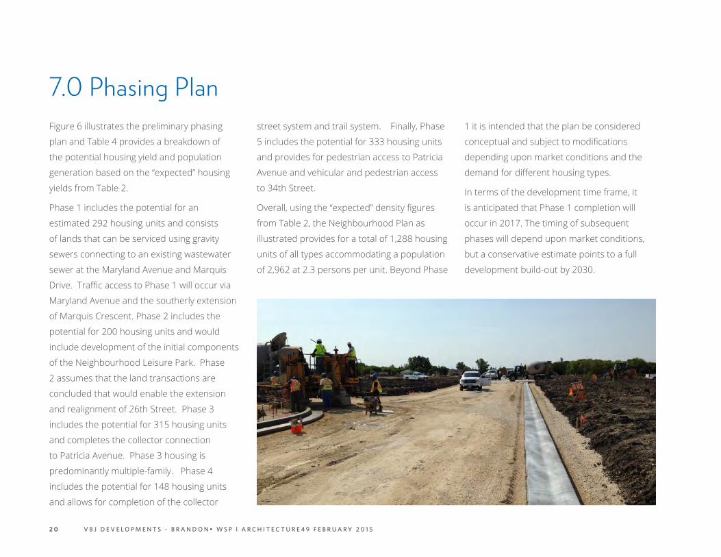
IMAGE: LOOKING NORTH FROM PATRICIA

2 V B J D E V E L O P M E N T S - B R A N D O N • W S P l A R C H I T E C T U R E 4 9 F E B R U A R Y 2 0 1 5
2.0 Area Context NORTH
The Neighbourhood Plan area is bordered
on the north by the Parkdale Heights
residential neighbourhood which contains
approximately 10 hectares (25 acres) of
developable land (gross area) that falls
within the Secondary Plan boundary but
outside of the Neighbourhood Plan area. As
shown on Figure 1, the developable land
lies to the north of the plan area across the
unimproved section of Maryland Avenue
west of Marquis Drive. The land is under
10 different ownerships including the City
of Brandon which controls street rights-of-
way that were part of an obsolete plan of
subdivision covering the southerly 8 hectares
(20 acres) of the area. Existing development
includes seven (7) single-family dwellings
with driveway approaches onto 34th Street.
Options for accessing these lands include
34th Street, Shaw Avenue (unimproved),
Prelude Bay (southerly extension of west leg),
and Maryland Avenue (westerly extension to
34th Street). The land was previously farmed
and is largely cleared with the exception of
shelterbelts, treed residential lots, and a
small woodlot on the north side of the future
Maryland extension. Drainage is overland
with much of the run-off collecting in a slough
contained within the woodlot.
EAST
The plan area is bounded on the east by
26th Street which exists as a sub-standard
10.0 metre (33-foot) ROW abutting the north-
south quarter-section line running between
Maryland and Patricia avenues. The north
half of the ROW contains a gravel road that
provides access to the Christian Heritage
(private) School and two (2) private residences.
The road also provides informal access to the
Brentwood Trailer Court. The trailer court and
the school are the principal developments
bordering the east limit of the plan area. The
Secondary Plan boundary includes the lands
to the east of 26th Street north of the trailer
court, spanning approximately 16.8 hectares
(42 acres) in four (4) separate titles. Of this
gross area, approximately 10 ha. (25 acres) is
available for future development with access
from Maryland Avenue and 26th Street.
SOUTH
Patricia Avenue abuts the plan area on the
south and is the boundary road between the
City of Brandon and the RM of Cornwallis.
The quarter section in the RM to the south
of the plan area is largely in agricultural use
with limited development including a private
residence and a garden centre and landscape
business. Patricia Avenue is a 2-lane paved
roadway with ditch drainage from PTH #10
(18th Street) west to the main entry to the
Brentwood Trailer Court and gravel thereafter.
WEST
The quarter-section to the west of the subject
neighbourhood also falls within the SW
Brandon Secondary Plan area and is slated
for staged residential development involving
the southerly extension of the Brookwood
residential development west of 34th Street
and south of Richmond Avenue. The major
collector street serving Brookwood is Lakeview
Drive, which is shown in the Secondary
Plan as crossing 34th Street to connect to
the east-west collector street in the subject
Neighbourhood Plan Area.

3V B J D E V E L O P M E N T S - B R A N D O N • W S P l A R C H I T E C T U R E 4 9 F E B R U A R Y 2 0 1 5
FUTURE DEVELOPMENT
R.M. OF CORNWALLIS FUTURE DEVELOPMENT
CHRISTIAN HERITAGE SCHOOL
18TH STREET
MARYLAND AVENUE
PATRICIA AVENUE
NEIGHBOURHOOD PLAN AREA 64.7 HA (160 AC.)SW 1/4 10-10-19 WPM
MA
RQU
IS DR
PARKDALE HEIGHTS
RICHMOND PARK
COMMERCIAL DEVELOPMENT
BRENTWOOD TRAILER COURT
BROOKWOODFUTURE DEVELOPMENT
FUTURE DEVELOPMENT
SHAW AVE
PRELUDE BAY
NORTH
34TH STREET
RICHMOND AVENUE
FIGURE 1: PLAN AREA IN THE CONTEXT OF THE LARGER CITY AND ADJOINING RM OF CORNWALLIS.
26TH STREET
NEIGHBOURHOOD PLAN AREA
SECONDARY PLAN BOUNDARY

4 V B J D E V E L O P M E N T S - B R A N D O N • W S P l A R C H I T E C T U R E 4 9 F E B R U A R Y 2 0 1 5
3.0 Site DescriptionKey characteristics of the plan area are described in the following paragraphs.
EXISTING PROPERTY OWNERSHIPFigure 2 shows parcel boundaries within the Neighbourhood Plan area at the time of writing (Parcels A to K). The plan area covers the entire SW Quarter-Section 10-10-19 WPM, spanning 65 ha. (160 ac.) divided amongst eleven (11) property titles. A majority of the land (55 ha.; 136 ac.) is owned by VBJ under two titles, Parcels I and J. The balance of the land (9.7 ha.; 24 ac.) is distributed amongst 9 titles owned by private individuals, of which eight (8) contain single-family residences with driveway access from 34th Street. Apart from hydro lines on boundary streets, the VBJ lands are unencumbered by utility easements.
SITE CHARACTERISTICSThe plan area is gently undulating with a gradual slope from north to south from a high elevation of 405 metres (1,329 ft.) ASL in the northwest portion of the quarter-section to 400 metres (1,312 ft.) ASL in the southeast corner, a drop of 5 metres (16.4 feet). Drainage is overland to the Patricia Avenue ditch, with a majority of the runoff collecting in the slough located on lands owned by VBJ
at the SW corner of the Patricia/PTH #10 intersection. Treed vegetation consists of shelter belts around the private dwellings and the southern tip of a woodlot bisected by the Maryland Avenue ROW at the NW corner of the plan area. The larger of the VBJ parcels (Parcel J on Figure 2) is currently being cropped, while the smaller parcel (Parcel I) adjacent to Maryland Avenue lies fallow.
SOILS AND GROUND WATER:The subsurface stratigraphy in the area of Brandon including the plan area can be expected to consist of topsoil and/or fill materials followed by deltaic deposits of sand, gravel and clay underlain predominately by a clay till extending to shale bedrock. The drift thickness varies throughout the area, although generally is of significant thickness (greater than 60 m).
Bore logs were obtained from three (3) drill sites within the plan area. The locations and soil profiles are as follows:
1. West of Marquis & Maryland: 1ft of topsoil with another 9ft of stiff silty brown clay; water seepage was apparent at the bottom of the 10ft hole.
2. Location of old Barn: 1ft of topsoil; 9ft of
stiff silty brown clay; no water seepage in bottom of the testhole.
3. Location halfway between Barn and Marquis locations: 1ft of topsoil; 9ft of stiff silty brown clay; no water seepage in bottom of the testhole.
Sand and gravel deposits within and above the till generally comprise a significant, although only marginally utilized aquifer. Using the Manitoba Department of Water Resources criteria, if significant contamination were present in the area as a result of past or current activities, the potential for groundwater contamination would be moderate.
Groundwater from the site generally flows overland and via tributaries southward and eventually eastward to the Assiniboine River.
Sources: Surficial Geological Map of Manitoba (Map 81-1, Manitoba Department of Natural Resources, 1978), the Manitoba Soils Survey (Report No. 6, 1956), Sand and Gravel Resources of the Brandon Region (The UMA Group, 1977) and AMEC’s experience in this area.

5V B J D E V E L O P M E N T S - B R A N D O N • W S P l A R C H I T E C T U R E 4 9 F E B R U A R Y 2 0 1 5
FIGURE 2: PARCEL PLAN
ACCESS POINTS
VBJ LANDS34TH
STREET
CHRISTIAN HERITAGE SCHOOL
PATRICIA AVENUE
MARYLAND AVENUE
BROOKWOOD
BRENTWOOD TRAILER COURT
H
GFE
D
CBA
J50.0 ha. / 123.6 ac.
NORTH
MA
RQU
IS DR
WOOD LOT
26TH STREET
SHAW AVEDURHAM DRIVE
I K5.6 ha. /12.7 ac.

6 V B J D E V E L O P M E N T S - B R A N D O N • W S P l A R C H I T E C T U R E 4 9 F E B R U A R Y 2 0 1 5
4.0 Neighbourhood PlanThe Neighbourhood Plan is illustrated in
Figure 3. The plan is designed to conform
to the Southwest Brandon Secondary Plan
(By-Law No. 7080). The Secondary Plan
sets out the broad development parameters
and guidelines for the Neighbourhood
Plan in terms of land use, sewer and water
servicing, land drainage, streets and Active
Transportation (AT) connectivity and parks and
natural areas. The proposed Neighbourhood
Plan adheres to the spirit and intent of the
Secondary Plan and implements the plan’s
essential elements as described in the
following paragraphs.
4.1 LAND USE
In accordance with the Secondary Plan, the
Neighbourhood Plan provides for a range of
housing densities and types. Figure 3 identifies
these areas as Residential Low Density and
Residential Moderate Density. With reference
to the City of Brandon Zoning By-Law, the
areas shaded to indicate Residential Low
Density includes detached dwellings under
the Residential Single Family (RSF) zoning
category and multiple-family dwellings under
the Residential Low Density (RLD) multiple family
zoning category. Parcels shaded Residential
Moderate Density on Figure 3 fall under the
Residential Moderate Density (RMD) multiple
family zoning category.
The Secondary Plan sets out target densities
ranging from 15 to 40 units per hectare (6 to 16
units per acre) for Residential Low Density (RLD)
housing, and 41 to 86 units per hectare (16.5
to 34.8 units per acre) for Residential Moderate
Density (RMD) housing.
At full build-out, the housing and population
yields will fall within the ranges prescribed in
the Secondary Plan. The precise block or parcel
zoning and resulting densities will be determined
at the time of subdivision approval, at which
point the following zoning categories will apply.
RESIDENTIAL ZONING & HOUSING TYPES
• Residential Single-Family (RSF): Within
the plan area, typical lots for single-family
dwellings will have widths ranging from
12.2 to 15.2 metres (40 to 50 feet), and
depths ranging from 30.5 to 36.5 metres
(100 to 120 feet).
• Residential Low Density (RLD): Within
the plan area, low density multiple-family
housing consisting of semi-detached
dwellings, duplexes, 3-plexes, 4-plexes and
row housing will be integrated into the
development on a block-by-block basis in
response to market demand.
• Residential Moderate Density (RMD):
Within the plan area, 8.49 hectares (20.98
acres) of land is contained in parcels slated
for higher density town houses, cluster
town houses and 3-4 storey apartment
buildings. The RMD parcels are shadow-
planned to allow for their conversion to
RSF and RLD development depending
upon market demand.
MIXED USE
The Secondary Plan identifies a Mixed Use (MU)
node at the northwest corner of Patricia Avenue
and 34th Street as identified in Figure 3. This
node is conceptually located in the Secondary
1. Site Assessment1. Site Assessment

7V B J D E V E L O P M E N T S - B R A N D O N • W S P l A R C H I T E C T U R E 4 9 F E B R U A R Y 2 0 1 5
LANDUSE HECTARES* ACRES * PERCENTAGE*
RESIDENTIAL LOW DENSITY 26.59 65.70 49.0 %
RESIDENTIAL MODERATE DENSITY
8.49 20.98 15.6%
PARKS & RECREATION 4.75 11.73 8.7`%
STORMWATER IMPOUNDMENT 2.47 6.10 4.5 %
ROADS 11.99 29.63 22.2 %
TOTAL PLAN AREA 54.28 134.14 100.0 %
* APPROXIMATE
TABLE 1: LAND USE BREAKDOWN
PATRICIA AVENUE
100 M
MARYLAND AVENUE
VBJ DEVELOPMENTS - BRANDON
POTEN
TIAL TRANSIT RO
UTE
26TH STREET
34TH STREET
SECONDARY TRAIL
PRIMARY TRAIL
FIGURE 3: NEIGHBOURHOOD PLAN
PRIMARY TRAIL
SECONDARY TRAIL
POTENTIAL TRANSIT ROUTE
POSSIBLE FUTURE MIXED USE NODE
MU
MU

8 V B J D E V E L O P M E N T S - B R A N D O N • W S P l A R C H I T E C T U R E 4 9 F E B R U A R Y 2 0 1 5
Plan on a parcel that currently contains a
private residence. The Neighbourhood Plan
locates a Residential Moderate Density (RMD)
parcel immediately east of the potential MU
site. The Neighbourhood Plan proponent
has no direct control over the possible future
development of a Mixed Use node in the
location proposed by the Secondary Plan.
However, given the potential prominence of
the intersection as development expands
southward along 34th Street, a mixed use
node in this location is not inconceivable. And
while it is premature to speculate as to how
future development on the adjoining parcels
could or should be integrated (or buffered), the
Secondary Plan provides some guidance on the
development of mixed-use nodes under Section
2.2
TRAFFIC ACCESS
As proposed under the Secondary Plan, the
Neighbourhood Plan area is serviced by a
collector street system that loops through
the neighbourhood to provide the following
primary, inter-community connection points:
• 34th Street: The neighbourhood collector
street connects to 34th Street on an
alignment that will enable it to serve as
a continuation of the Lakeview Drive
collector that is being constructed
within the developing Brookwood
Neighbourhood to the northwest. In
accordance with the Secondary Plan, the
Neighbourhood Plan shows the option of
a traffic circle at the intersection of 34th
and the collector street.
• 26th Street: South of Maryland Avenue,
the Neighbourhood Plan realigns 26th
Street to the west to better serve the
plan area while maintaining the level
of access currently enjoyed by existing
developments on the east side of 26th
south of Maryland. The collector street
loops through the plan area connecting
to 34th Street. As conceptually illustrated
in Figure 3, the City of Brandon wishes to
reserve the option of installing a traffic
circle at the intersection of Maryland
Avenue and 26th Street.
• Patricia Avenue: A collector street
segment interconnects Patricia Avenue
to the neighbourhood collector loop.
The traffic circle shown on the plan is
conceptual, as a possible option to a
conventional T-intersection.
In addition to the above, primary traffic
access points, the plan provides for the
following, secondary access points (local street
classification):
• Marquis Drive extension south to connect
to the neighbourhood collector;
• New connection to realigned 26th Street
to access existing development south of
Maryland Avenue, and;
• New connection at the SW corner of the
plan area to aid in the possible future
development of the private lands on the
east side of 34th Street.
TRANSIT
While there are no immediate plans to extend
transit service through the plan area, the plan
conceptually identifies a bus route on future
26th Street south from Maryland Avenue
and east on Patricia Avenue. In addition,
the neighbourhood collector loop is shown
with a 25 metre (82 foot) ROW in order to
accommodate bus traffic and transit stops.

9V B J D E V E L O P M E N T S - B R A N D O N • W S P l A R C H I T E C T U R E 4 9 F E B R U A R Y 2 0 1 5
PARK/GREENSPACE
0.5 KM RADIUS/ 5 MINUTE WALK
PRIMARY TRAIL CONNECTIONS
LEGEND
FIGURE 4: AREA PARKS AND GREENSPACE
1 0 V B J D E V E L O P M E N T S - B R A N D O N • W S P l A R C H I T E C T U R E 4 9 F E B R U A R Y 2 0 1 5
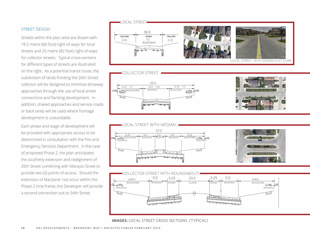
STREET DESIGN
Streets within the plan area are shown with
18.2 metre (60 foot) right-of-ways for local
streets and 25 metre (82 foot) right-of-ways
for collector streets. Typical cross-sections
for different types of streets are illustrated
on the right. As a potential transit route, the
subdivision of lands fronting the 26th Street
collector will be designed to minimize driveway
approaches through the use of local street
connections and flanking development. In
addition, shared approaches and service roads
or back lanes will be used where frontage
development is unavoidable.
Each phase and stage of development will
be provided with appropriate access to be
determined in consultation with the Fire and
Emergency Services Department. In the case
of proposed Phase 2, the plan anticipates
the southerly extension and realignment of
26th Street combining with Marquis Street to
provide two (2) points of access. Should the
extension of Maryland not occur within the
Phase 2 time frame, the Developer will provide
a second connection out to 34th Street.
IMAGES: LOCAL STREET CROSS SECTIONS (TYPICAL)
23.53.255.0 5.03.25ROADWAYBOULEVARD BOULEVARD
VARIESVARIESPAVERS ISLAND PAVERS ROADWAY
SIDEWALK SIDEWALK
27.55.0 5.0 6.255.06.25
BOULEVARD BOULEVARDROADWAY ROADWAYSIDEWALKSIDEWALK
MEDIAN
25.0
ROADWAYBOULEVARD BOULEVARD6.25 - 7.5 6.25 - 7.510.0 - 12.0
LOCAL STREET
LOCAL STREET WITH SIDEWALK AT CURB
COLLECTOR STREET
LOCAL STREET WITH MEDIAN
COLLECTOR STREET WITH ROUNDABOUT
18.0
7.5 5.255.25
5.25 5.25
ROADWAY

1 1V B J D E V E L O P M E N T S - B R A N D O N • W S P l A R C H I T E C T U R E 4 9 F E B R U A R Y 2 0 1 5
22.0
0
6.00
10.0
06.
00
22.0
0
6.00
10.0
0
RESIDENTIAL COLLECTOR STREET
FRONTAGE ROAD
B.C
.
E.C
.
E.C
.
R=25.0
R=1.20
R=12.0
R=9.0
15.00
6.00
1.00
6.0
6.00
9.00
P.R.C.
R=10.0
Winnipeg
ST-99A
NOTES:1. ALL PAVEMENT DIMENSIONS ARE TO BACK OF CURB (EDGE OF PAVEMENT IN BACK LANE).2. IF REQUIRED REFER TO SB-3 FOR TRANSIT STOP DETAILS.
TYPICAL FRONTAGE ROAD (9.0m)ALONGSIDE OF
A RESIDENTIAL COLLECTOR STREET
COLLECTOR STREET WITH FRONTAGE ROAD

1 2 V B J D E V E L O P M E N T S - B R A N D O N • W S P l A R C H I T E C T U R E 4 9 F E B R U A R Y 2 0 1 5
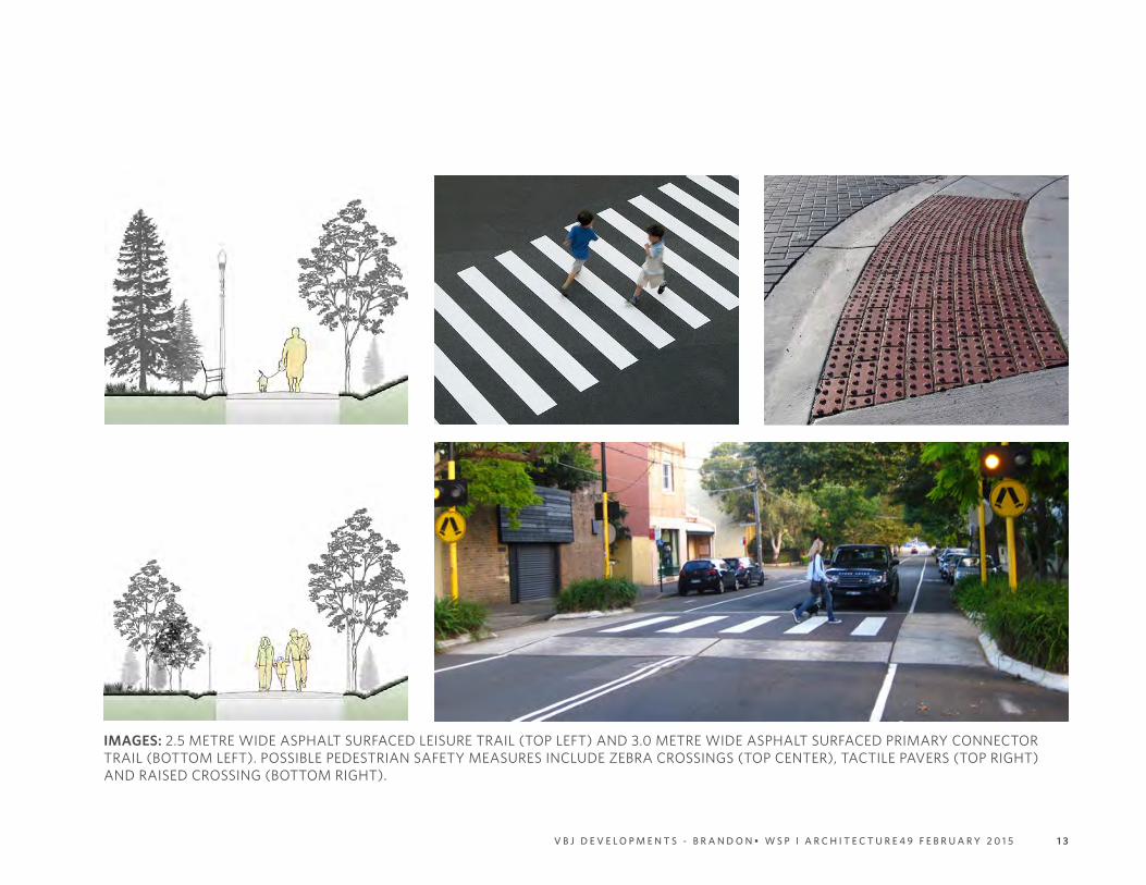
TRAIL NETWORK
The neighbourhood trail network will consist
of asphalt-surfaced Primary Off-Street Trails
and Secondary Off-Street Trails. As shown
on Figure 3, the Primary Trail will connect the
plan area to existing or future trails along
34th Street, Maryland Avenue, 26th Street
and Patricia Avenue. Through the plan area,
the Primary Trail will be constructed within
the collector right-of-ways and the park
area encircling the lake. Secondary Off-
Street Trails are used to connect the Primary
Trail to the Christian Heritage School to
the east, Patricia Avenue to the south, and
via the greenway to the northwest portion
of the neighbourhood. Primary Trails will
have a minimum width of 3.0 metres, while
Secondary Trails will have a minimum width
of 2.5 metres. Primary Trails will have a
minimum frontage of 5.0 metres at trail heads
with appropriate signage and rest points as
per the Greenspace Master Plan (November
2014 Draft). All trails will designed using
Crime Prevention Through Environmental
Design (CPTED) guidelines and will provide
barrier free access. At intersections, traffic-
calming measures such as zebra crossings
or raised crossings, along with pedestrian- IMAGES: COLLECTOR STREET WITH PRIMARY TRAIL
safety measures like textured paving, will be
employed. Light standards, signage, benches
and waste receptacles will be placed so as
not to obstruct pathway movement. Rest
areas with benches will be located along the
trail network and will incorporate different
surfacing (e.g. compacted gravel or pavers)
to indicate functional separation from the
adjacent path. Wayfinding signage will be
provided where required.
Figure 4 shows the proximity of the
neighbourhood to community-scale parks
and recreation facilities in the mature
neighbourhoods to the north and east of the
plan area that fall within a 10 or 15 minute
walk from the centre of the plan area.
1 3V B J D E V E L O P M E N T S - B R A N D O N • W S P l A R C H I T E C T U R E 4 9 F E B R U A R Y 2 0 1 5
IMAGES: 2.5 METRE WIDE ASPHALT SURFACED LEISURE TRAIL (TOP LEFT) AND 3.0 METRE WIDE ASPHALT SURFACED PRIMARY CONNECTOR TRAIL (BOTTOM LEFT). POSSIBLE PEDESTRIAN SAFETY MEASURES INCLUDE ZEBRA CROSSINGS (TOP CENTER), TACTILE PAVERS (TOP RIGHT) AND RAISED CROSSING (BOTTOM RIGHT).IMAGES: COLLECTOR STREET WITH PRIMARY TRAIL
1 4 V B J D E V E L O P M E N T S - B R A N D O N • W S P l A R C H I T E C T U R E 4 9 F E B R U A R Y 2 0 1 5
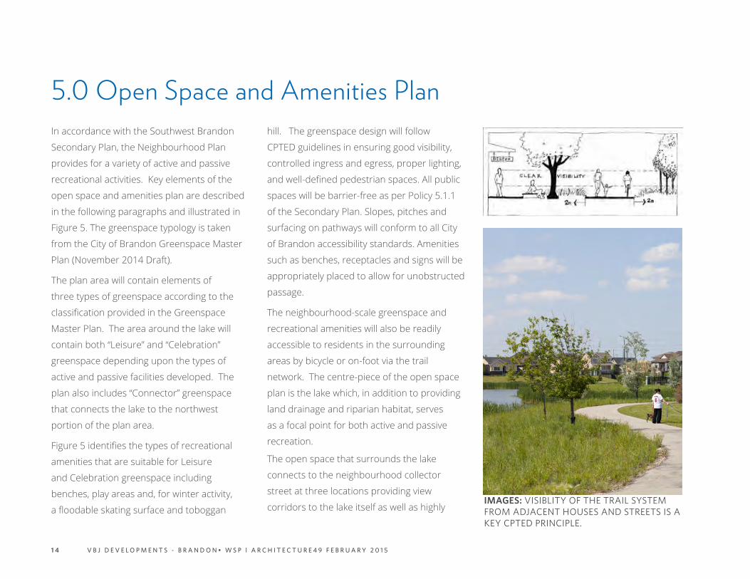
In accordance with the Southwest Brandon
Secondary Plan, the Neighbourhood Plan
provides for a variety of active and passive
recreational activities. Key elements of the
open space and amenities plan are described
in the following paragraphs and illustrated in
Figure 5. The greenspace typology is taken
from the City of Brandon Greenspace Master
Plan (November 2014 Draft).
The plan area will contain elements of
three types of greenspace according to the
classification provided in the Greenspace
Master Plan. The area around the lake will
contain both “Leisure” and “Celebration”
greenspace depending upon the types of
active and passive facilities developed. The
plan also includes “Connector” greenspace
that connects the lake to the northwest
portion of the plan area.
Figure 5 identifies the types of recreational
amenities that are suitable for Leisure
and Celebration greenspace including
benches, play areas and, for winter activity,
a floodable skating surface and toboggan
5.0 Open Space and Amenities Planhill. The greenspace design will follow
CPTED guidelines in ensuring good visibility,
controlled ingress and egress, proper lighting,
and well-defined pedestrian spaces. All public
spaces will be barrier-free as per Policy 5.1.1
of the Secondary Plan. Slopes, pitches and
surfacing on pathways will conform to all City
of Brandon accessibility standards. Amenities
such as benches, receptacles and signs will be
appropriately placed to allow for unobstructed
passage.
The neighbourhood-scale greenspace and
recreational amenities will also be readily
accessible to residents in the surrounding
areas by bicycle or on-foot via the trail
network. The centre-piece of the open space
plan is the lake which, in addition to providing
land drainage and riparian habitat, serves
as a focal point for both active and passive
recreation.
The open space that surrounds the lake
connects to the neighbourhood collector
street at three locations providing view
corridors to the lake itself as well as highly IMAGES: VISIBLITY OF THE TRAIL SYSTEM FROM ADJACENT HOUSES AND STREETS IS A KEY CPTED PRINCIPLE.

1 5V B J D E V E L O P M E N T S - B R A N D O N • W S P l A R C H I T E C T U R E 4 9 F E B R U A R Y 2 0 1 5
LEGEND
1. STORMWATER RETENTION POND
2. VIEWING AREA WITH BENCHES
3. ICE SKATING AREA
4. CHILDREN’S 5-12 PLAY AREA
5. NATURAL PLAY AREA
6. COVERED PAVILION
7. CHILDREN’S 2-5 PLAY AREA
8. TOBOGGAN HILL
3FIGURE 5: NEIGHBOURHOOD GREENSPACE
CONNECTOR GREENSPACE
LEISURE AND CELEBRATION
GREENSPACE
1 6 V B J D E V E L O P M E N T S - B R A N D O N • W S P l A R C H I T E C T U R E 4 9 F E B R U A R Y 2 0 1 5
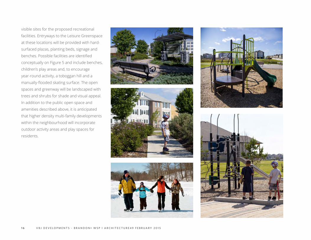
visible sites for the proposed recreational
facilities. Entryways to the Leisure Greenspace
at these locations will be provided with hard-
surfaced plazas, planting beds, signage and
benches. Possible facilities are identified
conceptually on Figure 5 and include benches,
children’s play areas and, to encourage
year-round activity, a toboggan hill and a
manually-flooded skating surface. The open
spaces and greenway will be landscaped with
trees and shrubs for shade and visual appeal.
In addition to the public open space and
amenities described above, it is anticipated
that higher density multi-family developments
within the neighbourhood will incorporate
outdoor activity areas and play spaces for
residents.

1 7V B J D E V E L O P M E N T S - B R A N D O N • W S P l A R C H I T E C T U R E 4 9 F E B R U A R Y 2 0 1 5

1 8 V B J D E V E L O P M E N T S - B R A N D O N • W S P l A R C H I T E C T U R E 4 9 F E B R U A R Y 2 0 1 5
6.0 Population and HousingThe population estimates for the development
area pictured in Figure 3 were derived from
the “minimum” and “maximum” housing yields
provided in the Southwest Brandon Secondary
Plan and summarized in Table 2. The table
also includes “expected” density factors
(shaded gray) that were subsequently used
to estimate the housing yield by development
phase.
Table 3 provides low and high housing and
population estimates for the plan area based
on the minimum and maximum housing
yields from Table 2. The housing yields were
obtained by applying the Secondary Plan
minimum and maximum density targets from
Table 2 against the net development area for
the three (3) major housing types: Residential
Single Family (17.73 hectares), Residential Low
Density Multiple Family (8.86 hectares), and
Residential Moderate Density Multiple Family
(8.49 hectares). The calculations indicate
that the development area could generate
between 747 and 1,793 housing units
accommodating between 1,718 and 4,124
people at full build-out based on an average
household size of 2.3 people per unit (2011
Canada Census).
As discussed in Section 7, “expected” density
factors were used to estimate the housing
and population estimates by development
phase. Based on the expected density rates,
the neighbourhood will generate in the order
of 1,288 total housing units and a population
of 2,962.

1 9V B J D E V E L O P M E N T S - B R A N D O N • W S P l A R C H I T E C T U R E 4 9 F E B R U A R Y 2 0 1 5
Neighbourhood Plan DESIGNATION HOUSING TYPE ZONING LABEL TYPICAL BUILT FORM
HOUSING DENSITY IN UNITS PER HECTARE (ROUNDED)
HOUSING DENSITY IN UNITS PER ACRE (ROUNDED)
MIN. EXPECTED MAX. MIN. EXPECTED MAX.
RESIDENTIAL LOW DENSITY
RESIDENTIAL SINGLE FAMILY RSF SINGLE DETACHED
DWELLING 15 24 40 6 10 16
RESIDENTIAL LOW DENSITY MULTIPLE FAMILY
RLDSEMI-DETACHED, DUPLEX,TRIPLEX, 4-PLEX, TOWNHOUSE
15 36 40 6 15 16
RESIDENTIAL MODERATE DENSITY
RESIDENTIAL MODERATE DENSITY MULTIPLE FAMILY
RMDTOWNHOUSE, STACKED TOWNHOUSE, LOW-RISE APARTMENTS
41 64 86 17 26 35
*USED IN CALCULATING HOUSING ESTIMATES BY DEVELOPMENT PHASE
ZONE NET HECTARES (1)
HOUSING AND POPULATION RANGE
MINIMUM EXPECTED MAXIMUM
DENSITY HOUSING DENSITY HOUSING DENSITY HOUSING
RESIDENTIAL LOW DENSITY (1)
RESIDENTIAL LOW DENSITY - RSF 17.73 15 266 24 426 40 709
RESIDENTIAL LOW DENSITY MULTIPLE FAMILY - RLD 8.86 15 133 36 319 40 354
RESIDENTIAL MODERATE DENSITY
RESIDENTIAL MODERATE DENSITY MULTIPLE FAMILY - RMD 8.49 41 348 64 543 86 730
TOTAL HOUSING LOW AND HIGH ESTIMATES 747 1,288 1,793
(1) BASED ON 26.59 NET HECTARES AND 2/1 RATIO OF DETACHED TO ATTACHED HOUSING
POPULATION ESTIMATES AT 2.3 PERSONS PER UNIT (2011 CENSUS) 2.3 1,718 2,962 4,124
TABLE 2: RESIDENTIAL YIELD BY HOUSING TYPE
TABLE 3: HOUSING AND POPULATION ESTIMATES (RANGE)
2 0 V B J D E V E L O P M E N T S - B R A N D O N • W S P l A R C H I T E C T U R E 4 9 F E B R U A R Y 2 0 1 5
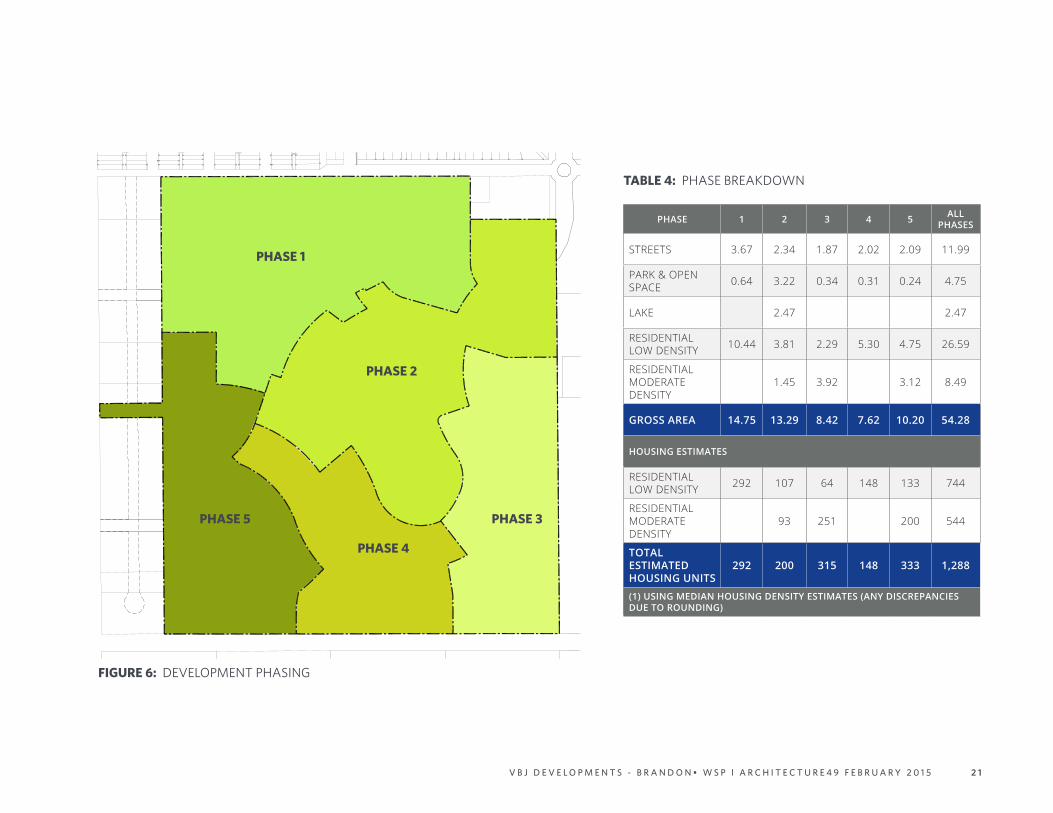
Figure 6 illustrates the preliminary phasing
plan and Table 4 provides a breakdown of
the potential housing yield and population
generation based on the “expected” housing
yields from Table 2.
Phase 1 includes the potential for an
estimated 292 housing units and consists
of lands that can be serviced using gravity
sewers connecting to an existing wastewater
sewer at the Maryland Avenue and Marquis
Drive. Traffic access to Phase 1 will occur via
Maryland Avenue and the southerly extension
of Marquis Crescent. Phase 2 includes the
potential for 200 housing units and would
include development of the initial components
of the Neighbourhood Leisure Park. Phase
2 assumes that the land transactions are
concluded that would enable the extension
and realignment of 26th Street. Phase 3
includes the potential for 315 housing units
and completes the collector connection
to Patricia Avenue. Phase 3 housing is
predominantly multiple-family. Phase 4
includes the potential for 148 housing units
and allows for completion of the collector
7.0 Phasing Planstreet system and trail system. Finally, Phase
5 includes the potential for 333 housing units
and provides for pedestrian access to Patricia
Avenue and vehicular and pedestrian access
to 34th Street.
Overall, using the “expected” density figures
from Table 2, the Neighbourhood Plan as
illustrated provides for a total of 1,288 housing
units of all types accommodating a population
of 2,962 at 2.3 persons per unit. Beyond Phase
1 it is intended that the plan be considered
conceptual and subject to modifications
depending upon market conditions and the
demand for different housing types.
In terms of the development time frame, it
is anticipated that Phase 1 completion will
occur in 2017. The timing of subsequent
phases will depend upon market conditions,
but a conservative estimate points to a full
development build-out by 2030.
2 1V B J D E V E L O P M E N T S - B R A N D O N • W S P l A R C H I T E C T U R E 4 9 F E B R U A R Y 2 0 1 5
PHASE 1
PHASE 2
PHASE 3
PHASE 4
PHASE 5
PHASE 1 2 3 4 5 ALL PHASES
STREETS 3.67 2.34 1.87 2.02 2.09 11.99
PARK & OPEN SPACE 0.64 3.22 0.34 0.31 0.24 4.75
LAKE 2.47 2.47
RESIDENTIAL LOW DENSITY 10.44 3.81 2.29 5.30 4.75 26.59
RESIDENTIAL MODERATE DENSITY
1.45 3.92 3.12 8.49
GROSS AREA 14.75 13.29 8.42 7.62 10.20 54.28
HOUSING ESTIMATES
RESIDENTIAL LOW DENSITY 292 107 64 148 133 744
RESIDENTIAL MODERATE DENSITY
93 251 200 544
TOTAL ESTIMATED HOUSING UNITS
292 200 315 148 333 1,288
(1) USING MEDIAN HOUSING DENSITY ESTIMATES (ANY DISCREPANCIES DUE TO ROUNDING)
TABLE 4: PHASE BREAKDOWN
FIGURE 6: DEVELOPMENT PHASING

2 2 V B J D E V E L O P M E N T S - B R A N D O N • W S P l A R C H I T E C T U R E 4 9 F E B R U A R Y 2 0 1 5
8.0 Urban Design ConsiderationsThe planning and urban design vision for
the neighbourhood intends an inclusive
community that melds a varied and
attractively designed built environment with
well-appointed parks and open spaces to
create an appealing and highly marketable
residential development. The development
will incorporate a variety of housing types at
different price points targeting people and
families across all sectors of the residential
market including renters, first-time home
buyers, families in the move-up market and
retirees. Representative housing types and
styles are pictured.
The planning and design of residential
neighbourhoods and the dwellings they
contain is evolving in response to changing
consumer tastes and preferences. Today’s
renters and buyers place a high value
on “selling features” that extend beyond
the dwellings themselves to include
neighbourhood “feel” and appearance,
recreational amenities, accessible and well-
designed public spaces, and variety in building
design and appearance. The Developer’s
team of in-house building and interior
designers collaborate from the ground up
to create marketable housing products. Key
architectural design considerations emphasize
variety in terms of façade and entry-way
treatments, window placement, exterior
cladding type, texture and colour, roof lines,
etc. Through the lot sale process, home
builders will be provided direction on the use
of building materials, colours and architectural
features on street-facing facades in order to
create a varied and attractive streetscape.
The site plans and architectural designs of
multi-family apartment and cluster townhouse
projects will be prepared on a project-specific
basis, but will conform to the standard
requirements and guidelines as identified
in the City of Brandon Southwest Brandon
Secondary Plan and The City of Brandon
Urban & Landscape Design Standards Manual.
Important site planning and urban design
considerations will include building orientation

2 3V B J D E V E L O P M E N T S - B R A N D O N • W S P l A R C H I T E C T U R E 4 9 F E B R U A R Y 2 0 1 5
and spacing to provide for natural light and
privacy, safe and convenient site access
and circulation for drivers and pedestrians,
appropriate lighting levels in parking lots
and along walkways, adequate buffering of
adjacent developments, the incorporation
of outdoor play and gathering areas, and
the consideration of environmental design
guidelines in the selection of plant materials
for the landscaping of yards and parking lots
and the design of storm-water management
systems.

2 4 V B J D E V E L O P M E N T S - B R A N D O N • W S P l A R C H I T E C T U R E 4 9 F E B R U A R Y 2 0 1 5

2 5V B J D E V E L O P M E N T S - B R A N D O N • W S P l A R C H I T E C T U R E 4 9 F E B R U A R Y 2 0 1 5
9.0 Public Consultation SummaryIn accordance with the City of Brandon Public
Outreach Requirements [Appendix “D” of
By-law No. 6642], the Neighbourhood Plan
proponent held a Public Open House for area
residents as outlined below.
Date and Location: The public meeting was
held on Wednesday January 28th from 6:00pm
to 8:00pm at the Westridge Community Centre
located at 32 Willowdale Crescent in Brandon.
Format: Informal drop-in with proponent
representative in attendance to provide
information and respond to questions.
Method of Notification: By Canada Post to
property owners within 100 metres (328 feet)
of lands owned by the Neighbourhood Plan
proponent. The mailing list was provided
by the City of Brandon and is available upon
request. Fifteen (15) people attended the
Open House.
SUMMARY OF COMMENTS OR CONCERNS:
a. Positive verbal comments were expressed
concerning the following plan elements:
• the connecting greenway trail system;
• the large, centralized green space;
• the overall layout and design of the NP
as being “new” and “different” and;
• the proposed mix of housing types and
densities.
b. Other verbal comments that were shared
in an open discussion with attendees and
the proponent representative:
Concern: Regarding traffic on Patricia
Avenue (currently gravel) which is used
as a short cut from 34th Street to 18th
Street with a 90km posted speed. Also
concern was expressed regarding traffic
on Maryland Avenue and 26th Street
during peak times due to traffic generated
by Christian Heritage School.
Response: Residents were informed that
a Traffic Impact Study had been completed
for the area and that the traffic situation
will be closely monitored and the study
updated at each phase of development.
Concern: Regarding how the lands will be
serviced.
Response: Residents were told that
an Infrastructure Servicing Study had been
completed for the area and that updates to
that study would be done during each phase
of development to ensure that the water,
sewer and land drainage infrastructure
can accommodate the development with
no detrimental impact on area residents.
Attendees were advised that major
infrastructure upgrades would not be needed
until Phase 2 of the development.
Concern: Regarding how the lands would be
developed and phased over time
Response: Residents were shown the
Neighbourhood Plan Land Use Map along
with the Phasing Plan.
Concern; Regarding how private land owners
could be involved in the future development
of their properties.
Response: Residents were advised that in
advance of development proceeding adjacent
to private lands fronting 34th Street, owners
will be contacted to look at options for
incorporation their holdings either individually
or collectively into the larger development.
2 6 V B J D E V E L O P M E N T S - B R A N D O N • W S P l A R C H I T E C T U R E 4 9 F E B R U A R Y 2 0 1 5
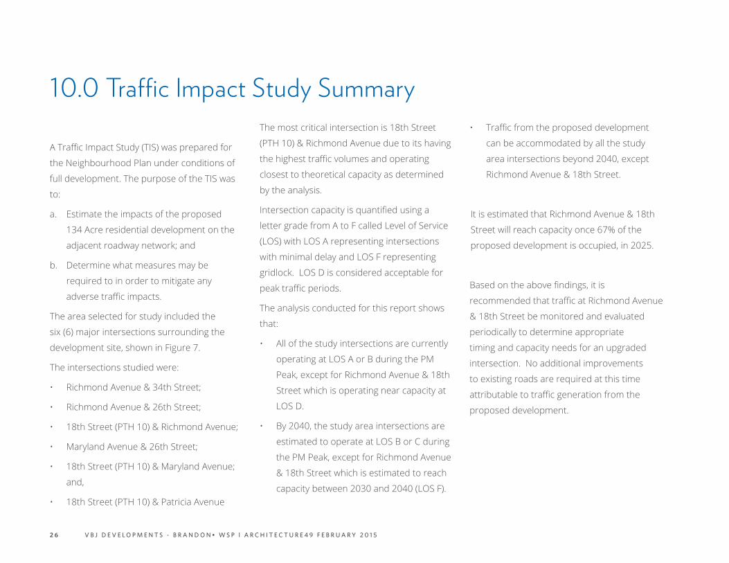
10.0 Traffic Impact Study Summary
A Traffic Impact Study (TIS) was prepared for
the Neighbourhood Plan under conditions of
full development. The purpose of the TIS was
to:
a. Estimate the impacts of the proposed
134 Acre residential development on the
adjacent roadway network; and
b. Determine what measures may be
required to in order to mitigate any
adverse traffic impacts.
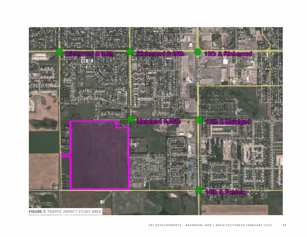
The area selected for study included the
six (6) major intersections surrounding the
development site, shown in Figure 7.
The intersections studied were:
• Richmond Avenue & 34th Street;
• Richmond Avenue & 26th Street;
• 18th Street (PTH 10) & Richmond Avenue;
• Maryland Avenue & 26th Street;
• 18th Street (PTH 10) & Maryland Avenue;
and,
• 18th Street (PTH 10) & Patricia Avenue
The most critical intersection is 18th Street
(PTH 10) & Richmond Avenue due to its having
the highest traffic volumes and operating
closest to theoretical capacity as determined
by the analysis.
Intersection capacity is quantified using a
letter grade from A to F called Level of Service
(LOS) with LOS A representing intersections
with minimal delay and LOS F representing
gridlock. LOS D is considered acceptable for
peak traffic periods.
The analysis conducted for this report shows
that:
• All of the study intersections are currently
operating at LOS A or B during the PM
Peak, except for Richmond Avenue & 18th
Street which is operating near capacity at
LOS D.
• By 2040, the study area intersections are
estimated to operate at LOS B or C during
the PM Peak, except for Richmond Avenue
& 18th Street which is estimated to reach
capacity between 2030 and 2040 (LOS F).
• Traffic from the proposed development
can be accommodated by all the study
area intersections beyond 2040, except
Richmond Avenue & 18th Street.
It is estimated that Richmond Avenue & 18th
Street will reach capacity once 67% of the
proposed development is occupied, in 2025.
Based on the above findings, it is
recommended that traffic at Richmond Avenue
& 18th Street be monitored and evaluated
periodically to determine appropriate
timing and capacity needs for an upgraded
intersection. No additional improvements
to existing roads are required at this time
attributable to traffic generation from the
proposed development.
2 7V B J D E V E L O P M E N T S - B R A N D O N • W S P l A R C H I T E C T U R E 4 9 F E B R U A R Y 2 0 1 5
FIGURE 7: TRAFFIC IMPACT STUDY AREA
2 8 V B J D E V E L O P M E N T S - B R A N D O N • W S P l A R C H I T E C T U R E 4 9 F E B R U A R Y 2 0 1 5
11.0 Municipal Servicing Overview SummaryA Municipal Servicing Overview has been
prepared in support of the Neighbourhood
Plan and submitted to the City for review. The
Municipal Servicing Overview is summarized in
the following paragraphs.
As a prerequisite for development in the plan
area as well as other lands in the southwest
area of Brandon, the City of Brandon has
carried out a series of studies over the past
few years for the purpose of determining
servicing requirements and identifying
deficiencies that would require upgrading.
These studies were primarily focused on the
water distribution network and the sanitary
sewer system. A study regarding storm
drainage is currently being carried out.
WATER DISTRIBUTION SYSTEM
The water distribution system for the plan area
will initially be fed from two (2) location points
immediately north on Maryland Avenue. The
first point is located at Marquis Drive and the
other at 26th Street. For the initial stages of
the development, the limits of which will be
determined later through detailed modelling
and design, these two point locations should
provide adequate water flow volumes to the
water distribution network for both domestic
consumption demands and fire-fighting
requirements, and should sustain the required
minimum pressures under both conditions.
Later stages of the development may,
additionally, require the extension of the
existing water main on Patricia Avenue west
to the plan area in order to improve water
pressures and increase available delivery
volumes. The need for the extension, as
well as any other water distribution network
requirements, will be determined later
through detailed modelling, analysis and
design.
WASTEWATER SEWER SYSTEM
The Neigbhourhood Plan area (SW ¼ 10-10-
19 WPM) is situated immediately west and
just outside of the wastewater catchment
area for the South End Lift Station. As such,
wastewater flows from the plan area would
not be able to contribute flows to that system.
With recent interest in the development
potential for the plan area, as well as other
properties in the vicinity, the City of Brandon
commissioned several wastewater studies to
investigate possible options to service these
lands and accommodate wastewater flows
from outside the catchment area of the South
End Lift Station.
These studies specifically investigated whether
there exists the opportunity to achieve either
of two (2) options available for the disposal of
wastewater as follows:
1. Determine whether or not there is
available capacity in the adjoining wastewater
sewer systems in the surrounding developed
areas; and/or,
2. Expand the catchment area of the
South End Lift Station to include lands to the
west, including SW ¼ 10-10-19 WPM, by taking
advantage of unused available capacity of the
South End Lift Station.

2 9V B J D E V E L O P M E N T S - B R A N D O N • W S P l A R C H I T E C T U R E 4 9 F E B R U A R Y 2 0 1 5
With respect to Option 1, it was determined
that there is available capacity in an existing
wastewater sewer located at Marquis
Drive to accommodate a portion of the
Neighbourhood Plan area. Accordingly, Phase
1 of the development concept has been sized
based on the estimate of available capacity.
The actual proportion of land that can be
serviced will be determined later through
detailed modelling, analysis and design.
With respect to Option 2, the studies have
determined that additional lands beyond
the boundary of the catchment area of the
South End Lift Station can be accommodated,
including the balance of the plan area located
in the plan area, within certain limitations. The
most significant obstacle in implementing this
option is the fact that the existing wastewater
sewer system adjacent to the outside
lands does not have the capacity to accept
additional flow. Therefore, in order to take
advantage of this option, flow from the area
would need to be transported to the South
End Lift Station by means of a lift station and
force main. The proposed location of the lift
station and the alignment of the force main
will be determined later through detailed
modelling, analysis and design. It has also
been noted that a review of the capacity and
operation of the South End Lift Station may
also be required as a part of the wastewater
analysis and design.
STORM WATER
As an integral component of the
neighbourhood plan, a storm water
management strategy has been implemented
to control and manage storm runoff from the
development. In part, the strategy includes
design features intended to mitigate the
downstream effects of the development
and reduce the likelihood of any adverse
conditions as a result of storm water runoff
released from the developed property.
In order to satisfy specific design criteria
of the storm water management strategy,
a detention/retention facility (Storm Water
Retention Basin or SRB) has been incorporated
into the concept for the plan area. Not only
does the SRB provide storm runoff detention/
retention duties, it also becomes an important
part of the open space and amenities plan,
providing recreation opportunities for
neighbourhood residents. Storm water will
be discharged from the SRB to the Patricia
Avenue ditch at a controlled and manageable
rate. At this point existing surface drains
will convey the flow to the Gun Club Coulee.
The details of the storm water management
strategy will be determined later through
detailed modelling, analysis and design in
consultation with the City of Brandon, the RM
of Cornwallis, MIT and Manitoba Conservation
and Water Stewardship.
SERVICING OF 34TH STREET PARCELS
The Southwest Brandon Secondary Plan
contains the following policies regarding the
servicing of the private land holdings fronting
34th Street shown on Figure 2 Parcel Plan:
3.1.5 Developments within SE ¼ 9-10-19
WPM and SW ¼ 10-10-19 WPM shall design
infrastructure services allowing existing
developed sites to be connected to such
services.
6.3.1 The Secondary Plan area incorporates
the land of a number of individual landowners.
Comprehensive development of land across
individual ownerships will be encouraged
through the development of Neighbourhood
Plans and the development approvals process
in order to achieve integrated and co-ordinated
development. The area encompassed by a
Neighbourhood Plan should be in accordance

3 0 V B J D E V E L O P M E N T S - B R A N D O N • W S P l A R C H I T E C T U R E 4 9 F E B R U A R Y 2 0 1 5
with Figure 23: Map Showing Possible
Neighbourhood Plan Areas. A Neighbourhood
Plan may encompass more than one
Neighbourhood Plan area adjacent to each
other. Where applicable, provisions confirmed
within Municipal Board Order E-10-150 with
respect to servicing connections of existing
developed sites and the agreement between
the City and the R.M. of Cornwallis shall be
accommodated in the Neighbourhood Plan.
During development of the annexed land in
SE ¼ 9-10-19 WPM east of 34th Street, which
includes the Neighbourhood Plan area, and
SW 1/4 10-10-19 WPM west of 34th Street,
the landowners, property developers and the
City of Brandon will work together to design
infrastructure services to accommodate
existing developed sites as referenced in the
Municipal Board (Annexation) Order E-10-150,
recommendation 1.i, page 21.

3 1V B J D E V E L O P M E N T S - B R A N D O N • W S P l A R C H I T E C T U R E 4 9 F E B R U A R Y 2 0 1 5
THIS PAGE INTENTIONALLY BLANK

WSP Canada Inc.1600 Buffalo PlaceWinnipeg, Manitoba R3T 6B8 CanadaT +1 204-477-6650F +1 204-474-2864