city of boulder - boulder housing partners
TRANSCRIPT
CITY OF BOULDER Planning and Development Services
1739 Broadway, Third Floor • P.O. Box 791, Boulder, CO 80306-0791 phone 303-441-1880 • fax 303-441-3241 • web boulderplandevelop.net
CITY OF BOULDER LAND USE REVIEW RESULTS AND COMMENTS
DATE OF COMMENTS: May 7, 2010 CASE MANAGER: Elaine McLaughlin PROJECT NAME: HIGH MAR LOCATION: 4990 MOORHEAD AV COORDINATES: S02W02 REVIEW TYPE: Concept Plan Review & Comment REVIEW NUMBER: LUR2010-00020 APPLICANT: JEFF DAWSON DESCRIPTION: CONCEPT REVIEW - For a 59-unit affordable housing project with six
residential buildings and one community center. REQUESTED VARIATIONS FROM THE LAND USE REGULATIONS, CHAPTER 9, B.R.C., 1981: • Building Height (Section 9-7-5) Request to modify 35-foot permitted height to 45 feet.
• Form/Bulk (Section 9-7-1) Request to modify the front yard setback, along Moorhead Avenue
from 25-feet to 19-feet.
I. REVIEW FINDINGS Staff acknowledges the applicant for the stated intent to “create Boulder’s first carbon neutral affordable housing community” using photovoltaic panels to meet at least 100 percent of the annual electricity demand. Staff also acknowledges the applicants efforts to include the surrounding neighborhood in the design development process with the series of neighborhood meetings, and for establishing laudable goals for the site design and architecture. In the comments below, staff delineates some of the topics that would likely be discussed at Planning Board based on the Concept Plan review criteria, provided in Section V of this comment letter. Included among the topics for discussion are: building scale, massing, and articulation; the provision of parking in excess of standards; and opportunities for multi-modal transportation to, from, and within the site. There are no decisions for approval or denial of a project made in this Concept Plan phase of the review process. Rather, it is intended to give the applicant an opportunity to solicit comments from staff, the Planning Board, and the public early in the development process consistent with the city’s land use code subsection 9-2-13, B.R.C. 1981. Because of this established process, no written responses to these comments are required. II. CITY REQUIREMENTS Building Design (Elaine McLaughlin, Case Manager, 303-441-4130) Three-Story Building: 1. Staff notes that the three-story building proposed along Moorhead Ave. would be in keeping with the
surrounding context. Additionally, staff notes that the presence of the building near the street will help to frame the street and provide interest and street presence for the pedestrian. Consistent with review criteria, impacts to surrounding residences to the west and south (from a taller building) are mitigated by arrangement on the site of the taller structure next to the street, rather than at either south or west property line.
2. It is understood that, in the existing topographic setting, the site is a high point in the surrounding context.
However, with substantial re-grading of the site proposed to excavate the below grade parking, staff

recommends that the applicant look at ways to reduce the overall height of the building to be more in-line with the allowed standard of 35-feet.
3. If topographic changes are not feasible, staff recommends stepping the third story of the building on the
south side as well as the east side, to reduce the appearance of the third floor from Moorhead Avenue – northbound.
4. If excavations on the site for the below grade parking do provide a means to lower the overall height of
the building, the applicant should explore ways to place a pitched roof on the building rather than the flat roof as shown in the sketch. The buildings on the interior of the site, while two story, do illustrate pitched roofs which not only add to the character of the buildings themselves, a pitched roof building along Moorhead would fit better into the surrounding context – particularly the residential context– where most of the homes have pitched roofs.
5. Overtime, as project plans progress, staff recommends greater building articulation on the three-story
building that faces the street. While it is understood that the sketch is provided for illustrative purposes only, Site Review criteria will require that the buildings on the site enhance the neighborhood character. Site Review criteria will also require affordable projects to blend into the surroundings with a compatible and integrated appearance so that the projects not appear as “affordable housing.”
Units on Interior of Site: 1. Staff acknowledges the applicant for providing concept sketches that illustrate pitched roofs for some of
the units. As noted with the three-story building along Moorhead Ave. staff recommends ensuring that all of the buildings have greater articulation such as wall off-sets, pitched roofs, balconies and variation in fenestration. There are elements of each building that seem to achieve good articulation, but as currently proposed, no one building combines all of the elements for a strong architectural character.
2. Boulder Valley Comprehensive Plan policy 7.14 states, “Permanently affordable housing whether publicly,
privately or jointly financed, will be designed as to be compatible, dispersed and integrated with housing throughout the community.” Based on this policy statement, the applicant should ensure, as project plans progress, that the style and character of the buildings not stand-out as “affordable” units rather, as the policy states, they will be designed to be “compatible” and “integrated” in the context. For this reason, staff recommends ensuring use of “authentic materials” strong building articulation and fenestration to avoid the appearance of “affordable” housing.
Fees (Elaine McLaughlin, Case Manager, 303-441-4130) Please note that 2010 development review fees include a $131 hourly rate for reviewer services following the initial city response (these written comments). Hourly billing is implemented for preparation of the Concept Plan review memo and any follow up questions or requests by the applicant of staff. Please see the P&DS Questions and Answers brochure for more information about the hourly billing system. Fire Protection (David Lowrey 303.441.4356) Fire hydrant placement is too far apart. Max distance is 350 feet between hydrants and no more than 175” to all parts of the buildings. Additional hydrants will need to be added. Building A has no access for fire apparatus and is unacceptable as it currently exist. Access must be improved to the building. As it currently sit, one piece of apparatus could park but would be 50 feet from the building. Distance to the back side would exceed 150 feet limit per the International Fire Code. Although that distance to all points of the building can be extended in certain circumstances the poor access to this building doesn’t warrant it. Inclusionary Housing (Michelle Allen, 303-441-4076) The City of Boulder has provided significant funding for this project and has a funding agreement specifying that 80 percent of the units will be permanently affordable to incomes between 40 percent and 50 percent AMI. Landscaping (Elizabeth Lokocz, 303-441-3138) The following areas should be addressed at Site Review submittal in additional to the general requirements of sections 9-9-12 Landscaping and Screening Standards, 9-9-13 Streetscape Design Standards and 9-9-14 Parking Lot Landscaping Standards. Please contact staff to discuss any questions or concerns prior to submittal.

1. The numerous existing trees on the site are not generally in good condition and some, such as Russian
olive, are invasive and should be removed. Provide a general tree inventory at the time of submittal indicating trees proposed for preservation and removal. In particular, note the higher quality, healthy trees along Moorhead and if possible incorporate them into the overall site design.
2. The parking and site design comments below are likely to significantly impact proposed landscaping. Landscaping, both hard and soft-scape, will be important when evaluating Site Review criteria, especially in useable open space areas and the streetscape. Review and address the Site Review Criteria of section 9-2-14(h)(2)(C) BRC 1981 in particular. Contact staff to discuss any anticipated landscape modifications prior to submittal.
3. Parking and access paving appear to make up a considerable portion of the site. Parking should be broken up as much possible to reduce the heat island effect and contribute to a more residential character. Any possible reduction in paving and increased shading would help mitigate these potential issues. Staff is supportive of tuck-under or structured parking as feasible, but agrees with comments below grading at the parking entrances should be coordinated to reduce building height as much as possible.
4. This site provides ample opportunities for sustainable site design to compliment the efforts being made in the structures. xeriscape planting techniques, shading of hardscapes, water quality treatment through bioswales, and pervious paving should be evaluated for use. Staff strongly recommends assessing the long term costs and benefits of these options. The applicant’s Written Statement indicates that bioswales are part of the overall site design. Detailed information regarding how they would be integrated into the landscape design must be provided at the time of Site Review. The current plan does not include any one-story accessory structures, but if that changes in future iterations, they are well suited to green roof applications.
5. The Written Statement describes passive and active open space. Its not clear from the current site design if these spaces will be equally accessible from all locations on the site. Although staff is supportive of having a mix of recreation opportunities, those opportunities might be more inviting to residents if they were in a single larger organized (and perhaps centrally located) space. For example, a direct line of sight from the community gardens to a play structure may facilitate more use of both by residents.
6. Utility-tree conflicts are often identified late in the design development process. Wet and dry, existing and proposed utility locations should be coordinated with all proposed tree planting and any existing trees to be preserved.
7. The surrounding context is a mix of different building types and heights. Landscaping may be useful to help make these transitions. Planting design can create significant separation for the single family lots along the northwest property line and the proposed multi-use path from the entrance drive.
Neighborhood Comments (Elaine McLaughlin, Case Manager, 303-441-4130) Staff acknowledges the applicant for hosting two good neighbor meetings, both well attended, to receive input from the surrounding neighbors, prior to submittal of a Concept Plan review application. Since the submittal, staff received two phone calls from neighbors articulating concerns. The first caller, Grant Curtis, had not attended either neighborhood meeting but had understood that three story buildings were proposed. He articulated concerns that three stories would be out of scale for the neighborhood. Another caller, Karl Metz, had attended the second neighborhood meeting and indicated that while he supported the idea of the project, he was concerned that there would be too many units that would create added traffic and parking concerns. Mr. Metz is a resident on Inghram Court and indicated that a number of the apartment tenants across Moorhead Avenue were already parking on Inghram Court and impacting the street with congestion. Staff told him that the Concept Plan indicated use of below grade parking with the number of spaces exceeding the required number. Parking (Elaine McLaughlin, Case Manager, 303-441-4130) 1. The efforts to place parking below grade are very positive. It removes that function from the visible built
space and is a more efficient use of the land. Staff does question the need for parking that exceeds the requirements, but does acknowledge the need to keep any visitor or overflow parking within the development site. As shown in the table 1, there are 94 parking spaces provided where 78 are required.

While it is understood that the applicant is responding to neighbor concerns about overflow parking, the Boulder Valley Comprehensive Plan policy 6.11, Managing Parking Supply, articulates the city’s desire to reduce single-occupant vehicle travel. The policy recommends that parking needs be accommodated in the most efficient way possible with the least number of new parking spaces. It also indicates that the city will promote parking reductions. Staff wants to ensure that the needs of the future residents as well as the neighbors, and the vision of the city are all met. Therefore, staff recommends additional data that would support the need for a 20 percent increase in parking supply.
2. While there is a proposed increase in parking supply on the site, to avoid any impacts on the quieter
single family streets, staff recommends a process for the property owners to inform residents to be good neighbors with their surroundings. One suggestion may be that as a part of signing leases, that residents be required to park within the designated spaces on the site, or on Moorhead Avenue (east side) only but not to impact the quieter single family residential neighborhood.
3. Staff notes that the parking that is provided is not equally distributed on the site, and doesn’t necessarily
serve all of the units in an equal or convenient fashion. It appears that the bulk of the parking (57 spaces) would be located below buildings E and F, with 37 spaces located in the surface lots. Prior to Site Review application, the applicant should better distribution parking on site, and at the same time ensure that the smallest area of land possible is devoted to parking, to be consistent with policies of the comprehensive plan.
Table 1 Parking Requirements Under RH-5 Zoning and
Concept Plan Provisions
Bedroom
Type
Total Number of Bedrooms Proposed
by Type
Parking
Requirement
Total
Parking Required
1 bedroom
26 1.0 spaces per 1 bdrm DU
26
2 bedroom
27
1.5 spaces per 2 bdrm DU
40
3 bedroom
6
2.0 spaces per 3 bedroom
12
-- 59 total bedrooms -- 78
Plan Documents (Elaine McLaughlin, Case Manager, 303-441-4130) 1. Please note that Sheet C2.0 must correct the labels of the buildings, and avoid duplication of the labels
on the plan. 2. Also prior to Planning Board hearing, staff recommends labeling the type of buildings proposed such as
“townhome with tuck-under parking” or “six-plex” etc., to provide a clearer understanding of the proposal. Site Design (Elaine McLaughlin, Case Manager, 303-441-4130) 1. Staff acknowledges the applicants efforts to establish a variety of open space alternatives such as open
play space, children’s play structure, picnic facilities and community gardens. Staff also acknowledges the intent to place taller structures further from the west property line that would impact the single family residential neighborhood. However, it isn’t clear from the submittal what type of building configuration is planned for buildings B and C, if they would be townhome type units with tuck-under parking or another configuration. Townhomes would be a good family alternative and does provide variety within the development.
2. Staff also notes that parking for Building A appears to be somewhat removed and more difficult to access
for daily types of errands such as carrying groceries, or for either certain elderly people who may have limited mobility, or for parents carrying small children to- and from- a parked vehicle. If the applicant intends to provide parking in excess of the required number of spaces (94 where 78 are required) the parking should be better distributed on the site. Because the bulk of the parking appears to be located below buildings E and F, access to those spaces would be circuitous and therefore staff recommends that
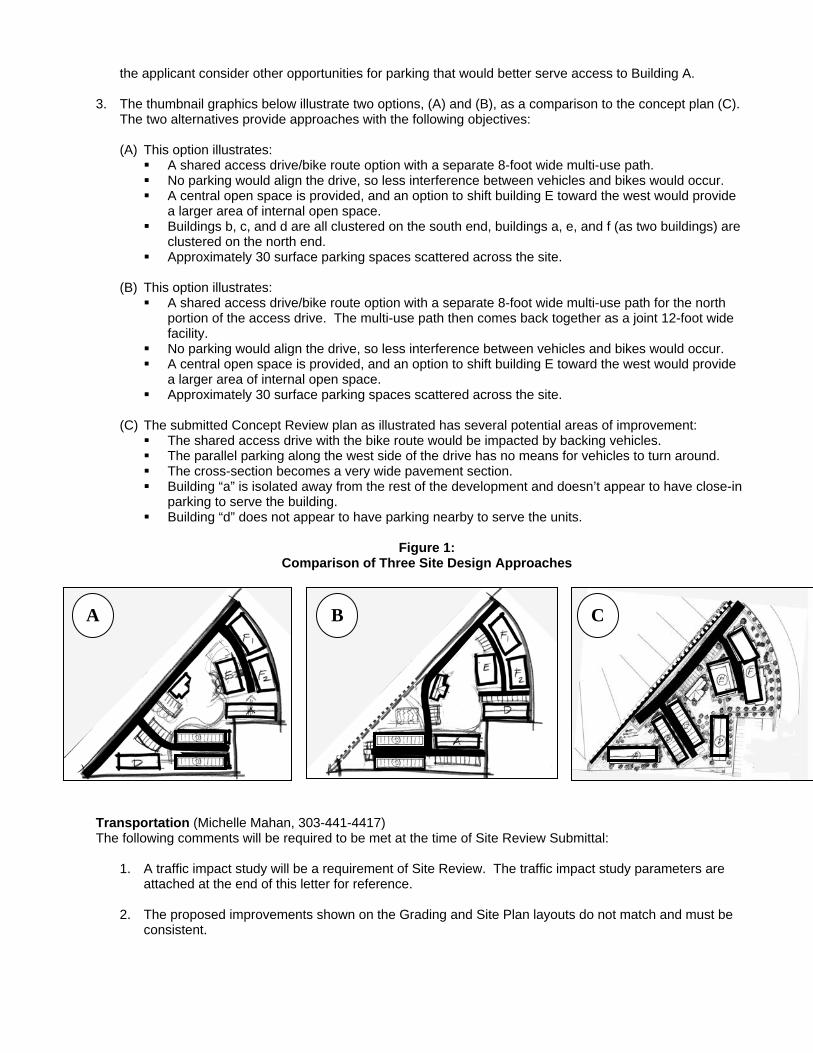
the applicant consider other opportunities for parking that would better serve access to Building A. 3. The thumbnail graphics below illustrate two options, (A) and (B), as a comparison to the concept plan (C).
The two alternatives provide approaches with the following objectives:
(A) This option illustrates: A shared access drive/bike route option with a separate 8-foot wide multi-use path. No parking would align the drive, so less interference between vehicles and bikes would occur. A central open space is provided, and an option to shift building E toward the west would provide
a larger area of internal open space. Buildings b, c, and d are all clustered on the south end, buildings a, e, and f (as two buildings) are
clustered on the north end. Approximately 30 surface parking spaces scattered across the site.
(B) This option illustrates:
A shared access drive/bike route option with a separate 8-foot wide multi-use path for the north portion of the access drive. The multi-use path then comes back together as a joint 12-foot wide facility.
No parking would align the drive, so less interference between vehicles and bikes would occur. A central open space is provided, and an option to shift building E toward the west would provide
a larger area of internal open space. Approximately 30 surface parking spaces scattered across the site.
(C) The submitted Concept Review plan as illustrated has several potential areas of improvement:
The shared access drive with the bike route would be impacted by backing vehicles. The parallel parking along the west side of the drive has no means for vehicles to turn around. The cross-section becomes a very wide pavement section. Building “a” is isolated away from the rest of the development and doesn’t appear to have close-in
parking to serve the building. Building “d” does not appear to have parking nearby to serve the units.
Figure 1:
Comparison of Three Site Design Approaches
A B C
Transportation (Michelle Mahan, 303-441-4417) The following comments will be required to be met at the time of Site Review Submittal:
1. A traffic impact study will be a requirement of Site Review. The traffic impact study parameters are attached at the end of this letter for reference.
2. The proposed improvements shown on the Grading and Site Plan layouts do not match and must be
consistent.

Bicycle/Pedestrian Connectivity
3. The Transportation Master Plan shows a multimodal path at the northern edge of the site. Although typically a 12-foot wide multi-use path would be required to be constructed, staff would be supportive of City of Boulder Design and Construction Standard (DCS) variance request to instead provide an 8-foot wide multi-use path east of the “split” due to the low volume of users in this area, with a 12-foot wide multi-use path provided between the “split” and the westernmost property line. A public access easement would be required to be dedicated which extends 2 feet beyond the edge of walk. However, the split 7-foot bike path and 4-foot sidewalk would not be adequate due to the less direct nature of the proposed pedestrian portion of the path. This path must allow a minimum 2.5 foot clearance from the face of curb to allow for door swing associated with the adjacent parallel parking. Any variance requests must clearly outline the 7 criteria in section 1.05(B) of the DCS being met at the time of Site Review.
4. The above mentioned multi-use path should also provide access ramps to the proposed parking lot
and to Moorhead. The city is currently pursuing communication with RTD to coordinate the construction of this connection to their site located just west of the subject property.
5. City staff is currently pursuing the collection and analysis of current bicycle and pedestrian users
along with accident data, to determine if a marked bicycle/pedestrian crossing would be warranted for the formalization of the multi-use path along the northern edge of the property. The results of this analysis will be forwarded to the applicant as they become available in mid-May. If a formalized bicycle/pedestrian crossing is warranted, then an access ramp will also be required to be provided on the east side of Moorhead.
6. Per Section 9-9-6(d)(5)(F) and Figure 9-15 of the Boulder Revised Code, a minimum 6 foot wide
sidewalk must be provided when immediately adjacent to perpendicular parking stalls with no curb blocks installed. Clearly dimension all pertinent sidewalks to be 6 foot minimum width.
7. The existing 4-foot sidewalk width on Moorhead will be required to be maintained.
Parking
8. Any proposed underground parking must clearly illustrate and label ramp grades and dimensions in order to verify the functionality of the proposed parking layout.
9. Per section 9-9-6(d)(3)(B) of the Boulder Revised Code, turnaround spaces must be provided for
dead-end parking bays of eight stalls or more. Turnarounds must be identified with a sign or graphic and marked “no parking”. All required turn-around spaces must be clearly labeled and dimensioned. A signage and striping plan in conformance with MUTCD standards will be a requirement at the time of final engineering submittal or building permit submittal.
10. The plans do not show any accessible parking spaces. Accessible spaces per section 9-9-6(b) of the
Boulder Revised Code will be required to be shown on the plans. Per section 4.6.2 of the ADA Accessibility Guidelines, accessible spaces must be dispersed and located closest to the accessible entrances. The accessible entrances will be required to be illustrated on the plans, showing the above requirements being met.
11. Per section 9-9-6 (d)(2)(C) of the Boulder Revised Code, accessible parking spaces are to be 8 feet
wide with an additional five foot wide diagonally striped aisle. Section 4.1.2(5)(b) of the Federal ADA Accessibility Guidelines requires that one of the spaces be 8 feet wide with an additional 8 foot wide diagonally striped aisle for a van accessible space.
12. Bicycle parking is required to be provided in accordance with sections 9-9-6(b) and 9-9-6(g) of the
Boulder Revised Code and section 2.11(E) of the City of Boulder Design and Construction Standards. The proposed bicycle parking locations and number of parking spaces must be shown on the plans at the time of Site Review. • The necessary spacing between all proposed bike racks and any adjacent walls, accessible
routes, required clear sidewalk/multi-use path widths, etc, must be clearly dimensioned in accordance with City of Boulder Standard Detail number 2.53.

• Per section 9-9-6(g) of the Boulder Revised Code, bicycle parking is required to be located in convenient, highly visible, active, well-lighted areas but shall not interfere with pedestrian movements.
• Per section 2.11(E)(2) of the DCS, bicycle parking should generally be provided within 50 feet of the main building entrance.
Transit
13. At the time of Site Review, a Transportation Demand Management (TDM) plan consistent with section 2.03(I) of the City of Boulder Design and Construction Standards and section 9-2-14(h)(2)(D)(iv) and (v) of the Boulder Revised Code is required to be submitted which outlines strategies to mitigate traffic impacts created by the proposed development and implementable measures for promoting alternate modes of travel. • The applicant should contact Chris Hagelin (303-441-1832), Senior Transportation Planner with
GO Boulder, to discuss viable TDM options specific to this project. • The TDM plan must be submitted as a separate document with Site Review submittal.
14. The 204 provides service to the site via Moorhead with approximately 57 alighting passengers per
day currently. An 8’x30’ concrete boarding area will be required to be installed along the Moorhead frontage between the curb and sidewalk. The south end of this boarding area should be located at least 90' from the Moorhead/site access flowline intersection. This boarding area must allow a 5’x8’ accessible loading area at the front (south end) of the boarding pad. The plans will be required to show this boarding pad, a bench, a u-rack, and the associated tree grates. A trash receptacle can also be shown if the property owner chooses to adopt and maintain it. All improvements must be in accordance with RTD Bus Transit Facility Design Guidelines and Criteria. • The standard City of Boulder bench (especially for downtown Boulder bus stops) is the
Landscape Forms Scarborough woven bench with back. A detail can be found at: http://www.landscapeforms.com/en-US/Products/Pages/ScarboroughBench.aspx
• The standard trash receptacle for the city of Boulder and RTD is the Victor Stanley Ironsites Series SD-42 in Black Powdercoat. A detail can be found at: http://www.victorstanley.com/products/?mode=prodDetail&id=27&coord=true
III. INFORMATIONAL COMMENTS Addressing, Chandler Van Schaack, 303-441-3137 The City is required to notify utility companies, the County Assessor’s office, emergency services and the US Post Office of proposed addressing for development projects. A Final Address Plat and list of all proposed addresses should be prepared and submitted in hardcopy and digital (pdf) format to P&DS staff for routing and comment. This is considered part of the Technical Document Review process for a project of this size and scope and is in addition to the Final Plat approval. Additionally, in assigning addresses and street names please refer to the attached guidelines. Drainage Brian Campbell, P.E., 303-441-3121 1. Storm water quality enhancement and detention ponding are issues that must be addressed during the
Site Review Process. A Preliminary Storm Water Report and Plan in accordance with the City of Boulder Design and Construction Standards must be provided by the applicant at time of Site Review application. Additional items that must be considered when developing a drainage plan include but are not limited to: • Adequate space to accommodate drainage and water quality facilities • Offsite drainage infrastructure improvements • Evaluation of negative impacts to downstream properties from existing offsite flow • Water quality for surface runoff using "Best Management Practices" • Groundwater discharge • Erosion control during construction activities
2. This project will disturb more than 1 acre of land and will be required to provide Water Quality Capture
Volume and a Water Quality Outlet in accordance with the UDFCD Drainage Criteria Manual unless other storm water quality facilities are approved by the Director.

3. The applicant is notified that detention and water quality ponds intended to detain and treat stormwater runoff for the entire property (not each individual lot) shall be located in Drainage Easements or Outlots, with maintenance responsibilities detailed in the subdivision agreement.
4. City standards require that all projects minimize directly connected impervious areas in accordance with
the Urban Drainage and Flood Control District Drainage Criteria Manual Volume III. Wherever possible, runoff from roofs and parking lots needs to be directed to landscaped areas, grass buffer strips, and grass lined swales. This requirement is in addition to the requirement that structural Best Management Practices such as water quality ponds be provided on the site. This requirement must be address in the Preliminary Stormwater Report and Plan at Site Review.
5. The applicant is proposing the installation of sidewalk chase located on the proposed site. It is the city’s
intent to minimize the use of sidewalk chase drains to convey storm drainage within the public right-of-way. The city recommends that the applicant look at other design possibilities that will eliminate the use of the chase drain. The Design and Construction Standards require special approval of chase drain installations subject to the following policy:
All of the following conditions must be met.
1. All reasonable on-site modifications which could reduce or eliminate the need for a chase drain have been determined to be ineffective or unreasonable, and
2. The property is not located adjacent to a storm sewer or similar conveyance or cannot reasonably extend a storm drainage facility to abut the property, and
3. Any groundwater discharge must conform with Section 8-2-8, “Discharging Water Prohibited” B.R.C., 1981. Per Section 8-2-8(a), no owner, lessee, or occupant of property shall cause or permit water to flow upon any sidewalk, street, alley or other public right-of-way so as to impair the use of such place, when the weather is such that the water may be frozen into ice, where the drainage is such that it may create a hazard to persons or property, or where it may cause damage to any public property or facility.
4. Discharge from the chase drain will not adversely affect down stream properties. And if at least one of the following conditions is met:
1. The Public Works Department has determined that it is not in the public interest to excavate a right-of-way for the purpose of installing a connection to a storm sewer system. Excavation may be restricted based on Section 8-5-13, “Construction and Restoration Standards for Newly Constructed of Overlayed Streets” B.R.C., 1981 or at the discretion of the Director of Public Works for Transportation.
2. Adopted city land use regulations or policies require or encourage that structures on the property be built directly adjacent to the right-of-way and roof downspouts or similar discharges cannot, in the opinion of the city, be reasonably conveyed to another location.
The chase drain will convey drainage from the defined drainage way as delineated on an approved Stormwater Plan and Report meeting city standards. Utilities Brian Campbell, P.E., 303-441-3121 1. On-site and off-site water main and wastewater main construction per the City of Boulder Design and
Construction Standards (DCS) as necessary to serve the development, as well as perpetuate the overall system, will be required. All proposed public utilities for this project shall be designed in accordance with the DCS. A Utility Report per Sections 5.02 and 6.02 of the DCS will be required at time of Site Review application to establish the impacts of this project on the City of Boulder utility systems. All on-site water main and wastewater main shall be in a Utility Easement.
2. The applicant is notified that, though the city allows Xcel and Qwest to install their utilities in the public
right-of-way, they generally require them to be located in easements on private property. 3. The applicant should note that trees are not permitted within ten feet of underground utility lines. At Site
Review, the applicant will need to demonstrate that their plans can meet both landscaping and utility requirements.

4. All water meters are to be placed in city R.O.W. or a public utility easement, but meters are not to be
placed in driveways, sidewalks or behind fences. IV. NEXT STEPS A Planning Board hearing has been tentatively set for June 3, 2010 in the City Council Chambers, 1799 Broadway at 6:00 p.m. A minimum of one week prior to the hearing, staff requests that the applicant provide, 18 sets of prints to a common scale (half size prints of 12x18 are recommended) of the plans, along with a CD of the applicant’s presentation. V. CITY CODE CRITERIA CHECKLIST
Guidelines for Review and Comment The following guidelines will be used to guide the planning board´s discussion regarding the site. It is anticipated that issues other than those listed in this section will be identified as part of the concept plan review and comment process. The Planning Board may consider the following guidelines when providing comments on a concept plan. 1) Characteristics of the site and surrounding areas, including, without limitation, its location,
surrounding neighborhoods, development and architecture, any known natural features of the site including, without limitation, mature trees, watercourses, hills, depressions, steep slopes and prominent views to and from the site;
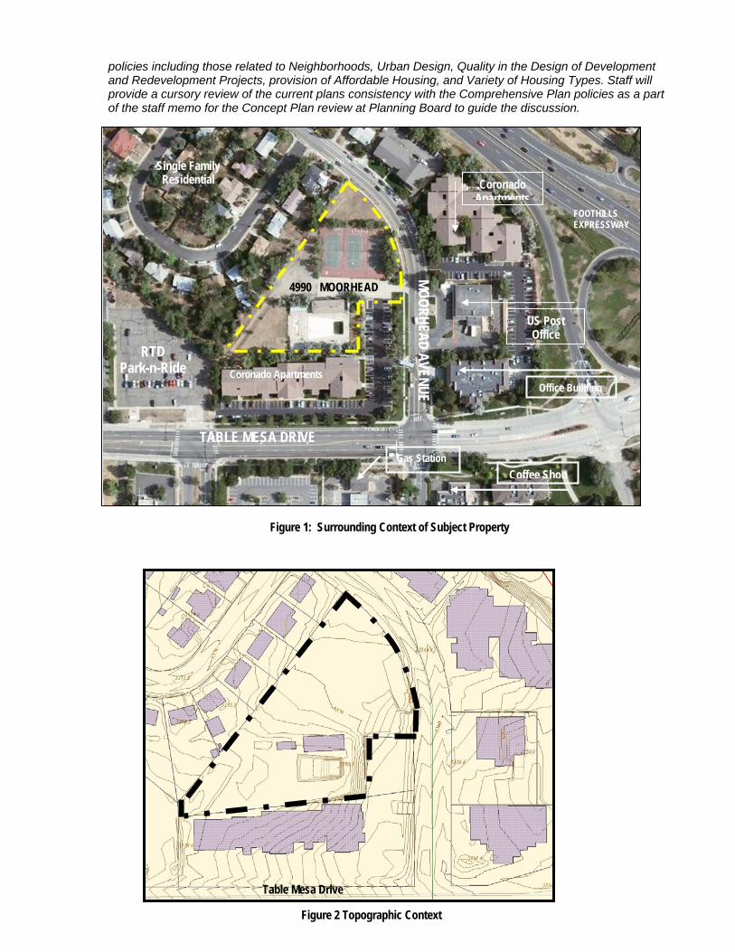
The site is located near the intersection of Table Mesa Drive and Moorhead Avenue. The built environment surrounding the subject property is eclectic with high density residential located to the south and east, office buildings, including a US Post Office, that are located across Moorhead Avenue, and single family residential that is part of the Martin Acres subdivision and located to the west of the site. Foothills Expressway is located approximately 300 feet to the east, and a regional RTD bus transfer facility is less than one-quarter mile east of the site. There’s also an RTD Park-n-Ride lot located just southwest of the subject property. Figure 1 below illustrates the surrounding context.
The wedge-shaped site was the former High Mar Swim and Tennis facility that closed operations several years ago. The swimming pool, tennis courts and a pool building remain on the site along with some children’s play equipment. All of the existing facilities are in a deteriorated state. The backyards of homes located in the adjoining single family residential neighborhood align the property on the west, and a chain link fence separates the backyards from the site.
The existing grade on Moorhead Avenue transitions approximately 10-feet from the intersection with Table Mesa Drive to the northern corner of the site. There is another eight to ten foot increase in grade change from Moorhead Avenue on the southeast corner into the site, and the site rests prominently above Moorhead Avenue, but levels out toward the north end of the site. Figure 2 below illustrates this topographic change in the vicinity of the site. There are several mature trees that occur mostly on the periphery of the site, with the majority of the tree species being Siberian elm or Russian olive – two species that are considered invasive or “weedy.” There are several mature pine trees along with other ornamental plant species along Moorhead Avenue. A small dirt pathway has been worn into the site on the west side of the property from the northern corner of the site to the southwest corner, where it connects to the RTD park-n-ride lot.
2) Community policy considerations including, without limitation, the review process and likely conformity of the proposed development with the Boulder Valley Comprehensive Plan and other ordinances, goals, policies, and plans, including, without limitation, subcommunity and subarea plans; The subject property is designated as High Density Residential under the Boulder Valley Comprehensive Plan, which is defined as having more than 14 units per acre. The site is not located within an area defined as a subcommunity or subarea, but will be subject to a number of relevant Comprehensive Plan
policies including those related to Neighborhoods, Urban Design, Quality in the Design of Development and Redevelopment Projects, provision of Affordable Housing, and Variety of Housing Types. Staff will provide a cursory review of the current plans consistency with the Comprehensive Plan policies as a part of the staff memo for the Concept Plan review at Planning Board to guide the discussion.
Coronado Apartments
US Post Office
Office Building
Coffee Shop Gas Station
Coronado Apartments
Single Family Residential
RTD Park-n-Ride
TABLE MESA DRIVE
MOORHEAD AVENUE
FOOTHILLS EXPRESSWAY
4990 MOORHEAD
Figure 1: Surrounding Context of Subject Property
Moor
head
Ave
nue
Table Mesa Drive
Figure 2 Topographic Context

Address: 4990 Moorhead Avenue Page 11
3) Applicable criteria, review procedures, and submission requirements for a site review; The next step in the review process is Site Review. Land Use code subsection 9-2-14(e), B.R.C. 1981 provides the criteria upon which, projects within a site review will be evaluated.
4) Permits that may need to be obtained and processes that may need to be completed prior to, concurrent with, or subsequent to site review approval; Following the Concept Plan and Site Plan review processes, the applicant will be required to complete Technical Document Review along with a Building Permit Process.
5) Opportunities and constraints in relation to the transportation system, including, without limitation, access, linkage, signalization, signage, and circulation, existing transportation system capacity problems serving the requirements of the transportation master plan, possible trail links, and the possible need for a traffic or transportation study; The subject property is located near a major intersection of Moorhead Avenue and Table Mesa Drive. Moorhead is considered a collector street and parallels U.S. Highway 36, it serves a number of single family residential neighborhood streets within the Martin Acres subdivision. Table Mesa Drive is a major east-west arterial and multi-modal corridor that transitions to South Boulder Road just past the interchange with U.S. Highway 36. There is a regional RTD bus transfer facility and park-n-ride parking structure located approximately ¼ mile from the site to the east. There’s also a smaller park-n-ride facility located just to the southwest of the site. The Transportation Master Plan illustrates a multi-modal path connecting from Moorhead Avenue to Table Mesa Drive along the western boundary of the subject property. The applicant will be responsible for constructing the path according to city standards.
The property manager for the adjacent Coronado Apartments, who spoke at one of the neighborhood meetings for the Concept Plan development reported that several accidents have occurred in the vicinity of the subject property, including the access point, just south of the subject property, into the Coronado Apartments. According to the property manager, two of the accidents included fatalities, one involving a pedestrian and the other involving a bicyclist. City staff is currently pursuing the collection and analysis of current bicycle and pedestrian use along with accident data, to determine if a marked bicycle/pedestrian crossing would be warranted for the formalization of the multi-use path along the northern edge of the property. The results of this analysis will be forwarded to the applicant as they become available in mid-May. If a formalized bicycle/pedestrian crossing is warranted, then an access ramp will also be required to be provided on the east side of Moorhead Avenue.
6) Environmental opportunities and constraints including, without limitation, the identification of wetlands, important view corridors, floodplains and other natural hazards, wildlife corridors, endangered and protected species and habitats, the need for further biological inventories of the site and at what point in the process the information will be necessary; The existing site is already developed with a deteriorated swimming pool and tennis courts, and a vacant building. There are no known special status species or habitat located on the subject property. There are no view corridors that would need to be protected, or wetlands or floodplains. Several existing mature trees scatter the site, some of which are weedy species, others that have the potential to provide amenity within the site.
7) Appropriate ranges of land uses;
The proposed affordable housing and community center with below grade parking serving the site is perfectly suited to the RH-5 site with a number of transportation options and mix of uses nearby.
8) The appropriateness of or necessity for housing. As a net zero, permanently affordable housing project proposed in a high density residential zone, staff notes that the intent of the project is highly consistent with a number of Boulder Valley Comprehensive Plan policies. As refinements to the plan are made, Staff encourages the applicant to review and fully understand the following policies to fulfill these important policies, noted as follows:

Address: 4990 Moorhead Avenue Page 12
2.13 Support for Residential Neighborhoods In its community design planning, the city will support and strengthen its residential neighborhoods. The city will seek appropriate building scale and compatible character of new development or redevelopment, desired public facilities and mixed commercial uses, and sensitively designed and sized rights-of-way.”
2.32 Trail Corridors/Linkages.
In the process of considering development proposals, the city and county will encourage the development of trails and trail linkages for appropriate uses such as hiking, bicycling or horseback riding, so as to provide a variety of alternative recreation and transportation opportunities. Implementation of this goal will be achieved through the coordinated efforts of the private and public sectors.
2.39 Sensitive Infill and Redevelopment.
Overall, infill and redevelopment will be expected to provide significant benefits to the community and the neighborhoods. The city will develop tools such as neighborhood design guidelines to promote sensitive infill and redevelopment. The city will work with neighborhoods to protect and enhance neighborhood character and livability.
2.42(a) Enhanced Design for the Built Environment - The context. Projects should become a coherent part of the neighborhood in which they are placed. They should be preserved and enhanced where the surroundings have a distinctive character. Where there is a desire to improve the character of the surroundings, a new character and positive identity as established through area planning or a community involvement process should be created for the area. Special attention will be given to protecting and enhancing the quality of established residential areas that are adjacent to business areas.
2.42(B) Enhanced Design for the Built Environment - The Public Realm.
Projects should relate positively to public streets, plazas, sidewalks and paths. Buildings and landscaped areas—not parking lots—should present a well-designed face to the public realm, should not block access to sunlight, and should be sensitive to important public view corridors.
2.42(a) Enhanced Design for the Built Environment - Human Scale
Projects should provide pedestrian interest along streets, paths and public spaces.
2.42(a) Enhanced Design for the Built Environment - Permeability
Projects should provide multiple opportunities to walk from the street into projects, thus presenting a street face that is permeable. Where appropriate, they should provide opportunities for visual permeability into a site to create pedestrian interest.
2.42(a) Enhanced Design for the Built Environment - On-site open spaces.
Projects should incorporate well designed functional open spaces with quality landscaping, access to sunlight and places to sit comfortably. Where public parks or open spaces are not within close proximity, shared open spaces for a variety of activities should also be provided within developments.
2.42(a) Enhanced Design for the Built Environment -Buildings
Buildings should be designed with a cohesive design that is comfortable to the pedestrian, with inviting entries that are visible from public rights of way.
Energy-Efficient Land Use. The city and county will encourage the conservation of energy through land use policies and regulations governing placement, orientation and clustering of development and through housing policies and regulations. The conservation of energy is served by the development of more intense land use patterns; the provision of recreation, employment and essential services in proximity to housing; the development of mass transit corridors; and efficient transportation.
Local Solutions to Affordable Housing.
The city and county will emphasize locally developed solutions to meet the housing needs of their low and moderate income households, including those who work but may not live in Boulder County. The city and county further recognize that such needs may not be met solely through private development. To facilitate availability of housing for this segment of the population, appropriate federal, state and local programs and resources will be used both locally and in collaboration with other jurisdictions. The city’s pursuit of additional affordable housing programs will include an analysis of the unmet need for such programs as well as an analysis of the financial, social, demographic and community resources and constraints.

Address: 4990 Moorhead Avenue Page 13
Attachment A: Traffic Impact Study Parameters – 4990 Moorhead (LUR2010-00020)
A traffic impact study is a requirement of Site Review since trip generation was shown to exceed the residential development threshold of 20 vehicle trips or greater during any single hour. In addition to meeting the following parameters, the traffic study format must be in compliance with section 2.03 of the City of Boulder Design and Construction Standards (DCS). Accident analyses and noise attenuation measures are not required by the city for this project. Relevant Transportation Area, Sub-area, and Capital Improvement Project Plans: The traffic study and site plan must consider and comply with the City of Boulder Transportation Master Plan (TMP) regarding future build-out volumes, connections, etc. The TMP can be found on the City of Boulder website (www.bouldercolorado.gov). Follow the links to: Departments -> Public Works -> Transportation -> Transportation Master Plan Proposed Street Improvements If public improvements are proposed in order to bring any approach of any intersection back up to level of service (LOS) D where the addition of project generated traffic has caused the LOS to fall below this standard for the city, the improvements must be demonstrated on the submitted site plans. Study Area Boundaries At a minimum, the following intersections must be analyzed:
• The proposed site access connection to Moorhead Avenue; • Moorhead/27th Way; and • Moorhead/Table Mesa
Level of Service Analysis The level of service analysis must be performed on the above outlined intersections for the following:
• Existing traffic conditions, project completion year background traffic, project completion year total traffic, 2030 background traffic, and 2030 total traffic;
• Weekday am and pm peak hour conditions (peak hour of adjacent street). For existing timing and phasing of signalized intersections, contact Joe Paulson, City of Boulder Signal Operations Engineer, at 303-441-3289. A level of service comparison table must be provided which compares all level of service scenarios and includes the number of seconds of delay for each movement. All level of service scenarios must be included on the same page for easy comparison. Methods for Projecting Future Year Background Traffic Volumes Future year background traffic volumes should consider the 2025 TMP travel model (see attached maps), historic traffic volume data if available, and the anticipated future residential development located at 4840 Table Mesa improvements on the south side of Valmont. The following should be noted when using the 2025 TMP travel model:
• The travel model includes assumptions that Boulder will increase its alternate mode share and in some corridors traffic volumes may actually decrease in the future, which is built into the model. The user of these model projections should be aware that these mode use assumptions are built into the TMP traffic model when developing future traffic estimates; and
• Determine the percentage that the model is low or high by comparing the Base Year (2001) Volumes model assignment (numbers with no parenthesis) and the Base Year (2001) Volumes actual count (numbers with parenthesis). Use this percentage to appropriately adjust the Fiscally Constrained 2025 Volumes.
Historic Growth Rates and Intersection Count Data Traffic count and growth rate information can be found at the following location: http://gisstage2.ci.boulder.co.us/website/pds/pds_trans_count/ New counts must be taken at all intersections, since city counts within the last 2 years are unavailable. Trip Generation Reductions Any trip reduction methods used should be clearly demonstrated in the study. This includes but is not limited to reductions due to multi-modal/shared trips, internal trips, pass-by trips, and diverted trips.

Address: 4990 Moorhead Avenue Page 14
Travel Demand Management Strategies At the time of Site Review submittal, a Travel Demand Management (TDM) plan in accordance with section 2.03(I) of the DCS and section 9-2-14(h)(2)(D) of the Boulder Revised Code is required to be submitted which outlines strategies to mitigate traffic impacts created by the proposed development and implementable measures for promoting alternate modes of travel. The applicant must:
• Contact Chris Hagelin (303-441-1832), Senior Transportation Planner with GO Boulder, to discuss viable TDM options specific to this project; and
• Submit the TDM plan as a separate document with Site Review submittal in addition to incorporating the TDM plan into the traffic impact study.