city of benicia downtown mixed use master...
TRANSCRIPT

Downtown Mixed Use Master PlanSeptember 2007
C i t y o f B e n i c i a
Opticos Design, Inc. Berkeley, California
Prepared By:


iiiDowntown Mixed Use Master PlanOpticos Design, Inc.
Downtown Mixed Use Master PlanCity of Benicia
September 2007
Lead Consultants Opticos Design, Inc. Dan Parolek, AIA, Principal Karen Parolek, Principal Stefan Pellegrini, AICP, Sr. Associate Christopher Janson John Miki Brenda Fuste 1285 Gilman Street Berkeley, California 94706 510.558.6957 Transportation Nelson Nygaard Jeff Tumlin 785 Market Street, Suite 1300 San Francisco, California 94103 415.284.1544
Benicia City Staff Jim Erickson, City Manager Charlie Knox, AICP Community Development Director Damon Golubics, Senior Planner Amalia Lorentz, AICP Economic Development Director Del Lacey, Technician
Economics Strategic Economics Dena Belzer Abby Thorne-Lyman Alex Demisch Nadine Fogarty 2991 Shattuck Ave., Suite 203 Berkeley, California 94705 510.647.5291 Planning and Zoning Crawford Multari & Clark Associates Paul Crawford Lisa Wise 641 Higuera Street, Suite 302 San Luis Obispo, CA 93401 805.541.2622
Design and Historic Resources Prentice & Prentice, Inc. Blair Prentice 706 Creston Rd. Berkeley, CA 94708
Benicia City Council Steve Messina, Mayor Alan Schwartzman, Vice Mayor Elizabeth Patterson Bill Whitney Mark Hughes
Benicia Planning Commission Scott Strawbridge Dan Healy Fred Railsback Richard Bortolazzo Bonnie Silveria Kyle Daley Mike Ioakimedes
Benicia Historic Preservation Review Commission James Conlow Don Dean Luis Delgado Patrick Donoghue Mike White Toni Haughey Blythe Wilson

vDowntown Mixed Use Master PlanOpticos Design, Inc.
Chapter 1: Introduction
Vision for the First Street District 1-1
Location and Overview 1-2
Summary of Process 1-3
Plan Organization 1-5
Chapter 2: Analysis and Background
Introduction 2-1
Historical Analysis 2-2
Primary Challenges 2-3
Key Opportunities 2-5
Chapter 3: Design Proposals
Introduction 3-1
First Street Recommendations 3-2
Neighborhood Centers 3-9
Mixed-Use Strategies for Historic Neighborhoods 3-10
Circulation and Transportation 3-11
Implementation Strategies 3-16
Chapter 4: Form-Based Code
Introduction 4-1
Regulating Plan 4-3
Zone Descriptions 4-4
Town Core (TC) Standards 4-5
Town Core - Open (TC-O) Standards 4-11
Neighborhood General (NG) Standards 4-17
Neighborhood General - Open (NG-O) Standards 4-21
Additional Standards 4-25
Frontage Types 4-26
Glossary 4-27
Chapter 5: Appendix
Appendix A: Market Conditions and Recommendations 5-1
Table of Contents

Do
wn
to
wn
Mix
ed
Us
e M
as
te
r P
la
n
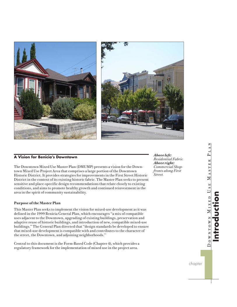
A Vision for Benicia’s Downtown
The Downtown Mixed Use Master Plan (DMUMP) presents a vision for the Down-town Mixed Use Project Area that comprises a large portion of the Downtown Historic District. It provides strategies for improvements in the First Street Historic District in the context of its existing historic fabric. The Master Plan seeks to present sensitive and place-specific design recommendations that relate closely to existing conditions, and aims to promote healthy growth and continued reinvestment in the area in the spirit of community sustainability.
Purpose of the Master Plan
This Master Plan seeks to implement the vision for mixed-use development as it was defined in the 1999 Benicia General Plan, which encourages “a mix of compatible uses adjacent to the Downtown, upgrading of existing buildings, preservation and adaptive reuse of historic buildings, and introduction of new, compatible mixed-use buildings.” The General Plan directed that “design standards be developed to ensure that mixed-use development is compatible with and contributes to the character of the street, the Downtown, and adjoining neighborhoods.”
Central to this document is the Form-Based Code (Chapter 4), which provides a regulatory framework for the implementation of mixed use in the project area.
Above left: Residential Fabric Above right: Commercial Shop-fronts along First Street.
Intr
od
uct
ion
1chapter

1-2 Downtown Mixed Use Master PlanOpticos Design, Inc.
Chapter 1: Introduction
Location and Overview
The project area is located in downtown Benicia, California, and is bounded roughly by West Second Street to the west, C Street to the south, East Second Street to the east, and K Street to the north. The project area comprises approximately 88 acres. The majority of the project area is contained within the Downtown Historic District.
Above: The Downtown Mixed Use project area is an 88-acre portion of downtown Benicia centered along First Street and located in eastern Benicia in the northern Bay Area.
Martinez
CrockettCrockett
Martinez
Carquinez StraitI-780
I-680
State Route 4
Vallejo
Lower Arsenal Planning Area
“Yuba” Property
Downtown Mixed Use
Planning Area
BeniciaBenicia
Vallejo

1-3Downtown Mixed Use Master PlanOpticos Design, Inc.
Chapter 1: Introduction
Summary of Process
An intense public process and extensive data collection phase was conducted for the Downtown Mixed Use Master Plan. The evolution of this plan is the result of site vis-its, reviews of documents, interviews, meetings, a design workshop or “charrette,” and community cooperation and input.
Plans and Documents
The following documents were reviewed and considered during the initial data collection phase of the planning and design process: Benicia General Plan and EIR, Zoning Code, Downtown Streetscape Design Plan, Downtown Benicia Parking Study, Benicia Downtown Market Study, Downtown Historic Conservation Plan, and Benicia: Portrait of an Early California Town by Robert Bruegmann. The design team also consulted the University of California, Berkeley, Fire Insurance Map data-base and internet-based aerial mapping resources.
Site Tour and Project Kickoff
The consultant team met with city staff, discussed project goals, and toured the project areas on August 3, 2006. The purpose of this visit was to gain a general understanding of context, constraints, and opportunities and to document various conditions in and around the project areas, such as traffic and circulation, building form, architecture, public realm, pedestrian access, and other conditions. As part of this process, members of Opticos Design prepared physical analysis diagrams and base maps.
Discovery Interviews and Visioning Workshop
Initial public input was gathered over a two-day period (August 22 and 23, 2006) through a series of nearly ninety interviews with key stakeholders. This two-day session culminated in a Visioning Workshop, which was open and accessible to the public, in the evening on the second day.
The consultant team interviewed property owners, business owners, residents, and representatives of organizations, such as the Benicia Historic Society. The inter-views were private, 30-minute sessions aimed at getting an in-depth understanding of community concerns and priorities.
At the Visioning Workshop on August 23, 2006, the consultant team presented initial physical and background analysis of the study area and received valuable information from community members. After the consultant’s presentation, the audience broke out into smaller groups to discuss relevant sub-topics, such as hous-ing, appropriate land use typologies, and identification of those areas that need to be preserved or attended to. This information was used to guide the design process and to define a series of overriding design principles.
Top: Project kickoff walking tour with City staff; Center: Community member presenting design ideas at inital vision-ing workshop; Bottom: Lunchtime brief-ing during the community workshop.
1-4 Downtown Mixed Use Master PlanOpticos Design, Inc.
Chapter 1: Introduction
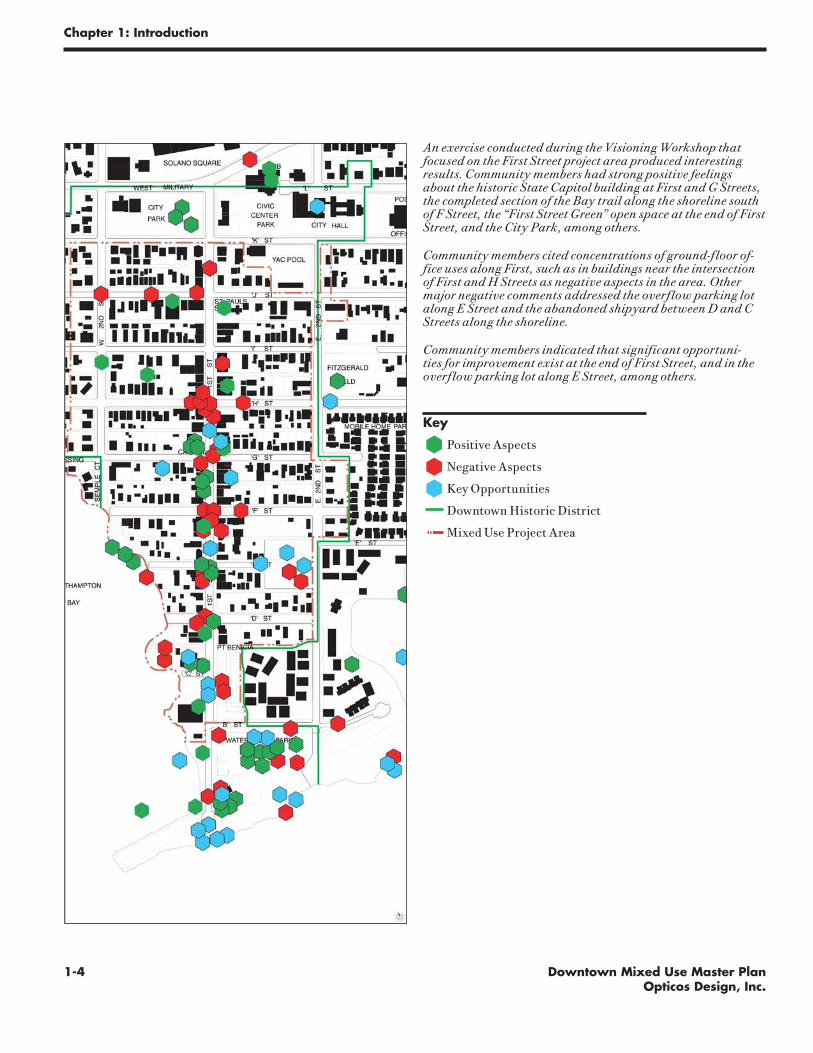
An exercise conducted during the Visioning Workshop that focused on the First Street project area produced interesting results. Community members had strong positive feelings about the historic State Capitol building at First and G Streets, the completed section of the Bay trail along the shoreline south of F Street, the “First Street Green” open space at the end of First Street, and the City Park, among others.
Community members cited concentrations of ground-floor of-fice uses along First, such as in buildings near the intersection of First and H Streets as negative aspects in the area. Other major negative comments addressed the overflow parking lot along E Street and the abandoned shipyard between D and C Streets along the shoreline.
Community members indicated that significant opportuni-ties for improvement exist at the end of First Street, and in the overflow parking lot along E Street, among others.
Key
Positive Aspects
Negative Aspects
Key Opportunities
Downtown Historic District
Mixed Use Project Area

1-5Downtown Mixed Use Master PlanOpticos Design, Inc.
Chapter 1: Introduction
The interviews and workshop produced many commonalities in perception and understanding among the participants and provided good direction for city staff and the consultant team. The following summarizes some of the major types of com-ments received:
• Make the Downtown more of a destination for residents, tourists, and events.
• Preserve and enhance First Street as an old-fashioned, small-scale main street.
• Move personal and professional businesses to second floors to allow more ground-floor retail.
• Provide economic incentives for historic renovation.
• Enhance Downtown with landscaping, benches, flower plantings, lighting, etc.
• Establish a greater presence of Benicia’s artist colony.
• Improve wayfinding with better signage.
• Extend the Bay Trail from Downtown to the Arsenal.
• Improve pedestrian safety.
• Consider providing additional parking.
Physical and Economic Analysis
After the Visioning Workshop the consultant team conducted four weeks of intensive physical and economic analysis. Physical analysis included the creation of maps trac-ing Downtown’s historic development, land use patterns, transportation and circula-tion systems, and built fabric. Economic analysis included research on demographic and market conditions in the project area.
Community Design Workshop
For the second workshop (September 18–22nd, 2006), members of the consultant team returned to Benicia for a five-day intensive working session to establish an illustra-tive vision plan and a land use “regulating” plan for the area. During this time the design team worked to produce an urban design plan for the study area that responded to interactive community input. The process was designed so that “feedback loops” were ongoing and immediate, keeping infeasible ideas from being fully developed and concentrating on the community’s desired results for the Downtown planning area.
The community design workshop allowed for a variety of interaction among the consultant team and members of the community. This occurred through organized presentations, informal evening pinups, group discussions, and facilitation of stake-holder meetings. Physical improvements, infill building types, and implementation strategies, among other topics, were discussed and illustrated.
During the design workshop, the appropriate strategy for Form-Based Coding was also explored. Based on community, stakeholder, and staff input, the consultant team developed a “zone-based” code, which sets different standards of form and intensity for designated areas. However, the code also pays careful consideration to building types, focusing on the use, mass, height, and bulk of different building types and how they may be used to implement the plan.
Top: Community members attend a lunchtime session during the community design workshop; Center: Consultant team members discuss downtown plan; Bottom: Community members discuss plan concepts with consultant team.

1-6 Downtown Mixed Use Master PlanOpticos Design, Inc.
Chapter 1: Introduction
Plan Organization
The Downtown Mixed Use Master Plan is organized as follows: Chapter 2 assesses the project area’s existing conditions and presents findings on its key issues and op-portunities. Chapter 3 provides a qualitative vision for the project area as it emerged through the community charrette process, containing information on circulation and transportation policies and programs, and suggested strategies for phasing and implementation.
Chapter 4 provides regulatory development standards for the implementation of this vision through a Form-Based Code. The Code provides form-based zoning regulations for the project area and is intended for adoption into the Benicia Zoning Ordinance.
The Appendix provides a glossary of terms used in the development code and throughout the Master Plan.

Do
wn
to
wn
Mix
ed
Us
e M
as
te
r P
la
n
Introduction
This chapter presents a summary of physical and demographic analyses performed in preparation for the Master Plan. It includes a discussion of downtown Benicia’s historical development and identifies a set of primary challenges and opportunities based on its physical form, geographic location, and demographic characteristics.
Downtown Benicia presents a unique case study in the Bay Area in that historically it has never experienced an economic boom that would have resulted in its wholesale change. For this reason, as the 1990 Downtown Historic Conservation Plan recog-nized, it presents a “rare view of the evolution of architecture from the mid-19th century to the 20th century in California,” with a rich collection of historic build-ings. Extensive analysis was conducted by the design team to ensure that design rec-ommendations would appropriately respond to Downtown Benicia’s unique historic fabric, and that the resulting implementation tools would preserve its best qualities.
An
aly
sis
an
d B
ack
gro
un
d
2chapter

2-2 Downtown Mixed Use Master PlanOpticos Design, Inc.
Chapter 2: Analysis and Background
Historical Analysis
Settlement in downtown Benicia began soon after its platting by Jasper O’Farrell in the summer of 1847. Under the direction of Robert Semple and Thomas Larkin, the city was laid out in blocks measuring 600 feet on each side and divided crosswise by two east-west alleys and a minor, 60’ wide east-west street, effectively creating two 250’ x 600’ blocks with their long side parallel to the Strait. First Street was platted well into the hills and terminated at a small promontory at its southern end.
By 1886 the City had already experienced two major stages in its development. The first stage began with the establishment of Benicia as State Capitol in 1853-54 with the subsequent construction of the State Capitol in 1853. This stage was furthered by the City’s brief heyday as the “Athens of the West,” which saw the establishment of a number of religious and educational institutions north of the State Capitol, includ-ing St. Catherine’s in 1854 on Solano Square. The second stage began in 1879 with railroad and ferry service to Port Costa. This brought an influx of industry to lower First Street that included numerous tanneries, mills, packing companies, and can-neries.
In 1929 the train and ferry service became obsolete with the construction of the Benicia railroad bridge, and many of the industrial facilities on the lower portion of First Street had closed or relocated elsewhere. By 1942 downtown Benicia was in a
Above, left to right: Downtown Benicia in 1847, 1886, 1942, and 2006.

2-3Downtown Mixed Use Master PlanOpticos Design, Inc.
Chapter 2: Analysis and Background
period of decline. This was exacerbated by the construction of I-780 in 1955, discon-necting downtown Benicia from the regional transportation system. While the city as a whole has enjoyed better access to the region, retail services have largely shifted to locations with better freeway connections and visibility.
Primary Challenges
Lack of freeway connections and downtown through-traffic comprise the core of Downtown Benicia’s many current challenges. Additional challenges involve re-evaluating Downtown Benicia’s commercial and public space needs, and providing for good parking management to make downtown Benicia viable as a strong econom-ic and historic center.
Lack of Through Traffic
From a transportation and economic development perspective, one of Downtown’s most important advantages is also one of its key disadvantages: All of Downtown’s streets dead-end in at least one direction; most of them terminate at both sides, end-ing at the water, the hills, or the edge of the Arsenal. As a result, there is far more traffic capacity in the streets of Downtown Benicia than would ever be used by the scale of development contemplated by the community. Indeed, several streets are excessively wide, with half of their width unnecessary.
The lack of through traffic, however, limits the visibility of First Street’s businesses. Customers do not arrive in Downtown Benicia by chance, or notice an interesting shop because they “happen to be driving by.” The result is that Downtown needs to work harder than other retail districts to attract customers.
Lack of Direct Freeway Connections
Downtown access is hampered by the fact that First Street does not connect to the freeway, and East Second Street is discontinuous, with the public safety building blocking the street right-of-way.
Oversupply of Commercial Space
The supply of commercial space on First Street exceeds the needs of retailers. First Street includes over 200,000 square feet of commercial space along eleven blocks from the Waterfront to Solano Square, a distance of over ½ mile. This configuration and scale poses several challenges for retailers in Benicia. Firstly, the linear nature of Benicia’s downtown makes it difficult to create a continuous, vibrant shopping atmosphere along the length of First Street that is appealing to pedestrians. Second-ly, the City of Benicia does not have a large enough customer base to support a full 200,000 square feet of retail, which is the size of a small regional shopping center.
This oversupply of retail has been potentially exacerbated by the encouragement of commercial development on the side streets east and west of First Street. Although conversions of residential or other buildings off of First Street have not been occur-ring at a rapid pace, some side streets in the southern part of Downtown, such as East D Street, have already reached a mass of commercial space sufficient to change their character. New mixed-use development on other side streets would not be appropri-ate given the historic residential character of these streets.
Top: Historic street grid and primary transportation network: in the late 19th and early 20th century First Street busi-ness activity was fueled by its proximity to the train-ferry service to and from Port Costa. Bottom: Current Street grid and primary transportation network: The removal of the train-ferry service and the introduction of the I-780 freeway has shifted principal retail visibility to the freeway interchanges. First Street has been cut off further by the closing of East Second Street between K and L Streets.

2-4 Downtown Mixed Use Master PlanOpticos Design, Inc.
Chapter 2: Analysis and Background
Prevalence of Office Uses
During the Master Plan process, many community members also expressed concern over the significant presence of ground floor office users on First Street. While blocks generally south of F Street have continuous retail activity and create a vibrant shopping atmosphere, blocks further to the north have a greater mix of office and retail activity. In some areas, the presence of ground floor offices makes it difficult for retailers to establish enough of a presence to draw pedestrian activity. Further, retailers are concerned that office-related tenants are willing to pay higher rents, and this could further dilute existing concentrations of retail.
Despite these concerns, market overview analysis indicates that office users play a very significant role in Downtown Benicia, providing nearly half of all jobs and over one-third of all business opportunities. Many of these office users, such as real estate agents and accountants, benefit from the walk-in activity and visibility associ-ated with ground floor spaces.
Above left: diagram illustrating First Street overlaid with a 1/4 mile radius, the typical distance pedestrians may be expected to walk; Above right: illus-trates lack of high quality public space in the First St. planning area.
State Capitol Building

2-5Downtown Mixed Use Master PlanOpticos Design, Inc.
Chapter 2: Analysis and Background
Lack of High-Quality Public Space
Despite a high-quality natural environment, with numerous view corridors that ter-minate at the water’s edge, Downtown suffers from a lack of publicly-accessible open spaces. First Street’s relatively narrow cross-section does not allow for generous side-walk areas that might encourage strolling and outdoor seating. Efforts at landscap-ing and sidewalk design have been fragmented and uncoordinated in the past.
Parking Management
Lack of available parking is a frequently voiced complaint about the downtown area. Yet a review of the data suggests that there is always abundant parking downtown, except during major festival days. The problem is that supply and demand are imbal-anced geographically, in particular along First Street, where employees who park all day displace short-term customers.
Key Opportunities
Despite the primary challenges discussed above, Downtown features many opportu-nities for improvement. These include:
Strong Historic Fabric
The project area comprises much of the Downtown Historic District and includes many high-quality buildings of character and significance, including the State Capitol building and St. Paul’s Church along First Street. The Downtown provides a unique physical setting as a regional tourist destination.
Recent New Investment
New mixed-use construction in the Downtown, such as the Harbor Walk project, has had success in attracting new tenants and demonstrating to other property owners that improved space can achieve higher rents. Several other projects currently in process may trigger significant revitalization of existing retail projects in the area.
Bay Trail
The almost completed Bay Trail is the only regional transportation route that serves the heart of Downtown and the Arsenal Historic District. Once the new bike path is complete on the Benicia Bridge, both the Arsenal and downtown merchants should work to attract cyclists to their businesses, much as cities like Sausalito do. Improv-ing access for cyclists and pedestrians along the official Bay Trail route and key “spurs” along the Trail should be a high priority for the city.
Extra Street Width
As noted above, Downtown Benicia’s unnecessarily wide streets provide many op-portunities for widening sidewalks, increasing parking, implementing traffic calm-ing programs, planting additional trees and providing other improvements on street rights-of-way.
Top: Historic row of Canary Date palms along West J Street; Center: The 1853 State Capitol; Bottom: New develop-ment along a recently completed section of the Bay Trail.

2-6 Downtown Mixed Use Master PlanOpticos Design, Inc.
Chapter 2: Analysis and Background
Parking
Extra street widths throughout Downtown Benicia offer the potential to add on-street parking, generally by converting existing parallel spaces to perpendicular or diagonal spaces. Such parking changes would need to address potentially negative traffic and urban design implications of diagonal parking.
More importantly, parking management techniques can better balance parking demand throughout the downtown area, ensuring that customers can always find a space along First Street near their destination.
Do
wn
to
wn
Mix
ed
Us
e M
as
te
r P
la
n
Introduction
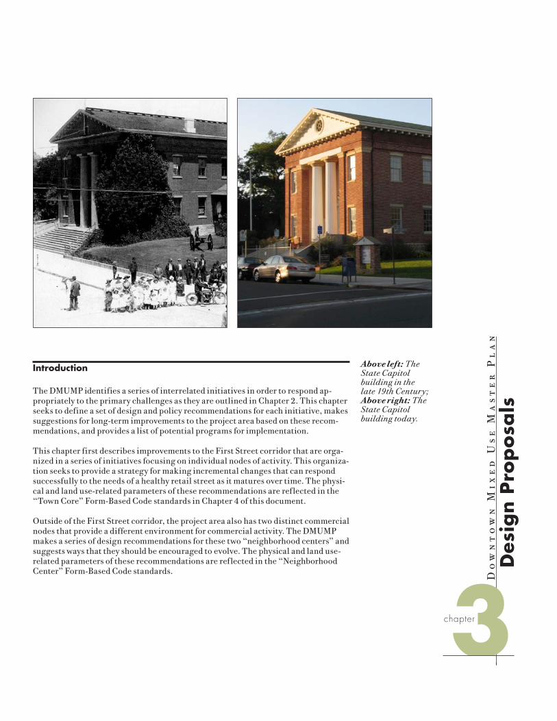
The DMUMP identifies a series of interrelated initiatives in order to respond ap-propriately to the primary challenges as they are outlined in Chapter 2. This chapter seeks to define a set of design and policy recommendations for each initiative, makes suggestions for long-term improvements to the project area based on these recom-mendations, and provides a list of potential programs for implementation.
This chapter first describes improvements to the First Street corridor that are orga-nized in a series of initiatives focusing on individual nodes of activity. This organiza-tion seeks to provide a strategy for making incremental changes that can respond successfully to the needs of a healthy retail street as it matures over time. The physi-cal and land use-related parameters of these recommendations are reflected in the “Town Core” Form-Based Code standards in Chapter 4 of this document.
Outside of the First Street corridor, the project area also has two distinct commercial nodes that provide a different environment for commercial activity. The DMUMP makes a series of design recommendations for these two “neighborhood centers” and suggests ways that they should be encouraged to evolve. The physical and land use-related parameters of these recommendations are reflected in the “Neighborhood Center” Form-Based Code standards.
Above left: The State Capitol building in the late 19th Century; Above right: The State Capitol building today.
3D
esig
n P
rop
osa
ls
chapter
3-2 Downtown Mixed Use Master PlanOpticos Design, Inc.
Chapter 3: Design Proposals
This chapter also provides design recommendations for the project area’s historic neighborhoods, including appropriate techniques for the integration of mixed-use development in residential areas, and recommendations for making compatible tran-sitions between retail-oriented mixed-use areas and neighborhoods that are largely residential in character. The physical and land use-related parameters of these recommendations are reflected in the remaining Form-Based Code zones - “Town Core-Open,” “Neighborhood General-Open,” and “Neighborhood General” – and their corresponding standards.
This chapter also makes recommendations for implementation strategies and pro-grams that are not directly related to the Form-Based Code and yet may be beneficial for the City to pursue in order to support continued improvement and reinvestment in the downtown area.
First Street Recommendations
First Street currently has a supply of commercial space that exceeds the needs of re-tailers. Existing land use policy that encourages commercial uses in areas off of First Street tends to dilute the already extensive supply of downtown commercial space, which contributes to the difficulty in creating a consistent pedestrian-oriented retail environment along First Street . The DMUMP envisions that retail and related mixed uses can be concentrated along First Street and in existing retail nodes, and discourages intense mixed-use development on side-street areas that have not seen considerable commercial development.
By encouraging intensified ground-floor retail, the City should support the develop-ment of second and third-story office and residential uses along First Street, creating additional opportunities for office uses to transition from ground-floor spaces. The City should focus on policies and programs that intensify commercial uses at one or more “nodes” along First Street in an incremental fashion as retail demands and needs increase over time.
As new buildings along First Street are developed, the City should also ensure that ground floor retail spaces are available and suitable for retail tenants. There are currently a number of buildings along First Street with ground-floor space that is only appropriate for office tenants. The Master Plan recommends that these build-ing types should be discouraged in the future, in order to offer increased visibility and access from First Street foot-traffic, and to allow a greater flexibility of uses that respond to changing market conditions over time.

3-3Downtown Mixed Use Master PlanOpticos Design, Inc.
Chapter 3: Design Proposals
BENICIA CITY LIMITS
BENIC
IA C
ITY LIMITS
BEN
ICIA
CIT
Y L
IMIT
S
BEN
ICIA
CIT
Y L
IMIT
S
BENICIA CITY
LIMITS
BENICIA CITY LIMITS
STRAIT
CARQUINEZ
MARINABENICIA
780
BAYSOUTHAMPTON
GOLDENSLOPES
ST.CATHERINE'S
ST
E. 2
ND
ST
'P' ST
E.
5TH
S
T
HILLCREST AVE
'W' ST
LINDA VISTA
'E' ST
'K' ST
STJACKSON
GRANT
ADAMS ST
POLK
ST
RD
1ST
S
T
'C' ST
'D' ST
E. 2
ND
S
T
PT BENICIA
'B' ST
'E' ST
E.
5TH
ST
E.
6TH
ST
'J' ST
'I' ST
'H' ST
E.
7TH
ST
'G' ST
JEFF
ERSON
GRA NT
ST
ST JEFFERSON ST
TYLER ST
LIN
C
OLN
BAYSHORE
RD
WASHIN
GTO N ST
BAYS
HORE
RD
CT
SEM
PLE
EASTST
W.
4TH
ST
MILITARY MILITARY
EAST
BUCHANAN
OAK
ST
LINDO
VECINO CA
SA G
RAN
DA
ST
VIEWMONT ST
VIE
WM
ON
T ST TIER
RA
LIN
DO
ST
AVE
'S' ST
ST
CT
RIN
CO
NA
DA
PAC
IFIC
A
CT
FRAN
CISC
A
VARN
I
AUGUSTINE
1ST
ST
TAMARA
CT
RD
VIA
ALT
A
VIA
MED
IA GRANDE
LA PRENDA
VIEW M ON T
CT ST.F
RAN
CIS
CT
ST.AU GU STINE
CT
E.
2N
D
ST
INCLI NE
'O' ST
VISTA CT
RIVER
HILL
DR
CI
R
O' H
ARA
D
R
'N' ST
DR
MARINA PL
'K' ST
'F' ST
'G' ST
1ST
S
T
'I' ST
'H' ST
W.
2N
D
ST
W.
2N
D
ST
W.
3R
D
ST
W.
3RD
S
T
'J' ST
WEST MILITARY
E.
3RD
ST
WY
'L' ST
'N' ST
E.
4TH
ST
'N' ST
'O' ST
RD
VILLAGE LN
PARK
R
D
BAYSHORE
RD
FIR RDCAMEL
ST
BUEN
A
CASA
PL
'M'
'T' ST
'S'
DR
SHANN
ON
CT
DE
BEN
EDET
TI
CT
WY
SHER
MAN
CT
ALM
A
SOL
DEL
CO
RTE
CO
RTE
E. 3
RD S
T
DRDR
SUNRISE
DALE
GO
LDEN
HIL
L
OLIVE BRANCH
RANKIN WY
SUIS
UN
OLD
HILLCREST AVE
SEAVIEW
CANYON
DR
ARBOR
HA
VEN
HIL
L
ARDMORECT
PARK
RD
E.2N
D ST
CLE
ARV
IEW
CIR
WA
RW
ICK
DR
TEN NY
DR
SEAVIEW DR
1ST
ST
BRA
N
DON
RD
LA
C R U Z
AV
E
DO
R A DO
EL
BONIT
O
W Y
DELCEN
TRO
RIVERVIEW TER
BA YVI E
KIM
CT
SHIR
LEY
DR
BRIDG
EV IEW
CT
DR
EDNA
CT
VALERIE
CT ELL
IEC
T
SUSA
NCT
LORI
RAYMOND
VISTA CT
SOUTHERN PACIFIC RAILROAD
W
WY
CT
CT CT
CT
CT
PL
AVE
VISTA GRANDE
CT CT
ST
CT
DRHARBOR
ST
PL
MOUNT VIEW
TER
HO
SPIT
AL
E.
5TH
ST
E.
3RD
ST
BENICIA - MARTINEZ BRIDGE FREEWAY
BRIDGE
VIEW
PARKCEMETERY
OVERLOOK
PARK
CITY
PARKCITY HALL
POST
OFFICE
PARK
CIVIC
CENTER
YAC POOL
ROBE
RT
SEM
PLE
ELEM
ENTA
RY
SCH
OO
L
PARK
FITZGERALD
FIELD
MARIA FIELD
RIBERO FIELD
ELEMENTARY
SCHOOL
PRIORY
SCHOOL
SOLANO SQUARE
WASTE WATER
TREATMENT
PLANT
BENICIA
PARK
TURNBULL
CITY
CORP
YARD
ST. DOMINIC'S
CEMETERY
ARMORY
FRANCESCA
TERRACE
PARK
MILITARY
CEMETERY
COMMANDANT'S
HOUSE AND
CLOCKTOWER
MUSEUM
PORT
OF
BEN
ICIA
WHA
RF
LIBRARY
MARINA CONDOMIUMS
RESERVOIR
E. CHFirst St.
Key
Buildings of Historical Significance
Plan Initiative Areas
Proposed Buildings
Public Open Spaces
Proposed Improvement Areas
Existing Building Fabric
Five Minute walking radius
Plan Area
Illustrative Framework Plan
Left: The Downtown Mixed Use Master Plan identifies improvements along First Street that are organized in a series of nodes that include new projects in the pipeline, suggested new building initia-tives, and coordinated renovations of existing structures, as well as new and improved open spaces. These recom-mendations seek to respond to the project area’s historic fabric (in blue) as well as capitalize on existing amenities, includ-ing public buildings and institutions (such as the former Capitol) and access and views of the Carquinez Strait.

3-4 Downtown Mixed Use Master PlanOpticos Design, Inc.
South of D and West of First
The area below D Street has seen significant commercial development in recent years with the construction of the “Harbor Walk” Project at First and B Streets. Several new projects along First Street continuing west to the water are currently in various stages of planning, approval, and construction, including a similar develop-ment at 221 First Street, newly renovated structures at 307 and 309 First Street, and a proposed Bed & Breakfast at 134 West D Street.
Many of the surrounding properties on D Street have transitioned to commercial uses. With the energy of existing projects, and new projects in the pipeline, this area represents the greatest opportunity for the City to take advantage of “critical mass,” encouraging the development of a series of high-quality, mixed-use buildings that may provide new opportunities for retail spaces that are appealing to a broad base of prospective tenants. The area is also likely to be in close proximity to a ferry termi-nal that would be located along the Carquinez Strait.
As the shipyard at the end of C Street is cleaned up and removed, and the Bay Trail is extended along the western shore, a great opportunity exists to provide a series of high-quality, interconnected open spaces along the way. The City should work to encourage this network, particularly between the redevelopment opportunity at the west end of C Street and continuing south to Captain Blyther’s Restaurant at 123 First Street.
Over time, the City should also consider encouraging the redevelopment of the existing garden nursery at the northeast corner of First and D Streets with a two to three-story mixed-use building.
The plan recommends that the City focus on the area south of D Street and west of First Street in the short-term in order to maximize the concentration of high-qual-ity retail in the downtown area that is accessible and pedestrian-oriented. As First Street matures, the City should work to encourage new and revitalized development in a series of nodes along First Street, ensuring a comfortable and continuous experi-ence for pedestrians.
First Street Between E and F Streets
The existing office/retail development along the east side of First Street between E and F Streets presents an opportunity for the encouragement of a future node. Although the building is rather new and fairly well-designed, it is currently occu-pied largely by office tenants and its few retail and restaurant establishments are not able to take full advantage of the rear courtyard. The City should explore the possibility of encouraging the renovation of this complex in the mid to long-term to create an appealing outdoor courtyard space that would be suitable for several eat-ing establishments to occupy. This could be accomplished simply by a renovation of the sunken courtyard area to make it more useable and accessible, combined with a restructuring of the two-story gallery space along the western end of the courtyard.
BENICIA CITY LIMITS
BENIC
IA C
ITY LIMITS
BEN
ICIA
CIT
Y L
IMIT
S
BEN
ICIA
CIT
Y L
IMIT
S
BENICIA CITY
LIMITS
BENICIA CITY LIMITS
STRAIT
CARQUINEZ
MARINABENICIA
780
BAYSOUTHAMPTON
GOLDENSLOPES
ST.CATHERINE'S
ST
E. 2
ND
ST
'P' ST
E.
5TH
S
T
HILLCREST AVE
'W' ST
LINDA VISTA
'E' ST
'K' ST
STJACKSON
GRANT
ADAMS ST
POLK
ST
RD
1ST
S
T'C' ST
'D' ST
E. 2
ND
S
T
PT BENICIA
'B' ST
'E' ST
E.
5TH
ST
E.
6TH
ST
'J' ST
'I' ST
'H' ST
E.
7TH
ST
'G' ST
JEFF
ERSON
GRA NT
ST
ST JEFFERSON ST
TYLER ST
LIN
C
OLN
BAYSHORE
RD
WASHIN
GTO N ST
BAYS
HORE
RD
CT
SEM
PLE
EASTST
W.
4TH
ST
MILITARY MILITARY
EAST
BUCHANAN
OAK
ST
LINDO
VECINO CA
SA G
RAN
DA
ST
VIEWMONT ST
VIE
WM
ON
T ST TIER
RA
LIN
DO
ST
AVE
'S' ST
ST
CT
RIN
CO
NA
DA
PAC
IFIC
A
CT
FRAN
CISC
A
VARN
I
AUGUSTINE
1ST
ST
TAMARA
CT
RD
VIA
ALT
A
VIA
MED
IA GRANDE
LA PRENDA
VIEW M ON T
CT ST.F
RAN
CIS
CT
ST.AU GU STINE
CT
E.
2N
D
ST
INCLI NE
'O' ST
VISTA CT
RIVER
HILL
DR
CI
R
O' H
ARA
D
R
'N' ST
DR
MARINA PL
'K' ST
'F' ST
'G' ST
1ST
S
T
'I' ST
'H' ST
W.
2N
D
ST
W.
2N
D
ST
W.
3R
D
ST
W.
3RD
S
T
'J' ST
WEST MILITARY
E.
3RD
ST
WY
'L' ST
'N' ST
E.
4TH
ST
'N' ST
'O' ST
RD
VILLAGE LN
PARK
R
D
BAYSHORE
RD
FIR RDCAMEL
ST
BUEN
A
CASA
PL
'M'
'T' ST
'S'
DR
SHANN
ON
CT
DE
BEN
EDET
TI
CT
WY
SHER
MAN
CT
ALM
A
SOL
DEL
CO
RTE
CO
RTE
E. 3
RD S
T
DRDR
SUNRISE
DALE
GO
LDEN
HIL
L
OLIVE BRANCH
RANKIN WY
SUIS
UN
OLD
HILLCREST AVE
SEAVIEW
CANYON
DR
ARBOR
HA
VEN
HIL
L
ARDMORECT
PARK
RD
E.2N
D ST
CLE
ARV
IEW
CIR
WA
RW
ICK
DR
TEN NY
DR
SEAVIEW DR
1ST
ST
BRA
N
DON
RD
LA
C R U Z
AV
E
DO
R A DO
EL
BONIT
O
W Y
DELCEN
TRO
RIVERVIEW TER
BA YVI E
KIM
CT
SHIR
LEY
DR
BRIDG
EV IEW
CT
DR
EDNA
CT
VALERIE
CT ELL
IEC
T
SUSA
NCT
LORI
RAYMOND
VISTA CT
SOUTHERN PACIFIC RAILROAD
W
WY
CT
CT CT
CT
CT
PL
AVE
VISTA GRANDE
CT CT
ST
CT
DRHARBOR
ST
PL
MOUNT VIEW
TER
HO
SPIT
AL
E.
5TH
ST
E.
3RD
ST
BENICIA - MARTINEZ BRIDGE FREEWAY
BRIDGE
VIEW
PARKCEMETERY
OVERLOOK
PARK
CITY
PARKCITY HALL
POST
OFFICE
PARK
CIVIC
CENTER
YAC POOL
ROBE
RT
SEM
PLE
ELEM
ENTA
RY
SCH
OO
L
PARK
FITZGERALD
FIELD
MARIA FIELD
RIBERO FIELD
ELEMENTARY
SCHOOL
PRIORY
SCHOOL
SOLANO SQUARE
WASTE WATER
TREATMENT
PLANT
BENICIA
PARK
TURNBULL
CITY
CORP
YARD
ST. DOMINIC'S
CEMETERY
ARMORY
FRANCESCA
TERRACE
PARK
MILITARY
CEMETERY
COMMANDANT'S
HOUSE AND
CLOCKTOWER
MUSEUM
PORT
OF
BEN
ICIA
WHA
RF
LIBRARY
MARINA CONDOMIUMS
RESERVOIR
E. CHFirst St.
Top: The shoreline west of First Street provides a key opportunity for new mixed-use development that can capital-ize on the existing natural setting, seen here from the end of C Street; Center: The nursery at the corner of First and D Streets; Bottom: Key plan of the area south of D and west of First.
Chapter 3: Design Proposals

3-5Downtown Mixed Use Master PlanOpticos Design, Inc.
Chapter 3: Design Proposals
State Capitol & Majestic Theater at H Street
The intersection of First and G Streets, including the historic State Capitol Building complex and the nearby Majestic Theater at 710 First Street, was mentioned by many community members as the “heart” of the downtown area, and should be considered for the development of another node. The Majestic, which currently provides an entertainment venue for the community, should be renovated to create a high-qual-ity pedestrian environment along First Street in front of the theater. The City should work with the existing property owner to explore the possibility of such a renovation.
Historic photos of the theater suggest that the ground floor was originally much more open, with a recessed outdoor forecourt and glazed ticket booth. The plan envisions that the ground floor of the theater may be restored with the removal of the wood cladding, the restoration or re-instillation of a glazed ticket booth, and the introduction of decorative paving materials in the forecourt and along the sidewalk in front of the theater.
BENICIA CITY LIMITS
BENIC
IA C
ITY LIMITS
BEN
ICIA
CIT
Y L
IMIT
S
BEN
ICIA
CIT
Y L
IMIT
S
BENICIA CITY
LIMITS
BENICIA CITY LIMITS
STRAIT
CARQUINEZ
MARINABENICIA
780
BAYSOUTHAMPTON
GOLDENSLOPES
ST.CATHERINE'S
ST
E. 2
ND
ST
'P' ST
E.
5TH
S
T
HILLCREST AVE
'W' ST
LINDA VISTA
'E' ST
'K' ST
STJACKSON
GRANT
ADAMS ST
POLK
ST
RD
1ST
S
T
'C' ST
'D' ST
E. 2
ND
S
T
PT BENICIA
'B' ST
'E' ST
E.
5TH
ST
E.
6TH
ST
'J' ST
'I' ST
'H' ST
E.
7TH
ST
'G' ST
JEFF
ERSON
GRA NT
ST
ST JEFFERSON ST
TYLER ST
LIN
C
OLN
BAYSHORE
RD
WASHIN
GTO N ST
BAYS
HORE
RD
CT
SEM
PLE
EASTST
W.
4TH
STMILITARY MILITARY
EAST
BUCHANAN
OAK
ST
LINDO
VECINO CA
SA G
RAN
DA
ST
VIEWMONT ST
VIE
WM
ON
T ST TIER
RA
LIN
DO
ST
AVE
'S' ST
ST
CT
RIN
CO
NA
DA
PAC
IFIC
A
CT
FRAN
CISC
A
VARN
I
AUGUSTINE
1ST
ST
TAMARA
CT
RD
VIA
ALT
A
VIA
MED
IA GRANDE
LA PRENDA
VIEW M ON T
CT ST.F
RAN
CIS
CT
ST.AU GU STINE
CT
E.
2N
D
ST
INCLI NE
'O' ST
VISTA CT
RIVER
HILL
DR
CI
R
O' H
ARA
D
R
'N' ST
DR
MARINA PL
'K' ST
'F' ST
'G' ST
1ST
S
T
'I' ST
'H' ST
W.
2N
D
ST
W.
2N
D
ST
W.
3R
D
ST
W.
3RD
S
T
'J' ST
WEST MILITARY
E.
3RD
ST
WY
'L' ST
'N' ST
E.
4TH
ST
'N' ST
'O' ST
RD
VILLAGE LN
PARK
R
D
BAYSHORE
RD
FIR RDCAMEL
ST
BUEN
A
CASA
PL
'M'
'T' ST
'S'
DR
SHANN
ON
CT
DE
BEN
EDET
TI
CT
WY
SHER
MAN
CT
ALM
A
SOL
DEL
CO
RTE
CO
RTE
E. 3
RD S
T
DRDR
SUNRISE
DALE
GO
LDEN
HIL
L
OLIVE BRANCH
RANKIN WY
SUIS
UN
OLD
HILLCREST AVE
SEAVIEW
CANYON
DR
ARBOR
HA
VEN
HIL
L
ARDMORECT
PARK
RD
E.2N
D ST
CLE
ARV
IEW
CIR
WA
RW
ICK
DR
TEN NY
DR
SEAVIEW DR
1ST
ST
BRA
N
DON
RD
LA
C R U Z
AV
E
DO
R A DO
EL
BONIT
O
W Y
DELCEN
TRO
RIVERVIEW TER
BA YVI E
KIM
CT
SHIR
LEY
DR
BRIDG
EV IEW
CT
DR
EDNA
CT
VALERIE
CT ELL
IEC
T
SUSA
NCT
LORI
RAYMOND
VISTA CT
SOUTHERN PACIFIC RAILROAD
W
WY
CT
CT CT
CT
CT
PL
AVE
VISTA GRANDE
CT CT
ST
CT
DRHARBOR
ST
PL
MOUNT VIEW
TER
HO
SPIT
AL
E.
5TH
ST
E.
3RD
ST
BENICIA - MARTINEZ BRIDGE FREEWAY
BRIDGE
VIEW
PARKCEMETERY
OVERLOOK
PARK
CITY
PARKCITY HALL
POST
OFFICE
PARK
CIVIC
CENTER
YAC POOL
ROBE
RT
SEM
PLE
ELEM
ENTA
RY
SCH
OO
L
PARK
FITZGERALD
FIELD
MARIA FIELD
RIBERO FIELD
ELEMENTARY
SCHOOL
PRIORY
SCHOOL
SOLANO SQUARE
WASTE WATER
TREATMENT
PLANT
BENICIA
PARK
TURNBULL
CITY
CORP
YARD
ST. DOMINIC'S
CEMETERY
ARMORY
FRANCESCA
TERRACE
PARK
MILITARY
CEMETERY
COMMANDANT'S
HOUSE AND
CLOCKTOWER
MUSEUM
PORT
OF
BEN
ICIA
WHA
RF
LIBRARY
MARINA CONDOMIUMS
RESERVOIR
E. CHFirst St.
Above Left: View of the Majestic The-ater; Above Right: Illustrative vision of the theater’s renovated façade; Bottom: Key plan of the area along First between G and H Streets.
1ST
ST
3-6 Downtown Mixed Use Master PlanOpticos Design, Inc.
Chapter 3: Design Proposals
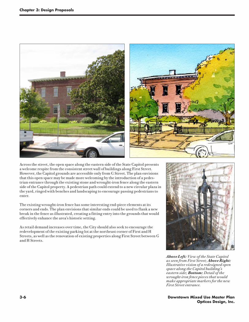
Across the street, the open space along the eastern side of the State Capitol presents a welcome respite from the consistent street wall of buildings along First Street. However, the Capitol grounds are accessible only from G Street. The plan envisions that this open space may be made more welcoming by the introduction of a pedes-trian entrance through the existing stone and wrought-iron fence along the eastern side of the Capitol property. A pedestrian path could extend to a new circular plaza in the yard, ringed with benches and landscaping to encourage passing pedestrians to enter.
The existing wrought-iron fence has some interesting end-piece elements at its corners and ends. The plan envisions that similar ends could be used to flank a new break in the fence as illustrated, creating a fitting entry into the grounds that would effectively enhance the area’s historic setting.
As retail demand increases over time, the City should also seek to encourage the redevelopment of the existing parking lot at the northeast corner of First and H Streets, as well as the renovation of existing properties along First Street between G and H Streets.
Above Left: View of the State Capitol as seen from First Street; Above Right: Illustrative vision of a redesigned open space along the Capitol building’s eastern side; Bottom: Detail of the wrought-iron fence pieces that would make appropriate markers for the new First Street entrance.
3-7Downtown Mixed Use Master PlanOpticos Design, Inc.
Chapter 3: Design Proposals
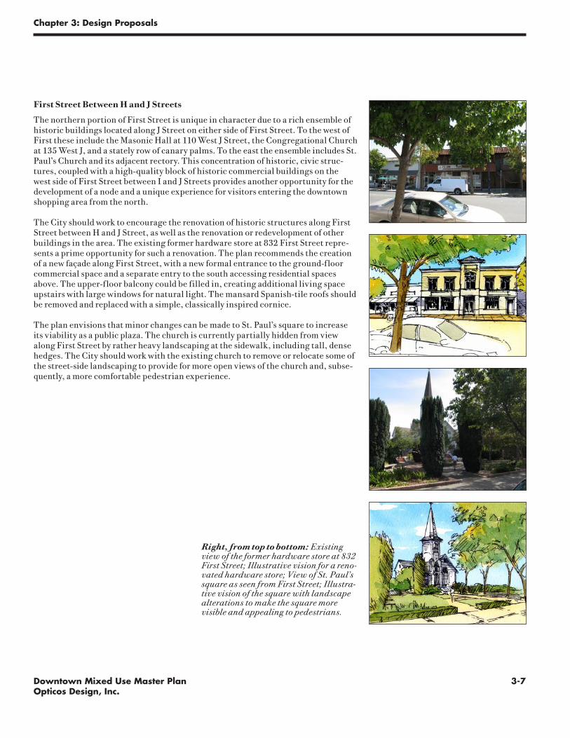
First Street Between H and J Streets
The northern portion of First Street is unique in character due to a rich ensemble of historic buildings located along J Street on either side of First Street. To the west of First these include the Masonic Hall at 110 West J Street, the Congregational Church at 135 West J, and a stately row of canary palms. To the east the ensemble includes St. Paul’s Church and its adjacent rectory. This concentration of historic, civic struc-tures, coupled with a high-quality block of historic commercial buildings on the west side of First Street between I and J Streets provides another opportunity for the development of a node and a unique experience for visitors entering the downtown shopping area from the north.
The City should work to encourage the renovation of historic structures along First Street between H and J Street, as well as the renovation or redevelopment of other buildings in the area. The existing former hardware store at 832 First Street repre-sents a prime opportunity for such a renovation. The plan recommends the creation of a new façade along First Street, with a new formal entrance to the ground-floor commercial space and a separate entry to the south accessing residential spaces above. The upper-floor balcony could be filled in, creating additional living space upstairs with large windows for natural light. The mansard Spanish-tile roofs should be removed and replaced with a simple, classically inspired cornice.
The plan envisions that minor changes can be made to St. Paul’s square to increase its viability as a public plaza. The church is currently partially hidden from view along First Street by rather heavy landscaping at the sidewalk, including tall, dense hedges. The City should work with the existing church to remove or relocate some of the street-side landscaping to provide for more open views of the church and, subse-quently, a more comfortable pedestrian experience.
Right, from top to bottom: Existing view of the former hardware store at 832 First Street; Illustrative vision for a reno-vated hardware store; View of St. Paul’s square as seen from First Street; Illustra-tive vision of the square with landscape alterations to make the square more visible and appealing to pedestrians.

3-8 Downtown Mixed Use Master PlanOpticos Design, Inc.
Chapter 3: Design Proposals
BENICIA CITY LIMITS
BENIC
IA C
ITY LIMITS
BEN
ICIA
CIT
Y L
IMIT
S
BEN
ICIA
CIT
Y L
IMIT
S
BENICIA CITY
LIMITS
BENICIA CITY LIMITS
STRAIT
CARQUINEZ
MARINABENICIA
780
BAYSOUTHAMPTON
GOLDENSLOPES
ST.CATHERINE'S
ST
E. 2
ND
ST
'P' ST
E.
5TH
S
T
HILLCREST AVE
'W' ST
LINDA VISTA
'E' ST
'K' ST
STJACKSON
GRANT
ADAMS ST
POLK
ST
RD
1ST
S
T
'C' ST
'D' ST
E. 2
ND
S
T
PT BENICIA
'B' ST
'E' ST
E.
5TH
ST
E.
6TH
ST
'J' ST
'I' ST
'H' ST
E.
7TH
ST
'G' ST
JEFF
ERSON
GRA NT
ST
ST JEFFERSON ST
TYLER ST
LIN
C
OLN
BAYSHORE
RD
WASHIN
GTO N ST
BAYS
HORE
RD
CT
SEM
PLE
EASTST
W.
4TH
ST
MILITARY MILITARY
EAST
BUCHANAN
OAK
ST
LINDO
VECINO CA
SA G
RAN
DA
ST
VIEWMONT ST
VIE
WM
ON
T ST TIER
RA
LIN
DO
ST
AVE
'S' ST
ST
CT
RIN
CO
NA
DA
PAC
IFIC
A
CT
FRAN
CISC
A
VARN
I
AUGUSTINE
1ST
ST
TAMARA
CT
RD
VIA
ALT
A
VIA
MED
IA GRANDE
LA PRENDA
VIEW M ON T
CT ST.F
RAN
CIS
CT
ST.AU GU STINE
CT
E.
2N
D
ST
INCLI NE
'O' ST
VISTA CT
RIVER
HILL
DR
CI
R
O' H
ARA
D
R
'N' ST
DR
MARINA PL
'K' ST
'F' ST
'G' ST
1ST
S
T
'I' ST
'H' ST
W.
2N
D
ST
W.
2N
D
ST
W.
3R
D
ST
W.
3RD
S
T
'J' ST
WEST MILITARY
E.
3RD
ST
WY
'L' ST
'N' ST
E.
4TH
ST
'N' ST
'O' ST
RD
VILLAGE LN
PARK
R
D
BAYSHORE
RD
FIR RDCAMEL
ST
BUEN
A
CASA
PL
'M'
'T' ST
'S'
DR
SHANN
ON
CT
DE
BEN
EDET
TI
CT
WY
SHER
MAN
CT
ALM
A
SOL
DEL
CO
RTE
CO
RTE
E. 3
RD S
T
DRDR
SUNRISE
DALE
GO
LDEN
HIL
L
OLIVE BRANCH
RANKIN WY
SUIS
UN
OLD
HILLCREST AVE
SEAVIEW
CANYON
DR
ARBOR
HA
VEN
HIL
L
ARDMORECT
PARK
RD
E.2N
D ST
CLE
ARV
IEW
CIR
WA
RW
ICK
DR
TEN NY
DR
SEAVIEW DR
1ST
ST
BRA
N
DON
RD
LA
C R U Z
AV
E
DO
R A DO
EL
BONIT
O
W Y
DELCEN
TRO
RIVERVIEW TER
BA YVI E
KIM
CT
SHIR
LEY
DR
BRIDG
EV IEW
CT
DR
EDNA
CT
VALERIE
CT ELL
IEC
T
SUSA
NCT
LORI
RAYMOND
VISTA CT
SOUTHERN PACIFIC RAILROAD
W
WY
CT
CT CT
CT
CT
PL
AVE
VISTA GRANDE
CT CT
ST
CT
DRHARBOR
ST
PL
MOUNT VIEW
TER
HO
SPIT
AL
E.
5TH
ST
E.
3RD
ST
BENICIA - MARTINEZ BRIDGE FREEWAY
BRIDGE
VIEW
PARKCEMETERY
OVERLOOK
PARK
CITY
PARKCITY HALL
POST
OFFICE
PARK
CIVIC
CENTER
YAC POOL
ROBE
RT
SEM
PLE
ELEM
ENTA
RY
SCH
OO
L
PARK
FITZGERALD
FIELD
MARIA FIELD
RIBERO FIELD
ELEMENTARY
SCHOOL
PRIORY
SCHOOL
SOLANO SQUARE
WASTE WATER
TREATMENT
PLANT
BENICIA
PARK
TURNBULL
CITY
CORP
YARD
ST. DOMINIC'S
CEMETERY
ARMORY
FRANCESCA
TERRACE
PARK
MILITARY
CEMETERY
COMMANDANT'S
HOUSE AND
CLOCKTOWER
MUSEUM
PORT
OF
BEN
ICIA
WHA
RF
LIBRARY
MARINA CONDOMIUMS
RESERVOIR
E. CHFirst St.
Above Left: View of the current parking lot on First south of West J Street; Above Right: Illustrative vision of a redesigned open space space in this location, with new liner buildings fronting a plaza; Bottom: Key plan of the area along First Street between H and J Streets.
Immediately to the west, the square in front of St. Paul’s church and the parking lot immediately to the west provide another opportunity for a coupling of two, high-quality open spaces, similar to the Majestic Theater – Capitol Grounds node described above. The parking lot provides a unique view of the formal rear elevation of the Masonic Hall, the monumental wall of the E.D.E.S Hall, and is flanked by two grandly-scaled masonry commercial block buildings. The City should explore the possibility of creating an outdoor plaza, relocating the onsite parking elsewhere, and promoting small commercial additions to the sides of the buildings along the alley. The space would be well-animated by adjacent commercial uses such as restaurants or cafés, and would provide distinct views of the area’s historic buildings. The plaza should be defined by a low, masonry wall along First Street, and may be designed to accommodate outdoor seating for adjacent commercial businesses as illustrated.
3-9Downtown Mixed Use Master PlanOpticos Design, Inc.
Chapter 3: Design Proposals
BENICIA CITY LIMITS
BENIC
IA C
ITY LIMITS
BEN
ICIA
CIT
Y L
IMIT
S
BEN
ICIA
CIT
Y L
IMIT
S
BENICIA CITY
LIMITS
BENICIA CITY LIMITS
STRAIT
CARQUINEZ
MARINABENICIA
780
BAYSOUTHAMPTON
GOLDENSLOPES
ST.CATHERINE'S
ST
E. 2
ND
ST
'P' ST
E.
5TH
S
T
HILLCREST AVE
'W' ST
LINDA VISTA
'E' ST
'K' ST
STJACKSON
GRANT
ADAMS ST
POLK
ST
RD
1ST
S
T
'C' ST
'D' ST
E. 2
ND
S
T
PT BENICIA
'B' ST
'E' ST
E.
5TH
ST
E.
6TH
ST
'J' ST
'I' ST
'H' ST
E.
7TH
ST
'G' ST
JEFF
ERSON
GRA NT
ST
ST JEFFERSON ST
TYLER ST
LIN
C
OLN
BAYSHORE
RD
WASHIN
GTO N ST
BAYS
HORE
RD
CT
SEM
PLE
EASTST
W.
4TH
ST
MILITARY MILITARY
EAST
BUCHANAN
OAK
ST
LINDO
VECINO CA
SA G
RAN
DA
ST
VIEWMONT ST
VIE
WM
ON
T ST TIER
RA
LIN
DO
ST
AVE
'S' ST
ST
CT
RIN
CO
NA
DA
PAC
IFIC
A
CT
FRAN
CISC
A
VARN
I
AUGUSTINE
1ST
ST
TAMARA
CT
RD
VIA
ALT
A
VIA
MED
IA GRANDE
LA PRENDA
VIEW M ON T
CT ST.F
RAN
CIS
CT
ST.AU GU STINE
CT
E.
2N
D
ST
INCLI NE
'O' ST
VISTA CT
RIVER
HILL
DR
CI
RO
' HARA
D
R
'N' ST
DR
MARINA PL
'K' ST
'F' ST
'G' ST
1ST
S
T
'I' ST
'H' ST
W.
2N
D
ST
W.
2N
D
ST
W.
3R
D
ST
W.
3RD
S
T
'J' ST
WEST MILITARY
E.
3RD
ST
WY
'L' ST
'N' ST
E.
4TH
ST
'N' ST
'O' ST
RD
VILLAGE LN
PARK
R
D
BAYSHORE
RD
FIR RDCAMEL
ST
BUEN
A
CASA
PL
'M'
'T' ST
'S'
DR
SHANN
ON
CT
DE
BEN
EDET
TI
CT
WY
SHER
MAN
CT
ALM
A
SOL
DEL
CO
RTE
CO
RTE
E. 3
RD S
T
DRDR
SUNRISE
DALE
GO
LDEN
HIL
L
OLIVE BRANCH
RANKIN WY
SUIS
UN
OLD
HILLCREST AVE
SEAVIEW
CANYON
DR
ARBOR
HA
VEN
HIL
L
ARDMORECT
PARK
RD
E.2N
D ST
CLE
ARV
IEW
CIR
WA
RW
ICK
DR
TEN NY
DR
SEAVIEW DR
1ST
ST
BRA
N
DON
RD
LA
C R U Z
AV
E
DO
R A DO
EL
BONIT
O
W Y
DELCEN
TRO
RIVERVIEW TER
BA YVI E
KIM
CT
SHIR
LEY
DR
BRIDG
EV IEW
CT
DR
EDNA
CT
VALERIE
CT ELL
IEC
T
SUSA
NCT
LORI
RAYMOND
VISTA CT
SOUTHERN PACIFIC RAILROAD
W
WY
CT
CT CT
CT
CT
PL
AVE
VISTA GRANDE
CT CT
ST
CT
DRHARBOR
ST
PL
MOUNT VIEW
TER
HO
SPIT
AL
E.
5TH
ST
E.
3RD
ST
BENICIA - MARTINEZ BRIDGE FREEWAY
BRIDGE
VIEW
PARKCEMETERY
OVERLOOK
PARK
CITY
PARKCITY HALL
POST
OFFICE
PARK
CIVIC
CENTER
YAC POOL
ROBE
RT
SEM
PLE
ELEM
ENTA
RY
SCH
OO
L
PARK
FITZGERALD
FIELD
MARIA FIELD
RIBERO FIELD
ELEMENTARY
SCHOOL
PRIORY
SCHOOL
SOLANO SQUARE
WASTE WATER
TREATMENT
PLANT
BENICIA
PARK
TURNBULL
CITY
CORP
YARD
ST. DOMINIC'S
CEMETERY
ARMORY
FRANCESCA
TERRACE
PARK
MILITARY
CEMETERY
COMMANDANT'S
HOUSE AND
CLOCKTOWER
MUSEUM
PORT
OF
BEN
ICIA
WHA
RF
LIBRARY
MARINA CONDOMIUMS
RESERVOIR
E. CHFirst St.
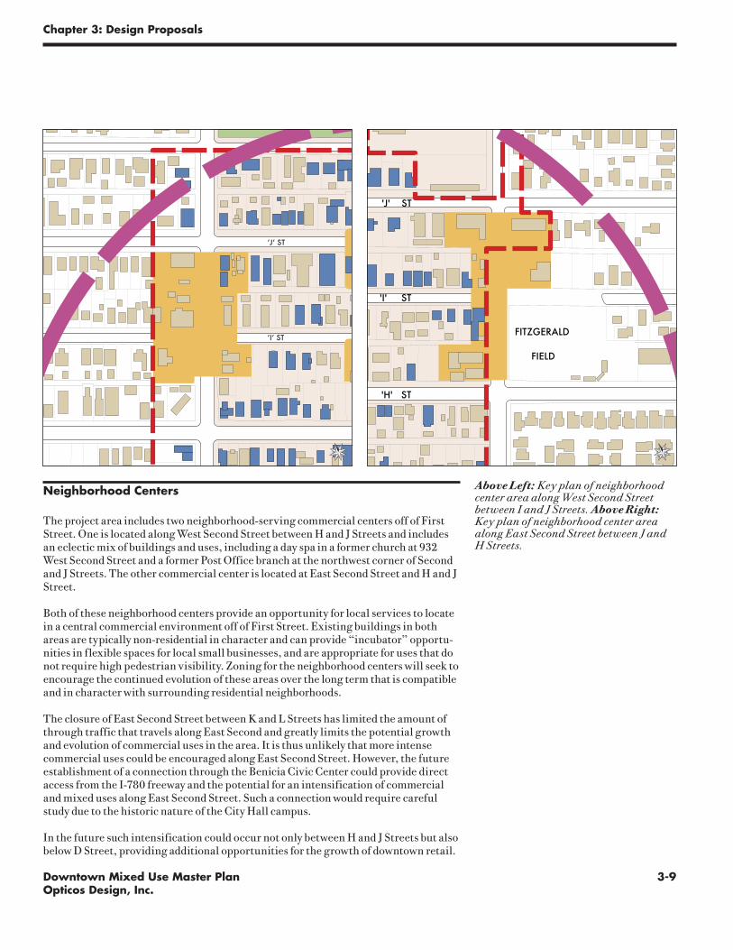
Above Left: Key plan of neighborhood center area along West Second Street between I and J Streets. Above Right: Key plan of neighborhood center area along East Second Street between J and H Streets.
‘J’ ST
‘I’ ST
Neighborhood Centers
The project area includes two neighborhood-serving commercial centers off of First Street. One is located along West Second Street between H and J Streets and includes an eclectic mix of buildings and uses, including a day spa in a former church at 932 West Second Street and a former Post Office branch at the northwest corner of Second and J Streets. The other commercial center is located at East Second Street and H and J Street.
Both of these neighborhood centers provide an opportunity for local services to locate in a central commercial environment off of First Street. Existing buildings in both areas are typically non-residential in character and can provide “incubator” opportu-nities in flexible spaces for local small businesses, and are appropriate for uses that do not require high pedestrian visibility. Zoning for the neighborhood centers will seek to encourage the continued evolution of these areas over the long term that is compatible and in character with surrounding residential neighborhoods.
The closure of East Second Street between K and L Streets has limited the amount of through traffic that travels along East Second and greatly limits the potential growth and evolution of commercial uses in the area. It is thus unlikely that more intense commercial uses could be encouraged along East Second Street. However, the future establishment of a connection through the Benicia Civic Center could provide direct access from the I-780 freeway and the potential for an intensification of commercial and mixed uses along East Second Street. Such a connection would require careful study due to the historic nature of the City Hall campus.
In the future such intensification could occur not only between H and J Streets but also below D Street, providing additional opportunities for the growth of downtown retail.
BENICIA CITY LIMITS
BENIC
IA C
ITY LIMITS
BEN
ICIA
CIT
Y L
IMIT
S
BEN
ICIA
CIT
Y L
IMIT
S
BENICIA CITY
LIMITS
BENICIA CITY LIMITS
STRAIT
CARQUINEZ
MARINABENICIA
780
BAYSOUTHAMPTON
GOLDENSLOPES
ST.CATHERINE'S
ST
E. 2
ND
ST
'P' ST
E.
5TH
S
T
HILLCREST AVE
'W' ST
LINDA VISTA
'E' ST
'K' ST
STJACKSON
GRANT
ADAMS ST
POLK
ST
RD
1ST
S
T
'C' ST
'D' ST
E. 2
ND
S
T
PT BENICIA
'B' ST
'E' ST
E.
5TH
ST
E.
6TH
ST
'J' ST
'I' ST
'H' ST
E.
7TH
ST
'G' ST
JEFF
ERSON
GRA NT
ST
ST JEFFERSON ST
TYLER ST
LIN
C
OLN
BAYSHORE
RD
WASHIN
GTO N ST
BAYS
HORE
RD
CT
SEM
PLE
EASTST
W.
4TH
ST
MILITARY MILITARY
EAST
BUCHANAN
OAK
ST
LINDO
VECINO CA
SA G
RAN
DA
ST
VIEWMONT ST
VIE
WM
ON
T ST TIER
RA
LIN
DO
ST
AVE
'S' ST
ST
CT
RIN
CO
NA
DA
PAC
IFIC
A
CT
FRAN
CISC
A
VARN
I
AUGUSTINE
1ST
ST
TAMARA
CT
RD
VIA
ALT
A
VIA
MED
IA GRANDE
LA PRENDA
VIEW M ON T
CT ST.F
RAN
CIS
CT
ST.AU GU STINE
CT
E.
2N
D
ST
INCLI NE
'O' ST
VISTA CT
RIVER
HILL
DR
CI
R
O' H
ARA
D
R
'N' ST
DR
MARINA PL
'K' ST
'F' ST
'G' ST
1ST
S
T'I' ST
'H' ST
W.
2N
D
ST
W.
2N
D
ST
W.
3R
D
ST
W.
3RD
S
T
'J' ST
WEST MILITARY
E.
3RD
ST
WY
'L' ST
'N' ST
E.
4TH
ST
'N' ST
'O' ST
RD
VILLAGE LN
PARK
R
D
BAYSHORE
RD
FIR RDCAMEL
ST
BUEN
A
CASA
PL
'M'
'T' ST
'S'
DR
SHANN
ON
CT
DE
BEN
EDET
TI
CT
WY
SHER
MAN
CT
ALM
A
SOL
DEL
CO
RTE
CO
RTE
E. 3
RD S
T
DRDR
SUNRISE
DALE
GO
LDEN
HIL
L
OLIVE BRANCH
RANKIN WY
SUIS
UN
OLD
HILLCREST AVE
SEAVIEW
CANYON
DR
ARBOR
HA
VEN
HIL
L
ARDMORECT
PARK
RD
E.2N
D ST
CLE
ARV
IEW
CIR
WA
RW
ICK
DR
TEN NY
DR
SEAVIEW DR
1ST
ST
BRA
N
DON
RD
LA
C R U Z
AV
E
DO
R A DO
EL
BONIT
O
W Y
DELCEN
TRO
RIVERVIEW TER
BA YVI E
KIM
CT
SHIR
LEY
DR
BRIDG
EV IEW
CT
DR
EDNA
CT
VALERIE
CT ELL
IEC
T
SUSA
NCT
LORI
RAYMOND
VISTA CT
SOUTHERN PACIFIC RAILROAD
W
WY
CT
CT CT
CT
CT
PL
AVE
VISTA GRANDE
CT CT
ST
CT
DRHARBOR
ST
PL
MOUNT VIEW
TER
HO
SPIT
AL
E.
5TH
ST
E.
3RD
ST
BENICIA - MARTINEZ BRIDGE FREEWAY
BRIDGE
VIEW
PARKCEMETERY
OVERLOOK
PARK
CITY
PARKCITY HALL
POST
OFFICE
PARK
CIVIC
CENTER
YAC POOL
ROBE
RT
SEM
PLE
ELEM
ENTA
RY
SCH
OO
L
PARK
FITZGERALD
FIELD
MARIA FIELD
RIBERO FIELD
ELEMENTARY
SCHOOL
PRIORY
SCHOOL
SOLANO SQUARE
WASTE WATER
TREATMENT
PLANT
BENICIA
PARK
TURNBULL
CITY
CORP
YARD
ST. DOMINIC'S
CEMETERY
ARMORY
FRANCESCA
TERRACE
PARK
MILITARY
CEMETERY
COMMANDANT'S
HOUSE AND
CLOCKTOWER
MUSEUM
PORT
OF
BEN
ICIA
WHA
RF
LIBRARY
MARINA CONDOMIUMS
RESERVOIR
E. CHFirst St.

3-10 Downtown Mixed Use Master PlanOpticos Design, Inc.
Chapter 3: Design Proposals
Mixed Use Strategies for Historic Neighborhoods
The DMUMP recognizes that the physical form of the project area is very diverse, and that what defines “mixed-use” should rely heavily on existing physical form and its potential to change and evolve. The form and character of many residential sections of the project area, particularly those with large concentrations of historic buildings, would be severely compromised if intense commercial uses were encour-aged to develop. At the same time, Benicia’s downtown neighborhoods have histori-cally supported a fine-grained mix of uses that are compatible with residential uses. These uses should be encouraged to continue. To this end, the selection of zoning designations for the project area has sought to respond carefully to existing condi-tions.
The plan envisions that intense, pedestrian-oriented retail and commercial uses will be limited to areas within the “Town Core” zone designation along First Street and concentrated in existing retail nodes. In these “Town Core” areas, ground-floor non-retail uses will be discouraged, and buildings will be urban in character, with front façades built to the front property line and at-grade entrances.
The “Town Core – Open” designation is intended for areas immediately adjacent to First Street where urban buildings exist or would be appropriate in redevelopment, but where ground floor uses may be more flexible than in the adjacent “Town Core” areas. These areas may act as a buffer zone between intense retail uses along First and quieter residential areas.
The “Neighborhood General – Open” designation is intended for areas that are residential in character, but that can support office and limited retail uses, either in main buildings fronting side streets in the project area or in workshops or office spaces oriented along the alleys in the downtown area. These locations are carefully considered to ensure compatibility with adjacent residential areas. Buildings are set back from the property line and treated with frontage that is residential in character, such as porches or stoops.
The “Neighborhood General” designation is reserved for solid residential areas that will continue to encourage high-quality residential fabric. Home offices and work-shops would still be allowed in these areas but will be limited to alleys and off-street spaces.
Right, from top to bottom: Examples of the Town Core, Town Core - Open, Neighborhood General - Open, and Neighborhood General conditions in the project area.

3-11Downtown Mixed Use Master PlanOpticos Design, Inc.
Chapter 3: Design Proposals
Circulation and Transportation
Area stakeholders have expressed that they like Downtown Benicia just the way it is, for the most part. Some modest improvements are desired in order to build upon the downtown area’s existing strengths. Most changes should be implemented incremen-tally over time.
Parking
Improvements to parking should start with better management of the existing park-ing supply, supplemented by modest incremental expansion.
Key parking principles for Downtown include:
1. Put customers first. The best parking spaces in Downtown Benicia should be reserved for customers, ensuring the highest turnover and productivity all along First Street, with customers always able to find a space on their desired block throughout the day. Employee parking should be located on side streets and in available lots at the foot of First Street and along East 2nd Street.
2. Manage parking. The city should make most effective use of its existing supply before spending resources to build new parking facilities. This means using parking management techniques to balance supply and demand, including time limits, motorist information and, if and where appropriate, pricing. These tools should be used to maximize customer convenience and ensure 15% availability in all parking lots and along all block faces at all times. If pricing is used, the primary intent should be to ensure proper levels of availability – not revenue generation. Moreover, parking pricing programs should use modern pay station devices that accept credit cards, debit cards and other payment media.

3-12 Downtown Mixed Use Master PlanOpticos Design, Inc.
Chapter 3: Design Proposals
3. Park once. Main Street retail environments work best when designed to assume that customers will park once and make several trips without moving their cars.
4. Share parking. Because office, retail, restaurant, residential and institutional uses experience peak parking at different times of day, it is important that down-town uses share parking as much as practical. The parking supply in Downtown Benicia should ideally be treated as a single, carefully managed pool.
5. Make the walk compelling. In order to take advantage of the “park once” con-cept and Main Street retail concepts, it is important that the walking environ-ment be pleasant and interesting.
6. Address spillover parking. As Downtown Benicia succeeds in its growth objec-tives, it is important that surrounding residents are not burdened by spillover parking problems. Typically this is accomplished through the establishment of restrictive Residential Parking Permit Programs. Neighborhoods in Austin, Texas, take this concept a step further by selling their surplus daytime parking capacity to commuters, with net revenue going toward neighborhood improve-ments.
7. Design parking well. When new parking is provided, it is critical that it does not detract from the excellent pedestrian environment in Downtown Benicia. New curb cuts should not be allowed on First Street. Rather, parking should be accessed from the side streets off of First Street as well as the alleys in the area. Garage door widths should be minimized. Parking lots should be attractively landscaped.
8. Allow for incremental expansion of parking. While Downtown Benicia currently has sufficient total parking supply, additional parking may be desired. There are a variety of opportunities to convert side street parallel parking to di-agonal or perpendicular parking, taking care to address traffic safety and urban design concerns. Similar opportunities are available on East 2nd Street.
9. Set appropriate parking requirements. Parking demand varies more by location than it does by land use, so it is important to tailor the parking re-quirements in Downtown Benicia to its unique conditions. To allow for simple changes in occupancy, there should be a single requirement for shared, non-resi-dential parking. Typically, peak parking demand in Main Street environments varies from 1.9 to 2.4 spaces per 1,000 square feet of non-residential develop-ment. Households in mixed-use downtown areas also own fewer cars, with some households, even in Benicia, owning no vehicles. Providing for reduced and flexible parking requirements will help Benicia meet its affordable housing goals, particularly if the costs of parking are unbundled from the cost of hous-ing.
10. Encourage in-lieu parking. In order to support compact and walkable devel-opment in Downtown Benicia, developers along First Street should be encour-aged to provide an in-lieu fee rather than building on-site parking. These fees can be used to construct and maintain parking nearby, or support alternative transportation arrangements.

3-13Downtown Mixed Use Master PlanOpticos Design, Inc.
Chapter 3: Design Proposals
Key
West Military - Ferry
Downtown - Walnut Creek/Pleasant
Hill Bart
Downtown - Arsenal
Possible Ferry Location
Transit
Benicia Breeze provides excellent coverage throughout the city, but these services are designed primarily to appeal to those without other transportation options. Routes are infrequent, and most run in long one-way loops, resulting in time-con-suming trips. As Downtown Benicia and the Arsenal Historic District grow, more frequent and direct service may be warranted, especially if ferry service is reestab-lished. Three routes merit further study:
• West Military to the ferry, serving the west neighborhoods of the City, the Down-town and potential future ferry terminal.
• Arsenal to Downtown, likely starting during special events, but possibly grow-ing to be regular daily service.
• Downtown Benicia to Pleasant Hill BART and Walnut Creek, providing more frequent direct connections between Benicia and these major regional transporta-tion and job centers.
Lower Arsenal Project Area
Downtown Mixed Use District
“Yuba” Property

3-14 Downtown Mixed Use Master PlanOpticos Design, Inc.
Chapter 3: Design Proposals
Ferry Service
Restoring ferry service to Benicia has the potential to put the city back on “the map,” but doing so will entail significant capital and operating costs. As the city considers various potential terminal locations, it should focus on sites within walking distance of Downtown Benicia. Several locations were preliminarily assessed during the Master Plan process.
The Historic Pier. It does not capture a large amount of pedestrian traffic due to its distance from Downtown Benicia; however it would increase traffic along First Street and would support the historic character of the project area. It is likely the best location for a new ferry terminal.
The Boat Yard west of First Street. This may be another site worthy of consider-ation, with the greatest ability to capture pedestrians within a 1/4 mile radius. How-ever, the water in this location may require significant dredging to provide access.
The Marina. This also provides good pedestrian access, but its limited size may make it difficult for ferries to maneuver.
The 5th Street Pier. It provides minimal advantages as a walkable area, and would not have a significant economic benefit for the project area.
West of 1st Street
Historic Pier
Marina
5th Street
Lower Arsenal Project Area
Downtown Mixed Use District
“Yuba” Property

3-15Downtown Mixed Use Master PlanOpticos Design, Inc.
Chapter 3: Design Proposals
Bicycle Connections
With the impending completion of the Benicia Bridge bike path, Benicia stands to benefit greatly from increased regional bicycle access, tying into the extensive path system on the south side of the Carquinez Strait and extending west to the City of Vallejo and the Carquinez Bridge. To take advantage of these new connections, the City should prioritize the following bicycle improvements, in order:
1. Park Road from Benicia Bridge path to East Military. Park Road currently has no accommodations for either bicyclists or pedestrians, and improving the road is central to connecting Downtown Benicia and the Arsenal Historic Dis-trict to the new bridge path.
2. East Military. Extending the bike lanes from West Military to the Arsenal His-toric District will require eliminating some on-street parking on East Military.
3. Shoreline Trail. Completing the shoreline trail around the marina and west side of Downtown Benicia is important not just for through-cyclists, but for all pedestrians in the downtown area. The shoreline trail has the potential to offer significant economic benefits for Downtown Benicia.
4. East 2nd Street. East 2nd Street has sufficient width for striped bike lanes along most of its length, but it is also possible to rethink East 2nd Street as a bicycle boulevard, where auto traffic is slowed to be compatible with bike speed. East 2nd Street is also a key connection to neighborhoods north of I-780.
5. East 5th Street. East 5th Street offers similar characteristics as East 2nd Street, including a connection to the shoreline trail.
Key
Existing bicycle routes
Future bicycle routes
Short Term Proposed routes
Long Term Proposed routes
Lower Arsenal Project Area
Downtown Mixed Use District
“Yuba” Property
1
2
3
4
5
6
7
8

3-16 Downtown Mixed Use Master PlanOpticos Design, Inc.
Chapter 3: Design Proposals
6. H Street to Arsenal. H Street offers a low-volume alternative to East Military Street for connecting Downtown Benicia and the Arsenal Historic District, particularly if a path can be developed along the west edge of the Arsenal.
7. Adams Street to Bayshore Road. As the Arsenal Historic District is developed, care should be taken to ensure good bicycle access along Adams Street, includ-ing bicycle lanes where widths permit – particularly in the uphill direction. Where widths are inadequate, traffic calming is appropriate. This access may continue east to Bayshore Road if security and access issues with the Port can be addressed.
8. Arsenal Historic District access. Continuing the shoreline trail along Bay-shore Road or the shoreline itself would also be desirable, if security and access issues with the Port can be addressed.
Implementation Strategies
The focus of the Form-Based Code in Chapter 4 is to clarify and improve zoning and design requirements in the First Street area. To this end, it focuses on land use policy and does not provide additional recommendations for signage, wayfinding, and land-scape improvements to the public realm, nor does it offer a mechanism to include public implementation strategies and financing options for public investments.
The 1990 Downtown Streetscape Design Plan outlines a series of streetscaping proj-ects that will continue to be relevant and valid from a design standpoint. However, many of the issues raised by the community throughout the public process suggest that there are a variety of implementation strategies that the City of Benicia, or the Main Street Program, could pursue in coordination with the new land use policies in order to more effectively achieve a variety of goals including:
• Drawing more business into Downtown Benicia, from both Benicia residents and visitors;
• Supporting building improvements to retain existing retail and office users, and to attract new businesses; and
• Stimulating reinvestment in historic and non-historic buildings along First Street.
In service of these goals, the City should consider pursuing the following implemen-tation strategies:
Regional Tourism Strategy
A coordinated tourism strategy could further attract visitors to Downtown Benicia in a variety of ways. Steps might include the installation of wayfinding signs from I-680 and I-780, continued attraction of visitors through regional marketing and festivals, and drawing visitors by linking First Street shopping to the City’s existing artist community by offering a subsidized downtown gallery. Future steps in attract-ing visitors should build off of the City’s existing tourism strategies such as festivals, farmer’s markets, and regional advertising on billboards. A more comprehensive strategy could be pursued through either the Main Street Program or through the City directly.
3-17Downtown Mixed Use Master PlanOpticos Design, Inc.
Chapter 3: Design Proposals
Low/No Interest Loans for Building Improvements Unreinforced Masonry (URM) Grants and Loans
Cities have created different types of financing programs to assist property owners with the costs of rehabilitation. A loan or grant program in Downtown Benicia could alleviate the prohibitive costs of seismic upgrading, accessibility codes, and un-known structural upgrading. Likewise, a construction loan program would enable property owners to invest in rehabilitation with less equity. Sample loan and grant programs include:
• Design consultation grants and programs (Cities of Pinole, Vacaville)
• Façade Improvement Grants and Loans (Cities of Emeryville, Vacaville)
• Seismic Upgrading Grants and Loans (Cities of Pinole, San Jose, Vacaville)
• Matching Fund Loans (City of Vacaville)
Parking In-Lieu Fee Program
The City should update the parking in-lieu fee that applicants may pay in lieu of meeting minimum parking requirements. The per-space fee may be calculated as not-to-exceed the following amount:
(The lowest per-acre cost of land within two blocks of the development site ÷ 100) + (typical surface parking construction costs per space, as defined by the Public Works Director) + (the annual maintenance cost of a surface parking space x 10)
The City should designate an organization to receive and allocate collected in-lieu fees. This may be the City, a downtown business association, a downtown Local Im-provement District or other entity.
Collected in-lieu fees may be spent on new parking construction, parking mainte-nance, parking enforcement or other activities related to parking in the district. In-lieu fees may also be spent on any projects or activities that increase access or re-duce parking demand in the downtown, including but not limited to transportation demand management, transit service, and bicycle and pedestrian improvements.
Residential Parking Permit District
Upon the establishment of commuter ferry service in Downtown Benicia or sooner, the City should establish a Residential Parking Permit District ordinance that allows residents of certain residential streets to vote to restrict commuter parking on their street. This ordinance would apply only to residential frontages of predominantly residential streets that exceed specific parking occupancy standards (As is the case in San Francisco, CA, for example).
This type of ordinance allows residents the option of selling a limited number of dis-trict permits to non-residents, with net revenue allocated to neighborhood improve-ments (As is done under the Austin, Texas, Neighborhood Parking Benefits District ordinance).

3-18 Downtown Mixed Use Master PlanOpticos Design, Inc.
Chapter 3: Design Proposals
Parking Management Strategies
The City should establish a parking management ordinance that makes the following provisions:
• Parking should be managed with the goal that 15% of parking spaces on all block faces and in all off-street lots and garages are available at all times (As is extab-lished is the Redwood City downtown parking ordinance).
• A “parking management officer” should be identified. This may be a city official, a member of the City Traffic, Bicycle, and Pedestrian Safety (TBPS) Committee, or staff at the Downtown Local Improvement District or other entity established to manage and promote the downtown. The parking management officer can be authorized to implement restrictions on parking in the downtown district, includ-ing time limits to prevent employee and commuter parking in front of retail and professional service establishments.
• To meet the parking availability goal, parking pay stations may be established in front of retail and/or office buildings. Pay stations must accept multiple forms of payment, including, at a minimum, coins and credit cards. Net revenue from the meters shall be allocated toward improvements in the downtown district. The parking management officer shall be authorized to adjust parking meter fees to meet the 15% availability goals, within certain limits established by the parking management ordinance.
• A citation fine schedule should be established for time limit and unpaid meter violations.
• Enforcement of fees and time limits should extend to any hours necessary to meet the 15% vacancy goal, including evenings and weekends as appropriate.

Do
wn
to
wn
Mix
ed
Us
e M
as
te
r P
la
n
Introduction
This chapter provides regulatory standards governing land use and building form within the Downtown Mixed Use Master Plan project area. The Form-Based Code is a reflection of the community vision for Benicia’s downtown area and implements the intent of the 1999 Benicia General Plan that “design standards be developed to ensure that mixed-use development is compatible with and contributes to the charac-ter of the street, the Downtown, and adjoining neighborhoods.”
The Form-Based Code is organized as follows:
The Regulating Plan (page 4-3) allocates plan zones and their corresponding land uses. Building Form Standards (pages 4-5 through 4-32) provide regulations for buildable areas, required frontage conditions, and acceptable land uses for each zone of the Regulating Plan. Additional Standards (page 4-33) provide regulations for frontage types and parking requirements.
The Form-Based Code is intended for adoption in the Zoning Ordinance for the City of Benicia. Upon adoption it will supersede and replace the City Zoning Ordinance provisions regarding zoning districts, allowable land uses, permit requirements, and site development standards.
The Downtown Mixed Use Master Plan project area includes a large part, but not all, of the Downtown Historic District as it was defined through the 1990 Historic Con-servation Plan. The Historic Conservation Plan will continue to provide additional design guidelines for proposals within the Historic District. In the event of a conflict between the Downtown Historic Conservation Plan and the DMUMP, the Downtown Historic Conservation Plan will apply.
BENICIA CITY LIMITS
BEN
ICIA
CITY
LIMITS
BEN
ICIA
CIT
Y L
IMIT
S
BEN
ICIA
CIT
Y L
IMIT
S
BENICIA CITY LIM
ITS
BENICIA CITY LIMITS
BENICIA CITY LIMITS
STRAIT
CARQUINEZ
MARINA
BENICIA
780
BAY
SOUTHAMPTON
GOLDENSLOPES
ST.CATHERINE'S
ST
E. 2
ND
ST
'P' ST
E.
5TH
S
T
HILLCREST AVE
'W' ST
LINDA VISTA
E.
4TH
ST
'E' ST
'K' ST
ST JACKSON
GRANT
ADAMS ST
POLK
ST
RD
1ST
S
T
'C' ST
'D' ST
E. 2
ND
S
T
PT BENICIA
'B' ST
'E' ST
E.
5TH
ST
E.
6TH
ST
'J' ST
'I' ST
'H' ST
E.
7TH
ST
'G' ST
JEFF
ERS ON
GRA NT
ST
ST JEFFERSON ST
TYLER ST
LI N
C
OL N
BAYSHORE
RD
WASH IN
GTO N ST
BAYSHORE
RD
GULL POINT CT SEMPLE CROSSING
CT
SEM
PLE
EAST ST
W.
4TH
ST
W
. 4
TH
ST
MILITARY MILITARY
EAST
BUCHANAN
OAK
ST
LIND
O
VECINO CA
SA G
RA
ND
A S
T
VIEWMONT ST
VIE
WM
ON
T ST
TIER
RA
LIN
DO
ST
AVE
'S' ST
ST
CT
RIN
CO
NA
DA
PAC
IFIC
A
CT
FRAN
CISC
A
VARNI
AUGUSTINE
1ST
ST
TAMARA
CT
RD
VIA
A
LTA
VIA
M
EDIA
GRANDE
LA PRENDA
VIEW M ON T
CT
ST.F
RAN
CIS
CT
ST.
AU GU STINE
CT
E.
2N
D
ST
INCLI NE
'O' ST
VISTA CT
RIVER
HILL
DR
CI
R
O' H
ARA
D
R
'N' ST
W.
2ND
ST
DR
'K' ST
'F' ST
'G' ST
1ST
S
T
'I' ST
'H' ST
W.
2N
D
ST
W.
3R
D
ST
W.
3RD
S
T
'J' ST
WEST MILITARY
E.
3RD
ST
WY
'L' ST
'N' ST
E.
4TH
ST
'N' ST
'O' ST
RD
VILLAGE LN
PARK
R
D
BAYSHO
RE
RD
FIR RD
CAMEL
ST
BU
EN
A
CASA
PL
'M'
'T' ST
'S'
DR
SHAN
NO
N
CT
DE
BEN
EDET
TI
CT
WY
SHERMAN
CT
ALM
A
SOL
DEL
CO
RTE
CO
RTE
E. 3
RD S
T
DR DR
SUNRISE
DALE
GO
LDEN
HIL
L
OLIVE BRANCH
RANKIN WY
SUIS
UN
O
LD
HILLCREST AVE
SEAVIEW
CANYON
DR
ARBOR
HA
VEN
HIL
L
ARDMORE CT
PARK
RD
E.
2ND
ST
CLE
A
RV
IE
W
C
IR
W
A R
WIC
K
DR
TEN NY
DR
SEAVIEW DR
1 ST
ST
BR
A
N
DON
RD
LA
C R U Z
AV
E
D O
R A DO
EL
BON IT O
W Y
DEL
CE N
T R
O
RIVERVIEW TER
BA YVI E
KIM C
T
SHIR
LEY
D
R
BRIDG
EV IEW
CT
DR
EDNA
CT
VALERIE
CT E LL
IE
C
T
SUSA
N
CT
LORI
RAYMOND
VISTA CT
SOUTHERN PACIFIC RAILROAD
W
WY
CT
CT CT
CT
CT
PL
AVE
VISTA GRANDE
CT CT
ST
CT
DR
HARBOR
ST
PL
MOUNT VIEW
TER
HO
SPIT
AL
E.
5TH
ST
E.
3RD
ST
BENICIA - MARTINEZ BRIDGE FREEWAY
BRIDGE
VIEW
PARK CEMETERY
OVERLOOK
PARK
CITY
PARK CITY HALL
POST
OFFICE
PARK
CIVIC
CENTER
YAC POOL
RO
BER
T
SEM
PLE
ELEM
ENTA
RY
SCH
OO
L
PARK
FITZGERALD
FIELD
MARIA FIELD
RIBERO FIELD
ELEMENTARY
SCHOOL
PRIORY
SCHOOL
B.U.S.D. OFFICES
SOLANO SQUARE
WASTE WATER
TREATMENT
PLANT
BENICIA
PARK
TURNBULL
CITY
CORP
YARD
ST. DOMINIC'S
CEMETERY
ARMORY
FRANCESCA
TERRACE
PARK
MILITARY
CEMETERY
COMMANDANT'S
HOUSE AND
CLOCKTOWER
MUSEUM
PORT
OF
BEN
ICIA
WH
ARF
LIBRARY
MARINA CONDOMIUMS
RESERVOIR
4Fo
rm-B
ase
d C
od
e
chapter
4-2 Downtown Mixed Use Master PlanOpticos Design, Inc.
Chapter 4: Form-Based Code
Administration
As part of the City's Municipal Code, The Benicia City Council, the Benicia Planning Commission, the Historic Preservation Review Commission, the Community Devel-opment Director, the Planning Department, the Public Works Department, and the TPBS Committee shall administer this Form-Based Code. These are individually and collectively referred to in the Code as the “Review Authority.”
The Form-Based Code and its corresponding regulations used a combination of map-ping resources and field measurements and documentation conducted by the City of Benicia and the DMUMP project team. It is the intent of this Code that the final locations of buildings, streets, and blocks will be in substantial compliance with the illustrations and regulations provided herein. Final interpretation of the Form-Based Code, in the context of verified field conditions, will be the judgment of the Review Authority.

4-3Downtown Mixed Use Master PlanOpticos Design, Inc.
Chapter 4: Form-Based Code
BENICIA CITY LIMITS
BEN
ICIA
CITY
LIMITS
BEN
ICIA
CIT
Y L
IMIT
S
BEN
ICIA
CIT
Y L
IMIT
S
BENICIA CITY LIM
ITS
BENICIA CITY LIMITS
BENICIA CITY LIMITS
STRAIT
CARQUINEZ
MARINA
BENICIA
780
BAY
SOUTHAMPTON
GOLDENSLOPES
ST.CATHERINE'S
ST
E. 2
ND
ST
'P' ST
E.
5TH
S
T
HILLCREST AVE
'W' ST
LINDA VISTA
E.
4TH
ST
'E' ST
'K' ST
ST JACKSON
GRANT
ADAMS ST
POLK
ST
RD
1ST
S
T
'C' ST
'D' ST
E. 2
ND
S
T
PT BENICIA
'B' ST
'E' ST
E.
5TH
ST
E.
6TH
ST
'J' ST
'I' ST
'H' ST
E.
7TH
ST
'G' ST
JEFF
ERS ON
GRA NT
ST
ST JEFFERSON ST
TYLER ST
LI N
C
OL N
BAYSHORE
RD
WASH IN
GTO N ST
BAYSHORE
RD
GULL POINT CT SEMPLE CROSSING
CT
SEM
PLE
EAST ST
W.
4TH
ST
W
. 4
TH
ST
MILITARY MILITARY
EAST
BUCHANAN
OAK
ST
LIND
O
VECINO CA
SA G
RA
ND
A S
T
VIEWMONT ST
VIE
WM
ON
T ST
TIER
RA
LIN
DO
ST
AVE
'S' ST
ST
CT
RIN
CO
NA
DA
PAC
IFIC
A
CT
FRAN
CISC
A
VARNI
AUGUSTINE
1ST
ST
TAMARA
CT
RD
VIA
A
LTA
VIA
M
EDIA
GRANDE
LA PRENDA
VIEW M ON T
CT
ST.F
RAN
CIS
CT
ST.
AU GU STINE
CT
E.
2N
D
ST
INCLI NE
'O' ST
VISTA CT
RIVER
HILL
DR
CI
R
O' H
ARA
D
R
'N' ST
W.
2ND
ST
DR
'K' ST
'F' ST
'G' ST
1ST
S
T
'I' ST
'H' ST
W.
2N
D
ST
W.
3R
D
ST
W.
3RD
S
T
'J' ST
WEST MILITARY
E.
3RD
ST
WY
'L' ST
'N' ST
E.
4TH
ST
'N' ST
'O' ST
RD
VILLAGE LN
PARK
R
D
BAYSHO
RE
RD
FIR RD
CAMEL
ST
BU
EN
A
CASA
PL
'M'
'T' ST
'S'
DR
SHAN
NO
N
CT
DE
BEN
EDET
TI
CT
WY
SHERMAN
CT
ALM
A
SOL
DEL
CO
RTE
CO
RTE
E. 3
RD S
T
DR DR
SUNRISE
DALE
GO
LDEN
HIL
L
OLIVE BRANCH
RANKIN WY
SUIS
UN
O
LD
HILLCREST AVE
SEAVIEW
CANYON
DR
ARBOR
HA
VEN
HIL
L
ARDMORE CT
PARK
RD
E.
2ND
ST
CLE
A
RV
IE
W
C
IR
W
A R
WIC
K
DR
TEN NY
DR
SEAVIEW DR
1 ST
ST
BR
A
N
DON
RD
LA
C R U Z
AV
E
D O
R A DO
EL
BON IT O
W Y
DEL
CE N
T R
O
RIVERVIEW TER
BA YVI E
KIM C
T
SHIR
LEY
D
R
BRIDG
EV IEW
CT
DR
EDNA
CT
VALERIE
CT E LL
IE
C
T
SUSA
N
CT
LORI
RAYMOND
VISTA CT
SOUTHERN PACIFIC RAILROAD
W
WY
CT
CT CT
CT
CT
PL
AVE
VISTA GRANDE
CT CT
ST
CT
DR
HARBOR
ST
PL
MOUNT VIEW
TER
HO
SPIT
AL
E.
5TH
ST
E.
3RD
ST
BENICIA - MARTINEZ BRIDGE FREEWAY
BRIDGE
VIEW
PARK CEMETERY
OVERLOOK
PARK
CITY
PARK CITY HALL
POST
OFFICE
PARK
CIVIC
CENTER
YAC POOL
RO
BER
T
SEM
PLE
ELEM
ENTA
RY
SCH
OO
L
PARK
FITZGERALD
FIELD
MARIA FIELD
RIBERO FIELD
ELEMENTARY
SCHOOL
PRIORY
SCHOOL
B.U.S.D. OFFICES
SOLANO SQUARE
WASTE WATER
TREATMENT
PLANT
BENICIA
PARK
TURNBULL
CITY
CORP
YARD
ST. DOMINIC'S
CEMETERY
ARMORY
FRANCESCA
TERRACE
PARK
MILITARY
CEMETERY
COMMANDANT'S
HOUSE AND
CLOCKTOWER
MUSEUM
PORT
OF
BEN
ICIA
WH
ARF
LIBRARY
MARINA CONDOMIUMS
RESERVOIR
Regulating Plan Downtown Mixed Use Master Plan Area and Parcels South of B Street
Zoning Districts
Town Core
Town Core-Open
Neighborhood General
Neighborhood General - Open
Public & Semi-Public 1s
t Str
eet
W. 2
nd S
tree
t
E. 2
nd S
tree
t
K Street
J Street
I Street
H Street
G Street
F Street
E Street
B Street
C St.
D Street

4-4 Downtown Mixed Use Master PlanOpticos Design, Inc.
Chapter 4: Form-Based Code
Town Core (TC):
The primary intent of this zone is to enhance the vibrant, pedestrian-oriented char-acter of First Street. The physical form and uses are regulated to reflect the urban character of the historic shopfront buildings.
How mixed use is defined within this zone: Mixed use within this zone primarily refers to vertical mixed use where retail or commercial are on the ground floor and residential or commercial are above.
Town Core-Open (TC-O):
The primary intent of this zone is to regulate the physical form of shopfront build-ings along the side streets between First Street and Second Street in order to provide an appropriate transition from First Street into the residential neighborhoods. The physical form of a shopfront building is regulated while allowing flexibility in use.
How mixed use is defined within this zone: Mixed use within this zone is defined by the flexibility and compatibility in use, allowing retail, commercial, or residential live/work uses in a shopfront form.
Neighborhood General (NG):
The primary intent of this zone is to protect the integrity and quality of the down-town residential neighborhoods.
How mixed use is defined within this zone: Appropriately-scaled ancillary build-ings are allowed that can accommodate residential, home-office, or workshop uses.
Neighborhood General-Open (NG-O):
The primary intent of this zone is to ensure a residential physical form to relate to adjacent residential buildings along the side streets between First Street and Second Street in order to provide an appropriate transition from First Street into the resi-dential neighborhoods. The physical form of a residential building is regulated while allowing flexibility in use. This zone is applied to buildings with an existing resi-dential form that has been compromised by on-site or adjacent development making pure residential use inappropriate.
How mixed use is defined within this zone: Commercial or residential uses are allowed in this area in a residential form both in the main buildings as well as in ancillary buildings.
Zone Descriptions

4-5Downtown Mixed Use Master PlanOpticos Design, Inc.
Chapter 4: Form-Based Code
Illustrative examples of buildings in a Town Core area
Town Core (TC):
The primary intent of this zone is to enhance the vi-brant, pedestrian-oriented character of First Street. The physical form and uses are regulated to reflect the urban character of the historic shopfront buildings.
How mixed use is defined within this zone: Mixed use within this zone primarily refers to vertical mixed use where retail or commercial are on the ground floor and residential or commercial are above.
How “primary street” is defined within this zone: The primary street is always First Street.
Town Core (TC) Standards
Primary Street Side S
treet

4-6 Downtown Mixed Use Master PlanOpticos Design, Inc.
Chapter 4: Form-Based Code
Property Line
Build-to Line (BTL)
Setback Line
Building Area
Building Placement
Build-to Line (Distance from Property Line)
Front 0'
Side Street 0'
Setback (Distance from Property Line)
Side 0'
Rear
Adjacent to NG Zone 8'
Adjacent to any other Zone 5'
Building Form
Primary Street Façade built to BTL 80% min.*
Side Street Façade built to BTL 30% min.*
Lot Width 125' max.
Lot Depth 100' max.
*Street façades must be built to BTL along first 30' from every corner.
Notes
All floors must have a primary ground-floor entrance that
faces the primary or side street.
Loading docks, overhead doors, and other service entries are
prohibited on street-facing façades.
Any building over 50' wide must be broken down to read as a
series of buildings no wider than 50' each.
1" = 15'-0"
Key
Sidewalk
Primary StreetSi
de S
treet
BTL, Property LineBT
L, P
rope
rty
Line
G
A
D
B
H
NI
KOJ
M
E
F
Property Line Street
C
A
I
C
B
D
D
E
F
G
H
K
K
J
L
M
N
Town Core (TC) Standards
O
L
Use
Ground Floor Service, Retail, or
Recreation, Education &
Public Assembly*
Upper Floor(s) Residential or Service*
*See Table 4.1 for specific uses. Ground floors that face the wa-
terfront shall be nonresidential and shall not include parking,
garages, or similar uses.
Height
Building Min. 22'
Building Max. 2.5 stories and 40'
Max. to Eave/Top of Parapet 35'
Ancillary Building Max. 2 stories and 25'
Finish Ground Floor Level 6" max. above sidewalk
First Floor Ceiling Height 12' min. clear
Upper Floor(s) Ceiling Height 8' min. clear.
Notes
Mansard roof forms are not allowed.
Any section along the BTL not defined by a building must be
defined by a 2'6" to 4'6" high fence or stucco or masonry wall.

4-7Downtown Mixed Use Master PlanOpticos Design, Inc.
Chapter 4: Form-Based Code
Property Line
Parking Area
Key
Sidewalk
Primary StreetSi
de S
treet
Sidewalk
Primary Street
Side
Stre
et
BTL,
Pro
pert
y Lin
e
P
S
T U
R
V
X
W
Parking
Location (Distance from Property Line)
Front Setback 30'
Side Setback 0'
Side Street Setback 5'
Rear Setback 5'
Required Spaces
Ground Floor
Uses <3,000 sf No off-street parking required
Uses >3,000 sf 1 space/500 sf
Upper Floors
Residential uses 1 space/unit; .5 space/studio
Other uses 1 space/1,000 sf
Notes
Parking Drive Width 15' max.
On corner lots, parking drive shall not be located on
primary street.
Parking may be provided off-site within 1,300' or as shared
parking.
Bicycle parking must be provided and in a secure environment.
Parking drives are highly discouraged along First Street and only
permitted if there is no other option for access to parking areas.
Q
Property Line
Build-to Line (BTL)
Setback Line
Encroachment Area
Key
BTL, Property Line
Q W
P
R
S
T
U
X
V
Town Core (TC) Standards
Encroachments
Location
Front 12' max.
Side Street 8' max.
Rear 4' max.
Notes
Canopies, Awnings, and Balconies may encroach over the BTL
on the street sides, as shown in the shaded areas. Balconies
may encroach into the setback on the rear, as shown in the
shaded areas.
Upper-story galleries facing the street must not be used to
meet primary circulation requirements.
Allowed Frontage Types (see page 4-26)
Gallery
Clearance 1' min. back from curb line
Height 9' min. clear, 2 stories max.
Awning
Depth 10' max.
Forecourt
Depth 15' min., not to exceed width
Width 20' min., 50% of lot width max.
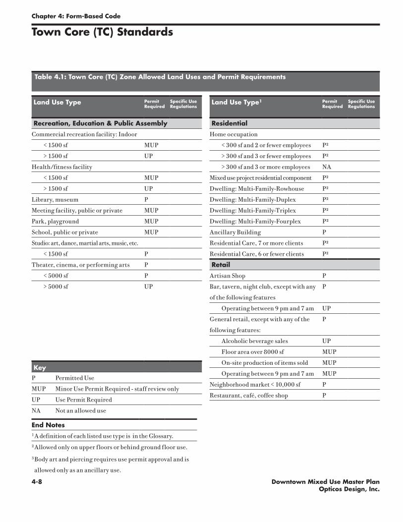
4-8 Downtown Mixed Use Master PlanOpticos Design, Inc.
Chapter 4: Form-Based Code
Land Use Type PermitRequired
Specific Use Regulations
Recreation, Education & Public Assembly
Commercial recreation facility: Indoor
< 1500 sf MUP
> 1500 sf UP
Health/fitness facility
< 1500 sf MUP
> 1500 sf UP
Library, museum P
Meeting facility, public or private MUP
Park, playground MUP
School, public or private MUP
Studio: art, dance, martial arts, music, etc.
< 1500 sf P
Theater, cinema, or performing arts P
< 5000 sf P
> 5000 sf UP
KeyP Permitted Use
MUP Minor Use Permit Required - staff review only
UP Use Permit Required
NA Not an allowed use
End Notes1 A definition of each listed use type is in the Glossary.2 Allowed only on upper floors or behind ground floor use.
3 Body art and piercing requires use permit approval and is
allowed only as an ancillary use.
Table 4.1: Town Core (TC) Zone Allowed Land Uses and Permit Requirements
Land Use Type1 PermitRequired
Specific Use Regulations
Residential
Home occupation
< 300 sf and 2 or fewer employees P²
> 300 sf and 3 or fewer employees P²
> 300 sf and 3 or more employees NA
Mixed use project residential component P²
Dwelling: Multi-Family-Rowhouse P²
Dwelling: Multi-Family-Duplex P²
Dwelling: Multi-Family-Triplex P²
Dwelling: Multi-Family-Fourplex P²
Ancillary Building P
Residential Care, 7 or more clients P²
Residential Care, 6 or fewer clients P²
Retail
Artisan Shop P
Bar, tavern, night club, except with any
of the following features
P
Operating between 9 pm and 7 am UP
General retail, except with any of the
following features:
P
Alcoholic beverage sales UP
Floor area over 8000 sf MUP
On-site production of items sold MUP
Operating between 9 pm and 7 am MUP
Neighborhood market < 10,000 sf P
Restaurant, café, coffee shop P
Town Core (TC) Standards
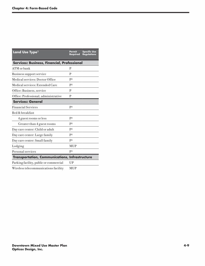
4-9Downtown Mixed Use Master PlanOpticos Design, Inc.
Chapter 4: Form-Based Code
Land Use Type1 PermitRequired
Specific Use Regulations
Services: Business, Financial, Professional
ATM or bank P
Business support service P
Medical services: Doctor Office P²
Medical services: Extended Care P²
Office: Business, service P
Office: Professional, administrative P
Services: General
Financial Services P²
Bed & breakfast
4 guest rooms or less P²
Greater than 4 guest rooms P²
Day care center: Child or adult P²
Day care center: Large family P²
Day care center: Small family P²
Lodging MUP
Personal services P³
Transportation, Communications, Infrastructure
Parking facility, public or commercial UP
Wireless telecommunications facility MUP

4-10 Downtown Mixed Use Master PlanOpticos Design, Inc.
Chapter 4: Form-Based Code
This page intentionally left blank

4-11Downtown Mixed Use Master PlanOpticos Design, Inc.
Chapter 4: Form-Based Code
Town Core-Open (TC-O) Standards
Illustrative examples of buildings in a Town Core-Open Area
Street
Town Core-Open (TC-O):
The primary intent of this zone is to regulate the physical form of shopfront buildings along the side streets between First Street and Second Street in order to provide an ap-propriate transition from First Street into the residential neighborhoods. The physical form of a shopfront building is regulated while allowing flexibility in use.
How mixed use is defined within this zone: Mixed use within this zone is defined by the flexibility and compat-ibility in use, allowing retail, commercial, or residential live/work uses in a shopfront form.
Parki
ng D
rive

4-12 Downtown Mixed Use Master PlanOpticos Design, Inc.
Chapter 4: Form-Based Code
Use
Ground Floor Service, Retail, or
Recreation, Education &
Public Assembly*
Upper Floor(s) Residential or Service*
*See Table 4.2 for specific uses.
Height
Building Min. 16'
Building Max. 2 stories and 25'
Ancillary Building Max. 2 stories and 25'
Finish Ground Floor Level 12" max. above sidewalk
First Floor Ceiling Height 12' min. clear
Upper Floor(s) Ceiling Height 8' min. clear
Notes
Mansard roof forms are not allowed.
Any section along the BTL not defined by a building must be
defined by a 2'6" to 4'6" high fence or stucco or masonry wall.
Building Placement
Build-to Line (Distance from Property Line)
Front 0'
Setback (Distance from Property Line)
Side 3'
Rear
Adjacent to NG Zone 8'
Adjacent to any other Zone 5'
Building Form
Street Façade built to BTL 80% min.*
Lot Width 75' max.
Lot Depth 150' max.
Notes
All floors must have a primary ground-floor entrance which
faces the street.
Loading docks, overhead doors, and other service entries are
prohibited on street façades.
Any building over 50' wide must be broken down to read as a
series of buildings no wider than 50' each.
G
A
H
C
C
B
D
E
F
I
I
K
L
J
J
D
Property Line Street
Property Line
Build-to Line (BTL)
Setback Line
Building Area
Key
Sidewalk
Street
BTL, Property Line
E F
A
C
LH
KG
I
B
Town Core-Open (TC-O) Standards
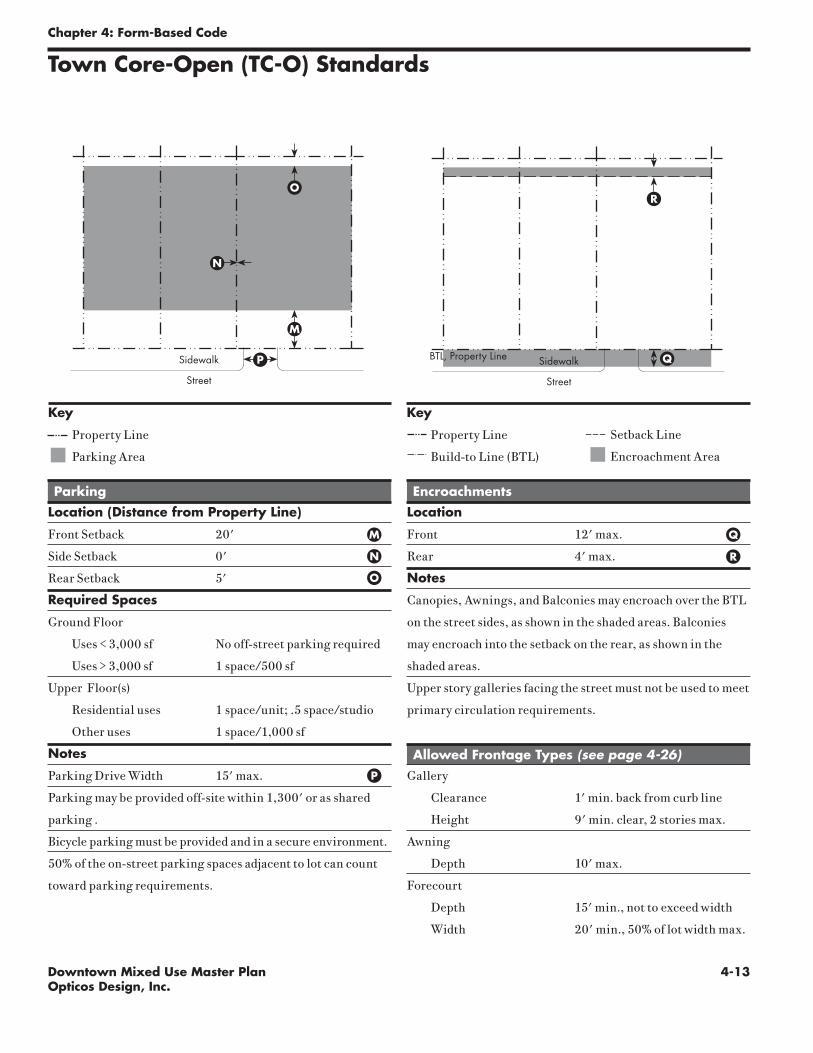
4-13Downtown Mixed Use Master PlanOpticos Design, Inc.
Chapter 4: Form-Based Code
Parking
Location (Distance from Property Line)
Front Setback 20'
Side Setback 0'
Rear Setback 5'
Required Spaces
Ground Floor
Uses < 3,000 sf No off-street parking required
Uses > 3,000 sf 1 space/500 sf
Upper Floor(s)
Residential uses 1 space/unit; .5 space/studio
Other uses 1 space/1,000 sf
Notes
Parking Drive Width 15' max.
Parking may be provided off-site within 1,300' or as shared
parking .
Bicycle parking must be provided and in a secure environment.
50% of the on-street parking spaces adjacent to lot can count
toward parking requirements.
Encroachments
Location
Front 12' max.
Rear 4' max.
Notes
Canopies, Awnings, and Balconies may encroach over the BTL
on the street sides, as shown in the shaded areas. Balconies
may encroach into the setback on the rear, as shown in the
shaded areas.
Upper story galleries facing the street must not be used to meet
primary circulation requirements.
Allowed Frontage Types (see page 4-26)
Gallery
Clearance 1' min. back from curb line
Height 9' min. clear, 2 stories max.
Awning
Depth 10' max.
Forecourt
Depth 15' min., not to exceed width
Width 20' min., 50% of lot width max.
QM
N
O
P
R
Property Line
Parking Area
Key
Property Line
Build-to Line (BTL)
Setback Line
Encroachment Area
Key
Sidewalk
Street
Sidewalk
Street
BTL, Property Line
M
O
P Q
R
N
Town Core-Open (TC-O) Standards

4-14 Downtown Mixed Use Master PlanOpticos Design, Inc.
Chapter 4: Form-Based Code
Town Core-Open (TC-O) Standards
Table 4.2: Town Core-Open (TC-O) Zone Allowed Land Uses and Permit Requirements
Land Use Type1 PermitRequired
Specific Use Regulations
Recreation, Education & Public Assembly
Commercial recreation facility: Indoor
< 1500 sf MUP
Library, museum P
Meeting facility, public or private MUP
Studio: art, dance, martial arts, music, etc.
< 1500 sf P
Residential
Home occupation
< 300 sf and 2 or fewer employees P
> 300 sf and 3 or fewer employees P
Live/work unit P
Mixed use project residential component P
Dwelling: Multi-Family-Rowhouse P
Dwelling: Multi-Family-Duplex P
Dwelling: Multi-Family-Triplex P
Dwelling: Multi-Family-Fourplex P
Ancillary Building P
Residential Care, 7 or more clients UP
Residential Care, 6 or fewer clients MUP
KeyP Permitted Use
MUP Minor Use Permit Required - staff review only
UP Use Permit Required
NA Use Not Allowed
End Notes
¹ A definition of each listed use type is in the Glossary.
Land Use Type1 PermitRequired
Specific Use Regulations
Retail
Artisan Shop P
Bar, tavern, night club, except with
any of the following
UP
Operating between 9 pm and 7 am NA
General retail, except with any of the
following features:
P
Alcoholic beverage sales UP
Floor area over 8000 sf NA
On-site production of items sold MUP
Operating between 9 pm and 7 am NA
Neighborhood market <10,000 sf P
Restaurant, café, coffee shop MUP
Services: Business, Financial, Professional
ATM or Bank MUP
Business support service P
Medical services: Clinic, urgent care MUP
Medical services: Doctor office P
Medical services: Extended Care MUP
Office: Business, service P
Office: Professional, administrative P
Services: General
Financial Services P
Bed & Breakfast
4 guest rooms or less P
Greater than 4 guest rooms P
Lodging MUP
Personal services P
Transportation, Communications, Infrastructure
Wireless telecommunications facility MUP

4-15Downtown Mixed Use Master PlanOpticos Design, Inc.
Chapter 4: Form-Based Code
Land Use Type1 PermitRequired
Specific Use Regulations
Services: Business, Financial, Professional
ATM or Bank P
Business support service P
Medical services: Clinic, urgent care MUP
Medical services: Doctor office P
Medical services: Extended Care MUP
Office: Business, service P
Office: Professional, administrative P
Services: General
Financial Services P
Bed & Breakfast
4 guest rooms or less P
Greater than 4 guest rooms MUP
Day care center: Child or adult MUP
Day care center: Large family UP
Day care center: Small family P
Personal services P
Transportation, Communications, Infrastructure
Wireless telecommunications facility MUP

4-16 Downtown Mixed Use Master PlanOpticos Design, Inc.
Chapter 4: Form-Based Code
This page intentionally left blank

4-17Downtown Mixed Use Master PlanOpticos Design, Inc.
Chapter 4: Form-Based Code
Neighborhood General (NG) Standards
Illustrative examples of buildings in a Neighborhood General area
Primary StreetSid
e Stre
et
Neighborhood General (NG):
The primary intent of this zone is to protect the integrity and quality of the downtown residential neighborhoods.
How mixed use is defined within this zone: Appropriate-ly-scaled ancillary buildings are allowed that can accommo-date residential, home-office, or workshop uses.
How “primary street” is defined within this zone: The primary street is always the East/West running street.
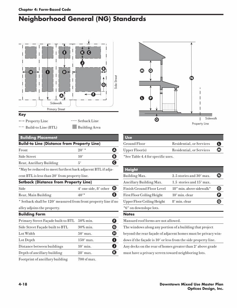
4-18 Downtown Mixed Use Master PlanOpticos Design, Inc.
Chapter 4: Form-Based Code
1" = 15'-0"
QM
P L
N
Use
Ground Floor Residential, or Services
Upper Floor(s) Residential, or Services
*See Table 4.4 for specific uses.
Height
Building Max. 2.5 stories and 30' max.
Ancillary Building Max. 1.5 stories and 15' max.
Finish Ground Floor Level 18" min. above sidewalk*
First Floor Ceiling Height 10' min. clear
Upper Floor Ceiling Height 8' min. clear
*6" on downslope lots.
Notes
Mansard roof forms are not allowed.
The windows along any portion of a building that project
beyond the rear façade of adjacent homes must be privacy win-
dows if the façade is 10' or less from the side property line.
Any decks on the rear of homes greater than 2' above grade
must have a privacy screen toward neighboring lots.
Building Placement
Build-to Line (Distance from Property Line)
Front 20' *
Side Street 10'
Rear, Ancillary Building 5'
*May be reduced to meet furthest back adjacent BTL if adja-
cent BTL is less than 20' from property line.
Setback (Distance from Property Line)
Side 4' one side, 8' other
Rear, Main Building 40'*
* Setback shall be 120' measured from front property line if no
alley adjoins the property.
Building Form
Primary Street Façade built to BTL 50% min.
Side Street Façade built to BTL 30% min.
Lot Width 50' max.
Lot Depth 150' max.
Distance between buildings 10' min.
Depth of ancillary building 28' max.
Footprint of ancillary building 700 sf max.
L
A M
E
B
C
O
N
H
P
Q
OProperty Line
Sidewalk
Neighborhood General (NG) Standards
D
I
Sidewalk
Primary Street
Side
Stre
et
H
E
A
D
C
BI
J
K
Property Line
Build-to Line (BTL)
Setback Line
Building Area
Key
G
F
J
K
F
G

4-19Downtown Mixed Use Master PlanOpticos Design, Inc.
Chapter 4: Form-Based Code
Parking
Location (Distance from Property Line)
Front Setback 20'
Side Setback 0'
Side Street Setback 5'
Rear Setback 5'
Required Spaces
Residential Uses
Studio unit ½ space
1-2 bedroom unit 1 space
3+ bedroom unit 1 space plus additional ½ space
for every bedroom over two
Other uses
Uses < 3,000 sf No off-street parking required
On lots without alley access, a one-unit ancillary structure up
to 400 sf may be built without requiring additional parking.
Notes
Parking Drive Width 11' max.
No more than a single space of parking is allowed in front of
the front façade plane.
50% of the on-street parking spaces adjacent to lot can count
toward parking requirements.
Neighborhood General (NG) Standards
Property Line
Parking Area
R
U
V
T
W
SX
Key
Property Line
Build-to Line (BTL)
Setback Line
Encroachment Area
Key
R
S
T
Encroachments
Location
Front 10' max.
Side Street 8' max.
Notes
Porches, Balconies, and Bay Windows may encroach into the
setback on the street sides, as shown in the shaded areas.
Allowed Frontage Types (see page 4-26)
Stoop
Depth 4' min., 6' max.
Forecourt
Depth 20' min., not to exceed width
Width 20' min., 50% of lot width max.
Porch
Depth 8' min.
Height 2 stories max.
Common Lawn
Porch Depth 8' min.
U
V
W
X
Sidewalk
Primary StreetSi
de S
treet
Sidewalk
Primary Street
Side
Stre
et

4-20 Downtown Mixed Use Master PlanOpticos Design, Inc.
Chapter 4: Form-Based Code
Neighborhood General (NG) Standards
Table 4.4: Neighborhood General (NG) Zone Allowed Land Uses and Permit Requirements
Land Use Type1 PermitRequired
Specific Use Regulations
Recreation, Education & Public Assembly
Park, playground MUP
School, public or private MUP
Residential
Dwelling: Single family P
Home occupation
< 300 sf, 2 or fewer employees P
> 300 sf, 3 or fewer employees P
Dwelling: Multi- family-Duplex P
Ancillary Building P
KeyP Permitted Use
MUP Minor Use Permit Required - staff review only
UP Use Permit Required
NA Not an allowed use
End Notes
¹ A definition of each listed use type is in the Glossary.2 Allowed only in ancillary buildings
Land Use Type1 PermitRequired
Specific Use Regulations
Retail
General retail, except with any of the
following features:
P
Alcoholic beverage sales NA
Floor area over 8000 sf NA
On-site production of items sold P2
Operating between 9 pm and 7 am NA
Services: Business, Financial, Professional
Office: Professional, administrative P2
Services: General
Bed & Breakfast
4 guest rooms or less P
Greater than 4 guest rooms MUP
Day care center: Child or adult MUP
Day care center: Large family UP
Day care center: Small family P
Transportation, Communications, Infrastructure
Wireless telecommunications facility MUP

4-21Downtown Mixed Use Master PlanOpticos Design, Inc.
Chapter 4: Form-Based Code
Neighborhood General-Open (NG-O) Standards
Illustrative examples of buildings in a Neighborhood General-Open area
Primary Street
Side S
treet
Neighborhood General-Open (NG-O):
The primary intent of this zone is to ensure a residential physical form to relate to adjacent residen-tial buildings along the side streets between First Street and Second Street in order to provide an appropriate transition from First Street into the residential neighbor-hoods. The physical form of a residential building is regulated while allowing flexibility in use. This zone is applied to buildings with an existing residential form that has been compromised by on-site or adjacent development making pure residential use inappropriate.
How mixed use is defined within this zone: Commercial or residential uses are allowed in this area in a residential form both in the main buildings as well as in ancillary buildings.
How “primary street” is defined within this zone: The primary street is always the East/West running street.

4-22 Downtown Mixed Use Master PlanOpticos Design, Inc.
Chapter 4: Form-Based Code
Use
Ground Floor Residential, Retail, or
Service
Upper Floor(s) Residential
*See Table 4.5 for specific uses.
Height
Building Max. 2.5 stories and 30' max.
Ancillary Building Max. 1.5 stories and 15' max.
Finish Ground Floor Level 18" min. above sidewalk*
First Floor Ceiling Height 10' min. clear
Upper Floor Ceiling Height 8' min. clear
*6" on downslope lots.
Notes
Mansard roof forms are not allowed.
The windows along any portion of a building that project
beyond the rear façade of adjacent homes must be privacy win-
dows if the façade is 10' or less from the side property line.
Any decks on the rear of homes greater than 2' above grade
must have a privacy screen toward neighboring lots.
Monument and illuminated signs are prohibited.
Neighborhood General-Open (NG-O) Standards
1" = 15'-0"
QM
P L
N
Building Placement
Build-to Line (Distance from Property Line)
Front 20' *
Side Street 10'
Rear, Ancillary Building 5'
*May be reduced to meet furthest back adjacent BTL if adja-
cent BTL is less than 20' from property line.
Setback (Distance from Property Line)
Side 4' one side, 8' other
Rear, Main Building 35' *
* Setback shall be 120' measured from front property line if no
alley adjoins the property.
Building Form
Primary Street Façade built to BTL 50% min.
Side Street Façade built to BTL 30% min.
Lot Width 50' max.
Lot Depth 150' max.
Distance between buildings 10' min.
Depth of ancillary building 28' max.
Footprint of ancillary building 1000 sf max.
LA
M
E
B
C
O
N
H
P
Q
OProperty Line
Sidewalk
D
I
Sidewalk
Primary Street
Side
Stre
et
H
E
A
D
C
BI
J
K
Property Line
Build-to Line (BTL)
Setback Line
Building Area
Key
G
F
J
K
F
G

4-23Downtown Mixed Use Master PlanOpticos Design, Inc.
Chapter 4: Form-Based Code
Neighborhood General-Open (NG-O) Standards
Parking
Location (Distance from Property Line)
Front Setback 20'
Side Setback 0'
Side Street Setback 5'
Rear Setback 5'
Required Spaces
Residential Uses
Studio unit ½ space
1-2 bedroom unit 1 space
3+ bedroom unit 1 space plus additional ½ space
for every bedroom over two
Other uses 1 space/1,000 sf
On lots without alley access, a one-unit ancillary structure up
to 400 sf may be built without requiring additional parking.
Notes
Parking Drive Width 11' max.
No more than a single space of parking is allowed in front of
the front façade plane.
50% of the on-street parking spaces adjacent to lot can count
toward parking requirements.
Property Line
Parking Area
R
U
V
T
W
SX
Key
Property Line
Build-to Line (BTL)
Setback Line
Encroachment Area
Key
R
S
T
Encroachments
Location
Front 10' max.
Side Street 8' max.
Notes
Porches, Balconies, and Bay Windows may encroach into the
setback on the street sides, as shown in the shaded areas.
Allowed Frontage Types (see page 4-26)
Stoop
Depth 4' min., 6' max.
Forecourt
Depth 20' min., not to exceed width
Width 20' min., 50% of lot width max.
Porch
Depth 8' min.
Height 2 stories max.
Common Lawn
Porch Depth 8' min.
U
V
W
X
Sidewalk
Primary StreetSi
de S
treet
Sidewalk
Primary Street
Side
Stre
et

4-24 Downtown Mixed Use Master PlanOpticos Design, Inc.
Chapter 4: Form-Based Code
Neighborhood General-Open (NG-O) Standards
Table 4.5: Neighborhood General (NG-0) Zone Allowed Land Uses and Permit Requirements
Land Use Type1 PermitRequired
Specific Use Regulations
Recreation, Education & Public Assembly
Meeting facility, public or private MUP
Park, playground P
School, public or private MUP
Studio: art, dance, martial arts, music, etc.
< 1500 sf MUP
> 1500 sf NA
Theater, cinema, or performing arts MUP
Residential
Dwelling: Single family P
Home occupation
< 300 sf and 2 or fewer employees P
> 300 sf and 3 or fewer employees P
> 300 sf and 3 or more employees P
Live/work unit P
Mixed use project residential component P
Dwelling: Multi-Family-Duplex P
Ancillary Building P
Residential Care, 7 or more clients UP
Residential Care, 6 or fewer clients MUP
KeyP Permitted Use
MUP Minor Use Permit Required - staff review only
UP Use Permit Required
NA Not an allowed use
End Notes1 A definition of each listed use type is in the Glossary.
Land Use Type1 PermitRequired
Specific Use Regulations
Retail
Artisan Shop P
General retail, except with any of the
following features:
P
Alcoholic beverage sales NA
Floor area over 8000 sf NA
On-site production of items sold MUP
Operating between 9 pm and 7 am NA
Restaurant, café, coffee shop MUP
Services: Business, Financial, Professional
Business support service P
Medical services: Doctor office P
Office: Business, service P
Office: Professional, administrative P
Services: General
Financial Services P
Bed & Breakfast
4 guest rooms or less P
Greater than 4 guest rooms MUP
Day care center: Child or adult MUP
Day care center: Large family UP
Day care center: Small family P
Lodging MUP
Personal services P
Transportation, Communications, Infrastructure
Wireless telecommunications facility MUP
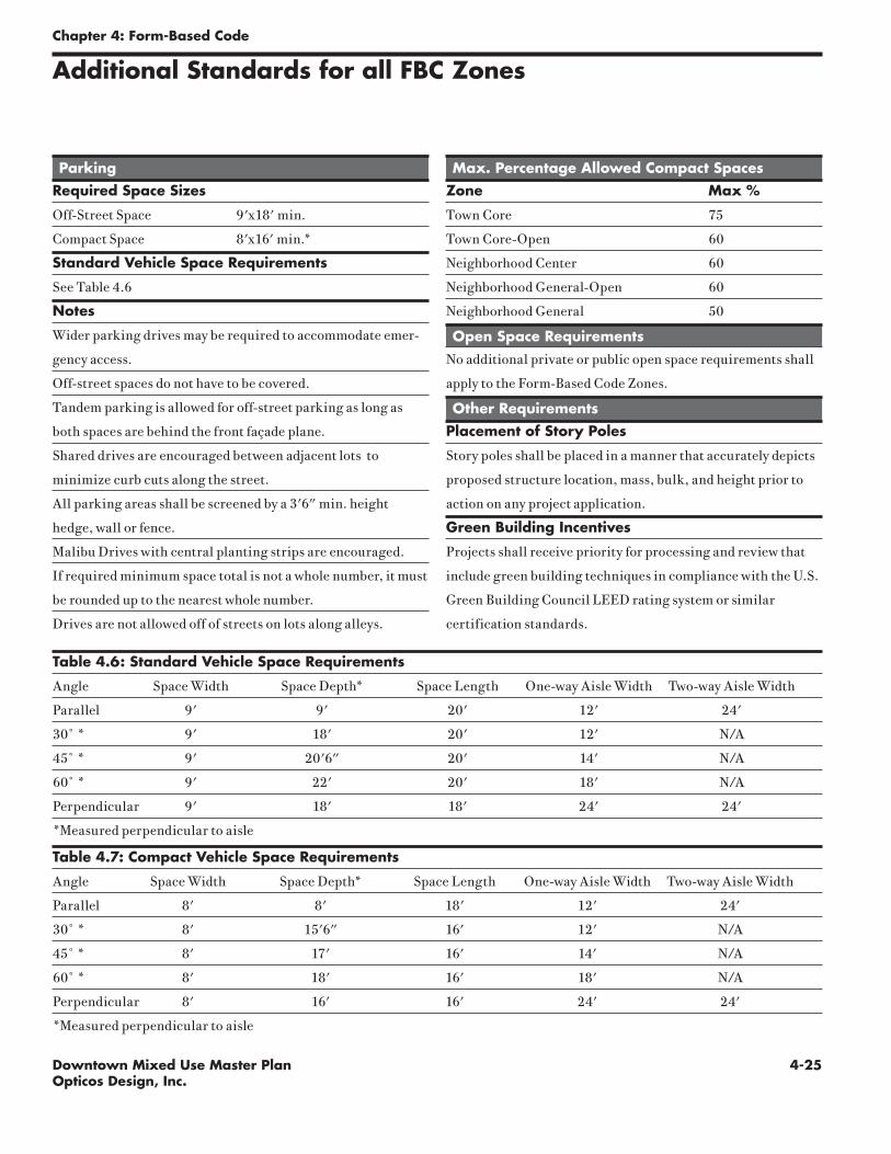
4-25Downtown Mixed Use Master PlanOpticos Design, Inc.
Chapter 4: Form-Based Code
Additional Standards for all FBC Zones
Table 4.6: Standard Vehicle Space Requirements
Angle Space Width Space Depth* Space Length One-way Aisle Width Two-way Aisle Width
Parallel 9' 9' 20' 12' 24'
30˚ * 9' 18' 20' 12' N/A
45˚ * 9' 20'6" 20' 14' N/A
60˚ * 9' 22' 20' 18' N/A
Perpendicular 9' 18' 18' 24' 24'
*Measured perpendicular to aisle
Table 4.7: Compact Vehicle Space Requirements
Angle Space Width Space Depth* Space Length One-way Aisle Width Two-way Aisle Width
Parallel 8' 8' 18' 12' 24'
30˚ * 8' 15'6" 16' 12' N/A
45˚ * 8' 17' 16' 14' N/A
60˚ * 8' 18' 16' 18' N/A
Perpendicular 8' 16' 16' 24' 24'
*Measured perpendicular to aisle
Parking
Required Space Sizes
Off-Street Space 9'x18' min.
Compact Space 8'x16' min.*
Standard Vehicle Space Requirements
See Table 4.6
Notes
Wider parking drives may be required to accommodate emer-
gency access.
Off-street spaces do not have to be covered.
Tandem parking is allowed for off-street parking as long as
both spaces are behind the front façade plane.
Shared drives are encouraged between adjacent lots to
minimize curb cuts along the street.
All parking areas shall be screened by a 3'6" min. height
hedge, wall or fence.
Malibu Drives with central planting strips are encouraged.
If required minimum space total is not a whole number, it must
be rounded up to the nearest whole number.
Drives are not allowed off of streets on lots along alleys.
Max. Percentage Allowed Compact Spaces
Zone Max %
Town Core 75
Town Core-Open 60
Neighborhood Center 60
Neighborhood General-Open 60
Neighborhood General 50
Open Space Requirements
No additional private or public open space requirements shall
apply to the Form-Based Code Zones.
Other Requirements
Placement of Story Poles
Story poles shall be placed in a manner that accurately depicts
proposed structure location, mass, bulk, and height prior to
action on any project application.
Green Building Incentives
Projects shall receive priority for processing and review that
include green building techniques in compliance with the U.S.
Green Building Council LEED rating system or similar
certification standards.

4-26 Downtown Mixed Use Master PlanOpticos Design, Inc.
Chapter 4: Form-Based Code
Frontage Line
Common Lawn: The main façade of the building has a large setback from the frontage line. The resulting front yard can be defined or undefined at the frontage line. This edge is typically defined by a fence or hedge within a traditional neighborhood or left undefined within more rural areas or subdivisions. Large common lawns are typical for larger homes within historic neighborhoods. A front porch is optional, but if it is used, it can be one or two story.
Porch: The main façade of the building has a small setback from the frontage line. The resulting front yard is typically very small and can be defined by a fence or hedge. The porch can encroach into the setback to the point that the porch extends to the frontage line. The porch can be one or two stories. A minimum depth of 6' clear is required within the development standards to ensure usability. On downslope lots the setback is typically minimized to improve the development feasibility of the lot. On upslope lots it is maximized to reduce visual impact of the building on the streetscape.
Forecourt: The main façade of the building is at or near the frontage line and a small percentage of it is set back, creating a small court space. The space could be used as an entry court or shared garden space for apartment buildings, or as an additional shopping or restaurant seating area within commercial zones. The proportions and orientation of these spaces should be carefully considered for solar orientation and user comfort. This frontage type should be used sparingly and should not be repeated within a block. A short wall, hedge, or fence should be placed along the undefined edge.
Stoop: The main façade of the building is near the frontage line and the elevated stoop engages the sidewalk. The stoop should be elevated a minimum of 24 inches above the sidewalk to ensure privacy within the building. The stairs from the stoop may lead directly to the sidewalk or may be side loaded. The minimum width and depth of the stoop should be 5 feet. This type is appropriate for residential uses with small setbacks.
Awning : The main façade of the building is at or near the frontage line and the canopy or awning element may overlap the sidewalk. The canopy is a structural, cantilevered, shed roof and the awning is canvas or similar material and is often retractable. The coverings should extend far enough from the building to provide adequate protection for pedestrians. This type is appropriate for retail and commercial uses only because of the lack of a raised ground story.
Gallery: The main façade of the building is at the frontage line and the gallery element overlaps the sidewalk. The entry should be at the same grade as the sidewalk. This type can be one or two stories and is intended for retail uses. The gallery should extend close enough to the curb so that a pedestrian cannot bypass it. Due to the overlap of the right-of-way, an easement is usually re-quired. A minimum depth is required within the development standards to ensure usability. This type is appropriate for ground floor commercial uses.
Frontage Types

4-27Downtown Mixed Use Master PlanOpticos Design, Inc.
Chapter 4: Form-Based Code
Glossary
Alcoholic Beverage Sales - Off-Premise: The retail sale of beer, wine, and/or spirits in sealed containers for off-site consumption, either as part of another retail use, or as a primary business activity.
Ancillary Building: A building customarily incidental to, related and clearly subordinate to the primary building on the same parcel, which does not alter the primary use nor serve property other than the parcel where the primary building is located.
Apartment: A dwelling unit sharing a building and a lot with other dwellings and/or uses. Apartments may be for rent or for sale as condominiums.
Artisan Shop: Premises available for the creation, assemblage, and/or repair of artifacts, using hand-powered and table-mounted electrical machinery, and includ-ing their retail sale.
ATM or Bank: An automated teller machine (computerized, self-service machine used by banking customers for financial transactions, including deposits, withdraw-als and fund transfers, without face-to-face contact with financial institution person-nel), located outdoors at a bank, or in another location. Does not include drive-up ATMs. Includes banks. See also “Financial Institutions” for other financial organi-zations. Does not include check-cashing stores.
Bar, Tavern, Night Club:
Bar, Tavern: A business where alcoholic beverages are sold for on-site con-sumption, which are not part of a larger restaurant. Includes bars, taverns, pubs, and similar establishments where any food service is subordinate to the sale of alcoholic beverages. May also include beer brewing as part of a microbrewery (“brew-pub”), and other beverage tasting facilities.
Night Club: A facility serving alcoholic beverages for on-site consumption, and providing entertainment, examples of which include live music and/or dancing, comedy, etc. Does not include adult oriented businesses.
Bed & Breakfast Inn: A residential structure with one or more bedrooms rented for overnight lodging, where meals may be provided subject to applicable Environmen-tal Health Department regulations.
Building Type: The structure defined by the combination of configuration, dispo-sition and function.
Build-to Line (BTL): A line appearing graphically on the regulating plan or stated as a setback dimension, along which a building façade must be placed.
Business Support Service: An establishment within a building that provides ser-vices to other businesses. Examples of these services include:
computer-related services (rental, repair) (see also “Maintenance Service - Cli-ent Site Services”), copying, quick printing, and blueprinting services, film processing and photofinishing (retail), mailing and mail box services.
Carriage Unit: A Carriage unit is an auxiliary housing unit located above or ad-jacent to the garage of the primary housing unit on the lot, with the front door and access directed towards an alley. A carriage unit constitutes a residential second unit in compliance with the Government Code Section 65852.2 and, as provided by the Government Code, is not included in the maximum density limitations.
Child Day Care: See “Day Care Center.”

4-28 Downtown Mixed Use Master PlanOpticos Design, Inc.
Chapter 4: Form-Based Code
Civic: A term defining not-for-profit organizations, dedicated to arts, culture, education, religious activities, government, transit, municipal parking facilities and clubs.
Commercial: A term defining workplace, office and retail use collectively.
Commercial Recreation Facility - Indoor: An establishment providing indoor amusement and entertainment services for a fee or admission charge, including:
bowling alleys,- coin-operated amusement arcades, electronic game arcades (video games, pinball, etc.), ice skating and roller skating, pool and billiard rooms as primary uses.
This use does not include sex oriented businesses. Four or more electronic games or amusement devices (e.g., pool or billiard tables, pinball machines, etc.) in any establishment, or a premises where 50 percent or more of the floor area is occupied by electronic games or amusement devices, are considered a commercial recreation facility; three or fewer machines or devices are not considered a land use separate from the primary use of the site.
Day Care Center, Child or Adult: A state-licensed facility that provides non-medi-cal care and supervision for adult clients or minor children for periods of less than 24 hours for any client. These facilities include the following, all of which are required to be licensed by the California State Department of Social Services.
1. Large Family Day Care Home: As defined by Health and Safety Code Section 1596.78, a day care facility in a single dwelling where an occupant of the residence provides family day care for seven to 14 children, inclusive, including children under the age of 10 years who reside in the home.
2. Small Family Day Care Home: As defined by Health and Safety Code Sec-tion 1596.78, a day care facility in a single residence where an occupant of the residence provides family day care for eight or fewer children, including children under the age of 10 years who reside in the home.
Director: The Community Development Director of the City of Benicia, or his duly appointed representative.
Dwelling, Dwelling Unit, or Housing Unit: A room or group of internally con-nected rooms that have sleeping, cooking, eating, and sanitation facilities, but not more than one kitchen, which constitute an independent housekeeping unit, occu-pied by or intended for one household on a long-term basis.
Dwelling, Multi-Family: A residential structure containing two or more dwelling units.
1. Duplex: A building with two separate dwellings located either side by side or one on top of the other.
2. Fourplex: A building with four separate dwellings.
3. Triplex: A building with three separate dwellings.
4. Rowhouse: A building with two or more single-family dwellings located side by side, with common walls on the side lot lines, the façades reading in a continuous plan.
Façade: The vertical surface of a building, generally set facing a street (“front façade”).
Financial Services: Includes banks and trust companies, credit agencies, hold-ing (but not primarily operating) companies, lending and thrift institutions, other investment companies, securities/commodity contract brokers and dealers, secu-
4-29Downtown Mixed Use Master PlanOpticos Design, Inc.
Chapter 4: Form-Based Code
rity and commodity exchanges, vehicle finance (equity) leasing agencies. Does not include check-cashing stores.
Frontage Line: The property lines of a lot fronting a street or other public way, or a park, green or paseo.
Front Porch: A roofed structure, that is not enclosed, attached to the façade of a building.
Frontage Type: See Chapter 4 (Frontage Type Standards).
Gallery: As a building frontage type, a roofed promenade extending along the façade of a building and supported by columns on the outer side.
General Retail: Stores and shops intended to serve the City as destination retail, rather than convenience shopping. Examples of these stores and lines of merchan-dise include:
art galleries, retail, art supplies, including framing services, books, magazines, and newspapers, cameras and photographic supplies, clothing, shoes, and acces-sories, collectibles (cards, coins, comics, stamps, etc.), drug stores and pharma-cies, dry goods, fabrics and sewing supplies, furniture and appliance stores, hobby materials, home and office electronics, jewelry, luggage and leather goods, musical instruments and-carried), parts, accessories, small wares, spe-cialty grocery store, specialty shops, sporting goods and equipment, stationery, toys and games, variety stores, videos, DVD’s, records, CD’s, including rental stores.
Health/Fitness Facility: A fitness center, gymnasium, health and athletic club, which may include any of the following:
exercise machines, weight facilities, group exercise rooms, sauna, spa or hot tub facilities; indoor tennis, handball, racquetball, archery and shooting ranges and other indoor sports activities, indoor or outdoor pools.
Height: A limit to the vertical extent of a building that is measured in number of stories. Height limits do not apply to masts, belfries, clock towers, chimney flues, water tanks, elevator bulkheads, and similar structures, which may be of any height approved by the Director.
Home Occupation: Residential premises used for the transaction of business or the supply of professional services. Home occupation shall be limited to the follow-ing: agent, architect, artist, broker, consultant, draftsman, dressmaker, engineer, interior decorator, lawyer, notary public, teacher, and other similar occupations, as determined by the Director. Such use shall not simultaneously employ more than 1 person in addition to residents of the dwelling. The total gross area of the home occu-pation use shall not exceed 25 percent of the gross square footage of the residential unit. The home occupation use shall not disrupt the generally residential character of the neighborhood. The Director shall review the nature of a proposed home occu-pation use at the time of review of a business license for such use, and may approve, approve with conditions, continue or deny the application.
Library, Museum: Public or quasi-public facilities, examples of which include: aquariums, arboretums, art galleries and exhibitions, botanical gardens, historic sites and exhibits, libraries, museums, planetariums, and zoos. May also include accessory retail uses such as a gift/book shop, restaurant, etc.
Live-Work Unit: An integrated housing unit and working space, occupied and utilized by a single household in a structure that has been designed or structurally modified to accommodate joint residential occupancy and work activity, and which

4-30 Downtown Mixed Use Master PlanOpticos Design, Inc.
includes:
1. Complete kitchen space and sanitary facilities in compliance with the Building Code; and
2. Working space reserved for and regularly used by one or more occupants of the unit.
Lodging: A facility (typically a hotel or motel) with guest rooms or suites, with or without kitchen facilities, rented to the general public for transient lodging. Hotels typically include a variety of services in addition to lodging; for example, restau-rants, meeting facilities, personal services, etc. Also includes accessory guest facilities such as swimming pools, tennis courts, indoor athletic facilities, accessory retail uses, etc.
Medical Services - Clinic, Urgent Care: A facility other than a hospital where medical, mental health, surgical and other personal health services are provided on an outpatient basis. Examples of these uses include:
medical offices with five or more licensed practitioners and/or medical special-ties, out-patient care facilities, urgent care facilities, other allied health services
These facilities may also include incidental medical laboratories. Counseling services by other than medical doctors or psychiatrists are included under “Offices - Professional/Administrative.”
Medical Services - Doctor Office: A facility other than a hospital where medi-cal, dental, mental health, surgical, and/or other personal health care services are provided on an outpatient basis, and that accommodates no more than four licensed primary practitioners (for example, chiropractors, medical doctors, psychiatrists, etc., other than nursing staff) within an individual office suite. A facility with five or more licensed practitioners is instead classified under “Medical Services - Clinic, Urgent Care.” Counseling services by other than medical doctors or psychiatrists are included under “Offices - Professional/Administrative.”
Medical Services - Extended Care: Residential facilities providing nursing and health-related care as a primary use with in-patient beds. Examples of these uses include: board and care homes; convalescent and rest homes; extended care facili-ties; and skilled nursing facilities. Long-term personal care facilities that do not emphasize medical treatment are included under “Residential Care.”
Meeting Facility, Public or Private: A facility for public or private meetings, including:
community centers, religious assembly facilities (e.g., churches, mosques, syna-gogues, etc.), civic and private auditoriums, Grange halls, union halls, meeting halls for clubs and other membership organizations, etc.
Also includes functionally related internal facilities such as kitchens, multi-pur-pose rooms, and storage. Does not include conference and meeting rooms accessory and incidental to another primary use, and which are typically used only by on-site employees and clients, and occupy less floor area on the site than the offices they sup-port. Does not include:
cinemas, performing arts theaters, indoor commercial sports assembly or other commercial entertainment facilities.
Related on-site facilities such as day care centers and schools are separately defined, and separately regulated by this Development Code.
Mixed-use: Multiple functions within the same building or the same general area through superimposition or within the same area through adjacency.
Chapter 4: Form-Based Code

4-31Downtown Mixed Use Master PlanOpticos Design, Inc.
Chapter 4: Form-Based Code
Museum - See “Library, Museum.”
Neighborhood Market: A neighborhood serving retail store of 3,500 square feet or less in gross floor area, primarily offering food products, which may also carry a range of merchandise oriented to daily convenience shopping needs, and may be combined with food service (e.g., delicatessen).
Office: Business, Service, Administrative, and Professional.
Business, Service: Establishments providing direct services to consumers. Examples of these uses include employment agencies, insurance agent offices, real estate offices, travel agencies, utility company offices, elected official satel-lite offices, etc. This use does not include “Bank, Financial Services,” which are separately defined.
Professional, Administrative: Office-type facilities occupied by businesses that provide professional services, or are engaged in the production of intellec-tual property. Examples of these uses include:
accounting, auditing and bookkeeping services, advertising agencies, attor-neys, business associations, chambers of commerce, commercial art and design services, construction contractors (office facilities only), counseling services, court reporting services, design services including architecture, engineering, landscape architecture, urban planning, detective agencies and similar servic-es, doctors, educational, scientific and research organizations, financial man-agement and investment counseling, literary and talent agencies, management and public relations services, media postproduction services, news services, photographers and photography studios, political campaign headquarters, psy-chologists, secretarial, stenographic, word processing, and temporary clerical employee services , security and commodity brokers, writers and artists offices.
Park, Playground: An outdoor recreation facility that may provide a variety of recreational opportunities including playground equipment, open space areas for passive recreation and picnicking, and sport and active recreation facilities.
Parking Facility, Public or Private: Parking lots or structures operated by the City, or a private entity providing parking for a fee. Does not include towing im-pound and storage facilities.
Personal Services: Establishments that provide non-medical services to individu-als as a primary use. Examples of these uses include:
barber and beauty shops, clothing rental, dry cleaning pick-up stores with lim-ited equipment, home electronics and small appliance repair, laundromats (self-service laundries), locksmiths, massage (licensed, therapeutic, non-sexual), nail salons, pet grooming with no boarding, shoe repair shops, tailors, tanning salons.
These uses may also include accessory retail sales of products related to the services provided.
Prohibited Uses: The following are examples of uses not permitted anywhere within the Downtown Mixed-Use Master Plan area:
animal hatcheries; boarding houses; chemical manufacturing, storage, or distribution; any commercial use in where patrons remain in their automobiles while receiving goods or services, except service stations; enameling, paint-ing, or plating of materials, except artist’s studios; kennels; the manufacture, storage, or disposal of hazardous waste materials; mini-storage warehouses; outdoor advertising or billboards; packing houses; prisons or detention centers, except as accessory to a police station; drug and alcohol treatment and rehab

4-32 Downtown Mixed Use Master PlanOpticos Design, Inc.
Chapter 4: Form-Based Code
centers; thrift stores; soup kitchens and charitable food distribution centers; sand, gravel, or other mineral extraction; scrap yards; tire vulcanizing and retreading; vending machines, except within a commercial building; uses pro-viding goods or services of a predominantly adult-only or sexual nature, such as adult book or video stores or sex shops; and other similar uses as determined by the Director.
Residential: Premises used primarily for human habitation. Units shall not be less than 375 square feet in net area.
Residential Care, 6 or Fewer Clients: A single dwelling or multi-unit facility with six or fewer clients, licensed or supervised by a Federal, State, or local health/wel-fare agency that provides 24-hour nonmedical care of unrelated persons who are handicapped and in need of personal services, supervision, or assistance essential for sustaining the activities of daily living or for the protection of the individual in a family-like environment. Does not include day care facilities, which are separately defined.
Residential Care, 7 or more Clients: A single dwelling or multi-unit facility with seven or more clients, licensed or supervised by a Federal, State, or local health/welfare agency that provides 24-hour nonmedical care of unrelated persons who are handicapped and in need of personal services, supervision, or assistance essential for sustaining the activities of daily living or for the protection of the individual in a family-like environment. Does not include day care facilities, which are separately defined.
Restaurant, Cafe, Coffee Shop: A retail business selling ready-to-eat food and/or beverages for on- or off-premise consumption. These include eating establishments where customers are served from a walk-up ordering counter for either on- or off-premise consumption (“counter service”); and establishments where customers are served food at their tables for on-premise consumption (“table service”), that may also provide food for take-out, but does not include drive-through services.
School, Public or Private: Includes the following facilities:
Elementary, Middle, Secondary: A public or private academic educational insti-tution, including elementary (kindergarten through 6th grade), middle and ju-nior high schools (7th and 8th grades), secondary and high schools (9th through 12th grades), and facilities that provide any combination of those levels. May also include any of these schools that also provide room and board.
Specialized Education/Training: A school that provides education and/or training, including tutoring, or vocational training, in limited subjects. Ex-amples of these schools include:
art school, ballet and other dance school, business, secretarial, and vocational school, computers and electronics school, drama school, driver education school, establishments providing courses by mail, language school, martial arts, music school, professional school (law, medicine, etc.), seminaries/reli-gious ministry training facility
Does not include pre-schools and child day care facilities (see “Day Care”). See also the definition of “Studio - Art, Dance, Martial Arts, Music, etc.” for smaller-scale facilities offering specialized instruction.
Secondary Building: A building that accommodates the secondary use of the site.
Setback: The mandatory distance between a property line and a building or appur-tenance. This area must be left free of structures that are higher than 3 feet exclud-ing Streetwalls, except as noted in the Urban Regulations.

4-33Downtown Mixed Use Master PlanOpticos Design, Inc.
Chapter 4: Form-Based Code
Shared Parking: Any parking spaces assigned to more than one use, where persons utilizing the spaces are unlikely to need the spaces at the same time of day.
Single Family Dwelling: A residential structure containing a single dwelling unit. Includes for the purposes of this Development Code Rowhouses.
Shopfront: The portion of a building at the ground floor that is made available for retail or other commercial use. Shopfronts shall be directly accessible from the sidewalk.
Story: A habitable floor level within a building, typically 8’to 12’ high from floor to ceiling. Individual spaces, such as lobbies and foyers may exceed one story in height. In Shopfront spaces, the ceiling height of the first story may be as high as 16’.
Studio: Art, Dance, Martial Arts, Music, etc: Small scale facilities, typically ac-commodating no more than two groups of students at a time, in no more than two instructional spaces. Examples of these facilities include:
individual and group instruction and training in the arts; production rehearsal; photography, and the processing of photographs produced only by users of the studio facilities; martial arts training studios; gymnastics instruction, and aero-bics and gymnastics studios with no other fitness facilities or equipment.
Also includes production studios for individual musicians, painters, sculptors, pho-tographers, and other artists.
Substantial Compliance: It occurs when physical improvements to the existing development site are completed which constitute the greatest degree of compliance with current development provisions.
Theater, Cinema or Performing Arts: An indoor facility for group entertainment, other than sporting events. Examples of these facilities include:
civic theaters, facilities for “live” theater and concerts, and movie theaters
Wireless Telecommunications Facility: Public, commercial and private electro-magnetic and photoelectrical transmission, broadcast, repeater and receiving sta-tions for radio, television, telegraph, telephone, data network, and wireless commu-nications, including commercial earth stations for satellite-based communications. Includes antennas, commercial satellite dish antennas, and equipment buildings. Does not include telephone, telegraph and cable television transmission facilities utilizing hard-wired or direct cable connections.
Zoning Code or Zoning Ordinance: The City of Benicia Zoning Code, Title 17 of the City of Benicia Municipal Code.

4-34 Downtown Mixed Use Master PlanOpticos Design, Inc.
Chapter 4: Form-Based Code
This page intentionally left blank

Ap
pen
dix
Do
wn
to
wn
Mix
ed
Us
e M
as
te
r P
la
n
5
Downtown Mixed Use Master PlanDRAFT Market Conditions and Recommendations
November 2006
prepared for:City of Benicia
Opticos Design, Inc.
chapter

5-2 Downtown Mixed Use Master PlanOpticos Design, Inc.
Appendix A
Draft Market Conditions and Recommendations -3-
This report summarizes background market conditions and offers recommendations for the
Downtown Form Based Code, and the Arsenal Specific Plan in Benicia, CA. The recommendations
made in this report are the culmination of several months of involvement in Benicia including
background document review, stakeholder interviews, involvement in the charrette that took place
from September 18 to 22, 2006, and follow up research on market conditions and potential
implementation strategies for both Downtown and the Arsenal.
The preliminary goal of the Downtown Form Based Code is to clarify design and land use guidelines
both on First Street and on side streets currently in a “mixed-use” designation. Community members
and business owners on First Street voiced concern about a variety of other issues and desirable goals
for First Street. Land use policy alone is not the appropriate mechanism for addressing all of the
community’s issues. Therefore, this report offers recommendations for ways to jointly apply land use
policy and other implementation strategies to improve First Street.
The goal of the Arsenal planning process is to develop a specific plan that clarifies and refines the
area’s “mixed-use” designation in the General Plan, and identifies potential strategies that the City of
Benicia can pursue to address particular concerns about preserving and enhancing unique
characteristics of this area. This report makes recommendations for land use policy based on research
about current and potential market support for a variety of uses. Further, the report describes several
possible implementation strategies and identifies sources of public and private financing for each
strategy.
This report includes three parts. Chapter II describes current demographic and market conditions that
pertain to both First Street and the Arsenal. Chapter III summarizes key issues in the First Street area,
and makes recommendations for the form-based code. Finally, Chapter IV summarizes key issues in
the Arsenal area, and makes recommendations for the specific plan.
I. INTRODUCTION
5-3Downtown Mixed Use Master PlanOpticos Design, Inc.
Appendix A
Draft Market Conditions and Recommendations -4-
This chapter provides information on demographic and market conditions that influence, or will
influence the physical and use characteristics of the Arsenal and Downtown Benicia. Strategic
Economics has gathered general information on Benicia’s demographics and market for housing,
office, retail, and industrial space, but has targeted its research around particular issues in both the
Arsenal and the Downtown. As some general market and demographic information is not relevant to
planning efforts in Downtown Benicia and the Arsenal, this section focuses on a more relevant set of
observations about the market for each of these types of uses. Further information about the City’s
demographics and market conditions can be found in the Benicia Downtown Market Study report
prepared by Bay Area Economics in 2002, and in information collected by Main Street Benicia.
These sources were used as the foundation for many of the observations made in following sections.
DEMOGRAPHIC TRENDSTable 1 presents demographic information for Benicia, as well as Solano and Contra Costa Counties,
as trends in the two-county area are expected to impact the potential for new housing, office and retail
in Benicia. Key demographic trends are summarized below:
Benicia has a small, slow growing population with higher incomes than the rest of Solano County.
! The population of Benicia increased by 10 percent between 1990 and 2000,
compared with 16 percent in Solano County and 18 percent in Contra Costa
Counties. Between 2000 and 2006, the population of Benicia is estimated to have
declined slightly due to declining household sizes (during the same period the
estimated number of occupied housing units increased).
! While the Benicia population remains relatively stable, a significant amount of
growth is occurring elsewhere in Solano County, such as Vacaville and Fairfield.
Much of this growth consists of family households who are moving to the area to
take advantage of lower housing costs. Meanwhile, households in Benicia tend to be
older and are less likely to be first-time homebuyers.
! While in general household incomes in all three geographic areas have remained
relatively flat, there likelihood that new residents in Benicia have higher incomes, as
discussed in the housing market section below.
! Therefore, future demand for retail will be driven not by additional household
growth, but by increases in incomes and visitor spending.
Benicia’s labor force differs from the rest of Solano County, indicating an association with areas
further south in the region.
! Benicia maintains strong connections to both Contra Costa County and Solano
County. Residents work throughout the Bay Area, but primarily in Solano County,
and Contra Costa County. Residents are closely tied to both the I-680 corridor in
Contra Costa and Solano County for working, shopping, and entertainment.
! Relative to both counties, Benicia is a city of commuters. A quarter of the City’s
workforce commutes to Contra Costa County, while another quarter commutes
within Solano County. The remaining half commutes to other destinations in
California or works at home.
! Benicia has a concentration of professional employees- 46 percent compared with 31
percent in Solano County and 41 percent in Contra Costa County.
II. DEMOGRAPHIC AND MARKET OVERVIEW

5-4 Downtown Mixed Use Master PlanOpticos Design, Inc.
Appendix A
Dra
ft M
arke
t Con
ditio
ns a
nd R
ecom
men
datio
ns
-5-
Tabl
e 1:
Dem
ogra
phic
and
Hou
sing
Tre
nds
in B
enic
ia, S
olan
o C
ount
y an
d C
ontra
Cos
ta C
ount
y
19
90
20
00
20
06
19
90
20
00
20
06
19
90
20
00
20
06
Popula
tion
Tota
l Pop
ulat
ion
24,4
3726
,865
26,7
2434
0,42
139
4,54
241
7,64
080
3,73
294
8,81
61,
021,
349
Hou
seho
lds
9,20
810
,328
10,3
4911
3,42
913
0,40
313
7,76
130
0,28
834
4,12
936
6,33
8
Avg
. Hou
seho
ld S
ize
2.65
2.60
2.58
2.88
2.90
2.91
2.64
2.72
2.76
Med
ian
Hou
seho
ld In
com
e (2
006
$)$8
1,44
2$8
2,49
3$7
8,79
4$6
4,14
5$6
4,75
3$6
5,16
3$7
3,94
3$7
7,68
4$7
3,31
3
Housi
ng U
nits
Tota
l Hou
sing
Uni
ts9,
587
10,5
47-
119,
533
134,
513
-31
6,17
035
4,55
7--
Occ
upie
d H
ousi
ng U
nits
9,20
810
,328
10,3
4911
3,42
913
0,40
313
7,76
130
0,28
834
4,12
936
6,33
8
% O
ccup
ied
Hou
sing
Uni
ts96
.0%
97.9
%-
94.9
%96
.9%
-95
.0%
97.1
%-
% O
wne
r-Occ
upie
d U
nits
70.1
%70
.7%
70.5
%62
.7%
65.2
%65
.4%
67.6
%69
.3%
65.4
%
% R
ente
r-Occ
upie
d U
nits
29.9
%29
.3%
29.5
%37
.3%
34.8
%34
.6%
32.4
%30
.7%
34.6
%
Emplo
ym
ent
Shar
e W
orki
ng in
Cou
nty
of R
esid
ence
42.8
%44
.2%
-61
.4%
56.8
%-
59.8
%57
.6%
--
Shar
e La
bor F
orce
in
Prof
essi
onal
Occ
upat
ions
-45
.7%
--
30.9
%-
-41
.0%
--
City o
f Ben
icia
Sola
no C
ounty
Contr
a C
ost
a C
ounty
Sour
ce: U
.S. C
ensu
s: 1
990,
200
0, C
larit
as: 2
006

5-5Downtown Mixed Use Master PlanOpticos Design, Inc.
Appendix A
Draft Market Conditions and Recommendations -6-
MARKET CONDITIONS
Housing Market
High prices for new and existing homes in Benicia indicate that housing is in high demand and is
likely to be the economic highest and best use on most land in the city.
! The median house price in Benicia was $579,500 as of 2005, the highest in theCounty (the County median was $429,000). As in the rest of the Bay Area, the
Benicia housing market has boomed over the past several years, and only began to
slow during the past few months (as of September 2006, the average price of a homein Solano County had declined 2 percent from the previous year).
! Rising home prices stimulated increased interest by residential builders in building in
Benicia; as shown in Figure 1, few residential units were permitted between 1997and 2001, however the annual number of permits increased every year thereafter.
The majority of permits since 2000 have been for single-family homes (74 percent).
New single-family homes are priced between $840,000 and $1.1 million, which
suggests that new households, or existing residents moving into new homes, havehigh incomes.
Figure 1: Housing Permits in City of BeniciaNew Residential Building Permits Per Year, City of Benicia
0
50
100
150
200
250
300
350
1995 1996 1997 1998 1999 2000 2001 2002 2003 2004 2005
Year
Perm
its
Multi Family
Single Family
Source: Construction Research Industry Board
There is a strong recent supply of both single-family detached and attached ownership units.
! Recent housing projects in Benicia are summarized in Table 2. Harborwalk, the
most recent addition to Downtown Benicia, offered townhouse units at a higher salesprice per square foot than any other recent attached or single-family development in
Benicia, due in part to increasing in home prices overall during the last year.
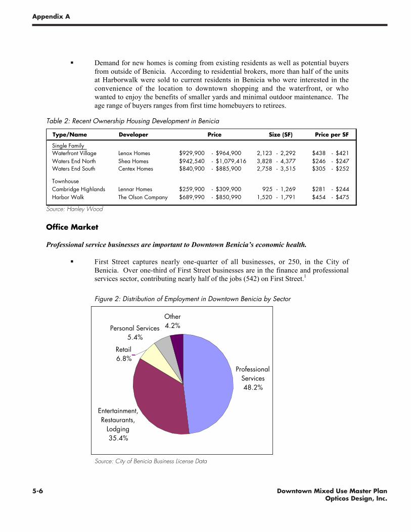
5-6 Downtown Mixed Use Master PlanOpticos Design, Inc.
Appendix A
Draft Market Conditions and Recommendations -7-
! Demand for new homes is coming from existing residents as well as potential buyers
from outside of Benicia. According to residential brokers, more than half of the unitsat Harborwalk were sold to current residents in Benicia who were interested in the
convenience of the location to downtown shopping and the waterfront, or who
wanted to enjoy the benefits of smaller yards and minimal outdoor maintenance. The
age range of buyers ranges from first time homebuyers to retirees.
Table 2: Recent Ownership Housing Development in Benicia
Type/Name Developer
Single FamilyWaterfront Village Lenox Homes $929,900 - $964,900 2,123 - 2,292 $438 - $421Waters End North Shea Homes $942,540 - $1,079,416 3,828 - 4,377 $246 - $247Waters End South Centex Homes $840,900 - $885,900 2,758 - 3,515 $305 - $252
TownhouseCambridge Highlands Lennar Homes $259,900 - $309,900 925 - 1,269 $281 - $244Harbor Walk The Olson Company $689,990 - $850,990 1,520 - 1,791 $454 - $475
Price Size (SF) Price per SF
Source: Hanley Wood
Office Market
Professional service businesses are important to Downtown Benicia’s economic health.
! First Street captures nearly one-quarter of all businesses, or 250, in the City of
Benicia. Over one-third of First Street businesses are in the finance and professionalservices sector, contributing nearly half of the jobs (542) on First Street.
1
Figure 2: Distribution of Employment in Downtown Benicia by Sector
Professional Services48.2%
Entertainment, Restaurants,
Lodging35.4%
Other4.2%Personal Services
5.4%
Retail6.8%
Source: City of Benicia Business License Data
1 Source: City of Benicia Business License Data
5-7Downtown Mixed Use Master PlanOpticos Design, Inc.
Appendix A
Draft Market Conditions and Recommendations -8-
Many downtown office tenants, or professional services businesses, benefit from ground floor,
“walk-in” locations. This accounts for the strong presence of ground floor office tenants on First
Street.
! Downtown professional tenants offer services to residents, such as real estate, law,
medicine, and accounting. Many of these services have similar needs to those ofretail tenants, including high visibility and good access. Others may prefer more
traditional office buildings.
There is competition for ground floor space on First Street from two user groups: office and retail
tenants.
! It appears that office tenants (who offer professional services as opposed to goods)are able to pay higher rents than retail tenants for the same space. Many believe this
is eroding the strong retail presence on First Street.
! Rents in Downtown Benicia currently range from $1.00 to $2.00 per square foot,
although there is evidence of recent increases, resulting from higher prices for new
ground floor commercial space at Harborwalk (asking rents of $2.50 to $3.00).
While the Downtown is the most desirable location for many of Benicia’s professional service
tenants, the Arsenal contains a significant proportion of the total office space in Benicia.
! Rents in the Arsenal are lower than First Street, with rates ranging from $1.00 to
$1.40 per square foot. While some office tenants are drawn to the Arsenal for its
unique character, brokers in the area believe that the lower rents are currently thegreatest draw to leasing space in Arsenal offices.
There is potential for future office growth in Benicia.
! ABAG estimates that there are currently 2,460 Finance and Professional Service jobs
in Benicia, and projects a growth of 620 jobs in this sector from 2005 to 2030,
representing long term potential for over 100,000 square feet of new office space inBenicia. This is a significant amount space relative to the current supply of space on
First Street and in the Arsenal, and will enable some increment of new office
development in these areas.
! Future office growth in Benicia could be absorbed in the downtown, the Arsenal, or
the current and proposed industrial parks between I-680 and I-780. The downtown is
the most desirable location for future growth in professional services geared towardslocal residents, while businesses serving the port and other industrial activities would
be drawn to the industrial parks. The Arsenal offers Benicia an opportunity to
capture a small segment of the office market, including creative industries seekingalternative space configurations such as older industrial buildings.

5-8 Downtown Mixed Use Master PlanOpticos Design, Inc.
Appendix A
Draft Market Conditions and Recommendations -9-
Retail Market
Downtown Benicia has a relatively stable mix of visitor and local-serving retail.
! Benicia has maintained a concentration of restaurants, shopping, and overnight
lodging in its Downtown Area. Patrons of these businesses include both local
residents and visitors to the area who are drawn by Benicia’s location next to thewaterfront, small-town character, periodic festivals and events, and proximity to the
rest of the Bay Area. However there is room for growth in Benicia’s tourist
economy, and a targeted marketing strategy could help stabilize the ebb and flow of
sales from this segment.
Retail tenants in Benicia are limited by the size and quality of ground floor spaces.
! In spite of the Downtown’s vital mix of small retailers, offices, and restaurants, rents
in Downtown Benicia remain relatively low at less than $2.00 per square foot. This
is in part due to the quality and size of ground floor spaces in Downtown Benicia;
infrastructure is often in disrepair, spaces are too small to attract interested businessesor to allow existing businesses to grow, and property owners are sometimes unwilling
to make tenant improvements.
! The process of triggering reinvestment in these properties requires an external force
to start the cyclical process of reinvestment: to afford the costs of building
rehabilitation, property owners have to increase rents, but tenants will only be willingto pay higher rents if spaces are improved and sales increase.
There has been some recent momentum towards reinvestment in First Street retail buildings.
! The retail space in Harborwalk has had a marked effect on the Downtown area.
Asking rents for Harborwalk retail suites are substantially higher than the average
asking rent in surrounding areas, at $2.50 to $3.00 per square foot. Harborwalk hashad success in attracting new tenants, demonstrating to other property owners that
improved space can achieve higher rents. Harborwalk, and other demonstration
projects in the area, could be the trigger for significant revitalization of existing retailin the area.
Rising incomes as a result of higher housing prices and new development could slightly increase
the demand for retail in the Downtown.
! New single-family homes are priced between $840,000 and $1.1 million, which
suggests that new residents have high incomes. For example, assuming a 20 percentdown payment, a 6 percent interest rate, and a 30-year term, a household would need
to have an income in excess of $140,000 to afford a typical unit at Water’s End.
Rising incomes could increase the potential buying power for new retail, and
strengthen local support for downtown shopping.
There is very limited, if any, demand for retail space in the Arsenal.
! Limited access, low visibility, and distance from existing retail centers inhibit the
future market potential for retail in the Arsenal. Some very small additional

5-9Downtown Mixed Use Master PlanOpticos Design, Inc.
Appendix A
Draft Market Conditions and Recommendations -10-
increment of retail, similar to the sandwich shop that currently occupies space on
Adams Street, might be possible if the area experiences job growth or increasedvisitor traffic as a result of new development or marketing.
Industrial Market
The Arsenal supports a wide mix of nonresidential tenants, including a large share of heavy and
light industrial tenants.
! There are over 300 jobs in the Lower Arsenal, of which over a third are in the
construction, manufacturing, and wholesale trade sectors, and nearly 40 percent arein the professional services sector. One-fifth of all jobs are in “other services,” which
ranges from auto repair to massage and other personal services. The wide mix of
business types are likely drawn to this area for a variety of reasons including lowrents, proximity to residential areas, availabili ty of flexible
industrial/storage/production space, or adjacency to the port. The mix of uses is also
reflective of the many identities found in the Lower Arsenal.
Figure 3: Distribution of Employment in the Arsenal by Sector
Professional Services
37%
Retail3%
Arts and Entertainment
1%Education and Health Services
5%
Other Services19%
Construction, Manufacturing,
Wholesale Trade35%
Source: City of Benicia Business License Data
Most future large-scale industrial growth will be accommodated in Benicia’s industrial parks near
I-680 and I-780.
! The limited land supply in the Arsenal, coupled with relatively difficult truck access,limits the future industrial potential of this area to smaller businesses in the
production, distribution, and repair (“PDR”) businesses. These PDR businesses offer
vital services to Benicia’s residents and their presence should be considered in plans
for the Arsenal and other future industrial areas.
5-10 Downtown Mixed Use Master PlanOpticos Design, Inc.
Appendix A
Draft Market Conditions and Recommendations -11-
First Street is the core of Benicia’s downtown, offering residents and visitors alike a small townenvironment in which to shop and work. The main purpose of the planning process in the First Street
area is to refine the land use code, incorporating design guidelines and redefining areas that are
appropriate for mixed-use development. This chapter identifies ways in which the Form Based Codecan help to address Downtown Benicia’s economic issues and further strengthen the commercial
environment found along First Street.
ISSUES FROM STAKEHOLDER INTERVIEWS AND CHARRETTECommunity members and business owners expressed concern about a number of issues regarding the
use and physical characteristics of buildings immediately on First Street. In particular:
! There is a need to strengthen the demand and consumer base for existing retailers. Business
owners in the area noted that it can be difficult to stay profitable, and shopping activityfluctuates to high and low levels with no discernable pattern.
! There is concern about the significant presence of ground floor office users on First Street.
While blocks south of F Street have continuous retail activity and create a vibrant shoppingatmosphere, blocks further to the north have a greater mix of office and retail activity. In
some areas, the presence of ground floor offices makes it difficult for retailers to establish
enough of a presence to draw pedestrian activity. Further, retailers are concerned that officerelated tenants are willing to pay higher rents, and this could further dilute existing
concentrations of retail.
! Commercial uses on First Street are constrained by a variety of building characteristics. The
historic character of First Street that makes Downtown Benicia so unique also provides
structural challenges for property owners and tenants. Business owners reported that the
infrastructure of many spaces is quite old, and may play a role in keeping rents low. Ownersof historic buildings find it difficult to upgrade space because the costs of meeting existing
codes are prohibitively expensive. Further, potential retail tenants who have expressed an
interest in leasing space on First Street have discovered that available spaces are not largeenough to meet their needs.
KEY FINDINGS! The supply of commercial space on First Street exceeds the needs of retailers. First Street
includes over 200,000 square feet of commercial space along eleven blocks from the
Waterfront to Solano Square. This configuration and scale poses several challenges forretailers in Benicia. First, the linear nature of Benicia’s downtown makes it difficult to create
a continuous, active shopping atmosphere along the length of First Street. Second, the City
of Benicia does not have a large enough customer base to support a full 200,000 square feet
of retail, which is the size of a small regional shopping center.
! Office users play a role in Downtown Benicia as well. As the market overview indicates, an
estimated 49 percent of all jobs, and 36 percent of all businesses on First Street are officeusers, who provide professional services to Benicia’s residents. Many of these office users
benefit from the walk-in activity and visibility associated with ground floor space; such users
include real estate agents, mortgage brokers, and accountants. However, some ground floorusers could easily locate on First Street in second or third story buildings, if spaces met their
physical needs.
III. FIRST STREET RECOMMENDATIONS

5-11Downtown Mixed Use Master PlanOpticos Design, Inc.
Appendix A
Draft Market Conditions and Recommendations -12-
! Side street mixed-use zoning increases the already extensive supply of commercial space in
the Downtown. While conversions of residential or other buildings have not been occurring
at a rapid pace, the ability of businesses to convert these spaces rather than occupying space
directly on First Street further dilutes the demand for space that could help stimulate
reinvestment in existing commercial properties. Some side streets in the southern part ofDowntown, such as East D Street, have already reached a mass of commercial space
sufficient to change their character, but new mixed-use development on other side streets
would not be appropriate given the residential character of these streets.
! Attracting additional retail to Downtown Benicia would require an increase in visitor
shopping. As Chapter II illustrated, Downtown Benicia’s primary market area is small
relative to less isolated communities in Contra Costa County or along the Interstate 80corridor. While Benicia residents enjoy higher incomes than their Solano County
counterparts, the lack of critical mass of residents and thru-traffic limits the types of tenants
who are willing to locate in Benicia. However, Benicia does have a small but stable regionaltourism economy and a strong base of visitors attracted by local festivals and the town’s
charming character. It is possible that Benicia could further market to this visitor crowd, thus
enhancing the customer base for existing and potential retailers.
LAND USE POLICY RECOMMENDATIONSSeveral of the issues identified above can be addressed through changes to First Street Area land use
policies. By strategically limiting development of new commercial space to First Street and a handful
of side streets only, the market for retail and office space will be more concentrated. Thisconcentration of uses has several benefits, including encouraging new development and rehabilitation
of existing buildings on First Street by directing demand for commercial space to one area, and
establishing commercial nodes rather than stretching Downtown Benicia along the length of First
Street. Strategic Economics recommends the following land use policies in support of furtherreinvestment in the First Street area:
! Intensify development in Benicia’s major retail nodes, especially south of E Street. Limit
ground floor uses in these areas to retail only. Some areas of First Street have a critical mass
of retailers that should be encouraged, however other areas may always be better suited to a
greater mix of uses. Retail and other commercial uses can be encouraged in blocks adjacentto the waterfront portion of First Street, in order to build upon the area’s existing
concentration of retail and side street mixed-use space. An intensified waterfront commercial
node will also benefit visitor economy by fully taking advantage of the City’s great views and
waterfront experience.
! Limit the mixed-use zoning designation on side streets to key areas only, including the
waterfront commercial node. This allows for a less linear form of retail expansion in majornodes, but also enables office tenants to locate in these areas if they would benefit from walk-
in traffic near Benicia’s more concentrated retail areas. Side street mixed-use designations in
the waterfront area could also enable property owners to develop commercial or mixed-use
buildings that support larger-format retail tenants. Limiting side street mixed-use zoning inother areas concentrates the market potential for non-residential space to First Street, thus
encouraging increased development intensity in the First Street corridor, and potentially
increasing leasing rates to stimulate reinvestment in buildings by property owners.

5-12 Downtown Mixed Use Master PlanOpticos Design, Inc.
Appendix A
Draft Market Conditions and Recommendations -13-
! Support the development of second and third story office or residential uses on First Street.
Consider whether office rents can support the addition of second and third story spaces. Ifallowing a two or three story mixed use building on First Street is not enough of an incentive
to property owners to invest in upgrading or new construction, conduct analysis to determine
whether construction of a building is financially feasible, and in fact profitable to the
developer. Consider whether there are other barriers to new development including thepermitting process, seismic upgrading costs, or historic preservation regulations, to determine
whether further public involvement is necessary to encourage reinvestment.
! Ensure design requirements for future buildings on First Street have ground floor spaces that
are appropriate for retail tenants, even if retail tenants do not occupy them. There are a
number of buildings on First Street with ground floor space that is only appropriate for office
tenants. These building types should be discouraged in the future, in order to offer increasedvisibility and access from First Street foot traffic, and to allow a greater flexibility of uses that
respond to changing market conditions over time.
IMPLEMENTATION STRATEGY RECOMMENDATIONSThe focus of the form-based code is to clarify and improve zoning and design requirements in the
First Street area. Such a code is only focused on land use policy and does not offer a mechanism toinclude information on public implementation strategies and financing options for public investments.
However, many of the issues raised by the community throughout the charrette process suggest that
there are a variety of implementation strategies that the City of Benicia, or the Main Street program,could pursue in coordination with the new land use policies in order to more effectively achieve a
variety of goals including:
! Drawing more business into the Downtown, both from Benicia residents and visitors;! Supporting building improvements to retain existing retailers and office users, and to attract
new businesses; and
! Stimulating reinvestment in historic and non-historic buildings along First Street.
In pursuit of these goals, the City could consider pursuing the following implementation strategies:
! Regional tourism strategy: A coordinated tourism strategy could further attract visitors todowntown Benicia in a variety of ways. Steps that might be included in this strategy are
installing wayfinding signs from I-680 and I-780; continued attraction of visitors through
regional marketing and festivals; and drawing visitors by linking First Street shopping to theCity’s existing artist community by offering a subsidized downtown gallery. Future steps in
attracting visitors should build off of the City’s existing tourism strategies such as festivals,
farmer’s markets, and regional advertising on billboards. A more comprehensive strategy
could be pursued through either the Main Street program or through the City directly.
! Low/no interest loans for building improvements, and Unreinforced masonry (URM) grants
or loans: Cities have created different types of financing programs to assist property ownerswith the costs of rehabilitation. A loan or grant program in Downtown Benicia could alleviatethe prohibitive costs of seismic upgrading, accessibility codes, and unknown structuralupgrading. Likewise, a construction loan program would enable property owners to invest inrehabilitation with less equity. Sample loan and grant programs include:
o Design consultation grants and programs (Pinole, Vacaville)o Façade Improvement Grants and Loans (Emeryville, Vacaville)o Seismic Upgrading Grants and Loans (Pinole, San Jose, Vacaville)o Matching Fund Loans (Vacaville)