citizen’s guide to land use, planning and development
TRANSCRIPT

Citizen’s Guide to Land Use, Planning and Development
Bethlehem, New York Produced by the Department of Economic Development and Planning, 2013
Delaware Avenue

The purpose of this Citizen’s Guide is to explain land use, planning and development in the Town of Bethlehem, in nontechnical terms. Planning is essential to ensure that the Town maintains a balance of economic growth, protection of natural resources, and sustainability in a manner that preserves the Town’s aesthetic character. Adopted by the Town Board in 2005, the Comprehensive Plan is not a law but rather serves as the overarching guide to all planning and land use regulation in the Town. The Comprehensive Plan is intentionally not prescriptive, but sets forth a vision. The Town Code and associated Zoning Map formally govern development, explicitly defining size and scope of allowable projects in each zone. The Town Code includes regulations for zoning, subdivision, streets/sidewalks, and building construction, among others. Developers propose projects in accordance with federal, state, and local laws. All proposed development follows a formal process, which may include Board review and approval. Town residents can comment on development proposals at public hearings, which are posted on the Town’s website.
3
4
5
6
7
8
10
11
12
13
14
15
BACK
Planning Vision
Zoning and Uses | Zoning Map
Hamlet Zoning
Review Boards
Development Process
Subdivision and Building Application Process
Balancing Development and Open Space
Conservation Subdivision
Mixed Economic Development District
Planned Development District
Planning Studies
Frequently Asked Questions
Planning Terms
Welcome
Bethlehem Town Hall, Delaware Avenue

PLANNING VISION
Goals identified in the Comprehensive Plan Situated in the heart of the New York’s Capital District, Bethlehem offers convenient access to all that the region has to offer. It is recognized for the excellence of its schools, the quality of its public safety and community services, the abundance of its recreational opportunities, the productivity of its local businesses, ten miles of Hudson River waterfront, and the beauty and health of its natural environment. This exceptional quality of life contributes to the economic growth and prosperity of the town and the region, assuring that the community can continue to meet the increasingly diverse needs and expectations of its residents in a fiscally sustainable manner.
- Excerpt from 2020 Vision Statement, Comprehensive Plan
Achieve a balanced tax base of residential development, commercial and industrial development, and open space.
Create a business-friendly environment supportive of small local businesses.
Encourage compact, mixed-use commercial and residential development in neighborhood commercial centers and hamlet centers. Appropriate design, attention to the pedestrian environment, and connections to adjacent neighborhoods are critical to the success of such centers.
Expand active and passive recreational resources and community services.
Develop mechanisms for protecting and enhancing the Town’s significant cultural resources, historic resources, and natural resources .
Maintain existing public water and sewer infrastructure in developed areas of the Town.
Work with willing landowners to conserve quality open spaces throughout the Town and create a network of open lands to provide wildlife habitat and potential recreational trail corridors.
Improve mobility to support people regardless of age and status. This includes strategic investments in roadway and pedestrian infrastructure, improved access to public transportation and development that is supportive of public transportation and non-motorized modes of travel.
Manage and protect significant environmental systems such as stream corridors and associated ravines, steep slopes, wetlands, and in particular, the Hudson River waterfront, and enhance public access to these resources.
Promote commercial and industrial growth in specifically designated locations. Encourage the reuse or redevelopment of existing sites and buildings as an alternative to development on “greenfield” locations.
Promote energy efficiency and conservation, and the use of renewable energy in the Town.
3
Provide opportunities for the development of a variety of housing options in the Town to meet the needs of its increasingly diverse population. In particular, the trend toward smaller household sizes, the aging population, and the increasing need for affordable housing for low to moderate income households.

ZONING AND USES
To download a large copy of the Zoning Map, visit the Town’s website.
What are the Town’s zones? The Town’s Zoning Map includes 16 zones, which specify residential, commercial, industrial, and mixed-use activities appropriate for that area. Each zone falls into a use district: residential, mixed-use, commercial, or special district. The zone types are: Commercial Hamlet (CH), Core Residential (CR), General Commercial (C), Hamlet (H), Heavy Industrial (I), Mixed Economic Development (ME), Multi-Family (MR), Planned Development District (PDD), Residential A (RA), Residential B (RB), Residential C (RC), Residential Large Lot (RLL), Rural (R), Rural Hamlet (RH), Rural Light Industrial (RLI), and Rural Riverfront (RR). The Schedule of Use Table defines residential uses (e.g. single family home, multifamily units, senior
housing, etc. ) and nonresidential uses (e.g. business office, fitness club, hotel, etc.) that are permissible in each zone. The Schedule clearly indicates , for each zone, whether each use is allowed by right (subject to building permit and certificate of occupancy for certain improvements), or allowed subject to a site plan approval, or subject to a special use permit, or prohibited.
The Schedule of Area, Yard, and Bulk Requirements defines the permissible lot dimensions (e.g. lot size, yard size, frontage, setbacks, etc.) for all developments in each zone.
How are the activities of each zone governed?
Town Code is available online
Chapter 128: Zoning Law Chapter 128a: Schedule of Uses Chapter 128b: Schedule of Area, Yard, and Bulk Requirements
Who enforces zone’s activities and construction? The Town’s Building Inspectors enforce the zoning code. Permits are required for any new or altered construction and no permits are issued until the Building Inspector has certified that the proposed building or alteration complies with the zoning code.
Are there ever exceptions? Area and use variances are essentially waivers from a component of the zoning code. Variances are approved by the Zoning Board of Appeals and granted only if the applicant can prove hardship and unique circumstances.
4
How does the Town support creative development? The Town’s Zoning Map and code serve as a framework to ensure growth occurs in accordance with the Town’s goals in the Comprehensive Plan. The Town also employs tools that afford more flexibility in design such as Conservation Subdivision, Mixed Economic Development, and Planned Development District, to name a few. The Department of Economic Development and Planning is always available to work directly with developers and stakeholders to support creative design.

HAMLET ZONING 5
Hamlet zoning encourages compact, mixed-use commercial and residential development. These zones allow for a variety of housing types and mixed-use buildings. The scale of development and pedestrian connections to neighborhoods is a priority within Hamlet zoning.
There are three types of Hamlet zoning: Hamlet, Commercial Hamlet, and Rural Hamlet. 1. Hamlet focus on pedestrian-friendly access,
compact mixed-use commercial and residential development and parking in the rear of buildings.
2. Commercial Hamlets provide for medium scale businesses and essential services to serve adjacent neighborhoods.
3. Rural Hamlets encourage small-scale businesses and compact commercial and residential development in close proximity to rural and agricultural land.
Hamlet zoning exists in several areas throughout Town such as along New Scotland Road, Elm Avenue at Cherry Avenue, Route 9W at Maple Avenue, the intersection of Feura Bush Road and Elsemere Avenue, and along Delaware Avenue, to name a few.
The Hamlet Apartments, New Scotland Road Hamlet
Keystone Builders, Elm Avenue/Cherry Avenue Hamlet
Park Place at Glenmont Square, Rt 9W at Hague Boulevard Hamlet
Berkshire Bank, Delaware Avenue Hamlet
Where are the Hamlets?
Kendall Square, Elsmere Avenue Hamlet

REVIEW BOARDS
Planning Board The Planning Board currently consists of seven members. Responsibilities include: reviewing site plan and subdivision proposals, approving special use permits, and providing guidance to the Town Board on zoning changes and Planned Development District proposals. These functions are carried out in close cooperation with the Town's Planning Department and Engineering Division. The Planning Board meets twice each month, on the first and third Tuesday at 6:00 pm in the Town Hall Auditorium. Meetings are webcast and archived, as well as shown on the local cable TV networks.
Zoning Board of Appeals
Development Planning Committee The Development Planning Committee (DPC) consists of representatives of the various Town departments that are involved in facilitating or servicing development projects in Town and functions under the direction of the Department of Economic Development and Planning. The DPC holds regularly scheduled monthly meetings during which prospective developers can present development concepts and receive feedback from the Town on a host of development related issues. The DPC facilitates early communication between the Town and developers during the project concept phase with regard to a variety of issues, which will later be considered by the Planning Board, such as:
• consistency with planning, zoning, building code and land use regulations • environmental impacts • stormwater regulations • availability and adequacy of public facilities (water mains, storm drainage, sanitary sewer, and roads) • potential for land conservation or parkland development • economic and fiscal impacts
The DPC usually meets on the third Thursday of the month at 10:00 a.m. and the meetings are open to the public.
The Zoning Board of Appeals (ZBA) consists of five members. The ZBA holds public hearings and decides appeals from decisions and determinations made by the Town Building Inspector as well as matters referred to it as prescribed by Town Law. Appeals shall be taken within 30 days unless the applicant is granted additional time by the Board. A concurring vote of at least three board members is needed in order to reverse a prior determination of the Building Inspector or to grant relief from applicable provisions of Town Law. All decisions of the Board shall be in writing and state fully the Board's decision and the reasons, facts and laws on which the decision was based. The ZBA meets twice each month, on the first and third Wednesday at 7:00 pm in the Town Hall Auditorium. Meetings are webcast and archived, as well as shown on the local cable TV networks.
The Planning Board and Zoning Board of Appeals are described in state law and have a legal role in Town land use oversight. However, as it is useful to identify development issues early in the project design process, the Town has established a Development Planning Committee (DPC) as a workgroup to give a pre-proposal review so that a project can be evaluated before it goes through the formal review stages. The powers and duties of the formal review processes through the Planning Board and the Zoning Board of Appeals (ZBA) are governed by Town law. Members of the Planning Board and ZBA are appointed by the Town Board. The DPC, Planning Board and ZBA all allow public comment and when necessary, hold public hearings.
6

DEVELOPMENT PROCESS
The flow chart illustrates the general process for a development project from initial application (project proposal) to construction. This primarily applies to site plans, special use permits, and subdivision applications. Minor modifications to the process may occur if a development project is located in the Mixed Economic District or requires a rezoning. There are opportunities for public input whenever a project is on a committee or board agenda.
Applicant meets with Town staff to discuss proposal
Applicant submits development plans
Town departments provide review comments
Applicant revises plans and provides initial presentation
to the Planning Board
Applicant addresses comments from Town
departments and Planning Board
Application may be referred to Albany County Planning Board
Planning Board conducts environmental review
Planning Board either approves, approves with
modifications/conditions, or disapproves the project
If needed, applicant addresses approval
modifications/conditions
Plans receive Planning Board Chairman’s approval stamp
Building Department issues Building Permit
Applicant constructs the project in accordance with
the approved plans
Building Department issues Certificate of Occupancy at
construction completion
BEG
IN
7
Public Comment
Opportunity
Public Comment
Opportunity
Public Comment
Opportunity

SUBDIVISION and BUILDING APPLICATION PROCESS
• Subdivision Application Form, which is found in the Subdivision Planning Packet. • Plat: Depending on the type of subdivision, the Plat must adhere to the requirements set forth
within the Town of Bethlehem Subdivision Regulations, Article V, adopted by the Town Board. • Minor Subdivision: Short Environmental Assessment Form OR
Major Subdivision: Long Environmental Assessment Form • Letter to the Chairman of the Planning Board: This letter must include a request to be placed on the
Board’s agenda for consideration. • Fees: Fee requirements are outlined the Fee Schedule, adopted by the Town Board.
What is the first step to proposing a subdivision? Contact the Town’s Department of Economic Development and Planning for a Subdivision Planning Packet, which includes a Subdivision Application Form, Affidavit, Minor Subdivision Plat Data Checklist, Major Subdivision Preliminary Plat Data Checklist, and List of Major Subdivision Required Standards.
What does the applicant submit?
Town Code is available online
Chapter 53: Building Construction and Fire Prevention Administration Chapter 56: Buildings, Unsafe Chapter 103: Subdivision Regulations
A subdivision is a cluster of houses planned during one development project. Subdivisions may also include mixed-use developments projects including office and retail space within the residential subdivision. A Minor Subdivision is defined as one that results in the creation of four or fewer lots fronting on an existing improved street and does not require any new streets. A Major Subdivision is one that exceeds this threshold and requires new streets or the extension of municipal facilities (water/sewer).
What is a subdivision?
Sample Subdivision Plan, The Pines at Normanside
8
• Configuration of Lots (Area, Yard, Bulk) • Landscaping • Street pattern • Service access • Drainage • Utilities • Environmental considerations
What are the design elements?
The Gables at Delmar, Delaware Avenue

9
The Planning Board has authority over subdivision proposals. 1. Initial Presentation to Planning Board There is an opportunity for public comment on agenda items during the initial 10
minutes of the meeting 2. Referral to Albany County (if necessary) 3. SEQRA Determination of Significance. Review by State agencies (NYSDOT, NYSDEC, etc.) 4. Public Hearing 5. Preliminary Plat Approval (if necessary) 6. Final Plat Approval (conditional)
Applicant to address conditions 7. Subdivision filed with Albany County Clerk
What is the review process?
1. Sketch Plan (optional): This occurs at the staff level through the Development Planning Committee. There are no formal time periods or specific procedures for this stage. This is for the benefit of the developer to learn if the project conforms to zoning and subdivision requirements; to receive suggestions regarding design and layout; to determine if a subdivision is major or minor; to identify necessary permits; and to discuss compliance with SEQRA (State Environmental Quality Review Act). The Planning Board is not bound by the DPC’s comments.
2. Preliminary Plat 3. Final Plat
Innovative Surface Solutions, RT 144
What are the design stages?
What is the first step to getting a building permit? Contact the Building Department for a Building Permit Application. (Note: In addition to building permits, the Town requires permits for signs, pools, fences, and host of other construction and rehabilitation activities.)
• Building Permit Application: Application must be filled out in ink, signed and notarized, if applicant is not the property owner. Efforts should be made by the applicant to complete the Application prior to submission.
• Plot Plans (Surveys): Plot plans must include new construction, additions when adding square footage, accessory structures, lawn sprinkler systems, swimming pools, sheds, detached garages, fences and roofing.
• Building Plans: Building plans are required for new construction, alterations and/or additions: If the value is more than $10,000, a New York State licensed engineer or architect must stamp the plans.
• Fees: Fee requirements are outlined in the Fee Schedule, adopted by the Town Board. Fees are required prior to the issuance of a permit.
What does the applicant submit for a building permit?

BALANCING DEVELOPMENT AND OPEN SPACE
“The Town will work with willing landowners to conserve quality open spaces throughout the Town and create a network of open lands to provide wildlife habitat and potential recreational trail corridors.”
What is open space? Open space is land that is not intensively developed. It is uniquely defined by each community’s characteristics and may include agricultural and forest land, undeveloped scenic lands, public parks, and hiking/biking trails, to name a few. Open space includes land that provides for public use as well as conservation land that prohibits public access.
What tools are currently used to achieve a balance of planned development and conservation?
The Town seeks to achieve a balance of economic growth for tax base diversification with the stewardship of finite land and environmental resources.
• Constrained lands are lands containing one or more of the following: protected freshwater wetlands, floodplains or flood hazard areas; steep slopes; and streams, ponds or lakes. When calculating the development potential of a parcel, constrained lands must be subtracted from the site area to determine the general site density.
• Additionally, Federal and State development requirements encourage the protection of land. For example, the State Department of Environmental Conservation (DEC) requires stormwater pollution prevention plans for the majority of development projects in the Town. Wetlands that are greater than 12.4 acres fall under the jurisdiction of the DEC. The Army Corps of Engineers also protects wetlands, regardless of size. Proposed impacts to wetlands require approvals from the applicable government agency.
• In reviewing residential site plans and subdivisions, and proposals for planned residential and mixed economic developments, the Town must ensure that the park demands generated by new residential development are addressed. This can be accomplished by requiring that a portion of the parcel be reserved for such purposes or alternatively can require that a fee in lieu of land reservation be paid to the Town. The Town Board can use this fee to maintain existing Town parks and recreation areas or purchase additional land for parks.
Scenes from around Town
• Conservation Subdivisions allow for development on a more concentrated portion of the land (compared to conventional subdivisions) leaving a majority of the remaining land left in its natural, open space condition in perpetuity.
- Comprehensive Plan goal
Who is impacted by planned conservation/open space? The intention of planning for a balance of development and conservation is to benefit everyone and harm no one. Open space planning places no requirements on landowners who do not wish to contribute to conservation and relies on willing landowners only. Willing landowners may choose to dedicate a portion of their property to open space and still develop a different portion of their land. In addition to the obvious aesthetic benefits, open space adds value to a neighborhood; supports farming; provides for recreation; protects natural resources and habitats; does not increase property taxes; and requires zero to minimal Town services.
10

CONSERVATION SUBDIVISION 11
Conservation Subdivisions allow for flexibility of design and development so as to preserve natural and scenic qualities of lands. It functions as a mechanism to preserve open space, agricultural land, water supplies, and other environmental resources within a developed site by clustering residences in areas that have the least impact. Conservation subdivisions can take advantage of incentives for increased density through incentive zoning provisions. Unusable lands, like wetlands, are not included within the calculation of developable – and ultimately conservation – lands.
23
11
24 25 26 27
28 29 30
31
Below is a site with a conventional subdivision layout that yields 29 units and the same site using the Conservation Subdivision design guidelines that preserves significant usable lands and results in 31 units. The lands identified in red will be designated open space in perpetuity.
1
2
3
4 5
6 7 8
10
9
13 12
15
16
14
19 18 17
21 22
20
Illustrative Example
29
30 3
1
10
11
12
13 14
15 16
17
18 19 20
21 22 23
24
25
26
27 28
29
Conventional Subdivision Conservation Subdivision
1
2
3 4
5 6 7
8
9

MIXED ECONOMIC DEVELOPMENT DISTRICT
Main elements of MEDD
One of the tools that the Town employs to support creative development is the use of the Mixed Economic Development District (MEDD). MEDDs allow for a mix of uses on one site.
12
In order for a site to be considered for MEDD, the development of a Master Plan is required. The Planning Board reviews and make recommendations, but the project must receive Town Board approval. Primary uses in MEDD include office, light industrial, manufacturing and technology-based businesses. These may comprise up to 100% of gross floor area of site. Secondary uses include service businesses, restaurants, entertainment uses, small-scale retail. Secondary uses may not exceed 30% of the gross floor area of the site. In MEDD, multi-family units are permitted but only at a maximum of eight dwelling units per acre.
Glenmont Road, Route 9W, the Thruway, and Wemple Road South of Wemple Road between Route 9W and the Thruway
Between Wemple Road and Clapper Road to the north and south, and between the railroad tracks and Route 144 to the west and east
Slingerlands Area (Vista Tech Campus)
Vista Tech Campus, Slingerlands
Along Route 144, just north of Exit 22 and south of the Cedar Hill hamlet
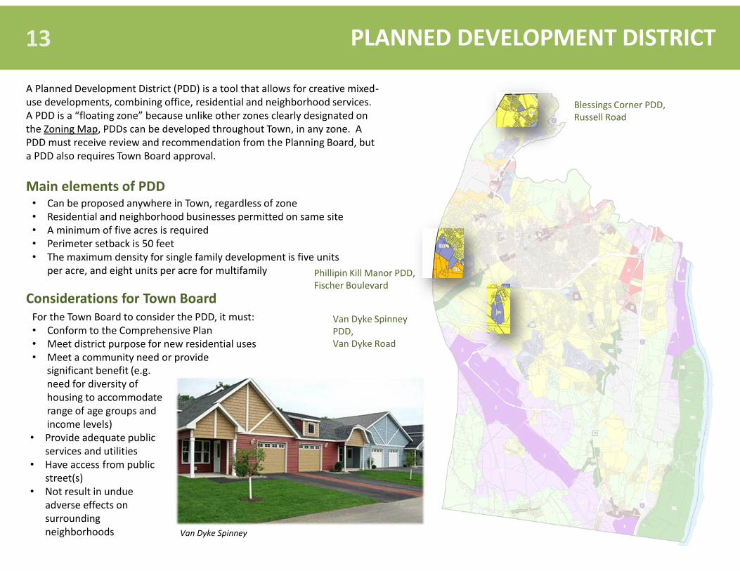
PLANNED DEVELOPMENT DISTRICT 13
A Planned Development District (PDD) is a tool that allows for creative mixed-use developments, combining office, residential and neighborhood services. A PDD is a “floating zone” because unlike other zones clearly designated on the Zoning Map, PDDs can be developed throughout Town, in any zone. A PDD must receive review and recommendation from the Planning Board, but a PDD also requires Town Board approval.
• Can be proposed anywhere in Town, regardless of zone • Residential and neighborhood businesses permitted on same site • A minimum of five acres is required • Perimeter setback is 50 feet • The maximum density for single family development is five units
per acre, and eight units per acre for multifamily
For the Town Board to consider the PDD, it must: • Conform to the Comprehensive Plan • Meet district purpose for new residential uses • Meet a community need or provide
Main elements of PDD
Considerations for Town Board
significant benefit (e.g. need for diversity of housing to accommodate range of age groups and income levels)
• Provide adequate public services and utilities
• Have access from public street(s)
• Not result in undue adverse effects on surrounding neighborhoods Van Dyke Spinney
Blessings Corner PDD, Russell Road
Phillipin Kill Manor PDD, Fischer Boulevard
Van Dyke Spinney PDD, Van Dyke Road

PLANNING STUDIES
9W Corridor Study (2008) The 9W Corridor study assesses the area’s transportation infrastructure’s ability to accommodate traffic generated by additional development in the 9W region. The study focuses on a review of previous planning efforts in the corridor; development of an existing conditions profile for the corridor; development of a 20-year growth scenario and traffic forecast; and the establishment of a vision statement and planning principles for the corridor.
Delaware Avenue Hamlet Enhancement Study (2011) The Delaware Avenue Hamlet Enhancement Study focuses on design guidelines; streetscape standards; parking and circulation for vehicles and bicycles; transportation improvements; and access management. There are four components to the study: Streetscape and Hamlet Design Standards and Guidelines; Transportation Improvement Plan; Study Implementation Section; and a Delaware Avenue Study Brochure.
Recommendations on Open Space Needs and Opportunities (2009) The Recommendations on Open Space Needs and Opportunities, completed with the participation of the Citizens Advisory Committee on Conservation (CACC), presents findings from an open space assessment and provides recommendations to establish a framework for open space planning in the Town. The report includes several useful maps, which can be found on the Town’s website, such as Recreation and Pathways Map, Natural Systems Map, and Farmland Location Map.
These studies, and others, flow from the Comprehensive Plan. All of the materials associated with each study, including information on the respective advisory committee’s contribution, can be found on the Town’s website. Development applicants are encouraged to review these studies, which may influence the design of their proposed projects such as site layout, building design, driveway access, etc.
Local Waterfront Revitalization Program and Harbor Management Study (under review) The Local Waterfront study includes an inventory of natural and man-made resources in the waterfront area; identification of existing roles and responsibilities of federal, state and local agencies in the study area; description of proposed land and water uses; and the Development of a Master Plan for Henry Hudson Park.
New Scotland Road Hamlet Plan (2006) The New Scotland Road Hamlet plan provides design guidelines unique to the Hamlet’s region. Through significant community participation, the plan sets forth a vision for the Hamlet that includes: traditional architectural styling and details, high density mixed-use development, public gathering spaces, smaller residential lots, and green spaces, to name a few.
14

FREQUENTLY ASKED QUESTIONS 15
Q. How can I contact the Building Department? A. Town Hall: Second floor, room 214
Phone: (518) 439-4955, ext. 1112 View e-mail address at: Building Department website
Q. How can I contact the Planning Department? A. Town Hall: Second floor, room 203
Phone: (518) 439-4955, ext. 1158 View e-mail address at : Planning Department website
Q. Who can I contact to ask about construction activity? A. Construction activity is monitored by the Building Department. Records are available to the public and can be viewed at the Town Hall, room 214. Q. Who can I contact to ask about proposed projects? A. Proposed projects are monitored by the Planning Department. Records are available to the public and can be viewed at the Town Hall, room 203. Information about projects being currently reviewed by the Town may also be found on the Town website at the meeting portal. Q. Where can I find information on Building Permits, Certificates of Occupancy, compliance with and/or violation of Building and Fire Codes? A. Contact the Building Department.
Q. What are the procedures and requirements for obtaining a Building Permit? How long does it take? A. Contact the Building Department for an application and instruction sheet. Issuance depends on current workload, however, typical turnaround
time is 7-10 business days. Q. How can I find out what Zoning District a property is in and what uses are allowed in the zone? A. For a general determination, review the official Zoning Map. Contact the Building Department with questions related to Zoning. This information is
also available on the Town's website.
Q. Who is responsible for maintaining the highway right-of-way? A. The Town's Highway Department is responsible for maintaining right-of-ways on Town-owned roads. Town right-of-ways are typically 25 feet from
the center line of the road. The Town is not responsible for maintaining right-of-ways located on County and State roads. For questions regarding County Roads, contact the Albany County Highway Department at (518) 765-2786. For questions regarding State Roads, contact the New York State Department of Transportation at (518) 765-2849.
Farmland, Meads Lane Henry Hudson Park

REZONING The Town is divided into 16 zones, which reflect existing or desired land uses . An individual can apply to change the zone of a parcel by completing a Rezoning application found on the Town’s website. The application requires review and approval from the Town Board.
SITE PLAN
MIXED ECONOMIC DEVELOPMENT ZONE
PLOT PLAN
HAMLET
A Mixed Economic Development Zone allows for a mix of office, light industry, and technology business as primary uses and high-density residential and neighborhood commercial as secondary uses.
It is commonly understood that the Town consists of Hamlets including Delmar, Selkirk, Elsmere, etc. In fact, these are not municipal subdivisions, but general neighborhood names that only exist distinctly by postal code. The Town’s Hamlets can be understood as small centers of social, cultural, civic and economic activity within the community.
PLANNED DEVELOPMENT DISTRICT
A Planned Development District (PDD) is a tool that allows for flexibility in development and conservation, such as creative architectural or planning concepts. PDDs require both Town Board and Planning Board review. PDDs are also sometimes described as “floating zones” because they may be developed anywhere within the Town provided the Town Board rezones them as such.
Stormwater is water from rain or melting snow that flows from rooftops, roadways, sloped lawns, etc., collecting and transporting animal waste, pesticides, fertilizers, oil and other potential pollutants. After these contaminants are carried away by stormwater runoff they are discharged into the bodies of water that we use for fishing, swimming, and drinking.
STORMWATER
A site plan is a drawing of a region of land that includes specific components such as property lines, location and size of buildings, easements, roads, driveways, and location and description of water supply and sewage disposal facilities, to name a few.
A plot plan is similar to a site plan except that it only covers a specific parcel of land and often requires additional descriptions of the structures on the property such as roof line, landscaping, etc.
VARIANCE A variance is a specific exemption from a zone’s regulations subject to approval by the Zoning Board of Appeals. Exceptions to permissible use and size of structures allowed in a zone require a Use Variance or an Area Variance respectively.
Town of Bethlehem 455 Delaware Avenue
Delmar, New York 12054 (518) 439-4955
townofbethlehem.org
PLANNING TERMS
Citizen’s Guide to Land Use, Planning and Development
HAMLET ZONING Hamlet Zoning allows for a variety of housing types and mixed-use buildings, with a particular focus on scale and pedestrian connectivity. Hamlet, Commercial Hamlet, and Residential Hamlet zones’ guidelines are prescribed in Town code.