citation no. 3 - she-oak hill dry stone wall · pdf filetypical melton heavy round lava...
TRANSCRIPT

Consultants: Jim Holdsworth, Raelene Marshall, David Moloney (2007) Sera Jane Peters (2011) 57
Melton Dry Stone Wall Study, Volume 2 – Citations
Melton Dry Stone Walls Survey Nos: (See description)
Location: Beatys Road, Ryans Road, and Diggers Rest – Coimadai Road, Diggers Rest
Critical Dates: Construction and repair of dry stone walls: c.1850s-1920s
Existing Heritage Listings: HO14, HO15, HO37, HO39, HO40, HO50
Recommended Level of Significance: LOCAL
Citation No. 3 - She-Oak Hill Dry Stone Wall Precinct
Statement of Significance: The She-Oak Hill Dry Stone Wall Precinct is significant as a collection of characteristic and highly intact dry stone walls situated between two different types of volcanic eruption points; in an intact, rural setting in which the unbroken lengths of stone wall remain as a unifying feature of the landscape. The cultural landscape also features two substantial bluestone mid nineteenth century homesteads and associated farm complexes, and two other heritage dwellings dating to the 1880s and the 1920s. The walls are significant for their length and range of all-stone and composite types. It demonstrates nineteenth century rural settlement patterns and a now largely superseded type of fence construction, and has high potential to provide both research and educational information regarding mid-nineteenth and early twentieth century fencing practices within Victoria.
The She-Oak Hill Dry Stone Wall Precinct is historically significant at the LOCAL level (AHC A3, A4, B2, D2). It includes some of the major walls in the Shire, in terms of length and variety of wall types; the longest dry stone wall in the Shire (3.8 kilometres); high and
long all-stone walls; one of the two best surviving examples of the most common style of wall in the Shire (composite stone and post-and-wire fences); composite walls (some with remnants of early post and rail tops); and walls with different stone types, ranging from the typical Melton heavy round lava basalt, to a rare red hued wall with angled vesicular fieldstone near the She-Oak Hill scoria cone. The precinct demonstrates, in the arrangement of walled enclosures and paddocks, early farming settlement patterns of Melbourne’s western plains. The cultural landscape includes four dwellings of heritage significance, ranging from substantial nineteenth century bluestone homesteads (Pinewood and Glencoe, HO 37 and HO 14), rare in the Shire; to a Federation era timber cottage (Angus Downs, HO 15); and an interwar timber bungalow (Kororoit Park Stud, HO 39). The precinct is historically significant for its association with the pioneer settler John Beaty and his family, who built (or commissioned) the construction of all but but one of the walls.
The She-Oak Hill Dry Stone Wall Precinct is aesthetically significant at the LOCAL level(AHC E1). The dry stone walls which cross the landscape in regular enclosure patterns, make a fundamental statement about human interaction with the volcanic landscape of which they are a part. The precinct has views of two volcanic sources: the more vertical and conical shape of She Oak Hill to the south; and the broader shape of Aitkens Hill, a ‘lava shield’ volcano to the north. While the most publically accessible walls are not high or dramatic, their original rural context is intact, ensuring that the walls are a prominent feature of the cultural landscape. The precinct affords beautiful pastoral views of farms, walls and wooded hills in the distance in undulating terrain, which contrasts to all the other very flat precincts. Numerous individual walls, including Walls R309 and R297 have excellent sculptural qualities and are

Consultants: Jim Holdsworth, Raelene Marshall, David Moloney (2007) Sera Jane Peters (2011) 58
Melton Dry Stone Wall Study, Volume 2 – Citations
expressive of the skilled craftsmanship of their builders.
The She-Oak Hill Dry Stone Wall Precinct is scientifically significant at the LOCAL level (A1, C2). The walls in the precinct demonstrate two different type of volcanic eruption points: She Oak Hill (a ‘scoria hill’ which emitted a more irregular vesicular stone); and Aitkens Hill (a ‘lava shield’ volcano which emitted a heavy round lava basalt). The walls also have potential to yield research information regarding nineteenth century rural settlement patterns and farm management, and ways of life on Melbourne’s western plains. In particular they have high potential for research of mid nineteenth century wall construction techniques, and the early twentieth century modification of these for changing farming practices.
The She-Oak Hill Dry Stone Wall Precinct is socially significant at the LOCAL level (AHC G1). The precinct has the potential to educate the community in regard to wall construction techniques, and also nineteenth century farm management, settlement patterns, and ways of life.
Overall, the She-Oak Hill Dry Stone Wall Precinct is of LOCAL heritage significance.
The following extract from Council’s GIS records all the walls in the She-Oak Hill Precinct (Blackhill Road):
WALL NO NEAREST ROAD
R190 Diggers Rest Coimadai Road
R194 Blackhill Road
R195 Blackhill Road
R196 Ryans Lane
R245 Diggers Rest Coimadai Road
R246 Blackhill Road
R247 Blackhill Road
R248 Blackhill Road
R301 Blackhill Road
R302 Blackhill Road
R303 Blackhill Road
R304 Blackhill Road
R305 Blackhill Road
R307 Blackhill Road
R308 Blackhill Road
R37 Blackhill Road
Description: The landscape features of the precinct, and the source of the fieldstone used in the construction of its walls, are She-Oak Hill (the top half of which is now removed for quarry stone) and Aitkens Hill, two of about 400 inactive eruption points that have been identified on Victoria’s western volcanic plains. Most were active between 4.5 million and 20,000 years ago.
In the Werribee – Bacchus Marsh area lava streams flowed to the south from catchments rising gently to the north and west. The ‘Port Phillip Sunklands’ contain scoria cones and domes as well as lava volcanoes with many broad low eruption points producing numerous overlapping flows. The tongues of lava emanating from ‘Lava Shield’ and ‘Lava Hill’ volcanoes – Mount Cottrell, Mount Atkinson, Mount Kororoit, Aitkens Hill, Cabbage Tree Hill and several unnamed hills – were gently effusive and slowly cooling, producing a dense basalt. The less numerous ‘Scoria Hills’ (the best example of which was She Oak Hill) were formed by more explosive and quickly cooling eruption points, which produced ‘pyroclastic material’ (ejecta), which ranged in size from ash, through sand and gravel, to large boulders, but which is generally seen as a more vesicular scoria, or tuff. While the round-shaped heavy fieldstone that is the major material seen in the dry stone walls of the Shire is the product of the Lava Shield and Lava Hill volcanoes, the ‘vesicularity’ of stone from the same eruption points varies, and there is often a mixture of dense, smooth lava stone and more honeycombed textured lava stone in the same area.1
1 Rosengren, N, ‘Eruption Points of the Newer Volcanics Province of Victoria: An Inventory and Evaluation of Scientific Significance’, a report prepared for the National Trust of Australia (Victoria) and the Geological Society of Australia (Victorian Division), 1994, pp.7-31

Consultants: Jim Holdsworth, Raelene Marshall, David Moloney (2007) Sera Jane Peters (2011) 59
Melton Dry Stone Wall Study, Volume 2 – Citations
Most of the steep-sided, dome shaped volcanic hills in Victoria are mounds of scoria, as distinct from volcanoes built up with lava flows, which are broader, with low angle slopes (such as Mount Cottrell). The near perfect sugarloaf shape dome of She Oak Hill, the only Scoria Cone in Melton Shire, is now completely removed.2 The walls in the precinct demonstrate two different type of volcanic eruption points: the typical Melton heavy round lava basalt (the most common type), and the angled vesicular fieldstone in a unique (for Melton) red hue near the She-Oak Hill scoria cone.
Apart from its geological and landscape context, and the walls themselves, the precinct includes buildings of considerable heritage significance. There are four dwellings, ranging from substantial nineteenth century bluestone homesteads, to Federation era timber cottage, and an interwar timber bungalow:- Pinewood homestead and garde, Glencoe homestead and outbuildings, which include a dry stone wall pig pen, Angus Downs and Kororoit Park Stud. They are integrally linked to the walls in this precinct, virtually all of which are either located on these farms, or were boundaries to these properties.
The landscape is arranged around Blackhill Road, which runs along a ridge between Yangardook and Kororoit Creek (West Branch). The landscape rises to the north, and is elevated above the plains to the south. In addition to She Oak Hill and Aitkens Hill, it provides views over these valleys and the timbered Black Hills behind Greenhills to the west. The precinct offers good visibility of most of the walls. The undulating landscapes within the properties themselves enable the dry stone walls to be appreciated as a cultural landscape; surrounding treed hills contribute to the beauty and integrity of the landscape.
The higher all-stone walls are within Pinewood and Glencoe. The mature hawthorn hedge (Crataegus monogyna) along the Pinewood homestead wall is indicative of the age of that wall. It is the only hawthorn hedge planted in association with a wall in the Shire.
The higher all-stone walls are the exceptions in the precinct, which generally consists of good representative examples of composite stone and post and wire walls. The precinct includes many very long walls, and includes the longest wall in the Shire (Wall R248). Some of these walls were originally post and rail,
2 ibid, pp.349, 373
and there are significant segments of post and rail posts.
She-Oak Hill dry stone wall precinct
History:
CONTEXTUAL HISTORY
Fencing in Nineteenth Century Rural Victoria
• Fencing1850s-1870s
The majority of dry stone walls in Victoria appear to have been built in the 30 year period from the 1850s to the 1880s.
In 1826 rural affairs commentator James Atkinson reported that he knew of no example of dry stone walling having been erected in the colony of New South Wales.1 Initially pastoralists employed shepherds to look after sheep. They guided the sheep to pasture during the day, and in the evening returned them to folds, constructed of wooden hurdles or brush fences, near their huts (or outstations). There are several dry stone walls on Melton’s Kororoit Creek that are thought to have been associated with early pastoralists: an outstation associated with Yuille at Caroline Springs, and the remnants of a wall that are thought to have been associated with a shepherd’s enclosure.2 Other fencing
1 Kerr, JS, ‘Fencing, a brief account of the development of fencing in Australia’, Australasian Society for Historical Archaeology Newsletter, Vol. 14.No.1, March 1984, pp.9-16.
2 Melton Heritage Study Place Nos. 467 and 81.

Consultants: Jim Holdsworth, Raelene Marshall, David Moloney (2007) Sera Jane Peters (2011) 60
Melton Dry Stone Wall Study, Volume 2 – Citations
was used on the squatters’ homestations:- the ‘home paddock’ (likely for the squatters’ precious horses) and the ‘cultivation [or kitchen] garden’. Early fences were also required to separate stock for breeding purposes. These fences were usually of post & rail, vertical timber slabs or other primitive paling material.3 (However at Greenhills in Toolern Vale there are some remains of a dry stone wall that would appear to be the remnants of an original homestation garden.4)
Two major and related events in the early 1850s radically changed this situation. Firstly, the exodus to the gold-rushes made it difficult and expensive for squatters to retain labour for shepherding. And secondly, the extensive survey, subdivision and sale of Crown land in the early 1850s provided security of tenure to pastoralists, and incentive for them to invest in major improvements, including permanent fences, on their stations. Pastoralists were also encouraged to fence their land to ensure that neighbouring farmers didn’t allow their stock to stray upon the open expanses of their stations.
Nevertheless, until the 1860s, extensive fencing of properties remained the exception rather than the rule. The first boundary fences in the Barrabool Hills of Victoria were only erected in 1854, and boundary and paddock fencing ‘only gathered momentum after the mid 1850s.’5 This was no doubt due to the extensive sale of Crown Land as freehold in the 1850s, as well as the increasing availability of capital due to the gold boom, and the increasing availability of labour including professional stone wallers as alluvial gold declined in the late 1850s.
Slowly, fences began to replace shepherds on the pastoral estates. Early maps of Melton Shire show that pastoralists built walls and fences relatively sparsely – only on property boundaries and to enclose huge paddocks (about 5-10 square kilometres in the south part of Clarke’s Rockbank estate).6 In dramatic contrast the same historical maps (and the mapping survey undertaken as part of this Study) show concentrated patterns of walled paddocks established on farms in the same areas at the same time. The creation of small
3 Kerr, loc cit; Allan Willingham, ‘The Dry Stone Walls in the Corangamite Region: A Brief History’, in Corangamite Arts Council Inc, If These Walls Could Talk, Report of the Corangamite Dry Stone Walls Conservation Project, Terang, 1995, p.44
4 Melton Heritage Study, Place No.0555 Kerr, loc cit6 Shire Map Series (1892); Army Ordnance Map, 1916: ‘Sunbury’.
paddocks enabled mixed farming, by securing crops and gardens from stock, and managing stock for breeding. This Study shows that, in the south of the Shire, virtually all of these fences were dry stone walls. Dry stone walls were also used to protect the homestead from stock, to construct stockyards, fowl houses and pigpens, and possibly, on a few of the larger farms, to provide aesthetic effect.7
Given the expense of establishing a farm from nothing in a wilderness, and the experience of many small farmers as agricultural labourers before coming to Australia, it is almost certain that the walls on all but the largest farms would have been constructed by farmers themselves rather than by professional wallers. For example, general hand William Ison and his wife arrived on a Werribee farm in the mid 1850s, and found there a small wooden cottage and a young German in charge, ‘who had already done some clearing of the stones which covered the land … We set to, and cleared about 10 acres, and had it fenced in with stones by the next sowing time.’8 The quality of wall construction would have depended on the experience of the farmers and their seasonal hands at the craft. William Robinson who settled in the Tarneit area in 1872, was a stonemason who turned his skills to fieldstone, building a house (which does not survive) of the material and numerous fences (some of which do survive along Robinsons Road).
The tracks that wandered across the landscape gradually became straight roads, constrained within the boundary walls of freehold rural landholdings. Slowly but surely the wide open land became plotted and pieced with fences. However until the fencing of properties was completed, straying stock remained a problem. Reserves for impounding stray stock had been established early: ‘by early 1851 a poundkeeper’s hut or house and a couple of fenced paddocks near a water supply had been established at more than forty inland
7 Alan Marshall, asking an old waller why the walls on a particular property were so high, was told that ostensibly the reason was to keep steers in (they jumped fences), but the real reason was ‘just so that he could say he had the best walls in the Western District, the biggest and the best, and bugger you.’ (cited in Corangamite Arts Council, 1995, p.114). On Melbourne’s western plains district however, such finely constructed walls were generally associated with formal gardens on only the largest properties, such as the Ha Ha walls on the Eynesbury (Melton Shire) and Werribee Park (Wyndham Shire) pastoral estates, or Greystones (Moorabool Shire).
8 Murray, E, The Plains of Iramoo, Henwood & Dancy, Geelong, 1974, p.111. (Murray notes that in 1974 these walls were still standing.)

Consultants: Jim Holdsworth, Raelene Marshall, David Moloney (2007) Sera Jane Peters (2011) 61
Melton Dry Stone Wall Study, Volume 2 – Citations
sites.’9 (By 1854 George Scarborough, on Mount Cottrell Road, had been installed as the Melton poundkeeper.10)
The outbreak of the highly contagious sheep disease, ‘scab’, which reached epidemic proportions in the 1850s, hastened enclosure of the pastoral estates.11 Western District squatter Neil Black quickly enclosed his Glenormiston run, and in 1854 George Russell ordered five miles of wire: ‘…the importance of fencing is becoming every year more apparent.’12 Likewise, the appearance of pluero-pneumonia in Australian cattle in the early 1860s impressed cattle-men of the need to isolate their properties from travelling or straying stock.13 That ‘dreadful disease’ also encouraged the erection of property fences by Melton dairy farmers (and was responsible for less use of local Commons by Melton’s farmers).14
The construction of fencing that was encouraged by sheep scab and cattle pleuro pneumonia was also fostered by legislation. At the beginning of the pastoral period in Victoria, common law held that, generally, a landowner was under no obligation to construct or maintain boundary fences, or fences adjoining a public road. However, as a result of Australia’s rapidly expanding pastoral industry, trespass of stock, and the need for security, the Victoria’s Fences Statute 1865 gave landowners the right to claim equal contribution towards the construction or repair of boundary fences from the owners of adjoining lands.15
By 1876 the presence of ‘substantial stone walls’ appears to have been hallmark of a good farm in the Melton district, the Australasian’s ‘Travelling Reporter’ making sure to note these on the farms of Ralph Parkinson, George Missen, John Moylan and Isaac Gidney.16 However little is known of dry stone wallers who worked in the Shire at the time: Irish brothers John and George Funston worked in the Toolern Vale area from the 1850s; Patrick Connor worked on Mount Aitken in
9 Priestley, Susan, The Victorians: Making Their Mark (Fairfax, Syme & Weldon Associates, McMahons Point, 1984), pp. 68-9
10 Government Gazette 185411 Kerr, loc cit12 Willingham, op cit, p.4513 Kerr, loc cit14 Victorian Parliamentary Papers, 1864, p.94 ; John Chandler,
Michael Canon, Forty Years in the Wilderness (Loch Haven, Main Ridge, 1990), p.175
15 Lawlink: New South Wales Law Reform Commission website: ‘Report 59 (1988) – Community Law Reform Program: Dividing Fences’; Parliament of Victoria website: Law Reform Committee, ‘Review of the Fences Act 1968’
16 The Australasian, October 1876.
the 1860s; and Dick (the mason) Mitchell, and Arcoll (Arkell) worked in the Mount Cottrell area before 1872.17
• TypesofFencingintheNineteenthCentury
The great variety and combination of nineteenth century fencing arose ‘as much from material shortages and the need to use what was procurable as from a desire to improve the utility and durability of fencing.’18 As is the case with the rest of the Shire, most of the walls in the She-Oak Hill precinct are ‘composite’ stone and post & wire, rather than all-stone.
The Fences Statute 1874 lists numerous types of fences, including ‘walls’ (stone walls) and ‘combination’ type fences. Walls that divided properties had to be a minimum of 4 feet high (1.22 metres), with a base of ‘not less than 2 feet wide at the bottom’, and ‘9 inches at the top’.19 Although the specifications for road boundary fences were not given (the Crown being exempt from the legislation) it could be expected that the walls on these public boundaries would be at least as high as those that divided neighbouring properties.
Post and rail fences were the most common early fence type in Australia, no doubt due to the prevalence of forests and woodlands, in contrast to stony land, across Victoria. They appeared early and were prominent in the study area. In 1854 William Westgarth, on his way to the goldfields Royal Commission in Ballarat, recorded that he ‘struck west through post and rail fences onto the Keilor Plains’.20 By the 1860s timber fencing, probably from the Grey Box forest in the west and south-west of the Shire, was common in the vicinity of Melton. But as local farmer John Chandler recorded, such fencing was prone to loss in the bushfires that swept south from the ranges over the plains.21 Even in the volcanic area near Aitkens Hill to the north of the Shire, nearly 80% of squatter John Aitken’s fencing was either ‘post & rail’ (either 2 rail, the most common, or 3 rail), or ‘post & 2
17 Bilszta, JA, ‘Dry Stone Wall: Faulkners Road, Mt Cottrell, Shire of Melton’, 9/9/1990, unpublished paper
18 Kerr, loc cit19 The Fences Statute 1874 (Fences Amendment Act, November
1873), Clause 4 (i-xi). Other types of early fencing are described in Michael Cannon’s Life in the Country: Australia in the Victorian Age: 2, Nelson, West Melbourne, 1978, pp.89-90; and Graham Condah’s Of the Hut I Builded, Cambridge University Press, Melbourne, 1988, p.89.
20 Lack, J, Ford, O, ‘Melbourne’s Western Region: An Introductory History’ (Melbourne’s Living Museum of the West Inc, Melbourne Western Region Commission, 1986), p.27
21 Chandler, J, Forty Years in the Wilderness, Loch Haven, 1990, p.174

Consultants: Jim Holdsworth, Raelene Marshall, David Moloney (2007) Sera Jane Peters (2011) 62
Melton Dry Stone Wall Study, Volume 2 – Citations
rails with (2 or 3) wires’, or ‘post & rail with 5 foot palings’. The balance was ‘stone walls’.22 These figures might reflect squatters’ early preference for timber fencing, and an early dearth of professional dry stone walling skills, not remedied until after the gold rushes. In 1868 on the same property Henry Beattie erected much more stone walling, but also built nearly twice as much ‘3-rail fence’ in the same year.23
Post and wire fences were first introduced into Victoria in the 1850s, but the price of the metal posts (which could often not go down into the dry hard ground in Victoria) made them ‘exceedingly expensive’.24 The very thick and soft ‘black bull wire’ was soon superseded by galvanised steel wires which, with droppers to keep the wire stable, allowing greater distance between fence posts, reducing the costs.25 With progressive improvements, including local production of wire, use of timber posts, and winding and straining devices, by at least the early 1870s wire was the cheapest type of fence.26 The invention of barbed wire in the 1870s, and its widespread use in Victoria in the 1880s meant that it could secure cattle as well as sheep, and it became the standard fence type from this time.27
• DryStoneWalls
In 1856 a government agricultural reporter travelling through the eastern part of Melton Shire (the Parish of Maribyrnong) commented that: ‘A few good stone fences the only improvement worth noting.’28
A dry stone wall was the best solution:- ‘Where stone was abundant, timber scarce, transport of fencing material expensive, skilled labour available, and where cheaper alternatives were unavailable.’29 From about the mid-late 1850s, when freehold ownership exploded and the price of labour declined, and through the early 1860s when the price of labour remained cheap, the
22 Map, ‘Index of Fences’ on John Aitken’s Mount Aitken property (after Crown Land sales). PROV 460/P0/39365. (The stone walls would appear not to survive.)
23 Beattie, Steward K, The Odd Good Year: Early Scots to Port Phillip, Northern Australia, Gap, Gisborne and Beyond, Southwood Press, Marrickville, 1999, p.63
24 Willingham, op cit, pp.45-625 Cannon, 1978, op cit, pp.89-9126 Survey of 21 Selectors in the Holden – Mount Cottrell districts.27 Willingham, op cit, p.46; Kerr, loc cit; Cannon, 1978, loc cit28 Victorian Parliamentary Papers, ‘Statistics of Victoria for 1856’,
Appendix No.1, p.4629 Vines, G, ‘Comparative Analysis of Dry Stone Walls in Victoria,
Australia and Overseas’, in Corangamite Arts Council, 1995, op cit, p.56
labour-intensive construction of stone walls remained very competitive.
Stone walls were built wherever stony ground made them possible, or necessary. While most farmers built their own walls to clear stony ground and manage stock and crops, pastoralists could afford professional wallers.30 In the mid 1850s brothers John and George Funston, stone wallers and farm labourers from Ireland, are known to have been erecting walls on the Mount Aitken and Gisborne Park estates.31 The Mount Aitken station accounts in 1868 showing the employment of a John Starkie for four weeks to help Henry gather and cart stones, and the engagement of ‘Paterick [sic] Connor, Stone Wall Fencer’ to erect 34 chains of stone walling at the very low rate of only 8 shillings per chain.
The popularity of stone walls with farmers is evident in the Lands Department files relating to the 1860s Selection Acts, which record the type, length and price of fencing ‘improvements’ made by each selector. A detailed examination of 21 selections in the Mount Cottrell, Rockbank, Mount Kororoit and Diggers Rest–Holden areas reveals that stone walling constituted by far the largest proportion (60%) of the 32.3 kilometres of fencing built on those properties by c.1875, despite the fact that it was the most expensive. Post & wire fences, one of the cheapest types of fencing then available, comprised only 6% of all fences erected. Post & rail fences, a little cheaper than the best stone walls, and a little dearer than the cheapest, constituted 9% of the fences. (Note that many other ‘composite’ varieties of fences were constructed from these three primary materials. There were also a small number of ‘stub’ or picket, and ‘log’ fences.32)
Stone walling resolved two problems: the need to
30 Ann Beggs-Sunter, ‘Buninyong and District Community News’, Issue 211, August 1996
31 Judith Bilszta, Melton Heritage Study Research, Place No.029 (3/8/2005)
32 Research of PROV VPRS 625 (Selection Act files) for the Keneally, Slattery, Reddan J, Reddan M, Tate, Rhodes C, Rhodes, McKenzie, O’Brien P, McLeod, O’Brien J, Moloney, White, Mangovin, Carrige, Moylan Mary, Moylan Margaret, Parry, Moylan, MP, Moylan T, and Watts selections. This sample is primarily of selectors on stony country, Hannah Watts, in the forest off Chapmans Road Toolern Vale being the only exception; interestingly, the cost of her post & rail fences were half the price of the others, no doubt reflecting the relative proximity of materials, with none of the other properties having ready access to local timber. Another possible bias of the sample is the over-representation of Moylan properties. But it remains a good sample of fences built in stony country in the period late 1860s to mid 1870s.
Consultants: Jim Holdsworth, Raelene Marshall, David Moloney (2007) Sera Jane Peters (2011) 63
Melton Dry Stone Wall Study, Volume 2 – Citations
clear the land of rocks, and the need for fencing. Unquestionably, as was the case elsewhere, the key reason for the preference for dry stone walls on Melbourne’s western plains by selectors was the need to clear stony land to enable cropping and grazing (dairying).33
Apart from the relatively small areas that were sold under the Selection Acts, there were many other areas of dry stone walling in Melton Shire. Apart from the She Oak Hill walls, property sale advertisements in the local paper suggest that the properties on the Keilor Plain east of Toolern Creek were almost entirely walled.34 Advertisements for stone wallers in the Buttlejorrk, Diggers Rest and Rockbank Estate areas appeared regularly until 1890. Between Toolern Vale and Diggers Rest the Beaty family built many kilometres of medium sized stone walls along boundaries, and a few larger walls inside their properties for stock. Other walls, including one of substantial composition (on what was formerly the Campbells’ Toolern Park property), are scattered lightly around Toolern Vale. The highest concentration of walls is situated in the southern plains of the Shire: the 1850s small farming communities of Mt Cottrell and Truganina, and the paddock and boundary fences of WJT Clarke’s Rockbank station.
According to Vines the dry stone walls of the Keilor Werribee Plains ‘form a reasonably distinct regional style quite different from either the interstate examples or the Western District walls’. This regional style is characterised by:-
‘… walls constructed using the local rounded, smoothly weathered, basalt field-stone of variable size. They are generally fairly low walls, averaging 1.2 metres with a width at the base of an average of 0.83 metres and battered sides on a slope of about 5-10 degrees off the vertical. Coursing is uncommon although coping is almost always found on intact walls and through stones can usually be identified at regular intervals of about one metre. The coping stones are often quite large, rounded boulders of a maximum dimension of 400-500 millimetres. Because of their rounded shape the stones are rarely suited to the close-fitting construction seen on the Western district walls, either for the main part of the wall or the coping. As a result, the rabbit proofing techniques involving close
33 Selectors were in fact obliged under the Selection Acts to cultivate 10% of their land area.
34 Bilszta, 1990, op cit.
plugging, overhanging coping, or other methods are never found in this region.’35
These regular round stones lack interlocking, and often surface friction, and were never the ideal building material. The author of the 1848 ‘Rural Cyclopedia’ considered round stones objectionable ‘as they are ever rolling off’. The small wedge stones which held these round stones in position were easily dislodged.36 Similarly, the ‘round stone fence’ surmounted by turf was described in Loudon’s 1857 guide to British agriculture as a ‘very indifferent fence’, whose only apparent benefit was that it cleared the land of stone and could be built by labourers. It was found to be unstable when built to a standard wall height. Stock could easily dislodged its copings, and ‘great trouble and expense are annually required to keep it in repair.’37 Despite this, as can be seen in an apparently scarce example of this type in Corangamite (the Foxhow Road Wall), a sturdy wall of very respectable height could be built by careful selection and coursing of stones, and the use of copestones and extensive plugging.38
The Fences Statute’s specification of walls to be a minimum 4 feet (1220 mm) high seems to have been the ‘average paddock height’ for which tenders were called in sheep country.39 Walls in cattle country were built higher ‘to discourage the cattle from leaning over to reach greener pastures and dislodging coping stones’. While numerous Western District dairying walls are higher, ‘walls enclosing cattle were generally at least 1.4 metres (4 feet 7 inches) high’.40 This standard also seems to have been applied in Melton, where the Moylan’s high walls on Mount Kororoit Farm measure 1400 mm.
Although there is no conclusive evidence of it in Melton Shire, elsewhere boundary walls were built higher than internal walls. Vines states that: ‘In almost all the dry stone wall regions in Victoria, the … most substantial walls are located along the boundaries of properties.
35 Corangamite Arts Council, op cit, p.5836 Willingham, op cit, p.4137 Loudon, JC, Encyclopaedia of Agriculture, 5th Edition (Longman
Brown Green Longmans and Roberts, London, 1857), p.49638 Corangamite Arts Council, op cit, p.2839 Willingham, op cit, p.41. (The 1300 mm height was chosen
as one of the categories for Study field survey. Almost all of the walls in the Shire had a base width of 700-800 mm.); Corangamite Arts Council, op cit, pp.49, 113
40 ibid, pp.17, 21, 130; Rod McLellan, ‘The Dry Stone Walls of Victoria’s Western District’, Historic Environment Vol 7 No 2, 1989, pp.28-32

Consultants: Jim Holdsworth, Raelene Marshall, David Moloney (2007) Sera Jane Peters (2011) 64
Melton Dry Stone Wall Study, Volume 2 – Citations
Subdivision of properties into fields was evidently a secondary consideration once the property had been fenced. Additional stone walls would be constructed to subdivide the property into paddocks if the field stone was so abundant as to allow these.’41 Perkins (whose stone wall education was in Britain) states similarly that: ‘Inner boundaries however were not built as high as the boundary fences, which are also known as March Dykes.’42
• CompositeWalls
In the Melton Shire, and Melbourne’s western plains area, most of the remnant early fences are a combination of low stone walls with spit timber post with wire above (or more rarely, timber rail). Many, perhaps the majority, of ‘half walls’ in Victoria were constructed because of limited availability of fieldstone.43 Peel states what is likely to be the primary reason for their construction:-
‘With increasing distance from a timber supply, less timber was used in fence construction and wire fences, or stone walls in the stony country, became more common. Again, where less stone was available, stone walls and wire fences were combined, with the stone wall portion consisting of anything from a single row of stones to a substantial wall three or more feet high with only one or two wires on top.’44
For example, says Peel, timber for the Sunbury vicinity was sourced from the Mount Macedon area, but as Sunbury was also at the edge of stony country, split timber, stone and wire were all used, commonly in the same fence.45 And, as Vines has shown, the ‘combination’ fencing is also common on the Keilor and Werribee plains.46 The reason for part stone wall - part wire fences of the Melton Shire study area relates to the quantity of stone in the area. And so the most typical stone fence of the study area reflects the particular geography and history of the Melton Shire, and is important for this reason.
Many other of Victoria’s composite stone walls would appear to be the remnants of original all-stone walls
41 Corangamite Arts Council, op cit, p.60 42 ibid, p.13043 Corangamite Arts Council, op cit, p.8044 Peel, LJ, Rural Industry in the Port Phillip Region 1835-1880, MUP,
1974, p.10845 Peel, op cit, p 108.46 Vines, G, Built To Last; An Historical and Archaeological Survey of
Dry Stone Walls in Melbourne’s Western Region (Living Museum of the West Inc, 1990).
that were later repaired by part-demolition and incorporation of post & wire fencing, or else just built up to a ‘workable height’ by the addition of post & wire fencing (perhaps to accommodate a transition from sheep to cattle ).47 Mitchell states that ‘Stone walls … have since been electrified or had post and wire worked into their construction’.48 Other examples of such walls have been recorded.49
Some ‘composite’ stone walls were definitely not built as such. Farmers sometimes gathered ‘floaters’ as they appeared, stacking them under fences, making a rubble stone fence, rather than a professionally built ‘dry stone wall’. Melton farmer Mary Tolhurst had stone walls on her childhood property, but also tells how, prior to sowing a crop, the men would take the horse and dray and pick up stones and place them along and under the property’s post & wire and post and rail fences.50
However the construction of half stone walls was not always simply an accidental by-product of the amount of fieldstone available, or deterioration of original walls, or need to increase wall height, or the need to progressively clear land. An 1861 treatise on fencing by a Scottish manufacturer includes a diagram showing wire fencing on top of stone walls.51 And experiments with combining fencing materials to most economic effect were undertaken early in Australia. In 1851 John Learmonth in the Western District erected a boundary fence in which the lowest rail was replaced by a stone dyke (or wall).52 It appeared to Learmonth: ‘that in some part this would add little to the expense, and at the same time would add to the durability and safety from fires.’ Contracts for the same fences were being deliberately let in 1927, when a ‘two foot walls with cope stone on a 2’6” base, with barb wire’ was built at Turkeith near Birregurra.53
In the Shire of Melton ‘half-stone walls’ – with the stone less than 18 inches high – were also built deliberately. The exact reasons are probably lost to time, but present farmers know that they had benefits in terms of preventing sheep crawling under the lower wire, and in
47 Vines, 1995, op cit, p.6048 Mitchell, H, ‘Building Dry Stone Walls’, Grass Roots, No.48, April
198549 Richard Peterson, Daniel Catrice, ‘Bacchus Marsh Heritage
Study’, 199450 Mary Tolhurst, February 2002.51 Willingham, op cit, p.4652 Kerr, op cit. (Dyke was the Scottish word for stone wall.)53 Mary Sheehan (author of Colac Otway Heritage Study),
11/8/2005

Consultants: Jim Holdsworth, Raelene Marshall, David Moloney (2007) Sera Jane Peters (2011) 65
Melton Dry Stone Wall Study, Volume 2 – Citations
preventing draught horses from scratching itch mites in the hairs of their legs.54
Many of the Melton composite stone and wire walls have neat coping stones intact. These all appear to have been built in the traditional manner in relation to base width and double wall construction (perhaps to comply with the Fences Act definition of a ‘sufficient’ wall). Other composite walls are less neatly constructed. These generally have a higher percentage of round-shaped stones, and consequently a higher wall batter and a more pyramidal, less vertical, shape. While some of these have obviously had posts inserted into them, it is also possible that some might have always been composite walls. The relative instability of stone walls built with the ‘round stone’ that predominates in Melton Shire may also have encouraged the original wall constructions to have been kept low, and topped up with wire.55
Our natural association of ‘the richest areas for dry stone walls’56 with areas where fieldstone is most abundant is not the complete explanation for the different extent and quality of stone wall construction in different areas. While the availability of stone is the ‘supply’ side of the equation, there is also a ‘demand’ side: the need for fencing; and the economic feasibility of clearing land and building walls.
As mentioned previously, both historical and present maps of dry stone walls in Melton Shire show strikingly greater densities of walls in farming areas than on large pastoral properties. This is despite the fact that, as in the southern part of the Shire, both the pastoral and farming land-uses are situated in exactly the same volcanic landscape. So, while the greatest numbers of extant walls in the Shire were built as part the Clarkes’ vast Rockbank pastoral estate, the greatest concentrations are situated on medium and small sized farms. Another contrast between pastoral and farming properties evident in the fieldwork undertaken for this Study is that in all but one case (Clarke’s boundary wall No.F96 on Faulkners Road) the most substantial stone walls – the most ‘all-stone’ and the highest walls – are also to be found on farms and small grazing properties rather than on the large pastoral estates.
Farms had a greater need for fencing, in order to
54 Personal conversations, John Morton, and Charlie Finch. 55 Loudon, loc cit56 Eg, Vines, 1995, op cit, p.58
separate stock from crops, and for construction of dairy yards, small dams, pigsties and cowsheds, than did large sheep-runs, which only required fencing of boundaries and large paddocks. This more intensive use of the land would also have meant that it was worth investing more in the land, including clearing the property of fieldstone. Whereas land needed to be cleared for crops, and to maximise grass for cattle on small farms, less complete (if any) clearing of land was required to make huge flocks of sheep economical. For example, in the 1890s parts of the Chirnside Brothers great Werribee Park pastoral estate were let to tenant farmers: ‘The Chirnsides retained the “rocky” country, which was not fit for cultivation, but which was quite good grazing country, growing a nice quality of wool.’57 And there was comparatively little demand for fencing on the vast paddocks of the Clarkes’ Rockbank estate. While the evidence of the nearby small farms indicates that there was sufficient stone to build at least some substantial all-stone walls, it was not economical (or perhaps necessary) to build such walls for sheep paddocks.
The situation was different for farmers. At least three of the 21 selectors examined in the district (the Holden area) had stone coverage that was too expensive to clear. The Land Department inspector reported on Ellen Slattery’s selection, which appears to have been the worst: ‘I consider the land to be unfit for cultivation; it would cost from £20 to £30 per acre to clear some part of it, as it is a mass of rock.’58 While most of the volcanic plains would have cost much less than this to clear, even with a very conservative estimate of only £1 or £2 per acre, stone clearing would still have been a substantial cost likely to have been economical only for the more intensive land uses; that is, for farming rather than pastoralism.59 Being unskilled work, farmers (and their sons and itinerant labourers) would also be in a position to do it themselves cheaply.
So, even if there was sufficient fieldstone to build substantial stone walls, it was not always economical to clear it. In Australia the comparatively large size of landholdings, the high cost of fencing from scratch, and the predominantly pastoral land use, is likely to have
57 Morris, G, ‘Centennial History, Werribee’, extract obtained from Werribee Banner, 5th April 1962.
58 PROV VPRS 625 Unit 304 (20712), Inspector Yeoman, 10/9/187559 Figures provided by selector Alexander McLeod, whose density
of rocks appears to have been unremarkable and may have been light, suggest that he spent approximately £1-2 per acre on ‘clearing stone and sundries’ (PROV VPRS 625, Unit 273 (18276)).

Consultants: Jim Holdsworth, Raelene Marshall, David Moloney (2007) Sera Jane Peters (2011) 66
Melton Dry Stone Wall Study, Volume 2 – Citations
had a significant influence on the form of stone wall built. Whereas in Europe there is a high proportion of high all-stone walls, in Australia paddocks with enough stone to build high all-stone walls may not have been economical to clear.60 In the Melton Shire exceptions to this occurred in the larger and more successful mid-nineteenth century farms and small grazing properties (such as the Moylan, Beaty and Hopkins properties), on which some substantial stone walls (generally near the homestead) were constructed. The other major exceptions in Melton are the large and finely built Clarke dry stone wall dams. These, together with the magnificent boundary walls built by the Manifolds in the Western District to protect against rabbits, also support a conclusion that the use of stone was related not just to its quantity (the supply), but also to the special needs of the owners (the demand): for farming; or to countervail the peculiarly dry climate on Melton plains; or to combat the devastating rabbit plague on the Stony Rises. Cultural circumstances, for example, the local pool of skills in the Western District, and local traditions (such as belief in stone walls as a fire retardant), no doubt also played a part.61
Analysis of the 21 Selection Act files provides some grounds for arguing that composite walls such as ‘post & wire and stone’ may in fact have been particularly associated with the Melton district. The printed forms upon which selectors were asked to mark the improvements to their properties included 11 types of fences. However, these 11 options did not include categories for the most common type of fence in the district:- the composite ‘post & wire & stone’ (or ‘post & rail & wire & stone’) fences. Yet at least 5 of the 21 selectors in the district describe these types of fences on their selections, marking additions such as ‘stone bottom’ to the ‘post and wire’ category (Patrick O’Brien). It is likely that the lack of category meant that others
60 Gary Vines, posting in Heritage Chat, 11/8/200561 While it has not been analysed, it would seem that many of
the large stone walls in the Western District (eg, the Kolora, Derrinallum and Purrumbete areas) were built by farmers c.1900 (Corangamite Arts Council, 1995, pp.76-142 and passim). The primary reason for the farmers’ high walls, no doubt, was the amount of stone on the properties. But the ‘demand’ side may also have contributed. This was a period when dairying was transforming from a cottage to an export industry: the quality of the soil, or the rainfall, might have made this investment in the land worthwhile at this time, whereas it did not in Melton Shire. This is clearly very speculative, but perhaps demonstrates a need for more general research on the relationship between economics of farming and fence construction.
again (in addition to these five) simply selected one of the given types to describe their composite walls; some probably called their ‘half stone’ fences either ‘stone walling’ or ‘post & wire’ or ‘post & rail’ fences. (As such, it is likely that much of the fencing described as ‘stone’ and other categories was actually composite post & wire and stone. The price of the different type of walls would support the possibility that some 30% of the fencing built by these selectors was in fact post & wire and stone.)
One conclusion that could be drawn from the Selection Act pro-formas is that composite ‘post & wire and stone’ and ‘post & wire & rail and stone’ walls/fences were variants that were particularly associated with Melbourne’s western plains. Alternatively, they may have been variants that became more common throughout the whole of Victoria around the time of the Selection Acts.
Composite stone and post & wire walls appear to characterise Melton Shire in a way that they do not elsewhere. But they are not confined to Melton Shire or Melbourne’s western and northern plains. Examples are to be found in virtually all of the stone wall districts of Victoria, although they would appear to be small minority in some districts. There are also known to be many in New Zealand’s Otago area, at least some in North America, but virtually none in Europe. The questions that remain, and can only ultimately be answered by further studies in other regions, is whether they are in fact the most common type of fence in Victoria as some claim, and whether they are more concentrated and numerous in Melton Shire and the Melbourne fringe than elsewhere.
Another much rarer type of composite wall of which there is an example in the She Oak Hill precinct is that which is referred to in the Fences Statute 1874 as the ‘close hedge or live fence’. During the late 1860s and 1870s many colonial farmers believed that stone, post-and-rail, wire, or combination fences should gradually be replaced with hedges. These could shelter stock from the cold, and crops and pastures from the hot Australian winds. Hedges began to be planted along the fence lines, with the intention of overgrowing and eventually replacing the ‘less permanent’ types of fence. For example, Osage Orange and Briar Rose were advertised in local papers for sale in large lots. Other species that might be found include Boxthorn, Hawthorn, Briar Rose (also called Wild Rose, or Sweet Briar), the native Tree
Consultants: Jim Holdsworth, Raelene Marshall, David Moloney (2007) Sera Jane Peters (2011) 67
Melton Dry Stone Wall Study, Volume 2 – Citations
Violet (which is indigenous to rocky volcanic areas), and the South African Honeysuckle or Red Trumpet Flower.62 Along some fences these species have apparently been self-sown by birds. No pure hedge fences would appear to remain in the study area, although remnants of hedges in conjunction with stone, post-and-wire/rail fences do survive. Wall R309 at Pinewood is the only known example of a composite stone and hawthorn wall identified in the Shire of Melton.
Like most farms in Melton Shire situated east of Toolern Creek, the Beaty property was surrounded on several sides by the Clarke family’s immense pastoral estate. While the She Oak Hill precinct is situated predominantly on the Beaty land, one wall (R245) on the Diggers Rest – Coimadai Road is a Clarke wall.63
History of the PlaceApart from Wall R245 on Diggers Rest – Coimadai Road, all of the walls in the She-Oak Hill precinct are situated on land historically owned by the Beaty family, r were built by or for the Beatys. John Beaty purchased a large allotment at one of the first sales of Crown Land in the district. There is a family belief that he settled on the property years before he purchased the land, perhaps as early as 1848, when he arrived in the colony from Northern Ireland.64 Pollitt’s earlier history of the Shire which states that ‘Old’ John Beaty settled on the Kororoit between Toolern and Sunbury in ‘1869’ may be meant to read ‘1849’. Pollitt states that Beaty, as with many who prospered in the area, ‘started a carrying business between Melbourne and Bendigo, using bullock teams, and prospered up to the time of the railway’.65
Jointly with a ‘John Beattie’, in August 1852 John Beaty purchased the 482 acre Crown Allotment 20 Parish of Holden at the very good price of £578. Five months later, in January 1853, John Beattie sold John Beaty his half share in this allotment for £1446.66 (Beattie may have been a relation of John Beaty, as different branches of the family adopted different spellings. For example John Beaty met his brother Charles when he arrived in Melbourne from their native Co. Tyrone Ireland in 1856, but Charles used the spelling
62 Peel, op. cit, p.108 63 Shire Map Series (1892), Parishes of Holden and Yangardook.64 Starr, J, Melton: Plains of Promise (Shire of Melton, nd, c.1985)
p.29; John Beaty, personal conversation, 8th May 2002. Also Wesfarmers’ real estate brochure for the property, 2002.
65 Pollitt, JH, An Historical Record of Melton (nd), p.4466 PROV Torrens Application file: VPRS 460/P0 (39493).
‘Beatty’, and his descendents ‘Beattie’.67 Beattys Road in Rockbank is named after Charles’ branch of the family who occupied the Rockbank Inn from the 1860s to 1970s. Official government records add to the confusion by often spelling John Beaty as ‘Beatty’, and sometimes ‘Beattey’. Confusion is further increased by John Beaty’s neighbour Henry Beattie, who managed and then leased for many years the adjacent Mt Aitken Station and other nearby property, but who hailed from Scotland and was presumably therefore no relation to John Beaty.68 Henry and his sons, including William and John Aitken, became nationally famous breeders of Hereford cattle, Shropshire sheep, and Leicester and Merino crosses. Another son Walter also owned land in the district.69)
Beaty had done well to establish in this area, with the very early pastoral station Green Hills on his west, the famous early squatter and sheep breeder John Aitken to his north and east, and the notorious land-shark WJT (Big) Clarke to his south. By 1854 Beaty had a well-established ‘homestead’ on his allotment, which was situated the east bank of the West Branch of Kororoit Creek.70 At Crown Land sales 1854-57, Beaty capitalised on his foothold and purchased the majority of his holding, a further 1547 acres. The majority of this land was situated on the west side of the West Branch of Kororoit Creek - formerly part of the Green Hills Station - where the Pinewood homestation would later be built (on Crown Allotment 9, Parish of Yangardook, purchased on 19th July 1855). Also on this side of the creek, along Blackhill Road, his son Andrew’s Glencoe, Andrew’s son George’s Angus Downs, and eventually the house at 847 Black Hill Road (Kororoit Park Stud), would also be built. He purchased 15 separate but contiguous parcels of land, some of which cost, in this gold-rush period, over £4 per acre. In total Beaty acquired some 2030 acres (c.820 hectares) in the 1850s Crown sales.
John Beaty (‘of Kororoit Creek’) and his wife Elizabeth apportioned their estate between sons John junior,
67 Starr, loc cit. International ‘Beatty’ family websites also encompass all spellings of the surname (although male and female Christian names recur constantly in the nineteenth century).
68 Peck, HH, Memoirs of a Stockman, (Stock & Land Publishing, Melbourne, 1972), p. 99; also Beattie, SK, The Odd Good Year: Early Scotes to Port Phillip, Northern Australia, Gap, Gisborne & Beyond, (the Author, Wagga Wagga, 1999), passim.
69 Peck, op cit, pp. 50, 99, 179-181; also Shire of Melton Ratebooks, 1882-1888.
70 Lands Victoria, Put-Away Plan Y27 (1854)

Consultants: Jim Holdsworth, Raelene Marshall, David Moloney (2007) Sera Jane Peters (2011) 68
Melton Dry Stone Wall Study, Volume 2 – Citations
Andrew and William. John junior was ‘granted’ (sold for £300, a small sum) the property on West Branch of Kororoit Creek as far west as Blackhill Road, in 1872.71 On this land (about 716 acres by the late 1880s) the bluestone homestead Pinewood was built by John junior.72 John was the youngest of the brothers, and didn’t marry until in his 40s, so Pinewood was the last of the houses built. A notice appears in the Melton Express in March 1876 for tenders to construct ‘five roomed bluestone with brick house for Mr John Beaty, Yangardook’.73 This fits the family’s belief that Pinewood was built c.1875, and that, as with the other brothers’ homesteads (Glencoe and Rockands), it was built of stone quarried on Glencoe, other stone tried not being suitable.74
John senior retained some 600 acres of land in his own name.75 This was probably the site of his original homestead, which was situated nearby, on a flat on the east side of the creek, a complex of house, outbuildings and fenced yards (probably containing a gardern or orchard, stockyard or paddock).76 All that remains of this house are three pinus radiata, an exceptionally fine old pear tree, and hawthorn plantings around the dry stone wall paddock.77 Archaeological evidence of the original house complex may remain. There are also paddocks fenced by good all-stone drystone walls nearby. John Beaty senior died on 18th November 1999.
John Beaty junior was described as ‘farmer and grazier’ in the early twentieth century. Two of sons, John III (Jack), and Robert, established ‘Beaty Brothers’ Dorset Horn Stud in the 1930s. The brothers’ partnership was dissolved in 1965, after which Robert and his son John continued the Dorset Horn Stud, and called the property Kororoit Park.78 In around 1926 a house (847 Black Hill Road) was built on that part of the property rated as 273 acres, being part of allotments 7, 8 and 9, Parish of Yangardook. It was owned then by the ‘Misses Beaty’ - Elizabeth A, Marjory C, and Catherine M - Robert and John III (Jack’s) sisters. The womens’ occupations were given as ‘home duties’, and their place of residence
71 PROV Torrens Application file: VPRS 460/P0 (39493), Conveyance John Beaty to John Beaty the Younger,12/2/1872.
72 Shire of Melton Ratebooks, 1887-1888.73 The Melton Express, 5/3/187674 John Beaty, and Mrs D Watt. (There is also a quarry beside the
Kororoit Creek on Rocklands.)75 Shire of Melton Ratebooks, 1887-1888.76 Shire Map Series, 1892, Parish of Yangarook (SLV 821.A)77 John Beaty, personal conversation, 8/5/20078 John Beaty, personal conversation, 25/10/2004, 8/5/2002
as Pinewood.79 While their mother had been keen to live in the new house, the sisters were happy living at Pinewood. The first occupant of 847 Blackhill Road was Jack Beaty, and then Robert, after he married in 1933.80
By 1936 ‘Robert Alexander Beaty grazier’ remained in possession of the land to the south of William Beaty’s Rocklands.81 His son John remains lives on this property today, carrying on the Dorset Horn Stud established by his father and uncle.
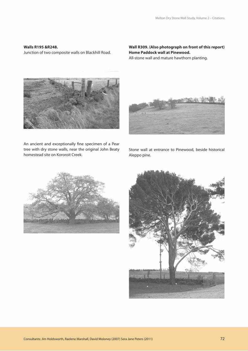
At the homestead (internal) gate of the rear (main) driveway to Pinewood, beside a dry stone wall around the garden, is an old tree which according to Beaty family lore is an offshoot of a Canary Island pine that was picked up in the Canary Islands en route to Australia. Inspection reveals that it is in fact an Aleppo pine (Pinus halepensis). The original tree, which the family relates was planted c.1870s and fell in 2001, remains as a stump on the opposite side of the gateway. The existing tree is said to have been planted c.1900 from a seed from the original. The property may have been named after these trees. The ancient and exceptionally fine specimen of a Pear tree near Kororoit Creek, again beside a dry stone wall, is thought to have been the remnant of an orchard situated near the original 1850s Beaty homestead (no longer extant).
In 1879 John senior transferred some 318 acres of land on the east side of the West Branch of Kororoit Creek (which had increased to some 739 acres in the late 1880s), to William who built the Rocklands homestead there.82 The next day John senior transferred to Andrew the property (some 803 acres by the late 1880s) on which the Glencoe homestead was established.83
Glencoe is situated on the west side of Blackhill Road. On the south-western corner of the Glencoe allotment an early ‘out station’ was marked on an early map.84 This allotment, purchased in 1855 by John Beaty, had undoubtedly been associated with the Green Hills ‘headstation’ about a kilometre to its south. John Hunter Patterson ‘finding the country almost totally
79 Shire of Melton Ratebooks, 1919-1927.80 ibid81 Torrens Application 48954, PROV VPRS 460 (Unit 817)82 PROV Torrens Application file: VPRS 460/P0, Unit 817 (48954),
Conveyance John Beaty to William Beaty,19/9/1879; also Shire of Melton Ratebooks, 1887-1888.
83 PROV Torrens Application file: VPRS 460/P0 (37508), Conveyance John Beaty to Andrew Beaty, 20/9/1879; also Shire of Melton Ratebooks, 1887-1888.
84 Lands Victoria, Put-Away Plan Y27 (1854)

Consultants: Jim Holdsworth, Raelene Marshall, David Moloney (2007) Sera Jane Peters (2011) 69
Melton Dry Stone Wall Study, Volume 2 – Citations
unoccupied’ had established the well-known Port Phillip Green Hills station in early December 1836.85 The 1841 census reveals that it was at the time the largest of the squatting stations in the Shire of Melton - far larger than Simon Staughton’s Brisbane Ranges-Exford run, or the nearby Mt Aitken run established earlier by John Aitken. In 1841 the census collector found Green Hills, on ‘Pennyroyal Creek’, being run by ‘Simeon Cadden for John Patterson’. There were 22 adults, including 15 shepherds, living on the property. In 1841 Patterson was forced by the financial crisis to sell or lease all his extensive pastoral holdings.
Andrew and his brother William returned to Ireland where they both married before returning home.86 It is possible that the construction of Glencoe was associated with Andrew’s marriage. Glencoe might have been built as early as the late 1850s, but was probably built 1860s-70s. It was definitely built by 1888.87 Glencoe was built of stone quarried behind the house, and the bluestone shed was then built from offcuts created when this stone was quarried.88
The other property established on the west side of Blackhills Road, south of and near to Glencoe, was the weatherboard cottage Angus Downs. In 1900 Andrew Beaty transferred various parcels of land south of Glencoe homestead, totalling some 240 acres, to George, who was his only son.89 (He may also have transferred other land at another time, as it is not certain that these parcels included the Angus Downs house. The Angus Downs property was in excess of 330 acres by the early twentieth century.) The family tradition is that George was expected to inherit Glencoe, so Angus Downs was regarded as something of a temporary home until this occurred. However George died in c.1902,90 some
85 A number of the squatters who established runs in the Mount Emu area near Caramut (Western District) - such as Cadden, Hyde, maybe Bell, and possibly Urquhart would also appear to have had early association with Green Hills at Toolern in some way. There was also a large pastoral run called Green Hills No.1 at Carumut. [Sayers, C.E.(ed), Bride, T.F., Letters From Victorian Pioneers, facsimile edition (Lloyd O’Neill, Melbourne 1983), pp.281-282, 290-291, 289-299; Brown, PL (ed), The Narrative of George Russell of Golf Hill, (Oxford University Press, London: Humphrey Milford, 1935), p.172]
86 ibid87 John Beaty, personal conversation, 25/10/2004; VPRS 460/P0
(37508); Shire of Melton, Ratebooks, 1887-88 Further family genealogical information on marriage dates etc might provide clues that would help to date the building.
88 John Beaty, personal conversation, 8/5/200289 VPRS 460/P0 (37508)90 Personal conversation, Mrs Verna Hornbuckle, granddaughter of
George Beaty, 12/10/04.
eight years before his father Andrew (on 27th November 1910). As a result of his son predeceasing him, the Glencoe property was eventually passed to Mrs Wilson, a daughter.
George Beaty’s son John George Beaty was born at Angus Downs in 1896. John George’s three sisters, the eldest of whom was about four years older than him, were also born at the house.91 It would appear then that the house was occupied by George Beaty by c.1892. It is possible that it had been erected (or moved to the site) to accommodate George on the occasion of his marriage to wife Eliza.
John George Beaty raised a family of three daughters, Zelma, Verna and Jean on Angus Downs. In the 1930s a large new kitchen was built onto the rear of the old house. John George lived there until about a week before his death in 1968.92 This was the end of an era for Angus Downs. In the 1970s the vacated property became the setting for a ‘back to the land’ experiment by a ‘community’ of university students and young teachers seeking to go ‘back to basics’. The young city community set to learning how to breed (and kill) chickens, raise a few farm animals (as pets), and once the tractor was tamed, plant a kitchen garden.93 It was a photograph of this group beside their first crop of corn that was chosen as the cover photograph of the inaugural edition of the magazine ‘Grass Roots’. The Angus Downs community had become something of an emblem for a magazine that would become a part of the 1970s alternative movement.94
The house is still in the ownership of the Beaty family. In 2002 Andrew Robinson, the son of Jean Beaty of Angus Downs was undertaking repairs, restoration and extensions to his family home. Apart from structural works, the alterations were confined to the rear part of the house.
The Beaty family have played a prominent part in the history of European settlement of the Toolern Vale area and Shire of Melton. For some 40 years in the early twentieth century John Beaty III (Jack) of Pinewood was
91 Ibid. 92 ibid93 An article on the community was written for the 25th Jubilee
edition of Grass Roots (No.127, June/July 1998). 94 Grass Roots (the Craft and Lifestyle Magazine, for Down to Earth
People), No.1, April-June 1973. Grass Roots was dedicated to sharing information between those who would turn their backs on ‘big business’ by co-operativism and subsistence, growing vegetables, making candles, and moulding mud bricks.

Consultants: Jim Holdsworth, Raelene Marshall, David Moloney (2007) Sera Jane Peters (2011) 70
Melton Dry Stone Wall Study, Volume 2 – Citations
a Melton Councillor, serving six terms as Shire President. ‘Beaty’s Bush Paddock’ was for many years the site of annual ‘Bird Day’ excursions for scholars at the nearby Toolern Vale State School.95
The Dry Stone WallsMost of the walls in this precinct were built on the Beaty properties, and one on the Clarke pastoral estate. The Melton Dry Stone Walls Heritage Study has shown that approximately 45% of the dry stone walls surviving in the Shire today were erected as part of the Clarkes’ pastoral estate. Of the balance, it is estimated that three larger farmers – the Beatys on Blackhills Road (8.5%), Hopkins & Farragher on Hopkins Road (7.4%), and the Moylans on Mount Kororoit Road (5.6%), between them built another 21.5% of the remaining walls. The residual one third of the walls in the Shire was built mainly by smaller farmers and selectors.
• BeatyWalls
It is very likely that the high all-stone wall (with hawthorn plantings) on the Pinewood property beside Kororoit Creek was built very early, close to the time that John Beaty established the property. Most of the other walls, especially the boundary walls along Blackhills Road, could be presumed to have been built very early in the Beaty occupation, probably the 1850s.
However the extensive boundary and paddock dry stone walls (all-stone, rather than composite post-and-wire) on the Pinewood property (including R193, R309) are believed to have been repaired / rebuilt in the 1920s. The higher internal paddock walls are in especially good condition, and may have been associated with the use of these paddocks for cattle. Some of the internal walls are not shown on the 1916 Ordnance plan for the area, and may date to the 1920s.
The long walls on the Glencoe property were likely built a little later, by Andrew Beaty. These are some of the longest and highest walls in the precinct.
Early twentieth century surveyors of the properties were described many of the composite walls: -
95 Toolern Vale State School Centenary History 1869-1969 (Toolern Vale State School Centenary Celebrations Committee, 1969); Pollitt, op cit, p.44; Starr, op cit, p.269
• In 1901 surveyor Muntz described well-built composite post and wire and stone wall (Wall R246) on the north-west corner of Blackhills and Diggers Rest – Coimadai Road simply as a ‘Stone Wall’.96 It is now a ‘post and wire double’ wall; a post and wire fence may have been added in the twentieth century.
• In 1911 surveyor Arundt identified the walls onBlackhill Road (Wall Nos.R248, R194, and the northern part of R247) as ‘fence and wall’. He also described the wall perpendicular to Blackhill Road on the east side (Wall R195) as ‘fence and wall’. He described the wall perpendicular to Blackhill Road (the entrance to Pinewood) as ‘wall and fence’.97 Most of these walls survive today in this form.
• In1933surveyorWebbdescribedWallR37asbeing‘Post Rail & wire and stone base’. This wall is still about 200 metres long, and is now described as a composite Post and Wire Double stone wall, in poor condition.98
Wall R245, built as part of the Clarke Rockbank estate, although visually unprepossessing, is significant in its own right. At 430 metres it is the second longest, and one of only six walls in the whole Shire in the height range 751-1000 mm that are recorded as being in ‘excellent’ condition. This is significant, as the height range of 751-1000 mm is the largest category of walls in the Shire (36% of all walls). Similarly, the other large group (the height range of 351-750 mm, which has 31% of all walls) also has a very low percentage of walls in excellent condition. This range of wall height (351-1000 mm) is the range in which walls are topped up by post and wire. The reason that most of these walls (comprising 66% of all Melton walls) are in only fair condition may be that most walls of these heights, in contrast to the higher walls, were built by farmers rather than professional wallers. In addition, the maintenance required for such walls was high, given that the typical round fieldstone of the locality made them particularly prone to tumbling-down. However, Wall No.R245 would appear to be an exception. The more intact section (at the eastern end) is better built than most and, given that it was a Clarke wall, is likely to have been professionally built.
96 Lands Victoria, Torrens Application No.32954, April 1901.97 Lands Victoria, Torrens Application No.39493, June 1911.98 Lands Victoria, Torrens Application No.49013, 15/9/1933

Consultants: Jim Holdsworth, Raelene Marshall, David Moloney (2007) Sera Jane Peters (2011) 71
Melton Dry Stone Wall Study, Volume 2 – Citations
Thematic Context / Comparative Analysis:
Shire of Melton Historical Themes: ‘Pastoral’,‘Farming’.
ComparablePlacesinShireofMelton:
The most comparable precincts in the Shire of Melton are those precincts centred on eruption points:- the Mount Cottrell Precinct, the Mount Atkinson Precinct, and the She-Oak Hill Precinct. It is also comparable, to a lesser extent, to the ‘gateway’ precincts, in particular the Greigs Road Precinct, the Western Highway Precinct, the Melton Highway Precinct, and the Robinsons Road Precinct.
The precinct is one of the most concentrated groups of dry stone walls in the Shire of Melton. It has a very high percentage of walls in ‘excellent’ or ‘good’ condition. It also has the most intact original rural context of all the dry stone wall precincts in the Shire. It also has the longest walls, including the longest wall in the Shire (R248, 3.8 kilometres) situated on Blackhill Road, and therefore entirely accessible to the public. These roadside walls are composite stone and post and wire (with a few remnant posts of former post-and-rail composite walls). The highest all-stone walls are on the Pinewood and Glencoe properties, not visible from the road.
The walls in this area were not surveyed in Vines’ 1990 study of dry stone walls in the nine municipalities of Melbourne’s western region.
Condition:
The walls in the precinct are generally in good condition.
Integrity:
The integrity of the walls in the precinct varies, high, to moderate, to low.
Recommendations:Individual walls are recommended for inclusion in the Melton Planning Scheme Heritage Overlay.
Other Recommendations:It is recommended that the dry stone walls condition, and threats, be identified as part of the development of a limited Conservation Management Plan to ensure their long-term maintenance. Archaeological survey of some of the walls has the potential to provide further information regarding early pastoral settlement, and in particular the original construction of the walls and any modifications to the style of the walls that have occurred in the early twentieth century.
WallR297.A substantial all-stone wall on Glencoe, west of Blackhill Road. Another long wall is visible in the distance.
WallR247(westsideofBlackhillRoad).Dry stone wall built around a venerable casuarina.
Consultants: Jim Holdsworth, Raelene Marshall, David Moloney (2007) Sera Jane Peters (2011) 72
Melton Dry Stone Wall Study, Volume 2 – Citations
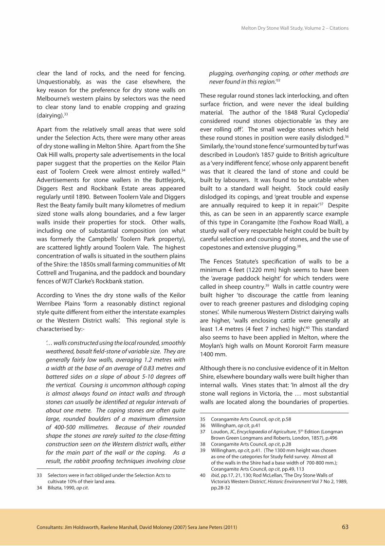
WallsR195&R248.Junction of two composite walls on Blackhill Road.
An ancient and exceptionally fine specimen of a Pear tree with dry stone walls, near the original John Beaty homestead site on Kororoit Creek.
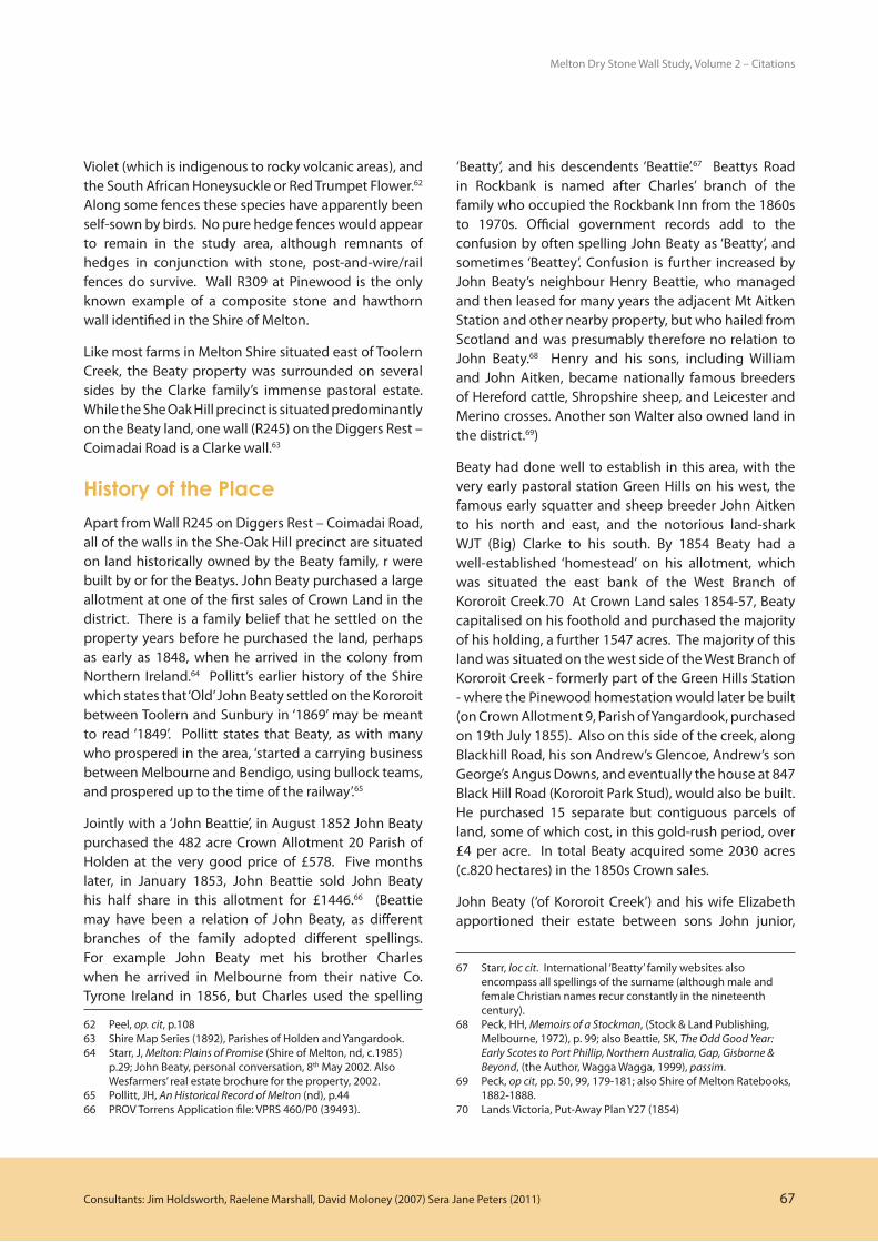
WallR309.(Alsophotographonfrontofthisreport)HomePaddockwallatPinewood.All-stone wall and mature hawthorn planting.
Stone wall at entrance to Pinewood, beside historical Aleppo pine.

Consultants: Jim Holdsworth, Raelene Marshall, David Moloney (2007) Sera Jane Peters (2011) 73
Melton Dry Stone Wall Study, Volume 2 – Citations
WallR190.Composite wall east of Ryans Road.
WallR247.Blackhill Road. This fence has a loose stone base. The accumulation of stone over the lower mortise of the former post & rail fence is evident.
WallR194.Composite wall, on the north part of Blackhill Road near the ‘Lava Shield’ volcano Aitkens Hill, showing heavy round lava basalt from that volcanic type.
WallR247.Composite wall, on the south part of Blackhill Road near the ‘Scoria Hill’ volcano She Oak Hill, showx more angular (rather than round) vesicular fieldstone, reddish in colour, from that volcanic type.

Consultants: Jim Holdsworth, Raelene Marshall, David Moloney (2007) Sera Jane Peters (2011) 74
Melton Dry Stone Wall Study, Volume 2 – Citations
WallR245(DiggersRest–CoimadaiRoad).This is one of the two most intact walls of this most common dry stone wall height range (751-1000) in Melton Shire.