circulation - san diego traffic circulation is an important concern inasmuch as the movement of...
TRANSCRIPT
CIRCULATION INTRODUCTION
Traffic circulation is an important concern inasmuch as the movement of people and goods within the Navajo community is directly related to its future economic, physical and social well-being. An adequate circulation system is essential to provide necessary services to households and businesses in the community. Because the Navajo area has a greatly varying terrain, and because it is adjacent to the cities of Santee, La Mesa and El Cajon, some of the transportation problems encountered here are unique. Through the application of sound planning and engineering principles, it is possible to develop a balanced transportation system that will serve the community's internal travel needs and provide access to other communities outside the immediately surrounding area.
It is beginning to be realized that, "(t)he effects from pollution, increasing dependency upon a single mode of transportation (motor driven vehicle) for all uses, and immobility among the poor, the aging, the young and the handicapped have caused doubt everywhere about the ultimate wisdom of our expanding roadway systems" (Report on Interim Hearings to the State Senate by the Senate Select Committee on Rapid Transit, 1971.) It is therefore necessary to make strenuous efforts to reduce our almost complete dependence on the automobile by providing efficient alternative methods for moving people. Buses and Light Rail Transit (LRT) service provide two of the most efficient, alternative and growing modes of transportation in San Diego. San Diego’s Metropolitan Transit System has an integrated bus/rail system. Currently, a network of bus routes serves the Navajo area. In October 1997, the MTD Board approved the extension of LRT through the Navajo community, continuing to San Diego State University and La Mesa. Service is scheduled to start in late 2004. The extension includes a station in Grantville that is planned to have a park-and-ride lot and would be served by the improved bus system. The LRT project included the extension of Alvarado Canyon Road over Waring Road to Adobe Falls Road, which will provide a direct connection between the Navajo Community and the LRT station. Another recent development to reduce dependence on the automobile is the Employer Transit Assistance Program (ETAP) in which employers subsidize monthly transit passes for employees to encourage transit use. The program is administered through MTDB and Ridelink. Future transportation requirements in the Navajo area are based upon anticipated future traffic volumes or "travel forecasts". Travel forecasts depend upon many factors, one of the most important of which is the future land use proposed for a particular area. Any substantial changes in proposed land uses and/or traffic forecasts in the Navajo area, therefore, may require a modification of the proposed transportation system, as would any change in present dependencies on the automobile for transportation. In addition to the local land use projections for Navajo, future travel demands for the entire region done by the San Diego Association of Governments (SANDAG) were used in evaluating the year 2000 transportation needs. Based on review of existing and currently anticipated future transportation needs of the Navajo area, it is proposed that the road and bikeway systems as
- 105 -
- 106 -
indicated be adopted as a guideline for future street and bikeway development in the area. Additionally, it is strongly recommended that there be accelerated expansion of public transportation for the area.
OBJECTIVES
The basic objective of the circulation system is to provide each member of the community with safe, ready access around, as well as in and out of the community, by a mode of transportation of individual choice with minimal environmental damage. To achieve this purpose will require that a fully integrated system of pedestrian, bicycle, public transit and automobile facilities be developed. The system should link all sections of the community--residential, commercial, employment, educational, recreational and cultural--by a safe mode best suited to the trip being made. With a well-balanced transportation system available, the necessity for a third or even a second car per household will be greatly reduced, thus decreasing air pollution and congested streets. The following additional objectives concerning the circulation element are established for the Navajo community: • Develop a balanced transportation system that adequately links the Navajo area to nearby
communities as well as regional facilities. • Encourage use of the integrated bus/LRT system to maximize the benefits of the
transportation system and its ability to efficiently move people and goods. • Develop a balanced transportation system that adequately accommodates the
community's internal needs. • Strive to separate automobile, pedestrian and bicycle conflicts and, where safe and
practical, provide specially designated bikeways to accommodate the increased demand for this mode of travel.
• Encourage hillside view preservation in the design of new streets. Fit streets carefully
into the topography to minimize grading to ensure that the street is compatible with the total landscape. The geology of an area may preclude or minimize grading in some specific cases.

PUBLIC TRANSPORTATION
INTRODUCTION
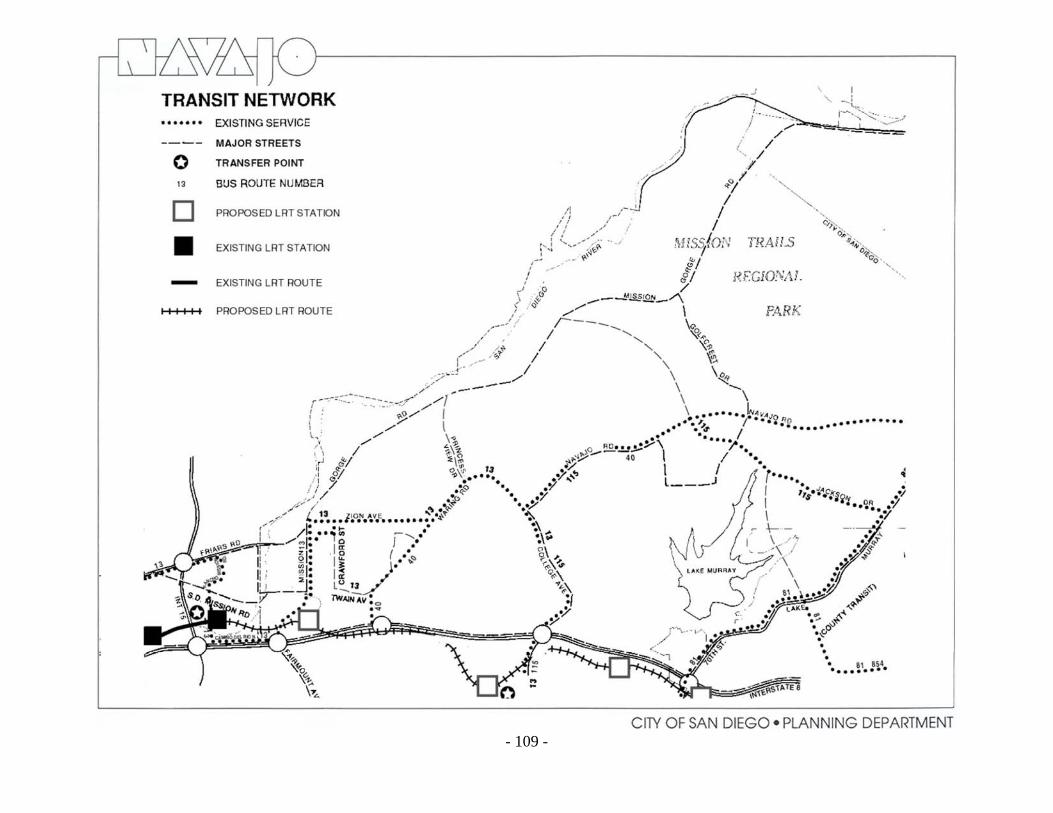
The future improvements in public transportation should be viewed objectively with regard to requirements to meet Navajo's future transportation needs. A SANDAG report titled "Transit Development, Plan and Program," completed in June 1970, discussed future transit improvements for the entire region. Mentioned as possible problems in expanding service to areas such as Navajo is the low-density development, the varying terrain of the area, and the lack of a grid street pattern. Mentioned as positive factors for an increase in public transportation are the future anticipated increases in automobile congestion, concern over air pollution caused by automobiles, the increase in costs of parking for those who work downtown, and the progressive attitude of the San Diego Transit Corporation and other governmental agencies. With increased transit service, many residents will be given alternatives to multi-car ownership. EXISTING CONDITIONS Currently, there are five bus routes that operate in the Navajo community areas. Bus Route 13 provides crosstown service on College Avenue, Waring Road, Zion Avenue, and Mission Gorge Road. Its southerly terminus is the LRT station at Euclid Avenue and Market Street in Southeastern San Diego. At present, this route provides modified service on weekends and holidays. Bus Route 115 operates from Fletcher Hills to downtown San Diego with service in the community along Lake Murray Boulevard, Jackson Drive, Navajo Road, and College Avenue. Bus Route 115 offers modified service on weekends and holidays. Route 854, County Transit System, provides limited service to the Navajo community. This route operates between Grossmont College in El Cajon and Grossmont Shopping Center in La Mesa, via Navajo Road and Lake Murray Boulevard in the City of San Diego. Bus Route 40 provides service five days/week during AM/PM peak hours only from Fletcher Hills to downtown San Diego with service in the community along Navajo Road and Waring Road. A fifth bus route, Bus Route 81, serves the southeast portion of the Navajo community via Baltimore Drive and Lake Murray Boulevard.
- 107 -

A study of Fiscal Year 1997 operating characteristics of the various buses serving Navajo showed that Route 115 is the most heavily used, carrying over 1,000,000 passengers annually with ten percent of its daily trips incurring standing loads. Of the five bus routes serving the Navajo community, Bus Route 40 carries the lowest number of passengers with annual boardings totaling 41,000. A survey of transit passengers in San Diego conducted in 1995 by SANDAG, showed that many people who use routes servicing the Navajo community are transit-dependent. While passengers on Bus Routes 13, 40 and 81 used the bus for transportation to work (35-87 percent), most passengers on Bus Routes 115 and 854 used the bus for transportation to school (36-54 percent). Because of the community’s proximity to San Diego State University and Grossmont College the percentage of riders using public transit for the home to school trips exceeds the citywide average. PROPOSALS Implied in the transportation recommendations is the realization that circulation systems for personal vehicles can be designed only to accommodate a desired optimum traffic volume. Before traffic reaches this point, other modes of transportation must be programmed. In the past the alternative has been to continually increase rights-of-way or acquire new alignments to accommodate heavier traffic volumes. This alternative can no longer be considered the only solution. The Metropolitan Transit Development Board has embarked on a program to improve bus service for San Diego. Planned transit improvements and others under consideration include:
• Evaluation of rerouting Bus Route 13 to serve the future Grantville LRT station. • Increase service on Bus Route 40 to operate all day, routing midday and selected peak
period trips to the Grantville station. Evaluate effect of marketing efforts, need and possible service reductions in this route.
• Possible elimination of Bus Route 81 to coincide with the opening of the Mission Valley
East Light Rail Extension. • Work with the city of La Mesa to possibly implement Westside Shuttle route operation to
serve the future 70th Street trolley station. For longer term improvements (up to the year 2000) there should be additional local and express service similar to that described above, with emphasis on minimizing travel time and wait time, extending service to provide a greater number of destinations and making transit travel more pleasing (e.g., modern vehicles and terminals).
- 108 -
- 109 -

BICYCLES
INTRODUCTION
Today across the United States the bicycle boom continues. People of all ages are riding bicycles as never before. People have turned to bicycles for exercise, recreation and transportation. Schools within a community often generate a high demand for bicycle facilities. Bikes do not pollute, are energy efficient, and they offer an opportunity to bypass congested streets. The City has design standards for the construction of bikeways and an ongoing program of providing a comprehensive bikeway system for City residents that will connect to a regional bikeway network. Bikeways fall into three categories based on the degree or extent of their improvements: bicycle paths (Class I), lanes (Class II) and routes (Class III). Four such bikeways have been constructed in Navajo, and are noted on the bikeways map. They are described in the following section along with the proposed routes.
PROPOSALS • Regional Bikeway
A regional bike route is proposed from the ocean through Mission Valley to Mission Gorge Road and northeasterly along Mission Gorge Road. This route will also continue east parallel to the north side of I-8 from Mission Gorge Road to the vicinity of College Avenue.
• Del Cerro Route
This route would be oriented to the Del Cerro area and would utilize Del Cerro Boulevard from Trinity Way on the west to Linfield Avenue on the east. The intended alignment would provide a scenic overlook of Mission Valley. Length: 2.0 miles.
• Allied Gardens Route
This route would be oriented to Allied Gardens and also provide for the extension of bicycling opportunities from that community easterly to the Del Cerro area. This existing route utilizes Barclay Avenue and Brunswick Avenue between Galewood Street and Zion Avenue. Both streets run through attractive residential areas. College Avenue, the link to Del Cerro, would provide scenic overlooks of San Diego. Length: 2.0 miles. Connector - This route provides a connection between the Allied Gardens route and the proposed San Diego River route in the vicinity of Zion Avenue. The route is aligned along Zion Avenue, Delbarton Street, Crawford Street, and Twain Avenue. Except for Twain Avenue, this route exists. Length: 2.0 miles.
- 110 -

- 111 -

• Jackson Drive Extension
An extension of the Jackson Drive route would be a route that lies largely outside the San Diego City limits. This route would run from the City limits to the San Carlos Community Center by way of East Lake Avenue, Lake Ashmere, Lake Arrowhead, San Carlos Drive, Boulder Lake Avenue, and Jackson Drive. The Jackson Drive portion now exists. Length: 3.2 miles.
• Lake Murray Boulevard Route
This route would be along Lake Murray Boulevard from Grossmont Community College to a connection with the Del Cerro route extension at Jackson Drive. This route presently utilizes a portion of the Lake Murray Boulevard frontage road from Jackson Drive to the Navajo shopping center. From the shopping center to the college, a portion of Lake Murray Boulevard would be set aside with appropriate striping for use as a bike route. The southerly portion of the route is a tree lined boulevard through an attractive residential area. Length: 1.75 miles.
• Jackson Drive Route
This route consists of an existing Class III bikeway from the city of La Mesa to Mission Gorge Road. Total length: 3.0 miles.
• Navajo Road Route
This route is along Navajo Road from the intersection of Waring Road and College Avenue, easterly to the City limits at Fanita Drive with the possibility of extensions into El Cajon. This route exists except for the most eastern half-mile. Total length: 3.7 miles.
• Golfcrest Drive Route
This route would be along Golfcrest Drive from Navajo Road to Mission Gorge Road and would serve as a connector between the bike routes on those streets. Length: 1.25 miles.
• Mission Gorge Road Route
This route would be along Mission Gorge Road from the Santee - San Diego City limits to the western limit of the community. Although the parallel bikeway along the San Diego River will remain as a desirable goal for future implementation, its construction is not imminent. In the meantime, relatively minimal and inexpensive work on Mission Gorge Road can produce a usable improvement for bicyclists. Total length: 5.2 miles.
Connector - This proposed route provides a connection between the Mission Gorge Road route and the proposed San Diego River route. The route would be aligned along Father Junipero Serra Trail. Length: 1.2 miles.
The routes shown and described above are bikeway corridors, and not exact alignments. When this Plan is implemented, minor deviations may be necessary.
- 112 -
STREETS
INTRODUCTION
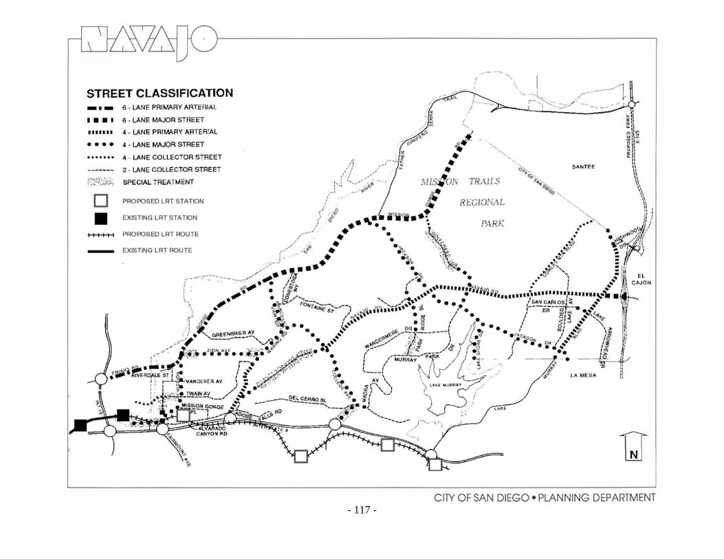
The five basic functional categories of streets in San Diego are present in Navajo. They are: freeways, primary arterials, major streets, collector streets, and local streets. Street and Highway Standards adopted for the City of San Diego in 1964 and revised in 1980, are shown in the Standards and Definitions section of this Plan. Although these standards are applicable primarily to streets in new subdivisions, they also indicate desirable features to be obtained whenever improvement of an existing street system is undertaken. Also shown on the table are the maximum Average Daily Volumes (ADT) of traffic desirable for each type of street. EXISTING CONDITIONS The Functional Road Network and Traffic Volumes map and the Street Classification map (see pages 114 and 115) show the existing functional classifications for streets in the Navajo community, from the primary arterial to the collector street level. Interstate 8 forms the southern boundary of the area. Friars Road, Mission Gorge Road east of Friars Road, and Navajo Road all function as primary arterials. The other streets shown on the existing road network map function as major or collector streets. The traffic volumes carried by each street in the Navajo roadway network are also shown on the Functional Road Network and Traffic Volumes map and the Street Classification map (see pages 114 and 115). The volumes listed are in vehicles per average weekday. Volumes of over 20,000 vehicles per day exist on portions of Mission Gorge Road, Waring Road, College Avenue, Friars Road, Navajo Road, and Lake Murray Boulevard. The highest traffic volume recorded on a surface street is on Mission Gorge Road between Friars Road and Zion Avenue (52,700) where a six-lane facility exists. There are several streets in the area that are carrying traffic volumes in excess of their design volume. Fairmount Avenue extension between Mission Gorge Road and Twain Avenue is 50 feet wide, yet carries 7,600 vehicles on an average weekday. The maximum desirable ADT for a two-lane collector street is 5,000 vehicles per day. Zion Avenue varies in width from 40 to 50 feet and has a maximum desirable ADT of 5,000 yet is currently carrying over 14,300 vehicles per day. Similarly, College Avenue between I-8 and Del Cerro Boulevard, Twain Avenue between Mission Gorge Road and 50th Street, Mission Gorge Road between Fairmount Avenue and Twain Avenue, and Madra Avenue north of Del Cerro Boulevard all carry volumes that exceed what is desirable for their classifications. (All traffic counts are as of 1987.)
- 113 -

PROPOSALS
Freeways and Expressways
• A recently completed study by SANDAG concluded that the easterly extension of State Route 52 (SR-52) is the most critical improvement needed to relieve traffic congestion on Mission Gorge Road, Friars Road, and I-8. Construction of SR-52 from Santo Road in Tierrasanta to the city of Santee will be scheduled as soon as environmental clearance is obtained.
• An extension of Route 125 north to SR-52 is proposed. When built, this freeway and/or
expressway would parallel the eastern edge of the Navajo community. • Improvement by Caltrans of Interstate 15 (I-15) to 6-8 lanes between I-8 and State Route
163 (SR-163), and eight or more lanes north of SR-163 is being implemented. • An additional westbound traffic lane on I-8 between College Avenue and I-15 is being
proposed by Caltrans. This improvement will relieve traffic congestion on I-8 and Navajo community streets that access I-8 (i.e., College Avenue, Waring Road, and Mission Gorge Road). Caltrans is scheduled to advertise for bids for the widening in 1991.
Streets 1. The synchronization of traffic signals along Mission Gorge Road, between I-8 and
Rainier Avenue is currently being designed (Fiscal Year 1988). The traffic signals north of Rainier Avenue cannot be synchronized because they are spaced in excess of one-quarter mile apart, the maximum practical distance for synchronization.
2. Friars Road, between Riverdale Street and Santo Road, is planned to be widened to six
lanes to alleviate congestion at the intersection of Mission Gorge Road and Friars Road that is caused by the three westbound lanes on Friars Road narrowing to two lanes west of Riverdale. This project is included in the Capital Improvements Program for design in Fiscal Year 1989.
3. Jackson Drive is planned to be extended as a major street from Mission Gorge Road
northerly to connect to Clairemont Mesa Boulevard and SR-52 in the Tierrasanta community concurrent with the completion of SR-52. This project is scheduled in the Capital Improvements Program for design in Fiscal Year 1990.
4. The easterly extension of Alvarado Canyon Road will be constructed as part of the Mission Valley East LRT project as a two-lane collector crossing over Waring Road to Adobe Falls Road. The road will provide improved access to the planned Grantville LRT Station and help to mitigate traffic impacts on Fairmount Avenue, Mission Gorge Road, and the westbound I-8 offramp.
- 114 -

5. A study of the realignment of Alvarado Canyon Road should be completed and the project undertaken as soon as feasible. Subject to environmental review, the intersection of Alvarado Canyon Road with Mission Gorge Road should be moved northward to align with the Mission Gorge Road/Fairmount Avenue intersection. This realignment will help alleviate traffic congestion on the westbound I-8 offramp/Fairmount Avenue intersection. Consideration should also be given to widening the southbound Fairmount Avenue to westbound I-8 on-ramp in conjunction with this project.
The circulation plan must be oriented to provide a balanced transportation system for the Navajo community. Additional streets and alterations to existing streets should be limited to remedial and corrective measures. Only as a last resort should the widening or addition of streets, as would be required by the City's street standards, be considered. Special treatment should be provided as indicated on the Street Classification Map to handle capacity problems. The special treatment required may take the form of parking prohibitions, widening at intersections to obtain additional lanes, adding or changing intersection channelization to facilitate heavy directional moves, and special traffic signal phasing or interconnection. In the event the above techniques cannot adequately facilitate traffic, the following improvements should be considered: 1. Navajo Road should be widened to a six-lane major street east of Lake Murray
Boulevard. 2. Mission Gorge Road should be widened to a six-lane facility north of Zion Avenue with
no left-turn lanes except at signaled intersections. Between Fairmount Avenue extension and I-8 (at its southerly terminus) Mission Gorge Road should also be improved to be a six-lane major street.
In preparing this next recommendation, City and state agencies and community interests were consulted and numerous alternatives were considered and analyzed. The recommendation for the extension of Navajo Road through Navajo Canyon appears to be the best solution at this time, but only under the following conditions: Since this Plan recommends maintaining Navajo Canyon as open space, the extension of Navajo Road through the canyon should be designed to parkway standards and limited to a two-lane facility with four lanes at the intersections with College Avenue and Waring Road and no intermediate access; sufficient capacity must exist on I-8 to accommodate the Navajo Road traffic; and a reevaluation of the entire recommendation shall be undertaken if at any time before construction, any curb on automobile traffic, such as the use of gasoline rationing, etc., takes place in San Diego. If the Navajo Road extension is not built, it is projected that volumes on Waring Road will approach 30,000 vehicles per day by the year 2000. This forecast volume exceeds the design capacity of this four-lane street with driveways, parking and houses fronting on the street.
- 115 -

- 116 -
- 117 -

Waring Road could become congested, resulting in inconvenience to motorists and nearby residents. In addition, the omission of the Navajo Road extension from the future roadway network would increase volumes on College Avenue, making it desirable to improve College Avenue to six lanes between Del Cerro Boulevard and I-8.
Design Principles One aspect of transportation planning which has been overlooked is that portion of its site planning which involves the art or form of the transportation facility. It is especially important that roadways be regarded as an integral part of the landscape in which they are sited. They must be something more than the standard provision of a surface for moving cars or guiding public transit vehicles. However, the design of the facility must not override, but be considered equally with, the safety and capacity of the facility. Because of topography, many of the City standards for streets are not suitable for the Navajo community. The following standards are suggested for use in these areas. • Street Widening
Widening and realignment frequently destroys the visual character and identity of streets by the removal of mature trees, other landscaping, and median strips. The approach to street widening and realignment should be more sensitive to the character of the street and the quality of adjacent development. When substantial environmental damage may result to adjoining properties, the traffic carrying capacity of the street might be improved by eliminating on-street parking or using reverse lanes at peak hours rather than physical widening. When a street must be widened and necessarily encroaches on a dwelling's front or side yard, variations should be permitted in the zoning code requirements that would permit high walls to give residents privacy from the sight and noise of traffic.
• Street Accessories
1) Standards for street paving and lighting are not varied systematically throughout the City. Most of the streets and sidewalks in the City are paved in the same materials, and lighting fixtures often do not reflect the character and scale of the frontage development.
2) Placement of telephones, police and fire call boxes, mail deposit boxes, street
numbers and news stands in consistent locations along the street would facilitate their use. These accessories should not be placed in the path of pedestrians or wheelchair users.
- 118 -

3) A coordinated system of variation in the use and placement of street trees, lighting, and other details could give streets better visual continuity and provide differentiation between through streets and local streets to aid driver orientation and traffic flow. The variations could include size, spacing and species of street trees and other landscaping, and intensity, spacing, and design of lighting fixtures. For example, major streets might have tall, widely spaced street trees; bright, closely spaced street lights; and large street signs. Local streets might have smaller, dense and more closely spaced trees; compass headings could be indicated by symbols on light poles or on the pavement. A more logical and systematic method of street naming should be used.
• Hillside Streets Hillside street standards should be
reviewed for compatibility with the terrain. More restrictive grading controls, street landscaping, and limitation of on-street parking to one side of all hillside roads, should all be considered. Even under existing standards however, the use of retaining walls and horizontally or vertically split street alignments would make theroad blend into this special topography. These methods were common in earlier hillside street
construction.
alkways (Sidewalks)
1)
nger to
and
ks.
ght
• Pedestrian W
Design walkways and parking facilities to minimize dapedestrians. Pedestrian walkways should be sharply separated from traffic areas set apart where possible to provide a separate circulation system. Where necessary and practical, the separation shouldinclude landscaping and other barriers. Walkways should pass through the interiors of blocWalkways that cross street corners should have good si
- 119 -

- 120 -
motorists and pedestrians.
ld
s
distances maintained at driveways.
he
from the parking to the dwellings.
distances for
2) Driveways across sidewalks shou
be kept to a practical minimum, with control maintained over thenumber and width of curb cuts. Barriers should be installed along parking lots to avoid encroachmenton sidewalks, with adequate sight
3) Commercial and industrial truck
loading should occur on private property rather than in roadways oron sidewalks. Residential parking should be as close as possible to tdwellings served, with adequate lighting along the walking route