cicada resources ltd
TRANSCRIPT

Cicada Resources Ltd.: Cic 513823 Claim Group BCGS 092I.059/069: Event No. 4376522
_____________________________________________________________________________________
Sookochoff Consultants Inc. January 22, 2010 page 1 of 33
CICADA RESOURCES LTD. (Owner & Operator)
GEOLOGICAL ASSESSMENT REPORT (Event 4376522)
on a
STRUCTURAL ANALYSIS Work done on
Tenure 513823 of the 4 Tenure
Cic 513823 Claim Group
of the
IRON MASK PROPERTY Kamloops Mining Division
BCGS 092I.059/069
Centre of Work 5,608,750N, 685,350E
AUTHOR & CONSULTANT Laurence Sookochoff, PEng
Cicada Resources Ltd.: Cic 513823 Claim Group BCGS 092I.059/069: Event No. 4376522
_____________________________________________________________________________________
Sookochoff Consultants Inc. January 22, 2010 page 2 of 33
TABLE OF CONTENTS page
Summary --------------------------------------------------------------------------------- 3. Introduction ------------------------------------------------------------------------------ 4. Property Description & Location ----------------------------------------------------- 4. Accessibility, Climate, Local Resources, Infrastructure & Physiography ------ 5. History: Regional ----------------------------------------------------------------------- 6. History: Area ---------------------------------------------------------------------------- 7. History: Property ------------------------------------------------------------------------ 13. Geology: Regional ---------------------------------------------------------------------- 14. Geology: Area ---------------------------------------------------------------------------- 17. Geological Map Legend ---------------------------------------------------------------- 18 Geology: Property ----------------------------------------------------------------------- 23. Mineralization: Area -------------------------------------------------------------------- 24 Mineralization: Property --------------------------------------------------------------- 27. 2009 Structural Analysis --------------------------------------------------------------- 27. Interpretation ----------------------------------------------------------------------------- 30. Selected References --------------------------------------------------------------------- 31. Statement of Costs ----------------------------------------------------------------------- 32. Certificate --------------------------------------------------------------------------------- 33. Illustrations Figure 1. Location Map ----------------------------------------------------------------- 4. Figure 2. Claim Map -------------------------------------------------------------------- 5. Figure 3. Claim Location --------------------------------------------------------------- 7. Figure 4. Property, Geology, Index & Minfile --------------------------------------- 27. Figure 5. Indicated Structures on Tenure 513823 ----------------------------------- 28. Figure 6. Rose Diagram ----------------------------------------------------------------- 29.Figure7. Indicated Structures on Tenure 513823 - following page 33.
Cicada Resources Ltd.: Cic 513823 Claim Group BCGS 092I.059/069: Event No. 4376522
_____________________________________________________________________________________
Sookochoff Consultants Inc. January 22, 2010 page 3 of 33
SUMMARY The 1,661 hectare Cic513823 claim group is located 240 air kilometres northeast of Vancouver, British Columbia, Canada, within 10 kilometres of Kamloops; within two kilometres of the former Ajax West mine and within 14 kilometres of the formerly productive Afton mineral deposit which is now being readied for production as the New Afton mineral deposit by New Gold Resources Ltd. Both the Ajax and the Afton copper-gold mineral deposits were hosted by the Iron Mask Batholith, an intrusive which is host to numerous mineral zones some of which were developed to minor and others to major productive mineral deposits. The estimated measured mineral reserves at the New Afton mine, which is hosted by shattered Cherry Creek Facie rocks of the Batholith, is reported as 43.25 million tonnes grading 1.12 % Cu, 0.83 g/t Au, and 2.68 g/t Ag. The mineral zone is reportedly a steeply dipping tabular body 365 metres long, averaging 76 metres wide and extending to at least 304 metres below the old pit bottom. The mineral zone is open in all directions with no indication of narrowing except towards surface. The Cic 513823 claim group is indicated (MapPlace Download; Figure 4) to be underlain centrally by three units of the Iron Mask batholith which is bordered by the eastern volcanic facies of the Nicola Volcanics (uTrNE) to the east and west. The Cherry Creek unit (LtrJlC) predominates and underlies most of the eastern property area. The western portion of the batholith is comprised of the hybrid unit (LTrJlH) which also occurs within the Cherry Creek unit in the north. The Property is also underlain in the southeast by the Sugarloaf unit (LTrJlS) and in the central-west by a capping of Eocene Kamloops volcanics. The volcanics are exposed on the Cic 513823 claim group with most of the localized exposure on the adjacent Tenure 521761 to the northeast of the structurally analyzed Tenure 513823. The volcanics are also indicated to be in a northerly trending contact with the Cherry Creek unit to the west and in a northeasterly trending contact with the Nicola volcanics to the north. The intersection of the two faults is indicated at the Nicola/Iron Mask (Cherry Creek) contact. The structural analysis on Tenure 513823 of the Cicada Resources Iron Mask property indicates dominant northerly structures, with minimal complementary northwesterly and subordinate variably oriented structures, preferenced northeasterly. The primary major cross structures of the controlled Iron Mask Batholith emplacement are regional northwesterly and east-northeasterly which are indicated by the framework of the Batholith. The later phases of more porphyritic rocks comprising the batholith are generally controlled by the major structures with the mineralizing episode related to these later stage intrusives. Subsequent dominant northerly structures of the area are indicated by the western end of the New Afton (Afton) deposit where it is vertically off-set some 700 metres by a normal northerly trending fault. As the intersection of these major structural trends would control the later stages of intrusives and mineralization, the intersection localities would be the prime area for any surficial positive geologic indicators of potentially economic mineral deposition. Two prime potential areas are indicated from the structural analysis. These two areas, designated as A and B on Figure 5 are at the intersection of three structural directions; the dominant northerly and northwesterly, in addition to an east-northeasterly structural direction which is a significant trend in the Iron Mask batholith as indicated at the New Afton mine where the mineral deposit lies at the western termination of a narrow, four kilometre long, easterly trending zone of intense intrusive brecciation.
Cicada Resources Ltd.: Cic 513823 Claim Group BCGS 092I.059/069: Event No. 4376522
_____________________________________________________________________________________
Sookochoff Consultants Inc. January 22, 2010 page 4 of 33
INTRODUCTION A structural analysis was completed on Tenure 513823 of the four claim Cic 513823 claim group for the purpose of determining potential structural controls for economic mineral zones on the property and to fulfill the assessment requirements as per Event Number 4376522. Information for this report was obtained from sources as cited under Selected References and from the author’s completion of the structural analysis as reported on herein.
PROPERTY DESCRIPTION & LOCATION Particulars of the Cic 513823 claim group are as follows.
Tenure Number Type Claim Name Good Until Area (ha) 513823 Mineral 20101126 676.91521761 Mineral LINCOLN 3 20101021 287.123521762 Mineral LINCOLN 5 20101021 369.063521765 Mineral LINCOLN 6 20101021 327.968
Total Area: 1661.064 ha
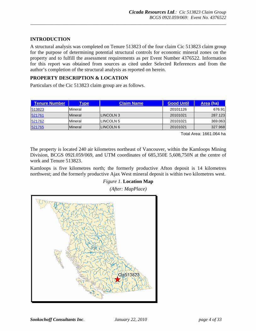
The property is located 240 air kilometres northeast of Vancouver, within the Kamloops Mining Division, BCGS 092I.059/069, and UTM coordinates of 685,350E 5,608,750N at the centre of work and Tenure 513823. Kamloops is five kilometres north; the formerly productive Afton deposit is 14 kilometres northwest; and the formerly productive Ajax West mineral deposit is within two kilometres west.
Figure 1. Location Map (After: MapPlace)
Cicada Resources Ltd.: Cic 513823 Claim Group BCGS 092I.059/069: Event No. 4376522
_____________________________________________________________________________________
Sookochoff Consultants Inc. January 22, 2010 page 5 of 33
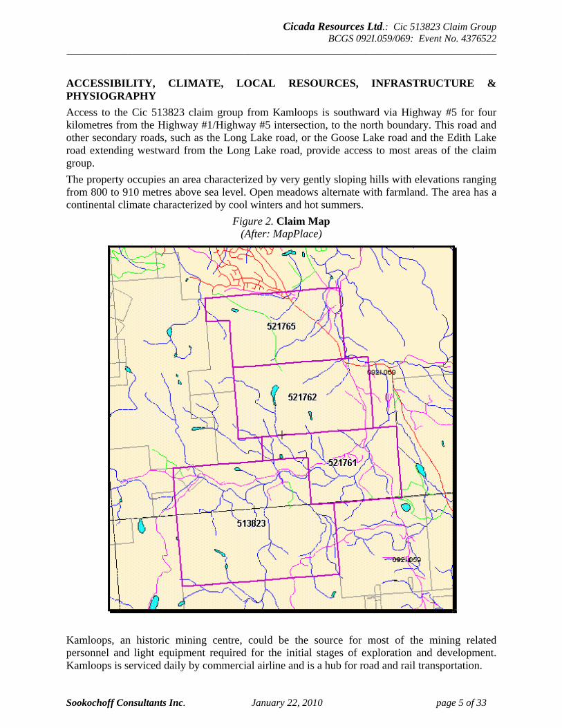
ACCESSIBILITY, CLIMATE, LOCAL RESOURCES, INFRASTRUCTURE & PHYSIOGRAPHY Access to the Cic 513823 claim group from Kamloops is southward via Highway #5 for four kilometres from the Highway #1/Highway #5 intersection, to the north boundary. This road and other secondary roads, such as the Long Lake road, or the Goose Lake road and the Edith Lake road extending westward from the Long Lake road, provide access to most areas of the claim group. The property occupies an area characterized by very gently sloping hills with elevations ranging from 800 to 910 metres above sea level. Open meadows alternate with farmland. The area has a continental climate characterized by cool winters and hot summers.
Figure 2. Claim Map (After: MapPlace)
Kamloops, an historic mining centre, could be the source for most of the mining related personnel and light equipment required for the initial stages of exploration and development. Kamloops is serviced daily by commercial airline and is a hub for road and rail transportation.
Cicada Resources Ltd.: Cic 513823 Claim Group BCGS 092I.059/069: Event No. 4376522
_____________________________________________________________________________________
Sookochoff Consultants Inc. January 22, 2010 page 6 of 33
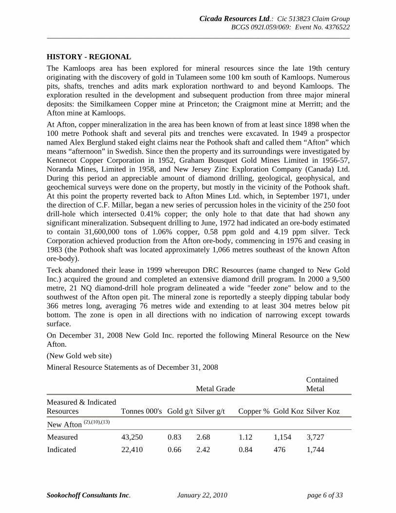
HISTORY - REGIONAL The Kamloops area has been explored for mineral resources since the late 19th century originating with the discovery of gold in Tulameen some 100 km south of Kamloops. Numerous pits, shafts, trenches and adits mark exploration northward to and beyond Kamloops. The exploration resulted in the development and subsequent production from three major mineral deposits: the Similkameen Copper mine at Princeton; the Craigmont mine at Merritt; and the Afton mine at Kamloops. At Afton, copper mineralization in the area has been known of from at least since 1898 when the 100 metre Pothook shaft and several pits and trenches were excavated. In 1949 a prospector named Alex Berglund staked eight claims near the Pothook shaft and called them “Afton” which means “afternoon” in Swedish. Since then the property and its surroundings were investigated by Kennecot Copper Corporation in 1952, Graham Bousquet Gold Mines Limited in 1956-57, Noranda Mines, Limited in 1958, and New Jersey Zinc Exploration Company (Canada) Ltd. During this period an appreciable amount of diamond drilling, geological, geophysical, and geochemical surveys were done on the property, but mostly in the vicinity of the Pothook shaft. At this point the property reverted back to Afton Mines Ltd. which, in September 1971, under the direction of C.F. Millar, began a new series of percussion holes in the vicinity of the 250 foot drill-hole which intersected 0.41% copper; the only hole to that date that had shown any significant mineralization. Subsequent drilling to June, 1972 had indicated an ore-body estimated to contain 31,600,000 tons of 1.06% copper, 0.58 ppm gold and 4.19 ppm silver. Teck Corporation achieved production from the Afton ore-body, commencing in 1976 and ceasing in 1983 (the Pothook shaft was located approximately 1,066 metres southeast of the known Afton ore-body). Teck abandoned their lease in 1999 whereupon DRC Resources (name changed to New Gold Inc.) acquired the ground and completed an extensive diamond drill program. In 2000 a 9,500 metre, 21 NQ diamond-drill hole program delineated a wide "feeder zone" below and to the southwest of the Afton open pit. The mineral zone is reportedly a steeply dipping tabular body 366 metres long, averaging 76 metres wide and extending to at least 304 metres below pit bottom. The zone is open in all directions with no indication of narrowing except towards surface. On December 31, 2008 New Gold Inc. reported the following Mineral Resource on the New Afton. (New Gold web site) Mineral Resource Statements as of December 31, 2008
Metal Grade Contained Metal
Measured & Indicated Resources Tonnes 000's Gold g/t Silver g/t Copper % Gold Koz Silver Koz
New Afton (2),(10),(13)
Measured 43,250 0.83 2.68 1.12 1,154 3,727 Indicated 22,410 0.66 2.42 0.84 476 1,744
Cicada Resources Ltd.: Cic 513823 Claim Group BCGS 092I.059/069: Event No. 4376522
_____________________________________________________________________________________
Sookochoff Consultants Inc. January 22, 2010 page 7 of 33
HISTORY – REGIONAL (cont’d) In 2009 New Gold Inc. reported that full production from the New Afton mineral deposit is currently expected to commence in the second half of 2012. New Afton will be an underground mine, which will produce an annual estimated average of 75 million pounds of copper, 80,000 ounces of gold and 214,000 ounces of silver. In 2009, expenditures at New Afton are expected to be approximately $59.2 million.
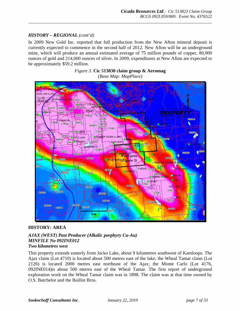
Figure 3. Cic 513830 claim group & Aeromag (Base Map: MapPlace)
HISTORY: AREA
AJAX (WEST) Past Producer (Alkalic porphyry Cu-Au) MINFILE No 092INE012 Two kilometres west This property extends easterly from Jacko Lake, about 9 kilometres southwest of Kamloops. The Ajax claim (Lot 4710) is located about 500 metres east of the lake; the Wheal Tamar claim (Lot 2126) is located 2000 metres east northeast of the Ajax; the Monte Carlo (Lot 4176, 092INE014)is about 500 metres east of the Wheal Tamar. The first report of underground exploration work on the Wheal Tamar claim was in 1898. The claim was at that time owned by O.S. Batchelor and the Boillot Bros.
Cicada Resources Ltd.: Cic 513823 Claim Group BCGS 092I.059/069: Event No. 4376522
_____________________________________________________________________________________
Sookochoff Consultants Inc. January 22, 2010 page 8 of 33
HISTORY: AREA (cont’d)
AJAX (WEST) Past Producer (Alkalic porphyry Cu-Au) (cont’d) The first development work reported on the Monte Carlo was in 1905, and on the Ajax in 1906. The Kamloops Queen, located adjacent to the Wheal Tamar claim in 1908, subsequently lapsed. The Wheal Tamar and Forlorn (Lot 3016) claims were Crown granted to O.S. Batchelor in 1912 and 1916 respectively. The Granby Consolidated Mining, Smelting and Power Company, Limited optioned the Wheal Tamar group in 1916 and carried out diamond drilling, but the results of this work are not recorded. Ownership of the Monte Carlo and Ajax groups was not recorded, other than that G.J. Rogers, of Knutsford, owned the Monte Carlo in 1913 and acquired the Ajax prior to 1923. Exploration work was carried out on an annual basis to 1914, and sporadically thereafter. The original workings on the Wheal Tamar include 6 shafts and an adit; in 1909 the adit was 143 metres long and shafts and adit totalled over 213 metres. The Monte Carlo workings included an adit, and a shaft said in 1924 to be 18 metres. The Ajax was explored by two adits. The Consolidated Mining and Smelting Company of Canada (Limited) (Cominco Ltd. since 1966) optioned 13 claims in the Ajax and Monte Carlo groups from Mr. Rogers late in 1928. Diamond drilling during 1929 was done in 10 holes on the Ajax group. The results indicated sparse mineralization in a zone approximately 76 metres wide and trending 295 degrees with steep dips to the north. On the Monte Carlo, 27 metres of drift was driven, and 243.8 metres of diamond drilling was done in 3 holes. Berens River Mines Limited in 1952 held an option on several of these claims. Diamond drilling was done in 4 holes midway between the Wheal Tamar and Monte Carlo claims. No mineralization was encountered and the option was dropped. Cominco Ltd. resumed work on the property in 1954. The company at that time held 4 Crown grants under lease and 16 full and fractional claims. A number of claims were subsequently acquired until in 1967 the property comprised the Jacko group of recorded claims and 8 Crown grants including, in addition to those mentioned above, the Copper Star (Lot 3015), Grass Roots (Lot 1496), Sultan (Lot 4717), and Neptune (Lot 4712). An electromagnetic survey was carried out in 1954 and further geophysical work was reported in 1958, and in 1967 (magnetometer survey). Diamond drilling by Cominco to the end of 1967 totalled over 7620 metres in 56 holes. Most of this drilling has been concentrated on the Ajax showings. Drilling was reported in 1967 on the Wheal Tamar and Monte Carlo showings. Drilling to 1967 is reported to have developed 9,710,000 tonnes grading 0.5 per cent copper (Prendergast, J.B., Summary Report on Property of Pinnacle Mines Ltd., January 30, 1969). No further activity was reported until 1973 when exploration work carried out by Attan Mines Ltd. included an induced polarization survey over 15.1 line kilometres, and percussion drilling in 28 holes totalling 2197.6 metres on the Ajax, 23 holes totalling 2103.1 metres on the Wheal Tamar, and 4 holes totalling 365.7 metres on Jacko 10 Fr. Seven holes drilled in 1973 and 1980 outlined a "reserve" of 5.9 million tons grading 1.55 per cent copper, 1.6 grams per tonne gold and 6.86 grams per tonne silver (Afton Annual Report, 1980). One hole hit 2.5 per cent copper and 1.06 grams per tonne gold over 200 metres. Another hole assayed 3.3 per cent copper over 85 metres, including 5.6 per cent copper over 32 metres. The mineralization is hypogene ore and has a true width of approximately 90 metres.
Cicada Resources Ltd.: Cic 513823 Claim Group BCGS 092I.059/069: Event No. 4376522
_____________________________________________________________________________________
Sookochoff Consultants Inc. January 22, 2010 page 9 of 33
HISTORY: AREA (cont’d)
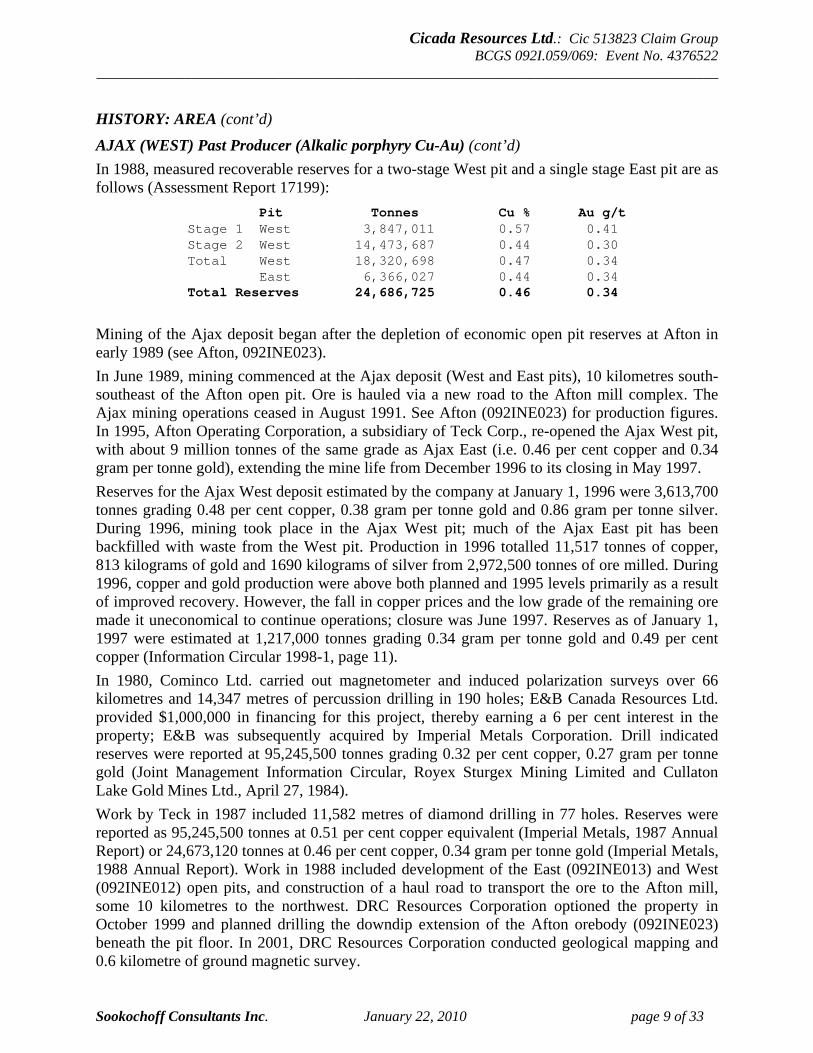
AJAX (WEST) Past Producer (Alkalic porphyry Cu-Au) (cont’d) In 1988, measured recoverable reserves for a two-stage West pit and a single stage East pit are as follows (Assessment Report 17199):
Pit Tonnes Cu % Au g/t Stage 1 West 3,847,011 0.57 0.41 Stage 2 West 14,473,687 0.44 0.30 Total West 18,320,698 0.47 0.34 East 6,366,027 0.44 0.34 Total Reserves 24,686,725 0.46 0.34
Mining of the Ajax deposit began after the depletion of economic open pit reserves at Afton in early 1989 (see Afton, 092INE023). In June 1989, mining commenced at the Ajax deposit (West and East pits), 10 kilometres south-southeast of the Afton open pit. Ore is hauled via a new road to the Afton mill complex. The Ajax mining operations ceased in August 1991. See Afton (092INE023) for production figures. In 1995, Afton Operating Corporation, a subsidiary of Teck Corp., re-opened the Ajax West pit, with about 9 million tonnes of the same grade as Ajax East (i.e. 0.46 per cent copper and 0.34 gram per tonne gold), extending the mine life from December 1996 to its closing in May 1997. Reserves for the Ajax West deposit estimated by the company at January 1, 1996 were 3,613,700 tonnes grading 0.48 per cent copper, 0.38 gram per tonne gold and 0.86 gram per tonne silver. During 1996, mining took place in the Ajax West pit; much of the Ajax East pit has been backfilled with waste from the West pit. Production in 1996 totalled 11,517 tonnes of copper, 813 kilograms of gold and 1690 kilograms of silver from 2,972,500 tonnes of ore milled. During 1996, copper and gold production were above both planned and 1995 levels primarily as a result of improved recovery. However, the fall in copper prices and the low grade of the remaining ore made it uneconomical to continue operations; closure was June 1997. Reserves as of January 1, 1997 were estimated at 1,217,000 tonnes grading 0.34 gram per tonne gold and 0.49 per cent copper (Information Circular 1998-1, page 11). In 1980, Cominco Ltd. carried out magnetometer and induced polarization surveys over 66 kilometres and 14,347 metres of percussion drilling in 190 holes; E&B Canada Resources Ltd. provided $1,000,000 in financing for this project, thereby earning a 6 per cent interest in the property; E&B was subsequently acquired by Imperial Metals Corporation. Drill indicated reserves were reported at 95,245,500 tonnes grading 0.32 per cent copper, 0.27 gram per tonne gold (Joint Management Information Circular, Royex Sturgex Mining Limited and Cullaton Lake Gold Mines Ltd., April 27, 1984). Work by Teck in 1987 included 11,582 metres of diamond drilling in 77 holes. Reserves were reported as 95,245,500 tonnes at 0.51 per cent copper equivalent (Imperial Metals, 1987 Annual Report) or 24,673,120 tonnes at 0.46 per cent copper, 0.34 gram per tonne gold (Imperial Metals, 1988 Annual Report). Work in 1988 included development of the East (092INE013) and West (092INE012) open pits, and construction of a haul road to transport the ore to the Afton mill, some 10 kilometres to the northwest. DRC Resources Corporation optioned the property in October 1999 and planned drilling the downdip extension of the Afton orebody (092INE023) beneath the pit floor. In 2001, DRC Resources Corporation conducted geological mapping and 0.6 kilometre of ground magnetic survey.
Cicada Resources Ltd.: Cic 513823 Claim Group BCGS 092I.059/069: Event No. 4376522
_____________________________________________________________________________________
Sookochoff Consultants Inc. January 22, 2010 page 10 of 33
HISTORY: AREA (cont’d)
AJAX (EAST), AFTON (AJAX), AJAX (AFTON), WHEAL TAMAR (L.2126), KAMLOOPS QUEEN, AJAX EAST Past Producer (Alkalic porphyry Cu-Au) MINFILE No 092INE013 One kilometre northwest This property extends easterly from Jacko Lake, about 9 kilometres southwest of Kamloops. The Ajax claim (Lot 4710) is located about 500 metres east of the lake; the Wheal Tamar claim (Lot 2126) is located 2000 metres east northeast of the Ajax; the Monte Carlo (Lot 4176, 092INE014)is about 500 metres east of the Wheal Tamar. The first report of underground exploration work on the Wheal Tamar claim was in 1898. The claim was at that time owned by O.S. Batchelor and the Boillot Bros. By 1904, three groups of claims had been located. These were the Wheal Tamar, Tamar Fraction, Blizzard Fraction; the Monte Carlo, Sultan, Anaconda, Whitecap Fraction; the Ajax, Hercules, Jupiter, Neptune, Mars. The first development work reported on the Monte Carlo was in 1905, and on the Ajax in 1906. The Kamloops Queen, located adjacent to the Wheal Tamar claim in 1908, subsequently lapsed. The Wheal Tamar and Forlorn (Lot 3016) claims were Crown granted to O.S. Batchelor in 1912 and 1916 respectively. The Granby Consolidated Mining, Smelting and Power Company, Limited optioned the Wheal Tamar group in 1916 and carried out diamond drilling, but the results of this work are not recorded. Ownership of the Monte Carlo and Ajax groups was not recorded, other than that G.J. Rogers, of Knutsford, owned the Monte Carlo in 1913 and acquired the Ajax prior to 1923. Exploration work was carried out on an annual basis to 1914, and sporadically thereafter. The original workings on the Wheal Tamar include 6 shafts and an adit; in 1909 the adit was 143 metres long and shafts and adit totalled over 213 metres. The Monte Carlo workings included an adit, and a shaft said in 1924 to be 18 metres. The Ajax was explored by two adits. The Consolidated Mining and Smelting Company of Canada (Limited) (Cominco Ltd. since 1966) optioned 13 claims in the Ajax and Monte Carlo groups from Mr. Rogers late in 1928. Diamond drilling during 1929 was done in 10 holes on the Ajax group. The results indicated sparse mineralization in a zone approximately 76 metres wide and trending 295 degrees with steep dips to the north. On the Monte Carlo, 27 metres of drift was driven, and 243.8 metres of diamond drilling was done in 3 holes. Berens River Mines Limited in 1952 held an option on several of these claims. Diamond drilling was done in 4 holes midway between the Wheal Tamar and Monte Carlo claims. No mineralization was encountered and the option was dropped. Cominco Ltd. resumed work on the property in 1954. The company at that time held 4 Crown grants under lease and 16 full and fractional claims. A number of claims were subsequently acquired until in 1967 the property comprised the Jacko group of recorded claims and 8 Crown grants including, in addition to those mentioned above, the Copper Star (Lot 3015), Grass Roots (Lot 1496), Sultan (Lot 4717), and Neptune (Lot 4712). An electromagnetic survey was carried out in 1954 and further geophysical work was reported in 1958, and in 1967 (magnetometer survey). Diamond drilling by Cominco to the end of 1967 totalled over 7620 metres in 56 holes. Most of this drilling has been concentrated on the Ajax showings. Drilling was reported in 1967 on the Wheal Tamar and Monte Carlo showings. Drilling to 1967 is reported to have developed 9,710,000 tonnes grading 0.5 per cent copper (Prendergast, J.B., Summary Report on Property of Pinnacle Mines Ltd., January 30, 1969).

Cicada Resources Ltd.: Cic 513823 Claim Group BCGS 092I.059/069: Event No. 4376522
_____________________________________________________________________________________
Sookochoff Consultants Inc. January 22, 2010 page 11 of 33
HISTORY: AREA (cont’d)
AJAX (EAST) Past Producer (Alkalic porphyry Cu-Au) (cont’d) No further activity was reported until 1973 when exploration work carried out by Attan Mines Ltd. included an induced polarization survey over 15.1 line kilometres, and percussion drilling in 28 holes totalling 2197.6 metres on the Ajax, 23 holes totalling 2103.1 metres on the Wheal Tamar, and 4 holes totalling 365.7 metres on Jacko 10 Fr. Seven holes drilled in 1973 and 1980 outlined a "reserve" of 5.9 million tonnes grading 1.55 per cent copper, 1.6 grams per tonne gold and 6.86 grams per tonne silver (Afton Annual Report, 1980). One hole intersected 2.5 per cent copper and 1.06 grams per tonne gold over 200 metres. Another hole assayed 3.3 per cent copper over 85 metres, including 5.6 per cent copper over 32 metres. The mineralization is in hypogene (sulphides) and has a true width of approximately 90 metres. In 1980, Cominco Ltd. carried out magnetometer and induced polarization surveys over 66 kilometres and 14,347 metres of percussion drilling in 190 holes; E&B Canada Resources Ltd. provided $1,000,000 in financing for this project, thereby earning a 6 per cent interest in the property; E&B was subsequently acquired by Imperial Metals Corporation. Drill indicated reserves were reported at 95,245,500 tonnes grading 0.32 per cent copper, 0.27 gram per tonne gold (Joint Management Information Circular, Royex Sturgex Mining Limited and Cullaton Lake Gold Mines Ltd., April 27, 1984). Teck Corporation and Metall Mining corporation, through Afton Operating Corporation, in November 1986 obtained an option to earn a 70 per cent interest from owners Cominco Ltd. and Imperial Metals Corporation. Work by Teck in 1987 included 11,582 metres of diamond drilling in 77 holes. Reserves were reported as 95,245,500 tonnes at 0.51 per cent copper equivalent (Imperial Metals, 1987 Annual Report) or 24,673,120 tonnes at 0.46 per cent copper, 0.34 gram per tonne gold (Imperial Metals, 1988 Annual Report). Work in 1988 included development of the East (092INE013) and West (092INE012) open pits, and construction of a haul road to transport the ore to the Afton mill, some 10 kilometres to the northwest. Mining of the Ajax deposit began after the depletion of economic open pit reserves at Afton in early 1989 (see Afton, 092INE023). In June 1989, mining commenced at the Ajax deposit (West and East pits), 10 kilometres to the south-southeast of the Afton open pit. Ore is hauled via a new road to the Afton mill complex. Ajax mining operations ceased in August 1991. See Afton (092INE023) for production figures. Afton Operating Corporation, a subsidiary of Teck Corp., resumed production in September, 1994 after a three-year suspension in operations because of depressed metal prices. Production from the Ajax East pit, which contained approximately 3.63 million tonnes of ore grading 0.46 per cent copper and 0.34 gram per tonne gold, totalled 3600 tonnes of copper and 245 kilograms of gold from 931,000 tonnes milled at a daily throughput of 8700 tonnes. Reserves for the Afton-Ajax deposits estimated by the company at January 1, 1995 were 13.2 million tonnes grading 0.42 per cent copper and 0.34 gram per tonne gold (Information Circular 1996-1, page 7). In 1995, Afton announced that it would re-open the Ajax West pit (092INE012), with about 9 million tonnes of the same grade as Ajax East, extending the mine life from December 1996 to about December 1998. Pushback stripping of the Ajax West pit began, and ore was milled (Information Circular 1996-1, page 7). See Ajax (West) (092INE012).
Cicada Resources Ltd.: Cic 513823 Claim Group BCGS 092I.059/069: Event No. 4376522
_____________________________________________________________________________________
Sookochoff Consultants Inc. January 22, 2010 page 12 of 33
HISTORY: AREA (cont’d)
AJAX (EAST) Past Producer (Alkalic porphyry Cu-Au) (cont’d) Production in 1995 from the Ajax East pit totalled 11,824 tonnes of copper, 830 kilograms of gold and 1559 kilograms of silver from 2,928,922 tonnes milled at a daily throughput of 8770 tonnes. During 1996, mining took place in the Ajax West pit; much of the Ajax East pit was backfilled with waste from the West pit. Closure of the West pit operation was June 1997 due to low copper prices and the low grade of the remaining ore. In 2001, DRC Resources Corporation conducted geological mapping and 0.6 kilometre of ground magnetic survey.
FARGO Prospect (Alkalic porphyry Cu-Au) MINFILE No 092INE051 One kilometre south The Fargo group was originally staked and prospected by C.H. King and L.G. Smith. A shipment of one carload of ore grading about 2 per cent copper and 2 grams per tonne gold is reported to have been made. In 1970, Royal Canadian Ventures Ltd. conducted geological mapping, a soil survey (625) and magnetometer survey (38.6 kilometres) on the MR claims which just border the Fargo showing area to the northwest. In 1972, Plaza Resources Ltd. completed a soil survey, ground magnetometer survey and drilled five percussion-drill holes totalling 184.4 metres on the Rose claims. In 1978, Cominco Ltd. completed 7.7 kilometres of induced polarization and magnetometer survey and drilled four vertical percussion-drill holes totalling 245 metres on the Wildrose claim. The drillholes were located about 400 metres east of the Fargo trench showing and intersected only traces of chalcopyrite in Iron Mask Hybrid unit rocks. In 1989, Cominco Ltd. drilled 41 percussion-drill holes totalling 3507 metres on their IM and Wild claims. Lyra Resources Ltd. drilled two drill holes in 2002.
CHANCE EDITH, HUMP Showing (Alkalic porphyry Cu-Au) MINFILE No 092INE101 One kilometre south Old workings consist of three shafts, several trenches and opencuts. One shaft, 54.8 metres deep, was sunk on a shear zone striking 280 degrees and dipping 60 degrees southwest. The shaft has short levels driven from it at depths of 30 and 36.5 metres but is filled with water to immediately below the 36.5-metre level (ca. early 1940s). Samples of quartz vein material with chalcopyrite from the No. 2 shaft dump yielded up to 4.0 grams per tonne gold, 11.3 grams per tonne silver and 0.4 per cent copper (Assessment Report 16137). The workings on the Chance showing were examined in the early 1940s. In 1972, a soil survey (661) and ground magnetometer survey (26 kilometres) was conducted over the Tia claims on behalf of Lori Explorations Ltd. In 1978, Cominco Ltd. completed an induced polarization (7.7 kilometres) and ground magnetometer (7.7 kilometres) survey over the Wildrose claim, which covered the showings at that time. In 1980, soil sampling (915), VLF-EM (27 kilometres) and an induced polarization survey (3.5 kilometres) was run over the showing and the Buda showing (092INE116) to the north. In 1981, Argenta Resources Ltd. completed three diamond-drill holes totalling 381 metres drilled. Two holes were drilled on the Buda showing and one hole on the Chance showing. In 1985, geological mapping was conducted on the Edith property on behalf of Argenta Resources Ltd. In 1986, Afton Operating Corporation conducted 2.7 kilometres of self-potential and resistivity survey. In 1987-88, geological mapping and a VLF-EM 16 survey was conducted by J.D. Murphy on the Hump claim. In 2000, Planet Ventures Inc. completed 0.8 kilometres of VLF-EM survey, airphoto interpretation and rock sampling on the Planet claims.
Cicada Resources Ltd.: Cic 513823 Claim Group BCGS 092I.059/069: Event No. 4376522
_____________________________________________________________________________________
Sookochoff Consultants Inc. January 22, 2010 page 13 of 33
HISTORY: PROPERTY WINDSOR Showing (Alkalic porphyry Cu-Au) MINFILE No 092INE009 Within Property (Tenure 513823) In 1956, Inland Copper Mines Ltd. drilled two shallow AX diamond-drill holes to test the showing. Minor pyrite-magnetite mineralization was intersected in drillhole W2, 91 metres northwest of the shaft. The hole passes from greenstones into strongly albitized and brecciated diorite of microdiorite of the Cherry Creek unit of the Iron Mask batholith. Drillhole W1 passes through picrite basalt into greenstones and back into picrite. The picrite is part of the Picrite unit of the batholith. In 1964, Rolling Hills Copper Mines Limited conducted a widely spaced induced polarization survey totalling 37.5 line kilometres over several claim groups. In 1976, four percussion-drill holes totalling 365.7 metres were drilled, 24 kilometres of induced polarization survey and a soil geochemical survey completed on the Sun claim on behalf of L.M.C. Resources Ltd.
KIMBERLY Developed Prospect (Alkalic porphyry Cu-Au) MINFILE No 092INE017 Within Property (Tenure 521765) The Kimberly property is located 5.5 kilometres south-southwest of Kamloops and about 1.5 kilometres northwest of Knutsford. About 200 claims were located in this vicinity in 1896 and it is probable that the 7 claim Kimberly group was located at that time. The owners, Messrs. Fowler and Carter, carried out exploration and development work until 1900. Most of this work was done on the Charlotte claim (Lot 1448) and included a 68.5 metre long adit, a 5.4 metre deep shaft and numerous opencuts. The Kimberley Copper Mines Ltd. was formed in July 1900 to purchase the property. Some exploration work was reported by the company in 1900 and 1901; the adit was reportedly extended a further 53 metres. The claims were apparently under option to a Mr. Beckman, of Cleveland, Ohio, in 1908 and further trenching was reported at that time. Three claims, the Morning Star (Lot 1450), Stem Winder (Lot 1451), and Keystone Fractional (Lot 1453) were Crown granted to the company in 1911; the company charter was surrendered in 1912. The property was subsequently acquired by Angelo Sartorio and in 1929 the following claims were Crown granted to him: Kimberly, Charlotte and Last Chance (Lots 1447 1449), and Occidental (Lot 1452). No work was reported at that time. In about 1940, the property was owned by Baroness Sartorio. New Jersey Zinc Exploration Company (Canada) Limited held the property, probably under option, in 1964 and completed 6 BX diamond-drill holes totalling 621.7 metres. Owner F. Sanft did a limited amount of diamond drilling in 1965. Kimberley Copper Mines Ltd. optioned the Crown-granted claims from F. Sanft in April 1966 and acquired the Kim group of 5 claims by staking. An additional 20 claims in the Alf, Jeep and Don groups were purchased at this time. Initial work by the company included geological mapping, geochemical and magnetometer surveys, and 276.1 metres of diamond drilling in 3 holes. Percussion drilling totalling 1176.8 metres was done in 42 holes, of which 9 failed to reach bedrock. Most of the holes drilled on the Crown-granted claims cut only minor amounts of copper. The best hole cut 18.2 metres averaging 0.54 per cent copper, including 6 metres of 1.07 per cent copper. Some 609 metres northwest, a drillhole cut 15.2 metres of 0.30 per cent copper. Phillips Petroleum Company sub-optioned the property from Kimberley Copper in July 1968. Work by the company included induced polarization and geochemical surveys, 2444.8 metres of diamond drilling in 20 holes and 1798.3 metres of percussion drilling in 23 holes. The sub-option was dropped in 1969.
Cicada Resources Ltd.: Cic 513823 Claim Group BCGS 092I.059/069: Event No. 4376522
_____________________________________________________________________________________
Sookochoff Consultants Inc. January 22, 2010 page 14 of 33
HISTORY: PROPERTY (cont’d)
KIMBERLY Developed Prospect (Alkalic porphyry Cu-Au) (cont’d) Kimberley Copper Mines changed its name in February 1971 to Nor-West Kim Resources Ltd; the company abandoned its option in about 1973. In 1985 or 1986, Teck Corporation carried out a VLF electromagnetic survey over 10.7 kilometres and a geochemical soil survey (148 samples) on the Kim claims in this vicinity. In October 1986, Glitter Gold Mines Ltd. optioned 100 per cent interest in the MD 1-6 claims covering this property from M. McElgunn, of Kamloops. The company reported that past work had outlined 362,840 tonnes grading 0.35 per cent copper (Glitter Gold Mines, Filing Statement 76/87).
IM Showing (Alkalic porphyry Cu-Au) MINFILE No 092INE112 Within Property (Tenure 521761) In 1968-69, Royal Canadian Ventures Ltd. completed 4 kilometres of ground magnetometer survey, soil sampling (120) and 22.5 kilometres of induced polarization survey over the IM claims. In 1970, Great Plains Development Company of Canada, Ltd. drilled eleven percussion-drill holes totalling 710 metres on the IM claims. In 1972-73, Craigmont Mines Limited drilled twenty-five diamond-drill holes totalling 1618.4 metres, three rotary-drill holes totalling 90.8 metres and fifteen percussion-drill holes totalling 972.3 metres on the IM claims. In 1978, Pan Ocean Oils Ltd. completed six diamond-drill holes totalling 588.2 metres on the IM claims. In 2001, a photo lineament analysis was conducted on behalf of Lyra Resources Ltd. on the Dal claims.
BUDA Showing (Alkalic porphyry Cu-Au) MINFILE No 092INE116 Within Property (Tenure 513823) In 1970, Royal Canadian Ventures Ltd. conducted geological mapping, a magnetometer survey (38.6 kilometres) and took 625 soil samples on the MR group of claims. In 1972-73, Rolling Hills Copper Mines Ltd. conducted geological mapping, 41.8 kilometres of magnetometer survey, an induced polarization survey, and drilled ten vertical percussion-drill holes totalling 914.4 metres on the Fox, Pam, X, Dave, Don and Map claims.
GEOLOGY: REGIONAL Regionally, the property is situated within the Quesnel Trough, a 30 to 60 km wide belt of Lower Mesozoic volcanic and related strata enclosed between older rocks and much invaded by batholiths and lesser intrusions (Campbell and Tipper, 1970). The southern part is the well-known Nicola belt, continuing nearly 200 km to its termination at the U.S. border. The Nicola belt is enveloped by the Guichon Creek Batholith, host to the major porphyry copper mines of the Highland Valley, to the west, the Wild Horse Batholith to the east, and the Iron Mask Batholith, host to the former producer Afton Mine, to the north northeast. In the vicinity of Afton, the Iron Mask district is part of a major structure extending northwestward across the general northerly trend of the Nicola belt. This cross structure is less than 10 km wide and about 35 km long. To the northwest, the structure is largely obscured by later stratified rocks of an adjoining basin. To the southeast, it contains two related plutons formerly believed to be a single connected body named the Iron Mask batholith. The Iron Mask batholith lies in the southern part of the Quesnel trough, also known as the Nicola belt. The most important pre- Tertiary rocks in this belt are Upper Triassic volcanic and sedimentary rocks of the Nicola Group.
Cicada Resources Ltd.: Cic 513823 Claim Group BCGS 092I.059/069: Event No. 4376522
_____________________________________________________________________________________
Sookochoff Consultants Inc. January 22, 2010 page 15 of 33
GEOLOGY: REGIONAL (cont’d) The batholith is a subvolcanic, multiple intrusion which is comagmatic and coeval with the Nicola rocks. It is situated along the southwest side of a regional northwest trending fracture zone and is itself cut by numerous northwesterly faults. The batholith comprises two major northwest trending plutons separated by 6 kilometres of Eocene Kamloops Group volcanic and sedimentary rocks. The Tertiary rocks occupy what appears to be a graben structure resulting from renewed fault movement around the margins of the plutons during Paleocene or Early Eocene time (Bulletin 77). The larger pluton, the 18 kilometre long southern part of the batholith, is called the Iron Mask pluton. The smaller Cherry Creek pluton farther northwest, outcrops on either side of Kamloops Lake. The combined exposure of the batholith, including the intervening younger rocks, is about 33 kilometres long and 5 kilometres wide. Sedimentary and volcanic rocks of the Kamloops Group unconformably overlie the Nicola rocks and the Iron Mask batholith. These include tuffaceous sandstone, siltstone and shale with minor conglomerate, as well as basaltic to andesitic flows and agglomerates with minor dacite, latite and trachyte. In the vicinity of the batholith, the Nicola Group is dominated by volcanic and volcaniclastic sedimentary rocks. They are generally recognized by albitization of feldspars, occurrence of patchy epidote, and/or rare hematite alteration. On the southwestern flank of the Iron Mask pluton, well-indurated, massive and bedded tuff, breccia and interbedded flows and flow breccia are prominent and are weakly metamorphosed. On the northeast flank, less well-indurated and less altered tuff and tuff breccia predominate. However, adjacent to the intrusive contact, these rocks are also well indurated and epidotized and are locally mineralized with sulphides. At the southeastern tip of the Iron Mask pluton and locally along the southwestern flank, the Nicola rocks comprise distinctive porphyritic augite-hornblende basalt. The Iron Mask pluton comprises four major, successively emplaced units designated as the Iron Mask Hybrid, Pothook, Sugarloaf and Cherry Creek units. Locally, an additional Picrite unit also occurs which is probably not genetically related to the batholith. The smaller Cherry Creek pluton consists entirely of the Cherry Creek unit. Isotopic dates (194 to 204 Ma +/- 6 Ma) indicate that all of these units are of Late Triassic or earliest Jurassic age (Bulletin 77). The component units (except the Picrite unit) of the multiphase batholith are largely controlled by major systems of northwesterly, northerly and northeasterly trending fractures or faults. Most units show some degree of alteration and/or contamination which may be intense locally. Weak to moderate saussuritization is ubiquitous in all batholithic rocks while potassium feldspathization is more prominent in rocks of the Cherry Creek unit. The units are briefly described in order of oldest to youngest (determined mainly on crosscutting relationships). The Iron Mask Hybrid unit forms the spine of the Iron Mask pluton. It is mostly agmatitic, consisting of rounded to angular fragments of various sizes, texture and composition in a dioritic matrix. The fragments include mainly coarse and fine-grained diorite and coarse-grained gabbro with lesser amounts of medium to coarse-grained hornblendite and scattered xenoliths of Nicola Group volcanic rocks. All rock varieties in the unit contain magnetite which is often more than 10 per cent by volume. Mineralization, particularly of iron and copper, is almost ubiquitous in this unit. The Iron Mask mine (092INE010), a former copper producer, is located in this unit, but is also associated with picrite. The Pothook unit occurs mainly in the northwestern half of the Iron Mask pluton, appearing frequently as narrow, gradational zones between the Iron Mask Hybrid and Cherry Creek units.

Cicada Resources Ltd.: Cic 513823 Claim Group BCGS 092I.059/069: Event No. 4376522
_____________________________________________________________________________________
Sookochoff Consultants Inc. January 22, 2010 page 16 of 33
GEOLOGY: REGIONAL (cont’d) Rocks of this unit are uniformly of dioritic composition and are medium to coarse grained. The Pothook unit is locally mineralized with copper and iron. The Picrite unit consists of rocks of basaltic composition with abundant clinopyroxene and serpentinized olivine phenocrysts. These rocks generally occur as steeply dipping, poorly exposed and relatively small lenticular bodies in many parts of the batholith. They appear to be associated with recurring, northwesterly trending fracture systems and copper mineralization frequently occurs in their vicinity. Because picrite basalt has been observed far from the two component plutons of the batholith, it is probable that this unit is not part of the batholith. The Sugarloaf unit occurs mainly along the southwest side of the Iron Mask pluton and as small enclosed bodies in the southern half of the pluton. Rocks of this unit are mainly porphyritic with hornblende, minor clinopyroxene and plagioclase in a greyish green matrix. They are of fairly uniform diorite-andesite composition. Several copper occurrences are hosted by the Sugarloaf rocks. The Ajax deposit (092INE012) east of Jacko Lake is located within brecciated and albitized Sugarloaf rocks. The Cherry Creek unit is the most widely distributed phase of the batholith. It constitutes the entire Cherry Creek pluton. The unit consists of rocks with composition ranges from diorite, monzonite, syenite to their porphyritic and fine-grained equivalents as well as local intrusive breccias.
Figure 4. Property, Geology, Index & Minfile (Base map: MapPlace)
Cicada Resources Ltd.: Cic 513823 Claim Group BCGS 092I.059/069: Event No. 4376522
_____________________________________________________________________________________
Sookochoff Consultants Inc. January 22, 2010 page 17 of 33
GEOLOGY: REGIONAL (cont’d) Copper and minor iron mineralization is prominent in the Cherry Creek unit, particularly in zones of intense brecciation associated with alkali metasomatism. Afton mine lies at the western termination of a narrow, 4 kilometre long, easterly trending zone of intense intrusive brecciation that is located at the northern edge of the Iron Mask pluton. The brecciation is considered to have resulted from high-level venting events. The Batholith lies lengthwise in a major cross structure of the Quesnel Trough and is emplaced in contemporaneous volcanic rocks of the Upper Triassic Nicola Group, all apparently of late Triassic age and ranging in composition from basic to moderately alkalic. Control of the cross-structure by long-active, deep-seated faults is evidenced by the manner of emplacement of plutons and by the development of adjacent sedimentary and volcanic basins of Eocene or possibly much earlier age. The Iron Mask and Pothook units are the oldest on geological evidence and consist chiefly of diorite and gabbro. Succeeding units of finer-grained, more porphyritic rocks are emplaced mainly along northwestern and western linear structure that frame and dissect the pluton. Thus, picrite basalt forms steep, lenticular bodies that are poorly exposed, commonly possess sheared, serpentinized margins, and are generally found within 300 m of most prospects in the district. The Afton ore-body lies on the northwestern edge of the Iron Mask Batholith and occurs in latephase plutonic rocks which include latite porphyry and related breccias The Afton ore-body lies at the intersection of structures considered to reflect deep seated faults that were active intermittently from the late Triassic (Carr, 1976). The area of the deposit and especially the western half is in an area which is known to be the locus of much faulting. Faults, although numerous, mostly defy correlation and cause only minor disruption of the deposit. However, the western end of the deposit is off-set some 2,000 feet by a normal northerly trending fault thus the western extension of the orebody is covered by some 2000 feet Kamloops volcanics. The ore-body also occupies the northwestern tip of a zone of abundant magnetite veining developed along the longitudinal axis of the Iron Mask Batholith. Hypogene alteration has no recognized pattern and it includes potassic, saussuritic and phyllic varieties. Supergene alteration is characterized by rock disintegration and abundant earthy hematite with limonite. An extensive pyrite halo lies south and west of the Afton ore-zone, overlapping slightly onto its southwestern sector. Geochemical and geophysical surveys fail to distinguish the orebody clearly from widespread sub-economic mineralization.
GEOLOGY: AREA The geology on some of the more significant mineral MINFILE reported occurrences, prospects, and past producers on the Property and peripheral to the Property (Figure 4) are reported as follows:
CHANCE EDITH, HUMP Showing (Alkalic porphyry Cu-Au) MINFILE No 092INE101 One kilometre south The Chance showings are shear zones in Upper Triassic Nicola Group augite porphyritic andesitic volcanic rocks intruded by diorite of the Late Triassic-Early Jurassic Iron Mask batholith. The shear zones are between 0.3 to 1.5 metres wide and host quartz veins and stringers that pinch and swell and are between 15 to 35 centimetres wide. The veins are mineralized with pyrite, chalcopyrite and galena; low values in gold were reported, with occasional high assays. Most of the shear zones are hosted by porphyritic andesitic volcanic rocks but one occurs at the contact between argillite and andesite and contains local pyrite and chalcopyrite mineralization.
Cicada Resources Ltd.: Cic 513823 Claim Group BCGS 092I.059/069: Event No. 4376522
_____________________________________________________________________________________
Sookochoff Consultants Inc. January 22, 2010 page 18 of 33
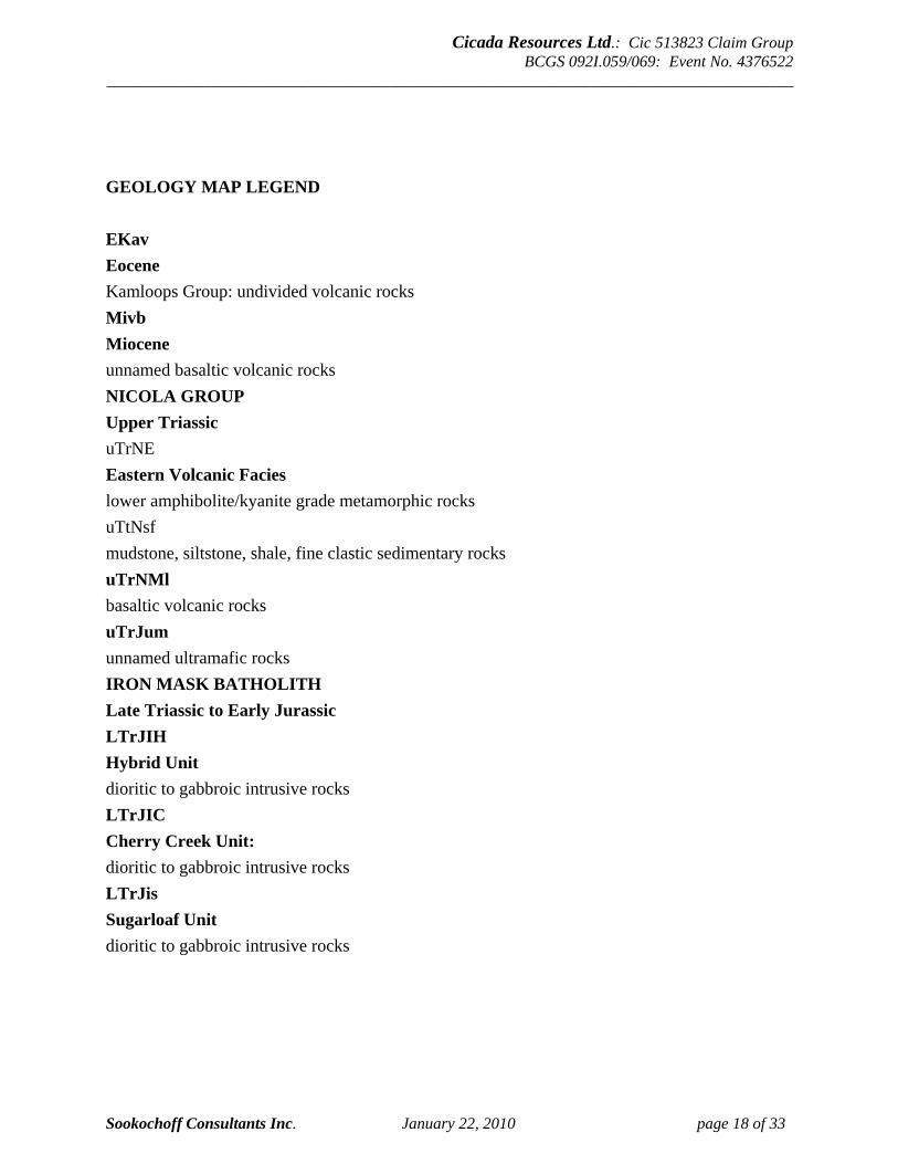
GEOLOGY MAP LEGEND EKav Eocene Kamloops Group: undivided volcanic rocks Mivb Miocene unnamed basaltic volcanic rocks NICOLA GROUP Upper Triassic uTrNE Eastern Volcanic Facies lower amphibolite/kyanite grade metamorphic rocks uTtNsf mudstone, siltstone, shale, fine clastic sedimentary rocks uTrNMl basaltic volcanic rocks uTrJum unnamed ultramafic rocks IRON MASK BATHOLITH Late Triassic to Early Jurassic LTrJIH Hybrid Unit dioritic to gabbroic intrusive rocks LTrJIC Cherry Creek Unit: dioritic to gabbroic intrusive rocks LTrJis Sugarloaf Unit dioritic to gabbroic intrusive rocks
Cicada Resources Ltd.: Cic 513823 Claim Group BCGS 092I.059/069: Event No. 4376522
_____________________________________________________________________________________
Sookochoff Consultants Inc. January 22, 2010 page 19 of 33
GEOLOGY: AREA (cont’d)
AJAX (WEST) Past Producer (Alkalic porphyry Cu-Au) MINFILE No 092INE012 Two kilometres west On the Ajax property, intrusive rocks are represented primarily by the Iron Mask Hybrid and Sugarloaf units. The Iron Mask Hybrid unit appears to have been emplaced as intrusive breccias cut and healed by mesocratic to leucocratic diorite. The younger Sugarloaf unit is directly associated with copper mineralization. It is typically a fine to medium-grained porphyritic diorite whose characteristic feature is a subparallel alignment of hornblende and augite phenocrysts. The bulk of this unit on the Ajax property seems to be from a single intrusive phase associated with the alteration and mineralizing events. However, at least one phase of post-ore, very fine-grained microdiorite is observed in drill core. This phase has little or no copper mineralization and occurs as bodies of limited size and extent, most notably in the hanging wall area of the West zone. The Picrite unit has been noted in drill core. Ore at the Ajax deposit is developed along the Iron Mask Hybrid/Sugarloaf units contact and forms relatively linear zones. Sodium metasomatism (albitization) is widespread and has caused extensive alteration of both Sugarloaf and Iron Mask Hybrid rocks. The degree of alteration ranges from minor fracture envelopes to total replacement of the original minerals resulting in a brittle, hard, porcellaneous white rock composed largely of secondary albite. Albitization is most intense in the contact area between Sugarloaf and Iron Mask Hybrid units. In detail, however, the albitized zones are variable, transitional and difficult to correlate between sections. Albitization as well as epidote-chlorite-carbonate alteration are important in the mineralized zones. Volcanic rocks of the Nicola Group underlie the south portion of the property. Close to the intrusive contact the rocks consist primarily of andesitic flows. Toward the southeast boundary tuffs are dominant. The Nicola rocks can be weakly albitized and cut by rare potassium feldspar veinlets but are never mineralized to ore grades. In the Ajax (West) zone, a linear body of Sugarloaf diorite, with a northwest trending axis and steep southerly dip, has been emplaced along the contact between Nicola volcanics and Iron Mask Hybrid diorite. The Sugarloaf unit has stoped out and assimilated substantial areas of Iron Mask Hybrid diorite creating a contact area with undulating embayment features. Numerous fragments of Iron Mask Hybrid diorite and breccia were noted in sections of Sugarloaf core. More mafic or volcanic-rich sections tend to remain as large unassimilated blocks within the Sugarloaf unit. Hydrothermal solutions associated with the Sugarloaf intrusive have extensively altered both the host diorite and the bounding Iron Mask Hybrid diorite. Albitization is predominant, but additional propylitic and potassic alteration minerals occur as well. Fracturing and alteration of the Iron Mask Hybrid diorite persist well away from the immediate contact area allowing copper mineralization to penetrate well into that unit. A large mass of Iron Mask Hybrid breccia located on the north or footwall side of the Iron Mask Hybrid diorite is seemingly impervious to significant alteration or mineralization. Nicola Group volcanics form the hanging wall of the West zone. In the hanging wall area, the volcanics are intruded by at least one phase of post-ore Sugarloaf unit microdiorite. Local faulting and brecciation mark contacts between units but no dominant through-going structures were identified in the West zone.

Cicada Resources Ltd.: Cic 513823 Claim Group BCGS 092I.059/069: Event No. 4376522
_____________________________________________________________________________________
Sookochoff Consultants Inc. January 22, 2010 page 20 of 33
GEOLOGY: AREA (cont’d)
AJAX (EAST), AFTON (AJAX), AJAX (AFTON), WHEAL TAMAR (L.2126), KAMLOOPS QUEEN, AJAX EAST Past Producer (Alkalic porphyry Cu-Au) MINFILE No 092INE013 One kilometre northwest On the Ajax (East) property, intrusive rocks are represented primarily by the Iron Mask Hybrid and Sugarloaf units. The Iron Mask Hybrid unit appears to have been emplaced as intrusive breccias cut and healed by mesocratic to leucocratic diorite. The younger Sugarloaf unit is directly associated with copper mineralization. It is typically a fine to medium-grained porphyritic diorite whose characteristic feature is a subparallel alignment of hornblende and augite phenocrysts. The bulk of this unit on the property seems to be from a single intrusive phase associated with the alteration and mineralizing events. However, at least one phase of post-ore, very fine-grained microdiorite is observed in drill core. This phase has little or no copper mineralization and occurs as bodies of limited size and extent, most notably in the hanging wall area of the West zone (092INE012). The Picrite unit has been noted in drill core. Sodium metasomatism (albitization) is widespread and has caused extensive alteration of both Sugarloaf and Iron Mask Hybrid rocks. The degree of alteration ranges from minor fracture envelopes to total replacement of the original minerals resulting in a brittle, hard, porcellaneous white rock composed largely of secondary albite. Albitization is most intense in the contact area between Sugarloaf and Iron Mask Hybrid units. In detail, however, the albitized zones are variable, transitional and difficult to correlate between sections. Albitization as well as epidote-chlorite-carbonate alteration are important in the mineralized zones. Volcanic rocks of the Nicola Group underlie the south portion of the property. Close to the intrusive contact the rocks consist primarily of andesitic flows. Toward the southeast boundary tuffs are dominant. The Nicola rocks can be weakly albitized and cut by rare potassium feldspar veinlets but are never mineralized to ore grades.
AFTON Past Producer (Alkalic porphyry Cu-Au) MINFILE No 092INE023 14 kilometres northwest The Afton orebody lies completely within the Cherry Creek unit of the Iron Mask pluton. Salient characteristics of the deposit include two unique features; these are the absence of a well-defined hypogene alteration pattern about the orebody, and the abundance of native copper in the supergene zone without apparent copper enrichment (Bulletin 77). The orebody is separated from the Tertiary rocks to the north mainly by faults and locally by a rather flat-lying unconformity which postdates the supergene event. The Cherry Creek rocks intrude the Nicola Group rocks; the contact is steep, southward dipping and partly sheared. Within this simplified framework, local complications arise because of the highly fractured and altered nature of the host rocks, similarity of both texture and composition of the intrusive and extrusive rocks, gradational contacts between various phases of the intrusive rocks, and the inclusion of large slabs of one rock type in another. The copper deposit consists of shattered rocks in which the ore minerals occupy fractures and are disseminated. Ignoring complexities, the deposit, as defined by a 0.25 per cent copper cutoff, is a tabular body that strikes about 290 degrees, with an average dip of 55 degrees south. If viewed from the south as a vertical longitudinal slice, it appears to be triangular and increasingly narrow downward between a steep western limit and an eastern limit inclined moderately westward.
Cicada Resources Ltd.: Cic 513823 Claim Group BCGS 092I.059/069: Event No. 4376522
_____________________________________________________________________________________
Sookochoff Consultants Inc. January 22, 2010 page 21 of 33
GEOLOGY: AREA (cont’d)
AFTON Past Producer (Alkalic porphyry Cu-Au) (cont’d The deposit measures 520 metres long, 90 metres in average width and as much as 600 metres in drilled depth. Widening and deepening of the deposit westward results in about half the mineable tonnage occurring in the western third of the orebody, where the grade is generally highest as well. Despite the foregoing generalization, the detailed shape of the deposit is complex. Within a planned open pit 274 metres deep, the proven (measured geological) start-up reserves of the Afton orebody were 30.84 million tonnes grading 1.0 per cent copper, 0.58 grams per tonne gold and 4.19 grams per tonne silver at a cutoff grade of 0.25 per cent copper and a waste-to-ore ratio of 4.2:1 (Canadian Institute of Mining and Metallurgy Special Volume 15). Within the Afton open pit itself, six rock units are distinguished. They are designated as Cherry Creek diorite, monzonite and syenite, Nicola volcanic rocks, latite dykes and Tertiary sediments and volcanic rocks. The Cherry Creek intrusive rocks, the most abundant rock type in the open pit, are typically fine grained, slightly porphyritic in texture and range from syenite to diorite in composition; diorite generally predominates over the other varieties. Plagioclase grains in all varieties of rock are completely albitized. Potassic feldspar, typically microcline, occurs mainly in the fine-grained matrix, frequently rims plagioclase and rarely occurs as phenocrysts. In the dioritic and monzonitic varieties, potassium feldspar frequently occurs in a patchy habit including and grading into aggregates of epidote or biotite. Discrete potassium feldspar veins commonly show a chloritic envelope. Sericite, carbonate and clay replacements are present in feldspars but are rarely very intense. Partially altered clinopyroxene forms up to 10 per cent of the rock in the eastern portion of the pit while amphibole and its alteration products are the principal mafic minerals elsewhere. Nicola volcanic rocks within the Afton pit and its vicinity are of several varieties. In the southern portion of the open pit, hard massive green volcanic breccia, with predominantly hornblendite fragments, is particularly abundant. This breccia commonly contains epidote +/- carbonate +/- sulphides veins and is locally pervasively replaced by carbonate +/- chlorite. In the northeastern portion, the Nicola volcanic rocks consist of highly saussuritized andesite. Elsewhere and in drill cores, the Nicola Group rocks range from fine-grained andesite to pebbly sandstone. Latite dykes in the open pit are invariably massive, fine-grained, and very slightly porphyritic rocks. Potassium feldspar is concentrated in the matrix. Plagioclase is typically albitized. Based on mineralogy and alteration, it is concluded that these latites are probably of pre-Tertiary age. Arranged in order of decreasing abundance, sandstone, arkose, conglomerate, lithic wacke, carbonaceous argillite, and streaks of coal are among the Tertiary sedimentary rocks observed in the open pit. Tertiary volcanic rocks include dacite, trachytic flow breccia, amygdaloidal andesite, and massive andesite. Where most plagioclase grains in these rocks remain intact, mafic minerals are typically replaced by ankerite. Compared to other porphyry copper deposits, the Afton deposit does not exhibit well-defined hydrothermal alteration patterns. The most obvious supergene alteration is the disintegration of the rock mass and accompanying intense, pervasive introduction of hematite. Strong phyllic and argillic alteration assemblages are absent. Argillic alteration may be supergene, because its products include montmorillonite, the principal clay mineral in a composite sample of supergene ore. The hypogene alteration is difficult to distinguish due to the prevalence of supergene effects.
Cicada Resources Ltd.: Cic 513823 Claim Group BCGS 092I.059/069: Event No. 4376522
_____________________________________________________________________________________
Sookochoff Consultants Inc. January 22, 2010 page 22 of 33
GEOLOGY: AREA (cont’d)
AFTON Past Producer (Alkalic porphyry Cu-Au) (cont’d It exhibits the following successive stages, the distribution and relative intensities of which are poorly known: potassic alteration characterized by secondary potassium feldspar and locally by hydrothermal biotite; saussuritic alteration, chiefly with epidote-chlorite-magnetite and only rarely quartz and calcite; and phyllic (quartz-sericite) alteration. Potassic alteration is sporadic and possibly related to the distribution of latite porphyry. Saussuritic alteration is more general and is related to a widespread propylitic alteration seen in pyritic rocks south of the deposit. As far as carbonate alteration is concerned, calcite predominates over ankerite in the eastern portion of the pit and the reverse is true elsewhere. Although calcite is an expected product of propylitic alteration, surprisingly most calcite at Afton occurs as late fracture-fillings that postdate the supergene event and are common to the nearby Tertiary strata. A large scale zoning of magnetite, pyrite and copper minerals is crudely evident in the vicinity of the Afton orebody. Abundant hydrothermal magnetite forms a 300 metre wide zone trending northwestward from the Magnet shaft (092INE022) to the Afton orebody, a distance of 800 metres. The magnetite zone contains the orebody and is flanked by barren pyrite zones. The southwestern pyrite zone forms the hanging wall of the orebody. The pyrite zone widens to about 300 metres at Afton, beyond which it swings westward and is widest near its termination 600 metres farther on. South of Afton, it contains up to 10 per cent pyrite by volume, chiefly as fracture-fillings in Cherry Creek rocks and disseminations in Nicola rocks. Within the boundary of large-scale zoning of pyrite and magnetite, ore appears to be most consistently associated with hydrothermal biotite.
FARGO Prospect (Alkalic porphyry Cu-Au) MINFILE No 092INE051 One kilometre south The Fargo showing area is dominantly underlain by two intrusive units of the Late Triassic-Early Jurassic Iron Mask batholith. Gabbroic to dioritic agmatites of the Iron Mask Hybrid unit underlies most of the western part of the property, while most of the eastern part is underlain by dioritic to syenitic rocks of the Cherry Creek unit. Magnetite is ubiquitous throughout these rocks, ranging from less than 3 per cent in the Cherry Creek unit to more than 10 per cent in the Iron Mask Hybrid unit. Weak to moderate propylitic alteration with attendant pyritization is quite pervasive throughout the Iron Mask Hybrid unit. In contrast, the Cherry Creek unit is pervasively saussuritized with local zones of propylitic, albitic and potassic alteration. The original Fargo showings consist of quartz veins in diorite of the Cherry Creek unit of the Iron Mask batholith. The principal working is an inclined shaft stated to be 9.1 metres deep with a drift to the north at the bottom. The workings are inaccessible because of water in the shaft (ca. early 1940s). The vein strikes 350 degrees and dips 75 degrees to the west and ranges up to 1.5 metres in width at the collar, tapers to 0.3 metre, and then swells again to 1.5 metres. The best mineralized part is a band about 0.3 metre wide along the hangingwall which contains considerable chalcopyrite and just below, abundant azurite and malachite. The vein has been traced 6 metres south and 3 metres north of the shaft by stripping; both strippings are now sloughed. Another shaft has been sunk at a point 45 metres southwest of the other. It has been sunk 6 metres on a vertical vein that is 35 centimetres wide at the collar and appears to widen near the bottom of the shaft (Geological Survey of Canada Memoir.
Cicada Resources Ltd.: Cic 513823 Claim Group BCGS 092I.059/069: Event No. 4376522
_____________________________________________________________________________________
Sookochoff Consultants Inc. January 22, 2010 page 23 of 33
GEOLOGY: PROPERTY The Cic 513823 claim group is indicated (MapPlace Download; Figure 4) to be underlain centrally by three units of the Iron Mask batholith which is bordered by the eastern volcanic facies of the Nicola Volcanics (uTrNE) to the east and west. The Cherry Creek unit (LtrJlC) predominates and underlies most of the eastern property area. The western portion of the batholith is comprised of the hybrid unit (LTrJlH) which also occurs within the Cherry Creek unit in the north. The Property is also underlain in the southeast by the Sugarloaf unit (LTrJlS) and in the central-west by a capping of Eocene Kamloops volcanics. The volcanics are exposed on the Cic 513823 claim group with most of the localized exposure on the adjacent Tenure 521761 to the northeast of the structurally analyzed Tenure 513823. The volcanics are also indicated to be in a northerly trending contact with the Cherry Creek unit to the west and in a northeasterly trending contact with the Nicola volcanics to the north. The intersection of the two faults is indicated at the Nicola/Iron Mask (Cherry Creek) contact. For more detailed information on the geology within the property area, a MINFILE capsule geology of the mineral occurrences that occur within the Property are herein included. The locations of the MINFILE mineral occurrences are shown on the included Figure 4.
WINDSOR Showing (Alkalic porphyry Cu-Au) MINFILE No 092INE009 Within Property (Tenure 513823) The Windsor showing is underlain by intrusive rocks of the Late Triassic-Early Jurassic Iron Mask batholith and andesitic volcanics of the Upper Triassic Nicola Group. Old workings spaced along a line 79 metres long trending 280 degrees consist of an inclined shaft more than 6 metres deep and several trenches and shallow pits. Host rock is Nicola andesitic volcanics. The exposures in the workings indicate that a fault, striking 280 degrees and mineralized across a width of 0.9 metre, gives place westward to two or more fractures whose strike is 300 degrees. The fractures dip about 60 degrees to the north.
KIMBERLY Developed Prospect (Alkalic porphyry Cu-Au) MINFILE No 092INE017 Within Property (Tenure 521765) The Kimberly prospect occurs in porphyritic brecciated monzonite of the Cherry Creek unit of the Late Triassic-Early Jurassic Iron Mask batholith, near its northeastern contact with Upper Triassic Nicola Group volcanics. The exposed underlying rock is a fractured and brecciated monzonite, weakly to strongly altered by pink to red and less commonly white feldspathization, and mineralized with varying amounts of pyrite, chalcopyrite and magnetite. Most of the exposed fractures trend north to northwest and surface mineralization is widespread.
IM Showing (Alkalic porphyry Cu-Au) MINFILE No 092INE112 Within Property (Tenure 521761) The IM showing consists of a 1973 drillhole (IM-33) which intersected disseminated chalcopyrite and pyrite mineralization between 39.6 and 51.8 metres depth in fractured and brecciated fine-grained monzonite. The fractures are healed by chlorite, calcite and epidote. The intrusive rock is part of the Cherry Creek unit of the Late Triassic-Early Jurassic Iron Mask batholith.

Cicada Resources Ltd.: Cic 513823 Claim Group BCGS 092I.059/069: Event No. 4376522
_____________________________________________________________________________________
Sookochoff Consultants Inc. January 22, 2010 page 24 of 33
GEOLOGY: PROPERTY (cont’d)
BUDA Showing (Alkalic porphyry Cu-Au) MINFILE No 092INE116 Within Property (Tenure 513823) The Buda property is underlain by diorite breccia of the Iron Mask Hybrid unit and diorite and monzonite of the Cherry Creek unit, both of the Late Triassic-Early Jurassic Iron Mask batholith. MINERALIZATION: AREA The mineralization on some of the more significant mineral MINFILE reported occurrences, prospects, and past producers in the Property area (Figure 4) are reported as follows:
AJAX (WEST) Past Producer (Alkalic porphyry Cu-Au) MINFILE No 092INE012 Two kilometres west Economic mineralization is confined to the main phase of Sugarloaf unit diorite and the bounding Iron Mask Hybrid unit diorite. Two and possibly three areas of intense albitization, carbonatization and brecciation within the West zone mark the location of likely breccia pipes. Mineralization is not controlled by any particular vein or fracture sets. At the Ajax (East) zone on Lot 2126 (092INE013), 1000 metres east-northeast of the West zone, mineralization occurs along the northeast trending and west dipping contact zone between Iron Mask Hybrid unit diorite to the northwest and the main lobe of Sugarloaf unit diorite to the south and east. Again, intense albite alteration is concentrated in the vicinity of the contact zone and affects both Sugarloaf and Iron Mask Hybrid rocks. Hydrothermal biotite is also abundant around the East pit area. Unique to the East zone is the presence of bands of very mafic to ultramafic rocks in the contact area. Drill core suggests they are intercalated with the Iron Mask Hybrid unit and are possibly a mafic or volcanic component of that unit. The occasional presence of serpentinized olivine suggests that the rocks might also be Picrite unit remnants sited on a deep-seated contact fault. The ultramafic rocks can be weakly albitized. This central contact area dips 40 to 50 degrees to the west-northwest and is strongly sheared and brecciated. Iron Mask Hybrid and Sugarloaf units become more massive and less altered away from the contact area. Copper mineralization is localized about the contact but occurs predominantly in the footwall Sugarloaf rocks and is bounded by stronger pyrite mineralization on the east. Distribution of mineralization is similar to the West zone, being a combination of disseminations and fracture-fillings. However, trench mapping indicated that north trending fracture and joint sets with steep westerly dips may be preferentially mineralized. Other known but less persistent mineralized zones occur to the southeast in an "en echelon" fashion and fall outside the initial East zone pit. At the north end of the zone, the Iron Mask Hybrid unit and included ultramafic rocks expand to the north and east cutting off both the Sugarloaf unit diorite and the copper mineralization. In both the West and East zones, chalcopyrite is the predominant copper mineral and the only one of economic significance. It occurs as blebs and disseminations, in fractures, veinlets and microveinlets, and occasionally in breccias and vugs with accompanying calcite. Pyrite is ubiquitous; it occurs with chalcopyrite in similar proportions but also exists separately, notably peripheral to copper mineralization. Overall pyrite content does not exceed 1 to 2 per cent. Bornite and chalcocite are present in trace amounts only.

Cicada Resources Ltd.: Cic 513823 Claim Group BCGS 092I.059/069: Event No. 4376522
_____________________________________________________________________________________
Sookochoff Consultants Inc. January 22, 2010 page 25 of 33
MINERALIZATION: AREA (cont’d)
AJAX (WEST) Past Producer (Alkalic porphyry Cu-Au) (cont’d) Malachite and azurite are noted in outcrop areas with spotty distribution at depth. Leaching and removal of copper have been minimal. Alteration tends to be spotty and incomplete with pyrite and chalcopyrite present as well. Molybdenite occurrences are widespread but values are generally quite low. Magnetite is present primarily as disseminations; large scale magnetite veining is absent. Gold mineralization is closely associated with chalcopyrite mineralization. Except in rare cases, gold values do not occur on the Ajax property except in conjunction with copper mineralization. Gold-copper ratios do vary however. Only one phase of mineralization is present in the East zone but in the West zone several pulses are indicated by the spatial distribution of copper-gold ratios.
AJAX (EAST), AFTON (AJAX), AJAX (AFTON), WHEAL TAMAR (L.2126), KAMLOOPS QUEEN, AJAX EAST Past Producer (Alkalic porphyry Cu-Au) MINFILE No 092INE013 One kilometre northwest At the Ajax East zone, located 1000 metres east-northeast of the Ajax West zone, mineralization occurs along the northeast trending and west dipping contact zone between Iron Mask Hybrid unit diorite to the northwest and the main lobe of Sugarloaf unit diorite to the south and east. Again, intense albite alteration is concentrated in the vicinity of the contact zone and affects both Sugarloaf and Iron Mask Hybrid rocks. Hydrothermal biotite is also abundant around the East pit area. Unique to the Ajax East zone is the presence of bands of very mafic to ultramafic rocks in the contact area. Drill core suggests they are intercalated with the Iron Mask Hybrid unit and are possibly a mafic or volcanic component of that unit. The occasional presence of serpentinized olivine suggests that the rocks might also be Picrite unit remnants sited on a deep-seated contact fault. The ultramafic rocks can be weakly albitized. This central contact area dips 40 to 50 degrees to the west-northwest and is strongly sheared and brecciated. Iron Mask Hybrid and Sugarloaf units become more massive and less altered away from the contact area. Copper mineralization is localized about the contact but occurs predominantly in the footwall Sugarloaf rocks and is bounded by stronger pyrite mineralization on the east. Distribution of mineralization is similar to the Ajax West zone (see 092INE012) being a combination of disseminations and fracture- fillings. However, trench mapping indicated that north trending fracture and joint sets with steep westerly dips may be preferentially mineralized. Other known but less persistent mineralized zones occur to the southeast in an en echelon fashion and fall outside the initial East zone pit. At the north end of the Ajax East zone, the Iron Mask Hybrid unit and included ultramafic rocks expand to the north and east, cutting off both the Sugarloaf unit diorite and the copper mineralization. In both the Ajax West and Ajax East zones, chalcopyrite is the predominant copper mineral and the only one of economic significance. It occurs as blebs and disseminations, in fractures, veinlets and microveinlets, and occasionally in breccias and vugs with accompanying calcite. Pyrite is ubiquitous; it occurs with chalcopyrite in similar proportions but also exists separately, notably peripheral to copper mineralization. Overall pyrite content does not exceed 1 to 2 per cent. Bornite and chalcocite are present in trace amounts only. Malachite and azurite are noted in outcrop areas with spotty distribution at depth. Leaching and removal of copper have been minimal. Alteration tends to be spotty and incomplete with pyrite and chalcopyrite present as well.

Cicada Resources Ltd.: Cic 513823 Claim Group BCGS 092I.059/069: Event No. 4376522
_____________________________________________________________________________________
Sookochoff Consultants Inc. January 22, 2010 page 26 of 33
MINERALIZATION: AREA (cont’d)
AJAX (EAST), AFTON (AJAX), AJAX (AFTON), WHEAL TAMAR (L.2126), KAMLOOPS QUEEN, AJAX EAST (cont’d) Molybdenite occurrences are widespread but values are generally quite low. Magnetite is present primarily as disseminations; large scale magnetite veining is absent. Gold mineralization is closely associated with chalcopyrite mineralization. Except in rare cases, gold values do not occur on the Ajax property except in conjunction with copper mineralization. Gold-copper ratios do vary however. Only one phase of mineralization is present in the East zone but in the West zone several pulses are indicated by the spatial distribution of copper-gold ratios. Measured recoverable reserves for a two-stage West pit and a single stage East pit are as follows (Assessment Report 17199):
-------------------------------------------------------- Pit Tonnes Cu % Au g/t Stage 1 West 3,847,011 0.57 0.41 Stage 2 West 14,473,687 0.44 0.30 Total West 18,320,698 0.47 0.34 East 6,366,027 0.44 0.34 Total Reserves 24,686,725 0.46 0.34 ---------------------------------------------------------
FARGO Prospect (Alkalic porphyry Cu-Au) MINFILE No 092INE051 One kilometre south Extensive percussion drilling by Cominco in 1989, about 600 metres east of the original Fargo showing, indicates that chalcopyrite mineralization appears to occur within an easterly trending, 304 metre wide brecciated zone that contains low grade intercepts that may be spatially related to relatively narrow, steeply dipping, northwesterly and northerly trending fault/shear structures. One hole, PE 89-21, intersected 15 metres grading 0.223 per cent copper. The highest gold value was from drillhole PE 89-32, 0.8 gram per tonne over 3 metres (Assessment Report 18873).
CHANCE EDITH, HUMP Showing (Alkalic porphyry Cu-Au) MINFILE No 092INE101 One kilometre south In 1985, a selected grab sample from a trench analysed 1.64 per cent copper, 9.6 grams per tonne silver and 24.8 grams per tonne gold (Assessment Report 14310).
Cicada Resources Ltd.: Cic 513823 Claim Group BCGS 092I.059/069: Event No. 4376522
_____________________________________________________________________________________
Sookochoff Consultants Inc. January 22, 2010 page 27 of 33
MINERALIZATION: PROPERTY The Property mineralization is taken from the MINFILE records of specifically designated mineral occurrences within the Property. The following cross-referenced MINFILE designations are indicated on Figure 4.
WINDSOR Showing (Alkalic porphyry Cu-Au) MINFILE No 092INE009 Within Property (Tenure 513823) Mineralization consists of chalcopyrite and abundant coarsely crystalline pyrite in calcite and quartz gangue. The sulphides extend into the adjacent sheared greenstone. Samples of the best material on the dumps at the shaft and the large pit assayed 1.5 and 0.69 per cent copper respectively (Minister of Mines Annual Report 1956).
KIMBERLY Developed Prospect (Alkalic porphyry Cu-Au) MINFILE No 092INE017 Within Property (Tenure 521765) Four apparently separate zones of copper mineralization are known to occur in a northwesterly trending area of more than 1219 by 243 metres. They are all found within or close to the monzonitic rocks, near their contacts with diorite. The mineralization occurs as fracture coatings and as disseminations. Malachite and azurite are common secondary copper minerals.
IM Showing (Alkalic porphyry Cu-Au) MINFILE No 092INE112 Within Property (Tenure 521761) A sample across 12 metres yielded an average of 0.22 per cent copper (Assessment Report 4844).
BUDA Showing (Alkalic porphyry Cu-Au) MINFILE No 092INE116 Within Property (Tenure 513823) Weak disseminated and fracture-coating pyrite and chalcopyrite mineralization occurs in Cherry Creek unit diorite. The diorite contains strong north to northwesterly striking, steeply dipping fractures and exhibits K-feldspar alteration. 2009 STRUCTURAL ANALYSIS Orthophoto maps obtained from MapPlace were utilized as the base map for the structural analysis on Tenure 513830. The analysis was accomplished using a stereographic projection viewing of the maps and marking the indicated structures on an overlay. A total of 135 indicated structures were marked (Figure 5), compiled into a 10 degree class interval, and plotted as a rose diagram as indicated on Figure 6.
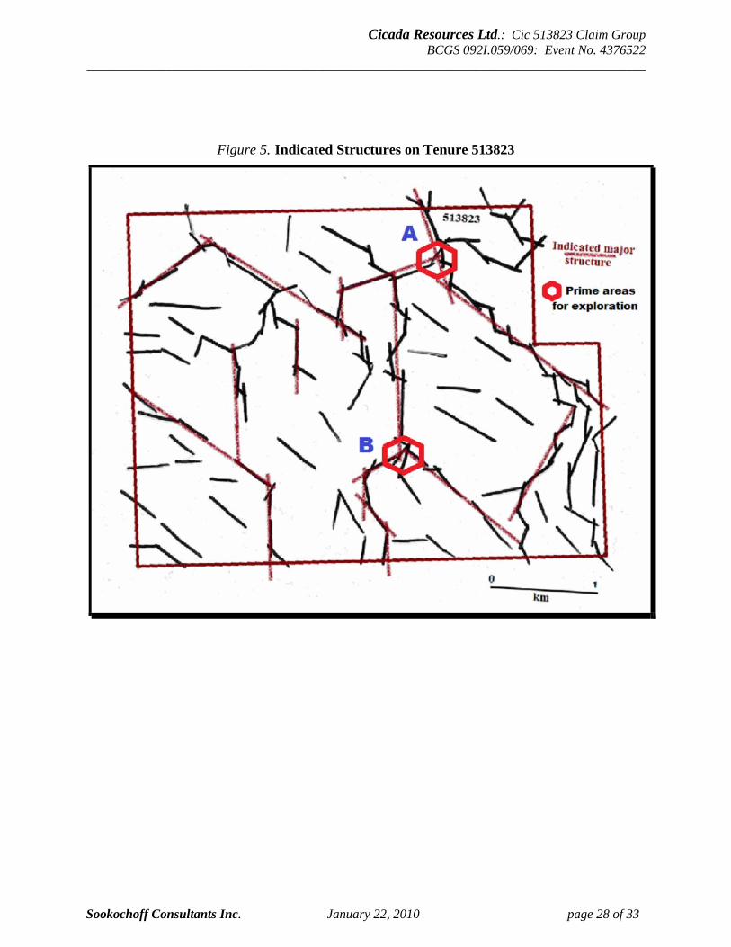
Cicada Resources Ltd.: Cic 513823 Claim Group BCGS 092I.059/069: Event No. 4376522
_____________________________________________________________________________________
Sookochoff Consultants Inc. January 22, 2010 page 28 of 33
Figure 5. Indicated Structures on Tenure 513823
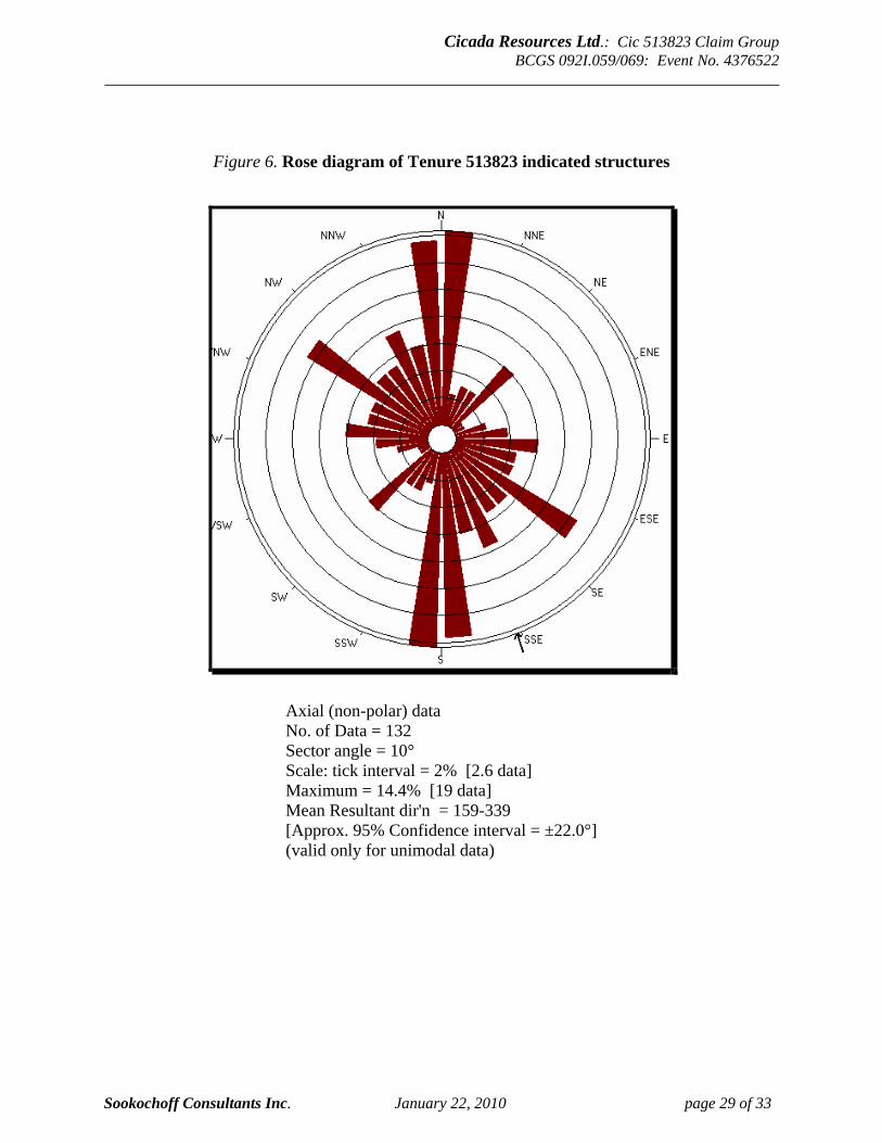
Cicada Resources Ltd.: Cic 513823 Claim Group BCGS 092I.059/069: Event No. 4376522
_____________________________________________________________________________________
Sookochoff Consultants Inc. January 22, 2010 page 29 of 33
Figure 6. Rose diagram of Tenure 513823 indicated structures
Axial (non-polar) data No. of Data = 132 Sector angle = 10° Scale: tick interval = 2% [2.6 data] Maximum = 14.4% [19 data] Mean Resultant dir'n = 159-339 [Approx. 95% Confidence interval = ±22.0°] (valid only for unimodal data)
Cicada Resources Ltd.: Cic 513823 Claim Group BCGS 092I.059/069: Event No. 4376522
_____________________________________________________________________________________
Sookochoff Consultants Inc. January 22, 2010 page 30 of 33
INTERPRETATION The structural analysis on Tenure 513823 of the Cicada Resources Iron Mask property indicates dominant northerly structures, with minimal complementary northwesterly and subordinate variably oriented structures, preferenced northeasterly and easterly. The primary major cross structures of the controlled Iron Mask Batholith emplacement are regional northwesterly and east-northeasterly which are indicated by the framework of the Batholith. The later phases of more porphyritic rocks comprising the batholith are generally controlled by the major structures with the mineralizing episode related to these later stage intrusives. Subsequent dominant northerly structures of the area are indicated by the western end of the New Afton (Afton) deposit where it is vertically off-set some 700 metres by a normal northerly trending fault. On Tenure 513823 the predominant indicated structural trend is northerly as suggested by the Rose Diagram, however, examining the plot of Indicated Structures of Figure 5 and generally plotting a trend to the directional series of limited structures, the predominant trend for major structure continuity appears to be northwesterly with the northerly structures also quite apparent. As the intersection of these major structural trends would control the later stages of intrusives and mineralization, the intersection localities would be the prime area for any surficial positive geologic indicators of potentially economic mineral deposition. Two prime potential areas are indicated from the structural analysis. These two areas, designated as A and B on Figure 5 are at the intersection of three structural directions; the dominant northerly and northwesterly, in addition to an east-northeasterly direction which is a significant trend in the Iron Mask batholith as indicated at the New Afton mine where the mineral deposit lies at the western termination of a narrow, four kilometre long, easterly trending zone of intense intrusive brecciation.
Respectfully submitted Sookochoff Consultants Inc.
Laurence Sookochoff, PEng
Cicada Resources Ltd.: Cic 513823 Claim Group BCGS 092I.059/069: Event No. 4376522
_____________________________________________________________________________________
Sookochoff Consultants Inc. January 22, 2010 page 31 of 33
SELECTED REFERENCES B.C. Government – MapPlace Internet Download Files. Carr, J.M. et al – Afton: A Supergene Copper Deposit, in Porphyry Deposits of the Western
Cordillera, Special Volume 15, CIM, pp376-387. 1976. Kwong, Y.T.J. – Evolution of the Iron Mask Batholith and its Associated Copper
Mineralization. BC Ministry of Energy, Mines and Petroleum Resources. Bulletin 77. 1987. The Discoverers – Monica R. Hanula–Editor, Pitt Publishing Company Limited, Toronto
Ontario, Canada. 1982. Mitchell J. – Report on a Geochemical Survey on the Tia Group of Mineral Claims for Lori
Explorations Ltd. August 2, 1972. AR 3,762. Pentland, A.G. – Summary Report of Exploration 1972 Kamloops Area. February 24, 1973. Reed, A. – Structural Geology of the Afton Copper-Gold Mine, Kamloops, BC and its
Influence on Pitfall Slope Stability for Afton Mines Ltd. Sookochoff, L. - Assessment Report on the HONEY claim. December 31, 2006. Sookochoff, L. – Geological Assessment Report on the Cic513830 for Cicada Resources Ltd.
dated January 3, 2010. Sullivan, J. – Bee Group of Mineral Claims, 3 Miles South of Knutsford, BC. For Mineral
Mountain Mines Ltd. April 22, 1966. AR 772.

Cicada Resources Ltd.: Cic 513823 Claim Group BCGS 092I.059/069: Event No. 4376522
_____________________________________________________________________________________
Sookochoff Consultants Inc. January 22, 2010 page 32 of 33
STATEMENT OF COSTS Structural Analysis Laurence Sookochoff, P.Eng. September 21, 2009 to September 25, 2009 2 days time @ $800.00/day ------------------------------------ $ 1,600.00 Maps ------------------------------------------------------------------ 1,600.00 Report ----------------------------------------------------------------- 3,000.00
$ 6,200.00 ========
Cicada Resources Ltd.: Cic 513823 Claim Group BCGS 092I.059/069: Event No. 4376522
_____________________________________________________________________________________
Sookochoff Consultants Inc. January 22, 2010 page 33 of 33
CERTIFICATE I, Laurence Sookochoff, of the City of Vancouver, in the Province of British Columbia, do hereby certify: That I am a Consulting Geologist and principal of Sookochoff Consultants Inc. with an address at 120 125A-1030 Denman Street, Vancouver, BC V6G 2M6. I, Laurence Sookochoff, further certify that: 1) I am a graduate of the University of British Columbia (1966) and hold a B.Sc. degree in Geology. 2) I have been practicing my profession for the past forty-three years. 3) I am registered and in good standing with the Association of Professional Engineers and Geoscientists of British Columbia. 4) The information for this report is based on information as itemized in the Selected Reference section of this report and from mineral exploration work the author has performed on the Iron Mask Property ground since 1979. 5) I have no interest in the Property as described herein.
Laurence Sookochoff, P. Eng.
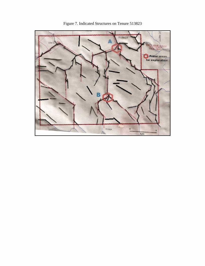
Figure 7. Indicated Structures on Tenure 513823