ci.sultan.wa.us · web viewsigned word document of legal descriptions and exhibit for all four...
TRANSCRIPT

CITY OF SULTAN
COUNCIL MEETING – COMMUNITY CENTERAugust 28, 2008
6:30 PM Downtown Development/Downtown Vision 2020
7:00 PM CALL TO ORDER - Pledge of Allegiance and Roll Call
CHANGES/ADDITIONS TO THE AGENDA
PRESENTATIONS 1) State Auditor Entrance Conference and SAS 112/SAS 114
COMMENTS FROM THE PUBLIC : Citizens are requested to keep comments to a 3 minute maximum to allow time for everyone to speak. It is also requested that you complete a comment form for further contact.COUNCILMEMBER COMMENTS
HEARINGS1) Ordinance 983-08 - Title 21 Amendments2) 2008 Budget Amendments
STAFF REPORTS – Written Reports Submitted
CONSENT AGENDA : The following items are incorporated into the consent agenda and approved by a single motion of the Council.
1) Approval of the August 14, 2008 Council Meeting Minutes2) Approval of the August 14, 2008 Public Hearing Minutes on the Sultan Basin Road Vacation3) Approval of the August 14, 2008 Closed Record Hearing on Anderson Farms4) Approval of Vouchers5) Set Budget workshop for September 4, 20086) Grafitti Abatement Grant Acceptance7) Cairncross Contract Amendment8) Food Bank Roof Repair – bid award9) Perteet Contract Amendment10) Sultan Basin Road Phase III – WH Pacific Scope of Work
ACTION ITEMS : 1) Ordinance 989-08 Sultan Basin Road Vacation – 1st reading2) Ordinance 979-08 – Title 2.26 Amendments – 1st reading3) Ordinance 990-08 – Budget Amendments – 1st reading4) Resolution 08-23 – Legal Descriptions of City limites, UGA and Water Service area5) 6th Street Sidewalk Grant – Relinquish back to TIB6) Brown & Caldwell Contract Amendment for Biosolids
DISCUSSION : Time Permitting
1) Park Regulations2) Council meeting schedule for November and December3) Public Records Requests4) WSDOT Highway Access Policy
PUBLIC COMMENT ON AGENDA ITEMS ONLYCOUNCILMEMBER RESPONSE TO PUBLIC COMMENT ON AGENDA ITEMS
Executive Session: Adjournment - 10:00 PM or at the conclusion of Council business.
ADA NOTICE: City of Sultan Community Center is accessible. Accommodations for persons with disabilities will be provided upon request. Please make arrangements prior to the meeting by calling City Hall at 360-793-2231. For additional information please contact the City at [email protected] or visit our web site at www.ci.sultan.wa.us

SULTAN CITY COUNCIL
AGENDA ITEM COVER SHEET
ITEM NO: H-1
DATE: August 28, 2008
SUBJECT: Sultan Municipal Code (SMC) AmendmentsSection 21.04
CONTACT PERSON: Robert Martin, Community Development Director
ISSUE:Conduct public hearing on Amendments to SMC 21.04, “Conditional Uses”.
STAFF RECOMMENDATION:1. Conduct a public hearing to take public comment on the Planning Board’s
recommendation to amend Sultan Municipal Code 21.04 to:
a. Remove the $850.00 fee set in the code and provide for the fee to be set by resolution through the annual fee schedule adopted by the City Council.
b. Change references in SMC 21.04 from “Planning Commission” to “Hearing Examiner” to be consistent with SMC 2.26 and SMC 16.120.
c. Remove the Planning Commission (Planning Board) from the following processes, and invest these authorities in the City Council to be consistent with SMC 2.26 and SMC 16.120:
i. 21.04.070; Revocation or modification of conditional usesii. 21.04.080; Acting on performance bonds and securitiesiii. 21.04.090; Accepting resubmittals of applications for conditional uses
BACKGROUND:For comprehensive plan and development regulation amendments, the statutes (RCW 35A.63.073 and 35A.63.070) require at least one public hearing. Notice is to be given as provided by ordinance and published at least ten days prior to the hearing. If continued hearings are held, no additional notices need be published.
The Planning Board discussed SMC 21.04 at its February 19, 2008 meeting. On April 1, 2008 the Planning Board set the public hearing for April 15, 2008. City staff missed the 10-day notice period for the April 15, 2008 meeting. The notice was sent out on April 22, 2008 and published in the Everett Herald on April 25, 2008 to hold a public hearing on May 6, 2008.
The Washington State Department of Community Trade and Economic Development (CTED) has reviewed this proposed amendment.

The Planning Board held a public hearing on May 6, 2008. There was no public comment, and the Board voted unanimously to recommend the proposed amendment to the City Council.
Council held a public hearing on July 10, 2008. Since the Council held its hearing, the city attorney recognized conflicts with the Planning Board (Commission) taking action on revocation, bonding, and resubmittal of conditional use applications.
Staff review prior to forwarding to Council indicated several additional items needing amendment. To provide abundant opportunity for public involvement, the notices were run again, and the Planning Board conducted public hearings on the new versions of these amendments at the regular meeting of August 5, 2008.
The Planning Board conducted an additional public hearing on the final draft of these proposed amendments at its regular meeting of August 5. The Board made a motion to forward the proposed Ordinance 983.08 (Attachment A) to the City Council with a recommendation for approval.
SUMMARY:The City is looking to: place the Conditional Use application fee in the Fee Schedule along with other land use processing fees; clarify roles of the Hearing Examiner and City Council in processing of such applications; and remove the Planning Commission (Board) from the process for these quasi-judicial procedures.
To provide for ample public input opportunity, council is requested to conduct another public hearing to review additional changes that were brought to the fore by the city attorney since the last hearing.
RECOMMENDATION: Conduct a public hearing to:
1. Amend the Sultan Municipal Code 21.04.030 by removing the $850.00 required filing fee for Conditional Use Permits and move the fee to the Fee Schedule, and clarify Hearing Examiner, City Council, and Planning Board (Commission) roles in Conditional Use processes.
ATTACHMENTS:Attachment A: Draft Ordinance 983.08Attachment B: Planning Board minutes of August 5 public hearing

ATTACHMENT A
ORDINANCE 983-08
AN ORDINANCE OF THE CITY OF SULTAN, WASHINGTON AMENDING SULTAN MUNICIPAL CODE SECTION 21.04 PERTAINING TO FEES AND
ADMINISTRATION OF CONDITIONAL USE APPLICATIONS.
WHEREAS, it is the intent of the City to publish its fees in a Fee Schedule, and remove various fees from the Municipal Code; and
WHEREAS, Sultan Municipal Code Section 21.04.030 contains a codified provision for a filing fee of $850.00 for a conditional use application; and
WHEREAS, authorization for the City of Sultan Planning Commission has been repealed and authorities for conduct of quasi-judicial hearings has been vested in a Hearing Examiner; and
WHEREAS, Sultan Municipal Code Section 21.04 contains a codified provision stating that the Planning Commission will review and make recommendations to the City Council regarding conditional use applications;
WHEREAS, the City of Sultan Planning Board held a public hearing on this amendment proposal at its regular meeting of August 5, 2008;
NOW THEREFORE, THE CITY COUNCIL OF THE CITY OF SULTAN , WASHINGTON DO ORDAIN AS FOLLOWS:
Section 1. The City of Sultan hereby amends Sultan Municipal Code Section 21.04 to: remove the fee reference from the code; delete references to the planning commission and; vest with the hearing examiner all responsibilities previously vested in the planning commission.
Section 2. Sultan Municipal Code is amended as follows:
Chapter 21.04CONDITIONAL USE PERMITS
Sections:21.04.010 Purpose.21.04.020 Uses requiring a conditional use permit.21.04.030 Application – Requirements and fees.21.04.050 Criteria.21.04.052 Additional criteria for single-family detached dwelling (clustered).21.04.054 Additional criteria for duplexes or two-family dwellings.

21.04.060 Expiration and renewal.21.04.070 Revocation of permit.21.04.080 Performance bond and other security.21.04.090 Resubmittal of application.21.04.010 Purpose.
It is the purpose of this chapter to establish review and permit approval procedures for unusual or unique types of land uses, which, due to their nature, require special consideration of their impact on the neighborhood, and land uses in the vicinity. The uses in approved under the provisions of this chapter may be located in any district by special permission of the planning commission zone districts listing the use as a “Conditional Use” under such conditions as the commission hearing examiner may recommend and the city council shall approve. (Ord. 690-98)21.04.020 Uses requiring a conditional use permit.
The following are the uses which require a conditional use permit:A. The conditional uses listed in the specified use districts as “Conditional Uses”
require a conditional use permit in order to locate and operate in an appropriate zone district within the city.
B. Existing nonconforming uses which wish to expand. (Ord. 690-98)21.04.030 Application – Requirements and fees.
Application for conditional use permits shall be filed with the planning department on forms prescribed by that office. A filing fee of $850.00 in the amount set by the Fee Schedule adopted by the City Council shall accompany all applications. The planning commission hearing examiner will review applications for conditional use permits and the recommendations will be passed to the city council for final action. The planning commission hearing examiner may recommend to the city council denial, approval, or approval with conditions. Conditional use applicants must adhere to all applicable public notification requirements. Denial of conditional use permit applications is not appealable. All conditional use permits are subject to design review procedures. (Ord. 690-98)21.04.050 Criteria.
The following criteria shall apply in granting a conditional use permit:A. The proposed conditional use will not be materially detrimental to the public
welfare or injurious to the property or improvements in the vicinity of the proposed conditional use or in the district in which the subject property is situated;
B. The proposed conditional use shall meet or exceed the performance standards that are required in the district it will occupy;
C. The proposed conditional use shall be compatible generally with the surrounding land uses in terms of traffic and pedestrian circulation, building and site design as approved by the design review committee;
D. The proposed conditional use shall be consistent with the goals and policies of the comprehensive land use policy plan;
E. All measures have been taken to minimize the possible adverse impacts, which the proposed use may have on the area in which it is located. (Ord. 690-98)

21.04.052 Additional criteria for single-family detached dwelling (clustered).The following additional criteria apply to allow single-family detached dwelling(s)
(clustered):A. The density on the property may not be greater than but should match the density
for single-family detached dwellings;B. Where urban density goals are to be achieved, but critical areas can be
adequately protected, dimensional requirements for lot size, lot width, front and rear yard setbacks may be decreased by no more than 20 percent;
C. As a result of the design of the subdivision, a minimum of 20 percent of the net land area of continuous, publicly accessible open space such as stream or wetland and associated buffers, a ravine, bluff or other unique topographic feature, or conservation area is preserved;
D. As a result of the dwellings and any subdivision, the availability of housing to all economic segments of the population is increased, and housing density variety is preserved throughout the community. (Ord. 780-02 § 16)21.04.054 Additional criteria for duplexes or two-family dwellings.
The following additional criteria apply to allow duplexes or two-family dwellings:A. Only one other duplex or multifamily use may exist within 300 feet of the proposed
use and there must be at least a 100-foot separation (building to building) between the uses.
B. The proposed dwelling has been designed to be harmonious with the neighborhood and is constructed to provide the appearance of a single-family unit by, for example, altering the location of the front doors and windows; garages and access to garages; parking; landscaping and fencing; utilities and mailbox locations; building heights consistent with surrounding properties; exterior colors and materials; and differing setbacks, all of which are confirmed by a site plan. (Ord. 780-02 § 17)21.04.060 Expiration and renewal.
A conditional use permit shall automatically expire one year after a notice of decision approving the permit is issued unless a building permit conforming to plans for which the CUP was granted is obtained within that period of time. A conditional use permit shall automatically expire unless substantial construction of the proposed development is completed within two years from the date a notice of decision approving the permit is issued. The planning commission or city council, on appeal, may authorize longer periods for a conditional use permit if appropriate for the project. The planning commission or city council, on appeal, may grant a single renewal of the conditional use permit if the party seeking the renewal can demonstrate extraordinary circumstances or conditions not known or foreseeable at the time the original application for a conditional use permit was granted, which would not warrant such a renewal. No public hearing is required for a renewal of a conditional use permit. (Ord. 690-98)21.04.070 Revocation of permit.
A. The planning commission city council may revoke or modify a conditional use permit. Such revocation or modification shall be made on any one or more of the following grounds:

1. That the approval was obtained by deception, fraud, or other intentional and misleading representations;
2. That the use for which such approval was granted has been abandoned;3. That the use for which such approval was granted has at any time ceased for a
period of one year or more;4. That the permit granted is being exercised contrary to be the terms or
conditions of such approval or in violation of any statute, resolution, code, law or regulation; or
5. That the use for which the approval was granted was so exercised as to be detrimental to the public health or safety.
B. Any aggrieved party may petition the planning commission city council in writing to initiate revocation or modification proceedings.
C. Before a conditional use permit may be revoked or modified, a public hearing shall be held. Procedures concerning notice, reporting and appeals shall be the same as required by this chapter for the initial consideration of a conditional use permit application. (Ord. 690-98)21.04.080 Performance bond and other security.
A performance bond or other adequate and appropriate security may be required for any elements of the proposed project which the planning commission hearing examiner or city council, on appeal, determines are crucial to the protection of the public welfare. Such bond shall be in an amount equal to 125 percent of the cost of the installation or construction of the applicable improvements. (Ord. 690-98)21.04.090 Resubmittal of application.
An application for a conditional use permit, which has been denied, may not be resubmitted within six months from the date of planning commission or city council disapproval, whichever is later. (Ord. 690-98)
PASSED by the City Council and APPROVED by the Mayor the __th day of ___________, 20__.
CITY OF SULTAN
By______________________________Carolyn Eslick, Mayor
Attest:By_______________________________Laura Koenig, City ClerkApproved as to form:By_______________________________Kathy Hardy, City Attorney

SULTAN CITY COUNCILAGENDA ITEM COVER SHEET
DATE: August 28, 2008
ITEM #: Public Hearing PH 2
SUBJECT: 2008 Budget Amendments
CONTACT PERSON: Laura Koenig, Clerk/Deputy Finance Director
ISSUE:The issue before the Council is to hold the continued pubic hearing on proposed budget amendments to implement Council direction on vehicle purchases.
SUMMARY STATEMENT:The City Council opened the public hearing on 2008 Budget Amendments on July 24, 2008 and continued the hearing to August 14, 2008 and then again to August 28, 2008. Staff anticipated the Interlocal Agreement for an Evidence Officer would be ready for Council consideration and an analysis of the Police Department budget would be complete. The agreement is still under review by Snohomish County.
The City Council has approved expenditures for vehicles that were not included in the adopted 2008 budget. The City is required to have a balanced budget. The Council is considering the following amendments to the 2008 Budget:
104 Equipment Reserve Fund: On June 26, 2008, the Council approved the purchase of two new Public Works utility vehicles at an estimated cost of $45,000.
Impacts: $45,000 expenditure increaseFunding Source Interfund transfers from operating funds (Street, Water, Sewer and
Garbage.
Staff budgeted for transfers into the reserve funds from the Street, Water, Sewer and Garbage funds (Attachment B) for vehicle purchases. The Equipment Reserve Fund did not include expenditures for equipment purchase. This was a staff oversight during the budget process. It is not possible to spend the money without the appropriation from the equipment reserve fund (104-104-538-10-640). There will be $9,500 added to the reserves of $138,694 to replace worn equipment.The Public Works Department will order the vehicles after the budget amend has been completed.
RECOMMENDATION:Staff recommends the Council provide funding for the vehicle purchases.

2008 Revenues ( no changes to 2008 revenues)Equipment Reserve Description Original Budget Amended Budget104-000-397-10-010 Operating Transfer In $54,500 $54,500
TOTAL RESOURCES $54,500 $54,500
2008 ExpendituresEquipment Reserve Description Original Budget Amended Budget104-104-538-10-640 Capital - Equipment $ 0 $45,000
TOTAL EXPENSE $0 $45,000
ENDING FUND RESERVES $54,500 $9,500
106 Police Equipment Reserve Fund: On June 12, 2008, the Council approved the purchase of a new police vehicle and on June 26, 2008 the renewal of the motorcycle lease. In addition to those cost, there have been major repairs costing $4,362 to two police vehicles this year. There were no expenditures for repairs included in the adopted budget. The original budget provided for the lease payments on vehicles purchased in 2007.
Impacts: $35,000 - New vehicle$ 2,000 - motorcycle lease$ 5,000 - vehicle repairs
Total $42,000Funding Source: Fund reserves and utility taxes collected
RECOMMENDATION:Staff recommends the Council provide funding for the vehicle purchases and repair
work.
2008 RevenuesPolice Vehicle Fund Description Original Budget Amended Budget106-000-308-10-000 Reserve Fund Balance $ $20,607106-000-316-40-000 Utility Taxes $43,653 $43,653
TOTAL RESOURCES $43,653 $64,260
2008 ExpendituresPolice Vehicle Fund Description Original Budget Amended Budget106-106-521-60-640 Equipment Purchase $22,260 $64,260

TOTAL EXPENSE $22,260 $64,260
ENDING FUND RESERVES $21,393 $0
Use of reserve funds from the Police Equipment Reserve Fund (106-106-308-10-000) were not needed to balance the adopted budget for 2008. To fund the purchase of the vehicles, $20,607 of the $52,760 beginning reserve funds are being used for the vehicle purchase.The $22,260 expenditure in the adopted 2008 budget in the Police Vehicle Fund (106-106-521-60-640) is for the lease payments on the vehicles purchase in 2007. The fund had reserves of $52,760 on January 1, 2008. For budget purposes, only $20,607 of those reserves are shown to provide a balanced budget.
107 Drug Enforcement Fund: Drug Enforcement Fund expenditures are restricted to activities directly related to drug enforcement or education. The City, through an Interlocal agreement with Snohomish County, is a member of the Drug Task Force. The annual fee was originally included in the Law Enforcement budget in the General Fund. Staff recommends the expenditure be reallocated to the Drug Enforcement Fund.
Impacts: $1021 expenditure increase.Funding source: Fund reserves ($7685)
RECOMMENDATION:Staff recommends the Council reallocate the cost of the Drug Task Force annual fee to the Drug Enforcement Fund.
2008 RevenuesDrug Enf. Fund Description Original Budget Amended Budget107-000-308-10-000 Begin Fund Balance $ $1,021107-000-351-50-000 Investigative funds $500 $500
TOTAL RESOURCES $500 $1521
2008 ExpendituresDrug Enf. Fund Description Original Budget Amended Budget107-107-521-23-310 Operating Supply $500 $500107-107-521-23-510 ILA Drug Task Force $0 $1,021
TOTAL EXPENSE $500 $1,521
ENDING FUND RESERVES $21,393 $0
The fund had reserves of $7,686 on January 1, 2008. For budget purposes, only $1,021 of those reserves are shown to provide a balanced budget.

Future Amendments:There are a number of issues that need further analysis and staff will schedule hearings and budget amendments in September and October. Other issues the Council will need to address include:
1. Police Chief contract with Snohomish County2. Police Records Clerk – part time3. Administrative Assistant – part time4. Debt service
General Fund: The Interlocal Agreement for the Evidence Officer/Office Tech is not available from Snohomish County to determine costs. Amendments are need to the General Fund to provide for the position of the Administrative Assistant that was added in February 2008 and staff is recommending funding the part time position of Records Specialist with a start date in October. The Council has approved Interlocal Agreements for the Interim Police Chief and for Officer backfill to provide police coverage.
RECOMMENDATION:Complete necessary budget amendments to the General Fund and other funds after all the cost estimates have been received and analyzed.
ATTACHMENTS: A Ordinance 990-08 Budget AmendmentB. Utility Fund BudgetsC. Revenue vs Expenses SummaryD. Budgets for Funds 104, 106 and 107

Attachment A
CITY OF SULTAN
SULTAN WASHINGTON
ORDINANCE 990-08
AN ORDINANCE OF THE CITY OF SULTAN AMENDING
THE 2008 BUDGET ADOPTED UNDER ORDINANCE 972-07
THE CITY COUNCIL OF THE CITY OF SULTAN DO ORDAIN AS FOLLOWS:
SECTION 1: The 2008 Budget as authorized under Ordinance 972-07 for revenues and expenditures for the operation of the City of Sultan for the fiscal year ending December 31, 2008 is amended to increase in the following amounts:
FUND # AND NAME REVENUES/ EXPENDITURES
UNENCUMBERED FUNDS
104 Equipment Reserve $ 0 $45,000
106 Police Equipment Reserve $ 20,607 $42,000
107 Drug Enforcement Fund $ 1,021 $ 1,021
Total Amendment $ 21,628 $88,021
A full copy of the amended budget sections are attached and made part of this ordinance by reference.
SECTION 2: The budget for the year 2008 is amended to provide for the changes as outlined above and filed in the office of the City Clerk.
SECTION 3: The City Clerk is hereby directed to transmit the amended budget to the Auditor of the State of Washington, Division of Municipal Corporations.
Severability: This ordinance is severable and if any portion of it shall be declared invalid or unconstitutional, the remaining portion shall remain valid and enforceable.

Effective Date: This ordinance shall be in full force and effect five days after publication as required by law.
REGULARLY ADOPTED this day of , 2008
Carolyn Eslick, Mayor
Attest:
Laura J. Koenig, City Clerk
Approved as to form:
Kathy Hardy, City Attorney
Published:

City of SultanGrant Funded Project Status Report
August 2008
By Donna Murphy – Grants and Economic Development CoordinatorPending
GrantDate
AppliedDepartme
ntAmoun
t Pendin
g
Amount Not Funde
d
Amount Funded
Project Status
Rural Town CorridorsUS 2 & Sultan Basin Rd. Phase III
March 2007
Public Works
$250,000
June 2007
Preparing to Obligate
the grant
STP® for Sultan Basin Road Phase III
2007 Public Works
$1,009,164
Preparing to obligate
the grant
CPG Cleanup & Recycling Day
Sept. 2007
Public Works
$4,735Nov. 2007
This is a 2 Year
Program – 2007 &
2008. $2,367
each yearTIB 6th St. Sidewalks
Sept. 2007
Public Works
$12,271Nov. 2007
Council to determine returning this grant
Skywall Drive RR Crossing – UTC Grant
Sept. 2006
Public Works
$20,000Nov. 2007
Negotiating contract
with Dan Ramirez as
grant partnerProject
MUST be complete
by 6/30/09Legislative Earmark for WWTP
2007 Public Works
$500,000
Application Materials
are being prepared. City MUST
have a

Pending Grant
Date Applied
Department
Amount
Pending
Amount Not Funde
d
Amount Funded
Project Status
compliant Comp Plan
before receipt of
funding.
Vactor Services – Partner Grant with Snohomish County
2008 Public Works
FUNDED Working with Lake Stevens &
Snohomish County for full vactor services in
January 2009
Hazard Mitigation Repetitive Flood Loss Purchase of 105 Alder
November 2006
Parks $278,800
Nov. 2007
Offer is being
made to the
property owner
Rural Business Opportunity Grant
March 2008
Economic Development
$75,000
Records ManagementPurchase file cabinets for maps and plans
July 2007
Clerk/Finance
$6,356 Renegotiated the
scope of work to
purchase filing
cabinets for current
essential records.
COPS Technology Federal Grant
2007 Law Enforcement
$117,000
Application
complete. Funding
available 9/08
Graffiti Abatement Grant –
July 2008
Volunteer & Law Enforceme
$12,000 Council to direct
Mayor to

Pending Grant
Date Applied
Department
Amount
Pending
Amount Not Funde
d
Amount Funded
Project Status
Multi-Jurisdiction Application
nt sign contract

SULTAN CITY COUNCILAGENDA ITEM COVER SHEET
ITEM NO: Consent C 1
DATE: August 28, 2008
SUBJECT: Council Minutes
CONTACT PERSON: Laura Koenig, Clerk/Deputy Finance Director
SUMMARY:Attached are the minutes of the August 14, 2008 Council meeting as on file in the office of the City Clerk.
RECOMMENDED ACTION: Approve as submitted
MOTION:Move to accept the consent agenda as presented.

CITY OF SULTAN COUNCIL MEETING – August 14, 2008
The regular meeting of the Sultan City Council was called to order in the Sultan Community Center by Mayor Eslick. Councilmembers present: Champeaux, Wiediger, Slawson, Flower, Blair and Doornek. Absent: Davenport-Smith
CHANGES/ADDITIONS TO THE AGENDA:Consent: Add excused absence of Councilmember Davenport-SmithDiscussion: Health District Funding CrisisConsent: Land Lease move to action.
PRESENTATIONS: Mayor Eslick, Debbie Copple and Chief Hawkins recognized members of the Explorer Group that assisted with the Sultan Summer Shindig in 2008. Debbie Copple advised that over the past 20 years there have been police officers from various communities helping during the Shindig and the Explorer Group was very professional.Chief Hawkins advised that, thanks to the Explorers patrol during the evenings, there were no reports of theft this year from the vendors during the Shindig.
COMMENTS FROM THE PUBLICMary Carson-Ford: They have raised $1250 for the repairs to the Gateway signs. The job is larger than they anticipated and additional repair work will be required. It was requested the advertising signs be moved away from the Gateway sign. Asked when the animal control position will be advertised as there are animal issues that need to be addressed.
Wendall Smith: The Council was presented with a budget of $500,000 for Stormwater because staff advised a NPDES permit was required and that was not true. They were misled by staff.
Frank Linth: The Planning Board meeting was held last week with the new members and it went quite well. He invited everyone to attend the Planning Board as they are an important part of the planning process and need public input. They are a very diverse group and strength come with diversity and the ability to agree to disagree.
Jeffrey Beeler: There were four homes in the developments that were allowed direct access off the Sultan Basin Road. He urged the Council not to approve any more direct access from the road and to look into the resident parking on the shoulder of Sultan Basin Road. The Highway 2 Safety Coalition is working with the State WSDOT to identify safety projects for Highway 2 and he urged the Council to request them to defer the improvements to the park and ride and put the money into safety issues. The stormwater utility had four options and the first was not enough to cover the expense of the retention ponds and the fourth was too much for the rate payers. The Council should reconsider the other two options.
Al Wirta: Suggested the Homeowners Association pay more then the $5.75 ERU and have the money put towards their projects. He will receive zero benefit from the utility at his home or business.
Debbie Copple: The Chamber of Commerce has concerns about the large increase proposed for traffic mitigation. The City can’t compete with other areas for commercial development if the fees are too high. Need to find a way to mitigate the fees to attract business. The Index Sportsman Club shooting range issues with the Forest Service are still being resolved and they hope to have it reopened soon.

CITY OF SULTAN COUNCIL MEETING – August 14, 2008
Keith Arndt: The comments about the mitigation fees from the Chamber were welcome but the Council should have heard from them months ago. There is an action item on the comprehensive plan for the annual docket review and he agrees the rezone request should be eliminated.There are no docketed issues to address retail versus rooftops and it can not be addressed for two years. The Council should consider extending the time frame to docket issues.
Loretta Storm: Her parents bought a house in 1950 for $4000 and it is worth $250,000 today. The cost of infrastructure has gone up and the Council needs to raise fees to meet those costs. The City has lost money by not raising mitigation fees and $5200 is not a large amount.
Steve Harris: The increase in the mitigation fee from $1837 to $5200 is hard to accept and the Council should consider a tier increase over a few years instead of a one time increase. With the Comprehensive Plan docket items, the Council needs to keep the whole community in mind when making decisions. They were elected to represent everyone and they will impact business and citizens by decisions.
COUNCILMEMBERS COMMENTS:Blair: Thanked everyone for the work on the Gateway signs. Animal control is important and staff has recommended cutting the funding but it will be considered as part of the budget amendments. The comprehensive plan docketing and the mitigation fees are major issues. Slawson: He has heard that the State and the County have a hiring freeze and other cities are cutting back. As a Council, they need to look at tightening the purse strings for the City. Businesses are closing all over the County and the Council needs to be creative and figure out how to get business into the City. Champeaux: We need to develop a plan to attract business into the community. The LID was supposed to encourage business and it did not. The City needs to be aggressive about recruiting business. Commercial development is still going strong in areas but residential is not.Mayor Eslick: Has heard that businesses are closing but the City is considering raising the mitigation fee. In a time of crisis we need to consider how to attract business and we need to educate people before they fail. The City will begin work on a promotional film for Sultan next week.
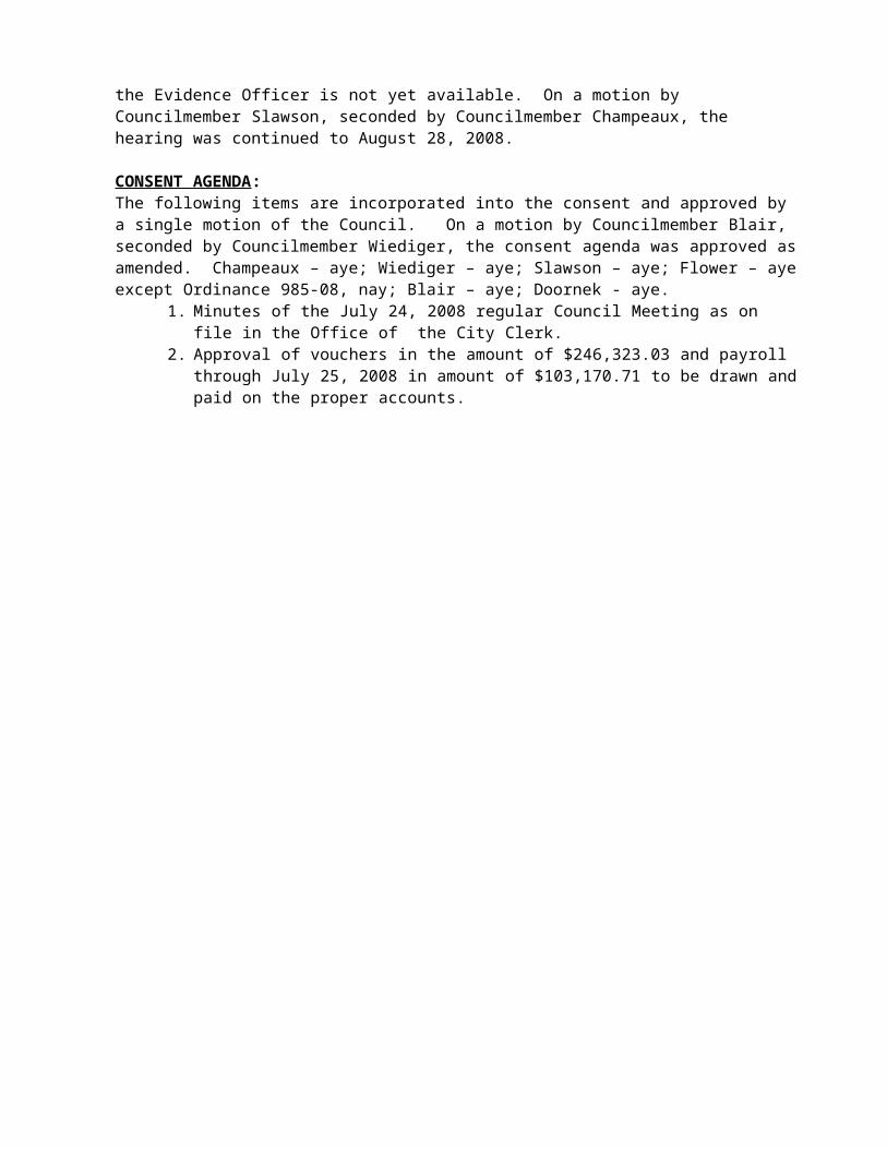
HEARINGS:2008 Budget Amendments: Staff requested the hearing be continued as the information from the Sheriff’s department on the Interlocal for the Evidence Officer is not yet available. On a motion by Councilmember Slawson, seconded by Councilmember Champeaux, the hearing was continued to August 28, 2008.
CONSENT AGENDA: The following items are incorporated into the consent and approved by a single motion of the Council. On a motion by Councilmember Blair, seconded by Councilmember Wiediger, the consent agenda was approved as amended. Champeaux – aye; Wiediger – aye; Slawson – aye; Flower – aye except Ordinance 985-08, nay; Blair – aye; Doornek - aye.
1. Minutes of the July 24, 2008 regular Council Meeting as on file in the Office of the City Clerk.
2. Approval of vouchers in the amount of $246,323.03 and payroll through July 25, 2008 in amount of $103,170.71 to be drawn and paid on the proper accounts.

CITY OF SULTAN COUNCIL MEETING – August 14, 2008
3. Approval of the revision to the scope of work for PWTF loan #PW-6-962-PRE-131 to suspend the design of the Membrane Bioreactor WWTP at 50% and the addition of a centrifuge solids dewatering system.
4. Acceptance of the Date Avenue street construction funded by CDBG and waterline project funded by the City.
5. Adoption of Ordinance 985-08 establishing a Stormwater Utility.6. Adoption of Ordinance 987-08 amending SMC 5.28 Cable TV Regulations.7. Excused absence of Councilmember Wiediger from the August 28, 2008 Council
meeting.8. Set a Public Hearing on amendments to SMC 21.04 for August 28, 2008.9. Excused absence of Councilmember Davenport-Smith from the August 14, 2008
Council meeting.
ACTION ITEMS : Ordinance 986-08 Stormwater Utility Rates: The issue before the City Council is to have First Reading of Ordinance No. 986-08 to establish a stormwater utility rate structure levied upon all developed real property within the boundaries of the utility. The City Council discussed four rate structure alternatives for the Stormwater Utility at its July 10, 2008 meeting. The City Council selected Alternative 1 and directed staff to prepare an adopting ordinance for Council action. Discussion was held regarding the amount of funds needed for capital improvements, limited budget proposed, lack of funds to provide stormwater improvements as a part of street projects, the stakeholder report that was not representative of all members in the group, and inadequate planning to meet the needs for maintenance and improvements. It was requested the matter be continued to September 11, 2008 when the entire Council would be present for the vote.On a motion by Councilmember Flower, seconded by Councilmember Champeaux, Ordinance 986-08 was continued to the September 11, 2008 meeting. All ayes.
Resolution 08-22 Anderson Farms: A Closed Record Hearing was held during the Council meeting of August 14, 2008. The Hearing Examiner found significant non-compliance with the code and has recommended denial of the proposal. Discussion was held regarding the 19 issues addressed by the Hearing Examiner that make the application non-compliant, concurrency not being an issue as there were no letters of availability for water and sewer connections, and the ability to submit a new applicationOn a motion by Councilmember Slawson, seconded by Councilmember Doornek, the Council adopted Resolution 08-22, accepting the Hearing Examiner’s recommendation to deny the application for the Grandview Inc. Planned Unit Development and Subdivision application for a 26-lot Planned Unit Development. All ayes, except Councilmember Flower who voted nay.
Comprehensive Plan Annual Docket: The Council opened the Annual Comprehensive Plan Docket for the 2008-2009 Docket with a closing date of June 30. No new Docketed applications were received. There is one item which remains on the Docket from the 2005 cycle. All other Docket items from 2005 through 2008 have been addressed by the recent work on the Comprehensive Plan in response to the Growth Management Hearing Board cases. The remaining Docket Item, a petition by Mr. Bart Dalmasso, to implement a buffer along Hwy 2 and change zoning to Highway Oriented designation on all property fronting the highway has been carried over since it was submitted in June 2005.There is approximately 34,000 lineal feet of frontage (both sides of the highway) along Hwy 2 within the City of Sultan. 90% is in either Highway Oriented Development (HOD) Zone, Urban Center Zone (UC), or Economic Development (ED) Zone. The issue is whether it is a worthwhile

CITY OF SULTAN COUNCIL MEETING – August 14, 2008
effort to open the Comprehensive Plan to change the zoning on the approximately 10% of the Hwy 2 frontage that is not already designated for commercial and industrial economic development. The properties designated in the residential categories are so designated because they, in general, contain residential development at the time the designations were put in place.Brief discussion was the residential use of the property and existing business in the zone and the need to solicit public input regarding the zoning. On a motion by Councilmember Slawson, seconded by Councilmember Doornek, the Council deleted the Highway 2 zoning item from the docket, affirmed that no additional docket applications were received during the open docket period and close action on the docket until the June 2009 docket application period. All ayes.
Lease Agreement: Snohomish County Solid Waste is requesting a new 15-month lease (October 1, 2008-December 31, 2009) of City owned property adjacent to the transfer station to continue temporary collection of residential wood debris. The Council authorized the first agreement effective October 1, 2007. The original lease was for a three month period with three 3-month extensions. The original lease agreement will expire on September 30, 2008. The collection site is open to the public on weekends and is staffed by Solid Waste employees. Brief discussion was held regarding charging fees to the residents as the original lease provided for the service to be free; also requirement to obtain city authorization prior to any construction at the site. On a motion by Councilmember Blair, seconded by Councilmember Slawson, the Council authorized the Mayor to sign the land lease with Snohomish County for City for property adjacent to the County Transfer Station on Cascade View Drive with clarification to the contract that there will be no cost to the East County citizens and they be required to obtain approval from the City for any construction of the walls. All ayes.
DISCUSSION ITEMS:SMC 2.26 Hearing Examiner: The issue before the City Council is to discuss proposed amendments to Sultan Municipal Code (SMC) 2.26 – Hearing Examiner to delete sections of the code that reference the process for appealing an Examiner’s decision. The proposed changes to SMC 2.26 include some “housekeeping” items to make SMC 2.26 consistent with SMC 21.04 (Conditional Use Permits) and Title 16. At the City Council retreat in January 2008, the City Council discussed its procedures for quasi-judicial closed record hearings on preliminary plat applications, preliminary planned unit development (PUD) applications, variances, and conditional use permits. The Council directed staff to review SMC 2.26 and propose amendments to be consistent with city code and state law. Under the city's process, land use applications that are not handled administratively by City staff first go to the Hearing Examiner for an open record hearing. The Hearing Examiner then makes a recommendation to the City Council that either recommends approval, approval with conditions, or denial of the application. The Hearing Examiner can also deny with prejudice which means the applicant cannot apply with the same project under the same circumstances.

The City Council holds a quasi-judicial closed record hearing where it can accept the recommendation, reject the recommendation, or remand the application back to the Hearing Examiner for further proceedings. Applicants must appeal Council decisions to Superior Court under the State of Washington Land Use Petition Act (LUPA). The City's process is somewhat confusing because Sultan Municipal Code 2.26.140 and 2.26.150 were not amended following Regulatory Reform in 1995. The revisions will make code consistent with state law and clarify the process.

CITY OF SULTAN COUNCIL MEETING – August 14, 2008
Snohomish County Health District: Councilmember Flower read a letter from Aaron Reardon regarding the financial issues with the Health District and County financial problems. They are considering staff layoffs and cutting critical health programs. The funding for the Health District used to be shared by the County and Cities, however, State law changed the requirement for cities to participate in the funding. The County is proposing a request for cities to share in the cost of health services. The funding issues have not been addressed by the County as the revenues have not increased but expenditures have increased. Brief discussion was held regarding the impacts to families that need the services and the financial burden the County is requesting the cities to consider.
PUBLIC COMMENTSFred Seiner: The City is talking about bringing in business but since they don’t have business they are asking the citizens to pay. They don’t need a storm system on Date Street as there are storm systems on other streets. Where is the money saved from the Library going to? The City bought a vactor truck that was not useable and the City wants to buy more new trucks. He would like to see results for the money the City has spent.
Jeffrey Beeler: The stakeholders want to review the expenses annually to make sure the city is spending the money well.
Steve Harris: The Health District employees make high salaries and it should be recommended to Mr. Reardon and others that they cut back their wages instead of asking the cities for money. Building will start up again and things will get better. Some citizens forget the Council are working citizens also and some are self employed and they pay the fees too.
Keith Ardnt: The analysis of the Health District is correct. The City staff and Council have gone through budget issues and the City has not resorted to playing the emotional track to get what they want or needed. City should tell Mr. Reardon not to go begging to those that have their own needs.
COUNCIL COMMENTSBlair: The library money is not available until 2009. Past action does not always dictate current action. The prior Councils have rubber stamped the budgets without review and they have allowed interfund loans to cover the problems. The Council requests information and reviews the finances.
Executive Session: On a motion by Councilmember Slawson, seconded by Councilmember Champeaux, the Council adjourned to executive session for ten minutes to discuss personnel matters. All ayes.
Adjournment: On a motion by Councilmember Blair, seconded by Councilmember Slawson, the meeting adjourned at 10:15 PM.
Carolyn Eslick, Mayor

Laura J. Koenig, City Clerk

SULTAN CITY COUNCILAGENDA ITEM COVER SHEET
ITEM NO: Consent C 2
DATE: August 28, 2008
SUBJECT: Council Minutes
CONTACT PERSON: Laura Koenig, Clerk/Deputy Finance Director
SUMMARY:Attached are the minutes of the August 14, 2008 Public Hearing on the Sultan Basin Road Vacation Request as on file in the office of the City Clerk.
RECOMMENDED ACTION: Approve as submitted
MOTION:Move to accept the consent agenda as presented.

CITY OF SULTAN COUNCIL MEETING – August 14, 2008
PUBLIC HEARINGS:The Public Hearing on the request to vacate a portion of the Sultan Basin Road was called to order by Mayor Eslick . Councilmembers present: Champeaux, Wiediger, Slawson, Flower, Blair and Doornek.There were no objections to the Council participation.
Staff: Bob Martin, Community Development Director, presented the staff report.
Terra-Ex Land Group is requesting vacation of approximately 860 lineal feet of un-used right-of-way of Sultan Basin Road north of its previous intersection with Highway 2. Sultan Basin Road has been reconstructed such that its intersection with Hwy 2 is approximately 600 feet east of its previous intersection. The right-of-way proposed for vacation is no longer used as a public traveled way. The petitioner is pursuing a commercial development that will include the land proposed for vacation.
Petitions for vacation must be accompanied by:1. Appropriate fees (received).2. An appraisal of the property by a qualified appraisal firm (received).3. Legal description of the property proposed for vacation (received).4. Signatures of at least 2/3 of the property owners abutting the proposed vacation
(received).5. Indication that no property will lose legal access to a public right-of-way through the
proposed vacation (received).6. A discussion of the public interest served by the proposed vacation (received).
The right-of-way proposed for vacation occupies 43,743 sq. ft. (just over one acre).If the vacation is ultimately approved, the right of access for a public street will no longer exist. Since there are utilities in the street corridor, the city will need to retain easements for the operation and maintenance of these utilities. This will limit use of the vacated corridor to parking lots, landscaping, and other uses that do not include construction of buildings.The application shows that all affected properties will retain access to public roads.The application indicates that the public interest served by the petition is pursuit of a commercial development that will benefit the community’s economic development interests.A Certified General Appraiser, Paul C. Bird of Macaulay & Associates Limited, has completed the appraisal submitted by the petitioner. He has determined the value of the acquired right-of-way (subject to ongoing utility easements which prevent building of structures on the vacated property) to be $130,000. RCW 35.79.030 provides that the owners abutting the right-of-way “shall compensate such city or town in an amount which does not exceed one-half the appraised value of the area so vacated. If the street or alley has been part of a dedicated public right-of-way for twenty-five years or more, the city or town may require the owners of the property abutting the street or alley to compensate the city or town in an amount that does not exceed the full appraised value.”
Public Input
Steve Harris: As the abutting property owner, he concurs with the request for the street vacation as it will enhance economic development in the city. He requested the Council consider the easements on the street when they determine the payment amount. He would like to move forward with the proposed development.

CITY OF SULTAN COUNCIL MEETING – August 14, 2008
On a motion by Councilmember Slawson, seconded by Councilmember Flower, the public meeting was closed. All ayes.
On a motion by Councilmember Blair, seconded by Councilmember Flower, staff was directed to draft an ordinance to complete the vacation of portions of Sultan Basin Road. All ayes.
Carolyn Eslick, Mayor
Laura J. Koenig, City Clerk

SULTAN CITY COUNCILAGENDA ITEM COVER SHEET
ITEM NO: Consent C 3
DATE: August 28, 2008
SUBJECT: Council Minutes
CONTACT PERSON: Laura Koenig, Clerk/Deputy Finance Director
SUMMARY:Attached are the minutes of the August 14, 2008 Closed Record Hearing on the Anderson Farm Planned Unit Development as on file in the office of the City Clerk.
RECOMMENDED ACTION: Approve as submitted
MOTION:Move to accept the consent agenda as presented.

CITY OF SULTAN COUNCIL MEETING – August 14, 2008
PUBLIC HEARINGS:The Closed Record hearing on the Anderson Farm Planned Unit Development (PUD) was called opened by Mayor Eslick. Councilmembers present: Champeaux, Wiediger, Slawson, Flower, Blair and Doornek.No Council member had any conflict of interest, would have a financial gain or received outside communication regarding the project. There were no objections to the Council participation.
Staff: Robert Martin, Community Development Director, provided the staff report.
To comply with SMC 16.10.080 C. it is necessary to conduct a Closed Record Hearing to review and to accept, modify, or reject the Hearing Examiner Recommendation. The Council decision is final, and may only be appealed to superior court under provisions of RCW Chapter 36.70C.
Council is charged with reviewing the record of the proceeding and taking brief testimony from Staff, and the applicant. There were no filed appellants in response to the Hearing Examiner’s denial recommendation, so there are no appellants from which to take testimony. The general public is welcome to observe the hearing, but may not testify.
City Staff determine that the Anderson Farm Planned Unit Development did not meet significant requirements of the applicable codes and development standards. A report recommending denial was prepared for the Public Hearing conducted by the Hearing Examiner on May 6, 2008. The Hearing Examiner agreed with many of the Staff findings, and rejected some of them. The Hearing Examiner has recommended that the City Council deny the application.
The Hearing Examiner’s summary included the following:
“The proposal does not meet most of the review criteria for approval as a preliminary subdivision.” “The question then is whether Anderson Farm should be returned for correction or simply denied. This proposal is so far from acceptable that the Examiner recommends that it be denied”.
1. The areas of deficiency listed by the Hearing Examiner are:a. Open Spaceb. Drainage waysc. Streets and roadsd. Alleyse. Other public waysf. Transit stopsg. Potable water supplyh. Sanitary wastesi. Parks and recreationj. Playgroundsk. Schools and schoolgroundsl. Safe walking conditionsm. Utility consistency

The Hearing Examiner’s recommendation:
“Based upon the preceding Findings of Fact and Conclusions of Law, the testimony and evidence submitted at the open record hearing, and the Examiner’s site view, the Examiner RECOMMENDS DENIAL of the proposed preliminary subdivision and planned unit development of Anderson Farm.” May 16, 2008 (emphasis in original).

CITY OF SULTAN COUNCIL MEETING – August 14, 2008
Applicant: Bill Foster, Attorney for the applicant: He has been a land use attorney for 30 years and has never seen a 54 page decision from John Galt. As noted by the Hearing Exminer, this is a difficult site that is separated by a road and contains degraded and irregularly shaped wetlands. The wetlands are defined as critical areas but because they are degraded they don’t perform the function of a wetland which made planning difficult. There have been staff changes over the course of the project and issues with getting information in a timely manner for adequate response from the applicant. The applicant is trying to put 26 homes on the site and would like to proceed with the project. The Hearing Examiner presented an option of returning the proposal to staff to work through the issues and they would like to encourage the Council to consider that option.
On a motion by Councilmember Blair, seconded by Councilmember Flower, the public meeting was closed. All ayes.
Carolyn Eslick, Mayor
Laura J. Koenig, City Clerk

SULTAN CITY COUNCIL
AGENDA ITEM COVER SHEET
ITEM #: Consent C 4
DATE: August 28, 2008
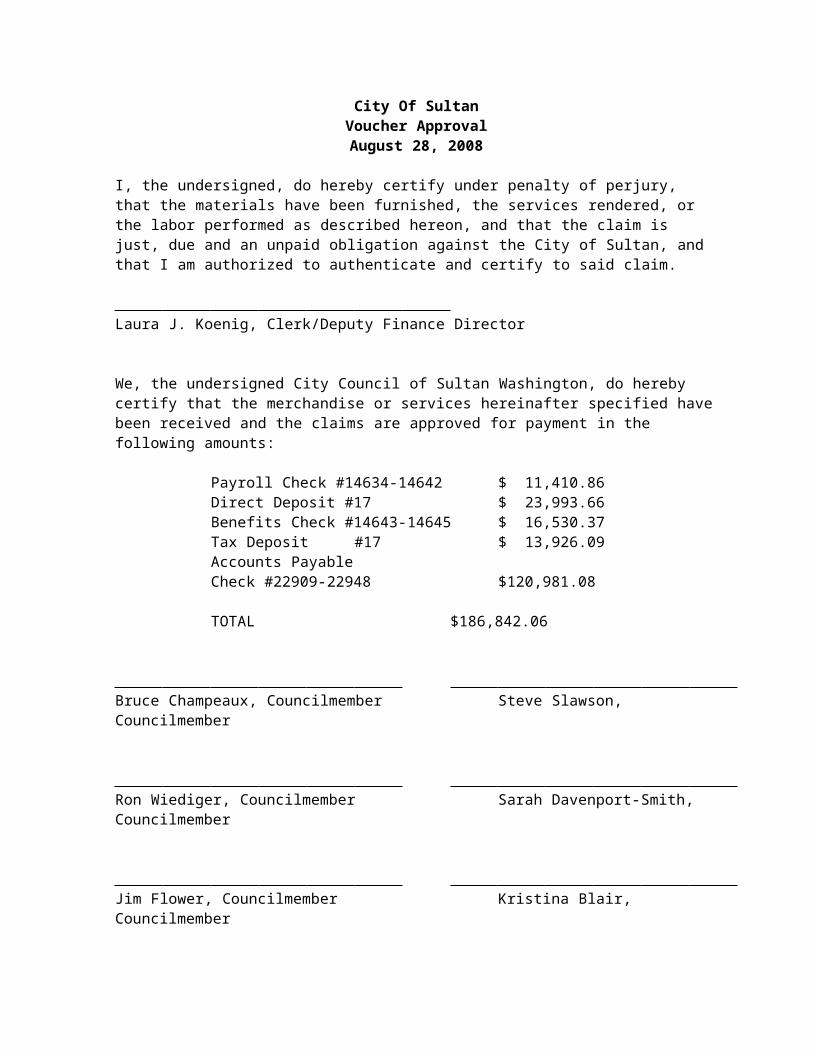
SUBJECT: Voucher Approval
CONTACT PERSON: Laura Koenig, Clerk/Deputy Finance Director
SUMMARY:Attached are the vouchers for approval in the amount of $120,981.08 and payroll through August 8, 2008 in the amount of $65,860.98 to be drawn and paid on the proper accounts.
FISCAL IMPACT: $186,842.06
RECOMMENDATION:Approve the payment of vouchers as submitted.
COUNCIL ACTION:
DATE:

City Of SultanVoucher ApprovalAugust 28, 2008
I, the undersigned, do hereby certify under penalty of perjury, that the materials have been furnished, the services rendered, or the labor performed as described hereon, and that the claim is just, due and an unpaid obligation against the City of Sultan, and that I am authorized to authenticate and certify to said claim.
Laura J. Koenig, Clerk/Deputy Finance Director
We, the undersigned City Council of Sultan Washington, do hereby certify that the merchandise or services hereinafter specified have been received and the claims are approved for payment in the following amounts:
Payroll Check #14634-14642 $ 11,410.86Direct Deposit #17 $ 23,993.66Benefits Check #14643-14645 $ 16,530.37Tax Deposit #17 $ 13,926.09Accounts PayableCheck #22909-22948 $120,981.08
TOTAL $186,842.06
Bruce Champeaux, Councilmember Steve Slawson, Councilmember
Ron Wiediger, Councilmember Sarah Davenport-Smith, Councilmember
Jim Flower, Councilmember Kristina Blair, Councilmember
Dale Doornek, Councilmember

SULTAN CITY COUNCILAGENDA COVER SHEET
Agenda Item #: Consent C 5
Date: August 28, 2008
Subject: 2000 Budget – Set Workshop
Contact: Laura Koenig, Deputy Finance Director
Issue:The issue before the Council is to set workshop on September 4, 2008 to discuss the 2009 Budget.
Summary Statement:Staff has prepared preliminary revenue assumptions and expenditures for the 2009 Budget. There are policy issues the Council needs to discuss in order to finalize the Mayor’s recommended Budget.
Recommendation:Set a workshop for September 4, 2008 at 7:00 PM to discuss the 2009 Budget.

CITY OF SULTANAGENDA ITEM COVER SHEET
Agenda Item : C-6
Date: August 28, 2008
SUBJECT: Acceptance of Graffiti Abatement Grant
CONTACT PERSON: Donna Murphy Grants and Economic Development Coordinator
ISSUE:Authorize Mayor Eslick to accept the $12,000 grant offered to the City of Sultan from the Washington Association of Sheriffs and Police Chiefs to fund a multi jurisdictional grant to purchase a self contained, housed on a trailer hot water pressure washer for volunteers in Sultan, Gold Bar and Index to remove graffiti. An Interlocal Agreement for use of the equipment between Sultan, Gold Bar and Index will be prepared.
SUMMARY STATEMENT:
On July 31, 2008 the City of Sultan filed an application with the Washington Association of Sheriffs and Police Chiefs requesting a $12,000 multi jurisdictional grant to purchase a self contained, hot water pressure washer for volunteers and City staff to remove graffiti. Attachment B
On August 15, 2008 Mayor Eslick received a letter from the Washington Association of Sheriffs and Police Chiefs announcing the award of the grant. Attachment A
MATCH REQUIREMENTS: There is no match requirement with this grant program
PROJECT TIMELINE: This project should be in full operation by October 1, 2008
Recommended Motion: I move to authorize Mayor Eslick to accept the $12,000 grant offered to the City of Sultan from the Washington Association of Sheriffs and Police Chiefs and negotiate an Interlocal Agreement between Sultan, Gold Bar and Index for use of the Graffiti Abatement equipment.

SULTAN CITY COUNCILAGENDA ITEM COVER SHEET
ITEM NO: C-7
DATE: August 28, 2008
SUBJECT: Cairncross and Hempelmann Amendment No. 1 Contract for Land Use Attorney Services
CONTACT PERSON: Deborah Knight, City Administrator Deborah KnightISSUE:The issue before the City Council is to authorize the Mayor to sign Amendment No. 1 to the contract with Cairncross and Hempelmann for land use attorney services to assist the City with adopting a compliant comprehensive plan under the State Growth Management Act.
Amendment No. 1 will increase the maximum payment allowed under the contract from $100,000 to $150,875 to:
1. Review and analysis of draft responses to public and agency comments. Estimated to require up to 40 hours ($11,000)
2. Attend team meetings with staff and consultants. Attend Planning Board and City Council workshops and public hearings. Estimated to require up to 45 hours ($12,375)
3. Prepare and/or review Planning Board recommendations and City Council ordinances. Estimated to require up to 20 hours ($5,500)
4. Representation at compliance hearings in front of the Central Puget Sound Growth Management Hearings Board. Estimated to require up to 60 hours ($16,500)
Prepare and submit report on compliance and other briefing Respond to requests for information Respond to petitioners’ arguments Present oral argument
5. Render legal advice and opinions concerning legal matters that affect the City. Estimated to require up to 20 hours ($5,500)
Review and comment on materials prepared by consultants for the comprehensive plan or other land use matters generally related to the comprehensive plan.
Respond to questions from staff regarding other land use matters as needed.

STAFF RECOMMENDATION:Authorize the Mayor to sign Amendment No. 1 with Cairncross and Hempelmann for land use attorney services to assist the City with adopting a compliant comprehensive plan under the State Growth Management Act.
SUMMARY:The City has been working since January 2008 to revise its 2004 Comprehensive Plan to be compliant with the Growth Management Act. Andrew Lane, the City’s land use attorney has been the project lead ensuring each technical product delivered by the City’s consulting team meets the requirements of the Growth Management Act.
Since January, Mr. Lane has spent over 370 hours assisting the City. Copies of Mr. Lane’s invoices since January 2008 are available upon request.
Month HoursJanuary 31Feb 65March 49.8April 53.3May 63.2June 68.8July 39Total 370.1
The original scope of work and budget were developed with the best information and project understanding available at the time. The City is in the final stretch and there is still significant work to do:
Tuesday, September 2, 2008 – Public Comment Period Closes. Consultants review comments and prepare draft responses. Land use attorney reviews and comments on draft responses.
Monday, September 8, 2008 – Consultant team meeting to finalize draft responses to public comment. Draft necessary changes to Revised Comprehensive Plan.
Tuesday, September 9, 2008 – Joint City Council/Planning Board Meeting and Public Hearing on the Comprehensive Plan, Implementing Development Regulations, 6-year Transportation Improvement Plan, and Water/Sewer Plan Amendments.
Thursday, September 11, 2008 – City Council meeting. Could include First Reading of some implementing ordinances.
Monday, September 15, 2008 – Issue Final Draft 2008 Revised Comprehensive Plan for public comment on September 25.
Thursday, September 25, 2008 – City Council Public Hearing on the Final Comprehensive Plan, Implementing Development Regulations, 6-year Transportation Improvement Plan, and Water/Sewer Plan Amendments. Final adoption of implementing ordinances.

Once the City Council has adopted the 2008 Revised Comprehensive Plan, the coordinated compliance schedule for Fallgatter V, Fallgatter VIII, and Fallgatter IX is set forth below:
The Board establishes September 30, 2008 as the deadline for the City of Sultan to take appropriate legislative action to comply with the GMA as interpreted in this Order.
By no later than October 10, 2008, the City of Sultan shall file with the Board an original and four copies of the legislative enactments taken to comply with this Order, along with a statement of how the enactments comply with this Order (Statement of Actions Taken to Comply - SATC). By this same date, the City shall also file a “Compliance Index,” listing the procedures (meetings, hearings, etc.) occurring during the compliance period and materials (documents, reports, analysis, testimony, etc.) considered during the compliance period in taking the compliance action.
By no later than October 24, 2008, the Petitioners may file with the Board an original and four copies of Response to the City’s SATC.
By no later than October 31, 2008, the City may file with the Board a Reply to Petitioner’s Response.
Pursuant to RCW 36.70A.330(1), the Compliance Hearing in this matter is scheduled for November 6, 2008, at 10:00 a.m. at the Board’s offices. The compliance hearing shall be limited to consideration of the Legal Issues found to be in continuing noncompliance and invalidity in this Order.
Board final decision no later than December 6, 2008.
BACKGROUND:Land Use Attorney Selection Process
At its November 15, 2007 meeting, the City Council directed staff to issue a request for proposal for land use attorneys to assist the City in prepare a comprehensive plan compliant with the Growth Management Act.
The City received nine proposals and invited three first to interview: Bricklin Newman Bold, EKW and Cairncross. The City selected Cairncross and Hempelmann after evaluating each of the three firms interviewed against the selection criteria. Council approved retaining the services of Mr. Lane as the land use attorney to provide special legal counsel to the City during the upcoming compliance effort.
FISCAL IMPACT:There are a lot of unknowns in GMA-related matters. City staff and Mr. Lane have provided a rational estimate but it is to some extent influenced by externalities over which the City has little control.

The original contract amount was $100,000 although, the City budgeted $150,000 for land use attorney services.
The total estimate to complete the compliance effort is $50,875. This includes work in progress (services that have not, yet been billed) –in the neighborhood of $3,500 - $4,000.
In order to preserve the City’s cash flow to support daily operations, the City negotiated a contract with Caircross to limit the City’s monthly expenses to a maximum of $5,000/month. The City will continue to pay $5,000/month until the remaining balance is paid in full. There will not be an immediate impact to the City’s budget as a result of the amendment rather the impact will be rolled forward into the 2009 budget.
A decision to hire special legal council comes with fiscal impacts. The City’s municipal attorney, Kathy Hardy charges $140/hour for municipal work. Mike Kenyon, a senior partner with land use experience charges $235. The proposed fee for Mr. Lane is $275/hour. Mr. Lane’s $275/hour is a reduction from his normal rate of $325/hour.
ALTERNATIVES:1. Authorize the Mayor to sign Amendment No. 1 with Cairncross and Hempelmann for
land use attorney services to assist the City with adopting a compliant comprehensive plan under the State Growth Management Act.
This alternative implies the City Council is comfortable with the staff recommendation to retain the services of Mr. Lane and Cairncross for this work, and the Council is prepared to authorize the necessary funding.
2. Do not authorize the Mayor to sign Amendment No. 1 with Cairncross and Hempelmann for land use attorney services to assist the City with adopting a compliant comprehensive plan under the State Growth Management Act.
This alternative implies the City Council is not comfortable with the staff recommendation to retain the services of Mr. Lane, and/or the Council is not prepared to authorize the necessary funding.
RECOMMENDED ACTION:I MOVE TO AUTHORIZE THE MAYOR TO SIGN AMENDMENT NO. 1 WITH CAIRNCROSS AND HEMPELMANN FOR LAND USE ATTORNEY SERVICES TO ASSIST THE CITY WITH ADOPTING A COMPLIANT COMPREHENSIVE PLAN UNDER THE STATE GROWTH MANAGEMENT ACT.
ATTACHMENTS:
A – Amendment No. 1 Cairncross and HempelmannB – Original Contract Scope of Work

COUNCIL ACTION:
DATE:

Attachment A to Agenda Cover
FIRST ADDENDUM BY AND BETWEEN THE CITY OF SULTAN AND
CAIRNCROSS AND HEMPELMANN, INC.
THIS FIRST ADDENDUM, is made on this 1st day of August, by and between the City of Sultan (hereinafter referred to as “City”), a Washington Municipal corporation, and Cairncross and Hempelmann (hereinafter referred to as “Service Provider”) doing business at 524 Second Avenue, Suite 500, Seattle, WA 98104-2323.
WHEREAS, on February 1, 2008, the City and the Service Provider entered into that certain Agreement for Services (“Agreement”) for the provision of land use attorney services; and
WHEREAS, the City and Service Provider agree there are additional tasks to perform that exceed the original payment amount; NOW THEREFORE,
IN CONSIDERATION OF the mutual promises, terms and conditions set forth in the Agreement and contained herein, the Parties hereby agree as follows:
Section 1. Amendment of Section 1 Description of Work of the Agreement.
Section 1 of the Agreement is hereby revised to provide in its entirety as follows:
Service Provider shall perform the additional work as described in Attachment A.1, Scope of Work, which is attached hereto and incorporated herein by this reference, according to the existing standard of care for such services. Service Provider shall not perform any additional services without the expressed permission of the City.
Section 2. Amendment of Payment
Section 2 A Payment of the Agreement is hereby revised to provide in its entirety as follows:
2. Payment.
A. The City shall pay Service Provider at the hourly rate set forth in Attachment A, but not more than a total of one hundred and fifty thousand dollars ($150,875) for the services described in this Agreement. This is the maximum amount to be paid under this Agreement, and shall not be exceeded without prior written authorization from the City in the form of a negotiated and executed supplemental agreement.
Section 2. Effect of Addendum. This 1st Addendum is in addition to the Agreement. Except as otherwise provided herein, the provisions of this 1st Addendum modify, but do not supersede the provisions of the Agreement. Except as otherwise provided herein, each provision of the Agreement shall continue in full force and effect as if this 1st Addendum did not exist. Except as otherwise provided herein, capitalized words and phrases shall have the meanings ascribed to them in the Agreement.
IN WITNESS WHEREOF, the parties have caused this Addendum to be signed and executed this 1st day of August, 2008.
CITY OF SULTAN: SERVICE PROVIDER:By: By:
Mayor Carolyn Eslick Title: Taxpayer I D Number:____________________
Address: ____________________________ Phone: _____________________________
ATTEST/AUTHENTICATED: APPROVED AS TO FORM:
By: By: City Clerk Office of the City Attorney

Attachment A.1 to Amendment No. 1Additional Scope of Work
6. Review and analysis of and draft responses to public and agency comments. Estimated to require up to 40 hours ($11,000)
7. Attend team meetings with staff and consultants. Attend Planning Board and City Council workshops and public hearings. Estimated to require up to 45 hours ($12,375)
8. Prepare and/or review Planning Board recommendations and City Council ordinances. Estimated to require up to 20 hours ($5,500)
9. Representation at compliance hearings in front of the Central Puget Sound Growth Management Hearings Board. Estimated to require up to 60 hours ($16,500)
Prepare and submit report on compliance and other briefing
Respond to requests for information
Respond to petitioners’ arguments
Present oral argument
10. Render legal advice and opinions concerning legal matters that affect the City. Estimated to require up to 20 hours ($5,500)
Review and comment on materials prepared by consultants for the comprehensive plan or other land use matters generally related to the comprehensive plan
Respond to questions from staff regarding other land use matters as needed.
Hourly rates for attorneys who may assist:
Andrew S. Lane: $275 per hour (discounted from $300 per hour) Primary Attorney
Sean K. Howe, Attorney: $220 per hour

Attachment B to Agenda Cover
Cairncross and HempelmannContract Effective February 1, 2008
Scope of Work
1. Representation at compliance hearings in front of the Central Puget Sound Growth Management Hearings Board. Estimated to require up to 60 hours ($16,500)
Prepare and submit briefs
Respond to requests for information
Respond to petitioner
2. Attend at Council, boards, commission, and committee meetings as required. Estimated to require up to 165 hours ($45,375)
City Council and Planning Board meetings – two to three meetings per month February 2008 through September 2008
Open Houses – one per month March 2008 through August 2008
3. Attend meetings with staff as needed. Estimated to require up to 60 hours ($16,500)
Coordination team meetings – one per month February 2008 through December 2008
Consultation meetings with the Mayor and City Administrator
4. Render legal advice and opinions concerning legal matters that affect the city. Estimated to require up to 65 hours ($17,875)
Prepare and/or review land use ordinances and resolutions
Review and comment on materials prepared by consultants for the comprehensive plan or other land use matters generally related to the comprehensive plan
Review development regulations and make recommendations regarding proposed code amendments

SULTAN CITY COUNCIL
AGENDA ITEM COVER SHEET
ITEM NO: C - 8
DATE: August 28, 2008
SUBJECT: Rejection of Bid for Cricket at 703 First Street
CONTACT PERSON: Connie Dunn, Public Works Director
ISSUE:The issue before the Council is the rejection of bids received for the installation of a cricket at 703 First Street in Sultan, Washington between the Food Bank new building and old building.
STAFF RECOMMENDATION:City staff recommends the Council reject all bids received for the installation of a cricket at 703 First Street due to budget constraints.
BACKGROUND:The Sultan Food Bank sent a letter (ATTACHMENT A) to Mayor Eslick informing the City of a serious problem with the design of the west addition to the premises. Because of the design of the roof and gutter system, water was pouring between the two buildings when it rains. The City sent a letter (ATTACHMENT B) to the food bank addressing this issue and letting them know the potential solution to this problem was to demolish the internal gutter and install a “cricket” to catch directing water away from the are area where the two buildings are combined.
Staff used the Municipal Services Research Center small works roster to select five construction companies then sent letters requesting bids to install the cricket between the two existing buildings. Letters and bond documents were mailed to:
1. Pacific Sheet Metal and Roofing2. NW Roofing Solutions, LLC3. Snyder Roofing of WA, LLC;4. Bruin Construction LLC and Mike’s Roofing Inc.
The bid closing date was Tuesday, August 19, 2008 at 11:30 am and the City received one bid (ATTACHMENT C) from Mike’s Roofing, Inc.
The bid received from Mike’s Roofing, Inc. was for $31,144.00 which included putting on an entire roof. This was a miscommunication and the City requested a new bid from them not include a re-roof. This bid came in at $27,715.00.
SUMMARY:

The City of Sultan does not have enough money in the budget to accept a bid of $27,715.00. The City had estimated the project cost of $4,500.00 to make the repairs and did not anticipate bids would come in so high. With the difference in the estimate and the actual bid, the City will go back to Mike’s Roofing Inc. and have an on-site meeting to re-evaluate the cost of the cricket.
ALTERNATIVES:1. Accept the bid from Mike’s Roofing, Inc. and make an amendment to the budget to pay
the $27,715.00 to get the work done.2. Reject the bid from Mike’s Roofing, Inc. and hold a meeting with Mike’s Roofing, Inc. to
negotiate a more reasonable price within the City’s budget.
FISCAL IMPACT:
RECOMMENDED ACTION:Reject bid received from Mike’s Roofing, Inc.
COUNCIL ACTION:
ATTACHMENT:Attachment A Letter dated March 17, 2008 from Sultan BankAttachment B Letter dated April 23, 2008 to the Sultan Food BankAttachment C Bid from Mike’s Roofing, Inc.

SULTAN CITY COUNCIL AGENDA ITEM COVER SHEET
ITEM NO: C-9
DATE: August 28, 2008
SUBJECT: On-call Planning Services ContractAddendum No. 2 with Perteet, Inc.
CONTACT PERSON: Deborah Knight, City Administrator Deborah KnightISSUE:The issue before the City Council is to authorize the Mayor to sign Addendum No. 2 (Attachment A) with Perteet, Inc. The Addendum is need to provide an additional $5,940.00 to work on the Comprehensive Plan revisions through the scheduled September 25, 2008, adoption date and the subsequent preparation for the Growth Management Hearings Board review during the months of October and November.
STAFF RECOMMENDATION:Authorize the Mayor to sign Addendum No. 2 with Perteet, Inc. for on-call planning services. SUMMARY:The City has reached the $120,000.00 not to exceed amount allowed under the on-call planning services contract with Perteet, Inc. approved by the City Council on January 10, 2008.
The City anticipated completing the scope of work by June 30, 2008. The term of the contract was extended beyond June 30, 2008 (Amendment No. 1), within the original budgeted amount. However, that budget amount has now been depleted by the continuing work on the Comprehensive Plan revisions toward compliance with the rulings of the Growth Management Hearings Board by September 30, 2008.
City staff recommends an additional contract amount not to exceed $5,940.00 for the work on the Comprehensive Plan revisions through the scheduled September 25, 2008, adoption date and the subsequent preparation for the Growth Management Hearings Board review during the months of October and November. The budget will be divided evenly between the general fund, street fund and the water and sewer enterprise funds.
The following hours are projected:

Week of:
August 30, 2008 – initiation of final review and responses to public comments 6 hrsSeptember 1, 2008 – completion of responses to public comments 7 hrsSeptember 15, 2008 – completion of final review 6 hrsSeptember 22, 2008 – adoption of the revised Comprehensive Plan 6 hrsOctober 20, 2008 – final submittal to Growth Management Hearings Board 6 hrsAugust-October, 2008 – project management 3 hrsSubtotal for Senior Project Manager hours 33 hrs
Budget Estimate:Senior Project Manager 33 hrs @ $160/hr $ 5,280.00Travel Expenses (4-5 trips to Sultan, Seattle, etc) $ 140.00 Subtotal for Comprehensive Plan revision $ 5,320.00
Contingency for other unanticipated expenses such as continuances, etc. $ 620.00Total Contract Extension Amount (not to exceed) $ 5,940.00
Brad Collins, with Perteet will continue to provide comprehensive plan review services to the City.
BACKGROUND:The City Council authorized the Mayor to a contract with Perteet, Inc. for on-call planning services on January 10, 2008 for an amount not to exceed $120,000.00. The contract included:
1) Project Management: billings, progress reports, coordination, milestone meetings.
2) Interim Community Development Director Services: attending management team meetings, attending City Council meetings, attending Planning Board meetings, overseeing and providing peer review on the GMA compliance work being completed by another Service Provider, managing the City Engineer and Building Department; preparing for the future Community Development Director by July 2008.
3) Current Planning Services: planning review of development proposals, and temporary planning staff services.
4) Comprehensive Planning and Code Amendment Services: comprehensive plan amendments (not including GMA compliance work), code amendments, GIS mapping, graphics and other Comprehensive Plan tasks as needed.
Tasks 3 and 4 are complete. The request is to complete the GMA compliance work in Tasks 1 and 2.

ALTERNATIVES:1. Authorize the Mayor to sign Addendum No. 2 with Perteet, Inc. for on-call planning
services.
This alternative keeps Mr. Brad Collins engaged in the City’s efforts to adopt a compliant comprehensive plan. In his current capacity Mr. Collins is in effect completing his work as the City’s Interim Community Development Director. Since Bob Martin joined the City at the end of the revision effort he is only able to provide minimal review rather than leadership.
Mr. Collins would continue to review and respond to public comments received on the draft 2008 revision to the 2004 Comprehensive Plan and assist in preparing the plan for the Growth Management Hearings Board. Mr. Collins would also continue to oversee the work performed by Mr. Eric Irelan on the Transportation Plan and Mr. Dean Franz on the Stormwater Plan.
2. Do not authorize the Mayor to sign Addendum No. 2 with Perteet, Inc. for on-call planning services and direct staff to areas of concern.
A decision not to authorize the Mayor to sign Addendum No 1, would remove Mr. Collins from the final review process. Mr. Collins has provided important input and direction throughout the City’s effort to adopt a compliant comprehensive plan. His input and recommendations would not be included in the final document.
FISCAL IMPACT:City staff recommends dividing the $5,930.00 contract cost between the General Fund, Street Fund and Water and Sewer Enterprise Funds – approximately $1,482.50 per fund.
The costs can be incorporated into the budget amendment for Council approval in September.
RECOMMENDED ACTION:Authorize the Mayor to sign Addendum No. 2 with Perteet, Inc. for on-call planning services.
ATTACHMENTA – Addendum No. 2 to Perteet, Inc. on-call planning services contract

Attachment A
SECOND ADDENDUMBY AND BETWEEN THE CITY OF SULTAN AND
PERTEET ENGINEERING
THIS SECOND ADDENDUM is made by and between the City of Sultan (hereinafter referred to as “City”), a Washington Municipal corporation, and Perteet Engineering Error: Reference source notfound(hereinafter referred to as “Service Provider”), doing business at 2707 Colby Avenue, Suite 900, Everett, WA 98201.
WHEREAS, on January 1, 2008, the Parties entered into that certain Agreement for Services (“Agreement”) for the provision of on-call planning services for:
1) Project Management: billings, progress reports, coordination, milestone meetings.
2) Interim Community Development Director Services: attending management team meetings, attending City Council meetings, attending Planning Board meetings, overseeing and providing peer review on the GMA compliance work being completed by another Service Provider, managing the City Engineer and Building Department; preparing for the future Community Development Director by July 2008.
3) Current Planning Services: planning review of development proposals, and temporary planning staff services.
4) Comprehensive Planning and Code Amendment Services: comprehensive plan amendments (not including GMA compliance work), code amendments, GIS mapping, graphics and other Comprehensive Plan tasks as needed.
; and
WHEREAS, on July 1, 2008 the City and the Service Provider amended the contract to extend the termination date to December 31, 2008; and
WHEREAS, the Service Provider has completed assigned tasks for current planning services and comprehensive planning and code amendment services; and
WHEREAS, the City desires to contract with the service provider to assist with public involvement and the City’s 2008 revision of the 2004 comprehensive plan; NOW, THEREFORE,
IN CONSIDERATION OF the mutual promises, terms and conditions set forth in the Agreement and contained herein, the Parties hereby agree as follows:
Section 1. Amendment of Section 1 Description of Work of the Agreement. Section 1 of the Agreement is hereby revised to provide in its entirety as follows:
Service Provider shall perform the additional work as described in Attachment A.1, Scope of Work, which is attached hereto and incorporated herein by this reference, according to the existing standard of care for such services. Service Provider shall not perform any additional services without the expressed permission of the City.
Section 2. Amendment of Section 2 Payment of the Agreement. Section 2 of the Agreement is hereby revised to provide in its entirety as follows:

B. The City shall pay Service Provider at the hourly rate set forth in Attachment A.1, but not more than a total of one hundred and twenty six thousand ($126,000) for the services described in this Agreement. This is the maximum amount to be paid under this Agreement, and shall not be exceeded without prior written authorization from the City in the form of a negotiated and executed supplemental agreement.
C. Service Provider shall submit monthly payment invoices to the City after such services have been performed, and the City shall make payment within four (4) weeks after the submittal of each approved invoice. Such invoice shall detail the hours worked, a description of the tasks performed. Charges for travel time described in Attachment A.1 must be listed separately. No other reimbursable expenses will be allowed.
D. If the City objects to all or any portion of any invoice, it shall so notify Service Provider of the same within fourteen (14) days from the date of receipt and shall pay that portion of the invoice not in dispute. The parties shall immediately make every effort to settle the disputed portion.
Section 3. Effect of Addendum. This First Addendum is in addition to the Agreement. Except as otherwise provided herein, the provisions of this First Addendum modify, but do not supersede the provisions of the Agreement. Except as otherwise provided herein, each provision of the Agreement shall continue in full force and effect as if this First Addendum did not exist. Except as otherwise provided herein, capitalized words and phrases shall have the meanings ascribed to them in the Agreement.
IN WITNESS WHEREOF, the parties have caused this Addendum to be signed and executed this 30th day of August, 2008.
CITY OF SULTAN: CONTRACTOR:
By: By: Mayor Carolyn Eslick Title:
Taxpayer ID #:
ATTEST/AUTHENTICATED: APPROVED AS TO FORM:
By: By: City Clerk Office of the City Attorney
Attachment A.1
TO: Deborah Knight, City Administrator, City of Sultan
FROM:
Brad Collins, Perteet Senior
Project Manager
Inc.
MEMORANDUM

DATE: August 20, 2008
RE: Sultan On-Call Services Contract Extension
Per our discussion, please review and approve an extension of the Perteet On-Call Services Contract to complete the peer review work on the City of Sultan Comprehensive Plan revisions. The original contract amount was $120,000 and was expected to be completed on June 30, 2008. The term of the contract was extended beyond June 30, 2008, within the original budgeted amount. However, that budget amount has now been depleted by the continuing work on the Comprehensive Plan revisions toward compliance with the rulings of the Growth Management Hearings Board by September 30, 2008.
Please authorize an additional contract amount not to exceed $5,940 for the work on the Comprehensive Plan revisions through the scheduled September 25, 2008, adoption date and the subsequent preparation for the Growth Management Hearings Board review during the months of October and November. The following hours are projected:
Week of:
August 30, 2008 – initiation of final review and responses to public comments 6 hrsSeptember 1, 2008 – completion of responses to public comments…………… 7 hrsSeptember 15, 2008 – completion of final review…………………………………… 6 hrsSeptember 22, 2008 – adoption of the revised Comprehensive Plan…………… 6 hrsOctober 20, 2008 – final submittal to Growth Management Hearings Board…. 6 hrsAugust-October, 2008 – project management……………………………………. 3 hrsSubtotal for Senior Project Manager hours………………………………………… 33 hrs
Budget Estimate:Senior Project Manager 33 hrs @ $160/hr………………..………..………… $5,280Travel Expenses (4-5 trips to Sultan, Seattle, etc.)………………………….. $ 140Subtotal for Comprehensive Plan revision…………………………………… $5,320
Contingency for other unanticipated expenses such as continuances, etc… $ 620Total Contract Extension Amount (not to exceed)………………………….. $5,940

SULTAN CITY COUNCIL
AGENDA ITEM COVER SHEET
ITEM NO: C - 10
DATE: August 28, 2008
SUBJECT: Sultan Basin Road Phase IIIWH Pacific Scope of Work and Cost Estimate
CONTACT PERSON: Connie Dunn, Public Works Director
ISSUE:The issue before the City Council is execution of a scope of work for preconstruction services to be completed by WH Pacific, Bothell, WA and their sub-consultants. Authorizing the Mayor to negotiate a contract for preconstruction work for Sultan Basin Road Phase III with an estimate consultant’s fee of $361,843.
STAFF RECOMMENDATION:Staff recommends the City Council authorize the Mayor to negotiate a contract with WH Pacific for preconstruction services on Phase III of the Sultan Basin Road.
SUMMARY:July 22, 2008 Staff sent out a Request for Proposal (RFP) to three engineering firms from Municipal Research Service Center for preconstruction services including design, survey, geotechnical and permitting.
WH Pacific, Bothell, WAPerteet Inc., Everett, WAPACE Engineers. Kirkland, WA
RFP’s were submitted to the City by August 1, 2008 at 5 PM. The City received one response from WH Pacific of Bothell. WH Pacific is the same engineering firm retained by the City through Snohomish County to design and construct Sultan Basin road Phase I and II.
On August 6, 2008 the City received verbal approval of the Federal Functional Classification Minor Collector for the Sultan Basin Road Phase III. Sharon Golphnee, WSDOT, agreed to forward the prospectus to Puget Sound Regional Council (PSRC) to obligate the $194,000 for preconstruction of the $1,009,164 grant the City received State Transportation Program (STP) funds.
On August 11, 2008 the City received a letter approving the Functional Classification (200804) of Sultan Basin Road as a Minor Collector from the Federal Highway Administration (FHWA)
On August 11, 2008 staff contacted WH Pacific requesting a scope of work and cost estimate (Attachment A). WH Pacific estimates the cost at $361,843 to complete the scope of work.
54

BACKGROUND:August 31, 2006 estimated cost of the total project was $2,012,000; this includes design engineering ($187,000), construction engineering, construction contract and right of way purchase.
October 18, 2007 City Council authorized the Mayor to sign an Interlocal Agreement (ILA) with Washington State Department of Transportation (WSDOT).
January 10, 2008 Sultan City Council approved Resolution 08-01 appointing Washington State Department of Transportation (WSDOT) as Certified Agent (CA) for Sultan Basin Road Phase III project administration.
February 6, 2008 the City received email notice from Puget Sound Regional Council (PSRC) the US 2 Sultan Basin Road Realignment Phase III has been found to be consistent with Destination 2030 Plan.
July 7, 2008 the City of Sultan requested WSDOT to classify Sultan Basin Road Phase III with the federal functional classification as a Minor Collector.July 17 2008 Sam Schuyler, WSDOT agreed with the City Staff to start the Design Engineer selection process using the City’s Engineer Roster. The City is not authorized to spend any funds until the grant money is obligated.
FISCAL IMPACT:Estimated cost of Preconstruction of US 2 – Sultan Basin Road Phase III is $361,843. $ 194,000 STP Funds (for design)$ 250,000 Rural Town Corridors (for design)
RECOMMENDED ACTION:Authorize the Mayor to negotiate a contract with WH Pacific for preconstruction services on Phase III of the Sultan Basin Road for the estimated cost of $361,843.
COUNCIL ACTION:
ATTACHMENT(S):Attachment A WH Pacific Scope of Work and Estimated Costs
55

Exhibit B-1Scope of Work
City of Sultan/WHPacificUS 2/Sultan Basin Road Improvements Project Phase III
The work to be accomplished under this Agreement will be for WHPacific (CONSULTANT) to provide engineering design services to the City of Sultan (CITY) for the improvements to add the south leg to the Sultan Basin Road intersection with US 2. The planned improvements will include extending Sultan Basin Road southerly to its intersection with Cascade View Drive to provide a 12-foot wide travel lane in each direction, a 12-foot wide left turn lane and a 5-foot bicycle lane and 6-foot wide sidewalk on both sides of the roadway. The new roadway will connect to a new intersection with Cascade View Drive and taper down in width to match the existing roadways to the south of Cascade View Drive intersection. Modifications to the existing US 2 and Sultan Basin Road will include improvements along US 2 to provide a new right turn lane, restriping for a southbound left turn lane and traffic signal modifications. Modifications to the existing storm drainage system, new water quality treatment and detention pond facilities will be added. Additionally, a new 12-inch waterline will be installed along Sultan Basin Road from the US 2 intersection to Cascade View Drive.
The project designs and PS&E will be based on the requirements of the City of Sultan Standards, the Washington State Department of Transportation Local Agency Guidelines and Design Manuals, MUTCD, and AASHTO design standards.
1.0 Project Management and Administration
The CONSULTANT will provide contract management and administration services for the project, to include: developing and maintaining project scope and budget, liaison with CITY staff, and preparing monthly narrative progress reports and invoices.
The CONSULTANT will attend project coordination meetings, provide information for CITY staff coordination meetings (as requested), and respond to public concerns through communication with CITY staff. The CONSULTANT will attend up to six (6) monthly project coordination meetings with the CITY staff to review schedule, budget, status of designs and plan review comments. The CONSULTANT will prepare meeting notes and distribute to participants.
The CONSULTANT will complete a quality control check prior to submitting work for the CITY’s review. A quality control check will be used to confirm that the design work follows CITY and LAG Manual standards and that the work is professional quality meeting industry standards. The quality control check will include review of engineering, drafting and clerical errors or omissions.
Deliverables: Monthly Progress Reports/Invoices Project Coordination Meeting Agendas and Notes
2.0 Data Collection and ReviewThe CONSULTANT will collect existing data pertinent to the project that is available from the CITY, other agencies, franchise utilities, and appropriate sources. The data will include survey control data, right-of-way information, legal descriptions, topographic surveys, existing utility locations, planned utility locations, plans for other roadway improvements common to this project, information from recent and proposed private developments including plans and reports, planning documents, and previous reports and documents pertaining to the project corridor.
56

The CONSULTANT’s key project personnel will visit the project site and familiarize themselves with the site conditions and the data that is collected for the project. Ground-level photographs will be obtained during the site visits for design references. The CITY will be responsible for obtaining and maintaining right-of-entry permits for the CONSULTANT to enter properties adjacent to the project. Site conditions review will not commence until rights of entry have been secured.
3.0 Utility Coordination
The CONSULTANT will collect and review existing utility information pertinent to the project that is available from the CITY and other utility companies. The data will include existing and planned utility locations. The CONSULTANT will attend up to two (2) meeting with the CITY and private utility companies to coordinate and resolve impacts on this project on the utility systems. We will prepare meeting notes and distribute to all meeting participants.
The anticipated utility companies involved are power, telephone (several), cable, and gas.
4.0 Field Surveys and Base Mapping
The CONSULTANT will research Snohomish County records to recover monumentation controlling the Site and establish a horizontal (NAD 83/91) and vertical (NAVD 88) datum.
The CONSULTANT will perform a topographic survey of an area approximately 6.5 acres in size, sufficient for the development of 2-foot contours, on the parcels affected by the proposed realignment. As part of that survey, conifer trees over 10-inch caliper and deciduous trees over 12-inch caliper will be located.
The CONSULTANT will perform a topographic survey of adjoining roads, specifically Cascade View Drive and Foundry Drive, 1000 feet each direction from the point of new road alignment and its intersection with Cascade View Drive.
The CONSULTANT will prepare a topographic base map suitable for design purposes. Base maps will be prepared at a scale of one inch equals twenty feet (1"=20'). Existing ground line profiles will be plotted from the field survey information. Base mapping will be tied to existing monumentation and defined on the plans.
Deliverables: An electronic (Adobe .PDF, AutoCAD .DWG) copy of survey basemap.
5.0 Geotechnical Review
Geotechnical Engineering
The CONSULTANT will compile and review readily available geologic and geotechnical information and other data relevant to the project. This information will be used to gain a general understanding of past human activities (filling, construction, etc.) and the underlying geology in the project area. Possible data sources include information in Landau Associates’ and the CITY’s files (construction drawings, utility layouts, geotechnical reports prepared for projects in the vicinity, etc.), and published geologic and topographic maps.
After reviewing the available data, a geologic reconnaissance of the project area will be completed to collect information on the general nature and physical features of the project site and to mark out proposed exploration locations for the one-call utility locate service. Following the site reconnaissance, two exploratory borings will be advanced to depths of 15 to 30 feet along the proposed alignment to characterize soil and groundwater conditions. Washington State Department of Archeology and Historic Preservation approval of the Area of Potential Effects (see Task 5) must be completed for the exploratory borings to commence. The project includes construction of a
57

new signal pole at the intersection of US 2 and Sultan Basin Road. Past explorations completed in the intersection during earlier phases of the project will be used to evaluate soil conditions within the intersection.
A drilling contractor under subcontract to Landau Associates will complete the exploratory borings. For the purpose of the cost estimate, it is assumed that the site will require a limited-access drill rig to order to complete the proposed borings. Landau Associates will also arrange for underground utility locates (“call before you dig”) prior to performing field activities. The exploratory borings will be located along the proposed alignment of Sultan Basin Road, which is located on private property. A private underground utility locating service under subcontract to our firm will check the planned exploration locations for potential conflicts. It is assumed that the CITY will obtain permission to enter private property for all exploratory borings located beyond the public right-of-way.
A geologist or geotechnical engineer from Landau Associates will supervise the explorations, obtain soil samples from the borings, and prepare field logs of conditions encountered in the explorations. Soil samples will be obtained from the exploratory borings on about a 2½- or 5-foot depth interval using the Standard Penetration Test (SPT) procedure, and returned to our laboratory for further examination and classification. Soil samples obtained from the explorations will be held in our laboratory for 30 days after submittal of the final report. After that date, the soil samples will be disposed of unless arrangements are made to retain them. Piezometers will not be installed to monitor groundwater levels; however, groundwater levels will be noted at the time of drilling. Upon completion of sampling and logging, the borings will be backfilled in accordance with the applicable sections of WAC 173-160.
The CONSULTANT will complete a limited geotechnical laboratory testing program consisting of natural moisture content and grain-size determinations on selected soil samples to aid in classifying the site soils. The budget provides for 10 moisture content and 4 grain-size determinations.
Information from the field investigation and laboratory testing program will be analyzed by a geotechnical engineer from Landau Associates to develop geotechnical engineering conclusions and recommendations for design and construction of the proposed intersection improvements. The results of the field explorations, laboratory testing, engineering analyses, and geotechnical engineering conclusions and recommendations will be summarized in a draft geotechnical report for review. Two (2) copies of the draft report will be provided for review by the project team. Upon receipt of review comments, the comments we be addressed and six (6) copies of a signed and sealed geotechnical report will be submitted. The geotechnical report will include:
A site plan showing the locations of the explorations completed for this study (WHPacific will provide a base map in AutoCAD format).
Results of laboratory testing and logs of the exploratory borings.
A discussion of the near-surface soil and groundwater conditions observed in the explorations at the project site.
Geotechnical conclusions and recommendations for the project, including:
o a discussion of subgrade support characteristics along the project alignment
o recommendations for subgrade preparation for new pavement sections, including reuse of site soil, and criteria for selection, placement, and compaction of structural fill
o a discussion regarding stability of embankment fill slopes and overall global stability of proposed retaining walls
o recommendations and geotechnical design parameters for retaining wall design
o recommendations regarding pavement sections
o recommended allowable soil stress for use in the WSDOT signal standard foundation design method
58

o recommendations for geotechnical monitoring and consultation during construction.
6.0 Environmental Review
CONSULTANT will prepare the required Environmental Classification Summary (ECS) for the project. This includes a National Environmental Policy Act (NEPA) determination. It is assumed that the project will be a Class II, Categorical Exclusion (CE). The following task will be completed for the final NEPA documentation:
Effect Determination and Essential Fish Habitat Evaluation, and Environmental Classification Summary
The CONSULTANT will prepare an effect determination letter documenting no effects on species listed under the Endangered Species Act. The effect determination letter will also include an evaluation of project impacts on Essential Fish Habitat (EFH).
Assumptions: The project will include design components necessary to make a determination of no effect for listed
species and critical habitat.
No in-water work will occur.
Meetings with agency staff [National Oceanic and Atmospheric Administration (NOAA), U.S. Fish & Wildlife Service (USFWS)] are not included in this proposal.
The project will qualify as a Class II Categorical Exclusion.
An air quality analysis and associated discipline report will not be required. The CITY is not in a carbon monoxide maintenance area.
This task does not include efforts to perform six month updates of species listings, if necessary.
Section 106 Cultural Historic Resources
A Landau Associates archaeologist will conduct a records search for the project at the Washington State Department of Archaeology and Historic Preservation (DAHP) prior to the field survey. Landau Associates cultural resources staff will review cultural resource records, reports, National Register of Historic Places (National Register) nomination forms, and historic property inventory forms on file at DAHP. This information will help determine if any archaeological or historic sites have been previously recorded on or near the property and draft an Area of Potential Effects (APE) letter for the client.
Following a records research and concurrence on the APE, two Landau Associates archaeologists will conduct a surface survey of the project area. A 10-meter (approximately 30 foot) interval pedestrian survey transect will be aligned along the proposed new street right-of-way for the survey. Subsurface probes will be used to search for buried archaeological resources. It is assumed that subsurface testing will require no more than six shovel probes excavated approximately every 20 meters (approximately 60 feet) along the centerline of the proposed new road segment, avoiding wetland areas. Each probe will measure 40 centimeters (cm) (approximately 16 inches) in diameter and will be excavated to a maximum of 100 cm (approximately 40 inches) below the ground surface to adequately cover proposed ground disturbance within the project area. Excavated matrix will be screened through ¼-inch mesh and examined for prehistoric and historic-period artifacts. If significant archaeological materials are discovered during the course of the survey, sites (a feature or more than two artifacts) and isolates (one artifact) will be photographed and documented on maps and appropriate DAHP forms.
A draft report will be prepared following the State of Washington Archaeological Survey and Reporting Standards. Site records and isolate forms will be attached if cultural resources are identified during the survey. Landau Associates will review relevant archaeological, ethnohistorical, and historical reports along with documents, historical aerial photographs, and maps available at the University of Washington libraries and other local
59
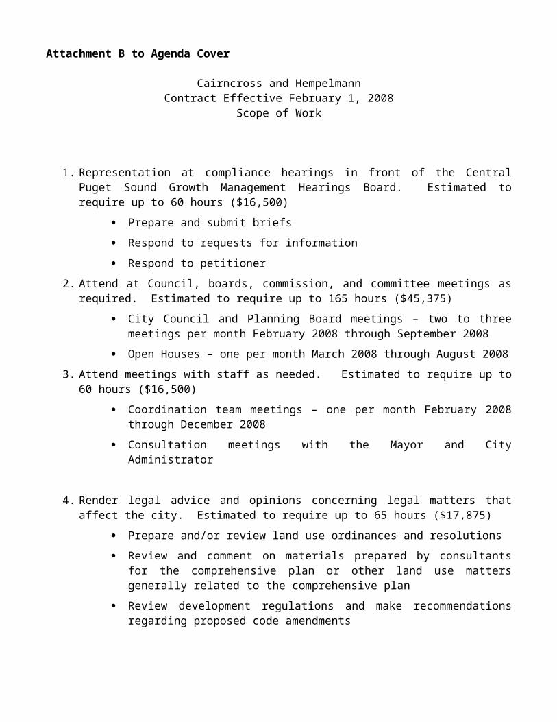
repositories. This information combined with that obtained from DAHP will assist in characterizing the culture history of the project area in order to determine the cultural context for the assessment report.
The report will include recommendations regarding the eligibility of archaeological resources identified in the project area for listing in the National Register provided that a reliable determination is possible based upon the results of the survey covered in this proposal. The report will also include an assessment of the potential effects of the proposed project on each significant cultural resource and recommendations for mitigation. If the significance of an archaeological site or historic property found in the project area cannot be determined from the site survey, formal subsurface investigations or other documentation may be required. Such methods, however, are not included in this scope. The report will be finalized after one round of review by WHPacific.
Assumptions: Site access will be reasonable and unrestricted.
No archaeological monitoring of geotechnical or environmental site assessment ground disturbance will be required.
No archaeological sites will be identified during the survey.
No human skeletal remains or historical buildings or structures will be identified during the survey.
If the significance of an archaeological site found in the project area cannot be determined from the site survey, additional formal subsurface investigations or other documentation may be required. Such methods, however, are not included in this scope.
Noise Analysis
The Federal Highway Administration (FHWA) is the agency responsible for administering the federal-aid highway program. Before those funds can be used for projects, the projects must be approved by FHWA, which can only grant its approval for projects that are developed in accordance with federal statutes and regulations. One of these regulations requires that a noise study be accomplished to determine what noise impacts, if any, will result from the proposed improvement and what measures will be taken to lessen those noise impacts.
Based on our current understanding of the proposed project, one sensitive receiver is located within the project vicinity that may experience an increase in traffic related noise. If the residential home, located immediately adjacent to the proposed roadway alignment will remain (i.e., will not be purchased with a Right-of-Way acquisition), a noise impact evaluation will need to be completed. Under these circumstances, Landau Associates will conduct a noise analysis that meets the FHWA/WSDOT noise evaluation criteria. This effort will require the following activities:
Site Visit: A site visit will be conducted to confirm the applicability of the screening criteria, to visually identify sensitive receivers, and to collect noise measurements.
Noise Screening Assessment: Noise conditions of the existing project area and the future worst-case hourly noise levels will be predicted with the Traffic Noise Modeling 2.5 software. These estimated noise levels will be compared with the FHWA/WSDOT noise abatement criteria.
Noise Report: A technical memorandum summarizing the existing conditions, future conditions, operational and construction impacts, and construction mitigation options will be prepared for review and approval by FHWA/WSDOT.
Assumptions: If the threshold for noise impacts is exceeded, a reasonable and feasible noise mitigation analysis will need
to be included in the noise report. This effort has been included as a contingent item within the scope.
Wetland Delineation, Mitigation Reporting, and Permitting Support
60

The purpose of this task is to prepare required documentation for permitting impacts to wetland and/or buffer habitat. Information from this task can also be used to provide complete information regarding natural resource elements on the site and can be used as a background document for permitting requirements and for State Environmental Policy Act (SEPA) requirements, if needed. This task includes the following subtasks, which are discussed in detail below:
Wetland Delineation and Jurisdictional Determination
Wetland Mitigation, Critical Area Report, Plans, and Specifications
Permitting Support (JARPA).
Wetland Delineation and Jurisdictional Determination
Landau Associates will conduct a wetland delineation in accordance with Ecology guidance and the 2008 U.S. Army Corps of Engineers (USACE) Interim Regional Supplement to the Corps of Engineers Wetland Delineation Manual: Western Mountains, Valleys, and Coast Region. Landau Associates will compile and review environmental information from readily available public domain resources to gain a general understanding of potential wetland issues at the site. Public domain resources include, but are not limited to:
Soil Survey data for Snohomish County
National Wetlands Inventory mapping
U.S. Geological Survey (USGS) topographic mapping
Recent aerial photography.
The field investigation will include an examination of vegetation, soils, and hydrology within the study area of the proposed roadway extension. Flagging will be placed along the wetland boundaries and will be confined to the project footprint (approximately 70 feet from the proposed roadway centerline). Any wetland habitat that extends beyond the project footprint, within 200 feet [as required for Critical Area study contents for wetlands and streams under the CITY’s Critical Area Regulations (CAR)], will be estimated both visually and using public domain resources in order to assess wetland extent. Included in this task is time to provide the WHPacific surveyors with a hand-sketch of wetland boundaries to assist the surveyors to locate the wetland flagging. Also included is time to review the wetland survey map and request any necessary changes to accurately represent existing wetland conditions.
Wetlands within the study area will be rated in accordance with Ecology’s Washington State Wetland Rating System for Western Washington, and buffer widths will be determined in compliance with the Sultan City Code, Chapter 16.80 Critical Areas Regulations. The WSDOT Wetland Function Evaluation will be completed for all delineated wetland habitat to characterize wetland functions.
Landau Associates will prepare a Draft Wetland Delineation Report in a format acceptable to the CITY and other regulating agencies that will include:
A summary of the methodology used
The size and rating of each wetland; a characterization of wetland vegetation, soils, and hydrology; and field data sheets
A scaled site map showing the locations of wetland boundaries and wetland buffers, locations of wetland data plots, and site topography.
A functional assessment of wetlands and/or buffers
A description of preliminary impacts to wetlands and/or buffers
Supporting photographs.
61

The draft report will be provided to WHPacific and the CITY for review. Comments will be reviewed and incorporated into a Final Wetland Delineation Report.
Landau Associates will request a Jurisdictional Determination (JD) from the USACE Seattle District in order to verify the wetland boundaries and regulation under the Clean Water Act. Landau Associates will make this request via submission of a Joint Aquatic Resources Permit Application (JARPA) to the USACE, including the wetland delineation report as an attachment. The JARPA will include a brief overview of the conceptual mitigation plan, including a schematic showing the preliminary design for mitigation that can be presented to regulatory agencies prior to completion of the mitigation design. This task is necessary in order make sure that all agencies support the plan and to reduce the need for multiple revisions of the agency review drafts prior to acceptance of the final mitigation plan.
A Landau Associates wetland biologist will meet on site with representatives from regulatory agencies. The USACE typically takes 1 to 3 months to set up a site visit for a JD visit. Following the JD, Landau Associates will prepare a memorandum documenting the outcome of this field meeting.
Deliverables: An electronic (Adobe PDF) copy of the draft and final wetland delineation report.
An electronic (Adobe PDF) copy of the draft JARPA as submitted to the agencies (City and USACE and/or Ecology).
An electronic (Adobe PDF) copy of the JD meeting documentation (as prepared by Landau Associates).
Wetland Mitigation, Critical Area Report, Plans, and Specifications
Landau Associates will prepare a Draft Critical Area Report for Streams and Wetlands in accordance with the CITY’s CAR, and in order to meet standards of other state or federal regulatory agencies. The report will include information from the Wetland Delineation report, and incorporate any necessary mitigation. This will include:
The Wetland Delineation Report
A summary of the methodology used
A description of impacts to wetlands and/or buffers
A wetland and/or buffer mitigation planting plan including: mitigation goals, objectives, and performance standards; a timeline for mitigation monitoring and reporting; and contingency plans
Planting lists and specifications that can be used for plant installation by a qualified landscaper to help assure success.
The draft report will be provided to WHPacific and the CITY/agencies for review. Comments will be reviewed and incorporated into a Final Critical Area Report for Streams and Wetlands
Deliverables: An electronic (Adobe PDF) and paper copy of the Draft Critical Area Report for Streams and
Wetlands.
An electronic (Adobe PDF) and paper copy of the Final Critical Area Report for Streams and Wetlands.
Electronic text of specifications for quality assurance will be delivered to WHPacific for incorporation into the document bid package.
Permitting Support (JARPA)
62

The JARPA form will be completed for submittal to USACE and/or the CITY to request approval for unavoidable wetland and/or buffer impacts, if necessary. This task includes time for coordination and revisions with WHPacific and/or agencies as needed to provide accurate information on the JARPA, including figures.
Deliverables: An electronic (Adobe PDF) and paper copy of the JARPA.
Assumptions: Wetland flagging will only be placed within the project boundaries where accessible.
Wetland grading plans and specifications (for wetland creation) will not be required.
Wetland mitigation can be accommodated on site (within the project limits). If offsite mitigation is required, the CITY will identify a suitable site to accommodate the required mitigation.
Mitigation plans and specifications will be incorporated by WHPacific into the overall design package.
If wetland impacts are regulated by the USACE, they will be authorized under a Nationwide permit (NWP).
Up to 8 hours of time is included for a Landau Associates biologist to coordinate with WHPacific, the CITY, regulatory agencies, and other consultants as needed, either by phone or in meetings, regarding wetland construction design and mitigation specifications.
A Landau Associates wetland biologist will meet onsite for one visit (up to 2 hours on site) with representatives from regulatory agencies for the JD.
State Environmental Policy Act Checklist
Using the information from the above tasks, a SEPA checklist will be prepared for the project. It is assumed that the CITY’s final determination will be a declaration of Non-Significance and that there will be no public comments or public hearing. It is also assumed that the CITY will circulate the SEPA and conduct the required public comment procedures.
Assumptions: The project will not require preparation of a SEPA Environmental Impact Statement, and either a
Determination of Non-Significance (DNS) or a mitigated DNS will be issued for the project.
CITY staff will prepare and publish the DNS (or mitigated DNS).
Landau Associates staff will not attend a public hearing should one be necessary.
One Landau Associates staff member will conduct one site visit.
One Landau Associates staff member will attend no more than one agency coordination meeting in Sultan, Washington.
Information to prepare the SEPA Checklist will be gathered from interviews with agency/utility provider representatives and from readily available public documents; no field work or other primary investigations will be required.
Landau Associates will provide a draft copy of the SEPA Checklist to the CITY for review. The CITY will provide one set of consolidated comments to Landau Associates, who will prepare a final SEPA Checklist for publication based on those comments. Should additional rounds of review and comment be requested by the CITY, a scope and budget amendment will be required.
This proposal does not include time for Landau Associates to respond to any public or resource agency comments on the SEPA Checklist after the Checklist has been published for public comment.
63

7.0 Preliminary Design and Report
The CONSULTANT will develop two (2) geometric design alternatives for the new roadway that reviews retaining wall verses fill slope options and intersection layout for Cascade View Drive. Each design alternative will include a plan, profile, typical section and cross sections. The CONSULTANT will prepare a brief design memorandum that will provide the basis for final design and plan preparation. The design memorandum will include the following elements:
A. Project Summary – A review of the project objectives and how the designs meet those objectives.
B. Preliminary Engineering – A discussion of the methodology, existing conditions and design criteria, and standards used in the approach to the preliminary designs.
C. Evaluation of Design Alternatives – A presentation of design alternatives studied, and justification for selection or non-selection. Evaluation and recommendation of two (2) design alternatives will consider costs, right-of-way acquisition, storm water collection, potential utility conflicts, environmental and permitting issues.
D. Proposed Improvements – A review of the technical elements comprising the proposed improvements including turning radii, sight distance and intersection geometry.
E. Cost Estimate – A summary of the estimated costs associated with the completion of the proposed improvements. Anticipated costs will be identified for design engineering, right-of-way acquisition, construction, and construction management.
F. Preliminary Improvement Plans – Plans for the improvements will consist of a channelization plan, plans and profile, typical section and cross sections. The scale of the plan sheets will be one inch equals twenty feet (1"=20'). The plans will be prepared using AutoCAD 2008 software and APWA standard symbols.
G. Review Comments – CITY review comments will be addressed and incorporated into the preliminary design plans and report.
Assumptions: CITY will review preliminary plan documents and provide one set of review comments.
Deliverables: An electronic (AutoCAD 2008) copy and paper copy of preliminary plans. An electronic (PDF) copy and paper copy of design memorandum.
8.0 Roadway Storm Drainage Analysis and Report
The CONSULTANT will develop a stormwater management system that will convey stormwater collected from the roadway pavements to detention and treatment facilities. The storm management system design will be based on the Washington State Department of Ecology (WSDOE) 2005 Stormwater Management Manual. Treatment and detention facilities will be evaluated to determine recommended type, size and location for accommodating roadway runoff. Facility layouts will include contour grading lines and elevations for ponds and swales, inlet/outlet details, and miscellaneous details. The CONSULTANT will prepare a brief technical memorandum, summarizing the roadway stormwater management system analysis and design. The report will include a project description, roadway corridor basin delineation map, summary of existing/proposed conditions hydrologic models, stormwater facility calculations, conveyance calculations, and a preliminary design proposed storm drainage system. The CITY will assist the CONSULTANT in identifying and recommending potential locations for stormwater facilities. Hydrologic and hydrologic models will be developed using Hydraflow software, by Autodesk. The CONSULTANT will prepare a draft Memorandum for CITY and Agency review, respond to comments on the draft Memorandum, and prepare a final document.
64

Deliverables: Stormwater System Technical Memorandum (Draft and Final) - (2) hard copies, electronic (.pdf) file
9.0 WSDOT Approvals
Channelization Plan
CONSULTANT will prepare and submit channelization plans to WSDOT for approval meeting WSDOT Design Manual Requirements. CONSULTANT will address WSDOT review comments and make revisions as needed. It is anticipated three (3) submittals will be made to WSDOT.
Signal Plan
CONSULTANT will submit to WSDOT for approval preliminary and final signal plans. CONSULTANT will address WSDOT review comments and make revisions as needed. It is anticipated three (3) submittals will be made to WSDOT.
10.0 Right of Way Plans
The CONSULTANT will prepare a right-of-way plan that shows existing right-of-way and proposed right-of-way along with permanent and temporary easements needed to accommodate the planned improvements.
The right-of-way plans will be drawn at a scale of one inch equals twenty feet (1"=20'). The base information on the maps will include surveyed topographic base mapping, property lines, right-of-way lines, easements, names of property owners, parcel areas, sections, townships, ranges and survey control information.
The CONSULTANT will obtain title reports needed to establish right-of-way. CONSULTANT will prepare legal descriptions and exhibit maps for those portions of the Site directly affected by the Sultan Basin Road realignment, specifically Snohomish County Tax Parcel Numbers 28083300303900, 28083300305200, 27080400201100 and 27080400201700.
Deliverables: An electronic (AutoCAD 2008) copy and paper copy of right of way plans. Signed Word document of Legal Descriptions and exhibit for all four parcels.
11.0 Final Design (60%, 90%, 100%)
Construction Plans
The CONSULTANT will prepare detailed construction plans of the proposed improvements, including:
Plans will be prepared with such provision and in such detail to permit convenient layout in the field for construction. The plans will be prepared using AutoCAD 2000 supported by Land Development Desktop Rel. 2i software.
The plans will include complete details for construction of the proposed improvements. The improvement plans will include details for excavating; placing embankment; pavement grinding; pavement/surfacing; sidewalks; storm drainage/water quality facilities; channelization, and pavement markings; landscaping; erosion control; signing; illumination; signal modification; traffic control; utility adjustments; and property/site restoration.
Plans will include plans and profiles, typical sections, and special details other than standard details available from the CITY, WSDOT, and the APWA Standard Drawings.
The scale for the plan and profiles will be one inch equals twenty feet (1"=20') horizontally, and one inch equals five feet (1"=5') vertically.
65

The complete plan set for the project will include the following plan sheets:
Estimated Sheets Description 1 Cover sheet 2 Typical roadway sections, details and note sheets1 Miscellaneous details 10 Roadway, storm drainage, waterline, and utility plans and profile2 Temporary erosion control plans4 Channelization/Signing/Illumination Plans3 Traffic Signal Plans2 Landscape Plans3 Wall Plans
2 Traffic Control Plans 30 Total
Specifications
The CONSULTANT will prepare the specifications for the project in conformance with the WSDOT 2008 Standard Specifications. CONSULTANT will assemble the complete specifications document for the project at 60%, 90%, and 100% complete submittals. CITY will provide the “Boiler Plate” version of the specification and general special provisions. The “Boiler Plate” version will be edited by supplementing as necessary with project specific information and by deleting unnecessary special provisions.
Cost Estimate
The CONSULTANT will prepare bid items and quantities and engineer’s estimate of probable cost for the proposed improvements at 60%, 90% and 100% complete design. The engineer's estimate of probable cost will be based upon the construction plans, bid item quantities, and current bid prices for similar work.
Review Documents
The CONSULTANT will provide five (5) half-size review plan sets, one (1) construction cost estimate, and one (1) specifications document for CITY review at the 60% and 90% complete submittal. Periodically during plan development, CONSULTANT will provide the CITY with a copy of the current working drawings. CITY will provide CONSULTANT with "redline" review comments on one set of plans and specifications.
Final PS&E Documents
The CONSULTANT will provide the CITY with all final plan sheets on standard 22-inch by 34-inch Mylar. CONSULTANT will provide design calculations, cost estimate, and specifications on 8.5-inch by 11-inch sheets. The electronic files for the AutoCAD plan drawings and specifications will be copied on a compact disc. The CONSULTANT will provide one (1) set of half size contract plans on bond paper and one (1) set of contract documents and specifications for contractor bidding purposes. CITY will be responsible for reproduction and distribution of these documents.
12.0 Schedule for Completion
The CONSULTANT will begin work upon the CITY issuing a notice-to-proceed for the work. A detailed schedule will be developed within the first month of work.
13.0 Advertise and Award
The CONSULTANT will assist the CITY in preparing the advertisement and responding to contractor calls. The CONSULTANT will prepare up to two (2) addendums as necessary for the CITY to distribute to plan holders. CONSULTANT will evaluate the bids received and prepare a recommendation for the CITY’s review.
Deliverables:
66

Project advertisement Award recommendations Bid tabulation
14.0 Construction Engineering
The CITY reserves the right to supplement this contract to provide all or a portion of the following work during the construction phase of this project: construction management, inspection, and arranging for geotechnical and material testing services to be provided during construction as needed.
15.0 Optional Services
Upon written approval by the CITY, the CONSULTANT will provide engineering services beyond this Scope of Work. Services may include additional meetings, adding additional or increasing the existing design tasks, right-of-way acquisition services, construction services or other work deemed necessary by the CITY. Such work will be specified in a written supplement to this agreement, which will establish the scope and costs.
67


August 18, 2008
WHPacific3350 Monte Villa ParkwayBothell, Washington 98021
Attn: Mr. Sam Richard
RE: PROPOSAL FOR GEOTECHNICAL ENGINEERING AND NATURAL RESOURCE SERVICESSULTAN BASIN ROAD REALIGNMENT, PHASE IIISULTAN, WASHINGTON
Dear Mr. Richard:Landau Associates is pleased to present this proposed scope of services and cost estimate for geotechnical
engineering and natural resource services for the Sultan Basin Road Realignment Project, Phase III, in Sultan, Washington. The proposed scope of services presented in this letter is based on discussions with and information provided by WHPacific and a site reconnaissance. Presented below is a summary of our project understanding and proposed scope of services.
PROJECT BACKGROUND
We understand that the City of Sultan (City) plans to realign Sultan Basin Road south of U.S. Highway 2 (U.S. 2) to complete the intersection improvements at Sultan Basin Road and U.S. 2. In particular, the project involves a new segment of roadway from U.S. 2 south to Cascade View Drive. The proposed roadway improvements will result in a four-way intersection at Sultan Basin Road and U.S. 2, thereby eliminating the U.S. 2-Cascade View Drive intersection.
We understand that the new segment of roadway south of U.S. 2 will require an embankment up to 30 feet (ft) in height and that retaining walls are planned to limit the extent of the embankment footprint. We also understand that federal funds through the Washington State Department of Transportation (WSDOT) have been authorized for the project. Thus, environmental documentation is necessary to satisfy federal requirements.
PROPOSED SCOPE OF SERVICES
The following sections define Landau Associates’ tasks for geotechnical engineering and natural resource services for the proposed intersection improvements project.
Task 1. Geotechnical Engineering
We will compile and review readily available geologic and geotechnical information and other data relevant to the project. This information will be used to gain a general understanding of past human activities (filling, construction, etc.) and the underlying geology in the project area. Possible data sources include information in Landau Associates’ and the City’s files (construction drawings, utility layouts, geotechnical reports prepared for projects in the vicinity, etc.), and published geologic and topographic maps.
After reviewing the available data, we will complete a geologic reconnaissance of the project area to collect information on the general nature and physical features of the project site and to mark out proposed exploration locations for the one-call utility locate service. Following the site reconnaissance, we propose to advance two exploratory borings to depths of 15 to 30 ft along the proposed alignment to characterize soil and groundwater conditions. Washington State Department of Archeology and Historic Preservation approval of the Area of Potential Effects (see Task 3) must be completed for the exploratory borings to commence. The proposed project includes construction of a new signal pole at the intersection of U.S. 2 and Sultan Basin Road. We propose to utilize past explorations completed in the intersection during earlier phases of the project.

A drilling contractor under subcontract to Landau Associates will complete the exploratory borings. For the purpose of our cost estimate, it is assumed that the site will require a limited-access drill rig into order to complete the proposed borings. Landau Associates will also arrange for underground utility locates (“call before you dig”) prior to performing field activities. The exploratory borings will be located along the proposed alignment of Sultan Basin Road, which is located on private property. A private underground utility locating service under subcontract to our firm will check the planned exploration locations for potential conflicts. It is assumed that the City will obtain permission to enter private property for all exploratory borings located beyond the public right-of-way.
A geologist or geotechnical engineer from Landau Associates will supervise the explorations, obtain soil samples from the borings, and prepare field logs of conditions encountered in the explorations. Soil samples will be obtained from the exploratory borings on about a 2½- or 5-ft depth interval using the Standard Penetration Test (SPT) procedure, and returned to our laboratory for further examination and classification. Soil samples obtained from the explorations will be held in our laboratory for 30 days after submittal of the final report. After that date, the soil samples will be disposed of unless arrangements are made to retain them. We do not plan to install piezometers to monitor groundwater levels; however, groundwater levels will be noted at the time of drilling. Upon completion of sampling and logging, the borings will be backfilled in accordance with the applicable sections of WAC 173-160.
We will complete a limited geotechnical laboratory testing program consisting of natural moisture content and grain-size determinations on selected soil samples to aid in classifying the site soils. We have budgeted for 10 moisture content and 4 grain-size determinations.
Information from the field investigation and laboratory testing program will be analyzed by a geotechnical engineer from Landau Associates to develop geotechnical engineering conclusions and recommendations for design and construction of the proposed intersection improvements. The results of our field explorations, laboratory testing, engineering analyses, and geotechnical engineering conclusions and recommendations will be summarized in a draft geotechnical report for review by WHPacific. Two (2) copies of the draft report will be provided for review by the project team. Upon receipt of review comments, we will address the comments and submit six (6) copies of a signed and sealed geotechnical report. The geotechnical report will include:
A site plan showing the locations of the explorations completed for this study (we assume that WHPacific will provide a base map in AutoCAD format).
Results of laboratory testing and logs of the exploratory borings.
A discussion of the near-surface soil and groundwater conditions observed in the explorations at the project site.
Geotechnical conclusions and recommendations for the project, including:
– a discussion of subgrade support characteristics along the project alignment
– recommendations for subgrade preparation for new pavement sections, including reuse of site soil, and criteria for selection, placement, and compaction of structural fill
– a discussion regarding stability of embankment fill slopes and overall global stability of proposed retaining walls
– recommendations and geotechnical design parameters for retaining wall design
– recommendations regarding pavement sections
– recommended allowable soil stress for use in the WSDOT signal standard foundation design method
– recommendations for geotechnical monitoring and consultation during construction.
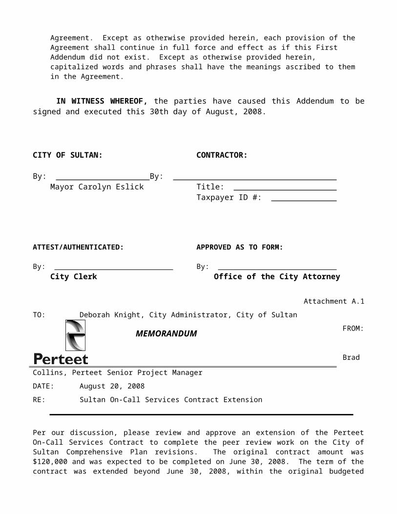
Task 2. Effect Determination and Essential Fish Habitat Evaluation, and Environmental Classification Summary
We propose to prepare an effect determination letter rather than a biological assessment, documenting no effects on species listed under the Endangered Species Act. We assume that the project will not require any in-water work and that the design will follow either the WSDOT Highway Runoff Manual or the Washington State Department of Ecology’s (Ecology’s) 2005 manual for treatment and detention of stormwater. Information on new impervious surfaces, stormwater detention and water quality treatment, temporary erosion control measures, and best management practices will be provided by WHPacific. The effect determination letter will also include an evaluation of project impacts on Essential Fish Habitat (EFH).
We will prepare the required Environmental Classification Summary (ECS) for the project. This includes a National Environmental Policy Act (NEPA) determination. We assume the project will be a Class II, Categorical Exclusion (CE). This will include the Section 106 Cultural Resource investigations and noise analysis, which are discussed separately in the following sections, as well as the endangered species compliance included above.
Assumptions: The project will include design components necessary to make a determination of no effect for listed
species and critical habitat.
No in-water work will occur.
Meetings with agency staff [National Oceanic and Atmospheric Administration (NOAA), U.S. Fish & Wildlife Service (USFWS)] are not included in this proposal.
The project will qualify as a Class II Categorical Exclusion.
An air quality analysis and associated discipline report will not be required. The City is not in a carbon monoxide maintenance area.
This task does not include efforts to perform six month updates of species listings, if necessary.
Task 3. Section 106 Cultural Historic Resources
A Landau Associates archaeologist will conduct a records search for the project at the Washington State Department of Archaeology and Historic Preservation (DAHP) prior to the field survey. Landau Associates cultural resources staff will review cultural resource records, reports, National Register of Historic Places (National Register) nomination forms, and historic property inventory forms on file at DAHP. This information will help us determine if any archaeological or historic sites have been previously recorded on or near the property and draft an Area of Potential Effects (APE) letter for the client.
Following a records research and concurrence on the APE, two Landau Associates archaeologists will conduct a surface survey of the project area. A 10-meter (approximately 30 ft) interval pedestrian survey transect will be aligned along the proposed new street right-of-way for the survey. We will also excavate subsurface probes to search for buried archaeological resources. We assume that subsurface testing will require no more than six shovel probes excavated approximately every 20 meters (approximately 60 ft) along the centerline of the proposed new road segment, avoiding wetland areas. Each probe will measure 40 centimeters (cm; approximately 16 inches) in diameter and will be excavated to a maximum of 100 cm (approximately 40 inches) below the ground surface to adequately cover proposed ground disturbance within the project area. Excavated matrix will be screened through ¼-inch mesh and examined for prehistoric and historic-period artifacts. If significant archaeological materials are discovered during the course of the survey, sites (a feature or more than two artifacts) and isolates (one artifact) will be photographed and documented on maps and appropriate DAHP forms.
A draft report will be prepared following the State of Washington Archaeological Survey and Reporting Standards. Site records and isolate forms will be attached if cultural resources are identified during the survey. Landau Associates will review relevant archaeological, ethnohistorical, and historical reports along with

documents, historical aerial photographs, and maps available at the University of Washington libraries and other local repositories. This information combined with that obtained from DAHP will assist in characterizing the culture history of the project area in order to determine the cultural context for the assessment report.
The report will include recommendations regarding the eligibility of archaeological resources identified in the project area for listing in the National Register provided that a reliable determination is possible based upon the results of the survey covered in this proposal. The report will also include an assessment of the potential effects of the proposed project on each significant cultural resource and recommendations for mitigation. If the significance of an archaeological site or historic property found in the project area cannot be determined from the site survey, formal subsurface investigations or other documentation may be required. Such methods, however, are not included in this scope. The report will be finalized after one round of review by WHPacific.
Assumptions: Site access will be reasonable and unrestricted.
Project boundaries will be clearly marked by WHPacific and readily identifiable by Landau Associates staff in the field.
No archaeological monitoring of geotechnical or environmental site assessment ground disturbance will be required.
No archaeological sites will be identified during the survey.
No human skeletal remains or historical buildings or structures will be identified during the survey.
If the significance of an archaeological site found in the project area cannot be determined from the site survey, additional formal subsurface investigations or other documentation may be required. Such methods, however, are not included in this scope.
Task 4. Noise Analysis
The Federal Highway Administration (FHWA) is the agency responsible for administering the federal-aid highway program. Before those funds can be used for projects, the projects must be approved by FHWA, which can only grant its approval for projects that are developed in accordance with federal statutes and regulations. One of these regulations requires that a noise study be accomplished to determine what noise impacts, if any, will result from the proposed improvement and what measures will be taken to lessen those noise impacts.
Based on our current understanding of the proposed project, one sensitive receiver is located within the project vicinity that may experience an increase in traffic related noise. If the residential home, located immediately adjacent to the proposed roadway alignment will remain (i.e., will not be purchased with a Right-of-Way acquisition), a noise impact evaluation will need to be completed. Under these circumstances, Landau Associates will conduct a noise analysis that meets the FHWA/WSDOT noise evaluation criteria. This effort will require the following activities:
Site Visit: A site visit will be conducted to confirm the applicability of the screening criteria, to visually identify sensitive receivers, and to collect noise measurements.
Noise Screening Assessment: Noise conditions of the existing project area and the future worst-case hourly noise levels will be predicted with the Traffic Noise Modeling 2.5 software. These estimated noise levels will be compared with the FHWA/WSDOT noise abatement criteria.
Noise Report: A technical memorandum summarizing the existing conditions, future conditions, operational and construction impacts, and construction mitigation options will be prepared for review and approval by FHWA/WSDOT.
Assumptions:

WHPacific will provide traffic data from existing and future design year conditions in the project area.
If the threshold for noise impacts is exceeded, a reasonable and feasible noise mitigation analysis will need to be included in the noise report. This effort has been included as a contingent item within the scope.
Task 5. Wetland Delineation, Mitigation Reporting, and Permitting Support
The purpose of this task is to prepare required documentation for permitting impacts to wetland and/or buffer habitat. Information from this task can also be used to provide complete information regarding natural resource elements on the site and can be used as a background document for permitting requirements and for State Environmental Policy Act (SEPA) requirements, if needed. This task includes the following subtasks, which are discussed in detail below:
5.1 Wetland Delineation and Jurisdictional Determination
5.2 Wetland Mitigation, Critical Area Report, Plans, and Specifications
5.3 Permitting Support (JARPA).
5.1 Wetland Delineation and Jurisdictional DeterminationLandau Associates will conduct a wetland delineation in accordance with Ecology guidance and the 2008
U.S. Army Corps of Engineers (USACE) Interim Regional Supplement to the Corps of Engineers Wetland Delineation Manual: Western Mountains, Valleys, and Coast Region. Landau Associates will compile and review environmental information from readily available public domain resources to gain a general understanding of potential wetland issues at the site. Public domain resources include, but are not limited to:
Soil Survey data for Snohomish County
National Wetlands Inventory mapping
U.S. Geological Survey (USGS) topographic mapping
Recent aerial photography.
The field investigation will include an examination of vegetation, soils, and hydrology within the study area of the proposed roadway extension. Flagging will be placed along the wetland boundaries and will be confined to the project footprint (approximately 70 ft from the proposed roadway centerline). Any wetland habitat that extends beyond the project footprint, within 200 ft [as required for Critical Area study contents for wetlands and streams under the City’s Critical Area Regulations (CAR)], will be estimated both visually and using public domain resources in order to assess wetland extent. Included in this task is time to provide the WHPacific surveyors with a hand-sketch of wetland boundaries to assist the surveyors to locate the wetland flagging. We also included time to review the wetland survey map and request any necessary changes to accurately represent existing wetland conditions.
Wetlands within the study area will be rated in accordance with Ecology’s Washington State Wetland Rating System for Western Washington, and buffer widths will be determined in compliance with the Sultan City Code, Chapter 16.80 Critical Areas Regulations. The WSDOT Wetland Function Evaluation will be completed for all delineated wetland habitat to characterize wetland functions.
Landau Associates will prepare a Draft Wetland Delineation Report in a format acceptable to the City and other regulating agencies that will include:
A summary of the methodology used
The size and rating of each wetland; a characterization of wetland vegetation, soils, and hydrology; and field data sheets

A scaled site map showing the locations of wetland boundaries and wetland buffers, locations of wetland data plots, and site topography.
A functional assessment of wetlands and/or buffers
A description of preliminary impacts to wetlands and/or buffers
Supporting photographs.
The draft report will be provided to WHPacific and the City for review. Comments will be reviewed and incorporated into a Final Wetland Delineation Report.
Landau Associates will request a Jurisdictional Determination (JD) from the USACE Seattle District in order to verify the wetland boundaries and regulation under the Clean Water Act. Landau Associates will make this request via submission of a Joint Aquatic Resources Permit Application (JARPA) to the USACE, including the wetland delineation report as an attachment. The JARPA will include a brief overview of the conceptual mitigation plan, including a schematic showing the preliminary design for mitigation that can be presented to regulatory agencies prior to completion of the mitigation design. This task is necessary in order make sure that all agencies support the plan and to reduce the need for multiple revisions of the agency review drafts prior to acceptance of the final mitigation plan.
A Landau Associates wetland biologist will meet on site with representatives from regulatory agencies. The USACE typically takes 1 to 3 months to set up a site visit for a JD visit. Following the JD, Landau Associates will prepare a memorandum documenting the outcome of this field meeting.
Deliverables: An electronic (Adobe PDF) copy of the draft and final wetland delineation report.
An electronic (Adobe PDF) copy of the draft JARPA as submitted to the agencies (City and USACE and/or Ecology).
An electronic (Adobe PDF) copy of the JD meeting documentation (as prepared by Landau Associates).
5.2 Wetland Mitigation, Critical Area Report, Plans, and SpecificationsLandau Associates will prepare a Draft Critical Area Report for Streams and Wetlands in accordance with
the City’s CAR, and in order to meet standards of other state or federal regulatory agencies. The report will include information from the Wetland Delineation report, and incorporate any necessary mitigation. This will include:
The Wetland Delineation Report
A summary of the methodology used
A description of impacts to wetlands and/or buffers
A wetland and/or buffer mitigation planting plan including: mitigation goals, objectives, and performance standards; a timeline for mitigation monitoring and reporting; and contingency plans
Planting lists and specifications that can be used for plant installation by a qualified landscaper to help assure success.
The draft report will be provided to WHPacific and the City/agencies for review. Comments will be reviewed and incorporated into a Final Critical Area Report for Streams and Wetlands
Deliverables: An electronic (Adobe PDF) and paper copy of the Draft Critical Area Report for Streams and
Wetlands.

An electronic (Adobe PDF) and paper copy of the Final Critical Area Report for Streams and Wetlands.
Electronic text of specifications for quality assurance will be delivered to WHPacific for incorporation into the document bid package.
5.3 Permitting Support (JARPA)The JARPA form will be completed for submittal to USACE and/or the City to request approval for
unavoidable wetland and/or buffer impacts, if necessary. This task includes time for coordination and revisions with WHPacific and/or agencies as needed to provide accurate information on the JARPA, including figures.
Deliverables: An electronic (Adobe PDF) and paper copy of the JARPA.
Assumptions: Wetland flagging will only be placed within the project boundaries where accessible.
WHPacific will supply survey information in AutoCAD format to Landau Associates pertaining to the wetland delineation and project plans, including the limits of clearing and grading, the final project footprint, drainage and erosion control plans, and construction phasing details.
Wetland grading plans and specifications (for wetland creation) will not be required.
Wetland mitigation can be accommodated on site (within the project limits). If offsite mitigation is required, the City will identify a suitable site to accommodate the required mitigation.
Mitigation plans and specifications will be incorporated by WHPacific into the overall design package.
WHPacific will provide Landau Associates with the areas of impact and amount of fill and/or grading within wetlands and wetland and/or buffer.
If wetland impacts are regulated by the USACE, they will be authorized under a Nationwide permit (NWP).
WHPacific will prepare the bid package documents. Landau Associates will supply information as requested by WHPacific to support preparation of these documents.
WHPacific will be responsible for coordination with the City and Landau Associates during review and finalization of the document bid package. Landau Associates will not coordinate directly with the City regarding revisions to the contract document.
We have included up to 8 hours of time for a Landau Associates biologist to coordinate with WHPacific, the City, regulatory agencies, and other consultants as needed, either by phone or in meetings, regarding wetland construction design and mitigation specifications.
A Landau Associates wetland biologist will meet onsite for one visit (up to 2 hours on site) with representatives from regulatory agencies for the JD.
Task 6. State Environmental Policy Act Checklist
Using the information from the above tasks, we will prepare a SEPA checklist for the project. We assume that the City’s final determination will be a declaration of Non-Significance and that there will be no public

comments or public hearing. We also assume that the City will circulate the SEPA and conduct the required public comment procedures.
Assumptions: The project will not require preparation of a SEPA Environmental Impact Statement, and either a
Determination of Non-Significance (DNS) or a mitigated DNS will be issued for the project.
City staff will prepare and publish the DNS (or mitigated DNS).
Landau Associates staff will not attend a public hearing should one be necessary.
One Landau Associates staff member will conduct one site visit.
One Landau Associates staff member will attend no more than one agency coordination meeting in Sultan, Washington.
Information to prepare the SEPA Checklist will be gathered from interviews with agency/utility provider representatives and from readily available public documents; no field work or other primary investigations will be required.
Landau Associates will provide a draft copy of the SEPA Checklist to the City for review. The City will provide one set of consolidated comments to Landau Associates, and we will prepare a final SEPA Checklist for publication based on those comments. Should additional rounds of review and comment be requested by the City, a scope and budget amendment will be required.
This proposal does not include time for Landau Associates to respond to any public or resource agency comments on the SEPA Checklist after the Checklist has been published for public comment. Should the City or WHPacific request Landau Associates’ involvement in responses or revisions to the SEPA Checklist based on public or agency comments, a scope and budget amendment will be required.
ESTIMATED COST
We estimate the cost for our proposed scope of services will be $69,795 in general accordance with the following approximate breakdown:
Geotechnical Engineering Services $16,695
Natural Resources Services
Effect Determination Letter, Essential Fish Habitat Evaluation, and Environmental Classification Summary
$10,000
Section 106 Cultural Historic Resources $12,000
Noise Analysis $12,100
Wetland Delineation and Conceptual Mitigation
SEPA Checklist
$13,700
$5,300
ESTIMATED TOTAL $69,795
We propose to provide the above-described services on a cost plus fixed fee basis according to the budget set forth above. In the event that project requirements change or unexpected conditions are disclosed that appear to require further field effort, study, or analysis, we will contact you and seek your approval for modification to the scope of services and budget, as appropriate.

AUTHORIZATION
We anticipate that you will develop a subconsultant agreement consistent with other agreements between WHPacific and Landau Associates to formalize our working relationship on this project. Please let us know how we can assist you in that process.
We appreciate the opportunity to work with WHPacific and the City of Sultan on this project. Please contact us if you have any questions about our proposed scope of services and budget for this project.
LANDAU ASSOCIATES, INC.
Steven J. QuartermanSenior Project Scientist
Steven R. Wright, P.E.Senior Associate
SJQ/SZW/kes
Attachments: Table 1 – Geotechnical Fee Determination Summary SheetTable 2 – Effect Determination/EFH, ECS Fee Determination Summary SheetTable 3 – Cultural Resources Fee Determination Summary SheetTable 4 – Noise Fee Determination Summary SheetTable 5 – Wetland, Mitigation, and Permitting Fee Determination Summary SheetTable 6 – SEPA Fee Determination Summary Sheet
SULTAN CITY COUNCIL AGENDA ITEM COVER SHEET
ITEM NO: A-1
DATE: August 28, 2008
SUBJECT: First Reading of Ordinance ApprovingVacation of a portion of Sultan Basin RoadTerra Ex Land Group, Petitioner
CONTACT PERSON: Robert Martin, Community Development Director
ISSUE: Vacation of a portion of Sultan Basin Road.
STAFF RECOMMENDATION: Staff recommends that Council:
Conduct the first reading of Ordinance 989-08.
SUMMARY: Vacation of a public right-of-way is a process controlled by statute (RCW 35.79). Once a petitioner has completed the submittals required by the statute, it is necessary for the legislative body (or designee) to hold a public hearing. The City Council carries that responsibility in Sultan.
In a vacation, the petitioner is not purchasing land. The petitioner is purchasing the public right-of-way (the public’s right to access across the land) that is a legal encumbrance on the land.
Terra Ex Land Group is requesting vacation of approximately 860 lineal feet of un-used right-of-way of Sultan Basin Road north of its previous intersection with Hwy. 2 (Attachment C). Sultan Basin Road has been reconstructed such that its intersection with Hwy. 2 is approximately 600 feet east of its previous intersection. The right-of-way proposed for vacation is no longer used as a public traveled way. The petitioner is pursuing a commercial development that will include the land proposed for vacation.
Petitions for vacation must be accompanied by:7. Appropriate fees (received) 8. An appraisal of the property by a qualified appraisal firm (received).9. Legal description of the property proposed for vacation (received).10.Signatures of at least 2/3 of the property owners abutting the proposed vacation
(received).11. Indication that no property will lose legal access to a public right-of-way through the
proposed vacation (received).12.A discussion of the public interest served by the proposed vacation (received).
ANALYSIS:

1. The statute (RCW 35.79.010) requires that a vacation petition be “signed by the owners of more than two-thirds of the property abutting upon the part of such street or alley sought to be vacated.” The petitioner owns property well in excess of the two-thirds minimum. There is only one other owner abutting. This owner is not required to sign the petition.
2. The right-of-way proposed for vacation occupies 43,743 sq.ft. (just over one acre).3. If the vacation is ultimately approved, the right of access for a public street will no longer
exist. Since there are utilities in the street corridor, the city will need to retain easements for the operation and maintenance of these utilities. This will limit use of the vacated corridor to parking lots, landscaping, and other uses that do not include construction of buildings.
4. The application shows that all affected properties will retain access to public roads.5. The application indicates that the public interest served by the petition is pursuit of a
commercial development that will benefit the community’s economic development interests. (Note that consideration or approval of the street vacation does not imply any such consideration or approval of the intended commercial development.)
ALTERNATIVES:1. Conduct the first reading, thereby continuing the vacation process.2. Do not conduct the first reading, thereby terminating the vacation process.
FISCAL IMPACT:1. It is expected that the municipality receives, on behalf of the public, compensation for the
public’s loss of access rights. An independent appraisal paid for by the petitioner is the customary basis for establishing the value. If, after the public hearing, Council determines to continue action on the vacation, Council has the option of hiring its own appraiser for a second opinion.
2. The appraisal submitted by the petitioner has been completed by a Certified General Appraiser (Paul C. Bird of Macauly & Associates Limited). He has determined the value of the acquired right-of-way (subject to ongoing utility easements which prevent building of structures on the vacated property) to be $130,000.
3. RCW 35.79.030 provides that the owners abutting the right-of-way “shall compensate such city or town in an amount which does not exceed one-half the appraised value of the area so vacated. If the street or alley has been part of a dedicated public right-of-way for twenty-five years or more, … the city or town may require the owners of the property abutting the street or alley to compensate the city or town in an amount that does not exceed the full appraised value.”
4. As this has been right-of-way for over twenty-five years, the Council has the prerogative of charging up to the full appraised value. For a vacation in July of 2005, the City charged one-half of the appraised value, but this is not a precedent. There is no code-prescribed or statute-prescribed methodology for negotiating the charge other than that cited in item 6 above.
5. The statute requires that at least one-half (1/2) of the amount received be expended on “acquisition, improvement, development, and related maintenance of public open space or transportation capital projects within the city or town.”

DISCUSSION:Ordinance No. 989.08 vacates approximately 860 lineal feet of the closed section of SBR north of and adjacent to the new intersection with US 2.
The ordinance sets the consideration for vacation at one-half the appraised value ($65,000.00) determined by the petitioner’s appraiser.
State Statue RCW 39.79.030 requires that at least one-half (1/2) of the amount received (32,500.00) be expanded on “acquisition, improvement, development etc..City Staff recommend the City Council use $32,000.00, to support the 2009 Parks Operating Budget for maintenance of public open space.
The remaining $32,500.00 should be put into the contingency fund to be used if necessary to balance the 2008 budget or cover any unanticipated expenses.
RECOMMENDED ACTION: 1. Conduct the first reading of Ordinance 989-08
ATTACHMENTS:Attachment A: Draft of Ordinance 989-08, including “Exhibit A” and “Exhibit B”.

ATTACHMENT A
ORDINANCE 989-08AN ORDINANCE OF THE CITY OF SULTAN, VACATING A PORTION OF SULTAN BASIN ROAD NORTH OF ITS CLOSED INTERSECTION WITH
STATE ROUTE 2 IN THE CITY OF SULTAN, WASHINGTON.
WHEREAS, Terra X Land Group has filed a complete petition for vacation of a portion of Sultan Basin Road as provided by RCW 35.79; and
WHEREAS, Terra X Land Group owns land in excess of the minimum of two-thirds (2/3) of the land abutting the right-of-way proposed for vacation as required by RCW 35.79.010, and is therefore qualified to submit a peition for vacation of the subject right-of-way; and
WHEREAS, the City of Sultan Planning Board held a public hearing on this amendment proposal at its regular meeting of May 6, 2008; and
WHEREAS, the City Council held a public hearing on this vacation petition at its regular meeting of August 14, 2008;
NOW THEREFORE, THE CITY COUNCIL OF THE CITY OF SULTAN , WASHINGTON DOES HEREBY ORDAIN AS FOLLOWS:
Section 1. Street Vacation: The following described portion of right-of-way commonly known as the 860 lineal feet of the closed section of Sultan Basin Road directly north of and adjacent to its intersection with State Route 2 is hereby vacated:
“Exhibit A”, a map of the subject right-of-way is attached and hereby made a part of this ordinance.
“Exhibit B”, “RIGHT OF WAY VACATION LEGAL DESCRIPTION” which describes the right-of-way to be vacated by this ordinance is attached and hereby made a part of this ordinance.
The City of Sultan retains all existing easements burdening the vacated property, and likewise retains the right to grant additional easements necessary or useful for public utilities and services as authorized by RCW 35.79.030.
Section 2. Consideration for Vacation: The vacation authorized in Section 1 of this ordinance shall be effective only upon payment of $65,000 by petitioner to the City of Sultan. At least one-half of such amount shall be dedicated for the acquisition or maintenance of public open space or transportation capital projects within the City of Sultan, as required by RCW 35.79.030.
Section 3. Recording with County Auditor: The City Clerk is requested to record with the Snohomish County Auditor a certified copy of this Ordinance.

Section 4. Severability: Should any section, paragraph, sentence, clause or phrase of this ordinance, or its application to any person or circumstance, be declared unconstitutional or otherwise invalid for any reason, or should any portion of this ordinance be pre-empted by state or federal law or regulation, such decision or pre-emption shall not affect the validity of the remaining portions of this ordinance or its application to other persons or circumstances.
Section 5. Effective Date: This ordinance shall be published in the official newspaper of the City, and shall take effect and be in full force (5) days after the date of publication.
PASSED by the City Council and APPROVED by the Mayor the __th day of ___________, 20__.
CITY OF SULTAN
By______________________________Carolyn Eslick, Mayor
Attest:
By_______________________________Laura Koenig, City Clerk
Approved as to form:
By_______________________________Kathy Hardy, City Attorney

ORDINANCE 989-08AN ORDINANCE OF THE CITY OF SULTAN, VACATING A PORTION OF SULTAN BASIN ROAD NORTH OF ITS CLOSED INTERSECTION WITH STATE ROUTE 2 IN
THE CITY OF SULTAN, WASHINGTON.
WHEREAS, Terra X Land Group has filed a complete petition for vacation of a portion of Sultan Basin Road as provided by RCW 35.79; and
WHEREAS, Terra X Land Group owns land in excess of the minimum of two-thirds (2/3) of the land abutting the right-of-way proposed for vacation as required by RCW 35.79.010, and is therefore qualified to submit a petition for vacation of the subject right-of-way; and
WHEREAS, the City of Sultan Planning Board held a public hearing on this amendment proposal at its regular meeting of May 6, 2008; and
WHEREAS, the City Council held a public hearing on this vacation petition at its regular meeting of August 14, 2008;
NOW THEREFORE, THE CITY COUNCIL OF THE CITY OF SULTAN , WASHINGTON DOES HEREBY ORDAIN AS FOLLOWS:
Section 1. Street Vacation: The following described portion of right-of-way commonly known as the 860 lineal feet of the closed section of Sultan Basin Road directly north of and adjacent to its intersection with State Route 2 is hereby vacated:
“Exhibit A”, a map of the subject right-of-way is attached and hereby made a part of this ordinance.
“Exhibit B”, “RIGHT OF WAY VACATION LEGAL DESCRIPTION” which describes the right-of-way to be vacated by this ordinance is attached and hereby made a part of this ordinance.
The City of Sultan retains all existing easements burdening the vacated property, and likewise retains the right to grant additional easements necessary or useful for public utilities and services as authorized by RCW 35.79.030.
Section 2. Consideration for Vacation: The vacation authorized in Section 1 of this ordinance shall be effective only upon payment of $65,000 by petitioner to the City of Sultan. At least one-half of such amount shall be dedicated for the acquisition or maintenance of public open space or transportation capital projects within the City of Sultan, as required by RCW 35.79.030.
Section 3. Recording with County Auditor: The City Clerk is requested to record with the Snohomish County Auditor a certified copy of this Ordinance.
Section 4. Severability: Should any section, paragraph, sentence, clause or phrase of this ordinance, or its application to any person or circumstance, be declared unconstitutional or otherwise invalid for any reason, or should any portion of this ordinance be pre-empted by state or federal law or regulation, such decision or pre-emption shall not affect the validity of the remaining portions of this ordinance or its application to other persons or circumstances.

Section 5. Effective Date: This ordinance shall be published in the official newspaper of the City, and shall take effect and be in full force (5) days after the date of publication.
PASSED by the City Council and APPROVED by the Mayor the __th day of ___________, 20__.
CITY OF SULTAN
By______________________________Carolyn Eslick, Mayor
Attest:
By_______________________________Laura Koenig, City Clerk
Approved as to form:
By_______________________________Kathy Hardy, City Attorney

SULTAN CITY COUNCILAGENDA ITEM COVER SHEET
ITEM NO: A-2
DATE: August 28, 2008
SUBJECT: First Reading Ordinance No. 979-08Amendments to SMC 2.26 Hearing Examiner
CONTACT PERSON: Deborah Knight, City Administrator
ISSUE:The issue before the City Council is to have First Reading of Ordinance No. 979-08 amending Sultan Municipal Code (SMC) 2.26 – Hearing Examiner to delete sections of the code that reference the process for appealing an Examiner’s decision.
The proposed changes to SMC 2.26 include some “housekeeping” items to make SMC 2.26 consistent with SMC 21.04 (Conditional Use Permits) and Title 16.
STAFF RECOMMENDATION:Have First Reading of Ordinance No. 979-08 to amend and repeal certain sections of Chapter 2.26, hearing examiner, of the Sultan Municipal Code; providing for severability; and establishing an effective date.
SUMMARY:At the City Council meeting on August 14, 2008, the City Council discussed the proposed ordinance to amend and repeal certain sections of SMC 2.26 to be consistent with city code and state law. Council directed staff to return with an ordinance for first reading.
The City's quasi-judicial land use hearing process is somewhat confusing because Sultan Municipal Code 2.26.140 and 2.26.150 were not amended following Regulatory Reform in 1995. Sultan Municipal Code 2.26.140 and 2.26.150 provided for an appeal process to a Hearing Examiner decision that was inconsistent with city code and state statutes. City staff is proposing changes to the Sultan Municipal Code to resolve the inconsistencies.
Proposed Changes to SMC 2.26:
2.26.090 Duties of the Examiner This section is not consistent with other municipal code sections. Staff recommends deleting 2.26.090(A) since SMC 21.04 takes the Hearing Examiner out of the approval process for conditional use permits. SMC 2.26.090(C) is revised to remove subdivisions which are appealed to Superior Court under LUPA.

2.26.120 Examiner’s DecisionDelete 2.26.120(C) and create new section for variance process. This section is moved to new section 2.26.190. The variance process should be described separately from the other Hearing Examiner decisions.
Delete 2.26.120 (D) and create new subsection under 2.26.120 on reconsideration.
2.26.140 Appeal from Examiner’s DecisionDelete appeal process. Appeals to Superior Court under LUPA per Chapter 36.70C RCW.
2.26.150 Council ConsiderationDelete Council consideration of Hearing Examiner decisions. Replace with Examiner’s recommendations shall come to Council for final decision in accordance with the procedures in the underlying ordinance or statute governing the land use permit or other land use application.
2.26.160 Effect of Council DecisionDeleted, covered under Title 16 – Unified Development Code for LUPA decisions.
DISCUSSION:Under the city's process, land use applications that are not handled administratively by City staff first go to the Hearing Examiner for an open record hearing. The Hearing Examiner then makes a recommendation to the City Council that either recommends approval, approval with conditions, or denial of the application. The Hearing Examiner can also deny with prejudice which means the applicant cannot apply with the same project under the same circumstances.
The City Council holds a quasi-judicial closed record hearing where it can accept the recommendation, reject the recommendation, or remand the application back to the Hearing Examiner for further proceedings. Applicants must appeal Council decisions to Superior Court under the State of Washington Land Use Petition Act (LUPA).
The Hearing Examiner and City Council serve in a role similar to that of a judge. The Hearing Examiner ensures that parties receive proper due process; and issues final decisions on some land use applications and makes recommendations to the City Council on others.
Applicants and appellants can’t technically appeal a Hearing Examiner’s recommendation. Although, the City Council has been hearing appeals of Hearing Examiner’s recommendations per SMC 2.26 to ensure the applicants/appellants due process.
Hearing Examiner land use decisions are appealed to Superior Court under the Land Use Petition Act (LUPA).

Council land use decisions are appealed to Superior Court under LUPA. Appeal provisions to Superior Court under LUPA are found in Sultan Municipal Code Title 16 (Unified Development Code).
BACKGROUNDOpen and Closed Record HearingsUnder Regulatory Reform, all cities and counties (GMA and non-GMA) must have established a project permit process to do the following (RCW 36.70B.050):
1. Combine SEPA review process with process for review of project permit applications (see above), and
2. Provide for no more than one open record hearing and one closed record appeal on a project permit application.
What is an open record hearing?It is the traditional public hearing in which testimony, evidence, and other information (reports, studies, etc.) is presented, where the record for the decision on the project permit is developed. It may be held prior to the decision on the project permit or it may be held on an appeal (such as from an administrative decision). (RCW 36.70B.020(3))
What is a closed record hearing? It is a proceeding (typically this would be before the legislative body) held after an open record hearing on a project permit application. No, or only limited, new evidence or information may be presented (the record is closed). Basically, all that can be presented would be oral argument based on the record. (RCW 36.70B.020(1))
The City can hold only one open record hearing on a land use application involving a quasi-judicial decision (Chapter 36.70B RCW). The purpose of the hearing is to give the public an opportunity to present evidence to be included in the official record. Participation by everyone with an interest is highly encouraged. The official record becomes the source for making the final decision.
ALTERNATIVES:3. Have First Reading of Ordinance No. 979-08. This alternative will amend the
Sultan Municipal Code and resolve inconsistencies in the code. It is the intent of this proposal to clarify the land use process for applicants and appellants.
4. Do Not have First Reading of Ordinance No. 979-08. This alternative implies that the City Council has additional questions or concerns regarding the changes proposed by City Staff.
RECOMMENDED ACTION:

Have First Reading of Ordinance No. 979-08 to amend and repeal certain sections of Chapter 2.26, hearing examiner, of the sultan municipal code; providing for severability; and establishing an effective date.
ATTACHMENTSA –Ordinance No. 979-08 Amending SMC 2.26 (Legislative Mark-up)

CITY OF SULTANWASHINGTON
ORDINANCE NO 979-08
____________________________________________________________________________
AN ORDINANCE OF THE CITY OF SULTAN, WASHINGTON, AMENDING AND REPEALING CERTAIN SECTIONS OF CHAPTER 2.26, HEARING EXAMINER, OF THE SULTAN MUNICIPAL CODE; PROVIDING FOR SEVERABILITY; AND ESTABLISHING AN EFFECTIVE DATE
____________________________________________________________________________
WHEREAS, the City Council desires to amend certain provisions of Sultan Municipal Code Chapter 2.26 in order to reconcile inconsistencies within the Sultan Municipal Code; and
WHEREAS, a public hearing on the proposed amendments was held before the Planning Board of the City of Sultan on August 5, 2008, and the Planning Board recommended adoption;
NOW, THEREFORE, THE CITY COUNCIL OF THE CITY OF SULTAN, WASHINGTON, DO ORDAIN AS FOLLOWS:
Chapter 2.26HEARING EXAMINER
Sections:
2.26.010 Purpose.2.26.020 Creation of hearing examiner position.2.26.030 Appointment.2.26.040 Qualifications.2.26.050 Removal.2.26.060 Freedom from improper influence.2.26.070 Conflict of interest.2.26.080 Rules.2.26.090 Duties of the examiner – Applications.2.26.100 Reports of city departments.2.26.110 Public hearing.2.26.120 Examiner’s recommendation or decision.2.26.130 Notice of examiner’s recommendation or decision.2.26.140 Appeal from examiner’s decision.2.26.150 Council consideration.2.26.160 Effect of council action.
2.26.180 Local improvement district assessment roll hearings.2.26.190 Variance criteria.
2.26.010 Purpose.
The purpose of this chapter is to establish a system of land use regulatory hearings which will satisfy the following basic needs:
A. A more prompt opportunity for a hearing and decision on alleged violations of land use regulations, and such other regulations as may be assigned to the hearing examiner;
B. To provide an efficient and effective system for deciding variances and appeals from administrative decisions;
C. To help ensure procedural due process and appearance of fairness by holding such hearings before a neutral party, competent in the fields of land use and procedural requirements. (Ord. 550, 1990)
2.26.020 Creation of hearing examiner position.
Pursuant to Chapter 35A.63 RCW, the office of hearing examiner, hereinafter referred to as examiner, is created. All land use matters of a quasi-judicial nature, not requiring a modification of any ordinance or legislation shall be referred to the examiner who shall interpret, review and implement land use regulations in accordance with the procedures set forth herein. (Ord. 701, 1999; Ord. 550, 1990)
2.26.030 Appointment.
The hearing examiner shall be appointed by the mayor from a list of qualified persons approved by the council. The council shall approve the compensation of the hearing examiner as with other professional and consultant positions. (Ord. 701, 1999; Ord. 550, 1990)
2.26.040 Qualifications.
Examiners shall be appointed solely with regard to their qualifications for the duties of their office and will have such training and experience as will qualify them to conduct administrative or quasi-judicial hearings on regulatory enactments and to discharge the other functions conferred upon them. Examiners shall hold no other elective or appointive office of position in the city of Sultan. (Ord. 550, 1990)

2.26.050 Removal.
The mayor with concurrent majority vote of the city council may remove an examiner from office for cause. (Ord. 550, 1990)
2.26.060 Freedom from improper influence.
No person, including city officials, elected or appointed, shall attempt to influence an examiner in any matter pending before him, except at a public hearing duly called for such purpose, or to interfere with an examiner in the performance of his duties in any other way; provided, that this section shall not prohibit the city’s attorney from rendering legal service to the examiner upon request. (Ord. 550, 1990)
Section 1. SMC Section 2.26.070 Amended. Section 2.26.070 of the Sultan Municipal Code is hereby amended to read as follows:
2.26.070 Conflict of interest.
No examiner shall conduct or participate in any hearing, decision, or recommendation in which the examiner has a direct or indirect substantial financial or familial interest or concerning which the examiner has had substantial prehearing contacts with proponents or opponents. Nor, on appeal from an examiner’s decision, in considering an examiner’s recommendation, shall any member of the council who has such an interest or has had such contacts participate in consideration thereof.
2.26.080 Rules.
The examiner shall have the power to prescribe rules for the scheduling and conduct of hearings and other procedural matters related to the duties of his office. Such rules may provide for cross-examination of witnesses. (Ord. 550, 1990)
Section 2. SMC Section 2.26.090 Amended. Section 2.26.090 of the Sultan Municipal Code is hereby amended to read as follows:
2.26.090 Duties of the examiner – Applications.

A. The examiner shall receive and examine available information, conduct public hearings, prepare a record thereof, and enter findings of fact and conclusions based upon those facts, which conclusions shall represent the final action on the applicationunless appeal, as specified in this section, for the following types of applications:
A. Denials of conditional use permits;
B. Denials of variance;
C. Appeals on short plats and subdivisions;1. Certain requests for a variance;
2. Appeals on short plats;
D.3. Appeals from administrative determination of the city’s land use regulation codes;
4. Appeals of a threshold determination or final EIS under SEPA.
E.B. The examiner is empowered to act in lieu of the board of adjustment, and such other officials, boards or commissions as may be assigned. Whenever existing ordinances, codes or policies authorize or direct the board of adjustment, or other officials, boards or commissions to undertake certain activities which the examiner has been assigned, such ordinances, codes or policies shall be construed to refer to the examiner.
F.C. The hearing examiner is empowered consistent with SMC 2.26.120(D) and rules adopted by the hearing examiner to reconsider decisions or recommendations of the hearing examiner. (Ord. 764-01; Ord. 550, 1990)
2.26.100 Reports of city departments.
On any land use issue coming before the examiner, the building official shall coordinate and assemble the reviews of other city’s departments, governmental agencies, and other interested parties and shall prepare a report summarizing the factors involved and the planning commission/city council findings and recommendations. At least seven calendar days prior to the scheduled hearing, the report shall be filed with the examiner and copies thereof shall be mailed to the applicant and made available for public inspection. Copies thereof shall be provided to interested parties upon payment of reproduction costs. In the event that information to be provided by the applicant or other parties outside of city control has not been provided in sufficient time for filing seven days in advance of the hearing, the examiner may

reschedule the hearing and notify interested parties. (Ord. 550, 1990)
2.26.110 Public hearing.
A. Before rendering a decision or recommendation on any application, the examiner shall hold at least one public hearing thereon.
B. Notice of the time and place of the public hearing shall be given as provided in the ordinance governing the application. If none is specifically set forth, such notice shall be given no less than 10 days before the public hearing.
C. The examiner shall have the power to prescribe rules and regulations for the conduct of hearings under this chapter and also to administer oaths, and preserve order. (Ord. 821-03 § 1; Ord. 550, 1990)
Section 3. SMC Section 2.26.120 Amended. Section 2.26.120 of the Sultan Municipal Code is hereby amended to read as follows:
2.26.120 Examiner’s recommendation or decision.
A. The examiner shall render a written recommendation or decision within 10 working days of the conclusion of a hearing, unless the applicant agrees to a longer period in writing. The recommendation or decision shall include at least the following:
A.1. Findings of fact and conclusions of law based upon and supported by the record;
B. A2. A recommendation or decision on the applicantapplication to grant, deny, or grant with such conditions, modifications, and restrictions as the examiner finds reasonable to make the application compatible with its environment, zoning ordinance, comprehensive plan,the Sultan Municipal Code, the City of Sultan Comprehensive Plan, other official policies and objectives, and land use regulatory enactments. Examples of the kinds of conditions, modifications, and restrictions whichthat may be imposed include, but are not limited to, additional setbacks, screenings in the form of fencing or landscaping, easements, dedications, or additional right-of-way and performance bonds;
C. No application for a variance shall be granted unless the examiner finds:
1. The variance shall not constitute a grant of special privilege inconsistent with the limitation upon uses of other properties in the vicinity and zone in which the property on behalf of which their application was filed is located; and

2. That the granting of such variance will not be materially detrimental to the public welfare or injurious to the property or improvements in the vicinity and zone in which the subject property is situated; and
3. That such variance is necessary:
a. Because of special circumstances set forth in the findings relating to size, shape, topography, location or surroundings of the subject property, to provide it with use rights and privileges permitted to other properties in the vicinity and in the zone in which the subject property is located; and
b. Because for reasons set forth in the findings, the variance as approved would contribute significantly to the improvement of environmental conditions, either existing or potentially arising from the proposed improvement;3.A statement of the date the recommendation or decision will become final.
D.B. 1. All decisions or recommendations of the hearing examiner are subject to reconsideration, unless reconsideration is waived. Reconsideration is waived unless within seven calendar days of the date of mailing of the decision or recommendation, the applicant, the city, or a party of record submits a written request for reconsideration in accordance with rules issued by the hearing examiner. Pending reconsideration by the hearing examiner, a decision or recommendation shall not be deemed final for the purpose of commencement of the period of time in which to commence an appeal. If reconsideration is waived because no timely request for reconsideration is made, the initial decision or recommendation of the hearing examiner, subject to any right of appeal, shall be deemed final as of the eighth calendar day after the date of mailing of the decision or recommendation. If a timely request for reconsideration is made, the hearing examiner shall grant or deny reconsideration within 10 calendar days of the date of receipt of the request for reconsideration. All periods of time provided for in this code for filing an appeal of a hearing examiner’s decision, or for council consideration of a hearing examiner’s recommendation, shall commence to run from the later of the eighth calendar day after mailing of the hearing examiner’s decision orcouncil consideration of a hearing examiner’s recommendation shall commence to run from the later of the eighth calendar day after mailing of the hearing examiner’s recommendation or the date of the hearing recommendation or the date of the hearing examiner’s order granting or denying reconsideration.
E. All fees associated with the reconsideration shall be set by council resolution.
F. A statement of the date the decision will become final unless appealed, together with a description of the appeal procedure. (Ord. 764-01; Ord. 550, 1990)
examiner’s order granting or denying reconsideration.
2. All fees associated with the reconsideration shall be set by council resolution.
Section 4. SMC Section 2.26.130 Amended. Section 2.26.130 of the Sultan Municipal Code is hereby amended to read as follows:

2.26.130 Notice of examiner’s recommendation or decision.
Not later than three working days following the rendering of a written recommendation or decision, copies thereof shall be mailed to the applicant and to other parties of record in the case. “Parties of record” shall include the applicant and all other persons who specifically request notice of decision by signing a register provided for such purpose at the public hearing, or otherwise provide written request for such notice.
Section 6. SMC Section 2.26.140 Amended. Section 2.26.140 of the Sultan Municipal Code is hereby amended to read as follows:
2.26.140 Appeal from examiner’s decision.
Where the examiner’s decision is final and conclusive it may be appealed to Superior Court by a party with standing in accordance with the procedures of Chapter 36.70C RCW.
A. The grounds for filing an appeal of an examiner’s decision shall be limited to the following:
1. Newly discovered evidence which is material to the examiner’s decision and which could not reasonably have been produced at the examiner’s hearing;
2. The examiner exceeded his jurisdiction;
3. The examiner failed to follow the applicable procedure in reaching his decision;
4. The examiner committed an error of law or misinterpreted the applicable zoning ordinance, comprehensive plan, provisions of the city’s code or other city or state law or regulation; or
5. The examiner’s findings and conclusions are not supported by the record.
B. 1. Where the examiner’s decision is final and conclusive with right of appeal to the council, any such appeal shall be filed by the applicant, a department of the city, or other aggrieved person or agency with the city clerk/treasurer within 10 calendar days following the rendering of the examiner’s decision pursuant to SMC 2.26.120. In computing the time in which to file an appeal with the council, the date the examiner’s decision is rendered shall not be included. The last day of the period so computed shall be included unless it is a Saturday, a

Sunday or a legal holiday, in which event the period runs until the end of the next day which is neither a Saturday, Sunday or a legal holiday.
2. Appeals filed with the city clerk/treasurer shall be in writing, shall contain a detailed statement of grounds for appeal and the facts upon which the appeal is based, and shall be accompanied by a fee of $50.00; provided, that such appeal fee shall not be charged to a department of the city or to other than the first appellant. All council proceedings shall be limited to those matters expressly raised in a timely written appeal or appeals.
3. The timely filing of an appeal shall stay the effective date of the examiner’s decision until such time as the appeal is adjudicated by the council or withdrawn.
C. 1. If the appeal is to the council, the timely filing of an appeal shall stay the effective date of the examiner’s decision until such time as the appeal is adjudicated or withdrawn.
2. Within seven calendar days following the timely filing of an appeal with the city clerk/treasurer, notice thereof and of the date, time and place for council consideration shall be mailed by the clerk’s office to the applicant, to the examiner and to all other parties of record. Such notice shall additionally indicate the deadline for submittal of written comments as prescribed in SMC 2.26.150.
D. Where the examiner’s decision is final and conclusive, with right of appeal to court, the procedures for appeal are as set out in the underlying ordinance or statute governing the land use permit or other quasi-judicial hearing. (Ord. 550, 1990)
Section 7. SMC Section 2.26.150 Amended. Section 2.26.150 of the Sultan Municipal Code is hereby amended to read as follows:
2.26.150 Council consideration.
An examiner’s recommendation shall come to Council for a final decision in accordance with the procedures in the underlying ordinance or statute governing the land use permit or other land use application. A. An examiner’s decision which has been timely appealed pursuant to SMC
2.26.140 shall come on for council consideration in open public meeting no sooner than 21 nor longer than 35 calendar days from the date the appeal was filed. The council shall consider the matter based upon the record before the examiner, the examiner’s decision, the written appeal statement and any written comments received by the council before closure of the city clerk/treasurer’s office seven days prior to the public meeting date set for council consideration.

B. At the public meeting, the council may concur with the findings and conclusions of the examiner and affirm the examiner’s decision; remand the matter to the examiner for further proceedings in accordance with the council’s findings and conclusions; or the council may determine to hear the appeal at public hearing. In those instances in which the council affirms the examiner’s decision or remands the matter to the examiner, the council’s decision shall be reduced to writing and entered into the record of the proceeding within 15 days of the public meeting. Copies of the decision shall be mailed to all parties of record.
C. In those instances in which the council determines to conduct a public hearing, notice of the hearing shall be given by publication in the city newspaper no less than 10 days prior to the date set for the hearing and written notice shall also be given by the council by mail to all parties of record before the hearing examiner.
D. All council hearings conducted pursuant to this section shall be de novo and shall be limited to those matters raised in the appeal. The council shall consider the appeal based upon the record before the examiner and all written and oral testimony presented at the council hearing. All testimony at any public hearing shall be taken under oath.
E. At the conclusion of the public hearing, the council shall enter its decision which shall set forth the findings and conclusions of the council in support of its decision. The council may adopt any or all of the findings or conclusions of the examiner which support the council’s decision. The council may affirm the decision of the examiner, reverse the decision of the examiner either wholly or in part, or may remand the matter to the examiner for further proceedings in accordance with the council’s findings and conclusions.
F. The council’s decision shall be reduced to writing and entered into the record of the proceedings within 15 days of the conclusion of the hearing. Copies of the decision shall be mailed to all parties of record. (Ord. 550, 1990)
Section 8. SMC Section 2.26.160 Repealed. Section 2.26.160 of the Sultan Municipal Code is hereby repealed in its entirety.
2.26.160 Effect of council action.
The council’s decision to affirm an examiner’s decision or remand a matter to the examiner pursuant to SMC 2.26.150(B), or the council’s decision after public hearing on an appeal, shall be final and conclusive with right of appeal to the Superior Court of Snohomish County by writ of certiorari, writ of prohibition or writ of mandamus within 15 calendar days of the council’s decision. The cost of transcription of all records ordered certified by the court for such review shall be borne by the applicant for the writ. (Ord. 550, 1990)
2.26.180 Local improvement district assessment roll hearings.
A. As authorized by RCW 35.44.070, the city council hereby provides for delegating, whenever directed by majority vote of the city council, the duty of conducting public hearings for

the purpose of considering and making recommendations on final assessment rolls and the individual assessments upon property within local improvement districts to a hearing examiner appointed under this section, and the hearing examiner is directed to conduct such hearings and make those recommendations when thus authorized by the city council.
B. All objections to the confirmation of the assessment roll shall be in writing and identify the property, be signed by the owners and clearly state the grounds of the objection. Objections not made within the time and in the manner prescribed and as required by law shall be conclusively presumed to have been waived.
C. The hearing examiner shall conduct the hearing to be commenced at the time and place designated by the city council, cause an adequate record to be made of the proceedings, and make written findings, conclusions and recommendations to the city council following the completion of such hearings, which may be continued and recontinued as provided by law whenever deemed proper by the hearing examiner, and the city council shall either adopt or reject the recommendations of the hearing examiner.
D. The recommendations of the hearing examiner shall be that the city council correct, revise, lower, change or modify the roll or any part thereof, or set aside the roll in order for the assessment to be made de novo, or that the city council adopt or correct the roll or take other action on the roll as appropriate, including confirmation of the roll without change. The recommendations of the hearing examiner shall be filed with the city clerk and be open to public inspection. All persons whose names appear upon the recommended assessment roll who timely filed written objections to their assessments shall receive mailed written notification of their recommended assessments.
E. Any persons who shall have timely filed objections to their assessments may appeal the recommendations of the hearing examiner regarding their properties to the city council by filing written notice of such appeal with the city clerk within 10 calendar days after the date of mailing of the hearing examiner’s recommendations.
F. The appeal shall be based exclusively upon the record made before the hearing examiner and shall be considered by the city council at a public meeting. No new evidence may be presented. Arguments on appeal shall be either oral or written as the city council may order.
G. The city council shall adopt or reject the recommendations of the hearing examiner at a public meeting, after considering any appeals, and shall act by ordinance in confirming the final assessment roll.
H. Any appeal from a decision of the city council regarding any assessment may be made to the superior court within the time and in the manner provided by law.
I. The procedures set forth in this section are independent of and alternative to any other hearing or review processes heretofore or hereafter established by the city, and shall govern the conduct and review of final assessment hearings conducted before hearing examiners and related proceedings when authorized by the city council. (Ord. 775-01 § 1)

Section 9. SMC Section 2.26.190 Adopted. A new Section 2.26.190 of the Sultan Municipal Code is hereby adopted to read as follows:
2.26.190 Variance criteria.
No application for a variance shall be granted unless the examiner finds:
A. The variance shall not constitute a grant of special privilege inconsistent with the limitation upon uses of other properties in the vicinity and zone in which the property on behalf of which their application was filed is located; and
B. That the granting of such variance will not be materially detrimental to the public welfare or injurious to the property or improvements in the vicinity and zone in which the subject property is situated; and
B. That such variance is necessary:
1. Because of special circumstances set forth in the findings relating to size, shape, topography, location or surroundings of the subject property, to provide it with use rights and privileges permitted to other properties in the vicinity and in the zone in which the subject property is located; and
2. Because for reasons set forth in the findings, the variance as approved would contribute significantly to the improvement of environmental conditions, either existing or potentially arising from the proposed improvement.
Section 10 . Severability . Should any section, paragraph, sentence, clause or phrase of this Ordinance, or its application to any person or circumstance, be declared unconstitutional or otherwise invalid for any reason, or should any portion of this Ordinance be pre-empted by state or federal law or regulation, such decision or pre-emption shall not affect the validity of the remaining portions of this Ordinance or its application to other persons or circumstances.
Section 1 1 . Effective Date . This Ordinance shall be published in the official newspaper of the City, and shall take effect and be in full force five (5) days after the date of publication.
ADOPTED BY THE CITY COUNCIL AT A REGULAR MEETING THEREOF ON THE _____DAY OF __________, 2008.
CITY OF SULTAN
______________________________

Carolyn Eslick, Mayor
ATTEST/AUTHENTICATED:
______________________________Laura Koenig, City Clerk
Approved as to form:
______________________________Kathy Hardy, City Attorney
Filed with the City Clerk:Passed by the City Council:Date of Publication:Effective Date:
SULTAN CITY COUNCILAGENDA COVER SHEET
Date: August 28, 2008
Agenda Item #: Action A 3
Subject: Ordinance 990-08 Budget Amendment
Contact: Laura Koenig, Deputy Finance Director
ISSUE:The issue before the Council is the introduction of Ordinance 990-08 (Attachment A) to amend the 2008 Budget.
Summary Statement : The Council held a public hearing on July 24, 2008 and August 28, 2008 for the purpose of amending the 2008 Budget. Amendments are proposed to the 104 Equipment Reserve Fund, 106 Police Equipment Reserve Fund and 107 Drug Enforcement Fund. (Refer to Staff report PH 2, Budget Amendments for detailed information).
Staff Recommendation : Introduce Ordinance 990-08 to amend the 2008 Budget with the recommended revenue and expenditure adjustments.
Motion:Move to introduce Ordinance 990-087amending the 2008 Budget and pass it on for a second reading on September 11, 2008.

Attachments: A. Ordinance 990-08

CITY OF SULTAN
SULTAN WASHINGTON
ORDINANCE 990-08
AN ORDINANCE OF THE CITY OF SULTAN AMENDING
THE 2008 BUDGET ADOPTED UNDER ORDINANCE 972-07
THE CITY COUNCIL OF THE CITY OF SULTAN DO ORDAIN AS FOLLOWS:
SECTION 1: The 2008 Budget as authorized under Ordinance 972-07 for revenues and expenditures for the operation of the City of Sultan for the fiscal year ending December 31, 2008 is amended to increase in the following amounts:
FUND # AND NAME REVENUES/ EXPENDITURES
UNENCUMBERED FUNDS
104 Equipment Reserve $ 0 $45,000
106 Police Equipment Reserve $ 20,607 $42,000
107 Drug Enforcement Fund $ 1,021 $ 1,021
Total Amendment $ 21,628 $88,021
A full copy of the amended budget sections are attached and made part of this ordinance by reference.
SECTION 2: The budget for the year 2008 is amended to provide for the changes as outlined above and filed in the office of the City Clerk.
SECTION 3: The City Clerk is hereby directed to transmit the amended budget to the Auditor of the State of Washington, Division of Municipal Corporations.
Severability: This ordinance is severable and if any portion of it shall be declared invalid or unconstitutional, the remaining portion shall remain valid and enforceable.
Effective Date: This ordinance shall be in full force and effect five days after publication as required by law.
REGULARLY ADOPTED this day of , 2008

Carolyn Eslick, Mayor
Attest:
Laura J. Koenig, City Clerk
Approved as to form:
Kathy Hardy, City Attorney
Published:

SULTAN CITY COUNCIL AGENDA ITEM COVER SHEET
ITEM NO: A-4
DATE: August 28, 2008
SUBJECT: Resolution No. 08-23Adopting Legal Descriptions for City Limits and Urban Growth Area
CONTACT PERSON: Deborah Knight, City Administrator Deborah KnightISSUE:
The issue before the City Council is authorizing the Mayor to sign Resolution No. 08-23 adopting legal descriptions for the Sultan City Limits and Urban Growth Area (UGA).
STAFF RECOMMENDATION:
Authorize the Mayor to sign Resolution No.08-23 adopting legal descriptions for the Sultan City limits and Urban Growth Area (UGA). SUMMARY:
During evaluation of the City’s 2004 Comprehensive Plan, City staff discovered the City has not updated its legal descriptions for the Sultan City Limits and UGA. Accurate legal descriptions are necessary to support the day-to-day operations of City Hall. These legal descriptions are also used by various government and business community members. The City requested BHC to prepare legal descriptions as a part of the scope of work to revise the 2004 Comprehensive Plan.
Property parcels comprising the City of Sultan have been assembled by different annexations at various dates over a period of many years. Some of the annexation records are incomplete; and several reference points are not clearly described. Accordingly, the legal descriptions represent a good-faith effort to describe the boundaries from the records available. However, the resulting accuracy is not warranted and the boundaries have not been delineated by a Record of Survey.
This is a housekeeping item. City staff recommends formally adopting the legal descriptions by resolution to ensure an official record. Following adoption of Resolution 08-23, City staff will request the Snohomish County Auditors Office record the legal

descriptions and incorporate the descriptions in the County’s electronic database and GIS program.

ALTERNATIVES:
5. Authorize the Mayor to sign Resolution No.08-23 adopting legal descriptions for the Sultan City limits and Urban Growth Area (UGA).
This alternative will provide the Sultan community and others seeking legal descriptions of the City Limits and UGA with the most up-to-date information available.
6. Do not authorize the Mayor to sign Resolution No.08-23 adopting legal descriptions for the Sultan City limits and Urban Growth Area (UGA).
This alternative implies the City Council has questions or concerns regarding the legal description, or the City Council would like to delay action until a later date.
FISCAL IMPACT:
The cost of recording the legal descriptions is $42 per document.
RECOMMENDED ACTION:
Authorize the Mayor to sign Resolution No.08-23 adopting legal descriptions for the Sultan City limits and Urban Growth Area (UGA).
ATTACHMENT
A – Legal DescriptionsB – Map

City of SultanRESOLUTION NO. 08-23
A RESOLUTION of the City of Sultan, Washington, Adopting Legal Descriptions for the Sultan City Limits and Urban Growth
Area
WHEREAS, during evaluation of the City’s 2004 Comprehensive Plan, City staff discovered the City has not updated its legal descriptions for the Sultan City Limits and Urban Growth Area; and
WHEREAS, accurate legal descriptions are necessary to support the day-to-day operations of City Hall; and
WHEREAS, legal descriptions are used by various government and business community members; and
WHEREAS, the City requested BHC to prepare legal descriptions as a part of the scope of work to revise the 2004 Comprehensive Plan;
NOW, THEREFORE, the City Council of the City of Sultan, Washington hereby resolves and clarifies its desire as follows:
Section 1
To establish legal descriptions for the Sultan City Limits and Urban Growth Area as set forth in Exhibit 1.Property parcels comprising the City of Sultan have been assembled by different annexations at various dates over a period of many years. Some of the annexation records are incomplete; and several reference points are not clearly described. Accordingly, the legal descriptions represent a good-faith effort to describe the boundaries from the records available. However, the resulting accuracy is not warranted and the boundaries have not been delineated by a Record of Survey.
Section 2
The City Clerk is hereby instructed to certify a copy of said resolution so entered upon said minutes. FURTHER that this document shall be filed with the Office of the Clerk and Recorder of Snohomish County.
This resolution shall become effective five days after publication.

PASSED by the City Council and APPROVED by the Mayor this _________ day of __________, 2008.
CITY OF SULTAN
______________________________
Carolyn Eslick, Mayor
ATTEST:
_____________________________
Laura Koenig, City Clerk
APPROVED AS TO FORM:
_____________________________
Kathy Hardy, City Attorney
Filed with the City Clerk:
Passed by the City Council:
Published:
Effective Date:
Resolution No.: 08-23

LEGAL DESCRIPTIONS
City of Sultan – City Limits
City of Sultan – Urban Growth Area
August 2008
Prepared By
BHC Consultants LLC720 Third AvenueSeattle, WA 98104
John C Wilson PEProject Manager
DISCLAIMER

Property parcels comprising the City of Sultan have been assembled by different annexations at various dates over a period of many years. Some of the annexation records are incomplete; and several reference points are not clearly described. Accordingly, these following legal descriptions represent a good-faith effort to describe the boundaries from the records available. However, the resulting accuracy is not warranted and the boundaries have not been delineated by a Record of Survey.
CITY OF SULTAN – CITY LIMITS Boundary of City Proper
Those portions of Sections 4, 5, & 6, Township 27 North, Range 8 East, Willamette Meridian, together with those portions of Sections 28, 29, 31, 32, 33, & 34, Township 27 North, Range 8 East, Willamette Meridian lying within the following described boundary. Beginning at the SW corner of the SW ¼ of the SE ¼ of Sec 31, TWP 28N RGE 8 E.W.M; thence North along the West line of said subdivision to the NW corner thereof; Thence East along the North line of said subdivision to the middle of the main channel of the Sultan River; thence Northerly and Easterly along the centerline of said channel to the SW corner of Tract 999, Riverwood, according to the plat thereof recorded in Volume 48 of Plats, pages 192 to 194 under Auditor’s File Number 8807195002 records of Snohomish County, Washington; thence continuing Northerly along said centerline of the Sultan River to North line of said Tract 999; thence East along said North line to the East line of Trout Farm Road; thence North along said East line to the North line of the south half of the SW ¼ of the NW ¼ of the NW ¼ of Sec 32, TWP 28N, RGE 8 E.W.M; thence East to the East line of the West 140 feet of the NW ¼ of said Section 32; thence North to the South line of the North half of the NW ¼ of the SW ¼ of the NW ¼ of the NW ¼ of said Section 32; thence East along said South line to a point on a line lying 264 feet East of and parallel with the West line of said NW ¼ of Section 32; thence North along said parallel line to the South line of the West half of the NW ¼ of the NW ¼ of the NW ¼ of Section 32; thence East along said South line to the southeast corner of said West half; thence North along the East line of said West half to the North line of Section 32; thence East along said North line to the Southwest corner of the East half of the West half of the East half of the SW ¼ of the SW ¼ of Section 29, TWP 28N, RGE 8 E.W.M; thence North along the West line of said East half of the West half of the East half of the SW ¼ of the SW ¼ of said Section 29 to the North line of the SW ¼ of the SW ¼ of Section 29; thence East along said North line to the Southwest corner of the NE ¼ of the SW ¼ of said Section 29; thence North along the West line of said NE ¼ to the Southeast corner of the SW ¼ of the NW ¼ of Section 29; thence West along the South line of said SW ¼ to the Southwest corner thereof; thence North along the West line of said SW ¼ to the Northwest corner thereof; thence East along the North line of said SW ¼ to the Northeast corner thereof; thence South along the East line of said SW ¼ to the Northwest corner of the NE ¼ of the SW ¼ of Section 29; thence East along the North line of said NE ¼ to the Northeast corner thereof; Thence South along the East line of said NE ¼ to the Southeast corner thereof; Thence South along the East line of the SE ¼ of the SW ¼ to the Northwest corner of the NE ¼ of said Section 32; thence South along the West line of said NE ¼ to the Northwest corner of the South half of the NW ¼ of the NE ¼ of Section 32; thence East along the North line of said South half to the Northeast corner thereof;

thence North along the West line of the North half of the NE ¼ of the NE ¼ of Section 32; thence East along the North line of said North half to the Northwest corner of Section 33, TWP 28N, RGE 8 E.W.M; thence East along the North line of said Section 33 to the Southwest corner of the SE ¼ of the SW ¼ of Section 28, TWP 28N, RGE 8 E.W.M; thence North along the West line of said SE ¼ of the SW ¼ to the Northwest corner thereof; thence East along the North line of the West half of said SE ¼ to the Northeast corner thereof; thence to a point 33.50 feet South of said Northeast corner; thence East following an existing fence to a point 21.20 feet South of the North line and 22.00 East of the West line of the SE ¼ of said Section 28; thence East along said North line to the intersection with a line which runs North from a point which lies 165 feet North and 264 feet West from a point on the South line at said Section 28 lying 825 West of the SE corner thereof; thence West along said South line to the Northeast corner of the West half of the NW ¼ of the NE ¼ of Section 33, TWP 28N, RGE 8 E.W.M; thence South to the southeast corner of said West half and the North line of the South half of the NE ¼ to the East line of said NE ¼; thence South along said East line to the SE corner of said NE ¼; thence East along the North line of the NW ¼ of the SW ¼ of Section 34, TWP 28N, RGE 8 E.W.M to the NW corner of Government Lot 3; thence East along the North line of Government Lot 3 to the centerline of Illman Creek; thence South along Illman Creek to the North line of State Highway No. 2; thence Southwesterly along the North line to a point on said North line which lies perpendicular to a point on the South line of said State Highway Number 2 which lies N 78˚18’30”E, 1671.68 feet from the West line of said Section 34; thence S 16˚42”09”E, 339.60 feet to a point on the North right-of-way line of the Old Stevens Pass Highway; thence Westerly along said North right-of-way line 1825 feet, more or less, to the section line between said Sections 33 and 34; thence continuing on said North right-of-way line to the Southerly line of State Highway No.2; thence Westerly along said Southerly line and the Southerly line of Sultan Startup Road to the West line of the SE ¼ of Section 33; thence South along said West line to the SW corner of said SE ¼; thence East along the South line of said SE ¼ to the West bank of Sprague Slough; thence Southerly along said West Bank to the North boundary line of the State Hatchery Land; thence West along said boundary to the East boundary of the county road; thence South 70 feet, more or less; thence West 72 feet to a point on the Southerly projection of the West line of said county road lying 210 feet North of the Great Northern Railway right-of-way; thence South to the South margin of the Great Northern Railway right-of-way; thence East along said right-of-way to the Southeasterly line of Government Lots 4 and 7, Section 4, TWP 28N, RGE 8 E.W.M.; thence along the Southerly line of Government Lots 6 and 7 in said Section 4 to the East line of Section 5, TWP 28N, RGE 8 EWM; thence West along the South line of that portion of Government Lot 9, Section 5, TWP 28N, RGE 8 EWM, lying North of the New Survey of the Skykomish River; thence South to the centerline of the Skykomish River; thence West along said centerline to the confluence of the Skykomish and Sultan Rivers; thence North along the centerline of the Sultan River to the Southeasterly right-of-way line of State Highway No. 2; thence Southwesterly along said Southeasterly margin to a point on said margin which lies 800 feet Southwesterly from the intersection of State Highway No. 2 and the Southerly projection of the West margin of Old Owen Road; thence North parallel to the west line of Old Owen Road to the North margin of State Highway No. 2; thence continuing North 400 feet; thence Northeasterly parallel to said State Highway No. 2, 800 feet to the West margin of Old Owen Road; thence continuing Northeasterly to the East margin of Old Owen Road; thence Northerly along said East margin to the West line of Government Lot Number 3, Section 6, TWP 28N, RGE 8 EWM; thence North along said West line to the NW corner of said Government Lot Number 3 and the SW corner of the SW ¼ of the SE ¼ of Section 31, TWP 28N, RGE 8 EWM, the Point of Beginning.

CITY OF SULTAN – CITY LIMITS Boundary of City Watershed
The Northwest quarter of Section 16, Township 28 North, Range 8 EWM; the West half of the Northeast quarter of said section; the Northwest quarter of the Southeast quarter of said section; the North half of the Southwest quarter of said Section, all in Snohomish County, Washington.
EXCEPT, commencing at the Northwest corner of Section 16, Township 28 North, Range 8 East, W.M., Snohomish County, Washington; thence South 2º40’22” West, along the west line of said Section 16, a distance of 775.75 feet to the centerline of the Snohomish County PUD easement, hereto referred as Station 355+14.59; thence North 43º21’09” East a distance of 1,129.38 feet, more or less, to the north line of Government Lot 1 of said Section 16, being known as Station 343+85.31; thence South 86º24’54” West a distance of 740.58 feet to the point of beginning, containing 6.55 acres, more or less.
And also a tract of land located in Government Lot 4 of Section 9, Township 28 North, Range 8 EWM, more particularly described as follows:
Commencing at the Southwest corner of Section 9, Township 28 North, Range 8 East, W.M., Snohomish County, Washington; thence North 86º24’54” East along the south line of said Section 9 a distance of 740.58 feet, to the True Point of beginning, hereto referred to as Station 343+85.31; thence North 43º21’09” East a distance of 930.22 feet, more or less, to the east line of Government Lot 4, of said Section 9, being known as Station 334+55.09; thence south along the east line of said Government Lot 4 to the south line of said Section 9; thence west along the south line of said Section 9 to the True Point of Beginning; containing 4.42 acres, more or less.
The new boundary with the deletion of 6.55 acres and an addition of 4.42 acres, constitute altogether 362.87 acres, more or less, all in Snohomish County.
Snohomish County Recording Number9601080205 Vol. 3112 page 0642

CITY OF SULTANBoundary of Urban Growth Area
Those portions of Sections 4, 5, & 6, Township 27 North, Range 8 East, Willamette Meridian, Together with those portions of Sections 28, 29, 30, 31, 32, 33, & 34, Township 27 North, Range 8 East, Willamette Meridian lying within the following described boundary:
Beginning at the SW corner of the SW ¼ of the SE ¼ of Sec 31, TWP 28N RGE 8 E.W.M; thence North along the West line of said subdivision to the NW corner thereof; thence East along the North line of said subdivision to the middle of the main channel of the Sultan River; thence Northerly along the centerline of said channel to the North line of Section 30, TWP 28N, RGE 8 E.W.M; thence East along said North line to the NW corner of the East ½ of the NE ¼ of said Section 30; thence South along the West line of said East ½ to the South line of the NE ¼ of said Section 30; thence East along the South line of said NE ¼ to the SW corner of the SW ¼ of the NW ¼ of Section 29, TWP 28N, RGE 8 E.W.M; thence North along the West line of said SW ¼ of the NW ¼ to the NW corner of said SW 1/4 ; thence East along the North line of said SW ¼ of the NW ¼ to the NE corner of said SW ¼; thence continuing East along the North line of the SE ¼ of said NW ¼ to the NW corner of the SW ¼ of the NE ¼ of said Section 29; thence continuing East along the North line of said subdivision to the NE corner thereof; thence South along the East line of said SW ¼ of the NE ¼ to the North line of the SE ¼ of said Section 29; thence West along said North line to the NW corner of said SE ¼; thence South along the West line of said SE ¼ to the SW corner of the N ½ of the S ½ of said SE ¼; thence East along the South line of said N ½ to the West line of Section 28, TWP 28N, RGE 8 E.W.M.; thence North along said line to the NW corner of the SW ¼ of the SW ¼ of said Section 28; thence East to the NW corner of the W ½ of the SE ¼ of said SW ¼; thence continuing East along the North line of the West half of said SE ¼ to the Northeast corner thereof; thence to a point 33.50 feet South of said Northeast corner; thence East following an existing fence to a point 21.20 feet south of the North line and 22.00 East of the West line of the SE ¼ of said Section 28; thence continuing East to the East line of said Section 28; thence South along said East line to the NE corner of Section 33, TWP 28N, R8 E.W.M; thence South along the East line of the NE ¼ of said Section 33 to the SE corner of said NE ¼; thence East along the North line of the NW ¼ of the SW ¼ of Section 34, TWP 28N, RGE 8 E.W.M to the NW corner of Government Lot 3; thence East along the North line of Government Lot 3 to the centerline of Illman Creek; thence South along Illman Creek to the North line of State Highway No. 2; thence Southwesterly along the North line to a point on said North line which lies perpendicular to a point on the South line of said State Highway No.2 which lies N 78˚18’30”E, 1671.68 feet from the West line of said Section 34; thence S 16˚42’09”E, 339.60 feet to a point on the North right-of-way line of the Old Stevens Pass Highway; thence Westerly along said North right-of-way line 1825 feet, more or less, to the section line between said Sections 33 and 34; thence continuing on said North right-of-way line to the Southerly line of State Highway No. 2; thence Westerly along said Southerly line and the Southerly line of Sultan Startup Road to the West line of the SE ¼ of Section 33; thence South along said West line to the SW corner of said SE ¼; thence East along the south line of said SE ¼ to the West bank of Sprague Slough; thence Southerly along said West Bank to the North boundary line of the State Hatchery Land; thence West along said boundary to the East boundary of the county road; thence South 70 feet, more or less; thence West 72 feet to a point on the Southerly projection of the West line of said county road lying 210 feet North of the Great Northern Railway right-of-way; thence South to the South margin of the Great Northern Railway right-of-

way; thence East along said right-of-way to the Southeasterly line of Government Lots 4 and 7, Section 4, TWP 28N, RGE 8 E.W.M.; thence along the Southerly line of Government Lots 6 and 7 in said Section 4 to the East line of Section 5, TWP 28N, RGE 8 E.W.M; thence West along the South line of that portion of Government Lot 9, Section 5, TWP 28N, RGE 8 EWM, lying North of the New Survey of the Skykomish River; thence South to the centerline of the Skykomish River; thence West along said centerline to the confluence of the Skykomish and Sultan Rivers; thence North along the centerline of the Sultan River to the Southeasterly right-of-way line of State Highway No. 2; thence Southwesterly along said Southeasterly margin to a point on said margin which lies 800 feet southwesterly from the intersection of State Highway No. 2 and the Southerly projection of the West margin of Old Owen Road; thence North parallel to the West line of Old Owen Road to the North margin of State Highway NO. 2; thence continuing North 400 feet; thence Northeasterly parallel to said State Highway No. 2, 800 feet to the West margin of Old Owen Road; thence continuing Northeasterly to the East margin of Old Owen Road; thence Northerly along said East margin to the West line of Government Lot Number 3, Section 6, TWP 28N, RGE 8 EWM; thence North along said West line to the NW corner of said Government Lot Number 3 and the SW corner of the SW ¼ of the SE ¼ of Section 31, TWP 28N, RGE 8 EWM, the Point of Beginning.


CITY OF SULTANAGENDA ITEM COVER SHEET
Agenda Item : A-5
Date: August 28, 2008
SUBJECT: TIB Grant for sidewalks on 6th Street
CONTACT PERSON: Donna Murphy Grants and Economic Development Coordinator
ISSUE:Authorize Mayor Eslick to sign the necessary documents to return a Transportation Improvement Board (TIB) Grant in the amount of $12,271 for reconstruction of sidewalks along 6th Street from Main Street to the Mountain View Fellowship Church at 210 6th Street.
SUMMARY STATEMENT:In 2005 and 2006 the City of Sultan applied to Community Development Block Grant (CDBG) for funding to reconstruct 6 th Street from Main Street to the Mountain View Fellowship Church at 210 6th Street. In concert with those applications, the City of Sultan also applied to TIB to reconstruct the sidewalks in the same area. The CDBG Grant proposals were denied both years because the City had too many approved grants that had not been spent down. Staff does not anticipate any Street Improvement Grant Proposals to CDBG this year because there are still two CDBG grant funded projects, 2nd Street Reconstruction and the LED Lighted Crosswalk that have not been spent down fully.
In 2007 TIB approved the grant proposal to reconstruct the sidewalks. Unfortunately, the street improvements grant from CDBG was not forthcoming. Consequently, it has been the determination of the City Engineer, Public Works Director and City Administrator that it is not in the best interest of the Citizens of Sultan or the Transportation Improvement Board’s grant funding to reconstruct the sidewalks on 6 th
Street at this time.
ALTERNATIVES:1. Return the grant to TIB and continue pursuing grant funding for street
reconstruction2. Keep the grant and reconstruct the sidewalks
a. This alternative is not a feasible option because it makes the future of this street more difficult to construct at a proper elevation, providing for drainage and drainage treatment. After a sidewalk is constructed at or

near existing grades the drainage is set and may be incorrect for the future when the street is actually reconstructed.
b. The sidewalk is in adequate condition and replacing it provides very limited benefit because the street will not be paved.
Recommended Motion: I move to authorize Mayor Eslick to sign the necessary documents to return a Transportation Improvement Board Grant in the amount of $12,271 for reconstruction of sidewalks along 6th Street.

SULTAN CITY COUNCILAGENDA ITEM COVER SHEET
ITEM NO: A-6
DATE: August 28, 2008
SUBJECT: Amendment #5 with Brown and Caldwell for the Centrifuge Design, PWTF Loan modifications and 50% Design Deliverable
CONTACT PERSON: Connie Dunn, Public Works Director
ISSUE:The issue before the City Council is to authorize the Mayor to sign contract amendment number 5, Attachment A, with Brown and Caldwell that reallocates remaining design funds, $629,197, to cover the centrifuge design, Public Works Trust Fund (PWTF) loan modifications, and binding the 50% complete design.
STAFF RECOMMENDATION:Authorize the Mayor to sign Amendment #5 with Brown and Caldwell to reallocate $84,888.00 of the remaining design funds to address the additional tasks described in Amendment #5. The remaining balance, $544,309, will be allocated to the contingency fund for other Council approved tasks that may come up.
SUMMARY:Amendment #5 addresses the centrifuge design, PWTF loan modifications, and binding of the 50% design documents. A brief summary of each of these tasks is provided below.
Centrifuge DesignThe overall Wastewater Treatment Plant (WWTP) upgrade design was advanced to about the 50 percent completion level in April of 2008. About this time, the City experienced a sharp downturn in housing development activity. Because the City’s rate study relied on a significant portion of the project cost to be supported by developer connection charges, the viability of continuing with the full upgrade project was reassessed given the concern of the housing market. In the course of this reassessment, the City Council determined May 29, 2008 that the sensible approach would be to re-phase the project so only those components of the project that were immediately necessary to provide efficient operation at the Wastewater Treatment Plant (WWTP) on a cost effective basis would be advanced at this time.
The City’s existing solids handling system limits the capacity of the WWTP since it has to be operated on an almost continuous basis to keep up with the waste activated sludge resulting from the current wastewater flows being conveyed to the WWTP. In
119

addition, the existing solids handling system is not a true dewatering system; rather it is a thickening process that produces only about 9 percent solids. This diluted sludge requires many more truck trips to transport it to the solids disposal facilities in LaConner than it would do were the system producing at least a two-fold higher solids content sludge as a centrifuge is capable of doing. The lower solids content of the sludge causes the City to incur significantly higher costs for sludge transportation and also increases greenhouse emissions from the extra truck trips to LaConner.
In order to take advantage of the design work that has already been completed to the 50 percent level, the City proposes to re-phase the project by adding only one of the centrifuges from the WWTP upgrade design project as part of the first phase of the project. This centrifuge would not only address immediate needs but also provide capacity for future flows. This centrifuge would be installed in the existing Equipment Building and would be reused as part of the future plant upgrade phases. With this approach, the City has actively adapted the project phasing to meet the immediate and future capacity needs at the WWTP in a way that makes best use of available funding. On July 28, 2008, the Public Works Trust Fund (PWTF) board indicated they supported this change in design scope, allowing the City to continue making use of the original PWTF loan for conducting the centrifuge design. Council approved the revised scope of work on August 14, 2008, consent item #3.
PWTF Loan ModificationsThe PWTF loan board requires the original PWTF loan application be revised to reflect the change in design direction. The Board has indicated they view the change in design direction to be consistent with the intent of the original loan request and will approve allocating loan money to the City for the design of the centrifuge project.
Binding of 50% DocumentsThe City desires to have a hard copy bound set and electronic copies of the overall design in its current state for reference until the design is reactivated. This task will include electronically changing any outstanding design markups that were not addressed prior to the City directing the Consultant to stop the design work.
Amendment #5As part of the 50 percent complete project, some of the design tasks in the original scope of work have been completed, some are only partially complete, and some have not yet been started. Because the design direction has changed from the original scope of work (which included services for the entire design through bid period services), Amendment #5 deletes all of the scope of work for those tasks and portions of tasks that have not been started to develop the design beyond its current state (the 50 percent completion level).
Similarly, this Amendment reallocates the entire remaining contract budget balance, 544,309 to the contingency fund for addressing any unforeseen tasks described in Amendment #5 (centrifuge design, PWTF modifications, and binding the 50 percent
120

deliverable) and other Council approved task that may come up during work being completed in Amendment #5, Attachment A, Exhibit B, page 2 of 7.
Amendment #5 creates a new task 400, the objective is to provide design consulting services for the installation of a new centrifuge in the existing equipment building. Prepare a brief report for Department of Ecology (DOE) that describes the project and how it coordinates with the approved Engineering Report for the Sultan WWTP. Prepare design calculations, drawings and specifications, for bidding process and procedures. Respond to questions, prepare and issue addenda, conduct pre-bid conference and assist with bid evaluation.
FISCAL IMPACT:Alternatives:
1. Authorize the centrifuge design, PWTF loan modifications, and binding of the 50% design documents. Authorize the Mayor to sign Amendment #5 with Brown and Caldwell to reallocate $84,888 of the original design fee to cover these tasks.
2. Authorize only a portion of Amendment #5 tasks. Authorize the Mayor to sign a revised Amendment #5 with Brown and Caldwell to reallocate sufficient funds to cover the desired tasks.
3. Do not authorize these tasks. Do not authorize the Mayor to sign Amendment #5 with Brown and Caldwell.
RECOMMENDED ACTION:1. Authorize the Mayor to sign Amendment #5 with Brown and Caldwell to
reallocate $84,888.00 of the original design fee to cover the tasks described in Amendment #5.
ATTACHMENTSATTACHMENT A Brown and Caldwell Amendment #5
121

SULTAN COUNCIL AGENDA ITEM COVER SHEET
ITEM NO: D-1
DATE: August 28, 2008
SUBJECT: Park Regulations
CONTACT PERSON: Deborah Knight, City Administrator Deborah Knight
ISSUE:The issue before the Council is to provide direction to staff on preparing draft park regulations.
STAFF RECOMMENDATION:Review sample park regulations from other municipalities and provide direction to staff in preparing draft park regulations.
Staff recommends the City Council select those sections of sample codes the Council is interested in implementing and/or suggesting other park regulations not included in the sample list. City staff will return to the Council subcommittee with draft language for discussion.
SUMMARY:The City Council discussed establishing regulations for park hours of operation at its June 25, 2008 meeting. The Council Subcommittee briefly reviewed the regulations at its July 17, 2008 meeting. The Council Subcommittee directed staff to return with draft regulations for Council consideration.
This staff report provides an overview of regulations from the cities of Kirkland, Mill Creek, and Sammamish as a starting point for discussion and direction.
For the most part, the sample regulations limit activities such as posting signs, use of firearms, operating motor vehicles, camping, building fires, alcohol and drug use, and park hours. Penalties for violation are included in some but not all regulations. However, park regulations can be as simple as a declaration of park hours with clear penalties for violations.
Staff is seeking direction from Council on the types of park regulations the Council wishes to review for consideration.
122

DISCUSSION:The City of Sultan owns several park properties including Osprey Park, Reese Park and a soon to be opened skate park. The Sultan Municipal Code is silent on park regulations. The Sultan Police Department is limited in its ability to regulate behavior in Sultan’s parks without clear rules and penalties.
If the Council chooses to establish park regulations there are a number of policy issues the Council will need to discuss and decide including:
prohibited activities park hours of operation use by groups and potential fees penalties for violations.
The focus of this effort is to provide the Sultan Police Department with the tools necessary to manage use and behavior in City parks. The Council may want to spend some time discussing civil infractions versus misdemeanors
Misdemeanors (criminal) vs. Civil Infractions
Misdemeanor
The primary difference between "fine-only" misdemeanors and civil infractions relate to constitutional due process requirements. More safeguards are required when a person is charged with a misdemeanor. For example, criminal defendants have a right to a jury trial and the prosecution must prove all elements of the offense beyond a reasonable doubt. Additionally, failure to appear in court does not result in a default judgment. See Snoqualmie Parks Code (Attachment A)
Violation of Sultan’s nuisance ordinance (SMC 8.04) is a misdemeanor
8.04.140 Violation – Penalty. A. Any person or organization violating any of the provisions of this chapter shall be
guilty of a misdemeanor and upon conviction thereof shall be subject to a fine not to exceed $500.00 or imprisonment not to exceed six months, or by both such fine and imprisonment.
B. Each day of violation of any provision of this chapter shall be considered a separate offense and such offender may be punished separately therefor. (Ord. 376 § 8, 1979)
Civil Infraction
Civil infractions have a lower standard of proof (preponderance of the evidence), do not confer a right to a jury trial on the defendant and allow default judgments for failure to appear. See Mill Creek Park Code (Attachment A).
123

Violation of Sultan’s noise ordinance (SMC 8.10.030) is a civil infraction. 8.10.030 Infraction. It is unlawful and a civil infraction for any person to cause or allow to be emitted a nonexempt public disturbance noise as defined by this chapter. (Ord. 799-02)
FISCAL IMPACT:Discussing and establishing park rules can be addressed using in-house staff with review and oversight of the City Attorney.
RECOMMENDED ACTION:Review sample park regulations from other municipalities and provide direction to staff in preparing draft park regulations for Council discussion.
ATTACHMENTS:A – Overview of sample regulations from Kirkland, Mill Creek and Snoqualmie
COUNCIL ACTION:
DATE:
124

Kirkland (1970)Sections:
11.80.010 Title of chapter.
11.80.020 Police power.
11.80.030 Definitions.
11.80.040 Posting signs, posters and notices.
11.80.050 Injury to park property unlawful.
11.80.060 Animals at large prohibited.
11.80.070 Firearms and explosives.
11.80.080 Teasing, annoying or injuring animals prohibited.
11.80.090 Certain vocations and loudspeakers prohibited.
11.80.100 Selling refreshments or merchandise.
11.80.110 Watercraft.
11.80.120 Emergency aid by watercraft.
11.80.130 Riding vehicles and animals.
11.80.140 Camping areas.
11.80.150 Practicing and playing games.
11.80.160 Depositing refuse and litter.
11.80.170 Testing vehicles prohibited.
11.80.180 Permit for assemblies required.
11.80.190 Races prohibited.
11.80.200 Building fires.(S)11.80.210 Intoxicating liquors and drugs prohibited.11.80.220 Adoption of rules and regulations by director.
11.80.230 Aiding and abetting violations.
11.80.240 Repealed.
11.80.250 Parks closed between ten p.m. or eleven p.m. and dawn.
125

126

Mill Creek Chapter 12.12PARK REGULATIONS
Sections:12.12.010 Police power.12.12.020 Definitions.12.12.025 Supplemental park permit authorized.12.12.026 Terms and conditions for supplemental park permits.12.12.027 Deposits and fees for supplemental park permits.12.12.030 Sign posting and structures prohibited.12.12.033 Distribution of handbills.12.12.035 Equipment regulations.12.12.037 Storage of equipment.12.12.040 Removal or destruction of park property prohibited.12.12.050 Molesting wild animals prohibited.12.12.055 Pets in parks.12.12.057 Horses prohibited.12.12.060 Selling refreshments or merchandise prohibited.12.12.065 Soliciting prohibited.12.12.070 Use by groups or assemblies.12.12.080 Vehicles and animals restricted.12.12.085 Skateboard park areas. Any area of a park devoted to skateboards shall be
governed by rules promulgated by the city manager, and as may be posted at the entrance to the skateboard area. A violation of any such rules, whether or not posted, shall be a violation of this chapter. (Ord. 2003-569 § 1)
12.12.090 Camping prohibited.12.12.095 Golf prohibited.12.12.100 Endangering persons or property prohibited.12.12.110 Firearms prohibited.12.12.115 Weapons prohibited.12.12.120 Fires prohibited.12.12.125 Fireworks prohibited.12.12.127 Sound-amplifying devices.12.12.130 Intoxicating liquor prohibited.12.12.135 Littering – Trash deposit.12.12.140 Park hours.12.12.150 Trespassing.12.12.160 Disorderly conduct and profanity prohibited.12.12.165 Smoking and tobacco use prohibited.12.12.170 Violation – Penalty.
12.12.170 Violation – Penalty.Any violation of or any failure to comply with any of the A. provisions of this chapter in which
no penalty is otherwise specified shall constitute a civil infraction as contemplated by RCW 7.80.120 and any person convicted thereof may be punished by a civil fine or forfeiture in the sum of $100.00.
Payment of the civil fine within 24 hours of the issuance of the B. notice of infraction issued under this chapter shall reduce the amount of the fine owing by 50 percent. (Ord. 2006-638 § 3; Ord. 2003-569 § 1)
127

Snoqualmie Chapter 12.12PARK CODESections:
12.12.010 Title.
12.12.020 Purpose.
12.12.030 Definitions.
12.12.035 Naming of parks, public open spaces, sensitive areas, and park facilities and features.
12.12.040 Hours.
12.12.045 Adopt-A-Park Program.
12.12.050 Conditions of use by community or other groups.
12.12.060 Groups to leave facilities in a satisfactory condition.
12.12.070 Liability of groups using facilities.
12.12.080 Liability insurance to be obtained by groups using facilities.
12.12.090 Adults to accompany minors.
12.12.100 Storage of equipment – Liability of city.
12.12.110 Posting signs, posters and notices.
12.12.120 Injury to park property unlawful.
12.12.130 Animals at large prohibited.
12.12.140 Dogs, pets or domestic animals prohibited on beaches and in buildings.
12.12.150 Disturbance by animals prohibited.
12.12.160 Horseback riding in designated areas only – Not to endanger others.
12.12.170 Motor vehicles – Parking in designated areas only.
12.12.180 Motor vehicles – Operation in designated areas only.
12.12.190 Motor vehicles – Speed limits.
12.12.200 Commercial trucks or other vehicles prohibited – Exceptions.
12.12.210 Swimming permitted in designated areas only.
12.12.220 Swimming or sunbathing prohibited in designated boat launching areas.
128

12.12.230 Swimmers to obey posted beach rules.
12.12.240 False alarm of drowning prohibited.
12.12.250 Fishing regulations.
12.12.260 Permission to hunt within city-owned open spaces, sensitive areas and park lands denied – Exceptions – Penalties.
12.12.270 Disrobing prohibited.
12.12.280 Repealed.
12.12.290 Practicing and playing certain games permitted in designated areas only.
12.12.300 Refuse and litter to be deposited in designated receptacles.
12.12.310 Testing vehicles prohibited.
12.12.320 Solicitation, peddling, advertising or use of amplifying devices prohibited.
12.12.330 Fireworks or explosives prohibited.
12.12.340 Alcoholic beverages prohibited except subject to special events permit.
12.12.350 Firearms and weapons permitted in designated areas only.
12.12.360 Aiding and abetting violation considered commission of act.
12.12.370 Penalties for violation.
12.12.370 Penalties for violation.Every person who wilfully violates any of the provisions of this chapter shall be guilty of a misdemeanor and shall, upon conviction, be punished by a fine of not more than $500.00, or by imprisonment in jail for not more than six months or both. In addition every person failing to comply with any provision of this chapter shall be subject to immediate ejection from the city park area. (Ord. 475 § 36, 1979).
129

SULTAN CITY COUNCILAGENDA ITEM COVER SHEET
ITEM NO. Discussion D 2 DATE: August 28, 2008
SUBJECT: November and December Council Meetings
CONTACT PERSON: Laura Koenig, Clerk/Deputy Finance Director
ISSUE:The issue before the City Council is the schedule for the November and December Council meetings.
SUMMARY:The following are the scheduled Council meetings for November and December:
November 13, 2008November 26, 2008 (the day before Thanksgiving)December 11, 2008December 23, 2008 (the day before Christmas holidays)
During the months of November and December, the Council will have hearings on the 2009 Budget and any final 2008 Budget Amendments. There are several other resolutions and ordinances for tax levies, salaries, and fee schedules that are adopted as part of the budget process. The budget must be adopted before the end of the year.
In 2007, the November meetings were held a week apart and the second meeting in December was cancelled.
RECOMMENDED ACTION:Staff recommends the meeting schedule be changed as follows:
November 13, 2008 – as scheduledNovember 20, 2008 – 2nd meetingDecember 11, 2008 – as scheduledDecember 18, 2008 – 2nd meeting (cancel is not needed)
ALTERNATIVES1. Hold the meetings as scheduled.2. Change the dates of the meetings and publish the necessary notices.
Attachment: Calendar
130

2 0 0 8 JULY AUGUST M T W T F S S M T W T F S S 1 2 3 4 5 6 1 2 3 7 8 9 1
01
11
21
3 4 5 6 7 8 9 10
14
15
16
17
18
19
20 1
11
21
31
41
51
61
7 2
12
22
32
42
52
62
7 18
19
20
21
22
23
24
28
29
30
31 2
52
62
72
82
93
03
1 SEPTEMBER OCTOBER M T W T F S S M T W T F S S 1 2 3 4 5 6 7 1 2 3 4 5 8 9 1
01
11
21
31
4 6 7 8 9 10
11
12
15
16
17
18
19
20
21 1
31
41
51
61
71
81
9 2
22
32
42
52
62
72
8 20
21
22
23
24
25
26
29
30 2
72
82
93
03
1 NOVEMBER DECEMBER M T W T F S S M T W T F S S 1 2 1 2 3 4 5 6 7 3 4 5 6 7 8 9 8 9 1
01
11
21
31
4 1
01
11
21
31
41
51
6 15
16
17
18
19
20
21
17
18
19
20
21
22
23 2
22
32
42
52
62
72
8 2
42
52
62
72
82
93
0 29
30
31
131

SULTAN CITY COUNCILAGENDA ITEM COVER SHEET
ITEM NO: D-3
DATE: August 28, 2008
SUBJECT: Public Records Requests - Access to Public Records
CONTACT PERSON: Deborah Knight, City Administrator Deborah Knight
ISSUE:The issue before the City Council is to discuss adopting a more generous policy than set by state statute for inspection and copying of public records.
STAFF RECOMMENDATION:Discuss the current state statute for inspection and copying of public records and the pros and cons of adopting a more generous policy. Provide direction to staff.
SUMMARY:The City has received a request to inspect public records outside normal city business hours. The City Attorney and staff have recommended denying the request. The concern is that a decision to accommodate one request to provide records after regular business hours will set a precedent for future accommodations.
The policy decision for the City Council is whether to adopt a more generous policy and make records available after regular business hours. If the Council would like to consider a more generous policy, under what circumstances, criteria and conditions would the Council consider accommodating requests to inspect and/or copy public records after regular business hours?
BACKGROUND:In accordance with RCW 42.56.090 Public Records (Records) must be available for inspection during a local agency’s regular business hours. If an agency does not have regular business hours of at least thirty hours each week, hours for inspection and copying must be set between 9 a.m. and noon, and 1 p.m. and 4 p.m. during the weekday, unless the person making the request agrees on a different time.
The model rules on public disclosure, WAC 44-14-04005 Inspection of records provides the following:
132

(2) Time, place, and conditions for inspection. Inspection should occur at a time mutually agreed (within reason) by the agency and requestor. An agency should not limit the time for inspection to times in which the requestor is unavailable. Requestors cannot dictate unusual times for inspection. The agency is only required to allow inspection during the agency's customary office hours. RCW 42.17.280/42.56.090. Often an agency will provide the records in a conference room or other office area.
DISCUSSION:The best and most legally defensible position is to keep the City’s policy aligned with the model rules developed by the State Attorney General in WAC 44-14. This ensures that everyone is treated equally. It also ensures City staff is not kept after regular business hours at the taxpayer’s expense to accommodate a single individual or small group. Potentially, staff could be required to be available late evenings and weekends to make public records available.
Adopting a policy to provide for a Council “volunteer” carries the same burden for equal treatment and availability, but avoids the concern of staffing costs. However, what happens in the case where Council members are either unavailable or unwilling to accommodate a request?
The drawback of this approach is the limitation to inspect public records. Many people work outside the City of Sultan and have long commutes to and from home making it difficult to inspect public records during normal business hours. Other community members seeking access to public records may be self-employed and unable to leave work during their own business hours to come to city hall.
One potential solution would be to allow limited access to public records after regular business hours within a specific time-frame. For example, the City Council could choose to make public records available upon request on the days of the month scheduled for regular Council meetings. Records could be available for inspection between 5:00pm and the start of the Council meetings.
The potential benefit of this alternative would be to limit the inspection of records on evenings when paid staff is already on-site. Typically, management team members take the time between 5:00pm and the start of the Council meeting to review meeting materials and prepare presentations. A staff member could be available with enough advance notice to observe the inspection or copying of records by the requestor to ensure they are not destroyed or disorganized.
FISCAL IMPACT:Potential staff costs associated with making public records available after regular business hours.
RECOMMENDED ACTION:Discuss the current state statute for inspection and copying of public records and the pros and cons of adopting a more generous policy. Provide direction to staff.
133

SULTAN CITY COUNCILAGENDA ITEM COVER SHEET
ITEM NO: D-4
DATE: August 28, 2008
SUBJECT: Washington State Department of TransportationManaged Access Model Ordinance
CONTACT PERSON: Deborah Knight, City Administrator
ISSUE:The issue before the City Council is to discuss the types of ordinances the City can adopt to establish access permitting standards for state management access highways within the city in accordance with RCW 47.50.030(3).
STAFF RECOMMENDATION:Review the types of ordinances the City can adopt pursuant to WAC 468-54 and WAC 468-058 and provide direction to staff.
SUMMARY:State law requires cities and towns to adopt access permitting standards for state managed access highways that meet or exceed WSDOT standards. The initial deadline for adoption was July 1, 1993. If cities fail to adopt the required standards, WSDOT standards may be used as a default.
The City of Sultan has not adopted the required standards.
By December 1, 2008, the WSDOT shall require confirmation from jurisdictions that plan under the growth management act, Chapter 36.70A RCW and that receive state transportation funding under this act, that the jurisdictions have adopted standards for access permitting on state highways that meet or exceed department standards in accordance with RCW 47.50.030.
The objective of this subsection is to encourage local governments, through the receipt of state transportation funding, to adhere to best practices in access control applicable to development activity significantly impacting state transportation facilities.
By January 1, 2009, the WSDOT shall submit a report to the appropriate committees of the legislature detailing the progress of the local jurisdictions in adopting the highway access permitting standards.
134

DISCUSSION:Cities have addressed the statutory requirement in a number of different ways. The most common approach seems to be adopting by reference the access permitting standards detailed in the Washington State Administrative Code WAC 468-51 and 468-52 (Attachment B). The City’s of Woodinville and Camas are examples of this approach (Attachment C).
Other cities, such as the City of Waitsburg, have adopted the administrative code by reference with these additional clarifying provisions:
“Definitions. Fore the purposes of this ordinance and the regulations adopted by reference, the term “government entity” means the City of Waitsburg. Where there is any reference to the “department” in the administrative and procedural sections adopted by reference, that reference shall be deemed to mean the City for purposes of this ordinance.”
“Fees. All fees due and payable in connection access permitting shall be paid to the City.”
A few cities have adopted ordinances that repeat in full many of the provisions of the administrative code while modifying some of the provisions based on local preference. The city of Airway Heights took this approach.
If the Council chooses this method, the access permitting standards must meet or exceed the WSDOT standards for access permitting on state managed access highways.
BACKGROUND:What is Access Management? Access management regulates traffic movements onto and off of roadways to improve system performance, minimize traffic conflicts, and increase traffic flow. Typical access management techniques include minimum spacing between intersections and driveways, dedicated turn lanes, and median treatments. Access management preserves a roadway’s safety and capacity, reducing accidents by as much as 55 percent and increasing road capacity by as much as 30 percent.
How are Limited and Managed Access Highways Different? In Washington, state highways are classified as either limited or managed access. The policy for limited access highways was established in 1951 and is based on the purchase of access rights from the owners of property abutting the highway. Managed access legislation was enacted in 1991 to address the portion of the state transportation system not established as limited access.
State law declares two policies that form the basis for managing access. First, the access rights of a property owner are subordinate to the public’s right and interest in a safe and efficient highway system. Second, a property owner’s direct access to a state highway may be restricted if reasonable access can be provided to another public road.
135

Who is Responsible for Managed Access Permitting? In unincorporated areas, access permitting is the responsibility of the WSDOT region offices. Within municipal boundaries, access permitting is the responsibility of the city or town.
The Legislative RequestThe Legislature’s 2007 transportation budget included a proviso directing the Washington State Department of Transportation (WSDOT) to require local jurisdictions to confirm they have adopted access permitting standards for state managed access highways that meet or exceed WSDOT standards. The proviso also directed WSDOT to submit a final report to the Legislature in 2009 detailing local jurisdictions’ progress toward adopting the standards.
FISCAL IMPACT:Discussing and establishing a highway access management ordinance can be addressed using in-house staff with review and oversight of the City Attorney.
RECOMMENDED ACTION:Review the types of ordinances the City can adopt pursuant to WAC 468-54 and 468-058 and provide direction to staff.
ATTACHMENTS
A – WSDOT Highway Access InformationB – 47.50.030(3) and WAC 468-51C – Sample adopting ordinances
COUNCIL ACTION:
DATE:
136

Attachment B
RCW 47.50.030Regulating connections.
(1) Vehicular access and connections to or from the state highway system shall be regulated by the permitting authority in accordance with the provisions of this chapter in order to protect the public health, safety, and welfare.
(2) The department shall by July 1, 1992, adopt administrative procedures pursuant to chapter 34.05 RCW which establish state highway access standards and rules for its issuance and modification of access permits, closing of unpermitted connections, revocation of permits, and waiver provisions in accordance with this chapter. The department shall consult with the association of Washington cities and obtain concurrence of the city design standards committee as established by RCW 35.78.030 in the development and adoption of rules for access standards for city streets designated as state highways under chapter 47.24 RCW.
(3) Cities and towns shall, no later than July 1, 1993, adopt standards for access permitting on streets designated as state highways which meet or exceed the department's standards, provided that such standards may not be inconsistent with standards adopted by the department.
[1991 c 202 § 3.]Notes: Captions not law -- Effective date -- Severability -- 1991 c 202: See notes following RCW 47.50.010.
137

Chapter 468-51 WACHighway access management access permits — administrative process
Last Update: 2/25/99
Chapter Listing
WAC Sections468-51-010
Purpose.
468-51-020
Definitions.
468-51-030
General provisions.
468-51-040
Connection categories.
468-51-050
Conceptual review.
468-51-060
Application requirements and procedures.
468-51-070
Fees and surety bond.
468-51-080
Application submittal, review, conditions.
468-51-090
Construction requirements.
468-51-100
Nonconforming connection permits.
468-51-105
Variance connection permits.
468-51-110
Changes in property site use.
468-51-120
Permit modification, revocation, closure of permitted connections.
468-51-130
Closure of unpermitted connections.
468-51-140
Department construction projects.
468-51- Adjudicative proceedings.
138

150
468-51-010Purpose. This chapter is adopted for use by the Washington state department of transportation to implement chapter 47.50 RCW for the regulation and control of vehicular access and connection points of ingress to, and egress from, the state highway system within unincorporated areas that are under the jurisdiction of the Washington state department of transportation. However, this chapter and chapter 468-52 WAC may be used, as a default, by cities that are the permitting authorities if they have not adopted an enacting ordinance as required under chapter 47.50 RCW.
This chapter describes the connection permit application process and procedures, including a preapplication conceptual review process, and requirements for closure of unpermitted and nonconforming connections to the state highway system.
[Statutory Authority: Chapter 47.50 RCW. 99-06-034 (Order 187), § 468-51-010, filed 2/25/99, effective 3/28/99. Statutory Authority: RCW 47.01.101 and chapter 47.50 RCW. 92-14-044, § 468-51-010, filed 6/24/92, effective 7/25/92.]
468-51-020Definitions. For the purposes of this chapter, the following definitions of terms shall apply unless the context clearly indicates otherwise:
(1) "Application" means an application form supplied by the department and completed by the applicant, a certified check or money order for the required application fee, and related property site, driveway, roadway, and traffic information.
(2) "Average daily traffic (ADT)" means the volume of traffic passing a point or segment of a highway, in both directions, during a period of time, divided by the number of days in the period and factored to represent an estimate of traffic volume for an average day of the year.
(3) "Average weekday vehicle trip ends (AWDVTE)" means the estimated total of all trips entering plus all trips leaving the applicant's site based on the final stage of proposed development.
(4) "Conforming connection" means a connection that meets current department location, spacing, and design criteria.
139

(5) "Connection" means approaches, driveways, turnouts, or other means of providing for the right of access to or from controlled access facilities on the state highway system.
(6) "Connection category" means a permit category of all state highway connections, in accordance with the type of property served and the estimated traffic generated by the applicant's site based on rates accepted by the department.
(7) "Connection permit" means a written authorization given by the department for a specifically designed connection to the state highway system at a specific location for a specific type and intensity of property use and specific volume of traffic for the proposed connection, based on the final stage of proposed development of the applicant's property. The actual form used for this authorization will be determined by the department.
(8) "Controlled access facility" means a transportation facility (excluding limited access facilities as defined in chapter 47.52 RCW) to which access is regulated by the governmental entity having jurisdiction over the facility. Owners or occupants of abutting lands and other persons have a right of reasonable access to and from such facility at such points only and in such manner as may be determined by the governmental entity.
(9) "Department" means the Washington state department of transportation.
(10) "Development approval" means an official action by a governmental land use planning authority authorizing the developer or land owner to begin construction of any permanent improvements on the property.
(11) "Governmental entity" means, for the purpose of this chapter, a unit of local government or officially designated transportation authority that has the responsibility for planning, construction, operation, maintenance, or jurisdiction over transportation facilities.
(12) "Joint use connection" means a single connection point that serves as a connection to more than one property or development, including those in different ownerships or in which access rights are provided in the legal descriptions.
(13) "Limited access facility" means a highway or street especially designed or designated for through traffic, and over, from, or to which owners or occupants of abutting land, or other persons have no right or easement, or only a limited right or easement of access, light, view or air by reason of the fact that their property abuts upon such limited access facility, or for any other reason to accomplish the purpose of a limited access facility.
(14) "Median" means the portion of a divided highway or divided connection separating vehicular traffic traveling in opposite directions; not including speed change lanes, storage lanes for left turning or U-turning vehicles, or two way left turn lanes.
(15) "Median opening" means either a full opening in a continuous median for the specific purpose of allowing vehicles to make a left turn maneuver into or out of a property abutting the
140

highway, to facilitate U-turns, or to allow for a vehicle to totally cross the road, or a directional opening allowing for left turn maneuvers into the property and U-turn maneuvers, but not allowing for left turns or cross movements out of the property.
(16) "Nonconforming connection" means a connection not meeting current department location, spacing, or design criteria.
(17) "Permit" means written approval issued by the department, subject to conditions stated therein, authorizing construction, reconstruction, maintenance, or reclassification of a state highway connection and associated traffic control devices on or to the department's right of way.
(18) "Permitting authority" means the department or any county, municipality, or transportation authority authorized to regulate access to their respective transportation systems.
(19) "Reasonable access" means an access connection that is suitable for the existing and/or proposed property use and does not adversely affect the safety, operations or maintenance of the highway system.
(20) "Right of way (R/W)" means a general term denoting land or interest therein, acquired for or designated for transportation purposes. More specifically, land in which the department, a county, or a municipality owns the fee simple title, has an easement devoted to or required for use as a public road and appurtenant facilities, or has established ownership by prescriptive right, or lands that have been dedicated for public transportation purposes.
(21) "Shoulder" means the portion of the highway contiguous with the traveled lanes for the accommodation of stopped vehicles for emergency use, and for lateral support of base and surface courses and for other uses as allowed by law.
(22) "State highway system" means all roads, streets, and highways designated as state routes in compliance with chapter 47.17 RCW.
(23) "Temporary connection" means a permitted connection for a specific property use, conditioned to be open for a specific purpose and traffic volume for a specific period of time with the right of way to be restored by the permit holder to its original condition upon connection closure.
(24) "Variance permit" means a special nonconforming or additional connection permit, issued for a location not normally permitted by current department standards, after an engineering study demonstrates, to the satisfaction of the department, that the connection will not adversely affect the safety, maintenance or operation of the state highway in accordance with its assigned classification. This permit will remain valid until modified or revoked by the permitting authority.
[Statutory Authority: Chapter 47.50 RCW. 99-06-034 (Order 187), § 468-51-020, filed 2/25/99, effective 3/28/99. Statutory Authority: RCW 47.01.101 and chapter 47.50 RCW. 92-14-044, § 468-51-020, filed 6/24/92, effective 7/25/92.]
141

468-51-030General provisions. (1) When connection permits required. Every owner of property which abuts a state highway, or has a legal easement to the state highway, where limited access rights have not been acquired has a right to reasonable access, but may not have the right to a particular means of access, to the state highway system. The right of access to the state highway may be restricted if, in compliance with local regulation, reasonable access to the state highway can be provided by way of another public road which abuts the property. These public roads shall be of sufficient width and strength to reasonably handle the traffic type and volumes that would be accessing that road. All new connections including alterations and improvements to existing connections to state highways shall require a connection permit. Such permits, if allowed, shall be issued only after written development approval where such approval is required, unless other interagency coordination procedures are in effect. However, the department can provide a letter of intent to issue a connection permit if that is a requirement of the agency that is responsible for development approval. The alteration or closure of any existing access connection caused by changes to the character, intensity of development, or use of the property served by the connection or the construction of any new access connection shall not begin before a connection permit is obtained from the department. Use of a new connection at the location specified in the permit is not authorized until the permit holder constructs or modifies the connection in accordance with the permit requirements. If a property owner or permit holder who has a valid connection permit wishes to change the character, use, or intensity of the property or development served by the connection, the department must be contacted to determine whether a new connection permit would be required.
(2) Responsibility for other approvals. Connection permits authorize construction improvements to be built by the permit holder on department right of way. It is the responsibility of the applicant or permit holder to obtain any other local permits or other agency approvals that may be required, including satisfaction of all environmental regulations. It is also the responsibility of the applicant to acquire any property rights necessary to provide continuity from the applicant's property to the state highway right of way if the applicant's property does not abut the right of way, except where the connection replaces an existing access as a result of department relocation activity.
(3) Early consultation. In order to expedite the overall permit review process, the applicant is strongly encouraged to consult with the department prior to and during the local government subdivision, rezoning, site plan, or any other applicable predevelopment review process for which a connection permit will be required. The purpose of the consultation shall be to determine the permit category and to obtain a conceptual review of the development site plan and proposed access connections to the state highway system with respect to department connection location, quantity, spacing, and design standards. Such consultation will assist the developer in minimizing problems and delays during the permit application process and could eliminate the need for costly changes to site plans when unpermittable connection proposals are
142

identified early in the planning phase. The conceptual review process is further detailed in WAC 468-51-050.
(4) Cost of construction.
(a) Permit holder. The cost of construction or modification of a connection shall be the responsibility of the permit holder, including the cost of modification of any connection required as a result of changes in property site use in accordance with WAC 468-51-110. However, the permit holder is not responsible for alterations made at the request of the department that are not required by law or administrative rule.
(b) Department. Existing permitted connections impacted by the department's work program and which, in the consideration of the department, necessitate modification, relocation, or replacement in order to meet current department connection location, quantity, spacing, and design standards, shall be modified, relocated, or replaced in kind by the department at no cost to the permit holder. The cost of further enhancements or modification to the altered, relocated, or replaced connections requested by the permit holder shall be the responsibility of the permit holder.
(5) Notification. The department shall notify affected property owners, permit holders, business owners and/or emergency services, in writing, where appropriate, whenever the department's work program requires the modification, relocation, or replacement of their access connections. In addition to written notification, the department shall facilitate, where appropriate, a public process which may include, but is not limited to, public notices, meetings or hearings, and/or individual meetings. The department shall provide the interested parties with the standards and principles of access management.
(6) Department responsibility. The department has the responsibility to issue permits and authority to approve, disapprove, and revoke such permits, and to close connections, with cause.
[Statutory Authority: Chapter 47.50 RCW. 99-06-034 (Order 187), § 468-51-030, filed 2/25/99, effective 3/28/99. Statutory Authority: RCW 47.01.101 and chapter 47.50 RCW. 92-14-044, § 468-51-030, filed 6/24/92, effective 7/25/92.]
468-51-040Connection categories. All connections, public or private shall be determined by the department to be in one of the following categories:
(1) "Category I - minimum connection" provides connection to the state highway system for up to ten single family residences, a duplex, or a small multifamily complex of up to ten dwelling units, which use a common connection. The category shall also apply to permanent
143
connections to agricultural and forest lands, including field entrances; connections for the operation, maintenance, and repair of utilities; and connections serving other low volume traffic generators expected to have an average weekday vehicle trip ends (AWDVTE) of one hundred or less.
(2) "Category II - minor connection" provides connection to the state highway system for medium volume traffic generators expected to have an AWDVTE of one thousand five hundred or less, but not included in Category I.
(3) "Category III - major connection" provides connection to the state highway system for high volume traffic generators expected to have an AWDVTE exceeding one thousand five hundred.
(4) "Category IV - temporary connection" provides a temporary, time limited, connection to the state highway system for a specific property for a specific use with a specific traffic volume. Such uses include, but are not limited to, logging, forest land clearing, temporary agricultural uses, temporary construction, and temporary emergency access. The department reserves the right to remove any temporary connection at its sole discretion and at the expense of the property owner after the expiration of the permit. Further, a temporary connection permit does not bind the department, in any way, to the future issuance of a permanent connection permit at the temporary connection location.
(5) "Nonconforming connection" designation may be issued for Category I through IV permits after an analysis and determination by the department that a conforming connection cannot be made and a finding that the denial of a connection would leave the property without a reasonable means of access to the public road system. In such instances, the permit shall be noted as nonconforming and contain specific restrictions and provisions, including limits on the maximum vehicular use of the connection, the future availability of alternate means of reasonable access for which a conforming connection permit could be obtained, the removal of the nonconforming connection at the time the conforming access is available, and other conditions as necessary to carry out the provisions of chapter 47.50 RCW.
(6) "Variance connection" means a special nonconforming or additional connection permit, issued for a location not normally permitted by current department standards, after an engineering study demonstrates that the connection will not adversely affect the safety, maintenance or operation of the highway in accordance with its assigned classification. This permit will remain valid until modified or revoked by the permitting authority.
(7) "Median opening" includes openings requested for both new connections and for existing connections. New median openings proposed as part of a new driveway connection shall be reviewed as part of the permit application review process. Request for the construction of new median openings to serve existing permitted connections shall require a reevaluation of the location, quantity, design of existing connection, and traffic at the existing connections. The property owner must file a new connection permit application, for the proper connection category, showing the new proposed median opening location and design and its relationship to the existing or modified driveway connections. Nothing contained herein shall be construed to
144

prohibit the department from closing an existing median opening where operational or safety reasons require the action. The department shall notify affected property owners, permit holders and tenants, in writing, thirty days in advance of the closure of a median opening unless immediate closure is needed for safety or operational reasons.
[Statutory Authority: Chapter 47.50 RCW. 99-06-034 (Order 187), § 468-51-040, filed 2/25/99, effective 3/28/99. Statutory Authority: RCW 47.01.101 and chapter 47.50 RCW. 92-14-044, § 468-51-040, filed 6/24/92, effective 7/25/92.]
468-51-050Conceptual review. Prior to filing a connection permit application and prior to receipt of development approval, all permit applicants, but in particular those applying for Category II and Category III connections, are strongly encouraged to request, in writing, a conceptual review of the site plan and proposed connection locations with the department and other local governmental agencies as appropriate. The purpose of the conceptual review is to expedite the overall review process by establishing the permit category, number, type, and general location of connections to the property early in the planning stages of a proposed development or a proposed significant change in property site use, or to determine that the connection as requested cannot be permitted. The conceptual review does not constitute final department approval of the location and design of the connection. If deemed appropriate, especially on the more complex proposals, the department shall establish the date for a conceptual review meeting to be held within two weeks of the receipt of the written request unless a later date is requested by the applicant. If a meeting is scheduled, representatives of the local governmental land use planning authority will be invited to attend. Within four weeks following the conceptual review meeting, or receipt of the request if no meeting is scheduled, the department will provide the applicant written notice of the department's conceptual review findings, provided all needed information to complete the review has been received from the applicant. These findings are nonbinding on the department and the developer. Additional detailed information received during the application process, changes in the proposed development, or changes in the existing or planned operational characteristics of the state highway system may necessitate modifications of the connections agreed to in the conceptual approval. The conceptual review findings can be used by the developer in the site plan review/approval process with the local government having jurisdiction over the development as indicating coordination of connection location, quantity, and design with the department and of preliminary department findings on the proposed connections.
[Statutory Authority: RCW 47.01.101 and chapter 47.50 RCW. 92-14-044, § 468-51-050, filed 6/24/92, effective 7/25/92.]
145

468-51-060Application requirements and procedures. This rule shall be used where the department is the permitting authority. Where the local governmental entity is the permitting authority, the applicable procedures of the local governmental entity must be followed. If the local governmental entity has no procedures then this rule may apply.
(1) Connection permit application and information. The appropriate application form and the application information are available from the designated local department offices. An application shall consist of the above form; application fee, as specified in WAC 468-51-070; plans; traffic data; and connection information specified in this section. All connection and roadway design documents for Category II and III permits shall bear the seal and signature of a professional engineer, registered in accordance with chapter 18.43 RCW.
(2) Information required - all permits. The following information is required of all applicants for all permit categories, unless the department determines that specific information will not be required on individual applications. Additional information required of Category II, III, and IV permit applications is specified in this chapter. In all cases it would be prudent, prior to submittal of the application, for the applicant to inquire of the department whether the application needs additional information. The department reserves the right to request clarification or additional information during the application review process. Failure to provide the requested information within the time limits specified in the request shall result in withdrawal of the permit application.
(a) Identification and signature of property owner and applicant. The current complete names, mailing addresses, and telephone numbers of the property owner(s), the developer(s), the applicant, the transportation and legal consultants representing the applicant (if any), and the local government representative(s) responsible for processing the development's approval shall be provided as part of the application. If the property owner desires to have a representative sign the application, a notarized letter of authorization from the applicant is to be provided with the application. When the owner or applicant is a company, corporation, or other public agency, the name, address, and telephone number of the responsible officer shall be furnished. The names of all individuals signing the application and their titles shall be typed or printed directly below the signature.
(b) Property uses and traffic information. The ultimate planned property uses shall be indicated in sufficient detail to determine the appropriate permit classification. Estimated average weekday vehicle trip ends to be generated by the development, based on the planned property use, consistent with the latest trip generation information published by the Institute of Transportation Engineers, Washington, D.C., (ITE) shall be included as appropriate. If local or special trip generation rates are used, instead of the ITE rates the latest and best information shall be used and all documentation for the rate development shall be submitted with the application. For residential developments with ten or fewer units, ten trips per day per unit may be assumed. The requirement for an average weekday vehicle trip ends estimate may be waived for agricultural uses where no retail marketing is proposed.
(c) Site plan. The application shall include a plan to scale, or a schematic drawing showing
146

critical dimensions (allowable on Category I permits only), the location of the property, and existing conditions and the character and extent of work proposed. The location of existing and proposed on-site development with respect to the existing and proposed driveway location(s) and the highway shall be shown. Minimum information on the plan shall include:
(i) Road information.
• State route number.
• County or local road name.
• Highway pavement type.
• Cross section.
• Posted speed limit.
• The existence and location of any existing and/or future proposed public or private road abutting or entering the property; the horizontal and vertical curvature of the road(s) noting the location of existing and proposed connections and any other pertinent information.
(ii) Property information.
• Location of all existing and proposed buildings, and other structures, such as gasoline pumps, lights, trees, etc., with respect to the existing and proposed property and right of way lines.
• Any adjacent properties that are owned or controlled by the applicant, or in which the applicant has a financial interest, and indicate whether these properties will be accessed by means of the proposed connection(s).
• Proof of legal ownership or legal easement.
• The application shall include a boundary survey. The requirement for a boundary survey may be waived for Category I connections, at the discretion of the department.
• Any existing or proposed parcels segregated from the applicant's property for separate development also shall be clearly designated on the plan.
(iii) Connection location information.
• The proposed connection milepost and highway engineer's station, if available.
• Location of the highway centerline with respect to existing and proposed property lines.
• Distance of proposed public or private access connection to intersecting roads, streets,
147

railroads.
• Existing or proposed median openings (crossovers) and connections on all sides of the state highway and other roads within six hundred sixty feet of the proposed connection location in urban areas and one thousand three hundred twenty feet in nonurban (rural) areas.
• Location of existing or proposed public or private retaining walls, fences, poles, sidewalks, bike paths, drainage structures and easements, traffic control devices, fire hydrants, utilities, or other physical features, such as trees, landscaping, green belts, and wetlands, that could affect driveway location.
• It shall be the responsibility of the applicant to physically identify the location of the proposed connection at the proposed site.
(iv) Connection design information.
• Proposed connection and approach improvements including its profile approaching the state highway, width, radii, angle to the highway, auxiliary pavement.
• Existing and proposed grading (or contouring that affects the natural drainage pattern or runoff impacting the state highway and the proposed connection).
• Drainage calculations and other pertinent data.
• Driveway, auxiliary lanes and crossover pavement design, including subgrade, base, surface materials, and thicknesses.
• Specific requirements for design information on individual Category I permit applications may be relaxed, or waived, at the discretion of the department.
(v) Joint driveway use.
• If the driveway is to serve more than one property, the plan shall detail information for all properties using the connection and the application shall include copies of legally enforceable agreements of concurrence for all property owners on joint driveway usage.
• Joint driveway use serving adjoining properties is encouraged on all highways and may be required on some highways, in compliance with rules adopted by the department.
(3) Additional information required, Category II and Category III permits. The following is a list of additional information that may be required for each phase of the development from the applicant. Prior to the submittal of the application, the applicant shall coordinate with the appropriate designated local office of the department on the level of detail and the analysis techniques to be used.
(a) Circulation plans. All parking, interior drives, and internal traffic circulation plans.
148

(b) Connection users. All internal and external adjacent parcels which will use the requested connection. All existing and proposed connecting roadways and potential means of alternate access through the final buildout stage of development shall be shown on the plans submitted with the application.
(c) Traffic control devices and illumination. Proposed traffic control devices and lighting locations.
(d) Sight distance. Analysis of horizontal and vertical sight distance on the state highway with respect to the proposed connection.
(e) Traffic data and analysis. Traffic data submitted by the applicant shall be signed and sealed by a qualified professional engineer, registered in accordance with chapter 18.43 RCW. The following traffic study information may be required:
(i) Turning movements. Vehicle turning movements for present and future traffic conditions.
(ii) Volume and type. Amount and type of traffic that will be generated by the proposed development including a breakdown of anticipated peak hour traffic and an analysis of the impact on the level of service on the state highway.
(iii) Parking and circulation. Analysis of off-street parking and traffic circulation, including distances to secondary access points on the connection roadway and their impact on the operation of the state highway.
(iv) Traffic signal data. If a traffic signal is requested, the following studies may be required: Traffic signal warrants; phasing and timing analysis; signal progression analysis; signalization, signing, and lighting plans in compliance with department standards. A separate department traffic signal permit is required.
(v) Off-site improvements. A traffic analysis to determine the need for off-site related roadway and geometric improvements and mitigation requirements.
(vi) Traffic control plan. A traffic control plan conforming to current department standards set forth in the "Manual on Uniform Traffic Control Devices," documenting how the permit holder will provide for safe and efficient movement on the state highway system during the construction of the connection.
(4) Additional information required, Category IV permits. Permit applications must contain the specific dates that the connection is to be open and must contain assurances acceptable to the department that the shoulder, curbing, sidewalks, bikeways, ditch, right of way, and any other amenities will be restored to their original condition at the permit holder's expense upon closure of the temporary connection.
149

[Statutory Authority: Chapter 47.50 RCW. 99-06-034 (Order 187), § 468-51-060, filed 2/25/99, effective 3/28/99. Statutory Authority: RCW 47.01.101 and chapter 47.50 RCW. 92-14-044, § 468-51-060, filed 6/24/92, effective 7/25/92.]
468-51-070Fees and surety bond. (1) Fee structure. The following nonrefundable fee structure is established for department application processing, review, and inspection. Full payment of base fees must accompany the permit application. Due to the potential complexity of Category II and Category III connection proposals, and required mitigation measures that may involve construction on the state highway, the department may require a developer agreement in addition to the connection permit. The developer agreement may include, but is not limited to: Plans; specifications; maintenance requirements; bonding requirements; inspection requirements; division of costs by the parties, where applicable; and provisions for payment by the applicant of actual costs incurred by the department in the review and administration of the applicant's proposal that exceed the required base fees in the following schedule:
(a) Category I base fees for one connection.(i) Field (agricultural), forest lands,
utility operation and maintenance . . . . . . . . . . . . $ 50
(ii) Residential dwelling units (up to 10) utilizing a single connection point . . . . . . . . . . . . $ 50
per dwelling unit(iii) Other, with 100 AWDVTE or
less . . . . . . . . . . . . $ 500(iv) Fee per additional connection
point . . . . . . . . . . . . $ 50(b) Category II base fees for one connection.(i) Less than 1,000 AWDVTE . . . . .
. . . . . . . $ 1,000(ii) 1,000 to 1,500 AWDVTE . . . . . .
. . . . . . $ 1,500(iii) Fee per additional connection
point . . . . . . . . . . . . $ 250
150
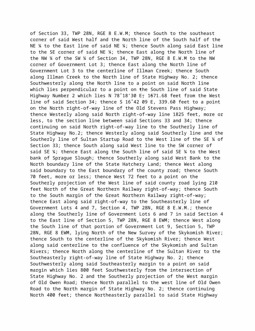
(c) Category III base fees for one connection.(i) 1,500 to 2,500 AWDVTE . . . . . .
. . . . . . $ 2,500(ii) Over 2,500
AWDVTE . . . . . . . . . . . . $ 4,000(iii) Fee per additional connection
point . . . . . . . . . . . . $ 1,000
(d) Category IV base fee per
connection . . . . . . . . . . . . $ 100
(2) Surety bond. Prior to the beginning of construction of any connection, the department may require the permit holder to provide a surety bond as specified in WAC 468-34-020(3).
[Statutory Authority: Chapter 47.50 RCW. 99-06-034 (Order 187), § 468-51-070, filed 2/25/99, effective 3/28/99. Statutory Authority: RCW 47.01.101 and chapter 47.50 RCW. 92-14-044, § 468-51-070, filed 6/24/92, effective 7/25/92.]
468-51-080Application submittal, review, conditions. (1) Application submittal. The application shall be submitted to the designated local department office serving the area. The application shall be properly prepared, clearly completed, and signed. Information on the specific number of copies to be provided and other submittal information is available from the designated local department office.
(2) Application review, processing, and approval. Upon receipt of the application, the application shall be reviewed consistent with the provisions of this chapter. If the department identifies errors in the application or if additional information is required, the department will notify the applicant. Applicants must provide such information or correct errors within thirty days of the notification. If the applicant determines that the time to provide additional or corrected information is insufficient, the applicant shall contact the department in writing to request additional time be approved. If the additional or corrected information has not been received by the department within thirty days or the approved time period agreed to, the application will be withdrawn.
(a) Review. Upon timely receipt of all required information, or upon expiration of the time
151

period for receipt of additional or corrected information, the location and design of the connection shall be examined for consistency with current department location, quantity, spacing, classifications, and department design standards. The review shall also include an analysis of the impact of the site's existing and projected traffic on the operation and safety of the state highway.
(b) Concurrence or denial, notice. If the department concurs in the location and design of the proposed connection, written notification of that concurrence will be sent to the applicant and to the local governmental land use planning authority having jurisdiction over the development. If the applicant has gone through the voluntary conceptual review process, the written notice of concurrence will indicate whether or not there have been any changes in the number, location, or design of the connection required by the department. No construction may commence on the department's right of way until all necessary department and local governmental permits are issued in accordance with (c) of this subsection. If the department does not concur in the connection location, quantity, or design, both the applicant and the local governmental land use planning authority having jurisdiction over the development approval shall be notified, in writing, indicating the department's intent to deny the connection as proposed in the application. The written notification shall state the specific reasons for the intent to deny the connection, the process for submitting an amended application, and the appeal rights of the applicant. The applicant may submit a revised application within thirty days based on department comments and concerns as stated in the notification. The submittal of a revised application within thirty days shall not require the payment of any additional application fees. Submittal of a revised permit is not a prerequisite for a request for an adjudicative proceeding in compliance with WAC 468-51-150.
(c) Permit issuance. The department shall issue the connection permit after review and concurrence that the application and the location and design of the connection comply with the requirements of this chapter, and after either:
(i) The applicant has received development approval from the appropriate local governmental land use planning authority; or
(ii) Other interagency coordination procedures in effect are satisfied for development approval by the local governmental land use planning authority.
The department shall provide the applicant with the connection permit for signature, and the applicant shall sign and return the permit to the department within thirty days after the mailing date. If the department does not receive the signed permit back from the applicant within thirty days after the mailing date or within an agreed upon time, the permit will be void and the application fee will be forfeited. The permit is not valid and construction on the access cannot begin without a completed permit that is signed by both the department and the applicant.
Additionally, the applicant must be in compliance with the surety bond requirements specified in the permit prior to construction, in compliance with WAC 468-51-070.
(d) Request for adjudicative proceedings. In the event of a denial of a connection permit as
152

proposed in the application, the applicant may apply for an adjudicative proceeding in compliance with WAC 468-51-150.
(3) Permit conditions. Any special requirements or provisions for the connection including off-site mitigation shall be clearly and specifically identified as part of the permit. Failure by the applicant or permit holder to abide by the permit provisions shall be sufficient cause for the department to initiate action to alter the connection or to revoke the permit and close the connection at the expense of the permit holder. The permit requirements shall be binding on the permit holder, the permit holder's successors, heirs and assigns, the permit application signatories, and all future owners and occupants of the property. The applicant may challenge the permit conditions by applying for an adjudicative proceeding in compliance with WAC 468-51-150.
[Statutory Authority: Chapter 47.50 RCW. 99-06-034 (Order 187), § 468-51-080, filed 2/25/99, effective 3/28/99. Statutory Authority: RCW 47.01.101 and chapter 47.50 RCW. 92-14-044, § 468-51-080, filed 6/24/92, effective 7/25/92.]
468-51-090Construction requirements. (1) Preconstruction conference. The department may require a preconstruction conference prior to any work being performed on the department's right of way. When required by provisions in the permit, the department will schedule a preconstruction conference. The preconstruction conference should be attended by the necessary personnel to assure compliance with the terms and provisions of the permit.
(2) Time limit. Substantial construction of the connection shall begin within ninety days of the effective date of the permit, unless a longer time is approved by the department or a time extension is requested by the applicant and approved by the department. Construction shall be completed within one hundred twenty days of the date of issuance of the permit, unless a time extension is approved by the department. As a condition of the permit, the department may further limit construction time, if the department determines that such limitation is warranted. Failure to comply with the time limits specified in the permit shall result in an automatic expiration of the permit following written notification to the permit holder. For any permit which expires for failure to begin construction or to complete construction within the specified time limits, the department may require a new application, including the payment of the required application fee prior to the initiation of any construction.
(3) Posting of permit. The approved connection permit shall be displayed in a prominent location, protected from the weather, within the vicinity of the connection construction.
153

(4) Disruption of traffic. All construction and/or maintenance within department right of way shall conform to the provisions of the connection permit, the "Manual on Uniform Traffic Control Devices" (MUTCD); the department's current "Design Manual," and the current "Standard Specifications for Road, Bridge, and Municipal Construction." The department may require or restrict hours of construction to minimize disruption of traffic on the state highway system. If construction activity within the department's right of way causes undue disruption of traffic or creates safety hazards on a state highway, or if the construction activity is not in compliance with the traffic control specifications in the permit, the department shall advise the permit holder or the permit holder's contractor of the need for immediate corrective action, and may order immediate suspension of all or part of the work if deemed necessary. Failure to comply with this provision may result in permit modification or revocation.
(5) Traffic signals and other traffic control devices. Traffic signals and other traffic control devices installed by the permit holder shall conform to MUTCD and department design and construction standards. The permit holder is responsible for securing any state and local permits needed for traffic signalization and regulatory signing and marking.
(6) Connection construction inspection. For Category II and Category III connections, the department may require the permit holder, the developer, or landowner to provide inspection of construction and certification that connection construction is in accordance with permit provisions and appropriate department standards by a professional engineer, registered in accordance with chapter 18.43 RCW, or the department may do the inspection at the applicant's expense, as provided in the developer agreement.
[Statutory Authority: Chapter 47.50 RCW. 99-06-034 (Order 187), § 468-51-090, filed 2/25/99, effective 3/28/99. Statutory Authority: RCW 47.01.101 and chapter 47.50 RCW. 92-14-044, § 468-51-090, filed 6/24/92, effective 7/25/92.]
468-51-100Nonconforming connection permits. The department may issue a permit for a connection not meeting department location and spacing criteria standards if it finds that a conforming connection is not attainable at the time of the permit application submittal and that denial would leave the property without a reasonable access to the public road system. The department may issue a connection permit requiring a legally enforceable joint-use connection when determined to be in the best interest of the state for restoring or maintaining the operational efficiency and safety of the state highway. Nonconforming connection permits shall specify conditions or limits including:
(1) Traffic volume. The maximum vehicular usage of the connection shall be specified in the permit.
154

(2) Future alternate access. The permit shall specify that a conforming connection be constructed when future alternate means of access become available, and that the nonconforming connection be removed.
(3) Users. The permit shall specify the properties to be served by the connection; and any other conditions as necessary to carry out the provisions of chapter 47.50 RCW.
[Statutory Authority: Chapter 47.50 RCW. 99-06-034 (Order 187), § 468-51-100, filed 2/25/99, effective 3/28/99. Statutory Authority: RCW 47.01.101 and chapter 47.50 RCW. 92-14-044, § 468-51-100, filed 6/24/92, effective 7/25/92.]
468-51-105Variance connection permits. Variance permits may be issued, at the discretion of the department, for certain connections not meeting the access classification location and spacing or that exceed the number of connections allowed by the standards adopted for a particular highway segment. These permits may be allowed if conditions warrant and are demonstrated to the satisfaction of the department by a traffic analysis, signed and sealed by a qualified professional engineer who is registered in accordance with chapter 18.43 RCW, which is included with the connection permit application. The variance permit will remain in effect unless a new permit is required due to changes in property site use in compliance with WAC 468-51-110 or unless permit modification, revocation, or closure of the variance permitted connection is required as provided for in WAC 468-51-120. The department may issue a connection permit requiring a legally enforceable joint-use connection when it is determined to be in the best interest of the state for restoring or maintaining the operational efficiency and safety of the state highway. Variance connection permits shall specify conditions or limits including, but not limited to:
(1) Traffic volume. The maximum vehicular usage of the connection shall be specified in the permit.
(2) Users. The permit shall specify the properties to be served by the connection, and any other conditions as necessary to carry out the provisions of chapter 47.50 RCW.
[Statutory Authority: Chapter 47.50 RCW. 99-06-034 (Order 187), § 468-51-105, filed 2/25/99, effective 3/28/99.]
155

468-51-110Changes in property site use. The connection permit is issued to the permit holder for a particular type of land use generating specific projected traffic volumes at the final stage of proposed development. Any changes made in the use, intensity of development, type of traffic, or traffic flow of the property requires the permit holder, his or her assignee, or property owner to contact the department to determine if further analysis is needed to determine if the change is significant and would require a new permit and modifications to the connection. An engineering study, signed and sealed by a professional engineer registered in accordance with chapter 18.43 RCW, may be required to document the extent of the change. If modification of the existing connection is required, based on a significant change as determined by the department, the permit holder, his or her assignee, or the property owner shall obtain a new permit prior to the initiation of any on-site construction to the connection or to the property.
(1) Significant change. A significant change is one that would cause a change in the category of the connection permit or one that causes an operational, safety, or maintenance problem on the state highway system based on objective engineering criteria or available accident data. Such data shall be provided to the property owner and/or permit holder and tenant upon written request.
(2) Notification. Failure to contact the department to determine the need for connection modifications or to apply for a new permit for such modifications prior to initiation of property improvements, land use changes or traffic flow alteration actions shall result in notification to the property owner and/or permit holder and tenant of intent to revoke the existing permit and closure of the connection to the property.
(3) Costs. The permit holder is responsible for all costs associated with connection removal, relocation, or modification caused by increased or altered traffic flows necessitated by changes to facilities, use, or to the nature of the business on the property.
[Statutory Authority: Chapter 47.50 RCW. 99-06-034 (Order 187), § 468-51-110, filed 2/25/99, effective 3/28/99. Statutory Authority: RCW 47.01.101 and chapter 47.50 RCW. 92-14-044, § 468-51-110, filed 6/24/92, effective 7/25/92.]
468-51-120Permit modification, revocation, closure of permitted connections. (1) Revocation criteria. All connection permits issued by the department prior to the effective date of this chapter remain valid until revoked. The department may initiate an action to revoke any permit if significant changes have occurred in the use, design, or traffic flow of the property
156

or of the state highway, requiring the relocation, alteration, or closure of the connection; if the connection was not constructed at the location or to the design specified in the permit; if the permit provisions were not met; or if the connection causes a safety, maintenance, or operational problem on the state highway system. The process to be followed by the department in the revocation of permits shall be consistent with the requirements of chapter 34.05 RCW and WAC 468-51-150. The notification process is as follows:
(a) Notification, correction of deficiencies. The department shall serve notice, in accordance with rules adopted in compliance with chapter 34.05 RCW, to the permit holder, permit holder's successors or assigns, or property owner with a copy to the occupant, for any connection found to be in noncompliance with the conditions of the permit or this chapter. The notice will identify and request that the deficiencies be corrected within thirty days of service of the notice. The notice shall further advise that the department's determination of noncompliance or deficiencies shall become final and conclusive thirty calendar days following service of the notice unless the violations are corrected or an adjudicative proceeding in compliance with chapter 34.05 RCW and WAC 468-51-150 is requested by the permit holder, permit holder's successor or assigns, or the property owner.
(2) Costs. The permit holder, permit holder's successor or assignee, or property owner shall be responsible for the costs of closure due to revocation of a connection permit in compliance with WAC 468-51-120 except when the closure is required by changes to the state highway.
(3) Emergency action. This chapter shall not restrict the department's right to take immediate remedial action, including the closure of a connection if there is an immediate and serious danger to the public health, safety, and welfare, in compliance with chapter 47.32 RCW. In such event, the department shall conform to the provisions for emergency adjudicative proceedings in RCW 34.05.479 and rules adopted thereunder.
[Statutory Authority: Chapter 47.50 RCW. 99-06-034 (Order 187), § 468-51-120, filed 2/25/99, effective 3/28/99. Statutory Authority: RCW 47.01.101 and chapter 47.50 RCW. 92-14-044, § 468-51-120, filed 6/24/92, effective 7/25/92.]
468-51-130Closure of unpermitted connections. Closure criteria, permit requirements. Any unpermitted connections to the state highway system which were in existence and in active use consistent with the type of connection on July 1, 1990, shall not require the issuance of a permit and may continue to provide connection to the state highway system, unless the property owner had received written notification initiating connection closure from the department prior to July 1, 1990, or unless the department determines that the unpermitted connection does not meet minimum acceptable standards of
157

highway safety and mobility based on accident and/or traffic data or accepted traffic engineering criteria, a copy of which must be provided to the property owner and/or permit holder and tenant upon written request. The department may require that a permit be obtained if a significant change occurs in the use, design, or traffic flow of the connection or of the state highway. If a permit is not obtained, the department may initiate action to close the unpermitted connection point in compliance with RCW 47.50.040. Any unpermitted connection opened subsequent to July 1, 1990, is subject to closure by the department. The process to be followed by the department in the closure of an unpermitted connection shall be consistent with chapter 34.05 RCW and rules adopted thereunder. The notification process is as follows:
(1) Notification. The department shall serve notice, in accordance with rules adopted in compliance with chapter 34.05 RCW, upon the property owner of a connection to a state highway which is found by the department to be unpermitted. This notice shall clearly describe the highway connection violation and shall establish a thirty-day time limit for either applying for a connection permit or requesting an adjudicative proceeding in compliance with chapter 34.05 RCW. The notice will further advise the property owner that failure to act in either of the prescribed ways within the time period will result in department closure of the unpermitted connection.
(2) Permit application. If a permit application is filed within the thirty days, and the application is denied, the department shall notify the property owner of the denial. The property owner may then proceed with the permit application revision process set forth in WAC 468-51-080 or request an adjudicative proceeding in compliance with WAC 468-51-150 within thirty days. Failure to act in either of those prescribed ways within the time period set forth in the rules will result in department closure of the unpermitted connection. If the location and design of the connection in the permit application are acceptable to the department, the existing connection may continue to be used for a specified period of time or until the connection specified in the permit application is constructed.
(3) Approval conditions. Modifications, relocation, or closure of unpermitted connections may be required by the department as a requirement of permit approval, subject to the adjudicative proceedings provisions of WAC 468-51-150.
[Statutory Authority: Chapter 47.50 RCW. 99-06-034 (Order 187), § 468-51-130, filed 2/25/99, effective 3/28/99. Statutory Authority: RCW 47.01.101 and chapter 47.50 RCW. 92-14-044, § 468-51-130, filed 6/24/92, effective 7/25/92.]
468-51-140Department construction projects.
158

During construction of department projects, connections will be provided as replacements for existing approved permitted connections, that are consistent with all current department spacing, location, and design standards, based on the following conditions:
(1) Nonconforming connections. All nonconforming connections will be examined to determine if the construction project will require relocation, alteration, or closure of the connection to make it conforming.
(2) Application of current standards. The number and location of connections shall be modified to the maximum extent possible to meet current department spacing, location, and design standards. Where current department standards cannot be met, the connection shall be classified as nonconforming.
(3) New connections, modifications. The department shall allow new or require modification of existing connections if a connection permit application is made and approved.
(4) Replacement of existing connections. When connections are made as part of a department construction project replacing existing connection points without material differences, no additional permit shall be required. Costs shall be borne by the department.
(5) New connections -- Cost. The construction of new connection points, if approved by the department, shall be done at the owner's expense by either the department's contractor as part of the roadway improvement or by the owner's contractor at the department's option.
(6) Modifications -- Cost. If the modification of the connection point, that are based on the owner's request, is more extensive than the routine replacement of an existing connection, the owner shall also participate in the differential cost.
(7) Work by permit holder's contractor. The department shall require that work done by the owner's contractor be accomplished at the completion of the department's contract or be scheduled so as not to interfere with the department's contractor. The department may require a surety bond prior to construction of the connection in accordance with WAC 468-51-070. When the number, location or design of existing access connections to the state highway are being modified by a department construction project, the resulting modified access connections shall provide the same general functionality for the existing property use as they did before the modification, taking into consideration the existing site design, normal vehicle types, and traffic circulation requirements.
Notification. The department shall notify affected property owners, permit holders, business owners and/or emergency services, in writing, where appropriate, whenever the department's work program requires the modification, relocation, or replacement of their access connections. In addition to written notification, the department shall facilitate, where appropriate, a public process which may include, but is not limited to, public notices, meetings or hearings, and/or individual meetings. The department shall provide the interested parties with the standards and principles of access management.
159

[Statutory Authority: Chapter 47.50 RCW. 99-06-034 (Order 187), § 468-51-140, filed 2/25/99, effective 3/28/99. Statutory Authority: RCW 47.01.101 and chapter 47.50 RCW. 92-14-044, § 468-51-140, filed 6/24/92, effective 7/25/92.]
468-51-150Adjudicative proceedings. (1) Application. Any person who has standing to challenge the denial of a permit application in compliance with WAC 468-51-080; a permit with conditions in compliance with WAC 468-51-080; a notice of permit modification, revocation, or closure of permitted connection in compliance with WAC 468-51-120; or notice of closure of an unpermitted connection in compliance with WAC 468-51-130 may apply for an adjudicative proceeding on the matter in compliance with chapter 34.05 RCW, rules adopted thereunder, and department rules within thirty days of the date the initial determination of the department is sent by certified mail.
(2) Conduct. Thereafter, and within the times set forth by chapter 34.05 RCW, rules adopted thereunder, and department rules, the department shall convene an adjudicative proceeding. The proceeding shall be conducted in compliance with chapter 34.05 RCW, rules adopted thereunder, and department rules.
(3) Failure to apply. Failure to apply for an adjudicative proceeding within the times set forth in subsection (1) of this section shall result in the adoption of the department's initial determination as its final determination.
(4) Failure to participate. Failure to attend or otherwise participate in an adjudicative proceeding may result in a finding of default.
(5) Reasonableness of access. The department in its regulation of connections in compliance with chapter 47.50 RCW and these regulations shall allow reasonable access. If the department's final order denies reasonable access, the appellant shall be entitled to just compensation in compliance with RCW 47.50.010(5). Access which is not reasonable is not compensable.
[Statutory Authority: Chapter 47.50 RCW. 99-06-034 (Order 187), § 468-51-150, filed 2/25/99, effective 3/28/99. Statutory Authority: RCW 47.01.101 and chapter 47.50 RCW. 92-14-044, § 468-51-150, filed 6/24/92, effective 7/25/92.]
160