chronicles of the trail - caminorealcarta.org€¦ · chronicles of the trail journal of el camino...
TRANSCRIPT

Chronicles of the TrailJournal of El Camino Real de Tierra Adentro Trail Association
Vol. 10, No. 1 Winter 2014
Misión de Nuestra Señora de Guadalupe, El Paso del Norte, Mexico, 1850
PRESIDENT’S MESSAGE
CARTA’s mission is to facilitate goodwill, cooperation, and understanding among communities, and to promote the education, conservation, and protection of the multicultural and multiethnic history and traditions associated with the living trail, El Camino Real de Tierra Adentro.
Membership in CARTA is open to all. Please see the membership form on our website: www.caminorealcarta.org
Greetings,
CARTA finishes the year far ahead of where it began last January. The agency-review issue with the BLM is resolved, work on the Bosquecito Road project has been completed, and we are again sponsoring well-attended hikes in areas associated with El Camino Real de Tierra Adentro.
As hoped, CARTA’s international symposium in El Paso was successful in bringing presenters from Mexico, Central and South America, Spain, and the southwestern United States to expand our understanding of caminos reales created by early Spanish explorers and settlers. We are grateful to the many individuals who worked to make this a success, including the folks at the University of Texas, El Paso (UTEP), and the Hilton Garden Inn, and, not least, CARTA’s own Ben Brown, Shelley Sutherland, and Troy Ainsworth. We look forward to planning new ventures and acquiring new members as a result of this gathering.
Future plans for CARTA include marking a hiking path through the Jornada del Muerto from the Fort Selden area to at least as far north as Engle, about thirty miles from there. We envision getting hikers on the trail route to appreciate the historical events and travails it represents. This will be a multiyear project developed in association with the Bureau of Land Management and will necessarily include a connection with the Spaceport near where it will pass.
We are pleased to welcome our new members, including a good number who joined at the symposium: L. G. Baumgarten, Ruben Esparza and Lisa Tomaka, Nicholas P. Houser, Mark Howe, Paul Lukowski, Juana Moriel-Payne, Shelley Sutherland and Herb Price, and El Paso Mission Trail Association, El Paso, Texas; Chris Hanson, San Antonio, Texas; Al Borrego, and Genealogy and Historical Society, San Elizario, Texas; Evelyn and Kenneth Harris, Dianne Rhea Layden, and Lewis M. and Lynda M. Witz, Albuquerque; Pat and Walter Farr, Cordelia Thomas Snow, and Vincent and Carolyn Stenerson, Santa Fe; Victoria M. Davila and Francis (Ted) E. Stanley, Tesuque, New Mexico; Evangeline Ordaz-Molina, Los Angeles; Catherine Romero, Rosemead, California; Henry J. Trauernicht, Lincoln, Nebraska; and Evan Ward, Provo, Utah.
CARTA welcomes you and your ideas and support. If you are not already a member, we hope you will consider joining us and taking part in our future.
Sincerely,
Sim Middleton
No part of this publication may be reproduced without the written permission of the publisher. © 2014 by El Camino Real de Tierra Adentro Trail Association.

CARTAOFFICERSPRESIDENT: Sim Middleton, Las CrucesVICE-PRESIDENT: David H. Reynolds, AlbuquerqueSECRETARY: Kristen Reynolds, Albuquerque TREASURER: Peggy Hardman, PhD, SocorroINTERNATIONAL LIAISON: Enrique Lamadrid, PhD, Albuquerque
DIRECTORSMiguel Chávez, Santa FePaul Harden, SocorroJere L. Krakow, AlbuquerqueBarbara Kuhns, Las CrucesDavid W. Love, PhD, SocorroVernon G. Lujan, EspañolaLolly Martin, Santa FeShelley Sutherland, El Paso
EXECUTIVE DIRECTOR: Troy M. Ainsworth, PhD, Los Lunas
Vol. 10, No. 1
CONTENTSPresident’s Message inside front coverEditor’s Letter 2Tour of Historic Sites in El Paso, Sept. 2013 3Troy AinsworthConference as Kaleidoscope: Report on Los 4 Caminos Reales de América International Symposium, El Paso, Sept. 26–29, 2013Julianne Burton-CarvajalDrawings by Louann JordanBernardo de Miera y Pacheco: Domínguez and 9Escalante’s Unruly CartographerJohn L. KessellField Report: Searching for El Camino Real de 14Tierra Adentro in the Jornada del MuertoElizabeth A. Oster and David H. ReynoldsSusan Shelby Magoffin at the Pass of the North 27Nicholas P. Houser Book Review 39
New Mexico’s Spanish Livestock Heritage: Four Centuries of Animals, Land, and People
by William W. DunmireReviewed by Richard Flint
Upcoming Events 40Letter from the Executive Director inside back cover
Chronicles of the Trail
El Camino REal dE TiERRa adEnTRo TRail assoCiaTion
CARTA, PO Box 1434, Los Lunas, NM 87031-1434(575) 528-8267 [email protected]
www.caminorealcarta.org
EXECUTIVE EDITOR: Catherine López Kurland, Santa Fe
Winter 2014
FRONT COVER: “Church at El Paso del Norte” (present-day Ciudad Juárez), from a color plate in William H. Emory, “Report on the United States and Mexican Boundary Survey,” vol. 1 (Cornelius Wendell, Washington, D.C. 1857). The plate was based on a pencil-and-sepia sketch attributed to Augustus de Vaudricourt, the Boundary Commission’s official artist and draftsman. The original sketch, c. 1850, is in the John Russell Bartlett Collection at the John Carter Brown Library, Brown University, Providence, RI. [See “Magoffin,” pp. 27–38.]BACK COVER: The storied seep spring that drew Camino Real travelers over the course of centuries to stop at the campsite, or paraje, that developed near la cruz del Alemán in the Jornada del Muerto. Courtesy of Elizabeth Oster and David Reynolds. [See “Field Report,” pp. 14–26.]
Journal of El Camino Real de Tierra Adentro Trail Association

2 Chronicles of the Trail, Winter 2014
Dear Reader,
In this first issue of 2014, we share some highlights from our international symposium in El Paso this past September. It was a major undertaking, and, we are glad to report, an unqualified success from many perspectives: attendees, presenters, local hosts, and organizers. It gave all of us a chance to get to know El Paso, the
southernmost site of El Camino Real de Tierra Adentro north of the Rio Grande. Via the stellar cast of presenters, we explored caminos reales from Aqua Fria, New Mexico to the Colombian Andes.
The commodious and welcoming Hilton Garden Inn on the campus of University of Texas at El Paso (UTEP) was our home away from home for several days. On Thursday evening we enjoyed antojitos and copitas on the veranda before moving indoors to hear illustrious keynote speaker John Kessell read passages from his new biography of Bernardo de Miera y Pacheco. We were spellbound by Dr. Kessell’s words, which you can read verbatim on these pages.
Julianne Burton-Carvajal of Monterey, California, offers a lively synopsis of each of the presentations, even her own, a highlight of the event for this attendee. On Sunday morning many participants opted to take a tour of the El Paso Mission Trail, Oñate’s Crossing, and other Camino sites in and around El Paso, revisited here for your vicarious enjoyment by CARTA executive director Troy Ainsworth.
Moving north though the Jornada del Muerto by foot and by drone in the metaphorical shadow of Spaceport America, Elizabeth Oster and David Reynolds offer plentiful fodder for archeologists and laypersons hungry for updates on the most advanced techniques for identifying the Trail. This report was commissioned by the Spaceport as mitigation for disturbing the pristine landscape, which until now was the same viewshed experienced by Oñate and the colonists in 1598. It is safe to say that Oster and Reynold’s presentation offered something new for everyone in the room, and will, we believe, for our readers as well.
Nicholas Houser has devoted untold hours researching the identities of Paseños in Susan Magoffin’s famed diary, correlating her descriptions with deeds, legal documents, and other original sources. Mr. Houser has generously shared his discoveries with Chronicles readers in “Susan Magoffin at the Pass of the North.”
The four-legged “colonists” who accompanied Juan Oñate, and the livestock that traveled up the Camino in succeeding centuries, made a profound impact on the land and the culture. William Dunmire’s groundbreaking new book on this subject, New Mexico’s Spanish Livestock Heritage: Four Centuries of Animals, Land, and People, is reviewed in this issue by historian Richard Flint.
Without the generous contribution of our contributors, there would be no Chronicles of the Trail. In addition to the writers, we would like to offer a special note of appreciation to artist Louann Jordan, photographer Miguel Gandert, and copyeditors Julie Newcomb and Kristen Reynolds.
Respectfully,
Catherine López Kurland
The purpose of this journal is to stimulate interest in El Camino Real de Tierra Adentro and encourage readers to join in the adventure of memorializing and exploring one of the great historic trails of North America. We look forward to receiving manuscripts and photographs for Chronicles of the Trail. Please send material in digital format, and images of at least 300 dpi, to [email protected].
Chronicles of the Trail is a publication of El Camino Real de Tierra Adentro Trail Association (CARTA).Past issues of Chronicles are posted to our website one year after publication.
EDITOR’S LETTER

Chronicles of the Trail, Winter 2014 3
TOUR OF HISTORIC SITES IN EL PASO, SEPTEMbER 2013By Troy Ainsworth
On the final day of “Los Caminos Reales de América,” Sunday, September 29, twenty-two symposium attendees toured historic sites in El Paso associated with El Camino Real de Tierra Adentro. Bernie Sargent, chairman of the El Paso County Historical Commission, ably served as a tour guide. The group was bussed from the hotel to Oñate’s Crossing on the Río Grande, one of the most historically significant sites in the Borderlands, as well as one of the most endangered. At that location, Oñate’s column forded the river in the spring of 1598, to continue the march north; two-and-a-half centuries later Simeon Hart built his home and grist mill on the site to supply flour to “The Post opposite El Paso del Norte,” the army outpost on the U.S. side of the river that later became Fort Bliss. Despite the historical importance of the “Plymouth Rock of the Southwest,” the site is stressed due to projects undertaken by the Texas Department of Transportation and the U.S. Department of Homeland Security. Mr. Sargent addressed the group on these challenges and on work being done to protect the site to the fullest extent possible through the efforts of the National Park Service and other agencies.
From Oñate’s Crossing the tour continued along the border highway, which affords views of Ciudad Juárez and, in the larger perspective, the landscape through which wayfarers traveled for hundreds of years along the Royal Road. The next stop was La Misión de Corpus Christi de los Tiguas, the mission church at Ysleta del Sur Pueblo, before the tour continued on to the plaza in San Elizario, the site of an eighteenth-century Spanish presidio. There they visited Los Portales, formerly Casa García, which was built in the late 1850s and currently serves as
a museum and information center, operated by the San Elizario Genealogy and Historical Society; the chapel on the plaza (Capilla de San Elcear); and the old county jail from the 1850s, which briefly housed Billy Bonney in 1880. The group also walked along the Camino Real on Glorieta Road and on Main Street. Upon leaving San Elizario, the group stopped at the mission church Nuestra Señora de la Concepción del Socorro in Socorro, Texas, with its elegant façade contrasting sharply against the brilliant blue El Paso sky.
After lunch in Ysleta, the tour made two additional stops, the first at the Magoffin Home
State Historic Site near downtown El Paso. There the group was given a guided tour of the recently restored interior and grounds of the 1875 home, a fine example of Territorial Style architecture in the Southwest. They then departed for El Paso International Airport to view the monumental sculpture of Juan de Oñate, “The Last Conquistador,” by John Houser, which stands near the airport’s entrance, where it was emplaced in 2007. Nick
Houser, the sculptor’s brother, was present on the tour, and en route from the Magoffin Home he provided a narrative about his brother’s work and the ongoing controversy surrounding Oñate as colonizer and governor of New Mexico. With this final stop, the tour returned full circle from the point where Oñate led his colonists across the river to the place where the thirty-six-foot-high statue in his likeness observes airline passengers as they arrive in and depart from the Pass of the North.
TROy AINSwORTH, PhD, is CARTA’s executive director. He lives in Los Lunas, New Mexico.
Gregorio García House, San Elizario, 1850s. Known today as Los Portales, it currently serves as a museum. Photograph by David Kaminsky, 1980, for Historic American Buildings Survey. Library of Congress Prints & Photographs online catalog: www.loc.gov/pictures/item/tx0138.photos.157073p.

4 Chronicles of the Trail, Winter 2014
CONFERENCE AS KALEIDOSCOPE: REPORT ON Los Caminos ReaLes de améRiCa
INTERNATIONAL SyMPOSIUM, SEPTEMbER 26–29, 2013, EL PASOBy Julianne Burton-CarvajalDrawings by Louann Jordan
The ancient Greek term “symposium” refers to a gathering in which the exchange of ideas is lubricated by copious amounts of wine. Why? Because the Greeks had no knowledge of tequila.
Attendees and presenters at CARTA’s conclave were generously supplied with coffee and tea during the daytime sessions. What they consumed in the evenings—whether Old World or New World in origin—was by personal choice. In recapitulating the El Paso encounter, the following summary bypasses the Greeks in favor of the Romans.
A conference (Latin for “the act of consulting together”) is more like a magazine than a book, rewarding attention with variety and unexpected juxtapositions. Knowledgeable conversations are catalyzed by variations of topic, timeframe, and approach. In our increasingly virtualized world, the opportunity to share a single spot on the planet for a limited, focused time invites the lively exchange of information and ideas. A successful conference is a kaleidoscope: each contribution is a prism that adds another mutable facet to the whole.
Months in advance, co-organizers Troy Ainsworth and Ben Brown cast their net across the Spanish Americas and beyond, encouraging participation from as far south as Argentina, as far north as Colorado, as far west as the coast of California and as far east as Spain. Presenters and attendees from myriad locations and vocations were drawn in: museum professionals, trails specialists, anthropologists, and cultural activists from across the Southwest and beyond; an engineer from Spain, an architect from Mexico City, young landscape history professionals from Mexico, Spain, and Colombia; university faculty from as far away as Utah; staff from the International Boundary and Water Commission, the National Park Service, and Mexico’s National Institute of Anthropology and History.
Re-viewing an intense, rewarding, dynamic experience, the following account reflects one attendee’s retrospective, freeze-frame glimpse. Fair
warning: the program roster so ably assembled and coordinated by co-organizers Ben and Troy has been freely reassembled here.
At the end of the long second day, Michael Taylor of the National Park Service Trails Office in Santa Fe and Ariadna Deni Hernández Osorio, a Mexican doing graduate study in Madrid, gave complementary presentations. Elucidating the recently developed “cultural routes/itinerarios culturales” framework that informs trail designation and management at both national and international levels, they provided essential context for the entire conference—Michael in English and Deni in Spanish. To the benefit of all, professional interpreters Rosa María Boadella and Patricia Jordan provided simultaneous translation for attendees who opted to don headsets. Their very unobtrusiveness confirmed their consummate skill.
Appropriately, both Mexico and New Mexico were richly represented during the two daylong sessions. A trio of young professionals—Mexicans Adrián Hernández Santisteban and Alejandro González Milea along with Marta Martín Gabaldón, a Spaniard studying in Mexico—explored camino real configurations west from Veracruz to Mexico City, as well as south and north from that hub. Through reconstructed maps, Adrián explained where the route taken by Hernán Cortés and successors between Veracruz and Tenochtitlan (the future Mexico City) conformed to pre-conquest trails, where it deviated from them, and why. Marta focused on community concentrations in early Oaxaca. The degree of detail in her maps was particularly impressive.
Architect and historian Alejandro González Milea of the National University in Ciudad Juárez emphasized the longstanding competition between east-west (regionalist) and north-south (centralizing) perspectives. Focusing on the mid-19th century, he recognized the durability of colonial-era paradigms for protecting roadways and creating centers of population across Mexico’s chronically

Chronicles of the Trail, Winter 2014 5
underpopulated northern expanse—Coahuila, Chihuahua, Tamaulipas, and Sonora. His research has revealed that forts, civilian settlements (colonias), and presidios combining soldiers with civilians were strategies recommended with surprising consistency by experts in the employ of republican as well as neo-imperial regimes, and to some extent implemented by both. He concluded that throughout the centuries the caminos carreteros—often antiguos caminos reales that incorporated veredas de indios—have answered a continuing need.
Alberto Ramírez Ramírez presented a photographic overview of a cumulatively dazzling recent accomplishment: dozens of architectural restorations accomplished under his supervision in the state of Durango since 2010, when world heritage status was granted to the Mexican portion of El Camino Real de Tierra Adentro. The majority of managed CARTA sites are located in that state.
Several presentations spanned the U.S.-Mexico border. First among presenters from the host state of Texas was Jesús (Frank) de la Teja from Texas State University in San Marcos. Combining seasoned scholarship, memorable insights, and easy wit, Frank offered a virtuoso recapitulation of how trails and boundaries evolved in “Old Texas.” Juana Moriel-Payne, a graduate student of history at the University of Texas–El Paso, who has embraced fiction as a more engaging means of evoking life along the inland trail from Chihuahua, shared selections translated from her 2013 novel, Trigueña. Ben Brown, who works on one side of the border while residing on the other, invoked two noted mid-19th-century memoir writers. Susan Magoffin, the young bride of an American merchant, penned a lively account of Santa Fe and regions to the south along the Chihuahua Trail. Globetrotting Scotswoman Fanny Calderón de la Barca recorded her impressions of two years in Mexico City as the wife of Spain’s first ambassador to that newly recognized nation.
Clara Payán de Sandoval and Ana Lidia Gutiérrez Martínez, public school teachers in
Albuquerque and Chihuahua respectively, have drawn practical inspiration from transborder linkages along El Camino Real de Tierra Adentro. Their joint presentation recapitulated fourteen years of collaboration on Estrechando Nuestras Manos, Enlazando Nuestras Fronteras/Reaching Out Our Hands, Linking Our Borders—an exchange program for fifth grade students, teachers, and parents. Seeking to create lasting bonds of friendship, the curriculum they have developed breaks apart stereotypes as participating students study the origins and promote the strengths of their respective cities. To date, the program has enlisted the participation of 250 teachers, 1,000 students, and an equal number of parents.
Folklorist Enrique Lamadrid, Chair of the Spanish and Portuguese Department at the University of New Mexico, offered another inspiring example of child-centered binational cooperation. His Amadito and the Hero Children/Amadito y los Niños Héroes, delightfully illustrated by Taos artist Amy Córdova, is fact-based fiction for children and adults. Published by UNM Press in 2011 and winner of major awards, the story presents an actual New Mexican family at the conclusion of World War I, as parents and children endeavor to avoid falling prey to a global epidemic. A tale of transborder response to another pandemic a century earlier is an interwoven motif. In both historic instances, the bravery of children ensured the survival of entire communities.
Christopher Talbot, a photography instructor who resides on a forested span of El Camino Real de los Tejas near Nacogdoches, shared his compelling

6 Chronicles of the Trail, Winter 2014
photographs of enduring Honduran portions of the Central American Camino Real while noting how impending modernization threatens their survival. From Sherill Spaar’s perspective, engineered 16th-century roadways are rank upstarts. With wide-ranging observations based on doctoral study of Roman infrastructure across the Iberian Peninsula, she stressed that, in the context of imperial expansions, viable roadways are one of many introduced benefits that reflect power, wealth, and control back onto the imperial center.
Spanish colonial authorities not only embraced the entire landmass of the Americas and adjacent islands but also endeavored to link the oceans. The richly illustrated presentation by retired Spanish highway engineer Luis Laorden Jiménez of Madrid recapitulated alternatives explored during the prolonged but unsuccessful quest to link the Atlantic and Pacific through various watery narrows in southern Mexico and Central America.
Results of a year’s intensive interdisciplinary scrutiny of the history of California’s “Camino Real del Litoral,” summarized in this author’s presentation, highlight the under-acknowledged interdependency of land and sea routes. From Mexico to Argentina, caminos reales customarily led to ports developed in order to ship gold and silver to the mother country. In contrast, along the coast of Alta California the initial goal was getting supplies to—rather than siphoning portable wealth from—scattered nuclei of settlement. The four Alta California presidios established near the harbors of San Diego, Santa Barbara, Monterey, and San Francisco between 1769 and 1776 were initially
distribution nodes for seaborne supplies essential to the survival of the precarious colony. Still an evolving “information highway,” California’s 700-mile Camino Real warrants an enhanced public profile. State officials, private enterprises, and nonprofit organizations could follow the example of Mexico and New Mexico, but can they be motivated to do so?
Another presenter who concluded with the question “Where do we go from here?” was Juliana Davila of Bogotá. Her illustrated case study of surviving camino real fragments on both sides of the Río Chicamocha Gorge in the Colombian Andes documents 500 years of functionality and spontaneous custodianship. In reprising the ways in which the tiny village of Agua Fría on the edge of cosmopolitan Santa Fe conserves its own looks-like-the-early-days fragment of El Camino Real, William Mee identified an example worthy of imitation within the continental United States.
Elizabeth Oster and David Reynolds, cultural resource specialists for a project sponsored by the New Mexico Spaceport Authority, are creatively applying new technologies to the age-old challenge of determining precisely where emigrant trains and seasonal traders crossed southern New Mexico’s daunting Jornada del Muerto—an inhospitable expanse that certainly required more than a single jornada (the span of one day’s travel). As mitigation for the construction of Richard Branson’s interplanetary terminal, Spaceport America, Oster and Reynolds have been combining a range of digitally assisted technologies, including infrared satellite photography that registers the Normalized Differential Vegetation Index (NDVI),
with traditional grounding methodologies. Their goal is to discern “parallel alignments” and other kinds of “trail signatures”—among them “artifact halos” associated with the transit of humans but not of animals. “History may be written by the winners, but archaeology has been created by everyone” was the memorable opening line of their two-part presentation. Along the allotted CARTA segment, their shared data

Chronicles of the Trail, Winter 2014 7
have detected widely meandering traces of early wagon trains and also confirmed the existence of pre-historic trails. “What cannot be found cannot be managed” was their admonitory conclusion.
Because the extension of caminos reales along the length of the Americas subsumes local, regional, national, binational, and international interests, topical possibilities for conference presenters are unbounded. The El Paso program encompassed both monumental art and monumental atrocity. The paper delivered by Dianne R. Layden of Central New Mexico Community College revisited the problem of how to commemorate the Spanish colonial accomplishment for modern-day audiences while acknowledging the suffering and sacrifice of those who were expropriated, enslaved, or eliminated in the process. Atrocity not yet commemorated in public sculpture or any other trans-linguistic form was grimly detailed in museum director Mark Santiago’s rigorously documented account of one-way traffic in human bodies along El Camino Real de Tierra Adentro in the late 18th century. During the “enlightened” deportation of Apache prisoners of war, force-marched south in chain gangs (colleras), a large proportion of captive women and men expired, some by their own hand, before being exported to do forced labor elsewhere in the empire.
A pair of distinguished keynote speakers bookended the Caminos Reales conclave. On Thursday evening renowned scholar John Kessell presented a fresh angle based on his decades of research into the life of pioneering cartographer, versatile artist, and influential citizen Bernardo Miera y Pacheco (1713–1784). Kessell’s masterful biography (reviewed by this writer in the Chronicles of the Trail, Summer 2013) cements Miera’s place in New Mexican history on the 300th anniversary of his birth. The question-answer portion of the
evening included slides of Miera’s surviving maps, paintings, and sculptures. Saturday evening’s banquet featured Joe E. Watkins, formerly of the University of Oklahoma and currently Chief
of Tribal Relations and American Cultures for the National Park Service. His reappraisal of “Intercultural Conflicts and the Camino Real: Borderland Politics and Political Borders” offered a broadly comparative Native American perspective.
Local entities played a role in publicizing the conference and making participants feel welcome. In early September, El Paso’s Museum of Archaeology hosted presentations by CARTA Board member Vernon Luján of Taos Pueblo and jade expert Mary L.J.T. Ridinger, followed by interviews broadcast on local radio. El Paso’s Museum of History hosted conference attendees on the afternoon of their arrival. Exhibition tours with senior staff followed refreshments and words of welcome from Executive Director Julia Bussinger. The opening afternoon concluded with a walk through El Paso’s evolving downtown led by a costumed local personality. On Sunday, an optional bus tour gave visitors a chance to visit Oñate’s Crossing, El Paso Mission Trail, and the Magoffin Home Historic Site. Unwittingly coinciding with the conference—and contradicting its emphasis on connectivity across time and space—was the emplacement of the final section of border barrier separating El Paso and Ciudad Juárez.
One of the weekend’s greatest pleasures defies description. In deference to now-universal

8 Chronicles of the Trail, Winter 2014
expectations of PowerPoint, many presenters enriched their talks with rare maps, period artwork, and other imagination-stoking imagery, thereby adding countless colorful facets to the kaleidoscope of collective memory. For pre-loading all the presentations into the master computer-projector and responding for hours on end to “Next slide, please!” prompts, co-organizer Troy Ainsworth deserves a laurel wreath, a toga, or a bottle of the best tequila.
JULIANNE bURTON-CARVAJAL, PhD, is an author and exhibitions curator from Monterey, California. Inspired in part by the Caminos Reales conference, she has begun researching and writing a subjective account of traveling on El Camino Real de Tierra Adentro in 1693–94 and helping to resettle New Mexico in the subsequent decades. Based on the life of Josefa de Pas Bustillos y Ontiveros (1684–1772), founder of the Bustos family line, Josefa en Dos Reinos will span her eighth to eighty-eighth year.
Presenters and attendees (partial group) at Los Caminos Reales de América, CARTA’s international symposium in El Paso. Photograph by Nafice Yassine Yohaid.

Chronicles of the Trail, Winter 2014 9
One October night long ago, an ailing scout, eighty-six days on the trail and uncertain of where he was, lay moaning in the darkness of an Indian hut. A wrinkled Paiute shaman hovered over him, chanting. The patient, a small and weathered white man, had suffered stomach cramps almost all the way. Pain showed in his tired blue eyes. Over the years he had grown to respect the strange skills of Native medicine men. His mixed-blood trail mates, most of them traders with the Utes of the southern Rockies, squatted around him.
They had been exploring some of the most challenging mountain and high desert country in the American West, landscapes unseen before by any but their Native inhabitants. Often these uninvited aliens relied on Indian guides. Before they found their way back, they would kill and eat some of their horses, just to stay alive.
The sick man, a seasoned frontier veteran, was not Kit Carson, but Bernardo de Miera y Pacheco, a Spaniard. And this rough, dry landscape was not yet Mexican or U.S. territory, but part of Spain’s boundless Kingdom and Provinces of New Mexico. The year was 1776.
A larger-than-life presence in the colony, Miera was not a braggart. Often he didn’t bother to sign his works, a frustration to us today. Ambidextrous in the broadest sense, he was “engineer and captain of militia” on Indian campaigns; explorer and cartographer of unmapped lands; district officer; merchant; luckless silver miner; debtor and debt collector; rancher; craftsman in metal, stone, and wood; and prolific religious artist. During his final years, don Bernardo served as a “distinguished soldier” at the Santa Fe presidio. He was also a devoted Roman Catholic, husband, and the father of two sons and a daughter.
Never one to idle at home, Miera seemed always to be planning something. He tried to turn old cannons into new in 1756, but failed and had to let the local blacksmith finish the job. In 1777, he proposed in a memorial to King Carlos III strategies to better defend New Spain’s northern frontier. Two years later, he supervised construction of a dam that washed out virtually overnight. Some of
bERNARDO DE MIERA y PACHECO: DOMíNGUEz AND ESCALANTE’S UNRULy CARTOGRAPHER
By John L. Kessell
his neighbors in fact charged that Miera’s projects were dangerous and wanted him exiled from the kingdom. They resented his influence, calling him Governor Juan Bautista de Anza’s pet. Although debtor Miera had spent time in the El Paso jail, artist Miera produced in Santa Fe the most exemplary religious icon of New Mexico’s colonial period, designing, carving, and painting the monumental stone altar screen that graces Cristo Rey Church today.
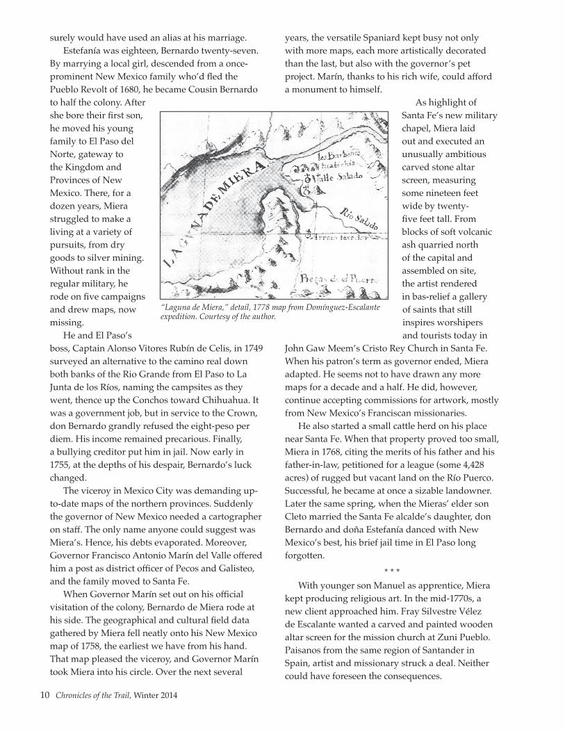
Bernardo de Miera y Pacheco lived a life bigger than any bronze statue. He deserves to have his name enshrined on a mountain somewhere in the Four Corners, or given to a new wilderness area, a river, a gorge, or a towering monolithic pinnacle. On his detailed map of the Domínguez-Escalante expedition of 1776, Miera himself wrote in block letters LAGUNA DE MIERA (MIERA’S LAKE) across a mirage bordering “unknown lands,” but the name didn’t stick.
We could set that right. Why not rename Utah Lake? The first non-Indian booster to marvel at the scene, Miera enthusiastically promoted the lake’s potential to the king of Spain. We have Escalante this and Escalante that, and of course Carson National Forest. So why not Lake Miera?
* * *Fair enough, but who was this prefabricated
bridegroom who showed up for his wedding in 1741 at the godforsaken presidio of Janos, Chihuahua? Were it not for his baptismal entry, we might not know of Bernardo de Miera y Pacheco’s birth in 1713 in the hill country of far north-central Spain. But what of his youth? Where did he learn to draw, paint, and sculpt? Who taught him the science of mathematics and cartography? When did he first pick up a brush, a chisel, or an astrolabe?
As el primogénito, the family’s first-born son, why did he leave home? On what ship, with whom, and where did he land? Was it a pull, an invitation he simply couldn’t refuse from a relative already established in the Spanish Indies? Or a push, a failed first marriage, a family tragedy, a scandal? Had young Bernardo fled a dastardly crime, he
10 Chronicles of the Trail, Winter 2014
surely would have used an alias at his marriage.Estefanía was eighteen, Bernardo twenty-seven.
By marrying a local girl, descended from a once-prominent New Mexico family who’d fled the Pueblo Revolt of 1680, he became Cousin Bernardo to half the colony. After she bore their first son, he moved his young family to El Paso del Norte, gateway to the Kingdom and Provinces of New Mexico. There, for a dozen years, Miera struggled to make a living at a variety of pursuits, from dry goods to silver mining. Without rank in the regular military, he rode on five campaigns and drew maps, now missing.
He and El Paso’s boss, Captain Alonso Vitores Rubín de Celis, in 1749 surveyed an alternative to the camino real down both banks of the Rio Grande from El Paso to La Junta de los Ríos, naming the campsites as they went, thence up the Conchos toward Chihuahua. It was a government job, but in service to the Crown, don Bernardo grandly refused the eight-peso per diem. His income remained precarious. Finally, a bullying creditor put him in jail. Now early in 1755, at the depths of his despair, Bernardo’s luck changed.
The viceroy in Mexico City was demanding up-to-date maps of the northern provinces. Suddenly the governor of New Mexico needed a cartographer on staff. The only name anyone could suggest was Miera’s. Hence, his debts evaporated. Moreover, Governor Francisco Antonio Marín del Valle offered him a post as district officer of Pecos and Galisteo, and the family moved to Santa Fe.
When Governor Marín set out on his official visitation of the colony, Bernardo de Miera rode at his side. The geographical and cultural field data gathered by Miera fell neatly onto his New Mexico map of 1758, the earliest we have from his hand. That map pleased the viceroy, and Governor Marín took Miera into his circle. Over the next several
years, the versatile Spaniard kept busy not only with more maps, each more artistically decorated than the last, but also with the governor’s pet project. Marín, thanks to his rich wife, could afford a monument to himself.
As highlight of Santa Fe’s new military chapel, Miera laid out and executed an unusually ambitious carved stone altar screen, measuring some nineteen feet wide by twenty-five feet tall. From blocks of soft volcanic ash quarried north of the capital and assembled on site, the artist rendered in bas-relief a gallery of saints that still inspires worshipers and tourists today in
John Gaw Meem’s Cristo Rey Church in Santa Fe. When his patron’s term as governor ended, Miera adapted. He seems not to have drawn any more maps for a decade and a half. He did, however, continue accepting commissions for artwork, mostly from New Mexico’s Franciscan missionaries.
He also started a small cattle herd on his place near Santa Fe. When that property proved too small, Miera in 1768, citing the merits of his father and his father-in-law, petitioned for a league (some 4,428 acres) of rugged but vacant land on the Río Puerco. Successful, he became at once a sizable landowner. Later the same spring, when the Mieras’ elder son Cleto married the Santa Fe alcalde’s daughter, don Bernardo and doña Estefanía danced with New Mexico’s best, his brief jail time in El Paso long forgotten.
* * *With younger son Manuel as apprentice, Miera
kept producing religious art. In the mid-1770s, a new client approached him. Fray Silvestre Vélez de Escalante wanted a carved and painted wooden altar screen for the mission church at Zuni Pueblo. Paisanos from the same region of Santander in Spain, artist and missionary struck a deal. Neither could have foreseen the consequences.
“Laguna de Miera,” detail, 1778 map from Domínguez-Escalante expedition. Courtesy of the author.

Chronicles of the Trail, Winter 2014 11
No one knew more about the human and physical geography of New Mexico than the veteran Miera and no one less than the neophyte fray Silvestre. Yet the latter’s religious superiors in Mexico City had instructed the young Franciscan to learn everything he could about a possible overland route westward from New Mexico to Monterey in Alta California. Imperial strategists intended to shore up east-west communication between the northern provinces.
As Miera carved and painted, Escalante pestered him with questions. A quick visit to the obstinate Hopis, who had thrown off Christianity in the Pueblo Revolt of 1680, and word of forbidding country beyond, convinced the missionary that any road westward must pass north of the Hopi towns through the country of the Utes. By the summer of 1776, fray Silvestre had convinced himself that a small party might make it through to California, although he questioned the odds. Discussions in Santa Fe with fray Francisco Atanasio Domínguez, his no-nonsense Franciscan superior, set plans in motion.
Apparently Escalante had oversold his countryman Miera. “I merely said,” the younger friar minced, “that he would be useful as one of those who were to go, not to command the expedition, but to make a map of the terrain explored. And I state that only for this do I consider him useful.” Too snide in translation, Escalante’s words presumed Miera’s part in the enterprise. But who else would go?
Only a handful of New Mexicans volunteered. Delays erased the friars’ planned departure on July 4, 1776. Ten members in all, soon swelled by a pair of runaway Genízaro Indians, they trailed north out of Santa Fe on July 29 with no idea of what lay ahead. Historian Herbert Eugene Bolton exalted their trek as “a pageant in the wilderness.” Hardly more notable than fleas on an elk’s back, these motley dozen souls were poised, nevertheless, to make one of the truly epic explorations of the American West.
Sixty-three-year-old Bernardo de Miera probably resented not being named captain of the little train. Worse, his stomach ached. On August 6, 1776, camped on the Río de Navajo (the San Juan), Miera shot the sun at midday with his astrolabe, making the latitude 31 degrees, 57 minutes (not fifty miles too high). That afternoon, according to
Father Escalante’s diary, Miera’s stomach “got much worse, but God willed that he got better before morning the next day, so that we could continue on our way.”
Their way led them westward splashing across the rivers of southwestern Colorado already named by New Mexican traders to the Utes: the Piedra Parada (or Standing Rock, for our Chimney Rock), the Río de los Pinos (still flowing through Bayfield), the Florido (our Florida), and the Animas. On the eighth, they camped on the site of Durango just downstream from today’s Strater Hotel (which, incidentally, didn’t open for another 111 years).
Up in the San Juans, the impatient Miera rode ahead alone along the Dolores and disappeared into Summit Canyon. Anxious, the two Franciscans sent another rider after him “to bring him back before he could get lost; but he had gone so far ahead that they did not arrive until after midnight at the place where the rest of us were waiting, extremely worried over the two’s delay.”
Still, they named the canyon El Laberinto de Miera, Miera’s Labyrinth, as Escalante explained, “because of the varied and pleasing scenery of rock cliffs which it has on either side and which, for being so lofty and craggy at the turns, makes the exit seem all the more difficult the farther one advances—and because Don Bernardo Miera was the first one to go through it.” Three days later, Miera insisted on climbing a rocky ridge that all but killed their horses.
Another month of trials and errors found them on Utah’s Green River. Artist and mapmaker Miera must have wondered at the enormous variety of land forms that slowly materialized on the horizon of their minute procession. A weather satellite, looking down from above on the expedition’s crazy, four-month-long, fifteen-hundred-mile loop around the Four Corners, would have tracked them northwest from Santa Fe, wobbling back northeast and recovering to the northwest. On the Green, in the vicinity of today’s Jensen, Utah, they were as far north as they would go. Yet more than half their vision quest lay ahead.
Having scrambled up, through, and around every obstacle, they rejoiced in the flat, open Utah Valley and the cautious but welcoming Uintah Utes. They were on the site of modern Provo. Miera, writing later to the king, pronounced this “the most pleasing, beautiful, and fertile site in all New Spain.

12 Chronicles of the Trail, Winter 2014
. . . This lake,” he continued,
and the rivers that flow into it abound in many varieties of savory fish, very large white geese, many kinds of ducks, and other exquisite birds never seen elsewhere, besides beavers, otters, seals (lobos marinos), and some strange animals which are or appear to be ermines, judging by the softness and whiteness of their fur.
But now the weather turned ugly. Heavy, wet snow fell in early October. The plain became so soggy that their pack animals staggered and got stuck. No Indian they met had heard of Spaniards to the west. And whatever mountain passes that lay in that direction were surely by now clogged with snow.
Fathers Domínguez and Escalante took worried council and decided that they must turn back. Miera fumed. The unruly cartographer and a couple of the others, according to Escalante, “came along very peevishly.” They could make it to Monterey in a week, Miera insisted, filling his companions heads with “grandiose dreams of honors and profits from solely reaching Monterey.” On an early version of his map, he estimated the remaining distance at only 140 leagues, some 364 miles. Actually, it was twice as far, and none of them knew about the Sierra Nevada.
Unnerved, the fathers relented. As previously on the trail, they would cast lots–on toward Monterey or back to Santa Fe? Despite Miera’s harangue, the lots fell to Santa Fe. “This we all heartily accepted now,” crowed Escalante, “thanks be to God, mollified and pleased.” Mollified and pleased? Whatever dark thoughts Miera harbored, had the little band listened to him, all would have frozen to death like the Donner Party seventy years later.
His stomach got worse. Ten days later, after the sun had set, the disgruntled map maker and most of the others ducked into an Indian hut. Fathers Domínguez and Escalante heard chanting but didn’t know until the next morning what was going on. A venerable Paiute medicine man, it seemed, had set about to cure Miera’s stomach, as related in the diary,
with chants and ceremonials which, if not overt idolatries (which they had to be), were wholly superstitious. All of our own gladly permitted them, the sick man included,
and they hailed them as indifferent kindly gestures when they should have prevented them for being contrary to the evangelical and divine law which they profess, or at least they should have withdrawn.
How the patient responded, the Franciscans didn’t bother to say. The journey back eastward would bring upon all of them thirst, hunger, and sickness from wild foods and bad water. They would eat horsemeat to survive and negotiate almost impassable slick-rock canyons and desert wastes. Finding a ford of the Colorado River deep in Glen Canyon cost them twelve grueling days. Today the so-called Crossing of the Fathers lies hundreds of feet beneath the surface of Lake Powell.
From there to the Hopi pueblo of Oraibi, cold and hunger stalked their every step. On November 12, while the rest of the half-starved party trailed out, the two friars remained in camp “to build a fire and warm up Don Bernardo Miera, who was ready to freeze on us and who we feared could not survive so much cold.” They said nothing about his stomach.
All survived. They never reached Monterey; their preaching had scant effect; and, at this stage, Spain possessed neither the motivation nor the resources to colonize the Great Basin. (Just seventy years later, Mormons, long on motivation but short on resources, would spill into the void.). Still, Fathers Domínguez and Escalante deserve enormous admiration for not losing en route a single one of their ten companions, each of whom endured countless perils by skill, luck, and God’s grace. How many of today’s rugged Rocky Mountain or canyonlands outfitters would step back willingly into the unknown landscape of 1776 for a four-month pack trip?
As Bernardo de Miera y Pacheco retraced their odyssey with his pen, placing meticulously a little circle with cross on top to mark every one of their eighty-odd campsites, he might still have heard the chanting of the Paiutes who tried to cure him. His busy and sweeping “Plano Geographico” would bring him only scant recognition in his day, since rival empires jealously guarded the work of their cartographers.
* * *Miera’s final years proved as full as his
middle years, especially after the arrival in 1778

Chronicles of the Trail, Winter 2014 13
of renowned Governor Juan Bautista de Anza. Estefanía was Anza’s second cousin. More important, Governor Anza commissioned new maps: of the Rio Grande corridor north from El Paso, of New Mexico’s eight administrative districts, and of Anza’s stunning victory over Comanches in 1779. When he enlisted Miera in the Santa Fe presidial garrison, Anza bestowed upon him the title distinguido–distinguished–in recognition of his service to the Crown. For the rest of his life, Miera acted as senior adviser to the governor on the social, political, and Indian affairs of the colony.
And all the while, he kept carving and painting. Art historians date some of his best work well into the 1780s. Both of his sons’ young first wives died, and they remarried. More grandchildren. Then, late in 1783, doña Estefanía died. Don Bernardo survived her for only a year and a half. In April 1785 they laid him to rest beside her in the military chapel at the base of his enduring stone altar screen.
Governor Anza noted at the foot of Miera’s enlistment document that the subject had died “naturally.” Whether the stomachaches he suffered a decade earlier figured in his death, we don’t know. While his early life in Spain is yet to be revealed, the man and his accomplishments in distant New Mexico still inspire. Over the years, the unruly cartographer, a European Spaniard by birth, had been transformed into the quintessential Hispanic New Mexican.
As such, Bernardo de Miera y Pacheco deserves that commemoration. Had someone suggested the name to Anza, Utah Lake would surely be Lake Miera today. And neither of the Fathers would have seen any harm in that.
NOTE: Citations to all sources and quotations can be found in John L. Kessell, Miera y Pacheco: A Renaissance Spaniard in Eighteenth-Century New Mexico (Norman: University of Oklahoma Press, 2013), reviewed in Summer 2013 Chronicles of the Trail.
JOHN L. KESSELL, PhD, author of Miera y Pacheco: A Renaissance Spaniard in Eighteenth-Century New Mexico (University of Oklahoma Press, 2013), is professor emeritus at the University of New Mexico. He holds an MA in History, specializing in Latin America, from UC Berkeley, and a PhD in History from UNM. Dr. Kessell, who has dedicated his academic career to the study of colonial Latin America and the American Southwest, counts among his many articles and books Kiva, Cross, and Crown: The Pecos Indians and New Mexico, 1540–1840 (National Park Service, 1979), and Pueblos, Spaniards, and the Kingdom of New Mexico (Norman: University of Oklahoma Press, 2008).
Altar screen, carved and painted for the military chapel La Capilla de Castrense, 1761, now in Cristo Rey Church, Santa Fe. Photograph by Miguel Gandert.

14 Chronicles of the Trail, Winter 2014
FIELD REPORT: SEARCHING FOR EL CAMINO REAL DE TIERRA ADENTRO IN THE JORNADA DEL MUERTO
By Elizabeth A. Oster and David H. Reynolds
Introduction and Purpose of the StudyThe nature of El Camino Real de Tierra Adentro
as it passes through New Mexico and Texas has posed many challenges for identification and documentation by field archaeologists. Crucial as it was for the movement of people, animals, and material items between the cities of the south and the despoblado (sparsely populated area—a term the Spanish used to characterize New Mexico) of the north, it remained a route rather than a road for most of its passage through what became the United States. Military cartographers, particularly from the mid-nineteenth century forward, created some excellent maps that continue to provide useful information for scholars of El Camino, but documents such as these were not available for much of the trail’s use-life, and would not, in any event, have been provided to most travelers. Until the twentieth century, when some portions of “El Camino Viejo” became formalized for use by motorized vehicles, the northern segments of El Camino Real de Tierra Adentro were defined, for the most part, by oral tradition, directional clues provided by landscape features, and the marks of passage left behind by previous travelers along the Royal Road.
Finding and correctly interpreting those physical traces is a daunting task for an archaeologist. Investigations of El Camino in New Mexico have generally focused upon documentation of landscape features such as swales and traces, significant changes in vegetation patterns, or associated resources such as parajes (campsites) or springs, all of which can be easily missed by traditional “eyes on the ground” approaches to transect-based field surveys in archaeology. While eroding constructed ramps, or artifacts such as olive jar sherds or military ordnance, are easier to spot on the landscape, such physical manifestations of traffic along El Camino are also rare.
A project sponsored by the New Mexico Spaceport Authority (NMSA) in New Mexico’s Jornada del Muerto is currently exploring the
utility of conducting focused pedestrian surveys in selected locations as indicated by analyses of remote sensing and other data, to identify trail traces and associated resources that have not been previously (or easily) detectable. The methodology incorporates information derived from multi-spectral satellite imagery, manipulated using geospatial applications to provide georeferenced locations for potential El Camino resources. The newly identified loci are being “ground-truthed” by archaeologists, and investigated and recorded using systematic techniques. In the final phase of the project, geophysical remote sensing techniques will be applied to targeted locations. The primary goal is to locate, georeference, and document as many vestiges of El Camino—and associated resources, such as camps, water sources, use areas, etc.—as can be identified within the study area that encircles the Spaceport America campus1.
Preliminary results indicate that the opportunity afforded by combining an array of remote sensing technologies with standard archaeological field methods permits a fuller characterization of the cultural landscape of El Camino in the Jornada as it was used through time than has previously been achieveable, perhaps pointing the way to an improved methodology for finding and recording elusive linear features such as historic trails. The project is being conducted on behalf of the NMSA and the Federal Aviation Administration (FAA)—in partnership with land-managing agencies and other consulting parties—as creative mitigation for effects of the construction of Spaceport America upon El Camino Real de Tierra Adentro and other fragile cultural resources of the Jornada del Muerto.
The study area addressed in this investigation is located in the central/south-central portion of the Jornada del Muerto, a north-south trending basin in Sierra County, New Mexico (Figure 1). Three major drainages or “draws”—Aleman, Jornada, and Yost—cross the area proposed for study, defined as a five-mile radius around the Spaceport (approximately 10,308.136 acres/4,171.57 hectares)

Chronicles of the Trail, Winter 2014 15
encompassing the “setting” or “visual effects” Area of Potential Effects (APE) for the Spaceport undertaking. Previously recorded cultural resources in the general project area and vicinity identified during archaeological surveys date from the Paleoindian Period up through the twentieth century, preserving a record of human use of the Jornada for the last 11,500 years. The majority of the cultural properties in the Central Jornada are prehistoric Native American sites, but the project area also includes segments of El Camino identified as portions of the Yost Draw Study Area (Marshall 1991; also see Merlan et al. 2010a&b) as well as the historic Aleman/Bar Cross Ranch complex2, which is privately owned. The ranch complex has been determined as “eligible” for the National Register of Historic Places, and encompasses
standing structures as well as archaeological components.
Relevant Previous ResearchOutlining the history of previous research in any area selected for investigation is a necessary first step, one often fraught with challenges unique to the kinds of resources being studied. This is particularly true for El Camino Real de Tierra Adentro, a linear feature that crosses more than 1,500 miles passing through two different countries, linking a variety of landscapes, historic trajectories, personal histories, and multitudinous aspects of human activity and interaction that transpired over the course of hundreds of years. Selecting appropriate nomenclature has, itself, posed a challenge, as noted in the Multiple Property Documentation Form (MPDF) prepared for the 2012 National Register listing of segments of El Camino in New Mexico:
There were various caminos reales in Spanish America. The term “camino real” means literally a royal road, but these roads were
neither authorized by the king nor laid out by government officials. They were trails defined and developed over time for the use of colonists, merchants, ecclesiastics, government officials, and visitors [Jones 1999:342]. They served as primary routes for transportation, communication, and colonization.” (Merlan et al. 2010a:3).
The concept of caminos reales apparently could also be extended to include maritime routes, as well as Precolumbian trails that continued to be used after the arrival of the Spanish3 (Merlan et al 2010a:4). The authors of the National Register MPDF note that while the name “Camino Real de Tierra Adentro” is commonly used in the modern literature of the road, the qualifying phrase “de
Figure 1: Project location, in the central Jornada del Muerto, a north-south trending basin in Sierra and Doña Ana Counties, New Mexico. The study area, defined as a five-mile radius around the Spaceport campus, is also depicted.

16 Chronicles of the Trail, Winter 2014
tierra adentro” would not have been likely to have been used in New Mexico (Merlan et al. 2010a:3)4. The source cited for this qualifier in the MPDF (and elsewhere) is the distinguished nineteenth-century traveler Alexander von Humboldt, who described four principal roads or caminos that were most vital and “más frecuentados” as commercial routes to and from Mexico City in the era, including “el camino de tierra adentro,” the road from Mexico City north to Durango and Santa Fe (Humboldt 1996:462, cited in Merlan et al. 2010a; also see Sanchez 2011). This nomenclature is thought to have served as a common name in colonial Mexico to refer to the far north, rather than as an official reference. Another referent has been noted as occasionally used in historic New Mexican documents, to refer to any place beyond New Spain’s northernmost frontier: “tierra afuera,” literally, “outside land,” or lands (David Snow, personal communication, cited in Merlan et al. 2010a:3-4).
Mike Marshall credits Cleve Hallenbeck and Max L. Moorhead with initiating formal scholarship of El Camino Real de Tierra Adentro, at least on this side of the international border, in the 1950s, although the study published by France V. Scholes predates their work by two decades (Marshall 1991:1; Scholes 1930). Hallenbeck writes about El Camino within the larger context of the Spanish conquest of North America (1950). Moorhead’s landmark study focuses on documentation and exploration of commerce and related activities along the northern portion of the route, which he refers to primarily as the “’Chihuahua Trail,’ . . . the link between the mining frontier of Nueva Vizcaya and the mission frontier of Nuevo México—the very lifeline of the missions, garrisons, ranches, and towns of the latter province during the two-and-one-half centuries of its occupation by Spain” (1995:7). Studies of El Camino and associated resources on the Mexican side of the border—which encompasses more than two-thirds of the historic route, including some sections
of formally engineered road—have followed a different orientation, with a focus on the historic trajectory and economic importance of silver mining in the northern marches of viceregal New Spain (Lopez Morales 2010).
Interest in protection and investigation of El Camino has burgeoned in the last several decades, resulting in a multitude of field and archival investigations, as well as the major heritage preservation efforts underwritten by the federal governments of the United States and Mexico, as described above. The flowering of Camino-related research has resulted in a diverse array of scholarly publications, field studies, journals, and anecdotal information. Some aspects of life along the historic trail have been thoroughly researched and documented, while others (including actual
locations of trail traces and associated resources, such as archaeological sites and springs) remain to be investigated.
While it may not be feasible to summarize the “status of knowledge” for El Camino as a whole at this juncture, the list of investigations of segments of El Camino within and near the Jornada del Muerto and the Spaceport encompasses
a more familiar neighborhood. These are summarized below, and consist of a number of research studies of trail loci in and near the project area, investigations conducted in order to permit identification of resources associated with the Spaceport undertaking, and background investigations conducted in order to create management documents and National Register nominations.
An innovative study of El Camino conducted from 1988 to 1990 by Mike Marshall resulted in the identification of sixteen road segment study areas, from Galisteo and La Bajada in the north to the Robledo Paraje near Fort Selden in the south, including the Yost Draw Study Area (1991). This research was undertaken under the auspices of the Camino Real Project, Inc., and the New Mexico State Historic Preservation Office (NM SHPO), and set
Mule shoe fragment recorded on the Trail, south of the Aleman/Bar Cross Ranch.

Chronicles of the Trail, Winter 2014 17
the stage for much of the work related to El Camino that would be accomplished in the ensuing decades, including the recent investigations that provided the basis for the multiple property nomination to the National Register. The project work ultimately combined the results of research using historical documents for a study of place names related to El Camino begun by Mike Marshall earlier in the 1980s with an archaeological reconnaissance of selected locations along El Camino in New Mexico (Marshall 1984; 1991). Fruits of the project work included the creation of a museum exhibit in 1990, “El Camino Real—Un Sendero Histórico,” sponsored by the National Endowment for the Humanities. At around this time, a Camino Real scenic highway marker project was sponsored by the New Mexico State Highway Department (now the New Mexico Department of Transportation).
Ed Staski (New Mexico State University at Las Cruces) conducted archaeological excavations at Paraje San Diego, located near the southernmost portion of the Jornada del Muerto (1998, 1999). Excavation data for El Camino and associated resources are very scant, thus results of this work (as well as the excavations conducted further north, in connection with the Spaceport undertaking) are invaluable. Staski followed up this research with a survey of segments of El Camino located between Las Cruces and El Paso (Staski 2004). Mike Marshall’s study of Qualacu (LA 757), near Socorro, a Piro site visited by Oñate’s expedition, provided excavation data for a contemporaneous indigenous village (Marshall 1987).
Four surveys using metal detectors were conducted along four segments of El Camino in the Jornada del Muerto in 2008 and 2009, in locations that have since been designated as “waysides for the public to experience the trail” (Laumbach and Legare 2009). The locations that were examined include three contiguous segments in the Yost area and one segment in the Point of Rocks area. Identification, collection, and analyses of metal artifacts (together with provenience data) in order to interpret different aspects of travel along El Camino were the primary objectives of the work that was performed in the field and later in the lab, but some samples of other historic materials were collected and analyzed as well. Prehistoric artifacts were noted and point-provenienced, but not collected. The post-field analyses included preparation
of distribution maps for various artifacts in the assemblages, which were diverse and included some temporally sensitive items (Laumbach and Legare 2009).
Cameras mounted on remote-controlled model airplanes were used to locate and photograph segments of El Camino between La Joyita and the southern boundary of Sevilleta National Wildlife Refuge in 2009 and 2010 (Harper 2010). The results of this work were analyzed to locate potential trail segments in the project area, which were then visited by an archaeologist conducting a reconnaissance survey to verify their association with El Camino.
The FAA, in partnership with the NMSA, conducted three intensive cultural resource inventories of the proposed construction areas identified for the Spaceport undertaking in 2007, in order to identify and provide the basis for evaluating the National Register eligibility of extant historic properties (as well as assessing the effects of the proposed construction). These efforts built upon earlier surveys that had been conducted in advance of the proposed “Southwest Regional Spaceport” by Human Systems Research (HSR 1997). The 2007 surveys included: (1) an inventory of all proposed construction areas located on the Spaceport site, encompassing the vertical and horizontal launch areas, access roads, wastewater treatment plant, and utility corridors (referred to as the “onsite inventory”); (2) an inventory of all offsite construction areas, including the location of the substation and electrical distribution line, as well as fiber optic cables (the “offsite inventory”); and (3) an inventory of the water well field and associated pipeline corridors (Gibbs 2009; Quaranta and Gibbs 2008a&b). The inventory efforts resulted in surveys of over 3,000 acres and identification of 80 cultural properties (primarily archaeological sites) and 622 isolated occurrences. With respect to El Camino, the investigations combined information derived from previous studies of the trail and aerial photography with data provided by the ground surveys and ancillary studies (FAA 2008). El Camino resources in the vicinity of the Spaceport campus included the ten identified trail segments that, with Yost Crossing, comprise the Yost Draw Study Area and have been designated as high-potential route segments, as well as Paraje del Alemán, designated as a high-potential historic site. The

18 Chronicles of the Trail, Winter 2014
historic Aleman/Bar Cross Ranch complex has been determined as “eligible” for the National Register as the Aleman Draw historic district, and encompasses standing structures as well as archaeological components.
The next major piece of research in the project area consists of data recovery conducted in 2009 at four archaeological sites (LA 8871; LA 51205; LA 80070; and LA 155962) located along the Spaceport entrance road (Vaughan et al. 2013)5. El Camino crosses the entrance road at this location, identified as Laboratory of Anthropology (LA) 80070, but also bisects a prehistoric site (LA 155962) and touches the Aleman Draw historic district, LA 8871. Three studies included in the data recovery report as appendices capture the results of specialized studies of El Camino, including an optical remote sensing study of additional acreage in the vicinity of the Spaceport campus (Hudspeth 2013); a magnetic geophysical investigation conducted using a gradiometer in portions of LA 155962 and LA 80070 (Reynolds 2013); and a reconnaissance survey along a short segment of the Trail immediately south of Aleman Arroyo conducted during the recent data recovery efforts for the Spaceport (Marshall 2013). The results of these investigations have provided some useful additional information about El Camino in the Central Jornada, as well as helpful indices for future studies, including the present investigation.
Hudspeth’s remote sensing study is of particular relevance, as it employed edge enhancement and multivariate image classification of aerial and satellite-derived imagery that incorporated 3-band spectral data (also known as RGB-bands data, as explained below). The results of this effort point to two previously undocumented potential El Camino traces in the vicinity of the Spaceport, described as follows:
The first is to be found north of Alemán Ranch, running from a distance of 1.3 km north of the ranch (UTM Zone 13 NAD 27 coordinates 313044E/3653538N) to a point that lies approximately 2.4 km north of the ranch (UTM Zone 13 NAD 27 coordinates 312914E/3654725N). This segment of the trail lies north of the area surveyed by Marshall. . . . In the imagery studied in the present work, the parallel trail tracks is [sic] represented by two linear alignments of
vegetation. Without field inspection of the identified alignments, it is impossible to determine whether the parallel alignments are indeed independent path, or merely two sides of an eroded linear depression which marks the single path of the trail. . . .
A second segment that appears to consist of two parallel tracks runs south from a point about 0.95 km south (UTM Zone 13 NAD coordinates 313229E/3651359N) of Alemán Ranch to a point approximately 1.2 km south (UTM Zone 13 NAD 27 coordinates 313272E/3651000N) of the ranch. Again, these features are mostly represented by linear alignments of vegetation.” (Hudspeth 2013:27-32)
The geophysical study performed by Reynolds in conjunction with the data recovery effort followed up on a preliminary study, also conducted using a gradiometer at the same two sites (LA 155962 and LA 80070) in the fall of 2008 (Reynolds 2008). The results of the gradiometer studies indicated that the technique is feasible in the environmental setting of the Jornada, but that more work would be needed to ground-truth feature loci suggested by the gradiometric assays.
MethodologyThe current study combines “new” and
“old” data obtained from a variety of remote sensing sources and geospatial analyses, with “old-fashioned” pedestrian field survey by archaeologists. Remote sensing technologies and analytic applications have been used as a common component of archaeological investigations for decades, certainly since the “scientific revolution in archaeology” of the 1960s and 1970s. The array of technologies, data sources and outputs, and applications referenced by use of the term “remote sensing” have become increasingly varied and will likely continue to do so. Most fortunately, the technologies involved in data acquisition, as well as the analysis software, have become more accessible, more effective, and more easily usable by archaeologists and geospatial analysts. The use of remote sensing does not replace traditional archaeological techniques such as hand or mechanical excavation and pedestrian survey, but strategic use of remote sensing data and analyses can greatly facilitate the detection of archaeological

Chronicles of the Trail, Winter 2014 19
features that may not be visible through traditional means of investigation. The reason is simple: the technologies permit discernment of features both on and below the ground surface that are not easily identified by the means available to ordinary human perception, i.e., the “naked eye.” Used effectively, remote sensing is a key component of the field archaeologist’s tool kit.
The increasingly broad category of technologies describable as “remote sensing” can generally be subdivided into two groups. First, and probably most commonly used, are techniques that involve optical data collection from a vantage point above the surface of the earth, including aerial photography and satellite imagery. These technologies were among the first to be widely used for remote sensing investigations of the earth’s surface and continue to have great utility for investigations of landscapes, particularly since commercial access to the data and the means for processing them have improved. More recently, “Light Detection and Ranging” technology, or LIDAR, has involved the use of lasers to collect data from points on the ground. This emerging technology has been employed using low-flying planes or helicopters, but can also be adapted to ground-based equipment. The second group consists of geophysical remote sensing technologies, including gradiometry, ground-penetrating radar, and metal detection. These techniques complement the broad perspective provided by data collected from above the earth’s surface, providing the opportunity to focus on smaller units of investigation and to collect below-ground imagery and other information. In the current era, many archaeological investigations utilize techniques from both groups, a trend that will likely continue.
While remote sensing data sources may vary, many of the methods used to process and analyze them are the same. In analytic terms, remote sensing investigations are a form of geospatial analysis. As such, they ultimately involve the creation and manipulation of data sets using methodologies that incorporate algorithmic calculations and statistical assays characterized as spatial analysis, such as nearest neighbor analysis, edge detection, etc. Typically, the remote sensing data, once collected, are post-processed using techniques of photogrammetry and Geographic Information Systems (GIS) and/or other geospatial modeling
applications to create the desired outcome, such as a map or a set of orthophotos.
Previous research and identification studies conducted in the vicinity of the Spaceport and elsewhere along El Camino, as described above, have yielded a variety of types of information about locations of segments of the trail as well as associated resources. These data provided a substantial body of very useful information about where to look for additional traces of El Camino in previously unsurveyed areas, suggesting logical “next steps” for building upon the work that has already been done, using the most relevant and applicable strategies for collecting new data. Previously available data sources include one-foot mapping contours derived from stereo pairs and georeferenced orthophotographs (produced by AECOM and Bohannon-Huston); mapping contours provided by Doña Ana and Sierra Counties; shapefiles of the centerline of El Camino and the spring at Aleman (provided by the National Park Service, the Bureau of Land Management, and various cultural resources contractors to the NMSA); architectural and archaeological data documenting the cultural resources of the Aleman/Bar Cross Ranch and vicinity (collected during the identification efforts for the Spaceport undertaking);
Figure 2: Oblique projection of El Camino Real de Tierra Adentro in the vicinity of the Spaceport.

20 Chronicles of the Trail, Winter 2014
gradiometric data and the results of the edge detection remote sensing study for portions of the Alemán paraje and El Camino (collected during data recovery conducted for the Spaceport); Laboratory of Anthropology (LA) forms from previous studies of El Camino; low-altitude oblique aerial photographs of the trail in the Jornada del Muerto (Figure 2, previous page); and historic maps documenting paraje locations and El Camino segments in the Jornada del Muerto, as well as other archival data.
For realization of the objectives of this study plan, 4-band (multispectral) satellite imagery was selected as the optical remote sensing strategy with the best potential for yielding data that could be used to detect previously undocumented traces, swales, and other resources associated with El Camino in the open desert of the Jornada del Muerto. While LIDAR was considered, the utility of the technology is questionable in the environmental regime of the study area, thus the very high cost of acquiring LIDAR data was not justifiable. The satellite data were analyzed in conjunction with the existing data sets described above, including aerial photographs (available in abundance, including imagery produced by low-altitude flights), GIS data, and the results of archival research and previous archaeological fieldwork.
Satellite imagery often includes multi-spectral data collection of information from the earth’s surface, and can record such attributes as color, thermal signature, and water retention. Typically, satellites collect “RGB-band” data as well as data from other spectral bands (depending on the sensor used), hence the term, “multispectral imagery.” A benefit of using multispectral satellite imagery is that the data contain four color bands—R,G,B, and “near infrared” or NIR—thus incorporating wavelengths that exceed the color perception capabilities of the human eye6. Of particular importance to remote sensing in archaeology is the NIR band, which measures moisture retention. Often, archaeological features exhibit moisture retention properties distinct from those inherent to surrounding landscape elements, but these differences are only discernible through spectral analyses. By manipulating and combing the various bands using geospatial modeling techniques, archaeological features can be detected that may not be discernible when only the RGB band data are accessed. Analyses of multispectral data of this type
has been successfully used in other studies of the Jornada Basin (Duncan et al. 1993).
The utility of spectral data collected by early satellites was limited by a relatively large resolution of 30–60 feet per pixel, limiting investigations to large sites, such as Angkor Wat in Cambodia and various Mayan sites throughout Mexico and Guatemala. Recently several commercial satellites have been launched that provide resolutions of 0.5 feet (one half of a foot) per pixel across multiple spectra. This resolution is sufficient for use on smaller archaeological resources, and the cost of acquisition and analysis has made the technique feasible for archaeology.
The techniques and attributes used for analyses of satellite imagery are similar to those used for aerial photography, including photogrammetric processing prior to use in geospatial analyses. Prior to the analysis of multispectral imagery, photogrammetric processing of the images is conducted to correct for an optical distortion and georeference the data to a specified coordinate system. The data set, after processing, removes the distortion and renders the data usable for conducting analysis in real-world coordinates, often with sub-meter accuracy. A common problem inherent in the use of multispectral imagery is that the image swath is limited by the range of the satellite sensor, and it can be difficult to obtain imagery over a large area collected simultaneously. Imagery collected along different swaths can be combined or “mosaiced,” but using composite imagery analysis can be compromised by variances in environmental conditions at the time the data were collected, such as weather, humidity, ground vegetation, and seasonal changes in ground cover; thus, the researcher must take pains to correct for such potential error factors.
Production of the geospatial data being used to guide the current study began with tracing previously identified segments in the study area using pan-chromatic and color infrared Digital Orthophoto Quarter Quads (DOQQ; an aerial image in which displacement caused by terrain relief has been removed), ultimately creating shapefiles using GIS software. The imagery accessed during this step resulted from flights made during the irrigation season (summer months). Any other obvious alignments identifiable on the imagery were also traced at this time. Next the color

Chronicles of the Trail, Winter 2014 21
infrareds of the DOQQs were processed using band-ratio analysis to look for other alignments, moving out from the known portions of El Camino (and nearby traces) revealed first. Other potential alignments immediately became apparent when the red to green band ratio was examined. Next, “tiles” of 4-band or “multispectral” imagery from the Worldview 2 satellite were processed using a geospatial application known as ENVI to calculate the normalized differential vegetation index (NDVI), providing another source of landscape patterning with potential to highlight El Camino segments7. The results of the NDVI conversion reinforced the potential of some of the previously detected alignments, but also revealed some new ones. Digitial Elevation Marker (DEM) slope data available from the U.S. Geological Survey were
also examined. Finally, the various indicators of potential El Camino segments from all sources were explored using a Principal Components Analysis, in order to differentiate between “most likely” versus “least likely” El Camino segments, given the variety of data under consideration. Ultimately, the locations for all potential El Camino alignments in the study area were converted to georeferenced ArcGIS format, and maps and coordinate data were produced for use by field crews in the “ground-truthing” phase of the study (Figure 3).
Durig the summer and fall of 2012 the effectiveness of using the results of the comprehensive analyses of multispectral and other data to create targeted, georeferenced locations for field identification of potential El Camino segments was put to the test. Using the maps and datasets produced during the analyses described above, archaeologists selected a subset of suspected locations for El Camino segments, swales, traces, and associated resources and attempted to locate them in the field. The primary objective for this pilot phase was determining whether the results of the geospatial analyses could serve as reliable indicators of alignments that could represent traces of El Camino on the ground. The results were very successful: the field crew was able to walk to every georeferenced segment location and to begin assessing them as likely/unlikely El Camino alignments (not every identifiable linear segment on the Jornada is, after all, an El Camino trace). Following the “pilot phase” fieldwork, a second round of analyses was conducted to evaluate the results of the initial analyses in combination with the results of the pilot phase of ground-truthing and evaluation of suspected trail traces and associated resources. The goal for this phase of the research was to refine all aspects of field and analytic methodology, in preparation for the major round of archaeological survey, now underway.
At this juncture, project work is in the hands of the field archaeologists searching for suspected segments and traces of El Camino and associated resources on the ground. While the primary goal of the research is to locate as many physical manifestations of El Camino as possible within the study area, systematic documentation of these resources is also occurring. Current standards for archaeological documentation in the New Mexico Cultural Resources Information System (NMCRIS)
Figure 3a: Example of a high-quality aerial photograph in which the primary trace of the El Camino south of the Aleman/Bar Cross Ranch is clearly visible.
Figure 3b: The results of the NDVI analyses enable discernment of alignments that are not visible on the aerial photograph taken of the same portion of the landscape. The westernmost alignment (on the left in the photo) is a newly identified segment of El Camino.

22 Chronicles of the Trail, Winter 2014
as well as the Federal Trail Data Standards (FTDS) are being employed for data collection. This includes recordation of dimensions, cross-sections, features, structures, surface artifacts, and condition for El Camino segments (including the primary trail trace as well as branches and parallel traces) and associated resources on Laboratory of Anthropology (LA) site forms (including GPS data and georeferenced photographs). All archaeological sites encountered within the areas designated for survey are being recorded, including El Camino segments and associated resources as well as other historic and prehistoric sites. Ultimately, seventeen previously recorded sites—including El Camino segments and other resources—located within 100 meters of El Camino’s main trace in the study area will be relocated and revisited, and re-recorded in the instances in which sites are not recorded to current standards or for which additional, more precise data are needed in order to characterize them fully. In addition, a 100-meter-square quadrat around each previously recorded site, and 100-meter buffers on either side of newly identified El Camino segments, are being surveyed where physiographic conditions permit using pedestrian transects both parallel and perpendicular to the trail. As the work proceeds, working criteria for use in distinguishing the historic trail segments from linear alignments created by ranchers, cattle, and other users of the Central Jornada landscape are being developed and applied (Figure 4).
Final project phases will involve focused geophysical investigations, such as metal detecting, but may also involve soil conductivity analyses or other geophysical techniques for targeted data collection in key areas. It is presumed that, at a minimum, metal detection studies will prove useful for collecting data in at least some locations, but in order to make such a determination—or to invoke other geophysical remote sensing techniques—it will be necessary to evaluate the results of the work that has already been accomplished before proceeding.
ConclusionsAlthough project fieldwork and analyses
are still ongoing and it will be some time before all of the results are reported, this effort can be judged a success in several key respects. First and foremost, “new” and “old” segments of El Camino and associated resources in the study area—as
well as other previously undocumented cultural resources—have been (and are being) physically identified and georeferenced. Second, these resources are being systematically documented and fully characterized according to current state and federal standards, ensuring the maximal utility of the data for current and later researchers, and land managers. And finally, the synthetic approach defined by combining state-of-the-art remote sensing and geospatial analytic techniques with time-tested survey and recording techniques in field archaeology points the way to a comprehensive methodology for finding and recording elusive linear features such as historic trails.
Identifying and systematically documenting the physical manifestations of El Camino Real de Tierra Adentro throughout the many hundreds of years of its use by travelers through the Jornada del Muerto represent the most important aspects of this study, as well as the manner in which field archaeology can most effectively contribute to El Camino studies. As has been noted above, interest in and studies of El Camino have flourished in recent years, producing a variety of excellent historical treatments and archival studies. Archaeology has also certainly been conducted, although in a more limited manner.
“Trail archaeology” in most of the United States, given that we are generally seeking to identify “routes” rather than “roads,” is a difficult enterprise, too often comparable to searching for a needle in a haystack. In the current era, it is not uncommon for a project proponent or land-managing agency to be required to send field archaeologists out to survey 15-meter transects in a given project area wherein archival data have indicated that a historic trail route might be located (or is projected), in the hope or belief that if anything is there to be seen, experienced field folk will find it, and be able to document it. In the experience of the authors of this report (both experienced field archaeologists), nothing could be further from the truth. Trail archaeology requires an intimate knowledge of the landscape, including vegetation and topography as well as probable cultural manifestations, in addition to a thorough understanding of relevant archival and other historical data. Even then, trail and “swale” indications are often so very subtle as to be invisible if you don’t know where to look for them. The

Chronicles of the Trail, Winter 2014 23
Figure 4: View of a trail segment north of the Aleman/Bar Cross Ranch.
sort of georeferenced information provided by the analyses used in this study has the effect of arming a field archaeologist not only with an extra set of eyes, but with eyes that can “see” what mere humans cannot.
Our questions are related to, but different from, the questions asked by historians. We are seeking to find physical evidence that documents where the carretas actually rolled, and where they were camped, what side or ancillary trails might have been used, where the people and their animals found water, and what kinds of material cultural objects were used—and potentially discarded—along the way. For a historic route in use as long as El Camino Real de Tierra Adentro, additional interesting questions include identifying changing ethnicities (and/or nationalities) of trail travelers based on material culture, as well as changing modes of conveyance. Preliminary results of the work reported here indicate, for example, that tied to the time period of reference and preferred contemporary mode of conveyance, the location of El Camino shifted. It is only to be expected: one would take a hill differently in an oxcart as opposed to a motorcar (both of which were used on portions of El Camino at different time periods). Archaeology seeks out and attempts to explain physical correlates of human behavior, a process that can complement the study of written records, but can also provide details that are missed by chroniclers and diarists. Histories tend to be written by the “winners,” and often focus on the events and activities involving the major players. The archaeological record, however, is created by everyone.
Documenting physical manifestations of historic trail segments and associated resources is of major importance in the modern era. This is because we are at a critical juncture in our cultural trajectory, involving a major shift from old, fossil-based
energy resources to new “green” technologies such as solar and wind power generating stations and their associated transmission lines. The new technologies, while certainly important and promising in terms of reducing carbon emissions and other aspects of “old energy” systems, are in a hyper-development planning and execution stage, and have the potential for major impacts to many of the cultural and natural landscapes that preserve our nation’s historic trails, the sorts of landscapes that were considered to be part of the “Great American Desert” in the nineteenth century. Ancient cultural and natural landscapes such as the Jornada del Muerto, or the Mojave Desert, or California’s Central Valley are currently under consideration for energy development projects that will affect not only viewsheds but also, potentially, the physical manifestations of the historic trails we are
attempting to preserve. Effective management of our historic trail resources requires documentation of where they actually are, as opposed to where we think or presume that they might have been. It is certainly possible to accommodate necessary develop-ment while preserving and even learning more about significant historic properties; the study reported
here is an example of such an effort. But in order to effectively manage any sort of historic property, it is necessary to know what it is, where it is, and why it is significant. Any land manager will attest to this.
The work reported here builds upon a number of excellent previous efforts, as detailed above. It is hoped that, through the combination of twenty-first century satellite data and geospatial analyses with standard techniques of archaeological fieldwork, studies of El Camino Real de Tierra Adentro and other historic trails in America are moving to a new level. Only time, of course, will tell.

24 Chronicles of the Trail, Winter 2014
NOTES1 During the Section 106 consultation conducted for the Spaceport undertaking, the FAA—in consulta-tion with the New Mexico State Historic Preserva-tion Office (NM SHPO), land managing agencies, Native American Tribes, and other consulting parties—defined two “Areas of Potential Effects,”or APEs. These are defined as: “…the Physical APE, comprised of the areas that may be directly affected by physical ground disturbance and construction of the commercial space launch site, [and] the Setting APE, comprised of the area within five miles of the facility wherein potential visual and audible effects to the historic properties may occur. . . .” (FAA 2008). Portions of El Camino lie within both of the APEs as identified.2 The traditional spelling, “Alemán,” is edited here to adapt to modern nomenclature. Contemporary documents drop the diacritical marking used in Spanish, and refer to the ranch as “Aleman.” The contemporary spelling is used when the modern era is referenced, while the Spanish spelling is used for historic terms such as paraje locations.3 In the experience of one of the authors of this re-port, “old” or historic roads in Mexico are routinely referred to as caminos reales by local residents.4 In modern parlance, the qualifier “de tierra ad-entro” also serves to distinguish the interior route from two other important caminos reales, El Camino Real de los Tejas (a route that ran from Monterey, Mexico, through Texas to Robline, Louisiana) and El Camino Real or the King’s Highway in what the Spanish referred to as Alta California. El Camino Real de California, also known as the “California Mission Trail,” connected missions, presidios, and pueblos from Misión San Diego de Alcalá in San Diego to Misión San Francisco de Solano in Sonoma.5 The final draft of the data recovery report is currently under review by the Section 106 consulting parties to the Spaceport undertaking.6 Data from spectral bands that exceed the color perception abilities of the human eye are also sometimes referred to as “hyperspectral imagery.” Other data capture techniques can provide hyperspectral imagery.7 NDVI (Normalized Difference Vegetation Index) is a relative measurement of the photosynthetic capacity of plants, as indicated by a ratio that is based on the spectral reflectance measurements acquired in the visible (red) and near-infrared regions. These spectral reflectances are themselves ratios of the reflected over the incoming ratios in each spectral band individually; values are between 0.0 and 1.0. NDVI = (NIR – VIS) ÷ (NIR + VIS)
REFERENCES CITEDDuncan, J., D. Stow, J. Franklin, and A. Hope
1993 Assessing the relationship betweenspectral vegetation indices and shrub cover in the Jornada Basin, New Mexico. International Journal of Remote Sensing, 14(18):3,395-3,3416.
FAA (Federal Aviation Administration)2008 Final Environmental Impact Statement
for the Spaceport America Commercial Launch Site, Sierra County, New Mexico (volume 1). Office of Commercial Space Transportation, FAA, Washington, D.C.
Gibbs, Victor2009 A Cultural Resources Survey for the
Proposed Wastewater Treatment Plant (NMCRIS 114371). Zia Engineering & Environmental Consultants, LLC, Las Cruces, New Mexico. Zia Report No. LCS-09-028).
Hallenbeck, Cleve1950 Land of the Conquistadores. Caxton Printers,
Caldwell, Idaho.Harper, Tom
2010 Aerial Photography of El CaminoReal de Tierra Adentro on Sevilleta National Wildlife Refuge. Unpublished ms., prepared for the National Park Service, National Trails Intermountain Region, Santa Fe, New Mexico.
Hudspeth, William2013 Imagery Analysis of El Camino Real de
Tierra Adentro, in the Jornada del Muerto, Vicinity of Alemán Ranch, Sierra County, New Mexico in Support of the Spaceport America Data Recovery Project. Appendix G, in Draft Final Report on Data Recovery Efforts for Four Sites Along the Spaceport American Entrance Road in Sierra County, New Mexico (NMCRIS 114231), by David Vaughan, Victor Gibbs, Maria Jonsson, and Joanne Eakin. Zia Report No. LCS-09-028-12-001, Zia Engineering and Environmental Consultants, LLC, Las Cruces, New Mexico.
HSR (Human Systems Research)1997 Southwest Regional Spaceport:
Archeological Survey of the Proposed Upham Area Site, volumes 1 and 2. Human Systems Research, Report No(s). 9510 and 9517.
Humboldt, Alexander von1966 Ensayo Político sobre el Reino de Nueva
España. Edited by Juan A. Ortega y Medina.[1808] Editorial Porrúa, S.A., México, D.F.
Reprinted from the original edition.

Chronicles of the Trail, Winter 2014 25
Jones, Okah 1999 Perspectives on the Camino Real in New
Mexico. In El Camino Real de Tierra Adentro, Volume Two, compiled by Gabrielle G. Palmer and Stephen L. Fosberg. Cultural Resources Series 13. Bureau of Land Management, New Mexico State Office, Santa Fe, New Mexico.
Laumbach, Karl, and David Legare2009 A Compilation of Summary Reports on
the Metal Detecting of Four Selected Areas on the Camino Real, Jornada del Muerto, Doña Ana and Sierra Counties, New Mexico. Unpublished ms., prepared for the Bureau of Land Management, Las Cruces District Office, and El Camino Real de Tierra Adentro Trail Association (CARTA). Human Systems Research, Inc., Las Cruces, New Mexico.
Lopez Morales, Francisco Javier2010 Camino Real de Tierra Adentro, World
Heritage Site Nomination No. 1351. Prepared for the International Council of Monuments and Sites by the Instituto Nacional de Antropología e Historia, México.
Marshall, Michael P.1984 Place Names of the Camino Real in the Rio
Abajo and in the Jornada Del Muerto. In Rio Abajo, Prehistory and History of a Rio Grande Province, pp. 235-244. Michael P. Marshall and Henry J. Walt. Department of Cultural Affairs, New Mexico Historic Preservation Division. Santa Fe, New Mexico.
1987 Qualacu: Archaeological Investigation ofa Piro Pueblo. U.S. Fish and Wildlife Service and the University of New Mexico. Office of Contract Archeology.
1991 El Camino Real de Tierra Adentro; anArchaeological Investigation; the 1990 New Mexico Historic Preservation Division Survey (NMCRIS 39797). Department of Cultural Affairs, Historic Preservation Division. Santa Fe, New Mexico.
2013 Paraje Alemán and the Jornada del Muerto. An Historical and Archeological Context. Appendix K, in Draft Final Report on Data Recovery Efforts for Four Sites Along the Spaceport American Entrance Road in Sierra County, New Mexico (NMCRIS 114231), by David Vaughan, Victor Gibbs, Maria Jonsson, and Joanne Eakin. Zia Report No. LCS-09-028-12-001, Zia Engineering and Environmental Consultants, LLC, Las Cruces, New Mexico.
Merlan, Thomas, Michael P. Marshall, and John Roney
2010a Camino Real in New Mexico, AD 1598–1881. National Register of Historic Places Multiple Property Documentation Form. On file at the New Mexico State Historic Preservation Office—Historic Preservation Division, Santa Fe, New Mexico.
2010b Camino Real—Yost Draw Section. NationalRegister of Historic Places Registration Form. On file at the New Mexico State Historic Preservation Office—Historic Preservation Division, Santa Fe, New Mexico.
Moorhead, Max L.1995 New Mexico’s Royal Road; Trade and Travel on
the Chihuahua Trail. University of Oklahoma Press, Norman, Oklahoma. Reprinted from the original edition (1958).
Quaranta, James, and Victor Gibbs2008a Cultural Resources Survey of 2,720 Acres
for the Proposed Spaceport America Sierra County, New Mexico (NMCRIS 104538). Zia Engineering & Environmental Consultants, LLC, Las Cruces, New Mexico. Zia Report No. LCS-06-086.
2008b Cultural Resources Survey of 463 Acresof Offsite Fiber Optics and Transmission Lines for Proposed Spaceport America, Sierra County, New Mexico. Prepared for Federal Aviation Administration, Office of Commercial Space Transportation. Zia Engineering & Environmental Consultants, LLC, Las Cruces, New Mexico. Zia Report No. LCS-06- 086.1.
Reynolds, David H.2008 Geophysical Survey of LA 155962 and
LA 80070 Results. Manuscript on file at the New Mexico Spaceport Authority, Las Cruces, New Mexico.
2013 Draft Results of Post-Processing MagneticGeophysical Data from LA 155962 and LA 80070. Appendix J Draft Final Report on Data Recovery Efforts for Four Sites Along the Spaceport American Entrance Road in Sierra County, New Mexico (NMCRIS 114231), by David Vaughan, Victor Gibbs, Maria Jonsson, and Joanne Eakin. Zia Report No. LCS-09-028-12-001, Zia Engineering and Environmental Consultants, LLC, Las Cruces, New Mexico.
Sánchez, Joseph P.2011 El Camino Real de Tierra Adentro. In,
From Mexico City to Santa Fe: A Historical Guide to El Camino Real de Tierra Adentro, Joseph P. Sánchez and Bruce Erickson, pp. 1-45. Rio Grande Books, Los Ranchos, New Mexico.

26 Chronicles of the Trail, Winter 2014
Scholes, France V.1930 The Supply Service of the New Mexico
Missions in the Seventeenth Century, I-III. New Mexico Historical Review 5:93-115, 186-210, 386-404.
Staski, Edward1998 Change and Inertia on the Frontier:
Archaeology at the Paraje de San Diego, Camino Real, in Southern New Mexico. International Journal of Historical Archaeology 2(1):21-44.
1999 Archaeology on the Camino Real inSouthern New Mexico: The Paraje San Diego. In Archaeology of the Jornada Mogollon: Proceedings from the 10th Jornada Mogollon Conference, compiled by M. Stow and M. Slaughter, pp. 111-123. Geo-marine, Inc., El Paso, Texas.
2004 An Archaeological Survey of El CaminoReal de Tierra Adentro, Las Cruces—El Paso. International Journal of Historical Archaeology, vol. 8(4):231-245.
Vaughan, David, Victor Gibbs, Maria Jonsson, and Joanne Eakin
2013 Draft Final Report on Data RecoveryEfforts for Four Sites Along the Spaceport American Entrance Road in Sierra County, New Mexico (NMCRIS 114231). Zia Report No. LCS-09-028-12-001, Zia Engineering and Environmental Consultants, LLC, Las Cruces, New Mexico.
The authors of this report would like to thank the New Mexico Spaceport Authority, the Federal Aviation Administration, the New Mexico State Land Office, and the Bureau of Land Management for providing access to the data and study locations described in this report, and for their support of this continuing research effort.
ELIzAbETH OSTER, PhD, has worked for more than twenty-seven years in archaeology, historic preservation, and cultural resources management, including thirteen years with the National Park Service, almost seven years with New Mexico’s Historic Preservation Division, and several years as a cultural resources consultant. Oster has conducted archaeological fieldwork in New Mexico, Arizona, Louisiana, and Mexico, including a site conquered by Juan de Oñate’s father, Cristóbal de Oñate, in 1529. She graduated from Tulane University in New Orleans with MA and PhD degrees, and holds a BA in Anthropology from the University of Oregon, and completed two semesters of coursework at the University of Guadalajara, Mexico. Currently, she assists communities, agencies, and nonprofit organizations with cultural resources management planning and fieldwork in her role as Principal Investigator for Jemez Mountains Research Center. Since 2008, she has served as the cultural resources specialist for the New Mexico Spaceport Authority.
DAVID HILL REyNOLDS is Cultural Resource Principal Investigator/GIS Analyst. He is experienced in historic and prehistoric archaeology of the Southwest, including survey, excavation, and cultural materials analysis, and he has conducted archaeological surveys, data recovery projects, and Historic American Buildings Survey (HABS)/Historic American Engineering Record (HAER) recordation. During his sixteen-year career, Reynolds has worked on several hundred cultural resource investigations, including historic emigrant trails in New Mexico, Wyoming, Colorado. He has a BA in Anthropology from the University of Denver, where he specialized in archaeology, archaeological geophysics, and GIS. Currently, he is contracted to provide environmental project review and management for all PNM projects in the City of Santa Fe and Santa Fe County. In addition to his work for PNM, Reynolds assists the cultural resource program at Kirtland Air Force Base and the New Mexico Spaceport Authority. He is vice president of CARTA.
The remains of a gas can, recorded south of Aleman Ranch, date to the final years of El Camino’s regular use as a road, by travelers in motor vehicles.
All photographs and “spacially manipulated” images are courtesy of the authors, with the exception of Figure 2, which is courtesy of Michael Elliot.

Chronicles of the Trail, Winter 2014 27
SUSAN SHELby MAGOFFIN AT THE PASS OF THE NORTH By Nicholas P. Houser
Susan Shelby Magoffin and her servant, Jane,1 were the first women from the United States known to have traveled down the Old Santa Fe Trail from Independence, Missouri, to the Pass of the North, or El Paso, and south to Chihuahua City.2 Susan kept a journal on her journey, first published in 1926 by Yale University Press, Down the Santa Fe Trail and into Mexico: The Diary of Susan Shelby Magoffin 1846–1847. Her relationship with the residents of the Santa Fe Trail communities, especially the Pass of the North, deserves recognition. For a month, from February 15 to March 18, 1847, she and her husband, Samuel, resided at the Pass. Although her diary is descriptive and well written, the identity of the twenty-four Paseños she references is not always explicit. In order to better identify these individuals, it has been necessary to examine deeds, municipal records, and other primary documents.
In 1598 Don Juan de Oñate and the party of Spanish colonists blazed a trail to Santa Fe—El Camino Real de Tierra Adentro. With Mexican Independence in 1821, El Camino Real became El Camino Nacional. That same year a trade route was opened between Independence, Missouri, and Santa Fe, Nuevo Mexico—The Santa Fe Trail. The legal descriptions of many of El Paso County’s pre-1860 deeds refer to El Camino Real or El Camino Nacional, or use both terms simultaneously.3
Susan Shelby Magoffin was born on July 30, 1827, in Arcadia, Kentucky, into one of the most affluent families in that state,4 and received a quality education from private tutors. On November 25, 1845, when eighteen years old, she married Samuel Magoffin, twenty-seven years her senior. He was a younger brother of James W. Magoffin. Both men, including their youngest sibling, William, were native Kentuckians and veteran Santa Fe traders.5
On June 11, 1846, nearly a month after war erupted between United States and Mexico, Susan joined Samuel on an extended honeymoon down the Santa Fe Trail. In that year the burgeoning Santa Fe trade reached a record—over one million dollars in goods.6 Susan’s handwritten diary, over 200 pages long, is very legible. It is preceded by forty-five pages of statements reflecting her sentiments, by poets, theologians and statesmen (not included
in the published diary). From the quotations it can be inferred that she supported the women’s suffrage and abolitionist movements.7 The following proclamation is as poignant today as when it was written: “Women! Arise! Assume thy rights! Bid lordly man revere! Step boldly up to nobler lights, And fill a wider sphere!” 8 Among the transcripts is a love poem written on April 7, 1839, by her brother-in-law, Beriah, to his future wife, Anna Shelby, Susan’s older sister. Beriah and Samuel Magoffin were brothers.9
Susan’s journal reflects her love of Mexican culture. Upon entering northern New Mexico, she experienced culture shock, but gradually adjusted to the different cultural environment. She was attended to by her maid, Jane, and three “tent servants.”10 Like her contemporaries of privilege and wealth, she exhibited class prejudice. For instance, on December 16, 1846, when Jane had drunk too much brandy and became lethargic, insolent and moody, Susan made the following observation: “Nothing hurts me more than to have a cross, ill-tempered servant about me.”11 Jane was Susan’s closest companion on the journey except for her husband.12 The relationship between the two women was not always mistress and servant—they often talked and walked together.
On August 27, as Susan arrived in San Miguel del Vado en route to Santa Fe, she was shocked to see country women walking outside “with their arms and necks bare, perhaps their bosoms exposed . . . to see children running about perfectly naked. . . .”13 As she approached Santa Fe, she wrote, ”I did think the Mexicans were as void of refinement, judgement—as dumb animals till I hear them say “bonita muchachita . . . they are certainly a very quick and intelligent people.” She was surprised to see the local women covering their faces with “paint and flour paste.”14
As the journey began, she was thrilled to be in a trading caravan in advance of an army that was invading another country. The Magoffin brothers favored the seizure of northern Mexico. They probably believed that such a victory would benefit the U.S. economy by providing markets, labor, agricultural lands and silver and gold mines. These

28 Chronicles of the Trail, Winter 2014
were the driving forces of an expanding nation that many Americans justified as Manifest Destiny. At the onset of the war, the Missouri Republican wrote the following about the first caravan of traders that had embarked on the trail: “The late war news from Mexico does not seem to intimidate the traders.”15
In jest, Susan referred to herself initially as “a wandering princess,”16 but the facts speak otherwise. She did travel in luxury with her own carriage, servants, a wardrobe and a large conical tent. She was very religious, preferring not to travel on the Sabbath, but did not always have a choice.17 The Magoffin caravan consisted of forty-five wagons. Originally her journal reflected her poetic and literary nature, but the rigors of rough travel and illness soon became apparent. Only weeks out of Independence, one of the Mexican teamsters died of consumption and was buried along the trail.18 Susan attempted to maintain her diary. Sometimes, for days and weeks, she failed to make entries as a result of poor health, as well as stress when she feared attack by Mexican soldiers or Indian raiders. Trail travel often was associated with illness. For days and weeks, the Magoffin caravan had to stop and set up camp so its members could recuperate from sickness.19
Samuel Magoffin and his two brothers, James and William, veteran Santa Fe traders, spoke Spanish. At the trip’s onset, although Susan had little familiarity with the language, she began to add Spanish words and phrases in her journal. Samuel often acted as her interpreter.20 She referred to her husband as “mi alma” (my soul) throughout the diary.21 Her proficiency improved as she journeyed through New Mexico, conversing with the residents in Spanish.
As Susan recorded the daily events in her journal, she was often accompanied by her greyhound companion, Mr. Ring, also called Mr. Ringling. She wrote that when camping at night in her large tent, Ring was on guard duty protecting her from wolves: “Ring, my dear good dog! was lying under my side of the bed, which was next
to the wolves, the instant they came up, he had been listening, he flew out with a fierce bark, and drove them away”.22 While on the trail, she may have stored her diary in a travel trunk, which she called “my plunder-basket.” It contained her most precious belongings—bible, prayer books, family letters, and jewelry.23
In mid-July, while traveling to Fort Bent, Susan’s health rapidly deteriorated. Dr. Philippe Masure, a Belgian physician, rushed from the fort to treat her.24 On July 27, 1846, she entered the fort near the Arkansas River, some 430 miles south of Independence.25 On July 30, her 19th birthday, she became acutely ill and soon suffered a miscarriage.26 A week later, she wrote about the loss of her infant
son, “In a few short months I should have been a happy mother and made the heart of the father glad, but the ruling hand of mighty Providence has interposed and by an abortion deprived us of the hope, the fond hope of mortals!”27
She and Sam occupied a room on the south side of the fort, which she described as follows: “. . . it is quite roomy. Like the others it has a dirt floor, which I keep sprinkling constantly during the day; we have two windows one looking out on the plain, the other is on the patio or yard. We have our own furniture, such as bed, chairs, wash basin, table furniture, and we eat in our own room. It is keeping house
regularly, but I beg leave not to be allowed that privilege much longer.”28
On July 30, Col. Doniphan’s troops arrived at Bent’s Fort, followed on August 18 by General Kearny’s Army of the West. Susan was surprised to see her countrymen engaged in questionable activities, and wrote: “There is no place on Earth I believe where man lives and gambling in some form or other is not carried on. Here in the Fort, and who could have supposed such a thing, they have a regularly established billiard room! They have a regular race track. And I hear the cackling of chickens at such a rate some times I shall not be surprised to hear of a cock-pit.”29
“Magoffin Family Santa Fe-Chihuahua Trail Monument,” bronze statue of Susan Magoffin and Mr. Ring, her greyhound. The sculpture, by Ethan Taliesin Houser, is 5 ft. 8 in. high, and stands in Keystone Heritage Park, El Paso, Texas.

Chronicles of the Trail, Winter 2014 29
Susan arrived in Santa Fe on August 30, 1846, nearly two weeks after Kearny entered the capital without a fight. His peaceful entry had been prepared by James Magoffin, who served as a secret agent for President James K. Polk.30 That evening Susan, Samuel, and Solomon Houck, the caravan’s wagon master, were welcomed by James in a celebratory reunion that included oyster soup and champagne.31 James soon departed from Santa Fe down the trail to facilitate the peaceful conquest of New Mexico.32 Susan and Samuel spent thirty-eight days in Santa Fe, from August 30 to October 7. She wrote that “nuestra casa” [our house], which had four rooms and a dirt floor, was in the center of town, next to the church and the plaza.33 In Santa Fe, she conversed in Spanish with the local women and improved her proficiency in the language.34
Initially, Susan naively noted the following, that American forces had occupied Santa Fe with respect for its inhabitants: “Though Gen. Kearny has come in and taken entire possession, seated himself in the former Governor’s chair, raised the American flag and holds Santa Fe as a part of the United States, still he had not molested the habits, religion of the people &c, who so far are well pleased with their truly republican governor.”35 While in Santa Fe, she wrote that the American soldiers were encamped opposite their house.36 She was shocked to witness their drunken behavior: “What an everlasting noise these soldiers keep up—from early dawn till late at night they are blowing their trumpets, whooping like Indians, or making some unheard of sounds, quite shocking to my delicate nerves”.37
On October 7, she and Samuel left Santa Fe. Three weeks later, in the vicinity of present-day Espanola and just north of San Gabriel, she encountered a child. He had been captured three years earlier when Apaches raided his home and killed his father, who had raised him after his mother had died. His captors made him a camp slave. One day he escaped and later arrived in the Río Arriba (Upper River) region. There, an elderly man gave him shelter under the oppressive conditions of debt peonage. Susan recorded the following in her diary: “A little Mexican boy of nine or ten years came this morning to mi alma to buy him. . . . Three years since the Apache Indians murdered his father . . . and carried him off as prisoner. . . . After three years of hard servitude among them, the little fellow ran off and found his
way to the house of an old Mexican, who resides there on the bank of the River in a lone hut the picture of misery. Here this boy has been for two months under the fostering care of the old compadre (godfather), but growing weary of this life, which was not better than that of the Indians, he now wishes to be bought with the sum of $7.00, which he owes the old man for his protection. Tomorrow the money is to be paid & hence forth Francisco is our servant.”38 Later, near San Gabriel, Susan, William, her brother-in-law, and little Francisco suffered from fever.39 Susan feared that Francisco might die, but apparently he recovered to complete the trip through Mexico to the States.
On Christmas morning, 1846, Doniphan’s Missouri Volunteers set up camp at Bracito,40 on the east bank of the Río Grande, five miles south of present-day Las Cruces. That afternoon they were attacked by a larger force of Mexican troops, whom they soundly defeated.41 On December 27, Doniphan’s forces entered El Paso del Norte without resistance.42
On February 12, 1847, Susan wrote that she passed through an area where, several years earlier, a band of Apaches had attacked General Armijo “. . . as he returned from the Pass with a party of troops, and killed some fourteen of his men the graves of whom, marked by a rude cross.”43 This site, named for the crosses in the bosque (thicket), appropriately became known as Las Cruces (The Crosses). Susan and Samuel arrived at the battle site. She wrote, “And today we nooned it at Brasito, the battle-field long to be remembered by Col. Doniphan and his little band of seven hundred volunteers. I rode over the battle ground, (a perfect plain) and brought off as trophies two cartridges one Mexican and the other Amer.”44
On Sunday, February 14, as the caravan45 approached the Pass of the North, Susan wrote: “Three miles we are from the crossing. . . . El Rio winds its way through the mountains, and if the naked cottonwood trees and willow bushes scattered along its banks, were only covered with green leaves I know ‘twould be pretty”.46 The next day, she and Samuel probably forded the river at El Vado de la Frontera (The Ford of the Frontier),47 which was the preferred crossing because the banks were not too steep. It was also known as Vado de los Muleros (Mule Drivers’ Ford) and the Upper Ford. It was located near today’s intersection of Doniphan

30 Chronicles of the Trail, Winter 2014
Drive and Sunland Park Drive. The main crossing, El Paso del Rio Del Norte (The Pass of the River of the North), located near the old Hart’s Mill (1800 Doniphan Dr.), was where Juan de Oñate traversed it in 1598. Although it had precipitous banks, the solid rocky surfaces prevented heavy wagons and livestock from sinking.
Upon arriving at the Pass, to enhance security and protection, the Magoffin caravan, with the teamsters, wagons, and livestock, established camp in the town’s center, near old Guadalupe Mission [illustrated on front cover —ed].48 Probably many of that group, including Jane and little Francisco, occupied dwellings near the camp.
Susan wrote about El Paso’s ferocious spring winds. “Sunday March 7th: It is exceedingly windy these last few days, more so I believe than in Ky. this month; there is so much dust one cannot even stand at the door or window without having their eyes nearly put out, much less going into the street, where nothing scarcely can be seen but flying sand.”49
Samuel was acquainted with Paseños, especially wealthy merchants and major government officials. Susan was impressed with the town’s charm and the hospitality of its residents. She visited Samuel’s friends, who lived in large adobe mansions near the mission. For three days they were the guests of Agapito Albo and his twenty-two-year-old daughter, Doña Josefita, who extended their hospitality during this difficult time when the two nations were at war. Susan referred to “Don Agapita” [Agapito] as her husband’s “good friend” and an “old Gauchupine [a Mexican name for a native-born Spaniard].”50
Susan described the interior patio of Don Agapito’s home: “Outside in the patio are flour-pots, bird cages, cats playing and pigeons eating, and such a quantity of the latter I have not seen for a long time. A back door opens into a garden, where the fruit trees and grape vines grow in abundance, with here and there a rose bush, a lilly bed. . . .”51 The following journal entry expressed her affection for Agapito and Josefita: “The more I see this family the more I like them, they are so kind and attentive, so desirous to make us easy, so anxious for our welfare in the disturbances of the country. I can’t help loving them.”52 Susan later identified the family by their last name, Albo.53 Agapito Albo was a prominent politician and landowner in El Paso
del Norte. In the 1820s, he was the town’s alcalde or mayor. In 1827, in that capacity, he presided over the surveying and conveying of the Ponce de León Grant, which included downtown El Paso, Texas.54
After a brief stay with Don Agapito and Doña Josefita, Susan and Samuel accepted an invitation to relocate to the large residence of Padre Ramón Ortiz, the beloved curate of El Paso del Norte.55 On February 16, 1847, they moved into the padre’s home near the mission. It was occupied by his two sisters, Rosalita and Ana María, and the latter’s daughter Josefa and her children, Fernando, Mariano and María Refugio. Some years before, Josefa’s husband, a presidio captain in Bavispe, Sonora, had been killed by Apaches.56 Doniphan had taken Padre Ortiz as a hostage to Chihuahua City to intimidate Paseños against resisting the occupation. Susan frequently entered the mission to pray and attend mass. Although a Protestant, she felt comfortable in the mission because it was a “House of God.” She wrote, “I can worship there within myself, as well as in a protestant church, or my own private chamber.”57 In the old mission, she became a friend of a young woman who was known locally as “María la tonta” (the stupid).58 Susan gave the distraught woman comfort and aid.
Susan loved Mexican cooking, especially at the cura’s residence. She recorded the recipes and recognized El Paso’s traditional drinks—brandy and wine: “Our dishes are all Mexican, but good ones, some are delightful; one great importance they are well cooked; their meats are all boiled, the healthiest way of preparing them, and are in most instances cooked with vegetables, which are onions, cabbage, and tomatoes; with the addition of apples and grapes; the courses for dinner are four, one dish at a time; for breakfast two, ending always with beans. Brandy and wine are regularly put on at each meal, and never go off with out being honoured with the salutations of all the company.”59
Among her acquaintances at the Pass, Susan adored Doña Guadalupe Herques, an elderly lady. On March 9, Doña Guadalupe and her family visited the home of Padre Ortiz. Susan wrote the following about this meeting: “Her whole family of children and grand children big and little came in and saluted us; and in half an hour or less after our arrival chocolate was brought.”60 The surname, Herques, has variant spellings in historic documents—Haques, Xaques and Jaques. Ramón

Chronicles of the Trail, Winter 2014 31
Ortiz, the priest at Guadalupe Mission, had been arrested with a Señor Haques [first name unknown], by Colonel Doniphan. They were detained for several months as prisoners in Chihuahua City.61
Doña Guadalupe may have been married to Don Anastacio Haques, who in 1822 was a resident of San Lorenzo de Real, where he purchased land in Ysleta for thirty pesos, which consisted of “la casa morada” (house) with “pan de llevar” (wheat field) from Felipe Durán (Tigua Indian).62 This is the second oldest deed in Ysleta from the Mexican period. Under Spanish and Mexican law, it was illegal to sell land within an Indian land grant. The land was located on the Contra Acequia (lateral canal) near El Camino Nacional. In an 1832 Ysleta conveyance, Haques is listed as a resident of San Lorenzo.63 In 1833, he was the mayor—“Alcalde Concilador of Senecú.”64 In an Ysleta deed of July 2, 1837, he is identified as a “vecino” (non-Indian) of San Lorenzo del Real, who purchased land from Lauriana Alderete (non-Indian) in the area of “La Acequia de Garanbullo” and “Las Lomas de Garanbullo” (near present-day Ivy Road).65 In a Socorro conveyance, Don Haques is identified as a resident of Paso del Norte who bought a large tract of land from Manuel Martínez for 1,073 pesos.66
In addition to Padre Ortiz’s family, Susan and Samuel met with the family members of two other Paseños—Haques [perhaps Anastacio Haques] and Sebastian Bermúdez, who were detained in Chihuahua City as captives of the Army of the West. Perhaps these families befriended the Magoffins to ensure the safety of their relatives who were Doniphan’s hostages. Susan was especially fond of the Ronquillo family, “Don Ygnacio Rouquia” (Ronquillo), his wife and three daughters. Don Ygnacio was a prominent citizen and landowner in the region. Susan wrote the following description of the Ronquillo home: “Her house is large, though
as yet unfurnished, and the placita quite pretty, for she takes pride in rearing choice fruit trees, as oranges, figs, apricots, almonds, &c., all of which are tastefully arranged, while in the center of the patio she had a raised bed of earth some four feet, for flowers. . . .”67
Susan liked Don Ygnacio, who she said resembled George Washington in appearance and who was a great admirer of his. However, he did not look favorably on President Polk whose policy, he said, “in regard to this war, is entirely against the principals of Washington, which were to remain at home, encourage all home improvements, to defend our rights there against incroachments of others, and never to invade the territory of an other nation. . . .”68
On Friday, March 5, while Susan and Samuel were visiting Doña Ronquillo in her home, Don Ygnacio appeared very distraught, frightening Susan and Samuel, who feared that they were about to be greeted by the tragic news that James Wiley Magoffin, Samuel’s older brother, had been executed by his Mexican captors. She wrote the following about his demeanor and his shocking news: “Ygnacio Rouquia suddenly stepped in at the door, with hair somewhat on ends and
features ghastly. At once our minds were filled with apprehensions lest the dreaded sentence had been passed. Without seating himself, and scarcely saying good morning, he took Mr. Magoffin by the hand and led him out of the room in haste, and with tears in his eyes told him that ‘he was a Mexican, and it pained him to the heart to know that the American army had gained the battle and taken possession of Chi.[huahua].”69
On or before December, 1821, Ronquillo, an ensign, was transferred to San Elizario Presidio after having served as a head of company at the Janos Presidio.70 In 1832 he is listed as a lieutenant colonel at the presidio in El Paso del Norte.71 In that year, he fought the Gila River Apaches and
Casa Ronquillo, southeast of San Elizario, El Paso County. Originally owned by José Ygnacio Ronquillo in the 1830s, five of the original eleven rooms are still standing. Photograph by David Kaminsky, 1980, for Historic American Buildings Survey. Library of Congress Prints & Photographs online catalog: www.loc.gov/pictures/itemk/tx0136.color.571316c.

32 Chronicles of the Trail, Winter 2014
made a short-lived truce with four Apache bands in New Mexico. In January 1832 he petitioned the alcalde of El Paso del Norte for a grant of 225 square leagues, which was subsequently approved the next day, and became known as the Ronquillo Grant.72 Eventually he sold the grant because he and his family no longer lived on the land, which had become vulnerable to Apache, Kiowa and Comanche raiders. Later the grant’s title was deemed fraudulent because it no longer had a legal title chain.73
In 1836, Ronquillo reorganized the forces and equipment of San Elizario Presidio.74 That year he was one of five non-Indians who received permission from the prefect of El Paso del Norte to purchase land within the Ysleta Grant from ten Tigua Indians. This illegal encroachment by non-Indians on Indian land grants would have never been permitted by the previous prefect, Julián Bernal,75 who recognized that, under Spanish and Mexican law, Indian lands could not be sold. In 1861 Don José Ygnacio’s son, Estanilias N. Ronquillo, an Ysleta resident, married Elena Jaquez. 76
José María Ronquillo, jefe político of El Paso del Norte, may have been related to José Ygnacio Ronquillo. On July 19, 1835, José María warned the Comandante Militar of the Territorio de Nuevo México that Anglo-American traders had entered New Mexico and ridiculed Mexican law. He complained that James Magoffin and other American traders were illegally engaged in providing weapons to Apache and Comanche bands to prevent them from interfering with their trading caravans.77 In 1839 Jose María Ronquillo was the prefect of El Paso del Norte, and in 1846 he helped to organize auxiliary forces in El Paso del Norte and recruit volunteers to resist Doniphan’s troops.
Susan met “Doña Belumdis” (Bermúdez), the wife of “Don Sevastiano” (Sebastiano), the prefect of the El Paso del Norte district,78 whom Colonel Doniphan held in Chihuahua City with Padre Ortiz. She warned Susan that Samuel might fancy other women. This remark upset Susan, who described her as follows: “She is a lady much given to talking, though perhaps means no harm by it; but to one not accustomed to such tis rather strange I must confess.”79
Sebastiano Bermúdez is identified in the 1842 census of El Paso del Norte as a merchant and resident of Partido Barrial,80 which suggests that
he was a Santa Fe trader. He and José Ygnacio Ronquillo participated in land transactions in Ysleta and San Elizario.81 In 1848 Bermúdez, then the mayor of El Paso del Norte, was displeased when the new American prefect of Frontera, Frank T. White, announced that he had jurisdiction over the towns of Ysleta, Socorro and San Elizario.82 Bermúdez’s daughter Francisca married Inocente Ochoa, the merchant and stage coach operator who in 1865–66 befriended President Benito Juárez in El Paso del Norte.83
Susan feared that should the Americans be defeated, Mexican officials would confiscate her diary and interpret it in a negative manner, which could have dire consequences. She wrote that her hosts sometimes tried to console her when she heard rumors of American losses. Likewise, she comforted them upon receiving rumors of Mexican losses. For several weeks, during this period of heightened anxiety, she was too distressed to maintain her journal. Susan noted that on the night of March 8, or several days earlier, two “Pueblo Indians” arrived at the nearby village of Socorro with the alarming news that they had come from the bloody battle near Chihuahua City, which took place on February 28, in which a great many were slain, including Padre Ortiz and Sebastiano Bermúdez.84 Soon it was realized that this account was baseless. The couriers may have been Tigua Indians of Ysleta del Sur Pueblo who had served as scouts for San Elceario Presidio before Doniphan’s troops seized the Pass of the North. This may be the only known reference to the Tigua Indians during the war between Mexico and the United States. Samuel was warned a day later that a mob in El Paso del Norte was about to “rob his wagons,” but this, too, proved to be bogus.85
On Friday, March 10, the day before Susan and Samuel left El Paso del Norte, she was overjoyed to receive news that Padre Ortiz had safely returned to his home that morning.86 He had been freed after Doniphan’s decisive victory, the Battle of Sacramento River, which occurred on February 28, just north of Chihuahua City. No doubt Bermúdez and Haques also were freed and reunited with their families. Earlier that month she made the following entry in her diary about her hosts: “I shall regret deeply when we have to leave them; twould be injustice to say that I like one more than an other for I love them all.”87
On Sunday, March 14, she began the trek to

Chronicles of the Trail, Winter 2014 33
Chihuahua City, which was occupied by American troops. She described her departure as follows: “We left El Passo this A.M., about 11 o’ck. And after a ride of six hours, jolting over saquias [acequias, irrigation canal] till I scarcely knew myself, and stoping [sic] under a big tree to lunch, we arrived at this little village [Socorro] south of the Pass, here we remain tonight.”88 As they traveled through the Lower Valley, she observed that the fields were separated not by fences, but by acequias.
After spending the night in Socorro, Susan and Samuel went to the presidio of San Elizario where they stayed two days at the home of Montes, the business agent of Samuel’s good friend Don José Ygnacio Ronquillo, who might have been the presidial captain. In 1789 the ancestors of the Montes family helped found the presidio. Although Susan did not record Montes’s first name, he may have been Apolonio Montes,89 or his son, Telesforo Montes. By the 1870’s, Telesforo had become a prominent resident of San Elizario and a well-known Texas Ranger, who is often cited in the town’s records and deeds.90
In San Elizario Susan became ill and complained about the meals. She remarked that Sam “. . . gained little flesh from eating onions, dried meat, cold beans, and tortillas.”91 She longed for the good Mexican dishes that she and Sam had enjoyed in El Paso del Norte, especially in the home of Padre Ortiz: “I often thought of some the nicely prepared dishes we had at the Cura’s.”92 On March 18, Susan and Samuel left San Elizario heading south to Cd. Chihuahua.93 Several days later, their caravan arrived in Carrizal, where James Wiley Magoffin had been imprisoned until he was detained in Chihuahua City.94
The conduct of the Missouri Volunteers toward the inhabitants of El Paso del Norte was sometimes cordial and sometimes unpleasant. One observer with Doniphan’s troops at the Pass wrote the following, which is rather reminiscent of their improprieties in Santa Fe: “Wednesday, 6th” [January 1847, at El Paso]: “. . . the Square like a market place, & the scene of perpetual gambling, monte-dealing, chuck-luck. . . . Spaniards & American soldiers block up the street at monte-dealing.”95
Six years later, on November 23, 1852, John
Russell Bartlett, U.S. Boundary Commissioner, arrived at Guadalupe Mission to attend church services. He wrote the following about Doniphan who entered Paso del Norte in 1846: “I attended the old church at El Paso . . . formerly contained some choice paintings by Marello [Murillo] but that Col. Doniphan has plundered the church and cut these beautiful pictures from their frames and taken away. What a sacrifice!”96 (These were attractive copies and not the original religious images by the famous 17th Century Spanish artist, Bartolomé Esteban Murillo.)
Susan described the despicable conduct of Doniphan’s troops in Chihuahua City: “I saw it filled with Missouri volunteers who though good to fight are not careful at all how much they soil
the property of a friend much less an enemy. The good citizens of Chi. had never dreamed I dare say that their loved homes would be turned into quarters for common soldiers, their fine houses many of them turned into stables, the rooves made kitchens of, their public pila [drinking fountain] used as a bathing trough, the fine trees of their beautiful alamador [alameda, a tree-lined avenue] barked and forever spoiled, and a hundred of other deprivations equal to any of these, but yet all has been done.”97
The portion of Susan’s journal that described the sojourn to Chihuahua City was recorded later after she arrived in Saltillo. Susan and Samuel traveled from Chihuahua City to Saltillo, where she became seriously ill with yellow fever: “el vomito negro; fiebre armarilla.” She gave birth to a baby boy, who soon expired. Thus, on this long journey she had
Doniphan’s soldiers meet traders along the route south to Chihuahua. It is possible that the drawing shows Susan Magoffin, since she and Samuel were traveling this route at about the same time, in 1847.

34 Chronicles of the Trail, Winter 2014
suffered from a spontaneous abortion at Bent’s Fort in western Colorado in July 1846, and now lost a son soon after his birth.
On that protracted journey from Independence, Missouri, to Matamoras, Tamaulipas, Susan experienced joy, adventure, fear, and grief. Upon her arrival at the Pass of the North, she was not the naive teenager who had embarked on the trip as the “wandering princess.” Through her tiring journey she gained sensitivity to others and the understanding that initial cultural biases can be transcended by mutual respect.
She and Samuel traveled by boat from Matamoras to New Orleans, where her diary ended on September 8, 1847.98 There, the strenuous fifteen-month trek permanently broke her health and no doubt shortened her lifespan. However, she left a significant legacy of that journey in her diary, which describes the people and landscape that she loved, including the families of the Pass of the North.
In Missouri, Susan and Samuel’s first daughter, Jane, was born. Susan Magoffin died in 1855 at the age of 28, after giving birth to her second daughter, Susan Shelby. Jane married George Taylor and Susan Shelby married Andre Jalicon. Susan Shelby Magoffin is buried in the Magoffin family plot in historic Fort Bellefontaine Cemetery in St. Louis, where many pioneer notables such as Senator Thomas Hart Benton, General Sterling Price, and William Clark are interred.
On June 2, 1851, James W. Magoffin and his wife, Dolores, for $541 sold to Samuel Magoffin a 258-acre mule farm in Jackson County Missouri, that originally had belonged to the late Herman Gregg. The purchase took place in El Paso, Texas.99 This sale was not only appropriate because Missouri mules supported the Santa Fe Trade, but also because Herman’s son was Josiah Gregg, the Santa Fe trader who wrote the classic Commerce on the Prairies, which was first published in 1844. It was the most comprehensive book on the Santa Fe Trail that recorded trade, geography, botany, and ethnology. Susan’s diary and Josiah Gregg’s book are the most important contemporary accounts of the Santa Fe Trail.
The DiarySusan Shelby Magoffin’s Diary received little
attention when first published. Howard R. Lamar, who wrote the foreword in subsequent editions, noted that after it was initially printed chauvinistic
historians called it “insignificant,” “girlish,” ”charming, and “naïve.”100 Later, historians concurred that it was one of the most outstanding journals of Western Americana. As Sandra L. Myres aptly described it: “One of the finest journals by women in 19th-century America, Susan Magoffin’s book not only gives us a sparkling account of the beauties of the southwest and its history, but also signals a distinct change in American perception of Mexicans, whom she learned to admire and respect, even in a time of hostility and war.”101
In 1926, Yale University Press published Susan’s journal, “Down the Santa Fe Trail and Into Mexico, The Diary of Susan Shelby Magoffin 1846-1847.” Her daughter Jane Taylor102 gave the diary to Stella M. Drumm, head librarian of the Missouri Historical Society, who edited it for publication. After Drumm’s death,103 a St. Louis book dealer procured the diary, which subsequently was acquired by Frederick W. Beinecke, who donated it to the Beinecke Rare Book and Manuscript Collection, which he had endowed at Yale University.
The author is grateful for the assistance from the historians, archivists and the descendants of the Magoffin, Glascow, Shelby, and Drumm families. El Paso’s Magoffin family legacy survives today in the historic home of Joseph Magoffin, son of James W. Magoffin104 and nephew of Susan and Samuel Magoffin.
Research for this article was initiated to assist the creation of the Magoffin Family Santa Fe-Chihuahua Trail Monument, third sculpture in the XII Travelers series. The 5’8”-high bronze by Ethan Taliesin Houser105 portrays Susan making an entry in her diary seated on her travel trunk, “the plunder basket.” Next to her is Mr. Ring, her faithful greyhound. The monument’s three components are a bas-relief medallion [30”x40”] of Susan’s brother-in-law, James Wiley Magoffin, and his wife, María Gertrudis Valdés,106 a bilingual story board, and a donors’ acknowledgment plaque. The statue was generously funded by the Huthesteiner Fine Arts Foundation.107 The Eugene E. and Evelyn McKee Foundation supported the maquette’s development. On June 2, 2012, the statue was

Chronicles of the Trail, Winter 2014 35
installed in Keystone Heritage Park near El Vado de la Frontera, the historic ford, where in mid-February 1847, Susan crossed the river and entered El Paso del Norte (Cd. Juárez). The park’s non-profit board donated an attractive location, and, with other donors and individuals, contributed to the statue’s site development.
NOTES1 Jane (last name unknown) may have been Afri-can-American. Susan grew up in Kentucky where slavery prevailed. Susan’s parents and grandparents probably were slave owners. After Susan died, Sam-uel married her cousin, also named Susan Shelby. In her will, Sam’s second wife, bequeathed to her “colored” servant, Harriet Parker, furniture from the kitchen and another room. She stated that the land where her father’s slaves were buried, be purchased and “. . .enclosed by a substantial wall or fence and a stone erected in the center of the grounds bearing a brief but fitting epitaph to their memory’” [Last Will & Testament, May 25, 1903, St. Louis County Probate Records].2 Most travelers on that byway were males—team-sters, traders, ranchers, and soldiers, although in 1829 four Mexican women had journeyed north with six men from Chihuahua City to Missouri. Ap-parently, Carmela Benavides was the only identified woman in that group [Wheeler, 6]. 3 Houser, 2012, 1–10, 2–11.4 Magoffin, xiv.5 In 1849, James acquired land in El Paso that com-prised his ranch, residence, and a trading station, which later was the first site of Fort Bliss [Strick-land, 5–6].6 Magoffin, ix.7 The transcriptions include “The Wants of Man,” by John Adams, lawyer, who in 1841, won the case before the Supreme Court which freed the Africans who had been on the Spanish slave ship, La Amis-tad [Original Magoffin Diary, Statements, 5–9]. 8 “Women Arise” was written by the English poet, Bryan Waller Procter (1787–1874), whose pseud-onym was Barry Cornwall [Ibid., 51].9 Magoffin, xvi.10 Ibid., 4, 6.11 Ibid., 174–175. 12 In Santa Fe, Susan described the dance called “The Cuna”(the cradle) which she enjoyed: “. . . One lady and gentleman danced a figure (the name I now forget, but it resembled the ‘old Virginia’ negro
shuffle)” Ibid.,145.13 Ibid, 95.14 Ibid., 98, 102.15 Timmons, 31–32.16 Magoffin, 11.17 Ibid., 9, 204, 210.18 Magoffin, 38.19 TB, dysentery, cholera, typhus, smallpox, and pneumonia were common afflictions along the Santa Fe Trail. Josiah Gregg described a smallpox outbreak in February 1840 [Gregg, 315].20 Magoffin, 109. 21 Ibid., 4.22 Ibid., 4, 13.23 Ibid., 2. 24 Ibid., 53, n. 17.25 Susan arrived at the fort on July 27 and left on August 8 [Ibid., 56, 72]. Weeks earlier James Magof-fin arrived at Bent’s Fort en route to Santa Fe to secretly confer with General Armijo. Because of her deteriorating health, Susan’s diary failed to mention James’ arrival at the fort. On Wednesday July 29th, Susan wrote that in the afternoon General Kearny arrived at Fort Bent [Ibid., 65].26 Ibid., 66–67.27 Ibid., 67.28 Ibid., 61. In 1976, the National Park Service, in celebration of the nation’s bicentennial, constructed a replica of Old Bent’s Fort on that historic site in southeastern Colorado, which includes “The Susan Magoffin Room.”29 Magoffin, 61.30 James Wiley Magoffin’s role as an agent for the U.S. Government began with a series of secret meet-ings, first with Senator Hart Benton, and later with officials in Washington D.C., including President James K. Polk and the Secretary of War, William L. Marcy. Joseph Magoffin, the son of James Wiley, wrote the following about his father’s role in the war: “About this time war was declared between the United States Mexico, Doniphan’s Expedition was organized. My father and Uncle Samuel had returned to Independence with their goods, when my father was sent for by the authorities at Wash-ington, through Senator Benton. He was given a commission as secret agent of our Government, and instructed to go with Doniphan; and on account of his extensive acquaintance with the people of New Mexico and the State of Chihuahua, to pave the way for the occupation of that country without blood-shed if possible” [Connelley, 197, n. 39½].

36 Chronicles of the Trail, Winter 2014
31 Magoffin, 107.32 Ibid., xxvii.33 Ibid., 103.34 Ibid., 103, 107.35 Ibid., 103.36 Ibid., 110.37 Ibid., 114.38 Ibid., 163.39 Ibid., 164, 173, 174, 176, 183.40 For centuries, El Bracito was a popular pa-raje (campsite) for travelers on the Camino Real [Bowden, 85]. 41 Sonnichsen, 113–114.42 Ibid., 90.43 Ibid., 202.44 Magoffin, 202.45 “Samuel was taking fourteen wagonloads of goods and the train included a baggage wagon, the proprietor’s carriage, a Dearborn for Susan’s maid Jane, and a remuda of about all told, oxen, mules, and saddle horse. Twenty men staffed it, three of them Mexicans” [Devoto, 251].46 Magoffin, 204.47 Ibid., 205.48 When Doniphan’s troops entered Paso del Norte, first they camped just south of Guadalupe Mission, but that location was too vulnerable to the winds. They abandoned the camp and were “…quartered in houses near the square” [Connelley, 382].49 Magoffin, 218–219.50 Ibid., 205.51 Ibid., 206.52 Ibid., 207.53 Ibid., 213.54 Bowden, 304. Mayor Albo assisted in creating the Rancho de Ysleta Grant [Bowden, 171–172].55 Magoffin, 207–208. That large home, owned by the padre, was located south of the mission where the Plaza de Toros was in 1950. In his old age, he sold the home after his granddaughter Josefa died in 1885 [Puckett, 274, 291].56 Ibid., 273.57 Magoffin, 209. 58 Ibid., 212.59 Ibid., 206.60 Ibid., 222.61 John Taylor Hughes, with the Missouri Volun-
teers, wrote in his diary that on February 3, 1847, Haques and Ortiz had been arrested in Paso del Norte for having received a Mexican military cou-rier and “were carried before” Colonel Doniphan [Connelley, 97]. 62 EPCR, Deed Book E: 571–572.63 EPCR, Deed Book A: 164–167.64 Ibid., 187–189. 65 Ibid., 65–166.66 EPCR, Deed Book E: 209.67 Magoffin, 211. 68 Ibid.69 Ibid., 217–218.70 There, J.Y. Ronquillo served under Ysidro Rey, lieutenant colonel, and purchased a house just east of the presidio walls (EPCR, Deed Book A: 369). 71 Ibid., 425.72 José Ygnacio Ronquillo sold the grant because he had to perform his military duties elsewhere and due to the threat of Apache raids his family could no longer live on that land.73 The grant’s title was later fraudulently pro-duced. Since it no longer had a legal chain of title it became subject to fraudulent actions. The Texas court refused to accept the grant’s validity [Bowden, 194–208]. In the 1880s, the son of the original owner, Estanilias N. Ronquillo, claimed the grant and began to sell the land, which led to his arrest and conviction [El Paso Herald, Jan. 30, 1890].74 Hendricks and Timmons, 53, 54, 111, 113. 75 Houser 2000, 2:16, 123, n. 30.76 EPCR, Deed Book C: 458.77 Timmons, 25, n. 6. 78 In the 1842 census Bermúdez is a merchant and resident of Partido Barrial in El Paso del Norte (Cd. Juárez Archives, UTEP Library, 1842 Partido Bar-rial Census, Frame 0284), which may indicate that he was engaged in the Santa Fe trade. He and José Ygnacio Ronquillo independently had land transac-tions in Ysleta and San Elizario (EPCR, Deed Book A: 241–242). 79 Magoffin, 211–212.80 Cd. Juárez Archives, UTEP Library, 1842 Partido Barrial Census, Frame 0284.81 EPCR, Deed Book A: 241–242.82 Strickland, 11.83 The Borderer, Aug. 2, 1871: 3.84 Magoffin, 219.85 Ibid., 215.

Chronicles of the Trail, Winter 2014 37
86 Ibid., 223.87 Ibid., 215.88 Ibid., 223.89 Apolonio Montes is cited in a San Elizario deed of Dec. 22, 1823 (EPCR, Deed Book A: 262). 90 Telesforo Montes was the Justice of the Peace in 1853. On April 4, 1853, he and other San Elizario residents conveyed the church, “Yglesia de los Indigenas,” formerly an Apache Mission, to the Roman Catholic Church (EPCR, Deed Book 8: 30). On Aug. 1, 1858, he was elected justice of the peace (Long, 100). In 1874, he was commanding officer of the Minute Men, the Texas Rangers, in which Jesús Montes and Severo Montes also served (Texas State Archives, Ranger Rolls, San Elizario, May 27, 1874 to April 20, 1876). In 1872, Telesforo was county judge in 1872. In 1886 he was mayor of San Elizario (El Paso Herald, Oct. 25, 1882: 2–3). 91 Magoffin, 224.92 Ibid.93 Ibid., 223–224.94 Timmons, 40. Elias Bonilla, El Paso Historian, says that the old adobe where James was incarcer-ated, site of the Spanish presidio, still stands. 95 Connelley, 90.96 Bartlett Papers, UTEP, Microfilm, MF 497 r.10, vol. X.97 Magoffin, 228–229.98 On September 14,1847, the war ended when Mexico offered terms of capitulation (Bill 1947: 300).99 EPCR, Deed Book A: 198. 100 Magoffin, xiv. 101 Ibid., back cover.102 Jane M. Taylor died in 1934 at the age of 83. She was born in 1851 in Lexington, Kentucky, and moved to Missouri a year later. Jane married George Taylor of Ohio, and after his death returned to St. Louis. They had a daughter, Susan Shelby Taylor [Globe Democrat, St. Louis, Mo., June 1, 1934]. In Oc-tober 1948, the El Paso International Museum held a book review featuring Susan Magoffin, including a daguerreotype [c. 1853] of Jane with her sister and mother [El Paso Herald-Post, Oct. 28, 1948: 8].103 Stella M. Drumm died in Oct. 1946 as result of an auto accident [Globe Democrat, St. Louis, Mo., Oct. 17, 1946; St. Louis Post-Dispatch, Oct. 16 & 17, 1946].104 The Magoffin Home (1120 Magoffin Avenue) has a portrait of J. W. Magoffin that was painted by Henry Cheever Pratt (Oct. 18510, who accompanied the U.S. International Boundary Commission to El Paso.
105 Ethan Houser assisted his father, John Houser, on creating the first two XII Travelers monuments supported by XII Travelers’ nonprofit board. The author is the brother of John Houser and the uncle of Ethan. 106 Recently discovered documents identify the Valdés family and James’s premarital association with his first wife, María Gertrudis, who was not from the prestigious Veramendi family of San Anto-nio de Bejar, Texas, as had been previously thought. She was born in San Antonio and raised in Mon-clova in the State of Coahuila [Hendricks, Saffell and Bergloff, 10]. Their son, Joseph, was El Paso’s progressive mayor [Hendricks, 64–79].107 The Huthsteiner Fine Arts Trust donated $50,000 to support the Magoffin Monument.
SOURCESBartlett, John Russell 1852 Bartlett Papers, U.S. Boundary
Commissioner. University of Texas at El Paso. Microfilm, MF 497 r.10, Vol. X.
Bill, Alfred Hoyt 1947 Rehearsal For Conflict, The Story of our
War with Mexico (1846-1848). New York History Club, Borzoi Book, Alfred A. Knopf, New York.
Borderer 1871 “Defuncion.” (Obituary of Doña Francisca
Ronquillo Ochoa), The Borderer, Las Cruces, N.M., Aug. 2, 1871:3.
Bowden, Jocelyn J. 1971 Spanish and Mexican Land Grants in the
Chihuahuan Acquisition. Texas Western Press, The University of Texas at El Paso.
Cd. Juárez Archives v.d. Cd. Juárez Archives, University of Texas
at El Paso Library Microfilm Collection. Connelly, William Elsey 1907 War with Mexico, 1836-1847, Doniphan’s
Expedition and the Conquest of New Mexico and California, published by the author, Topeka, Kansas.
DeVoto, Bernard 1943 The Year of Decision 1846, Little, Brown
and Company, Boston, Mass.El Paso County Records (Special Collections,
University of Texas at El Paso) v.d. Deed Books; Special Collections,
University of Texas at El Paso ; microfilm El Paso County Archives, El Paso, Texas.
El Paso Herald 1882 “A Petition,” Oct. 25, 1882:2-3.

38 Chronicles of the Trail, Winter 2014
1890 “The Ronquillo Grant,” Jan. 30, 1890:1. 1948 “Museum Book Review To Feature
Pioneer Susan Shelby Magoffin,”El Paso Herald-Post, Oct. 28, 1948: 8.
Findley, Rowe 1991 “Along the Santa Fe Trail,” National
Geographic. March 1991, 98-123.Globe Democrat (St. Louis, MO) 1934 Obituary, Jane M. Taylor, daughter of
Susan Shelby Magoffin, June 1, 1934. 1946 Obituary, Stella M. Drumm (Mrs. Chilton
Atkinson), Oct. 17, 1946. Gregg, Josiah 1990 Commerce of the Prairies, University of
Oklahoma Press, Norman, Oklahoma.Hendricks, Rick 2005 The Marriages of James Wiley Magoffin.
Password, 50, no. 2 (Summer 2005):64-79.Hendricks, Rick, PhD, Cameron L. Saffell, PhD, and
Leslie Bergloff 2011 “The Amondarain/Valdés Family,” Sept.
2011. Magoffin Home State Historic Site, El Paso,TX.
Hendricks, Rick, and W.H. Timmons 1998 “San Elizario, Spanish Presidio to Texas
County Seat.” University of Texas at El Paso , Texas Western Press, El Paso.
Houser, Nicholas P. 2000 “The Ysleta Grant (To the Place of
Beginning).” Ysleta del Sur Pueblo Archives, Vol. 2, El Paso, Texas.
2012 History of the Ysleta Grant and Transportation, Travel Through Time and Space. Part I: The Story of the Ysleta Grant of the Tigua Indians and how it was plundered by force and fraud. Part II: The History of Roads and Transportation in Ysleta del Sur Pueblo. Printed by Ysleta del Sur Pueblo, Economic Development Department.
Long, Grace 1931 “The Anglo-American Occupation of the
El Paso District,” MA Thesis, University of Texas, Austin.
Magoffin, Susan Shelby 1926 Down the Santa Fe Trail and Into Mexico.
The Diary of Susan Shelby Magoffin, 1846-1847. Edited by Stella M. Drumm. Foreword by Howard R. Lamar.
1982 edition, University of Nebraska Press, Lincoln. First published 1926, Yale University Press.
Puckett, Fidelia Miller 1950 “Ramon Ortiz: Priest and Patriot.” New
Mexico Historical Review, 25, no. 4 (Oct. 1950): 265-295.
St. Louis County Probate Records (Mo.) 1903 Last Will and Testament of Susan Shelby
Magoffin (signed Oct. 16, 1899), Final Settlement filed May 25, 1903 (Note: She was Samuel’s second wife, cousin of his first wife, who had the same name.) Photocopy in Magoffin House Archives, El Paso).
St. Louis Post-Dispatch, St. Louis, Mo. 1946 Obituary, Stella M. Drumm, Oct. 16, 17.Simmons, Marc, Editor 1986 On The Santa Fe Trail, edited by, and
introduction by Marc Simmons. University Press of Kansas.
Sonnichsen, C.L. 1968 Pass of the North, Four Centuries on the Rio
Grande. University of Texas at El Paso, Texas Western Press, El Paso.
Strickland, Rex 1963 “Six Who Came to El Paso—Pioneers of
the 1840’s.” Southwestern Studies, no. 3, Texas Western Press, El Paso.
Texas State Archives, Austin, Texas 1874-76 “Minute Men of San Elizario,” May 27,
1874 to April 20, 1876.Timmons, W. H. 1999 “James Wiley Magoffin, Don Santiago—El
Paso Pioneer,” Southwestern Studies, no. 106, University of Texas at El Paso, Texas Western Press, El Paso.
Wheeler, Allan J. 2013 History and Story of the Santa Fe Trail, The
Trail That changed History—The Story of the Santa Fe Trail, compiled by Allan J. Wheeler and updated May 2013 http://williambecknell.com/?page_id-131
NICHOLAS P. HOUSER’s published works include “The Ysleta Grant (To the Place of Beginning)” (2000), and History of the Ysleta Grant and Transportation, Travel Through Time and Space, part I: “The Story of the Ysleta Grant of the Tigua Indians and how it was plundered by Force and Fraud,” and part II: “The History of Roads and Transportation in Ysleta del Sur Pueblo” (2012). Mr. Houser lives in El Paso, Texas.

Chronicles of the Trail, Winter 2014 39
bOOK REVIEw By Richard Flint
New Mexico’s Spanish Livestock Heritage: Four Centuries of Animals, Land, and People, by William W. Dunmire. University of New Mexico Press, Albuquerque, NM, 2013. 233 pages, illustrations, maps, notes, bibliography, index.
A century ago it was obvious that the livelihood and well-being of New Mexico’s population depended on livestock. At the turn of the twentieth century, cattle, horses, and mules (what Spaniards called ganado mayor) and sheep and goats (ganado menor) were ubiquitous in both town and countryside. But changes in economy and ecology during the last one hundred years make Bill Dunmire’s New Mexico’s Spanish Livestock Heritage: Four Centuries of Animals, Land, and People especially valuable for urban generations who have had little direct contact with any livestock.
Dunmire outlines the trajectory, century by century, of livestock production and exploitation in Nuevo Mexico and New Mexico. Stock raising had a slow and fitful beginning in the 1600s, mostly under the impetus of Franciscan missionaries. By the middle 1700s, though, cattle, horses, and sheep had become the mainstays of subsistence and transportation for all New Mexicans: indios, españoles, and a smattering of others of Old World extraction. A spectacular boom period of livestock propagation lasted from the final third of the nineteenth century through the first third of the twentieth. That has been succeeded by a rapid and continuing decline in livestock numbers in recent decades.
As Dunmire points out, in 1900 there were, for instance, about five million sheep in New Mexico, a number that has shrunk to just over a hundred thousand today, a ninety-eight percent decline. With
more ups and downs than in sheep numbers, New Mexico’s cattle population also has fallen over the last century from a high of about 1.9 million head in the early 1900s, to about 1.5 million in 2011. As with sheep, horse numbers in New Mexico have plummeted in the last hundred years to only about a quarter of what the population was in the 1920s. As Dunmire observes, “By mid-century [1950] the state’s livestock industry was principally in the hands of corporations and large-scale ranchers.” (p. 118) Where once nearly every home boasted a complement of ganado mayor y menor, today livestock is rarely seen except on ranches.
Over the four-plus centuries since domestic livestock were first imported into what is now New Mexico, the strains and breeds of stock have also changed. Almost gone— but making a modest comeback—are the Spanish churro sheep, raised for both wool and mutton, which have been replaced by merinos, superior wool producers. Criollo cattle of the 1600s and 1700s have given way to Herefords, Angus, and Holsteins. Horses, too, have seen a similar shift, from Andalusians, Arabians, and Andalusian-Arabian crosses to the American quarter horses, which predominate today.
Dunmire, a professional naturalist, is at pains to detail the impacts that livestock have had on the peoples and lands of New Mexico. As the foundation of subsistence, livestock have sustained and eased the lives of the state’s populace for hundreds of years. They also served, though, as the main reservoir of Old World diseases such as smallpox, to which the native peoples of New Mexico had no immunity and which proved lethal to vast numbers of them. A catastrophic smallpox epidemic in 1780, for example, killed over half of all the Pueblo people of New Mexico. Less devastating, though a perennial threat to native food production, was grazing by livestock on indigenous crops in the field.
Dunmire devotes a long chapter to livestock’s “impacts on the land.” Under industrial-scale production, which began in the late 1800s, sheep and cattle have been responsible for massive environmental injury: loss of topsoil, extensive gullying, lowering of water tables, desertification, and encroachment of scrub vegetation. Citing the

40 Chronicles of the Trail, Winter 2014
example of the Rio Puerco in the central part of the state, Dunmire calls it “the worst example of riparian degradation in New Mexico, if not the nation.” (p. 141). Excessive grazing by sheep resulted in the stripping of an estimated billion cubic meters of soil from the river’s 150-mile-long drainage in just a hundred years.
Illustrated with dozens of historical and modern photographs, New Mexico’s Spanish Livestock Heritage balances discussion of serious social and environmental damage with a long list of economic benefits that are part of the legacy of importation of domestic stock into New Mexico during the earliest days of Spanish colonization.
RICHARD FLINT, PhD, together with his collaborator and wife, Shirley Cushing Flint, have been engaged in research on the Coronado expedition and the early Spanish colonial period in the southwest United States and northwest Mexico for the past thirty-five years. Dr. Flint has a BA from St. Johns, Santa Fe, an MA from New Mexico Highlands University, and a PhD from the University of New Mexico. The most recent of their many groundbreaking published works is Documents of the Coronado Expedition, 1539–1542: “They Were Not Familiar with His Majesty, nor Did They Wish to Be His Subject” (University of New Mexico Press, 2012). The Flints live near Villanueva, New Mexico.
Museum of Art, Santa FeRenaissance to Goya: prints and drawings from Spain
This exhibition brings together for the first time prints and drawings by Spanish and other European artists working in Spain from the mid-16th to the early-19th century, including Velázquez, Murillo, Zurbarán, Ribera, Tiepolo, and Goya. This is the only American venue in this international tour, presented by the British Museum in collaboration with the New Mexico Museum of Art.Through March 9www.nmartmuseum.org
border book FestivalMaíz: Honoring the Corn MotherApril 24–27, Las Cruces, NMwww.borderbookfestival.org
Historical Society of New MexicoHistory ConferenceMay 1–3, Las Vegas, NMwww.hsnm.org/conference-2
The Albuquerque Museum of Art and HistoryBehind Closed Doors: Art in the Spanish American Home, 1492–1898
Behind Closed Doors explores the private lives and interiors of Spain’s New World elite from 1492 through the nineteenth century, focusing on the house as a principal repository of fine and decorative art.Through May 18http://albuquerquemuseum.org
UPCOMING EVENTS
New Mexico Heritage Preservation MonthNew Mexico Historic Preservation DivisionThe month of May, throughout New Mexicowww.nmhistoricpreservation.org
El Paso Museum of ArtGaspar enríquez: metaphors of el BarrioJanuary 26, 2014–May 11, 2014Luis Jiménez: native sonFebruary 9, 2014–May 25, 2014 www.elpasoartmuseum.orgComplementing the museum’s concurrent retrospective devoted to Gaspar Enríquez, the smaller exhibition Luis Jiménez: Native Son features work from the permanent collection by an artist who served as an important role model to Enriquez. Significantly, both Enríquez and Jiménez before him served as significant mentors for a variety of Chicano artists in the region.

LETTER FROM THE EXECUTIVE DIRECTOR
Dear Members:
Four hundred fifteen years ago, inhabitants of the pueblos along the Río Grande first beheld the sight of Spaniards en route to some unknown point upstream. From that moment of cultural contact, the course of human occupation along the river and its hinterlands would be irrevocably impacted. Many of those impacts were discussed during CARTA’s recent “Los Caminos Reales de América” international
symposium in El Paso, Texas. Attendees heard presentations covering a wide range of topics relating to the people, places, and events along the entire length of the Spanish Colonial route. I commend all the presenters for their participation and willingness to share their expertise, and I thank the attendees for their interest and enthusiasm. The symposium was greatly enriched by the international group of presenters and attendees from Mexico, Colombia, and Spain, and by the simultaneous translations in Spanish and English for the benefit of all present. “Los Caminos Reales en América” marks one of the trail association’s most ambitious public outreach initiatives to date.
CARTA sponsors a symposium every other year. The next one, in September 2015, “Where Trails Meet,” which will take place in Santa Fe, is being produced in cooperation with the Old Spanish Trail and Santa Fe Trail Associations.
CARTA continues to sponsor hikes at locations along the Camino, including the Jornada del Muerto and La Bajada. On November 16, a group of outdoor enthusiasts hiked to the petroglyph site at the base of Tonuco Mountain in Doña Ana County, where they were enlightened about rock art by Margaret Barrier and LeRoy Unglaub, two authorities on the subject. Unfortunately, the September 14 La Bajada hike had to be cancelled due to dangerous thunderstorms. A rescheduled try at the infamous La Bajada and other hikes are in the planning stages for 2014; please check the CARTA webpage in January (www.caminorealcarta.org) for updates.
There has been a change concerning CARTA’s federal advisors: longtime BLM archaeologist Dave Simons has been named BLM Trail Coordinator, replacing Jane Childress, who will now be concentrating on energy-related projects, precluding her from continuing as our Trail Coordinator and BLM liaison. I thank Jane for her assistance over the past few years, and look forward to working with Dave.
On October 26, during CARTA’s Annual Meeting at El Camino Real Historic Trail Site, results of the Board of Directors election were announced. New officers are David H. Reynolds (Vice President, Albuquerque), Peggy Hardman (Treasurer, Socorro), and Enrique Lamadrid (International Liaison, Albuquerque), while Paul Harden (Socorro), Barbara Kuhns (Las Cruces), David W. Love (Socorro), and Shelley Sutherland (El Paso) were elected as directors. Catherine López Kurland of Santa Fe and Claire Odenheim of Las Cruces were elected to serve on the Nominating Committee, joining Louann Jordan of Santa Fe. The new officers and directors will assuredly continue the good work of their predecessors, and I thank the immediate past Board of Directors for all the quality time and effort each member gave to the trail association.
As the new year begins, I hope you will continue to support the trail association through your volunteer efforts, participation in events, and membership. For your convenience, a membership application is enclosed. To all, I wish you the best in 2014.
Yours in preservation,
Troy M. Ainsworth, Ph.D.
Printed by State of New Mexico Printing & Graphics Services

El Camino Real de Tierra AdentroTrail Association (CARTA)
PO Box 1434Los Lunas, NM 87031-1434
Jornada del Muerto near Paraje del Alemán