christchurch southern motorway stage 2 and main south road ... · christchurch southern motorway...
TRANSCRIPT
Christchurch Southern Motorway Stage 2 and Main South Road Four Laning Terrestrial Ecology Assessment Prepared for the New Zealand Transport Agency NOVEMBER 2012

NZ Transport Agency CSM2 & MSRFL
Status: Final November 2012 Project number: z1982500 Our ref: TR18_FINAL
This report has been prepared for the benefit of the NZ Transport Agency (NZTA). No liability is accepted by this company or any employee or sub-consultant of this company with respect to its use by any other person.
This disclaimer shall apply notwithstanding that the report may be made available to other persons for an application for permission or approval or to fulfil a legal requirement.
QUALITY STATEMENT PROJECT MANAGER PROJECT TECHNICAL LEAD
Simon Beale Simon Beale
PREPARED BY ………………………………............ November 2012
Simon Beale
CHECKED BY ………………………………........ November 2012
Adam Forbes
REVIEWED BY ………………………………............... November 2012
Adam Forbes
APPROVED FOR ISSUE BY
………………………………............... November 2012 Simon Beale
QUEENSTOWN 134a Gorge Rd, Queenstown 9300 PO Box 649, Queenstown 9348 TEL +64 3 450 0890, FAX +64 3 450 0891
REVISION SCHEDULE
Rev No Date Description
Signature or Typed Name (documentation on file).
Prepared by Checked by Reviewed by Approved by

NZ Transport Agency CSM2 & MSRFL
Status Final November 2012 Project number: z1982500 i TR18_FINAL
This Technical Report has been produced in support of the Assessment of Environmental Effects (AEE) for the Main South Road Four Laning and Christchurch Southern Motorway Stage 2 Project. It is one of 20 Technical Reports produced (listed below), which form Volume 3 of the lodgement document. Technical information contained in the AEE is drawn from these Technical Reports, and cross-references to the relevant reports are provided in the AEE where appropriate.
A Construction Environmental Management Plan (CEMP) has been prepared to provide the framework, methods and tools for avoiding, remedying or mitigating environmental effects of the construction phase of the Project. The CEMP is supported by Specialised Environmental Management Plans (SEMPs), which are attached as appendices to the CEMP. These SEMPs are listed against the relevant Technical Reports in the table below. This Technical Report is highlighted in grey in the table below. For a complete understanding of the project all Technical Reports need to be read in full along with the AEE itself; however where certain other Technical Reports are closely linked with this one they are shown in bold.

NZ Transport Agency CSM2 & MSRFL
Status Final November 2012 Project number: z1982500 ii TR18_FINAL
Schedule of Technical Reports for the AEE
No. Technical Report Title Primary AEE
Chapter Reference
SEMP
1 Design philosophy statement 4
2 Traffic and transportation effects report 11 Construction Traffic Management Plan
3 Assessment of stormwater disposal and water quality 19
Erosion and Sediment Control Plan, Accidental
Aquifer Interception Management Plan
4 Landscape and visual effects 15 Landscape Management Plan
5 Assessment of effects - urban design 14 Landscape Management Plan
6 Urban and landscape design framework 14, 15 Landscape Management Plan
7 Landscape context report 15 Landscape Management Plan
8 Assessment of operational noise effects 17
9 Assessment of construction noise & vibration 17
Construction Noise and Vibration Management
Plan
10 Assessment of air quality effects 18 Air Quality Management Plan
11 Geotechnical engineering and geo-hazards assessment 3, 21
12 Assessment of archaeological effects 24 13 Social impact assessment 26 14 Economic impact assessment 25 15 Cultural impact assessment 23 16 Contaminated land assessment 22 17 Aquatic ecology assessment 20 18 Terrestrial ecology assessment 20 19 Lighting assessment 16 20 Statutory provisions report 6, 28
- Construction Environmental Management Plan 5
For further information on the structure of the lodgement documentation, refer to the ‘Guide to the lodgement documentation’ document issued with the AEE in Volume 1.

NZ Transport Agency CSM2 & MSRFL
Status Final November 2012 Project number: z1982500 iii TR18_FINAL
Executive Summary The terrestrial ecology assessment presents the results of a desktop study and field investigations carried out to determine baseline ecological values, the effects of the proposed Christchurch Southern Motorway Phase 2 (CSM2) and Main South Road Four Laning (MSRFL) project on these values and to recommend appropriate mitigation measures. Naturally occurring indigenous vegetation observed within the study area during the site inspection was of a very localised nature, reflecting the extensive tracts of pasture associated with production landscape traversed by the CSM2 and MSRFL sections. Affected areas of pasture, shelterbelts, hedgerows, rural-residential gardens and tall informal grass margins associated with roadside and stock water race margins provide feeding, nesting and shelter habitat for commonly occurring indigenous birds with wide habitat preferences. The rank grassland verges especially along shelterbelt and road margins provide suitable habitat for lizards such as common skink and McCann’s skink, as well as a diverse range of invertebrates. The study area contains no natural waterways or wetlands, but does contain a number of stock water races of limited ecological value. There are no sites of conservation significance such as ecological heritage sites, Recommended Areas for Protection (RAPs) and significant natural areas within the Project designation corridor. The effects of the Project on the terrestrial ecology of the Project area will be most pronounced during construction. Removal of sections of exotic shelterbelts, hedgerows, stands of trees and areas of tall grass represents localised loss of habitat for indigenous and introduced fauna. The disturbances associated with construction, coupled with loss of habitat, will lead to a localised displacement of resident bird populations and mortality and injury of resident lizard and invertebrate populations due to their sedentary nature when considering movement and dispersal abilities. To reduce the degree of mortality of affected lizard populations, the capture and translocation of lizard populations to suitable lizard habitat is proposed as part of a suite of mitigation measures associated with lizard recovery. This habitat will consist of boulder areas to be established within the Project designation corridor prior to construction works commencing. The totara/matai forest, mixed woodland and low level forest plantings proposed as part of the landscape mitigation will enhance habitat quality in time for indigenous birds, lizards and invertebrates. The landscaping measures provide an opportunity to integrate with natural value enhancement projects proposed by the Christchurch City Council in areas adjacent to the Project designation corridor such as the stormwater detention basins in the upper Halswell River catchment. The effect of vegetation removal on indigenous avifauna and invertebrates arising from the loss of woody and grassland habitats is considered to be less than minor owing to the highly modified nature of the affected land and the similarity of nearby habitats. Implementation of the recommended mitigation measures dealing with lizard recovery (capture and translocation) in combination with the creation of lizard habitat will reduce the adverse effects of construction on affected lizard populations to no more than minor.

NZ Transport Agency CSM2 & MSRFL
Status: Final November 2012 Project number: z1982500 Our ref: TR18_FINAL
New Zealand Transport Agency Christchurch Southern Motorway Stage 2
CONTENTS Executive Summary .................................................................................................................................. iii 1 Introduction ........................................................................................................................................ 3
1.1 Objectives ..................................................................................................................................... 3 1.2 Study Area..................................................................................................................................... 3
1.3 Report Structure ............................................................................................................................ 3
1.4 Assessment Methodology ............................................................................................................. 4
2 Project Description ............................................................................................................................. 6
2.1 MSRFL .......................................................................................................................................... 6
2.2 CSM2 ............................................................................................................................................ 6 2.3 Key Design Features ..................................................................................................................... 6
3 Terrestrial Ecology (Baseline) Character ........................................................................................... 8
3.1 Ecological Setting .......................................................................................................................... 8 3.2 Current Land Cover and Land Uses ............................................................................................ 10
3.3 Project Section Overviews .......................................................................................................... 12
3.3.1 MSRFL ................................................................................................................................. 12 3.3.2 Jones Road Accessway........................................................................................................ 12
3.3.3 Robinsons Road to Hamptons Road .................................................................................... 13
3.3.4 Hamptons Road to Blakes Road .......................................................................................... 14 3.3.5 Blakes Road to Marshs Road ............................................................................................... 15
3.3.6 Marshs Road to Halswell Junction Road .............................................................................. 16
3.4 Indigenous Vegetation ................................................................................................................. 17 3.5 Habitat Categories....................................................................................................................... 18
3.6 Avifauna Values .......................................................................................................................... 18
3.7 Herpetofauna Values ................................................................................................................... 19
3.8 Invertebrate Values ..................................................................................................................... 20
4 Assessment of Effects on Terrestrial Ecosystems ........................................................................... 21
4.1 During Construction ..................................................................................................................... 21 4.2 Post Construction ........................................................................................................................ 22
5 Recommended Mitigation Measures ................................................................................................ 23
5.1 Lizard Recovery .......................................................................................................................... 23 5.2 Problem Weed Control ................................................................................................................ 24
6 Ecological Enhancement Opportunities ........................................................................................... 25 7 Conclusions ...................................................................................................................................... 26
8 References ....................................................................................................................................... 27

NZ Transport Agency CSM2 & MSRFL
Status: Final November 2012 Project number: z1982500 Our ref: TR18_FINAL
Appendix 1: An Assessment of the Potential Lizard Fauna and Habitats of the Canterbury Plains in Reference to NZ Transport Agency’s Christchurch Southern Corridor Motorway Extension Proposal (CSM2 and MSRFL)
Appendix 2: Birds Recorded in Project Area
LIST OF TABLES TABLE 3-1: Land Environments .............................................................................................................. 8
LIST OF FIGURES Figure 1-1 : Study Area ........................................................................................................................... 5
Figure 3-1 : Land Environments ............................................................................................................. 9 Figure 3-2 : Land Cover Classification ................................................................................................ 11

NZ Transport Agency CSM2 & MSRFL
Status: Final November 2012 Project number: z1982500 Page 3 TR18_FINAL
1 Introduction
This report has been prepared to assess the character of the terrestrial ecology of the land affected by the proposed Christchurch Southern Motorway Phase 2 (CSM2) and Main South Road Four Laning (MSRFL) (the Project).
The scope of the terrestrial ecology study includes an assessment of the affected vegetation and habitat types, and the avifauna and herpetofauna (lizard) values affected by the Project. The herpetofauna values have been assessed in a separate study undertaken by EcoGecko Consultants Limited (EcoGecko). That study report forms Appendix 1 to this assessment.
All lizards except for an introduced skink species are legally protected under an amendment to the Wildlife Act 1953, and their habitat by the RMA.
1.1 Objectives The objective of this assessment is to:
• Characterise the terrestrial ecology (baseline) values of the affected land;
• To assess the actual and potential effects of the Project on the integrity and functioning of those values; and
• Provide recommendations as to appropriate remedial and mitigation measures.
1.2 Study Area The study area is illustrated on Figure 1 and encompasses the CSM2 and MSRFL corridor between Halswell Junction Road to Rolleston and land within 1km of the sealed road alignments.
1.3 Report Structure
The report has been structured in the following manner:
• Section 1 sets the study objectives, an overview of the study area and methodology for the assessment.
• Section 2 describes the Project including local road connections.
• Section 3 provides an overview of the site environment, including current land cover, land uses, vegetation and habitat types, and avifauna and herpetofauna values associated with the Project area.
• Section 4 describes the effects of the Project during construction and post construction.
• Section 5 outlines the mitigation measures recommended prior to, during and following construction.
• Section 6 forms the conclusion.
• Section 7 lists the references referred to during this assessment.

NZ Transport Agency CSM2 & MSRFL
Status: Final November 2012 Project number: z1982500 Page 4 TR18_FINAL
1.4 Assessment Methodology
In order to understand the terrestrial ecology of the land affected by the Project, the following tasks were undertaken: • Desk top review of relevant literature including previous terrestrial ecology assessments and
review of relevant databases to identify any areas of ecological value affected by the Project;
• Review of recent satellite imagery and aerial photography;
• Field investigations conducted by way of walk over survey along sections of the Project and through observations at key vantage points. The purpose of these investigations was to assess the overall ecological character of the affected land and specific areas of ecological value, including any naturally occurring indigenous vegetation and habitats of indigenous fauna. The walk over survey for this assessment was conducted on 8 September 2011. The herpetofauna survey was conducted on 27 March 2012.

NZ Transport Agency CSM2 & MSRFL
Status: Final November 2012 Project number: z1982500 Page 5 TR18_FINAL
Figure 1-1 : Study Area

NZ Transport Agency CSM2 & MSRFL
Status: Final November 2012 Project number: z1982500 Page 6 TR18_FINAL
2 Project Description The NZ Transport Agency (NZTA) seeks to improve access for people and freight to and from the south of Christchurch via State highway 1 (SH1) to the Christchurch City centre and Lyttelton Port by constructing, operating and maintaining the Christchurch Southern Corridor. The Government has identified the Christchurch motorway projects, including the Christchurch Southern Corridor, as a road of national significance (RoNS).
The proposal forms part of the Christchurch Southern Corridor and is made up of two sections: Main South Road Four Laning (MSRFL) involves the widening and upgrading of Main South Road (MSR), also referred to as SH1, to provide for a four-lane median separated expressway; and the construction of the Christchurch Southern Motorway Stage 2 (CSM2) as a four-lane median separated motorway. The proposed construction, operation and maintenance of MSRFL and CSM2, together with ancillary local road improvements, are referred to hereafter as ‘the Project’.
2.1 MSRFL Main South Road will be increased in width to four lanes from its intersection with Park Lane north of Rolleston, for approximately 4.5 km to the connection with CSM2 at Robinsons Road. MSRFL will be an expressway consisting of two lanes in each direction, a median with barrier separating oncoming traffic, and sealed shoulders. An interchange at Weedons Road will provide full access on and off the expressway. MSFRL will connect with CSM2 via an interchange near Robinsons Road, and SH1 will continue on its current alignment towards Templeton.
Rear access for properties fronting the western side of MSRFL will be provided via a new road running parallel to the immediate east of the Main Trunk rail corridor from Weedons Ross Road to just north of Curraghs Road. For properties fronting the eastern side of MSRFL, rear access is to be provided via an extension of Berketts Drive and private rights of way.
The full length of MSRFL is located within the Selwyn District.
2.2 CSM2 CSM2 will extend from its link with SH1 / MSRFL at Robinsons Road for approximately 8.4 km to link with Christchurch Southern Motorway Stage 1(CSM1, currently under construction) at Halswell Junction Road. The road will be constructed to a motorway standard comprising four lanes, with two lanes in each direction, with a median and barrier to separate oncoming traffic and provide for safety.1 Access to CSM2 will be limited to an interchange at Shands Road, and a half-interchange with eastward facing ramps at Halswell Junction Road. At four places along the motorway, underpasses (local road over the motorway) will be used to enable connectivity for local roads, and at Robinsons / Curraghs Roads, an overpass (local road under the motorway) will be provided. CSM2 will largely be constructed at grade, with a number of underpasses where elevated structures provide for intersecting roads to pass above the proposed alignment.
CSM2 crosses the Selwyn District and Christchurch City Council boundary at Marshs Road, with approximately 6 km of the CSM2 section within the Selwyn District and the remaining 2.4 km within the Christchurch City limits.
2.3 Key Design Features The key design features and changes to the existing road network (from south to north) proposed
are:
• a new full grade separated partial cloverleaf interchange at Weedons Road;
1 CSM2 will not become a motorway until the Governor-General declares it to be a motorway upon request from the NZTA under section 71 of the Government Roading Powers Act 1989 (GRPA). However, for the purposes of this report, the term “motorway” may be used to describe the CSM2 section of the Project.

NZ Transport Agency CSM2 & MSRFL
Status: Final November 2012 Project number: z1982500 Page 7 TR18_FINAL
• a new roundabout at Weedons Ross / Jones Road;
• a realignment and intersection upgrade at Weedons / Levi Road;
• a new local road running to the immediate east of the rail corridor, to the west of Main South Road, between Weedons Ross Road and Curraghs Road;
• alterations and partial closure of Larcombs Road intersection with Main South Road to left in only;
• alterations to Berketts Road intersection with Main South Road to left in and left out only;
• a new accessway running to the east of Main South Road, between Berketts Road and Robinsons Road;
• an overpass at Robinsons and Curraghs Roads (the local roads will link under the motorway);
• construction of a grade separated y-junction (interchange) with Main South Road near Robinsons Road;
• a link road connecting SH1 with Robinsons Road;
• a short new access road north of Curraghs Road, adjacent to the rail line;
• a new roundabout at SH1 / Dawsons Road / Waterholes Road;
• an underpass at Waterholes Road (the local road will pass over the motorway);
• an underpass at Trents Road (the local road will pass over the motorway);
• the closure of Blakes Road and conversion to two cul-de-sacs where it is severed by CSM2;
• a new full grade separated diamond interchange at Shands Road;
• an underpass at Marshs Road (the local road will pass over the motorway);
• providing a new walking and cycling path linking the Little River Rail Trail at Marshs Road to the shared use path being constructed as part of CSM1;
• an underpass at Springs Road (the local road will pass over the motorway);
• a new grade separated half interchange at Halswell Junction Road with east facing on and off ramps linking Halswell Junction Road to CSM1; and
• closure of John Paterson Drive at Springs Road and eastern extension of John Paterson Drive to connect with the CSM1 off-ramp via Halswell Junction Road roundabout (east of CSM2).
The proposed alignment is illustrated on Figure 1.1 and encompasses the MSRFL and CSM2 alignments between Rolleston and Halswell Junction Road.
.

NZ Transport Agency CSM2 & MSRFL
Status: Final November 2012 Project number: z1982500 Page 8 TR18_FINAL
3 Terrestrial Ecology (Baseline) Character 3.1 Ecological Setting The Project is located within pastoral farmland on the south west outskirts of Christchurch in an area of the Canterbury Plains that has been largely cleared of indigenous vegetation cover.
The lower parts of the Canterbury Plains including the Project study area is located within the Low Plains Ecological District which is described in McEwen (1987) as “Large area of coalesced fans of glacial outwash gravels and alluvial deposits, 0-300m a.s.l; some beach gravels, swamp deposits, dunes, very low rainfall; shallow, stony droughty soils on lower terraces, deep clayey loess on high terraces, alluvial soils on river flats, some peaty soils, saline soil (near Ellesmere) etc; former vegetation mainly short tussockland and scrub, some floodplain forest, swamplands,. Riparian woodland, now mostly farmed with small remnants of indigenous vegetation types.”
Land Environments of New Zealand (LENZ) classifies the land traversed by the proposed motorway into three land environments, I3.2b, J2.1b and N1.1a being flat plains differentiated according to soil drainage and fertility and the parent material. These are described below in Table 3-1 and mapped on Figure 3-1 on page 9.
The Threatened Environments Classification (TENZ) provides a framework for identifying land environments where much reduced and poorly protected terrestrial indigenous habitats/ecosystems are more likely to occur. Land on the outskirts of south west Christchurch, for example is classified as acutely threatened2 with little indigenous vegetation remaining in this intensively managed environment.
TABLE 3-1: Land Environments
LENZ Description Threat Category Percentage Protected
I3.2b Flat Plains; imperfectly drained recent soils of high fertility from fine greywacke alluvium
Acutely threatened 0.3
J2.1b Flat plains, well drained soils of high fertility from greywacke gravels and alluvium
Acutely threatened 2.8
N1.1a Flat plains, well drained soils of high fertility from loess derived from greywacke and greywacke gravels
Acutely threatened 0.3
The soils types occurring within the study area are the loamy Templeton and Kaiapoi soils and shallower stoney Waimakariri and Selwyn soils. The original vegetation cover associated with the Templeton, Kaiapoi and Selwyn soils would have been totara/matai podocarp forest with an understorey of smaller trees and ground cover including karamu, cabbage tree and kanuka. The shallower Waimakariri and Selwyn soils would have supported a shrubland/grassland community dominated by kanuka, cabbage trees, matagouri, porcupine shrub, prostrate kowhai, speargrass, fescue tussock and silver tussock (Department of Conservation 2005). These vegetation types would have supported diverse avifauna, lizard and invertebrate populations.
The study area contains no land administered by the Department of Conservation or any designated areas of natural significance. An ecological heritage site exists on the corner of Wilmers and Springs Road, where an area of semi-natural Danthonia grassland exists and a Recommended Area for Protection (RAP) encompassing an area of flax and swamp kiokio (Blechnum minus) by a water race adjacent to Marshs Road. However, both these areas lie outside the designation and will not be affected by the Project.
2 Acutely threatened land environments are those that contain less than 10% of their area in indigenous vegetation cover. Land environments that have 20% percent or less remaining in indigenous cover were identified by the Government in 2007 as the first of four national priorities for protecting rare and threatened native biodiversity on private land.

NZ Transport Agency CSM2 & MSRFL
Status: Final November 2012 Project number: z1982500 Page 9 TR18_FINAL
Figure 3-1 : Land Environments

NZ Transport Agency CSM2 & MSRFL
Status: Final November 2012 Project number: z1982500 Page 10 TR18_FINAL
3.2 Current Land Cover and Land Uses The Project traverses predominantly flat agricultural land comprising pastoral farmland, and to a lesser extent, arable/cropped land, orchards and vineyards, horse training tracks and rural–residential/lifestyle blocks. The extent of these different land uses is portrayed in the land cover map on Figure 3.2. The land is punctuated by mature shelterbelts of radiata pine, Eucalyptus spp., macrocarpa, Leyland cypress, Lombardy poplar, and hybrid poplar species, along with the occasional pine and Eucalyptus spp. woodlot and gorse hedgerows. In places, the alignments impinge on individual and small stands of radiata pine, macrocarpa and crack willow trees. Amenity exotic and native plantings occur within the many farmsteads and rural-residential lifestyle blocks associated with this area.
The pastoral farmland comprises improved and rough pasture and is used predominately for grazing horses and sheep.
No naturally occurring waterways, ponds or wetlands were observed during the site visit. Water features within and immediately adjacent to the Project corridor alignments are restricted to narrow stock water races which extend alongside local roads, and intersect the Project at a number of locations.

NZ Transport Agency CSM2 & MSRFL
Status: Final November 2012 Project number: z1982500 Page 11 TR18_FINAL
Figure 3-2 : Land Cover Classification

NZ Transport Agency CSM2 & MSRFL
Status: Final November 2012 Project number: z1982500 Page 12 TR18_FINAL
3.3 Project Section Overviews 3.3.1 MSRFL The designation corridor associated with widening of SH1 between the Robinson Road intersection and Rolleston would impinge on a variety of exotic trees lining both sides of the state highway. These include group plantings of deodar and Atlantic cedars, cherry and walnut trees, English oak, pussy willow, and various species of gums (Eucalyptus spp.) along with wilding silver wattle, Douglas fir and radiata pine trees. In places, plantings of native species such as lemonwood, lacebark, cabbage trees and flax have been established amongst the exotic trees. A Cupresses lusitanica shelterbelt located close to the Weedons Road intersection lies next to a water race where several young kohuhu (Pittosporum tenuifolium) and a small patch of the native fern or swamp koikoi Blechnum minus and a sedge (Carex sp.) were observed growing on the banks of the race beneath the low hanging shelterbelt foliage.
3.3.2 Jones Road Accessway A rear access-way is proposed alongside the main trunk railway line to the west of SH1 between Weedons Road and Curraghs Road. From the Weedons Road/Jones Road intersection, the access-way corridor passes through a line of generally mature gum trees (Eucalyptus spp.), past several radiata pine shelterbelts, across several paddocks of improved pasture and along a Cupresses lusitanica shelterbelt towards the Curraghs Road intersection.
Figure 3-3: View south along SH 1 near Robinson Road intersection.
Figure 3-4: View south along SH1 near Weedons Road intersection showing cherry planting on left side and young oak trees on the right side of the highway.
Figure 3-5: Looking south along corridor of unimproved pasture between Jones Road and the Main Trunk Railway Line
Figure 3-6: Opposite view towards Curraghs Road showing leyland cypress shelterbelt beyond railway line.

NZ Transport Agency CSM2 & MSRFL
Status: Final November 2012 Project number: z1982500 Page 13 TR18_FINAL
3.3.3 Robinsons Road to Hamptons Road The section of the alignment crosses over a number of paddocks of improved pasture, including a horse training track with mostly radiata pine shelterbelts of varying height and age, which crisscross the area. In the vicinity of the Robinsons Road/SH1 junction, the CSM2 designation corridor (which includes off and on ramps), crosses a number of smaller plots of pastoral and orchard land demarcated by numerous Lombardy poplar and hybrid poplar shelterbelts. Several short shelterbelts of mature radiata pine and Cupresses lusitanica, the latter bordering a water race would also be impacted upon by the alignment along with individual specimens and small groups of gum (Eucalptyus spp.), Tasmanian blackwood (Acacia melanoxylon) and weeping willow trees.
Figure 3-9: Farm Road off Waterholes Road with stables in the background. The CSM2 alignment crosses this road from left to right beyond the horse stables.
Figure 3-10: View south towards farmstead on Waterholes Road. The CSM2 designation corridor would encompass a large part of this field.
Figure 3-7: Improved pasture near the CSM2/SH1 junction showing variety of exotic trees cover in the form of hybrid poplar and radiata pine shelterbelts.
Figure 3-8: Stock water race bordering Lombardy poplar shelterbelt and access road off SH1. The Southern Woods nursery is at top left of picture.
NZ Transport Agency CSM2 & MSRFL
Status: Final November 2012 Project number: z1982500 Page 14 TR18_FINAL
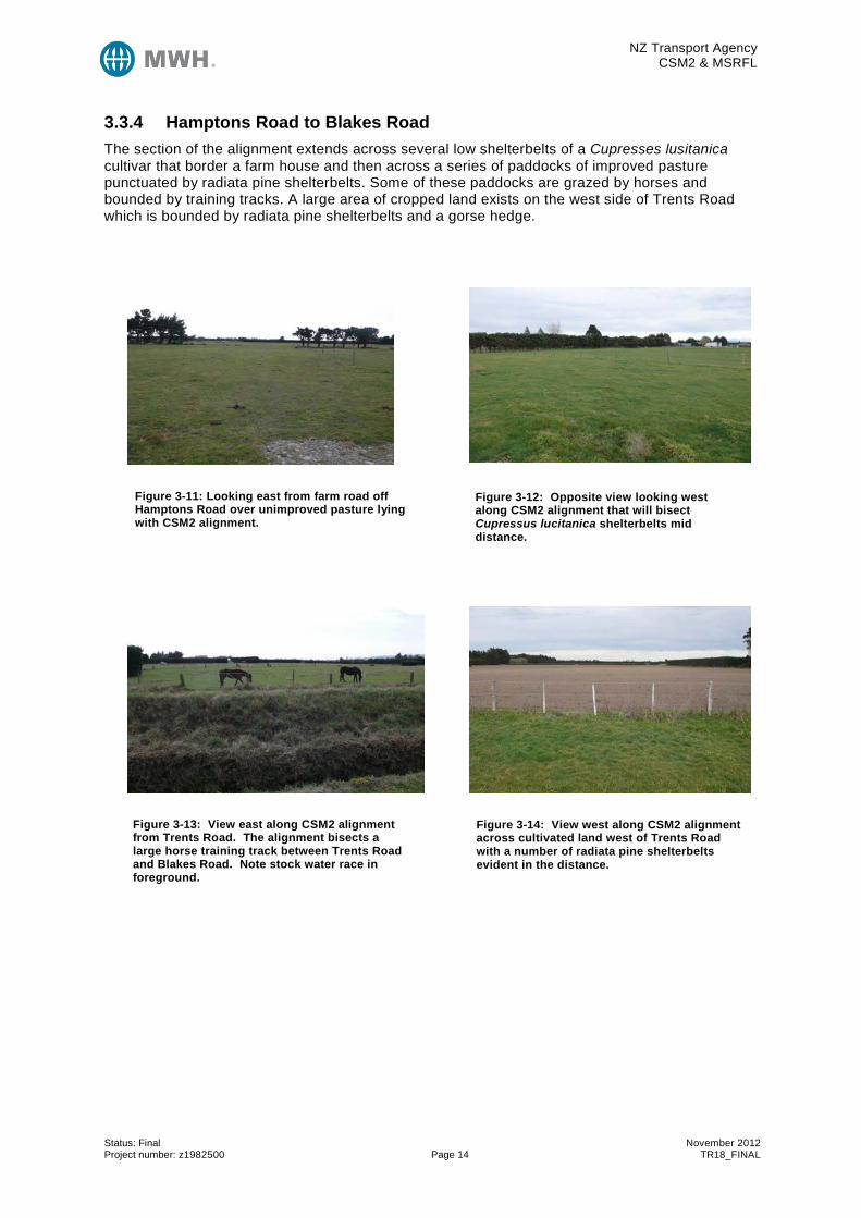
3.3.4 Hamptons Road to Blakes Road The section of the alignment extends across several low shelterbelts of a Cupresses lusitanica cultivar that border a farm house and then across a series of paddocks of improved pasture punctuated by radiata pine shelterbelts. Some of these paddocks are grazed by horses and bounded by training tracks. A large area of cropped land exists on the west side of Trents Road which is bounded by radiata pine shelterbelts and a gorse hedge.
Figure 3-13: View east along CSM2 alignment from Trents Road. The alignment bisects a large horse training track between Trents Road and Blakes Road. Note stock water race in foreground.
Figure 3-14: View west along CSM2 alignment across cultivated land west of Trents Road with a number of radiata pine shelterbelts evident in the distance.
Figure 3-11: Looking east from farm road off Hamptons Road over unimproved pasture lying with CSM2 alignment.
Figure 3-12: Opposite view looking west along CSM2 alignment that will bisect Cupressus lucitanica shelterbelts mid distance.

NZ Transport Agency CSM2 & MSRFL
Status: Final November 2012 Project number: z1982500 Page 15 TR18_FINAL
3.3.5 Blakes Road to Marshs Road The section of the alignment similarly passes across expansive areas of cultivated land and improved pasture, including a horse training track.
A small plot of land situated near a house on Blakes Road and bordering the designation corridor contains amenity plantings comprising of a number of mature and young lowland ribbonwood (Plagianthus regius) and kohuhu (Pittosporum tenuifolium) trees.
The shelterbelts intersected by the alignment and on and off ramps include several Lombardy poplar shelterbelts delimiting cropped land adjacent to Shands Road and a line of mature macrocarpa trees bordering Shands Road. Several long radiata pine shelterbelts oriented in a west east direction span a number of paddocks of improved pasture used for horse grazing.
Figure 3-17: Mixed shelterbelt of Eucalyptus species, macrocarpa, Atlantic cedar and cabbage trees beside Marshs Road.
Figure 3-18: Looking east along CSM2 alignment across cultivated land north of Marshs Road.
Figure 3-15: Extensive area of improved pasture bounded by poplar shelterbelts west of Shands Road
Figure 3-16: Exotic amenity plantings associated with rural residential property on Shands Road

NZ Transport Agency CSM2 & MSRFL
Status: Final November 2012 Project number: z1982500 Page 16 TR18_FINAL
3.3.6 Marshs Road to Halswell Junction Road The section of the alignment initially passes over cultivated land between Marshes Road and Springs Road. A large part of the cultivated area lies within the Ready Lawn Estate. Beyond the estate the alignment is punctuated by gorse hedgerows, lombardy poplar and Leyland and Lawson cypress shelterbelts of a limited extent while a small group of Old Man pines exist beside Springs Road near the John Paterson Drive intersection. A small hillock located near a truck yard off Springs Road is covered in part in unimproved/rank grassland with scattered silver dollar gum, elderberry and tree lucerne trees. The rank grass cover here in combination with its relatively undisturbed situation (in comparison with adjacent areas of farmland) provides habitat for hares observed in the immediate area. Between Springs Road and Halswell Junction Road the alignment passes over cultivated land previously sown in a fodder crop.
Figure 3-19: Cultivated land of the Ready Lawn Estate located between Springs Road and Marshs Road.
Figure 3-20: Cultivated land within CSM2 designation corridor adjacent to disused railway line which forms part of proposed cycleway link between Halswell Junction Road and the Little River Rail Trail at Marshs Road. Note mature Leyland cypress shelterbelt beyond.
Figure 3-21: View from elevated land near Springs Road showing part of area proposed for Colombia Basin Stormwater detention area lying partially within the CSM2 designation corridor.
Figure 3-22: View westward along CSM2 alignment from near the detention basin showing extensive area of farmland.

NZ Transport Agency CSM2 & MSRFL
Status: Final November 2012 Project number: z1982500 Page 17 TR18_FINAL
3.4 Indigenous Vegetation The extent of naturally occurring indigenous vegetation, i.e. self-sown indigenous vegetation that is affected by the Project is confined to very localised areas, where individual specimens or small groups of indigenous plants occur. These include kohuhu (Pittosporum tenuifolium), ferns such as swamp (refer to Figure 3.23) kiokio Blechnum minus and sedges (Carex spp.), which grow along the edge of the water race beside Weedons Road. Some sections of the water races are overtopped by shelterbelts which afford favourable microclimate conditions which in combination with an absence of grazing enable the establishment of pioneer vegetation.
Areas of naturally occurring indigenous vegetation were identified during previous ecological assessments undertaken by Meurk (2002 and 2005) for CSM1 to the east of Halswell Junction Road beyond the CSM2 designation corridor. These are the regionally rare Wilmer Road grasslands, wetland (marsh) species inhabiting the riparian margins of the Upper Heathcote River, riverbed species associated with the shingle beaches of artificial ponds and planted riparian vegetation along Haytons Drain.
However, a range of indigenous trees and shrubs do occur along parts of the Project alignments as amenity plantings in gardens and as components of some shelterbelts, particularly those bordering Shands Road and SH1. An area of plantings encountered along the alignments is contained in a plot of land situated near a house on Blakes Road. It includes mature and young specimens of lowland ribbonwood (Plagianthus regius) and kohuhu trees (refer to Figure 3.24). This area lies partially within the designation.
Figure 3-24: Small residential plot containing indigenous plantings of lowland ribbonwood and kohuhu situated adjacent to proposed motorway embankment by Blakes Road
Figure 3-23: Localised patch of swamp kiokio fern (Blechnum minus) and young kohuhu (Pittosporum tenufolium) beneath shelterbelt of Cupresses lusitanica and bordering a water race beside Weedons Road
NZ Transport Agency CSM2 & MSRFL
Status: Final November 2012 Project number: z1982500 Page 18 TR18_FINAL
3.5 Habitat Categories In general terms, the current land cover could be described as farmland habitat. However, within this habitat, further categories exist which reflect the different land uses and vegetation types encountered along the Project alignment as described above. These are: • Improved/developed pasture;
• Rough pasture;
• Market gardens and other cultivated areas;
• Orchards;
• Rural-residential gardens/amenity plantings;
• Small plantations/woodlots (radiata pine, Eucalyptus spp., macrocarpa);
• Shelterbelts (radiata pine, Eucalyptus spp., macrocarpa, Leyland cypress, willow, poplar);
• Stands/groves (radiata pine, poplar, crack willow, silver wattle);
• Hedgerows (gorse);
• Road, shelterbelt, fence and stock water race margins (rank sward grasses and herbaceous vegetation);
• Naturally occurring native/indigenous plants; and
• Amenity plantings of native/indigenous plants.
These habitats are of varying quality in terms of the shelter, roosting, feeding and breeding opportunities they provide for indigenous and exotic avifauna and herpetofauna.
3.6 Avifauna Values Farmland habitat throughout the country is shown to support many taxon groupings and like native forest and coastal habitats can have high representation of indigenous birds including endemic taxa (Robertson et al, 2007). These findings are based on distributional data gathered from bird surveys conducted throughout the country.
Examination of field survey data from the Atlas of Bird Distribution in New Zealand (1999-2004) indicates that at least thirteen indigenous and seventeen exotic bird species are likely to be present in the Project study area over this period. These species are listed in Appendix 2 and represent resident birds, seasonal visitors and irregular visitors. During the site inspection conducted in September 2011, seven indigenous and eight exotic bird species were observed along the Project route.
The majority of the indigenous bird species observed in the study area are common and have wide habitat preferences including farmland, orchards, gardens and urban areas. These include omnivorous silvereyes and insectivorous fantails and grey warbler, which generally nest in and feed around the edges of hedges, hedgerows, shelterbelts and amenity plantings encountered along the Project alignments. These same habitats are also favoured by introduced passerines such as Australian magpies, blackbirds, song thrushes and house sparrows. Pasture grasses especially rank swards associated with the margins of paddocks, roads and water races provide an abundant seed source and invertebrates for finches, yellowhammer and redpoll.
Other indigenous birds have benefited from habitat changes though clearance of forested land to farmland since European arrival. These are Paradise Shelduck, Spur winged plover, Australasian harrier, Southern black-backed and black-billed gulls (threatened - nationally critical), South Island Pied Oystercatcher (at risk – declining) and Pied Stilt which are common to the Canterbury Plains and peri-urban areas of Christchurch. Paradise Shelduck, Spur winged plover and Australasian harrier were observed during the field trip conducted in early spring (8 September 2011). Southern black backed gulls, black-billed gulls, South Island pied oystercatchers, white faced heron and Australasian pied stilts are seasonal visitors to areas of improved pasture within the study area

NZ Transport Agency CSM2 & MSRFL
Status: Final November 2012 Project number: z1982500 Page 19 TR18_FINAL
during the late winter and spring months. They are attracted to arable/cultivated land and seasonally wet or semi-submerged paddocks which provide suitable feeding habitat owing to abundant food supplies on offer. However, the area of arable land or improved pasture prone to ponding which is affected by the Project is localised in extent compared to other areas of farmland within the study area and wider peri-urban area beyond the designation. Paradise Shelduck and Spur winged plover were observed at regular intervals along the alignment, including non-farmland areas such as the Colombia stormwater detention basin by Springs Road. Along with the Australasian harrier, these birds are usually the more conspicuous species observed in the countryside.
The water races that intersect the alignments provide suitable food sources such as aquatic vegetation and invertebrates for waterfowl recorded in the study area such as grey teal and mallard duck. The water races along Weedons Road and Robinsons Road provide some degree of tree and shrub cover which may additionally afford suitable nesting conditions for these ducks. Other freshwater birds that have been recorded in the study area are pukeko, white faced heron and New Zealand kingfisher. While farmland generally suits the wide dietary requirements of pukeko, white faced heron and kingfisher, the population size of these birds that inhabit the area affected by the Project alignment are likely to be lower than in surrounding pastoral areas due to the absence of naturally occurring water features, and a general lack of suitable riparian cover along the water races. Limited nesting cover for pukeko exist in the form of isolated clumps of rushes and sedges that occur along some of the water races. Nearby mature pine, Eucalyptus and macrocarpa shelterbelts and stands of mature trees provide favourable nesting sites for white faced heron and kingfisher which are also recorded within the study area.
The lack of recorded sightings of the frugivorous kereru and the nectar eating bellbird and tui in the study area as indicated on taxon plans contained in the Atlas of Bird Distribution reflects a lack of suitable habitat for these birds. In a rural landscape, these are typically indigenous forest remnants and Eucalpytus plantings. It is possible though that the proposed landscape mitigation plantings which include a number of flowering species, both native and introduced, could attract bellbirds to the Project area on a seasonal basis.
3.7 Herpetofauna Values EcoGecko undertook a desktop assessment of the potential lizard values of the Canterbury Plains, their threat status, their abundance and the significance of their presence in the Project study area (attached in Appendix 1). This assessment involved a search in the Department of Conservation’s BioWeb Herpetofauna database in combination with reviews of historical records and application of their expert knowledge of lizard species distribution patterns and habitat requirements which enabled them to predict species occurrence. EcoGecko also rated the significance of occurrence of each species in the Canterbury Plains, which is an indicator of the potential and relative significance of populations of each species likely to be present within the Project designation corridor.
The combination of a desktop assessment and rapid site reconnaissance initially led to the identification of up to eight species within the Low Plains Ecological District3, while two species of skinks: Oligosoma polychroma (common skink), and Oligosoma maccanni (McCann’s skink) were considered to be potentially present within the designation corridor. One common skink was observed on site by EcoGecko. The current threat classification ranks both species as ‘Not Threatened’ (Hitchmough et al. 2010). Potential lizard populations within the designation corridor represent relictual4 populations as a result of large scale land use changes, habitat losses, and introduced predatory mammals.
3 During the late 1970’s and 1980’s an attempt was made to define New Zealand’s unique landscapes and ecological communities. The topography, geological features, climatic patterns, anthropogenic factors and biological communities were described in order to identify distinctive patterns of the landscape. To this end, 85 Ecological Regions (ER’s) further subdivided into 268 Ecological Districts (ED’s) were defined (McEwen, 1987). This framework was initially developed to assist in identifying the requirements for the protection of representative elements of the landscape under the Protected Natural Areas Programme. The ED that the Project is located in is the “Low Plains” ED. 4 The term “relictual” is used for local species that would have once been very widespread and well connected across the Canterbury landscape. However extensive land development into a predominately agricultural and horticultural landscape has

NZ Transport Agency CSM2 & MSRFL
Status: Final November 2012 Project number: z1982500 Page 20 TR18_FINAL
The Project designation corridor consists of low value habitats for lizards, due to the vast tracts of highly-developed pasture land, which is the predominant land use (Figure 3-2). However, the proposed designation corridor runs parallel with some communities of riparian vegetation and rank exotic grasslands which may support local lizard populations. EcoGecko considers such habitat to be high-quality lizard habitat, particularly for common skink. It notes that McCann skink may occupy these grasslands, but usually prefer open scrubland, especially where rocky ground cover is present. The two gecko species (Naultinus gemmeus, Woodworthia brunnea) have been infrequently recorded in such habitats elsewhere in the Canterbury region, including some Christchurch suburbs, but usually when adjacent to scrub/scrubland vegetation communities and rocky habitats. EcoGecko states that intensive pastoral practices have largely suppressed potential skink habitat, except for those areas of ungrazed exotic grasslands where the common skink and McCann’s skinks are likely to inhabit at low abundance.
3.8 Invertebrate Values The terrestrial invertebrate fauna, including soil fauna inhabiting the project area is dominated by introduced species typically encountered on farmland and suburban gardens. While being highly modified environments, the range of vegetation types in this area provides habitat for a variety of invertebrates.
Flowering plants such as clover which forms a major component of the ground cover on less intensively managed areas of pasture attract large numbers of honey bees and bumble bees in the spring and summer months. Areas of rank grass that grow along the stock water races are favoured habitat for insects such as dragonflies and damselflies. Areas of rank grass that occur on drier sites such as along roadside and fence lines are also favoured habitats for insects such as moths, beetles and spiders while woody debris and litter associated with shelterbelts, hedgerows are inhabited by a diverse assemblage of beetles, arthropods and amphipods. It is within these more “informal” less disturbed habitats that a greater proportion of indigenous species are likely to be encountered. Such habitats are spread widely within the study area, both within and outside the designation corridor.
led to considerable habitat fragmentation of available habitat patches, whether native or exotic; this may have population abundance, persistence and genetic consequences.

NZ Transport Agency CSM2 & MSRFL
Status: Final November 2012 Project number: z1982500 Page 21 TR18_FINAL
4 Assessment of Effects on Terrestrial Ecosystems
4.1 During Construction The effects of the Project on terrestrial ecology values will be most pronounced during construction. Construction of the Project, including on and off ramps and local road connections, will result in the removal of approximately 16,000 m2 or 1.6 hectares of woody vegetation comprising shelterbelts, gorse hedgerows, stands of trees and amenity plantings. This represents about 2.5% of the Project designation corridor, with over half of the affected woody vegetation being radiata pine shelterbelts, mixed species shelterbelts, poplar shelterbelts and amenity plantings. Areas of rank grassland cover associated with pasture, roadside and stock water race margins encompass about 2% of the designated area. The vast majority of the affected land is farmland used for cropping, horticulture, grazing and horse training.
The affected vegetation types provide a range of habitats for birds, lizards and invertebrates, particularly the shelterbelts, hedgerows, amenity plantings and areas of rank grassland which afford a greater degree of food and shelter. The loss of habitat, in combination with disturbances arising from construction activities, will lead to displacement of the affected bird populations into the surrounding countryside. It is also likely to lead to mortality and injury to many lizards and ground dwelling invertebrates due to their limited movement and dispersal abilities.
The effects of loss of habitat for common native and introduced passerines will be more pronounced for those species with small territories and home ranges, such as fantails and grey warblers. While the loss of habitat in particular will result in a loss in the degree of connectivity or ecological functionality at a local level, these adverse effects are considered to be of a minor scale given the small proportion of woody and grassland vegetation that would be lost compared to the extent of similar habitat that exists in adjoining areas of farmland.
Displacement of resident bird populations will lead to an increased amount of competition between displaced individuals and resident populations in adjoining areas. The effects of competition may lead to some mortality. However, this is considered to be of a low scale given the large area of similar habitat that exists beyond the Project designation corridor, and affected species, and wide habitat preferences, and hence their adaptability.
The low populations of freshwater birds recorded within the study area, due largely to the absence of any naturally occurring water features (such as streams, ponds or wetlands and lack of suitable riparian vegetation) in the vicinity of the alignment reduces the likelihood that species such as pukeko, white faced heron, kingfisher and waterfowl would be adversely affected to any significant degree during construction.
The overall adverse effects of the construction activities and associated habitat loss is assessed as less than minor for indigenous and visitor bird populations and invertebrate populations.
For the common, and possibly also McCann’s skink, the adverse effects are assessed by EcoGecko as being more than minor, due to a combination of factors, including mortality and injuries, habitat loss and fragmentation. The effect is more pronounced for the lizard species because of the relictual nature of their populations in small habitat isolates in the highly developed Canterbury Plains. These adverse effects are a result of direct construction works by machinery, which will destroy lizards and their rank grassland habitat on roadside edges.
All native lizard species are protected by the Wildlife Act 1953. Lizards cannot be disturbed, injured or killed without a Wildlife Permit from the Department of Conservation. The capture and relocation of affected lizards prior to the commencement of earthworks to pre-prepared sites within the Project designation, consisting of boulderfields and plantings of low growing vegetation, is recommended in order to mitigate these adverse effects. By implementing the recommended mitigation measures and fulfilling the legislative requirements of the Wildlife Act, the adverse effects of construction on affected lizard populations will be ‘no more than minor.’ Further details on the recommended mitigation measures are provided in Section 5.1. Construction activities and particularly heavy machinery presents an opportunity for problem weed species not currently present in the area to become established. Seeds of problem weed species

NZ Transport Agency CSM2 & MSRFL
Status: Final November 2012 Project number: z1982500 Page 22 TR18_FINAL
can be introduced inadvertently when machinery has been previously working in locations where these plants exist. These species could potentially pose a threat to the indigenous plantings recommended within the Project designation and to surrounding farmland. Recommended mitigation measures are set out in Section 5.2 of this report.
4.2 Post Construction Post construction works include a range of landscaping measures as recommended in the Landscape Context Report (Technical Report Number 7). These measures include totara/matai forest and shrubland plantings and mixed indigenous/exotic woodland plantings within the Project designation. Once established, the plantings will significantly enhance the ecological values within this highly modified landscape. It is noted that species selection and composition of the plantings conform to ecological principles, reflecting the original vegetation cover of the area and the underlying ecological conditions (as advocated by Meurk, 2007). The planting measures recommended in the Landscape Context Report include ecological plantings of Purei (Carex secta), jointed rush and coastal flax along sections of stock water races, both inside and outside of the designation. These plantings will improve the habitat value of the riparian margins and the instream environments through the establishment of a more diverse and taller stature of indigenous plant cover.
Lineal features such as motorways can obstruct the movement of wildlife across the country side and may pose a hazard to certain species depending on their mobility. In terms of the Project area, the most vulnerable species are pukeko and introduced mammals, such as brush tailed possums, hares and rabbits that naturally forage over a wide area.
The vulnerability of pukeko is related to its tendency to seek out favoured plants such as clover, over wide areas of pasture which may exist at a distance from its territory. Pukeko territories are generally restricted to within 50 metres of a waterbody or wetland (Fordham, 1983). As noted in the baseline character assessment above, the absence of naturally occurring waterways in the vicinity of the Project designation corridor, and general lack of cover associated with the stock water races means that the potential for the Project to pose a risk to the pukekos is low. Higher quality habitat is considered to exist in the Heathcote River headwaters and the interconnected stormwater retention areas and drains in that area, several kilometres to the east of the Project.
The risk that pukeko may traverse the motorway in search of seasonally favoured areas of pasture, including cultivated areas and market gardens should not be discounted entirely though. Pukekos can also be attracted to the wide stormwater swales and detention ponds established as part of the Project. Other birds at risk of mortality or injury from motorway traffic are the Australasian Harrier and Southern black-backed Gull as these birds regularly scavenge road killed animals.

NZ Transport Agency CSM2 & MSRFL
Status: Final November 2012 Project number: z1982500 Page 23 TR18_FINAL
5 Recommended Mitigation Measures 5.1 Lizard Recovery In view of the adverse effects that construction of the Project poses to resident lizard populations (discussed in section 4.1 above) and in order to meet the legislative requirements of the Wildlife Act 1953, it is recommended that the NZTA undertake the following mitigation measures: • Prior to commencement of the earthworks seek a Wildlife Permit from the Department of
Conservation for the capture and relocation of affected lizards, and for the unintentional killing or injury of lizards as a result of the earthworks; and
• Develop a Lizard Management Plan as part of the Construction Environmental Management Plan for the Project. This plan should be finalised in consultation with the Department of Conservation, as part of the Wildlife Permit process. The Lizard Management Plan should also consider the following matters in so far as these are consistent with the requirements of the Wildlife Act permit sought from the Department of Conservation:
o Undertaking the lizard surveys prior to earthworks to rescue and relocate lizards. This should include (a) an agreed and defined minimum effort of night-spotlighting (expressed in person-hours) for Woodworthia and Naultinus spp. geckos along shelterbelts, gorse and other hedgerow vegetation on warm and calm evenings during the early or late summer; (b) an agreed and defined minimum effort in pitfall trapping to capture and remove terrestrial skinks in areas of woody vegetation and rank grasslands. Night spotlighting should occur along shelterbelts, gorse and hedgerow vegetation, while trapping should be undertaken in riparian vegetation and rank exotic grassland habitats, in consultation with a herpetologist.
o All capture and relocation works should be under the supervision of a qualified and experienced ecologist or herpetologist. The surveys and relocation should be undertaken between September and April only.
o Rescue and relocation using both night-spotlighting and pitfall trapping. o A written survey report from night-spotting and pitfall trapping, outlining results, lizard
species presence and habitat utilised within the Project designation post the rescue and relocation effort.
o Relocate all captured lizards to pre-prepared sites consisting of boulderfields and plantings of low growing vegetation as described below.
o This release sites should have pest control for cats, mustelids, rodents (including mice) and hedgehogs commencing 3 months prior to the actual release event, and concluding 12 months after the release event. Such effort will typically involve 30 person days over this 15 month timeframe.
o The relocated lizards should be monitored for a period of three years after release to determine the success of this mitigation activity. The first year will help determine individual survival, while the last two years will help determine population establishment and growth. This effort will typically consist of one week’s field work each year for an ecologist to undertake, and with approximately half a week each year for reporting. If the relocation criteria within the Wildlife Act permit at the end of the three year period are not met, new recommendations should be set for further work or mitigation effort in consultation with the Department of Conservation.
• Develop one boulderfield and three boulder strips as part of the landscaping of sections of the
Project (where this will not be a safety hazard to users). These areas should include plantings of Coprosma crassifolia, C. propinqua, Muehlenbeckia astonii, Corokia cotoneaster and silver tussock (Poa cita) to mitigate the habitat loss as a result of the development, and encourage

NZ Transport Agency CSM2 & MSRFL
Status: Final November 2012 Project number: z1982500 Page 24 TR18_FINAL
natural re-colonisation by resident lizards. The 1.2 hectares of dry woodland habitat created as part of the landscaping may benefit skinks in time. However, it is strongly recommended that:
(a) boulder/scree habitat is created, as 2 metre wide and 0.3 metre deep strips running at the habitat edges of these new plantings and,
(b) as a ‘boulderfield’ created within the large grassed basin near Trents Road.
These boulder areas should add up to a total of 0.420 hectares; and would form the release sites for rescued and relocated lizards.
The boulderfield and boulder strip areas will form effective protective habitat for lizards during the time it takes for the plantings to establish habitat complexity. These areas would need to be established 3 to 6 months before construction work commences in order to receive the captured lizards.
5.2 Problem Weed Control Prior to entry on work sites, it is recommended that all machinery involved in construction be water blasted at a suitable facility. This is a preventative measure to ensure seeds of problem weed species are not conveyed to the work sites by machinery.
Over a period of a year following completion of construction of the Project, it is recommended that a programmed round of monitoring is undertaken to detect any new problem weed species that may have been accidentally introduced to the area. Should plants of these species be detected, a programmed round of eradication would need to be implemented, involving a combination of spraying and hand-pulling depending on the species involved and extent of the infestation.

NZ Transport Agency CSM2 & MSRFL
Status: Final November 2012 Project number: z1982500 Page 25 TR18_FINAL
6 Ecological Enhancement Opportunities The enhancement of the ecological values along the Project designation corridor that will arise through the proposed landscape mitigation plantings (refer Landscape Technical Report (EPA-PL_TR7) sets a good example for other organisations such as Councils and community groups and may encourage complementary planting programmes over a wider area beyond the designation. Measures such as under planting and edge planting of adjacent lineal habitats, such as shelterbelt margins, roadside margins and riparian margins of stock water races and drains beyond the Project designation corridor would improve the habitat matrix and quality of wildlife corridors across this production landscape. Re-establishment and the transformation of these functional landscape elements through multiple indigenous plantings represent an integration of conservation and production practices (Meurk and Swaffield, 2000).
NZ Transport Agency CSM2 & MSRFL
Status: Final November 2012 Project number: z1982500 Page 26 TR18_FINAL
7 Conclusions The land affected by the Project is a highly modified landscape comprising agricultural land and lifestyle blocks. The extent of naturally occurring indigenous vegetation is confined to very localised areas beneath shelterbelts where favourable microclimate conditions exist. There is an absence of naturally occurring wetlands and other water features. The man made water races that cross the land within the proposed alignment are reflective of already modified and channelised waterways. The banks of these waterways are covered in pasture grasses and herbaceous plants and are of low habitat quality with limited connectivity to natural waterways.
The numerous shelterbelts, woodlots and gardens associated with this production landscape provide suitable feeding, nesting and shelter habitat for indigenous avifauna with wide habitat preferences. The extensive areas of pasture both within and adjacent to the designation provide suitable seasonal feeding habitat for Paradise shelduck, spur winged plover and pukeko.
The adverse effects of the Project on terrestrial ecosystems will be most pronounced during construction when sections of shelterbelt, stands of trees and areas of rank grass are removed and resident populations of avifauna, lizards and invertebrates are displaced or killed.
The effects of construction on indigenous avifauna and invertebrate populations is less than minor owing to the exotic nature of the farmland within and surrounding the Project area, the similarity of nearby exotic habitats and wide ecological tolerances and adaptability of the affected indigenous bird and invertebrate species.
The effects of construction on common skink and possibly McCann’s skink are more than minor. However, implementation of specific mitigation measures associated with lizard recovery to be contained in a Lizard Management Plan, as recommended by EcoGecko, will reduce the effects to no more than minor.
The Project is consistent with the objectives of the NZTA (Transit) Environmental Plan concerning ecological resources (Section 2.7). The recommended mitigation measures that relate to the creation of higher quality lizard habitat in conjunction with the landscape mitigation plantings represent an enhancement of the ecological values and the promotion of biodiversity along the Project designation corridor. The Project will not result in a net loss of indigenous vegetation or a net loss of any naturally occurring ecosystems due to the very localised nature of any naturally occurring indigenous vegetation and absence of any naturally occurring ecosystems within or adjacent to the Project designation corridor. The potential for spread of pest plants will be managed through appropriate preventative, monitoring and control measures as outlined in Section 5.2 of this report, and as documented in the Construction Environmental Management Plan.

NZ Transport Agency CSM2 & MSRFL
Status: Final November 2012 Project number: z1982500 Page 27 TR18_FINAL
8 References
Christchurch City Council, 2008. Integrated Catchment Management Plan for South-West Christchurch.
Christchurch City Council, 2009. South-West Christchurch Area Plan (SWAP).
Department of Conservation. 2003. Schedule of Sites of Natural Significance.
Department of Conservation. 2000. Canterbury Conservation Management Strategy 2000-2009. Canterbury Conservation Management Planning Series No.10. Christchurch.
Department of Conservation. 2005. Native Plant Communities of the Canterbury Plains. Department of Conservation, Christchurch.
Fordham, R.A. 1983. Seasonal Dispersion and Activity of the Pukeko Porphyrio P. Melanotius (Rallidae) in Swamp and Pasture. New Zealand Journal of Ecology 6. 133-142.
Heather, B. and Robertson, H. 1996. The Field Guide to the Birds of New Zealand. Penguin Books (NZ) Ltd, Auckland. Revised Edition, 2005.
Hughey, K.F.D. 2007. Assessment of Environmental Effects for the Christchurch Southern Motorway: Avifauna.
Leathwick, J., Wilson, G., Rutledge, D., Wardle, P., Morgan, F., Johnston, K., McLeod, M. and Kirkpatrick, R. 2003. Land Environments of New Zealand. David Bateman Limited, Auckland.
McEwen, W M (ed) 1987: Ecological Districts and Regions of New Zealand, (third revised edition in four 1:500 000 maps). New Zealand Biological Resources Centre publication No 5. Department of Conservation, Wellington.
Meurk, C.D. and Swaffield, S.R.. 2000. A landscape ecological framework for indigenous regeneration in rural New Zealand-Aotearoa. Landscape and Urban Planning 50(2000): 129-144.
Meurk, C.D. 2008. Assessment of Environmental Effects for the Christchurch Motorway: Terrestrial Ecology. Miskelly et al, 2008. Conservation status of New Zealand Birds, 2008. Notornis, 2008. Vol. 55: 117-135 Robertson, C.J.R; Hyvonen, P; Fraser, M.J; Pickard, C.R. 2007. Atlas of Bird Distribution in New Zealand. 1999-2004. The Ornithological Society of New Zealand, Inc., Wellington.
Rough and Milne Landcape Architects Limited. 2011. Assessment of Landscape and Visual Effects. Transit New Zealand, 2008. Environmental Plan 2008.

1
Appendix 1: An Assessment of the Potential Lizard Fauna and Habitats of the Canterbury Plains in Reference to NZ Transport Agency’s Christchurch Southern Corridor Motorway Extension Proposal (CSM2 and MSRFL)

2
AN ASSESSMENT OF THE POTENTIAL LIZARD FAUNA AND HABITATS
OF THE CANTERBURY PLAINS IN REFERENCE TO NZ TRANSPORT AGENCY’S CHRISTCHURCH
SOUTHERN CORRIDOR MOTORWAY EXTENSION PROPOSAL (CSM2 and MSRFL)
Trent Bell, EcoGecko Consultants Limited
AUGUST 2012
1. Executive Summary
• The New Zealand Transport Agency (NZTA) has proposed an extension of the Christchurch Southern Motorway. This extension is in two stages: Christchurch Southern Motorway Stage 2 (CSM2) and Main South Road Four Laning (MSRFL). The combined stages are referred to here as the Project.
• There appear to be no records of lizards on the Department of Conservation’s BioWeb Herpetofauna records database from within the proposed development envelope (project area). However, one skink—most likely a common skink (Oligosma polychroma)—was sighted during a rapid site reconnaissance on the 27th March 2012.
• Species potentially present within the development footprint include the two skinks: Oligosoma polychroma (common skink), and Oligosoma maccanni (McCann’s skink). The current Threat Classification rank for both is ‘Not Threatened’ (Hitchmough et al. 2010). Existing lizard populations within the development footprint are relicts of what was a large and continuous population across the Canterbury landscape as a result of large scale land use changes, habitat losses, and introduced predatory mammals,
• Species that may have once existed in the locality include Naultinus gemmeus (jewelled gecko, ‘Declining’) and Woodworthia brunnea (Canterbury gecko, ‘Declining’). Other lizards that occur nearby but are unlikely to be present within the proposed development envelope include the Central Canterbury spotted skink (Oligosoma sp. ‘Central Canterbury’, ‘Nationally Vulnerable’), and the Southern Alps gecko (Woodworthia sp. ‘Southern Alps’, ‘Not Threatened’).
• The assessed quality of potential lizard habitat in this area is of low to moderate value, or of no value. Affected habitats of low to moderate value include riparian vegetation along stock water races (0.5 hectare), gorse shelterbelts (0.06 hectare) and rank exotic grasslands (1.2 hectares), and likely contain Common skink and possibly also McCann’s skink. Habitats not regarded as lizard habitat include high-rotation cropland and intensively grazed farmland. It
3
is this land use type which provides, by far, the greatest majority of land affected by the Project.
• The proposed Project does not contravene the purposes and intention of Section 6 (c) of the RMA. The area where the Project is located cannot be described as a particularly significant habitat or ecological area for native lizards, due to the highly developed nature of the Canterbury landscape. It is more relevant to determine the insignificance of a proposal’s adverse environmental effects on lizards or their habitats, and that any remaining lizard populations and their habitats should be assessed as significant (Anderson et al. 2012).
• The overall impact from the construction of the Project has been assessed as having ‘more than minor adverse effects’ for the lizards present. These effects are best described as a combination of deaths and injuries to individual lizards, and habitat losses (Table 3). Destruction of lizard habitat within the Project’s designation corridor likely will represent even further habitat losses and fragmentation for the lizard species present. Considering the relictual nature of lizard populations and their habitats within a highly developed landscape, the weighting of impacts tend towards a higher severity in the region than elsewhere.
• With a mitigation package involving rescue and relocation of some affected lizards and site-habitat enhancement projects as part of the Project landscaping, this effect will be, on balance, ‘less than minor’. In particular, refer to the ‘Recommended Mitigation’ section of this report (pages 10-12), and Table 4 for recommended mitigation strategies. These recommendations should be considered during the preparation of Specialised Environmental Management Plans (SEMP), and specifically the SEMP007 Lizard Management Plan.

4
2. Introduction
The New Zealand lizard fauna currently has 100 recognised species, of which around half are formally described (Hitchmough et al. 2010, Nielsen et al. 2011). All lizards, apart from one, are endemic to New Zealand, and our lizard species richness is approximately equivalent to that of terrestrial birds, making them a significant component of our extant fauna. All lizards, except for an introduced skink species, are legally protected under an amendment to the Wildlife Act 1953, and their habitats by the Resource Management Act 1991 (Anderson et al. 2012). A significant component of our lizard fauna (68%) are recognised as ‘Threatened’ or ‘At Risk’ in the latest Threat Ranking Lists (Hitchmough et al. 2010), 2.1 Overview of project
The NZ Transport Agency (NZTA) has proposed an extension of the Christchurch Southern Motorway. This extension is part of the project entitled the ‘Christchurch Southern Corridor’. The Southern Corridor provides access to Lyttelton Port and the Christchurch CBD for people and freight from south of Christchurch. This project has been recognised as a Road of National Significance (RoNS). The corridor includes the Southern Motorway from Barrington Street to Halswell Junction Road (Stage 1), the extension from Halswell Junction Road to rejoin SH1 south of Waterholes Road (Stage 2: Christchurch Southern Motorway Stage 2, CSM2), and widening the existing highway from Waterholes Road to Weedons Road, Rolleston (Stage 3: Main South Road Four Laning, MSRFL). The current lizard AEE assesses two of the three stages of the RoNS project: CSM2 and MSRFL, and refers to both stages as “the Project”. 2.2 Ecology of the 56:02 Low Plains Ecological District
The CSM2 and MSRFL designation corridor is within the Canterbury Plains Ecological Region (ER 56) and occurs in the Low Plains Ecological District (ED 56:02) (McEwen 1987). The Low Plains ED consists of a large area of coalesced glacial outwash and alluvial fans and has a dry climate (annual rainfall 600-800 mm p.a.). Summers are warm, with occasional hot foehn northwesterlies, and cool winters with frequent frosts and occasional snowfall.
The Low Plains ED has been mainly cleared for pastoral farming of sheep, cattle and cropland, and includes a major city, Christchurch. The current composition of the CSM2 and MSRFL designation corridor similarly consists mainly of transport infrastructure network surrounded by pastoral land and rural settlements. The historical vegetation composition would have included lowland short tussockland and scrub or shrubland (Coprosma, matagouri, Olearia) and some floodplain forest.
The NZTA engaged the services of GHD Limited and MWH Ltd to undertake an assessment of ecological effects of the proposed Project development on the ecosystems, flora and fauna within the CSM2 and MSRFL designation corridor. EcoGecko Consultants Limited were commissioned by GHD to undertake an assessment of the potential lizard and habitat values in this development envelope. This report is our assessment of these values.

5
3. Materials and Methods
3.1 Desktop assessment
A desktop assessment was undertaken to assess the potential lizard values of the Canterbury Plains, their threat status, abundance and significance of their presence at the CSM2 and MSRFL locations (if present). This assessment was conducted using a search in the Department of Conservation’s BioWeb Herpetofauna database, along with our expert knowledge of lizard species distribution patterns. This assessment, which is no substitute for a thorough survey effort, attempts to predict species occurrence based on historical records within the vicinity, along with our expert knowledge of habitat requirements relative to the habitat types available within the Canterbury Plains (Tables 1 & 2). Similarly, we also rated the significance of occurrence of each species in the Canterbury region, which is an arbitrary indicator of the potential and relative significance of populations of each species in the region, if any are confirmed present at CSM2 and MSRFL (Table 2). These rankings are based on our knowledge of the species’ currently known range and extent of ranges, local and regional abundances, threat categories and are subject to revision, as new information becomes available, particularly from future survey work. Finally, we also rated the significance of impacts on the lizard species potentially present within the development footprint (Table 2).
3.2 Remote habitat assessment and rapid site reconnaissance
A lizard habitat assessment was conducted via desktop methods along with a rapid site reconnaissance, incorporating information from aerial maps and photographs supplied by GHD and MWH, and discussions with GHD and MWH ecologists. The combination of a desktop assessment and rapid site reconnaissance was considered appropriate due to the highly developed nature of the CSM2 and MSRFL designation corridor, along with EcoGecko Consultants’ prior knowledge of the potential lizard species and habitat values of the southern part of the Low Plains ED.
The aerial maps included the ‘developmental envelope’ mapped in ArcGIS by GHD based on information supplied by NZTA. These maps showed the road layout at the time of the assessment. We used the vegetation type classification developed by MWH for the Terrestrial Ecology Assessment to identify and classify particular habitat compositions of interest. However, some habitat types were not surveyed, because they consisted of little or no value to lizards (such as buildings, transport infrastructure, vehicle tracks, and vast tracts of pasture). Geo-referenced photopoints were taken along the development envelope at various locations by GHD, MWH and EcoGecko ecologists.

6
4. Results
We identified the verified presence of five species within the Low Plains Ecological District, and potential presence of up to eight species in total (excluding recently extinct species). We also determined that there is a reasonable likelihood of the presence of up to six lizard species in the general area, due to DOC’s BioWeb Herpetofauna database records, our knowledge of lizard ranges and ecology and habitat available at the locality. These verified and potential lizard species are described in Table 1.
TABLE 1: Extant lizard taxa known from the Low Plains Ecological District, or in nearby districts. Taxonomy used follows that of Hitchmough et al. 2010 and Nielsen et al. 2011.
ED Code Ecological District Name
Species
55.01 Ashley Nil lizards recorded
55.02 Oxford Woodworthia ‘Southern Alps’, Oligosoma lineoocellatum (=? O. sp. ‘Central Canterbury’), Oligosoma polychroma.
55.03 Whitecliffs Woodworthia ‘Southern Alps’, Oligosoma polychroma.
56.01 High Plains Woodworthia ‘Southern Alps’, Naultinus gemmeus, Oligosoma maccanni.
56.02 Low Plains Woodworthia brunnea, Naultinus gemmeus, Oligosoma sp. ‘Central Canterbury’, Oligosoma maccanni, Oligosoma polychroma.
56.03 Ellesmere Woodworthia brunnea, Oligosoma sp. ‘Central Canterbury’, Oligosoma maccanni, Oligosoma polychroma.
57.01 Port Hills Woodworthia brunnea, Naultinus gemmeus, Oligosoma sp. ‘Central Canterbury’, Oligosoma maccanni, Oligosoma polychroma.
57.02 Herbert Woodworthia brunnea, Naultinus gemmeus, Oligosoma sp. ‘Central Canterbury’, Oligosoma maccanni, Oligosoma polychroma.
57.03 Akaroa Woodworthia brunnea, Mokopirirakau granulatus, Naultinus gemmeus, Oligosoma sp. ‘Central Canterbury’, Oligosoma maccanni, Oligosoma polychroma.
Species potentially present within the designation footprint include the two skinks: Oligosoma polychroma (common skink), and Oligosoma maccanni (McCann’s skink). The current Threat Classification rank for both is ‘Not Threatened’ (Hitchmough et al. 2010). Lizard populations within the development footprint represent relictual5 populations as a result of large scale land use changes, habitat losses, and introduced predatory mammals.
5 The term ‘relictual’ is used in the sense that for the local species in question, they would once have been very widespread and well-connected across the Canterbury landscape. However extensive land development into a predominantly agricultural and horticultural landscape has led to considerable habitat fragmentation to tiny areas of available habitat patches, whether native or exotic; this may have population abundance, persistence and genetic consequences.

7
Species that may have once existed in the locality include Naultinus gemmeus (jewelled gecko, ‘Declining’) and Woodworthia brunnea (Canterbury gecko, ‘Declining’). Other lizards that occur nearby but are unlikely to be present within the proposed designation footprint include the Central Canterbury spotted skink (Oligosoma sp. ‘Central Canterbury’, ‘Nationally Vulnerable’), and the Southern Alps gecko (Woodworthia sp. ‘Southern Alps’, ‘Not Threatened’). The former have been recorded at McLeans Island, Banks Peninsula, mid- to north Canterbury foothills, and mid-Canterbury high country; while the latter is recorded south of the Rakaia River and the Canterbury foothills. These species are subsequently not assessed for impacts, because of their likely absence from the designation footprint. In Table 2 below, we rate the likelihood of occurrence for six of the eight species within the CSM2 and MSRFL designation corridor (two other species were considered highly unlikely to be present).
Of these six species, three are classified as ‘Not Threatened’ by the Department of Conservation’s national threat ranking (Hitchmough et al. 2010). These species were given a moderate to high likelihood of occurrence in our assessment for the Low Plains area of south-western Christchurch; the assessment for significance of occurrence ranks these species as either low or high, but that severity of impact to be moderate to high, should populations be discovered within the development footprint. Two species are currently ranked as ‘Declining’, and one is considered ‘Nationally Vulnerable’. Populations of any of these at the locality would likely be of high significance and high severity of impact.
The Project footprint along the Canterbury Plains usually consists of low value habitats for lizards, due to the vast tracts of highly-developed pasture land, which is the predominant land use (Figures 1-2 of this report). However, the road runs parallel with some communities of riparian vegetation (0.5 hectares in total) and rank exotic grasslands (1.2 hectares) which may support local lizard populations (Figures 3-4 of this report). Such habitat is often considered high-quality lizard habitat elsewhere, particularly for Oligosoma polychroma. Oligosoma maccanni may occupy these grasslands, but usually prefer open scrubland, especially where rocky ground cover is present. The two gecko species (Naultinus gemmeus, Woodworthia brunnea) have been infrequently recorded in such habitats elsewhere in their range, but usually when adjacent to scrub/scrubland vegetation communities and rocky habitats; gorse shelterbelts may be part of the scrub habitat potentially supporting geckos, and comprise 0.06 hectare of affected habitats within the Project development corridor. The grazing of pasture grasslands has largely suppressed potential skink habitat, except for these areas of non-grazed exotic grasslands, therefore skinks are likely to be at low abundance.

8
TABLE 2: Extant lizard taxa known from the Low Plains Ecological District, or in nearby districts, listed with their likelihood and significance of occurrence, along with their current Department of Conservation national threat rankings (Hitchmough et al. 2010). Taxonomy used follows that of Hitchmough et al (2010) and Nielsen et al. (2011). Qualifiers are as follows: Conservation Dependent, CD; Partial Decline, PD, Range Restricted, RR; Sparse, SP; and Data Poor, DP.
Common name
Scientific name Threat Category
Habitat Likelihood of
Occurrence
Significance of
Occurrence6
Significance of Impact
Jewelled gecko
Naultinus gemmeus
Declining Forest and scrub, including Coprosma, manuka and kanuka shrubland.
Low High High
Southern Alps gecko
Woodworthia sp. ‘Southern Alps’
Not Threatened
This species typically occupies rock forms in and near mountains, including talus slopes, scree, bluffs and dry stony riverbeds. In rare cases, can occupy forests, shrubs and scrubland.
Low High High
Canterbury gecko
Woodworthia brunnea
Declining A very wide range of habitats from the littoral zone on tiny islands to inland broadleaf and beech forests. Isolated remnant populations sometimes occur in highly modified farmland, urban habitats, or previously forested habitat
Low High High
Central Canterbury spotted skink
Oligosoma sp. ‘Central Canterbury’
Nationally Vulnerable
Coastal and lowland populations of this species are known from pingao duneland, shrubland, river terraces, outcropping rock, and cliff edges. Inland populations inhabit tussock grassland and rocky habitats, including talus slopes, scree and eroding river terraces, usually where shrubland cover exists.
Low High High
McCann’s skink
Oligosoma maccanni
Not Threatened
Forest and open or shaded areas with adequate ground cover such as logs, rocks or long grass. Also encountered in urban areas such as compost heaps, rock gardens etc. Occurs close to the high-tide line in coastal situations
Moderate Low Moderate
¥Common skink
Oligosoma polychroma
Not Threatened
The species occupies a very wide range of generally open habitats up to 1800m including small rocky islets, littoral and supralittoral zones, driftwood on sandy beaches, grasslands, shrublands, rocky sites, and subalpine grasslands and herbfields
High Low Moderate
¥The taxon currently known as O. polychroma may consist of five genetically distinct clades, suggesting specific-level taxonomic treatment is likely (Liggins et al. 2008). The taxon likely to be recognised in the Low Plains ED would be Clade 5, which has a very extensive distribution from Banks Peninsula, Central Canterbury, Otago, Southland and Stewart Island.
6 The term ‘significance of occurrence’ used in this table is not used with the same intent, meaning or purposes as ‘significance’ under the Resource Management Act 1991. The current viewpoint in assessments of significance for lizard fauna and lizard habitats is to prove the insignificance of the adverse effects of development, rather than the significance of populations or their habitats (Anderson et al. 2012).

9
5. Legislative and Project Implications for Lizards
With regards to the Resource Management Act 1991, the following conclusions have been reached on the topic of populations of native lizards resident within the Project footprint:
• The proposed Project does not contravene the purposes and intention of Section 6 (c) of the Resource Management Act 1991. Section 6 (c) provides for “the protection of areas of significant indigenous vegetation and significant habitats of indigenous fauna” as a matter of national importance. The area that the Project is located within cannot be described as a particularly significant habitat or ecological area for native lizards, due to the highly developed nature of the Canterbury Plains landscape.
• However, the Project has been assessed to have adverse effects on resident lizards species within the designation footprint7. For the common, and possibly also McCann’s skink, the adverse effects are noted to be ‘more than minor’ due to a combination of factors including mortality and injuries to individual lizards, habitat loss and fragmentation (see Tables 3-4 in this report). The effect is more pronounced for the lizard species because of the nature of their populations in small habitat isolates in the highly developed Canterbury Plains. These lizard populations represent relictual fragments of a once highly-continuous population that ranged across the entire Canterbury Plains Ecological District. Hence, the weighting of impacts tend towards a higher severity than otherwise would have been assessed for the same species elsewhere, and losses at the local level should therefore be assessed as moderately significant for the region. These adverse effects are a result of direct construction works by machinery, destroying lizards and their rank grassland habitat on roadside edges.
• Hence, the principles to ‘avoid, remedy, mitigate and/or offset’ adverse effects under the Resource Management Act 1991 are triggered by the presence of an absolutely protected fauna adversely affected by the Project.
With regards to the Wildlife Act 1953, the following conclusions have been reached on the topic of populations of native lizards resident within the Project footprint:
• All native lizard species are absolutely protected by the Wildlife Act 1953—that is, lizards cannot be disturbed, injured or killed without a Wildlife Permit from the New Zealand Department of Conservation. The Wildlife Act requires permits from the Department of Conservation to be in place for any activity relating to native lizards (whether they be to ‘hunt or kill’ or have in possession absolutely or partially
7 The current viewpoint with regards to lizard conservation in context to the Resource Management Act 1991 (Anderson et al. 2012) has been utilised in this assessment. This viewpoint can be described in two simple ways: all remaining lizard populations and their habitats are significant, and that the onus is on the resource consent proponent to demonstrate the insignificance of the adverse environmental effects of their project on lizards. Note that this insignificance can be reached ‘on balance’ as part of a mitigation proposal avoiding, remedying, mitigating and/or offsetting the adverse effects of the project. It is also recommended by Anderson et al. (2012) that where possible, ‘a net gain’ is preferable over ‘no net loss’ thus improving the conservation status of the affected species overall.

10
protected animals). To meet the requirements of this Act, a Wildlife Permit is required to rescue and relocate lizards affected by the construction of the Project. This permit will also require a condition allowing for the unintentional killing or injuring of animals that could not be detected and removed, using reasonable search and relocation effort.
Recommended mitigation measures to manage the recognised legislative and implications of the Projects on the lizard fauna are described in the section below.
6. Recommended Mitigation
In order for the Project to meet the requirements of both the Resource Management Act 1991 and the Wildlife Act 1953, a Wildlife Act permit and some mitigation are necessary for lizards. Such mitigation should be identified and described via a Specialised Environmental Management Plan (SEMP), and specifically the SEMP007 Lizard Management Plan (LMP).
This LMP should include the following activities to mitigate the adverse effects, as required by the Resource Management Act 1991, and also to meet the legislative requirements of the Wildlife Act 1953:
• The LMP will seek a Wildlife Act permit from the Department of Conservation for the capture and relocation of affected lizards prior to the commencement of earthworks; and for the unintentional killing or injury of lizards as a result of the earthworks.
• The LMP will describe activities to avoid, remedy or mitigate the identified Project impacts on lizards. These proposed activities should be finalised in consultation with the Department of Conservation, as part of the Wildlife Act permit process. Further and more specific details on mitigation planning and recommendations are not possible until the Wildlife Act permit is obtained from the Department of Conservation.
• However, draft LMP recommendations should at least include the following: • A condition that lizards need to be surveyed for and relocated prior to
construction to adjacent sites in advance of any development works. • All capture and relocation works should be under the supervision of a qualified
and experienced ecologist or herpetologist, and that the surveys and relocation are undertaken during the spring through to the early autumn months (September-April) only.
• Survey work should include (a) an agreed and defined minimum effort of night-spotlighting (expressed in person-hours) for Woodworthia and Naultinus spp. geckos along shelterbelts, gorse and other hedgerow vegetation on warm and calm evenings during the early or late summer; (b) an agreed and defined minimum effort in pitfall trapping to capture and remove terrestrial skinks in areas of woody vegetation and rank grasslands. Night spotlighting should occur along shelterbelts, gorse and hedgerow vegetation while trapping should be undertaken in riparian vegetation and rank exotic grassland habitats, in consultation with a herpetologist. The minimum required effort for rescue and

11
relocation using both night-spotlighting and pitfall trapping will be defined in the Wildlife Act permit in consultation with the Department of Conservation.
• A written survey report should be prepared after these surveys, outlining results, lizard species presence and habitat utilized within the Project’s designation corridor post the rescue and relocation effort. This is usually a condition of a Wildlife Act permit.
• Released lizards are relocated to suitable receptor sites. Such sites may need advance preparation for the establishment of new low growing vegetation planting and boulderfield habitats. If the relocation site is within 500 m of the designation corridor (or, more accurately, from the precise location of capture of the animal), no approved translocation proposal will be required. However, if this is greater than 500 m, a translocation plan will need to be submitted to the Department of Conservation (Anderson et al. 2012).
• The receptor sites will be integrated with the landscaping of the Project8 (where this will not be a safety hazard to users). Specifically the receptor sites consists of one boulderfield, and three boulder strips. These areas should include plantings of Copromsa crassifolia, C. propinqua, Muehlenbeckia astonii, Corokia cotoneaster and silver tussock (Poa cita) to mitigate the habitat loss as a result of the development, and encourage natural recolonisation by resident lizards. The 1.2 hectares of non-habitat isolate of dry woodland habitat created as part of the landscaping may benefit skinks in time, however, it is strongly recommended that (a) boulder/scree habitat is also created, as 2 m wide and 0.3 m deep strips running at the habitat edges of these new plantings and (b) as a ‘boulderfield’ created within the large grassed basin near Trents Road. These boulder areas should add up to a total area of 0.420 hectares; and would form the release sites for rescued and relocated lizards. The boulderfields and boulder strip areas will form effective protective habitat during the time it takes for the plantings to establish habitat complexity. These areas would need to be established 3 to 6 months before construction works commences in order to receive the captured lizards.
• This receptor sites should have pest control for cats, mustelids, rodents (including mice) and hedgehogs commencing 3 months prior to the actual
8 The addition of dry woodland communities from the Project’s proposed landscaping (3.1 hectares) would have usually benefited the skink species that are present, provided sufficient habitat complexity eventuates in time. However, the benefit in terms of total new habitat available is limited by the fact that some of these plantings are effectively habitat isolates completely surrounded by encircling roads (ramps and roundabouts linking the motorway to connecting roads). This creates isolated lizard populations that are unable to contribute to the wider meta-population and may be subject to genetic isolation. Further, small isolated sub-populations are more at risk of localised extinction. Hence, in excluding these habitat isolates, 1.2 hectares of new dry woodland habitat is created for skinks. However, such habitat will take time to establish the required habitat complexity needed to protect lizards. The 14.7 hectares of new totara/matai forest communities may benefit arboreal geckos (Woodworthia brunnea, Naultinus gemmeus) where remnant populations exist. The likelihood that geckos actually do benefit from this new habitat is an unlikely scenario, given the highly fragmented distribution of these geckos, and their inability to disperse and colonise new habitat patches over this fragmented landscape. It is strongly recommended to include both boulderfield and boulderstrip habitat into the landscaping to form the release sites for rescued and relocated lizards, and to offset habitat losses.

12
release event, and concluding 12 months after the release event. Such effort will typically involve 30 person days over this 15 month timeframe.
• The relocated lizards should be monitored for a period of 3 years after release to determine the success of this mitigation activity. The first year will help determine individual survival, while the last two years will help determine population establishment and growth. This effort will typically consist of one week’s field work each year for an ecologist to undertake, and with approximately half a week each year for reporting. If the relocation criteria within the Wildlife Act permit at the end of the three year period are not met, new recommendations should be set for further work or mitigation effort in consultation with the Department of Conservation.
With the landscape planning in conjunction with the recommendations in this report, the adverse effects of the Project on lizards will be, on balance, ‘less than minor’ (see Tables 3—6).

13
TABLE 3: Lizard species likely to be present within the proposed CSM2 and MSRFL development envelope, with assessment of severity of adverse effects (low, moderate, high) from the proposed Project development for both species.
9 Habitat destruction refers to lizard habitat along the development corridor which will be permanently destroyed during the construction of the motorway. 10 The barrier effect refers to a species’ inability to cross non-optimal habitat, such as roads, to reach other newly fragmented habitat patches what was once a continuous habitat area. This may be an issue of concern for particularly sedentary lizard species, given their tiny home ranges and low rate of dispersal. 11 Changed predator behaviour identifies the risk that utilization of newly created corridors (e.g. roads) in foraging movements by introduced predatory mammals may put prey species at further risk. This is unlikely in the instance of a motorway development project. 12 Losses will be in the order of greater magnitude of any individuals killed, given the initial depauperate abundance of the species, however, the low density likely indicates fewer animals will actually be directly impacted during construction.
Common name
Scientific name
Mortality via
construction and roadkill
Habitat destruction9
Barrier effect in dispersal via
habitat fragmentation10
Altered predator
behaviour11
Edge effects
Effect on local population without
mitigation
Jewelled gecko
Naultinus gemmeus
The species is unlikely to be present, but this
needs to be assessed by prior-construction
surveys
Canterbury gecko
Woodworthia brunnea
As for above, although Canterbury geckos have been found in relatively urban locations within
and adjacent to Christchurch city
Southern Alps gecko
Woodworthia sp. ‘Southern
Alps’
The species is unlikely to be present, but this
needs to be assessed by prior-construction
surveys
Central Canterbury
spotted skink
Oligosoma sp. ‘Central Canterbury’
The species is unlikely to be present, but this
needs to be assessed by prior-construction
surveys
Common &
McCann’s skinks
Oligosoma polychroma, O.maccanni
High12 Moderate Low, since this Issue is pre-
existing, will not be greatly
excaberated by a new
motorway overlaid on an existing one
Not applicable
Moderate, common
and McCann’s skink are
often found at roadside habitats
More than Minor Adverse Effects. Local
population currently low in abundance and in limited habitat, may suffer from habitat
losses

14
TABLE 4: Proposed landscape planning for CSM2 and MSRFL identifying planned vegetation plantings and their size. Comments refer to the potential for this planting to form isolated habitats encircled completely by roading (such as ramps and roundabouts). These have potential to form lizard populations effectively disconnected and fragmented from the wider lizard meta-population; one which they cannot contribute to. If these plantings are to be utilized as mitigation for lizards, they should require investigation into wildlife underpasses to connect these lizard populations to the wider meta-population in the landscape.
Landscaping Plans (Beca 2012) Location Reference
Type Size Comments
CMS2 SHEET 1 Totara/matai forest13 embankment planting 13,878m2 / 1.4 ha
CMS2 SHEET 4 Dry woodland14 embankment planting 6,493m2 / 0.6 ha
CMS2 SHEET 6 Dry woodland embankment planting 6,243m2 / 0.6 ha
CMS2 SHEET 9 Totara/matai forest pocket planting 11,936m2 / 1.2 ha Potential habitat isolate
CMS2 SHEET 9 Totara/matai forest low level planting 28,248m2 / 2.8 ha Potential habitat isolate
CMS2 SHEET 9 Totara/matai forest embankment planting 7,859m2 / 0.7 ha Potential habitat isolate
CMS2 SHEET 11 Totara/matai embankment planting 6,230m2 / 0.6 ha
CMS2 SHEET 13 Totara/matai embankment planting 6,880m2/ 0.6 ha Potential habitat isolate
CMS2 SHEET 13 Totara/matai embankment planting 7,164m2 / 7.1 ha
CMS2 SHEET 14 Totara/matai embankment planting 3590m2 / 0.3 ha
MSRFL SHEET 3 Dry woodland embankment planting 7,240m2 / 0.7 ha Potential habitat isolate
MSRFL SHEET 3 Dry woodland pocket and hedgerow planting 12,089m2 / 1.2 ha Potential habitat isolate
13 Totara/matai plantings are intended to comprise communities of the following: Podocarpus totara, Prumnopitys taxifolia, Anementhele lessoniana, Carex solandri, Copromsa crassifolia, C. lucida, C. propinqua, C. robusta, C. viriscens, Cordyline australis, Corokia cotoneaster, Cortaderia richardii, Griselinia littoralis, Hebe strictissima, Hoheria angustifolia, Kunzea ericoides, Leptospermum scoparium, Olearia paniculata, Phormium tenax, Pseudopanax arboreus, P. crassifolius, Pseudowintera colorata, Schefflera digitata, Sophora microphylla, Muehlenbeckia astonii, Pittosporum eugenioides, P. tenuifolium, Poa cita, Sophora prostrata. 14 Dry woodland planting are intended to include the following: Carex solandri, Coprosma crassifolia, C. propinqua, C. robusta, Cordyline australis, Corokia cotoneaster, Dodonea viscose, Hoheria angustifolia, Leptospermum scoparium, Lophomyrtus obcordata, Kunzea ericoides, Muehlenbeckia astonii, Myrsine divaricata, Olearia paniculata, Plagianthus regius, Pittosporum tenuifolium, Poa cita, Podocarpus totara, Prumnopitys taxifolia, Pseudopanax arboreus, P. crassifolius, Pseudowintera colorata, Schefflera digitata, Sophora microphylla, Sophora prostrata.

15
TABLE 5: Recommended locations for boulders to create protective lizard habitat.
Landscaping Plans (Beca 2012) Location Reference
Habitat Type Comments
CMS2 SHEET 2-3 of 14 Grass verge and embankments along northern margin of Main South Road.
Two separate strips of boulderfield, adding up to 750m2 located along the northern margin of MSR, opposite the landscaping plantings
CMS2 SHEET 6 of 14 Dry woodland embankment planting + grassed basin near Trents Road
Concentrate 2,250m2 area of boulderfield in grassed basin; potential release & monitoring site.
MSRFL SHEET 2-3 of 7 Grass verge and embankments along northern margin of slip road at Weedons Road interchange
1,200m2 of boulderfield as one strop along north margin of roadside

16
TABLE 6: Lizard species likely present within the proposed CSM2 and MSRFL designation corridor, and achievability of mitigation programme for both species.
15 Translocation of animals from the development corridor, as to avoid animal mortality during the development. This usually includes the likelihood of a successful outcome in post-translocation establishment into release sites using SMART goals, and assumes effective predatory mammal control. 16 Introduced mammalian pest control may result in changed predator-prey dynamics i.e. potentially resulting in the risk of trophic cascades which occur when one type of predator is controlled another predator species may benefit, resulting in unexpected impacts potentially as serious, or even worse than the removal of the initial predator (eg, rats vs mice). 17 It will usually be more effective to use a combination of capture methods such as pitfall traps, coverboards, and Onduline ACO’s as a technique to recover skinks from the development corridor, than using just one trap type only.
Species Road micrositing
Translocation15 Habitat mitigation
and restoration
Pest control16 Overall likely local lizard population response to mitigation; and final
assessment of adverse effects with mitigation
Common &
McCann’s skinks
Not necessary
Moderate, due to low
population density and difficulty in maintaining
sustained trapping
outcomes17. Not all lizards
will be recovered.
High, as habitat
restoration of 1.2 ha of
dry woodland,
4200m2 area of boulder field and
landscaping for
grasslands and
scrubland is likely to
benefit both species.
High, recommended
for release location for survival of released
lizards and support
population establishment
Moderately Positive; ‘Less Than Minor Adverse Effects’. The relocation of as many lizards as possible prior to earthworks, and subsequent habitat restoration and enhancement along with pest control at the release location will likely see both the increased security of lizards in the particular location, and reduce the overall impact of the development works.

17
7. Conclusion and Recommendations
The proposed Project does not contravene the purposes and intention of Section 6 (c) of the Resource Management Act 1991. The area in which the Project is located cannot be described as a particularly significant habitat or ecological area for native lizards, due to the highly developed nature of the Canterbury landscape.
It was more relevant to determine the insignificance of a proposal’s adverse environmental effects on lizards or their habitats, and that any remaining lizard populations and their habitats should be assessed as significant. This assessment found that there were ‘more than minor’ adverse effects on native lizards as a result of the construction works required for the Project. There is thus a requirement to undertake mitigation activity to ‘avoid, remedy, mitigate and/or offset’ the adverse effects of the Project on resident lizard populations.
The presence of lizards as wildlife absolutely protected by the Wildlife Act 1953 requires a Wildlife Act permit from the New Zealand Department of Conservation, since lizards cannot be disturbed, injured or killed without such a permit in place. The requirement to secure a permit is in order to carry out the mitigation programme, and to allow for the unintentional killing and destruction of lizards and their habitat, beyond reasonable mitigation effort.
A Specialised Environmental Management Plan (SEMP) is required to meet NZTA’s legislative obligations of both the Resource Management Act 1991 and the Wildlife Act 1953. This will be met via the SEMP007 Lizard Management Plan (LMP). The specifics of the LMP will need to be undertaken in consultation with the New Zealand Department of Conservation, as part of the Wildlife Act permit process.
A mitigation package as part of the LMP should consist of rescue and relocation of some affected lizards and site-habitat enhancement projects as part of the project landscaping plans. If the recommendations in this report are carried out as part of the LMP, the adverse effect on lizards will be reduced to, on balance, ‘less than minor’. Such mitigation activities would be consistent with best practice nationally for similar works.
It is stressed that if any aspect of the Project departs significantly from that proposed at the time of this assessment, this assessment of ecological effects on lizards may no longer be valid.

18
8. References
Anderson, P.; Bell, T., Chapman, S. and Corbett, K. 2012: SRARNZ NZ Lizards Conservation Toolkit – a resource for conservation management of the lizards of New Zealand. A SRARNZ Miscellaneous Publication. Society for Research on Amphibians and Reptiles in New Zealand (SRARNZ, www.srarnz.org.nz). 70 p. Hitchmough, RH.; Hoare, J.M.; Jamieson, H.; Newman, D.; Tocher, M.D.; Anderson, P.J.; Lettink, M. Whitaker, A.H. 2010: Conservation status of New Zealand reptiles, 2009. New Zealand Journal of Zoology. Vol. 31, Issue 3, September 2010, pages 203-244. Liggins, L.; Chapple, D.G.; Daugherty, C.H.; Ritchie, P.A. 2008: A SINE of restricted gene flow across the Alpine Fault: phylogeography of the New Zealand common skink (Oligosoma nigriplantare polychroma). Molecular Ecology 17: 3668-3683 McEwen W.M. (Ed.) 1987: Booklet to accompany SHEET 3: descriptions of Districts in central New Zealand, from Eastern Wairarapa to Akaroa; also Chathams, not shown on map. Ecological Regions and Districts of New Zealand. Wellington, Department of Conservation. 92 pp. Nielsen, S.V.; Bauer, A.M.; Jackman, T.R.; Hitchmough, R.A. and Daugherty, C.H 2011. New Zealand geckos (Diplodactylinae): cryptic diversity in a post-Gondwanan lineage with trans-Tasman affinities. Molecular Phylogenetics and Evolution, Volume 59, Issue 1, April 2011, pages 1-22.

Figures 1-2: Typical landscape and land uses of Low Plains ED along the NZTA CSM2 and MSRFL designation corridor. The predominant land use is pastoral farming with intensively grazed grasslands, or crop production. Riparian vegetation and rank exotic grasslands are an occasional feature in this landscape which may harbour common and McCann’s skink.

Figures 3-4: Photographs of potential lizard habitats. The nature of such habitats, including thick ground ferns, and rank grassland indicates a complex environment potentially supporting lizards. Certain skink species have been recorded in such habitats elsewhere. An unidentified skink, possibly a common skink, was seen occupying the rock cobbles in the top right photograph below during a rapid site reconnaissance. The utilization of boulderfields and boulder strips along with short stature vegetation as mitigation is intended to emulate the rock cobble habitat in that photograph.

Appendix 2: Birds Recorded in the Atlas of Bird Distribution in New Zealand that might be present in the project area
Species Threat Classification
Grey Warbler (Gerygone igata)* Not threatened
Fantail (Rhipidura fuliginosa)* Not threatened
Silvereye (Zosterops lateralis)* Not threatened
Paradise Shelduck (Tadorna variegate)* Not threatened
Grey Teal (Anas gracilis) Not threatened
Mallard (Anas platyrhynchos)* Introduced and Naturalised
Spur-winged Plover (Vanellus miles)* Not threatened
Pukeko (Porphyrio porphyrio) Not threatened
Australasian Harrier (Circus aaproximans)* Not threatened
Little Owl (Athene noctua) Introduced and Naturalised
White faced Heron (Ardea novaehollandiae) Not threatened
Southern black-backed Gull (Larus dominincanus)* Not threatened
Black-billed Gull (Larus bulleri) Nationally endangered
South Island Pied Oystercatcher (Haematopus ostralegus) At Risk - Declining
Australasian Pied Stilt (Himantopus himantopus) Not threatened
New Zealand Kingfisher (Halcyon sancta) Not threatened
Canada Goose (Branta canadensis) Introduced and Naturalised
Pheasant (Phasianus colchicus) Introduced and Naturalised
Rock (feral) pigeon (Columba livia)* Introduced and Naturalised
Australian Magpie (Gymnorhina tibicen)* Introduced and Naturalised
Welcome swallow (Hirundo tahitica)* Not threatened
Skylark (Alauda arvensis) Introduced and Naturalised
Blackbird (Turdus merula)* Introduced and Naturalised
Song Thrush (Turdus philomelos) Introduced and Naturalised
Starling (Sturnus vulgaris)* Introduced and Naturalised
House Sparrow (Passer domesticus)* Introduced and Naturalised
Dunnock (Prunella modularis) Introduced and Naturalised
Redpoll (Carduelis flammea) Introduced and Naturalised
Yellowhammer (Emberiza citronella)* Introduced and Naturalised
Chaffinch (Fringilla coelebs)* Introduced and Naturalised
Greenfinch (Carduelis chloris) Introduced and Naturalised
Goldfinch (Carduelis carduelis) Introduced and Naturalised * - Observed during site inspection