china’s maritime silk roadchina’s maritime silk road | ii. about csis. for over 50 years, the...
TRANSCRIPT

China’s Maritime Silk RoadStrategic and Economic Implications for the Indo-Pacific Region
MA RCH 2018
EDITOR Nicholas Szechenyi
FOREWORD Michael J. Green
CONTRIBUTING AUTHORS Zack Cooper Matthew Funaiole Jesse Barker Gale Jonathan Hillman
Gurmeet Kanwal Harsh V. Pant Gregory B. Poling Andrew Shearer


China’s Maritime Silk Road
Strategic and Economic Implications for the Indo-Pacific Region
MARCH 2018
EDITOR Nicholas Szechenyi
FOREWORD Michael J. Green
CONTRIBUTING AUTHORS Zack Cooper
Matthew Funaiole Jesse Barker Gale Jonathan Hillman Gurmeet Kanwal
Harsh V. Pant Gregory B. Poling Andrew Shearer

CHINA’S MARITIME SILK ROAD | II
ABOUT CSISFor over 50 years, the Center for Strategic and International Studies (CSIS) has worked to develop solutions to the world’s greatest policy challenges. Today, CSIS scholars are providing strategic insights and bipartisan policy solutions to help decisionmakers chart a course toward a better world.
CSIS is a nonprofit organization headquartered in Washington, D.C. The Center’s 220 full-time staff and large network of affiliated scholars conduct research and analysis, and develop policy initiatives that look into the future and anticipate change.
Founded at the height of the Cold War by David M. Abshire and Admiral Arleigh Burke, CSIS was dedicated to finding ways to sustain American prominence and prosperity as a force for good in the world. Since 1962, CSIS has become one of the world’s preeminent international institutions focused on defense and secu-rity; regional stability; and transnational challenges ranging from energy and cli-mate to global health and economic integration.
Thomas J. Pritzker was named chairman of the CSIS Board of Trustees in Novem-ber 2015. Former U.S. deputy secretary of defense John J. Hamre has served as the Center’s president and chief executive officer since 2000.
CSIS does not take specific policy positions; accordingly, all views expressed herein should be understood to be solely those of the author(s).
© 2018 by the Center for Strategic and International Studies. All rights reserved.
Center for Strategic & International Studies
1616 Rhode Island Avenue, NW
Washington, DC 20036
202-887-0200 | www.csis.org

CHINA’S MARITIME SILK ROAD | III
TAB
LE OF C
ON
TEN
TS
FOREWORD: CHINA’S MARITIME SILK ROAD Strategic and Economic Implications for the Indo-Pacific Region
Michael J. Green
KYAUKPYU Connecting China to the Indian Ocean
Gregory B. Poling
GAME OF LOANSHow China Bought Hambantota
Jonathan Hillman
PAKISTAN’S GWADAR PORTA New Naval Base in China’s String of Pearls in the Indo-Pacific
Gurmeet Kanwal
INDIA-IRAN COOPERATION AT CHABAHAR PORT Choppy Waters
Harsh V. Pant
CHINA’S MARITIME SILK ROAD INITIATIVE Economic Drivers and Challenges
Matthew Funaiole and Jonathan Hillman
SECURITY IMPLICATIONS OF CHINA’S MILITARY PRESENCE IN THE INDIAN OCEANZack Cooper
THE QUADRILATERAL SECURITY DIALOGUE AND THE MARITIME SILK ROAD INITIATIVEJesse Barker Gale and Andrew Shearer
ABOUT THE AUTHORS
1
4
7
11
16
20
26
30
34

CHINA’S MARITIME SILK ROAD | IV

CHINA’S MARITIME SILK ROAD | 1
JULY 2017
By Michael J. Green
China’s Maritime Silk Road
FOREWORD
Strategic and Economic Implications for the Indo-Pacif ic Region
hina unveiled the concept for the Twenty-First Century Maritime Silk Road (MSR) in 2013 as a development strategy to boost infrastructure connectivity throughout Southeast Asia, Oceania, the Indian Ocean, and East Africa. The MSR is the maritime complement to
the Silk Road Economic Belt, which focuses on infrastructure development across Central Asia. Together these initiatives form the One Belt One Road (OBOR) initiative designed to enhance China’s influence across Asia.
There is a shortage of infrastructure investment to meet the needs of developing nations across the Indo-Asia-Pacific region and most nations have welcomed the opportunity to bid for Chinese funding. At the same time, there are growing questions about the economic viability and the geopolitical intentions behind China’s proposals. Thus far MSR initiatives have mainly been concentrated in the littoral states of the Indo-Pacific region, especially port-development projects, which is raising questions about whether these investments are economic or military in nature. These large-scale investments are also structured in ways that invite questions about the potential for China to exert undo leverage over the domestic and foreign policies of heavily indebted recipient countries.
To shed light on some of these themes, CSIS has commissioned seven experts to unpack the economic and geostrategic implications of China’s infrastructure
development across the Indo-Pacific region under the MSR. Their research is presented in this volume. The essays begin with analysis of four infrastructure projects, three by China under MSR and one by India as a counter to MSR. These are: Kyaukpyu (Myanmar), Hambantota (Sri Lanka), Gwadar (Pakistan), and Chabahar (Iran):
o Kyaukpyu: Greg Poling explains the economic and strategic rationale behind China’s investments in Kyaukpyu, a coastal town along the Bay of Bengal in Myanmar’s western-most state of Rakhine. China recently won contracts to develop a deep-sea port at Kyaukpyu and an industrial area in a special economic zone (SEZ) nearby. Kyaukpyu is also the terminus for an oil pipeline and a parallel natural gas pipeline running to Kunming, capital of southwestern China’s Yunnan Province. Those projects reflect a strategic effort by Beijing to reduce its reliance on oil and gas imports through the Strait of Malacca, and a deep-sea port at Kyaukpyu could similarly help China in its drive to develop its inland provinces. Poling references regional concerns about the potential that China would leverage a port at Kyaukpyu for military purposes but concludes that at present the overriding fear within Myanmar is China’s potential economic leverage via debt financing.
o Hambantota: Jonathan Hillman examines China’s development of the Hambantota port in Sri Lanka and questions the economic rationale of this project
CPhoto: Richard A. Brooks/AFP/Getty Images

CHINA’S MARITIME SILK ROAD | 2
given existing capacity and expansion plans at Colombo port, fueling concerns that Hambantota could become a Chinese naval facility. This case also highlights the potential risks of becoming a debt trap as Sri Lanka handed the port over to China in December 2017 with a controlling equity stake and a 99-year lease—eerily similar to the imperial strategies Britain imposed on Qing China with Hong Kong in the Nineteenth Century. Hillman suggests the Hambantota case reveals the need for recipient countries to tie infrastructure projects to larger development strategies in order to better monitor debt levels, and for the international community to expand alternatives to Chinese infrastructure financing.
o Gwadar: Gurmeet Kanwal highlights the development of Gwadar port as a key element in the larger China-Pakistan Economic Corridor (CPEC) initiative. Though CPEC is branded as a symbol of strong bilateral ties between China and Pakistan, Kanwal argues that both sides have misgivings about the project, including China’s concern about the safety of its workers and fears in Pakistan about increased indebtedness resulting from the project, that could increase tensions. Kanwal also addresses the security implications of China’s potential naval access to Gwadar as a gateway to the Indo-Pacific, and concludes by examining the potential from the revived quadrilateral framework of security dialogue and cooperation among India, Japan, Australia, and the United States as a way to counter China’s strategic outreach.
o Chabahar: Harsh Pant notes that China is not the only country playing the great game through infrastructure investment. India’s efforts to help develop Iran’s Chabahar Port reflect Delhi’s own ambitions as a driver of infrastructure development and improved regional connectivity, particularly with
Afghanistan. Close to the Chinese-backed, Pakistani port of Gwadar, the Chabahar project is also seen as a strategic play to limit the influence China seeks to gain and wield through its Belt and Road Initiative and MSR. Pant concludes by identifying complications in India’s strategy stemming from Iran’s openness to Chinese and Pakistani participation in the development of Chabahar.
These four infrastructure case studies are followed by two essays addressing the broader economic and military implications of China’s MSR initiative:
o Economic Implications: Matthew Funaiole and Jonathan Hillman begin their chapter by framing the larger economic significance of the Indo-Pacific region, noting for example that each of the 10 busiest container ports in the world are along the shores of either the Pacific or the Indian Ocean, and more than half of the world’s maritime trade in petroleum transits the Indian Ocean alone. In order to begin addressing whether China’s infrastructure investments serve economic or strategic purposes—or both—the authors introduce three criteria for assessing the economic viability of infrastructure development projects: proximity to shipping lanes; proximity to existing ports; and hinterland connectivity, or the degree to which port projects are connected to larger development strategies inland (though some ports can arguably serve meaningful economic purposes as hubs for cargo transshipment). In their view, all three of the
© Mapbox, © OpenStreetMap

CHINA’S MARITIME SILK ROAD | 3
Chinese infrastructure projects examined in this volume are somewhat misaligned with economic objectives, particularly with respect to the third criterion of connectivity.
o Military Implications: Zack Cooper posits that China’s increased military presence in the Indian Ocean should not come as a surprise. China is following in the traditional path of other rising powers; it is expanding its military operations to match its interests abroad. The Chinese economy is highly reliant on trade routes that pass through the Indian Ocean, which serves as a vital pathway, particularly for energy supplies, and it is therefore natural for the Chinese government to seek to protect its interests along these sea lines of communication. In his view, the security implications of China’s push into the Indian Ocean are mixed. In peacetime, these efforts will certainly expand Chinese influence in the region, possibly through access to port facilities to refuel or resupply naval vessels and in terms of anti-piracy operations and familiarization with other regional militaries. At the same time, however, China’s Indian Ocean presence will likely create as many vulnerabilities as opportunities in terms of protecting trade routes, bases, and ships—particularly in wartime. Nevertheless, Beijing’s political, economic, and military influence is likely to expand in future years and will remain a concern for strategists focused on the Indian Ocean, which has long been seen by the United States and Australia as a critical transit point from the Pacific to the Middle East and critical for maritime defense in depth to manage any threats to the critical chokepoints of the Gulf of Hormuz and the Strait of Malacca. These concerns are increasingly on Japan’s radar and India has also grown concerned that China’s so-called “string of pearls” in the Indian Ocean would give Beijing new options to horizontally escalate beyond long-standing Sino-Indian competition in the Himalayas.
The series concludes by examining how the maritime democracies of the United States, Japan, India, and Australia might respond to the uncertainties posed by the MSR through the newly reconstituted “Quad.”
o Quad Response: Jesse Barker Gale and Andrew Shearer review the history of the Quadrilateral Security Dialogue, or “Quad,” which began when Australia, Japan, India, and the United States first came together
to provide humanitarian assistance after the 2004 Indian Ocean tsunami. In subsequent years, the four governments failed to formalize the construct because of differences within each capital about China’s possible reaction. Fast-forward a decade, and the four countries have now reestablished the Quad in what the authors consider a response to China’s unexpected economic and military assertiveness in the region. They argue that with increasing convergence among the four maritime democracies on the need to coordinate on a broader strategy to ensure a free and open Indo-Pacific region, the “Quad 2.0” has potential to shape China’s strategy in a more benign direction, but remains underutilized and under-operationalized.
This study builds on prior work at CSIS on the geopolitics of the Indo-Pacific, including: the Asia Maritime Transparency Initiative; Reconnecting Asia; China Power; and Countering Coercion in Maritime Asia. The idea for a focused examination of China’s Maritime Silk Road grew out of discussions with senior leadership on Japan’s National Security Council staff, who then provided some funding for a conference on the subject. As with our other research on maritime Asia, we have endeavored to integrate political, military, economic, and historical considerations. The analysis and prescriptions are entirely those of the authors and do not represent the official positions of any government in the region.
The overall conclusion is mixed. China’s MSR projects are neither purely military nor purely commercial. Moreover, China’s overall approach is probably evolving. It is our hope that this study will help the United States and like-minded states refine their own response to MSR—hedging or deterring where necessary, but also working to encourage a more transparent and economically viable approach from Beijing.
I am grateful to the authors for their expertise and careful work and to Nick Szechenyi for leading the project and pulling together the essays for this study.

CHINA’S MARITIME SILK ROAD | 4
JULY 2017
CENTER FOR STRATEGIC &INTERNATIONAL STUDIES
middle eastprogram
By Gregory B. Poling
KyaukpyuConnecting China to the Indian Ocean
MARCH 2018
CSIS B
RIEFS
THE ISSUEChinese state-owned firms have reached agreements with Myanmar to construct a $7.3 billion deep-water port and $2.7 billion industrial area in a special economic zone at Kyaukpyu along the coast of the Bay of Bengal. The strategic town is the terminus of a $1.5 billion oil pipeline and parallel natural gas pipeline running to Kunming in China’s Yunnan Province.
Despite fears that the project could eventually be used for Chinese military access, political and legal restrictions in Myanmar make this unlikely. The project is aimed mainly at helping China avoid the vulnerable Strait of Malacca and aid the development of its southwestern hinterland.
Like many major projects under the Belt and Road Initiative, there are well-founded fears that the project could grant China a dangerous level of economic leverage over Myanmar, especially if the government in Naypyidaw is forced to turn to Chinese loans to fund its share of the port and SEZ, which combined could amount to 5 percent of national GDP.

CHINA’S MARITIME SILK ROAD | 5
yaukpyu is a coastal town along the Bay of Bengal in Myanmar’s western-most state of Rakhine. In 2016, subsidiaries of China’s CITIC Group Corporation, including China Harbor Engineering Company, won contracts for two major projects in the town—the dredging of
a deep-sea port and the creation of an industrial area in an accompanying special economic zone (SEZ). The port project is valued at $7.3 billion and the SEZ at $2.7 billion. Under the terms of the deal, CITIC will build and then run the project for 50 years with a potential extension of another 25 years.
Negotiations on Kyaukpyu predate the Belt and Road Initiative—CITIC signed initial memorandums of understanding (MOUs) for the harbor project and a railway connecting the SEZ to southern China in 2009. However, they languished amid political sensitivities in Myanmar surrounding Chinese investments following the 2011 suspension of the Myitsone dam project and violent protests starting in 2012 over the Letpadaung copper mine. The railway MOU was canceled in 2014 while the port and SEZ industrial area projects are moving forward, but slowly and with considerable pushback within Myanmar. Only in October 2017 did the two sides reach an agreement on ownership of the port project after CITIC agreed to drop its stake from 85 percent to 70 percent. Ownership stakes in the SEZ have yet to be finalized.
THE STRATEGIC AND ECONOMIC RATIONALEChina has remained committed to the Kyaukpyu projects primarily because the town is the terminus of a $1.5 billion oil pipeline and a parallel natural gas pipeline running to Kunming, capital of southwestern China’s Yunnan Province. Unlike the other projects related to Kyaukpyu, construction on the pipelines moved forward despite significant local opposition. They were constructed between 2010 and early 2015 by China National Petroleum Corporation and Myanmar Oil and Gas Enterprise—both state-owned firms—with the former the majority stakeholder. The gas pipeline entered operation in 2013 and can send 12 billion cubic meters of gas to China annually. After a two-year delay, the oil pipeline finally entered operations in April 2017. It can reportedly carry 22 million barrels of oil per year, which amounts to about 6 percent of China’s 2016 oil imports. The pipeline project is part of a strategic effort by Beijing to reduce its reliance on oil and gas imports through the Strait of Malacca, thereby avoiding the possibility that an adversary like the United States could close the strait to threaten China’s energy supply.
Building a deep-sea port at Kyaukpyu makes considerable economic and strategic sense for China in its drive to develop its inland provinces. Shipping goods from Europe, the Middle East, Africa, and India to Kyaukpyu and then overland to Yunnan could save thousands of miles. It would be far more efficient than sailing all the way through the Strait of Malacca and the South China Sea to ports along China’s southern and eastern coasts, and then traveling overland to China’s western provinces. Unsurprisingly, in December 2017 State Councilor Aung San Suu Kyi and President Xi Jinping agreed during a meeting in Beijing to establish a new China-Myanmar Economic Corridor connecting Kyaukpyu and Kunming. No details were released, but the project would likely include construction of a road and perhaps the restart of the suspended rail project. Mandalay, Myanmar’s second-largest city and the traditional hub for trade with southern China, would serve as a waypoint along this new economic corridor. Ultimately it seems Chinese planners envision the Kyaukpyu to Kunming oil and gas pipelines as just the first step in a new trade route that could change the economics of China’s hinterland.
While the establishment of a deep-sea port at Kyaukpyu makes sense for China, its benefits for Myanmar will depend in large part on the success of the accompanying SEZ. Without successful industrial projects in the SEZ, Kyaukpyu could become little more than a waystation for goods headed to Yunnan. The former government of Myanmar under Thein Sein promoted three large SEZ projects to boost the country’s economy. Of these, the Japanese-led Thilawa SEZ just outside Yangon is the only one already up and running. Another, the joint Thai-Japanese Dawei project along the southern coast, has faced constant financial troubles but continues to move forward slowly. That puts Kyaukpyu third in a three-way race, and it is unclear whether the zone, with its late start and distance from Myanmar’s commercial and economic heart of Yangon, will be able to lure sufficient investment.
K Kyaukpyu is of considerable strategic and economic value for China as it seeks to speed development of Yunnan and its other inland provinces.

CHINA’S MARITIME SILK ROAD | 6
DANGERS BOTH REAL AND IMAGINEDThere are concerns among some in India and the West, as well as within Myanmar itself, that China could leverage the port at Kyaukpyu for military purposes, but such worries are premature at best. Myanmar’s leaders, both military and civilian, are famously jealous of the nation’s sovereignty and will not accept a permanent foreign military presence, whether from China or anywhere else. In fact, the country’s 2008 constitution expressly forbids the deployment of foreign troops on its soil. That means that commercial investment in the port at Kyaukpyu is not likely to lead to a permanent Chinese presence such as in Djibouti or, reportedly, Gwadar, Pakistan. Chinese naval assets could certainly pay calls to the port from time to time, as they do at Colombo in Sri Lanka, which is also majority-owned by a Chinese company. But such port calls should not by themselves be cause for concern.
A more realistic, and worrying, possibility is that China could gain a dangerous level of economic leverage over Myanmar due to the accumulation of too much Chinese-funded debt. Chinese loans and large-scale investments have proven highly controversial in other regional states, such as the Maldives, where Beijing has been accused of using them to leverage the recipient nation into making political and economic concessions against its national interest. Such fears are not unfounded. The Myanmar government’s 30 percent stake in the Kyaukpyu port amounts to $2.2 billion. If it takes a 50 percent stake in the SEZ, that would bring its total responsibility for the projects to $3.5 billion, or about 5 percent of GDP. As Yun Sun at the Stimson Center has pointed out, if the Myanmar government cannot handle that level of financing, it will likely turn to Chinese loans.
Concerns about Chinese economic leverage are not new to Myanmar, and help explain the continued local
opposition to Kyaukpyu (and hence the glacial pace of its implementation). One of the driving factors behind Myanmar’s decision to move toward civilian government in 2010–2011 was a worry about overreliance on China amid continued Japanese and Western sanctions. For the time being, China remains a major but not overwhelming economic presence in the country. China has a major footprint in Myanmar, both in trade and investment, but so do other partners like Japan that provide Myanmar with a significant degree of maneuverability. That is not likely to change in the short term, though the potential debt burden from Kyaukpyu bears watching.
Kyaukpyu is of considerable strategic and economic value for China as it seeks to speed development of Yunnan and its other inland provinces. That value is centered on the development of a deep-water port and the construction of accompanying road and rail links to supplement the pipelines already running to Kunming. Whether the project also boosts Myanmar’s economic growth will depend on the success of the accompanying SEZ, and the terms under which it takes shape.
Gregory P. Poling is director of the Asia Maritime Transparency Initiative and a fellow in the Southeast Asia Program at CSIS.
Part of “China’s Maritime Silk Road: Strategic and Economic Implications for the Indo-Pacific Region.”
Concerns about Chinese economic leverage are not new to Myanmar, and help explain the continued local opposition to Kyaukpyu.
CSIS BRIEFS is produced by the Center for Strategic and International Studies (CSIS), a private, tax-exempt institution focusing on international public policy issues. Its research is nonpartisan and nonproprietary. CSIS does not take specific policy positions. Accordingly, all views, positions, and conclusions expressed in this publication should be understood to be solely those of the author(s). © 2018 by the Center for Strategic and International Studies. All rights reserved.

CHINA’S MARITIME SILK ROAD | 7
JULY 2017
By Jonathan Hillman
Game of LoansHow China Bought Hambantota
THE ISSUEUnable to repay its debt, Sri Lanka gave China a controlling equity stake and a 99-year lease for Hambantota port, which it handed over in December 2017.
The economic rationale for Hambantota is weak, given existing capacity and expansion plans at Colombo port, fueling concerns that it could become a Chinese naval facility.
RECOMMENDATIONSRecipient countries should link infrastructure projects to broader development strategies that assess projects within larger networks and monitor overall debt levels.
The international community should expand alternatives to Chinese infrastructure financing but cannot and should not support all proposed projects.
Photo: Lakruwan Wanniarachchi/AFP/Getty Images

CHINA’S MARITIME SILK ROAD | 8
he view from Hambantota’s Martello Tower says it all. Built by the British in the early 1800s as a lookout post, the small circular fort occupies a hill on Sri Lanka’s southern coast. Look west, along that coastline, and shipping cranes rise above a new port. Look south, out
to the Indian Ocean, and hulking ships move cargo along one of the world’s busiest shipping lanes. These images could converge in the coming years, but on most days, they remain miles apart. Last year, only 175 cargo ships arrived at Hambantota’s port.
This gap explains how Hambantota became a cautionary tale in Asia’s infrastructure contest. The port was intended to transform a small fishing town into a major shipping hub. In pursuit of that dream, Sri Lanka relied on Chinese financing. But Sri Lanka could not repay those loans, and in 2017, it agreed to give China a controlling equity stake in the port and a 99-year lease for operating it. On the day of the handover, China’s official news agency tweeted triumphantly, “Another milestone along path of #BeltandRoad.”
Not everyone is celebrating. Negotiations around the port sparked local protests and accusations that Sri Lanka was selling its sovereignty. Some observers worry that China’s infrastructure investments are creating economic dependencies, which are then exploited for strategic purposes. In 2014, a Chinese submarine docked at Colombo, Sri Lanka’s capital, setting off alarms about China’s expanding military footprint. Unlike Colombo, where Sri Lanka’s navy is headquartered, Hambantota is more isolated and could offer Chinese vessels greater independence.
Sri Lankan officials have tried to calm those fears. “Sri Lanka headed by President Maithripala Sirisena does not enter into military alliances with any country or make our bases available to foreign countries,” Sri Lankan Prime Minister Ranil Wickremesinghe said in August 2017. In February 2018, Sri Lanka’s highest-ranking military officer said, “There had been this widespread claim about the port being earmarked to be used as a military base. . . . No action, whatsoever will be taken in our harbor or in
our waters that jeopardizes India’s security concerns.” Sri Lanka’s parliament approved the agreement, but the text has not been made public, allowing suspicions to fester.
POLITICAL AMBITIONS, ECONOMIC REALITIESAs speculation continues about Hambantota’s future, its past provides lessons for Asia’s broader infrastructure competition. For recipient countries, the case underscores the importance of assessing infrastructure projects as part of an overall development strategy. Infrastructure projects often look more attractive in isolation, but their long-term success hinges on being part of a wider network, whether transportation, energy, information, or other systems. A broader approach also draws attention to debt sustainability. The challenge, of course, is that political incentives are skewed toward starting big projects sooner without mitigating risks.
Hambantota’s port did not appear overnight, but resulted from a series of Sri Lankan government decisions. Many Chinese-funded projects in Sri Lanka have been unsolicited, but Hambantota’s port is not one of them. Constructing a port at Hambantota has been part of Sri Lanka’s official development plans since at least 2002. In 2003, SNC Lavalin, a French engineering firm, completed a feasibility study for the port. A Sri Lankan government-appointed task force reviewed and ultimately rejected the study, faulting it for ignoring the port’s potential impact on Colombo Port, which in recent years has handled roughly 95 percent of Sri Lanka’s international trade.
In 2006, Ramboll, a Danish consulting firm, completed a second feasibility study. It took a relatively optimistic view of the port’s potential, basing traffic projections on Sri Lanka’s future growth and overflow from existing ports at Colombo, Galle, and Trincomalee. Dry and break bulk cargo (commodities and goods loaded individually rather than in standard containers) would provide the main source of traffic until 2030, when the balance would start shifting toward container traffic. By 2040, the port would handle nearly 20 million twenty-foot equivalent units (TEU), roughly as much as the world’s fifth busiest port in 2015.
With that assessment in hand, Sri Lankan President Mahina Rajapaksa was even more eager to pursue the project. Elected in 2005, Rajapaksa had promised to develop Sri
T
The challenge, of course, is that political incentives are skewed toward starting big projects sooner without mitigating risks.
Hambantota’s main challenge came from within Sri Lanka itself.

CHINA’S MARITIME SILK ROAD | 9
Lanka’s southern districts, especially his home district of Hambantota, which was among the areas devastated by the 2004 tsunami. During Rajapaksa’s tenure in office, Sri Lanka embarked on a series of ambitious projects. Many of these big-ticket projects—including an international airport, a cricket stadium, and the port—had three things in common: they used Chinese financing, Chinese contractors, and Rajapaksa’s name.
Chinese loans were often at high rates. The first phase of the Hambantota port project was a $307 million loan at 6.3 percent interest. Multilateral development banks typically offer loans at rates closer to 2 or 3 percent, and sometimes even closer to zero. One reason China is successful in locking in these higher rates is that better alternatives are often unavailable. Another reason is that Chinese loans, while often requiring the partner to use Chinese contracts, are not as stringent in their requirements for safeguards and reforms. There were no competing offers for Hambantota’s port, suggesting that other potential lenders did not see rewards commensurate with the project’s risks.
Putting political ambitions ahead of market demands, this approach failed to consider Hambantota port within a larger development strategy. Critically, the port at Colombo handled 5.7 million TEU in 2016, has not reached capacity, and will expand in the coming years. If Colombo port’s most ambitious plans are realized, its capacity could expand to 35 million TEU by 2040. Early plans for Hambantota focused on offering fuel services, but under Rajapaksa, it was scaled up to include other
activities, many of them already carried out at Colombo. In sum, Hambantota’s main challenge came from within Sri Lanka itself.
The political environment changed in 2015, when Maithripala Sirisena unseated Rajapaksa, but the new government’s options were limited. It reexamined some deals and halted construction at Hambantota’s port. While well-intentioned, this also delayed any revenue the port
could generate, effectively making it even more difficult to service the loans. By 2015, some 95 percent of Sri Lanka’s government revenue was going toward servicing its debt, and the government initiated debt renegotiations with China. Talks culminated in the 70 percent equity and 99-year lease deal.
THE PATH FORWARDHighlighting the mistakes that led to Hambantota’s handover is easier than identifying a path forward. But Sri Lanka and its partners are not without options for limiting the damage and preventing similar outcomes in the future.
For its part, the Sri Lankan government could release the full text of the port agreement to help address concerns about the port’s future use. It could also improve government procurement and accounting processes.
National debt remains a major concern. In February 2018, Sri Lanka’s auditor general admitted that he could not say with certainty how much public debt the country owed. Greater transparency would help across the board, from evaluating project proposals to contracting and payments.
The challenge for Sri Lanka’s partners is to avoid throwing good money after bad. India, for example, has expressed interest in taking over the international airport near Hambantota port. Officials have suggested it could be used as a flight school. The prospect of turning a failing project around is difficult to resist. But if that attempt is unsuccessful, India risks assuming the reputational damage that China would otherwise suffer. Likewise, Indian and Japanese interest in port facilities in Trincomalee, on Sri Lanka’s east coast, should be tempered by Sri Lanka’s debt levels and the existence of competing ports in the region.
Advancing a “free and open” Indo-Pacif ic will not come free.
Mattala Rajapaksa International Airport, “world’s emptiest airport.”Jonathan Hillman/CSIS

CHINA’S MARITIME SILK ROAD | 10
India has another type of leverage, but may not be willing to use it. Its domestic shipping laws do not allow foreign vessels to carry domestic cargo between Indian ports. If those laws were loosened, allowing for greater international participation, India’s own ports would become more active and the need for transshipment services at Sri Lanka’s ports would decline. That would likely cut into a primary source of Hambantota’s future traffic, but also negatively impact Colombo port. Perhaps the biggest barrier to implementation are the interests within India that benefit from these laws and the status quo. But at some point, a stronger response to murky Chinese port investments could include greater openness of India’s own ports.
Clearly, advancing a “free and open” Indo-Pacific will not come free. As Sri Lanka’s experience illustrates, it is not enough to warn against embarking on risky projects. When leaders weigh the short-term incentives of starting projects against the long-term risks of debt and subpar performance, the former often wins out. Better financing alternatives could limit recipient countries’ exposure to high interest rates and project terms that create dangerous dependencies. Capacity-building measures could help train governments to evaluate projects and negotiate terms.
But none of this will solve the fundamental challenge of walking away from unviable projects. Better financing alternatives cannot and should not be made available for all
proposed projects. Some projects simply should not be pursued. That responsibility falls to government officials, and in democracies, the citizens who elect them. Sri Lanka’s recent local elections suggest its political winds could change yet again, potentially bringing former President Rajapaksa back to power in 2020. When you climb down from Hambantota’s Martello Tower, there is a plaque and picture of him, smiling, at the bottom of the ladder.
Trincomalee, Sri LankaJonathan Hillman/CSIS

CHINA’S MARITIME SILK ROAD | 11
JULY 2017
By Gurmeet Kanwal
Pakistan’s Gwadar PortA New Naval Base in China’s String of Pearls in the Indo-Pacif ic
THE ISSUEThe development of Gwadar Port is a key element of the greater China-Pakistan Economic Corridor (CPEC). It speaks to both the strength of the China-Pakistan relationship and the reach of China’s grand strategy.
With Pakistan’s two other major ports operating near capacity with no room for expansion, projects in Gwadar promise to eventually handle one million tons of cargo annually, while also providing significant industrial, oil, and transportation infrastructure.
Though a “monument of Pakistan-China friendship,” there are misgivings on both sides about CPEC, including the safety of Chinese workers, the resentment of Baloch nationalists, and the growing debt trap created by the project.
The prospect of the PLA Navy in Gwadar poses greater security questions, as it forms another link in China’s efforts to expand its maritime presence in the Indo-Pacific region.
The members of the Quadrilateral Security Dialogue, or “Quad,” comprised of India, Japan, Australia, and the United States, should counter China’s strategic outreach by networking with other like-minded countries on cooperative security frameworks to ensure a free, open, prosperous, and inclusive Indo-Pacific region.
Photo: Jean-Herve Deiller/AFP/Getty Images
CHINA’S MARITIME SILK ROAD | 12
wadar, gateway to the $62 billion China-Pakistan Economic Corridor (CPEC), was until recently a cluster of small, little-known fishing villages on the Makran coast of Pakistan. Gwadar is only 107 miles (172 km) from Chabahar across the border with Iran
and, now, both ports are being developed into maritime hubs by China and India, respectively, triggering what is being called the New Great Game in South Asia. The CPEC is projected to link Kashgar in Xinjiang with Gwadar on the Makran coast of Balochistan, the largest province of Pakistan. It is expected to bring economic prosperity to the region and is part of President Xi Jinping’s “dream of national rejuvenation.”
He Lifeng, chairman of National Development and Reform Commission–China, said in a message, “The China-Pakistan Economic Corridor is an important loop in the larger chain of Belt and Road Initiative, and would enable the possibility of a 21st Century Maritime Silk Route.” Earlier called One Belt, One Road (OBOR), the bold initiative under which multiple projects like CPEC are likely to be launched has been renamed Belt and Road Initiative (BRI). Other terms such as the New Silk Road and the Maritime Silk Road are also in use.
It is not so well known that at the time of independence of India and Pakistan from Britain in 1947, Gwadar was a principality that had been in the possession of the Sultan of Oman for almost 200 years. Gwadar had been given as a gift to Oman by the Khan of Kalat in 1783. From 1863 up to independence in 1947, it was administered by a British assistant political agent on behalf of the Sultan of Oman. At that time, the enclave comprised a few fishing villages.
After independence, Gwadar was administered by an Indian administrator on behalf of the Sultan of Oman as the two countries enjoyed excellent relations. When, at the urging of the Pakistan government, the Khan of Kalat requested the Sultan of Oman to return Gwadar to Pakistan, reportedly the Sultan first offered the port to India. However, India declined to accept the gift. Oman is then reported to have sold Gwadar to Pakistan for $3 million on September 8,
1958. Since December 1958, it has been an integral part of the Balochistan province of Pakistan. It is now being developed into a deep-water port with Chinese assistance.
PAKISTAN-CHINA RELATIONS AND CPECThe China-Pakistan relationship has been labeled by the leaders of both counties as an “all-weather friendship.” It has been variously described as “higher than the mountains, deeper than the oceans, stronger than steel and sweeter than honey.” The two countries have colluded in developing nuclear warheads and ballistic missiles. They also have a close relationship in manufacturing military hardware. Most of Pakistan’s weapons and equipment now come from China. The relations between the two have become even closer with the China-Pakistan Economic Corridor (CPEC) beginning to take shape. Together the two countries have been assiduously wooing Afghanistan, Iran, and Russia to join CPEC for mutual benefit. India opposes CPEC, as the project is being built through disputed territory in Gilgit-Baltistan and Pakistan-occupied Kashmir (PoK).
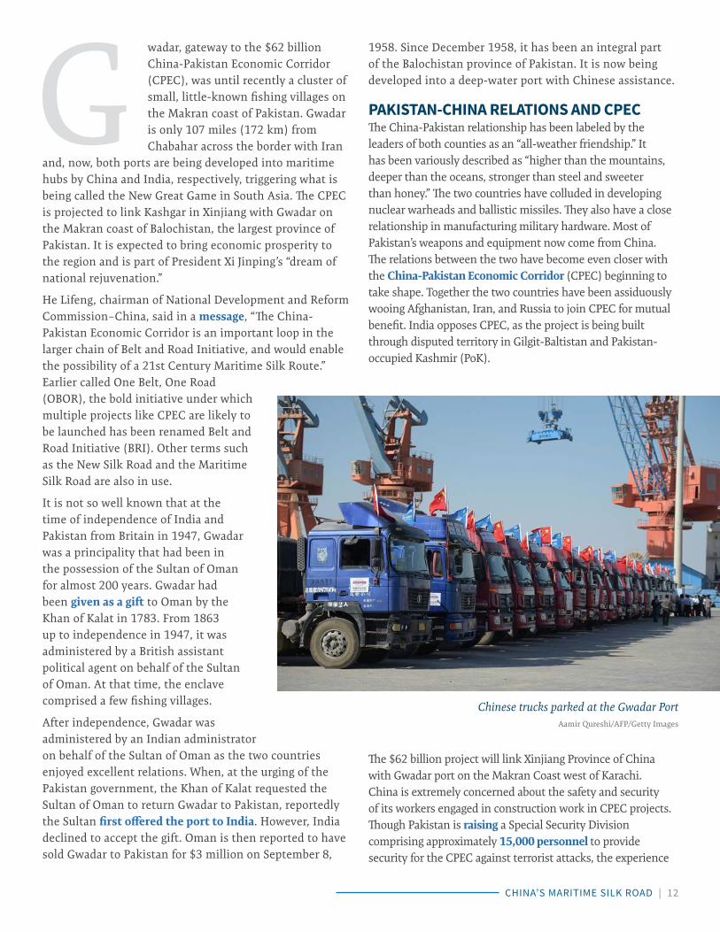
The $62 billion project will link Xinjiang Province of China with Gwadar port on the Makran Coast west of Karachi. China is extremely concerned about the safety and security of its workers engaged in construction work in CPEC projects. Though Pakistan is raising a Special Security Division comprising approximately 15,000 personnel to provide security for the CPEC against terrorist attacks, the experience
G
Chinese trucks parked at the Gwadar PortAamir Qureshi/AFP/Getty Images

CHINA’S MARITIME SILK ROAD | 13
of Chinese dam construction in Gilgit-Baltistan has shown that eventually PLA soldiers are inducted for this purpose. The presence of PLA personnel in Pakistan in large numbers will further vitiate the security environment in South Asia.
With its growing investment in infrastructure projects in Pakistan and increase in the number of its citizens on Pakistani soil, China will have a greater stake in regional peace and stability and could play a positive role to help resolve a future crisis. However, in view of its recent track record in the South China Sea, its handling of the dispute over the Senkaku (Diaoyu) Islands, and its failure to intervene effectively to curtail North Korea’s nuclear ambitions, it is doubtful whether China will actually do so.
GWADAR PORT: PLANS AND PROGRESSGwadar port, now under construction, is located close to the mouth of the Persian Gulf just below the Straits of Hormuz. It is the third commercial port of Pakistan after Karachi and Qasim. Together the older two ports handle 95 percent of Pakistan’s sea-borne trade, but their capacities have been fully exploited and there is no scope for further expansion. Gwadar port is being built in phases. When completed, it will have three 200-meter-long berths and one Ro-Ro (roll on-roll off) facility. At present the port has the capacity to handle 50,000 deadweight tonnage (DWT) bulk carriers drawing up to 12.5 meters.
According to the Gwadar Port Authority’s vision statement, “Gwadar deep sea port is the second great monument of Pakistan-China friendship after the Karakoram Highway linking Pakistan and China.” Besides Gwadar port, CPEC will include transport infrastructure, oil pipelines, power plants,
and industrial zones with a capital outlay of nearly $60 billion. A $2 billion oil refinery is planned to be set up near Gwadar. The port is being developed by the China Overseas Port Holding Company (COPHC), to which it was leased by the Pakistan government for 40 years in April 2017. The final expansion of the port and ancillary systems will be undertaken by the Chinese.
Funds for this ambitious project will be provided by China both through the Asian Infrastructure Investment Bank (AIIB) and by way of direct government-to-government soft loans. To help China to recover its capital investment, COPHC will get a 91 percent share of the revenue from the operations of the port and the terminal and 85 percent of the revenue generated by the free zone. Under this arrangement, though the port is expected to handle 1 million tonnes of cargo annually, the impression in Pakistan is that benefits will accrue mainly to the Chinese. Also, there are misgivings within Pakistan regarding the debt trap that the huge investment in CPEC will result in. The Pakistani elite are no doubt watching the disaster that the developments of Hambantota port and international airport have been for Sri Lanka.
RESENTMENT AGAINST CPEC IN BALOCHISTANBalochistan is Pakistan’s largest province, but has the lowest population (13 million) and is the least developed. The Baloch people never quite accepted the forcible merger of their province with Pakistan soon after independence from the British in 1947. Since then, there have been several uprisings in Balochistan. The current struggle of the Baloch people against Pakistan’s central government dates back to 2005. The
ethnic Baloch people say they have been marginalized and deprived of their rights, with reports that thousands of people have been picked up by the Pakistan army and police forces.
The Balochistan conflict is driven by Baloch nationalists’ push for a greater share of natural resources and expanded internal political and administrative autonomy, and complicated by Pakistan’s charge that India is supporting the Balochistan Liberation Army (BLA) and India’s denial that it has offered more than sympathy to the Baloch peoples’ aspirations. Balochistan continues to remain the least-developed province of

CHINA’S MARITIME SILK ROAD | 14
Pakistan and poverty is rampant, leading to a sense of deep resentment among the people and no sign of resolution of the underlying political and economic sources of friction.
The separatist resurgence is thwarting Pakistan’s plans to optimally utilize Balochistan’s energy reserves. It is also hampering efforts to build transnational gas pipelines from Iran and Turkmenistan—with the potential to generate royalty worth $700 to 800 million annually. Accepting responsibility for an attack on construction workers near Gwadar in which 10 laborers died in May 2017, Jeander Baloch, the BLA spokesperson, said in a statement, “This conspiratorial plan [CPEC] is not acceptable to the Baloch people under any circumstances. Baloch independence movements have made it clear several times that they will not abandon their people’s future in the name of development projects or even democracy.” In previous years, some Chinese workers have also been targeted.
EFFORTS TO COUNTER CHINA’S STRATEGIC OUTREACHIn China’s grand strategy, Gwadar is an important foothold that is part of its String of Pearls strategy for the Indo-Pacific. Other “pearls” in South Asia include Myanmar’s Kyaukpyu port and Hambantota in Sri Lanka. Maldives has also negotiated an agreement with China for the long-term lease of a port. Chinese maritime strategy draws heavily from Mahan’s theory of sea dominance. Mahan’s hypothesis was that whoever controls the Indian Ocean will dominate the whole of Asia. The PLA Navy is expanding rapidly and clearly aims to dominate the Indo-Pacific. If Gwadar port is converted into a naval base sometime in the future, it will enable the PLA Navy to maintain a permanent presence in the Arabian Sea and the Gulf of Oman. In the eventuality of India having to fight a two-front war—undoubtedly a low-probability scenario—the Indian Navy would have to contend with a formidable maritime force. India’s energy supplies from the Gulf and maritime trade will become highly vulnerable to interception.
Both China and Pakistan view the development of Gwadar port as a win-win situation. The CPEC is part of China’s Belt and Road Initiative (BRI) that seeks to extend China’s strategic outreach deep into the Indo-Pacific region and counter U.S. influence in the Indo-Pacific. It is also designed to give a fillip to China’s slowing economy by generating large-scale construction activity, building an alternative route for oil and gas supplies and creating new markets for China’s products. Notably, China is simultaneously engaged in building its first overseas military base in Djibouti. China’s
military assertiveness in reclaiming land and building air strips and ancillary support facilities on some of the disputed Spratly and Paracel islands in the South China Sea, in blatant violation of the Law of the Sea Treaty and other international norms, has led to instability and fueled the possibility of future conflict in Southeast Asia.
However, the challenge posed by China is unlikely to go uncontested. In November 2017, senior officials of Australia, India, Japan, and the United States, meeting on the sidelines of the East Asia Summit in the Philippines, agreed that a “free, open, prosperous and inclusive Indo-Pacific region serves the long-term interests of all countries in the region and of the world at large.” This development led to speculation that the idea of a Quadrilateral Security Dialogue (also called the Quad) is being revived after a hiatus of 10 years. The Quad’s discussions for cooperative security are likely to be undertaken in concert with other strategic partners in the Indo-Pacific like Singapore and South Korea. It is expected that this will eventually lead to strategic realignment for peace and stability in the Indo-Pacific.
Admiral Arun Prakash, former Indian naval chief, wrote recently, “India’s recent agreement with Oman providing access, for ‘military use and logistical support’ in the new Port of Duqm, has raised hopes that India is, belatedly, strengthening its maritime posture in the Indian Ocean Region (IOR). There have been other significant developments too; like President Ram Nath Kovind’s visit to Djibouti and its impending recognition by India; the conclusion of an Indo-Seychelles agreement for creation of air and naval facilities on Assumption Island; and the agreement with the UAE for joint naval exercises.” India is negotiating with Djibouti for port facilities, including logistics replenishment, and for the Agalega Islands with Mauritius for use by the Indian Navy.
The Joint Strategic Vision of India-France Cooperation in the Indian Ocean Region, endorsed by India and France in March 2018, along with a reciprocal logistics support agreement, will enable the two countries to cooperate for peace and stability in the region. In fact, the India-France strategic partnership has been described in an editorial as “transcending the traditional alliance frameworks and new geopolitical fault lines.” All of these initiatives will empower India to shoulder greater responsibility as a contributor to security in the western Indo-Pacific.
The PLA Navy will pose a formidable challenge in the years ahead as it acquires a blue-water status and has naval bases and port facilities to fall back on. A concerted effort needs to be made to meet the emerging challenge. Though

CHINA’S MARITIME SILK ROAD | 15
it will be a gradual and long-drawn process, a cooperative security framework will eventually emerge from the discussions now being initiated by the leaders of the Quad for the security of the global commons. Cooperative security does not necessarily require a formal military alliance. Cooperative security in the maritime sphere entails the sharing of intelligence; joint counterterrorism and counterproliferation efforts; upholding the rules and norms governing maritime transit and overflights; providing help to the littoral states to meet their security needs; helping to counter piracy, arms smuggling, and narcotics trafficking; and undertaking joint humanitarian and disaster relief (HADR) operations in the region.

CHINA’S MARITIME SILK ROAD | 16
By Harsh V. Pant
India-Iran Cooperation at Chabahar Port
THE ISSUE India’s efforts to help develop Iran’s Chabahar Port reflect Indian ambitions as a driver of infrastructure development and improved regional connectivity, particularly with Afghanistan.
Chabahar Port is meant to serve as an essential node to a multi-modal transportation network for the movement of goods and passengers between Iran, Afghanistan, and India. During the final phase of its development, the port is expected to be capable of handling 20 million tons of trade annually.
Only 72 kilometers from the Chinese-backed, Pakistani port of Gwadar, the project is seen as a strategic play to limit the influence China seeks to gain and wield through its Belt and Road Initiative. Chabahar also allows the bypassing of a Pakistani bottleneck in terms of India-Afghanistan connectivity.
The India-Iran relationship remains constrained due to Iran’s openness to Pakistani and Chinese participation in the development of Chabahar. U.S.-Iran uncertainty and instability in Afghanistan complicate the intended benefits of the project still further.
Choppy WatersPhoto: Atta Kenare/AFP/Getty Images

CHINA’S MARITIME SILK ROAD | 17
On October 29, 2017, India flagged off the first shipment of wheat bound for Afghanistan via Iran’s Chabahar Port, in which India is a key developer. Indian Prime
Minister Narendra Modi on the occasion tweeted, “I congratulate Afghanistan and Iran on Indian wheat shipment being flagged off from Kandla to Afghanistan through Chabahar.” Chabahar is important to India, both as a stepping stone to become a larger regional infrastructure developer, but also to help drive trade and aid to Afghanistan. Despite these important drivers in Delhi, the project has not proceeded smoothly, and there could be further bumps ahead as India tries to balance cooperation with Iran, its relations with the United States and Israel, and fend off regional challenges from China and Pakistan.
The first phase of the strategic Chabahar port was inaugurated in December 2017 by Iranian President Hassan Rouhani in the presence of officials from 17 countries. To underscore the importance of this project for India, Indian minister of state for shipping Pon Radhakrishnan was present at the inauguration ceremony of the Phase 1 of the Shahid Beheshti Port at Chabahar. During Iranian President Hasan Rouhani’s visit to India in February 2018, New Delhi signed the leasing agreement with Iran giving India Ports Global Private Limited (IPGPL) operational rights of Chabahar’s Shahid-Besheshti port terminal for 18 months.
Ever since Iran hired Indian firms to develop a seaport in the Chabahar city in the 1990s, India has been central to the Chabahar project. Having sensed the need to improve transregional connectivity, India signed a trilateral transit agreement with Afghanistan and Iran in May 2016 that enables a passage for Indian exports to reach Afghanistan through Iran. This was followed by Prime Minister Modi’s visit to Iran in May 2016, when India signed an agreement to develop two terminals of the Chabahar port. India views Chabahar as a means to gain access to Central Asia and the region beyond to overcome its limitation of not having a contiguous border with Afghanistan, hampering the prospects of bilateral trade between India and Central Asia.
THE STATE OF PLAYIndia is to build and operate two berths in Chabahar Port Phase-I with a total capital investment of $85 million and annual revenue expenditure of $23 million on a 10-year lease. Chabahar will become a key transit and transport corridor connecting India, Iran, and Afghanistan, and feed into a larger multimodal transportation network for goods and passengers across the three nations. The port is expected to be operational by the end of 2018 with New Delhi committed to developing a free-trade area around the port, and finally complete the loop with a $1.6 billion railway line to Zahedan, an Iranian city near the border of southwest Afghanistan.
Chabahar currently has two port complexes, the Shahid Kalantari and Shahid Beheshti. The former is a traffic port, while the latter being planned as the future regional hub port. With the extension of the Shahid Beheshti port complex in 2017, Chabahar port’s present capacity of 2.5 million tons (MT) per annum has been expanded to 8 MT per annum and is expected to reach 20 million MT per annum during the final phase of the project. Iran has offered India several incentives around Chabahar such as the establishment of an elaborate free trade and industrial zone (FTZ). The FTZ is divided into nine functional zones, with 26 percent of the territory being allocated for the trade and service sector, 49 percent for industries, and 25 percent for tourism and residential activities. Other measures undertaken by the Iranian government, which encourage foreign capital inflow, include protecting the
OIranian President Hassan Rouhani shakes hands with Indian Prime Minister
Narendra Modi in New Delhi on February 17, 2018Money Sharma/AFP/Getty Images

CHINA’S MARITIME SILK ROAD | 18
incoming investments under the Foreign Investment Promotion and Protection Act (FIPPA) and conforming to key World Trade Organization (WTO) rules and regulations.
RATIONALEChabahar port sits only 72 kilometers from Pakistan’s Gwadar Port, which is being developed with Chinese investment. This proximity is viewed as another sign of strategic competition between India and China in the region. The Chabahar port project is important to India’s larger geostrategic ambition that aims to limit China-Pakistan cooperation while expanding New Delhi’s influence beyond South Asia. Chabahar is 950 kilometers away from the Milak border crossing on the Afghan border and 768 nautical miles from India’s Mumbai port. Chabahar is vital for both India and Iran to realize their ambition of reducing dependency on the Suez Canal for transporting cargo to Europe. Chabahar’s strategic position is a boon for the envisioned International North South Transport Corridor (INSTC), signed between India, Iran, and Russia in 2000, that would establish transport connectivity between Europe, Central Asia, and India. Chabahar is also situated in the path of the South Asia corridor, which passes through India and Mirjaveh in Iran, linking Southeast Asia with Europe.
There is also a larger dynamic at play here in terms of regional connectivity. India, Iran, and Afghanistan are working toward integrated development of connectivity
infrastructure including ports and road and rail networks to open up greater opportunities for regional market access and integration of their economies. India has already completed the Zaranj-Delaram highway in Afghanistan, which would facilitate the trade to Kabul, and eventually beyond, to Central Asia. At a time when China is attempting to redraw regional boundaries through its Belt and Road Initiative, India and other regional players are looking at enhancing their own regional connectivity profiles.
Clearly, alleviating the Pakistani bottleneck in terms of India-Afghanistan connectivity is central to the project as a means to expand trade between the two nations, as well as facilitate delivery of Indian aid. As Afghan Chief Executive Abdullah Abdullah made clear, “Afghanistan used to rely only on one transit road, which was through Karachi. That is not the case anymore. [Now] it’s [also] through Chabahar.” For Kabul, overcoming its dependence on Islamabad is a key foreign policy priority and for New Delhi, and enhancing connectivity with Kabul is key to sustaining its multidimensional engagement in long-term capacity building in the war-torn nation.
CHALLENGESThe development of Chabahar continues to be a challenging affair. India does not occupy a privileged place in Iran’s foreign policy. Other factors such as the impact of U.S. economic sanctions and instability in Afghanistan remain key concerns that could impact the development pace and full operationalization of the project.
Iran has repeatedly shrugged off Indian requests to gain a greater foothold in its energy sector, as evident in the case of Farzad-B gas field. Notwithstanding the fact that India is currently the second-largest buyer of Iranian oil, Iran awarded the lucrative deal to Russia for developing the gas field that was discovered by an Indian consortium. Moreover, against what has been termed as a “strategic partnership” by some, India-Iran ties remain underdeveloped when compared to
the former’s expansive relationship with Israel and the Gulf Cooperation Council (GCC) member states.

CHINA’S MARITIME SILK ROAD | 19
Though Iran’s ties with Pakistan have been historically mired in suspicion, Tehran has assured Islamabad that it would not allow Delhi or any other country to use Chabahar against Pakistan. Iran doesn’t want Pakistan to overtly shift to the Saudi Arabia-led regional bloc evolving in the Middle East and it has even dangled the possibility of Pakistan joining the project at some future date. In May 2016, the same year in which India signed the historic trilateral accord with Iran and Afghanistan to cooperate on the Chabahar port project, Iran’s ambassador to Pakistan, Mehdi Honerdoost, categorically stated that the Chabahar deal is not finished, nor is it limited to just three partner countries. Mehdi commented, “The deal is not finished. We are waiting for new members. Pakistan, our brotherly neighbours and China, a great partner of the Iranians and a good friend of Pakistan, are both welcome.” In fact, the Chinese firm Shanghai Zhenhua Heavy Industries Co. Ltd. (ZPMC) won the auction for supplying cranes to India Ports Global Private Limited (IPGPL), which is developing the Chabahar project.
Iran may find it difficult to leave China out of the Chabahar project. China is the largest foreign investor in Iran, filling the vacuum left by Western nations in recent decades. Moreover, China has successfully completed a number of infrastructure projects in Iran including the Tehran metro, and is providing $1.5 billion for the electrification of the Tehran-Mashhad railway line through its EXIM bank. Both China and Iran announced in 2016 their intent to expand
bilateral trade to $600 billion. This is complemented by the fact that China has more experience than India in successfully undertaking overseas infrastructure projects. Bureaucratic snarls accompanied by the delay in transferring the $150 million soft loan and the promised $500 million investment in the FTZ around Chabahar adds skepticism to India’s commitment in realizing the project.
The attitude of the Trump administration toward Iran also exacerbates India’s fears of deepening its economic engagement with Iran. Despite former U.S. Secretary of State Rex Tillerson suggesting that Washington does not wish to intervene in the legitimate business activities between Iran and India, the Trump administration has taken an aggressive posture toward Iran. The threat of
renewed sanctions against Iran, and firms that contribute to the Iranian economy, looms overhead. The volatile security situation in Afghanistan can also derail the trilateral endeavor of India, Iran, and Afghanistan to operationalize the Chabahar port facility.
Despite these challenges, India and Iran have repeatedly underscored their desire to complete the Chabahar project and there seems to be a recognition in both New Delhi and Tehran that this project is key to their strategic priorities.

CHINA’S MARITIME SILK ROAD | 20
JULY 2017
By Matthew Funaiole and Jonathan Hillman
China’s Maritime Silk Road Initiative
THE ISSUE China’s Maritime Silk Road Initiative (MSRI) seeks to connect Beijing with trading hubs around the world.
Beijing insists the MSRI is economically motivated, but some observers argue that China is primarily advancing its strategic objectives.
This article examines several economic criteria that should be used when analyzing port projects associated with the MSRI.
Economic Drivers and Challenges
Photo: Aamir Qureshi/AFP/Getty Images

CHINA’S MARITIME SILK ROAD | 21
hina’s leaders have mapped out an ambitious plan, the Maritime Silk Road Initiative (MSRI), to establish three “blue economic passages” that will connect Beijing with economic hubs around the world. It is the maritime dimension of President
Xi Jinping’s Belt and Road Initiative (BRI), which could include $1–4 trillion in new roads, railways, ports, and other infrastructure. Within this broad and ever-expanding construct, Chinese investments have been especially active in the Indo-Pacific region, raising questions about whether it is China’s economic or strategic interests that are driving major port investments.
The Indo-Pacific is already central to global commerce and will become even more important in the coming years. Each of the 10 busiest container ports in the world are situated along the shores of either the Pacific or Indian Ocean, and more than half of the world’s maritime trade in petroleum transits the Indian Ocean alone. The ocean’s commercial shipping volume has increased four-fold since 1970, with an estimated 9.84 billion tons of products being transported each year. Exports from Asian economies are expected to rise from 17 percent in 2010 to 28 percent in 2030, further indicating the economic vibrancy of the region.
Continuing this growth will require further reforms and investment. South Asia is the least integrated region in the world, with intraregional trade amounting for less than 5 percent of the region’s total trade. Standing in the way of further integration are “soft” infrastructure challenges, such as customs and trade barriers, as well as hard infrastructure challenges. The World Bank has estimated that between $1.7 trillion and $2.5 trillion needs to be invested in South Asia to close its infrastructure gap. As a result of these challenges, it is more than twice as expensive to export or import a container in South Asia than it is in East Asia.
Beijing insists the MSRI is intended to increase global integration and boost growth, but some analysts question China’s motivations, particularly those behind its investments in ports. During the first half of 2017 alone, Chinese companies announced plans to buy or invest in nine overseas ports, five of which are in the Indian Ocean. Those critical of the MSRI typically argue that while some economic factors may be at play, these investments are driven primarily by strategic objectives. At the heart of this critique is a concern that China will use ports associated with the MSRI to service military assets deployed to the region in support of China’s growing security interests. These concerns have focused on several port projects, including those in Gwadar, Pakistan; Hambantota, Sri Lanka; and Kyaukpyu, Myanmar.
One way to begin testing these competing narratives is to explore the economic viability of new port construction projects associated with the MSRI. To be sure, many of the same attributes that make a port commercially competitive can also increase its strategic utility. For example, deep water ports can accommodate larger commercial vessels as well as larger military ships. It is also true that ports with weak economic fundamentals are not necessarily strategic plays. Political incentives can also motivate the funding of questionable infrastructure projects. With few exceptions, however, these projects have been advertised by Beijing and recipient countries as economic opportunities. Examining the economic merits is a practical first step in assessing the motivations of the MSRI.
This article outlines three economic criteria that should be used when analyzing port projects associated with the MSRI: (1) proximity to major shipping lanes; (2) proximity to existing ports; and (3) hinterland connectivity. While far from exhaustive, these initial criteria are intended to lay the groundwork for more detailed assessments of individual port projects. The following sections explore these factors with reference to the three port projects (Gwadar, Hambantota, and Kyaukpyu) mentioned above.
PROXIMITY TO SHIPPING LANESOne of the most important—and perhaps the most obvious—determinants of a port’s economic viability is its geographic location. Major ports are typically situated near busy shipping routes and benefit from topographical features such as deep channels or natural harbors. Sri Lanka, for instance, is strategically situated along the Europe-Asia trade route, which has contributed to Colombo Port’s status as the 25th busiest container port in the world.
C
Many of the same attributes that make a port commercially competitive can also increase its strategic utility. . . . deep water ports can accommodate larger commercial vessels as well as larger military ships.

CHINA’S MARITIME SILK ROAD | 22
In Sri Lanka’s Southern Province, a port at Hambantota is only 10–15 kilometers from the Europe-Asia trade route. Advocates for the port, which Chinese firms now operate, point out that it is even closer to those ship lanes than Colombo Port, which sits on Sri Lanka’s western coast. Given the volume of trade that travels along this maritime corridor—estimated to be 23.1 million twenty-foot equivalent units (TEUs) in 2017 and expected to grow in the coming years—they argue that Hambantota can succeed by capturing just a fraction of this traffic.
Gwadar’s proximity to shipping routes is less optimal than it appears at first glance. It is located at the mouth of the Gulf of Oman, a vital maritime passageway for tankers carrying petroleum from the Arabian Peninsula to the energy-hungry countries of East Asia. More than half of the 7.6 million barrels of crude oil that China imports each day come from countries along the Persian Gulf. However, Gwadar is too close to ports of departure to serve as an effective waypoint for ships traveling from the Persian Gulf to China. Beijing and Islamabad’s longer-term vision for Gwadar includes high-speed rail and road networks that could carry oil from ships arriving at Gwadar to Western China. This would reduce the total distance that oil would travel from the Persian Gulf to China, but increase transportation costs while incurring
other risks, namely those associated with traveling through restive western Pakistan. At present, much of this supporting infrastructure is yet to be developed, as the final section of this article explains.
PROXIMITY TO EXISTING PORT(S)Given that most maritime traffic follows well-established routes designed to reduce shipping times, and thus costs, it comes as little surprise that some of the construction projects associated with the MSRI lie close to existing ports.
In general terms, the construction of a new port close to an established port makes economic sense if the established port cannot satisfy demand. In practice, assessing these factors is more challenging. Colombo Port, for instance, operates predominately as a transshipment port that services the Indian
subcontinent, and has witnessed its throughput—measured in millions of TEU of containerized cargo—increase from 4.9 million TEUs in 2014 to 6.2 million TEUs in 2017. But with a reported capacity of 7.1 million TEUs and plans to further expand its capacity, Colombo is well-positioned to handle future growth in maritime trade.
If Colombo continues to expand its capacity to meet demands, Hambantota may struggle to attract shipping traffic well into the future. According to Sri Lanka’s Ministry of Shipping and
Ports, only 183 ships arrived at Hambantota in 2017, down from 281 ships in 2016—far less than the nearly 4,500 that annually visit Colombo. Most of the ships (40 percent) that did visit Hambantota over this period were vehicle container vessels, a result of the Sri Lanka Port Authority’s decision in 2012 to route vehicle carriers to Hambantota.
The case for Kyaukpyu is comparatively stronger. Some 200 nautical miles north of Kyaukpyu on the coastline of the Bay of Bengal is the much-maligned Port of Chittagong. For years, reports have indicated that Chittagong is congested and inefficient, with throughput in 2017 double that of the port’s designed capacity. Kyaukpyu could serve to alleviate this pressure, especially for vessels traveling between the Indian Ocean and the South China Sea. In 2017, over two-thirds of the port
More than half of the 7.6 million barrels of crude oil that China imports each day come from countries along the Persian Gulf.
Global Shipping RoutesPhoto: B.S. Halpern (T. Hengl; D. Groll) / Wikimedia Commons

CHINA’S MARITIME SILK ROAD | 23
calls made at Chittagong by container ships and bulk carriers were conducted by vessels traveling (in either direction) between Colombo and ports along the Malacca/Singapore Straits.
HINTERLAND CONNECTIVITY The commercial success of all three port projects hinges on improving their connectivity to the “hinterland” (areas located further inland). The specific requirements of this connectivity depend on the services that each port aims to provide. For example, connectivity requirements are lower for ports specializing in transshipment, which involves moving cargo between ships rather than transporting it along overland routes. Nonetheless, all three ports aspire to be more than just transshipment hubs.
At Gwadar, port facilities have advanced faster than the area’s supporting infrastructure. The port recently received its first container ship, but the lack of adequate transport connections—particularly roads and rail—between Gwadar and the more developed areas of Pakistan hamper the port’s operations. An uptick in shipping traffic at Gwadar, particularly cargo destined for locations elsewhere in Pakistan, would result in serious delays due to the area’s limited connectivity. Importantly, connectivity isn’t just limited to transportation. Ample
water and power supplies are also critical. Reports also indicate a shortage of basic services at Gwadar, including potable water.
Much like Gwadar, Hambantota’s port is relatively isolated from Sri Lanka’s more developed areas. According to one optimistic projection, traffic leaving the port could surge from under 1,000 vehicles a year to nearly 25,000 vehicles by 2040. Much of that traffic would be destined for areas closer to Colombo. To service this growth, Sri Lanka’s road and rail networks would need to be considerably upgraded and expanded. Some of these supporting projects are underway.
The success of Kyaukpyu could also depend on the development of the China-Myanmar Economic corridor. The proposed multiphase project is designed to promote interstate connectivity between areas in southwest China and Myanmar. These connections, including oil and gas pipelines, could also help to expedite trade from Europe and the Middle East to inland China by allowing it to enter the continent at Kyaukpyu rather than at Chinese ports in the South China Sea, where goods must travel overland for hundreds of miles before reaching inland provinces like Yunnan.
To be sure, connectivity gaps are not limited to Chinese port investments. Chabahar Port in Iran faces similar challenges, particularly its isolation from Iran’s railway network. State-backed companies in India have recently announced investments aimed at addressing this shortcoming.
The commercial success of all three port projects hinges on improving their connectivity to the “hinterland”.
Sometimes better investments do not offer as many political benef its.

CHINA’S MARITIME SILK ROAD | 24
POLITICAL CURRENTS AND CHANGING TIDEThese cases highlight how the domestic political incentives for port construction do not always align with the economic merits. Hambantota, Gwadar, and Kyaukpyu are all advertised as engines of development for historically underdeveloped areas. As rural locations, they are less connected to broader transportation networks. In other words, the appeal of building a “game-changing” port in an undeveloped area almost always brings with it broader connectivity challenges, most of which are not captured in the cost of the port itself.
Sometimes better investments do not offer as many political benefits. Improving an existing port’s operations is often a cost-effective way to increase trade competitiveness, but technical and management enhancements do not generate the same excitement as ribbon-cutting and ground-breaking ceremonies. The duration of many infrastructure projects also magnifies the political incentives for starting projects. Successful projects can take years to complete and even longer before they become profitable. As such, officials who reap the political benefits of the new projects are often unaccountable for the project’s long-term performance.
Maritime trade is a fluid business. Shipping lanes are slow to change, but they are not immune to revision. As the Arctic warms, for example, northern sea lanes are remaining open for longer each year. There are also ambitious plans, like the Kra Canal, that could impact future shipping lanes, albeit not as dramatically as the Suez and Panama Canals did in the past. Individual ports may rise and fall, based not only on their location but also on their ability to compete and provide services. As the new ports examined in this article mature, they will
need to overcome connectivity and services challenges or they will remain constrained. Further research is needed, not only to better understand each port’s characteristics, but also their related connectivity projects.
Learn More
ChinaPower unpacks the complexity of China’s rise through data visualization and objective analysis.
https://chinapower.csis.org
Reconnecting Asia maps new linkages—roads, railways, and other infrastructure—that are reshaping economic and geopolitical realities.
https://reconnectingasia.csis.org
CSIS BRIEFS | WWW.CSIS.ORG | 24

CHINA’S MARITIME SILK ROAD | 25
ENDNOTES1. The MSRI was originally announced in 2013. A document released in 2017 elaborated on the MSRI concept and outlined three “blue econom-ic passages.”
2. Based on authors’ calculations using automatic identification system (AIS) data.
3. Services is another area of interest that warrants further analyses.

CHINA’S MARITIME SILK ROAD | 26
JULY 2017
By Zack Cooper
Security Implications of China’s Military Presence in the Indian Ocean
THE ISSUE China’s increased military presence in the Indian Ocean should not come as a surprise. China is following in the traditional path of other rising powers; it is expanding its military operations to match its interests abroad.
The security implications of China’s push into the Indian Ocean region are mixed. In peacetime, these efforts will certainly expand Chinese regional influence. In wartime, however, China’s Indian Ocean presence will likely create more vulnerabilities than opportunities.
hina’s military forays into the Indian Ocean have triggered a series of warnings. The term “string of pearls” was first used to refer to Chinese basing access in the Indian Ocean by a 2004 report for the U.S. Department of Defense. That report suggested China’s
growing regional presence could “deter the potential disruption of its energy supplies from potential threats, including the U.S. Navy, especially in the case of a conflict with Taiwan.” Other scholars have warned that Beijing seeks to “dominate” the Indian Ocean region. Others suggest that the Chinese government is simply following its expanding trading interests and seeking to secure its supply lines against disruption.
Although China’s presence in the Indian Ocean may permit it to increase its regional influence, Chinese facilities and forces would be highly vulnerable in a major conflict. Thus, the security implications of China’s push into the Indian Ocean region are mixed. In peacetime, these efforts will certainly expand Chinese regional influence. In wartime,
however, China’s Indian Ocean presence will likely create more vulnerabilities than opportunities.
EXPANDING INFLUENCE IN PEACETIMEChina’s increased military presence in the Indian Ocean should not come as a surprise. China is following in the traditional path of other rising powers; it is expanding its military operations to match its interests abroad. The Chinese economy is highly reliant on trade routes that pass through the Indian Ocean, which serves as a vital pathway, particularly for energy supplies. It is natural, therefore, for the Chinese government to seek to protect its interests along these sea lines of communication. Leaders in Beijing have reason to be concerned about multiple potential risks in the region, ranging from maritime piracy to the potential for the United States or India to disrupt Chinese supply lines if a conflict were to occur.
China’s efforts to project power in the Indian Ocean are nascent, but their outlines are becoming clear. To sustain military forces in the Indian Ocean region, China needs to have reliable access to facilities in key points around the
C
Photo: Keith Tsuji/Getty Images

CHINA’S MARITIME SILK ROAD | 27
region. China’s new military base in Djibouti provides a rudimentary power-projection base, which is bolstered by its access to ports in Bangladesh, Burma, Pakistan, and Sri Lanka. Although China is using its Belt and Road Initiative (BRI) to fund many of these projects, there is no question that the infrastructure is being created with dual-use purposes in mind.
How might China use these facilities in peacetime? The most likely Chinese strategy would be to rely on port facilities to refuel and resupply its naval vessels without having to come back to Chinese facilities in East Asia. In the years ahead, it would not be surprising to see the People’s Liberation Army (PLA) develop some rudimentary facilities in the region for conducting at least minor repairs. These types of activities would provide China with a greater ability to sustain forces in theater, thereby avoiding the costly and time-consuming practice of having to foray from distant ports in mainland China.
How might China use its forces in peacetime? In the near term, China will likely continue to conduct counter-piracy operations around the Horn of Africa.
This serves multiple purposes. First, it gives Chinese forces practice conducting difficult operations at a great distance from the mainland. Such efforts are helpful for assessing shortcomings in the PLA’s ability to sustain power-projection forces far from China’s shores. Second, counter-piracy provides a window into the operational patterns of foreign militaries. This may be useful both from an intelligence-gathering perspective and for helping the PLA to compare its strengths and weaknesses to those of foreign militaries, including the United States, India, Japan, Australia, and others.
Chinese vessels may also conduct some more specific intelligence, surveillance, and reconnaissance missions to better understand regional militaries and gather data on the geographic area in and around the Indian Ocean. Mapping undersea features would be particularly beneficial in preparing for a potential wartime scenario. Such activities could help to provide information on the typical operating practices of potential challengers, to include the Indian Navy.
China may also seek to conduct training and exercises in the region, potentially in partnership with other militaries.
Although Beijing is unlikely to find any highly capable partners in the region, it could work with less capable maritime states, such as Pakistan, to help them develop their maritime capabilities. This would also serve to expand the number of concerns for the Indian military, potentially stretching the Indian Navy. Such efforts could serve as a response to Indian efforts to build maritime capacity in Southeast Asia with states such as Vietnam.
In short, Chinese operations in the Indian Ocean during peacetime are likely to resemble those of other great powers, including the United States. Protection of trade routes is likely to be the primary objective, but it will require substantial improvements
Learn More
How is China bolstering its military diplomatic relations?

CHINA’S MARITIME SILK ROAD | 28
in the PLA Navy’s ability to sustain forces at sea. A secondary objective will be to prepare for the possibility of a conflict, in which the Indian Ocean might be an area of conflict, which is discussed in greater detail below.
CREATING VULNERABILITIES IN WARTIMEWhile peacetime operations in the Indian Ocean provide many opportunities for the PLA to expand its reach and capabilities, any substantial Chinese military presence in the Indian Ocean would be highly vulnerable in wartime. The PLA would find it exceedingly difficult to protect its trade routes, bases, and ships if a contingency were to occur involving either India or the United States (or potentially both at once).
Chinese trade routes would be particularly vulnerable because the sea lines of communication from the Middle East to China run near the Indian coast for much of their journey. Without a substantial naval presence, China would be unable to protect these shipping routes. Although it might be possible to convoy forces, these convoys would probably have to avoid the Malacca Strait. After all, Indian facilities in the Andaman and Nicobar Islands are rapidly improving, which would make it difficult for Chinese forces to protect against aircraft or submarines in that area. In addition, U.S. facilities at Diego Garcia would pose another significant challenge.
As a result, Chinese-bound shipping would likely have to divert from the Malacca Strait to the Sunda Strait, which would add significant time to transiting the Indian Ocean. Yet, this would also prove risky, as Australian facilities at Cocos and Christmas Islands are within range of these trade routes and could potentially be used by U.S. forces in a contingency. Therefore, if a conflict were severe enough that the United States or India were attempting to cut energy supplies to China, then Beijing would likely be forced to rely on its continental supply routes and its reserves for the duration of a conflict.
Furthermore, Chinese military vessels would be dependent on access to a limited number of bases. Just as the United States is vulnerable in East Asia because it relies on a few bases in the Pacific to project power, China would be vulnerable in the Indian Ocean. Yet, this would be a more severe challenge for the PLA, because China partners in the Indian Ocean region are far less capable than U.S. partners, such as Japan, in the Pacific. Simply getting sufficient munitions into the region could be problematic, preventing any Chinese forces from entering engagements past the first few days or weeks of a conflict.
Some have warned that China might be able to sustain a carrier strike group in the region, which would certainly provide a substantial power-projection capability in a crisis. Yet, historical experience shows that carrier-based airpower is highly vulnerable to land-based aircraft, which have greater range and payload. As a result, it is unlikely that China would risk operating a carrier strike group in the Indian Ocean in a contingency. In a conflict with the United States, sailing such forces through the Malacca Strait would be extremely risky given U.S. undersea capabilities. Instead, these types of assets would probably be kept nearer to the Chinese coast or in the Western Pacific, where they could better protect against U.S. land-based airpower or quiet attack submarines.
What PLA forces would this leave in the Indian Ocean region? The most likely Chinese assets would be long-range surveillance aircraft in combination with submarines. These forces would be less vulnerable to attack than large surface ships. They might also provide China with a limited ability to hold at risk an adversary’s surface ships and commercial vessels in the region. The Chinese military might also keep smaller naval vessels, such as patrol ships or frigates, to help protect its military ports and bases. If substantial ground and air forces were based in the region, these forces would be forced to defend themselves independently if they came under attack. Regardless, Chinese supply lines from the Middle East would likely be under severe threat in a major contingency and its forces in the Indian Ocean would be isolated.
CONCLUSIONChina’s activities in the Indian Ocean have attracted a great deal of interest in recent years. There is no doubt that Chinese engagement is changing regional security dynamics in the current peacetime environment.
China is following in the traditional path of other rising powers; it is expanding its military operations to match its interests abroad.

CHINA’S MARITIME SILK ROAD | 29
Beijing’s political, economic, and military influence is likely to expand in future years, triggering greater concern, particularly from Indian strategists. However, Chinese forces and facilities would be highly vulnerable if a major conflict were to break out.

CHINA’S MARITIME SILK ROAD | 30
JULY 2017
By Jesse Barker Gale and Andrew Shearer
The Quadrilateral Security Dialogue and the Maritime Silk Road Initiative
THE ISSUE Major geopolitical shifts in the Asia-Pacific in the last decade have led to a revitalization of the Quadrilateral
Security Dialogue between India, Japan, Australia, and the United States first established in 2007-2008.
China’s expanding maritime strategy and increasing assertiveness in land reclamation and territorial claims have been a key driver of a strengthening alignment among the Quad members.
China’s Maritime Silk Road Initiative (MSRI) offers unique concerns to each member:
o India fears encroachment on its zone of strategic interest as well as encirclement from Chinese projects in Pakistan.
o Japan is wary of China’s ability to influence the energy supply chains on which East Asia depends.
o Australia is concerned that China’s project aid could render fragile states more vulnerable to coercion.
o The United States is seeking a way to counteract Chinese influence, particularly in the vacuum left by U.S. withdrawal from the TPP.
While an official meeting of the Quad in November 2017 included key issues like freedom of navigation, maritime security, and respect for international law, official readouts of the meeting differed, suggesting that strategic geography, threat perceptions, and dynamics vis-à-vis China vary among the parties.
Notwithstanding these challenges, the interests of the Quad countries are converging, and this underlying structural dynamic provides a strong foundation on which the member countries can build an agenda for regional cooperation.
Photo: Saeed Khan/AFP/Getty Images

CHINA’S MARITIME SILK ROAD | 31
n the sidelines of the November 2017 East Asia Summit in Manila, the Philippines, officials from the United States, Japan, India, and Australia met to reestablish and re-conceptualize the Quadrilateral Security Dialogue (or Quad). These
states originally came together as the “Core Group” to provide urgent humanitarian assistance in the aftermath of the 2004 Indian Ocean tsunami disaster. They then met formally just once as the Quadrilateral Security Dialogue in 2007 before newly elected Australian Prime Minister Kevin Rudd directed Foreign Minister Stephen Smith to withdraw from the nascent dialogue. Attempts by subsequent Australian governments to build strategic trust with India and repair the damage to the emerging Australia-India security relationship were often rebuffed.
The reestablishment of the Quad a decade later points to tectonic shifts in the geopolitics of the region and in the Asia policies of the members of the original Quad. Having resigned suddenly in 2007 after only a year in office, Japanese Prime Minister Shinzo Abe—a consistent proponent of a “free and open Indo-Pacific” strategic concept—has mounted a highly successful return to office since 2012 and has emerged as a key leadership figure in the region. The Obama administration announced the U.S. “Rebalance to Asia”, and the Trump administration has officially labeled China as a strategic competitor to the United States. Ambivalence in India about closer strategic ties with the United States under Prime Minister Manmohan Singh has been replaced under his successor Narendra Modi by a commitment to strengthen the U.S.-India security relationship as pressure over China’s influence in the Indian Ocean region increased. In Australia revelations of Chinese interference in domestic politics and higher education and Beijing’s increasing international assertiveness have triggered increasing public concern and more forthright government moves to counteract growing Chinese influence in the region—including by rejoining the Quad.
China’s expanding maritime strategy and the increasing assertiveness of its land reclamation and territorial claims in disputed areas in the South and East China Seas over the past decade have been a key driver of this strengthening alignment among the Quad members. Undaunted by the international arbitration judgment invalidating many of Beijing’s legal claims in the South China Sea or by international pushback, President Xi Jinping has outlined an ambitious regional maritime agenda, encouraging Southeast Asian states to assist
China in building a twenty-f irst-century Maritime Silk Road (MSR) to complement an overland Silk Road to be built with Central Asian partners. Additionally, the Chinese Military Strategy White Paper, released in May 2015, declared that the People’s Liberation Army Navy (PLAN) would “gradually shift its focus from ‘offshore waters defense’ to the combination of ‘offshore waters defense’ with ‘open seas protection,’” requiring enhanced power-projection capabilities already evident in increasing patrols of the Indian Ocean by PLAN surface task groups and submarines. As with the overland Silk Road, establishing the Maritime Silk Road involves significant investments in both economic and security-related infrastructure around the Indian Ocean littoral, including in countries such as Burma, Pakistan, Sri Lanka, the Maldives, and Djibouti. Often these activities involve predatory lending practices that feed corruption and domestic political and social divisions, contributing to wider regional concerns about China’s long-term intentions. The revival of the Quadrilateral Security Dialogue needs to be understood in this wider geopolitical context.
INDIAThe Modi government’s opposition to the Maritime Silk Road Initiative reflects two interlocking concerns. The f irst is that it perceives the MSRI as a means to extend Beijing’s strategic influence deep into India’s zone of strategic interest. Reinforcing India’s concern are the efforts of the Chinese government to partner with regional institutions over which China exerts significant influence. The second concern relates to India’s tense relationship with Pakistan. New Delhi views both aspects of the Silk Road Initiative—the maritime and overland routes—as attempts to “encircle” India. Compounding this concern is the Chinese development of the Gwadar Port, a deep-sea port in the Southwest Balochistan Province of Pakistan. Close to the critical energy lanes from the Persian Gulf and the hydrocarbon-rich states of Central Asia, Gwadar is intended to form a natural link between the overland and maritime components of the Chinese Belt and Road strategy. In addition, elements of the overland Silk Road pass through disputed territory in the Kashmir region—leading to Indian reservations on the grounds of perceived threats to sovereignty and territorial integrity. Although Gwadar is touted as a commercial project (as indeed are all the investments connected to the Belt and Road initiative), the increasing Chinese military presence in the Indian Ocean raises questions about this assertion.
O

CHINA’S MARITIME SILK ROAD | 32
JAPANJapan’s concerns about the MSR initiative relate mostly to the risk it could be employed to limit or block energy shipments to East Asia. Japan imports some 90 percent of its energy, leaving it highly vulnerable to supply-chain disruption. As noted above, the Gwadar Port project is intended to function as a link between the continental and maritime strands of the Belt and Road strategy. China has already shown preparedness to exploit Japan’s dependence on imported rare earths in pursuit of its political objectives. This precedent suggests it is not implausible that Beijing could seek at some point in the future to play to Japan’s energy insecurity by routing a larger proportion of energy supplies through the Gwadar Port, ultimately to be stored or resold by China, limiting the amount of energy that passes through the Strait of Malacca. Japan’s sensitivity to this vulnerability can be seen in the comments of former Vice Foreign Minister Akitaka Saiki that Japan sees no difference regarding security issues in the Indian Ocean, Pacific Ocean, South China Sea, or East China Sea. It is also a factor in Japan’s active effort to maintain and diversify its access to facilities and resources, such as its partnership with India to create the Asia-Africa Growth Corridor, which aims to promote development and connectivity between Africa and Asia for “realizing a free and open Indo-Pacif ic.” Indeed, at the 2016 Tokyo International Conference on African Development in Nairobi, Kenya, Prime Minister Abe stated, “Japan bears the responsibility of fostering the confluence of the Pacific and Indian Oceans and of Asia and Africa into a place that values freedom, the rule of law, and the market economy, free from force or coercion, and making it prosperous.” The 2016 conference in Nairobi was the first in the series to be held outside Japan. Not coincidentally, Kenya is home to the Port of Mombasa, the only international port in Kenya, the largest port in East Africa, and a key target for the Maritime Silk Road.
AUSTRALIAIn 2011 President Barack Obama addressed the Australian Parliament, declaring that the United States was a Pacific power and “here to stay”—underlined by the announcement that U.S. Marines and military aircraft would henceforth rotate through bases in northern Australia. Three years later, during a visit to Australia to attend the Brisbane G20 Summit and finalize a bilateral free-trade agreement, President Xi Jinping told the same Parliament, “Oceania is a natural extension of the ancient maritime Silk Road, and China welcomes
Australia’s participation in the twenty-first-century Maritime Silk Road.” Australia’s decision to participate in the Asian Infrastructure Investment Bank (AIIB) and the subsequent sale of the Port of Darwin to a company linked to the One Belt, One Road strategy in late 2015 ruffled feathers in Washington and seemed to indicate that Australia was open to Xi’s entreaty. Notwithstanding these decisions and China’s importance as a trading partner, however, Australia’s response has been ambivalent. Australia has not formally joined the Belt and Road Initiative, while successive Australian governments have refused Chinese requests to link the infrastructure aspects of the Maritime Silk Road Initiative with the Northern Australia Infrastructure Facility, citing concern over China’s assertiveness in the South China Sea. Recent unguarded comments by an Australian minister responsible for development assistance show that Canberra also casts a wary eye at China’s increasing project aid in the Pacif ic Islands to Australia’s near north, fearing it could undermine governance and render fragile states more vulnerable to coercion.
UNITED STATESLike Australia, the United States lies outside the direct route of the Maritime Silk Road, but not outside its reach. The Trans-Pacific Partnership (TPP) originally offered an attractive U.S.-led alternative to China’s economic vision for the region, limiting the attractiveness of Chinese economic overtures in the Indo-Pacific. It would also have acted to reinforce the international rules-based order and the Trump administration’s proclaimed objective of a “free and open” region. Instead, the U.S. withdrawal from this important, high-quality trade pact has hobbled American strategy in Asia and provided an opportunity for the spread of Chinese influence. China even invited countries in Latin America and the Caribbean to join the One Belt, One Road initiative, underscoring Beijing’s willingness to challenge the United States in its backyard in the Americas. In his recent testimony before the Senate Armed Services Committee, Adm. Kurt Tidd, commander of the U.S. Southern Command, highlighted that the extension of One Belt, One Road to Central and South America would create security vulnerabilities for the United States likely to “compromise communication networks, and ultimately constrain our ability to work with our partners.” Today U.S. officials responsible for fleshing out the administration’s vision for a “free and open Indo-Pacific” are struggling to come up with a credible alternative to TPP as the vital economic pillar of an effective regional strategy.

CHINA’S MARITIME SILK ROAD | 33
QUAD 2.0Formal discussions regarding a revival of the Quad began to percolate publicly in the latter half of 2017 as China expanded its security exercises into the eastern and western quadrants of the Indian Ocean. On October 25, 2017, Japanese Foreign Minister Taro Kano publicly proposed the revitalization of the Quadrilateral Security Dialogue in an interview with The Nikkei. Two days later, on October 27, Ambassador Alice Wells, the U.S. acting assistant secretary for South and Central Asian affairs, pushed back against concerns that China might see the concept of a quadrilateral dialogue as a maneuver to contain China, noting, “[I] think it’s hard to see a meeting of diplomats from four countries as a plan to contain China. I think it’s a natural expression and convergence of interests between democratic countries in the Indo-Pacific region and it’s a natural stepping stone from the very productive trilateral conversations, exercises, and cooperation that we’ve seen between India, Japan, and the United States.”
The first Quad meeting on November 12, 2017, addressed seven core themes: the rules-based order in Asia, freedom of navigation and overflight in the maritime commons, respect for international law, enhancing connectivity, maritime security, the North Korean threat and nonproliferation, and terrorism. However, the official readouts of the meeting differed in emphasis and specificity. The Indian statement omitted any reference to freedom of navigation and overflight, respect for international law, or maritime security; the Japanese statement demurred on any mention of “connectivity”; and only the statements from Australia and the United States utilized the term “quadrilateral”. These omissions and divergences are relatively minor, but they do underscore that strategic geography, threat perceptions, and dynamics vis-à-vis China vary among the parties to the security dialogue. Managing them will require careful management if Quad 2.0 is to prosper, as will the sensitivities of countries in the Indo-Pacific who could resent their exclusion from the grouping unless it is seen to serve broader regional interests.
Notwithstanding these challenges, the interests of the Quad countries — and likeminded partners throughout the Indo-Pacific — are converging as the balance of
power shifts and the regional order comes under increasing strain. Together with their shared values, high-end capabilities, and complementary geography, this underlying structural dynamic provides a strong foundation on which the member countries can build a practical, functional agenda for regional cooperation that embraces economic and diplomatic elements as well as robust security collaboration. In the process they can contribute to a free, open and inclusive Indo-Pacific.

CHINA’S MARITIME SILK ROAD | 34
About the AuthorsJesse Barker Gale is a research associate in the CSIS Alliances and American Leadership Project.
Zack Cooper is a senior fellow for Asian security at CSIS.
Matthew P. Funaiole is a fellow with the China Power Project at CSIS.
Michael J. Green is senior vice president for Asia and Japan chair at CSIS, and director of Asian studies and chair in modern and contemporary Japanese politics and foreign policy at the Edmund A. Walsh School of Foreign Service at Georgetown University.
Jonathan Hillman is a fellow with the Simon Chair in Political Economy and director of the Reconnecting Asia Project at CSIS.
Brig. (Ret.) Gurmeet Kanwal is former director Center for Land Warfare Studies (CLAWS), New Delhi, and an adjunct fellow with the Wadhwani Chair in U.S.-India Policy Studies at CSIS.
Harsh V. Pant is an adjunct fellow (non-resident) with the Wadhwani Chair in U.S.-India Policy Studies at CSIS.
Gregory P. Poling is director of the Asia Maritime Transparency Initiative and a fellow in the Southeast Asia Program at CSIS.
Andrew Shearer is senior adviser on Asia-Pacific Security and director of the Alliances and American Leadership Project.
Nicholas Szechenyi is a senior fellow and deputy director of the Japan Chair at CSIS.

CHINA’S MARITIME SILK ROAD | 35
COVER PHOTO RICHARD A. BROOKS/AFP/GETTY IMAGES
1616 Rhode Island Avenue NW
Washington, DC 20036
202 887 0200 | www.csis.org