chesapeake bay john tyler tmdl action plan college · eee consulting, inc ... natural infiltration...
TRANSCRIPT

EEE Consulting, Inc.
John Tyler Community College
CHESAPEAKEBAYTMDLACTIONPLAN(2013‐2018MS4GeneralPermit)
This plan satisfies the requirements of Section I(C) of the MS4 General Permit (9VAC25‐890‐40) for Special Conditions for the Chesapeake Bay TMDL. This plan is consistent with the Chesapeake Bay TMDL and the Virginia Phase I and II WIPs to meet the Level 2 (L2) scoping run for existing developed lands as it represents an implementation of 5.0% of L2 as specified in the 2010 Phase I WIP.
APlanforAchievinga5%ReductionofExistingLoads
June30,2015
Chester Campus
Midlothian Campus

John Tyler Community College Phase I Chesapeake Bay TMDL Action Plan
i
EXECUTIVE SUMMARY John Tyler Community College (JTCC), is authorized to discharge stormwater from its municipal
separate storm sewer system (MS4) under the Virginia Pollutant Discharge Elimination System
(VPDES) General Permit for Discharge of Stormwater from Small MS4s (MS4 General Permit). To
maintain permit compliance, JTCC implements an MS4 Program Plan that includes best
management practices (BMPs) to address six minimum control measures (MCMs) and special
conditions for the Total Maximum Daily Load (TMDL) in which JTCC has been assigned a
wasteload allocation (WLA). The Environmental Protection Agency (EPA) describes a TMDL as a
“pollution diet” that identifies the maximum amount of a pollutant the waterway can receive and
still meet water quality standards. A WLA determines the required reduction in pollutant of
concern loadings from the MS4s to meet water quality standards. The MS4 General Permit serves
as the regulatory mechanism for addressing the load reductions described in the TMDL,
predominantly through the requirement of a TMDL Action Plan.
The Chesapeake Bay TMDL was established by the EPA on December 29, 2010 and initiated WLAs
for phosphorus, nitrogen and total suspended solids. In response, the Commonwealth of Virginia
developed Watershed Implementation Plans (WIPs) that, in part, identify the MS4 General Permit
as a mechanism for enforcing load reductions in urban areas. Subsequently, the Commonwealth
included special conditions into the latest MS4 General Permit to address the reductions required
by the TMDL for the pollutants of concern. The WIPs intended the reductions to be achieved
over the course of three 5‐year permit cycles, with the first cycle (2013 – 2018) requiring 5% of
the reductions be achieved. Reduction requirements for the following two permit cycles are
anticipated to increase substantially, requiring an additional 35% and 60% of the reductions be
achieved, respectively.
JTCC has developed an Action Plan consistent with the Chesapeake Bay Action Plan Guidance
Memo (Memo No. 15‐2005) provided by the Virginia Department of Environmental Quality
(DEQ). The guidance was used to determine the required pollutant load reductions and identify
the means and methods for achieving the reductions required by the current MS4 General
Permit. A review of JTCC’s existing stormwater management facilities identified applicable
pollutant reduction credits in a retention basin and an extended detention basin, both located
on the Midlothian campus. These existing BMPs, combined with the implementation of street
sweeping as a new BMP to collect approximately 190 lbs/yr of material, serve as the means and
methods to achieve the required reductions for the permit cycle. These means and methods,
along with continued implementation of the JTCC MS4 Program Plan is consistent with the
provisions of an iterative MS4 Program, which constitutes compliance with the MS4 General
Permit standard of reducing pollutants to the maximum extent practicable.

John Tyler Community College Phase I Chesapeake Bay TMDL Action Plan
ii
Table of Contents 1.0 Introduction and Purpose ................................................................................................... 1
1.1 Total Maximum Daily Loads ............................................................................................. 1 1.2 MS4 General Permit Special Conditions .......................................................................... 2 1.3 Watershed Implementation Plan and Strategy for MS4s ................................................ 2 1.4 JTCC Chesapeake Bay Action Plan .................................................................................... 2
2.0 Applicable Overview of JTCC’s MS4 Program ..................................................................... 3 2.1 Current Program and Existing Legal Authority ................................................................. 3 2.2 New or Modified Legal Authorities .................................................................................. 5
3.0 Pollutant Loadings ............................................................................................................... 6 3.1 Baseline Loading Characterization ................................................................................... 6 3.2 Annual Loadings from Existing Sources ........................................................................... 6 3.3 Annual Loadings from New Sources and Grandfathered Projects .................................. 7 3.4 Required Load Reductions ............................................................................................... 8
4.0 Means to Achieve Pollutant Reductions ........................................................................... 10 4.1 Reductions Achieved with Existing BMPs ...................................................................... 10 4.2 Reductions Achieved with New BMPs ........................................................................... 12
5.0 Implementation to the MEP ............................................................................................. 13 5.1 Supplemental Means and Methods ............................................................................... 13 5.2 Public Comment Period .................................................................................................. 13 5.3 Annual Reporting ........................................................................................................... 14
Tables Table 1: Classification of Campus Land Cover Area (Acres) ........................................................... 6 Table 2: Loadings from the Chester Campus .................................................................................. 7 Table 3: Loadings from the Midlothian Campus ............................................................................. 7 Table 4: Estimated POC Reductions from the Chester Campus ..................................................... 9 Table 5: Estimated POC Reductions from the Midlothian Campus ................................................ 9 Table 6: Compiled POC Reductions from JTCC Regulated Campuses............................................. 9 Table 7: Summary of POC Reductions from the Retention II Basin BMP ..................................... 11 Table 8: Summary of POC Reductions from the Extended Detention Basin BMP ........................ 11 Table 9: Summary of POC Reductions from Existing BMPs to Achieve Required Reductions ..... 12 Table 10: Required Street Sweeping per the Mass Loading Approach ........................................ 12
Appendices Appendix A: Mapping for Characterization of JTCC Campuses Appendix B: Supporting POC Reduction Calculations Appendix C: Supporting BMP Design Plans

John Tyler Community College Phase I Chesapeake Bay TMDL Action Plan
iii
Acronyms BMP Best Management Practice
CGP Construction General Permit
CUA Census Urban Area
CWA Clean Water Act
DEQ Virginia Department of Environmental Quality
EOS Edge of Stream
EPA Environmental Protection Agency
ESC Erosion and Sediment Control
GIS Geographic Information System
IDDE Illicit Discharge Detection and Elimination
JTCC John Tyler Community College
LA Load Allocation
L2 Level 2
MCM Minimum Control Measure
MEP Maximum Extent Practicable
MS4 Municipal Separate Storm Sewer System
MS4 GP General Permit for Discharge of Stormwater from Small MS4s
NMP Nutrient Management Plan
POC Pollutant of Concern
RLDA Regulated Land Disturbing Activity
SWPPP Stormwater Pollution Prevention Plan
SWM Stormwater Management
TMDL Total Maximum Daily Load
VAC Virginia Administrative Code
VCCS Virginia Community College System
VPDES Virginia Pollutant Discharge Elimination System
VSMP Virginia Stormwater Management Program
WIP Watershed Implementation Plan
WLA Wasteload Allocation

John Tyler Community College Phase I Chesapeake Bay TMDL Action Plan
iv
Definitions Best Management Practices (BMPs) are schedules of activities, prohibitions of practices,
maintenance procedures, and other management practices, including both structural and
nonstructural practices, to prevent or reduce the pollution of surface waters and groundwater
systems.
Census Urbanized Area (CUA) are areas identified as urban by the United States Census Bureau.
MS4 regulations only apply within CUAs.
Existing Sources are pervious and impervious urban land uses served by the MS4 as of June 30,
2009.
Impervious Cover is a surface composed of material that significantly impedes or prevents
natural infiltration of water into soil.
L2 Scoping Run is a model run to determine required reductions from urban sources as of June
30, 2009. The L2 reductions are summarized in the following table:
Municipal Separate Storm Sewer System (MS4) is a conveyance or system of conveyances
otherwise known as a municipal separate storm sewer system (MS4), including roads with
drainage systems, municipal streets, catch basins, curbs, gutters, ditches, manmade channels, or
storm drains that are:
Owned or operated by a federal state, city, town, county, district, association, or other
public body, created by or pursuant to state law that discharges to surface waters;
Designed or used for collecting or conveying stormwater;
That is not a combined sewer; and
That is not part of a publicly owned treatment works.
New Sources are pervious and impervious urban land uses served by the MS4 developed or
redeveloped on or after July 1, 2009.
JTCC MS4 Program Plan is the guiding document of the JTCC’s MS4 Program and includes best
management practices to address conditions of the MS4 General Permit.
Pollutants of Concern (POC) are total nitrogen (“TN”), total phosphorus (“TP”), and total
suspended solids (“TSS”).
Prior Developed Lands are lands that has been previously utilized for residential, commercial,
industrial, institutional, recreation, transportation, or utility facilities or structures, and that will
have the impervious areas associated with those uses altered during a land‐disturbing activity.
Transitional Sources are regulated land disturbing activities that are temporary in nature and
discharge through the MS4.
Pollutant of Concern Regulated Impervious (%) Regulated Pervious (%)
Nitrogen 9 6
Phosphorus 16 7.25
Sediment 20 8.75

John Tyler Community College Phase I Chesapeake Bay TMDL Action Plan
1
1.0 INTRODUCTION AND PURPOSE Mandated by Congress under the Clean Water Act (CWA), the
National Pollutant Discharge Elimination System (NPDES) storm
water program includes the Municipal Separate Storm Sewer
System (MS4), Construction, and Industrial General Permits. In
Virginia the NPDES Program is administered by the Department
of Environmental Quality (DEQ) through the Virginia
Stormwater Management Program (VSMP) and the Virginia
Pollutant Discharge Elimination System (VPDES). John Tyler
Community College (JTCC) is authorized to discharge
stormwater from its MS4 under the VPDES General Permit for
Discharge of Stormwater from Small MS4s (MS4 General
Permit). As part of the MS4 General Permit authorization, JTCC developed and implements a
MS4 Program Plan (the Plan) with best management practices (BMPs) to address the six
minimum control measures (MCMs) and the special conditions for applicable total maximum
daily loads (TMDLs) outlined in the MS4 General Permit. Implementation of these BMPs is
consistent with the provisions of an iterative MS4 Program, which constitutes compliance with
the standard of reducing pollutants to the "maximum extent practicable” or MEP.
The JTCC MS4 program strives to improve environmental compliance, quality and stewardship
through effective management, implementation, and enforcement of sound technical guidelines,
criteria and practices for stormwater management and erosion and sediment control. The plan
presented herein demonstrates how JTCC’s MS4 Program Plan addresses sediment and nutrients
(nitrogen and phosphorus) in its MS4 regulated area consistent with the requirements of the
Chesapeake Bay TMDL.
1.1 Total Maximum Daily Loads
A TMDL is the total amount of a given pollutant that a waterbody can assimilate and still meet
water quality standards. Typically, TMDLs are represented numerically in three main
components: Waste Load Allocations (WLAs), a Load Allocation (LA), and a Margin of Safety. A
WLA is the allocated amount of pollutant from areas discharging through a pipe or other
conveyance considered a point source. Point sources include sewage treatment plants, industrial
facilities and storm sewer systems. In contrast, an LA is the amount of pollutant from existing
non‐point sources and natural background such as farm runoff and atmospheric deposition. As
a point source discharge, MS4’s are assigned a WLA representing the annual loading of the
pollutant of concern (POC) that can be discharged from its regulated MS4 area.
“JTCC’s MS4 program strives to improve environmental compliance, quality and stewardship through effective management, implementation, and enforcement.”

John Tyler Community College Phase I Chesapeake Bay TMDL Action Plan
2
1.2 MS4 General Permit Special Conditions
JTCC’s MS4 General Permit includes a series of special conditions that must be addressed for
permit compliance where JTCC has been assigned a WLA as part of an approved TMDL. The
special conditions state that any TMDL approved by the State Water Control Board (SWCB)
assigning a WLA to an MS4 must be addressed by the Permittee through the measurable goals of
their MS4 Program Plan.
In 1998, large portions of Chesapeake Bay and its tidal tributaries within Virginia were identified
as not meeting water quality standards and listed as impaired because of excess nitrogen,
phosphorus and sediment. Due to the Chesapeake Bay waters remaining on the impaired waters
list, the Environmental Protection Agency (EPA) required that a TMDL be developed, which was
subsequently approved on December 29, 2010.
1.3 Watershed Implementation Plan and Strategy for MS4s
The Chesapeake Bay Watershed Implementation Plans (WIPs) are plans that detail how and when
the six Chesapeake Bay states and the District of Columbia will meet pollutant allocations. In the
Phase I and Phase II WIPs for the Chesapeake Bay TMDL, Virginia committed to a phased
approach to reducing nutrients and suspended solids discharging from MS4s. The issuance of
the 2013‐2018 MS4 General Permit set forth special conditions required by all MS4 General
Permit holders within the Chesapeake Bay watershed. In part, the special conditions require the
permittee to achieve 5% of the required reductions identified in the so‐called Level 2 Scoping
Run from existing baseline loads by July 1, 2018. Baseline loads are defined as those occurring
on June 20, 2009, and are computed using loading rates provided in the MS4 General Permit.
1.4 JTCC Chesapeake Bay Action Plan
The JTCC Action Plan presented herein provides a review of the current MS4 program, which
demonstrates JTCC’s ability to ensure compliance with the special conditions and includes the
means and methods JTCC will use to meet 5.0% of the Level 2 (L2) scoping run reduction for
existing development during the first MS4 General Permit cycle. This Action Plan was developed
to comply with the special conditions of the MS4 General Permit (9VAC25‐890) and under the
advisement of DEQ’s Guidance Memo No. 15‐2005 (DEQ Guidance), which provides background
information and procedures to meet the Chesapeake Bay TMDL special condition requirements.

John Tyler Community College Phase I Chesapeake Bay TMDL Action Plan
3
2.0 APPLICABLE OVERVIEW OF JTCC’S MS4 PROGRAM
JTCC’s MS4 Permit regulates stormwater discharges from areas included within census urbanized
areas (CUAs). JTCC campuses included in CUAs include the Chester and Midlothian campuses, as
depicted in Appendix A. JTCC’s collective efforts, as described in the JTCC MS4 Program Plan,
result in significant reduction of pollutants that may be discharged from its regulated MS4.
BMPs already included in the JTCC Program Plan that address sediment and nutrients impairing
the Chesapeake are described in the following sections. Each subsection is provided to address
the referenced special condition in the MS4 General Permit.
2.1 Current Program and Existing Legal Authority
As a non‐traditional MS4, JTCC does not have the ability to create legal authorities and has not
identified any necessary legal authorities necessary to meet the requirements of the special
conditions. However, JTCC’s MS4 Program includes Minimum Control Measures (MCMs) that
include policies and procedures consistent the goals of the Chesapeake Bay TMDL. A summary
of the applicable MCMs is listed below to address the following special condition:
“A review of the current MS4 program implemented as a requirement of this state permit including
a review of the existing legal authorities and the operator's ability to ensure compliance with this
special condition.” [Section I(C)(2)(a)(1)]
MCM 1 (Public Education and Outreach) – JTCC’s MS4 Program includes a Public Education
and Outreach Program (PEOP) that identifies the Chesapeake Bay TMDL pollutants of concern
(POCs) as a high priority water quality issue. The PEOP is described in BMP 1.2 of the JTCC
MS4 Program Plan and includes the distribution of educational materials regarding methods
to reduce introduction of the POCs into stormwater runoff.
MCM 3 (Illicit Discharge Detection and Elimination) – JTCC’s MS4 Program includes an Illicit
Discharge Detection and Elimination (IDDE) Program that includes written procedures to
detect, identify, and address non‐stormwater discharges, including illegal dumping, to the
small MS4 with policies and procedures for when and how to use legal authorities. JTCC
prohibits non‐stormwater discharges into the storm sewer system through language
provided within the Standards of Conduct for employees and the Student Handbook for
students. IDDE BMPs are described in the Minimum Control Measure 3 BMPs in the JTCC
MS4 Program Plan. The IDDE Program is effective at addressing the POC through staff
training, prohibition of illicit discharges, and annual outfall screening.
MCM 4 (Construction Site Runoff Control) – JTCC’s MS4 Program includes a Construction Site
Runoff Control Program that includes mechanisms to ensure compliance and enforcement
on regulated construction sites with implementation of the DEQ‐approved “VCCS Annual
Erosion and Sediment Control and Stormwater Management Standards and Specifications.”

John Tyler Community College Phase I Chesapeake Bay TMDL Action Plan
4
The standards and specifications are consistent with the Virginia Erosion and Sediment
Control and Stormwater Management Laws and Regulations and includes:
o Required plan approval prior to commencement of a regulated land disturbance
activity;
o Construction site inspections and enforcement; and
o Certification of post‐construction stormwater management facilities.
The Construction Site Runoff Control Program is especially effective at reducing downstream
conveyance of sediment from transitional sources. Minimum Control Measure 4 BMPs in the
JTCC MS4 Program Plan describe construction site runoff control BMPs.
MCM 5 (Post‐Construction Stormwater Management) – JTCC’s MS4 Program includes a Post‐
Construction SWM Program that ensures water quality criteria in the Virginia Stormwater
Management Regulations has been achieved on new developments and developments on
prior developed land since July 1, 2009. Included among these requirements are written
policies and procedures in the VCCS Erosion and Sediment Control and Stormwater
Management Standards and Specifications to ensure that stormwater management facilities
are designed and installed in accordance with appropriate law and regulations. Post‐
construction, the Program includes schedules and written procedures to ensure long‐term
inspections and maintenance of stormwater management BMPs. Minimum Control Measure
5 BMPs in the JTCC MS4 Program Plan describe post‐construction stormwater management
BMPs.
Implementation of this program addresses the following MS4 General Permit special
conditions for the Action Plan to include:
“The means and methods that will be utilized to address discharges into the MS4 from new sources
[Section I(C)(2)(a)(3)]
MCM 6 (Good Housekeeping) – JTCC’s MS4 Program includes a Pollution Prevention/Good
Housekeeping Program that includes policies and procedures to ensure that day‐to‐day
operations minimize the exposure of pollutants to rainfall on campus grounds to the
maximum extent practicable. The program is supported with JTCC’s Pollution Prevention &
Good Housekeeping Manual and annual training for applicable staff. JTCC also utilizes
contract language to ensure appropriate certifications for application of fertilizers per a DEQ‐
approved Nutrient Management Plan. Minimum Control Measure 6 BMPs in the JTCC MS4
Program Plan describe pollution prevention and good housekeeping BMPs.

John Tyler Community College Phase I Chesapeake Bay TMDL Action Plan
5
2.2 New or Modified Legal Authorities
Consistent with the MS4 General Permit, JTCC uses an iterative approach to ensure the College
is minimizing the discharge of pollutants through its MS4 to the MEP. The iterative approach is
implemented through the annual reporting process with the review of the effectiveness of each
MS4 Program Plan BMP. BMPs are modified, as necessary, to increase effectiveness. If new or
modified authorities are identified as part of the annual “measure of effectiveness” as described
for each BMP in the JTCC MS4 Program Plan annual reporting, they will be reported through the
annual report process. The iterative process addresses the following special condition in the MS4
General Permit:
“The identification of any new or modified legal authorities such as ordinances, state and other
permits, orders, specific contract language, and inter‐jurisdictional agreements implemented or
needing to be implemented to meet the requirements of this special condition.” [Section
I(C)(2)(a)(2)]
As a non‐traditional MS4, JTCC does not have the ability to create legal authorities. No new
policies and procedures or modifications to existing policies and procedures were identified as
necessary to meet the requirements of the special conditions. Means and methods to meet the
special conditions are described in Section 4.

John Tyler Community College Phase I Chesapeake Bay TMDL Action Plan
6
3.0 POLLUTANT LOADINGS The MS4 General Permit requires JTCC to estimate the annual loadings and the POC load
reductions (5.0% of the L2 Scoping Run reductions). To complete this requirement, JTCC
determined the amount of pervious and impervious land cover for their regulated campus and
input the data into the appropriate loading and reduction tables provided in the MS4 General
Permit. The methodology to determine sediment and nutrient loadings and the required
reductions are described in the following sub‐sections.
3.1 Baseline Loading Characterization
JTCC’s MS4 regulated area was calculated using the JTCC property boundaries as a conservative
estimate of the areas the MS4 serves. Campus boundaries were obtained from the County of
Chesterfield’s GIS data. The determination of regulated area was based on the 2010 CUA. Aerial
photography was obtained from the 2009 Virginia Base Map Program Orthophotography
Program Aerials1. The extent of pervious, impervious and forest areas as of June 30, 2009, were
digitized based on the aerial imagery and best professional judgment, as depicted in Appendix A.
For areas that were under construction or disturbed in the 2009 aerial imagery, current aerial
images were used to determine whether the areas resulted in pervious or impervious surfaces
after construction. Baseline land cover results are provided in Table 1.
Table 1: Classification of Campus Land Cover Area (Acres)
Land Cover Chester Campus Midlothian Campus
Impervious 19.1 15.8
Pervious 16.8 43.6
Forest* 19.0 57.6
Surface Water* 0.0 0.64
* Consistent with methodology described in the DEQ Guidance, these areas are not included in the loading computations described in Section 3.2.
3.2 Annual Loadings from Existing Sources
The data summarized in Table 1 was used to estimate pollutant loads from existing sources as of
June 30, 2009, using the James River Basin calculation sheet for estimating existing source loads
provided in the MS4 General Permit. The calculation sheet was completed for each regulated
JTCC campus as provided in Tables 2 and 3 which address the following special condition:
“An estimate of the annual POC loads discharged from the existing sources as of June 30, 2009,
based on the 2009 progress run. The operator shall utilize the applicable versions of Tables … based
1 Virginia Base Map Program Orthophotography Program, 2009. http://www.vita.virginia.gov/isp/default.aspx?id=8412

John Tyler Community College Phase I Chesapeake Bay TMDL Action Plan
7
on the river basin to which the MS4 discharges by multiplying the total existing acres served by
the MS4 on June 30, 2009, and the 2009 Edge of Stream (EOS) loading rate.” [Section I(C)(2)(a)(4)]
Table 2: Loadings from the Chester Campus
Pollutant Regulated Urban Land
Cover
Total Existing Acres Served by
MS4 (06/30/09)
2009 EOS Loading Rate
(lbs/acre)
Estimated Total POC Load Based on 2009
Progress Run (lbs)
Total Load (lbs)
Nitrogen Impervious Pervious
19.1 16.8
9.39 179.35 296.78
6.99 117.43
Phosphorus Impervious Pervious
19.1 1.76 33.62 42.02
16.8 0.5 8.40
TSS Impervious Pervious
19.1 676.94 12,929.55 14,627.69
16.8 101.08 1,698.14
Table 3: Loadings from the Midlothian Campus
Pollutant Regulated Urban Land
Cover
Total Existing Acres Served by
MS4 (06/30/09)
2009 EOS Loading Rate
(lbs/acre)
Estimated Total POC Load Based on 2009
Progress Run (lbs)
Total Load (lbs)
Nitrogen Impervious Pervious
15.8 9.39 148.36 453.12
43.6 6.99 304.76
Phosphorus Impervious Pervious
15.8 1.76 27.81 49.61
43.6 0.5 21.80
TSS Impervious Pervious
15.8 676.94 10,695.65 15,102.74
43.6 101.08 4,407.09
3.3 Annual Loadings from New Sources and Grandfathered Projects
In addition to computing baseline loadings from existing conditions as of June 30, 2009, the
special conditions require the determination of offsets for increased loads from development
occurring on or after July 1, 2009, including grandfathered projects. No offsets are necessary for
new sources since:
Loadings from new sources are addressed with the water quality criteria in the
stormwater management regulations. Water quality criteria for new sources from
regulated development between July 1, 2009 and June 30, 2014 was based on an average
land cover condition of 16% and therefore appropriate offsets were incorporated within
the development project’s stormwater management plan.
No JTCC projects are grandfathered.
Since no offsets for new sources are necessary, the following special conditions are addressed:
“A list of future projects and associated acreage that qualify as grandfathered in accordance with
9VAC25‐870‐48” [Section I(C)(2)(a)(10)]

John Tyler Community College Phase I Chesapeake Bay TMDL Action Plan
8
“The means and methods to offset the increased loads from new sources initiating construction
between July 1, 2009, and June 30, 2014, that disturb one acre or greater as a result of the
utilization of an average land cover condition greater than 16% impervious cover for the design of
post‐development stormwater management facilities. The operator shall offset 5.0% of the
calculated increased load from these new sources during the permit cycle.” [Section I(C)(2)(a)(7)]
“The means and methods to offset the increased loads from projects as grandfathered in
accordance with 9VAC25‐870‐48, that disturb one acre or greater that begin construction after
July 1, 2014, where the project utilizes an average land cover condition greater than 16%
impervious cover in the design of post‐development stormwater management facilities.” [Section
I(C)(2)(a)(8)]
“Implementation of the means and methods to address discharges from new sources in
accordance with the minimum control measure in Section II … related to post‐construction
stormwater management in new development and development of prior developed lands and in
order to offset 5.0% of the total increase in POC loads between July 1, 2009, and June 30, 2014.
Increases in the POC load from grandfathered projects initiating construction after July 1, 2014,
must be offset prior to completion of the project.” [Section I(C)(3)(c)]
3.4 Required Load Reductions
The MS4 General Permit requires JTCC to reduce 5.0% of the L2 Scoping Run POC reductions for
existing sources as of June 30, 2009. The required load reductions for both campuses for this
permit cycle were calculated using the calculation sheet in the MS4 General Permit for
determining POC reductions for the James River basin. The calculation sheets were modified
with the corrected loading rates provided in DEQ’s Guidance. The required load reductions for
each campus are depicted in Tables 4 and 5. Since both regulated campuses are in the James
River Basin, reductions are not campus‐specific and therefore summed in Table 6. The
information in the tables addresses the following special condition to provide:
“A determination of the total pollutant load reductions necessary to reduce the annual POC loads
from existing sources utilizing the applicable versions of Tables … based on the river basin to which
the MS4 discharges. This shall be calculated by multiplying the total existing acres served by the
MS4 by the first permit cycle required reduction in loading rate. For the purposes of this
determination, the operator shall utilize those existing acres identified by the 2000 U.S. Census
Bureau urbanized area and served by the MS4.” [Section I(C)(2)(a)(5)]

John Tyler Community College Phase I Chesapeake Bay TMDL Action Plan
9
Table 4: Estimated POC Reductions Required for the Chester Campus
Pollutant Regulated Urban Land
Cover
Existing Acres Served by
MS4 (06/30/09)
Reduction in Loading Rate (lbs/acre)
Reduction Required First Permit Cycle
(lbs)
Total Reduction
(lbs)
Nitrogen Impervious Pervious
19.1 0.042255 0.81 1.16
16.8 0.02097 0.35
Phosphorus Impervious Pervious
19.1 0.01408 0.27 0.30
16.8 0.0018125 0.03
TSS Impervious Pervious
19.1 6.7694 129.30 136.73
16.8 0.442225 7.43
Table 5: Estimated POC Reductions Required for the Midlothian Campus
Pollutant Regulated Urban Land
Cover
Existing Acres Served by
MS4 (06/30/09)
Reduction in Loading Rate (lbs/acre)
Reduction Required First Permit Cycle
(lbs)
Total Reduction
(lbs)
Nitrogen Impervious Pervious
15.8 0.042255 0.67 1.58
43.6 0.02097 0.91
Phosphorus Impervious Pervious
15.8 0.01408 0.22 0.30
43.6 0.0018125 0.08
TSS Impervious Pervious
15.8 6.7694 106.96 126.24
43.6 0.442225 19.28
Table 6: Compiled POC Reductions Required for JTCC Regulated Campuses
Pollutant Chester Reduction
(lbs) Midlothian Reduction
(lbs)
Total Reduction Required (lbs)
Nitrogen 1.16 1.58 2.74
Phosphorus 0.30 0.30 0.60
TSS 136.73 126.24 262.97

John Tyler Community College Phase I Chesapeake Bay TMDL Action Plan
10
4.0 MEANS TO ACHIEVE POLLUTANT REDUCTIONS
DEQ’s Guidance was used to identify appropriate means and methods for achieving the required
reductions computed in Section 3.4. A review of JTCC’s existing stormwater management
facilities determined that the required reductions are achieved for the current MS4 General
Permit cycle as described in the following sub‐sections, addressing the following MS4 General
Permit special condition:
“Implementation of means and methods sufficient to meet the required reductions of POC loads
from existing sources in accordance with the Chesapeake Bay TMDL Action Plan.” [Section
I(C)(3)(d)]
Reduction credits described in this section demonstrate compliance with the reduction
requirements for this MS4 General Permit cycle with the understanding that any changes in
established BMP efficiencies will not be retroactively applied to projects approved to meet
reductions for this MS4 General Permit cycle.
4.1 Reductions Achieved with Existing BMPs
Consistent with the DEQ Guidance, certain credits from historic water quality BMPs can be
credited towards pollutant load reductions requirements. Specifically, permittees can receive
full credit from BMPs that were:
Initially installed on or after January 1, 2006 and prior to July 1, 2009, and constructed to
address water quality within the permittee’s regulated service area; and
Initially installed after June 30 2009, provided that credit is only taken for reductions
achieved in excess of the reductions required by the SWM regulations water quality
criteria for the development.
A review of JTCC’s BMPs did not identify water quality BMPs installed on or after January 1, 2006
and prior to July 1, 2009; but did identify two facilities that provide POC reductions in excess of
those necessary for the associated developments:
In October 2009, a retention II basin, as described in the Virginia Stormwater
Management Handbook, was installed on the Midlothian campus as part of a stormwater
master plan completed by Burgess and Niple entitled, “John Tyler Community College
Midlothian Campus Stormwater Master Plan.” Consistent with the stormwater
regulations water quality criteria at the time, the retention II basin was designed to
provide to achieve water quality criteria for the existing and future build‐out of the JTCC
Midlothian campus. Per the stormwater master plan, the existing retention II basin is
designed to provide an additional pollutant removal of 1.5 pounds of phosphorus after
future build‐out of the Midlothian campus is complete.

John Tyler Community College Phase I Chesapeake Bay TMDL Action Plan
11
To ensure that credit is taken based only on existing development actually treated by the
BMP, calculations were completed to determine what portion of the additional 1.50
pounds of phosphorus may be applied to current reduction requirements. As described
in Appendix B, based on a ratio of existing impervious area to ultimate impervious area
(after all phases of the future build‐out are completed), it was calculated that 1.32 of the
1.50 pounds remaining in the pond may be applied to meet reduction requirements. The
remaining 0.18 pounds (1.50 ‐ 1.32) of phosphorus will become applicable as future
campus development occurs. Calculations to determine the proportional nitrogen and
sediment credits available in the regional pond that may be applied towards the required
reductions are included in Appendix B and relevant BMP design plan sheets are included
in Appendix C. Required and provided nutrient reductions are summarized in Table 7.
Table 7: Summary of POC Reductions from the Retention II Basin BMP
Pollutant Reductions Required by L2 Scoping
Run (lbs/yr)
Reductions Provided by Existing BMP (lbs/yr)
Nitrogen 2.74 2.11
Phosphorus 0.60 1.32
TSS 262.97 512.61
In the spring of 2015, an extended detention basin, as described in the Virginia
Stormwater Management Handbook, was installed on the Midlothian campus as part of
a plan completed by Timmons Group entitled, “John Tyler Community College Midlothian
Campus Phase III.” The approved design plans show that the BMP provides an extra 0.1
pounds of phosphorus removal per year than what is required for its associated
development. Calculations to determine the corresponding nitrogen and sediment
reductions achieved are included in Appendix B and relevant BMP design plan sheets are
included in Appendix C. Required and provided nutrient reductions are summarized in
Table 8.
Table 8: Summary of POC Reductions from the Extended Detention Basin BMP
Pollutant Reductions Required by L2 Scoping
Run (lbs/yr)
Reductions Provided by Existing BMP (lbs/yr)
Nitrogen 2.74 0.30
Phosphorus 0.60 0.10
TSS 262.97 71.97
John Tyler Community College Phase I Chesapeake Bay TMDL Action Plan
12
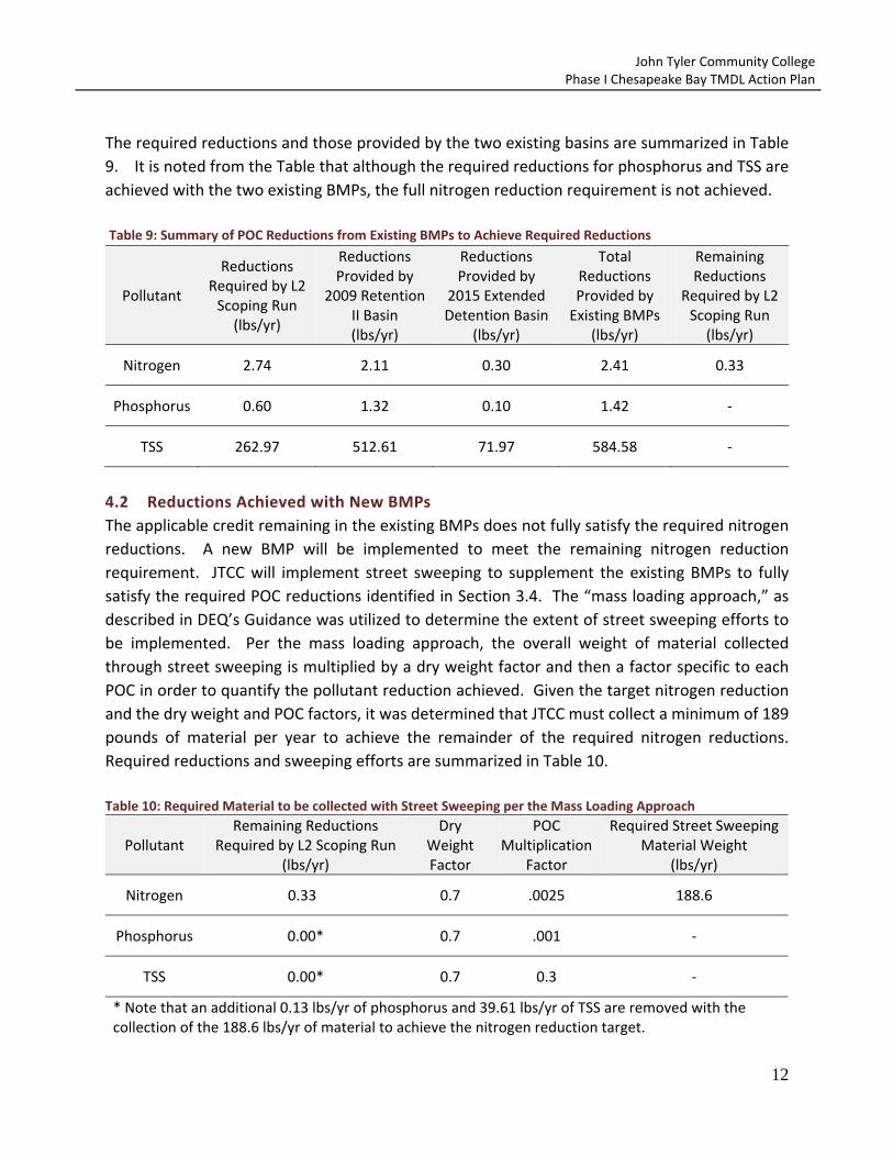
The required reductions and those provided by the two existing basins are summarized in Table
9. It is noted from the Table that although the required reductions for phosphorus and TSS are
achieved with the two existing BMPs, the full nitrogen reduction requirement is not achieved.
Table 9: Summary of POC Reductions from Existing BMPs to Achieve Required Reductions
Pollutant
Reductions Required by L2 Scoping Run
(lbs/yr)
Reductions Provided by
2009 Retention II Basin (lbs/yr)
Reductions Provided by
2015 Extended Detention Basin
(lbs/yr)
Total Reductions Provided by Existing BMPs
(lbs/yr)
Remaining Reductions
Required by L2 Scoping Run
(lbs/yr)
Nitrogen 2.74 2.11 0.30 2.41 0.33
Phosphorus 0.60 1.32 0.10 1.42 ‐
TSS 262.97 512.61 71.97 584.58 ‐
4.2 Reductions Achieved with New BMPs
The applicable credit remaining in the existing BMPs does not fully satisfy the required nitrogen
reductions. A new BMP will be implemented to meet the remaining nitrogen reduction
requirement. JTCC will implement street sweeping to supplement the existing BMPs to fully
satisfy the required POC reductions identified in Section 3.4. The “mass loading approach,” as
described in DEQ’s Guidance was utilized to determine the extent of street sweeping efforts to
be implemented. Per the mass loading approach, the overall weight of material collected
through street sweeping is multiplied by a dry weight factor and then a factor specific to each
POC in order to quantify the pollutant reduction achieved. Given the target nitrogen reduction
and the dry weight and POC factors, it was determined that JTCC must collect a minimum of 189
pounds of material per year to achieve the remainder of the required nitrogen reductions.
Required reductions and sweeping efforts are summarized in Table 10.
Table 10: Required Material to be collected with Street Sweeping per the Mass Loading Approach
Pollutant Remaining Reductions
Required by L2 Scoping Run (lbs/yr)
Dry Weight Factor
POC Multiplication
Factor
Required Street Sweeping Material Weight
(lbs/yr)
Nitrogen 0.33 0.7 .0025 188.6
Phosphorus 0.00* 0.7 .001 ‐
TSS 0.00* 0.7 0.3 ‐
* Note that an additional 0.13 lbs/yr of phosphorus and 39.61 lbs/yr of TSS are removed with the collection of the 188.6 lbs/yr of material to achieve the nitrogen reduction target.

John Tyler Community College Phase I Chesapeake Bay TMDL Action Plan
13
5.0 IMPLEMENTATION TO THE MEP
Implementation of the Action Plan is dependent on continued execution of the JTCC MS4
Program Plan. MS4 Program Plan BMPs will continue to be implemented per the schedules
outlined in the JTCC MS4 Program Plan to address the following special condition:
“The means and methods, such as management practices and retrofit programs that will be
utilized to meet the required reductions included in subdivision 2 a (5) of this subsection … and a
schedule to achieve those reductions. The schedule should include annual benchmarks to
demonstrate the ongoing progress in meeting those reductions.” [Section I(C)(2)(a)(6)]
The cost associated with the implementation of street sweeping is estimated to be approximately
$1,390 per year per pound of nitrogen reduction. This estimate is based on the document titled
“Cost‐Effectiveness Study of Urban Stormwater BMPs in the James River Basin” by the Center for
Watershed Protection. The study detailed costs associated with street sweeping based on a ten
year life cycle and capital costs of the equipment. This statement addresses the following special
condition:
“An estimate of the expected costs to implement the requirements of this special condition during
the state permit cycle.” [Section I(C)(2)(a)(11)]
5.1 Supplemental Means and Methods
In addition, the remaining Minimum Control Measure BMPs described in Section 2.1 will continue
to be implemented by JTCC as part of the JTCC MS4 Program Plan. Continued implementation of
these BMPs demonstrates implementation of the JTCC Chesapeake Bay Action Plan to the
maximum extent practicable and demonstrates adequate progress satisfying the following
special conditions:
“Implementation of nutrient management plans ...” [Section I(C)(3)(a)]
“Implementation of the minimum control measure … related to construction site stormwater
runoff control in accordance with this state permit shall address discharges from transitional
sources.” [Section I(C)(3)(b)]
5.2 Public Comment Period
JTCC will solicit public comment on the Plan and consider all comments that are provided. Public
comment will be provided through the following means:
A draft of the Chesapeake Bay TMDL Action plan will be posted on JTCC’s website for a
minimum of 14 total days.
An email will be sent to the target audience audiences identified in Minimum Control
Measure 1 of the JTCC MS4 Program Plan with a link where the public may comment on
the Action Plan.

John Tyler Community College Phase I Chesapeake Bay TMDL Action Plan
14
Solicitation of public comment on the Action Plan addresses the following special condition:
“An opportunity for receipt and consideration of public comment regarding the draft Chesapeake
Bay TMDL Action Plan.” [Section I(C)(2)(a)(12)]
5.3 Annual Reporting
The effectiveness of the Action Plan will be measured through the MS4 General Permit annual
reporting requirement. JTCC will report annually on the implementation on the BMPs described
in Section 4.1 of this Plan.
John Tyler Community College Phase I Chesapeake Bay TMDL Action Plan
Appendix A: Mapping for Characterization of JTCC Campuses

MIDLOTHIAN CAMPUSIMPERVIOUS AND PERVIOUS LAND COVER
JOHN TYLER COMMUNITY COLLEGE0 500 1,000
FeetChesterfield, Virginia
Sources: 2009 VGIN ImageryPrepared by Brian Brown, May 14, 2015
Campus Boundary
Impervious
Pervious
Ü
Projection: NAD 1983 StatePlane Virginia North FIPS 4501 Feet

CHESTER CAMPUSIMPERVIOUS AND PERVIOUS LAND COVER
JOHN TYLER COMMUNITY COLLEGE0 400 800
FeetChesterfield, Virginia
Sources: 2009 VGIN ImageryPrepared by Brian Brown, May 14, 2015
Campus Boundary
Impervious
Pervious
Ü
Projection: NAD 1983 StatePlane Virginia North FIPS 4501 Feet

John Tyler Community College Phase I Chesapeake Bay TMDL Action Plan
Appendix B: Supporting POC Reduction Calculations

John Tyler Community College Phase I Chesapeake Bay TMDL Action Plan
Calculations for JTCC Midlothian Campus Retention II Basin TP, TN and TSS Reductions Per Part III.3 of DEQ’s Guidance Memo No. 15‐2005, JTCC may receive POC reduction credits for SWM BMPs initially installed after June 30, 2009, provided that credit is only taken for reductions in excess of the reductions required by the SWM regulation water quality criteria for the development. As described in Section 4.1 of the JTCC Action Plan, a retention II basin was installed on the Midlothian campus in October 2009 as part of a stormwater master plan titled “John Tyler Community College Midlothian Campus Stormwater Master Plan” by EYP Architecture & Engineering, P.C. Relevant plan sheets are included in Appendix C for reference. The aforementioned plan utilized the retention II basin and a combination of other existing and future SWM facilities to comply with water quality requirements for ultimate development. Specifically, the retention II basin was designed to provide for water quality reductions for portions of the existing and future build‐out of the Midlothian campus. As described in Section 4.1 of the JTCC Action Plan, the retention II basin has a reduction credit of 1.5 pounds of phosphorus per year remaining after treatment requirements for the future campus build‐out are satisfied. To ensure that credit is taken based only on existing development draining to the pond, calculations were completed to determine what portion of the remaining 1.5 pounds of phosphorus may be applied to current reduction requirements. Based on the ratio of existing impervious area to ultimate impervious area (after all phases of the future build‐out are completed), it is determined that 1.32 of the 1.5 pounds remaining in the pond may be applied to meet reduction requirements. The remaining 0.18 pounds of phosphorus will become applicable as future campus development occurs. The applicable 1.32 pounds of phosphorus per year was determined as follows: BMP’s available credit (after future build‐out) = 1.5 lbs TP/yr
Impervious area (after future build‐out) on JTCC Midlothian campus = 15.41 acres Existing impervious area on JTCC Midlothian campus = 13.53 acres BMP’s available credit (current) = 1.5 lbs TP/yr * (13.53 acres / 15.41 acres) = 1.32 lbs TP/yr Steps 1 – 4 below are based on DEQ’s Guidance Memo No. 15‐2005 Example V.E.1 for determining reductions from oversized BMPs. Step 1: Determine the proportion of the retention II basin’s total TP reductions that may be applied towards the TMDL reduction requirements. The total TP reduction provided by the BMP (23.39 lbs) was determined by multiplying the post‐development phosphorous load in the water quality worksheet calculations by the 65% removal efficiency.
Proportion of BMP’s available credit = 1.32 lbs TP/yr / 23.39 lbs TP/yr = 0.0564

John Tyler Community College Phase I Chesapeake Bay TMDL Action Plan
Step 2: Determine the total post‐development TN and TSS loads going to the retention II basin. Loading rates in this step to determine the total associated post‐development TN and TSS loads to the BMP are from Table 4 in the MS4 GP (James River basin). The post‐development pollutant load for the basin was calculated to be 35.99 lbs TP/yr, as shown in water quality calculations included in Appendix B. TN = 35.99 lbs TP/yr * 5.2 lbs TN/lb TP = 187.15 lbs TN/yr TSS = 35.99 lbs TP/yr * 420.9 lbs TSS/lb TP = 15,148.19 lbs TSS/yr Step 3: Determine the total retention II basin reductions for TN and TSS: The JTCC facility was designed as a retention II basin; therefore, per the Bay Program Established Efficiencies, a 20% efficiency for TN and a 60% efficiency for TSS were used to calculate total removals. TN = 187.15 lbs TN/yr * 0.20 = 37.43 lbs TN/yr TSS = 15,148.19 lbs TSS/yr * 0.60 = 9,088.91 lbs TSS/yr Step 4: Determine the credit that may be applied towards the TMDL reduction requirements for TN and TSS: TN = 37.43 lbs TN/yr * 0.0564 = 2.11 lbs TN/yr TSS = 9,088.91 lbs TSS/yr * 0.0564 = 512.61 lbs TN/yr

PERFORMANCE-BASED WATER QUALITY CALCULATIONS APPENDIX 5D
5D-9
Worksheet 2 : Situation 2 Page 1 of 4
Summary of Situation 2 criteria: from calculation procedure STEP 1 thru STEP 3, Worksheet 1:
Applicable area (A)* = acres
Ipost = (total post-development impervious cover ÷ A) × 100 = %
Iwatershed = % or Iwatershed = 16%
Iexisting = (total existing impervious cover ÷ A*) × 100 = %
Iexisting % • • Iwatershed %; and
Ipost % > Iwatershed %
STEP 4 Determine the relative pre-development pollutant load (Lpre).
Lpre(watershed) = [0.05 + (0.009 × Iwatershed)] × A × 2.28 (Equation 5-16)
where: Lpre(watershed) = relative pre-development total phosphorous load (pounds per year)Iwatershed = average land cover condition for specific watershed or locality or
the Chesapeake Bay default value of 16% (percent expressed inwhole numbers)
A = applicable area (acres)
Lpre(watershed) = [0.05 + (0.009 × )] × × 2.28
= pounds per year

PERFORMANCE-BASED WATER QUALITY CALCULATIONS APPENDIX 5D
5D-10
Worksheet 2 : Situation 2 Page 2 of 4
STEP 5 Determine the relative post-development pollutant load (Lpost).
Lpost = [0.05 + (0.009 × Ipost)] × A × 2.28 (Equation 5-21)
where: Lpost = relative post-development total phosphorous load (pounds peryear)
Ipost = post-development percent impervious cover (percent expressed inwhole numbers)
A = applicable area (acres)
Lpost = [0.05 + (0.009 × )] × × 2.28
= pounds per year
STEP 6 Determine the relative pollutant removal requirement (RR).
RR = Lpost • • Lpre(watershed)
RR = • •
= pounds per year
STEP 7 Identify best management practice (BMP) for the site.
1. Determine the required pollutant removal efficiency for the site:
EFF = ( RR ÷ Lpost ) × 100 (Equation 5-22)
where: EFF = required pollutant removal efficiency (percent expressed in wholenumbers)
RR = pollutant removal requirement (pounds per year) Lpost = relative post-development total phosphorous load (pounds per
year)
EFF = ( ÷ ) × 100
= %

John Tyler Community College Phase I Chesapeake Bay TMDL Action Plan
Calculations for JTCC Midlothian Campus Extended Detention Basin TN and TSS Reductions In the spring of 2015, an extended detention basin, as described in the Virginia Stormwater Management Handbook, was installed on the Midlothian campus as part of a plan completed by Timmons Group titled “John Tyler Community College Midlothian Campus Phase III.” The extended detention basin is designed to meet and exceed water quality requirements for the phase III development. Sheet CA302 of the JTCC Midlothian Campus Phase III design plan indicates that the BMP provides an extra 0.1 pounds of phosphorus removal per year than what is required by its associated development. Sheet CA302 is included in Appendix C for reference. Calculations to determine the proportional nitrogen and sediment reductions achieved are shown below. Steps 1 – 4 below are based on DEQ’s Guidance Memo No. 15‐2005 Example V.E.1 for determining reductions from oversized BMPs. Step 1: Determine the proportion of the extended detention basin’s total TP reductions that may be applied towards the TMDL reduction requirements.
Proportion of BMP’s available credit = 0.10 lbs TP/yr / 3.2 lbs TP/yr = 0.03125
Step 2: Determine the total post‐development TN and TSS loads going to the retention II basin. Loading rates in this step to determine the total associated post‐development TN and TSS loads to the BMP are from Table 4 in the MS4 GP (James River basin). The post‐development pollutant load for the basin was calculated to be 9.12 lbs TP/yr, as shown in water quality calculations included in Appendix B. TN = 9.12 lbs TP/yr * 5.2 lbs TN/lb TP = 47.42 lbs TN/yr TSS = 9.12 lbs TP/yr * 420.9 lbs TSS/lb TP = 3,838.61 lbs TSS/yr Step 3: Determine the total extended detention basin reductions for TN and TSS: Since this facility was designed as an extended detention pond, a 20% efficiency for TN and a 60% efficiency for TSS per the Bay Program Established Efficiencies were used to calculate total removals. TN = 47.42 lbs TN/yr * 0.20 = 9.48 lbs TN/yr TSS = 3,838.61 lbs TSS/yr * 0.60 = 2,303.17 lbs TSS/yr Step 4: Determine the credit that may be applied towards the TMDL reduction requirements for TN and TSS: TN = 9.48 lbs TN/yr * 0.03125 = 0.30 lbs TN/yr TSS = 2,303.17 lbs TSS/yr * 0.03125 = 71.97 lbs TN/yr

PERFORMANCE-BASED WATER QUALITY CALCULATIONS APPENDIX 5D
5D-10
Worksheet 2 : Situation 2 Page 2 of 4
STEP 5 Determine the relative post-development pollutant load (Lpost).
Lpost = [0.05 + (0.009 × Ipost)] × A × 2.28 (Equation 5-21)
where: Lpost = relative post-development total phosphorous load (pounds peryear)
Ipost = post-development percent impervious cover (percent expressed inwhole numbers)
A = applicable area (acres)
Lpost = [0.05 + (0.009 × )] × × 2.28
= pounds per year
STEP 6 Determine the relative pollutant removal requirement (RR).
RR = Lpost • • Lpre(watershed)
RR = • •
= pounds per year
STEP 7 Identify best management practice (BMP) for the site.
1. Determine the required pollutant removal efficiency for the site:
EFF = ( RR ÷ Lpost ) × 100 (Equation 5-22)
where: EFF = required pollutant removal efficiency (percent expressed in wholenumbers)
RR = pollutant removal requirement (pounds per year) Lpost = relative post-development total phosphorous load (pounds per
year)
EFF = ( ÷ ) × 100
= %

John Tyler Community College Phase I Chesapeake Bay TMDL Action Plan
Appendix C: Supporting BMP Design Plans


R
P
A
R
P
A
R
P
A
R
P
A
R
P
A
R
P
A
R
P
A
R
P
A
R
P
A
RP
A
RP
A
R
P
A
R
P
A
R
P
A
R
P
A
R
P
A
RP
A
R
P
A
R
P
A
R
P
A
R
P
A
R
P
A
R
P
A
R
P
A
R
P
A
1
0
+
0
0
1
1
+
0
0
1
2
+
0
0
1
3
+
0
0
1
4
+
0
0
EXIT DISCHARGE TO
PUBLIC WAY (TYP.)
EXIT DISCHARGE TO
PUBLIC WAY (TYP.)
REFER TO
LOOP ROAD
PROFILE,
SHEET CL200
RETAINING
WALL
ACCESSIBLE
ROUTE
ACCESSIBLE
ROUTE
APPROX. LIMITS OF RPA
MITIGATION PLANTING
(TO BE DETAILED
PENDING
FIELD CONFIRMATION)
ALL BUILDING ENTRANCES
ARE ADA ACCESSIBLE
FF = 332.00
70' VDOT
RIGHT OF WAY
50' VDOT
RIGHT OF WAY
SAWCUT
AND TIE TO
EXISTING
SIDEWALK
AND CG-6
CG-12
TYPE A
SAWCUT
EXISTING
ASPHALT
RE
IN
FO
RC
ED
T
UR
F
RD
RD
U
D
D
U
D
U
D
U
D
U
D
U
D
D
W
W
W
W
W
W
W
W
W
W
W
W
W
W
W
W
W
W
W
W
W
W
W
W
W
R
/
W
R
/
W
R
/
W
R
/
W
R
/
W
R
/
W
R
/
W
R
/
W
R
/
W
R
/
W
R
/
W
R/W 95' WIDE (TYP.)
BB HUNT LLC
14400 N WOOLRIDGE ROAD
GPIN: 724703719100000
MIDLOTHIAN DENTAL LAB ASSOC
14001 CHARTER PARK DRIVE
GPIN: 724703358500000
DB. 9770 PG. 585
BB HUNT LLC
1001 WESTWOOD VILLAGE WAY
GPIN: 723704650900000
DB. 6309 PG. 381
R/W
POST-DEV
DRAINAGE AREA
TO BASIN
A=15.24 AC
C=0.56
A
A
B
B
C
C
D D
POST-DEV WEST
DRAINAGE AREA
POST-DEV SOUTH
DRAINAGE AREA
JO
HN
T
YL
ER
C
OM
MU
NIT
Y C
OL
LE
GE
M
ID
LO
TH
IA
N C
AM
PU
S P
HA
SE
III
VIR
GIN
IA
C
OM
MU
NIT
Y C
OL
LE
GE
S
YS
TE
M
80
0 C
HA
RT
ER
C
OL
ON
Y P
AR
KW
AY
4620
MAY 13, 2014
CN NO:
DATE:
DESIGN:
DRAWN:
REVIEW:
REVISIONS
SHEET OF
No. Date Description
Architecture & Engineering
WWW.CLARKNEXSEN.COM
NORFOLK, VIRGINIA 23502
6160 KEMPSVILLE CIRCLE
757·455·5800 FAX 757·455·5638
MID
LO
TH
IA
N, V
IR
GIN
IA
2
31
14
-4
38
3
WWW.TIMMONS.COM
RICHMOND, VIRGINIA 23225
1001 BOULDERS PKWY, SUITE 300
804·200·6500 FAX 804·560·1016
TG NO: 33966
PR
OJE
CT
C
OD
E A
CA
DE
MIC
B
UIL
DIN
G: 2
60
-1
79
92
PR
OJE
CT
C
OD
E P
AR
KIN
G D
EC
K: 2
60
-1
79
42
PR
OJE
CT
C
OD
E L
OO
P R
OA
D: 2
60
-1
73
93
1
E
2 3 4 5 6
D
C
B
A
CO PROJ #: 13-0282
PRELIMINARY
RESUBMITTAL
NOT FOR
CONSTRUCTION
JANUARY 23, 2014
-- ---------- -------------------------
0
SCALE 1"=60'
120'60'
V. SHEEHAN
V. SHEEHAN
K. PENNOCK
CA302