chatham hills ordinance of the city of westfield and washington township, hamilton county, indiana...
TRANSCRIPT
Chatham Hills Planned Unit Development
Westfield, Indiana
10/4/2013
Chatham Oaks, LLP / Henke Development Group LLC, Developer

Chatham Hills PUD District
Page | 2
ORDINANCE NUMBER 13-24
Document Cross Reference No. 1311-PUD-11
AN ORDINANCE OF THE CITY OF WESTFIELD AND WASHINGTON TOWNSHIP, HAMILTON COUNTY, INDIANA CONCERNING AMENDMENT TO
TITLE 16 – LAND USE CONTROLS
This is a Planned Unit Development District Ordinance to amend the Westfield-Washington Zoning Ordinance of the City of Westfield and Washington Township, Hamilton County, Indiana (the "Zoning Ordinance"), enacted by the City of Westfield pursuant to its authority under the laws of the State of Indiana, Ind. Code § 36-7-4 et seq., as amended.
WHEREAS, the City of Westfield, Indiana (the "City") and the Township of Washington, both of Hamilton County, Indiana are subject to the Zoning Ordinance;
WHEREAS, the Westfield-Washington Advisory Plan Commission (the "Commission") considered a petition (Petition No. 13-24 ), requesting an amendment to the Zoning Ordinance and to the Zoning Map with regard to the subject real estate more particularly described in Exhibit A attached hereto (the "Real Estate");
WHEREAS, the Commission forwarded Petition No. 13-24_________________ to the Common Council of the City of Westfield, Hamilton County, Indiana (the "Common Council") with a _____________recommendation in accordance with Indiana Code § 36-7-4-608, as required by Indiana Code § 36-7-4-1505;
WHEREAS, the Secretary of the Commission certified the action of the Commission to the Common Council on _________________, 2013;
WHEREAS, the Common Council is subject to the provisions of the Indiana Code §36- 7-4-1507 and Indiana Code § 36-7-4-1512 concerning any action on this request; and
NOW, THEREFORE, BE IT ORDAINED by the Common Council of the City of Westfield, Hamilton County, Indiana, meeting in regular session, that the Zoning Ordinance and Zoning Map are hereby amended as follows:

Chatham Hills PUD District
Page | 3
Section 1. Applicability of Ordinance.
1.1 The Zoning Ordinance is hereby changed to designate the approximately seven hundred and forty six and sixteen thousandths (746.016) acres, herein referred to as the Real Estate as a Planned Unit Development District to be known as the "Chatham Hills PUD District" (the “District”).
A. Nestled among tree-adorned rolling hills and meandering creeks, Chatham Hills emerges—unlike any terrain familiar to Central Indiana. This is a special place, carved out by Mother Nature herself. Filled with history and preserved land, Chatham Hills has a story, many stories in fact. Located in Westfield, Indiana, this land has been passed down for seven generations, originally purchased as part of the Northwest Territory. Indiana’s beloved poet James Whitcomb Riley recited stories in fireside readings, children explored the creeks and hills, families farmed the fields, and memories have been made around fire pits tucked beneath the tree canopies. It seems like a world away. But it’s been here all along. With quick access to Indianapolis’ main artery, US 31, you can get here and there and go to and fro within minutes. Residents and members alike will be able to enjoy the natural surroundings, with miles of nature trails, paths and parks, as well as enjoy an all-encompassing, active lifestyle featuring a Pete Dye-designed 18-hole championship golf course, a 9-hole executive par-3 course, tennis, swimming, casual dining and community involvement. Chatham Hills invites one to create, reinvent, and live their story—to share with generations to come.
1.2 Development of the Real Estate shall be governed by (i) the provisions of this Ordinance and its exhibits, and (ii) the provisions of the Zoning Ordinance as set forth herein, unless specifically modified by the terms of this Ordinance.
1.3 All provisions and representations of the Zoning Ordinance that conflict with the provisions of this Ordinance are hereby made inapplicable to the Real Estate and shall be superseded by the terms of this Ordinance.
Section 2. Definitions. Capitalized terms not otherwise defined in this Ordinance shall have the meanings ascribed to them in the Zoning Ordinance.
2.1 Building Height: Building height shall be measured (i) from the average ground level at the foundation of the residence facing the street (ii) to the highest point of the roof for a flat roof; to the deck line of a mansard roof; and to the mean height between eaves and ridges for gable, hip and gambrel roofs. Chimneys, elevators, tanks and other similar structures shall not be included in calculating heights.
2.2 Clubhouse: shall refer to the building(s) referenced herein under Section 2.9.B.
2.3 Community Garden: shall mean and refer to a designated area within a subdivision common area set aside for use by residents for the growing of plants including fruits, vegetables and flowers. These areas may be segmented off for use by individual owners of lots within the subdivision.
Chatham Hills PUD District
Page | 4
2.4 Conceptual Plan: The plan attached hereto and incorporated herein by reference as Exhibit B.
2.5 Developer: Any individual, corporation, partnership or entity engaged in the improvement of a parcel of land or construction of a building within the District.
2.6 Developer, Master: Chatham Oaks, LLP, until such time as it transfers, or assigns, in writing its rights as Master Development. Such rights may be transferred by the Master Development, in its sole discretion, in whole or in part, but only by written instrument signed by the
2.7 Master Developer. A copy of any executed transfer shall be provided to the Department.
2.8 Development Amenities: shall mean and refer to community features that provide comfort, convenience, pleasure, and increased quality of life within the development and may include, but are not limited to, uses of the Clubhouse, Golf Course Community, Trails, Farmstead, lakes and aquatic recreation, non-motorized lake recreation and rentals, parks, shared common area, private or public dog parks, gyms, community event barns, basketball courts, ball-fields (soccer, football, etc.), disc golf course, outdoor tented patio, event, theater facility; restaurant and dining, outdoor grill area, equestrian trails and stables; picnic or barbecue areas or pavilions, playgrounds, tree houses, sand volleyball courts, bocce, outdoor yoga terrace and racquetball courts.
2.9 District Area: A discrete geographic area within the District, as identified on the Conceptual Plan. The District contains two (2) District Areas: Area I: Residential Districts and Area II: Mixed Use District. The size, dimension, and acreage of subareas within Area I: Residential Districts may be increased or decreased by up to fifteen percent (15%) as long as the gross number of residential dwelling units does not exceed the maximum permitted by this Ordinance.
2.10 Golf Course Community: (also referred herein as “Golf Course”) The area or areas comprising public or privately owned golf course and country club, together with uses, improvements, structures, accessory thereto catering to patrons of the privately owned golf course rather than the general public, including, without limitation, the following:
A. The eighteen (18) hole championship golf course, the nine (9) hole executive golf course, including all elements of the course (i.e. fairways and surrounding corridors, greens, tee boxes, bunkers, hazards, natural features (i.e. creeks, woods, lakes)), common areas, restrooms or park pavilions, bridges, pathways, practice facility, driving range, short game area, instructional area, cart paths, golf bag storage and drop-off, golf cart parking and golf cart use on cart paths, Trails and transportation on roadways, golf cart-related services (indoor/outdoor storage, rental, service, sales, cleaning, re-fueling/charging, maintenance).
B. Clubhouse(s), including the main building or accessory pavilions
Chatham Hills PUD District
Page | 5
comprising welcome center or sales offices, indoor/outdoor fitness and training facilities, practice areas, private or group training or instruction, simulation or technology, retail shops, meeting space, event facilities and rental, locker rooms, spa, dog washing station, babysitting/daycare, cooking instruction, professional offices, club rental/service or sales, concession stands on the course, food and beverage services/sales and associated business uses, snack bars, private bars, coffee bars, catering, commissary, instructional schools, outdoor/terrace dining and grilling, score and leader boards.
C. Tennis and paddle tennis courts, indoor or outdoor swimming pools, recreational practice fields, basketball or racquetball courts, outdoor sand volleyball, playgrounds, cart paths, Development Amenities and Trails, outdoor event/tent facility, picnic pavilions, outdoor fire pits, small amphitheater or outdoor movie screen, tree house and security house.
D. Auto repair garages and storage primarily for the maintenance and repair of golf carts and other related equipment for the course and facilities, pump house, maintenance facilities, barns, sheds and related buildings, outdoor storage, equipment repair/refueling/cleaning, public address/storm signaling system, solar or alternative energy panels, small warehouses or barns for indoor storage of maintenance or construction equipment and shall be consistent with overall design theme and may be included in the Clubhouse or may be separate structure(s) off-site;
E. Dairy bars, food bars, burger stands, hot dog stands, lunch bars, and refreshment stands are permitted as well as diners, dining rooms, grills, lunch counters, pizza parlors, pizzerias, restaurants, soda fountains, submarine sandwich shops, delicatessen, ice cream parlors, frozen custard stands, bakeries, brewery or vineyard, coffee shops or coffee cafes and tea rooms as well as temporary food trucks or mobile concession carts.
2.11 Farmstead: Farmstead shall refer to the land and existing or future improvements for an active and operational farm, processing, packaging, merchandising, sale and distribution of beverage and food items on-site and off-site, including but not limited to dairy, herbs and spices, vineyard or brewery for production/sale of spirits, wine or beer, produce or creamery. Uses may also entail private gardens or gardening plots, co-operative garden or farm for picking produce, animal interaction (i.e. pony rides, petting zoo), educational experiences or tours, indoor/outdoor dining, grilling or tasting rooms. Farmstead may comprise a main building for customer interaction or offices, as well as ancillary buildings or barns for storage, operations, warehousing, distribution, refrigeration, animals or other related operations, including equestrian riding academies and stables or petting zoos, dairy bars, drive-in restaurants, food bars, burger stands, hot dog stands, lunch bars, and refreshment stands are permitted, as well as diners, dining rooms, grills, lunch counters, pizza parlors, pizzerias, restaurants, soda fountains, submarine sandwich shops, delicatessen, ice cream parlors, frozen custard stands, bakeries, coffee shops or coffee cafes, and tea rooms.
Chatham Hills PUD District
Page | 6
2.12 Fiber Cement Siding: Shall mean and refer to a substance that is not a Masonry product, but is a mix of Portland cement, ground sand, cellulose fiber, and various additives mixed with water and manufactured into a siding material.
2.13 Frontage Place: A permanent public or private way situated parallel to a District II street or a boulevard in order to provide access to one or more lots.
2.14 Frontage Line: The property line adjacent to the street. In the case of a corner lot, that part of the lot having the narrowest frontage on any street shall be considered the frontage line unless otherwise indicated on a plat.
2.15 Herein: Shall mean and refer to the entirety of, and anywhere within, this PUD, and shall not be restricted to a particular paragraph or section in which “herein” appears.
2.16 Red Barn: The red-colored barn located on Legal Description 2 of Exhibit A.
2.17 Lindley Farm Road House: The historical, red-brick home located on Legal Description 2 of Exhibit A.
2.18 Illustrative Layout Exhibit: The plan attached hereto and incorporated herein by reference as Exhibit B and also referred to as the Conceptual Plan.
2.19 Masonry: Shall mean and refer to brick, limestone, natural stone, cultured stone, or a combination of the same, bonded together with a mortar to form a wall, buttress, or similar mass.
2.20 Monon Trail: The municipal-owned public, pedestrian trail that will be extended through the property by the City of Westfield and connects to downtown Indianapolis.
2.21 Open/Green Space: Shall mean and refer to any part of the District not covered by public or private streets, driveways and buildings. Open space includes but shall not be limited to areas and/or uses such as: the golf course and corridors, parks, playgrounds, wetlands, trails, water retention/detention areas, lakes, floodplains, screening buffers, yards, and other landscaped areas. Open space shall not include the area of a dumpster/compactor enclosure or immediately surrounding lawn area.
2.22 Street, External: Tomlinson Road, 199th Street, Cox Avenue, 203rd Street, Horton Road, 206th Street, Oak Ridge Road, Lindley Farm Road or US-31.
2.23 Street, Internal: Any public, private or shared drive other than Tomlinson Road, 199th Street, Cox Avenue, 203rd Street, 206th Street, Horton Road, Oak Ridge Road, Lindley Farm Road or US-31.
2.24 Trails: Trails shall include pedestrian or nature trails that may be paved or left in their natural state, gravel, rock or mulch and are to be used by pedestrians, hikers, cyclists, pets, golf carts or other fitness or golf-related equipment throughout the development. Trails may be private or public, permitted in non-vehicular areas (i.e. woods) and may also comprise or feature elevated ropes/obstacle or fitness

Chatham Hills PUD District
Page | 7
courses, tree houses, dog washing station, educational or historical themes and may connect to the Monon Trail, as well as other existing or future municipal or state trails or parks.
2.25 Underlying Zoning District: The Zoning District of the Zoning Ordinance that shall govern the development of the District and its various subareas, as set forth in Section 1.2 and Section 5 of this Ordinance.
Section 3. District Areas. The District is hereby divided into areas and further divided into subareas, as set forth below and illustrated on the Conceptual Plan. Development of each District area shall be regulated as set forth in this Ordinance:
3.1 Area I: Residential Districts: This area is intended for detached single family residential, Clubhouse, Golf Course Community, Farmstead, Golf Course, Trails, and limited attached residential uses, as generally shown on the Illustrative Layout Exhibit, and as further regulated by this Ordinance.
3.2 Area II: Mixed-Use Area: This area is intended for commercial, retail, office, attached or detached and multi-family residential, Farmstead, Golf Course Community, Development Amenities and Trails.
Section 4. Illustrative Layout Exhibit. The Illustrative Layout Exhibit provides a general vision for the development of the District which illustrates one possible layout of internal drives, uses, green space, thoroughfares, and buildings that are permitted by this Ordinance. The Conceptual Plan is only conceptual. The final layouts and sites plans shall be subject to the terms and conditions of this Ordinance and may vary from the Conceptual Plan.
Section 5. Underlying Zoning Districts. Except as modified, revised, supplemented or expressly made inapplicable by this Ordinance, the standards of the Zoning Ordinance applicable to the Underlying Zoning District, as set forth below, shall apply. Section ("WC §") cross-references of this Ordinance shall hereafter refer to the Section as specified and referenced in the Zoning Ordinance.
5.1 District I: Residential Districts: The Underlying Zoning District for District I: Residential Districts shall be the SF4 – Single Family Residential District.
A. Farmstead Uses in District I: If property within District I is developed for Farmstead uses, as set forth in this Ordinance, then the Underlying Zoning District for that portion of District I shall be GB – General Business District. Farmstead uses in District I will likely be located at or near the area identified as “Farmstead” on Exhibit B.
5.2 District II: Mixed-Use District: The Underlying Zoning District for District II: Mixed-Use District shall be the GB – General Business District for non-residential and mixed-use development.
A. Multi-Family Uses: If property within District II is developed for multi-family residential uses, as set forth in this Ordinance, then the

Chatham Hills PUD District
Page | 8
Underlying Zoning District for that portion of District II shall be MF2 – Multi-family District.
B. Residential Uses in District II: If property within District II is developed for single family residential uses, then the Underlying Zoning District for that portion of District II shall be the SF4 – Single Family Residential District.
Section 6. Permitted Uses. The uses permitted in each District Area shall be as set forth below.
6.1 All uses permitted in the Underlying Zoning District shall be permitted in their respective District Area.
6.2 Additional District I Uses: The following additional uses shall be permitted within District I:
A. In Residential areas, common areas and privately owned amenity areas along with accessory uses, structures and improvements located thereon including, without limitation, all uses included in the Golf Course Community, Development Amenities, Trails and Farmstead;
B. Public park;
C. Fire station;
D. Model dwellings, design centers and sales offices therein and temporary trailers from which lot and dwelling sales activities may be conducted with outside sales persons;
E. Monon Trail (or other subsequent municipal or state trail or park) access points shall adhere to City of Westfield’s Monon Trail standards but shall be private access points for residents, members and their guests only;
F. Event tents shall not require a permit and shall be considered permanent, ancillary uses to the Golf Course Community;
G. Subject to quantity limitations specified herein, Bed and Breakfasts/Inns;
H. Home occupations shall be permitted per the terms and conditions of the Zoning Ordinance with the following additional terms: (i) home garage sales shall not exceed one (1) day per year, (ii) home-based schools shall be limited to eight (8) or less full-time or part-time students, including residents of the home, (iii) personal motor vehicle sales are prohibited and (iv) professional offices of a technology-related service, interior design or graphic design shall be permitted; and
I. Wireless Communication Service Facility.
6.3 Additional District II Uses: The following additional uses shall be permitted
Chatham Hills PUD District
Page | 9
within District II:
A. All residential uses permitted in District I, including attached single family dwellings in the form of townhomes, duplexes, triplexes, or quadplexes;
B. All additional uses permitted in District I, including Golf Course Community, Development Amenities, Trails and Farmstead uses;
C. Multi-family residential shall be permitted per additional standards in Section 8.3;
D. Amphitheaters without permanent public address systems;
E. Apartments housing located above the ground floor of any building, the main floor of which is used for retail or commercial purpose;
F. Assisted living facilities;
G. Boat and trailer sales and service for non-motorized watercrafts
H. Cemeteries for pets;
I. Bed and Breakfasts or Inns, having not more than a total of two-hundred fifty (250) bedrooms or suites, each of which is not less than two hundred (200) square feet, together with conference and food facilities as an incidental or accessory use;
J. Data processing;
K. General construction company, only design center, general offices and showroom purposes;
L. Kennel with outdoor runs complying with Zoning Ordinance standards;
M. Wireless Communication Service Facility;
N. Barns, storage or additional buildings that complement the original and historical barns located on the property;
O. Drug stores with or without drive-thru services. All drive-thru facilities shall be located on the side of a building or in the rear of the building.
P. Drive-thru facilities located on the side of a building or in the rear of the building Drive-thru facilities located on the side of a building shall have one (1) lane only, and drive-thru facilities located in the rear of a building may have up to two(2) lanes;
Q. Financial institutions, including drive-through banking facilities and exterior ATMs (provided such are not located between the primary building and the nearest External Streets). All drive-through facilities shall
Chatham Hills PUD District
Page | 10
be located on the side of a building or the rear of the building. Drive-through facilities for financial institutions may be up to four (4) lanes;
R. Insurance companies;
S. Wireless or cellular towers, flag poles or other related structures;
T. Liquor stores, sales and temporary promotions;
U. Brewery or vineyard including the production, sale and consumption of alcohol (and gross sales from food sales may be less than 50%), taverns;
V. Medical, dental and emergency clinics and labs;
W. One (1) automobile service station, including car wash, the sale of gasoline and other automotive petroleum products and retail consumer goods. Body work and major mechanical services are prohibited; however, routine maintenance shall be permitted. All service bays shall face interior parking;
X. Public, semi-public and private recreational uses except shooting gallery, but including bowling alley and billiard parlor;
Y. Retail packaging and mailing service; and
Z. No dry cleaners within District II shall have a dry cleaning plant on the premises but, instead, shall be drop-off only.
6.4 District II Prohibited Uses: The following uses shall be prohibited in District II:
A. Outdoor storage;
B. Any business that would emit a foul-smelling by-product, gas, smoke or other unpleasant smell or sound.
C. Any building or structure that would compromise the views, residential and golf experience in Area I.
D. Fitness or recreational clubs, event spaces or facilities that promote the same or similar services as found in Area I.
Section 7. General Regulations. The regulations of the Underlying Zoning District shall apply to the development of the District.
7.1 The US Highway 31 Overlay Zone (WC § 16.04.070) shall not apply to District I and District II.
Section 8. Bulk and Density Standards. The regulations of the Underlying Zoning District shall apply, except as otherwise provided below.
8.1 Residential: The standards of the Underlying Zoning District shall apply,
Chatham Hills PUD District
Page | 11
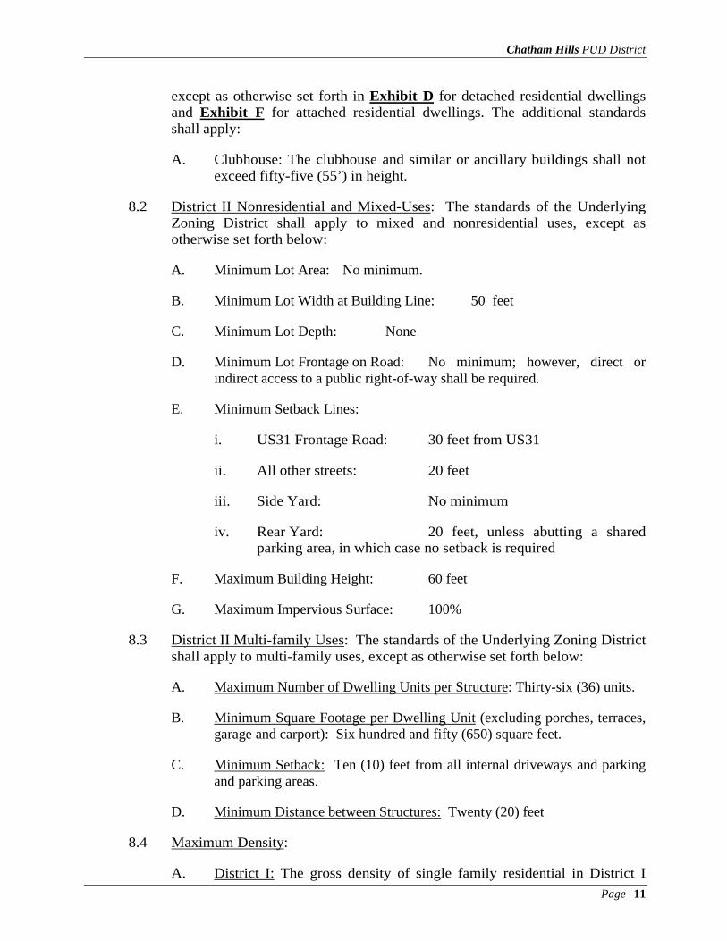
except as otherwise set forth in Exhibit D for detached residential dwellings and Exhibit F for attached residential dwellings. The additional standards shall apply:
A. Clubhouse: The clubhouse and similar or ancillary buildings shall not exceed fifty-five (55’) in height.
8.2 District II Nonresidential and Mixed-Uses: The standards of the Underlying Zoning District shall apply to mixed and nonresidential uses, except as otherwise set forth below:
A. Minimum Lot Area: No minimum.
B. Minimum Lot Width at Building Line: 50 feet
C. Minimum Lot Depth: None
D. Minimum Lot Frontage on Road: No minimum; however, direct or indirect access to a public right-of-way shall be required.
E. Minimum Setback Lines:
i. US31 Frontage Road: 30 feet from US31
ii. All other streets: 20 feet
iii. Side Yard: No minimum
iv. Rear Yard: 20 feet, unless abutting a shared parking area, in which case no setback is required
F. Maximum Building Height: 60 feet
G. Maximum Impervious Surface: 100%
8.3 District II Multi-family Uses: The standards of the Underlying Zoning District shall apply to multi-family uses, except as otherwise set forth below:
A. Maximum Number of Dwelling Units per Structure: Thirty-six (36) units.
B. Minimum Square Footage per Dwelling Unit (excluding porches, terraces, garage and carport): Six hundred and fifty (650) square feet.
C. Minimum Setback: Ten (10) feet from all internal driveways and parking and parking areas.
D. Minimum Distance between Structures: Twenty (20) feet
8.4 Maximum Density:
A. District I: The gross density of single family residential in District I

Chatham Hills PUD District
Page | 12
shall not exceed one thousand five hundred (1500) dwelling units;
B. District II: The total number of (i) detached or attached single family dwellings, plus (ii) attached single family dwellings, plus (iii) Apartments, Bed and Breakfast rooms or Suites shall not exceed five hundred (500) units.
C. The maximum number of multi-family dwellings shall not exceed three hundred and fifty (350) and a gross density of thirty-sixe (36) dwelling units per acre; and
D. Units within an Assisted Living Facility shall not be considered dwelling units for purposes of calculating density within the District.
8.5 Variations: The Plan Commission may approve a fifteen percent (15%) reduction in any minimum development standard or fifteen percent (15%) increase in any maximum development standard specified in this Section, excluding density standards.
Section 9. Off-Street Loading and Parking. The parking and loading standards of the Zoning Ordinance (WC § 16.04.120) shall apply, except as provided below:
9.1 District II: Required parking may be provided with both on and off-street parking spaces. Parking spaces immediately adjacent to the frontage of a building adjacent to internal streets, with parking bays, shall be included in the required parking calculation. Minimum parking spaces accessory to designated uses shall be provided as follows:
A. Office Uses: Two (2) parking spaces for each one-thousand (1,000) square feet of floor area, provided, however, that in no case shall any individual tenant or owner provide less than five (5) parking spaces.
B. Retail Uses: Three (3) parking spaces for each one thousand (1,000) square feet of floor area, provided, however, that in no case shall any individual tenant or owner provide less than five (5) parking spaces.
C. Inn or Bed and Breakfast: One (1) parking space for each rental sleeping unit. If, in addition to sleeping units, there are other accessory uses located within or operated in conjunction with the inn or Bed and Breakfast, additional parking spaces, calculated based upon the parking requirements for that specific use, shall be provided.
D. Apartments: One (1) parking space for each Dwelling.
9.2 Golf Cart Parking: When applicable and approved by Developer, parking spaces for golf carts shall be included in the overall parking lot plan.
9.3 Location: All loading, off-street parking and drive-through facilities shall be in rear yard or side yards; however, parking shall be permitted to exist in front yards of buildings located partially or wholly within or along the Golf Course
Chatham Hills PUD District
Page | 13
Community, so as to prevent any parking visible or bordering the Golf Course. Loading, parking, and drive-through facilities shall be screened as set forth herein.
9.4 Parking Surface: Parking lots may include limited grass, rock, natural (i.e. mulch) or gravel parking, if at the Developer’s discretion, such areas are consistent with the environmental preservation, the dining type and the development theme. Such areas shall be delineated and reviewed as part of a site’s Development Plan approval.
Section 10. Landscaping and Screening. The District’s landscaping and screening shall comply with the Zoning Ordinance (WC § 16.06), except as otherwise provided below.
10.1 Preservation of Trees: The Developer shall only be required to inventory trees for which the Developer is requesting a tree preservation credits; provided, however, that tree stands shall be generally outlined on any Development Plan.
10.2 Installation of Trees: The required landscaping of development projects seeking Certificates of Occupancy or building permits may be delayed up to 120 days due to Golf Course construction, completion of amenities or infrastructure of the Golf Course if the project has frontage on the Golf Course or total landscaping is dependent on credits from the Golf Course.
10.3 Perimeter Yards along External Streets: Perimeters along External Streets shall be landscaped as follows:
A. Multi-family / Attached Residential: Perimeter yards along External Streets for attached residential areas shall include a combination of berms, landscaping, brick or stone masonry, and ornamental metal or wood fencing. Berming shall be a minimum height of four (4) feet with a minimum of seven (7) evergreen trees and two (2) shade trees per one-hundred (100) linear. Ornamental trees may be substituted at a ratio of 1:1 for evergreen trees for up to forty percent (40%) of the required evergreen trees. Brick, stone or masonry columns and ornamental metal or wood fencing may also be used provided they do not exceed eight (8) feet in height.
B. District II Non-Residential: Perimeter Yards along External Streets shall be landscaped with shade trees, ornamental trees, and shrubs. At least one (1) shade tree or two (2) ornamental per forty (40) linear feet and eight (8) shrubs per forty (40) linear feet shall be planted. Such plantings should be arranged in a manner to provide street tree plantings and building foundation plantings to enhance the appearance of the buildings and streets. Where parking or loading areas occur adjacent to External Streets, the following standards shall apply:
i. Parking Lot and Drive-Through Facility Screening. Parking lotsand drive-through facilities along External Streets shall bescreened using one continuous evergreen shrub row, measuring

Chatham Hills PUD District
Page | 14
a minimum of twenty-four (24) inches at planting and maintained to a minimum of five (5) feet at maturity, across one hundred percent (100%) of the parking lot length. Individual shrubs shall be spaced not more than thirty-six (36) inches on center, planted in a double staggered row, so as to form a continuous visual screen a minimum of thirty-six (36) inches in height above grade, under normal growing conditions, within one (1) year after planting. One (1) shade tree or two (2) ornamental trees per forty (40) linear feet shall also be planted.
ii. Loading Area Screening. Loading areas shall be screened alongExternal Streets using a brick or stone masonry wall or anevergreen tree hedge. If a masonry wall is used, it shall be atleast six (6) feet in height and it shall match the exterior of thebuilding it serves. If an evergreen tree hedge is used, it shall be aminimum of six (6) feet in height at planting. Individualevergreen trees shall be spaced no more than eight (8) feet apart,planted in a double staggered row so as to form a continuousvisual screen along the entire length of the loading area. One (1)shade tree or two (2) ornamental trees per forty (40) linear feetshall also be planted.
10.4 Buffer Yards: There shall be a twenty (20) foot buffer yard required between (i) adjoining residential and non-residential subareas, and (ii) adjoining residential subareas; provided, however, that there shall be no buffer yard required for subareas separated by streets or rights-of-way.
10.5 Landscaping and Preservation along the Golf Course: All rear yards located on or near the Golf Course Community, Trails or Development Amenities in District I and II shall preserve all trees or existing landscaping, where possible, with the emphasis towards creating a buffer between the building and feature.
A. District I – All residential exterior amenities (i.e. playground, fireplace, patio) shall be landscaped at the homeowner’s expense so as to create a natural buffer between the Golf Course Community and the exterior use.
B. District II: No amenities for a multi-family, attached residential or non-residential area shall be permitted to border, be located near or adjacent to the Golf Course Community (i.e. pool, playground) and shall not be visible from the Golf Course Community from any view. All outdoor furniture, grill or other exterior items for Multi-Family ground units shall be buffered by landscaping per requirements in the Zoning Ordinance.
Section 11. Open Space and Amenity Standards.
11.1 Natural Areas: The preservation of the natural landscape, terrain, topography and natural features of the Real Estate shall be preserved when possible and shall be a priority when constructing all residential, infrastructure, amenities and other aspects of the development.
Chatham Hills PUD District
Page | 15
11.2 District Amenities: Amenities for the District may include, but are not limited to: Development Amenities clubhouse; fitness center; swimming pool; playground(s), tree house; shuffle board or Bocce court; park (minimum five thousand (5,000) square feet); Trails for pedestrians, pets, cyclists, golf carts; tennis courts; paddle/platform tennis courts; Golf Course; dog park and dog pond; playground; formal garden (minimum two thousand five hundred (2,500) square feet); Farmstead; vineyard; Community Gardens.
11.3 District I and II: Open space shall be greater than or equal to twenty percent (20%) of the combined gross acreage of District I and II, and shall include but is not limited to the Golf Course Community areas, Farmstead, Development Amenities and surrounding corridors, Trails, parks, lakes and ponds. All amenities and parking areas within District I or II shall be screened from the golf course and may not be located adjacent to or bordering the golf course.
11.4 Multi-family Amenities: Amenities shall be provided in accordance with the Underlying Zoning District for any multi-family development; however, a maximum of two (2) amenities may be credited if access to shared amenities in the District is provided and if approved by the Master Developer.
Section 12. Sign Standards. The District’s signs shall comply with the Zoning Ordinance (WC § 16.08.010), except as provided below:
12.1 Permitted Signs: The following additional signs shall be permitted:
A. Signs advertising construction projects shall not exceed seventy-five (75) square feet.
B. Publicly-owned traffic-control and transit signs, informational, identification, directional signs and temporary signage in any public right-of-way may be replaced with signage consistent with the development theme at the expense of the Developer for existing signs or Developer may pay the difference in cost for new signage per the City’s approval.
C. Banners, ornamental banners, pennants or flags shall be permitted for Developer.
D. Signage may be located on the Red Barn or other farm improvement.
E. Signage may be permitted to be placed on a personal or commercial vehicle which is parked or positioned for the primary purpose of displaying the said sign, so long as the sign refers to the use of the property it is on.
F. Electronic signage shall be permitted to include scoring or leader board signage with manual or digital changeable copy area, which shall not be counted toward total sign display area square footage or towards total allotted sign area; scoring or leader boards shall be located in the rear or side yards. Outdoor televisions screens shall not be considered as signage.
G. Signage including the logo, trademark, directions and website for Chatham

Chatham Hills PUD District
Page | 16
Hills shall be permitted to be painted or placed in a similar aesthetic, to scale, on the front or side elevations or roof of the Red Barn and shall include two (2) signs.
H. Message or announcement boards mounted to the Clubhouse or other building included in the Golf Course Community, Trails or other Development Amenities shall not count toward total allotted sign area.
I. All signage may be illuminated, including up-lighting of signs and of the Red Barn or other improvements on the property in an aesthetically-pleasing manner that is not distracting from any nearby residential.
12.2 Prohibited Signs: The following additional signs shall be prohibited:
A. Signage facing the Golf Course, Clubhouse or other amenities except for way-finding, scoring or other informational purposes as approved by the Master Developer and otherwise permitted by this Ordinance;
B. Billboards, except for those located on US31;
C. Signs painted or mounted upon the exterior side or rear walls of any principal or accessory building or structure, except as otherwise permitted hereunder;
D. Signs not consistent with the overall design theme, materials or size of comparable signage in the development;
E. No signage (temporary or permanent) shall be permitted on the golf course side of a multi-family development or any building façade or yard, except for way-finding or regulatory signage consistent with the District.
12.3 Identification with the City of Westfield: Title signs may include only the word, “Westfield” following any designation of an industrial, office, apartment, retail or residential area and shall only be required at the entrance to the Clubhouse.
12.4 Residential Signs: The following additional residential signs shall be permitted:
A. Two (2) entrance signs indicating the name of the development, the name of the residential section, subdivision and Development Amenity shall be permitted at each entrance and each start of a particular section or area of the development and each sign shall not exceed seventy-five (75) square feet.
B. Matching or coordinating signage which borders either side of one entrance shall be treated as one sign but both sign faces shall be used to calculate the total sign area.
C. Entryway signage resembling entrance signage (but not at actual entrances) shall be permitted at the corners of 199th Street and Tomlinson Road, Lindley Farm hillside and Lindley Farm Road & SR-38, 203rd and
Chatham Hills PUD District
Page | 17
Tomlinson Road, Oak Ridge Road, 191st and US-31, 206th and Horton Road along 206th Street at the dairy farm entrance area.
D. All entrance signs from External Streets shall be consistent in their size, content, materials, landscaping and orientation throughout the development and all signage identifying entrances to residential areas or amenities shall be consistent.
E. Entrance signage to residential areas but also to the Clubhouse or other amenities shall be considered as a residential signage use and shall not count against total Sign Area Allocation for nonresidential areas.
12.5 Golf Course Community Signage: The additional signage shall be permitted and not included in the total allotted signage area:
A. Signage engraved in stone or concrete to signify an subdivision name, historical site or event;
B. Way-finding signage located within District I to all amenities, residential sections, Trails, Farmstead or exits.
C. Interior Circulation Signs may include traffic directing information for golf carts or pedestrians on Trails and cart paths, crossings, cautionary/warning signage (i.e. near golf) and at the Developer’s discretion, may not be required to have a setback from a property line or right-of-way.
D. Signage throughout the Golf Course or Development Amenities pertaining to the facilities, rules, regulations, hole numbers, cart paths, warnings, etc.;
E. Temporary or permanent signage related to tours or layout of the development (i.e. hole numbers, amenities, lot numbers or other items);
F. Painted signage on the roof or side of a building or structure with the development’s logo may be permitted on any existing improvements that are preserved and integrated into the project and shall be permitted on both sides of the Red Barn and a maximum of seventy-five (75) square feet.
G. Signage made from recycled materials or natural materials.
H. One (1) residential sign indicating who lot has been purchased by and where the owner is from, of which shall be removed upon completion of construction.
12.6 Construction signage: One (1) construction sign for each street frontage of a lot upon which construction of any structure (other than construction of a detached dwelling) is in progress, provided the following standards are met:
A. The maximum sign area shall be thirty-two (32) square feet.
B. The maximum height of each sign shall be eight (8) feet.

Chatham Hills PUD District
Page | 18
C. The sign shall not be illuminated.
D. The sign shall be removed within seven (7) days after the beginning of the intended use of the building.
E. Sign copy shall be limited to identification of the building, architects, engineers, contractors and other persons involved with the construction, but shall not include any advertising or product other than a rendering of the building being constructed.
12.7 Site plan signage: Signs depicting the site plan of an Area or subdivision assuming completion of development in accordance with the development plan and indicating the location within the Real Estate of the person viewing the sign, provided the following standards are met:
A. The maximum sign area per Parcel shall be thirty-two (32) square feet.
B. The maximum height shall be eight (8) feet.
C. Site plan signage within Area I for Golf Course and club and in open and recreational space may be illuminated; elsewhere in the Real Estate, illumination is not permitted.
D. Site plan signage shall be removed from a Parcel when ninety-five percent (95%) of the lots in that parcel have been sold.
12.8 Rendering signs: Signs containing a rendering of one or more buildings expected to be constructed on a lot or portion of the Real Estate, provided the following standards are met:
A. The maximum sign area per lot shall be thirty-two (32) square feet.
B. The maximum height of each sign shall be eight (8) feet.
C. The sign may be illuminated.
D. One sign will be permitted for each street frontage of the lot or portion of the Real Estate upon which construction of the depicted building is contemplated.
E. The sign shall be removed not later than thirty-six (36) months following installation thereof unless construction of the building has commenced prior to that date and, if construction commences, the sign shall be removed within seven (7) days after the beginning of the intended use of the building.
12.9 Real estate sales and leasing signs: The additional standards shall apply:
A. The maximum sign area shall be twenty (20) square feet.

Chatham Hills PUD District
Page | 19
B. The maximum height of the sign shall be eight (8) feet.
C. Limited to one sign for each street frontage lot, with no more than two (2) sign faces per sign.
D. The sign shall not be illuminated.
E. Signs for detached dwellings and commercial structures shall be removed within seven days after the date the unit is leased, sold, or occupied.
F. With respect to attached dwellings, when eighty percent (80%) of the dwellings are sold or occupied, real estate signs are limited to a ground sign, a wall sign or a window sign of six (6) square feet or less.
Section 13. Lighting Standards. The District’s lighting shall comply with the Zoning Ordinance (WC § 16.07.010) with the following exceptions:
A. Light may be directed upward on Golf Course buildings in District I and II.
B. Lighting may be directed upward or onto the surface(s) of the Red Barn or Lindley Farm Road House and shall not be required to be shielded.
Section 14. Pedestrian and Bicycle Connectivity. (See Exhibit C)
14.1 Pedestrian and bicycle access shall be provided through the District to permit and encourage pedestrian movement within the District and surrounding developments to: (i) provide an alternative for people to get where they are going without using their vehicles; (ii) provide a means for people to safely and practically get to local destinations; and (iii) provide for fitness and general recreational opportunities.
14.2 The District’s pedestrian and bicycle network shall comply with the specifications outlined in Exhibit H and the Zoning Ordinance. To the maximum extent practicable, land uses, amenities, parks, trails and other open spaces should be organized to create integrated systems of open space that connect both internal to the District and to development surrounding the District.
14.3 Residents of the District and club members shall be permitted to utilize golf carts on trails, roadways and designated amenity areas within the District. Residential and business owners within the District who own or lease golf carts shall be permitted to operate electric golf carts only, on private streets, public streets, cart paths, lanes, greenway trails, accessory lanes, and multi-use paths in such areas specified by the Master Developer under rules, regulations, and standards promulgated and enforced by the Master Developer. Golf carts may only be operated by persons at least (16) years of age who hold valid license for the operations of motor vehicles within the State of Indiana.
Section 15. Architectural and Streetscape Design Standards. The procedures and regulations of WC § 16.04.165 Development Plan Review applicable to the Underlying Zoning District shall apply, except as otherwise provided below:

Chatham Hills PUD District
Page | 20
15.1 Residential Uses: The design standards applicable to detached and attached single family dwellings within the District shall be as set forth in Exhibit E and Exhibit G, respectively.
15.2 Multi-family Uses: The design standards applicable to multi-family uses shall be as set forth in Exhibit G for attached single family dwellings, where applicable. Structures shall be architecturally compatible and cohesive, but shall also utilize multiple textures (i.e., rough, smooth, striated, etc.) or multiple architectural elements (quoins, pilasters, solder courses, lintels, friezes, cornices, dentils, architraves) to achieve variation in terms of footprint and architectural elevations. Masonry, stone or other similar materials shall be required on a minimum of ten (10%) percent of each building façade.
15.3 Non-Residential Uses: The design standards applicable to nonresidential or mixed-use buildings shall be as set forth in Exhibit H. In addition, the following shall apply:
A. Restaurant Uses: Outdoor cafes and eating areas shall be permitted in accordance with the Zoning Ordinance. Permanent outdoor cafés and eating areas shall be delineated and reviewed as part of a site’s Development Plan approval.
B. Farmstead Uses: Metal or aluminum siding shall be permitted for buildings or structures in the Farmstead area only.
C. Sidewalk Displays: Retail uses shall be permitted to have sidewalk displays of retail merchandise, subject to obtaining the necessary approvals if located within a public right-of-way, and subject to the following:
i. Displays shall be limited to directly in front of an establishment,provided that a minimum of five (5) feet of sidewalk clearancealong the curb and leading to the storefront entrance ismaintained free of display, and the display area does not exceedseventy-five percent (75%) of the length of the storefront.
ii. Displays shall be permitted only during normal business hoursand shall be removed at the end of the business day. Cardboardboxes or pallets shall not be used for sidewalk displays.
iii. Sidewalk displays shall maintain a clean, litter-free, and well-kept appearance at all times.
Section 16. Infrastructure Standards. The District’s infrastructure shall comply with the Zoning Ordinance and the City’s Principal Standards of Design, except as otherwise provided below.
16.1 Alternative Standards: The standards set forth in Exhibit H shall apply, and shall replace and supersede, to the extent they conflict, with those standards set forth by the Zoning Ordinanc*e or City’s Construction Standards.

Chatham Hills PUD District
Page | 21
16.2 Environmental Considerations: Consideration to the preservation of the natural topography and environment shall be a priority for the design and installation of infrastructure, including road layout, improvements and connectivity.
Section 17. Owners’ Association and Declaration(s) of Covenants.
17.1 Declarations of Covenant(s) shall be prepared by the Master Developer and recorded with the Recorder’s Office of Hamilton County, Indiana. There may be multiple Declaration(s) of Covenants applicable to the different areas of the Real Estate, and multiple corresponding Owners’ Association(s) and may contain standards that may be stricter than the standards of this PUD.
17.2 Owners’ Association(s) shall be established and responsible for the ongoing upkeep and maintenance of any privately owned common grounds, structures, signs, etc., as outlined in the association documents and any other specific development improvements noted as their responsibility by this Ordinance.
17.3 The Declaration(s) of Covenants shall establish a Architectural Review Committee (“ARC”). The organization and procedures of the ARC shall be set forth in the Declaration of Covenants. There may be a separate ARC for each Owners’ Association(s) or a single ARC for multiple Owners’ Association(s). The ARC shall be established to review and approve all proposed development within the District, as well as any proposed changes to an existing building. Then, a letter of support from the ARC shall accompany any building permit application to the City for the construction or modification of a structure.
17.4 The Declaration applicable to District I shall provide that all single family residential dwelling owners shall be social members of the District’s club, subject to terms, conditions, rules and regulations which are determined by the Master Developer in the Master Developer’s sole discretion, and which may from time to time be changed by the Master Developer in the Master Developer’s sole discretion. Membership as it may pertain to uses in District II shall be at the Master Developer’s discretion.
Section 18. Master Developer and Design Review Committee Consent.
18.1 A written consent by the Master Developer or its assigns shall accompany any permit or approval request pertaining to the Real Estate by a Developer, user, owner, or tenant. Permits or approvals may include, but are not limited to:
A. Improvement Location Permit for any improvements within the District;
B. Sign permit for any signs within the District;
C. Building permits for any Buildings within the District;
D. Development Plan, or Primary or Secondary Plat approvals for any part of the District; and
E. Any text amendment or other requests for variations to the terms and
Chatham Hills PUD District
Page | 22
conditions of this Ordinance.
F. Approval and compliance with all Covenants as set forth by Developer for development.
18.2 A letter of support for construction or modification of a structure from the Design Review Committee shall accompany any building permit application.
Chatham Hills PUD District
Page | 23
ALL OF WHICH IS HEREBY ADOPTED BY THE CITY COUNCIL OF WESTFIELD, HAMILTON COUNTY, INDIANA THIS _____ DAY OF ________________ , 2013.
WESTFIELD COMMON COUNCIL HAMILTON COUNTY, INDIANA
Voting For Voting Against Abstain
Jim Ake Jim Ake Jim Ake
Councilor Councilor Councilor
Steven Hoover Steven Hoover Steven Hoover
Robert L. Horkay Robert L. Horkay Robert L. Horkay
Bob Smith Bob Smith Bob Smith
Cindy L.Spoljaric Cindy L. Spoljaric Cindy L. Spoljari
Robert W. Stokes Robert W. Stokes Robert W. Stokes
ATTEST:
Cindy J. Gossard, Clerk-Treasurer
I affirm, under the penalties for perjury, that I have taken reasonable care to redact each Social Security Number in this document, unless required by law: Jesse M. Pohlman
This Instrument prepared by: Jesse M. Pohlman, Senior Planner, City of Westfield Economic and Community Development Department, 2728 East 171st Street, Westfield, Indiana 46074.

Chatham Hills PUD District
Page | 24
I hereby certify ORDINANCE 12-XX was delivered to the Mayor of Westfield on the
______ day of ____________ , 2013.
________________________________________ Cindy J. Gossard, Clerk Treasurer
I hereby APPROVE ORDINANCE 13-XX I hereby VETO ORDINANCE 13-XX this _____ day of _________ , 2013. this _____ day of _________ , 2013.
J. Andrew Cook, Mayor J. Andrew Cook, Mayor
ATTEST:
Cindy J. Gossard, Clerk Treasurer

Chatham Hills PUD District
Page | 25
EXHIBIT A REAL ESTATE / LEGAL DESCRIPTIONS
The numbered parcels on the map below correspond with the numbered legal descriptions that follow herein this exhibit.

Chatham Hills PUD District
Page | 26
Legal Description: 1 Deeded Owner: Maley, Janet Acreage: 16.36 Acres per GIS (15.995 Surveyed Acres) Parcel No: 08-05-13-00-00-022.000 Notes: Under Contract / Consent from Owners Provided
Chatham Hills PUD District
Page | 27
Legal Description: 2 Deeded Owners: Bray, Philip D & Helen L & Marjorie A Maley Huffman, Toni K Maley, Joseph
B Maley, Jeffrey Thomas Rainwater, Charles David Updegraff, Kevin Updegraff, Michael Updegraff
Acreage: 167.77 Acres per GIS (158.911 Surveyed Acres, represents land sold to INDOT) Parcel No: 2a. 08-05-13-00-00-025.000 (99.1 Acres per GIS)
2b. 08-05-13-00-00-024.000 (27.81 Acres per GIS) 2c. 08-05-13-00-00-023.000 (11.43 Acres per GIS) 2d. 08-05-24-00-00-006.000 (29.43 Acres per GIS)
Notes: Under Contract / Consent from Owners Provided
Part of the Northeast Quarter of Section 24, Township 19 North, Range 3 East and part of the Southeast Quarter of Section 13, Township 19 North, Range 3 East, Hamilton County, Indiana, more particularly described as follows:BEGINNING at the northwest corner of said Southeast Quarter; thence North 87 degrees 46 minutes 40 seconds East along the north line of said Southeast Quarter (assumed basis of bearings) 1,815.72 feet to the west right-of-way line of US 31 as defined in Instrument Numbers 2011024282 and 2011006538, on file in the Office of the Recorder of Hamilton County, Indiana; thence South 28 degrees 59 minutes 58 seconds East along said west right-of-way line 276.98 feet to the north line of the parcel conveyed to John and Lesley Lautenschlager in Instrument Number 9509660, on file in the Office of said Recorder, the following four (4) courses are along the north, west, south and east lines of said Lautenschlager parcel; 1)thence South 87 degrees 46 minutes 40 seconds West 1,041.94 feet; 2)thence South 22 degrees 35 minutes 01 second West 818.10 feet; 3)thence North 87 degrees 46 minutes 40 seconds East 562.54 feet; 4)thence North 02 degrees 13 minutes 20 seconds West 309.68 feet to the south line of Parcel 2 as described in Instrument Number 2010050848, on file in the Office of said Recorder, the following three (3) courses are along the south and east lines thereof; 1)thence South 87 degrees 35 minutes 23 seconds East 49.34 feet; 2)thence North 08 degrees 16 minutes 20 seconds East 155.16 feet; 3)thence North 65 degrees 39 minutes 48 seconds East 91.85 feet to the south line of said Lautenschlager parcel; thence North 87 degrees 46 minutes 40 seconds East along said south line 786.14 feet to said west right-of-way line of US 31, the following sixteen (16) courses are along said west right-of-way line as defined by Instrument Numbers 2011006538, 2011024282 and 2012012117 and as shown on the Final Right-of-Way Plans for U.S. 31, INDOT Project Number

Chatham Hills PUD District
Page | 28
0710215, Code 5306; 1)thence South 28 degrees 59 minutes 58 seconds East 35.72 feet; 2)thence North 89 degrees 59 minutes 46 seconds East 197.53 feet; 3)thence South 19 degrees 21 minutes 02 seconds East 201.44 feet; 4)thence South 06 degrees 14 minutes 47 seconds East 260.67 feet; 5)thence North 87 degrees 46 minutes 43 seconds East 89.67 feet; 6)thence South 07 degrees 49 minutes 05 seconds East 174.34 feet; 7)thence South 00 degrees 11 minutes 28 seconds West 49.98 feet; 8)thence South 02 degrees 44 minutes 20 seconds West 246.03 feet; 9)thence South 00 degrees 07 minutes 14 seconds West 359.23 feet; 10)thence South 31 degrees 15 minutes 28 seconds West 81.78 feet; 11)thence South 00 degrees 07 minutes 19 seconds West 550.00 feet; 12)thence South 16 degrees 49 minutes 16 seconds West 52.20 feet; 13)thence South 00 degrees 07 minutes 19 seconds West 250.01 feet; 14)thence South 29 degrees 48 minutes 18 seconds East 115.39 feet; 15)thence South 00 degrees 00 minutes 57 seconds East 686.26 feet; 16)thence South 03 degrees 01 minutes 14 seconds West 45.57 feet to the south line of the parcel described in Instrument Number 8411319 (Book 344, Page 661), on file in the Office of said Recorder, the following six (6) courses are along the south, east and west lines of said parcel; 1)thence South 87 degrees 58 minutes 52 seconds West 532.83 feet; 2)thence South 00 degrees 02 minutes 47 seconds East 424.30 feet; 3)thence South 87 degrees 58 minutes 52 seconds West 254.03 feet; 4)thence North 00 degrees 00 minutes 53 seconds East 424.30 feet; 5)thence South 87 degrees 58 minutes 52 seconds West 400.29 feet; 6)thence North 00 degrees 00 minutes 32 seconds East 909.09 feet to the south line of the Southeast Quarter of said Section 13; thence South 87 degrees 54 minutes 03 seconds West along said south line 1,322.56 feet to the southwest corner of said Southeast Quarter; thence North 00 degrees 21 minutes 41 seconds East along the west line of said Southeast Quarter 2,654.14 feet to the POINT OF BEGINNING. Containing 158.911 acres, more or less.
Legal Description: 3 Deeded Owner: Lautenschlager, John & Lesley Acreage: 7.5 Acres [8.837 acres per Legal] Parcel No: 08-05-13-00-00-024.001 Notes: Under Contract / Consent from Owners Provided
LAUTENSCHLAGER PARCEL I Part of the Southeast Quarter of Section 13, Township 19 North, Range 3 East, Hamilton County, Indiana, more particularly described as follows: Commencing at the northwest corner of said Southeast Quarter; thence North 87 degrees 46 minutes 40 seconds East along the north line of said Southeast Quarter (assumed basis of bearings) 1,815.72 feet to the west right-of-way line of US 31 as defined in Instrument Numbers 2011024282 and 2011006538, on file in the Office of the Recorder of Hamilton County, Indiana; thence South 28 degrees 59 minutes 58 seconds East along said west right-of-way line 276.98 feet to the north line of the parcel conveyed to John and Lesley Lautenschlager in Instrument Number 9509660, on file in the Office of said Recorder, being the POINT OF BEGINNING; thence continuing South 28 degrees 59 minutes 58 seconds East along said west right-of-way line 168.62 feet the north line of Parcel 2 as described in Instrument Number 2010050848, on file in the Office of said Recorder, the following four (4) courses are along the north and west lines of said Parcel 2; 1)thence South 80 degrees 59 minutes 34 seconds West 109.67 feet; 2)thence North 89 degrees 45 minutes 00 seconds West 462.61 feet; 3)thence North 87 degrees 29 minutes 54 seconds West 475.43 feet; 4)thence South 02 degrees 30 minutes 06 seconds West 50.42 feet to the north line of Parcel 1 as described in said Instrument Number 2010050848, the following five (5) courses are along the north, west, south and east lines of said Parcel 1; 1)thence North 88 degrees 42 minutes 30 seconds West 9.23 feet; 2)thence South 22 degrees 52 minutes 23 seconds West 220.69 feet; 3)thence South 55 degrees 59 minutes 15 seconds East 176.32 feet; 4)thence North 12 degrees 13 minutes 24 seconds East 34.61 feet; 5)thence South 87 degrees 35 minutes 23 seconds East 102.75 feet to an east line of said Lautenschlager parcel, the following four (4) courses are along the east, south and west lines thereof; 1)thence South 02 degrees 13 minutes 20 seconds East 309.68 feet; 2)thence South 87 degrees 46 minutes 40 seconds West 562.54 feet; 3)thence North 22

Chatham Hills PUD District
Page | 29
degrees 35 minutes 01 second East 818.10 feet; 4)thence North 87 degrees 46 minutes 40 seconds East 1,041.94 feet to the POINT OF BEGINNING. Containing 8.073 acres, more or less. LAUTENSCHLAGER PARCEL II Part of the Southeast Quarter of Section 13, Township 19 North, Range 3 East, Hamilton County, Indiana, more particularly described as follows: Commencing at the northwest corner of said Southeast Quarter; thence North 87 degrees 46 minutes 40 seconds East along the north line of said Southeast Quarter (assumed basis of bearings) 1,815.72 feet to the west right-of-way line of US 31 as defined in Instrument Numbers 2011024282, 2011006538, 2012027432 and 2011006538, on file in the Office of the Recorder of Hamilton County, Indiana; thence South 28 degrees 59 minutes 58 seconds East along said west right-of-way line 498.80 feet to the south line of Parcel 2 as described in Instrument Number 2010050848, on file in the Office of said Recorder, being the POINT OF BEGINNING; thence continuing South 28 degrees 59 minutes 58 seconds East along said right-of-way line 57.95 feet to the south line of the parcel conveyed to John and Lesley Lautenschlager in Instrument Number 9509660, on file in the Office of said Recorder; thence South 87 degrees 46 minutes 40 seconds West along said south line 786.14 feet to a southeast corner of Parcel 1 as described in Instrument Number 2010050848, on file in the Office of said Recorder; thence North 65 degrees 39 minutes 48 seconds East along an east line of said Parcel 1, a distance of 153.85 feet to the south line of Parcel 2 as described in said Instrument Number 2010050848, the following three (3) courses are along said south line; 1)thence South 87 degrees 29 minutes 54 seconds East 19.37 feet; 2)thence South 89 degrees 45 minutes 00 seconds East 467.65 feet; 3)thence North 80 degrees 59 minutes 34 seconds East 131.91 feet to the POINT OF BEGINNING. Containing 0.764 acres more or less. Containing, in both parcels, 8.837 acres, more or less. Legal Description: 4 Deeded Owner: Stewart, Jeffery A & Catherine S Parker T/C Acreage: 76.96 (per GIS; 77.672 per Survey) Acres Parcel No: 08-05-13-00-00-026.000 Notes: Under Contract / Consent from Owners Provided The East Half of the Southwest Quarter of Section 13, Township 19 North, Range 3 East, Hamilton County, Indiana, more particularly described as follows: BEGINNING at the SE corner of said Southwest Quarter, the following four (4) courses are along the south, west, north and east lines of said East Half; 1)thence South 87 degrees 57 minutes 50 seconds West (basis of bearings is the Indiana State Plane Coordinate System, East Zone) 1,322.01 feet; 2)thence North 00 degrees 16 minutes 25 seconds East 2,660.92 feet; 3)thence North 88 degrees 15 minutes 49 seconds East 1,325.81 feet; 4)thence South 00 degrees 21 minutes 41 seconds West 2,654.14 feet to the POINT OF BEGINNING.Containing 80.71 acres, more or less. EXCEPT A part of the Southwest Quarter of Section 13, Township 19 North, Range 3 East, located in Washington Township, Hamilton County, Indiana being described as follows: Commencing at the Southwest comer of the Southeast Quarter of the Southwest Quarter of Section 13, Township 19 North, Range 3 East; thence North 00 degrees 02 minutes 56 seconds East, 700.42 feet on and along the West line of the Southeast Quarter of said Southwest Quarter to the POINT OF BEGINNING of this description; thence North 00 degrees 02 minutes 56 seconds East, 551.24 feet on and along the West line of the Southeast Quarter of Said Southwest Quarter to a fence; thence North 86 degrees 07 minutes 47 seconds East, 236.88 feet on and along said fence; thence South 00 degrees 00 minutes 26 seconds East, 567.43 feet; thence North 89 degrees 57 minutes 06 seconds West, 236.88 feet to the Point of Beginning. Containing 3.038 acres, more or less. Containing, after Exception, 77.672 acres, more or less.

Chatham Hills PUD District
Page | 30
Legal Description: 5 Deeded Owner: Stewart, Jeffery A & Linda S Acreage: 3.038 Acres Parcel No: 08-05-13-00-00-026.001 Notes: Under Contract / Consent from Owners Provided
A part of the Southwest Quarter of Section 13, Township 19 North, Range 3 East, located in Washington Township, Hamilton County, Indiana being described as follows: Commencing at the Southwest comer of the Southeast Quarter of the Southwest Quarter of Section 13, Township 19 North, Range 3 East; thence North 00 degrees 02 minutes 56 seconds East, 700.42 feet on and along the West line of the Southeast Quarter of said Southwest Quarter to the POINT OF BEGINNING of this description; thence North 00 degrees 02 minutes 56 seconds East, 551.24 feet on and along the West line of the Southeast Quarter of Said Southwest Quarter to a fence; thence North 86 degrees 07 minutes 47 seconds East, 236.88 feet on and along said fence; thence South 00 degrees 00 minutes 26 seconds East, 567.43 feet; thence North 89 degrees 57 minutes 06 seconds West, 236.88 feet to the Point of Beginning. Containing 3.038 acres, more or less.
Legal Description: 6 Deeded Owner: Godby, James L & B Ann Godby Trustee Acreage: 21.45 Acres Parcel No: 08-05-13-00-00-027.000 Notes: Under Contract / Consent from Owners Provided
Part of the Southwest Quarter of Section 13, Township 19 North, Range 3 East, Hamilton County, Indiana, more particularly described as follows:
Commencing at the southwest corner of said Southwest Quarter; thence North 00 degrees 11 minutes 12 seconds East along the west line of said Southwest Quarter (basis of bearings is the Indiana State Plane Coordinate System, East Zone) 335.44 feet to the northwest corner of the 0.467-acre parcel described in Instrument Number 200100054117, on file in the Office of the Recorder of Hamilton County, Indiana, being the POINT OF BEGINNING; thence continuing North 00 degrees 11 minutes 12 seconds East along the west line of said Southwest Quarter 307.26 feet to a point that is 148.13 feet south of the southeast corner of the 1.0-acre parcel described as Parcel II in Instrument Number 9419576, on file in the Office of said Recorder, the following two (2) courses are parallel with the south and east lines of said Parcel II; 1)thence North 88 degrees 25 minutes 07 seconds East 438.53 feet; 2)thence North 00 degrees 11 minutes 12 seconds East 298.13 feet to a point on the north line of Parcel I as described in said Instrument Number 9419576, said point being 148.13 feet east of the northeast corner of said Parcel II, the following two (2) courses are along the north and east lines of said Parcel I; 1)thence North 88 degrees 25 minutes 07 seconds East 873.47 feet; 2)thence South 00 degrees 40 minutes 12 seconds West 930.75 feet to the south line of said Southwest Quarter; thence South 87 degrees 57 minutes 50 seconds West along said south line 545.43 feet to the east line of the 3.00-acre parcel described in Instrument Number 9563173, on file in the Office of said Recorder, the following three (3) courses are along the east, north and west lines thereof; 1)thence North 00 degrees 11 minutes 12 seconds East 344.80 feet; 2)thence South 89 degrees 06 minutes 56 seconds West 363.00 feet; 3)thence South 00 degrees 11 minutes 12 seconds West 352.10 feet to the south line of said Southwest Quarter; thence South 87 degrees 57 minutes 50 seconds West along said south line 141.52 feet to the west line of said 0.467-acre parcel, the following six (6) courses are along the west and north lines thereof; 1)thence North 00 degrees 10 minutes 28 seconds West 44.59 feet; 2)thence South 89 degrees 49 minutes 32 seconds West 165.62 feet; 3)thence North 09 degrees 13 minutes 08 seconds West 95.60 feet to the point of curve of a non tangent curve concave to the east, having a radius of 940.00 feet,

Chatham Hills PUD District
Page | 31
the radius point of which bears North 80 degrees 46 minutes 53 seconds East; 4)thence northerly along said curve a distance of 154.30 feet to a point that bears North 89 degrees 48 minutes 49 seconds West from said radius point; 5)thence North 00 degrees 11 minutes 12 seconds East 34.10 feet; 6)thence North 89 degrees 48 minutes 48 seconds West 60.00 feet to the POINT OF BEGINNING. Containing 21.45 acres, more or less. Legal Description: 7 Deeded Owner: Hazel V Scott Revocable Trust (Steele, Carl M Trustee) Acreage: 113.43 Acres Parcel No: 08-05-24-00-00-002. 004 Notes: Under Contract / Consent from Owners Provided Part of the Northwest Quarter of Section 24, Township 19 North, Range 3 East, Hamilton County, Indiana, more particularly described as follows: BEGINNING at the northeast corner of said Northwest Quarter; thence South 00 degrees 03 minutes 52 seconds West (basis of bearings is the Indiana State Plane Coordinate System, East Zone) 629.76 feet to the northeast corner of the 3.00-acre parcel described in Instrument Number 2009056686, on file in the Office of the Recorder of Hamilton County, Indiana, the following seven (7) courses are along the north, west and south lines of said 3.00-acre parcel; 1)thence North 89 degrees 56 minutes 08 seconds West 176.79 feet; 2)thence South 24 degrees 53 minutes 54 seconds West 504.88 feet; 3)thence South 56 degrees 46 minutes 35 seconds East 47.81 feet;4) thence South 65 degrees 09 minutes 25 seconds East 41.76 feet; 5)thence South 70 degrees 36 minutes 27 seconds East 22.55 feet; 6)thence South 76 degrees 34 minutes 05 seconds East 76.76 feet; 7)thence South 72 degrees 16 minutes 03 seconds East 62.11 feet; thence South 65 degrees 39 minutes 43 seconds East 45.00 feet; thence South 57 degrees 47 minutes 20 seconds East 135.50 feet to the east line of said Northwest Quarter; thence South 00 degrees 03 minutes 52 seconds West 916.84 feet to the southeast corner of the 91.59-acre parcel described in Instrument Number 9249819, on file in the Office of said Recorder, the following two (2) courses are along the south and west lines thereof; 1)thence South 88 degrees 24 minutes 37 seconds West 2,429.69 feet; 2)thence North 00 degrees 15 minutes 45 seconds East 1,472.26 feet to the south line of the 21-acre parcel described in said Instrument Number 9249819; thence South 87 degrees 57 minutes 50 seconds West along said south line 221.19 feet to the west line of said Northwest Quarter; thence North 00 degrees 15 minutes 45 seconds East along said west line 429.19 feet to the southwest corner of the 4.25-acre parcel described in Instrument Number 20070009175, on file in the Office of said Recorder, the following two (2) courses are along the south lines thereof; 1)thence South 81 degrees 22 minutes 15 seconds East 337.53 feet; 2)thence North 58 degrees 37 minutes 15 seconds East 663.74 feet to a point on the north line of said Northwest Quarter that is 899.73 feet east of the northwest corner thereof; thence North 87 degrees 57 minutes 50 seconds East along said north line 1,744.29 feet to the POINT OF BEGINNING. Containing 116.43 acres, more or less. EXCEPT Part of the Northwest Quarter of Section 24, Township 19 North, Range 3 East, Hamilton County, Indiana, more particularly described as follows: Commencing at the northeast corner of said Northwest Quarter; thence South 00 degrees 03 minutes 52 seconds West (basis of bearings is the Indiana State Plane Coordinate System, East Zone) 629.76 feet to the northeast corner of the 3.00-acre parcel described in Instrument Number 2009056686, on file in the Office of the Recorder of Hamilton County, Indiana, the following two (2) courses are along the north and west lines of said 3.00-acre parcel; 1)thence North 89 degrees 56 minutes 08 seconds West 176.79 feet to the POINT OF BEGINNING; 2)thence South 24 degrees 53 minutes 54 seconds West 504.88 feet to the southwest corner of said 3.00-acre parcel; thence North 44 degrees 57 minutes 01 second West 250.00
Chatham Hills PUD District
Page | 32
feet; thence North 24 degrees 53 minutes 54 seconds East parallel with the west line of said 3.00-acre parcel 556.80 feet; thence South 44 degrees 57 minutes 01 second East 250.00 feet to the northerly extension of said west line; thence South 24 degrees 53 minutes 54 seconds West along said northerly extension 51.92 feet to the POINT OF BEGINNING. Containing 3.00 acres, more or less. Containing, after Exception, 113.43 acres, more or less.
Legal Description: 8 Deeded Owner: Chatham Oaks, LLP Acreage: 3 Acres Parcel No: 08-05-24-00-00-002.000
Commencing at the northeast corner of said Northwest Quarter; thence South 00 degrees 03 minutes 52 seconds West (basis of bearings is the Indiana State Plane Coordinate System, East Zone) 629.76 feet to the northeast corner of the 3.00-acre parcel described in Instrument Number 2009056686, on file in the Office of the Recorder of Hamilton County, Indiana, the following two (2) courses are along the north and west lines of said 3.00-acre parcel; 1)thence North 89 degrees 56 minutes 08 seconds West 176.79 feet to the POINT OF BEGINNING; 2)thence South 24 degrees 53 minutes 54 seconds West 504.88 feet to the southwest corner of said 3.00-acre parcel; thence North 44 degrees 57 minutes 01 second West 250.00 feet; thence North 24 degrees 53 minutes 54 seconds East parallel with the west line of said 3.00-acre parcel 556.80 feet; thence South 44 degrees 57 minutes 01 second East 250.00 feet to the northerly extension of said west line; thence South 24 degrees 53 minutes 54 seconds West along said northerly extension 51.92 feet to the POINT OF BEGINNING. Containing 3.00 acres, more or less.
Legal Description: 9 Deeded Owner: Chatham Oaks, LLP Acreage: 6.75 Acres Parcel No: 08-05-24-00-00-037.001
Land situated in the County of Hamilton, State of Indiana, Part of the Northwest Quarter of Section 24, Township 19 North, Range 3 East Washington Township, Hamilton County, Indiana, being described as follows: Commencing at the Southeast corner of the Northwest Quarter of Section 24, Township 19 North, Range 3 East; thence on the East line of said Northwest Quarter North 00 degrees 03 minutes 31 seconds East (assumed bearing) 226.25 feet to a Mag Nail and the Point of Beginning of this description; thence South 88 degrees 24 minutes 39 seconds West 1172.80 feet to a 5/8 inch steel rebar with a yellow cap stamped "Miller Survey" on the West line of a 35 acres tract of real estate described in Instrument No. 9609630806; thence on said West line North 00 degrees 03 minutes 41 seconds East 250.75 feet to a 5/8 inch steel rebar with a yellow cap stamped "Miller Survey" on the North line of said 35 acres tract of real estate described in Instrument No. 9609630806; thence on said North line North 88 degrees 24 minutes 39 seconds East 1172.80 feet to a Mag Nail on the East line of said Northwest Quarter; thence on said East line South 00 degrees 03 minutes 41 seconds West 250.75 feet to the Point of Beginning, containing 6.75 acres more or less.
Legal Description: 10 Deeded Owner: Chatham Oaks, LLP Acreage: 14.12 Parcel No: 10a. 08-05-24-00-00-037.002
10b. 08-05-24-00-00-037.003
Part of the Northwest and Southwest Quarters of Section 24, Township 19 North, Range 3 East, Hamilton

Chatham Hills PUD District
Page | 33
County, Indiana, more particularly described as follows: BEGINNING at the northeast corner of said Southwest Quarter, also being on the east line of the 35-acre parcel described in Instrument Number 9609630806, on file in the Office of the Recorder of Hamilton County, Indiana; thence South 00 degrees 21 minutes 24 seconds West along the east line of said Southwest Quarter (basis of bearings is the Indiana State Plane Coordinate System, East Zone) 35.92 feet; thence South 88 degrees 24 minutes 37 seconds West parallel with the north line of said 35-acre parcel 1,174.27 feet to the west line thereof; thence North 00 degrees 14 minutes 58 seconds East 262.20 feet along said west line to the south line of the parcel described in Instrument Number 2011012100, on file in the Office of said Recorder; thence North 88 degrees 24 minutes 38 seconds East along said south line 1,173.61 feet to the southeast corner of said parcel and the east line of said Northwest Quarter; thence South 00 degrees 03 minutes 52 seconds West along said east line 226.25 feet to the POINT OF BEGINNING. Containing 7.06 acres, more or less. AND Commencing at the northeast corner of said Southwest Quarter, also being on the east line of the 35-acre parcel described in Instrument Number 9609630806, on file in the Office of the Recorder of Hamilton County, Indiana; thence South 00 degrees 21 minutes 24 seconds West along the east line of said Southwest Quarter (basis of bearings is the Indiana State Plane Coordinate System, East Zone) 35.92 feet to the POINT OF BEGINNING; thence continuing South 00 degrees 21 minutes 24 seconds West along said east line 262.21 feet; thence South 88 degrees 24 minutes 37 seconds West parallel with the north line of said 35-acre parcel 1,173.78 feet to the west line thereof; thence North 00 degrees 14 minutes 58 seconds East along said west line 262.19 feet to a point that is 1,174.27 feet South 88 degrees 24 minutes 37 seconds West from the beginning point; thence North 88 degrees 24 minutes 37 seconds East parallel with the north line of said 35-acre parcel 1,174.27 feet to the POINT OF BEGINNING. Containing 7.06 acres more/less.
Legal Description: 11 Deeded Owner: Rasnake, Craig A and Gregory M Acreage: 14.12 Acres Parcel No: 08-05-24-00-00-037.000 Notes: Under Contract / Consent from Owners Provided
Part of the Southwest Quarter of Section 24, Township 19 North, Range 3 East, Hamilton County, Indiana, more particularly described as follows: Commencing at the northeast corner of said Southwest Quarter, also being on the east line of the 35-acre parcel described in Instrument Number 9609630806, on file in the Office of the Recorder of Hamilton County, Indiana, the following four (4) courses are along the east, south and west lines of said 35-acre parcel; 1)thence South 00 degrees 21 minutes 24 seconds West along said east line 560.45 feet to the POINT OF BEGINNING; 2)thence continuing South 00 degrees 21 minutes 24 seconds West 262.45 feet; 3)thence South 88 degrees 24 minutes 37 seconds West 1,172.80 feet; 4)thence North 00 degrees 14 minutes 58 seconds East 262.43 feet to a point that is 1,173.29 feet South 88 degrees 24 minutes 37 seconds West from the beginning point; thence North 88 degrees 24 minutes 37 seconds East 1,173.29 feet to the POINT OF BEGINNING. AND Commencing at the northeast corner of said Southwest Quarter, also being on the east line of the 35-acre parcel described in Instrument Number 9609630806, on file in the Office of the Recorder of Hamilton County, Indiana; thence South 00 degrees 21 minutes 24 seconds West along said east line 298.13 feet to the POINT OF BEGINNING; thence continuing South 00 degrees 21 minutes 24 seconds West along said east line 262.32 feet; thence South 88 degrees 24 minutes 37 seconds West parallel with the north line of said 35-acre parcel 1,173.29 feet to the west line thereof; thence North 00 degrees 14 minutes 58 seconds East along said west line 262.30 feet to a point that is 1,173.78 feet South 88 degrees 24 minutes 37 seconds West from the beginning point; thence North 88 degrees 24 minutes 37 seconds East parallel with the north line of said 35-acre parcel 1,173.78 feet to the POINT OF BEGINNING. Containing 7.06 acres, more or

Chatham Hills PUD District
Page | 34
less. TOTAL Containing 14.12 acres, more or less. Legal Description: 12 Deeded Owner: Ogle, Larry S & Jerolyn Acreage: 10.434 Acres Parcel No: 08-05-23-00-00-012.00 Notes: Under Contract / Consent from Owners Provided A part of the Northeast Quarter of the Northeast Quarter of Section 23, Township 19 North, Range 3 East in Washington Township, Hamilton County, more particularly described as follows: Beginning at a point on the North line of the Northeast Quarter of Section 23, Township 19 North, Range 3 East, said point being N 90°00' 00" W (assumed bearing) 692.00 feet from the Northeast corner thereof, thence S 03°14' 20" E 732.38 feet, thence S 29° 14' 21" 317.08 feet, thence N 86° 45' 40" E 461 .28 feet, thence S 03° 14' 20" E 440.00 feet, thence S 86° 45' 40" W 872.23 feet, thence N 03° 14' 20" W 440.00 feet, thence N 86° 45' 40" E 222.00 feet, thence N 03° 14' 20" W 1018.79 feet to a point on the North line of said quarter, thence N 90° 00' 00" E along said North line 50.00 feet to the point of beginning and containing 10.434 acres, subject to all legal easements and rights of way of record. Subject to easements, agreements and restrictions of record. Legal Description: 13 Deeded Owner: Godby, Barbara Ann Ogle & Larry Shaul Ogle Acreage: 107.7 Acres (110.056 Surveyed Acres) Parcel No: 13a. 08-05-23-00-00-013.000 (28.05 Acres per GIS) 13b. 08-05-23-00-00-012.000 (66.85 Acres per GIS) 13c. 08-05-24-00-00-039.000 (2.8 Acres per GIS) 13d. 08-05-24-00-00-040.000 (10 Acres per GIS) Notes: Under Contract / Consent from Owners Provided Part of the Northeast and Southeast Quarters of Section 23 and part of the Northwest and Southwest Quarters of Section 24, all in Township 19 North, Range 3 East, Hamilton County, Indiana, more particularly described as follows: Commencing at the northeast corner of said Northeast Quarter; thence South 00 degrees 15 minutes 45 seconds West along the east line of said Northeast Quarter (basis of bearings is the Indiana State Plane Coordinate System, East Zone) 47.15 feet to the southeast corner of the 0.336-acre parcel described in Instrument Number 200100054118, on filed in the Office of the Recorder of Hamilton County, Indiana, being the POINT OF BEGINNING; thence continuing South 00 degrees 15 minutes 45 seconds West along the east line of said Northeast Quarter 636.35 feet to the northeast corner Parcel No. 08-05-24-00-00-40.00 (“Parcel 40”) as described in Instrument Number 9508535, on file in the Office of said Recorder, the following three (3) courses are along the north, east and south lines of said Parcel 40; 1)thence North 88 degrees 24 minutes 37 seconds East 222.50 feet; 2)thence South 00 degrees 15 minutes 45 seconds West 1,956.43 feet; 4)thence South 88 degrees 24 minutes 37 seconds West 1.52 feet to the east line of Parcel No. 08-05-24-00-00-39.00 (“Parcel 39”), as described in said Instrument Number 9508535; thence South 00 degrees 15 minutes 45 seconds West along the east line of said Parcel 39 a distance of 540.33 feet to the north line of the 3.01-acre parcel described in Instrument Number 2007034241, on file in the Office of said Recorder, the following two (2) courses are along the north and west lines of said 3.01-acre parcel; 1)thence South 88 degrees 45 minutes 51 seconds West 294.37 feet; 2)thence South 00 degrees 10 minutes 40 seconds West 445.58 feet to the south line of Parcel No. 08-05-23-00-00-13.000 as described in said Instrument Number 9508535; thence South 89 degrees 51 minutes 00 seconds West along said south line 971.17 feet to the northeast right-of-way line of a railroad; thence North 33 degrees 22 minutes 47 seconds West along said railroad right-of-way line 508.24 feet to the west line of the East Half of said Southeast Quarter; thence North 00 degrees 16 minutes 52 seconds East along the west line of said East Half 560.81

Chatham Hills PUD District
Page | 35
feet to the southwest corner of the East Half of said Northeast Quarter; thence North 00 degrees 11 minutes 30 seconds East along the west line of the East Half of said Northeast Quarter 2,639.20 feet to the northwest corner of the East Half of said Northeast Quarter; thence North 89 degrees 49 minutes 09 seconds East along the north line of said Northeast Quarter 852.77 feet to the northwest corner of said 0.336-acre parcel, the following two (2) courses are along the west and south lines of said 0.336-acre parcel; 1)thence South 00 degrees 11 minutes 42 seconds East 47.27 feet; 2)thence North 89 degrees 48 minutes 18 seconds East 475.41 feet to the POINT OF BEGINNING. Containing 120.49 acres, more or less. EXCEPT A part of the Northeast Quarter of the Northeast Quarter of Section 23, Township 19 North, Range 3 East in Washington Township, Hamilton County, more particularly described as follows: Beginning at a point on the North line of the Northeast Quarter of Section 23, Township 19 North, Range 3 East, said point being N 90°00' 00" W (assumed bearing) 692.00 feet from the Northeast corner thereof, thence S 03°14' 20" E 732.38 feet, thence S 29° 14' 21" 317.08 feet, thence N 86° 45' 40" E 461 .28 feet, thence S 03° 14' 20" E 440.00 feet, thence S 86° 45' 40" W 872.23 feet, thence N 03° 14' 20" W 440.00 feet, thence N 86° 45' 40" E 222.00 feet, thence N 03° 14' 20" W 1018.79 feet to a point on the North line of said quarter, thence N 90° 00' 00" E along said North line 50.00 feet to the point of beginning and containing 10.434 acres, subject to all legal easements and rights of way of record. Subject to easements, agreements and restrictions of record. Containing, after Exception, 110.056 acres, more or less.
Legal Description: 14 Deeded Owner: Chatham Oaks, LLP Acreage: 42.94 Acres (43.066 Surveyed Acres) Parcel No: 14a. 08-05-23-00-00-011.000 (40.47 Acres per GIS)
14b. 08-05-23-01-03-014.000 (2.47 Acres per GIS)
A PART OF THE NORTH HALF OF SECTION 23, TOWNSHIP 19 NORTH. RANGE 3 EAST LOCATED IN WASHINGTON TOWNSHIP, HAMILTON COUNTY, INDIANA DESCRIBED AS FOLLOWS:
COMMENCING AT THE NORTHEAST CORNER OF THE NORTHWEST QUARTER OF THE NORTHEAST QUARTER OF SECTION 23, TOWNSHIP 19 NORTH, RANGE 3 EAST; THENCE SOUTH 00 DEGREES 11 MINUTES 40 SECONDS WEST (ASSUMED BEARING) 532.00 FEET ALONG THE EAST LINE OF THE WEST HALF SAID NORTHEAST QUARTER TO THE NORTHEAST CORNER OF A 10 ACRE TRACT OF REAL ESTATE DESCRIBED IN MISCELLANEOUS RECORD 138, PAGE 456 AND THE POINT OF BEGINNING OF THIS DESCRIPTION; THENCE SOUTH 00 DEGREES 11 MINUTIES 40 SECONDS WEST 1438.00 FEET ALONG THE EAST LINE OF THE WEST HALF OF SAID NORTHEAST QUARTER TO THE SOUTHEAST CORNER OF A 29 ACRE TRACT OF REAL ESTATE DESCRIBED IN MISCELLANEOUS RECORD 138, PAGE 456; THENCE SOUTH 89 DEGREES 49 MINUTES 15 SECONDS WEST 853.78 FEET ALONG THE SOUTH LINE OF SAID 29 ACRE TRACT AND SAID SOUTH LINE EXTIENDED WESTERLY TO THE CENTERLINE OF THE ABANDONED MONON RAILROAD; THENCE NORTH 33 DEGREES 25 MINUTIES 35 SECONDS WEST 1897.30 FEET ALONG SAID CENTERLINE TO THE WESTERLY EXTENSION OF THE NORTH LINE OF A 1.79 ACRE TRACT OF REAL ESTATE DESCRIBED IN INSTRUMENT 9809817997; THENCE NORTH 89 DEGREES 47 MINUTES 54 SECONDS EAST 229.73 FEET ALONG SAID WESTERLY EXTENSION AND ALONG THE NORTH LINES OF SAID 1.79 ACRE TIRACT (THE FOLLOWING 3 COURSES ARE ALONG THE EASTERLY LINES OF SAID 1.79 ACRE TRACT); 1) THENCE SOUTH 00 DEGREES 07 MINUTES 27 SECONDS WEST 152.00 FEET; 2) THENCE NORTH 89 DEGREES 47 MINUTES 54 SECONDS EAST 123.75 FEET; 3) THENCE SOUTH 18 DEGREES 24 MINUTES 07 SECONDS EAST 386.27 FEET TO THE NORTH LINE OF SAID 29 ACRE TRACT; THENCE NORTH 89 DEGREES 49 MINUTES 15 SECONDS EAST 107.46 FEET ALONG THE NORTH LINE OF SAID 29 ACRE TRACT TO THE SOUTHWEST CORNER OF SAID 10 ACRE TRACT; THENCE NORTH DO DEGREES 11 MINUTIES 40 SECONDS EAST 370.00 FEET TO THE NORTHWEST CORNER OF SAID 10 ACRE TRACT; THENCE

Chatham Hills PUD District
Page | 36
NORTH 89 DEGREES 49 MINUTES 15 SECONDS EAST 1320.00 FEET TO THE POINT OF BEGINNING. CONTAINING 43.066 ACRES, MORE OR LESS.
Legal Description: 15 Deeded Owner: Chatham Oaks, LLP Acreage: 134.70 Acres (135.88 Surveyed Acres) Map Number/Parcel No: 15a. 08-05-23-00-00-002.201 (9.45 Acres per GIS)
15b. 08-05-22-00-00-013.002 (22 Acres per GIS) 15c. 08-05-23-00-00-002.001(14 Acres per GIS) 15d. 08-05-23-00-00-002.101(22 Acres per GIS) 15e. 08-05-22-00-00-013.001 (12 Acres per GIS) 15f. 08-05-22-00-00-013.000 (43.75 Acres per GIS) 15g. 08-05-22-00-00-014.000 (10 Acres per GIS) 15h. 08-05-22-00-00-012.000 (1.5 Acres per GIS)
THE EAST HALF OF THE NORTHEAST QUARTER OF THE EAST HALF OF THE EAST HALF OF THE NORTHEAST QUARTER OF THE SOUTHEAST OF SECTION 22, TOWNSHIP 19 NORTH, RANGE 3 EAST AND PART OF THE WEST HALF OF THE NORTHWEST QUARTER OF SECTION 23, TOWNSHIP 19 NORTH, RANGE 3 EAST DESCRIBED AS FOLLOWS:
BEGINNING AT THE NORTHEAST CORNER OF THE NORTHEAST QUARTER OF SECTION 22, TOWNSHIP 19 NORTH, RANGE 3 EAST; THENCE SOUTH 00 DEGREES 11 MINUTES 21 SECONDS WEST (ASSUMED BEARING) 1149.38 FEET ALONG THE EAST LINE OF SAID NORTHEAST QUARTER TO THE NORTHWEST CORNER OF A 45.45 TRACT OF REAL ESTATE DESCRIBED IN INSTRUMENT NUMBER 9809872007; THENCE NORTH 89 DEGREES 47 MINUTES 37 SECONDS EAST 1326.94 FEET TO THE NORTHEAST CORNER OF SAID 45.45 ACRE TRACT; THENCE SOUTH 00 DEGREES 09 MINUTES 24 SECONDS WEST 1409.76 FEET ALONG THE EAST LINE OF THE WEST HALF OF THE NORTHWEST QUARTER OF SECTION 23, TOWNSHIP 19 NORTH, RANGE 3 EAST TO THE SOUTHEAST CORNER OF THE WEST HALF OF SAID NORTHWEST QUARTER; THENCE SOUTH 89 DEGREES 43 MINUTES 28 SECONDS WEST 1327.795 FEET TO THE SOUTHWEST CORNER OF SAID NORTHWEST QUARTER: THENCE SOUTH 00 DEGREES 11 MINUTES 21 SECONDS WEST (ASSUMED BEARING) 2641.76 FEET TO THE SOUTHEAST CORNER OF SAID NORTHEAST QUARTER; THENCE SOUTH 00 DEGREES 02 MINUTES 03 SECONDS WEST 1321.84 FEET TO THE SOUTHEAST CORNER OF THE NORTHEAST QUARTER OF THE SOUTHEAST QUARTER OF SAID SECTION 22; THENCE SOUTH 89 DEGREES 45 MINUTES 09 SECONDS WEST 330.95 FEET TO THE SOUTHWEST CORNER OF THE EAST HALF OF THE EAST HALF OF THE NORTHEAST QUARTER OF SAID SOUTHEAST QUARTER; THENCE NORTH 00 DEGREES 02 MINUTES 13 SECONDS EAST 1321.93 FEET TO THE NORTHWEST CORNER OF THE EAST HALF OF THE EAST HALF OF THE NORTHEAST QUARTER OF SAID SOUTHEAST QUARTER; THENCE SOUTH 89 DEGREES 46 MINUTES 01 SECOND WEST 992.655 FEET TO THE SOUTHWEST CORNER OF THE EAST HALF OF SAID NORTHEAST QUARTER; THENCE NORTH 00 DEGREES 07 MINUTES 13 SECONDS EAST 2643.16 FEET TO THE NORTHWEST CORNER OF THE EAST HALF OF SAID NORTHEAST QUARTER; THENCE NORTH 89 DEGREES 49 MINUTES 42 SECONDS EAST 1326.71 FEET TO THE POINT OF BEGINNING. CONTAINING 135.88 ACRES, MORE OR LESS.
Chatham Hills PUD District
Page | 37
Legal Description: 16 Deeded Owner: Chatham Oaks, LLP Acreage: 9.34 Acres per GIS (9.257 Surveyed Acres) Parcel No: 08-05-23-00-00-007.001
Chatham Hills PUD District
Page | 38
EXHIBIT B
ILLUSTRATIVE LAYOUT EXHIBIT / CONCEPTUAL PLAN


Chatham Hills PUD District
Page | 39
EXHIBIT C
VEHICULAR AND PEDESTRIAN CONNECTIVITY PLAN
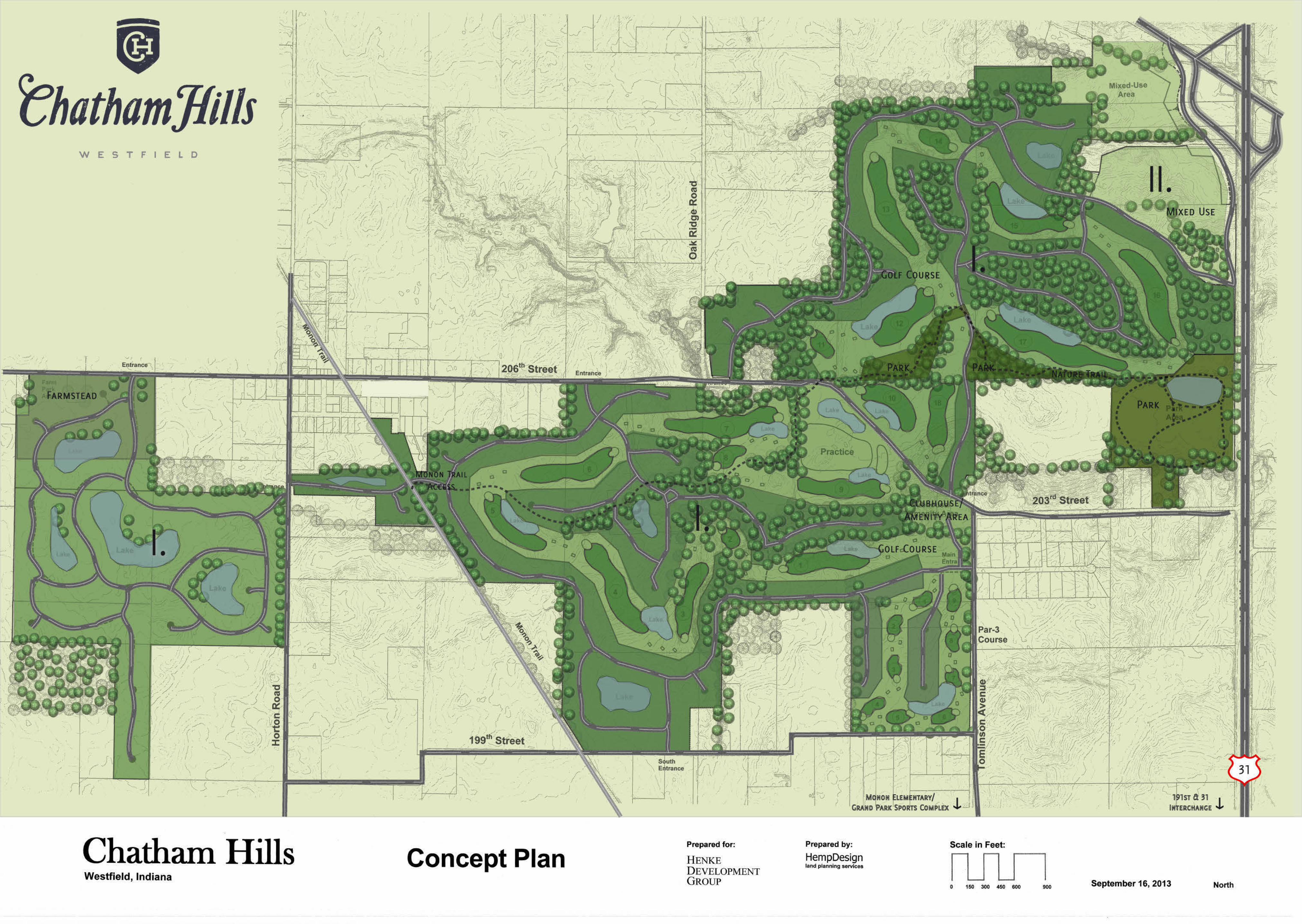
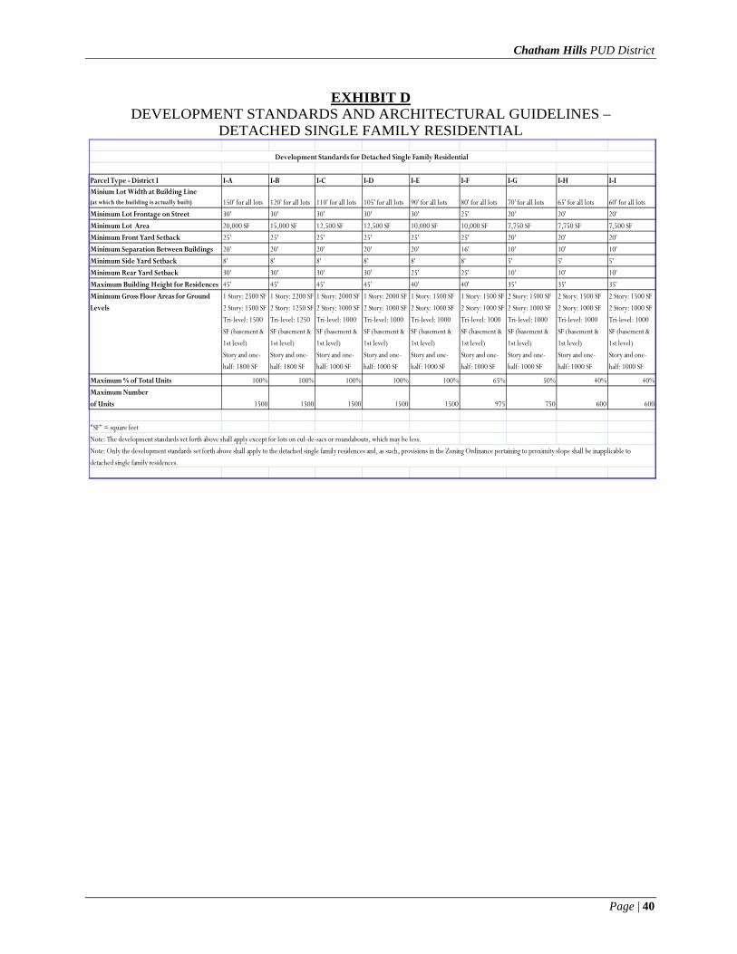
Chatham Hills PUD District
Page | 40
EXHIBIT D DEVELOPMENT STANDARDS AND ARCHITECTURAL GUIDELINES –
DETACHED SINGLE FAMILY RESIDENTIAL
Parcel Type - District I I-A I-B I-C I-D I-E I-F I-G I-H I-IMinium Lot Width at Building Line (at which the building is actually built) 150' for all lots 120' for all lots 110' for all lots 105' for all lots 90' for all lots 80' for all lots 70' for all lots 65' for all lots 60' for all lotsMinimum Lot Frontage on Street 30' 30' 30' 30' 30' 25' 20' 20' 20'Minimum Lot Area 20,000 SF 15,000 SF 12,500 SF 12,500 SF 10,000 SF 10,000 SF 7,750 SF 7,750 SF 7,500 SFMinimum Front Yard Setback 25' 25' 25' 25' 25' 25' 20' 20' 20'Minimum Separation Between Buildings 20' 20' 20' 20' 20' 16' 10' 10' 10'Minimum Side Yard Setback 8' 8' 8' 8' 8' 8' 5' 5' 5'Minimum Rear Yard Setback 30' 30' 30' 30' 25' 25' 10' 10' 10'Maximum Building Height for Residences 45' 45' 45' 45' 40' 40' 35' 35' 35'Minimum Gross Floor Areas for Ground Levels
1 Story: 2500 SF2 Story: 1500 SFTri-level: 1500SF (basement &1st level)Story and one-half: 1800 SF
1 Story: 2200 SF2 Story: 1250 SFTri-level: 1250SF (basement &1st level)Story and one-half: 1800 SF
1 Story: 2000 SF2 Story: 1000 SFTri-level: 1000SF (basement &1st level)Story and one-half: 1000 SF
1 Story: 2000 SF2 Story: 1000 SFTri-level: 1000SF (basement &1st level)Story and one-half: 1000 SF
1 Story: 1500 SF2 Story: 1000 SFTri-level: 1000SF (basement &1st level)Story and one-half: 1000 SF
1 Story: 1500 SF2 Story: 1000 SFTri-level: 1000SF (basement &1st level)Story and one-half: 1000 SF
2 Story: 1500 SF2 Story: 1000 SFTri-level: 1000SF (basement &1st level)Story and one-half: 1000 SF
2 Story: 1500 SF2 Story: 1000 SFTri-level: 1000SF (basement &1st level)Story and one-half: 1000 SF
2 Story: 1500 SF2 Story: 1000 SFTri-level: 1000SF (basement &1st level)Story and one-half: 1000 SF
Maximum % of Total Units 100% 100% 100% 100% 100% 65% 50% 40% 40%Maximum Numberof Units 1500 1500 1500 1500 1500 975 750 600 600
"SF" = square feetNote: The development standards set forth above shall apply except for lots on cul-de-sacs or roundabouts, which may be less.
Development Standards for Detached Single Family Residential
Note: Only the development standards set forth above shall apply to the detached single family residences and, as such, provisions in the Zoning Ordinance pertaining to proximity slope shall be inapplicable to detached single family residences.

Chatham Hills PUD District
Page | 41
EXHIBIT E
STREET SCAPE STANDARDS AND ARCHITECTURAL GUIDELINES - DETACHED SINGLE FAMILY RESIDENTIAL
A. Street Scape Standards 1. Dusk to Dawn Lights. The builder on each lot shall supply and install a light on such lot at a
location, having a height and of a type, style and manufacturer approved by the ArchitecturalReview Board. Each such light shall either be pole mounted in the front yard of a lot orattached as a carriage light to the residence, and shall be equipped with a photo electrical cell orsimilar device to ensure automatic illumination from dusk to dawn. The yard light shall bemaintained in proper working order by the owner of each lot. Illumination intensity forfixtures without shielding shall be limited to one hundred sixty (160) watts for incandescent bulbsor an equivalent illumination for other types of bulbs.
2. Mailboxes. All mailboxes within any particular Parcel shall be uniform in design, coloring, lettering,and numbering.
3. Street Lights. Street lights will be installed at the intersections of Internal Streets. In the developer'sdiscretion custom and/or architectural street lights may be substituted for standard streetlights specified in the Zoning Ordinance. Such custom and/or architectural street lights shall beinstalled at the developer's expense and maintained by the owner of the area in which they exist orby the not-for-profit association for the area in which they exist. All street lights shall comply withWC 16.07 et seq.
4. Street Number. The number of the street address of each single-family dwelling shall be placed onboth the sing1e-family dwelling and the mailbox for that single- family dwelling. All such numberingshall be of uniform design, coloring, and numbering. The number attached to the single-familydwelling shall be etched in stone, concrete, or other iron or brass type plate.
5. Street Signage. In the Developer's discretion, the Developer shall be permitted to substitute customsignage for standard street signage specified in the Zoning Ordinance. Such custom signage shall beinstalled at the developer's expense and maintained by the owner of the area in which they exist orby the not-for-profit association for the area in which they exist.
6. Gas Lights. Real or faux gas lights may be used without shielding.B. Architectural Guidelines
1. Design Elements. Design elements and detailing shall be continued completely around thestructure. Such design elements shall include, but are not limited to, windows, windowplacement, trim detailing, and exterior wall materials. The use of long, massive, unbrokenexterior building walls shall be avoided.
2. Exterior Colors. As part of the application for a building permit, exterior color selection shall besubmitted and approved by the Architectural Review Board.
3. Exterior Surfaces. Aluminum and vinyl siding are prohibited on residences, but vinyl clad windowsand soffits shall be permitted. Permitted exterior surfaces shall include EIFS, synthetic stucco,cultured stone, brick, stone, wood, and concrete fiber (Hardy-Plank or similar). Minimum of tenpercent (10%) of bu i ld ing exter ior sha l l be cultured stone, brick or stone for allbuildings/structures in developments, excluding roofs and windows.
4. Roof Form. Roof form and design will include, where appropriate, varied pitches and ridge levels.5. Roof Overhang. Each s ingle-family residence shall have eaves of a minimum eight (8) inch overhang.6. Windows and Architectural Breaks. Detached single-family buildings shall have windows on at least
three (3) sides; provided, however, that in the event a side of a detached single-family buildingdoes not have a window, it shall have at least two (2) architectural breaks, such as a chimneyor other corner break. The outermost comers of a dwelling unit shall not be consideredarchitectural breaks.

Chatham Hills PUD District
Page | 42
EXHIBIT F DEVELOPMENT STANDARDS AND ARCHITECTURAL GUIDELINES –
ATTACHED SINGLE FAMILY RESIDENTIAL
Development Standards for Attached Single Family Residential
Parcel Type Duplex Homes Triplex Homes Quadplex Homes Town homes CondominiumsMinimum residence setback from Internal Street 10' 10' 10' 10' 10'Minimum setback from Internal Street for g20' 20' 20' 20' 20'Minimum building separation 12' 12' 12' 12' 12'Minimum building setback from right-of-wa20' 20' 20' 20' 20'Minimum SF 1500 SF* 1500 SF* 1500 SF* 1200 SF * 1200 SF*Permitted density 6 per Acre 10 per Acre 10 per Acre 12 per Acre 12 per Acre
1. Maximum building height: Primary - 50' Accessory, including clubhouse - 55'
Notes:*Minimum Square Footage:
Not more than 50% of the total dwelling units for duplex, triplex and quadplex combined shall be a minimum of 1500 SF and 1200 SF for Townhomes or Condos. Atleast fifty (50%) percent of the dwelling units for duplex, triplex and quadplex units shall be a minimum of 1700 SF, a minimum of 1500 SF for Townhomes and 1350 SF for Condominiums.
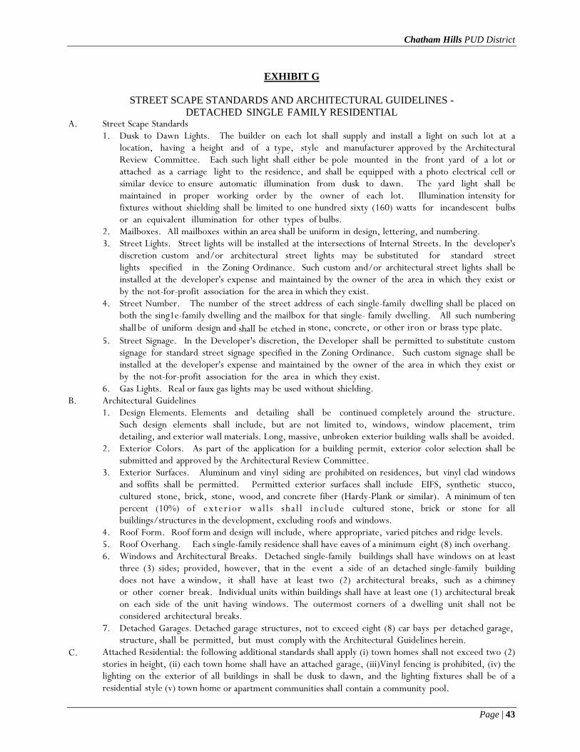
Chatham Hills PUD District
Page | 43
EXHIBIT G
STREET SCAPE STANDARDS AND ARCHITECTURAL GUIDELINES - DETACHED SINGLE FAMILY RESIDENTIAL
A. Street Scape Standards 1. Dusk to Dawn Lights. The builder on each lot shall supply and install a light on such lot at a
location, having a height and of a type, style and manufacturer approved by the ArchitecturalReview Committee. Each such light shall either be pole mounted in the front yard of a lot orattached as a carriage light to the residence, and shall be equipped with a photo electrical cell orsimilar device to ensure automatic illumination from dusk to dawn. The yard light shall bemaintained in proper working order by the owner of each lot. Illumination intensity forfixtures without shielding shall be limited to one hundred sixty (160) watts for incandescent bulbsor an equivalent illumination for other types of bulbs.
2. Mailboxes. All mailboxes within an area shall be uniform in design, lettering, and numbering.3. Street Lights. Street lights will be installed at the intersections of Internal Streets. In the developer's
discretion custom and/or architectural street lights may be substituted for standard streetlights specified in the Zoning Ordinance. Such custom and/or architectural street lights shall beinstalled at the developer's expense and maintained by the owner of the area in which they exist orby the not-for-profit association for the area in which they exist.
4. Street Number. The number of the street address of each single-family dwelling shall be placed onboth the sing1e-family dwelling and the mailbox for that single- family dwelling. All such numberingshall be of uniform design and shall be etched in stone, concrete, or other iron or brass type plate.
5. Street Signage. In the Developer's discretion, the Developer shall be permitted to substitute customsignage for standard street signage specified in the Zoning Ordinance. Such custom signage shall beinstalled at the developer's expense and maintained by the owner of the area in which they exist orby the not-for-profit association for the area in which they exist.
6. Gas Lights. Real or faux gas lights may be used without shielding.B. Architectural Guidelines
1. Design Elements. Elements and detailing shall be continued completely around the structure.Such design elements shall include, but are not limited to, windows, window placement, trimdetailing, and exterior wall materials. Long, massive, unbroken exterior building walls shall be avoided.
2. Exterior Colors. As part of the application for a building permit, exterior color selection shall besubmitted and approved by the Architectural Review Committee.
3. Exterior Surfaces. Aluminum and vinyl siding are prohibited on residences, but vinyl clad windowsand soffits shall be permitted. Permitted exterior surfaces shall include EIFS, synthetic stucco,cultured stone, brick, stone, wood, and concrete fiber (Hardy-Plank or similar). A minimum of tenpercent (10%) of exter ior wa l l s sha l l inc lude cultured stone, brick or stone for allbuildings/structures in the development, excluding roofs and windows.
4. Roof Form. Roof form and design will include, where appropriate, varied pitches and ridge levels.5. Roof Overhang. Each s ingle-family residence shall have eaves of a minimum eight (8) inch overhang.6. Windows and Architectural Breaks. Detached single-family buildings shall have windows on at least
three (3) sides; provided, however, that in the event a side of an detached single-family buildingdoes not have a window, it shall have at least two (2) architectural breaks, such as a chimneyor other corner break. Individual units within buildings shall have at least one (1) architectural breakon each side of the unit having windows. The outermost corners of a dwelling unit shall not beconsidered architectural breaks.
7. Detached Garages. Detached garage structures, not to exceed eight (8) car bays per detached garage,structure, shall be permitted, but must comply with the Architectural Guidelines herein.
C. Attached Residential: the following additional standards shall apply (i) town homes shall not exceed two (2) stories in height, (ii) each town home shall have an attached garage, (iii)Vinyl fencing is prohibited, (iv) the lighting on the exterior of all buildings in shall be dusk to dawn, and the lighting fixtures shall be of a residential style (v) town home or apartment communities shall contain a community pool.

Chatham Hills PUD District
Page | 44
EXHIBIT H
DEVELOPMENT STANDARDS PERTAINING TO SHARED DRIVES, PRIVATE STREETS, PUBLIC STREETS, PATHS, TRAILS
AND GATES
1. Street Standards.a. Streets may be either private or public.b. Streets may, where applicable, intersect at a ninety (90) degree angle for less than one-hundred
(100) feet from the intersection of right-of-way lines and may be permitted to intersect at less thanninety (90) degrees so as to follow the natural contour and features of the property.
c. Street jogs with centerline offsets of less than one-hundred twenty-five (125) shall be permitted soas to follow and preserve the natural contour or features of the property.
d. Adjustments to required horizontal visibility and curvature shall be permitted so as to preserve thenatural contour or features of the property.
e. Maximum grade for primary arterials and secondary arterials may exceed six percent (6%) andcollectors and local roads may exceed ten percent (10%) so as to follow the natural topography ofthe property.
f. Blocks may exceed twelve-hundred fifty (1250) feet in length.2. Accessory Lane. An Accessory Lane (i) shall be a minimum of five feet (5') in width, (ii) may be
located within the right-of-way of some or all public streets internal to the development asdetermined by Developer in Developer's sole discretion, (iii) shall be identified by striping and(iv) may be used by pedestrians, golf carts, and bicycles. The location and number of AccessoryLanes shall be determined by Developer in Developer's discretion.
3. Cart Paths. Cart Paths within the Golf Course shall be of size, dimensions, configurations, number,and location determined by the Developer. They shall be maintained by the Developer for use bygolf club employees, authorized patrons of the golf club, and electric-powered golf carts associatedwith authorized golf patrons .
4. Cul-de-Sacs. In Developer's discretion, shared drives may stub and need not conclude in a cul-de- sac. Private Streets or Public Streets shall conclude in a cul-de-sac. There shall be no limitation onthe length of a Cul-de-sac Street; provided, however, that if the length of a Cul-de-sac street exceedsseven hundred fifty feet (750'), there shall be established in such street, a turnaround of dimensions,configuration and location acceptable to the Depar tment.
5. Curbing. Curbing shall not be required for Private Streets, Shared Drives, or parking lots within theclubhouse maintenance and storage areas of the Golf Course.
6. Entrances, Curb Cuts, and Road Cuts. Four (4) road cuts shall be permitted off of Cox Avenue, Two(2) road cuts shall be permitted off of Tomlinson Road, two (2) road cuts shall be permitted off of199th Street, f our (4 ) o f f o f 206 t h S t r ee t , three (3) road cuts shall be permitted off of HortonRoad, two (2) off of Lindley Farm Road, two (2) off of Oak Ridge Road and any others that may ariseout of Developer’s discretion when platting. Road cuts from Public Streets internal to thedevelopment shall be determined with the City. Road cuts from Private Streets shall be determined bythe Developer in the Developer's sole discretion.
7. Faux Gates. Faux gates, or gates which do not function, shall be permitted on Shared Drives, PrivateStreets or Public Streets including the right-of-way. The number and location of Faux Gates shall bedetermined by the Developer at the Developer’s sole discretion. Faux gates shall be maintained by theDeveloper and it's successors or assigns.
8. Frontage. Homes adjacent to Private Streets need not have frontage on a public right-of-way.9. Functioning Gates. Functioning gates shall be permitted on Private Streets and Shared Drives, only.
The number and location of functioning gates shall be determined by the Developer in theDeveloper's sole discretion. Utility and emergency vehicles shall be assured access. Functioninggates shall be maintained by the Developer and it's successors or assigns.
10. Trails. Trails shall be (i) located in common areas or easements in the general area shown on theConcept plan and (ii) eight feet (8') wide, and may be used by pedestrians, golf carts, and bicycles.

Chatham Hills PUD District
Page | 45
Some exceptions shall be permitted for less than an eight foot (8’) Trail when located within woods or preserved areas.
11. Lanes. A Lane is a private way or easement located through the interior of a Parcel and providingvehicular, pedestrian and service access to the side or rear of residential lots. Lanes (i) may, in theDeveloper's sole discretion, be located in what are identified on the Concept Plan as District I:a. Any Lane shall be a perpetual easement or private drive and shall not be dedicated to the public.
Lanes may be conveyed to the owner's association or may be dedicated as common easements acrossthe rear portions of lots;
b. The minimum width of a Lane shall be twenty-four (24’) feet.c. The minimum set back of garages on Lanes shall be twenty (20’) feet;d. No parking is permitted on either side of the cartway of a Lane, but is permitted on a drive, garage
apron or other paved area between the cartway and the Lane easement lines;e. Curbing is not required; andf. Water and sewer utilities shall not be located in Lanes.
12. Private Streets. Private streets shall be twenty-four (24) feet in width and need not be curbed and shallbe: a. Maintained by an owner's association in accordance with provisions for such maintenance set forth in
a Declaration;b. Be permitted in number and location as determined by the Developer in the Developer's sole
discretion;c. Private Streets shall be constructed to depth and material standards set forth by the Zoning
Ordinance with the exception of any natural or temporary roadways;d. An owner's association shall maintain a reasonable reserve for the maintenance, repair and
replacement of Private Streets within the District; ande. Private Streets shall not be dedicated for public use by the City of Westfield.
13. Public Streets. All Public Streets are to be dedicated for public use and accepted for maintenance byand shall be constructed to the standards of the Zoning Ordinance for depth and materials, except asotherwise provided in this PUD. The width of Public Streets, from back of curb to back of curb, shall bea minimum of 24' feet.
14. Shared Drive Width. A Shared Drive is a drive extending from a Private Street, intended for pedestrianand motor vehicle use only by the owners of residential lots having frontage on the Shared Drive. Shareddriveway shall be private, need not be curbed and shall be twenty-four (24) feet in width. Shareddriveways shall be permitted in number as delivered by the Developer in the Developer’s discretion.
15. Sidewalks. Sidewalks shall not be required on Private Streets or Shared Drives. Sidewalks shall bedeveloped to City standards and shall be installed within all segments of Public Streets, abuttingresidences, on the side of the street on which residences are located and the following shall apply:a. Within those segments of Public or Private Streets in which there are houses on neither side, the
Developer shall install a sidewalk on either side but need not install a sidewalk on both sides;b. Developer may substitute Trails for sidewalks and vice-versa;c. When a proposed subdivision abuts and existing street right-of-way, sidewalks parallel to the
existing street shall not be required if an internal Trail provides for connectivity to other parts of thedevelopment; and
d. Off-site sidewalks or Trails shall not be required by the Plan Commission for Developer to install ifincreased infrastructure demands are in response to increased traffic of the Monon Trail or GrandPark.