chapter one fargo, north dakota in 2007 · growth plan 2007 fargo north dakota 11 chapter one...
TRANSCRIPT
Growth Plan 2007Fargo North Dakota
11
Chapter OneFargo, North Dakota in 2007
The Existing City of Fargo There is evidence that native Americans traveled the Red River
Valley and took advantage of its rich, dark soil. It became a place of commerce, a crossroads. The modern city grew up at the intersection of two transportation routes; the Red River of the North carrying grain from throughout the Upper Great Plains and the railroad carrying that same grain to mills in the cities of Minneapolis/St. Paul. Fargo is still a major crossroads for the Upper Great Plains. The primary transportation has changed to the automobile and the crossroads are now marked by two Interstate Highways. Fargo has a strong agricultural economy that is broadened with new industries and activities such as computer software, nanoscale devices, education, and health care.
Fargo is the largest city in the State of North Dakota. It continues to grow steadily despite ongoing out-migration from the state as a whole. The city covers approximately 28,650 acres and has a population of approximately 93,000. Fargo has two adjoining sister cities, West Fargo, North Dakota and Moorhead, Minnesota. Combined, the metropolitan area has a population of 150,000 and is seeing consistent growth.
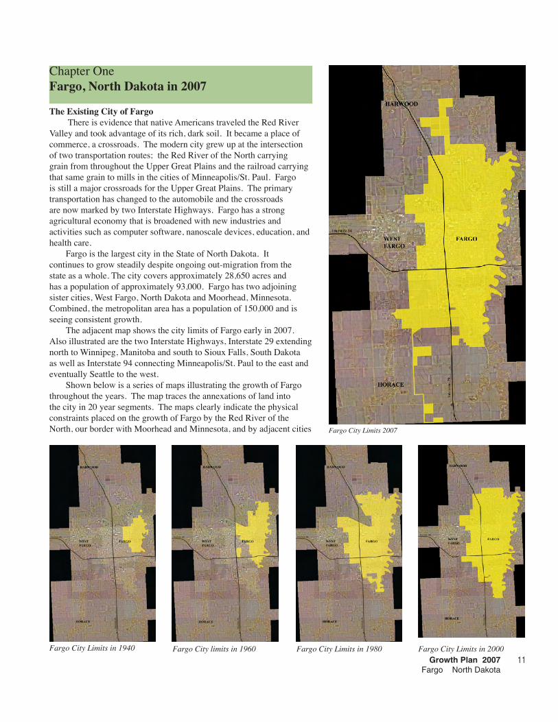
The adjacent map shows the city limits of Fargo early in 2007. Also illustrated are the two Interstate Highways, Interstate 29 extending north to Winnipeg, Manitoba and south to Sioux Falls, South Dakota as well as Interstate 94 connecting Minneapolis/St. Paul to the east and eventually Seattle to the west.
Shown below is a series of maps illustrating the growth of Fargo throughout the years. The map traces the annexations of land into the city in 20 year segments. The maps clearly indicate the physical constraints placed on the growth of Fargo by the Red River of the North, our border with Moorhead and Minnesota, and by adjacent cities Fargo City Limits 2007
Fargo City Limits in 1940 Fargo City limits in 1960 Fargo City Limits in 1980 Fargo City Limits in 2000

Fargo in 200712
The extra-territorial area of Fargo at the end of 2006.
such as West Fargo and Horace. Fargo, because of these constraints is being forced into a longitudinal city which is much longer than it is wide.
Extra-territorial Area of Fargo By state statute, the City of Fargo, and other cities with a
population over 25,000, may claim up to four miles beyond its city limits as the city’s extra-territorial (ET) area. Although this land is not a part of the city it is within the control of the city for the purposes of subdivision control and zoning authority. Establishment of the ET area ensures that the city has an opportunity to plan for and review future development to make sure that expansion of the urban character is possible. It also protects the continuity of future road corridors and prohibits incompatible development. Other jurisdictions are barred from encroaching on this area once it is designated as ET area. The adjacent map indicates the extra-territorial area of the City of Fargo early in 2006. The city limits are illustrated in yellow and the extra-territorial area is shaded green. It is this extra-territorial area that we are concerned with for this update of the city’s growth plan. The extra-territorial area is the land established as the future growth area for the city.
Existing Characteristics of the Future Growth AreasThe area with which we are concerned, the extra-territorial area
of Fargo is largely rural land currently in agricultural production. The previous photograph gives you an indication of the character of the land within the extra-territorial areas of the city.
One of the goals of this growth plan is to help create a sustainable city that discourages sprawl and exists in harmony with the natural environment. The Red River Valley is an important agricultural area with rich, lake bottom soils from the bottom of ancient Lake Agassiz. Sustainable practices within planning seek to value this agricultural land in such a way as to minimize its loss. The anticipated growth within the city of Fargo requires us to grow into the agricultural land that surround us but we desire to do so in a way that creates a compact and efficient city surrounded by beautiful agricultural fields.
The extra-territorial area already contains large numbers of
A view of typical land within the extra-territorial area of Fargo
Growth Plan 2007Fargo North Dakota
1�
both natural and man-made features that impact the nature of the development that can occur in the area. It is important for us to locate the significant natural features, existing transportation paths, existing utility easements, and planned infrastructure improvements so that they may be incorporated into the planning for the growth of the city into this area. These features also represent tremendous opportunities to begin to link together the community with walkways, bikeways, and ski trails while honoring and valuing the natural features that make this a unique place.
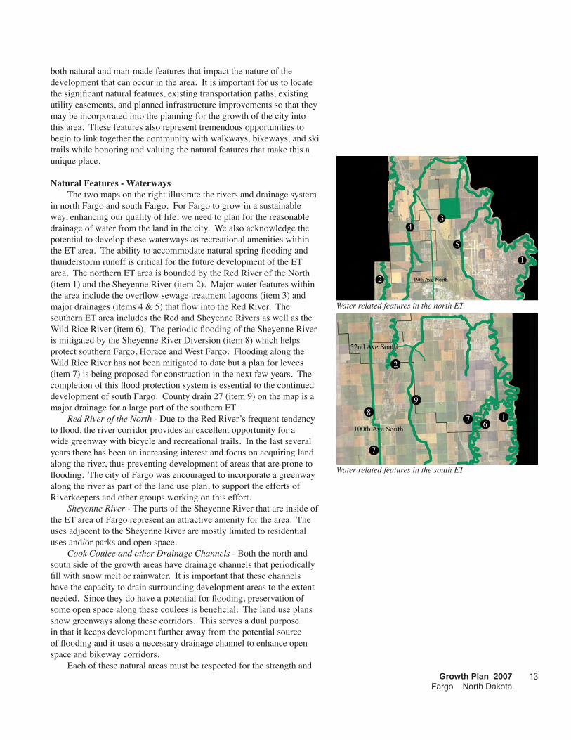
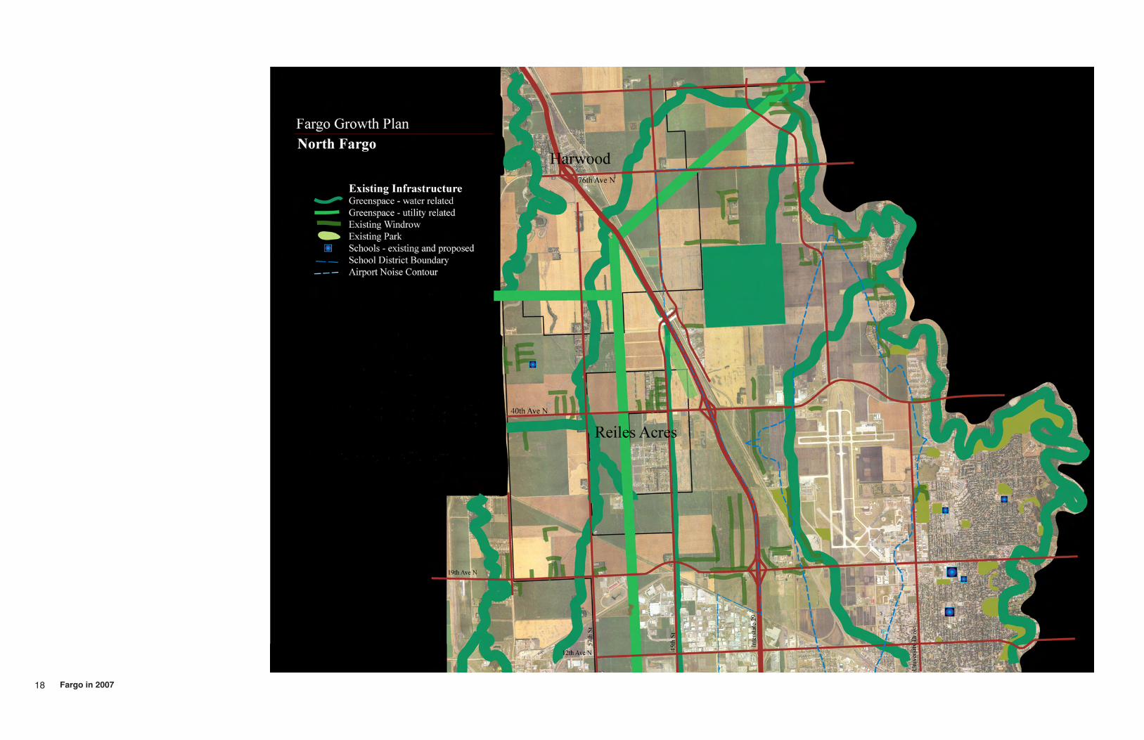
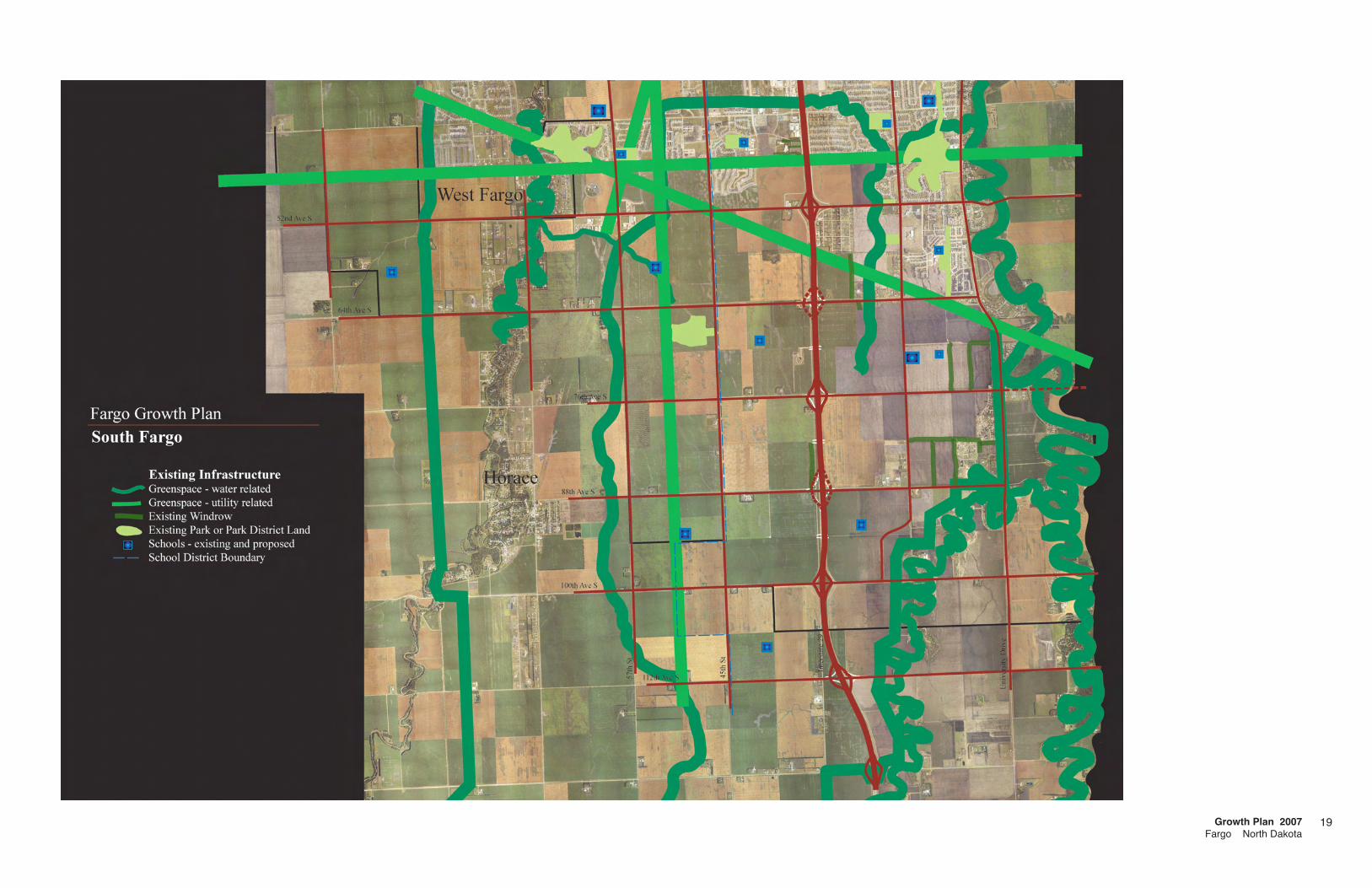
Natural Features - WaterwaysThe two maps on the right illustrate the rivers and drainage system
in north Fargo and south Fargo. For Fargo to grow in a sustainable way, enhancing our quality of life, we need to plan for the reasonable drainage of water from the land in the city. We also acknowledge the potential to develop these waterways as recreational amenities within the ET area. The ability to accommodate natural spring flooding and thunderstorm runoff is critical for the future development of the ET area. The northern ET area is bounded by the Red River of the North (item 1) and the Sheyenne River (item 2). Major water features within the area include the overflow sewage treatment lagoons (item 3) and major drainages (items 4 & 5) that flow into the Red River. The southern ET area includes the Red and Sheyenne Rivers as well as the Wild Rice River (item 6). The periodic flooding of the Sheyenne River is mitigated by the Sheyenne River Diversion (item 8) which helps protect southern Fargo, Horace and West Fargo. Flooding along the Wild Rice River has not been mitigated to date but a plan for levees (item 7) is being proposed for construction in the next few years. The completion of this flood protection system is essential to the continued development of south Fargo. County drain 27 (item 9) on the map is a major drainage for a large part of the southern ET.
Red River of the North - Due to the Red River’s frequent tendency to flood, the river corridor provides an excellent opportunity for a wide greenway with bicycle and recreational trails. In the last several years there has been an increasing interest and focus on acquiring land along the river, thus preventing development of areas that are prone to flooding. The city of Fargo was encouraged to incorporate a greenway along the river as part of the land use plan, to support the efforts of Riverkeepers and other groups working on this effort.
Sheyenne River - The parts of the Sheyenne River that are inside of the ET area of Fargo represent an attractive amenity for the area. The uses adjacent to the Sheyenne River are mostly limited to residential uses and/or parks and open space.
Cook Coulee and other Drainage Channels - Both the north and south side of the growth areas have drainage channels that periodically fill with snow melt or rainwater. It is important that these channels have the capacity to drain surrounding development areas to the extent needed. Since they do have a potential for flooding, preservation of some open space along these coulees is beneficial. The land use plans show greenways along these corridors. This serves a dual purpose in that it keeps development further away from the potential source of flooding and it uses a necessary drainage channel to enhance open space and bikeway corridors.
Each of these natural areas must be respected for the strength and
Water related features in the north ET
Water related features in the south ET
Fargo in 20071�
power of floods but each is also an opportunity to develop green spaces for public use and to link parts of the community together.
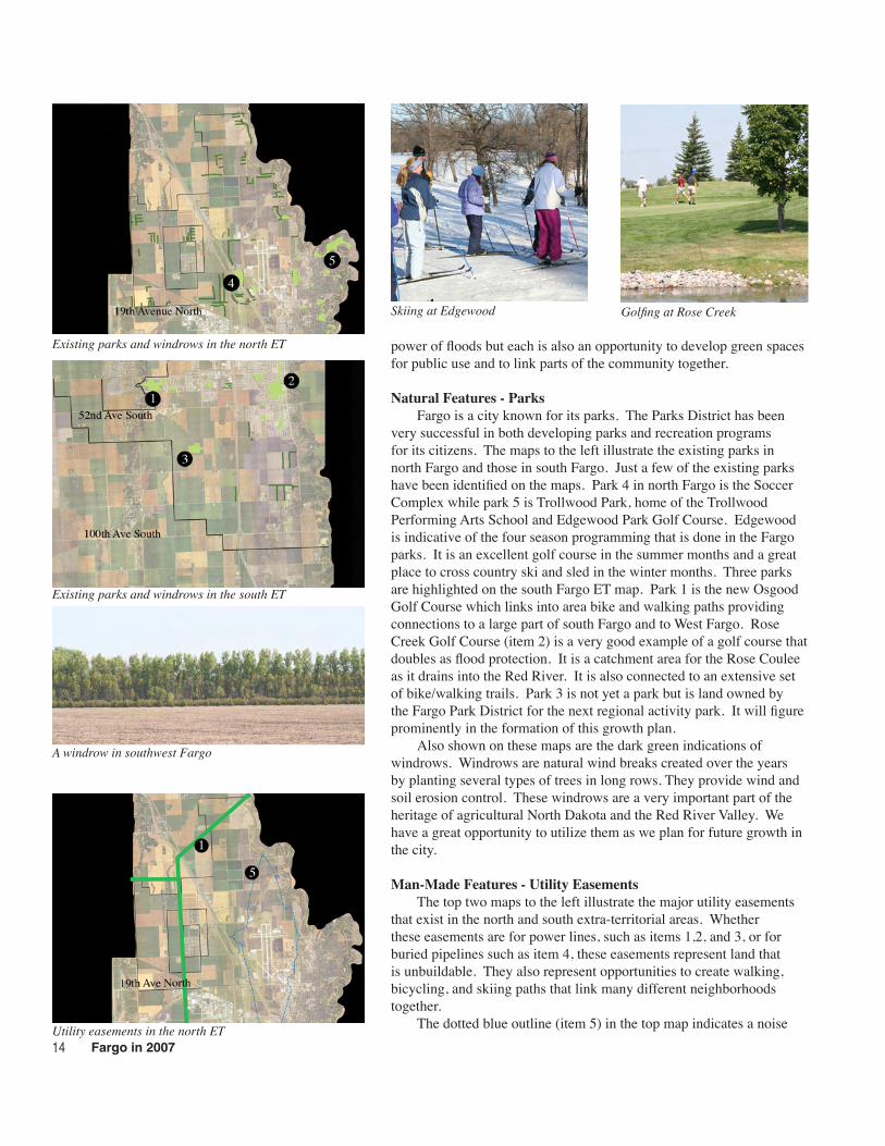
Natural Features - ParksFargo is a city known for its parks. The Parks District has been
very successful in both developing parks and recreation programs for its citizens. The maps to the left illustrate the existing parks in north Fargo and those in south Fargo. Just a few of the existing parks have been identified on the maps. Park 4 in north Fargo is the Soccer Complex while park 5 is Trollwood Park, home of the Trollwood Performing Arts School and Edgewood Park Golf Course. Edgewood is indicative of the four season programming that is done in the Fargo parks. It is an excellent golf course in the summer months and a great place to cross country ski and sled in the winter months. Three parks are highlighted on the south Fargo ET map. Park 1 is the new Osgood Golf Course which links into area bike and walking paths providing connections to a large part of south Fargo and to West Fargo. Rose Creek Golf Course (item 2) is a very good example of a golf course that doubles as flood protection. It is a catchment area for the Rose Coulee as it drains into the Red River. It is also connected to an extensive set of bike/walking trails. Park 3 is not yet a park but is land owned by the Fargo Park District for the next regional activity park. It will figure prominently in the formation of this growth plan.
Also shown on these maps are the dark green indications of windrows. Windrows are natural wind breaks created over the years by planting several types of trees in long rows. They provide wind and soil erosion control. These windrows are a very important part of the heritage of agricultural North Dakota and the Red River Valley. We have a great opportunity to utilize them as we plan for future growth in the city.
Man-Made Features - Utility EasementsThe top two maps to the left illustrate the major utility easements
that exist in the north and south extra-territorial areas. Whether these easements are for power lines, such as items 1,2, and 3, or for buried pipelines such as item 4, these easements represent land that is unbuildable. They also represent opportunities to create walking, bicycling, and skiing paths that link many different neighborhoods together.
The dotted blue outline (item 5) in the top map indicates a noise Utility easements in the north ET
Existing parks and windrows in the south ET
A windrow in southwest Fargo
Skiing at Edgewood Golfing at Rose Creek
Existing parks and windrows in the north ET
Growth Plan 2007Fargo North Dakota
1�
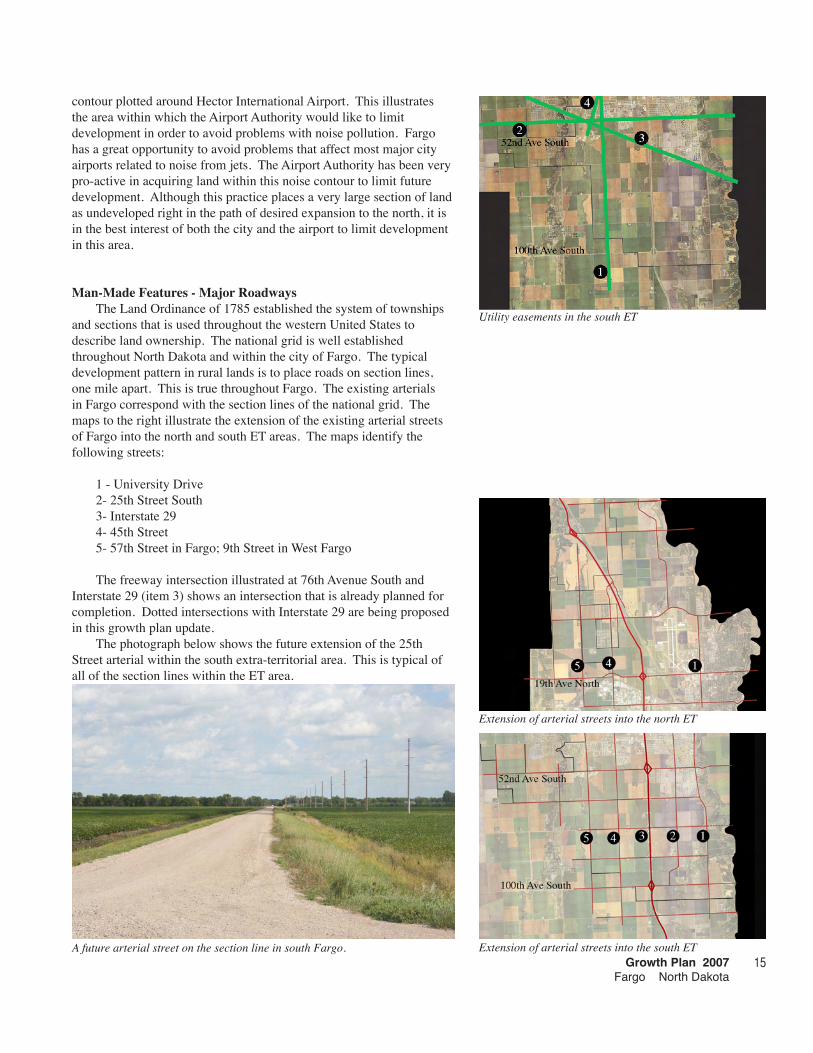
contour plotted around Hector International Airport. This illustrates the area within which the Airport Authority would like to limit development in order to avoid problems with noise pollution. Fargo has a great opportunity to avoid problems that affect most major city airports related to noise from jets. The Airport Authority has been very pro-active in acquiring land within this noise contour to limit future development. Although this practice places a very large section of land as undeveloped right in the path of desired expansion to the north, it is in the best interest of both the city and the airport to limit development in this area.
Man-Made Features - Major RoadwaysThe Land Ordinance of 1785 established the system of townships
and sections that is used throughout the western United States to describe land ownership. The national grid is well established throughout North Dakota and within the city of Fargo. The typical development pattern in rural lands is to place roads on section lines, one mile apart. This is true throughout Fargo. The existing arterials in Fargo correspond with the section lines of the national grid. The maps to the right illustrate the extension of the existing arterial streets of Fargo into the north and south ET areas. The maps identify the following streets:
1 - University Drive2- 25th Street South3- Interstate 294- 45th Street5- 57th Street in Fargo; 9th Street in West Fargo
The freeway intersection illustrated at 76th Avenue South and Interstate 29 (item 3) shows an intersection that is already planned for completion. Dotted intersections with Interstate 29 are being proposed in this growth plan update.
The photograph below shows the future extension of the 25th Street arterial within the south extra-territorial area. This is typical of all of the section lines within the ET area.
A future arterial street on the section line in south Fargo.
Utility easements in the south ET
Extension of arterial streets into the north ET
Extension of arterial streets into the south ET
Fargo in 20071�
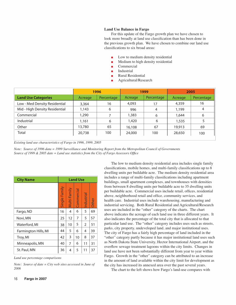
Land Use Balance in FargoFor this update of the Fargo growth plan we have chosen to
look more broadly at land use classification than has been done in the previous growth plan. We have chosen to combine our land use classifications to six broad areas:
Low to medium density residentialMedium to high density residentialCommercialIndustrialRural ResidentialAgricultural/Research
The low to medium density residential area includes single family classifications, mobile homes, and multi-family classifications up to 8 dwelling units per buildable acre. The medium density residential area includes a range of multi-family classifications including apartment buildings, small apartment complexes, and townhouses with densities from between 8 dwelling units per buildable acre to 35 dwelling units per buildable acre. Commercial uses include retail, offices, residential above, neighborhood retail and office, community services, and health care. Industrial uses include warehousing, manufacturing and industrial servicing. Both Rural Residential and Agricultural/Research uses are included in the “other” category of the charts. The chart above indicates the acreage of each land use in three different years. It also indicates the percentage of the total city that is allocated to that particular land use. The “other” category includes uses such as streets, parks, city property, undeveloped land, and major institutional uses. The city of Fargo has a fairly high percentage of land included in the “other” category partly because it has major institutional land uses such as North Dakota State University, Hector International Airport, and the overflow sewage treatment lagoons within the city limits. Changes in land use have not been substantially different from year to year within Fargo. Growth in the “other” category can be attributed to an increase in the amount of land available within the city limit for development as the city has increased its annexed area over the past several years.
The chart to the left shows how Fargo’s land-use compares with
■
■
■
■
■
■
Existing land use characteristics of Fargo in 1996, 1999, 2005
Note: Source of 1996 data = 1999 Surveillance and Monitoring Report from the Metropolitan Council of GovernmentsSource of 1999 & 2005 date = Land use statistics from the City of Fargo Assessors Office
Land use percentage comparisons
Note: Source of date = City web sites accessed in June of 2006
Land Use Categories Acreage Percentage Acreage Percentage Acreage Percentage
3,364Low - Med Density Residential
Mid - High Density Residential
Commercial
Industrial
Other
Total
19991996 2005
1,143
1,290
1,161
13,780
20,738 100 100 100
16
6
7
6
65
17
4
6
6
67
16
4
6
5
69
4,093
996
1,383
1,420
16,108
4,359
1,199
1,644
1,535
19,913
24,000 28,650
Sin
gle
Fam
ily
Mu
lti-
Fam
ily
Co
mm
erci
al
Ind
ust
rial
Oth
er
Novi, MN
Waterford, MI
Farmington Hills, MI
Troy, MI
Minneapolis, MN
St. Paul, MN
City Name Land Use
7
5
6
10
6
5
4
5
2
8
11
11
12
10
5
3
7
4
40
36
25
38
44
42
31
37
57
51
39
37
Fargo, ND 16 4 6 5 69
Growth Plan 2007Fargo North Dakota
several cities of similar size and with Minneapolis and St. Paul. The commercial, industrial and multi-family uses are rather consistent with other cities. The percentage of lower density residential has historically been low. There are several reasons for this anomaly; Fargo is a regional retail, service, medical, industrial, financing and entertainment center increasing the relative percentage of these uses. The neighboring communities of West Fargo and Moorhead offer residential areas as a somewhat larger percentage of their developed area, off-setting the lower percentage in Fargo. The historically high number of transient residents, largely students, continue to be an important percentage of the residential population of Fargo. This is an ongoing issue for the growth plan.
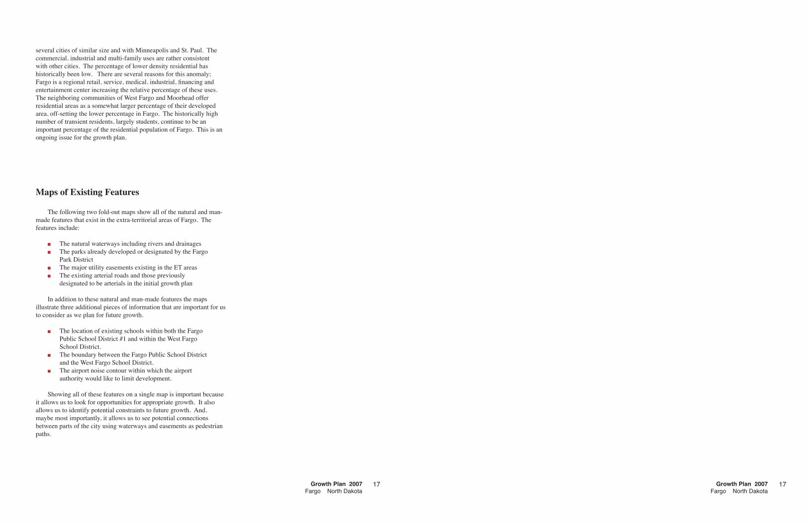
Maps of Existing Features
The following two fold-out maps show all of the natural and man-made features that exist in the extra-territorial areas of Fargo. The features include:
The natural waterways including rivers and drainagesThe parks already developed or designated by the Fargo Park DistrictThe major utility easements existing in the ET areasThe existing arterial roads and those previously designated to be arterials in the initial growth plan
In addition to these natural and man-made features the maps illustrate three additional pieces of information that are important for us to consider as we plan for future growth.
The location of existing schools within both the Fargo Public School District #1 and within the West Fargo School District.The boundary between the Fargo Public School District and the West Fargo School District.The airport noise contour within which the airport authority would like to limit development.
Showing all of these features on a single map is important because it allows us to look for opportunities for appropriate growth. It also allows us to identify potential constraints to future growth. And, maybe most importantly, it allows us to see potential connections between parts of the city using waterways and easements as pedestrian paths.
■
■
■
■
■
■
■
1717Growth Plan 2007Fargo North Dakota
18 Fargo in 2007
Growth Plan 2007Fargo North Dakota
19

20 Fargo in 2007