chapter land - amazon s3
TRANSCRIPT
LAND
5.3C H A P T E R
EXPLORATORY WORKS FOR SNOWY 2.0 - ENVIRONMENTAL IMPACT STATEMENT 5.3-1
5.3 Land
5.3.1 Overview
An assessment of impacts to land has been carried out, which broadly includes: soils and land capability; landforms (including geotechnical stability and land use compatibility of new landforms); seismic and subsidence impacts; soil contamination (existing contamination and potential for contamination from excavated rock); naturally occurring asbestos; and impacts to karst systems. The assessment is supported by a series of technical assessments appended to this EIS:
• Soil and land Assessment, prepared by EMM (Appendix H) – this report includes a desktop review and soil survey and analysis to characterise soil and land capability of the disturbance footprint;
• Excavated rock emplacement areas assessment, prepared by SGM Environmental (Appendix K) – this report describes the design of excavated rock emplacement on land and its management;
• Phase 1 contamination assessment, prepared by EMM (Appendix J) – this report includes a desktop site history assessment, site inspection, limited sampling and assessment of contamination risks; and
• Geodiversity review, prepared by EMM (Appendix I) – this assessment identifies risks to geodiversity sites and features.
5.3.2 Existing environment
i Soils and land capability
There are four major soil types within the Exploratory Work disturbance footprint: the major soil orders are Kandosols and Tenosols, with small areas of Dermosols and Vertosols. These soil types are described in detail at Appendix H.
Land capability is described as ‘the inherent physical capacity of the land to sustain a range of land uses and management practices in the long term without degradation to soil, land, air and water resources’ (OEH 2012). Given the project area is largely within KNP and under conservation management, soils and land capability characterisation is used only as a guide to the existing physical capacity of the land to support different agricultural land uses.
Broad scale land and soil capability (LSC) mapping for NSW identifies most of the project area’s soils are LSC Class 4 to Class 8, meaning that there are moderate to extreme limitations to cropping. The majority of the area is Class 7 and Class 8 which are typically land uses such as grazing, forestry, and nature conservation). This is consistent with the existing use of most of the project area as a national park.
The main constraints to intensive use of the soils in the disturbance footprint are steep slopes, relatively low fertility, presence of coarse fragments, low pH and often shallow soil profiles. Areas where steep slopes are present are only suited to land uses such as selective forestry, passive tourism and conservation. The gentler landscapes such as Lobs Hole have a higher capability and may be capable of some grazing as it had done historically during the last century, as well as the aforementioned uses.
There is potential for naturally occurring asbestos within the project area. One area of low potential is within the Jackalass Slate Formation, through a 600 m section of Lobs Hole Ravine Road and running parallel to the existing transmission lines that traverse the project area. However, no works are proposed in this area.

EXPLORATORY WORKS FOR SNOWY 2.0 - ENVIRONMENTAL IMPACT STATEMENT 5.3-2
ii Major geological structures, landforms and surface features
The Long Plains Fault is a major regional fault separating the Siluro-Devonian rocks in the west from the Ordovician volcanics in the east, and is relevant to the Exploratory Works project area. The north-northeast trending Long Plain Fault extends over a distance of 200 km from the Upper Murray River to west of the Brindabella Ranges. The west-dipping reverse fault is understood to have a shear zone at the project area of between 300 and 350 m (Jacobs 2017). Folding is well developed across the project area and is a consequence of the significant tectonic activity and east-west compression across the Tumut and Tantangara geological blocks. The Silurian aged Ravine Beds are reported to have undergone moderate folding and some faulting, particularly along the Yarrangobilly River (Wyborn D, Owen & Wyborn L 1990).
The project area is within a steeply incised ravine, along the western fringe of the Long Plains fault escarpment. Elevations typically range from around 550 to 1,400 m AHD. Most of the project area is characterised by deep gorges and steep sloping ridges, the product of incision from watercourse flow and glaciations, with localised areas of lower grade, such as ridgelines, saddles, benches, and alluvium beside watercourses.
Pleistocene glacial landforms in the form of block streams (or boulder screes) are present in the project area (see Appendix I). Pleistocene glacial landforms in KNP can be found in most areas above 1,000 m and possibly as far down as 600 m and are the only examples of this landform on the mainland of Australia and are of national and international significance (OEH 2011a). Periglacial features of the park include terracing, solifluction lobes, sliding and shattered boulders and block streams. Block streams are listed under ‘Rocks and Landforms’ in Schedule 1 (Significant Natural and Cultural Features) of the KNP PoM. They are defined as ‘river’ or field of rocks that has moved downhill in mass and which was held together by ice, and occur in various areas of KNP, including the project area, where they occur along a section of Lower Lobs Hole Ravine Road.
Karst formations are landforms produced by the action of natural waters on soluble rocks (most commonly, limestone and dolomite) and they occur at various places in KNP. The Ravine karst area is relevant to Exploratory Works as it is the area surrounding Lobs Hole Ravine Road about 1 km south of the exploratory tunnel portal. The karst significance of Ravine is attributed to the massive tufa deposits (porous deposits of Calcium carbonate often with a spongy like appearance) and caves. The KNP PoM suggests that the tufa deposits and fossil sequence at Ravine are considered to have national or regional significance (DEC 2006), preserving records of vegetation and climate change. The Devonian strata are also of interest for its fossils (which include corals, trilobites, brachiopods and molluscs; Geoscience Australia 2017).
Limestone in this area of Exploratory Works occurs as a component of the Lick Hole Formation. Fossiliferous rock is evident in the Lick Hole Formation and can be seen from an outcrop within the project area. The outcrop of this formation is adjacent to Lobs Hole Ravine Road and is exposed most likely as a result of previous road construction and is in a disturbed condition.
EXPLORATORY WORKS FOR SNOWY 2.0 - ENVIRONMENTAL IMPACT STATEMENT 5.3-3
iii Existing contamination
The Lobs Hole area was the site of a copper mine in the late nineteenth century through to 1916. Remnants of both surface and below ground works from the mine are still seen today. At the time of closure, the mine consisted of six shafts, two adits and several waste rock stockpiles. The settlement of Ravine was associated with the mining boom, however the population of the town dwindled by the 1920s. Remnants of the Washington Hotel and other minor building foundations remain.
Three existing areas of environmental concern have been identified and are described in Table 5.6.
Table 5.6 Areas of environmental concern
Historical land uses Areas of environmental concern
Copper mining (1874-1916)
A detailed investigation conducted at the Lobs Hole mine (URS 2015) identified soil, sediment, and surface water contamination associated with historical mine activities as being present at concentrations above the relevant assessment criteria. This has impacted the sediments and water quality in the Yarrangobilly River; however, concentrations of contaminants of potential concern (COPCs) were measured below the relevant criteria at a distance of less than 700 m down gradient (west) of the mine. Preliminary soil sampling conducted at limited locations around mine features did not identify any health-based soil impacts, but confirmed ecological exceedances of heavy metals (copper, zinc, nickel and arsenic). Some of Lobs Hole mine is located outside of the boundaries of the Exploratory Works disturbance footprint on the northern/eastern bank of the Yarrangobilly river. These areas were not considered part of the phase 1 assessment.
Soil sampling conducted at additional locations around Lobs Hole, such as near the portal and near the accommodation camp, also reported ecological exceedances of heavy metals in the soil (copper, zinc, and nickel). These exceedances were attributed to the disturbed nature and historical use of the area.
The mine has adversely impacted the quality of the soil, surface water and sediment in the Yarrangobilly River within the mine footprint. A groundwater assessment at Lobs Hole mine has not been completed to date.
Operations of the township of Ravine
Small scale, localised grazing, horticultural, agriculture, and/or waste activities associated with the township of Ravine may have had minor impacts to the shallow soils.
Recent recreational/ campsite use
An additional source of shallow contamination would be related to camping and 4WD activities (ie waste disposal, fuel leaks and spills, open fires and localised rubbish). However, given the limited extent of these activities and sources, the potential contamination risk from these activities is low. Given the age and scale of these activities, they are unlikely to have caused significant levels of contamination.
The limited sampling program (Appendix J) demonstrated that despite being within a National Park setting, the shallow soils in the Lobs Hole area are impacted with heavy metals. However, the magnitude of these exceedances is representative of the historic use at (or nearby) that location. For example, the copper exceedances around the mine workings far exceed those measured in areas of minimal disturbance.

EXPLORATORY WORKS FOR SNOWY 2.0 - ENVIRONMENTAL IMPACT STATEMENT 5.3-4
5.3.3 Assessment of impacts
i Avoidance and minimisation of impacts
A range of measures have been implemented as part of the design to avoid and minimise impacts to land:
• Refinement of disturbance footprint and avoidance area: the disturbance footprint has been reduced as far as practical to avoid and minimise disturbance to land broadly, which has avoided and minimised impacts to soils and land capability and landforms in the project area.
• Development of rehabilitation principles: rehabilitation principles and implementation of a rehabilitation strategy will result in most areas disturbed being returned to land uses generally consistent with their current use, subject to ongoing consultation with NPWS.
• Rock emplacement design: the design of the eastern rock emplacement addresses potential risks associated with acid rock drainage to minimise generation of acidic runoff, and passively addresses existing contamination associated with Adit South from the former Lobs Hole Mine.
• Existing contamination: with the exception of the Adit South in Lick Hole Gully in the footprint of the eastern rock emplacement area, the Lobs Hole Mine, a source of historical contamination, has been avoided. This area is also a geoheritage site and has associated heritage values, which will be retained through avoidance of former mine areas.
• Periglacial and karst features: geological features with heritage value were identified through desktop review and a site inspection and resulted in a need to minimise disturbance in these areas. Road upgrades proposed along Lobs Hole Ravine Road have been designed to avoid and minimise impacts where possible.
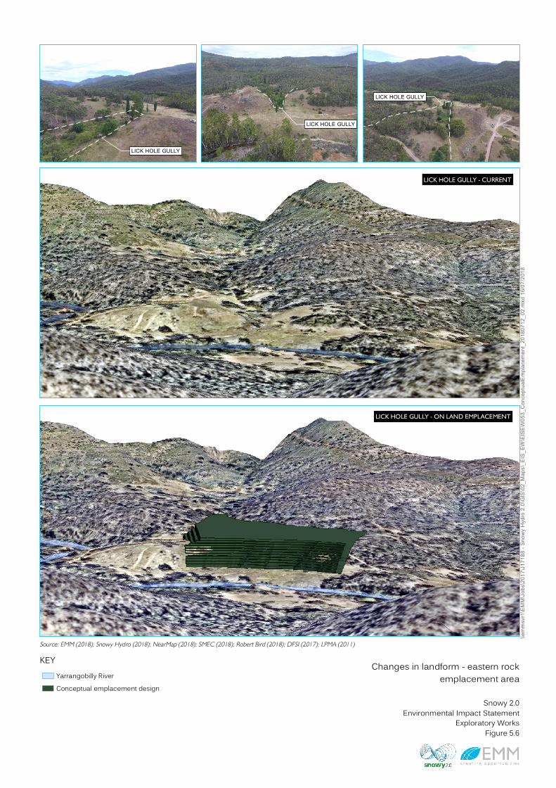
a. On land rock emplacement areas
In consultation with NPWS, the eastern rock emplacement area has been designed with the ability to remain as permanent landform, representing a change to the current landform – Lick Hole Gully. This is shown in Figure 5.6. The conceptual design has been developed to:
• achieve a rehabilitated final landform which is safe, stable, self-sustaining and non-polluting in the long term; and
• address specific environmental risks identified during the design and impact assessment process, including limiting the potential future reactivity of potentially acid forming rock, erosion potential and rehabilitation of the final landform.
\\emm
svr1\
EMM\
Jobs
\2017
\J171
88 - S
nowy
Hyd
ro 2.0
\GIS
\02_M
aps\_
EIS_
EW\EI
SEW0
53_C
once
ptualE
mplac
emen
t_201
8071
2_02
.mxd
16/07
/2018
Source: EMM (2018); Snowy Hydro (2018); NearMap (2018); SMEC (2018); Robert Bird (2018); DFSI (2017); LPMA (2011)KEY Changes in landform - eastern rockemplacement area
Snowy 2.0Environmental Impact StatementExploratory WorksFigure 5.6
LICK HOLE GULLY - ON LAND EMPLACEMENT
LICK HOLE GULLY - CURRENT
Yarrangobilly RiverConceptual emplacement design
LICK HOLE GULLY
LICK HOLE GULLY
LICK HOLE GULLY

EXPLORATORY WORKS FOR SNOWY 2.0 - ENVIRONMENTAL IMPACT STATEMENT 5.3-6
The design features of the eastern rock emplacement which address environmental risks are described in Table 5.7.
Table 5.7 Design features of the eastern rock emplacement to minimise environmental risks
Design element Description Environmental risks addressed
Geometry The stockpile geometry promotes a higher overall stockpile with a smaller top area and increased areas of side batter slope, which will increase potential for infiltration and seepage and minimise runoff to the Yarrangobilly River.
Erosion potential, management of surface flows
Lift height and bench width
The emplacement would be built in 11, 2 m high lifts. Each lift would be comprise two 1 m layers of excavated rock compacted by trafficking and roller compaction, separated from the lift above by a 4 m vegetated bench. Benches will be graded back towards the rock emplacement and bunded so that any runoff from direct rainfall onto the benches and upslope lift will pond against the toe of the above lift. Benches would be vegetated and would use seepage water for vegetation growth, minimising seepage from entering surface and groundwater.
Acid rock drainage, management of surface flows and infiltration
Acid consuming limestone pad and layers
A limestone pad will separate Lick Hole Gully from the overlying potentially acid forming excavated rock, and will separate sub-lateral flow from Lick Hole Gully from the eastern rock emplacement, as well as passively treat existing impacted runoff from historic contamination sources of the former Lobs Hole Mine that flows through Lick Hole Gully. A layer of acid consuming limestone will be placed above each 1 m rock layer to manage geochemical risks, which will act to disrupt the flow of oxygen and infiltration of water, avoiding oxidation of potentially acid forming materials, and limiting discharge to the Yarrangobilly River and groundwater recharge. Limestone layers will provide excess acid neutralising capacity to limit future potential for acid rock drainage.
Acid rock drainage and existing contamination, management of surface flows and infiltration
Batter slope treatment
Batter slopes will be constructed from excavated rock, with any dredged sediment placed away from batter slopes to prevent potential eutrophication of the Yarrangobilly River. The batter slopes will be a combination of exposed excavated rock and vegetated rehabilitation. Erosion potential will be limited through reducing the catchment of each slope face. The nature of emplaced materials (ie drill and blast waste rock) would further limit erosion potential.
Erosion potential, management of surface flows
Soil and vegetation stripping
The soil within Lick Hole Gully has poor fertility, however, it is suitable for treatment of benches to encourage vegetation growth, which will limit erosion potential. Mulched vegetation in addition to the soil would be a valuable source of seed to establish vegetation on the benches.
Erosion potential, management of surface flows
Setback from Yarrangobilly River
A 50 m setback from the Yarrangobilly River promotes the conservation of riparian habitat adjacent to the watercourse.
Impacts to riparian habitat
The western rock emplacement will be a short-term temporary change to landform, and will be used to store excavated materials that have a low geochemical risk and able to be re-used or disposed of within Talbingo Reservoir. Design features to minimise impacts include construction methods that limit compaction, and measures such as establishing a vegetated layer to stabilise the landform. No diversions or drop drains will be required. The design will incorporate a flood protection berm or rock armouring along the northern edge to prevent the risk of the rock emplacement area being entrained in flood waters during a 1 in 500 year flood event.

EXPLORATORY WORKS FOR SNOWY 2.0 - ENVIRONMENTAL IMPACT STATEMENT 5.3-7
ii Residual impact summary
a. Soils and land capability
The overall impact to soil and land capability is expected to be low:
• permanent losses are expected due to the introduction of access infrastructure that will largely be left in place (ie upgraded and new roads and Middle Bay barge ramp);
• net losses are expected due to shallower soil depths of the eastern emplacement area after rehabilitation;
• temporary losses or reduction in soil and land capability are expected at the accommodation camp, portal construction pad, western rock emplacement area and other temporarily disturbed areas; and
• the risk of exposure to naturally occurring asbestos is low, as no road upgrade works are proposed in the 600 m section of Lobs Hole Ravine Road where there is potential for asbestos to occur.
Rehabilitation principles will be designed to minimise impacts and it is expected that temporarily losses or reductions in land capability will largely be reversed through rehabilitation. While the risk of encountering naturally occurring asbestos is low, works intersecting or excavating in areas of potential asbestos will need a site-specific management strategy as a contingency measure.
b. Landforms and land use compatibility
Some changes to landform will occur as a result earthworks for the portal construction pad, accommodation camp, and the eastern emplacement area. However, all activities undertaken as part of Exploratory Works will be rehabilitated and not permanently or substantially alter existing landforms, subject to Snowy 2.0 not proceeding. Engagement with NPWS has identified that the future land use of the Lobs Hole area should be consistent with its current use as a remote recreational campground, and this influenced the design of the final landform of the eastern emplacement area which will be a permanent feature in the landscape.
The eastern rock emplacement area is the primary permanent change to landforms during Exploratory Works. However, the conceptual design of the eastern rock emplacement addresses a number of environmental risks and incorporates rehabilitation principles to minimise impacts to land use compatibility and will have a beneficial recreational outcome.
The accommodation camp, portal construction pad, western rock emplacement would result in temporary changes to landform during Exploratory Works. These areas may be used for the main works of Snowy 2.0 subject to it proceeding. However, should Snowy 2.0 not proceed, these areas would be decommissioned and rehabilitated on completion of Exploratory Works, and the underlying land rehabilitated. General rehabilitation activities for areas temporarily disturbed during Exploratory Works including the accommodation camp, portal construction pad, western rock emplacement area will include:
• decommissioning and removal of all infrastructure and facilities;
• re-shaping of the landform including the use of fill to achieve a landform similar to its original state before construction;

EXPLORATORY WORKS FOR SNOWY 2.0 - ENVIRONMENTAL IMPACT STATEMENT 5.3-8
• rehabilitation of slopes through placement of organic matter and revegetation; and
• fencing and tree guards of revegetated areas to protect it from grazing fauna.
Access infrastructure including upgraded and new roads and barge access infrastructure will largely be left in place, and would constitute a permanent change. Landscape and design considerations for establishing these elements will consider longer term rehabilitation objectives and how these interact with the existing environment, including:
• minimising clearance of native vegetation;
• stockpiling and reuse of soils and cleared organic materials;
• batter stabilisation where required;
• prompt revegetation of cleared areas; and
• incorporation of drainage controls and sedimentation control planting.
While some Exploratory Works elements that remain in perpetuity, such as road infrastructure and the rehabilitated eastern rock emplacement, will slightly alter the character of the area, rehabilitation will minimise the impacts and enhance existing native vegetation.
Key features of the existing landscape, including the former Lobs Hole Mine, historic remnants of Ravine township and native riparian vegetation along the Yarrangobilly River will be avoided. These will continue to be conserved for the benefit of future conservation and recreational land users.
c. Seismic and subsidence impacts
Potential for seismic and subsidence impacts is limited to excavation of the exploratory tunnel. Geological and geotechnical risks have been considered as part of the feasibility study (SMEC 2017) and included consideration of hazards that may affect ground and sub-surface movement. The geotechnical design of the exploratory tunnel and alignment has considered suitable excavation and primary support schemes and construction techniques. To inform this, geotechnical investigations were undertaken at depth at the nominated cavern location, which defined the baseline surface and sub-surface conditions including an assessment of ground behaviour during tunnel excavation along the alignment. The construction method has been developed based on these factors, particularly the known geological in-situ stress and strength conditions.
The drill and blast techniques for excavation will involve smooth blasting, which is a series of closely spaced charged drill holes and fired simultaneously without fracturing the adjacent rock. This produces a final profile with minimal overbreak and minimum stressing and fracturing of the rock beyond the required excavation lines. The exploratory tunnel would be progressively rock bolted or made structurally secure for worker safety. This process would limit broader rock mass movement above and surrounding the tunnel. Consequently, ground and sub-surface movement are expected to be minimal.
The only built feature on the surface above the exploratory tunnel is an access track established for the geotechnical drilling program in the Marica area. There are no other built structures or features in this area. The natural surface features within the project area, including native vegetation and plant communities, soils and surface water resources are discussed in detail in Section 5.1, 5.3 and 5.4 of this EIS. As ground and sub-surface movement are expected to be minimal, subsidence impacts to built or natural surface features are not expected.

EXPLORATORY WORKS FOR SNOWY 2.0 - ENVIRONMENTAL IMPACT STATEMENT 5.3-9
d. Contamination
Except for the adit underlying the eastern rock emplacement area, Exploratory Works has avoided impacts to areas of existing contamination associated with Lobs Hole Mine. The design of the eastern rock emplacement has taken into consideration the presence of contamination at the site (high concentration of metals). Suitable ground preparation strategies such as backfilling, covering or patching of the impacted area will be implemented before emplacement of any rock over the adit.
As previously described (see Table 5.4), the eastern rock emplacement area also addresses potential geochemistry risks by incorporating a number of design measures to avoid and minimise acid generation and contamination. All other construction activities have a low likelihood of resulting in contaminated land and can be managed with standard management measures and controls.
Contamination investigations to date have not assessed potential groundwater contamination. To establish baseline conditions, a baseline groundwater monitoring network will be established in Lobs Hole to measure the background, or up-gradient, conditions, establish baseline conditions in the vicinity of the rock emplacement area footprints, and establish whether groundwater contamination has occurred as a result of historical mining activities. This is discussed further in Section 5.4.
e. Karst systems
The main areas of disturbance with potential to impact geodiversity features within the KNP are along Lower Lobs Hole Ravine Road, which is within the Ravine karst area. Works along Lower Lobs Hole Ravine Road include road upgrades and geophysical and geotechnical investigations within the road. The Yarrangobilly karst area (which includes the Yarrangobilly Caves) is about 8 km north-east of the exploratory tunnel, and no impacts are expected to the karst (including caves) in this area.
Road upgrades to Lobs Hole Ravine Road will be designed to minimise earthworks where possible. As the majority of the features terminate upslope of the road, these features have predominantly been avoided. There is a minor encroachment on the block stream in one section of Lower Lobs Hole Ravine Road, where the existing road has cut through the block stream by some 3.5 m.
Karst features associated with the Devonian strata appear to be minimal and not of high significance at this location. The outcrop is in a disturbed condition and continues to degrade as a result of its exposure. Road improvements may require some removal of fossiliferous rock on the upslope side of the road, and construction works and associated increased heavy vehicle traffic may result in indirect vibration impacts. Further expert opinion could be sought on the significance of the fossils present, however it is likely that removal of fossiliferous rock will simply expose more fossiliferous rock. Removal may also provide an opportunity for expert cataloguing of the fossil suite.
The tufa features identified in the Lobs Hole area are in avoidance areas and will not be disturbed by Exploratory Works.

EXPLORATORY WORKS FOR SNOWY 2.0 - ENVIRONMENTAL IMPACT STATEMENT 5.3-10
5.3.4 Mitigation measures
A summary of the mitigation and management measures that would be implemented for Exploratory Works to minimise and avoid impacts to land resources is provided in Table 5.8. These measures will be incorporated into the CEMP for Exploratory Works.
Table 5.8 Land resources mitigation and management measures
Impact/risk Reference# Measures
Impacts to soil resources
SOIL01 Soil management procedures (including stripping, stockpiling and application) will be implemented as part of the CEMP. The objectives of soil management will be to:
● preserve as much of the topsoil and subsoil as possible; ● prevent contamination; ● ensure soil is not degraded or compacted during construction and following
reinstatement; ● avoid or ameliorate subsoil constraints immediately below topsoils; ● ensure topsoil is not mixed with unsuitable soil and spoil materials; and ● ensure reinstatement of soil horizons in the correct order and depths.
Erosion and sediment transport
SOIL02 Erosion and sedimentation controls will be implemented as part of the Water Management Plan to minimise erosion potential, in particular in areas of dispersive soils, in accordance with the guideline Managing Urban Stormwater, Volume 2A Installation of Services, or equivalent.
Changes to landform and land use
SOIL03 A Landscape Management Plan will be prepared for the rehabilitation of disturbed areas: The Plan will include:
● objectives for landform rehabilitation at each site; ● measures to ensure successful rehabilitation and stabilisation of soils; and ● a soil balance to identify the depths and volume of soils to be re-applied in particular
areas during rehabilitation.
Compatibility of land use post-Exploratory Works
SOIL04 A Final Rehabilitation Strategy will be prepared to guide the long term rehabilitation of the site. Rehabilitation goals and objectives for the domains of the project area will be determined through the final land use.
This strategy will be developed in consultation with NPWS and other relevant government agencies.
Disturbance of existing contamination, including areas of naturally occurring asbestos
CON01 A Contaminated Land Management Plan will be prepared and implemented during construction. The Plan will include:
● management procedures to: - manage areas of known or potential contamination that would be impacted during
Exploratory Works; - manage unexpected finds in the event that unexpected contamination sources are
identified. This would include steps to cease works in the affected area, undertake further investigation to assess the extent, magnitude and type of contaminants and identify appropriate remedial actions.
● Site specific asbestos management plan (AMP) for the identified 600 m section of Lobs Hole Ravine Road where there is potential for asbestos to occur. The plan would be prepared to satisfy the relevant legislative requirements and guidelines and include a procedure for the identification, testing and remediation of areas identified as containing asbestos. The AMP would also include procedures for air monitoring and clearance inspections and reports.

EXPLORATORY WORKS FOR SNOWY 2.0 - ENVIRONMENTAL IMPACT STATEMENT 5.3-11
Table 5.8 Land resources mitigation and management measures
Impact/risk Reference# Measures
Excavated rock management
CON02 The eastern rock emplacement area will be constructed in accordance with the conceptual design presented in Appendix K.
CON03 An Excavated Rock Management Plan will be prepared and implemented during construction. The Plan will include:
● protocols for handling, geochemical testing, classification, storage and disposal/placement of excavated rock will be implemented to ensure that excavated material is appropriately managed; and
● monitoring measures to be included as part of the Surface and Groundwater Monitoring Program, to monitor potential impacts from the placement of excavated rock material.
Geodiversity and karst features
GEO01 Measures to avoid and minimise impacts to geodiversity features will be implemented as part of the CEMP and include:
● installing rock protection measures to protect identified periglacial features and limit direct and indirect impacts to the features as far as possible;
● cataloguing any fossiliferous rock removed during upgrade of Lower Lobs Hole Ravine Road;
● minimising surface water pollution within the Ravine karst catchment by installing erosion and sediment controls to manage water quantity and quality; and
● monitoring the effectiveness of environmental controls during Exploratory Works.