chapter 8 - regional hydrogeology · chapter 8 - regional hydrogeology introduction the physical...
TRANSCRIPT

58
of time, chemical changes within the rock take place. This process is called “metamorphism” and the product, “metamorphic” rock. Metamorphic rocks contain a variety of derived minerals, and often metamorphism occurred under conditions of directional or uneven pressure so that re-crystallisation of minerals within the rock aligned in preferred directions to give a tabular structure. Schist is a metamorphic rock formed in this way. The rock types that form the basement of the Wairau Catchment north of the Wairau River are predominantly schist. There are instances of volcanic intrusions in both rock types. The Red Hills form a “massif’ within the schist of the Northbank. There are also distinctive bands of red coloured rocks within the greywacke and argillite of the Taylor River Catchment. Further south, crystalline rock of Mount Tapuae-o-Uenuku is resistive to erosion and forms the centre of the Inland Kaikoura Range.
Structural settingTectonic activity (earthquakes and fault movement) has played a major part in shaping the landscape of Marlborough, and in particular the Wairau Catchment. The Wairau River flows approximately north then east for some 170 kilometres from its headwaters in the Spencer Mountains near the main divide, to its point of discharge into the Pacific Ocean at Cloudy Bay. The journey the river travels is largely controlled by the geology, in particular a large rift in the earth’s crust
known as the Alpine Fault. The Alpine Fault is the most spectacular geological structure in the country. It can be traced the whole length of the South Island, from Fiordland, along the western flank of the Southern Alps to where it crosses Marlborough as the Wairau Fault. Some 480 kilometres of movement has occurred along the Alpine-Wairau Fault over the last 10 million years or so. As a result, the metamorphic schist which can be found to the north of the Wairau Fault was once situated adjacent to similar rock in Southland.
As the Alpine Fault leaves the Southern Alps northwards of Arthurs Pass it starts to branch out into a number of individual northeast-trending faults (Fig. 8.1). These faults form a regional shear zone that extends from northern Canterbury to Marlborough, known as the Marlborough Fault system (Begg and Johnstone - 2000). This belt is bounded to the north by the Wairau Fault and
Chapter 8 - Regional HydrogeologyIntroductionThe physical attributes of any catchment, including its present day structure and its structural history, are fundamental to any discussion on its water resources. In geological terms, New Zealand is a very young country. The oldest rocks were formed around 500 million years ago during the Cambrian Period however, most of New Zealand’s rocks have been formed in the last 300 million years (Permian Period or younger). The rocks which make up the main mountain ranges of New Zealand were formed in deep ocean basins and trenches, from vast accumulations of sand and mud eroded from adjacent landforms. Rocks formed from sediments such as sand and mud are called “sedimentary”. Rocks which have been formed from molten rock are referred to as “igneous”. A discrete body of rock that has been formed by a distinct natural process of deposition is called a Formation. The most common rock types in Marlborough, greywacke and argillite, are both sedimentary rocks that were formed by heat and pressure compacting and hardening seafloor sediments. Greywacke is formed from compacted sand, and argillite is formed from compacted mud and silt which forms dark coloured bands within the greywacke. When either sedimentary or igneous rocks are subjected to the extremes of heat and pressure over long periods
Figure 8.1: Geological map of the Marlborough region. (John Begg, GNS Science)

59
includes the Awatere, Clarence, Kekerengu and Hope Faults. These faults have formed long valleys, known as rifts, separated by mountain chains.
Over geological time the rifts between successive mountain chains have been infilled with alluvium eroded from the rapidly rising Southern Alps. These sediments consisting of gravels, sands, clays or boulders have been mainly transported by the rivers that follow the main fault traces.
The Marlborough Fault system became active during the Miocene period. This most recent phase of New Zealand’s geological evolution is distinguished by tectonic uplift and mountain building, and is known by geologists as the Kaikoura Orogeny.
During the Kaikoura Orogeny, movements of the rock blocks between these major faults has resulted in the formation of regional scale physical structures called fault angle depressions (Fig. 8.2). Not only are the mountain blocks sliding past each other, but locally they are also being tilted. This is called secondary tectonic movement and is not as significant as the sideways or primary movement along the fault. However it has significant impacts on local drainage systems.
The rock blocks that collectively form the Marlborough Fault system are all being slowly tilted or rotated towards the northwest. This northwest tilt means that the northern part of each block is sinking relative to the land to the south. For example, uplift of the southern Awatere block along the Awatere Fault has caused the main channel of the Wairau River to flow along the northern margin of the Awatere block. As a result, most tributaries join the Wairau River by flowing from south to north.
The northwest tilt of the Marlborough Sounds block has given rise to the drowned valleys that are known as the Marlborough Sounds. Uplift of this same block along the Wairau Fault forms the Richmond Range. Gradual uplift along the Wairau Fault over time has reversed the
direction of flow in the Kaituna River, causing it to flow towards Kenepuru Sound. The same block rotation has also created the Para wetland at the outlet of the Tuamarina River Valley.
In the Awatere Valley, there has been less subsidence than in the Wairau, and also considerably less erosion in the upper catchment. As a result,
the deposits of outwash gravels are much thinner, and older deposits have mostly been eroded away by the Awatere River during successively younger interglacial periods. At the SH1 bridge across the Awatere River, alluvial gravels of the last glaciation (Q2) can be seen overlying Pliocene marine gravels (Starborough Formation). By comparison there is at least a 120 metre thickness of sediment between these two units in the lower Wairau River Valley. Furthermore, alluvial gravels equivalent to the Wairau Aquifer are restricted to the Awatere River channel. This lack of thick permeable interglacial gravels in the Awatere Valley means that water must be sourced from the river rather than the ground.
Climate cyclesMaterial that has been eroded from basement rocks, mostly by rivers and streams, is deposited as mixtures of gravels, sands and silts (alluvium) within valleys and along valley margins. This alluvium is eventually washed down the rivers and reworked, forming thick sedimentary deposits on alluvial and coastal plains such as the Wairau Plain.
These reworked sediments are the primary source of groundwater in Marlborough and most of New Zealand. In general, the best aquifers are those that have had the most alluvial reworking, as the rivers preferentially remove finer material such as clay and silt, leaving coarser gravel material behind.
The intensity and severity of erosion at any time is very closely linked to the prevailing climate. The Pleistocene Period (1.8 million to 10,000 years before present) was characterised by global-scale climatic changes that alternated between glacial and interglacial (warm climate) periods. It was during the Pleistocene that the Wairau Plain began to take its present shape. The alluvial deposits that make up the flood plain and delta (plains area) of the Wairau River were laid down and reworked during this period.
Figure 8.2: Fault angle depression

60
The freezing and thawing of ice sheets in response to climate cycles has caused sea level to vary by 140-160 metres during the last 400,000 years. These sea level fluctuations have had a large influence on the hydrological cycle. During glacial times the coastline was several tens of kilometres offshore from the present day coast and there was almost a land bridge to Wellington.
Rivers also had longer courses and steeper gradients than those of today. Because of intense erosion at the higher altitudes, there were equally massive amounts of eroded material carried seawards by the glaciers, and their meltwater or outwash rivers.
Mean annual temperatures during Pleistocene glacial periods were around 14 degrees colder than those experienced today although during interglacial periods temperatures were about the same as today (possibly a little warmer). The climate during glacial periods was sufficiently severe to discourage the growth of forests, particularly in the upper catchments. Much of the mid to upper catchment area was either completely bare,
or thinly covered with alpine type vegetation. These sparsely vegetated mountains suffered massive erosion during glacial periods, especially in areas where glaciers formed and flowed.
The cold glacial periods of the Pleistocene were characterised by the formation of glaciers in the upper reaches of the Wairau Catchment, and along the top of the Inward Kaikoura Range. Erosion took place on a massive scale. In the Wairau Valley, the eroded debris was carried or pushed down the valley with the glaciers as they advanced. The debris was either retained within the ice of the glacier and deposited as moraine, or carried down river and deposited as glacial outwash gravels.
Over time, these glacial outwash deposits accumulated within the valleys and formed a surface, graded to the sea level of the period. The accumulated sediments that lie beneath an outwash surface are collectively referred to as a glacial outwash formation. Generally each glacial event has both an outwash surface and an outwash formation associated with it.
Figure 8.3: Geological map of the Wairau Plain. Schist of the Marlborough Sounds block is coloured purple while greywacke of the Awatere block is coloured blue. The Wairau fault can be seen to clearly separate these two geological domains. The basement rocks are covered by younger (Pliocene to Miocene) sediments that are typically not water-bearing. These sediments are coloured yellow, orange and brown. The lighter grey to fawn-coloured areas represent the most recent and more productive sediments that have been deposited in the last 300,000 years. (John Begg, GNS Science)
61
In the lower reaches of the main valleys, the temperatures were cold, but there was not permanent ice all year round. Rivers were fed by melt water from the glaciers and there was extensive build up of alluvial gravel deposits on the plains and valley floors. Erosion on the hillsides occurred as a result of periglacial processes caused by the intense freezing and thawing of the earth on a regional scale.
During warmer interglacial periods, glaciers melted and retreated and sea levels rose. As the sea moved inland, fine marine sediments and shells were deposited on the sea floor. These marine units now form the confining layers between the water bearing gravel aquifers.
A warmer climate and more vegetation meant that there was less erosion occurring in the high country. The rivers, which were carrying less sediment load, eroded into the glacial outwash deposits and redeposited gravel, sand and silt in the lower reaches. During this process, terraces were formed in the glacial outwash deposits upstream and the coastal plains began to take shape. As the river channel alternated from north and south across the valleys and plains surface that were being established, these deposits were reworked with the fines being removed from the river channels, leaving gravel strips of high, or of higher permeability than the surrounding area. With these processes occurring during a succession of glacial and interglacial periods, the main alluvial plains were built up.
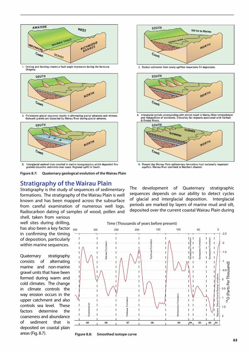
Geology of the Wairau Catchment Geological structure Throughout most of its length the Wairau River flows along the Wairau Fault, which is the dominant geological structure in the catchment. The Wairau Fault separates metamorphic schist of the Marlborough Sounds block to the north from sedimentary greywacke or argillite of the Awatere block to the south (Fig. 8.3).
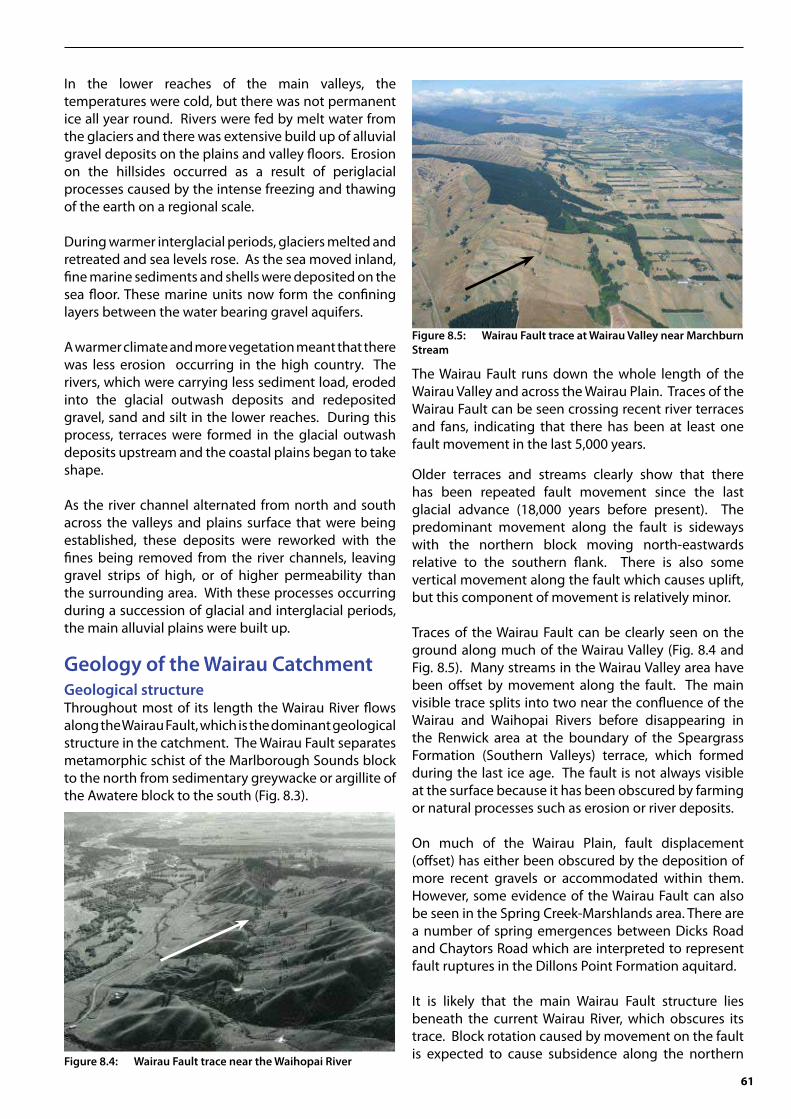
The Wairau Fault runs down the whole length of the Wairau Valley and across the Wairau Plain. Traces of the Wairau Fault can be seen crossing recent river terraces and fans, indicating that there has been at least one fault movement in the last 5,000 years.
Older terraces and streams clearly show that there has been repeated fault movement since the last glacial advance (18,000 years before present). The predominant movement along the fault is sideways with the northern block moving north-eastwards relative to the southern flank. There is also some vertical movement along the fault which causes uplift, but this component of movement is relatively minor.
Traces of the Wairau Fault can be clearly seen on the ground along much of the Wairau Valley (Fig. 8.4 and Fig. 8.5). Many streams in the Wairau Valley area have been offset by movement along the fault. The main visible trace splits into two near the confluence of the Wairau and Waihopai Rivers before disappearing in the Renwick area at the boundary of the Speargrass Formation (Southern Valleys) terrace, which formed during the last ice age. The fault is not always visible at the surface because it has been obscured by farming or natural processes such as erosion or river deposits.
On much of the Wairau Plain, fault displacement (offset) has either been obscured by the deposition of more recent gravels or accommodated within them. However, some evidence of the Wairau Fault can also be seen in the Spring Creek-Marshlands area. There are a number of spring emergences between Dicks Road and Chaytors Road which are interpreted to represent fault ruptures in the Dillons Point Formation aquitard.
It is likely that the main Wairau Fault structure lies beneath the current Wairau River, which obscures its trace. Block rotation caused by movement on the fault is expected to cause subsidence along the northern Figure 8.4: Wairau Fault trace near the Waihopai River
Figure 8.5: Wairau Fault trace at Wairau Valley near Marchburn Stream

62
edge of the Wairau block, and this is the most likely position for the Wairau River to follow. The linearity of the foothills of the Richmond Range also supports this theory, and some spring emergences and stream offsets can be observed along strike (in line) in the Tuamarina area.
Seismic surveys have been carried out at Rarangi by Canterbury University to try and detect any subsurface fault traces (Wilkinson - 2005) and the seismic profiles show the presence of numerous faults within the sedimentary sequence, some of which penetrate the Dillons Point Formation aquitard.
The most pervasive structural feature detected in the seismic profiles is an extensional feature (pull-apart basin) that is centred just south of the hills of the Robertson Range. This structure appears to penetrate the schist basement and is therefore of regional significance. It is most likely however, that the main Wairau Fault structure lies to the south of the seismic survey lines.
Quaternary sedimentsQuaternary sediments are the rocks from where almost all of Marlborough’s groundwater is taken. These sediments represent an extremely thin layer on the earth’s surface, up to 500 metres depth (Fig. 8.6).
Only the most recent sediments are exposed on the surface of the Wairau Plain, and the deeper we drill into the Wairau Basin, the older the sediments become. Sediments exposed at the surface also get progressively older away from the rivers towards the margins of the major valleys. Sediments of different ages of outwash alluvium form distinct terraces on the valley flanks, with higher terraces representing older deposits.
If we follow the surfaces formed by outwash alluvium to the upper reaches of the Wairau Valley, we can find remnants of the glacial sediments from where the outwash was sourced. Glacial sediments are known as
moraine, poorly sorted boulder sediments left behind by actual glacial advances. Several periods of glacial advance can be recognised in the Wairau Valley from terminal moraine deposits. The youngest of these were deposited by small glaciers about 6 kilometres long and are only found in the upper reaches of the catchment. Moraine deposits from the last glacial maxima can be seen further down the upper Wairau Valley near Lake Sedgemere (Suggate - 1965). A moraine of the same age has been deposited by the Rainbow Glacier just downstream of the Rainbow-Wairau junction near the old Rainbow Homestead. From here, an extensive glacial outwash surface covering most of the Wairau Valley can be traced almost to the sea, a distance of some 95 kilometres away. This outwash, known as the “Wairau Surface” (Wellman - 1955), is the only glacial outwash surface in the Wairau Valley that has been traced from its terminal moraine for any significant distance downstream. The top of this surface represents the top of the Speargrass Formation, which was deposited over 12,000 years ago.
Moraines that predate the last glacial advance are found just downstream of Wash Bridge on the flanks of Middle Spur (Rattenbury et al. - 2006). Outwash material from the Waimea and Waimaunga glaciations form the Tophouse and Manuka Formations respectively. These sediments make up the ridges that separate the Southern Valleys, and also provide host material for the Deep Southern Valleys and Deep Wairau Aquifers. Terraces associated with these outwash deposits can be followed along the flanks of much of the Wairau Valley.
The oldest moraine seen in the Wairau Valley can be found to the east of Chrome Stream, just downstream of Middle Spur. This moraine was formed over 350,000 years ago (Rattenbury et al. - 2006), and is older than any of the Quaternary sediments identified by drilling on the Wairau Plain.
Figure 8.6: Geological cross section through the Wairau Plain looking east (Begg and Mazengarb, 1996). Quaternary sediments shaded yellow are compared to the much older basement rocks. Note that the vertical scale is greatly exaggerated; the horizontal distance 36 kilometres. The location of the cross section is shown on the geological map of the Wairau Plain, Figure 8.3.
63
Stratigraphy of the Wairau PlainStratigraphy is the study of sequences of sedimentary formations. The stratigraphy of the Wairau Plain is well known and has been mapped across the subsurface from careful examination of numerous well logs. Radiocarbon dating of samples of wood, pollen and shell, taken from various well sites during drilling, has also been a key factor in confirming the timing of deposition, particularly within marine sequences.
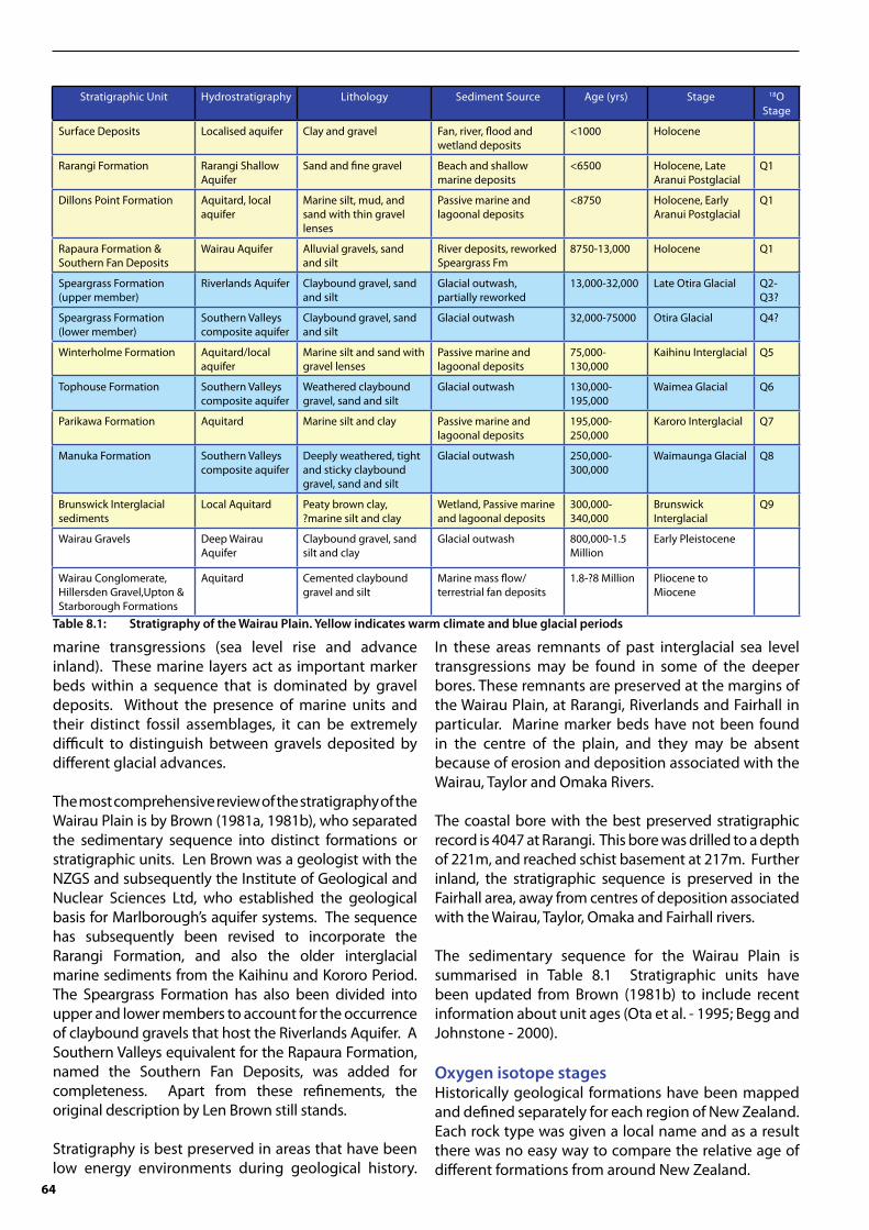
Quaternary stratigraphy consists of alternating marine and non-marine gravel units that have been formed during warm and cold climates. The change in climate controls the way erosion occurs in the upper catchment and also controls sea level. These factors determine the coarseness and abundance of sediment that is deposited on coastal plain areas (Fig. 8.7).
The development of Quaternary stratigraphic sequences depends on our ability to detect cycles of glacial and interglacial deposition. Interglacial periods are marked by layers of marine mud and silt, deposited over the current coastal Wairau Plain during
Figure 8.7: Quaternary geological evolution of the Wairau Plain
-2.5
-2
-1.5
-1
-0.5
0
0.5
1
1.5
2
2.5
20025030035018
Q1Q6Q7Q9 Q8 Q5 Q4 Q3 Q2
Sca
ndan
avia
n
Par
ikaw
aFo
rmat
ion
Win
terh
olm
eFo
rmat
ion
Rap
aura
, D
illon
s P
oint
& R
aran
gi o
rmat
ions
Man
uka
Form
atio
n
Toph
ouse
Form
atio
n
Spe
argr
ass
Form
atio
n
Spe
argr
ass
Form
atio
n
Spe
argr
ass
Form
atio
n
Time (Thousands of years before present)O
(Par
ts P
er T
hous
and)
18150 100 50 0
Figure 8.8: Smoothed isotope curve
64
marine transgressions (sea level rise and advance inland). These marine layers act as important marker beds within a sequence that is dominated by gravel deposits. Without the presence of marine units and their distinct fossil assemblages, it can be extremely difficult to distinguish between gravels deposited by different glacial advances.
The most comprehensive review of the stratigraphy of the Wairau Plain is by Brown (1981a, 1981b), who separated the sedimentary sequence into distinct formations or stratigraphic units. Len Brown was a geologist with the NZGS and subsequently the Institute of Geological and Nuclear Sciences Ltd, who established the geological basis for Marlborough’s aquifer systems. The sequence has subsequently been revised to incorporate the Rarangi Formation, and also the older interglacial marine sediments from the Kaihinu and Kororo Period. The Speargrass Formation has also been divided into upper and lower members to account for the occurrence of claybound gravels that host the Riverlands Aquifer. A Southern Valleys equivalent for the Rapaura Formation, named the Southern Fan Deposits, was added for completeness. Apart from these refinements, the original description by Len Brown still stands.
Stratigraphy is best preserved in areas that have been low energy environments during geological history.
In these areas remnants of past interglacial sea level transgressions may be found in some of the deeper bores. These remnants are preserved at the margins of the Wairau Plain, at Rarangi, Riverlands and Fairhall in particular. Marine marker beds have not been found in the centre of the plain, and they may be absent because of erosion and deposition associated with the Wairau, Taylor and Omaka Rivers.
The coastal bore with the best preserved stratigraphic record is 4047 at Rarangi. This bore was drilled to a depth of 221m, and reached schist basement at 217m. Further inland, the stratigraphic sequence is preserved in the Fairhall area, away from centres of deposition associated with the Wairau, Taylor, Omaka and Fairhall rivers.
The sedimentary sequence for the Wairau Plain is summarised in Table 8.1 Stratigraphic units have been updated from Brown (1981b) to include recent information about unit ages (Ota et al. - 1995; Begg and Johnstone - 2000).
Oxygen isotope stagesHistorically geological formations have been mapped and defined separately for each region of New Zealand. Each rock type was given a local name and as a result there was no easy way to compare the relative age of different formations from around New Zealand.
Stratigraphic Unit Hydrostratigraphy Lithology Sediment Source Age (yrs) Stage 18O Stage
Surface Deposits Localised aquifer Clay and gravel Fan, river, flood and wetland deposits
<1000 Holocene
Rarangi Formation Rarangi Shallow Aquifer
Sand and fine gravel Beach and shallow marine deposits
<6500 Holocene, Late Aranui Postglacial
Q1
Dillons Point Formation Aquitard, local aquifer
Marine silt, mud, and sand with thin gravel lenses
Passive marine and lagoonal deposits
<8750 Holocene, Early Aranui Postglacial
Q1
Rapaura Formation & Southern Fan Deposits
Wairau Aquifer Alluvial gravels, sand and silt
River deposits, reworked Speargrass Fm
8750-13,000 Holocene Q1
Speargrass Formation (upper member)
Riverlands Aquifer Claybound gravel, sand and silt
Glacial outwash, partially reworked
13,000-32,000 Late Otira Glacial Q2-Q3?
Speargrass Formation (lower member)
Southern Valleys composite aquifer
Claybound gravel, sand and silt
Glacial outwash 32,000-75000 Otira Glacial Q4?
Winterholme Formation Aquitard/local aquifer
Marine silt and sand with gravel lenses
Passive marine and lagoonal deposits
75,000-130,000
Kaihinu Interglacial Q5
Tophouse Formation Southern Valleys composite aquifer
Weathered claybound gravel, sand and silt
Glacial outwash 130,000-195,000
Waimea Glacial Q6
Parikawa Formation Aquitard Marine silt and clay Passive marine and lagoonal deposits
195,000-250,000
Karoro Interglacial Q7
Manuka Formation Southern Valleys composite aquifer
Deeply weathered, tight and sticky claybound gravel, sand and silt
Glacial outwash 250,000-300,000
Waimaunga Glacial Q8
Brunswick Interglacial sediments
Local Aquitard Peaty brown clay, ?marine silt and clay
Wetland, Passive marine and lagoonal deposits
300,000-340,000
Brunswick Interglacial
Q9
Wairau Gravels Deep Wairau Aquifer
Claybound gravel, sand silt and clay
Glacial outwash 800,000-1.5 Million
Early Pleistocene
Wairau Conglomerate, Hillersden Gravel,Upton & Starborough Formations
Aquitard Cemented claybound gravel and silt
Marine mass flow/ terrestrial fan deposits
1.8-?8 Million Pliocene to Miocene
Table 8.1: Stratigraphy of the Wairau Plain. Yellow indicates warm climate and blue glacial periods

65
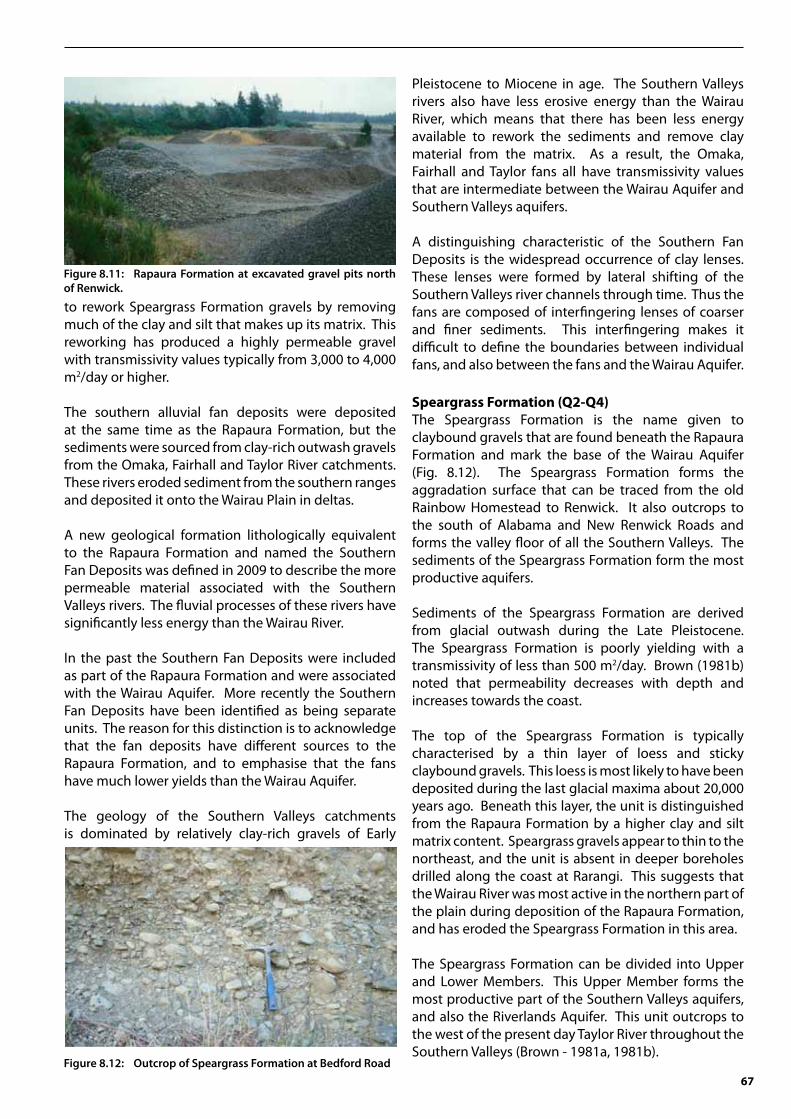
The oxygen isotope age was introduced to overcome the confusion of large numbers of names for geological formations with the same age. Each rock type is assigned a Q number from 1 to 21, with higher numbers representing older rock types. The method only applies to the relatively young sedimentary rocks deposited during the Pleistocene period which contain microfossils. The actual ages are based on the oxygen isotope ratios (16O and 18O) contained in the rocks.
Throughout the earth’s history the ratio of stable oxygen isotopes in the atmosphere has changed with the climate (Fig. 8.8). The heavier 18O isotope is relatively abundant in the oceans during colder periods when the ice sheets are larger and the sea floor is low. Negative values (18O deficiency) represent periods of warmer climate and high sea level. In general, these periods are distinguished by odd Q-numbers (Q5, Q7, Q9 etc), and are represented by marine or peaty units in the Wairau Basin geological record.
The global oxygen isotope record has been established by deep sea drilling of the sea floor and analysing the 18O composition of foraminifera (a type of microfossil) in seafloor sediments. While the foraminifera are growing, oxygen within the oceans is absorbed within their carbonate skeletons. When the foraminifera die they sink to the sea floor where they eventually become buried and preserved in the geological record.
The oxygen isotope nomenclature has been widely adopted in New Zealand, as it is a convenient way to correlate Pleistocene stratigraphy between different regions.
Marlborough geological formationsRarangi Formation (Q1b)The Rarangi Formation is a new unit to describe recent sediments that host the very important Rarangi Shallow Aquifer. The Rarangi Formation consists of marginal marine sand, gravel and minor alluvium that represent a phase of advancing coastline deposition (progradation) since sea levels stabilised 6,500 years ago. Rarangi Formation sediments have previously been classified as the upper member of the Dillons Point Formation (Brown - 1981b). However, the Rarangi deposits represent an environment of much higher energy, which makes it distinct from the more passive Dillons Point Formation marine silt and non-marine clay in the coastal area. Furthermore, the thickness and distribution of the Rarangi Formation on the northeastern Wairau Plain is sufficient to host a distinct aquifer, which warrants a new unit on hydrostratigraphic grounds.
The Rarangi Formation consists of sand and fine gravel that is commonly referred to as pea gravel. It is predominantly derived from longshore drift (Pickrill - 1976). The coastal origin of the sediments is evident in the abundance of shell fragments and a distinctive geomorphology of paleo-beach ridges deposited in echelon, parallel to the coast.
The thickness of the Rarangi Formation is up to 15 metres north of the Wairau Diversion. In general, the unit thins to the west and to the south. This suggests that tectonic subsidence is occurring in the Rarangi area adjacent to the Richmond Range. Ota et al. (1995) record up to seventeen metres of beach deposits at the Wairau Bar (Well 1733). This suggests that the Wairau River mouth has eroded into the upper surface of the Dillons Point Formation during the last 6500 years.
A detailed well log was created for MDC well 4349 at North Rarangi (Fig. 8.9). The top five metres of the sequence consists of recent beach deposits of pebbles within a fine sand matrix. Below this, two graded bed sequences are identified which are also evident in well logs for the Rarangi area. Many of the shallow wells in the area are excavated to the base of the upper graded bed sequence.
The contact with the underlying Dillons Point Formation is marked by the presence of fine sand or silt. In places the bottom 50-100 millimetres of the Rarangi Formation consists of carbonate cemented sand and fine gravel.
Figure 8.9: Well log for the Rarangi Formation well 4349

66
Dillons Point Formation aquitard (Q1)The Dillons Point Formation is the name given to the marine silt sequence that overlies the coastal Wairau Aquifer (Brown - 1981b). Well drillers sometimes refer to this unit as “Papa”. This silt was deposited in a lagoon or passive marine environment.
The dominance of clay and silt within the unit means that it acts as an aquitard or confining layer to the Wairau Aquifer. The unit extends from the coast as far inland as Bells Road. The marine sediments can be found close to the surface in western parts of Blenheim.
Detailed stratigraphic descriptions and a depositional history of the Dillons Point Formation, including radiocarbon dates, are presented in Ota et al. (1995). Overall, the Dillons Point Formation tends to coarsen with depth from fine silt and clay near the surface to silty sand near the base. The bottom 1-2 metres is typically a mixture of silt, sand and shingle. Gravel lenses can also be found throughout the sequence (White - 2009). These lenses appear to represent old outwash deltas of the Wairau, Omaka and Taylor Rivers. Fossil shells are present throughout the Dillons Point Formation and whole shells may often be found in borehole cuttings. Most of the fossils are bivalves (a type of mollusc), although some gastropods (snails) can also be found.
There is little hydraulic information available for the Dillons Point Formation. The large number of drains located east of Blenheim suggests that the unit does not act as an aquiclude, but is leaky. This is supported by the mass balance of the groundwater system (Davidson and Scott - 1994; Wilson - 2008). Aquitard leakage is also evident in potentiometric contours, which show that there is some interaction between the Wairau Aquifer and Taylor River, at least within the Blenheim area.
Aquitard leakage can be detected in the drawdown curve of aquifer tests if accurate monitoring results are available. Drawdown initially follows a typical `Theis curve’ which gradually flattens in response to an external recharge source. This flattening is evidence of vertical leakage, most probably from the Dillons Point Formation. The leakage coefficient (K’/B’) of the aquitard is difficult to estimate accurately because of tidal interference effects. Aquifer test results indicate that K’/B’ values range from 0.2 days-1 along the leading edge of the aquitard to 2 x 10⁻⁴ days-1 at the coastline. Results suggest a vertical hydraulic conductivity for the aquitard of 10 m/day to 0.002 m/day.
Water quality in the Dillons Point Formation is generally poor because of the marine origin of the sediments and the long residence time of water leaking through the sediments. Groundwater at the Wairau Aquifer margins is interpreted to be partially mixed with water drawn down from the Dillons Point Formation and local rainfall. This mixing produces a water composition that is high in dissolved solids and relatively enriched in chloride, calcium and magnesium compared to unmixed Wairau Aquifer water. Higher rates of natural groundwater through-flow below the centre of the Wairau Plain near the coast have flushed a higher proportion of the residual salts from the sediments relative to the Riverlands or Rarangi areas.
Rapaura Formation, and Southern Fan Deposits (Q1)Two main depositional sequences of Holocene gravels can be identified on the Wairau Plain. High-yielding alluvial gravels associated with the Wairau River are known as the Rapaura Formation. More clay-rich alluvial fan deposits are found along the southern part of the Wairau Plain. The Rapaura and fan deposits are difficult to distinguish in well logs, but there is a clear difference in terms of well yield. The boundary between the Rapaura Formation and Southern Fan Deposits lies between Middle and New Renwick Roads, with sediments to the north being associated with the Wairau River. The boundary is most apparent at Renwick where the edge of an alluvial terrace can be seen today to the north of Old Renwick Road (Fig. 8.10). Apart from this terrace there are no distinct geological markers to separate the Wairau sequence from the Omaka sequence to the south. Rapaura Formation is the name given by Brown (1981b) to describe all fluvial (river-derived) sediments deposited on the Wairau Plain since the last (Otiran) glaciation (Fig. 8.11). A warming climate at the end of the Otira Glaciation reduced the sediment load on the Wairau and Omaka rivers. This allowed these rivers to cut into the Speargrass terrace surface, and
Figure 8.10: Speargrass Formation terrace above Rapaura Formation at Bedford Road.
67
to rework Speargrass Formation gravels by removing much of the clay and silt that makes up its matrix. This reworking has produced a highly permeable gravel with transmissivity values typically from 3,000 to 4,000 m2/day or higher. The southern alluvial fan deposits were deposited at the same time as the Rapaura Formation, but the sediments were sourced from clay-rich outwash gravels from the Omaka, Fairhall and Taylor River catchments. These rivers eroded sediment from the southern ranges and deposited it onto the Wairau Plain in deltas.
A new geological formation lithologically equivalent to the Rapaura Formation and named the Southern Fan Deposits was defined in 2009 to describe the more permeable material associated with the Southern Valleys rivers. The fluvial processes of these rivers have significantly less energy than the Wairau River.
In the past the Southern Fan Deposits were included as part of the Rapaura Formation and were associated with the Wairau Aquifer. More recently the Southern Fan Deposits have been identified as being separate units. The reason for this distinction is to acknowledge that the fan deposits have different sources to the Rapaura Formation, and to emphasise that the fans have much lower yields than the Wairau Aquifer.
The geology of the Southern Valleys catchments is dominated by relatively clay-rich gravels of Early
Pleistocene to Miocene in age. The Southern Valleys rivers also have less erosive energy than the Wairau River, which means that there has been less energy available to rework the sediments and remove clay material from the matrix. As a result, the Omaka, Fairhall and Taylor fans all have transmissivity values that are intermediate between the Wairau Aquifer and Southern Valleys aquifers.
A distinguishing characteristic of the Southern Fan Deposits is the widespread occurrence of clay lenses. These lenses were formed by lateral shifting of the Southern Valleys river channels through time. Thus the fans are composed of interfingering lenses of coarser and finer sediments. This interfingering makes it difficult to define the boundaries between individual fans, and also between the fans and the Wairau Aquifer.
Speargrass Formation (Q2-Q4)The Speargrass Formation is the name given to claybound gravels that are found beneath the Rapaura Formation and mark the base of the Wairau Aquifer (Fig. 8.12). The Speargrass Formation forms the aggradation surface that can be traced from the old Rainbow Homestead to Renwick. It also outcrops to the south of Alabama and New Renwick Roads and forms the valley floor of all the Southern Valleys. The sediments of the Speargrass Formation form the most productive aquifers. Sediments of the Speargrass Formation are derived from glacial outwash during the Late Pleistocene. The Speargrass Formation is poorly yielding with a transmissivity of less than 500 m2/day. Brown (1981b) noted that permeability decreases with depth and increases towards the coast.
The top of the Speargrass Formation is typically characterised by a thin layer of loess and sticky claybound gravels. This loess is most likely to have been deposited during the last glacial maxima about 20,000 years ago. Beneath this layer, the unit is distinguished from the Rapaura Formation by a higher clay and silt matrix content. Speargrass gravels appear to thin to the northeast, and the unit is absent in deeper boreholes drilled along the coast at Rarangi. This suggests that the Wairau River was most active in the northern part of the plain during deposition of the Rapaura Formation, and has eroded the Speargrass Formation in this area.
The Speargrass Formation can be divided into Upper and Lower Members. This Upper Member forms the most productive part of the Southern Valleys aquifers, and also the Riverlands Aquifer. This unit outcrops to the west of the present day Taylor River throughout the Southern Valleys (Brown - 1981a, 1981b).
Figure 8.12: Outcrop of Speargrass Formation at Bedford Road
Figure 8.11: Rapaura Formation at excavated gravel pits north of Renwick.

68
The Lower Member underlies both the Riverlands and Wairau Aquifers. The Upper Member of the Speargrass Formation represents a phase of deposition that is older than the Rapaura Formation and Southern Fan Deposits. The Upper Member was most probably deposited by the Taylor and Wairau Rivers during the mid Otiran Glacial period. These sediments have not been reworked to the same extent as the more recent Rapaura Formation, hence their lower yield compared to the Wairau Aquifer.
The Upper Speargrass Formation would have formed a higher river terrace at the end of the Otiran glacial period, prior to deposition of the Rapaura Formation. The Rapaura gravels have subsequently infilled the river plain below the terrace at the onset of the last postglacial period. The alluvial plain was then levelled to form a peneplain (regional terrace surface) during the postglacial marine transgression, prior to deposition of the Dillons Point Formation.
Kaihinu marine sediments (Winterholme Formation) (Q5)Towards the coastline on the edges of the Wairau Plain, some deeper bores have intercepted marine sediments underlying the Speargrass Formation. These sediments were deposited during the Kaihinu Interglacial period. The Kaihinu sediments also outcrop at Kekerengu, where Lensen (1962) named them the Winterholme Formation. The Kaihinu marine sediments are similar to the Dillons Point Formation, and consist predominantly of fine grained marine sand and blue silt. Water bearing gravel lenses are common within this deeper unit and are typically thicker than those found in the Dillons Point Formation.
At Riverlands the bores 1913 and 3745 intercepted the Winterholme Formation at depths of 48 metres and 41 metres respectively. The base of the marine sediments was not reached in either of these bores, which showed the unit to be at least 32 metres thick.
At Rarangi, the Winterholme Formation is intercepted in several bores, of which three drilled through the base of the unit. The marine unit is about 36 metres thick at Rarangi and can be traced inland to wells at Tuamarina.
It is difficult to trace Winterholme Formation further inland from the coast, mainly because the sequence is inundated with gravels from the Wairau River and Taylor River fan. However, it can be traced with certainty to the Athletic Park well, and also to wells along New Renwick Road at Fairhall as far inland as Brancott Road. The marine unit is intercepted in wells 3278, 3291, and 3310 at depths ranging from 20 metres to 34 metres respectively. At Fairhall the unit has a thickness of up to 15m and thins inland.
There are no traces of this unit in wells further north, or north of Athletic Park. It seems that the Winterholme marine sediments have been removed from the centre of the Wairau Plain by the Omaka, Fairhall and Wairau Rivers. The eroded material has subsequently been replaced with Rapaura and Speargrass Formation gravels.
Tophouse Formation (Q6)The Tophouse Formation represents glacial outwash fan deposits that are mantled over the Manuka and older formations. These sediments are the Marlborough correlative of the Linwood Gravel of the Canterbury Plains where they provide a composite aquifer. The Tophouse Formation hosts the mid-depth Southern Valleys aquifers. The Tophouse Formation consists of slightly weathered brown gravel, sand and silt, which is mainly derived from greywacke. The unit is markedly less weathered and dissected than the deeper Manuka Formation. It is difficult to identify the base of the Tophouse Formation without the presence of the overlying Kaihinu marine sediments. Only a thin cover of loess separates the two units (up to 1m), and careful well logging is required to detect the subsurface contact (Fig. 8.13).Figure 8.13: Outcrop of Tophouse Formation at Benmorven
Road
Figure 8.14: Bluffs of Manuka Formation near Lake Timara

69
Figure 8.16: Outcropping Hillersden Gravel exposed at SH1 Road cutting
Figure 8.15: Outcropping Upton Formation at Pukapuka Stream below Weld Pass
The upper surface of the Tophouse Formation is highly undulating in localities where it has been deposited on top of the Manuka Formation. Remnant fans of Tophouse Formation outcrop around the edges of the Manuka Formation ridges that separate the Southern Valleys.
The Tophouse Formation is present at the coastline, and Winterholme marine silts in well 4047 at Rarangi from 72 to 129 metres depth. Observed thickness is 29 metres at the coast, and varies from about 40 to 70 metres at Fairhall. Thickness is expected to be even more variable in localities where the bounding marine aquitards are absent.
Karoro marine sediments (Parikawa Formation) (Q7)The Karoro Marine sediments represent marine silts deposited during the Karoro interglacial period. Kahini marine sediments outcrop inland from Kekerengu, where Lensen (1962) named them the Parikawa Formation. To date 4047 at Rarangi, is the only coastal bore to have intercepted the Parikawa Formation. The unit is present as four metres of grey clay from 101 to 104 metres depth.
Parikawa Formation can be traced as far inland as Fairhall Cemetery on New Renwick Road. Wells 3291, 3310, 3151, 3278 and 3287 at Fairhall intercept Karoro marine silts at depths of around 75 to 92 metres. The thickness of the unit varies from 5 metres to 20 metres in bores where the marine sediments can be identified. Marine sediments are also present in bores at Athletic Park, and at the hospital. In the latter bore, the continuity of blue clays in the log makes it difficult to distinguish the Parikawa Formation from the deeper Brunswick Interglacial sediments and Wairau Gravels.
Manuka Formation (Q8)The Manuka Formation outcrops at the top of the northeasterly trending ridges that separate the Southern Valleys (Fig. 8.14). Like the Tophouse Formation, these sediments represent glacial outwash fans that have been eroded and mantled with loess. In the Southern Valleys, the topography of the upper surface of the Manuka Formation is highly undulating. The Manuka Formation hosts the deeper of the Southern Valleys aquifers.
In the absence of the marine sediments of the Parikawa Formation, the upper contact of the Manuka Formation may be difficult to detect at depth. The unit is bounded by marine sediments and peat layers in wells 3291 and 3287 at Fairhall, where the unit is around 20 metres thick, and also in 4047 at Rarangi where it is 24 metres thick. The terrestrial contact is marked by up to three metres of loess. Manuka Formation is distinguished from the Tophouse Formation by the presence of more deeply weathered yellow-brown greywacke gravel, and also a higher sand and clay content. At Rarangi, Manuka Formation claybound gravels are distinctly tight and sticky, more so than the overlying Tophouse and Speargrass Formations.
Brunswick interglacial sediments (Q9)Brunswick Interglacial sediments are recognised on the Canterbury Plain as the Shirley Formation, which consist of interglacial marine sediments. The extent and continuity of the Brunswick sediments on the Wairau Plain is currently not well defined.
The Brunswick Interglacial marine sediments can be identified as a strong reflector at about 120 metres depth in a seismic profile carried out to the south of Rarangi Road (Wilkinson - 2005). This reflector is present in well 4047 as 17 metres of grey clay at 129 metres depth.

70
Correlatives are identified in bores 3291, 3287 and 3278 on New Renwick Road at Fairhall. The unit is interpreted to be present as five to ten metres of blue-grey mud or sand found at around 110 to 120 metres depth.
Wairau Gravels Formation The Wairau Gravels Formation hosts what is commonly known as the Deep Wairau Aquifer. The Wairau Gravels can be identified in the subsurface by a marked change from deeply weathered yellow-brown gravel of the Manuka Formation to unweathered grey-blue gravel with occasional peaty clay lenses.
The latest geological mapping (Begg and Johnston - 2000) does not differentiate the Wairau Gravels and includes them within the Hillersden Gravel unit. The northerly trending ridges that separate the Southern Valleys previously mapped by Brown are remapped as mostly Hillersden Formation. Provision is made in the accompanying text for the possibility that remnants of younger, Mid Pleistocene gravels (Wairau Gravels Formation), may be present.
Gravels can be seen to underlie Brunswick Interglacial sediments and overlie schist bedrock in a seismic profile carried out to the south of Rarangi Road (Unit six of Wilkinson, 2005). The nature of these gravels is uncertain, but it is most likely that they represent or are correlatives of the Wairau Gravels Formation. While difficult to detect as surface outcrop, the Wairau Gravels have been clearly identified in several deep bores along
the southern margin of the Wairau Plain between Wairau Hospital and Renwick. Carbon dates of peat samples taken from bores 3287 and 3278 indicate a Mid Pleistocene deposition age of 0.8 to 1.3 million years before present.
The climate at this time was warm and temperate and the Wairau Plain was covered in wetlands with broadleaf and podocarp forest. The dating shows that an unconformity or erosion surface that is found at the top of the Wairau Gravels represents a depositional hiatus of 350,000 to 400,000 years.
Pliocene and Miocene age sedimentsThe Wairau Conglomerate and Hillersden Gravel form the northern edge of the Wither Hills, while the Upton Formation forms the Vernon Hills. The three units all onlap onto greywacke and look superficially similar but have different depositional environments and ages. Exploration for groundwater in these units has so far been unsuccessful, and they are not known to be water-bearing. These units effectively mark the hydrogeological basement of the Wairau Plain. The Upton Formation consists of a poorly sorted marine conglomerate that is Late Miocene in age (Fig. 8.15). Large outcrops of Upton Formation can be seen at a quarry next to the Pukapuka Stream bridge at SH1 on the way to Weld Pass. When it is exposed to rainfall the Upton Formation weathers into flutes or pinnacles, which can form spectacular outcrops. The Upton Formation is overlain by the Wairau Conglomerate, a very similar looking thickly bedded marine conglomerate of Pliocene age. Above the Wairau Conglomerate lies the Early Pleistocene Hillersden Gravel, which dominates the Wither Hills.
Figure 8.17: Outcropping Starborough Formation siltstone - Awatere River bed
Figure 8.18: Uplift and subsidence of the Wairau Plain
-150
-140
-130
-120
-110
-100
-90
-80
-70
-60
-50
-40
-30
-20
-10
0
10
20
300 50 100 150 200 250 300 350
Elev
atio
n (m
am
sl)
Age (thousands of years)
0838 Blenheim0949 Blenheim3287 Fairhall3291 Fairhall3310 Fairhall3327 Rarangi4047 Rarangi1913 Riverlands3270 Tuamarina
Q1 Q6 Q7 Q9Q8Q5Q4Q3Q2
Spe
agra
ss
Dill
ons
Poi
nt
Win
terh
olm
e
Toph
ouse
Par
ikaw
a
Man
uka
Bru
nsw
ick
Inte
rgla
cial

71
This unit is a claybound greywacke-derived terrestrial gravel that may be difficult to distinguish from the Wairau Gravel Formation in outcrop. The Hillersden gravel is best exposed in a SH1 road cutting at Vernon where weak bedding planes can be seen to dip in a northerly direction (Fig. 8.16).
Further south in the Awatere Valley Quaternary gravels form a thin veneer over Pliocene and Miocene sediments. The Awatere River carves its way through marine sandstone of the Starborough Formation, which is Pliocence in age. Starborough Formation sandstone also forms the hills between the Awatere Valley and Ward. To the south, the Starborough Formation is underlain by Upton Formation (Fig. 8.17) and the older Medway Formation. The latter consists of marine conglomerate sandstone and silt.
Wairau basin sedimentation and subsidence ratesThe thickness of different sedimentary units varies both vertically and laterally on the Wairau Plain. Sedimentation rates vary in different locations and units, and basin subsidence occurs in response to the loading of new sediments. We can understand how the Wairau Basin has evolved by comparing the elevation and depth of each formation at different locations on the Wairau Plain.
Elevations of lower and upper surfaces of marine formations act as markers for the respective rising and falling of sea levels through time. The thickness between these markers provides an estimate of the deposition rate. The elevation of the upper marine surface relative to sea level is an indicator of the rate of uplift or subsidence for the top of each unit.
Subsidence of the lower marine surface is measured relative to the elevation at the furthest extent of the Dillons Point Formation which is assumed to represent an age of 6,500 years. Along the coastline the base of the Dillons Point Formation has been dated at 8,750 years, at which time the sea level was about six metres below its present elevation. All sediments are subject to compaction, particularly the marine units which does introduce some error into any estimation of subsidence and sedimentation rates, particularly for younger units.
The relative rates of sedimentation and subsidence can be seen when marker horizon depths for deeper wells are plotted against the intersection age (Fig. 8.18). There is a lack of lithological (sediment) dates on the Wairau Plain, so the curves are interpretations based on correlations between marine units.
The slope between marker horizons indicates the rate of deposition for that unit. The following conclusions can be reached: • A steeper slope indicates a more rapid rate of sedimentation. • As expected, the rate of gravel deposition decreases towards the coastline. • Sedimentation rates were greatest during deposition of the Manuka Formation. • The rate of Speargrass Formation deposition was very low compared to the other gravel units. • The rate of basin subsidence has been greatest along the coastline and in the centre of the plain where the sedimentary sequence is thickest. • Subsidence rates have been particularly high since the last marine transgression at the top of the Wairau Aquifer.
At Riverlands and Rarangi the subsidence rate is about 2.4 and 2.8 mm per year respectively, while 3.4 mm per year can be measured at the Wairau Bar. Ota et al. estimate that about 40% of this subsidence can be accounted for by compaction of the Dillons Point Formation.
The average subsidence rate at the coast for older units has been 0.4 to 0.6 mm per year. For comparison, subsidence rates of 0.6-0.8 mm per year have previously been estimated for the Lower Hutt aquifer at Petone (Begg and Mazengarb - 1996). The maximum net subsidence that has occurred over the last 340,000 years is about 150m along the coastline. From the limited information available, it appears that net subsidence at Riverlands is slightly greater (by 0.1mm per year) than at Rarangi. This rate of subsidence at the coast has been about double the rate further inland at Tuamarina and Blenheim (0.3-0.35 mm per year). The main reason for this is that sedimentary sequence at the coast is thicker, particularly the marine units.
Further inland at Fairhall, subsidence of the Winterholme and Dillons Point Formations has been countered by uplift in the Vernon block in the vicinity of the Southern Valleys. Net subsidence is greatest in the Parikawa and Brunswick marine units, which consistently record 0.3 mm per year.
At Fairhall the Dillons Point and Winterholme Formations are above present day sea level, indicating the some uplift has occurred in this area. Wells 3310 and 3151 show that the uplift rate has been about 0.05 mm per year since sea levels stabilised about 6,500
72
years ago. There has been no net vertical movement at Blenheim during this period.
In summary, the rate of gravel deposition is greatest in the western part of the Wairau Plain. The Manuka and Tophouse Formations were deposited very rapidly while the rate of Speargrass Formation deposition is very low. Subsidence has been greatest along the coastline and on the centre of the Plain while uplift has been greatest in the vicinity of the Southern Valleys.
Referencesbal, a.a., 1996. valley fillS aNd coaStal cliffS buried beNeatH
aN alluvial PlaiN: evideNce froM variatioN of PerMeabilitieS iN gravel aQuiferS, caNterbury PlaiNS, New ZealaNd. JourNal of Hydrology (NZ), 35(1):1-27.
begg, J. g. aNd JoHNStoNe, M.r. (coMPilerS), 2000. geology of tHe welliNgtoN area. iNStitute of geological aNd Nuclear ScieNceS 1:250 000 geological MaP 10. iNStitute of geological aNd Nuclear ScieNceS, lower Hutt, 1 SHeet + 64P.
begg, J.g. aNd MaZeNgarb, c., 1996. geology of tHe welliNgtoN area: Scale 1:50,000. iNStitute of geological aNd Nuclear ScieNceS geological MaP 22, lower Hutt.
browN, l. J., 1981a. water well data NortHerN MarlborougH, Part SHeet P28 wairau PlaiN (geology aNd water wellS), 1:25000. New ZealaNd geological rePort 93.
browN, l.J., 1981b. late QuaterNary geology of tHe wairau PlaiN, MarlborougH, New ZealaNd. New ZealaNd JourNal of geology aNd geoPHySicS 24: 477-490.
cuNliffe, J.J., 1988. water aNd Soil reSourceS of tHe wairau voluMe two: grouNdwater. MarlborougH catcHMeNt aNd regioNal water board, 107P.
davidSoN, P.w., aNd Scott, d., 1994. wairau aQuifer reSource aNd iSSueS. tecHNical rePort PrePared for MarlborougH diStrict couNcil.
KruSeMaNN, g.P. aNd de ridder, N.a., 1970. aNalySiS aNd evaluatioN of PuMPiNg teSt data. iNterNatioNal iNStitute for laNd reclaMatioN aNd iMProveMeNt, 200P.
leNSeN, g.J., 1962. SHeet 16: KaiKoura, geological MaP of New ZealaNd. dSir, welliNgtoN.
logaN, J. 1964. eStiMatiNg traNSMiSSivitieS froM routiNe teStS of waterwellS. grouNdwater 2: 35-37.
ota, y., browN, l.J., berryMaN, K.r., fuJiMori, t., MiyaucHi, t., 1995. vertical tectoNic MoveMeNt iN NortHeaSterN MarlborougH: StratigraPHic, radiocarboN, aNd Paleoecological data froM HoloceNe eStuarieS. New ZealaNd JourNal of geology aNd geoPHySicS 38: 269-282.
rae, S.N. (ed.), 1987. water aNd Soil reSourceS of tHe wairau voluMe oNe: water reSourceS. MarlborougH catcHMeNt aNd regioNal water board, 301P.
ratteNbury, M.S., towNSeNd, d.b., aNd JoHNStoNe, M.r. (coMPilerS), 2006. geology of tHe KaiKoura area. iNStitute of geological aNd Nuclear ScieNceS 1:250 000 geological MaP 13. iNStitute of geological aNd Nuclear ScieNceS, lower Hutt, 1 SHeet + 70P.
raZacK, M.d. aNd HuNtley, d., 1991. aSSeSSiNg traNSMiSSivity froM SPecific caPacity data iN a large aNd HeterogeNeouS alluvial aQuifer. grouNdwater 29 (6): 856-861.
Stewart, M.K. 2004b. age datiNg of grouNdwater iN tHe raraNgi area. rePort writteN for MarlborougH diStrict couNcil. iNStitute of geological ScieNceS, lower Hutt.
Suggate, r.P., 1965. late PleiStoceNe geology of tHe NortHerN Part of tHe SoutH iSlaNd. New ZealaNd geological Survey bulletiN 77, 91P.
taylor, c.b., browN, c.J., cuNliffe, J.J. aNd davidSoN, P.w., 1992. eNviroNMeNtal tritiuM aNd 18o aPPlied iN a Hydrological Study of tHe wairau PlaiN aNd itS coNtributiNg MouNtaiN catcHMeNtS, MarlborougH, New ZealaNd. JourNal of Hydrology (aMSterdaM) 138: 269-319.
waltoN, w.c., 1970. grouNdwater reSource evaluatioN. Mcgraw-Hill booK coMPaNy, 664P.
wellMaN, H.w., 1955. New ZealaNd QuaterNary tectoNicS. geologiScHe raNdScHau. 43, 248-257.
wilKiNSoN, S.J., 2005. a Hydrological Study of tHe raraNgi area witH refereNce to arSeNic coNtaMiNatioN. rePort SubMitted iN Partial fulfilMeNt for tHe degree of bSc (HoNS) iN eNgiNeeriNg geology, uNiverSity of caNterbury.
wilSoN, S.r., 2008. riverlaNdS grouNdwater Model aNd aQuifer SuStaiNability aSSeSSMeNt. tecHNical rePort PrePared for MarlborougH diStrict couNcil by water MatterS liMited, welliNgtoN, 42P.